Jupiter City Zoning Code
ARTICLE VI
- DISTRICTS AND DISTRICT REGULATIONS
Sec. 27-471.- General intent.
In addition to the goals listed in sections 27-4 and 27-5, the districts established in the regulations in this chapter are intended to:
(1)
Provide sufficient space, appropriately located, for residential development to meet the housing needs of the present and expected future population of the town within the range of house types and densities anticipated.
(2)
Ensure light, air and privacy, as far as possible, by controlling the spacing and height of buildings and other structures.
(3)
Protect residential areas against hazards of fire, offensive noise, vibration, smoke, odors, glare or other objectionable influences.
(4)
Prevent congestion, as far as possible, by regulating the density of population and the dimensions of buildings, and by providing for sufficient off-street parking.
(5)
Protect residential neighborhoods from heavy or through traffic.
(6)
Make possible provisions for those public and private educational, recreational, health and similar facilities serving the needs of nearby residents, which perform most effectively in a residential environment and do not create objectionable influences.
(7)
Promote the most desirable use of land and direction of building development in accordance with a well considered plan, to promote stable development, to protect the character of any district and its particular suitability for particular uses, to conserve the value of land and buildings, and to secure the town tax revenues.
(8)
Provide zoning classifications to be assigned to newly annexed land, in accordance with existing uses of such land and statutory provisions concerning changes in such use.
(Code 1992, § 27-371; Ord. No. 10-88, § 500.1, 3-1-1988)
Sec. 27-472. - General enumeration.
In order to classify, regulate and restrict the use of land, water, buildings, and structures; to regulate the intensity of land use, and to promote the orderly growth of the town, the town is hereby divided into zoning districts designated as follows:
(1)
Agricultural (A-1) (See division 2 of this article).
(2)
Commercial, Neighborhood (C-1) (See division 3 of this article).
(3)
Commercial, General (C-2) (See division 4 of this article).
(4)
Commercial, Office (C-3) (See division 5 of this article).
(5)
Commercial, Restricted (C-4) (See division 6 of this article).
(6)
Conservation Preservation (CP) (See division 7 of this article).
(7)
CR Conservation Restricted (CR) (See division 16 of this article).
(8)
CR/L conservation restricted/limited (CR/L) (See division 17 of this article).
(9)
Industrial, Park, Light Industry (I-1) (See division 10 of this article).
(10)
Industrial, General (I-2) (See division 11 of this article).
(11)
Industrial, High Technology (I-3) (See division 12 of this article).
(12)
Industrial, High Technology and Employment Center (I-4) (See division 13 of this article).
(13)
Inlet Village Zoning District (IV) (See division 14 of this article).
(14)
Medical Center (M-C) (See division 15 of this article).
(15)
Rural Residential (R-R) (See division 22 of this article).
(16)
Residential, Single-Family (R-1) (See division 18 of this article).
(17)
Residential, Compact Single-Family (R-1A) (See division 19 of this article).
(18)
Residential, Single-Family-Duplex (R-2) (See division 20 of this article).
(19)
Residential, Limited Multifamily (R-3) (See division 21 of this article).
(20)
Quasi-Public Institutional (QPI) and Public/Institutional (PI) (See division 17 of this article).
(21)
U.S. Highway One/Intracoastal Waterway Corridor Zoning District (USH1/ICW) (See division 23 of this article).
(Code 1992, § 27-372; Ord. No. 10-88, § 300.1, 3-1-1988)
Sec. 27-473. - Adoption of zoning map.
(a)
The zoning map of the town shall consist of one or more maps which may be prepared and adopted separately or cumulatively by the town council.
(b)
The zoning map and all explanatory matter and attendant documents attached thereto shall be made a part of and incorporated in this chapter and is on file in the department of planning and zoning.
(c)
The zoning map shall be part of the public records of the town and shall be made available for public inspection and shall be the final authority as to the current zoning status of land and water area, buildings and other structures in the town, subject to interpretation as noted in section 27-474(b)(9).
(d)
No changes or amendments to the official zoning map shall be made except in compliance and conformity with all procedures set forth in this chapter. If in accordance with procedures of this chapter, changes are made in district boundaries or other subject matter portrayed on the zoning map, such changes shall be made promptly after official adoption of the amendment.
(Code 1992, § 27-373; Ord. No. 10-88, § 302, 3-1-1988)
Sec. 27-474. - District boundaries.
(a)
Zoning districts are bounded and defined as shown on the zoning map of the town, adopted herewith, which is on file in the department of planning and zoning; all matter thereon is made a part of this chapter.
(b)
When uncertainty exists as to the boundaries of districts on the official zoning map, the following rules shall apply:
(1)
Centerlines. Boundaries indicated as approximately following the centerlines of streets, highways and alleys shall be construed to follow such lines.
(2)
Lot, section, tract lines. Boundaries indicated as approximately following platted lot lines, section or tract lines shall be construed as following such lines.
(3)
Political boundaries. Boundaries indicated as approximately following political boundaries shall be construed as following same.
(4)
Railroad lines. Boundaries indicated as following railroad lines shall be construed to be the centerline of the railroad right-of-way.
(5)
Shorelines. Boundaries indicated as following shorelines shall be construed to follow such shorelines, and in the event of change in the shoreline shall be construed as moving with the actual shoreline; boundaries indicated as approximately following the centerlines of streams, rivers, canals or other bodies of water shall be construed to follow such centerlines.
(6)
Parallel lines. Boundaries that are approximately parallel to the centerlines or street lines of streets, the centerlines or alley lines of alleys, or the centerlines or right-of-way lines of highways shall be construed as being parallel thereto and at such distance therefrom as indicated on the zoning map. If no distance is given, such dimension shall be determined by the use of the scale shown on the zoning map.
(7)
Bisecting lines. Boundaries that approximately bisect a block, lot or tract shall be construed to follow the median line of such blocks, as indicated by rear property lines or as measured between the centerlines of boundary streets. In the absence of both of the above, distances shall be determined by use of the scale shown on the zoning map.
(8)
Street abandonments. Where a public road, street or alley is officially vacated or abandoned, the regulations applicable to the property to which it is reverted shall apply to such vacated or abandoned road, street or alley.
(9)
Uncertainties. Where physical or cultural features existing on the ground are at variance with those shown on the official zoning map, or in case any uncertainty exists, the board of adjustments shall interpret the intent of the zoning map as to the location of district boundaries.
(Code 1992, § 27-374; Ord. No. 10-88, §§ 300.2, 300.3.A, 3-1-1988)
Sec. 27-475. - Application of districts—Existing uses.
In all districts after March 1, 1988, except as provided in article XIV of this chapter:
(1)
The use of any existing building or other structure may be continued.
(2)
The use of any existing tract of land or water body approved prior to March 1, 1988, may be continued.
(3)
The enlargement, alteration, conversion, reconstruction, rehabilitation or relocation of any existing building or other structure shall be in accordance with the property development regulations of the district within which the property is located and other applicable requirements of this chapter.
(Code 1992, § 27-375; Ord. No. 10-88, § 301.1, 3-1-1988)
Sec. 27-476. - Same—New uses.
In all districts after the effective date of the ordinance from which this chapter was derived, any new building or tract of land or body of water shall be used, constructed or developed only in accordance with the use and property development regulations of the district within which the property is located and other applicable requirements of this chapter.
(Code 1992, § 27-376; Ord. No. 10-88, § 301.2, 3-1-1988)
Sec. 27-477. - Medical marijuana treatment centers (MMTC) and dispensaries.
Pursuant to F.S. 381.986(11), the state of Florida has pre-empted the regulation of the cultivation, processing, and delivery of marijuana by MMTC, except as provided therein.
(1)
A MMTC may not be located within 500 feet of the real property that comprises a public or private elementary school, middle school, or secondary school.
(2)
In accordance with the authority set forth in F.S. 381.986(11), the council hereby bans MMTC dispensaries from locating within the Town of Jupiter.
(Ord. No. 4-18, § 3, 9-20-2018)
Editor's note— Ord. No. 4-18, § 3, adopted Sept. 20, 2018, set out provisions intended for use as § 27-377. For purposes of classification, and at the editor's discretion, these provisions have been included as § 27-477.
Sec. 27-506.- Intent.
The purpose and intent of the Agricultural District (A-1) is to provide for the protection of agricultural areas within the town by preventing encroachment on agricultural lands by incompatible uses; and to protect watersheds and water supplies, scenic areas and conservation and wildlife areas.
(Code 1992, § 27-396; Ord. No. 10-88, § 501.1, 3-1-1988)
Sec. 27-507. - Use regulations.
(a)
Uses by right. In any Agricultural District (A-1), land, buildings or premises may be used by right only for one or more of the following:
(1)
Single-family dwelling.
(2)
General farming activities, including:
a.
Dairying.
b.
Forestry.
c.
Greenhouses.
d.
Horticulture.
e.
Nurseries.
f.
Crop raising.
g.
Kennels (See division 23 of article XI).
h.
Fowl raising, including poultry and egg production.
i.
Cattle raising.
(b)
Accessory uses. Buildings and structures customarily related to those uses permitted above, and on the same lot with the main building, may be permitted providing they meet all area and dimension regulations herein set forth.
(c)
Special exceptions. The following uses may be permitted or denied in this district after review by the planning and zoning commission and provided the town council determines that the application meets the criteria contained in section 27-177, all other applicable provisions of law, and does not otherwise adversely affect the public:
(1)
Excavation and removal of natural resources (See division 14 of article XI of this chapter).
(2)
Private landing strips and heliports (See division 4 of article XI of this chapter).
(3)
The sale of farm or dairy products which have been raised or processed on the farm from which it is to be sold, provided the sales structure does not exceed 500 square feet of gross floor area.
(4)
Agricultural research and development facilities, but not including the manufacture and sale of products.
(5)
Home occupations (See division 20 of article XI of this chapter).
(6)
Marine facilities (See division 25 of article XI of this chapter).
(7)
Day care and preschool centers (See division 8 of article XI of this chapter).
(8)
Public or private schools.
(9)
Cemeteries (See division 7 of article XI of this chapter).
(10)
Utility services (See division 43 of article XI of this chapter).
(11)
Guest cottage.
(12)
Public uses (See division 35 of article XI of this chapter).
(Code 1992, § 27-397; Ord. No. 10-88, § 501.2, 3-1-1988; Ord. No. 37-99, § 6, 10-19-1999; Ord. No. 33-08, § 4, 10-7-2008)
State Law reference— Family day care homes, considered residential use, F.S. § 166.045; comprehensive plan housing element, group home facilities, F.S. § 163.3177 (6 )(f)1.d; community residential homes to be residential uses in all districts, F.S. § 419.001.
Sec. 27-508. - Area and dimension regulations.
(a)
In the Agricultural District (A-1) on each lot that is used hereafter, and on each lot upon which buildings or structures hereafter are erected or enlarged and maintained, the following regulations shall be observed:
(b)
Regulations. Prior to issuance of a building permit, all parcels of land subdivided or development of land within the town after March 1, 1988, shall have access to a dedicated public road or street, or to a private road or street developed to the town standards for a public road or street as set forth in chapter 25.
(Code 1992, § 27-398; Ord. No. 10-88, § 501.3.A, 3-1-1988)
Sec. 27-509. - Access.
(a)
The regulations and requirements set forth herein are intended to provide private and/or public access to all parcels of land or development within the town and to control vehicular movements thereto to facilitate safe and uncongested traffic patterns.
(b)
Where double fronted lots are created adjacent to collector or arterial streets, they shall front on a local street and the rear of the lot shall be the side which abuts the collector or arterial street. In such cases, the lot shall be screened from the abutting collector or arterial street with landscaping and/or a decorative wall. No residential lots shall front directly or have direct access to a collector, arterial or higher classification of street.
(Code 1992, § 27-399; Ord. No. 10-88, § 501.4.A, 3-1-1988; Ord. No. 32-91, § 4, 1-7-1992)
Sec. 27-510. - Flood hazard regulations.
For provisions regulating flood hazard conditions and their application to the Agricultural District (A-1), see chapter 22.
(Code 1992, § 27-401; Ord. No. 10-88, § 501.4.C, 3-1-1988)
Sec. 27-511. - Signs.
For provisions regulating signs and their application to the Agricultural District (A-1), see article XIV of this chapter.
(Code 1992, § 27-402; Ord. No. 10-88, § 501.4.D, 3-1-1988)
Sec. 27-531.- Intent.
The purpose of the Commercial, Neighborhood District (C-1) is to provide a limited commercial facility of a convenience nature, servicing residential neighborhoods. Commercial facilities within this district shall be planned and developed as an integral retail or business unit.
(Code 1992, § 27-521; Ord. No. 10-88, § 506.1, 3-1-1988)
Sec. 27-532. - Use regulations.
(a)
Uses by right. In any Commercial, Neighborhood District (C-1), land, buildings or premises may be used by right only for one or more of the following:
(1)
Self-service laundry and dry cleaning.
(2)
Newsstand.
(3)
Personal services.
(4)
Hardware, paint and garden supplies.
(5)
Pharmacy.
(6)
Professional offices.
(7)
Florist shop.
(8)
Shoe repair shop.
(9)
Interior decoration.
(10)
Medical or dental clinics.
(11)
Banking or financial office.
(12)
Accessory residential (See section 27-1913).
(b)
Special exceptions. The following uses may be permitted after review by the planning and zoning commission and provided the town council determines that the application meets the criteria contained in section 27-177, all other applicable provisions of law, and does not otherwise adversely affect the public:
(1)
Dry cleaning and laundry.
(2)
Day care centers and preschool facilities (See division 8 of article XI of this chapter).
(3)
Public and private utility services (See division 35 of article XI of this chapter).
(4)
Commercial swimming pool (See division 40 of article XI of this chapter).
(5)
Automotive fueling station (See division 37 of article XI of this chapter).
(6)
Restaurant of less than 75 seats.
(7)
Convenience food and beverage.
(8)
Limited public uses (See division 35 of article XI of this chapter).
(9)
Funeral homes (See division 17 of article XI of this chapter).
(10)
Veterinary clinic (See division 23 of article XI of this chapter).
(Code 1992, § 27-522; Ord. No. 10-88, § 506.2.B, 3-1-1988; Ord. No. 5-97, § 2, 5-19-1998; Ord. No. 38-98, § 3, 11-17-1998; Ord. No. 64-98, § 3, 1-19-1999; Ord. No. 37-99, § 11, 10-19-1999; Ord. No. 12-10, § 4, 2-16-2010; Ord. No. 15-10, § 3, 9-21-2010; Ord. No. 44-14, § 3, 2-17-2015)
Sec. 27-533. - Area and dimension regulations.
In the Commercial, Neighborhood District (C-1), on each lot or site that is used hereafter, and on each lot or site upon which buildings or structures are hereafter erected or enlarged and maintained, the following regulations shall be observed:
Note: The following regulations pertain to either a single building or to a cluster of buildings.
(Code 1992, § 27-523; Ord. No. 10-88, § 506.3, 3-1-1988; Ord. No. 27-00, § 4, 6-6-2000; Ord. No. 01-04, § 2, 11-23-2004)
Sec. 27-534. - Special regulations.
The following special regulations shall apply as indicated in the Commercial, Neighborhood District (C-1):
(1)
All uses, except automotive fueling stations, shall be operated entirely within enclosed buildings.
(2)
Artificial lighting, used to illuminate the premises, shall be directed away from adjacent properties and shall be extinguished no later than 11:00 p.m.
(3)
No commercial use shall commence business activities (including delivery and stocking operations) prior to 7:00 a.m. nor continue activities later than 11:00 p.m.
(4)
No outdoor storage of any type shall be permitted within this district.
(5)
When applicable zoning districts are contiguous and/or adjoin a residential zoning district, it shall be prohibited to install garage/bay doors which front or face the residential zoning district. This shall include dissimilar zoning districts with intervening public/private right-of-way, easements, etc., of any size.
(Code 1992, § 27-524; Ord. No. 10-88, § 506.4, 3-1-1988; Ord. No. 30-92, § 2, 11-17-1992; Ord. No. 15-10, § 4, 9-21-2010; Ord. No. 44-14, § 4, 2-17-2015)
Sec. 27-535. - Access.
(a)
Intent. The regulations and requirements set forth in this division are intended to provide private and/or public access to all parcels of land or development within the town and to control vehicular movements thereto to facilitate safe uncongested traffic patterns.
(b)
Regulations.
(1)
Prior to issuance of a building permit, all parcels of land subdivided or development of land within the town after March 1, 1988, shall have access to a dedicated public road or street, or to a private road or street developed to the town standards for a public road or street as set forth in chapter 25.
(2)
Where double-fronted lots are created adjacent to collector or arterial streets, they shall front on a local street and the rear of the lot shall be the side which abuts the collector or arterial street. In such cases, the lot shall be screened from the abutting collector or arterial street with landscaping and/or a decorative wall.
(Code 1992, § 27-525; Ord. No. 10-88, § 506.4.F, 3-1-1988; Ord. No. 32-91, § 4, 1-7-1992)
Sec. 27-536. - Fences, walls and hedges.
(a)
Intent. It is the intent of this section to provide regulations and requirements for the location of fences, walls, and hedges within the town.
(b)
Regulations. Fences and walls enclosing any permitted use, except primary agricultural uses, shall comply with the building permit procedures of the town. Hedges shall comply with the requirements of chapter 23 as regards sight visibility.
(1)
Within the area formed by the rights-of-way lines of intersecting streets, a straight line connecting points on such right-of-way lines at a distance 25 feet in length along such right-of-way lines, such connecting lines extending beyond the points to the edge of the pavement, there shall be a clear space with no obstruction to vision. Fences, walls, hedges and vision obstructing plantings shall be restricted to a height of 2½ feet or less above the average grade of each street as measured at the centerlines thereof.
(2)
No fence, wall or hedge in a commercial or industrial usage shall exceed a height of eight feet.
(Code 1992, § 27-527; Ord. No. 10-88, § 506.4.H, 3-1-1988)
Sec. 27-537. - Buffer areas.
Where any commercial use abuts a residential use or zoning district, a ten-foot-wide, vegetated buffer area shall be provided. Screening requirements within this buffer area are delineated in chapter 23.
(Code 1992, § 27-528; Ord. No. 10-88, § 506.4.I, 3-1-1988)
Sec. 27-538. - Flood hazard regulations.
For provisions regulating flood hazard conditions and their application to the Commercial, Neighborhood District (C-1), see chapter 22.
(Code 1992, § 27-529; Ord. No. 10-88, § 506.4.J, 3-1-1988)
Sec. 27-539. - Landscaping.
For landscaping and tree protection provisions and their application to the Commercial, Neighborhood District (C-1), see the provisions of chapters 23 and 26.
(Code 1992, § 27-530; Ord. No. 10-88, § 506.4.K, 3-1-1988)
Sec. 27-540. - Performance standards.
For the application of performance standards on the Commercial, Neighborhood District (C-1), see the provisions of article XII of this chapter.
(Code 1992, § 27-531; Ord. No. 10-88, § 506.4.L, 3-1-1988)
Sec. 27-541. - Signs.
For provisions regulating signs and their application to the Commercial, Neighborhood District (C-1), see article XIII of this chapter.
(Code 1992, § 27-532; Ord. No. 10-88, § 506.4.M, 3-1-1988)
Sec. 27-542. - Off-street loading.
For provisions regarding off-street loading in the Commercial, Neighborhood District (C-1), see division 32 of article XI of this chapter.
(Code 1992, § 27-533; Ord. No. 10-88, § 506.4.N, 3-1-1988)
Sec. 27-563.- Intent.
The purpose and intent of the Commercial, General District (C-2) is to encourage the development of intensive commercial facilities, providing a wide range of goods and services, located adjoining at least one major collector or arterial street.
(Code 1992, § 27-551; Ord. No. 10-88, § 507.1, 3-1-1988)
Sec. 27-564. - Use regulations.
(a)
Uses by right. In any Commercial, General District (C-2), land, buildings or premises may be used by right only for one or more of the following:
(1)
All retail or service stores or shops except convenience stores.
(2)
All personal service or repair shops.
(3)
Medical or dental clinics.
(4)
Office buildings.
(5)
Banking, finance or insurance business.
(6)
Restaurant, tavern or lounge.
(7)
Printing and publishing service.
(8)
Day care and preschool facilities (See division 8 of article XI of this chapter).
(9)
Swimming pools (See division 40 of article XI of this chapter).
(10)
Nursery and greenhouse.
(11)
Indoor recreation facilities.
(12)
Veterinary clinic (See division 23 of article XI of this chapter).
(13)
Museum and art gallery.
(14)
Water-oriented uses.
(15)
Accessory residential (See section 27-1913).
(b)
Special exceptions. The following uses may be permitted after review by the planning and zoning commission and provided the town council determines that the application meets the criteria contained in section 27-177, all other applicable provisions of law, and does not otherwise adversely affect the public:
(1)
Auto, marine, recreational vehicle, truck sales, mobile homes (new and used sale and rental facilities and lots) (See division 28 of article XI of this chapter).
(2)
Wholesale outlets and distribution businesses.
(3)
Shopping centers and/or retail with aggregate floor area of more than 20,000 square feet.
(4)
Motel, hotel.
(5)
Car wash.
(6)
Self-service storage facilities.
(7)
Marine facilities (See division 25 of article XI of this chapter).
(8)
Outdoor recreation facilities, amusements (See division 30 of article XI of this chapter).
(9)
Utility services and transmission towers (See division 43 of article XI of this chapter).
(10)
Churches and funeral homes.
(11)
Recreational vehicle parks (See division 36 of article XI of this chapter).
(12)
Nursing homes and convalescent facilities (See division 29 of article XI of this chapter).
(13)
Automotive fueling stations (See division 37 of article XI of this chapter).
(14)
Hospital (See division 29 of article XI of this chapter).
(15)
Hospital, specialty (see division 29 of article XI of this chapter).
(16)
Theaters, indoor and drive-in.
(17)
Auction.
(18)
Cemeteries (See division 7 of article XI of this chapter).
(19)
Automobile repair station.
(20)
Public parking garage.
(21)
Club.
(22)
Helistop (See division 4 of article XI of this chapter).
(23)
Timesharing.
(24)
Fast food restaurant.
(25)
Public uses (See division 35 of article XI of this chapter).
(26)
Mobile home parks, subject to the provisions of chapter 12 and division 27 of article XI of this chapter.
(27)
Integrated health park (See division 22 of article XI of this chapter).
(28)
Convenience stores.
(29)
Assisted and independent living facilities (See division 6 of article XI of this chapter).
(30)
High-tech, laboratory and/or office research (in multi-story buildings).
(31)
Microbrewery.
(Code 1992, § 27-552; Ord. No. 10-88, §§ 507.2.A, 507.2.B, 3-1-1988; Ord. No. 5-97, § 3, 5-19-1998; Ord. No. 38-98, § 4, 11-17-1998; Ord. No. 37-99, § 12, 10-19-1999; Ord. No. 22-00, § 4, 2-20-2001; Ord. No. 14-02, § 3, 7-16-2002; Ord. No. 12-10, § 5, 2-16-2010; Ord. No. 15-10, § 5, 9-21-2010; Ord. No. 39-14, § 3, 2-17-2015; Ord. No. 44-14, § 5, 2-17-2015; Ord. No. 9-21, § 3, 6-15-2021)
Sec. 27-565. - Shopping center development.
(a)
Within the required minimum lot area for shopping centers there may be smaller tracts or lots to be owned and/or developed individually or in increments provided that each individual tract or lot meets all requirements of the Commercial, General District (C-2).
(b)
If individual or subdivided ownership is proposed for a portion of the total shopping center development, the applicant, prior to site plan approval or issuance of building permits, shall submit to the town council, for review by the town attorney, documents which provide for and ensure:
(1)
Unified control of all proposed improvements through an owners association or other town council-approved alternate method.
(2)
Retention into perpetuity of all common areas (i.e., parking, sidewalks, service areas, public access, etc.).
(3)
The future maintenance of all individually owned improvements and all common areas.
(c)
No final plan approval shall be granted unless the individual tract or lot submitted for approval includes a like portion of the proposed common areas.
(Code 1992, § 27-553; Ord. No. 10-88, § 507.2.C, 3-1-1988)
Sec. 27-566. - Area and dimension regulations.
In the Commercial, General District (C-2) on each lot or site that is used hereafter, and on each lot or site upon which a building or structure hereafter is erected or enlarged and maintained, the following regulations shall be observed:
(Code 1992, § 27-554; Ord. No. 10-88, § 507.3.A, 3-1-1988; Ord. No. 27-00, § 5, 6-6-2000; Ord. No. 01-04, § 2, 11-23-2004)
Sec. 27-567. - Artificial lighting.
Artificial lighting used to illuminate the premises and/or advertising copy in the Commercial, General District (C-2) shall be directed away from adjacent properties.
(Code 1992, § 27-555; Ord. No. 10-88, § 507.4.A, 3-1-1988)
Sec. 27-568. - Access.
(a)
Intent. The regulations and requirements set forth in this division are intended to provide private and/or public access to all parcels of land or development within the town and to control vehicular movements thereto to facilitate safe and uncongested patterns.
(b)
Regulations.
(1)
Prior to issuance of a building permit, all parcels of land subdivided or development of land within the town after passage of this chapter shall have access to a dedicated public road or street, or to a private road or street as set forth in chapter 25.
(2)
Where double fronted lots are created adjacent to collector or arterial streets, they shall front on a local street and the rear of the lot shall be the side which abuts the collector or arterial street. In such cases, the lot shall be screened from the abutting collector or arterial street with landscaping and/or a decorative wall.
(Code 1992, § 27-557; Ord. No. 10-88, § 507.4.C, 3-1-1988; Ord. No. 32-91, § 4, 1-7-1992)
Sec. 27-569. - Fences, walls and hedges.
(a)
Intent. It is the intent of this section to provide regulations and requirements for the location of fences, walls and hedges within the town.
(b)
Regulations. Fences and walls enclosing any permitted use, except primary agricultural uses, shall comply with the building permit procedures of the town. Hedges shall comply with the requirements of chapter 23 as regards sight visibility.
(1)
Within the area formed by right-of-way lines of intersecting streets, a straight line connecting points on such right-of-way lines at a distance 25 feet in length along such right-of-way lines, such connecting lines extending beyond the points to the edge of the pavement, there shall be a clear space with no obstruction to vision. Fences, walls, hedges, and vision obstructing plantings shall be restricted to a height of 2½ feet or less above the average grade of each street as measured at the centerlines thereof.
(2)
No fence, wall or hedge in commercial or industrial usage shall exceed a height of eight feet.
(Code 1992, § 27-558; Ord. No. 10-88, § 507.4.D, 3-1-1988)
Sec. 27-570. - Outdoor storage and display.
(a)
Outdoor storage and display may be permitted in a Commercial, General District (C-2) where such use is customarily incidental thereto. Such outdoor display and sale of merchandise shall be limited to the operation of the principal business located at the premises in question and conducted by employees of such principal business. There shall be no outdoor display and sale of merchandise by any person operating or conducting a business which is different or distinct from the principal business conducted at such location. Charitable organizations desiring a permit for their sale activities may apply for same from the town manager, which if granted, will exempt them from the provisions hereof.
(b)
Outdoor storage may be permitted adjacent to a structure provided it is located in an area other than a parking area or front yard area and screened from a street or abutting property by a masonry wall, ornamental fence or dense hedge planting no less than six inches higher than the materials stored. Screening density must be such that items within the screened area will not be visible through such screening. When the outside storage is on or abutting a residential district, the height of the stored materials shall not exceed 7½ feet from the grade level. The above provisions do not prevail in the event the materials present a fire hazard.
(c)
No screening will be required when abutting property is in the same zoning classification. All existing outdoor storage within a period of three years from March 1, 1988, shall meet the above screening requirements.
(d)
No loose materials such as sand, lumber, cardboard boxes and the like which are subject to being scattered or blown about the premises by normal weather conditions shall be allowed.
(e)
Outdoor display of merchandise may be permitted within the front, side, or rear yard areas, providing such display is set back no less than ten feet from the front right-of-way line and five feet from the side property line.
(f)
No outdoor display areas shall be permitted within required parking areas, nor shall they be permitted on public sidewalks or pedestrian access areas.
(Code 1992, § 27-560; Ord. No. 10-88, § 507.4.F, 3-1-1988)
Sec. 27-571. - Buffer areas.
Where any commercial use abuts a residential use or zoning district, a ten-foot-wide vegetated buffer area shall be provided. Screening requirements within this buffer area are delineated in chapter 23.
(Code 1992, § 27-561; Ord. No. 10-88, § 507.4.G, 3-1-1988)
Sec. 27-572. - Landscaping.
For landscaping and tree protection provisions and their application to the Commercial, General District (C-2), see the provisions of chapters 23 and 26.
(Code 1992, § 27-562; Ord. No. 10-88, § 507.4.H, 3-1-1988)
Sec. 27-573. - Performance standards.
For the application of performance standards on the Commercial, General District (C-2), see the provisions of article XII of this chapter.
(Code 1992, § 27-563; Ord. No. 10-88, § 507.4.I, 3-1-1988)
Sec. 27-574. - Signs.
For provisions regulating signs and their application to the Commercial, General District (C-2), see article XIII of this chapter.
(Code 1992, § 27-564; Ord. No. 10-88, § 507.4.J, 3-1-1988)
Sec. 27-575. - Flood hazard regulations.
For provisions regulating flood hazard conditions and their application to the Commercial, General District (C-2), see chapter 22.
(Code 1992, § 27-565; Ord. No. 10-88, § 507.4.K, 3-1-1988)
Sec. 27-576. - Off-street loading.
For provisions regarding off-street loading in the Commercial, General District (C-2), see division 32 of article XI of this chapter.
(Code 1992, § 27-566; Ord. No. 10-88, § 507.4.L, 3-1-1988)
Sec. 27-577. - Special regulations.
When applicable zoning districts are contiguous to and/or adjoin a residential zoning district, it shall be prohibited to install garage/bay doors which front or face the residential zoning district. This shall include dissimilar zoning districts with intervening public/private right-of-way, easements, etc., of any size.
(Code 1992, § 27-567; Ord. No. 30-92, § 2, 11-17-1992)
Sec. 27-603.- Intent.
The purpose and intent of the Commercial, Office District (C-3) is to promote orderly and logical development of land for office and commercial uses which by their characteristics have a low turnover of vehicular movement and, as such, enhance the proper movement of traffic along major arterial roads.
(Code 1992, § 27-586; Ord. No. 10-88, § 508.1, 3-1-1988)
Sec. 27-604. - Use regulations.
(a)
Uses by right. In any Office Commercial District (C-3), land, buildings or premises may be used by right only for one or more of the following:
(1)
Office buildings.
(2)
Banking, finance and insurance business.
(3)
Restaurant, tavern or lounge.
(4)
Swimming pools (See division 40 of article XI of this chapter).
(5)
Medical and dental clinics.
(6)
Veterinary clinic (See division 23 of article XI of this chapter).
(7)
Limited ancillary retail.
a.
One or all of the following uses may be approved in office buildings in this zoning district:
1.
Art goods.
2.
Barber shops and beauty salons.
3.
Book, magazine and tobacco shops.
4.
Cleaners, pickup and delivery only.
5.
Florists.
6.
Office interiors.
7.
Office supply and equipment.
8.
Photo finishing and camera stores.
9.
Travel agencies.
10.
Copying and print shops.
b.
In order for the ancillary uses to be considered, they must be located in office-type facilities built to be used primarily for office or business purposes.
c.
They must be limited to no more than ten percent of the gross floor area of the building and be confined to the first floor.
(8)
Accessory residential (See section 27-1913).
(b)
Special exceptions. The following uses may be permitted after review by the planning and zoning commission and provided the town council determines that the application meets the criteria contained in section 27-177, all other applicable provisions of law, and does not otherwise adversely affect the public:
(1)
Hospital (See division 29 of article XI of this chapter).
(2)
Hospital, specialty (see division 29 of article XI of this chapter).
(3)
Utility services and transmission towers (See division 43 of article XI of this chapter).
(4)
Automotive fueling station (See division 37 of article XI of this chapter).
(5)
Arenas, auditoriums (See division 30 of article XI of this chapter).
(6)
Day care and preschool facilities (See division 8 of article XI of this chapter).
(7)
Public parking garage.
(8)
Shopping centers and/or retail of greater than 100,000 square feet of total floor area. Uses allowed shall be those listed as a use by right in the Commercial, General District (C-2). Area and dimension regulations shall follow section 27-605.
(9)
Helistop (See division 4 of article XI of this chapter).
(10)
Timeshare.
(11)
Club.
(12)
Motel, hotel.
(13)
Public uses (See division 35 of article XI of this chapter).
(14)
Funeral homes (See division 17 of article XI of this chapter).
(15)
Assisted and independent living facilities (See division 6 of article XI of this chapter).
(16)
Integrated health park (See division 22 of article XI of this chapter).
(17)
High-tech, laboratory and/or office research (in multi-story buildings).
(18)
Licensed service provider facilities offering licensable service components as listed in section 27-1(b)—(d) of the definition of licensed service provider facilities. The services listed in section 27-1(e), (f) of the definition of licensed service provider facilities may be permitted as a special exception use only in conjunction with, and as a part of, services listed in section 27-1(b)—(d) of the definition of licensed service provider facilities (See division 29 of article XI of this chapter).
(Code 1992, § 27-587; Ord. No. 10-88, §§ 508.2.A, 508.2.B, 508.4.M, 3-1-1988; Ord. No. 5-97, § 4, 5-19-1998; Ord. No. 37-99, § 13, 10-19-1999; Ord. No. 22-00, § 5, 2-20-2001; Ord. No. 14-02, § 4, 7-16-2002; Ord. No. 16-08, § 3, 5-6-2008; Ord. No. 12-10, § 6, 2-16-2010; Ord. No. 15-10, § 7, 9-21-2010; Ord. No. 44-14, § 6, 2-17-2015; Ord. No. 9-21, § 4, 6-15-2021)
Sec. 27-605. - Area and dimension regulations.
In the Commercial, Office District (C-3) on each lot or site that is used hereafter, and on each lot or site upon which a building or structure hereafter is erected or enlarged and maintained, the following regulations shall be observed:
(Code 1992, § 27-588; Ord. No. 10-88, § 508.3, 3-1-1988; Ord. No. 27-00, § 6, 6-6-2000; Ord. No. 01-04, § 2, 11-23-2004)
Sec. 27-606. - Artificial lighting.
Artificial lighting used to illuminate the premises and/or advertising copy shall be directed away from adjacent properties in a Commercial, Office District (C-3).
(Code 1992, § 27-589; Ord. No. 10-88, § 508.4.A, 3-1-1988)
Sec. 27-607. - Sales of individual properties.
(a)
Within the required minimum lot area for shopping or office centers there may be smaller tracts or lots to be owned and/or developed individually or in increments provided that each individual tract or lot meets all requirements of the Commercial, Office District (C-3).
(b)
If individual or subdivided ownership is proposed for a portion or portions of the total shopping or office center development, the applicant, prior to site plan approval or issuance of building permits, shall submit to the town council, for review by the town attorney, documents which provide for and ensure:
(1)
Unified control of all proposed improvements through an owners association or other town council-approved alternate method including cross access easements.
(2)
Retention into perpetuity of all common areas (i.e., parking, sidewalk service areas, public access areas, etc.).
(3)
The future maintenance of all individually owned improvements and all common areas.
(c)
No final plan approval shall be granted unless the individual tracts or lots, submitted for approval includes a like proportion of the proposed common areas.
(Code 1992, § 27-590; Ord. No. 10-88, § 508.4.B, 3-1-1988)
Sec. 27-608. - Access.
(a)
Intent. The regulations and requirements set forth in this division are intended to provide private and/or public access to all parcels of land or development within the town and to control vehicular movements thereto to facilitate safe and uncongested traffic patterns.
(b)
Regulations. Prior to issuance of a building permit, all parcels of land subdivided or development of land within the town after March 1, 1988, shall have access to a dedicated public road or street, or to a private road or street developed to the town standards for a public road or street as set forth in chapter 25. Where double fronted lots are created adjacent to collector or arterial streets, they shall front on a local street and the rear of the lot shall be the side which abuts the collector or arterial street. In such cases, the lot shall be screened from the abutting collector or arterial street with landscaping and/or a decorative wall.
(Code 1992, § 27-591; Ord. No. 10-88, § 508.4.C, 3-1-1988; Ord. No. 32-91, § 4, 1-7-1992)
Sec. 27-609. - Fences, walls and hedges.
(a)
Intent. It is the intent of this section to provide regulations and requirements for the location of fences, walls and hedges in the town.
(b)
Regulations. Fences and walls enclosing any permitted use, except primary agricultural uses, shall comply with the building permit procedures of the town. Hedges shall comply with the requirements of chapter 23 in regard to sight visibility.
(1)
Within the area formed by the right-of-way lines of intersecting streets, a straight line connecting points on such right-of-way lines at a distance 25 feet in length along such right-of-way lines, such connecting lines extending beyond the points to the edge of the pavement, there shall be a clear space with no obstruction to vision. Fences, walls, hedges and vision obstructing plantings shall be restricted to a height of 2½ feet or less above the average grade of each street as measured at the centerlines thereof.
(2)
No fence, wall or hedge in a commercial or industrial usage shall exceed a height of eight feet.
(Code 1992, § 27-592; Ord. No. 10-88, § 508.4.D, 3-1-1988)
Sec. 27-610. - Outdoor storage and display.
(a)
Outdoor storage and display may be permitted in a Commercial, Office District (C-3) where such use is customarily incidental thereto. Such outdoor display and sale of merchandise shall be limited to the operation of the principal business located at the premises in question and conducted by employees of such principal business. There shall be no outdoor display and sale of merchandise by any person operating or conducting a business which is different or distinct from the principal business conducted at such location. Charitable organizations desiring a permit for their sale activities may apply for same from the town manager, which, if granted, will exempt them from the provisions hereof.
(b)
Outdoor storage may be permitted adjacent to a structure provided it is located in an area other than a parking area or front yard area and screened from a street or abutting property by a masonry wall, ornamental fence or dense hedge planting no less than six inches higher than the materials stored. Screening density must be such that items within the screened area will not be visible through such screening. When the outside storage is on or abutting a residential district, the height of the stored materials shall not exceed 7½ feet from the grade level.
(c)
No screening will be required when abutting property is in the same zoning classification. All existing outdoor storage within a period of three years from March 1, 1988, shall meet the above screening requirements.
(d)
No loose materials such as sand, lumber, cardboard boxes and the like which are subject to being scattered or blown about the premises by normal weather conditions shall be allowed.
(e)
Outdoor display of merchandise may be permitted within the front, side or rear yard areas, provided such display is set back no less than ten feet from the front right-of-way line and five feet from the side of the property line.
(f)
No outdoor display areas shall be permitted within required parking areas, nor shall they be permitted on public sidewalks or pedestrian access areas.
(Code 1992, § 27-594; Ord. No. 10-88, § 508.4.F, 3-1-1988)
Sec. 27-611. - Buffer areas.
Where any commercial use abuts a residential use or zoning district, a ten-foot-wide vegetated buffer area shall be provided. Screening requirements within this buffer area are delineated in chapter 23.
(Code 1992, § 27-595; Ord. No. 10-88, § 508.4.G, 3-1-1988)
Sec. 27-612. - Landscaping.
For landscaping and tree protection provisions and their application to the Commercial, Office District (C-3), see the provisions of chapters 23 and 26.
(Code 1992, § 27-596; Ord. No. 10-88, § 508.4.H, 3-1-1988)
Sec. 27-613. - Performance standards.
For the application of performance standards on the Commercial, Office District (C-3), see the provisions of article XII of this chapter.
(Code 1992, § 27-597; Ord. No. 10-88, § 508.4.I, 3-1-1988)
Sec. 27-614. - Signs.
For provisions regulating signs and their application to the Commercial, Office District (C-3), see article XIII of this chapter.
(Code 1992, § 27-598; Ord. No. 10-88, § 508.4.J, 3-1-1988)
Sec. 27-615. - Flood hazard regulations.
For provisions regulating flood hazard conditions and their application to the Commercial, Office District (C-3), see chapter 22.
(Code 1992, § 27-599; Ord. No. 10-88, § 508.4.K, 3-1-1988)
Sec. 27-616. - Off-street loading.
For provisions regarding off-street loading in the Commercial, Office District (C-3), see division 32 of article XI of this chapter.
(Code 1992, § 27-600; Ord. No. 10-88, § 508.4.L, 3-1-1988)
Sec. 27-617. - Special regulations.
When applicable zoning districts are contiguous to and/or adjoin a residential zoning district, it shall be prohibited to install garage/bay doors which front or face the residential zoning district. This shall include dissimilar zoning districts with intervening public/private right-of-way, easements, etc., of any size.
(Code 1992, § 27-601; Ord. No. 30-92, § 2, 11-17-1992)
Sec. 27-638.- Intent.
The purpose and intent of the Commercial, Restricted District (C-4) is to permit the location of certain types of retail stores, commercial and business uses in a limited area that adjoins a residential district, and to impose controls and regulations in such district limiting noise, vibration, smoke, odors, glare, traffic or other objectionable influences, and to the reasonable extent possible confine all such emissions to the interior of the buildings therein, whereby the uses within each district will be completely compatible, harmonious and convenient to each other, and which will promote and foster the protection and improvement of the public safety, health, morals and general welfare of the town.
(Code 1992, § 27-616; Ord. No. 10-88, § 509.1, 3-1-1988)
Sec. 27-639. - Use regulations.
(a)
Uses by right. In any Commercial, Restricted District (C-4), land, buildings or premises may be used by right only for the following uses, providing the use can meet the regulations, specifically the standards of performance as set forth in article XII of this chapter (see special exceptions for certain exclusions):
(1)
Retail, or services, excluding retail food establishments.
(2)
Business office and contractor office.
(3)
Medical or dental clinics.
(4)
Personal service shops.
(5)
Self-service laundries and dry cleaning pickup shops.
(6)
Pet shops, including grooming, but not including boarding.
(7)
Reserved.
(8)
Furniture repair, upholstery and furniture refinishing shops.
(9)
Research uses, which includes theoretical and applied research in all the sciences, product engineering and marketing development and testing, provided that the activities do not produce objectionable levels of noise, odor or radiation. Disposal of any waste materials are subject to the regulations of the controlling authority.
(10)
Light assembly work involving the use of hand or portable tools and small components held, transferred and manipulated by hand, excluding auto assembly, provided that the activities do not produce objectionable levels of noise or odor.
(11)
Indoor recreation facilities.
(12)
Accessory residential (see section 27-1913).
(b)
Special exceptions. The following uses may be permitted after review by the planning and zoning commission and provided the town council determines that the application meets the criteria contained in section 27-177, all other applicable provisions of law, and does not otherwise adversely affect the public:
(1)
Convenience stores and retail food establishments.
(2)
Restaurant, tavern or lounge.
(3)
Reserved.
(4)
Veterinary clinic (see division 23 of article XI of this chapter).
(5)
Auto waxing shops, auto air-conditioning service and repairs, and auto top and upholstery service and repair, provided that all work must be performed entirely inside the building.
(6)
Small engine repair shops, excluding outboard and automobile engine service and repairs, and provided that all work must be performed entirely inside the building.
(7)
Wholesale outlets and distribution businesses.
(8)
Reserved.
(9)
Public uses (see division 35 of article XI of this chapter).
(10)
Warehousing and limited access self-service storage facilities.
(11)
Truck rentals and leasing associated with a self-service storage facility.
(Code 1992, § 27-617; Ord. No. 10-88, § 509.2, 3-1-1988; Ord. No. 18-93, § 3, 10-5-1993; Ord. No. 40-95, § 1, 11-21-1995; Ord. No. 5-97, § 5, 5-19-1998; Ord. No. 38-98, § 5, 11-17-1998; Ord. No. 64-98, § 4, 1-19-1999; Ord. No. 37-99, § 14, 10-19-1999; Ord. No. 12-10, § 7, 2-16-2010; Ord. No. 15-10, § 8, 9-21-2010; Ord. No. 12-19, § 2, 12-17-2019)
Sec. 27-640. - Area and dimensions regulations.
In the Commercial, Restricted District (C-4), on each lot or site that is used hereafter, and on each lot or site upon which a building or structure hereafter is erected or enlarged and maintained, the following regulations shall be observed:
(Code 1992, § 27-619; Ord. No. 10-88, § 509.3, 3-1-1988; Ord. No. 27-00, § 7, 6-6-2000; Ord. No. 01-04, § 2, 11-23-2004)
Sec. 27-641. - Performance standards.
No use will be permitted in a Commercial, Restricted District (C-4) which will exceed the performance standards in section 27-3226 et seq., nor which will produce any unusual traffic hazards or congestion due to the type or amount of vehicles required by or attracted to the use.
(Code 1992, § 27-619; Ord. No. 10-88, §§ 509.4.A, 509.4.J, 3-1-1988)
Sec. 27-642. - Artificial exterior lighting.
(a)
All outdoor lighting, including lighting for off-street parking facilities for use of the public shall be installed in such a manner that the source of each individual incandescent or mercury vapor light is shaded, positioned and maintained so as not to be visible off the premises. Every use shall be so operated as to prevent the emission of glare of such intensity as to be readily perceptible on any point on the lot line of the property on which the use is located.
(b)
If there is a zoned residential property located adjacent to the plot where the outdoor lighting is installed or maintained, then such lighting shall meet the following additional test: With a standard light meter, the cell of which is directed towards the source of light in question, the footcandle intensity measured at the property line on such adjacent zoned residential property closest to the light source in question shall not exceed one footcandle.
(c)
Street lights, security lights and lights from governmental facilities shall be exempt from the provisions of this section.
(Code 1992, § 27-620; Ord. No. 10-88, § 509.4.B, 3-1-1988)
Sec. 27-643. - Business hours.
No use shall regularly conduct business activities (including delivery and stocking operations) between the hours of 10:00 p.m. and 7:00 a.m.
(Code 1992, § 27-621; Ord. No. 10-88, § 509.4.C, 3-1-1988)
Sec. 27-644. - Access.
(a)
Intent. The regulations and requirements set forth in this division are intended to provide private and/or public access to all parcels of land or development within the town and to control vehicular movements thereto to facilitate safe and uncongested traffic patterns.
(b)
Regulations.
(1)
Prior to issuance of a building permit, all parcels of land subdivided or development of land within the town after March 1, 1988, shall have access to a dedicated public road or street, or to a private road or street developed to the town standards for a public road or street as set forth in chapter 25.
(2)
Where double-fronted lots are created adjacent to collector or arterial streets, they shall front on a local street and the rear of the lot shall be the side which abuts the collector or arterial street. In such cases, the lot shall be screened from the abutting collector or arterial street with landscaping and/or a decorative wall.
(Code 1992, § 27-622; Ord. No. 10-88, § 509.4.D, 3-1-1988; Ord. No. 32-91, § 4, 1-7-1992)
Sec. 27-645. - Fences, walls and hedges.
(a)
Intent. It is the intent of this section to provide regulations and requirements for the location of fences, walls and hedges within the town.
(b)
Regulations. Fences and walls enclosing any permitted use, except primary agricultural uses, in the Commercial, Restricted District (C-4) shall comply with the building permit procedures of the town. Hedges shall comply with the requirements of chapter 23 as regards sight visibility.
(1)
Within the area formed by the right-of-way lines of intersecting streets, a straight line connecting points on such right-of-way lines at a distance 25 feet in length along such right-of-way lines, such connecting lines extending beyond the points to the edge of the pavement, there shall be a clear space with no obstruction to vision. Fences, walls, hedges and vision obstructing plantings shall be restricted to a height of 2½ feet or less above the average grade of each street as measured at the centerlines thereof.
(2)
No fence, wall or hedge in a commercial district shall exceed a height of eight feet.
(Code 1992, § 27-624; Ord. No. 10-88, § 509.4.F, 3-1-1988)
Sec. 27-646. - Outdoor storage and display.
(a)
Outdoor storage and display may be permitted in a Commercial, Restricted District (C-4) where such use is customarily incidental thereto. Such outdoor display and sale of merchandise shall be limited to the operation of the principal business located at the premises in question and conducted by employee of such principal business. There shall be no outdoor display and sale of merchandise by any person operating or conducting a business which is different or distinct from the principal business conducted at such location. Charitable organizations desiring a permit for their sale activities may apply for same from the town manager, which, if granted, will exempt them from the provisions hereof.
(b)
Outdoor storage may be permitted adjacent to a structure provided it is located in an area other than a parking area or front yard area and screened from a street or abutting property by a masonry wall, ornamental fence or dense hedge planting no less than six inches higher than the materials stored. Screening density must be such that items within the screened area will not be visible through such screening. When the outside storage is on or abutting a residential district, the height of the stored materials shall not exceed 7½ feet from the grade level.
(c)
No screening will be required when abutting property is in the same zoning classification. All existing outdoor storage within a period of three years from March 1, 1988, shall meet the above screening requirements.
(d)
No loose materials such as sand, lumber, cardboard boxes and the like which are subject to being scattered or blown about the premises by normal weather conditions shall be allowed.
(e)
Outdoor display of merchandise may be permitted within the front, side or rear yard areas, providing such display is set back no less than ten feet from the front right-of-way line and five feet from the side property line.
(f)
No outdoor display areas shall be permitted within required areas, nor shall they be permitted on public sidewalks or pedestrian access areas.
(Code 1992, § 27-625; Ord. No. 10-88, § 509.4.G, 3-1-1988)
Sec. 27-647. - Buffer areas.
Where any commercial use abuts a residential use or zoning district, a ten-foot-wide vegetated buffer area shall be provided. Screening requirements within this buffer area are delineated in chapter 23.
(Code 1992, § 27-626; Ord. No. 10-88, § 509.4.H, 3-1-1988)
Sec. 27-648. - Landscaping.
For landscaping and tree protection provisions and their application to the Commercial, Restricted District (C-4), see the provisions of chapters 23 and 26.
(Code 1992, § 27-627; Ord. No. 10-88, § 509.4.I, 3-1-1988)
Sec. 27-649. - Signs.
For provisions regulating signs and their application to the Commercial, Restricted District (C-4), see article XIII of this chapter.
(Code 1992, § 27-628; Ord. No. 10-88, § 509.4.K, 3-1-1988)
Sec. 27-650. - Flood hazard regulations.
For provisions regulating flood hazard conditions and their application to the Commercial, Restricted District (C-4), see chapter 22.
(Code 1992, § 27-629; Ord. No. 10-88, § 509.4.L, 3-1-1988)
Sec. 27-651. - Off-street loading.
For provisions regarding off-street loading in the Commercial, Restricted District (C-4), see division 32 of article XI of this chapter.
(Code 1992, § 27-630; Ord. No. 10-88, § 509.4.M, 3-1-1988)
Sec. 27-652. - Special regulations.
When applicable zoning districts are contiguous and/or adjoin a residential zoning district, it shall be prohibited to install garage/bay doors which front or face the residential zoning district. This shall include dissimilar zoning districts with intervening public/private right-of-way, easements, etc., of any size.
(Code 1992, § 27-631; Ord. No. 30-92, § 2, 11-17-1992)
Sec. 27-678.- Definitions.
The following words, terms and phrases, when used in this division, shall have the meanings ascribed to them in this section, except where the context clearly indicates a different meaning:
Environmentally sensitive means those entities or areas which shall or may contain rare, threatened or endangered wildlife and vegetation, rare and unique upland habitat, wetland and deep water habitats, special geological formations, artifacts of archaeological and historic significance within public water supply system wellfield cones of influence. More precisely defined by the South Florida Water Management District.
Homeowners association means a union of persons in the form of an organization or entity which shall be responsible for the operation of such lands and uses contained within such property in connection to or in relation as defined under such entities' jurisdiction.
Nonpervious means any permanent installation on or improvement to the natural earth surface which completely or partially prevents the absorption of precipitation and surface water in a natural manner.
Passive park means those recreation activities which are of low intensity in nature and have no adverse impact nor require substantial change to the existing natural topography or state of property. Activities included within such could include, but not be limited to, nature and foot trails, jogging trails, exercise trails, permeable play areas, picnic areas, camping areas, etc.
Pervious surface means all that area of land that can be landscaped or planted, allows natural passage through by water, and is not covered by nonpervious manmade materials or structures, such as buildings or paving.
Propagation means to cause to continue, spread or multiply by generation; the continuous multiplication of young.
Unique upland areas means those areas which are designated environmentally sensitive through the existence of unique wildlife or ecological species or habitat.
(Code 1992, § 27-771; Ord. No. 10-89, § 1, 3-21-1989)
Sec. 27-679. - Intent.
The purpose and intent of the Conservation Preservation District (CP) is to:
(1)
Establish regulations to preserve and protect, water supplies, unique natural areas, scenic views, trees or other vegetation in woodlands, wetlands, aquatic preserves or watersheds in perpetuity.
(2)
Establish and protect certain areas which are composed of protected species of wildlife, fish or flora, or which are important habitats for the production of fish and wildlife of which may include sites of historical and archaeological significance.
(3)
Provide for the protection of areas which are unique in composition and makeup which exemplify environmental sensitivity or fragile attributes; the destruction of which would create a public harm.
(4)
Promote economic growth, environmental public education and awareness, public recreation and tourism in the immediate areas and throughout the entire region by preserving water quality and aesthetic areas that are naturally significant and increasing surrounding property values.
(5)
Prohibit development for the subsistence of human activities associated with residency or economic profit, with the opportunity being extended to the landowner to make use of the transfer of development rights for such property available under the provisions of this chapter.
(6)
Provide buffers between developments and unique or environmentally sensitive or fragile areas and recreational areas.
(Code 1992, § 27-772; Ord. No. 10-89, § 2(514.1), 3-21-1989)
Sec. 27-680. - Use regulations.
(a)
Uses by right. In any Conservation Preservation District (CP), land, water, structures or premises may be used by right for only one or more of the following:
(1)
Natural nature and foot trails.
(2)
Limited waterborne transportation uses:
a.
Canoeing.
b.
Boating with no mechanical propulsion.
(3)
Public and private game preserves, fish and wildlife management areas, marine research and education, hatcheries, parks and open spaces, botanical conservatories, nature gardens, nature study areas or similar facilities endorsed and approved by applicable governmental agencies or recognized authority.
(4)
Water conservation areas, reservoirs and control structures, natural drainage systems and water wells endorsed and approved by applicable governmental agencies or recognized authority.
(5)
Exploration, observation and excavation activities for cultural, anthropological and historical purposes performed in accordance with the applicable methods, criteria and practices established by the division of historical resources and department of state or any other applicable entities within the scientific community or as endorsed or approved by the appropriate governmental agency or similar recognized authority.
(6)
Use of the areas shall require such area to remain in its natural state, whether for recreational use, hunting, fishing or sporting purposes for the protection of natural vegetation flora, fauna or wildlife present thereon.
(b)
Special exceptions. The following uses may be permitted or denied in this district after review by the planning and zoning commission and provided the town council determines that the application meets the criteria contained in section 27-177, all other applicable provisions of law, and does not otherwise adversely affect the public:
(1)
Publicly or privately operated passive parks.
(2)
Fishing camps.
(3)
Environmental research, interpretive and educational facilities.
(4)
Horseback riding trails.
(5)
Utilities (transmission/distribution lines only).
(6)
Roads (natural and pervious).
(Code 1992, § 27-773; Ord. No. 10-89, § 2(514.2), 3-21-1989; Ord. No. 37-99, § 19, 10-19-1999)
Sec. 27-681. - Prohibited uses.
The following uses are prohibited in the Conservation Preservation District (CP):
(1)
Wheeled or tracked vehicles, prop (agitation) dredging and airboats. Government and emergency vehicles are exempt.
(2)
Any use which has an adverse impact upon the habitat, historical bird roosting and nesting areas, archaeological sites, endangered or threatened wildlife species causing the deterioration of the habitat, physical alteration of the environment, or prohibiting the propagation or causing the extermination thereof.
(3)
Any alteration of the soils, vegetation or water levels beyond the minimum required to accommodate the uses permitted, subject to review by the agencies listed in section 27-685.
(4)
Utility substations or stations (water, sewer, electric, etc.).
(5)
Septic tanks.
(Code 1992, § 27-774; Ord. No. 10-89, § 2(514.5), 3-21-1989)
Sec. 27-682. - Area and dimension regulations.
In the Conservation Preservation District (CP) on each lot that is used hereafter, and on each lot upon which buildings or structures hereafter are erected or enlarged and maintained, the following regulation shall be observed:
(Code 1992, § 27-775; Ord. No. 10-89, § 2(514.3), 3-21-1989)
Sec. 27-683. - Special regulations.
Applicants as a requirement for submission as uses by right or special exception shall be required to submit the provisions of sections 27-684 through 27-688 upon submission of application.
(Code 1992, § 27-776; Ord. No. 10-89, § 2(514.4), 3-21-1989)
Sec. 27-684. - Building/structures.
Main buildings and structures permitted or customarily related to those uses permitted, and on the same lot with accessory buildings, may be permitted providing they meet all areas and dimension regulations herein set forth of which the building size is subject to review and approval by the planning and zoning commission and town council.
(Code 1992, § 27-777; Ord. No. 10-89, § 2(514.4.A), 3-21-1989)
Sec. 27-685. - Environmental.
(a)
All applicants shall obtain written sign-offs, permits or consents from the below-listed primary involvement agencies as to whether such agency is exempt or has jurisdiction thereof. Sign-off permits or consents of secondary involvement agencies shall be at the discretion of staff relative to the location of the property. The agencies include:
(1)
Primary involvement.
a.
State Department of Environmental Protection (DEP).
b.
Palm Beach County Department of Environmental Resources Management (ERM).
c.
United States Army Corp of Engineers (ACOE).
d.
South Florida Water Management District (SFWMD).
e.
Jupiter Inlet District (JID).
f.
Loxahatchee River Environmental Control District (ENCON).
(2)
Secondary involvement.
a.
Florida Fish and Wildlife Conservation Commission (FWC).
b.
Department of Economic Opportunity (DEO).
c.
Treasure Coast Regional Planning Council (TCRPC).
d.
Any other applicable governmental agencies extending jurisdictional controls over the site.
(b)
All applicants shall submit an environmental assessment report of the site which shall include:
(1)
An on-site inventory of existing vegetation and wildlife referenced and exhibited on a field survey.
(2)
An identification of wildlife or vegetation listed as endangered, threatened or species/plant of special concern.
(3)
A written assessment of the land identifying the location of all environmentally sensitive habitat or vegetation and containing a mitigation plan to protect the resource.
(4)
An analysis of the functional viability and quality of the various habitats.
(5)
A discussion of the environmental impacts, both positive and adverse, on the resources.
(6)
A discussion of how the proposed development plan will adversely impact the environment.
(7)
A discussion concerning whether there are any irreplaceable, irretrievable resources or irreversible environmental damage.
(8)
A mitigation plan that describes actions to be taken that replace those functions and values of the ecological community lost as a result of developing the adjacent or proposed land development or utilization.
(9)
The designation of environmentally sensitive areas on the site plan.
(10)
Identification of those environmentally sensitive areas as worthy of protection and preservation or those areas that may possibly require transfer of existing density rights to more suitable areas or other lands for development.
(Code 1992, § 27-778; Ord. No. 10-89, § 2(514.4.B), 3-21-1989)
Sec. 27-686. - Access.
The regulations and requirements set forth in this section are intended to provide private and/or public access to all parcels of land or development within the town and to control vehicular movements thereto to facilitate safe and uncongested traffic patterns. These include:
(1)
Prior to issuance of a building permit, all parcels of land subdivided or development of land within the town after March 1, 1988, shall have access to a dedicated public road or street, or to a private road or street developed to the town standards for a public road or street as set forth in chapter 25.
(2)
Alternative transportation through the use of waterborne access may occur in unique situations, however such means shall be only for United States Coast Guard approved pedestrian transport (not to include vehicular) of which the type and motor size is at the discretion of the town council.
(3)
Where double fronted lots are created adjacent to collector or arterial streets, they shall front on a local street and the rear of the lot shall be the side which abuts the collector or arterial street. In such cases, the lot shall be screened from the abutting collector or arterial street with landscaping and/or a decorative wall. No residential lots shall front directly or have direct access to a collector, arterial or higher classification of street.
(Code 1992, § 27-779; Ord. No. 10-89, § 2(514.4.C), 3-21-1989; Ord. No. 32-91, § 4, 1-7-1992)
Sec. 27-687. - Site plan standards.
(a)
All uses which require the submittal of a site plan shall conform to site plan approval procedures in accordance with the provisions of this chapter, which shall require review and approval by the planning and zoning commission and town council, which shall meet all the applicable requirements of the conservation element of the comprehensive plan.
(b)
Accessory buildings shall comply with all yard, lot coverage and building height requirements of this chapter.
(c)
Any building site which is approved for the location of the buildings, structures or improvements permitted hereunder shall specifically be located and designated on the site plan. Such site plan shall be reasonably sound from the standpoint of normal engineering, land planning and architectural standards of the construction industry and shall not be in environmentally sensitive areas. All the above-listed requirements shall be attained prior to submittal for all permitted uses.
(d)
Lighting of buildings, structures and uses shall be only for protective and crime preventive orientation of low intensity and in no manner shall be of adverse impact to wildlife and subject to the town lighting standards.
(e)
Signage is permitted for informational purposes only with a maximum permitted height of ten feet subject to other applicable town sign requirements. If lighting is required, signs shall be internally lit and of low intensity. Directional signs are permitted; however, no lighting is permitted.
(f)
All parking areas, trails, and roads shall be pervious surfaces of which any type of nonpervious surface shall be subject to review and approval upon submittal of site plan.
(g)
Development adjacent to environmentally sensitive areas shall in no manner utilize such areas for discharge or retention of on-site drainage, which result in an adverse or negative change in the quality of the adjacent sensitive areas, water bodies or groundwater.
(h)
All environmentally sensitive areas as outlined by the comprehensive land use plan conservation element shall have a minimum 50-foot buffer area encompassing the entire perimeter. Where such property borders fresh or salt water, such measurements shall occur from the high water line or ordinary high water line, or from the property boundary line if no water line exists, subject to reduced buffer area requirements upon evaluation and review under the provisions of a variance request.
(Code 1992, § 27-780; Ord. No. 10-89, § 2(514.4.D), 3-21-1989)
Sec. 27-688. - Methods of conservation space preservation.
Conservation space may be preserved by any of the following means:
(1)
Dedication of the conservation space or of a conservation easement in perpetuity to and acceptance by the town for use as parks, recreation areas, preservation of environmental and natural resources, historically important land areas or other suitable public purposes.
(2)
Dedication for suitable public purposes of the conservation space or of a conservation easement in perpetuity to and acceptance by state or federal agency or by a private nonprofit charitable organization qualified to accept such dedications in accordance the Federal Internal Revenue Code.
(3)
The conservation space may become the property of a homeowners or property owners' association under the following conditions:
a.
Such conservation space shall remain undivided and no lot or unit owner or any other person shall bring any action for partition or division of any part thereof. Each lot or unit owner's undivided interest shall be preserved, protected and maintained through recorded covenants running with the land or developer's agreement. Title of such areas shall be encumbered for the perpetual benefit of the public generally and all future use shall be consistent with the conservation space intent and purpose.
b.
Any such arrangement or agreement shall require a stated obligation on behalf of the association to pay for the cost of care and maintenance of conservation areas or facilities.
(4)
The transfer of development rights (as outlined in article X of this chapter) incorporating the above mentioned measure to ensure the subsistence of the conservation area shall be very low intensity in nature at the discretion of the town council.
(5)
The landowner enters into a developer's agreement with the town utilizing a recorded conservation easement as outlined in F.S. § 704.06, regarding conservation easement, acquisition, and enforcement.
(Code 1992, § 27-782; Ord. No. 10-89, § 2(514.6), 3-21-1989)
Sec. 27-689. - Flood hazard regulations.
For provisions regulating flood hazard conditions and their application to the Conservation Preservation District (CP), see chapter 22.
(Code 1992, § 27-783; Ord. No. 10-88, § 514.7, 3-1-1988)
Sec. 27-690. - Landscaping.
For landscaping and tree protection provisions and their application to the Conservation Preservation District (CP), see the provisions of chapters 23 and 26.
(Code 1992, § 27-784; Ord. No. 10-88, § 514.8, 3-1-1988)
Sec. 27-709.- Intent.
The purpose and intent of the Conservation Restricted District (CR) is to:
(1)
Reduce erosion runoff into streams, rivers and watersheds and to assist in controlling nonpoint source pollution by controlling development near the water edges.
(2)
Enhance the environment by natural areas preservation, restrictions on development in floodplains, other erosion prone areas, as well as areas that are aesthetically or environmentally significant.
(3)
Provide buffers between developments and unique or environmentally sensitive or fragile areas and recreational areas.
(4)
Control urban development and maintain adequate public infrastructure, government facilities, services and avoid incurring unreasonable public financial indebtedness while preserving the natural amenities for the public.
(5)
Recognize certain selected areas of lands within such district suitable for low density and low intensity residential, limited agricultural uses and recreational uses.
(6)
Proposed development in wetlands, unique upland areas, floodplains and swampy areas shall be discouraged with the opportunity being extended to the landowner to make use of the transfer of development rights for such property available under the provisions of this chapter.
(Code 1992, § 27-801; Ord. No. 10-89, § 3(515.1), 3-21-1989)
Sec. 27-710. - Use regulations.
(a)
Uses by right. In any Conservation Restricted District (CR), land, water, structures or premises may be used by right only for one or more of the following:
(1)
Nature, foot and bicycle trails.
(2)
Limited waterborne transportation uses.
a.
Canoeing.
b.
Boating limited to motors of less than ten horsepower.
(3)
Public and private game preserves, fish and wildlife management areas, marine research and education, hatcheries, parks and open spaces, botanical conservatories, nature gardens, nature study areas or similar facilities endorsed and approved by applicable governmental agencies or recognized authority.
(4)
Water conservation areas, reservoirs and control structures, natural drainage systems and water wells endorsed and approved by applicable governmental agencies or recognized authority.
(5)
Exploration, observation and excavation activities for cultural, anthropological and historical purposes performed in accordance with the applicable methods, criteria and practices established by the division of historical resources and department of state or any other applicable entities within the scientific community or as endorsed or approved by the appropriate governmental agency or similar recognized authority.
(b)
Special exceptions. The following uses may be permitted or denied in this district after review by the planning and zoning commission and provided the town council determines that the application meets the criteria contained in section 27-177, all other applicable provisions of law, and does not otherwise adversely affect the public:
(1)
Public or private operated passive parks.
(2)
Fishing camps.
(3)
Environmental research, interpretive, and educational facilities.
(4)
Horseback riding trails.
(5)
Single-family dwelling and accessory uses (excluding mobile homes) customary thereto at very low density levels and very low intensity in nature.
(6)
Boat ramp.
(7)
Utilities (transmission/distribution lines only).
(8)
Boat concession (limited to boating less than ten horsepower).
(9)
Lunch concessions (accessory use only).
(10)
Public restrooms.
(11)
Tent camping.
(Code 1992, § 27-802; Ord. No. 10-89, § 3(515.2), 3-21-1989; Ord. No. 37-99, § 20, 10-19-1999)
Sec. 27-711. - Prohibited uses.
The following uses are prohibited in the Conservation Restricted District (CR):
(1)
Wheeled or tracked vehicles, prop (agitation) dredging and airboats are prohibited. Government and emergency vehicles are exempt.
(2)
Any use which has an adverse impact upon the habitat, historical bird roosting area, or archaeological sites, endangered or threatened wildlife species causing the deterioration of the habitat, physical alteration of the environment, or prohibiting the propagation or causing the extermination thereof is prohibited.
(3)
Any alteration of the soils, vegetation or water levels beyond the minimum required to accommodate the uses permitted is subject to review by the above listed agencies as outlined in section 27-715.
(4)
Utility substations or stations (water, sewer, electric, etc.).
(5)
Septic tanks.
(Code 1992, § 27-803; Ord. No. 10-89, § 3(515.5), 3-21-1989)
Sec. 27-712. - Area and dimension regulations.
In the Conservation Restricted District (CR) on each lot that is used hereafter, and on each lot upon which buildings or structures hereafter are erected or enlarged and maintained, the following regulations shall be observed:
(Code 1992, § 27-804; Ord. No. 10-89, § 3(515.3), 3-21-1989)
Sec. 27-713. - Special regulations.
Applicants as a requirement for submission as uses by right or special exception shall be required to comply with sections 27-714 through 27-719 upon submission of application.
(Code 1992, § 27-805; Ord. No. 10-89, § 3(515.4), 3-21-1989)
Sec. 27-714. - Buildings/structures.
Main buildings and structures permitted or customarily related to those uses permitted, and on the same lot with accessory buildings, may be permitted providing they meet all area and dimension regulations herein set forth of which the building size is subject to review and approval by the planning and zoning commission and town council.
(Code 1992, § 27-806; Ord. No. 10-89, § 3(515.4.A), 3-21-1989)
Sec. 27-715. - Environmental.
(a)
All applicants shall obtain written sign-offs, permits or consents from the below listed agencies as to whether such agency is exempt or has jurisdiction thereof. Sign-offs, permits or consents of secondary involvement agencies shall be at the discretion of staff relative to the location of the property. The agencies include:
(1)
Primary involvement.
a.
State Department of Environmental Protection (DEP).
b.
Palm Beach County Department of Environmental Resources Management (ERM).
c.
United States Army Corp of Engineers (ACOE).
d.
South Florida Water Management District (SFWMD).
e.
Jupiter Inlet District (JID).
f.
Loxahatchee Environmental Control District (ENCON).
(2)
Secondary involvement.
a.
Florida Fish and Wildlife Conservation Commission (FWC).
b.
Department of Ecomomic Opportunity (DEO).
c.
Treasure Coast Regional Planning Council (TCRPC).
d.
Any other applicable governmental agencies extending jurisdictional controls over the site.
(b)
All applicants shall submit an environmental assessment report of the site which shall include:
(1)
An on-site inventory of existing vegetation and wildlife referenced and exhibited on a field survey.
(2)
An identification of wildlife or vegetation listed as endangered, threatened or species/plant of special concern.
(3)
A written assessment of the land identifying the location of all environmentally sensitive habitat or vegetation and containing a mitigation plan to protect the resource.
(4)
An analysis of the functional viability and quality of the various habitats.
(5)
A discussion of the environmental impacts, both positive and adverse, on the resources.
(6)
A discussion of how the proposed development plan will adversely impact the environment.
(7)
A discussion concerning whether there are any irreplaceable, irretrievable resources or irreversible environmental damage.
(8)
A mitigation plan that describes actions to be taken that replace those functions and values of the ecological community lost as a result of developing adjacent of the proposed land development or utilization.
(9)
The designation of environmentally sensitive areas on the site plan.
(10)
Identification of those environmentally sensitive areas as worthy of protection and preservation or those areas that may possibly require transfer of existing density rights to more suitable areas or other lands for development.
(11)
All developments containing two or more units which contain environmentally sensitive areas shall establish a homeowners association or nonprofit organization or form of agreement, which shall be mandatory for each lot buyer and successive buyer to provide for the maintenance thereof.
(Code 1992, § 27-807; Ord. No. 10-89, § 3(515.4.B), 3-21-1989)
Sec. 27-716. - Access.
The regulations and requirements set forth in this section are intended to provide private and/or public access to all parcels of land or development within the town and to control vehicular movements thereto to facilitate safe and uncongested traffic patterns. These include:
(1)
Prior to issuance of a building permit, all parcels of land subdivided or development of land within the town after March 21, 1989, shall have access to a dedicated public road or street, or to a private road or street developed to the town standards for a public road or street as set forth in chapter 25.
(2)
Alternative transportation through the use of waterborne access may occur in unique situations however such means shall be only for United States Coast Guard approved pedestrian transport (not to include vehicular) of which the type and motor size at the discretion of the town council.
(3)
Where double-fronted lots are created adjacent to collector or arterial streets, they shall front on a local street and the rear of the lot shall be the side which abuts the collector or arterial street. In such cases, the lot shall be screened from the abutting collector or arterial street with landscaping and/or a decorative wall. No residential lots shall front directly or have direct access to a collector, arterial or higher classification of street.
(Code 1992, § 27-808; Ord. No. 10-89, § 3(515.4.C), 3-21-1989; Ord. No. 32-91, § 4, 1-7-1992)
Sec. 27-717. - Site plan standards.
(a)
All uses which require the submittal of a site plan shall conform to site plan approval procedures in accordance with the provisions of this chapter, which shall require review and approval by the planning and zoning commission and town council, which shall meet all the applicable requirements of the conservation element of the comprehensive plan.
(b)
Accessory buildings shall comply with all yard, lot coverage and building height requirements of this chapter.
(c)
Any building site which is approved for the location of the buildings, structures or improvements permitted hereunder shall specifically be located and designated on the site plan. Such site plan shall be reasonably sound from the standpoint of normal engineering, land planning and architectural standards of the construction industry and shall not be in environmentally sensitive areas. All the above-listed requirements shall be attained prior to submittal for all permitted uses.
(d)
Lighting of buildings, structures and uses shall be only for protective and crime preventive orientation of low intensity and in no manner shall be of adverse impact to wildlife and subject to the town's lighting standards.
(e)
Signage is permitted for informational purposes only with a maximum permitted height of ten feet subject to other applicable town sign ordinance requirements. If lighting is required, signs shall be internally lit and of low intensity. Directional signs are permitted; however, no lighting is permitted.
(f)
All parking areas, trails, roads shall be pervious surfaces, of which any type of nonpervious surface shall be subject to review and approval upon submittal of site plan.
(g)
Development adjacent to environmentally sensitive areas shall in no manner utilize such areas for discharge or retention of on-site drainage, which result in an adverse or negative change in the quality of the adjacent sensitive areas, water bodies or groundwater.
(h)
All environmentally sensitive areas as outlined by the comprehensive land use plan conservation element shall have a minimum 50-foot buffer area encompassing the entire perimeter. Where such property borders fresh or salt water, such measurements shall occur from the high water line, or ordinary high water line, or from property boundary line if no water line exists. Subject to reduced buffer area requirements upon evaluation and review under the provisions of a variance request.
(Code 1992, § 27-809; Ord. No. 10-89, § 3(515.4.D), 3-21-1989)
Sec. 27-718. - Methods of conservation space preservation.
Conservation space may be preserved by any of the following means:
(1)
Dedication of the conservation space or of a conservation easement in perpetuity to and acceptance by the town for use as parks, recreation areas, preservation of environmental or natural resources, historically important land areas or other suitable public purposes.
(2)
Dedication for suitable public purpose of the conservation space or of a conservation easement in perpetuity to and acceptance by state or federal agency or by a private nonprofit charitable organization qualified to accept such dedications in accordance with the Federal Internal Revenue Code.
(3)
The conservation space may become the property of a homeowners or property owners' association under the following conditions:
a.
Such conservation space shall remain undivided and no lot unit owner or any other person shall bring any action for partition or division of any part thereof. Each lot or unit owner's undivided interest shall be preserved, protected and maintained through recorded covenants running with the land or developer's agreement. Title of such areas shall be encumbered for the perpetual benefit of the public generally and all future use shall be consistent with the conservation space intent and purpose.
b.
Any such arrangement or agreement shall require a stated obligation on behalf of the association to pay for the cost of care and maintenance of conservation areas or facilities.
(4)
The transfer of development rights (as outlined in article X of this chapter) incorporating the above-mentioned measure to ensure the subsistence of the conservation area of which an unit count shall be very low density in nature at the discretion of the town council.
(5)
The landowner enters into a developer's agreement with the town utilizing a recorded conservation easement as outlined in F.S. § 704.06, conservation easements; acquisition; enforcement.
(Code 1992, § 27-811; Ord. No. 10-89, § 3(515.6), 3-21-1989)
Sec. 27-719. - Flood hazard regulations.
For provisions regulating flood hazard conditions and their application to the Conservation Restricted District (CR), see chapter 22.
(Code 1992, § 27-812; Ord. No. 10-89, § 3(515.7), 3-21-1989)
Sec. 27-737.- Definitions.
The following words, terms and phrases, when used in this division, shall have the meanings ascribed to them in this section, except where the context clearly indicates a different meaning:
Buildable area means that portion or area of any property excluding environmentally sensitive areas such as freshwater or saltwater wetlands, rare or unique upland areas, and areas located at or below the mean high water line.
Gross site area means the total area of any property, including, but not limited to, environmentally sensitive areas such as freshwater or saltwater wetlands, rare or unique upland areas, and areas located below the mean high water line, or ordinary high water line; provided, however, such area shall not include any property located below the mean high water line or ordinary high water line unless proof of ownership is demonstrated through a Trustees of the Internal Improvement Fund deed, or similar instrument.
Low density residential means residential density of minimum intensity not exceeding one unit per acre.
Nonbuildable area means the area which remains following the subtraction of the buildable area from the gross site area.
(Code 1992, § 27-831; Ord. No. 54-89, § 1, 1-16-1990)
Sec. 27-738. - Intent.
The purpose and intent of the Conservation Restricted/Limited District (CR/L) is to:
(1)
Reduce erosion runoff into streams, rivers, and watersheds and to assist in controlling nonpoint source pollution by controlling development near the water's edge.
(2)
Enhance the environment by preservation of natural areas by placement of restrictions on development in areas which are floodprone, erosion-prone or aesthetically or environmentally significant.
(3)
Provide buffers between developments and unique, environmentally sensitive or fragile areas and recreational areas.
(4)
Control urban development and maintain adequate public infrastructure, government facilities and services and avoid incurring unreasonable public financial indebtedness while preserving the natural amenities for the public.
(5)
Recognize certain selected areas of lands within such district suitable for low density and low intensity residential, limited commercial uses and recreational uses.
(6)
Discourage development in wetlands, unique upland areas, floodplains and swampy areas, with the opportunity being extended to the landowner to make use of the transfer of development rights for such property available under the provisions of this chapter.
(7)
Implement the appropriate provisions of the town's comprehensive plan to ensure consistency between the plan and the implementing of land development regulations.
(Code 1992, § 27-832; Ord. No. 54-89, § 1(516.1), 1-16-1990)
Sec. 27-739. - Use regulations.
(a)
Uses by right. In any Conservation Restricted/Limited District (CR/L), land, water or structures may be used by right only for one or more of the following:
(1)
Nature, foot and bicycle trails.
(2)
Public and private game preserves, fish and wildlife management areas, marine research and education, hatcheries, parks, open spaces, botanical conservatories, nature gardens, nature study areas or similar facilities endorsed and approved by applicable governmental agencies or recognized authority.
(3)
Water conservation areas, reservoirs, and control structures, natural drainage systems and water wells endorsed and approved by applicable governmental agencies or recognized authority.
(4)
Exploration, observation and excavation activities for cultural, anthropological and historical purposes performed in accordance with the applicable methods, criteria, and practices established by the division of historical resources and department of state or any other applicable entities within the scientific community or as endorsed or approved by the appropriate governmental agency or similar recognized authority.
(b)
Special exceptions. The following uses may be permitted or denied in this district after review by the planning and zoning commission and provided the town council determines that the application meets the criteria contained in section 27-177, all other applicable provisions of law, and does not otherwise adversely affect the public:
(1)
Public or private operated passive parks.
(2)
Fishing camps.
(3)
Environmental research, interpretive and educational facilities.
(4)
Horseback riding trails.
(5)
Single-family dwelling units and accessory uses customary thereto of a low density residential nature; however, customary uses shall be limited as provided within section 27-743(g).
(6)
Boat ramp.
(7)
Utilities (transmission/distribution lines only).
(8)
Boat concessions (limited to boating less than ten horsepower).
(9)
Lunch concessions.
(10)
Public restroom.
(11)
Tent camping.
(c)
Prohibited uses. The following uses are prohibited in the Conservation Restricted/Limited District (CR/L):
(1)
Wheeled or tracked vehicles, prop (agitation), dredging and airboats are prohibited within nonbuildable areas. Government and emergency vehicles are exempt.
(2)
Any use which has an adverse impact upon the habitat, historical bird roosting and nesting areas, archaeological sites, endangered or threatened wildlife species, causing the deterioration of the habitat, physical alteration of the environment or prohibiting the propagation or causing the extermination thereof is prohibited.
(3)
Any alteration of the soils, vegetation, or water levels beyond the minimum required to accommodate the uses permitted is subject to review by the above-listed agencies as outlined in section 27-744.
(4)
Utility substations or stations (water, sewer, electric, etc.), excluding common facilities necessary to provide service to an approved residential or commercial development.
(Code 1992, § 27-833; Ord. No. 54-89, § 1(516.2, 516.5), 1-16-1990; Ord. No. 37-99, § 21, 10-19-1999)
Sec. 27-740. - Area and dimension regulations.
In the Conservation Restricted/Limited District (CR/L) on each lot that is used hereafter, and on each lot upon which buildings or structures hereafter are erected or enlarged and maintained, the following regulations shall be observed:
(Code 1992, § 27-834; Ord. No. 54-89, § 1(516.3.A), 1-16-1990)
Sec. 27-741. - Optional concept of cluster development.
It is the intent of the Conservation Restricted/Limited District (CR/L) to offer the option of development design flexibility in order to encourage imaginative functional, high quality development planning while conserving environmentally sensitive lands. If the applicant selects this option, the conventional use and dimensional specifications set forth in section 27-740 are replaced by an approval process in which an approved plan becomes the basis for continuing land use controls, subject to the following overall development criteria:
(1)
No minimum lot size shall be required within the Conservation Restricted/Limited District (CR/L).
(2)
No minimum distance between structures shall be required within the Conservation Restricted/Limited District (CR/L).
(3)
There are no required setbacks or yards; however, there shall be a setback or yard of not less than 25 feet in depth, abutting all public road rights-of-way within or abutting a Conservation Restricted/Limited District (CR/L) and not less than 50 feet from environmentally sensitive lands.
(4)
Master plans shall exhibit and maintain a total open space requirement equal to at least 35 percent of buildable area.
(5)
Environmentally sensitive lands shall be preserved by means set forth in section 27-968. One hundred percent of such area preserved may be counted as open space.
(6)
Maximum residential density shall be one unit per acre per buildable area plus such additional units as may be permitted by transfer of development rights to encourage preservation of environmentally sensitive lands as set forth in this chapter.
(Code 1992, § 27-835; Ord. No. 54-89, § 1(516.3.B), 1-16-1990)
Sec. 27-742. - Special regulations.
Applicants, as a requirement for submission as uses by right, or special exception, shall be required to comply with sections 27-742 through 27-750 upon submission of application.
(Code 1992, § 27-836; Ord. No. 54-89, § 1(516.4), 1-16-1990)
Sec. 27-743. - General requirements.
(a)
All residential development located within a Conservation Restricted/Limited District (CR/L) shall prepare and record a subdivision plat pursuant to this chapter. All subdivision plats affecting property within a Conservation Restricted/Limited District (CR/L) shall not be recorded until review and approval by the town council.
(b)
All residential or noncommercial development and their customary accessory uses located within a Conservation Restricted/Limited District (CR/L) shall be served by and shall be connected to public sanitary sewer and potable water services. However, the town council may approve alternative methods of providing sanitary sewer and potable water services provided that substantial competent evidence is presented that the alternative method provides a satisfactory level of service and is environmentally sound.
(c)
All principal commercial uses or development located within a Conservation Restricted/Limited District (CR/L) shall be served by and shall be connected to public sanitary sewer and potable water services. The use of septic tanks within a Conservation Restricted/Limited District (CR/L) is prohibited. Except for the purposes of outdoor irrigation, emergency use, and related nonresidential uses, the installation and use of wells is prohibited.
(d)
Prior to approval of any special exception or site plan affecting property within a Conservation Restricted/Limited District (CR/L), substantial competent evidence shall be presented to ensure the provision of an adequate level of service for each of the following:
(1)
Police protection.
(2)
Fire protection.
(3)
Emergency ambulance service.
(4)
Solid waste collection and disposal.
(5)
Transportation service for areas not served by public or private roads.
(e)
The following transfer of development rights density credit is hereby established for use within the Conservation Restricted/Limited District (CR/L):
(1)
On any parcel with a Conservation Restricted/Limited District (CR/L) designation, not more than one-half dwelling unit per nonbuildable acre may be transferred to any buildable area within that parcel; or
(2)
On any parcel with a Conservation Restricted/Limited District (CR/L) designation, not more than three dwelling units per nonbuildable acre may be transferred to any residential zoning district on lands not designated for conservation use on the future land use element of the town comprehensive plan.
(f)
Prior to the issuance of any town clearing permit, vegetation removal permit or building permit, the following shall be obtained:
(1)
Approval of a special exception, site plan and subdivision plat;
(2)
Permits as required from the appropriate county, regional, state and federal agencies possessing jurisdiction to issue permits required to allow development; and
(3)
A developer's agreement approved by the town council.
(g)
The town council may, following an advisory recommendation by the planning and zoning commission, restrict the extent and amount of certain community oriented accessory uses such as swimming pools, tennis courts, other recreational facilities, boat houses, boat docks and club houses.
(h)
Overall development plans for any property within the Conservation Restricted/Limited District (CR/L) shall utilize the following site planning techniques:
(1)
Elimination of all exotic plants.
(2)
Use of xeriscape landscaping techniques.
(3)
Use of native plant materials.
(4)
Protection of wildlife habitat.
(5)
Use of protective measures for plants and wildlife during all phases of construction.
(6)
Clustering of development to avoid excess land clearing.
(7)
Use of micrositing techniques for all buildings and related improvements to be constructed.
(8)
Use of construction techniques which eliminate or reduce pollution of air and water resources.
(i)
Prior to the issuance of any certificate of occupancy for any building constructed pursuant to an approved special exception and site plan, there shall be established a legal entity to provide for the continued maintenance of all common areas, common facilities, conservation areas, etc. Such legal entity may be a homeowners association, property owners' association or any other similar organization or association. The town attorney shall review and approve the documents which create such organization or association.
(j)
The town council is prohibited from approving any proposed development within a Conservation Restricted/Limited District (CR/L) which allows more than one residential dwelling unit per acre per buildable area except as provided herein.
(Code 1992, § 27-837; Ord. No. 54-89, § 1(516.4.A), 1-16-1990)
Sec. 27-744. - Buildings/structures.
All principal and accessory structures constructed in a Conservation Restricted/Limited District (CR/L) shall conform to all area and dimensional requirements of this division.
(Code 1992, § 27-838; Ord. No. 54-89, § 1(516.4.B), 1-16-1990)
Sec. 27-745. - Environmental.
(a)
Any development permit issued by the town is not intended to supplant any development permit required by any other agency, including, but not limited to, the following:
(1)
State Department of Environmental Protection (DEP).
(2)
Palm Beach County Department of Environmental Resource Management (ERM).
(3)
United States Army Corps of Engineers (ACOE).
(4)
South Florida Water Management District (SFWMD).
(5)
Jupiter Inlet District (JID).
(6)
Loxahatchee River Environmental Control District (ENCON).
(7)
Florida Fish and Wildlife Conservation Commission (FWC).
(8)
Department of Economic Opportunity (DEO).
(9)
Treasure Coast Regional Planning Council (TCRPC).
(10)
Any other applicable governmental agencies having jurisdictional controls over the site.
(b)
All applicants shall submit an environmental assessment report of the site which shall include:
(1)
An on-site inventory of existing vegetation and wildlife referenced and exhibited on a field survey.
(2)
An identification of wildlife or vegetation listed as endangered, threatened or species/plant of special concern.
(3)
A written assessment of the site identifying the location of all environmentally sensitive habitat or vegetation and containing a mitigation plan to protect the resources.
(4)
An analysis of the functional viability and quality of the various habitats.
(5)
A discussion of the environmental impacts, both positive and adverse, on the resources.
(6)
A discussion concerning whether there are any irreplaceable, irretrievable resources or irreversible environmental damage.
(7)
A mitigation plan that describes actions to be taken that replace those functions and values of the ecological community lost as a result of the proposed land development.
(8)
The designation of environmentally sensitive areas on the site plan.
(9)
An identification of those environmentally sensitive areas as worthy of protection and preservation and that may possibly require transfer of existing density rights to more suitable areas or other lands for development.
(Code 1992, § 27-839; Ord. No. 54-89, § 1(516.4.C), 1-16-1990)
Sec. 27-746. - Access.
The provisions of this section are intended to provide for private and/or public access to all parcels of land within the town and to control vehicular movements to facilitate safe and uncongested traffic patterns.
(1)
Prior to issuance of a building permit, all parcels of land subdivided or development of land within the town shall have access to a dedicated public road or street, or to a private road or street, developed to the town standards for a public road or street as set forth in this chapter; provided, however, exceptions may be allowed as provided in subsection (2) of this section.
(2)
Alternative transportation through the use of waterborne access may occur in unique situations; however, such means shall be only for United States Coast Guard approved pedestrian transport.
(3)
Where double fronted lots are created adjacent to collector or arterial streets, they shall front on a local street and the rear of the lot shall be the side which abuts the collector or arterial street. In such cases, the lot shall be screened from the abutting collector or arterial street with landscaping and/or a decorative wall. No residential lots shall front directly or have direct access to a collector, arterial or higher classification of street.
(Code 1992, § 27-840; Ord. No. 54-89, § 1(516.4.D), 1-16-1990; Ord. No. 32-91, § 4, 1-7-1992)
Sec. 27-747. - Site plan standards.
(a)
All uses which require the submittal of a site plan shall conform to site plan approval procedures in accordance with the provisions of this chapter, which shall require review and approval by the town council, following an advisory recommendation by the planning and zoning commission.
(b)
Accessory buildings shall comply with all yard setbacks, lot coverage and building height requirements of this chapter.
(c)
The building site which is approved for the location of any of the buildings, structures or improvements permitted hereunder shall specifically be located and designated on the site plan. Such site plan shall be reasonably sound from the standpoint of normal engineering, land planning and architectural standards of the construction industry and shall not be located in environmentally sensitive areas.
(d)
Exterior lighting of buildings, structures and uses shall be only for protective and crime prevention purposes. Lighting shall be of low intensity and in no manner shall have an unreasonable impact to wildlife.
(e)
Signage is permitted for informational purposes only with a maximum permitted height of ten feet subject to other applicable town sign ordinance requirements. If lighting is required, signs shall be internally lit and of low intensity. Directional signs are permitted; however, no lighting is permitted.
(f)
All parking areas, trails and roads shall be pervious surfaces. However, impervious surfaces may be allowed to accommodate the characteristics of a specific site.
(g)
Development adjacent to environmentally sensitive areas shall, in no manner, utilize such areas for discharge or retention of on-site drainage. Development shall not occur in a manner which results in an adverse or negative change in the quality of the adjacent sensitive areas, water bodies or groundwater.
(h)
All environmentally sensitive areas as outlined by the comprehensive land use plan conservation element shall have a minimum 50-foot buffer area encompassing the entire perimeter. Where such property borders fresh or salt water, such measurements shall occur from the high water line or ordinary high water line or property boundary line if no water line exists.
(i)
Common mooring facilities shall be located in conformance with the standards of the appropriate governmental agencies.
(Code 1992, § 27-842; Ord. No. 54-89, § 1(516.4.E), 1-16-1990)
Sec. 27-748. - Methods of conservation area preservation.
Conservation areas may be preserved by the applicant by any of the following means:
(1)
Dedication of the conservation area or of a conservation easement in perpetuity to and with acceptance by the town for use as parks, recreation areas, environmental or natural resources preserves, historic area preservation or other suitable public purposes.
(2)
Dedication for suitable public purpose of the conservation area or of a conservation easement in perpetuity to and acceptance by a federal, state, regional, county or other public agency, or by a private nonprofit charitable organization qualified to accept such dedications in accordance with the Federal Internal Revenue Code.
(3)
Retention of the conservation area by the property of a homeowners or property owners' association under the following conditions:
a.
Such conservation area shall remain undivided and no lot unit owner or any other person shall bring any action for partition or division of any part thereof. Each lot or unit owner's undivided interest shall be preserved, protected, and maintained through recorded covenants running with the land or developer's agreement. Title of such areas shall be encumbered for the perpetual benefit of the public generally, and all future use shall be consistent with the conservation space intent and purpose; and
b.
A stated obligation on behalf of the association to pay for the cost of care and maintenance of conservation areas or facilities.
(4)
Utilization of the transfer of development right provisions of this division and this chapter to allow retention of areas in an undisturbed manner, provided suitable means for maintenance and protection of such areas is established.
(5)
Utilization of F.S. § 704.06, regarding the use of conservation easements, provided a suitable means for maintenance and protection of such areas is established.
(Code 1992, § 27-843; Ord. No. 54-89, § 1(516.6), 1-16-1990)
Sec. 27-749. - Flood hazard regulations.
For provisions regulating flood hazard conditions and their application to the Conservation Restricted/Limited District (CR/L), see chapter 22.
(Code 1992, § 27-844; Ord. No. 54-89, § 1(516.7), 1-16-1990)
Sec. 27-750. - Landscaping.
For landscaping and tree protection provisions and their application to the Conservation Restricted/Limited District (CR/L), see the provisions of chapters 23 and 26.
(Code 1992, § 27-845; Ord. No. 54-89, § 1(516.8), 1-16-1990)
Sec. 27-769.- Intent.
The purpose and intent of the Industrial, Park, Light Industry District (I-1) is to provide areas in appropriate locations for industrial uses consisting of light manufacturing, processing, assembly, distribution or warehousing involving the finishing of intermediate products; research and development; wholesale trade; repair; and building and construction services.
(Code 1992, § 27-646; Ord. No. 10-88, § 510.1, 3-1-1988; Ord. No. 19-10, § 3, 12-21-2010)
Sec. 27-770. - Use regulations.
(a)
Uses by right. In the Industrial, Park, Light Industry District (I-1), land, buildings or premises may be used by right only for one or more of the following:
(1)
High tech, laboratory, and office research.
(2)
Processing, assembly, distribution, repair or warehousing involving the finishing of intermediate products.
(3)
Light manufacturing.
(4)
Research and development uses, including theoretical and applied research in all of the sciences, product development and testing, engineering development and marketing development.
(5)
Business offices less than or equal to 2,500 square feet.
(6)
Contractor office.
(7)
Automotive paint and body shop.
(8)
Lumber and building material supply.
(9)
Warehouses less than or equal to 10,000 square feet.
(10)
Self-service storage facilities (See division 39 of article XI of this chapter) less than or equal to 10,000 square feet.
(11)
Printing and publishing.
(12)
Wholesale or retail sale of products made, processed or assembled on-site.
(13)
Wholesale bakery and food processing less than or equal to 10,000 square feet.
(14)
Automotive repair station.
(15)
Kennel (See division 23 of article XI of this chapter).
(16)
Public uses (See division 35 of article XI of this chapter).
(17)
Adult entertainment establishment.
(18)
Veterinary clinic.
(19)
Dairy processing or bottling plant less than or equal to 10,000 square feet.
(20)
Indoor recreation less than or equal to 2,500 square feet.
(b)
Special exceptions. The following uses may be permitted or denied in the Industrial, Park, Light Industry District (I-1), after review by the planning and zoning commission, and provided the town council determines that the application meets the criteria contained in section 27-177, all other applicable provisions of law, and does not otherwise adversely affect the public:
(1)
Wholesale bakery and food processing greater than 10,000 square feet.
(2)
Dairy processing or bottling plant greater than 10,000 square feet.
(3)
Machinery shop.
(4)
Utility service facilities (See division 43 of article XI of this chapter).
(5)
Club.
(6)
Day care and preschool facilities (See division 8 of article XI of this chapter), as an accessory use to a permitted use.
(7)
Churches and other places of worship.
(8)
Indoor recreation greater than 2,500 square feet.
(9)
Auction.
(10)
Outdoor storage yard, principal (See division 31 of article XI of this chapter).
(11)
Business office greater than 2,500 square feet.
(12)
Warehouse greater than 10,000 square feet.
(13)
Self-service storage facilities (See division 39 of article XI of this chapter) greater than 10,000 square feet.
(14)
Restaurant.
(15)
Truck rental and leases.
(16)
Heliport (See division 4 of article XI of this chapter).
(17)
Accessory residential (See section 27-1913), except those properties in the bioscience overlay, where accessory residential shall be prohibited.
(c)
As of the effective date of Ordinance Number 19-10, any legally established use by right which becomes classified as a special exception use as of the date of Ordinance Number 19-10 shall continue to be regarded as a use by right for the purposes of expansion, alteration, renovation or similar improvement.
(Code 1992, § 27-647; Ord. No. 10-88, § 510.2, 3-1-1988; Ord. No. 38-98, § 6, 11-17-1998; Ord. No. 46-98, § 3, 9-8-1998; Ord. No. 16-99, § 2, 6-1-1999; Ord. No. 27-99, § 2, 10-19-1999; Ord. No. 37-99, § 15, 10-19-1999; Ord. No. 45-07, § 3, 3-18-2008; Ord. No. 15-10, § 9, 9-21-2010; Ord. No. 19-10, § 4, 12-21-2010; Ord. No. 22-16, § 2, 11-15-2016)
Sec. 27-771. - Area and dimension regulations.
In the Industrial, Park, Light Industry District (I-1), on each lot or parcel of land that is used hereafter, and on each lot or parcel upon which a building or structure hereafter is erected or enlarged and maintained, the following regulations shall be observed:
(Code 1992, § 27-648; Ord. No. 10-88, § 510.3, 3-1-1988; Ord. No. 27-00, § 8, 6-6-2000; Ord. No. 11-01, § 2, 4-17-2001; Ord. No. 01-04, § 2, 11-23-2004)
Sec. 27-772. - Artificial lighting.
Artificial lighting used to illuminate the premises in an Industrial, Park, Light Industry District (I-1) shall be directed away from the adjacent properties.
(Code 1992, § 27-649; Ord. No. 10-88, § 510.4.A, 3-1-1988)
Sec. 27-773. - Access.
(a)
Intent. The regulations and requirements set forth in this division are intended to provide private and/or public access to all parcels of land or development within the town and to control vehicular movements thereto to facilitate safe and uncongested traffic patterns.
(b)
Regulations.
(1)
Prior to issuance of a building permit, all parcels of land subdivided or development of land within the town after March 1, 1988, shall have access to a dedicated public road or street, or to a private road or street developed to the town standards for a public road or street as set forth in chapter 25.
(2)
Where double fronted lots are created adjacent to collector or arterial streets, they shall front on a local street and the rear of the lot shall be the side which abuts the collector or arterial street. In such cases, the lot shall be screened from the abutting collector or arterial street with landscaping and/or a decorative wall.
(Code 1992, § 27-650; Ord. No. 10-88, § 510.4.B, 3-1-1988; Ord. No. 32-91, § 4, 1-7-1992)
Sec. 27-774. - Fences, walls and hedges.
(a)
Intent. It is the intent of this section to provide regulations and requirements for the location of fences, walls and hedges within the town.
(b)
Regulations. Fences and walls enclosing any permitted use, except primary agricultural uses, shall comply with the building permit procedures of the town. Hedges shall comply with the requirements of chapter 23 as regards sight visibility.
(1)
Within the area formed by the right-of-way lines of intersecting streets, a straight line connecting points on such right-of-way lines at a distance 25 feet in length along such right-of-way lines, such connecting lines extending beyond the points to the edge of the pavement, there shall be a clear space with no obstruction to vision. Fences, walls, hedges and vision obstructing plantings shall be restricted to a height of 2½ feet or less above the average grade of each street as measured at the centerlines thereof.
(2)
No fence, wall or hedge in a commercial or industrial district shall exceed a height of eight feet.
(Code 1992, § 27-651; Ord. No. 10-88, § 510.4.C, 3-1-1988)
Sec. 27-775. - Outdoor storage yard, primary.
Refer to division 31 of article XI of this chapter, for regulations concerning outdoor storage yards that are primary uses on a site.
(Code 1992, § 27-652; Ord. No. 45-07, § 4, 3-18-2008)
Sec. 27-776. - Outdoor storage yard, accessory.
(a)
Outdoor storage and display may be permitted in an Industrial, Park, Light Industry District (I-1) where such use is customarily incidental thereto. Such outdoor display and sale of merchandise shall be limited to the operation of the principal business located at the premises in question and conducted by employees of said principal business. There shall be no outdoor display and sale of merchandise by any person operating or conducting a business which is different or distinct from the principal business conducted at such location. Charitable organizations desiring a permit for their sale activities may apply for same from the town manager, which, if granted, will exempt them from the provisions hereof.
(b)
Outdoor storage may be permitted adjacent to a structure provided it is located in an area other than a parking area or front yard area and screened from a street or abutting property by a masonry wall, ornamental fence or dense hedge planting no less than six inches higher than the materials stored. Screening density must be such that items within the screened area will not be visible through such screening. When the outside storage is on or abutting a residential district, the height of the stored materials shall not exceed 7½ feet from the grade level.
(c)
No screening will be required when abutting property is in the same zoning classification. All existing outdoor storage within a period of three years of March 1, 1988, shall meet the above screening requirements.
(d)
No loose materials such as sand, lumber, cardboard boxes and the like which are subject to being scattered or blown about the premises by normal weather conditions shall be allowed.
(e)
Outdoor display of merchandise may be permitted within the front, side or rear yard areas, provided the display is set back no less than ten feet from the front right-of-way line and five feet from the side property line.
(f)
No outdoor display areas shall be permitted within required parking areas, nor shall they be permitted on public sidewalks or pedestrian access areas.
(Code 1992, § 27-653; Ord. No. 10-88, § 510.4.E, 3-1-1988; Ord. No. 45-07, § 5, 3-18-2008)
Sec. 27-777. - Buffer areas.
Where any commercial or industrial use abuts a residential use or zoning district, a ten-foot-wide vegetated buffer shall be provided. Screening requirements within this buffer area are delineated in chapter 23.
(Code 1992, § 27-654; Ord. No. 10-88, § 510.4.F, 3-1-1988)
Sec. 27-778. - Landscaping.
For landscaping and tree protection provisions and their application to the Industrial, Park, Light Industry District (I-1), see the provisions of chapters 23 and 26.
(Code 1992, § 27-655; Ord. No. 10-88, § 510.4.G, 3-1-1988)
Sec. 27-779. - Performance standards.
For the application of performance standards on the Industrial, Park, Light Industry District (I-1), see the provisions of article XII of this chapter.
(Code 1992, § 27-656; Ord. No. 10-88, § 510.4.H, 3-1-1988)
Sec. 27-780. - Signs.
For provisions regulating signs and their application to the Industrial, Park, Light Industry District (I-1), article XIII of this chapter.
(Code 1992, § 27-657; Ord. No. 10-88, § 510.4.I, 3-1-1988)
Sec. 27-781. - Off-street loading.
For provisions regarding off-street loading in the Industrial, Park, Light Industry District (I-1), see division 32 of article XI of this chapter.
(Code 1992, § 27-658; Ord. No. 10-88, § 510.4.J, 3-1-1988)
Sec. 27-782. - Flood hazard regulations.
For provisions regulating flood hazard conditions and their application to the Industrial, Park, Light Industry District (I-1), see chapter 22.
(Code 1992, § 27-659; Ord. No. 10-88, § 510.4.K, 3-1-1988)
Sec. 27-783. - Special regulations.
When applicable zoning districts are contiguous and/or adjoin a residential zoning district, it shall be prohibited to install garage/bay doors which front or face the residential zoning district. This shall include dissimilar zoning districts with intervening public/private right-of-way, easements, etc., of any size.
(Code 1992, § 27-660; Ord. No. 30-92, § 2, 11-17-1992)
Sec. 27-805.- Intent.
The purpose and intent of the Industrial, General District (I-2) is to provide areas in appropriate locations for industrial uses consisting of light and general manufacturing, processing, assembly, distribution or warehousing involving the finishing of intermediate products; research and development; wholesale trade; repair; and building and construction services.
(Code 1992, § 27-676; Ord. No. 10-88, § 511.1, 3-1-1988; Ord. No. 19-10, § 5, 12-21-2010)
Sec. 27-806. - Use regulations.
(a)
Uses by right. In the Industrial, General District (I-2), land, buildings or premises may be used by right only for one or more of the following:
(1)
Manufacturing, processing, repair, assembly or fabrication uses, except those listed as special exceptions.
(2)
Research and development uses, including theoretical and applied research in all of the sciences, product development and testing, engineering development and marketing development.
(3)
High tech, laboratory, and office research.
(4)
Business offices less than or equal to 2,500 square feet.
(5)
Contractor office.
(6)
Warehouses less than or equal to 10,000 square feet.
(7)
Self-service storage facilities (See division 39 of article XI of this chapter) less than or equal to 10,000 square feet.
(8)
Outdoor storage yard, principal (See division 31 of article XI of this chapter).
(9)
Lumber and building material supply.
(10)
Automotive repair station.
(11)
Automotive paint and body shop.
(12)
Kennel (See division 23 of article XI of this chapter).
(13)
Veterinary clinic.
(14)
Public uses (See division 35 of article XI of this chapter).
(15)
Adult entertainment establishment.
(16)
Printing and publishing.
(17)
Wholesale or retail sale of products made, processed or assembled on-site.
(18)
Wholesale bakery and food processing less than or equal to 10,000 square feet.
(19)
Dairy processing or bottling plant less than or equal to 10,000 square feet.
(20)
Indoor recreation less than or equal to 2,500 square feet.
(21)
Machinery shop.
(b)
Special exceptions. The following uses may be permitted or denied in the Industrial, General District (I-2), after review by the planning and zoning commission and provided the town council determines that the application meets the criteria contained in section 27-177, all other applicable provisions of law, and does not otherwise adversely affect the public:
(1)
Asphalt and concrete mixing and product manufacturing.
(2)
Utility services and transmission towers (See division 43 of article XI of this chapter).
(3)
Salvage (See division 38 of article XI of this chapter).
(4)
Heliport (See division 4 of article XI of this chapter).
(5)
Marine facilities (See division 25 of article XI of this chapter).
(6)
Club.
(7)
Day care and preschool facilities (See division 8 of article XI of this chapter), as an accessory use to a permitted use.
(8)
Church and other places of worship.
(9)
Auction.
(10)
Business office greater than 2,500 square feet.
(11)
Warehouse greater than 10,000 square feet.
(12)
Self-service storage facilities (See division 39 of article XI of this chapter) greater than 10,000 square feet.
(13)
Automotive fueling station (See division 37 of article XI of this chapter).
(14)
Indoor recreation greater than 2,500 square feet.
(15)
Restaurant.
(16)
Truck rental and leases.
(17)
Wholesale bakery and food processing greater than 10,000 square feet.
(18)
Dairy processing or bottling plant greater than 10,000 square feet.
(19)
Accessory residential (See section 27-1913), except those properties in the bioscience overlay where accessory residential shall be prohibited.
(20)
Parking facilities (public and private) including parking lots and garages when located within a redevelopment overlay area.
(c)
As of the effective date of Ordinance Number 19-10, any legally established use by right which becomes classified as a special exception use as of the date of Ordinance Number 19-10 shall continue to be regarded as a use by right for the purposes of expansion, alteration, renovation or similar improvement.
(Code 1992, § 27-677; Ord. No. 10-88, § 511.2, 3-1-1988; Ord. No. 84-90, § 2, 10-16-1990; Ord. No. 38-98, § 7, 11-17-1998; Ord. No. 46-98, § 3, 9-8-1998; Ord. No. 27-99, § 3, 10-19-1999; Ord. No. 37-99, § 16, 10-19-1999; Ord. No. 45-07, § 6, 3-18-2008; Ord. No. 15-10, § 10, 9-21-2010; Ord. No. 19-10, § 6, 12-21-2010; Ord. No. 44-14, § 7, 2-17-2015; Ord. No. 22-16, § 3, 11-15-2016; Ord. No. 31-17, § 2(27-677), 12-19-2017)
Sec. 27-807. - Area and dimension regulations.
In the Industrial, General District (I-2), on each lot or parcel that is used hereafter, and on each lot or parcel upon which a building or structure hereafter is erected or enlarged and maintained, the following regulations shall be observed:
(Code 1992, § 27-678; Ord. No. 10-88, § 511.3, 3-1-1988; Ord. No. 27-00, § 9, 6-6-2000; Ord. No. 11-01, § 2, 4-17-2001; Ord. No. 01-04, § 2, 11-23-2004)
Sec. 27-808. - Nuisance control.
As may be required by the town council, a written opinion of an engineer, chemist or other professional shall be provided by the applicant to ensure that the requested use will not constitute a nuisance to persons or property in the Industrial, General District (I-2) and that at no time will such use cause or result in:
(1)
The dissemination of dust, smoke, smog, observable gas, fumes, odors or other atmospheric pollutions, noise, glare, heat or vibration beyond the limits of the general industrial district; or
(2)
The hazards of fire, explosion or other physical hazards to any adjacent buildings or any plant growth on land adjacent to the site of the use.
(Code 1992, § 27-679; Ord. No. 10-88, § 511.4.A, 3-1-1988)
Sec. 27-809. - Artificial lighting.
Artificial lighting used to illuminate the premises in the Industrial, General District (I-2) shall be directed away from adjacent properties.
(Code 1992, § 27-680; Ord. No. 10-88, § 511.4.B, 3-1-1988)
Sec. 27-810. - Access.
(a)
Intent. The regulations and requirements set forth in this division are intended to provide private and/or public access to all parcels of land or development within the town and to control vehicular movements thereto to facilitate safe and uncongested traffic patterns.
(b)
Regulations.
(1)
Prior to issuance of a building permit, all parcels of land subdivided or development of land within the town after March 1, 1988, shall have access to a dedicated public road or street, or to a private road or street developed to the town standards for a public road or street as set forth in chapter 25.
(2)
Where double-fronted lots are created adjacent to collector or arterial streets, they shall front on a local street and the rear of the lot shall be the side which abuts the collector or arterial street. In such cases, the lot shall be screened from the abutting collector or arterial street with landscaping and/or a decorative wall.
(Code 1992, § 27-681; Ord. No. 10-88, § 511.4.C, 3-1-1988; Ord. No. 32-91, § 4, 1-7-1992)
Sec. 27-811. - Fences, walls and hedges.
(a)
Intent. It is the intent of this section to provide regulations and requirements for the location of fences, walls, and hedges within the town.
(b)
Regulations. Fences and walls enclosing any permitted use, except primary agricultural uses, shall comply with the building permit procedures of the town. Hedges shall comply with the requirements of chapter 23 as regards sight visibility.
(1)
Within the area formed by the rights-of-way lines of intersecting streets, a straight line connecting points on such rights-of-way lines at a distance 25 feet in length along such rights-of-way lines, such connecting lines extending beyond the points to the edge of the pavement, there shall be a clear space with no obstruction to vision. Fences, walls, hedges and vision obstructing plantings shall be restricted to a height of 2½ feet or less above the average grade of each street as measured at the centerlines thereof.
(2)
No fence, wall or hedge in a commercial or industrial district shall exceed a height of eight feet.
(Code 1992, § 27-682; Ord. No. 10-88, § 511.4.D, 3-1-1988)
Sec. 27-812. - Outdoor storage yard, primary.
Refer to division 31 of article XI of this chapter, for regulations concerning outdoor storage yards that are primary uses on a site.
(Code 1992, § 27-683; Ord. No. 45-07, § 7, 3-18-2008)
Sec. 27-813. - Outdoor storage yard, accessory.
(a)
Outdoor storage and display may be permitted in an Industrial, General District (I-2) where such use is customarily incidental thereto. Such outdoor display and sale of merchandise shall be limited to the operation of the principal business located at the premises in question and conducted by the employees of such principal business. There shall be no outdoor display and sale of merchandise by any person operating or conducting a business which is different or distinct from the principal business conducted at such location. Charitable organizations desiring a permit for their sale activities may apply for same from the town manager, which, if granted, will exempt them from the provisions hereof.
(b)
Outdoor storage may be permitted adjacent to a structure provided it is located in an area other than a parking area or front yard area and screened from a street or abutting property by a masonry wall, ornamental fence or dense hedge planting no less than six inches higher than the materials stored. Screening density must be such that items within the screened area will not be visible through such screening. When the outside storage is on or abutting a residential district, the height of the stored materials shall not exceed 7½ feet from the grade level.
(c)
No screening will be required when abutting property is in the same zoning classification. All existing outdoor storage within a period of three years of the date of passage of the ordinance from which this chapter is derived shall meet the above screening requirements.
(d)
No loose materials such as sand, lumber, cardboard boxes, and the like which are subject to being scattered or blown about the premises by normal weather conditions shall be allowed.
(e)
Outdoor display or merchandise may be permitted within the front, side or rear yard areas, providing such display is set back no less than ten feet from the front right-of-way line and five feet from the side property line.
(f)
No outdoor display areas shall be permitted within required parking areas, nor shall they be permitted on public sidewalks or pedestrian access areas.
(Code 1992, § 27-684; Ord. No. 10-88, § 511.4.F, 3-1-1988; Ord. No. 45-07, § 8, 3-18-2008)
Sec. 27-814. - Buffer areas.
Where any commercial or industrial use abuts a residential use or zoning district, a ten-foot-wide vegetated buffer shall be provided. Screening requirements within this buffer area are delineated in chapter 23.
(Code 1992, § 27-685; Ord. No. 10-88, § 511.4.G, 3-1-1988)
Sec. 27-815. - Landscaping.
For landscaping and tree protection provisions and their application to the Industrial, General District (I-2), see the provisions of chapters 23 and 26.
(Code 1992, § 27-686; Ord. No. 10-88, § 511.4.H, 3-1-1988)
Sec. 27-816. - Performance standards.
For the application of performance standards on the Industrial, General District (I-2), see the provisions of article XII of this chapter.
(Code 1992, § 27-687; Ord. No. 10-88, § 511.4.I, 3-1-1988)
Sec. 27-817. - Signs.
For provisions regulating signs and their application to the Industrial, General District (I-2), see article XIII of this chapter.
(Code 1992, § 27-688; Ord. No. 10-88, § 511.4.J, 3-1-1988)
Sec. 27-818. - Off-street loading.
For provisions regarding off-street loading in the Industrial, General District (I-2), see division 32 of article XI of this chapter.
(Code 1992, § 27-689; Ord. No. 10-88, § 511.4.K, 3-1-1988)
Sec. 27-819. - Flood hazard regulations.
For provisions regulating flood hazard conditions and their application to the Industrial, General District (I-2), see chapter 22.
(Code 1992, § 27-690; Ord. No. 10-88, § 511.4.L, 3-1-1988)
Sec. 27-820. - Special regulations.
When applicable zoning districts are contiguous and/or adjoin a residential zoning district, it shall be prohibited to install garage/bay doors which front or face the residential zoning district. This shall include dissimilar zoning districts with intervening public/private right-of-way, easements, etc., of any size.
(Code 1992, § 27-691; Ord. No. 30-92, § 2, 11-17-1992)
Sec. 27-849.- Intent.
(a)
The purpose and intent of the Industrial, High Technology District (I-3) is to provide areas within the town where high technology and research uses may be located. Further, it is the intent of this district to provide a campus-like development pattern which provides an alternative to the conventional commercial and industrial zoning approach.
(b)
It is essential that the regulations and requirements applying to this district are sufficiently flexible in structure so as to encourage creative and imaginative designs in planning and development.
(Code 1992, § 27-706; Ord. No. 10-88, § 512.1, 3-1-1988; Ord. No. 19-10, § 7, 12-21-2010)
Sec. 27-850. - Use regulations.
(a)
Uses by right. In the Industrial, High Technology District (I-3), buildings or premises may only be used for one or more of the following specified uses: research uses or light industrial uses, or office uses which are related to high technology activities; limited business office or medical or dental clinic uses; and activities incidental and accessory thereto.
(1)
Research and development uses, including theoretical and applied research in all of the sciences, product development and testing, engineering development and marketing development.
(2)
Light industrial uses, including manufacturing, fabricating, processing, converting, altering and assembling, and testing of products, provided that such uses meet the performance standards of this section.
(3)
Office uses, including, but not limited to, those office uses related to scientific or industrial research, product development and testing, engineering development and marketing development, and such other office uses which are ancillary to and compatible with high technology uses.
(4)
High tech, laboratory, and office research.
(5)
Limited public uses.
(6)
Adult entertainment establishments.
(7)
Business offices or medical or dental clinics, less than 40 percent of the gross floor area on any property.
(b)
Accessory uses. Those uses, buildings or structures customarily related to those permitted uses above as uses by right, may be permitted, provided that they meet all of the development standards as herein set forth:
(1)
Sales rooms for wholesale distribution of items manufactured on the premises.
(2)
Garages for storage and maintenance of company vehicles and for storage of gasoline and lubricating oils needed for operation of these vehicles, and for the maintenance of company, plant and machinery located thereon.
(3)
Parking facilities, including multi-level structures.
(4)
Maintenance and utility shops for the upkeep and repair of buildings and structures on the site.
(5)
Utility facilities; those electrical, water, sewage, fire protection, etc., facilities that may be required to operate the main use.
(6)
Educational facilities for training and study.
(7)
Storage buildings.
(8)
Communication facilities.
(9)
Living facilities for custodians and caretakers, there shall be a limit of one such facility per building site. The living area of such a facility shall not exceed 600 square feet.
(10)
Data processing facilities.
(11)
Employee credit unions.
(12)
Cafeterias.
(13)
Accessory residential (See section 27-1913), except those properties in the bioscience overlay where accessory residential shall be prohibited.
(14)
Indoor recreation for the use of building employees only.
(15)
Warehousing (indoors).
(c)
Special exceptions. The following uses may be permitted or denied in the Industrial, High Technology District (I-3), after review by the planning and zoning commission and provided the town council determines that the application meets the criteria contained in section 27-177, all other applicable provisions of the law, and does not otherwise adversely affect the public. It is the intent that these uses not exceed ten percent of the total gross floor area on any property:
(1)
Banks and financial institutions.
(2)
Duplicating, copying, letter and secretarial service establishments.
(3)
Personal services.
(4)
Laundry and dry cleaning pickup shops and dry cleaning and pressing establishments.
(5)
Restaurants.
(6)
Automotive fueling stations (See division 37 of article XI of this chapter).
(7)
Heliports (See division 4 of article XI of this chapter).
(8)
Retail and service uses (maximum of 20,000 square feet of floor area).
(9)
Uses to any of the above uses including the outdoor storage of passenger cars, panel or pick-up trucks, or other items used in the business in such areas as designated on the approved site plan and screened from view from all roadways by a masonry wall, berm, hedge or other landscaped screen.
(10)
Day care facilities, as an accessory use to a permitted use.
(11)
Distribution facilities.
(12)
Indoor recreation.
(13)
Warehousing (indoors).
(Code 1992, § 27-707; Ord. No. 10-88, § 512.2, 3-1-1988; Ord. No. 38-98, § 8, 11-17-1998; Ord. No. 46-98, § 3, 9-8-1998; Ord. No. 37-99, § 17, 10-19-1999; Ord. No. 15-05, § 2, 5-17-2005; Ord. No. 15-10, § 11, 9-21-2010; Ord. No. 19-10, § 8, 12-21-2010; Ord. No. 44-14, § 8, 2-17-2015; Ord. No. 2-15, § 2, 3-17-2015)
Sec. 27-851. - Area, dimension and setback regulations.
In the Industrial, High Technology District (I-3), on each lot or parcel that is used hereafter, and on each lot or parcel upon which a building or structure hereafter is erected or enlarged and maintained, the following minimum regulations shall be observed:
(1)
An Industrial, High Technology District (I-3) shall have a minimum site area of 15 acres.
(2)
Individual lot area for each use shall be a minimum of 2½ acres. In industrial parks with an aggregate land area in excess of 50 acres, lots of less than 2½ acres may be permitted subject to the following regulations:
a.
These lots shall not exceed 40 percent of the lots within the park.
b.
These lots must have a minimum size of one acre.
c.
These lots cannot be located on the perimeter of the park, nor are they to be located on a major access or collector drive.
d.
Where lots less than 2½ acres in size are created, other lots in the project shall be increased by a commensurate amount so that there will be an average of not less than one lot for each 2½ acres of land.
(3)
Lot width (minimum): 150 feet.
(4)
Lot depth (minimum): 300 feet.
(5)
Frontage (minimum): 100 feet.
(6)
Front setback (minimum): 40 feet.
(7)
Rear setback (minimum): 30 feet.
(8)
Side setback.
a.
Interior (minimum): 20 feet.
b.
Corner (minimum): 40 feet.
(9)
Setback from district boundaries abutting residential (minimum): 75 feet.
(10)
Building height (maximum): 50 feet.
a.
No structure shall be permitted within the 75-foot setback requirement when an Industrial, High Technology District (I-3) abuts a residentially zoned district.
b.
No rear yard is required where the lot abuts an existing or proposed railroad right-of-way or spur.
(11)
Lot coverage (maximum): 40 percent.
(12)
Green space (minimum): 25 percent.
(See chapter 23, landscaping, for more information on green space requirements)
(13)
Refer to division 15 of article XI, exceptions to development regulations.
(Code 1992, § 27-708; Ord. No. 10-88, § 512.3, 3-1-1988; Ord. No. 27-00, § 10, 6-6-2000; Ord. No. 01-04, § 2, 11-23-2004; Ord. No. 15-05, § 3, 5-17-2005)
Sec. 27-852. - Written opinion.
As may be required by the town, a written opinion of a land planner, engineer or other professional shall be provided by the applicant to ensure that the requested use in a Industrial, High Technology District (I-3) will not constitute a nuisance to persons or property, and that at no time will such use cause or result in:
(1)
An undue, adverse effect upon the adjacent property, the character of the neighborhood, traffic conditions, parking, utility facilities, and other matters affecting the public health, safety and general welfare.
(2)
A development that is inconsistent with the character of the existing land uses in the area.
(3)
A development that will interfere with the development or use of neighboring properties.
(4)
A development that is inconsistent with the policies and performance standards that are delineated in chapters 24 and 27.
(Code 1992, § 27-709; Ord. No. 10-88, § 512.4.A, 3-1-1988)
Sec. 27-853. - Unified control.
(a)
At the time of filing an application for rezoning to an Industrial, High Technology District (I-3) classification, all land included within the application shall be owned or under the control of the petitioner, whether that petitioner be an individual, partnership or corporation, or a group of individuals, partnerships or corporations.
(b)
After approval of the application for Industrial, High Technology District (I-3) classification, the land area comprising the project shall be subdivided and platted pursuant to chapter 25 prior to the issuance of building permits. At the time of platting, a declaration of covenants and restrictions to run with the land shall be filed of record whereby the individual lots, plots and building sites thereby created and the common areas, open spaces, easements, and rights-of-way appurtenant thereto, shall be made subject to the development criteria of this chapter in general and of the conditions of approval of the applicant's petition hereunder.
(Code 1992, § 27-710; Ord. No. 10-88, § 512.4.B, 3-1-1988)
Sec. 27-854. - Access.
Access to any Industrial, High Technology District (I-3) shall be via a publicly dedicated regional or local arterial roadway.
(Code 1992, § 27-711; Ord. No. 10-88, § 512.4.C, 3-1-1988)
Sec. 27-855. - Fences, walls and hedges.
(a)
Intent. The intent of this section is to provide regulations and requirements for the location of fences, walls and hedges within the town.
(b)
Regulations. Fences and walls enclosing any permitted use in an Industrial, High Technology District (I-3) shall comply with the building permit procedures of the town. Hedges shall comply with the requirements of chapter 23 as regards sight visibility.
(1)
Within the areas formed by the right-of-way lines of intersecting streets, a straight line connecting points on such right-of-way lines at a distance 25 feet in length along such right-of-way lines, such connecting lines extending beyond the points to the edge of the pavement, there shall be a clear space with no obstruction to vision. Fences, walls, hedges, and vision obstructing plantings shall be restricted to a height of 2½ feet or less above the average grade of each street as measured at the centerlines thereof.
(2)
No fence, wall or hedge in an industrial district shall exceed a height of eight feet.
(Code 1992, § 27-712; Ord. No. 10-88, § 512.4.D, 3-1-1988)
Sec. 27-856. - Outdoor storage yard, accessory.
(a)
Intent. The regulations, requirements and restrictions of this division are intended to minimize the utilization of outdoor storage areas on the individual lots, plots and building sites of Industrial, High Technology District (I-3) developments, both as to the frequency and the intensity of use thereof, and to keep outdoor storage usage as inconspicuous as possible so as to promote the aesthetics inherent in the unique campus-like setting concept of this zoning district.
(b)
Standards. Outdoor storage shall be subject to the following regulations, requirements and restrictions:
(1)
Outdoor storage shall be prohibited at plumbing shops, cabinet shops and storage and warehouse locations.
(2)
Outdoor storage shall be prohibited in parking areas, front yard areas, common areas and rights-of-way.
(3)
Outdoor storage of any motor vehicles, trailers, machinery or equipment, which are in an abandoned or neglected state, shall be prohibited.
(4)
Motor vehicles or trailers shall not be parked or left standing in Industrial, High Technology Districts (I-3) or used for storage purposes unless the same be completely enclosed inside a building or structure.
(5)
Outdoor storage of loose materials, including, but not limited to, sand, dirt, shell, rock, lumber, boards, cardboard, paper, packing materials, boxes and the like, which are subject to being scattered or blown about the premises by normal weather conditions, is prohibited.
(6)
Outdoor storage shall be prohibited in Industrial, High Technology Districts (I-3) unless such use is customarily incidental to the operation of the principal business located and conducted on the specific premises in question. There shall be no outdoor storage by any person for business, commercial or industrial activity which is different and distinct from the principal business conducted at such location.
(7)
To the extent possible, property owners in Industrial, High Technology Districts (I-3) are required to use interior building space for the storage of the raw materials, inventory, packaging materials and finished products of their business.
(8)
Subject to the above provisions, outdoor storage will be allowed in an otherwise permissible area provided it is located adjacent to a building or structure and provided it is screened from public view from abutting streets, and adjoining properties. Such screening shall be accomplished by a masonry wall, ornamental fence, or dense hedge planting which shall be no less than six inches higher than the material stored. Screening density shall be such that items within the screened minimum area will not be visible through such screening. When the outside storage area abuts a residential district, the height of the stored materials shall not exceed 7½ feet from grade level.
(9)
All outdoor storage areas shall be policed and maintained by the property owner or occupant thereof on a regular basis and shall conform to reasonable aesthetic standards of contemporary housekeeping practices for the town's business community.
(Code 1992, § 27-714; Ord. No. 10-88, § 512.4.F, 3-1-1988; Ord. No. 45-07, § 9, 3-18-2008)
Sec. 27-857. - Buffer areas.
All Industrial, High Technology District (I-3) land developments shall be required to have a buffer adjacent to and completely around the perimeter of the development site. The requirements of such buffer are delineated hereafter.
(1)
Adjacent to residential. When an Industrial, High Technology District (I-3) development abuts and is adjacent to a residential district, one of the following buffers shall be installed as set forth in development approval. This shall not be construed to allow a building closer than 75 feet to the residential property line:
a.
When adequate native vegetation exists, a 75-foot-wide buffer may be provided.
b.
For every 100 linear feet, there shall be three shade trees, six small trees and 25 shrubs.
c.
For every 100 linear feet, there shall be four shade trees, eight small trees and 35 shrubs.
d.
For every 100 linear feet, there shall be six shade trees, 11 small trees and 45 shrubs.
(2)
Adjacent to uses other than residential. When a high technology development is constructed next to a use other than residential, one of the following buffers shall be constructed around the perimeter of the development site:
a.
For every 100 linear feet, there shall contain two shade trees, four small trees and 15 shrubs.
b.
For every 100 linear feet, there shall contain at least three shade trees, six small trees and 25 shrubs.
c.
For every 100 linear feet, there shall contain at least three shade trees, six small trees, 25 shrubs and a continuous six-foot-high wall.
Note: All landscaping must have an approved irrigation system.
1.
When a wall exists on the adjacent property line prior to development, a wall will not be required in the buffer area.
2.
Credit for native landscaping may be given.
(Code 1992, § 27-715; Ord. No. 10-88, § 512.4.G, 3-1-1988)
Sec. 27-858. - Landscaping.
For landscaping and tree protection provisions and their application to the Industrial, High Technology District (I-3), see the provisions of chapters 23 and 26.
(Code 1992, § 27-716; Ord. No. 10-88, § 512.4.H, 3-1-1988)
Sec. 27-859. - Performance standards.
For the application of performance standards on the Industrial, High Technology District (I-3), see the provisions of article XII of this chapter.
(Code 1992, § 27-717; Ord. No. 10-88, § 512.4.I, 3-1-1988)
Sec. 27-860. - Hazardous substances and waste.
(a)
Annually, each June 1, the individual, firm, corporation or business having land zoned Industrial, High Technology District (I-3) shall provide a list of all its tenants, classified according to the four-digit standard industrial classification (SIC) code, to the county solid waste authority, or the agency the county has assigned responsibility for hazardous waste management.
(b)
Each tenant located within an Industrial, High Technology District (I-3), who is a hazardous waste generator, according to the SIC code, must report to the county solid waste authority, in accordance with F.S. § 403.72, the types of hazardous waste generated, the storage method utilized, and the method of disposing of the waste material.
(c)
All rules and procedures regarding the management of hazardous materials as required by state law and administrative rules shall be implemented.
(Code 1992, § 27-718; Ord. No. 10-88, § 512.4.J, 3-1-1988)
Sec. 27-861. - Utilities and lighting.
For utilities and lighting requirements in the Industrial, High Technology District (I-3), see chapter 25.
(Code 1992, § 27-719; Ord. No. 10-88, § 512.4.K, 3-1-1988)
Sec. 27-862. - Signs.
For provisions regulating signs and their application to the Industrial, High Technology District (I-3), see article XIII of this chapter.
(Code 1992, § 27-720; Ord. No. 10-88, § 512.4.L, 3-1-1988)
Sec. 27-863. - Off-street loading.
For provisions regarding off-street loading in the Industrial, High Technology District (I-3), see division 32 of article XI of this chapter.
(Code 1992, § 27-721; Ord. No. 10-88, § 512.4.M, 3-1-1988)
Sec. 27-864. - Flood hazard regulations.
For provisions regulating flood hazard conditions and their application to the Industrial, High Technology District (I-3), see chapter 22.
(Code 1992, § 27-722; Ord. No. 10-88, § 512.4.N, 3-1-1988)
Sec. 27-865. - Exceptions to development regulations.
In the furtherance of the objectives of a high technology development, to permit flexibility, ingenuity, imagination and creativity in the design and construction of industrial developments, a variance may be granted to certain specific property development regulations as provided for in this division. This variance shall not extend to changes in the intensity of the project or permitted land uses. The procedure granting such a variance shall comply with the provisions of division 4 of article II of this chapter, except that no hardship need be shown. The public hearing on the variance may be combined with the same public meeting at which the town council considers the approval of the high technology development. The developer shall present a written request for any such variance as part of his application for high technology development approval. The developer shall explain fully the nature of the request for variance, the extent to which it departs from the minimum regulations of this chapter, and the reasons or basis for which it is sought. In addition to other requirements, the granting of any such variance shall be subject to a finding by the board of adjustments that the spirit and intent of this chapter is in compliance with the total development of the project: that a more desirable environment for the occupants of the development will be achieved; and that there is no detrimental effect on the general health, safety, convenience, comfort or welfare of the community as a result thereof.
(Code 1992, § 27-723; Ord. No. 10-88, § 512.4.O, 3-1-1988)
Sec. 27-866. - Special regulations.
When applicable zoning districts are contiguous and/or adjoin a residential zoning district, it shall be prohibited to install garage/bay doors which front or face the residential zoning district. This shall include dissimilar zoning districts with intervening public/private right-of-way, easements, etc., of any size.
(Code 1992, § 27-724; Ord. No. 30-92, § 2, 11-17-1992)
Sec. 27-896.- Purpose and intent.
(a)
The purpose and intent of the Industrial, High Technology and Employment Center District (I-4) is to provide areas within the town where high tech, laboratory and office research uses may be located together with other employment center uses.
(b)
It is the intent of this district to establish regulations which are flexible so as to encourage creative and imaginative designs in planning for development.
(Code 1992, § 27-725; Ord. No. 60-04, § 2, 12-21-2004; Ord. No. 19-10, § 10, 12-21-2010)
Sec. 27-897. - Use regulations.
(a)
Uses by right. Land, buildings or premises, in the Industrial, High Technology and Employment Center District (I-4), may only be used for the following uses, and those activities incidental and accessory thereto:
(1)
Research and development uses, including theoretical and applied research in all of the sciences, product development and engineering.
(2)
High tech, laboratory, and office research.
(3)
Office uses related to scientific, laboratory, or limited industrial research, product development and testing, engineering development and marketing, and such other office uses which are ancillary to high technology uses occurring on-site.
(4)
Clinical research.
(5)
Light industrial uses, involving manufacturing, fabricating, processing, converting, altering and assembling, and testing of products, which are directly related to high technology.
(6)
Warehousing (indoors), not to exceed 20 percent of the gross floor area of any building.
(7)
Duplicating, copying, letter and secretarial service establishments (maximum 5,000 square feet).
(8)
Limited public uses (See division 35 of article XI of this chapter).
(9)
Corporate office, single tenant, if approved as part of a planned unit development.
(b)
Accessory uses. Those uses, buildings or structures customarily related to those permitted uses above as uses by right, may be permitted, provided that they meet all of the development standards as herein set forth.
(1)
Cafeteria.
(2)
Data processing facilities and communication facilities.
(3)
Educational facilities for training and study.
(4)
Garages for storage and maintenance, including gasoline and lubricating oils for maintenance.
(5)
Indoor recreation.
(6)
Maintenance and utility shops for buildings.
(7)
Wholesale or retail sale of products made, processed or assembled on-site.
(c)
Special exceptions. The following uses are special exception uses which are permitted in the district, provided they meet the criteria set forth in section 27-177. The cumulative total of these special exception uses shall not exceed 40 percent of the total gross floor area of a development:
(1)
Light industrial uses, including manufacturing, fabricating, processing, converting, altering and assembling.
(2)
Day care and preschool facilities, as an accessory use to a permitted use.
(3)
Hospital (see division 29 of article XI of this chapter).
(4)
Hospital, specialty (see division 29 of article XI of this chapter).
(5)
Limited living facilities for scientists, laboratory technicians, custodians and caretakers that are demonstrated to be necessary to carry out a permitted use in this district.
(6)
Heliports (See division 4 of article XI of this chapter) as an accessory use to a permitted use.
(7)
Educational facilities for training and study.
(8)
Automotive fueling station (See division 37 of article XI of this chapter).
(9)
Laundry and dry cleaning.
(10)
Restaurant (maximum 2,000 square feet per restaurant).
(11)
Retail and personal service uses (maximum 12,000 square feet).
(12)
Business office.
(Code 1992, § 27-726; Ord. No. 60-04, § 2, 12-21-2004; Ord. No. 19-10, § 11, 12-21-2010; Ord. No. 44-14, § 9, 2-17-2015; Ord. No. 9-21, § 5, 6-15-2021)
Sec. 27-898. - Area, dimension and setback regulations.
The following minimum regulations must be met for each lot or parcel upon which a building or structure is developed or expanded and maintained:
(1)
The minimum site area of five acres.
(2)
Within an area being developed under this division, individual lots shall be a minimum of one acre; provided, however, that industrial parks having an aggregate land area exceeding 20 acres may have lots of less than one acre, subject to the approval of the town council.
(3)
Lot width (minimum): 100 feet.
(4)
Lot depth (minimum): 150 feet.
(5)
Frontage (minimum): 75 feet.
(6)
Front setback (minimum): 35 feet.
(7)
Rear setback (minimum): 25 feet.
(8)
Side setback.
a.
Interior (minimum): 10 feet.
b.
Corner (minimum): 35 feet.
(9)
Setback from district boundaries abutting residential (minimum): 75 feet.
(10)
Building height (maximum): 50 feet.
No structure shall be permitted within the 75-foot setback requirement when an Industrial, High Technology and Employment Center District (I-4) abuts a residentially zoned district.
(11)
Lot coverage (maximum): 40 percent.
(12)
Green space (minimum): 25 percent.
(See chapter 23, landscaping, for more information on green space requirements.)
(Code 1992, § 27-727; Ord. No. 60-04, § 2, 12-21-2004)
Sec. 27-899. - Fences, walls and hedges.
(a)
Fences and walls enclosing any permitted or special exception in this district shall comply with the building permit procedures of the town.
(b)
Hedges shall comply with the requirements of chapter 23 for sight visibility.
(c)
Within the areas formed by the right-of-way lines of intersecting streets, a straight line connecting points on such right-of-way lines at a distance 25 feet in length along such right-of-way lines, such connecting lines extending beyond the points to the edge of the pavement, there shall be a clear space with no obstruction to vision.
(d)
Fences, walls, hedges, and vision obstructing plantings shall be restricted to a height of 2½ feet or less above the average grade of each street as measured at the centerlines thereof.
(e)
No fence, wall or hedge in this district shall exceed eight feet.
(Code 1992, § 27-728; Ord. No. 60-04, § 2, 12-21-2004)
Sec. 27-900. - Outdoor storage.
Outdoor storage as a principal or accessory use is prohibited.
(Code 1992, § 27-729; Ord. No. 60-04, § 2, 12-21-2004; Ord. No. 45-07, § 10, 3-18-2008; Ord. No. 19-10, § 12, 12-21-2010)
Sec. 27-901. - Landscaping.
(a)
For landscaping and tree protection provisions and their application to the Industrial, High Technology and Employment Center District (I-4), see the provisions of chapters 23 and 26 for industrial uses.
(b)
Properties fronting on a collector or arterial roadway shall follow the requirements established in section 23-68 (b) of the town Code.
(Code 1992, § 27-730; Ord. No. 60-04, § 2, 12-21-2004)
Sec. 27-902. - Performance standards.
Uses developed with the Industrial, High Technology and Employment Center District (I-4) shall meet the performance standards of article XII of this chapter.
(Code 1992, § 27-731; Ord. No. 60-04, § 2, 12-21-2004)
Sec. 27-903. - Hazardous substances and waste.
(a)
Each year on June 1, the individual, firm, corporation or business having land zoned Industrial, High Technology and Employment Center District (I-4) shall provide a list of all its tenants, classified according to the four-digit standard industrial classification (SIC) code, to the county solid waste authority, or the agency that the county has assigned responsibility for hazardous waste management.
(b)
Each tenant located within an Industrial, High Technology and Employment Center District (I-4), who is a hazardous waste generator, according to the SIC code, shall report to the Palm Beach County Solid Waste Authority, the types of hazardous waste generated, the storage method utilized, and the method of disposing of the waste material, in accordance with F.S. § 403.72.
(Code 1992, § 27-732; Ord. No. 60-04, § 2, 12-21-2004)
Sec. 27-904. - Utilities and lighting.
For utilities and lighting requirements in the Industrial, High Technology and Employment Center District (I-4), see chapter 25 and division 43 of article XI of this chapter.
(Code 1992, § 27-733; Ord. No. 60-04, § 2, 12-21-2004)
Sec. 27-905. - Signs.
For provisions regulating signs and their application to the Industrial, High Technology and Employment Center District (I-4), see article XIII of this chapter.
(Code 1992, § 27-734; Ord. No. 60-04, § 2, 12-21-2004)
Sec. 27-906. - Off-street loading.
For provisions regulating off-street loading in the Industrial, High Technology and Employment Center District (I-4), see division 32 of article XI of this chapter.
(Code 1992, § 27-735; Ord. No. 60-04, § 2, 12-21-2004)
Sec. 27-907. - Flood hazard regulations.
For provisions regulating flood hazard conditions and their application to the Industrial, High Technology and Employment Center District (I-4), see chapter 22.
(Code 1992, § 27-736; Ord. No. 60-04, § 2, 12-21-2004)
Sec. 27-908. - Special regulations.
Properties shall be developed such that garage/bay doors do not front or face properties in adjacent residential zoning districts. This shall include dissimilar zoning districts with intervening public/private right-of-way, easements, etc., of any size.
(Code 1992, § 27-737; Ord. No. 60-04, § 2, 12-21-2004)
Sec. 27-935.- Purpose and intent.
The purpose and intent of the Inlet Village Zoning District (IV) is to:
(1)
Promote the creation of a village having a residential scale and traditional neighborhood development (TND) concepts;
(2)
Provide for a compact, small residential scale development of commercial and residential uses that is reminiscent of a small, historical, fishing village;
(3)
Encourage innovative design that is pedestrian friendly and requires pedestrian and vehicular linkages between properties;
(4)
Build upon the historic center of Jupiter;
(5)
Enhance and promote the existing residential scale and character of the area;
(6)
Provide for public access to existing or proposed unique features that are incorporated into the design of the projects through the street and pedestrian network plan, and cross access easements;
(7)
Provide design criteria that promotes a residential architectural scale;
(8)
Provide design criteria that creates a small residential village scale through the use of urban design elements such as gridded streets and pedestrian network, build-to lines, and a variation of rooflines and building heights;
(9)
Provide design criteria for the placement and design of buildings relative to the hierarchy of the abutting streets;
(10)
Provide public access and views to existing and/or proposed unique features (such as the Jupiter River or oxbow, marinas, water features, open space and park facilities) such that these features are incorporated in the design of the project;
(11)
Provide criteria that promote concealing parking with liner buildings.
(Code 1992, § 27-860.11; Ord. No. 21-06, § 4, 9-26-2006; Ord. No. 22-21, § 2, 12-7-2021)
Sec. 27-936. - Applicability.
Any new development as defined by section 27-1, or site plans, or alteration, expansion, renovation or other improvements to existing structures and approved site plans in this zoning district, shall conform to the requirements of this division, as described below:
(1)
Any amendment to, or renovations or redevelopment of an existing building or approved development involving modifications of 25 percent or more of a building or site plan or 25 percent of the appraised value of the existing development based upon the records of the Palm Beach County Property Appraiser shall be subject to the provisions of this district.
(2)
Discontinuance. The provisions of this district shall be met where a nonconforming use of a structure ceases for any reason, except where governmental action impedes access to the premises, for a period of more than 365 consecutive days.
(Code 1992, § 27-860.12; Ord. No. 21-06, § 5, 9-26-2006)
Sec. 27-937. - Effect of existing comprehensive land use plan.
(a)
The establishment of the Inlet Village Zoning District (IV) is hereby declared consistent with the town's comprehensive plan.
(b)
The land development regulations of this district shall not be applied to development for which a development order has been issued prior to the adoption of the ordinance from which this division is derived. However, the land development regulations of this chapter shall be applied to any application to amend a development granted prior to the effective date of the ordinance from which this chapter is derived or to any site plan applications for parcels within a previously approved planned unit development.
(Code 1992, § 27-860.13; Ord. No. 21-06, § 6, 9-26-2006)
Sec. 27-938. - Use regulations.
The uses which are permitted by right or by special exception in the Inlet Village Zoning District (IV) are shown in Table 1. Uses not included in Table 1 are prohibited.
Table 1. Flex South Subdistrict
(Code 1992, § 27-860.14; Ord. No. 21-06, § 7, 9-26-2006)
Sec. 27-939. - Flex South Subdistrict.
(a)
Purpose and intent.
(1)
Foster infill development and allow for flexibility of uses to encourage the development of residential and commercial uses;
(2)
Create a mixed use area that allows uses to change over time;
(3)
Provide for a harmonious mix of nonresidential and residential uses both vertically and/or horizontally throughout the subdistrict while ensuring compatibility and functionality.
(b)
Area encompassed by the Flex South Subdistrict. The Flex South Subdistrict maybe assigned to properties south of Saturn Street, north of Jupiter Beach Road, and extending west of Dubois Road to the Jupiter River (oxbow).
(c)
One hundred percent of a property may be used for residential, commercial or a combination thereof with intensity and density combination shall be according to Table 2.
(d)
Area and lot dimensions for properties in the subdistrict shall be as set forth in Table 2, below.
Table 2. Flex South Subdistrict Area and Lot Dimensions
Notes:
1. An additional one story shall be permitted for live/work units and may be permitted for hotels, motels, timeshares, bed and breakfasts, and inns pursuant to section 27-942 below.
2. An additional half story bonus may be permitted; however, it shall be limited to providing roofline and architectural variation consistent with subsection 27-942(g)(3)a. below.
3. Provided the town council has approved a development order authorizing an increase in density in accordance with the town's comprehensive plan and a planned unit development ordinance as authorized in subsections 27-1642(d) or 27-1713(d).
(Code 1992, § 27-860.15; Ord. No. 21-06, § 8, 9-26-2006; Ord. No. 22-21, § 3, 12-7-2021)
Sec. 27-940. - Residential Subdistrict.
(a)
Purpose and intent.
(1)
Foster infill of vacant lands and redevelopment on existing properties;
(2)
Encourage a mix of residential building types such as duplex, townhomes, apartments, condominiums, and live-work units;
(3)
Provide for a unified design concept that is compatible with Flex South Subdistrict;
(4)
Allow for limited nonresidential uses such as, but not limited to, live-work units and small bed and breakfasts.
(b)
Area encompassed by the Residential Subdistrict. The Residential Subdistrict may be assigned south of Saturn Street, north of Jupiter Beach Road, and extending west of Dubois Road to the Jupiter River (oxbow).
(c)
Area and lot dimensions. Area and lot dimensions for properties in the subdistrict shall be as set forth in Table 3, below.
Table 3. Residential Subdistrict Area and Lot Dimensions
Notes:
1. An additional one story is permitted for live/work units, and may be authorized for hotels, motels, timeshares, bed and breakfasts, and inns in accordance with section 27-942.
2. An additional half story bonus may be permitted; however, the increased height shall be for the limited purpose of providing roofline and architectural variation consistent with subsection 27-942(g)(3)a. below.
3. Where the town council approves additional density as authorized by the town's comprehensive plan, or as part of a planned unit development ordinance pursuant to subsections 27-1642(d) or 27-1713(d).
(Code 1992, § 27-860.16; Ord. No. 21-06, § 9, 9-26-2006; Ord. No. 22-21, § 4, 12-7-2021)
Sec. 27-941. - Nonconformities and previously approved developments.
The provisions of this division shall not apply to any site plan or development order approved by the town council or, administratively by the department of planning and zoning prior to December 7, 2021, the effective date of Ordinance 22-21.
Property owners whose properties have been destroyed by an Act of God, or otherwise, by more than 50 percent, may redevelop their properties at the same densities and intensities previously approved, provided the property is developed as a PUD, and the council finds that comparable substantial public benefits have been provided for the increased density and intensity.
However, in the event a property owner proposes the redevelopment of its property, or the amendment of a site plan or other development order approved by the town council or, administratively by the department of planning and zoning after December 7, 2021, the effective date of Ordinance 22-21, then the provisions of this division shall apply.
(Ord. No. 22-21, § 5, 12-7-2021)
Editor's note— Ord. No. Ord. No. 22-21, § 5, adopted December 7, 2021, repealed the former § 27-941, and enacted a new § 27-941 as set out herein. The former § 27-941 pertained to a bonus program and derived from the Code of 1992; and Ord. No. 21-06, adopted September 26, 2006.
Sec. 27-942. - Supplemental regulations.
(a)
Street edges such as a low wall, fence, or hedge with columns/piers shall be required as established by this section. A street edge shall be a minimum of 30 inches or a maximum of 40 inches, as measured from the public sidewalk or pedestrian path. Tall architectural features such as trellises, arbors, or pergolas may be permitted at entry points. Street edges shall be as follows:
(1)
Parallel to at-grade parking areas or other objectionable views, such as service or storage areas, that are exposed to pedestrian paths, public sidewalks, or public gathering spaces;
(2)
Along build-to lines where vehicular and pedestrian access does not occur such as drive aisles, courtyards, plazas, green space, and pedestrian paths.
(b)
Wall/fence/gate regulations.
(1)
Walls/fences/gates that abut a right-of-way shall not exceed 40 inches, unless a lot has more than one right-of-way frontage. Walls/fences/gates that abut more than one right-of-way frontage, or abuts a side interior and/or rear setback, shall not exceed six feet in height as measured from the public sidewalk or pedestrian path, provided that between the fifth and sixth foot above grade the fence shall be no more than 50 percent opaque. The transition from 40 inches to six feet shall occur a minimum ten feet back from the property line on the primary street front;
(2)
Walls/fences/gates between properties with unlike uses may be permitted at a height of eight feet that is 100 percent opaque. New uses that are incompatible with the abutting, existing use may be required to construct a concrete wall at the maximum height;
(3)
Fences or walls four feet or higher, 50 feet in length or more, shall provide landscaping on the street side of the fence or wall with a combination of trees, shrubs, and/or vines, and walls and fences shall be consistent with the architectural style of the building.
(c)
All buildings shall front on and have a primary pedestrian access to a right-of-way, plaza, square, muse, courtyard or other common publicly accessible area.
(d)
Live-work unit regulations.
(1)
Live-work units shall meet the requirements of section 27-1140(a)(7);
(2)
All live-work units shall front a right-of-way that includes on-street parking, pedestrian plaza, square, muse, courtyard or other common publicly accessible area that is a minimum of 30 feet wide. Live-work units that do not include on-street parking in front of the building shall provide the minimum required parking for the nonresidential uses on-site.
(3)
Live-work units shall be permitted up to three stories, and may include a half story if roofline architectural variations and/or enhancements are determined to be appropriate.
(e)
Parking regulations.
(1)
Under building parking. Along A1A, under building parking is permitted at-grade if the parking is concealed with linear buildings. Along all other streets or road easements, at-grade, under building parking shall be concealed according to the parking structure standards in section 27-1491(d).
(2)
Nonresidential uses in live-work units shall not be required to provide parking, provided the total gross floor area of the nonresidential use does not exceed 500 square feet and public on-street parking is provided on the right-of-way abutting the unit. If a live-work unit does not front a right-of-way with on-street parking, parking shall be provided consistent with section 27-2828.
(3)
All parking shall be located to the rear or the side of the buildings to minimize off-street parking areas adjacent to street frontages. Off-street parking areas shall be set back a minimum of 50 feet from street intersections.
(4)
Individual garage faces shall not be located within 40 feet of the required build-to line and shall be buffered by landscape and street wall, as appropriate.
(5)
Alternative parking surfaces such as rock, gravel, or grass-crete may be approved by the town council, provided the town's requirements for stormwater quality and the Americans with Disabilities Act are met.
(f)
Street regulations.
(1)
All developments shall adhere to the street and pedestrian network plan (the plan) and policy 1.9.13 of the future land use element of the town's comprehensive plan.
(2)
Parking access shall be encouraged to be from alleys and/or shared driveways. Where there are no alleys at the time of development or redevelopment of any property, the developer may be required to provide a ten-foot-wide vehicular cross access easement along the rear property line.
(3)
Reduced safety and sight distance triangles may be permitted on drive aisles, road rights-of-way or vehicular access easements, provided the reductions are based on the posted speed limits with justification to allow the reductions from a registered Florida engineer.
(4)
Developments shall provide public vehicular and pedestrian access pursuant to the street and pedestrian network plan.
(g)
Architectural design regulations.
(1)
The purpose and intent of this subsection is to:
a.
Authorize the town council, the planning and zoning commission and planning and zoning staff to require buildings and structures which are proposed as part of a site plan to incorporate specific architectural features within the plan for development of the site;
b.
Maintain and/or enhance the architectural character and community appearance of present and future land use and development in the town consistent with F.S. § 163.3161(7) and the town's comprehensive plan;
c.
Ensure that any proposed or modified buildings or structures are developed consistent with the appearance and architectural character established in this zoning district;
d.
Create visual interest through the use of pedestrian and residential scale architectural elements, breezeways, and fenestration related to the scale and mass of the building and the historical architectural style of a building.
(2)
Parking structures in this district shall adhere to the regulations referenced in section 27-1491(d).
(3)
Variety in building heights.
a.
Half story. Buildings may be constructed to include an additional half story as part of the overall building height, if roofline architectural variations and/or enhancements are determined to be appropriate. The half story shall be designed in keeping with the architectural style of the building. For example, the location of the conditioned space within the roof structure shall coincide with the slope of the roof that is typical of the style of the building or be set back from the front of the building a minimum of 12 feet from the floor below. A half story may include dormers.
b.
One story incentive. For every square foot of gross floor area of a building that is a maximum height of one story, along a public right-of-way, an increase in building height from two to three stories shall be permitted on a square footage to square footage basis, without receiving a bonus.
(4)
All buildings shall provide architecture that has a residential scale, and shall include the following elements:
a.
A variety of building and roof heights such that the overall development does not appear as a consistent story;
b.
Ground level shade or coverings over the majority of sidewalks under arcades or awnings;
c.
Human scaled or classical proportions to architectural detailing and elements that follow a logical rhythm;
d.
Use of window boxes, pots, hanging baskets, trellises, arbors with plant material;
e.
Building fenestration and outdoor spaces (porches, stoops, balconies) facing the streets frontage and publicly viewed areas;
f.
Building floors delineated by the use of historically correct architectural elements, balconies, arcades, colonnades, awnings;
g.
Buildings with detailing and fenestration on the sides comparable with the front facade.
(5)
Buildings or street facades shall be placed abutting and/or adjacent to the build-to line according to the type of street the building fronts as noted below. Where buildings are not placed on the build-to line, outdoor spaces and/or trees/palms shall be provided. On the first floor at street intersections, portions of the building or street facade are exempt from this requirement in order to allow greater visibility or the ability for an outdoor space, plaza, or green space:
a.
Along A1A, Parkway Street, Saturn Street and New River Road up to 60 percent of the building street frontage may be located off the required build-to line;
b.
Along residential streets up to 70 percent of the building street frontage may be located off the required build-to line.
(6)
The minimum percentage of building fenestration for buildings fronting the street, plaza, square or other publicly viewed areas, except alleys shall be:
a.
For nonresidential uses, except live-work units, between 50 and 90 percent of all building facades at the required build-to line (when measured as a percentage of the area of each facade and story between three and eight feet above the finish floor).
b.
For residential uses on the ground floor or upper story facades, between 30 and 70 percent of all building facades at the required build-to line.
(7)
The height of a story shall be based on the floor to ceiling height requirements:
a.
The minimum first floor to ceiling height is 11 feet with a maximum of 14 feet for nonresidential uses;
b.
The maximum first floor to ceiling height is 11 feet for residential uses;
c.
The maximum floor to ceiling height for buildings above the first floor is ten feet.
(8)
Outdoor space (i.e., porch, patio terrace, balcony, stoop, arcade, colonnades or other similar use) requirements. Each residential lot or dwelling unit, except for a live-work unit on the first floor, shall adhere to the following:
a.
Provide an outdoor space that is either at the main entry including, but not limited to, a raised covered stoop or entranceway, porch, or terrace; or provide a balcony, deck, or terrace above the first floor;
b.
Outdoor spaces shall be usable space that have adequate room for seating or congregation, except for covered stoops or entranceways;
c.
Outdoor spaces may encroach beyond the build-to line a maximum of 50 percent on the first floor. Outdoor spaces may encroach provided they are not screened or otherwise enclosed.
d.
Outdoor spaces such as terraces, stoops, porches, awnings, colonnades, arcades, balconies may encroach beyond the build-to line a maximum of 50 percent, for nonresidential lots, buildings or uses provided that the immediately adjacent sidewalk is in the right-of-way.
(9)
Subgrade or at-grade parking structures that are incorporated into the building shall be calculated in the maximum story height for the subdistrict.
(10)
The minimum finish floor elevation for residential uses on the first floor shall be 24 inches above the abutting sidewalk, except live-work units.
(11)
All proposed development in the Inlet Village Zoning District (IV) shall construct structures and accessory structures that are consistent with coastal vernacular style architecture as referenced in section 27-1491(h) except the postmodernist style which is prohibited in this district.
(h)
Hotels, motels, timeshares, bed and breakfasts, and inns may be permitted up to three stories, and may include a half story if roofline architectural variations and/or enhancements are determined to be appropriate.
(i)
All developments shall provide vehicular and pedestrian cross access through properties to encourage connectivity to abutting properties and streets.
(Code 1992, § 27-860.18; Ord. No. 21-06, § 11, 9-26-2006)
Sec. 27-943. - Landscape requirements.
(a)
The purpose and intent is to provide regulations in this district that allow for a specific plant palette, provide flexibility in planting design, allow for reduced interior landscape requirements, preserve existing native species and establish minimum requirements for transitional buffers.
(b)
For those proposed developments in the Flex South and Residential Subdistricts, the interior landscape requirements of section 23-70 may be reduced or eliminated provided the town council finds that two or more of the following are met:
(1)
Alternative methods of shade that reduces heat gain in vehicle use areas such as landscape diamonds and aeration holes with trees/palms;
(2)
Vehicle use areas are screened from publicly viewed areas with alternative materials such as street edges;
(3)
Creative use or design of landscape materials are used to soften the amount of hardscape such as vines on walls, espalier, potted plants, hanging baskets, window boxes;
(4)
Use of decorative pavers, colored concrete, grass pavers and/or creative hardscape design.
(c)
Those properties located in the Flex South and Residential Subdistricts, which are subject to a development application and which share a side interior or rear property line to an incompatible use (i.e., commercial adjacent to residential) shall meet the following criteria:
(1)
A new use that is incompatible (i.e., commercial adjacent to residential) with an abutting existing use, which shares a side interior or rear property line with no alley abutting the property, shall provide a concrete wall or fence with no landscape buffer;
(2)
A five-foot-wide landscape buffer, in addition to the concrete wall or fence, may be required at the discretion of the town council.
(d)
All properties which are subject to a development application shall provide street trees or palms according to the town's street tree program, as identified in the street and pedestrian network plan, where there is adequate space in or adjacent to the abutting right-of-way.
(e)
There shall be no perimeter landscape buffer requirements for the Flex South and Residential Subdistricts above the requirements for street edges, transitional buffers, and street trees.
(f)
A minimum of 50 percent of the required green space as noted in sections 27-939 and 27-940 shall be within 75 feet from public view or from the street and shall be consolidated into usable areas for all properties proposed for development and redevelopment.
(Code 1992, § 27-860.19; Ord. No. 21-06, § 12, 9-26-2006)
Sec. 27-944. - Sign regulations for Inlet Village Zoning District (IV).
The regulations and requirements for signage in the Flex South and Residential Subdistricts shall comply with section 27-1493.
(Code 1992, § 27-860.20; Ord. No. 21-06, § 13, 9-26-2006)
Sec. 27-962.- Intent.
The purpose and intent of the Medical Center District (M-C) is to provide areas in appropriate locations where medical facilities may be established when the need exists.
(Code 1992, § 27-741; Ord. No. 10-88, § 513.1, 3-1-1988)
Sec. 27-963. - Use regulations.
(a)
Uses by right. In the Medical Center District (M-C), land, buildings or premises may be used by right only for one or more of the following specified uses:
(1)
Hospital (see division 29 of article XI of this chapter).
(2)
Hospital, specialty (see division 29 of article XI of this chapter).
(3)
Nursing homes and convalescent facilities (see division 29 of article XI of this chapter).
(4)
Medical and dental clinics and medical laboratories.
(5)
Private offices for doctors, dentists, opticians, and other recognized medical professions.
(6)
Establishments offering physical therapy treatments.
(7)
Apothecaries/pharmacies and stores for the retail sale or rental of hospital physical therapy or orthopedic equipment, and the sales of prescription drugs, medicines and medically related items only.
(8)
Professional offices that conduct business in any of the following related categories; law, architecture, landscape architecture, engineering and accounting.
(9)
Limited public uses (See division 35 of article XI of this chapter).
(10)
Assisted and independent living facilities (See division 6 of article XI of this chapter).
(11)
Integrated health park (See division 22 of article XI of this chapter).
(12)
Wellness centers.
(13)
Licensed service provider facilities offering the licensable service components as listed in section 27-1(b)—(d) of the definition of licensed service provider facilities. The services listed in section 27-1(e), (f) of the definition of licensed service provider facilities may be permitted only in conjunction with, and as a part of, services listed in section 27-1(b)—(d) of the definition of licensed service provider facilities (see division 29 of article XI of this chapter).
(14)
Accessory residential (See section 27-1913).
(b)
Special exception. The following uses may be permitted or denied in this district after review by the planning and zoning commission and provided the town council determines that the application meets the criteria contained in section 27-177, all other applicable provisions of law, and does not otherwise adversely affect the public:
(1)
Gift shops.
(2)
Floral shops.
(3)
Restaurants, cafeterias.
(4)
Beauty shops.
(5)
Barber shops.
(6)
Residential quarters for hospital staff personnel.
(7)
Day care and preschool facility (See division 8 of article XI of this chapter).
(Code 1992, § 27-742; Ord. No. 10-88, § 513.2, 3-1-1988; Ord. No. 28-97, § 3, 5-20-1997; Ord. No. 37-99, § 18, 10-19-1999; Ord. No. 22-00, § 6, 2-20-2001; Ord. No. 16-08, § 4, 5-6-2008; Ord. No. 15-10, § 12, 9-21-2010; Ord. No. 9-21, § 5, 6-15-2021)
Sec. 27-964. - Area and dimension regulations.
In the Medical Center District (M-C), on each lot or parcel of land that is used hereafter and on each lot or parcel upon which a building or structure hereafter is erected or enlarged and maintained, the following regulations shall be observed:
(1)
Site area (minimum): five acres.
(2)
Site frontage (minimum): 300 feet.
(3)
Setbacks:
a.
Front: 50 feet.
*Front setbacks may be reduced by up to 20 percent, upon the approval of a waiver by the town council as authorized by section 27-964.1.
b.
Rear: 30 feet.
c.
Side (interior): ten feet.
d.
Side (corner): 35 feet.
Note: No interior side setback is required if vehicular access to the rear of the building is provided.
(4)
Building height (maximum), hospital building: 85 feet.
All other buildings or structures or parts thereof shall be limited to a maximum height of 50 feet, except where they are located within a distance of 250 feet from a single-family zoned district in which case their maximum height shall not exceed 25 feet.
(5)
Hospital facilities shall meet all state requirements for operation and certification.
(6)
Green space (minimum): 20 percent.
(See chapter 23, landscaping, for more information on green space requirements)
(7)
Refer to division 15 of article XI, exceptions to development regulations.
(Code 1992, § 27-743; Ord. No. 10-88, § 513.3, 3-1-1988; Ord. No. 27-00, § 11, 6-6-2000; Ord. No. 01-04, § 2, 11-23-2004; Ord. No. 5-23, § 2, 9-19-2023)
Sec. 27-964.1. - Waiver of standard front setback regulations.
(a)
For consideration of a front setback reduction, a written request for a waiver together with any site plan application, shall be submitted. The written request must explain the nature of the request, the extent to which it departs from the standard zoning regulations, and justification for the request. The department of planning and zoning may request such information as it deems necessary to review the waiver request.
(b)
To qualify for a front setback waiver, the application shall demonstrate that all of the following criteria are met:
(1)
Proposed building/structure must meet a 1:1 ratio, one foot setback for every one foot of building/structure height;
(2)
One or more of the following must be provided: additions of architectural features such as green walls, additional details that provide shade and shadow; expanded landscape buffers; bioswales with plantings; and larger sized plant material upon installation;
(3)
The building/structure receiving the reduced front setback shall not exceed 35 percent of each street frontage.
(Ord. No. 5-23, § 3, 9-19-2023)
Sec. 27-965. - Artificial lighting.
Artificial lighting used to illuminate the premises and/or advertising copy shall be directed away from adjacent properties in the Medical Center District (M-C).
(Code 1992, § 27-744; Ord. No. 10-88, § 513.4.A, 3-1-1988)
Sec. 27-966. - Access.
(a)
Intent. The regulations and requirements set forth in this division are intended to provide private and/or public access to all parcels of land or development within the town and to control vehicular movements thereto to facilitate safe and uncongested traffic patterns.
(b)
Regulations. Prior to issuance of a building permit, all parcels of land subdivided or development of land within the town after passage of the ordinance from which this chapter is derived shall have access to a dedicated public road or street, or to a private road or street, developed to the town standards for a public road or street as set forth in chapter 25.
(1)
Access to corner lots shall be located a minimum of 30 feet from intersecting right-of-way lines on local streets, and a minimum of 180 feet, or the greatest distance possible governed by lot dimensions, from intersecting right-of-way lines on all other streets of higher classifications.
(2)
Where double fronted lots are created adjacent to collector or arterial streets, they shall front on a local street and the rear of the lot shall be the side which abuts the collector or arterial street. In such cases, the lot shall be screened from the abutting collector or arterial street with landscaping and/or a decorative wall.
(Code 1992, § 27-745; Ord. No. 10-88, § 513.4.B, 3-1-1988)
Sec. 27-967. - Fences, walls and hedges.
(a)
Intent. It is the intent of this section to provide regulations and requirements for the location of fences, walls and hedges within the town.
(b)
Regulations. Fences and walls enclosing any permitted use, except primary agricultural uses, shall comply with the building permit procedures of the town. Hedges shall comply with the requirements of chapter 23 as regards sight visibility.
(1)
Within the area formed by the right-of-way lines of intersecting streets, a straight line connecting points on such right-of-way lines at a distance 25 feet in length along such right-of-way lines, such connecting lines extending beyond the points to the edge of the pavement, there shall be a clear space with no obstruction to vision. Fences, walls, hedges and vision obstructing plantings shall be restricted to a height of 2½ feet or less above the average grade of each street as measured at the centerlines thereof.
(2)
No fence, wall or hedge in a commercial or industrial district shall exceed a height of eight feet.
(Code 1992, § 27-746; Ord. No. 10-88, § 513.4.C, 3-1-1988)
Sec. 27-968. - Buffer areas.
Where any commercial use abuts a residential use or zoning district, a ten-foot-wide vegetated buffer area shall be provided. Screening requirements within this buffer area are delineated in chapter 23.
(Code 1992, § 27-748; Ord. No. 10-88, § 513.4.E, 3-1-1988)
Sec. 27-969. - Landscaping.
For landscaping and tree protection provisions and their application to the Medical Center District (M-C), see the provisions of chapters 23 and 26.
(Code 1992, § 27-749; Ord. No. 10-88, § 513.4.F, 3-1-1988)
Sec. 27-970. - Performance standards.
For the application of performance standards on the Medical Center District (M-C), see the provisions of article XII of this chapter.
(Code 1992, § 27-750; Ord. No. 10-88, § 513.4.G, 3-1-1988)
Sec. 27-971. - Signs.
For provisions regulating signs and their application to the Medical Center District (M-C), see article XIII of this chapter.
(Code 1992, § 27-751; Ord. No. 10-88, § 513.4.H, 3-1-1988)
Sec. 27-972. - Flood hazard regulations.
For provisions regulating flood hazard conditions and their application to the Medical Center District (M-C), see chapter 22.
(Code 1992, § 27-752; Ord. No. 10-88, § 513.4.I, 3-1-1988)
Sec. 27-973. - Off-street loading.
For provisions regarding off-street loading in the Medical Center District (M-C), see division 32 of article XI of this chapter.
(Code 1992, § 27-753; Ord. No. 10-88, § 513.4.J, 3-1-1988)
Sec. 27-974. - Special regulations.
When applicable zoning districts are contiguous and/or adjoin a residential zoning district, it shall be prohibited to install garage/bay doors which front or face the residential zoning district. This shall include dissimilar zoning districts with intervening public/private right-of-way, easements, etc., of any size.
(Code 1992, § 27-754; Ord. No. 30-92, § 2, 11-17-1992)
Sec. 27-1186.- Purpose and intent.
(a)
The purpose of the sign code is to encourage signs that are integrated with and harmonious to the architecture and environment of the sites they occupy.
(b)
The need for self-expression and the need to advertise a place of business are recognized and the need to advertise a place of business are recognized within this Code. The Code seeks to encourage creativity and diversity of expression while it aims to preserve a quality of life and aesthetics, that will enhance the overall perception of the town, improve the appearance of the town as a place to visit, work, or trade, and to restrict signs which create visual clutter or confusion.
(c)
It is not the intent or purpose of this section to impermissibly regulate signs by giving commercial speech greater protection than noncommercial speech, nor to discriminate among various noncommercial messages exhibited or conveyed by signs. Notwithstanding anything contrary contained in the town Code, any sign erected pursuant to the provisions of this Code may, at the option of the applicant, contain either a noncommercial message unrelated to the business located on the premises where the sign is erected, or a commercial message related to the business and located on the business premises. The noncommercial message may occupy the entire sign face or portion thereof. The sign may be changed from commercial to noncommercial messages as frequently as desired by the owner of the sign, provided that the size and design criteria conform to the applicable portions of this Code, the sign is allowed by this Code, the sign conforms to the requirements of the mixed use zoning district, and the appropriate permits are obtained. For the purposes of this Code, noncommercial messages, by their very nature, shall never be deemed an off-premises sign.
(Code 1992, § 27-990.15; Ord. No. 16-97, § 2(7.4.1), 6-17-1997; Ord. No. 56-01, § 4, 12-4-2001)
Sec. 27-1187. - Approval process.
No sign of any kind except as specifically noted in section 27-1196 shall be attached, erected or installed without the approval of the planning and zoning department of the town.
(Code 1992, § 27-990.16; Ord. No. 16-97, § 2(7.4.2), 6-17-1997)
Sec. 27-1188. - Required permit.
No sign or sign structure shall be erected, altered, or displayed, (except exempt signs), until a permit has been issued by the planning and zoning department of the town.
(Code 1992, § 27-990.17; Ord. No. 16-97, § 2(7.4.3), 6-17-1997)
Sec. 27-1189. - Fees.
The town council shall, from time to time, amend by resolution, following a public hearing, the schedule of fees for applications, permits, appeals, and other approvals called for in this Code.
(Code 1992, § 27-990.18; Ord. No. 16-97, § 2(7.4.4), 6-17-1997)
Sec. 27-1190. - Application requirements.
Applications for a sign permit shall be on forms provided by the planning and zoning department of the town, and shall be accompanied by the materials described herein:
(1)
Site plan. Scale plans indicating the location of proposed new signs on the building as well as indicating all existing signs on a property survey, signed and sealed by a surveyor registered by the state, completed within one year of submittal.
(2)
Building elevations. Scale drawings indicating locations of all proposed new signs. Indicate on same elevation drawings, locations of all existing signs that are to remain and any that are to be removed.
(3)
Photographs. Submit color photographs (at least three-inch by five-inch size) of building, site and all existing signs.
(4)
Sign illustration. Scale drawing indicating dimensions, colors, materials, height, width, square footage per sign face, size of lettering, illumination, fastenings and supports of construction for each sign proposed.
(5)
Engineering. All temporary and permanent signs in excess of 24 square feet shall be signed, sealed and certified, by an engineer registered in the state and shall contain sufficient calculations to enable the building official to determine whether the sign complies with all local, state, and national codes.
(6)
Written permission from the owners of the property on which the sign is to be erected with name, address, and telephone number of owner.
(7)
The name, mailing address, telephone number, and town business tax receipt of the person or company erecting the sign.
(Code 1992, § 27-990.19; Ord. No. 16-97, § 2(7.4.5), 6-17-1997; Ord. No. 66-06, 12-19-2006)
Sec. 27-1191. - Applicable districts.
All subdistricts within the Mixed Use Development District (MXD) shall be governed by the regulations contained herein.
(Code 1992, § 27-990.20; Ord. No. 16-97, § 2(7.4.6), 6-17-1997)
Sec. 27-1192. - Requirements.
(a)
No sign or sign structure shall be erected, altered, displayed or changed, (except exempt signs), without a validly issued sign permit. Any sign erected, altered, displayed or changed without a permit is an illegal sign and shall be subject to the penalties set forth herein.
(b)
A sign permit shall become null and void if the sign for which the approval was generated and all conditions imposed in connection with the approval has not been completed within six months of issuance of the sign permit, or within three months of a newly completed building's issuance of a certificate of occupancy.
(c)
The owner and/or tenant of the premises, and the owner and/or erector of the sign shall be held responsible for any violation of this chapter. However, when the sign has been erected in accordance with this chapter, the sign company shall be relieved of further responsibility after final approval of the sign.
(Code 1992, § 27-990.21; Ord. No. 16-97, § 2(7.4.7), 6-17-1997)
Sec. 27-1193. - Construction specifications.
All signs shall be constructed and installed in accordance with all the requirements of the town building code and all applicable local or state codes.
(Code 1992, § 27-990.22; Ord. No. 16-97, § 2(7.4.8), 6-17-1997)
Sec. 27-1194. - Maintenance.
All signs shall be properly maintained. Exposed surfaces shall be clean and painted, if paint is required. Defective or damaged parts shall be replaced. The town shall have the right to order the repair or removal of any sign that is defective, damaged or substantially deteriorated.
(Code 1992, § 27-990.23; Ord. No. 16-97, § 2(7.4.9), 6-17-1997)
Sec. 27-1195. - Removal process.
(a)
Any sign or sign structure which is neglected, decrepit, dilapidated, not well maintained or in violation of these regulations shall be removed after due notice to the owner or lessee of the site or sign is given.
(b)
The town shall remove or cause to be removed, at the owner's expense, any sign erected or maintained in conflict with this Code if the owner or lessee of either the site or the sign fails to correct the violation within three working days after receipt of written notice of the violation. Sign removal by the town shall not affect any proceedings instituted prior to the removal of such sign.
(c)
Costs incurred by the town's removal of a sign shall be charged to the real property owner on whose property the sign is located. The town shall assess the entire cost of such demolition, removal or repair, which assessment shall include, but not be limited to, all administrative costs, postal expenses and newspaper publication costs. Such charge shall constitute a lien upon such property. The town clerk shall file such lien in the county's official record book showing the nature of such lien, the amount thereof and an accurate legal description of the property. No certificate of use and occupancy shall be approved for such a property until the full amount associated with the lien, or the full amount in the event no lien has yet been filed, has been paid to the town by the property owner.
(d)
Any sign previously associated with vacated premises shall be:
(1)
Removed from the premises by the owner or lessee no later than 30 days from the time such activity ceases to exist; or
(2)
Altered by the owner or lessee within the same time period so that the sign shall not display any information pertaining to the activity formerly associated with the vacated premises.
(e)
Notwithstanding the above, the town may cause the immediate removal of any sign that poses an immediate danger to the health, safety or welfare of the community. The town may cause the sign to be made safe as an alterative to removal. In either event, town personnel may enter onto premises, with or without the property owner's consent, for emergency repair or removal.
(Code 1992, § 27-990.24; Ord. No. 16-97, § 2(7.4.10), 6-17-1997)
Sec. 27-1196. - Exemptions.
The following sign types shall be exempt from the requirement of obtaining a permit subject to the terms and conditions contained herein. It does not waive the general provisions of this section or the structural requirements outlined by this section and/or the adopted building code.
(1)
Flags shall be permitted as provided in Table 1, section 27-3304. The town manager shall have the authority to approve the locations and the duration for flags that are to be displayed on town properties and rights-of-way.
(2)
Convenience signs. Signs which convey information or direction but do not contain any logo, advertising or commercial message, and are designed to be viewed on-site or adjacent to the site by pedestrians or motorists.
(3)
Real estate signs in residential subdistricts which are located on the pertinent site, non-illuminated, not to exceed three feet in height and not to exceed one square foot for the sign face area. Real estate signs are non-permanent signs and must be removed when the transaction being advertised has been completed.
(4)
Regulatory signs controlled by or required by any municipal, county, state, federal or governmental agency.
(5)
Vehicle tow-away signs erected pursuant to F.S. § 715.07 and provisions of the town Code.
(6)
Numerical address signs in a nonresidential zoned district, non-illuminated, not to exceed two square feet in sign area.
(7)
Temporary window signs. Any window sign or combination of window signs, the total area of which does not exceed five square feet or 25 percent of the window area, whichever is less. Temporary window signs shall not be displayed for more than 20 consecutive days in each three-month period.
(8)
Signs located 15 feet inside a window shall be exempt from the requirements of this Code.
(9)
Name plate and identification signs when letters for said signs do not exceed three inches in height and the sign does not exceed two square feet in area.
(10)
Theater sign copy or display changes on legally permitted theater marquee signs or permanently affixed display cases.
(11)
One garage sale sign is permitted per single-family residential dwelling unit, for one day only, twice each calendar year, not to exceed two square feet in area. The sign shall be erected on the private property where the garage sale is to be located, from sunrise to sunset.
(12)
Interior stadium signage (which may include advertising), including signage, such as, but not limited to, electronic scoreboards, whether such signage or the structural supports for such signage is exterior or interior to the stadium, shall be permitted so long as such signage is intended for the primary use of the occupants of the stadium. Such signage may be secondarily visible from outside the boundaries of the spring training stadium facility, including adjoining rights-of-way. Signage customarily associated with similar stadium facilities shall be permitted.
(Code 1992, § 27-990.25; Ord. No. 16-97, § 2(7.4.11), 6-17-1997; Ord. No. 61-01, § 4, 2-5-2002)
Sec. 27-1197. - Prohibited signs and sign types.
See section 27-3304 for prohibited signs within this district.
(Code 1992, § 27-990.26; Ord. No. 16-97, § 2(7.4.12), 6-17-1997; Ord. No. 20-05, § 3, 5-17-2005; Ord. No. 23-10, § 5, 9-21-2010)
Sec. 27-1228.- Subdistrict regulations.
Subject to the other provisions of this article, the following types of permanent signs are permitted within the individual subdistricts.
(Code 1992, § 27-990.28; Ord. No. 16-97, § 2(7.4.14), 6-17-1997)
Sec. 27-1229. - Neighborhood Subdistrict (NB).
The following signs shall be permitted within the Neighborhood Subdistrict (NB).
(1)
A postal identification number and/or tenant, residence or building name not to exceed one square foot in area, applied to the principal structure, with a minimum four-inch letter height.
(2)
One real estate sign not to exceed one foot by one foot per sign face (double-faced allowed), with the name and phone number of the realtor not to exceed three feet in height. Properties with two or more street frontages shall be permitted one additional sign. The signage structure shall consist of a vertical two-inch by two-inch square metal post with an attached horizontal two-inch by two-inch member projecting no more than 13 inches to form an L configuration. With an optional additional six-inch height by 12-inch width sign face announcing the property is open for inspection, sold or with realtor's name, attached to the same structure.
(3)
For assisted and independent living facilities or nursing homes the following signs are permitted:
a.
One single- or double-sided monument sign shall be permitted for each development. The allowable sign area shall not exceed 30 square feet per sign face, six feet in height, setback a minimum of ten feet from the public rights-of-way. If illuminated, light sources shall be shielded so as not to be visible from any public right-of-way or adjacent property.
b.
One permanent identification sign per street frontage shall be permitted. The allowable sign area shall not exceed six square feet per sign, and six feet in height to the top of the sign.
c.
One pedestrian oriented wall sign shall be permitted at each public entry on the first floor of the building. The allowable sign area shall not exceed three square feet with no internal illumination.
d.
If the facility meets the following criteria, a maximum of one flat sign or wall sign, nonilluminated, identifying the property, its use, or the complex, may be attached on the exterior walls of the primary building located on the property. Such sign shall not exceed a size of 30 square feet with letters not exceeding 24 inches in height.
e.
Criteria for a flat sign or wall sign on an assisted and independent living facility building:
1.
The exterior wall on which the sign is attached must face Central Boulevard.
2.
The sign must be attached to a structure that is a minimum of 550 feet from the centerline of Central Boulevard.
3.
An edge area, at least 200 feet in width, must be located between Central Boulevard and the subject property that the facility is located on.
4.
The area between the subject property and Central Boulevard shall not have any residential use.
(4)
For subdistrict model centers:
a.
One double-faced model home name and/or identification sign per home site, not to exceed six square feet per sign face and not to exceed three feet in height.
b.
One double-faced sales center identification sign, not to exceed 12 square feet per sign face, and not to exceed three feet in height.
c.
Temporary directional signs to models or sales center, (no more than four per site), located within the site where models are displayed and not permitted at or around the perimeter of the site, shall not exceed four square feet per sign face, double faced and no more than five-feet-high. All temporary residential development type signs must be removed from the site by the developer or contractor within ten days of the sale of the last home or home site.
(5)
A neighborhood subdistrict may erect and maintain a permanent subdistrict identification/entry sign or feature adjacent to the entry roadway to the neighborhood. A maximum of two signs shall be permitted at each entrance to the neighborhood, provided it is in accordance with the following standards:
a.
The total sign area for each sign attached to an entry feature or sign structure shall not exceed 20 square feet.
b.
The sign area of an entry feature shall not exceed six feet in height to the top.
c.
All sign/entry feature designs shall be submitted to the town's department of planning and zoning for approval.
(Code 1992, § 27-990.29; Ord. No. 16-97, § 2(7.4.15), 6-17-1997; Ord. No. 22-01, § 2, 6-19-2001; Ord. No. 45-01, § 5, 4-16-2001; Ord. No. 19-09, § 2, 8-18-2009; Ord. No. 1-25, § 2, 3-18-2025)
Sec. 27-1230. - Residential Urban Subdistrict (RU).
The following signs shall be permitted within the Residential Urban Subdistrict (RU).
(1)
All signs as permitted in the Neighborhood Subdistrict (NB).
(2)
The following additional signs shall be permitted within the residential urban subdistrict:
a.
One flat sign or wall sign per street frontage, illuminated or non-illuminated, double or single faced, identifying the property or complex on which it is attached. Such sign shall not exceed 35 square feet per sign face.
b.
Building number identification signs to identify individual buildings within a multiple unit complex, not to exceed six square feet per sign with a minimum six-inch letter height
Two signs per building shall be allowed on two different facades or rights-of-way.
(Code 1992, § 27-990.30; Ord. No. 16-97, § 2(7.4.16), 6-17-1997)
Sec. 27-1231. - Neighborhood Commercial Subdistrict (NC).
The following signs shall be permitted within the Neighborhood Commercial Subdistrict (NC):
(1)
Postal identification numbers a minimum of six inches and a maximum of 12 inches in letter height.
(2)
One real estate sign shall be permitted on the street frontage of the premises for sale, rent, or lease. The permitted sign shall be non-illuminated and shall not exceed six square feet in sign area. Such sign may be displayed at an individual bay or shop window or flat on a building, not to exceed five feet in height, if freestanding or the second floor line. In no case shall the sign be permitted to extend above the roofline of the building.
(3)
One freestanding, double-faced sign may be used to identify the entire building for sale, rent or lease. The sign shall not exceed 16 square feet in area per sign face and may not exceed five feet in height if freestanding or the second floor line. In no case shall the sign be permitted to extend above the roofline of the building. The required setback shall be a minimum of ten feet from the adjacent ROW.
(4)
One building identification sign or major building tenant sign shall be allowed. Such sign shall be flat or wall type sign not to exceed 24 square feet in sign area, illuminated or non-illuminated. Only one building identification sign shall be allowed per building regardless of number of tenants in the building or number of street frontages. In no case shall the sign be permitted to extend above the roofline of the building.
(5)
Individual tenant signs in a multiple tenant building shall be grouped into a single sign band applied horizontally to the facade of the building. Either flat or wall type signs parallel to the street frontage may be used, not to exceed 24 inches in letter height and may not exceed 60 percent of the width between tenant's lease lines measured across the width of the facades. In no case shall the sign be permitted to extend above the roofline of the building.
(6)
One illuminated or non-illuminated pedestrian-oriented sign shall be allowed per tenant, per street frontage, beneath a canopy, awning, or colonnade, which must be attached perpendicular to the facade and extend horizontally from the facade face. Each sign shall not exceed four square feet per sign face. A minimum clearance under the sign of seven feet six inches must be maintained. No sign may project beyond any line of the public rights-of-way.
(7)
Signs occurring greater than five feet from the inside face of the storefront window must be accompanied by a display and shall not be considered an exterior sign by this Code.
(8)
On buildings with an integrated canopy or awning, canopy or awning signs shall be permitted on the vertical valance in lieu of either flat or wall type signs, as provided in subsection (5) of this section. The cumulative sign area shall not exceed 75 percent of the width between tenant lease lines measured across the width of the facade with a maximum letter height of 12 inches. Sign copy may be repeated on each canopy or awning.
(9)
One sign per tenant space shall be permitted on the front window glass within proximity to the front door, for the purpose of listing the name of the store, the owner or contact person's name and phone number and the hours of operation. This sign shall not exceed three square feet in sign area. Any letters, logos, etc., on this sign may not exceed three inches in height. Any credit card stickers, which the tenant may want to display, must occur within this area. No other signs are permitted on the storefront window glass except six-inch letter height postal identification numbers.
(10)
One directory sign, for pedestrian use/orientation, shall be permitted for approved developments under five acres in size. A development over five acres in size with more than one street frontage shall be permitted a maximum of two directory signs per street frontage. Such sign may be a flat or wall sign or freestanding sign, located to be visible primarily by pedestrians, illuminated or non-illuminated, and not to exceed 20 square feet in area per sign face with a maximum of six-tenths square feet per tenant listing, and not to exceed six feet in height.
(11)
When a building provides a rear entrance or remote parking area on-premises, one flat or wall sign per occupancy, not to exceed seven square feet in area, shall be permitted at the rear of the building or rear entrance ways.
(12)
The following signs shall be permitted, based on the linear frontage of said property:
a.
On frontages that are less than 500 linear feet of street frontage, not including street frontage abutting neighborhood subdistricts, one double-faced freestanding monument sign shall be permitted per parcel. The permitted sign shall only contain the center or individual user name; however, if a property has street frontage that requires a landscape buffer of 35 feet or more, those properties may have up to two tenant names on the freestanding monument sign located within the buffer. The allowable sign area per sign face shall not exceed 90 square feet, nine feet in height and have a minimum setback of ten feet from public rights-of-way.
b.
On frontages that exceed 500 linear feet of street frontage, not including street frontage abutting neighborhood subdistricts, one double-faced freestanding monument sign shall be permitted, per parcel. The permitted sign shall only contain the center or individual user name; however, if a property has street frontage that requires a landscape buffer of 35 feet or more, the subject property may have up to three tenant names on the freestanding monument sign located within the buffer. The allowable sign area per sign face shall not exceed 115 square feet, 12 feet in height and have a minimum setback of ten feet from the public rights-of-way.
(Code 1992, § 27-990.31; Ord. No. 16-97, § 2(7.4.17), 6-17-1997; Ord. No. 78-00, § 2, 1-4-2001; Ord. No. 51-02, § 2, 9-3-2002; Ord. No. 9-08, § 2, 3-18-2008)
Sec. 27-1232. - Neighborhood Commercial, Limited Subdistrict (NCL) signs.
The following signs are permitted within the Neighborhood Commercial, Limited Subdistrict (NCL) use area of the Neighborhood Subdistrict (NB):
(1)
All signs permitted in the Neighborhood Subdistrict (NB).
(2)
One facade sign, hanging sign or pedestrian oriented sign, not to exceed three square feet in sign copy area.
(3)
Signs shall not project beyond any line of the public right-of-way.
(4)
One window sign shall be permitted per live-work unit or Neighborhood Commercial, Limited Subdistrict (NCL) use in common use area, not to exceed two square feet in sign copy area.
(5)
When a building provides a rear entrance or service/delivery area in the rear or alley, one flat wall sign is permitted for each live-work unit or Neighborhood Commercial, Limited Subdistrict (NCL) use in a common use area, not to exceed one square foot in sign copy area.
(Code 1992, § 27-990.31.1; Ord. No. 45-01, § 6, 4-16-2001)
Sec. 27-1233. - Community Commercial Subdistrict (CC) and Town Center Subdistrict (TC).
The following signs shall be permitted within the Community Commercial (CC) and Town Center (TC) Subdistricts.
(1)
Monument signs, building identification signs and individual tenant signs in the town center are permitted as stated below. For all other signage, refer to the Neighborhood Commercial Subdistrict (NC).
a.
Individual tenant signs shall not exceed 75 percent of the width between tenant lines measured across the width of the facades with a maximum letter height of 18 inches. In no case shall a sign be permitted to exceed the height of the individual tenant space corresponding to the sign. Individual tenant signs shall be designed such that the sign is integrated into the architecture of the building.
b.
Sign copy for individual tenant signs may be located on more than one flat or wall sign structure, provided the sign copy is not repeated.
c.
Tenants with more than one frontage on a street or vehicular use area may be permitted one secondary individual tenant sign.
d.
No tenant wall sign shall be permitted for businesses located above the first floor.
e.
Tenant wall signs shall be attached to the exterior wall of the tenant space being advertised.
(2)
The following monument signs are permitted, based on the linear frontage of said property:
a.
On frontages that are less than 500 linear feet of street frontage, not including street frontage abutting neighborhood subdistricts, one double-faced freestanding monument sign shall be permitted per parcel. The permitted sign shall only contain the center or individual user name; however, if a property has street frontage that requires a landscape buffer of 35 feet or more, the subject property may have up to two tenant names on the freestanding monument sign located within the buffer. The allowable sign area per sign face shall not exceed 90 square feet, nine feet in height and have a minimum setback of ten feet from public rights-of-way.
b.
On frontages between 500 and 750 linear feet of street frontage, not including street frontage abutting neighborhood subdistricts, one double-faced freestanding monument sign are permitted, per parcel. The permitted sign shall only contain the center or individual user name; however, if a property has street frontage that requires a landscape buffer of 35 feet or more, the subject property may have up to three tenant names on the freestanding monument sign located within the buffer. The allowable sign area per sign face shall not exceed 115 square feet, 12 feet in height and have a minimum setback of ten feet from the public rights-of-way.
c.
On frontages that exceed 750 linear feet of street frontage, not including street frontage abutting neighborhood subdistricts, one double faced freestanding monument sign is permitted, per parcel. The permitted sign shall only contain the center or individual user name; however, if a property has street frontage that requires a landscape buffer of 35 feet or more, the subject property may have up to four tenant names on the freestanding monument sign located within the buffer. The allowable sign area per sign face shall not exceed 140 square feet, 15 feet in height and have a minimum setback of ten feet from the public rights-of-way.
(3)
Parcels with more than one street frontage and greater than five acres in size are permitted one additional freestanding monument sign. The two permitted signs shall not be located within 250 feet of each other, measured along the frontage line.
(4)
Permitted signs on adjacent or contiguous properties or parcels shall not be located closer than 50 feet of each other, measured along the frontage line.
(5)
Monument signs located at the perimeter locations of the Town Center Subdistrict (TC) shall be permitted as part of and in relationship to architectural elements or features of the subdistrict.
(6)
Cinemas are permitted the following signage:
a.
Up to three wall signs may be permitted for cinemas consisting of one primary and two secondary wall signs, with a maximum sign copy area of 130 square feet for the street frontage, not including street frontage abutting neighborhood subdistricts sign and 50 square feet for each secondary frontage sign; or
b.
One kiosk-type, facade-mounted or monument changeable copy sign per section 27-1271. Refer to this section for specific regulations.
(7)
Identification signage for the town center subdistrict, in lieu of a monument sign. The Town Center Subdistrict (TC) shall be allowed one rooftop sign on a community building. The following regulations shall apply:
a.
Sign copy area shall be limited to the name of the development, not any individual business;
b.
The sign shall consist of only channel letters;
c.
The sign letter height shall be no more than three feet. The overall sign height shall be 5½ feet maximum, and the sign area shall be no more than 85 square feet; and
d.
The sign shall not extend above the top of the main roof structure.
(8)
Banners.
a.
Permanent light pole banners located in town center only. Light pole banners shall be equal-sized two-sided pairs mounted side-by-side on lamp posts. The dimensions for each side shall be 13 square feet maximum. The sign's copy area shall be limited to name of the development and general directional information, which does not include any individual business names. The design and location of these signs shall be subject to site plan approval.
b.
Permanent arcade banners located in the town center only. Permanent arcade banners shall be mounted to the arcade ceilings within the and shall hang no lower than three feet from the ceiling. The sign copy area shall be limited to four square feet. The design and location of these signs shall be subject to site plan approval.
c.
Banners for periodic events in the town center only. The design and location of all banners for periodic events shall be subject to site plan approval.
(9)
One building identification sign shall be allowed for multi-story buildings. A second sign shall be permitted in lieu of a freestanding monument sign for buildings with more than one street frontage. The total number of building identification and individual tenant signs for any one tenant shall not exceed three. Such sign shall be a flat or wall type sign, illuminated or non-illuminated. In no case shall the sign be permitted to extend above the roofline of the building be placed on the residential portion of a building or face directly towards residential units located in adjacent buildings or across the street. The square footage of the sign copy area shall be based on the following:
a.
For buildings that are two or three stories tall, the sign area shall not exceed 40 square feet;
b.
For buildings that are four stories or greater, the sign area shall not exceed 85 square feet; and
c.
For signs located on buildings with variations in story height, the sign copy area shall be based on the location of the sign (e.g., if on a two- or three-story section, a 40-square-foot sign would be permitted, if on a four-story or greater section, then sign area shall not exceed 85 square feet).
(Code 1992, § 27-990.32; Ord. No. 16-97, § 2(7.4.18), 6-17-1997; Ord. No. 78-00, § 3, 1-4-2001; Ord. No. 22-01, § 3, 6-19-2001; Ord. No. 51-02, § 3, 9-3-2002; Ord. No. 20-05, § 2, 5-17-2005; Ord. No. 01-07, § 5, 6-5-2007; Ord. No. 9-08, § 3, 3-18-2008; Ord. No. 44-08, § 2, 12-16-2008; Ord. No. 13-16, § 2, 6-21-2016)
Sec. 27-1234. - Workplace Limited Subdistrict (WPL).
The following signs shall be permitted within the workplace limited subdistrict (WPL).
(1)
Postal identification numbers a minimum of six inches and a maximum of 12 inches in letter height, if identifying an individual building, and a maximum of eight inches in letter height if identifying individual tenants within a multiple tenant building. Address numbers shall be required on all buildings and monument signs, and shall not count towards the sign copy area.
(2)
Real estate signs.
a.
One real estate sign shall be permitted on the street frontage of the premises for sale, rent, or lease. The permitted sign shall be non-illuminated and shall not exceed six square feet in sign area. Such signs may be displayed at an individual bay or shop window, flat on a building or freestanding, not to exceed five feet in height, if freestanding or the second floor line. In no case shall the sign be permitted to extend above the roofline of the building
b.
One freestanding double-faced sign may be used to identify the entire building for sale, rent or lease. The sign shall not exceed 20 square feet in area per sign face and may not exceed five feet in height. The required setback shall be a minimum of ten feet.
(3)
Two building identification signs or major building tenant signs shall be permitted. Such sign shall be a flat or wall type sign, illuminated or non-illuminated in accordance with the following:
a.
For buildings that exceed 60 feet or tenants with a storefront greater than 60 feet, such sign shall not exceed 60 square feet in area.
b.
For buildings that are less than 60 feet or tenants with a storefront less than 60 feet, such sign shall not exceed 40 square feet in area.
1.
Only two building identification signs shall be permitted per building regardless of number of tenants in the building or number of street frontages.
2.
If the permitted sign is utilized to identify a major tenant, then an additional tenant sign as described in subsection (4) of this section, shall not be permitted.
(4)
Individual tenant signs in a multiple tenant building shall be permitted as follows:
a.
Individual tenant signs shall not exceed 60 percent of the width between a tenant's lease lines measured across the width of the facades, with a maximum length of 50 linear feet, with a maximum letter height of 24 inches.
b.
Sign copy for individual tenant signs may be located on more than one wall sign structure, such as on multiple awnings or sign panels, provided the sign copy is not repeated.
c.
Tenants with more than one frontage on a street or vehicle use area shall be permitted another tenant sign.
d.
Signs shall not extend above the height of the second floor line. Signs shall not be permitted to extend above the building roofline.
(5)
One pedestrian oriented sign shall be allowed per street frontage per tenant, beneath a canopy, awning, or colonnade, which must be attached perpendicular to the facade and extending horizontally from the facade face. Each sign shall be non-illuminated and not to exceed seven square feet per sign face. A minimum clearance under the sign of seven feet, six inches must be maintained. No sign may project beyond any line of the public rights-of-way.
(6)
On buildings with an integrated canopy or awning, one canopy or awning sign shall be permitted per tenant space, per street frontage or frontage on a vehicle use area. The letter height of such sign shall not exceed five inches in height, if any other facade or wall type sign is used. If the canopy or awning sign is the primary identification of the premises and no sign is to be used, then a letter height of 18 inches shall be allowed with the sign area not to exceed 60 percent of the width between the tenant lines measured across the width of the facade with a maximum length of 50 linear feet.
(7)
The following monument signs shall be permitted, based on the linear frontage of said property:
a.
On frontages which exceed 1,000 linear feet of street frontage, not including street frontage abutting neighborhood subdistricts, two double-faced freestanding monument signs shall be permitted per parcel. The permitted sign shall only contain the center or individual user name; however, if a property has street frontage that requires a landscape buffer of 35 feet or more, the subject property may have up to four tenant names on the freestanding monument sign located within the buffer. The allowable sign area per sign face shall not exceed 70 square feet, seven feet in height and have a minimum setback of ten feet from public rights-of-way.
b.
Workplace Limited Subdistrict (WPL). On frontages between 750 and 1,000 linear feet of street frontage, not including street frontage abutting neighborhood subdistricts, one double-faced freestanding monument sign shall be permitted per parcel. The permitted sign shall only contain the center or individual user name; however, if a property has street frontage that requires a landscape buffer of 35 feet or more, the subject property may have up to four tenant names on the freestanding monument sign located within the buffer. The allowable sign area per sign face shall not exceed 140 square feet, seven feet in height and have a minimum setback of ten feet from the public rights-of-way.
c.
On frontages between 500 and 749 linear feet of street frontage, not including street frontage abutting neighborhood subdistricts, one double-faced freestanding monument sign shall be permitted per parcel. The permitted sign shall only contain the center or individual user name; however, if a property has street frontage that requires a landscape buffer of 35 feet or more, the subject property may have up to three tenant names on the freestanding monument sign located within the buffer. The allowable sign area per sign face shall not exceed 115 square feet, seven feet in height and have a minimum setback of ten feet from the public rights-of-way.
d.
On frontages which are less than 500 linear feet of street frontage, not including street frontage abutting neighborhood subdistricts, one double-faced freestanding monument sign per parcel is permitted. The permitted sign shall only contain the center or individual user name; however, if a property has street frontage that requires a landscape buffer of 35 feet or more, the subject property may have up to two tenant names on the freestanding monument sign located within the buffer. The allowable sign area per sign face shall not exceed 90 square feet, seven feet in height and have a minimum setback of ten feet from public rights-of-way.
e.
Properties with only residential street frontage shall be permitted a monument sign in accordance with section 27-1234(7), based on the linear feet of street frontage of such properties abutting a neighborhood subdistrict.
(8)
One sign per tenant space shall be permitted on the front window glass within proximity to the front door, for the purpose of listing the name of the store, the owner or contact person's name and phone number and the hours of operation. This sign shall not exceed 12 square feet in sign area. Any letters, logos, etc. on this sign may not exceed four and one-half inches in height. Any credit card stickers, which the tenant may want to display, must occur within this area. No other signs are permitted on the storefront window glass except six-inch height postal identification numbers.
(9)
One directory sign, for pedestrian use/orientation, shall be permitted. Such sign may be a flat or wall sign or freestanding sign, located to be visible primarily by pedestrians, illuminated or non-illuminated, and not to exceed 20 square feet in area per sign face and not to exceed six feet in height. The total allowable area for each tenant on a directory type sign shall not exceed one square foot.
(10)
When a building provides a rear entrance or remote parking area on-premises, one flat or wall sign per occupancy, not to exceed seven square feet in area, shall be permitted at the rear of the building or rear entrance ways.
(Code 1992, § 27-990.33; Ord. No. 16-97, § 2(7.4.19), 6-17-1997; Ord. No. 9-03, § 10, 5-20-2003; Ord. No. 07-04, § 2, 3-16-2004; Ord. No. 9-08, § 4, 3-18-2008)
Sec. 27-1235. - Workplace Subdistrict (WP).
The following signs shall be permitted within the Workplace Subdistrict (WP).
(1)
All signs as permitted in the Workplace Limited Subdistrict (WPL).
(2)
When a building provides a rear entrance or loading area, one of the following signs shall be permitted per tenant:
a.
On the rear of warehouse/industrial type buildings, one sign not to exceed seven square feet shall be permitted at or over each door identifying the use of that door. No logos or commercial messages are allowed.
b.
At the rear man door of each tenant in a multiple tenant warehouse or single tenant warehouse type building, one sign on or directly adjacent to that door shall be permitted. The permitted sign shall not to exceed 12 square feet in total area. It may contain the company logo, text, etc. This sign may be a flat wall type sign or a projecting sign provided adequate clearance is provided for commercial vehicles.
(Code 1992, § 27-990.34; Ord. No. 16-97, § 2(7.4.20), 6-17-1997)
Sec. 27-1236. - Institutional Subdistrict (IN).
The following signs shall be permitted within the Institutional Subdistrict (IN).
(1)
All signs as permitted in the Neighborhood Commercial Subdistrict (NC).
(2)
Churches and schools shall be permitted one single or double-sided monument sign. The permitted sign must not exceed 30 square feet in area per sign face, six feet in height and must be setback a minimum of ten feet from the public rights-of-way. If illuminated, light sources must be shielded so as not to be visible from any public right-of-way or adjacent properties.
(Code 1992, § 27-990.35; Ord. No. 16-97, § 2(7.4.21), 6-17-1997)
Sec. 27-1237. - Recreation Subdistrict (REC).
The following signs shall be permitted within the Recreation Subdistrict (REC):
(1)
All signs as permitted in the Neighborhood Commercial Subdistrict (NC).
(2)
The following signs shall be permitted within recreation subdistrict site which specifically is approved for the Spring Training Stadium Facility and associated fields:
a.
One illuminated marquee sign on the property announcing facility events shall be permitted. Such signage shall not exceed 50 square feet and may include the name of the stadium.
b.
Illuminated or non-illuminated identification signs (i.e., the name of the stadium) shall be permitted. Such sign shall not exceed 120 square feet. The town, at their sole discretion, may approve up to three identification signs as permitted above.
c.
Directional and informational signage, customarily associated with similar type facilities shall be permitted, provided there are associated with the direct use of the facility.
(Code 1992, § 27-990.36; Ord. No. 16-97, § 2(7.4.22), 6-17-1997)
Sec. 27-1238. - Edge Area Subdistrict (EA).
The following signs shall be permitted within the Edge Area Subdistrict (EA).
(1)
Informational, educational, directional and government/official signs shall be permitted within the edge area subdistricts with approval from the planning and zoning department of the town. All permitted signs shall be non-illuminated and shall not exceed 14 square feet in total sign area per sign face and six feet in height.
(2)
Jogging path, vita-course, instructional and similar directional type signs shall be permitted, not to exceed three square feet in area per sign face and four feet in height.
(Code 1992, § 27-990.37; Ord. No. 16-97, § 2(7.4.23), 6-17-1997)
Sec. 27-1265.- Special applications.
The following regulations shall be applicable to the entire approved Mixed Use Development District (MXD) master plan area as necessary.
(Code 1992, § 27-990.38; Ord. No. 16-97, § 2(7.4.24), 6-17-1997)
Sec. 27-1266. - Additional signage types permitted in the Mixed Use Development District (MXD).
The following signs are permitted within each subdistrict (See sections 27-3359 and 27-3362 for specific requirements of each sign type):
(1)
P-1 (governments or government agencies sign).
(2)
P-4 (memorial or historical markers).
(3)
P-5 (private property signs).
(4)
P-6 (directional signs).
(5)
P-15 (menu boards).
(6)
P-16 (way finding signs).
(7)
P-17 (ATM signs).
(Code 1992, § 27-990.38.1; Ord. No. 23-12, § 5, 9-4-2012)
Sec. 27-1267. - Mixed Use Development District (MXD) entry features, identification markers and directional signs.
(a)
Entry signage features and location.
(1)
Major entrance features, minor entrance features and identification markers shall be permitted adjacent to roadways at the perimeter of the overall Mixed Use Development District (MXD) and along roadways that enter and/or exit the site. Such entry features may contain unique architectural elements, landscaping, lighting and signage elements and must be approved by the town. Regardless of the size of the architectural element proposed, the signage portion of each entry feature may not comprise more than 35 percent of each side of the entry feature or a maximum of 50 square feet of each side of the entry feature, whichever is less.
(2)
Major tenant signage may be permitted on the wall of a major or minor entrance feature walls. The sign copy area shall not exceed seven feet in height. For major and minor entrance features, the sign copy area shall not exceed 75 square feet. For major entrance features, an additional 20 square foot sign area is permitted, provided the major entry feature sign is in scale and proportion with the entry feature.
(3)
The location of major entrance, minor entrance and identification markers shall be in accordance with a master sign plan approved by the town council. The wall features, major entrance and minor entrance signage may include up to five major tenant names. Major tenants shall be determined as part of the review and approval of a master sign plan.
(b)
Subdistrict identification/entry feature monument signs shall be permitted at the entry feature locations for the Town Center, Workplace, Institutional and Recreational Subdistricts with the following requirements:
(1)
Monument signs shall be compatible with the adjacent and/or abutting Mixed Use Development District (MXD) identification/entry feature sign.
(2)
Monument signs shall not exceed six feet in height, except when incorporated into a pedestrian oriented architectural structure such as a pergola, gazebo, trellis or arbor, the maximum letter height shall not exceed 18 inches.
(3)
Maximum sign copy area shall not exceed 60 square feet.
(4)
No more than two subdistrict identification/entry features shall occur at each entry feature location.
(5)
The identification/entry feature shall be limited to the project name for the subdistrict and indicate the direction from the entry point at which it is provided. For properties in the Town Center, in addition to the subdistrict name, identification of each phase name may be included in the sign area.
(c)
Community directional signage is permitted along main roadways throughout the Mixed Use Development District (MXD) master site plan. Permitted signage shall not exceed 25 square feet per face, six feet in height and shall be setback a minimum of four feet from the vertical face of the curb or two feet if a breakaway/frangible sign is utilized.
(d)
Major entry features shall be permitted to incorporate banner structures into the architecture of the features, consistent with section 27-1270(a).
(Code 1992, § 27-990.39; Ord. No. 16-97, § 2(7.4.25), 6-17-1997; Ord. No. 51-02, § 4, 9-3-2002; Ord. No. 8-15, § 2, 4-21-2015)
Sec. 27-1268. - Building address signs.
(a)
All nonresidential buildings shall have visible from the public rights-of-way the address of said building, building complex or development which shall be a minimum height of six inches in letter height.
(b)
All residential buildings shall have visible from the public rights-of-way the address of said building, building complex or development which shall be a minimum height of four inches in letter height.
(Code 1992, § 27-990.40; Ord. No. 16-97, § 2(7.4.26), 6-17-1997)
Sec. 27-1269. - Temporary signs.
Temporary signs within the Mixed Use Development District (MXD) shall be permitted based on the regulations of section 27-3360.
(Code 1992, § 27-990.41; Ord. No. 16-97, § 2(7.4.27), 6-17-1997; Ord. No. 01-07, § 6, 6-5-2007)
Sec. 27-1270. - Special event signs, banners, and directionals.
(a)
Special event signs or banners directing the attention of the public to special events are permitted provided they meet the regulations herein. Signs may be erected on the entry features noted on a master sign plan as approved by the town council.
(b)
The special event signs or banners shall not be placed above the structure or any roof elements of an entrance feature. The special event signs or banners may be externally lit as long as the light source is not visible.
(c)
Special event signs or banners that are freestanding shall not exceed 32 square feet. If the signs or banners are incorporated into the architectural design of the major entrance features, the signs or banners may be increased to 75 square feet, provided they are in scale and proportion to the entry feature.
(d)
Permitted special event pole-banners may be installed no sooner than six weeks prior to an event and must be removed within three days after the scheduled event ends. Directional signs may be installed no sooner than 24 hours prior to an event and must be removed within 24 hours after the event.
(Code 1992, § 27-990.42; Ord. No. 16-97, § 2(7.4.28), 6-17-1997; Ord. No. 78-00, § 4, 1-4-2001; Ord. No. 8-15, § 3, 4-21-2015)
Sec. 27-1271. - Changeable copy signs.
In addition to the signs allowed in the specific subdistrict regulations, one changeable copy sign shall be permitted in conjunction with certain specific building types to include the following:
(1)
For civic buildings, churches, schools or common use buildings one of the following shall be permitted:
a.
One wall mounted sign; or
b.
One freestanding monument sign (single or double-faced).
The permitted sign shall not exceed eight square feet in area per sign face, six feet height and setback a minimum of ten feet from the public rights-of-way. No glare or off-site saturation of light is to occur to the adjacent right-of-way or properties.
(2)
Cinemas.
a.
One kiosk type, facade mounted or monument changeable copy sign shall be permitted. Kiosks may have up to four sign faces or sides. The permitted sign face may be illuminated or non-illuminated. Each sign face for a kiosk or monument changeable copy sign shall not exceed 30 square feet per sign face, ten feet in height and must be set back a minimum of ten feet from the public rights-of-way. A facade mounted sign shall not exceed 15 square feet per auditorium or screen with the maximum letter size of six inches. The height of a facade mounted sign shall not exceed the roofline of the building upon which it is affixed. No more than 120 square feet of sign face may be permitted, unless otherwise approved by the town council. The request for a facade sign larger than 120 square feet must be filed with a development application, and must demonstrate that the signage is integrated in the architecture of the building facade. If the town council approves a facade mounted changeable copy sign above 120 square feet, the maximum sign area shall be 400 square feet.
b.
Changeable movie poster display cases, whether illuminated or not, shall be oriented for pedestrian viewing. No display case shall exceed 32 inches width by 42 inches high.
c.
Signage for cinemas shall be subject to the review and approval of the town council.
(3)
Automotive fuel station pricing signs.
a.
Service stations dispensing products of companies, which have a standard trademark sign, shall be permitted one freestanding monument sign. The sign must conform to the height and square footage regulations of the subdistrict within which it is located.
b.
One of the permitted signs which advertises the price of automotive fuel dispensed at the station shall be permitted to be affixed to the freestanding pylon sign. This sign may not exceed eight square feet in area and four feet in height.
c.
Signs advertising the price of the automotive fuel shall be internally lit or when externally lit the source must be concealed from the view of the adjacent rights-of-way. The permitted sign may be double faced.
d.
The prices for automotive fuels on a freestanding sign may be displayed by using adjustable light emitting diode (LED), light emitting polymer (LEP) or organic electro luminescence (OEL) illumination within the allowable square footage of the changeable copy sign. The prices for automotive fuels shall not move, fade or flash. The maximum permitted letter height shall be 16 inches and the letters shall be of a consistent single color of either green, white, yellow, red, amber or blue.
(4)
No sign shall be erected at a corner intersection of a street in such a manner that it would block or obscure the visibility at the street intersection.
(Code 1992, § 27-990.43; Ord. No. 16-97, § 2(7.4.29), 6-17-1997; Ord. No. 41-00, § 2, 10-3-2000; Ord. No. 25-11, § 3, 10-18-2011; Ord. No. 44-14, § 15, 2-17-2015)
Sec. 27-1272. - Ingress and egress signs.
For directional purposes, one ingress/egress sign per entry/exit shall be permitted at each point of ingress or egress to a parking area. Signs shall not contain any logos or commercial messages. Sign shall not exceed four square feet in area and five feet in height. Signs shall be setback a minimum of five feet from the public rights-of-way and be non-illuminated.
(Code 1992, § 27-990.44; Ord. No. 16-97, § 2(7.4.30), 6-17-1997)
Sec. 27-1273. - Rear of signs.
Where the rear or side of any sign is visible from any street or from any adjoining residential district, such side or rear shall have a completely finished appearance.
(Code 1992, § 27-990.45; Ord. No. 16-97, § 2(7.4.31), 6-17-1997)
Sec. 27-1274. - Unique situations.
Any sign which is deemed to be a unique situation by the town, and is determined to enhance the aesthetic appearance of the Mixed Use Development District (MXD), and/or the subdistrict it is within, may be granted a waiver to the regulations of the particular subdistrict. The town may approve such waivers as it deems appropriate but shall not exceed 25 percent of the allowable sign face area or maximum height in granting such approvals. If granted, the approval in no way relieves the applicant of the responsibility or requirement to get a valid sign permit for said items, prior to installation of the sign.
(Code 1992, § 27-990.46; Ord. No. 16-97, § 2(7.4.32), 6-17-1997)
Sec. 27-1275. - Temporary sales and information center signage.
For the purposes of identifying a temporary sales and information center, one double-faced identification sign or one attached wall sign shall be permitted per building or center. The permitted sign shall be subject to the following:
(1)
The permitted double-faced identification sign shall not exceed 16 square feet per sign face and six feet in height. The required setback shall be ten feet from the adjacent ROW.
(2)
The permitted attached wall sign shall not exceed 32 square feet in area, exceed the roofline of the building or project more than 12 inches from the structure it is attached to.
(3)
The permitted sign may be illuminated or non-illuminated. When the permitted sign is illuminated, lighting shall be concealed from view.
(Code 1992, § 27-990.47; Ord. No. 16-97, § 2(7.4.33), 6-17-1997)
Sec. 27-1276. - Transit signage.
Bus and/or trolley route and pickup signage. These signs shall be limited to a maximum of four square feet of sign area, with a maximum height of 5½ feet, and may only include bus routing, bus pickup/drop-off information, and similar directional information. The location of the signage shall be limited to one per bus/trolley stop.
(Code 1992, § 27-990.47.1; Ord. No. 20-05, § 4, 5-17-2005)
Sec. 27-1296.- Intent.
Purpose and intent. The purpose and intent of the Quasi-Public Institutional District (QPI) and Public/Institutional District (PI) are to:
(1)
Provide a separate zoning classification to appropriately classify and regulate the use and development of public/institutional uses.
(2)
Provide a coordinated land planning approach to ensure public/institutional facilities are not detrimental to surrounding incompatible land uses.
(3)
Maintain the goals, objectives and policies of the comprehensive plan with specific reference to the location criteria for public/institutional land uses.
(Code 1992, § 27-846; Ord. No. 28-94, § 1, 8-16-1994)
Sec. 27-1297. - Uses regulations.
The following uses may be permitted by right, subject to all applicable provisions of this division, or by special exception after review by the planning and zoning commission, and provided the town council determines that the application meets the criteria contained in section 27-177, all other applicable provisions of law, and does not otherwise adversely affect the public:
(Code 1992, § 27-847; Ord. No. 28-94, § 1, 8-16-1994; Ord. No. 61-97, § 1, 12-16-1997; Ord. No. 37-99, § 22, 10-19-1999; Ord. No. 27-00, § 12, 6-6-2000; Ord. No. 22-00, § 7, 2-20-2001; Ord. No. 01-04, § 2, 11-23-2004; Ord. No. 15-10, § 13, 9-21-2010)
Sec. 27-1298. - Off-street parking.
For the application of off-street parking requirements to this zoning district, refer to division 32 of article XI of this chapter.
(Code 1992, § 27-849; Ord. No. 28-94, § 1, 8-16-1994)
Sec. 27-1299. - Fences and walls.
For provisions relating to fences and walls in this zoning district and their application, refer to each applicable zoning district.
(Code 1992, § 27-850; Ord. No. 28-94, § 1, 8-16-1994)
Sec. 27-1300. - Performance standards.
For the application of performance standards to this zoning district, refer to article XII of this chapter.
(Code 1992, § 27-851; Ord. No. 28-94, § 1, 8-16-1994)
Sec. 27-1301. - Landscape ordinance.
For landscaping provisions and their application to this zoning district, refer to chapter 23.
(Code 1992, § 27-852; Ord. No. 28-94, § 1, 8-16-1994)
Sec. 27-1302. - Vegetation/environmental preservation.
For vegetation/preservation provisions and their application to this zoning district, refer to chapter 26.
(Code 1992, § 27-853; Ord. No. 28-94, § 1, 8-16-1994)
Sec. 27-1303. - Signs.
For provisions regulating signs and their application to this zoning district, refer to article XIII of this chapter.
(Code 1992, § 27-854; Ord. No. 28-94, § 1, 8-16-1994)
Sec. 27-1304. - Flood hazard regulations.
For provisions regulating flood hazard conditions and their application to this zoning district, refer to chapter 22.
(Code 1992, § 27-855; Ord. No. 28-94, § 1, 8-16-1994)
Sec. 27-1322.- Intent.
The lands comprising the Residential, Single-Family District (R-1) are suited for single-family dwellings as evidenced by the land uses now contained therein and the trend of new development. Therefore, uses in this district are limited primarily to single-family dwellings and such nonresidential uses intended to provide service to the immediate and adjacent areas.
(Code 1992, § 27-446; Ord. No. 10-88, § 503.1, 3-1-1988)
Sec. 27-1323. - Use regulations.
(a)
Uses by right. In any Residential, Single-Family District (R-1), land, buildings or premises may be used by right only for one or more of the following:
(1)
Single-family dwelling.
(b)
Accessory uses. Those uses, buildings and structures customarily related to those uses permitted above as uses by right, and on the same lot with the main building, may be permitted provided they meet area and dimension regulations as herein set forth:
(1)
Private garage.
(2)
Private swimming pool (See division 40 of article XI of this chapter).
(3)
Storage building (See division 2 of article XI of this chapter for location requirements).
(4)
Private boat dock (See division 25 of article XI of this chapter).
Only one structure of each of the accessory uses listed above may be allowed per lot or parcel.
(c)
Special exceptions. The following uses may be permitted or denied in this district after review by the planning and zoning commission and provided the town council determines that the application meets the criteria contained in section 27-177, all other applicable provisions of law, and does not otherwise adversely affect the public:
(1)
Home occupations (See division 20 of article XI of this chapter).
(2)
Parks and playgrounds.
(3)
Utility services (See division 43 of article XI of this chapter).
(4)
Churches and other places of worship.
(5)
Cemeteries (See division 7 of article XI of this chapter).
(6)
Planned unit development (See article VIII of this chapter).
(7)
Public and private schools and day care centers.
(8)
Limited public uses (See division 35 of article XI of this chapter).
(9)
The commercial uses which are listed below, provided the use is associated with the adaptive reuse of a locally designated historic structure (pursuant to the requirements of section 27-2438):
a.
Art gallery (retail sale), with no outside storage or work permitted;
b.
Barber shop;
c.
Beauty salon;
d.
Bed and breakfast (up to ten beds);
e.
Book store;
f.
Clothing store (retail sale);
g.
Education services;
h.
Florist shop;
i.
Furniture store;
j.
Home furnishings store;
k.
Ice cream or candy snack shop;
l.
Massage therapy;
m.
Museum;
n.
Professional offices;
o.
Restaurant, with restrictions and limitations listed in section 27-2442.
(Code 1992, § 27-447; Ord. No. 10-88, § 503.2.C, 3-1-1988; Ord. No. 37-99, § 8, 10-19-1999; Ord. No. 33-02, § 5, 6-18-2002; Ord. No. 15-17, § 2, 10-17-2017)
State Law reference— Family day care homes, considered residential use, F.S. § 166.045; comprehensive plan housing element, group home facilities, F.S. § 163.3177 (6 )(f)1.d; community residential homes to be residential uses in all districts, F.S. § 419.001.
Sec. 27-1324. - Area and dimension regulations.
In the Residential, Single-Family District (R-1) on each lot that is used hereafter, and on each lot upon which a building or structure hereafter is erected or enlarged and maintained, the following regulations shall be observed:
(Code 1992, § 27-448; Ord. No. 10-88, § 503.3.A, 3-1-1988; Ord. No. 01-04, § 2, 11-23-2004)
Sec. 27-1325. - Access.
(a)
Intent. The regulations and requirements set forth in this division are intended to provide private and/or public access to all parcels of land or development within the town and to control vehicular movements thereto to facilitate safe, uncongested traffic patterns.
(b)
Regulations.
(1)
Prior to issuance of a building permit, all parcels of land subdivided or development of land within the town after March 1, 1988, shall have access to a dedicated public road or street, or to a private road or street developed to the town standards for a public road or street as set forth in chapter 25.
(2)
Where double-fronted lots are created adjacent to collector or arterial streets, they shall front on a local street and the rear of the lot shall be the side which abuts the collector or arterial street. In such cases, the lot shall be screened from the abutting collector or arterial street with landscaping and/or a decorative wall. No newly platted residential lots shall front directly or have direct access to a collector, arterial or higher classification of street as set out in the town comprehensive plan.
(Code 1992, § 27-449; Ord. No. 10-88, § 503.4.A, 3-1-1988; Ord. No. 32-91, § 4, 1-7-1992)
Sec. 27-1326. - Fences, walls and hedges.
(a)
Intent. The intent of this section is to provide regulations and requirements for the location of fences, walls and hedges within the town.
(b)
Regulations. Fences and walls enclosing any permitted use, except primary agricultural uses, shall comply with the building permit procedures of the town. Hedges shall comply with the requirements of chapter 23 as regards sight visibility.
(1)
Within the area formed by the right-of-way lines of intersecting streets, a straight line connecting points on such right-of-way lines at a distance 25 feet in length along such right-of-way lines, such connecting lines extending beyond the points to the edge of the pavement, there shall be a clear space with no obstruction to vision. Fences, walls, hedges and vision obstructing plantings shall be restricted to a height of 2½ feet or less above the average grade of each street as measured at the centerlines thereof.
(2)
On residentially zoned property, fences and walls may be erected or maintained along or adjacent to a lot line to a height not exceeding six feet in the required side and rear yards. Hedges may be planted or maintained along and adjacent to the rear, side corner and side yard lot line provided the hedge does not exceed eight feet.
(3)
Fences, walls and hedges erected within the front yard area in any residential district shall not exceed four feet in height. No fence, wall or hedge in a commercial or industrial usage shall exceed a height of eight feet.
(4)
Walls, fences, hedges or similar types of barrier or enclosure erected in any residential district shall not contain any substance such as broken glass, spikes, nails or similar materials designed to inflict pain or injury to any person or animal.
(Code 1992, § 27-451; Ord. No. 10-88, § 503.4.C, 3-1-1988; Ord. No. 01-04, § 2, 11-23-2004; Ord. No. 23-13, § 3, 7-16-2013)
Sec. 27-1327. - Landscaping.
For landscaping and tree protection provisions and their application to the Residential, Single-Family District (R-1), see the provisions of chapters 23 and 26.
(Code 1992, § 27-452; Ord. No. 10-88, § 503.4.D, 3-1-1988)
Sec. 27-1328. - Performance standards.
For the application of performance standards on the Residential, Single-Family District (R-1), see the provisions of article XII of this chapter.
(Code 1992, § 27-453; Ord. No. 10-88, § 503.4.E, 3-1-1988)
Sec. 27-1329. - Signs.
For provisions regulating signs and their application to the Residential, Single-Family District (R-1), see article XIII of this chapter.
(Code 1992, § 27-454; Ord. No. 10-88, § 503.4.F, 3-1-1988)
Sec. 27-1330. - Flood hazard regulations.
For provisions regulating flood hazard conditions and their application to the Residential, Single-Family District (R-1), see chapter 22.
(Code 1992, § 27-455; Ord. No. 10-88, § 503.4.G, 3-1-1988)
Sec. 27-1359.- Intent.
The purpose and intent of the Residential, Compact Single-Family District (R-1A) is to provide regulations for moderate density single-family dwelling units. The uses in this district are limited to primarily single-family dwellings and such nonresidential uses intended to provide service to the immediate and adjacent areas.
(Code 1992, § 27-456; Ord. No. 42-09, § 2, 1-5-2010)
Sec. 27-1360. - Use regulations.
(a)
Uses by right. In any Residential, Compact Single-Family District (R-1A), land, buildings or premises may be used by right only for one or more of the following: Single-family dwelling.
(b)
Accessory uses. Buildings and structures customarily related to single-family dwellings may be permitted provided they are on the same lot and meet the area and dimension regulations set forth below:
(1)
Private garage.
(2)
Private swimming pool (See division 40 of article XI of this chapter).
(3)
Storage building (See division 2 of article XI of this chapter).
(4)
Private boat dock (See division 25 of article XI of this chapter).
Only one accessory structure for each of the accessory uses listed above per lot is permitted.
(c)
Special exceptions. The following uses may be permitted or denied in this district after review by the planning and zoning commission and provided the town council determines that the application meets the criteria contained in section 27-177 and does not otherwise adversely affect the public:
(1)
Home occupations (See division 20 of article XI of this chapter).
(2)
Parks and playgrounds.
(3)
Utility services (See division 43 of article XI of this chapter).
(4)
Churches and other places of worship.
(5)
Cemeteries (See division 7 of article XI of this chapter).
(6)
Planned unit development (See article VIII of this chapter).
(7)
Public and private schools and day care centers.
(8)
Limited public uses (See division 35 of article XI of this chapter).
(Code 1992, § 27-457; Ord. No. 42-09, § 2, 1-5-2010)
State Law reference— Family day care homes, considered residential use, F.S. § 166.045; comprehensive plan housing element, group home facilities, F.S. § 163.3177 (6 )(f)1.d; community residential homes to be residential uses in all districts, F.S. § 419.001.
Sec. 27-1361. - Area and dimension regulations.
The regulations listed below apply to lots and the buildings or structures erected or enlarged thereon in the Residential, Compact Single-Family District (R-1A):
(1)
Lot area (minimum): 6,000 square feet.
(2)
Lot width (minimum): 65 feet.
(3)
Lot depth (minimum): 75 feet.
(4)
Front setback (minimum): 25 feet.
(5)
Rear setback (minimum): 15 feet.
(6)
Side setback, interior (minimum): 7.5 feet.
(7)
Corner (minimum): 15 feet.
(8)
Building height (maximum): 35 feet.
(9)
Lot coverage (maximum): 40 percent.
(10)
Refer to division 15 of article XI of this chapter, exceptions to development regulations.
(Code 1992, § 27-458; Ord. No. 42-09, § 2, 1-5-2010)
Sec. 27-1362. - Access.
(a)
Intent. To provide private and/or public access to all parcels of land within the town and to control vehicular movements to facilitate safe, uncongested traffic patterns.
(b)
Regulations.
(1)
Prior to issuance of a building permit, all parcels of land subdivided or developed after March 1, 1988, shall have access to a dedicated public road or street, or to a private road or street which has been developed in accordance with the standards set forth in chapter 25.
(2)
Where double-frontage lots are created adjacent to collector or arterial streets, they shall front a local street and the rear of the lot shall be the side which abuts the collector or arterial street. In such cases, the lot shall be screened from the abutting collector or arterial street with landscaping and/or a decorative wall. No newly platted residential lots shall front directly or have direct access to a collector, arterial or higher classification of street.
(Code 1992, § 27-459; Ord. No. 42-09, § 2, 1-5-2010)
Sec. 27-1363. - Fences, walls and hedges.
(a)
Intent. To provide regulations and requirements for the location of fences, walls and hedges within the town.
(b)
Regulations. Fences and walls enclosing any permitted use, except primary agricultural uses, shall comply with the building permit procedures of the town. Hedges shall comply with the requirements of chapter 23 regarding sight visibility.
(1)
Within the area formed by the right-of-way lines of intersecting streets, a straight line connecting points on such right-of-way lines at a distance 25 feet in length along such right-of-way lines, such connecting lines extending beyond the points to the edge of the pavement, there shall be a clear space with no obstruction to vision. Fences, walls, hedges and plantings shall not exceed a height of 2½ feet above the average grade of each street, measured at the centerlines thereof.
(2)
On residentially zoned property, fences and walls may be erected or maintained along or adjacent to a lot line to a height not exceeding six feet in the required side and rear yards. Hedges may be planted or maintained along and adjacent to a lot line to a height not exceeding eight feet in the required side, side corner and rear yards.
(3)
Fences, walls and hedges erected within the front yard area in any residential district shall not exceed a height of four feet. No fence, wall or hedge in a commercial or industrial usage shall exceed eight feet in height.
(4)
Walls, fences, hedges or similar types of barriers or enclosures erected in any residential district shall not contain any substance such as broken glass, spikes, razors, nails or similar materials designed to inflict pain or injury to any person or animal.
(Code 1992, § 27-460; Ord. No. 42-09, § 2, 1-5-2010; Ord. No. 23-13, § 4, 7-16-2013)
Sec. 27-1364. - Landscaping.
For landscaping and tree protection provisions and their application to the Residential, Compact Single-Family District (R-1A), see the provisions of chapters 23 and 26.
(Code 1992, § 27-461; Ord. No. 42-09, § 2, 1-5-2010)
Sec. 27-1365. - Performance standards.
For the application of performance standards on the Residential, Compact Single-Family District (R-1A), see the provisions of article XII of this chapter.
(Code 1992, § 27-462; Ord. No. 42-09, § 2, 1-5-2010)
Sec. 27-1366. - Signs.
For the provisions regulating signs and their application to the Residential, Compact Single-Family District (R-1A), see article XIII of this chapter.
(Code 1992, § 27-463; Ord. No. 42-09, § 2, 1-5-2010)
Sec. 27-1367. - Flood hazard regulations.
For provisions regulating flood hazard conditions and their application to the Residential, Compact Single-Family District (R-1A), see chapter 22.
(Code 1992, § 27-464; Ord. No. 42-09, § 2, 1-5-2010)
Sec. 27-1388.- Intent.
(a)
The Residential, Single-Family-Duplex District (R-2) provides for single-family, duplex and zero lot line dwelling units and allows slightly higher densities than the Residential, Single-Family District (R-1), and as such is intended to provide more economical living units.
(b)
It is specifically not the intent, and as such shall be prohibited, to allow separate ownership of the two dwelling units within a duplex building, whether through condominium fee simple or other type of ownership, except where provisions are made for common open space and building maintenance and provisions are made to meet or exceed multifamily fire codes.
(c)
Zero lot line units (wholly detached units) may be developed for individual ownership when it can be shown to the town staff that adequate provisions have been made for access and maintenance along common lot lines.
(Code 1992, § 27-471; Ord. No. 10-88, § 504.1, 3-1-1988)
Sec. 27-1389. - Use regulations.
(a)
Uses by right. In any Residential, Single-Family-Duplex District (R-2), land, buildings or premises may be used by right only for one or more of the following:
(1)
Single-family dwelling.
(2)
Duplex.
(3)
Zero lot line.
(b)
Accessory uses. Those uses, buildings and structures customarily related to those uses permitted above as uses by right, and on the same lot with the main building, may be permitted provided they meet area and dimension regulations as herein set forth:
(1)
Private garage;
(2)
Private swimming pool (See division 40 of article XI of this chapter);
(3)
Storage building (See division 2 of article XI of this chapter for location requirements);
(4)
Private boat dock (See division 25 of article XI of this chapter).
Only one structure of each of the accessory uses listed above may be allowed per lot or parcel.
(c)
Special exceptions. The following uses may be permitted or denied in this district after review by the planning and zoning commission and provided the town council determines that the application meets the criteria contained in section 27-177, all other applicable provisions of law, and does not otherwise adversely affect the public:
(1)
Parks and playgrounds.
(2)
Churches and other places of worship.
(3)
Public or private schools.
(4)
Home occupations (See division 20 of article XI of this chapter).
(5)
Utility services (See division 43 of article XI of this chapter).
(6)
Day care and preschool facilities (See division 8 of article XI of this chapter).
(7)
Commercial swimming pool (See division 40 of article XI of this chapter).
(8)
Cemeteries (See division 7 of article XI of this chapter).
(9)
Planned unit development (See article VIII of this chapter).
(10)
Limited public uses (See division 35 of article XI of this chapter).
(11)
Integrated health park (See division 22 of article XI of this chapter).
(Code 1992, § 27-472; Ord. No. 10-88, § 504.2, 3-1-1988; Ord. No. 37-99, § 9, 10-19-1999; Ord. No. 33-02, § 6, 6-18-2002)
State Law reference— Family day care homes, considered residential use, F.S. § 166.045; comprehensive plan housing element, group home facilities, F.S. § 163.3177 (6 )(f)1.d; community residential homes to be residential uses in all districts, F.S. § 419.001.
Sec. 27-1390. - Area and dimension regulations.
In the Residential, Single-Family-Duplex District (R-2) on each lot that is used hereafter, and on each lot upon which a building or structure hereafter is erected or enlarged and maintained, the following regulations shall be observed:
(Code 1992, § 27-473; Ord. No. 10-88, § 504.3, 3-1-1988; Ord. No. 01-04, § 2, 11-23-2004)
Sec. 27-1391. - Access.
(a)
Intent. The regulations and requirements set forth in this division are intended to provide private and/or public access to a parcel of land or development within the town and to control vehicular movements thereto to facilitate safe and uncongested traffic patterns.
(b)
Regulations.
(1)
Prior to issuance of a building permit, all parcels of land subdivided or development of land within the town after March 1, 1988, shall have access to a dedicated public road or street, or to a private road or street developed to the town standards for a public road or street as set forth in chapter 25.
(2)
Where double fronted lots are created adjacent to collector or arterial streets, they shall front on a local street and the rear of the lot shall be the side which abuts the collector or arterial street. In such cases, the lot shall be screened from the abutting collector or arterial street with landscaping and/or a decorative wall. No newly platted residential lots shall front directly or have direct access to a collector, arterial or higher classification of street as set out in the town comprehensive plan.
(Code 1992, § 27-474; Ord. No. 10-88, § 504.4.A, 3-1-1988; Ord. No. 32-91, § 4, 1-7-1992)
Sec. 27-1392. - Fences, walls and hedges.
(a)
Intent. The intent of this section is to provide regulations and requirements for the location of fences, walls and hedges within the town.
(b)
Regulations. Fences and walls enclosing any permitted use, except primary agricultural uses, shall comply with the building permit procedures of the town. Hedges shall comply with the requirements of chapter 23 as regards sight visibility.
(1)
Within the area formed by the right-of-way lines of intersecting streets, a straight line connecting points on such right-of-way lines at a distance 25 feet in length along such right-of-way lines, such connecting lines extending beyond the points to the edge of the pavement there shall be a clear space with no obstruction to vision. Fences, walls, hedges and vision obstructing plantings shall be restricted to a height of 2½ feet or less above the average grade of each street as measured at the centerlines thereof.
(2)
On residentially zoned property, fences and walls may be erected or maintained along or adjacent to a lot line to a height not exceeding six feet in the required side and rear yards. Hedges may be planted or maintained along and adjacent to the rear, side corner and side yard lot line provided the hedge does not exceed eight feet.
(3)
Fences, hedges or walls erected within the front yard area in any residential district shall not exceed four feet in height. No fence, wall or hedge in a commercial or industrial usage shall exceed a height of eight feet.
(4)
Walls, fences, hedges or similar types of barrier or enclosure erected in any residential district shall not contain any substance such as broken glass, spikes, nails or similar materials designed to inflict pain or injury to any person or animal.
(Code 1992, § 27-476; Ord. No. 10-88, § 504.4.C, 3-1-1988; Ord. No. 01-04, § 2, 11-23-2004; Ord. No. 23-13, § 5, 7-16-2013)
Sec. 27-1393. - Landscaping.
For landscaping and tree protection provisions and their application to the Residential, Single-Family-Duplex District (R-2), see the provisions of chapters 23 and 26.
(Code 1992, § 27-477; Ord. No. 10-88, § 504.4.D, 3-1-1988)
Sec. 27-1394. - Performance standards.
For the application of performance standards on the Residential, Single-Family-Duplex District (R-2), see the provisions of article XII of this chapter.
(Code 1992, § 27-478; Ord. No. 10-88, § 504.4.E, 3-1-1988)
Sec. 27-1395. - Signs.
For provisions regulating signs and their application to the Residential, Single-Family-Duplex District (R-2), see article XIII of this chapter.
(Code 1992, § 27-479; Ord. No. 10-88, § 504.4.F, 3-1-1988)
Sec. 27-1396. - Flood hazard regulations.
For provisions regulating flood hazard conditions and their application to the Residential, Single-Family-Duplex District (R-2), see chapter 22.
(Code 1992, § 27-480; Ord. No. 10-88, § 504.4.G, 3-1-1988)
Sec. 27-1416.- Intent.
(a)
The Residential, Limited Multifamily District (R-3) is composed of certain higher density residential areas plus additional open area where it is likely and desirable to extend such type of development. Due to the higher than average concentrations of persons or vehicles, these districts are situated where they are well served by public and commercial services and have convenient access to thoroughfares and collector streets. Site area requirements are graduated to reflect the relative need for open space of the various types of buildings based on expected parking and population density.
(b)
Zero lot line units (wholly detached units) may be developed for individual ownership when it can be shown to the town staff that adequate provisions have been made for access and maintenance along a common lot line.
(Code 1992, § 27-496; Ord. No. 10-88, § 505.1, 3-1-1988)
Sec. 27-1417. - Use regulations.
(a)
Uses by right. In any Residential, Limited Multifamily District (R-3), land, buildings, or premises may be used by right only for one or more of the following:
(1)
Single-family dwelling.
(2)
Duplex.
(3)
Zero lot line dwelling.
(4)
Townhouse.
(5)
Garden apartment.
(6)
Efficiency apartment unit.
(b)
Accessory uses. Those uses, buildings and structures customarily related to the uses by right enumerated in subsection (a) of this section, provided they are located on the same lot with the main use or building, are permitted provided they meet area and dimension regulations as herein set forth:
(1)
Private garage.
(2)
Private swimming pool (See division 40 of article XI of this chapter).
(3)
Storage building (See division 2 of article XI of this chapter for location requirements).
(4)
Private boat dock (See division 25 of article XI of this chapter).
Only one accessory structure for each of the accessory uses listed above per lot or parcel is permitted.
(c)
Special exceptions. The following uses may be permitted after review by the planning and zoning commission and provided the town council determines that the application meets the criteria contained in section 27-177, all other applicable provisions of law, and does not otherwise adversely affect the public:
(1)
Home occupations (See division 20 of article XI of this chapter).
(2)
Parks and playgrounds.
(3)
Churches and other places of worship.
(4)
Public and private schools.
(5)
Marine facilities (See division 25 of article XI of this chapter).
(6)
Utility services (See division 43 of article XI of this chapter).
(7)
Nursing and convalescent facilities (See division 29 of article XI).
(8)
Commercial swimming pools (See division 40 of article XI of this chapter).
(9)
Cemeteries (See division 7 of article XI of this chapter).
(10)
Planned unit development (See article VIII of this chapter).
(11)
Day care and preschool facilities (See division 8 of article XI of this chapter).
(12)
Roominghouse, boardinghouse.
(13)
Group house.
(14)
Mobile home parks, subject to the provisions of chapter 12 (See division 27 of article XI of this chapter).
(15)
Limited public uses (See division 35 of article XI of this chapter).
(16)
Funeral homes (See division 17 of article XI of this chapter).
(17)
Assisted and independent living facilities (See division 6 of article XI of this chapter).
(Code 1992, § 27-497; Ord. No. 10-88, § 505.2, 3-1-1988; Ord. No. 37-99, § 10, 10-19-1999; Ord. No. 22-00, § 3, 2-20-2001; Ord. No. 33-02, § 7, 6-18-2002; Ord. No. 12-10, § 3, 2-16-2010)
State Law reference— Family day care homes, considered residential use, F.S. § 166.045; comprehensive plan housing element, group home facilities, F.S. § 163.3177 (6 )(f)1.d; community residential homes to be residential uses in all districts, F.S. § 419.001.
Sec. 27-1418. - Area and dimension regulations.
In the Residential, Limited Multifamily District (R-3) on each lot or parcel of land that is used hereafter, and on each lot or parcel of land upon which a building or structure hereafter is erected or enlarged and maintained, the following regulations shall be observed. The following lot area requirements are the minimum net (i.e., total site less roads and service facilities) area requirements per dwelling unit:
(Code 1992, § 27-498; Ord. No. 10-88, § 505.3, 3-1-1988; Ord. No. 27-00, § 3, 6-6-2000; Ord. No. 01-04, § 2, 11-23-2004; Ord. No. 48-08, § 2, 1-20-2009)
Sec. 27-1419. - Access.
(a)
Intent. The regulations and requirements set forth in this division are intended to provide private and/or public access to all parcels of land or development within the town and to control vehicular movements thereto to facilitate safe and uncongested traffic patterns.
(b)
Regulations.
(1)
Prior to issuance of a building permit, all parcels of land subdivided or development of land within the town after March 1, 1988, shall have access to a dedicated public road or street, or to a private road or street developed to the town standards for a public road or street as set forth in chapter 25.
(2)
Where double-fronted lots are created adjacent to collector or arterial streets, they shall front on a local street and the rear of the lot shall be the side which abuts the collector or arterial street. In such cases, the lot shall be screened from the abutting collector or arterial street with landscaping and/or a decorative wall. No newly platted residential lots shall front directly or have direct access to a collector, arterial or higher classification of street as set out in the town comprehensive plan.
(Code 1992, § 27-499; Ord. No. 10-88, § 505.4.A, 3-1-1988; Ord. No. 32-91, § 4, 1-7-1992)
Sec. 27-1420. - Fences, walls and hedges.
(a)
Intent. It is the intent of this section to provide regulations and requirements for the location of fences, walls, and hedges within the town.
(b)
Regulations. Fences and walls enclosing any permitted use, except primary agricultural uses, shall comply with the building permit procedures of the town. Hedges shall comply with the requirements of chapter 23 as regards sight visibility.
(1)
Within the area formed by the right-of-way lines of intersecting streets, a straight line connecting points on such right-of-way lines at a distance 25 feet in length along such right-of-way lines, such connecting lines extending beyond the points to the edge of the pavement, there shall be a clear space with no obstruction to vision. Fences, walls, hedges, and vision obstructing plantings shall be restricted to a height of 2½ feet or less above the average grade of each street as measured at the centerlines thereof.
(2)
On residentially zoned property, fences and walls may be erected or maintained along or adjacent to a lot line to a height not exceeding six feet in the required side and rear yards. Hedges may be planted or maintained along and adjacent to the rear, side corner and side yard lot line provided the hedge does not exceed eight feet.
(3)
Fences, hedges or walls erected within the front yard area in any residential district shall not exceed four feet in height. No fence, wall or hedge in a commercial or industrial usage shall exceed a height of eight feet.
(4)
Walls, fences, hedges or similar types of barriers or enclosures erected in any residential district shall not contain any substance such as broken glass, spikes, nails or similar materials designed to inflict pain or injury to any person or animal.
(Code 1992, § 27-501; Ord. No. 10-88, § 505.4.C, 3-1-1988; Ord. No. 01-04, § 2, 11-23-2004; Ord. No. 23-13, § 6, 7-16-2013)
Sec. 27-1421. - Landscaping.
For landscaping and tree protection provisions and their application to the Residential, Limited Multifamily District (R-3), see the provisions of chapters 23 and 26.
(Code 1992, § 27-502; Ord. No. 10-88, § 505.4.D, 3-1-1988)
Sec. 27-1422. - Performance standards.
For the application of performance standards on the Residential, Limited Multifamily District (R-3), see the provisions of article XII of this chapter.
(Code 1992, § 27-503; Ord. No. 10-88, § 505.4.E, 3-1-1988)
Sec. 27-1423. - Signs.
For provisions regulating signs and their application to the Residential, Limited Multifamily District (R-3), see article XIII of this chapter.
(Code 1992, § 27-504; Ord. No. 10-88, § 505.4.F, 3-1-1988)
Sec. 27-1424. - Flood hazard regulations.
For provisions regulating flood hazard conditions and their application to the Residential, Limited Multifamily District (R-3), see chapter 22.
(Code 1992, § 27-505; Ord. No. 10-88, § 505.4.G, 3-1-1988)
Sec. 27-1442.- Intent.
The Rural Residential District (R-R) is composed of agricultural and residential areas that are now or will be developed in low density residential uses. As such, it will consist primarily of single-family detached dwellings, with special exceptions limited to those uses or facilities that will serve the residents of the district, without detriment to its character.
(Code 1992, § 27-421; Ord. No. 10-88, § 502.1, 3-1-1988)
Sec. 27-1443. - Use regulations.
(a)
Uses by right. In any Rural Residential District (R-R), land, buildings, or premises may be used by right only for one or more of the following:
(1)
Single-family dwelling.
(2)
Limited farming activities, including:
a.
Greenhouses.
b.
Horticulture.
c.
Nurseries.
d.
Crop raising.
(b)
Accessory uses. Buildings and structures customarily related to those uses, permitted above, and on the same lot with the main building, may be permitted, providing they meet all area and dimension regulations herein set forth, including:
(1)
Private detached garage.
(2)
Private swimming pool (See division 40 of article XI of this chapter).
(3)
Storage building (See division 2 of article XI of this chapter for location requirements).
(4)
Private boat dock (See division 25 of article XI of this chapter).
(5)
Farm buildings (See division 2 of article XI of this chapter for location requirements).
(c)
Special exceptions. The following uses may be permitted or denied in this district after review by the planning and zoning commission and provided the town council determines that the application meets the criteria contained in section 27-177, all other applicable provisions of law, and does not otherwise adversely affect the public:
(1)
Parks, playgrounds and community centers.
(2)
Churches and other places of worship.
(3)
Home occupations (See division 20 of article XI of this chapter).
(4)
Excavation and removal of natural resources (See division 14 of article XI of this chapter).
(5)
Kennels (See division 23 of article XI of this chapter).
(6)
Planned unit development (See article VIII of this chapter).
(7)
Day care and preschool facilities (See division 8 of article XI of this chapter).
(8)
Marine facilities (See division 25 of article XI of this chapter).
(9)
Cemeteries (See division 7 of article XI of this chapter).
(10)
Utility services (See division 43 of article XI of this chapter).
(11)
Public or private schools.
(12)
Mobile home parks, subject to the provisions of chapter 12 (See division 27 of article XI of this chapter).
(13)
Guest cottage.
(14)
Limited public uses (See division 35 of article XI of this chapter).
(Code 1992, § 27-423; Ord. No. 10-88, § 502.2, 3-1-1988; Ord. No. 37-99, § 7, 10-19-1999; Ord. No. 33-02, § 4, 6-18-2002; Ord. No. 33-08, § 5, 10-7-2008)
State Law reference— Family day care homes, considered residential use, F.S. § 166.045; comprehensive plan housing element, group home facilities, F.S. § 163.3177 (6 )(f)1.d; community residential homes to be residential uses in all districts, F.S. § 419.001.
Sec. 27-1444. - Area and dimension regulations.
In the Rural Residential District (R-R), on each lot that is used thereafter, and on each lot upon which a building or structure hereafter is erected or enlarged and maintained, the following regulations shall be observed:
(Code 1992, § 27-423; Ord. No. 10-88, § 502.3.A, 3-1-1988)
Sec. 27-1445. - Access.
(a)
Intent. The regulations and requirements set forth in this division are intended to provide private and/or public access to all parcels of land or development within the town and to control vehicular movements thereto to facilitate safe and uncongested traffic patterns.
(b)
Regulations.
(1)
Prior to issuance of a building permit, all parcels of land subdivided or development of land within the town after March 1, 1988, shall have access to a dedicated public road or street, or to a private road or street developed to the town standards for a public road or street as set forth in chapter 25.
(2)
Where double fronted lots are created adjacent to collector or arterial streets, they shall front on a local street and the rear of the lot shall be the side which abuts the collector or arterial street. In such cases, the lot shall be screened from the abutting collector or arterial street with landscaping and/or a decorative wall. No residential lots shall front directly or have direct access to a collector, arterial or higher classification of street.
(Code 1992, § 27-424; Ord. No. 10-88, § 502.4.A, 3-1-1988; Ord. No. 32-91, § 4, 1-7-1992)
Sec. 27-1446. - Fences and walls and hedges.
(a)
Intent. The intent of this section is to provide regulations and requirements for the location of fences, walls and hedges within the town.
(b)
Regulations. Fences and walls enclosing any permitted use, except primary agricultural uses, shall comply with the building permit procedures of the town. Hedges shall comply with the requirements of chapter 23 as regards sight visibility.
(1)
Within the area formed by the right-of-way lines of intersecting streets, a straight line connecting points on such right-of-way lines at a distance 25 feet in length along such right-of-way lines, such connecting lines extending beyond the points to the edge of the pavement, there shall be a clear space with no obstruction to vision. Fences, walls, hedges and vision obstructing plantings shall be restricted to a height of 2½ feet or less above the average grade of each street as measured at the centerlines thereof.
(2)
On residentially zoned property, fences and walls may be erected or maintained along or adjacent to a lot line to a height not exceeding six feet in the required side and rear yards. Hedges may be planted or maintained along and adjacent to the rear, side corner and side yard lot line provided the hedge does not exceed eight feet.
(3)
Fences, hedges or walls erected within the front yard area in any residential district shall not exceed four feet in height. No fence, wall or hedge in a commercial or industrial usage shall exceed a height of eight feet.
(4)
Walls, fences, hedges or similar types of barrier or enclosure that are erected in any residential district shall not contain any substance such as broken glass, spikes, nails or similar materials designed to inflict pain or injury to any person or animal.
(Code 1992, § 27-426; Ord. No. 10-88, § 502.4.C, 3-1-1988; Ord. No. 01-04, § 2, 11-23-2004; Ord. No. 23-13, § 2, 7-16-2013)
Sec. 27-1447. - Performance standards.
For the application of performance standards on the Rural Residential District (R-R), see the provisions of article XII of this chapter.
(Code 1992, § 27-427; Ord. No. 10-88, § 502.4.D, 3-1-1988)
Sec. 27-1448. - Landscaping.
For landscaping and tree protection provisions and their application to the Rural Residential District (R-R), see the provisions of chapters 23 and 26.
(Code 1992, § 27-428; Ord. No. 10-88, § 502.4.E, 3-1-1988)
Sec. 27-1449. - Signs.
For provisions regulating signs and their application to the Rural Residential District (R-R), see article XIII of this chapter.
(Code 1992, § 27-429; Ord. No. 10-88, § 502.4.F, 3-1-1988)
Sec. 27-1450. - Flood hazard regulations.
For provisions regulating flood hazard conditions and their application to the Rural Residential District (R-R), see chapter 22.
(Code 1992, § 27-430; Ord. No. 10-88, § 502.4.G, 3-1-1988)
Sec. 27-1479.- Purpose and intent.
The purpose and intent of this zoning district is to:
(1)
Enhance and increase public access to and along the Intracoastal Waterway within the U.S. One/Intracoastal Waterway Corridor Zoning District (US1/ICW);
(2)
Preserve and enhance open space within the U.S. One/Intracoastal Waterway Corridor Zoning District (US1/ICW) adjacent to U.S. Highway One to create and to enhance the scenic qualities of this corridor;
(3)
Promote infill by encouraging mixed use development and redevelopment;
(4)
Allow for increased density and intensity of development within the U.S. One/Intracoastal Waterway Corridor Zoning District (US1/ICW) for properties developed as a planned unit development;
(5)
Enhance the visual quality of the built environment by requiring landscaping standards for both public and private properties;
(6)
Establish architectural and site design standards;
(7)
Require the installation of special landscape and landmark features to serve as gateways into the U.S. One/Intracoastal Waterway Corridor Zoning District (US1/ICW) and the Riverwalk Corridor component;
(8)
Require the implementation of waterfront and riverwalk amenities;
(9)
Create public spaces that foster community interaction;
(10)
Prohibit strip commercial development, drive throughs, big box development, and development that prohibits public view of and public access to the Intracoastal Waterway, Jupiter River or other bodies of water which are contiguous to the U.S. One/Intracoastal Waterway Corridor Zoning District (US1/ICW);
(11)
Enhance and increase vistas of the town's waterways by requiring viewing corridors for all new development and redevelopment within the U.S. One/Intracoastal Waterway Corridor Zoning District (US1/ICW); and
(12)
Increase property values for owners of property within the U.S. One/Intracoastal Waterway Corridor Zoning District (US1/ICW) by creating an activity center which will attract residents and visitors to the U.S. One/Intracoastal Waterway Corridor Zoning District (US1/ICW).
(Code 1992, § 27-856; Ord. No. 11-98, § 2, 9-15-1998; Ord. No. 23-21, § 2, 12-7-2021)
Sec. 27-1480. - Definitions.
The following words, terms and phrases, when used in this division, shall have the meanings ascribed to them in this section, except where the context clearly indicates a different meaning. These definitions are set forth separate from those definitions contained in section 27-1 because they are particular to this district. To the extent there is any conflict between these definitions and those of section 27-1 the meaning given herein shall control:
Active uses means uses that promote and encourage pedestrian activity or those uses that are listed in Table 1 of the use regulations (i.e., specialty stores, restaurants, book stores, boutiques, bars, coffee shops, lounges).
Architectural style means system or style of a building or structure, having certain characteristics of structure, decoration, rhythm, articulation, pattern, texture, and materials all of which contribute to or establish a building character.
(1)
Cracker style. An architectural style characterized by large porches, a metal or split wood shingled roof, and clapboards.
(2)
Craftsman style. An architectural style characterized by the rustic textures of the building materials (such as wood or stone), broad overhangs, and exposed rafter tails, in natural wood and earth tone colors.
(3)
Mediterranean style. An architectural style characterized by stucco walls, roof tiles, corbelled brackets, a predominantly hipped roof, parapet walls, and a distinguishable entrance.
(4)
Postmodernist style. An architectural and decorative arts style originating in the 1970's characterized by the use of architectural elements from historical vernacular styles and often playful illusion, decoration and complexity.
(5)
Shingle style. An American architectural style characterized by shingled siding and roof material, sometimes clapboards, and masonry work, in natural wood and earth tone colors that were frequently asymmetrical in design.
(6)
Stick style. An architectural style characterized by steeply pitched roofs, pattern of wood boards (vertical, horizontal, and diagonal) that suggests a structural framework on the facade or stickwork, brackets, gingerbread, contrasting paint colors, wood shingled roof, and clapboards.
Automotive, retail and repair services means any use that includes sales or repairs of automotive and/or auto-oriented parts and accessories as a primary use, or the sale or rental of new or used motor vehicles, mobile homes/recreation vehicles.
Building height, average.
(1)
The average of the overall distance from the grade to the:
a.
Bottom of the roof or pole plate on a trussed roof system; and/or
b.
Top of the coping on a parapet or flat roof system.
(2)
Calculation for average building height (See Figure 1)
Assumptions:
2,000 sq. ft. of hip roof @ + 40.0 feet roof plate height.
2,000 sq. ft. of flat roof @ + 50.0 feet top of coping.
2,000 sq. ft. of hip roof @ + 60.0 feet roof plate height.
6,000 sq. ft. of total roof area.
Calculation: (2,000 sq. ft. × 40.0 feet)
(2,000 sq. ft. × 50.0 feet)
+ (2,000 sq. ft. × 60.0 feet)
300,000 (= + 50.0 average building height)
6,000 sq. ft. of total roof area.
(3)
Structured or subgrade parking which extends beyond the footprint of the floor above the parking, and elements such as porte cocheres, arcades, porches and balconies shall not be included in calculating the average building height. However, if an un-air-conditioned space contributes to the bulk and mass of a building above the ground floor, these items shall be included in the calculations.
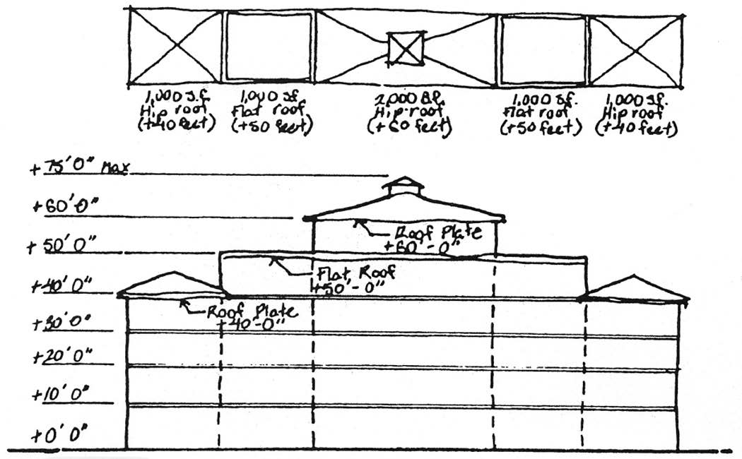
Figure 1
Building height, maximum. See Building height.
Building adjacent to or along U.S. Highway One means buildings developed on properties with no direct access onto the Intracoastal Waterway or Jupiter River (or a waterway).
Building or properties adjacent to Riverwalk Corridor component means buildings developed on properties with direct access onto the Intracoastal Waterway, Jupiter River or a waterway.
Grade means the existing median ground elevation at the base of a building or the minimum building elevation, whichever is higher. In order to establish the median ground elevation on-sites with varying elevations, each building's median ground elevation shall be established by averaging the pre-development elevation at the corners of a proposed building.
Inactive uses means uses or businesses that do not promote and encourage pedestrian activity; these types of uses are excluded from Table 1 of the use regulations (auto dealers, gas stations, fast food with drive throughs, carpet stores, large grocery store, large offices, large furniture and appliance stores).
Landmark feature means a specific location which identifies an entrance into a unique or special district, articulating the area through the use of special architectural features including sculpture, landscape material, signage, special pavement.
Mean high water line means the intersection of the land with the water surface at the elevation of the mean high tide with the shore.
Plaza means an open space or area that is improved, providing for use by the public, usually surrounded by public access areas and buildings, and may include accent pavers, landscaping, seating, fountains, sculpture, bike racks, architectural elements, trellis, and clock towers.
Riverwalk Corridor component means a linear park with a continuous 25-foot-wide public easement, located primarily adjacent to the water's edge and providing public access to the Intracoastal Waterway from the Jupiter Inlet south to the Jupiter Ridge Natural Area.
Scenic corridor component means a 50-foot landscaped pedestrian corridor, with a 29-foot easement located on the adjacent private property and 21-foot easement located in the right-of-way on U.S. Highway One. The corridor shall be located approximately 1,350 linear feet from the southwest corner of the intersection of Indiantown Road and U.S. Highway One and run parallel along the western side of the road until it reaches the Diamondhead/Radnor land tract, at which point the corridor will transverse across U.S. Highway One and run parallel to the eastern side of U.S. Highway One to the south municipal boundaries.
Stepback building envelope means the area in which a building or structure is required to be contained; the limits of the area is defined by the maximum building heights permitted relative to the building setback.
Structured parking means parking that is located in or under a building or structure that is either separate from or attached to commercial and/or residential uses above the established grade.
Subgrade parking means parking that is located in a principal building or structure, that contains air conditioned space for commercial and/or residential uses, but is located below the established grade.
Transitional buffer means a landscape buffer between incompatible uses, such as commercial and residential uses. The buffer may include public access from the scenic corridor component to the Riverwalk Corridor component.
Vendors means push carts or temporary concession stands used to sell goods for profit.
Vista means a view or outlook from U.S. Highway One or Coastal Way to a specific location or focal point along the Riverwalk, as seen through a long passage such as between buildings or rows of trees.
Note: Terms not defined herein are subject to the definition in this Code.
(Code 1992, § 27-857; Ord. No. 11-98, § 2, 9-15-1998; Ord. No. 03-06, § 2, 7-18-2006; Ord. No. 23-21, § 3, 12-7-2021)
Sec. 27-1481. - Applicability.
Any new development as defined by section 27-1 or site plans, or alteration, expansion, renovation or other improvements to existing structures and approved site plans in this zoning district, shall conform to the requirements of this division, as described below:
(1)
Any amendment to or renovations or redevelopment of an existing building or approved development involving modifications of 25 percent or more of a building or site plan or 25 percent of the appraised value of the existing development shall be subject to the provisions of this district.
(2)
Discontinuance. The provisions of this district shall be met where a nonconforming use of a structure ceases for any reason, except where governmental action impedes access to the premises, for a period of more than 365 consecutive days.
(Code 1992, § 27-858; Ord. No. 11-98, § 2, 9-15-1998)
Sec. 27-1482. - Established.
(a)
The U.S. One/Intracoastal Waterway Corridor Zoning District (US1/ICW), subdistricts and its components shall consist of that portion of the town shown on the official zoning map. See Figure 2 for the specific area.
(b)
The Mixed Use Residential, the Waterway Commercial and Entertainment Subdistricts are hereby created as part of the U.S. One/Intracoastal Waterway Corridor Zoning District (US1/ICW).
(c)
The scenic corridor and Riverwalk corridor components are hereby created as part of the U.S. One/Intracoastal Waterway Corridor Zoning District (US1/ICW).
(Ord. No. 11-98, § 2, 9-15-1998)
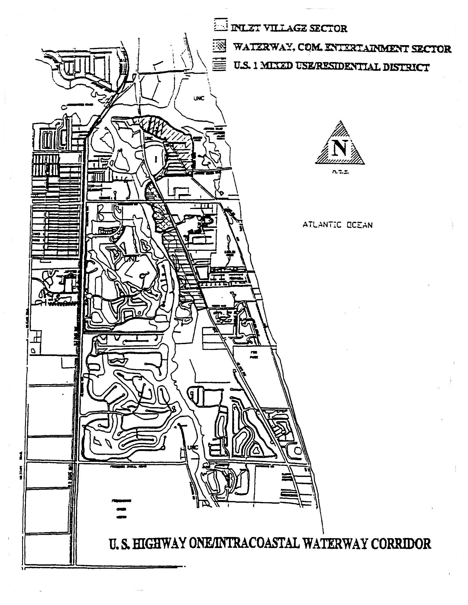
Figure 2
Sec. 27-1483. - Effect of existing comprehensive land use plan and official zoning map designations.
(a)
The establishment of the U.S. One/Intracoastal Waterway Corridor Zoning District (US1/ICW) is hereby declared consistent with the town's comprehensive plan.
(b)
The land development regulations of this district shall not be applied to development which has received a development order prior to the adoption of this district. Provided, however, the land development of this district shall be applied to any application to amend a development approval granted prior to the effective date of these land development regulations or to any site plan applications submitted as part of a previously approved planned unit development.
(Code 1992, § 27-860; Ord. No. 11-98, § 2, 9-15-1998)
Sec. 27-1484. - Use regulations.
(a)
Purpose and intent. The purpose and intent of these use regulations is to establish those uses to be permitted as uses by right or by special exception two subdistricts of the U.S. One/Intracoastal Waterway Corridor Zoning District (US1/ICW).
(b)
For those properties with frontage directly upon both the Riverwalk Corridor component and U.S. Highway One, the uses shall be limited to those indicated in the Waterway Commercial and Entertainment Subdistrict for properties developing directly adjacent to the Riverwalk Corridor component.
(c)
The uses which are permitted by right or by special exception in this zoning district are shown in Table 1. Those uses that are not included in Table 1 are prohibited uses.
Table 1
(Code 1992, § 27-860.1; Ord. No. 55-00, § 2, 11-7-2000; Ord. No. 12-10, § 8, 2-16-2010; Ord. No. 39-14, § 7, 2-17-2015; Ord. No. 13-17, § 7, 12-19-2017)
Sec. 27-1485. - Nonconformities and previously approved developments.
The provisions of this division shall not apply to any site plan or development order approved by the town council or, administratively by the department of planning and zoning prior to December 7, 2021, the effective date of Ordinance 23-21.
Property owners whose properties have been destroyed by an Act of God, or otherwise, by more than 50 percent, may redevelop their properties at the same densities and intensities previously approved, provided the property is developed as a PUD, and the council finds that comparable substantial public benefits have been provided for the increased density and intensity.
However, in the event a property owner proposes the redevelopment of its property, or the amendment of a site plan or other development order approved by the town council or, administratively by the department of planning and zoning after December 7, 2021, the effective date of Ordinance 23-21, then the provisions of this division shall apply.
(Ord. No. 23-21, § 4, 12-7-2021)
Editor's note— Ord. No. Ord. No. 23-21, § 4, adopted December 7, 2021, repealed the former § 27-1485, and enacted a new § 27-1485 as set out herein. The former § 27-1485 pertained to a bonus program and derived from the Code of 1992; Ord. No. 11-98, adopted September 15, 1998; and Ord. No. 03-06, adopted July 18, 2006.
Sec. 27-1486. - Riverwalk Corridor component.
(a)
Purpose and intent. The purpose and intent of this component is to provide for public access to and along the Intracoastal Waterway, and to generate periodic unobstructed vistas along the water within this district. The town shall require the dedication of a 25-foot perpetual easement for public use as required by section 25-91(13). The Riverwalk Corridor component shall consist of a minimum 25-foot easement landward of the mean highwater line with a minimum 15-foot universally accessible unobstructed path for each parcel of property within this district.
(b)
Easement dedication. The dedication of a minimum 25-foot perpetual easement for the benefit of the public shall be required by all applicants meeting the applicability section of this district. All applicants meeting the applicability section of this district shall construct a 15-foot unobstructed path within the Riverwalk Corridor component.
(c)
Americans with Disabilities Act. The Riverwalk Corridor component shall be designed in accordance with the provisions of the Americans with Disabilities Act (ADA).
(d)
Placement of buildings. All principal buildings within this district shall be oriented towards the Riverwalk Corridor component and/or the Intracoastal Waterway. The pedestrian ingress/egress of buildings located on the Riverwalk Corridor component and the Intracoastal Waterway, shall be designed, placed or oriented in the following methods:
(1)
Principal buildings shall provide a front facade towards the Riverwalk Corridor component, Intracoastal Waterway, the Jupiter River or other contiguous bodies of water;
(2)
Groupings of buildings or adjacent buildings shall be massed together or designed to form outdoor plazas or spaces that are oriented towards and allow the Riverwalk Corridor component activities to occur in the space, and shall include landscaping, lighting, seating, trash receptacles, and accent pavers; and
(3)
Building facades shall provide pedestrian scale elements such as arcades, shutters, awnings, base walls, accent banding, etc. along the Riverwalk Corridor component.
(e)
Riverwalk Corridor component amenities. The Riverwalk Corridor component shall include, but not be limited to the following amenities, that are set forth as standardized elements in the Riverwalk design guidelines:
(1)
Site furniture, such as benches, light poles, trash and cigarette receptacles, bike racks;
(2)
Textured or accent paving material and boardwalk and/or sidewalk for pedestrian circulation for all pedestrian pathways; and
(3)
Landscape elements, including trees, shrubs, groundcovers and decorative planters, potted plants.
(f)
Location of off-street parking. Parking at-grade, surface and structure, shall be maintained at the same building setback as the closest adjacent building and shall be adjacent to the Riverwalk Corridor component. (See Figure 3.)
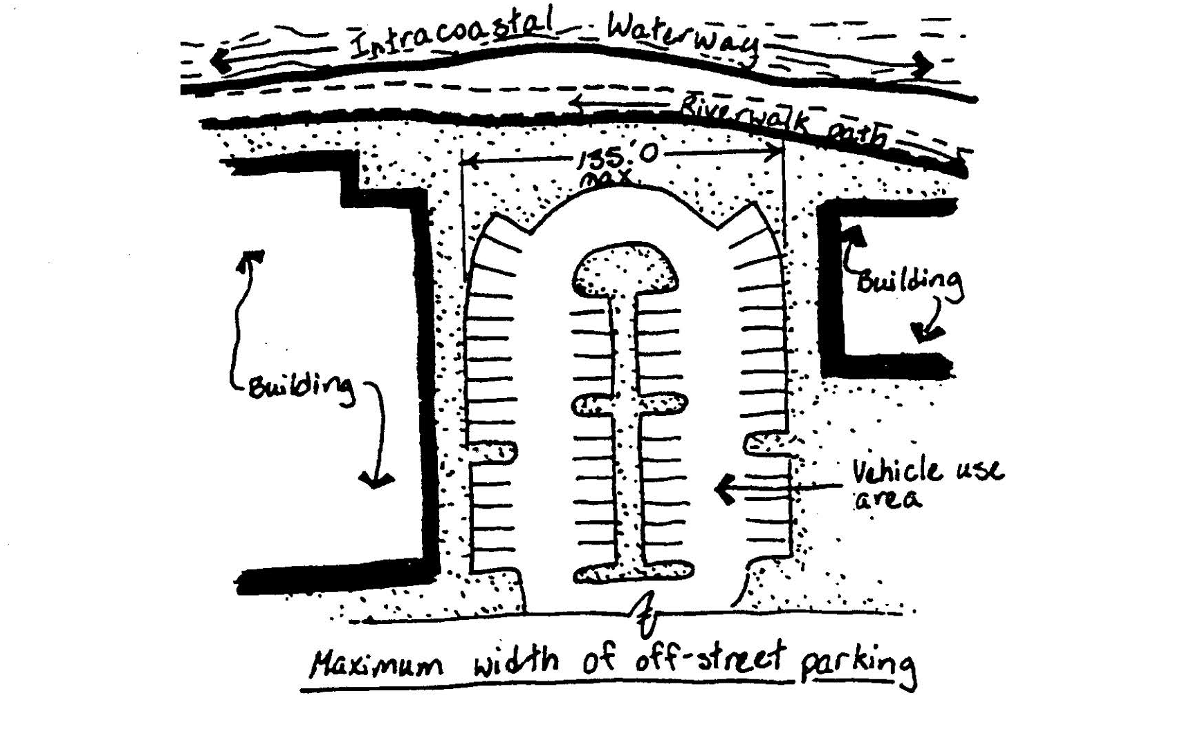
Figure 3
(g)
Off-street parking at-grade adjacent to the Riverwalk Corridor component.
(1)
The maximum width of vehicle use areas or off-street parking, directly adjacent to the Riverwalk Corridor component, shall be 135 feet, and shall include additional features such as vistas, landscaping, special paving treatments, sculpture, water features, etc., along the Riverwalk (See Figure 3).
(2)
Parking and vehicular use areas, directly adjacent to the Riverwalk Corridor component, shall not be closer than 100 feet from another parking and/or vehicular use area and/or adjacent to the right-of-way.
(h)
Location of service areas. Service areas, including loading areas, dumpsters and recycling facilities shall not be visible from the Riverwalk. All service areas shall be located a minimum of 50 feet from the Riverwalk Corridor component, and shall be screened completely by a concrete block and/or stucco wall and landscaping material.
(i)
Recreational impact fees. Those developments with residential dwelling units which provide land and capital improvements within the Riverwalk component may be entitled to a credit toward the payment of the applicable recreational impact fee.
(Code 1992, § 27-860.3; Ord. No. 11-98, § 2, 9-15-1998; Ord. No. 23-21, § 5, 12-7-2021)
Sec. 27-1487. - Scenic Corridor component.
(a)
Purpose and intent. The purpose and intent of this component is to provide a 50-foot-wide pedestrian and landscape corridor with a minimum ten-foot multi-purpose path and a 40-foot landscape buffer, consisting of installed or preserved coastal scrub vegetation, creating a consistent landscape theme along U.S. Highway One.
(b)
Provide for a variety of users. The ten-foot multi-purpose path within this component is intended for more active or recreational users, such as bicyclists, in-line skaters and runners.
(c)
Plant theme. This component shall preserve existing native coastal scrub and the landscaping of development or redevelopment within this component shall incorporate or restore landscape material from the coastal scrub plant theme, as indicated in Table 4.
Table 4. Coastal Scrub Plant Theme
(d)
Requirement of berm. A one- to three-foot berm with an average height of 18 inches as measured from the crown of U.S. Highway One shall be located in the installed coastal scrub plantings, along U.S. Highway One within the district. In areas where existing scrub vegetation can be preserved or where the adjacent development is below the grade of the curb of U.S. Highway One, the berm may be omitted subject to approval by the town council.
(e)
Requirement of sand beds. Sand beds, which are typical in scrub habitat, shall be provided a minimum of 600 square feet in meandering beds for every 500 linear feet of the scenic corridor component.
(f)
Preservation of existing natives. The special landscaping treatments established for this component may be waived by the town council, provided it determines that by doing so it would better accommodate existing on-site coastal scrub vegetation.
(g)
Minimum percentage of landscape material. All landscape plans within this district shall include a minimum or 80 percent of the plant material from the required planting palette. Twenty percent of the amount and type of plant material necessary to meet the landscaping requirements of this component may be materials which are not within the planting palette except; provided, however, this shall not apply to the specified tree species. Installed tree material shall be required to be in the coastal scrub theme. (See Figure 4.)
(h)
Required irrigation. Temporary irrigation shall be required a minimum of 90 days from installation of new landscape material. After the landscape material is established the applicant may remove the irrigation.
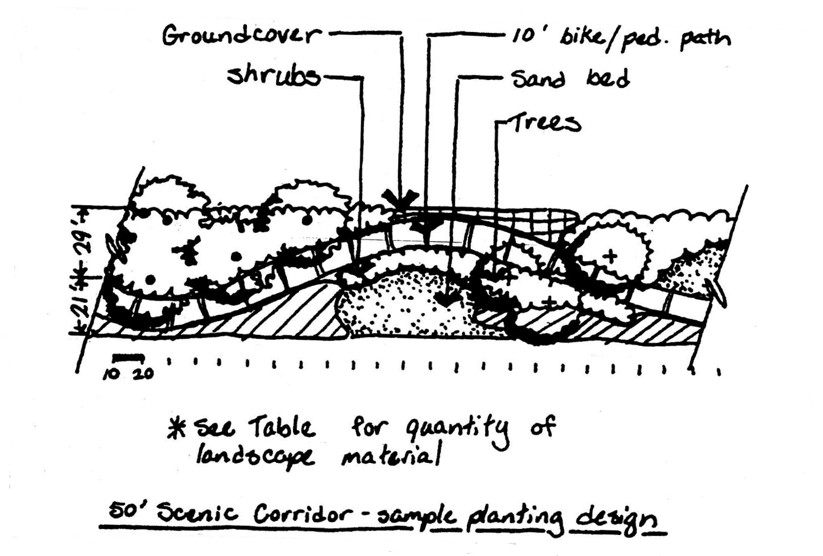
Figure 4
(Code 1992, § 27-860.4; Ord. No. 11-98, § 2, 9-15-1998; Ord. No. 03-06, § 4, 7-18-2006)
Sec. 27-1488. - Mixed Use Residential Subdistrict.
(a)
Purpose and intent. This subdistrict is intended to promote a compact development design, and encourage residential development. The subdistrict is intended to be compatible with pre-existing residential uses in the vicinity of this subdistrict and to provide opportunities to maintain and enhance the value of properties within this subdistrict by encouraging accessory commercial uses in developments.
(b)
Mixture of residential and commercial. Developments may be permitted to mix residential and commercial uses. The minimum acreage for residential uses shall be 50 percent, and the maximum acreage for commercial shall be 30 percent.
(c)
Commercial only. Developments that are less than five acres may be developed as 100 percent commercial as defined within the use regulations for this subdistrict.
(d)
Relation to water. In the Mixed Use Residential Subdistrict, the Riverwalk Corridor component shall follow the water's edge or extend into the water for 100 percent of the property water frontage.
(e)
Area and lot dimensions for residential. Area and lot dimension regulations for properties with residential uses:
(1)
Lot area (minimum).
a.
Duplex: 3,000 square feet.
b.
Townhouse: 2,000 square feet.
c.
Multifamily: 3,000 square feet.
(2)
Lot width (minimum).
a.
Duplex per unit: 30 feet.
b.
Townhouse per unit: 20 feet.
c.
Multifamily per building: 100 feet.
(3)
Lot depth (minimum).
a.
All uses but townhouses: 100 feet.
b.
Townhouse: 80 feet.
(4)
Front setback (minimum)—Measured from property line.
a.
Duplex: 20 feet.
b.
Townhouse: 20 feet.
c.
Multifamily: 35 feet.
d.
Garages: 25 feet.
(5)
Front setback (minimum)—Measured from U.S. Highway One.
a.
Duplex: 35 feet.
b.
Townhouse: 35 feet.
c.
Multifamily: 35 feet.
d.
Garages: 45 feet.
(6)
Rear setback (minimum)—Measured from the Riverwalk Corridor component or any other rear yard.
a.
Duplex: 15 feet.
b.
Townhouse: 15 feet.
c.
Multifamily: 30 feet.
(7)
Side setback for each building (minimum).
a.
Duplex: ten feet.
b.
Townhouse: 15 feet.
c.
Multifamily: 15 feet.
(8)
Side corner for each building (minimum).
a.
Duplex: 25 feet.
b.
Townhouse: 25 feet.
c.
Multifamily: 35 feet.
(9)
Maximum building height and average building height.
a.
A maximum average building height of 35 feet per building.
b.
The maximum building height shall not be more than 15 feet greater than the allowed average building height.
(10)
Lot coverage (maximum): 35 percent.
(11)
Open space (minimum): 15 percent.
(12)
Density: six d.u./acre (or up to 15 d.u./acre subject to the town council approval of an increase in density as part of a planned unit development pursuant to subsection 27-1642(d) or subsection 27-1713(d)).
(f)
Area and lot dimensions for commercial in the Mixed Use Residential Subdistrict. Area and lot dimension regulations for properties with a mixture of residential uses and commercial uses, accessory commercial uses shall be developed with a maximum of 30 percent of the gross floor area (GFA) of the project, and on each project upon which a building or structure hereafter is erected or enlarged and maintained, the following regulations shall be observed:
(1)
Lot area (minimum): 10,000 square feet.
(2)
Lot width (minimum): 75 feet.
(3)
Lot depth (minimum): 100 feet.
(4)
Front setback (minimum)—Measured from:
a.
U.S. Highway One: 40 feet.
b.
Riverwalk: ten feet.
(5)
Rear setback (minimum): 30 feet.
(6)
Side setback (minimum): 20 feet.
(7)
Side corner (minimum): 30 feet.
(8)
Maximum building height and average building height:
a.
A maximum average building height of 35 feet per building;
b.
The maximum building height shall not be more than 15 feet greater than the allowed average building height;
c.
The average building height may be increased to 45 feet when a level of public parking is incorporated into a nonresidential or mixed use building for a minimum of 70 percent of any floor, except on the ground or first floor level.
(9)
Lot coverage (maximum): 35 percent.
(10)
Open space (minimum): 15 percent.
(11)
Density: six d.u./acre (or up to 15 d.u./acre subject to the town council approval of an increase in density as part of a planned unit development pursuant to subsection 27-1642(d) or subsection 27-1713(d)).
(g)
Encroachments. Screen enclosures, patios, decks, balconies, roof overhang or arcades shall not encroach more than 50 percent into the required rear setback.
(h)
Retention/detention areas. Stormwater retention/detention areas shall comply with the following (See Figure 5):
(1)
The shape of retention/detention areas, shall be designed to appear natural with off-sets in the edge alignment that are a minimum of ten feet and spaced an average of 50 feet.
(2)
All retention/detention areas adjacent to the scenic corridor component shall be located directly along U.S. Highway One, but exclusive of any required landscape buffers or easements.
(3)
Stormwater management areas shall be exclusive of all landscape areas.
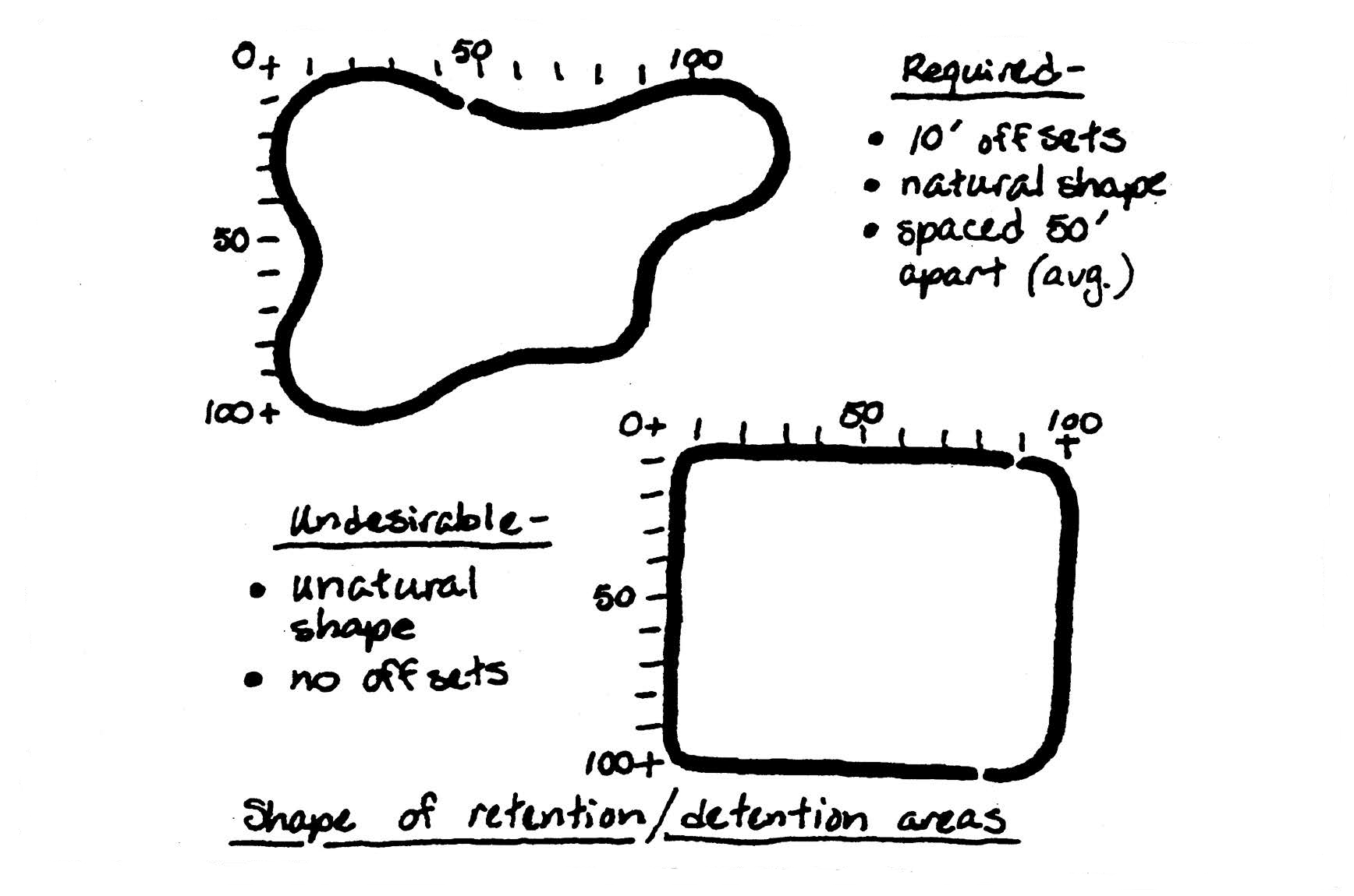
Figure 5
(Code 1992, § 27-860.5; Ord. No. 11-98, § 2, 9-15-1998; Ord. No. 44-05, § 2, 9-20-2005; Ord. No. 03-06, §§ 5, 6, 7-18-2006; Ord. No. 23-21, § 6, 12-7-2021)
Sec. 27-1489. - Waterway Commercial and Entertainment Subdistrict regulations.
(a)
Purpose and intent. The purpose and intent of this subdistrict is to:
(1)
Provide an active commercial waterfront oriented subdistrict at the intersection of U.S. Highway One and Indiantown Road and provide for accessory residential development above the first floor uses.
(2)
Enhance and increase the property values of properties within the subdistrict by creating a commercial and entertainment area which attracts residents and visitors to the subdistrict.
(3)
Provide for appropriate waterfront commercial uses oriented toward the Intracoastal Waterway.
(4)
Link public spaces to these appropriate commercial uses providing pedestrian access to the uses and the waterfront.
(b)
Area and lot dimensions. Area and lot dimension regulations for properties in this subdistrict.
(1)
Lot area (minimum): 15,000 square feet.
(2)
Lot width (minimum): 75 feet.
(3)
Lot depth (minimum): 150 feet.
(4)
Front setbacks—Measured from:
a.
U.S. Highway One: 50 feet.
b.
Riverwalk: 15 feet.
(5)
Rear setback (minimum): 20 feet.
(6)
Side (minimum): ten feet.
(7)
Side corner (minimum): 35 feet.
(8)
Maximum building height and average building height:
a.
A maximum average building height of 35 feet per building;
b.
The maximum building height shall not be more than 15 feet greater than the allowed average building height;
c.
The average building height may be increased to 45 feet when a level of public parking is incorporated into a nonresidential or mixed use building for a minimum of 70 percent of any floor, except on the ground or first floor level.
(9)
Lot coverage: 35 percent.
(10)
Density: six d.u./acre (or up to 15 d.u./acre subject to the town council approval of an increase in density as part of a planned unit development pursuant to subsection 27-1642(d) or subsection 27-1713(d)).
(c)
One hundred percent Riverwalk Corridor component . In this subdistrict, the Riverwalk Corridor component shall follow the mean high water line or extend into or over the water for a minimum of 100 percent of the property water frontage.
(d)
Encroachments. Awnings, balconies, outdoor dining, outdoor seating, and arcades, may be cantilevered or encroach into the building setback.
(e)
Active uses on first floor. The first floor of all buildings should be oriented such that they promote pedestrian activity in the Riverwalk Corridor component as well as the street facade. Only those uses that are listed within Table 1 for the Waterway Commercial and Entertainment Subdistrict for properties developing directly adjacent to the Riverwalk Corridor component shall comprise the first floor and provide direct access to the Riverwalk.
(f)
First floor architectural standards.
(1)
First floor level architectural features shall have a minimum 12-foot ceiling height, with windows and entries covered with minimum five-foot-wide canopies, curved awning or arcade or otherwise be designed to create interest to the facade.
(2)
Fifty percent of the area of the elevations on the first floor, that are viewed by the public, shall be designed to include transparent windows and door displays and to minimize expanses of blank walls.
(3)
The remaining 50 percent of the elevations on the first floor, that are viewed by the public, shall be designed to include any or all of the following:
a.
Landscape material (i.e., foundation plantings, vertical trellis with vines, planter boxes with cascading landscape material);
b.
Architectural detailing and articulation similar to those elements decided in the above architectural styles, that provides texture on the facade and/or parking structure openings;
c.
Artwork such as sculpture, murals, mosaics, etc.
(g)
Individual identity. Each storefront, building, or bay with an individual building shall be designed to permit individual retail identity with specific attention given to door or window details. This may include door/window pediments, window planter boxes, decorative tile insets, etc. (See Figure 6.)
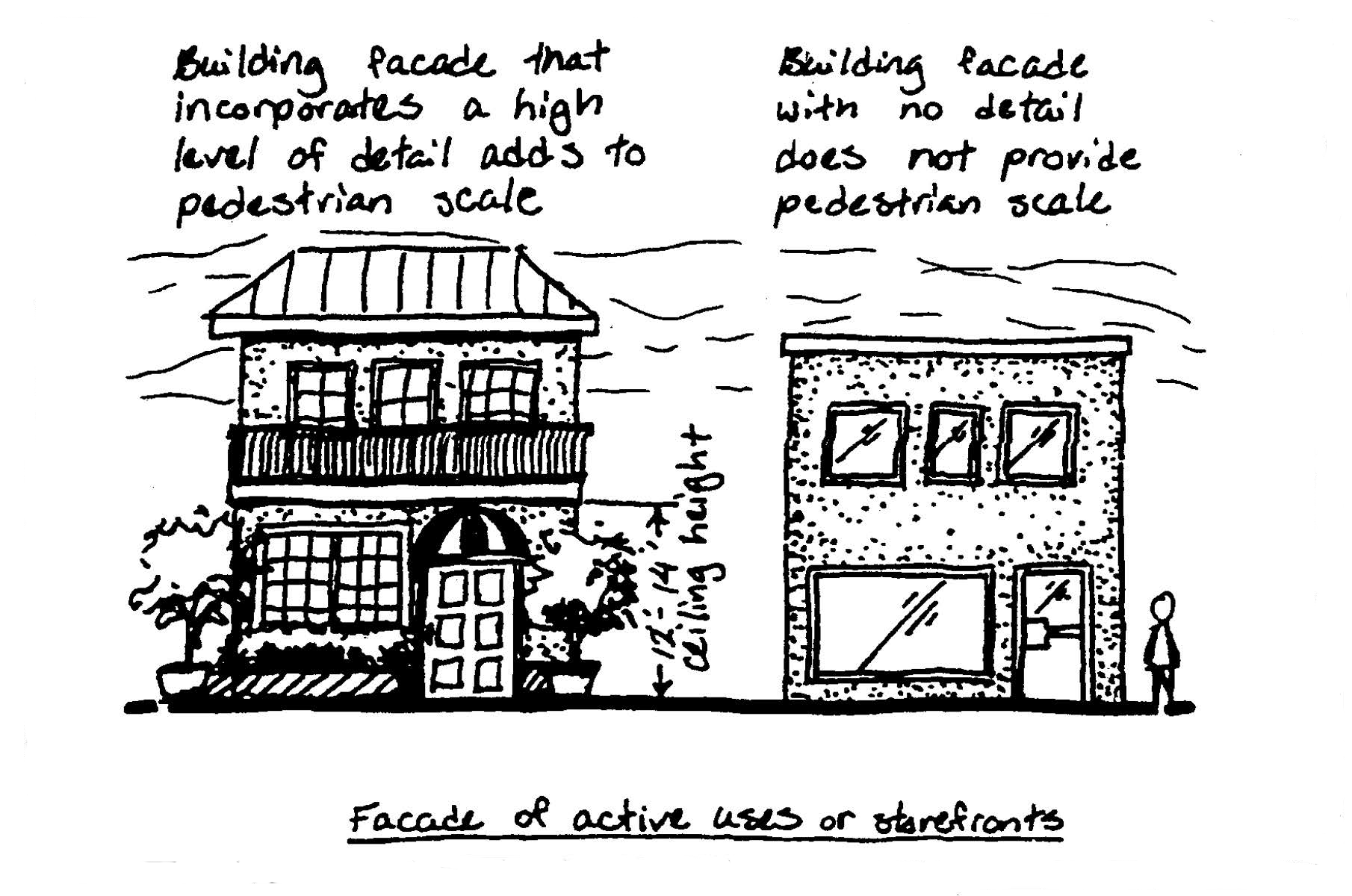
Figure 6
(Code 1992, § 27-860.6; Ord. No. 11-98, § 2, 9-15-1998; Ord. No. 03-06, § 7, 7-18-2006; Ord. No. 23-21, § 7, 12-7-2021)
Sec. 27-1490. - Supplemental regulations for the U.S. One/Intracoastal Waterway Corridor Zoning District (US1/ICW).
(a)
Purpose and intent. The purpose and intent of this section is to provide:
(1)
Site design standards that provide for the screening of objectionable views;
(2)
For the underground installation of distribution utility lines;
(3)
For public views or vistas along the Intracoastal Waterway; and
(4)
For stepback building envelopes for buildings proposed adjacent or along U.S. Highway One.
(b)
Screening consistent with architecture. Rooftop and ground level mechanical, utility and electrical equipment shall be screened consistent with the overall character and architecture of the building. (See Figure 7.)
Figure 7
(c)
Screening from public view. All proposed rooftop mechanical and electrical equipment shall be screened from public view, including views from the ground level, adjacent buildings and bridges.
(d)
Screening dumpster and recycling enclosures. All dumpster and recycling enclosures shall be screened from public view with concrete block and stucco walls on three sides and with metal gates and surrounding landscape material on the walled sides.
(e)
Underground utility lines. All electric distribution lines and other utility (i.e., telephone, cable, internet, etc.) shall be placed underground for all new development and redevelopment.
(f)
Requirement for vista. For parcels which exceed over two acres, vistas and view points to the Riverwalk Corridor component shall occur a minimum of one per property which is the subject of an application. All proposed property which is the subject of an application shall include the following for each required vista (See Figure 8):
(1)
Provide a view to the Riverwalk Corridor component from adjacent rights-of-way, pedestrian pathways, vehicular use areas, and/or open space.
(2)
Provide landscape material, such as rows of trees or palms, and associated shrubs, groundcovers, and accent material, to emphasize and/or accentuate the vista to a specific location or focal point on the Riverwalk Corridor component. The required landscape material may be reduced or deleted approval by the town in areas where the vista passes through a building or breezeway.
(3)
Provide a focal point at the end of the vista, which may include one of the following: sculpture, fountain, architectural features such as an archway, specimen tree, open plaza with special accent pavers, and/or special landscape material.
(4)
Refer to the bonus program section of this division for the applicability of vista bonuses as in Table 2.
(5)
The minimum width for each vista shall be 15 feet.
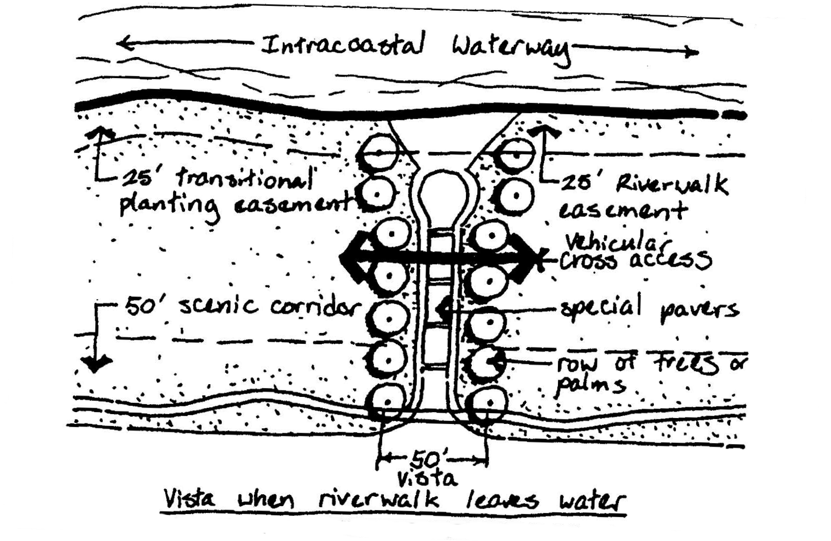
Figure 8
(Code 1992, § 27-860.7; Ord. No. 11-98, § 2, 9-15-1998)
Sec. 27-1491. - Architectural design standards.
(a)
Purpose and intent. The purpose and intent of this section is to:
(1)
Authorize the town council, the planning and zoning commission and planning and zoning staff to require buildings and structures which are proposed as part of a site plan to incorporate specific architectural features within the plan for development of the site;
(2)
Maintain and/or enhance the architectural character and community appearance of present and future land use and development in the town consistent with F.S. § 163.3161(7) and the town's comprehensive plan;
(3)
Ensure that any proposed or modified buildings or structures are developed consistent with the appearance and architectural character established in this zoning district;
(4)
Provide specific architectural design guidelines that are constructed and incorporated into the building design;
(5)
Discourage the appearance of a continuous wall of buildings, generally parallel to U.S. Highway One; and
(6)
Create visual interest through the use of pedestrian scale architectural elements, breezeways, step backs, building separation and articulated facades related to the scale and mass of the building.
(b)
Colors. The proposed colors for any building or structure, and their architectural features and signs, shall be reviewed and approved for consistency with the district and existing and proposed adjacent structures by the town.
(c)
Wall and roof variations. Each building shall be required to provide a change or variation in the roofline or building facade proportionate to the scale of the proposed building, and the change or variation in the wall and roof must be significant to produce shadow lines against the building.
(d)
Parking structures standards. A minimum of 100 percent of any primary facade or facade viewed by the public, of a parking structure or covered parking facility shall incorporate three of the following elements (see Figure 9):
(1)
Retail businesses with transparent windows along the ground floor;
(2)
Display windows;
(3)
Landscape material (i.e., foundation plantings, vertical trellis with vines, planter boxes with cascading landscape material, etc.);
(4)
Architectural detailing and articulation similar to those elements decided in the above architectural styles, that provides texture on the facade and/or parking structure openings;
(5)
Artwork such as sculpture, murals, mosaics, etc.
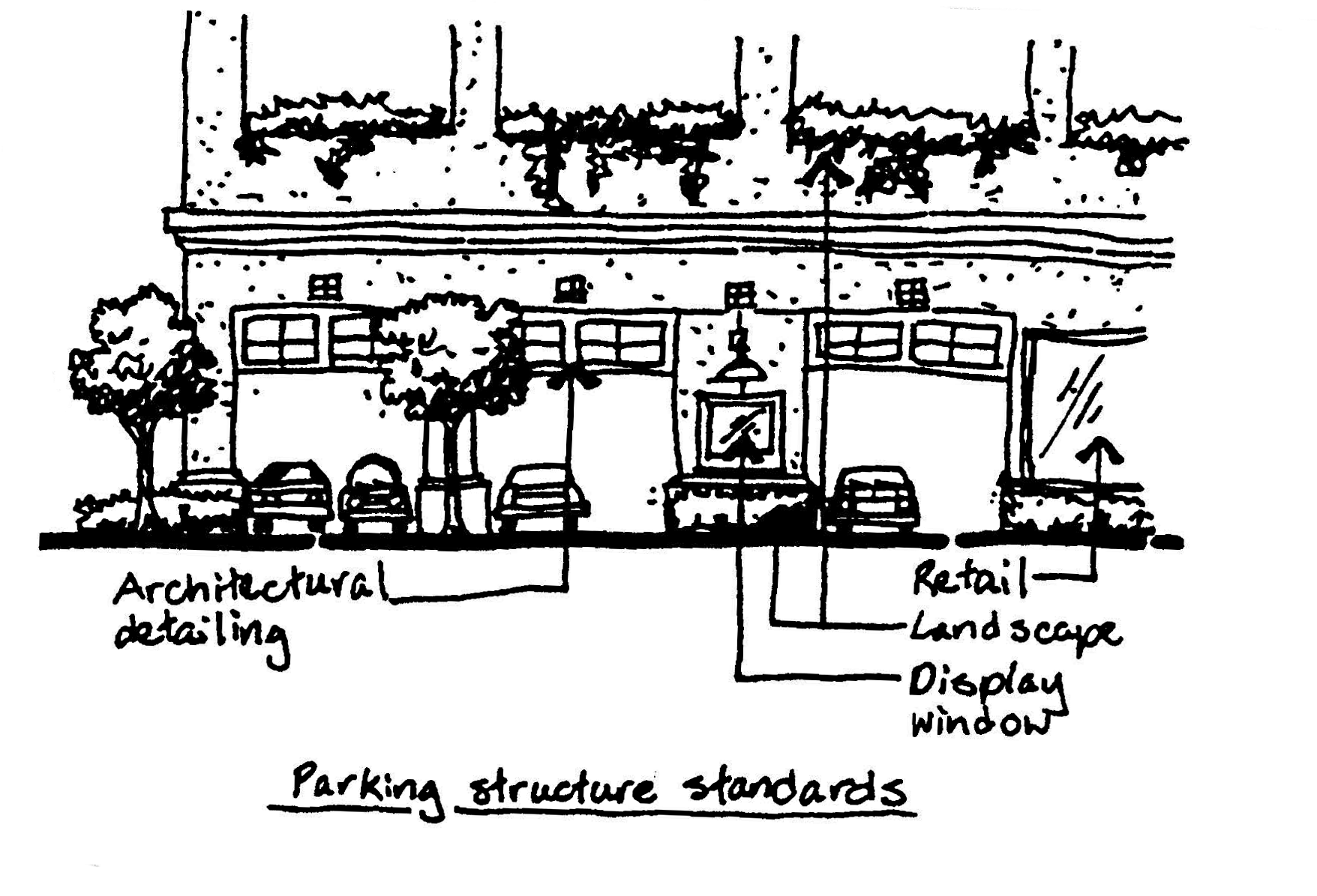
Figure 9
(e)
Location of parking structures. Parking structures shall not be located directly adjacent to the Riverwalk Corridor component , except where active uses are provided along the ground level and outer portion of the parking structure.
(f)
Additional parking structure regulations. Parking structures with two or more parking levels shall not count towards the overall lot coverage of a site. Single level parking structures shall not count towards the overall lot coverage, if the following criteria are met:
(1)
The maximum lot coverage of all buildings and parking structures on a property shall not exceed 70 percent.
(2)
100 percent of the parking structure not located under the building footprint is covered by an intensive vegetated green roof that includes trees, shrubs, and ground cover. Up to 35 percent of the intensive vegetated green roof may be hardscape for pedestrian access.
(3)
The vegetated green roof shall be integrated and transition into the at-grade greenspaces, where feasible.
(g)
Building stepback envelope along the Riverwalk Corridor component and/or U.S. Highway One. Any applicant receiving a setback waiver which enables the applicant to reduce the minimum setback, along the Riverwalk Corridor component and/or U.S. Highway One shall be required to adhere to the stepback building envelope as follows:
(1)
All structures and buildings which are constructed adjacent to the Riverwalk Corridor component and/or U.S. Highway One shall not exceed a maximum height of 35 feet without adhering to the building stepback envelope, not including the roofline. If buildings are constructed above the 35-foot height, the buildings shall be stepped back as set forth in this section.
(2)
The step back envelope of buildings shall increase at a one to one foot ratio (for every one foot of vertical run, one foot of horizontal) above 35 feet, not including the building height above the roof or pole plate for trussed roof systems (see Figure 10).
(3)
A building shall be required to meet the stepback building envelope for 80 percent of the linear frontage along the Riverwalk Corridor component and/or U.S. Highway One, no more than 20 percent of the linear frontage along the Riverwalk Corridor component and/or U.S. Highway One shall protrude outside the stepback building envelope as follows:
a.
A horizontal plane, such as a trellis, screened or solid roof, or awning may protrude outside of the stepback building envelope; and/or
b.
A vertical plane, such as a stairwell, tower, elevator shaft, or other portion of building may protrude outside of the stepback building envelope.
(4)
Regardless of the building setback, all proposed building heights, except for those allowable protrusions, shall not exceed the stepback building envelope when located adjacent to the Riverwalk Corridor component (see Figure 11).
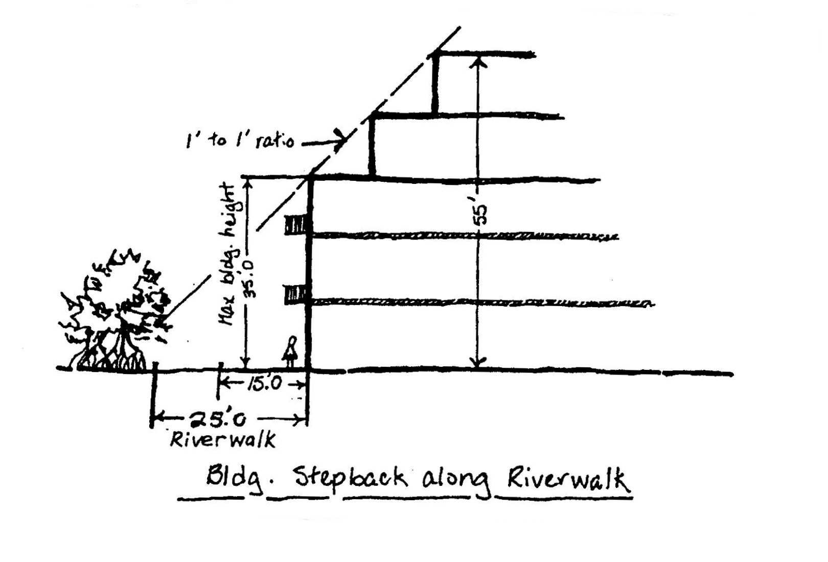
Figure 10
(5)
If a proposed building is not located at the minimum building setback, the proposed building heights shall not exceed the stepback building envelope when located adjacent to the Riverwalk Corridor component and/or to U.S. Highway One (see Figure 11).
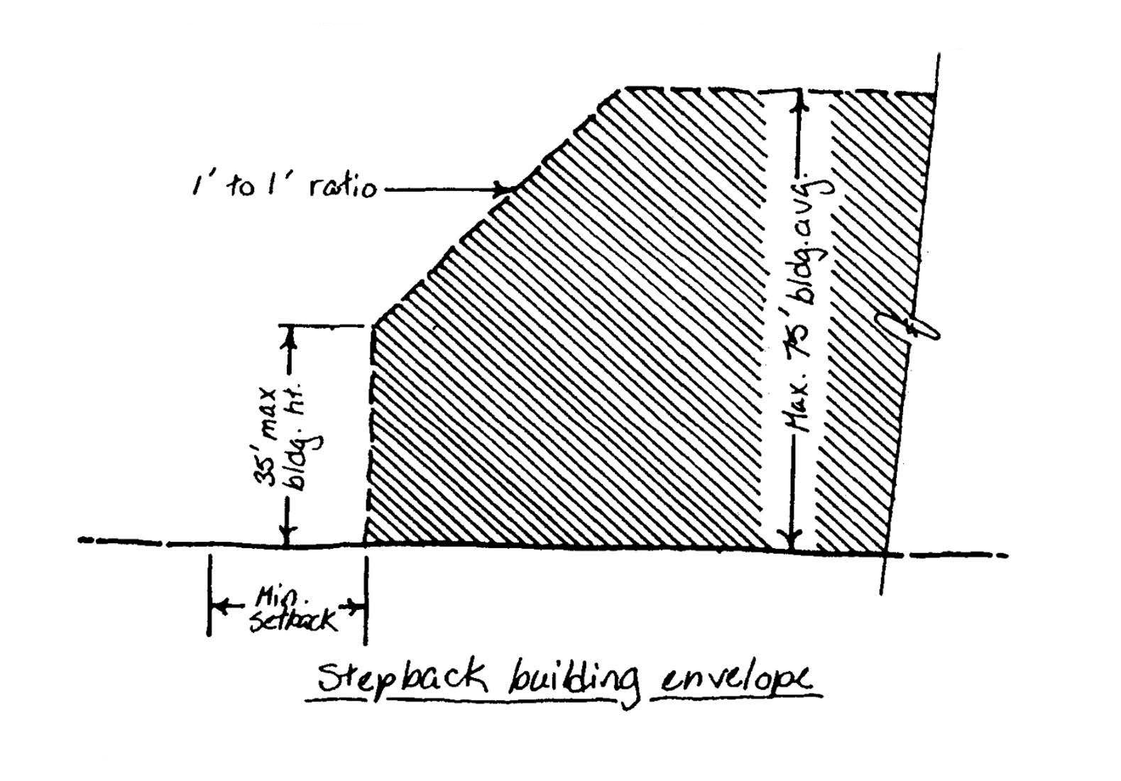
Figure 11
(6)
When a building or structure is located at the minimum setback, relative to the Riverwalk only, a building step back shall not be required provided the entire length of any proposed buildings, which are adjacent to the Riverwalk, contains structures or architectural features covering the 15-foot unobstructed path of the Riverwalk (arcade, awning, shed roof, or balcony) (see Figure 12).
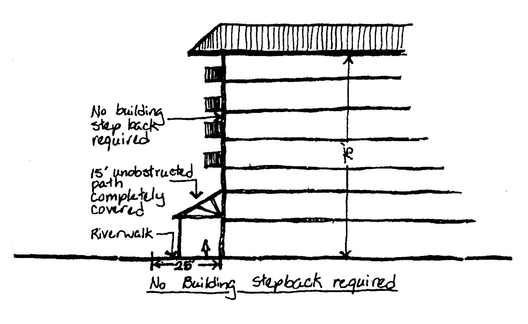
Figure 12
(h)
Coastal vernacular style architecture. All proposed development in this corridor district shall construct structures and accessory structures that are consistent with coastal vernacular style architecture. This can include, but not be limited to cracker style, shingle style, Mediterranean style, stick style, craftsman style, or a postmodernist mixture of the below architectural styles:
(1)
The applicant shall incorporate at least ten of the following details in the cracker style, for all elevations of the proposed structure:
a.
Hipped roof (minimum 4:12 pitch).
b.
Projecting eaves.
c.
Porches.
d.
Two over two double-hung sash windows.
e.
Clapboards.
f.
Squared columns on porch.
g.
Metal roof material.
h.
Triangular shaped louvered vents.
i.
Louvered shutters.
j.
Cupola.
k.
Pyramidal roof at main entry.
l.
Exposed trusses or brackets.
m.
Gable roof (minimum 4:12 pitch).
(2)
The applicant shall incorporate at least ten of the following details in the shingle style for all elevations of the proposed structure:
a.
Hipped roof (minimum 4:12 pitch).
b.
Hipped roof dormers.
c.
Clapboards.
d.
Wood or simulated wood shingles.
e.
Eyebrow.
f.
Porches.
g.
Tower elements.
h.
Splayed or cutout brackets.
i.
Louvered shutters.
j.
Rectangular shaped louvered vents.
k.
Six over one double hung sash windows.
l.
Pergola.
m.
Boxed cornice.
(3)
The applicant shall incorporate at least ten of the following details in the Mediterranean style for all elevations of the proposed structure:
a.
Stucco.
b.
Arched entry.
c.
Projecting portico or recessed loggia.
d.
Barrel tile roof material.
e.
Hipped roof.
f.
Emphasized cornice.
g.
Exposed trusses or brackets.
h.
Piers with corbels capitals on porch.
i.
Six over one double hung sash window.
j.
Projecting eaves or broad overhangs.
k.
Accent banding.
l.
Quoins.
(4)
The applicant shall incorporate at least ten of the following details in the stick style for all elevations of the proposed structure:
a.
Steep pitched gable roof (minimum 4:12 pitch).
b.
Porches.
c.
Applied stickwork.
d.
Clapboard.
e.
One over one double hung sash window.
f.
Braced arch, beveled strut or open bracing.
g.
Open or splayed brackets.
h.
Shed roof above porch.
i.
Tower elements.
j.
Wood or simulated wood shingles.
k.
Squared columns.
l.
Pediment on main entry.
m.
Gabled dormers.
(5)
The applicant shall incorporate at least ten of the following details in the craftsman style for all elevations of the proposed structure:
a.
Clapboards.
b.
Cutout brackets.
c.
Gable roof (minimum 4:12 pitch).
d.
Projecting eaves or broad overhangs.
e.
Wood or simulated wood shingles.
f.
Porches.
g.
Eight over one or nine over one double hung sash window.
h.
Exposed trusses or brackets.
i.
Grouped windows.
j.
Low pitched roof.
k.
Tapered columns on porch.
l.
Shed roof above windows.
m.
Gabled dormers.
n.
Pergola.
(6)
The applicant may incorporate at least ten of the above architectural styles to blend and form an eclectic, postmodernist style, which shall be reviewed for consistency.
(Code 1992, § 27-860.8; Ord. No. 11-98, § 2, 9-15-1998; Ord. No. 27-17, § 2, 12-19-2017; Ord. No. 23-21, § 8, 12-7-2021)
Sec. 27-1492. - District landscape and buffer requirements.
(a)
Purpose and intent. The purpose and intent is to provide regulations in this district that allow for a specific plant palette, provide flexibility in planting design, preserve existing native species and establish minimum requirements for landscape buffers.
(b)
For developments in this district, interior landscape requirements for vehicle use areas shall meet the requirements in section 23-70.
(c)
Required transitional buffer. All proposed properties which are the subject of application that are located adjacent to unlike and/or incompatible uses (i.e., commercial adjacent to residential), shall provide a minimum 15-foot transitional buffer (when the proposed development is a different use than the preexisting development). The 15-foot transitional buffer shall consist of a minimum ten-foot-wide landscaped buffer and may include a five-foot concrete pathway connecting the scenic corridor component to the Riverwalk Corridor component. The plant material shall be consistent with the scenic corridor component's plant theme or the existing natural plant communities.
(d)
The landscape buffer requirements for the Waterway Commercial and Entertainment Subdistrict are illustrated in Table 5:
Table 5. Waterway Commercial and Entertainment Subdistrict (perimeter landscape buffer requirements)
(1) Hardscape may be permitted in landscape buffer in the form of plazas or sidewalks.
(2) Riverwalk landscape buffer may be reduced or eliminated if the Riverwalk is covered or if alternative landscape enhancements and/or streetscape enhancements within or adjacent to the 25 feet Riverwalk Corridor component are provided.
(3) Perimeter landscape buffers may be reduced to match the setback reduction when a setback waiver is approved pursuant to sections 27-1641 or 27-1711.
(e)
In the Waterway Commercial and Entertainment Subdistrict, the proposed plant palette shall be the Formal palm tree special landscape requirements of section 27-1528.
(f)
The landscape buffer requirements for the Mixed Use Residential Subdistrict is illustrated in Table 6:
Table 6. Mixed Use Residential Subdistrict (perimeter landscape buffer requirements)
(1) Hardscape may be permitted in landscape buffer.
(2) Perimeter landscape buffers may be reduced to match the setback reduction when a setback waiver is approved pursuant to sections 27-1641 or 27-1711.
(g)
In the Mixed Use Residential Subdistrict, the coastal scrub plant theme, as described in Table 4, shall be utilized for all perimeter landscape buffers.
(Code 1992, § 27-860.9; Ord. No. 11-98, § 2, 9-15-1998; Ord. No. 14-05, § 2, 4-19-2005; Ord. No. 2-06, § 2, 6-20-2006; Ord. No. 23-21, § 9, 12-7-2021)
Sec. 27-1493. - District sign regulations.
(a)
The regulations and requirements set forth in this section are intended to preserve and enhance the visual qualities of the U.S. One/Intracoastal Waterway Corridor Zoning District (US1/ICW) by controlling the size, location and use of signs. It is not the intent or purpose of this article to impermissibly regulate signs by giving commercial speech greater protection than noncommercial speech, nor to discriminate among various noncommercial messages exhibited or conveyed by signs. Notwithstanding anything contrary contained in the town Code, any sign erected pursuant to the provisions of this Code may, at the option of the applicant, contain either a noncommercial message unrelated to the business located on the premises where the sign is erected, or a commercial message related to the business and located on the business premises. The noncommercial message may occupy the entire sign face or portion thereof. The sign may be changed from commercial to noncommercial messages as frequently as desired by the owner of the sign, provided that the size and design criteria conform to the applicable portions of this Code, the sign is allowed by this Code, the sign conforms to the requirements of the U.S. One/Intracoastal Waterway Corridor Zoning District (US1/ICW), and the appropriate permits are obtained. For the purposes of this Code, noncommercial messages, by their very nature, shall never be deemed an off-premises sign.
(b)
The Waterway Commercial and Entertainment Subdistrict and the Mixed Use Residential Subdistrict in the U.S. One/Intracoastal Waterway Corridor Zoning District (US1/ICW) shall utilize the following sign standards in Table 7. For all other sign regulations, not mentioned in Table 7, see article XIII of this chapter.
Table 7. U.S. One/Intracoastal Waterway Corridor Zoning District (US1/ICW) Sign Regulations
(c)
The wall sign height and letter height may be increased up to a maximum of 50 percent, if the proposed sign meets all of the following criteria:
(1)
The facade sign is set back 200 feet or greater from the adjacent right-of-way.
(2)
The tenant space where the sign is attached is 30,000 square feet or greater.
(3)
The sign shall be designed such that the sign is in the scale and proportions of the architecture of the building.
(Code 1992, § 27-860.10; Ord. No. 11-98, § 2, 9-15-1998; Ord. No. 56-01, § 2, 12-4-2001; Ord. No. 23-10, § 3, 9-21-2010; Ord. No. 23-12, § 3, 9-4-2012)
Sec. 27-992. - Title.
This division shall be known and may be cited as the "Mixed Use Development District (MXD) Ordinance for the Town of Jupiter, Florida."
(Code 1992, § 27-972; Ord. No. 1-95, § 1.1, 6-6-1995; Ord. No. 6-00, § 2, 8-1-2000)
Sec. 27-993. - Applicability.
Properties appropriately designated Mixed Use Development District (MXD) shall be governed by the requirements and regulations contained herein.
(Code 1992, § 27-973; Ord. No. 1-95, § 1.2, 6-6-1995; Ord. No. 6-00, § 2, 8-1-2000)
Sec. 27-994. - Purpose and intent.
The purpose and intent of the Mixed Use Development District (MXD) is to:
(1)
Provide the method by which tracts of land may be developed as a unit rather than on a lot-by-lot basis as provided for in the town's other zoning regulations.
(2)
Provide a maximum of design freedom by permitting the applicants an opportunity to more fully utilize the physical characteristics of the site through modified development regulations and the planned mixing of uses.
(3)
Require that property approved by the town council for a Mixed Use Development District (MXD) will be developed through a unified design providing continuity among the various elements causing a better environment.
(4)
Include traditional neighborhood development concepts, including the following attributes:
a.
Neighborhood component with the following characteristics:
1.
Limited in area to that which can be traversed in a ten-minute walk by a majority of its residents to its center. This area is roughly inscribed by a 1,320 ft. (one-fourth-mile) radius from the center of a neighborhood.
2.
Bring within walking distance most of the activities of daily living, residents of all ages may gain independence of movement, thereby reducing the number and length of vehicular trips.
3.
Include a number of places to go and things to do within walking distance, including an assortment of residential buildings (i.e., houses, apartments, outbuildings, etc.), workplace buildings (i.e., offices, studios, craft shops, etc.), limited neighborhood commercial buildings (i.e., grocery stores, craft shops, boutiques, salons, restaurants, etc.), and public buildings (i.e., schools, churches, libraries, assembly halls, etc.). These components are bound together by a well-planned public realm.
4.
Organized around a centrally located public square or greens. Spatially defined areas and elements such as tree-lined streets, sidewalks, greens, playgrounds, parks, benches, picnic shelters and gazebos create a neighborhood's character and offer amenities available to the entire community. This provides opportunities for citizens to know each other and to watch over their collective security with the establishment of public spaces.
5.
Subdivided to allow for an assortment of building types, large and small to be developed at a pedestrian scale for satisfying residential and nonresidential needs of a diverse population.
6.
Provide a variety of housing types and sizes to accommodate the needs of a diverse population.
7.
Encourages alternative modes of transportation aimed at pedestrian circulation.
8.
Provide a hierarchy of streets designed to serve the needs of pedestrians, bicyclists and vehicular circulation equitably.
9.
Landmark opportunities, including physically defined squares; parks; playgrounds; open spaces; civic buildings; and places of assembly for social, cultural and religious activities provide places for social activity and (passive and active) recreation which reinforce the community values and identity of neighborhoods.
10.
Private and public buildings form a clear edge, spatially delineating the public street space and private block interiors.
11.
Provide a unique identity to each neighborhood and residential district.
b.
Integration of other components or uses in addition to the residential, which may include: commercial/retail, workplace, civic and common uses.
c.
Provide an alternative method by which tracts of land may be developed as a whole unit providing continuity among various land use elements and resulting in a compact living environment.
d.
By organizing appropriate building densities, public transit may become a viable alternative to private vehicles.
e.
Provide a strong emphasis on aesthetics and architectural design through the use of the neighborhood regulations and the planned mixing of uses to establish neighborhood identity, diversity and focus. This can be accomplished by the following:
1.
Utilization of a variety of architectural solutions to create a sense of place, including the spatial relationship of buildings and the characteristics created to ensure attractive and functional neighborhoods.
2.
Utilization of a range of housing types that are affordable.
3.
Increase the choices available for transportation to encourage increased mobility and reduction in transportation expenses. Choices should include public transit, bicycle and pedestrian circulation opportunities.
4.
Integration of open space and (active and passive) recreation areas, including the preservation of natural resource features and scenic areas.
5.
Provide a full range of housing types and workplace opportunities, age and economic class are integrated and the bonds of community are formed.
6.
Creating an architectural detail pattern book.
(5)
Applications for development review and consideration pursuant to this division, must demonstrate that they have satisfied the intent of the division and in particular, the attributes and characteristics of traditional neighborhood development concepts and mixed use concepts outlined in the following:
a.
Florida Department of Community Affairs Model Development Code, section 2.01.09 of article II, entitled Mixed Use, and section 3.03.00 of article III, entitled Traditional Neighborhood Development or as modified herein.
b.
Criteria contained in subsection (4) of this section.
Further, the town council shall make specific findings of fact that the attributes and characteristics of the traditional neighborhood development and mixed use concepts are fully provided for in each application that receives development approval from town council.
(Code 1992, § 27-974; Ord. No. 1-95, § 1.3, 6-6-1995; Ord. No. 6-00, § 2, 8-1-2000)
Sec. 27-1017. - General requirements.
(a)
Requests for a Mixed Use Development District (MXD) application shall be subject to all provisions outlined in the town Code, chapter 27, article II.
(b)
Master site plan approval granted by town council for a project that is also a development of regional impact shall be subject to the time limitations and requirements of the DRI development order and F.S. ch. 380.
(Code 1992, § 27-976; Ord. No. 1-95, § 2.1, 6-6-1995; Ord. No. 6-00, § 2, 8-1-2000)
Sec. 27-1018. - Phasing controls.
Planning and zoning commission or town council may establish phasing requirements for the Mixed Use Development District (MXD) master site plan and subdistrict master site plan subject to the following:
(1)
Mixed Use Development District (MXD)master site plan. If the Mixed Use Development District (MXD) master site plan is associated with a development of regional impact, phasing shall be consistent with the approved phasing plan.
(2)
Subdistrict master site plan. To ensure adequate distribution of residential low and medium uses in a neighborhood subdistrict, specific conditions may be placed upon a subdistrict master site plan to ensure the delivery of such mixes occur.
(Code 1992, § 27-977; Ord. No. 1-95, § 2.2, 6-6-1995; Ord. No. 6-00, § 2, 8-1-2000)
Sec. 27-1019. - Approval of development plans.
(a)
Development review process. Development review and consideration of site plans for properties designated Mixed Use Development District (MXD) shall occur in the following order:
(1)
Mixed Use Development District (MXD) master site plan review and approval shall be secured first.
(2)
Subdistrict master site plan review and approval shall occur.
(3)
Individual site plan approvals for portions (i.e., pods, tracts, etc.), or an entire subdistrict may occur.
The specifics of the above items are outlined in subsection (b), (c) and (d) of this section.
(b)
Mixed Use Development District (MXD) master site plan review and approval. The town council upon review and recommendation by the planning and zoning commission and town staff, may grant final approval of the final master site plan for a proposed Mixed Use Development District (MXD). This approval shall be via adoption of an ordinance.
(c)
Subdistrict master site plan review and approval. The town council upon review and recommendation by the planning and zoning commission and town staff, may grant final approval of the final master plan for a subdistrict. This approval shall be by the adoption of a resolution.
(d)
Individual site plan review and approval. The town council upon review and recommendation by the planning and zoning commission and town staff, may grant final approval of the final site plan for an entire subdistrict or a portion thereof. This approval shall be by the adoption of a resolution.
(e)
Approval. The approval of all development plans for the entire Mixed Use Development District (MXD) or portions thereof, by the town council is a discretionary and legislative act. It is not mandatory that any portions of the proposed Mixed Use Development District (MXD) be approved.
(Code 1992, § 27-978; Ord. No. 1-95, § 2.3, 6-6-1995; Ord. No. 6-00, § 2, 8-1-2000)
Sec. 27-1020. - Approval of plats.
(a)
Filing of plat.
(1)
The final plat for any portion of a development site may only be filed subsequent to securing final master site plan approval, subdistrict site plan approval and individual site plan approval from town council.
(2)
The final plat shall be filed in accordance with the procedure set forth in F.S. ch. 25, div. 3 and F.S. ch. 177, as may be amended from time to time.
(b)
Boundary plats. Boundary plats for subdistricts or a portion of a subdistrict may be filed subsequent to town council review and approval of the master site plan for the Mixed Use Development District (MXD) as outlined in above section 27-1019.
(Code 1992, § 27-979; Ord. No. 1-95, § 2.4, 6-6-1995; Ord. No. 6-00, § 2, 8-1-2000)
Sec. 27-1039. - Preapplication conference.
(a)
Scheduling requirements. Prior to the submission of an application for Mixed Use Development District (MXD) master site plan review, subdistrict master site plan review, and individual site plan approvals for portions (i.e., pods, tracts, etc.), or an entire subdistrict, the applicant is required to schedule a preapplication conference with department of planning and zoning staff to present a preliminary site plan. The required preapplication conference shall be at least 30 days prior to submission of the application to the department of planning and zoning. Within 14 days after the preapplication conference with the department of planning and zoning staff, the department may provide to the applicant written comments resulting from the conference, including the following:
(1)
Appropriate recommendations to inform and assist the applicant in the preparation of the components of the application;
(2)
Additional requirements to assist staff in the review of the application at time of formal submission; and
(3)
Deletion of various application requirements not pertinent to the review of the application at time of formal submission.
(b)
Submission requirements. The preapplication conference submission requirements for Mixed Use Development District (MXD) master site plan review, subdistrict master site plan review, and individual site plan approvals for portions (i.e., pods, tracts, etc.), or an entire subdistrict, are noted below:
(1)
Mixed Use Development District (MXD) master site plan review. As a minimum, the following items shall be submitted:
a.
Written project description outlining the following:
1.
Site plan data.
2.
The effect of the proposed project on surrounding land uses, and the effect of the proposed development on the town's comprehensive plan, adjacent applicable local governments or other appropriate government agencies.
3.
All applicable concurrency requirements relative to the amount, location, design and appropriateness of the proposed land-use arrangement for the size and configuration of the property involved, including, but not limited to, the following:
(i)
Transportation;
(ii)
Water;
(iii)
Sewer;
(iv)
Schools;
(v)
Recreation/open space;
(vi)
Stormwater;
(vii)
Solid waste; and
(viii)
Public safety.
4.
Proposed development schedule and phasing plan, showing the number of dwelling units, and/or the amount of nonresidential square feet to be provided during the various phases of the subdistricts development.
5.
The ability of the subject property or surrounding areas to accommodate any contemplated future expansion of the master site plan, if appropriate.
b.
Conceptual Mixed Use Development District (MXD) master site plan, including, but not limited to, the following:
1.
The location, description and quantity of all land uses to be included.
2.
Proposed location and amount of land to be used, including, but not limited to, the following uses:
(i)
Vehicular rights-of-way and dimensions;
(ii)
Pedestrian/bicycle circulation;
(iii)
Common uses;
(iv)
Recreation/open space;
(v)
Schools;
(vi)
Government/civic;
(vii)
Stormwater; and
(viii)
Vegetation preservation.
3.
Projected type, location, number and density of all residential dwelling units to be constructed in the development.
4.
Proposed development schedule and phasing plan, showing the number and type of dwelling units, and/or the amount of nonresidential square feet to be provided during the various phases of the subdistrict's development.
c.
Any other items determined by the department of planning and zoning staff to be pertinent to preliminary review of the application.
(2)
Subdistrict master site plan review. As a minimum, the following items shall be submitted:
a.
Written project description outlining the following:
1.
Site plan data.
2.
How the proposed subdistrict master site plan is consistent with the approved Mixed Use Development District (MXD) master site plan.
3.
What portion of applicable concurrency requirements relative to the amount, location, design and appropriateness of the proposed land-use arrangement for the size and configuration of the property have been utilized in relation to the approved Mixed Use Development District (MXD) master site plan. This shall include, but not be limited to, the following:
(i)
Transportation;
(ii)
Water;
(iii)
Sewer;
(iv)
Schools;
(v)
Recreation/open space;
(vi)
Stormwater;
(vii)
Solid waste; and
(viii)
Public safety.
4.
Proposed development schedule and phasing plan, showing the number and type of dwelling units, and/or the amount of nonresidential square feet to be provided during the various phases of the subdistrict's development.
b.
Conceptual subdistrict master site plan, including, but not limited to, the following:
1.
Neighborhood subdistricts. The location, description and quantity of all residential uses such as Residential, Low Use (RL); Residential, Medium Use (RM); Neighborhood Commercial (NC); and nonresidential uses such as Neighborhood Commercial (NC), and Neighborhood Commercial, Limited Use (NCL) land uses.
2.
Nonresidential subdistricts. The location, description and square footage, of all nonresidential and residential uses.
3.
Proposed location and amount of land to be used for, including, but not limited to, the following uses:
(i)
Vehicular rights-of-way and dimensions;
(ii)
Pedestrian/bicycle circulation;
(iii)
Common uses;
(iv)
Recreation/open space;
(v)
Schools;
(vi)
Government/civic;
(vii)
Stormwater; and
(viii)
Vegetation preservation.
4.
Projected type, location, number and density of all residential dwelling units to be constructed in the development.
(3)
Individual site plan review of an entire subdistrict or portions thereof. As a minimum the following items shall be submitted:
a.
Written project description outlining the following:
1.
Site plan data.
2.
How the proposed site plan is consistent with the approved subdistrict master site plan.
3.
What portion of applicable concurrency requirements relative to the amount, location, design and appropriateness of the proposed land-use arrangement for the size and configuration of the property have been utilized in relation to the approved subdistrict master site plan. This shall include, but not be limited to, the following:
(i)
Transportation;
(ii)
Water;
(iii)
Sewer;
(iv)
Schools;
(v)
Recreation/open space;
(vi)
Stormwater management;
(vii)
Solid waste; and
(viii)
Public safety.
4.
Outline of the proposed phasing of construction within the subdistrict.
b.
Conceptual site plan, including, but not limited to, the following:
1.
Neighborhood subdistricts. The location, description and quantity, of all residential uses such as Residential, Low Use (RL); Residential, Medium Use (RM); Neighborhood Commercial (NC); and nonresidential uses such as Neighborhood Commercial, Limited Use (NCL) land uses.
2.
Nonresidential subdistricts. The location, description and square footage of all nonresidential and residential uses.
3.
Proposed location and amount of land to be used for, including, but not limited to, the following uses:
(i)
Vehicular rights-of-way and dimensions;
(ii)
Pedestrian/bicycle circulation;
(iii)
Common uses;
(iv)
Recreation/open space;
(v)
Schools;
(vi)
Government/civic;
(vii)
Stormwater management; and
(viii)
Vegetation preservation.
4.
Projected type, location, number and density of all residential dwelling units to be constructed in the development.
(4)
Other items. Any other items determined by the department of planning and zoning staff to be pertinent to preliminary review of the above applications may be requested.
(Code 1992, § 27-981; Ord. No. 1-95, § 3.1, 6-6-1995)
Sec. 27-1040. - Application submission requirements.
(a)
Applicationsubmission requirements. Following the preapplication conference for each of the development plans outlined in the previous section, an application for each of the above can then be submitted by the applicant to the department of planning and zoning pursuant to the requirements as outlined in the town Code, chapter 27, article III unless otherwise superseded by requirements contained in this division.
(b)
Additional application submission requirements. The following additional items shall be submitted to evaluate site plans as noted:
(1)
Master neighborhood subdistricts site plans and individual site plans within neighborhood subdistricts. The following additional items shall be required to be submitted to evaluate this application:
a.
Proposed development schedule and phasing plan, showing the number and type of dwelling units, and/or the amount of square feet of Neighborhood Commercial, Limited Subdistrict (NCL) uses to be provided during the various phases of the subdistricts development.
b.
Analysis of the estimated population to inhabit each of the housing types projected to the completion of the buildout of the neighborhood or buildout of any phases. The methodology for the population projections shall be based on the assumptions for average household size and related factors in the population report in the town's comprehensive plan, unless other methodology is approved by the department of planning and zoning staff.
c.
The projected type, location, number, density and proposed sale price ranges of all residential dwelling units to be constructed in each phase of the subdistrict.
d.
Conformance with all design regulations for the subdistrict the proposed site plan request is being processed.
e.
All items requested at the preapplication conference as outlined in section 27-1039.
f.
Traffic study analyzing as a minimum the following:
1.
Proposed traffic impact that are internal to the development, including any intersection with major roadways.
2.
Data and analysis relative to any previously reviewed and approved site plans.
The outcome of the study shall conclude the internal roadways will function at an acceptable LOS subject to review and approval by the town prior to any issuance of any development permits for the proposed site.
(2)
Master nonresidential subdistrict site plans and individual site plans. The following additional items shall be required to be submitted to evaluate this application:
a.
Market study for all nonresidential uses over 100,000 square feet of gross floor space.
b.
The projected type, location, number, density and proposed sale price ranges of all residential dwelling units to be constructed in each phase of the subdistrict.
c.
Proposed development schedule and phasing plan, showing the number and type of dwelling units, and/or the amount of square feet of Neighborhood Commercial, Limited Subdistrict (NCL) uses to be provided during the various phases of the subdistrict's development.
d.
Analysis of the estimated population to inhabit each of the housing types projected to the completion of the buildout of the neighborhood or buildout of any phases. The methodology for the population projections shall be based on the assumptions for average household size and related factors in the population report in the town's comprehensive plan, unless other methodology is approved by the department of planning and zoning staff.
e.
Conformance with all design regulations for the subdistrict the proposed site plan request is being processed.
f.
All items requested at the preapplication conference as outlined in section 27-1039.
g.
Traffic study analyzing as a minimum the following:
1.
Proposed traffic impact that are internal to the development, including any intersection with major roadways.
2.
Data and analysis relative to any previously reviewed and approved site plans.
The outcome of the study shall conclude the internal roadways will function at an acceptable LOS subject to review and approval by the town prior to any issuance of any development permits for the proposed site.
(3)
Submission of a landscape palette, indicating all proposed landscape materials to be installed.
(4)
Site plan application requests for golf courses. The following additional items shall be submitted at the time of application for site plan requests for golf courses:
a.
Topographic map.
b.
Drainage map.
c.
Wetland/water elevations mapping.
d.
Written narrative explaining the above three items.
(c)
Development of regional impacts. If a development of regional impact (DRI) application for development approval has been submitted for the proposed development pursuant to F.S. ch. 380.06, this information may be referenced in meeting the specific application requirements contained in this section. Planning and zoning staff shall determine if additional copies of the information is required or if the previously submitted information requires updating.
(Code 1992, § 27-982; Ord. No. 1-95, § 3.2, 6-6-1995)
Sec. 27-1041. - Professional services required.
Professional certification. Each Mixed Use Development District (MXD) application shall include certification that the services of two or more of the following professionals were utilized in the design or planning process for the preliminary master plan that is required to be submitted with the application. Such services are necessary to ensure that the integrity of this chapter and other land development regulations are complied within a manner that is both cost effective and timely for the applicant and the town. They include the following:
(1)
Architect licensed by the state.
(2)
Civil engineer registered by the state.
(3)
Landscape architect registered by the state.
(4)
Land planner who possesses the education and experience to qualify for full membership in the American Institute of Certified Planners.
(5)
Land surveyor registered by the state.
(Code 1992, § 27-983; Ord. No. 1-95, § 3.3, 6-6-1995)
Sec. 27-1042. - Waiver of application requirements.
In the event that the department of planning and zoning staff determines that certain required application materials are already on file with the town, and are still accurate, or are not necessary in order to evaluate the application, staff may waive the requirement to submit same.
(Code 1992, § 27-984; Ord. No. 1-95, § 3.4, 6-6-1995)
Sec. 27-1043. - Application fee.
The application fee is outlined in chapter 27, article III shall be charged for filing for the application.
(Code 1992, § 27-985; Ord. No. 1-95, § 3.5, 6-6-1995)
Sec. 27-1070. - Minimum land area.
Total gross acreage of the property shall be a minimum of 100 contiguous acres required for a site to qualify for a Mixed Use Development District (MXD).
(Code 1992, § 27-986; Ord. No. 1-95, § 4.1, 6-6-1995; Ord. No. 6-00, § 2, 8-1-2000)
Sec. 27-1071. - Consistency—Comprehensive plan.
(a)
The subject property has a Mixed Use Development District (MXD) future land use classification.
(b)
The mix of uses desired shall be required to satisfy the minimum/maximum percentage requirements as outlined in the town's 1990 comprehensive plan.
(c)
Satisfy all other applicable comprehensive plan requirements.
(Code 1992, § 27-987; Ord. No. 1-95, § 4.2, 6-6-1995; Ord. No. 6-00, § 2, 8-1-2000)
Sec. 27-1072. - Same—Subdivision and land development regulations.
All properties shall satisfy all applicable regulations as outlined herein as well as all applicable provisions within the subdivision and land development code. The regulations contained within this division shall supersede all development regulations.
(Code 1992, § 27-988; Ord. No. 1-95, § 4.3, 6-6-1995; Ord. No. 6-00, § 2, 8-1-2000)
Sec. 27-1073. - Same—All other applicable provisions of the town Code.
(a)
The land development regulations contained within this division shall be applicable to all properties designated Mixed Use Development District (MXD).
(b)
All land development regulations contained within the town Code shall be applicable to all properties designated Mixed Use Development District (MXD), unless superseded by regulations contained herein.
(Code 1992, § 27-989; Ord. No. 1-95, § 4.4, 6-6-1995; Ord. No. 6-00, § 2, 8-1-2000)
Sec. 27-1074. - Same—All other applicable county, state and federal regulations; all development orders approvals.
All development within the Mixed Use Development District (MXD) shall satisfy all applicable county, state and federal regulations.
(Code 1992, § 27-990; Ord. No. 1-95, § 4.5, 6-6-1995; Ord. No. 6-00, § 2, 8-1-2000)
Sec. 27-1075. - Same—Development order approvals.
If a Mixed Use Development District (MXD) project is approved pursuant to a development of regional impact, all development within the Mixed Use Development District (MXD) shall comply with the DRI development order conditions.
(Code 1992, § 27-990.1; Ord. No. 1-95, § 4.6, 6-6-1995; Ord. No. 6-00, § 2, 8-1-2000)
Sec. 27-1076. - Unified control.
All land included within a proposed Mixed Use Development District (MXD) shall be owned by or under the control of the applicant, whether the applicant is an individual, partnership or corporation, or a group of individuals, partnerships or corporations. The applicant shall submit written consent and/or agreements of all property owners of record present firm evidence of the unified control of the entire area to be designated Mixed Use Development District (MXD) boundaries. An approval of the Mixed Use Development District (MXD) application by the town shall be based on the requirements that, if the applicant proceeds with the proposed development, the applicant will:
(1)
Do so in accord with the officially approved final master plan for the Mixed Use Development District (MXD), and any other conditions or modifications as may be attached to it.
(2)
Provide agreements, covenants, contracts, deed restrictions or sureties acceptable to the town for completion of the undertaking in accordance with the adopted final master plan as well as for the continuing operation and maintenance of those areas, functions and facilities that are not to be provided, operated or maintained at general public expense.
(3)
Bind all development successors in title to any commitments made under subsections (1) and (2) of this section.
(Code 1992, § 27-990.2; Ord. No. 1-95, § 4.7, 6-6-1995; Ord. No. 6-00, § 2, 8-1-2000)
Sec. 27-1077. - Permissible uses.
Subdivision V of this division outlines the subdistricts and the allowable uses for each subdistrict is outlined in section 27-1160.
(Code 1992, § 27-990.3; Ord. No. 1-95, § 4.8, 6-6-1995; Ord. No. 6-00, § 2, 8-1-2000)
Sec. 27-1078. - Open space requirements.
(a)
Minimum requirements. Minimum of 35 percent open space shall be maintained within all Mixed Use Development District (MXD) master site plans.
(b)
Environmental preservation requirements. Open space that is to remain in a natural state may also count toward meeting the town's environmental preservation requirements.
(c)
Open space dedication.
(1)
The town council shall have the right to determine what improvements, if any, are necessary to ensure the enjoyment, uses, safety and general welfare of the occupants of the proposed development, and as such may require open space in excess of the percentage requirements contained herein if substantial portions of the applicant's open space is in nonusable areas or of such a nature as it is deemed by the town council as not meeting the recreational needs of the occupants of the Mixed Use Development District (MXD).
(2)
In determining what open space and recreational improvements will be necessary such as playground equipment, drinking fountains, gazebos or other architectural features, benches, bike racks, and trash receptacles, the applicant and the town council shall consider the population to be served, availability and service capabilities of existing public recreation facilities in the town, and the general physical characteristics of the Mixed Use Development District (MXD) site.
(3)
If common open space is to remain in other than public ownership, final approval of the Mixed Use Development District (MXD) master plan shall not be granted until permanent provisions for the management of such open space is determined. Permanent provisions for open space management shall be subject to review and approval by the town council to ensure:
a.
The retention into perpetuity of the common use/open space and the continued availability of the proposed use to all occupants of the town.
b.
The adequacy of the techniques proposed for the ensured future maintenance of common use/open spaces.
As required by the town council, such documents shall be submitted prior to final site plan approval or the issuance of a certificate of occupancy for a structure to be occupied for residential or nonresidential uses.
(4)
Where lands or interests in lands are proposed for common use/open spaces for sale or dedication to the town (or any other public body), review by the town attorney is required for:
a.
The form of sale or dedication; and
b.
Certification by the public body of intention to accept ownership of the land for the use proposed and in the manner proposed.
(5)
No final site plan approval shall be granted by the town council, unless the plan or phase submitted for approval includes a like proportion of the area proposed for common use/open space.
(Code 1992, § 27-990.4; Ord. No. 1-95, § 4.9, 6-6-1995; Ord. No. 6-00, § 2, 8-1-2000)
Sec. 27-1079. - Recreation land dedication.
(a)
Land dedication requirements. All approved Mixed Use Development District's (MXD) shall include land dedication or a cash payment in lieu of such dedication, at the discretion of the town council, for public parks or recreation in accordance with the following requirements:
(1)
If recreation land dedication is desired by the town as appropriate, such land dedication shall be based on the projected population characteristics of the proposed Mixed Use Development District (MXD) (See Mixed Use Development District (MXD) application requirements for methodology parameters) and the standards for recreation land area in Table 1. Upon review and recommendation by town staff and the planning and zoning commission, town council may reduce the recreational land dedication requirements, if the applicant can demonstrate the required facilities pursuant to the comprehensive plan, chapter IX, policy 1.2.1, Recreation Facility Standards, can be accommodated or shared with surrounding facilities such as elementary, middle or high school sites, other recreational facilities such as stadiums, etc. The reduction is dependent upon securing perpetual written consent or agreement from the adjacent recreational facilities for the shared use. If the consent and agreement is voided, the amount of recreation lands required shall be dedicated or a cash payment in lieu of dedication received.
(2)
Justification for the recreation land dedication requirement shall be determined as part of the Mixed Use Development District (MXD) application review process. This determination shall be based on the standards in this subsection and on an analysis of projected population for the proposed Mixed Use Development District (MXD), as described in the application requirements of these regulations. The analysis of recreation lands needs shall be prepared by the Mixed Use Development District (MXD) applicant.
(3)
The minimum recreation land dedication required shall be one acre of contiguous land.
(4)
Lands proposed to be dedicated to the town for recreation purposes shall be located and in a condition that is usable in the opinion of the town council.
(5)
This requirement for recreation land dedication shall supersede a similar requirement in the town's subdivision and land development regulations.
(b)
In lieu of the required dedication of land herein, the town council, after review, may require the following in full or part substitution thereof:
(1)
In the event the proposed Mixed Use Development District (MXD), due to size or location, is determined to not be appropriate to a publicly dedicated park or recreation area, the developer shall be required to provide a suitable alternate parcel of land within the town, which shall be at least equivalent in value and of comparable size to the value and size of the sum total of land normally required for dedication in the proposed Mixed Use Development District (MXD). However, if the town council determines that the available alternate parcels of land which the developer may offer to the town are unsuitable for public parks or recreation, the developer shall then be required to provide a sum of money to an escrow account in the general fund of the town to be used only for acquiring lands for public parks, recreation or open space, or improving recreation facilities on town-owned properties; the monies received shall be expended by the town whenever possible so as to provide the greatest and direct benefits to the residents of the town.
(2)
The total sum of money required in lieu of dedicating land shall be determined by the amount of land normally required for dedication and the location thereof. The value thereof shall be determined by two MIA appraisers, one to be appointed by the town and one by the developer. The amount of money determined by averaging the two appraisals shall be paid by the developer to the town at the time of final approval of the Mixed Use Development District (MXD) by the town council or as the town council may authorize. Each party shall bear the expense of the respective appraiser appointed.
(3)
In lieu of the appraisal method, the value of the land, at the option of the town council, may be determined by the total purchase price paid by the developer or to be paid by the developer as a contract vendee for the land as a bona fide purchaser. The sale of the land shall be within one year of the date of determination. The amount of money due from the developer shall be paid as provided above.
_____
(Code 1992, § 27-990.5; Ord. No. 1-95, § 4.10, 6-6-1995; Ord. No. 6-00, § 2, 8-1-2000)
Sec. 27-1080. - Public land dedication.
Any land areas in a Mixed Use Development District (MXD) that are to be dedicated for public use shall be conveyed to the town or other appropriate public body by deed. Such deeds for dedicating land to the town shall be approved by the town attorney prior to being executed and shall be recorded by the Mixed Use Development District (MXD) developer in the county official records after being executed. The town's approval of a Mixed Use Development District (MXD) shall indicate that the conveyance of land for public use shall either be a condition of building permit approval or a condition for issuance of a certificate of occupancy, and for any proposed development in the Mixed Use Development District (MXD) in either case.
(Code 1992, § 27-990.6; Ord. No. 1-95, § 4.11, 6-6-1995; Ord. No. 6-00, § 2, 8-1-2000)
Sec. 27-1081. - Density.
The maximum gross density in the MXD zoning district shall be four dwelling units per acre.
(Ord. No. 14-23, § 2, 8-15-2023)
Sec. 27-1099. - Applicability.
The zoning district designation for the subject property is designated as Mixed Use Development District (MXD). This division creates its own underlying zoning districts, referenced as subdistricts.
(Code 1992, § 27-990.7; Ord. No. 1-95, § 5.1, 6-6-1995; Ord. No. 6-00, § 2, 8-1-2000)
Sec. 27-1100. - Subdistricts.
(a)
Mixed Use Development District (MXD) subdistricts. Within the Mixed Use Development District (MXD) zoning district are underlying subdistricts. The subdistricts area as follows:
(1)
Neighborhood Subdistrict (NB);
(2)
Neighborhood Commercial Subdistrict (NC);
(3)
Residential, Urban Subdistrict (RU);
(4)
Community Commercial Subdistrict (CC);
(5)
Town Center Subdistrict (TC);
(6)
Workplace, Limited Subdistrict (WPL);
(7)
Workplace Subdistrict (WP);
(8)
Institutional Subdistrict (IN);
(9)
Recreation Subdistrict (REC); and
(10)
Edge Area Subdistrict (EA).
(b)
Subdistrict designation. The allowable subdistricts are designated on the master site plan contained with section 27-1159.
(c)
Density. The maximum gross density in the MXD zoning district shall be four dwelling units per acre. Net density requirements are established in each subdistrict that permit residential use, which shall be consistent with the gross maximum density for the master site plan.
(Code 1992, § 27-990.8; Ord. No. 1-95, § 5.2, 6-6-1995; Ord. No. 6-00, § 2, 8-1-2000; Ord. No. 14-23, § 3, 8-15-2023)
Sec. 27-1101. - Subdistrict regulations.
The above referenced subdistricts and the regulations governing their use are as described in the following sections.
(Code 1992, § 27-990.9)
Sec. 27-1102. - Neighborhood Subdistrict (NB).
(a)
General. Within the Neighborhood Subdistrict (NB), to ensure the subsistence of the traditional neighborhood concept, the incorporation of the uses listed below is required in each neighborhood, excluding the Neighborhood Commercial, Limited Subdistrict (NCL), which is optional. The uses required include the following:
(1)
Common Use Subdistrict (CU);
(2)
Residential, Low Subdistrict (RL) use;
(3)
Residential, Medium Subdistrict (RM) use; and
(4)
Neighborhood Commercial, Limited Subdistrict (NCL) (optional use).
(b)
Purpose and intent. The purpose and intent for neighborhoods is outlined in section 27-994(4)a.
(Code 1992, § 27-990.9.1)
Sec. 27-1103. - Common Use Subdistrict (CU).
(a)
Applicability. Common use areas are required within each neighborhood subdistrict. The developer of a neighborhood shall designate common use area based upon the standards of this section on the subdistrict master site plan and individual master site plan at the time of application.
(b)
Purpose and intent. The purpose and intent is to provide areas in appropriate locations designated for public and/or civic uses/facilities and Neighborhood Commercial, limited (NCL) uses for the residents of each neighborhood, which may include: community buildings with or without commercial; libraries; post offices; clubhouses; recreational facilities; meeting halls; parks; squares; other similar public buildings, uses or spaces; and commercial buildings and uses for use primarily by the surrounding residents within a neighborhood.
(c)
Use regulations. The uses permitted are listed in section 27-1160.
(d)
Design regulations.
(1)
Land allocations.
a.
Percentage. Minimum of three percent or three acres (whichever is greater) of the neighborhood proper shall be common use area.
b.
Public squares. As a part of the required three percent common use area, a minimum of one public square, no less than one acre in size, sodded and landscaped shall be required at the approximate center of the neighborhood proper.
c.
Location. The remaining percentage of the common use areas shall be divided and distributed such that the majority of lots are within a 650-foot radius from a common use tract. Common use tracts shall have a property line on at least two of its sides abutting a street. One of the two sides may abut a pedestrian pathway connected to or within an edge area.
d.
Neighborhood multiuse activity centers. At least one multiuse activity center or facility shall be provided in the common use area of each neighborhood subject to the following regulations:
1.
Neighborhoods of less than 25 units shall construct at least a 500 square foot enclosed or open facility that includes seating and tables.
2.
Neighborhoods of between 25 and 50 units shall construct at least a 1,000 square foot enclosed or open facility that includes seats and tables.
3.
Neighborhoods of 51-300 units shall be required to construct as a minimum a total of 2,500 square feet of facility.
4.
Neighborhoods of greater than 300 units shall be required to construct as a minimum a total of 3,500 square feet of facility or a minimum of eight square feet for each residential dwelling unit, whichever is greater.
5.
As a minimum, one neighborhood multiuse building shall be provided within or adjacent to the above required public square.
6.
No more than 25 percent of the total required square footage may be in the form of open type facilities for neighborhoods greater than 25 dwelling units.
7.
These facilities shall be completed prior to the issuance of a certificate of occupancy of 50 percent of the total amount of residential dwelling units for the neighborhood proper.
8.
The activity centers may include the following enclosed or open type structures: meeting facilities, such as large meeting halls; recreation facilities such as gazebos, covered trellises, covered pavilions, etc. Where necessary accessory uses such as restrooms and office facilities may be included.
9.
Optional Neighborhood Commercial, Limited (NCL) use area in common use area.
(i)
A minimum of 250 square feet with a maximum of 750 square feet of gross floor area may be designated for Neighborhood Commercial, Limited Subdistrict (NCL) uses in the neighborhood multiuse building for each neighborhood, or the Neighborhood Commercial, Limited Subdistrict (NCL) use may be located in a separate freestanding building provided it does not exceed 750 square feet of gross floor area.
(ii)
NCL uses are permitted in the central common use area of each neighborhood.
(iii)
The gross floor area for designated Neighborhood Commercial, Limited Subdistrict (NCL) uses shall be in addition to the minimum square footage requirement for the multiuse facility or facilities for each neighborhood.
(iv)
If a Neighborhood Commercial, Limited Subdistrict (NCL) use area and/or building is proposed in the common use area, it shall be maintained in perpetuity to include Neighborhood Commercial, Limited Subdistrict (NCL) uses as defined in section 27-1160 and shall not be reallocated as part of or an expansion of the multiuse building.
(2)
Buildings regulations.
a.
Setback requirements.
1.
Front setback. Minimum front setback is 15 feet.
2.
Side setbacks. Minimum interior side setback is five feet, and minimum corner side setback shall be ten feet.
3.
Rear setback. Minimum rear setback is ten feet. Minimum rear setback abutting alleys is five feet.
b.
Building height requirements. Maximum building height is 35 feet.
c.
Lot coverage. Maximum permitted lot coverage is 25 percent.
(3)
Blocks and lots. Lot requirements.
a.
Lot area. Minimum lot area shall be 5,000 square feet.
b.
Front property line lot width. Minimum front property line width is 50 feet.
c.
Lot depth. Minimum lot depth is 100 feet.
(4)
Streets, alleys and sidewalks.
a.
Right-of way. The following right-of-way widths as detailed in section 27-1161 shall be permitted adjacent to this subdistrict:
1.
45-foot right-of-way.
2.
50½-foot right-of-way.
Through streets as detailed on the master site plan, referenced in section 27-1159, shall be exempt from the maximum right-of-way provisions stated herein.
b.
Raised curbing. Six-inch raised curbing shall be provided on streets abutting a common use area. Curbcuts and ramps for persons with disabilities access shall also be provided at all street intersection and points of pedestrian crossing.
c.
Supplemental regulations. See section 27-1161 for rights-of-way improvement details in illustration form and other pertinent information.
(5)
Parking regulations.
a.
Parking requirements. Refer to division 32 of article XI of this chapter for parking requirements for each land use.
b.
On-street parking. Where common use areas abut streets, on-street parking shall be provided on both sides of the streets, to the maximum extent feasible, surrounding the common use area.
(6)
Landscaping regulations.
a.
Common use area planting requirements.
1.
Minimum of 60 trees per acre or one tree per 750 square feet shall be planted within the interior of the required common use areas subject to the following:
(i)
Maximum of 15 percent of the total may be palm trees.
(ii)
Minimum of 45 percent of the total shall be native shade or ornamental shade trees, a minimum of two to four inches in caliper size.
(iii)
Minimum of 40 percent of the total shall be native shade or ornamental shade trees, a minimum of five inches or more in caliper size.
2.
The above tree quantity requirements can be dispersed throughout the common use areas or accommodated on one common use area. This shall allow the opportunity for unobstructed open or green space areas. Existing preserved on-site native vegetation may be utilized to satisfy the above requirements.
b.
Street tree planting requirements. Native shade street trees shall be planted within the right-of-way abutting the common use areas subject to the following regulations at time of installation:
1.
One tree at a maximum interval of 50 feet.
2.
Minimum height of 14 feet.
3.
Minimum caliper size of 2½ inches.
4.
Minimum clear trunk of six feet.
5.
Overall canopy spread of six feet at the time of planting.
c.
Material. All installed plant material shall be Florida Number One grade or better.
d.
Timing of installation. The installation of all common use area plantings shall be completed prior to the issuance of certificate of occupancy of 50 percent of the total amount of residential dwelling units and/or 50 percent of the nonresidential square footage abutting two sides of the common use area. More restrictive modifications to this requirement may be made at time of site plan approval.
(7)
Sign regulations. Refer to section 27-1232 for regulations regarding the placement of signage.
(8)
Supplemental regulations.
a.
All common uses areas with the exception of publicly owned properties shall be dedicated and maintained by the property owners association or equivalent entity.
b.
Refer to subdivision VII of this division for additional supplemental regulations.
(Code 1992, § 27-990.9.1.1; Ord. No. 8-19, § 2, 10-17-2019)
Sec. 27-1104. - Residential, Low Subdistrict (RL) Use.
(a)
Purpose and intent. The purpose and intent is to provide areas in appropriate locations for lands generally containing buildings of residential uses such as: single-family dwellings, multifamily dwellings, etc., within a neighborhood.
(b)
Use regulations. The uses permitted are listed in section 27-1160.
(c)
Design regulations.
(1)
Density requirements. Minimum density permitted shall be three units per gross acre and a maximum density permitted shall be seven units per gross acre.
(2)
Land allocations. Minimum of 30 percent and a maximum of 70 percent of the gross area of the neighborhood proper shall be designated for Residential, Low Use (RL).
(3)
Building regulations.
a.
Building allocation requirements. One auxiliary dwelling unit is permitted on each lot. This unit shall be included in the overall density as approved for the master site plans. The unit shall satisfy all applicable development criteria (i.e., building codes, fire codes, parking codes, etc.) as would be required of any residential dwelling unit.
b.
Setback requirements.
1.
Front setback. Minimum front setback is 20 feet.
2.
Side setbacks.
(i)
Interior. Minimum side interior setbacks is 7.5 feet.
(ii)
Corner. Minimum side corner setbacks is 20 feet.
(iii)
Zero lot line. There shall be a minimum three feet, one inch setback on one side and 11 feet, 11 inches setback on the other side.
c.
Rear setback. Minimum rear setback shall be ten feet. Minimum rear setback for structures abutting an alley shall be five feet.
d.
Pools. Pools shall maintain a minimum five-foot side and rear yard separation from all property lines.
e.
Screen enclosures. Screen enclosures shall maintain a minimum two-foot side and rear separation from all property lines. Screen enclosures shall be limited to the side and rear yards, and shall not be permitted to enclose front and side corner porches and/or balconies.
(4)
Building height requirements. Maximum building height of 35 feet.
(5)
Lot coverage. Maximum lot coverage is 40 percent. Porches and porte-cocheres may be exempted from the lot coverage calculations provided a drainage study is approved by the town demonstrating the additional lot coverage will not exceed the maximum impervious area allowed for the neighborhood drainage approvals. In no case shall the total lot coverage exceed 45 percent.
(d)
Blocks and lots. Lot requirements.
(1)
Lot size. Minimum lot size shall be 5,000 square feet.
(2)
Front property line lot width. Minimum front property line width shall be 40 feet or greater.
(3)
Lot depth. Minimum lot depth shall be 75 feet.
(4)
Consolidate lots. Maximum of two residential lots may be consolidated for the purpose of constructing a single building. Unity of title shall be required when consolidating the lots.
(e)
Streets, alleys and sidewalks.
(1)
Right-of-way widths. Streets, alleys and sidewalks. The following right-of-way widths as detailed in section 27-1161 shall be permitted adjacent to this subdistrict:
a.
40-foot right-of-way.
b.
45-foot right-of-way.
Through streets as detailed on the master site plan, referenced in section 27-1159, shall be exempt from the maximum right-of-way provisions stated herein.
(2)
Raised curbing. Valley curbing shall be provided on streets abutting a common use areas. Raised six-inch curbing may be installed if desired. Curbcuts and ramps for persons with disabilities access shall also be provided at all street intersections and points of pedestrian crossing.
(f)
Parking regulations. Refer to division 32 of article XI of this chapter for parking requirements for each land use.
(g)
Landscaping regulations.
(1)
Street tree planting requirements. Native trees shall be planted within all rights-of-way abutting the proposed uses in this subdistrict. Street hierarchy should be distinguished by the use of different street trees. The options available as to the types of trees to be planted and installation requirements at the time of planting is as follows:
a.
Native shade or ornamental shade street trees. Minimum of 75 percent of the required total shall be this variety subject to the following requirements:
1.
One tree at a maximum interval of 75 feet.
2.
Minimum height of 14 feet.
3.
Minimum caliper size of 2½ inches.
4.
Minimum clear trunk of six feet.
5.
Minimum overall canopy spread of six feet at the time of planting.
b.
Palm trees. Maximum of 25 percent of the required total may be this variety subject to the following requirements:
1.
Cluster of three trees at an average interval of 75 feet.
2.
Minimum clear trunk of eight feet.
3.
Minimum caliper to meet Florida Number One Standards.
(2)
Material. All installed plant material shall be Florida Number One grade or better.
(h)
Sign regulations. Refer to section 27-1186 for regulations regarding the placement of signage.
(i)
Supplemental regulations. Refer to subdivision VI of this division for additional supplemental regulations.
(Code 1992, § 27-990.9.1.2)
Sec. 27-1105. - Residential, Medium Subdistrict (RM) Use.
(a)
Purpose and intent. The purpose and intent is to provide areas in appropriate locations for lots generally containing buildings for higher residential densities such as single-family dwelling units, multifamily dwellings, etc.
(b)
Use regulations. The uses permitted are listed in section 27-1160.
(c)
Design regulations.
(1)
Density requirements. Minimum density permitted shall be four units per gross acre and a maximum density permitted may be ten units per gross acre.
(2)
Land allocations.
a.
Minimum of 20 percent and a maximum of 60 percent of the gross area of the neighborhood proper shall be designated for Residential, Medium Use (RM).
b.
Minimum of ten percent of the total number of units in each neighborhood shall be multifamily.
(3)
Building regulations.
a.
Building allocation requirements. One auxiliary dwelling unit is permitted on each lot. This unit shall be included in the overall density as approved for the master site plans. The unit shall satisfy all applicable development criteria (i.e., building codes, fire codes, parking codes, etc.) as would be required of any residential dwelling unit.
b.
Setback requirements.
1.
Front setback. Minimum front setback shall be 15 feet.
2.
Side setbacks.
(i)
Interior. Minimum side interior setbacks shall be five feet.
(ii)
Corner. Minimum side corner setbacks shall be ten feet.
(iii)
Zero lot line. There shall be a minimum three feet one inch setback on one side and six feet 11 inches setback on the other side.
(iv)
Rowhouses. Minimum zero feet on sides. Consolidated lots which form one large lot shall be required to satisfy above required side setback requirements.
3.
Rear setback. Minimum rear setback shall be ten feet. Minimum rear setback abutting alley shall be five feet.
4.
Pools. Pools shall maintain a minimum five-foot side and rear yard separation from all property lines.
5.
Screen enclosures.
(i)
Single-family, duplex and townhouse units. Screen enclosures shall be limited to the side and rear yards, and shall not be used to enclose front and side corner porches and/or balconies. Screen enclosures shall maintain a minimum two-foot side and rear separation from all property lines. Multifamily and duplex units shall be permitted a zero side interior setback for screen enclosures, provided the materials are noncombustible and are mounted on the top of a masonry wall.
(ii)
Assisted and independent living facilities. Porches and/or balconies are permitted to be screened, utilizing only translucent screening material (allowing at least ten percent of light to pass through).
c.
Building height requirements. Maximum building height of 35 feet.
d.
Lot coverage. Maximum lot coverage is 50 percent.
(4)
Blocks and lots. Lot requirements.
a.
Lot size. Minimum lot size shall be 3,000 square feet.
b.
Front property line lot width. Maximum front property line width shall be 50 feet.
c.
Lot depth. Minimum lot depth shall be 75 feet.
d.
Rowhouses/apartments. Maximum of six lots may be consolidated for the purpose of constructing a single building. The following regulations shall apply:
1.
Lot size. Minimum lot size of 2,000 square feet.
2.
Front property line width. Minimum lot width shall be 20 feet and the maximum lot width shall be 30 feet.
3.
Lot depth. Minimum lot depth shall be 75 feet.
4.
Lot coverage. Maximum lot coverage of 50 percent.
5.
Vehicle storage areas. All interior/exterior vehicle storage areas (i.e., garages, driveways, vehicle use areas, etc.), shall be located and accessible to/from the rear of the buildings and/or lots.
6.
Building length. Maximum length of a single building shall be 180 feet on a single consolidated lot.
7.
Unity of title. Unity of title shall be required when consolidating lots.
e.
Consolidating two lots for a single building. Two residential lots may be consolidated for the purpose of constructing a single building. A unity of title shall be required when consolidating lots.
(5)
Streets, alleys and sidewalks.
a.
Right-of-way widths. Streets, alleys and sidewalks. The following right-of-way widths as detailed in section 27-1161 shall be permitted adjacent to this subdistrict:
1.
45-foot right-of-way.
2.
50-foot right-of-way.
3.
50-foot right-of-way.
Through streets as detailed on the master site plan, referenced in section 27-1159, shall be exempt from the maximum right-of-way provisions stated herein.
b.
Vehicle use areas. When vehicle use areas are required or desired to access from an alley, on-street parking shall be provided on both sides of the street. If provided, a minimum three-foot landscape buffer may be utilized.
c.
Raised curbing. Six-inch raised curbing shall be provided on all streets abutting this use. Curbcuts and ramps for persons with disabilities access shall also be provided at all street intersections and points of pedestrian crossing.
d.
Parking regulations. Refer to division 32 of article XI of this chapter for parking requirements for each land use.
e.
Landscaping regulations.
1.
Street tree planting requirements. Native trees shall be planted within all rights-of-way abutting the proposed uses in this subdistrict. Street hierarchy should be distinguished by the use of different street trees. The options available as to the types of trees to be planted and installation requirements at the time of planting is as follows:
(i)
Native shade or ornamental shade street trees. Minimum of 75 percent of the required total shall be this variety subject to the following requirements:
A.
One tree at a maximum interval of 75 feet.
B.
Minimum height of 14 feet.
C.
Minimum caliper size of 2½ inches.
D.
Minimum clear trunk of six feet.
E.
Minimum overall canopy spread of six feet at the time of planting.
(ii)
Palm trees. Maximum of 25 percent of the required total may be this variety subject to the following requirements:
A.
Cluster of three trees at an average interval of 75 feet.
B.
Minimum clear trunk of eight feet.
C.
Minimum caliper to meet Florida Number One standards.
2.
Material. All installed plant material shall be Florida Number One grade or better.
(d)
Sign regulations. Refer to section 27-1186 for regulations regarding the placement of signage.
(e)
Supplemental regulations. Refer to subdivision VI of this division for additional supplemental regulations.
(Code 1992, § 27-990.9.1.3)
Sec. 27-1106. - Neighborhood Commercial, Limited Subdistrict (NCL) Use.
(a)
Applicability. The Neighborhood Commercial, Limited Subdistrict (NCL) use is optional within each Neighborhood Subdistrict (NB). Either the developer of a neighborhood, or the town council, if determined to be necessary or appropriate to fulfill conditions of approval of the Abacoa DRI DO and the general intent of the Neighborhood Subdistrict (NB) have, the option to include or allocate land in accordance with this section adjacent to and in the central neighborhood common use area for limited nonresidential activities. The optional Neighborhood Commercial, Limited Subdistrict (NCL) use area shall be designated on the subdistrict master site plan and individual master site plan at the time a site plan review application is processed.
(b)
Purpose and intent. To provide the opportunity for areas adjacent to and within neighborhood common use areas to include limited and small-scale commercial, retail and office components in the multiuse building of the central common use area or in a freestanding building in the common use area and in live-work units primarily for use by the surrounding residential areas; to ensure that Neighborhood Commercial, Limited Subdistrict (NCL) uses assist in reducing traffic, and are not intrusive to a neighborhood.
(c)
Use regulations. The uses permitted are listed in section 27-1160.
(d)
Design regulations.
(1)
Land allocations. Maximum of five percent to of the units allocated in a neighborhood may be designated for Neighborhood Commercial, Limited Use (NCL) with live-work units that front the central neighborhood public square, or abut the Neighborhood Commercial (NC) or Institutional (IN) subdistrict.
(2)
Location requirements. The location of Neighborhood Commercial, Limited Use (NCL) is subject to the following:
a.
Lots, or groups of lots, that directly front the neighborhood public square or that abut the Neighborhood Commercial Subdistrict (NC) or Institutional Subdistrict (IN), may be designated Neighborhood Commercial, Limited Subdistrict (NCL). Streets may intervene between the Neighborhood Commercial, Limited Subdistrict (NCL) tracts and the public square.
b.
The area shall not be more than 150 feet in depth when surrounding the common use areas.
(3)
Live-work units building regulations.
a.
Building allocation requirements.
1.
One hundred percent of the building's net area above the ground floor shall be designated as residential.
2.
Residential use shall be permitted on the ground floor, as an interim use that may be converted upon application to the town, to nonresidential sometime in the future, pursuant to section 27-1160.
3.
At a minimum, the ground floor of all Neighborhood Commercial, Limited Subdistrict (NCL) designated buildings shall meet the Florida Industrial Building Code requirements at time of construction for mixed occupancy buildings.
4.
Each unit shall be separated by walls from other live-work units or other uses in the building, and shall provide the ability to construct separate entrances to each use in the future.
5.
Access to all live-work units shall be clearly identified in order to provide for emergency services.
6.
NCL uses in a live-work unit shall not exceed 1,500 square feet of gross floor area.
7.
Refer to section 27-1140(7)(e) for the operation of a live-work unit.
8.
Applicants for a change in use permit to allow for Neighborhood Commercial, Limited Subdistrict (NCL) uses shall be required to pay impact and water fees.
b.
Setback requirements.
1.
Front setback. Minimum front setback shall be 15 feet. If arcades, stoops, porches or covered areas are provided a minimum of 50 percent of the entire length of the building frontage, such arcades or covered structures may encroach 7½ feet into the required setback. The remaining 7½ feet in front of the arcade or covered structure shall be utilized as landscape area with installed plant material.
2.
Side setbacks.
(i)
Interior. Minimum side interior setbacks shall be five feet.
(ii)
Corner. Minimum side corner setbacks shall be ten feet.
(iii)
Zero lot line. Minimum zero feet on one side and ten feet on other side.
(iv)
Rowhouses. Minimum zero feet on interior sides. Consolidated lots which form one large lot shall satisfy above required side setback requirements.
3.
Rear setback.
(i)
Minimum rear setback shall be ten feet.
(ii)
Minimum rear setback abutting alley shall be five feet.
(iii)
Minimum rear setback abutting residential subdistrict shall be 15 feet.
c.
Building height requirements. Minimum building height shall be two floors and 25 feet. Maximum building height shall be 35 feet.
d.
Lot coverage. Maximum lot coverage is 50 percent.
e.
Accessibility. Buildings designated as Neighborhood Commercial, Limited Subdistrict (NCL) shall provide universal accessibility from the public sidewalk adjacent to the street, to the front of the nonresidential area of the live-work unit.
(4)
Live-work units lot size. The minimum lot size shall be 3,000 square feet.
a.
Front property line width. The minimum front property line width shall be 20 feet. The maximum front property line width shall be 80 feet.
b.
Lot depth. The minimum lot depth shall be 75 feet. The maximum lot depth shall be 150 feet.
(5)
Streets, alleys and sidewalks.
a.
Right-of-way widths. Streets, alleys and sidewalks. The following right-of-way widths as detailed in section 27-1161 shall be permitted adjacent to this subdistrict:
1.
40-foot right-of-way.
2.
45-foot right-of-way.
3.
50.5 foot right-of-way.
Through streets as detailed on the master site plan, referenced in section 27-1159, shall be exempt from the maximum right-of-way provisions stated herein.
b.
When Neighborhood Commercial, Limited Subdistrict (NCL) uses are designated around a central square, on-street parking shall be provided on both sides of the street around the central square.
c.
Raised curbing. Six-inch raised curbing shall be provided on all streets abutting this use. Curbcuts and ramps for persons with disabilities access shall also be provided at all street intersections and points of pedestrian crossing.
(6)
Operation of live-work unit.
a.
Prior to the issuance of a business tax receipt for a nonresidential use, the applicant shall apply to the town for a change in use.
b.
No portion of a live-work unit shall be sold as a nonresidential space for a person not living in the unit or as a residential space for a person not living in the same Mixed Use Development District (MXD) zoning district, as established by the overall master plan.
c.
One of the persons who works in the live-work unit must also reside, full-time in subject unit. Upon annual renewal of the business tax receipt for the live-work unit, the business owner must provide verification of residency to the town. Up to four other persons may work in the live-work unit.
d.
Deliveries for nonresidential uses in the live-work unit and/or Neighborhood Commercial, Limited Subdistrict (NCL) use area shall be limited to the hours of 9:00 a.m. to 6:00 p.m.
e.
Live-work units shall not be used for storage of flammable liquids or hazardous materials. Live-work units shall not be used for open flame work, such as welding or gas burners for cooking.
f.
Uses creating an industrial type impact such as machinery, loud speakers and ringers, emission of fumes, or smoke that create noise, odors or vibration are prohibited.
(7)
Parking regulations.
a.
Vehicle use areas shall not abut street intersections or be adjacent to common use areas (i.e., plazas, squares, parks, etc.), or occupy lots which terminate a street vista.
b.
Refer to division 32 of article XI of this chapter for parking requirements for each land use.
(8)
Landscaping regulations.
a.
Street tree planting requirements. Native trees shall be planted within all rights-of-way abutting the proposed uses in this subdistrict. Street hierarchy should be distinguished by the use of different street trees. The options available as to the types of trees to be planted and installation requirements at the time of planting is as follows:
1.
Native shade or ornamental shade street trees. Minimum of 75 percent of the required total shall be this variety subject to the following requirements:
(i)
One tree at a maximum interval of 50 feet.
(ii)
Minimum height of 14 feet.
(iii)
Minimum caliper size of 2½ inches.
(iv)
Minimum clear trunk of six feet.
(v)
Minimum overall canopy spread of six feet at the time of planting.
2.
Palm trees. Maximum of 25 percent of the required total may be this variety subject to the following requirements:
(i)
Cluster of three trees at an average interval of 50 feet.
(ii)
Minimum clear trunk of eight feet.
(iii)
Minimum caliper to meet Florida Number One standards.
b.
Material. All installed plant material shall be Florida Number One grade or better.
(9)
Sign regulations. Refer to section 27-1232 for regulations regarding the placement of signage.
(10)
Supplemental regulations.
a.
Nonresidential square footage thresholds when associated with a development of regional impact development order. The total amount of nonresidential square footage requested to be located within the Neighborhood Commercial, Limited Subdistrict (NCL) shall not be additional nonresidential square footage above and beyond the maximum square footage as permitted pursuant to the thresholds as established or associated with a development of regional impact development order.
b.
Refer to subdivision VI of this division for additional supplemental regulations.
(Code 1992, § 27-990.1.4; Ord. No. 24-05, § 2, 9-20-2005; Ord. No. 66-06, § 9, 12-19-2006; Ord. No. 46-06, §§ 2, 3, 2-20-2007; Ord. No. 35-13, §§ 2, 3, 8-20-2013; Ord. No. 3-14, § 2, 8-7-2014)
Sec. 27-1107. - Neighborhood Commercial Subdistrict (NC).
(a)
Purpose and intent. The purpose and intent is to provide moderately sized nonresidential uses (i.e., commercial, retail, workplace uses) to serve neighborhood needs.
(b)
Use regulations. The uses permitted are listed in section 27-1160.
(c)
Design regulations.
(1)
Density requirements. Minimum density permitted shall be seven units per gross acre and the maximum density permitted may be 20 units per gross acre. The town council may award a density bonus of up to ten percent of the maximum density provided 40 percent of the bonus dwelling units are designated as workforce housing units and the units are within a vertically integrated mixed-use building.
(2)
Building regulations.
a.
Building allocation requirements.
1.
A building's net area above the ground floor shall be designated as either a residential or nonresidential uses as part of a site plan application.
2.
The total ground floor residential areas for the subdistrict shall not exceed 70 percent and shall meet the requirements of this subsection (c). Additional ground floor residential may be permitted up to 85 percent if the ground floor residential square footage that exceeds the 70 percent is built for commercial occupancy.
3.
If additional ground floor residential uses are permitted in excess of 35 percent on any single block, the following requirements shall be met:
(i)
A minimum of seven percent of the total block area shall be common/open space and shall be consolidated into spaces that provide areas to be used for recreation. The common/open space areas shall be distributed such that the majority of the residential units are within a 300-foot radius of the common/open space being provided.
(ii)
The amount of common/open space may be reduced by up to 50 percent, if the number of residential units with porches or balconies is increased to 95 percent and one of the following requirements is met:
A.
Contribute a sum of money in lieu of providing all of the required common/open space. The amount of money contributed to the town shall be based on the requirements established in section 27-1646(b); or
B.
Provide a multiuse activity center consistent with the requirements of section 27-1103(d)(1)d.
b.
Setback requirements.
1.
Front setback. Minimum front setback shall be 15 feet. If arcades or covered areas are utilized the entire length of the building frontage such arcades may encroach 7½ feet into the required setback. The remaining 7½ feet shall be in front of the arcade shall be utilized as landscape buffer area with installed plant material.
2.
Side setbacks.
(i)
Interior. Minimum side interior setbacks shall be five feet.
(ii)
Corner. Minimum side corner setbacks shall be ten feet.
3.
Rear setback.
(i)
Minimum rear setback shall be ten feet.
(ii)
Minimum rear setback abutting alley shall be five feet.
(iii)
Minimum rear setback abutting residential subdistrict shall be 15 feet.
c.
Building height requirements. Minimum building height shall be 18 feet. Maximum building height shall be 35 feet.
d.
Lot coverage. Maximum lot coverage is 50 percent.
(3)
Blocks and lots. Lot requirements.
1.
Lot area. Minimum lot area is 20,000 square feet.
2.
Front property line lot width. Minimum lot width shall be 100 feet.
3.
Lot depth. Minimum lot depth shall be 150 feet.
4.
Nonresidential uses and/or structures. Maximum of six lots may be consolidated for the purpose of constructing a single building. The following regulations shall apply:
(i)
Lot size. Minimum lot size of 2,000 square feet.
(ii)
Front property line width. Minimum lot width shall be 20 feet and the maximum lot width shall be 30 feet.
(iii)
Lot depth. Minimum lot depth shall be 75 feet.
(iv)
Lot coverage. Maximum lot coverage of 50 percent.
(v)
Vehicle storage areas. All interior/exterior vehicle storage areas (i.e., garages, driveways, vehicle use areas, etc.), shall be located and access to/from the rear of the buildings and/or lots.
(vi)
Building length. Maximum length of a single building shall be 180 feet on a single consolidated lot. Unity of title shall be required for lot consolidation.
(4)
Streets, alleys and sidewalks.
a.
Right-of-way widths. Streets, alleys and sidewalks. The following right-of-way widths as detailed in section 27-1161 shall be permitted adjacent to this subdistrict:
1.
45-foot right-of-way.
2.
50-foot right-of-way.
Through streets as detailed on the master site plan, referenced in section 27-1159, shall be exempt from the maximum right-of-way provisions stated herein.
b.
Vehicle use areas. When vehicle use areas are required or desired to access from an alley, on-street parking shall be provided on both sides of the street. If provided, a minimum three-foot landscape buffer may be utilized.
c.
Raised curbing. Six-inch raised curbing shall be provided on all streets abutting this use. Curbcuts and ramps for persons with disabilities access shall also be provided at all street intersection and points of pedestrian crossing.
(5)
Parking regulations.
a.
Vehicle use areas shall not abut street intersections or be adjacent to common use areas (i.e., plazas, squares, parks, etc.), or occupy lots which terminate a street vista.
b.
Refer to division 32 of article XI of this chapter for parking requirements for each land use.
(6)
Landscaping regulations.
a.
Street tree planting requirements. Native trees shall be planted within all rights-of-way abutting the proposed uses in this subdistrict. Street hierarchy should be distinguished by the use of different street trees. The options available as to the types of trees to be planted and installation requirements at the time of planting is as follows:
1.
Native shade or ornamental shade street trees. Minimum of 75 percent of the required total shall be this variety subject to the following requirements:
(i)
One tree at a maximum interval of 50 feet.
(ii)
Minimum height of 14 feet.
(iii)
Minimum caliper size of 2½ inches.
(iv)
Minimum clear trunk of six feet.
(v)
Minimum overall canopy spread of six feet at the time of planting.
2.
Palm trees.Maximum of 25 percent of the required total may be this variety subject to the following requirements:
(i)
Cluster of three trees at an average interval of 50 feet.
(ii)
Minimum clear trunk of eight feet.
(iii)
Minimum caliper to meet Florida Number One Standards.
b.
All installed plant material shall be Florida Number One grade or better.
(7)
Sign regulations. Refer to section 27-1186 for regulations regarding the placement of signage.
(8)
Supplemental regulations. Refer to subdivision VI of this division for additional supplemental regulations.
(Code 1992, § 27-990.9.2; Ord. No. 9-03, § 2, 5-20-2003; Ord. No. 29-03, § 2, 10-21-2003; Ord. No. 67-03, § 2, 2-17-2004; Ord. No. 41-07, § 2, 1-15-2008; Ord. No. 6-12, § 2, 2-7-2012; Ord. No. 4-13, § 5, 3-19-2013; Ord. No. 8-19, § 3, 10-17-2019)
Sec. 27-1108. - Residential Urban Subdistrict (RU).
(a)
Purpose and intent. The purpose and intent is to provide areas in appropriate locations for lands generally containing buildings of higher residential densities.
(b)
Use regulations. The uses permitted are listed in section 27-1160.
(c)
Design regulations.
(1)
Density requirements. Minimum density permitted shall be seven units per gross acre and the maximum density permitted may be 16 units per gross acre.
(2)
Building regulations.
a.
Building allocation requirements. One accessory structure is permitted on each lot.
b.
Setback requirements.
1.
Front setback. Minimum front setback shall be 15 feet.
2.
Side setbacks.
(i)
Interior. Minimum side interior setbacks shall be five feet.
(ii)
Corner. Minimum side corner setbacks shall be ten feet.
(iii)
Zero lot line. Minimum zero feet on one side and ten feet on other side.
(iv)
Rowhouses/apartments. Minimum zero feet on sides. Consolidated lots which form one large lot shall be required to satisfy above required side setback requirements.
3.
Rear setback. Minimum rear setback shall be ten feet. Minimum rear setback abutting alley shall be five feet.
c.
Building height requirements. Maximum building height of 50 feet.
d.
Lot coverage. Maximum lot coverage is 50 percent.
(3)
Blocks and lots. Lot requirements.
a.
Lot size. Minimum lot size shall be 3,000 square feet.
b.
Front property line lot width. Minimum front property line width shall be 50 feet.
c.
Lot depth. Minimum lot depth shall be 75 feet.
d.
Rowhouses/apartments. Maximum of six lots may be consolidated for the purpose of constructing a single building. The following regulations shall apply:
1.
Lot size. Minimum lot size of 1,200 square feet with a minimum average of 1,500 square feet.
2.
Front property line width. Minimum lot width shall be 20 feet and the maximum lot width shall be 30 feet.
3.
Lot depth. Minimum lot depth shall be 60 feet.
4.
Lot coverage. Maximum lot coverage of 50 percent.
5.
Vehicle storage areas. All interior/exterior vehicle storage areas (i.e., garages, driveways, vehicle use areas, etc.), shall be located and access to/from the rear of the buildings and/or lots.
6.
Building length. Maximum length of a single building shall be 180 feet on a single consolidated lot. Unity of title shall be required for lot consolidation.
(4)
Streets, alleys and sidewalks.
a.
Right-of-way widths. Streets, alleys and sidewalks. The following right-of-way widths as detailed in section 27-1161 shall be permitted adjacent to this subdistrict:
1.
45-foot right-of-way.
2.
50-foot right-of-way.
3.
60-foot right-of-way.
Through streets as detailed on the master site plan, referenced in section 27-1159, shall be exempt from the maximum right-of-way provisions stated herein.
b.
Vehicle use areas. When vehicle use areas are required or desired to access from an alley, on-street parking shall be provided on both sides of the street. If provided, a minimum three-foot landscape buffer may be utilized.
c.
Raised curbing. Six-inch raised curbing shall be provided on all streets abutting this use. Curbcuts and ramps for persons with disabilities access shall also be provided at all street intersection and points of pedestrian crossing.
(5)
Parking regulations. Refer to division 32 of article XI of this chapter for parking requirements for each land use.
(6)
Landscaping regulations.
a.
Street tree planting requirements. Native trees shall be planted within all rights-of-way abutting the proposed uses in this subdistrict. Street hierarchy should be distinguished by the use of different street trees. The options available as to the types of trees to be planted and installation requirements at the time of planting is as follows:
1.
Native shade or ornamental shade street trees.
(i)
Minimum of 75 percent of the required total shall be this variety subject to the following requirements: One tree at a maximum interval of 50 feet.
(ii)
Minimum height of 14 feet.
(iii)
Minimum caliper size of 2½ inches.
(iv)
Minimum clear trunk of six feet.
(v)
Minimum overall canopy spread of six feet at the time of planting.
2.
Palm trees. Maximum of 25 percent of the required total may be this variety subject to the following requirements:
(i)
Cluster of three trees at an average interval of 50 feet.
(ii)
Minimum clear trunk of eight feet.
(iii)
Minimum caliper to meet Florida Number One standards.
b.
Material. All installed plant material shall be Florida Number One grade or better.
(7)
Sign regulations. Refer to section 27-1186 for regulations regarding the placement of signage.
(8)
Supplemental regulations. Refer to subdivision VI of this division for additional supplemental regulations.
(Code 1992, § 27-990.9.3)
Sec. 27-1109. - Community Commercial Subdistrict (CC).
(a)
Purpose and intent. The purpose and intent is to provide areas in appropriate locations for community scaled mixed use commercial, retail and office uses which provide for the daily needs of the surrounding population.
(b)
Use regulations. The uses permitted are listed in section 27-1160.
(c)
Design regulations.
(1)
Building regulations.
a.
Building allocation requirements.
1.
A maximum of 35 percent of the ground floor of the total net area of all buildings on a block may be designated for residential use.
2.
One hundred percent of the building's net area above the ground floor shall be designated as either a residential or nonresidential use.
3.
Residential uses shall be permitted on the ground floor of a live-work unit, provided the total ground floor residential area complies with subsection (c)(1)a.1 of this section. Refer to section 27-1140(a)(7) and/or 27-1140(l)(1).
b.
Setback requirements.
1.
Street setback. Minimum street setback is 25 feet. If arcades or covered areas are provided 50 percent of the length of the building frontage, such arcades may encroach 20 feet into the required setback. The remaining five feet in front of the arcade must be utilized as landscape buffer area with installed plant material.
2.
Side setbacks. Minimum side interior setbacks may be zero or otherwise shall be a minimum of 20 feet.
3.
Rear setback.
(i)
Minimum rear setback for the principal structure shall be 100 feet or 25 percent of the lot depth, whichever is less. Minimum rear setback for accessory structures shall be 20 feet.
(ii)
Minimum rear setback for accessory structures abutting an alley shall be 20 feet.
(iii)
Minimum rear setback for accessory structures abutting residential subdistrict shall be 30 feet.
c.
Building height requirements. Maximum building height of 40 feet.
d.
Lot coverage. Maximum lot coverage is 50 percent.
(2)
Blocks and lots. Lot requirements.
a.
Lot size. Minimum lot size shall be 30,000 square feet.
b.
Front property line lot width. Minimum lot width shall be 100 feet.
c.
Lot depth. Minimum lot depth shall be 150 feet.
(3)
Streets, alleys and sidewalks.
a.
Right-of-way widths. Streets, alleys and sidewalks. The following right-of-way widths as detailed in section 27-1161 shall be permitted adjacent to this subdistrict:
1.
50-foot right-of-way.
2.
60-foot right-of-way.
Through streets as detailed on the master site plan, referenced in section 27-1159, shall be exempt from the maximum right-of-way provisions stated herein.
b.
Vehicle use areas. When vehicle use areas are required or desired to access from an alley, on-street parking shall be provided on both sides of the street. If provided, a minimum three-foot landscape buffer may be utilized.
c.
Raised curbing. Six-inch raised curbing shall be provided on all streets abutting this use. Curbcuts and ramps for persons with disabilities access shall also be provided at all street intersection and points of pedestrian crossing.
(4)
Parking regulations. Refer to division 32 of article XI of this chapter for parking requirements for each land use.
(5)
Landscaping regulations.
a.
Street tree planting requirements. Native trees shall be planted within all rights-of-way abutting the proposed uses in this subdistrict. Street hierarchy should be distinguished by the use of different street trees. The options available as to the types of trees to be planted and installation requirements at the time of planting is as follows:
1.
Native shade or ornamental shade street trees. Minimum of 75 percent of the required total shall be this variety subject to the following requirements:
(i)
One tree at a maximum interval of 50 feet.
(ii)
Minimum height of 14 feet.
(iii)
Minimum caliper size of 2½ inches.
(iv)
Minimum clear trunk of six feet.
(v)
Minimum overall canopy spread of six feet at the time of planting.
2.
Palm trees. Maximum of 25 percent of the required total may be this variety subject to the following requirements:
(i)
Cluster of three trees at an average interval of 50 feet.
(ii)
Minimum clear trunk of eight feet.
(iii)
Minimum caliper to meet Florida Number One standards.
b.
Material. All installed plant material shall be Florida Number One grade or better.
(6)
Sign regulations. Refer to section 27-1186 for regulations regarding the placement of signage.
(7)
Supplemental regulations.
a.
Building permit issuance. If residential units are approved within this subdistrict as a part of the site plan approval, at which time 75 percent of the nonresidential square footage receives its certificate of occupancy, a minimum of 25 percent of the total residential units, designated for the subdistrict must be constructed and have secured certificate of occupancies. At which time 100 percent of the certificate of occupancies for the nonresidential square footage, has been received, 90 percent of the residential units shall be constructed and have secured a certificate of occupancy.
b.
Refer to subdivision VI of this division for additional supplemental regulations.
(Code 1992, § 27-990.9.4; Ord. No. 9-03, § 3, 5-20-2003)
Sec. 27-1110. - Town Center Subdistrict (TC).
(a)
Purpose and intent. The purpose and intent of this subdistrict is to promote a compact form of mixed use development, including more intense commercial retail and office uses in the commercial core, and residential uses which shall be proportioned such that no one use shall predominate.
(b)
Use regulations. The uses permitted are listed in section 27-1160.
(c)
Design regulations.
(1)
Building regulations.
a.
Building allocation requirements.
1.
Commercial core. A minimum of 30 percent of the total land area of the Town Center Subdistrict (TC) shall be limited to only nonresidential uses on the ground floor. This area shall be depicted on the subdistrict master site plan and shall ensure that a minimum number of blocks and streets contain the central commercial core of the subdistrict.
2.
Blocks outside of the commercial core. The total ground floor residential area on any single block shall not exceed 35 percent, unless the following are met:
(i)
The overall plan for the Town Center Subdistrict (TC) at build-out does not exceed 50 percent of residential use on the ground floor. Refer to section 27-1140(a)(7) and/or 27-1140(l)(1.
(ii)
If additional ground floor residential uses are permitted in excess of 35 percent on any single block, the following requirements shall be met:
A.
A minimum of seven percent of the total block area shall be common/open space and shall be consolidated into spaces that provide areas to be used for recreation.
B.
The amount of common/open space may be reduced by up to 50 percent, if the number of residential units with porches or balconies is increased to 95 percent and a multiuse activity center consistent with the requirements of section 27-1103(e)(4) is provided.
C.
The common/open space areas shall be distributed such that the majority of the residential units are within a 300-foot radius of the common/open space.
D.
Live-work units shall be universally accessible and are required on certain roadways in the Town Center Subdistrict (TC) to allow for nonresidential uses on the ground floor.
b.
Setback requirements.
1.
Street setback.
(i)
Minimum street setback is 20 feet. If arcades or covered areas are provided 50 percent of the length of the building frontage, such arcades may encroach 15 feet into the required setback. The remaining five feet in front of the arcade may either be utilized as landscape buffer area with installed plant material or additional paving surface for pedestrian circulation.
(ii)
Residential buildings may have a minimum street setback of ten feet. A street edge shall be required the entire length of the front property line. All other requirements of the Residential Urban Subdistrict (RU) shall apply.
2.
Side setbacks. Minimum side interior setbacks may be zero or otherwise shall be a minimum of ten feet.
3.
Rear setback.
(i)
Minimum rear setback for the principal structure shall be 30 feet.
(ii)
Minimum rear setback for accessory structures (maximum height of 15 feet) abutting alley shall be five feet.
c.
Building height requirements.
1.
Minimum building height of 20 feet.
2.
Maximum building height of 60 feet/five stories, whichever is less.
d.
Lot coverage. Maximum lot coverage is 50 percent.
e.
Building and streetscape diversity. In order to provide the diversity of traditional town centers and to hold the interest of the pedestrian, building facades shall be designed as discrete architectural compositions at a maximum interval of 75 feet per block face. Shopfronts shall show a distinct compositional change at a maximum interval of 50 feet per block face in their design. Shop owners may be allowed to modify their storefronts over time consistent with the intent of providing good diversity.
(2)
Blocks and lots. Lot requirements.
a.
Lot area. Minimum lot size shall be 5,000 square feet.
b.
Front property line lot width. Minimum lot width shall be 40 feet.
c.
Lot depth. Minimum lot depth shall be 120 feet.
(3)
Streets, alleys and sidewalks.
a.
Right-of-way widths. The following right-of-way widths as detailed in section 27-1161 shall be permitted adjacent to this subdistrict:
1.
45-foot right-of-way.
2.
50-foot right-of-way.
3.
60-foot right-of-way.
Through streets as detailed on the master site plan, referenced in section 27-1159, are exempt from the maximum right-of-way provisions stated herein.
b.
Vehicle use areas. When vehicle use areas are required or desired to access from an alley, on-street parking shall be provided on both sides of the street.
c.
Raised curbing. Six-inch raised curbing shall be provided on all streets abutting this use. Curbcuts and ramps for persons with disabilities access shall also be provided at all street intersection and points of pedestrian crossing.
(4)
Parking regulations.
a.
Parking requirements. Refer to division 32 of article XI of this chapter for parking requirements for each land use.
b.
On-street parking. On-street parking must be provided on both sides of the street on all streets adjoining the Town Center Subdistrict (TC).
(5)
Landscaping regulations.
a.
Street planting requirements. Native trees shall be planted within all rights-of-way abutting the proposed uses in this subdistrict. Street hierarchy should be distinguished by the use of different street trees. The options available as to the types of trees to be planted and installation requirements at the time of planting is as follows:
1.
Native shade street trees. Minimum of 75 percent of the required total shall be this variety subject to the following requirements:
(i)
One tree at a maximum interval of 50 feet.
(ii)
Minimum height of 18 feet.
(iii)
Minimum caliper size of three inches.
(iv)
Minimum clear trunk of six feet.
(v)
Minimum overall canopy spread of six feet at the time of planting.
2.
Palm trees. Maximum of 25 percent of the required total may be this variety subject to the following requirements:
(i)
Cluster of three trees at an average interval of 50 feet.
(ii)
Minimum clear trunk of ten feet.
(iii)
Minimum caliper to meet Florida Number One standards.
b.
Material All installed plant material shall be Florida Number One grade or better.
(6)
Sign regulations. Refer to section 27-1186 for regulations regarding the placement of signage.
(7)
Supplemental regulations.
a.
Building permit issuance. At which time 75 percent of the nonresidential square footage in each phase receives its certificate of occupancy, a minimum of 25 percent of the total residential units, designated for the subdistrict must be constructed and have secured certificate of occupancies. At which time 100 percent of the certificate of occupancies for the nonresidential square footage, has been received, 90 percent of the residential units shall be constructed and have secured a certificate of occupancy.
b.
Refer to subdivision VI of this division for additional supplemental regulations.
(Code 1992, § 27-990.9.5; Ord. No. 9-03, § 4, 5-20-2003; Ord. No. 43-08, § 2, 11-18-2008; Ord. No. 02-13, §§ 2, 3, 3-5-2013)
Sec. 27-1111. - Workplace Limited Subdistrict (WPL).
(a)
Purpose and intent. The purpose and intent is to provide areas in appropriate locations for lands generally containing buildings, including, but not limited to, the following uses: business/professional, corporate offices, light industry, artisan, automotive, residential and other similar uses.
(b)
Use regulations. The uses permitted are listed in section 27-1160.
(c)
Design regulations.
(1)
Building regulations.
a.
Building allocation requirements.
1.
A maximum of 35 percent of the ground floor of the total net area of all buildings on a block may be designated for residential use.
2.
One hundred percent of the building's net area above the ground floor shall be designated as either a residential or a nonresidential uses.
3.
Residential uses shall be permitted on the ground floor of a live-work unit, provided the total ground floor residential area complies with subsection (c)(1)a of this section. Refer to section 27-1140(a)(7) and/or 27-1140(l)(1).
b.
Setback requirements.
1.
Street setback. Minimum street setback is 20 feet. If arcades or covered patio areas are provided the entire length of the building frontage, such arcades may encroach 15 feet into the required setback. The remaining five feet in front of the arcade may either be utilized as landscape buffer area with installed plant material or additional paving surface for pedestrian circulation.
2.
Side setbacks. Minimum side interior setbacks may be zero or otherwise shall be a minimum of ten feet.
3.
Rear setback.
(i)
Minimum rear setback shall be ten feet.
(ii)
Minimum rear setback abutting alley shall be five feet.
(iii)
Minimum rear setback abutting residential subdistricts shall be 15 feet.
c.
Building height requirements. Maximum building height of 50 feet.
d.
Lot coverage. Maximum lot coverage is 50 percent.
(2)
Blocks and lots.
a.
Lot requirements.
1.
Lot area. Minimum lot area is 5,000 square feet.
2.
Front property line lot width. Minimum lot width shall be 50 feet.
3.
Lot depth. Minimum lot depth shall be 100 feet.
b.
Pedestrian access. The building's primary pedestrian access shall be from the street. At least one office (minimum 80 sq. ft.) or 50 percent of the total office area on the lot, whichever is the greater, shall be along the building's street frontage perimeter with appropriate fenestration to allow visual contact with the street from those offices.
(3)
Streets, alleys and sidewalks.
a.
Right-of-way widths. The following right-of-way widths as detailed in section 27-1161 shall be permitted adjacent to this subdistrict:
1.
45-foot right-of-way.
2.
50-foot right-of-way.
3.
60-foot right-of-way.
4.
Greater right-of-way widths may be requested at time of site plan approval if it can be demonstrated that increased right-of-way width is required for larger vehicles such as large trucks, semi-tractor trailers, etc.
Through streets as detailed on the master site plan, referenced in section 27-1159, shall be exempt from the maximum right-of-way provisions stated herein.
b.
Vehicle use areas. When vehicle use areas are required or desired to access from an alley, on-street parking shall be provided on both sides of the street. If provided, a minimum three-foot landscape buffer may be utilized.
c.
Raised curbing. Six-inch raised curbing shall be provided on all streets abutting this use. Curbcuts and ramps for persons with disabilities access shall also be provided at all street intersection and points of pedestrian crossing.
(4)
Parking regulations. Refer to division 32 of article XI of this chapter for parking requirements for each land use.
(5)
Landscaping regulations.
a.
Street tree planting requirements. Native trees shall be planted within all rights-of-way abutting the proposed uses in this subdistrict. Street hierarchy should be distinguished by the use of different street trees. The options available as to the types of trees to be planted and installation requirements at the time of planting is as follows:
1.
Native shade or ornamental shade street trees. Minimum of 75 percent of the required total shall be this variety subject to the following requirements:
(i)
One tree at a maximum interval of 50 feet.
(ii)
Minimum height of 16 feet.
(iii)
Minimum caliper size of 2½ inches.
(iv)
Minimum clear trunk of six feet.
(v)
Minimum overall canopy spread of six feet at the time of planting.
2.
Palm trees. Maximum of 25 percent of the required total may be this variety subject to the following requirements:
(i)
Cluster of three trees at an average interval of 50 feet.
(ii)
Minimum clear trunk of ten feet.
(iii)
Minimum caliper to meet Florida Number One standards.
b.
Material. All installed plant material shall be Florida Number One grade or better.
(6)
Sign regulations. Refer to section 27-1186 for regulations regarding the placement of signage.
(7)
Supplemental regulations.
a.
Building permit issuance. At which time 75 percent of the nonresidential square footage in each phase receives its certificate of occupancy, a minimum of 25 percent of the total residential units, designated for the subdistrict must be constructed and have secured certificate of occupancies. At which time 100 percent of the certificate of occupancies for the nonresidential square footage, has been received, 90 percent of the residential units shall be constructed and have secured a certificate of occupancy.
b.
Refer to subdivision VI of this division for additional supplemental regulations.
(Code 1992, § 27-990.9.6; Ord. No. 9-03, § 5, 5-20-2003)
Sec. 27-1112. - Workplace Subdistrict (WP).
(a)
Purpose and intent. The purpose and intent is to provide areas in appropriate locations for lands generally containing buildings primarily for more intensive nonresidential uses, such as light manufacturing, research and development, corporate offices and as a secondary use limited commercial/retail uses and residential to serve the needs of those individuals working within the subdistrict.
(b)
Use regulations. The uses permitted are listed in section 27-1160.
(c)
Design regulations.
(1)
Building regulations.
a.
Building allocation requirements.
1.
A maximum of 35 percent of the ground floor of all the total net area of all buildings on a block may be designated for residential use.
2.
One hundred percent of the building's net area above the ground floor shall be designated as either a residential or a nonresidential use.
3.
Residential uses shall be permitted on the ground floor of a live-work unit, provided the total ground floor residential area complies with subsection (c)(1)a of this section. Refer to section 27-1140(a)(7) and/or 27-1140(l)(1).
b.
Setback requirements.
1.
Street setback Minimum street setback is 20 feet. If arcades or covered patio areas are provided the entire length of the building frontage, such arcades may encroach 15 feet into the required setback. The remaining five feet in front of the arcade may either be utilized as landscape buffer area with installed plant material or additional paving surface for pedestrian circulation.
2.
Side setbacks. Minimum side interior setbacks may be zero or otherwise shall be a minimum of ten feet.
3.
Rear setback.
(i)
Minimum rear setback shall be 20 feet.
(ii)
Minimum rear setback abutting alley shall be ten feet.
(iii)
Minimum rear setback abutting residential subdistricts shall be 30 feet.
c.
Building height requirements. Maximum building height of 60 feet.
d.
Lot coverage. Maximum lot coverage is 50 percent.
(2)
Blocks and lots.
a.
Lot requirements.
1.
Lot area. Minimum lot area is 5,000 square feet.
2.
Front property line lot width. Minimum lot width shall be 50 feet.
3.
Lot depth. Minimum lot depth shall be 100 feet.
b.
Pedestrian access. The building's primary pedestrian access shall be from the street. At least one office (minimum 80 sq. ft.) or 50 percent of the total office area on the lot, whichever is the greater, shall be along the building's street frontage perimeter with appropriate fenestration to allow visual contact with the street from those offices.
(3)
Streets, alleys and sidewalks.
a.
Right-of-way widths. The following right-of-way widths as detailed in section 27-1161 shall be permitted adjacent to this subdistrict:
1.
45-foot right-of-way.
2.
50-foot right-of-way.
3.
60-foot right-of-way.
4.
Greater right-of-way widths may be requested at time of site plan approval if it can be demonstrated that increased right-of-way width is required for larger vehicles such as large trucks, semi-tractor trailers, etc.
Through streets as detailed on the master site plan, referenced in section 27-1159, shall be exempt from the maximum right-of-way provisions stated herein.
b.
Vehicle use areas. When vehicle use areas are required or desired to access from an alley, on-street parking shall be provided on both sides of the street. If provided, a minimum three-foot landscape buffer may be utilized.
c.
Raised curbing. Six-inch raised curbing shall be provided on all streets abutting this use. Curbcuts and ramps for persons with disabilities access shall also be provided at all street intersection and points of pedestrian crossing.
(4)
Parking regulations. Refer to division 32 of article XI of this chapter for parking requirements for each land use.
(5)
Landscaping regulations.
a.
Street tree planting requirements. Native trees shall be planted within all rights-of-way abutting the proposed uses in this subdistrict. Street hierarchy should be distinguished by the use of different street trees. The options available as to the types of trees to be planted and installation requirements at the time of planting is as follows:
1.
Native shade or ornamental shade street trees. Minimum of 75 percent of the required total shall be this variety subject to the following requirements:
(i)
One tree at a maximum interval of 50 feet.
(ii)
Minimum height of 16 feet.
(iii)
Minimum caliper size of 2½ inches.
(iv)
Minimum clear trunk of six feet.
(v)
Minimum overall canopy spread of six feet at the time of planting.
2.
Palm trees. Maximum of 25 percent of the required total may be this variety subject to the following requirements:
(i)
Cluster of three trees at an average interval of 50 feet.
(ii)
Minimum clear trunk of ten feet.
(iii)
Minimum caliper to meet Florida Number One standards.
b.
Material. All installed plant material shall be Florida Number One grade or better.
(6)
Sign regulations. Refer to section 27-1186 for regulations regarding the placement of signage.
(7)
Supplemental regulations.
a.
Building permit issuance. At which time 75 percent of the nonresidential square footage in each phase receives its certificate of occupancy, a minimum of 25 percent of the total residential units, designated for the subdistrict must be constructed and have secured certificate of occupancies. At which time 100 percent of the certificate of occupancies for the nonresidential square footage, has been received, 90 percent of the residential units shall be constructed and have secured a certificate of occupancy.
b.
Refer to subdivision VI of this division for additional supplemental regulations.
(Code 1992, § 27-990.9.7; Ord. No. 9-03, § 6, 5-20-2003)
Sec. 27-1113. - Institutional Subdistrict (IN).
(a)
Purpose and intent. The purpose and intent is to provide areas in appropriate locations for lands containing governmental and institutional uses.
(b)
Use regulations. The uses permitted are listed in section 27-1160.
(c)
Design regulations.
(1)
Building regulations.
a.
Setback requirements.
1.
Street setback. Minimum street setback shall be 20 feet. If arcades or covered patio areas are provided the entire length of the building frontage, such arcades may encroach 15 feet into the required setback. The remaining five feet in front of the arcade may either be utilized as landscape buffer area with installed plant material or additional paving surface for pedestrian circulation.
2.
Side setbacks. Minimum side interior setbacks shall be 20 feet.
3.
Rear setback.
(i)
Minimum rear setback shall be 20 feet.
(ii)
Minimum rear setback abutting alley's shall be ten feet.
(iii)
Minimum rear setback abutting residential subdistricts shall be 30 feet.
b.
Building height requirements. Maximum building height of 50 feet.
c.
Lot coverage. Maximum lot coverage is 50 percent.
(2)
Blocks and lots. Lot requirements.
a.
Lot area. Minimum lot area is 30,000 square feet.
b.
Front property line lot width. Minimum lot width shall be 100 feet.
c.
Lot depth. Minimum lot depth shall be 150 feet.
(3)
Streets, alleys and sidewalks.
a.
Right-of-way widths. The following right-of-way widths as detailed in section 27-1161 shall be permitted adjacent to this subdistrict:
1.
45-foot right-of-way.
2.
50-foot right-of-way.
3.
60-foot right-of-way.
4.
Greater right-of-way widths may be requested at time of site plan approval if it can be demonstrated that increased right-of-way width is required for larger vehicles such as large trucks, semi-tractor trailers, etc.
Through streets as detailed on the master site plan, referenced in section 27-1159, shall be exempt from the maximum right-of-way provisions stated herein.
b.
Vehicle use areas. When vehicle use areas are required or desired to access from an alley, on-street parking shall be provided on both sides of the street. If provided, a minimum three-foot landscape buffer may be utilized.
c.
Raised curbing. Six-inch raised curbing shall be provided on all streets abutting this use. Curbcuts and ramps for persons with disabilities access shall also be provided at all street intersection and points of pedestrian crossing.
(4)
Parking regulations. Refer to division 32 of article XI of this chapter for parking requirements for each land use.
(5)
Landscaping regulations.
a.
Street tree planting requirements. Native trees shall be planted within all rights-of-way abutting the proposed uses in this subdistrict. Street hierarchy should be distinguished by the use of different street trees. The options available as to the types of trees to be planted and installation requirements at the time of planting is as follows:
1.
Native shade or ornamental shade street trees. Minimum of 75 percent of the required total shall be this variety subject to the following requirements:
(i)
One tree at an average interval of 50 feet.
(ii)
Minimum height of 16 feet.
(iii)
Minimum caliper size of 2½ inches.
(iv)
Minimum clear trunk of six feet.
(v)
Minimum overall canopy spread of six feet at the time of planting.
2.
Palm trees. Maximum of 25 percent of the required total may be this variety subject to the following requirements:
(i)
Cluster of three trees at an average interval of 50 feet.
(ii)
Minimum height of 16 feet.
(iii)
Minimum caliper size of five inches for the cluster of three trees.
(iv)
Minimum clear trunk of ten feet.
(v)
Minimum overall canopy spread of the cluster shall be a minimum of 15 feet.
b.
Material. All installed plant material shall be Florida Number One grade or better.
(6)
Sign regulations. Refer to section 27-1186 for regulations regarding the placement of signage.
(7)
Supplemental regulations. Refer to subdivision VI of this division for additional supplemental regulations.
(Code 1992, § 27-990.9.8)
Sec. 27-1114. - Recreational Subdistrict (REC).
(a)
Purpose and intent. The purpose and intent is to provide areas in appropriate locations for lands containing recreation uses of both private and public in nature.
(b)
Use regulations. The uses permitted are listed in section 27-1160.
(c)
Design regulations.
(1)
Building regulations.
a.
Setback requirements.
1.
Front setback. Minimum front setback shall be 20 feet.
2.
Side setbacks.
(i)
Interior. Minimum side interior setbacks shall be 20 feet.
(ii)
Corner. Minimum side corner setbacks shall be ten feet.
3.
Rear setback.
(i)
Minimum rear setback shall be 20 feet.
(ii)
Minimum rear setback abutting alley's shall be ten feet.
(iii)
Minimum rear setback abutting residential uses shall be 30 feet.
b.
Building height requirements.
1.
Maximum building height of 50 feet.
2.
Stadiums shall have a maximum height of 75 feet.
c.
Lot coverage. Maximum lot coverage is 50 percent. A stadium facility (stadium structure) shall be exempt from lot coverage requirements.
(2)
Blocks and lots. Lot requirements.
a.
Lot area. Minimum lot area is 30,000 square feet.
b.
Front property line lot width. Minimum lot width shall be 100 feet.
c.
Lot depth. Minimum lot depth shall be 150 feet.
(3)
Streets, alleys and sidewalks.
a.
Right-of-way widths. The following right-of-way widths as detailed in section 27-1161 shall be permitted adjacent to this subdistrict:
1.
45-foot right-of-way.
2.
50-foot right-of-way.
3.
60-foot right-of-way.
Through streets as detailed on the master site plan, referenced in section 27-1159, shall be exempt from the maximum right-of-way provisions stated herein.
b.
Vehicle use areas. When vehicle use areas are required or desired to access from an alley, on-street parking shall be provided on both sides of the street. If provided, a minimum three-foot landscape buffer may be utilized.
c.
Raised curbing. Six-inch raised curbing shall be provided on all streets abutting this use. Curbcuts and ramps for persons with disabilities access shall also be provided at all street intersection and points of pedestrian crossing.
(4)
Parking regulations. Refer to division 32 of article XI of this chapter for parking requirements for each land use. Shared parking facilities may be provided within adjacent areas provided that a shared facilities agreement has been executed between the parties in accordance with division 32 of article XI of this chapter.
(5)
Landscaping regulations.
a.
Street tree planting requirements. Native trees shall be planted within all rights-of-way abutting the proposed uses in this subdistrict. Street hierarchy should be distinguished by the use of different street trees. The options available as to the types of trees to be planted and installation requirements at the time of planting is as follows:
1.
Native shade or ornamental shade street trees. Minimum of 75 percent of the required total shall be this variety subject to the following requirements:
(i)
One tree at a maximum interval of 50 feet.
(ii)
Minimum height of 18 feet.
(iii)
Minimum caliper size of 2½ inches.
(iv)
Minimum clear trunk of six feet.
(v)
Minimum overall canopy spread of six feet at the time of planting.
2.
Palm trees. Maximum of 25 percent of the required total may be this variety subject to the following requirements:
(i)
Cluster of three trees at an average interval of 50 feet.
(ii)
Minimum clear trunk of ten feet.
(iii)
Minimum caliper to meet Florida Number One standards.
b.
Material. All installed plant material shall be Florida Number One grade or better.
(6)
Sign regulations. Refer to section 27-1186 for regulations regarding the placement of signage.
(7)
Supplemental regulations. Refer to subdivision VI of this division for additional supplemental regulations.
(Code 1992, § 27-990.9.9)
Sec. 27-1115. - Edge Area Subdistrict (EA).
(a)
Purpose and intent. The purpose and intent is to provide lands to be preserved in perpetuity as a natural area or buffer area between various land uses. Edge areas delineate, separate and accentuate specific land uses. These areas may be utilized as wetlands, waterways, stormwater management areas, subsistence of animal habitat, etc., for surrounding land uses.
(b)
Use regulations. The uses permitted are listed in section 27-1160.
(c)
Design regulations.
(1)
Land allocations.
a.
Edge areas shall surround a minimum of 50 percent of each neighborhood subdistrict.
b.
When neighborhood subdistricts abut one another, edge areas shall surround a minimum of 25 percent of the neighborhood proper.
(2)
Width requirements. Minimum permitted width is 100 feet.
(3)
Streets, alleys and sidewalks.
a.
Pedestrian, bicycle and vehicular circulation routes when traversing or bisecting the edge area subdistrict shall be limited in pavement width and frequency of crossing shall be limited.
b.
Pedestrian and bicycle pathways for the purpose of connecting subdistricts or other uses may only be located on the outer fringes on the edge area subdistrict.
c.
Pervious pathways or nature trails shall be the only pathways permitted internal in the edge area subdistrict. Such pathways shall be utilized as a nature trail for only pedestrian circulation. No motorized vehicles, bicycles, etc., may be permitted on these pathways.
(4)
Sign regulations. Refer to section 27-1186 for regulations regarding the placement of signage.
a.
Applicability of environmental preservation requirements. Edge areas that are to remain in a natural state shall count toward meeting the environmental preservation requirements.
b.
The storage of materials, goods, merchandise, equipment for the purpose of display and/or sales or any other purpose shall be prohibited in edge areas.
c.
All portions of the edge area subdistrict shall be maintained in perpetuity as natural preserve, vegetative and/or open space areas. To ensure perpetual preservation, all areas within the edge area subdistrict shall be maintained as a conservation easement pursuant to F.S. ch. 704.06, or through similar restrictions contained within the deed of conveyance subject to town council approval.
d.
Refer to subdivision VI of this division for additional supplemental regulations.
(Code 1992, § 27-990.9.9.1; Ord. No. 1-95, § 5.3, 6-6-1995; Ord. No. 40-97, §§ 2—5, 8-5-1997; Ord. No. 18-98, § 2, 7-21-1998; Ord. No. 6-00, § 2, 8-1-2000; Ord. No. 16-00, §§ 2—4, 8-1-2000; Ord. No. 33-01, § 2, 8-21-2001; Ord. No. 40-02, § 2, 6-18-2002; Ord. No. 45-01, § 3, 4-16-2001; Ord. No. 9-03, § 2, 5-20-2003; Ord. No. 29-03, § 3, 10-21-2003)
Sec. 27-1139. - General.
The following supplemental regulations shall be applicable to all subdistricts of a master site plan. The regulations are as follows in section 27-1140.
(Code 1992, § 27-990.10; Ord. No. 1-95, § 6.1, 6-6-1995; Ord. No. 6-00, § 2, 8-1-2000)
Sec. 27-1140. - Design regulations.
(a)
Building regulations.
(1)
Setback requirements.
a.
Porches, balconies, porte-cocheres, stoops and colonnades may encroach up to 50 percent of the front setback or side setback requirement. No portion of the building shall be closer than 7½ feet to the front line or five feet to the side property line, except in the Residential Urban Subdistrict (RU) and Town Center Subdistrict (TC). In the Residential, Urban Subdistrict (RU) and Town Center Subdistrict (TC), cantilevered open balconies on the second story and above, that meet the town's building code, may encroach into the side setback five feet provided that there is a ten-foot separation between the balcony and any building or structure.
b.
Garages, carports or similar vehicle storage structures when accessed other than an alley. The following standards shall apply:
1.
Front setback.
(i)
Front facing garages. Minimum front setback of 25 feet from the front property line and ten feet from the established location of the principal building or structure.
(ii)
Side facing garages. When not facing the front property line, the minimum building front setback from the front property line shall be 20 feet.
2.
Shall require the installation of driveways with decorative pavement treatments.
c.
Awnings, roof overhangs, etc., may project a maximum of 36 inches into the required setbacks. However, no such projection may exceed 50 percent of the required setback.
(2)
Building height requirements.
a.
Minimum building height of buildings facing a neighborhood common use areas shall be 25 feet and the maximum building height shall be 35 feet.
b.
Spires, bell towers or similar structures may be a maximum of 20 feet above the maximum height requirements as outlined for the subdistrict. The height shall be determined at time of site plan review.
c.
A maximum 25 percent increase in height may be requested at time of site plan approval, however, the additional height shall only be utilized for the use of varying or assorted roof designs and/or styles.
(3)
Architectural standards. Buildings and structures shall be subject to the following requirements, in addition to the architectural and community appearance standards in division 5 of article XI of this chapter:
a.
The sides of a building or structure at street corner lots shall be provided with similar architectural features (i.e., windows, cornice lines, etc.), as to those provided on the front facade.
b.
Pedestrian access orientation. All buildings, except accessory buildings, shall have their main pedestrian entrance oriented towards the front property or side property line.
c.
Facades in excess of 150 feet in length, shall incorporate design features with the use of, but not limited to, the following items:
1.
Staggering of the facade.
2.
Use of architectural elements, such as kiosks, overhangs, arcades, balconies, porches, etc.
The intent is to encourage a pedestrian friendly environment and provide a reduction of the scale of buildings with the above elements.
d.
Architectural diversity. Architectural styles shall be evaluated as defined in the town's architectural detail pattern book or another development specific pattern book which may be approved by the town council. In order to provide units with unique characteristics, including massing, rooflines and slopes, window and door locations and treatments, building footprints, heights, the following requirements shall apply to all residential developments with more than 50 units, as a minimum:
1.
Neighborhoods with one architectural style shall have a minimum of six single-family and/or duplex floor plans or one for every 75 units or fraction thereof, whichever is greater, provided a minimum of two facades are provided for each floor plan. No one floor plan shall exceed 30 percent of the units in such neighborhood. Provided this criteria is met, other architectural styles determined to be compatible as part of the site plan approval may be added to provide more diversity.
2.
Neighborhoods with two architectural styles shall have a minimum of five single-family and/or duplex floor plans or one for every 75 units or fraction thereof, whichever is greater, provided a minimum of two facades are provided for each floor plan. A minimum of 30 percent of the total number of units must represent each of the two primary architectural styles and no one floor plan shall exceed 40 percent of the units in such neighborhood. Provided this criteria is met, other architectural styles determined to be compatible as part of the site plan approval may be added to provide more diversity.
3.
Neighborhoods with three or more architectural styles shall have a minimum of four single-family and/or duplex floor plans or one for every 75 units or fraction thereof, whichever is greater, provided a minimum of two facades are provided for each floor plan. A minimum of 15 percent of the total number of units must represent each of the primary architectural styles with no one style exceeding 65 percent and no one floor plan shall exceed 50 percent of the units in such neighborhood. Provided this criteria is met, other architectural styles determined to be compatible as part of the site plan approval may be added to provide more diversity.
4.
A minimum of ten percent of the single-family units in residential neighborhoods shall be two-story in addition to the requirements of section 27-1140(a)(2)a. Two-story units should be encouraged at the termination of streets or other vistas.
5.
A minimum of ten percent of the units in any neighborhood with more than 350 dwelling units shall be set aside for custom built homes. This requirement may be waived by the town council if two additional floor plans are provided above the minimum required.
6.
Multifamily buildings in a neighborhood or residential district shall have a minimum of two building footprints and two facades for every 100 units or fraction thereof. No one footprint shall exceed 65 percent of the total number of footprints in such neighborhood or residential district.
(4)
Minimum square footage of residential units.
a.
Auxiliary dwelling unit/efficiency apartment: 400 square feet.
b.
One-bedroom: 600 square feet.
c.
Two-bedroom: 800 square feet.
d.
Three-bedroom: 1,000 square feet.
e.
Four-bedroom: 1,200 square feet.
(5)
Porch requirements.
a.
All single-family dwellings shall have a front porch connected to the front entrance or a habitable room and 80 percent of the units shall satisfying the following requirements:
1.
Minimum depth of six feet.
2.
Minimum area of 100 square feet.
3.
Minimum width of 30 percent of the front facade at the widest section.
4.
The space between the columns, piers or posts shall be no less than the height of the columns, piers or posts.
5.
Maximum front setback of no more than five feet more than the required porch minimum. This requirement shall apply to 50 percent of the custom homes in a neighborhood.
6.
Dwellings located on a corner lot shall continue the porch a minimum of two column bays along the side street facade. A porte cochere extending the length of two column bays shall satisfy this requirement.
b.
Duplex and multifamily dwellings shall have a porch or balcony for 50 percent of the units satisfying the following requirements:
1.
Minimum depth of five feet.
2.
Minimum area of 45 square feet.
c.
The use of varying architectural details to provide diversity of porches should be encouraged by increasing the minimum width of porches to provide a combination of small and large porches, and providing a variety of columns, posts, piers, roof types, roof eaves, railings or balustrades. The town council may require conditions to ensure these variations are provided as indicated in the architectural pattern book.
d.
Screen enclosures.
1.
Single-family, duplex and townhouse units. Screen enclosures shall be limited to the side and rear yards, and shall not be used to enclose front and side corner porches and/or balconies. Screen enclosures shall maintain a minimum two-foot side and rear separation from all property lines. Multifamily and duplex units shall be permitted a zero side interior setback for screen enclosures, provided the materials are noncombustible and are mounted on the top of a masonry wall.
2.
Assisted and independent living and nursing and convalescent facilities. Porches and/or balconies are permitted to be screened utilizing translucent screening material (allowing at least ten percent of light to pass through).
(6)
Auxiliary dwelling units and accessory buildings.
a.
Auxiliary dwelling units and accessory buildings shall not exceed the height of the principal building on the same lot.
b.
Auxiliary dwelling units shall have kitchen facilities, bathroom facilities and may be rented or otherwise used as a separate dwelling unit.
c.
Auxiliary dwelling units shall be required to satisfy all applicable development and building regulations as would be required for a residential dwelling unit.
d.
The maximum size of an auxiliary dwelling unit or accessory building shall not exceed 35 percent of the gross square footage of the principal building.
(7)
Live-work units.
a.
Live-work units shall be permitted uses as listed in section 27-1160.
b.
The uses permitted in a live-work unit in residential and nonresidential subdistricts shall be those permitted in the Neighborhood Commercial, Limited Subdistrict (NCL) as listed in section 27-1160.
c.
In residential districts refer to the regulations in section 27-1106.
d.
In nonresidential districts the following shall be required for live-work units:
1.
One hundred percent of a building's net area above the ground floor shall be designated residential.
2.
Residential uses on the ground floor may be permitted in a live-work unit, as an interim use that may be converted upon application to the town, to nonresidential use sometime in the future, pursuant to section 27-1160. The town council can require the inclusion of nonresidential uses at time of site plan approval and/or amendment.
3.
Residential uses on the ground floor shall be permitted provided the total net ground floor residential area on any single block in the subdistrict does not exceed 35 percent.
4.
The ground floor of all live-work shall meet the Florida Building Code requirements at time of completion for mixed occupancy buildings.
5.
Each live-work unit, including the garage, shall be separated by walls from other live-work units or other uses in the building, and shall have the ability to construct separate entrances to each use in the future.
6.
The nonresidential space of a live-work unit may be expanded to include the nonresidential space of an abutting live-work unit if the applicant meets all applicable building codes and receives approval from the division of planning and zoning and the building division.
7.
Nonresidential uses in a single live-work unit shall not exceed 1,500 square feet of gross floor area, unless the nonresidential use is expanded into another live-work unit.
8.
Applicants for a change in use permit to allow for nonresidential uses shall be required to pay impact and water fees, meet the Florida Building Code, and the town's parking requirements.
9.
Buildings designated as live-work shall provide universal accessibility from the public sidewalk adjacent to the street, to the front and to the interior space of the nonresidential area of the live-work unit.
e.
Operation of live-work unit.
1.
Prior to the issuance of a business tax receipt for a nonresidential use, the applicant shall apply to the town for a change in use permit if the unit was previously designated as a live-work unit as part of a development approval.
2.
Deliveries for nonresidential uses in the live-work unit shall be limited to the hours of 9:00 a.m. to 6:00 p.m.
3.
Live-work units shall not be used for storage of flammable liquids, or toxic hazardous materials which means any and all materials, substances, waste or chemicals classified under applicable governmental laws, rules or regulations as hazardous or toxic substances, materials, waste or chemicals. Live-work units shall not be used for open flame work, (i.e., welding or gas burners for cooking).
4.
Nonresidential uses creating an industrial type impact such as those that involve processes that generate significant amounts of heat, mechanical and chemical processing, require the use of heavy machinery, loud speakers, bells, emit gases, fumes, and/or smoke or that create a nuisance (i.e., noise, odors and/or vibration) are prohibited.
f.
Setbacks, building height, and lot requirements. Required setbacks, building height, and lot requirements for live-work units shall be consistent with the requirements for the Residential Urban Subdistrict (RU) listed in section 27-1160.
(8)
Parking structure requirements. Parking structures of two or more levels located in the Town Center (TC) and Workplace (WP) Subdistricts may increase the overall lot coverage above the maximum percentage established within the district. However, in no case shall the overall lot coverage exceed 60 percent.
(b)
Blocks and lots.
(1)
All lots shall share a front lot line on a street or a common use tract, except as set forth herein. In Residential Urban Subdistrict (RU), front lot lines may also front on an edge area or recreation subdistricts, provided a minimum five-foot clear pedestrian path which is required to connect either an open space area or a common use area of a minimum quarter acre each is provided along this edge. Lots fronting an edge area of recreational subdistrict within a common use tract shall in no way replace the required square footage of a common use tract within a neighborhood subdistrict.
(2)
The average perimeter length of all blocks within the neighborhood subdistrict and nonresidential subdistricts shall not exceed 1,500 feet. No block face shall have a length greater than 550 feet without a public pedestrian passageway or alley providing through access.
(c)
Streets.
(1)
All streets shall be public.
(2)
Right-of-way widths. Right-of-way widths and the improvements required within each is dependent upon what type of land use the right-of-way serves. Refer to each subdistrict for the required right-of-way requirements. The right-of-way specifications are noted in section 27-1161.
(3)
Improvements within rights-of-way. The following development standards shall be adhered to for the following improvements:
a.
Ten-foot (maximum width) travel lanes.
b.
Eight-foot (minimum width) parallel parking stalls.
c.
Twenty-three (minimum length) parallel parking stalls.
d.
Five-foot (minimum) width sidewalk on each side of the street.
e.
Curb radius (maximum) of 15 feet.
f.
Street trees within the right-of-way as outlined in subsection (i) of this section.
(4)
Cul-de- sacs, T-shaped turn-around, dead end streets (other than closes referenced below) and the use of gates or similar preventative barriers shall be prohibited.
(5)
Closes are permitted, subject to the following:
a.
Minimum 30-foot landscape median within its center.
b.
No more than ten percent of the residential dwelling units within a neighborhood proper may be located on a close.
c.
Maximum length of a close shall be 250 feet.
d.
At the end of closes, a public pedestrian pathway shall be provided to form a continuous pedestrian network.
e.
Refer to section 27-1161 for the design details of a close.
f.
The landscape median provided within closes feet shall not be calculated as satisfying the minimum common use area requirements.
(6)
Streets shall connect to existing streets outside the district whenever possible.
(7)
When dissimilar land use categories front the same street, the larger street requirement shall prevail.
(8)
All streets shall connect to other streets or alleys to form a continuous vehicular and pedestrian network. The only exception would be with the use of closes as noted above. Private access easements shall not be permitted for the purpose of providing access.
(9)
All street tree plantings shall satisfy the state department of transportation tree clearance planting zone requirements.
(d)
Alleys.
(1)
Alleys may be privatized in the neighborhood subdistricts for use of surrounding residences.
(2)
All alleys shall connect to other alleys or streets to form a continuous vehicular and pedestrian network.
(3)
Improvements within alleys. Twenty-foot (maximum) right-of-way shall be utilized to include as a minimum the following:
a.
Ten-foot travel lanes.
b.
Curb radius of ten feet.
Refer to section 27-1161 for details of construction of alleys.
(e)
Sidewalks.
(1)
Pedestrian pathways and/or sidewalks shall connect to one another to form a continuous pedestrian network within all subdistricts within the Mixed Use Development District (MXD). Wherever possible pathways shall be separated from vehicular traffic.
(2)
Pedestrian pathways/sidewalks shall include the following:
a.
Located on both sides of all streets with a minimum of four-foot unobstructed clear area. The clear area shall be unobstructed by utility poles, fire hydrants, benches, trash receptacles, newspaper stands, light poles, planter boxes, telephone booths or other similar temporary or permanent structures (traffic signage shall be exempt from the above regulations).
b.
Connection to other sidewalks/paths to form a continuous pedestrian network. The use of gates or similar barriers to prevent access shall be prohibited.
c.
No waivers or variances for the installation of sidewalks shall be granted to this requirement.
d.
Refer to each subdistrict for the sidewalk width required.
(3)
Sidewalks at points of street intersections or pedestrian crossing shall be sloped in such a manner as to accommodate persons with disabilities access with the use of two curbcuts and/or ramps at each street intersection.
(4)
All sidewalks and paths located within rights-of-way shall be public.
(f)
Curbing requirements. Curbing requirements are contained within subdistricts.
(g)
Driveway requirements.
(1)
Brick pavers and stamped concrete shall be provided at all driveway entrances/exists for nonresidential uses. The area shall be the entire width of the entrance/exit and a minimum of 30 feet in depth. The color shall match the proposed colors of the subject property.
(2)
See building regulations within this subsection (a) of this section for regulations regarding the use of driveways, garages and carports.
(h)
Parking regulations.
(1)
General.
a.
On-street parking shall be encouraged on all rights-of-way.
b.
Shared parking may be permitted in accordance with the regulations as outlined in division 32 of article XI of this chapter for parking requirements for each land use.
c.
Vehicle use areas and parking garages in nonresidential subdistrict shall be subject to the following regulations:
1.
Parking areas shall be graded, compacted and covered with the use of permeable or paved surfaces. All permeable surfaces shall be approved by the engineering department.
2.
Minimum of 75 percent of the required parking shall be located to the rear or the side of buildings to minimize off-street parking areas adjacent to street frontages.
3.
Accommodate pedestrian access to adjacent street.
4.
Vehicle use areas adjacent or contiguous to one another shall have internal vehicular or alley connections.
5.
Off-street vehicle use areas shall be set back a minimum of 50 feet from street intersections.
d.
See building regulations within this subsection (a) of this section for regulations regarding the use of driveways, garages and carports.
(2)
Parking requirements.
a.
The parking requirements for special uses in the Neighborhood Commercial, Limited Subdistrict (NCL) and for live-work units in nonresidential subdistricts are not applicable to the uses exempted in this section, except for required disabled parking. The following uses shall not be required to provide parking provided the uses total gross floor area does not exceed 500 square feet and the proposed use is located in conjunction with the residential use in the same structure and provided sufficient on-street parking is available. The uses are as follows:
1.
Art galleries;
2.
Personal services such as barbers/beauty parlor;
3.
Bookstore;
4.
Confectionary, sale of baked goods, cookies, ice cream;
5.
Convenience store with no automotive fuel service;
6.
Dry cleaner with no dry cleaning on-premises;
7.
Sale of newspaper, magazines or other similar reading materials;
8.
Shoe repair with no sale of shoes on-site;
9.
Professional office.
If it is determined insufficient on-street parking exists adjacent to the Neighborhood Commercial, Limited Subdistrict (NCL) uses or live-work units at time of site plan review, the above referenced uses may be required to provide parking.
b.
On-street parking directly abutting a lot shall be counted toward fulfilling the off-street parking requirement. One parking space credit shall be given for each full space abutting a lot. Where an on-street space abuts more than one lot, the parking space credit shall be given to the lot which abuts more than 50 percent of the on-street parking space. On-street parking located on the opposite side of the right-of-way, and within the property lines, as extended to the opposite side of the right-of-way, may be counted toward fulfilling the off-street parking requirement when a determination is made that the adjacent lot is open space or a common use parcel, and it does not warrant parking.
c.
On-street parking. Except on through streets not abutting common use areas, on-street parking shall be encouraged and evaluated at time of site plan approval.
d.
Restricting of use of on-street parking spaces for individual tenant or users with the use of signage, pavement markings, etc., shall be prohibited. This shall include valet parking areas.
(3)
Parking garages.
a.
Include architectural treatments compatible with buildings or structures which occupy the same street.
b.
Parking garages shall have pedestrian access to a sidewalk.
c.
Parking garages shall be subject to the landscaping regulations for a vehicular use area as outlined in the landscape code.
(4)
Alternative parking requirements. To encourage the use of alternative transportation such as bicycle, etc., each common use area, public governmental entity, playgrounds, baseball, tennis, basketball fields/courts shall incorporate a minimum of one bicycle rack (accommodating parking for ten or more bicycles) adjacent to the public rights-of-way. The bicycle rack shall be located outside of the public rights-of-way. Determination of location shall be a time of site plan approval.
(i)
Landscaping regulations.
(1)
Street trees shall be subject to the following additional regulations:
a.
Arranged and maintained at intersections to maintain the following:
1.
Street intersection visibility requirements with a clear zone of 20 feet by 20 feet.
2.
Installed traffic signage, signals, etc., are not obstructed or will be obstructed when plant material reaches maturity.
b.
The installation of all street trees shall be completed prior to the issuance of certificate of occupancy of 50 percent of the total amount of residential dwelling units or 50 percent of the nonresidential square footage abutting a street the trees are to be installed.
c.
For the purpose of these regulations, Medjool and Canary Island Date palms shall equal 1.5 palm trees.
(2)
All front property lines of all properties (i.e., commercial, residential, workplace, institutional, recreational, etc., shall provide a street edge. The street edge requirement may be waived for common use areas and residential dwellings. The waiver for residential dwellings can only occur when a front porch with a total area in excess of 100 square feet and a minimum depth of six feet is provided within the required front setback. The street edge requirement in the Town Center Subdistrict may be reduced to 50 percent of the street frontage, provided groundcover plantings are used in lieu of a street edge. A street edge can include one of the following or combinations thereof: Masonry wall; metal fence; landscape hedge; and wood fencing.
Subject to the following regulations:
1.
Along the entire front property line, except where pedestrian and vehicular crossings occur;
2.
Plant material shall be installed at a minimum height of two feet to three feet and maintained at a minimum height of three feet in height, installed 24 inches on center;
3.
Fences, walls, etc., screening shall not exceed three feet in height;
4.
Walls, fences and landscaping shall be a maximum of 75 percent opaque;
5.
Architectural style and color of fencing, walls, etc., shall match the primary dwelling unit; and
6.
Chainlink fencing shall be prohibited.
(3)
Fencing.
a.
Residential fencing may be permitted in the side and rear yards; however, the maximum height shall not exceed six feet provided that between five and six feet abovegrade the fence shall be no more than 50 percent opaque. Multifamily and duplex units will not be required to maintain the 50 percent opaque requirement between five and six feet abovegrade if a wall is utilized within the interior side or rear yard.
b.
Fencing within the required front yard setback shall be limited to a maximum height of three feet and shall meet the criteria for a street edge as specified in subsection (i)(2) of this section.
c.
Perimeter fences/walls may be permitted with a maximum height of six feet provided that the fence/wall has architectural features compatible with the neighborhood or subdistrict and shall include architectural features such as banding, capping, reveals, columns, stucco treatment or other similar accents. Additional articulation and change in direction (jogs) may be required where a fence/wall exceeds 200 feet in length.
(4)
Vehicle use areas shall be subject to all applicable landscape provisions as outlined in the landscape ordinance. Requirements contained herein shall supersede applicable landscaping provisions of the landscape ordinance.
(5)
Street furniture, including, but not limited to, trash receptacles, benches, etc., shall be permanently secured to the sidewalk.
(j)
Signage regulations. If signage is desired, refer to the sign code in section 27-1186 et seq.
(k)
Miscellaneous regulations.
(1)
Residential uses in nonresidential subdistricts. When residential uses are permitted in nonresidential subdistricts, the regulations for the development of such residential uses shall satisfy all applicable regulations of the Residential Urban Subdistrict (RU) and/or live-work unit regulations as outlined in this division, unless provided for elsewhere in specific subdistricts. When residential uses are permitted on the ground floor of a nonresidential subdistrict, the development shall satisfy the following:
a.
For each block that contains residential units, a minimum of three percent of common/open space shall be provided and consolidated into an areas to be used for recreation.
b.
The common/open space areas shall be distributed such that the majority of the residential units are within a 300-foot radius of the common/open space.
(2)
Utilities.
a.
All utilities shall be installed underground. The only exception shall be utility substations, junction boxes, main distribution lines, etc.
b.
Underground utility line locations shall not impact or interfere with street tree planting root systems. Location of line shall be outside the proposed root ball system of street trees.
c.
Aboveground facilities shall be appropriately screened to entirely hide the facility. Screening materials may include landscaping, fencing, etc., to achieve 100 percent opacity. Determination of type of screening shall be determined at time of site plan request.
(3)
Outdoor storage. The storage of materials, goods, merchandise, equipment for the purpose of display and/or sales outside the confines of structures is prohibited.
(4)
Overhead doors. Within all nonresidential subdistricts, overhead doors shall not face or be directed towards residential properties and/or adjacent rights-of-way.
(5)
Incompatible land uses. Incompatible land uses, such as residential uses and industrial uses within a structure or abutting structure shall be evaluated at the time of site plan approval. Those uses to be determined as incompatible shall be prohibited based upon performance standards established within the town Code.
(l)
Identity regulations. Each neighborhood or residential district in each Mixed Use Development District (MXD) master site plan shall have a unique identity which is different from the surrounding neighborhoods or residential districts within a three-quarter-mile radius. The determination as to the existence of a unique identity shall be made by the town council after considering the recommendation of the planning and zoning commission. A unique identity as required herein may be accomplished by utilizing three of the four different characteristics referenced below and by providing one of the distinct architectural styles, including the variations thereof as presented in the pattern book:
(1)
Unit types and floor plans;
(2)
Landscape themes;
(3)
Street layouts, sections and paving materials; and
(4)
Common use amenities and structures.
(Code 1992, § 27-990.11; Ord. No. 1-95, § 6.2, 6-6-1995; Ord. No. 24-97, § 3, 4-15-1997; Ord. No. 40-97, §§ 6, 7, 8-5-1997; Ord. No. 18-98, § 3, 7-21-1998; Ord. No. 10-99, § 2, 8-3-1999; Ord. No. 6-00, § 2, 8-1-2000; Ord. No. 33-01, §§ 3, 4, 8-21-2001; Ord. No. 55-01, § 2, 12-18-2001; Ord. No. 9-03, §§ 7—9, 5-20-2003; Ord. No. 18-04, § 2, 5-18-2004; Ord. No. 01-04, § 2, 11-23-2004; Ord. No. 24-05, § 3, 9-20-2005; Ord. No. 17-06, § 2, 5-18-2006; Ord. No. 66-06, § 9, 12-19-2006; Ord. No. 4-13, § 6, 3-19-2013; Ord. No. 35-13, § 4, 8-20-2013; Ord. No. 44-14, § 13, 2-17-2015)
Sec. 27-1159. - Mixed use development master site plan.
(a)
The mixed use development district master site plan is outlined in Diagram 1. The underlying subdistricts referenced on the master site plan are as follows:
(1)
Neighborhood Subdistrict (NB);
(2)
Neighborhood Commercial Subdistrict (NC);
(3)
Residential, Urban Subdistrict (RU);
(4)
Community Commercial Subdistrict (CC);
(5)
Town Center Subdistrict (TC);
(6)
Workplace, Limited Subdistrict (WPL);
(7)
Workplace Subdistrict (WP);
(8)
Institutional Subdistrict (IN);
(9)
Recreation Subdistrict (REC); and
(10)
Edge Area Subdistrict (EA).
(b)
The subdistricts shown on Diagram 1 are also shown on the zoning map.
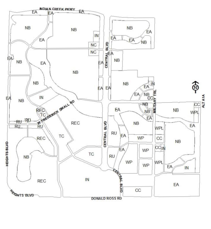
Diagram 1. Master Site Plan
(c)
Density. The maximum gross density of the MXD master site plan shall not exceed four dwelling units per acre.
(Code 1992, § 27-990.12; Ord. No. 1-95, § 7.1, 6-6-1995; Ord. No. 64-06, § 2, 1-16-2007; Ord. No. 4-13, § 7, 3-19-2013; Ord. No. 14-23, § 4, 8-15-2023)
Sec. 27-1160. - Mixed use development subdistrict use classification.
The zoning district use classifications as listed on the following pages is a comprehensive listing of uses permitted within each zoning subdistrict. Uses within each district are depicted by the following:
P - Permitted as a use by right.
P* - Permitted as a use by right only in the central common use area.
SE - Special exception.
SE* - Special exception only in the central common use area.
Blank - Prohibited use.
Any use not depicted within the tables is considered to be a prohibited use within the Mixed Use Development District (MXD) project.
Mixed Use Development District (MXD) - Subdistrict Use Regulations
See self-service storage facilities supplemental regulations (section 27-3053) for additional location restrictions.
(Code 1992, § 27-990.13; Ord. No. 1-95, § 7.2, 6-6-1995; Ord. No. 43-97, § 1, 10-21-1997; Ord. No. 44-97, § 2, 3-3-1998; Ord. No. 38-98, § 10, 11-17-1998; Ord. No. 46-98, § 4, 9-8-1998; Ord. No. 22-00, § 9, 2-20-2001; Ord. No. 45-01, § 4, 4-16-2001; Ord. No. 29-03, § 3, 10-21-2003; Ord. No. 60-04, § 3, 12-21-2004; Ord. No. 37-06, § 3, 9-19-2006; Ord. No. 46-06, § 4, 2-20-2007; Ord. No. 32-08, § 4, 9-16-2008; Ord. No. 05-10, § 2, 4-6-2010; Ord. No. 4-13, § 8, 3-19-2013; Ord. No. 39-14, § 5, 2-17-2015; Ord. No. 44-14, § 14, 2-17-2015; Ord. No. 6-18, § 2, 4-17-2018; Ord. No. 9-21, § 6, 6-15-2021)
Sec. 27-1161. - Street types.
The street types listed on the following pages are an outline of those rights-of-way permitted within the Mixed Use Development District (MXD). The rights-of-way listed are for right-of-way located only within the subdistricts. The arterial and/or collector streets is identified on the Mixed Use Development District (MXD) master site plan.
(Code 1992, § 27-990.14; Ord. No. 1-95, § 7.3, 6-6-1995)