
Keller City Zoning Code
ARTICLE Four
DEVELOPMENT PROCEDURES AND REQUIREMENTS FOR APPLICATION SUBMITTALS
Section 4.01 - Application and General Requirements
Article Four provides a simple framework for the processes of land development in the City of Keller. All land development and use within Keller's City Limits is guided by the many documents that form the City's Master Plan and regulated by the Unified Development Code, so that development will occur in a manner appropriate to the character of the city, as defined by its citizens. This section's purpose is to advise landowners, developers, architects, and engineers of the process of land development. This section contains flow charts and timelines of the processes, a list of steps involved, and a checklist of items to submit. Applications for each process are in Article Nine- Application Forms of this Code. The following general requirements shall apply to all applications under this Development Code:
A.
Authority to File Applications. Any application for development review or approval under this Development Code shall be filed by the person having legal authority to take action in accordance with the approval sought. That person is presumed to be the record owner, purchaser under a sale from the record owner, or the duly authorized agent of the record owner in the absence of satisfactory proof to the contrary. The City shall be authorized to require proof of legal authority to take the action sought. The Planning and Zoning Commission or the City Council may initiate any action under this Development Code with or without an application from the property owner.
B.
Applications. Applications required under this Article shall be submitted on forms and in such numbers as required by these regulations. Applications should be accompanied by all required documents and a nonrefundable fee established by City Council to defray the costs of processing applications. Applications shall be reviewed for completeness within five (5) days of submittal. If the City determines that the application is complete, the application shall then be processed. If the City determines that it is incomplete upon initial submittal, the City shall notify the applicant of the deficiencies. If the city determines that a resubmittal has not addressed comments provided on previous submittals, reapplication fees will be charged. Only complete applications will be accepted for review and processing. The required time frame for action by an approval body starts once a complete application and documents are submitted. An application that does not have all required documents will not be considered filed with the City and time periods for review will not begin to run until the application is complete.
C.
Inactive Development Applications. All inactive development applications including Zoning Changes, Specific Use Permits, Site Plans, Landscaping and Screening Wall Plans, and all Plats that have remained idle for a total of six (6) months shall automatically expire. The six (6) month time period will begin on the date that the most recent set of staff comments was returned to the applicant. A complete application along with the appropriate application fee shall be resubmitted in order to resume activity on an application in the development process.
D.
Application Completeness.
1.
Any application that does not include required information or that is not accompanied by the required fee shall be returned to the applicant as incomplete and no further processing of the application shall occur until the deficiencies are corrected. Fees shall not be required with applications initiated by the Planning and Zoning Commission, City Council, or City department heads.
2.
Basic fees associated with development applications are published in Article Nine - Fees.
E.
Requirements for Development.
1.
Zoning. The first step in development is zoning the property for its appropriate use. Zoning is the delineation of districts and the establishment of regulations governing the use, placement, spacing, and size of land and building. The purpose of zoning is to promote the public health, safety, morals, or general welfare and protecting and preserving places and areas of historical, cultural, or architectural importance and significance. Each Zoning District has a list of allowed uses and specifications for the size and type of building permitted. The Zoning Districts have been designed to lessen street congestion; to secure public safety from fire; to ensure adequate light and air, and prevent the overcrowding of land; to expedite the adequate provision of transportation, water, sewer, parks, and other public facilities; and to protect the natural resources that contribute to noise reduction, air quality, glare reduction, and promote the natural ecological, environmental, and aesthetic qualities of the City.
2.
Site Plans and Civil Engineered Plans. Site plans and necessary civil engineered plans must be submitted prior to the Final Plat for residential construction; the building plans, site plans, and necessary civil engineered plans shall be submitted prior to the Final Plat for non-residential construction. These plans detail the specific locations and design of public and private improvements to be installed in the subdivision or addition.
All non-single family residential construction requires a submittal of a Site Plan and full Civil Engineered Plans. This is a document that shows the development plan for one or more lots. A Site Plan may be submitted with a Preliminary Site Evaluation, however must be submitted prior to a Final Plat. Site Plans and Civil Engineered Plans show the location of proposed buildings, parking, fire lanes, fire hydrants, landscaping, access, lighting, signs (detached and directional) and public/private infrastructure needed to develop the site. Site Plan review is to ensure efficient and safe land development; harmonious use of land; compliance with appropriate design and zoning standards; safe and efficient vehicular and pedestrian circulation, parking, and loading; and adequate water supply, drainage and storm water management, sanitary facilities, and other utilities and services. Civil Engineered Plans shall be stamped, sealed, and signed as required by the Texas Board of Professional Engineers. (Amended by Ord. No. 1761 on October 6, 2015)
3.
Plats. Platting is the act of subdividing land into lots on which homes and businesses can be built. Preliminary Site Evaluations and Final Plats locate the boundaries of each lot, street, open space, easements, dedications, etc., planned for the parcel. Platting ensures orderly development patterns, and enables City Staff and the developer to plan for appropriate drainage, streets, water, and sanitary sewer facilities when the property is developed. (Amended by Ord. No. 1761 on October 6, 2015)
4.
Development Agreements. For all subdivisions or additions requiring public improvements such as streets, drainage, water, sewer facilities, or public fund participation, the developer shall enter into an agreement with the City to delineate responsibility for construction and expenditures. These agreements outline a general contractor's performance bond, contractor's maintenance bond, fees to be paid, and other information as required. This document is prepared by the Public Works Department.
5.
Building Permits. Building Permits are permission from the City for the construction, repair, or alteration of, or addition to, a structure. For residential subdivisions, Building Permits are issued after drainage, water, sewer, and street facilities have been completed and accepted, in order to ensure that the underlying infrastructure is available before building begins. For non- residential development, a Building Permit may be issued simultaneously with the infrastructure construction.
6.
Certificate of Occupancy. The final step in non-residential construction is the issuance of a Certificate of Occupancy, which allows use of a building, and certifies that it has been constructed and will be used in compliance with all municipal codes.
F.
Requirements for Phasing a Development. A development may be phased on a preliminary site evaluation or site plan by establishing phase lines and/or lot lines. Each phase shall be capable of standing alone, as development occurs and not depend on future construction to meet City standards or requirements. All required public and private improvements, as defined by this Code, shall be designed and constructed with each phase in conformance with all current applicable City standards. (Amended by Ord. No. 1761 on October 6, 2015)
Section 4.02 - Pre-Application Meeting
A.
Before submitting any development application, the applicant is encouraged to confer with the Development Review Committee (DRC) to discuss the proposal and applicable regulations. The purpose of the Pre-Application Conference is for the applicant to become familiar with applicable City procedures and standards. Following their review, the reviewing officials may confer with the applicant to discuss any matters that will assist the applicant in preparing further submittals. No review fee shall be required for Pre-Application Conferences.
B.
The Development Review Committee (DRC) meets weekly with potential applicants by appointment. All potential applicants are encouraged to meet with City Staff prior to submitting applications in order to review the application process, timing, and information submittals required. The DRC schedule may change without amending this Code.
C.
Development Review Committee Members are listed in Article Nine - Development Review Committee Members (DRC).
Section 4.03 - Zoning Change (Rezoning) Application Procedures
A.
All zoning changes are subject to Article Eight - Zoning of this Code. The zoning of all property within Keller is reflected on the City's current Zoning Map. The process described in this section applies when a property owner, his attorney, or a person who has written authorization to act for the owner, wishes to change the property's zoning. In making a determination regarding a requested zoning change, the Planning and Zoning Commission and City Council consider the following factors:
1.
Appropriateness of all the uses permitted by the proposed change for the immediate area concerned, and the relationship of the proposed uses to the general area and to the City as a whole.
2.
Agreement of the proposed change with any existing or proposed plans for providing streets, water supply, sanitary sewers, and other utilities to the area.
3.
The amount of vacant land currently classified for similar development in the City, and any special circumstances that may make a substantial part of such vacant land unavailable for development.
4.
The rate at which land in the same zoning classification has recently been developed, particularly in the vicinity of the proposed change.
5.
Effect on other areas designated for similar development if the proposed amendment is approved.
6.
Conformity with the goals and objectives for future developments within the Future Land Use Plan for the City of Keller.
7.
Any other factors which will substantially affect the health, safety, morals or general welfare of the citizens of the City of Keller.
B.
Application. The following minimum requirements shall be submitted to the Community Development Department in accordance with the Development Process Schedule (see Article Nine - Development Process Schedule):
1.
A completed application form.
2.
Application fee.
3.
The property's legal description or metes and bounds description.
4.
An exhibit showing the property.
5.
Aerial photo with overlay of plan in accordance with Article Eight - Tree Preservation, as applicable.
6.
Any drawings the applicant considers necessary to demonstrate the case for rezoning. Drawings of the site should be drawn to scale.
C.
Public Hearing Process.
1.
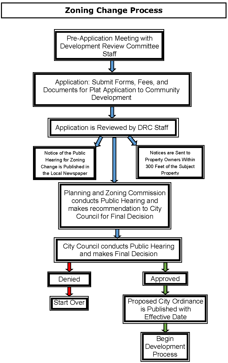
Public hearings prior to the Planning and Zoning Commission decision and the City Council decision are required for all zoning change cases in order to give citizens who may be affected by the proposed change an opportunity to voice their support or opposition. When applications are submitted, they are reviewed by the Development Review Committee (DRC). Notices of public hearing before the Planning and Zoning Commission are mailed ten (10) days prior to the Planning and Zoning Commission meeting to property owners within three hundred feet (300') of the subject property. Meanwhile, staff prepares a report to the Planning and Zoning Commission with its recommendation. This report is available to the applicant and the public on the Friday just prior to the Planning and Zoning Commission meeting at which the case will be heard. Petitioners should be fully prepared to present their request to both the Planning and Zoning Commission and the City Council immediately prior to the public hearing. After the public hearing is held at the Planning and Zoning Commission meeting, the Planning and Zoning Commission decides what recommendation it will make to City Council based on the staff report and public input.
2.
The staff report, Planning and Zoning Commission recommendation, and public response to the proposed zoning change are then made available to the public, and an additional public hearing before the City Council is scheduled following the initial hearing before the P&Z Commission. This public hearing is advertised in the newspaper fifteen (15) days before it is held. City Council Members make the final decision on the request.
3.
It is recommended that applicants prepare a brief presentation on their proposal, to be given at each public hearing. The applicants should also have maps, slides, and handouts available at the meeting. Applicants should include in their presentation:
a.
Current and proposed zoning or use.
b.
Compatibility of proposed zoning with surrounding zoning and land uses.
c.
Important physical features such as topography, roadways, or creeks.
d.
A statement of the need for the proposed zoning change.
e.
Descriptions that show in what ways the proposal is consistent with the City's Master Plan.
f.
Evidence of communicating the proposal with the adjacent neighborhood.
4.
The applicant should make the presentations, but it is recommended that the property owner, if different from the applicant, also be present at the hearing to answer questions if necessary.
D.
Types of Zoning Applications.
1.
Simple Zoning Changes. A Simple Zoning Change is one which involves a change from a Zoning District that has been approved by the Keller City Council within the Zoning section of this Code to another approved Zoning District. This request does not allow any deviations from the base zoning district. Simple Zoning Change requests require only the information listed above in Section 4.03 (B).
2.
Planned Development District. A Planned Development District (PD) is a district which accommodates planned associations of uses developed and operated as integral land use units by a single owner or a combination of owners. A land area of one acre or more may be designed as a PD as an alternative to a Simple Zoning Change request. A PD Ordinance can designate specific designs, different development standards, and combinations of uses that are unique. Uses within the PD must conform to the standards and regulations of the base zoning district to which they are most similar. Some uses are allowed in the City of Keller only with the approval of a PD designation. Additional information must be included with the initial application for a Planned Development District listed in Section 4.03 (B). Other documents that are required:
a.
A Concept Plan or Detailed Site Plan as described in Article Eight - Zoning.
b.
A written proposal describing the uses, concept, and development standards.
c.
Aerial photo with overlay of plan and a tree survey and preservation plan in accordance with Article Eight - Tree Preservation, as applicable. (Amended by Ord. No. 1818 on October 18, 2016)
d.
The Planning Manager, Planning and Zoning Commission, or City Council may require additional information or drawings, operations data, or expert evaluation when considering the application, including traffic studies and drainage studies.
e.
All plans submitted following the approval of the zoning change with attached Concept Plan or Detailed Site Plan must substantially comply with the plans submitted as part of the zoning change. Substantial deviation from the Concept Plan or Detailed Site Plan may require new public hearings.
3.
Specific Use Permits. Specific Use Permits (SUP) are approved to allow uses that with special conditions and development restrictions may be considered compatible in a district in which they are not allowed by right. The City Council, after receiving a recommendation from the Planning and Zoning Commission, may approve the permit based on its determination that the uses requested are in general conformance with the Keller Master Plan and objectives of the City, and that the SUP contains the requirements and safeguards that are necessary to protect adjoining property. In granting a SUP, the City Council may impose conditions to which the property must comply before a Certificate of Occupancy may be issued. Additional information must be included with the initial application for a Specific Use Permit as listed in Section 4.03 (B). Other documents that are required:
a.
A written proposal outlining all special conditions and additional requirements for the property controlled by the SUP.
b.
A Concept Plan or Detailed Site Plan in accordance with Article Eight - Zoning of this Code. The Planning Manager, Planning and Zoning Commission, or City Council may require additional information or drawings, operations data, or expert evaluation when considering the application.
c.
The SUP is granted to the land owner and is transferable to a new owner upon sale of the property unless specified by approving Ordinance. If the SUP is approved, the applicant must secure a Building Permit or Certificate of Occupancy within one (1) year of approval; otherwise, the SUP expires and the applicant must go through the entire process again to obtain another one if desired. A Building Permit is valid for six (6) months. If construction has not commenced following issuance of a Building Permit, the SUP expires upon expiration of the Building Permit. The applicant may request a one- time six (6) month extension, which may be approved by the Planning Manager. All applicable requirements of the SUP must be met before the building's occupancy.
E.
Required Signs. City Staff will place at least one Notification of Requested Zoning Change or Specific Use Permit sign, whichever is applicable, on the property for which the Zoning or SUP Application has been proposed ten (10) days prior to the Planning and Zoning Commission public hearing. This sign will, if at all possible, be placed adjacent to a public street. The applicant is responsible for ensuring that the sign remains on the property until the City Council's final action. City Staff will remove the sign from the property after the final action by the City Council, or upon withdrawal of the application by the applicant.
Zoning Change Process
Section 4.04 - Exemptions
A.
The following specific divisions of land do not require plat approval by the City of Keller. However, the City shall not extend utilities, provide access to public roads, or issue building permits for the development of any property that has not received Final Plat approval, except as otherwise provided by this Code.
1.
The division of land into two or more parts where all parts are larger than five acres, where each part has direct access to a public right-of-way, where no new building or improvement is proposed, and no required public improvement is to be constructed or dedicated.
2.
The creation of a leasehold for a space within a multi-occupant building or a commercial building site that does not abut a public street, or the division of property into such leaseholds, provided that the property is a part of an approved subdivision or addition and regulated in accordance with the site plan requirements of the City, and such plat has been amended as may be required to add easements or otherwise serve the leasehold. For purposes of this section, a leasehold abuts a public street if it is immediately adjacent to a public street or if it is so close to a public street that no usable property lies between the leasehold and the public street.
3.
The creation of a leasehold for agricultural use of the subject property, provided that the use does not involve the construction of a building(s) to be used as a residence or for any purpose not directly related to agricultural use of the land or crops or livestock raised thereon.
4.
The division of property through inheritance, the probate of an estate, or by a court of law.
5.
Acquisition of property by a local, state, or federal government in a condemnation, dedication, or purchase.
6.
Partition of property among co-tenants to give each owner the share of property already owned as a consequence of some prior conveyance.
7.
Common ownership of apartments, condominiums, trailer (or manufactured housing) parks, commercial and office buildings.
B.
A written request may be directed to the Community Development Department for information concerning whether a plat is required under these regulations, in accordance with Section 212.0115, as amended, of the Texas Local Government Code.
C.
The exclusion of such activities from the platting regulations does not waive any jurisdiction the City now exercises or may exercise over such matters.
Section 4.05 - Platting Applicability
A.
A Final Plat is a survey prepared in accordance with this Code and prepared by a registered land surveyor. The Plat is prepared from actual field measurement and staking of all identifiable points, with the subdivision location referenced to a survey corner. All boundaries, corners, and curves of the land division are sufficiently described so that they can be reproduced without additional references. A plat shall be required in accordance with the Local Government Code, Section 212.004 and the City of Keller's local ordinances. An approved Final Plat is required prior to issuance of a Building Permit application. This includes any permit for new construction for tracts that conform with dimensions shown in current City Tax Department records but that have not been formally platted.
B.
Platting shall be required for any division of land into two or more parcels or development on one or more contiguous parcels not previously platted, or for development that involves the construction of any public improvements to be dedicated to the City.
C.
Except for legal lots of record established prior to the effective date of this Code, no land shall be sold or transferred until the property owner has obtained approval of a Final Plat from the Planning Manager, the Planning and Zoning Commission, or City Council, as required by this Code.
D.
The City shall withhold all public improvements and utilities, including the maintenance of streets and/or sanitary sewer and water services, from all tracts, lots, or additions, the platting of which has not been officially approved by the Planning Manager, the Planning and Zoning Commission, or City Council as required by this Code.
E.
Except as provided herein, no Building Permit or Certificate of Occupancy for new structures shall be issued for any parcel or tract of land inside the city limits or Extraterritorial Jurisdiction (ETJ) until such property has received Final Plat approval and is in substantial conformity with the provisions of these regulations and no private improvements shall take place or be commenced except in conformity with these regulations.
F.
When a Platted lot is further subdivided, the entire lot of record must be Replatted. All Replats shall comply with the provisions of the Texas Local Government Code for public hearings.
G.
No Plat or Replat shall create a non-conforming use or structures according to City Regulations. If a lot or tract with existing structures is later subdivided, an Exhibit of Existing Conditions (see Section 4.06 (C.2) for requirements) may be required to ensure that the subdivision of property does not create a non-conforming use or structures.
H.
No Plat shall create a land-locked situation where any parcel is without access to public streets as described in the Texas Local Government Code.
Section 4.06 - Preliminary Site Evaluations
A Preliminary Site Evaluation is an overall preliminary development plan for a tract of land. A Preliminary Site Evaluation is intended to show the infrastructure requirements for developing property. A Preliminary Site Evaluation must be prepared by a Texas-Registered Civil Engineer.
A.
Preliminary Site Evaluation Required.
1.
A Preliminary Site Evaluation is required on all unplatted tracts:
a.
That are larger than ten (10) acres, or
b.
That do not conform with tract dimensions shown on Tarrant Appraisal District Maps, or
c.
That the development of which involves dedication or construction of streets, drainage ways, or utilities.
2.
The purpose of a Preliminary Site Evaluation is to allow the Planning and Zoning Commission and City Staff to review the property's proposed major thoroughfares and collector street patterns, land use, environmental issues, drainage patterns, availability of utilities, conformance to the Master Plan, and relationship to adjoining subdivisions or properties.
3.
A Preliminary Site Evaluation shall include all contiguous property that is under the ownership or control of the applicant. It may contain more than one phase, but each phase must contain improvements that do not depend on future construction in order to meet City standards.
B.
Application. A complete Preliminary Site Evaluation application consists of the application form, fee, five (5) collated and folded copies of the Preliminary Site Evaluation including proposed Drainage and Utility Plans, and all information listed below in Section 4.06 (C). When a complete application is submitted, the Preliminary Site Evaluation and accompanying documents are distributed to Development Review Committee (DRC) members. The Development Review Committee will review the application within fifteen (15) working days. Following review, comments and requested revisions are forwarded to the applicant. The applicant must then return revised copies along with all markups made by staff to the Community Development Department. The Development Review Committee will review the revised documents and will provide comments again within ten (10) working days. An application that does not have all required documents will not be considered filed with the City and time periods for review will not begin to run until the application is complete. Once all comments are addressed, the project will be scheduled on the Planning and Zoning Commission agenda. Preliminary Site Evaluations may be approved by the Planning and Zoning Commission if they meet all applicable requirements of this Code. Any changes, variances, or alternatives to the City's requirements must be noted on the Preliminary Plat, which can only be approved by City Council.
C.
Information to be Submitted with Preliminary Site Evaluation Applications. The review process will not begin until a Preliminary Site Evaluation that includes at least the information on the following list is submitted with a completed application form and filing fee. The applicant must submit to the Community Development Department five (5) 24" x 36" copies of the Preliminary Site Evaluation and five (5) 22" x 34" copies Proposed Utility and Drainage Plans, collated and folded to 9" x 12" paper size (see Article Nine - Plan Folding Procedures). Rolled documents will not be accepted. Scale used should be 1" = 100' or larger.
1.
Preliminary Site Evaluation sheet should contain the following information:
a.
Title block (see Article Nine - Title Blocks Formats) in lower right hand corner of site evaluation to include:
1)
Project's name.
2)
Address and/or legal description of the project, total number of lots and/or phases, total acreage, and zoning.
3)
Name, address, and telephone number of the applicant.
4)
Name, address, and telephone number of contact person of the developer.
5)
Name, address and telephone number of the preparer (Engineer).
6)
Date of preparation and dates of revisions, if any (As plats are revised, add dates of revision to each submittal).
b.
For all single-family residential subdivisions, a plan summary table to include:
1)
Total number of lots.
2)
Number of lots per zoning category.
3)
Total acreage per phase.
4)
Number of lots per phase.
5)
Minimum lot size.
6)
Minimum dwelling unit size.
7)
Density per acre.
c.
Graphic Scale labeled with scale used.
d.
North arrow oriented to the top or right of the sheet.
e.
Vicinity map of the City Base Map with scale of 1" = 1000' with site location shaded.
f.
Length and bearing of all straight lines; radii, arc length, tangent length, and central angles of all curves, indicated along the lines of each lot or in tables.
g.
Diagram of a typical corner clip and visibility easement.
h.
Cross-section of proposed streets and alleys, showing the width and type of pavement and the location and width of sidewalks.
i.
Park Dedication requirements.
j.
A list of requested variances from development requirements, if applicable.
k.
Signature block labeled: "Preliminary Site Evaluation Approved by the City of Keller Planning and Zoning Commission for the Preparation of a Final Plat" (see Article Nine - Signature Blocks for Plats).
l.
Signature block labeled: "Preliminary Site Evaluation Approved by the City of Keller City Council for the Preparation of a Final Plat" if variances are requested (see Article Nine - Signature Blocks for Plats).
m.
Names and boundary lines of abstracts and surveys of the land being platted.
n.
Description and location of all survey monuments placed or found.
o.
Lines delineating the proposed phases of development, if applicable.
p.
Property lines, including lot and block numbers and date recorded if applicable, of land within the area being platted.
q.
The layout and approximate dimensions of proposed lots and blocks, with:
1)
Front building setback lines and a note that reads, "All setbacks shall be in accordance with the zoning district, as described in the Keller Unified Development Code."
2)
Lot number and block letter designations.
3)
Acreage or square footage of each lot.
4)
Proposed use.
r.
Existing and/or proposed streets and alleys, showing proposed street names and the widths of right-of-way and pavement. Where a development abuts a street shown on the City's Thoroughfare Plan, the Preliminary Site Evaluation shall include a proposed dedication of right-of-way in accordance with the requirements of the Thoroughfare Plan.
s.
Median openings, turning lanes, acceleration lanes, deceleration lanes, and proposed driveway locations with dimensions.
t.
Traffic control signals, devices, and striping, if applicable.
u.
Other features that impact the land being platted - including, but not limited to, buildings, cemeteries, parks, landfills, and monuments.
v.
Easements, deed restrictions, or other encumbrances that impact development of the property.
w.
Names and recording information of adjoining subdivisions, municipalities, counties, special districts, and parcels of unsubdivided land, including:
1)
Names of owners of record.
2)
Boundary lines.
3)
Zoning designations.
4)
Names and accurate location of all adjacent streets.
5)
Dimensions of all abutting lots.
6)
Reference ties to courses and distances of at least one recognized land corner.
7)
Easements on all abutting lots.
x.
Land proposed for dedication to public use, or for reservation for the common use of property owners, including parks and linear trails, labeled with a separate lot and block designation. Also include a list of the conditions of or limitations on the use of this land.
y.
Traffic study and/or drainage study, if required to further clarify the needs of the project.
z.
The Planning Manager, Planning and Zoning Commission, or City Council may require additional information or drawings, operations data, or expert evaluation when considering the application, including traffic studies and drainage studies.
2.
Drainage Plan sheet showing existing and proposed systems, including:
a.
Description of the extent to which any watercourse or natural drainage will be altered or relocated as a result of the proposed development.
b.
Location of lines and inlets.
c.
Location of all existing and proposed utility and/or drainage easements, or right-of-way and detention/retention structures.
d.
Proposed drainage rights-of-way.
e.
Delineation of the 100-year floodplain, if applicable.
f.
Easements, deed restrictions, or other encumbrances that impact development of the property.
g.
Contours at intervals of two feet (2') or less, referred to the latest USC or GS sea level datum, including benchmark.
3.
Utility Plan sheet showing existing and proposed systems, including:
a.
Location and size of all existing and proposed water systems and sanitary sewer lines shown for the distance which impacts the land being platted.
b.
Location and size of other existing and/or proposed utility lines which may impact the land development.
c.
Identification of proposed lots that will be served by septic tanks, if applicable.
d.
Easements, deed restrictions, or other encumbrances that impact development of the property.
4.
Aerial photo with overlay of plan and tree survey and preservation plan in accordance with Article Eight - Tree Preservation, as applicable. (Amended by Ord. No. 1818 on October 18, 2016)
5.
UDC Variance Request as described in Section 2.08 - Procedures for Variances from the Regulations of the Code, if applicable.
D.
Approval Process for Preliminary Site Evaluations.
1.
Once all comments are addressed, the project will be scheduled on the Planning and Zoning Commission agenda. Preliminary Site Evaluations may be approved by the Planning and Zoning Commission if they meet all applicable requirements of this Code. Any changes, variances, or alternatives to the City's requirements must be noted on the Preliminary Site Evaluation, which can only be approved by City Council. Preliminary Site Evaluation applications will be scheduled for a Planning and Zoning Commission meeting if they are considered complete by Friday at noon, ten (10) days prior to the meeting. The Community Development Department must receive electronic copy and one (1) collated and folded copy on 24" x 36" paper size for the Planning and Zoning Commission meeting. Based on the Development Review Committee's review, staff will prepare a report and recommendation for the Planning and Zoning Commission. A copy of this information and an agenda for the Planning and Zoning Commission meeting at which the application will be discussed will be available to the applicant on the Friday prior to that Planning and Zoning Commission meeting. The Planning and Zoning Commission shall consider approval or approval with conditions of the Preliminary Site Evaluation that conforms to all City regulations.
2.
If alternatives or variances are requested, the Preliminary Site Evaluation will be forwarded to the City Council along with the Planning and Zoning Commission's recommendations within thirty (30) days of the last Planning and Zoning Commission meeting. In such case, the Community Development Department must receive one electronic copy and one (1) collated and folded copy on 24" x 36" paper size at least two (2) weeks prior to the City Council meeting.
3.
Alternatively, the Planning and Zoning Commission may table the request and ask the applicant to make revisions and/or provide additional information on the Preliminary Site Evaluation before it approves the site evaluation. In such cases, the Community Development Department must receive one electronic copy and one folded copy on 24" x 36" paper size at least two (2) weeks prior to the next Planning and Zoning Commission meeting. Staff will provide to the applicant a copy of the staff report and recommendations, according to the review-and-comment process described above, and the approval process will begin again.
E.
Final File Copies.
1.
Once approved, the official approved copy of the Preliminary Site Evaluation will be scanned for electronic filing with the city.
2.
Approval of a Preliminary Site Evaluation is effective for two (2) years. At the end of two (2) years, if no development or change in requirements that affects the Preliminary Site Evaluation has occurred, the applicant may request a one-time one (1) year extension which may be granted by the Planning Manager. No filing fee is required for such extensions. If an extension is not requested or if City regulations have significantly changed since the approval of the Preliminary Site Evaluation, the site evaluation or any portion that has not been constructed or has not received Final Plat approval will be deemed invalid and a new application shall be submitted for development.
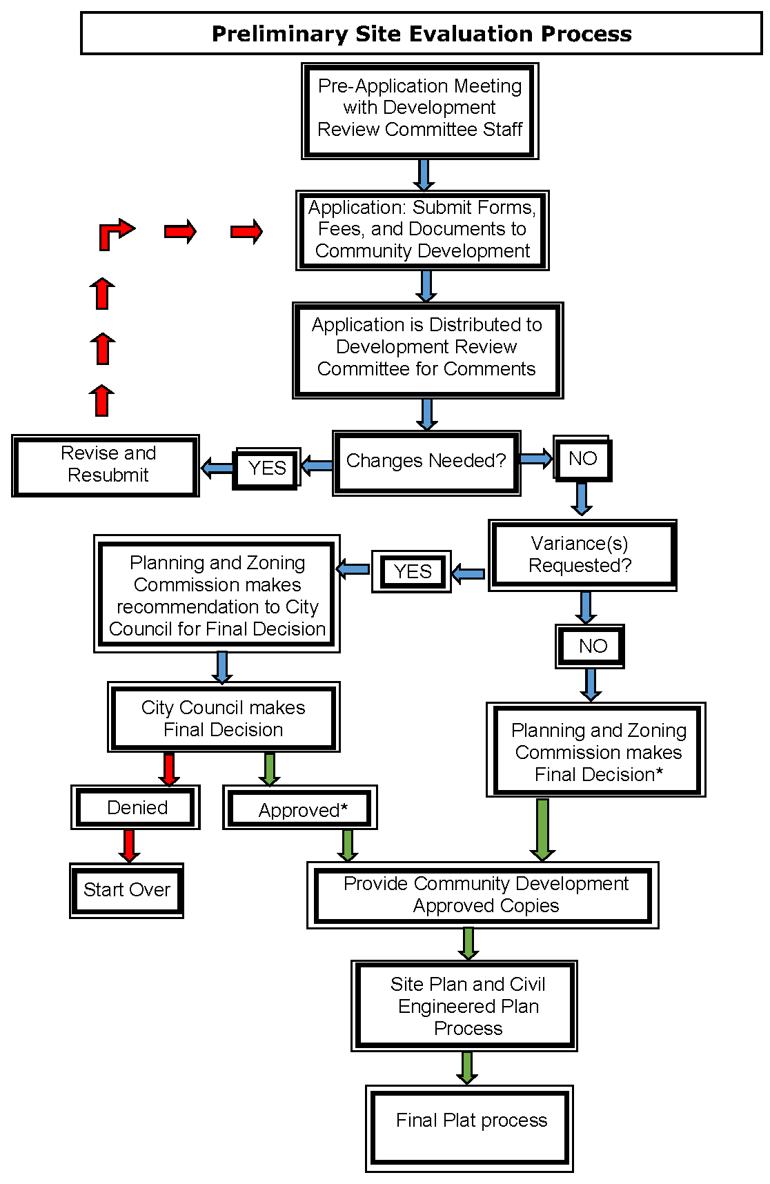
*If Approved, Preliminary Site Evaluation Expires After Two (2) Years.
Section 4.07 - Minor Subdivision Final Plats
A Minor Subdivision Plat is a Final Plat that creates no more than four lots and does not require the creation of a new street or a major extension of municipal facilities. A Preliminary Site Evaluation is not required prior to preparation of a Minor Subdivision Plat. Minor Subdivision Plats may be approved for residential and non-residential properties. The Planning Manager may approve Minor Subdivision Plats or refer them to the Planning and Zoning Commission for their action.
A.
Minor Subdivision Final Plat Requirements.
1.
A minor platting procedure is applicable if the subdivision meets the following requirements:
a.
No more than four (4) lots are contained within the subdivision plat and are fronting on an improved existing street or an approved access easement.
b.
The proposed lots meet all the requirements of the existing zoning district.
c.
The plat proposes no vacation of public rights-of-way or easements.
d.
The extensions of public facilities, such as streets or utilities, are not required for utilization of the property except for minor extensions of existing water or sewer lines (less than 300 feet), construction plans of which shall be submitted at the time of application.
e.
The proposed development does not create nor contain any drainage problem, it conforms to FEMA flood plain management rules, and it is not within the flood way.
2.
If the applicant proposes to plat less than all of its property, a preliminary site evaluation shall be required and the minor plat process shall not be used.
3.
The Planning Manager may require a Preliminary Site Evaluation prior to a Minor Subdivision Final Plat application to evaluation of site elements on a case by case basis.
B.
Application. A complete Minor Subdivision Plat application consists of the application form, fee, and five (5) collated and folded copies of the Final Plat that includes all information listed below in Section 4.07(C). When a complete application is submitted, the Final Plat and accompanying documents are distributed to Development Review Committee (DRC) members. DRC will review the application within five (5) working days. Following review, comments and requested revisions are forwarded to the applicant. The applicant must then return revised copies along with all markups made by staff to the Community Development Department. The Development Review Committee will review the revised documents and will provide comments again within ten (10) working days. An application that does not have all required documents will not be considered filed with the City and time periods for review will not begin to run until the application is complete.
C.
Information to be Submitted with Minor Subdivision Plats. The final plat application shall not be considered filed and the review process will not begin until a Final Plat that includes the complete information on the following list is submitted with a required application form and filing fee. The applicant must submit to the Community Development Department seven (7) 24" x 36" copies of the Minor Final Plat, collated and folded to 9" x 12" paper size (see Article Nine - Plan Folding Procedures). When more than one sheet is required to show a subdivision, a 24" x 36" index sheet must be filed showing the entire subdivision and all dedications, attests, dates, titles, and seals on one sheet. Rolled documents will not be accepted. Scale used should be 1" = 100' or larger.
1.
Final Plat sheet should contain the following information:
a.
Title Block (see Article Nine - Title Blocks Formats) in lower right hand corner of plat to include:
1)
Project's name.
2)
Address and/or legal description of the project, total number of lots and/or phases, total acreage and zoning.
3)
Name, address, and telephone number of the applicant.
4)
Name, address, and telephone number of contact person of the developer.
5)
Name, address, and telephone number of the preparer (Surveyor).
6)
Date of preparation and dates of revisions, if any (As plats are revised, add dates of revision to each submittal).
b.
For all single-family residential subdivisions, a plan summary table to include:
1)
Total number of lots.
2)
Number of lots per zoning category.
3)
Total acreage per phase.
4)
Number of lots per phase.
5)
Minimum lot size.
6)
Minimum dwelling unit size.
7)
Density per acre.
c.
Graphic Scale labeled with scale used.
d.
North arrow oriented to the top or right of the sheet.
e.
Vicinity map of the City Base Map with scale of 1"=1000' with site location shaded.
f.
Length and bearing of all straight lines; radii, arc length, tangent length, and central angles of all curves, indicated along the lines of each lot or in tables.
g.
Diagram of a typical corner clip and visibility easement.
h.
Park Dedication requirements.
i.
A list of variances from development requirements, if applicable.
j.
Signature block labeled: "Approved by the City of Keller Community Development Department" (see Article Nine - Signature Blocks for Plats).
k.
Signature block labeled: "Approved by the City of Keller Planning and Zoning Commission" (see Article Nine - Signature Blocks for Plats).
l.
Signature block labeled: "Approved by the City of Keller City Council" (see Article Nine - Signature Blocks for Plats).
m.
The following statement when City sewer will not be utilized: "This subdivision is subject to all of the terms and conditions of Tarrant County Commissioner Court Order Number 42703 (Sewage Regulations). Prior to the issuance of a building permit, a license must be obtained by the owner for any private sewage facility (septic tank or aerobic system) to be constructed in the subdivision. A sewage disposal plan will be filed with Tarrant County and areas suitable for septic tanks or aerobic systems will be defined."
n.
An Owner's Certificate stating the following:
OWNER'S CERTIFICATE
STATE OF TEXAS
COUNTY OF TARRANT
WHEREAS, John Doe and Jane Doe are the Owner(s) of a tract of land situated in the (Survey Name), Abstract Number (Survey Number), Tarrant County, Texas and being that same tract of land described in (Name and Recording Information), and being more particularly described by metes and bounds as follows:
(Metes and bounds description of subdivision with exact acreage and the volume and page of the County Deed Records of the deed for the land being platted and description and location of all survey monuments placed or found)
NOW THEREFORE, KNOW ALL MEN BY THESE PRESENTS:
That we, John Doe and Jane Doe, Owners, do hereby adopt this plat designating the hereinabove described property as (Plat Name, include lot and blocks), an addition to the City of Keller and do hereby dedicate to the public use forever the streets and alleys shown thereon and do hereby reserve the easement strips shown on this plat for the mutual use and accommodation of garbage collection agencies and all public utilities desiring to use or using same. Any public utility shall have the right to remove and keep removed all or part of any buildings, fences, or other improvements which in any way endanger or interfere with the construction, maintenance, or efficiency of its respective systems on any of these easement strips and any public utility shall at all times have the right of ingress and egress to and from and upon the said easement strips for the purpose of constructing, reconstructing, inspecting, and patrolling, without the necessity at any time of procuring the permission of anyone. Trees and shrubs further than five- feet from the utility lines shall remain. This plat approved subject to all platting ordinances, rules, regulations, and resolutions of the City of Keller, Texas.
Witness our hands at Tarrant County, Texas, this _____ day of ___________.
___________ ___________
John Doe, Owner Jane Doe, Owner
o.
Notary Public's Certificate with a signature line, the Notary Public's stamp, and stating the following:
STATE OF TEXAS COUNTY OF TARRANT
Before me, the undersigned authority, a Notary Public in and for said County and State on this date personally appeared John Doe and Jane Doe, Owners, known to me to be the persons whose names are subscribed to the foregoing instrument and acknowledged to me that they each executed the same for the purpose and considerations therein expressed.
Given under my hand and seal of office, this _____ day of ___________.
___________
Notary Public in and for the State of Texas
p.
Surveyor's Certificate with a signature line, the Surveyor's seal, and stating the following:
KNOW ALL MEN BY THESE PRESENTS:
That I, [Surveyor's Name], do hereby certify that I prepared this plat from an actual and accurate survey of the land and that the corner monuments shown thereon as set were properly placed under my personal supervision in accordance with the platting rules and regulations of the City of Keller, Texas.
___________
Registered Professional Land Surveyor
q.
Names and boundary lines of abstracts and surveys of the land being platted.
r.
Lines delineating the proposed phases of development, if applicable.
s.
The layout and exact dimensions of proposed lots and blocks, with:
1)
Front building setback lines and a note that reads, "All setbacks shall be in accordance with the zoning district, as described in the Keller Unified Development Code."
2)
Lot number and block letter designations.
3)
Acreage or square footage of each lot and minimum finished floor elevation (minimum finished floor elevation is required only if lot is located within 100-year floodplain or near natural drainage feature).
t.
Land proposed for dedication to public use or for reservation for the common use of property owners, labeled with a separate lot and block designation. Also include a list of the conditions of or limitations on the use of this land.
u.
Deed restrictions or other encumbrances that impact development of the property.
v.
Rights-of-way and public property to be abandoned should be identified on the plat, but information is to be provided separately for the creation of an abandonment certificate (see Section 4.12 - Abandonment of Easements or Rights-of-Way for procedures).
w.
Existing and/or proposed streets and alleys, showing street names and the widths of rights-of-way and pavement. Where a development abuts a street shown on the City's Thoroughfare Plan, the Final Plat must include the dedication of rights-of-way in accordance with the requirements of the Thoroughfare Plan.
x.
Location and size of all existing and proposed utility, access, and/or drainage easements for electric, telephone, gas, cable, and solid waste disposal, with a note regarding responsibility for maintenance.
y.
Delineation of the 100-year floodplain, if applicable.
z.
Names and recording information of adjoining subdivisions, municipalities, counties, special districts, and parcels of unsubdivided land, including:
1)
Names of owners of record.
2)
Boundary lines.
3)
Zoning designations.
4)
Names and accurate location of all adjacent streets.
5)
Dimensions of all abutting lots.
6)
Reference ties to courses and distances of at least one recognized land corner.
aa.
The Planning Manager, Planning and Zoning Commission, or City Council may require additional information or drawings, operations data, or expert evaluation when considering the application, including traffic studies and drainage studies.
2.
Exhibit of Existing Conditions sheet showing existing and proposed systems, including:
a.
Location of all existing above-ground structures, driveways, sheds, fences, etc., if applicable.
b.
Location and size of all existing and proposed utility, access, and/or drainage easements, with a note regarding responsibility for maintenance.
c.
Location and size of all other utilities existing and/or proposed, underground or overhead, including private transmission lines.
d.
Location and size of all public and private service lines and meters for water and sanitary sewer or septic tanks, if applicable.
e.
Location and distance of nearest existing fire hydrant.
f.
Proposed grading, and a description of the extent to which any watercourse or natural drainage will be altered or relocated as a result of the proposed development.
g.
Delineation of the 100-year floodplain, if applicable.
3.
A drainage study shall be provided for each development in accordance with Article Five - Design and Technical Construction Standards (DTCS). The study shall be provided to ensure that all upstream and downstream watershed components are accounted for and will not be adversely impacted. The study shall include a pre-development versus post development runoff analysis and a storm water runoff routing analysis designed to predict the post development runoff rate and the downstream drainage system ability to accommodate post development runoff.
4.
Tree survey and aerial photo with overlay of plan and tree survey and preservation plan in accordance with Article Eight - Tree Preservation, as applicable. (Amended by Ord. No. 1818 on October 18, 2016)
5.
UDC Variance Request as described in Section 2.07 - Procedures for Variances from the Regulations of the Code, if applicable.
D.
Approval Process For Minor Subdivision Final Plats.
1.
The Planning Manager may approve a Minor Subdivision Final Plat if it meets all requirements of this Code. The Planning Manager shall make final approval or disapproval of a Minor Subdivision Final Plat application within thirty (30) days of a complete application filing. The Planning Manager's decision may be appealed to the Planning and Zoning Commission and City Council.
2.
Based on the Development Review Committee's review, staff will prepare a report and recommendation for the Planning and Zoning Commission and/or City Council if variances are requested. A copy of this information and an agenda for the Planning and Zoning Commission and/or City Council meeting at which the application will be discussed will be available to the applicant on the Friday prior to that Planning and Zoning Commission and/or City Council meeting. The Planning and Zoning Commission and/or City Council votes on approval, approval with conditions, or disapproval.
E.
Final File Copies.
1.
The applicant must provide to the Community Development Department one (1) 24" x 36" of each blackline and mylar copies of the Final Plat exactly as it was approved by the City, complete with owner's signatures with notarization and the surveyor's signature and seal. One of the copies will be filed with Tarrant County Plat Records, and the other copy will be kept on file with the City. A Development Agreement for the development or a Building Permit shall not be executed if the mylar copies of the approved Final Plat have not been provided to the City. An electronic format of the plat, in AutoCAD version for GIS purposes must also be submitted with the final mylar copies (see Article Nine - Keller CAD Standards for CAD plat requirements).
2.
Additionally, the applicant must provide current certified original tax receipts on all properties being platted. These are required by state law in order to file the plat with Tarrant County. The Applicant is also responsible for the filing fees to file the plat with Tarrant County. Addresses will be assigned for each lot once the plat is recorded with Tarrant County.
3.
Approval of a Minor Subdivision Final Plat is effective for two (2) years. At the end of two (2) years, if the Minor Subdivision Final Plat has not been filed with Tarrant County, the plat will be deemed expired and the applicant/developer must go through the entire Minor Subdivision Final Plat process again to obtain another one if desired.
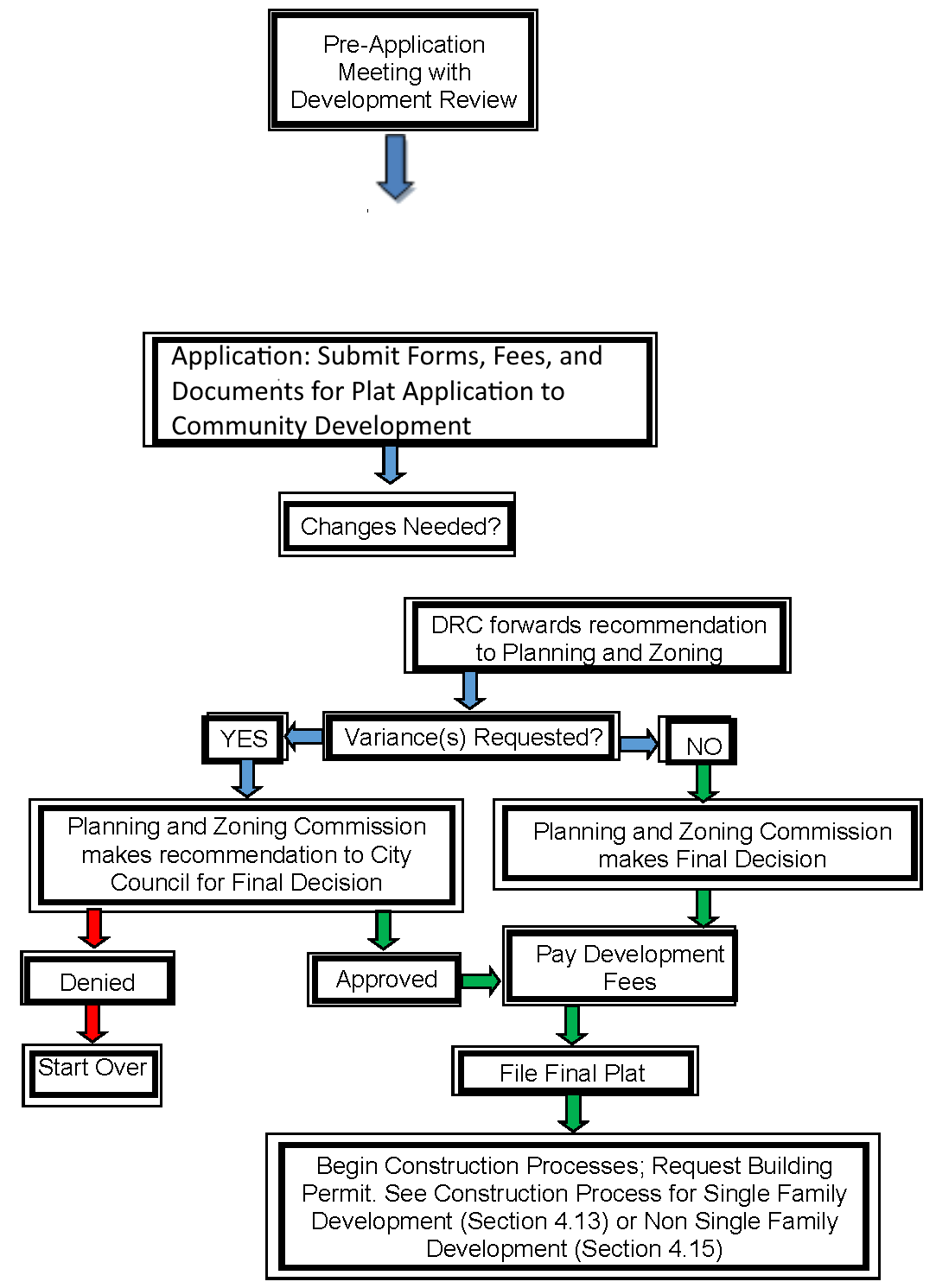
Section 4.08 - Major Subdivision Final Plats
A.
Major Subdivision Final Plat Requirements.
1.
Major Subdivision Final Plat involves the creation of new streets, the extension of municipal facilities or the creation or more than four lots. Major Subdivision plat may be applicable for residential and non-residential properties. The procedure for approving a major subdivision plat shall require an approved Preliminary Site Evaluation, approved site plan, and approved civil engineered plans (see Section 4.13 or Section 4.15, as applicable).
2.
Major Subdivision Final Plats shall substantially conform with approved Preliminary Site Evaluations, or a revised Preliminary Site Evaluation shall first be submitted for formal approval. The Major Subdivision Final Plat shall include a complete set of approved site plan and approved civil engineered construction plans for all public improvements.
3.
Except as otherwise permitted, the Planning and Zoning Commission's approval of a final plat is required prior to the construction of public improvements on the property.
B.
Application. A complete Major Subdivision Final Plat application consists of the application form, fee, seven (7) collated and folded copies of the Final Plat along with three (3) sets of approved, Detailed Site Plan and Engineering Construction Plans at 22" x 34" page size (when applicable - See Section 4.13 for requirements), and all information listed below in Section 4.08(C). Detailed construction plans may be rolled. When a complete application is submitted, the Final Plat and accompanying documents are distributed to Development Review Committee (DRC) members. The Development Review Committee has five (5) working days to review the application. Following review, comments and requested revisions are forwarded to the applicant. The applicant must then return revised copies along with all markups made by staff to the Community Development Department. The Development Review Committee will review the revised documents and provide comments again within ten (10) working days.
C.
Information to be Submitted with Major Subdivision Final Plats. The final plat application shall not be considered filed and the review process will not begin until a Plat that includes at least the information on the following list is submitted with a completed application form and filing fee. The applicant must submit to the Community Development Department seven (7) 24" x 36" copies of the Plat, collated and folded to 9" x 12" paper size (see Article Nine - Plan Folding Procedures). When more than one sheet is required to show a subdivision, a 24" x 36" index sheet must be filed showing the entire subdivision and all dedications, attests, dates, titles, and seals on one sheet. Rolled documents will not be accepted. Scale used should be 1" = 100' or larger.
1.
Final Plat sheet should contain the following information:
a.
Title Block (see Article Nine - Title Blocks Formats) in lower right hand corner of plat to include:
1)
Project's name.
2)
Address and/or legal description of the project, total number of lots and/or phases, total acreage and zoning.
3)
Name, address, and telephone number of the applicant.
4)
Name, address, and telephone number of contact person of the developer.
5)
Name, address, and telephone number of the preparer (Surveyor).
6)
Date of preparation and dates of revisions, if any (As plats are revised, add dates of revision to each submittal).
b.
For all single-family residential subdivisions, a plan summary table to include:
1)
Total number of lots.
2)
Number of lots per zoning category.
3)
Total acreage per phase.
4)
Number of lots per phase.
5)
Minimum lot size.
6)
Minimum dwelling unit size.
7)
Density per acre.
c.
Graphic Scale labeled with scale used.
d.
North arrow oriented to the top or right of the sheet.
e.
Vicinity map of the City Base Map with scale of 1"=1000' with site location shaded.
f.
Length and bearing of all straight lines; radii, arc length, tangent length, and central angles of all curves, indicated along the lines of each lot or in tables.
g.
Diagram of a typical corner clip and visibility easement.
h.
A note that a Park Dedication Agreement exists, if applicable.
i.
A list of variances from development requirements, if applicable.
j.
Signature block labeled: "Approved by the City of Keller Planning and Zoning Commission" (see Article Nine - Signature Blocks for Plats).
k.
Signature block labeled: "Approved by the City of Keller City Council" if variance is requested (see Article Nine - Signature Blocks for Plats).
l.
The following statement when City sewer will not be utilized: "This subdivision is subject to all of the terms and conditions of Tarrant County Commissioner Court Order Number 42703 (Sewage Regulations). Prior to the issuance of a building permit, a license must be obtained by the owner for any private sewage facility (septic tank or aerobic system) to be constructed in the subdivision. A sewage disposal plan will be filed with Tarrant County and areas suitable for septic tanks or aerobic systems will be defined."
m.
An Owner's Certificate stating the following:
OWNER'S CERTIFICATE
STATE OF TEXAS
COUNTY OF TARRANT
WHEREAS, John Doe and Jane Doe are the Owner(s) of a tract of land situated in the (Survey Name), Abstract Number (Survey Number), Tarrant County, Texas and being that same tract of land described in (Name and Recording Information), and being more particularly described by metes and bounds as follows:
(Metes and bounds description of subdivision with exact acreage and the volume and page of the County Deed Records of the deed for the land being platted and description and location of all survey monuments placed or found)
NOW THEREFORE, KNOW ALL MEN BY THESE PRESENTS:
That we, John Doe and Jane Doe, Owners, do hereby adopt that plat designating the hereinabove described property as (Plat Name, include lot and blocks), an addition to the City of Keller and do hereby dedicate to the public use forever the streets and alleys shown thereon and do hereby reserve the easement strips shown on this plat for the mutual use and accommodation of garbage collection agencies and all public utilities desiring to use or using same. Any public utility shall have the right to remove and keep removed all or part of any buildings, fences, or other improvements which in any way endanger or interfere with the construction, maintenance or efficiency of its respective systems on any of these easement strips and any public utility shall at all times have the right of ingress and egress to and from and upon the said easement strips for the purpose of constructing, reconstructing, inspecting, and patrolling, without the necessity at any time of procuring the permission of anyone. Trees and shrubs further than five- feet from the utility lines shall remain. This plat approved subject to all platting ordinances, rules, regulations, and resolutions of the City of Keller, Texas.
Witness our hands at Tarrant County, Texas, this _____ day of ___________.
___________ ___________
John Doe, Owner Jane Doe, Owner
n.
Notary Public's Certificate with a signature line, the Notary Public's stamp, and stating the following:
STATE OF TEXAS
COUNTY OF TARRANT
Before me, the undersigned authority, a Notary Public in and for said County and State on this date personally appeared John Doe and Jane Doe, Owners, known to me to be the persons whose names are subscribed to the foregoing instrument and acknowledged to me that they each executed the same for the purpose and considerations therein expressed.
Given under my hand and seal of office, this _____ day of ___________.
___________
Notary Public in and for the State of Texas
o.
Surveyor's Certificate with a signature line, the Surveyor's seal, and stating:
KNOW ALL MEN BY THESE PRESENTS:
That I, [Surveyor's Name], do hereby certify that I prepared this plat from an actual and accurate survey of the land and that the corner monuments shown thereon as set were properly placed under my personal supervision in accordance with the platting rules and regulations of the City of Keller, Texas.
___________
Registered Professional Land Surveyor
p.
Names and boundary lines of abstracts and surveys of the land being platted.
q.
Lines delineating the proposed phases of development, if applicable.
r.
The layout and exact dimensions of proposed lots and blocks, with:
1)
Front building setback lines and a note that reads, "All setbacks shall be in accordance with the zoning district, as described in the Keller Unified Development Code."
2)
Lot number and block letter designations.
3)
Acreage or square footage of each lot and minimum finished floor elevation (minimum finished floor elevation is required only if lot is located within 100-year floodplain or near natural drainage feature).
s.
Land proposed for dedication to public use or for reservation for the common use of property owners, labeled with a separate lot and block designation. Also include a list of the conditions of or limitations on the use of this land.
t.
Deed restrictions or other encumbrances that impact development of the property.
u.
Rights-of-way and public property to be abandoned should be identified on the plat, but information is to be provided separately for the creation of an abandonment certificate (see Section 4.12 - Abandonment of Easements or Rights-of-Way for procedures).
v.
Existing and/or proposed streets and alleys, showing street names and the widths of rights-of-way and pavement. Where a development abuts a street shown on the City's Thoroughfare Plan or a proposed Thoroughfare is within the development, the Final Plat shall include the dedication of rights-of-way in accordance with the requirements of the Thoroughfare Plan.
w.
Location of all existing and proposed utility, access, and/or drainage easements, with a note regarding responsibility for maintenance.
x.
Delineation of the 100-year floodplain, if applicable.
y.
Names and recording information of adjoining subdivisions, municipalities, counties, special districts, and parcels of unsubdivided land, including:
1)
Names of owners of record.
2)
Boundary lines.
3)
Zoning designations.
4)
Names and accurate location of all adjacent streets.
5)
Dimensions of all abutting lots.
6)
Reference ties to courses and distances of at least one recognized and corner.
z.
The Planning Manager, Planning and Zoning Commission, or City Council may require additional information or drawings, operations data, or expert evaluation when considering the application, including traffic studies and drainage studies.
2.
Exhibit of Existing Conditions (if Construction Plans are not required) showing the following:
a.
Location of all existing and proposed utility, access, and/or drainage easements, with a note regarding responsibility for maintenance.
b.
Proposed grading, and a description of the extent to which any watercourse or natural drainage will be altered or relocated as a result of the proposed development.
c.
Delineation of the 100-year floodplain, if applicable.
d.
Location of all public and private service lines for natural gas, water, sanitary sewer or septic tanks, and other buried utilities, if applicable. (Amended by Ord. No. 1818 on October 18, 2016)
3.
Tree survey and aerial photo with overlay of plan and tree survey and preservation plan in accordance with Article Eight - Tree Preservation, as applicable.
4.
UDC Variance Request as described in Section 2.08 - Procedures for Variances from the Regulations of the Code, if applicable.
D.
Approval Process for Major Subdivision Final Plats.
1.
Major Subdivision Final Plat applications will be scheduled for a Planning and Zoning Commission meeting once approved by the DRC. The Community Development Department must receive one (1) electronic copy and one (1) collated and folded copy on 24" x 36" paper size for the Planning and Zoning Commission meeting. Based on the Development Review Committee's review, staff will prepare a report and recommendation for the Planning and Zoning Commission. A copy of this information and an agenda for the Planning and Zoning Commission meeting at which the application will be discussed is available to the applicant on the Friday prior to that Planning and Zoning Commission meeting. The Planning and Zoning Commission shall consider approval or approval with conditions of the Major Subdivision Final Plat that conforms to all City regulations.
2.
If alternatives or variances are requested, the Major Subdivision Final Plat shall be forwarded to the City Council along with the Planning and Zoning Commission's recommendations within thirty (30) days of the last Planning and Zoning Commission meeting. In such case, the Community Development Department must receive one (1) electronic copy at least two (2) weeks prior to the City Council meeting.
E.
Final File Copies.
1.
The applicant must provide to the Community Development Department one (1) 24" x 36" of each blackline and mylar copies of the Final Plat exactly as it was approved by the City, complete with owner's signatures with notarization and surveyor's signature and seal. One of the blackline mylars will be filed with Tarrant County Deed Records. The other will be kept on file with the City. A Development Agreement for the development may not be executed if the mylar copies of the approved Final Plat have not been provided to the City. An electronic format of the plat, in AutoCAD version for GIS purposes must also be submitted with the final mylar copies (see Article Nine - Keller CAD Standards for CAD plat requirements).
2.
Additionally, the applicant must provide current certified original tax receipts on all properties being platted. These are required by state law in order to file the plat with Tarrant County. The Applicant is also responsible for the filing fees to file the plat with Tarrant County. The Community Development Department will assign addresses for each lot once the plat is recorded with Tarrant County.
3.
Approval of a Major Subdivision Final Plat is effective for two (2) years. At the end of two (2) years, if the Major Subdivision Final Plat has not been filed with Tarrant County, the plat will be deemed expired and the applicant/developer must go through the entire process again to obtain another one if desired.
Site and Civil Engineered Plans must be approved prior to submittal.
If Approved Final Plat Expires After Two (2) Years, if not filed.
Section 4.09 - Amending Plats
Amending Plats can be filed to correct an error in the real property description on part of all of an officially recorded Plat. Amending plats can be filed only to correct the errors specifically listed in Section 212.016 of Texas Local Government Code.
A.
Amending Plat Requirements. An Amending Plat shall meet all of the informational requirements set forth for a Final Plat in Section 4.07 (C). The Planning Manager may approve and issue an Amending Plat, which may be recorded and is controlling over the preceding or final plat without vacation of that plat, if the amending plat is signed by the applicants only and is solely for one or more of the following purposes:
1.
Correcting an error in a course or distance shown on the preceding plat.
2.
Adding a course or distance that was omitted on the preceding plat.
3.
Correcting an error in a real property description shown on the preceding plat.
4.
Indicating monuments set after the death, disability, or retirement from practice of the engineer or surveyor responsible for setting monuments.
5.
Showing the location or character of a monument that has been changed in location or character or that is shown incorrectly as to location or character on the preceding plat.
6.
Correcting any other type of scrivener or clerical error or omission previously approved by the municipal authority responsible for approving plats, including lot numbers, acreage, street names, and identification of adjacent recorded plats.
7.
Correcting an error in courses and distances of lot lines between two adjacent lots if:
a.
Both lot owners join in the application for amending the plat. b. Neither lot is abolished.
c.
The amendment does not attempt to remove recorded covenants or restrictions.
d.
The amendment does not have a material adverse effect on the property rights of the owners in the plat.
8.
Relocating a lot line to eliminate an inadvertent encroachment of a building or other improvement on a lot line or easement.
9.
Relocating one or more lot lines between one or more adjacent lots if:
a.
The owners of all those lots join in the application for amending the plat.
b.
The amendment does not attempt to remove recorded covenants or restrictions. c. The amendment does not increase the number of lots.
10.
To make necessary changes to the preceding plat to create six or fewer lots in the subdivision or a part of the subdivision covered by the preceding plat if:
a.
the changes do not affect applicable zoning and other regulations of the municipality;
b.
the changes do not attempt to amend or remove any covenants or restrictions; and b. the area covered by the changes is located in an area that the municipal planning commission or other appropriate governing body of the municipality has approved, after a public hearing, as a residential improvement area; or
11.
To replat one or more lots fronting on an existing street if:
a.
the owners of all those lots join in the application for amending the plat;
b.
the amendment does not attempt to remove recorded covenants or restrictions;
c.
the amendment does not increase the number of lots; and
d.
the amendment does not create or require the creation of a new street or make necessary the extension of municipal facilities.
12.
Notice, a public hearing, and the approval of other lot owners are not required for the approval and issuance of an amending plat.
B.
Approval Process for Amending Plats. Other than noted above, the procedure for approval of plat amendment(s) shall be the same as for approval of a Minor Subdivision Final Plats seen in Section 4.07 (D).
C.
Final File Copies.
1.
Within thirty (30) days of the Amended Plat's approval by the Planning Manager, the applicant must provide to the Community Development Department one (1) 24" x 36" of each blackline and mylar copies of the Final Plat exactly as it was approved by the City, complete with owner's signatures with notarization and surveyor's signature and seal. One of the blackline mylars will be filed with Tarrant County Deed Records. The other will be kept on file with the City. A Development Agreement for the development may not be executed if the mylar copies of the approved Final Plat have not been provided to the City. An electronic format of the plat, in AutoCAD version for GIS purposes must also be submitted with the final mylar copies (see Article Nine - Keller CAD Standards for CAD plat requirements).
2.
Additionally, the applicant must provide current certified original tax receipts on all property being platted. These are required by state law in order to file the plat with Tarrant County. The Applicant is also responsible for the filing fees to file the plat with Tarrant County. Addresses will be assigned for each lot once the plat is recorded with Tarrant County.
3.
Approval of an Amended Plat is effective for two (2) years. At the end of two (2) years, if the Amended Plat has not been filed with Tarrant County, the plat will be deemed expired and the applicant/developer must go through the entire process again to obtain another one if desired.
Section 4.10 - Replats
A.
A Replat replaces part or all of an officially recorded Final Plat. Requirements for the replatting process are the same as the process for approval of a Final Plat. A public hearing may be required for replatting in accordance with Section 212.014 and 212.015 of Texas Local Government Code.
B.
Replats involving four (4) or fewer lots fronting on an existing street and not requiring the creation of any new street or the extension of municipal facilities shall meet the submittal requirements of a Minor Subdivision Final Plat in Section 4.07 of this Code and may be subject to a public hearing. All other Replats shall meet the requirements of a Major Subdivision Final Plat in Section 4.08 of this Code and may be subject to a public hearing.
C.
Information to be Submitted with Replats.
1.
Information to be included on Replats is the same as that required for a Final Plat in Section 4.07 (C). No Preliminary Site Evaluation is required when property is replatted except in the case of Replats that create major changes in infrastructure requirements for a subdivision.
2.
The Replat of a subdivision shall meet all current requirements of this Code.
3.
The title shall identify the document as "Lots, being a Replat of Lots of Block of the (Name of Addition) Subdivision" as seen in Article Nine - Title Blocks Formats.
D.
Final File Copies.
1.
Within thirty (30) days of the Replat's approval by the Director of Community Development, Planning and Zoning Commission and/or City Council, the applicant must provide to the Community Development Department, one (1) 24" x 36" each black line paper and Mylar copy of the Final Plat exactly as it was approved by the City, complete with owner's signatures with notarization and surveyor's signature and seal. The blackline paper copy will be filed with Tarrant County Deed Records. The mylar copy will be kept on file with the City. The applicant shall provide proof of filing the plat by submitting the Plat Filing Receipt to the Community Development Department within two weeks of filing the Replat with the Tarrant County Appraisal District. A Developer Agreement for the development may not be executed if the mylar copy of the approved Final Plat has not been provided to the City. An electronic format of the plat shall also be submitted with the final mylar copy (see Article Nine - Keller CAD Standards for CAD plat requirements).
2.
Additionally, the applicant must provide current certified original tax receipts on all properties being platted. These are required by state law in order to file the plat with Tarrant County. The Applicant is also responsible for the filing fees to file the plat with Tarrant County. Addresses will be assigned for each lot once the plat is recorded with Tarrant County.
3.
Approval of a Replat is effective for two (2) years. At the end of two (2) years, if the Replat has not been filed with Tarrant County, the plat will be deemed expired and the applicant/developer must go through the entire process again to obtain another one if desired.
(Ord. No. 2095, § 2(Exh. A), 10-4-22)
Section 4.11 - Vacation of Plats
Vacation procedure shall be followed as set forth in Chapter 212, Section 212.013 of the Texas Local Government Code.
A.
The owners of a tract covered by a plat may vacate the plat at any time before any lot in the plat is sold. The plat is vacated when a signed, acknowledged instrument declaring the plat vacated is approved and recorded in the manner prescribed for the original plat.
B.
If lots in the plat have been sold, the plat, or any part of the plat, may be vacated on the application of all the owners of lots in the plat with approval obtained in the manner prescribed for the original plat.
C.
A Vacating Plat shall meet all of the informational requirements set forth for a Final Plat in Section 4.07 (C). Each lot vacated shall be clearly marked with the word "VACATED" boldly printed across the lot on the plat.
D.
Final File Copies.
1.
Within thirty (30) days of the Vacating Plat's approval by the Planning Manager, the applicant must provide to the Community Development Department one (1) 24" x 36" of each blackline and mylar copies of the Final Plat exactly as it was approved by the City, complete with owner's signatures with notarization and surveyor's signature and seal. One of the blackline mylars will be filed with Tarrant County Deed Records. The other will be kept on file with the City. A Development Agreement for the development may not be executed if the mylar copies of the approved Final Plat have not been provided to the City. An electronic format of the plat, in AutoCAD version for GIS purposes must also be submitted with the final mylar copies (see Article Nine - Keller CAD Standards for CAD plat requirements).
2.
Additionally, the applicant must provide current certified original tax receipts on all property being platted. These are required by state law in order to file the plat with Tarrant County. The Applicant is also responsible for the filing fees to file the plat with Tarrant County. Addresses will be assigned for each lot once the plat is recorded with Tarrant County.
Section 4.12 - Abandonment of Easements or Rights-of-Way
The abandonment of easements and rights-of-way that are determined to be unnecessary by the City may be approved by a Certificate of Abandonment. Any dedicated or recorded easement shall be abandoned in the same manner as it was dedicated, either by Final Plat or by Separate Instrument. All supporting documents including exhibits and fees shall be submitted prior to approval of the Certificate (see Article Nine - Fees and Application Forms).
A.
Abandonment of Easements or Rights-of-Way Requirements.
1.
An abandonment procedure is applicable if the legal lot or record, as defined by this Code, or subdivision meet the following requirements:
a.
The proposed lot(s) meet all the requirements of the existing zoning district.
b.
The proposed abandonment does not create nor contain any drainage problem, it conforms to FEMA flood plain management rules, and it is not within the flood way.
2.
A pre-application meeting with City Staff is encouraged if the applicant plans to request an Abandonment of Easements or Rights-of-Way Process.
3.
Any dedicated or recorded easement to be abandoned by plat will follow replat procedures.
4.
Any dedicated or recorded easement to be abandoned by separate instrument, will follow process outlined below.
B.
Application.
1.
A complete Certificate of Abandonment application consists of the application form, fee, letters of acceptance from private utility companies, and three (3) copies of the Abandonment exhibit that includes all information listed below in Section 4.11 (C). When a complete application is submitted, the Easements or Rights-of-Way Abandonment and accompanying documents are distributed to Development Review Committee (DRC) members. DRC has fifteen (15) working days to review the application. Following review, comments and requested revisions are forwarded to the applicant. The applicant must then return revised copies along with those marked by staff to the Community Development Department. The Development Review Committee will review the revised documents and provide comments again within ten (10) working days. The applicant is responsible for providing any necessary letters of verification of utility company review and Easement or Rights-of-Way abandonment approvals from electric, telephone, gas, cable, and other applicable companies that may affect this easement(s) or rights-of-way.
C.
Information to be Submitted with Certificate of Abandonments. The review process will not begin until an Abandonment exhibit that includes at least the information on the following list is submitted with a completed application form, filing fee, and letters of acceptance from private utility companies. The applicant must submit to the Community Development Department three (3) 8-1/2" x 11" or 8-1/2" x 14" copies of the Abandonment exhibit. Scale used should be 1" = 100' or larger.
1.
Title Block in lower right hand corner of Abandonment Exhibit to include:
a.
Project's name.
b.
Address and/or legal description of the project, total acreage and zoning.
c.
Name, address, and telephone number of the preparer (Surveyor).
d.
Date of preparation and dates of revisions, if any (As exhibits are revised, add dates of revision to each submittal).
2.
Graphic Scale labeled with scale used.
3.
North arrow oriented to the top or right of the sheet.
4.
Metes and bounds description of the property to be abandoned.
5.
Surveyor's Certificate with a signature line, the Surveyor's seal, and stating:
"This is to certify that this abandonment exhibit is an accurate representation of an actual survey made on the ground under my supervision of the described tract and the boundary lines, corners, and dimensions shown are as indicated."
___________
Registered Professional Land Surveyor
6.
An Owner's Certificate stating the following:
OWNER'S CERTIFICATE
STATE OF TEXAS
COUNTY OF TARRANT
WHEREAS, John Doe and Jane Doe are the Owner(s) of a tract of land situated in the (Survey Name), Abstract Number (Survey Number), Tarrant County, Texas and being that same tract of land described in (Name and Recording Information), and being more particularly described by metes and bounds as follows:
(Metes and bounds description of subdivision with exact acreage and the volume and page of the County Deed Records of the deed for the land being platted and description and location of all survey monuments placed or found)
NOW THEREFORE, KNOW ALL MEN BY THESE PRESENTS:
That we, John Doe and Jane Doe, Owners, do hereby adopt this plat designating the hereinabove described property as (Plat Name, include lot and blocks), an addition to the City of Keller and do hereby dedicate to the public use forever the streets and alleys shown thereon and do hereby reserve the easement strips shown on this plat for the mutual use and accommodation of garbage collection agencies and all public utilities desiring to use or using same. Any public utility shall have the right to remove and keep removed all or part of any buildings, fences, , or other improvements which in any way endanger or interfere with the construction, maintenance, or efficiency of its respective systems on any of these easement strips and any public utility shall at all times have the right of ingress and egress to and from and upon the said easement strips for the purpose of constructing, reconstructing, inspecting, and patrolling, without the necessity at any time of procuring the permission of anyone. Trees and shrubs further than five- feet from the utility lines shall remain. This plat approved subject to all platting ordinances, rules, regulations, and resolutions of the City of Keller, Texas.
Witness our hands at Tarrant County, Texas, this day of .
___________ ___________
John Doe, Owner Jane Doe, Owner
Notary Public's Certificate with a signature line, the Notary Public's stamp, and stating the following:
STATE OF TEXAS
COUNTY OF TARRANT
Before me, the undersigned authority, a Notary Public in and for said County and State on this date personally appeared John Doe and Jane Doe, Owners, known to me to be the persons whose names are subscribed to the foregoing instrument and acknowledged to me that they each executed the same for the purpose and considerations therein expressed.
Given under my hand and seal of office, this day of .
Notary Public in and for the State of Texas
7.
Length and bearing of all straight lines, radii, arc length, tangent length, and central angles of all curves, indicated along the lines of the easement or rights-of-way that is to be abandoned.
8.
Label showing which easement or rights-of-way to be abandoned.
a.
For drainage easements or areas within or near a 100-year floodplain, the following note will need to be included; "The property owner(s) shall maintain the drainage patterns, after abandonment of easement, as per the plans on file at the City of Keller as record drawings for this property."
b.
Additional information pertaining to such easement abandonment may be required by the Public Works Department.
9.
Description and location of all survey monuments placed or found.
10.
Metes and bounds description of the easement or rights-of-way that is to be abandoned with exact acreage and the volume and page of the County Deed Records of the deed for the land being abandoned.
11.
Existing and/or proposed streets and alleys, showing street names and the widths of right- of-way and pavement.
12.
Location of all existing and proposed utility, access, and/or drainage easements.
13.
Delineation of the 100-year flood plain, if applicable.
14.
Legal description and recording information of all adjacent properties including subdivisions, municipalities, counties, special districts, and parcels of unsubdivided land.
D.
Approval Process for Certificate of Abandonments.
1.
Easements.
a.
The City Manager makes the final decision on a Certificate of Abandonment for all easements if it meets all of the City's Code requirements for development. The City Manager shall make final approval or disapproval of a Certificate of Abandonment application within thirty (30) days of a complete application filing. The City Manager may refer any Certificate of Abandonment application to the City Council for their action.
b.
City Manager or designee will prepare an approval, approval with conditions, or disapproval letter for the Certificate of Abandonment. A copy of this information will be available to the applicant.
2.
Rights-of-Way.
a.
The Certificate of Abandonment for rights-of-way will be scheduled for a City Council meeting if it is considered complete by Friday at noon, thirty (30) days prior to the meeting. The Community Development Department must receive seven (7) collated and folded copies of the informational documents described in 4.11.C. for distribution to the Development Review Committee. Based on the Development Review Committee's review, Public Works staff will prepare a report and recommendation for City Council. Upon approval by the DRC, an electronic copy shall be provided to the Community Development Department. A copy of this information and an agenda for the City Council meeting at which the application will be discussed will be made available to the applicant on the Friday prior to that City Council meeting.
b.
The City Council makes final decision on rights-of-way abandonments in accordance with Texas Local Government Code.
E.
Final File Copies.
1.
After approval of the Certificate of Abandonment, the applicant shall provide two (2) copies of the Certificate of Abandonment and filing fees to file the document at Tarrant County.
2.
Easements abandoned by a Final Plat shall meet the requirements for final copies of a Minor Plat in Section 4.06 of this Code.
3.
An electronic, georeferenced format of the plat either in AutoCAD version, for GIS purposes must also be submitted with the final mylar copies. Following is the appropriate coordinate reference system to be used:
Geographic Coordinate System: GCS_North_American_1983
Projected Coordinate
System: NAD_1983_StatePlane_Texas_North_Central_FIPS_4202_Feet
Projection: Lambert_Conformal_Conic
(see Article Nine - Keller CAD Standards for CAD plat requirements).
Section 4.13 - Single-Family Residential Construction Process
A.
Application.
1.
Civil Engineered Plans must be submitted for review prior to the Final Plat, and they must detail the specific location and design of public improvements to be installed in the subdivision or addition. This review process was created to ensure that the improvements installed comply with all applicable City Codes and Ordinances. Three (3) sets of Civil Engineered Plans, including all applicable fees should be submitted to the Community Development Department when any single-family residential Final Plat is submitted. The Civil Engineered Plans are considered to be an integral part of the Final Plat and will be reviewed accordingly. Community Development Department staff forwards the plans to the Development Review Committee for review. The Plans must be reviewed and released for construction before a Pre-Construction Meeting will be scheduled.
2.
Civil Engineered Plans will be reviewed by the Development Review Department, and comments will be returned to the developer within fifteen (15) working days. Each subsequent submittal of Civil Engineered Plans will be reviewed within ten (10) working days. When the Civil Engineered Plans have been reviewed and released for construction, the developer shall provide Public Works with two (2) sets of 22" x 34" and three sets of (3) 11" x 17" approved sets of Civil Engineered Plans. The Civil Engineered Plans shall be valid for one (1) year, after which they shall be resubmitted for review and release of before their use will be allowed. All Civil Engineered Plans shall be signed by the City Engineer to indicate acceptance and release for construction.
3.
Community Development Department staff will provide preliminary approval of proposed street names and will address the lots.
4.
For single-family residential developments platted with rear or side yards adjacent to arterial or collector streets identified on the City of Keller Thoroughfare Plan, landscaping and screening walls shall be required (see Section 5.10 - Residential Subdivisions Thoroughfare Screening and Landscaping for requirements). Landscaping and Screening Wall Plans must be submitted as part of the Civil Engineered Plans for review and approval before building permits can be issued (see Section 4.14 - Landscaping and Screening Wall Plans for plan requirements).
B.
Information To Be Submitted With Single-Family Residential Civil Engineered Plans. Three (3) complete sets of Civil Engineered Plans must be submitted when the Final Plat is submitted. The Final Plat will not be released for filing until the complete set of Plans has been reviewed and released for construction by the Director of Public Works. The set of Plans must conform to the requirements listed within this Code. A complete set of Civil Engineered Plans includes Detailed Engineering Civil Engineered Plans; Trench Safety Plans; Utilities Plans; Park and/or Trail Improvements (if applicable); Landscape and Screening Wall Plans (if applicable), Tree Survey and Tree Protection Plans (if applicable). (Amended by Ord. No. 1818 on October 18, 2016)
1.
Detailed Engineering Civil Engineered Plans. Civil Engineered Plans shall conform to Design and Technical Construction Standards (DTCS) requirements (see Article Five - DTCS) and include at least the following:
a.
Cover page with name, address, and telephone number of the engineer and developer.
b.
Vicinity map on cover page.
c.
North arrow, scale, and engineer's seal on each page.
d.
Design details of:
1)
Streets.
2)
Drainage systems.
3)
Site grading.
4)
Water systems.
5)
Sanitary sewer system.
6)
Alleys.
7)
Sidewalks.
8)
Erosion control.
9)
Tree survey.
10)
Tree preservation.
e.
City of Keller Construction Details.
2.
Trench Safety Plans. For projects in which trench excavation will exceed a depth of five feet (5'), a Trench Safety Plan that complies with all Occupational Safety and Health Administration standards and State of Texas regulations must be submitted prior to any utility construction.
3.
Utilities Plans. Location and description of easements for private utilities must be included.
4.
Park and/or Trail Improvements (if applicable):
a.
Note existing trees to be removed in accordance with Article Eight - Tree Preservation of this Code.
b.
Note existing distinctive natural features.
c.
For Park Improvements, provide a site plan denoting the improvements and details of specifications of the proposed site features.
d.
For Trail Improvements, provide a layout of the trail and details of specifications in accordance with the City Wide Trail System Master Plan (see Section 7.02 for requirements).
5.
Tree Survey and Tree Protection Plan. Location and description of all existing trees. Location and description of those to be protected and/or removed. (see Section 10.02 - Exhibit C for requirements).
C.
Pre-Construction Meeting. Public Works staff will then make arrangements with the project engineer for a pre-construction meeting. The developer, engineer, contractor, sub-contractors, and other interested parties are required to attend this meeting. At the meeting, City Staff will discuss Keller's construction sequencing and the Development Agreement. The applicant pays Development and Inspection Fees and submits Payment and Performance Bonds and Trench Safety Plan. A Notice to Proceed will be issued at this meeting if all needed information and fees have been provided by the developer.
D.
Development Agreement.
1.
For all subdivisions or additions that require public improvements, such as streets, drainage, water, and sewer facilities, the developer must enter into an agreement with the City to delineate responsibility for construction and expenditures. These Agreements are required in order to ensure proper construction and completion of the subdivision. A Development Agreement usually contains the following elements:
a.
Cost estimate for public improvements. b. Street and drainage participation.
c.
Oversizing agreements.
d.
Fee amounts - inspections, impact, parks, street signs.
e.
Assurance of construction of water and sewer facilities, streets, drainage, street lights and street signs, and park trail improvements.
f.
Construction phasing.
g.
Performance, payment, and contractor's maintenance bonds in the amount of one hundred percent (100%) of construction cost.
h.
Stipulation of the amounts for which the developer must require the contractors to obtain Public Liability, Bodily Injury, and Property Damage Insurance.
i.
Requirement that the contractor provide Workers' Compensation Insurance in accordance with the most recent Texas Workers' Compensation Commission's rules.
j.
Any off-site easements required.
2.
The Development Agreement is executed on forms available from Public Works. When required by the Director of Public Works, the Final Plat will be filed with Tarrant County following the approval of the Development Agreement and payment of all fees. Under special circumstances, the Final Plat may be filed with Tarrant County following approval of the Development Agreement and payment of the Parks Fees. In such a case, all other fees may be submitted after Final Plat is filed, but they must be in before construction of improvements begins. City participation in the development cost will require approval of the Development Agreement by the City Council.
E.
Construction Sequence. Detailed construction specifications can be found in the City of Keller Design and Technical Construction Standards (DTCS), the Standard Specifications for Public Works Construction, and this Development Code. Private utilities shall be installed at the same time that public utility features are being installed where practicable. The developer is responsible for coordination of the construction activity to provide for orderly installation of all utilities. Construction should generally follow this sequence of events:
1.
Begin cut and fill procedures.
2.
Install water and sewer mains.
3.
Install underground storm drainage facilities.
4.
Complete public utilities installation.
5.
Install streets, curb inlets, sidewalks, and trails (when applicable).
6.
Install street lights.
7.
Install street signs per Development Agreement.
8.
Install screening walls, irrigation systems, and landscaping.
9.
Contact the Public Works Department to schedule a final inspection.
F.
Formal Acceptance.
1.
City Staff will conduct a final inspection after the Public Works Department is notified by the contractor. A contractor must be present at the final inspection and prepared to pull all manhole covers, meter lids, valve covers, and clean-out covers. The contractor must be prepared to open valves, curb stops, and fire hydrants. The final inspection shall apply to all of the following:
a.
Infrastructure has been completed according to approved plans and specifications. b. Street lights and regulatory signs have been installed.
c.
Retesting and fire hydrant meter fees have been paid.
2.
After final inspection, the City will formally accept ownership of water, sanitary sewer, drainage, and street facilities by issuing a Letter of Acceptance signed by the Director of Public Works to the contractor if all work has been completed as specified and the City has received the following:
a.
2-year 100% Maintenance Bonds from each contractor.
b.
Lien Releases from Contractors and Subcontractors that they have received payment in full and release any lien rights.
c.
One (1) sets of blueline or blackline Civil Engineered Plans, one (1) set of mylar Civil Engineer Plans and one electronic copy reflecting the project "as built". The engineer of record must sign, date, and certify that the "as built" Construction Plans (based on field observation comments submitted by the construction inspector, construction manager, and construction general contractor and subcontractors with these comments) accurately annotated on the original construction drawings by the project engineer or project engineer's staff, reflect the project as it has actually been constructed.
d.
Computer Aided Design (CAD), in appropriate format and georeferenced for GIS purposes, of the As-Built Construction Plans submitted by the design engineer (see Article Nine - Keller CAD Standards for CAD construction plan requirements). Following is the appropriate coordinate reference system to be used:
Geographic Coordinate System: GCS_North_American_1983
Projected.Coordinate.System: NAD_1983_StatePlane_Texas_North_Central_FIPS_4202_Feet
Projection: Lambert_Conformal_Conic
(see Article Nine - Keller CAD Standards for CAD plat requirements). e. Affidavit
of Bills Paid.
G.
Issuance of Building Permit. As a general rule, the subdivision must be fully completed and accepted before any building permit is issued. An exception may be granted if all infrastructure improvements (i.e. water, sanitary sewer, drainage, paving, street lights, regulatory signs, perimeter sidewalks, public trail construction, and detention ponds) except for the screening wall, landscaping, irrigation system, and private amenities (pool, clubhouse, trail, etc.) approved as part of a PD are ready for final acceptance. In such a situation, the developer may request a final inspection from the Public Works Department for the infrastructure improvements. The Director of Public Works or designee may issue a letter of acceptance on the infrastructure improvements and notify the Community Development Department of the acceptance. The Community Development Department may then authorize the release of up to ten percent (10%) of the building permits within the subdivision upon receipt of the letter of acceptance. If the Community Development Department releases ten percent (10%) of the permits, the Community Development Department may consider prior performance or require escrow funds up to the amount required to complete the screening walls, landscaping, irrigation and other amenities. The Community Development Department will release the remaining ninety percent (90%) of the building permits when the screening wall, landscaping, irrigation system, and all other amenities are completed and installed in accordance with the reviewed and released landscaping and screening wall plans and/or site plans.
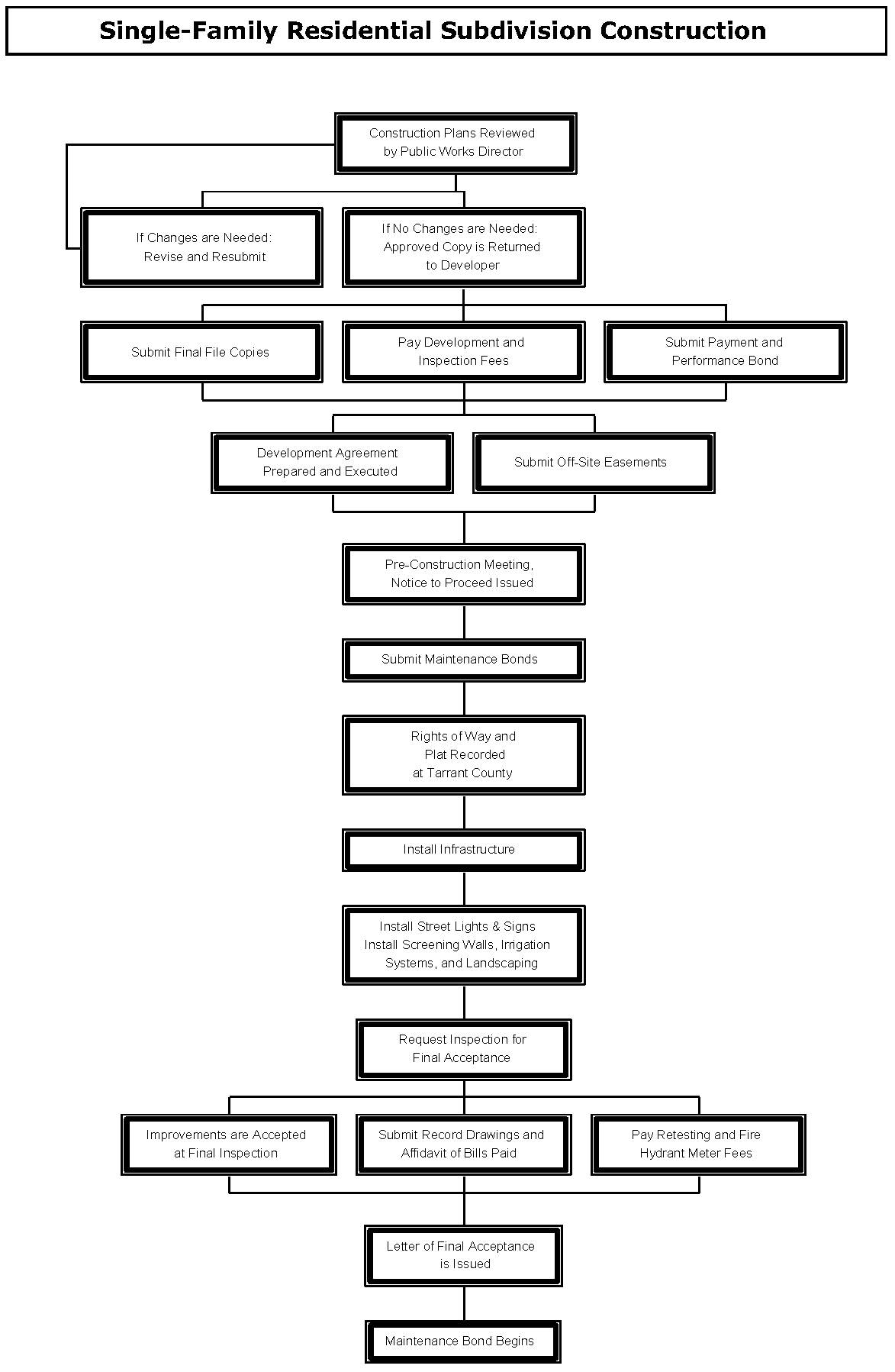
(Ord. No. 1976, § 2(Exh. A), 7-21-20; Ord. No. 2104, § 2, 12-6-22)
Section 4.14 - Landscaping and Screening Wall Plans
A.
Application. Screening walls shall be required in all residential subdivisions platted with rear or side yards adjacent to arterial or collector streets identified on the City of Keller Thoroughfare Plan (see Section 5.10 - Residential Subdivisions Thoroughfare Screening and Landscaping). A complete Landscaping and Screening Wall Plan application consists of the application form and three (3) sets of detailed Landscaping and Screening Wall Plans. These plans may be rolled. When a complete application is submitted, the Landscaping and Screening Wall Plans and accompanying documents are distributed to Development Review Committee (DRC) members. The Development Review Committee has fifteen (15) working days to review the application. Following review, comments and requested revisions are forwarded to the applicant. The applicant must then return revised copies along with all markups made by staff to the Community Development Department. The Development Review Committee will review the revised documents and provide comments again within ten (10) working days. Every subsequent submittal will be reviewed within ten (10) working days.
B.
Information to be Submitted with Landscaping and Screening Wall Plans. The review process will not begin until a complete Landscaping and Screening Wall Plan that includes at least the information on the following list is submitted with a completed application form. The applicant must submit three (3) 24" x 36" sets of Landscaping and Screening Wall Plans to the Community Development Department. Plans for private park improvements, pools, and clubhouses must be submitted independently to Keller's Development Services Division. Scale used must be 1" = 50' or larger.
1.
Landscaping and Screening Wall Plans should contain the following information:
a.
Title Block to include:
1)
Project's name.
2)
Address and/or legal description of the project.
3)
Name, address, and telephone number of the applicant.
4)
Name, address, and telephone number of contact person of the developer.
5)
Name, address, and telephone number of the preparer (Landscape Architect and/or Engineer).
6)
Date of preparation and dates of revisions, if any (As plans are revised, add dates of revision to each submittal).
b.
North arrow oriented to the top or right of the sheet.
c.
A typical section showing the lot, street, parkway, sidewalk, screening wall easement, landscaping, and screening wall (include dimensions).
d.
Paving and design detail (sidewalks, streets, parking, etc.).
e.
A typical elevation of the screening wall including signage and landscaping (show dimensions, materials, colors, plant types, etc.)
f.
Structural design for the wall, including column, drainage, and footing design, and stamped by a Structural Engineer. Wall design shall accommodate drainage.
g.
A note placed on all sheets stating that upon completion of the screening wall construction, a letter will be submitted to the City signed and sealed by a Licensed Engineer or contractor responsible for the construction of the wall stating that the screening wall was built in accordance with the approved Landscaping and Screening Wall Plans and specifications.
h.
Plan view that includes dimensions and shows the rights-of-way, lots, all easements, and the location of the screening wall(s) and landscaping.
i.
Location of the required sidewalks and trails to be constructed with the subdivision. Sidewalks are required along all thoroughfares and are to be located at the property line or one-foot (1') from the property line. Trails are required in accordance with the City Parks and Trails Master Plan. Other sidewalk and trail locations must be approved by the Development Review Committee.
j.
Location, size, and species of all trees to be preserved in accordance with this code (see Section 8 for Tree Preservation Requirements). "Tree stamps" are not to be used unless they indicate the true size and location of trees.
k.
Location, size, species, and spacing of all required trees and plant material to be used. (see Section 5.10 - Residential Subdivisions Thoroughfare Screening and Landscaping for requirements). Existing trees credited toward the requirements must also be shown. Proposed trees must be located within the landscaping and screening wall easement.
l.
Location of all other landscaping material to be used, including paving, benches, screens, fountains, statues, earthen berms, and ponds (marked with water depth).
m.
Additional landscaping amenities provided by the developer or required as part of a Planned Development zoning.
n.
Topography of the site.
2.
Irrigation Plans should contain the following information:
a.
Description of maintenance provisions and specific models/materials used.
b.
Layout and description of irrigation, sprinkler, or water systems and the placement of water sources.
c.
Location and size of all water and irrigation meters.
d.
Location and type of backflow prevention device.
e.
Location and type of rain and freeze sensor.
f.
Irrigation plans shall be designed by a licensed irrigator. Irrigator shall sign and seal the plans submitted.
3.
UDC Variance Request as described in Section 2.08 - Procedures for Variances from the Regulations of the Code, if applicable.
C.
Approval Process for Landscaping and Screening Wall Plans.
1.
Landscaping and Screening Wall Plans can be approved by the Planning Manager if it meets all applicable requirements of this Code.
2.
If variances are requested for the Landscaping and Screening Wall Plan, then variance requests shall be considered for approval by City Council before it can proceed.
3.
Based on the Development Review Committee's review, staff will prepare a report and recommendation for the Planning and Zoning Commission and City Council if variances are requested. A copy of this information and an agenda for the Planning and Zoning Commission and City Council meeting at which the application will be discussed will be available to the applicant on the Friday prior to that Planning and Zoning Commission and City Council meeting. The Planning and Zoning Commission and City Council votes on approval, approval with conditions, or disapproval.
D.
Final File Copies.
1.
After approval by the Planning Manager, the applicant shall submit to the Community Development Department:
a.
one (1) set on 24" x 36" paper size of the Landscaping and Screening Wall Plan as approved by the Planning Manager;
b.
Computer Aided Design (CAD), in appropriate format and georeferenced for GIS purposes, of the As-Built Construction Plans submitted by the design engineer (see Article Nine - Keller CAD Standards for CAD construction plan requirements). Following is the appropriate coordinate reference system to be used:
Geographic Coordinate System: GCS_North_American_1983
Projected.Coordinate.System: NAD_1983_StatePlane_Texas_North_Central_FIPS4202_Feet
Projection:Lambert_Conformal_Conic
(see Article Nine - Keller CAD Standards for CAD plat requirements).
2.
Approval of a Landscaping and Screening Wall Plan is effective for one (1) year. At the end of one (1) year, the Landscaping and Screening Wall Plan or any portion that has not been constructed or is deemed not to be under construction, shall expire. The applicant may request a one-year extension from the Planning Manager, if no changes in development requirements impacting the Landscaping and Screening Wall Plan have occurred.
3.
The Community Development Department will release the remaining ninety percent (90%) of the building permits for a single-family residential development when the screening wall, landscaping, irrigation system, and all other amenities are completed and installed in accordance with the approved Landscaping and Screening Wall Plans (see Section 4.13 (G) - Single-Family Residential Construction Process).
Section 4.15 - Non-Single Family Residential Construction Process
A.
Site Plan Required. All non-single family-residential construction in the City of Keller requires Site Plan approval prior to construction. A complete Site Plan is required for the following:
1.
All new non-single family-residential developments.
2.
Additions or changes to an existing non-residential building, or conversion of a building for a non-residential use.
3.
Changes in use or occupancy of an existing non-residential building requires a modified Site Plan that shows parking, dumpster location and screening, screening walls, landscaping, and signage (see Section 8.02 (A.5.g) for requirements)
4.
Multi-family, mobile home park, or mixed use developments.
5.
Planned Developments and Specific Use Permits.
B.
Application.
1.
A complete Site Plan application consists of the application form, fee, and seven (7) collated and folded copies of the Site Plan that includes all information listed below in Section 4.15 (C). When a complete application is submitted, the Site Plan and accompanying documents are distributed to the Development Review Committee (DRC) members. The Development Review Committee has fifteen (15) working days to review the application. Following review, comments and requested revisions are forwarded to the applicant. The applicant must then return revised copies along with all markups made by staff to the Community Development Department. The Development Review Committee will review the revised documents and provide comments again within ten (10) working days. This review-and- comment process will repeat until the Site Plan is in a form that could be approved.
2.
All non-single family-residential site plan applicants are responsible for coordinating with all utility companies to determine the locations of all utility needs of the development. Utility boxes shall be placed in locations where they will not detract from the visual quality of the site from the street view and be screened with live landscaping.
C.
Information To Be Submitted With a Site Plan Application. The review process will not begin until a Site Plan that includes at least the information on the following list is submitted with a completed application form and filing fee. Site Plans shall be prepared by a Texas-Registered Professional Architect, Texas-Registered Professional Civil Engineer, or other qualified professional (as approved by the DRC). Utility plans, Drainage Plans, and Grading Plans shall be prepared by a Texas Registered Professional Civil Engineer. Architectural elevation plans shall be prepared by a Texas Registered Professional Architect. Landscape Plans shall be prepared by a Texas Registered Landscape Architect. Trails may be designed by either a Texas Registered Professional Engineer or Landscape Architect. Screening walls and other structural walls must be designed by a Texas Registered Structural Engineer. The applicant shall submit to the Community Development Department seven (7) 22" x 34" copies of the Site Plan, collated and folded to 9" x 12" paper size (see Article Nine - Plan Folding Procedures, no later than Friday at noon. Rolled documents will not be accepted. Scale used should be 1" = 50' or larger. The overall site plan package must contain the following six sheets with the corresponding information listed below:
1.
Site Plan Sheet.
a.
Title Block in lower right hand corner of site plan to include:
1)
Project's name.
2)
Name, address, telephone number, fax number, and contact person of the Applicant.
3)
Name, address, telephone number, fax number, and contact person of the Owner.
4)
Name, address, telephone number, fax number, and contact person of the preparer (Architect or Engineer).
5)
Address and/or legal description of the project (addition's name, lots, and blocks).
6)
Total acreage and zoning.
7)
Date of preparation and dates of revisions, if any (as the site plan is revised, add dates of revision to each submittal).
b.
A summary table showing:
1)
Total building square footage.
2)
Number of required parking spaces (show calculations based on building usage).
3)
Number of provided parking spaces (number of handicapped parking spaces shall not be included as part of required parking spaces).
c.
Graphic Scale labeled with scale used.
d.
North arrow oriented to the top or right of sheet.
e.
Vicinity map of the City Base Map with scale of 1"=1,000' with site location shaded.
f.
Distances and bearings of all lots.
g.
Cross section of proposed streets, alleys, and parking lots, showing the width and type of pavement and the location and width of sidewalks.
h.
The footprints of all proposed buildings or structures.
i.
Setback lines as required by the respective zoning district.
j.
The names and widths of rights-of-way and pavement of existing and proposed streets and alleys.
k.
All curbs or pavement edge and lane striping on adjacent streets with dimensions.
l.
Driveway and sidewalk locations with dimensions and curve radii labeled.
m.
Parking layout, including maneuvering, loading, and unloading areas.
n.
Easements, deed restrictions, or other encumbrances that impact development of the lot.
o.
Location, type, material, and height of:
1)
Required screening walls or fences, including elevations.
2)
Site lighting showing the height and location of exterior light fixtures.
3)
Signs locations (All signs shall be permitted separately and meet the sign requirements of this Code at the time of permit).
p.
Location and screening of trash receptacles with materials clearly identified (Trash receptacles/dumpsters are required for all non-single family-residential developments unless other acceptable alternative is proposed).
q.
Zoning, legal description, and owner of record for all adjacent lots or tracts.
r.
Park/Trail location and improvements, if applicable.
s.
Location of all utility boxes, cabinets, or meters, which shall be located at rear or side of building, if practical.
2.
Utility Plan.
a.
All property lines and easements.
b.
The footprints of all proposed buildings or structures.
c.
Driveway and sidewalk locations with dimensions and curve radii labeled.
d.
Parking layout, including maneuvering, loading, and unloading areas.
e.
Location and size of all existing and proposed water and sewer lines.
f.
Location and size of all other utilities existing and proposed, underground or overhead.
g.
Fire protection, including locations of existing and proposed fire hydrants, fire lanes, and fire lines, with all dimensions clearly designated.
h.
Distances to closest existing fire hydrants, on-site or off-site, which would provide water access for this property in the event of a fire.
i.
Location of trees and shrubs to be preserved or planted. Trees and shrubs within five- feet of the utility lines may be removed. All others shall remain in compliance with the UDC.
3.
Grading and Drainage Plan
a.
All property lines and easements.
b.
The footprints of all proposed buildings or structures.
c.
Driveway and sidewalk locations with dimensions and curve radii labeled.
d.
Parking layout, including maneuvering, loading, and unloading areas.
e.
Existing and proposed contours.
f.
Location of existing and proposed drainage structures with sizes and dimensions clearly labeled.
g.
Location of 100-year floodplain and floodway.
h.
Location of proposed improvements in relation to Areas of Special Flood Hazard.
i.
Elevation from mean sea level of new or substantially improved structures.
j.
A certificate from a Texas-registered Professional Engineer or Architect that states non- residential flood proofed structures meet the criteria contained in the Flood Plain Ordinance.
k.
Description of the extent to which any watercourse or natural drainage will be altered or relocated as a result of the proposed development.
4.
Landscape Plan. The Landscape Plan must be prepared by a Texas Registered Landscape Architect. It must include the following at a minimum scale of 1" = 50'. The Landscape Plan shall conform to the requirements set forth in Article Eight of this Code.
a.
Name of preparer.
b.
Date of preparation.
c.
North arrow oriented to the top or right of the sheet.
d.
Location and spacing of all plants and landscaping materials and features to be used, including paving, benches, and fountains.
e.
Species, quantity, and size of all plant materials to be used.
f.
Location, size, and species of all trees to be preserved ("tree stamps" may not be used unless they indicate the true size and location of trees).
g.
Depth of pond, if applicable.
h.
Topography.
i.
Description of provisions for maintenance.
j.
A note that states that all landscaped areas will be irrigated and that detailed irrigation plans will be submitted with construction plans.
k.
A note that all landscaped areas are to be maintained in accordance with City regulations.
l.
Location and size of all other utilities existing and/or proposed, underground or overhead, including private transmission lines.
5.
Elevations.
a.
Architectural elevations showing all sides of the proposed building and labeled north, south, east and west.
b.
The height of the proposed building clearly dimensioned.
c.
All exterior finishes and roofing materials clearly identified.
d.
One 11" x 17" sheet with all elevations in color with labels and dimensions removed to serve as a color sample of exterior finishes.
6.
Photometric Plan. The Photometric Plan must be submitted with all site plans that are adjacent to residential zoning or uses, showing the light intensity within and around the perimeter of the site. The Photometric Plan shall conform to the requirements set forth in Section 9.12 - Lighting and Glare Standards.
a.
All property lines and easements.
b.
The footprints of all proposed buildings or structures.
c.
Parking layout, including maneuvering, loading, and unloading areas.
d.
Type, location, and height of all proposed light poles and fixtures.
7.
Aerial Overlay. A recent aerial photograph must be submitted (if applicable) in either 11" x 17" or 8.5" x 11" format with an attached transparent overlay that shows the following items:
a.
All property lines and easements.
b.
The footprints of all proposed buildings or structures.
c.
Driveway and sidewalk locations.
d.
Parking layout, including maneuvering, loading, and unloading areas.
8.
Tree Survey and Tree Preservation Plan, as applicable see Section 10.01 (Amended by Ord. No. 1818 on October 18, 2016)
9.
UDC Variance Request as described in Section 2.08 - Procedures for Variances from the Regulations of the Code, if applicable.
D.
Approval Process For Site Plans.
1.
Modified Site Plans for existing buildings or Site Plans for parking improvements may be approved by the Development Review Committee if it meets all applicable requirements. The DRC's decision may be appealed to the Planning and Zoning Commission and City Council.
2.
Site Plans within the Town Center (TC) Zoning District shall be considered for approval by City Council after a recommendation from the Planning and Zoning Commission. All other site plans shall be considered for approval by the City Manager or designee if it complies with best professional practices and meets all applicable requirements of this Code for development. The City Manager's decision may be appealed to the Planning and Zoning Commission and City Council.
3.
If variances are requested, the Site Plan shall be considered by City Council after a recommendation by the Planning and Zoning Commission. Based on the Development Review Committee's review, staff will prepare a report and recommendation for the Planning and Zoning Commission. Staff can recommend approval, conditional approval, or denial based on the requirements of this Code. A copy of this information and an agenda for the Planning and Zoning Commission meeting at which the application will be discussed will be available to the applicant on the Friday prior to that Planning and Zoning Commission meeting. The Site Plan will be placed on a City Council agenda within thirty (30) days following the Planning and Zoning Commission meeting. The applicant shall submit one (1) collated and folded 24" x 36" copy and twelve (12) 11" X 17" reductions of the Site Plan at least ten (10) days prior to the City Council meeting.
4.
Prior to the City Council meeting, staff will provide to the applicant a copy of the staff report and recommendations, and the City Council agenda. The City Council can approve, approve with conditions, or deny a Site Plan. After the City Council approves a Site Plan, if final architectural or engineering design necessitates minor changes in the approved Site Plan, the changes may be approved by the City Manager or his/her designee, provided that they do not materially alter traffic circulation, building location, or any conditions attached to the City Council's approval of the Site Plan.
E.
Final File Copies.
1.
After approval by the Development Review Committee and/or the Planning and Zoning Commission and City Council, the applicant shall submit to the Community Development Department:
a.
Three (3) 22" x 34" blueline or blackline copies of the Site Plan as approved. All changes made by the approving body shall be reflected on the Site Plan;
b.
An electronic format of the exterior elevations of the project, either in .pdf or .jpeg versions. These copies of the approved site plan must be submitted within thirty (30) days of the date of approval. No Building Permit will be issued until the copies are submitted;
c.
Computer Aided Design (CAD), in appropriate format and georeferenced for GIS purposes, of the As-Built Construction Plans submitted by the design engineer (see Article Nine - Keller CAD Standards for CAD construction plan requirements). Following is the appropriate coordinate reference system to be used:
Geographic Coordinate System: GCS_North_American_1983
Projected.Coordinate.System: NAD_1983_StatePlane_Texas_North_Central_FIPS4202_Feet
Projection:Lambert_Conformal_Conic
(see Article Nine - Keller CAD Standards for CAD plat requirements).
2.
Approval of a Site Plan is effective for one (1) year. At the end of one year, the Site Plan or any portion that has not been constructed or is deemed not to be under construction, shall expire. The applicant may request a one-year extension from the City Manager or his/her designee, if no changes in development requirements impacting the Site Plan have occurred.
F.
Construction Plans. Following the approval of the Site, Construction Plans may be submitted to the Development Services Division. Three (3) sets of Building Plans prepared and/or stamped by a Texas- Registered Architect; three (3) sets of Paving, Drainage, and Utility Plans prepared by a Texas- Registered Civil Engineer; Landscape Plans shall be prepared by a Texas Registered Landscape Architect. Trails may be designed by either a Texas Registered Professional Engineer or Landscape Architect. Screening walls and other structural walls must be designed by a Texas Registered Structural Engineer, the Building Permit Application; and applicable fees must be submitted before the review process can begin. These plans will be reviewed within fifteen (15) working days by all applicable departments and may be picked up at the Development Services Division of the City. Every subsequent submittal will be reviewed within ten (10) working days. A Building Permit will be issued when the Plans are released for construction by all applicable departments. Developments requiring public infrastructure improvements (road and utility extensions) must include Construction Plans for the improvements.
G.
Development Agreement. After approval of Building Plans and Paving, Drainage, and Utility Plans, the developer shall enter into an agreement with the City to delineate responsibility for construction of public improvements and related expenditures, if applicable.
H.
Pre-Construction Meeting/Issuance of Building Permit. Public Works staff will then make arrangements with the project engineer for a pre-construction meeting. The developer, engineer, contractor, sub-contractors, and other interested parties are required to attend this meeting. At the meeting, City Staff will discuss Keller's construction sequencing and the Development Agreement. The applicant pays Development and Inspection Fees and submits Maintenance Bonds and Trench Safety Plan. A Notice to Proceed will be issued at this meeting if all needed information and fees have been provided by the developer.
I.
Final Acceptance/Certificate of Occupancy. Inspections will be performed at various stages of work. The City will conduct a final inspection after all work has been completed. This includes all building-related and site-related (on-site and off-site) improvements. Computer Aided Design (CAD) in appropriate format of the As- Built Construction Plans must be submitted by the design engineer (see Article Nine - Keller CAD Standards for CAD construction plan requirements) before the letter of final acceptance from the City. A Certificate of Occupancy will be issued upon completion of all improvements in accordance with all applicable codes.
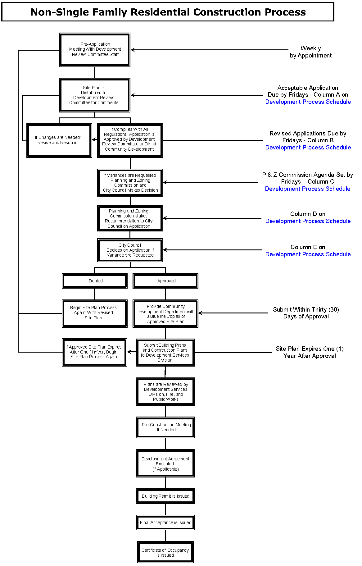
(Ord. No. 2104, § 2, 12-6-22)