
Keller City Zoning Code
ARTICLE Eight
ZONING DISTRICTS1
Editor's note—Ord. No. 2104, adopted Dec. 6, 2022, renumbered and reorganized Article Eight, to read as set out herein. Former Article Eight, §§ 8.01—8.20 pertained to Zoning Districts, Development Standards and Tree Preservation. See Article Nine for Development Standards; Article Ten for Tree Preservation; and Article Eleven for Appendices. Historical Notations have been retained.
Section 8.01 - Zoning Regulations
A.
Purpose. The zoning regulations and Districts as herein established have been made in accordance with Texas Local Government Code and an adopted set of coordinating plans collectively serving as the Comprehensive Plan for the purposes of promoting sound development; promoting the health, safety, morals and general welfare of the City; and to protect, preserve, and promote places and areas of historical, cultural, or architectural importance and significance. They have been designed to lessen the congestion in the streets; to secure safety from fire, panic, and other dangers; to ensure adequate, quality light and air; to protect and preserve the natural groundwater; to prevent the overcrowding of land; to avoid undue concentration of population; to facilitate the adequate provision of transportation, water, sewerage, parks, and other public requirements. They have been made with reasonable consideration, among other things, for the character of the district, and its peculiar suitability for the particular uses specified; and with a view to conserving the value of buildings and encouraging the most appropriate use of land throughout the city.
B.
Zoning District Map.
1.
The boundaries of zoning districts set out herein are delineated upon a zoning district map of the City, adopted as part of this Code as fully as if the same were set forth herein in detail.
2.
One original of the Zoning District Map shall be filed in the Community Development Department. This copy, together with amending ordinances, shall be the controlling document governing the zoning districts in Keller. The zoning district map shall be revised no less than once every twelve (12) months to reflect any changes or amendments approved by the City Council.
C.
Zoning District Boundaries. The district boundary lines shown on the Zoning District Map are usually along streets, alleys, property lines, or extensions thereof. Where uncertainty exists as to the boundaries of districts as shown on the Official Zoning Map, the following rules shall apply:
1.
Boundaries indicated as approximately following the centerline of streets, highways, or alleys shall be construed to follow such centerline.
2.
Boundaries indicated as approximately following platted lot lines shall be construed as following such lot lines.
3.
Boundaries indicated as approximately following city limits shall be construed as following city limits.
4.
Boundaries indicated as following railroad lines shall be construed to be midway between the right-of-way lines.
5.
Boundaries indicated as following shore lines shall be construed to follow such shore lines, and in the event of change in the shore line shall be construed as moving with the actual shore line; boundaries indicated as approximately following the centerline of all bodies of water shall be construed to follow such centerline, and in the event of change in the centerline, shall be construed to move with such centerline.
6.
Boundaries indicated as parallel to or extensions of features indicated in Sections 8.01 (C.1) through 8.01 (C.5) above shall be so construed. The scale of the map shall determine distances not specifically indicated on the original zoning maps.
7.
Whenever any street, alley, or other public right of way is vacated by official action of the City Council or whenever such area is franchised for building purposes, the zoning district line adjoining each side of such street, alley, or other public way shall be automatically extended to the centerline of such vacated street, alley, or way and all areas so involved shall then and henceforth be subject to all regulations of the extended districts.
8.
The zoning classification applied to a tract of land adjacent to a street shall extend to the centerline of the street, unless as a condition of zoning approval, it is stated that the zoning classification shall not apply to the street.
9.
Where physical features on the ground are at variance with information shown on the official zoning district map or when there arises a question as to how or whether a parcel of property is zoned and such question cannot be resolved by the application of Sections 8.01(C.1) through 8.01(C.8), the property shall be considered as classified, SF-36, in the same manner as provided for newly annexed territory.
D.
Compliance Required. All land, buildings, structures, or appurtenances thereon located within the City of Keller, Texas which are hereafter occupied, used, constructed, erected, removed, placed, demolished, or converted shall be occupied, used, erected, altered, removed, placed, demolished, or converted in conformance with the zoning regulations prescribed for the zoning district in which such land or building is located. All of the standards and regulations prescribed herein shall be considered as the minimum requirement unless explicitly stated otherwise.
E.
Zoning Upon Annexation. All territory hereinafter annexed to the City of Keller shall be classified as Single-Family Low Density (SF-36) as a holding district until other zoning is established by the City. The procedure for establishing zoning other than SF-36 for annexed territory shall conform to the procedure set forth in this Code.
1.
In an area classified as SF-36:
a.
No permit for the construction of a building or use of land shall be issued by the Planning Manager other than a permit which will allow the construction of a building or use permitted in the SF-36 District, unless and until such territory has been classified in a zoning district other than the SF-36 District, by the City Council in the manner prescribed in this Code.
b.
An application for a building permit for any proposed use other than those specified in the SF-36 District must be made to the Planning Manager of the City of Keller within three (3) months after annexation. If the applicant shows that plans and other preparation for developing the property commenced prior to annexation by the City, the City Council may authorize the construction of the project by a majority vote. The action of the City Council concerning any such permit shall take into consideration the Comprehensive Plan and the appropriate land use for the area. Upon approval by the City Council, the Building Official shall issue the permit.
Section 8.02 - Administration
A.
Nonconforming Uses and Structures.
1.
Intent of Provisions.
a.
Within the districts established by this Code or amendments thereto, there exist lots, structures, uses of land and structures, and characteristics of use which were lawful before this Code was enacted, amended, or otherwise made applicable to such lots, structures or uses, but which do not now conform to the regulations of the district in which they are located. It is the intent of this Code to permit such nonconforming uses to continue, as long as the conditions within this Section and other applicable sections are met.
b.
It is further the intent of this Code that nonconforming uses shall not be enlarged upon, expanded or extended, and not be used as a basis for adding other structures or uses prohibited elsewhere in the same district.
c.
Nonconforming uses are hereby declared to be incompatible with the permitted uses in the districts involved.
2.
Nonconforming Status. Any use, platted lot, or structure which does not conform with the regulations of the zoning district in which it is located shall be deemed a nonconforming use or structure when:
a.
Such use, platted lot, or structure was in existence and lawfully operating at the time of the passage of the previous Code or this Code, and has since been in regular and continuous use; or
b.
Such use, platted lot, or structure is a lawful use at the time of the adoption of any amendment to this Code but by such amendment is placed in a district wherein such use, platted lot, or structure is not otherwise permitted and has since been in regular and continuous use; or
c.
Such use, platted lot, or structure was in existence and lawfully operating at the time of annexation to the City and has since been in regular and continuous use.
3.
Continuing Lawful Use of Property and Existence of Structures.
a.
The lawful use of land or lawful existence of structures at the time of the passage of this Code, although such do not conform to the provisions hereof, may be continued; but if said nonconforming use or structure is discontinued or abandoned, any future use of said premises shall be in conformity with the provisions of this Code.
b.
Discontinuance of a nonconforming use shall consist of the actual act or date of discontinuance of a use previously operational in a building. Abandonment of a nonconforming structure shall consist of the act or date of abandonment.
c.
When a nonconforming use or structure which does not meet the development standards in this Code ceases to be used for a period of six (6) months, such use shall not be resumed and proof of such event shall constitute prima facie evidence of an act of abandonment. Any nonconforming use which does not involve a permanent type of structure or operation and which is moved from the premises shall be considered to have been abandoned.
d.
No nonconforming use or structure may be expanded, reoccupied with another nonconforming use, or increased as of the effective date of this Code except as provided herein.
e.
Conforming single-family residential uses on platted lots or unplatted tracts approved prior to this Code, which may now be nonconforming due to stricter standards or right- of-way dedications/takings, shall be deemed in conformance with this Code as long as the use of the lot is allowed in the respective district. Only the lot size, depth, width, and setbacks shall be allowed to be less than the regulations prescribed in the zoning district in which it is located. All other regulations of this Code shall be met or the lot shall be considered nonconforming.
4.
Changing Nonconforming Uses.
a.
Any nonconforming use may be changed to a conforming use, and once such change is made, the use shall not be changed back to a nonconforming use.
b.
Where a conforming use is located in a nonconforming structure, the use may be changed to another conforming use by the process outlined herein.
c.
A nonconforming use may not be changed to another nonconforming use.
5.
Expansion of Nonconforming Uses and Buildings. An expansion of a nonconforming use or structure is allowed in accordance with the following:
a.
A non-conforming use located within a building may be extended throughout the existing building, provided;
1)
No structural alteration may be made on or in the building except those required by law to preserve such building in a structurally sound condition.
2)
The number of dwelling units or rooms in a nonconforming residential use shall not be increased so as to exceed the number of dwelling units or rooms existing at the time said use became a nonconforming use.
b.
No nonconforming use within a building may be extended to occupy any land outside the building.
c.
No nonconforming use of land or building shall be enlarged, increased, or extended to occupy a greater area of land than was occupied at the time the land became a nonconforming use, except to provide off-street loading or off-street parking space, if required by City ordinances; and except where adaptive re-use is proposed, in which case the proposal shall be presented to both the Planning and Zoning Commission and the City Council for consideration.
d.
The minimum residential lot areas for the various zoning districts shall be in accordance with their respective districts except that a lot having less area than herein required which was an official "lot of record" prior to the adoption of this Code, may be used for a single-family dwelling. A residential lot that is not a legal lot of record and does not meet the depth or width requirements of this Code at the time of platting may be approved by the Zoning Board of Adjustment with a variance.
e.
Buildings or structures which do not conform to the area regulations or development standards in this Code shall not increase their gross floor area except when such expansion brings nonconformity into conformance; and except where adaptive re-use is proposed, in which case the proposal shall be presented to both the Planning and Zoning Commission and the City Council for consideration.
f.
A non-residential building or structure that does not meet current area regulations or development standards may be reoccupied with a conforming use and without any expansion upon approval of a modified site plan meeting the requirements of Section 8.02 (A.5.g) below and issuance of a Certificate of Occupancy. The Development Review Committee (DRC) shall review this plan for compliance and, once approved by the DRC, a Certificate of Occupancy may be issued.
g.
A conforming non-single family residential use in a building which does not meet the area regulations or development standards in this Code may be reoccupied with another conforming use upon approval of a modified site plan to determine compliance with the following:
1)
Off-street parking, driveways, and circulation requirements.
2)
Dumpster location and screening; sidewalk and landscaping requirements.
3)
Sign requirements.
4)
Building codes.
5)
Screening requirements.
6)
Drainage requirements.
Each of the above will be reviewed for compliance by the Development Review Committee (DRC) and may be approved by the Planning Manager if total compliance is met. The Planning and Zoning Commission shall make final approval or disapproval of a site plan if substantial compliance is met and there is concurrence with the City Staff's recommendations. If the Planning and Zoning Commission does not concur with City Staff's recommendations, the site plan shall automatically be sent to the City Council for approval or denial.
6.
Restoration of Nonconforming Uses or Structures.
a.
If a structure occupied by a nonconforming use is destroyed by fire, the elements, or other cause, it may not be rebuilt except to conform to the provisions of this Code. In the case of partial destruction of a nonconforming use structure not exceeding sixty percent (60%) of its total appraised value as determined by the Tarrant County Central Appraisal District, reconstruction will be permitted, in accordance with Section 9.01, but the existing square footage or function of the nonconforming use cannot be expanded, and the above procedures in 8.02 (A.5.g) shall be met.
b.
A nonconforming use or structure can be remodeled, maintained, or improved as long as the size (square footage) of the structure is not increased.
c.
When a nonconforming sign, or a substantial part of the sign is damaged, destroyed, taken down, or removed, it may not be re-erected, reconstructed, or rebuilt except in full compliance and conformance with this Code. For purposes of this section, substantial shall mean if the cost of repair exceeds fifty percent (50%) of the cost of a new sign of the same construction and size. A nonconforming, on-premise, detached sign which is required to be relocated due to expansion of public right-of-way may be relocated on the same lot or tract, provided there is no more than one (1) detached sign per lot or tract. The relocation shall occur within six (6) months following completion of the road.
7.
Completion of Structures.
a.
Nothing herein contained shall require any change in the plans, construction, or designated use of:
1)
A building or structure for which a building permit has been issued or a site plan approved prior to the effective date of these zoning regulations, and the permits have not expired in accordance with this Code; or
2)
A building or structure for which a substantially complete application for a building permit was accepted by the Building Official on or before the effective date of these regulations, provided however that such building permit shall comply with all applicable ordinances of the City of Keller in effect on the date such application was filed and the building permit is issued within thirty (30) days of the effective date of these regulations.
b.
All structures that have received a permit and have started construction shall complete construction within twelve (12) months or a proposed timeframe accepted an authorized by the Building Official. In the event that construction is delayed, the owner may request a one-time extension to the construction period of up to six (6) months or a proposed timeframe accepted and authorized by the Building Official. If a building is left unfinished and the City determines that construction activity has ceased, the City shall require the owner/developer to submit a proposal for timing to finish the building. Otherwise, the City shall cause the unfinished structure to be demolished at the owner's expense.
B.
Planning and Zoning Commission.
1.
General. The Planning and Zoning Commission shall function according to the Code of Ordinances and Texas Local Government Code which establishes other membership and operating procedures.
2.
Created; Membership; Officers.
a.
There is hereby created in accordance with Chapter 211 of the Texas Local Government Code, a City Planning and Zoning Commission which shall consist of seven (7) members, each of whom shall be a resident of the City of Keller. Members shall be appointed by the City Council. Of the seven (7) members, four (4) shall serve a period of one (1) year from the date of initial appointment and three (3) shall serve for a period of two (2) years from the date of initial appointment. Thereafter, all seven (7) members shall serve for a period of two (2) years from the date of appointment. Vacancies shall be filled by appointments for unexpired terms only.
b.
Members may be removed from office at any time by a majority vote of the City Council for any reason. All members shall serve without compensation. All members shall serve in accordance with Ordinance No. 1701 or most current ordinance pertaining to attendance and tenure requirements. The City Secretary or his/her designee shall keep minutes of all meetings held by the Planning and Zoning Commission and full record of all recommendations to be made by the Planning and Zoning Commission to the City Council. A Chairman may be appointed by the City Council, however if they do not make the appointment on the date annual appointments are made, the Chairman and Vice-Chairman shall be elected by the Planning and Zoning Commission from its membership at its first meeting following the date of annual appointments. The Chairman and Vice Chariman shall hold said offices for a term of one (1) year and until their successors have been elected.
c.
Any member of the Planning and Zoning Commission remaining absent for three (3) consecutive regular meetings of the commission may have their appointment declared vacated by a majority vote of the City Council. Any member of the commission remaining absent for six (6) consecutive regular meetings of the commission shall be deemed to have vacated their appointment.
d.
Newly appointed members of the Planning and Zoning Commission shall go through training offered by the city attorney and the American Planning Association for new commissioners.
3.
Quorum; Voting. Four (4) members of the Planning and Zoning Commission shall constitute a quorum, and all members, including the presiding chairman, shall have the right of one vote each, a quorum being present. All actions by the Planning and Zoning Commission shall be by a majority vote of those members present. If any member has a conflict of interest in review of any item on the Commission's agenda, he or she shall remove themselves from the room and refrain from voting only on the item for which a conflict exists. In the absence of the Chairperson and/or Vice-Chairperson the members constituting a quorum shall select, from the members present, a Chairperson to conduct the meeting.
4.
Meetings. The Planning and Zoning Commission shall meet at such times in the Town Hall or other specified locations as may be designated by the Chairman or Vice-Chairman in the absence of the Chairman, and at such intervals as may be necessary to orderly and properly transact the business of the Commission but not less than once every thirty (30) days.
5.
Powers and Duties. The Planning and Zoning Commission shall be an advisory body to the City Council and shall carry out the duties detailed in the Texas Local Government Code and Ordinance No. 70 to make recommendations regarding amendments to the Comprehensive Plan, changes of zoning and permanent zoning to be given to newly annexed areas, and shall approve or make recommendations regarding the approval of the plats of subdivisions as provided by the Texas Local Government Code. The Planning and Zoning Commission shall make a periodic review of the City's Comprehensive Thoroughfare Plan and Future Land Use Plan and be prepared to make such recommendations to the City Council as deemed necessary to keep the City's Plans with the needs and uses of the City as outlined in the Comprehensive Plan. The Planning and Zoning Commission shall serve in an advisory capacity on any land use or planning related item(s) in the City.
6.
Procedure on Zoning Hearings. The procedure and process for zoning changes and/or amendments shall be in accordance with this Code.
C.
Zoning Board of Adjustment (ZBA).
1.
General. In accordance with the Texas Local Government Code, Chapter 211, a Board of Adjustment may be appointed for the purpose of hearing and deciding appeals or special exceptions or authorizing variances or other matters as adopted.
2.
Creation. There is hereby created a Board of Adjustment to be composed of five (5) members and two (2) alternate members who shall be residents and qualified voters of the City of Keller and shall serve without compensation.
3.
Members and Terms of Office.
a.
The Board of Adjustment shall consist of five (5) regular members and two (2) alternate members who shall be appointed by the City Council in accordance with Section 211 of the Texas Local Government Code, as amended. The members shall serve for a period of two (2) years and until their successors are duly appointed and qualified. The regular members of the board shall be identified by place numbers 1 through 5. Places 1, 3, and 5 and the first alternate member shall be appointed to serve for two-year terms with terms beginning on November 30 of odd numbered years. Places 2, 4 and the second alternate member shall be appointed to serve for two-year terms beginning on November 30 of even numbered years. All members will be appointed by a majority vote of the City Council. Members may be removed in accordance with State law. Board members may be appointed to succeed themselves. Vacancies shall be filled by an alternate member for the unexpired term of a member whose term becomes vacant. A Chairman may be appointed by the City Council, however if they do not make the appointment on the date annual appointments are made, the Chairman and Vice-Chairman shall be elected by the Board of Adjustment from its membership at its first meeting following the date of annual appointments. The Chairman and Vice Chariman shall hold said offices for a term of one (1) year and until their successors have been elected.
b.
Any member absent for three (3) regular consecutive meetings may have their office declared vacated by a majority vote of the City Council. Any member of the board remaining absent for six (6) consecutive regular meetings of the board shall be deemed to have vacated their office. Vacancies of an alternate member shall be filled by appointment of the City Council by majority vote.
c.
Newly appointed members of the Zoning Board of Adjustment shall go through training offered by the city attorney and the American Planning Association for new board members.
d.
Meetings of the Board shall be held at the call of the Chairman and at such other times as the Board may determine. All meetings of the Board shall be open to the public. Four (4) members of the Board shall constitute a quorum for the conduct of business. All cases to be heard by the Board of Adjustment will always be heard by a minimum number of four (4) members. In the absence of the Chairperson and/or Vice- Chairperson the members constituting a quorum shall select, from the members present, a Chairperson to conduct the meeting. The members of the Board shall regularly attend meetings and public hearings of the Board and shall serve without compensation.
4.
Authority of Board. The Board of Adjustment shall have the authority, subject to the standards established in Sections 211.008 to 211.011 of the Texas Local Government Code and those established herein, to exercise the following powers and perform the following duties:
a.
Hear and decide an appeal that alleges error in an order, requirement, decision, or determination made by an administrative official in the enforcement of this Code;
b.
Hear and decide special exceptions to the terms of this Code when it requires the Board to do so; and
c.
Authorize in specific cases a variance from the terms of the zoning portions of this Code, such as lot width, depth and building lines, if the variance is not contrary to the public interest and, due to special conditions, a literal enforcement would result in unnecessary hardship, and so that the spirit of this Code is observed and substantial justice is done.
d.
In exercising its authority under Section 8.02 (C.4.a) above, the Board may reverse or affirm, in whole or in part, or modify the administrative official's order, requirement, decision, or determination from which an appeal is taken and make the correct order, requirement, decision, or determination, and for that purpose the Board has the same authority as the administrative official.
e.
Each case before the Board of Adjustment must be heard by at least seventy-five percent (75%) [four (4)] of the members. The concurring vote of four (4) members of the Board is necessary to:
1)
Reverse an order, requirement, decision, or determination of an administrative official.
2)
Decide in favor of an applicant on a matter on which the Board is required to pass under this Code.
3)
Authorize a variation from the terms of this Code.
f.
The Chairperson may administer oaths and compel the attendance of witnesses.
5.
Limitations on Authority of Board.
a.
The Board may not grant a variance authorizing a use other than those permitted in the district for which the variance is sought.
b.
The Board shall have no power to grant or modify Specific Use Permits (SUP) authorized under Section 8.02 (F) of these regulations.
c.
The Board shall have no power to grant a zoning amendment. In the event that a request for a zoning amendment is pending before the Planning and Zoning Commission or the City Council, the Board shall neither hear nor grant any variances with respect to the subject property until final disposition of the zoning amendment.
d.
The Board shall not grant a variance for any parcel of property or portion thereof upon which a Site Plan, Preliminary Site Evaluation, or Final Plat if required by the City, has not been finally acted upon by both the Planning and Zoning Commission and, if required by the City, by the City Council. All administrative remedies available to the applicant shall have been exhausted prior to hearing by the Zoning Board of Adjustment.
e.
The Board shall have no power to grant variances except to those established in Section 8.02 (C.4.c) in this Code.
6.
Variances.
a.
In order to grant a variance from these zoning regulations, the Board of Adjustment must make written findings that the variance relieves undue hardship, using the following criteria:
1)
That literal enforcement of the controls will create an unnecessary hardship or practical difficulty in the development of the affected property;
2)
That the situation causing the hardship or difficulty is neither self-imposed nor generally affecting all or most properties in the same zoning district;
3)
That the relief sought will not injure the permitted use of adjacent conforming property; and
4)
That the granting of a variance will be in harmony with the spirit and purpose of these regulations.
b.
A variance shall not be granted to relieve a self-created or personal hardship, nor shall it be based solely on economic gain or loss, nor shall it permit any person a privilege in developing a parcel of land not permitted by this Code to other parcels of land in the particular zoning district. No variance may be granted which results in undue hardship on another parcel of land.
c.
The applicant bears the burden of proof in establishing the facts justifying a variance.
7.
Special Exceptions.
a.
The Zoning Board of Adjustment shall have the authority to hear and allow special exceptions only for uses which are conforming but the building structure is not.
b.
In granting a special exception, the Zoning Board of Adjustment shall not authorize uses that are not allowed under the terms of this Code for the respective district.
c.
A proof of hardship is not required for granting a special exception.
d.
In granting a special exception, the Board shall not permit variances from the use district regulations which are not prevalent on other lots in the same zoning district.
e.
The Board may consider special exceptions to the Development Standards contained in this section for single-family residential uses that do not require a plat or site plan approval by the Planning and Zoning Commission (P & Z) and City Council.
8.
Procedures.
a.
Application and Fee. An application for granting a variance by the Board of Adjustment, other than an appeal, shall be in writing using forms provided by the City and shall be accompanied by a fee.
b.
Notice and Hearing. The Board of Adjustment shall hold a public hearing no later than forty-five (45) days after the date the application for action or an appeal is filed on each such application or appeal. Notice of a public hearing shall be provided to all property owners within two hundred feet (200') of the affected property ten (10) days prior to the public hearing.
c.
Appeals.
1)
An appeal may be taken from the decision of an administrative official by an applicant for the permit on which the decision is rendered, by any person or persons directly aggrieved by the decision or by any officer, department, board, or bureau of the municipality affected by the decision.
2)
The appellant must file with the Board and the official against whom the appeal is taken a written notice of appeal specifying the grounds for the appeal within fifteen (15) days after the decision has been rendered. The officer to whom the appeal is made shall forthwith transmit to the Board all papers constituting the record of the action that is appealed.
3)
An appeal stays all proceedings in furtherance of the action that is appealed unless the official from whom the appeal is taken certified in writing to the Board that facts supporting the official's opinion that a stay would cause imminent peril to life or property. In that case, the proceedings may be stayed only by a restraining order granted by the Board or a court of record on application, after notice to the official, if due cause is shown.
4)
The Board shall set a reasonable time for the appeal hearing and shall give public notice of the hearing and due notice to the parties. The appellant party may appear at the appeal hearing in person or by agent or attorney.
5)
The Board shall decide the appeal within three (3) weeks after placement on its agenda after which time the request shall be deemed automatically approved. The Board may reverse or affirm, in whole or in part, or modify the administrative official's order, requirement, decision, or determination from which an appeal is taken, and make the correct order, requirement, decision, or determination.
a)
Vote Required for Board Decisions. The concurring vote of four (4) members of the Board shall be necessary to reverse any order, requirement, decision, or determination of an administrative official, or to decide in favor of the applicant on any matter upon which it is required to pass under these zoning regulations, or to effect any variance to the zoning regulations granted by the Board.
b)
Judicial Review. Any person or persons, jointly or severally, aggrieved by a decision of the Board of Adjustment, or any taxpayer, or any officer, department, or Board of the City may present to a court of record a petition, duly verified, setting forth that such decision is illegal, in whole or in part, specifying the grounds of the illegality. Such petition must be presented within ten (10) days after the date the decision is filed in the Board's office.
D.
Changes and Amendments to All Zoning Ordinances and Districts and Administrative Procedures.
1.
Declaration of Policy and Review Criteria. The City declares the enactment of these regulations governing the use and development of land, buildings, and structures as a measure necessary to the orderly development of the community. Therefore, no change shall be made in these regulations or in the boundaries of the zoning districts except:
a.
To correct any error in the regulations or map;
b.
To recognize changed or changing conditions or circumstances in a particular locality;
c.
To recognize changes in technology, the style of living, or manner of conducting business;
d.
To change the property to uses in accordance with the approved Master Plan;
e.
In making a determination regarding a requested zoning change, the Planning and Zoning Commission and City Council shall consider the following factors:
1)
Whether the uses permitted by the proposed change will be appropriate in the immediate area concerned and their relationship to the general area and the City as a whole, and in compliance with the Future Land Use Plan.
2)
Whether the proposed change is in accord with any existing or proposed plans for providing streets, water supply, sanitary sewers, and other utilities to the area, and shall note the findings.
3)
The amount of vacant land currently classified for similar development in the vicinity and elsewhere in the City, and any special circumstances which may make a substantial part of such vacant land unavailable for development.
4)
The recent rate at which land is being developed in the same zoning classification as the request, particularly in the vicinity of the proposed change.
5)
How other areas designated for similar development will be, or are unlikely to be, affected if the proposed amendment is approved.
6)
Any other factors which will substantially affect the health, safety, morals, or general welfare.
2.
Authority to Amend Ordinance.
a.
The City Council may from time to time, after receiving a final report thereon by the Planning and Zoning Commission and after public hearings required by law, amend, supplement, or change the regulations herein provided or the boundaries of the zoning districts specified on the Zoning Map. Any Ordinance regulations or Zoning District boundary amendment may be ordered for consideration by the City Council, be initiated by the Planning and Zoning Commission, or be requested by the owner of real property, or the authorized representative of an owner of real property.
b.
Consideration for a change in any district boundary line or special zoning regulation may be initiated only with written consent of the property owner, or by the Planning and Zoning Commission, or City Council on its own motion when it finds that public benefit will be derived from consideration of such matter. In the event the ownership stated on an application and that shown on the City records are different, the applicant shall submit proof of ownership.
c.
Each application for zoning or for an amendment or change to the existing provisions of this Code shall be made in writing on an application form available at the City, filed with the City and shall be accompanied by payment of the appropriate fee as established by the City of Keller, Texas and on file with the City Secretary.
3.
Public Hearing and Notice.
a.
Upon receipt of a complete written application for a change in a zoning classification (rezoning) or for an amendment to the existing provisions of this Code (text amendment), Community Development staff will set a date for a public hearing before the Planning and Zoning Commission.
b.
Community Development staff shall prepare notice of the public hearing before the Planning and Zoning Commission in accordance with the notice provisions of Chapter 211 of the Texas Local Government Code.
1)
For a change in zoning classification, written notice of the public hearing shall be sent to the independent school district with jurisdiction and each owner, as indicated by the most recently approved municipal tax roll, of real property within three hundred feet (300') of the property on which the change in classification is proposed. Written notice will also be sent to each property owner, as indicated by the most recently approved municipal tax roll, of the land for which the change in zoning classification is being proposed. Written opposition towards initiating the super-majority vote shall only be applicable to property owners receiving notice within the two hundred foot (200') distance in accordance with State law and Section 8.02 (D.6.e) of this Code.
a)
For the purposes of this section, "most recently approved municipal tax roll" shall mean the annual supplemental tax roll from Tarrant Appraisal District (TAD) as amended by the most recent TAD monthly update.
b)
The notice shall be sent not less than ten (10) days prior to the date of the public hearing. The notice may be served by its deposit in the municipality, properly addressed with postage paid, in the United States mail.
2)
For an amendment to the existing provisions of this Code, notice of the public hearing shall be published in in the official newspaper of the City not less than ten (10) days prior to the date of the public hearing.
c.
The City will place at least one sign on the property proposed to be rezoned. Such sign shall, if possible, be located adjacent to a public street. Such sign shall be erected on or before the first date of the first notice to property owners required by law. The City will remove the sign(s) immediately after final action by the City Council, or upon withdrawal of the request of the applicant, whichever comes first. The sign shall state the property posted is under consideration by the City for a zone change and shall contain the City telephone number and office to contact for specific information about hearing dates and the requested zoning action. The erection or continued maintenance of the sign shall not be deemed a condition precedent to the granting of any zone change or the holding of any public hearing.
4.
Failure to Appear. Failure of the applicant or his representative to appear before the Planning and Zoning Commission or City Council for more than one hearing without an approved delay by the Planning Manager shall constitute sufficient grounds for the Planning and Zoning Commission to table or deny the application.
5.
Planning and Zoning Commission Consideration and Report. The Planning and Zoning Commission, after the public hearing is closed, shall prepare its report and recommendations on the proposed change stating its findings, its evaluation of the request and of the relationship of the request to the Master Plan. The Planning and Zoning Commission may defer its report for not more than ninety (90) days from the time it is posted on the agenda or until it has had an opportunity to consider other proposed changes which may have a direct bearing thereon unless a postponement is requested by the applicant.
6.
City Council Consideration.
a.
Applications Recommended for Approval by the Planning and Zoning Commission: Every application or proposal which is recommended favorable by the Planning and Zoning Commission shall be automatically forwarded to the City Council for setting and holding of public hearing thereon. No change, however, shall become effective until after the adoption of an ordinance for same.
b.
Applications Recommended for Denial by the Planning and Zoning Commission: When the Planning and Zoning Commission makes a recommendation that a proposal should be denied, the request, in its original form, shall be automatically placed on the City Council agenda, unless the request is withdrawn by the applicant.
c.
Resubmission of Applications: A request which has been denied by the City Council may be resubmitted at any time for reconsideration by the City (a new filing fee must accompany the request).
d.
City Council Hearing and Notice for Zoning Changes: Notice of the City Council public hearing shall be given by publication in the official newspaper of the City, stating the time and place of such hearing, which shall be at least fifteen (15) days after the date of publication.
e.
Three-Fourths Vote: If a proposed change in zoning classification is protested by the owners of at least twenty percent (20%) of either the area of the lots or land covered by the proposed change or the area of the lots or land immediately adjoining the area covered by the proposed change and extending two hundred feet (200') from that area, the affirmative vote of at least three-fourths (3/4) of all members of the City Council is required to effect the change in zoning classification provided:
1)
The protest is by/from property owners as described in 3.b.(1)(a) above.
2)
The protest is written and signed by all persons listed as owners of the property as described in 3.b.(1)(a) above.
3)
Written protests with signatures are submitted to the City of Keller Community Development department no later than 12:00 p.m. (noon) on the day of the City Council public hearing on the proposed change in zoning classification.
7.
Final Approval and Ordinance Adoption. Upon approval of the zoning request by the City Council, the applicant shall submit a metes and bounds description of the property to the City for the preparation of the amending Ordinance. The amending Ordinance shall be approved at the time the City Council makes a decision to approve the request as submitted or with certain conditions. The amending Ordinance will not be approved until a correct property description has been prepared for the amending Ordinance.
E.
Certificates of Occupancy and Compliance.
1.
Certificates of Occupancy shall be required for any of the following:
a.
Occupancy and use of a building hereafter erected or structurally altered.
b.
Change in use of an existing building to a use of a different classification.
c.
Change in the use of land to a use of a different classification.
d.
Change in ownership or business within a building.
No such use, or change of use, shall take place until a Certificate of Occupancy therefore shall have been issued by the Building Official or his/her agent. A fee shall be established by separate Ordinance.
2.
Procedure for New or Altered Buildings: Written application for a Certificate of Occupancy for a new building or for an existing building which is to be altered shall be made at the same time as the application for the Building Permit for such building. Said Certificate shall be issued after the Public Services Director or his/her designee orders the building or structure inspected and finds no violations of the provisions of this Code or other regulations which are enforced by the Department of Public Services. Said Certificate shall be issued by the Public Services Director or his/her designee after the erection or alteration of such building or part thereof has been completed in conformity with the provisions of this Code.
3.
Procedure for Vacant Land or a Change in Building Use: Written application for a Certificate of Occupancy for the use of vacant land, a change in the use of land or a change in the use of a building, or for a change from a nonconforming use to a conforming use, shall be made to said Planning Manager or his/her agent. If the proposed use is a conforming use, as herein provided, written application shall be made to said Planning Manager. If the proposed use is found to be in conformity with the provisions of this Code upon review of a site plan, the Certificate of Occupancy shall be issued after the application for same has been made and all required inspections are completed and approved by the Public Services Director or his/her designee.
4.
Contents: Every Certificate of Occupancy shall contain the following:
a.
A building permit number.
b.
The address of the building.
c.
The name and address of the owner.
d.
A description of that portion of the building for which the Certificate is issued.
e.
A statement that the described portion of the building has been inspected for compliance with the requirements of the adopted Building Codes.
f.
Signature by the Building Official or his/her designee.
5.
Temporary Certificate: If the Building Official finds that no substantial hazard will result from occupancy of any building or portion thereof before the same is completed, a temporary Certificate of Occupancy may be issued for a period not to exceed six (6) months, for the use of a portion or portions of a building or structure prior to the completion of the entire building or structure. Such temporary Certificate of Occupancy shall not be construed as in any way altering the respective rights, duties, or other obligations of the owners/tenants relating to the use or occupancy of the premises, or any other provision of this Code.
6.
Posting: The Certificate of Occupancy shall be posted in a conspicuous place on the premises and shall not be removed except by the Building Official or his authorized agent.
7.
Revocation: The Building Official may, in writing, suspend or revoke a Certificate of Occupancy or a building permit issued under the provisions of this Code whenever the permit or Certificate of Occupancy is issued in error, or on the basis of incorrect information supplied, or when it is determined that the building or structure or portion thereof is in violation of any Ordinance or regulation, or any of the provision of this Code, or the most current Building, Electrical, Mechanical, Fire, and Plumbing Codes.
F.
SUP or "S" - Specific Use Permits.
1.
Specific Uses.
a.
The purpose of this district is to allow the consideration of certain uses in districts that under most circumstances would not be compatible with other permitted uses but with certain conditions and development restrictions may be compatible.
b.
The City Council by an affirmative vote may, after public hearing and proper notice to all parties affected, and after recommendations from the Planning and Zoning Commission that the uses are in general conformance with the Master Plan and general objectives of the City and containing such requirements and safeguards as are necessary to protect adjoining property and health, safety, and general welfare of the population, authorize certain uses by a Specific Use Permit.
c.
Application shall be accompanied by a written and Detailed Site Plan or Concept Plan as defined in this Code drawn to scale and showing the general arrangement of the project, together with essential requirements such as building elevations, site landscaping, off-street parking facilities; size, height, construction materials, and locations of buildings and the uses to be permitted; location and instruction of signs; means of ingress and egress to public streets; traffic study if needed, the type of visual screening such as walls, plantings and fences; and the relationship of the intended use to all existing properties and land uses in all directions. The Planning Manager, Planning and Zoning Commission, or City Council may require additional information or drawings (such as building floor plans or material sample), operating data and expert evaluation or testimony concerning the location, function, and characteristics of any building or use proposed.
2.
Specific Use Permit Regulations.
a.
In recommending that a Specific Use Permit for the premises under consideration be granted, the City shall determine that such uses are harmonious and adaptable to building structures and uses of abutting property and other property in the vicinity of the premises under consideration, and shall make recommendations as to requirements for the paving of streets, alleys and sidewalks, means of ingress and egress to public streets, provisions for drainage, adequate off-street parking, screening and open space, heights of structures, and compatibility of buildings. In approving a requested Specific Use Permit, the City Council may consider the following:
1)
The use is harmonious and compatible with surrounding existing uses or proposed uses;
2)
The activities requested by the applicant are normally associated with the permitted uses in the base district;
3)
The nature of the use is reasonable and appropriate in the immediate area;
4)
Any negative impact on the surrounding area has been mitigated; and
5)
That any additional conditions specified ensure that the intent of the district purposes are being upheld.
b.
In granting a Specific Use Permit, the City Council may impose conditions which shall be complied with by the owner or grantee before a certificate of occupancy may be issued by the Planning Manager for use of the building on such property pursuant to such Specific Use Permit and such conditions precedent to the granting of the certificate of occupancy. Any special conditions shall be set forth in writing by the City Council prior to issuance of the Certificate of Occupancy.
c.
No Specific Use Permit shall be granted unless the applicant, owner and grantee of the Specific Use Permit shall be willing to accept and agree to be bound by and comply with the written requirements of the Specific Use Permit, as attached to the site plan drawing (or drawings) and reviewed by the Planning and Zoning Commission and approved by the City Council. An SUP and/or Certificate of Occupancy may be revoked by the Planning Manager or Building Official if all SUP conditions are not complied with.
d.
A Building Permit or Certificate of Occupancy shall be applied for and secured within one (1) year from the time of granting the Specific Use Permit, provided however, that the City Council may authorize an extension. After one (1) year from the date of approval has elapsed, the Planning and Zoning Commission and City Council may review the site plan for compliance. If the site plan is determined to be invalid, the property owner(s) must submit a new or revised site plan for approval prior to any construction or application for building permit for the area designated for the Specific Use Permit. If the use for which the SUP applies is not issued a building permit or certificate of occupancy within one year, the SUP will automatically expire.
e.
No use, building, premise, or land operating under a Specific Use Permit may be enlarged, modified, altered, or otherwise changed unless an amendment to the Specific Use Permit is granted by the City Council for such enlargement, modification, alteration, or change. The requirement to amend a Specific Use Permit is triggered by, but is not limited to, the following:
(1)
The provision of additional services;
(2)
Amendments to the site plan or detailed site plan;
(3)
A change in the type of products or services offered that is not anticipated by the use associated with the SUP;
(4)
A commercial structure operating under a SUP is vacant for a period of six (6) months or longer.
f.
A change in business name or property ownership shall not trigger a Specific Use Permit amendment.
g.
For legal non-conforming uses operating without an SUP in a zoning district where an SUP would otherwise be required, the requirement to obtain an SUP is triggered by, but is not limited to, the following:
(1)
The provision of additional services;
(2)
Amendments to the site plan or detailed site plan;
(3)
A change in the type of products or services offered;
(4)
A commercial structure is vacant for a period of six months or longer.
h.
The Board of Adjustment shall not have jurisdiction to hear, review, reverse, or modify any decision, determination, or ruling with respect to the specific land use designated by any Specific Use Permit.
i.
When the City Council authorizes granting of a Specific Use Permit, the records shall be amended according to its legend to indicate that the affected area has conditional and limited uses.
3.
Use Regulations - Uses permitted by SUP are specified in the base-zoning district.
4.
Prior SUP Ordinances Remaining In Effect. Prior to adoption of this Code, the City Council had established various Specific Use Permits, some of which are to be continued in full force and effect. The permits or parts of permits approved prior to this Code shall be carried forth in full force and effect and are the conditions, restrictions, regulations, and requirements which apply to the respective Specific Use Permits as authorized within the approving Ordinance at the date of adoption of this Code. Any changes to an existing SUP shall be approved in accordance with the provisions of this Code.
(Ord. No. 2112, § 2,3-21-23)
Section 8.03 - Zoning Districts Established
A.
Zoning Districts Established. The City of Keller, Texas is hereby divided into the following zoning districts. The use, height and area regulations as set out herein apply to each district. The districts established herein shall be known as:
B.
Use Regulations. The use of land and/or buildings shall be in accordance with those listed in each respective zoning district. No land or building shall hereafter be used and no building or structure shall be erected, altered, or converted other than for those specified in the zoning district in which it is located.
1.
Classification of New/Unlisted Uses. It is recognized that new types of land use will develop and forms of land use not presently anticipated may seek to locate in the City of Keller. In order to provide for such changes and contingencies, a determination as to the appropriate classification of any new or unlisted form of land use in the Use Chart shall be made as follows:
a.
Initiation.
1)
A person, the Community Development Staff, the Planning and Zoning Commission, or City Council may propose zoning amendments to regulate new and previously unlisted uses.
2)
A person requesting the addition of a new use shall submit to the Planning Manager all information necessary for the classification of the use, including but not limited to:
a)
The nature of the use and whether the use involves dwelling activity, sales, services, or processing;
b)
The type of product sold or produced under the use;
c)
Whether the use has enclosed or open storage and the amount and nature of the storage;
d)
Anticipated employment typically anticipated with the use;
e)
Transportation requirements;
f)
The nature and time of occupancy and operation of the premises;
g)
The off-street parking and loading requirements;
h)
The amount of noise, odor, fumes, dust, toxic materials, and vibration likely to be generated; and
i)
The requirements for public utilities such as sanitary sewer and water and any special public services that may be required.
b.
The Planning Manager shall refer the question concerning any new or unlisted use to the Planning and Zoning Commission requesting an interpretation as to the zoning classification into which such use should be placed. The referral of the use interpretation question shall be accompanied by the statement of facts listed in Section 8.03 (B.1.a) above. An amendment to this Code shall be required.
c.
The Planning and Zoning Commission shall consider the nature and described performance of the proposed use and its compatibility with the uses permitted in the various districts and determine the zoning district or districts within which such use is most similar and should be permitted.
d.
The Planning and Zoning Commission shall transmit its findings and recommendations to the City Council as to the classification proposed for any new and unlisted use. The City Council shall approve or disapprove the recommendation of the Planning and Zoning Commission or make such determination concerning the classification of such use as is determined appropriate based upon its findings.
e.
Standards for new and unlisted uses may be interpreted by the Planning Manager as those of a similar use. When a determination of the appropriate zoning district cannot be readily ascertained, the same process outlined above shall be followed for determination of the appropriate district. The decision of the Planning Manager may be appealed according the process outlined in Sections 8.03 (B.1.a) through 8.03 (B.1.d) above.
Section 8.04 - SF-36 - Single-Family Residential - 36,000 square-foot lots
1.
General Purpose and Description. The SF-36, Single Family Residential District - 36,000 is intended to promote and encourage a suitable environment for family life on large parcels of land used for agricultural purposes and single-family homes. This District is intended to encourage more open space, permeable surfaces, and greater setbacks with characteristics of semi-rural areas.
2.
Permitted Uses:
a.
Those uses specified in this Section.
b.
Single-family detached dwellings.
c.
Farms, barns, livestock, nurseries, greenhouses, or gardens, limited to the propagation and cultivation of plants, provided no retail business is conducted on the premises except as provided under home occupation (see definition for Home Occupation). The property owner's privately owned horses, mules, donkeys and ponies shall have a maximum number allowed according to the acreage of the property. (See definition for Private Stable). The boarding or keeping of horses other than the owner's shall require a Specific Use Permit (SUP). A Commercial Stable SUP Application shall include the following:
1)
Minimum amount of grazing area per animal. City Council reserves the right to set a maximum number of animals as part of the SUP approval.
2)
Standards of Care Proposal, including detailed plan for fencing, shelter, sanitation and feeding of animals.
d.
Municipally-owned facilities and uses.
e.
Real estate sales offices during the development of residential subdivisions in which the office is located until eighty percent (80%) of the building permits of the platted lots in the subdivision are issued.
f.
Temporary buildings for uses incidental to construction work on the premises, which said buildings shall be removed upon the completion or abandonment of construction work or by order of the Building Official for non-compliance with the provisions of which the use was permitted.
g.
Detached accessory buildings and uses, customarily incidental to the above uses and located on the same lot therewith, but not involving the conduct of a retail business, as follows:
1)
A detached private garage or an attached private garage, used in conjunction with the main building at the time of construction of the dwelling unit, within the regulations of the parking section (see Section 9.02 - Off-Street Parking and Loading Requirements) of this Code.
2)
A maximum of two (2) detached accessory buildings are permitted on any lot/tract. Structures for agricultural purposes only, such as shade structures, one hundred twenty (120) square feet or less are excluded from this maximum, but are included in consideration of maximum impervious coverage. The boarding or keeping of equine shall be a maximum of one (1) horse, mule, donkey or pony per acre. Accessory buildings one hundred twenty (120) square feet or less do not require a building permit but shall not exceed ten feet (10') in height and shall be a minimum of five feet (5') from the side and rear property lines. Accessory buildings greater than one hundred (120) square feet up to one-thousand two- hundred (1,200) square feet (including detached garage, workshop, pool house, etc.) are allowed with a building permit and must observe the setback requirements for the main structures. All accessory buildings greater than one- thousand two-hundred (1,200) square feet require a Specific Use Permit (SUP).
3)
One antenna fifty feet (50') or less in height (amateur or CB radio) located in the rear yard.
4)
Detached living quarters/accessory dwelling units shall only be considered by Specific Use Permit (SUP) and are required to be on a lot one-and-a-half (1.5) acres or larger. They may be used for domestic workers, as a guest house, as an in-law house (even with permanent residence), or as a temporary house while the main structure is built/renovated.
5)
Private open space or other private recreational amenities as part of a residential subdivision and not for commercial purposes.
6)
All accessory structures shall be constructed of materials complimentary to the main structure.
h.
Swimming Pool (private).
i.
Such uses as may be permitted under the provisions of a Specific Use Permits (SUP).
3.
Height Regulations.
Maximum Height - Two and one-half (2½) stories, not to exceed thirty-five feet (35') for the main building. For height requirements for accessory buildings, see Section 9.06 - Accessory Buildings and Use Regulations. Modified building heights may be imposed for properties of exceptional topograghy or necessary finished floor elevations to aid in screening when standard heights create a looming effect over a neighboring property. This determination will be made by the DRC. Decisions of the DRC may be appealed to the City Council for a final decision.
4.
Area Regulations (see also Section 9.11 - Supplemental Regulations).
a.
Size of Lots.
1)
Minimum Lot Area - Thirty-six thousand (36,000) square feet.
2)
Minimum Lot Width - One hundred forty feet (140').
3)
Minimum Lot Depth - Two hundred feet (200').
b.
Size of Yards.
1)
Minimum Front Yard - Thirty-five feet (35'), one hundred feet (100') for agricultural structures without a main building, sixty feet (60') for residential buildings with access on a thoroughfare.
2)
Minimum Side Yard - Ten percent (10%) of the lot width but not more than fifteen feet (15'); fifteen feet (15') from street right-of-way; twenty-five feet (25') from a thoroughfare right-of-way.
3)
Minimum Rear Yard - Twenty feet (20') adjacent to an alley; fifteen feet (15') if no alley.
Special exceptions for building setbacks may be made for properties of exceptional topograghy or necessary finished floor elevations to aid in screening when standard setbacks create a looming effect over a neighboring property. This determination will be made by the DRC. Decisions of the DRC may be appealed to the City Council for a final decision.
c.
Maximum Lot Coverage - Thirty percent (30%) by main buildings; fifty percent (50%) including accessory buildings, driveways, and parking areas. (Amended by Ord. No. 1850 on July 18, 2017)
d.
Parking Regulations.
1)
A garage with a minimum capacity of two (2) cars shall be constructed on the same lot as the primary dwelling unit. The garage shall be maintained for parking and shall not be converted to living space.
2)
Automobiles, motorcycles, pickup trucks, light load vehicles, recreational vehicles, and towed heavy load vehicles (trailers) may be parked anywhere within a lot provided they are parked on paved surfaces in accordance with Section 9.02 (B.2) of this Code or on gravel surfaces over compacted sub-grade except that light load and heavy load trailers and recreational vehicles shall be parked no closer than a distance of one-hundred feet (100') from the front street right-of-way. If covered by tarps or covers, automobiles, motorcycles, pickup trucks, and other self- propelled light load vehicles shall only be parked within side or rear yards.
3)
Notwithstanding the locational criteria in 2) above, recreational vehicles may be temporarily parked on paved surfaces within one-hundred feet (100') of the front street right-of-way for loading and unloading and for guest stays. Loading and unloading time shall not exceed six (6) days. Guest stays shall not exceed twenty-eight (28) days in calendar year.
4)
Agricultural equipment and vehicles are permitted and such vehicles do not have to parked on paved surfaces; these vehicles may be parked anywhere within a lot on gravel, grass, or any other type of surface.
5)
No self-propelled heavy load vehicle (see definition for Heavy Load Vehicle) shall be parked or stored overnight within the lot of any residential district.
e.
Minimum Dwelling Unit Area - Two thousand four hundred (2,400) square feet.
5.
Special Requirements.
a.
No permanent use of temporary dwellings, such as recreational vehicles, travel trailers, or mobile homes, may be used for on-site dwelling purposes unless approved by a Specific Use Permit (SUP).
b.
Gravel driveways are permitted for properties one (1) acre in size and larger.
c.
Electrical fencing and barbed wire is prohibited as perimeter fencing except for containment of farm animals on two (2) acres or larger.
d.
Outside storage is prohibited (except for materials for the resident's personal use or consumption, i.e. firewood, garden materials, etc.)
e.
Single-family homes with side entry garages have special setback requirements as established in Section 9.02 - Off-Street Parking and Loading Requirements.
f.
Other Regulations - As established in Section 9.01 - Building Design and Development Standards.
SF-36 Zoning District Use Table
P = Permitted Uses
SUP = May Be Approved as Special Use Permit
Additional uses permitted only by Planned Development Districts are listed in Section 8.27(l)
- = Not Permitted
(Ord. No. 2072, § 2(Exh. A), 6-21-22; Ord. No. 2104, § 1, 12-6-22; Ord. No. 2225, § 3, 5-20-25)
Section 8.05 - SF-30 - Single-Family Residential - 30,000 square-foot lots
1.
General Purpose and Description. The SF-30, Single Family Residential District - 30,000 is intended to provide for development of single-family detached dwelling units on lots of not less than thirty thousand (30,000) square feet. Other uses, such as religious and educational facilities, and open spaces, will be provided for to maintain a balanced, orderly, convenient, and attractive residential area.
2.
Permitted Uses.
a.
Those uses specified in this Section.
b.
Single-family detached dwellings.
c.
Municipally-owned facilities and uses.
d.
Real estate sales offices during the development of residential subdivisions in which the office is located until eighty percent (80%) of the building permits of the platted lots in the subdivision are issued.
e.
Temporary buildings for uses incidental to construction work on the premises, which said buildings shall be removed upon the completion or abandonment of construction work or by order of the Building Official for non-compliance with the provisions of which the use was permitted.
f.
Detached accessory buildings and uses, customarily incidental to the above uses and located on the same lot therewith, but not involving the conduct of a retail business, as follows:
1)
A detached private garage or an attached private garage, used in conjunction with the main building at the time of construction of the dwelling unit, within the regulations of the parking section (see Section 9.02 - Off-Street Parking and Loading Requirements) of this Code.
2)
A maximum of two (2) detached accessory buildings are permitted on any lot/tract. Structures for agricultural purposes only, such as shade structures, one hundred twenty (120) square feet or less are excluded from this maximum, but are included in consideration of maximum impervious coverage. Accessory buildings one hundred twenty (120) square feet or less do not require a building permit but shall not exceed ten feet (10') in height and shall be a minimum of five feet (5') from the side and rear property lines. Accessory buildings greater than one hundred (120) square feet up to one-thousand (1,000) square feet (including detached garage, workshop, pool house, etc.) are allowed with a building permit and must observe the setback requirements for the main structures. All accessory buildings greater than one-thousand (1,000) square feet require a Specific Use Permit (SUP). All accessory structures shall be constructed of materials complimentary to the main structure.
3)
One antenna fifty feet (50') or less in height (amateur or CB radio) located in the rear yard.
4)
Accessory dwelling units may be used for domestic workers, as a guest house, as an in-law house (even with permanent residence), or as a temporary house while the main structure is built/renovated.
5)
Private open space or other private recreational amenities as part of a residential subdivision and not for commercial purposes.
g.
Swimming Pool (private).
h.
Such uses as may be permitted under the provisions of Specific Use Permits (SUP).
3.
Height Regulations.
Maximum Height - Two and one-half (2½) stories, not to exceed thirty-five feet (35') for the main building. For height requirements for accessory buildings, see Section 9.06 - Accessory Buildings and Use Regulations. Special exceptions for building heights may be made for properties of exceptional topograghy or necessary finished floor elevations to aid in screening when standard heights create a looming effect over a neighboring property. This determination will be made by the DRC. Decisions of the DRC may be appealed to the City Council for a final decision.
4.
Area Regulations (see also Section 9.11 - Supplemental Regulations).
a.
Size of Lots.
1)
Minimum Lot Area - Thirty thousand (30,000) square feet.
2)
Minimum Lot Width - One hundred forty feet (140').
3)
Minimum Lot Depth - Two hundred feet (200').
b.
Size of Yards.
1)
Minimum Front Yard - Thirty-five feet (35'), sixty feet (60') for residential buildings with access on a thoroughfare.
2)
Minimum Side Yard - Ten percent (10%) of the lot width but not more than fifteen feet (15'); fifteen feet (15') from street right-of-way; twenty-five feet (25') from a thoroughfare right-of-way.
3)
Minimum Rear Yard - Twenty feet (20') adjacent to an alley; fifteen feet (15') if no alley.
Special exceptions for building setbacks may be made for properties of exceptional topograghy or necessary finished floor elevations to aid in screening when standard setbacks create a looming effect over a neighboring property. This determination will be made by the DRC. Decisions of the DRC may be appealed to the City Council for a final decision.
c.
Maximum Lot Coverage - Thirty percent (30%) by main buildings; fifty percent (50%) including accessory buildings, driveways, and parking areas. (Amended by Ord. No. 1850 on July 18, 2017)
d.
Parking Regulations.
1)
A garage with a minimum capacity of two (2) cars shall be constructed on the same lot as the primary dwelling unit. The garage shall be maintained for parking and shall not be converted to living space.
2)
Automobiles, motorcycles, pickup trucks, and other self-propelled light load vehicles may be parked anywhere within a lot provided they are parked on paved surfaces in accordance with Section 9.02 (B.2) of this Code. If covered by tarps or covers, automobiles, motorcycles, pickup trucks, and other self-propelled light load vehicles shall only be parked within side or rear yards on paved surfaces. Towed light load vehicles (trailers) and recreational vehicles shall only be parked within side or rear yards on paved surfaces in accordance with Section 9.02 (B.2) of this Code.
3)
Notwithstanding the locational criteria in 2) above, recreational vehicles may be temporarily parked on paved surfaces within front yards for loading and unloading and for guest stays. Loading and unloading time shall not exceed six (6) days. Guest stays shall not exceed twenty-eight (28) days in calendar year.
4)
No heavy load vehicle (see definition for Heavy Load Vehicle) shall be parked or stored overnight within the lot of any residential district.
e.
Minimum Dwelling Unit Area - Two thousand four hundred (2,400) square feet.
5.
Special Requirements.
a.
No permanent use of temporary dwellings, such as recreational vehicles, travel trailers, or mobile homes, may be used for on-site dwelling purposes unless approved by a Specific Use Permit (SUP).
b.
Electrical fencing and barbed wire is prohibited as perimeter fencing except for containment of farm animals on two (2) acres or larger.
c.
Outside storage is prohibited (except for materials for the resident's personal use or consumption, i.e. firewood, garden materials, etc.).
d.
Single-family homes with side entry garages have special setback requirements as established in Section 9.02 - Off-Street Parking and Loading Requirements.
e.
Other Regulations - As established in Article 9.01 - Building Design and Development Standards.
SF-30 Zoning District Use Table
P = Permitted Uses
SUP = May Be Approved as Special Use Permit
Additional uses permitted only by Planned Development Districts are listed in Section 8.27(l)
- = Not Permitted
(Ord. No. 2072, § 2(Exh. A), 6-21-22; Ord. No. 2104, § 2, 12-6-22; Ord. No. 2225, § 3, 5-20-25)
Section 8.06 - SF-25 - Single-Family Residential - 25,000 square-foot lots
1.
General Purpose and Description. The SF-25, Single Family Residential District - 25,000 is intended to provide for development of single-family detached dwelling units on lots of not less than twenty-five thousand (25,000) square feet. Other uses, such as religious and educational facilities, and open spaces, will be provided for to maintain a balanced, orderly, convenient, and attractive residential area.
2.
Permitted Uses.
a.
Those uses specified in this Section.
b.
Single-family detached dwellings.
c.
Municipally-owned facilities and uses.
d.
Real estate sales offices during the development of residential subdivisions in which the office is located until eighty percent (80%) of the building permits of the platted lots in the subdivision are issued.
e.
Temporary buildings for uses incidental to construction work on the premises, which said buildings shall be removed upon the completion or abandonment of construction work or by order of the Building Official for non-compliance with the provisions of which the use was permitted.
f.
Detached accessory buildings and uses, customarily incidental to the above uses and located on the same lot therewith, but not involving the conduct of a retail business, as follows:
1)
A detached private garage or an attached private garage, used in conjunction with the main building at the time of construction of the dwelling unit, within the regulations of the parking section (see Section 9.02 - Off-Street Parking and Loading Requirements) of this Code.
2)
A maximum of two (2) detached accessory buildings are permitted on any lot/tract. Accessory buildings one hundred twenty (120) square feet or less do not require a building permit but shall not exceed ten feet (10') in height and shall be a minimum of five feet (5') from the side and rear property lines. Accessory buildings greater than one hundred (120) square feet up to one-thousand (1,000) square feet (including detached garage, workshop, pool house, etc.) are allowed with a building permit. All accessory buildings greater than one-thousand (1,000) square feet require a Specific Use Permit (SUP). All accessory structures shall be constructed of materials complimentary to the main structure.
3)
One antenna fifty feet (50') or less in height (amateur or CB radio) located in the rear yard.
4)
Accessory dwelling units may be used for domestic workers, as a guest house, as an in-law house (even with permanent residence), or as a temporary house while the main structure is built/renovated.
5)
Private open space or other private recreational amenities as part of a residential subdivision and not for commercial purposes.
g.
Swimming Pool (private).
h.
Such uses as may be permitted under the provisions of Specific Use Permits (SUP).
3.
Height Regulations.
Maximum Height - Two and one-half (2½) stories, not to exceed thirty-five feet (35') for the main building. For height requirements for accessory buildings, see Section 9.06 - Accessory Buildings and Use Regulations. Special exceptions for building height may be made for properties of exceptional topograghy or necessary finished floor elevations to aid in screening when standard heights create a looming effect over a neighboring property. This determination will be made by the DRC. Decisions of the DRC may be appealed to the City Council for a final decision.
4.
Area Regulations (see also Section 9.11 - Supplemental Regulations).
a.
Size of Lots.
1)
Minimum Lot Area - Twenty-five thousand (25,000) square feet.
2)
Minimum Lot Width - One hundred twenty feet (120').
3)
Minimum Lot Depth - One hundred fifty feet (150').
b.
Size of Yards.
1)
Minimum Front Yard - Thirty-five feet (35'), sixty feet (60') for residential buildings with access on a thoroughfare.
2)
Minimum Side Yard - Ten percent (10%) of the lot width but no more than fifteen feet (15'); fifteen feet (15') from street right-of-way; twenty-five feet (25') from a thoroughfare right-of-way.
3)
Minimum Rear Yard - Twenty feet (20') adjacent to an alley; fifteen feet (15') if no alley.
Special exceptions for building setbacks may be made for properties of exceptional topograghy or necessary finished floor elevations to aid in screening when standard setbacks create a looming effect over a neighboring property. This determination will be made by the DRC. Decisions of the DRC may be appealed to the City Council for a final decision.
c.
Maximum Lot Coverage - Thirty percent (30%) by main buildings, fifty percent (50%) including accessory buildings, driveways, and parking areas. (Amended by Ord. No. 1850 on July 18, 2017)
d.
Parking Regulations.
1)
A garage with a minimum capacity of two (2) cars shall be constructed on the same lot as the primary dwelling unit. The garage shall be maintained for parking and shall not be converted to living space.
2)
Automobiles, motorcycles, pickup trucks, and other self-propelled light load vehicles may be parked anywhere within a lot provided they are parked on paved surfaces in accordance with Section 9.02 (B.2) of this Code. If covered by tarps or covers, automobiles, motorcycles, pickup trucks, and other self-propelled light load vehicles shall only be parked within side or rear yards on paved surfaces. Towed light load vehicles (trailers) and recreational vehicles shall only be parked within side or rear yards on paved surfaces in accordance with Section 9.02 (B.2) of this Code.
3)
Notwithstanding the locational criteria in 2) above, recreational vehicles may be temporarily parked on paved surfaces within front yards for loading and unloading and for guest stays. Loading and unloading time shall not exceed six (6) days. Guest stays shall not exceed twenty-eight (28) days in calendar year.
4)
No heavy load vehicle (see definition for Heavy Load Vehicle) shall be parked or stored overnight within the lot of any residential district.
e.
Minimum Dwelling Unit Area - Two thousand four hundred (2,400) square feet.
5.
Special Requirements.
a.
No permanent use of temporary dwellings, such as recreational vehicles, travel trailers, or mobile homes, may be used for on-site dwelling purposes unless approved by a Specific Use Permit (SUP).
b.
Electrical fencing and barbed wire is prohibited as perimeter fencing except for containment of farm animals on two (2) acres or larger.
c.
Open storage is prohibited (except for materials for the resident's personal use or consumption, i.e. firewood, gardening materials, etc.).
d.
Single-family homes with side entry garages have special setback requirements as established in Section 9.02 - Off-Street Parking and Loading Requirements.
e.
Other Regulations - As established in Section 9.01 - Building Design and Development Standards.
SF-25 Zoning District Use Table
P = Permitted Uses
SUP = May Be Approved as Special Use Permit
Additional uses permitted only by Planned Development Districts are listed in Section 8.27(l)
- = Not Permitted
(Ord. No. 2072, § 2(Exh. A), 6-21-22; Ord. No. 2104, § 2, 12-6-22)
Section 8.07 - SF-20 - Single-Family Residential - 20,000 square-foot lots
1.
General Purpose and Description. The SF-20, Single-Family Residential District - 20,000 is intended to provide for development of single-family detached dwelling units on lots of not less than twenty thousand (20,000) square feet. Other uses, such as religious and educational facilities, and open spaces, will be provided for to maintain a balanced, orderly, convenient and attractive residential area.
2.
Permitted Uses.
a.
Those uses specified in this Section.
b.
Single-family detached dwellings.
c.
Municipally-owned facilities and uses.
d.
Real estate sales offices during the development of residential subdivisions in which the office is located until eighty percent (80%) of the building permits of the platted lots in the subdivision are issued.
e.
Temporary buildings for uses incidental to construction work on the premises, which said buildings shall be removed upon the completion or abandonment of construction work or by order of the Building Official for non-compliance with the provisions of which the use was permitted.
f.
Detached accessory buildings and uses, customarily incidental to the above uses and located on the same lot therewith, but not involving the conduct of a retail business, as follows:
1)
A detached private garage or an attached private garage, used in conjunction with the main building at the time of construction of the dwelling unit, within the regulations of the parking section (see Section 9.02 - Off-Street Parking and Loading Requirements) of this Code.
2)
A maximum of two (2) detached accessory buildings are permitted on any lot/tract. Accessory buildings one hundred twenty (120) square feet or less do not require a building permit but shall not exceed ten feet (10') in height and shall be a minimum of five feet (5') from the side and rear property lines. Accessory buildings greater than one hundred (120) square feet up to one-thousand (1,000) square feet (including detached garage, workshop, pool house, etc.) are allowed with a building permit. All accessory buildings greater than one-thousand (1,000) square feet require a Specific Use Permit (SUP). All accessory structures shall be constructed of materials complimentary to the main structure.
3)
One antenna fifty feet (50') or less in height (amateur or CB radio) located in the rear yard.
4)
Accessory dwelling units may be used for domestic workers, as a guest house, as an in-law house (even with permanent residence), or as a temporary house while the main structure is built/renovated.
5)
Private open space or other private recreational amenities as part of a residential subdivision and not for commercial purposes.
g.
Swimming Pool (private).
h.
Such uses as may be permitted under the provisions of Specific Use Permits (SUP).
3.
Height Regulations.
Maximum Height - Two and one-half (2½) stories, not to exceed thirty-five feet (35') for the main building. For height requirements for accessory buildings, see Section 9.06 - Accessory Buildings and Use Regulations. Special exceptions for building heights may be made for properties of exceptional topograghy or necessary finished floor elevations to aid in screening when standard heights create a looming effect over a neighboring property. This determination will be made by the DRC. Decisions of the DRC may be appealed to the City Council for a final decision.
4.
Area Regulations (see also Section 9.11 - Supplemental Regulations).
a.
Size of Lots.
1)
Minimum Lot Area - Twenty thousand (20,000) square feet.
2)
Minimum Lot Width - One hundred twenty feet (120').
3)
Minimum Lot Depth - One hundred fifty feet (150')
b.
Size of Yards.
1)
Minimum Front Yard - Thirty-five feet (35'), sixty feet (60') for residential buildings with access on a thoroughfare.
2)
Minimum Side Yard - Ten percent (10%) of the lot width but no more than fifteen feet (15'); fifteen feet (15') from street right-of-way; twenty feet (20') from a thoroughfare right-of-way.
3)
Minimum Rear Yard - Twenty feet (20') adjacent to an alley; fifteen feet (15') if no alley.
Special exceptions for building setbacks may be made for properties of exceptional topograghy or necessary finished floor elevations to aid in screening when standard setbacks create a looming effect over a neighboring property. This determination will be made by the DRC. Decisions of the DRC may be appealed to the City Council for a final decision.
c.
Maximum Lot Coverage - Thirty percent (30%) by main buildings; fifty percent (50%) including accessory buildings, driveways, and parking areas. (Amended by Ord. No. 1850 on July 18, 2017)
d.
Parking Regulations.
1)
A garage with a minimum capacity of two (2) cars shall be constructed on the same lot as the primary dwelling unit. The garage shall be maintained for parking and shall not be converted to living space.
2)
Automobiles, motorcycles, pickup trucks, and other self-propelled light load vehicles may be parked anywhere within a lot provided they are parked on paved surfaces in accordance with Section 9.02 (B.2) of this Code. If covered by tarps or covers, automobiles, motorcycles, pickup trucks, and other self-propelled light load vehicles shall only be parked within side or rear yards on paved surfaces. Towed light load vehicles (trailers) and recreational vehicles shall only be parked within side or rear yards on paved surfaces in accordance with Section 9.02 (B.2) of this Code.
3)
Notwithstanding the locational criteria in 2) above, recreational vehicles may be temporarily parked on paved surfaces within front yards for loading and unloading and for guest stays. Loading and unloading time shall not exceed six (6) days. Guest stays shall not exceed twenty-eight (28) days in calendar year.
4)
No heavy load vehicle (see definition for Heavy Load Vehicle) shall be parked or stored overnight within the lot of any residential district.
e.
Minimum Dwelling Unit Area - Two thousand two hundred (2,200) square feet.
5.
Special Requirements.
a.
No permanent use of temporary dwellings, such as recreational vehicles, travel trailers or mobile homes, may be used for on-site dwelling purposes unless approved by a Specific Use Permit (SUP).
b.
Electrical fencing and barbed wire is prohibited as perimeter fencing except for containment of farm animals on two (2) acres or larger.
c.
Open storage is prohibited (except for materials for the resident's personal use or consumption, i.e. firewood, gardening materials, etc.).
d.
Single-family homes with side entry garages have special setback requirements as established in Section 9.02 - Off-Street Parking and Loading Requirements.
e.
Other Regulations - As established in Section 9.01 - Building Design and Development Standards.
SF-20 Zoning District Use Table
P = Permitted Uses
SUP = May Be Approved as Special Use Permit
Additional uses permitted only by Planned Development Districts are listed in Section 8.27(l)
- = Not Permitted
(Ord. No. 2072, § 2(Exh. A), 6-21-22; Ord. No. 2104, § 2, 12-6-22)
Section 8.08 - SF-15 - Single-Family Residential - 15,000 square-foot lots
1.
General Purpose and Description. The SF-15, Single-Family Residential District - 15,000 is intended to be similar to the SF-20 except composed of detached, single family residences on lots of not less than fifteen thousand (15,000) square feet.
2.
Permitted Uses.
a.
Those uses specified in this Section.
b.
Single-family detached dwellings.
c.
Municipally-owned facilities and uses.
d.
Real estate sales offices during the development of residential subdivisions in which the office is located until eighty percent (80%) of the building permits of the platted lots in the subdivision are issued.
e.
Temporary buildings for uses incidental to construction work on the premises, which said buildings shall be removed upon the completion or abandonment of construction work or by order of the Building Official for non-compliance with the provisions of which the use was permitted.
f.
Detached accessory buildings and uses, customarily incidental to the above uses and located on the same lot therewith, but not involving the conduct of a retail business, as follows:
1)
A detached private garage or an attached private garage, used in conjunction with the main building at the time of construction of the dwelling unit, within the regulations of the parking section (see Section 9.02 - Off-Street Parking and Loading Requirements) of this Code.
2)
A maximum of two (2) detached accessory buildings are permitted on any lot/tract. Accessory buildings one hundred twenty (120) square feet or less do not require a building permit but shall not exceed ten feet (10') in height and shall be a minimum of five feet (5') from the side and rear property lines. Accessory buildings greater than one hundred (120) square feet up to eight hundred (800) square feet (including detached garage, workshop, pool house, etc.) are allowed with a building permit. All accessory buildings greater than eight hundred (800) square feet require a Specific Use Permit (SUP). All accessory structures shall be constructed of materials complimentary to the main structure.
3)
One antenna fifty feet (50') or less in height (amateur or CB radio) located in the rear yard.
4)
Accessory dwelling units may be used for domestic workers, as a guest house, as an in-law house (even with permanent residence), or as a temporary house while the main structure is built/renovated.
5)
Private open space or other private recreational amenities as part of a residential subdivision and not for commercial purposes.
g.
Swimming Pool (private).
h.
Such uses as may be permitted under the provisions of Specific Use Permits (SUP).
3.
Height Regulations.
Maximum Height - Two and one-half (2½) stories, not to exceed thirty-five feet (35') for the main building. For height requirements for accessory buildings, see Section 9.06 - Accessory Buildings and Use Regulations. Special exceptions for building heights may be made for properties of exceptional topograghy or necessary finished floor elevations to aid in screening when standard heights create a looming effect over a neighboring property. This determination will be made by the DRC. Decisions of the DRC may be appealed to the City Council for a final decision.
4.
Area Regulations (see also Section 9.11 - Supplemental Regulations).
a.
Size of Lots.
1)
Minimum Lot Area - Fifteen thousand (15,000) square feet.
2)
Minimum Lot Width - One hundred five feet (105').
3)
Minimum Lot Depth - One hundred twenty-five feet (125').
b.
Size of Yards.
1)
Minimum Front Yard - Thirty feet (30'), sixty feet (60') for residential buildings with access on a thoroughfare.
2)
Minimum Side Yard - Ten percent (10%) of the lot width but no more than fifteen feet (15') required; fifteen feet (15') on corner lots adjacent to a street, twenty feet (20') adjacent to thoroughfare.
3)
Minimum Rear Yard - Twenty feet (20') adjacent to an alley; fifteen feet (15') if no alley exists.
Special exceptions for building setbacks may be made for properties of exceptional topograghy or necessary finished floor elevations to aid in screening when standard setbacks create a looming effect over a neighboring property. This determination will be made by the DRC. Decisions of the DRC may be appealed to the City Council for a final decision.
c.
Maximum Lot Coverage - Thirty-five percent (35%) by main buildings; fifty percent (50%) including accessory buildings, driveways, and parking areas. (Amended by Ord. No. 1850 on July 18, 2017)
d.
Parking Regulations.
1)
A garage with a minimum capacity of two (2) cars shall be constructed on the same lot as the primary dwelling unit. The garage shall be maintained for parking and shall not be converted to living space.
2)
Automobiles, motorcycles, pickup trucks, and other self-propelled light load vehicles may be parked anywhere within a lot provided they are parked on paved surfaces in accordance with Section 9.02 (B.2) of this Code. If covered by tarps or covers, automobiles, motorcycles, pickup trucks, and other self-propelled light load vehicles shall only be parked within side or rear yards on paved surfaces. Towed light load vehicles (trailers) and recreational vehicles shall only be parked within side or rear yards on paved surfaces in accordance with Section 9.02 (B.2) of this Code.
3)
Notwithstanding the locational criteria in 2) above, recreational vehicles may be temporarily parked on paved surfaces within front yards for loading and unloading and for guest stays. Loading and unloading time shall not exceed six (6) days. Guest stays shall not exceed twenty-eight (28) days in calendar year.
4)
No heavy load vehicle (see definition for Heavy Load Vehicle) shall be parked or stored overnight within the lot of any residential district.
e.
Minimum Dwelling Unit Area - Two thousand (2,000) square feet.
5.
Special Requirements.
a.
No permanent use of temporary dwellings, such as recreational vehicles, travel trailers, or mobile homes, may be used for on-site dwelling purposes unless approved by a Specific Use Permit (SUP).
b.
Electrical fencing and barbed wire is prohibited as perimeter fencing except for containment of farm animals on two (2) acres or larger.
c.
Open storage is prohibited (except for materials for the residents personal use or consumption i.e. firewood, gardening materials, etc.).
d.
Single-family homes with side entry garages have special setback requirements as established in Section 9.02 - Off-Street Parking and Loading Requirements.
e.
Other Regulations - As established in Section 9.01 - Building Design and Development Standards.
SF-15 Zoning District Use Table
P = Permitted Uses
SUP = May Be Approved as Special Use Permit
Additional uses permitted only by Planned Development Districts are listed in Section 8.27(l)
- = Not Permitted
(Ord. No. 2072, § 2(Exh. A), 6-21-22; Ord. No. 2104, § 2, 12-6-22)
Section 8.09 - SF-12 - Single-Family Residential - 12,000 square-foot lots
1.
General Purpose and Description. The SF-12 Single Family Residential District - 12,000 is intended to be similar to the SF-15 except composed of detached, single family residences on lots of not less than twelve thousand (12,000) square feet.
2.
Permitted Uses.
a.
Those uses specified in this Section.
b.
Single-family detached dwellings.
c.
Municipally-owned facilities and uses.
d.
Real estate sales offices during the development of residential subdivisions in which the office is located until eighty percent (80%) of the building permits of the platted lots in the subdivision are issued.
e.
Temporary buildings for uses incidental to construction work on the premises, which said buildings shall be removed upon the completion or abandonment of construction work or by order of the Building Official for non-compliance with the provisions of which the use was permitted.
f.
Detached accessory buildings and uses, customarily incidental to the above uses and located on the same lot therewith, but not involving the conduct of a retail business, as follows:
1)
A detached private garage or an attached private garage, used in conjunction with the main building at the time of construction of the dwelling unit, within the regulations of the parking section (see Section 9.02 - Off-Street Parking and Loading Requirements) of this Code.
2)
A maximum of two (2) detached accessory buildings are permitted on any lot/tract. Accessory buildings one hundred twenty (120) square feet or less do not require a building permit but shall not exceed ten feet (10') in height and shall be a minimum of five feet (5') from the side and rear property lines. Accessory buildings greater than one hundred (120) square feet up to seven hundred fifty (750) square feet (including detached garage, workshop, pool house, etc.) are allowed with a building permit. All accessory buildings greater seven hundred fifty (750) square feet require a Specific Use Permit (SUP). All accessory structures shall be constructed of materials complimentary to the main structure.
3)
One antenna fifty feet (50') or less in height (amateur or CB radio) located in the rear yard.
4)
Accessory dwelling units may be used for domestic workers, as a guest house, as an in-law house (even with permanent residence), or as a temporary house while the main structure is built/renovated.
5)
Private open space or other private recreational amenities as part of a residential subdivision and not for commercial purposes.
g.
Swimming Pool (private).
h.
Such uses as may be permitted under the provisions of Specific Use Permits (SUP).
3.
Height Regulations.
Maximum Height - Two and one-half (2½) stories, not to exceed thirty-five feet (35') for the main building. For height requirements for accessory buildings, see Section 9.06 - Accessory Buildings and Use Regulations. Special exceptions for building heights may be made for properties of exceptional topograghy or necessary finished floor elevations to aid in screening when standard heights create a looming effect over a neighboring property. This determination will be made by the DRC. Decisions of the DRC may be appealed to the City Council for a final decision.
4.
Area Regulations (see also Section 9.11 - Supplemental Regulations).
a.
Size of Lots.
1)
Minimum Lot Area - Twelve thousand (12,000) square feet.
2)
Minimum Lot Width - One hundred feet (100').
3)
Minimum Lot Depth - One hundred fifteen feet (115').
b.
Size of Yards.
1)
Minimum Front Yard - Thirty feet (30'), sixty feet (60') for residential buildings with access on a thoroughfare.
2)
Minimum Side Yard - Ten percent (10%) of the width of the lot but no more than fifteen feet (15') required; fifteen feet (15') on corner lot adjacent to a street; twenty feet (20') adjacent to a thoroughfare.
3)
Minimum Rear Yard - Twenty feet (20') if adjacent to an alley; fifteen feet (15') if no alley exists.
Special exceptions for building setbacks may be made for properties of exceptional topograghy or necessary finished floor elevations to aid in screening when standard setbacks create a looming effect over a neighboring property. This determination will be made by the DRC. Decisions of the DRC may be appealed to the City Council for a final decision.
c.
Maximum Lot Coverage - Thirty-five percent (35%) by main buildings; fifty percent (50%) including accessory buildings, driveways, and parking areas. (Amended by Ord. No. 1850 on July 18, 2017)
d.
Parking Regulations.
1)
A garage with a minimum capacity of two (2) cars shall be constructed on the same lot as the primary dwelling unit. The garage shall be maintained for parking and shall not be converted to living space.
2)
Automobiles, motorcycles, pickup trucks, and other self-propelled light load vehicles may be parked anywhere within a lot provided they are parked on paved surfaces in accordance with Section 9.02 (B.2) of this Code. If covered by tarps or covers, automobiles, motorcycles, pickup trucks, and other self-propelled light load vehicles shall only be parked within side or rear yards on paved surfaces. Towed light load vehicles (trailers) and recreational vehicles shall only be parked within side or rear yards on paved surfaces in accordance with Section 9.02 (B.2) of this Code.
3)
Notwithstanding the locational criteria in 2) above, recreational vehicles may be temporarily parked on paved surfaces within front yards for loading and unloading and for guest stays. Loading and unloading time shall not exceed six (6) days. Guest stays shall not exceed twenty-eight (28) days in calendar year.
4)
No heavy load vehicle (see definition for Heavy Load Vehicle) shall be parked or stored overnight within the lot of any residential district.
e.
Minimum Dwelling Unit Area - One thousand eight hundred (1,800) square feet.
5.
Special Requirements.
a.
No permanent use of temporary dwellings, such as recreational vehicles, travel trailers or motor homes, may be for on-site dwelling purposes unless approved by a Specific Use Permit (SUP).
b.
Electrical fencing and barbed wire is prohibited as perimeter fencing except for containment of farm animals on two (2) acres or larger.
c.
Open storage is prohibited (except for materials for the resident's personal use or consumption, i.e. firewood, gardening materials, etc.).
d.
Single-family homes with side entry garages have special setback requirements as established in Section 9.02 - Off-Street Parking and Loading Requirements.
e.
Other Regulations - As established in Section 9.01 - Building Design and Development Standards.
SF-12 Zoning District Use Table
P = Permitted Uses
SUP = May Be Approved as Special Use Permit
Additional uses permitted only by Planned Development Districts are listed in Section 8.27(l)
- = Not Permitted
(Ord. No. 2072, § 2(Exh. A), 6-21-22; Ord. No. 2104, § 2, 12-6-22)
Section 8.10 - SF-10 - Single-Family Residential - 10,000 square-foot lots
1.
General Purpose and Description. The SF-10 Single Family Residential District - 10,000 is intended to be similar to the SF-12 except composed of detached, single family residences on lots of not less than ten thousand (10,000) square feet.
2.
Permitted Uses.
a.
Those uses specified in this Section. b. Single-family detached dwellings.
c.
Municipally-owned facilities and uses.
d.
Real estate sales offices during the development of residential subdivisions in which the office is located until eighty percent (80%) of the building permits of the platted lots in the subdivision are issued.
e.
Temporary buildings for uses incidental to construction work on the premises, which said buildings shall be removed upon the completion or abandonment of construction work or by order of the Building Official for non-compliance with the provisions of which the use was permitted.
f.
Detached accessory buildings and uses, customarily incidental to the above uses and located on the same lot therewith, but not involving the conduct of a retail business, as follows:
1)
A detached private garage or an attached private garage, used in conjunction with the main building at the time of construction of the dwelling unit, within the regulations of the parking section (see Section 9.02 - Off-Street Parking and Loading Requirements) of this Code.
2)
A maximum of two (2) detached accessory buildings are permitted on any lot/tract. Accessory buildings one hundred twenty (120) square feet or less do not require a building permit but shall not exceed ten feet (10') in height and shall be a minimum of five feet (5') from the side and rear property lines. Accessory buildings greater than one hundred (120) square feet up to five hundred (500) square feet (including detached garage, workshop, pool house, etc.) are allowed with a building permit. All accessory buildings greater than five hundred (500) square feet require a Specific Use Permit (SUP). All accessory structures shall be constructed of materials complimentary to the main structure.
3)
One antenna fifty feet (50') or less in height (amateur or CB radio) located in the rear yard.
4)
Accessory dwelling units may be used for domestic workers, as a guest house, as an in-law house (even with permanent residence), or as a temporary house while the main structure is built/renovated.
5)
Private open space or other private recreational amenities as part of a residential subdivision and not for commercial purposes.
g.
Swimming Pool (private).
h.
Such uses as may be permitted under the provisions of Specific Use Permits (SUP).
3.
Height Regulations.
Maximum Height - Two and one-half (2½) stories, not to exceed thirty-five feet (35') for the main building. For height requirements for accessory buildings, see Section 9.06 - Accessory Buildings and Use Regulations. Special exceptions for building heights may be made for properties of exceptional topograghy or necessary finished floor elevations to aid in screening when standard heights create a looming effect over a neighboring property. This determination will be made by the DRC. Decisions of the DRC may be appealed to the City Council for a final decision.
4.
Area Regulations (see also Section 9.11 - Supplemental Regulations).
a.
Size of Lots.
1)
Minimum Lot Area - Ten thousand (10,000) square feet.
2)
Minimum Lot Width - Ninety feet (90').
3)
Minimum Lot Depth - One hundred ten feet (110').
b.
Size of Yards.
1)
Minimum Front Yard - Twenty-five feet (25'), sixty feet (60') for residential buildings with access on a thoroughfare.
2)
Minimum Side Yard - Ten percent (10%) of the lot width but no more than fifteen feet (15') required; fifteen feet (15') on corner lot adjacent to a street; twenty feet (20') adjacent to thoroughfare.
3)
Minimum Rear Yard - Twenty feet (20') adjacent to an alley; fifteen feet (15') if no alley exists.
Special exceptions for building setbacks may be made for properties of exceptional topograghy or necessary finished floor elevations to aid in screening when standard setbacks create a looming effect over a neighboring property. This determination will be made by the DRC. Decisions of the DRC may be appealed to the City Council for a final decision.
c.
Maximum Lot Coverage - Thirty-five percent (35%) by main buildings; fifty percent (50%) including accessory buildings, driveways, and parking areas. (Amended by Ord. No. 1850 on July 18, 2017)
d.
Parking Regulations.
1)
A garage with a minimum capacity of two (2) cars shall be constructed on the same lot as the primary dwelling unit. The garage shall be maintained for parking and shall not be converted to living space.
2)
Automobiles, motorcycles, pickup trucks, and other self-propelled light load vehicles may be parked anywhere within a lot provided they are parked on paved surfaces in accordance with Section 9.02 (B.2) of this Code. If covered by tarps or covers, automobiles, motorcycles, pickup trucks, and other self-propelled light load vehicles shall only be parked within side or rear yards on paved surfaces. Towed light load vehicles (trailers) and recreational vehicles shall only be parked within side or rear yards on paved surfaces in accordance with Section 9.02 (B.2) of this Code.
3)
Notwithstanding the locational criteria in 2) above, recreational vehicles may be temporarily parked on paved surfaces within front yards for loading and unloading and for guest stays. Loading and unloading time shall not exceed six (6) days. Guest stays shall not exceed twenty-eight (28) days in calendar year.
4)
No heavy load vehicle (see definition for Heavy Load Vehicle) shall be parked or stored overnight within the lot of any residential district.
e.
Minimum Dwelling Unit Area - One thousand six hundred (1,600) square feet.
5.
Special Requirements.
a.
No permanent use of temporary dwellings, such as recreational vehicles, travel trailers or motor homes, may be for on-site dwelling purposes unless approved by a Specific Use Permit (SUP).
b.
Electrical fencing and barbed wire is prohibited as perimeter fencing except for containment of farm animals on two (2) acres or larger.
c.
Open storage is prohibited (except for materials for the resident's personal use or consumption, i.e. firewood, gardening materials, etc.).
d.
Single-family homes with side entry garages have special setback requirements as established in Section 9.02 - Off-Street Parking and Loading Requirements.
e.
Other Regulations - As established in Section 9.01 - Building Design and Development Standards.
SF-10 Zoning District Use Table
P = Permitted Uses
SUP = May Be Approved as Special Use Permit
Additional uses permitted only by Planned Development Districts are listed in Section 8.27(l)
- = Not Permitted
(Ord. No. 2072, § 2(Exh. A), 6-21-22; Ord. No. 2104, § 2, 12-6-22)
Section 8.11 - SF-8.4 - Single-Family Residential - 8,400 square-foot lots
1.
General Purpose and Description. The SF-8.4, Single Family Residential District - 8,400 is designed to provide for suitable residential environment on smaller and more compact lots or parcels of land not less than eight thousand four hundred (8,400) square feet.
2.
Permitted Uses.
a.
Those uses specified in this Section.
b.
Single-family detached dwellings.
c.
Municipally-owned facilities and uses.
d.
Real estate sales offices during the development of residential subdivisions in which the office is located until eighty percent (80%) of the building permits of the platted lots in the subdivision are issued.
e.
Temporary buildings for uses incidental to construction work on the premises, which said buildings shall be removed upon the completion or abandonment of construction work or by order of the Building Official for non-compliance with the provisions of which the use was permitted.
f.
Detached accessory buildings and uses, customarily incidental to the above uses and located on the same lot therewith, but not involving the conduct of a retail business, as follows:
1)
A detached private garage or an attached private garage, used in conjunction with the main building at the time of construction of the dwelling unit, within the regulations of the parking section (see Section 9.02 - Off-Street Parking and Loading Requirements) of this Code.
2)
A maximum of two (2) detached accessory buildings are permitted on any lot/tract. Accessory buildings one hundred twenty (120) square feet or less do not require a building permit but shall not exceed ten feet (10') in height and shall be a minimum of five feet (5') from the side and rear property lines. Accessory buildings greater than one hundred (120) square feet up to five hundred (500) square feet (including detached garage, workshop, pool house, etc.) are allowed with a building permit. All accessory buildings greater than five hundred (500) square feet require a Specific Use Permit (SUP). All accessory structures shall be constructed of materials complimentary to the main structure.
3)
One antenna fifty feet (50') or less in height (amateur or CB radio) located in the rear yard.
4)
Accessory dwelling units may be used for domestic workers, as a guest house, as an in-law house (even with permanent residence), or as a temporary house while the main structure is built/renovated.
5)
Private open space or other private recreational amenities as part of a residential subdivision and not for commercial purposes.
g.
Swimming Pool (private).
h.
Such uses as may be permitted under the provisions of Specific Use Permits (SUP).
3.
Height Regulations.
Maximum Height - Two and one-half (2½) stories, not to exceed thirty-five feet (35') for the main building. For height requirements for accessory buildings, see Section 9.06 - Accessory Buildings and Use Regulations. Special exceptions for building heights may be made for properties of exceptional topography or necessary finished floor elevations to aid in screening when standard heights create a looming effect over a neighboring property. This determination will be made by the DRC. Decisions of the DRC may be appealed to the City Council for a final decision.
4.
Area Regulations (see also Section 9.11 - Supplemental Regulations).
a.
Size of Lots.
1)
Minimum Lot Area - Eight thousand four hundred (8,400) square feet.
2)
Minimum Lot Width - Sixty-five feet (65').
3)
Minimum Lot Depth - One hundred ten feet (110').
b.
Size of Yards.
1)
Minimum Front Yard - Twenty-five feet (25'), sixty feet (60') for residential buildings with access on a thoroughfare.
2)
Minimum Side Yard - Ten percent (10%) of the lot width but no more than fifteen feet (15') required; fifteen feet (15') on corner lots adjacent to a street; twenty feet (20') adjacent to a thoroughfare.
3)
Minimum Rear Yard - Twenty feet (20') if adjacent to an alley; fifteen feet (15') if no alley exists.
Special exceptions for building setbacks may be made for properties of exceptional topography or necessary finished floor elevations to aid in screening when standard setbacks create a looming effect over a neighboring property. This determination will be made by the DRC. Decisions of the DRC may be appealed to the City Council for a final decision.
c.
Maximum Lot Coverage - Thirty-five percent (35%) by main buildings; fifty percent (50%) including accessory buildings, driveways, and parking areas. (Amended by Ord. No. 1850 on July 18, 2017)
d.
Parking Regulations.
1)
A garage with a minimum capacity of two (2) cars shall be constructed on the same lot as the primary dwelling unit. The garage shall be maintained for parking and shall not be converted to living space.
2)
Automobiles, motorcycles, pickup trucks, and other self-propelled light load vehicles may be parked anywhere within a lot provided they are parked on paved surfaces in accordance with Section 9.02 (B.2) of this Code. If covered by tarps or covers, automobiles, motorcycles, pickup trucks, and other self-propelled light load vehicles shall only be parked within side or rear yards on paved surfaces. Towed light load vehicles (trailers) and recreational vehicles shall only be parked within side or rear yards on paved surfaces in accordance with Section 9.02 (B.2) of this Code.
3)
Notwithstanding the locational criteria in 2) above, recreational vehicles may be temporarily parked on paved surfaces within front yards for loading and unloading and for guest stays. Loading and unloading time shall not exceed six (6) days. Guest stays shall not exceed twenty-eight (28) days in calendar year.
4)
No heavy load vehicle (see definition for Heavy Load Vehicle) shall be parked or stored overnight within the lot of any residential district.
e.
Minimum Dwelling Unit Area - One thousand four hundred (1,400) square feet.
5.
Special Requirements.
a.
No permanent use of temporary dwellings, such as recreational vehicles, travel trailers, or mobile homes, may be used for on-site dwelling purposes unless approved by a Specific Use Permit (SUP).
b.
Electrical fencing and barbed wire is prohibited as perimeter fencing except for containment of farm animals on two (2) acres or larger.
c.
Open storage is prohibited (except for materials for the residents personal use or consumption i.e. firewood, gardening materials, etc.).
d.
Single-family homes with side entry garages have special setback requirements as established in Section 9.02 - Off-Street Parking and Loading Requirements.
e.
Other Regulations - As established in Section 9.01 - Building Design and Development Standards.
SF-8.4 Zoning District Use Table
P = Permitted Uses
SUP = May Be Approved as Special Use Permit
Additional uses permitted only by Planned Development Districts are listed in Section 8.27(l)
- = Not Permitted
(Ord. No. 2072, § 2(Exh. A), 6-21-22; Ord. No. 2104, § 2, 12-6-22)
Section 8.12 - 2F - Two-Family Residential (Townhome)
1.
General Purpose and Description. The 2F, Two-Family Residential is intended to promote stable, quality multiple-occupancy residential development at slightly increased densities. Individual ownership of the two- family or townhome units is encouraged. This District may include entire neighborhoods, or, when in accordance with the intent of the Master Plan, may provide a "buffer" or transition district between lower density residential areas and higher or non-residential areas, or major thoroughfares.
2.
Permitted Uses.
a.
Those uses specified in this Section.
b.
Two-Family residence (townhome).
c.
All uses allowed in the SF-8.4 Zoning District except that accessory dwelling units are prohibited.
d.
Such uses as may be permitted under the provisions of Specific Use Permits (SUP).
3.
Height Regulations.
Maximum Height - Two and one-half (2½) stories, not to exceed thirty-five feet (35') for the main building. For height requirements for accessory buildings, see Section 9.06 - Accessory Buildings and Use Regulations. Special exceptions for building heights may be made for properties of exceptional topograghy or necessary finished floor elevations to aid in screening when standard heights create a looming effect over a neighboring property. This determination will be made by the DRC. Decisions of the DRC may be appealed to the City Council for a final decision.
4.
Area Regulations (see also Section 9.11 - Supplemental Regulations).
a.
Size of Lots.
1)
Minimum Lot Area - Eight thousand four hundred (8,400) square feet for each pair of dwelling units or four thousand two hundred (4,200) square feet per unit.
2)
Minimum Lot Width - Seventy feet (70'); thirty-five feet (35') for each dwelling unit.
3)
Minimum Lot Depth - One hundred feet (100').
b.
Size of Yards.
1)
Minimum Front Yard - Twenty-five feet (25'); sixty feet (60') for residential buildings with access on a thoroughfare.
2)
Minimum Side Yard - Ten percent (10%) of the lot width but no more than fifteen feet (15') required; fifteen feet (15') on corner lot adjacent to street; twenty feet (20') adjacent to a thoroughfare.
3)
Minimum Rear Yard - Twenty feet (20') if adjacent to an alley; fifteen feet (15') if no alley exists.
Special exceptions for building setbacks may be made for properties of exceptional topograghy or necessary finished floor elevations to aid in screening when standard setbacks create a looming effect over a neighboring property. This determination will be made by the DRC. Decisions of the DRC may be appealed to the City Council for a final decision.
c.
Maximum Lot Coverage - Thirty-five percent (35%) by main buildings; fifty percent (50%) including pools, accessory buildings, driveways, parking areas, and impervious surfaces.
d.
Parking Regulations.
1)
A garage with a minimum capacity of one (1) car shall be constructed for each dwelling unit. The garage shall be maintained for parking and shall not be converted to living space.
2)
Automobiles, motorcycles, pickup trucks, and other self-propelled light load vehicles may be parked anywhere within a lot provided they are parked on paved surfaces in accordance with Section 9.02 (B.2) of this Code. If covered by tarps or covers, automobiles, motorcycles, pickup trucks, and other self-propelled light load vehicles shall only be parked within side or rear yards on paved surfaces. Towed light load vehicles (trailers) and recreational vehicles shall only be parked within side or rear yards on paved surfaces in accordance with Section 9.02 (B.2) of this Code.
3)
Notwithstanding the locational criteria in 2) above, recreational vehicles may be temporarily parked on paved surfaces within front yards for loading and unloading and for guest stays. Loading and unloading time shall not exceed six (6) days. Guest stays shall not exceed twenty-eight (28) days in calendar year.
4)
No heavy load vehicle (see definition for Heavy Load Vehicle) shall be parked or stored overnight within the lot of any residential district.
e.
Minimum Dwelling Area Size - One Thousand One Hundred (1,100) square feet.
f.
Lots in the 2F District shall be platted in pairs such that a townhome may be placed on each of a pair of lots for the purpose of encouraging individual ownership of each side or unit. The subdivision plat shall designate the pairs of lots and which lot lines are to be outside lot lines of each pair. There shall be only one dwelling unit per lot, and no dwelling unit shall cross a designated outside lot line. No single-family detached dwelling may be constructed on one of the designated pair of lots unless the zoning classification is changed to a single-family district.
g.
All utilities shall be provided separately to each townhome in a 2F District such that each unit is individually metered.
5.
Special Requirements.
a.
No permanent use of temporary dwellings, such as recreational vehicles, travel trailers, or mobile homes, may be used for on-site dwelling purposes unless approved by a Specific Use Permit (SUP).
b.
Electrical fencing and barbed wire is prohibited as perimeter fencing except for containment of farm animals on two (2) acres or larger.
c.
Open storage is prohibited (except for materials for the resident's personal use or consumption, i.e. firewood, gardening materials, etc.).
d.
Single-family homes with side entry garages have special setback requirements as established in Section 9.02 - Off-Street Parking and Loading Requirements.
e.
Other Regulations - As established in Section 9.01 - Building Design and Development Standards.
2F Zoning District Use Table
P = Permitted Uses
SUP = May Be Approved as Special Use Permit
Additional uses permitted only by Planned Development Districts are listed in Section 8.27(l)
- = Not Permitted
(Ord. No. 2104, § 2, 12-6-22)
Section 8.13 - MF - Multi-Family Residential
1.
General Purpose and Description. The MF, Multi-Family Residential District, is an attached residential district intended for condominiums and apartments with a base density of twelve (12) residential units per acre and a maximum density of sixteen (16) residential units per acre if certain enhancements as stated in this Code are met. This district is meant to be developed in a park-like setting with extensive areas of usable open space and landscaping. This District should be located adjacent to a major thoroughfare and should not have access to standard residential streets. This district should serve as a buffer between retail/commercial development or heavy automobile traffic, and medium or low density residential development.
2.
Permitted Uses.
a.
Those uses specified in this Section.
b.
Multi-Family Dwelling greater than two (2) units attached.
c.
Municipally-owned facilities and uses.
d.
Leasing offices for the apartment complex.
e.
Temporary buildings for uses incidental to construction work on the premises, which said buildings shall be removed upon the completion or abandonment of construction work, by order of the Building Official.
f.
Accessory buildings and uses, customarily incidental to the above uses and located on the same lot therewith, but not involving the conduct of a retail business except as provided herein:
1)
Covered parking areas and garages.
2)
Antenna(s) (fifty feet [50'] or less) (amateur or CB radio) located in the rear yard and screened from the view of public streets and single family residential uses as permitted by regulations.
g.
Swimming Pool (private).
h.
Group Family Home.
i.
Common open space, community center, recreational building, and other facilities or amenities, provided they are for use by the residents and guests of the multi-family complex.
j.
Such uses as may be permitted under the provisions of Specific Use Permits (SUP).
3.
Height Regulations.
Maximum Height - Two and one-half (2½) stories not to exceed thirty-five feet (35') except where the first floor is composed entirely of parking garages, then three and one- half (3½) stories not to exceed forty-five (45) feet. All accessory buildings (excluding recreational buildings and clubhouse) shall be limited to one story, fifteen feet (15') in height.
4.
Area Regulations.
a.
Size of Lots.
1)
Minimum Lot Area - The minimum lot size shall be twenty thousand (20,000) square feet.
2)
Minimum Lot Width - Seventy feet (70').
3)
Minimum Lot Depth - One hundred twenty feet (120').
b.
Size of Yards.
1)
Minimum Front Yard - Forty feet (40'). All areas adjacent to a street shall be deemed front yards.
2)
Minimum Side Yard - Twenty feet (20'); sixty feet (60') when adjacent to a Single-Family Residential zoning district.
3)
Minimum Rear Yard - Thirty feet (30'); sixty feet (60') when adjacent to a Single-Family Residential zoning district.
c.
Minimum Area Per Dwelling Unit - Seven hundred fifty (750) square feet per unit plus one hundred fifty (150) square feet for each additional bedroom over one.
d.
Maximum Lot Coverage - Fifty percent (50%) by main buildings; sixty-five percent (65%) including accessory buildings, driveways, parking areas, and impervious surfaces.
5.
Parking Regulations.
a.
Automobiles, motorcycles, and light load vehicles may be parked provided the vehicles are parked on paved surfaces in accordance with the minimum number of parking spaces as indicated in Article 9.02.
b.
All open parking areas shall be screened from direct view adjacent to public streets. Screening may be in the form of live plant materials, berms, or brick masonry walls. Covered carports shall not be constructed adjacent to streets and shall not be in the view from the public rights-of-ways.
c.
Attached or detached garages shall be provided for twenty-five percent (25%) of the total units. Covered parking shall be provided for fifty percent (50%) of the units. Carports shall be constructed in a manner to be compatible in design and material with the primary buildings. Metal roof/poles shall be of architectural metal.
d.
No heavy load vehicle (see definition for Heavy Load Vehicle) shall be parked or stored overnight within the lot of any residential district.
e.
Boats, campers, trailers, and other recreational vehicles shall be prohibited unless oversize parking areas are provided. This parking area shall not be used to meet the minimum parking requirements and shall not be in view from a public street.
6.
Special District Requirements.
a.
A site plan submittal shall be in accordance with this Code and shall include façade elevations and landscaping plans at the time of submittal. All zoning requests for multi-family shall include a complete site plan submittal including facade elevations and landscaping plans. A life-like computer generated and/or rendering showing the color and material for the buildings is required with all submittals.
b.
Each multi-family complex shall provide recreational facilities designed for use by the tenants of the complex.
c.
Buildings shall not exceed two hundred feet (200') in length.
d.
All multi-family dwelling units shall have roof slopes with a minimum of 4:12 pitch.
e.
Buildings with facades that are longer than fifty feet (50') shall have their facades broken up into smaller areas through the use of varying facade setbacks, arcades, and architectural features such as recessed vestibules, columns, canopies, or other acceptable means.
f.
All buildings containing residential units shall provide a sign, visible from the driveway, identifying the unit numbers within the building.
g.
All floor mounted mechanical, heating, and air conditioning units shall be screened with a minimum three-foot (3') masonry wall and/or live screening.
h.
Every multi-family project shall provide for adequate refuse facility within the development. All dumpsters shall be screened with a minimum six-foot (6') masonry- screening wall on three (3) sides and shall not be in view from any streets. Refuse dumpsters shall be no closer than fifty feet (50') to any adjacent single-family residential zoning district.
i.
All multi-family developments shall provide for fifteen percent (15%) of the development in usable open space exclusive of street yard landscaping. This includes, but not limited to, landscaped hike/bike trail, open area recreational facilities, parks and playgrounds, water features and decorative objects such as fountains. Usable open space shall not include rooftops, accessory buildings, parking areas, driveways, turnaround areas, or the right-of-way or easement for streets or alleys.
j.
At the time of site plan approval, the City Council may approve up to fifty percent (50%) of park dedication or park fee credit for usable open space under the following conditions:
1)
Children's play areas developed with play equipment.
2)
Preservation of significant trees or other natural vegetation. k. Preservation of vistas and other natural qualities.
l.
Buffer or transition between the multi-family use and other uses that exceed the Code requirements.
m.
Defined pedestrian connections between the multi-family development and parkland.
n.
In addition to the landscaping provisions of this Code, the following additional criteria apply to multi-family developments:
1)
Landscaping buffer at street frontage(s) and adjacent to developed single-family residential property shall be thirty feet (30').
2)
One (1) four-inch (4") caliper shade tree spaced to achieve full canopy coverage at mature height shall be planted within the landscape buffer at all street frontages and adjacent to any portion of the lot adjacent to developed single-family residential property. If spacing exceeds thirty feet (30'), provide for two (2) understory trees in between canopy trees. Trees such as Crape Myrtle or Bradford Pear will not be considered in meeting this requirement.
3)
All principal and accessory buildings located in the multi-family zoning district shall have at least seventy-five percent (75%) of the total exterior walls, excluding doors and windows, constructed of brick, stone, or a combination of both materials. Stucco or similar material and/or exceptions to the above requirements may be considered by the City Council, on case-by-case basis, at the time of site plan approval. Accessory structures shall be compatible with the main structure.
o.
The use of temporary dwellings, such as travel trailers, recreational vehicles, or motor homes, is prohibited. Open storage is prohibited.
7.
Density Calculations. The maximum density in the multi-family zoning district shall be twelve (12) units per acre. One (1) additional unit per acre in excess of the base density is permitted (up to a maximum of sixteen [16] units per acre) for each of the following standards:
a.
Fifty percent (50%) of the total units to have attached or detached garages.
b.
All stairways to be located inside individual units.
c.
Increase the depth of the landscaping buffer yards and the number of trees to be planted within the landscaping buffer yards by thirty percent (30%) over standard requirement.
d.
Twenty percent (20%) of the total development to be allocated for usable open space. e. Permanent usable open space within the development or within one hundred feet (100') of the development for the general public including public parks or trail system. (If this credit is used, the park dedication credit will not be applicable.)
8.
Other Regulations. Unless otherwise noted all Development Standards contained within this Code will apply to multi-family projects. Any changes to the multi-family district requirements shall only be considered through a Planned Development zoning application.
MF Zoning District Use Table
P = Permitted Uses
SUP = May Be Approved as Special Use Permit
Additional uses permitted only by Planned Development Districts are listed in Section 8.27(l)
- = Not Permitted
(Ord. No. 2104, § 2, 12-6-22)
Section 8.14 - NS - Neighborhood Service
1.
General Purpose and Description. The NS, Neighborhood Service District is established as a limited retail category intended for the use of nearby neighborhood areas for the purpose of supplying day-to-day needs and personal services. The maximum floor area for a use within a multi-use building or a free-standing building for one use shall not exceed six thousand (6,000) square feet unless approved by a Specific Use Permit (SUP) or a Planned Development (PD). The architectural character within this district shall be compatible with the adjacent residential neighborhoods.
2.
Permitted Uses.
a.
Those uses specified in this Section.
b.
Such uses as may be permitted under the provisions of Specific Use Permits (SUP).
3.
Height Regulations.
a.
Maximum Height - Two (2) stories, thirty-five feet (35'); if additional height over thirty-five feet (35') is desired, then an additional setback is required. One (1) story and twenty-five feet (25') maximum height if within one hundred feet (100') of a developed SF-zoning district/lot. Architectural features may exceed twenty-five feet (25').
b.
Roof - Buildings shall have pitched or mansard roofs. Other roof types may be considered by the City Council at the time of site plan approval.
4.
Area Regulations.
a.
Size of Lots.
1)
Minimum Lot Size - Thirty-three thousand (33,000) square feet.
2)
Minimum Lot Width - One hundred fifty feet (150').
b.
Size of Yards.
1)
Minimum Front Yard - Thirty feet (30'); all yards adjacent to a street shall be considered a front yard.
2)
Minimum Side Yard - Exterior, fifteen feet (15'); interior, none; thoroughfare, thirty feet (30').
3)
Minimum Rear Yard - Twenty feet (20').
4)
Adjacent to a Single-Family District - The side or rear setback, whichever is adjacent to the single-family zoning district shall observe a thirty-foot (30') setback.
5)
Additional setback for structures over thirty-five feet (35') - One (1) additional foot setback for each additional two feet (2') in height above thirty-five feet (35').
5.
Other Regulations.
a.
As established in Article Eight.
b.
Parking Requirements: As established in Section 9.02 - Off Street Parking and Loading Requirements.
c.
No permanent use of temporary dwellings, such as travel trailers or mobile homes, may be used for on-site dwelling or non-residential purposes.
d.
Site Plan submittal is required.
e.
No outside storage or display is permitted unless approved by a Specific Use Permit (SUP).
NS Zoning District Use Table
P = Permitted Uses
SUP = May Be Approved as Special Use Permit
Additional uses permitted only by Planned Development Districts are listed in Section 8.27(l)
- = Not Permitted
(Ord. No. 2072, § 2(Exh. A), 6-21-22; Ord. No. 2104, § 2, 12-6-22; Ord. No. 2118, § 2, 4-4-23; Ord. No. 2158, § 2(Exh. A), 3-5-24)
Section 8.15 - O - Office
1.
General Purpose and Description. The O, Office District is established to create a flexible District for low intensity office and professional uses generally in buildings two (2) stories or less. Permitted uses should be compatible with adjacent residential areas by limiting heights to one (1) story and utilizing buffers and landscape requirements established by the District. Adaptive reuse of existing structures is encouraged. Sites zoned "O" may be built over two (2) stories in height if located away from any properties zoned for single family residential. Buildings in this District should be compatible and in similar scale with residential uses and adjacent property.
2.
Permitted Uses.
a.
Those uses specified in this Section.
b.
Accessory uses to the main use.
c.
Professional, administrative, and general office uses. d. Uses permitted by Specific Use Permit (SUP).
3.
Height Regulations.
a.
Maximum Height - Two (2) stories, thirty-five feet (35'); if additional height over thirty-five feet (35') is desired, then an additional setback is required. One (1) story and twenty-five feet (25') maximum height if within one hundred feet (100') of a developed SF-zoning district/lot. Architectural features may exceed twenty-five feet (25').
b.
Roof Pitch - Buildings shall have pitched or mansard roof design. Other roof type may be considered on a case-by-case basis, by the City Council.
4.
Area Regulations.
a.
Size of Lots.
1)
Minimum Lot Size - Thirty-three thousand (33,000) square feet.
2)
Minimum Lot Width - One hundred fifty feet (150').
b.
Size of Yards.
1)
Minimum Front Yard - Thirty feet (30'); all yards adjacent to a street shall be considered a front yard.
2)
Minimum Side Yard - Exterior, fifteen feet (15'); interior, none; thoroughfare, thirty feet (30').
3)
Minimum Rear Yard - Twenty feet (20').
4)
Adjacent to a Single-Family District - The side or rear setback, whichever is adjacent to the single-family zoning district shall observe a thirty-foot (30') setback.
5)
Additional setback for structures over thirty-five feet (35') - One (1) additional foot setback for each additional two feet (2') in height above thirty-five feet (35').
5.
Other Regulations.
a.
As established in Article Eight.
b.
Parking Requirements: As established in Section 9.02 - Off Street Parking and Loading Requirements.
c.
No permanent use of temporary dwellings, such as travel trailers or mobile homes, may be used for on-site dwelling or non-residential purposes.
d.
Site Plan submittal is required.
e.
No outside storage or display is permitted unless approved by a Specific Use Permit (SUP).
O Zoning District Use Table
P = Permitted Uses
SUP = May Be Approved as Special Use Permit
Additional uses permitted only by Planned Development Districts are listed in Section 8.27(l)
- = Not Permitted
(Ord. No. 2072, § 2(Exh. A), 6-21-22; Ord. No. 2104, § 2, 12-6-22; Ord. No. 2158, § 2(Exh. A), 3-5-24)
Section 8.16 - R - Retail
1.
General Purpose and Description. The R, Retail District is established to provide locations for various types of general retail trade, business, and service uses. The District allows shopping areas or uses with a gross leasable floor area which exceeds six thousand (6,000) square feet (those not permitted in the NS District). These shopping areas should utilize established landscape and buffering requirements.
2.
Permitted Uses.
a.
Those uses specified in this Section.
b.
Such uses as may be permitted under the provisions of Specific Use Permits.
3.
Height Regulations.
Maximum Height - Two (2) stories, thirty-five feet (35'); if additional height over thirty-five feet (35') is desired, then additional setback is required. One (1) story, twenty-five feet (25') if within one hundred feet (100') of a developed SF-zoning district/lot. Architectural features may exceed twenty-five feet (25').
4.
Area Regulations.
a.
Size of Lots.
1)
Minimum Lot Size - Thirty-three thousand (33,000) square feet.
2)
Minimum Lot Width - One hundred fifty feet (150').
b.
Size of Yards.
1)
Minimum Front Yard - Thirty feet (30'); all yards adjacent to a street shall be considered a front yard.
2)
Minimum Side Yard - Exterior, fifteen feet (15'); interior, none; thoroughfare, thirty feet (30').
3)
Minimum Rear Yard - Twenty feet (20').
4)
Adjacent to a Single-Family District - The side or rear yard setback, whichever is adjacent to the single-family zoning district shall observe a sixty-foot (60') building setback.
5)
Additional setback for structures over thirty-five feet (35') - One (1) additional foot setback for each additional two feet (2') in height above thirty-five feet (35').
5.
Supplemental Regulations for Fuel Pumps/Sales.
a)
Fuel pumps/sales shall only be allowed as an accessory use with a grocery or food store, fifty thousand (50,000) square-feet or larger in size, and may be approved by Specific Use Permit (SUP).
b)
Convenience stores shall not be allowed as part of the fuel pumps. Kiosks may be used in lieu of convenience stores and shall not exceed three hundred fifty (350) square feet in building area. Kiosks larger than three hundred fifty (350) square feet may be considered as part of the site plan variance process.
c)
The design elements of the kiosk and fuel pumps columns and canopy shall be aesthetically compatible with its associated grocery or food store and surroundings. Fuel pump canopies shall not exceed twenty-five feet (25') in height.
d)
The use of lighted stripes, exposed neon tubular lights or similar material on kiosks or fuel pump canopies shall not be permitted.
e)
Fuel pumps/sales shall consist of no fewer than four (4) fueling dispensers and no more than six (6) fueling dispensers as a condition of their Specific Use Permit application.
f)
All fuel pump station amenities such as lighting fixtures, trash receptacles, and other features shall be coordinated in design with the building and fuel pump canopy and compatible with the surroundings.
g)
The outside placement of vending machines, ice machines, merchandise, and other outside storage or displays are prohibited.
h)
Fuel pump station canopies are allowed no more than two (2) attached signs or two (2) logos not to exceed twenty-four inches (24") in height. Kiosks shall be limited to one (1) attached sign, not to exceed twenty (20) square feet in total area and thirty-six inches (36") in height.
i)
Fuel pump stations in the Retail zoning district may utilize electronic signage for advertisement of gas prices only. The placement of electronic signage shall be limited to monument signs. Electronic signage shall be static.
6.
Other Regulations.
a.
As established in Article Eight.
b.
Parking Requirements: As established in Section 9.02 - Off Street Parking and Loading Requirements.
c.
No permanent use of temporary dwellings, such as travel trailers or mobile homes, may be used for on-site dwelling or non-residential purposes.
d.
Site Plan submittal is required.
e.
No outside storage or display is permitted unless approved by a Specific Use Permit (SUP).
R Zoning District Use Table
P = Permitted Uses
SUP = May Be Approved as Special Use Permit
Additional uses permitted only by Planned Development Districts are listed in Section 8.27(l)
- = Not Permitted
(Ord. No. 1959, § 2(Exh. B), 12-3-19; Ord. No. 2061, § 2, 5-3-22; Ord. No. 2072, § 2(Exh. A), 6-21-22; Ord. No. 2096, § 2(Exh. A), 10-18-22; Ord. No. 2104, § 2, 12-6-22; Ord. No. 2117, § 2, 4-4-23; ; Ord. No. 2118, § 2, 4-4-23; Ord. No. 2158, § 2(Exh. A), 3-5-24)
Section 8.17 - TC - Town Center
1.
General Purpose and Description.
a.
The Town Center district is intended to serve as a mixed use community retail center. Mutually supportive office, civic, cultural, entertainment, and residential uses are planned to enhance the viability of this mixed use community retail center. Multiple, complementary uses may be mixed vertically within the same building and/or may be mixed horizontally in multiple buildings. The form of development is compact with tightly grouped buildings arranged around a connected street and sidewalk network that serves vehicle, pedestrian, and bicycle transportation. Building architecture reflects a distinct look and identity. Open space, street trees, street lighting, benches, and other amenities create a human scale environment. The standards of this district are unique to the Town Center district.
b.
The Master Plan for Town Center is a conceptual layout of buildings, streets, buffers, landscaping, and open space within the Town Center district (see Figure 1 within this section.) Building locations, sizes, orientations, and other features as shown on the Master Plan are intended to be illustrative rather than a mandatory development plan. The exact location and precise boundaries for various developments are established by the standards of this district and identified through the site plan review process required as part of this district.
c.
All requirements of this Code are applicable to Town Center district unless otherwise specifically noted in this section.
2.
Permitted Uses in Town Center.
a.
The following use charts specify those uses permitted in the Town Center district.
b.
Uses in Town Center district shall be generally pedestrian oriented and encourage pedestrian traffic. Uses with drive-through lanes are discouraged in Town Center, are permitted only by Specific Use Permit. If such uses are allowed by City Council approval, the use must be mitigated with special design features during site plan review.
TC Zoning District Use Table
P = Permitted Uses
SUP = May Be Approved As Specific Use Permit
- = Not Permitted
3.
Design Review Required for Town Center. All development within the Town Center district shall be subject to design review as part of the site plan review process. A site plan as outlined in this Code shall be submitted for each use in Town Center. The Development Review Committee may also require any other reasonable and pertinent information necessary for design review. Design review is required in this district to ensure that development within the district is in conformance with design guidelines for the Town Center and that:
a.
The proposed development is architecturally compatible with other development in the surrounding areas.
b.
The proposed development is within the character of the Town Center concept as a community focal point with quality development having a pedestrian orientation, suitable amenities, and an overall design theme.
4.
Design Standards for Town Center.
a.
Street Network, Building Siting and Massing. The layout of public streets and private drives, and building location, design, and orientation, should generally conform to the approved Master Plan. The following standards shall be used to evaluate the conformance of site development to the intent of the Master Plan:
1)
Town Center Lane shall be extended north of Keller Parkway and shall terminate in a circle, loop, or some other monumental configuration and design similar to the southern terminus of Town Center Lane at Bear Creek Parkway. A public street or private drive aisle shall connect the northern terminus of Town Center Lane to Rufe Snow Drive.
2)
Public streets, private drives, and sidewalks shall be designed to form an interconnected street system that serves pedestrians and cyclists as well as vehicular transportation.
3)
Site layout shall reinforce street edges and create pedestrian scaled open spaces.
4)
Buildings shall be sited perpendicular and parallel to streets.
5)
Building fronts and entries shall be articulated and be oriented toward streets, and shall be arranged to create courtyards and other human scale spaces.
6)
Where possible, buildings shall be arranged to provide views and access to open spaces.
7)
Off-street surface parking should be located behind or to the sides of buildings where possible. Large parking lots in front of buildings, along the street frontage, are prohibited. Buildings fronting streets are allowed to have only two rows of parking and one driving lane.
b.
Building Height, Building Area, and Setback Requirements.
1)
Unless otherwise stated, the building height in the Town Center district shall be two (2) stories, not to exceed thirty-five (35) feet. Restaurant uses, kiosks and fuel pump canopies may be single-story in height by right. Hotel uses in the Town Center South sub-district only may be five (5) stories in height by right. Single- story building heights and three (3) to five (5) story building heights may be approved by Specific Use Permit. Maximum height shall be five (5) stories or sixty feet (60'). If a single story building is proposed the building façade shall either be a minimum height of twenty feet (20') or shall reflect a two-story design to provide for compatibility with other buildings in the area. Single-Family Attached Dwelling (Townhouse) and Patio Home uses shall meet the maximum heights as per the Design Standards within this section.
2)
Building footprints and locations should generally follow the arrangement of the Master Plan. No building footprint in Town Center shall be less than six thousand (6,000) square feet of air-conditioned space. Building footprints less than six thousand (6,000) square feet may be approved by Specific Use Permit.
3)
Restaurants in Town Center may be one story and incorporate their own special design features in keeping with the design guidelines and spirit of Town Center.
4)
The setbacks for non-single family residential uses in the Town Center district shall be determined based on the building and site design at the time of site plan review provided that all building and fire code requirements are met at the time of construction and proposed setbacks compliment the surrounding area .
5)
In Town Center, the minimum setback from an adjacent single-family residential district shall be sixty feet (60'). For structures over thirty-five feet (35'), the minimum sixty-feet (60') setback shall be increased one foot (1') for each additional two feet (2') in building height above thirty-five feet.
6)
Mixed-use Residential uses shall comply with the building height, building area, and setback requirements as non-residential uses.
7)
Supplemental Regulations for Fuel Pumps/Sales.
a)
Fuel pumps/sales shall only be allowed as an accessory use with a grocery or food store, fifty thousand (50,000) square-feet or larger in size, and may be approved by Specific Use Permit (SUP).
b)
Convenience stores shall not be allowed as part of the fuel pumps. Kiosks may be used in lieu of convenience stores and shall not exceed 350 square feet in building area. Kiosks larger than three hundred fifty (350) square feet may be considered as part of the site plan variance process. Kiosks shall not be required to meet the minimum building footprint of Town Center.
c)
The design elements of the kiosk and fuel pumps columns and canopy shall be aesthetically compatible with its associated grocery or food store and the Town Center surroundings. Fuel pump canopies shall not exceed twenty-five feet (25') in height. Fuel pump canopies and kiosks shall comply with the Town Center zoning district's building material requirements (see Section 8.17 (4.d).
d)
The use of lighted stripes, exposed neon tubular lights or similar material on kiosks or fuel pump canopies shall not be permitted.
e)
Fuel pumps/sales shall not exceed four (4) fueling dispensers or eight (8) fueling pumps.
f)
All fuel pump station amenities such as lighting fixtures, trash receptacles, and other features shall be coordinated in design with the building and fuel pump canopy and compatible with the Town Center surroundings.
g)
The outside placement of vending machines, ice machines, merchandise, and other outside storage or displays are prohibited.
h)
Fuel pump station canopies are allowed no more than two (2) attached signs or two (2) logos not to exceed twenty-four inches (24") in height. Kiosks shall be limited to one (1) attached sign, not to exceed twenty (20) square feet in total area and thirty-six inches (36") in height.
i)
Fuel pump stations in Town Center may utilize electronic signage for advertisement of gas prices only. The placement of electronic signage shall be limited to monument signs. Electronic signage shall be static.
8)
Single-family residential uses may be allowed through PD.
c.
Architectural Character.
1)
The architectural styles of buildings in the Town Center District shall be compatible with the buildings constructed within the district. Compatibility can be achieved through coordinated and complementary attributes such as building materials, colors, building forms, architectural detailing and amenities. This provision does not require that all developments be the same and diversity is encouraged in Town Center.
2)
All buildings shall have horizontal and vertical facade articulations.
3)
Buildings with facades longer than fifty feet (50') shall have their facades broken up into smaller areas through the use of varying façade setbacks, arcades, awnings, canopies, architectural features such as plazas, columns, or other means.
4)
Non-single family residential buildings shall have an expression of a masonry pier or column effect at least twenty-five feet (25') on center. On the ground floor, the facade in between piers or columns shall have as much storefront glass as possible so as to enliven the facade and open it up to pedestrian involvement. Windows shall not be located higher than three feet (3') from the ground. For large uses with expansive facade areas without windows, an expression of windows with elements such as display windows or opaque windows with canopies and awnings shall be considered.
5)
Rooflines shall be interrupted with gables or other architectural elements to break up the building profile.
6)
Windows along streets shall be equally spaced with a specific rhythm and not create long areas of flat, solid spaces along streets. Varying window size and height based on the interior functions is discouraged. Windows shall be designed to reinforce a vertical appearance, not a horizontal appearance.
7)
If a building sides or backs to a street, public open space, or adjacent developments, the side or rear facade shall be treated in the same architectural style and material as the front facade. This includes but is not limited to the same roof treatment, building material, and window treatment. All buildings shall carry the roof treatment and facade articulation around the entire building, including the rear side.
8)
Sloping roof forms as a complete sloping form (pitched roof) or mansard roof shall be utilized on all buildings in Town Center. Flat roofs are allowed only based on building design as approved during the site plan review by the Development Review Committee. Roof pitch shall not be less than 4:12, but if the pitch is less than 6:12 but more than 4:12, the roof must have a projecting eave of no less than two feet (2') horizontally from the vertical wall plane. Mansard roofs shall have a pitch of not less than 1:1.
9)
At the intersection of the facade and roof planes, there shall be a projecting cornice element of brick or cast stone. Fibrous Cement may be allowed only with approval of the City Council.
10)
All non-residential buildings are required to have window head and sill details, which utilize either projecting elements or materials of a contrasting color and texture, which will highlight the window treatment.
d.
Building Material Requirements.
1)
The wall surface for all buildings other than glass shall be of one hundred percent (100%) masonry material compatible with the Town Center district. Seventy percent (75%) of overall wall surfaces other than glass shall be of brick, stone, or cast stone. The remaining twenty-five percent (25%) may be stucco, fibrous cement, split-face block, or other masonry material. The use of any other wall surface material may be approved by the City Council at the time of site plan review. Stucco may be used on wall surfaces of a minimum ten feet (10') above grade level.
2)
Building colors shall be compatible with one another. Building colors shall generally be variations of red or earth tones with white or off-white accents and generally compatible with the character of Town Center.
3)
Roof material shall be standing-seam metal, stone, clay, or concrete roofing tile. Adjacent buildings shall have similar roof material to provide for compatibility among individual developments.
4)
The use of reflective glass is prohibited in Town Center. The use of florescent paint, florescent colors, or exterior neon tubular lights shall be prohibited. The use of lighted color bands and back-lighted plastic awnings are prohibited.
5)
Other building material requirements of this Code shall apply to Town Center if not specifically noted otherwise.
e.
Landscape Easements/Setbacks. The following minimum landscape easement/setback (measured from R.O.W.) shall be required and shown on the final plat:
f.
Landscaping Requirements Adjacent to Rights-of-Way and Within Landscaping/Sidewalk Easements. The streetscape within Town Center District is one of the key components that establishes a basic framework for development and establish connections among different uses. Proposed improvements are located in either the right-of-way (R.O.W.) or landscape easements on either side of the road. Easements are measured from the edge of right of way. Location of trees and shrubs further than five feet from utility lines shall remain and/or comply with UDC landscaping requirements.
1)
FM 1709/Keller Parkway shall have a single row of matched Texas Red Oaks, minimum four-inch (4") caliper, thirty feet (30') on center, planted within the landscaping easement on each side, in accordance with specifications provided by the City (see Figure 5 within this section). A single row of tree form Yaupon Hollies shall be planted adjacent to the street in addition to the single row of Oaks. A five- foot (5') concrete sidewalk shall be constructed centered between Oaks and Hollies. Pedestrian scaled light fixtures, consistent in color and design with the City approved specifications, shall be provided at a one hundred twenty-foot (120') spacing on center.
2)
Rufe Snow Drive and Keller-Smithfield Road shall have a single row of Red Oaks, minimum four-inch (4") caliper, thirty feet (30') on center planted within the landscaping easement on each side in accordance with specifications provided by the City (see Figure 6 within this section). Brick columns and evergreen shrubs (required along all off-street parking areas adjacent to streets) shall not be required along Rufe Snow Drive south of tributary BB12 of Big Bear Creek. A five- foot (5') concrete sidewalk shall be constructed in a location approved by the City. Pedestrian scaled light fixtures, consistent in color and design with the City approved specifications, shall be provided at a one hundred twenty-foot (120') spacing on center.
3)
Country Brook Lane shall have a single row of matched Elms, minimum four-inch (4") caliper, thirty feet (30') on center planted within the right of way along both sides (see Figure 7 within this section). A five-foot (5') concrete sidewalk shall be constructed in a location approved by the City. Pedestrian scaled light fixtures, consistent in color and design with the City approved specifications, shall be provided at a one hundred twenty-foot (120') spacing on center.
4)
Bear Creek Parkway shall have a single row of matched Elms, minimum four-inch (4") caliper, thirty feet (30') on center planted within the right-of-way along both sides and the center medians (see Figure 8 within this section). A five-foot (5') concrete sidewalk shall be constructed in a location approved by the City. Pedestrian scaled light fixtures, consistent in color and design with the City approved specifications, shall be provided at a one hundred twenty-foot (120') spacing on center.
5)
Town Center Lane shall have a single row of Cedar Elms, minimum four-inch (4") caliper, thirty feet (30') on center planted within the landscape easement on each side in accordance with specifications provided by the City (see Figure 9 within this section). Any future extension of Town Center Lane shall be consistent in design, landscaping, and special features with the existing Town Center Lane.
g.
Parking Lot Lay Out, Landscaping, and Lighting.
1)
Parking for all uses shall be provided in accordance with this Code, however, smaller parking ratios may be considered at the time of site plan approval. The sharing of parking for two (2) or more uses is encouraged and may be utilized. The minimum number of parking spaces shall be determined by a study following the procedures of the Urban Land Institute or Institute of Transportation Engineers parking guidelines.
2)
All parking lots and drives shall be constructed of reinforced concrete. Concrete pavers, consistent with the Town Center specifications, shall be utilized at select locations such as building entry or parking lot islands.
3)
Concrete curbs shall be provided at the edge of all surface parking areas and around all islands.
4)
Twenty-five (25) square feet of landscaped area shall be provided for each surface parking space and one (1) tree shall be provided for every twelve (12) surface parking spaces. A maximum of twelve (12) surface parking spaces is permitted between trees. Large, shade providing canopy trees with a minimum three-inch (3") caliper, shall be used to meet this requirement. Required trees shall be in in accordance with the list of Large Trees, provided in Section 10.02.
5)
Parking lot trees shall be planted in islands a minimum of ten feet (10') wide or in curbed five feet-by-five feet (5'X5') diamond cut-outs in pavement. Islands or diamond cut-outs shall be placed to offer shaded parking from the western sun whenever practicable. Additional landscaping in these islands or diamond cut-outs shall be heat tolerant and low maintenance varieties accordance with the list of Large Trees, provided in Section 10.02.
6)
If the proposed number of surface parking spaces for a development exceed the Code requirement by ten percent (10%), fifty (50) square feet of landscaping per each additional parking space shall be provided.
7)
All off-street parking areas adjacent to streets shall be screened by a solid row of evergreen shrubs, to create a three-foot (3') evergreen hedge, and brick column with stone caps, thirty feet (30') on center, in accordance with specifications provided by the City (See Figures 18 and 19 within this Section)
8)
A minimum five-foot (5') foundation planting shall be provided along the front and sides of all buildings and parking structures. Potted plantings may be considered around patio dining areas in lieu of foundation plantings adjacent to the patio area. Foundation planting and landscape islands with trees may also be required at the rear of the building if visible from streets, other buildings, or open spaces within Town Center.
9)
In the Town Center district, landscaping shall comply with the Landscaping section of this Code except that the required canopy trees for side and rear lot buffers shall be in accordance with the list of Large Trees, provided at the end of this article. For the Town Center district, the following landscape plant materials are required in side and rear buffers that abut single-family residential zoning districts:
a)
Five (5) gallon dwarf Yaupon Holly evergreen shrubs shall be planted at five feet (5') on-center spacing adjacent to the required screening wall.
10)
Required screening walls shall comply with Section 9.09 of this Code except as noted below. In Town Center, required screening walls must comply with all of the following:
a)
Screening walls shall be a minimum of eight feet (8') in height.
b)
Screening walls shall be made of pre-cast concrete with panels and columns. Panels shall be monolithic - no more than one panel between posts - with a running bond, brick pattern stamped or cast into the panel on both sides of the panel. The material and color of the panel shall be complimentary and compatible to existing screening walls.
11)
All landscaping and parking lot islands shall be irrigated in accordance with an approved automatic drip irrigation system. Landscaping shall be maintained in good condition.
12)
Landscape lighting may be used to highlight landscape elements, building entries, and other important architectural features and accent elements such as fountains and sculptures.
13)
Parking lot lighting fixtures shall be provided in accordance with the approved specifications for Town Center (see Figure 16 within this section). A lighting plan shall be required, illustrating proposed light fixtures and respective candle footprints to determine number of required fixtures for maximum safety and pleasant appearance. Ornamental light fixtures are required within the front yard/front parking lot. Large parking lots may utilize another type of fixture as approved by the City. The total height for parking lot lights shall not exceed twenty feet (20') unless approved at the time of site plan review. A maximum height of thirty inches (30") is allowed for light pedestals within parking lots.
14)
Building lighting shall be limited to decorative lighting. Standard wall pack lights shall not be used are in the Town Center district.
h.
Driveway Locations and Turning Lanes.
1)
Parking lots and driveways shall connect to provide internal circulation for the development.
2)
A ten-foot (10') band of pavers, consistent in color and design with the approved specifications, shall be provided in crosswalks and entry drives. Pavers shall be antique red Uni-Décor pavers in a herringbone pattern with Holland Stone Soldier Course, as manufactured by or equal to Pavestone Co., Grapevine, Texas.
3)
Turning lanes shall comply with the general requirements contained in this Code.
i.
Sidewalk Patios.
1)
Sidewalk Patio. The design of the interior and immediate surroundings of a sidewalk patio should adhere to the following guidelines.
a)
The clear height from grade level to any obstruction such as an overhead canopy should be a minimum of seven feet (7').
b)
The surface area of an outdoor patio may not exceed the interior floor area of the primary licensed establishment.
c)
The path to the door of the primary licensed establishment shall be maintained at three feet (3').
d)
The patio shall extend to the building line when located between the primary licensed establishment and the street.
2)
Patio Fencing. Fences or railings are used to delineate and contain the patio.
a)
A fence or other vertical barrier must be used to delineate the perimeter of the patio area.
b)
The width of any opening in a fence should be no greater than six and a half feet (6.5') and no less than three feet (3').
c)
The required height of a fence facing the street is three and a half feet (3.5'). Side screens may be up to seven feet (7') high above the grade. Such screens should not be entirely opaque but may be formed by structures with lattice or grillwork and climbing vines.
d)
Fences and screens should be easily removable at all times.
e)
The design, materials and colors used in the development of the patio restaurant should be of high quality finish and compatible with the streetscape.
f)
All finishes should be clean and free of any exposed screws or other fasteners. g) Perimeter fences shall not obstruct the line of sight for pedestrians and drivers.
3)
Awning. Awnings can be used to provide shade and weather protection for the patio as well as visual screening from adjacent uses.
a)
Materials should be securely fastened to a frame, which is either retractable or demountable.
b)
Sheltering material should be fabricated and finished to fit the supporting structure with no loose or unsecured edges.
c)
Materials and colors should coordinate with the surrounding buildings and streetscape elements. They should generally contribute to the design theme of the street.
d)
The awning should not extend into the public sidewalk adjacent to the patio.
e)
The awning should attach to the building below the signage identifying the restaurant with a minimum height of seven feet (7').
f)
Lighting and other attachments to the awning should be securely fixed and integrated to the supporting structure.
g)
A building permit is required for awnings.
h)
Awnings shall be maintained in excellent condition at all times.
4)
Enclosures. Enclosures may be used for more extensive weather protection and to extend the patio season.
a)
Enclosures must include a minimum of one continuous opening (from ground to canopy) to the outside (ie. no roll-down walls of any kind, however slide up/down doors are acceptable) that comprises at least 25% of the total perimeter of all of the patio walls.
b)
The enclosure area should be well ventilated to provide for dispersion of smoke and exchange of air.
c)
Ventilation should be directly to the exterior and may be achieved by passive means through vents in the awning and/or active fans.
d)
Cash machines should not be located within the patio area, except where enclosed within a freestanding building or kiosk.
e)
A building permit is required for the construction of an enclosure.
5)
Lighting. Lighting is important to the function and appearance of a patio as well as the safety and security of the public environment.
a)
Exterior lighting should not spill into abutting private property or interfere with the public thoroughfare.
b)
Lighting should be demountable with no exposed cables or energized fixtures.
c)
Lighting design should coordinate with patio furnishings and streetscape design.
d)
Lighting should not be attached to trees or shrubs on City property; however string lighting to highlight deciduous trees within the patio area is permitted.
e)
Lighting should be used to identify the entrance to a patio.
f)
Pathways through a patio should be illuminated to ensure the safety of patrons and staff.
6)
Plant Materials. Plant materials contribute to our general comfort and enjoyment of the patio experience.
a)
Planting of annuals, vines and container-grown vegetation is encouraged but should be easily removable from the site.
b)
Planters should be integral with fence and deck structures to maintain a compatible design relationship.
c)
Deciduous shade trees enhance the quality of the patio space with shade and screening.
d)
Planting should be used along with spatial separation and structures to screen a patio from adjacent vehicle parking and circulation.
e)
Planters must not obstruct the public right of way.
7)
Surface Treatment. The paving of a patio surface provides durable and attractive platform for the patio, which is distinct from the public right-of-way.
a)
Paving should be durable, skid-proof and easily maintained in a clean and unobstructed condition.
b)
The minimum slope of pavement should be one percent (1%) and the maximum slope four percent (4%) within the seating area.
c)
A change in elevation may be used to define the edge of a patio, but should not create an additional barrier to movement.
j.
Utility Placement. All new utilities shall be placed underground. A utility plan including the location of all existing and new utility boxes shall be provided with the site plan. Utility boxes shall be located away from the rights-of-way lines and where possible at the rear of properties. All other provisions of the Private Utilities section of this Code shall be met.
k.
Signage. All signs or any changes, modifications, or alterations to a sign require a permit. All signs shall be externally illuminated unless noted otherwise.
1)
Monument Signs.
a)
Each platted parcel may have one monument sign. A corner lot with more than six hundred feet (600') of frontage on two streets may have one additional sign. Residential uses may have two signs per frontage located at either side of the primary entry drive.
b)
The design of the monument sign, including sign shape, area, height, and length, shall be in accordance with Figure 17 within this section.
c)
Sign materials shall be as follows:
i.
Sign Frame and Base - The exterior finish for the sign base and frame shall be brick, natural or cultured stone, cementitious stucco, or integrally- colored split face block.
ii.
Coping and Accents - Coping and accents shall be cast stone, brick, or natural or cultured stone, or cementitious stucco. Coping and accents materials shall not be the same materials as used for the sign frame and base.
iii.
Sign Panel/Face - The sign panel/face can be cast stone, acrylic, painted or coated aluminum, or other material commonly used for sign panel/faces. Metallic and or other highly-reflective materials and wood materials are prohibited.
iv.
Letters/Logos - Individual letters and logos shall be pin mounted to the sign panel/face. Letters and logos may be constructed of bronze, aluminum, acrylic, or other material commonly used for sign letters and logos. If cast stone is used for the sign panel/face, letters and logos may be carved (cast) into the cast stone panel/face.
d)
Monument signs shall be externally illuminated only.
2)
Attached Building Signage.
a)
All signs shall be placed in a uniform area on each building defined by architectural detailing. Permit drawings shall show all details associated with the sign including height, location, types of material, and method of lighting.
b)
Attached signs shall be individually mounted letters. Internally illuminated channel letters and silhouette channel lighting are allowed.
c)
Window signs are allowed in accordance with Section 9.05 of this Code. (Amended by Ord. No. 1799 on July 5, 2016)
d)
Temporary signs are allowed in accordance with Section 9.05 of this Code. (Amended by Ord. No. 1799 on July 5, 2016)
e)
Murals shall be considered on a case-by-case basis. Public murals shall be considered by the Public Arts Board for recommendation to and approved by the City Council. Private murals approval process includes a recommendation from the Planning and Zoning Commission to the City Council based on the following criteria:
i.
Shall not include any owner identification or commercial text message; however, it may contain graphics or images that relates to the products or services offered on the premises where the mural is located.
ii.
Murals or art representation displaying any owner identification or Commercial text message will be considered as a "flat/wall sign."
iii.
Shall not depict nudity or obscene images and be generally acceptable for viewing by all audiences.
iv.
Materials utilized in painting a mural shall have proven durability and shall be maintained or removed if not maintained.
3)
Landmark Sign.
a)
A landmark sign is a special purpose, off-premise sign that advertises multiple businesses and tenants within the Town Center Zoning District. Businesses and tenants listed on the landmark sign cannot be on the same lot as the landmark sign.
b)
With approval of a specific use permit, one (1) landmark sign is permitted for every five-hundred feet (500') of street frontage along both sides of Keller Parkway.
c)
Landmark signs shall be architecturally compatible to the overall architecture of the Town Center Zoning District. Decorative roof and wall design features, such as parapets, ridges, and eaves, etc. shall be incorporated into the design to provide visual interest.
d)
Landmark signs may be two- or four-sided, and shall comply with the following standards:
i.
Maximum Height: Thirty-five feet (35').
ii.
Maximum Base Dimensions: Fourteen feet (14') by fourteen feet (14').
iii.
Maximum Sign Area Per Business/Tenant: Five feet tall (5') by ten feet (10') wide.
iv.
The initial landmark sign shall establish the form, design, and materials for subsequent landmark signs. Subsequent landmark signs shall match the initial landmark sign.
4)
Sandwich Board Sign.
a)
One (1) free-standing sandwich board sign (A-frame sign) shall be allowed per business.
b)
The maximum width is twenty-four inches (24"), The maximum height is forty-eight inches (48").
5)
No signage or other type of advertisement is permitted on park benches and trash receptacles.
6)
All other signage requirements or any provisions not listed shall comply with the sign requirements (see Section 9.05 - Sign Regulations) of this Code.
l.
Outside Storage - Except as provided herein, all outside storage and display is prohibited in Town Center.
1)
Orderly outside displays shall be approved, with a permit, only in association with special events in Town Center.
2)
Retailers may have limited seasonal displays for thirty (30) days, twice each year and shall obtain a permit for such uses.
3)
The outside placement of vending machines, ice machines, newspaper machines, grocery carts, merchandise, and other outside uses is prohibited. Temporary cart storage is allowed in the parking lot and shall be provided with six-inch (6") concrete curbs. Metal corrals are not allowed.
m.
Service Areas and Loading Docks.
1)
All loading docks and trash collection areas shall not face a street and shall be screened in accordance with the provisions of this Code.
2)
Service areas, loading docks, and back doors shall not front on streets or public open spaces.
n.
Fences and Walls.
1)
Wood fences are prohibited in Town Center.
2)
All fencing and walls shall be of brick, stone, or ornamental metal with evergreen landscaping or a combination thereof. The screening wall requirements in Town Center shall be in accordance with the provisions of this Code (see Section 9.08 - Fencing Requirements in Multi-Family and Non-Residential Uses).
o.
Pedestrian Circulation. Each lot within the Town Center area shall provide its share of on-site pedestrian facilities. Where the concept plan shows connections to other properties, adequate provisions shall be made for creating a coordinated system of pedestrian ways throughout the district.
1)
Grade separations shall be provided where pedestrian ways cross thoroughfares or creeks.
2)
Facilities for bike parking shall be provided.
3)
Benches shall be provided at approximately one hundred-foot (100') intervals (See Figure 13).
p.
Street Furnishings and Lighting. Private development within the Town Center District shall coordinate the selection and installation of street furniture, trash receptacles, ash urns, and lighting with the standards selected by the City for the public areas in order to maintain design continuity (see Figures 12-16 within this section).
5.
Variances to Design Standards. When special conditions exist that prevent strict compliance with the regulations in Section 4, Design Standards, the City Council, upon recommendation from the Planning and Zoning Commission, may authorize a variance or deviation from these regulations. The process for requesting a variance shall be in accordance with Article Two, Section 2.08 - Procedures for Variances from the Regulations of the Code.
6.
Illustrations.
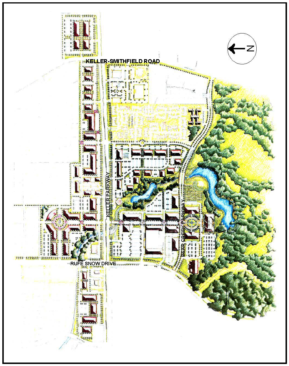
Figure 1 - Town Center Master Plan
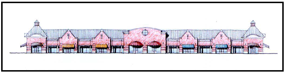
Figure 2 - Single Story Building Elevation
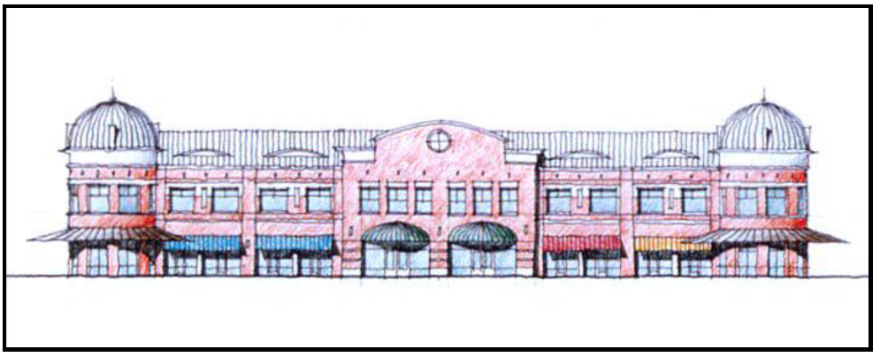
Figure 3 - Two Story Building Elevation
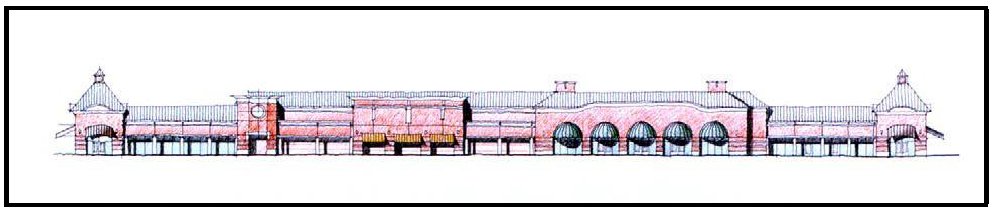
Figure 4 - Grocery/Retail Building Elevation
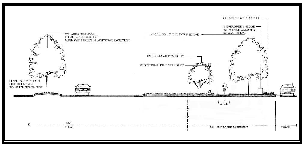
Figure 5 - FM 1709
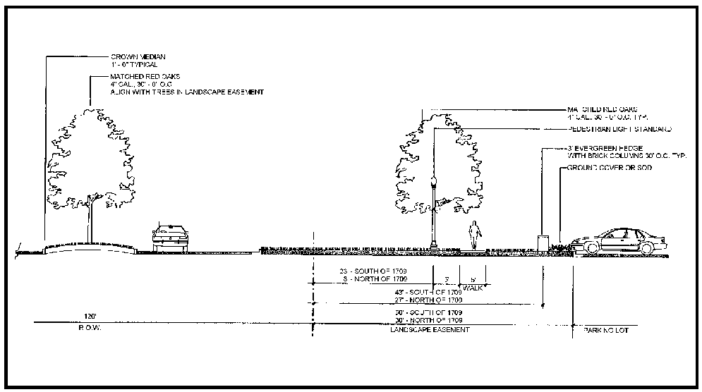
Figure 6 - Rufe Snow Drive/Keller-Smithfield Road With Retail Frontage
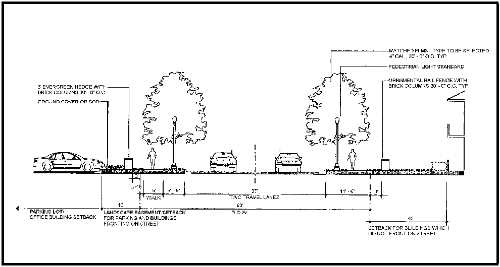
Figure 7 - Country Brook Lane
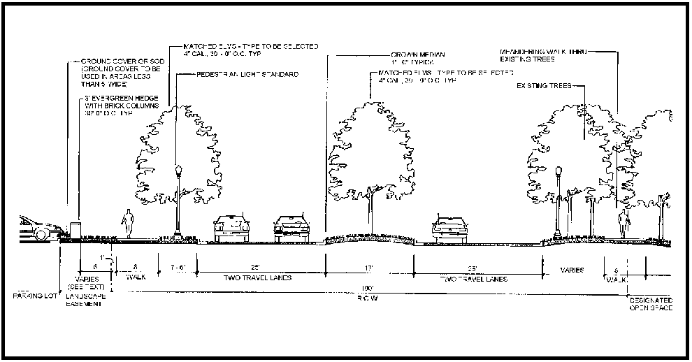
Figure 8 - Bear Creek Parkway (Divided Cross Section)
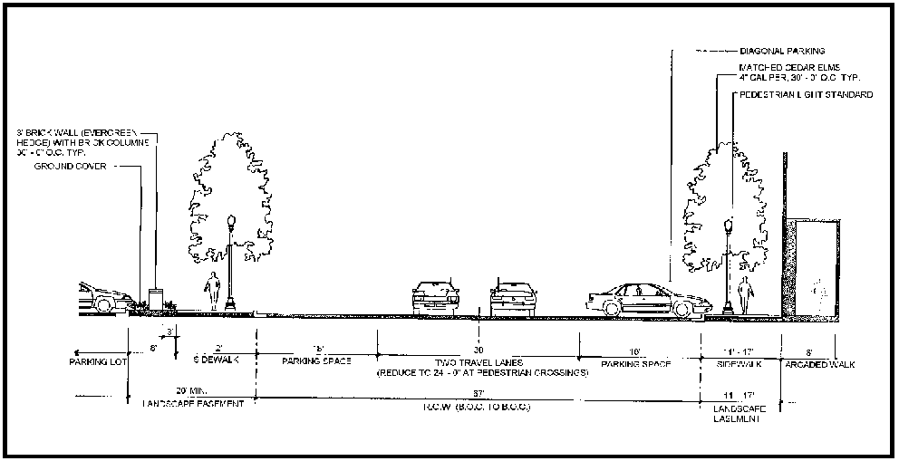
Figure 9 - Town Center Lane
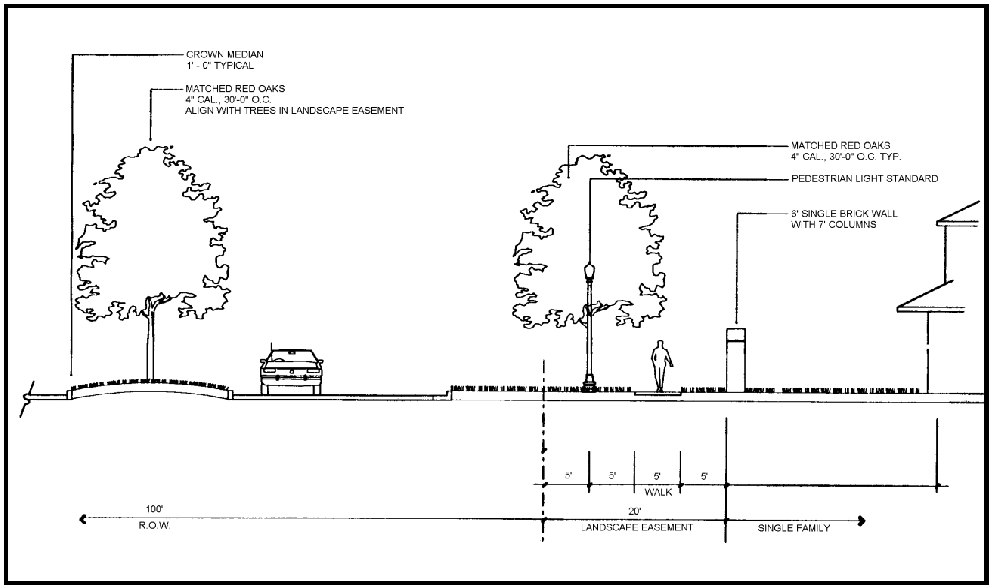
Figure 10 - Keller-Smithfield Road With Single Family Frontage
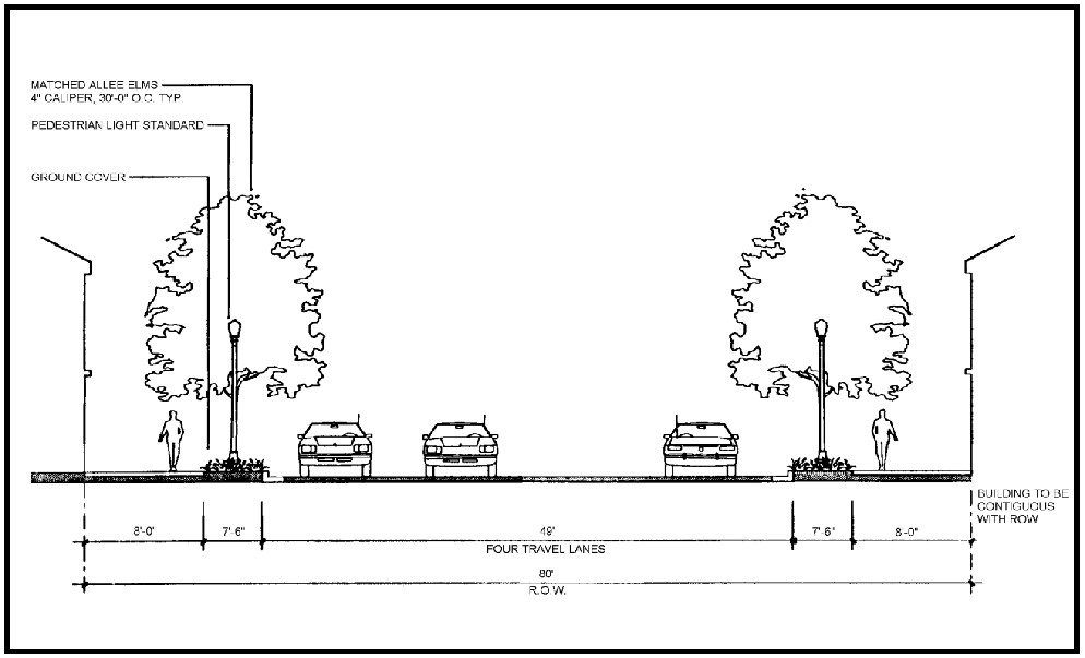
Figure 11 - Bear Creek Parkway at Town Center (Undivided Cross Section)
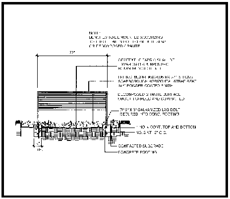
Figure 12 - Bench Details
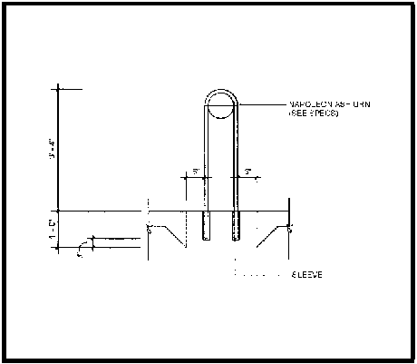
Figure 13 - Ash Urn Details
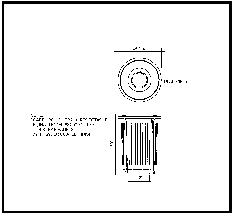
Figure 14 - Trash Receptacle Details
Figure 15 - Pedestrian Light Pole Details
Figure 16 - Parking Light Details
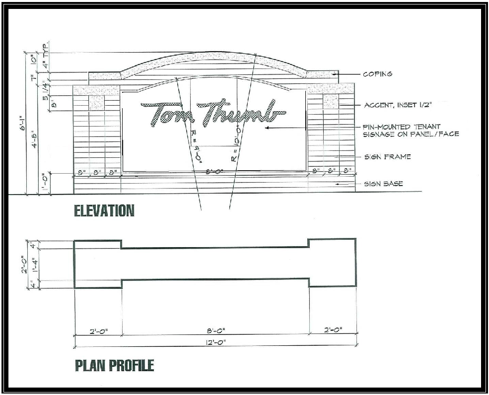
Figure 17 - Monument Sign Details
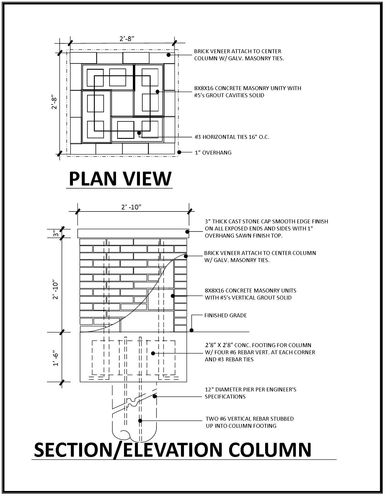
Figure 18 - Brick Columns Details
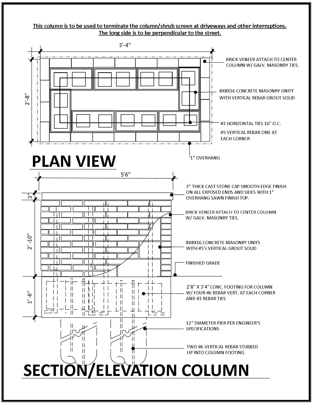
Figure 19 - Brick Columns Details
(Ord. No. 1959, § 2(Exh.B), 12-3-19; Ord. No. 2072, § 2(Exh. A), 6-21-22; Ord. No. 2104, § 2, 12-6-22; Ord. No. 2138, 9-5-23; Ord. No. 2158, § 2(Exh. A), 3-5-24)
8.18. - Town Center Medical Overlay
A.
General Purpose and Description. The purpose of the Town Center Medical Overlay District is to allow the ability for "medical clinic" uses to be utilized within this designated area by right. The regulations and standards of this overlay district reflect all standards and regulations of Town Center, except for the use of "medical clinic" uses.
1.
Boundary. The Town Center Medical Overlay encompasses land parcels east of Town Center Lane, and north of Keller Parkway. The Town Center Medical Overlay consists of 1135, 1139, 1141, 1149, and 1151 Keller Parkway. The boundary of the District is shown in Figure 1.
B.
Permitted Uses. The Town Center Medical Overlay District conforms to the uses of the Town Center zoning district, with the exception that "medical clinic" uses shall be permitted by right.
C.
General Standards. All applicable Town Center zoning district standards shall apply.
1.
Parking.
a.
Parking for all medical office uses shall comply with Town Center standards in Section 8.03, all other uses shall also meet Town Center standards.
2.
Landscape Requirements. All landscape requirements shall follow the Town Center landscape requirements under Section 8.03.
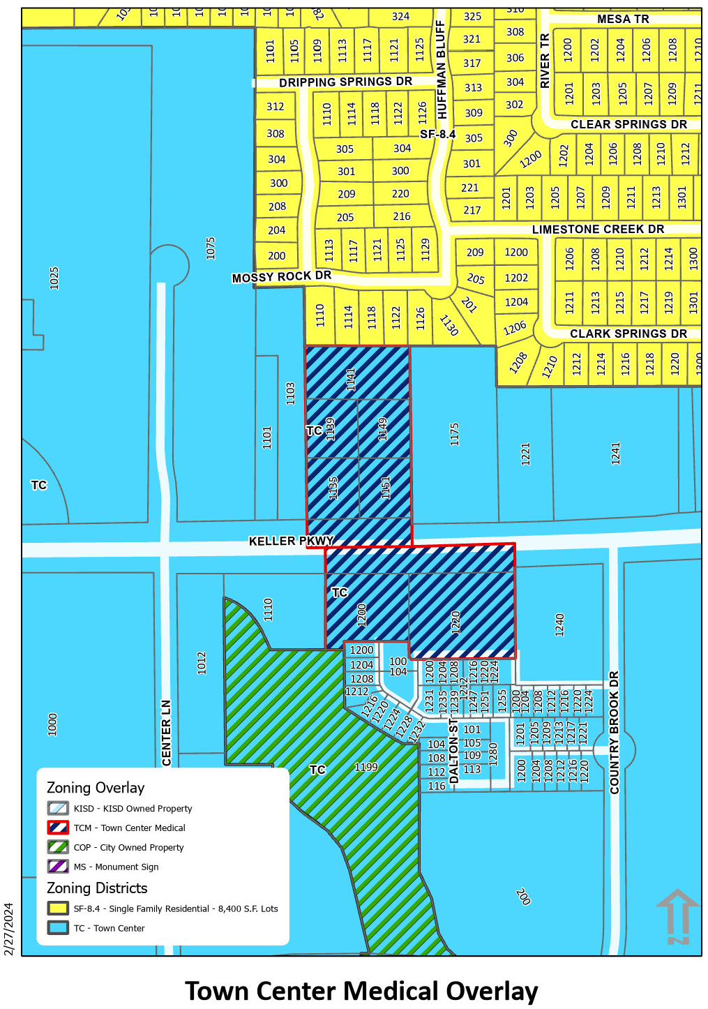
Figure 1 - Town Center Medical Overlay District
TCM Zoning District Use Table
P = Permitted Uses
SUP = May Be Approved as Special Use Permit
- = Not Permitted
(Ord. No. 2072, § 2(Exh. A), 6-21-22; Ord. No. 2104, § 2, 12-6-22; Ord. No. 2158, § 2(Exh. A), 3-5-24)
Section 8.19 - OTK - Old Town Keller
1.
General Purpose and Description. The OTK District encompasses most of the original town site of Keller. The area generally contains a mixture of some of the oldest buildings in Keller along with newer uses and buildings that have replaced older structures over the years. Vacant lots are scattered throughout the district. The OTK District is designed to transform the area into a historic focal point of the City with the character of a small Texas town of the early to middle 1900's. The standards set forth in this district will ensure design consistency in both the redevelopment of existing structures and in new developments.
a.
Boundary Established. The boundary of the OTK Overlay District consists of Johnson Road on the north, the Union Pacific Railroad on the west, and the actual Bear Creek on the south. The eastern boundary follows various property lines near Elm Street and Ruby Street. Please refer to the attached Old Town Keller boundary map for exact boundaries (See Figure 1 within this Section).
b.
Subdistricts Created.
1)
Main Street Subdistrict. The Main Street Subdistrict consists of all properties with frontage along Main Street and Keller Parkway. This subdistrict is characterized by continuous storefronts along the streets with deep, long, and narrow shops. Buildings are typically one or two stories in height with flat roofs and display a historic mercantile character.
2)
Neighborhood Subdistrict. The Neighborhood Subdistrict consists of all other properties within the OTK boundary. A mixture of architectural styles including Minimal Traditionalist with Tudor influence, Bungalow, Craftsman, American Foursquare, and Ranch Style. There are a few examples of the historic mercantile character.
c.
Monument Sign Overlay District Created. The boundary of the Monument Sign Overlay District is the Main Street Subdistrict north of Keller Parkway.
2.
Site Plan Required. All developments within the OTK District shall be subject to design review as part of the site plan review process. A detailed site plan as outlined in this Code shall be submitted for each use in OTK. Unless specifically noted within this section, all requirements of this Code apply to the OTK District. Design review is required in this district to ensure that development within the district is in conformance with design guidelines for OTK and that proposed development is architecturally compatible and within the historic character of OTK. Site plan approval shall be required for the following:
a.
All new developments/buildings.
b.
A change of use in an existing structure.
c.
Additions to existing non-residential buildings or additions to residential buildings costing twenty-five percent (25%) or more of appraised value as determined by the Tarrant Appraisal District.
d.
Remodeling of existing non-residential buildings costing twenty-five percent (25%) or more of appraised value as determined by the Tarrant Appraisal District.
3.
Development Standards - Main Street Subdistrict of Old Town Keller.
a.
Site Orientation and Layout. The front facades of buildings or dining patio fencing in new developments or proposed remodeling shall be located close to the sidewalks to encourage pedestrian involvement and to provide an area for landscaping, benches, tables and other types of street furniture. Parking shall be provided at the rear of developments (see Figure 2 within this Section). Developers shall share in the cost of remote parking lots if parking cannot be provided on site.
b.
Size of Lot.
1)
Minimum lot area: Two-thousand five-hundred (2,500) square feet. (Amended by Ord. No. 1805 on August 16, 2016)
2)
Minimum lot width: Twenty-five feet (25'). (Amended by Ord. No. 1805 on August 16, 2016)
3)
Minimum lot depth: Sixty feet (60'). (Amended by Ord. No. 1805 on August 16, 2016)
4)
Lot and tracks in existence prior to July 7, 2015 shall be deemed conforming and may be developed or redeveloped in compliance with all other sections of this Code, provided their dimension are unchanged except for dedications of Rights-of- Way. (Amended by Ord. No. 1805 on August 16, 2016)
c.
Size of Yards.
1)
Minimum front yard: The character of Old Town calls for 'Build-to' lines, reducing the setback from the street as much as possible while still accommodating the landscape buffer, sidewalk and necessary easements. This is typically fifteen feet (15'), however may vary from case-to-case to achieve the build-to scenario.
2)
Minimum side yard: Fifteen feet (15') adjacent to a street.
3)
Interior side yard: No side yard is required provided that:
a)
Both property owners agree to adjoin buildings.
b)
Adequate fire lanes and circulation is provided on site. c) Appropriate building codes can be met.
4)
Minimum rear yard: Five feet (5').
d.
Building Height. Maximum building height shall be two (2) stories or thirty-five feet (35'). Buildings may be up to four (4) stories if approved by the City Council at the time of site plan review. Building height shall be measured from the ground to the peak of the roof. New construction shall have a minimum height of twenty feet (20') to maintain a well- defined street space.
4.
Outside Storage and Outside Display.
a.
The provisions for outside storage and display shall apply to all permitted uses in accordance with this Code within the Old Town Keller District (OTK).
b.
Outside storage and display are prohibited on vacant or undeveloped lots.
c.
All outside storage and display areas shall not be located in or on any required parking spaces, sidewalks, public rights-of-way, or required landscape or buffer areas.
d.
A minimum accessible pathway in areas used for outside storage or display shall be provided to allow for flow of pedestrian traffic outside of designated vehicular traffic drives.
e.
All outside storage and display areas shall be maintained free of garbage and other debris.
f.
Outside storage and display areas for single-occupant or multi-occupant structures or buildings shall be limited to ten percent (10%) of the total gross floor area of the structure or building with a maximum storage and display area of one thousand five hundred (1,500) square feet.
g.
Merchandise must be freestanding and not be located in or on pallets, crates, stands, shelving, racks, or similar types of storage structures.
h.
Only goods and merchandise associated with the existing on-site business use may be sold or displayed on-premise.
i.
Outside storage and display areas of bulk goods and merchandise including, but not limited to mulch (bag or bulk), concrete, salt, tires, or other similar products that cannot be easily carried into the store for purchase shall meet the following requirements:
1)
Outside storage and display areas are located in the side or rear yards.
2)
Outside storage and display areas, goods, and merchandise shall not exceed the height of six feet (6').
3)
Outside storage and display areas shall be screened from view of the public rights- of-way and adjacent residential properties by an opaque fence of suitable height to prevent visibility from public rights-of-way.
4)
Where screening or fencing is provided or required, decorative iron with landscaping, aluminum with landscaping, wood, or materials being used on the primary structure or building shall be used for fencing. Other materials may be considered with the administrative approval of the Planning Manager.
5)
Screening shall not be required if the outside storage and display area is located out of view from any public rights-of-way.
5.
Design Standards - Main Street Subdistrict of Old Town Keller.
a.
Architectural Requirements.
1)
Materials. The selected architectural materials must reflect a sense of quality, history, and permanence by utilizing brick, stone, stucco, fibrous cement and concrete. The use of split-faced concrete block shall be limited to the base of a building up to three feet (3') in height from the foundation. Metal and canvas are acceptable materials for awnings and canopies. Vinyl or plastic awnings or canopies shall not be allowed. The color of building materials and the facade shall reflect the eclectic character of the early to mid 1900's, and include earth tones of red, tan, brown and off-white. Accessory structures shall compliment the main structure in façade and design.
2)
Façade composition pattern of openings and surface features, a recognizable entry, an interesting roofline, and appropriate building materials. Aspects of the architecture and eclectic character of the Main Street subdistrict, reminiscent of early to middle 1900s, such as materials, colors, window types, cornices, and overall proportions should be reflected in the overall facade composition. Blank walls are prohibited on the front facade and on any facades that may face side streets. As much storefront glass as possible must be incorporated into the facade along with projecting elements and recesses in the facade to define individual tenants within the building. Materials and architectural elements of the front facade shall be carried on all sides of the building (see Figure 3 within this Section).
3)
Building entrances. Building entrances must be prominent and easy to identify. The main building entrance must be distinguishable along the storefront. At least one of the following treatments is required:
a)
Entrance located in the center of the facade, as part of a symmetrical overall composition;
b)
Entrance accented by architectural elements, such as columns, overhanging roofs, awnings, or balconies;
c)
Entrance marked or accented by a change in the roofline or change in the roof type.
If rear or side entries are provided, they must be prominent and easy to identify and should be treated as a secondary main entrance in a manner similar to the main entry. Buildings adjacent to the promenade must provide a primary access to the promenade.
4)
Accent elements. Accent elements such as cut-out openings and latticework, balconies, ornamental building numbers, medallions, and decorative ceramic tile accents must be incorporated into the design of the building to reflect the eclectic character of the Main Street subdistrict, reminiscent of the early to middle 1900s.
5)
Mechanical equipment. Exterior building walls shall be tall enough to shield all rooftop mechanical equipment from the streetview. Other screening devices such as latticework, louvered panels, any treatments that are compatible with the building's architecture may be considered on a case-by-case basis with approval by the City Council. All ground-mounted mechanical equipment shall be screened within an opaque material matching the building style, durability and color.
6)
Residential-style architecture. Any buildings, in the form of new construction or being relocated from another location and having a residential-style architecture fitting the character of the district, may be considered in the Main Street subdistrict on a case-by-case basis and approved by the City Council as an element of a site plan application.
b.
Landscaping, Lighting, Street Furniture, Fencing, and Sidewalk Requirements.
1)
Street Trees. Large canopy trees shall be planted along Main Street in a straight line spaced at a distance allowing for healthy mature tree canopy between the sidewalk and the street in areas where possible . Understory street trees may be proposed in place of large canopy trees if overhead power lines are present. Such proposals shall be considered by the Planning Manager or his/her designee for final determination. Tree grates shall be provided for tree planting in paved areas. Open tree grates shall be at least five feet by five feet (5' x 5') with openings no more than one- fourth inch (¼") in width (in narrow sidewalk areas, three-foot by seven-foot (3' x 7') is an acceptable alternate). The size and shape of the tree grates must relate to the paving pattern. The grates must be designed to allow for tree trunk growth and be constructed of ductile iron with a durable factory applied finish. Landscape up-lighting and electrical outlets shall be provided in the tree grate area. All trees and landscaping must be provided with adequate and inconspicuous irrigation systems.
2)
Courtyards and Small spaces. Scale appropriate landscaping shall be designed and planted in courtyards and in areas where space is limited near existing buildings. All new developments shall have foundation watering to reduce soils shifting and appropriately scaled plantings in front of the building and along any sides adjacent to public streets. The foundation planting area shall be a minimum of five feet (5') in width and contain a mixture of landscaping to provide seasonal interest and color.
3)
Existing Building Surrounded by Paving. In lieu of foundation planting, landscaping may be provided in raised planters, pots or raised landscape beds in the front and sides of existing buildings that are surrounded by paving or to provide for an outdoor patio. The container landscaping chosen must provide near equivalent coverage as a five foot (5') foundation landscape bed. An automatic irrigation system must be provided to ensure adequate hydration of the selected landscaping.
4)
Streetlights and Street Furniture. Decorative style streetlights, benches and trash receptacles of a style and color similar to those currently in place and provided in Figure 6. Street lights shall be installed on all street corners and at a spacing between street corners not to exceed sixty feet (60') in a uniform manner as each property is developed or redeveloped.
5)
Lighting. Light for off-street parking facilities shall be of the same height, style and color of the required streetlights mentioned above. Lighting fixtures attached to buildings shall be of a decorative or historic character that is compatible with the architecture of the buildings and the required streetlights.
6)
Fencing and Screening. Masonry products in keeping with the OTK common area style must be used to screen dumpsters. In areas where fencing is appropriate, as determined by the DRC, materials and styles fitting the character of the neighborhood shall be used. If wood fencing is proposed, details including construction, footing design, specific materials proposed, and maintenance to maximize life must be included in the site plan and permit request.
c.
Sidewalk Patios.
1)
Sidewalk Patios. Sidewalk patios are encouraged along the promenade. The design of the interior and immediate surroundings of a sidewalk patio should adhere to the following guidelines.
a)
The clear height from grade level to any obstruction such as an overhead canopy should be a minimum of seven feet (7').
b)
The surface area of an outdoor patio may not exceed the interior floor area of the primary licensed establishment.
c)
The path to the door of the primary licensed establishment shall be maintained at three feet (3').
d)
The patio shall extend to the building line when located between the primary licensed establishment and the street.
2)
Patio Fencing. Fences or railings are used to delineate and contain the patio.
a)
A fence or other vertical barrier must be used to delineate the perimeter of the patio area.
b)
The width of any opening in a fence should be no greater than six and a half feet (6.5') and no less than three feet (3').
c)
The required height of a fence facing the street is three and a half feet (3.5'). Side screens may be up to seven feet (7') high above the grade. Such screens should not be entirely opaque but may be formed by structures with lattice or grillwork and climbing vines.
d)
Fences and screens should be easily removable at all times.
e)
The design, materials and colors used in the development of the patio restaurant should be of high quality finish and compatible with the streetscape.
f)
All finishes should be clean and free of any exposed screws or other fasteners. g) Perimeter fences shall not obstruct the line of sight for pedestrians and drivers.
3)
Awning. Awnings can be used to provide shade and weather protection for the patio as well as visual screening from adjacent uses.
a)
Materials should be securely fastened to a frame, which is either retractable or demountable.
b)
Sheltering material should be fabricated and finished to fit the supporting structure with no loose or unsecured edges.
c)
Materials and colors should coordinate with the surrounding buildings and streetscape elements. They should generally contribute to the design theme of the street.
d)
The awning should not extend into the public sidewalk adjacent to the patio.
e)
The awning should attach to the building below the signage identifying the restaurant with a minimum height of seven feet (7').
f)
Lighting and other attachments to the awning should be securely fixed and integrated to the supporting structure.
g)
A building permit is required for awnings.
h)
Awnings shall be maintained in excellent condition at all times.
4)
Enclosures. Enclosures may be used for more extensive weather protection and to extend the patio season.
a)
Enclosures must include a minimum of one continuous opening (from ground to canopy) to the outside (ie. no roll-down walls of any kind, however slide up/down doors are acceptable)) that comprises at least 25% of the total perimeter of all of the patio walls.
b)
The enclosure area should be well ventilated to provide for dispersion of smoke and exchange of air.
c)
Ventilation should be directly to the exterior and may be achieved by passive means through vents in the awning and/or active fans.
d)
Cash machines should not be located within the patio area, except where enclosed within a freestanding building or kiosk.
e)
A building permit is required for the construction of an enclosure.
5)
Lighting. Lighting is important to the function and appearance of a patio as well as the safety and security of the public environment.
a)
Exterior lighting should not spill into abutting private property or interfere with the public thoroughfare.
b)
Lighting should be demountable with no exposed cables or energized fixtures. c) Lighting design should coordinate with patio furnishings and streetscape design.
d)
Lighting should not be attached to trees or shrubs on City property; however string lighting to highlight deciduous trees within the patio area is permitted.
e)
Lighting should be used to identify the entrance to a patio.
f)
Pathways through a patio should be illuminated to ensure the safety of patrons and staff.
6)
Plant Materials. Plant materials contribute to our general comfort and enjoyment of the patio experience.
a)
Planting of annuals, vines and container-grown vegetation is encouraged but should be easily removable from the site.
b)
Planters should be integral with fence and deck structures to maintain a compatible design relationship.
c)
Deciduous shade trees enhance the quality of the patio space with shade and screening.
d)
Planting should be used along with spatial separation and structures to screen a patio from adjacent vehicle parking and circulation.
e)
Planters must not obstruct the public right of way.
7)
Surface Treatment. The paving of a patio surface provides durable and attractive platform for the patio, which is distinct from the public right-of-way.
a)
Paving should be durable, skid-proof and easily maintained in a clean and unobstructed condition.
b)
The minimum slope of pavement should be 1% and the maximum slope 4% within the seating area.
c)
A change in elevation may be used to define the edge of a patio, but should not create an additional barrier to movement.
d.
Sidewalks. All sidewalks along Main Street in the Main Street Subdistrict shall be constructed of brick pavers in the same design, pattern and color as the sidewalk in place along South Main Street between Taylor Street and the Big Bear Creek Bridge. Properties with existing concrete sidewalks shall upgrade the sidewalk with brick pavers in the manner described above when any building additions are proposed or when remodeling existing buildings at a cost of twenty-five percent (25%) or more of the appraised value as determined by the Tarrant Appraisal District.
e.
Signage Requirements. All signage for new buildings/uses or change in use shall comply with these requirements at the time of sign permit.
1)
A sign permit shall be required for all signage.
2)
Signage may be internally or externally illuminated.
3)
Unless located in the OTK Monument Sign Overlay District, monument signs are not permitted in OTK. Within the OTK Monument Sign Overlay District, only one (1) monument (see 8.09) or detached sign (i.e. post and bracket) shall be allowed per business per public street frontage.
4)
Only one (1) attached sign shall be allowed per building or lease space elevation exclusive of address number signs and shingle signs. (Amended by Ord. No. 1799 on July 5, 2016)
5)
Sign sizing shall be as set forth in Section 9.05. (Amended by Ord. No. 1799 on July 5, 2016)
a)
Wall mounted signs on Main Street must be historic in context with the eclectic character of the Main Street Subdistrict.
b)
Projecting signs are considered attached wall mounted signs and shall be allowed provided that they do not extend more than four feet (4') from the wall surface. (See Figure 4 within this Section). Vertically oriented (projection sign) signage shall be placed a minimum of ten feet (10') above grade.
c)
Shingle signs on Main Street may be up to four (4) square feet and in keeping with the eclectic character of the Main Street Subdistrict.
6)
Sign materials and styles shall reflect the character of Old Town Keller. Post and bracket styles; wood, metal, or masonry materials with painted, engraved, or mounted letters are encouraged.
7)
Signs must be located on the facade in areas designated for this function; for example, a recessed or framed area or a parapet panel between shop-front and roofline.
8)
Color, materials, sizes, shapes, and lighting of signs must be compatible with the architecture of the building, the business it identifies and the character of the surrounding area.
9)
Sign shapes must be simple and straightforward to communicate well. Signs as symbols are permitted and encouraged because they are easily read and add to the vitality of a storefront.
10)
Portable signs such as menu boards for restaurants or to direct customers to parking areas shall be allowed provided they do not block sidewalks or streets and are stored indoors after hours of operation.
11)
Murals shall be considered on a case-by-case basis. Public murals shall be considered by the Public Arts Board for recommendation to and approved by the City Council. Private murals approval process includes a recommendation from the Planning and Zoning Commission to the City Council based on the following criteria:
•
Shall not include any owner identification or commercial text message; however, it may contain graphics or images that relates to the products or services offered on the premises where the mural is located.
º
Murals or art representation displaying any owner identification or commercial text message will be considered as a "flat/wall sign."
•
Shall not depict nudity or obscene images and be generally acceptable for viewing by all audiences.
•
Materials utilized in painting a mural shall have proven durability and shall be maintained or removed if not maintained.
12)
Temporary signs are allowed in accordance with the general sign provisions of this Code. (Amended by Ord. No. 1799 on July 5, 2016)
f.
Parking Requirements. Parking areas situated in front of buildings in new developments in the Main Street Subdistrict are prohibited. In new developments, required parking shall be provided at the rear of buildings. Parking provided on the side of a building will be considered on a case-by-case basis and approved by the City Council as an element of a site plan application. The parking requirements of this Code shall be enforced in new developments to the greatest extent possible. Developers must share in the cost of remote parking lots if all required parking cannot be provided on site.
6.
Development Standards - Neighborhood Subdistrict of Old Town Keller.
a.
Site Orientation and Layout. The Neighborhood Subdistrict is more residential in character and contains a mixture of some of the early homes built in Keller and some infill residential structures from the 1900's through the 1970's. The structures in this subdistrict are set back farther from the street than the structures in the Main Street Subdistrict to allow for additional landscaping. Most of the streets have wide right-of-ways (approximately eighty feet [80']) that will accommodate ninety-degree (90°) head in parking within the street right-of-way (see Figure 5 within this Section).
b.
Size of Lot. Lots vary in size and dimension through the Neighborhood Subdistrict of OTK. Many of the structures built were designed to fit on narrow lots. Lot and yard sizes should be suitable to fit the character of the area and maintain health and safety as defined in the current building and fire codes.
7.
Design Standards - Neighborhood Subdistrict of Old Town Keller.
a.
Architectural Requirements. All new structures of the Neighborhood Subdistrict shall resemble the residential character and style of a Texas small town of the early to middle 1900's (see Figure 4).
Architectural styles considered appropriate include American foursquare, Craftsman, Bungalow, Minimal Traditional, and Ranch Style,
Any buildings, in the form of new construction or being relocated from another location and having a non-residential-style architecture fitting the character of the district, may be considered in the Neighborhood subdistrict on a case-by-case basis and approved by the City Council as an element of a site plan application.
b.
Landscaping, Lighting, and Sidewalk Requirements.
1)
Street Trees. A minimum of two large canopy trees shall be planted at suitable spacing, based on the type of tree, to accommodate mature canopy spread on center within the required front yard centered between the building and the property line. All trees and landscaping must be provided with adequate and inconspicuous irrigation systems.
2)
Ornamental Trees and Shrubs. Ornamental trees and shrubs shall be planted in courtyards and in areas where space is limited near existing buildings. All new developments shall have foundation plantings, either in ground, raised planters or pots, in front of the building and along any sides adjacent to public streets. The foundation planting area shall be a minimum of five feet (5') in width in ground, or of equal spacing if pots or raised bades are used, and contain a mixture of drought and heat tolerant ornamental trees, shrubs, and seasonal color.
3)
Streetlights, Parking Lot Lighting and Building Lighting. The streetlight, parking lot lighting, building lighting and street furniture requirements for the Neighborhood Subdistrict are the same as the requirements for the Main Street Subdistrict.
4)
Sidewalks. Sidewalks in the Neighborhood Subdistrict shall be six feet (6') in width and constructed of concrete with a two-foot (2') wide band of pavers spaced every ten feet (10'). Paver's band shall resemble the brick paver sidewalks along Main Street.
c.
Signage Requirements.
1)
The attached signage requirements for the Neighborhood Subdistrict are the same as the Main Street Subdistrict.
2)
Detached or Ground Mounted Signage.
a)
All detached signage shall be externally illuminated.
b)
A sign permit shall be required for all new signs or alterations to signs.
c)
Only one detached sign shall be allowed per business per public street frontage.
d)
For single-occupant buildings, detached signage shall not exceed fifteen (15) square feet in total surface area and six feet (6') in height. For multi-occupant buildings, all detached signage shall not exceed twenty-four (24) square feet in total surface area and six feet (6') in height.
e)
Signs must reflect the character of Old Town and may include post and bracket or double-pylon signs using wooden posts or painted metal poles or monument style signs shall be allowed. Other styles that reflect the character of Old Town will be considered.
f)
Sign materials shall be consistent with the character of Old Town and the primary licensed establishment.
g)
Color, materials, sizes, shapes, and lighting of signs must be compatible with the architecture of the primary licensed establishment, the business it identifies and the character of the surrounding area.
h)
Sign shapes must be simple and straightforward to communicate well. Signs as symbols are permitted and encouraged because they are easily read and add to the vitality of a storefront.
d.
Parking Requirements. As existing structures in the Neighborhood Subdistrict are redeveloped, the developer or property owner shall be responsible for constructing the ninety-degree (90°) head in parking within the right-of-way composed of either concrete or asphalt. The developer or property owner is also responsible for the construction of a concrete curb adjacent to the sidewalk and a concrete valley gutter between the street edge and the head-in parking space (see Figure 7 within this section for street cross-section). If head in parking does not provide an adequate number of parking for a particular use, parking may be added at the rear of the building if accessible, or the property owner may contribute funds for the construction of remote parking facilities. These requirements also apply to new developments.
OTK Zoning District Use Table
P = Permitted Uses
SUP = May Be Approved As Specific Use Permit
- = Not Permitted
8.
Illustrations.
Figure 1 - Old Town Keller Boundary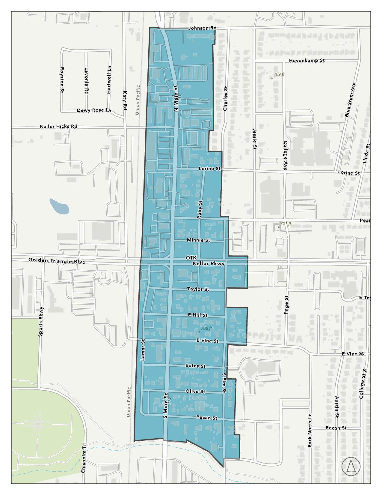
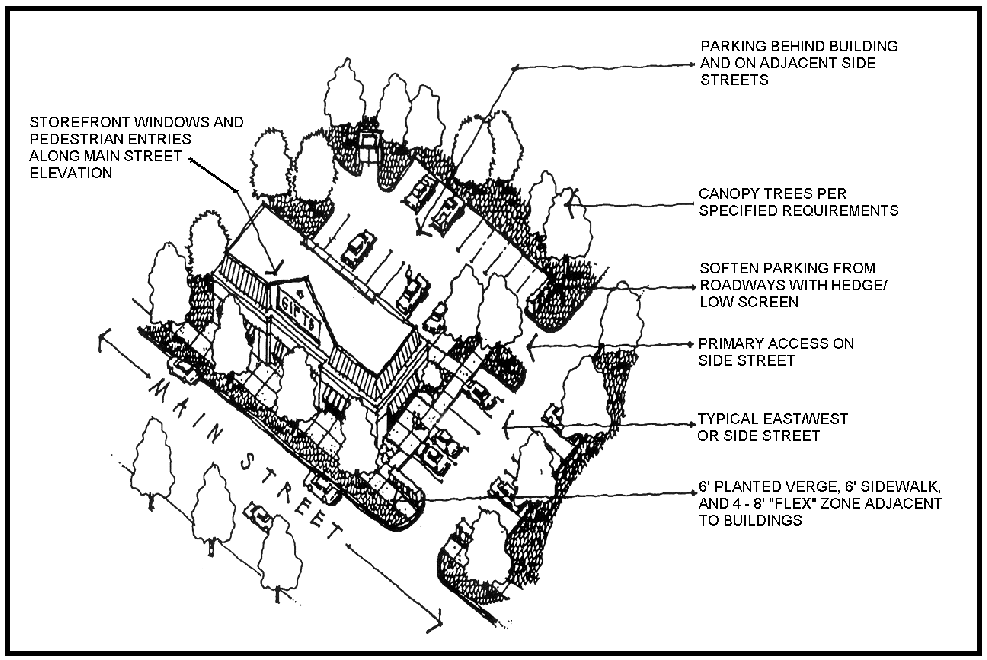
Figure 2 - Building Relationship to Main Street
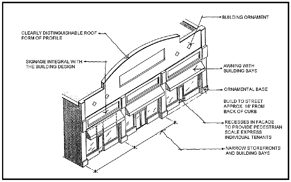
Figure 3 - Main Street Facade Treatments
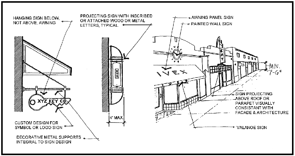
Figure 4 - Projecting Signs & View From Main Street
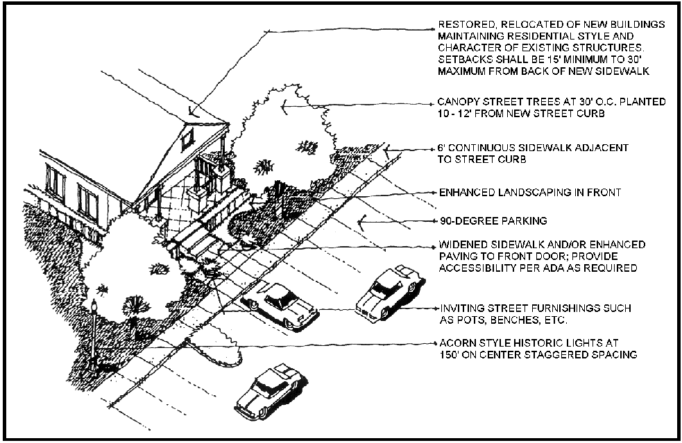
Figure 5 - Typical Neighborhood Street
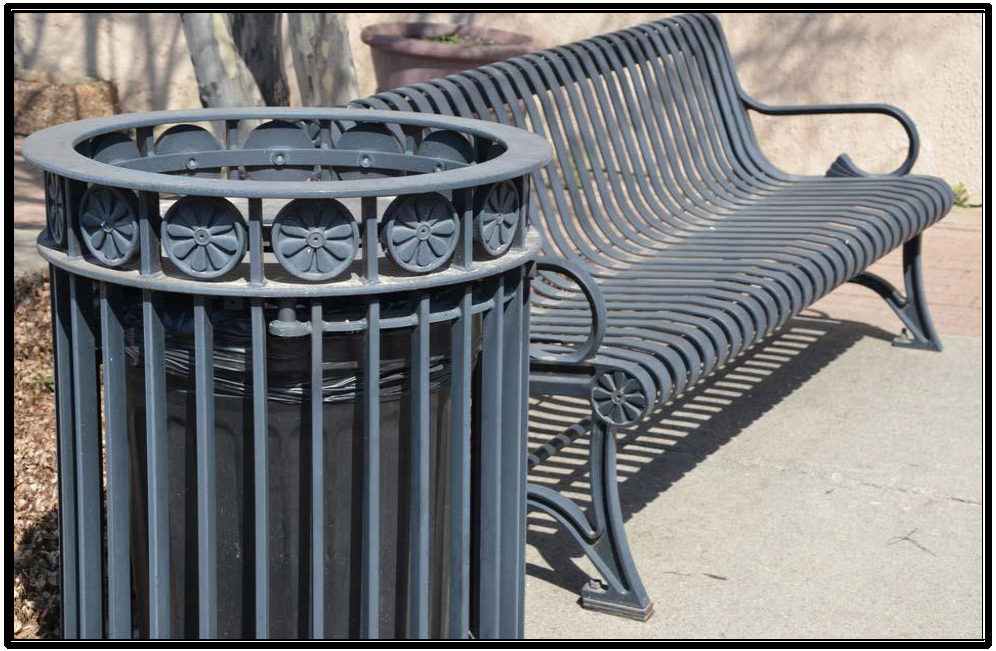
Figure 6 - Trash Receptacles and Street Furniture
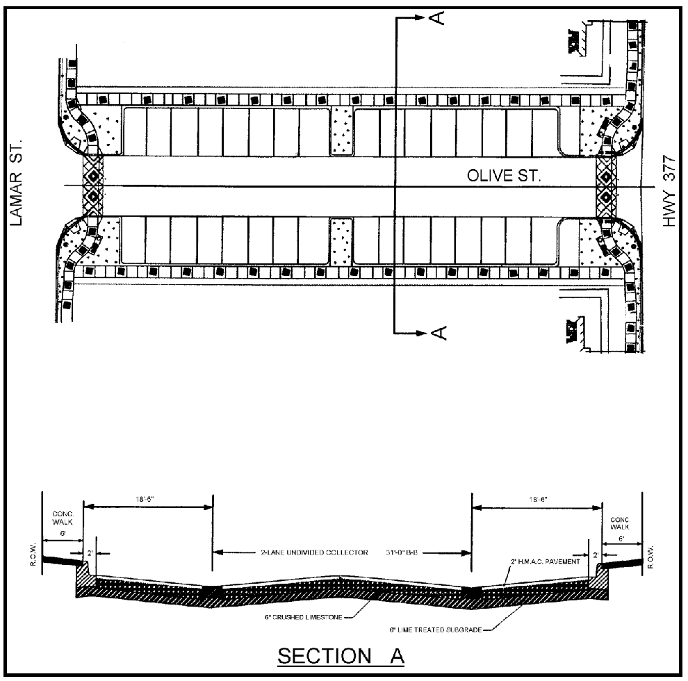
Figure 7 - Typical Cross Section of Street in Old Town Keller
(Ord. No. 1959, § 2(Exh.B), 12-3-19; Ord. No. 2072, § 2(Exh. A), 6-21-22; Ord. No. 2083, § 2(Exh. A), 8-2-22; Ord. No. 2087, § 2(Exh. A), 9-6-22; Ord. No. 2104, § 2, 12-6-22; Ord. No. 2105, § 2, 12-20-22; Ord. No. 2158, § 2(Exh. A), 3-5-24)
Section 8.20 - Katy Road - Katy Road District
1.
General Purpose and Description. The Katy Road District area generally contains a mixture of industrial-type businesses and older buildings along the railroad corridor in Keller. There are a few residential lots scattered throughout the district. The Katy Road District is designed to encourage redevelopment and increase economic growth for this area. The regulations and standards set forth in this district will ensure design consistency in both the redevelopment of existing structures and in new developments.
2.
Boundary. The boundary of the Katy Road District consists of Caylor Road on the north, the Union Pacific Railroad on the east, Katy Road on the west, and Golden Triangle Boulevard on the south, and includes all property within this boundary. Please refer to the attached Katy Road District boundary map for exact boundaries (See Figure 1 within this Section).
3.
Site Plan/Design Review Required. A detailed site plan as outlined in this Code shall be submitted for any new non-residential building, expansion or addition to an existing non-residential building, or conversion of an existing structure from residential to non-residential use. Design review is required in this district to ensure that development within the district is in conformance with site and architectural standards of this overlay district.
4.
Permitted Uses.
a.
The following use charts specify those uses permitted in the Katy Road district.
b.
Any new or unlisted uses not shown on the use chart for the Katy Road District shall follow the provisions for classification of new or unlisted uses as stated in Section 8.03 (B.1) of this Code.
KR Zoning District Use Table
P = Permitted Uses
SUP = May Be Approved As Specific Use Permit
- = Not Permitted
5.
General Standards. The standards within this section apply to all properties within the Katy Road District unless specified otherwise.
a.
Access Management. Driveway approaches shall follow these guidelines:
1)
Required widths:
a)
One-Way Driveway: Fifteen feet (15') plus ten-foot (10') radii.
b)
Two-Way Driveway: Twenty-four feet (24') plus fifteen-foot (15') radii.
c)
A maximum width of forty-five feet (45') plus twenty-foot (20') radii will be allowed where significant traffic is projected for two-way access as determined by the Director of Public Works.
2)
Each property shall be permitted a minimum of one (1) driveway. No minimum spacing between driveways along Katy Road shall be required.
3)
Driveways shall be located a minimum of two hundred fifty feet (250') from arterial street intersections and two hundred feet (200') from collector street intersections.
4)
All two-way driveways shall intersect at ninety degrees (90°).
5)
All non-residential driveway approaches shall be constructed in accordance with the City Standard Driveway Construction Details and be maintained by the property owners or property associations.
6)
Modifications or alternatives to the standards in Section 8.19(5.a) may be approved by the Director of Public Works if he/she determines that the requested changes will not create a serious detriment to the safety or operation of traffic on the street or roadway. The Director of Public Works may require that the applicant submit a traffic analysis if it is determined that such an analysis is necessary in order to render a decision on the request.
b.
Parking.
1)
The minimum number of parking spaces for all uses shall be provided at a rate of seventy-five percent (75%) of the required number of parking spaces per Section 9.02 of this Code.
2)
Parking areas shall be permitted in front of existing buildings or new developments.
3)
All off-street parking and maneuvering areas shall be paved to a minimum of six inches (6") of reinforced concrete over six inches (6") cement-limed or crushed limestone stabilized base compacted to ninety-five percent (95%) density or an equivalent asphalt section. Gravel, pavers or alternative pavement types intended to reduce storm water runoff may be approved by the Director of Public Works.
4)
Approaches for fire lanes, loading, and storage areas shall be paved to a minimum of seven inches (7") of reinforced concrete over six inches (6") cement-limed or crushed limestone stabilized base compacted to nine-five percent (95%) density.
c.
Landscape Requirements.
1)
Buffers.
a)
Minimum five-foot (5') landscape buffer adjacent to public streets.
b)
Minimum five-foot (5') landscape buffer adjacent to rear property lines. c) Landscape buffers along side property lines will not be required.
2)
Understory Trees.
a)
Understory trees shall be planted in landscape buffers adjacent to public streets and along rear property lines at a rate of one (1) ornamental tree per fifteen feet (15') of landscape buffer (see Article Nine - Recommended List for Required Landscape Areas).
b)
The required understory trees for landscape buffers adjacent to public streets may be placed in a linear arrangement with consistent spacing or in a random, free-form, and/or clustered arrangement.
c)
Understory trees shall be a minimum of eight feet (8') in height at the time of planting.
3)
Seasonal Color, Shrubs, Planters, Pots, and Beds. Seasonal color, living ground cover, and small shrubs may be used in lieu of ornamental trees for landscape buffers adjacent to public streets. Such plantings shall be provided in raised planters, pots, or landscape beds in the front and sides of existing buildings. The area for seasonal color and shrubs shall be equivalent to the area of the required front landscape buffer. One (1) five-gallon shrub shall be provided for every fifteen (15) square feet of landscape area. Landscape areas not planted with shrubs shall be planted with seasonal color and/or living ground cover.
4)
All trees and landscaping must be provided with irrigation systems.
d.
Development Standards.
1)
Site Orientation and Layout. The front facades of existing buildings and new developments may be located close to the street to provide an area for parking and landscaping. Parking may be provided in front or at the rear of developments.
2)
Size of Lot.
a)
Minimum lot area: Five thousand (5,000) square feet. b) Minimum lot width: Fifty feet (50').
c)
Minimum lot depth: None.
3)
Size of Yards.
a)
Minimum front yard: Fifteen feet (15'). Buildings shall be allowed to encroach fifty percent (50%) of a lot's minimum fifteen-foot (15') front building setback.
b)
Minimum side yard: Fifteen feet (15') adjacent to a street.
c)
Interior side yard: None.
d)
Minimum rear yard: Five feet (5').
e)
Adjacent to a Single-Family District or Use: None.
4)
Building Height.
a)
Maximum building height shall be twenty-five feet (25'). Architectural features may exceed twenty-five feet (25').
b)
Pitched roofs may exceed height limits with City Council approval provided they are gable or non-shed roof types.
c)
One (1) additional foot setback from all property lines for each additional two feet (2') in height above twenty-five feet (25').
e.
Design Standards.
1)
Architectural Requirements. The intent of the design standards that follow is to allow construction of buildings that reflect the context of existing industrial developments and close proximity to the railroad corridor.
2)
Building Materials.
a)
The selected architectural materials must reflect a sense of quality and permanence by utilizing brick, stone, concrete, stucco, and metal.
b)
The use of natural clay brick, native or manufactured stone, stucco, exposed concrete, textured concrete blocks (quick brick), split-face concrete blocks, fiber-cement materials or any other wall surface material allowed by building code shall be noted on the site plan elevations. Stucco may be used for cornices, medallions, and other architectural details and elements.
c)
The use of exposed metal exterior walls and finishes shall be allowed so long as it is architectural metal. For metal exterior finishes, the use of corrugated panels, profiled panels, deep ribbed panels, or concealed fastener systems are permitted and shall have a finish of a permanent material such as a baked or enamel finish or painted to the wall manufacturer's standards. Metal exterior walls shall be compatible in color with the principal buildings and existing surrounding structures.
d)
Roof material shall be asphalt composition, architectural metal, stone, clay or concrete roofing tile.
e)
Carports constructed entirely out of metal are permitted. Carports shall be shown on the site plan and shall be compatible in design and material with the main structure. Carports shall be located on the side or rear of the property and shall observe all building setback lines.
3)
Building Exterior Colors.
a)
Preferred colors of buildings and accessory structures are earth tones (red, brown, tan, off-white, green). Accessory structures shall be compatible with the main structure. The use of florescent paint, florescent colors and the extensive use of bright colors on buildings as commercial identity or signage shall not be permitted.
b)
Service doors, down spouts, utility boxes and panels, and other similar features on the buildings shall be painted to match the primary material on the building.
c)
The use of lighted stripes, exposed neon tubular lights or similar material on buildings or accessory structures shall not be permitted.
d)
Awning and canopies shall be architectural metal, canvas, glass, fiberglass, or fabric. Vinyl, plastic or similar materials for awnings and canopies are not allowed.
4)
Mechanical equipment. Roof top mechanical/electrical equipment shall be screened with an extension of the building facade or a compatible roof design and shall be tall enough to shield all rooftop mechanical equipment from the view from the street. The screening of equipment with metal screening, latticework, louvered panels, or other materials that are compatible with the building's architecture may be approved on a case- by-case basis by City Council. The screening of all ground-mounted mechanical equipment shall not be required.
5)
Service Areas and Loading Docks. Service area, loading docks, service doors, and trash collection areas fronting on streets or public open spaces shall be permitted. Screening of these areas shall not be required.
f.
Signage Requirements.
1)
Attached or Building Mounted Signage.
1)
Attached signs are allowed in accordance with the sign provisions in Section 9.05 of this Code unless otherwise specified.
b)
Sign materials shall consist of wood, metal, masonry, durable plastic, or similar materials with painted, engraved, or individual mounted letters.
c)
Only one attached sign shall be allowed per business per public street frontage. An additional attached sign may be permitted per business if facing the rear of the property.
d)
Murals shall be considered on a case-by-case basis. Public murals shall be considered by the Public Arts Board for recommendation to and approved by the City Council. Private murals approval process includes a recommendation from the Planning and Zoning Commission to the City Council based on the following criteria:
•
Shall not include any owner identification or commercial text message; however, it may contain graphics or images that relates to the products or services offered on the premises where the mural is located.
º
Murals or art representation displaying any owner identification or commercial text message will be considered as a "flat/wall sign."
•
Shall not depict nudity or obscene images and be generally acceptable for viewing by all audiences.
•
Materials utilized in painting a mural shall have proven durability and shall be maintained or removed if not maintained.
2)
Detached or Ground Mounted Signage.
a)
Detached or ground mounted signs are allowed in accordance with the sign provisions in Section 9.05 of this Code unless otherwise specified.
1)
Sign materials shall consist of wood, metal, masonry, durable plastic, or similar materials with painted, engraved, or individual mounted letters.
2)
Only one detached sign shall be allowed per business per public street frontage.
3)
Post and bracket or double-pylon signs using wooden posts or painted metal poles or monument style signs shall be allowed. Masonry framing of monument signs shall not be required.
e)
Detached signs for Single-Occupant or Multi-Occupant Buildings two thousand (2,000) square feet or less shall not exceed twenty-four (24) square feet in total surface area and six feet (6') in height.
f)
Detached signs for Single-Occupant or Multi-Occupant Buildings greater than two thousand (2,000) square feet to five thousand (5,000) square feet shall not exceed thirty-six (36) square feet in total surface area and six feet (6') in height.
g)
Detached signs for Single-Occupant or Multi-Occupant Buildings greater than five thousand (5,000) square feet shall comply with the sign provisions in Section 9.05 of this Code.
h)
The sign may be located within five feet (5') from the public right-of-way and shall not create hazards to traffic or pedestrians.
i)
Pole signs are not permitted.
3)
Miscellaneous Signage.
a)
Window signs are allowed in accordance with the sign provisions in Section 9.05 of this Code.
b)
Temporary banner signs are allowed in accordance with the sign provisions in Section 9.05 of this Code.
g.
Fencing.
1)
All fencing shall be shown on the site plan for the development and be approved as part of the site plan approval.
2)
Fencing shall be constructed of wrought iron, tubular steel, chain link, barbed wire, masonry, wood, fiberglass stockade, split rail, live screening, or a combination thereof.
3)
Fencing shall not exceed eight feet (8') in height unless specifically approved on a site plan by the City Council.
4)
Fencing shall be allowed within the front building setback.
h.
Screening.
1)
Screening walls between non-residential developments and single-family or two-family residential uses or zoning districts shall not be required.
2)
Screening walls around refuse storage, trash compactor, ground mounted utilities, heating/cooling units, and loading areas shall not be required.
3)
If screening walls are proposed, screening walls shall be constructed in accordance with Section 9.09 of this Code. Screening wall plans shall be submitted at time of Building Permit application in accordance with the application requirements listed in Section 4.13 - Landscaping and Screening Wall Plans.
i.
Lighting.
1)
Lighting shall be in accordance with Section 9.12 of this Code.
2)
No minimum setback shall be required for light poles placed on the site from all adjacent residential properties.
3)
Back-lit canopies or awnings shall not be allowed.
j.
Sidewalks. No perimeter sidewalks along the street rights-of-way of Katy Road shall be required for properties within this Katy Road District. A five-foot (5') wide concrete sidewalk shall be required along the street rights-of-way of Golden Triangle Boulevard.
k.
Outside Storage and Outside Display.
1)
The provisions for outside storage and display shall apply to all permitted uses in accordance with this Code except for single-family and two-family residential uses within the Katy Road District.
2)
Outside storage and display are prohibited on vacant or undeveloped lots.
3)
All outside storage and display areas shall not be located in or on any sidewalks, public rights-of-way, or required landscape or buffer areas.
4)
A minimum accessible pathway in areas used for outside storage or display shall be provided to allow for flow of pedestrian traffic outside of designated vehicular traffic drives.
5)
All outside storage and display areas shall be maintained free of garbage and other debris.
6)
Outside storage and display areas for single-occupant or multi-occupant structures or buildings shall be limited to seventy-five percent (75%) of the total lot area.
7)
Outside storage and display areas shall not exceed the height of six feet (6') within the front yard.
8)
Merchandise must be freestanding and not be located in or on pallets, crates, stands, shelving, racks, or similar types of storage structures.
9)
Only goods and merchandise associated with the existing on-site business use may be sold or displayed on-premise.
10)
Screening shall not be required for outside storage of vehicles.
11)
Outside storage and display areas of bulk goods and merchandise including, but not limited to mulch (bag or bulk), concrete, salt, tires, or other similar products that cannot be easily carried into the store for purchase shall meet the following requirements:
a)
Outside storage and display areas are located in the side or rear yards.
b)
Goods and merchandise shall not exceed the height of six feet (6').
c)
Outside storage and display areas shall be screened from view of the public rights-of-way and adjacent residential properties by a minimum six foot (6') fence.
d)
Where screening or fencing is provided or required, it shall be in accordance with Section 8.12 (5.g) and (5.h) of this Code.
l.
Drainage. With the approval of the Director of Public Works, no on-site detention of storm water runoff is required provided:
1)
There is sufficient downstream capacity of the storm water drainage system to accommodate the increased runoff due to site development;
2)
The conveyance of the storm water from the site being developed is directly to a storm water system within public rights-of-way or minor tributary and not across private property; and/or
3)
Site development makes use of gravel or other permeable pavement and/or other storm water quanity best management practices to reduce the amount of storm water runoff.
6.
Variances to Standards. When special conditions exist that prevent strict compliance with the regulations in Section 5, General Standards, the City Council, upon recommendation from the Planning and Zoning Commission, may authorize a variance or deviation from these regulations. The process for requesting a variance shall be in accordance with Article Two, Section 2.08 - Procedures for Variances from the Regulations of the Code.
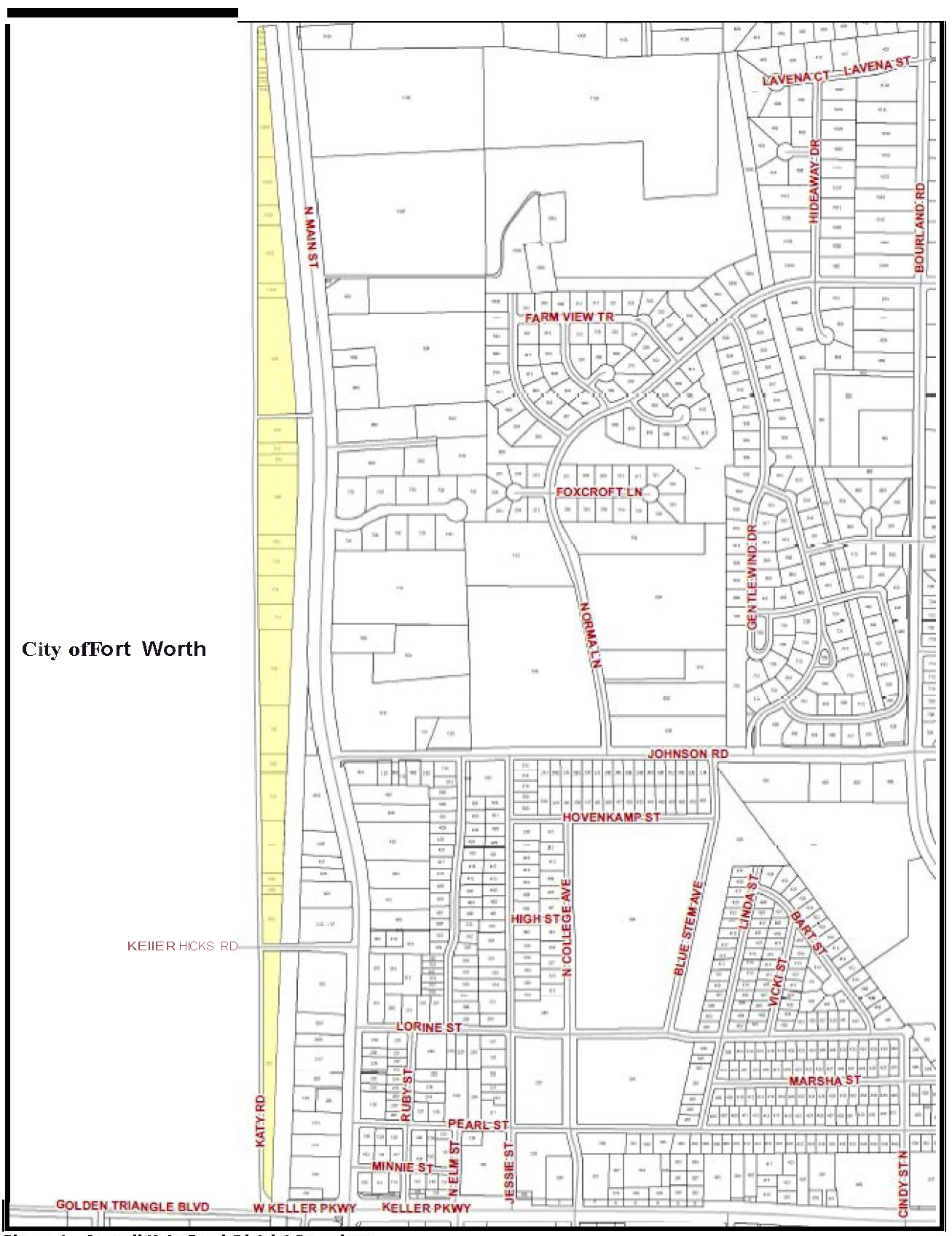
Figure 1 - Overall Katy Road District Boundary
(Ord. No. 1959, § 2(Exh.B), 12-3-19; Ord. No. 2072, § 2(Exh. A), 6-21-22; Ord. No. 2104, § 2, 12-6-22; Ord. No. 2158, § 2(Exh. A), 3-5-24)
Section 8.23 - C - Commercial District
1.
General Purpose and Description. The C, Commercial District is intended predominately for certain retail, and light intensity wholesale and commercial uses of a service nature which typically have operating characteristics or traffic service requirements generally incompatible with typical office, other retail, shopping, and residential environments.
2.
Permitted Uses.
a.
Those uses specified in this Section.
b.
Such uses as may be permitted under provisions of Specific Use Permits (SUP).
3.
Height Regulations.
Maximum Height - Two (2) stories, thirty-five feet (35'); maximum four (4) stories, forty-eight feet (48') if an additional setback is met. One story, twenty-five feet (25') if within one hundred feet (100') of a developed SF-zoning district/lot. Architectural features may exceed twenty-five feet (25').
4.
Area Regulations.
a.
Size of Lots.
1)
Minimum Lot Size - Thirty-three thousand (33,000) square feet.
2)
Minimum Lot Width - One hundred fifty feet (150').
3)
Minimum Lot Depth - None.
b.
Size of Yards.
1)
Minimum Front Yard - Thirty feet (30'); all yards adjacent to a street shall be considered a front yard.
2)
Minimum Side Yard - None.
3)
Minimum Rear Yard - Twenty feet (20').
4)
Adjacent to a Single-Family District - The side or rear setback, whichever is adjacent to the single-family zoning district shall observe a sixty-foot (60') setback.
5)
Additional setback for structures over thirty-five feet (35') - One (1) additional foot setback for each additional two feet (2') in height above thirty-five feet (35').
5.
Other Regulations.
a.
As established in Article Eight.
b.
Parking Requirements: As established in Section 9.02 - Off Street Parking and Loading Requirements.
c.
No permanent use of temporary dwellings, such as travel trailers or mobile homes, may be used for on-site dwelling or non-residential purposes.
d.
Site Plan submittal is required.
e.
No outside storage is permitted unless approved by a Specific Use Permit (SUP).
6.
Compliances with State Laws and Federal Laws. No uses shall be allowed which are prohibited by State law or which operate in excess of State or National environmental or pollution standards as determined by the U.S. Environmental Protection Agency, Texas Air Control Board, Texas State Department of Health, or The Texas Water Quality Control Board, as the case may be.
C Zoning District Use Table
P = Permitted Uses
SUP = May Be Approved as Special Use Permit
Additional uses permitted only by Planned Development Districts are listed in Section 8.27(l)
- = Not Permitted
(Ord. No. 2061, § 2, 5-3-22; Ord. No. 2072, § 2(Exh. A), 6-21-22; Ord. No. 2104, § 2, 12-6-22; Ord. No. 2118, § 2, 4-4-23)
Section 8.24 - IP - Industrial Park District
1.
General Purpose and Description. The IP, Industrial Park District is intended to provide a low intensity campus or open setting for research and development laboratories, science and high technology firms and related office and support uses.
2.
Permitted Uses.
a.
Those uses specified in this Section.
b.
Such uses as may be permitted under provision of Specific Use Permits (SUP).
3.
Height Regulations.
Maximum Height - Six (6) stories, seventy-two feet (72') - additional height is allowed by a Specific Use Permit (SUP) on a case-by-case basis.
4.
Area Regulations.
a.
Size of Lot.
1)
Minimum Lot Area - Three (3) acres.
2)
Minimum Lot Width - One hundred fifty feet (150').
3)
Minimum Lot Depth - Two hundred feet (200').
b.
Size of Yards.
1)
Minimum Front Yard - Fifty feet (50').
2)
Minimum Side Yard - None - Thirty feet (30') adjacent to a street.
3)
Minimum Rear Yard - Thirty feet (30').
4)
Adjacent to a Single-Family District - The side or rear setback, whichever is adjacent to the single-family zoning district shall observe a sixty-foot (60') setback.
5.
Other Regulations.
a.
As established in Article Eight.
b.
Parking Requirements: As established in Section 9.02 - Off Street Parking and Loading Requirements.
c.
No permanent use of temporary dwellings, such as travel trailers or mobile homes, may be used for on-site dwelling or non-residential purposes.
d.
Site Plan submittal is required.
e.
No outside storage is permitted unless approved by a Specific Use Permit (SUP).
6.
Compliance With State Laws and Federal Laws. No uses shall be allowed which are prohibited by State law or which operate in excess of State or National environmental or pollution standards as determined by the U.S. Environmental Protection Agency, Texas Air Control Board, Texas State Department of Health, or The Texas Water Quality Control Board, as the case may be.
IP Zoning District Use Table
P = Permitted Uses
SUP = May Be Approved as Special Use Permit
Additional uses permitted only by Planned Development Districts are listed in Section 8.27(l)
- = Not Permitted
(Ord. No. 2072, § 2(Exh. A), 6-21-22; Ord. No. 2104, § 2, 12-6-22; Ord. No. 2158, § 2(Exh. A), 3-5-24)
Section 8.25 - LI - Light Industrial District
1.
General Purpose and Description. The LI, Light Industrial District is intended primarily for the conduct of light manufacturing, assembling and fabrication, and for warehousing, wholesaling and service operations that do not depend upon frequent customer or client visits. Such uses do require accessibility to major highways, rail lines or other means of transportation.
2.
Permitted Uses. The attached uses are permitted in the "LI" District, provided that such manufacturing or industrial operation shall not disseminate dust, fumes, gas, noxious odor, smoke, glare, or other atmospheric influence beyond the boundaries of the property on which such use is located and which produces no noise exceeding the average intensity of noise of street traffic at that point and provided that such use does not create fire hazards on surrounding property.
a.
Those uses specified in this Section.
b.
A "high risk or hazardous industrial use" is permitted by Specific Use Permit (SUP) only. In this section, "high risk or hazardous industrial use" means any industrial use whose operation, in the opinion of the Fire Chief, involves a much higher than average risk to public health and safety. These uses include but are not limited to facilities where significant amounts of radiation, radioactive materials, highly toxic chemicals or substances, or highly combustible or explosive materials are present, used, produced, stored, or disposed of.
c.
Such uses as may be permitted under provisions of Specific Use Permits (SUP).
3.
Height Regulations.
Maximum Height - Two (2) stories, thirty-five feet (35'); maximum four (4) stories, forty-eight feet (48') if an additional setback is met.
4.
Area Regulations.
a.
Size of Lots.
1)
Minimum Lot Size - Thirty-three thousand (33,000) square feet.
2)
Minimum Lot Width - One hundred fifty feet (150').
3)
Minimum Lot Depth - None.
b.
Size of Yards.
1)
Minimum Front Yard - Thirty feet (30'); all yards adjacent to a street shall be considered a front yard.
2)
Minimum Side Yard - None; thirty feet (30') adjacent to street.
3)
Minimum Rear Yard - Thirty feet (30').
4)
Adjacent to a Single-Family District - The side or rear setback, whichever is adjacent to the single-family zoning district shall observe a one hundred-foot (100') setback.
5)
Additional setback for structures over thirty-five feet (35') - One (1) additional foot setback for each additional two feet (2') in height above thirty-five feet (35').
5.
Other Regulations.
a.
As established in Article Eight.
b.
Parking Requirements: As established in Section 9.02 - Off Street Parking and Loading Requirements.
c.
No permanent use of temporary dwellings, such as travel trailers or mobile homes, may be used for on-site dwelling or non-residential purposes.
d.
Site Plan submittal is required.
e.
No outside storage is permitted unless approved by a Specific Use Permit (SUP).
6.
Compliance With State Laws and Federal Laws. No uses shall be allowed which are prohibited by State law or which operate in excess of State or National environmental or pollution standards as determined by the U.S. Environmental Protection Agency, Texas Air Control Board, Texas State Department of Health, or The Texas Water Quality Control Board, as the case may be.
LI Zoning District Use Table
P = Permitted Uses
SUP = May Be Approved as Special Use Permit
Additional uses permitted only by Planned Development Districts are listed in Section 8.27(l)
- = Not Permitted
(Ord. No. 2061, § 2, 5-3-22; Ord. No. 2072, § 2(Exh. A), 6-21-22; Ord. No. 2104, § 2, 12-6-22; Ord. No. 2118, § 2, 4-4-23; Ord. No. 2158, § 2(Exh. A), 3-5-24)
8.26. - FP - Flex Space District
1.
General Purpose and Description. The purpose of the Mixed Use Flex Space District is to encourage the mixing of residential, retail, office and warehouse uses within an urban framework which is small in scale and compatible with adjacent developments. This section is also intended to promote flexibility in the development process.
2.
Permitted Uses. The attached uses are permitted in the "FP" District, provided that such manufacturing or industrial operation shall not disseminate dust, fumes, gas, noxious odor, smoke, glare, or other atmospheric influence and which produces no noise exceeding the average intensity of noise of street traffic at that point and provided that such use does not create fire hazards on surrounding property. Flex Space zoning shall permit development only in accordance with a Site Plan, in accordance with this UDC, that has been approved by the City Council. Property zoned Flex Space may only be used and/or developed in accordance with its approved Site Plan. No amendment(s) to an approved Site Plan are permitted without City Council approval. A request to amend a Site Plan in a Flex Space district is a request to re-zone the tract. Uses permitted under an approved Site Plan are only permitted in strict accordance with the corresponding, approved Site Plan.
The following uses of Land are authorized as permitted uses within the Flex Space District, strictly in accordance with an approved Site Plan as provided for herein below and within the UDC. Uses are further classified according to general categories of land uses. To the extent expressly authorized by these district regulations, a general use category shall be identified on a Site Plan. Upon approval of such plan, any use appearing in the use list, which is classified under such general category, is authorized to be established in accordance with the Site Plan, and any conditions attached thereto.
a.
Principal Uses (as provided in the FP Land Use Table):
1)
Residential uses;
2)
Commercial uses;
3)
Retail uses;
4)
Office uses;
5)
Warehouse uses;
6)
Light Manufacturing uses;
7)
Light Industrial uses.
b.
Accessory Uses: The following uses shall be permitted as accessory uses, strictly in accordance with an approved Site Plan as provided for herein below:
1)
Community, social, hobby or laundry facilities for use by occupants of a development within the district.
2)
Recreation space and facilities including exercise facilities and weight rooms, tennis courts, racquetball, handball and volleyball courts, spas and swimming pools, for use by occupants of a development within the district.
3)
Parking and parking structures.
4)
Daycare.
5)
Other uses customarily incidental to the permitted uses.
3.
Height Regulations.
Maximum Height - No building shall exceed fifty (50) feet in height unless the additional height is set back from the setback line/build to line one (1) additional foot for each two (2) feet of height above the 50-foot limit.
A turret, spire or tower may exceed maximum height of a building provided that any such structure is no more than 15-feet higher than the maximum permitted height and has a floor area which is ten percent, or less, of the ground floor area of the building of which it is a part.
4.
Density and Area Regulations. The density and area standards shall apply:
a.
Maximum Lot Coverage: The combined area occupied by all impervious coverage (main structures, accessory structures and ground surfaces) shall not exceed eighty percent (80%) of the total lot area.
b.
The area of an above grade parking structure is included in the calculations of lot coverage
c.
The area of a porch or arcade fronting a public street is included in the calculation of lot coverage.
d.
Minimum Density/Floor Area Ratio (FAR) - The gross minimum density/ FAR for the Mixed Use District shall be 1.5.
e.
Minimum Floor Area per Dwelling Unit:
Efficiency - 600 square feet
1 Bedroom - 750 square feet
2 Bedroom - 900 square feet
3 Bedroom - 1,000 square feet
f.
Size of Lots.
1)
Minimum Lot Width - two hundred feet (200').
2)
Minimum Lot Depth - two hundred feet (200').
g.
Size of Yards.
1)
Build-to line: The build-to line for accessory and primary buildings, structures, walls and fences shall be ten feet (10') on all public street frontages except where landscape buffers are greater, then they shall meet the landscape buffer. Twenty- five (25) percent of any street frontage of a building shall be located five feet (5') from the front property line.
a)
The zone between the right-of-way line and the build-to line shall be landscaped in accordance with the UDC.
b)
There shall be no build-to-line/setback for temporary buildings, structures or tents erected in accordance herein, provided sidewalks are not obstructed.
2)
Perimeter Setbacks: Primary buildings and parking structures shall be setback from the district boundary lines a minimum of ten feet (10').
3)
Overhangs and fireplaces: The minimum setback requirements shall apply in all cases, except that fireplaces, eaves, bays, balconies and fireproof stairways located above the first floor may extend up to a maximum of five feet (5') into the required setbacks.
4)
Patios: Patios may not be constructed within the required setback zones. This limitation, however, does not apply to sidewalk cafes.
5.
Other Regulations.
a.
Parking: Off-street facilities shall be provided for all uses, in accordance with this section.
1)
Parking garages shall be located behind and be wrapped (joined on three sides) by the proposed primary uses.
2)
Parking space count shall be passed on proposed uses, as described in Section 8.07 of the UDC with credit being given for shared parking as described herein.
3)
Parking garages shall not have frontage on public streets.
4)
Ramps shall not be placed on the face of parking structures fronting, or visible from, public streets.
5)
Steel parking garages and steel guard cables on garage facades are prohibited.
6)
Off-street below grade parking is permitted to the lot lines, but must be designed to allow planting of landscape as defined in the UDC.
7)
Shared Parking: Uses may join in establishing shared parking areas if it can be demonstrated that the parking for two or more specific uses occurs at alternating time periods. Required parking shall be determined based on parking demand for the peak parking period, as determined by a parking analysis study approved by the Planning Manager.
b.
Exterior Appearance.
1)
Materials: At least ninety percent (90%) of the exterior cladding of all exterior walls fronting or visible from public streets (including above grade parking structures) shall be of masonry construction exclusive of doors and windows. An applicant however may submit a design that employs alternative construction materials for exterior cladding with an application for a Flex Space District designation. The alternative may be approved by the City upon determination that such construction will result in an appearance that is compatible with surrounding buildings and the overall character of the district.
2)
Upon a finding that the alternative design will result in an appearance that is compatible with surrounding buildings and the overall character of the district, waivers may be granted for alternatives employing a minimum of forty percent (40%) masonry cladding, provided that the ground floor of the structure (up to a height of twelve [12] feet), is a minimum of ninety percent (90%) masonry.
a)
At least eighty percent (80%) of the exterior cladding of all walls not fronting, or not visible from public ways (including above grade parking structures) shall be masonry construction.
b)
The exterior cladding, (excluding doors and windows), of all buildings, (including above grade parking structures), shall be composed of not more than three (3) materials, (excluding roofs).
c)
The following materials are prohibited as primary cladding materials:
i.
Wood or plastic siding.
ii.
Wood roof shingles.
iii.
Architecturally finished concrete block is permitted as a cladding material.
iv.
Corrugated panels; galvanized steel, corrugated aluminum coated, zinc- aluminum coated, or unpainted exterior metal finish are prohibited, however architectural metal is permitted.
d)
The following materials are prohibited as primary roofing materials:
i.
Wood roof shingles.
ii.
Composition shingles on any portion of a roof visible from any adjacent street.
iii.
Corrugated panels; galvanized, corrugated aluminum coated, zinc- aluminum coated, or unpainted exterior metal finish are prohibited, however architectural metal is permitted.
3)
Colors.
a)
The dominant color of all buildings (including above grade parking structures) shall be shades of red, beige, gray with red tones (warm gray) and/or brown. Black and stark white shall not be used. There are no restrictions on accent colors, except that fluorescent colors are prohibited.
b)
The roof colors shall be a shade of cool gray, warm gray, brown or red.
4)
Windows:
a)
Where a retail use occupies the first floor, at least seventy percent (70%) of the first floor exterior wall facing a thoroughfare, street, boulevard or parking plaza shall be transparent glazing.
b)
The exterior wall surface of all buildings above the first floor shall not be more than fifty percent (50%) non-reflective, non-glare glass.
c)
Glass is to be non-glare, clear or tinted, not reflective.
5)
Walls attached to buildings shall be developed as architectural extensions of the buildings, constructed of the same material and in the same style.
6)
All on-site lighting, landscaping and signs must meet the requirements of the UDC.
6.
Screening: Screening within the Flex Space District shall comply with the provisions of the UDC and the following:
a.
Mechanical equipment shall be screened from view of all public roadways and located to minimize noise intrusion off the lot. The required screening must be composed of the same exterior materials as the buildings on the lot, or through the use of masonry walls, ornamental fence (eighty [80] percent opaque), evergreen landscape material, or combination thereof.
b.
All roof-mounted mechanical elements must be screened from view of the public right- of-way and neighboring properties. Screening must be architecturally compatible with the building design.
c.
Loading, service and trash storage areas shall be screened from all public roadways. Refuse containers must be placed on a designed, reinforced concrete pad and approach, per the UDC. The required screening must be composed of the same exterior materials as the buildings on the lot.
7.
Outside Sales and/or Commercial Promotions:
a.
Any temporary outside sales shall be required to obtain a permit and be subject to the requirements of this section.
b.
Temporary outside sales may be permitted for a period of fourteen (14) days each event with a maximum two (2) permits allowed per calendar year, providing such goods, products or merchandise is displayed on a sidewalk within ten feet (10') of the business building.
c.
Temporary outside sales shall be deemed to include merchandise-dispensing units placed adjacent to, and outside of, a business building.
d.
In order to qualify for a permit, the applicant must:
1)
Provide a plan showing the location of the outside display.
2)
Provide the City with a Site Plan showing location(s) of all tents (if applicable). Submit documentation showing compliance with all building and fire codes including, but not limited to, flame spread certificate(s).
3)
Provide a map, plan, or drawing to indicate adequate off-street parking for patrons, employees and delivery trucks; such map, plan or drawing should also indicate that no fire lanes, streets or other public rights-of-way will be blocked as a result of the sale or promotion.
4)
Provide for adequate trash and waste removal and cleanup of the area.
5)
Comply with all other reasonable conditions imposed by the City.
8.
Outside Storage or Outside Display: Except for the equipment and/or the materials stored on a construction site and used for a temporary construction project, the outside storage or outside display of equipment, building and/or other materials, goods and products shall be prohibited within the district, with the exception of outside dining shown on an approved Site Plan.
9.
Flexible Standards.
a.
Alternative Uses or Phases: In order to encourage an integrated development pattern of mixed uses over time within the district, it is understood that flexibility in the development of phases or sites may be necessary. Whenever an applicant of a Flex Space District proposes alternative land uses or phases of an approved Flex Space District, such alternative uses or phases shall be incorporated in a zoning amendment to the Flex Space District. The zoning amendment for alternative land uses or phases shall constitute a zoning change and shall follow the proceures. In no case, however, may the Council approve an alternative use not allowed in the Use Tables for the Flex Space District.
b.
Flexible Design Standards: It is intended that the general conditions, as well as the dimensional and design standards set forth herein be flexible in order to encourage development in the Flex Space District. In some cases, the standards set forth may be varied. For requests other than those set out in herein, developer must request a waiver from a specific standard. The Council may approve such waiver in conjunction with its decision to establish or amend the district in those cases where the waiver addresses a standard applicable to the Site Plan.
10.
Waiver Procedure.
a.
Procedure: An application for a waiver to a development standard authorized under this article must be made by a property owner, lessee, or contract purchaser at the time of submission of an application to establish a Flex Space District. A contract purchaser or lessee must file with the application, a copy of the contract, or lease, or other form of written statement containing the property owners' endorsement of the application. The application shall be filed in duplicate with Community Development Department on forms provided by the City. Upon a determination that the waiver application is complete, the Planning Manager shall forward the request to the Planning and Zoning Commission and the City Council for decision in conjunction with its decision on the application to establish a Flex Space District.
b.
Standards for Granting Waiver: The Planning and Zoning Commission in making its recommendations, and the City Council in deciding whether to grant the request for waiver, shall determine that the following standards are met:
1)
The waiver for the specific development site is in harmony with the policies in the Comprehensive Master Plan.
2)
The waiver is in harmony with the general purpose and intent of this article and the zoning ordinance.
3)
The waiver shall not adversely affect the use of neighboring property, and the public's use and enjoyment of public areas, in accordance with the provisions of this article.
4)
The waiver is in conformity with the approved Site Plan.
c.
Lapse of Waiver: A waiver granted under this section shall lapse with the lapse of the approved Site Plan or amendment to the Flex Space Mixed Use District, in accordance with this article.
11.
Amendments of a Site Plan.
General Requirement: Amendments of any Site Plan shall be made in accordance with the procedure required for approval of the initial plan. Amendments to a Site Plan shall be considered amendment to the Flex Space Zoning District.
12.
Design Requirements.
a.
Day Care Facility:
1)
Freestanding day care facilities shall not be permitted.
2)
Day care facilities shall only be permitted on the ground floor level as an accessory use to (a) primary use(s).
3)
Maximum allowable size for a day care facility shall be 5,000 square feet.
4)
Parking for a day care facility shall be counted as shared parking except that daycare employees must be provided parking in conformance with the UDC parking standards.
b.
Restaurant: A restaurant may be permitted in the Flex Space District as a conditional use, however, drive-through restaurants shall not be permitted.
c.
Outdoor Seating Area: Use Patio Dining Criteria from Old Town Keller.
13.
Compliance With State Laws and Federal Laws: No uses shall be allowed which are prohibited by State law or which operate in excess of State or National environmental or pollution standards as determined by the U.S. Environmental Protection Agency, Texas Air Control Board, Texas State Department of Health, or The Texas Water Quality Control Board, as the case may be.
Flex Space Zoning District Use Table
P = Permitted Uses
SUP = May Be Approved as Special Use Permit
Additional uses permitted only by Planned Development Districts are listed in Section 8.04(l)
(Ord. No. 1891, 6-5-18;Ord. No. 1958, § 2(Exh. A), 12-3-19; Ord. No. 1972, § 2(Exh. A), 6-16-20; Ord. No. 1982, § 2(Exh. A), 9-1-20; Ord. No. 1991, § 2(Exh. A), 11-17-20; Ord. No. 2003, § 2, 3-16-21; Ord. No. 2104, § 2, 12-6-22)
Section 8.27 - PD - Planned Development
Planned Development Districts shall be used in conjunction with base zoning district, unless changed by zoning amendment. New base districts or changes in existing base districts may be requested at the same time planned development districts are requested. Unless otherwise specified, all uses in the base district are applicable for a planned development district.
A.
General Purpose and Description. The Planned Development District is a district which accommodates planned associations of uses developed as integral land use units such as industrial districts, offices, commercial or service centers, shopping centers, residential developments of multiple or mixed housing including attached single-family dwellings or any appropriate combination of uses which may be planned, developed, or operated as integral land use units either by a single owner or a combination of owners. A Planned Development (PD) District may be used to permit new or innovative concepts in land utilization not permitted by other zoning districts in this Code. While greater flexibility is given to allow special conditions or restrictions, which would not otherwise allow the development to occur, procedures are established herein to ensure against misuse of increased flexibility. The minimum area for a Planned Development (PD) District shall be one (1) acre.
B.
Permitted Uses. An application for a PD District shall specify the base district(s), the use or the combination of uses proposed. Uses which may be permitted in a PD must be specified if not permitted in the base district. In the case of residential PD districts for single-family or duplex categories, the proposed lot area shall be no smaller than the lot sizes allowed in the base zoning district except for minor reductions in a small percentage of the lots in order to provide improved design. In selecting a base zoning district, the uses allowed in the base district must be similar or compatible with those allowed in the PD. A PD designation may not be applied to the TC, Town Center district except for residential developments. PD designations shall not be attached to Specific Use Permit (SUP) requirements. Specific Use Permits allowed in a base zoning district are allowed in a PD only if specifically identified at the time of PD approval.
C.
Planned Development Requirements.
1.
Development requirements for each separate PD District shall be set forth in the amending Ordinance granting the PD District and shall include, but may not be limited to: uses, density, lot area, lot width, lot depth, yard depths and widths, building height, building elevations, building material coverage, floor area ratio, parking, access, screening, landscaping, accessory buildings, signs, lighting, hours of operation, project phasing or scheduling, management associations, and other requirements as the City Council and Planning and Zoning Commission may deem appropriate.
2.
In the PD District, uses shall conform to the standards and regulations of the base-zoning district to which it is most similar. The base zoning district shall be stated in the granting Ordinance. All applications to the City shall list all requested deviations from the standard requirements set forth throughout this Code (applications without this list will be considered incomplete) specifically any deviation not requested is deemed to comply with this Code even if shown graphically on a Site Plan. The Planned Development District shall conform to all other sections of this Code unless specifically excluded in the granting Ordinance.
3.
The Ordinance granting a PD District shall include a statement as to the purpose and intent of the PD granted therein. A specific list is required of modifications in each district or districts and general statement citing the reason for the PD request.
D.
In establishing a Planned Development District in accordance with this section, the City Council shall approve and file as part of the amending Ordinance appropriate plans and standards for each Planned Development District. To facilitate understanding of the request during the review and public hearing process, the Planning and Zoning Commission and City Council shall require, at minimum, a Conceptual Plan. A Detailed Site Plan may be submitted in lieu of a concept plan. All PD applications shall have a written proposal explaining all aspects of the requested PD including any deviations from this Code.
1.
Conceptual Plan - This plan shall be submitted by the applicant at the time of the PD request. The plan shall show the applicant's intent for the use of the land within the proposed Planned Development District in a graphic manner and as may be required, supported by written documentation of proposals and standards for development. The City may prepare application form(s), which further describe and explain the following requirements:
a.
General use;
b.
Preliminary lot arrangements;
c.
Size, type, height and location of buildings and building sites;
d.
Building elevations;
e.
Access;
f.
Density;
g.
Fire lanes;
h.
Topography;
i.
Boundary of PD area;
j.
Existing physical features of the site, including existing streets, alleys and easements;
k.
Location of future public facilities including streets, water, sanitary sewer, etc.;
l.
Parking ratios;
m.
Conceptual landscaping plans showing turf areas, screening walls, ornamental planting areas, wooded areas, and treed areas; and
n.
Other information to adequately describe the proposed development and to provide data for approval which is to be used in drafting the final Detailed Site Plan.
2.
Detailed Site Plan - This plan shall set forth the final plans for development of the Planned Development District and shall conform to the data presented and approved on the Conceptual Plan. Changes of detail on the Detailed Site Plan, which differ from the original Concept Plan, but do not alter the basic relationship of the proposed development to adjacent property, the uses permitted, or increase the density, building height or coverage of the site, the off-street parking ratio or reduce the yards provided at the boundary of the site, or does not significantly alter the landscape plans as indicated on the approved Conceptual Plan may be authorized by the City Council. Approval of the Detailed Site Plan shall be the basis for issuance of a building permit, but does not release the applicant of the responsibility to submit plans to the Building Official for a building permit. The detailed site plan shall describe and explain the following requirements in addition to those required in Sections 4.13 or 4.15 of this Code:
a.
Specific uses and density;
b.
Final lot arrangements including the land area of all abutting sites and the zoning classification thereof on an accurate survey of the tract with a topographical contour interval of not more than two feet (2');
c.
Site inventory analysis including a scaled drawing showing major existing vegetation, natural water courses, creeks or bodies of water and an analysis of planned changes in such natural features as a result of the development. This should include a delineation of any flood prone areas.
d.
Scaled drawing showing proposed size, type, height and location of buildings and building sites for non-residential, multi-family or mixed used developments;
e.
Scaled drawing showing proposed building lots and pad elevations for single family residential developments;
f.
An architectural plan (elevations, etc.) showing elevations and signage style to be used throughout the development. Planned developments intended for custom single- family homes shall provide a summary of architectural requirements that will guide the design and construction of the homes.;
g.
Scaled drawing of traffic circulation including points of egress and ingress;
h.
A dimension control plan showing property lines and all dimensions for rights-of way, easements, setbacks (the minimum distance between buildings and property lines), the location of separate buildings and the minimum distance between buildings. Also to be included on the dimension control plan is the arrangement and number of off- street parking.;
i.
Scaled drawing of fire lanes and emergency access if other than standard egress and ingress;
j.
Topography;
k.
Boundary of PD area;
l.
Existing physical features of the site, including existing streets, alleys and easements;
m.
Scaled drawing showing location of planned public or private streets and alleys, street widening or any street changes, curb cuts (width and curve radii);
n.
Scaled drawing showing general location and description of proposed utility services including water lines/mains, sanitary sewer lines/mains, storm sewer, etc. Indicate whether these service lines are located in easements or rights-of-way;
o.
Scaled drawing showing location of planned parks, playgrounds, school sites;
p.
Parking ratios;
q.
Conceptual landscaping plans showing turf areas, screening walls, ornamental planting areas, wooded areas, and treed areas; and
r.
Other information to adequately describe the proposed development and to provide data describing standards, regulations, or other data pertinent to the development of the Planned Development District as appropriate to adequately explain or understand the request.
E.
Approval Process and Procedure - The procedure for establishing a Planned Development District shall follow the procedure for zoning amendments as set forth in Section 8.02 (D). This procedure is further expanded as follows for approval of Conceptual and Detailed Site Plans.
1.
If a Detailed Plan is submitted with the PD request, then a Conceptual Plan is not required. A Conceptual Plan or Detailed Site Plan, whichever is submitted with the PD request, shall be heard before both Planning and Zoning commission and City Council in public hearings. The Planning and Zoning Commission shall consider the request and make the final determination.
2.
If a Concept Plan is submitted with the PD request, then a Detailed Plan will also be required. If the Detailed Site Plan conforms substantially to the conceptual Site Plan as approved by the City Council, then a public hearing on the Detailed Site Plan is not required. The staff shall review the Detailed Site Plan for conformance to the Concept Plan and other requirements set forth for a Detailed Site Plan. Approval of a Detailed Site Plan is required prior to issuance of a building permit.
If the Detailed Site Plan is not in conformance with the Conceptual Plan, then additional public hearings are required by the Planning and Zoning Commission and City Council prior to approval of the Detailed Site Plan. If additional public hearings are required, additional processing fees will be assessed. After approval by the City Council, a building permit may be issued for the project.
3.
The amending Ordinance establishing the Planned Development District shall not be approved until the Conceptual and/or Detailed Site Plan is approved.
a)
The Detailed Site Plan may be approved in sections. When a Site Plan is approved in sections, then separate approvals for subsequent sections or phases will be required.
b)
A Detailed Site Plan shall be submitted for approval within one (1) year from the date of approval of the Conceptual Plan for all or some portion of the Concept Plan. If a Detailed Site Plan is not submitted within one (1) year, the Concept Plan is subject to review by the Planning and Zoning Commission and City Council. If some portion of the project is not started within two (2) years, the Planning and Zoning Commission and City Council may review the original Concept Plan or Detailed Site Plan to ensure its continued validity. If the City determines the Concept Plan is not valid, a new Concept Plan must be approved prior to a Detailed Site Plan for the PD District. Although a new Concept Plan or Detailed Site Plan may be required to be approved, this does not effect the validity of the PD in terms of uses, density, and other development standards permitted in the PD.
F.
When a PD District is being considered, a written report from the Planning Manager or his/her designated representative, discussing the impact on planning, engineering, water utilities, electric, sanitation, building inspection, tax, police, fire, and traffic, and written comments from the applicable public agencies shall be submitted to the Planning and Zoning Commission prior to the Commission making any recommendations to the City Council.
G.
All Planned Development Districts approved in accordance with the provisions of this Code in its original form, or by subsequent amendments thereto, shall be referenced on the Zoning District Map, and a list of such Planned Development, together with the category of uses permitted therein, shall be maintained as part of this Code.
H.
Planned Development Ordinances Continued. Prior to adoption of this Code, the City Council has established various Planned Development Districts, some of which are to be continued in full force and effect. The ordinances or parts of ordinances approved prior to this Code specified in Article Eight shall be carried forth in full force and effect and are the conditions, restrictions, regulations, and requirements which apply to the respective Planned Development Districts shown on the Zoning Map at the date of adoption of this Code.
I.
Uses or Developments Allowed Only by PD. Because of the uniqueness of the following uses in Keller, they shall be permitted by PD designation only. All planned developments shall provide for fifteen percent (15%) of the development in usable open space exclusive of street yard landscaping. This includes, but not limited to, landscaped hike/bike trail, open area recreational facilities, parks and playgrounds, water features and decorative objects such as fountains. Usable open space shall not include rooftops, accessory buildings, parking areas, driveways, turnaround areas, or the right-of-way or easement for streets or alleys.
1.
Single-Family Attached Dwelling (Townhouse)
2.
Patio Homes
3.
Mobile Home Development
4.
Private Street Residential Development
5.
The following uses shall only be permitted in a Planned Development (PD) District that is specifically designated for such a use:
a)
Airport.
b)
Athletic stadium or field (private).
c)
Theater-outdoor.
d)
Batching plant (concrete or asphalt).
e)
Wrecking yard, auto salvage, junkyard, or outside reclamation.
f)
Industrial processing uses such as:
1)
Canvas
2)
Cellophane
3)
Cement or hydrated lime manufacture
4)
Clay products utilizing previously pulvarized clays and gas or electric kilns
5)
Cork
6)
Feathers
7)
Felt
8)
Fiber
9)
Fur
10)
Glass
11)
Horn
12)
Industrial manufacturing
13)
Leather
14)
Meat packing plant
15)
Oil or gas extraction
16)
Paint, not employing boiling process
17)
Paper
18)
Plastics
19)
Precious/semi-precious metal or stone
20)
Shell
21)
Textiles
22)
Tobacco
23)
Wood
24)
Yard
(Ord. No. 2104, § 2, 12-6-22)
Editor's note— Former Section 8.04.
Section 8.28 - U.S. Highway 377 North Overlay District
A.
General Purpose and Description. The purpose of the U.S. Highway 377 North Overlay District is to implement additional development regulations within the U.S. Highway 377 North Corridor Plan. The regulations and standards of this overlay district are reflective of the high visibility and traffic volumes of the corridor. They are intended to create unique site design, building architecture, and streetscape that enhance the overall image of the corridor while remaining compatible with adjacent developed and planned residential neighborhoods.
1.
Boundary. The U.S. Highway 377 North Overlay District encompasses land parcels on the east side of U.S. Highway 377 from Johnson Road north to the southern rights-of-way line of Marshall Ridge Parkway. The boundary of the District is shown in Figure 1.
2.
Marshall Ridge Subdistrict. The U.S. Highway 377 North Overlay District contains one subdistrict - Marshall Ridge. The common boundary between the subdistrict and the rest of the overlay district is Mt. Gilead Rd. as depicted in Figure 3.
B.
Permitted Uses. The U.S. Highway 377 North Overlay District amends the permissible uses of the base or underlying Commercial or Light Industrial zoning districts. Permissible uses within the U.S. Highway 377 North Overlay District are allowed in the same manner, by right or with approval of a Specific Use Permit, as in the underlying zoning district except as noted in "1.", 2.", and "3." below.
1.
The following uses are prohibited within the U.S. 377 North Overlay District: Cemetery or Mausoleum (new or expansion); Fraternal Clubs, Lodges, Sororities and Fraternities, etc.; Freight or Truck Terminal Yard; Heavy Machinery Sales and Service; Heavy Vehicle Storage; Metal Recycling Collection Center; Monuments and Headstone Sales with Outside Storage; Newspaper Printing; Portable Building Sales with Outside Storage; Veterinarian Office with Outside Pens.
2.
The following additional uses are permitted by right within the U.S. 377 North Overlay District: Retail, Office, Office-warehouse, Restaurant (without Drive-thru), Minor Medical Emergency Clinics, Public Parking Garage.
3.
The following additional uses may be permitted with approval of a Specific Use Permit within the U.S. 377 North Overlay District: Restaurant (including Drive-thru); Uses not specifically provided here-in.
C.
General Standards. The standards within this section apply to the entire U.S. 377 North Overlay District.
1.
Access Management. In addition to the Design and Technical Construction Standards in Article Nine of this Code, the following shall apply:
a.
Each site must have access to a median opening via private drive aisles, private streets, or public streets. The Director of Public Works may waive this requirement if topography, hydrology, or existing buildings or improvements make access to a median opening impractical.
b.
In the event that access to a median opening is not available, each site must have two (2) points of access. One or both points of access may be off-site.
2.
Parking.
a.
Parking for all uses shall be provided in accordance with Section 9.02 of this Code; however, for developments with multiple uses with dissimilar parking demand characteristics, smaller parking ratios may be considered at the time of site plan approval. The minimum number of spaces shall be determined by a study following the procedures of the Urban Land Institute or Institute of Traffic Engineers parking reduction guidelines.
b.
The maximum allowable number of off-street parking spaces shall be the minimum number of required off-street parking spaces plus ten percent (10%). Parking spaces in excess of the maximum allowable number of parking spaces may be provided in accordance with the one of the following conditions:
1)
The parking in excess of maximum is constructed to mitigate storm water runoff. At a minimum, permeable paving and grassy swales/buffer strips, to convey storm water runoff from parking area to point of collection, shall be used to provide filtration and infiltration of storm water.
2)
Additional landscaping is provided to mitigate the negative aesthetics of large fields of parking. In addition to the required landscape area and landscape improvements in Section 9.03 of this Code and in "3. Landscape Requirements" below, additional landscape areas and landscape improvements are provided as follows:
a)
For each parking space constructed in excess of maximum, additional landscape area at the rate of seven (7) square feet per parking space shall be provided.
b)
One additional canopy tree shall be provided for each three (3) parking spaces constructed in excess of maximum. The additional trees and landscape area shall be distributed in landscape areas within parking areas or adjacent to buildings and not in the landscape buffer.
c)
No storm water mitigation measures or additional landscaping is required if excess parking is in elevated or below-grade parking structures. Parking structures are subject to area, yard, and bulk requirements of this Code.
3.
Landscape Requirements. In addition to the required landscape area and landscape improvements in Section 9.03 of this Code, the following shall apply:
a.
The required canopy trees for landscape buffers adjacent to thoroughfares shall not be placed in a linear arrangement with consistent spacing, but shall be in a random, free- form, and/or clustered arrangement.
b.
Up to one-half (1/2) of the required canopy trees for landscape buffers adjacent to thoroughfares and parking lot landscaping may be substituted with ornamental trees at a ratio of two (2) ornamental trees for each canopy tree. Ornamental trees shall be a minimum of eight feet (8') in height at the time of planting.
c.
Ornamental grasses may be used instead of shrubs for required foundation plantings. Similarly, ornamental grasses may be used for required parking lot screening provided the variety of the ornamental grass can satisfy the mature height and coverage requirements for such screening. Acceptable ornamental grasses are adapted or native ornamental grasses with low or medium water demand as listed for the North Central Texas region in the Texas Smartscape plant database.
d.
Buffalo grass or other native turf grasses with a mature height of twelve inches (12") or less may be used for up to fifty percent (50%) of the total turf area.
e.
Masonry screening walls, three feet (3') in height, may be used in place of or supplement the required parking lot screening.
4.
Energy Conservation Incentive. This incentive applies to any new or existing development within the overlay district. For buildings with minimum energy performance ratings that meet the requirements of the 2009 International Energy Conservation Code or that exceed the requirements of the 2006 International Energy Conservation Code by fifteen percent (15%), the required number of parking spaces may be reduced by fifteen percent (15%) or two (2) spaces whichever is greater.
D.
Marshall Ridge Subdistrict Standards. The standards within this section apply to only the Marshall Ridge Subdistrict.
1.
Development Standards. Site orientation and layout, size of lot, size of yards, and building heights shall be in accordance with the standards of the underlying Commercial zoning district.
2.
Design Standards. The purpose of these design standards is that buildings and sites should reflect a modern, contemporary interpretation of Prairie Style architecture. The overall building forms, materials, and colors of Prairie Style architecture should be maintained; however, bold colors, metal finishes, and building ornamentation may be utilized as noted below.
a.
Architectural Character.
1)
Buildings shall have a long and low building form with strong horizontal lines. Windows in geometric shapes and/or glass storefront may be arranged in ribbons to emphasize the horizontality of the overall building design.
2)
Buildings shall contain or incorporate a minimum of two (2) of the following Prairie Style architectural elements: arcades, towers, foundation planter boxes, freestanding low masonry walls, mansard roofs, overhanging eaves, porticos, or awnings or canopies.
3)
Building facades that face or front public streets or public ways shall comply with both of the criteria listed below. Building facades that do not face or front public streets or public ways shall comply with either criteria "a)" or "b)" below.
a)
No building façade shall exceed a length of one-hundred feet (100') without a horizontal and vertical break or articulation in the façade. The horizontal and vertical break or articulation shall be a minimum depth/height of three feet (3') for a minimum length of twenty feet (20').
b)
Facades shall contain patterns of contrasting materials, material colors, and material textures that visually break up the horizontal and vertical expanse of the façade.
b.
Building Materials.
1)
The building materials for a minimum of ninety percent (90%) of the area of each building façade excluding the area of windows, storefront and/or other glass areas shall be: natural clay brick, integrally-colored split-face concrete masonry units, glass block, native or manufactured stone, rough-sawn or hewn wood, wood logs, fiber-cement materials, or cement or synthetic stucco. The remaining ten percent (10%) of each façade area may be any material allowed by building codes.
2)
Integrally-colored split-face concrete masonry units, fiber-cement materials, ceramic tile, or cement or synthetic stucco shall not be used on more than fifty percent (50%) of each building façade area excluding the area of windows, storefront, and/or other glass.
3)
Synthetic stucco shall only be used on portions of facades six feet (6') or greater above finish floor elevation.
4)
Window and storefront glass shall be clear or tinted. The use of reflective glass is not allowed. Mullions and muntins shall be clear anodized or mill finish, or earth tone colors as detailed in "c. Building Exterior Colors" below.
5)
Roof or mansard roof materials, visible from public or private streets and drive aisles, shall be standing seam metal, or metal, stone, clay, or concrete roof tiles.
6)
Awning and canopies shall be metal, glass, fiberglass, or fabric. Plastic or similar materials for awnings and canopies are not allowed.
c.
Building Exterior Colors. The natural materials used in Prairie Style architecture established a color palette of primarily earthen tones. A minimum of seventy percent (70%) of the exterior building colors shall be grey, green, beige, tan, orange, red, rust, brown or other earth tone colors. The remaining exterior building colors may be non-earth tone colors or metallic finishes.
3.
Lighting, Street Furniture, and Sidewalk Requirements.
a.
Lighting.
1)
Streetlight lighting shall be Sternberg "Prairie" lighting with either single arm or double arms. Streetlights shall be installed along all public streets at street corners, drive approaches, and between drive approaches and street corners at a spacing of not more than eighty feet (80') on center.
2)
Parking lot lighting, where used, shall be the same as streetlight lighting.
3)
Decorative building-mounted lighting shall be Sternberg "520 Tinley" fixtures.
4)
For required lighting in "1)", "2)", and "3)" above, other light standards and fixtures of similar Prairie, Mission, or Arts and Crafts styles may be used if found to be consistent with the design of this overlay district at the time of site plan review.
5)
Canopies and awnings shall not be backlit.
b.
Street furniture is encouraged at building entrances and along walks. Street furniture, if used, shall be Prairie, Mission, or Arts and Crafts styles.
E.
Site Plan/Design Review Required. A detailed site plan as outlined in this Code shall be submitted for any new building or addition to existing buildings within the U.S. Highway 377 North Overlay District. Design review shall be a part of the site plan review process. The purpose of the design review is to ensure that buildings and sites are in conformance with site and architectural standards of this overlay district.
F.
Variances to Standards. When special conditions exist that prevent strict compliance with the regulations in Section "C", General Standards, Section "D", Marshall Ridge Subdistrict Standards, the City Council, upon recommendation from the Planning and Zoning Commission, may authorize a variance or deviation from these regulations. The process for requesting a variance shall be in accordance with Article Two, Section 2.08 - Procedures for Variances from the Regulations of the Code.
G.
Illustrations.
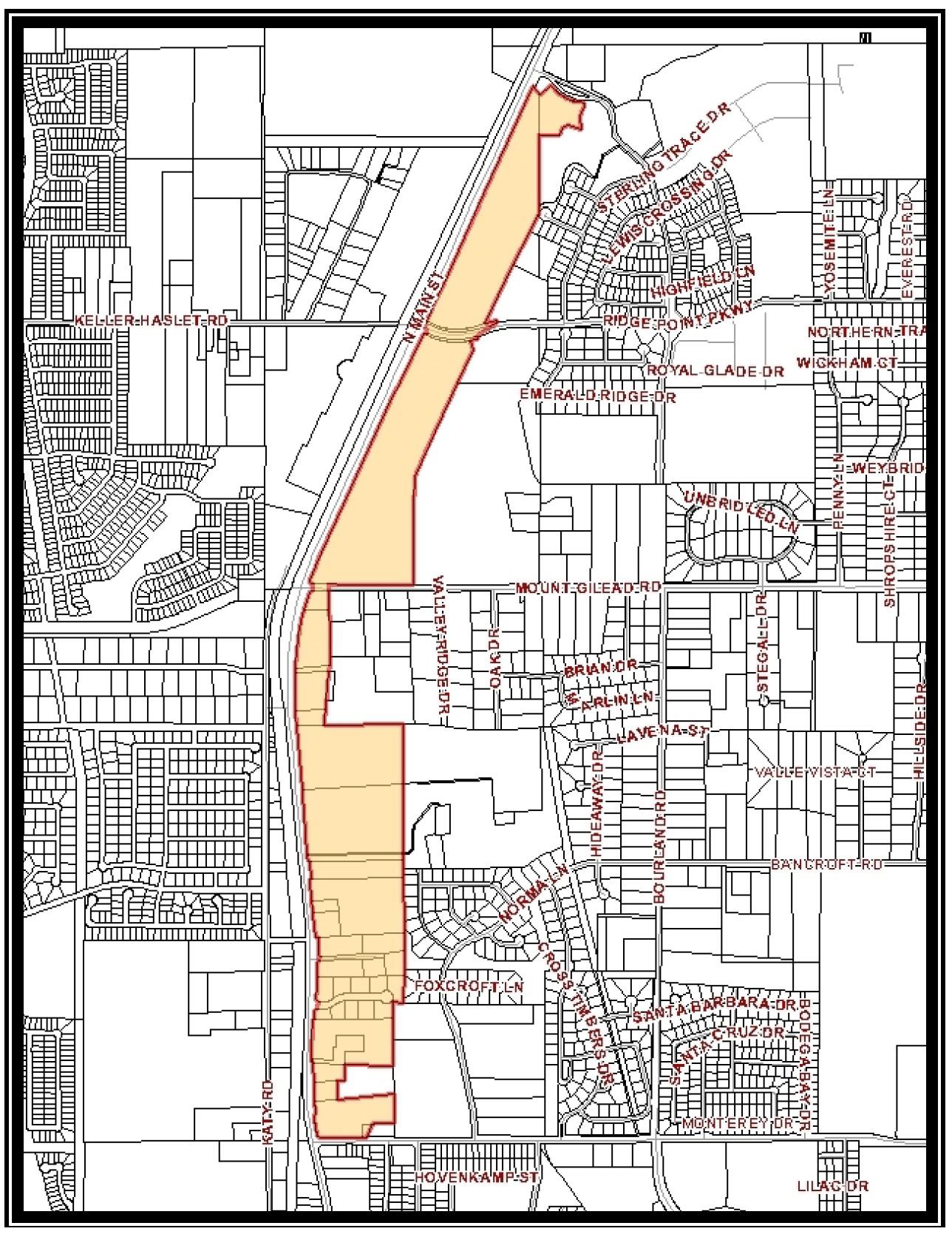
Figure 1- Overall U.S. Highway 377 North Overlay District Boundary
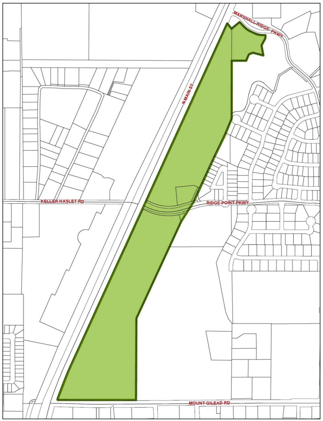
Figure 3- Marshall Ridge Subdistrict Boundary
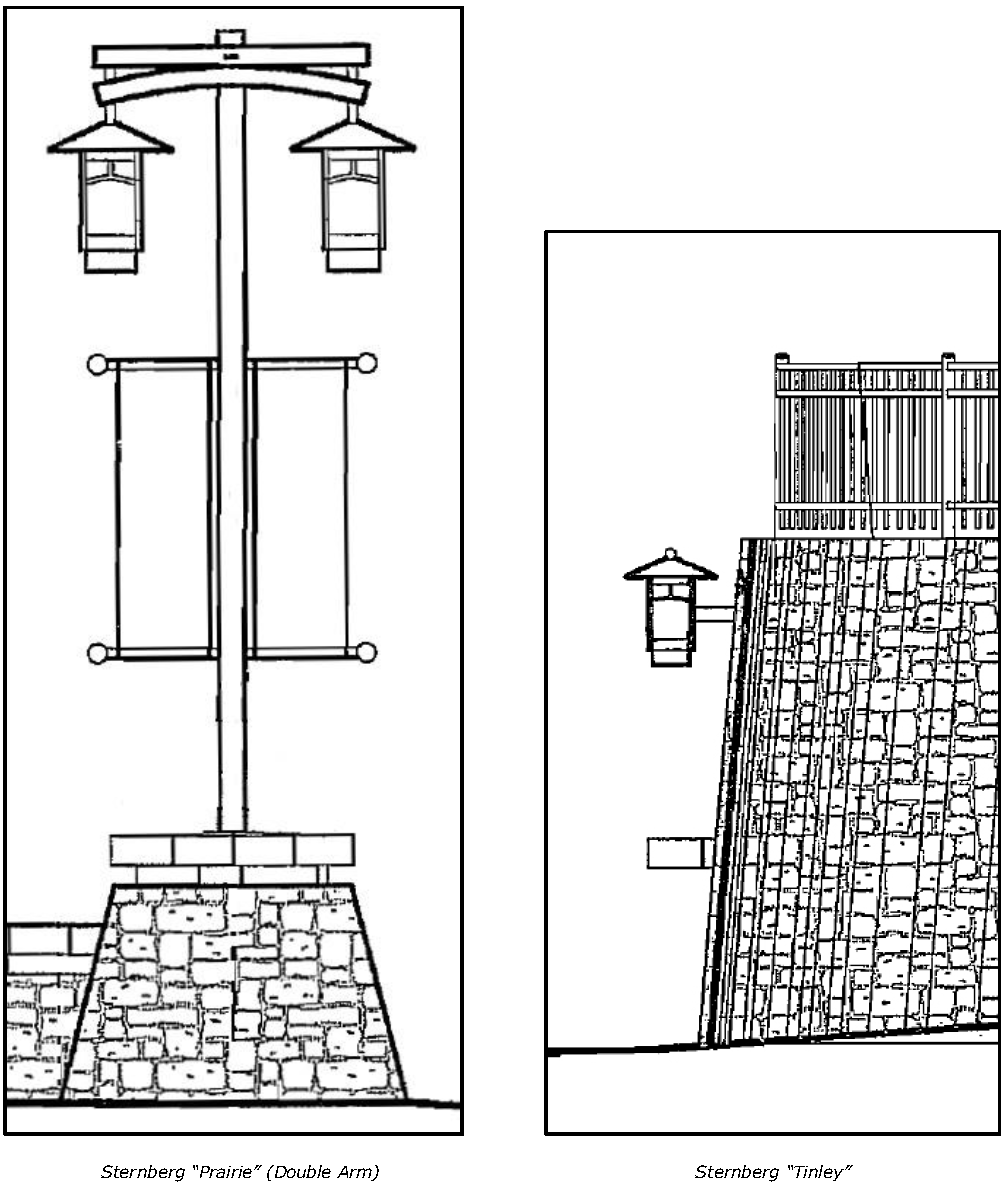
Figure 4 - Site and Parking Lot Lighting
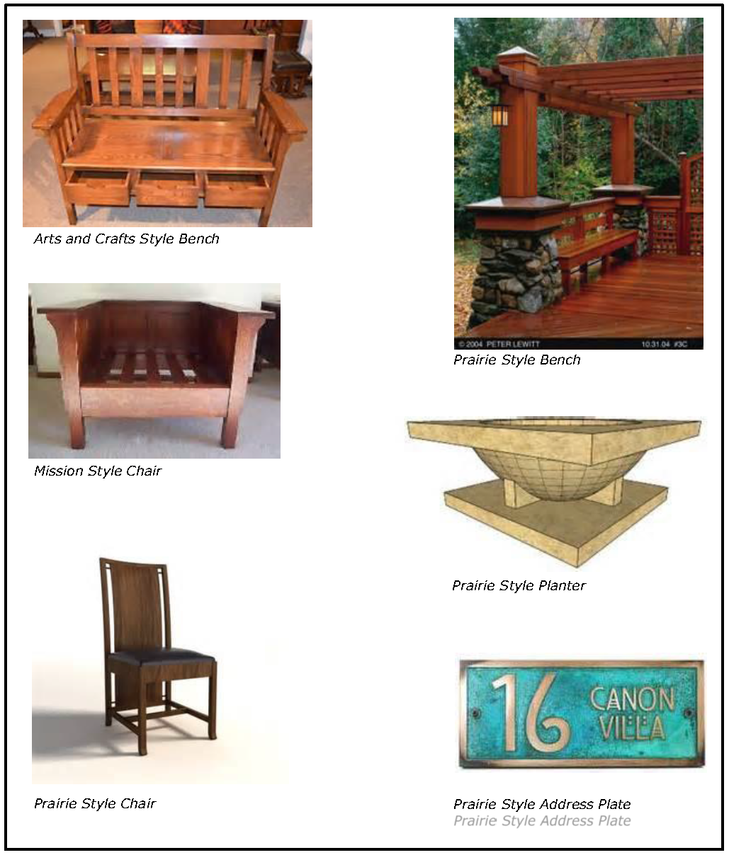
Figure 5 - Furniture
(Ord. No. 2104, § 2, 12-6-22)
Editor's note— Former Section 8.05.
Section 8.35 - Summary of Zoning District Regulations
This is a chart for general comparison purposes only and is incomplete. For complete requirements, see Article Nine of this Code.
* See text of Article Nine of this Code for additional or supplemental requirements.
(Ord. No. 2104, § 2, 12-6-22)
Editor's note— Former Section 9.04.