
Kuna City Zoning Code
PART 5
- ZONING DISTRICTS
5-8-501: - ZONING DISTRICTS ESTABLISHED; PURPOSE:
The city has established five (5) zoning districts; these being: agriculture, residential, commercial, manufacturing/industrial and public; additionally, the city has established certain overlay districts whose purposes are also identified in Part 3 of this chapter.
A.
Agriculture:
Agriculture district (A): The A district has been established to preserve, protect and assure the continuing viability of agricultural lands within the city and the area of city impact (ACI). This district has been established to lessen the encroachment of urban type development into agricultural areas whose presence would interfere with agricultural pursuits.
Land uses, other than those directly relating to agriculture, or those typically coexisting with agricultural uses, are generally prohibited in this district. The agricultural district requires land parcels to be a minimum five (5) acres in area with certain exceptions.
The A district refers to land uses engaged for farming, dairying, pasturage, agriculture, horticulture, floriculture, viticulture, animal and poultry husbandry and the accompanying accessory uses for packing, treating or storing the produce. Agricultural accessory uses shall be considered a use secondary to the normal agricultural activities. Agriculture does not include the operation or maintenance of a commercial stockyard or feed yard where large numbers of livestock are fed concentrated feeds particularly for the purpose of fatting for market (CAFO).
B.
Residential:
Low density residential district (R-2): The purpose of the R-2 district is to promote the establishment of low-density residential areas that do not exceed two (2) dwelling units per net acre. The district is considered semi-rural in nature and intended to preserve residential living arrangements that are rural or semi-agriculture in character. The district serves as a transitional buffer between rural areas and higher density urban development. The R-2 zone is not intended to provide a full range of urban services. A district requirement is connection to public sewer and water with some limited exceptions found in KCC § 5-9-603. The R-2 zone is intended to accommodate accessory dwelling units [ADU], senior housing, bed and breakfast operations, single-family dwellings, duplexes, home occupations, manufactured homes and a limited number of agricultural uses. It is not intended for placement of more intensive type residential uses associated with condominiums, townhouses, apartments, multifamily or group living arrangements.
Medium density residential district (R-4): The purpose of the R-4 district is to promote the development of residential living areas with low to moderate densities, not to exceed four (4) dwelling units per net acre. A district requirement is connection to public sewer and water. The district is intended to accommodate accessory dwelling units, bed and breakfast operations, single-family dwellings, duplexes, senior housing and manufactured homes. There is an opportunity to initiate mixed-use activity in this zone through the planned unit development (PUD) process.
Medium density residential district (R-6): The purpose of the R-6 district is to promote the development of medium density living areas, not to exceed six (6) dwelling units per net acre. A district requirement is connection to public sewer and water. The zone is intended to accommodate single-family dwellings, duplexes, manufactured homes and group living arrangements. There is an opportunity to initiate mixed-use activity in this zone through the PUD process.
High density residential district (R-8): The purpose of the R-8 district is to promote the development of medium to high residential densities, not to exceed eight (8) dwelling units per net acre. The district is intended to accommodate residential infill development in the older Kuna neighborhoods and in areas adjacent to light commercial activity. A district requirement is connection to public sewer and water. The R-8 zone is intended to accommodate single-family dwellings, duplexes, multifamily, manufactured homes and group living arrangements. There is an opportunity to initiate mixed-use activity in this zone through the PUD process. This district is an appropriate designation for a neighborhood center to be established.
High density residential district (R-12): The purpose of the R-12 district is to promote development of higher residential development densities, not to exceed twelve (12) dwelling units per net acre. The R-12 zone is intended to serve, in part, as a transitional buffer between less intensive residential and more intensive commercial uses, as well as to accommodate the placement of higher density development in select areas of the city. A district requirement is connection to public sewer and water. The zone is intended to accommodate multifamily dwellings and group living arrangements. There is an opportunity to initiate mixed-use activity in this zone through the PUD process. This district is an appropriate designation for a neighborhood center to be established.
High density multifamily residential district (R-20): The purpose of the R-20 district is to define a maximum residential density limit per acre based on factors such as traffic generation, availability of city services and land use compatibility. Accordingly, the district is established to serve higher density, multi-storied residential development, not to exceed twenty (20) dwelling units per net acre. District requirements include direct access to arterial or collector roadways and connection to public sewer and water. This zone is intended to accommodate multi-storied, multifamily dwellings and group living arrangements. There is an opportunity to initiate mixed-use activity in this zone through the PUD process. This district is an appropriate designation for a neighborhood center to be established.
C.
Commercial:
Neighborhood commercial district (C-1): The purpose of the C-1 district is to accommodate a wide variety of low impact commercial activities to meet the daily needs of nearby neighborhood residents. This district is an appropriate designation for a neighborhood center and mixed-use to be established.
Area commercial district (C-2): The purpose of the C-2 district is to promote the establishment of general business uses that are larger in scale than found in the neighborhood commercial district. The commercial development should have direct access to collector or arterial roadways. This district is an appropriate designation for a neighborhood center and mixed-use to be established.
Service commercial district (C-3): The purpose of the C-3 district is to promote the development of more intensive larger scale commercial use activities with the ability to directly access collector or arterial roadways. The district is also established to address the needs of large space users whose customers make frequent purchases. The activities of the service commercial district are more intensive in character than those found in other commercial zones and may include business activities that are semi-industrial in nature. This district is an appropriate designation for a community commercial to be established.
Central business district (CBD): The CBD district is established to promote development expansion and urban renewal in Kuna's downtown areas. The district is poised to accommodate a variety of business, institutional, public, quasi-public, cultural, residential and other related uses to create a mix of activities necessary to sustain a viable downtown.
D.
Office district (O): The O district is established to accommodate professional, research, executive, administrative, accounting and similar type uses in an open and attractive industrial park-type setting or as a stand-alone operation. A district requirement is direct access to functionally classified roadways and noting these types of business uses typically generate large volumes of traffic. The O district is designed, in part, to act as a buffer between high density residential uses and commercial type enterprises. This district is an appropriate designation for a neighborhood center to be established. This district is an appropriate designation for mixed-use general or mixed-use city center to be established.
E.
Manufacturing/industrial:
Light manufacturing/industrial district (M-1): The M-1 district is established to promote the development of manufacturing and wholesale business operations that are clean, quiet and free of hazardous or objectionable elements such as noise, odor, dust, smoke or glare. The manufacturer is expected to operate the business enterprise entirely within enclosed structures and design the operation to accommodate industrial type traffic and loading demands. The manufacturing site is expected to be attractively designed and preferably constructed in a business park-like setting. Research activities are encouraged in this district. This district is intended to serve as a transitional buffer between heavy type manufacturing uses and less intense commercial and industrial type uses.
Heavy manufacturing/industrial district (M-2): The M-2 district is intended to accommodate manufacturing processes and warehouse activities. Businesses locating in this district may produce objectionable or hazardous noise, odor, dust, smoke and glare. Therefore, the district is not intended for general public access due to the exposure risks. The manufacture business is expected to operate entirely within enclosed structures that are designed to accommodate industrial type traffic and loading demands. The M-3 district, which is limited to mining uses, has been consolidated with the M-2 district.
F.
Public district (P): The purpose of the P district is to accommodate the placement of public or quasi-public facilities such as schools, parks, greenbelts, cemeteries, post offices, fire stations, administrative and cultural buildings that are necessary to the community's advancement. This district is an appropriate designation for a neighborhood center and mixed-use to be established.
G.
Highway overlay district: The purpose of this overlay district is to improve safety conditions, reduce congestion and delays, sustain traffic speeds, provide property owners with safe access to Highway 69, Kuna Mora Road and other roadways that assume this overlay district status. The overlay district has also been established to promote desirable land use development patterns, to include aesthetic considerations. Roadways included in this district are intended to serve, in part, as Kuna's gateway scenic corridors for public presentation purposes.
H.
Design review overlay district (DR): The DR district is intended to guide the general appearance of buildings as they are constructed or reconstructed, consistent with the goals and objectives found in the city's comprehensive land use plan or other development plans that have been adopted by the city council. The DR district is superimposed over other districts to assure a consistent continuity of design integrity. The design review overlay district includes the entire city limits and any land annexed into the city. The design character of the overlay district is guided by a design review committee.
(Ord. No. 2024-06, § 2, 4-16-2024)
5-8-502: - COMPLIANCE WITH REGULATIONS:
The regulations for each district set forth by this title shall represent minimum zoning standards and shall apply uniformly to each class or kind of structure or land, except as hereinafter provided:
A.
Use and occupation conformity: No building, structure or land shall be used or occupied and no building or structure or part thereof shall be erected, constructed, reconstructed, moved or structurally altered except in conformity with all the regulations found within this title specified for the district in which the kind of structure or land is located.
B.
Time of adherence: The zoning district use and occupation conformity regulations found in this title shall apply from the time of their adoption.
C.
Erection and alteration prohibitions: No building or other structure shall be erected or altered to change its conformity with the provisions of this title that would:
1.
Increase the height of the building(s) or structure(s);
2.
Accommodate or house a greater number of families or individuals through internal or external expansion of the buildings(s) or structures;
3.
Increase the building(s) or structure(s) to occupy a greater percentage of lot area; or
4.
Cause the attenuation of rear yards, front yards, side yards or other open space parameters below the dimensional or area thresholds established for a zoning district or in any other manner be contrary to the provisions of this title.
D.
Yard conformity: No yard or parcel existing at the time of the effective date hereof, shall be reduced in dimensions or area below the minimum requirements set forth herein. Parcels, which are nonconforming at the time of the effective date, may not increase their nonconformity. Yards or parcel created after the effective date hereof, shall meet at least the minimum area, yard, height or separation dimensional requirements set forth herein.
E.
Corner lot driveway placement:
1.
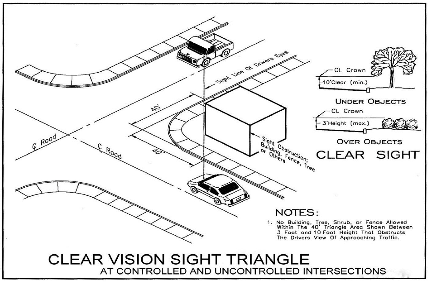
Residential driveways; placement along nonfunctional street corner lot frontage: The residential corner lot driveway entrance shall be constructed as far back from the roadway intersection as possible along the frontage of roads classified as nonfunctional and preferably installed as a common driveway entrance with the adjoining lot. Under no circumstances shall the driveway entrance be constructed closer than forty (40) feet from the roadway intersection, as measured from the public curb line; in accordance with the provisions of the clear vision sight diagram graphically depicted below - See KCC § 5-8-502:E.5 for details.
2.
Commercial/industrial/office driveway placement along functional or nonfunctional street corner lot frontage: Commercial, industrial or office zone designated corner lot driveway entrances shall be constructed as far back from the roadway intersection as possible along the frontage of roads classified as functional or nonfunctional and preferably installed as a common driveway entrance with the adjoining lot. Driveways installed in the commercial, industrial and office zoning districts shall be designed and constructed to commercial or industrial driveway standards. Under no circumstances shall the driveway's placement be less than the distance separation from the intersection required by ACHD or the City of Kuna's access management standards as they are applied to a subject property based on roadway functionality and other site specific or localized variables - See KCC § 5-9-402 for details.
3.
Driveway placement on a corner lot frontage of roadways subject to the city's highway overlay district standards: Corner lot driveway placement is subject to the overlay district's access management standards.
4.
Residential property access onto functional classified roads: Residential property owners shall not have direct driveway access onto functionally classified roadways (e.g., arterial, collector or highway); rather, they shall rely upon nonfunctional streets to access functional roads.
5.
Clear vision sight triangle diagram: The city has adopted the following clear vision triangle exhibit for both controlled and uncontrolled intersections. The term clear vision triangle has the same meaning as the phrase clear sight triangle:
6.
Irrigation or drainage ditch or canal: If the Boise-Kuna Irrigation, New York Irrigation District, other irrigation purveyor or government agency request a drainage or irrigation ditch or canal be placed in an easement it shall be legally described and recorded as a separate lot, to be maintained by the homeowners' association or other identified party, unless it is accepted by the irrigation purveyor or another government agency.
(Ord. No. 2024-06, § 2, 4-16-2024)
5-8-503: - OFFICIAL SCHEDULE OF DISTRICT LAND USE REGULATIONS:
A.
Determining Where Land Uses Are Allowed:
1.
Find the land use in subsection B of this section.
2.
Read across the schedule until either a "P" or "S" appears. If a "P" appears, the use is considered a permitted use in the corresponding zoning district it appears in. If a "S" appears, the use is only allowed in the corresponding zoning district it appears in upon the issuance of a Special Use Permit in accordance with Chapter 8, Part 8, of this title.
3.
If a "P" or "S" do not appear under a district, that use is not allowed in that district.
4.
Many of the land uses identified in the land use table are defined in Chapter 2 of this title. In the event the definition is not listed there, please refer to staffs copy of, "A Planners Dictionary" edited by Michael Davidson and Fay Dolnick, American Planning Association Planning Advisory Service for land use definition. If the term sought is not found in either location, the City staff may refer to another Treasure Valley jurisdiction's terminology for land use definition.
5.
In the event that a land use is unlisted, the Director, or their designee, shall interpret appropriate zoning district for land uses not specifically identified in the land use table and determine their placement status in a particular zone by comparing the requested land use to similar type uses on the land use table.
6.
When several land uses are proposed to be combined together on a land use parcel or need to be reconciled to determine their placement in a zone, the most intensive land use shall be considered as the primary activity and relied upon for establishing zoning placement status.
B.
Schedule of Land Use Regulations:
LAND USE TABLE NOTES:
1.
Subject to the home occupation, accessory use standards set forth in section 5-8-1004.K of this title.
2.
Owner/Operator occupancy required for permitted daycares in residential Zoning Districts.
3.
Multifamily and Condominium dwelling units shall only exist on secondary levels. The main/ground floor shall not be used for any residential purposes.
4.
Up to five (5) animals allowed; however, no roosters are permitted.
5.
Alcoholic beverages require city licensure according to the provisions of Title 3, Chapter 1, of Kuna City Code. Consumption of alcohol on-premises is prohibited within three hundred (300) feet of a school or place of worship as measured from the primary entrance, unless the city council provides relief from that distance requirement. The three-hundred-foot distance separation requirement does not apply to temporary beer and wine licenses procured by way of catering license.
6.
Child care facilities require a minimum of forty (40) square feet of usable indoor space per child and eighty (80) square feet of usable outdoor space per child.
7.
Subject to additional Equivalent Dwelling Unit (EDU) Evaluation.
(Ord. No. 2024-06, § 2, 4-16-2024; Ord. No. 2025-07A, § 3, 4-1-2025)
5-8-504: - SCHEDULE OF HEIGHT AND AREA STANDARDS:
A.
Official height and area regulations.
Notes:
1.
Exceptions to height regulations: The height limitations contained in the official height and area regulations do not apply to public utility structures, spires, belfries, cupolas, antennas, water tanks, ventilators, chimneys or other appurtenances usually required to be placed above the roof level and not intended for human occupancy except where the height of such structures will constitute a hazard to the safe landing and takeoff of aircraft at an established airport.
2.
Zero Lot Line: Townhouse/Rowhouse developments shall be permitted to reduce the interior side yard setback to zero, provided the reduction does not create health or safety issues and can satisfy utility easements.
3.
The minimum lot size of all parcels created through the lot split process shall be one (1) acre, with the exception of public utility lots.
4.
There shall be no minimum lot size that applies to a public utility lot. Public Utility lots will not be subject to setbacks.
B.
For all residential districts:
1.
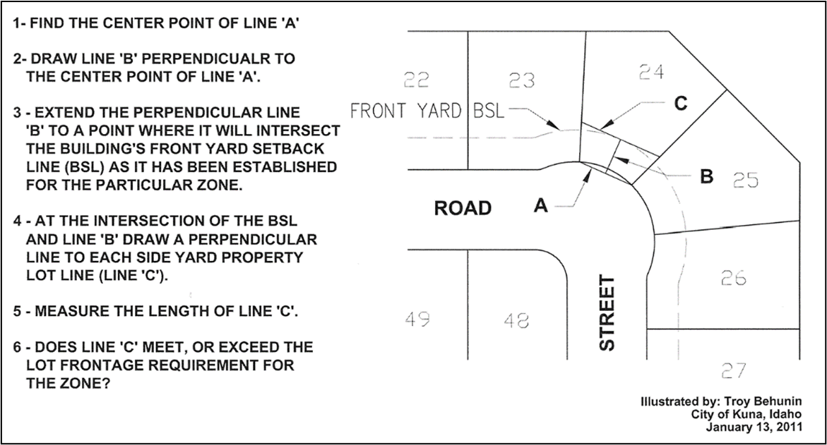
When a lot's side property boundaries are not parallel or the lot has an odd configuration that casts doubt on its capacity to meet the city's lot width requirements for a given zone - city staff will measure the lot width at the front yard setback to determine whether it meets this requirement by way of the following process:
2.
Flag lots require a minimum thirty-foot of street frontage.
3.
The front yard setback may be reduced to fifteen (15) feet for the residential living area or side entry designed garage; however, a street facing garage entrance shall be located a minimum twenty (20) feet beyond the sidewalk or sidewalk easement.
4.
Certain structures and projections are permitted within the required yard setback area, unless their placement there would interfere with building code provisions. Items permitted there include: Cornices, canopies, eaves or other like projections, which do not increase the volume of space enclosed by the building as determined by the Director, in consultation with the building official. None of these items shall project into a designated side yard more than two (2) feet or extend to within three (3) feet of a property line. It should be noted, that even though certain structures or projections are permitted within the yard setback, they are likely not permitted within an easement or right-of-way.
5.
Exterior steps or stairs shall not project into the designated side yard setback.
6.
Setbacks are typically measured from the property line; however, if a public sidewalk is placed upon private property by way of a public easement - the private property side edge of the sidewalk shall serve as the beginning of the setback line for establishing the yard setback.
C.
For all residential and/or commercial/industrial districts:
1.
The term "maximum lot coverage" assumes all of the required onsite development functions necessary to support the development as a feature of lot coverage requirements are satisfied. These functions include: On-site parking; landscaping; building separation distances; travel aisle widths; solid waste collection device placement; easements; sidewalks; walkways; internal streets; irrigation, water and waste water systems; lawns; lighting; drainage facilities; parks; open spaces; public dedications; service areas and other land use support functions requiring physical space.
2.
The Director has administrative authority to modify side or rear setback requirements and height restrictions by up to twenty (20) percent with the Commission's concurrence, provided building or fire code separation distances and other development requirements are not compromised by that action.
3.
When a commercial and/or industrial use abuts a residential zoning district, the yard setback requirements shall be the same as required in the adjacent residential district. When residents are located in commercial or industrial zones, the yard setbacks are the same as required for the R-4 residential zoning district.
4.
Odd lot size or topographical dimensional issues: The director will determine how to address area and setback requirements for odd shaped lots and land with topographical issues.
5.
Land use violation: The city shall not accept land use plans or time extension requests, if prior to their submission, the city has advised the property owner, or their representative, of an illegal or improper land use action or activity on the subject parcel, and in the interim, it has not been addressed to the city's satisfaction.
(Ord. No. 2024-06, § 2, 4-16-2024)