
Lake Park City Zoning Code
ARTICLE VIII
LANDSCAPING AND VEGETATION PROTECTION5
Cross reference— Vegetation, ch. 34.
Sec. 78-251.- Landscaping generally.
(a)
Purpose and intent. The purpose and intent of this article is to protect, preserve, and enhance the natural environment and beauty of the town by creating minimum standards for landscaping and vegetation protection. The purpose and intent as expressed in section 34-1 of this Code is also applicable to this section. Landscaping that meets these standards will:
(1)
Improve and sustain the aesthetic appearance of the town.
(2)
Improve air and water quality by such natural processes as transpiration and the maintenance of permeable land areas for aquifer recharge and surface water filtration.
(3)
Buffer noise and reduce pollution through the filtering capacity of living trees and vegetation.
(4)
Promote energy conservation through:
a.
The creation of shade which reduces heat gain in or on buildings and paved areas; and
b.
The channeling and control of breezes to facilitate the natural cooling of buildings.
(5)
Reduce erosion by stabilizing the soil.
(6)
Provide habitat for urban wildlife and a planned transition of the town's green space and open space to the town's conservation areas.
(7)
Conserve freshwater resources through the use of drought-tolerant plants and mulch, promoting the planting of less sod and water efficient irrigation systems.
(8)
Provide a visual and/or structural buffer between otherwise incompatible types of land uses.
(9)
Increase the economic value of land by serving as a capital asset when properly incorporated into site design.
(10)
Provide for the public health, safety and welfare.
(b)
Procedures established. In order to fulfill these goals, this article establishes the following:
(1)
Procedures to evaluate new landscape plans and existing vegetation protection plans using:
a.
Minimum standards for new landscape installations;
b.
Minimum standards for the preservation of existing vegetation; and
c.
Adequate standards for maintenance and arboriculture.
(2)
Procedures for administration and enforcement of these standards.
(c)
Applicability.
(1)
The standards contained in this section shall apply to all property within the town.
(2)
Nonconforming parcels.
a.
Any parcel of land, with the exception of nonconforming parcels on which single-family, two-family or three-family dwellings exist, must conform with the requirements and regulations of this article and chapter, regardless of the date of the erection of the structure.
b.
Nonconforming parcels of real property on which single-family, two-family or three-family dwellings exist must comply with the landscape requirements of this article whenever a building permit is issued by the town for construction work on the property, where the estimated total value of the construction work and/or other improvements is $5,000.00 or more. Provided however that, nonconforming parcels shall incorporate only those landscaping requirements determined by the director of community development to be feasible based on existing site conditions. Financial hardships shall not be considered to be a site condition which would alleviate a property owner's compliance with landscaping requirements. The community development department is authorized to approve waivers of the landscaping requirements of this section upon the review and approval of an application for same. The application shall include a landscape plan signed and sealed by a Florida registered landscape architect.
c.
Nonconforming parcels of real property shall be subject to the landscape requirements of this article, should they seek any expansion, modification, or where the property has been damaged based on the following criteria:
1.
Repair, rehabilitation, restoration, reconstruction, alteration, expansion, or similar improvement, in a calendar year, in excess of 50 percent of the value of the improvements of the property, as determined by the most recent certified tax roll prepared by the county tax collector; or
2.
Repair, rehabilitation, restoration, reconstruction, alteration, expansion, or similar improvement, over three calendar years, in excess of 50 percent of the value of the improvements of the property, as determined by the most recent certified tax roll prepared by the county tax collector.
d.
If it is impossible to satisfy the landscape requirements of a nonconforming parcel, the town may designate the town manager or his/her designee to mitigate the nonconformity by donation to the town of cash equal to the costs of the required improvements, or by the owners contribution of a like amount (or combination thereof) of trees, shrubs, and groundcovers for the improvement of the town's public parks, ball fields or other parcels that might be designated to satisfy the extent of the nonconformity.
(d)
Approval required. Unless otherwise provided within this chapter, no parcel within the town which is in violation of the landscape requirements of this article, or any parcel which requires site plan approval shall be landscaped, cleared or grubbed unless a landscape permit is issued by the community development department for the parcel which is in violation of the requirements of this article, after review and administrative approval of the landscape permit application and the payment of the applicable permit fee by the applicant. In the case of property which is the subject of an approval site plan, the property shall not be landscaped, cleared or grubbed until an amended site plan together with a separate landscape plan is submitted by the applicant along with the applicable site plan amendment application fee, and the site plan amendment and landscape plan are approved by the town. Furthermore, the standards for tree removal and abuse as set forth in articles 1 and 2 of chapter 34 entitled "vegetation" shall be strictly complied with, and are incorporated by reference herein. Approved landscape and tree protection plans shall not be altered in any way, unless otherwise provided for by this chapter.
(e)
Application and permit required.
(1)
Any person or entity seeking site plan approval and a part thereof, desires to landscape or clear existing vegetation, grub, or remove or destroy a tree, or in any way alter existing plant communities or alter previously cleared land shall submit a technically complete development application to the community development director for review and approval or denial. Applications are available at the community development department.
(2)
If an application for a site plan amendment is submitted, a separate landscape plan shall be submitted as part of the application.
(3)
Prior to the submission of any application for site plan approval or a landscape permit, the community development department shall use its best efforts to schedule a pre-applicaiotn conference and inspection of the property to identify specific areas of concern and protection in order to plan for tree protection, relocation, grading, drainage, building location, and road alignment.
(4)
Except for single-family, and two-family and three-family dwellings, prior to the issuance of any permit for paving, a landscape permit application shall be submitted to the community development department. The landscape application shall be subject to the community development department's review and approval. Provided however, nonconforming parcels shall incorporate only those landscaping requirements that are feasible based on existing site conditions. Financial hardship shall not be considered to be a site condition which would alleviate the property owner from compliance with landscaping requirements. The community development department is authorized to approve waivers of the landscaping requirements of this section upon the review and approval of an application for same. The application shall include a landscape plan signed and sealed by a Florida registered landscape architect. No permit shall be issued for paving unless the application complies with the provisions hereof, and no final certificate of occupancy or completion shall be issued until the landscaping is complete and passes a final inspection by the town.
(f)
Development application.
(1)
Any person who does not have a site plan or landscape plan approval as required by this section and who desires to clear vegetation, plant vegetation, grub, remove, or destroy a tree, or in any way alter a plant community or previously cleared land , must first submit a written development application for the proposed landscape work to the community development, together with the applicable permit fee, and obtain a landscape permit from the town.
(2)
The following actions require approval from the town commission and will only be reviewed upon submittal of a technically complete development application and other information deemed necessary by the community development director and/or town commission:
a.
Installation of new landscaping, land clearing, site vegetation grubbing, or removal of trees or other vegetation that is proposed by either a proposed landscape plan or drawing, a site plan amendment, a development review site plan, or other form of development order(s).
b.
Clearing, grubbing, or removing trees or plants for the expansion of a permitted use within a particular land use or zoning district.
c.
Performing major changes to the landscaping or preserve area which is the subject of a previously approved site plan or PUD approval to the extent that plant quantities or design is affected.
d.
Changing the landscape area or preserve area which is the subject of a previously approved site plan or PUD approval due to restraints, conflicts or conditions put on property owner by the state department of transportation, a utility company or a governmental agency with multijurisdictional authority prior to starting work.
(3)
Evaluation of the development application will be based upon the application package prepared by the applicant. A preapplication field inspection by the town community development director shall be conducted. The submitted development application package shall include, but shall not be limited to, the following information:
a.
The technically complete development application submitted, on a form which is available in the community development department, together with the applicable application fee.
b.
Location map, including, but not limited to, the location of the site within the town, including, but not limited to, the nearest major roadways, landmarks, and water bodies.
c.
Vegetation and habitat map. A drawing to scale or aerial photo with scale of the site that shows the existing terrestrial and aquatic vegetation and significant wildlife habitat, including exotic invasive species and native plant communities at the same scale as the site plan:
1.
Within the plant communities, the location of all three-inch caliper trees or greater.
2.
Location of large groups of trees in close proximity can be designated as clusters within predominant communities if approximate tree count and the largest and average caliper in the cluster is indicated on the map; using plot samples to acquire this information is acceptable.
3.
A description of each plant community, including species within the canopy, understory and ground cover and a written statement to indicate the proposed removal, relocation or preservation of all or part of such community.
4.
Soil types and conditions.
5.
A drawing to scale or aerial photo with scale that maps the species, location or possible location of any federal- or state-listed endangered, threatened or species of special concern (plant or animal), and a written statement to indicate the proposed removal, relocation, or preservation of all or part of the habitat at the same scale as the site plan.
6.
Archaeologically, historically, and/or geologically important features found on site.
7.
Areas of previous alteration or degradation including present and past human use should be indicated on a map or aerial photo at the same scale as the site plan.
8.
Surrounding landscaping or plant communities within 50 feet of the property line.
9.
Protected trees, as designated by the town commission, must be located on a survey map which map is not older than 90 days from the date of submission of the application and is signed and sealed by a registered State of Florida surveyor. This survey will be used in the project design to help protect the trees through the planning stages of development.
10.
Data table with specific values for acreage of each plant community, including total upland and wetland areas before and after land alteration.
d.
Project design plan.
1.
Site plan showing proposed buildings, roadways, parking areas, utility easements, dumpster enclosures, water features, flood control structures, backflow preventers, wellfield locations, stormwater systems, landscaped areas, buffer areas, preserve areas and other open space areas at the same scale as an overlay of the vegetation map.
2.
Elevation (contour) or grade maps for the existing grades and proposed grades at the same scale as the vegetation map.
3.
Mitigation proposals as they relate to loss of wetlands or actual occupied habitat of endangered, threatened species or species of special concern for plants and wildlife.
4.
Detailed landscape plan. All landscape plans except individual single-family, duplex and triplex lots, or areas of one acre or less which are required by this chapter shall bear the seal of a landscape architect licensed to practice in the State of Florida or be prepared by another licensed professional authorized to prepare landscape plans by F.S. § 481.301 et seq., and be at a scale no smaller than one inch equals 20 feet. Detailed landscape plans shall include but not be limited to:
i.
Clearly delineated and keyed landscape areas, square footage of open space and impervious areas, landscape materials with specifications, such as caliper, height, species name (common and botanical), size and the like, and quantities to be used.
ii.
Existing trees on the property that are proposed or required to be preserved and the methods to protect these trees during construction. The protection methods will be consistent with the Florida Division of Forestry, Tree Protection Manual for Builders and Developers, most current edition.
iii.
Specifications of hardscapes (nonliving landscape materials) including heights, widths, types, and locations of all barriers.
iv.
Landscape plans may be required to have typical aerial view drawings and/or cross section details of any proposed perimeter buffer area, road right-of-way, or lot landscaping.
v.
Landscaping shall be shown as an overlay of the site plan including all new trees, shrubs, grass, open areas, preservation areas and hardscapes. For purpose of public hearings, landscape plans submitted for planning and zoning or town council review shall be rendered with plan (color) graphics and present elevations of all sides of a property or building. Presentations may be in the form of a digital PowerPoint or equivalent format. The town encourages the proper choice of plants for water conservation in landscaping as set forth in the South Florida Water Management Xeriscape Plant Guide.
vi.
A plan (narrative) to eradicate and prevent the reestablishment of prohibited plant species listed in subsection 78-253(f).
vii.
Landscape plans may be required to have typical aerial view drawings and/or cross section details of any proposed littoral planting zones as referenced in subsection 78-254(f).
viii.
Conceptual irrigation system plan, including main lines, backflow preventer, and water source, which indicates 100 percent coverage of all pervious areas and which meets the standards of Florida Irrigation Society. Also refer to subsection 78-254(e)(3) for more information.
e.
Project operations.
1.
Description of construction methodology to be performed on site, including use, storage, handling or production of substances known to be harmful to plants and/or wildlife.
2.
Description of any anticipated soil, water, or air pollution produced or generated by the project and known to be harmful to plants and/or wildlife.
3.
Description of the project phasing. Any project that will require multiple building permits due to the methodology or construction sequence caused by off-site improvements, staging building-by-building, increasing square footage, restructuring finances or changing market strategies will be considered phased. There shall be a narrative and/or map depicting the projected phasing submitted that describes when areas will be cleared and landscaped.
f.
Prior to approval, revised site plans shall be accompanied by a written description of all changes made since the last site plan review.
g.
After approval and prior to the issuance of any town permit, the site plan shall have all conditions of approval located on the site plan, and this information will be available on the site during construction. A reduced copy shall be provided to the town clerk's office for attachment to the respective ordinance or resolution documents.
(g)
Administrative approval.
(1)
The following actions may be approved by the community development director upon request for a permit:
a.
Landscape plans for single-family and two-family dwellings.
b.
Clearing, grubbing, or removal of trees or other vegetation pursuant to an approved site plan. No vegetation clearing will be permitted until a written permit is issued or as otherwise permitted in this chapter.
c.
Removing and replacing dead, diseased, damaged, or insect-infested vegetation, including trees, if such determination is made and approved by the town community development director.
d.
Removing or relocating vegetation, including trees, that are a hazard to existing buildings or within existing utility easements or rights-of-way, if such determination is made and approved by the community development department.
e.
Removing and replacing trees due to a hardship regarding health or safety, if such determination is made and approved by the town community development director.
f.
Minor alterations or changes to approved landscape plans within all districts to improve or remove existing landscape as determined by the town manager. Minor alterations shall be defined, in most cases, as a change of type, quantity, or location that affects up to 25 percent of required shrubs or 25 percent of required trees on a site.
g.
Installations of fences, if no expansion of an existing or proposed use is intended.
h.
Temporary landscaping (landscaping other than what was originally approved), if it does not result in the removal of native vegetation.
(2)
Evaluation of the permit to amend a landscape plan administratively shall be based upon the information prepared and submitted to the town by the property owner or the property owner's designee. A field inspection by the town community development director shall be conducted. The submittal shall include, but not be limited to, the following information:
a.
Location map of the property (a current legible aerial photograph or a drawing to scale).
b.
Existing vegetation inventory map and landscape plan for all changes.
c.
Location and description of all proposed changes.
d.
Reasons/rationale for the proposed changes.
e.
Replacement schedule, if applicable.
f.
Site plan data revision, if applicable.
(3)
Administrative approval will be granted, granted with conditions, or denied within 15 working days from the time a technically complete application is submitted to the community development director, unless circumstances warrant additional review time by the town. The cost recovery provisions of section 51-6 shall apply to the review and processing of all such applications by the town and must be paid in advance prior to the issuance of any approval or permit by the town.
(Ord. No. 7-1998, § I, 7-1-1998; Code 1978, § 32-144; Ord. No. 02-2010, § 3, 2-17-2010; Ord. No. 01-2014, § 2, 2-5-2014)
Sec. 78-252. - Administration.
(a)
Stop work order. A stop work order for all construction or any part of construction work shall be issued by the community development department if grubbing, clearing, preservation, excavation, landscaping, or pruning work is proceeding in direct conflict with this chapter or an approved site plan, landscaping plan or construction plan.
(b)
Certificate of occupancy. A certificate of occupancy shall not be issued by the community development department if landscaping does not comply with the approved landscape plan of record under this chapter. The community development director or the community development director's designee shall have a certified or signed landscape plan or document by the landscape architect of record verifying that landscaping for projects has been installed as per the approved landscape plan. Projects landscape architect verification before each phase is complete. This verification includes the species (quality, type, quantity, and any other original plant specifications), design or location, irrigation, and all other landscape structures and material used in accordance with the site plan. The town's landscape inspector will review the project for compliance after the documentation has been received from the landscape architect. Any deviation from the approved landscape plan will be relayed to the community development director and town manager for further review prior to the issuance of the certificate of occupancy. If landscape deviations cannot be corrected prior to the certificate of occupancy, a letter of credit or bond shall be posted by the owner, general contractor, or principal for the remaining work to be accomplished.
(c)
Performance bond. The community development director or a designated representative may enter into an agreement on behalf of the town with the developer, the owner, or agent that will allow issuance of the certificate of occupancy before the landscape installation required by this chapter is completed, provided that a performance surety or guarantee shall be posted. The guarantee shall consist of a performance bond or other surety agreement approved by the town attorney in an amount equal to 110 percent of the direct costs of materials and labor, and other costs incidental to the installation of the required landscaping as certified by the landscape architect. The guarantee shall specify the time for the completion of the landscaping requirements and shall be accompanied by a site plan identifying the plant material covered by the surety. A performance bond shall not be required for landscape installation of existing single-family dwellings or projects which are valued at less than $150,000.00.
(Ord. No. 7-1998, § I, 7-1-1998; Code 1978, § 32-145)
Sec. 78-253. - Minimum landscape requirements.
(a)
Nonresidential districts.
(1)
In nonresidential districts, no more than 40 percent of the total landscape area shall be covered with sod (grass), except those projects proposing playgrounds, ballfields, golf courses, dry retention areas and the like, which would normally be covered with grass (sod). A list of preferred species is available in the town hall for a fee.
(2)
The following uses within nonresidential zoning districts shall be required to be screened from public view (see also subsection (h) of this section):
a.
Backflow preventer systems.
b.
Trash (dumpster) containers and recycling containers.
c.
Storage or mechanical equipment areas.
d.
Outside display or sales areas.
e.
Parking areas.
(3)
The following uses within nonresidential zoning districts shall be required to have landscaping (see subsections (c) and (h) of this section):
a.
Vehicular use areas.
b.
Building foundations excluding rear areas not visible by a public road right-of-way or not generally traveled by the public or visible from adjacent structures.
c.
Signs (see subsection (d) of this section pertaining to signs).
d.
Multilevel parking garages.
e.
Berms or perimeter walls.
f.
Right-of-way medians and shoulders, in accordance with all state department of transportation rules.
g.
Swales, ditch banks, including any transition between land and a water body and littoral zones, in accordance with all South Florida Water Management District or United States Army Corps of Engineers rules.
(4)
Where redevelopment projects are unable to meet the landscape or open space requirements as stated in this section, required landscaping may be transferred to other lands (i.e., public lands, parks, road rights-of-way) or an assessment can be levied by the town commission. The assessment shall be based on the share of the landscape budget that cannot be installed on the site. The assessment shall be calculated at a rate equal to two times the total caliper of plants required. Monies collected shall be used for landscaping public lands.
(5)
Trees located on the property required to be preserved by any other code or section may be used to satisfy requirements within this section. The trees are to be protected during construction, and protection methods shown on the landscape plan.
(b)
Residential districts.
(1)
The minimum required open space in residential districts shall be 35 percent of the entire site within a site plan. Landscaping shall be achieved with a combination of trees, shrubs, ground cover, grass (sod), and nonliving landscape material. One hundred percent of all open space shall be landscaped.
(2)
The following uses within residential zoning districts shall be required to be screened with landscaping:
a.
Lift stations;
b.
Backflow preventers;
c.
Ground-mounted air conditioning units;
d.
RV parking areas;
e.
Boat storage areas;
f.
Maintenance and storage areas; and
g.
Dumpster or trash pickup areas.
(3)
Single-family and duplex yards (lots) will have a minimum of one tree or two palms per every 1,000 square feet of open space or fraction thereof. A single shade tree from the town's preferred tree list is required as a street tree, located on or within 15 feet of the street right-of-way line. Street trees are to be replaced if removed for any reason by the landowner.
(4)
Trees located on the property required to be preserved by any other code or section may be used to satisfy requirements within this section. The trees are to be protected during construction, and protection methods shown on the landscape plan.
(c)
Parking areas.
(1)
The minimum shade tree spacing for interior parking areas shall be such that no parking space is more than 40 feet from the center of the shade tree. A shade tree may be replaced by a minimum of three palms clustered to create shade as long as the affected parking bays are more than 50 feet from a public street. Palm cluster planting shall be limited to 120 feet on center in any direction within parking areas.
(2)
The minimum landscape area shall contain no dimension less than five feet in width, measured from the inside of the curb. There shall be no landscape area smaller than 25 square feet. Landscape areas within interior parking areas may be reduced if the areas shall constitute an obstruction in use of a building structure, providing the reduced square footage is relocated so as to emphasize entrance corridors or special landscaped areas within the general parking area.
(3)
All landscape areas shall be protected from vehicular encroachment and from the damages caused by vehicles overhanging into landscape areas. Landscaping, except grass, shall be required to be at least two feet six inches from the edge of the wheel stops or curbing. The grassed area over which vehicles may hang will not be counted as landscaped area. The curb shall be at least six inches in height above grade.
(4)
Vehicle use areas, including driveways, public rights-of-way and parking lots, shall have a minimum four-foot-high hedge at maturity.
(5)
Multilevel parking garages shall have planters adequately designed to permit trees to live on the top level. The top parking area shall have trees as required in subsection (c)(1) of this section.
(6)
Turf parking is encouraged in appropriate areas.
(7)
Grass parking shall be required to meet the same standards as outlined in subsections (c)(1), (3) and (5) of this section.
(8)
Regular maintenance of vehicular use areas adjacent to all landscape areas shall include replacement of broken curbs or curb stops as needed to keep the general appearance in good condition and safe.
(9)
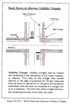
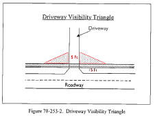
Visibility triangles. At any road intersections or where a point of ingress or egress (driveway) intersects a public right-of-way, visibility shall not be obscured by the construction, placement or maintenance of a structure wall, sign, fence, bench, berm, plant material, shrubs or any similar item. In order to provide a clear view of intersecting streets and sidewalks to the motorist, there shall be an area of clear visibility on the triangular portion of property closest to two intersecting streets or the intersection of a driveway and a street or sidewalk. The following standards shall be met:
a.
Nothing shall be erected, placed, parked, planted or allowed to grow within this "clear visibility triangle" in such a manner as to materially impede vision between a height of three feet and eight feet above the grade, measured at the centerline of the intersection. However, trees or palms shall be permitted provided they are trimmed so as to allow visibility at the levels indicated above and provided they are located so as not to create a traffic hazard.
b.
Clear visibility triangles shall be created and maintained at the intersection of any street, roadway, alleyway or sidewalk according to the following standards:
1.
For roads, streets, and alleyways that intersect with a road, two sides of the triangle shall extend adjacent to the edge of pavement for 20 feet measured from the point of intersection or the point of intersection established when the lines are extended in a straight line so as to intersect. The third side of this triangle shall be a line connecting the ends of the other two sides. (See Figure 78-253-1.)
2.
For driveways that intersect with sidewalks. The area of property on both sides of a driveway formed by the intersection of each side of the driveway and the public right-of-way line for a distance of 15 feet in length and five feet in width along the public right-of-way. (See Figure 78-253-2.)
3.
Alternative visibility triangles. Alternative visibility triangles approved by the community development director or director of public works may be allowed in individual cases if they are deemed to ensure adequate traffic safety. If alternative visibility triangles are required, they shall result in traffic safety equivalent or superior to the minimum requirements of this subsection.
(d)
Ground signs. A ground sign shall be erected in a landscaped area. The landscaping shall consist of shrubbery of at least 30 inches in height, the intent being to create a hedge or a collection of individual shrubs of the same or varying species. The hedges shall be spaced not more than 18 inches apart at their base. Provided however, nonconforming parcels shall incorporate only those landscaping requirements that are feasible based on existing site conditions. Financial hardship shall not be considered to be a site condition which would alleviate the property owner from compliance with landscaping requirements. The community development department is authorized to approve administrative waivers of the landscaping requirements of this section. For all new developments and substantial renovations the landscaped area shall be equal to no less than the height of the sign in all directions from the sign face and front end and a minimum of three feet from the rear of the sign. The area shall be planted with appropriate vegetation and automatic irrigation by the property owner and shall comply with this section.
(e)
Preserve areas.
(1)
All plants (trees, shrubs, ground cover) within a preserve area that meet or exceed the minimum landscape requirements as set forth in this chapter can be counted toward meeting landscape requirements pursuant to subsections (a) through (c) of this section.
(2)
The minimum width of a preserve area to be used to meet landscape requirements shall be 25 feet.
(3)
The preserve area shall screen any area that requires screening with the same minimum planting requirements as does new landscape material (see subsection (h) of this section). Infilling new vegetation within preserve areas or around preserve areas shall be required if minimum requirements for screening cannot be met with existing vegetation. Infilling preserves shall be accomplished with relocating existing native plants or adding appropriate new native plants to the voids or bare areas of the preserve to accomplish the required screening.
(4)
One hundred percent irrigation is not required within preserve areas. The preserve area shall be preserved in such a way that the transition of new landscaping or open space to existing vegetation duplicates nature. The preserve area shall not be adversely impacted by surrounding drainage or elevation changes proposed by development.
(5)
Preserve areas shall be maintained or managed with the same standards set forth in sections 78-254(d) and (e), except there shall be no pruning of vegetation or trees within preserve areas without written approval from the town community development director. Preserve areas shall be cleared and kept clean of any plants listed on the town prohibited plant list (see subsection (f)(1) of this section).
(6)
There shall be no construction within preserve areas unless otherwise approved during site plan approval.
(7)
Walls or other barriers shall not be constructed in such a manner that impedes or restricts the use of preserve areas that also act as habitat corridors or pathways unless otherwise approved during site plan approval.
(8)
Trees and shrubs used to meet landscape requirements that die within preserve areas for any reason shall be replaced once it is determined by the town that landscape screening requirements have dropped below minimum standards.
(9)
Code enforcement regulations shall apply to preservation areas that are used to meet landscape requirements.
(f)
Prohibited plants; removal of invasive nonnative plants.
(1)
The following shall be considered the official list of invasive nonnative plant species, and the list may be updated by the town. These plants shall be removed from all open space in their entirety from the entire site:
(g)
Tree replacement. During construction, all new landscaping that dies shall be replaced with the same species within 30 days or before issuance of the certificate of occupancy. The minimum replacement specifications will be one for one at the minimum size standard set in the approved landscape plan. Trees protected that die during construction shall be replaced with the same species within 30 days or before issuance of the certificate of occupancy. The minimum replacement specifications and minimum size standard is set forth and provided in this chapter.
(1)
No certificate of occupancy or other official acceptance of completed work shall be issued for development until verification is provided, through inspection by the town community development director, that all required removal of invasive nonnative plants has been completed and is in accordance with the development plan or phasing plan and permit conditions.
(2)
Ficus species may be planted as individual trees or hedge material provided the following provisions are met:
a.
No individual Ficus spp. tree shall be planted within 15 feet of any public road right-of-way or other public utility.
b.
Ficus spp. hedges shall be constantly maintained, shall be of cold-tolerant variety, and shall not exceed six feet in height.
(h)
Planting.
(1)
A landscaped buffer shall be a minimum of eight feet in depth around the perimeter of a parcel; provided, however, a landscaped buffer of 15 feet in depth shall be required on lands located adjacent to public street rights-of-way.
(2)
The maximum spacing of planted trees along any perimeter buffer along a public street shall be 20 linear feet or fraction thereof, on center, with a minimum of two trees on any one street frontage. Buffers not adjacent to public streets shall contain one tree for each 40 linear feet or fraction thereof.
(3)
Seventy-five percent of the total quantities of trees and plants will be from the town's preferred plant list. In no case shall palm trees constitute more than 50 percent of the required total quantity.
(4)
All outside storage and trash collection sites will have a three-foot-high hedge and structural barriers, berms or any combination thereof to 100 percent screen the area from view.
(5)
There shall be foundation landscaping within 15 feet of all building structures. The location and size of this foundation landscaping shall be of the height and quantity to visibly soften bare walls and accent building design elevations and help direct pedestrian traffic to building entrances. All foundation areas shall be irrigated and of appropriate size to accommodate the vegetation to be planted.
(6)
Service areas of nonresidential buildings, when visible from the street right-of-way or adjacent residential land uses, shall have barriers and a hedge at a minimum of six feet in height to screen the service area from this use.
(7)
Backflow preventer systems.
a.
All water line backflow preventer systems not constructed within a building shall be no higher than five feet above immediate surrounding grade and the system shall be screened by a fence or wall of solid manmade materials on three sides with the open side facing the building structure, and the fence or wall shall be screened by live materials (hedge) in a sufficient amount of type and quality to reach maturity within six months from the date of planting. An automatic watering system shall be required for planting.
b.
Smaller irrigation backflow preventer systems (i.e., irrigation systems) may be permitted to be screened by landscaping only.
(8)
Landscaping around ground signs is required (see subsection (d) of this section).
(9)
Hedge shrubs shall be planted on two-foot centers. Hedge material used to meet buffer requirements as set forth in this chapter shall be 30 inches in height at planting.
(10)
Vines shall be a minimum of 60 inches trellis length containing live runners or more at planting. Following sound horticultural practices, the vine shall be attached to the fence, column or wall, if appropriate, in a way that encourages proper plant growth.
(11)
Lawn grass shall be solidly sodded unless otherwise approved in the landscape plans. Lawn grass shall not be allowed to grow higher than six inches in height.
(12)
Palms shall have a minimum of eight feet of gray trunk immediately after planting when used to meet buffer or parking area requirements.
(13)
Required trees shall be a minimum of 12 feet in height according to Florida Grades and Standards (height is measured from the ground to what is the average of the ends of branches, not the tallest branch or two), a plant spread (crown) of five feet in diameter, and a minimum diameter of three inches measured at a point which is at least 4½ feet above the existing grade. A minimum of 75 percent of all trees required to be planted by this section shall be native species or from the town's preferred plant list. Copies will be available at town hall for a fee.
(14)
Nonliving landscape material requirements.
a.
Perimeter walls, metal or wood fences, or other nonliving landscape materials may be used in conjunction with vegetation to meet required landscaping. Approved walls or fences shall be set back from property lines sufficiently to include landscape on the outside of the wall or fence. Maintenance of the wall or fence is required and associated landscaping. If nonliving barriers are used, 50 percent of the barrier shall be covered or screened by vegetation on the street side along public rights-of-way and interior perimeter areas visible to the public.
b.
Earth berms may be used only when installed in conjunction with sufficient plant material and adequately spaced to satisfy the provisions of this chapter. The slope of a berm shall not exceed a ratio of 4:1. Earth berms may not be constructed over public utilities without written consent from all applicable utility companies.
c.
All tree and shrub beds shall receive at least two inches of mulch. Mulch shall be temporarily applied to areas not immediately covered by ground cover. Where mulch is intended to be installed permanently, it shall be renewed and maintained at three inches of depth. Mulch will be thoroughly wet at the time of application to prevent wind displacement.
(15)
Non-specimen palms planted in perimeter buffers shall be installed in groups of no less than three.
(16)
Soil erosion shall be controlled and held to a minimum. Areas in which vegetation or ground cover has been allowed to be removed pursuant to an approved site plan and subsequently abandoned for any reason for more than six months shall be seeded with a ground cover or grass immediately upon request by the town, or the town shall have the work done at the owner's expense.
(i)
List of protected trees. The town commission shall establish and update by resolution from time to time a list of protected trees. A copy of the list shall be maintained at all times by the town community development director. The list is as follows:
(1)
All mangrove trees, located within town coastal zones.
(2)
All oak trees 16 inches diameter at breast height (DBH) or greater, located within the town limits.
(3)
All Royal Palm trees in Kelsey Park.
(4)
Banyan trees at the old Blakely House (currently medical office) located on the northwest corner of U.S. Highway One and Park Avenue.
(Code 1978, § 32-146; Ord. No. 7-1998, § I, 7-1-1998; Ord. No. 03-2009, § 3, 2-18-2009; Ord. No. 17-2017, § 2, 11-1-2017)
Sec. 78-254. - Minimum installation and maintenance standards.
(a)
Enforcement. The code compliance board is granted jurisdiction for enforcement of this section.
(b)
Exemptions.
(1)
All licensed plant or tree nurseries or tree farms shall be exempt from the terms and provisions of this chapter only with respect to those trees planted and growing which are for the sale or intended sale to the general public in the ordinary course of the licensee's business. The buildings and parking lots shall adhere to all codes outlined in this chapter.
(2)
The limited removal of understory vegetation by a state-licensed land surveyor in the performance of the surveyor's duties, provided that the swath cleared shall not exceed five feet in width, is exempt from the terms and provisions of this chapter. The surveyor shall not have the right to cut a tree three inches in diameter or greater without written consent from the town.
(3)
The requirements of this chapter may be waived by the town manager to facilitate the emergency removal of trees or vegetation when a state of emergency has been issued for the town.
(4)
Clear cutting trees (i.e., agriculture, timber, or pulpwood harvesting) is strictly prohibited. Forestry practices known to provide substantial benefits or protection and that conform to the town's environmental preservation standards may be allowed with a plan by the state forest service or other professional community development director and the town commission's approval.
(5)
The clearing of a path not to exceed ten feet in width to provide vehicular access necessary to conduct soil percolation and/or soil bore test on land is exempt from the terms and provisions of this chapter, provided such clearing or removal is conducted under the direction of a state-registered surveyor or engineer.
(c)
Tree and plant installation.
(1)
Plant quality shall be Florida No. 1 or better, as given in Grades and Standards for Nursery Plants, Part I and Part II, Florida Department of Agriculture and Consumer Services. All vegetation shall be clean and free of noxious pests or disease.
(2)
A preferred species list shall be prepared, periodically revised, and distributed to the public by the town upon request. This species list shall, to the greatest extent possible, represent plants that are:
a.
Drought-tolerant.
b.
Adapted to cold weather.
c.
Commercially available.
d.
Native or naturalized.
e.
Noninvasive and not destructive to native plants.
f.
Strong wooded (not brittle).
(3)
All landscaping shall be installed with sound workmanship and sound nursery practices in a manner which will encourage vigorous growth.
(4)
A plant's or tree's growth characteristics shall be considered before site plan approval to prevent conflict with building design, views of signage, underground and overhead utilities and drainage. Unless otherwise approved by the town, trees shall be of a shape and size typical of their species throughout their life cycle.
(d)
Pruning. Pruning standards as reflected in this chapter shall only apply to nonresidential uses, and common areas within PUD projects (all land uses). Crown reduction of shade trees shall be prohibited until the tree canopy has reached at least 15 feet in diameter, except to remove limbs or foliage presenting a hazard to structures or mankind, in conflict with a crime prevention program, to remove dead or diseased limbs, pruning young trees for strength of form, or in association with tree/palm relocation work. After a tree canopy reaches 15 feet in diameter, crown reduction shall only be permitted as incidental when correct pruning standards are used and when there are constraints such as but not limited to power lines and structures. The following are general pruning requirements:
(1)
Hat-racking is prohibited except pruning that is required to keep utility lines clear. Excessive pruning like hat-racking may be considered tree abuse and a code violation by the town's code compliance board. Each tree hat-racked shall be considered a clear and separate violation, with a maximum fine of $250.00 for the first tree and a maximum fine of $250.00 for each additional tree. If the town's code compliance board has made a previous determination that a person has violated this section, then such person may be charged with a repeat violation. A maximum fine of $500.00 for the first tree and a maximum fine of $500.00 for each additional tree shall be set by the town's code compliance board for repeat violation of this section. In determining the correctness of particular tree pruning techniques, the town shall use the current edition of the "Pruning Standards for Shade Trees," published by the National Arborist Association, or any future national standard on shade tree pruning. Tree replacement may be required by the code compliance board.
(2)
If other than the normal expected tree canopy shade and size (such as topiary) is desired by the owner of the trees, the desired shape and size shall be indicated on the approved site plan. If not noted, trees shall be allowed to grow to their natural shape and size. Landowners can request that their approved site plans be amended to allow tree shaping if any of the following conditions apply:
a.
Trees are located in a constraining situation, such as under power lines.
b.
A tree's unnatural shape is to be used as an accent or focal point in a landscape design, but not for the total landscape design.
c.
A maintenance commitment must be clearly outlined on the landscaping plan to explain the care and upkeep of unnaturally shaped trees.
(3)
Pruning shall be performed by a person or tree service which is knowledgeable with the latest standards of the National Arborist Association. Copies of these standards are included in the town's landscape handbook. All tree service companies shall have as public service a county occupational license at a minimum.
(4)
Pruning palm trees shall be limited to dead fronds, seed pods and up to one-fifth (20 percent) of the green fronds.
(5)
Maximum limb pruning, or severely cutting back lower branches to increase sight visibility from underneath a tree's canopy, shall be 13.5 feet from the ground level to the collar of the first limb.
(e)
Maintenance.
(1)
Regular maintenance of all landscape areas shall include weeding, watering, fertilizing, pruning, mowing, edging, mulching and other horticultural practices that are needed to keep landscaping in good condition, and free from disease, insect pests, weeds, refuse and debris.
(2)
Plants shall be alive and in good condition at the time of issuance of the certificate of occupancy. There shall be a minimum three-month replacement guarantee provided by the landscape company responsible for all new landscape material from time of issuance of the certificate of occupancy. It shall be the responsibility of the property owner to replace landscaping and maintain landscaping throughout the life of the project.
(3)
All landscape areas, except those areas composed of existing native plant communities, shall be irrigated. The irrigation system shall be designed and installed in accordance with the Florida Irrigation Society Standards and Specifications for Turf and Landscape Irrigation Systems (revised 1989) as amended from time to time. Irrigation systems shall be designed and maintained to:
a.
Eliminate the wasteful use of water.
b.
Eliminate staining of buildings, walks, walls and other site improvements including landscaping.
c.
Have a minimum of 100 percent coverage, including the capability of applying water onto turf areas on a different saturation level than those which irrigate shrub planting beds.
d.
Eliminate water overthrow onto nonpervious areas.
e.
A rain sensor (switching off irrigation during wet periods) shall be required on all irrigation systems.
(4)
The maintenance of ponds or any water management area and dried retention area shall be the responsibility of the landowner and shall be kept in a neat and clear appearance, free of exotic aquatic vegetation and algae.
(5)
The root system of existing trees shall be protected during construction by barricades acceptable to the town community development director. Prior to land clearing and/or construction, the developer shall erect and maintain protective barriers constructed of metal, wood, or other durable material around the drip line of all trees, clusters of trees, or preserve areas to be protected. No storage of material, equipment, debris, or fill shall be permitted within the protected barrier. No cleaning of equipment, disposal of liquid or solid wastes (paint, oil solvents, asphalt, concrete, mortar, and the like) shall be permitted within the protective barrier. No attachments or wires other than those of a protective nature shall be attached to any protected tree. In determining the appropriateness of particular protection techniques, the town shall use the current edition of the Florida Division of Forestry, Tree Protection Manual for Builders and Developers, 1979.
(f)
Littoral planting zones. Littoral planting is required on lakes the water surface of which is larger than one acre in size. At least 50 percent of the shoreline shall be planted with wetland trees and/or aquatic plants at ten square feet of littoral zone for every one linear foot of shoreline. There shall be a minimum of one tree for every 80 square feet and plants shall be on three-foot centers, minimum. Shelf slope and size shall be noted on the landscape plan in the form of a cross section drawing and respective specifications based on actual plant and tree requirements.
(Ord. No. 7-1998, § I, 7-1-1998; Code 1978, § 32-147)
Cross reference— Traffic and motor vehicles, ch. 30; vegetation, ch. 34.