
Laramie City Zoning Code
CHAPTER 15
14 - DEVELOPMENT STANDARDS
15.14.010 - Purpose.
A.
Purpose. The development and design standards set forth in this chapter shall apply to the physical layout and design of development in Laramie. These provisions address the physical relationship between development and adjacent properties, public streets, neighborhoods, and the natural environment, in order to implement the comprehensive plan vision for a more attractive, efficient, and livable community. The specific purposes of this chapter include:
1.
To implement the Laramie comprehensive plan through the creation and application of development standards that reflect Laramie's community character and development choices;
2.
To encourage the proper use of the land by promoting an appropriate balance between the built environment and the preservation and protection of open space and natural resources;
3.
To protect public and private investment through preservation of open spaces, protection of natural resources including existing trees, providing buffers between incompatible uses and along roadways, and encouraging the planting of new trees and vegetation as deemed appropriate;
4.
To promote sound management of water quality and quantity through preservation of natural areas and their functions and by encouraging soil management and the use of native plant materials;
5.
To provide appropriate standards to ensure a high quality appearance for Laramie and promote good design while also allowing flexibility, individuality, creativity, and artistic expression;
6.
To strengthen and protect the image, identity, and unique character of Laramie and thereby to enhance its business economy;
7.
To protect and enhance residential neighborhoods, commercial districts, and other areas by encouraging physical development that is of high quality and is compatible with the character, scale, and function of its surrounding area;
8.
To encourage developments that relate to adjoining public streets, open spaces, and neighborhoods with building orientation and physical connections that contribute to the surrounding network of streets and walkways; and
9.
To provide road connectivity for the movement of people, goods, and services.
B.
Applicability.
1.
New Development. The development standards of this code shall apply to all new development of the type identified in each section or subsection.
2.
Enlargement or Modifications to an Existing Development.
a.
Except in the case of single-family detached/attached, IBC/IRC modular homes, manufactured homes, and two-family/duplex, multifamily developments with less than four units, or accessory structures associated with the preceding residential uses, additions and modifications to an existing development shall fully comply with the development standards of this code including but not limited to building design, building materials, parking, landscaping, screening, buffering, and public improvements. The development standards shall apply to the entirety of the existing development if proposed development:
(i)
Increases the number of stories of a building on the lot; or
(ii)
Increases the size of a structure by more than twenty percent or twenty thousand square feet, whichever is less, as measured by the combined gross floor areas of a building; or
(iii)
Increases the non-permeable lot coverage by more than two thousand square feet.
b.
Exceptions. Alternative design that satisfactorily meets the intent of the code may be granted pursuant to [subsection] 15.06.060.J, minor administrative modification.
3.
Redevelopment of an Existing Development. Redevelopment involving demolition of one or more principal buildings shall require full compliance with the standards of this code within the development pad, included but not limited to, construction of principal and accessory buildings, driveways, walkways, loading areas and storage yards; public improvements or a development area is internal to a development site.
a.
Exceptions. Alternative design that satisfactorily meets the intent of the code may be granted pursuant to [subsection] 15.06.060.J, minor administrative modification.
4.
Change of Use. Section 15.10.010 identifies use categories and corresponding use levels. The development standards of this code shall apply to changes of use within or outside of use levels as follows:
a.
Change of use within each use level as shown in table 15.10-2 of subsection 15.10.010 shall not require mandatory compliance with the development standards of Chapter 15.14 [of] this code. For example, a change of use from a financial institution (Level 6—Financial Service) to a clothing store (Level 6—Retail) shall not require compliance with the development standards of Chapter 15.14 [of] this code.
b.
Change of use between adjacent levels as shown in table 15.10-2 of subsection 15.10.010 shall require compliance with [subsection] 15.14.050.F., site perimeter landscaping, for all adjacent street frontages. For example, a change of use from a clothing store (Level 6—Retail) to a restaurant (Level 7—Food and Beverage Services) shall require compliance with [subsection] 15.14.050.F., site perimeter landscaping, for all adjacent street frontages, internal landscaping, and site perimeter landscaping not adjacent to rights-of-way shall not be required.
c.
Change of use differing by two or more levels as shown in table 15.10-2 of subsection 15.10.010 shall require full compliance with the development standards of this code. For example, a change of use from a clothing store (Level 6—Retail) to a wholesale business (Level 8—Wholesale Business) shall require full compliance with the development standards of this chapter, including but not limited to parking, landscaping, and screening.
d.
Exceptions.
(i)
Multi-tenant Commercial Complex. Change of use within a multi-tenant complex shall not require conformance with the development standards of the chapter provided that the use is permitted within the zoning district and the change of use does not result in any addition to the existing structure. Exterior modifications such as signage, screening of new mechanical units and compliance with parking shall be required to conform to applicable standards of this chapter.
(ii)
Alternative design that satisfactorily meets the intent of the chapter may be granted pursuant to [subsection] 15.06.060.J, minor administrative modification.
5.
Interior Improvements/Remodel. Where development changes are wholly internal to the existing structure and there is no change of use, the development standards of this chapter shall not be mandatory. Examples of internal changes to a building shall include, but are not limited to, work performed in conjunction with a plumbing, electrical permit, mechanical permit or interior structural alteration.
(Ord. No. 1578, § 2(att. A), 3-20-2010; Ord. No. 1671, § 18(Att. C), 11-18-2014; Ord. No. 1706, §§ 5—7, 5-3-2016; Ord. No. 1830, § 10, 10-17-2023)
15.14.020 - Natural resource protection and sustainability.
A.
Purpose. The city contains many natural amenities, including stream corridors, river corridors, natural drainages, significant viewsheds, hillsides, tree cover, and open space—all of which contribute to the city's character, quality of life, and property values. The regulations of this section are intended to implement the Laramie comprehensive plan and ensure that the natural character of the city is reflected in patterns of development and redevelopment, and significant natural features are protected and incorporated into open space areas.
B.
Applicability. These development standards apply to all development types in the areas identified according to criteria specified in subsections C. through F.
C.
Steep Slope Development. [Reserved].
[This section is reserved for potential future amendment to include steep slope development standards and processes, in accordance with the Laramie comprehensive plan.]
D.
Ridgeline Protection. [Reserved].
[This section is reserved for potential future amendment to include ridgeline-protection standards and processes, in accordance with the Laramie comprehensive plan.]
E.
Erosion Prevention and Sediment Control.
1.
All new development shall be subject to the following erosion prevention and sediment control standards:
a.
Compliance with applicable city and state requirements shall be required.
b.
Water shall be carried off the site without damage to downhill public or private properties and/or improvements.
c.
Water shall be directed away from buildings and other heavily used areas.
d.
Post-development discharge of stormwater shall not exceed predevelopment discharge for a one-hundred-year storm event.
e.
Unnecessary ponding not intended for detention or retention purposes should be avoided.
f.
Erosion control measures as necessary to control erosion and sedimentation during site development and construction shall be implemented. These may include, but are not limited to, the placement of hay bales and siltation fences.
2.
Grading Plan—Revegetation of Disturbed Sites. A grading plan, submitted and approved pursuant to subsection 15.06.060.S. grading permits and demonstrating compliance with the above standards, shall be required prior to commencement of site grading. Following construction, the site shall be reclaimed and revegetated following the standards of Section 15.14.050, landscaping and screening standards. In areas of subdivisions and development sites where landscaping is not required or not anticipated by the city manager's office, the developer shall reclaim all disturbed property and replant the entire area with native vegetation. Topsoil shall be stockpiled and placed on disturbed areas. Irrigation shall be provided to the revegetated areas if it is necessary to ensure survival of native species planted. The grading plan shall include a section outlining the type and extent of revegetation proposed to accomplish this requirement.
F.
Stormwater Management—Redevelopment of Existing Lot or Parcel. All redevelopment shall conform to the following stormwater management requirements:
1.
Redevelopment of the site shall not have adverse effects on the city stormwater drainage system.
2.
As determined by the city engineer, redevelopment of the site shall not have detrimental effects on any applicable city approved drainage basin area.
(Ord. No. 1578, § 2(att. A), 3-20-2010; Ord. No. 1728, § 16, 4-18-2017)
15.14.030 - Alternative energy.
A.
Solar Energy.
1.
Solar Energy Systems.
a.
Purpose. This section is intended to promote the compatible use of solar energy systems and to assist in decreasing the city's dependence upon non-renewable energy systems through the encouragement of solar energy systems for the heating of buildings and water.
b.
Standards. Solar energy systems shall be a permitted use in all zoning districts subject to the following requirements. Private restrictions on solar energy systems, such as homeowner's association covenants or restrictions, shall not be permitted.
c.
Height. In solar retrofit installations: Solar energy collectors, storage tanks and equipment, roof ponds, or other solar equipment appurtenant to a solar energy system may exceed by three feet the maximum height limits established by this code. Systems taller than three feet above any maximum height shall be subject to the conditional use permit process set forth in subsection 15.06.060.E.
d.
Setbacks. In solar retrofit installations, solar energy collectors, storage tanks and equipment, roof ponds, or other solar equipment appurtenant to a solar energy system may extend into the required setbacks a maximum of three feet. Systems extending more than three feet into any required setback shall be subject to the conditional use permit process set forth in subsection 15.06.060.E.
e.
Conflict with Other Municipal Policies and Ordinances. Nothing in this subsection does, or is intended to, abrogate the owner's responsibility to meet all other requirements of this code, including, but not limited to the following: preservation of private and public views, the quality of architectural design, the preservation of historic landmark structures, or the like.
2.
Solar Rights.
a.
Purpose. The purpose of this section is to protect the health, safety and general welfare of the residents of the city by encouraging the use of solar energy systems. It is the intent of this section to provide a means of protection for the use of solar collectors without causing undue hardships on the rights of adjacent property owners.
b.
Procedure and Applicability.
(i)
The procedure for the issuance of a solar access permit is found in subsection 15.06.060.L.
(ii)
Solar access permits shall not be permitted for properties in the Downtown Commercial zoning district.
c.
Solar Access Permit Required for Protection of Solar Right.
(i)
A solar permit shall be issued before a solar right may be established under this chapter.
(ii)
A solar permit shall be granted for any proposed or existing solar collector that complies with the requirements of this chapter and other city ordinances and state law.
(iii)
Solar rights under applications filed subsequent to the effective date of the ordinance codified in this chapter shall vest on the date the solar permit is issued, which date shall also be the priority date of the solar right. The solar collector shall be put to beneficial use within two years of that time, except additional time may be granted by the city engineer for good cause shown. The city manager's office shall certify the right and its beneficial use within two years of its vesting. In the event beneficial use has not been established, the city manager's office shall revoke the permit and record the revocation with the Albany County clerk.
(iv)
Users of solar collectors that existed prior to the effective date of the ordinance codified in this section shall apply for permit(s) within five years after the effective date. Failure to apply for and receive such permit(s) shall require that the or the collectors be removed. The priority date for these solar rights shall be the first date the solar collector was beneficially used, which shall be determined by the city manager's office.
d.
Restrictions on Solar Rights.
(i)
Solar collectors shall be located on the solar user's property so as not to unreasonably or unnecessarily restrict the uses of neighboring property. Unreasonable or unnecessary restriction shall include, but not be limited to, any restriction that would prohibit the uses allowed by city code (but not including planting of trees).
(ii)
No solar right shall attach to a solar collector or a portion of a solar collector, that would be shaded by a hypothetical nonlight-transmitting, ten-foot high wall located on the property line on a winter solstice day.
(iii)
The solar right to radiation of the sun before nine a.m. or after three p.m. Mountain Time is de minimus and may be infringed without compensation to the owner of the solar collector.
(iv)
A solar right that is not applied to a beneficial use for a period of five years or more shall be deemed abandoned and without priority.
(v)
The priority of new construction with regard to interference in solar rights shall vest as of the date of application for a building permit.
e.
Prior Existing Uses.
(i)
The lawful location of structures in existence prior to the time of beneficial use of an existing solar energy collection system or in existence at the effective date of the ordinance codified in this title may be continued, even though the location does not conform to the requirements of this section, provided the structure conforms or is legally non-conforming in other aspects under this title.
(ii)
The solar applicant shall be required to take the permit subject to the natural growth of all vegetation that exists at the time of filing the application.
(iii)
Such structure or vegetation that has been damaged by fire or a calamity may be restored to its original condition or replanted, provided the work is commenced within eighteen months of the calamity. In addition, normal and routine maintenance of structures may be carried on.
(iv)
Whenever the use of such a structure or presence of vegetation has been discontinued for a period of eighteen months, the structure or vegetation shall not thereafter be re-established, unless such future use shall be in conformance with provisions of this title.
3.
Solar Oriented Lots.
a.
Purpose. It is the city's intent to encourage the use of both active and passive solar energy systems for heating air and water in homes and businesses, as long as natural topography, soil, or other subsurface conditions or other natural conditions peculiar to the site are preserved. While the use of solar energy systems is optional, the right to solar access is protected. Solar collectors require access to available sunshine during the entire year, including between the hours of nine a.m. and three p.m., Mountain Time on the winter solstice date, when the longest shadows occur. Additionally, a goal of this section is to ensure that site plan elements do not excessively shade adjacent properties, creating a significant adverse impact upon the solar potential of adjacent property owners. Thus, standards are set forth to evaluate the potential impact of shade caused by buildings, structures, and trees.
b.
Solar-Oriented Residential Lots. At least forty percent of the lots less than fifteen thousand square feet in area in single- and two-family residential developments shall conform to the definition of a "solar-oriented lot" in order to preserve the potential for solar energy usage.
c.
Access to Sunshine. The elements of the development plan (e.g., buildings, circulation, open space, and landscaping) shall be located and designed, to the maximum extent feasible, to protect access to sunshine for planned solar energy systems or for solar-oriented rooftop surfaces that can support a solar collector or collectors capable of providing for the anticipated hot water needs of the buildings in the project between the hours of nine a.m. and three p.m. Mountain Time, on December 21.
4.
Clothes Lines. Clothes lines shall be permitted in all residential and mixed-use zoning districts.
B.
Wind Energy.
1.
Wind Energy Systems—Generally.
a.
Purpose. This section is intended to promote the compatible use of wind energy systems
that are designed for compatibility with urban and suburban locations. Wind energy
is an abundant, renewable, and nonpolluting energy resource. When converted to electricity,
it reduces our dependence on nonrenewable energy resources and reduces air and water
pollution that result from more conventional sources. Distributed wind energy structures
also enhance the reliability and power quality of the power grid, reduce peak power
demands, and increase local electricity generation.
This section recognizes that only certain types of wind energy systems are suitable
for urban and suburban areas. Two different types of wind energy systems are recognized
for use in the city. For purposes of this title, they are defined and classified as
follows: Small wind energy systems (SWESs) and vertical axis wind turbines (VAWTs).
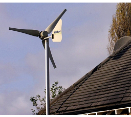
Figure 15.14.030-1: Small residential wind energy system.
2.
Small Wind Energy Systems (SWESs)—Permitted Districts, Height Standards. Small Wind Energy Systems (SWESs) shall be a permitted use in all zoning districts except Downtown Commercial (DC). They are subject to the following requirements:
a.
Height. The maximum height of a SWES shall be seventy-five feet, measured from grade to the highest point on the SWES. SWESs taller than seventy-five feet may be allowed, subject to the conditional use permit process set forth in subsection 15.06.060.E.
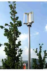
Figure 15.14.030-2: Vertical axis wind turbine.
3.
Vertical Axis Wind Turbines (VAWTs)—Permitted Districts, Number per Lot, Height Standards. A Vertical Axis Wind Turbine (VAWT) using vertical wind turbine technology shall be permitted in all zoning districts as an accessory use, subject to the following requirements:
a.
VAWTs—Residential District Requirements.
(i)
A maximum of one VAWT is permitted per lot or one VAWT per acre, whichever is greater.
(ii)
For VAWTs mounted on rooftops or otherwise attached to a building, the maximum height for a VAWT shall not exceed the maximum-height standard for a principal building in the applicable zoning district (table 15.12-2), measured from grade to the highest point on the VAWT.
(iii)
For VAWTs mounted on freestanding towers, the maximum tower height for a VAWT shall not exceed forty feet, measured from the base of the tower to the highest point on the VAWT.
b.
VAWTs—Non-Residential District Requirements. Multiple VAWTs are permitted on any non-residential district lot, subject to the following requirements:
(i)
For VAWTs mounted on rooftops or otherwise attached to a building, the maximum height for a VAWT shall not exceed 10 feet, measured vertically from the point of attachment on the building to the highest point on the VAWT.
(ii)
For VAWTs mounted on freestanding towers, the maximum tower height for a VAWT shall not exceed sixty feet, measured from the base of the tower to the highest point on the VAWT.
(iii)
Lightpole-mounted VAWTs shall not exceed twenty-five feet in height measured from grade to the highest point on the VAWT.
4.
Setbacks—All Wind Energy Systems.
a.
A SWES or VAWT mounted on a principal or accessory building shall be set back a distance equal to or greater than the applicable zoning district required minimum building setback, as specified in Section 15.12.000 (tables 15.12-1 through 15.12-4) ; provided, however, that in no case shall the setback be less than five feet (subsection 15.14.030.B.10.e).
b.
A freestanding tower for a SWES or VAWT shall be set back a distance equal to or greater than 1.0 times its total height from:
(i)
Any public road right-of-way, unless written permission is granted by the governmental entity with jurisdiction over the road;
(ii)
Any overhead utility lines, unless written permission is granted by the affected utility; and
(iii)
All property lines, unless written permission is granted from the affected land owner.
The preceding subsections notwithstanding, in no case shall the setback for a freestanding
SWES or VAWT tower be less than five feet (subsection 15.14.030.B.10.e).
5.
Lighting—All Wind Energy Systems. A SWES or VAWT shall not be artificially lighted unless such lighting is required by the Federal Aviation Administration. A light temporarily used to inspect a turbine, tower, and associated equipment shall be permissible, providing said light is only used for inspection purposes and not left on for an extended period of time.
6.
Decibel Levels—All Wind Energy Systems. Decibel levels for the SWES or VAWT shall not exceed sixty decibels (dBa) as measured at the closest neighboring inhabited dwelling, except during short-term events such as utility outages and severe wind storms.
7.
Signs—All Wind Energy Systems. All signs, other than the manufacturer's or installer's identification, appropriate warning signs, or owner identification on a wind generator, tower, building, or other structure associated with a SWES or VAWT that are visible from any public right-of-way shall be prohibited.
8.
Code Compliance—All Wind Energy Systems. A SWES or VAWT structure including tower shall comply with all applicable state construction and electrical codes, and the National Electrical Code as adopted by the city.
9.
Screening—All Wind Energy Systems. Ground-level mechanical equipment associated with the SWES or VAWT shall conform to the utility screening standards of subsection 15.14.050.H.
10.
Other Standards—All Wind Energy Systems.
a.
The SWES or VAWT structure shall comply with all applicable Federal Aviation Administration requirements, including but not limited to Subpart B (commencing with Section 77.11) of Part 77 of Title 14 of the Code of Federal Regulations regarding installations in excess of two hundred feet in height, and installations close to airports. The system shall also comply with any and all Wyoming Aeronautics regulations.
b.
All electrical wires associated with a SWES or VAWT, other than wires necessary to connect the wind generator to the tower wiring, the tower wiring to the disconnect junction box, and the grounding wires, shall be located underground.
c.
All ground mounted electrical and control equipment for the SWES or VAWT shall be labeled or secured to prevent unauthorized access.
d.
A SWES or VAWT tower shall be designed and installed so as to not provide step bolts or a ladder readily accessible to the public for a minimum height of eight feet above the ground.
e.
No part of the SWES or VAWT installation, including guy wire anchors, may be closer than five feet from any property boundary.
11.
New Technology—All Wind Energy Systems. The city manager's office may waive the provisions of these requirements through the Alternative Equivalent Compliance process in subsection 15.06.060.K. where the availability of new technology alleviates the issues addressed by these regulations.
12.
Temporary Meteorological (Met) Towers. Temporary meteorological (Met) towers shall be permitted under the same standards as a SWES, except that the requirements shall be the same as those for a temporary structure. A permit for a temporary met tower shall be valid for a maximum of three years, after which an extension may be granted. Permanent Met towers may be permitted under the same standards as a SWES.
(Ord. No. 1578, § 2(att. A), 3-20-2010; Ord. No. 1671, § 21, 11-18-2014; Ord. No. 1728, § 16, 4-18-2017; Ord. No. 1830, § 11, 10-17-2023)
15.14.040 - Parking and off-street loading.
A.
Purpose. The purpose of this section is to establish standards for vehicle parking, bicycle parking, loading areas, and for trash facilities. These standards are established in order to provide for the safe movement of vehicles and pedestrians and to reduce hazards to public safety.
B.
General Provisions.
1.
Plan. Parking design and striping for non-residential and multifamily uses shall require
approval by the appropriate decision-making entity, in conjunction with either site
plan, (subsection 15.06.060.O.) or the minor administrative modification process,
(subsection 15.06.060.J.), as applicable. Certain minor refurbishment activities within
existing parking areas shall not require plan review, as specified in subsection 15.22.000.G.
Parking spaces required to meet the standards of this chapter shall be located on
the same lot or zoning lot as the building or use served unless the city manager's
office determines that location of the parking on-site would result in an unnecessary
hardship and that the intent of this chapter would be better served by locating the
required parking on another site within one thousand feet of the use.
2.
Credit for Public Parking. Some or all of the required off-street parking spaces may be waived by the City Manager's Office if publicly owned off-street parking is located within a one thousand foot walking distance from the main entrance of the proposed use, and the City Manager's Office also determines that adequate parking spaces are available within the publicly owned parking area to accommodate the anticipated use. Credit may also be given at a rate of one space for every on-street space on the property's lot boundary and at a rate of zero and fifty one-hundredths spaces for every on-street space not on the property's lot boundary located within three hundred feet of a public entry of the building in which the use is located.
a.
A maximum of fifteen percent of the required off-street parking spaces may be waived by the city manager's office if covered, weather protected and secured bicycle parking spots are provided at the site. The covered, weather protected and secured bicycle parking design must be approved by the City Manager's Office. Credit may be given for all covered weather protected and secured bicycle parking approved by the city manager's office to reduce the required vehicle parking at a rate of one space for every four bicycle parking spaces up to a maximum of fifteen percent of the required off-street parking spaces.
3.
Minimum Vehicle Parking Requirements.
a.
Properties located within the DC zoning district are exempt from minimum parking requirements unless otherwise provided for in that district.
b.
Requirements for the minimum number of parking spaces for each use are listed in table 15.14.040-3, off-street parking standards.
c.
The requirements may result in the calculation of a fractional parking space. If the fraction is less than one-half, the fraction may be deleted. If the fraction is one-half or greater, the fraction shall count as one parking space.
d.
Off-street parking for separate uses may be provided collectively if all other regulations are observed. A parking space designated for one use shall not be designated as fulfilling the requirements for another use unless approved by the city manager's office, or unless the space meets the applicable criteria specified in subsection 15.14.040.5.
e.
Vehicle parking requirements for uses not specified in this chapter shall be determined by the city manager's office based upon the requirements of similar uses. Where use specific performance standards have been established for a use in this chapter that include parking requirements, the parking requirements associated with the use specific performance standards shall supersede the requirements contained in table 15.14.040-3, off-street parking standards.
f.
For the purpose of calculating parking requirements, fleet vehicle parking spaces shall not count against either the minimum or maximum requirements.
4.
Maximum Parking Spaces Allowed.
a.
For any use categorized as a "commercial" or "industrial" use in Chapter 15.10 of this code, off-street vehicle parking spaces shall not be provided in an amount that is more than one hundred twenty-five percent of the minimum requirements established in table 15.14.040-3: off-street parking standards.
b.
For the purpose of calculating parking requirements, the following types of parking spaces shall not count against the maximum parking requirement:
(i)
Accessible parking;
(ii)
Vanpool and carpool parking;
(iii)
On-street parking adjacent to the lot or lots on which the parking is located;
(iv)
Structured parking, underground parking, and parking within, above, or beneath the building(s) it serves; and
(v)
Fleet vehicle parking spaces associated with the use.
c.
Exceptions to the maximum parking requirement may be allowed by the city manager's office in situations that meet the following criteria:
(i)
The proposed development has unique or unusual characteristics such as high sales volume per floor area or low parking turnover, that create a parking demand that exceeds the maximum ratio and that typically does not apply to comparable uses;
(ii)
The parking demand cannot be accommodated by on-street parking, shared parking with nearby uses, or by increasing the supply of spaces that are exempt from the maximum ratio;
(iii)
The request is the minimum necessary variation from the standards.
d.
If application of the maximum parking standard would result in fewer than six parking spaces, the development shall be allowed six parking spaces.
5.
Shared Parking. Parking lots for different buildings, structures, uses, or mixed uses may be provided and used collectively or jointly in any district in which separate off-street parking facilities for each use would be permitted, subject to the following provisions:
a.
A reciprocal written agreement assuring joint usage of such common parking shall be executed by the parties concerned and approved by the city attorney and the City Manager's Office. The agreement shall be recorded in the Office of Albany County clerk. Any amendments to the agreement or its terms shall be reviewed for relevancy, approved by the city and recorded in the office of Albany County clerk.
b.
Up to sixty percent of the parking spaces required for theaters, public auditoriums, bowling alleys, dance halls and night clubs, and up to one hundred percent of the parking spaces required for a church use, may be provided and used jointly by financial institutions, offices and similar uses not normally open, used or operated during the same hours as those uses.
c.
Where shared parking is contemplated, the applicant may be required to include parking accumulation studies as a part of the request for approval by the city manager's office. The study shall include an analysis of the parking demand for each hour over a twelve to twenty-four-hour period for a typical high volume day. This shall determine the minimum number of spaces that shall be provided. Based on the study submitted, if the maximum number of vehicles accumulated during a peak hour or hours for all overlapping uses exceeds the number of spaces that are required to be provided, shared parking shall be limited. A prorated number of shared parking spaces may be permitted based on the justification information of the study.
6.
Minimum Bicycle Parking Requirements.
a.
Bicycle parking requirements shall apply to all uses except single-family detached, single-family attached or two-family dwelling uses.
b.
At minimum, the greater of three bicycle parking spaces or a number of bicycle spaces equal to five percent of all off-street parking spaces provided shall be required.
c.
Bicycle parking shall be provided with racks approved by the city manager's office.
d.
Bicycle parking areas shall not impede travel on designated sidewalks or accessways on site.
e.
Bicycle parking shall be located within one hundred feet from a primary entrance of a commercial or multifamily use, in all zoning districts, excluding the DC Zoning District.
f.
For all developments requiring a site plan within the DC Zone District, on-site bike parking is required unless a bicycle parking rack is located or is installed within fifty feet of the entrance. Bicycle parking racks may be located within the right-of-way with proper permits and must be of an approved stylized or artistic design, as approved by the city manager's office.
7.
Required Accessible Parking.
a.
In addition to the parking required by table 15.14.040-3: Off-street parking standards, the parking space requirements listed in table 15.14.040-1 shall be provided for all nonresidential uses. All parking shall conform to the requirements of the Americans with Disabilities Act (ADA), building code, or these standards, whichever is more restrictive. In addition, van accessible spaces and loading areas may also be required by the building code.
Table 15.14.040-1
Nonresidential Accessible Parking
Table 15.14.040-2
Multifamily Accessible Parking
b.
In addition to the parking required by Table 15.14.040-3: Off-Street Parking Standards of this section, the parking space requirements listed in Table 15.14.040-2 shall apply for multifamily residential uses except for Groups R-2, R-3 and R-4 as defined by the International Building Code, in the greatest number of parking spaces of any of the following:
(i)
For Groups R-2, R-3 and R-4 (e.g. apartments, congregate living, live/work, lodging house, rehab centers, assisted living, etc.) as defined by the International Building Code, that are required to have accessible units, Type A or B dwelling or sleeping units, at least two percent, but not less than one, of each type of parking space shall be accessible.
(ii)
Where at least one parking space is provided for each dwelling or sleeping unit, at least one accessible parking space shall be provided for each Accessible and Type A Unit.
(iii)
For every six ADA parking spaces, one must be Van Accessible, this "van accessible" parking spot, shall be at least one hundred thirty-two inches wide with a sixty inch access aisle and a minimum of ninety-eight inches of vertical clearance.
These spaces shall be specifically assigned first to disabled accessible residential unit(s). Any extra spaces shall be unassigned. All parking shall conform to the requirements of the ADA, building code or these standards, whichever is more restrictive. In addition, van accessible spaces and loading areas may also be required by the building code.
Table 15.14.040-3 Off-Street Parking Standards
C.
Design Standards.
1.
Parking Lot Access and Circulation. Parking lot access and circulation parking lots should be designed with a hierarchy of circulation. For example, major driveways should be clearly delineated by landscaped areas and should have limited or no parking along them while parking aisles should provide direct access to parking spaces. Parking lots shall not dominate the street frontage, interrupt pedestrian routes, or negatively impact surrounding neighborhoods. Parking lots should be located behind buildings or in the interior of a block whenever possible. Parking areas shall not abut street intersections. All sites, where feasible, shall allow two-way cross-access to adjacent parcels. Parking lot design shall also incorporate the standards of subsection 15.14.060.F. (pedestrian circulation).
2.
Parking Lot Lighting. All parking lot lighting shall comply with the lighting requirements contained in Chapter 15.14.080 (Lighting). The following additional standards shall apply:
a.
A parking-lot lighting fixture shall not exceed twenty-four feet in height, including the base or pedestal, measured from grade, and shall be located so as to not impede pedestrian or vehicular travel.
b.
A parking-lot luminaire shall be so oriented and shielded that it does not shine directly onto an abutting property.
c.
A parking-lot luminaire shall direct light downward and the bulb shall not be visible below the fixture head, and the light source shall be recessed within the fixture.
3.
Surfacing.
a.
All parking lots, parking spaces, drive aisles, drive thrus, vehicle stacking areas, loading zones, trash handling facilities, accessways, and driveways (excluding driveways on single-family detached residential driveways on lots over sixteen thousand square feet in area) shall be surfaced with portland cement concrete or plant mixed bituminous paving materials prior to issuance of a certificate of occupancy, unless a delay is approved by the city manager's office and any financial security posted per subsection 15.14.040.C.3.e. below.
b.
With the approval of the city manager's office, permeable or pervious surface pavement may be used. Neither gravel nor unfinished road bed shall be considered permeable pavement. All surfacing shall be designed to support anticipated loads and to remain dust-free.
c.
The surface shall be maintained so that traffic may move safely in and out of the parking area.
d.
For all developments requiring more than four parking spaces pursuant to table 15.14.040.C, continuous curbs shall be installed on all edges of parking areas, drive aisles and maneuvering areas, and adjacent to any landscaped area.
e.
Surfacing of the parking area may be delayed until the next construction season with written approval from the city manager's office. A performance bond or letter of credit for one hundred twenty-five percent of the surfacing materials and labor costs may be required to be posted by the city manager's office to ensure the completion and placement of the required surface.
4.
Drive and Access Ways. All driveways and access ways shall comply with the access requirements contained in subsection 15.14.060.E.4., driveways and access.
5.
Landscaping. All landscaping shall comply with the applicable landscaping requirements contained in Section 15.14.050 (landscaping and screening standards).
6.
Off-Street Utility, Dumpster, Recycling and Trash Handling Facilities. All utility, dumpster, recycling and trash handling facilities shall comply with the screening requirements contained in subsections 15.14.050.H. and I.
7.
Distribution of Parking. To the maximum extent feasible, parking shall be distributed between the front, side and rear of the building(s). Not more than seventy-five percent of the required parking shall be located in front of the building.
8.
Dividing Parking Lots. Parking lots containing more than two hundred parking stalls shall be divided into two or more lots, separated by an L2 landscaped area (see table 15.14.050-3) that may be counted toward the required off-street parking landscaping area. Within each parking lot, parking spaces shall be grouped into blocks of forty to fifty spaces with each block separated from the others by curbed planting areas at least the size of one parking stall.
9.
Access.
a.
Each off-street parking space shall open directly onto an aisle or driveway that is designed to provide safe and efficient vehicular access to each parking space. Parking shall not be allowed to impede traffic movement on alleys or streets or to impede pedestrian or bicycle activities.
b.
Off-street facilities shall be designed and constructed with turnaround areas to prevent back up movement onto arterial streets. The location and design of all access to arterial and collector streets are subject to review and approval of the city manager's office. Accesses to arterial or collector streets shall be located a minimum of one hundred fifty feet from any other access or street intersection, measured from centerline to centerline unless otherwise approved by the city engineer. Minor modifications to this minimum may be granted by the city manager's office in accordance with subsection 15.06.060.J., minor modifications. Evaluations of minor modifications shall consider posted speed of the street on which access is proposed, constraints due to lot patterns and effects on safety and capacity of the adjacent public street, bicycle and pedestrian facilities. No development site shall be permitted more than one access to any arterial or collector street as defined by the city major street and highway system plan, except as approved by the city manager's office in accordance with subsection 15.06.060.J., minor modifications. As part of any expansion or alteration in use, the city may require relocation and/or reconstruction of existing access not meeting the city's standards.
10.
Backing or Maneuvering.
a.
Developments required to provide three or more parking spaces shall not be designed to have backing or maneuvering movements for any of the parking spaces occurring across public sidewalks or within any public street other than an alley, except as approved by department.
b.
Where backing movements from a driveway to the public right-of-way are allowed, any off-street parking space located between a garage or carport and the sidewalk or future sidewalk shall provide a minimum of twenty feet of length to be considered a parking space. Where less than twenty feet of length is provided between the garage or carport and the sidewalk or future sidewalk, the area shall not be considered a parking space but may be used as a driveway, provided a minimum of fifteen feet is maintained and the configuration is approved by the City Manager's Office and City Engineer.
11.
Dimensions.
a.
The parking configurations described in table 15.14.030-4, below, shall apply as appropriate. Table 15.14.040-4 measurements are calculated according to the parking angle dimension measurement diagram (Figure 15.14.040-1). Both sides of a parking stall shall be at the same angle.
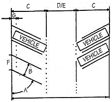
Figure 15.14.040-1: Parking angle dimension measurement.
b.
Off-street parking spaces shall be measured exclusive of any access drives, aisles or columns.
c.
Nonresidential parking spaces and multifamily parking spaces shall be clearly outlined with single lines, four inches in width and of white color on the surface of the lot so that each parking space is clearly identified.
d.
The minimum length of a parking stall that is adjacent to a landscaped island may be reduced as described in Column G for vehicle overhang provided suitable ground cover is placed an equivalent distance behind the curb. For double head-in parking, the landscape island shall be a minimum of eight feet in width.
e.
The minimum length of a parking stall that is adjacent to a sidewalk or pedestrian walkway may be reduced as described in Column G for vehicle overhang provided that an additional two feet of sidewalk width is provided. For double head-in parking, an additional four feet of sidewalk width shall be provided.
f.
All spaces shall have a minimum vertical clearance of six feet, six inches.
g.
No parking shall be allowed in travel aisles.
h.
For parking lots containing twenty or more parking spaces, all aisles, approach lanes and maneuvering shall be clearly marked with directional arrows and lines to facilitate traffic movement.
i.
Parking spaces using geometric standards other than those specified here may be approved, subject to a determination by the city manager's office that the plans for the facility are sealed by a registered engineer with recognized expertise in parking facility design and a determination that the proposed facility will satisfy off-street parking requirements as adequately as would a facility using standard ordinance dimensions.
12.
Stacked Parking Space. In the case of single family dwelling units, two-family dwelling units and multifamily dwelling units of no more than four dwelling units, up to two parking spaces may be stacked front to back for each unit. For example, a single space forty feet long and nine feet wide could be provided to accommodate the parking for a two-bedroom unit. A stacked parking space shall not be used to meet minimum parking requirements, i.e., a stacked parking space will create two parking spaces but shall be counted as one required parking space. The city manager's office shall not approve stacked parking unless the developer provides reasonable information that stacking spaces does not interfere with traffic flow around the building and does not negatively impact emergency access to the building.
D.
Drive-Thru and Vehicle Stacking Requirements. Vehicle stacking is the minimum required length of an on-site drive aisle necessary to allow for the movement of vehicles within a parking lot to a drive-up window service or other drive-through services without impeding the flow of traffic on-site and off-site. Stacking distance shall be measured from the point of service within a designated drive aisle. The required cumulative stacking distance may be distributed between accesses serving the site, provided a minimum stacking distance of twenty feet is provided at each access point.
Table 15.14.040-5 Vehicle Stacking Requirements
E.
Loading Areas. For every commercial or industrial use in connection with every building having a gross floor area of ten thousand square feet or more, at least one off-street loading space shall be provided on site. One additional off-street loading space shall be provided for each additional twenty thousand square feet or major fraction thereof. All loading areas shall conform to the following standards.
1.
Location. No loading spaces shall be located within thirty feet of street intersections or in any required setback.
2.
Surfacing. All open off-street loading areas shall be surfaced with concrete or asphalt designed to carry the heaviest vehicle loads that can commonly be expected. Consideration should be given to the weight of fire and sanitation equipment as well as delivery vehicles.
3.
Repair and Service. No motor vehicle repair work or service of any kind shall be permitted in conjunction with loading areas.
4.
Utilization. Space allocated to any off-street loading space, accessory drives or aisles shall not be used to satisfy the space requirements for any off-street parking or trash handling facilities.
5.
Ingress and Egress. Each required off-street loading space shall be provided with a means of unobstructed ingress and egress to an alley or onto a public street wide enough to accommodate expected vehicles. Where such ingress and egress is made onto a public street, it shall be through driveways or openings that meet required standards. Permanent wheel stops or curbing shall be provided to prevent any vehicle using the loading area from encroachment either on the required front setback, side setbacks or adjacent property.
6.
Off-Street Loading Requirements. The loading spaces shall be indicated on site plans submitted for approval. The city manager's office may require one or more additional loading areas if the magnitude of the use would anticipate the need for more loading or standing space. Loading spaces shall be at least ten feet in width by thirty-five feet in length with fourteen feet of vertical clearance. The size may be modified by the city manager's office where site or use conditions warrant changes to this standard.
7.
Landscaping Requirements. Loading areas shall be screened from public streets and adjacent residentially used property in accordance with the landscaping requirements contained in Chapter 15.14.050, Landscaping and Screening Standards.
8.
Exceptions. Loading area requirements may be waived by the city manager's office where the buildings abut a public alley in such a manner that operations can be conducted from the alley in accordance with applicable loading traffic and parking conditions.
(Ord. No. 1578, § 2(att. A), 3-20-2010; Ord. No. § 45, 5-3-2011; Ord. No. 1637, § 4(Att. D), 2-5-2013; Ord. No. 1671, §§ 6, 8, 21, 11-18-2014; Ord. No. 1711, § 1, 7-19-2016; Ord. No. 1728, § 16, 4-18-2017; Ord. No. 1777, §§ 25, 27, 7-7-2020; Ord. No. 1795, § 1(Attch. A), 11-2-2021; Ord. No. 1872, § 7—10, 10-7-2025)
15.14.050 - Landscaping and screening standards.
A.
Purpose. The purpose of this chapter is to provide landscaping standards which: enhance and promote an improved image for the Laramie area; ensure that landscaping is an integral part of the site design and development process. This chapter's purpose also includes protecting the public health, safety and welfare by: improving parking lot traffic safety by guiding the circulation of cars and people and lowering traffic speeds; minimizing noise, air, water and visual pollution; increasing screening and buffering between incompatible land uses; reducing the amount of reflected glare and heat absorbed in and around developments; breaking up large expanses of parking lots; preserving residential neighborhoods by lessening the impacts of potentially incompatible uses; and providing screening from the wind.
B.
Applicability.
1.
General Applicability. The provisions of this section are applicable to the following development types:
2.
Alternative Equivalent Compliance—Landscaping and Screening Applicability. Alternative Equivalent Compliance provisions in subsection 15.06.060.K. shall be available to satisfy landscaping standard requirements, provided that in addition to the requirements and criteria of subsection 15.06.060.K., the following specific procedures are followed:
a.
Any and all plans and documents submitted shall be approved by a professional specialist with demonstrable expertise in landscaping, such as a landscape architect or landscape contractor. Such approval shall be in written form and shall state that the specialist has reviewed and approved the specific plans and documents presented.
b.
In order to grant a request for alternative equivalent compliance, the decision-making entity shall find, in addition to the criteria in subsection 15.06.060.K.6., that the following criteria are met:
(i)
The proposed alternative landscape design will conserve water and/or reduce long-term maintenance costs; and
(ii)
The proposed alternative landscape design is compatible with the character and ambiance of vegetation and environmental design traditional to Wyoming and interior Western communities.
C.
General Provisions for Multifamily (Four or more Dwelling Units), Commercial, Institutional and Industrial Uses.
1.
Landscaping Area Requirements. As identified in subsection 15.14.050.B., applicability, most development sites, excluding single family, two-family and multifamily developments (less than four dwelling units), shall be required to be landscaped pursuant to this subsection. A minimum of fifteen percent of the lot or parcel area, excluding the building(s) or use footprint, shall be landscaped in accordance with the requirements of this chapter (Equation: Landscaped area = .15 × (lot area - primary building and use footprint)). For the purposes of this section, use footprint shall include any outdoor storage or display areas. At least fifty percent of the required landscape area shall be placed so that it abuts the adjoining public street rights-of-way, excluding alleys.
2.
Landscaping Treatments Not Counted. No area required to be landscaped shall include any artificial trees, plants, or turf, impervious surfacing, or any carpeting designed as a visual substitute for lawn or other groundcover. Areas devoted to pasture, farm crops or undeveloped areas of a lot or parcel shall not be considered landscaped for the purpose of fulfilling any landscape requirements.
3.
Water-Conserving Landscaping. Low-water, drought-tolerant plants shall be used for all new landscaping. Plant materials shall be selected from the plant list maintained by the city. The city plant list may be found in the administrative manual. Materials not on the list may be approved if it is determined that they are equally suitable for local soil conditions and climate and would provide the same level of visual benefits and have the desired growth habits.
4.
Xeriscape/Water Conserving Landscaping Option. Xeriscaping improves aesthetic appearance and mitigates water usage. A xeriscape option is set forth as an alternative to conventional landscaping requirements. A xeriscape plan shall include the following:
a.
Low-water, drought-tolerant plant materials shall make up eighty-five percent of all plant materials used and shall be selected from the Recommended Trees and Shrubs for Laramie, Wyoming list maintained by the city. Alternative plant materials may be approved if it is determined through alternative equivalent compliance (subsection 15.06.060.K.) that the alternative plan satisfactorily meets the intent of this chapter, that proposed plantings are equally suitable for local soil conditions and climate, would provide the same level of visual benefits and have the same desired growth habits.
b.
Shall be prepared and signed/sealed by a licensed landscape architect.
c.
All required landscaped areas shall contain a minimum of forty-five percent living organic landscape material and no more than twenty-five percent planted turf grass.
5.
Cover in Landscaped Areas. All required landscaped areas shall contain:
a.
A minimum of sixty-five percent living organic landscaping material, with a maximum of thirty-five percent nonliving landscaping materials.
b.
All required landscaping, living and nonliving, shall be calculated cumulative for the whole site, unless landscaped in accordance with subsection 4. above.
c.
At a minimum, twenty-five percent of the required living landscaping shall be planted adjacent to each street frontage associated with the site.
6.
Irrigation Systems for Landscaped Areas. All required landscaping and landscape areas shall include a permanently installed irrigation system unless the city manager's office determines that the planting and maintenance plan is not dependent on a permanent system. Such alternative determination shall be specifically approved by the city manager's office. Applicable irrigation plans shall be submitted with the site plan as required by subsection 15.06.060.O.
7.
Maintenance. The responsibility for the maintenance of landscaping shall lie with the property owner, his/her successor and/or their agents. All landscaping elements shall be permanently maintained in good growing condition and, whenever necessary, replaced with new plant materials to ensure continued compliance with these standards. All required landscaped areas shall be kept free of weeds, debris, and litter. In addition, all walls and fences shall be maintained in good condition, and when necessary, be repaired or replaced. Any required landscape material, including any tree, grass or shrubs, that dies shall be replaced by September 30 of each year. All required landscaping shall be cleared of all unplanned vegetation including weeds at least once each year prior to September 30.
8.
Landscaping Plan Preparation. For all multifamily (four or more units), commercial, institutional and industrial uses requiring site plan review and approval, a professional horticulturist, nurseryman, or design professional shall be consulted to determine the proper time to move and install all plant materials, so that stress to the plants will be minimized. All nursery stock shall generally conform to the ANSI standard for nursery stock.
9.
Installation and Final Inspection. The planting of the required landscaping may be delayed for a period up to twelve months after issuance of the temporary certificate of occupancy. Unless all such landscaping is installed, inspected and approved prior to issuance of the temporary certificate of occupancy, a financial security for one hundred twenty-five percent of the landscaping materials and labor costs shall be required to be posted by the developer to ensure the placement of the required landscaping. All landscaping for multifamily, commercial, institutional and industrial uses requiring site plan review and approval shall be installed, inspected and approved by the city manager's office prior to certificate of occupancy issuance, per Chapter 15.18 (improvements) and other applicable section of this title.
10.
Sight-Obscuring Fence. Chainlink or wire fencing shall be prohibited where a sight-obscuring fence is required in a bufferyard or landscaped area. (15.14.100, fences and walls.)
11.
Utilities. All utilities within the exterior property lines of the site shall be installed underground. Freestanding utility boxes shall be integrated into the landscaping as much as possible and screened from view pursuant to [subsection] 15.14.050.H., screening standards.
12.
Location of Landscaping and Measurement. All landscaping shall be located so that it does not interfere with utilities, easements, street lighting, or fire hydrants. The placement and design of the landscaping shall be generally at the discretion of the developer, but shall be approved by the city manager's office. The landscape area width is measured from the property line inward, unless alternatively approved pursuant to subsection 15.14.050.F.2.d.
13.
Retention/Detention Ponds. Retention and detention ponds shall be landscaped and approved by the applicable decision making body. Landscaping shall ensure aesthetic appearance and screening of the facility, provide suitable grass mixes or plantings (ground cover) within the pond, provide suitable ground cover outside the pond as needed to ensure long-term stability of the structure, and shall prevent invasive plant species from growing with the retention/detention pond. Native species of shrubs and trees indigenous to the region shall be preferred over exotic plant species.
D.
Landscaping Material Standards.
1.
Plants to Conform. Plants shall conform to the measurements specified in the plant schedule submitted with the landscaping plan.
2.
Size of Required Landscape Materials. Required landscaping materials shall comply with the following minimum size standards at the time of planting, with caliper measurements taken six inches above grade.
a.
Minimum size for deciduous trees shall be a one and one-half-inch caliper.
b.
Minimum size for evergreen trees shall be three feet in height.
c.
Minimum size for shrubs shall be one-gallon or #1 container for low and medium shrubs and five-gallon or #5 container for tall shrubs.
d.
Minimum sizes may be reduced at the discretion of the city manager's office where a developer proposes a reasonable alternative planting size and/or more landscaping or plantings than are required.
3.
Trees. A mixture of canopy and ornamental trees shall be permitted. Generally, street frontage trees shall be canopy trees unless impractical and other tree types are approved by the city manager's office.
E.
Residential Front Yard Landscaping.
1.
Applicability. The front yard areas between the rear most principal building and back of curb within all new developments containing three or fewer dwelling units on lots or parcels less than sixteen thousand square feet in size shall be landscaped pursuant to this subsection. The landscaping shall be located within the entirety of the front yard between the front plane of the building or front fence(s), whichever is greater, and the roadway. For the purposes of calculating landscape area, driveways and sidewalks shall not be included. (Ord. No. 1800, § 8, 1-4-2022)
2.
Landscape Plan. A landscape plan shall be submitted with an application for a building permit and become part of the building permit. The landscape plan shall be approved prior to installation of the landscaping. Any modifications to the approved plan shall be reviewed and approved by the city manager's office. The plan shall include a calculation of landscaped areas and a list of proposed plant species. An underground irrigation system is recommended.
3.
Installation and Final Inspection. The landscaping shall be completed by the developer, builder or property owner and inspected by the city manager's office prior to the issuance of a certificate of occupancy. The planting of the required landscaping may be delayed for up to twelve months past the certificate of occupancy. Failure to install the required landscaping within twelve months of issuance of a certificate of occupancy may result in a citation and fine issued by the city.
4.
Gardenscape Option.
a.
The required landscaping shall consist of at least seventy-five percent living ground cover. Up to fifty percent of the living ground cover area may be used for flower or garden beds, shrubbery planters or other similar accent features. At least two trees shall be planted in the front yard area. Trees may be a combination of evergreen and/or deciduous. At planting time evergreen trees shall be at least three feet tall. Deciduous trees shall be at least one and one-half inches caliper. Tree wells of five-foot diameter or less may be excluded from calculating the seventy-five percent living groundcover requirement. It is recommended that tree wells and other exposed planter areas be covered with organic material such as bark or mulch.
b.
In order to reduce dust and soil erosion, any remaining area not covered by living groundcover shall be covered by materials such as bark, decorative rock or mulch.
5.
Xeriscape Option. As an alternative to the gardenscape option identified above, xeriscape landscaping is permissible and shall be in compliance with the city's xeriscape guidelines. The design may include a mix of decorative rock, mulch, plants, and native grasses. A maximum of fifty percent of the front yard area may be without plants, but shall be covered with materials such as decorative rock, bark, or mulch. Plants species used shall be of appropriate variety to tolerate low watering and high altitude climate.
6.
Modifications After Initial Installation. Landscaping may be modified by the property owner after initial installation without approval by the city manager's office, provided that the front-yard area remains landscaped, meets the purpose of this chapter and does not violate the provisions of Laramie municipal code Chapter 8.28.
F.
Site Perimeter Landscaping.
1.
Applicability. Site perimeter landscaping shall be provided along the perimeter property line of all multifamily (four or more dwelling units), commercial, institutional and industrial development sites except for approved points of pedestrian or vehicle access, in accordance with table 15.14.050-2 (see figure 15.14.050-1). Site perimeter landscaping shall not be defined as parking lot perimeter landscaping, which is provided for in subsection 15.14.050.G.
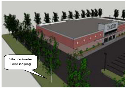
Figure 15.14.050-1: Site perimeter landscaping is required on site perimeter of any commercial, institutional,
industrial or multifamily development exceeding three dwelling units.
2.
Exceptions.
a.
Site perimeter requirements for development in the DC (Downtown Commercial) District shall be required pursuant to subsection 15.08.030.E.2.c., development standards.
b.
Site perimeter requirements for development in the TO (Technology and Office) District shall be required pursuant to subsection 15.08.030.L.2.d., landscaping and screening.
c.
Site perimeter requirements may be reduced up to one hundred percent for projects on lots and parcels allowing setbacks less than the required site perimeter yard width through the alternative equivalent compliance requirements of subsection 15.06.060.K. Reductions shall only apply to lots and parcels where any given building setback is less than the specific required perimeter landscaping width as shown in table 15.14.050.A. Reductions shall only apply to specific required site perimeter areas between the property line and proposed principal building.
d.
The city may consider landscaping in the adjacent public right-of-way as a substitution for some or all of the required onsite street frontage landscaping, where in the judgment of the city manager's office the proposed public right-of-way landscaping meets the intent of this chapter. Any property owner requesting to landscape the public right-of-way as an alternative shall be required to maintain the landscaping into perpetuity unless the landscaped area is accepted for maintenance by the city. Such acceptance shall be reviewed and approved pursuant to subsection 15.06.060.K, alternative equivalent compliance. In addition to substituting for street frontage landscaping, public right-of-way landscaping may be substituted for other required landscaping if approved by the city manager's office. This may include the landscaping of public right-of-way or public lands within the city on a separate unrelated site in some cases where in the judgment of the city manager's office the public landscaping proposed will have significantly greater community benefit.
3.
Specifications for Site Perimeter Landscaping.
a.
In any area where site perimeter landscaping is required according to table 15.14.050-2, the planting requirements in table 15.14.050-3 shall apply. The amount of landscaping required in table 15.14.050-3 shall be measured per linear foot of property line or street frontage. Access driveways and pedestrian connections shall be subtracted from the linear frontage in calculations of the amount of landscaping required.
b.
In any area where site perimeter landscaping is required according to table 15.14.050-2, the planting requirements in table 15.14.050-3 shall apply. The amount of required landscaping units required in table 15.14.050-3 shall be reduced on each perimeter length as follows:
(i)
Fifteen percent reduction in required units for sites two to five acres in size.
(ii)
Twenty percent reduction in required units for sites five to ten acres in size.
(iii)
Twenty-five percent reduction in required units for sites ten acres in size or greater.
c.
Developments requesting reductions in perimeter landscaping pursuant to subsection 15.14.050.F.3.b. above, shall not be eligible for the minor administrative modification procedure of subsection 15.06.060.J.
* Refer to Exceptions section 15.08.050.A.5.h.1.d.
4.
Landscape Units Awarded. To provide for flexibility, allow design creativity, encourage use of larger trees, and retention of natural vegetation, the required amount of planting material for site enhancement, site perimeter, parking lot or tree retention landscaping shall be based on a "landscape units" point system. The number of units awarded to each landscaping element shall be as follows:
G.
Off-Street Parking Lot Landscaping. The following landscaping requirements shall be met for off-street parking lots for development that is not exempt from the landscape standards.
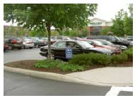
Figure 15.14.050-2: Landscaped off-street parking lot.
1.
Parking Lot Perimeter Landscaping. Perimeter parking lot landscaping (see Figure 15.14.050-2) shall be required for all parking lots having more than ten spaces where the parking lot is adjacent to a public street or a non-retail use such as a residential area, institutional use (e.g., hospital), or office, as provided below:
2.
General Requirement.
The parking lot perimeter landscaping requirement may be satisfied by complying with
one of the following options:
(i)
Option 1: L4 Screening as defined in table 15.14.050-3; or
(ii)
Option 2: L3 separation as defined in table 15.14.050-3, with a maximum two-foot vehicle overhang area or no parking spaces adjacent to the landscaping. This option shall be available only to parking lots with fewer than 100 spaces, or if less than sixty percent of the parking spaces are located in the front parking area; or
(iii)
Option 3: L2 buffer as defined in table 15.14.050-3, with no vehicle overhang or no parking spaces adjacent to the landscaping. This option shall be available only to parking lots with fewer than forty spaces, or if less than fifty percent of the parking spaces are located in the front parking area.
(iv)
Option 4: Where lots are being developed under a common site/site plan, master site/site plan, or joint parking/circulation plan in a mixed-use district, the parking lot perimeter landscaping requirement may be waived along an interior lot line, providing that interior parking lot landscaping applies to both parking lots together.
3.
Exceptions—Downtown Commercial and Technology and Office Zone Districts.
(i)
Parking lot landscaping and screening requirements for lots and parcels in the DC district shall be required pursuant to subsection 15.08.030.E.2.c., development standards.
(ii)
Parking lot landscaping and screening requirements for lots and parcels in the TO district shall be required pursuant to subsection 15.08.030.L.2.d, development standards.
4.
Parking Area Trees Required. In addition to parking lot perimeter landscaping requirements of this subsection, there shall be one tree provided for every ten parking stalls. Trees may be placed within the parking areas or within twenty feet of the parking areas at the discretion of the developer, but shall be approved by the city manager's office.
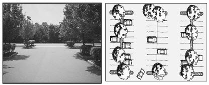
Figure 15.14.050-3: The use of landscape islands and terminal islands to define a parking area and provide
shade and visual interest.
5.
Internal Landscape Area. Internal landscape areas shall be required for any parking area creating ten or more parking stalls (see Figure 15.14.050-3). No landscape area shall be required for the first nine parking spaces. Twenty square feet of landscape area shall be required for each parking stall exceeding the first nine. For example, a parking lot with fifty-two stalls shall require no square feet for the first nine parking stalls and twenty square feet per stall for stalls ten to fifty-two [(total spaces—9) × 20 = square feet internal landscape required]. Internal landscape area shall be a combination of landscape or terminal islands.
6.
Landscape Islands. The minimum width or length of any landscaped area shall be eight feet (see Figure 15.14.050-4). Each of the required landscaped areas shall contain a minimum of seventy-five percent living and irrigated landscaping material, with a maximum of twenty-five percent nonorganic landscaping material. Approved sidewalks shall not be not counted toward the non-living landscape material percentage.
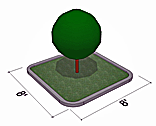
Figure 15.14.050-4: Minimum width of landscape islands is 8 feet.
7.
Terminal Islands. The developer shall be required to utilize landscaped terminal islands at the end of each parking row. Divider strips between parking rows may also be used to help disperse the required landscaping throughout the entire parking lot.
8.
Curbs. Landscaped areas within parking lots or along the perimeter of the property shall be protected from vehicular traffic through the use of continuous concrete curbs (see Figure 15.14.050-5).
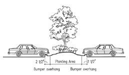
Figure 15.14.050-5: Protecting landscape areas with curbs.
9.
Parking-Lot Clear Vision Area. Clear vision areas within the off-street parking area shall be established at street and/or drive aisle intersections by maintaining a maximum height for shrubs and ground cover of thirty inches. Within a clear vision area, tree branches shall be trimmed up to six feet from the ground.
10.
Sidewalks as Divider Strips. A landscaped divider strip within a parking lot that separates either parking rows or parking lots shall be allowed to count a sidewalk located within this divider strip toward a part of the required off-street parking lot landscaping. The intent of this sidewalk is to help facilitate safe pedestrian movement. This sidewalk shall meet the following criteria if it is to be counted toward the required landscaping:
a.
The sidewalk shall have a five-foot-wide walking path. Two feet for vehicle overhang shall be added for each abutting parking stall without curb stops.
b.
The sidewalk shall run the entire length of the divider strip.
c.
The sidewalk shall be bordered on at least one side by landscaping, of which the sidewalk shall not account for more than fifty percent of the area of the divider strip.
H.
Screening Standards.
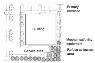
Figure 15.14.050-6: Screening through site design and landscaping.
1.
Screening of Service and Off-Street Loading Spaces. All service areas and off-street loading spaces on a site shall be screened from all public and private rights-of-way and adjacent uses (see Figure 15.14.050-6). Screening shall comply with the following standards:
a.
To the maximum extent feasible, service and off-street loading areas shall not be visible from public streets. If a service or loading area is visible from a public street, approval of the planning commission shall be required. Off-street loading shall not include spaces for vehicles operated by the U.S. Postal Service or express-type package vehicles with three axles or less.
b.
No service and off-street loading areas shall be located within twenty feet of any public street, public sidewalk, or internal pedestrian walkway.
c.
Service and off-street loading areas shall be incorporated into the overall design of the building and landscaping so that the visual and acoustic impacts of these functions are fully contained and out of view from adjacent properties and public streets.
d.
Service areas not enclosed by a wall or fence shall be concealed by screening materials at least eight feet in height measured from the grade of the loading area. Such screening shall be provided by using one or more of the following methods; however, off-street loading spaces located adjacent to residentially zoned property shall use the method in subsection (iii) below. In addition, walls or fences used to screen a loading area that face a collector, minor and major arterial roads and interstates are required to follow the higher design standards found in [subsections] 15.14.100.D.5.a through 15.14.100.D.5.c.
(i)
A combination of evergreen trees and shrubs that are planted in a double staggered row that provides the required screening (see Figure 15.14.050-7).

Figure 15.14.050-7: A double staggered row of evergreens.
(ii)
Masonry wall that matches the primary building (see Figure 15.14.050-8).
(iii)
A combination of any two of the following: A six-foot ornamental metal fence, large evergreen-type screening shrubs, and/or berm.
Figure 15.14.050-8: Service area screened by an eight-foot masonry wall.
e.
When screening for service areas and off-street loading spaces is provided by earthen berm and/or plant materials, the following regulations shall apply:
(i)
The berm shall have a minimum side slope of 3:1 and a minimum crown width of three feet.
(ii)
Large evergreen-type shrubs shall be selected from the approved planting materials list and planted in accordance with specifications herein. In addition, the plant materials shall:
(1)
Be located in a bed that is of a width suitable for the required plant spacing, but at least five feet wide.
(2)
Be planted in staggered rows over the entire length of the bed unless the city manager's office approves an alternative planting density as being capable of providing a solid screen within one year of planting.
(3)
Be a minimum of eight feet in height at time of planting and provides the required visual barrier.
I.
Off-Steet Utility, Dumpster, Recycling, Trash Handling and Recycling Facilities.
1.
Location. All utility fixtures (including heating and air conditioning units), dumpsters, and trash handling facilities shall be located on the same lot as the use served unless shared facilities are approved by the City Manager's Office. A reciprocal written agreement assuring the perpetual joint usage of such common trash handling facilities shall be executed by the parties concerned and approved by the city attorney and the City Manager's Office. The agreement shall be recorded in the office of Albany County clerk and recorder.
2.
Screening.
a.
General Provisions
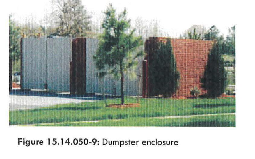
i.
All off-street utility, dumpster, recycling, and trash handling facilities - including the occupant's recycling facilities - shall be completely screened from public view and from the view of any adjoining property.
b.
On-Site Utilities.
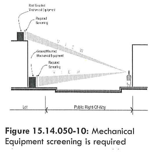
i.
A wall, opaque fence, evergreen hedge, berm, or any combination thereof shall be provided to obscure these facilities. Wood materials are only allowed for aesthetic improvements for enclosure facades and shall not be a structural component of the enclosure.
ii.
Mechanical equipment shall be screened from view from public streets adjacent to the property at eye level (see Figure 15.14.050-10). This includes HVAC systems, other building mechanical apparatus, and satellite/ communication dishes.
iii.
All building projections used for screening that are visible from abutting public streets, including but not limited to chimneys, flues, vents, gutters, parapets, wing-walls and down spouts, shall match one of the predominant colors or trim colors used on the primary facade of the building, or shall be constructed of materials such as brick, stone or other compliant material as determined by the City Manager's office that match one of the predominant colors used on the primary facade of the building.
iv.
All ground-mounted mechanical equipment shall be screened from public view and adjacent properties by plantings, fencing, or masonry walls that screen the equipment. All fencing and walls shall match materials being used on site and can be constructed of wood, metal, masonry, or other material or methods as approved by the City Manager's Office.
v.
Freestanding utility boxes shall be integrated into the landscaping as much as possible and screened from view.
vi.
For on-building mounted utilities such as water meters or gas meters, the meters shall be located on a non-street facing side of the building, or integrated into the building design and fully screened from view.
c.
Trash and Disposal Enclosures.
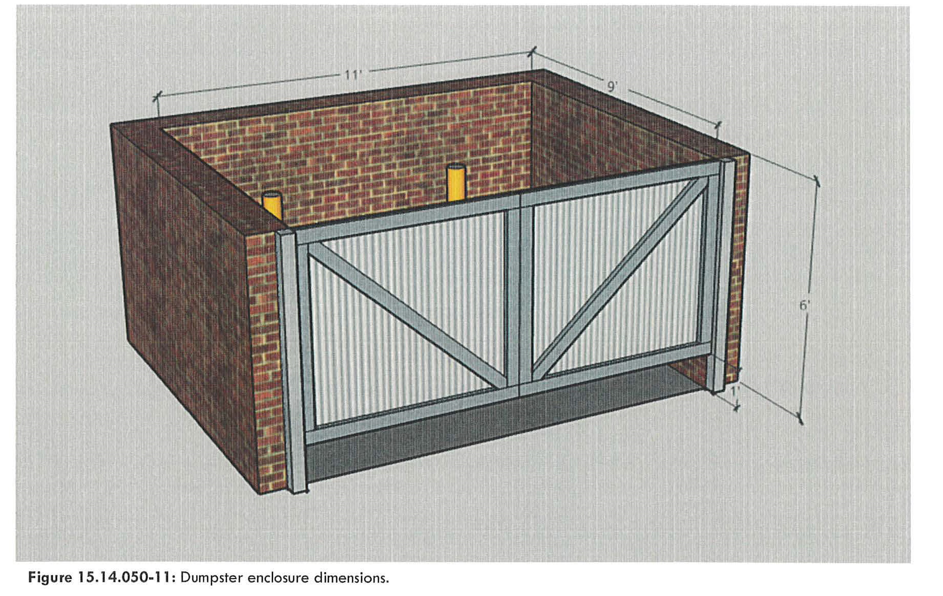
i.
The location and design of all trash facilities and service areas shall be submitted with the application for site plan permit and shall be designed to be serviced by the City of Laramie.
ii.
Dumpsters shall be located in masonry or metal framed trash enclosures with gates hung on steel posts embedded in concrete (see Figure 15.14.050-11). No trash enclosures shall be constructed only of wood. Wood materials are only allowed for aesthetic improvements for enclosure facades and shall not be a structural component of the enclosure.
iii.
All required enclosures shall be a minimum of eleven feet wide from the hinge, nine feet front-to-back measured from the front of the bollards, and six feet high.
a.
Enclosure doors whose swinging radius are one-hundred and twenty degrees or less, shall provide an opening of at least thirteen feet in width per single receptacle.
iv.
Receptacles shall be placed on a concrete pad slanting down towards the gate opening at a slope of one-eighth of an inch per foot for drainage purposes.
a.
Property and access to the trash enclosure shall be graded as to provide service vehicles with a flat approach (access at the same grade as the enclosure) up to at least twelve feet from the front of the enclosure.
v.
All enclosures shall include at least two six feet by forty-eight feet steel pipe, concrete filled bollards or other protection mechanism as approved by the Public Works Department located a minimum of four inches from rear wall to prevent interior wall damage as shown in Figure 15.14.050-11.
vi.
All residential developments requiring Site Plan Review shall include a pedestrian entry to the trash enclosure which is a minimum of three feet in width.
vii.
Enclosures shall not be required for dumpsters in nonresidential developments when located in a service area per LMC 15.14.050.H and fully screened by the buildings, wing walls, fencing or screening walls from all adjacent properties and public rights-of-ways.
viii.
Gates shall be designed with a minimum gate width of eleven feet or thirteen feet as specified in 15.14.050.A.2.c (ii)(1) and a minimum clearance of twelve inches at the bottom and a mechanism as described below in Section 15.14.050.I.3 for holding the gates closed, as well as open during trash collection.
a.
Gates shall be made of metal or other durable material. Wooden gates shall not be permitted.
b.
Gates shall be constructed with Cane bolts and Cane bolt receptacles to hold the gate closed when not in use and open when servicing. The Cane bolt receptacles shall consist of one inch pipe sleeve inserted a minimum of two inches into the ground. Other mechanisms may be approved by the City Manager's Office.
ix.
Clearance and Turnaround Requirements for Enclosures. All trash and recycling enclosures shall meet clearance and turnaround requirements as established below and shown in Figure 15.14.050-12.
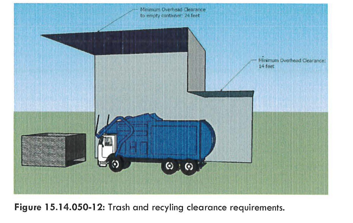
a.
Overhead clearance for collection truck entry shall be a minimum of fourteen feet.
b.
Overhead clearance for loading shall be a minimum of twenty-four feet from ground surface to lowest point of overhead obstruction or overhead lines to service or empty the receptacle over the collection truck.
c.
The minimum required outside turning radius for collection trucks shall be thirty-seven and one-half feet in order to make a one hundred and eighty degree turn without stopping.
d.
The maximum safe backup distance shall be one hundred and fifty feet unobstructed for a truck to backup instead of turning around.
e.
Trash and recycling enclosures shall not be located in a manner that will require a collection truck to back onto any street.
f.
Recycling
1.
At the discretion of the City Manager's Office and when drop off recycling is available in Laramie, either through a government entity or commercially, public recycling drop off-sites shall be required for all subdivisions platted with twenty-five lots or greater (except for exempt single-family developments). One single stream recycling bin per unit shall be required for all residential multi-family developments six units or less and, either through a government entity or commercially, recycling drop off sites shall be required for all residential multi-family developments seven units or more. Drop-off sites are encouraged and shall be permitted as an accessory use in all nonresidential zones. Drop off-site are communal recycling bins to be used by a complex or multiple lots to service the recycling needs of the complex or lots.
2.
The drop off site shall be kept free of litter, residue, and debris by the party responsible for the maintenance and management of the drop off facility.
3.
Recycling centers shall be designed to be accessible to the public and shall be located so as to minimize disturbance to adjacent properties. The City Manager's Office shall review all proposed recycling centers and determine what type of screening shall be required.
4.
The drop off site containers shall be durable, waterproof, covered and well maintained. The name and phone number of the party responsible for maintenance shall be posted on the container. Containers on the site shall have uniform colors.
5.
The city manager or his/her designee may impose additional conditions if necessary to protect adjacent properties.
(g)
Access. All required dumpster, recycling, and trash handling facilities shall be designed with appropriate means of access to a street or alley in a manner that will least interfere with traffic or pedestrian movement, and that will most facilitate the service of the facilities. Access routes shall be approved by the City Manager's Office.
(h)
Utilization.
1.
Space allocated to any off-street dumpster and trash handling facilities shall not be used to satisfy the space requirements for off-street parking and/or loading facilities, nor shall any parking or loading spaces be used to satisfy the space requirements for any dumpster or trash handling facility.
(Ord. No. 1578, § 2(att. A), 3-20-2010; Ord. No. 1596, §§ 46, 50(att. A), 51(att. B), 5-3-2011; Ord. No. 1622, § 4, 7-31-2012; Ord. No. 1625, §§ 18, 19, 26(Att. A), 9-4-2012; Ord. No. 1637, §§ 5, 6, 2-5-2013; Ord. No. 1671, § 21, 11-18-2014; Ord. No. 1689, § 2, 10-6-2015; Ord. No. 1719, § 1(Att. A), 10-18-2016; ; Ord. No. 1727, § 1(Att. A), 2-7-2017; Ord. No. 1728, § 16, 4-18-2017; Ord. No. 1744, § 44, 3-6-2018; Ord. No. 1829, § 1, 10-3-2023)
15.14.060 - Transportation, mobility, and connectivity.
A.
Purpose. The purpose of this section is to:
1.
Support the creation of a highly connected transportation system within Laramie in order to provide choices for drivers, bicyclists, and pedestrians;
2.
Increase effectiveness of local service delivery; promote walking and bicycling; connect neighborhoods to each other and to local destinations such as employment, schools, parks, and shopping centers;
3.
Reduce vehicle miles of travel and travel times; improve air quality; reduce emergency response times;
4.
Mitigate the traffic impacts of new development, and free up arterial capacity to better serve regional long-distance travel needs.
These standards attempt to avoid the creation of large, isolated tracts without routes for through traffic or pedestrian and bicycle connections.
B.
Traffic Impact Mitigation.
1.
Applicability of Traffic Impact Analysis Requirement. The transportation system for new development shall be capable of supporting the proposed development in addition to the existing and future uses in the area. Evaluation of system capacity shall be undertaken through a Traffic Impact Analysis (TIA), that should consider the following factors without limitation: street capacity and level of service; vehicle access and loading; on-street parking impacts; the availability of transit service and connections to transit; impacts on adjacent neighborhoods; and traffic safety including pedestrian safety. A TIA shall be required with applications for development review and approval when:
a.
Trip generation during any peak hour is expected to exceed two hundred fifty trips per day or more than one hundred trips during any one-hour peak period, based on traffic generation estimates of the Institute of Transportation Engineers' Trip Generation Manual (or any successor publication); or
b.
A TIA is required by the planning commission or city council as a condition of any land use application approved pursuant to the requirements of this code; or
c.
The city manager's office, in its sole discretion, requires a TIA for:
(i)
Any project that proposes access to a street with level of service "D" or below;
(ii)
Any application for a rezoning or specific plan review;
(iii)
Any case where the previous TIA for the property is more than two years old;
(iv)
Any case where increased land use intensity will result in increased traffic generation; or
(v)
Any case in which the city manager's office determines that a TIA should be required because of other traffic concerns that may be affected by the proposed development.
C.
Traffic Impact Analysis and Development Review Process.
1.
A scoping meeting between the developer and the city manager's office shall be required prior to the start of the TIA in order to determine the parameters of the study. This may be conducted as part of a pre-application meeting. The city manager's office shall define the TIA study in as limited a vicinity as is feasible to make adequate traffic determinations for the project. Where a larger boundary is necessary to make adequate traffic determinations, the city shall work with the applicant to provide traffic information and perform such modeling as is necessary to study the area outside of the project vicinity.
2.
If required, the TIA shall be submitted with the applicable development application.
3.
When access points are not defined or a site plan is not available at the time the TIA is prepared, additional studies may be required when a design review plan becomes available or the access points are defined.
Figure 15.14.060-1: Speed table used as a traffic calming device.
D.
Traffic Mitigation Measures. The applicant shall, as part of the TIA, recommend measures to minimize and mitigate the anticipated impacts and determine the adequacy of the development's planned access points. Mitigation measures shall be acceptable to the city manager's office and may include, without limitation: an access management plan; transportation demand management measures; street improvements on or off the site; placement of pedestrian, bicycle, or transit facilities on or off the site; or other capital improvement projects such as traffic calming infrastructure or capacity improvements (see Figure 15.14.060-1).
E.
Streets and Vehicular Circulation.
1.
Street Standards. All streets shall meet the standards of Chapters 15.16, Subdivision and 15.18, Improvements, and shall be consistent with the transportation element of the Laramie comprehensive plan and the city's adopted major street and highway plan (or successor plan), as applicable.
2.
Street Connectivity.
a.
Purpose. Street and block patterns should include a clear hierarchy of well-connected streets that distribute traffic over multiple streets and avoids traffic congestion on principal routes. Within each development, the access and circulation system should accommodate the safe, efficient, and convenient movement of vehicles, bicycles, and pedestrians through the development, and provide ample opportunities for linking adjacent neighborhoods, properties, and land uses. Local neighborhood street systems are intended to provide multiple direct connections to and between local destinations such as parks, schools, and shopping. These connections should knit separate developments together, rather than forming barriers between them.
b.
Local Residential Streets.
(i)
Local residential streets shall be laid out so that use by through-traffic will be discouraged. Traffic-calming techniques such as diverters, neck-downs, street gardens, and curvilinear alignments are encouraged to reduce speeds and cut-through traffic.
(ii)
Should topography or other constraints require the use of streets that extend more than six hundred feet without being punctuated by cross streets, a median, traffic-calming device, or similar feature shall be used to slow traffic and break-up the "runway" appearance. (See Figure 15.14.060-2.) Location, dimensions and design of such features shall be coordinated with required mid-block pedestrian connections (subsection 15.14.060.F.2.) so as to maximize pedestrian safety.
(iii)
To the maximum extent practicable, streets shall be arranged to follow the natural contours of the site.
Figure 15.14.060-2: Oblong median.
c.
Vehicular Access to Public Streets, Public Access Easements, and Adjacent Land.
(i)
All development shall provide public street connections to all existing, proposed or preliminary platted adjacent public streets.
(ii)
If there are no adjacent public streets, subdivisions and/or site plans, the development shall provide for connections along each boundary abutting adjacent vacant land for future connections spaced at intervals not to exceed one thousand feet for arterials, or six hundred sixty feet for other street types, or as otherwise approved by the city manager's office. When connections to surrounding streets are proposed or required by the city, public rights-of-way shall be dedicated and streets developed to existing paved rights-of-way. The city may also require temporary turnarounds to be constructed for temporary culs-de-sac between development phases.
(iii)
No public right-of-way or public access easement shall be gated, have security-personnel stations or facilities, or have similar barriers installed, so as to restrict free vehicular access thereupon. This provision shall not apply to: (a) gates or barriers, temporary or permanent, installed under authority of public-safety agencies; (b) temporary street closures installed under authority of the city's right-of-way obstruction license (Section 12.08.090 et seq.) or special event permits (Chapter 12.60); (c) license agreements granted by city council; or (d) temporary closures required to perform infrastructure work or similar public-property maintenance duties (e.g., [Section] 12,20.010, [Section] 12,24.010 et seq.
(iv)
Gate restricted access and similar physical access-control barriers and facilities shall be permitted across private driveways associated with non-residential developments; provided that: (a) all such barriers and facilities shall require approval by the city for public-safety and emergency access, including approval by the city fire marshall, prior to installation or operation; and (b) no gates or other access-restriction measures shall be installed across public right-of-way or access easements, except as may be permitted under [subsection] 15.14.060.E.2.c(iii) (vehicular access to public streets, public access easements, and adjacent land.
d.
Culs-de-sac and Dead-End Streets Discouraged.
(i)
The design of street systems shall use through-streets. Permanent culs-de-sac and dead-end streets shall be used only when topography, the presence of natural features, and/or vehicular safety factors make a vehicular connection impractical.
(ii)
All permanent dead-end streets shall be developed as culs-de-sac and extend no further than six hundred sixty feet.
(iii)
All culs-de-sac shall conform to the requirements of the present adopted International Fire code.
(iv)
Half streets (i.e., streets of less that the full right-of-way and pavement width) shall not be permitted except where such streets, when combined with a similar street (developed previously or simultaneously) on property adjacent to the development, creates or comprises a street that meets the approved right-of-way and City of Laramie Engineering Standard Design for roadway width.
(v)
Whenever cul-de-sac streets are created, at least one, twenty-foot-wide pedestrian access easement shall be provided, to the extent practicable, between each cul-de-sac head or street turnaround and the sidewalk system of the closest adjacent street or pedestrian pathway. This requirement shall not apply where it would result in damage to or intrusion into significant natural areas, such as stream corridors, wetlands and steep slope areas. The pedestrian access easement shall be dedicated to the city and maintained as part of the sidewalk system (see Figure 15.14.060-3).
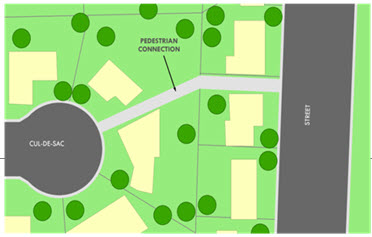
Figure 15.14.060-3: Cul-de-sac pedestrian connection.
4.
Driveways and Access.
a.
General.
(i)
Every lot shall have access that is sufficient to afford a reasonable means of ingress and egress for emergency vehicles, as well as for those needing access to the property in its intended use.
(ii)
All driveway entrances and other openings onto streets shall be constructed so that:
(1)
Vehicles may safely enter and exit from the lot in question;
(2)
Interference with the free and convenient flow of traffic in abutting or surrounding streets is minimized; and
(3)
The driveway shall provide a minimum of twenty feet in length from the face of the garage or carport to the sidewalk or future sidewalk in order to be considered a parking space. Where less than twenty feet is provided, the area shall not be considered a parking space but may be used as a driveway, provided a minimum of fifteen feet is maintained and the configuration is approved by the City Manager's Office and City Engineer.
b.
Residential. In addition to the above general requirements, all residential development shall be subject to the following:
(i)
Direct driveway access (ingress or egress) from any single-family residential lots to any arterial street or highway shall be prohibited on any lot preliminarily platted after the effective date of this code.
(1)
Detached garages accessing alley right-of-way shall be accessed by a driveway measuring either: three feet in length from the right-of-way line, or a minimum of twenty feet in length from the right-of-way line. No garage shall be accessed by a driveway measuring between three feet and twenty feet in length from the alley right-of-way.
(ii)
Multifamily development sites greater than five acres shall include a minimum of two through-access drives. An exception may be made by the city manager's office where a site is landlocked by existing development or other physical constraints, or where existing natural features on the site require the use of protective measures that would otherwise make a second access drive infeasible.
(iii)
A minimum of one driveway access to a multi-family dwelling site shall be maintained with unobstructed vehicular access between the dwelling entrance(s) and the public street access. Gates capable of closure and similar barriers shall be specifically prohibited from installation or operation on such driveways. This section shall not prohibit secondary additional accessways to a multi-family development from having emergency-access-only gates or barriers, provided the design, installation and operation shall be approved by appropriate public-safety review entities, including the city fire marshall, for that purpose.
(iv)
The provisions of subsection (iii) above shall also apply to driveways serving manufactured home communities ([Section] 15.14.140).
c.
Nonresidential. In addition to the above general requirements, all non-residential development shall be subject to the following:
(i)
All sites shall be designed so as to limit access to adjoining collector or arterial streets.
(ii)
All nonresidential buildings, structures, and parking and loading areas shall be physically separated from all nonarterial or collector streets by vertical curbs and other suitable barriers and landscaping to prevent unchanneled motor vehicle access. Each property shall have not more than two access ways to any one street, unless unusual circumstances demonstrate the need for additional access points. In addition, each access way shall comply with the following:
(1)
The width of any access way leading to an adjoining arterial street shall be median-divided to provide separation from incoming and outgoing traffic. (See Figure 15.14.060-4.)
(2)
Curb returns shall have a minimum radius of thirty feet.
(3)
On corner lots for nonresidential development, no part of any access way shall be nearer than seventy-five feet to the intersection of any two street rights-of-way unless otherwise approved by the city engineer.
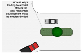
Figure 15.14.060-4: The width of access ways from arterial streets must be median-divided.
(iii)
Each nonresidential driveway shall be not more than thirty feet in width, measured at right angles to the center line of the driveway, except as that distance may be increased by permissible curb return radii. Driveways that access state roads shall be not more than thirty-eight feet in width, and shall be divided by a landscaped island. Ingress and egress shall be one way on each side of the island.
(iv)
Joint nonresidential driveways are desirable whenever possible in order to minimize the number of access points to streets and access easements (see Figure 15.14.060-5).
(v)
Unless no other practicable alternative is available, all non-residential driveways and other openings shall be located a minimum of:
(1)
Seventy-five feet from a street intersection;
(2)
Forty feet from another access driveway;
(3)
Ten feet from an interior property line for single family development and twenty feet from an interior property line for multifamily and non-residential development; and
(4)
Ten feet from any mid-block pedestrian connection ([subsection] 15.14.060.F.2.d).
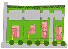
Figure 15.14.060-5: Use of joint-access curb cuts to minimize curb cuts.
5.
[Clear Vision Areas at Intersections.]On all corner lots or parcels of land on which a front setback is required, no obstruction that will obscure the view of road users shall be placed within the triangular area formed by the adjoining street right-of-way lines (property lines) and a line connecting them at points twenty-five feet from the intersection of said street right-of-way lines (property lines). Landscaping (excluding trees) and fencing shall be permitted within said triangular area provided the landscaping and fencing does not exceed three feet above the ground level of the adjacent street. Trees may be placed within said triangular area provided that limbs are trimmed to at least eight feet above the ground level of the adjacent street, so as not to significantly obstruct the view of road users approaching the intersection.
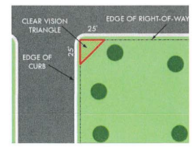
Figure 15.14.060-6: No obstructions to view are allowed in the clear vision area
F.
Pedestrian Circulation.
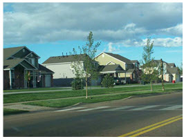
Figure 15.14.060-7: Sidewalk placement and landscaping.
1.
Sidewalks Required. Sidewalks shall be installed on both sides of all arterials, collector streets, and local streets (including loop streets and culs-de-sac), and within and along the frontage of all new development or redevelopment. This requirement shall not apply to local streets in zoning districts in which the minimum lot size is one acre or greater, or in steep-slope areas where sidewalks on one side of the street may be approved by the city manager's office to reduce excessive slope disturbance, adverse impacts on natural resources, and potential soil erosion and drainage problems (see Figure 15.14.060-7).
2.
Mid-Block Pedestrian Connections. On all new or newly extended residential streets with length greater than six hundred feet between the nearest pair of intersections, a mid-block pedestrian connection shall be provided on both sides of the street. Mid-block pedestrian connections shall:
a.
Be located approximately equidistant from either intersection in the pair;
b.
Be aligned directly across the subject street from each other;
c.
Be located along property boundaries wherever possible;
d.
Be located at least ten feet from the nearest driveway curb-cut, measured edge-to-edge at the street right-of-way;
e.
Contain a minimum of twenty feet easement width, such easement to be dedicated for public pedestrian access, and minimum-width improved travel surface of five feet;
f.
Connect at the farther ends to either: (i) a public street with sidewalk or similar pedestrian feature; or (ii) another public off-street pedestrian pathway;
g.
Be delineated with a crosswalk across the street's travel surface;
h.
Be provided with a street-center pedestrian refuge (e.g., accessible median or island)
if located on streets with arterial or above status where existing or projected average
daily traffic (ADT) is more than ten thousand vehicles.
The city manager's office may grant an exemption from the mid-block pedestrian connection
requirement for particular circumstances in which the connection poses a potential
public risk, including but not limited to: Inadequate sight distance for vehicles
and/or pedestrians; impossibility of present or future connection to other pedestrian
travelways; or encroachment on a significant natural feature (e.g., stream channel,
wetland, steep slope).
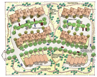
Figure 15.14.060-8: On-site pedestrian connections that link to off-site development.
3.
On-Site Pedestrian Connections.
a.
All commercial, industrial, multifamily, mixed-use, and attached residential development shall provide a network of on-site pedestrian walkways with a minimum width of five feet to and between or among the following areas (see Figure 15.14.060-8):
(i)
Public entrances to each commercial, industrial, multifamily, mixed-use, and/or attached residential building on the site, including pad site buildings;
(ii)
Public sidewalks, walkways, or trails on adjacent properties that extend to the boundaries shared with the subject development;
(iii)
Public sidewalks along the perimeter streets adjacent to the development;
(iv)
Adjacent land uses and developments;
(v)
Adjacent public park, greenway, or other public or civic use; and
(vi)
Adjacent public transit station areas, transit stops, park and ride facilities, or other transit facilities.
b.
Internal pedestrian walkways shall be provided through parking areas in excess of fifty spaces, constructed of materials distinguishable from the driving surface pursuant to subsection 15.14.060.F.3.c., below.
c.
Pedestrian walkways and crosswalks shall be identified to motorists and pedestrians through the use of one or more of the following methods, subject to department approval:
(i)
Changing paving material, patterns, or paving color (see Figure 15.14.060-9);
(ii)
Changing paving height;
(iii)
Decorative bollards;
(iv)
Painted crosswalks;
(v)
Raised median walkways with landscaped buffers; or
(vi)
Stamped asphalt.
Figure 15.14.060-9: Change in paving materials to distinguish pedestrian walkway.
d.
On-site pedestrian circulation routes shall be emphasized with special design features that establish them as areas where pedestrians are physically separated from the flow of vehicular traffic and/or are protected from the elements. Techniques shall include one or more of the following:
(i)
Arcades, porticos, or other shade structures (see Figure 15.14.060-10);
(ii)
Pedestrian light features,
(iii)
Bollards,
(iv)
Seat walls or benches;
(v)
Drinking water fountains; or
(vi)
Landscape planters.
Figure 15.14.060-10: Separating pedestrians from traffic and the elements through the use of arcades.
(Ord. No. 1578, § 2(att. A), 3-20-2010; Ord. No. 1625, §§ 14, 15, 9-4-2012; Ord. No. 1671, §§ 9—14, 21, 11-18-2014; Ord. No. 1711, § 2, 7-19-2016; ; Ord. No. 1728, § 16, 4-18-2017; Ord. No. 1744, § 24, 3-6-2018; Ord. No. 1762, § 1, 4-16-2019; Ord. No. 1777, § 26, 7-7-2020; Ord. No. 1830, § 12, 10-17-2023; Ord. No. 1872, § 11, 10-7-2025)
15.14.070 - Parks and open space.
A.
Purpose. This section is intended to ensure that open space and natural areas throughout the city are provided, considered and protected during and after the development review process in accordance with the city of Laramie comprehensive plan, Chapter 4, Parks and Recreation. Open space serves numerous purposes, including preservation of natural areas and resources, preservation of scenic views, greater resident access to open areas and recreation, public health benefits, and enhancement of the quality of new development.
B.
Public Park and Open Space Dedication and Fees In-Lieu.
1.
Purpose. This subsection is intended to provide land or fees in-lieu of land for park and open space demand generated by new residential subdivisions. Particular emphasis should be placed on providing a diversity of parks that serve residents of all ages and abilities and that are accessible from a variety of locations within the community. Where no suitable land is available, based on subsection 15.14.070.B.4., characteristics of land to be dedicated, fees in-lieu of land or the equivalent monetary value may be substituted at the city's discretion, pursuant to subsection 15.14.070.B.8.
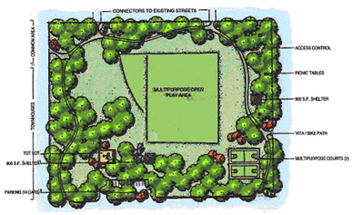
Figure 15.14.070-1: Typical neighborhood park from the Laramie comprehensive plan.
2.
Applicability. Any person applying for preliminary or final plat for development of any area zoned and to be used for single-family, two-family, or multifamily residential purposes in the city shall be required to dedicate for open space a portion of land per individual unit, or pay a fee in lieu thereof pursuant to subsection 15.14.070.B.8. based on the demand for open space created by the development.
3.
Amount of Land to be Dedicated. The amount of land to be dedicated shall be determined based upon a finding by the city council that the land being dedicated is reasonably related to the impacts upon the city's parks and recreation system that will be generated by the residents and users of the subject development.
a.
The amount of land dedicated shall not be less than 6.3 acres of park land per one thousand ultimate residents of the subdivision (based on national park standards). The following formula may be used as a general guideline for determining the amount of land (in acres) to be dedicated:
b.
The distribution of this land shall generally be as follows:
(i)
Playlots and/or community gardens: 0.3 acres/1,000 residents
(ii)
Neighborhood Parks (see Figure 15.14.070-1) and/or community gardens: 1.0 acres/1,000 residents
(iii)
Community Parks (see Figure 15.14.070-2): 5.0 acres/1,000 residents
c.
The city council shall have discretion to re-allocate acreage among the above categories for the benefit of the community as well as for the creation of a large community park.
d.
The city council finds that pursuant to the Laramie comprehensive plan, the following chart represents the average number of persons per unit by density category:
e.
The developer shall submit with each subdivision plat for residential development information concerning the number of units. Should the developer fail to do so, the city council shall assume the highest density allowed in the residential district. Such information may be required by the city manager's office at time of filing a site plan or a rezoning request.
f.
An applicant seeking approval for a residential development application may submit an independent calculation of density and proposed parkland dedication. If approved by the city council, the independent calculation shall be used to calculate the required dedication.
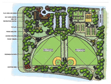
Figure 15.14.070-2: Typical community park from the Laramie comprehensive plan.
4.
Characteristics of Land to be Dedicated. Except as otherwise required by the city council at the time of preliminary plat approval, all dedications of land under this section shall meet the following criteria:
a.
Locational Criteria. To the maximum extent feasible, where significant natural and scenic resource assets exist on a property, the subdivider, developer, or owner shall give priority to their preservation through public land dedication. In reviewing the proposed location of public land dedication areas, the city manager's office shall use all applicable plans, including the Laramie comprehensive plan, maps, and reports to determine whether significant resources exist on a proposed site that should be protected, with priority being given to the following areas (in no particular order):
(i)
Flood hazard areas;
(ii)
Lakes, rivers, stream/riparian corridors, and drainageways;
(iii)
Wildlife habitat and migration corridors;
(iv)
Tree or native plant retention areas;
(v)
Ridgelines as identified in the Laramie comprehensive plan;
(vi)
Conservation easements;
(vii)
Trails as depicted in the Laramie comprehensive plan; and
(viii)
Wetlands.
b.
Number of Parcels. The dedicated park land shall form a single parcel of land, except where the city council determines that two or more parcels would be in the best interest of the public, given the type and distribution of open spaces needed to adequately serve the proposed development. In such cases, the city council may require that such parcels be connected by a dedicated strip of land at least thirty feet in width.
c.
Usability. At least fifty percent of the dedicated land required by this code shall be suitable for passive, active, or recreational open space. No part of such fifty percent to be used for passive, active, or recreational open space shall be within any designated detention pond, flood plain or floodway of the city.
d.
Location Outside of Subdivision. At the discretion of the city council, the dedicated park land may be located outside of the residential development in order to comply with the comprehensive plan, to add property to existing park land, or to combine land dedication efforts with those of other developments.
e.
Access. Public access to dedicated park land shall be provided either by adjoining public street frontage or, if required by the city manager's office, by a dedicated public easement at least twenty feet wide that connects the dedicated land to a public street or right-of-way, unless the land being dedicated is a sensitive environmental area to which access should be restricted for preservation purposes. Gradients adjacent to existing and proposed streets shall allow for reasonable access to the dedicated land. Public access to greenway/greenbelt dedications only shall be at least twenty feet wide.
f.
Areas Not Eligible. Lands within the following areas shall not be accepted for public park or open space dedication:
(i)
Private yards;
(ii)
Public or private streets or rights of way;
(iii)
Open parking areas and driveways for dwellings; and
(iv)
Land covered by structures not intended solely for recreational uses.
5.
Public Parks and Trails. The location and size of public parks and trails within the city shall be determined by the Laramie comprehensive plan or other appropriate plan. Parks shall have a minimum area and function as described in the Laramie comprehensive plan or other applicable plan.
6.
Procedure for Dedication of Land. The dedication of such land shall be reviewed and approved as part of the preliminary and final plat. The developer shall designate on the preliminary and final plat the area or areas of land to be dedicated pursuant to this section. The director of parks and recreation shall be required, by his or her signature, to accept any lands for park or recreation use. The director of parks and recreation may refer the dedication to the city council.
7.
Submission of Deed and Survey. Unless otherwise stipulated in a subdivision or development agreement, the conveyance of dedicated land to the city shall be by warranty deed, and the title shall be free and clear of all liens and encumbrances, including real property taxes prorated to the time of conveyance. The owner shall provide the city with title insurance for the property. The deed shall be submitted no later than one year after the approval of the subject final plat, or by the time that fifty percent of the certificates of occupancy for that phase have been issued, whichever is earlier.
8.
Payments of Fees In-lieu of Land Dedication.
a.
Applicability. If a development would require, by virtue of subsection 15.14.070.B.3 above, less than five acres to be dedicated as park land, the developer shall be required to pay cash in-lieu of land in an amount determined as set out in this section unless the city council determines the land area to be dedicated has a positive impact to the park system.
In instances where dedication is proposed or required, the city council shall have the right to refuse dedication of land, and instead, require payment of cash in-lieu of land as provided in this section if it determines that such dedication will not have a positive impact upon the park system, will not provide the necessary opportunities for the public, is unsuitable for public use, or other such reason determined by the city council.
b.
Payment into Park Dedication Fund. In instances where payment of fee is to be made in lieu of land dedication, the money in lieu of land shall be paid into a fund established by the city. The cash payment shall be in an amount set from time to time by resolution of the city council.
c.
Administration of Park Dedication Fund. The park dedication fund will be administered by the city to provide a general benefit to contributing developments, provided that the establishment of all public parks shall be within the discretion of the city council. The money paid by the developer will be expended exclusively to establish park land that generally benefits the proposed development. The money shall be properly expended by the city or returned to the developer within twenty-five years of the date of final plat approval. The city shall account for all money deposited to the fund. All or part of the contribution may be expended for such purposes as acquisition of land, construction of improvements, and purchase of equipment for the relevant park.
C.
Trail Linkages.
1.
Trail linkages shall be incorporated into the design of all new subdivisions and multifamily and non-residential developments. Trail linkage shall be located and designed so as to provide public access, to connect residences and businesses to open space and the city's trail system, and to promote pedestrian and bicycle movement between residential areas and employment/business areas.
2.
All development, at the time of platting, shall be required to demonstrate that the design of the proposed development includes open space and trail linkages pursuant to the Laramie comprehensive plan, Turner Tract area plan, or other applicable plan.
3.
Trails shall be constructed at the time of development in accordance with city standards and specifications adopted by the city engineer.
D.
Private Common Open Space.
1.
Purpose. Private common open space is private open land area set aside for the exclusive use and enjoyment of a development's residents, employees, or users. Goals and requirements for common open space complement this code's requirements for dedicated parks, and serve similar purposes.
2.
Applicability. Private common open space set-aside is an option available to residential developers with projects that have a minimum of twenty-five dwelling units. Should a developer opt to follow these provisions, the city may award up to a fifteen-percent reduction in the required public park and open space dedication or fee in-lieu of subsection 15.14.070.B.
3.
Generally. All residential development in the city containing twenty-five or more dwelling units shall have the option to set aside a minimum of twenty percent of the total land area as private common open space.
4.
District Specific. This option shall not be available where the standards of the specific zone district establish a different standard for open space dedication, such as the Downtown Commercial district.
5.
Standards.
a.
Location Criteria. To the maximum extent feasible, where significant natural and scenic resource assets exist on a property, the subdivider, developer, or owner shall give priority to their preservation as private common open space. In reviewing the proposed location of private common open space areas, the city manager's office shall use all applicable plans, including the Laramie comprehensive plan, maps, and reports to determine whether significant resources exist on a proposed site that should be protected, with priority being given to the following areas (which are not listed in a particular order):
(i)
Flood hazard areas;
(ii)
Lakes, rivers, and stream/riparian corridors;
(iii)
Wildlife habitat migration corridors;
(iv)
Tree or native plant preservation areas;
(v)
Trails as identified in the Laramie comprehensive plan;
(vi)
Ridgelines as identified in the Laramie comprehensive plan
(vii)
Wetlands; and
(viii)
Private on-site stormwater detention facilities where the design has been approved by the city manager's office.
b.
Areas Not Credited. Lands within the following areas shall not be counted towards private common open space set-aside areas:
(i)
Private yards;
(ii)
Public or private streets or rights of way;
(iii)
Open parking areas and driveways for dwellings; and
(iv)
Land covered by structures not intended solely for recreational uses.
6.
Use of Common Open Space Areas. Private common open space areas shall not be disturbed, developed, or improved with any structures or buildings, except for the limited purposes allowed below:
a.
Facilities for active recreation (equipment for such uses shall be indicated by type and location on the site and/or subdivision landscape/amenity plan provided by the developer);
b.
Common open space areas may include passive recreational and educational purposes approved by the city, including but not limited to walking, biking, picnicking, fishing, preservation of natural areas and scenic resources, parks, environmental education, and wildlife habitat protection; and
c.
Clearing of underbrush and debris and the provision of walks, fountains, fences, restrooms and similar features shall be allowed.
7.
Design Criteria. Land set aside for private common open space shall meet the following design criteria, as relevant:
a.
Common open space areas shall be located so as to be readily accessible and useable by residents in various positions of the development, unless the lands are sensitive natural resources and access should be restricted. A portion of the open space should provide focal points for the neighborhood.
b.
The lands shall be compact and contiguous unless the land shall be used as a continuation of an existing trail, or specific topographic features require a different configuration. An example of such topographic features would be the provision of a trail or private open area along a riparian corridor.
c.
Where private common open space areas, trails, parks, or other public spaces exist adjacent to the tract to be subdivided or developed, the private common open space shall, to the maximum extent feasible, be located to adjoin, extend, and enlarge the presently existing trail, park, or other open area land.
8.
Ownership. All private common open space areas shall be owned jointly or in common by the owners of property within the development.
9.
No Fee-In-Lieu. The payment of fees-in-lieu of the set-aside of land for private common open space uses shall be prohibited.
10.
Private Open Space Maintenance.
a.
The owner of the private open space land shall be responsible for maintenance.
b.
For the purposes of this subsection, "maintenance" shall include control of noxious weeds, reseeding as needed to prevent erosion, restriction of use as necessary to allow revegetation, irrigation when appropriate, and the establishment and enforcement of reasonable rules for the protection of the open space.
(Ord. No. 1578, § 2(att. A), 3-20-2010; Ord. No. 1671, § 21, 11-18-2014; Ord. No. 1728, § 16, 4-18-2017; Ord. No. 1744, § 24, 3-6-2018)
15.14.080 - Residential design standards.
A.
Purpose. The purpose of the residential design standards is to preserve the quality and character of the built environment in the city. More specifically, the purposes of this section are to:
1.
Encourage high quality development as a strategy for investing in the city's future;
2.
Emphasize the city's unique community character;
3.
Maintain and enhance the quality of life for the city's citizens;
4.
Shape the city's appearance, aesthetic quality, and spatial form;
5.
Protect and enhance property values;
6.
Provide property owners, developers, architects, builders, business owners, and others with a clear and equitable set of parameters for developing land; and
7.
Promote the sustainability of both the structure and the overall community.
Figure 15.14.080-1: Varied façades are preferred.
Figure 15.14.080-2: Façades that do not meet design standards.
B.
Applicability.
1.
The design standards in this subsection apply to all new detached and attached one- and two-family dwellings, townhouses, and accessory buildings.
2.
Subsection 15.14.010.B.2.b., (applicability—redevelopment and infill development) provides information about how these provisions apply to redevelopment and infill development. In the case of exterior enlargement of an existing development (subsection 15.14.010.B.2.a.) or interior changes (subsection 15.14.010.B.3.), residential design standards shall not be mandatory for existing detached and attached one- and two-family dwellings, but shall apply in the case of townhouses.
C.
Design Standards.
1.
Façades. Developments containing twenty or more single-family detached and/or attached houses (aggregated if the development is phased) shall offer a minimum of four distinctly different front façades. Development containing thirty or more single-family detached and/or attached houses (aggregate if the development is phased) shall offer a minimum of six different front façades. The number of different front façades required shall increase by two for each addition of ten homes up to a maximum of twenty distinct façades. Mirror images of the same façade elevation are not considered distinctively different, with the exception of a two-family or similar attached dwelling (see Figures 15.14.080-1 and 2).
a.
No façade shall be repeated more than once every four lots on the same side of the street, nor shall any façade be repeated on any two lots immediately across the street from each other. Each façade used to satisfy this requirement shall distinctly differ from other façades in a minimum of four of the following:
(i)
Placement of windows and doors on the front façade;
(ii)
Use of different materials on the front façade;
(iii)
Substantial variation in the location and proportion of garages and garage doors;
(iv)
Variation in the use, location, or proportion of front porches;
(v)
Substantial variations in rooflines, that may include roof pitch;
(vi)
Use of dormers;
(vii)
Variation of building type between ranch, two-story or split level;
(viii)
Window shapes that are substantially different;
(ix)
Window grilles or shutters, or
(x)
Other distinct and substantial façade design variations approved by the city manager's office.
2.
Number of Units. No more than six single-family dwelling units shall be attached in any single row of townhomes. The attached single-family dwellings in any one row structure shall be required to have distinctly different facades (see Figure 15.1.4.080-3). No attached single-family structure facade shall be repeated more than once every four structures on the same side of the street.
3.
Separation. The minimum separation between buildings, including accessory buildings, on the same lot or development parcel is five feet.

Figure 15.14.080-3: Multiple façades in an attached dwelling.
4.
Massing. To the maximum extent practicable, the massing and use of exterior materials on attached single-family dwellings, not including townhouses, should be arranged so as to give the appearance of a large single-family house (see Figure 15.14.080-4).

Figure 15.14.080-4: Example of single-family attached dwellings arranged as a large house.
5.
Garages.
a.
Reserved.
b.
In all zone districts-single-family dwellings (attached and detached) and duplex units with-garages, the street-facing garage shall be no more than twelve feet closer to the front property line than other elements of the structure. The following special setback provisions shall also apply:
(i)
In the RR and LR Zoning Districts: A new single-family dwelling with attached garage shall be allowed to encroach into the required minimum front setback by up to ten feet; provided however, that the front of the garage shall be set back by a compensating additional distance from the minimum, such that the additional garage setback is equal to or greater than the front-setback encroachment (see Figure 15.14.080-5). A new single-family dwelling with only a detached alley-facing garage shall be allowed to encroach into the required minimum front setback by up to ten feet.
(ii)
In the R1 Zoning District: A new single-family dwelling or duplex unit with attached garage shall be allowed to encroach into the required minimum front setback by up to five feet; provided however, that the front of the garage shall be set back by a compensating additional distance from the minimum, such that the additional garage setback is equal to or greater than the front-setback encroachment (see Figure 15.14.080-5). A new single-family dwelling or duplex unit with only a detached alley-facing garage shall be allowed to encroach into the required minimum front setback by up to five feet. (Ord. No. 1800, § 6, 1-4-2022)
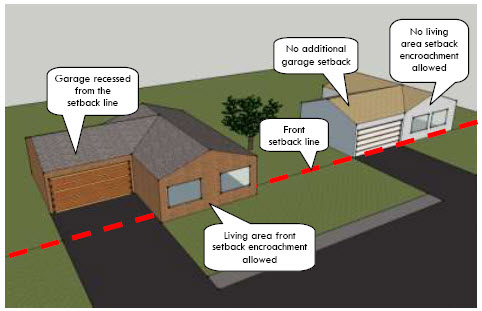
Figure 15.14.080-5: A front setback encroachment is allowed, provided however, that the front of the
garage shall be set back by a compensating additional distance from the minimum front
setback, such that the additional garage setback is equal to or greater than the front-setback
encroachment and does not exceed the maximum encroachment allowed within that subject
zoning district.
c.
For single-family and single-story duplex dwellings with street-facing attached two-car garage doors shall not comprise more than forty-five percent of the façade width of each dwelling or eighteen feet of each dwelling, whichever is lesser (see Figure 15.14.080-6); and attached three-car garage doors shall not comprise more than fifty-five percent of the façade width of each dwelling or twenty-seven feet of each dwelling, whichever is lesser. This standard may be changed through a minor administrative modification process for pre-existing narrow lots.
For two-story duplex dwellings, street-facing attached two-car garage doors shall not comprise more than sixty-seven percent of the façade width of each dwelling or eighteen feet of each dwelling, whichever is lesser, provided that the second story living space projects over at least fifty percent of the garage width with a maximum offset of seven feet behind the face of the garage; and, at a minimum, the second story be at least the same width as the garage or greater than fifty percent of the structure; and attached three-car garage door shall not comprise more than sixty-seven percent.
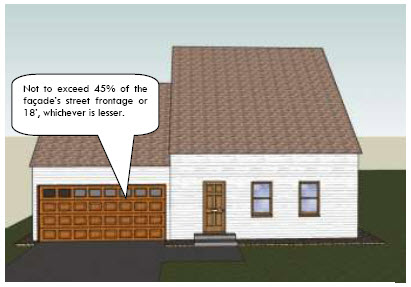
Figure 15.14.080-6: Street-facing, two-car garage doors shall not compromise more than 45 percent of
the façade width or 18 feet, whichever is lesser.
d.
The use of side-loading garages shall be permitted (see Figure 15.14.080-7.). The outside wall of a street-facing side-loading garage shall have a minimum of two of these design features:
(i)
Siding materials identical to that found on the primary façade;
(ii)
Two or more windows of a size and design similar to those found on the primary façade;
(iii)
A permanent trellis covering a minimum of twenty-five percent of the wall area. One vine for every eight linear feet of trellis shall be planted at its base. Appropriate vine species are as approved by the city manager's office; or
(iv)
Garage or living area façade offset from the other a minimum of four feet.
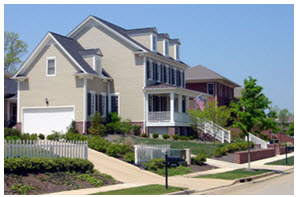
Figure 15.14.080-7: Sample side-loading garage design.
6.
[Materials.] All construction shall be of durable high-quality materials. If vinyl exterior siding is used, it shall have a manufacturer's warranty of a minimum of 15 years. Refer to Table 15.14.080-1 regarding the use of metal siding, smooth-faced CMU block or tilt-up panels. This subsection shall not prohibit the use of metal siding designed to look like clapboard siding, metal trim, soffits, fascia, gutters, corners, standing seam roofing or specific architectural elements or features.
D.
Multifamily Development.
1.
Dwellings with Three or More Living Units. These standards apply to all structures intended or constructed to be occupied by three or more households, including individually constructed buildings, townhomes, and multiple buildings constructed as parts of a larger development.
a.
The minimum separation between multifamily buildings, including accessory buildings, on the same lot or development parcel is five feet. (Ord. No. 1800, § 7, 1-4-2022)
b.
Individual buildings within a multifamily development shall be oriented to the following (see Figure 15.14.080-9):
(i)
Common open space, such as interior courtyards or on-site natural areas or features;
(ii)
Perimeter streets;
(iii)
Other residential buildings; or
(iv)
Through-access drives.

Figure 15.14.080-9: Courtyard orientation.
c.
Multifamily buildings in a single development shall be clustered or grouped to form neighborhoods.
d.
To the maximum extent practicable, buildings shall be oriented or arranged in a manner to enclose common open spaces such as gardens, courtyards, recreation or play areas, that shall contain a minimum of three of these features:
(i)
Seasonal planting areas;
(ii)
Trees;
(iii)
Pedestrian-scaled lighting;
(iv)
Gazebos or other decorative shelters;
(v)
Seating;
(vi)
Play structures for children; or
(vii)
Natural features or areas, unless the city determines that for preservation reasons the buildings should avoid the feature or area.
2.
Building Design Generally.
a.
The maximum length of any multifamily building shall be one hundred and eighty feet or six townhouse units, whichever is less.
i.
Multi-family buildings with a facade length of greater than thirty linear feet shall incorporate a minimum of two of the following design elements in the design of the front facade (see Figure 15.14.080-10):
(1)
Bay windows;
(2)
Covered porches or balconies;
(3)
Structural offsets of a minimum of four feet from the principal plane of the facade;
(4)
Accent materials such as brick, stone, or stucco with banding highlights; or
(5)
Window grills and shutters.
(6)
An equivalent element approved by the City Manager's office.
ii.
Multi-family buildings with a facade length of greater than thirty linear feet shall incorporate a minimum of two of the following design elements in the design of the roof:
(1)
Changes in pitch: A minimum change of fifteen degrees or more in pitch between two sections of the roof.
(2)
Roof height differential: A vertical difference of fifteen percent or more between roof planes.
(3)
Cardinal direction shift: A minimum forty-five degree shift in the orientation or cardinal direction of the roof plane, it can be considered a separate slope plane.
(4)
An equivalent element approved by the City Manager's office.

Figure 15.14.080-10: Multifamily structure with multiple design elements.
b.
At least fifty percent of all ground-floor units shall be provided with a minimum six-foot by ten-foot patio directly accessible from the unit. At least fifty percent of all units above ground-floor level shall be provided with a minimum four-foot by ten-foot balcony directly accessible from the unit.
c.
All construction shall be of durable high-quality materials. If vinyl exterior siding is used, it shall have a manufacturer's warranty of a minimum of fifteen years. Refer to Table 15.14.080-2 regarding the use of metal siding, smooth-faced CMU block or tilt-up panels. This subsection shall not prohibit the use of metal siding designed to look like clapboard siding, metal trim, soffits, fascia, gutters, corners, and standing seam roofing or specific architectural elements or features.
3.
Parking Location and Layout.
a.
To the maximum extent feasible, garage entries, carports, parking areas, and parking structures shall be internalized in building groupings or oriented away from street frontage (see Figure 15.14.080-11).
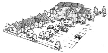
Figure 15.14.080-11: Multifamily parking shall be oriented away from street frontage.
b.
Parking areas and freestanding parking structures (detached garages or carports) shall not occupy more than thirty percent of each perimeter public street frontage of a multifamily development.
c.
To the maximum extent practicable, freestanding parking structures that are visible from perimeter public streets shall be sited so that the narrow end of the parking structure is perpendicular to the perimeter street.
d.
Temporary parking structures shall not be permitted.
4.
Storage Space.
a.
Intent.
(i)
To ensure multifamily developments provide sufficient storage for residents, so that balconies and garages may be used for their original purpose;
(ii)
To reduce parking impacts resulting from undersized garage spaces and a lack of storage; and
(iii)
To ensure parking is used for parking and not for storage.
b.
Design Standards. Multifamily developments shall provide a minimum of thirty-two square feet of storage space per unit. Storage may be provided through one or more of the following:
(i)
Increased garage dimensions, in addition to the ten feet by twenty feet standard garage space allotted for parked vehicles, that allow for storage in front of parked vehicles;
(ii)
Storage units incorporated above detached garage structures or within the multifamily building;
(iii)
Storage closets within units, aside from bedroom closets; or
(iv)
Detached storage buildings or sheds.
E.
Landscaping. The provisions of Section 15.14.050, landscaping and screening standards, of this code shall apply to all multifamily residential development.
(Ord. No. 1578, § 2(att. A), 3-20-2010; Ord. No. 1596, § 55, 5-3-2011; Ord. No. 1625, §§ 27—31, 9-4-2012; Ord. No. 1728, § 16, 4-18-2017; Ord. No. 1731, § 1, 5-16-2017; Ord. No. 1777, § 28, 7-7-2020; Ord. No. 1807, § 2, 4-19-2022; Ord. No. 1830, §§ 13—15, 10-17-2023; Ord. No. 1861, § 7, 3-4-2025)
15.14.090 - Commercial industrial and institutional design standards.
A.
[Purpose.] The commercial industrial and institutional design standards are intended to protect and preserve the quality and character of the built environment in the city. More specifically, the purposes of this section are to:
1.
Encourage high quality development as a strategy for investing in the city's future;
2.
Emphasize the city's unique community character;
3.
Maintain and enhance the quality of life for the city's citizens;
4.
Shape the city's appearance, aesthetic quality, and spatial form;
5.
Reinforce the civic pride of citizens through appropriate development;
6.
Increase awareness of aesthetic, social, and economic values;
7.
Protect and enhance property values;
8.
Minimize negative impacts of development on the natural environment;
9.
Provide property owners, developers, architects, builders, business owners, and others with a clear and equitable set of parameters for developing land;
10.
Encourage a pedestrian- and bicyclist-friendly environment;
11.
Enhance the city's sense of place and contribute to the sustainability and lasting value of the city;
12.
Shape development in a manner that is most beneficial to the citizens in the city;
13.
Ensure greater public safety, convenience, and accessibility through the physical design and location of land-use activities;
14.
Promote both the sustainability of the structure and the overall community; and
15.
Ensure compatibility of nonresidential uses developed in residential zone districts.
B.
Applicability.
1.
The design standards in this subsection apply to all new commercial, mixed-use, institutional and industrial structures, except those located in the Downtown Commercial district.
2.
Subsection 15.14.010.B., applicability provides information about how these previsions apply to redevelopment and infill development.
3.
Development in the Downtown Commercial district shall conform to the design requirements found in subsection 15.08.030.E: Downtown Commercial district.
4.
The design standards of subsection 15.08.030.L.2.h, building design standards, shall apply for all development within the TO district. In the event of a direct conflict between the provisions of subsection 15.08.030.L and this section exist; the standards of [subsection] 15.08.030.L shall govern.
C.
Site Design and Layout.
1.
Slopes. Development of sloping properties should generally conform to the natural contours of the land. When it is necessary to build on sloping ground, the use of terraced parking, stepped building pads, and larger setbacks may be required by the city engineer.
2.
Utilities. All utilities shall be installed underground within the exterior property lines of the site. Freestanding utility boxes shall be integrated into the landscaping to the maximum extent practicable and screened from view pursuant to the screening standards in [subsection] 15.14.050.I.
3.
Drainage. All drainage from the property to city rights-of-way shall be by underground structures to avoid drainage across city walks or drive aprons. On-site storm drainage may be conveyed on the surface. All storm drainage shall be reviewed for conformance with city standards. Where appropriate this provision may be waived by the city manager's office and alternative drainage methods may be constructed, including the use of a naturalized channel.
D.
Building Design.
1.
Materials and Colors.
a.
All primary exterior building materials on principal buildings shall be durable, economically maintained, and of a high quality that will retain its appearance over time, including but not limited to, brick, sandstone, natural or synthetic stone, and tinted/textured concrete masonry units. Refer to Table 15.14.090-1 regarding the use of metal siding, smooth-faced CMU block or tilt-up panels. This section shall not prohibit the use of metal siding designed to look like clapboard siding, metal trim, soffits, fascia, gutters, corners, and standing seam roofing or specific architectural elements or features.
b.
Building materials, except glass, shall be of low reflectance and finished in subtle, neutral or earth tone colors (brown, tan, grey, green, blue, red in muted, flat colors) characteristic of the soil types and vegetation found in Laramie.
2.
Façades.
a.
The majority of a building's architectural features and treatments shall not be restricted to a single façade. Building details, including roof forms, windows, doors, trim, and siding materials, shall reflect the architectural style of the building. All sides of a commercial building shall display a similar level of quality and architectural detailing.
b.
Blank building walls shall not be permitted. Any wall that faces a street, connecting pedestrian walkway, or residential use, and that exceeds thirty feet in length shall include a minimum of two of the following within each successive thirty-foot section or fraction thereof (see Figure 15.14.090-3):
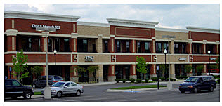
Figure 15.14.090-3: Façade change in suburban development
(i)
Change in wall plane, such as projections or recesses, having a depth of at least three percent of the length of the façade and extending at least twenty percent of the length of the façade;
(ii)
Change in texture or masonry pattern;
(iii)
Windows;
(iv)
Covered walkways;
(v)
Structural canopies;
(vi)
An equivalent element that subdivides the wall into human scale proportions.

Figure 15.14.090-4: Franchise architecture designed to match the community style.
c.
Ground floor façades that face public streets shall have arcades, display windows, entry areas, awnings, or other such features along no less than sixty percent of their horizontal length.
d.
Rear façades of buildings shall either be screened from view of the public or be landscaped and incorporate architectural façade elements resembling the elements in the front façade.
3.
Building Orientation. The front building façade shall be oriented toward a public street and pedestrian walkways.
4.
Building Styles. Buildings within a single complex or related complexes shall be stylistically consistent. Franchise architecture is discouraged in favor of architecturally compatible designs (see Figure 15.14.090-4).
5.
Roofs. Roofs shall be designed and constructed as follows:
a.
Flat roofs shall include parapets concealing flat roofs and rooftop equipment such as HVAC units from public view. Parapet roofs should be of sufficient height to conceal HVAC units and other similar roof-mounted apparatus from public view from adjacent street levels. Parapet roofs shall have cornices or be stepped (see Figure 15.14.090-5). The city manager's office may waive or reduce the parapet requirement where solar equipment is roof-mounted or for green roofs in subsection 15.14.090.D.5.c, below.

Figure 15.14.090-5: Parapet wall with cornice treatment.
b.
Sloping roofs shall have a vertical rise of not less than one foot for every three feet of horizontal run and no more than one foot for every one foot of horizontal run. Sloping roofs shall have three or more roof slope planes where a building exceeds three thousand square feet. Two or more roof slope planes shall be required for sloped-roof buildings of three thousand square feet or less. Separate slope planes shall be defined by one or more of the following criteria:
(i)
Changes in Pitch: A minimum change of fifteen degrees or more in pitch between two sections of the roof.
(ii)
Roof Height Differential: A vertical difference of fifteen percent or more between roof planes.
(iii)
Cardinal Direction Shift: A minimum forty-five degree shift in the orientation or cardinal direction of the roof plane,
(iv)
An equivalent element approved by the City Manager's office.
c.
Sustainable roofs are encouraged. At the discretion of the city manager's office, buildings with sustainable roofs may be granted reduced or waived on-site parking requirements. Sustainable roofs include:
(i)
Cool roofs that for a minimum of seventy-five percent of the total roof surface have a solar reflectance index (SRI) of seventy-eight or higher for a roof with a slope of 2:12 or less, or twenty-nine or higher for a roof with a slope greater than 2:12; or
(ii)
For a minimum of fifty percent of the total roof surface, a vegetated roof with plant materials identified from the city's planting list (see Figure 15.14.090-6).
Figure 15.14.090-6: Vegetated roof.
E.
Central Gathering Place.
1.
Commercial development shall incorporate on-site indoor or outdoor gathering spaces or community amenities as visible, accessible, focal points as follows:
a.
Lots with lot areas greater than fifty thousand square feet shall provide at least one central gathering place or community amenity; and
b.
Lots with lot areas greater than fifty thousand square feet shall provide an additional central gathering place or community amenity for each twenty-five thousand square feet or fraction thereof of lot area over fifty thousand square feet. No more than four central gathering places shall be required.
2.
Any one or more of the following features may be used to satisfy the central gathering place or community amenity standard:
a.
Patio or plaza with seating, landscaping, water features, or other unique features (see Figure 15.14.090-7);
b.
Landscaped mini-parks or square;
c.
Rooftop or community garden; or
d.
Similar features as approved by the city manager's office.
Figure 15.14.090-7: Front plaza with seating areas.
3.
The minimum size of central gathering spaces or community amenities intended to satisfy requirements of this subsection shall be one thousand square feet, with a minimum width and depth of twenty feet each. The total required square footage may be aggregated or dispersed on the site.
(Ord. No. 1578, § 2(att. A), 3-20-2010; Ord. No. 1596, §§ 47—49, 5-3-2011; Ord. No. 1625, §§ 32—36, 9-4-2012; Ord. No. 1637, § 7, 2-5-2013; Ord. No. 1728, § 16, 4-18-2017; Ord. No. 1744, § 40, 3-6-2018; Ord. No. 1777, § 29, 7-7-2020; Ord. No. 1830, § 17, 10-17-2023)
Editor's note— Section 32 of Ord. No. 1625, adopted Sept. 4, 2012, changed the title of § 15.14.090 from "Commercial and industrial design standards" to "Commercial industrial and institutional design standards."
15.14.100 - Fences and walls.
A.
Accessory Uses. Fences, hedges, trees, and walls shall be considered as permitted accessory uses provided that they meet the requirements of this section.
B.
Height.
1.
Front. No fence or wall located in the front yard shall exceed four feet in height (see Figure 15.14.100-1).
2.
Side and Rear. No fence or wall shall exceed six feet in height when located between the front building line or front setback whichever distance is greater, and a parallel line located forty-five feet from the front lot line; and no wall or fence shall exceed eight feet in height when located more than the forty-five ft parallel setback line from the front lot line. Fences exceeding seven feet in height shall require a building permit.
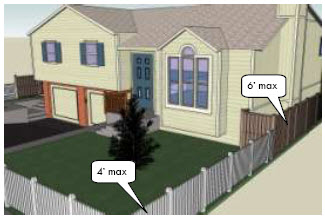
Figure 15.14.100-1: Fences located within the front yard of a structure shall not exceed four feet in
height, fences behind the front yard shall not exceed six feet in height.
C.
Articulation and Design. Walls and fences shall be articulated to avoid continuous, unbroken expanses. No wall or fence facing a collector or arterial street or adjacent to an interstate highway shall extend continuously, without articulation, for more than one hundred feet. No wall or fence facing any other type of public street shall extend continuously, without articulation, more than fifty feet. Columns or pilasters shall be a maximum of twenty-five feet apart. Fences or walls shall be articulated using any combination of the following:
1.
Changes in material or texture, including the use of view walls that allow for views into the site;
2.
Offsets (projections or recessions);
3.
Landscape pockets; or
4.
Similar features as approved.
D.
Wall and Fence Materials.
1.
Walls and fences shall be constructed with any one or more of the following materials:
a.
Integrally-colored, split-face, or ground-face concrete masonry units (CMU);
b.
Concrete masonry units that have been painted, stuccoed, or faced with another permitted material;
c.
Stone (natural or simulated);
d.
Brick;
e.
Vinyl pursuant to the provisions of [subsection] 15.14.100.D.5.c., below;
f.
Wrought-iron or other decorative metal (see Figure 15.14.100-2);
g.
Wood (painted or stained),
h.
Other materials as approved by the planning commission; or
i.
Barbed wire pursuant to the provisions of [subsections] 15.14.100.D.3. and 5. below; or
j.
Chain link (or fencing with a similar appearance) pursuant to the provisions of [subsections] 15.14.100.D.2. and 5. below.
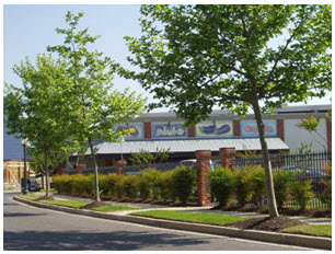
Figure 15.14.100-2: Wrought-iron fence used as part of a parking lot perimeter.
2.
Except as necessary to ensure public safety during approved construction activities on the site, and except as modified in subsection 15.14.100.D.5.c, the use of chain link fencing shall be subject to the following limitations:
a.
The use of uncoated or galvanized chain link fencing shall be prohibited in the NB, B1, B2 and C2 and DC Zoning districts and Gateway Overlay district where visible from a public right-of-way.
b.
Unless otherwise approved in conjunction with a conditional use permit, the use of vinyl-coated chain link fences shall be allowed in the LM, C2, B2, and B1 Zoning districts, provided it is restricted to the interior side yard and the rear yard areas of a development site.
c.
Chain link fencing shall be permitted in the RR, LR, R1, R2, R2M, R3 Zoning districts.
d.
The use of chain link fencing shall be allowed in the I2, I1, and IP Zoning districts, except as prohibited in subsection 15.14.100.D.2.a above.
e.
Preschools, elementary schools, middle schools, high schools, parks, cemeteries, sporting complexes and fields shall be exempted from the restrictions set forth in subsections 15.14.100.D.2.a through 15.14.100.D.2.c and 15.14.100.D.5.c, provided all chain link fences are at least five feet from adjacent rights-of-way.
3.
Barbed wire fencing visible from adjacent rights-of-way is prohibited on commercial and residential development sites.
4.
Colors, materials, and forms for walls and fences that complement the architectural character of the primary building or overall development shall be used.
5.
A higher level of design detail shall be required for highly visible walls and fences along collectors, minor and major arterial roads and interstates, including but not limited to, elements such as the incorporation of mosaic designs, relief panels, or similar public art. In order to achieve this end, the following provisions shall apply to new construction on properties abutting major or minor arterial streets and Interstate highways:
a.
All site plans for new construction shall include elevations and details for fencing visible from collector, major or minor arterial or Interstate rights-of-way, with detail specifications for color, texture, articulation, and artistic or graphic design elements. Review of site plans shall address architectural and graphic compatibility with the remainder of the project and with surrounding natural and built landscape.
b.
All proposed preliminary subdivision plats for property abutting collector, major or minor arterial or interstate rights-of-way shall include a required common fencing plan, applicable to proposed lots abutting said rights-of-way. The common fencing plan shall include elements specified in subsection (a), and shall be reviewed according to the compatibility criteria as specified therein.
c.
Use of chain link, barbed wire or vinyl fencing shall be prohibited for fencing visible from collector, major or minor arterial or interstate rights-of-way.
E.
Wall and Fence Placement. Fences may be allowed within the public right-of-way upon approval of the public works director or applicable right-of-way entity. The height of any such fence shall be a maximum of 3.5 feet. The public works director shall have the authority to order removal of any fence that, in the judgment of the public works director, poses a threat to public safety.
F.
Retaining Walls. Retaining walls may be used to minimize cut and fill. Generally, a retaining wall shall be no higher than five feet, except that a wall varied in height to accommodate a variable slope shall have an average height no greater than five feet and a maximum height no greater than ten feet in any one-hundred-foot length. The wall shall incorporate a landscaped terrace, a minimum of 3 feet in depth, in-between each five foot section rise (see Figure 15.14.100-3). A higher wall shall be permitted:
1.
Where used internally at the split between one- and two-story portions of a building; and
2.
Where substantially hidden from public view at the rear of a building, where it shall not exceed the eave height of the building.
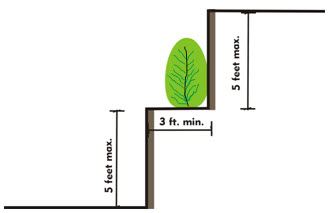
Figure 15.14.100-3: Retaining wall with landscaped terrace.
(Ord. No. 1578, § 2(att. A), 3-20-2010; Ord. No. 1596, §§ 56, 57, 5-3-2011; Ord. No. 1625, § 17, 9-4-2012; Ord. No. 1671, §§ 3, 21, 11-18-2014; Ord. No. 1744, § 22, 3-6-2018; Ord. No. 1830, § 18, 10-17-2023)
15.14.110 - Lighting.
A.
Purpose. The purpose of this section is to establish outdoor lighting standards and guidelines that help the city of Laramie to balance safety and aesthetics and to incorporate standards for illumination that minimizes impacts on surrounding neighborhoods and the night sky.
B.
Lighting Limitations for All Uses.
1.
Stray Light. All light fixtures, except street lights, shall be located, aimed, or shielded so as to minimize stray light trespassing across property boundaries.
2.
Floodlights. Outdoor floodlights and unshielded wall packs shall be prohibited.
3.
Total Light Output. Total light output of any development project that requires site plan review (excluding streetlights for public rights-of-way and single-family, and/or two-family development projects), shall not exceed forty thousand lumens per acre, averaged over the entire project. A photometric study shall be submitted as part of the site plan review application. The photometric study shall show that no more than 0.2 footcandles are observed at a property line on an adjacent property. For those property lines that abut right-of-way, no more than 0.0 footcandles shall be observed twenty feet beyond the property line. Exceptions may be granted by the city for lighting of a shared driveway, common access way or pedestrian connection.
4.
Shielded. All light fixtures shall be fully shielded. All fixtures illuminating parking and pedestrian areas shall be cutoff fixtures as defined by the Illuminating Engineering Society of North America (IESNA) (see Figure 15.14.110-1).
5.
Heights. Luminaries shall not exceed a height of twenty-four feet above finished grade. Lighting associated with recreational facilities shall not be required to comply with standards for lighting height.
6.
Lighting Under Awnings, Canopies, and Similar Structures. Outdoor lighting under awnings, canopies, buildings, overhangs, or roof eaves shall be shielded so as to light pedestrian areas and walks and not illuminate the overhang, eave, or awning. Lighting fixtures in gasoline filling stations shall not extend below the ceiling plane(s) of such canopies.
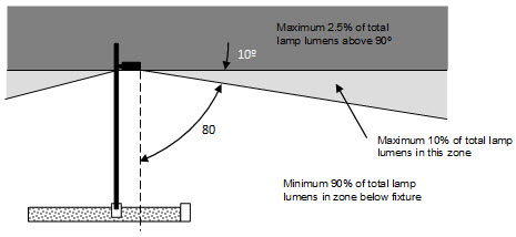
Figure 15.14.110-1: Cut-off fixture.
(Ord. No. 1578, § 2(att. A), 3-20-2010; Ord. No. 1596, § 44, 5-3-2011; Ord. No. 1625, §§ 20, 21, 9-4-2012; Ord. No. 1671, § 21, 11-18-2014; Ord. No. 1728, § 13, 4-18-2017)
15.14.120 - Signs.
A.
Intent and Purpose. The intent and purpose of Section 15.14.120 is to:
1.
Encourage the effective use of signs as a means of communication in the city;
2.
Enhance economic development opportunities for the community;
3.
Provide for a safe and efficient transportation network;
4.
Ensure that pedestrians, motorists, travelers, and other citizens are protected from damage or injury caused or attributable to the distractions and obstructions which are caused by improperly situated signs;
5.
Minimize the adverse effect of signs on nearby public and private property;
6.
Preserve the Laramie area's natural scenic beauty; and
7.
Improve the aesthetic appearance of Laramie.
The city intends to provide a reasonable balance between the right of an individual to identify its business or convey its message, and the right of the public to be protected from the visual discord that results from unrestricted proliferation and uncoordinated placement of signs.
This chapter[section] is not intended to and shall not regulate: (a) building design, exclusive of sign regulatory elements; or (b) the content and message of signs.
B.
Definitions.
1.
For the purposes of this Sign Ordinance (Section 15.14.120), the following words and terms shall have the meanings set forth in this definitions subsection. Words and phrases not defined in this subsection but defined in Chapter 15.28 of this section[title] shall be given such meanings. Other words and phrases shall be given their common, ordinary meaning, unless the context clearly requires otherwise.
2.
"Abandoned sign" means a sign that no longer identifies or advertises a bona fide business, service, or product. An abandoned sign is not defined as a nonconforming sign.
3.
"Aggregate sign area." See "Sign display area."
4.
"Animated sign" means any sign that uses movement or change of lighting to depict action or create a special effect. An animated sign is not defined as a changeable copy sign for purposes of this section.
5.
"Area, sign." See "Sign display area."
6.
"Banner" means any wall sign made of fabric, plastic, or other non-rigid material with no enclosing framework. A banner is deemed to be a type of temporary sign.
7.
"Beacon" means any light with one or more beams directed into the atmosphere or directed at one or more points not on the same lot as the light source; also, any light with one or more beams that rotate or move.
8.
"Billboard" means an off-premise sign on a permanent structure on which the copy may be periodically changed, typically designed for viewing from interstate or primary arterial corridors. An off-premise sign on a permanent structure with sign display area of two hundred square feet or more is deemed to be a billboard for purposes of this chapter.
9.
"Building marker" means any sign indicating the name of a building and date and incidental information about its construction, which sign is an integral part of a masonry surface or made of bronze or other permanent material.
10.
"Building frontage, street" means the width of a building parallel to the street frontage. In a shopping center or mall where buildings do not have direct access or frontage on a street, the building frontage is defined as the width of the building parallel to the public parking lot frontage.
11.
"Canopy sign" means any sign that is a part of or attached to an awning, canopy, marquee or other fabric, plastic, or structural protective cover over a door, entrance, window, sidewalk or outdoor service area.
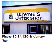
12.
"Changeable copy sign" means a sign or portion thereof with characters, letters, or illustrations that can be changed or rearranged without altering the face or the surface of the sign, either manually through the use of attachable letters or panels, or electronically using incandescent bulbs, liquid crystal displays (LCDs), light emitting diodes LEDs), or similar technologies. An off-premise sign on which the message changes more than seventy-two times in any given twenty-four-hour day is defined as an animated sign and not a changeable copy sign for purposes of this chapter.
13.
"Commercial message" means any sign wording, logo, or other representation that names, advertises, or calls attention to a business, product, service, or other commercial activity.
14.
"Commemorative sign" means a sign, tablet, cornerstone or plaque less than ten square feet memorializing a person, event, structure or landmark.
15.
"Construction sign" means a temporary sign placed in advance of occupancy of a building or structure indicating the name of the building or structure, the architects, the contractors, and other information regarding the building or structure.
16.
"Directional sign." See "Off-premise directional sign" or "On-premise directional sign."
17.
"Election sign" means a sign advertising a candidate for political office or a measure scheduled for election.
18.
"Electronic message center (EMC)" means a sign which meets the definition herein of either an "on-premise electronic message center (EMC)" or an "off-premise electronic message center (EMC)".
19.
"Electronic message center (EMC), monochrome" means a sign which meets the definition herein of either an "on-premise electronic message center (EMC)" or an "off-premise electronic message center (EMC)" and displays only one color within any given eight-second period of time, excluding black and white.
20.
"Electronic message center (EMC), multicolor" means a sign which meets the definition herein of either an "on-premise electronic message center (EMC)" or an "off-premise electronic message center (EMC)" and displays more than one color at any given time, excluding black and white.
21.
"Festoon" means a string of ribbons, tinsel, pennants, or pinwheels.
22.
"Flag" means any fabric or bunting containing distinctive colors, patterns, or symbols, used as a symbol of a government, political subdivision, or other entity, or displaying a noncommercial message.
23.
"Freestanding sign" means any sign supported by structures or supports that are placed in, or anchored in, the ground and that are independent from any building or other structure. Freestanding signs as defined herein are deemed to include monument signs and pole signs.
24.
"Fuel price sign" means an on-premise sign, located on property whose primary use is retail dispensing of fuel and fuel products, and that displays any or all of the following elements: (a) the name or logo of the business on which premises the fuel dispensing activity occurs; (b) the per-unit price(s) of fuel(s) to be dispensed on the premises.
25.
Governmental sign" means a sign installed by a unit of federal, state or local government whose purpose and function is control of traffic or other regulatory purposes, including street signs, detour signs, danger signs, railroad crossing signs, and temporary or permanent signs erected by or on the order of a public officer in the performance of his public duty. This term is deemed to include signs of public service entities whose purpose and function is control of traffic or other regulatory purposes, including hazard or danger warning signs and similar aids to service safety.
26.
"Height, sign." See "Sign height."
27.
"Holiday decorations" means noncommercial signs, graphics, or other materials that are temporarily displayed during the generally accepted season of traditionally accepted civic, patriotic, cultural, and/or religious holidays.
28.
"Incidental sign" means a sign, generally informational, that has a purpose secondary to the use of the lot on which it is located, such as "no parking," "loading only," "telephone," and other similar directives. No sign with a commercial message legible from a position beyond the boundary of the lot on which the sign is located is deemed to be incidental. A sign that meets the definition of an on-premise directional sign is not defined as an incidental sign.
29.
"Monument sign (low profile sign)" means a freestanding sign that is composed of a solid base structure between finished grade and the topmost point of the sign structure, such that the base length at grade equals seventy percent (70%) or more of the maximum sign length, measured parallel to the widest horizontal dimension of the sign face(s).
Figure 15.14.120-3: Multi-tenant monument sign.
30.
"Multi-tenant complex" means a lot that contains multiple business entities contiguous to a common parking lot.
31.
"Neon-style sign" means a sign that utilizes electrically charged neon or other inert gas contained within a vacuum tube to generate light. "Neon-style sign" may also mean a sign that uses other technology to mimic or reproduce the visual appearance of gas-containing tubes, such as LED light source(s) within flexible light-diffusing tubes. The sign message is created by bending and forming the tubes into lettering and/or iconic graphical shapes.
32.
"Nonconforming sign" means any sign that was lawfully established prior to the effective date of this chapter or a subsequent amendment thereto, but does not conform to the requirements of this chapter.
33.
"Off-premise sign" means a stationary sign that advertises or displays commercial information about a commercial or business establishment, good, facility, service or product that is not sold, conducted or offered on the premises on which the sign is located. An off-premise sign is deemed to not include a sign that meets the definition of an off-premise directional sign.
34.
"Off-premise directional sign" means a sign that is not located upon the premises of the activity to which it refers that directs the movement or placement of pedestrian or vehicular traffic. To be classified as an off-premise directional sign, the subject sign shall display only a business name or logo and directional information.

Figure 15.14.120-4: Off-premise directional sign.
35.
"Off-premise electronic message center (EMC)" means a changeable copy or animated sign that utilizes a computer or other electronic controlled means to change and control the message displayed, and that advertises or displays commercial information about any commercial or business establishment, good, facility, service or product that is not sold, conducted or offered on the premises on which the sign is located. An off-premise EMC may use incandescent lamp, LCD, LED or other illuminated display technologies. An off-premise EMC whose copy changes more than seventy-two times in any given twenty-four-hour day is defined as a type of animated sign; any other EMC is defined as a type of changeable copy sign. An off-premise EMC that also meets the definition of a billboard as defined herein is deemed to be a type of billboard for purposes of this chapter.
36.
"On-premise sign" means a sign that is located upon the lot, property, or premises of the activity to which it refers. To be classified as an on-premise directional sign, the subject sign shall display only a business name or logo and directional information.
37.
"On-premise directional sign" means a sign located upon the lot, property, or premises of the activity to which it refers that directs the movement or placement of pedestrian or vehicular traffic.

Figure 15.14.120-5: On-premise directional sign.
38.
"On-premise electronic message center (EMC)" means a changeable copy or animated sign that utilizes a computer or other electronic controlled means to change and control the message displayed, and that is located on the same lot or premises to which all sign messages refer. An on-premise EMC may use incandescent lamp, LCD, LED or other illuminated display technologies. An on-premise EMC whose copy changes more than seven and one-half times in any given minute is defined as a type of animated sign; any other on-premise EMC is defined as a type of changeable copy sign.
39.
"Pennant" means any lightweight plastic, fabric, or other material, whether or not containing a message of any kind, suspended from a rope, wire, or string, usually in series, designed to move in the wind.
40.
"Pole (pole-style) sign" means a freestanding sign that is supported by one or more columns, uprights, poles or braces extended from the ground or from an object on the ground.
Figure 15.14.120-6: Pole-style signs.
41.
"Portable sign" means any sign not permanently attached to the ground or other permanent structure and designed to be transported, including, but not limited to, signs designed to be transported by means of wheels or signs converted to A- or T-frames. For purposes of this chapter, a portable sign shall be classified as either: (a) a temporary sign; or (b) a vehicle sign, as applicable.
42.
"Principal building" means the building in which is conducted the principal use of the lot on which it is located. Lots with multiple principal uses may have multiple principal buildings, but storage buildings, garages, and other clearly accessory uses are not deemed to be principal buildings.
43.
"Principal street frontage" For properties with frontage on more than one public street, the property owner at his discretion shall designate the principal street frontage to be either: (a) the street with the longest frontage, or (b) the street with the highest functional classification, as determined by the adopted Major Street Plan.
44.
"Projecting sign" means any sign affixed to a building or wall in such a manner that its leading edge extends more than twelve inches beyond the surface of such building or wall.

Figure 15.14.120-7: Projecting sign.
45.
"Revolving sign" means a sign that has the ability to turn at least one hundred eighty degrees. All or a portion of the revolving sign shall be capable of revolving at a steady or variable speed.
46.
"Roof sign" means any sign erected and constructed wholly on and over the roof of a building, supported by the roof structure, and extending vertically above the highest portion of the roof.

Figure 15.14.120-8: Roof sign.
47.
"Roof sign, integral" means any sign erected or constructed as an integral or essentially integral part of a normal roof structure of any design, such that no part of the sign extends vertically above the highest portion of the roof and such that no part of the sign is separated from the rest of the roof by a space of more than six inches.
Figure 15.14.120-9: Roof sign, integral.
48.
"Sandwich board sign" means a portable self-supporting sign with one or more faces, typically designed with an A-frame (i.e., upside-down "V") or similar shape.
49.
"Setback" means the distance from the property line to the nearest part of the sign, measured perpendicularly to the property line or right-of-way.
50.
"Sign, signage" means any device, fixture, placard, or structure that uses any color, form, graphic, illumination, symbol, or writing to advertise, announce the purpose of, or identify the purpose of a person or entity, or to communicate information of any kind to the public. The term "signage" is deemed to be identical to the term "sign", whether singular, plural, or collective. A graphic display whose purpose and function is purely decorative or artistic in character, that is recognizable as such to a typical observer, and that is not intended to convey a particular message, is not deemed to be a sign for purposes of this chapter.
51.
"Sign display area (individual) " means the area of a sign face (which is also the sign display area of a wall sign or other sign with only one face) shall be computed by means of the smallest square, circle, rectangle, triangle, or combination thereof that will encompass the extreme limits of the writing, representation, emblem, or other display, together with any material or color forming an integral part of the background of the display or used to differentiate the sign from the backdrop or structure against which it is placed, but not including any supporting framework, bracing, or decorative fence or wall when such fence or wall otherwise meets zoning regulations and is clearly incidental to the display itself.
Figure 15.14.120-10: Wall sign display area. The hatched area represents the sign display area.

Figure 15.14.120-11: Monument sign display area. The hatched area represents the sign display area.
52.
"Sign display area (multi-faced)" means the sign display area for a sign with more than one face shall be computed by adding together all individual sign display areas visible from any one point. When two identical sign faces are placed parallel (back-to-back), so that both faces cannot be viewed from any point at the same time, and when such sign faces are part of the same sign structure and are not more than seventy-two inches apart, the sign display area shall be computed by the measurement of the individual sign display area on one face.
53.
"Sign height" means the height of a sign shall be computed as the distance from the base of the sign at normal grade to the top of the highest attached component of the sign structure. Normal grade shall be construed to be the lower of: (1) existing grade prior to construction; or (2) the newly established grade after construction, exclusive of any filling, berming, mounding, or excavating solely for the purpose of locating the sign. In cases in which the normal grade cannot reasonably be determined, sign height shall be computed on the assumption that the elevation of the normal grade at the base of the sign is equal to the elevation of the nearest point of the crown of a public street, or the grade of the land at the principal entrance to the principal structure on the lot, whichever is lower. In the case of a billboard in the I-80 Corridor Billboard Sign district, the sign height is measured from interstate highway grade to the top of the billboard structure, as specified in subsection E.2.
54.
"Suspended sign" means a sign that is suspended from the underside of a horizontal plane surface and is supported by such surface.

Figure 15.14.120-12: Suspended sign.
55.
"Temporary sign" means any sign that is used only temporarily and is not permanently mounted. Temporary signs shall be classified as either: (a) special-event temporary signs, (b) supplemental temporary signs, or (c) portable signs.
56.
"Temporary sign (special-event temporary sign)" means any temporary sign that is displayed in association with a generally recognized event of limited duration that is of special importance to the greater Laramie community, such as: Homecoming Week(end) (for any education institution holding same); "First Day of Classes" Period (defined as one week before, through one week after, the first day of classes for any educational institution holding same); Jubilee Days; Snowy Range Rendezvous; or the Dead Dog Classic. For purposes of this chapter, temporary signage for a special event whose duration is two consecutive weeks or longer shall not be classified as special-event temporary signage.
57.
"Temporary sign (supplemental temporary sign)" means any temporary sign that is not classified as a special-event temporary sign.
58.
"Time-temperature sign" means a sign that displays only an electronic or mechanical indication of time, temperature, or both. A time-temperature sign is deemed to be a changeable copy sign, and thus exempt for purposes of this chapter, without respect to frequency or duration of the changeable copy message.
59.
Vehicle sign" means any sign which is painted on, affixed to or otherwise mounted on any vehicle or on any object which is placed on, in or attached to a vehicle that is parked and visible from the public right-of-way, unless said vehicle is used in the normal day-to-day transportation operations of a business. For the purposes of this definition, the term "vehicle" is deemed to include trucks, buses, vans, railroad cars, automobiles, tractors, trailers, motor homes, and semi-tractors.
60.
"Wall sign" means any sign attached parallel to, and within twelve inches of, a wall, painted on the wall surface, or erected and confined within the limits of an outside wall of any building or structure, which is supported by such wall or building, and which displays only one sign surface.
Figure 15.14.120-13: Wall sign.
61.
"Wayfinding sign" means an off-premise directional sign, located within a right-of-way or on public property, that guides the traveling public to key noncommercial civic, cultural, visitor, or recreational destinations within Albany County. A wayfinding sign is deemed to include an off-premise directional sign guiding the traveling public to a specific neighborhood or district within the city of Laramie.
62.
"Window sign" means any sign, pictures, symbol, or combination thereof, designed to communicate information about an activity, business, commodity, event, sale, or service, that is permanently affixed inside or upon a window and is visible from the exterior of the window.

Figure 15.14.120-14: Window sign.
C.
General Provisions.
1.
Sign Permit Requirements. The following provisions apply to all signs:
a.
Unless otherwise provided by this chapter, all signs shall require a permit.
b.
If a sign requiring a permit under the provision of this chapter is to be placed, constructed, erected, or modified on a lot, the owner of the lot shall secure a sign permit prior to the construction, placement, erection, or modification of such a sign. A sign permit shall be obtained in accordance with subsection H. of this chapter.
c.
A permit shall not be required for a modification to an existing sign that changes only the message content thereof and does not alter or affect the sign structure in any other way. Examples of such changes that do not require a permit include, but are not limited to: Repainting faded lettering or graphics; replacing visibly worn materials in the sign display area, such as plastic lettering; or changing the sign copy to reflect a change in a business's name or identity.
d.
A permit shall not be required for changing the message content of an electronic message center (EMC), provided that all requirements of Section 15.14.120.G (Electronic Message Center [EMC] Signs) are met.
2.
Exempt Signs. The following signs shall be exempt from regulation under this chapter.
a.
Barber poles (whether revolving or stationary);
b.
Building markers, plaques, or cornerstones;
c.
Time-temperature signs that do not exceed thirty-two square feet in sign display area;
d.
Commemorative signs;
e.
Construction signs that do not exceed thirty-two square feet in sign display area and seven feet in sign height;
f.
Display of street addresses or numbers;
g.
Flags of any governmental unit (nation, state, etc.), or flags with a noncommercial message;
h.
Fuel price signs, provided the copy area devoted to displaying fuel pricing is thirty-two square feet or less per each price displayed, and provided that any fuel price sign that also meets the definition of an on-premise electronic message center (EMC) conforms to this chapter's regulations governing same;
i.
Governmental signs for control of traffic and other regulatory purposes, including street signs, detour signs, danger signs, and railroad crossing signs;
j.
Signs of public service companies indicating danger or aids to service safety, erected by or on the order of a public officer in the performance of his public duty;
k.
Holiday decorations;
l.
Neon-style signs that do not display a commercial message;
m.
Neon-style signs displaying a commercial message, provided that such sign:
(i)
Is eight square feet or less;
(ii)
Is located and displayed interior to a building, such as behind window glass; and
(iii)
Complies with the frequency, duration, and operational standards for on-premise EMCs (subsections G.3; G.7);
n.
Incidental signs;
o.
Gravestones or grave markers;
p.
Nameplates in residential districts;
q.
Pennants and festoons;
r.
Election signs that do not exceed thirty-two square feet in sign display area and seven feet in sign height, and are not located in any public right-of-way;
s.
Product dispensers and point of purchase displays;
t.
Signs on property being offered for sale or lease, provided that the sign:
(i)
Is an on-premise sign;
(ii)
Does not exceed the following sign display area measurements: Six square feet for residentially zoned property, or thirty-two square feet for non-residentially zoned property; and
(iii)
Is not artificially illuminated.
u.
Sandwich boards less than three feet in sign height, placed in accordance with city ordinances and regulations;
v.
Supplemental temporary signs in association with the University of Wyoming's fall term beginning of classes and Homecoming Weekend, provided they comply with the provisions of subsections C.4(c) and (d);
w.
Traffic control signs, whether on public or private property (e.g., parking-lot stop signs), provided they conform to the standards of the Manual of Uniform Traffic Control Devices (MUTCD), and provided they do not contain any commercial message or logo;
x.
Vehicle signs on properly licensed vehicles used to transport persons or property, provided that said vehicle is operated on a public right-of-way at least three (3) hours during any given one hundred sixty-eight-hour period;
y.
Signs not visible from a public right-of-way;
z.
Temporary window signs;
aa.
Messages and graphics transmitted and displayed via television that are primarily intended for interior view within a building, and only incidentally visible from outside;
bb.
Window signs that cumulatively constitute less than fifty percent of the window area on each facade;
cc.
Signs that are held or carried by person(s) at all times when visible from a public right-of-way.
3.
Prohibited Signs.
a.
Abandoned signs that are not removed within the specified 180-day inactivity period, per subsection 15.14.020.H.4 of this title;
b.
Beacon signs and displays;
c.
Revolving signs;
d.
Off-premise signs, except:
(i)
Off-premise directional signs; and
(ii)
Billboards as provided in the I-80 Corridor Billboard Sign district.
e.
Roof signs, except those signs defined and regulated as integral roof signs;
f.
Signs located in or above the public right-of-way, whether temporary or permanent, except governmental, wayfinding signs and projecting and suspended signs pursuant to subsection D.3.b;
g.
Portable signs, except portable signs meeting the standards for sandwich boards (subsection C.2) and vehicle signs meeting the standards for exempt vehicle signs (subsection C.2.x).
4.
Temporary Signs. Temporary signs containing a commercial message or erected to advertise a commercial entity shall be allowed under the provisions of this section. Such signs shall be classified as either:
a.
Special-event temporary signs; or
b.
Supplemental temporary signs.
The following regulations shall apply to each temporary sign so classified:
c.
Special-Event Temporary Signs. Special-event temporary signs shall not require sign permits. Special-event temporary signs are not restricted as to maximum number or size of signage. Special-event temporary signage shall be installed no earlier than one hundred twenty hours [i.e., five days] before the commencement of the special event, and shall be removed no later than forty-eight hours after the special event's cessation.
d.
Supplemental Temporary Signs. Supplemental temporary signs shall not require sign permits. Any supplemental temporary sign shall remain in place for a period not to exceed thirty consecutive days; provided, however, that a supplemental temporary sign containing message content that identifies a time-limited event (e.g., "two-for-one sale," "half-price pizza") shall be removed no later than forty-eight hours after the event's cessation.
5.
Historical or Culturally Significant Signs. Signs that have historical or cultural significance to the city but do not conform to the provisions of this chapter may be permitted by the planning commission, provided that the following regulations and procedures are followed:
a.
Application for historical or culturally significant sign is completed and submitted, per the city's Codes Administrative Manual;
b.
The planning commission holds a public hearing on the request, following the general notice procedures as specified in Section[Chapter] 15.06 of this Title;
c.
The planning commission approves the request, adopting findings supporting historical or cultural significance of the sign, and directs the city manager's office to issue a historical or culturally significant sign permit.
Criteria to determine a finding of historical or cultural significance include, but are not limited to: Wyoming or Western image; nostalgic significance; character, design, or materials that represent a particular historical period; landmark recognition; and character or design that are recognizably important to one or more cultures. Signs that are hand-painted directly on the surface of a building and include artistic work, in addition to a commercial message, may be eligible for a finding of cultural significance. Historic or cultural nature of the signage may be significant to society generally or in the context of the Laramie community particularly.
6.
Installation, Maintenance. All signs shall comply with all applicable code provisions as adopted by the city, in addition to the requirements of this chapter. The city manager's office shall have the right under [subsection] H to order the repair or removal of any sign which is defective, damaged, or substantially deteriorated.
7.
Illumination (Except Electronic Message Center signs). Illumination of a sign (except electronic message center signs) shall be regulated as specified in this section and in Section 15.14.110 (Lighting), whichever is more restrictive. Illumination of signage shall be allowed, with the following provisions:
a.
No flashing lights, or rotating or revolving beams, shall be used;
b.
All direct light shall be directed toward the sign and away from any residential areas and public rights-of-way;
c.
All lamps or luminance-generating fixtures for external, reflected illumination of signs shall be shielded such that the lamp or luminance-generating fixture is not directly visible from any residential property, from any public right-of-way, or from any point higher than the uppermost point of the subject sign;
d.
Sign illumination shall generally be designed and directed such that the illuminated area lies at or below the horizontal plane corresponding to the topmost point of the sign structure, and any illumination of the area above the sign's topmost point shall be minimal and incidental; and
e.
Any illumination that is provided by artificial light shall be constant in direction, intensity, direction, and color.
8.
On-Premise Directional Signs. An on-premise directional sign shall contain no message(s) other than business name or logo and directional information.
9.
Billboards—Generally. Billboard signage shall be regulated according to the provisions in W.S. tit. 24, ch. 10 (Outdoor Advertising); provided, however, that any provision in this chapter or elsewhere in the Laramie Municipal Code that is more restrictive shall apply.
10.
Noncommercial Signage. Signs containing noncommercial speech or messages shall be permitted anywhere that commercial, business or advertising signs are permitted under this chapter, subject to the same regulations applicable to such signs.
D.
District Specific Standards.
1.
Residential (RR, LR, R1, R2, R2M, R3) Zoning Districts.
a.
Subdivision Identification Signs. For residential subdivisions consisting of more than four residential units, one monument subdivision sign per development entrance shall be permitted. Each sign shall not exceed twenty-four square feet in sign display area and shall not exceed five feet in sign height. The sign shall be set back at least five feet from any property line, unless designed and constructed as part of an entranceway architectural feature, such as a gate, decorative wall, archway, or similar element.

Figure 15.14.120-15: Subdivision ID signs.
b.
Non Single-Family Use Residential Identification Signs.
(i)
For properties used for multi-family residential buildings or townhouse structures, one monument or wall sign per street frontage shall be permitted. Each sign shall not exceed twenty-four square feet in sign display area. The monument sign shall not exceed five feet in sign height and shall be set back at least five feet from both the front and side property lines.
(ii)
For properties used for multi-family residential buildings or townhouse structures that have more than one street frontage, a two-faced monument sign oriented so as to be visible from either right-of-way (such as a diagonal sign on a corner lot) shall be allowed in accordance with the standards in the preceding subsection and other requirements of this chapter, and provided it meets the "sign display area (multi-faced)" definition herein.
c.
Signs Associated with Non-Residential Uses in Residential Zoning Districts.
(i)
For properties used for any permitted or conditional, or nonconforming use in their respective district(s), other than residential uses, no signs shall be permitted except those reviewed and approved through the Conditional Use Permit process, provided that:
(1)
If the use is indicated as a Permitted Use (P) in Table 15.10.000.E of this Title, any such sign(s) shall be reviewed and approved as a separate signage Conditional Use Permit pursuant to Chapter 15.06 of this Title, prior to installation or modification; and
(2)
If the use is indicated as a Conditional Use (C) in Table 15. l 0.000.E of this Title, any such sign(s) shall be reviewed and approved as an element in the overall use's Conditional Use Permit review and approval (or amendment thereto), pursuant to Chapter 15.06 of this Title, prior to installation or modification.
(3)
If the use is a nonconforming use, any such sign(s) shall be reviewed and approved as a separate signage Conditional Use Permit pursuant to chapter 15.06 of this Title, prior to installation or modification.
d.
Home Occupation Signs. Approved home occupations shall be permitted a maximum of one sign that shall not exceed two square feet in sign display area. Such sign shall not be located in any required setback area.
e.
Sign Illumination.
(i)
Non-single-family use residential identification signs, if illuminated, shall be illuminated
only from the exterior, subject to subsection C.7.
Single-family use identification signs and home-occupation signs shall not be illuminated,
except for such illumination as may result from general-purpose household exterior
lighting (e.g., porch lights).
f.
Animated Signs, Electronic Message Centers. Animated signs and electronic message centers shall not be permitted in these zoning districts, except that electronic message center signage may be reviewed and approved as specifically provided for through the conditional use permit process as outlined in this section; provided such signage complies with subsection G of this Title[section], and provided such signage shall not exceed sixteen square feet in aggregate sign area.
g.
Pole-style Freestanding Signs. Pole-style freestanding signs, billboards. Pole-style freestanding signs and billboards shall not be permitted in these zoning districts.
2.
Commercial, Industrial (NB, B1, B2, C2, LM, I1, I2, IP, AV, AE) Zoning districts.
a.
Total Sign Display Area per Lot or Business: Frontage on a Single Street, Excluding Wall Signs. Total sign display area for each lot, or for an individual business in the case of multi-tenant lots, with frontage on only one public street shall not exceed three hundred square feet aggregate sign display area per lot or individual business. Aggregate total shall include sign display area of all signs for which a permit is required under this section, including any legally nonconforming signs, and including any off-premise directional signs on other properties that refer to the subject property or business. Aggregate sign area shall not include wall signs.
b.
Total Sign Display Area per Lot or Business: Frontage on Two or More Streets, Excluding Wall Signs. For lots with more than one public street frontage, the principal street frontage as defined herein shall be allocated three hundred square feet of aggregate sign display area, and each additional street frontage shall be allocated one hundred fifty square feet of sign display area. Signage shall be oriented to and primarily visible from the respective street to which the sign display area is allocated. Aggregate total shall include sign display area of all signs for which a permit is required under this section, including any legally nonconforming signs. Aggregate sign area shall not include wall signs.
c.
A common signage program for a group of businesses or offices may be permitted pursuant to [subsection] F (Common Signage Program).
d.
Freestanding Signs.
(i)
Monument Signs—Generally. One monument sign shall be permitted per property, irrespective of the number of individual businesses or tenants on said property. For purposes of this subsection, the term "property" shall refer to a single functional developmental site with common circulation and parking, irrespective of the number of recorded lots, parcels, deeds, or similar instruments comprising said property. The monument sign shall not exceed one hundred twenty square feet in sign display area, shall have a minimum setback of five feet, and a maximum sign height of thirty-six feet.
(ii)
Exception: Monument Signs on Lots with Two or More Street Frontages. For properties with more than one public street frontage, the principal street frontage as defined herein shall be allocated one monument sign with size, height and setback standards as specified in the preceding subsection. In addition, one monument sign per each additional street frontage shall be allowed. Each such additional monument sign shall not exceed sixty square feet in sign display area, shall have a minimum setback of five feet, and a maximum sign height of twelve feet.
(iii)
Exception: Monument Signs on Corner Lots. A property with a corner location (i.e., with frontage at the point of intersection of two public streets) may elect to combine its front and side street monument-sign allocation into a single corner sign with a total of one hundred and eighty square feet of sign display area, measured in accordance with the "sign display area (multi-faced)" definition herein, provided that the sign:
(1)
Is a two-faced sign, oriented diagonally so as to be equally visible from both streets;
(2)
Does not exceed twenty-four feet in sign height;
(3)
Is set back at least five feet from the nearest right-of-way; and
(4)
Does not obstruct the clear vision area as defined in subsection 15.28.030.A of this title.

Figure 15.14.120-16: Two-sided monument sign on corner lot equally visible from both streets.
(iv)
Pole-style Freestanding Signs. Pole-style freestanding signs, including pole-style billboards, shall not be permitted, except as provided in the I-80 Corridor Billboard Sign district, following the effective date of this ordinance.
(v)
Pole-style Signs Prohibited After Effective Date. Existing or permitted pole-style signs shall be removed or converted to monument style if greater than fifty percent of the sign value needs to be replaced.
e.
Wall Signs. Wall signs shall not exceed twenty percent of the wall area fronting the principal street frontage or four hundred square feet in sign area, whichever is more restrictive. Canopy, window (except exempt) and integral roof signs shall be classified as wall signs. Wall signs, except integral roof signs, shall not project above the top of a wall or parapet.
(i)
Exception—Wall Signs for Multiple Street Frontage(s). For properties with more than one public street frontage, the principal street frontage as defined herein shall not exceed twenty percent of the wall area fronting the principal street frontage or four hundred square feet in sign area, whichever is more restrictive, and each additional street frontage shall not exceed ten percent of the wall area fronting the street frontage or two hundred square feet in sign area, whichever is more restrictive. Signage shall be oriented to and primarily visible from the respective street to which the sign display area is allocated.
(ii)
Exception—Walls Not Fronting a Public Street. For walls not fronting a public street, one wall sign not exceeding ten percent of the wall area or one hundred square feet in sign area, whichever is more restrictive, provided such sign shall not abut a Residential (RR, LR, R1, R2, R2M or R3) Zoning district.
f.
Projecting and Suspended Signs.
(i)
Projecting Signs. One projecting sign per business or building tenant shall be permitted. Projecting signs shall not exceed eight square feet in sign display area nor extend more than four feet from the building. Projecting signs shall provide a minimum clearance from grade of eight vertical feet.
(ii)
Suspended Signs. One suspended sign per public entrance shall be permitted; provided, however, that each projecting sign permitted per subsection D.2.f.(i), shall reduce the number of permitted suspended signs by one. Suspended signs shall not exceed four square feet in sign display area and have a minimum clearance from grade of eight vertical feet.
(iii)
Right-of-Way Encroachment. No portion of any projecting or suspended sign shall be permitted within any public right-of-way.
g.
On-premise Directional Signs. The total number of on-premise direction signs per lot or business shall not be limited, and shall not be counted toward the total sign display area allocation. Any individual on-premise directional sign shall not exceed six square feet of sign display area or seven feet in sign height.
h.
Off-premise Directional Signs.
(i)
Number: Three off-premise directional signs shall be permitted per lot (or per business, in the case of multi-tenant lots) to which the off-premise directional sign refers, provided that consent of the property owner on which the sign(s) are located is obtained, as specified in the city's Codes Administrative Manual.
(ii)
Size and Type: Each off-premise directional sign shall not exceed twenty-four square feet in sign display area and shall not exceed sixteen feet in sign height.
3.
Other Zoning Districts (AG, O, DC) Overlay Districts (PUD, TTO, GO, ROB)
a.
Planned Unit Development (PUD) Overlay District. Planned Unit Development signage shall be regulated as specified in subsection 15.08.040.C, Planned Unit Development (PUD) Overlay district, of this title.
b.
Turner Tract (TTO) Overlay District. Turner Tract Overlay (TTO) district signage shall be regulated by standards set for the underlying zoning district. For cases in which the TTO overlaps another overlay district (e.g., Gateway Overlay district), the more restrictive standards shall control.
c.
Gateway (GO) Overlay District. Gateway Overlay district signage shall be regulated as specified in subsection 15.08.040.E.4.(v), signs, of this title. For properties on which the Gateway Overlay district overlays the Interchange Sign district, or the I-80 Corridor Billboard Sign district, or both, the regulations of the Interchange Sign district, or the I-80 Corridor Billboard Sign district, as applicable, shall control.
d.
Residential Overlay for Business (ROB) District. Residential Overlay for Business (ROB) district signage shall be regulated according to the underlying zoning district regulations of this title.
E.
Special Sign Districts. This section shall recognize three special sign districts: the Interchange Sign district, the I-80 Corridor Billboard Sign district, and the University Sign district. The intent of establishing these districts is to allow for special circumstances associated with these areas of the city. In the Interchange Sign district and the I-80 Corridor Billboard Sign district, the intent is to allow businesses to have larger and/or additional signage to accommodate greater speeds and the higher volume of traffic in these areas. In the University district, since most signs erected by the university are informational and directional, the intent is to establish guidelines for noncommercial and commercial signage erected by the university.
1.
Interchange Sign District.
a.
The Interchange Sign district zone shall be defined as the area including properties located within thirteen hundred feet of each of the interchanges, measured at right angles, from the Interstate 80 right-of-way line, beginning at the point where the right-of-way widens to accommodate the interchange and ending at the point where the right-of-way resumes its normal width. Where any property is split by the boundary so defined, the boundary shall extend beyond thirteen hundred feet to encompass the entirety of said property; provided, however, that the Interchange Sign district shall not exceed an absolute maximum distance of fifteen hundred feet from its associated interchange right-of-way boundary.
b.
Total signage for a non-residential lot in the Interchange Sign district, except for off-premise directional signs and billboards, may exceed the underlying zoning district area and sign height limitations by up to two hundred percent. This allowance shall not apply in Residential (LR, R1, RR, R2, R2M, R3) Zoning districts.
2.
I-80 Corridor Billboard Sign District.
a.
The I-80 Corridor Billboard Sign district shall be defined as the area within five hundred feet of the Interstate 80 highway right-of-way boundary on either side, as measured perpendicular to the right-of-way.
b.
Billboards as defined herein shall be permitted in the I-80 Corridor Billboard Sign district, subject to the following provisions:
(i)
Billboards shall have a minimum spacing of a five-hundred-foot radius from any other billboard. For the purposes of measuring minimum spacing, measurements shall not extend across rights-of-way.
(ii)
No billboard shall be placed in, or within one hundred fifty feet of, any Residential (LR, R1, RR, R2, R2M, R3) Zoning district boundary.
(iii)
Billboards shall not exceed six hundred square feet of sign display area.
(iv)
Billboards shall not exceed forty feet in sign height, measured from interstate highway grade to the top of the billboard structure. For purposes of this subsection, "interstate highway grade" is determined to be the point of highest elevation along a transect line running from the billboard's center across the full width of the Interstate 80 right-of-way, perpendicular to the nearest I-80 right-of-way boundary.
(v)
Billboards shall be oriented to, and designed such that the display areas are primarily visible from, the Interstate 80 right-of-way.
(vi)
Notwithstanding any other provision of this title, the total square footage of billboard faces in the I-80 Billboard Sign district shall not exceed the square footage of billboard faces in the district on July 31, 2012; however, additional square footage shall be awarded as follows:
(1)
A nonconforming billboard located outside of the Interstate 80 Corridor Billboard district shall be allowed to be relocated within the district. The total sign display area of the nonconforming billboard removed shall be multiplied by two and shall be added to the total allowable billboard sign display area within the district.
c.
One pole-style freestanding sign per lot or parcel shall be permitted; provided, the sign is oriented perpendicular to the Interstate 80 right-of-way and shall not exceed forty feet in sign height, measured from interstate highway grade to the top of the sign structure. For purposes of this subsection, "interstate highway grade" is determined to be the point of highest elevation along a transect line running from the sign's center across the full width of the Interstate 80 right-of-way, perpendicular to the nearest I-80 right-of-way boundary.
3.
University Sign District. Any sign on University-owned or University-controlled property that does not contain a commercial message shall be considered a governmental or incidental sign and shall be exempt according to subsection C.2. Any sign containing a commercial message located on University-owned property, or along any public street contiguous to university-owned or university-controlled property, and intended to be viewed from a public right-of-way, unless otherwise exempt according to subsection C.2, shall:
a.
Conform to the regulations of the zoning district in which the sign is located; and
b.
Require approval of a sign permit as specified in subsection I.
F.
Common Signage Plan.
1.
Businesses located in a multi-tenant complex may submit a common signage plan that would contribute to uniformity in the complex's collective signage. Signage permitted under a common signage plan may exceed the sign restrictions dictated by this ordinance by up to thirty percent. The common signage plan shall contain specific standards for consistency among all signs on the lots affected by the plan. Criteria for a common signage designation include but are not limited to: (A) color scheme; (B) lettering or graphic style; (C) lighting; (D) location of each sign on the building(s) or lot(s); (E) sign material; (F) sign proportions; and (G) cumulative sign display areas and heights of all signs.
2.
Common signage plan signs that serve as a directory to a multi-tenant complex shall be monument signs or wall signs. Signage listed on a directory sign shall be considered monument or wall signage, as the case may be, and shall be calculated as part of a tenant's cumulative signage allowance.
3.
Common signage plans shall require approval by the planning commission. The process for review and approval of a common signage plan shall be the same as the process for review and approval of a conditional use as specified in Chapter 15.06 of this title, provided that the planning commission shall review the common sign plan according to criteria (A) through (G) above.
G.
Electronic Message Center (EMC) Signs.
1.
On-Premise Electronic Message Centers (EMCs): Permitted Zoning Districts and Locations. The following locational standards shall apply to all on-premise EMCs:
a.
On-premise EMC signs shall be permitted only in a Commercial or Industrial (B1, B2, C2, LM, I1, I2, IP) Zoning district, or in a Residential (RR, LR, R1, R2, R2M, R3) Zoning district as may be provided for through the conditional use permit process.
b.
On-premise EMC signs in Commercial or Industrial (B1, B2, C2, LM, I1, I2, IP) Zoning districts located within three hundred feet of any Residential (RR, LR, R1, R2, R2M, R3) Zoning district, as measured from any part of the sign to the nearest Residential Zoning district boundary, shall not exceed sixteen square feet in sign display area, unless the on-premise EMC fronts a state or federal highway.
2.
On-Premise Electronic Message Centers (EMCs): Number and Type of Signs Permitted. Notwithstanding any other provision of this chapter, the following limitations shall apply to on-premise EMCs:
a.
No more than one on-premise EMC sign shall be allowed per property or parcel on which the sign is located. This limitation shall apply without regard to the number of businesses or tenants occupying the property or the property's number of street frontages. This limitation shall not prevent the installation of both an EMC and fuel price digits on the same property or frontage for service stations.
b.
No on-premise EMC shall be installed or used as:
(i)
A temporary sign;
(ii)
A portable sign;
(iii)
A projecting sign;
(iv)
A suspended sign; or
(v)
A pole sign.
3.
On-Premise Electronic Message Centers (EMCs): Frequency and Duration of Individual Displays.
a.
A multicolor on-premise EMC sign shall have a frame hold time of no less than eight seconds per static graphic display, and the total number of transitions from one frame to another shall not exceed seven and one-half in any given one-minute period.
b.
A monochrome (single-color) on-premise EMC sign shall not have a minimum hold time.
4.
Off-Premise Electronic Message Centers (EMCs): Permitted Zoning Districts and Locations.
a.
The following locational standards shall apply to all off-premise EMCs:
(i)
Off-premise EMC signs shall be permitted only on properties that meet both of the following locational criteria:
(1)
Located in the I-80 Corridor Billboard Sign district; and
(2)
Located in a Commercial or Industrial (B1, B2, C2, LM, I1, I2, IP) Zoning district.
b.
All requirements of the I-80 Corridor Billboard Sign district shall apply to off-premise EMC signs. In addition, the following shall apply:
(i)
Off-premise EMC signs located within three hundred feet of any Residential (RR, LR, R1, R2, R2M, R3) Zoning district, as measured from any part of the sign to the nearest property line within the applicable Residential Zoning district, shall not exceed one hundred sixty square feet in sign display area.
5.
Off-Premise Electronic Message Centers (EMCs): Frequency and Duration of Individual Displays. An off-premise EMC sign shall have a frame hold time of no less than eight seconds per static graphic display, and the total number of transitions from one frame to another shall not exceed seven and one-half in any given one-minute period.
6.
Illumination Standards for All Electronic Message Centers (EMCs). The following illumination standards shall apply to all EMCs:
a.
No electronic message center sign installed after July 31, 2012, shall be permitted to operate unless it is equipped with:
(i)
A default mechanism that will freeze the sign display in one position as a static message if a malfunction occurs; and
(ii)
A mechanism that will automatically adjust the illuminative brightness of the display according to ambient light conditions by means of a light detector/photocell.
b.
No electronic message center sign installed after July 31, 2012, shall exceed 0.3 foot candles above ambient light, as measured using a foot candle (Lux) meter at a preset distance depending on sign area. The measurement distance shall be calculated with the following formula: The square root of the product of the sign area and one hundred. Example using a twelve square foot sign: Measurement Distance = √(12 sq. ft. x 100) = 34.6 feet. Conformity with these illumination levels may be established by submittal of a manufacturer's certification that the sign is incapable of exceeding the stated limits, subject to approval of the city manager's office.
7.
Operational Standards for All Electronic Message Centers (EMCs). The following operational standards shall apply to all EMCs:
a.
Entrance and exit effects may be used to transition from one static display to another, provided said entrance effects result in all of the text within the frame appearing at once. Fading and dissolve transition effects may be used, provided the fade or dissolve effect results in all of the text within the frame appearing at once. Entrance and exit effects where all of the text within the frame does not appear at once are prohibited (including, but not limited to, scrolling from left to right, scrolling from top to bottom, and entrance effects referred to as slot machine, slots, splice, mesh, radar, kaleidoscope and spin).
b.
Except for the transition effects permitted herein, each frame shall remain static with no additional frame or hold effects applied to text within the frame (including, but not limited to, the fading or flashing on any part of the message and hold effects referred to as flash, spin, twinkle, wavy and rumble).
c.
The use of background animation shall be prohibited.
d.
The use of streaming video or full-motion video on any EMC sign shall be prohibited.
H.
Nonconforming and Abandoned Signs.
1.
Nonconforming Signs. All signs, except certain prohibited signs regulated under subsection C.3 and those temporary signs regulated under subsection C.4, that were legally permitted prior to July 31, 2012, shall be considered legal, permitted signs under this chapter and shall be designated as "nonconforming signs." Such signs shall not be required to obtain sign permits, except as specified in subsection H.3.
2.
Removal of Nonconforming Signs. Nonconforming signs may be continued, subject to the following limitations:
a.
The message or display area of a nonconforming sign may be altered to display a different message without affecting the sign's nonconforming status, provided that all other provisions of this section and title are met.
b.
Except as provided in subsection (a), no nonconforming sign, including its structure, shall be extended, enlarged, moved, relocated, or otherwise altered unless such sign is made to conform to the current regulations of this chapter.
c.
When the repair or replacement cost of a nonconforming sign exceeds fifty percent of its replacement value, such sign shall be eliminated or made to conform to the current regulations of this chapter. Valuation for purposes of this subsection shall be as determined by a written estimate signed by a contractor or professional specializing in sign installation and/or maintenance and approved by the city manager's office.
d.
Notwithstanding other provisions of this chapter, a nonconforming sign of any type other than an EMC shall not be converted to an EMC without conforming to all applicable provisions of this chapter.
e.
Notwithstanding other provisions of this chapter, any EMC in existence on July 31, 2012, shall be allowed to continue operation for the lifetime of the electronic message center. Cumulative repair costs totaling more than fifty percent of the replacement value of the sign shall trigger compliance with subsection G.7 (Operational Standards for EMCs).Existing portable or temporary signs subject to regulation under subsection C.4 of this chapter shall either obtain permits or shall be removed, no later than sixty days after July 31, 2012. Subsequent to July 31, 2012, all such signs shall conform to the regulations of this chapter.
f.
A nonconforming sign shall be subject to all requirements of this title and code regarding safety, maintenance, and repair. If a legal nonconforming sign is deemed hazardous by the city manager's office due to damage or deterioration, it shall be brought into conformance with this chapter or removed.
3.
Sign Permits for Nonconforming Signs. Nonconforming signs shall not be required to obtain sign permits, except as provided in this section:
a.
Any nonconforming sign, including its structure, that is extended, enlarged, moved, relocated, or otherwise altered so as to bring it into conformance with this chapter, as provided under subsection H.2.b., shall be required to obtain a sign permit prior to such alteration.
b.
If a nonconforming sign is damaged or in need of repairs or maintenance, the sign owner or proprietor wishing to assert a claim of continued nonconforming-sign status under subsection H.2.c or H.2.d shall be required to obtain a sign permit prior to commencement of such repair or maintenance. In such cases, the sign permit application shall include, in addition to other required items, the following:
(i)
The percentage of the sign's display area that is to be repaired or replaced, expressed as a percentage of total sign display area;
(ii)
The total estimated cost of the repair, maintenance or replacement of the sign, including its structure. Valuation for purposes of this subsection shall be as determined by a written estimate signed by a licensed contractor and approved by the city manager's office.
c.
Absence or failure to provide the specified additional sign permit information shall cause the sign to lose its nonconforming status.
d.
If damage or disrepair to the nonconforming sign is such that an immediate threat to public health or safety exists, the nonconforming sign may be repaired or maintained without prior issuance of a sign permit; provided that permit application shall be made within seven days after such repair or maintenance is commenced. Issuance or denial of such sign permit shall be determined by the city manager's office as though the permit application preceded the repair or maintenance of the applicable nonconforming sign.
4.
Removal of Abandoned Signs. Abandoned signs shall be removed no later than one hundred eighty days after July 31, 2012. Abandoned signs that are not removed within this period shall be subject to the abatement procedures specified in Laramie Municipal Code Title 8, in addition to any penalties and enforcement actions as specified in this title.
5.
Annexed Nonconforming Signs. Signs that do not meet the requirements of this chapter, and that are located on property annexed to the city after July 31, 2012, at the time of annexation, shall be considered nonconforming signs under this chapter and subject to all regulations therein, except that all timelines that begin upon July 31, 2012, shall instead begin upon the effective date of annexation to the city.
I.
Administration and Enforcement.
1.
Department.
a.
The city manager's office shall be designated by the city manager and is authorized to process and approve or disapprove applications for permits, and to enforce and carry out all provisions of this chapter. The city manager's office is authorized to promulgate regulations and procedures consistent with this function.
b.
The city manager's office is empowered, upon presentation of proper credentials, to enter or inspect any building, structure, or premises in the city for the purpose of inspection of a sign and its structural and electrical connections to ensure compliance with all applicable codes and ordinances. Such inspections shall be carried out during business hours unless the city manager's office in its discretion finds that an emergency exists.
2.
Application for Permits.
a.
Application for a sign permit shall be made to the city manager's office upon a form provided by the city manager's office, and shall provide all information as specified in the city's Codes Administrative Manual.
b.
All applications for permits filed with the city manager's office shall be accompanied by a payment of the sign permit fee, in the amount specified by the city's Codes Administrative Manual.
c.
The city manager's office shall approve and issue a permit for the erection, structural alteration, or relocation of a sign within fourteen days of receipt of a valid application, provided the sign complies with the provisions of this chapter and with all applicable laws and regulations of the city.
d.
All required building permits, including electrical permits, shall be duly applied for and obtained prior to installation of the subject sign, per city and other code requirements. Issuance of a sign permit is not intended to and shall not serve as a substitute for any other required permit.
3.
Permit Fees. Fees for sign permits shall be as established per subsection 15.06.030.B.6.c of this title.
4.
Issuance and Denial.
a.
In all applications, where a matter of interpretation arises, the more specific definition or higher standard shall prevail.
b.
When a permit is denied, the city manager's office shall within seven days of the denial, provide a written notice to the applicant along with a brief statement of findings and reasons for the denial, citing code sections and interpretation of applicable nonconformity.
c.
The city manager's office may suspend or revoke an issued permit for any false statement or misrepresentation of fact in the application.
d.
The city manager's office's decision on any sign permit may be appealed to the city's board of adjustment, as provided by the Laramie Municipal Code and Wyoming state statutes.
5.
Removal of Signs.
a.
The city manager's office may cause the removal and impoundment of any sign not permitted under the provisions of this chapter in cases of emergency, or for failure to comply with written orders of removal or repair. After removal or demolition of the sign, a notice shall be mailed to the sign owner stating the nature of the work, and the date on which it was performed and demanding payment of the costs as certified by the city manager's office. The debt may be collected in accordance with the established debt collection procedures of the city. No impounded signage shall be relinquished by the city until all outstanding debts as specified in the chapter have been satisfied.
b.
The owner of the property upon which the sign is located shall be presumed to be the owner of all signs thereon unless facts to the contrary are brought to the attention of the city manager's office, as in the case of a leased sign.
c.
For purposes of removal, the definition of sign shall include all sign embellishments and structures designed specifically to support the sign.
6.
Other Enforcement, Remedies and Penalties. In addition to the foregoing section providing for removal of signs, all applicable provisions as specified in Section 15.26.030, Remedies and Penalties, and Section 15.26.040, Procedures for Enforcement Actions, of this title, shall pertain to in the case of signage compliance and violations.
(Ord. No. 1622, § 23, 7-31-2012; Ord. No. 1657, § 5(Att. E), 4-1-2014; Ord. No. 1666, §§ 1, 2, 9-2-2014; Ord. No. 1728, § 16, 4-18-2017; Ord. No. 1744, § 23, 3-6-2018; Ord. No. 1830, §§ 19, 20, 10-17-2023; Ord. No. 1861, § 8, 3-4-2025)
Editor's note— Ord. No. 1622, §§ 5 and 23, repealed former § 15.14.120 and enacted a new § 15.14.120 as set out herein. Former § 15.14.120 pertained to similar subject matter, and derived from Ord. No. 1578, § 2(att. A), adopted March 20, 2010.
15.14.130 - Wireless communications and macro cell towers.
A.
Purpose. This section regulates wireless communications and macro cell towers, antennas, equipment cabinets, and related structures in order to: (1) protect residential areas and land uses from potential adverse economic impacts of towers and antennas; (2) encourage the location of towers in nonresidential areas; (3) encourage the joint use of new and existing tower sites as a primary option rather than construction of additional single-use towers; and (4) encourage users of towers and antennas to locate them in areas where the adverse effects on the community are minimal. This section is enacted to promote and protect the health, safety, and general welfare of the citizens of Laramie. (Ord. No. 1786, § 3, 2-16-2021)
B.
General Requirements.
1.
Commercial Mobile Radio Service. Commercial mobile radio service (CMRS) facilities shall be considered either principal or accessory use in any zoning district. A different existing use of an existing structure on the same lot shall not alone preclude the installation of a CMRS antenna or tower on the lot.
2.
Lot Size. The dimensions of the entire lot (if platted) or parcel (if unplatted) shall control for purposes of measurements under this section, even though the antennas or towers may be located on leased parcels within a lot. "Lot" as used in this section shall include both platted lots and unplatted parcels.
3.
Inventory of Existing Sites. Each applicant for a building permit for a tower shall provide to the city manager's office an inventory of its existing towers and sites within the city limits and within one mile outside of the city limits, including specific information about the location, height, and design of each tower.
4.
Materials. Towers and antennas shall, to the extent possible, use materials, colors, textures, screening and landscaping that will blend them in to the natural setting and surrounding buildings.
5.
Lighting. Towers shall not be artificially lighted unless required by the FAA or other authority having jurisdiction.
6.
State and Federal Requirements. All towers shall meet the standards and requirements of the Federal Aviation Administration, Federal Communications Commission, and any other agency of local, state or federal government with jurisdiction to regulate towers or antennas.
7.
Building Codes—Safety Standards. To ensure the structural integrity of towers, the owner of a tower shall be responsible to construct and maintain it in compliance with applicable state and local building code standards and the applicable industry standards for towers. (Ord. No. 1786, § 4, 2-16-2021)
8.
Measurement. Tower setbacks and separation distances shall be calculated and applied to facilities located in the city limits and within one-half-mile of the city limits, irrespective of municipal and county jurisdictional boundaries.
9.
Not Essential Services. Towers and antennas shall be regulated and permitted pursuant to this title, and not regulated or permitted as essential services, public utilities, or private utilities.
10.
Franchises. Owners and operators of towers and antennas shall certify to the city manager's office's satisfaction that all franchises required for the construction or operation of a wireless communication system in the city have been filed or recorded, as applicable.
11.
Public Notice. Any request for a variance or appeal of an administrative decision concerning a building permit for a tower or antenna shall require notice to all property owners who would be entitled to notice for a zoning variance concerning the lot where the tower or antenna is to be constructed, and any other notice required by law.
C.
Use by Right.
1.
Wireless communications, macro cell towers and free standing antennas shall be permissible pursuant to the use regulations of this section. (Ord. No. 1786, § 5, 2-16-2021)
2.
The following uses shall be specifically permitted as accessory uses by right:
a.
Television and amateur radio antennas in residential zoning districts, for the exclusive use of the residence on the lot where the antenna is located;
b.
Television and radio antennas in nonresidential zoning districts for the exclusive use of owners or tenants of the property where located, and that do not extend more than fifteen feet above the highest point of the existing structure;
c.
Antennas or similar hardware installed in all zones, for the purposes of receiving satellite television, radio transmissions, internet service or any other similar service for the exclusive use of occupants of the building to which it is attached to, provided that the antenna, or similar hardware is attached to an existing structure, and provided the antenna does not extend above the highest point of the existing structure;
d.
Antennas attached to utility poles and light poles upon private property in all zoning districts, provided the antenna does not extend more than three feet above the highest point of the pole structure. Antennas attached to utility poles and light poles within the public right-of-way shall not extend more than three feet above the highest point of the pole structure and may be installed: (1) when permitted by the pole owner's franchise; or (2) by amendment to the pole owner's franchise ordinance or right-of-way use easement or agreement with the consent of the city council and upon payment of reasonable compensation for use of the right-of-way.
D.
Structural Requirements—Availability Of Existing Towers, Other Structures, Stealth Towers.
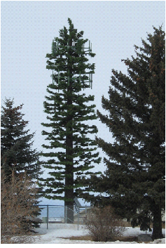
Figure 15.14.130-1: Stealth tower in Laramie.
1.
All new towers shall be designed with the structural capacity to accommodate at least two col-located antennas. (Ord. No. 1786, § 6, 2-16-2021)
2.
All new towers shall be located upon sites that are large enough to contain the support equipment for at least two col-located antennas. (Ord. No. 1786, § 7, 2-16-2021)
3.
No application for a building permit for a new tower shall be processed until the applicant has met with the city manager's office before submitting the application, to review the feasibility of using an existing tower, structure, or a stealth tower. The applicant shall demonstrate that there is no existing facility that can reasonably accommodate the applicant's proposed antenna before the building permit application is processed. The city manager's office may require the applicant to make reasonable efforts to co-locate upon an existing tower. The city manager's office may require the applicant to make reasonable efforts to use a stealth tower. Collocation of facilities and/or stealth design may be considered a mitigating factor to a conditional use request and may justify the request. (Ord. No. 1786, § 8, 2-16-2021)
4.
If an applicant claims that it cannot col-locate upon an existing tower, the applicant shall provide a written report from a Wyoming licensed engineer, qualified radio frequency expert, or other expert professional in support of its position. The city manager's office shall consider the written report in making its decision. (Ord. No. 1786, § 9, 2-16-2021)
5.
Any applicant who is aggrieved by the decision of the city manager's office concerning a building permit application may appeal the decision to the building code board of appeals.
E.
Setbacks and Separation.
1.
Setbacks.
a.
Freestanding Tower. Freestanding towers shall be set back a distance equal to at least one hundred percent of the height of the tower from adjoining lot lines (see Figure 15.14.130-2).
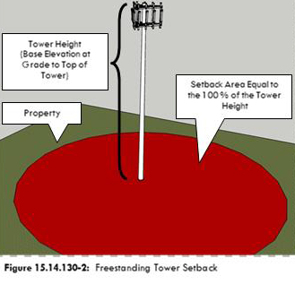
(Ord. No. 1786, §§ 10, 11, 2-16-2021)
b.
Building-Mounted Towers and Antennas. Any building-mounted tower or antenna shall be subject to the following provisions:
(i)
Building mounted towers or antennas within twenty feet from the nearest roof's edge shall be camouflaged to minimize contrast from ground-level view as telecommunications devices or facilities, and shall include, but not be limited to, architecturally screened roof-mounted antennas, building-mounted antennas painted to match the existing structure or skyline behind the antenna, antennas integrated into architectural elements such as church spires or window walls, and antenna structures designed to resemble light poles or flag poles.
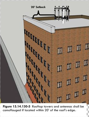
(Ord. No. 1786, § 13, 2-16-2021)
c.
Accessory Buildings and Other Equipment. Pursuant to [subsection] 15.14.130.F., buildings and other equipment. (Ord. No. 1786, § 12, 2-16-2021)
2.
Separation From Residential Uses. The following separation requirements shall apply to all towers and antennas located in the B1, B2, DC, C2, LM, I1, I2, O, and IP districts:
a.
Tower separation shall be measured from the center base of the tower to the lot line of the off-site use/designated area. Tower separation shall comply with the minimum standards in this subsection. Towers shall be separated from off-site uses/designated areas as follows:
(i)
From single-family or two-family residential uses: Three hundred feet or three hundred percent of the height of the tower, whichever is greater;
(ii)
From vacant land in a residential zoning district, either platted or that has an unexpired preliminary plat approved: Three hundred feet or three hundred percent of the height of the tower, whichever is greater;
(iii)
From vacant unplatted residentially zoned land, public parks, public schools, and cemeteries: Three hundred feet or three hundred percent of the height of the tower, whichever is greater;
(iv)
No area separation distance shall be required from land not within a residential zoning district or from nonresidential uses.
3.
Separation Distances Between Towers.
(i)
Separation distances between towers shall be applicable for and measured between the proposed tower and existing towers. The separation distances shall be measured by a straight horizontal line between the center of the base of the existing tower and the center of the base of the proposed tower.
(ii)
The minimum separation distances shall be:
(1)
For towers seventy-five feet or less in height, five hundred feet separation;
(2)
For towers more than seventy-five feet in height, one thousand feet separation.
F.
Buildings and Other Equipment.
1.
For antennas mounted on structures or rooftops, any equipment cabinet or structure used in association with antennas shall not be more than fifteen feet in height and shall comply with all applicable building codes and zoning requirements.
2.
For antennas mounted on utility poles or light poles, any associated equipment cabinet or structure may be located in or outside of the public right-of-way and in accordance with the following:
(Ord. No. 1786, § 14, 2-16-2021)
a.
In residential zoning districts, the equipment cabinet or structure may be located in a side or rear yard. The equipment cabinet or structure shall be no more than fifteen feet in height, with a floor area of three hundred fifty square feet or less, and shall be located at least twenty-five feet from all lot lines.
b.
In non-residential districts, the equipment cabinet or structure shall be no greater than twenty feet in height, and shall be screened from view by landscaping, fencing, or both, of all adjacent residential properties.
3.
For antennas located on towers, any related unmanned equipment cabinet or structure shall be no more than twenty feet in height, and shall be located in accordance with the minimum setback requirements for the zoning district in which located.
G.
Removal of Abandoned Antennas and Towers. Any antenna or tower not operated for twelve consecutive months shall be considered abandoned. The owner of the antenna or tower shall remove the same within ninety days of abandonment.
H.
Pre-Existing Towers. New construction other than routine maintenance on a pre-existing tower shall comply with the requirements of this chapter.
I.
Col-locations. For towers on which antennas are co-located:
(Ord. No. 1786, § 15, 2-16-2021)
1.
Separation distances under subsection 15.14.130.E. of this chapter are reduced by twenty-five percent.
2.
An existing tower may be modified or rebuilt to a taller height, not to exceed forty feet over the tower's existing height per each col-located additional user, to accommodate the col-location of an additional antenna. The additional height allowed by this provision shall not require additional setback or more separation distance. (Ord. No. 1786, § 16, 2-16-2021)
3.
A tower that is being rebuilt to accommodate col-location of an additional antenna may be relocated onsite within fifty feet of its existing location. After rebuilding, one tower only shall remain on the site. A relocated onsite tower shall be measured from its original location for measurement of separation distances. (Ord. No. 1786, § 17, 2-16-2021)
J.
Height. New towers, freestanding or building-mounted, shall not exceed these heights above grade:
1.
For a single user, one hundred feet;
2.
For two users, one hundred forty feet;
3.
For three or more users, one hundred eighty feet.
Building-mounted towers shall be measured from the base elevation of the building at grade to the tallest elevation point of the tower.
K.
Conflicts. If the terms of this chapter conflict with any other applicable provision of local, state, or federal law, the most restrictive shall apply. (Ord. 1311 § 12, 2000).
L.
Use of Right-of-Way. This chapter concerns wireless communications, macro cell towers and antennas. Use of public right-of-way for any system or components of a system for the collection or distribution of signals to be transmitted or which are received by antennas may require a license, agreement or franchise as is appropriate. (Ord. No. 1786, § 18, 2-16-2021)
M.
Small Wireless Facilities—Purpose. The provisions of this chapter shall be known as the small wireless facilities regulations. It is the purpose of these provisions to delineate restrictions, development standards and siting criteria, and establish procedures in order to protect the city from the uncontrolled siting of wireless communication facilities in locations that have significant adverse effects and cause irreparable harm. It is further the purpose of these provisions:
1.
To protect the community's visual quality and safety while facilitating the reasonable and balanced provision of wireless communication services. More specifically, it is the city's goal to minimize the visual impact of wireless communication facilities on the community, particularly in and near residential districts, Downtown Commercial District and in and along highly visible corridors and entrances to the community;
2.
To promote the public health, safety and welfare, preserve the aesthetic character of the Laramie community, and to reasonably regulate the development and operation of wireless communication facilities within the city to the extent permitted under state and federal law;
3.
To minimize the impact of wireless communication facilities by establishing standards for siting design and screening;
4.
To preserve the opportunity for continued and growing service from the wireless industry;
5.
To accommodate the growing need and demand for wireless communication services;
6.
To establish clear guidelines and standards and an orderly process for review intended to facilitate the deployment of wireless transmission equipment, to provide advanced communication services to the city, its residents, businesses and community at large;
7.
To ensure city zoning regulations are applied in a competitively neutral and non-discriminatory basis consistently with federal and state telecommunications laws, rules, regulations and controlling court decisions; and
8.
To provide regulations which are specifically not intended to, and shall not be interpreted or applied to, (1) prohibit or effectively prohibit the provision of wireless services, (2) discriminate among functionally equivalent service providers, or (3) regulate wireless communication facilities and wireless transmission equipment on the basis of the environmental effects of radio frequency emissions to the extent that such emissions comply with the standards established by the Federal Communications Commission.
N.
Definitions and Abbreviations. As used in sections 15.14.130.M—EE., the following terms shall have the meanings set forth below:
1.
"Administrative review" means review of an application by the city relating to the issuance of a permit to determine whether the issuance of a permit is in conformity with the applicable provisions of this chapter.
2.
"Antenna" means any exterior transmitting or receiving device mounted on a tower, pole, building or structure and used in communications that sends or receives wireless digital signals, wireless analog signals, radio frequencies or wireless communication signals.
3.
"Antenna array" means a single or group of antenna elements, not including small cell antennas, and associated mounting hardware, transmission lines, remote radio units, or other appurtenances which share a common attachment device such as a mounting frame or mounting support structure for the sole purpose of transmitting or receiving wireless communication signals.
4.
"Applicable codes" means uniform building, fire, safety, electrical, plumbing or mechanical codes adopted by a recognized national code organization to the extent such codes have been adopted by the city, including any amendments.
5.
"Applicant" means any person engaged in the business of providing wireless communication services or the wireless communications infrastructure required for wireless communications services and who submits an application.
6.
"Application" means a written request, on a form provided by the city, for a permit.
7.
"City council" means a council or group of elected individuals as defined by W.S. § 15-1-101(a)(vi) with the powers and duties as defined by Wyoming Statutes.
8.
"Collocation" means the mounting or installation of equipment on a tower, pole, building or other structure for the purpose of transmitting and/or receiving radio frequency signals for communications purposes.
9.
"Decorative pole" means a pole that is specially designed and placed for aesthetic purposes.
10.
"Distributed Antenna System (DAS)" means a network consisting of transceiver equipment at a central hub site to support multiple antenna locations throughout the desired coverage area.
11.
"FAA" means the Federal Aviation Administration.
12.
"FCC" means the Federal Communications Commission.
13.
"Laws" means, collectively, any and all federal, state, or local law, statute, common law, code, rule, regulation, order, resolution or ordinance.
14.
"Macro cell" means an antenna or antennas mounted on or in a tower, ground-based mast, rooftops or structures, at a height that provides coverage to the surrounding area and exceeds the volumetric dimensional limits applicable to small wireless facilities.
15.
"Ordinary maintenance and repair" means inspections, testing or repair that maintain functional capacity, aesthetic and structural integrity of a wireless communication facility and the associated structure, pole or tower, and that does not involve damaging any portion of the ROW.
16.
"Permit" means a permit issued and described in accordance with laws, which is used to regulate, monitor and control improvement, construction or excavation activities, or other work or activity, occurring in or otherwise affecting the ROW.
17.
"Permittee" means an applicant that has received a permit under this chapter.
18.
"Pole" means a legally constructed pole, such as a utility, lighting or similar pole made of wood, concrete, metal or other material, located or to be located within the right-of-way.
19.
"Provider" means a wireless services provider or wireless infrastructure provider and includes any person that owns or operates wireless communication facilities within the ROW.
20.
"Right-of-way (ROW)" means the surface of and the space above and below the public roads, streets and alleys, and public utility easements or other public ways of any type whatsoever, now or hereafter located and existing within the city limits, whether or not improved.
21.
"Replace" or "replacement" means, in connection with wireless communication facilities and a corresponding pole, structure or tower, to replace (or the replacement of) the same with something that is substantially similar in design, size, color and scale to the existing facilities or structure and in conformance with this chapter and any other applicable city regulations.
22.
"Small wireless facilities" means equipment that meets the following criteria: (1) the facilities—(i) are mounted on structures fifty feet or less in height including their antennas, or (ii) are mounted on structures no more than ten percent taller than other adjacent structures, or (iii) do not extend existing structures on which they are located to a height of more than fifty feet or by more than ten percent, whichever is greater; (2) each antenna associated with the deployment, excluding associated antenna equipment, is no more than three cubic feet in volume; (3) all other wireless equipment associated with the structure, including the wireless equipment associated with the antenna and any pre-existing associated equipment on the structure, is no more than twenty-eight cubic feet in volume; (4) the facilities do not require antenna structure registration under federal law; (5) the facilities are not located on Tribal land as defined under federal law; and (6) the facilities do not result in human exposure to radiofrequency radiation in excess of the applicable safety standards specified under federal law.
23.
"State" means the state of Wyoming.
24.
"Stealth" means a design that minimizes the visual impact of wireless communication facilities by camouflaging, disguising, screening or blending into the surrounding environment. Examples of stealth design include but are not limited to facilities disguised as trees (monopines), flagpoles, utility and light poles, bell towers, clock towers, ball field lights and architecturally screened roof-mounted antennas or flush-mounted antennas that are either painted to match or enclosed in an architecturally-applicable box.
25.
"Tower" means any structure built for the sole or primary purpose of supporting any FCC-licensed or authorized antennas and their associated facilities, including structures that are constructed for wireless communications services including, but not limited to, private, broadcast, and public safety services, as well as unlicensed wireless services and fixed wireless services such as microwave backhaul, and the associated site.
26.
"Transmission equipment" means equipment that facilitates transmission for any FCC-licensed or authorized wireless communication service, including, but not limited to, radio transceivers, antennas, microwave dishes, coaxial or fiber-optic cable, and regular and backup power supplies. The term includes equipment associated with wireless communication services including, but not limited to, private, broadcast, and public safety services, as well as unlicensed wireless services and fixed wireless services such as microwave backhaul.
27.
"Utility support structure" means utility poles or utility towers supporting electrical, telephone, cable or other similar facilities.
28.
"Wireless Communication Facilities (WCF)" means an unstaffed facility or equipment for the transmission or reception of radio frequency (RF) signals or other wireless communications or other signals (including, but not limited to cellular and internet services) for commercial communications purposes, typically consisting of a group of antennas, a pole, tower or base station, transmission cables and other transmission equipment, backup power supplies, power transfer switches, cut-off switches, electric meters, coaxial cables, fiber optic cables, wires, telecommunications demarcation boxes and related materials and equipment and equipment cabinets, and including small wireless facilities.
29.
"Wireless infrastructure provider" means a person or entity, other than a wireless services provider, that builds or installs towers, wireless transmission equipment, wireless facilities poles or wireless support structures.
30.
"Wireless services" means any wireless services using licensed or unlicensed spectrum, whether at a fixed location or mobile, provided to the public.
31.
"Wireless services provider" means a person or entity who provides wireless services.
O.
Access to Right-of-Way.
1.
Agreement. Prior to installing in the ROW any small wireless facility, or any pole built for the sole or primary purpose of supporting a small wireless facility, a person shall enter into an agreement with the city expressly authorizing use of the ROW for the small wireless facility or pole proposed to be installed. The agreement shall provide for the attachment to city-owned poles or structures in the right-of-way in addition to poles or structures owned by unrelated third parties in the right-of-way, provided that the applicant secures the written consent of the third party for such attachment.
2.
General Terms.
a.
The initial term of an agreement shall be for up to ten years. The agreement may be renewed for an additional term subject to the mutual written agreement of the city and provider.
b.
The agreement authorizes the provider's non-exclusive use of the ROW for the sole purpose of constructing, installing, maintaining, modifying and operating small wireless facilities, including any pole built for the sole or primary purpose of supporting the small wireless facilities to provide the services expressly authorized in the agreement, subject to applicable laws and this chapter. The agreement authorizes use only of the ROW in which the city has an actual interest. It is not a warranty of title or interest in any ROW and it does not confer on the provider any interest in any particular location or to a superior or preferred location within the ROW. Nothing herein shall authorize the use of the city's other structures in the ROW. All use of other structures in the ROW shall require a separate attachment agreement and include the payment of fees for such use.
c.
The provider shall, at its sole cost and expense, keep and maintain its small wireless facilities and poles in the ROW in a safe condition and in good order and repair per the agreement between the city and provider.
d.
In the event of an emergency regarding the provider's small wireless facilities or related poles, the provider shall, as soon as reasonably possible, notify the city manager's office of the nature of the emergency and the implemented or planned response to the emergency.
3.
Permit Required. No person may construct or install in the ROW any small wireless facilities without first receiving a Type III site plan, street closure permit, right-of-way obstruction permit, excavation permit, or combination of permits as required by city code or ordinance. Notwithstanding the foregoing, in the event of an emergency, a provider or its duly authorized representative may work in the ROW prior to obtaining a permit, provided that the provider shall contact the city prior to commencing the work and shall apply for a permit as soon as reasonably possible, but not later than twenty-four hours after commencing the emergency work. For purposes of this subsection 15.14.130.O, an "emergency" means a circumstance in which immediate repair to damaged or malfunctioning facilities is necessary to restore lost service or prevent immediate harm to persons or property.
4.
Ordinary Maintenance and Repair. A permit shall not be required for ordinary maintenance and repair. The provider or other person performing the ordinary maintenance and repair shall obtain any other permits required by applicable laws and shall notify the city in writing at least forty-eight hours before performing the ordinary maintenance and repair.
5.
Application Fees and Bonds. All applications pursuant to this chapter shall be accompanied by the requisite fees required by the city. Unless otherwise provided in an agreement or agreed to in writing by the city, a performance or construction bond or other form of surety acceptable to the city equal to at least one hundred twenty-five percent of the estimated cost of the work within the ROW shall be provided before the applicant commences work. The bond shall be released after city inspection and completion of construction to the city's satisfaction.
6.
Effect of Permit. A permit from the city authorizes an applicant to undertake only the activities in the ROW specified in the application and permit, and in accordance with this chapter. A permit does not authorize attachment to or use of existing poles or other structures in the ROW. A permittee or provider must obtain all necessary written approval from the owner of any pole or other support structure prior to any attachment or use and such written approval shall be submitted with the permit request. A permit does not create a property right for the applicant. The applicant shall not interfere with other uses or users of the ROW.
7.
Duration. Any permit for construction issued under this chapter shall be valid for a period of one year, provided that the one-year period may be extended for up to an additional one year upon approval by the governing body or its designee upon the written request of the applicant (made prior to the end of the initial one-year period) if the failure to complete construction is as a result of circumstances beyond the reasonable control of the applicant.
8.
Batching. An applicant may simultaneously submit no more than ten sites for small wireless facilities in a single, consolidated application, provided that the proposed small wireless facilities are to be deployed on the same type of pole or structure, using similar equipment within the city.
9.
Collocation. It is the policy of the city to minimize the number of wireless communication support structures and to encourage the collocation of antennas of more than one wireless service provider on a single pole to the extent technically feasible.
P.
Applicability.
1.
New Poles, Antennas, Distributed Antenna Systems (DAS) and Small Wireless Facilities. All new poles, antennas, DAS and small wireless facilities in zoning districts shall be subject to these regulations.
a.
New poles exceeding the maximum height limitation of the affected zoning district require a conditional use permit.
b.
New antenna arrays meeting the requirements of 15.14.130.R.12 are permitted with a building permit.
c.
DAS and small wireless facilities are permitted pursuant to 15.14.130.Q.
d.
Antennas attached to utility poles and street lights in the right-of-way shall not extend more than ten feet above the highest point of the pole structure.
2.
Design Standards. Subject to the height limitation set forth above, all poles built for the sole or primary purpose of supporting small wireless facilities may be approved through administrative review subject to the wireless provider complying with reasonable and technically feasible considerations for the:
a.
Height, shape, design and color for poles and related equipment.
b.
Number, location and styles of poles that may be installed or used.
c.
Aesthetic approach for different types of poles and related equipment using the most recent guidance provided by the FCC and decisions of Federal Courts interpreting that guidance.
d.
Construction of each small wireless facility, including powering and metering.
e.
Structural integrity.
f.
Set-backs for poles and ground-mounted equipment.
g.
Ground-mounted equipment for small wireless facilities may be used only to house equipment in support of the operation of the facilities.
h.
Lighting, marking and noise requirements.
i.
Fencing/landscaping/screening/signage requirements as required by Title 15.14 of the Laramie Municipal Code outside of the right-of-way.
j.
Collocation analysis.
k.
Use of decorative or stealth poles, where necessary.
l.
A written report will be prepared, signed and sealed by a professional engineer which assesses whether the proposed small wireless facility demonstrates compliance with the radio frequency emissions limits established by the FCC.
3.
Pre-existing Antennas. Pre-existing antennas shall not be required to meet the requirements of this chapter unless modified as described by this chapter, with the exception of eligible facilities requests (as they are defined in 47 U.S.C. Section 1455(a)(2)).
4.
Exempt Facilities. The following are exempt from this chapter:
a.
FCC licensed amateur (ham) radio facilities;
b.
Satellite earth stations, dishes and/or antennas used for private television reception;
c.
A WCF installed upon the declaration of a state of emergency by the federal, state or local government, or a written determination of public necessity by the city; except that such facility must comply with all federal and state requirements. The WCF shall be exempt from the provisions of this chapter for up to three months after the duration of the state of emergency;
d.
A temporary, commercial WCF installed for providing coverage of a special event such as news coverage or sporting event, subject to any required approvals by the city. The WCF shall be exempt from the provisions of this chapter for up to two weeks before and one week after the duration of the special event;
e.
Other temporary, commercial WCFs installed for a period of up to ninety days, subject to the city's discretion and required approvals; provided that such temporary WCF will comply with applicable setbacks and height requirements;
f.
Antennas attached to existing structures (such as commercial buildings, houses or apartments) for internet purposes and used solely for occupants of the building or property for which the antennas are attached;
g.
Routine maintenance and repair of antennas and poles. Applicable building permits may be required for equipment replacement;
h.
City facilities, equipment and services, including, but not limited to, those involving police, fire, public health and safety, and information technology; and
i.
Fixed wireless broadband service.
Q.
Distributed Antenna Systems and Small Wireless Facilities.
1.
Distributed antenna systems and small wireless facilities are allowed in all zones per the table of allowed uses, Table 15.10-1, provided the applicant complies with all federal laws (such as the Americans with Disabilities Act) and state laws and requirements and the stealth requirements of this chapter.
2.
Distributed antenna systems (DAS) and small wireless facilities in all zones are subject to approval via permits and administrative review by the planning manager unless their installation requires the construction of a new pole or structure exceeding the maximum height limitation of the affected zoning district (in which instance a conditional use permit is required). A permit is required for replacement utility support structures.
3.
A single permit application may be used for multiple distributed antennas that are part of a larger overall DAS network. A single permit application may also be used for multiple small wireless facilities. A single license agreement may be used for multiple node locations in DAS and/or small wireless facilities networks.
4.
At the time of filing an application, an applicant shall also provide all of the following:
a.
Design Justification. A clear and complete written analysis that includes design drawings that explains how the proposed design complies with the applicable design standards under this chapter to the maximum extent feasible. A complete design justification must identify all applicable design standards under this chapter and provide a factually detailed reason why the proposed design either complies or cannot feasibly comply.
b.
Noise Study. A noise study shall be conducted if requested by the city, and the proposed site is in or within two hundred feet of a residential district or in the Downtown Commercial District. The small wireless facility shall not impede upon the peaceful and quiet enjoyment of the surrounding area and shall not create a nuisance to pedestrian or vehicular traffic. If such occurs, the facilities may be declared a nuisance and subject to abatement.
R.
General Requirements.
1.
Color. To the extent technically feasible, antennas shall be placed and colored to reasonably blend into the architectural detail and coloring of the host structure. Non-wooden poles shall be painted a color that best allows them to blend into the surroundings. The use of grays, blues, greens, bronze, browns or other site-specific colors are encouraged and may be appropriate; however, each case should be evaluated individually.
2.
Lighting. Security lighting for the equipment shelters or cabinets and other on the ground ancillary equipment is permitted, as long as it complies with LMC 15.14.110—Lighting.
3.
Landscaping and Screening. Equipment shelters and cabinets and other on the ground ancillary equipment shall be screened with landscaping (except for those in the right-of-way) or with another design as required by 15.14.050.I. Alternatively, where technically feasible, the applicant shall incorporate the cabinet and other equipment into the base of a new pole (for example, for a small wireless facility) provided there is adequate space in the right-of-way and that ADA sidewalk accessibility requirements can be met. All provisions of the ADA (including, but not limited to, clear space requirements) shall be met by the applicant.
4.
State or Federal Requirements. All poles and antennas must meet current standards and regulations of the FAA, the FCC and any other agency of the state or federal government with the authority to regulate poles and antennas.
5.
Site Development. All small wireless facilities shall be subject to the site development standards, building permits and site plan applications, or other permits as prescribed herein. A site development application shall contain the following information:
a.
Construction drawings showing the proposed method of installation;
b.
The manufacturer's recommended installations, if any; and
c.
A diagram to scale showing the location of the small wireless facility, property and setback lines, easements, power lines, all structures, and the required landscaping, if applicable.
d.
A photo simulation that includes to-scale visual simulations that show unobstructed before-and-after construction daytime and clear-weather views from at least four angles, together with a map that shows the location of each view, including all equipment and cabling.
6.
Applicable Codes. To ensure the structural integrity of poles, the owner of a pole shall ensure that the pole is maintained in compliance with industry standards and applicable codes.
7.
Public Notice. For purposes of this chapter, and if applicable to other infrastructure providers for their use of the right-of-way, any application for a small wireless facility which includes a new or replacement pole, variance or appeal of a request for a permit requires public notice to all adjacent property owners and all owners of surrounding properties in the manner described in the Municipal Code in 15.06.030.D—Step 4: Public Notice Requirements.
8.
Signs. No facilities may bear any signage or advertisement(s) other than signage required by law or expressly permitted/required by the city.
9.
Visual Impact. All small wireless facilities in residential districts and within three hundred feet of residential districts or the Downtown Commercial District shall be sited and designed to minimize adverse visual impacts on surrounding properties and the traveling public to the greatest extent reasonably possible, consistent with the proper functioning of the small wireless facilities. Such facilities and equipment enclosures shall be integrated through location and design to blend in with the existing characteristics of the site. Such facilities shall also be designed to either resemble the surrounding landscape and other natural features where located in proximity to natural surroundings, or be reasonably compatible with the built environment, through matching and complementary existing structures and specific design considerations such as architectural designs, height, scale, color and texture or be reasonably consistent with other uses and improvements permitted in the relevant zone.
10.
Use of Stealth Design. The applicant shall use stealth design to the maximum extent feasible unless otherwise approved by the planning manager. Stealth and concealment techniques must be appropriate given the proposed location, design, visual environment, and nearby uses, structures, and natural features. Stealth design shall be designed and constructed to substantially conform to surrounding building designs or natural settings. Stealth design that relies on screening small wireless facilities in order to reduce visual impact must screen all substantial portions of the facilities from view.
11.
Building-mounted WCFs.
a.
All transmission equipment shall be concealed within existing architectural features to the maximum extent feasible. Any new architectural features proposed to conceal the transmission equipment shall be designed to mimic the existing underlying structure, shall be as proportional as possible to the existing underlying structure or conform to the underlying use and shall use materials in similar quality, finish, color and texture as the existing underlying structure.
b.
All roof-mounted transmission equipment shall be set back from all roof edges to the maximum extent feasible consistent with the need for "line-of-sight" transmission and reception of signals.
c.
To the extent technically feasible, antenna arrays and supporting transmission equipment shall be installed so as to camouflage, disguise or conceal them to make them closely compatible with and blend into the setting or host structure.
12.
Antenna Arrays. Antenna arrays are permitted in any zone as long as they are located upon an existing structure (except on single family houses or duplexes) that provides sufficient elevation for the array's operation without the necessity of constructing a tower, pole or other apparatus to extend the antenna array more than fifteen feet above the structure. Installation on city property requires the execution of necessary agreements as provided in subsection 13(b) below. However, if any tower or pole exceeding the height extension of fifteen feet is needed to achieve the desired elevation, then a conditional use permit is required.
13.
WCFs in the Right-of-Way.
a.
Pole-mounted equipment. All pole-mounted transmission equipment shall be mounted as close as technically possible to the pole so as to reduce the overall visual profile to the maximum extent feasible subject to applicable safety codes.
b.
License or Agreement. For all WCFs to be located within the right-of-way, prior to submitting for a permit, the applicant must have a valid municipal agreement, license, franchise agreement, right-of-way use agreement, encroachment permit or exemption otherwise granted by applicable law. Prior to the installation or construction of a WCF within the right-of-way or a utility easement, the applicant or provider must notify all utilities located within such right-of-way regarding the use of the right-of-way or easement.
14.
Accessory Uses. Accessory uses shall be limited to such structures and equipment that are necessary for transmission or reception functions and shall not include equipment storage.
15.
Accessory Equipment. In residential districts or the Downtown Commercial District, all accessory equipment located at the base of a small wireless facility shall be located or placed (at the applicant's choice) in an existing building, underground, or in an equipment cabinet that is:
a.
Designed to blend in with existing surroundings, using architecturally compatible construction and colors; and
b.
Located so as to be unobtrusive as reasonably possible consistent with the proper functioning of the facilities.
16.
Site Design Flexibility. Individual WCF sites vary in the location of adjacent buildings, existing trees, topography and other local variables. By mandating certain design standards, there may result a project that could have been less intrusive if the location of the various elements of the project could have been placed in more appropriate locations within a given site. Therefore, the WCF and supporting equipment may be installed so as to best camouflage, disguise them, or conceal them, to make the WCF more closely compatible with and blend into the setting or host structure, upon approval by the city.
17.
General Standards and Construction Provisions.
a.
All structures shall be constructed and installed to manufacturer's specifications and constructed to withstand wind speed as required by the city's currently adopted building code.
b.
Structures shall be permitted and constructed to meet applicable code requirements.
c.
All structures shall conform to FCC and FAA regulations, as applicable.
d.
If any setback as prescribed within the Laramie Municipal Code or a master plan requires a greater distance than required of this chapter, the greater distance shall apply.
e.
To the extent technically feasible, new poles must be designed to match the existing light fixtures and other poles, and they shall serve a dual purpose (for example, a new light fixture, flag pole or banner display or clips).
18.
As-Builts and Maps. The provider shall furnish to the city paper and electronic maps showing the location of its equipment in the ROW and as-builts after construction is completed.
S.
Decorative Poles and Compliance.
1.
Notwithstanding anything to the contrary in this chapter, an applicant may not install a small wireless facility on a decorative pole, or replace a decorative pole with a new decorative pole unless the city has determined, in its sole discretion, that each of the following conditions has been met:
a.
The application qualifies for issuance of a permit; and
b.
The attachments and replacement pole are in keeping with the design and color of the existing decorative pole.
2.
An applicant may not install a small wireless facility on a decorative pole, replace a decorative pole with a new decorative pole, or install new above-ground facilities in any historic district unless the city has determined, in its sole discretion, that each of the following conditions has also been met:
a.
The application qualifies for issuance of a permit; and
b.
The attachment and replacement pole are in keeping with the design and color of the existing decorative pole and historic district.
3.
General Safety and Compliance with Laws. The permittee shall employ due care during the installation, maintenance or any other work in the ROW, and shall comply with all safety and construction requirements of applicable laws, city guidelines, standards and practices and any additional commonly accepted safety standards.
4.
Traffic Control. Unless otherwise specified in the permit, the permittee shall erect a barrier around the perimeter of any excavation and provide appropriate traffic control devices, signs and lights to protect, warn and guide the public (vehicular and pedestrian) through the work zone. The manner and use of these devices shall be as described within a traffic control plan. Before any work can begin in the right-of-way, a traffic control plan shall be submitted that meets the city's requirements. The permittee shall maintain all barriers and other traffic control and safety devices related to an open excavation until the excavation is restored to a safe condition or as required by the city.
5.
Work in the Right-of-Way. Any work conducted within the right-of-way, including the street and/or sidewalk, shall be required to submit for a street closure permit or right-of-way obstruction permit issued by the engineering division. All excavation within the right-of-way shall also be required to submit for an excavation permit. All work performed in the right-of-way shall also be in accordance with MUTCD Standards and must be reviewed and approved by the engineering division before any work can begin.
6.
Interference. The permittee shall not interfere with any existing facilities or structures in the ROW, and shall locate its lines and equipment in such a manner as not to interfere with the usual traffic patterns (vehicular or pedestrian) or with the rights or reasonable convenience of owners of property that abut any ROW.
7.
Utility Locates. Before beginning any excavation in the ROW, the permittee shall comply with One Call of Wyoming.
8.
Compliance with Permit. All construction practices and activities shall be in accordance with the permit and approved final plans and specifications. The city and its representatives shall be provided access to the work site and such further information as they may require to ensure compliance with such requirements. All equipment that does not comply with the permit, the approved plans and specifications for the work, or the requirements of this chapter, shall be removed at the sole expense of the permittee. The city may stop work in order to assure compliance with the provisions of this chapter.
T.
Location of New Facilities.
1.
The provider shall not locate or maintain its wireless communication facilities so as to interfere with the use of the ROW by the city, by the general public or by other persons authorized to use the ROW.
2.
Whenever any existing electric utilities, natural gas, water or sewer lines (or other public improvements) and communications facilities are located underground within a ROW, the provider with permission to occupy the same portion of the ROW shall locate its wireless communication facilities underground at its own expense. The city may, in its sole discretion, approve above-ground placement of equipment cabinets, pedestals and similar equipment. For facilities or equipment such as wireless communication facilities that cannot, by their nature, operate unless located above-ground, the provider shall work to find a suitable location for such facilities or equipment, which may be outside of the ROW.
3.
The provider, or its agent or contractor, shall restore, repair and replace any portion of the ROW that is damaged or disturbed by the provider's wireless communication facilities or work in or adjacent to the ROW as required in this chapter and all other applicable laws and city policies.
4.
If the provider fails to timely restore, repair or replace the ROW as required in this subsection, the city or its contractor may do so and the provider shall pay the city's costs and expenses in completing the restoration, repair or replacement including reasonable attorneys' fees and expenses.
U.
Conditional Use Permits. In addition to the approval criteria found in 15.06.060.E.3.e.(ii), the planning commission shall consider the following additional approval criteria in determining whether to recommend approval of a conditional use permit:
1.
Nature of uses on adjacent and nearby properties.
2.
Surrounding tree coverage and foliage.
3.
Design of the pole that has the effect of reducing or eliminating visual obtrusiveness.
4.
No existing structures are located within the geographic area which meet the applicant's engineering requirements.
5.
Existing structures do not have sufficient structural strength to support the applicant's proposed antenna and related equipment.
6.
The applicant demonstrates that there are other limiting factors not enumerated herein that render existing poles and structures unsuitable.
V.
Variance to Standards.
1.
Applicability. Except as otherwise provided in this chapter (under site design flexibility), no small wireless facility shall be used or developed contrary to any applicable development standard unless a variance has been granted pursuant to this chapter. These provisions apply exclusively to conditional use permits; provided this chapter does not provide a variance from visual impacts and stealth design.
2.
Procedure Type. A variance is subject to approval by the board of adjustment.
3.
Submittal Requirements. An application for a small wireless facility variance shall include:
a.
A variance application and all associated materials and fees.
b.
A written statement demonstrating how the request would meet the variance review criteria.
c.
A site plan that includes:
(i)
Description of the proposed facility's design and dimensions, as it would appear with and without the variance.
(ii)
Elevations showing all components of the facility, as it would appear with and without the variance.
(iii)
Color simulations of the facility after construction demonstrating compatibility with the vicinity, as it would appear with and without the variance.
4.
Criteria. An application for a small wireless facility variance shall be considered if the following criteria are met:
a.
Finding that the small wireless facility meets the requirements of the variance review criteria found in LMC 15.06.060.D.2.e.(ii).
b.
Based on a visual analysis, the design minimizes the visual impacts to residential districts, Downtown Commercial District and in and along highly visible corridors and entrances to the community through mitigating measures, including, but not limited to, height, bulk, color and landscaping.
c.
The applicant demonstrates the following:
(i)
The development standard materially limits or inhibits the ability of the applicant to compete in a fair and balanced legal and regulatory environment;
(ii)
The situation can only be addressed through a variance to one or more of the standards in this chapter; and
(iii)
The variance is narrowly tailored such that the small wireless facility conforms to this chapter's standards to the greatest extent possible.
W.
Independent Technical and Legal Review. Although the city intends for city staff to review applications to the extent feasible, the city may retain the services of an independent technical expert and attorney of its choice to provide technical and legal evaluations of permit applications for small wireless facilities, when they are subject to conditional use permits, variances or administrative review. The third-party expert shall have recognized qualifications in the field of wireless communication facilities engineering or wireless communication facilities regulations. The expert's review may include, but is not limited to (a) the accuracy and completeness of the items submitted with the application; (b) the applicability of analysis and techniques and methodologies proposed by the applicant; (c) the validity of conclusions reached by the applicant; and (d) whether the proposed small wireless facilities comply with the applicable approval criteria set forth in this chapter. The applicant shall pay the reasonable cost for any independent consultant fees through a deposit, estimated by the city, within ten days of the city's request. When the city requests such payment, the application shall be deemed incomplete for purposes of application processing timelines until the deposit is received. In the event that such costs and fees do not exceed the deposit amount, the city shall refund any unused portion within thirty days after the final permit is released or, if no final permit is released, within thirty days after the city receives a written request from the applicant. The independent consultant(s) shall provide an itemized description of the services provided and related fees and charges, such fees and charges not to exceed three thousand five hundred dollars per application.
X.
Final Inspection.
1.
The small wireless facilities must be installed in substantial compliance with the approved plans and photo simulations.
2.
If it is found that the installation does not substantially comply with the approved plans and photo simulations, the applicant shall make any and all such changes required to bring the installation into compliance within thirty days.
Y.
Standards and Maintenance.
1.
All wireless communication facilities must comply with all standards and regulations of the FCC and any state or other federal government agency with the authority to regulate wireless communication facilities.
2.
The site and wireless communication facilities, including all landscaping, fencing and related transmission equipment must be maintained at all times in a neat and clean manner and in accordance with all approved plans.
3.
All graffiti on provider-owned equipment must be removed at the sole expense of the permittee after notification by the city to the owner/operator of the WCF.
4.
If any FCC, state or other governmental license or any other governmental approval to provide communication services is ever revoked as to any site permitted or authorized by the city, the permittee must inform the city of the revocation within thirty days of receiving notice of such revocation.
Z.
Indemnification. Each permit issued for a small wireless facility located on city property shall be deemed to have as a condition of the permit a requirement that the applicant and provider defend, indemnify and hold harmless the city and its officers, agents, employees, volunteers and contractors ("city indemnitees") from any and all liability, damages, or charges (including attorneys' fees and expenses) arising out of claims, suits, demands, or causes of action as a result of the permit process, a granted permit, installation, construction, location, performance, operation, maintenance, repair, replacement, removal or restoration of the small wireless facility, except to the extent such claims, suits, demands, or causes of action arise from the sole negligence or willful misconduct of the city.
AA.
Compliance with Laws. These small wireless facilities regulations shall be subject to all applicable laws. If state or federal law conflicts with these small wireless facilities regulations in a material respect, and if such law preempts a provision in these small wireless facilities regulations, then the city shall amend these small wireless facilities regulations to comply with such law.
BB.
Municipal Code Conflicts. These small wireless facilities regulations are in addition to other regulations in the municipal code. In case of a conflict between regulations, the most restrictive shall apply.
CC.
Venue. Venue for any judicial dispute between the city and provider shall be in the District Court, 2nd Judicial District, in Albany County, Wyoming.
DD.
Severability. The various parts, sentences, paragraphs, sections and clauses of this chapter are hereby declared to be severable. If any part, sentence, paragraph, section or clause is adjudged unconstitutional or invalid by a court of competent jurisdiction, the remainder of this chapter shall not be affected thereby.
EE.
Violations of this Chapter. A violation of any of the provisions of this chapter shall be subject to LMC 15.26, Enforcement and Penalty, and may be punishable with a fine of up to seven hundred fifty dollars a day for each violation. Each day that a violation occurs or is allowed to exist by the provider constitutes a separate offense.
(Ord. No. 1578, § 2(att. A), 3-20-2010; Ord. No. 1600, § 1, 7-19-2011; Ord. No. 1728, § 16, 4-18-2017; Ord. No. 1786, §§ 1, 2, 19(Att. A), 2-16-2021)
Editor's note— Ord. No. 1786, §§ 1, 2 amended the title of § 15.14.130 from "Wireless communication towers" to "Wireless communications and macro cell towers," as set out herein.
15.14.140 - Manufactured home communities.
Manufactured home communities shall comply with the licensing provisions of subsection 15.24.050.F. and the requirements listed in this subsection. The proposed manufactured home community shall be reviewed pursuant to the site plan procedures of subsection 15.06.060.O.
A.
Development Standards.
1.
All manufactured home communities shall comply with all other applicable zoning, design, and development regulations set forth in this code, including but not limited to:
a.
The requirements of the zoning district in which the property is located (Chapters 15.08, 15.10, and 15.12);
b.
Applicable development and design standards (Chapter 15.14));
c.
Improvement standards (Chapter 15.18);
d.
Current NFPA 501A (Standard for Fire Safety Criteria for Manufactured Home Installations, Sites, and Communities) standards; and
e.
Current NFPA 54 (National Fuel Gas Code), NFPA 58 (Liquefied Petroleum Gas Code) and NFPA 31(Standard for the Installation of oil Burning Equipment) standards.
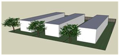
Figure 15.14.140-1: At minimum, manufactured home parks shall be landscaped, have perimeter fencing and
shall be skirted.
2.
Site development and access shall conform to the current International Fire Code as adopted by the city and all applicable development standards of this chapter.
3.
All manufactured home communities shall be a minimum of twenty contiguous acres.
4.
All manufactured home communities shall conform to the L4 site perimeter landscaping standards of Section 15.14.050.
5.
All manufactured home communities shall be screened from any adjacent development or public street with a masonry wall or solid material fence at least six feet in height and adequate plantings.
6.
All manufactured homes, and extensions thereof, accessory structures and other buildings shall be set back:
a.
20 feet from the boundary of the manufactured home community;
b.
40 feet from the edge of a public right-of-way;
c.
10 feet from a private interior drive, or walking or parking area or other common space; and
d.
16 feet from any other manufactured home.
7.
One freestanding identification sign may be erected at each major approach to the community provided that such sign:
a.
Does not exceed an area of fifteen square feet;
b.
Does not exceed ten feet in height;
c.
Is set back from the street at least eighteen feet;
d.
Is of low-intensity illumination, not flashing or animated, and is ground-mounted; and
e.
Meets all other requirements of Section 15.14.120, signs.
8.
Manufactured home communities shall comply with the parking requirements of [Section] 15.14.040. Visitor parking spaces may be grouped in a common parking area and shall not be more than two hundred feet of the manufactured home space to which it relates.
9.
All access aisles, internal roadways, and parking areas shall be surfaced with concrete or asphalt as determined by the city manager's office.
10.
Ingress/Egress. A minimum of two accesses to a manufactured home community shall be required. At minimum, one access shall occur directly from a collector or arterial street unless otherwise approved by the city manager's office.
11.
Dead-end access aisles, internal roadways or driveways shall not exceed one-hundred and fifty feet in length unless otherwise approved by the City Manager's Office.
12.
Individual spaces shall provide three hundred square feet of private open space for the sole benefit and use of the occupier of the space. The area shall not be a part of any modular home building footprint area, shall be adjacent to the subject manufactured homes and shall not count towards required landscaping or bufferyards.
13.
Solid waste collection stands shall be provided for all personal waste containers. Such stands shall be so designed as to prevent containers from being tipped, to minimize spillage and container deterioration, and to facilitate cleaning of the area. Solid waste collection stands shall be screened adequately from view. As an alternative, screened dumpsters may be provided.
14.
Storage areas shall be provided for the storage of boats, campers, utility trailers and extra vehicles at the following minimum ratio: Three hundred square feet for each two manufactured home spaces. Each storage area shall be enclosed with a fence six feet in height and shall be screened from exterior view.
15.
There shall be a paved system of walkways which gives safe and convenient access to every manufactured home and all common facilities.
16.
The manufactured home community shall be connected to city water and sewer service. Septic systems are not approved for manufactured home community.
17.
All utility lines shall be underground.
18.
Each manufactured home shall be securely installed upon a stand and shall be skirted so as to conceal the undercarriage.
19.
At least one-third of the manufactured home spaces in the manufactured home community shall be fully developed before any units may be located on the site and every unit shall be connected with water and sewer systems before occupancy.
20.
No additions shall be attached to any manufactured home.
21.
All accessory buildings shall conform to the accessory building setback requirements of the approved development plan and the provisions of this title.
22.
Each manufactured home space shall be provided with a paved concrete patio, redwood deck, or other similar area of at least forty square feet.
B.
Permitted Accessory Buildings Within a Manufactured Home Park. The following shall be permitted accessory buildings within a manufactured home park:
1.
Laundry, grounds maintenance, recreation, restroom and swimming pool facilities and leasing offices. All community accessory building shall be on the approved development plan.
2.
Detached individual storage rooms with an area no more than one hundred fifty square feet each.
C.
Manufactured Home Requirements.
1.
All units located within a manufactured home community shall have been constructed after June 15, 1976 and built in accordance with National Manufactured Home Construction and Safety Standards Act, 42 U.S.C. Section 5400 et seq.
2.
All units shall be a minimum of sixteen feet wide by thirty-six feet long.
D.
Conversion to Recreational Vehicle Park. Conversion of a Manufactured Home Community to a Recreational Vehicle Park, in whole or in part, shall require conformance with the development standards of Section 15.14.160 and the licensing requirements of Section 8.68.100 (licenses).
(Ord. No. 1578, § 2(att. A), 3-20-2010; Ord. No. 1671, § 21, 11-18-2014; Ord. No. 1711, § 4, 7-19-2016; Ord. No. 1728, § 16, 4-18-2017; Ord. No. 1830, §§ 21, 22, 10-17-2023)
15.14.150 - Reserved.
Editor's note— Ord. No. 1711, § 3, adopted July 19, 2016, repealed former § 15.14.150 which pertained to mobile home communities, and derived from Ord. No. 1578, § 2, adopted March 20, 2010; and Ord. No. 1671, § 21, adopted Nov. 18, 2014.
15.14.160 - Travel trailer parks, recreational vehicle parks and campgrounds.
Travel trailer parks, recreational vehicle parks and campgrounds shall comply with the licensing provisions of subsection 15.24.050.F. and the requirements listed in this subsection. The development standards shall be reviewed pursuant to the site plan procedures of subsection 15.06.060.O. Any modification to a non-conforming travel trailer park, recreational vehicle park or campground, as described in this section, shall be reviewed pursuant to the site plan procedures of subsection 15.06.060.O.
A.
Development Standards.
1.
General.
a.
Site development and access shall conform to the current International Fire Code as adopted by the city and all applicable development standards of this chapter.
b.
Travel trailer parks, recreational vehicle parks and campgrounds shall have direct access to a Collector or arterial street.
c.
No direct access to an individual site shall be permitted from a public street.
d.
The minimum size of a travel trailer park, recreational vehicle park or campground shall be one acre of contiguous land.
e.
All trailer, recreational vehicle and vehicle parking spaces are to be paved with asphalt or concrete as determined by the city manager's office.
f.
Accessory uses may include recreational facilities, laundry buildings, service retail store, manager's office and storage buildings, sanitary facilities, and fences, constructed in accordance with all the provisions of this Section and all other applicable city regulations
g.
One manufactured home or single-family dwelling may be located in a travel trailer park, recreational vehicle park, or campground.
h.
Recreation area or common space area, exclusive of campsites, shall be eight percent of the gross site area or two thousand five hundred square feet, whichever is greater.
i.
A dog run conveniently located for the occupants and encompassing at least seven hundred square feet shall be provided.
j.
All utilities shall be underground.
k.
Interior landscaping of the park shall require at least one tree per space, existing or planted. Each tree shall be at least two-inch caliper in size at the time of planting.
l.
At least one sanitary garbage pickup area shall be located on the site. The garbage pickup area shall be screened from view in accordance with applicable city regulations.
m.
Cooking shelters, barbecue pits, fireplaces, wood-burning stoves and incinerators shall be so located, constructed, maintained and used as to minimize fire hazard and smoke nuisance both on the property on which used and on neighboring property.
n.
Recreational Fires.
(i)
No recreational fires shall be permitted on any travel trailer site.
(ii)
Exception for campsites
(i)
Recreational fires may be allowed for campsites subject to the following:
(1)
Recreational fire locations shall have a total fuel area of three feet (914 mm) or less in diameter and two feet (610 mm) or less in height.
(2)
Recreational fires shall not be conducted within twenty-five feet (7620 mm) of a structure or combustible material.
(3)
Recreational fires shall not be conducted within twenty-five feet (7620 mm) of a tent or cabin site, group tent or camp site or travel trailer park or campground boundary.
(4)
Conditions which could cause a fire to spread within twenty-five feet of a structure shall be eliminated.
2.
Travel Trailer and Recreational Vehicle Park.
a.
Individual travel trailer site development standards:
(i)
Minimum width of twenty-five feet.
(ii)
Minimum depth of forty-five feet.
(iii)
A maximum of forty percent of each site shall be developed with pervious material, including but not limited to accessways, parking areas and patios.
b.
No travel trailer parking pad shall be located within twenty-five feet of the boundary of the park.
3.
Campgrounds.
a.
Campsites shall provide a minimum of five hundred square feet for each individual campsite. A ten-foot separation shall be maintained between campsites. Alternative designs, such as clustering or walk-in campsites may be approved with approval by the city manager's office.
B.
Service Buildings Required.
1.
A central service building containing the necessary toilet and other plumbing fixtures specified shall be provided pursuant to Table 15.14.160.B-1 in travel trailer parks, recreational vehicle parks and campgrounds. Service buildings shall be conveniently located to the spaces to be served. Service buildings shall be connected to city water and sewer service.
2.
For travel trailer parks, recreational vehicle parks and campgrounds having more than one hundred spaces or campsites there shall be provided: one additional toilet and lavatory for each sex per each additional thirty spaces or campsites, or fraction thereof, one additional shower for each sex per each additional forty spaces or campsites or fraction thereof, and one additional men's urinal per each additional one hundred spaces or campsites or fraction thereof.
(Ord. No. 1578, § 2(att. A), 3-20-2010; Ord. No. 1671, § 21, 11-18-2014; Ord. No. 1728, § 16, 4-18-2017)
15.14.170 - Tree protection.
A.
Purpose. The purpose of this section is to protect the existing tree canopy as well as protect future tree canopies of the city when development or redevelopment occurs. The standards in this subsection are intended to regulate the removal of trees on lots within the city. It is not the intent of this subsection to unduly restrict desirable development and redevelopment that would otherwise be possible without these standards.
B.
Applicability. The standards in this section shall be applied during review of any development or building permit applications on lots within the city of Laramie; provided, however, that development located in rear yards of lots with existing attached or detached single family dwellings shall be exempt from the provisions of this section. Emergency replacement or repair of existing water or wastewater lines necessary to provide continued service shall be exempt from this section.
C.
Standards.
1.
Preservation of Significant Trees. Significant trees shall be preserved to the maximum extent practicable. For the purposes of this standard, the caliper of a "significant" tree shall be at least twenty-four inches DBH for a deciduous tree and eighteen inches DBH for evergreens.
a.
Significant Tree Replacement.
(i)
Where significant trees cannot feasibly be preserved, the total caliper inches of the tree(s) that are removed shall be replaced by the same caliper inches of new trees. The new trees shall either be of the same or similar species, or, if identified by the city manager's office for species diversification, shall be from a list of permissible species provided by the city manager's office.
(ii)
If site limitations affect the ability of the developer to replace the total caliper inches of the removed tree(s), the city manager's office may allow the developer to reduce the replacement measurement in an amount that allows for the maximum replacement of caliper inches feasible on the site. This reduction shall not exceed fifty percent of the total caliper inches removed.
b.
Where the city manager's office reduces the number of trees planted in replacement of significant trees, the developer shall make a contribution to the city tree fund for the remaining caliper inches not replaced. The amount of the in-lieu fee shall be calculated as the cost to replace the remaining total caliper inches not planted with new trees of the same or similar species purchased wholesale at two-inch caliper DBH.
c.
The city tree fund shall be used to maintain, replace or provide new trees within the city.
2.
Enforcement. The city manager's office shall notify all development applicants reminding them of the significant tree replacement requirements at the time of pre-application or application, whichever occurs first.
3.
Maintenance. Any new trees used to replace significant trees shall be maintained in accordance with LMC 15.14.050.C.7. For purposes of this subsection, the cited Landscaping and Screening maintenance subsection shall be deemed applicable to single-family properties.
4.
Removal of a Dead or Dying Tree or Unsafe Tree. Nothing in this section shall be interpreted to require a property owner to keep a dead or dying tree. The status of a tree shall be determined by the city manager's office prior to removal. The city may require a property owner to remove a dead or dying tree if it is determined to be a hazard to public safety.
D.
Tree Protection During Construction.
1.
Owner's Responsibility. During development, the owner or developer shall be responsible for the erection of any and all barriers necessary to protect any existing or installed trees from damage during construction in accordance with the standards of this subsection.
2.
Tree Protection Fencing.
a.
Where Required. All significant trees and trees intended for use as credit towards the landscaping and tree-protection standards of this code shall be fenced in accordance with this subsection before grading or other land-disturbing activity begins. Fencing shall extend at least one foot in distance from the edge of the tree for each inch of diameter at BREAST Height (DBH) to a maximum of ten feet, but in no case closer than five feet to the trunk. The city manager's office shall consider existing site conditions in determining the exact location of any tree protection fencing.
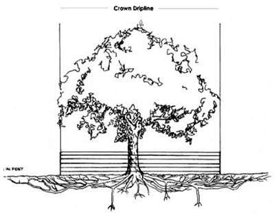
Figure 15.14.170-1: Example of tree protection fencing at the edge of a tree's dripline.
b.
Type of Fencing. The developer shall erect a temporary plastic mesh fence or temporary chain link fence a minimum of four feet in height at the drip line around each tree or group of trees to prevent the placement of debris or fill within the drip line of any tree.
c.
Inspection. All tree protection measures shall be inspected and approved by the city manager's office prior to start of any land disturbing activities. Failure to have tree protection measures prior to the commencement of construction shall be a violation of this code.
d.
When Required. The tree protection fencing shall be clearly shown on the site plan or grading permit. No construction, grading, equipment or material storage, or any other activity shall be allowed within the fenced area except in accordance with the standards in subsection 3. below, encroachments in to root zones. Fencing shall be maintained until the land disturbance activities are complete.
3.
Encroachments into Root Zones. Encroachments within the root zones of trees protected in accordance with this subsection shall occur only in rare instances. If such an encroachment is anticipated, the following preventive measures shall be employed prior to the encroachment:
a.
Arborist Report. Written verification shall be prepared by an International Society of Arboriculture (ISA) certified arborist of the tree's condition before and after the encroachment, including preventive measures that shall be employed prior to, during, and after the encroachment to insure the viability of the tree.
b.
Soil Compaction. Where compaction might occur due to traffic or materials through the protection area, the area shall first be mulched with a minimum four-inch layer of wood chips or a six-inch layer of pine straw. Equipment or materials storage shall not be allowed within the tree protection zone.
c.
Effluent. In no instance shall any effluent associated with construction process, including concrete mixing, pouring, or rinsing processes, drain onto lands protected by tree protection fencing or other control measures.
d.
Soil Compaction
.
All tree protection activities during construction activities shall conform to current ANSI standards or exemptions prepared by a qualified ISA certified arborist.
(Ord. No. 1578, § 2(att. A), 3-20-2010; Ord. No. 1671, § 21, 11-18-2014; Ord. No. 1728, § 16, 4-18-2017; Ord. No. 1728, §§ 1—3, 4-18-2017)
15.14.180 - Historic preservation
A.
Purpose. It is found and determined that certain areas, improvements, and districts within the city have a special character or special historic or aesthetic interest or value and represent architectural products of distinct periods in the history of the city, and that the areas, improvements and districts are in danger of being uprooted or having their distinctiveness destroyed without adequate consideration of the irreplaceable loss of the aesthetic, cultural, and historic values represented by such areas, improvements and districts, and therefore the preservation thereof is both feasible and desirable to the people of this city. It is declared as a matter of public policy that the protection, enhancement, perpetuation, and use of such areas, improvements and districts of special character or special historic or aesthetic interest or value is a public necessity and is required in the interest of the health, prosperity, safety and welfare of the people of this city.
B.
Demolition Controls for Historic Structures.
1.
Purpose. The purpose of this subsection is to:
a.
Effect and accomplish the protection, enhancement, and perpetuation of such areas and improvements and of districts which represent or reflect elements of the city's cultural, social, economic, political, and architectural history.
b.
Safeguard the city's historic, aesthetic and cultural heritage, as embodied and reflected in such areas, improvements and districts.
c.
Stabilize and improve property values in such districts.
d.
Foster civic pride in the beauty and accomplishments of the past.
e.
Protect and enhance the city's attractions to tourists and visitors and the support and stimulus to business and industry thereby provided.
f.
Strengthen the economy of the city.
g.
Promote the use of historic districts and landmarks for the education, pleasure, and welfare of the people of the people of the city.
2.
Applicability. The standards of this subsection shall be applicable to the following structures:
a.
Structures designated as a historic structure on the National Register of Historic Places
b.
Structures designated as a historic structure on the Wyoming State Inventory of Historic Places;
c.
Structures designated as a contributing structure to any National Register Historic District.
3.
Demolition Restriction. No structure designated as a historic structure on the National Register of Historic Places, or on the Wyoming State Inventory of Historic Places, or is designated as a contributing structure to any national register historic district, shall be demolished unless the owner has first given the city at least six months notice of his or her intention to demolish the building. During that six-month period, the city shall work with the owner to identify any alternative uses that would allow the existing building to produce a better economic return that would allow it to remain in active use, or that would allow it to be used for the purposes or land uses the owner wants to achieve, or to identify a purchaser for the building who would preserve it from demolition. In the event the owner does not accept the alternatives, if any, offered by the city during that six-month period, the demolition may proceed, but only after the owner has provided at least thirty days additional time for the city or other parties to document the building through photographs or other means. The owner is encouraged, but not required, to allow access to the building during the thirty-day period in order to allow documentation of the interior of the building as well.
4.
Maintenance. Property owners shall be required to maintain historic buildings and structures, as defined above, in a state of normal repair and not allow demolition by neglect. Demolition by neglect is the gradual deterioration of a building when routine maintenance is not performed. The city shall have authority to impose enforcement provisions on property owners who are found to have allowed a historic structure to fall into a state of neglect.
5.
Neglect. Property owners of historic buildings and structures shall be required to keep them safe and fit for human habitation. The city shall have the authority to impose enforcement provisions on property owners who are found to have allowed an unsafe, insanitary, or dangerous condition to exist on their property. The provisions of subsection 15.08.030.E.3.c.(xiii), shall apply to any proposed demolition of such structure.
(Ord. No. 1578, § 2(att. A), 3-20-2010)