
Larimer County Unincorporated
City Zoning Code
City Zoning Code
ARTICLE 2
0 - ZONING DISTRICTS1
Cross reference— Any land use, zoning or rezoning ordinance or resolution or amendment to the zoning map saved from repeal, § 1-9(a)(10); buildings and building regulations, ch. 10; businesses, ch. 14; health, environment and natural resources, ch. 30.
2.7. - Overlay Districts
The overlay districts in this section are intended to be used in addition to the base zoning districts established in §§2.2 through 2.5. If any regulation in this section conflicts with any other regulation in this Code, the provisions of this section shall apply regardless of whether they are more or less restrictive than the base zoning district.
2.1.1. - Districts Established.
Zoning districts are established as shown in Table 2-1. Zoning districts are established by the County's adoption of the Larimer County Zoning Districts Map pursuant to §2.1.3, Larimer County Zoning Districts Map.
(Res. of 4-22-2024, Exh. A; Res. of 12-9-2024, Att. A)
2.1.2. - Organization of this Article.
A.
Base Zoning Districts.
1.
Character Areas Intent.
The base zoning districts in §§2.2 through 2.5 are grouped into four character areas: Conservation and Agriculture, Rural, Mixed Center, and Urban. Each character area includes multiple zoning districts with generally similar allowed land uses and development standards. The character areas are an organizational tool and are based on land use classifications in the Comprehensive Plan.
2.
Base Zoning Districts and Dimensional Standards.
A purpose statement for each of the base zoning districts in §§2.2 through 2.5 describes the intended character of the zoning districts. A summary table for each character area sets forth the lot and building standards applying to development in the districts, and any district-specific development standards. General rules for measurement of dimensional standards, as well as exceptions to the general rules, are in §2.9, Measurements and Exceptions.
3.
District Illustrations.
For each base zoning district, an illustration depicts the general layout of the zoning districts within that character area. Illustrations do not depict specific locations or buildings and do not necessarily reflect all the standards that may apply to a particular development. If a standard shown in an illustration is inconsistent with the respective table of lot and building standards or other text in this Code, the standards in the table and text of this Code shall govern.
B.
Planned Development Districts.
1.
Section 2.6 identifies the two types of planned development districts available in the County: Planned Development and Rural Planned Development.
2.
Planned development districts are separate base zoning districts negotiated with the Larimer County Community Development Department, reviewed by the Planning Commission, and reviewed and approved by the Board of County Commissioners pursuant to the procedures in §6.6.1.E, Rezoning to Planned Development (PD).
3.
An approved Planned Development zoning district is labeled "PD" or "RPD" on the Larimer County Zoning Districts Map.
C.
Overlay Districts.
Section 2.7, Overlay Districts, identifies the overlay zoning districts and sets forth each district's purpose and the standards that modify those of underlying districts. Overlay zoning districts are superimposed over one or more underlying base or planned development zoning districts. If the standards for an overlay district expressly conflict with those for an underlying base zoning district, planned development district, or another applicable overlay district, the more restrictive standards as determined by the Director shall apply.
2.1.3. - Larimer County Zoning Districts Map.
A.
Incorporation of the Map.
1.
The location and boundaries of the zoning districts established by this Code are shown on the Larimer County Zoning Districts Map.
2.
The Larimer County Zoning Districts Map has been adopted by the County Commissioners and is incorporated as part of this Code.
3.
The Official Zoning District Map shall be maintained by the Larimer County Community Development Department. Official zoning districts shall be determined by the Director in the event of a conflict with the Larimer County Zoning Districts Map.
B.
Zoning District Boundaries.
1.
The County Commissioners intend that all unincorporated areas within Larimer County be included within a zoning district.
2.
A zoning district boundary shown as approximately following a property line, municipal boundary, or county boundary is construed to follow that property line.
3.
Where a zoning district boundary line divides a lot, the location of the zoning district boundary is determined by using the scale appearing on the Larimer County Zoning Districts Map unless the boundary is indicated by dimensions printed on the Larimer County Zoning Districts Map. When there is a conflict between scaled and printed dimensions, the printed dimensions control.
4.
Where a zoning district boundary is shown as approximately following a road, alley, railroad, stream, river, irrigation ditch, or other identifiable map feature, the zoning district boundary is construed to be the centerline of the map feature.
C.
Boundary Clarification.
1.
If there is uncertainty about the location of a zoning district boundary or other feature shown on the Larimer County Zoning Districts Map, a determination shall be made by the Director.
2.
Any appeal of the Director's determination of the zoning district boundary shall be heard by the County Commissioners.
D.
Amendments to the Map.
Changes in the boundaries of any zoning district require an amendment to the Larimer County Zoning Districts Map per §6.6.1, Amending the Official Zoning Map (Rezoning).
2.2.1. - General Character Area Description.
The Conservation and Agriculture character area supports the preservation, management, and productive use of natural areas, open lands, and agriculture.
•
The area is characterized by open lands with minimal development and limited infrastructure and support services such as public water/sewer or fire protection. Agriculture-supporting uses and limited residential uses are allowed.
•
This area furthers the Comprehensive Plan goals for the Rural, Agricultural and Ranching, Mountains and Foothills, and Natural Resources framework categories.
•
The character area is comprised of the Natural Resources (NR), Agriculture (A), Forestry (FO), and Agricultural Commercial Enterprise (ACE) base zoning districts.
2.2.2. - Intent Statements for Base Zoning Districts.
A.
Natural Resources (NR).
The NR district is intended to maintain the character of natural areas, public lands, and open lands. Rural residential development may be allowed through the Rural Land Use Process (§5.9).
B.
Forestry (FO).
The FO district is intended for the purpose of efficiently using land to conserve forest resources and protect the natural environment. Rural residential development may be allowed through the Rural Land Use Process (§5.9).
C.
Agriculture (A).
The A district is intended to encourage agricultural cultivation and production activities. Agricultural practices such as agriculture and ranching should be the principal activity of these areas. Rural residential development may be allowed through the Rural Land Use Process (§5.9). Residential uses are secondary in agricultural areas and should be developed at very low densities or clustered to protect and conserve existing open and agricultural lands and to preserve a rural character. Residential development adjacent to existing agricultural uses should have no significant, adverse impact on the continued operations of any adjacent agricultural use(s) and should comply with any applicable "right to farm" provisions in state statutes.
D.
Agricultural Commercial Enterprise (ACE).
The ACE district is intended to accommodate commercial and industrial uses that support agricultural operations such as processing, packaging, and distribution.
2.2.3. - Lot and Building Standards.
2.3.1. - General Character Area Description.
The Rural character area supports rural residential and agricultural uses of land.
•
The area is characterized by rural residential development with accessory agricultural and minimal infrastructure and support services.
•
Conservation development is required for developments of 30 acres or more.
•
This area furthers the Comprehensive Plan goals for the Rural, Agricultural and Ranching, and Mountains and Foothills framework categories.
•
The character area is comprised of two Rural Residential (RR-1 and RR-2) zoning districts and the Open (O) district.
2.3.2. - Intent Statements for Base Zoning Districts.
A.
Rural Residential (RR-1).
The RR-1 district is intended to accommodate rural residential, agricultural, and civic uses. RR-1 parcels may serve as transitions between the Conservation and Rural character area and more intensive areas within the Rural character area, such as RR-2. Properties within the RR-1 district generally have public water and on-lot septic, but public water is not always available. A property zoned RR-1 may be further subdivided through the RLUP, conservation development, or subdivision processes based on the size of the original parcel and the availability of public water and sewer serving the property.
B.
Rural Residential (RR-2).
The RR-2 district is intended to accommodate rural residential uses, along with compatible agricultural and civic uses. It serves as a transition between rural and urban areas. Development options include conservation development or subdivision depending on the size of property being developed. Minimum lot sizes are based on the availability of public water and sewer serving the property.
C.
Open (O).
The O district is intended to accommodate a wide range of development patterns. It is primarily intended for rural residential uses and agricultural uses.
2.3.3. - Lot and Building Standards.
2.4.1. - General Character Area Description.
The Mixed Center character area supports mixed-use development and uses in non-urban areas.
•
The area is characterized by a combination of commercial, residential, institutional, and recreational uses.
•
Conservation development is required for developments of 30 acres or more.
•
This area furthers the Comprehensive Plan goals for the Urban and Rural Interface, Rural Center, and Retail Services framework categories.
•
The character area is comprised of the Interface Residential (IR), Rural Commercial (RC), and Community Facilities (CF) base zoning districts.
2.4.2. - Intent Statements for Specific Districts.
A.
Interface Residential (IR).
The IR district is intended to accommodate residential uses while allowing agricultural and supporting institutional uses. This district is intended for parcels near adopted Growth Management Areas that serve as transitions between urban and rural areas. Minimum lot sizes are based on the availability of public water and sewer to serve the site.
B.
Rural Commercial (RC).
The RC district is intended for areas identified in the Comprehensive Plan as "rural centers" or "retail service nodes." The district accommodates a mix residential, civic, commercial, retail, educational, and accommodation uses where appropriate water and sewer infrastructure is available.
C.
Community Facilities (CF).
The CF district is intended to accommodate public, educational, institutional, cultural, recreational, and similar uses to serve the needs of residents of the County by providing focal points in neighborhoods and/or the community for gathering, social interactions, and select neighborhood and community services and amenities. It is intended to accommodate public and quasi-public facilities.
2.4.3. - Lot and Building Standards.
2.5.1. - General Character Area Description.
The Urban character area supports appropriate-sized structures and uses adjacent to and within growth management areas (GMAs), the LaPorte Plan Area, the Red Feather Lakes Plan Area, and similar plan areas.
•
The area is characterized by a mix of residential, commercial, and industrial development.
•
This area furthers the Comprehensive Plan goals for the Urban Expansion, Urban and Rural Interface, and Industrial framework categories, and, where appropriate, Rural Centers.
•
The character area is comprised of the Urban Residential (UR-1, UR-2, and UR-3), Multi-Unit Residential (MR), Manufactured Housing Park (MHP), Manufactured Housing Park Preservation (MHP-P), Mixed-Use Neighborhood (MU-N), Mixed-Use Commercial (MU-C), Commercial Corridor (CC), Commercial Neighborhood (CN), Commercial Destination (CD), Industrial Light (IL), Industrial Heavy (IH), and Airport (AP) districts.
(Res. of 4-22-2024, Exh. A; Res. of 12-9-2024, Att. A)
2.5.2. - Intent Statements for Specific Districts.
A.
Urban Residential (UR-1).
The UR-1 district is intended to accommodate a mix of low-density residential, supporting institutional, and accessory agricultural uses. This district is primarily intended for parcels within adopted Growth Management Areas.
B.
Urban Residential (UR-2).
The UR-2 district is intended to accommodate medium-density residential, supporting institutional, and accessory agricultural uses. This district is primarily intended for parcels within adopted Growth Management Areas.
C.
Urban Residential (UR-3).
The UR-3 district is intended to accommodate diverse types of higher-density residential uses with supporting institutional and accessory agricultural uses. This district is primarily intended for parcels within adopted Growth Management Areas.
D.
Multi-Unit Residential (MR).
The MR district is intended to accommodate diverse types of multi-unit residential uses with supporting institutional uses. This district is primarily intended for parcels within adopted Growth Management Areas.
E.
Manufactured Housing Park (MHP).
The MHP district is intended to accommodate manufactured housing developments with shared amenities in order to encourage alternative housing opportunities. Other residential use types may be allowed through a site plan review process provided they are consistent with the adopted goals in the Comprehensive Plan for housing options and affordability. This district is primarily intended for parcels within adopted Growth Management Areas.
F.
Manufactured Housing Park Preservation (MHP-P).
The MHP-P district is designed to protect parcels with existing manufactured housing parks in order to preserve natural alternative housing opportunities. This district is intended to support existing manufactured housing communities as the primary residential use and allow for other complementary uses that serve residents of manufactured housing communities.
G.
Mixed-Use Neighborhood (MU-N).
The MU-N district is intended to accommodate compact centers made up of neighborhood-oriented commercial and institutional uses within or surrounded by residential areas, compatible in scale and character with surrounding residential uses. This district is intended for areas within a Growth Management Area or sub-area plan or within rural centers as identified in the Comprehensive Plan.
H.
Mixed-Use Commercial (MU-C).
The MU-C district is intended to accommodate a wide range of commercial uses and activities with limited residential uses. This district is intended for areas along major corridors and activity centers. This district is intended for areas within a Growth Management Area or sub-area plan or within rural centers as identified in the Comprehensive Plan.
I.
Commercial Corridor (CC).
The CC district is intended to accommodate general retail and other commercial and service uses, and incidental or accessory uses, where access requires good vehicular circulation. Land uses are characterized by frequent visits of customers and clients. The CC district is intended to provide commercial development with adequate access to arterial streets and with efficient internal circulation and parking that is compatible with surrounding residential areas. This district is intended for areas within a Growth Management Area or sub-area plan or within rural centers as identified in the Comprehensive Plan.
J.
Commercial Neighborhood (CN).
The CN district is intended to accommodate office-related uses that provide employment opportunities for the community and the surrounding region. This district is intended for areas within a Growth Management Area or sub-area plan or within rural centers as identified in the Comprehensive Plan.
K.
Commercial Destination (CD).
The CD district is intended to accommodate a variety of lodging and related uses. This district is primarily intended for parcels within adopted Growth Management Areas.
L.
Industrial Light (IL).
The IL district is intended to accommodate public and private light manufacturing, processing, service, storage, wholesale, and distribution operations, as well as heavier-intensity commercial uses. This district is intended for parcels within adopted Growth Management Areas.
M.
Industrial Heavy (IH).
The IH district is intended to accommodate public and private heavy manufacturing, storage, major freight terminals, waste and salvage, resource extraction, and other related uses. This district is intended for parcels within adopted Growth Management Areas.
N.
Airport (AP).
The AP district is intended to provide standards to ensure compliance with Federal Aviation Administration (FAA) regulations for areas impacted by airport operations.
(Res. of 4-22-2024, Exh. A; Res. of 12-9-2024, Att. A)
2.5.3. - Lot and Building Standards.
(Res. of 6-13-2023, Exh. A, 1; Res. of 4-22-2024, Exh. A; Res. of 12-9-2024, Att. A)
2.5.4. - Additional Standards for the AP District.
The following standards apply within the AP district:
1.
No use will be allowed that would:
a.
Adversely affect visibility in the vicinity of the airport or the operational efficiency of any navigational or communications facilities used by aircraft at the airport;
b.
Make it difficult for pilots to distinguish between airport lights and other lighting; or
c.
Result in glare in the eyes of pilots using the airport.
2.
No uses are allowed where the principal business purpose is the manufacture, warehousing, storage, or shipping of commercial explosives or radioactive materials.
3.
Any dust, fumes, odors, smoke, vapor, noise, and vibration not directly resulting from the takeoff and landing of aircraft shall be effectively confined within the boundaries of the AP district.
4.
Unless approved through the special review process, no uses are allowed that require above-ground storage of chemicals, gases, liquids, or other materials that are flammable, explosive, or poisonous or that pose a safety hazard to the public in quantities of 1,000 gallons or more. Such materials in quantities exceeding 1,000 gallons can be stored aboveground only in accordance with safety criteria and standards relating to quantity-distance criteria, type of storage facilities and the shielding of storage facilities that are customary in the industry with respect to stored material.
5.
Table 2-6 displays land uses that are considered to be incompatible with airport operations in the areas listed. An 'X' denotes that the use is not compatible in the relevant area.
2.6.1. - Intent.
The PD districts allow greater flexibility than is available by the strict application of the Code in exchange for more creative and imaginative designs with a higher level of amenities and public benefits than is otherwise possible under the base zoning districts. There are two planned development districts:
A.
Planned Development (PD).
The PD district is intended to allow for urban or village development in:
1.
Growth Management Areas, so that development in such areas is consistent with the land use objectives for the respective GMA district for the municipality, including applicable supplementary regulations. In the absence of such supplementary regulations, the recommendations of the municipality shall be considered; and
2.
Areas subject to sub-area plans such as LaPorte and Red Feather Lakes, to ensure consistency with such plans.
B.
Rural Planned Development (RPD).
The RPD district is intended to facilitate planned development outside of areas subject to a sub-area plan such as LaPorte and Red Feather Lakes and established GMAs that allows greater flexibility than that allowed by the strict application of the Code in exchange for more creative and imaginative designs with a higher level of amenities and public benefits than is otherwise possible under the base zoning districts.
2.6.2. - Applicability.
A.
The PD district is a base zoning district that may be applied only in a GMA, the LaPorte Plan Area, the Red Feather Lake Plan Area, or any new sub-plan area created after the adoption of this Code.
B.
The RPD district is a base zoning district and may be applied only in areas outside of a GMA, the LaPorte Plan Area, the Red Feather Lake Plan Area, or any new sub-plan area created after the adoption of this Code.
2.6.3. - Establishment.
The PD and RPD districts shall be established or their boundaries modified only through an amendment to the Larimer County Zoning Districts Map following procedure set forth in §6.6.1, Amending the Official Zoning Map (Rezoning). The PD or RPD procedure shall not be used when a variance, minor modification, or rezoning to a base zoning district could achieve a similar result.
2.6.4. - General Standards Applicable to PDs.
Development in a PD or RPD district is subject to standards included in or referenced in an approved PD or RPD development plan as approved by the County Commissioners. PD and RPD development plans shall be consistent with any applicable supplementary regulations.
2.7.1. - Floodplain Overlay (FP-O).
A.
Intent.
The FP-O district is intended to provide additional standards for areas that are at risk of flooding.
B.
Applicability.
Properties zoned in the FP-O district retain the uses of and are subject to the regulations of the underlying base zoning district. In the case where FP-O and base zoning regulations conflict, FP-O regulations shall apply.
C.
Standards.
Standards for properties zoned in the FP-O district are subject to the regulations in Article 12.0, Floodplain.
2.7.2. - Growth Management Area (GMA).
A.
Intent.
The purposes of the GMA district are to:
1.
Designate areas in the County adjacent to a municipality's corporate limits where urban level development and annexation are appropriate, and where development may have an impact on present and future municipal growth patterns;
2.
Support a municipality's comprehensive plan within the GMA district;
3.
Protect the health, safety, and welfare of county residents by providing land use regulations and standards that cause development to occur consistent with a municipality's comprehensive plan for its GMA district to the extent deemed feasible by the County in consultation with the municipality;
4.
Minimize urban services provided by the County by encouraging municipalities to annex land designated for urban uses and densities;
5.
Facilitate the annexation of lands that have developed in the GMA district while under county jurisdiction;
6.
Facilitate the annexation of lands that are eligible for annexation prior to the development of these lands;
7.
Implement the guiding principles, policies, and strategies of the Comprehensive Plan regarding urban and rural land uses;
8.
Establish county standards and criteria that are compatible with standards and criteria adopted by municipalities; and
9.
Implement intergovernmental agreements with municipalities regarding growth management.
B.
Applicability.
1.
The GMA district applies within the following areas of Larimer County:
a.
The Fort Collins GMA district;
b.
The Loveland GMA district;
c.
The Windsor GMA district; and
d.
Any other GMA district created pursuant to an intergovernmental agreement with a municipality located within Larimer County.
2.
The term "GMA district" shall mean whichever of the above districts is applicable given the location of the subject site.
3.
The boundaries of each GMA district are shown on the Larimer County Zoning Districts Map adopted for Larimer County.
4.
The GMA district is an overlay zoning district and shall be applied together with an underlying zoning district.
5.
The provisions of this subsection apply to all areas zoned in a GMA district. Supplementary regulations to a GMA district, herein referred to as "supplementary regulations," may be adopted that apply only to a particular GMA area.
6.
In the event of a conflict between the supplementary regulations, this subsection, or any other provisions of this Code, the supplementary regulations shall prevail over this subsection and the other provisions of this Code; this subsection shall prevail over the other provisions of this Code.
C.
Review Criteria for Establishment or Enlargement of GMA Boundaries.
1.
The GMA district shall be established or its boundaries modified only through an amendment to the Larimer County Zoning Districts Map following procedure set forth in §6.6.1, Amending the Official Zoning Map (Rezoning).
2.
The County Commissioners may establish or enlarge a GMA district if the following review criteria are met:
a.
There is an intergovernmental agreement with the adjacent municipality pertaining to a growth management area and the GMA district is intended to implement the agreement;
b.
The area within the GMA district boundary is expected, by the parties, to be annexed within the time frame anticipated by the municipality's comprehensive plan;
c.
The municipality's comprehensive plan provides the County and property owners with clear guidance regarding the types and intensities of land uses intended for each parcel within the GMA district boundary;
d.
The area within the GMA district can and will be served with urban level services, including, but not limited to, public sewer, public water, urban streets, and urban fire protection; and
e.
The review criteria for boundary or zone designation set forth in §6.6.1, Amending the Official Zoning Map (Rezoning) have been met.
3.
The County Commissioners may exclude an area from an established GMA district boundary following consultation with the municipality if the County Commissioners find that one or more of the review criteria listed in this subsection above can no longer be met or that the municipality is not complying with the intergovernmental agreement.
D.
Rezoning, Minor Land Division, and Planned Land Division Standards.
1.
Parcels within a GMA district may only be rezoned to the PD district. The PD rezoning application shall specify the proposed land use types, densities, and intensities. Rezoning to RPD is not permitted in any GMA district.
2.
Except as provided in §2.7.2.D.3 or as otherwise permitted by the supplementary regulations, the County shall not accept any application for a rezoning to a PD or special review:
a.
For any property zoned in a GMA that has any contiguity to the municipal limits and thus can be made eligible for voluntary annexation, whether through a series of annexations or otherwise. Instead the owner of such property shall be required to seek annexation to the municipality; or
b.
For any property in a GMA district, which was part of a parcel eligible for annexation as of December 18, 2000, but which is no longer eligible because of subsequent land divisions resulting in a break in contiguity, except land divisions created by court order from probate, dissolution of marriage, or eminent domain proceedings; or
c.
Where the municipality denies the petition for annexation because:
i.
The property owner has included conditions or requirements in the petition which the County deems to be unreasonable or unduly burdensome; or
ii.
The property owner refuses to agree to conditions or requirements imposed by the municipality as a condition of annexation which the County deems to be reasonable.
3.
The County may accept applications for rezoning or special review where:
a.
The subject parcel(s) has no contiguity to the municipal limits; or
b.
The municipality denies the petition for annexation for reasons other than those stated in §2.7.2.D.2.c.i and §2.7.2.D.2.c.ii; or
c.
The applicable supplementary regulations authorize the County to accept the application for rezoning, special review, or planned land division; or
d.
In lieu of a denial of annexation by the municipality, the County Commissioners accept the written determination by the designated representative of the municipality that the subject property owner(s) need not apply for annexation.
4.
In order to approve a rezoning to PD, the County Commissioners shall find the proposed rezoning meets the review criteria in §6.6.1.E, Rezoning to Planned Development (PD), and that the proposed land use type, density, and intensity are consistent with the applicable supplementary regulations, if any.
5.
All divisions of land to create new lots in GMA districts shall be submitted and processed as planned land divisions or minor land divisions. No division of land to create new lots in GMA districts through the planned land division process shall be approved unless the County Commissioners have approved a rezoning of the land to PD.
6.
Prior to final approval of a rezoning, special review, administrative special review, site plan review, planned land division, or minor land division, the property owner shall provide a binding agreement for annexation. The agreement shall:
a.
Be in a form approved by the County;
b.
Include a power of attorney authorizing the city or town clerk to execute and file annexation petitions and maps;
c.
State that the property owner agrees to submit to the applicable municipality a petition for voluntary annexation at such time as the property becomes eligible for annexation according to state annexation laws;
d.
Be signed by the owner of the property;
e.
Run with the land; and
f.
Be recorded in the Office of the County Clerk and Recorder with a copy forwarded to the applicable municipality.
7.
The County shall submit, to the applicable municipality for review and comment, all proposals for rezoning, special review, minor land division, and planned land division within the applicable GMA district.
8.
The County shall afford the municipality 21 days from the date of transmittal of the referral to provide written comments.
E.
Use Standards.
1.
Any parcel within a GMA may be used for any use that is designated a use allowed by right in the underlying zoning district. This does not apply to uses that involve land divisions, special review, or any other decisions requiring discretionary review by the County Commissioners.
2.
Uses allowed only by special review in the underlying zoning district may be approved only if such uses are consistent with the applicable supplementary regulations to a GMA district. If no applicable supplementary regulations have been adopted, the review criteria for special review shall apply. Supplementary regulations do not apply to Wireless Communication Facilities.
F.
Modifications of Development Standards Required by Supplementary Regulations.
1.
Development standards in supplementary regulations to the GMA district may be modified if agreed upon in writing by the developer, County Commissioners, and the municipality.
2.
For proposed modifications not agreed to by the applicable municipality, the County Commissioners may grant such modifications only in exceptional circumstances and only if they find that granting the modification will not be detrimental to the public good and that:
a.
By reason of exceptional physical conditions or other extraordinary and exceptional situations unique to such property, including, but not limited to, physical conditions, such as exceptional narrowness, shallowness, or topography, the strict application of the standard sought to be modified would result in unusual and exceptional practical difficulties, or exceptional and undue hardship upon the owner of the affected property, provided such difficulties or hardship are not caused by the act or omission of the applicant; or
b.
The alternative plan, as submitted, will advance or protect the public interests and purposes of the standard for which modification is requested, equally well or better than a plan that complies with the standards for which modification is requested. In ascertaining the "public interests and purposes of the standards" the County Commissioners shall give great weight to:
i.
The recommendation of the municipality;
ii.
The specific language of the standard, taken in the context of the regulation in which the standard is contained and in the context of the applicable provisions of the municipality's comprehensive plan; and
iii.
The willingness and agreement of the municipality to annex the subject area.
3.
A modification shall be processed and reviewed concurrently with the development application to which it applies. A modification may be processed separately from such development application only if the Community Development Director in his/her sole discretion determines there is adequate information to allow the modification to be evaluated separately from the development application.
4.
Applicants seeking a modification shall file a written request with the Community Development Director.
5.
The Community Development Director shall refer the application to the planning director of the municipality. The municipality shall provide a recommendation to the County within 21 days of receipt of the request.
6.
The Larimer County Planning Commission or other recommending board, per the applicable intergovernmental agreement, and the County Commissioners shall hear the request in the public hearings set for the development application.
7.
If the Community Development Director has authorized the modification request to be processed separately from the development application, the applicable recommending board shall hear the request at the next available public hearing as determined by the Planning Director after receipt of the recommendation of the municipality, and the County Commissioners shall hear the request at a public hearing no later than 21 days after receipt of the recommendation from the applicable recommending board.
8.
At the hearing, the County Commissioners shall consider relevant information presented by the applicant, the municipality and interested members of the public. Based on the information, the County Commissioners may grant the modification or grant the modification with conditions in accordance with the criteria contained in this section or deny the modification.
9.
If a modification is approved it shall be controlling for the successively, timely filed, development applications for that particular development proposal only to the extent that it modified the standard pertaining to such plan.
10.
All modifications which apply to a development plan which has not been filed at the time of the granting of the modification shall be valid for a period of time not to exceed one year following the determination of the County Commissioners of the request for the proposed modification.
G.
Supplementary Regulations for Growth Management Areas.
1.
Windsor Growth Management Area.
a.
Applicability.
i.
These supplementary regulations shall apply to all requests for rezoning to PD planned development or special review in that portion of unincorporated Larimer County that is in the Windsor GMA overlay zoning district, in accordance with §2.7.2 of this LUC.
ii.
Except as modified by these supplementary regulations, all County regulations, standards, and procedures shall apply within the Windsor GMA district. Appeals, interpretations and variances, including those applied at the building permit stage, shall be processed and decided upon by the County as provided for in this LUC.
b.
Land Use Type, Density, and Intensity.
i.
1)
In the event that land within the Windsor GMA district is rezoned to PD planned development, approved by special review, or subdivided, the land use type, density and intensity requirements as set forth on Map 1, dated May 20, 2003 incorporated herein by reference and as specified below shall apply.
2)
High density estate single-unit residential area;
3)
Neighborhood and general commercial area;
4)
Residential mixed use area; and
5)
Parks, open space, mineral extraction, and floodplain area.
ii.
Purpose.
1)
Lands within the high density estate single-unit residential area, the neighborhood and general commercial area, or the residential mixed use area that are subdivided or rezoned to PD planned development shall be developed as clustered single-unit residential detached homes, within the density limitations of §2.3.2.B, Rural Residential (RR-2) and following the same requirements as a residential conservation development per §5.4 of this LUC, except that such land division shall be titled as a subdivision rather than a conservation development, that all dwelling units shall be single-unit detached structures, and that the density bonus in Table 5-2 in §5.8.3 shall not apply. Such development shall be served by a public water system and a public sanitary sewer system.
2)
Lands in the parks, open space, mineral extraction, and floodplain area are primarily intended for parks, open space and mineral extraction and should remain open and generally free from development so as to protect natural environmental elements including, but not limited to, floodplains, major drainage ways and other flood prone areas as identified by FEMA. However, if lands in the parks, open space, mineral extraction, and floodplain area are subdivided or rezoned to PD planned development, they shall do so in accordance with the high-density estate single-unit residential area requirements above.
iii.
Principal Uses and Structures.
Land within the Windsor GMA district that is rezoned to PD planned development, approved for a special review use, or subdivided shall be subject to §2.3.2.B, Rural Residential (RR-2), except that the following principal uses and structures shall be prohibited:
1)
Garden supply center.
2)
Commercial feedlot or dairy.
3)
Commercial kennel.
4)
Packing facility.
iv.
Accessory Uses and Structures.
Land within the Windsor GMA district that is rezoned to PD planned development, approved for a special review use, or subdivided shall be subject to §3.4, Accessory Uses and Structures, except as modified below:
1)
Home occupations in accordance with this LUC with the further requirement that there shall be no advertising display, outdoor storage, merchandise sold or displayed for sale or other indications of the home occupation on the premises.
2)
Storage buildings, barns, and garages in accordance with this LUC, except that use of items such as semi-trailers (with or without running gear), truck bodies, mobile homes or other structures that were not constructed or intended for the specific purpose of use as a storage building is strictly prohibited.
3)
Outside storage of vehicles in accordance with this LUC with the further requirement that there shall be no outdoor storage of agricultural equipment.
4)
The following accessory uses and structures shall be prohibited:
(a)
Guest quarters.
(b)
Farmsteads.
v.
Administrative Special Review.
Land within the Windsor GMA district that is rezoned to PD planned development, approved by special review, or subdivided shall not be allowed those land uses requiring an administrative special review.
c.
Development Standards.
i.
All requests to the County for rezoning to PD planned development, special review, and/or subdivided shall meet either Article 4.0, Development Standards, or these supplementary regulations, whichever is more stringent.
ii.
Subdivision or rezoning to PD planned development on properties proposed for development that are not eligible for annexation to the town shall be required to develop within the density limitations of §2.3.2.B, Rural Residential (RR-2) and following the same requirements as a residential conservation development per §5.4, except that such land division shall be titled as a subdivision rather than a conservation development, that all dwelling units shall be single-unit detached structures, and that the density bonus in Table 5-3 in §5.4.3 shall not apply. Such development shall be served by a public water system and a public sanitary sewer system.
(Res. of 4-22-2024, Exh. A; Res. of 8-12-2024, Exh. A)
2.7.3. - Cooperative Planning Area (CPA).
A.
Intent.
The CPA overlay is established to protect the health, safety, and welfare of all county residents by providing land use regulations and standards that are consistent with and implement a jointly adopted plan for any cooperative planning area established by intergovernmental agreement between the County and a municipality.
B.
Applicability.
1.
The decision to have cooperative planning areas will be as set forth in intergovernmental agreements between a municipality and Larimer County which will be implemented by the application of the CPA district to the cooperative planning area described in that intergovernmental agreement.
2.
The provisions of the CPA district apply to all rezonings, special reviews, subdivisions, conservation developments, and any additional land development applications as may be specified in the supplementary regulations to the CPA district. There may be numerous CPA areas, each with its own unique set of supplemental regulations.
3.
It is intended that each application of the generic CPA requirements will be accompanied by supplemental regulations to the CPA district which are contained in the technical supplement to this Code.
4.
Each set of supplemental regulations will apply to specific geographic cooperative planning areas. These supplemental regulations are intended to implement the jointly adopted plan for the CPA and specifically set forth requirements pertaining to the type, location, and intensity of land use allowed, and additional development standards, if any, as may be needed to implement the jointly adopted plan for the cooperative planning area.
C.
Standards.
1.
Within the CPA district, rezonings, special reviews, subdivisions, and conservation developments, and any additional land development applications as may be specified in the supplementary regulations to the CPA district, shall be developed in accordance with this section and the County's and municipality's jointly adopted plan for the CPA.
2.
If the underlying county zoning for a given parcel is in existence prior to the application of the CPA district, the County shall honor the underlying county zoning with respect to use and density in its development approval decisions.
3.
The provisions of the CPA district and supplemental regulations may be applied to development applications not listed above as conditions of approval if the County finds the effect on public health, safety, and welfare so warrants.
4.
The CPA district is an overlay zone. Within the CPA district this Code and the underlying zoning district apply unless modified by the supplementary regulations to the CPA district, in which case the more stringent applies.
5.
Prior to establishing any improvement district within the CPA overlay zone, the County shall solicit a recommendation from the applicable municipality.
2.7.4. - Agricultural Overlay (AG-O).
Reserved.
2.8.1. - Purpose.
To implement the Estes Valley Comprehensive Plan and to provide for consistent and coordinated development review and land use compliance in the unincorporated area of the Estes Valley Planning Area. The zoning of the Estes Valley Planning Area shall remain the same as in prior Estes Valley Development Code. The application materials and procedures will be modified by this Code.
2.8.2. - Effective Date.
Beginning on April 1, 2020, all applications for development within the Estes Valley Planning Area shall be accepted and processed pursuant to §6.4.2, Special Review, §6.4.3, Administrative Special Review, §6.7.3, Zoning Variances; Article 5.0, Land Division Standards; §6.4.1, Site Plan Review; §6.3, Common Review Procedures; and §6.4.4, Location and Extent.
2.8.3. - District Boundaries.
A.
To carry out the purposes of this section, the following zoning district classifications shall continue to apply within the Estes Valley Planning Area of Larimer County:
1.
EV RE-1 Estes Valley Rural Estate
2.
EV RE Estes Valley Rural Estate
3.
EV E-1 Estes Valley Estate
4.
EV E Estes Valley Estate
5.
EV R Estes Valley Residential
6.
EV RM Estes Valley Multi-Unit Residential
7.
EV A Estes Valley Accommodations/Highway Corridor
8.
EV A-1 Estes Valley Accommodations/Low Intensity
9.
EV CO Estes Valley Outlying Commercial
10.
EV O Estes Valley Office
11.
EV I-1 Estes Valley Restricted Industrial
B.
The boundaries of each zoning district are shown on the official zoning map adopted for Larimer County.
(Res. of 4-22-2024, Exh. A)
2.8.4. - Applicability.
A.
These regulations apply within the Planning Area boundary initially established by the Estes Valley Comprehensive Plan.
B.
The provisions apply to all land development applications.
C.
The full supplemental regulations for the Estes Valley Planning Area are contained in Article 13.0, Supplemental Regulations for the Estes Valley. The supplemental regulations are intended to set forth requirements pertaining to the type, location and intensity of land use allowed, and additional development standards, if any, as may be needed to continue to implement the Estes Valley Comprehensive Plan.
2.8.5. - Requirements.
Within the Estes Valley Planning Area, all development must be in accordance with Article 13.0, Supplemental Regulations for the Estes Valley.
2.9.1. - Purpose.
This section provides uniform methods of measurement for interpretation and enforcement of the lot and building standards in this Code.
2.9.2. - Density.
A.
Density shall be calculated by the number of dwelling units per acre within a proposed development site, excluding public and private streets and rights-of-way, natural bodies of water, and public access easements that restrict the surface use of the property.
B.
The density calculation shall be adjusted for conservation development as provided in §5.4 and rural land plans as provided in §5.9.
2.9.3. - Minimum Lot Dimensions.
A.
New lots created, developed, used, or occupied shall meet the minimum lot dimensions for the applicable zoning district unless otherwise established in this Code.
B.
No land needed to comply with minimum lot dimensions or other standards in this Code shall be sold or leased away from such lot.
C.
Minimum lot area, for lots created by the land division process, may not include any portion of an adjacent road.
D.
Lot width is measured parallel to the front lot line at the front setback.
E.
Lot depth is measured at an angle of 90 degrees to the front lot line at the center of the front lot line.
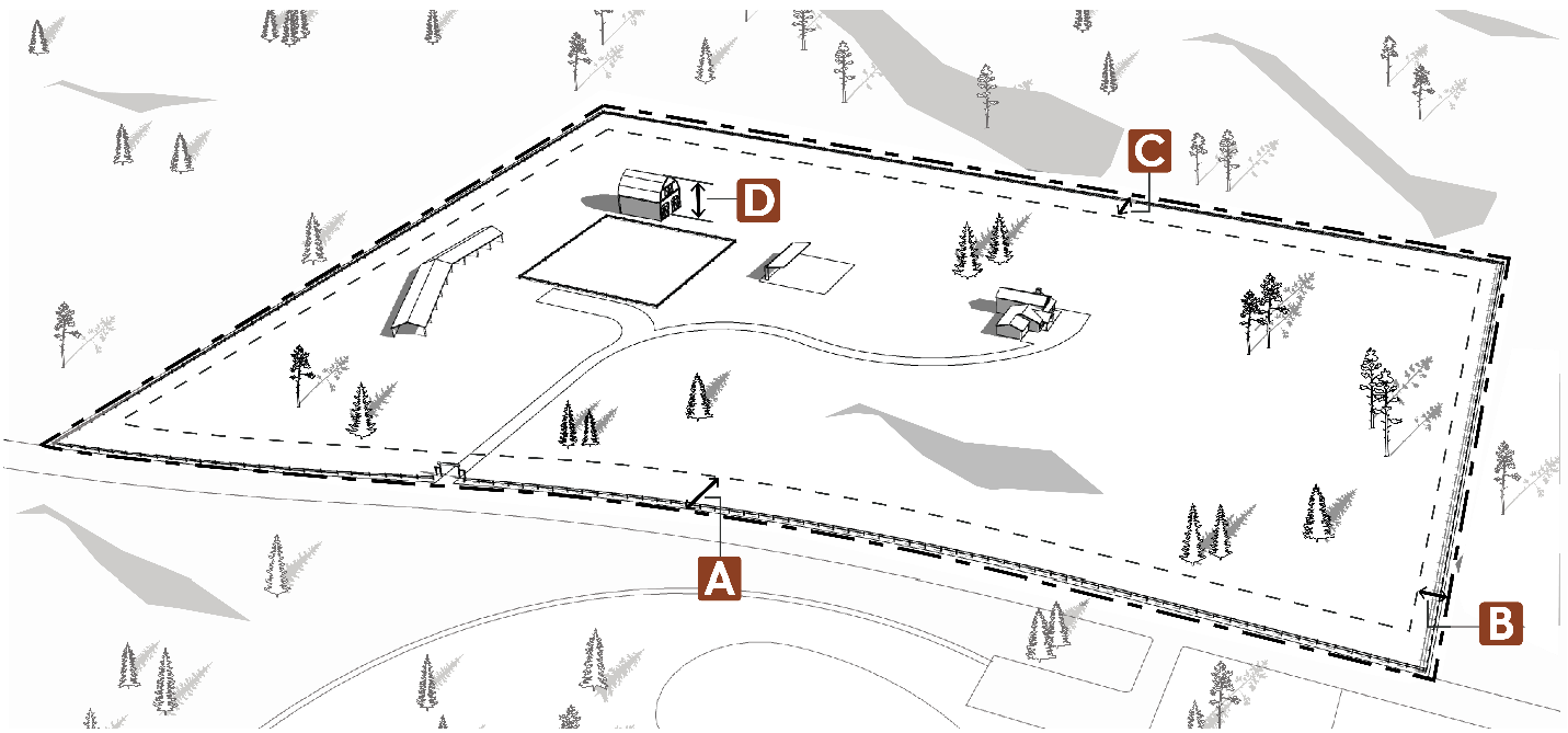
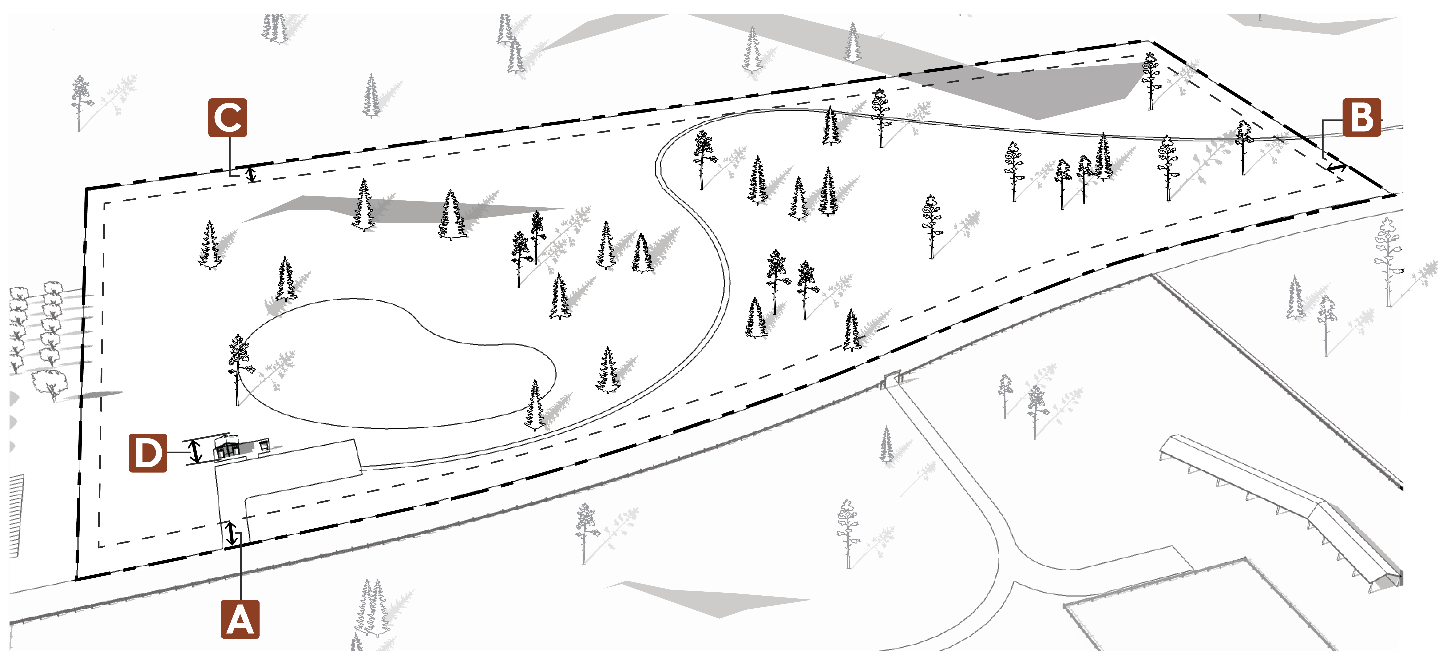
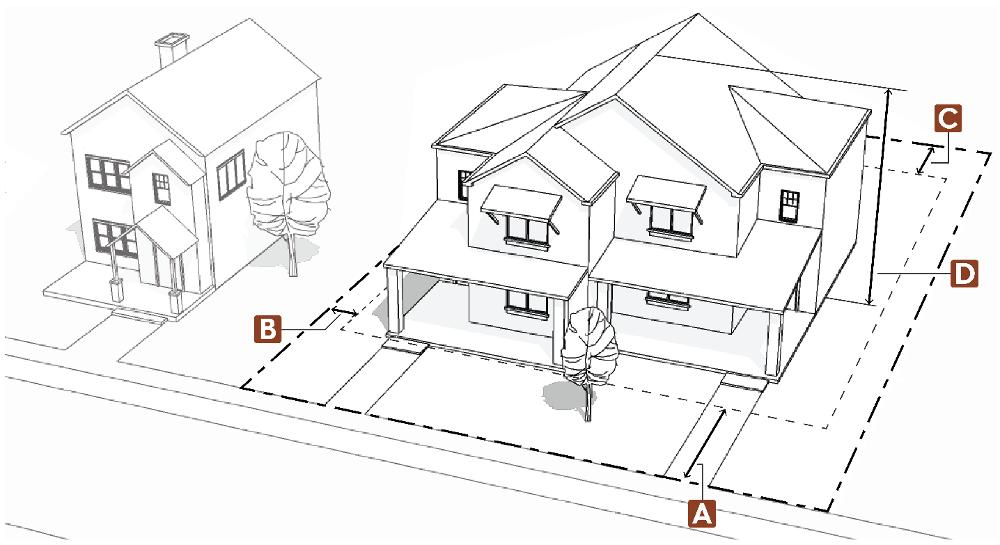
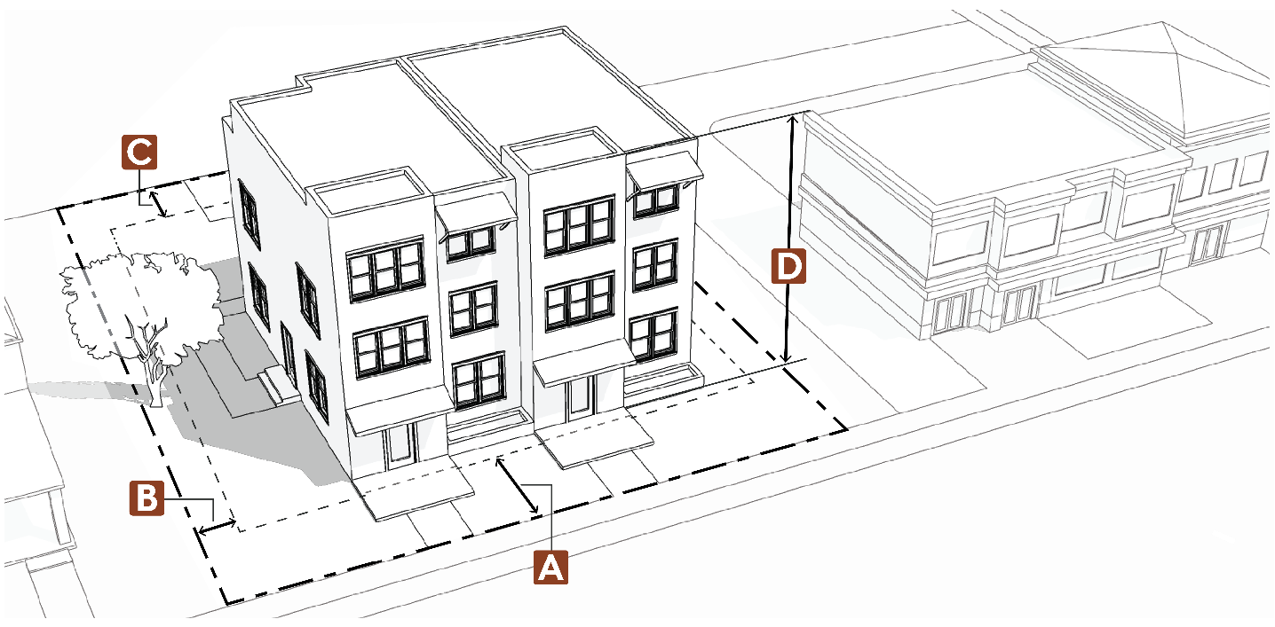
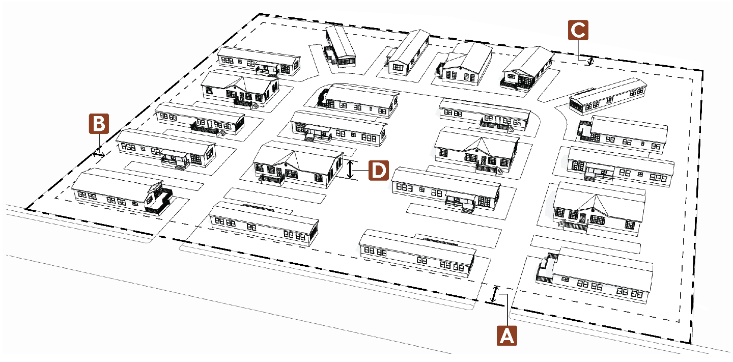
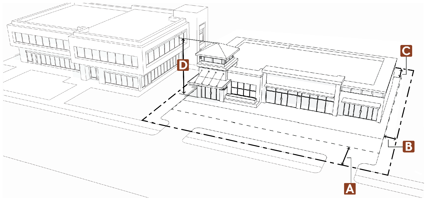
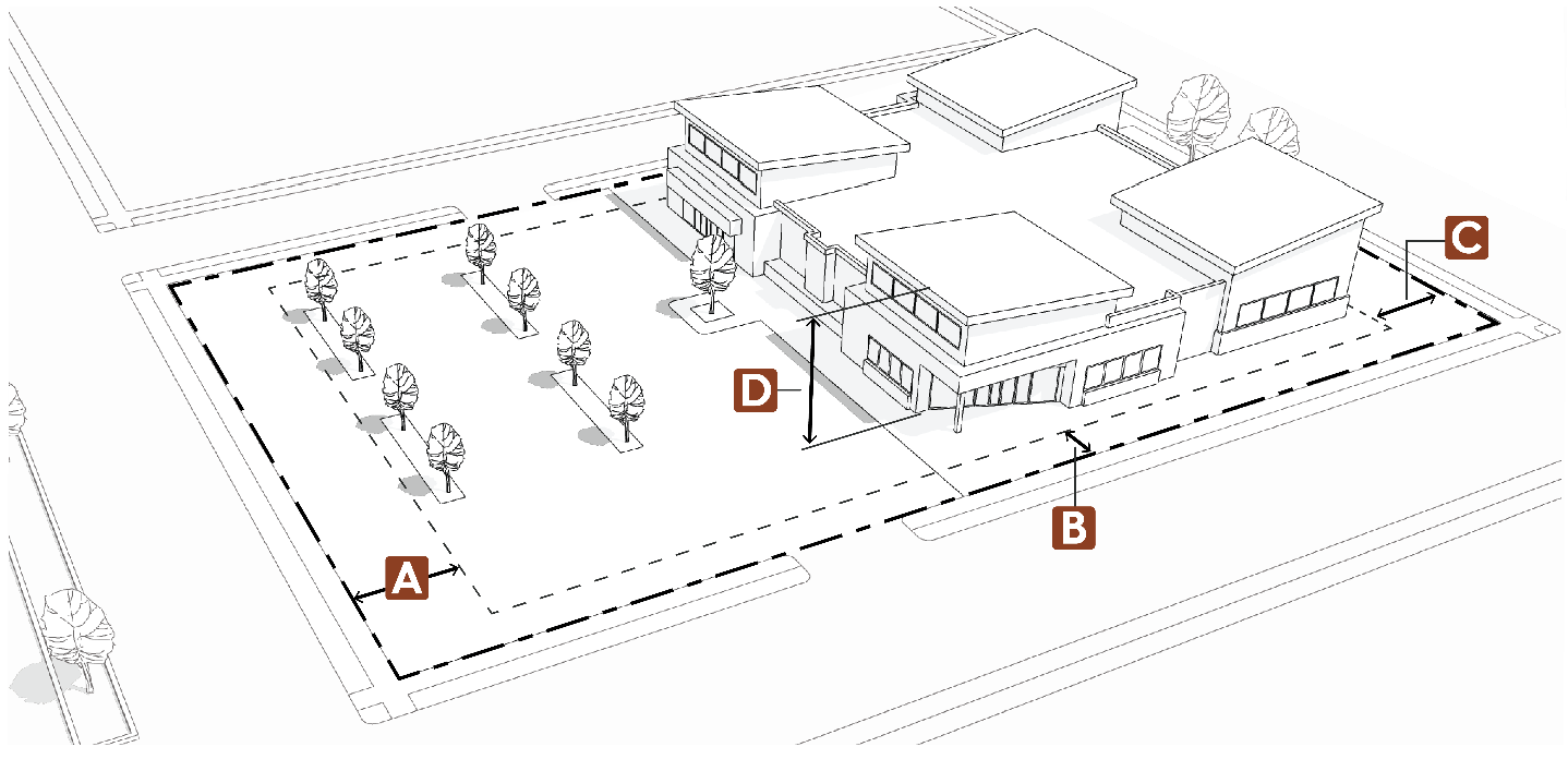
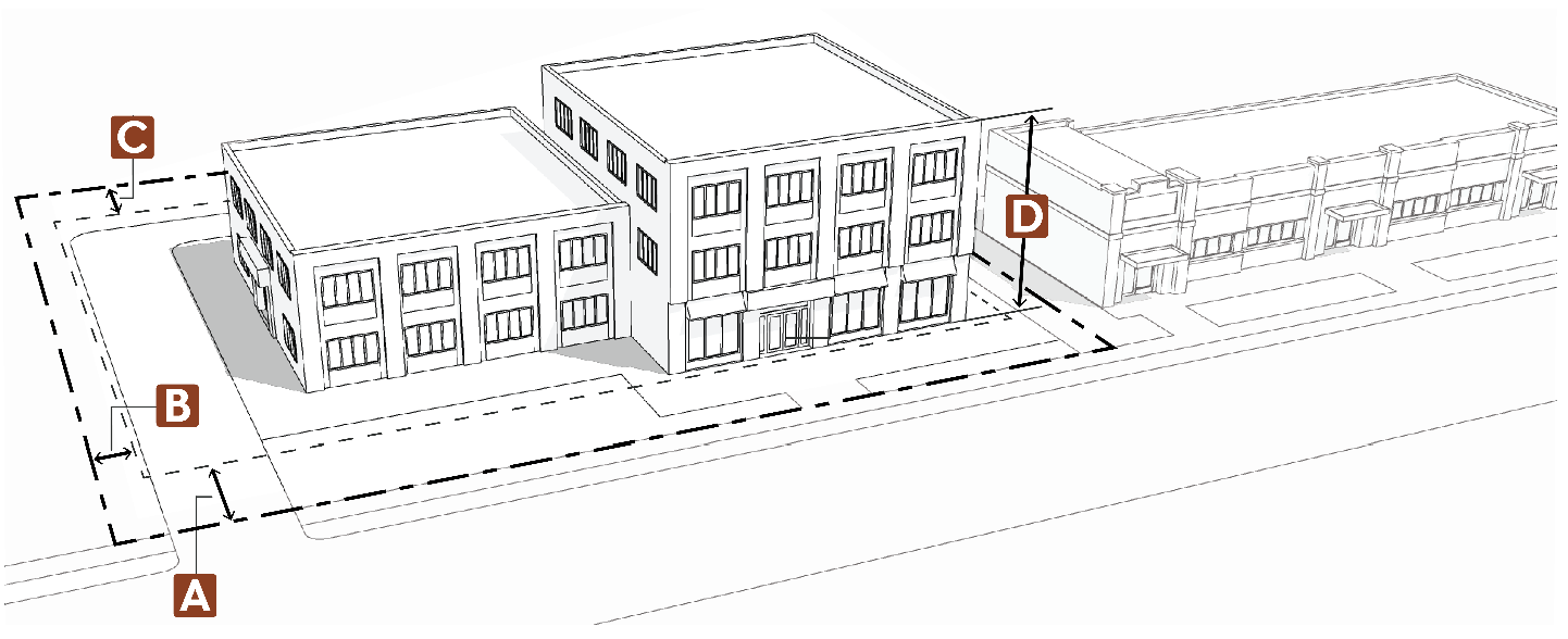
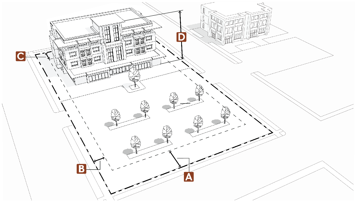
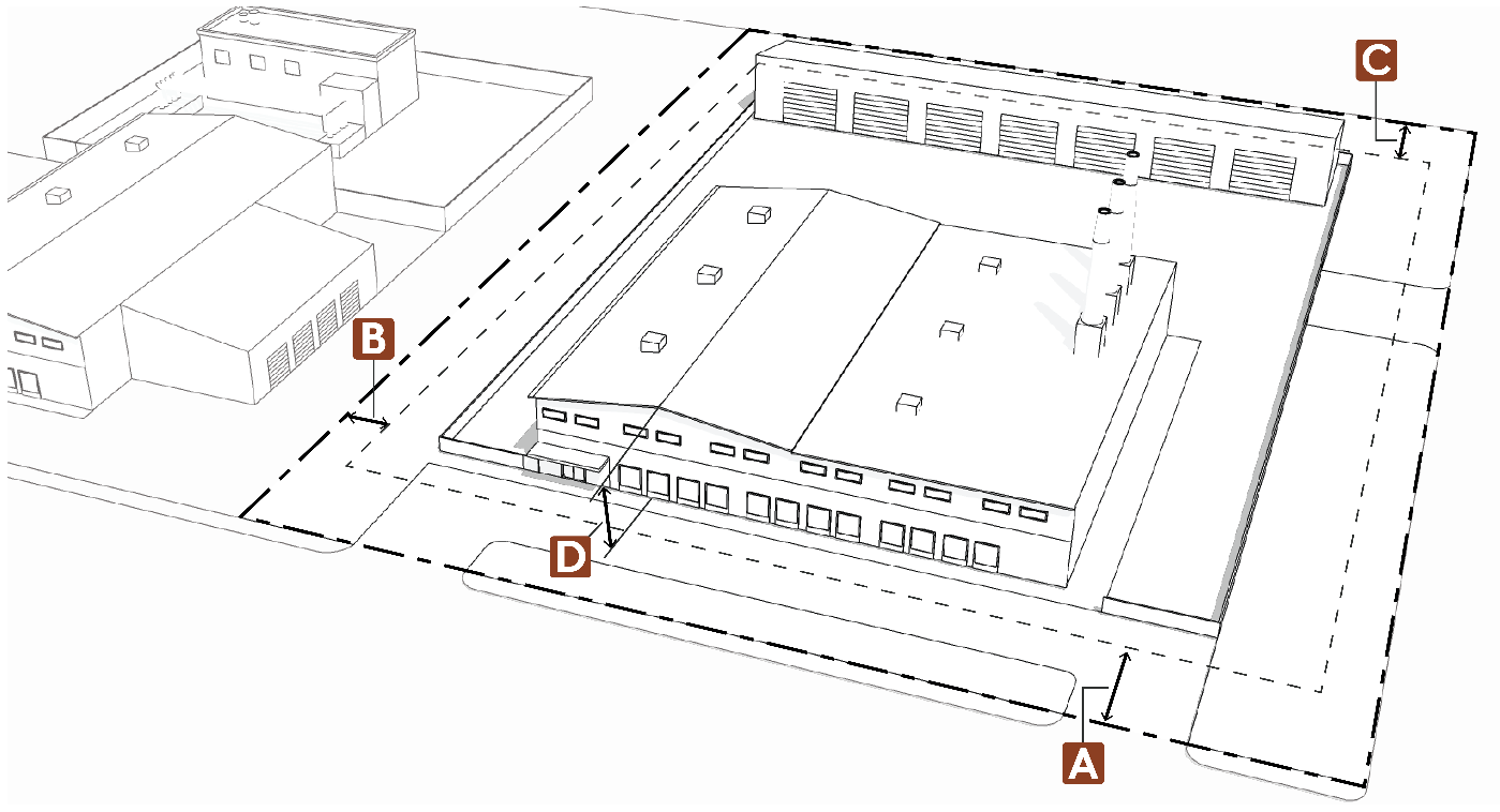
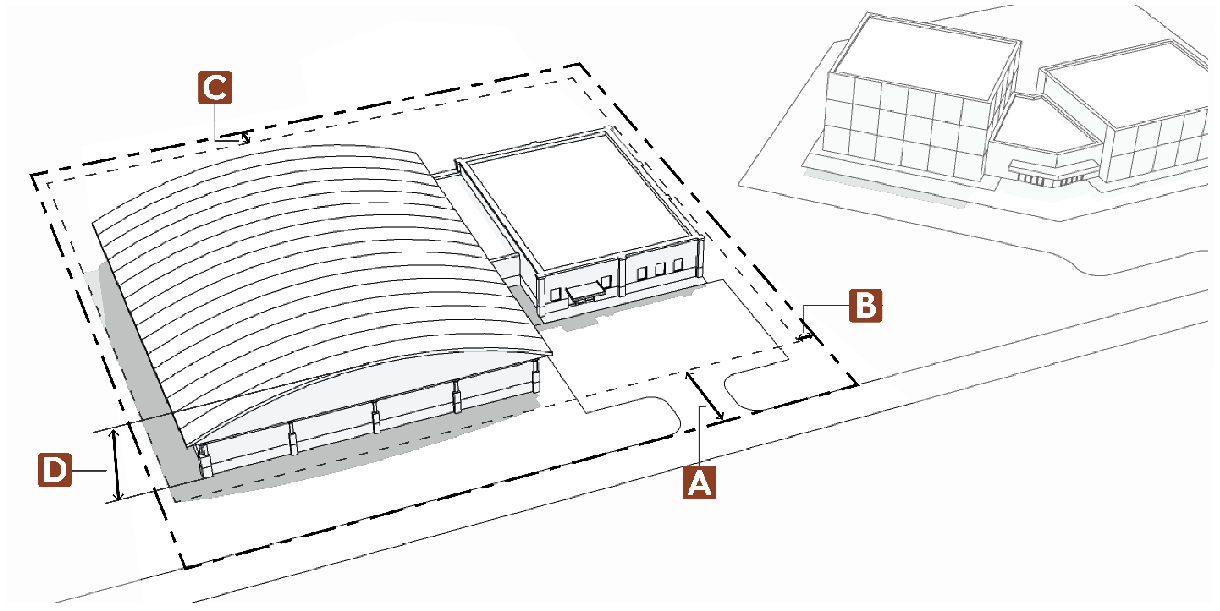
2.9.4. - Setbacks.
A.
Setback Measurement.
1.
Setbacks shall be measured from the lot line, nearest edge of the road easement, nearest edge of right-of-way, or nearest edge of traveled way, whichever is greater.
2.
The applicable street and road setback apply to both sides of a street or road adjacent to a lot or that goes through a lot. When an applicable side or rear setback exceeds the street or road setback, the greater setback applies.
3.
Setbacks do not apply to streets or roads that are used for internal circulation in multi-unit dwelling, commercial, or industrial developments.
4.
No part of any structure may extend into or above any easement.
B.
Setbacks for Attached Buildings.
For buildings where multiple dwellings or businesses share a common wall, only the outside walls of the end units shall comply with applicable setback requirements.
C.
Double-Frontage Lots.
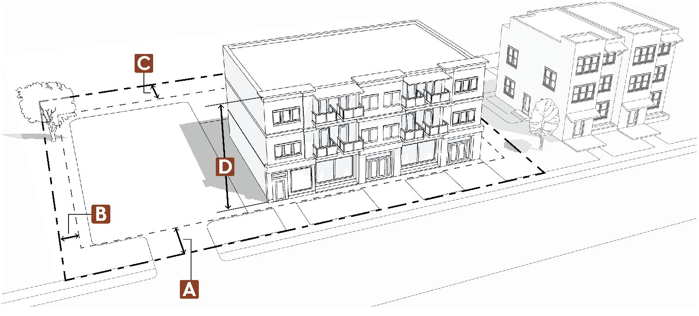
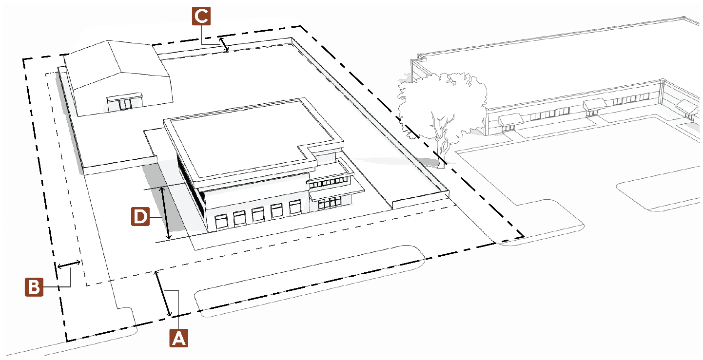
In the case of double-frontage lots, front setbacks shall apply to all frontages. See Figure 2-1, below.
Figure 2-1: Double-Frontage Lot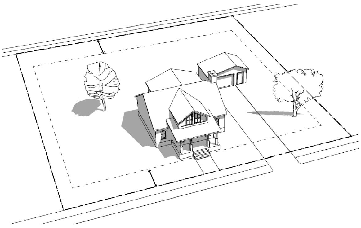
D.
Setbacks for Detached Accessory Buildings 200 Square Feet in Area or Less.
1.
Detached accessory buildings may be placed within the rear or side setbacks of a lot subject to the following requirements:
a.
All elements of the accessory building (including eaves and decorative features) shall maintain a distance of five feet from all lot lines;
b.
All other required setbacks, including those listed in subsection E and subsection F below, are met;
c.
The building is not on a permanent foundation;
d.
The height shall not exceed one story;
e.
The building is not used for any type of commercial or residential purpose;
f.
No part of any building may extend into or above any easement; and
2.
Where a building envelope is applicable, an accessory building may only be located outside of the building envelope when defined by the approval of a specific development approval condition.
E.
Setbacks from All Roads, Streets, and Highways.
Setbacks from specific road types are listed below. For all other road types not listed below, setback requirements are set forth in §§2.2 through 2.5 for each zoning district. In all cases, all structures shall be located outside of any existing right-of-way.
1.
Highways.
Setbacks from state and federal highways are 100 feet from the right-of-way centerline or 50 feet from the right-of-way line, whichever is greater, except those highways noted below where the minimum setback is 130 feet from centerline of the right-of-way or 80 feet from the right-of-way line, whichever is greater:
a.
U.S. Highway 287 from Fort Collins city limits south to the Boulder County line.
b.
Colorado Highway 68 (Harmony Road) from Interstate 25 west to Highway 287.
c.
Colorado Highway 14 (Mulberry Street) from Fort Collins city limits east to the Weld County line.
d.
Colorado Highway 392 from Interstate Highway 25 east to the Weld County line.
e.
U.S. Highway 34 from Morning Drive east to the Weld County line.
f.
Fort Collins Expressway and those portions of U.S. Highway 287 and Colorado Highway 14 north of Fort Collins city limits that are four lanes.
g.
Colorado Highway 402 from Loveland city limits east to the Weld County line.
2.
County Roads.
a.
Setbacks from Larimer County roads, as identified and classified on the Larimer County Functional Road Classification Map, are measured from the original right-of-way centerline as shown in Table 2-7: Road Classification, before any additional right-of-way was dedicated, as determined by the County Engineer.
b.
Setbacks for additions to existing buildings that are nonconforming with respect to county road setbacks may be eligible for a minor modification pursuant to §6.7.1, Minor Modifications.
3.
County and Annexed Roads within an Adopted Growth Management Area (GMA).
a.
Properties in unincorporated Larimer County and within the boundaries of an adopted Growth Management Area (GMA) that are adjacent to a county road that is located within the GMA are eligible for a minor modification, pursuant to §6.71., Minor modifications, to conform with to the standard building setbacks of the applicable County zone district rather than the County Road classification setbacks shown in Table 2.7: Road Classification.
b.
Properties in unincorporated Larimer County and within the boundaries of an adopted Growth Management Area (GMA) that are adjacent to an annexed road that is located within the GMA are eligible for a minor modification pursuant to §6.7.1., Minor Modifications, to utilize a setback consistent with those allowed by the municipality of the GMA rather than the County Road classification setbacks shown in Table 2.7: Road Classification.
F.
Setbacks from Streams, Creeks, and Rivers.
The minimum required setback from any stream, creek or river identified on a U.S.G.S. quadrangle map is 100 feet from the centerline of the water course unless a greater setback is required by §4.4.2, Wetlands, §4.4.4, Wildlife, or Article 12.0, Floodplain, or unless evidence is provided documenting that the centerline has been relocated by a previously approved development; or where the centerline is a ditch managed by a ditch company. This section is not applicable to irrigation laterals.
G.
Setbacks from Oil and Gas Facilities.
1.
Pre-Production Phase.
For permitted or existing oil and gas locations where all permitted wells have not entered completions, no new residential, commercial, or mixed-use building units shall be allowed within 1,000 feet of such oil and gas location. This includes, but is not limited to, school facilities, hospitals, medical clinics, senior living or assisted living facilities, or state licensed daycares. This section does not apply to industrial, agricultural, or open space uses. Measurements shall be taken from the edge of the oil and gas location.
2.
Early Production Phase.
Unless waived as described below, no new residential, commercial, or mixed use shall be allowed to be constructed within 1,000 feet of permitted or existing working pad surfaces for three years after the final well permitted for the location has been put into production. This includes, but is not limited to, school facilities, hospitals, medical clinics, senior living or assisted living facilities, or state licensed daycares. This section does not apply to industrial, agricultural, or open space uses. Measurements shall be taken from the edge of the working pad surface.
a.
Surface owner may waive this requirement to begin construction on platted lots but new construction must meet minimum setback requirements listed under "Production Phase";
b.
Surface owner must comply with noticing requirements in "Plat Requirements" below, and
c.
Buildings will not receive a certificate of occupancy until the two years has expired or at the discretion of the Director.
3.
Production Phase.
For permitted working pad surfaces where all permitted wells have been in production for more than three years, or the permit has otherwise lapsed, been revoked, or forfeited, and is not subject to renewal or reissuance:
a.
No new residential, commercial, or mixed-use lots, school facilities, hospitals, medical clinics, senior living or assisted living facilities, parks, or state licensed daycares may be platted within the following minimum setbacks:
b.
Measurements shall be taken from the closest edge of the "working pad surface."
c.
The setback from a flowline or gathering line shall be a minimum of 50 feet. Increased setbacks shall be evaluated on a case-by-case basis, with the determining locational factor being the size, pressure, and type of pipeline being proposed.
4.
Post-Production Phase.
For oil and gas wells that have been abandoned, no building may be placed within 200 feet of the well-bore. There shall be access for ingress and egress to the buffer of a width of not less than 26 feet. An applicant may be granted an "alternative compliance buffer" as described below.
a.
Alternative Compliance Buffer Reduction from Plugged and Abandoned Wells.
Upon applicant request, the Director of Development Services may approve a reduced buffer distance from a plugged and abandoned well in lieu of the minimum 200 foot buffer distance provided that the approved reduced buffer is not less than 50 feet in width and 100 feet in length. The plugged and abandoned well shall be located in the center of the buffer. There shall be access for ingress and egress to the buffer of a width of not less than 26 feet.
b.
Alternative Compliance Buffer Plan.
An alternative compliance buffer reduction plan shall be prepared and submitted in accordance with the submittal requirements established by the Director. At a minimum, the plan must:
i.
Clearly identify and discuss the proposed buffer reduction and the ways in which the plan eliminates or minimizes the potential adverse effects to the level achieved by the 200 foot buffer.
ii.
Include information regarding environmental testing and monitoring for the site. Engineering review, site investigation, sampling, and/or monitoring shall be conducted to demonstrate that the well has been properly abandoned and that soil, air and water quality have not been, and will not be, adversely impacted by oil and gas operations or facilities or other sources of contamination. Such sampling and monitoring shall be conducted by a qualified environmental engineering or consulting firm with experience in oil and gas investigations. Director approval that the sampling and monitoring plan contains the information required pursuant to this subsection is required prior to sampling occurring.
iii.
Include a site survey, historical research, and/or physical locating techniques to determine exact location and extent of oil and gas operations and facilities.
iv.
The plugged and abandoned well shall be permanently marked by a brass plaque set in concrete similar to a permanent bench-mark to monument its existence and location. Such plaque shall contain all information required on a dry hole marker by the Energy and Carbon Management Commission. The exact location will be recorded at the county clerk and recorder.
v.
Include documentation of plugging activities, abandonment and any subsequent inspections.
vi.
Include the results of soil sampling, including soil gas testing.
vii.
Include the results of groundwater sampling.
viii.
Include a written report verifying that the soil and groundwater samples meet applicable EPA and State residential regulations and that a reduced buffer would not pose a greater health or safety risk for future residents or users of the site.
c.
Review Criteria.
To approve an alternative compliance buffer reduction plan, the Director of Development Services must first find that the proposed alternative plan eliminates or minimizes the adverse effects referenced in the purpose of this section equally well or better than would a plan which complies with the separation and spacing standards of this section.
d.
Conditions of Approval.
The Director of Development Services may require conditions of approval which may specify an appropriate buffer distance or require that the following actions be completed by a qualified professional before development may occur, including but not limited to:
i.
Remediation of environmental contamination to background levels.
ii.
Re-plugging of a previously abandoned well.
5.
Plat Requirements.
The following information shall be denoted on all preliminary and final plats as required by §6.5.5, Preliminary Plat and §6.5.6, Final Plat.
a.
No final plat shall be submitted to the County for approval if such plat includes any lot, upon which a dwelling unit or public or private school could be built, within 1,000 feet from an existing or proposed oil or gas well unless the subdivider records against title to such lots the following notice, in at least 14 point font: "As required by Section 2-9-4 of the Larimer County Land Use Code, notice is hereby given that [insert description of lot] contains, or in the future could contain, a dwelling unit or public or private school within 1,000 feet of a producing or proposed oil or gas well. For more information contact Larimer County Community Development Department or the Energy and Carbon Management Commission." Such written notice may only be amended or terminated by the owner of such lot to correct typographical errors or to reflect the plugging and abandonment of wells. When any lot subject to the above written notice is first sold after plat approval to a purchaser intending to occupy the dwelling unit, the seller must provide the above written notice, in at least 14 point font, to the purchaser.
b.
The reception number, date, and recording location of all relevant surface use agreements;
c.
The plat must show the location of all oil and gas production facilities, pipelines, flowlines, gathering lines, access roads, and any associated easements within 1,000 feet of the platted property. This information will also be provided in a format suitable for input into the County's GIS system.
i.
A plat designation surrounding such oil and gas wells and facilities, and a note expressly prohibiting any habitable building or structure within the Production Phase setback as described in §2.9.4.G.3.
ii.
A plat designation surrounding such flowlines and gathering lines, and a note expressly prohibiting any habitable building or structure within 50 feet of those facilities; and
d.
Plugged and Abandoned Wells.
i.
Prior to submittal of a final plat or site-specific development plan, each plugged and abandoned well shall be located and surveyed. This information will also be provided in a format suitable for input into the County's GIS system.
ii.
On every final plat or site-specific development plan which contains a plugged and abandoned well, there shall be dedicated a well maintenance and workover setback depicted on the plat, the dimensions of which shall provide a 200 foot buffer unless Director has granted an alternative compliance buffer of not less than 50 feet in width and 100 feet in length. No structures shall be located within this setback. The plugged and abandoned well shall be located in the center of the setback. There shall be public access for ingress and egress to the setback of a width of not less than 26 feet.
e.
Vacation of Existing Easements.
No easement may be vacated for a previous or existing well, flowline, or gathering line, unless documentation is provided to the County demonstrating such well, flowline, or gathering line has been vacated in compliance with all applicable Energy and Carbon Management Commission regulations.
H.
Steep Slopes.
The Director may require greater setbacks for properties in the mixed-use and nonresidential districts to avoid development of steep slopes adjacent to public rights-of-way.
I.
Allowed Setback Encroachments.
1.
In all cases a minimum setback of five feet shall be required from all property lines for any structural component or architectural feature.
2.
All structures must maintain a distance of five feet from all lot lines. Structures may be located outside of a building envelope unless restricted to the building envelope as a part of an approved development. No part of any structure may extend into or above any easement.
3.
Setback exceptions do not apply to easements.
4.
Certain architectural features and improvements may encroach into required setbacks as follows:
J.
Setback and Survey Certification.
1.
All non-residential development requires a survey certification to verify compliance with the approved site plan, plat, or plot plan.
2.
At the time of the footing and foundation inspection by the Larimer County Building Department, the property owner is required to clearly identify the boundary corners of the lot and/or building envelope.
3.
On lots without building envelopes, the owner will be required to obtain a licensed surveyor's certification of the building location whenever the proposed setback is less than five feet beyond the required setback.
4.
On lots with building envelopes, the owner will be required to obtain a licensed surveyor's certification whenever the proposed building location is less than five feet from the boundary of the building envelope.
5.
The certification, when required, shall be provided by a surveyor licensed to practice in the State of Colorado. The certification may be in the form of a letter, which shall be signed and sealed by the licensed surveyor. The letter shall include the number of the building permit issued for the site in question.
(Res. of 6-13-2023, Exh. A, 2; Res. of 11-6-2023, Exh. A; Res. of 4-22-2024, Exh. A; Res. of 8-12-2024, Exh. A)
2.9.5. - Building/Structure Height.
A.
Measurement.
Generally, the height of a building or structure shall be measured vertically from the average elevation of the finished grade to the highest point on a building or structure.
B.
Exceptions.
1.
The maximum height standards specified in this Article 2.0 shall not apply to:
a.
Church spires, belfries, cupolas, chimneys, and other similar design or architectural features or other appurtenances that are usually installed above roof level.
b.
Federally licensed amateur radio transmission and receiving antennas that meet the following criteria:
i.
The height of the tower and antenna does not exceed the distance to the nearest property line;
ii.
All guy wires, tiedowns and other support components of the antenna are installed according to the manufacturer's specifications and are located on the same lot with the antenna; and
iii.
Foundation plans for the antenna are submitted with an original seal and signature of a Colorado Licensed Engineer who has documented experience reviewing such installations.
c.
Radio and television transmitters, accessory wind generators approved by administrative special review, and/or small wind energy facilities.
d.
Building-mounted accessory solar energy system or small solar energy facility provided it does not exceed the maximum height allowed by the respective zoning district by more than five feet.
e.
Wireless Commercial Facilities (WCF), which are regulated by Article 9.0, Wireless Communication Facilities.
2.
The maximum height of flagpoles is 40 feet in all zoning districts, provided that the height of the flagpole does not exceed the distance to the nearest property line.