Larimer County Unincorporated
City Zoning Code
City Zoning Code
ARTICLE 4
0 - DEVELOPMENT STANDARDS1
Cross reference— Buildings and building regulations, ch. 10; businesses, ch. 14; health, environment and natural resources, ch. 30 open space, parks and recreation, ch. 42; roads and bridges, ch. 50.
4.1. - Purpose
The article includes standards that regulate the physical layout and design of development in the County. These standards implement the Comprehensive Plan goals of:
A.
Encouraging safe, affordable, and reliable infrastructure, connectivity, and services, compatible with rural activities and needs;
B.
Encouraging the deployment of reliable, affordable, and redundant connectivity with built-in redundancy for critical infrastructure;
C.
Valuing, identifying, protecting, and responsibly managing the County's natural and cultural resources to minimize impact and protect our air, soil, open spaces, watersheds, water supply, and other ecosystem services;
D.
Ensuring land use is suitable for and compatible with the environmental characteristics of the site;
E.
Preparing for wildfires, floods, and other natural disasters, and helping residents and businesses prepare themselves to be resilient to such events; and
F.
Ensuring that adequate public and/ or private facilities and services are provided and maintained concurrent with development.
4.4. - Environmental Resource Standards[2]
Cross reference— Health, environment and natural resources, ch. 30; open space, parks and recreation, ch. 42.
4.6. - Off-Street Parking and Loading[3]
Cross reference— Parking, ch. 58, Art. III.
4.11. - Air Quality[4]
Cross reference— Health, environment and natural resources, ch. 30.
4.14. - Supplementary Engineering Regulations
The following standards have been adopted by the County as supplemental regulations to this LUC:
4.2.1. - Identification of and Compliance with Development Standards.
A.
Overview.
Determining how the development standards of this article apply to a property involves two considerations: identification of relevant standards and determination of compliance.
1.
Identification of relevant standards (subsection B below) is the process by which an applicant determines which standards will be generally applicable to a development project based on the property's location. For example, connectivity standards may apply to development in more urban areas, but not apply to rural development.
2.
Compliance (subsection C below) is a determination made by the County of the extent to which the relevant development standards apply to a specific project. For example, parking lot landscaping standards may apply to new construction but not to a change of use.
B.
Identification of Relevant Development Standards.
1.
Table 4-1 below identifies when development standards are generally applicable based on the character area in which the project is located.
2.
Specific applicability requirements and exemptions are identified in each development standard section of this article.
3.
The subsection following Table 4-1 identifies which development standards may be applicable to a particular type of project.
C.
Determining Development Standard Compliance by Development Types.
This section describes the extent to which a proposed project is required to comply with applicable development standards.
1.
Definition of Development Type.
For the purposes of this article, development types are categorized as:
a.
New.
Any construction activity or site alteration on a site that has not been previously developed.
b.
Minor Expansion.
Any development activity that includes the following:
i.
Expansion of a mixed-use building by more than 2,000 square feet of non-residential space or the lesser of more than ten dwelling units or ten percent of the number of dwelling units; or
ii.
Expansion of a non-residential building by the greater of either 2,000 square feet or more than 20 percent of the total square footage of the building.
c.
Change of Use.
Any change of use that involves or requires on-site or off-site improvements, including but not limited to:
i.
Parking;
ii.
Landscaping, screening, or buffering;
iii.
Drainage facilities;
iv.
Outdoor uses on the lot, including sales, display, and storage.
d.
Major Redevelopment.
Any development activity on a mixed-use or non-residential site that involves change to 75 percent or more of the square footage of a primary structure. Major redevelopment shall be measured cumulatively over a rolling five-year period in the same ownership, starting with the applicant's most recent development application.
2.
Compliance Requirement.
Development shall comply with applicable development standards as described in this section and summarized in Table 4-2.
3.
Compliance Requirements by Development Standard Category.
a.
Section 4.3, Adequate Public Facilities.
Any adequate facility type that is directly impacted by a minor expansion or change of use shall be brought into compliance with this Code. Where this requirement would result in a disproportionate expense to the applicant in relationship to the overall cost of the project, the Director may work with the applicant to determine the most critical improvements and recommend deferred compliance with less relevant facilities based on the following order of priority (most important to least):
i.
Drainage.
ii.
Wastewater Disposal.
iii.
Access to Public Roads.
iv.
Fire Protection.
v.
Domestic Water.
b.
Section 4.4, Environmental Resource Standards.
Minor expansions and changes of use may not expand into or impact hazard or environmentally sensitive areas that are mapped through the consideration of environmental resource standards. Where an application for minor expansion or change provides an opportunity to reduce the impact on environmental resources, the Director may encourage design changes that will result in reducing the impact.
c.
Section 4, 5, Connectivity and Circulation.
Minor expansions and changes of use shall comply with the following sections:
i.
Section 4.5.3, Driveways, and
ii.
Section 4.5.5 Pedestrian and Bicycle Circulation.
d.
Section 4.6, Off-Street Parking and Loading.
i.
Minor expansions shall comply with all applicable requirements in §4.6, Off-Street Parking and Loading unless the Planning Director waives the requirements based on a determination that the character and scale of the expansion does not adversely impact the parking and loading needs of the development.
ii.
Changes of use shall comply with all applicable requirements in §4.6, Off-Street Parking and Loading unless the Planning Director waives the requirements based on a determination that the scale and character of the new use is sufficiently similar to the current use and is not likely to adversely impact the off-street parking and loading needs of the development.
e.
Section 4.7.3, Landscaping.
i.
Minor expansions shall comply with all applicable requirements in §4.7.4, Minimum Landscaping Required unless the Planning Director waives the requirements through an Alternative Landscape Plan or based on a determination that the scale and character of the expansion does not adversely impact the quality, appearance, or
ii.
Changes of use shall comply with all applicable requirements in §4.7.4, Minimum Landscaping Required unless the Planning Director waives the requirements based on a determination that the scale and character of the new use is sufficiently similar to the current use and is not likely to adversely impact the off-street parking and loading needs of the development.
f.
Section 4.8, Adjacency and Buffering Standards.
Parcels with minor expansions and changes of use shall be brought into full compliance with §4.8, Adjacency and Buffering Standards.
g.
Section 4.9, Site and Building Standards in Urban Areas.
Minor expansions and changes of use shall comply with site and building standards that are applicable to the expansion or any proposed site change.
h.
Section 4.10, Exterior Lighting.
A minor expansion or change of use shall trigger full compliance with the exterior lighting standards.
i.
Section 4.11, Air Quality.
A minor expansion or change of use shall trigger full compliance with the air quality standards.
j.
Section 4.12, Water Quality.
A minor expansion or change of use shall trigger full compliance with the water quality standards.
4.2.2. - Compliance, How Shown.
1.
All development applications shall submit the necessary information required by the Director to demonstrate compliance with the standards of this article. All nonresidential development applications shall be required to submit a site plan pursuant to §6.4.1, Site Plan Review.
2.
Applicants may request minor modifications of development standards per §6.7.1, Minor Modifications.
4.2.3. - Consultant Review.
A.
When Required.
Consultant assistance may be commissioned for complex projects or when certain aspects of a project are beyond the County staff's expertise.
B.
Planning Director Authority.
1.
The Planning Director may, when necessary, decide that additional expertise is needed to ensure compliance with the standards in this article.
2.
If the Planning Director decides additional expertise is needed, the Planning Director and the applicant will select a consultant to review the project.
C.
County Commissioners Authority.
1.
If the Planning Director and the applicant cannot agree on a consultant, the County Commissioners will select the consultant.
2.
The Planning Director's decision to require a consultant may be appealed to the County Commissioners.
D.
Costs to the Applicant.
All costs for the consultant will be charged to the applicant.
4.3.1. - Purpose.
The purpose of this section is to implement the Comprehensive Plan goal of ensuring that adequate public and/or private utilities, facilities, and services are provided and maintained concurrent with development.
4.3.2. - Applicability.
A.
Compliance Thresholds.
The standards of this section shall apply to all development that meets the compliance thresholds established in §4.2, Applicability.
B.
Application Requirements.
Application requirements are in the LUC Supplemental Materials.
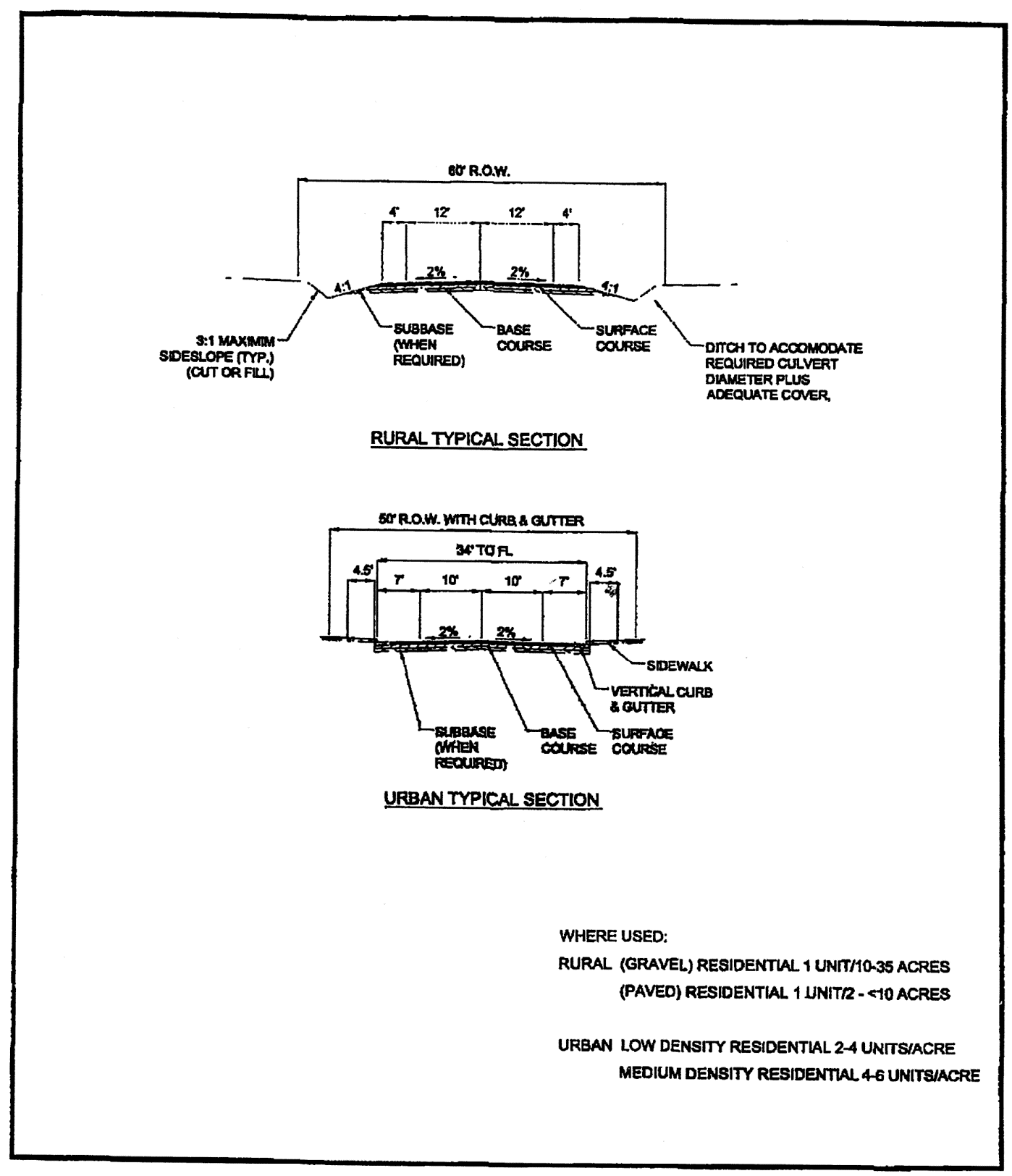
4.3.3. - Road Capacity and Access to Public Roads.
A.
Applicability and Relationship to other Standards.
1.
The standards in this §4.3.3 apply to all development.
2.
Additional standards relating to connectivity and circulation may also apply in the mixed center and Urban Districts and GMAs. See §4.5, Connectivity and Circulation.
B.
Purpose.
The purpose of the road capacity and level of service standard is to ensure that:
1.
All development will have safe and adequate access to public roads and transportation related services;
2.
Development does not create demand for public improvements and services that cannot be met with existing public resources; and
3.
If safe and adequate access does not exist at the time of development, the development makes the improvements necessary to meet the standard or waits until the needed improvements are constructed by others.
C.
Safe and Adequate Access.
1.
All development shall have safe and adequate access on the county roads or state highways within the traffic impact area of the development. Safe and adequate access exists when traffic volumes do not exceed the capacity of the road; when operating conditions on the road and at intersections do not fall below a specified level of service (LOS); and when pavement sections and structures can accommodate projected traffic.
2.
The capacity of an unpaved road is defined as the maximum traffic volume that can be accommodated without creating unsafe operating conditions for vehicles and without negatively impacting air quality by creating excessive amounts of dust. The capacity of a paved road is defined as the maximum traffic volume that can be accommodated at a specified level of service and depends on road characteristics, such as number of lanes, lane widths, intersection geometry, and signalization.
3.
The adequacy of pavement sections and structures depends on the physical conditions of the improvements, such as type, depth, and condition of pavements and the load-bearing capacity of bridges.
D.
Capacity and Level of Service for Unpaved Roads.
1.
To prevent adverse impacts on vehicles and air quality and to allow for effective road maintenance, roads shall have an all-weather gravel surface.
2.
The County Engineer may waive the requirement for gravel and allow a road to be surfaced with native material in limited cases when, in the opinion of the County Engineer, traffic volumes, materials, and location allow such a surface. However, in no case will a native material surface be allowed when the average daily traffic volume (ADT) exceeds 50 vehicles per day at the time of full build-out of the development.
3.
The capacity of an untreated gravel road is defined as an ADT of 200 vehicles per day at the time of full build-out of the development. The capacity of a treated gravel road (treated with chemicals to control dust) is defined as an ADT of 400 vehicles per day.
4.
Paving is required when cumulative traffic volumes exceed these capacities and shall consist of asphaltic concrete or Portland cement concrete, base course material and subbase material (if required) placed on compacted subgrade.
E.
Capacity and Level of Service for Paved Roads.
1.
Level of service (LOS) is a qualitative measurement of operating conditions on a paved road or at an intersection. Levels of service for roadways and intersections are generally determined by analyzing the ratio of traffic volume to capacity of roadways or by analyzing the length of delays experienced at intersections.
2.
Collector and arterial roads and intersections within the traffic impact area shall function at LOS "D" in the Urban districts and GMAs and LOS "C" in areas outside of the Urban districts and GMAs at the time of full build-out of a proposed development. Local roads and intersections within the traffic impact area shall function at LOS "C" in all areas of the County at the time of full build-out of a proposed development.
F.
Adequacy of Pavement Section and Structures.
1.
The roads within the traffic impact area of a proposed development shall have an adequate pavement section (depth of gravel, depth of base course and type, and depth of paving material) to accommodate the projected additional traffic loads from the development without damaging the roadway or accelerating the need for maintenance and shall not cross any bridge or structure that has been determined to be structurally deficient or functionally obsolete by the County Engineer.
2.
The County Engineer maintains a list of structurally deficient or functionally obsolete bridges that is available to applicants.
G.
Additional Conditions.
1.
The existence of safe and adequate access does not preclude the imposition of additional requirements as a condition of development approval when such requirements are deemed necessary to mitigate the impacts of the development on county and state roads and highways.
2.
In cases where the access route between the subject site and a county road identified on the Larimer County Functional Road Classification Map is anything but a public right-of-way, the applicant shall demonstrate by, competent evidence, the legal right to use any and all portions of that access route to the extent required for the pending development.
H.
Traffic Impact Area.
The limits of the traffic impact area for a proposed development are determined by the County Engineer in consultation with the applicant as described in Appendix F of the Rural Area Road Standards.
I.
Documentation Outside of the Urban Districts and GMAs.
Every development shall meet the requirements outlined in Appendix F of the Rural Area Road Standards.
J.
Documentation within the Urban Districts and GMAs.
1.
Every development shall meet the requirements of Chapter 4 of the Urban Area Street Standards.
2.
Every development shall submit a traffic impact study as required in Chapter 4 of the Urban Area Street Standards, in the technical supplement to this Code.
K.
Capital Contribution Front-Ending Agreement.
1.
The County may enter into a capital contribution front-ending agreement with any person proposing to construct a road to provide safe and adequate access to a proposed development. Where the road is on the County's major road system (collector and arterial streets established in the Larimer County Master Transportation Plan) and is eligible for capital expansion fee credits, the capital contribution front-ending agreement will provide proportionate and share reimbursement to the extent that the cost of the road exceeds the amount of credits for which the road is eligible.
2.
Where the road is not eligible for road capital expansion fee credits, the capital contribution front-ending agreement will provide proportionate share reimbursement.
3.
Reimbursement shall be provided from the new development that, in the future, will use the road for safe and adequate access within the traffic impact area.
Cross reference— Roads and bridges, ch. 50.
4.3.4. - Drainage.
A.
Drainage Standards.
1.
To be adequate, facilities shall be legally and physically acceptable. Adequate facilities may consist of natural drainages or manmade channels. The Larimer County Stormwater Design Standards provide guidance on drainage design and submittal requirements.
2.
Urban Districts and GMAs.
New developments within the Urban districts and GMAs shall comply with the following.
a.
Surface Runoff Level of Service.
i.
An approved master plan for basin-wide stormwater facilities shall be referenced if available.
ii.
Stormwater drainage shall be achieved through concrete curb and gutter systems throughout the development.
iii.
An acceptable legal and physical path-of-flow for runoff through and from the development to an identified outfall facility that drains into an established channel shall be available or funded at the time of vesting of development rights. The path of flow shall be consistent with the applicable master plan.
b.
Subsurface Drainage Level of Service.
i.
Level-of-service standards for subsurface drainage applies to lot sizes of one acre or less with an average lot frontage of 125 feet or less and public sanitary sewer service.
ii.
Groundwater drainage shall be achieved through sub-drain systems installed separately from the sanitary sewer system.
iii.
An acceptable legal and physical point of discharge for gravity flow of groundwater from the development to the discharge point shall either be available or funded at the time of vesting of development rights.
3.
Conservation and Agriculture, Rural, and Mixed-Center Districts.
New developments in the Conservation and Agriculture, Rural, and Mixed-Center districts shall comply with the following requirements:
a.
If an approved master plan for stormwater facilities exists for the basin within which the development is proposed, the master plan shall be referenced.
b.
An acceptable legal and physical path of flow for runoff through and from the development to an identified outfall facility which drains into an established channel shall be available or funded at the time of vesting of development rights. The path of flow shall be consistent with the applicable master plan.
4.3.5. - Wastewater Disposal.
A.
General Requirements.
The County Health Department must approve all wastewater disposal systems. New development shall provide one of the following wastewater systems:
1.
Domestic Wastewater Treatment Works.
a.
A domestic wastewater treatment works is the preferred method of wastewater collection and treatment in all zoning districts.
b.
The developer or applicant shall provide evidence that a sanitation district or municipal wastewater system serving the proposed development complies with the following requirements:
i.
Unless higher standards are required by the district or municipality, the design of the domestic wastewater treatment works shall be approved by the Colorado Department of Public Health and Environment's Water Quality Control Division;
ii.
The wastewater treatment works complies with the applicable Colorado wastewater discharge permit system permit; and
iii.
A report detailing compliance with the requirements listed above is submitted in accordance with the LUC Supplemental Materials.
c.
Capacity for the collection and treatment works shall be available at the time of issuance of a building permit.
2.
On-Site Wastewater Treatment System.
a.
Where Permitted.
On-site wastewater treatment systems must be located outside of the Urban districts, GMAs, and any existing or proposed wastewater treatment works service area as defined in the North Front Range Water Quality Planning Association's Water Quality Management plan, except in the case of Rural Land Plans.
b.
System Design and Submittal.
i.
All proposed lots shall be at least 87,120 square feet (two acres) unless otherwise allowed by the underlying zoning district or if site conditions require a larger minimum lot requirement as determined by the Planning Director.
ii.
In addition to the wastewater treatment works provider approval, an analysis comparing the feasibility to extend and connect to domestic wastewater treatment works with the feasibility to design and construct on-site alternatives is required for development sites within an existing or proposed wastewater treatment works service area as defined in the North Front Range Water Quality Planning Association's Water Quality Management Plan.
iii.
If an on-site wastewater treatment system is allowed, an inventory and analysis of site conditions relevant to the use of on-site wastewater treatment systems is required to support their use. Relevant site conditions include but are not limited to soils; percolation rates; location of bedrock and groundwater; surface water bodies; slopes; rock outcrops; irrigation ditches; and wetlands.
iv.
Substantial evidence shall be submitted to show that the design, layout, and density of a development proposal incorporates the inventory and analysis of site conditions listed above. Proposals shall show that site conditions are compatible with the use of on-site wastewater treatment systems and that the location of these systems will take advantage of favorable site conditions while avoiding significant constraints. Evidence of compatibility may include natural suitability of soils and other site conditions; development design and density tailored to limits placed by site constraints; and the ability to meet future lot owner expectations for operation and maintenance.
3.
Community Wastewater Treatment Systems.
a.
Where Permitted.
Development proposing to be served by community wastewater treatment systems shall be located outside of the Urban Districts, GMAs, and any existing or proposed wastewater treatment works service areas as defined in the North Front Range Water Quality Planning Association's Water Quality Management Plan, except in the case of Rural Land Plans.
b.
Management.
If approved to install a community wastewater treatment system, the development shall establish management arrangements that meet one of the following criteria:
i.
The development is located within an existing or proposed wastewater treatment works service area, and the community wastewater treatment system will be operated by the applicable wastewater treatment works provider (district or municipality) under the terms of a Colorado Department of Public Health and Environment discharge permit issued to the district or municipality;
ii.
The development is located within an existing or proposed wastewater treatment works service area and the applicable provider (district or municipality) has informed the County in writing that it does not wish to manage the community wastewater treatment system, and the system will be operated by a management entity as below; or
iii.
The development will connect to an existing community wastewater treatment system with adequate capacity to accommodate the additional flow and will be operated by the applicable authority under the terms of a Colorado Department of Public Health and Environment discharge permit issued to the authority.
c.
System Design and Submittal.
i.
An analysis comparing the feasibility to extend and connect to domestic wastewater treatment works with the feasibility to design and construct community wastewater treatment systems is required.
ii.
If applicable, a site approval is required by local reviewing agencies and the Colorado Department of Public Health and Environment's Water Quality Control Division.
iii.
If a site approval is not applicable, a report addressing site conditions as outlined in this §4.3.5.A.2, regarding on-site wastewater treatment systems, together with design and location information for the proposed community wastewater treatment system(s) is required.
iv.
A plan for operation and maintenance of the community wastewater treatment system is required for county approval. The plan shall outline the legal, financial, and staffing needs to:
1)
Provide for an incorporated management entity with power to compel all lot owners to participate;
2)
Provide for initial construction and ongoing operation and maintenance;
3)
Provide for system monitoring and evaluation;
4)
Provide for system repairs and replacement; and
5)
Provide for ultimate connection to public wastewater treatment where applicable.
v.
Unless higher standards are required by the district or municipality, the design of the domestic wastewater treatment works shall be approved by the Colorado Department of Public Health and Environment's Water Quality Control Division;
vi.
Capacity will be available at the time of issuance of a certificate of occupancy.
4.
On-Site Wastewater Treatment Systems in the Urban Districts and GMAs.
Development in the Urban Districts and GMAs that includes a proposal to use on-site wastewater treatment systems shall submit an appeal as part of the application. The appeal shall include the following items:
a.
A technical/economic analysis demonstrating that public wastewater treatment is not feasible;
b.
A letter from the applicable city utility or sanitation domestic wastewater treatment works provider indicating concurrence that it is not feasible to connect to public wastewater treatment;
c.
A letter from the applicable municipality indicating their concurrence that the development as proposed will achieve the land use pattern envisioned for this part of the growth management area.
d.
A letter from the applicable municipality that indicates their willingness to annex the property when it becomes eligible for annexation; and
e.
Information demonstrating that on-site wastewater treatment systems can be safely provided as anticipated as stated in this subsection.
5.
Interim Uses.
Uses that do not require permanent facilities (such as gravel mining or special events) may propose alternative sanitation facilities methods for review and approval by the County Health Department.
4.3.6. - Fire Protection.
A.
Applicability and Relationship to Adopted Fire Codes.
1.
Fire protection standards or a fire protection plan are required for all new developments.
2.
The standards of this subsection shall be considered the minimum requirements even for those areas within the boundaries of a fire district that have adopted a fire code approved by the County Commissioners.
B.
Determination of Adequacy.
1.
Fire protection shall be deemed adequate if compliance with the standards as stated in this section have been met.
2.
The availability and adequacy of water supply and access for emergency medical and fire protections services will determine how fire protection is provided.
3.
Access to a site is required for emergency medical and fire protection service.
4.
The adequacy of fire protection is determined by:
a.
The location of development,
b.
Availability of a water supply for firefighting, and
c.
Access to development.
5.
The adequacy of access to development is determined by the:
a.
Type of dwelling units or non-residential construction being served,
b.
Surface type and length of access roadways, and
c.
Firefighting water supply availability determines how fire protection is provided.
C.
Provision of Fire Protection and Emergency Medical Service.
1.
Fire protection service is provided by one of three entities:
a.
A municipality or a special district/authority,
b.
Volunteer departments, or
c.
The Larimer County Sheriff.
2.
Emergency medical service is provided by a mix of ambulance service, fire districts, and/or "quick response teams."
D.
Authority of the Fire District to Request Additional Information.
1.
The fire district or other appropriate agency may, based upon their adopted fire code, require compliance with a higher standard for development proposals as the result of the development's location, size, or type of construction, in which case one of the following shall occur:
a.
The applicant may agree to the higher standard, which would be implemented through a condition of approval;
b.
The County Commissioners, upon the recommendation of the fire district may impose a higher standard as a condition of the approval of the development proposal; or
c.
If not agreed to by the applicant or required as a condition of approval by the County Commissioners, the fire district may elect to enforce a higher standard through their own enforcement processes.
2.
Disclosure documents required as a part of the final documents for a development application, recorded as part of the final approval, shall include language stating that the County will not enforce or be responsible for enforcing a higher standard.
E.
General Standards.
1.
Water Supply for Firefighting.
a.
All development subject to the standards of §4.3.6, Fire Protection, shall comply with the applicable requirements listed in Table 4-3, below.
b.
Fire sprinkler systems must be designed and installed according to the standards of the National Fire Protection Association (NFPA) and the requirements of the fire authority having jurisdiction.
c.
When a public water system is not available, the fire protection provider or the Office of Emergency Services of the Larimer County Sheriff's Department, and Chief Building Official shall review and make a recommendation of a fire protection plan that meets the standards set forth in §4.3.6.G, Fire Protection Plans.
2.
Residential Development Access.
Development applications proposing access to serve 30 or more dwelling units, shall provide two access points. If the access serves less than 30 units, an approved secondary/emergency access may be required.
F.
District-Specific Standards.
1.
Standards for the Urban Districts and GMAs.
a.
Proximity to Services.
New development within the Urban districts and GMAs shall be located within a five-mile travel distance of an existing, manned fire station.
b.
Firefighting Access Roadways.
All access roadways shall meet the following requirements unless an alternative standard is approved by the County Commissioners:
i.
Meet the Urban Area Street Standards;
ii.
Have a minimum travel way width of 20 feet and have full connectivity to a public road system;
iii.
Allow for secondary (emergency) access when necessary;
iv.
Have no uninterrupted road segment which results in a dead-end road length of more than 660 feet;
v.
Provide access for firefighting, equipment, and firefighters to all sides of any nonresidential structure;
vi.
Allow for all access roads to support fire apparatus with a weight of 80,000 pounds; and
vii.
Incorporate turnarounds with a minimum diameter of 100 feet for all dead-end accesses, irrespective of length.
2.
Standards for All Other Districts.
a.
Proximity to Services.
Developments in the Conservation and Agriculture, Rural, and Mixed Center districts have no requirements for proximity to a fire station, due to the variety of jurisdictions, providers, and character of the area.
b.
Firefighting Access Roadways.
All access roadways shall meet the following requirements:
i.
Meet the Rural Area Road Standards;
ii.
Have a minimum travel way width of 20 feet;
iii.
Not be more than 660 feet in length from a secondary access point. If the distance is more than 660 feet, then residential sprinklers shall be required; and
iv.
Design roadway construction for all access roads to support fire apparatus with a weight of 80,000 pounds and be an all-weather surface.
G.
Fire Protection Plans.
1.
A fire protection plan shall be required for developments that cannot comply with the fire protection standards in §4.3.6, Fire Protection.
2.
Fire protection plans shall include:
a.
Water available for firefighting by source;
b.
Maintenance of the water supply;
c.
Distance to supply;
d.
Distance between structures;
e.
Access to supply and structures;
f.
Special plans/designs to address the existence and mitigation of wildfire hazards.
g.
Entity responsible for providing fire protection services (fire district fire department or Larimer County Sheriff); and
h.
The fire protection plan shall use national standards for gallons and flow duration as described in the International Fire Code (IFC) and, as appropriate, be prepared by a qualified and licensed engineer.
3.
Fire protection plans are reviewed and recommended by the fire authority having jurisdiction in the fire district. If the fire district fails to provide comment or recommenda-tions on the fire protection plan within the allotted review time, the review and recommendation may be performed by the Larimer County Sheriff, Office of Emergency Services.
4.
Fire protection plans proposed for areas of the County not within a fire district boundary, are reviewed and given a recommendation by Larimer County Sheriff, Office of Emergency Services.
5.
The County Commissioners shall approve proposed fire protection plans as a part of the development review approval of preliminary plat or special review.
6.
The Planning Director shall approve proposed fire protection plans as a part of the approval of applications for administrative special review and site plan review.
7.
Fire-fighting water supply connections for fire protection shall be approved by the water supply entity and that all physical connections (i.e., screw threads) must meet the requirements of the fire protection provider.
Cross reference— Fire prevention and protection, ch. 26.
4.3.7. - Domestic Water.
New development shall comply with one of the following criteria, except that wells may be allowed in a rural land plan pursuant to state statute.
A.
Public Community Water Systems (or Public Waterworks).
The development will be connected to a public community water system including water supply, collection, treatment, and distribution facilities designed to meet:
1.
The design criteria of the normal and minimum pressure requirements for water mains contained in the "State of Colorado Design Criteria for Potable Water Systems" policy created and regulated by the Colorado Department of Public Health and Environment's Water Quality Control Division as regulated by the Colorado Primary Drinking Water Regulations; or
2.
More stringent standards as may be required by the public water system supplier having authority.
B.
Wells.
The development will be served by individual wells and comply with all the following requirements:
1.
The following requirements apply to all domestic water wells:
a.
The development cannot physically be served by a public community water system whose distribution system is within one mile of the development or the public community water system provides documentation that they do not have the capacity to serve the property and they do not object to the property utilizing a well;
b.
Evidence is submitted showing adequate water quality and quantity can be made available for the development. Evidence shall include test well data, laboratory analyses of water quality, and geologic and hydrologic analysis. Applicants shall show that the water source will be safe, adequate, and reliable.
c.
The well is permitted through the State of Colorado Department of Water Resources and complies with all applicable permit requirements; and
d.
Any well that supplies water as part of a collection, treatment, and distribution system for a development and meets the criteria of a public water system shall comply with the State of Colorado Design Criteria for Potable Water Systems policy, regulated by the Colorado Department of Public Health and Environment's Water Quality Control Division.
2.
The following requirements apply to domestic water wells on properties less than 35 acres in size:
a.
Lots less than 35 acres that were legally created prior to May 5, 1972 OR legally created through a rural land use plan (RLUP), and are located within an area serviced by a public community water system may utilize a well if §4.3.7.B.1 above are met and if appropriate approval and compliance with state law and regulation exists.
b.
The development is outside any existing or planned water district and/or water service area; and
c.
An augmentation plan has been approved, if required by the State and the Colorado Division of Water Resources confirms that well permits will be issued.
3.
The following requirements apply to domestic wells on properties equal to or greater than 35 acres in size:
a.
The development is outside any existing water district, which is defined as a special district under Colorado law and is compliant with all state law and regulation, and demonstrates that a well can provide safe, adequate, and reliable water.
C.
Interim Uses.
1.
Uses that do not require permanent facilities such as gravel mining or special events may propose alternative methods for the provision of domestic water for review and approval by the County Health Department.
2.
Cisterns may only be used for interim uses or to supplement another water source such as a well and require approval from the Community Development Director prior to installation.
(Res. No. 06232025, § 4(Exh. B), 6-23-2025)
4.4.1. - General.
A.
Purpose.
This section is intended to protect the environmental resources that contribute to the County's quality and character, including but not limited to the varying topography and hillsides, floodplains, wetlands, and other significant features. This section also is intended to ensure that land subject to natural hazards such as wildfire, flooding, and geologic hazards is not approved for development without appropriate consideration by the County of potential conditions and safeguards to help protect life, health, and property.
B.
Site Design to Protect Environmental Resources.
Flexibility and creativity are encouraged in designing development around existing environmental features. Natural vegetation, rock outcroppings, and significant landforms shall be retained during development of a site to the maximum extent practicable.
C.
Disturbance Envelope.
To the maximum extent practicable, development shall identify a disturbance envelope within which all grading, clearing, excavation, and development will be located on the property, including but not limited to any septic systems, wells, dwellings, buildings, or other structures. The disturbance envelope shall be identified with regard to environmental features identified in this section, including wetlands, hazard areas, wildlife habitat and migration corridors, and commercial mineral deposits. The disturbance envelope shall be shown on the site plan, if required.
D.
Variances or Minor Modifications.
No variances or minor modifications are allowed from the provisions of this §4.4.
4.4.2. - Wetlands.
A.
Purpose.
The purpose of this section is to protect wetlands, their buffer areas, and their water sources from encroachment that would adversely affect the wetlands' ability to maintain water quality, provide wildlife habitat, provide flood protection, and maintain other critical environmental functions. When encroachment cannot be avoided, this section provides for mitigation of the impacts resulting from the encroachment.
B.
General Applicability.
Except as otherwise provided in this section, the standards of this section shall apply to all development that meets the compliance thresholds established in §4.2, Applicability.
C.
Exemptions.
1.
This section does not apply to:
a.
Agricultural activities, such as soil preparation, irrigation, planting, harvesting, grazing, and agricultural operation ponds;
b.
Urban and rural drainage systems;
c.
Maintenance and repair of existing public roads, utilities and other public facilities within an existing right-of-way or easement;
d.
Maintenance and repair of flood control structures and activities in response to a bona fide flood emergency;
e.
Wetland and wildlife habitat restoration, creation and/or enhancement that improves the wetland's function if the activity proposed is approved by the appropriate agency, such as the Army Corps of Engineers or Colorado Parks and Wildlife; or
f.
Building permit applications for single-unit or duplex dwellings on existing legal lots.
D.
Relationship to Other Regulations.
When this section imposes a higher or more restrictive standard than that imposed by a federal, state, or local law, easement, covenant, deed restriction, or other similar document, this section will apply.
E.
Wetland Mapping.
Wetland mapping is intended for general planning purposes. The following sources of mapping shall be used to indicate the approximate location and/or extent of possible wetland areas. The following wetland maps and identification documents are available for reference in the Community Development Department:
1.
Larimer County Partnership Land Use System (PLUS) Wetland Classification and Protection Program, prepared by David J. Cooper, Ph.D., David M. Merritt, M.S., and Scott Woods;
2.
National Wetlands Inventory prepared by the U.S. Department of the Interior, Fish and Wildlife Service;
3.
Colorado Natural Heritage Program maps; and
4.
Other maps or information that may be identified by the Planning Director in cooperation with other agencies, such as the Army Corps of Engineers, Fish and Wildlife Service or the Colorado Natural Heritage Program.
F.
Wetland Definition.
Two definitions are used in concert to identify mapped and unmapped wetlands under this Code:
1.
Wetlands are those areas that are inundated or saturated by surface or ground water at a frequency and duration sufficient to support, and that under normal circumstances do support, a prevalence of vegetation typically adapted for life in saturated soil conditions. Wetlands generally include swamps, marshes, bogs, and similar areas; and
2.
Wetlands are land transitions between terrestrial and aquatic systems where the water table is usually at or near the surface or the land is covered by shallow water. Wetlands shall have one or more of the following attributes:
a.
At least periodically the land supports predominately hydrophytes;
b.
The substrate is predominately undrained hydric soil; and
c.
The substrate is non-soil and is saturated with water or covered by shallow water at some time during the growing season of each year. This applies only to salt flats too saline to support hydrophytes, and the margins of lakes, reservoirs, and streams where there is too much erosion to support either hydrophytes or hydric soils.
G.
Unmapped Wetlands.
Review of a development proposal may reveal a potential wetland on the site. The Community Development Department will cooperate with the applicant to identify boundaries of the wetland. The applicant is responsible for delineating the wetland's boundaries on maps, plats, and site plans submitted as part of a development proposal.
H.
Wetland Boundary Disputes.
1.
If the available information, such as the Soil Survey by the U.S. Natural Resources Conservation Service, referral comments from the U.S. Fish and Wildlife Service and the Army Corps of Engineers and/or vegetation on the site, indicate the presence of a wetland and the applicant disputes the information, the applicant shall demonstrate that the information is incorrect.
2.
Information submitted by the applicant will be reviewed by a qualified wetlands expert retained or employed by the County.
3.
The County Commissioners will make the final determination of the existence and boundaries of the wetland based on the expert's recommendation.
4.
A request to delineate a wetland boundary may be submitted as part of a development application, or the applicant may submit a separate application to be decided before a development application is submitted.
5.
All requests to delineate wetland boundaries will be decided at a public hearing by the County Commissioners under §6.3.8.E, Public Hearing Procedures.
I.
Wetland Development Standards.
1.
The following minimum buffer areas are required from the boundary of a wetland:
a.
Wetlands of one acre or less: 50 feet.
b.
Wetlands of more than one acre: 100 feet.
c.
Class 3 and 4 wetlands of any size as delineated on Larimer County Partnership Land Use System Wetland Classification and Protection Program Maps: 100 feet.
2.
If credible and competent evidence, including the site inventory, is presented to show that the recommended buffer distances are not appropriate, the County Commissioners may approve increased or decreased buffer distances that are supported by the evidence.
3.
Only plant species that are identified by the Larimer County Landscape Guide as being appropriate for riparian life zones can be introduced into any wetland or riparian area, including the required buffer area.
4.
Development proposals that include the keeping of livestock adjacent to wetlands or their buffer areas shall include provisions in a use plan for residual land and/or common area conforming to §5.10, Residual Land and/or Common Area Use Plans, that protect the wetland and buffer area from damage due to such livestock.
5.
Utilities may be allowed in the buffer area only if County Commissioners determine there is no practical alternative, and the following requirements are met:
a.
Any disturbance of the buffer area is reclaimed by regrading and revegetation.
b.
Provisions for reclamation of the disturbed area are included in the development agreement for the project with adequate collateral to guarantee reclamation will be completed.
c.
Utility corridors in buffer areas are located at the buffer's outside edge and access roads for utility maintenance shall be located outside the buffer area.
d.
Access for utility maintenance in buffer areas should be at specific points rather than parallel to the utility corridor.
6.
Structures and improvements are prohibited in any wetland except those for educational or scientific activities. Improvements, such as trails, fishing access, and wildlife management and viewing, may be permitted in buffer areas with a use plan for residual land and/or common area conforming to §5.10, Residual Land and/or Common Area Use Plans.
7.
The County Commissioners may allow roads and bridges across wetlands and buffer areas if they determine that:
a.
No practical alternative exists;
b.
All crossings minimize impact to the wetland and provide mitigation for unavoidable impacts through restoration, enhancement, or replacement;
c.
Crossings do not change the overall wetland hydrology;
d.
Crossings do not diminish the flood storage capacity of the wetland; and
e.
Crossings do not negatively impact wildlife.
J.
Protection of Wetland Water Sources.
1.
Applications for developments shall evaluate the impact of the proposed development on surface and ground water flows and design the project to ensure that the historic flow of surface and ground water needed to sustain an existing wetland will not be interrupted.
2.
Surface and ground water flows intercepted by roads, utility trenches, and other development improvements cannot be diverted away from an existing wetland unless a mitigation plan is approved with the development to mitigate the impact on the existing wetland.
3.
Activities below the seasonal high groundwater table, decreases in infiltration, and diversions of surface and ground water flows with drainage ditches or fill shall be avoided.
K.
Wetland Mitigation Requirements.
1.
Restoration is required when a wetland or its buffer is altered in violation of law or without specific permission or approval of the County Commissioners.
2.
The following standards apply to restoration of a wetland or buffer area to the maximum extent practicable:
a.
The original wetland configuration shall be restored, including its width, depth, length, and gradient at the original location;
b.
The original soil type and configuration shall be restored;
c.
The wetland edge and buffer area shall be restored to its original configuration;
d.
The wetland and buffer shall be replanted with species native or adaptive to Larimer County that restores the original vegetation in species composition, size, and densities to the maximum extent practicable;
e.
The original wetland functions shall be restored, including hydrologic, and biologic functions;
f.
The restoration shall be accomplished according to a plan prepared by a recognized wetland expert with demonstrated expertise in the field who is acceptable to Larimer County.
i.
The property owner is responsible for the expert's fee and cost of restoration.
ii.
Restoration shall be accomplished within 12 months after the alteration of the wetland or buffer area is discovered.
3.
Replacement of a wetland is required when a wetland or buffer is altered or when a wetland is used for a regional retention or detention pond or other use approved by the County Commissioners.
4.
Enhancement may be allowed when a wetland or buffer is altered under an approved development proposal, but the wetland's biologic or hydrologic functions will be improved as demonstrated in a study by a recognized wetland expert acceptable to Larimer County.
5.
All approved alterations of wetlands shall be mitigated by replacement or enhancement on the site or within the same drainage basin on a one-to-one basis with equivalent or better biologic and hydrologic functions.
6.
Replacement off-site may be allowed if the property owner shows in a study by a recognized wetlands expert acceptable to Larimer County that:
a.
The off-site location is in the same drainage subbasin as the original wetland;
b.
The replacement is on a one-to-one basis by area; and
c.
Greater biologic and hydrologic functions can be achieved.
7.
Replacement sites shall be located to avoid wildlife habitat fragmentation.
L.
Wetland Mitigation Plan Requirements.
1.
A wetland mitigation plan shall include at least the following information:
a.
A description of the ownership, location, type, size, and classification of the wetland and its buffer area;
b.
An evaluation of the altered wetland's hydrologic and biologic functions;
c.
The estimated cost of the proposed mitigation, its probability of success and a financial guarantee for completion. The financial guarantee may be included in the development agreement described in §6.3.9.H, Development Agreements;
d.
An evaluation of the suitability of the proposed mitigation site for establishing the restored or created wetland;
e.
An evaluation of the hydrology of the site proposed for restoration or creation of a wetland and a clear statement of the project's hydrologic and ecological goals;
f.
A maintenance program that includes:
i.
Weed control;
ii.
Litter and debris removal;
iii.
Erosion control;
iv.
Watering, repair of water-control structures;
v.
Maintenance of vegetation and wildlife habitat; and
vi.
Cleaning of culverts.
g.
The maintenance program shall be included in the use plan for residual land and/or common area described in §5.10, Residual Land and/or Common Area Use Plans;
h.
A description of the water source and evidence of ownership of water rights approved by the state engineer;
i.
A description of the critical elements and potential problems that may influence the success of the mitigation effort;
j.
A timetable for construction and monitoring;
k.
A three-year, post-construction monitoring program. The monitoring program shall be included in the use plan for residual land and/or common area described in §5.10, Residual Land and/or Common Area Use Plans; and
l.
A demonstration of fiscal, administrative, and technical competence to successfully execute the plan.
2.
All maps and reports prepared under this section shall be prepared by or under the responsible direction of a person with demonstrated technical expertise in the field who is acceptable to Larimer County.
M.
Mitigation Plan Review.
The Planning Director may refer proposed mitigation plans to a qualified wetlands expert retained by the County for review and recommendation.
N.
Administrative Modifications.
The Planning Director may approve minor modifications of any standards in this section that might prevent a reasonable use of property if they find the following conditions exist:
1.
The administrative modification complies with this section;
2.
The administrative modification has no appreciable adverse impacts on wetlands;
3.
Any potential adverse impacts are mitigated or offset to the maximum extent practicable; and
4.
The decision of the Planning Director can be appealed to the County Commissioners under §6.7.2, Appeals.
(Res. of 4-22-2024, Exh. A)
4.4.3. - Hazard Areas.
A.
Purpose.
The purpose of this section is to protect County residents and their property by integrating standards that account for natural hazards like wildfires, avalanches, and mud slides. These standards are intended to reduce the risk presented by these and other natural hazards by mitigating their risks before the hazard occurs.
B.
Applicability.
The standards of this section shall apply to all development that meets the compliance thresholds established in §4.2, Applicability.
C.
Relationship to Other Regulations.
This section applies with all other county and state land use regulations. If a provision of any other land use regulation conflicts with this section, this section will apply.
D.
Professional Qualifications.
1.
All maps and reports required by this section shall be prepared by or under the responsible direction of a duly qualified expert.
2.
Wildfire hazard analysis shall be performed by a professional forester with at least two years' experience with wildfire hazards in the Rocky Mountain Region.
3.
All geologic hazard analyses required by this section shall be prepared by or under the responsible direction of a professional geologist with experience in engineering geology.
4.
All engineering work required by this section shall be prepared by or under the responsible direction of a registered professional engineer who is experienced and competent in the engineering specialty required to meet the objectives of this section.
E.
Description of Hazard Areas.
Hazard areas regulated by this section include all areas that are or may become hazardous due to environmental conditions. Hazards include but are not limited to wildfire, avalanche, landslide, rock fall, mud flow and debris fan, unstable or potentially unstable slopes, seismic effects, radioactivity, ground subsidence, and expansive soil and rock.
F.
Classification of Hazards.
For purposes of administration, hazards are divided into these classes:
1.
Wildfire hazards (See Wildfire Hazard Areas Map).
2.
Geologic hazards:
a.
Class I hazards — Include expansive soil and rock.
b.
Class II hazards — Include but are not limited to avalanche; landslide; rockfall; mud flow and debris fans; unstable or potentially-unstable slopes; seismic effects; radioactivity; and ground subsidence.
G.
Location of Hazard Areas.
1.
Geologic hazard areas include all areas classified as 4, 5, 6, or 7 on the official geologic hazard maps reviewed by the Colorado Geological Survey.
a.
Hazard areas also include any areas that have not been classified, but where a hazard has been identified and confirmed by the Colorado Geological Survey.
b.
If an applicant questions the existence of a hazard area within the area proposed for development, they may submit evidence from duly qualified experts.
c.
The County Commissioners may consider that evidence and other evidence in determining if the development is within a hazard area.
2.
The wildfire hazard area includes those areas west of the boundary shown on the Larimer County Fire Hazard Area Map adopted by the County Commissioners.
a.
Lands within the wildfire hazard area are classified as a wildfire hazard on maps prepared by the Colorado State Forest Service and previously adopted by County Commissioners.
b.
Wildfire hazard areas also include any areas that have not been classified but where a hazard has been identified and confirmed by the Colorado State Forest Service or the Larimer County Wildfire Safety Coordinator.
c.
If an applicant questions the existence of a wildfire hazard within the area proposed for development, they may submit evidence from duly qualified experts.
d.
The County Commissioners may consider that evidence and all other evidence in determining if the development is within a hazard area.
3.
If there is an indication that a hazard area exists within all or a part of any development that has not either been mapped or identified as detailed in this section, the County or other public agency claiming the existence of the hazard area has the burden to establish the extent and severity of the hazard by competent evidence from experts in the field. The County Commissioners will make the final determination as to whether a hazard area exists.
H.
Project Description.
1.
The applicant, in a narrative, pictorial, or graphic form, shall explain the nature, density, and intensity of the proposed development or land use change.
2.
The applicant shall also explain mitigation procedures planned to carry out the objectives of this section.
I.
Review Criteria.
Evaluation of hazard areas in proposed developments includes but is not limited to:
1.
"Planning for Hazards: Land Use Solutions for Colorado" written by the Colorado Department of Local Affairs;
2.
"Colorado Landowner Forest Stewardship Plan (LFSP) Guidelines (Code 30)," prepared by the Colorado State Forest Service;
3.
"Guidelines and Criteria for Identification and Land Use Controls of Geologic Hazard and Mineral Resource Areas" written by the Colorado Geological Survey;
4.
Geologic, vegetative, topography, access, and other technical information presented by the applicant or other interested party, including the County or other public agency;
5.
Recommendations of the reviewing state agency having expertise with respect to the hazard in question and recommendations of others with similar expertise;
6.
The severity of the hazard and the future effect of the hazard on the development;
7.
The intensity and character of the development and its future effect on the hazard;
8.
The relationship between the development and the hazard area and the potential impact of the development within the area on lands outside the development; and
9.
Whether building envelopes are located outside areas identified as Class II geologic hazard areas.
J.
Review Procedure.
1.
The review procedure under this section will coincide with the review procedure established in this Code for the type of development proposed.
2.
In deciding whether to approve a proposed development or use, the Planning Commission, County Commissioners, Board of Adjustment, or Planning Director, as applicable, shall consider the evidence and information required to be submitted under this section. Based on this evidence and information, the Planning Commission, County Commissioners, Board of Adjustment, or Planning Director may approve, approve with conditions, or deny the proposed development or use. Conditions for approval may include but are not limited to specific requirements for:
a.
Alteration to the physical characteristics of the land;
b.
Alteration to the vegetative features of the land;
c.
Construction of structures upon the land;
d.
Construction of roads upon the land;
e.
The arrangement and density distribution within the area; and
f.
Location of proposed structures, uses, or other improvements on the land.
K.
Development Agreement.
Any approved mitigation plan and conditions for approval shall be included in the development agreement described in §6.3.9, Post-Decision Actions and Limitations.
L.
General Requirements.
1.
Development proposed within an area that is or may become a natural hazard may be disallowed if not designed and built in a manner to adequately mitigate the hazard as described below.
2.
Hazard areas within proposed developments should be identified as early in the development review process as possible.
3.
At the pre-application conference, planning staff will consult the available hazard maps to help determine if a mitigation plan is required.
4.
At the concept review or sketch plan review meeting, staff will discuss potential hazard areas with the applicant.
5.
The application for the first public hearing on any project or the site plan review application shall include a complete mitigation plan as described in the supplemental regulations.
M.
Site Design for Wildfire Mitigation.
In order to reduce the potential wildfire damage to new development in Conservation and Rural districts, the site plan (if required) shall be accompanied by proposed wildfire mitigation measures that address building siting, access to and storage of flammable materials, maintenance, and other related issues at the discretion of the applicant. Defensible space complying with the County building code shall be planned around all new buildings, within which area combustible materials such as fire-prone vegetation (such as dead plants and weeds) and firewood stacks and wood piles shall be removed.
Cross reference— Fire prevention and protection, ch. 26; health, environment and natural resources, ch. 30.
4.4.4. - Wildlife.
A.
Purpose.
The purpose of this section is to maintain and enhance the diversity of wildlife species and habitat in Larimer County and to plan and design land uses to be harmonious with wildlife habitat and the species that depend on that habitat for the economic, recreational, and environmental benefit of county residents and visitors.
B.
Applicability.
1.
General Applicability.
Except as otherwise provided in this section, the standards of this section shall apply to all development that meets the applicability thresholds established in §4.2, Applicability.
2.
Exemptions.
This section does not apply to:
a.
Agricultural activities, such as soil preparation, irrigation, planting, harvesting, grazing, and agricultural operation ponds;
b.
Maintenance and repair of existing roads, utilities, and other public facilities within an existing right-of-way or easement;
c.
Maintenance and repair of flood control structures and activities in response to a bona fide flood emergency; or
d.
Wildlife habitat enhancement and restoration activities under a wildlife conservation plan approved under this section.
C.
Development Standards.
1.
Except as provided for in this subsection, all new development shall be designed so it does not adversely impact wildlife and wildlife habitats or that such adverse impacts have been avoided or mitigated to the maximum extent practicable.
2.
The review criteria used to determine if this standard has been met are in §4.4.4.D, Review Criteria.
3.
For proposed developments that will or may have an adverse impact on wildlife and wildlife habitats, an approved wildlife conservation plan is required.
4.
For subdivisions, conservation developments, multi-unit developments, or nonresidential developments of less than two acres; for site plan reviews of buildings or additions having a gross floor area of 10,000 square feet or less; and for all proposed developments not required to submit a wildlife conservation plan, the following standards apply.
a.
Buffers.
All development shall have a minimum setback of 100 feet from any identified important wildlife habitat area unless the Colorado Division of Wildlife specifies a greater distance based on the presence of specified wildlife species.
b.
Nonnative Plants and Animals.
i.
Only plant species native to Larimer County or that are on an approved county landscaping list (see the Larimer County Plant Lists) may be introduced on sites containing important wildlife habitat areas.
ii.
To the maximum extent feasible, existing herbaceous and woody cover on sites shall be maintained and removal of native vegetation shall be minimized.
iii.
Only animal species approved by the Colorado Division of Wildlife may be introduced on sites containing important wildlife habitat areas.
c.
Refuse Disposal.
Developments on sites containing important wildlife habitat, such as black bear, shall use county-approved, animal-proof refuse disposal containers.
d.
Fencing.
i.
Fencing on sites containing important wildlife habitat cannot exceed four feet high unless the Planning Director approves the fencing to confine permitted domestic animals or to protect permitted ornamental landscaping or gardens.
ii.
The Planning Director will determine the type of fencing (materials, opacity, etc.) appropriate for the wildlife species on the site based on advice from the Colorado Division of Wildlife.
iii.
All fences over six feet high require a permit from the Larimer County Building Department.
e.
Domestic Animals.
i.
Development applications for property that includes important wildlife habitat shall include a plan with specified enforcement measures for the control of domestic animals and household pets.
ii.
The plan shall include provisions to prevent the harassment, disturbance, and killing of wildlife and to prevent the destruction of important wildlife habitat.
f.
Exterior lighting.
i.
Use of exterior lighting shall be minimized in areas of important wildlife habitat.
ii.
Lighting shall be designed so it does not spill over onto habitat.
iii.
All exterior lighting shall be shielded by cutoffs with an angle not exceeding 90 degrees.
D.
Review Criteria.
In determining if a new development could have an adverse impact on wildlife and wildlife habitats or that such adverse impacts have been avoided or mitigated to the greatest extent practicable, the Planning Commission, County Commissioners, Board of Adjustment, or Planning Director, as applicable, will consider the following.
1.
Impacts on wildlife species, including but not limited to human-related activities (including impacts from domestic pets) that disrupt necessary life cycle functions of wildlife or cause stress on wildlife to the extent that the health and viability of a species is threatened in the County. Assessment of significant impacts will be based on the following:
a.
Activities in previously undisturbed areas involving any combination of humans, pets, and machines or equipment that disturb or harass an individual animal, group of animals or wildlife species;
b.
Site development or activities that disrupt necessary lifecycle functions, resulting in stress to the extent that physiological damage is done to an individual animal, group of animals or wildlife species including introduction of non-native vegetation; excessive use of fertilizers and other chemicals; placement of structures in close proximity to nesting and feeding areas; and excessive exterior lighting;
c.
Species reliance on specific, unique habitat features, such as riparian areas, that may be affected;
d.
Mitigation efforts that directly address the potential adverse impacts of the proposed land use on wildlife species including:
i.
Controls on domestic animals and household pets;
ii.
Restrictions on types and intensity of lighting;
iii.
Clustering of development to avoid intrusion into or fragmentation of habitat; and
iv.
Creation of buffers around critical areas.
2.
Impact on wildlife habitat including elimination, reduction, or fragmentation of wildlife habitat to the extent that the viability of an individual species is threatened in the County and the diversity of wildlife species occurring in the County is reduced. Assessment of significant impacts will be based on the following:
a.
The amount of vegetation/habitat removal or alteration within the development site;
b.
The amount of habitat of similar type and quality within the development site that remains contiguous;
c.
The existing and proposed amount of lot coverage;
d.
The existence of contiguous habitat of similar type and quality on adjoining land; and
e.
Mitigation efforts that directly address the potential adverse impacts of the proposed land use on wildlife species including:
i.
Clustering of development to avoid intrusion into or fragmentation of habitat;
ii.
Creation of buffers around critical areas;
iii.
Limits on the amount of disturbance on a site;
iv.
Restrictions on vegetation removal; and
v.
Enhancement or restoration of equivalent habitat on or adjacent to the site.
3.
Impact on wildlife movement patterns/displacement and adaptation of wildlife populations including disruption of necessary migration or movement patterns that keep wildlife from using their entire habitat to the extent that the health and viability of a species is threatened in the County; displacement of wildlife species into areas that cannot support or sustain the species over the long term to the extent that the health and viability of a species is threatened in the County; and the inability of wildlife species living within or in close proximity to development to adapt and thrive to the extent that the health and viability of the species is threatened in the County. Assessment of significant impacts will be based on the following:
a.
Preventing wildlife from using a habitat they would normally use, such as blocking migration patterns from summer to winter range;
b.
Causing wildlife to find new routes that expose them to significantly increased predation, interaction with motor vehicles, intense human activity or more severe topography and climatic conditions;
c.
The size of the affected habitat and availability of similarly sized and quality habitat within the surrounding area;
d.
The human activity and development that would result in the inability of a single or multiple species to adapt to the new conditions;
e.
Inability of the specie [sic] or species to adapt to significant alteration of their current habitats or to find a new habitat that is sufficient to sustain the species over the long term; and
f.
Mitigation efforts that directly address the potential adverse impacts of the proposed land use on wildlife species, including, but not limited to clustering or location of development to avoid intrusion into migration or movement areas; creation of buffers around critical areas; limits on fencing that might interfere with migration and movement patterns; and enhancement or restoration of equivalent habitat on or adjacent to the site.
4.
Uniqueness of habitat and species to Larimer County, including elimination, reduction, or fragmentation of important wildlife habitat that is identified as unique to Larimer County in that it supports wildlife species that do not commonly occur outside the County. Assessment of significant adverse impacts will be based on the following:
a.
The extent that habitat similar to that affected by the proposed development exists in Larimer County;
b.
Whether the species does not commonly occur outside Larimer County, as determined by listing by state or federal agencies as threatened or endangered or as determined by Larimer County in conjunction with the Colorado Division of Wildlife;
c.
Whether the habitat does not commonly occur outside of Larimer County as determined by the County in conjunction with the Colorado Division of Wildlife;
d.
The extent of the threat to the viability of the species;
e.
The extent of the reduction of the diversity of wildlife species in the County; and
f.
Mitigation efforts that directly address the potential adverse impacts of the proposed land use on wildlife species, including:
i.
Clustering of development to avoid intrusion into or fragmentation of habitat;
ii.
Creation of buffers around critical areas;
iii.
Limits on the amount of disturbance on a site; and
iv.
Enhancement or restoration of equivalent habitat on the site or elsewhere in the County.
5.
Cumulative impacts including cumulative impacts beyond the boundaries of the proposed site such that the wildlife habitat in the County is eliminated, reduced, or fragmented to the point that the viability of individual species is threatened and the diversity of species occurring in the County is reduced. Assessment of significant adverse impacts will be based on the following:
a.
The area, including land outside the project site, in which effects of the proposed project will occur and the impacts of the proposed project that are expected to occur in that area; and
b.
The incremental impact on wildlife habitat and wildlife species of the proposed development added to the past and present impact of other activities and developments.
E.
Wildlife Conservation Plans.
1.
Plan Preparation.
A wildlife conservation plan required by this section shall be prepared for the applicant, at the applicant's expense, under the direction of a qualified person acceptable to Larimer County who has demonstrated appropriate expertise.
2.
Plan Content.
Any wildlife conservation plan required by this section shall include the following minimum information:
a.
A description of the ownership, location, type, size, and other attributes of the wildlife habitat on the site;
b.
A description of the populations of wildlife species that inhabit or use the site including a qualitative description of their spatial distribution and abundance;
c.
An analysis of the potential adverse impacts of the proposed development on wildlife and wildlife habitat on or off-site;
d.
A list of proposed mitigation measures and an analysis of the probability of success of such measures;
e.
A plan for implementation, maintenance, and monitoring of mitigation measures;
f.
A plan for any relevant enhancement or restoration measures; and
g.
A demonstration of fiscal, administrative, and technical competence of the applicant or other relevant entity to successfully execute the plan.
3.
The Planning Director may waive in writing specific supplemental application requirements based on the location of the development, the previous use of the site, the size and potential impact of the development, the absence of a particular species on the site, the prohibition of a reasonable use of the site, and other relevant factors.
F.
Waivers and Modifications.
1.
The Planning Director may approve, in writing, minor modifications of any standards or review criteria contained in this section upon a finding that the minor modification:
a.
Is consistent with this section;
b.
Will have no appreciable adverse impacts on wildlife or wildlife habitat;
c.
Any potential adverse impacts will be mitigated or offset to the maximum extent practicable; and
d.
Application of the standard or criteria is not warranted based on the location of the development, the absence of a particular species on the site or other relevant factors.
2.
The decision of the Planning Director can be appealed to the County Commissioners under §6.7.2, Appeals.
(Res. of 4-22-2024, Exh. A)
4.4.5. - Commercial Mineral Deposits.
A.
Mineral Resources.
Under the commercial mineral resources plan adopted by County Commissioners, neither the Commissioners nor the Board of Adjustment can, by official action or inaction, permit the use of any land that would preclude the extraction of a commercial mineral deposit.
B.
Exceptions.
1.
Nothing in this section shall be construed to prohibit any agricultural use of land.
2.
Nothing in this section shall be construed to prohibit any use of land that was permitted by the land's zoning on July 1, 1973.
3.
Nothing in this section shall be construed to prohibit any use that does not include the erection of permanent structures or otherwise permanently preclude the extraction of a commercial mineral deposit.
C.
Wetland Mitigation.
Mineral extraction applications in identified wetland areas shall include a wetland mitigation plan per §4.4.2.L, Wetland Mitigation Plan Requirements.
4.5.1. - Purpose.
The purpose of this section is to support the creation of a highly connected transportation system within the County in order to:
A.
Encourage multimodal travel in Larimer County by providing options for automobiles, transit, bicycles, and pedestrians;
B.
Connect neighborhoods to each other;
C.
Connect neighborhoods to local destinations such as employment, schools, parks, and shopping centers;
D.
Reduce & miles of travel and travel times;
E.
Mitigate the traffic impacts of new development;
F.
Improve air quality; and
G.
Avoid the creation of large, isolated tracts without routes for through traffic or pedestrian and bicycle connections.
4.5.2. - Applicability.
A.
General Applicability.
Except as provided in §4.5.2.B, the standards of this section shall apply to all development that meets the applicability thresholds established in §4.2, Applicability.
B.
Exemptions.
Properties in the Conservation and Agriculture and Rural districts are exempt from all parts of this section. See §4.3, Adequate Public Facilities, for access requirements that apply to all of the character areas including the Conservation and Agriculture and Rural districts.
4.5.3. - Driveways.
A.
Every lot shall have sufficient access providing reasonable means of ingress and egress for emergency vehicles, trucks supplying necessary services, and for those needing access to the property for its intended use.
B.
All driveway entrance and other openings onto streets shall be constructed so that:
1.
Vehicles may safely enter and exit the property;
2.
Interference with the free and convenient flow of traffic in abutting or surrounding streets is minimized; and
3.
Shared driveways are provided to the maximum extent feasible to minimize the number of access points to streets (except for driveways within reasonable subdivisions or along private residential streets).
C.
Unobstructed, direct, and convenient access for vehicles to and from a public street shall be provided for all off-street parking spaces. Access from any parking area to a public street shall be designed to allow vehicles to enter and exit in forward drive.
D.
All driveways from existing private or public roads that interfere with a natural or constructed drainage course shall provide a drainage culvert that meets the engineering standards.
4.5.4. - Street Connectivity.
A.
Compliance with the Larimer County Urban Area Street Standards.
In addition to the standards listed in this section, streets shall be designed to meet the standards in the Urban Area Street Standards. If a standard in this section conflicts with a standard in the Urban Area Street Standards, the Urban Area Street Standards shall apply.
B.
Street Design.
1.
All streets shall be aligned to join with planned or existing streets.
2.
All streets shall be designed to bear a logical relationship to the topography of the land.
3.
Intersections of streets shall be at right angles unless otherwise approved by the County Engineer based on topography, existing street conditions, or other factors as determined by the County Engineer.
C.
Cul-de-Sacs.
1.
Cul-de-sacs shall be permitted only if they are not more than 660 feet in length and have a turnaround at the end with a diameter of at least 100 feet.
2.
Surface drainage on a cul-de-sac shall be toward the intersecting street, if possible, and if not possible, a drainage easement shall be provided from the cul-de-sac.
D.
Dead-End Streets.
1.
Except as provided for in subsection C above for cul-de-sacs, no dead-end streets shall be permitted except in cases where such streets are designed to connect with future streets on abutting land, in which case a temporary easement at the end of the street with a diameter of at least 100 feet must be dedicated and constructed.
2.
A turnaround easement shall not be required if no lots in the subdivision are dependent upon such street for access.
4.5.5. - Pedestrian and Bicycle Circulation.
A.
Sidewalks.
1.
Unless exempted in subsection 2 below, sidewalks shall be installed on both sides of all arterials, collector streets, and local streets, including cul-de-sacs, and within and along the frontage of all new development or redevelopment.
2.
Sidewalks are not required for:
a.
Existing local streets in single-unit residential zoning districts; and
b.
Steep-slope areas where sidewalks on one side of the street may be approved to reduce excessive slope disturbance, adverse impacts on natural resources, and potential soil erosion and drainage problems.
B.
Multi-Use Trails.
Multi-use trails, separated from automobile traffic, are encouraged to enhance pedestrian and bicycle travel. Upon approval from the Planning Director, multi-use trails may replace the sidewalk requirements in §4.5.5.A if the multi-use trails:
1.
Connect to the street system in a safe and convenient manner;
2.
Are well-signed with destination and directional signing;
3.
Connect origin and destination points such as residential areas, schools, shopping centers, parks, etc.; and
4.
Are designed in such a manner that motor vehicle crossings can be eliminated or significantly minimized.
C.
Use and Maintenance of Sidewalks, Walkways, and Trails.
1.
Restriction on Use.
Sidewalks, walkways, and trails are intended to provide pedestrian and bicycle access. Vehicle parking, garbage containers, merchandise storage or display, utility boxes and poles, signs, trees, and other obstructions shall not encroach into the required minimum widths of any required sidewalk, trail, walkway, or other pedestrian way.
2.
Maintenance and Snow Removal.
Sidewalks, trails, and walkways required by this title shall be maintained in usable condition throughout the year.
D.
Bicycle Circulation.
Designated bicycle lanes are required in the design of all arterial and collector streets where low traffic speeds and volumes allow bicycles and motorists to share the road safely.
(Res. of 4-22-2024, Exh. A)
4.6.1. - Purpose.
This section is intended to regulate the amount and design of off-street parking and loading for different areas of the County and to help protect the public health, safety, and general welfare by:
A.
Avoiding and mitigating traffic congestion;
B.
Providing necessary access for service and emergency vehicles;
C.
Providing for safe and convenient interaction between motor vehicles, bicycles, and pedestrians;
D.
Encouraging multi-modal transportation options and enhanced pedestrian safety; and
E.
Providing flexibility to respond to the transportation, access, and loading impacts of various land uses in different areas of the County.
4.6.2. - Applicability.
The standards of this section shall apply to all development that meets the applicability thresholds established in §4.2, Applicability.
4.6.3. - Calculation of Parking and Loading Requirements.
A.
Area Measurements.
All square footage based parking and loading requirements shall be computed on the basis of gross floor area of the subject use. Structured parking within a building shall not be counted in that computation.
B.
Fractions.
When measurements of the number of required spaces result in a fractional number, any fraction exceeding 0.5 shall be rounded up the next higher whole number.
C.
Parking and Loading for Multiple Uses.
Lots containing more than one use shall provide parking and loading in an amount equal to the total of the requirements for all uses unless otherwise stated in this section or as approved by the Planning Director.
D.
Parking and Loading for Unlisted Uses.
For uses not expressly stated in Table 4-1, the Planning Director and/or County Engineer is authorized to:
1.
Apply the minimum off-street parking space requirement for the listed use that is deemed most similar to the proposed use based on operating characteristics, occupancy classification, or other factors determined by the Planning Director; or
2.
Establish the minimum off-street parking space requirement by reference to parking resources published by the Institute of Traffic Engineers (ITE) or other acceptable source of parking demand data.
4.6.4. - Minimum Vehicle Parking Required.
Unless otherwise provided in this LUC, uses in the Urban character area districts and GMAs shall provide the number of off-street parking spaces listed in Table 4-4. Uses in all other areas of the County should follow the recommendation listed in Table 4-4.
(Res. of 6-6-2023, Exh. A, 5; Res. of 6-13-2023, Exh. A, 7; Res. of 4-22-2024, Exh. A; Res. of 1-13-2025(1), Exh. A, 8)
4.6.5. - Minimum Amount of Accessible Parking Spaces Required.
A.
Accessible parking spaces must be provided to meet the requirements of the Americans with Disabilities Act (ADA). If there is a conflict between any standard in this section and ADA requirements, ADA requirements shall apply. Accessible parking spaces shall be surfaced with concrete or asphalt and striped.
B.
Accessible spaces shall be 13 feet wide unless the space is parallel to a pedestrian walkway. All other dimensions for the space are the same as those for standard parking spaces.
C.
Accessible parking spaces shall be located as close as possible to the nearest accessible building entrance, using the shortest-accessible travel route. When possible, the accessible route should not cross lanes for vehicular travel.
D.
Each handicapped parking space shall be clearly designated as being reserved for use by the physically handicapped with the appropriate signing and pavement markings.
E.
The minimum amount of accessible parking spaces shall be provided as stated in Table 4-5.
4.6.6. - Minimum Parking Alternatives.
A.
Modification by the Planning Director or County Engineer.
The number of parking spaces provided for a particular use may be varied from the requirement or recommendation listed in Table 4-4, provided the applicant submits a description of the type of business, number of employees, number of customers, distribution of customers over time, and any other information necessary to support a different number to the County Engineer or Planning Director for approval.
B.
Joint Parking.
Off-street parking spaces may be provided in areas designated to jointly serve two or more buildings or uses provided the total number of parking spaces provided is not less than that required for the total combined number of buildings or uses.
C.
Shared Parking.
No part of an off-street parking space required for any building or use for the purpose of complying with the provisions of this section can be included as part of an off-street parking space similarly required for another building or use. However, the Director and/or County Engineer may approve a shared parking plan in cases where there is sufficient evidence to clearly show that demands for parking for adjacent uses justify a shared parking arrangement as practical and appropriate.
D.
Structured Parking.
1.
The Director and/or County Engineer may reduce off-street parking for developments that provide structured parking.
2.
The height of a parking structure shall not exceed the height of the principal building it is intended to serve or if no principal building exists, the maximum height of the zoning district in which the structure is located.
E.
Pedestrian and Transit Access.
The Director and/or County Engineer may reduce off-street parking requirements if an applicant can show that:
1.
Because of the unique nature of the specific existing or proposed land use or due to an unusually large number of pedestrian or transit trips, below-normal parking demands will be generated; and
2.
The reduced parking supply will still accommodate the vehicular traffic without increasing traffic or on-street parking problems in adjacent areas and neighborhoods.
4.6.7. - Design, Use, and Location of Vehicle Parking.
A.
Compliance with the Rural Area and/or Urban Area Street Standards.
Off-street parking shall comply with the Rural Area Road Standards and/or the Urban Area Street Standards included in the technical supplement to this Code.
B.
Conversion of Parking.
No part of an off-street parking space required for any building or use under this section can be converted to any use other than parking unless additional parking space is provided to replace the converted parking space or meet the requirements of any use for which the parking space is converted.
C.
Location.
Required off-street parking shall be located on the same lot as the principal use except parking spaces provided on any lot or premises owned by the owner of the parking generator within 300 feet of the property generating the parking requirements for any commercial or industrial use if:
1.
The owner of the off-site parking spaces signs and records a covenant that applies to the land where the off-site parking spaces are located;
2.
The covenant restricts the use of the off-site parking spaces, so they are available for as long as the parking generator exists; and
3.
The covenant is enforceable by the County.
D.
Single-Unit Detached and Duplex Dwellings.
Single-Unit detached and duplex dwellings in the urban districts and GMAs shall pave parking and loading access areas with asphalt, concrete, or similar material from the edge of the roadway to the right-of-way line. In all other areas, single-unit detached and duplex dwellings shall pave parking and loading access areas when necessary to comply with ADA requirements or §3.3.5.B, Short-Term Rental.
E.
Multi-Unit Residential and Nonresidential Development.
1.
Multi-Unit and nonresidential parking areas and associated private local access roads in the Urban districts and GMAs shall be paved with asphalt or concrete, with the exception of the following situations where a gravel, all-weather surface is acceptable:
a.
Parking areas and private local access roads that take access from unpaved roads.
b.
Seasonal or temporary private local access roads and parking areas.
c.
Loading and storage areas.
d.
Parking areas and associated private local access roads for agricultural uses listed in §3.2, Tables of Allowed Uses except the following uses that are considered more commercial in character and require an asphalt or concrete surface:
i.
Garden supply center;
ii.
Commercial kennel; and
iii.
Pet animal veterinary clinic or hospital.
2.
Parking areas shall be designed with clearly defined and unobstructed entrances and exits rather than continuous access from an adjacent roadway. No parking space or lot will be permitted that would require a vehicle to back into the roadway to exit the space or lot.
3.
Entrances and exits to the parking lot shall be sited to minimize disruption to traffic flows on the access road. When a parking lot is adjacent to both an arterial road and a road of lower functional classification (such as a collector), access shall be from the lower classification road to avoid interfering with the primary function of the arterial road to move traffic rather than provide access.
4.
When entrances and exits shall be located off higher classification roads, they shall be sited to minimize safety and operational problems and to preserve the traffic-carrying capacity of the road.
5.
Entrances and exits to the parking lot shall also be sited to minimize conflicts within the parking lot and encourage efficient circulation patterns.
6.
In cases where there are adjacent and compatible land uses, parking areas shall be designed with circulation between the uses in mind, providing internal connections between the parking areas for the adjacent uses.
7.
All proposed parking areas shall have an access road between the access point off the public road system to the parking area that meets, at a minimum, the design and construction standards for private local access roads found in Appendix G of the Rural Area Road Standards.
F.
Additional Standards for Parking Lots.
1.
Layout
a.
In general, parking bays shall be perpendicular to the land use they serve. Circulation patterns around parking bays can be established using angled parking, signing, or pavement marking.
b.
Where more than ten parking spaces are proposed or required, no more than 50 percent of the off-street parking can be located between the front façade of the principal building(s) and the abutting streets.
c.
Parking lots shall meet the applicable requirements in Table 4-6, unless otherwise stated in this section.
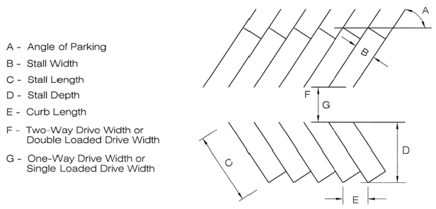
2.
Location.
a.
Parking lots shall be separated from road rights-of-way and from side and rear lot lines in accordance with the following:
i.
Along an arterial road — 15 feet
ii.
Along a nonarterial road — 10 feet
iii.
Along a side or rear lot line — 8 feet
b.
Parking lot setbacks for rear and side lot lines may be waived for buildings or uses with shared parking facilities.
3.
Pedestrian Facilities.
a.
Parking lots shall be designed to minimize conflicts between vehicles, bicycles, and pedestrians. Pedestrian routes that provide direct and convenient access through the site shall be identified and incorporated into the layout of the parking lot.
b.
To the maximum extent practical, pedestrian improvements shall be provided within the parking lot that collect and channel pedestrians safely through the lot, minimizing the need to use driving aisles for walkways.
c.
Pedestrian routes shall be highly visible, incorporating design elements, such as grade separation, special paving, pavement marking or other means to clearly delineate routes for both pedestrians and vehicles. Where pedestrian routes cross driving aisles, consideration shall be given to providing pedestrian refuge areas.
d.
Pedestrian drop-off areas shall be provided where needed, particularly for land uses serving children and the elderly. However, pedestrian drop-off areas shall not be sited in any public road rights-of-way.
4.
Drainage Requirements.
Parking lots shall be designed to provide positive drainage and carry stormwater quickly and effectively away from the site. At points where stormwater flows are discharged from the site, water quality and erosion control measures may be required. Parking lots cannot be designed to serve as stormwater detention facilities.
5.
Landscaping Requirements.
Landscaping for parking lots shall comply with the landscaping requirements in §4.7.4.B, Parking Lot Landscaping as applicable.
G.
Additional Standards for Drive-Through Facilities
1.
Drive-through facilities shall be designed to minimize interference with access and circulation on public roadways and within a parking lot. To accomplish this, drive-through facilities shall be located on separate routes off the primary circulation routes for vehicles, bicycles, and pedestrians, such as the sides or rear of a parking lot.
2.
Drive-through facilities shall be clearly signed and marked to provide efficient flow through the facility.
3.
Drive-through facilities shall provide adequate stacking spaces for automobiles entering and exiting the facility.
H.
Electric Vehicle Parking Spaces.
1.
Number of Spaces Required.
a.
Single-Unit Detached and Duplex Dwellings.
A property where a new single-unit detached or a duplex dwelling is added shall provide one EV-Ready space.
b.
All Other Household Living Uses.
Parking areas required to provide more than ten parking spaces for the following types of development shall meet the minimum electric vehicle requirements as set forth in Table 4-7 below.
2.
General Standards.
a.
Electric vehicle parking spaces shall count toward the minimum vehicle parking requirement as set forth in §4.6.4.
b.
All required electric vehicle parking spaces shall be located on the same lot as the principal use; and
c.
When the electric vehicle parking spaces are put in service, they shall be signed in a clear and conspicuous manner indicating exclusive availability to electric vehicles.
(Res. of 6-6-2023, Exh. A, 5; Res. of 4-22-2024, Exh. A)
4.6.8. - Loading Zones.
A.
Loading zones and service areas shall be designed to minimize interference with access and circulation on public roadways and within a parking lot.
B.
When possible, loading zones and service areas shall be located on separate routes off primary circulation routes for vehicles, bicycles, and pedestrians, such as at the sides and rear of the building.
C.
Accesses to parking lots that will also be used by delivery and service vehicles shall be designed to minimize conflicts with the movements of other vehicles, bicycles, and pedestrians.
4.6.9. - Bicycle Parking.
A.
Amount Required.
1.
For multi-unit residential and nonresidential developments in Urban districts and GMAs, bicycle parking shall be provided at a rate of one per ten required vehicle parking spaces, up to five bicycle spaces, and then at a rate of one per every additional 30 required vehicle parking spaces.
2.
Required bicycle parking may be reduced by the County Engineer for sites that are unlikely to be accessed by bicycles.
B.
Location and Design.
1.
Bicycle parking spaces shall be located near building entrances but not so close as to interfere with pedestrian or automobile traffic near the entrances.
2.
Bicycle parking facilities shall be designed to allow the bicycle frame and both wheels to be securely locked to the parking structure, which shall be of permanent construction materials such as heavy-gauge tubular steel permanently attached to the pavement.
(Res. of 4-22-2024, Exh. A)
4.7.1. - Purpose.
The purpose of this section is to protect the aesthetic, economic, recreational, and environmental resources of Larimer County with landscape standards that:
1.
Enhance the quality and appearance of new development in public or private areas.
2.
Mitigate negative visual impacts between existing and proposed uses.
3.
Promote the efficient use of water in landscaping through application of Xeriscape™ water-wise design techniques to establish procedures for landscape design, installation, and maintenance.
4.
Improve the environment by providing:
a.
Shade to reduce the heat island effect generated by large, paved areas or structures;
b.
Air purification;
c.
Wildlife habitat;
d.
Wildfire-safe designs;
e.
Erosion and stormwater control;
f.
Controls on noxious weed and invasive/destructive plants;
g.
For the use of native, adaptive and drought tolerant plants; and
h.
For the preservation of existing, non-invasive, trees and shrubs.
4.7.2. - Applicability.
A.
General Applicability.
Except as otherwise provided in this section, the standards of this section shall apply to all development that meets the compliance thresholds established in §4.2, Applicability.
B.
Exemptions.
Properties containing only single-unit detached dwellings, cabin dwellings, or duplex dwellings are exempt from all parts of this section except for the following:
1.
Section 4.7.4.D, Street Landscaping;
2.
Section 4.8.1, Buffering and Screening; and
3.
Section 4.8.2, Fences and Walls.
C.
Landscape Plan Requirements.
1.
Landscape Plan.
All landscape plans shall meet the requirements listed in the LUC Supplemental Materials.
2.
Alternative Compliance.
a.
Landscape Narrative.
The Director may determine that a landscape narrative can substitute for a landscape plan. The landscape narrative shall be approved by the County prior to installation of any landscape materials. The landscape narrative shall meet the requirements in the LUC Supplemental Materials.
b.
Alternative Landscape Plan.
The Director may approve alternative landscape plans that do not meet the specific requirements in §4.7, when the applicant demonstrates and the Director determines that the alternatives meet all of the following criteria:
i.
Are consistent with the purposes of §4.7;
ii.
Are consistent with the general landscape character and context of the site;
iii.
Do not include noxious, invasive, or prohibited vegetation as identified by Larimer County, the State of Colorado, or the United States;
iv.
Provide equal or superior buffering of adjacent properties from anticipated impacts of the proposed development; and
v.
Provide equal or superior visual appearance of the property when viewed from a public right-of-way.
(Res. of 4-22-2024, Exh. A)
4.7.3. - General Landscaping Standards.
A.
Plant Materials.
1.
Generally.
All plant materials shall meet the American Association of Nurserymen specifications for Number 1 grade and comply with the quality standards of the Colorado Nursery Act, 1973 C.R.S. Title 35, Article 26, as amended.
2.
Mulch.
a.
Organic mulch is required below plants and shall extend a minimum of one foot from the drip line (outer edge of the plant) at time of install.
b.
Inorganic mulch, including rock, stone, and synthetic material, may be used between plant groups.
c.
Mulch depth shall not exceed four inches.
d.
Shrub and flower beds may be lined with a weed barrier mesh (or similar material designed for weed control) to prevent noxious weeds. Non-porous fabrics, such as black plastic, are prohibited.
e.
Edging shall be placed with sufficient rise to keep mulch out of turf, walks, drives and drainage features. Metal edging shall be of the "rolled edge" type. Concrete, wood, or similar material without sharp edges may also be used.
3.
Turf Areas.
a.
Turf areas shall be a drought-tolerant and/or adaptive sod or seed mix that is appropriate to the natural conditions found at the site.
b.
Turf areas classified as medium or high water use in the Larimer County Plant List shall be limited to high use or high visibility areas.
4.
Soil Amendments.
Soil amendments such as compost, peat, or aged manure, that are appropriate for the intended plant materials, design of the site, and soil conditions shall be selected and installed. The minimum soil amendment requirements per 1,000 square feet of landscape area are as follows:
a.
High-water plantings (as indicated in the Larimer County Plant List): three cubic yards
b.
Shrubs, perennials, and low to medium-water plantings (as indicated in the Larimer County Plant List): two cubic yards
c.
Xeric and very low-water plantings (as indicated in the Larimer County Plant List: one cubic yard or comparable treatment
d.
Dryland and native grassland re-establishment areas: no required treatment.
B.
Location and Arrangement.
1.
Landscape areas shall be arranged to maximize their inter-connectivity with other landscaping on the site, to landscaping on adjacent sites and to natural areas. Plants shall not be spread thinly around the site in small, isolated pockets of landscaping.
2.
Landscape elements including turf, plants, mulch, boulders, and other materials shall be arranged to provide appropriate spacing to avoid a disproportionate and excessive use of mulch.
3.
Plants with similar water use shall be grouped together to the maximum extent practicable.
4.
Low water use plants are preferred in all locations, but are required in areas where permanent irrigation is not feasible.
5.
Plants that exceed six inches in mature height shall not be planted within three feet of fire hydrants.
C.
Minimum Plant Specifications.
1.
Open Space, Common Areas, and Nonresidential Development Landscaping.
a.
Plants used in open space or common areas, or in landscaped areas provided for all nonresidential development shall meet the following size standards:
b.
Plants used in common areas or in landscaped areas provided for all nonresidential development in the Urban character area shall provide plants exceeding the minimum size requirements in the following amounts:
2.
Residential Street Landscaping.
Plants required along residential streets or roads shall meet the following size standards:
D.
Plant Selection.
1.
Species Mix Standards.
Landscape plans shall follow the below species mix requirements to reduce disease susceptibility and the potential demise of a large portion of trees. The maximum percentage of any single species is based on the number of trees proposed. Related varieties or cultivars may substitute as long as they are not susceptible to the same diseases.
2.
Plant Variety.
a.
Landscaping plans shall use native, adaptive and drought tolerant plant varieties as identified in the Larimer County Plant List.
b.
Plant varieties shall be selected based on the natural conditions at the site and grouped together based on water, sun, and other similar needs for viability. Invasive, destructive, and exotic plants shall not be used.
c.
In the Urban character area and within the GMAs, trees and shrubs classified as high water use shall not exceed 50 percent of the total required landscaping.
E.
Lighting.
Any exterior lighting used in the landscape plans shall comply with §4.10, Exterior Lighting.
F.
Sight Triangles.
The County Engineer will determine sight triangle locations and these shall be shown on landscape plans provided for County review and approval. No plant materials, structures, or signs higher than 30 inches above the top of the curb can be located within the designated sight triangles.
G.
Utility Easement Landscaping.
1.
Landscaping in utility easements shall be designed to comply with the utility company requirements. Other required landscaping necessary to meet the requirements of this Code shall be located outside of utility easements.
2.
Trees shall not be planted within four feet of any underground natural gas line or electric utility line or within ten feet of any water or sewer line. Where utility lines are present, trees shall be located outside of the utility easements.
H.
Water Features.
Water features such as fountains, waterfalls and ponds shall comply with the following standards:
1.
The water used shall be recycled through the feature;
2.
The feature shall be designed to prevent leakage;
3.
Permanent provisions for maintenance of the feature shall be explained in a narrative that accompanies the landscape plan;
4.
Evidence of the right to use the water for this purpose is required when the water will be obtained from an irrigation ditch or a well.
I.
Wildfire Prevention.
Wildfire prevention requirements apply to all new development located in designated wildfire hazard areas. Prevention requirements are based on the "Wildfire Hazard Mitigation Requirements for New Construction" found in the International Building Code (as adopted or amended) on file with the Larimer County Building Department. Sites in designated wildfire hazard areas shall include defensible spaces in the design and use plant varieties appropriate for wildfire mitigation. Fire-prone vegetation included in a landscape plan shall be limited to the maximum extent practicable.
4.7.4. - Minimum Landscaping Required.
A.
Site Area Landscaping.
1.
General.
a.
Any part of a site not used for buildings, parking, driveways, walkways, utilities, or approved storage areas shall be retained in a natural state, reclaimed to its natural state, or landscaped pursuant to the standards in this section.
b.
Plants, walls, fences, buffering and screening, etc., located on adjacent properties do not satisfy landscape requirements for proposed development. All required landscaping shall be located on the property it serves.
2.
Minimum Landscaped Area in Urban Character Area.
For all multi-unit residential, commercial, or mixed-use development in the Urban character area, a minimum percentage of site area is required to be landscaped as established for the zoning districts listed in Table 4-12. All required screening, parking perimeter, building perimeter, and interior parking landscaping shall count toward this minimum landscaped area requirement.
B.
Parking Lot Landscaping.
1.
Purpose.
The purpose of this section is to reduce the heat island effect produced by large expanses of pavement. Parking lot landscaping provides shade for vehicles and pedestrians and can buffer or screen views of parking lots from adjacent public areas, streets, and development. It also adds an aesthetic element to nonresidential areas and enhances the overall appearance of the site.
2.
Where Required.
All uses that require special review, administrative special review, and site plan review, excluding uses in the Conservation and Agriculture and Rural character areas, shall provide parking lot landscaping in compliance with this section.
3.
Standards.
a.
Parking Lot Perimeter.
i.
At least 70 percent of the length of all sides of a parking lot containing six or more spaces shall be buffered or screened according to §4.8.1B.3.b, Constructed Landscape Buffer. The Director may determine that the arrangement of existing structures, uses, or other factors make this amount of landscaping impractical or unnecessary.
ii.
Parking areas on side or rear lot lines shall contain at least one shade or ornamental tree for every 40 lineal feet of parking area along the lot line, within three to ten feet of sidewalks. Trees shall be at least 25 feet from street intersections; at least ten feet from fire hydrant access points, and at least 40 feet from streetlights.
iii.
Trees shall be arranged to allow for the maximum possible shading of parking areas.
b.
Parking Lot Interior Design.
i.
Parking lots with more than 100 spaces shall be designed to provide areas for pedestrian staging and snow storage.
ii.
Landscape areas in parking lots with a gravel or other permeable surface, may omit the raised bed requirement of paragraph 4.7.4.B.3.c.iii.4) below with County approval. Landscape areas shall have clearly defined edges and designed in such a way to contain mulch within the landscape bed.
iii.
Landscape areas in parking lots without raised beds shall use wheel-stops to define the end of the parking area.
iv.
Plantings shall not interfere with driver vision or with vehicle and pedestrian circulation.
v.
Parking lots shall be designed to minimize impervious area to enhance stormwater runoff quality, increase on-site retention for plant materials, and replenish groundwater supplies.
c.
Landscape Islands.
i.
Number of Parking Lot Landscape Islands Required.
Parking lots with more than 15 parking spaces shall provide a landscape island after every 15 th contiguous parking space.
ii.
Size and Location Requirements.
1)
Landscaped islands shall define parking lot entrances, the ends of all parking aisles and pedestrian staging areas to the maximum extent possible.
2)
Landscape islands shall be at least nine feet by 19 feet in size. Landscape islands on the perimeter of pedestrian staging areas shall be a minimum of four feet in width per side.
3)
Landscape islands in areas not visible from public roads, sidewalks or open space may be reduced in size to a minimum of 25 square feet.
iii.
Planting Requirements.
1)
Landscape islands shall have a minimum of one shade tree and two shrubs. If the landscape island extends the width of a double parking row, two shade trees are required. Shrubs are not required for landscape islands that are 25 square feet in size.
2)
Organic mulch shall be used around plants per §4.7.3.A.2.
3)
Ground covers, boulders and other decorative features may be used as optional decorative elements.
4)
Landscape islands shall be contained within raised beds to minimize vehicle contact with planting areas. Where mulch is used in the islands, the interior level of the island shall be constructed lower than the required curb to retain mulch and water.
5)
Landscape islands shall include an automated sprinkler system and be contained within raised beds to minimize vehicles from entering planting areas. Where mulch is used in the islands, the interior level of the island shall be constructed lower than the required curb to retain mulch and water.
6)
Rain gardens, bio-swales, drainage easements, and drainage inlets are permitted within parking lot islands.
C.
Building Perimeter Landscaping.
1.
Purpose.
The purpose of this section is to visually connect structures to the landscape using trees, shrubs, and groundcover. Building perimeter landscaping enhances the overall appearance of the development and integrates the site with adjacent land uses and/or the surrounding neighborhoods.
2.
Where Required.
All commercial, industrial, and multi-unit residential uses that require administrative special review, special review, and site plan review shall provide building perimeter landscaping per this section for structures included in the plan.
3.
Standards.
a.
Planting Requirements.
i.
At least 50 percent of the length of any facade visible from public streets, roads, sidewalks, and open space areas shall have perimeter landscaping.
ii.
Plant beds shall be at least five feet wide, with the actual size determined by the quantity and choice of plant materials.
iii.
At least one tree and eight shrubs are required for every 500 square feet of lineal building perimeter.
iv.
Trees shall be placed a minimum of one-half the diameter of the mature canopy from the structure.
b.
Sidewalks.
Sidewalks may be placed between the structure and the parking area landscaping. Cut-through areas are required to accommodate pedestrian movement.
4.
Exposed Foundations.
Exposed foundations not screened by landscaping shall be finished with a decorative veneer or use some other method to hide the exposed foundation.
D.
Street Landscaping.
1.
Purpose.
The purpose of this section is to add an attractive element to a site that complements the overall neighborhood character. Street trees, shrubs, ornamental grasses, ground covers and flowers can enhance the pedestrian experience, provide an element of safety by separating pedestrians and vehicular traffic, reduce the heat island effect of pavement on surrounding structures and help to establish a neighborhood identity.
2.
Where Required.
The following types of uses shall provide street landscaping for all areas that adjoin public streets, roads, or sidewalks:
a.
All nonresidential development, except those uses subject to the standards in §4.7.4.E, Outdoor Display and Sales Lots.
b.
All single- and multi-unit residential development in the Urban districts and GMAs.
c.
All facilities that require site plan review, except §4.7.4.E, Outdoor Display and Sales Lots.
3.
Standards.
a.
Plant Beds.
Landscape areas along public streets or roads shall be at least five feet wide and run the length of the street or road between access points.
b.
Shade Trees.
i.
Conservation and Agriculture, Rural, and Mixed Center Districts.
1)
Shade tree plantings are required where the site includes a sidewalk, trail, or parking area adjacent to the public street or road.
2)
Shade trees may be planted in a lineal fashion or in groups depending on the context of the site and the existing pattern of development.
3)
The required number of trees is one tree for every 40 feet of street frontage adjacent to the sidewalk, trail, or parking area.
ii.
Urban Districts and GMAs.
1)
One shade tree is required for every 40 feet of street frontage.
2)
Trees shall be planted at an average spacing of 20 to 40 feet on center and within three to ten feet of sidewalks.
3)
Trees shall be at least:
(a)
Twenty-five feet from street intersections;
(b)
Ten feet from fire hydrant access points; and
(c)
Forty feet from streetlights.
4)
Where utility lines are present, trees shall be located outside of the utility easements.
c.
Sidewalks and Tree Grates.
i.
Cutouts for tree plantings in sidewalks shall include tree grates to provide for pedestrian safety and adequate water penetration.
ii.
Grates can vary in shape and size but shall cover at least 25 square feet and may be constructed of decorative iron, structural plastic, or other sustainable materials.
iii.
Tree grates shall be set flush with the sidewalk and maintained at even levels and replaced when damaged or when necessary to accommodate trunk growth.
iv.
Trees shall be set so that the root flare remains exposed below the grate to provide proper air circulation for the health of the tree.
d.
Understory Landscaping.
i.
Street landscaping shall include groups of understory plantings, groundcovers, rock features, sculptures, etc., or a combination of these elements. Understory landscape plants shall:
1)
Reach a minimum height of three feet at maturity, measured from the ground plain adjacent to the landscaped area.
2)
Cover a minimum of 40 percent of the street frontage and may be divided into groups or run in a linear fashion.
ii.
Seventy-five percent of understory landscaping shall be covered with living ground cover. Non-living materials such as rock, gravel, and bark shall be used sparingly.
e.
Right-of-Way Landscaping.
i.
Conservation and Agriculture, Rural, and Mixed Center Districts.
Only native or adaptive ornamental grasses and/or wildflowers shall be planted in the right-of-way. Trees, shrubs and irrigation systems and other elements shall be located outside of the right-of-way, unless approved by the County Engineer.
ii.
Urban Districts and GMAs.
Trees, shrubs, and other plant materials identified in the Larimer County Plant list are permitted in the right-of-way.
E.
Outdoor Display and Sales Lots.
1.
Purpose.
Display and sales lot landscaping is intended to enhance the overall appearance of the site and integrate the development with adjacent land uses and the surrounding neighborhood.
2.
Where Required.
All display and sales lot uses including agricultural equipment sales, outdoor display and sales, and vehicle sales and leasing, that require administrative special review or site plan review shall provide parking lot landscaping per this section.
3.
Standards.
a.
Parking Areas.
Parking areas for customers and employees shall include landscape islands per §4.7.4.B.3.c.
b.
Display Pads.
i.
Vehicles and/or merchandise exhibited at the perimeter of the sales lot shall be located on a paved display pad.
ii.
Display pads may be located between required street landscape areas and shall not be larger than 400 square feet in size.
iii.
Manufactured homes cannot be displayed on pads.
c.
Landscape Islands.
Display and sales lots where agricultural equipment, vehicles or manufactured homes are parked for sales purposes are not required to provide landscape islands unless otherwise determined by the County Commissioners.
d.
Maintenance, Service and Trash Areas.
Areas used for maintenance, the parking of vehicles before or after service, or waste storage and removal shall meet the standards set forth in §4.8.1, Buffering and Screening.
e.
Planting Beds.
Landscape areas between outdoor display and sales lots and streets shall be at least five feet wide and run the length of the street with provisions made for access points.
f.
Security Fencing.
Chain link or similar security style fencing may be used to secure the sales lot only on sides adjacent to property not zoned or used for residential purposes, and in areas not adjacent to public roads, sidewalks, or public/private open space areas.
g.
Street Landscaping.
i.
Landscaping adjacent to public streets or roads shall include one shade tree for every 60 feet of street frontage.
ii.
Trees shall be planted at an average spacing of 40 to 60 feet on center, within three to ten feet of existing and proposed sidewalks/roads.
iii.
Trees shall be at least:
1)
Twenty-five feet from intersections;
2)
Ten feet from fire hydrant access points; and
3)
Forty feet from streetlights.
iv.
Where utility lines are present, trees shall be located outside of the utility easements.
h.
Understory Landscaping.
i.
Outdoor display and sales lot landscape plans shall include understory plantings for at least 50 percent of the area adjacent to public street or road.
ii.
Eighty percent of these plants shall be of varieties that reach a mature height of at least three feet.
iii.
Seventy-five percent of understory landscaping shall be covered with living ground cover. Non-living materials such as rock, gravel, and bark shall be used sparingly.
(Res. of 4-22-2024, Exh. A; Res. of 12-9-2024, Att. A)
4.7.5. - Installation and Maintenance.
A.
Landscape Installation.
1.
Generally.
a.
Plants shall be professionally installed in compliance with planting details and notes shown on the approved landscape plan.
b.
Plants shall be installed where shown on the approved landscape plan. Plants shall be installed to allow for maximum growth in height and shape without the need for excessive pruning to maintain the health of the plant.
2.
Nonresidential Landscaping.
Nonresidential landscaping shall be installed before the issuance of any certificate of occupancy. A temporary certificate of occupancy may be issued.
3.
Residential Landscaping.
Residential landscaping shall be installed no later than three months following the issuance of the certificate of occupancy for each lot in front of which the landscaping is required. If seasonal conditions prohibit plant installation, it shall be done no later than June 15 of the following year.
4.
Common Area and Entry Feature Landscaping.
Installation of common area and entry feature landscaping shall occur at the start of the warranty period, or, if seasonal conditions prohibit planting, installation shall occur no later than May 31 of the following year.
5.
Major Design Changes.
Major changes require staff review and approval of a revised landscape plan prior to installation. Major changes include the following:
a.
The removal, relocation, or reduction in size of planted beds;
b.
The replacement of approved plant selections that do not provide the same effect as the original in species and form; or
c.
The removal, relocation, and replacement of hardscape elements.
6.
Minor Design Changes.
Minor changes do not require submittal of a new plan, but a written description of all minor changes shall be provided for staff approval prior to installation. Minor changes include the following:
a.
Small adjustments to the dimensions of planted beds with less than a ten percent reduction in size;
b.
Replacing plant species with selections from the same genus that provides a similar form and effect as the initial selection;
c.
Adjustments to the placement of hardscape elements including sidewalk or trail layouts;
d.
The placement of other elements such as gazebos, play sets, etc.
7.
Collateral.
Developer shall provide funding in the amount of 125 percent of the purchase and installation cost of landscaping, to include all elements needed for its installation and care, as shown on the approved landscape plan and described in an opinion of costs. For residential development, the homeowner's association shall retain control of the remaining funds following the two-year warrantee.
B.
Landscape Irrigation.
1.
Automated irrigation systems are required for all areas where public water is available and shall meet the following standards:
a.
A certified irrigation designer (CID) shall design the system.
b.
Irrigation methods shall use a combination of pop-up, drip, spray, or bubbler delivery as appropriate. Drip irrigation or bubblers shall be used for non turf areas and pop-up and spray methods shall be used for turf.
c.
Turf areas shall have low-volume and low angle emitters.
d.
Timing mechanisms shall be set to prevent activation between the hours of 9:00 a.m. and 7:00 p.m. and include a rain detection/shut-off device.
e.
System flow rates for individual zones shall be set to provide the appropriate amount of irrigation for the specific plant varieties used in each zone.
2.
Where a public water supply is unavailable, the applicant shall provide an appropriate method for watering for a minimum of three growing seasons to ensure the establishment of approved plantings.
C.
Maintenance.
1.
Generally.
a.
All elements that are unique to and part of the approved landscape plan shall be properly and continuously maintained, for as long as the use is in effect that required the landscaping.
b.
All plant materials shall be kept in a healthy condition.
2.
Plant Removal and Replacement.
a.
Dead plants shall be replaced as necessary.
b.
Diseased or insect/parasite-infested plants that cannot be effectively treated shall be replaced during the current growing season or at the start of the next growing season. The Director may grant an extension and/or require adequate financial assurance from the applicant to ensure replacement.
c.
Dead or dying landscape plants shall be replaced within the next planting season, not to exceed one calendar year. Trees that are diseased, damaged, or considered invasive/nuisance species shall be replaced with a new tree recommended in the Larimer County Plant List by the end of the following planting season.
3.
Fences and Walls.
All fences shall be constructed in a professional manner and properly maintained.
4.
Restoration Standards.
a.
Applicability.
i.
This section shall apply to any development that will disturb one or more acres of ground.
ii.
An applicant for a development with less than one acre of ground disturbance shall submit an equipment decontamination plan/weed prevention plan and is responsible for the management of any List A or B noxious weeds.
b.
Desirable Condition.
i.
Desirable post-disturbance conditions are determined by considering pre-disturbance conditions or appropriate reference site condition, habitat connectivity, a cost/benefit analysis, and conservation outcomes that align with the landowner's desires.
ii.
At a minimum, the site will be restored to function at the same level as the pre-disturbance site or appropriate reference site.
c.
Planning.
i.
Construction projects shall be planned and designed to include site protection and restoration specifications and ensure that these costs are included in the project scope and budget.
ii.
The applicant shall submit a restoration plan that includes restoration goals, measurable objectives, restoration prescription and a cost estimate to be included in the land use application.
d.
Acceptable Materials.
i.
Noxious weed-free plant materials shall be used exclusively at all sites. To the maximum extent practicable, plant grasses, forbs and shrubs that are native to the site or Larimer County.
ii.
Seed tags and plant lists shall be approved by Larimer County staff and the landowner(s) prior to plant materials being sown or planted. Seed and plant substitutions shall receive written approval by Larimer County staff and the landowner(s).
iii.
To the maximum extent practicable, erosion control materials shall be fully bio-degradable (not photodegradable) and made of the highest quality materials.
iv.
Straw used for erosion control shall be certified weed free.
v.
In the foothills and higher elevations, use of wood-based or Excelsior erosion control products to mitigate for weed seeds is recommended.
vi.
Hydro-mulch shall be biodegradable, rated for the grades they are applied to, and have a functional longevity of at least six months. Hydroseeding is not recommended.
vii.
Straw crimping shall only be applied on flat surfaces and not slopes.
e.
Soils.
i.
Topsoil shall be salvaged and stockpiled appropriately.
ii.
Project plans will designate the depth of soil that shall be salvaged and the stockpile location, preferably protected by prevailing wind conditions.
iii.
Soil testing is recommended prior to seeding to determine if any amendments are necessary.
iv.
Soil compaction shall be ripped to a minimum depth of 12 inches and seed bed prepared to specification.
v.
Importing topsoil shall be limited to sites where there is no other alternative appropriate and shall not be imported without the written approval of landowner(s). Where importing topsoil is the only appropriate alternative, measures to monitor and manage invasive/noxious weeds shall be required to be stipulated in the applicants' restoration plan or submitted as an addendum.
f.
Planting.
i.
Seed mix shall be applied at the specified rate either with a native seed drill or broadcasted. If broadcasted, seed shall be manually incorporated into the top 0.25 inches to 0.5 inches of soil.
ii.
All plant material shall be inspected and approved by Larimer County Department of Natural Resources staff and the landowner(s) prior to installation.
iii.
Trees in balls and burlap shall be two inches in caliper. Balled and burlap trees shall be planted, maintained, watered and protected in a manner consistent with the International Society of Arborist standards.
iv.
Where feasible, plantings shall be hand watered rather than the installation of irrigation systems. If an irrigation system is necessary, the system shall be inspected monthly to check for leaks and ensure the correct amount of water is dispensed.
v.
If rare or endangered plant species or communities are found at the site, a setback buffer will be required. The distance of the setback shall be based on regulations, Larimer County staff direction and best available science.
g.
Erosion and sediment control measures shall be installed in accordance with the project's State Construction Stormwater permit, MS4 Permit and any other applicable permits and mitigation plans.
h.
Inspections shall occur by Larimer County staff throughout restoration implementation for quality assurance purposes. Inspections examine the following elements:
i.
Equipment has been properly decontaminated and cleaned of mud and plant materials before entering the site. This includes but is not limited to tracks, tires, undercarriage, seed drills and hydro mulchers.
ii.
Seed tags stating rates, variety and scientific names. Tags shall remain on the seed bags until approved by an inspector.
iii.
Proper mulch and straw materials.
iv.
Proper pollution prevention and erosion and sediment control installations and materials.
v.
Proper plant installation and materials.
vi.
Proper seed bed preparation where the surface is firm, but not compacted.
vii.
Compliance with wildlife and resource protection standards required by Larimer County in application approval.
viii.
Compliance with MS4, State Construction Stormwater and any other applicable permits.
i.
Monitoring shall occur at specified intervals to determine if the project has met the objectives as defined in the construction plan set.
j.
Adaptive management shall be based on monitoring data until all restoration objectives have been met. If an objective is unobtainable due to unforeseen circumstances, it can be modified based on the professional judgement of Larimer County staff.
k.
Topsoil shall be salvaged and reapplied following construction prior to revegetation activities according to the following standards:
i.
For areas with native vegetation, strip topsoil in all areas of excavation to a minimum of four inches and stockpile separately.
ii.
Wetland and upland soils shall be stockpiled separately from each other.
iii.
Stockpile height shall not exceed two feet unless the topsoil pile is intended to be inoculated before reapplying on site.
l.
Damage Penalties.
i.
Staff shall document resource protection measures as well as resource condition prior to construction.
ii.
If staff finds that the resource protection measures were not taken or adhered to, and resources were damaged during construction, a penalty may be assessed commensurate with restoration or mitigation costs. A damages provision within the contract shall be written for this purpose.
4.7.6. - Tree Preservation and Protection.
A.
Generally.
1.
No cut or fill over four inches is allowed below the perimeter drip line of any protected tree, without evaluation by a qualified arborist or forester, and subsequent approval by the County in writing prior to digging.
2.
No damaging attachments, wires, signs, or permits may be fastened to any protected tree at any time.
B.
Tree Protection During Construction.
1.
Contractors shall not stockpile any construction materials or debris below the perimeter drip line of trees. This area shall be clearly designated on-site with temporary fencing or other similar material at least four feet in height. Large areas containing protected trees may be "ribboned off," rather than surrounding each tree with protective fencing.
2.
Contractors shall not clean equipment below the perimeter drip line of any trees or store or dispose of any harmful cleaning materials such as paints, oils, solvents, asphalt, or concrete, in these areas.
3.
Desirable trees and snags to be left on site after construction shall be protected from heavy equipment.
4.
Trees shall be wrapped with construction blankets and flagged if root zone is within the limits of disturbance.
5.
Any additional required tree protections including signage and fencing will be specified by the Larimer County Department of Natural Resources staff.
C.
Utility Line, Irrigation Line, and Underground Fixture Installation.
The installation of utilities, irrigation lines or underground fixtures requiring excavation deeper than six inches shall be accomplished by boring under the root system of protected trees at a minimum depth of 24 inches. The auger distance is scaled from the tree's diameter, measured at six inches above ground level and based on the following schedule:
D.
Tree Removal.
1.
To the maximum extent practicable, large, healthy trees shall be retained.
2.
Prior to removing any trees, the tree shall be monitored for nesting birds and mitigated as necessary.
3.
All trees shall be cut as low to the ground as possible unless specified otherwise.
4.
An appropriate herbicide shall be applied to the living plant tissue on the stump surface within five minutes of the final cut to all deciduous tree removals to prevent resprout.
4.7.7. - Irrigation Facilities.
Irrigation facilities shall meet the standards set forth in the LUC Supplemental Materials.
4.8.1. - Buffering and Screening.
A.
Purpose.
The purpose of this section is to enhance the visual relationships between uses and structures and mitigate undesirable impacts including, but not limited to noise, dust, odor, spraying, or glare from proposed development on existing or allowed uses.
B.
Credits Toward Required Landscaping.
Any landscaping provided to meet buffering and screening standards shall be credited towards the overall landscaping requirements set forth in §4.7, Landscaping.
1.
Applicability.
a.
A buffer shall be provided in the following situations:
i.
Between all new residential structures and lots that do not qualify as agricultural housing and that are located within or adjacent to an agricultural or conservation zoning district or use.
ii.
Between all new nonresidential structures adjacent to an existing residential use or a lot with residential zoning.
iii.
When proposed mineral extraction operations will be visible from public roads, or other uses of a less intense zoning classification. All landscaping shall be installed during the initial extraction phase, unless the County Commissioners approves an alternate proposal. Stockpiles may be used as a buffer and shall be seeded with drought tolerant grasses to prevent erosion and provide for dust control.
iv.
When a new residential development will have double frontage lots with one side against an arterial road.
v.
Between any drive-through facility and adjacent residential property.
vi.
When the Director determines the proposed arrangement of uses, the design of buildings or other characteristics of development do not adequately mitigate visual compatibility issues, or negative impacts, that are reasonably anticipated to arise.
b.
Where required, the buffer shall be placed and maintained on the lot proposed for development.
c.
Only one buffer type is required unless a combination is used to meet the standards in §4.8.1B.3.c, Setback Buffer.
2.
Alternative Buffers.
The Director may approve alternative buffer widths or setback distances through the Alternative Landscape Plan process as set forth in §4.7.2C.2.b.
3.
Buffer Types.
a.
Adequate Existing Buffer.
Existing physical features, such as topography, water bodies, trees, hedgerows, plants, rock features, landforms or similar vegetation, may be utilized to serve as the buffer. Such buffer shall be at least:
i.
Fifty feet wide between new residential structures (excluding agricultural housing) and a Conservation and Agriculture zoning district or agricultural use.
ii.
Twenty-five feet wide between new industrial uses and an existing residential use.
iii.
Fifteen feet wide for all other applicable situations.
b.
Constructed Landscape Buffer.
i.
A new physical barrier may be constructed to serve as the buffer. Constructed buffers shall:
1)
Provide a year-round, semi-opaque or opaque separation between uses for the length of the buffer area;
2)
Be at least:
(a)
Fifty feet wide between new residential and a Conservation and Agriculture zoning district or use.
(b)
Twenty-five feet wide between new industrial uses and an existing residential use.
(c)
Fifteen feet wide for all other applicable situations.
3)
Incorporate a vegetative screening component (trees, shrubs, or berms) and may incorporate a solid, architectural, landscaped wall or fence; and
4)
Be described on a landscape plan prepared by a professional landscape architect or landscape designer.
ii.
Any fences or walls used to achieve an opaque separation shall meet the requirements in §§4.8.2.C.4. and 4.8.2.D.
iii.
At least 60 percent of the plants provided for buffering or screening along fences or walls shall be on the side facing the public right-of-way, open space, residential area, or other uses being buffered or screened.
c.
Setback Buffer.
i.
An enhanced setback buffer shall provide the following minimum separation between the proposed structure and adjacent use's property line(s).
ii.
The setback buffer may be reduced to the distance from the property line listed in Table 4-14, above, by considering the following:
1)
The nature of the proposed use and the potential for conflict between the proposed use and the existing adjacent use due to potential impacts such as noise, dust, odor, chemical drift, and fire/smoke; and
2)
Whether an adequate existing buffer or a constructed buffer, as described above, or a combination of the two, will be provided that will achieve the buffer benefits described above.
Figure 4-1: Enhanced Setback Buffer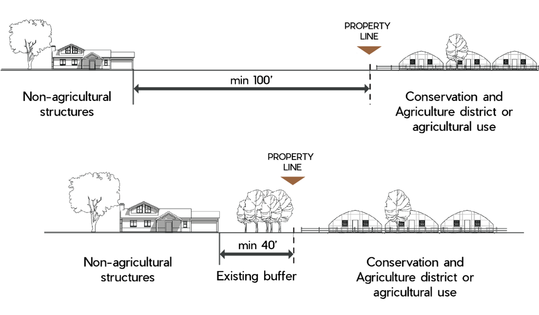
C.
Screening.
In addition to the standards in this section, fences and walls used for screening shall meet the requirements in §4.8.2, Fences and Walls.
1.
Refuse Areas.
All refuse and refuse containers shall be screened from all public rights-of-way.
a.
Enclosures Required.
Refuse containers shall be located within an enclosure.
b.
Location.
Refuse container enclosures shall be located at the rear of the property to the extent practicable and shall be sited to allow for easy vehicular access such that access does not require backing movements onto public rights-of-way, with the exception of alleys.
c.
Design and Materials.
Refuse container enclosures shall be of sufficient height to screen containers but shall not exceed eight feet in height unless screening a refuse container taller than eight feet. Such enclosures shall be visually compatible with materials used on the primary building. In no case shall enclosures consist of chain link or corrugated metal.
d.
Landscaping.
Landscaping shall be used to soften the appearance of the enclosure where such enclosure is located within a side yard or can be viewed from public rights-of-way.
2.
Mechanical and Utility Equipment.
All mechanical and utility equipment including but not limited to air-conditioning, heating, water, propane, and fuel tanks, televisions antennas, satellite dishes, security apparatus, transformers, ground-mounted solar equipment, and electric and gas meters shall be integrated into the building design, screened from public view, or enclosed in a suitable accessory structure, pursuant to the following standards:
a.
Location.
i.
Ground-mounted mechanical and utility equipment shall be located outside of sight triangles in order to avoid obscuring vision at intersections.
ii.
Ground-mounted mechanical and utility equipment shall be located out of view of public rights-of-way, customer entrances, and other public areas.
b.
Design.
i.
Ground-mounted mechanical equipment located within view of customer entrances or public rights-of-way shall be integrated into the overall site design, the architectural design of the building, and screened from public view using one or a combination of the following:
1)
Decorative wall, fence or enclosure that is constructed of materials that are compatible with the overall architectural design of the development and of a height that is not less than the height of the equipment to be screened; or
2)
Landscaping that is of sufficient height at maturity and of opacity to effectively soften and screen the equipment, and that is integrated into the overall landscape plan.
ii.
Roof-mounted mechanical and utility equipment shall be an integral part of the building's overall architectural design and shall be screened from view to the extent practicable from public rights-of-way, residential land uses, public parking areas, and/or adjacent properties using parapet walls or other means of screening. When reviewing the type and amount of screening, the Director shall consider the following:
1)
The proximity of the development to surrounding residential land uses and the visual impact that roof-mounted equipment may have upon those surrounding residential land uses.
2)
The number and size of roof-mounted equipment. The greater the number and/or size, the more screening may be warranted.
iii.
Roof-mounted equipment shall maintain a color and finish that are compatible with the primary building façade.
4.8.2. - Fences and Walls.
A.
Purpose.
This section is intended to provide uniform, minimum technical standards for fences and walls including those used as elements in a landscape plan for buffering and screening purposes.
B.
Exemptions.
Agricultural fencing, as defined in §20.3, Other Terms Defined, is not required to meet the standards in paragraphs C.1, C.2, and C.3, below.
C.
Standards for All Fences and Walls.
1.
Height.
a.
The height of all fences will be measured from finished grade at the base of the fence except that depth-of-drainage channels under a fence shall not be included in the height measurement.
b.
The height of all fences built on berms or retaining walls shall include the height of the berm or wall.
2.
Fences for Nonresidential Uses.
Fences for individual nonresidential uses, shall meet the following criteria:
a.
Fences up to six feet high may be placed anywhere on the lot but are subject to sight triangle standards included in the Larimer County Road Standards.
b.
Security fencing may include three strands of wire on top of the fence that will not be included in the height measurement. The wire strands shall not extend beyond the property line.
c.
Fences within a fire district shall provide adequate access for fire authority staff to service the property.
3.
Development Perimeter Fencing.
Fences installed on the perimeter or any development, shall meet the following criteria:
a.
If fencing is proposed around the perimeter of a development, any fencing adjacent to a county road or state or federal highway shall be compatible with existing land uses, topography, and landscaping in the immediate vicinity.
b.
Fences longer than 40 feet shall include one evergreen tree or three shrubs for each 40-foot section or portion thereof planted on the outer or public side of the fence.
c.
Fences longer than 100 feet shall provide variation by using changes in height, different material combinations, offset angles, articulation and/or plant materials.
4.
Wildlife Protection.
Wildlife should be considered before the construction of any fence. All fences shall meet the wildlife fencing standards in §4.4.4.C.4.d. If a development is subject to a wildlife conservation plan, there may be additional fence regulations based on the plan.
D.
Additional Standards for Fences and Walls Included in Landscaping Plan.
1.
Height.
a.
Fences used for screening shall be at least six feet high and not taller than eight feet from the finished grade. Fences above six feet require a building permit.
b.
All walls used for screening require a building permit and shall be no more than ten feet in height from the finished grade. Wall heights above ten feet require written approval by the Director.
c.
Fences or walls may be combined with landscape berms to achieve the desired height if berms are sized appropriately to provide adequate support for the fence or wall. If the use or element to be screened remains visible at six feet off-site, additional screening may be required.
2.
Materials and Design.
a.
Articulation.
i.
Fencing or walls used as a screen shall not have breaks in the run of fences or walls, unless breaks are needed to prevent wind damage. Where breaks are necessary, the placement of trees or shrubs shall conceal the view through the gaps.
ii.
Where fences are designed with vertical picket boards on the alternate sides of the horizontal rail, the design shall use plant materials or board widths sufficient to screen the view into the site between the pickets.
iii.
If the fence or wall exceeds 40 feet in length, the design shall include at least one tree and six shrubs for each 40-foot section. Four of the required shrubs shall be of a variety that reaches a mature height of three feet, and two of the required shrubs shall be of a variety that reaches a mature height of six feet.
iv.
Alternating 40-foot sections of fence and wall can be constructed within three feet of the property line, so long as they do not interfere with site triangle requirements or create safety concerns.
b.
Design.
Required fences and walls shall have a unifying theme and provide variation by using clearly visible changes in height or depth, different material combinations, offset angles or structural articulation and/or plant materials.
c.
Prohibited Finish Materials.
Chain link fencing, with or without slats, shall not be used for screening or buffering, except as allowed by §4.7.5.B.6, Security Fencing.
4.9.1. - Purpose.
This section is intended to promote high-quality building design and is intended to:
A.
Protect and enhance the visual interest, character, and quality of nonresidential and mixed-use areas; and
B.
Ensure compatibility between residential neighborhoods and adjacent commercial and mixed-use areas.
4.9.2. - Applicability.
A.
General Applicability.
The standards of this section shall apply to all development in the Urban districts and GMAs that meets the compliance thresholds established in §4.2, Applicability.
B.
Exemptions.
This section shall not apply to any development in the Conservation and Agriculture, Rural, or Mixed Center districts.
C.
Review Process.
1.
Review for compliance with these standards shall occur at the time of site plan review, administrative special review, or special review. Where site plan, administrative, or special review is not required, review for compliance with these standards shall occur prior to the issuance of a building permit.
2.
Interpretations as to applicability or design requirements contained within this section shall be the responsibility of the Director. Appeals of the Director's interpretations shall be heard according to the process set forth in §6.7.2, Appeals.
4.9.3. - Design Standards.
A.
Building Orientation.
Buildings shall be sited parallel to public rights-of-way with parking and any service functions located in side or rear yards and incorporated into the overall design theme of the building and the landscape to the maximum extent practicable.
B.
Building Massing.
1.
Building scale and massing shall respect the scale and massing of existing buildings along the block face.
2.
Horizontal masses shall not exceed a height to width ratio of 1:3 without substantial variation in massing that includes a change in height and projecting or recessed elements.
Figure 4-2: Height-to-Width Ratio
3.
Changes in mass shall be related to entrances, the integral structure and/or the organization of interior spaces and activities and not merely for cosmetic effect.
C.
Building Articulation.
1.
Building facades shall include a repeating pattern that shall include at least two of the elements listed below. At least one of these elements shall repeat horizontally. All elements shall repeat at intervals of no more than 30 feet, either horizontally or vertically:
a.
Color change;
b.
Texture change;
c.
Material change;
d.
Projections, recesses, and reveals; or
e.
Other similar techniques.
2.
Facades greater than 100 feet in length, measured horizontally, shall incorporate wall plane projections or recesses having a depth of at least three percent of the length of the facade and extending at least 20 percent of the length of the facade. No uninterrupted length of any facade shall exceed 100 horizontal feet.
3.
Ground floor facades that face public streets shall have arcades, display windows, entry areas, awnings, or other such features along at least 60 percent of their horizontal length.
Figure 4-3: Building Articulation Standards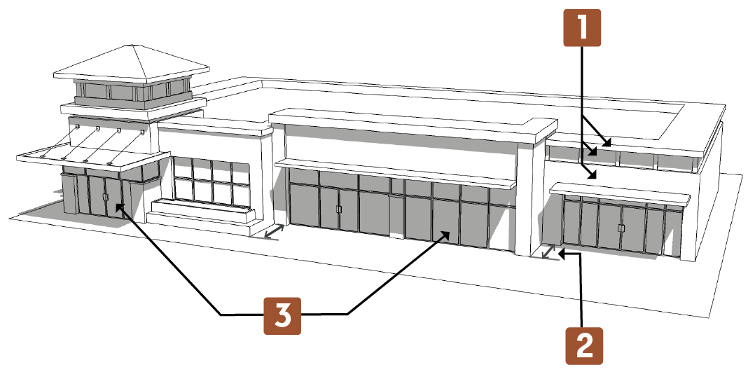
D.
Primary Entrance.
1.
Primary public entrances shall be clearly defined and articulated with architectural elements such as porches, columns, overhangs, awnings, or other comparable features.
2.
For buildings with multiple tenant entries, each entrance shall be defined and articulated with architectural elements.
3.
At least one main entrance of any nonresidential or mixed-use building shall face and open directly onto a connecting walkway with a pedestrian frontage.
E.
Roof Form.
Buildings shall be designed to avoid continuous rooflines to reduce the scale of larger buildings. Roofs shall have no less than two of the following features:
1.
Parapets concealing flat roofs and rooftop equipment, such as HVAC units, from public view. The average height of such parapets shall not exceed 15 percent of the height of the supporting wall, and such parapets shall not at any point exceed one-third of the height of the supporting wall. Such parapets shall feature three-dimensional cornice treatment.
2.
Overhanging eaves, extending no less than three feet past the supporting walls.
3.
Sloping roofs that do not exceed the average height of the supporting walls, with an average slope greater than or equal to one foot of vertical rise for every three feet of horizontal run and less than or equal to one foot of vertical rise for every one foot of horizontal run.
4.
Three or more roof slope planes.
Figure 4-4: Roof Form Standards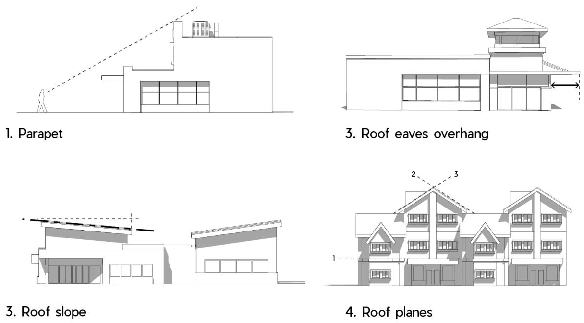
F.
Architectural Design.
1.
All sides of a building shall include materials and design characteristics consistent with those on the front. Use of inferior or lesser quality materials for side or rear facades shall be prohibited.
2.
Building design shall contribute to the unique characters of an area and/or development through building massing and scale, building materials, architectural elements, and colors. In the case of a multiple building development, each individual building shall include predominant characteristics shared by all buildings in the development.
3.
Where there is no established or consistent neighborhood or area character, or where it is not desirable to reinforce the existing character, the proposed development shall be designed to establish a high-quality standard for future development.
4.10.1. - Purpose.
The purpose of this section is to encourage the wise use of exterior lighting and to provide enough exterior light for the safety, security, enjoyment and function of the land use; conserve energy and resources; reduce light trespass, glare, artificial night glow, and obtrusive light; protect the local natural ecosystem and public health from damaging effects of artificial lighting; and encourage quality lighting design and fixtures. These standards implement the Comprehensive Plan goal to mitigate the negative effects of land uses that create off-site impacts, and minimize light pollution.
(Res. of 1-13-2025(2), Att. A, 2)
4.10.2. - Applicability.
A.
General.
All exterior lighting in all zoning districts shall comply with the standards in this section unless exempted by paragraph (B), below or by any other provision of this LUC. For the purposes of this section, the definition of "development" includes new single-unit and new duplex dwellings in addition to any development as defined in Article 4.
B.
Exemptions.
The following types of exterior lighting are exempt from the requirements of this section, provided they shall not create glare to motorists or result in light trespass onto adjacent properties:
1.
Emergency lighting used by police, fire fighting, or medical personnel, or at their direction;
2.
Holiday lighting and seasonal decorations using low-intensity lamps;
3.
Agricultural equipment lighting;
4.
Special events that have been issued a special event permit;
5.
Lighting within the public right-of-way. Such lighting is regulated under the Larimer County Urban or Rural Area Street Standards;
6.
Traffic control lighting; and
7.
Any lighting required to be installed by a state or federal government agency, including but not limited to the Federal Aviation Administration (FAA) or other federal air safety authority.
C.
Lighting Plan Required.
1.
Unless expressly exempt by §4.10.2.B, a lighting plan is required for all development that meets the compliance thresholds established in §4.2, Applicability.
2.
The lighting plan shall meet the requirements listed in the LUC Supplemental Materials.
D.
Alternative Compliance.
Upon request of an applicant, the Director may approve an alternative lighting plan that may be substituted in whole or in part for a plan meeting the standards of this section. The Director's decision can be appealed to the County Commissioners. Alternative lighting plans shall meet the requirements listed in the LUC Supplemental Materials.
1.
Review Criteria.
To approve an alternative plan, the Director shall find the plan:
a.
Accomplishes the purposes of this section as well as or better than a lighting plan that complies with this section;
b.
Protects natural areas from light intrusion, artificial night glow, and damaging effects of artificial lighting;
c.
Reduces light trespass, glare, artificial night glow, and obtrusive light;
d.
Conserves energy and resources; and
e.
Demonstrates innovative design and use of fixtures or other elements.
(Res. of 1-13-2025(2), Att. A, 2)
4.10.3. - General Lighting Standards.
A.
Prohibited Lighting Types.
1.
Unshielded lights, lamps, or floodlights that produce glare and light trespass in excess of that allowed in Table 4-15: Lighting Level Requirements;
2.
Flashing or revolving exterior lighting, except for standard agricultural or emergency equipment;
3.
Site lighting that may be confused with warning or emergency lights, or traffic signals; and
4.
Mercury vapor, high-pressure sodium and low-pressure sodium lights.
B.
Shielding and Light Trespass.
1.
The minimum requirement permitted by this plan is luminaires with cut-offs with an angle not exceeding 90 degrees to minimize the potential for glare and unnecessary diffusion on adjacent properties. All lighting fixtures shall be fully shielded so that the lighting element is not visible to an observer at a point on any property line of the lot or parcel on which the light is located. Beyond that requirement, light sources shall be concealed or shielded to the maximum extent feasible.
Figure 4-5: Ninety-Degree Cut-off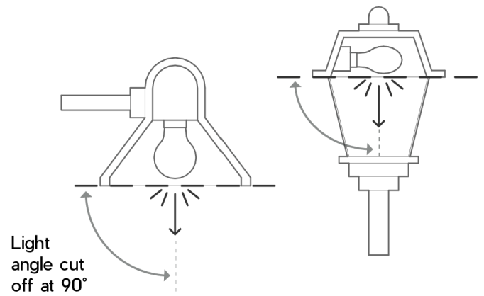
2.
There shall be no light trespass (i.e., zero foot-candles) measured at all property lines adjacent to the development site. When a development site containing a commercial or industrial use is abutting another commercial or industrial property, a request may be made to the Director for review and approval of shared lighting and/or limited light trespass on a case-by-case basis.
3.
Light levels measured 20 feet beyond the property line of the development adjacent to public rights-of-way shall be minimized to the extent reasonably feasible and shall not exceed one-tenth foot-candle as a direct result of the on-site lighting.
4.
There shall be no light trespass (i.e., zero foot-candles) measured at the property line adjacent to publicly-protected open spaces, sensitive natural features including streams, creeks, rivers, wetlands, lakes and reservoirs, and protected species habitat. Additional consideration should be given to lighting and light levels within known migratory corridors for birds and other wildlife, particularly during migration periods.
5.
If the Director determines that the size, height, nighttime lighting requirements, or operational characteristics of the proposed property use, or its proximity to residential zoning districts, are likely to create high levels of glare on residential properties, the glare shall be minimized and mitigated to the greatest extent feasible.
6.
Upward-directed architectural, landscape and decorative lighting (such as flags, statues or any other objects mounted on a pole, pedestal or platform) shall be located, aimed and shielded so that direct illumination is focused exclusively on the object and away from adjoining properties and the public street right-of-way. Architectural features may be illuminated by up-lighting provided that the light is effectively contained by the structure. In all cases, up-lighting must not cause glare or light trespass. The landscape lighting must be low voltage (24 volts or less), and it must be controlled by a photocell and timer set to extinguish no later than 11:00 p.m.
7.
When topography, slope or other site characteristics could result in light trespass onto adjacent properties, then additional techniques for mitigation of these impacts should be explored (e.g., adjusting the angle of fixtures, additional shields, dimming, motion sensing, lighting curfews, or other measures).
C.
Lighting Output levels.
1.
Light sources (such as exposed L.E.D. (light emitting diode) lighting or other future lighting technologies) shall be limited to a maximum of 1,000 candela per square meter (nits).
2.
All lighting shall have a nominal correlated color temperature (CCT) of no greater than 3,000 degrees Kelvin (K). On properties located immediately adjacent to publicly-protected open spaces, all lighting shall have a nominal CCT of no greater than 2,700 degrees Kelvin.
3.
All project lighting used to illuminate buildings, parking lots, walkways, plazas, or the landscape, with the exception of lighting for public streets, shall comply with all other standards (e.g., fixture type, mounting height and shielding) with the following minimum and maximum outputs:
D.
Lighting Controls.
1.
All site lighting, except low output (2,000 lumens or less) lighting, shall be equipped with an on-off switch.
2.
All exterior lighting not necessary for security purposes shall be reduced, activated by motion sensor devices, or turned off during non-operating hours. Any illumination between 10:00 p.m. and sunrise shall be reduced to levels sufficient for security purposes only.
E.
Light Fixtures.
The style of light fixtures should be consistent with the style and character of architecture proposed on the site.
F.
Lighting Efficiency.
All exterior light fixtures shall generate at least 80 lumens per watt of energy consumed, as shown on the manufacturer's specifications for the fixture.
G.
Mounting Height.
Building mounted fixtures shall not be mounted higher than 20 feet in height.
(Res. of 1-13-2025(2), Att. A, 2)
4.10.4. - Surface Parking Area Lighting.
A.
All lighting for surface parking lots and upper uncovered decks of parking structures shall use full cut-off fixtures.
B.
Parking lot poles shall not exceed 20 feet in height.
4.10.5. - Under-Canopy Lighting.
A.
Canopies shall be illuminated so that the total lighting output meets the requirements set forth in Table 4-15: Lighting Level Requirements.
B.
All luminaires shall be mounted flush with or recessed from the lower surface of the canopy.
4.10.6. - Sports Fields, Playgrounds and Other Recreational Facilities.
All sports fields, playgrounds, and/or other recreational facilities are subject to the requirements and standards within §4.10 or §4.10.2.D, Alternative Compliance.
(Res. of 1-13-2025(2), Att. A, 2)
Editor's note— Res. of 1-13-2025(2), Att. A, 2, adopted January 13, 2025, renumbered the former §§ 4.10.6, 4.10.7 as §§ 4.10.7, 4.10.8 and enacted a new § 4.10.6 as set out herein. The historical notation has been retained with the amended provisions for reference purposes.
4.10.7. - Additional Lighting Standards in the Urban Districts and GMAs.
In addition to the standards in §4.10.3, General Lighting Standards, all development in the Urban districts and GMAs is subject to the standards below.
A.
All street lighting shall be designed and constructed in accordance with the Urban Area Street Standards.
(Res. of 1-13-2025(2), Att. A, 2)
Editor's note— Res. of 1-13-2025(2), Att. A, 2, adopted January 13, 2025, renumbered the former § 4.10.6 as § 4.10.7. The historical notation has been retained with the amended provisions for reference purposes.
4.10.8. - Installation, Maintenance and Replacement.
A.
Exterior lighting fixtures shall comply with the building code and other applicable codes as adopted by the County.
B.
Exterior lighting shall be maintained in good structural condition at all times.
C.
In some cases, previously existing lighting does not meet current standards. As light sources and light fixtures are updated, replaced and/or added to a development, they must conform to all applicable requirements set out in §4.10, Exterior Lighting. If development is proposed that significantly changes or expands the existing development on a property and necessitates additional land use planning and/or building permit approvals, a new Lighting Plan, Addendum, or demonstration of Alternative Compliance may be required in accordance with §4.10.2.C.2.
(Res. of 1-13-2025(2), Att. A, 2)
Editor's note— Res. of 1-13-2025(2), Att. A, 2, adopted January 13, 2025, renumbered the former § 4.10.6 as § 4.10.7. The historical notation has been retained with the amended provisions for reference purposes. Subsequently, Res. of 1-13-2025(2), Att. A, 2, adopted January 13, 2025, amended the title of § 4.10.8 to read as herein set out. The former § 4.10.8 title pertained to Installation and Maintenance.
4.11.1. - Purpose.
The purpose of this section is to ensure that air quality impacts are addressed at the design phase of a development, which can significantly reduce air emissions over the life of a project.
4.11.2. - Applicability.
The standards of this section shall apply to all development that meets the compliance thresholds established in §4.2, Applicability.
4.11.3. - General.
A.
The County Planning and Health Department will review air quality mitigation plans and recommend they be accepted or rejected prior to the public hearing process.
B.
Developments shall comply with all county, state and federal air quality standards and shall reduce potential emissions where feasible.
4.11.4. - Air Quality Management Plan.
A.
Applicants for developments involving more than 200 dwelling units, or more than 2,000 projected vehicle trips per day, shall submit an air quality mitigation plan addressing how air quality impacts will be minimized.
B.
The air quality management plan shall identify potential sources of air emissions, identify possible strategies for minimizing emissions and propose a plan for implementing those strategies. The strategies shall include those methods that are available, feasible and economically reasonable. Examples of mitigation strategies include providing transit stops; bike and walking paths; restricting wood or coal-burning fireplaces; paving roads; and collocating neighborhood-level retail services within developments.
4.11.5. - Fugitive Dust During Construction.
A.
Land development activities release fugitive dust, a pollutant regulated by the Air Pollution Control Division of the Colorado Department of Public Health and Environment. Colorado's air quality regulations require the control of dust emissions during all construction activities including land preparation such as excavating and grading for all residential, commercial, and industrial development.
B.
State-level permits are required depending on the amount of land disturbed and the duration of the disturbance. For developments that will disturb over 25 acres of land and/or a duration of six months, Air Pollutant Emissions Notices and/or air permits shall be obtained from the Air Pollution Control Division of the Colorado Department of Public Health and Environment. Developments that are 25 acres or less and/or six months in duration may not be required to obtain state-level permits but control measures shall be implemented to minimize the release of fugitive dust from the site.
C.
Regardless of the size and duration, all land disturbances shall operate under a fugitive dust control plan.
D.
The County Health Department shall review and approve all fugitive dust control plans.
4.11.6. - Compliance with Air Pollution Control Division Regulations During Operation.
A.
In Colorado, land uses with the potential to emit air pollutants above defined thresholds shall report those emissions and apply for a permit. The permit program is administered by the Air Pollution Control Division of the Colorado Department of Public Health and Environment.
B.
Developments that have emission sources regulated under the Colorado Air Quality Control Commission regulations shall submit the following documentation regarding control of air emissions:
1.
An Air Pollution Emissions Notice prepared in accordance with state guidelines. This notice shall be submitted to the County and state and shall identify potential air emissions and appropriate control strategies.
2.
If applicable, a Colorado Air Emissions Permit. This permit shall be submitted prior to operating the facility.
4.12.1. - Purpose.
The purpose of this section is to ensure that water quality impacts are addressed during the planning, design, construction, and post construction phases of developments and land disturbing activities in order to reduce or prevent water quality impacts by preventing the discharge of pollutants and illicit discharges to the local waters, irrigation ditches, state waters, and drinking water reservoirs.
4.12.2. - Applicability.
A.
The standards of this section shall apply to all development that:
1.
Meets the compliance thresholds established in §4.2, applicability.
2.
Is associated with a Larimer County Building permit within the County Municipal Separate Storm Sewer System (MS4) Permit Area.
3.
Includes any construction activity within the County Municipal Separate Storm Sewer System (MS4) Permit Area that is equal to or greater than one acre, or less than one acre but is part of a common plan of development, which is a contiguous area where multiple separate activities may be taking place at different times and schedules, but remain related. Construction Activity includes, but is not limited to, ground surface disturbances, clearing, grading, excavation, demolition, staging/storage areas, stockpiles, and borrow areas, excluding land disturbance activities associated with agricultural activities.
B.
The standards of this section are supplemented by:
1.
Section 4.13, Supplementary Engineering Regulations.
2.
Larimer County Stormwater Quality Ordinance.
3.
Larimer County Municipal Separate Storm Sewer System (MS4) Permit Area found on the County website.
4.12.3. - General.
A.
The County Engineering Department will review and approve stormwater quality documentation outlined in §4.14, such as, but not limited to, disturbance area calculations and stormwater quality management design reports and plans, prior to:
1.
Final approval of an applicable development project that meets the thresholds established in section §4.2, Applicability.
2.
Issuance of a Larimer County building permit.
3.
Issuance of a development construction permit, land disturbance permit, or other similar permit for land disturbing activities.
B.
Developments shall comply with all county, state, and federal water quality standards, including but not limited to, those regulating erosion and sedimentation, storm drainage and runoff control, nutrients, solid wastes, and hazardous substances and shall reduce or prevent potential pollution sources where feasible.
C.
Developments shall comply with the Larimer County Stormwater Quality Ordinance through the construction and post construction phases of development.
4.12.4. - Water Quality Management Documentation.
A.
Applicable developments shall submit the following documents, when applicable, addressing how water quality impacts will be addressed:
1.
A stormwater quality management report and plan as specified in §4.14 and Supplementary Engineering Regulations, which further references the Larimer County Stormwater Design Standards.
a.
The County stormwater quality documentation requirements include a stormwater quality management report and stormwater management plan that describes the construction activities, disturbed area, and addresses adjacent and downstream waters, and the design, selection, installation, implementation, inspection, and maintenance needs of the water quality control measures needed during and post construction in order to provide control of all pollutant sources and prevent degradation of state waters.
2.
An issued certification from the State Water Quality Control Division of the Colorado Department of Public Health and Environment for the Colorado General Permit for Stormwater Discharges Associated with Construction Activities.
a.
A certification for Stormwater Discharges Associated with Construction Activity is required Statewide prior to starting construction for those projects that involve land disturbance in excess of state-specified acreage amounts.
3.
An issued Colorado Stormwater Permit for Industrial Facilities from the State Water Quality Control Division of the Colorado Department of Public Health and Environment.
a.
Industrial Use Permits must be obtained from the State, with associated the documentation and stormwater management plans, prior to operating an applicable Industrial facility.
4.12.5. - Installation of Water Quality Control Measures.
A.
Appropriate Water Quality Control Measures must be installed correctly and maintain their function. The following is required to ensure proper installation and function of the control measures:
1.
The applicant must perform routine inspections of the temporary, in-construction stormwater quality controls and address any inadequacies as needed during construction phase.
2.
The applicant must submit as-built plans and a technical certification, stamped by a Colorado licensed professional civil engineer, confirming that the permanent water quality control measures, or systems, have been installed correctly and function properly.
4.12.6. - Long Term Maintenance of Water Quality Control Measures.
A.
Water quality control measures must be maintained indefinitely by the property owner to ensure the long-term operation and function of the water quality control measure in order to prevent or reduce the discharge of pollutants into State and local waters. The following documentation is needed:
1.
Documentation of perpetual operation and maintenance procedures to ensure the long-term observation/inspection, maintenance, and operation of the control measures must be recorded prior to final approval of an applicable development.
2.
Documentation regarding easements or other legal means for access of the control measure for purposes of operation, maintenance, and inspection of the control measure in perpetuity.
4.12.7. - Water Quality Adjacent to Drinking Water Reservoirs.
Drinking water reservoirs must be given the highest achievable level of environmental protection.
A.
Stormwater from new developments cannot be discharged into a drinking water supply reservoir unless water quality will not be impaired.
B.
Drinking water reservoir quality management reports addressing this standard must address water chemistry, biological contamination, and sediment transport.
C.
The County Health and Environment Department and the applicable water district or municipality will review drinking water reservoir quality management reports and recommend they be accepted or rejected prior to the public hearing process.
4.13.1. - Purpose.
Irrigation is necessary for agricultural operations in the County. Development has the potential of disrupting the delivery of irrigation water. This section is intended to protect irrigation facilities from adverse development impacts.
4.13.2. - Applicability.
The standards of this section shall apply to all development that meets the compliance thresholds established in §4.2, Applicability.
4.13.3. - Easements.
Easements for existing irrigation facilities, including adequate easements for maintenance access, shall be dedicated and shown on all final plats and final site plans approved under this Code. Applications for development proposals will be referred to the appropriate ditch companies for review and comment. It is the responsibility of the ditch companies to respond within 21 days from the date the materials are sent to them.
4.13.4. - Review Criteria.
A.
Any preliminary plat or site plan shall show the top of ditch banks relative to the limits of the proposed easement;
B.
Written approval of the ditch owner or its representatives shall be obtained for any proposed modifications of any irrigation facilities, including but not limited to realignments, changes to configurations (e.g., from an earthen to a lined ditch, from an open ditch to underground, etc.) or crossings;
C.
The time schedule for any modifications approved under subsection B above or other activities that may disrupt the flow of water shall be referred to the ditch owner for review and comment. The County Commissioners will require, by condition of approval, that such modifications be made or such activities be conducted when the disruption of the water flow will be minimized;
D.
Ditch easements will extend the length of the ditch through the site. The minimum width of the easement will be the area between the ditch banks plus the following:
1.
For ditches having an average bottom width of less than eight feet, the easement will be 25 feet measured from the top of the ditch on one side of the ditch;
2.
For ditches having an average bottom width of eight feet or more, the easement will be 30 feet measured from the top of the ditch on both sides of the ditch;
3.
The ditch owner will be entitled to additional easement width where the ditch owner demonstrates:
a.
Terrain or other circumstances (such as existing maintenance roads on both sides of a ditch) necessitate a wider easement or additional easements to operate, repair and maintain the ditches; and/or
b.
An entitlement to a wider easement by law or based on historical use or an agreement between the land owner and the ditch owner.
4.
Prior to dedication of any easement or right-of-way for irrigation facilities, the applicant shall provide a proper abstract of title or a proper commitment for title insurance in form, amount and insurance company acceptable to the ditch owner;
5.
The applicant is responsible for any and all reasonable costs for engineering, surveying and legal services incurred on behalf of a ditch owner as a result of the development proposal. The costs incurred on behalf of a ditch owner shall be paid in full before any public hearing is scheduled for the development proposal;
6.
Unless approved in writing by the County Engineer and the ditch owner, irrigation ditches shall not be used to carry surface water flows and stormwater runoff, except to the extent that the ditch received such water prior to the development. Such water can only be discharged into the ditch in the same volumes, at the same rate of flow, at the same location or locations and within the same time frames as historically occurred. Unless the ditch owner agrees otherwise, in writing, the development shall be designed and constructed so that the ditch receives such water in this manner free from the addition of any pollutant but does not receive additional water;
7.
When the County Commissioners determine that unreasonable, unnecessary or extraordinary requirements are proposed by a ditch owner, the Commissioners may approve only those requirements they deem appropriate to protect the irrigation facilities.
4.14.1. - Larimer County Rural Area Road Standards.
Adopted October 22, 2007.
4.14.2. - Larimer County Urban Area Street Standards.
Repealed and reenacted April 1, 2007.
4.14.3. - Larimer County Stormwater Design Standards.
Adopted August, 2023.
(Res. of 11-6-2023, Exh. A)
4.14.4. - LaPorte Plan Area Access Control and Roadway Design.
Adopted February 23, 2004, including the following itemized sections:
A.
Access Control and Traffic Circulation.
1.
New land divisions, rural land plans and/or site plans shall be designed and constructed to implement the access control and traffic circulation plan as shown on the LaPorte Area Plan Future Transportation Improvements Map.
2.
Land divisions, rural land plans and/or site plans pertaining to those properties affected by said access control and traffic circulation plan shall be designed such that access from County Road 54G or Taft Hill Road takes place only in the locations shown on the LaPorte Area Plan Future Transportation Improvements Map. The exact location of the access points along County Road 54G or Taft Hill Road and the right-of-way for said access points shall be determined by the County Engineer based upon the access control and traffic circulation plan. For those properties where it is not physically feasible to take access according to the plan, the County may allow an alternate temporary access point(s) as approved by the County Engineer until such time as access per the plan is physically feasible.
3.
At the time of final plat or site plan approval, for those properties affected by said access control and traffic circulation plan shown on the LaPorte Area Plan Future Transportation Improvements Map, public right-of-way for traffic circulation shall be dedicated in a final configuration that considers the map, the final plat or site plan for adjacent sites, the topography, drainage, floodplains and/or other physical characteristics of the area, and is approved by the County Engineer.
4.
Streets, roads, intersections, turning lanes, or other physical improvements included in the design of new development affected by said access control and traffic circulation plan shall be constructed at the time of development or, at the County's discretion, a fee-in-lieu shall be paid to the County.
B.
Roadway Design.
Street and road improvements shall be designed in accordance with the typical sections contained in the LaPorte Area Plan and detailed below:
1.
Rural Arterial Typical Section.
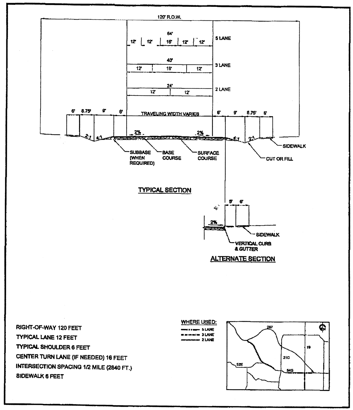
2.
Urban Arterial Typical Section.
3.
Collector Typical Section.
4.
Local Residential Street Typical Section.