
Larimer County Unincorporated
City Zoning Code
City Zoning Code
ARTICLE 5
0 - LAND DIVISION STANDARDS1
Cross reference— Any ordinance or resolution regarding subdivisions or dedicating or accepting any plat or subdivision in the county saved from repeal, § 1-9(a)(13); buildings and building regulations, ch. 10; health, environment and natural resources, ch. 30; open space, parks and recreation, ch. 42.
5.3. - Street and Access Standards[2]
Cross reference— Roads and bridges, ch. 50; traffic and vehicles, ch. 58.
5.4. - Easement and Utility Standards
The following easement and utility standards apply to all land divisions:
5.1.1. - Applicable Standards.
A.
The standards in §§5.1 through 5.4 apply to all applications for land division.
B.
The standards in Article 4, Development Standards, are also applicable to the extent that preliminary plat includes the level of design detail required to apply the standard. Where more site or lot specific detail is required, compliance with a development standard can be shown in a later review process.
5.1.2. - Land Division Requirements.
A.
Development shall be designed to avoid, eliminate, or mitigate potential effects of natural hazards and other hazardous site conditions. New building sites and building envelopes cannot be placed on land:
1.
With a slope of 30 percent or greater,
2.
With geologic hazards rated 5, 6 or 7 on geologic hazard maps adopted by the County Commissioners, or
3.
In a designated floodplain, unless the Federal Emergency Management Agency approved a letter of map amendment or a conditional letter of map revision (see the technical supplement for amendments and revisions to National Flood Insurance Program maps);
B.
Requirements for all phased land divisions:
1.
The phasing schedule shall be noted in the development agreement;
2.
A block cannot be divided by a phase;
3.
County Commissioners shall approve all phasing as part of a subdivision concept plan; and
4.
The phasing schedule shall allow for proper drainage, secondary access, water, and sewer systems and open space at all times during construction of a phased project.
5.1.3. - Land Division Considerations.
The following standards should be incorporated into land divisions to the maximum extent practicable:
1.
The development should be designed to preserve the natural terrain, existing topsoil, and vegetation, including significant trees.
a.
"Significant trees" for this purpose shall mean deciduous trees with a caliper of greater than four inches and coniferous trees 15 feet or greater in height.
b.
Significant trees not feasible for preservation should be replaced on-site with similar trees of the largest caliper possible (not less than three-inch caliper for shade trees, two-and-one-half-inch caliper for ornamental trees and eight feet all for coniferous trees), except that invasive or nuisance tree species or trees removed to comply with wildfire hazard mitigation requirements need not be replaced.
2.
Lot layouts should provide desirable settings for structures by using natural contours, maintaining desirable views, and providing protection from adverse wind, noise, and vehicular traffic.
a.
Lots should use natural and manmade features, such as fences, streams, ditches, rights-of-way, and easements, as their boundaries.
b.
Lots should not be divided by an irrigation ditch or a stream unless an approved bridge or other crossing is built to provide vehicular and/or pedestrian access to both sides.
3.
Where practicable, all residential structures should be located at least one-quarter mile (1,320 feet) from Interstate 25.
4.
Design should provide for solar access and orientation.
5.
Recreation facilities should be centrally located to all lots in the development.
6.
All lots should have reasonable physical and/or visual access to open space.
5.2.1. - Lots.
A.
Lot Layout.
1.
Standards.
a.
All land divisions shall create lots that can be developed consistent with this Code and other adopted county standards and regulations.
b.
Lots shall be laid out to provide positive drainage away from all building sites, and the overlot grading shall be designed and maintained consistent with the general storm drainage pattern for the area.
c.
Lot area, width, depth, shape, location, and orientation shall conform to this Code.
d.
Corner lots shall have adequate width and depth to meet applicable setbacks from and orientation to all roads.
e.
Side lot lines shall be substantially at right angles or radial to road right-of-way lines.
f.
Irregular or wedge-shaped lots shall have sufficient width at the front setback line to permit construction of a building that meets side setback requirements.
g.
Lots shall not be divided by a municipal or county boundary line, road, alley, or another lot.
2.
Guidelines.
a.
Lots should not exceed a depth-to-width ratio of 3-to-1. Lots should not exceed a width-to-depth ratio of 1.5-to-1.
B.
Prohibited Lot Types and Design.
1.
Double frontage lots should be avoided except where they are essential to provide separation of residential development from arterial streets or to overcome specific topographic problems. When double frontage lots are unavoidable, additional lot depth should be included to account for road setbacks.
2.
Flag lots should be avoided. They may be used where extraordinary topography or other physical constraints prevent another design; and where the natural terrain is altered significantly in order to facilitate drainage or for other reasons, maximum building heights should be defined in the development plan, so that the height of structures is consistent with what would be allowed if measured from the original grade of the site.
3.
Reserve strips to prevent access to roads are prohibited.
C.
Outlots.
All parcels that are to be used only for drainage easements, rights-of-way or other uses that do not need any buildings shall be labeled "Outlot" followed by consecutive letter designations beginning with "A."
D.
Residual Lots.
All parcels in conservation developments and rural land plans that are considered to be residual land shall be labeled "Residual Lot" followed by consecutive letter designations beginning with "A." Residual lots shall be further identified by one of the following applicable designations that shall be placed in parentheses after the residual lot label:
1.
"Buildable/residence(s)" for those residual lots that may be occupied by one or more single-unit dwellings;
2.
"Buildable/support buildings only" for those residual lots that may be occupied by buildings that are accessory to the use of the residual lot;
3.
"Nonbuildable" for those residual lots that are not intended to be occupied by any buildings;
4.
Building envelopes indicating where buildings will be placed shall be shown on residual lots that will have a building or buildings. Building envelopes shall be situated to meet the required setbacks of the zoning district in which the property is located.
E.
Common Area Lots.
1.
All parcels in subdivisions, conservation developments, rural land plans, and minor land divisions that are common open space for the development shall be labeled "Common Area Lot" followed by a consecutive letter designation beginning with "A." Common area lots shall be further identified by one of the following applicable designations that shall be placed in parentheses after the common area lot label:
a.
"Buildable/support buildings only" for those common area lots that may be occupied by buildings or structures (such as pools, playground equipment, or gazebos) that are intended for use by the lot owners in the development;
b.
"Nonbuildable" for those common area lots that are not intended to be occupied by any buildings or structures.
2.
Any building or structure proposed to be located on a common area lot that was not approved as part of the original approval, and any proposed changes to the location of an approved building or structure shall be reviewed through §6.4.1, Site Plan Review.
(Res. of 11-6-2023, Exh. A; Res. of 4-22-2024, Exh. A)
5.2.2. - Blocks.
The following block standards apply to all land divisions:
A.
Block lengths shall be designed to provide safe and convenient access to the lots; and
B.
In the Urban districts and GMAs, block lengths in excess of 1,000 feet may require pedestrian access approximately midway through the block.
5.3.1. - Public Right-of-Way Required.
A.
All roads within the boundaries of land divisions, in both urban and rural areas, shall be a public right-of-way.
B.
In order for the County Commissioners to approve a modification to allow a private road within a land division, the County Commissioners shall find that both of the following criteria are met:
1.
There would be no foreseeable public purpose or benefit in having a public right-of-way; and
2.
The County Commissioners find that road connectivity to adjacent parcels is not needed or practical and have granted an appeal to §5.3.4, Connectivity.
C.
If a modification to this subsection is granted, the following standards shall apply to the private road:
1.
There is an easement, agreement, covenant or other appropriate document to be recorded in the County records that grants the right of access for emergency and service vehicles and that defines the persons/entities entitled to use the road easements, including the installation and maintenance of street name signs within the easement, the purpose for and manner in which the roads may be used, any limitations on the use of the roads, the persons/entities authorized to enforce the terms of the easement and penalties for violation of the terms of the easement.
2.
The design and construction of the private road will meet applicable county road or street standards;
3.
The property owner shall form an improvement district for the long-term maintenance of the road; and
4.
County requirements for road naming, road name signs and addressing have been or will be met prior to the issuance of any building permit.
5.3.2. - Gated Public Roads.
A.
Gated public roads are prohibited.
B.
Gated private roads are prohibited unless the County Commissioners approve a modification allowing private gated roads. In order for the County Commissioners to approve gated private roads, the County Commissioners shall find that all the following criteria are met:
1.
The subject road is a private road and all owners of property having a legally established right to access via the private road have approved gating the road;
2.
The modification request has been referred to the applicable fire protection entity and the Sheriff's Department, emergency services for their review and comment, and such comments have been duly considered; and
3.
The design provides for adequate vehicle stacking distance and turn around between the public road and the gate.
5.3.3. - Dead-End Design.
A.
The maximum length of a dead-end access shall be no greater than 660 feet in an Urban district or GMA.
B.
Dead-end road systems outside of an Urban district or GMA are not limited in length but shall provide a secondary/emergency access if the principal access is:
1.
Crossed by drainage channels that have culverts that cannot pass the 50-year design frequency storm with no more than one foot of flow across the road; or if the principal access is located in an area subject to a wildfire fire hazard where trees cannot be readily restricted from that area adjacent to the road by a distance of at least the mature height of said trees; or any other identifiable or geologic hazards that have the potential to block the access.
2.
In all cases dead end roads shall be provided with inter-visible turn outs of at least ten feet in width and 30 feet in length, no less than 500 feet apart.
C.
Land divisions that cannot meet this standard shall provide a second point of access. The second access shall be either a dedicated, public right-of-way or an easement specifically granted for emergency access purposes.
5.3.4. - Connectivity.
A.
All land divisions shall be designed to comply with §4.5, Connectivity and Circulation.
B.
Where future connectivity is required to adjacent undeveloped parcels, a road shall be constructed to the property line meeting applicable County Road or Street Standards. When such a road is constructed, a sign stating "Future Road Connection" shall be erected and maintained in a conspicuous location along such road.
5.3.5. - Road Surfacing Requirements.
The following road surfacing requirements apply to the interior roads of all development:
A.
The selection of road surfacing material should be based on factors including but not limited to safety; convenience; dust control; and maintenance considerations. Acceptable road surface types vary with traffic volumes and character area location: Urban districts and GMAs require different road surfacing than rural districts.
B.
The minimum road surfacing requirements for various traffic volumes and locations are:
C.
Pavements must consist of either asphaltic concrete pavement or Portland cement concrete pavement, placed on a compacted subgrade, with base course and subbase course where required, placed on compacted subgrade.
D.
Structural design criteria for road surfaces are contained in Chapter 5, Structural Design criteria, of the technical supplement to this Code, Larimer County Road Standards.
5.4.1. - Design.
A.
Utility easements shall be a minimum of eight feet on each side of abutting rear lot lines. Rear lot lines not adjacent to subdivided property shall have ten foot utility easements. Side lot line easements, where needed, shall be five feet wide. Front lot line easements, where needed, shall be 15 feet wide. These are minimum standards. Additional or wider easements may be needed to accommodate certain utilities;
B.
Utility easements shall be designed to allow efficient installation and maintenance of utilities and multiple installations wherever possible;
C.
Utility lines shall be placed underground unless the applicant demonstrates to the County Commissioners' specific engineering considerations that necessitate aboveground utility installations;
D.
Transformers, switching boxes, pedestals and other such necessary facilities may be placed aboveground. All such facilities shall be placed within easements or rights-of-way provided for these facilities; and
E.
Utilities shall be extended to each lot or building site.
5.4.2. - Approval.
Utility easements shall be approved by utility companies serving the project.
5.5.1. - Purpose.
A.
The purpose of residual land and common area use plans is to identify the specific uses and structures to be allowed for residual land and/or common area parcels created through the land division processes and provide for the perpetual maintenance of these parcels.
B.
The use plan must be coordinated and consistent with the applicable Article 4.0 development standards, such as: wetlands mitigation plans, wildlife conservation plans, hazard area mitigation plans and other plans approved as part of the land division process or the administrative special review or special review processes.
5.5.2. - Applicability.
A.
Any development process that creates residual land and/or common area parcels must include a use plan for residual land and/or common area as part of the development agreement for that project.
B.
A greater level of detail may be required for rural land plans that include bonus units on agricultural land.
5.5.3. - Use Plan Elements.
Residual land and/or common area use plans must include the information identified on the application form, which shall include at least the following elements:
A.
Identification of residual land or common area parcels with a specific assignment of ownership, permitted uses and structures and perpetual maintenance responsibility for each parcel; and
B.
Reference to any other plans approved as part of the project that pertain to all or part of the residual land and/or common area, such as, but not limited to wetlands mitigation plans, wildlife conservation plans, hazard area mitigation plans, water quality management plans, storm water management plans and air quality management plans. The use plan must identify how the execution of these plans will affect the proposed use(s) and maintenance of the residual land or common area.
5.5.4. - Review Criteria.
To approve a residual land and/or common area use plan, the County Commissioners must find that the following conditions exist:
A.
The use plan adequately describes the proposed uses and maintenance of the residual land and/or common area parcels and such proposed uses and maintenance are consistent with the intent of the residual land and/or common area;
B.
The use plan specifically identifies the entity responsible for ownership and maintenance of the residual land and/or common area parcels; and
C.
The use plan clearly indicates how compliance with Article 4.0, Development Standards will affect the proposed uses of the residual land and/or common area parcels as well as how the use plan is coordinated with and consistent with the requirements of Article 4.0, Development Standards.
5.5.5. - Final Approval.
Final approval of any project by the County Commissioners must include approval of the project's use plan for residual land and/or common area. The use plan must be included in the project development agreement per §6.3.9.H and referenced in the disclosure notice.
5.5.6. - Amendments.
The Director may authorize minor adjustments to the use plan for residual land and common area upon a finding that the original intent and purpose of the approved use plan is preserved. If the Director determines the adjustments are not minor or will change the intent and purpose of the original use plan, the County Commissioners must approve the amendments at a public hearing with notice to property owners within the development.
5.6.1. - Overview of Subdivision.
A subdivision is intended to provide the process for creating parcels where a conservation development of planned land Division is not required.
5.6.2. - Applicability.
The subdivision process must be used to subdivide and develop legal lots less than 30 acres (except parcels of fewer than 30 acres created by minor land division). The subdivision process may also be used to subdivide and develop parcels that have been granted an exception from conservation development requirements, those parcels which comply with the requirements in §5.8.2.C and to divide parcels outside of the GMA districts that are not zoned for residential uses.
5.6.3. - General Provisions.
The following general provisions apply to all subdivisions:
A.
Development Standards.
Development of subdivisions shall comply with the development standards in Article 4.0, Development Standards, as applicable.
5.6.4. - Process.
A.
Land Division Procedures Apply.
Subdivision applications shall be processed pursuant to §6.5, Land Division Procedures.
5.7.1. - Overview of Planned Land Division.
The planned land division is intended to allow flexibility in the design of urban development to carry out intergovernmental agreements between the county and municipalities located in the County.
5.7.2. - Applicability.
All divisions of land to create new lots in the GMA district shall be submitted and processed as planned land divisions or minor land divisions. Any land in the LaPorte Plan Area that has been rezoned to PD-Planned Development may only be divided through the Planned Land division process.
5.7.3. - General Provisions.
The following general provisions apply to all planned land divisions:
A.
Land Use and Density.
1.
All land in a planned land division must be rezoned to PD-Planned development.
2.
All planned land divisions must include and development agreement that specifies details of the development. Upon recording of the final plat and development agreement for the planned land division, the rezoning to PD-Planned Development will be effective.
5.7.4. - Process.
The following general provisions apply to all conservation developments:
A.
Land Division Procedures Apply.
Planned Land Division applications shall be processed pursuant to §6.5, Land Division Procedures and §6.6, Code Amendment Procedures.
5.8.1. - Overview of Conservation Development.
A.
Conservation development is intended to ensure that residential development on large parcels is creatively designed to maintain the open character of rural areas, to encourage the ongoing use of land for agricultural purposes, and to protect and maintain natural environmentally sensitive areas while permitting development to the allowed zoning density. This is accomplished by clustering development on lots smaller than would otherwise be permitted ("development cluster") and keeping the remainder of the site in residual land ("residual land").
B.
Development cluster(s) are designed for residential development. Development cluster layout is regulated by §5.8.4, Development Cluster Design.
C.
Residual land is held in open space with limited uses, which may include conservation, agricultural production, and general open space. Most residual parcels are placed in a conservation easement for perpetuity. Residual land is regulated in §5.8.5, Residual Land Design.
5.8.2. - Applicability.
Conservation development is required for residential development on contiguous parcels of 30 acres or more located outside of the Urban districts and GMAs unless:
A.
The property is divided into lots of 35 acres or greater;
B.
The property is developed pursuant to §5.9, Rural Land Use Process; or
C.
The parcels have public water and sewer service, are zoned UR-1 Residential, UR-2 Residential, UR-3 Residential, MR Multi-Unit Residential, MHP Manufactured Housing Park, or MHP-P Manufactured Housing Park Preservation and are located outside growth management areas, in which case they may be developed through the subdivision process described in §6.5, Land Division Procedures.
(Res. of 4-22-2024, Exh. A; Res. of 12-9-2024, Att. A)
5.8.3. - General Provisions.
The following general provisions apply to all conservation developments:
A.
General.
All residual land, except that in a limited-term conservation development, shall be maintained and remain undeveloped in perpetuity using a legal instrument such as a development agreement or conservation easement to set forth such conditions and restrictions.
B.
Design.
1.
All property included within a conservation development shall be contiguous.
2.
All conservation developments shall consist of two segments: (1) the development cluster or clusters, on which the residential units are located, and (2) the designated private residual land to be held in conservation.
3.
A minimum of 80 percent residual land and maximum of 20 percent developable land is required in all conservation developments unless a different percentage is allowed as provided in Table 5-2:
a.
When a conservation development is designed to increase the average size of lots by reducing the number of dwelling units by ten percent, the percentage of residual land provided may also be reduced at the discretion of the County Commissioners, but in no event can the residual land be less than 50 percent of the total developable land area of the site.
b.
This increase is an incentive to the developer and benefits the community by maximizing the protection of open space and water quality. The density bonus is to be awarded at the discretion of the County Commissioners upon finding that there is a significant public benefit due to the design of the conservation development, the feature(s) being preserved in the residual land and the project complies with Article 4.0, Development Standards.
4.
All residual land shall be maintained and remain undeveloped in perpetuity in accordance with appropriate use plan for residual land and/or common area as provided in §5.5 of this Code, except in cooperative planning areas (CPAs) where a conservation development may be an interim development while waiting for full development at urban densities in a GMA district.
C.
Density.
1.
The total number of dwelling units permitted in a conservation development is determined by dividing the total developable land area of the site by the minimum lot size required for the applicable zoning district.
a.
The total number of dwelling units cannot exceed the overall density permitted in the zoning district where the development is located.
b.
When the total number of dwelling units calculated results in a fractional number, any fraction shall be rounded down.
2.
Where permitted in the zoning district, agricultural labor housing in a conservation development shall be counted as part of the allowed number of dwelling units. Four beds in an agricultural labor housing structure equal one dwelling unit when such housing is proposed in a conservation development.
3.
No more than 50 percent of the total dwelling units in a development shall be attached single-unit dwellings.
4.
If the full density permitted within a conservation development is not used, the remaining permitted density may be achieved through a replat of the development area.
5.
Residual land may be divided into 35-acre or larger parcels. The number of such parcels created in a conservation development counts against the total number of dwelling units allowed by the current zoning, and the area contained within the building envelope on each of these parcels counts against the total developed area and not as residual land.
a.
Design of these lots will include the siting of building envelopes, access roads and driveways, utility and drainage easements, and other facilities in relation to the purpose of the conservation development regulations.
b.
All 35-acre and larger lots in conservation developments shall be included in the use plan for residual land and/or common area for the project and identified in the development agreement.
D.
Land Use.
1.
Land uses in a proposed conservation development shall be limited to those allowed in the applicable zoning district.
2.
Where permitted in the zoning district, attached single-unit dwellings shall be limited to no more than four units in a single structure.
3.
Agricultural labor housing in a conservation development shall be counted as part of the allowed number of dwelling units. Four beds in an agricultural labor housing structure equal one dwelling unit when such housing is proposed in a conservation development.
4.
Existing rural features on the site, such as farmstead structures and fencing, should be preserved if the structures have historic value.
(Res. of 6-13-2023, Exh. A, 8; Res. of 4-22-2024, Exh. A)
5.8.4. - Development Cluster Design.
A.
Development Cluster Design and Improvements.
1.
Multiple development clusters shall be physically separated from one another so the appearance and visual impacts of these developed areas on the intervening residual land is minimized.
2.
Residential and related land uses, roads, and parking areas shall be located in the development cluster; except, in those conservation developments where the ratio of developed area to residual land is 20 percent to 80 percent, up to 60 feet of road right-of-way may be included in the residual land area.
B.
Development Cluster Location.
The following criteria should be considered when identifying the location of a residential cluster(s):
1.
Avoidance of prime agricultural land or agricultural land that has historically been used for agricultural production;
2.
Avoidance of hazards and environmentally sensitive lands;
3.
Avoidance of alterations to natural drainage patterns;
4.
Preference for locations closer to roads and existing or future infrastructure; and
5.
Preference for "isolated" tracts that are not easily accessible for agricultural uses.
C.
Site Design.
1.
Continuing Productive Agricultural and Ranching Areas.
a.
Structures shall be sited to optimize the shape and configuration of farmable parcels and fields. Fragmented farmland and wildlife habitat shall be avoided to the maximum extent practicable.
b.
Structures shall be located at the edges of farmland to allow the creation of cohesive farm fields.
c.
New structures or development shall be located at the edge of existing developed areas in compact configurations. Where possible, development should be located at the edge of farmland and a natural feature such as a ridgeline, tree stand, bluff, or stream.
d.
Driveways shall be located along fencerows or other natural features that are not incorporated into farm fields. The distance and number of driveways shall be minimized to the maximum extent practicable. See Figure 5-1 below.
Figure 5-1: Driveway Site Design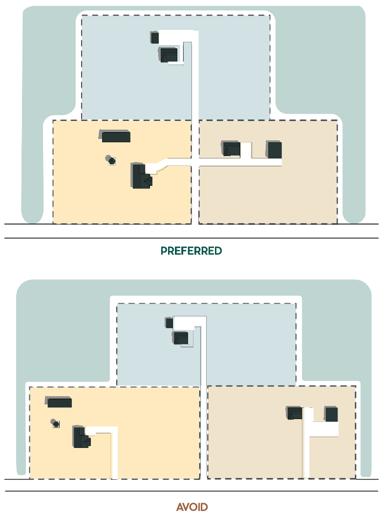
e.
Fence rows shall be used where practicable to define productive parcels and developed areas.
2.
Compact Development.
a.
Multiple-lot residential development shall be clustered in the form of a typical farmstead and served by a cul-de-sac road. See Figure 5-2 below.
Figure 5-2: Cluster Development with Cul-de-Sac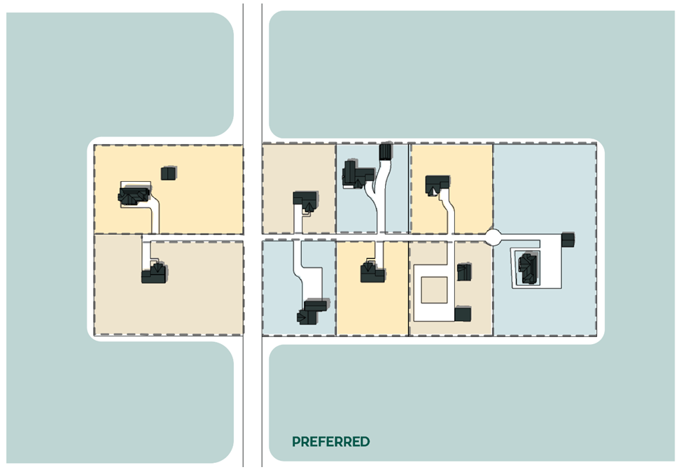
b.
Developed land adjacent to farmland shall be minimized to prevent the loss of farmland.
c.
Development shall be designed and sited to minimize the perimeter of developed areas adjacent to farmland.
d.
Large, isolated lots shall be avoided to the maximum extent practicable.
3.
Development Sited Away from Roadway.
Homes and outbuildings shall be set back from the road and shall not be designed to line the roadway with structures and driveways as shown in Figure 5-3 below.
Figure 5-3: Roadway Siting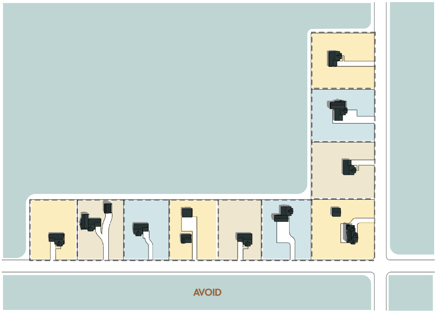
D.
Lot Size and Design.
1.
Even within the development cluster, the highest priority for site layout shall be the preservation of environmentally sensitive areas and agricultural uses. The location of home sites and the corresponding layout of lots and streets shall have a lower priority and shall be designed to create a compact development pattern.
2.
No minimum lot size is required in the development cluster, except for those developments and lots that use on-lot septic systems or wells where the minimum lot size is two acres (87,120 square feet).
3.
Site layout shall be oriented to:
a.
Achieving the best possible relationship between development and features of the land;
b.
Minimizing alteration of the natural site features and topography;
c.
Relationship to surrounding properties;
d.
Improving the view from and the view of buildings; and
e.
Reducing the area devoted to roads and utilities.
4.
Flexibility in lot size is encouraged to:
a.
Promote a design that is sensitive to the natural environment;
b.
Adapt to the natural topography of the site;
c.
Accommodate the mix of residential land uses and housing types proposed within the development; and
d.
Design for compatibility with agricultural uses and other existing and allowed uses.
5.
To the extent practical, home sites should be located to enhance visual access to residual land both from the proposed development and from adjacent lands.
E.
Building Envelopes.
1.
In lieu of setbacks, building envelopes may be designated for each lot to identify the area where all buildings shall be constructed and to provide adequate separation between buildings and uses or activities, but in no case shall the building envelope be less restrictive than the setbacks of the base zoning district.
2.
Building envelopes shall be designed to avoid hazard areas, the tops of ridgelines or slopes, view corridors, open fields, sensitive environmental areas, and agricultural infrastructure.
3.
To the maximum extent feasible, all building envelopes shall be located at least one-quarter mile (1,320 feet) from the edge of the Interstate 25 right-of-way.
4.
In mountainous areas, building envelopes shall be designated at the minimum size necessary to construct a dwelling on the lot so the area disturbed is minimized.
5.
In Conservation and Agriculture and Rural districts, the placement of buildings within building envelopes along the street frontage should be varied to minimize uniformity.
6.
If building envelopes are used, agricultural buildings may be located outside the building envelope on the residual lot if specified as part of an approved development. Applicable base zoning district setbacks shall still be applicable.
7.
A building envelope may be used to limit the location of various types of structures. When so used, the types of structures limited to the building envelope shall be clearly stated as part of an approved development with the implication that all other types of structures may be located outside the building envelope.
F.
Development Standards.
1.
Development Standards Applicable.
Development within a cluster shall comply with the development standards in Article 4.0, Development Standards, as applicable.
2.
Buffering.
Perimeter buffering of a development cluster is required to minimize visual and noise impacts where adjacent land uses are of a different type (e.g., residential adjacent to commercial or industrial) or are of a substantially different residential density; or where the cluster is adjacent to a county road, state or federal highway or a railroad.
a.
Where the proposed cluster abuts an agricultural use or zoning district, a residential/agricultural buffer shall be provided per §4.8.1, Buffering and Screening.
b.
Where the proposed cluster abuts an existing or approved residential, mixed-use, or commercial development, the buffer shall be at least equal to the required rear yard depth of the adjacent lots. Where the proposed cluster abuts a county road, state or federal highway or a railroad, the buffer is measured from the edge of the existing right-of-way and shall be of a width and design to reduce visual and noise impacts from the road, highway, or railroad.
c.
Buffering may be accomplished through the use of increased separation between land uses and/or by using native or drought resistant vegetation, fencing, walls or a combination of these measures.
d.
The traditional concept of using windbreak plantings around a farmstead may be desirable for the design of buffering between a cluster and agricultural uses.
e.
Perimeter buffering of a cluster in mountainous areas should be designed to take into consideration the buffering effect provided by existing trees and topography.
3.
Fencing.
a.
Privacy fencing may be used in conservation developments when the backs of lots are adjacent to a county road or state highway, or on individual lots to provide privacy or enclosure for the lot or a portion of the lot.
b.
Fencing should be designed to conform to the topography and be of a color that blends with the natural environment.
4.
Entry Features and Signage.
a.
The color, materials, size, height and lighting of entry features, signs and related structures shall be compatible with the proposed development and the maintenance of views of the natural landscape, public parks, and open space. Standards for signs are found in Article 8.0, Signs, of this Code.
b.
Lighting of entry features and signage shall be kept to a minimum and shall be consistent with §4.10, Exterior Lighting.
c.
Where a gated entryway into a conservation development is proposed, a plan shall be provided with the submittal to address potential safety concerns of accessibility to the development by emergency services vehicles and general service or delivery vehicles, and whether the access road is planned to extend beyond the development boundaries.
5.8.5. - Residual Land Design.
A.
Generally Applicable Standards.
1.
Residual land in conservation developments shall be designed to achieve the maximum contiguous amount of open space possible while avoiding the creation of small, isolated, and unusable areas.
2.
Roads, pedestrian walkways, and trails may connect through the residual land under the standards in §4.5, Connectivity and Circulation.
3.
Where practical, residual land should be located contiguous to and be connected with other residual land on the site or residual land adjacent to the conservation development boundaries. Connectivity is based on visual connections for residents of the development and, where applicable, physical connections for wildlife habitat.
4.
Residual land may include such uses as pedestrian and bicycle areas, buffer areas and common area devoted exclusively to the use of the residents of the conservation development and their guests.
5.
Residual land areas containing environmentally sensitive areas or features can not contain any structure or improvements, except walkways or trails, provided such areas are determined to be appropriate for walkways or trails and they can be constructed with minimal disturbance to environmentally sensitive areas.
6.
Residual land areas shall not include road rights-of-way or parking areas, except in projects with a ratio of 20 percent developed area to 80 percent residual land, the road right-of-way, up to 70 feet in width, may be included in the calculation of the required residual land.
B.
Generally Applicable Use Standards.
1.
Uses in residual land are limited to such uses, accessory structures, and improvements necessary for agricultural uses or for the educational, cultural, recreational, or social enjoyment of the residents of the conservation development and their guests, and any utility services, including community sewer systems, providing the coverage of all structures and improvements in the residual land does not exceed five percent of the residual land.
a.
Structures and improvements that count toward the five percent include barns, silos, animal shelters, swimming pools, tennis courts and other similar improvements. Examples of such uses include, but are not limited to, golf courses, pools, spas, Jacuzzis, children's play areas, court and field games, walking trails, bicycle paths, picnic areas, community buildings or centers and stables or arenas.
b.
All accessory structures and improvements shall be described in the development agreement and included in the use plan for residual land and/or common area for the conservation development.
c.
Accessory structures shall be appropriate to the use of the residual land as stated in the use plan for residual land and/or common area.
d.
Those portions of residual land devoted to agricultural use may include accessory structures directly related to and necessary for the agricultural use. A farmstead may be allowed in the residual land and, if included, counts toward the total allowed residential density in the development.
e.
The residual land in a conservation development is private property and not available to the public.
C.
Cooperative Planning Areas.
Land in a cooperative planning area designated in an intergovernmental agreement may be developed as a conservation development with the residual land designated for future development upon its inclusion in a GMA district. These details shall be addressed in the development agreement as provided in §6.3.9.H.
5.8.6. - Process.
A.
Land Division Procedures Apply.
Conservation development applications shall be processed pursuant to §6.5, Land Division Procedures.
B.
Special Area Plan for Large and Contiguous Clusters.
1.
When a single conservation development contains over 250 dwelling units, or where the potential exists for multiple conservation developments within one-quarter mile of any boundary of a proposed conservation development to reach a combined total of more than 250 dwelling units, the County Commissioners shall review the cumulative effect of such developments. The County Commissioners will then determine if a special area plan is required for the conservation development to be approved. The County Commissioners will make this determination at the sketch plan or concept review stage of the development review process.
2.
Special area plans will be prepared by the County as directed by the County Commissioners. If such a plan is not in the current county work program or budget, funding may be provided by the applicant or other entity so that the special area plan may be prepared by a private consultant with oversight by the County.
3.
All special area plans require a recommendation by the Community Development Director and approval by the Planning Commission. The recommendation and decision shall include the general content and process requirements for a special area plan, as well as the options available for the development of the special area plan on a timely basis. If the proposed conservation development is consistent with an existing adopted special area plan, no additional special area plan is required.
4.
The following criteria shall be used in making a determination of whether a special area plan is required:
a.
All or a part of the cluster is located within the cooperative planning area of a municipality; or
b.
There is a need for urban level services to support the cluster(s) and existing, planned or approved uses.
5.9.1. - Overview.
The Rural Land Use Process (RLUP) provides for the conservation of natural areas and preservation of agricultural lands, while allowing limited rural land divisions on parcels greater than 70 acres where only well water is available.
5.9.2. - Purposes.
The purposes of the RLUP are:
A.
Identify and Standardize Rural Subdivision Options and Incentives.
1.
To recognize the current 35-acre exemption law and implement the domestic water and cluster development provisions of C.R.S. § 30-28-401 et seq. and amendments to C.R.S. § 37-92-602.
2.
To develop new methods to incentivize the retention of agricultural and forest land as productive, nonrenewable resources through innovative land division designs.
3.
To encourage land use designs and flexibility that optimize preservation of environmental resources and/or lessen the public cost of infrastructure;
4.
To encourage flexibility and innovation of compact development patterns that are compatible with and supportive of agricultural operations or preservation of natural resources.
5.
To curtail requirements to support creative achievements in designs.
6.
To enable rural land use projects between and among noncontiguous parcels (including the transfer of development rights) or between and among cooperating landowners for large parcel planning.
B.
Protect Both Agricultural Land and Critical Areas.
1.
To preserve and protect critical county areas by designating and recognizing distinctions in the land such as agricultural land, open lands, regional preserves, parks, and trails, as well as critical areas such as distinct landscapes, forest land, ecosystems, watersheds, ridgelines, wildlife, wetlands, hazardous areas, view corridors, historic and archeological sites, and urban areas, and to encourage development that respects these critical areas.
2.
To encourage continued agricultural land uses and protection of the County's rural character, open space, and the character of existing communities while identifying development options that recognize current zoning.
3.
To promote the goal of contiguous agricultural lands.
4.
To provide flexibility in land use regulations responding to the needs of the agricultural community (i.e., additional dwelling units, migrant farm housing, caretaker/foreman quarters, guest housing, etc.).
5.
To apply development standards appropriate to the character area or property context and encourage new development innovations and technologies.
C.
Implement Larimer County Plans, Policies, and Community Priorities.
1.
To implement the Comprehensive Plan.
2.
To promote the goals of the Larimer County Parks Master Plan and other adopted plans.
3.
To encourage alternatives to 35-acre parcels that will allow maximum retention of characteristics considered special to Larimer County and most valued by its citizens.
4.
To encourage and promote good use of the land while responding to lifestyle choices.
5.
To evaluate the impact on neighborhoods in the approval of alternatives to 35-acre developments.
6.
To educate people who purchase property adjacent to agricultural uses about agricultural or forestry practices, and support "right to farm" laws.
7.
To recognize and respect both individual rights and community interests and values when development is proposed.
8.
To educate decision-makers, applicants and citizens about the proposed alternatives and outcomes.
(Res. of 4-22-2024, Exh. A)
5.9.3. - Applicability.
A.
The rural land use process can be used for any parcel in a district within the Conservation and Agriculture character area, or a parcel within the RR-1 district located at the interface of the Conservation and Agriculture and Rural character areas, that meets the following size requirements:
1.
For RLUP projects involving a single parcel, or two or more noncontiguous parcels where no transfer of development rights among parcels will occur, each parcel shall be at least 70 acres in size.
2.
For RLUP projects involving two or more noncontiguous parcels where a transfer of development rights among parcels will occur:
a.
At least one of the parcels shall be 70 acres in size, and all other parcels shall be at least 35 acres in size; and
b.
The receiving parcel(s) shall be at least 70 acres in size.
B.
The rural land use process can be used only for single-unit residential purposes.
(Res. of 4-22-2024, Exh. A)
5.9.4. - Design Standards.
The following standards are applicable to the development and review of Rural Land Use Process subdivisions.
A.
Density.
1.
The maximum number of buildable lots allowed will equal the total acreage divided by 17.5 (rounded down to the nearest whole number. In no event can the total number of buildable lots and bonus lots exceed one residential unit for each 17.5-acre increment.
a.
Any remaining, undeveloped parcel that is not included in a rural land plan shall contain at least 35 acres.
b.
The applicant shall enter into a development agreement detailing restrictions on further development and subdivision of the subject property so that the maximum number of dwelling units permitted on the property does not exceed the number approved through the rural land use process.
2.
Any principal dwelling for the agricultural use on the residual land which is approved by the County Commissioners pursuant to §5.9.4.C.4 shall be included in density calculations. Any accessory dwellings for the agricultural use on the residual land in excess of one approved by the County Commissioners pursuant to §5.9.4.C.3 shall be included in density calculations.
B.
Site-Specific Layout.
1.
The layout of RLUP subdivisions shall be based upon the unique qualities and characteristics of the underlying parcel. The parcel will also be considered in context with surrounding areas.
2.
Lots should be sited in areas deemed compatible with the special characteristics of the specific parcel under consideration as well as surrounding areas. Lot sizes and spacing will depend on the specific site and technical and environmental factors.
3.
Results of specific siting may be:
a.
Dispersed siting: The locating of residential sites on lots smaller than 35 acres which may or may not share common boundaries in order to enhance the special characteristics of the specific parcel.
b.
Clustered siting: Groups of residential sites on lots smaller than 35 acres which may have shared boundaries and result from the evaluation of special characteristics of the specific parcel.
C.
Residual Land.
1.
All development proposals shall reserve at least two-thirds of the total area of the parcel for the preservation of contiguous undeveloped land, unless the Board of County Commissioners finds that a noncontiguous arrangement of residual land would be more appropriate in achieving the purposes of the rural land use process. For plans involving noncontiguous parcels, the two-thirds residual land requirement may be met in either of the following two ways:
a.
An area equal to two-thirds of the total area of all parcels may be designated as residual land on one of the parcels; or
b.
An area equal to two-thirds of the area of each individual parcel may be designated as residual land on each of the individual parcels.
2.
Residual land shall remain undeveloped for either a 40-year timeframe or in perpetuity. The residual land will be precluded from additional development by an appropriate legal instrument.
3.
In the event that the residual land will remain undeveloped through the use of a conservation easement, an acceptable grantee shall be designated for the easement. The grantee will then be responsible for monitoring the easement.
4.
Residual land will be precluded from additional development by an appropriate legal process, e.g., deed restrictions, covenants, etc. The preliminary plat must designate all existing dwellings located on the residual land. No principal farm or ranch dwelling or accessory farm or ranch dwelling can be constructed on the residual land unless specifically approved by the County Commissioners and designated on the final plat or described in the development agreement or an amendment to the final plat or development agreement. Any principal farm or ranch dwelling, and any accessory farm or ranch dwelling(s) must be designed to allow a logical pattern of lots that meet minimum lot size and setback requirements of the applicable zoning district.
D.
Development Standards.
RLUP development shall comply with applicable standards in Article 4.0, Development Standards and Article 5.0, Land Division Standards.
(Res. of 4-22-2024, Exh. A; Res. of 8-12-2024, Exh. A)
5.9.5. - Process.
RLUP applications shall be processed pursuant to §6.5, Land Division Procedures.
5.10.1. - Purpose.
A.
The purpose of residual land and common area use plans is to identify the specific uses and structures to be allowed for residual land and/or common area parcels created through the land division processes and provide for the perpetual maintenance of these parcels.
B.
The use plan must be coordinated and consistent with the applicable Article 4 development standards, such as: wetlands mitigation plans, wildlife conservation plans, hazard area mitigation plans and other plans approved as part of the land division process or the administrative special review or special review processes.
5.10.2. - Applicability.
A.
Any development process that creates residual land and/or common area parcels must include a use plan for residual land and/or common area as part of the development agreement for that project.
B.
A greater level of detail may be required for rural land plans that include bonus units on agricultural land.
5.10.3. - Use Plan Elements.
Residual land and/or common area use plans must include the information identified on the application form, which shall include at least the following elements:
A.
Identification of residual land or common area parcels with a specific assignment of ownership, permitted uses and structures and perpetual maintenance responsibility for each parcel; and
B.
Reference to any other plans approved as part of the project that pertain to all or part of the residual land and/or common area, such as, but not limited to wetlands mitigation plans, wildlife conservation plans, hazard area mitigation plans, water quality management plans, storm water management plans and air quality management plans. The use plan must identify how the execution of these plans will affect the proposed use(s) and maintenance of the residual land or common area.
5.10.4. - Review Criteria.
To approve a residual land and/or common area use plan, the County Commissioners must find that the following conditions exist:
A.
The use plan adequately describes the proposed uses and maintenance of the residual land and/or common area parcels and such proposed uses and maintenance are consistent with the intent of the residual land and/or common area;
B.
The use plan specifically identifies the entity responsible for ownership and maintenance of the residual land and/or common area parcels; and
C.
The use plan clearly indicates how compliance with Article 4.0, Development Standards will affect the proposed uses of the residual land and/or common area parcels as well as how the use plan is coordinated with and consistent with the requirements of Article 4.0, Development Standards.
5.10.5. - Final Approval.
Final approval of any project by the County Commissioners must include approval of the project's use plan for residual land and/or common area. The use plan must be included in the project development agreement per §6.3.9.H and referenced in the disclosure notice.
5.10.6. - Amendments.
The Director may authorize minor adjustments to the use plan for residual land and common area upon a finding that the original intent and purpose of the approved use plan is preserved. If the Director determines the adjustments are not minor or will change the intent and purpose of the original use plan, the County Commissioners must approve the amendments at a public hearing with notice to property owners within the development.