
League City City Zoning Code
ARTICLE III
ZONING REGULATIONS
Sec. 125-3.1.- Purpose.
The purpose of this section is to establish base and overlay zoning districts for the City of League City. These zoning districts are intended to:
(1)
Regulate and manage the location and use of buildings and land for residence, commerce and trade, industry, transportation, communications and utilities, and other purposes;
(2)
Regulate and manage the location, height and size of buildings and structures hereafter erected or structurally altered, the size of yards, setbacks, and other open spaces, and the density of population; and
(3)
Establish site development and design standards, subdivision standards, and requirements for adequate public facilities and services.
(Ord. No. 2020-25, § 1(Exh. A), 9-29-2020)
Sec. 125-3.2. - Establishment of zoning districts.
125-3.2.1.
Base zoning districts. For the purposes of this chapter, the City of League City is hereby divided into base zoning districts. Base zoning districts are shown in Table 125-3.2.1 below.
125-3.2.2.
Overlay zoning districts. For the purposes of this chapter, overlay zones may be applied to the base zoning districts established in section 125-3.2.1 above. Overlay zoning districts are shown in Table 125-3.2.2 below.
125-3.2.3.
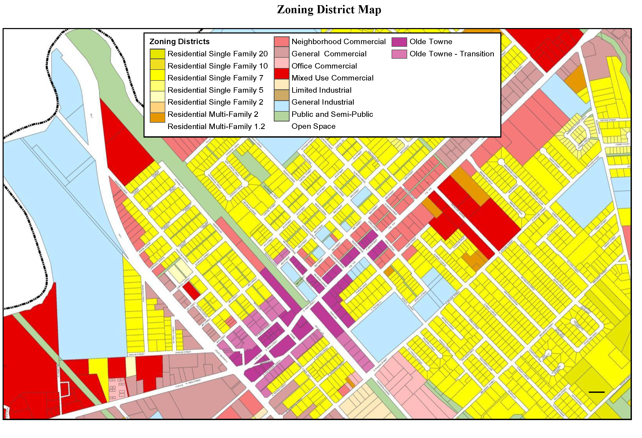
Zoning district map. The boundaries of these base and overlay zoning districts are hereby established as shown on the official zoning map, which accompanies and is made part of this chapter. The city planner or designee shall be responsible for custody of the official zoning map and shall promptly make any changes approved by the city council. The provisions of an ordinance establishing a district, amending a district classification, or amending a district boundary shall control over any conflicting information shown on the official zoning map. The official zoning map, together with all notations, references, and other information shown thereon and all amendments thereto, shall be as much a part of this chapter as if fully set forth and described herein. The official zoning map, properly attested, is on file in the office of the city planner or designee and is fully accessible to the public during normal business hours.
125-3.2.4.
Interpretation of zoning district boundaries. Where uncertainty exists with respect to the boundaries of the various zoning districts as shown on the official zoning map accompanying and made a part of this chapter the following rules shall apply:
(a)
In cases where a zoning district boundary line is given a position adjoining, coincident with, or within a street or alley or non-navigable stream, it shall be deemed to be in the center of the street, alley or stream, and if the actual location of such street, alley or stream varies slightly from the location as shown on the district map, then the actual location shall control.
(b)
In cases where a zoning district boundary line is shown as being located a specific distance from a street line or other physical feature, this distance shall control.
(c)
In cases where a zoning district boundary line is shown adjoining or coincident with a railroad, it shall be deemed to be in the center of the railroad right-of-way and distances measured from a railroad shall be measured from the center of the designated mainline track.
(d)
Where the zoning district boundary lines are not otherwise indicated, and where the property has been or may hereafter be divided into blocks and lots, the zoning district boundaries shall be considered to be the lot lines, and where the zoning districts designated on the official zoning map are bounded approximately by lot lines, said lot lines shall be considered to be the boundary of such zoning districts unless said boundaries are otherwise indicated on the map or by ordinance.
(e)
In unsubdivided property, unless otherwise indicated, the zoning district boundary line on the official zoning map shall be determined by the use of the scale contained on such map.
(f)
Zoning district boundary lines indicated as approximately following city limits shall be considered to follow the city limits.
(g)
All water areas within the city limits are considered to be within a zoning district and controlled by applicable district regulations. Zoning district boundary lines over water areas are located by noted and scaled dimensions, by relation to physical features, by coincidence with the city limit line, or by a straight line projection of the centerlines of streets as indicated on the district maps. Straight line district boundaries over water areas shall be assumed to continue as straight line until they intersect with each other or with the city limit line.
(h)
Zoning district boundary lines indicated as following shorelines shall be considered to follow such shorelines, and in the event of change in the shoreline, shall be considered as moving with the actual shoreline.
(i)
Where existing physical or natural features contradict those shown on the official zoning map, or if case any other uncertainty exists, the location of zoning district boundaries shall be determined by the city planner or designee in accordance with the provisions in section 125-2.9.
(j)
The city planner shall keep a record of interpretations made pursuant to this section that will be available to the public. When an interpretation relates to the official zoning map, a record of measures taken to correct the placement of the zoning district boundary line on the map to remove permanently any ambiguity also shall be included in the record of interpretations.
125-3.2.5.
Zoning upon annexation. Any new addition and annexation of land to the City of League City shall be zoned "RSF-7," unless otherwise classified by the planning and zoning commission and city council at the time of annexation. The rezoning of annexed lands shall follow the procedures and requirements for the rezoning of other lands within the city as set forth in section 125-2.15.
(Ord. No. 2020-25, § 1(Exh. A), 9-29-2020)
Sec. 125-3.3. - Residential single family districts.
125-3.3.1.
Purpose. The specific purpose of the RSF Residential Single Family Districts is to create, maintain, and enhance neighborhood residential areas that are characterized by detached, single-unit structures with typical lot sizes ranging anywhere from 2,000 to 20,000 square feet in size. Future development must remain single family residential in nature, although some attached single-family units, small-scale public, and non-residential uses may be permitted in certain districts. Five RSF Residential Single Family Districts are established:
(a)
RSF-20 Residential Single Family. This district reflects existing "large lot" single family areas of the city and is intended to provide for very low density suburban residential development. The minimum lot size is 20,000 square feet.
(b)
RSF-10 Residential Single Family. This district reflects existing single family areas of the city and is intended to provide for low density suburban residential development. The minimum lot size is 10,000 square feet.
(c)
RSF-7 Residential Single Family. This district reflects existing single family areas of the city and is intended to provide for medium density residential development. The minimum lot size is 7,000 square feet. This district is intended to replace the existing SD-R Suburban Development-Residential District in undeveloped areas of the city.
(d)
RSF-5 Residential Single Family. This district reflects existing single family areas of the city and is intended to provide for medium density residential development. The minimum lot size is 5,000 square feet. Zero-lot line and attached single-family units are permitted. Mobile homes are conditionally permitted but are regulated as a special use in this district.
(e)
RSF-2 Residential Single Family. This district is intended to provide for high density, small lot single family residential development with a minimum lot size of 2,000 square feet. Zero-lot line units are permitted.
125-3.3.2.
Development regulations. Table 125-3.3.2 below prescribes the development regulations for RSF Residential Single Family Districts. Refer also to section 125-3.14, Standards for specific uses.
125-3.3.3.
Regulations specific to RSF-2 zoning district and zero-lot line dwellings.
(a)
Side yard. Zero-lot line, duplexes and townhouses are permitted in the RSF-2 districts. For such development, the yard requirement on the zero-lot line or attached side will be waived. In no case shall a distance of less than ten feet separate dwelling units along the opposite side yard. A perpetual easement related to maintenance, eaves, and drainage of at least four feet shall be provided the lot adjacent to the zero-lot line property, which with the exception of walls and fences, shall be kept clear of structures. This easement shall be noted on the plat and incorporated into each deed transferring title to property. The 15-foot side yard setback shall apply to townhouses and duplexes only.
(b)
Street side yard. A zero-lot line dwelling unit shall not be built to the street side yard.
(Ord. No. 2020-25, § 1(Exh. A), 9-29-2020)
Sec. 125-3.4. - Residential multi-family districts.
125-3.4.1.
Purpose. The specific purpose of the RMF Residential Multi-Family Districts is to create, maintain, and enhance neighborhood residential areas with multi-family housing that is typically located near the city's major arterial roads, is part of mixed use development, and is characterized by a mix of attached housing in small and large multi-unit buildings. While future development will be primarily residential in nature, some small-scale public and nonresidential uses may be on the ground floor in a mixed use building on an arterial street may be permitted in certain districts. Two RMF Residential Multi-Family Districts are established:
(a)
Multi-Family Residential (RMF-2). This district reflects existing multi-family areas of the city and is intended to provide for medium density residential development with a maximum density of 22 dwelling units per acre. Future development may take the form of two-family dwellings (duplexes), multiplexes, and townhouses.
(b)
Multi-Family Residential (RMF-1.2). This district is intended to provide for high density multi-family residential development with a maximum density of 36 dwelling units per acre. Future development may take the form of multiplexes and apartments.
125-3.4.2.
Development regulations. Table 125-3.4.2 below prescribes the development regulations for RMF Residential Multi-Family Districts. Refer also to section 125-3.14, Standards for specific uses.
125-3.4.3.
Building Streetscapes. All multi-family buildings are required to use a wrap-building design consisting of apartments that wrap around a central parking garage. The structure may have retail shops on the ground floor.
(Ord. No. 2020-25, § 1(Exh. A), 9-29-2020; Ord. No. 2022-25, § 2, 8-9-2022)
Sec. 125-3.5. - Commercial and mixed use districts.
125-3.5.1.
Purpose. The specific purpose of the C Commercial and Mixed Use District is to create, maintain, and enhance commercial and mixed use areas that serve as local activity centers for surrounding neighborhoods as well as regional centers serving city and area residents. Commercial and mixed use areas are typically located on or near the city's major arterial roads and represent a range of development scales and intensities that may include residential uses where appropriate. Four C Commercial and Mixed Use Districts are established:
(a)
CN Neighborhood Commercial. This district is intended to provide for areas of smaller-scaled and pedestrian-oriented neighborhood-serving commercial and mixed use development (typically with floorplates of less than 10,000 square feet) that includes retail, services, office, eating and drinking, housing, smaller-scaled public uses, etc.
(b)
CG General Commercial. This district reflects existing and future areas of larger-scaled pedestrian- and auto-oriented commercial development (typically with floorplates of more than 10,000 square feet) located on the city's major arterial roads and include a wide variety of community-serving uses that include retail, services, office, auto-related businesses, eating and drinking, recreation and entertainment, public and semi-public uses, etc. Residential uses are not permitted in this district.
(c)
CO Commercial Office. This district is intended to provide for areas of large-scale integrated professional office development of quality design in a landscaped setting serving high technology, and research and development. Secondary support uses—such as business services and institutional uses—serving the development are encouraged.
(d)
CM Commercial Mixed Use. This district is intended to provide for areas of large-scale pedestrian- and auto-oriented region-serving mixed use development that includes a mix of retail formats (both large and small), office and business services, commercial lodging, office-oriented research and development, recreation and entertainment, etc. Multi-family residential uses are permitted in this district. Development in this district will occur under a master development plan.
125-3.5.2.
Development regulations. Table 125-3.5.2 below prescribes the development regulations for C Commercial and Mixed Use District. Refer also to section 125-3.14, Standards for specific uses.
125-3.5.3.
Building streetscape.
(a)
Building articulation. No blank walls greater than 15 feet in length, excluding garage doors, shall be permitted on all street frontages excluding alleys. Building surfaces shall include offsets, recesses, or projections that create shade or cast shadows to provide visual interest for at least 25 percent of the frontage. Examples include, but are not limited to, attached columns, recessed windows or window bays, horizontal/vertical banding or decorative cornices.
(b)
Storefront continuity. Ground floor of retail buildings shall have a storefront appearance along all street frontages excluding alleys.
(c)
Minimum build-to lines. Fifty percent of the front façade shall be built to the sidewalk along the primary street frontage.
(d)
Properties located on 7th Street west of North Kansas Street with a Neighborhood Commercial base zoning District may have residential structures and uses.
(Ord. No. 2020-25, § 1(Exh. A), 9-29-2020; Ord. No. 2022-25, § 3, 8-9-2022)
Sec. 125-3.6. - Industrial district.
125-3.6.1.
Purposes. The specific purposes of the I Industrial Districts are to create, maintain, and enhance industrial areas that serve as important employment generators while protecting the function of such industrial areas from the encroachment of potentially incompatible land uses, and protecting adjacent land use from adverse impacts from industrial uses. Industrial areas are typically located on or near the city's major arterial roads and may require rail access. Two I Industrial Districts are established:
(a)
IL Limited Industrial. This district is intended to provide for areas of large-scale industrial development with limited off-site impacts, including research and development, high technology, biotechnology, small-scale distribution, and activities requiring flexible floorspace. Secondary support uses—such as office, business services, and institutional uses—are encouraged. Such development will be screened and buffered from adjacent commercial and residential districts. Development in this district will occur under a unified plan.
(b)
IG General Industrial. This district is intended to provide for areas of large-scale industrial development with potentially significant off-site impacts, including manufacturing, processing, and assembly; warehouse and distribution; large equipment supply and sales; etc. Such uses may occur outside buildings and may require heavy truck and/or rail access. Such development will be screened and buffered from adjacent commercial and residential districts.
125-3.6.2.
Development regulations. Table 125-3.6.2 below prescribes the development regulations for I Industrial Districts. Refer also to section 125-3.14, Standards for specific uses.
125-3.6.3.
Building streetscape. No unadorned blank walls greater than 50 feet in length, excluding garage doors, shall be permitted on the primary street frontage. Building surfaces shall include an offset, recess, or projection providing shadows or visual interest for at least 25 percent of the frontage.
(Ord. No. 2020-25, § 1(Exh. A), 9-29-2020)
Sec. 125-3.7. - Public and semi-public district.
125-3.7.1.
Purpose. The specific purpose of the PS Public and Semipublic District is to provide for a range of public and institutional development, including government facilities, park and recreation facilities, hospitals, educational facilities, cultural and institutional facilities, and other similar and supporting uses. This district also applies to city, state, and federal lands.
125-3.7.2.
Development regulations. Table 125-3.7.2 below prescribes the development regulations for the PS Public and Semipublic District. Refer also to section 125-3.14, Standards for specific uses.
125-3.7.3.
Building streetscape. No unadorned blank walls greater than 15 feet in length, excluding garage doors, shall be permitted on the primary street frontage. Building surfaces shall include an offset, recess, or projection providing shadows or visual interest for at least 25 percent of the frontage.
(Ord. No. 2020-25, § 1(Exh. A), 9-29-2020)
Sec. 125-3.8. - Open space district.
125-3.8.1.
Purpose.. The specific purpose of the OS Open Space District is to identify existing public and private open space in the city and to provide for appropriate use and development within lands zoned as such in the future. Such lands include undeveloped open space, drainage ways, and utility easements. Future open space set-asides resulting from new development, excluding city parkland requirements, will be zoned OS Open Space District.
125-3.8.2.
Development regulations. Table 125-3.8.2 below prescribes the development regulations for the OS Open Space District. Refer also to section 125-3.14, Standards for specific uses.
(Ord. No. 2020-25, § 1(Exh. A), 9-29-2020)
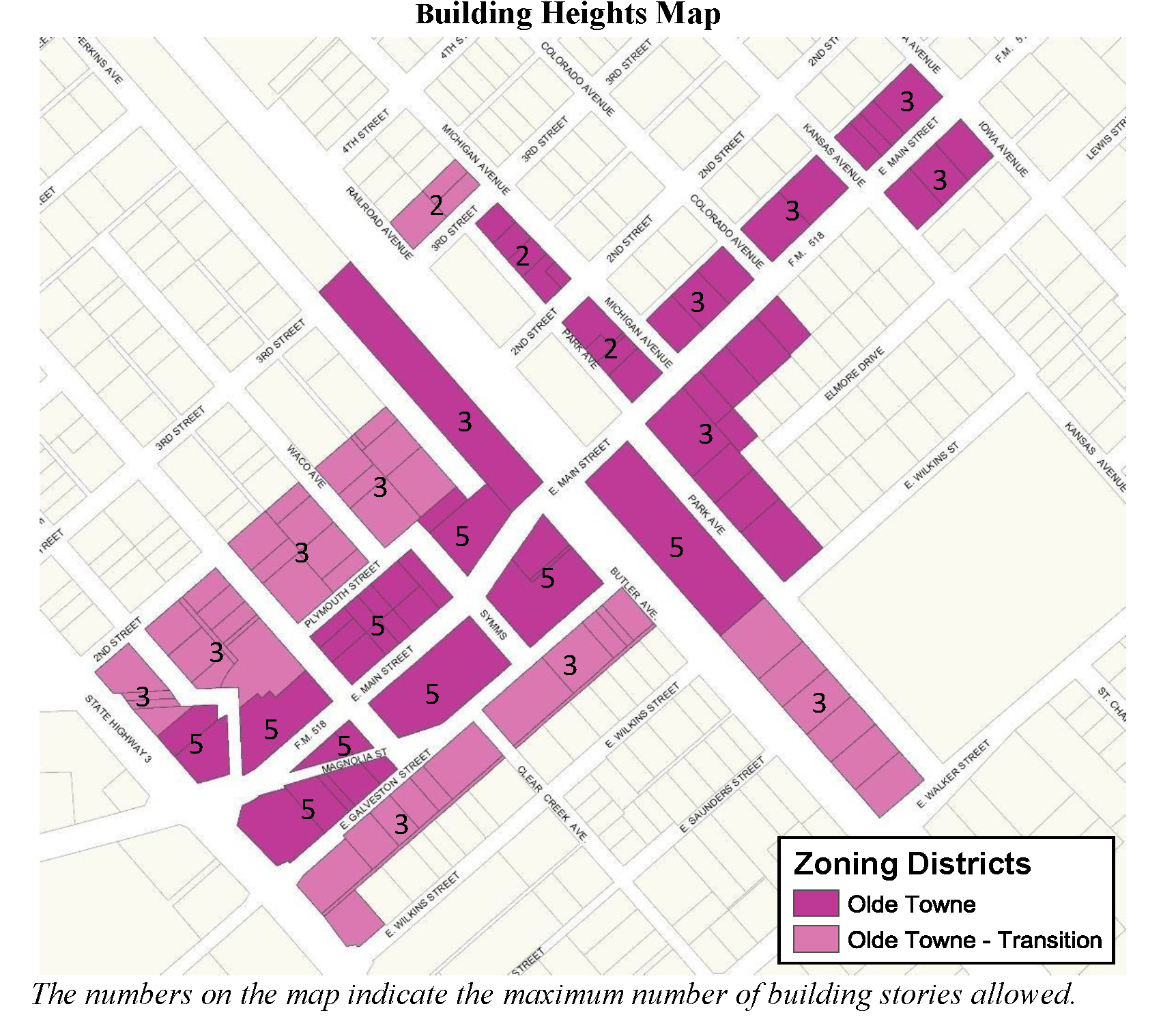
Sec. 125-3.9. - Olde Towne districts.
125-3.9.1.
Purpose and intent. The specific purpose of the Olde Towne Districts is to implement the vision of the Main Street Livable Centers Study for a more walkable, vibrant, mixed-use neighborhood in the heart of League City, Texas by:
(a)
Coordinating public and private investments;
(b)
Establish a central Olde Towne location for the community;
(c)
Providing greater walkability along Main Street (FM 518) and to the adjoining neighborhoods; and
(d)
Enhance the quality of development within Olde Towne.
Therefore, the goals of the Olde Towne Districts are to:
(a)
Promote a more functional and attractive community through quality development techniques;
(b)
Support property owner flexibility in land use and creativity;
(c)
Prescribe a higher level of detail in building design and form than in the current standards of the city's zoning regulations; and
(d)
Encourage better functional development patterns to create higher quality pedestrian environments along Main Street and across the railroad tracks.
125-3.9.2.
Components of the Code.
(a)
Olde Towne Zoning Map. The districts in Olde Towne and the regulations within this section shall apply only to parcels within the Olde Towne Districts as established on the City of League City Zoning Map. The regulations within these districts are subject to these rules and regulations exclusively.
(b)
Zoning districts. Two Olde Towne Districts are established: Olde Towne and Olde Towne—Transition. Each district shall establish uses and building form standards including standards for building placement, functional design, and parking.
(1)
OT Olde Towne Zoning District. This district is intended to enhance, and establish historical character in the Main Street area, focusing on commercial uses, live-work and upper floor residential opportunities.
(2)
OTT Olde Towne—Transition Zoning District. This is intended to be a neighborhood transition zone. This zone is intended to allow for a range of residential, live-work, and lower intensity office and retail uses as a transition between the more active Main Street and scale of the adjoining neighborhoods.
125-3.9.3.
Administration.
(a)
Applicability:
(1)
The uses and buildings on all properties within the Olde Towne District classification shall conform exclusively to these regulations unless specifically referenced as otherwise in this chapter.
(2)
Table 125-3.9.3 (Applicability Matrix) shall determine the extent to which different sections of this chapter apply to any proposed development or redevelopment.
(3)
Terms used throughout this section are defined in Appendix A—Definitions. For terms not defined in either section, they shall be accorded commonly accepted meanings.
(4)
Where in conflict, numerical and written standards shall take precedence over graphic standards.
(b)
Approval authority.
(1)
All development and redevelopment that complies with the Olde Towne Districts may be approved administratively by the city planner unless requiring historic commission review per subsection (c) below.
(2)
Any development or redevelopment that does not comply with this section or qualify for a minor modification listed in Table 125-3.9.3: Applicability Matrix shall be processed as a regular site development plan and referred to the planning and zoning commission for final action.
(c)
Historic commission. Any exterior modifications to a structure within the historic district boundary shall be reviewed by the historic commission prior to its approval.
125-3.9.4.
Development regulations. Table 125-3.9.4 below prescribes the development regulations for the Olde Towne Districts. This section shall establish all standards for new construction or additions to building sites as they relate to all improvements on the site.
125-3.9.5.
Building design standards. This section shall address all external building design, including architectural design and style, for new and existing nonresidential, multi-family, and mixed use buildings.
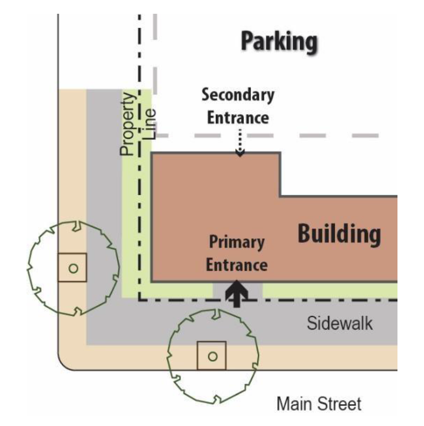
(a)
Building orientation and entrances. Buildings shall be oriented towards the streets. All primary entrances shall be oriented to the public sidewalk for ease of pedestrian access. Secondary entrances may be permitted from another street or from a rear parking lot.
(b)
Building entrances. Entrances shall be defined and articulated by any of the architectural elements such as lintels, pediments, pilasters, columns, porticos, porches, overhangs, railings, balustrades, and others as appropriate. All building elements should be compatible with the architectural style, materials, colors, and details of the building as a whole. Entrances to upper level uses may be defined and integrated into the design of the overall building façade.
(c)
Articulation. No blank walls greater than 15 feet in length, excluding garage doors, shall be permitted on all street frontages excluding alleys. Building surfaces shall include an offset, recess, or projection providing shadows or visual interest for at least 25 percent of the frontage.
(d)
Pedestrian-friendly building massing and scale.
(1)
A building's massing shall serve to define entry points and help orient pedestrians.
(2)
Buildings and/or façades shall emphasize and frame or create important termini of vistas.
(3)
Building façades, to the extent practicable, shall maintain a minimum 25-feet building façade width to present an architectural rhythm along the street.
(4)
Architectural elements shall be designed to the appropriate scale and proportions.
(e)
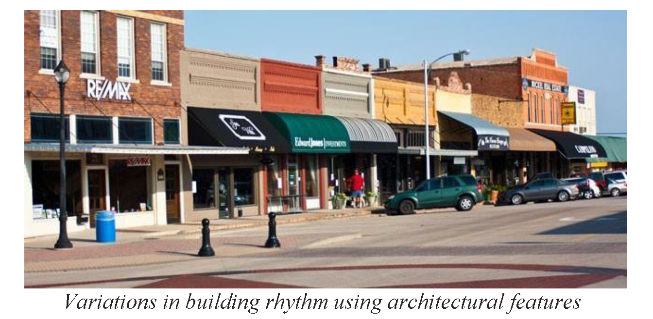
Architectural elements and storefronts.
(1)
A rhythm within the elevation on any individual building facades is required. This may be achieved with architectural elements such as bays, columns, doors, windows, etc.
(2)
Breaks in the predominant rhythm may also be used to reinforce changes in massing and important elements such as building entrances, terminated vistas, or corner sites.
(3)
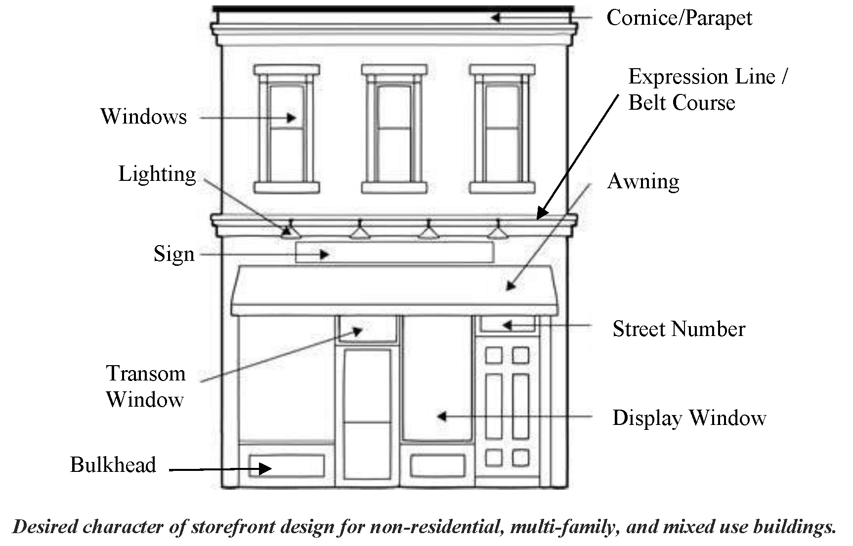
Retailers located at the street level shall primarily use storefronts to orient and advertise merchandise to customers. For retail storefronts, a transom, display window area and bulkhead at the base shall be utilized. Storefronts on facade treatments that span multiple tenants shall use architecturally compatible materials, colors, details, awnings, signage, and lighting fixtures.
(f)
Windows. Windows on the second and above stories shall be or give the appearance of being operational.
(g)
Shutters.
(1)
Shall be or give the appearance of being operational.
(2)
Shall be made of a solid material that is not hollow. Vinyl or PVC are not permitted.
(h)
Roofs. The type, shape, texture, and color of the roof of a building shall be designed to complement the architectural style of the building. A roof shall be considered as an integral part of the design of a building and shall be architecturally compatible with the style, materials, colors, and details of the building.
(i)
Expression line. An expression line or equivalent architectural element shall delineate divisions between floors of all buildings, and a cornice or parapet shall delineate the tops of facades that do not utilize a pitched roof.
(j)
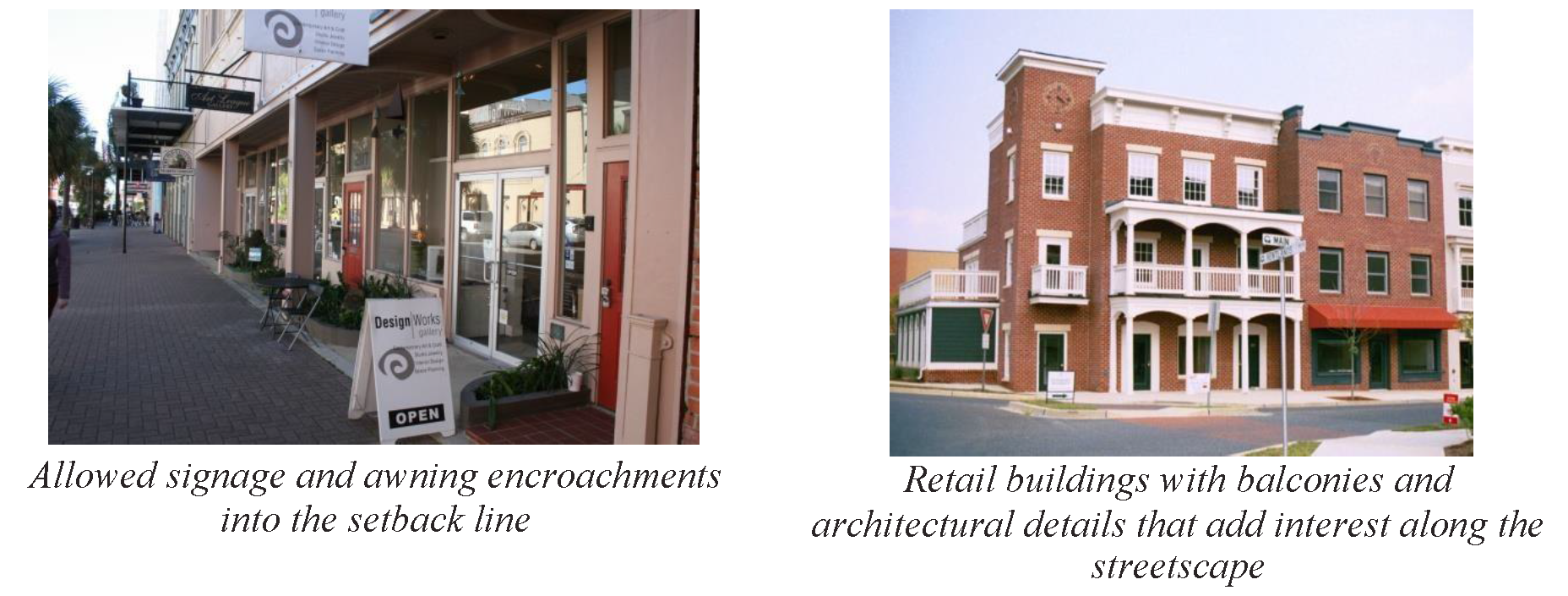
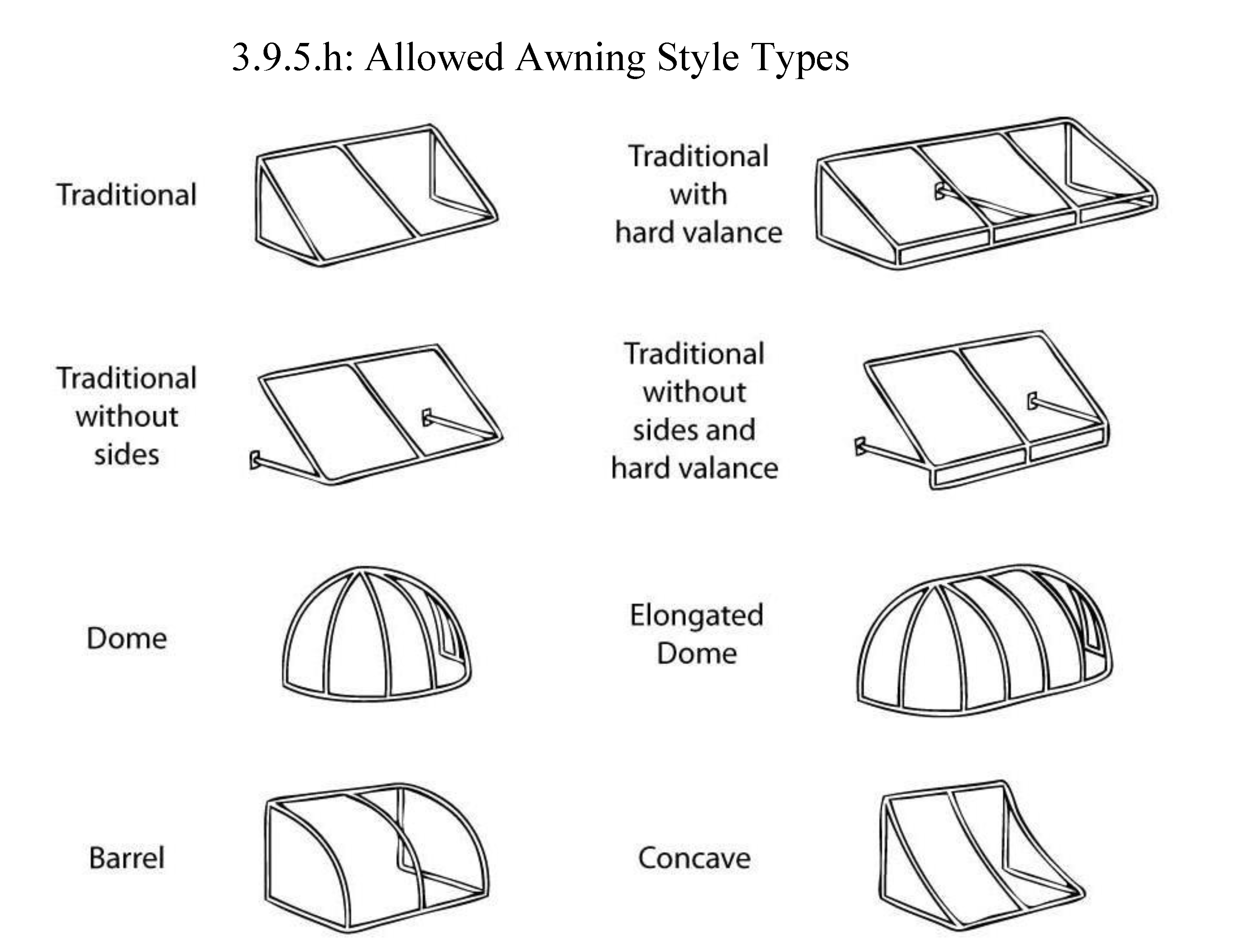
Awnings. If used:
(1)
Shall be of the following materials: cloth, fabric, woven material, and similar materials. No pre-fabricated metal or plastic/vinyl awnings shall be permitted.
(2)
Style can be traditional or traditional without sides, dome, barrel, or concave.
(3)
Valances may be hard or soft.
(4)
Shall be of a fade-resistant quality and colors shall compliment the façade and signage colors.
(5)
Shall either be placed over individual sets of windows or doors or along the entire length of the building façade.
(6)
Vertical clearance beneath the awning shall be a minimum of eight feet.
(7)
Awnings shall be maintained in good repair and condition without holes, rips, or faded designs/colors.
(k)
Building materials and finishes.
(1)
Exterior color/contrast or harmonizing colors for trim—no more than four colors including base, trim, and accent colors.
(2)
Matte or low-luster finish or non-reflective finish for any painted surfaces.
(3)
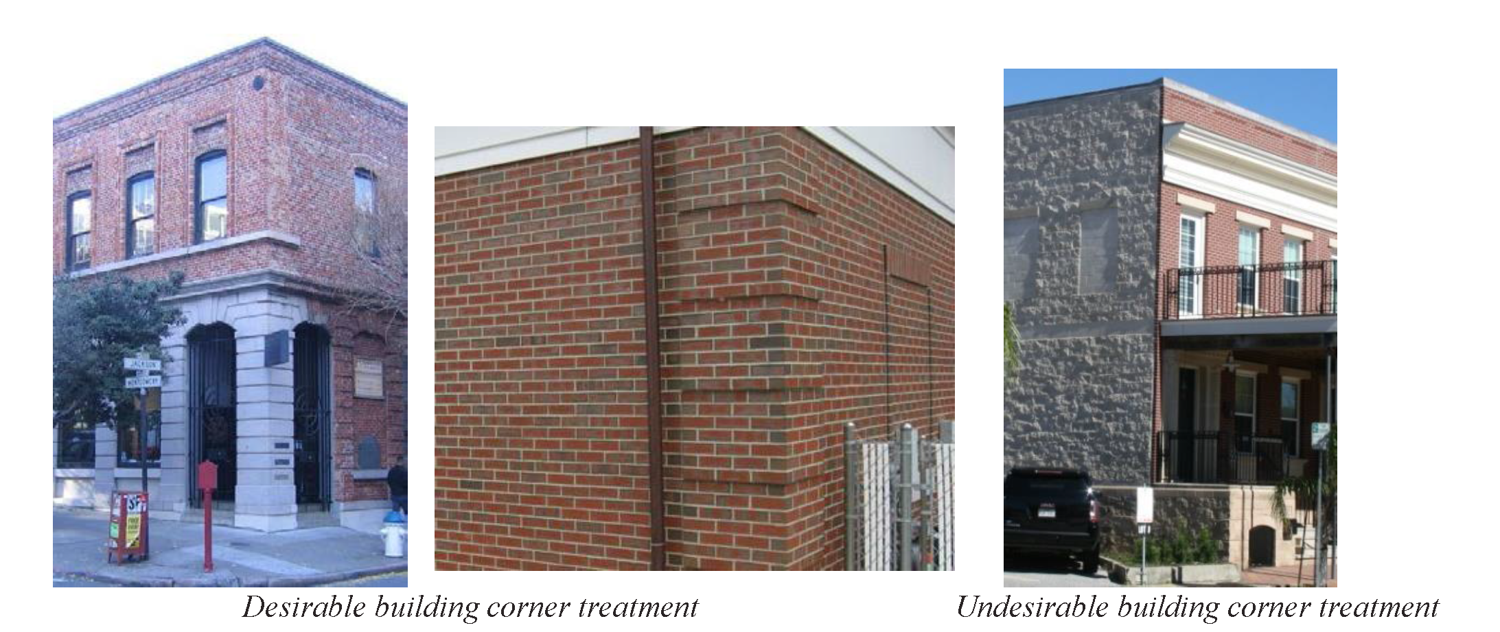
Building corner treatments:
a.
Where two corners meet of the same material, no corner treatment is required.
b.
Where two corners meet of different materials, a corner treatment of one material shall expand a minimum of one foot on both building faces from the corner.
(l)
Building height and height transition.
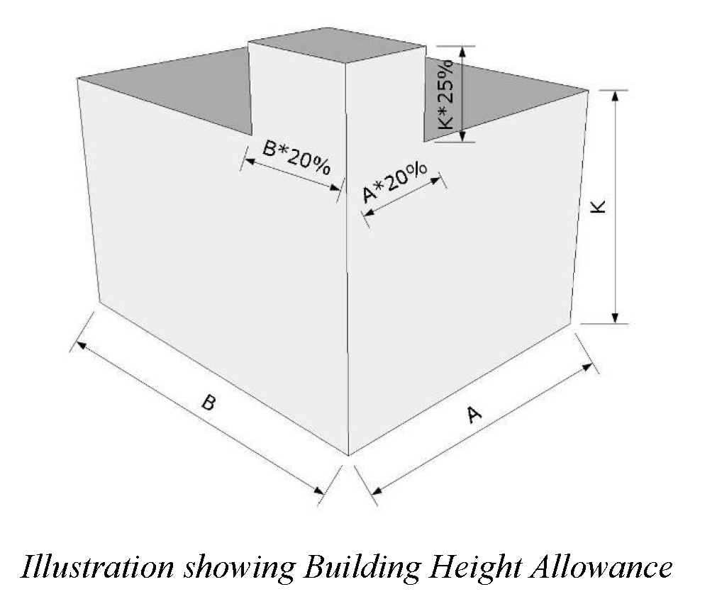
(1)
Building height allowance. Buildings may exceed the maximum building height by 25 percent along no more than 20 percent of the building's frontage along each corresponding street façade.
(2)
Height transition.
a.
The following transition standards (related to Figure 125-3.9.5.k.2: Height Transition Diagram) shall apply to all new building construction and all upper story additions to existing buildings located adjacent to any existing single-family residential zoned lots (to the rear or to the side). This requirement shall NOT apply if an alley or other similar R-O-W separates the subject lot and the existing single-family detached residential lot. See Figure 125-3.9.5.k.2 below.
Figure 125-3-.9.5.k.2: Height Transition Diagram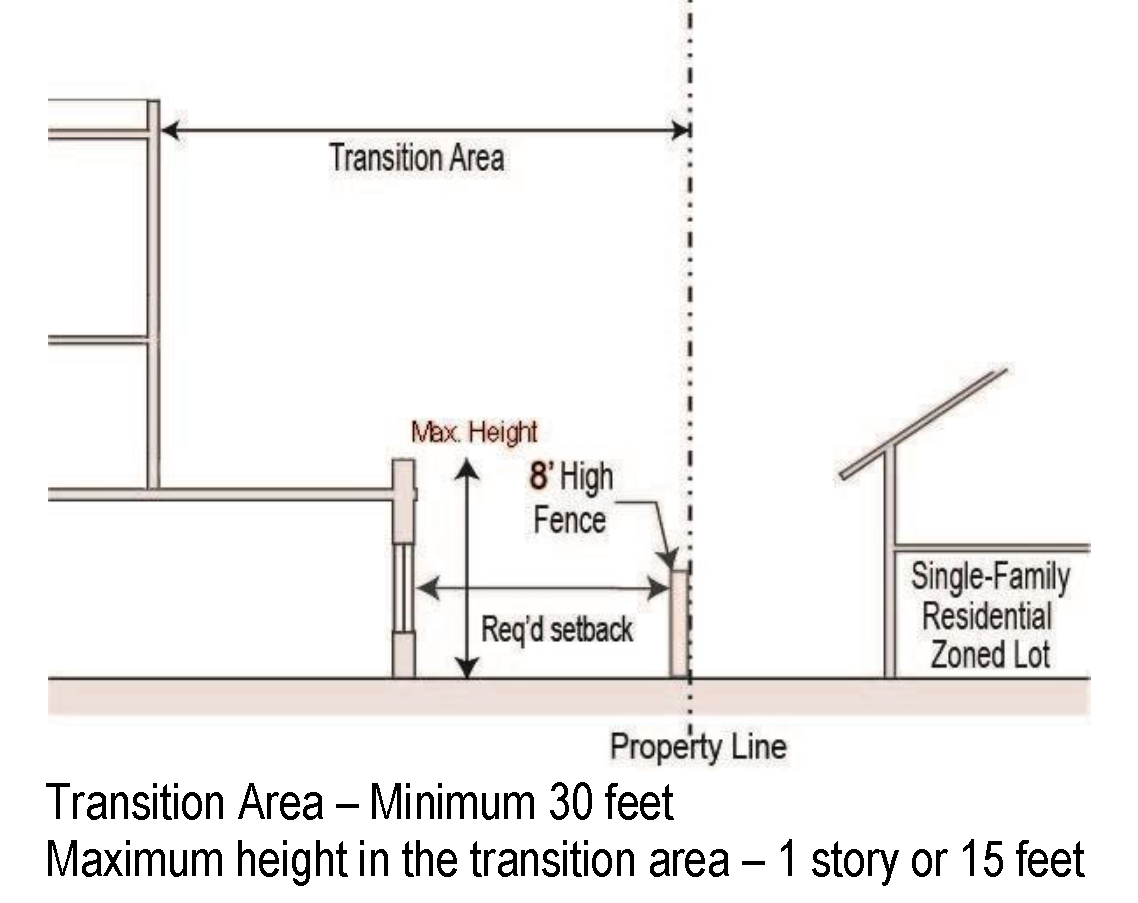
b.
A fence shall be required when adjacent to any existing single-family detached residentially zoned lot and shall be optional for all other adjacencies. The required fence shall be a minimum of eight feet in height and constructed of masonry or block.
(m)
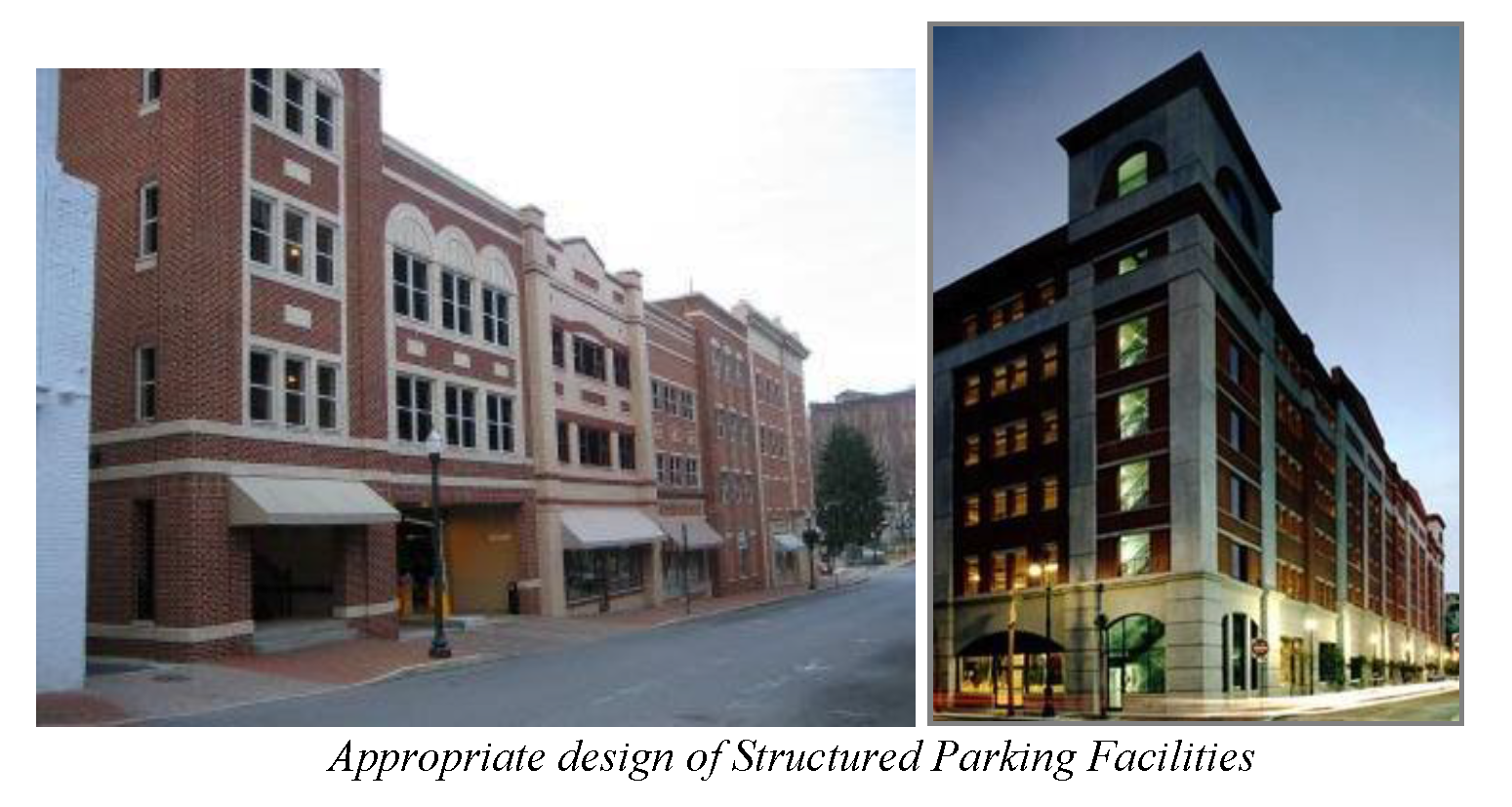
Design of structured parking facilities.
(1)
All frontages of parking structures located on Main Street shall not have parking uses on the ground floor to a minimum depth of 30 feet along the Main Street frontage.
(2)
The amount of Main Street frontage devoted to a parking structure shall be minimized by placing the shortest dimension(s) along the Main Street frontage.
(3)
Parking structure facades on Main Street shall be designed with both vertical (façade rhythm of approximately 25 feet) and horizontal (aligning with horizontal elements along the block) articulation.
(4)
Any internal areas of a parking structure shall be screened from view on sides fronting rights-of-way.
(5)
When parking structures are located at corners, corner architectural elements shall be incorporated such as corner pedestrian entrance, signage, and glazing.
(6)
Parking structures and adjacent sidewalks shall be designed so pedestrians are clearly visible to entering and exiting automobiles.
(7)
When a parking structure fronts Main Street and a secondary street, the entrance shall be located on the secondary street. The parking structure entrance shall be designed to complement the adjacent store fronts.
(n)
Changes to non-conforming structures.
(1)
Allowable addition for historic structures. Structures deemed historic may allow additions on the rear and side of the structure without conforming to the build to line.
(2)
Allowable additions for existing single-family residential structures. Existing single-family residential structures may expand the residential use up to 50 percent of the square footage of the structure, subject to the development standards for residential properties in the historic district.
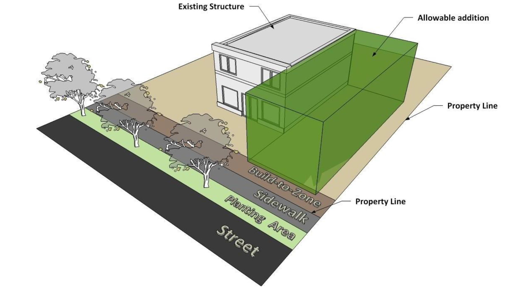
(3)
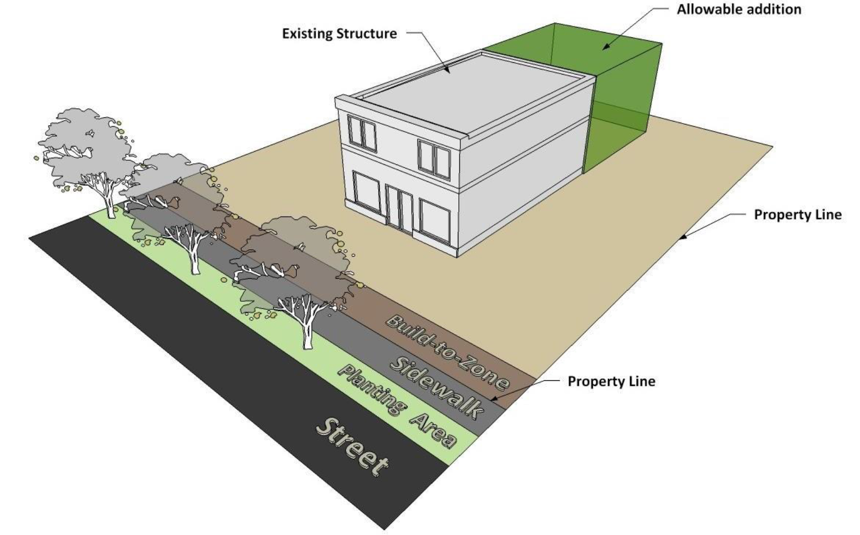
Allowable additions for non-historic structures. The following illustrations show potential allowable additions to nonconforming structures and sites. Additions shall meet the build-to-zone standards of the zoning district they are located in.
(4)
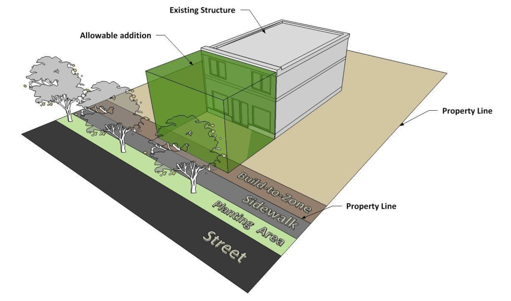
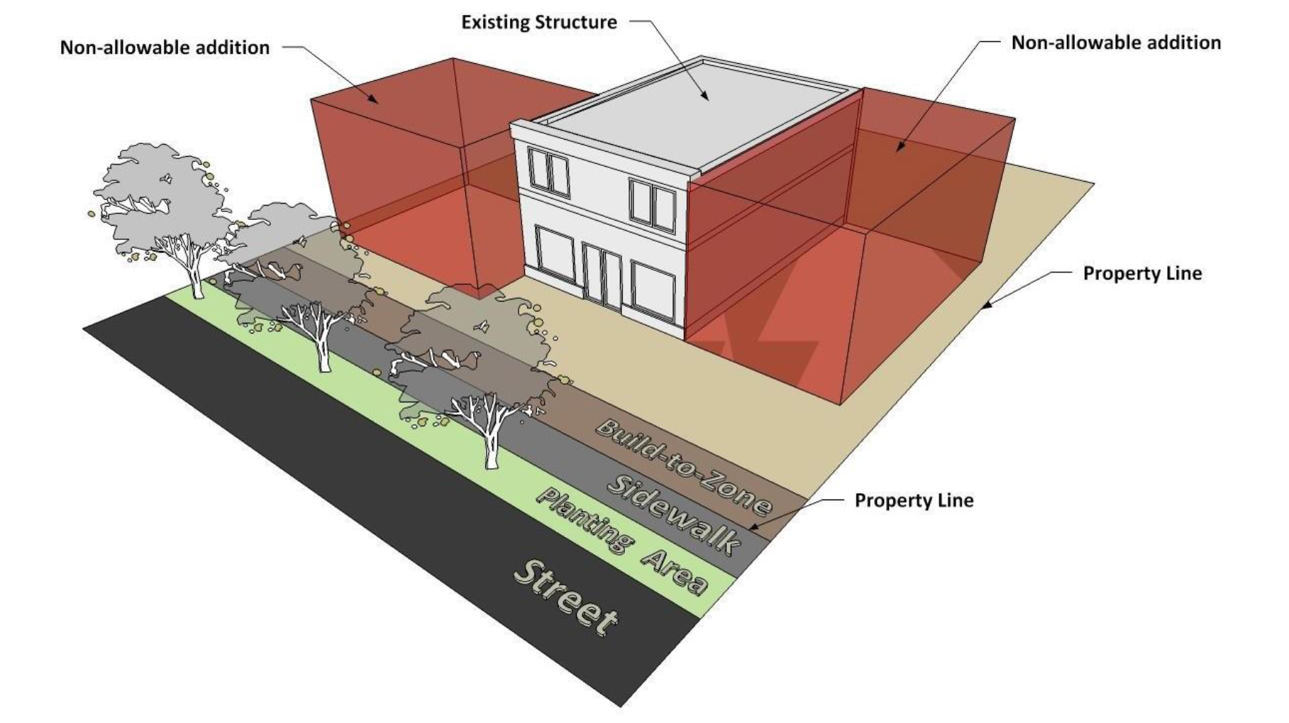
Non-allowable additions. The following illustration shows potential non-allowable additions to nonconforming structures and sites since the additions do not comply with the build-to zone standards of the character zone.
(o)
Off-street parking.
(1)
Nonresidential. One space per 350 square feet. The first 2,000 square feet of nonresidential uses in all buildings [new and existing] shall be exempt from this requirement.
(2)
Residential. One and three-tenths spaces per unit.
(3)
Shared parking. Shared parking may be permitted within 1,200 feet of the subject property with approval of the city planner.
(p)
Driveways and service areas.
(1)
Driveways, service areas, and off-street loading shall not be allowed along the Main Street frontage of any lot unless the property has no other street frontage nor does it have a shared or cross access easement to an adjoining property with alternative driveway access.
(2)
Driveway spacing shall be subject to TxDOT standards along Main Street and city standards on all other streets.
(3)
Shared driveways, joint use easements, or joint access easements, including alley easements, shall be required to adjoining properties when driveway and service access is off Main Street.
(4)
Service and loading/unloading areas shall be screened per standards in this section.
(q)
Building encroachments.
(1)
The minimum vertical clearance from the finished sidewalk shall be eight feet.
(2)
In no case, shall an encroachment be located over an on-street parking or travel lane.
(3)
In no case, shall an encroachment interfere with any canopies or root zones of preserved Butler Oaks within the area of the Olde Towne Districts.
(4)
Any encroachments over city right-of-way may require additional permits by the city.
(5)
Any encroachment over TxDOT right-of-way may require additional permits by TxDOT.
125-3.9.6.
Streetscape and landscape standards. Standards in this section apply to both Olde Towne and Olde Towne—Transition Zoning Districts.
(a)
Sidewalks.
(1)
A minimum of a five-foot-wide sidewalk is required for all street frontages.
(2)
Where a commercial frontage is built within the build-to-zone, the entryway and surrounding area shall be paved flush to the grade of the sidewalk and be built up to the sidewalk.
(b)
Screening standards.
(1)
Any frontage along Main Street or open space with surface parking within the setback range shall be defined by a three-foot-high street screen. Furthermore, along all streets (except alleys), service areas shall be screened in such a manner that the service area shall not be visible to a person standing on the property line on the far side of the adjoining street. Required street screens shall be of one of the following:
a.
The same building material as the principal structure on the lot; or
b.
A vegetative screen composed of shrubs planted to be opaque at maturity; or
c.
A combination of the two.
(2)
The required street screen shall be located at the minimum setback line along the corresponding frontage.
(3)
Street screens cannot block any required sight triangles along a cross street or driveway.
(4)
Street screens may include breaks to provide pedestrian access from any surface parking or service area to the public sidewalk.
(c)
Landscaping standards.
(1)
Planting distance. Street trees shall be planted every 30 linear feet along street frontages or when practical as determined by the city planner.
(2)
The following Table 125-3.9.6(c)(2) details the minimum street tree planting clearances. Where special conditions exist, the city may waive planting location standards. Such a waiver will be on a case-by-case basis and will require written approval of the city arborist.
(3)
Butler Oaks and other protected trees. If building a structure in the build-to-zone would harm or cause the removal of a protected tree, the city planner may approve different setbacks.
(4)
Table 125-3.9.6(c)(4) lists the preferred plantings for the Olde Towne Districts.
Table 125-3.9.6(c)(4): Preferred Plantings Matrix
(Ord. No. 2020-25, § 1(Exh. A), 9-29-2020)
Sec. 125-3.10. - -PUD Planned Unit Development Overlay District.
125-3.10.1.
Purpose. The -PUD Planned Unit Development Overlay District is intended to encourage high quality development in the city by providing additional flexibility in the planning and development of projects. Such flexibility is intended to result in development that is more efficient, environmentally sensitive, visually pleasing, safe, and socially integrated than traditional zoning might provide. The -PUD Overlay District is also meant to provide the city with the ability to better manage development in areas that are adjacent to residential development. The specific purposes of the -PUD Overlay District are to:
(a)
Establish a procedure for the development of land under unified controls to increase flexibility from the strict application of land use regulations, development standards, and procedures intended primarily for individual lots;
(b)
Ensure orderly and thorough review procedures that will result in quality design, protection of open space and sensitive areas, and the creation and improvement of common open space and pedestrian and bicycle circulation, particularly in residential areas;
(c)
Achieve efficient land use patterns while permitting creative and innovative approaches to the development of urban and suburban residential, commercial, and industrial land;
(d)
Encourage mixed development patterns, architectural styles, and building forms to avoid monotony in large developments by allowing greater freedom in selecting the means to provide access light, open space, amenities; and
(e)
Provide for flexibility in the strict application of certain of the land use regulations and performance standards found in the base zoning districts to take advantage of special site characteristics, location, and/or land uses.
(f)
Consider the impact on adjacent developed properties, particularly residential areas, and enter into a documented dialog to address their issues and concerns.
(g)
All -PUD Overlay Districts shall have an underlying zoning designation.
125-3.10.2.
Zoning map designator. A -PUD Overlay District will be combined with the base zoning district(s) applied to the area and will be shown on the zoning map by a -PUD designator applied to the base district(s) designation.
125-3.10.3.
Applicability. The applicability of the -PUD Overlay District shall be as follows:
(a)
Allowable locations. No -PUD Overlay District may be applied to an area of the city that is not served by critical infrastructure, such as potable water, sanitary sewer, storm sewer, and paved streets, except where one or more of such services not currently in place is included in the city's master plan for installation or construction within a three-year period from the date of the application for a planned unit development. In addition, no -PUD Overlay District may be applied to an area that is located more than one mile from a major arterial street, as designated by the city planner or designee, or shown on the master transportation plan.
(b)
Minimum area. No -PUD Overlay district may be applied to a land area less than five acres for residential development and two acres for nonresidential development.
125-3.10.4.
Land use regulations. Any use authorized in the base district regulations, may be included in a -PUD Overlay District, provided such use is consistent with the land use concepts in the comprehensive plan for the area to be included in the -PUD Overlay District, and is not disruptive or inconsistent with current neighboring development, particularly residential areas. Existing uses are permitted and may continue. All uses in the -PUD Overlay District shall be in accordance with the master plan approved for the district.
125-3.10.5.
Development regulations. The total number of dwelling units in a -PUD Overlay District shall not exceed that permitted by the comprehensive plan density for the total area of parcels designated for residential use. Other development regulations, such as for building scale, building form and location, pedestrian orientation, parking accommodation, open space and landscaping, and other standards shall be as prescribed by the development plan approved for the district and may depart from conformance with the standards specified in the base zoning district where the - PUD Overlay District is applied if specifically approved by the planning and zoning commission and/or city council.
125-3.10.6.
Initiation. A -PUD Overlay District may be initiated by a property owner or authorized agent, the planning and zoning commission, or the city council. If the property is not under a single ownership, then all owners shall join in the application and a map showing the extent of ownerships shall be submitted with concept plans and materials.
125-3.10.7.
Criteria for consideration of -PUD Overlay District Application. The planning and zoning commission shall consider an application for rezoning to a -PUD Overlay District as prescribed under section 125-3.10 and shall at the same time consider a proposed concept plan for the area. A recommendation of the planning and zoning commission to rezone to a -PUD Overlay District shall be accompanied by a resolution recommending approval of the concept plan. In addition to the criteria for considering an application for a zoning map amendment, planning and zoning commission shall recommend approval or conditional approval of the concept plan to the city council upon finding that:
(a)
The concept plan is consistent with the adopted comprehensive plan and other applicable policies and is compatible with surrounding development;
(b)
The concept plan will enhance the potential for superior urban design and amenities in comparison with the development under the base district regulations that would apply if the concept plan were not approved;
(c)
Deviations from the base district regulations that otherwise would apply are justified by compensating benefits of the concept plan; and
(d)
The concept plan includes adequate provisions for utilities, services, and emergency vehicle access; and public service demands will not exceed the capacity of existing and planned systems. See the Adequate Public Facilities Ordinance for these requirements.
125-3.10.8.
Procedures for -PUD Overlay District Application. In addition to the procedures for an application for a zoning map amendment, an application for rezoning to a -PUD Overlay District shall be processed in the following manner.
(a)
Pre-application conference. Prior to submitting an application for a planned unit development, the prospective applicant shall request a review by the city planner or designee and representatives from other city departments, as appropriate, to discuss the prospective development with respect to compatibility with existing and anticipated land uses in the vicinity and the city's adopted planning rationale. The pre-application conference is intended to guide the prospective applicant in the preparation of a concept plan to be submitted for planning and zoning commission consideration and city council approval. There is no fee associated with a request for a pre-application conference; however, additional requests for a pre- application conference for the same site within a period of one year from the date of the initial conference may incur a fee associated with any city costs to do so.
(b)
Submission and approval of concept plan. The applicant shall submit a concept plan (bubble plan) as part of the application for rezoning to a -PUD Overlay District. The city planner or designee shall prepare a written report on the concept plan that will summarize the anticipated impacts of the proposed development on planning goals, utilities, emergency services, vehicular traffic, taxes, and properties within a 500-foot distance of the site for which the development is proposed. The concept plan, a list of requested variances, and report by the city planner or designee shall be submitted for consideration by the planning and zoning commission and recommendation to city council. Upon approval by city council of the concept plan, the applicant may proceed with the preparation of a master plan and proceed to subsequent steps for approval with reasonable assurance that if the agreed upon concept is carried forth, then preliminary and final plat approvals will be granted by the city. Following approval of the concept plan by city council, the applicant shall prepare a master plan. Recommendation for approval or denial of a -PUD Overlay District shall be made by the planning and zoning commission and approved or denied by city council.
(c)
Approval of master plan. After [the] city council has approved the -PUD Overlay District, then the applicant shall submit a master plan for consideration and approval by the planning and zoning commission. The applicant may proceed with platting after approval of the master plan. The master plan must not have more than a 15 percent change in the land use or a significant change in geographic location from the previously approved concept plan for the -PUD Overlay District. Changes that alter the uses permitted by more than 15 percent and/or have a significant change in geographic location shall require submittal of a revised concept plan to be considered and approved by the commission and city council via a public hearing and notified in the same manner as a text or map amendment. When determining whether or not a "PUD" development has exceeded 15 percent and should be considered by city council, each of the following shall be considered:
(1)
The total acreage change to the "PUD" development based on the original concept plan document. The concept plan establishes the land use acreages and represents the baseline in determining the percentage of change. (Example: In a 100-acre "PUD," an increase of ten acres of residential and a decrease of ten acres of commercial is still a total change of ten acres and the percentage of change of the total acreage is ten percent.)
(2)
Percentage of change (increased or decreased) within each land use category based on the original concept plan document. For residential uses, the density units per acre shall also be calculated. (Example: In a 100-acre "PUD," a decrease from 15 to ten acres in the residential land use category represents a five percent change in acreage. However, an increase in density units per acre (dua) from 100 dua to 150 dua represents a 50 percent density increase.)
(3)
Intangibles such as relocating a thoroughfare shown on the transportation plan, changing the general concept or changing the location of uses that may not necessarily have anything to do with the acreage of land uses per se, but may be just as important in evaluating whether or not a "PUD" should be reconsidered by the commission and city council.
(d)
Lapse of approval and renewal of master plan. A master plan shall be effective on the date the ordinance creating the -PUD Overlay District is approved and shall expire after two years unless a building permit has been issued and a vested right established. An approved master plan may specify a development staging program exceeding two years. The planning and zoning commission may recommend, and the city council may renew, a master plan for a period of up to two years if it finds the renewal consistent with the purposes of this section. Application for renewal shall be made in writing to the city planner or designee not less than 30 days or more than 120 days prior to expiration.
(e)
Revisions to master plan. Changes to the master plan that do not alter the basic relationship of the proposed development to adjacent property; do not alter the uses permitted or increase the density, building height or coverage of the site; do not decrease the off-street parking ratio or reduce the yards provided at the boundary of the site; and do not significantly alter the landscape plans or signage as indicated on the approved development may be recommended by the city planner or designee and approved by the planning and zoning commission. The master plan must not have more than a 15 percent change in the land use or a significant change in geographic location from the previously approved concept plan for the -PUD Overlay District. Changes that alter the uses permitted by more than 15 percent and/or have significant change in geographic location shall require submittal of a revised concept plan to be considered and approved by the commission and city council via a public hearing and notified in the same manner as a text or map amendment. When determining whether or not a "PUD" development has exceeded 15 percent and should be considered by city council, each of the following shall be considered:
(1)
The total acreage change in the "PUD" development based on the original concept plan document. The concept plan establishes the land use acreages and represents the baseline in determining the percentage of change. (Example: In a 100-acre "PUD," an increase of ten acres of residential and a decrease of ten acres of commercial is still a total change of ten acres and the percentage of change of the total acreage is ten percent.)
(2)
Percentage of change (increased or decreased) within each land use category based on the original concept plan document. For residential uses, the density units per acre shall also be calculated. (Example: In a 100-acre "PUD," a decrease from 15 to ten acres in the residential land use category represents a five percent change in acreage. However, an increase in density units per acre (dua) from 100 dua to 150 dua represents a 50 percent density increase.)
(3)
Intangibles such as relocating a thoroughfare shown on the transportation plan, changing the general concept or changing the location of uses that may not necessarily have anything to do with the acreage of land uses per se, but may be just as important in evaluating whether or not a "PUD" should be reconsidered by the commission and city council.
(4)
Minor changes to a master plan may be approved administratively. Minor changes include:
a.
Amendments that do not alter the basic relationship of uses to adjacent properties; and
b.
Amendments that constitute less than a one percent change in land use.
(f)
Annual report. The developer shall submit an annual progress report to the city planner by September 1 of each year for review and acceptance. The report shall contain a discussion of the development schedule and any deviations from the originally approved schedule. The city planner shall refer the annual report to the planning and zoning commission and the city council for review. Acceptance of the annual report by the city planner or designee is required prior to any staff review of any aspect of the -PUD Overlay District project, including building permits and revisions.
125-3.10.9.
Required plans and materials. An application for rezoning to a -PUD Overlay District requires the approval of a concept plan by city council and approval of a master plan by the planning and zoning commission. This section outlines the information required for each plan.
(a)
Concept plan. The concept plan shall include the following information:
(1)
A site inventory analysis showing existing vegetation, natural watercourses or standing water, flood prone areas, and any other known hazard areas. This analysis shall include graphic and textural materials indicating how the proposed development will affect such natural features and identify what, if any, trees intended for removal.
(2)
An accurate survey of the subject property showing the existing topographical contour intervals of not more than five feet, and a plan showing the proposed topography at minimum five-foot contour intervals and significant change in drainage.
(3)
A summary of the proposed development program, including: detailed tabulation showing the proposed acreage of each land use and underlying zoning districts; description of the open space program, including the location and function of developed and/or improved open space, its relationship to any natural or historic values on the site, and its status as either public or private open space.
(4)
A traffic impact analysis as required by the city engineer.
(5)
A scale drawing showing the proposed street and circulation system design, including a layout diagram, landscaping, and pedestrian amenities; building sites or lots; areas reserved for use as parks, playgrounds, utility easements, and school sites; lands to be dedicated to the city; general location and description of existing and proposed utility services (including size of water and wastewater mains); and the existing zoning classification and underlying zoning districts, if applicable, of all abutting properties.
(6)
A determination that adequate public facilities exist to service the proposed development (road, sewerage, water, fire suppression, and storm drainage) as determined by the city engineer and/or by the city's Adequate Public Facilities Ordinance.
(7)
An estimate of the projected population within the -PUD Overlay District to assist the city and the applicable school district(s) in determining future needs.
(8)
A summary of requested variance(s) from any provision in the League City Code of Ordinances.
(9)
A development schedule indicating the rate of anticipated development to completion from the date on which construction begins. As part of the PUD Plan, the development schedule shall be adhered to by the owner, applicant, and any successor in interest.
(10)
Perspective illustrations, either hand drawn or computer generated, indicating the general form and character of development, including representative examples of residential and non-residential buildings.
(11)
A statement explaining the reasons that justify use of a -PUD Overlay District for the project in relation to the findings.
(12)
Verbal and/or illustrative plans on the specific architectural and aesthetic elements to be included in the development project that must be substantially more generous than the underlying zoning requires.
(b)
Master plan. In addition to presenting the final form of the various elements required in the concept plan above, the master plan shall include the following information:
(1)
A description of proposed governance institute or institutions, such as homeowner's associations, and initial governance documents, if applicable.
(2)
A plot plan showing adherence to the buffer yards requirements.
(3)
A depiction of existing surface drainage patterns and proposed retention and detention areas is required. Depict historical flows and proposed flows along with the existing flows.
(Ord. No. 2020-25, § 1(Exh. A), 9-29-2020; Ord. No. 2022-25, § 4, 8-9-2022)
Sec. 125-3.11. - -CRC Commercial Revitalization Overlay District.
125-3.11.1.
Purpose.. The -CRC Commercial Revitalization Overlay District is intended to preserve the character of an established commercial corridor while providing opportunities for infill development that is consistent with and enhances the prevailing built character. The -CRC Overlay District applies to commercial development on the FM 518 corridor between Pecan Drive and FM 270, excluding properties within the Olde Towne Districts and encourages small-scale commercial uses to locate nearer the street with parking located to the rear or side of buildings. The use regulations and development standards included in the -CRC Overlay District will facilitate neighborhood maintenance, upgrading, and the development of vacant or underutilized lots while reducing the potential for incompatible land uses. Circulation and access in the district will be consistent with the FM 518 Corridor Access Management Plan.
125-3.11.2.
Zoning map designator. The -CRC Overlay District will be combined with the base zoning district(s) applied to the area and will be shown on the zoning map by a -CRC designator applied to the base district(s) designation.
125-3.11.3.
Applicability. Except as otherwise noted in this section, the regulations of the underlying base zoning district(s), and any other applicable overlay district, shall apply to property in the -CRC Overlay District. In the case of a conflict between the provisions of an underlying base zoning district or other applicable overlay district and the -CRC Overlay District, the provisions of the -CRC Overlay District shall govern.
125-3.11.4.
Development regulations. Table 125-3.11.4 below prescribes the development regulations for the -CRC Commercial Revitalization Overlay District, including building density, building form and location, and vehicle accommodation.
125-3.11.5.
Building streetscape.
(a)
Minimum Build-to Lines. Along the primary street frontage, 50 percent of the front façade shall be built to the sidewalk.
(b)
Storefront continuity. Ground floor of retail buildings shall have a storefront appearance along the primary street frontage.
(c)
Articulation. No unadorned blank walls greater than 15 feet in length, excluding garage doors, shall be permitted on the primary street frontage. Building surfaces shall include an offset, recess, or projection providing shadows or visual interest for at least 25 percent of the frontage.
(d)
Driveways. The number and location of driveways shall comply with the FM 518 Corridor Access Management Plan.
(Ord. No. 2020-25, § 1(Exh. A), 9-29-2020)
Sec. 125-3.12. - HCD Historic Overlay District.
125-3.12.1.
Historic Overlay District. On July 8, 1997, the City of League City authorized the establishment of historic districts. These districts provide the most powerful tool to protect the character of our historic neighborhoods.
125-3.12.2.
Purpose. The Historic Overlay District is intended to:
(a)
Protect, enhance and perpetuate places and areas which represent distinctive and important elements of the League City's historical, cultural, and architectural history;
(b)
Ensure the harmonious, orderly and efficient growth and development of the city that is sensitive to its historic resources.
(c)
Preserve the old town atmosphere;
(d)
Increase public knowledge and appreciation of the city's historic past and unique sense of place;
(e)
Foster civic and neighborhood pride and a sense of identity;
(f)
Promote economic prosperity and welfare of the community by encouraging the most appropriate use of historic resources within the city;
(g)
Create a more livable urban environment; and
(h)
Encourage stabilization, restoration, and improvements of such properties and their values.
125-3.12.3.
Historic preservation officer. The executive director of planning and development shall appoint a qualified staff person to serve as historic preservation officer (hereafter referred to as preservation officer). This officer shall administer this chapter and advise the commission on matters submitted to it. The officer shall also be responsible for coordinating the city's preservation activities with those of state and federal agencies and with local, state, and national nonprofit preservation organizations when required.
125-3.12.4.
Historic Overlay District designation. This designation establishes a historic overlay district which includes contributing (historic) and non-contributing structures. The area within the historic overlay contains a mixture of residential and commercial uses, cottage style retail and office spaces, including plazas, parks, and natural open spaces. It is an area of suburban village development with majestic oak trees and landscaping developed in a street grid pattern that is both walkable and bike friendly.
125-3.12.5.
Compliance with historic designation. The property owners within this district shall comply with the requirements of this section, other ordinances of the city and to the League City Design Guidelines. Buildings or places within the Historic Overlay District which lack historical, architectural, or cultural importance or value must comply with the provisions of this section except as noted.
125-3.12.6.
Criteria for historic designation.
(a)
Landmarks. Properties that are listed as a Recorded Texas Historic Landmark (RTHL), State Archeological Landmark (SAL) or listed on the National Register of Historic Places (NR) shall be considered as recognized local landmarks. An individual Landmark may be designated if it is at least 50 years old and it substantially complies with two or more of the following:
(1)
Possesses significance in history, architecture, archeology, or culture.
(2)
Is associated with events that have made a significant contribution to the broad patterns of local, regional, state, or national history.
(3)
Is associated with events that have made a significant impact in our past.
(4)
Represents the work of a master designer, builder, or craftsman.
(5)
Embodies the distinctive characteristics of a type, period, or method of construction.
(6)
Represents an established and familiar visual feature of the city.
(b)
Criteria for creating or adding to a historic district. The criteria for including area in a Historic Overlay District (by creation or addition) are as follows:
(1)
The included area must be a geographically definable area possessing significant concentration, linkage or continuity of buildings, structures, sites, areas or lands that are united by architectural, historical, or cultural importance or significance.
(2)
The included area must meet three or more of the following criteria:
a.
It has character, interest or value as part of the development, heritage or cultural characteristics of the city, the state, or the United States.
b.
It includes one or more Texas Historic Landmark, National Historic Landmarks or places entered into the National Register of Historic Places.
c.
It includes distinguishing characteristics of an architectural type, period, or method of construction.
d.
It is identified with the work of an architect or master builder who influenced the development of the city.
e.
It includes elements of design, detail, materials or craftsmanship that represent a significant innovation.
f.
It has a close relationship to distinctive buildings, sites or areas that can be preserved under a plan based on architectural, historic, or cultural motif.
g.
It portrays the environment of a group of people in an area characterized by a distinctive architectural style.
h.
It exemplifies the cultural, economic, social, ethnic, or historical heritage of the city, state or nation.
i.
It includes the location of a significant historical event.
j.
It is identified with a person or persons who significantly contributed to the culture and development of the city, state or nation.
k.
It contributes significantly to community identity, spirit, or pride.
(3)
Applications for including an area in a historic district may be by a petition of property owners and shall be filed with the historic preservation officer. The application shall contain a report to the commission containing the following information:
a.
A list of representative buildings and places within the included area and a description of the significance of each one;
b.
A map clearly showing the boundaries of the included area and the locations of the representative buildings and places (identified by a number or letter);
c.
A written description, with photographs, of each representative building and place, including color, condition, architectural style, date of construction (if known), builder and architect (if known), the chain of uses and ownership, materials, construction techniques, recognition by governmental agencies (for architecturally or historic significance), cultural importance or value (if made the basis of the application), any proposed restrictions upon use or construction, and anticipated effects on public facilities (including utilities, streets, and other public improvements, existing or proposed); and
d.
All applicable fees; and
e.
A petition signed by 100 percent of the number of owners of parcels of land lying wholly or partly within the included area (other than streets). For this purpose, parcels and owners are determined by the most current records of the central appraisal district at the time of filing. To be effective, the signature of an owner must be affixed in the same form and manner as would be required for a deed conveying the whole parcel (and more than one signature may be required).
(4)
The commission may also consider creating or adding to a historic district on its own motion or at the request of the council. The commission shall apply the criteria listed in item (2) of this subsection and make a recommendation to the planning and zoning commission, which shall handle the recommendation as a proposed amendment to this chapter (refer to section 125-2.15). A recommendation from the historic commission to create or add to a Historic Overlay District shall include a draft ordinance with:
a.
A description of the boundaries of the included area;
b.
Findings that the area meets the criteria prescribed by this section; and
c.
A classification of existing occupancies and structures and their effects upon the character, safety, economic and physical impact of the district; and
d.
If a new district is proposed, recommendation may include provisions for buildings or places which lack historical, architectural, or cultural importance or value.
125-3.12.7.
Zoning. Except as noted in this section, the underlying base zoning district shall apply to property within the Historic Overlay District. In case of a conflict between this section and the provisions of the base zoning district or with any other regulations, the Historic District Overlay regulations shall prevail.
125-3.12.8.
Development regulations.
(a)
Nonresidential. Nonresidential zoning districts shall follow the Olde Town District development regulations. Deviations may include the following:
(1)
Sidewalks are required in nonresidential zoning districts in the Historic District. The preservation officer may approve alternate sidewalk designs to the extent necessary to preserve or protect a historic structure, place or large tree.
(2)
Curbs and gutters are only required along streets without open ditches.
(b)
Residential. Residential zoning districts shall follow the residential standards found in the design guidelines.
(c)
Sidewalks. Sidewalks are not required on residentially zoned properties in the historic district.
(d)
Parking. The zoning board of adjustments may issue a special exception to relax parking regulations in the historic district, to the extent necessary to preserve or protect a historic building, place, or large tree. Relaxation may include the use of off-sites paces, leased spaces, tandem spaces, shared, spaces, on-street spaces, etc.
(e)
Interpretations. City officials, boards, and commissions are authorized and encouraged to interpret and apply other ordinances, rules, and regulations liberally to minimize conflicts to preserve and protect historic buildings and places.
(f)
Design guidelines. Architectural regulations are found in the most recently adopted League City Historic District Design Guidelines and are adopted by reference. These regulations apply to other structures and places, even if no certificate of appropriateness is required.
125-3.12.8.
Certificate of appropriateness (COA).
(a)
General information. No person or entity shall construct, reconstruct, alter, restore, rehabilitate, move or demolish exterior portions any building, or architectural feature of a building within the district, nor shall any person make any material change in other exterior elements visible from a public right-of-way which affect the appearance and cohesiveness of any property within the historic district without approval of a COA. Submitting an application for a COA does not constitute approval of the COA. All development within the Historic District shall be subject to review by the preservation officer. No other permits for such work shall be issued unless a COA, if required, has been issued. Any property owner within the historic district who is considering changes to the exterior of their property should meet with or call the City of League City Preservation Officer at (281) 554-1080 to determine if a COA is required for the proposed work.
All work must comply with the applicable preservation regulations and the approved COA including any conditions and restrictions imposed by the historic commission. A COA does not constitute a building permit and the undertaking may require a building permit to perform the work.
(b)
Ordinary maintenance and repair. Nothing in this chapter shall be construed to prevent the ordinary maintenance and repair of any exterior architectural feature of a landmark or property within a historic district which does not involve a change in design, material, or outward appearance that require the issuance of a building permit. In-kind repair/replacement and repainting is included in this definition of ordinary maintenance unless painting involves an exterior masonry surface that was not previously painted. The preservation officer shall make the decisions as to what is "ordinary maintenance and repair." Masonry includes brick, stone, cast stone, limestone, marble and granite.
(c)
Application. A COA may be issued by the historic commission (which requires a public hearing) or the preservation officer, when the proposed improvements are compatible with the historic character of the historic district. Only the owner of a building may apply for a COA. A complete application must be submitted for both types of approval. The application shall include elevation drawings of the proposed changes (if available), detailed description of proposed work, samples of material, site plan showing location of structures affected and proposed structure (if applicable), photographs, and other descriptions sufficient to communicate the nature and extent of the proposed work. For work requiring a COA, the COA is required in addition to, and not in lieu of, any required building permit.
(d)
Criteria for COA approval. In considering an application for a COA, the preservation officer and/or historic commission shall be guided by the adopted design guidelines, and where applicable, the following from The Secretary of the Interior's Standards for Rehabilitation of Historic Buildings:
(1)
Every reasonable effort shall be made to adapt the property in a manner which requires minimal alteration of the building, structure, object, or site and its environment.
(2)
The distinguishing original qualities or character of a building, structure, object, or site and its environment shall not be destroyed. The removal or alteration of any historic material or distinctive architectural features should be avoided when possible.
(3)
All buildings, structures, objects, and sites shall be recognized as products of their own time. Alterations that have no historical basis and which seek to create and earlier appearance shall be discouraged.
(4)
Changes which may have taken place in the course of time are evidence of the history and development of a building, structure, object, or site and its environment. These changes may have acquired significance in their own right, and this significance shall be recognized and respected.
(5)
Distinctive stylistic features or examples of skilled craftsmanship which characterize a building, structure, object, or site shall be kept where possible.
(6)
Deteriorated architectural features shall be repaired rather than replaced, wherever possible. In the event replacement is necessary, the new material should reflect the material being replaced in composition, design, color, texture, and other visual qualities. Repair or replacement of missing architectural features should be based on accurate duplications of features, substantiated by historical, physical, or pictorial evidence rather than on conjectural designs or the availability of different architectural elements form other buildings or structures.
(7)
The surface cleaning of structures shall be undertaken with the gentlest means possible. Sandblasting and other cleaning methods that will damage the historic building materials shall not be undertaken.
(8)
Every reasonable effort shall be made to protect and preserve archeological resources affected by, or adjacent to, any project.
(9)
Contemporary design for alterations and additions to existing properties shall not be discouraged when such alterations and additions do not destroy significant historical, architectural, or cultural material, and such design is compatible with the size, scale, color, material, and character of the property, neighborhood, or environment.
(10)
Whenever possible, new additions or alterations to buildings, structures, objects, or sites shall be done in such a manner that if such additions or alterations were to be removed in the future, the essential form and integrity of the building, structure, object, or site would be unimpaired.
(e)
Matrix. The following matrix outlines approving authority for a COA:
(f)
Application review. In reviewing an application, the preservation officer and/or the historic commission may request additional information from the owner. Site visits by the preservation officer may be necessary. Generally, it is not necessary for the property owner to be home as only the exterior of the property will be viewed. The preservation officer may refer any request for a COA to the commission if the preservation officer and the applicant disagree over the appropriateness of the request or, if in the preservation officer's opinion, the request may have an adverse effect on surrounding properties.
(g)
Commission level approval. For applications requiring commission approval, the commission shall hold a public hearing on each application. Staff shall post a notice on the property (i) at least 15 days prior to the hearing, (ii) at or near the principal entrance to the affected property, and (iii) so that it is clearly legible by a person standing within a street or other public way.
(h)
Decision. After reviewing an application, if the commission finds the proposed work meets the standards for issuance, the commission shall issue a COA. The commission may impose conditions and restrictions on a certificate, to the extent reasonably necessary to meet the standards for issuance. Otherwise, the commission shall disapprove the application. All descriptions of the work provided by the applicant (and any other representations made by the applicant) are deemed to be included in each certificate, regardless of whether they are attached or referenced, but are subject to the certificate of appropriateness and any conditions or restrictions imposed.
(i)
Notification. The preservation officer shall promptly notify the applicant and the building official of the disposition of each application. Building permits and other approvals are usually required, in addition to a COA.
(j)
Failure to act on COA. If the commission neither issues a COA nor disapproves an application by the decision deadline, the preservation officer shall issue a COA covering all the work applied for, without conditions or restrictions. The decision deadline is the 45 th day following the date the application is filed (or, in case of an application including any major demolition or removal, the 90 th day). In this paragraph, "major demolition or removal" means demolition or removal of 250 square feet or more of building space, measured by the affected floor area.
(k)
Appeals. A person aggrieved by any action of the commission may appeal to the zoning board of adjustment. Appeals must be in writing and filed with the preservation officer not later than the 30 th day following the day the applicant is notified of the action. The board shall give notices, hold a hearing and make a decision in the same manner as prescribed for commission action under this section. For this purpose, decision deadlines are measured from the date an appeal is filed with the preservation officer.
(l)
Expirations and extensions. Certificates of appropriateness may expire and/or be extended in the following circumstances:
(1)
Expiration. COAs shall expire:
a.
If work is not commenced within 12 months of the date of issuance;
b.
If work is suspended or abandoned for 90 days or more after commencement excluding days when the certificate is stayed pursuant to appeal or court action; or
c.
If work is not completed within 24 months of date of issuance.
(2)
Extensions. The historic commission or the preservation officer may grant one or more 90-day extensions of time for completing the work authorized by the COA when:
a.
The applicant submits a written explanation of the need for additional time;
b.
The preservation officer finds that the explanation justifies the extension; and
c.
The applicant agrees to complete the work within the extended time period or be subject to revocation of the COA.
125-3.12.9.
Relocation of contributing structures. A property owner seeking to move a contributing building shall submit an application for a certificate of appropriateness requesting approval to move or relocate the structure.
(a)
Moving a contributing structure within the historic district. To move a contributing structure to a different location on the same lot or to a different lot within the historic district, the applicant must meet all of the following criteria:
(1)
The structure can be relocated without significantly diminishing the integrity of the historic district in which it is located.
(2)
The structure can be moved without significant damage to its physical integrity. Note: It may be necessary to install structural supports within the building during the move. Consult a qualified structural mover, who can assess the condition of the structure and take the appropriate steps to stabilize it before, during, and after relocation. Secure the building to prevent unauthorized entry while it is unoccupied.
(3)
The structure will be located to an area that is compatible with and retains the distinguishing qualities and historical and architectural character of the contributing structure.
(4)
There are compelling circumstances justifying the relocation of the structure.
(5)
The front and side setbacks of the structure in its new location will be compatible with the front and side setbacks of existing contributing structures in the new area. Note: the original primary building on a lot should not be relocated behind a new main house.
(b)
Moving a contributing structure out of the historic district. Moving a contributing structure out of a historic district is equivalent to demolishing that building. The applicant must comply with all of the criteria listed above. They also must establish that relocation is necessary to prevent an unreasonable economic hardship by meeting all of the following criteria (the same criteria that are required for demolition). The applicant must prove that:
(1)
The property is incapable of earning a reasonable return, regardless of whether the return is the most profitable return, including without limitation, regardless of whether the costs of maintenance or improvement of the property exceed its fair market value;
(2)
That the owner has demonstrated that the property cannot be adapted for any other use, whether by the current owner, by a purchaser, or by a lessee, which would result in a reasonable return;
(3)
That the owner has demonstrated reasonable efforts to find a purchaser or lessee interested in acquiring the property and preserving it, and that those efforts have failed; and
(4)
If the applicant is a nonprofit organization, determination of an unreasonable economic hardship shall instead be based upon whether the denial of a certificate of appropriateness financially prevents or seriously interferes with carrying out the mission, purpose, or function of the nonprofit corporation.
(c)
Moving a structure into the historic district. Moving any structure (historic or non-contributing) into a historic district requires the historic commission to a certificate of appropriateness. The request will be reviewed and approved as new construction.
125-3.12.10.
Demolitions.
(a)
Demolition/partial demolition. A property owner seeking to demolish all or a portion of a contributing building shall submit an application for a certificate of appropriateness requesting approval for a partial or total demolition of the structure to the planning department. For issuance of certificates of appropriateness for demolition of all or a portion of a contributing building, the applicant must prove a preponderance of the following factors:
(1)
Neither restoration nor repair is feasible, considering the condition of the building;
(2)
The cost of restoration or repair is unreasonable;
(3)
The building has little or no existing or potential usefulness, including economic usefulness;
(4)
The building is not important for maintaining the character of the district or for achieving the historic preservation purposes of this chapter.
(b)
The demolition application shall include but may not be limited to all of the following:
(1)
Proof of ownership. The applicant must provide proof of ownership.
(2)
Owner's signatures. The application must be signed by all owners of the property or provide power of attorney to sign for other owners.
(3)
Statement of reasons. A statement of the reasons that the demolition is being sought and documentation in support of each reason cited.
(4)
Burden of proof. The applicant has the burden of proof in presenting all necessary facts and documentation to warrant approval of the application.
(5)
For a partial demolition, state the square footage of the area to be demolished measured by the affected floor area.
(c)
Demolition by neglect. No owner or person with an interest in real property included within a designated historic district shall permit the property to fall into a serious state of disrepair so as to result in the deterioration of any exterior architectural feature which would, in the judgment of the commission, produce a detrimental effect upon the character of the historic district as a whole or the life and character of the property itself. Examples of such deterioration include:
(1)
Deterioration of exterior walls or other vertical supports.
(2)
Deterioration of roof or other horizontal members.
(3)
Deterioration of exterior chimneys.
(4)
Deterioration or crumbling of exterior stucco or mortar.
(5)
Ineffective waterproofing of exterior walls, roof, or foundations, including broken windows or doors.
(6)
Deterioration of any feature so as to create a hazardous condition which could lead to the claim that demolition is necessary for the public safety.
(d)
Procedure. The procedure to address demolition by neglect is as follows:
(1)
Documentation of neglect. The Code enforcement officer and the building official shall document evidence of disrepair or neglect on designated properties located within a historic district.
(2)
Notification of property owner. If the disrepair or neglect does not rise to a level that warrants the building official's intervention, the code enforcement officer shall notify the property owner in writing, informing the owner of the specifics of the alleged deterioration and requesting that the owner appear before the historic commission within 45 days of the date of the notification. The notification shall be provided to the owner either personally or by regular mail.
(3)
Hearing. The commission shall conduct a hearing in accordance with the public hearing procedures. The purpose of the hearing is to enable the commission to make a fuller and more accurate determination of the existence and degree of deterioration and the urgency for corrective action. The owner may appear before the commission in person or by agent.
(4)
Required action upon finding of demolition by neglect. If the commission determines that the deterioration has produced a detrimental effect on the historic integrity of the property, the commission may order the owner to cure the deterioration by repair or other appropriate actions within a reasonable time period. The owner must obtain a certificate of appropriateness (if required) for making the necessary repairs to correct the deterioration.
(e)
Claim of economic hardship. Upon receiving a notification or corrective order under this section, the property owner may make a claim of economic hardship through the procedure provided in [the] section entitled "Economic Hardship" in which case the corrective order issued under this section shall be stayed until the commission makes its determination on the claim.
(f)
Corrective order if claim unsuccessful. In the event of a finding of no economic hardship, the Commission may direct the code enforcement officer to proceed with a corrective order as provided under this section. The commission may direct the code enforcement officer to coordinate with the property owner on a compliance plan and schedule to address the detrimental deterioration that is the focus of the corrective order.
(g)
Potential voluntary measures if claim successful. In the event of a finding of economic hardship, the commission may recommend options for addressing the detrimental deterioration while relieving the economic hardship, and the commission may also recommend voluntary actions the property owner may take to address the detrimental deterioration.
125-3.12.11.
Economic hardship.
(a)
After receiving notification from the commission of the denial of a certificate of appropriateness for demolition of a contributing structure due to the effect of this chapter, the owners may file a claim for economic hardship.
(b)
Information required. A property owner claiming an economic hardship shall submit the following information to the preservation officer. If any of the required information is not reasonably available to or otherwise cannot be obtained by the owner, the owner shall describe the reasons. The preservation officer or commission may specify that certain information items are not relevant or necessary for a particular case.
(1)
Nature of ownership (individual, business, or non-profit) or legal possession, custody and control.
(2)
Amount paid for the property, date of purchase, or other means of acquisition of title such as gift or inheritance and the party from whom purchased or otherwise acquired including a description of the relationship between the owner and the person from whom the property was purchased.
(3)
Financial resources of the owner and any parties in interest.
(4)
Drawings, photographs, or written descriptions depicting the current condition of the structure.
(5)
Assessed value of the land and improvements according to the two most recent assessments from the Galveston Central Appraisal District.
(6)
Real estate taxes for the previous two years.
(7)
Verification of the presence or absence of a lien against the property from any agency.
(8)
Current fair market value of the structure and property as determined by an independent licensed appraiser.
(9)
All appraisals obtained by the owner or prospective purchasers within the previous two years in connection with the potential or actual purchase, financing, or ownership of the property.
(10)
Any listing of the property for sale or rent, price asked, and any offers received within the previous two years.
(11)
If the property is income-producing:
a.
Annual gross income from the property for the previous two years;
b.
Itemized operating and maintenance expenses for the previous two years, including proof that adequate and competent management procedures were followed including, but not limited to, assurance of regular maintenance and inspection intervals of the property;
c.
Annual cash flow, if any, for the previous two years and proof that efforts have been made by the owner to obtain a reasonable return on his investment based on previous service;
d.
All capital expenditures during the current ownership;
e.
Annual debt service, if any, for the previous two years; and
f.
Two separate detailed cost analyses conducted independently by contractors registered with the city who are proficient in rehabilitation and repair of historic structures that estimate the cost of making the building structurally sound and safe for use or occupancy.
g.
A restoration study of the structure performed by a licensed architect that analyzes the feasibility of restoration or adaptive reuse of the structure.
(c)
Criteria for approval. No building permit or demolition permit shall be issued unless the commission makes a finding that hardship exists. When a claim of economic hardship is made, the owner must clearly demonstrate that:
(1)
The property is incapable of earning a reasonable return, regardless of whether that return represents the most profitable return possible;
(2)
Neither the current owner nor any purchaser can adapt the property to comply with general zoning regulation, which would result in a reasonable return;
(3)
The property owner has made diligent attempts efforts to find a purchaser interested in acquiring the property and preserving it in compliance with historic preservation regulations but have failed.
(4)
The applicant has worked in good faith with the commission, any local preservation groups and other interested parties, in a diligent effort to seek an alternative that would result in preservation of the property. Such efforts must be shown to the commission.
(d)
Criteria for denial. Claims of economic hardship by the owner shall not be based on conditions resulting from:
(1)
Evidence of demolition by neglect or other willful and negligent acts by the owner.
(2)
Purchasing the property for substantially more than market value at the time of purchase.
(3)
Failure to perform normal maintenance and repairs.
(4)
Failure to diligently solicit and retain tenants.
(5)
Failure to provide normal tenant improvements.
(e)
Public hearing. The commission shall hold a public hearing on the application within 60 days from the date the application is received by the preservation officer. Following the hearing, the commission has 30 days in which to prepare a written recommendation to the (building inspector or other official). If the commission does not act within 90 days of the receipt of the application, a permit may be granted.
(f)
Decision. All decisions of the commission shall be in writing. A copy shall be sent to the applicant and a copy filed with the building inspector. The commission's decision shall state the reasons for granting or denying the hardship application.
(g)
Appeal. An applicant for a certificate of appropriateness dissatisfied with the action of the commission relating to the issuance or denial of a certificate of appropriateness shall have the right to appeal to the city council within 30 days after receipt of notification of such action. The city council shall give notice, follow publication procedure, hold hearings, and make its decision in the same manner as provided in the general zoning ordinance of the city.
125-3.12.12.
Enforcement. All work performed pursuant to a certificate of appropriateness issued under this chapter shall conform to any requirements included therein. It shall be the duty of the building inspector or other city official to inspect periodically any such work to assure compliance. In the event work is not being performed in accordance with the certificate of appropriateness, or upon notification of such fact by the commission and verification by the planning staff, the building official shall issue a stop work order and all work shall immediately cease. No further work shall be undertaker on the project as long as a stop work is in effect.
(Ord. No. 2020-25, § 1(Exh. A), 9-29-2020; Ord. No. 2024-56, § 1, 12-17-2024)
Sec. 125-3.13. - Use of land and/or buildings.
125-3.13.1.
Use of land and/or buildings. The use of land and/or buildings shall be in accordance with those listed in the following table of permitted uses. No land or building shall hereafter be used and no building or structure shall be erected, altered, or converted other than for those uses specified in the zoning district in which it is located. The regulations for each district are established by letter designations as follows:
"P" indicates the land use is permitted in the zoning district.
"S" indicates the land use may be permitted after review and approval of a special use permit by the city council.
□ indicates the use is prohibited in the zoning district.
125-3.13.2.
Classification of new and unlisted uses. In cases where a specific land use or activity is not listed or defined, the city planner or designee shall assign the land use or activity to a classification that is substantially similar in character.
(Ord. No. 2022-25, § 5, 8-9-2022; Ord. No. 2023-16, § 1(Exh. A), 6-13-2023; Ord. No. 2024-56, § 2(Exh. A), 12-17-2024)
Sec. 125-3.14. - Standards for specific uses.
125-3.14.1.
The section provides regulations that apply to specific uses in all zoning districts where the specific use is allowed by right or by a special use permit.
125-3.14.2.
Drive-through facilities. Drive-through service facilities must be located, developed, and operated in compliance with the following standards.
(a)
Buffer yards. A minimum five-foot buffer yard along the side and rear property lines is required for businesses with drive-throughs. The buffer yard shall have trees and plantings. Buffer yards shall meet the standards of section 125-4.20. Buffer yard planting may be located in a required setback area. If there is any conflict between this requirement and buffer yard requirements in other sections of this chapter, the wider buffer yard requirement shall apply.
(b)
Drive-through queue area. Each facility shall provide sufficient queue area at a minimum of 20 feet per vehicle in advance of the service to accommodate a minimum of six vehicles per establishment. The queuing lane shall be a separate lane and shall not interfere with other on-site circulation and parking facilities.
(c)
Litter. One permanent trash receptacle must be installed.
(d)
Menu boards. Menu boards must be located at least 50 feet from any R district boundary. Noise levels measured at the property line of a drive-through service facility may not increase the existing ambient noise levels in the surrounding area.
(e)
Pedestrian walkways. Pedestrian walkways must have clear visibility, and be emphasized by enhanced paving or markings when they intersect the drive through aisles.
125-3.14.3.
Home occupation. The City of League City desires to encourage home occupations that are compatible with residential neighborhoods. No permit shall be required for a home occupation. However, home occupations shall be operated only in accordance with the following provisions.
(a)
No person other than members of the family residing on the premises shall be engaged in a home occupation.
(b)
The use of the dwelling unit for the home occupation shall be clearly incidental and subordinate to its use for residential purposes by its occupants.
(c)
The home occupation shall be conducted entirely within the dwelling unit or an accessory structure.
(d)
There shall be no change in the outside appearance of the dwelling or premises, or other visible evidence of the conduct of such home occupation.
(e)
No traffic shall be generated by such home occupation in greater volumes than would be expected in residential neighborhood, provided that deliveries to the premises shall not be prohibited.
(f)
No equipment or process shall be used in such home occupation that creates noise, vibration, glare, fumes, odors, or electrical interferences, outside the dwelling unit. In the case of electrical interferences, no equipment or process shall be used which creates visual or audible interference in any television or radio receivers off the premises or causes fluctuations in line voltage off the premises.
125-3.14.4.
Outdoor retail sales and merchandise displays. Outdoor retail sales and merchandise displays shall be located, developed, and operated in compliance with the following standards.
(a)
Outdoor area. Outdoor retail sales and merchandise displays shall not obstruct ingress and egress to a building, obstruct fire lanes, interfere with vehicular circulation or sight distance, be located in landscaped areas, or extend into the right-of-way. Outdoor retail sales and merchandise display areas shall be adjacent to the structure containing the business selling the merchandise. Site development plans shall designate permitted areas for outdoor retail sales and merchandise display.
(b)
Maximum area. Other than for automobile/vehicle/equipment sales and rental uses, the maximum area of outdoor retail sales shall be five percent of the gross floor area of the use.
(c)
Height. Display merchandise shall not exceed a height of ten feet above finished grade. Construction equipment including forklifts, boom trucks, cranes, bucket trucks and similar equipment shall be displayed in an unextended position.
(d)
Temporary use of parking area. The temporary use of a parking area for sales and display may be permitted pursuant to section 125-4.19.
125-3.14.5.
Outdoor storage. Outdoor storage areas that are accessory, incidental, and subordinate to the principal use may be located outside an enclosed building, provided that such storage:
(a)
Is limited to a height of six feet;
(b)
Is enclosed by a screening fence or wall at least six feet in height;
(c)
Does not exceed 25 percent of the floor area of the principal building located on the lot, excluding space used for the parking or storage of vehicles; and
(d)
Is not located between the building and the street property line.
125-3.14.6.
Recreational vehicle (RV) parks. Recreation vehicle (RV) parks shall be located, developed, and operated in compliance with the following standards.
(a)
Public and private streets. Rights-of-way, design and paving standards shall conform to city standards.
(b)
Driveways and interior roads.
(1)
Setbacks. Setbacks, at a minimum, shall meet those required in the district within which the recreational vehicle is located.
(2)
General requirements. All RV parks shall be provided with safe and convenient vehicular access from abutting public streets or roads to the internal parking area or RV site. All surfaces shall be paved with concrete or flexible base.
(3)
Access. Access to RV parks shall be designed to minimize congestion and hazards at the entrance or exit and allow free movement of traffic on adjacent streets. The entrance road to the RV park off a public street shall conform to section 125-4.19.
(4)
Interior paving widths. Interior driveways and roadways planned for two-way traffic should be 25 feet wide. One-way roads should be 15 feet wide. Inside turning radii should be a minimum of 25 feet, and outside turning radii 40 feet.
(5)
Illumination. All RV parks shall be furnished with uniform perimeter, roadway and pad site lighting units which direct the light downward and within the RV park.
(c)
Office and parking areas.
(1)
Off-street parking areas shall be provided near the office for one RV for every one acre of gross site area. Each parking space shall be ten feet wide and 60 feet long.
(2)
Each RV park shall have a designated office on the site which is a permanent building, and a sign on the property providing information as to the office location.
(d)
Caretaker's quarters. One existing residential structure may be retained or one new residential structure may be permitted for the occupancy of the owner or operator of the RV park. A mobile home may be permitted if in compliance with (League City Code of Ordinances) chapter 66.
(e)
Pad site layout.
(1)
Pull-through parking sites shall have full hookups and shall be not less than 12 feet wide and 57 feet long.
(2)
Motor home pull-through sites shall have full hookups and shall be a minimum of 12 feet wide and 72 feet long.
(3)
Back-in sites for small RVs shall have a combination of full and partial hookups and shall be not less than 12 feet wide and 20 feet in length. Any small RV with plumbing facilities will be required to have hookups.
(4)
Each site shall be supplied with an enclosed utility stand for all utility services. All utility services shall be underground.
(5)
Each site shall be level, with a maximum of 1-inch variation for every five feet, side-to-side and end-to-end.
(a)
Water and wastewater systems.
(1)
Adequately sized circulating looped water lines approved by the engineering department shall be installed and connected with the city lines, at the owner's expense, for domestic use and fire protection.
(2)
Adequately sized sanitary sewer lines approved by the engineering department to dispose of sanitary wastes shall also be installed and connected with the city sanitary sewer system at the owner's expense.
(3)
Properly located and adequately sized easements as approved by the engineering department for publicly maintained water or sewer lines on private property shall require dedication by separate instrument unless dedicated by plat.
(4)
Dedication of right-of-way for public use will require a separate instrument unless dedicated by plat.
(g)
Drainage systems. An adequate drainage system shall be designed by a Texas licensed engineer retained by the property owner to drain the RV park site into an approved drainage system, in accordance with plans and specifications approved by the city engineer.
(h)
Required recreation areas. Recreational vehicle parks must include a common area, which shall be a minimum of ten percent of the RV park area. Amenities may be constructed in lieu of open space. Such amenities shall be approved by the parks board. Recreation areas shall be so located as to be free of traffic hazards.
(i)
Refuse handling. The method of storage, collection and disposal of refuse in the RV park shall be approved by the fire marshal prior to site development plan approval. It shall also comply with section 125-4.11.
(j)
Landscaping and planting. Any portion of the site not required for pad sites, driveway or parking areas, but not less than 15 percent of the site area, shall be planted with greenery, shrubbery and trees. Planting shall include one tree for every 30 feet of street frontage, distributed evenly, planted not more than 20 feet from the front lot line. In addition, one tree shall be planted for every 50 feet of site depth and rear lot line, distributed evenly. Utilization of established trees will be considered in-lieu of this requirement.
Sec.
125-3.14.7. Hotels and commercial lodging. The following standards shall apply to full service hotels, limited service hotels and residence hotels.
(a)
Exterior building façade.
(1)
Building materials. A minimum of 90 percent of all exterior walls, including parking structures, garages, and accessory structures, shall be constructed of: stone, brick or tile laid up by unit and set in mortar; stucco (exterior portland cement plaster with three coats of metal lath or wire fabric lath); cultured stone, brick or cast stone; architecturally finished block ? i.e. burnished block, glazed block, and split-faced concrete masonry units (not to exceed 40 percent of each façade); exterior insulation and finish system (EIFS ? but not less than 20 feet above grade); architectural glass (less than 25 percent reflectance); or a maximum of ten percent of the façade may include accent materials not listed in this section.
(2)
A minimum of two distinct building materials are required, each covering at least 20 percent of the exterior building façade on each side. For a unique style of architectures, the city planner may grant administrative approval to use less than the required number of materials.
(3)
Prohibited materials. Prohibited materials are: aluminum siding or cladding (excludes composite aluminum cladding, such as Alucobond); galvanized steel or other bright metal; wood or plastic siding; cementitious fiberboard, unfinished concrete block; exposed aggregate; wood roof shingles; and reflective glass.
(b)
Roofing materials. Variations in roof lines shall be used to add interest and reduce the scale of large buildings. Roof features shall complement the character of the overall development.
(1)
Flat roofs. Flat roofs shall only be permitted on full service hotels. Flat roofs are permitted on limited service hotels and residence hotels if they are LEED (Leadership in Environmental and Energy Design) certified or have substantive rooftop amenities such as gardens and restaurants.
(2)
Overhanging eaves. Overhanging eaves shall extend no less than three feet past the supporting walls. Overhanging eaves may be reduced to no less than two feet as long as it is embellished by an articulated cornice.
(3)
Pitched roofs. Pitched roofs shall have a minimum pitch of 4/12. This requirement shall not apply to roofs for entries or dormers. Asphalt shingles, industry approved synthetic shingles, standing seam metal or roofs are allowed for sloping roofs.
(c)
Entry features.
(1)
All public entrances shall incorporate arcades, roofs, alcoves, porticoes and awnings that protect pedestrians from the sun and weather. This requirement shall not apply for loading areas.
(2)
Primary building entrances are to be defined and treated as a signature element of the building and articulated with architectural elements such as pediments, columns, porticos, and overhangs.
(3)
A porte cochere or other covered area shall be provided immediately adjacent to the building entrance nearest the registration desk with an area for temporary parking of at least two vehicles underneath the covered area for guests checking in and out.
(4)
Full service and limited hotels must provide some design element such as, but not limited to, water features, sculptures, and public art at the building entrance. Water features must be designed in proportion to the primary building entrance.
(d)
Façade articulation. Building façades fronting public and private streets and driveways shall have massing changes and architectural articulation to provide visual interest and texture and reduce large areas of undifferentiated building façade. Buildings should avoid oversimplified, one-dimensional façades that lack human scale. Design articulation should not apply evenly across the building façade but should be grouped for greater visual impact employing changes in volume and plane. Architectural elements include projecting volumes, windows, balconies, loggia, canopies, pediments, and moldings that break up the mass of the building.
(e)
Design elements. Design features used as part of the building's entry feature may not be counted towards the design element requirement. Buildings shall include a minimum of at least four design features. These features include, but are not limited to: overhangs; canopies or porticos; recesses/projections; arcades; raised corniced parapets over the entrance; peaked roof forms; arches; outdoor patios; tower elements (at strategic locations); roof deck terraces; display windows; integral planters that incorporate landscaped areas or seating areas; water features; public art/sculptures; trellises; balconettes; and architectural pavers such as scored, stamped, or stained concrete in the porte-cochere area.
(f)
Site design.
(1)
All outside equipment such as air conditions, pool equipment, satellite dishes, etc., shall be screened from view by a masonry wall or landscaping. Individual window air conditioning units are prohibited.
(2)
Hotels shall conform to Crime Prevention through Environmental Design (CPTED) principles and provide good visibility in all public areas, open space areas, driveway entrances from public streets, driveway intersections, and parking lots. Lighting, for example, shall be used to create safe and secure public areas while illuminating only those areas for which lighting is designed, and shall be designed to reduce glare and not impact adjacent uses.
(g)
Full service hotels. The following standards apply to full service hotels only.
(1)
Access to guest rooms shall be restricted exclusively to interior corridors, which shall be accessed via the main lobby of the building or entryways.
(2)
The hotel shall install and maintain, in properly operating order surveillance cameras in each interior hallway and lobby area, in the parking lots and at each exterior door. The cameras shall be placed so as to provide visibility to the front and rear exteriors of the building. Monitors shall be provided for security and other hotel personnel so that on-site activities may be viewed at all times. Surveillance cameras shall be in operation 24 hours a day and records of images shall be kept a minimum of 30 days.
(3)
A minimum of 200 guest rooms.
(4)
A minimum guest room size of 350 square feet.
(5)
An open and unobstructed lobby area (excluding the work area for hotel employees) that is designed as part of the check-in/check-out area for guests. The lobby shall be a minimum size of five square feet per guest room.
(6)
A lounge or waiting area with a minimum size of five square feet per guest room. Atriums or other open space areas (excluding the lobby) may be counted as waiting area if seating is provided.
(7)
Conference/meeting spaces that total a minimum of 20,000 square feet with the largest space a minimum of 10,000 square feet.
(8)
Recreation facilities including a swimming pool with a minimum surface area of 1,000 square feet; and an exercise room or comparable recreation facilities such as sports courts.
(9)
At least one interior restaurant with a full-service kitchen, cooking and service staff offering meals during normal dining hours (breakfast, lunch and dinner). Restaurant(s) shall be open to the public and provide seating for a minimum of 200 guests.
(10)
Daily housekeeping service; room service; concierge service; and a bellman.
(11)
On-site management 24 hours a day to provide check-in/check-out services, custodial and maintenance response, or other guest services.
(12)
A business center featuring personal computers with internet access, facsimile and copy machines.
(h)
Limited service hotels. The following standards apply to limited service hotels only.
(1)
Access to guest rooms shall be restricted exclusively to interior corridors, which shall be accessed via the main lobby of the building or entryways individually equipped with some form of security controlled access system.
(2)
The hotel shall install and maintain, in properly operating order surveillance cameras in each interior hallway and lobby area, in the parking lots and at each exterior door. The cameras shall be placed so as to provide visibility to the front and rear exteriors of the building. Monitors shall be provided for security and other hotel personnel so that on-site activities may be viewed at all times. Surveillance cameras shall be in operation 24 hours a day and records of images shall be kept a minimum of 30 days.
(3)
A minimum of 100 guest rooms.
(4)
A minimum guest room size of 350 square feet.
(5)
An open unobstructed lobby area (excluding the work area for hotel employees) that is designed as part of the check-in/check-out area for guests. The lobby shall be a minimum size of two and one-half square feet per guest room.
(6)
A lounge or waiting area with a minimum size of two and one-half square feet per guest room. Atriums or other open space areas (excluding the lobby) may be counted as waiting area if seating is provided.
(7)
Conference/meeting spaces that total a minimum of 1,250 square feet.
(8)
Recreation facilities including a swimming pool with a minimum surface area of 700 square feet; and an exercise room or comparable recreation facilities.
(9)
An area for the preparation of food or beverages for on-site consumption. Seating shall be provided in the area at a minimum of 40 percent of the total number of guest rooms.
(10)
Daily housekeeping service.
(11)
On-site management 24 hours a day to provide check-in/check-out services, custodial and maintenance response, or other guest services.
(12)
A business center featuring personal computers with internet access, facsimile and copy machines.
(i)
Residence hotels. The following standards apply to residence hotels only.
(1)
Access to guest rooms shall be restricted exclusively to interior corridors, which shall be accessed via the main lobby of the building or entryways individually equipped with some form of security controlled access system.
(2)
The hotel shall install and maintain, in properly operating order surveillance cameras in each interior hallway and lobby area, in the parking lots and at each exterior door. The cameras shall be placed so as to provide visibility to the front and rear exteriors of the building. Monitors shall be provided for security and other hotel personnel so that on-site activities may be viewed at all times. Surveillance cameras shall be in operation 24 hours a day and records of images shall be kept a minimum of 30 days.
(3)
A minimum of 80 guest rooms.
(4)
A minimum guest room size of 300 square feet. Each room must contain a telephone as well as a complete kitchen, including a refrigerator, rangetop, sink and cabinets.
(5)
An open unobstructed lobby area (excluding the work area for hotel employees) that is designed as part of the check-in/check-out area for guests. The lobby shall be a minimum size of two and one-half square feet per guest room.
(6)
The lounge or waiting area with a minimum size of two and one-half square feet per guest room. Atriums or other open space areas (excluding the lobby) may be counted as waiting area if seating is provided.
(7)
Conference/meeting spaces that total a minimum of 1,250 square feet.
(8)
Recreation facilities a minimum of 1,000 square feet that include a swimming pool or exercise room.
(9)
An area for the preparation of food or beverages for on-site consumption. Seating shall be provided in the area at a minimum of 40 percent of the total number of guest rooms.
(10)
Weekly housekeeping service and on-site laundry facilities.
(11)
On-site management 24 hours a day to provide check-in/check-out services, custodial and maintenance response or other guest services.
(12)
A business center featuring personal computers with internet access, facsimile and copy machines.
125-3.14.8
Oil and gas well drilling. The regulations required by this chapter for a special use permit are in addition to and are not in lieu of permits required by chapter 42 (Environment) of the Code of Ordinances, any other provision of this chapter, or any other governmental agency. No well may be drilled within the corporate limits of the City of League City without a special use permit for such purposes. Where a zoning overlay district encumbers real property where an application for a special use permit for oil and gas well drilling is requested, the applicable concept and/or master plans shall also be amended in accordance with this chapter.
(a)
Location and distance setback requirements. The operator or designated representative shall establish a drill site within which the well bore will be located and an operation site within which the storage tanks will be located.
(1)
The proposed drill site shall not be located within any floodway as identified by FEMA on the most current FIRM.
(2)
The proposed drill site shall not be within 50 feet of any alley, street, road, highway, right-of-way or future right-of-way as shown on the thoroughfare plan of the city or equivalent thereof.
(3)
The proposed well bore shall not be within 600 feet of any fresh water well. The measurement shall be in a direct line from the closest well bore to the fresh water well bore. The setback may be reduced to no less than 200 feet from the fresh water well if all current surface property owners within a radius of 200 to 600 feet from the fresh water well sign a notarized affidavit consenting to the encroachment at the time the special use permit application is submitted to the city. The operator or designated representative shall submit the notarized affidavits noting the property legal descriptions with the special use permit application. The reduction of the distance requirement for fresh water wells is subject to the regulations of the Texas Commission on Environmental Quality, Railroad Commission and any other state or federal requirements.
(4)
The proposed well bore shall not be within 300 feet of any off-site building or structure for the support, shelter, enclosure or partial enclosure of movable property of any kind for which a building permit has been issued on or before the date the special use permit application is accepted by the city. The measurement shall be in a direct line from the closest well bore to the nearest portion of the building or structure. The setback may be reduced from the building or structure if all current surface property owners within the affected radius sign a notarized affidavit consenting to the encroachment at the time the special use permit application is submitted to the city. The operator or designated representative shall submit the notarized affidavits noting the legal descriptions with the special use permit application. The reduction of the distance requirement is subject to the regulations of the railroad commission and any other state or federal requirements.
(5)
The proposed well bore shall not be within 600 feet of any off- site pool, building or structure for the support, shelter, enclosure or partial enclosure of persons or animals for which a building permit has been issued on or before the date the special use permit application is accepted by the city. The measurement shall be in a direct line from the closest well bore to the nearest portion of the pool, building or structure. The setback may be reduced from the pool, building or structure if all current surface property owners within the affected radius sign a notarized affidavit consenting to the encroachment at the time the special use permit application is submitted to the city. The operator or designated representative shall submit the notarized affidavits noting the legal descriptions with the special use permit application. The reduction of the distance requirement is subject to the regulations of the railroad commission and any other state or federal requirements.
(6)
The proposed well bore shall not be within 600 feet of a public or private park or within 600 feet of a dwelling unit, religious assembly building, hospital building, public or private school boundary, or day care boundary for which a building permit has been issued on or before the date the special use permit application is accepted by the city. The distance shall be calculated from the proposed well bore, in a straight line, without regard to intervening structures or objects, to the primary structure of the protected use or boundaries of a park, school or day care, whichever is applicable. The planning and zoning commission may recommend and the city council may approve a reduction in the setback distance. The applicant must show that the reduction is necessary in order to gain access to minerals owned by or leased to the applicant. Upon showing evidence that there are no other viable alternatives that would impact the adjacent property owners to a lesser degree while still providing access to the minerals, a reduction in the setback distance may be approved. If a reduction is approved, then additional requirements may be imposed for nuisance and aesthetic control.
(7)
The proposed battery and storage tanks cannot be within 300 feet or the distance mandated by the applicable state entity, whichever is greater, of any off-site building or structure, public or private park, dwelling unit, religious assembly building, hospital building, public or private school boundary, or day care boundary for which a building permit has been issued on or before the date of the production permit application.
(b)
Notice requirements.
(1)
The operator or designated representative shall meet with property owners lying within 600 feet of the drilling and production zone prior to submittal of the application. The meeting announcement shall be delivered via U.S. mail. The city may provide the list of property owners as identified on the most recently approved municipal tax roll upon request. Documentation of the meeting in the form of a copy of the meeting announcement, the list of notified property owners and a list of the signatures from meeting attendants shall accompany the application. The meeting shall be held within five miles of the boundaries of the City of League City limits.
(2)
The city shall provide notice (including written and posting of signs) of all public hearings in the same manner as prescribed for all other special use permits except the radius shall be 600 feet of the boundaries of the property to be used for drilling and operations.
(c)
Special use permit application. The special use permit applicant shall submit the following information with the application:
(1)
Submit a copy of the application filed with the railroad commission along with the approved permit by the commission for operations within the city, copies of the water board letter from the Texas Commission on Environmental Quality, and any casing exceptions applied for and/or granted.
(2)
A map showing the proposed transportation routes and roads for equipment, water, chemicals or waste products used or produced by the operation. The map shall include a list of the length of all roadways that will be used to access the site.
(3)
A preliminary site layout delineating the proposed drill site and operation site, including, but not limited to, the proposed location of all major components, improvements and equipment; rigs; proposed well(s); tanks; lights; separators; storage sheds; fire hydrants proposed to supply water to the site; impacted vegetation, creeks and other topographic features; easements; adjoining roadways; and surrounding property, parks, buildings and structures within 600 feet of the site.
(4)
Exhibits showing the types of mitigation measures that will be utilized to buffer noise, dust, vibration, odors, lighting, and structures. Mitigation measures shall at a minimum include the requirements for fencing, landscaping and buffer yards required by chapter 42 of the Code of Ordinances. However, fencing, landscaping and buffer yards shall be increased above the minimum and other screening methods incorporated when necessary to mitigate nuisance impacts based upon the proposed drilling and operations program.
(5)
Proposed mitigation measures to include permanent and temporary methods for noise abatement that meet the noise restrictions required for oil and gas well drilling in article III, chapter 42 of the Code of Ordinances.
(6)
An accurate legal description of the property to be used for the drilling and operation, the parcel, and the production unit and name of the field and reservoir as used by the railroad commission. Property recorded by plat should reference subdivision, block and lot numbers.
(7)
A description of public utilities required during drilling and operation.
(8)
An estimate of the total volume of water needed, the approximate dates the water supply will be needed at the site, and the maximum instantaneous withdrawal rate in gallons per minute from each point of withdrawal.
(9)
A copy of the determination by the Texas Commission on Environmental Quality of the depth of ground water aquifers bisecting the proposed well bore to help determine the surface casing setting depth.
(10)
A preliminary spill prevention, control and countermeasure plan utilizing requirements established by the Environmental Protection Agency, Texas Commission on Environmental Quality, Department of Transportation, and the Texas Railroad Commission (or their successor agencies).
(11)
Emergency action response plan establishing written procedures to minimize any hazard resulting from drilling, completion or producing of oil and gas wells. The plan should include drive-to-maps from public rights-of-way to operation site and evacuation routes for surrounding area that utilize the same roadways.
(12)
A preliminary risk management assessment to identify, assess, and prioritize risks including coordination and economical application of resources to minimize, monitor, and control the probability and/or impact of incidents.
(13)
A preliminary hazard mitigation plan describing actions that will be taken before, during or after a disaster to eliminate or reduce risks to human life and property in accordance with city ordinances and established policies.
(14)
Geologic report addressing how fracking, subsidence and other environmental impacts will be mitigated.
(15)
A copy of any incident reports or written complaints received from and operator's response submitted to the railroad commission, Texas Commission on Environmental Quality, Texas General Land Office, Environmental Protection Agency, Occupational Safety and Health Administration, or other applicable governmental agency.
(16)
A determination on the feasibility of alternative drill site locations.
(17)
A determination that adequate water supply exists for the proposed drilling operation.
(d)
Upon a completed special use permit application and remittance of all fees, city staff will review the application and may submit it to a technical advisor for review. A report shall be submitted to the planning and zoning commission with findings on:
(1)
Mitigation measures for noise, dust, vibration, odors and lighting to include screening, landscaping, and sound barrier walls.
(2)
Operation, plan, design, layout or any change in the on-site and technical regulations in chapter 42, Environment Code of Ordinances.
(3)
Any other matters reasonably required by public interest.
(e)
The burden of proof on all matters considered in the hearing shall be upon the operator or designated representative.
(f)
The planning and zoning commission and city council shall consider the following in deciding whether to grant a special use permit for oil or gas well drilling:
(1)
Whether the operations proposed are reasonable under the circumstances and conditions prevailing in the area considering the particular location and the character of the improvements located there;
(2)
Whether the drilling of such wells would conflict with the orderly growth and development of the city;
(3)
Whether there are other alternative drill site locations;
(4)
Whether the operations proposed are consistent with the health, safety and welfare of the public when and if conducted in accordance with the conditions to be imposed;
(5)
Whether the impact upon the adjacent property and the general public by operations conducted in compliance with the conditions are reasonable and justified, balancing the right of the owners(s) of the mineral estate to explore, develop, and produce the minerals.
(g)
In making its decision, the city council shall have the power and authority to refuse any special use permit and grant variances to drill any oil or gas well at any particular location within the city, when by reason of such particular location and other characteristics, the drilling of such wells at such particular location would be injurious to the health, safety or welfare of the inhabitants in the immediate area of the city.
125-3.14.9.
Pipelines. The regulations required by this chapter for a special use permit are in addition to and are not in lieu of permits required by chapter 42 (Environment) of the Code of Ordinances, any other provision of this this chapter, or by any other governmental agency. No pipeline may be installed or modified within the corporate limits of the City of League City without a special use permit for such purposes. Where a zoning overlay district encumbers a property where pipelines are requested, the applicable concept and/or master plans shall also be amended in accordance with this chapter.
(a)
The special use permit applicant shall submit the following information with the application:
(1)
Submit a copy of the application filed with the railroad commission along with the approved permit by the commission for operations within the city, copies of the water board letter from the Texas Commission on Environmental Quality, and any casing exceptions applied for and/or granted.
(2)
Map showing proposed transportation routes and roads for equipment, water, chemicals or waste products used or produced by the operation. The map shall include a list of the length of all roadways that will be used to access the site.
(3)
Preliminary drawings of the pipeline route through the city inclusive of, but not limited to, horizontal and vertical dimensional representation, nominal diameter of pipe and materials of construction. Include fire hydrants proposed to supply water to the site; impacted vegetation, creeks and other topographic features; easements; adjoining roadways; and surrounding property, parks, buildings and structures within 500 feet of the pipeline alignment.
(4)
Preliminary documentation regarding the kind (such as saltwater disposal lines, flowlines, intralease piping, gathering, or transmission) and character of the pipeline including construction material, radiography requirements, cathodic protection, maximum pressure level, a list of the materials that will be transported through the pipeline, and where the materials will be transported.
(5)
For above-ground pipelines, exhibits showing the types of mitigation measures that will be utilized for screening of the pipelines. Mitigation measures shall at a minimum include the requirements for screening and landscaping required by chapter 42 of the Code of Ordinances. However, fencing and landscaping shall be increased above the minimum and other screening methods incorporated when necessary based upon the proposed pipeline location.
(6)
An accurate legal description of the property to be used for the pipeline easement. Property recorded by plat should reference subdivision, block and lot numbers.
(7)
A description of public utilities required for the pipeline operation.
(8)
A preliminary spill prevention, control and countermeasure plan utilizing requirements established by the Environmental Protection Agency, Texas Commission on Environmental Quality, Department of Transportation, and the Railroad Commission of Texas (or their successor agencies).
(9)
Emergency action response plan establishing written procedures to minimize any hazard resulting from the construction and operation of the pipeline in accordance with all applicable state and federal agencies having jurisdiction. The plan should include drive-to-maps from public rights-of-way to the operation site and evacuation routes for surrounding area that utilize the same roadways.
(10)
A preliminary risk management assessment to identify, assess, and prioritize risks including coordination and economical application of resources, to minimize, monitor, and control the probability and/or impact of incidents.
(11)
A preliminary hazard mitigation plan describing actions that will be taken before, during or after a disaster to eliminate or reduce risks to human life and property in accordance with city ordinance and established policies.
(12)
A copy of any incident reports or written complaints received from and operator's response submitted to the railroad commission, Texas Commission on Environmental Quality, Texas General Land Office, Environmental Protection Agency, Occupational Safety and Health Administration, or other applicable governmental agency for all pipelines operated by the proposed operator.
(13)
A determination on the feasibility of alternative pipeline alignments.
(b)
Notice requirements.
(1)
The Operator or designated representative shall meet with property owners of real property lying within 500 feet of the alignment of the pipeline prior to submittal of the application. The meeting announcement shall be delivered via U.S. mail. The city may provide the list of property owners as identified on the most recently approved municipal tax roll upon request. Documentation of the meeting in the form of a copy of the meeting announcement, the list of notified property owners and a list of the signatures from meeting attendants shall accompany the application. The meeting shall be held within five miles of the boundaries of the City of League City limits.
(2)
The city shall provide notice (including written and posting of signs) of all public hearings in the same manner as prescribed for all other special use permits.
(c)
Upon a completed special use permit application and remittance of all special use permit application fees, city staff will review the application or submit it to a technical advisor for review. A report shall be submitted to the planning and zoning commission with findings on:
(1)
Mitigation measures for screening of above-ground pipelines to include screening, landscaping, and sound barrier walls.
(2)
Operation, plan, design, layout, or any change in the on-site and technical regulations in chapter 42, Environment Code of Ordinances.
(3)
Any other matters reasonably required by public interest.
(d)
The burden of proof on all matters considered in the hearing shall be upon the operator or designated representative.
(e)
The planning and zoning commission and city council shall consider the following in deciding whether to grant a special use permit for a pipeline:
(1)
Whether the operations proposed are reasonable under the circumstances and conditions prevailing in the area considering the particular location and the character of the improvements located there;
(2)
Whether there are other alternative pipeline alignment locations; and
(3)
Whether the operations are consistent with the health, safety and welfare of the public when and if conducted in accordance with the pipeline operation permit conditions to be imposed.
(f)
In making its decision, the city council shall have the power and authority to refuse any special use permit and grant variances for a pipeline at any particular location within the city, when by reason of such particular location and other characteristics, the pipeline at such particular location would be injurious to the health, safety or welfare of the inhabitants in the immediate area of the city.
125-3.14.10.
Pump stations. The regulations required by this chapter for a special use permit are in addition to and are not in lieu of permits required by chapter 42 (Environment) of the Code of Ordinances, any other provision of this chapter, or by any other governmental agency. No pump station may be operated within the corporate limits of the City of League City without a special use permit for such purposes. Where a zoning overlay district encumbers a property where a pump station is requested, the applicable concept and/or master plans shall also be amended in accordance with this chapter.
(a)
Location and distance setback requirements.
(1)
The proposed site shall not be within any floodway as identified by FEMA on the most current FIRM.
(2)
The proposed pump station shall not be within 50 feet of any alley, street, road, highway, right-of-way or future right-of-way as shown on the thoroughfare plan of the city or equivalent thereof. (The department of public works may permit temporary access in with consideration of the nature of the request and the number of hours and/or days that any street or alley may be blocked, encumbered or closed.)
(3)
The proposed pump station shall not be within 600 feet of any fresh water well. The measurement shall be in a direct line from the pump station to the fresh water well bore. The setback may be reduced to no less than 200 feet from the fresh water well if all current surface property owners within a radius of 200 to 600 feet from the fresh water well sign a notarized affidavit consenting to the encroachment at the time the special use permit application is accepted by the city. The operator or designated representative shall submit the notarized affidavits noting the property legal descriptions with the special use permit application. The reduction of the distance requirement for fresh water wells is subject to the regulations of the Texas Commission on Environmental Quality, the Railroad Commission and any other state or federal requirements.
(4)
The proposed pump station shall not be 600 feet of any off-site pool, building or structure for the support, shelter, enclosure or partial enclosure of persons or animals for which a building permit has been issued on or before the date the special use permit application is accepted by the city. The measurement shall be in a direct line from the closest well bore to the nearest portion of the building or structure. The setback may be reduced from the building or structure if all current surface property owners within the affected radius sign a notarized affidavit consenting to the encroachment at the time the special use permit application is submitted to the city. The operator or designated representative shall submit the notarized affidavits noting the legal descriptions with the special use permit application. The reduction of the distance requirement is subject to the regulations of the railroad commission and any other state or federal requirements.
(5)
The proposed pump station site shall not be within 600 feet of a public or private park or within 600 feet of a dwelling unit, religious assembly building, hospital building, public or private school boundary, or day care boundary for which a building permit has been issued on or before the date of the special use permit application. The distance shall be calculated from the proposed pump station site, in a straight line, without regard to intervening structures or objects, to the primary structure of the protected use or boundaries of a park, school or day care, whichever is applicable. The planning and zoning commission may recommend, and the city council may approve a reduction in the setback distance if the applicant demonstrates that the reduction is necessary because of the type of pump station and its operations. If a reduction is approved, then additional requirements may be imposed for nuisance and aesthetic control.
(b)
Notice requirements.
(1)
The operator or designated representative shall meet with property owners of real property lying within 600 feet of the boundaries of the property prior to submittal of the application. The meeting announcement shall be delivered via U.S. mail. The city may provide the list of property owners as identified on the most recently approved municipal tax roll upon request. Documentation of the meeting in the form of a copy of the meeting announcement, the list of notified property owners and a list of the signatures from meeting attendants shall accompany the application. The meeting shall be held within five miles of the boundaries of the City of League City limits.
(2)
The city shall provide notice (including written and posting of signs) of all public hearings in the same manner as prescribed for all other special use permits except the radius shall be 600 feet of the boundaries of the property.
(c)
Application. The operator or designated representative shall submit exhibits with the application to include the following information:
(1)
Submit a copy of the application filed with the railroad commission along with the approved permit by the commission for operations within the city, copies of the water board letter from the Texas Commission on Environmental Quality, and any casing exceptions applied for and/or granted.
(2)
Map showing proposed transportation routes and roads for equipment, water, chemicals or waste products used or produced by the operation. The map shall include a list of the length of all roadways that will be used to access the site.
(3)
A preliminary site layout delineating the proposed site, including, but not limited to, the proposed location of all major components, improvements and equipment; storage sheds; fire hydrants proposed to supply water to the site; water (including, but not limited to, water wells) and power supply; impacted vegetation, creeks and other topographic features; easements; adjoining roadways; and surrounding property, parks, buildings and structures within 600 feet of the site.
(4)
Exhibits showing the types of mitigation measures that will be utilized to buffer noise, dust, vibration, odors, lighting, and structures. Mitigation measures shall at a minimum include the requirements for screening and landscaping required by chapter 42 of the Code of Ordinances. However, screening and landscaping shall be increased above the minimum and other screening methods incorporated when necessary to mitigate nuisance impacts.
(5)
Proposed mitigation measures to include permanent and temporary methods for noise abatement that meet the noise restrictions required for the pump station in article III, chapter 42 of the Code of Ordinances.
(6)
An accurate legal description of the property to be used for the site. Property recorded by plat should reference subdivision, block and lot numbers.
(7)
A description of public utilities required for the pump station.
(8)
An estimate of the total volume of water needed, the approximate dates the water supply will be needed at the site, and the maximum instantaneous withdrawal rate in gallons per minute from each point of withdrawal.
(9)
A preliminary spill prevention, control and countermeasure plan utilizing requirements established by the Environmental Protection Agency, Texas Commission on Environmental Quality, Department of Transportation and the Railroad Commission of Texas (or their successor agencies).
(10)
Emergency response action plan establishing written procedures to minimize any hazard resulting from the pump station in accordance with all applicable state and federal agencies having jurisdiction. The plan should include drive-to-maps from public rights-of-way to the operation site and evacuation routes for surrounding area that utilize the same roadways.
(11)
A preliminary risk management assessment to identify, assess, and prioritize risks including coordination and economical application of resources to minimize, monitor, and control the probability and/or impact of incidents.
(12)
A preliminary hazard mitigation plan describing actions that will be taken before, during or after a disaster to eliminate or reduce risks to human life and property in accordance with city ordinance and established policies.
(13)
A copy of any incident reports or written complaints received from and operator's response submitted to the railroad commission, Texas Commission on Environmental Quality, Texas General Land Office, Environmental Protection Agency, Occupational Safety and Health Administration, or other applicable governmental agency for all pipelines operated by the proposed operator.
(14)
A determination on the feasibility of alternative pump station site locations.
(15)
A determination that adequate water supply exists for the proposed drilling operation.
(d)
Upon a completed application and remittance of all special use permit application fees, city staff will review the application or submit it to a technical advisor for review. A report shall be submitted to the planning and zoning commission with findings on:
(1)
Mitigation measures for noise, dust, vibration, odors and lighting to include screening, landscaping, and sound barrier walls.
(2)
Operation, plan, design, layout or any change in the on-site and technical regulations in chapter 42, Environment Code of Ordinances.
(3)
Any other matters reasonably required by public interest.
(e)
The burden of proof on all matters considered in the hearing shall be upon the operator or designated representative.
(f)
The planning and zoning commission and city council shall consider the following in deciding whether to grant a special use permit for a pump station:
(1)
Whether the operations proposed are reasonable under the circumstances and conditions prevailing in the area considering the particular location and the character of the improvements located there;
(2)
Whether the compressor station would conflict with the orderly growth and development of the city;
(3)
Whether there are other alternative pump station site locations; and
(4)
Whether the operations proposed are consistent with the health, safety and welfare of the public when and if conducted in accordance with the conditions to be imposed.
(g)
In making its decision, the city council shall have the power and authority to refuse any special use permit and grant variances for a pump station at any particular location within the city, when by reason of such particular location and other characteristics, the pump station at such particular location would be injurious to the health, safety or welfare of the inhabitants in the immediate area of the city.
125-3.14.11.
Group residential facilities. Group residential facilities must be located, developed and operated in compliance with the following standards.
(a)
Location of disabled group dwelling. A disabled group dwelling shall not locate in such close proximity to other disabled group dwellings so as to form a cluster of such facilities that poses a substantial risk of creating a residential area distinguishable from other residential areas primarily occupied by persons who do not require routine support services because of a disability. There shall be a rebuttable presumption that such a risk is present if a disabled group dwelling locates so near to other disabled group dwellings that any one disabled group dwelling is within 600 feet of at least three other disabled group dwellings.
(b)
Location of halfway houses and homeless shelters. Halfway houses and homeless shelters shall not be located within one-half mile of another halfway house or homeless shelter, or within 1,000 feet of a park or K-12 school.
(c)
Architecture and character. Group residential facilities located in RSF residential single-family zoning districts shall be designed, constructed and maintained to uphold the single-family residential architectural character of the surrounding area.
(d)
Location of parking. Except for disabled group dwellings, group residential facilities located in RSF residential single-family zoning districts shall provide for their required parking on the side or rear of the property. All parking areas shall be paved and screened from surrounding residential uses by an opaque fence of wood or masonry, no less than six feet, and no more than eight feet in height.
(e)
State license. Applicable state license or certification shall be provided prior to the issuance of an operations permit.
(f)
Evacuation plan. Group residential facilities shall prepare and provide an evacuation plan to the fire department prior to receipt of an operations permit.
(g)
Operations permit. All group residential facilities shall obtain an operations permit from the City of League City.
125-3.14.12.
Nursery and landscaping material and wholesale.
(a)
Hours of operation. When abutting a residential use or zoning district, said business shall not operate between the hours of 9:00 p.m. and 7:00 a.m.
(b)
Minimum setback.
(1)
Loading and service areas: 50 feet from any residential use or zoning district.
(2)
Outdoor merchandise display/sales and other outdoor storage: 50 feet from any residential use or zoning district.
(3)
Plant placement: 20 feet from any residential use or zoning district.
(c)
Screening. Outdoor storage shall be enclosed by a solid masonry or concrete wall or wood fence having a minimum height of 18 feet. The business shall also meet the buffer yard requirement in section 125-4.20.
(d)
Materials management.
(1)
Materials stored outdoors shall not exceed a height of 18 feet.
(2)
Materials stored outdoors shall not be located between the building and the street property line, except for the placement of plants.
(3)
Appropriate measures shall be taken to contain, cover or otherwise secure materials that are likely to generate wind-blown dust or debris that may affect adjacent properties, including bulk mulch, sand, soil, fill, rock, and similar materials.
(4)
Outdoor storage may be on unimproved surfaces.
(e)
Fencing. If chain link fencing is used on site, it shall not be visible from any property line.
125-3.14.13.
Dogs in outdoor dining areas. A food service establishment may permit a customer to be accompanied by a dog in an outdoor dining area if:
(a)
The food service establishment posts a sign in a conspicuous location in the area stating that dogs are permitted;
(b)
The customer and the dog access the outdoor dining area directly from the exterior of the food service establishment;
(c)
The dog does not enter the interior of the food service establishment;
(d)
The customer keeps the dog on a leash and controls the dog;
(e)
The customer does not allow the dog on a seat, table, countertop, or similar surface; and
(f)
In the area, the establishment does not:
(1)
Prepare food; or
(2)
Permit open food, except for food that is being served to a customer.
125-3.14.14.
Accessory structures and uses.
(a)
General. Structures and uses ancillary to a permitted principal use are considered accessory structures and uses. Accessory structures and uses are subject to the same regulations that apply to principal uses in each district, except as otherwise specified by this section. Accessory structures may not be constructed without the primary structures that they support. This section establishes regulations for residential and nonresidential accessory structures and uses, excluding home occupations.
(b)
Accessory structures. Accessory structures shall be located, developed, and operated in compliance with the following standards:
(1)
Location. Detached accessory structures shall be located to the rear or to the side of the principal building.
(2)
Setbacks. The minimum setbacks are determined by the zoning district in which the property is located, with the following exceptions:
a.
An accessory structure shall be setback a minimum of ten feet from the rear lot line.
b.
If an alley abuts the rear lot line, the rear setback for an accessory structure is six feet.
(3)
Maximum size. The total floor area of all accessory structures shall not exceed 30 percent of the square footage of the livable area of the residence on the premises, or 15 percent of the lot area, whichever is greater. This requirement shall not apply to swimming pools or barns and agricultural related structures.
(4)
Maximum height. The maximum height of residential accessory structures shall be 25 feet. The maximum height of nonresidential accessory structures shall be determined by the maximum height permitted in the zoning district in which it is located.
(5)
Shipping containers. Shipping containers may be used as accessory structures in General Commercial (CG), Mixed Use Commercial (CM), and Industrial zoning districts provided the following requirements are met:
a.
A building permit must be obtained for the placement of a container.
b.
No container may be placed closer to the front property line than the principal building on the property, nor in a required landscaped area, retention basin, travel way or drive aisle, fire lane, required parking space, sidewalk, loading zone, or any other location where said container may cause a hazardous condition.
c.
Containers may not be stacked.
d.
No container may be connected to any electrical power source or plumbing line unless said container meets the requirements of the city's building, plumbing, and fire codes and the appropriate permits obtained for such connections.
e.
No container may be used for any human occupancy unless said container meets the requirements of the city's building and fire codes as a habitable space and the appropriate permit(s) obtained for such occupancy.
f.
All containers shall be completely screened from view from any abutting street, right-of-way, or property by means of an opaque fence or wall with a height at least one foot greater than the height of the storage container and constructed of a material compatible with that of the primary building on the property on which the container is placed.
g.
Shipping containers may be used as accessory structures without meeting the requirements above in the following situations:
h.
Retail establishments located in General Commercial, Mixed Use Commercial, or Industrial zoning districts may use shipping containers for storage on a seasonal basis, without building permit or screening, subject to the following:
i.
Beginning no earlier than October 15 and ending no later than January 15 (maximum of 92 days) in any given year;
j.
To the extent practicable, containers shall be placed in the rear yard of the property behind the main building;
k.
Containers may be used for storage on city-owned property with approval of the city manager;
l.
Containers may be used for the temporary storage of equipment, supplies, merchandise, or similar materials on a lot or parcel during construction undertaken pursuant to a valid building permit. Upon completion or abandonment of construction, or expiration of the building permit, containers shall be removed at the owner's expense. No container may be placed in a required landscaped area, retention basin, travel way or drive aisle, fire lane, required parking space, sidewalk, loading zone, or any other location where said container may cause a hazardous condition; or
m.
In the case of emergencies, such as floods, windstorms, fires, or other acts of God, and man-made disasters such as sewage backups, water leaks, electrical overloads and other such events that damage property, the city planner or chief building official or designees shall have the discretion to allow the temporary placement and use of shipping containers on said property if such placement and use is reasonably deemed necessary or beneficial in recovery, restoration, mitigation of further damage, and/or reconstruction efforts.
(6)
An accessory dwelling unit may be approved by the planning director in a single family residential district if said dwelling unit: (i) will share the same address and meters for utility service as the primary residential dwelling, and (ii) is to be occupied by no more than two persons who are related by blood or marriage to the family that occupies the primary residential dwelling.
(c)
Accessory uses. Principal uses authorized as permitted uses are deemed to include accessory uses. The following accessory uses are permitted within nonresidential districts:
(1)
Caretaker units, other than mobile homes, for security or maintenance personnel;
(2)
Gates and guard houses;
(3)
Cafeterias, dining halls, and other similar limited service eating and drinking establishments when operated primarily for the convenience of employees, residents, clients or visitors to the principal use;
(4)
Gift shops, newsstands, and similar commercial activities operated primarily for the convenience of employees, residents, clients or visitors to the principal use;
(5)
Parking garages and off-street parking areas;
(6)
Other necessary and customary uses determined by the city planner or designee to be appropriate, incidental, and subordinate to the principal use on the lot.
125-3.14.15.
Temporary structures and uses.
(a)
General. Structures and uses ancillary to a permitted principal that are intermittent in nature are considered temporary structures and uses. Temporary structures and uses are subject to the same regulations that apply to principal uses in each district, except as otherwise specified by this section. This section establishes regulations for temporary structures and uses.
(b)
Temporary structures. Temporary structures shall be located, developed, and operated in compliance with the following standards:
(1)
Construction trailers. Construction trailers are permitted only on a lot or parcel during construction undertaken pursuant to a valid building permit. Construction trailers may be occupied for office or security purposes or may be used for storage of equipment and material used in construction on the site. Upon completion or abandonment of construction or expiration of the building permit, construction trailers buildings shall be removed at the owner's expense. Temporary construction trailers shall be located and developed in compliance with the following standards:
a.
Setbacks. Setbacks shall be the minimum required in the district within which the construction trailer is located.
b.
Signage. The parking of a vehicle, trailer, or other device that is parked in such a manner that it is used principally as a portable sign is prohibited.
(2)
Sales trailers. Sales trailers, including modular offices, used for the sale and lease of residential real estate are permitted only on a lot or parcel during construction undertaken pursuant to a valid building permit. Upon completion or abandonment of construction or expiration of the building permit, sales trailers buildings shall be removed at the owner's expense. Temporary sales trailers shall be located and developed in compliance with the following standards:
a.
Setbacks. Setbacks for sales trailers are set forth in the development regulations of each base zoning district.
b.
Surfacing. The area of the sales trailer including parking areas, access points, aisles, driveways, and travel ways shall be constructed to support emergency apparatus.
(c)
Temporary use permits (administrative). The planning director and building official or designees shall approve or deny temporary use permits based upon consideration of the nature of the use; existing uses in the surrounding area; noise, dust, light and traffic generated; and health and sanitary conditions. The planning director and building official or designees shall have the right, upon finding that a hazard or nuisance shall exist by continuing such use, to revoke any temporary use permit at any time or to deny any extension. The planning director and building official or designees may consider temporary use permits for the following uses:
(1)
Concrete mixing or batching plant uses temporarily required by contractors during the construction of residential structures, buildings, and infrastructure improvements, provided that such use shall not be permitted nearer than 250 feet to a developed lot in a district zoned for residential uses. The period of time for which the use may be permitted shall be determined by the planning director and building official or designees.
(2)
Temporary parking lots for overflow parking of principal uses on site or adjacent to the site. The period of time for which the use may be permitted shall be determined by the planning director and building official or designees.
(3)
Other temporary uses. All other temporary uses that are not described in this section may be considered by the planning and zoning commission.
(d)
Building and fire permits. Temporary uses shall obtain applicable building and fire permits prior to commencement of activities.
(e)
Setbacks. The temporary use shall be set back a minimum of 50 feet from any adjacent, occupied residential lot or parcel.
(f)
Parking. Any parking for the use shall be on site or adjacent to the site. The number of spaces required shall conform to the requirements of section 125-4.19.
(g)
Signage. All signage shall conform to the requirements article VIII, Signs.
(h)
Additional requirements. Adequate sanitation, water, traffic control, parking and public health measures shall be provided for all temporary uses.
125-3.14.16.
Nonconforming uses, lots and structures.
(a)
Purpose. The purpose of this section is to regulate uses lawfully established prior to the effective date of the zoning regulations that do not conform to the use regulations of this chapter in the zoning districts in which such uses are located (known as "nonconforming uses"). This section also regulates uses, lots and structures lawfully constructed prior to the effective date of this chapter that do not comply with the applicable development standards of this chapter in the zoning districts in which such uses, lots or structures are located (known as "nonconforming uses, lots or structures").
(b)
Nonconforming status. Any use, platted lot, or structure which does not conform with the regulations of the zoning district or subdivision regulations in which it is located shall be deemed a nonconforming use, lot, or structure when:
(1)
The use, platted lot, or structure was in existence and lawfully operating prior to the adoption of this chapter and which has since been in regular and continuous use.
(2)
The use, platted lot, or structure was in existence and lawfully constructed, located, and operating at the time of any amendment to this chapter, but by such amendment is placed in a district wherein such use, platted lot, or structure is not otherwise permitted and has since been in regular and continuous use.
(3)
The use, platted lot, or structure was in existence at the time of annexation into the city and has since been in regular and continuous use.
(4)
A nonconforming lot or structure whose configuration has been altered involuntarily by eminent domain shall be allowed to reconfigure within the remaining space and reconstruct in order to permit the pre-existing use. The pre-existing use shall be consistent with the survey and/or site plan on file with the city, but in no event shall be allowed to enlarge to occupy more of a building or site.
(c)
Nonconforming uses. A nonconforming use results from failure to conform to the applicable district regulations or use groups or performance standards (such as parking, landscaping signage, buffers).
(1)
Grandfather status. A nonconforming use legally existing at the time of adoption of this chapter is grandfathered under these regulations and may be continued but shall not be enlarged to occupy more of a building or site.
(2)
Abandoned uses and structures. If said nonconforming use or structure is discontinued or abandoned, any future use of the premises shall be in conformity with the provisions of this chapter. The following regulations apply to abandoned uses and structures:
a.
When a nonconforming use or structure does not meet the development standards of this chapter, is discontinued or abandoned for a period of six months, such use shall not be resumed.
b.
Any nonconforming use which does not involve a permanent structure and said use is discontinued or moved from the premises shall be considered to have been abandoned.
c.
No nonconforming use may be abandoned and subsequently reoccupied with another nonconforming use or increased as of the effective date of the ordinance from which this chapter is derived.
(3)
Change to nonconforming uses. The following regulations apply to changing a nonconforming use:
a.
Any nonconforming use may only be changed to a conforming use, and once such a change is made, the use shall not be changed back to a nonconforming use.
b.
A conforming use located in a nonconforming structure may be changed to another conforming use, however, the structure remains subject to the nonconforming structure regulations contained in this section.
c.
A nonconforming use shall not be changed to another nonconforming use.
(d)
Nonconforming lots. Lots are considered nonconforming if the lot size, lot depth, setbacks and/or width are less than the regulations prescribed in the zoning district in which it is located. Exceptions to lot size:
(1)
Single lots. A building may be erected on any single nonconforming lot that is located on a properly filed and approved plat. In addition, a building may be erected on a lot, tract, or parcel defined in a recorded deed prior to the adoption of Subdivision Ordinance Number 81 on September 11, 1969, notwithstanding limitations imposed by other provisions of the zoning regulations. Such lot must be in separate ownership and not of continuous frontage with other lots in the same ownership. This provision shall apply even if such lot fails to meet the applicable lot area or width requirements for the district within which the lots are located, provided that such development complies with all other development standards applicable within the zoning district. Any variance to such requirements shall be obtained only through action of the zoning board of adjustment.
(2)
Multiple lots. If two or more lots or combinations of lots and portions of lots with continuous frontage in single ownership are of record at the time of passage of this chapter and if all or part of the lots do not meet the applicable lot area or width requirements for the district within which the lots are located, the lands involved may be considered to be an undivided parcel for the purposes of this section and shall be subject to all use and development regulations for the district within which said lands are located.
(e)
Nonconforming structures. The zoning regulations prescribe the general placement, height, and density for all buildings and structures. These regulations include minimum setbacks from streets and lot lines, maximum building height, maximum building footprint, and maximum percentage of a lot which can be covered with buildings and structures. When a building or structure does not meet all these regulations, it is considered nonconforming.
(1)
Repair, maintenance, and alteration. Any nonconforming structure may be repaired, maintained, or altered provided that no such repair, maintenance, or alteration either creates any new nonconformity or increases the degree of the existing nonconformity of all or any part of such structure.
(2)
Reconstruction following damage or destruction.
a.
Destruction greater than 50 percent. Any nonconforming structure or portion of a structure destroyed by any means to an extent of more than 50 percent of its replacement cost at the time of destruction may only be rebuilt in conformance to the provisions of this chapter. If any nonconforming structure or portion of a structure for which the city has issued a certificate of nonconforming status is destroyed by fire or natural cause without the intervention of man, or arising wholly above the control of human agencies, and which could not have been prevented by the exercise of prudence, diligence, and care to an extent of more than 50 percent of its replacement cost at the time of destruction, the owner shall be allowed to reconstruct such nonconforming structure or portion of a structure consistent with the survey and/or site plan on file with the city, but in no event shall be allowed to enlarge to occupy more of a building or site.
b.
Destruction less than 50 percent. In the case of partial destruction of a nonconforming structure or structure occupied by nonconforming use, which has been damaged to an extent of not greater than 50 percent of the structure's current replacement cost, reconstruction will be permitted provided that:
• The size or function of the nonconforming use cannot be expanded;
• Repair shall be completed within one year (365 calendar days) following the event that caused the partial destruction; and
• If reconstruction is delayed by contested insurance claims, litigation, or some other similar cause, then the one-year reconstruction period may be extended by the city planner.
(3)
Moving a nonconforming structure. Any nonconforming structure that is moved in whole or in part for any reason and for any distance shall thereafter conform to the regulations of this chapter.
(4)
Abandonment. A nonconforming structure and premises that is discontinued or abandoned for six consecutive months, or for 18 months during any three-year period, except when government action impedes access to the premises, shall be presumed abandoned and may not be reestablished or resumed and shall hereafter conform to the regulations of this chapter.
125-3.14.17.
Mobile food vendors.
(a)
Permit required, exception. It shall be illegal to sell food and/or drink items from a food truck, concession trailer, or similar vehicle parked on private property within the city except in compliance with regulations adopted in this division or within a food truck park, as permitted in section 3.13.
(b)
Special event regulations. Mobile food vendors operating at a food truck special event are subject to the following regulations:
(1)
Owner permission. A mobile food vendor must have permission from the owner of the property on which a special event is occurring.
(2)
Permit. A mobile food vendor must have a valid mobile food vendor preparation vehicle permit issued from the fire marshal office.
(3)
Noise. Mobile food vendors at a special event must comply with chapter 42, article II, Noise.
(4)
Alcohol sales. Subject to a valid TABC license, mobile food vendors at a special event may serve alcohol.
(5)
Duration of special event. Unless approved by the city manager, a mobile food vendor cannot operate at a special event for more than three consecutive days.
(6)
Parking. Mobile food vendors may utilize required parking spaces at community facilities or parks for neighborhood (HOA) special events. In no case shall a mobile food vendor obstruct any required fire lane.
125-3.14.18.
Short-term rentals (STR).
(a)
Purpose.
(1)
The purpose of this division is to establish regulations for the protection of the health and safety of the occupant(s) of short-term rental properties; to protect the integrity of the neighborhoods in which short term rental properties operate, and to ensure the collection and payment of hotel/motel occupancy taxes.
(2)
This division does not grant the owner of residential property with the right or privilege to violate any private conditions, covenants, and/or restrictions applicable to the owner's property that may prohibit the use of said residential property for short-term rental purposes as defined in this division.
(b)
Compliance and permit required.
(1)
It shall be illegal to advertise, offer or enter into an agreement for a short-term rental within the city except in compliance with regulations adopted in this division and a valid permit issued pursuant thereto.
(2)
In this section, the term "advertise" shall refer to any communication made by the owner/operator of a short-term rental notifying the public that a short-term rental is available for rent by the reader.
(3)
A violation under this section is a class C misdemeanor offense punishable upon conviction by a fine not to exceed $500.00 per offense. Each day shall constitute a separate offense.
(c)
STR permit.
(1)
Application requirements. An application for a short-term rental permit shall be submitted to the planning department.
a.
The application shall include the following information:
1.
The name, address, email address, and telephone number of the operator of the subject STR;
2.
The name, address, email address, and telephone number that is answered 24 hours a day for the local contact person of the subject STR;
3.
The name and address of the proposed STR;
4.
Proof of hotel occupancy tax registration;
5.
The number of sleeping areas and the applicable overnight and daytime occupancy limit(s) of the proposed STR;
6.
A floor plan of the subject STR that identifies sleeping areas, evacuation route(s), and location of fire extinguishers;
7.
A site plan of the property showing structures and the location of parking spaces; and
8.
Such other information as the city planner, or designee, deems reasonably necessary to administer this division.
b.
A passing fire and life safety inspection.
(2)
Fee. The annual STR permit fee established in the permit fee schedule is nonrefundable and due with the application for a permit. Said fee is applicable to all rental units including rooms and guest houses.
(3)
STR permits are valid for one calendar year and must be renewed annually by payment of the permit fee on or before December 1 st and inspection requested before December 31 st for the following calendar year.
(4)
Failure to complete the renewal process for an STR permit may result in revocation of the STR permit. If an STR permit is revoked for any reason, the operator may not reapply for such for the same property for a period of 12 months from the revocation.
(5)
An STR permit is not transferable to another owner, operator, or location.
(d)
Compliance with law.
(1)
The owner of the property and the operator of the STR shall be responsible for compliance with all applicable laws, rules, and regulations pertaining to the use and occupancy of the subject STR, including prohibition of public nuisances and unreasonable noise. Violations of any applicable law, rule, or regulation, may result in the revocation or denial of a short-term rental permit.
(2)
Short-term rental operators shall be responsible for informing their occupants of all relevant city codes and the occupants' liability for violation of same.
(3)
Landscaped areas and yards shall not be utilized to provide required parking. If the STR is less than an entire property, a minimum of one off-street parking space is required per rental unit in addition to the required parking for single family residential lots. Parking must meet all other parking requirements in applicable law.
(e)
Fire and life safety.
(1)
All short-term rentals shall be equipped with fire extinguishers, smoke detectors, and carbon monoxide detectors as required by all applicable law.
(2)
Every sleeping area shall have at least one operable emergency escape and rescue opening as required by all applicable law.
(3)
An evacuation plan shall be posted conspicuously in each permitted sleeping area.
(4)
Any room or sleeping area in an STR that does not comply with this section shall not be used as a sleeping area and where equipped with a door, shall remain locked at all times when the dwelling is being used as an STR. Such non-compliant sleeping area shall not be included in the maximum occupancy calculation for the STR. The owner/operator shall notify every occupant, in writing, that the non-compliant sleeping area may not be used for sleeping.
(5)
Each sleeping area must include at a minimum the shared use of a full bathroom.
(f)
Posting of information. The operator of the STR shall post in a conspicuous location in the common area in each STR unit the following:
(1)
A notice that includes:
a.
The maximum number of occupants;
b.
Location of off-street parking and prohibition of parking on landscaped areas and yards;
c.
Notice that failure to conform to the occupancy and parking requirements is a violation of the City Code and occupant or visitor can be cited;
d.
Restrictions on use of outdoor facilities, such as pools;
e.
Local contact person's name and 24-hour phone number;
f.
Property cleanliness requirements;
g.
Location of trash cans and pick-up requirements; and
h.
Flooding hazards and evacuation routes.
(2)
Short term rental permit.
(3)
The STR's hotel occupancy tax registration.
(g)
Hotel occupancy tax required.
(1)
The operator of a short-term rental shall collect and remit hotel occupancy taxes as provided by all applicable law including the city hotel occupancy tax code, chapter 106 article II. Failure to collect and/or remit the tax as required by law shall be grounds for revocation of the STR permit and may result in a fine.
(2)
Hotel occupancy tax is to be remitted and reported on a quarterly basis. Hotel occupancy tax and quarterly reports are due by the 20th of the month following the quarter end. The reports must be filed even if there is no occupancy tax to remit. Failure to submit reports on time may result in a delinquent report penalty.
125-3.14.19.
Battery energy storage systems.
(a)
Purpose. The purpose of this division is to establish regulations for battery energy storage system (BESS) sites with the following objectives:
(1)
Ensure the health, safety, and welfare of the community.
(2)
Provide a regulatory scheme for the designation of properties suitable for the location, construction, and operation of BESS sites.
(3)
Mitigate any negative impacts of BESS sites.
(4)
Provide regulations for current and existing BESS sites.
(b)
Use classification.
(1)
BESS facilities shall be operated in accordance with the Land Use Chart (3.13) and classified as a "private utility" use.
(c)
Special use permit (SUP) application requirements.
(1)
Application fee. A $5,000.00 fee is due at time of application submittal in addition to the standard special use permit application fees.
(2)
SUP requirements. An application for a BESS site shall be submitted to the planning department in form of a special use permit. The regulations required for a special use permit are in addition to, and are not in lieu of, permits required by any other provision of this section or other governmental agency.
a.
The special use permit application shall include the following information:
1.
Site plan indicating the distance between battery containers and distance from all adjacent property lines and structures.
2.
Landscaping and screening plan.
3.
Elevations and renderings/illustrations.
4.
Hazard mitigation analysis.
5.
Plume study.
6.
Fire management plan.
7.
Such other information as the city deems reasonably necessary to administer this division.
(d)
Site reviews and inspections.
(1)
The city will contract with a 3 rd party expert to review all BESS sites for compliance with applicable life/safety requirements. The 3 rd party expert shall provide the following deliverables for each site:
a.
General safety analysis of the proposed site.
b.
Review to confirm compliance with IFC and NFPA regulations.
c.
Review of building permit.
d.
Inspections conducted during construction and a final inspection performed prior to operations commencing.
e.
Any other matters requested by the city.
(2)
The applicant proposing the BESS site will reimburse the city for all costs incurred by the third-party expert.
(3)
The League City Fire Marshal's office will be involved in all plan reviews, construction, and inspections to ensure compliance with fire department requirements.
(e)
Fire and life safety. BESS sites are required to meet, but are not limited to, the following fire codes and actions, as amended and updated:
(1)
2024 IFC and the listed NFPA references within the IFC.
(2)
NFPA 855 (2023): Standard for the Installation of Stationary Energy Storage Systems.
(3)
Provide an environmental site plan that includes a firefighting water containment plan.
(4)
There shall be an air monitoring system for vapor detection to the satisfaction of the fire chief and fire marshal.
(5)
Provide a water fire flow analysis at the permitting phase to ensure the existing water infrastructure can support the firefighting demands.
(6)
Provide the fire department with the equipment needed to monitor and test the air and water for any hazards at these sites during emergencies. All monitoring equipment shall be provided to the fire department by the BESS applicant to the satisfaction of the fire chief and fire marshal.
(7)
Provide annual training to the fire department and mutual aid agencies for hazards and responses related to BESS systems.
(8)
Furnish all necessary firefighting equipment, related to the proposed BESS site, to the League City Fire Department, ensuring it meets the approval of the fire marshal.
(9)
The fire command center and water supply should be situated at a safe distance from the closest BESS enclosure, based on deflagration data that indicates how far away is considered safe. The minimum distance should be 100 feet, as per NFPA requirements, unless approved otherwise by the fire marshal.
(10)
The fire service command center shall be sheltered from the weather and have an overhang to reduce glare on the command center and allow emergency personnel to work under and review all emergency response plans and information needed to bring the incident under control.
(11)
All BESS sites shall adhere to any additional requirements and/or safety items set forth by the most current version of NFPA and IFC, specifically addressing ESS sites if 25 percent or more batteries are replaced or added to the site/containers.
(12)
Any incidents that exceed a 12-hour working period shall require a third-party hazardous materials team to respond to help control/monitor them for the duration of the event.
(13)
City of League City Public Works approved water meters shall be installed on-site to monitor how much water is used during emergency responses to BESS sites.
(14)
A documented plan if an exhaust fan fails to work during an emergency.
(f)
Emergency response plan. A copy of the approved emergency response plan shall be given to the system owner, the fire department, mutual aid agencies, and the emergency management department. The emergency response plan shall be approved by the city prior to the BESS being installed on the site. The emergency response plan shall at a minimum include the following:
(1)
Procedures for safe shutdown, de-energizing, or isolation of equipment and systems under emergency conditions to reduce the risk of fire, electric shock, and personal injuries, and for safe start-up following cessation of emergency conditions.
(2)
Procedures for inspection and testing of associated alarms, interlocks, and controls.
(3)
Procedures to be followed in response to notifications from the battery energy storage management system, when provided, that could signify potentially dangerous conditions, including shutting down equipment, summoning service and repair personnel, and providing agreed upon notification to fire department personnel for potentially hazardous conditions in the event of a system failure.
(4)
Emergency procedures to be followed in case of fire, explosion, release of liquids or vapors, damage to critical moving parts, or other potentially dangerous conditions. Procedures can include sounding the alarm, notifying the fire department, evacuating personnel, de-energizing equipment, and controlling and extinguishing the fire.
(5)
Response considerations similar to a safety data sheet (SDS) that will address response safety concerns and extinguishment.
(6)
Procedures for dealing with battery energy storage system equipment damaged in a fire or other emergency event, including maintaining contact information for personnel qualified to safely remove damaged battery energy storage system equipment from the facility.
(7)
Other procedures as determined necessary by the fire chief and fire marshal to ensure the safety of occupants, neighboring properties, and emergency responders.
(8)
Procedures and schedules for conducting drills of these procedures and for training local first responders on the contents of the plan and appropriate response procedures.
(9)
A mitigation plan indicating actions for post-event response and clean-up. Should an event occur, preventative action must be completed (with corrective action report) to prevent reoccurrence.
(10)
Provide a list of emergency contacts that shall be updated annually or when significant changes are made, whichever is earlier.
(11)
A documented plan for natural disasters and/or extreme environmental conditions such as high ambient temperatures and/or humidity, including how flooding or brackish water would affect the BESS devices if compromised and emergency procedures for mitigating the negative effects of such scenarios. How does the site ensure in the event of an emergency that the BESS site is not contaminating the ground or source water?
(g)
Setbacks and location.
(1)
BESS systems shall meet the minimum setback requirements established in their respective zoning district.
(2)
A BESS site shall be no closer than 1,500 feet perpendicular in any direction from another BESS site measured at the perimeter fence.
(3)
The setback requirement for a BESS site perimeter fence shall be the greater of either:
a.
A minimum of 200 feet from the nearest property zoned for single-family uses or school; or
b.
A setback distance required based on Plume modeling and testing data.
(4)
Additional setbacks may be considered based on proximity to underground pipelines, railroad tracks, and overhead utilities.
(5)
Spacing of on-site containers shall be determined by a hazard mitigation analysis relying on data produced by the UL 9540A Fire Testing required in section 125-3.14.19.k.2.
(6)
Preference will be given to sites that are not adjacent to or within 300 feet of a roadway classified as an arterial or higher.
(h)
Landscaping and screening. The BESS site shall comply with the following landscaping and screening requirements. Additional requirements may be imposed as a result of the SUP.
(1)
A Type B buffer yard is required around the perimeter of the facility in accordance with section 125-4.20.3.
(2)
A masonry wall, at least the height of the containers, shall be installed around the perimeter of the facility. Where adjacent to surrounding communities, the screening wall shall match existing walls in style and material to the greatest extent possible.
(3)
The masonry wall shall be designed to withstand a blast door from a BESS container striking it.
(4)
A continuous hedge shall be installed adjacent to the masonry wall.
(i)
Noise. If a BESS site is located within 500 feet of a property zoned for single-family use, a noise study shall be provided indicating that noise level shall not exceed an ambient level measured at the single-family property line.
(j)
Remote monitoring. All BESS sites shall have a redundant 24/7 site monitoring system (approved supervising station) to detect and prevent thermal runaway. The system shall be subject to the following requirements:
(1)
The system shall have detectors for temperature, gases, and smoke installed.
(2)
System alerts and detection warnings of a potential thermal runaway, smoke detector activation, or gas detector activation shall be sent to local emergency services (fire and police departments), site and remote operators, and owners.
(3)
Alerts and detections of a potential thermal runaway, smoke detector activation, or gas detector activation shall trigger BESS unit shutdown and exhaust fan initiation at a minimum.
(4)
All critical safety systems and remote monitoring systems shall have a secondary source of power in the event of a power failure.
(5)
A plan shall be provided showing the capability of providing battery backup power for as long as it takes for a permanent (generator) power source to be put in place. The company shall send its backup power plan to the fire marshal's office at time of permitting for review. The plan shall explain how they will sustain emergency backup power until normal power is restored, especially during a natural disaster.
(6)
For additional safety and redundancy of a commercial energy storage system (ESS) installation, a battery analytics software system shall be required to monitor the data produced by the battery management system (BMS). Indications of a potential failure shall be immediately transmitted to the energy storage system operator and to the fire department.
(k)
Listing and testing of site. The following standards are applicable to the listing and full-scale testing of stationary energy storage systems. The city may accept battery systems listed and tested to later editions of these standards when necessary to address evolving standards applicable to a rapidly developing technology.
(1)
Listing. All stationary energy storage systems shall be tested and listed by a nationally recognized testing laboratory to the following standards:
a.
Underwriters Laboratories (UL) Standard 1741, entitled "Inverters, Converters, Controllers and Interconnection System Equipment for Use with Distributed Energy Resources";
b.
Underwriters Laboratories (UL) Standard 1973, entitled "Batteries for Use in Light Electric Rail (LER) Applications and Stationary Applications"; and
c.
Underwriters Laboratories (UL) Standard 9540, entitled "Energy Storage Systems and Equipment."
d.
Underwriters Laboratories (UL) Standard 1642, entitled "Standard for Lithium Batteries."
(2)
Full-scale testing. Stationary energy storage systems shall be tested to Underwriters Laboratories (UL) Test Method 9540A, entitled "Safety Test Method for Evaluating Thermal Runaway Fire Propagation in Battery Energy Storage Systems," or other approved standard or test data; and shall be subjected to a large-scale destructive fire test of a complete BESS.
(l)
Supervision of site. A stationary energy storage system shall be operated and maintained under the general supervision of a technical expert held to the following standards:
(1)
Be trained and knowledgeable in the installation, maintenance, and operation of the battery system, such as a person engaged in the design or installation of such systems;
(2)
Possess the manufacturer's installation and operating specifications for each battery system and any associated fire protection systems;
(3)
Immediately report any emergency condition affecting a battery system to the fire department; and
(4)
Provide technical assistance about the stationary energy storage system installation to the department and, in coordination with the energy storage management system monitoring facility, identify a subject matter expert (such as a representative of the manufacturer) who can provide technical assistance about the battery's design and performance in the event of an emergency condition affecting the battery system.
(m)
Event response. If city employees respond to an incident at the site, the operator of the BESS site shall adhere to the following requirements:
(1)
A technical expert, as described in [section] 125-3.14.19.l., must be on-site within one hour of any remote monitoring alert.
(2)
All city costs associated with the incident must be reimbursed at a rate specified by the city, as detailed in the fire mitigation fee schedule.
(3)
Any third-party response requested by the city or LCFD will be at the cost of the property owner. (Hazardous materials company, specialized fire equipment, F-500 encapsulating agent, air monitoring, or other city assets)
(n)
Insurance. The operator of the BESS site shall provide and maintain, as current, a certificate of liability insurance in form and content satisfactory to the HR director. The city shall be named as an additional insured.
(o)
Flood risks. Batteries shall be installed subject to the regulations of chapter 50, Floods.
(p)
Decommissioning.
(1)
Upon the ceasing of operations or the end of life of the facility, whichever comes first, the site shall be decommissioned based on the following criteria:
a.
The owner shall notify the city, the fire chief, and the fire marshal before any work is started.
b.
All above and below ground features (i.e. containers, underground utilities, foundations, gravel, etc.) shall be removed from the site with the exception of the drainage improvements and access road. The site shall be returned to its natural pre-construction ground state.
c.
All material removed from the site shall be disposed, reused, and recycled in accordance with state and federal requirements.
d.
Any adverse substances that may have entered the ground during the course of operations shall be removed from the property and properly disposed of.
(2)
Prior to the city's authorization to operate the facility, the applicant shall:
a.
Provide a decommissioning bond, with the applicant as the principal and the instrument shall run to the city, as oblige, and shall become effective on or before the beginning of operations at the site and shall remain in force until the property is fully decommissioned. The amount shall be based on a professional engineer's signed and sealed estimate of current costs to decommission the site, at build-out, with an adjusted inflation rate based on the average CPI over the last ten years from the U.S. Bureau of Labor Statistics.
(q)
On-site signage. The operator of the BESS site shall post in a conspicuous location at the entrance to the facility a sign subject to the following regulations:
(1)
The sign shall be reflective and weatherproof and shall be placed at all entrance gates to the facility, as well as on the entrance to any buildings that may house any components of the BESS.
(2)
Lettering shall be a minimum letter height of 3/8 inches permanently affixed.
(3)
The sign shall display the following information:
a.
24/7 contact information.
b.
Types of technology associated with the BESS.
c.
Any special hazards associated with the BESS.
d.
Type of suppression system installed.
e.
Disconnect and other emergency shutoff information.
f.
Command center location.
(4)
The sign shall be inspected annually to ensure its structural integrity and to determine if any additional information is required.
(r)
Plume modeling. To determine the potential toxic risk to those in proximity to the BESS, including responding firefighters, a plume analysis shall be performed. The plume analysis shall utilize appropriate modeling to evaluate worst-case scenarios with varying weather conditions and toxic gas release rates. The plume study shall address toxicity hazards based on toxic gases expected to be released based on gas composition measurements from the cell and module level testing pursuant to UL9540A or other testing. The plume analysis shall include battery failures with both flaming and non-flaming scenarios. These scenarios should be based on results from relevant tests such as UL 9540A tests and include modeling of a full propagation event involving an entire BESS enclosure. The modeling of multiple BESS enclosure failures shall not be required except where testing or analysis indicates that this is to be reasonably expected. Model assumptions, techniques, results, and a summary document shall be provided in a report. The plume study shall be conducted by a qualified firm with experience in plume modeling for battery energy storage systems. The city shall commission the plume model and all costs incurred by the city shall be fully reimbursed by the BESS applicant.
(s)
Partnership agreement. The applicant shall enter into a Payment in Lieu of Taxes Agreement or similar agreement with the City of League City to compensate the local taxing authorities for the loss in tax revenue attributable to depreciation and/or other factors.
(t)
Transfer of ownership. The applicant shall provide written notification to the planning department at least 30 days prior to any change in ownership of a BESS. A change in ownership includes any kind of assignment, sale, lease, transfer, or other conveyance of ownership or operating control of the applicant, the BESS, or any portion thereof. The applicant or successors-in-interest or assignees of the special use permit, as applicable, shall remain liable for compliance with all conditions, restrictions and obligations contained in the special use permit, the provisions of this section, and applicable city, state, and federal laws.
(Ord. No. 2020-25, § 1(Exh. A), 9-29-2020; Ord. No. 2022-25, §§ 6—10, 8-9-2022; Ord. No. 2023-02, § 1, 2-14-2023; Ord. No. 2023-16, § 2(Exh. A), 6-13-2023; Ord. No. 2023-39, § 6, 10-24-2023; Ord. No. 2024-23, § 1(Exh. A), 7-9-2024; Ord. No. 2024-34, § 1, 9-24-2024; Ord. No. 2025-42, § 1, 10-14-2025)