
Longboat Key City Zoning Code
ARTICLE III
Development Review Procedures
158.018 - Applications for Special Exception Uses.
(A)
The Town Commission and Planning and Zoning Board shall have final decision-making authority to hear and decide applications for Special Exceptions pursuant to the specific delegations of authority set forth in the Zoning Code. In instances where the Town Commission has final decision-making authority over Special Exception applications, such applications shall be heard first by the Planning and Zoning Board in a quasi-judicial proceeding before being heard by the Town Commission. In such instances, the Planning and Zoning Board's review shall be advisory only and the Planning and Zoning Board shall recommend approval of the application as submitted, approval of the application with changes or special conditions, or denial of the application. The Town Commission or Planning and Zoning Board, as applicable, shall decide questions that are involved in determining when Special Exceptions should be granted or denied and grant Special Exceptions with appropriate conditions and safeguards, or deny Special Exceptions when not in harmony with the purpose and intent of this Chapter.
(B)
In granting any Special Exception, the Town Commission or Planning and Zoning Board, as applicable, shall find that the grant will not adversely affect the public interest. The decision shall be reached only after the holding of a public hearing conducted in the manner set forth in Section 158.019.
(C)
In granting any Special Exception, the Town Commission or Planning and Zoning Board, as applicable, in addition to the standards enumerated in Section 158.019, may prescribe appropriate conditions and safeguards in conformity with the provisions of this Chapter. Violation of the conditions and safeguards when made a part of the terms under which the Special Exception is granted, shall be deemed a violation of this Chapter. The Town Commission or Planning and Zoning Board, as applicable, may prescribe a reasonable time limit within which the action for which the Special Exception is required shall be begun or completed or both.
(Ord. 2018-24, passed 4-1-19; Ord. 2022-02, passed 2-7-22)
158.019 - Special Exception Uses.
Special Exception Uses, within the Town's zoning districts, shall be permitted only upon authorization by the Town Commission or Planning and Zoning Board, as applicable, following a quasi-judicial public hearing. Special Exceptions must meet all applicable criteria within Article III, Division 1, of the Zoning Code and other requirements set forth in Article III, Division 5, as applicable. A Special Exception application, including full payment of an application fee as set forth by resolution of the Town Commission, shall be submitted to the Planning and Zoning Official for appropriateness and completeness and review in accordance with the procedure set forth in Subsections 158.029. The Town Commission or Planning and Zoning Board, as applicable, shall not receive, review, make recommendations, or act on applications for Special Exceptions except during the Town's Annual Site Development Plan Season. For purposes of this Chapter, the Annual Site Development Plan Season shall include the months of September, October, November, December, January, February, March, April, May, and June of each year. For purposes of calculating the required processing times set forth in this Section for the Town Commission or Planning and Zoning Board, as applicable, the period of time from July 1 through August 31 shall not be counted in said computation. Upon receipt of the completed application from the Planning and Zoning Official, the Planning and Zoning Board shall review the Special Exception application making their findings in respect to the Special Exception proposal, as set forth in this Section. For purposes of this Section, the Planning and Zoning Board shall receive a Special Exception application from the Planning and Zoning Official at the Planning and Zoning Board's next regular meeting where a quorum is present following the Planning and Zoning Official's submittal of the application to the Planning and Zoning Board. Special Exception applications reviewed by the Town Commission and Planning and Zoning Board, as applicable, shall require Site Development Plan review in accordance with Article III, Division 5.
(A)
Findings. Before any Special Exception shall be granted, the Town Commission or Planning and Zoning Board, as applicable, shall make a written finding of the following, where applicable:
(1)
Compliance with all elements of the Comprehensive Plan.
(2)
That the use is a permitted Special Exception use as set forth in the schedule of use regulations.
(3)
Ingress and egress to property and proposed structures thereon, with particular reference to automotive and pedestrian safety and convenience, traffic flow and control, and access in case of fire or catastrophe.
(4)
Off-street parking and loading areas, where required, with particular attention to the items in (3) above and the economic, noise, glare, or other effects of the Special Exception on adjoining properties and properties generally in the district.
(5)
Refuse and service areas, with particular reference to in Subsections (3) and (4) above.
(6)
Utilities, with reference to locations, availability and compatibility.
(7)
Screening and buffering with reference to type, dimensions, and character.
(8)
Signs, if any, and proposed exterior lighting with reference to glare, traffic safety, economic effects, and compatibility and harmony with properties in the district.
(9)
Required yards and other open space.
(10)
That the use conforms with all applicable regulations governing the district where located.
(11)
Considerations relating to general compatibility with adjacent properties and other property in the district, including but not being limited to:
(a)
Whether the proposed use would be contrary to the land use plan and would have an adverse effect on the Comprehensive Plan.
(b)
Whether the proposed use would be compatible with the established land use pattern.
(c)
Whether the proposed use would materially alter the population density pattern and thereby increase or overtax the load on public facilities such as schools, utilities and streets.
(d)
Whether changed or changing conditions find the proposed use to be advantageous to the community and the neighborhood.
(e)
Whether the proposed use would adversely influence living conditions in the neighborhood.
(f)
Whether the proposed use would create or excessively increase traffic congestion or otherwise affect public safety.
(g)
Whether the proposed use would create a drainage problem.
(h)
Whether the proposed use would seriously reduce the flows of light and air to adjacent areas.
(i)
Whether the proposed use would adversely affect property values in the adjacent area.
(j)
Whether the proposed use would be a deterrent to the improvement or development of adjacent property in accordance with existing regulations.
(k)
Whether the proposed use would be out of scale with the needs of the neighborhood or the Town.
(B)
Expiration. Any Special Exception shall expire the later of 24 months from the date of grant, or the date of the Site Development Plan expiration, as applicable, unless appealed and extended by action of the Town Commission, if by that date the use for which the Special Exception was granted has not been commenced. An appeal for extension shall show that commencement of the use is being actively pursued by evidence of an application for a Building Permit, preliminary plat, or Site Development Plan, or other evidence satisfactory to the Town Commission.
(C)
Discontinuance. Any Special Exception shall expire 12 months following the discontinuance of the use for which the Special Exception was granted.
(Ord. 2018-24, passed 4-1-19; Ord. 2022-02, passed 2-7-22)
158.020 - Variances.
(A)
Upon receipt of a complete application and application fee as set forth by resolution of the Town Commission, the Zoning Board of Adjustment may authorize a Variance from the terms of this Chapter as will not be contrary to the public interest and as set forth in Subsection 158.010(F), where, owing to special conditions, a literal enforcement of the provisions of this Chapter will result in unnecessary and undue hardship. In order to authorize any Variance from the terms of this Chapter, the Zoning Board of Adjustment must and shall find the following:
(1)
The Variance is in fact a Variance as set forth within this Chapter and within the jurisdiction of the Zoning Board of Adjustment after consideration of the recommendation of the Town Attorney.
(2)
Special conditions and circumstances exist which are peculiar to the land, structure, or building involved and which are not applicable to other lands, structures, or buildings in the same zoning district.
(3)
The special conditions and circumstances do not result from the actions of the Applicant.
(4)
Granting the Variance requested will not confer on the Applicant any special privilege that is denied by this Chapter to other lands, buildings, or structures in the same zoning district.
(5)
Literal interpretation of the provisions of this Chapter would deprive the Applicant of rights commonly enjoyed by other properties in the same zoning district under the terms of this Chapter and would work unnecessary and undue hardship on the Applicant.
(6)
The Variance granted is the minimum Variance that will make possible the reasonable use of the land, building, or structure.
(7)
The grant of the Variance will be in harmony with the general intent and purpose of this Chapter, and the Variance will not be injurious to the area involved or otherwise detrimental to the public welfare.
(B)
An Applicant for a Variance shall have the burden of establishing both that a literal enforcement of the provisions of this Chapter will result in unnecessary hardship, as that term is defined by law, including court decisions; and that allowance of the Variance shall not be contrary to the public interest.
(C)
In granting any Variance, the Zoning Board of Adjustment may prescribe appropriate conditions and safeguards in conformity with this Chapter. Violation of the conditions and safeguards, when made a part of the terms under which the Variance is granted, shall be deemed a violation of this Chapter. The Zoning Board of Adjustment may prescribe a reasonable time limit within which the action for which the Variance is required shall be begun or completed or both. Under no circumstances, except as permitted above, shall the Zoning Board of Adjustment grant a Variance to permit a use not generally or by Special Exception permitted in the zoning district involved or any use expressly or by implication prohibited by the terms of this Chapter in the zoning district. No nonconforming use of neighboring lands, structures, or buildings in the same zoning district and no permitted use of lands, structures, or buildings in other zoning districts shall be considered grounds for the authorization of a Variance.
(D)
In granting any Variance, the Zoning Board of Adjustment shall hold a public hearing as set forth in Section 158.010, and shall make specific findings of fact which establish that a literal enforcement of this Zoning Code will result in unnecessary and undue hardship. The Zoning Board of Adjustment shall also make specific findings of fact that each of the criteria set forth in Subsection (A) of this Section have been met. The findings of fact as required by this Subsection shall be incorporated in the minutes of the meeting and in the written order.
(Ord. 2018-24, passed 4-1-19)
158.021 - Zoning Text Amendments.
(A)
Initiation of Proposals for Zoning Text Amendments. The Town Commission may, from time to time, amend, supplement, or repeal the regulations and provisions of this Chapter after public notice and hearings as provided by the Charter and upon initiation in one of the following ways:
(1)
On its own motion;
(2)
On recommendation of the Planning and Zoning Board;
(3)
On application by a person who is a fee simple owner of any property in the Town.
(B)
Planning and Zoning Board Report and Recommendations. The Planning and Zoning Board, regardless of the source of the proposed change, shall hold a public hearing thereon, with due public notice, and shall submit in writing its recommendation on the proposed change to the Town Commission for official action. The Planning and Zoning Board's recommendation shall be based on competent and substantial evidence in relation to the following findings as applicable:
(1)
The need and justification for the change;
(2)
Applicability of the change Town-wide;
(3)
Consistency with the adopted goals, objectives, and policies contained the Town's Comprehensive Plan; and
(4)
The proposed change will further the purposes of the Zoning Code and other Town codes, regulations, and actions designed to implement the Comprehensive Plan.
(C)
Town Commission Action on Planning and Zoning Board Recommendations. Upon receiving the recommendation of the Planning and Zoning Board, the Town Commission shall then proceed to amend, supplement, repeal, or leave unchanged the regulations in accordance with applicable provisions of the Charter and this Code. The Town Commission's decision shall be based on competent and substantial evidence in relation to the findings listed in Subsection (B), above. If the recommendation of the Planning and Zoning Board is for denial of the proposed change, such change shall not become effective except by an affirmative vote of not less than four members of the Town Commission, after due public notice. When a Zoning Text Amendment and related Zoning Map Amendment are being considered at the same public hearing, the text amendment shall be considered first on the agenda.
(Ord. 2018-24, passed 4-1-19)
158.022 - Zoning Map Amendments.
(A)
Initiation of Proposals for Zoning Map Amendments. Whenever a fee simple owner of any property in the Town desires a change in zoning classification of their property, such owner or agent of such owner as Applicant shall make written application to the Planning and Zoning Official on a form as provided by the Town Staff together with full payment of an application fee as set forth by resolution of the Town Commission with the written application to be signed by the Applicant. The application shall be accompanied by any necessary information or documentation supporting the request and shall be reviewed in accordance with the provisions of this Chapter and the Charter.
(B)
Planning and Zoning Board Report and Recommendations. The Planning and Zoning Board, regardless of the source of the proposed change, shall hold a public hearing thereon, with due public notice, and shall submit in writing its recommendation on the proposed change to the Town Commission for official action. The Planning and Zoning Board's recommendation shall be based on the following:
(1)
Whether the proposed change would be consistent with the land use designation on the Town's Future Land Use Map or other provisions of the Town's Comprehensive Plan;
(2)
Whether the proposed change would be consistent with the adopted goals, objectives, and policies contained in the Town's Comprehensive Plan;
(3)
Whether the proposed change would be compatible with the existing land use pattern and zoning categories of adjacent properties;
(4)
Whether the proposed change would adversely impact the neighboring properties or the Town in general; and
(5)
Whether the proposed change would cause the lot, structure, building, or use to become nonconforming.
(C)
Town Commission Action on Planning and Zoning Board Recommendation. Upon receiving the recommendation of the Planning and Zoning Board, the Town Commission shall then proceed to amend, supplement, repeal, or leave unchanged the regulations in accordance with applicable provisions of the Charter and this Code. If the recommendation of the Planning and Zoning Board is for denial of the proposed change, such change shall not become effective except by an affirmative vote of not less than four members of the Town Commission, after due public notice. When a Zoning Text Amendment and related Zoning Map Amendment are being considered at the same public hearing, the Zoning Text Amendment shall be considered first on the agenda.
(Ord. 2018-24, passed 4-1-19)
158.023 - Development Agreements.
(A)
The Town Commission may enter into Development Agreements in accordance with the provisions of Florida Statutes to encourage a stronger commitment to comprehensive and capital facilities planning, ensure compliance with special procedures and projects, ensure the provision of adequate public facilities for development, encourage the efficient use of resources, and reduce the cost of development. The following are procedures and requirements for the Town Commission to consider entering into a Development Agreement with any person having a legal or equitable interest in the real property located within the Town.
(B)
Before entering into, amending, or revoking a Development Agreement, the Town shall conduct at least two public hearings. One public hearing shall be held before the Planning and Zoning Board and the other public hearing shall be held before the Town Commission.
(C)
Notice of intent to consider a Development Agreement shall be advertised at least seven days before each public hearing in a newspaper of general circulation and readership within the Town. Notice of intent to consider a Development Agreement shall also be mailed prior to the first public hearing to all affected property owners within 500 feet of any portion of the property being considered for the Development Agreement. The notice of intent shall state the date, place, and time of the first public hearing. The date, time, and place at which the second public hearing will be held shall be announced at the first public hearing.
(D)
The notice of intent shall specify the address of the property subject to the Development Agreement, the development uses proposed for the property, the proposed densities, and the proposed building intensities and height, and shall specify a place where a copy of the proposed Development Agreement can be obtained.
(E)
At a minimum, the Development Agreement shall include the following:
(1)
A legal description of the land subject to the agreement and the names of its legal and equitable owners;
(2)
The duration of the agreement;
(3)
The development uses permitted on the land, including population densities, and building intensities and height;
(4)
A description of public facilities that will service the development, including who shall provide such facilities; the date any new facilities, if needed, will be constructed; and a schedule to assure public facilities are available concurrent with the impacts of the development;
(5)
A description of any reservation or dedication of land for public purposes;
(6)
A description of all local development permits approved or needed to be approved for the development of the land;
(7)
A finding that the development permitted or proposed is consistent with the local government's Comprehensive Plan and land development regulations;
(8)
A description of any conditions, terms, restrictions or other requirements determined to be necessary by the local government for the public health, safety or welfare of its citizens; and
(9)
A statement indicating that the failure of the agreement to address a particular permit, condition, term, or restriction shall not relieve the developer of the necessity of complying with the law governing said permitting requirements, conditions, term, or restriction.
(F)
A Development Agreement may provide that the entire development or any phase thereof be commenced or completed within a specific period of time.
(G)
Duration. The duration of a Development Agreement shall not exceed the time period provided in F.S. § 163.3229.
(H)
Periodic review. The Town shall review its Development Agreements at least once every 12 months to determine if there has been demonstrated good faith compliance with the terms of the Development Agreement.
(I)
All Development Agreements entered into pursuant to this Section shall comply with F.S. §§ 163.3223 through 163.3243, as may be amended.
(Ord. 2018-24, passed 4-1-19)
158.024 - Purpose.
The purpose of this division is to establish procedures and standards for the preparation, review, and approval of all plans to construct, reconstruct, or alter structures, or to carry on any other type of land development activity that does not fall under the regulatory purview of the Subdivision Regulations of this Code. The Site Development Plan review process is the principal way of enforcing the provisions of this Chapter regulating construction, development, and redevelopment in the Town.
(Ord. 2018-24, passed 4-1-19)
158.025 - Required for certain permitted use applications.
Applications for all permitted uses with Site Development Plan review shall require the submission of a Site Development Plan in accordance with the provisions of this Chapter. If not exempted pursuant to Section 158.026, applications for accessory uses shall require the submission of a Site Development Plan, as provided for in this Chapter. No Certificate of Occupancy shall be issued for any building unless all facilities included in the approved Site Development Plan or Building Permit Plan have been provided in accordance with Chapter 150. The Town may, prior to approving a Certificate of Occupancy, require evidence of the filing of record documents establishing the form of organization owning or maintaining any common open space and may also require evidence of the filing of record, covenants, grants of easement, or other restrictions imposed on the use of the land. The Town may require copies of such recorded documents.
(Ord. 2018-24, passed 4-1-19)
158.026 - Exemptions.
(A)
Upon a determination by the Planning and Zoning Official that the following development proposals or changes are in accord with all of the elements of the Town's Comprehensive Plan, this Chapter and the Town's Site Development Plan performance standards, they may be determined to be minor development proposals or changes which are exempt from the Site Development Plan submission requirements specified in Section 158.029. The Applicant shall submit a Site Development Plan sketch and provide such information as necessary to describe such development proposals or changes at one or more preapplication conferences with the Planning and Zoning Official. Such minor development proposals or changes are as follows:
(1)
Addition of awnings, canopies or other ornamental structures; redesign and different location of pools, parking spaces, drives and driveways; or modifications in stairs or elevations of decks, porches, terraces, and fencing;
(2)
Addition to parking spaces not to exceed 20 percent, including fractions thereof, of the total number of existing parking spaces or ten spaces, whichever is the lesser amount; when such addition does not occur in R-1SF zoning district;
(3)
The paving, with a nonporous material, of existing parking areas, which are presently composed of porous material;
(4)
Attached or detached additions to buildings which do not increase the floor area in excess of five percent of the ground floor area of the principal structure or 1,000 square feet, whichever is the lesser amount;
(5)
The installation of utility system improvements including buildings not exceeding 100 square feet;
(6)
Any changes of use to existing structures when such change is a permitted use, permitted use with Site Development Plan review, for the zoning district it lies within, in accordance with the "schedule of use regulations" in this Chapter, Article IV, and includes only minor changes, as per this section;
(7)
Such minor accessory uses which include, but are not limited to the following uses or structures: Personal wireless service facilities classified as rooftop or building or structure-mounted antennas, davits, doghouses, carports, porte cocheres, sheds, private garages, porches, gazebos, private swimming pools;
(8)
Minor architectural changes that do not increase the floor area by more than five percent of the ground floor area of the principal structure or increase the overall ground floor area by more than 1,000 square feet, whichever is less;
(9)
The relocation of minor accessory structures, which include, but are not limited to: Gatehouses, guardhouses, trellises, sheds, carports or gazebos. Minor accessory structures, for the purposes of site plan exemptions, shall not exceed five percent of the ground floor area of the principal structure or 1,000 square feet, whichever is the lesser amount;
(10)
Temporary Uses.
(B)
The Planning and Zoning Official may impose such conditions or limitations on projects reviewed pursuant to this Section in order to ensure compliance with all applicable standards and policies of the Town.
(C)
The exemptions of Section 158.026(A) may be applied regardless of whether or not the subject property had previously received Site Development Plan approval.
(Ord. 2018-24, passed 4-1-19)
158.027 - Pre-application conference.
In order to expedite the review of a Site Development Plan, coordinate its local review in respect to the provisions of this Chapter with the necessary outside agency reviews, and to inform the Town of a Site Development Plan in preparation, one or more preapplication conferences between the Applicant and the Planning and Zoning Official is required to informally discuss the applicable requirements and procedures. In cases of minor development proposals or changes, the Planning and Zoning Official may determine a preapplication conference is not necessary. For the purposes outlined above, the Applicant should provide such information as necessary to describe the proposed development. Formal application or filing of a Site Development Plan with the Planning and Zoning Official is not required for the preapplication conference.
(Ord. 2018-24, passed 4-1-19)
158.028 - Application for Site Development Plan approval.
Any application for Site Development Plan approval shall be signed and submitted by the Applicant on a form provided by the Town together with full payment of an application fee as set forth by resolution of the Town Commission and in addition shall include at least the following information, unless the Planning and Zoning Official determines that one or more of the following elements do not apply to the particular development:
(A)
The character of use and the location and size of the site, including a current land survey with a complete legal description prepared and certified by a registered surveyor.
(B)
Site Development Plan with the title of the project, its lot configuration, finished ground floor elevations, contours (i.e., at six-inch intervals with reference to mean sea level), and designating number of dwelling units, square footage paved areas and open area, and dimensioned setbacks to scale indicating compliance with regulations.
(C)
Verified statement, including a certificate of ownership, showing each and every individual person having a legal ownership, interest in the subject property except publicly held corporations whose stock is traded on a nationally recognized stock exchange, in which case the name and address of the corporation and principal executive officers will be sufficient. A property owners' affidavit shall be provided if the owners are authorizing an agent to submit the Site Development Plan application on their behalf. If the agent is acting on behalf of an Association, the agent shall provide a copy of the Board Meeting minutes and authorization that verifies the agent has authorization to act on behalf of the Association.
(D)
The relationship of the site to existing development in the area including streets, utilities, residential and commercial development, and important physical features in and adjoining the project, including ecological features.
(E)
The density or intensity of land use(s) to be allocated to all parts of the site to be developed together with tabulations by acreage and percentage thereof itemized by use and density.
(F)
Tabulations by acreage and percentage as to the amount of the site that is uplands and wetlands, indicating those wetlands landward and seaward of the mean high-water line (MHWL). Additional related information should include the extent and type of wetlands in accordance with the Town's Comprehensive Plan.
(G)
Architectural definitions for buildings in the development, include use, height, daylight plane, exterior construction material, exact number of dwelling units, sizes and types of building and dwelling units, together with typical floor plans of each type. The floor plans should indicate uses and square footage of each proposed use within each building or structure and all exterior dimensions of each type of building or structure.
(H)
The type and location of all existing trees protected by Town regulations, including a plan how the removal of such vegetation would be avoided or replanted or replaced.
(I)
Location, design and character of all utilities.
(J)
Location, height and general character of perimeter and ornamental walls, fences, landscaping, including berms and other required screening devices and any other plans for protecting adjacent property owners.
(K)
Location of all pedestrian walks, malls and bike paths.
(L)
Location and character of recreation areas and facilities and the disposition of all open space indicated on drawings. This information should include calculations, verified by a licensed design professional, indicating how the Town's open space requirements are being met. If common facilities (such as recreation areas or structures, private streets, common open space, etc.) are to be provided for the development, statements as to how such common facilities are to be provided and permanently maintained. Such statements may take the form of proposed deed restrictions, deeds of trust, homeowners associations, surety arrangements, or other legal instruments providing adequate guarantees to the Town that such common facilities will not become a future liability of the Town.
(M)
Location and character of all outside facilities for waste disposal, storage areas or display.
(N)
A traffic impact analysis, if applicable under Section 158.030 (D)(1), to ensure that the adopted level of service standards are not exceeded before capacity-related improvements are implemented.
(O)
The locations and dimensions of all curb cuts, driveways, including the number of parking spaces with their location and dimension, details of off-street parking, including interior parking areas and loading areas, all off-street vehicular surfaces available for maneuvering, surface materials, number of employees and number and type of vehicles owned by the establishment shall be provided.
(P)
Flood protection elevation data and flood zones delineated. A surface water management plan based on best management practices and in accordance with the sanitary sewer, potable water, solid waste, and drainage element of the Town's Comprehensive Plan.
(Q)
A soil erosion and sedimentation plan in accordance with of the Town's Comprehensive Plan and best management practices.
(R)
Such additional data, maps, plans or statements as may be required for the particular use or activity involved.
(S)
Such additional data, as the Applicant may believe is pertinent to the Site Development Plan.
(T)
Such additional material and information as the Town may reasonably require.
(U)
A list of all Waivers from the supplemental controls set forth in Subsection 158.030(K) and a clear description of the nature and extent of the requested Waiver and a statement specifically indicating the factual basis for any hardship claimed by the Applicant and a statement of the facts constituting the basis for a request for a Waiver of the supplemental controls as set forth in subsection 158.030(K).
(Ord. 2018-24, passed 4-1-19)
158.029 - Submission procedure.
(A)
An application for a Site Development Plan review shall be made by the Applicant to the Planning and Zoning Official prior to an application for a Building Permit, and the application for a Site Development Plan review will only be approved if all other ordinances and provisions of the Town where a public hearing is required have been complied with and a preapplication conference has been conducted in accordance with Section 158.029. For development requiring subdivision approval under Chapter 157 of this Code, final subdivision plat approval must be obtained prior to Site Development Plan approval.
(B)
Upon receipt of the Site Development Plan application, the Planning and Zoning Official shall determine the appropriateness and completeness and accept or reject the application in writing. Within a reasonable period of time after the application is found appropriate and complete, the Planning and Zoning Official shall refer the application, together with all supporting documentation and Staff weighted options, to the Planning and Zoning Board for their review. In instances where the Town Commission has final decision-making authority over Site Development Plan applications, such applications shall be heard first by the Planning and Zoning Board in a quasi-judicial proceeding before being heard by the Town Commission. In such instances, the Planning and Zoning Board's review shall be advisory only and the Planning and Zoning Board shall recommend approval of the application as submitted, approval of the application with changes or special conditions, or denial of the application. The Planning and Zoning Board, or Town Commission as applicable, shall not receive, review, make recommendations, or act on applications for Site Development Plan approval except during the Town's Annual Site Development Plan Season.
(C)
Upon receipt of the application from the Planning and Zoning Official, the Planning and Zoning Board, where it has final decision-making authority over Site Development Plan applications, shall review the Site Development Plan and make findings with respect to the proposed development as set forth in Section 158.030. In instances where the Town Commission has final decision-making authority over Site Development Plan applications, the Planning and Zoning Board's findings shall be advisory only and the Planning and Zoning Board's recommendation shall be conveyed to the Town Commission. In instances where the Town Commission has final decision-making authority, the Town Commission shall review the Site Development Plan and make findings with respect to the proposed development as set forth in Section 158.030. The Planning and Zoning Board, or Town Commission as applicable, shall either approve the application as submitted; approve the application with changes or special conditions; or disapprove the application. For purposes of this Section, the Planning and Zoning Board, where it has final decision-making authority or serves in advisory capacity over Site Development Plan applications, shall receive a Site Development Plan application from the Planning and Zoning Official at their next regular meeting where a quorum is present following the Planning and Zoning Official's submittal of the application to the Planning and Zoning Board. Appeals of the Planning and Zoning Board's, or Town Commission's as applicable, final decision shall be in accordance with Section 158.014.
(D)
The Applicant may elect to revise the Site Development Plan submission at any time in the review process prior to the public hearing before the final decision-making or recommending public hearing. The Applicant shall submit a letter of intent to revise to the Planning and Zoning Official who, upon receipt of the letter, will halt the normal review processing. Within a reasonable period of time after receiving the revised documents, the Town's Planning and Zoning Official will review the revisions and forward their comments and weighted options to the appropriate decision-making body hearing such application.
(E)
Upon the granting of approval, either as submitted or with changes or special conditions, the Town shall, upon receipt of a complete Building Permit application, issue a Building Permit for a portion or all of the proposed development after finding that the Building Permit application is in compliance with Chapter 157 and all other Town, county, state, and federal requirements which may include the establishment of bonding, or other performance requirements as determined by the Town. An approved Site Development Plan becomes null and void if:
(1)
The Applicant shall abandon the plan or the Section thereof that has been finally approved, and shall so notify the Town; or
(2)
Within 24 months of the date of approval of an application for Site Development Plan review, a complete application for Building Permit has not been submitted to the Town and a Building Permit issued; or
(3)
A final Certificate of Occupancy for all phases of the project has not been issued within three years from the date set for receipt of a complete application for Building Permit for the final building or development phase of the project.
The Town may extend the period of approval only if special conditions and circumstances exist which do not result from the voluntary actions of the Applicant, representatives or agents, which have caused an unforeseeable delay in the ability of the Applicant to submit a complete application for a Building Permit or obtain a final Certificate of Occupancy for all phases of the project. Economic conditions or financing problems shall not, absent other relevant considerations, form the basis for an extension of the period of approval. The Town Commission, however, may extend the period of approval if it determines that no material benefit would be derived to the Town by requesting the Applicant to resubmit an application for Site Development Plan approval, in accordance with Division 5 of this Chapter.
(F)
Any changes or amendments to an approved Site Development Plan shall require a resubmission in accordance with the provisions of this Chapter.
(Ord. 2018-24, passed 4-1-19; Ord. 2022-02, passed 2-7-22)
158.030 - Performance standards for Site Development Plans.
The following standards shall be used by the Town in reviewing any site or development plan:
(A)
Site location and character of use. The Comprehensive Plan together with the Zoning Code, including size and dimension regulations, general provisions, performance standards, and the list of permitted and conditional uses, off-street parking, landscaping, required open spaces, yards and building setbacks, shall collectively be the principal guides in determining the suitability of the location and design of the proposed use. If the proposed use is a community residential home for seven to 14 residents, then it shall also be reviewed in accordance with applicable law.
(B)
Appearance of site and structures. The appearance of site and structures shall be coordinated for the purpose of creating a pleasing and harmonious overall effect. The choice of building materials, plant materials, lighting, and other building and site improvements shall be commensurate with the objectives of the subject use without generating adverse visual impact on surrounding properties or transportation corridors. Architectural style or design is not restricted. Evaluation of the appearance of a project shall be based on the quality of its overall design and relationship to the impacted area considering the following factors:
(1)
Exterior appearance. The exterior of buildings and structures, including mass, facade and materials, shall be in harmony with the site and the impacted area. Awnings or ornamental features shall be designed in a manner harmonious with the building design and shall be of appropriate scale, shape, and pattern in order to reinforce good design principles. Similarly, awnings or ornamental features shall not use incompatible or extraordinary scale, shapes, color schemes, patterns, or other extraordinary features for purposes of attracting attention. Except for buildings listed on the Florida Master Site File or the National Register of Historic Buildings, i.e., historic buildings, the appearance of buildings and structures shall be disapproved under this Section in extreme cases only and reasonable doubt shall be resolved in favor of the Applicant. Exterior alterations to historic buildings may be denied by the Building division if not in accordance with the U.S. Secretary of Interior's Standards for Rehabilitation.
(2)
Design and arrangement of buildings.
(a)
Adequate provision shall be made for light, air, access, and privacy in the arrangement of the buildings to each other. Each living space shall have sufficient exterior exposures. Adequate laundry facilities, including space and connections for washing machines and clothes dryers, shall be available for multifamily dwellings on the premises.
(b)
All buildings in the layout and design shall be an integral part of the development and have convenient access to and from adjacent uses.
(c)
Individual buildings shall be related to each other in design, masses, materials, placement and connections to provide a visually and physically integrated development.
(d)
Treatment of the sides and rear of all buildings within the development shall be comparable in amenity and appearance to the treatment given to street frontage of these same buildings.
(e)
The design of buildings and the parking facilities shall take advantage of the natural features and topography of the project site.
(f)
All building walls shall be so oriented as to ensure adequate light and air exposures to the room within.
(g)
All buildings shall be arranged so as to avoid undue exposure to concentrated loading or parking facilities wherever possible and shall be so oriented as to preserve visual and audible privacy between adjacent buildings.
(h)
All buildings shall be arranged so as to be accessible to emergency vehicles.
(3)
Screening of mechanical equipment. Mechanical equipment or other utility hardware shall be harmonious with the building and shall be screened from the public way as well as from view of tenants within adjacent buildings by use of either landscaping or architectural features or a combination of both. Mechanical equipment and utilities in or adjacent to residential areas shall be designed in a manner which minimizes nuisance impacts, such as noise and odor, and shall be landscaped and screened in order to minimize adverse visual impacts and enhance their general appearance and to preserve the stability and integrity of adjacent residential areas.
(4)
Maintenance of activities within enclosed building. All businesses or services should be conducted within completely enclosed buildings in all zoning districts, except as provided for in the Town Code of Ordinances.
(5)
Exterior lighting. Exterior lighting shall be so arranged as to shield or deflect the light from adjoining properties, public streets, and the Gulf of Mexico, pursuant to Chapter 100 of the Town Code, Marine Turtle Protection, as may be amended.
(C)
Parking, internal circulation, and access to public or private streets. Driveways and areas for parking and internal circulation of vehicles shall be located, designed, and controlled so as to provide for safe and convenient circulation within the site and safe and convenient access from adjoining streets. Parking requirements of the Zoning Code shall be applied for calculating required off-street parking. Among factors to be considered shall be the number and location of access drives from adjacent streets, the location and width of driveways and access aisles to parking spaces, the arrangement of parking areas, and means of access to buildings for firefighting apparatus and other emergency vehicles. All nonresidential and residential development and uses except for single-family homes, shall be required to provide adequate off-street parking and facilities for on-site backup and turnaround movements. Parking areas and driveways shall be clearly identified and separated from principal pedestrian routes and recreation areas by curbs, pavement markings, planting areas, fences, or similar features designed to promote pedestrian safety.
(D)
Traffic impacts. A traffic impact analysis shall be required, except for voluntary reconstruction that does not generate a net increase in traffic, pursuant to standards, procedures, and criteria defined herein for future land use plan map amendments, Outline Development Plans including amendments thereto, and Zoning Map Amendments when the change will increase the total number of trips generated for any of the above application types. If a specific land use is not known at the time of a future land use plan map amendment, Outline Development Plan application, or Zoning Map Amendment the highest trip generation rate of all the permitted uses shall be used in the calculation. A traffic impact analysis shall also be required for all major and minor development except as provided herein, pursuant to standards, procedures, and criteria defined herein. The traffic impact analysis shall be reviewed by a qualified Florida registered engineer employed by the Town at the Applicant's expense. The traffic impact analysis is designed to achieve objectives stipulated in the traffic circulation element of the Comprehensive Plan.
(1)
Applicability. A transportation impact analysis shall be required for the following:
(a)
A proposed development or redevelopment that generates more than 100 net new trips per day. Such development shall maintain a level of service C for peak season, peak hour for local and collector roads, and level of service E for peak season, peak hour conditions along Gulf of Mexico Drive. All intersections on Gulf of Mexico Drive within the Town will operate at level of service E or better in the peak season peak hour. All other intersections within the Town will operate at level of service D or better in the peak season peak hour. The peak season adjustment factor will be determined annually through coordination with the FDOT, District 1 Office. The trip generation rate shall be based on the most recent edition of the "Institute of Transportation Engineers Trip Generation Manual", unless a qualified traffic engineer demonstrates that unique development characteristics will result in substantially different rates.
(b)
A proposed development of a theater, auditorium, civic center, hotel ballroom, or other place of public assembly of either 7,650 square feet or larger, or designed to accommodate more than 425 people.
(2)
Impact study areas. The transportation impact study area shall include all arterial and collector streets within one-half mile of the site entrance or shall include the nearest arterial roads that will be impacted by the development. For developments which generate between 250 and 1,000 trips during the peak hour or over 1,000 trips during the peak hour, the study area shall be one and three miles respectively. Estimates of peak hour trip generation shall be determined by the Town's, Florida registered engineer. Peak hour traffic impact shall be assessed, with and without the development, for all collector and arterial road segments and their respective intersections with other collector and arterial roadways within the designated service area. If additional traffic counts are warranted, they shall be undertaken at the direction of the Town's, Florida registered engineer at the Applicant's expense.
(3)
Contents. The transportation impact analysis report shall contain the following:
(a)
A detailed description of the collector and arterial road network within the impact study area, including existing and proposed roadway widths and right-of-way widths; existing and proposed traffic signals and traffic-control devices; existing and proposed ingress and egress locations, including existing or proposed acceleration or deceleration lanes or turning lane improvements.
(b)
A detailed description of the existing and proposed land uses within the impacted study area.
(c)
A detailed level of service C condition analysis of all local and collector roads and a detailed service level E condition analysis of arterial roadways and intersections within the study area based on procedures outlined in the most recent edition of the Transportation Research Board's Highway Capacity Manual.
(d)
A description of all the existing collector and arterial roadways and intersections that are at or below the service level C condition (service levels C, D, E or F).
(e)
A detailed analysis of traffic impact of the development, including trip generations (peak season peak hour), internal and external trips, trip absorptions, and trip distributions over all collector and arterial roads within the study area. All methodology and assumptions must be clearly stated. The analysis shall utilize the most recent local transportation data available.
(f)
A detailed cumulative transportation impact of the existing traffic conditions, including traffic from the development, normal increases in traffic, and increases from allocation of road capacity to already approved projects. This analysis must identify projected peak season peak hour volumes for all the local, collector, and arterial roads and must describe all the roadways and intersections that will be at or below the adopted level of service.
(4)
Traffic study and traffic data inventory and file. The Town Planning and Zoning Official shall keep a file on all traffic studies including the future capacity allocated for each project. In determining the projected demand in Subsection (E)(3)(f) above, the impact analysis shall include all trips already allocated in previous development proposals. Should a project's development plan expire pursuant to other provisions of this Chapter, the allocated capacity of each affected facility shall become reassigned coincident with the expiration of the development plan. The Town shall provide information when available and where appropriate data already exists in order to prevent duplication of efforts and unnecessary costs.
(5)
Improvements to roadways or traffic-control devices. Transportation improvements such as intersection improvements; additional turning, acceleration or deceleration lanes; modified land delineations; new or improved traffic-control devices; or other such improvements may be required in order to maintain the required level of service. In such case, the Applicant for a development permit may be required to fund and/or install the necessary improvements or provide a legal assurance, such as a performance bond or other surety approved by the Town Attorney, prior to the receipt of a Building Permit. Where the traffic impact does not generate traffic volume that substantiates the total improvement needs, the Planning and Zoning Board shall determine an equitable participation in the required improvement. The participation by the Applicant may, at the discretion of the Planning and Zoning Board, consist of a pro rata dollar share of improvement costs.
(E)
Open Space and landscape. Open space for the purpose of calculating residential, nonresidential, and mixed use open space requirements of this Subsection shall be defined as those areas not defined as impermeable surface as provided for in Section 158.144. The calculation of open space coverage shall be verified by a licensed design professional. Active recreation areas may be counted as open space as provided for in Section 158.144. Parking lots and driveways, whether paved or unpaved, shall not be included as open space. Swimming pools shall not count as open space. Other active recreation areas which are not defined as impermeable surface as provided for in Section 158.144 and not covered by an impermeable structure shall be included as open space.
(1)
Residential Open Space requirement. All residential development shall preserve a minimum of 50 percent of the gross land areas as open space. Of the required 50 percent open space only a maximum of 60 percent of the total required open space acreage may be comprised of a golf course. The intent is to maximize usable active and passive open space and recreation area and to require good principles of urban design, including walkway systems which provide access to unique open spaces, courtyards, sitting areas, and other usable areas near the principal residential structures. Wetlands and landlocked waterbodies may be used in calculating open space, as long as minimum of 40 percent of the upland property is comprised of open space.
(2)
Nonresidential open space requirement. All tourist accommodations including motels, hotels, and tourist resort facilities, shall provide a minimum of 50 percent of the gross land area as open space. Wetlands and landlocked waterbodies may be used in calculating open space as long as a minimum of 40 percent of the upland property is comprised of open space. Other forms of nonresidential development shall provide a minimum of 20 percent open space. Wetlands and landlocked waterbodies may be used in calculating open space as long as minimum of 15 percent of the upland property is comprised of open space.
(3)
Mixed use Open Space requirement. Where residential and nonresidential development is permitted pursuant to this Chapter, the development shall provide a minimum of 50 percent of the gross land area as open space. Wetlands and landlocked waterbodies may be used in calculating open space, as long as a minimum of 50 percent of the upland property is comprised of open space.
(4)
Use of Open Space. Open space and spaces between buildings required by this Chapter shall be located and improved so as to reasonably serve the purposes for which the requirements are intended. These purposes include provisions of adequate light and air, appropriate separation between buildings and uses, enhancement of privacy, sufficient area for recreation and leisure pursuits (in residential areas), and to facilitate surface water drainage.
(5)
Preserve natural landscape, native vegetation and significant wildlife species and their habitats. Any development proposal that threatens mortality to rare, endangered, or threatened wildlife, marine life, plant life, or species of special concern, or alters the natural processes of wetlands will not be approved by the Town. The natural landscape of the site shall be preserved as much as possible for purposes of enhancing the general appearance of the site as well as to prevent excessive stormwater runoff, erosion, siltation, and dust. Sand dunes and natural landscape barriers fronting on the Gulf of Mexico shall be preserved, enhanced, and restored to the greatest extent possible through the land development process. In landscaping efforts, priority is given to removing nuisance exotics, maintaining native trees, and using vegetation that is dry season and wet season tolerant. Every effort shall be made to avoid the removal of native vegetation. Wherever such native vegetation has to be removed however (i.e., having a diameter of four inches or more), the Applicant shall either replant or replace each tree on the site at the rate of at least two mature trees for every tree removed. All landscaping activities and work resulting from this condition shall be incorporated into a landscaping plan to be submitted to the Town. All landscaping work shall not only meet the conditions of this Development Order but also the provisions of the Town of Longboat Key Tree Ordinance.
(a)
Specimen or habitat of terrestrial species on the U.S. Fish and Wildlife Service (USFWS) lists, as amended, will not be adversely impacted by development unless appropriate mitigation is approved by the appropriate government agencies.
(b)
Specimen or habitat of bayside marine species on the appropriate lists shall not be altered by new dredging activity, while existing channels may be maintained only to their original dimension.
(c)
Specimens or habitat of Gulfside marine species on the USFWS lists may be affected by beach restoration efforts, but only after such efforts are assessed and adequate mitigation programs are instituted for the affected species.
(d)
For Gulf-front properties, a Dune Enhancement and Protection Plan is required. The Dune Enhancement and Protection Plan will include the following information: installation and/or maintenance of salt-tolerant plants, such as sea oats, dune grasses, and other diverse species; minimize breaks in the vegetated dune zone at beach access corridors; identify access corridors where dune walkovers shall be installed (where appropriate); and seek to connect to the adjacent vegetated dune zones to maintain alongshore vegetative connectivity of the dunes. Where appropriate, the Applicant will import beach compatible sand to restore the elevation of the landward portion of the beach to re-establish the dunes prior to vegetative enhancement. The Plan will also acknowledge and discuss the requirement to acquire permits from the appropriate agencies for the implementation of the Plan (e.g., FDEP Coastal Construction Control Line permit).
(6)
The open space area requirements of this Section may be reduced through the use of pervious or semi-pervious parking as specified under Section 158.100(O), Incentive For Pervious or Semi-Pervious Parking.
(F)
Wetland development restrictions. Site specific investigations shall confirm the existence of wetland areas (see Section 158.144) based on on-site soil and vegetative analysis with assistance of appropriate representatives of the Florida Department of Environmental Protection (FDEP), the Southwest Florida Water Management District (SWFWMD), the U.S. Soil Conservation Service, and the U.S. Army Corps of Engineers. No development activity shall be allowed in a wetland area unless "competent evidence" indicates that:
(1)
Dominant vegetation is no longer comprised of wetland types.
(2)
The water regime has been permanently altered artificially or naturally in a manner to preclude its associated watershed areas from functioning as wetlands and cannot function as part of the stormwater management system for the site. Applicants for Site Development Plan review shall have an opportunity to demonstrate that any wetland designations within the confines of their property no longer functions as wetlands, including its function as part of the stormwater management system, as defined above. The urban forester, the soil conservationist, as well as representatives of the Florida Department of Environmental Protection, the Southwest Florida Water Management District, and the U.S. Army Corps of Engineers, shall be made a part of the Site Development Plan review process to assist in identifying and delineating wetlands. The Applicant may request a Waiver of the provisions of this Section for docks or relatively small isolated marginal wetlands for which the developer shall provide viable compensatory preserve areas which mitigate against a loss of viable wetland systems. Subject to the provisions of this Section, no development shall be permitted in wetlands. However, where land is held under unity of title (common ownership) and such properties include both uplands and wetlands, density credit may be granted for wetland acreage with approval of the Planning and Zoning Board subject to provisions to be established in the Land Development Code. However, in calculating credit for density in wetland areas, landward of the mean high-water line, in no case shall density credits exceed half the gross density assigned to the wetland area pursuant to the Comprehensive Plan land use map. No credit for density shall be given for wetland areas seaward of the mean high-water line. Furthermore, the net residential density in the upland area shall not exceed 1.5 times the gross density assigned to the site.
(G)
Surface water management. All stormwater runoff from development sites and construction sites shall meet applicable Southwest Florida Water Management District and Florida Department of Environmental Protection applicable stormwater and wastewater discharge requirements; and all development and construction applications shall be reviewed to assure adequate drainage, flood prevention, and protection of water quality. The owner of any site will be responsible for the on-site management of runoff in such a manner that post-development discharge rates will not exceed pre-development conditions and requirements. No stormwater should be discharged directly into Sarasota Bay or the Gulf of Mexico unless it has been detained on-site in accordance with local and state regulations and conveyed to the open water in an acceptable manner.
(1)
Flood control policies. The flood control ordinance, surface water drainage, and flood control policies of the subdivision ordinance and other applicable rules and regulations of the Town of Longboat Key together with the flood management criteria and the Stormwater Treatment and Storage Regulations of the Southwest Florida Water Management District shall be used as a basis for reviewing surface water management plans. In case of conflict the more restrictive provision shall govern.
(2)
Surface water management plans. Surface water management plans shall be submitted by the Applicant as part of all Site Development Plan reviews and shall be approved pursuant to procedures included in the Town of Longboat Key's Land Development Code, prior to the issuance of a Building Permit for any construction, including construction incidental to a new or changed use or major expansion. The intent is that criteria within the Town's subdivision ordinance for managing surface waters shall also be applied in review of development proposed for Site Development Plan review. Furthermore, the intent is to assure to the greatest feasible extent that all future development occurs at an intensity which will not impede or adversely impact natural hydrologic systems. The intent is that new development, redevelopment, and expanded or changed uses to be planned, designed, and constructed to include design features necessary to achieve the following objectives: 1) prevent or restrict the construction of buildings in the most frequently flooded areas; 2) require the elevation or flood proofing of buildings in less frequently flooded areas; 3) restrict interference with the normal movement of floodwaters; and 4) restrict increases in the rate or volume of surface water discharge.
(3)
Runoff from construction sites. Construction activities shall implement proper erosion and sediment control practices at construction sites to minimize the amount of pollutant entering the stormwater system.
(4)
Domestic wastewater. There shall be no connection to a storm system, or manmade or natural waterway from any domestic wastewater systems such as wastewater collection and transmission systems or septic tank systems. Prohibited connections may consist of piping connections, exfiltration, infiltration, seepage, leaks, or ditching.
(5)
Surface water management criteria. The Town may waive this requirement for minor construction as shall be hereafter defined by the Town. Criteria for managing such Waiver procedures shall be established as a departmental operations policy and shall be adopted by resolution of the Town Commission. All publications incorporated in the Southwest Florida Water Management District (SWFWMD) criteria for review of surface water management shall be used in planning and reviewing surface water management within the Town of Longboat Key. New or updated criteria approved for use by the SWFWMD or by the Town may be used to review and adequately manage water quality and drainage system improvements. The owner of any facility which fails to comply with these criteria will be required to cease all discharges to the storm sewer system unless such discharges are in strict conformity with all federal, state or Town permits or other local law or regulation.
(6)
Surface water management review coordination. The Town shall coordinate the surface water management review process with the SWFWMD to prevent unnecessary duplication of effort. The Town may maintain more restrictive standards for review in order to adequately assess and manage surface water drainage within the Town limits.
(H)
Available potable water.
(1)
All new and existing development shall be required to connect to the Town's public water system except that development on islands geographically separated from the main island of the Town may be exempted from this requirement. Any water service systems improvements required by proposed development or redevelopment shall be designed to satisfy performance standards of the state, county and the Town of Longboat Key.
(2)
All new development that requires additional potable water in an amount in excess of 500 gallons per day shall enter into a Development Agreement with the Town to ensure that the additional potable water capacity required by the development is purchased from the Manatee County Water Utility, pursuant to the terms and conditions of the agreement between Manatee County and the Town of Longboat Key then in effect.
(I)
Wastewater service. All new and existing development shall be required to connect to the Town's central wastewater utility except that development on islands geographically separated from the main island of the Town may be exempted from this requirement. Any wastewater service systems shall be designed to satisfy performance standards of the state, county, and Town of Longboat Key.
(J)
Soil erosion and sedimentation control.
(1)
Applicability. In order to prevent both soil erosion and sedimentation, a soil erosion and sedimentation control plan shall be required as a part of an application for Site Development Plan review whenever a development will involve any clearing, grading, transporting, or other form of disturbing land by the movement of earth, including the mining of minerals, sand, and gravel, provided that any one of the following descriptions applies to said movement:
(a)
Excavation, fill, or any combination thereof will exceed 250 cubic yards.
(b)
Fill will exceed three feet in vertical depth at its deepest point as measured from the natural ground surface.
(c)
Excavation will exceed four feet in vertical depth at its deepest point as measured from the natural ground surface.
(d)
Excavation, fill, or any combination thereof will exceed an area of 5,000 square feet.
(e)
Plant and tree cover is to be removed from an area exceeding 5,000 square feet on any parcel of land.
(f)
Whenever any land located in a stream, stream channel, or body of water is disturbed, a soil erosion and sedimentation control plan shall be provided.
(2)
Erosion-control measures. All best management practices necessary to minimize soil erosion and to control sedimentation in the disturbed land area shall be implemented. Soil erosion and sedimentation by wind and water shall be minimized by retaining or restoring vegetation during and after construction. Protection shall be provided for all disturbed areas: minimize velocities of water runoff, maximize protection of disturbed areas from stormwater runoff, and retain sedimentation within the development site as early as possible following disturbances. A list of major problem areas for erosion and sedimentation control follows. For each one, the purpose(s) of requiring control is described. Soil erosion and sedimentation control measures for all such areas shall be provided with a view toward achieving the specific purpose listed below for which a control plan is required:
(a)
Erodible slopes. Prevent detachment and transportation of soil particles from slope.
(b)
Streams, streambeds, streambanks, bodies of water, lake shorelines. Prevent detachment and transportation of soil particles.
(c)
Drainage ways. Prevent detachment and transportation of soil particles (which would otherwise deposit in streams, bodies of water, or wetlands); promote deposit or sediment loads (traversing these areas) before these reach bodies of water.
(d)
Land adjacent to the gulf, bay, tributaries and wetlands. Prevent detachment and transportation of soil particles.
(e)
Enclosed drainage structure. Prevent sedimentation in structure, erosion at outfall of system, and deposit of sediment loads within system or beyond it.
(f)
Large flat surface areas (unpaved). Prevent detachment of soil particles and their off-site transportation.
(g)
Impervious surfaces. Prevent the detachment and transportation of soil (in response to an increase in the rate or volume of runoff of the site or its concentration caused by impervious surfaces).
(h)
Borrow and stockpile areas. Divert runoff from face of slopes which are exposed in the excavation process; convey runoff in stabilized channels to stable disposal points; leave borrow areas and stockpiles in stable condition.
(i)
Adjacent properties. Prevent their erosion or being deposited with sediment.
(K)
Supplemental controls for multifamily residential and tourism uses. In reviewing the proposed Site Development Plan for ten or more multifamily or tourism units, the Town shall be guided by the following controls. The supplemental control relating to the maximum length of buildings, as provided for in Subsection (3) of this Section, shall be taken as a mandatory requirement which cannot be waived by the Town Commission. The remaining controls in this Section shall be taken as mandatory requirements, except that the Town Commission may waive one or more of these requirements where it determines a hardship exists Notwithstanding any provision of this Section to the contrary, for properties located in a Planned Unit Development, the Town Commission may consider and grant a Departure, under the standards for a requested Departure as outlined in Subsection 158.036(D), for one or more of the supplemental controls of this Subsection 158.030(K), including Subsection (3) for the maximum length of buildings.
In any Development Order approving a Site Development Plan, the Town Commission shall make specific findings of facts constituting a hardship, if a hardship is found to exist, and shall make specific findings of any facts constituting the basis for a Waiver of these supplemental controls.
The provisions of Section 158.020 shall apply in determining whether a Waiver shall be granted upon a finding that a hardship exists, except that the Town Commission, rather than the Zoning Board of Adjustment, shall determine whether a hardship exists or not. The facts forming the basis for the grant of a Waiver under the provisions of this Section shall be specifically set forth in the Development Order.
The graphic below, provided for illustrative purposes, depicts standards found in Sections 158.030(K)(1) through (4).
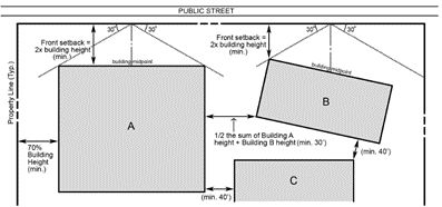
(1)
Minimum street yards (front setbacks).
(a)
The distance measured perpendicularly from any front lot line to the nearest surface of a building shall not be less than twice the height of the building, which height shall be measured from the lowest visible elevation under the building to the highest part of the building.
(b)
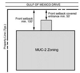
Development lots in certain locations within the MUC-2 zoning district shall observe the following street yard (front setback) standards in lieu of the general standard above:
1.
All buildings must be set back at least 100 feet from Gulf of Mexico Drive, except that a covered entrance portico that is attached to a building can be as close as 50 feet to Gulf of Mexico Drive. See graphic, provided for illustrative purposes, below.
2.
Development lots that are separated by a private street from an adjacent lot that is permanently restricted as open space or golf course shall have the minimum street yard (front setback) measured as follows. The graphic below, provided for illustrative purposes, depicts standards found in Sections 158.030(K)(1)(b)(2)(a) through (c).
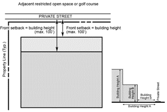
a.
Buildings must be set back from the private street at least a distance equal to their height, but never more than 100 feet.
b.
If the front of a building has two or more vertical planes, the setback distances apply to each plane. For example, a building with a two-story podium and six stories above the podium must have its podium set back at least a distance equal to the podium's height and the remainder of the building must be set back at least a distance equal to the height of all eight stories, but never more than 100 feet.
c.
These private street setbacks shall be measured to the edge of the street's pavement.
(2)
Distance between buildings. No building shall be located closer to another building on the same lot than a distance equal to half the sum of the heights of both buildings (measured from the lowest visible elevation under each building), nor shall any structure be located closer to a site lot line than a distance equal to 70 percent of the building height (measured from the lowest visible elevation under the building). In addition, the front or rear of any building may be no closer to the front or rear of any other building than 40 feet. The side of any building should be no closer to the side, front, or rear of any other building than 30 feet.
As to Subsections (K)(1) and (2), "visible elevation" shall not include elevator shafts, stairwells, and other mechanical equipment areas, so long as such areas do not exceed ten percent of the area under the building.
(3)
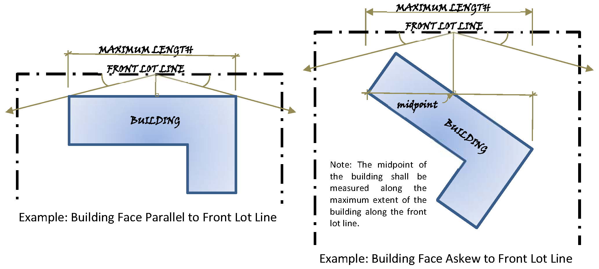
Maximum length. No portion of any individual building shall extend beyond a line drawn from the front lot line 30 degrees either side of a line through the midpoint of the front face of the building and perpendicular to the front lot line.
(4)
Distance between buildings and driveways. No driveway or parking lot should be closer than 25 feet to the front of any building or ten feet to the side or rear of any building except where parking under or within the building is proposed or in the case of a front entrance to a building.
(L)
All docks and boat facilities shall comply with Section 158.099, of the Town Zoning Code and Comprehensive Plan.
(M)
Proposed residential development shall comply with school concurrency proportionate-share mitigation program in accordance with Article 9, School Concurrency Proportionate-Share Mitigation Program.
(N)
Other performance standards. Other performance standards used by the Town in reviewing any site or development plan shall include such other standards as may be imposed by this Zoning Code on the particular use or activity involved.
(Ord. 2018-24, passed 4-1-19; Ord. 2020-14, passed 1-5-21; Ord. 2020-18, passed 1-5-21)
158.031 - Grant or denial of applications for Site Development Plan approval; findings of fact and conclusions.
The granting or denial of approval of applications for Site Development Plan approval by written Development Order shall include not only conclusions but also findings of fact related to the specific proposal and shall set forth the reasons for the grant, with or without changes or special conditions, or for the disapproval. The Development Order shall set forth findings of fact and conclusions on the following:
(A)
In what respects the plan is or is not consistent with the Comprehensive Plan and the purpose and intent of the zoning district in which it is located.
(B)
In what respects the plan is or is not in conformance with all applicable regulations of the zoning district in which it is located.
(C)
In what respects the plan is or is not in conformance with the Town's Subdivision Regulations, Chapter 157, and all other applicable Town requirements, including the design, adequacy and construction of streets, drainage, utility facilities, and other essential services.
(D)
In what respects the plan is or is not consistent with good design standards in respect to all external relationships, including, but not limited to, relationship to adjoining properties; internal circulation, both vehicular and pedestrian; disposition and use of open space, provision of screening and buffering, and preservation of existing natural features, including trees; size, and apparent bulk of structures; and building arrangements both between buildings in the proposed development and those adjoining the site.
(E)
In what respects the plan is or is not in conformance with Town policy in respect to sufficiency of ownership, guarantees for completion of all required improvements, and, if private, the guarantees for continued maintenance.
(Ord. 2018-24, passed 4-1-19)
158.032 - Consultants may be retained by Town.
The Town may retain consultants to assist in the review of an application for Site Development Plan review. The cost of retaining the consultants shall be borne by the Applicant. The Applicant shall be responsible for making timely payment of all said consultant fees charged. Failure to do so will result in the Town being relieved of its obligation to continue processing the application until the required payment(s) is/are made. The payment of all outstanding consultant fees shall be a condition of Site Development Plan approval and payment is a condition precedent to the Town's obligation to issue a Building Permit.
(Ord. 2018-24, passed 4-1-19)
158.033 - Statement of Zoning Compliance.
Where an addition, alteration, or reconstruction of a building or the construction or erection of a fence, wall, parking area, or other structure is undertaken after the issuance of a Building Permit and upon completion is in accordance with all provisions of this Chapter; and where a Certificate of Occupancy is not applicable, a Statement of Zoning Compliance shall be issued in the same manner as a Certificate of Occupancy at a fee to be established by resolution of the Town Commission.
(Ord. 2018-24, passed 4-1-19)
158.034 - Overview of Planned Unit Developments (PUD).
(A)
Intent. Planned unit developments (PUD's) are intended: to encourage flexibility in the design and development of land; facilitate the adequate and economical provision of streets, utilities, and public spaces; and preserve the natural and scenic qualities of open areas. The PUD application, review, and approval procedure is intended to permit diversification in the location of structures and improve circulation facilities and other site qualities while ensuring adequate standards relating to public health, safety, comfort, order, appearance, convenience, morals, and general welfare.
PUD regulations provide an optional review and approval process for Applicants who seek to develop or redevelop parcels in and are limited to parcels that are: 1) located in Mixed Use Community (MUC) zoning districts; or 2) conforming for density, if developed with residential or tourism uses and not zoned R-1IP, R-1SF, R-2SF, R-3SF, R-4SF, or R-6SF; or 3) zoned INS, OI, C-1, C-2, C-3 or M-1.
In the MUC zoning districts, the PUD process establishes development rights on specific parcels, thus the PUD process is the only process that landowners in those zoning districts can use to request changes to the development plans for those parcels. The PUD process allows approval of a conceptual Site Development Plan, known as a binding concept plan, prior to preparation and submission of a final Site Development Plan. The PUD process also allows landowners to seek Departures from certain provisions of this Code at the conceptual design stage. Landowners must conform to the approved binding concept plan when they submit final Site Development Plans in accordance with Subsection 158.036(F).
(B)
Effect on zoning district. The PUD process requires the submission of an Outline Development Plan (ODP), which becomes an integral part of a PUD approval. PUD approval does not change the underlying zoning district, nor does it add permitted uses to those specified for each zoning district in the Use Regulations tables accompanying Article IV.
(C)
Where permissible. PUD approval shall be limited to any of the following zoning district(s), provided that parcels developed with residential or tourism uses are conforming for density, are not already zoned CORD, and the minimum area requirements in Section 158.037 are met for the following zoning districts:
(1)
INS;
(2)
R-3MX, R-4MX, and R-6MX;
(3)
MUC-1, MUC-2, and MUC-3;
(4)
OI, C-1, C-2, C-3, and M-1; and
(5)
T-3 and T-6.
(D)
Density. PUD approvals are limited to parcels that are developed with conforming density for residential or tourism uses and shall comply with the special density provisions found in Section 158.039.
(E)
Site plans. A PUD is approved through the adoption of an Outline Development Plan (ODP). Binding concept plans are required as part of Outline Development Plans, except where this Code explicitly allows a Final Site Development Plan to replace a binding concept plan (see, for instance, Subsections 158.036(B)(1) and 158.106(F)). Binding concept plans become an integral part of ODP and PUD approvals. Binding concept plans (and Final Site Development Plans) may be subsequently amended in accordance with the standards and procedures in Section 158.036.
(Ord. 2018-24, passed 4-1-19; Ord. 2019-08, passed 11-4-19)
158.035 - Preapplication Conference.
In order to expedite the review of a proposed Planned Unit Development, coordinate its local review in respect to the provisions of this Chapter with the necessary county, state, and federal agency reviews, and to inform the Town of a Planned Unit Development in preparation, one or more preapplication conferences between the Applicant and the Planning and Zoning Official is required. The preapplication conference, while informal, will serve several purposes and focus on the following items:
(A)
To inform the Town of any Planned Unit Development plans in progress together with the scale and character of the plan so that the Town may recognize the proposed development in any of its physical or facility planning for the entire Town.
(B)
To inform the Applicant of the Town's informal response as to the scale and character of the proposed development and to alert the Applicant to any specific areas of concern that the Town may have for that specific site or proposed plan.
(C)
To clarify and inform the Applicant in respect to the Outline Development Plan approval procedure and submission requirements, including an anticipated application time and review period as specifically set forth in Section 158.036.
(D)
To enable the Applicant to inform the Town of the requirements, procedure, and status of the various county, state, and federal agency reviews.
(Ord. 2018-24, passed 4-1-19)
158.036 - Review and approval of Planned Unit Developments.
(A)
Approving authority. Planned unit developments are subject to the approval of the Town Commission after review and recommendation by the Planning and Zoning Board and after public hearings are held by the Town Commission in accordance with law.
(B)
Applications. In order to provide an expeditious method for processing an Outline Development Plan application for a Planned Unit Development, under the terms of this Chapter, it is hereby declared to be in the public interest that all procedures with respect to the review, approval, or disapproval of a plan for a Planned Unit Development, and the continuing administration thereof, shall be consistent with the following provisions:
(1)
Application requirements. An application for an Outline Development Plan for a Planned Unit Development, including full payment of an application fee as set forth by resolution of the Town Commission, shall be signed and filed by the Applicant with the Planning and Zoning Official. The purpose of the Outline Development Plan is to provide the Town with information with respect to the type, character, scale, and intensity of development as well as the time phasing of the proposed Planned Unit Development in order for the Town to evaluate the impact of the development to the Town. Any application for outline development approval shall be submitted on a form provided by the Town and in addition shall include at a minimum the following information, unless the Planning and Zoning Official determines in writing that one or more of the following elements do not apply to the particular application:
(a)
A scaled drawing delineating the relationship of the site to existing development in the area, including streets, utilities, residential and commercial development, and important physical features in and adjoining the project, including ecological features.
(b)
A scaled drawing delineating the approximate location and dimensions of all boundary lines of the development, and of any contiguous lands, including those separated only by a street, canal, or similar feature, in which the developer or property owner presently has any legal interest.
(c)
A verified statement, including a certificate of ownership, showing each and every individual person having a legal ownership interest in the subject property except publicly held corporations whose stock is traded on a nationally recognized stock exchange, in which case the name and address of the corporation and principal executive officers will be sufficient.
(d)
A scaled drawing delineating the approximate location, nature, and extent of all existing easements, streets, buildings, land uses, zoning, tree groupings, watercourses, uplands, wetlands, and topographic contours (i.e., at six-inch intervals with reference to mean sea level), on the site; the existing zoning and land use for all contiguous property; and flood protection elevation data and flood zones.
(e)
Tabulations by acreage and percentage as to the amount of the site that is uplands and wetlands, indicating those wetlands landward and seaward of the mean high-water line (MHWL), including the extent and type of wetlands in accordance with the Town's Comprehensive Plan.
(f)
A scaled drawing delineating the approximate locations, intensity. and acreages of general land uses (proposed), including dwelling types and units and general types of nonresidential uses, open spaces, recreational facilities, and other proposed uses.
(g)
A traffic impact analysis shall be provided, except for voluntary reconstruction without additional dwelling or tourism units, to ensure that the adopted level of service standards are not exceeded before capacity-related improvements are implemented; and a scaled drawing delineating a circulation facilities plan indicating approximate locations and types of proposed streets, bicycle paths, pedestrian walks, and emergency vehicle access points, including all curb cuts, driveways, off-street parking and loading areas, and off-street surfaces available for maneuvering vehicles.
(h)
Tabulations of total project acreage and proposed densities for each tourism and dwelling unit type and total number of tourism and dwelling units by type.
(i)
Tabulations of all land uses and approximate square footage of gross area for all nonresidential buildings by general type (e.g., offices, limited commercial, etc.).
(j)
A proposed development schedule indicating approximate starting and completion dates for the entire project and any phases thereof, together with appropriate identification and description of such phases.
(k)
Such additional data and information as the Applicant may believe is pertinent to the plan of development.
(l)
Such additional relevant data and information the Town may reasonably require.
(m)
A written statement by the landowner or any other entity having a cognizable interest in the land, describing fully the character and intended use of the Planned Unit Development and setting forth the reasons why, in their opinion, a Planned Unit Development would be in the public interest and would be consistent with the Town's statement of purposes of a Planned Unit Development.
(n)
A statement specifically indicating any requested Departures from Article IV of this Chapter and Section 158.030, and a statement of any existing hardship and/or clear and specific statement of how the code Departures are necessary or desirable to accomplish a Planned Unit Development under Article III, Division 7. The statement shall include the Applicant's position as to why each requested Departure either meets or has no material adverse effect on each of the Departure criteria in Subsection 158.036(D).
(o)
A binding concept plan, which is a conceptual Site Development Plan that depicts the proposed development and is intended to become an integral part of a Planned Unit Development approval. The binding concept plan shall show the existing and proposed uses and structures, lots, streets, and other physical aspects of the proposed development as enumerated in Sections 158.036 and 158.030. At an Applicant's discretion, a final Site Development Plan may be submitted for approval concurrently with the Outline Development Plan, thus eliminating this requirement for a binding concept plan.
(p)
Additional requirements for applications for reconstruction of nonconformities:
1.
A statement specifically indicating modifications and adjustments from the requirements of this Code of Ordinances which would otherwise be applicable to the project if reconstruction of a nonconformity were not granted by the Town.
2.
A clear and specific statement of any hardship that exists making the modifications and adjustments from the Code necessary.
3.
A clear and specific statement of how the modifications and adjustments are necessary or desirable to accomplish one or more of the stated purposes of the reconstruction provisions in Section 158.132.
(2)
Application procedures. The application for an Outline Development Plan of a Planned Unit Development shall be signed and filed by the Applicant with the Planning and Zoning Official. As an alternative to submitting a binding concept plan, the Applicant may concurrently file an application for Site Development Plan approval. If filed, the application for Site Development Plan approval shall be processed in accordance with Article III, Division 5, herein. Upon receipt of the application the Planning and Zoning Official shall review the application to determine its appropriateness and completeness and accept or reject it in writing. Upon acceptance of the application, the Town's administrative Staff shall refer the application, together with all supporting documentation and a Staff report, to the Planning and Zoning Board for its review and recommendations. The Planning and Zoning Board and Town Commission shall not receive, review, make recommendations, or act on applications for Outline Development Plan approval except during the Town's annual Site Development Plan season. During the review process, the Town may retain consultants to assist in the review. The cost of retaining the consultants shall be borne by the Applicant. For purposes of this Chapter, the annual Site Development Plan season shall include the months of September, October, November, December, January, February, March, April, May, and June of each year. For purposes of calculating the required processing times set forth in this Section for the Planning and Zoning Board and the Town Commission, the period of time from July 1 through August 31 shall not be counted in said computation.
(3)
Planning and Zoning Board public hearing. Upon receipt of the application from the Planning and Zoning Official, the Planning and Zoning Board shall review the Outline Development Plan and make recommendations to the Town Commission that are based on competent, substantial evidence of record. The Planning and Zoning Board may also formulate findings of fact as to the consistency of the application with this Code and with the Comprehensive Plan. The Planning and Zoning Board shall recommend approval of the application as submitted, approval of the application with changes or special conditions, or disapproval of the application. The determination and recommendations of the Planning and Zoning Board shall be advisory only and shall not be binding upon the Town Commission. For purposes of this Section, the Planning and Zoning Board shall receive an Outline Development Plan application from the Planning and Zoning Official at the Planning and Zoning Board 's next regular meeting where a quorum is present following the Planning and Zoning Official's submittal of the application to the Planning and Zoning Board. The Planning and Zoning Board is specifically authorized to continue its deliberations, reasonably request additional relevant materials, and elicit expert testimony to aid in its deliberations.
(4)
Town Commission public hearing. A public hearing on the Planned Unit Development application shall be held by the Town Commission upon the Commission's receipt of the application from the Planning and Zoning Board, public notice of which shall be given in accordance with the provisions of the Charter and this Chapter. For purposes of this Section, the Town Commission shall receive an Outline Development Plan application from the Planning and Zoning Board at the Commission's next regular meeting where a quorum is present, following the submittal of the Planning and Zoning Board's action on the application to the Commission. A transcript of the hearing may be caused to be made by the Town Commission at the cost of the Applicant, copies of which shall be made available at cost to any party to the proceedings; and all exhibits accepted in evidence shall be identified and duly preserved, or, if not accepted in evidence, shall be properly identified and the reason for the exclusion clearly noted in the record. The Town Commission is specifically authorized to continue its deliberations, request additional materials, and elicit expert testimony to aid in its deliberations, and may, at its sole discretion, remand the application to the Planning and Zoning Board for additional hearing and consideration. If changes are made to the application, accompanying plans or conditions of approval after review by the Planning and Zoning Board, the Commission may, at its sole discretion, remand the application back to the Planning and Zoning Board, but is not required to do so.
(5)
Town Commission decision procedures. At the conclusion of the public hearing, the Town Commission shall review the Outline Development Plan application and either approve it as submitted, approve it with changes or special conditions, or disapprove it. The action taken by the Town Commission shall be by ordinance. The Town Commission may unilaterally extend the time for final action where the Commission determines additional time is necessary to properly and completely review the Outline Development Plan application.
(a)
In the event approval is granted, the Town Commission shall, as part of its ordinance, specify the drawings, plan sheets, renderings, specifications, and form of performance and maintenance bonds that shall be considered part of the final approval.
(b)
In the event approval is granted subject to changes or special conditions, the Applicant shall, within 30 calendar days after receiving a copy of the ordinance of the Town Commission, notify the Town Commission in writing of the Applicant's acceptance or refusal of all the conditions. In the event the Applicant refuses to accept all the conditions or fails to reply within 30 calendar days, the Applicant shall be deemed to have withdrawn the plan. Nothing contained herein shall prevent the Town Commission and the Applicant from mutually agreeing to a change in the conditions, or an extension of the time during which the Applicant shall notify the Town Commission of acceptance or refusal of the conditions.
(c)
In the event an Outline Development Plan is granted approval, the Town Commission shall set forth in the ordinance the time within which an application for final Site Development Plan approval, or applications in the case of a phased development, shall be filed. However, if a final Site Development Plan was approved concurrently with the Outline Development Plan, the ordinance does not need to specify a time period.
(C)
Standards for approval or disapproval of application. The Town Commission shall base its decision on each Outline Development Plan application on competent, substantial evidence of record and shall include conclusions but may also include written findings of fact related to the specific proposal and shall set forth the reasons for the grant of approval, with or without changes or special conditions, or for the disapproval of an Outline Development Plan application. The Commission's approval, approval with changes or special conditions, or disapproval of an Outline Development Plan application, shall be based on the application, evidence and testimony presented in the public hearing, and the following standards:
(1)
In what respects the Outline Development Plan is or is not consistent with the intent of a Planned Unit Development as provided in Section 158.034.
(2)
Whether the plan is consistent with the Town's Comprehensive Plan.
(3)
The extent to which the plan meets the zoning and Subdivision Regulations otherwise applicable to the subject property without Departures, Waivers, or Variances.
(4)
The purpose, location and amount of common open space in the plan, the adequacy or inadequacy of the proposals for maintenance and conservation of the common open space, and the adequacy or inadequacy of the amount and purpose of the common open space as related to the proposed density and type of development.
(5)
The physical design of the plan and the manner in which the design makes adequate provision for public services, provides adequate control over vehicular traffic and parking, and enhances the amenities of light and air, recreation and visual enjoyment.
(6)
The relationship, beneficial or adverse, of the proposed plan to the neighborhood in which it is proposed to be established.
(7)
In the case of a plan that proposes development over a period of years, the sufficiency of the terms and conditions intended to protect the public interest and of the residents and owners of the Planned Unit Development in the faithful completion of the plan.
(8)
The extent to which the plan provides for an effective and unified development on the project site making appropriate provision for the preservation of scenic features and amenities of the site and the surrounding areas.
(9)
For the MUC-1 and MUC-2 zoning districts only, all permitted uses as listed in Article IV, Division 4 for each district, are considered generally to be compatible uses in the MUC districts based on the intent to encourage mixed use and clustering at varying scales and intensity. Compatibility shall be achieved at specific locations by implementing compatibility techniques, such as those listed in this Section as appropriate to the context:
(a)
Tourism uses and restaurants shall be designed to minimize noise from outdoor activities, such as outdoor music;
(b)
Loading areas and parking at grade shall be screened and landscaped to minimize impacts to residential uses and adjacent rights-of-way/private roads;
(c)
Anti-glare glass shall be utilized in all windows that could potentially reflect toward another residential use;
(d)
Lighting shall be designed to minimize impacts to residential units and adjacent public rights-of-way/private roads;
(e)
Additional compatibility techniques shall be employed wherever a proposed structure exceeding 50 feet is located within 500 feet of another structure that is substantially lower in height. "Substantially lower" means there is a difference of 50 feet or more between the proposed structure and the structure within 500 feet. For the purpose of this provision, acceptable compatibility techniques include, but are not limited to, perimeter berms, landscaping buffers, building orientation, building design, and architectural treatments; and
(f)
This Section does not apply to the compatibility of uses within a proposed PUD development site, as permitted uses are deemed internally compatible.
(10)
The additional criteria listed below apply to requests for buildings taller than 50 feet in the MUC-2 zoning district:
(a)
Yard sizes (building setbacks) are greater than required by Article IV; and
(b)
The taller buildings are consistent with the intent of the district and compatible with similar existing uses within the overall district.
(D)
Standards for approval or disapproval of Departures. Planned unit development applications may be accompanied by requests for Departures from specific standards of Article IV of this Chapter and from the standards of Section 158.030, whether the application for final Site Development Plan approval is concurrently filed or not. However, Departures may not be granted to add uses that are not listed in the Use Regulations tables in Article IV for the zoning district underlying the Planned Unit Development. Before approving a Departure, the Town Commission shall determine by competent, substantial evidence of record that each Departure is consistent with the Longboat Key Comprehensive Plan and shall decide whether each Departure either meets or has no material adverse effect on the following criteria, except where clearly inapplicable to the requested Departure:
(1)
The Departure is no less consistent with the health, safety, and welfare of abutting landowners and the general public than the standard from which the Departure is being requested, and the Departure adequately protects against adverse impacts to adjacent parcels and the surrounding area.
(2)
The Departure preserves or enhances natural or scenic qualities, or preserves a larger percentage of open space than required by the Zoning Code, or preserves higher quality natural areas or more attractive and useful public spaces.
(3)
The Departure facilitates desirable infrastructure, stormwater retention, or parking facilities.
(4)
The Departure reduces traffic impacts or improves traffic circulation.
(5)
The Departure enhances the project's character and compatibility within the development and with adjacent developments.
(6)
The Departure allows the project to add or improve on-site amenities and recreational opportunities serving the development and the community.
(7)
The Departure helps the project promote walkability, offers multimodal transportation options, improves access to existing commercial or other amenities, or improves connections to beach or bay accesses.
(E)
Modified standards for Planned Unit Developments. Lot coverage and building standards in Article IV of this Code are modified for Planned Unit Developments as follows:
(1)
If the plan is for land within the T-3, T-6, MUC-1, MUC-2, INS, OI, C-1, C-2, C-3, or M-1 district, lot coverage may exceed the standard lot coverage provided by Article IV by up to ten percent to encourage flexibility in design and development without the requirement for a Departure pursuant to Subsection (D) above. The density/intensity table in the Comprehensive Plan authorizes these increases for PUDs only. The increases are reflected in the table accompanying Article IV of this Code; further increases are not allowed by the Comprehensive Plan.
(2)
If the plan is for property within the MUC-1 district, building height may exceed the standard height provided by section 158.145 by a maximum of 15 feet. If the plan is for property within the MUC-2 district, the height for buildings with tourism units may be a maximum of 130 feet, and the height of other uses may be a maximum of 87 feet, provided the standards in Subsection 158.036(C) are met. The density/intensity table in the Comprehensive Plan authorizes these increases for PUDs only. The increases are reflected in the table accompanying Article IV of this Code; increases beyond those heights are not allowed by the Comprehensive Plan.
(F)
Actions after decision. Within seven days after the adoption of the ordinance provided for in Subsection (B) above, it shall be certified by the Town Clerk, and shall be filed in their office, and a certified copy shall be mailed to the Applicant. An Outline Development Plan upon approval and acceptance, as provided herein, is defined as running with the land; however, an Applicant may apply for a revision to the Outline Development Plan in accordance with the procedures for an original submission, review, and approval. Approval of an Outline Development Plan shall not qualify a plat of the Planned Unit Development for recording purposes or authorize development or the issuance of any Building Permits. Upon approval and acceptance, if applicable, the Town Clerk shall file with the Clerk of the Circuit Court the Outline Development Plan to record it in the official records of the county in which the property is located.
(G)
Final Site Development Plan required. An application for Final Site Development Plan approval may be for all the land included in an Outline Development Plan, or to the extent set forth in the Outline Development Plan approval, for a section thereof.
(1)
The Final Site Development Plan application shall include any drawings, plan sheets, renderings, specifications, covenants, easements, conditions, and form of performance and maintenance bonds as were set forth by the Town Commission in the ordinance approving the Outline Development Plan and required by Subsection 157.31(B).
(2)
The submission, review, and approval of an application for Final Site Development Plan approval shall be subject to the procedures and provisions of a Site Development Plan review as set forth within Article III, Division 5.
(3)
Planned Unit Development applications may include a request for Final Site Development Plan approval at the same time as Outline Development Plan approval; see Subsection 158.036(B)(1).
(4)
An application for approval of a Final Site Development Plan for a portion of or all of an Outline Development Plan shall be in compliance with the approved Outline Development Plan with respect to open space and lot, yard and bulk regulations.
(5)
If the Final Site Development Plan is not in compliance, the Applicant shall revise the final Site Development Plan, apply for a Site Development Plan exemption, or amend the Outline Development Plan through the outline development process provided herein, in order to achieve compliance.
(H)
Length of approval.
(1)
Notwithstanding the 24-month period specified in Subsection 158.029(F), Final Site Development Plan approval for a Planned Unit Development runs with the land for a period not to exceed four calendar years from the date of the ordinance adopting the final Site Development Plan.
(2)
For Planned Unit Developments in the MUC-1 and MUC-2 zoning districts, this period shall be increased to ten calendar years, or for an approved period longer than ten years for a specific future phase delineated on the Final Site Development Plan, provided the Applicant meets at least two of the following criteria:
(a)
Commenced site preparation work and maintained substantial progress during the initial four-year period affecting 33 percent or more of the acreage of the PUD development parcel, or if the PUD approval includes phases, affecting 66 percent of the acreage of the initial phase;
(b)
Commenced site preparation work and completed at least one critical element of the required infrastructure to serve the PUD development parcel;
(c)
Commenced site preparation work and constructed at least one principal building (not including a temporary building) within the PUD development parcel; or
(d)
Paid all impact fees for development authorized by the Site Development Plan.
(3)
The Town reserves the right to change or reformat the provisions of this Code and adopted PUD ordinances or resolutions; such changes will not alter any rights granted by unexpired Site Development Plan approvals.
(I)
Conformance with Subdivision Regulations. The design, construction, and guarantee of completion and maintenance of all physical improvements—including, but not limited to, streets, drainage, potable water, and sewage collection required by a PUD—shall conform with Chapter 157 of this Code and all other applicable ordinances.
(Ord. 2018-24, passed 4-1-19)
158.037 - Minimum area.
A Planned Unit Development shall include not less than two acres of contiguous land in any residential zoning district, and not less than one-half acre for all other zoning districts.
(Ord. 2018-24, passed 4-1-19)
158.038 - Open space.
All residential planned unit developments shall preserve a minimum of 50 percent of the gross land area as open space. Of the required 50 percent open space, only a maximum of 60 percent of the total required open space acreage may be comprised of a golf course. Relative to nonresidential planned unit developments, all such developments consisting of tourist accommodations including motels, hotels, and tourist resort/commercial facilities shall provide a minimum of 50 percent of the gross land area as open space. Wetland and landlocked waterbodies may be used in calculating open space, as long as a minimum of 40 percent of the upland property is comprised of open space. In other types of nonresidential planned unit developments a minimum of 20 percent of the gross land area shall be preserved as open space. Wetlands and landlocked waterbodies may be used in calculating open space, as long as a minimum of 15 percent of the upland property is comprised of open space. For all mixed use planned unit developments, a minimum of 50 percent of the gross land area shall be preserved as open space. In all of the above cases, parking areas and vehicle access facilities shall not be considered in calculating open space.
(Ord. 2018-24, passed 4-1-19)
158.039 - Tourism and residential density.
(A)
Planned unit developments shall have densities no greater than that permitted for a PUD within the zoning district in which it is located as shown below:
Notes:
1 Dwelling units per acre refers to residential units; tourism units per acre refers to tourism units; units per acre refers to total allowed residential units and tourism units.
(B)
In any event, a Planned Unit Development shall be consistent with the Comprehensive Plan for the Town and the zoning district in which it is located in respect to design compatibility, use, and height regulations.
(Ord. 2018-24, passed 4-1-19)
158.040 - Proposed land uses.
(A)
(1)
Proposed land uses shall not adversely affect surrounding development and shall be consistent with the Town's Comprehensive Plan.
(2)
Recreational uses, as defined in Section 158.144, shall not be included in the computation of permitted nonresidential areas of a Planned Unit Development.
(B)
In cases where land proposed for a Planned Unit Development is zoned for both residential and nonresidential uses, a mix of residential and nonresidential land uses may be approved by the Town Commission through the Outline Development Plan review process in order to achieve the purposes of the Planned Unit Development as set forth herein.
(C)
In cases where land is proposed for Planned Unit Development and where the existing zoning district(s) comprising the entire land area of the Planned Unit Development is nonresidential, a nonresidential Planned Unit Development may be approved by the Town Commission through the Outline Development Plan review process in order to achieve the purposes of the Planned Unit Development as set forth herein.
(D)
Once development rights, whether residential or nonresidential, have been assigned to a parcel within a Planned Unit Development, any subsequent request for new or additional residential or tourism density shall be considered a transfer of density under the governing resolutions and ordinances of the Planned Unit Development which shall require amendment of the Outline Development Plan for the Planned Unit Development in accordance with the procedures of Section 158.036. In no event shall the overall density of a Planned Unit Development exceed the maximum overall density set forth in this Code or the Comprehensive Plan for the Planned Unit Development.
(Ord. 2018-24, passed 4-1-19)
158.043 - Commercial Revitalization—Intent and purpose.
This Division, Commercial Revitalization, recognizes that within the Town there exist commercially zoned and developed parcels with structures, which were lawful when established, but as of October 1, 2002 are nonconforming under the terms of the Town's land development code. It is the intent of the Commercial Revitalization Sections to provide reasonable flexibility for these nonconforming commercial, office and marina establishments located within the C-1, C-2, C-3, O-I and M-1 zoning districts, that are developed with conforming uses as of October 1, 2002, by providing a process for existing business establishments to make small alterations in order to meet state or federal mandates; or to improve their businesses to maintain viability.
The Commercial Revitalization is optional. Property owners may avail themselves of these provisions contingent on the requirements and standards identified in this Section. Waiver approvals shall apply during the life of the building or improvement only and shall not run with the land. Waiver approvals shall terminate at the time of building demolition or destruction whether by voluntary or involuntary means.
(Ord. 2018-24, passed 4-1-19)
158.044 - Permitted Uses.
(A)
Without Site Development Plan review and approval.
(1)
Essential services.
(B)
With Site Development Plan review and approval.
(1)
Permitted uses in C-1, C-2, C-3, O-I and M-1 districts.
All uses are subject to the provisions of Subsection 158.131(A), the status of nonconformities.
(Ord. 2018-24, passed 4-1-19)
158.045 - Development Standards.
Commercial revitalization shall be subject to the development standards of this Section.
(A)
Height.
(B)
Accessory uses.
(1)
Permitted accessory uses in the C-1, C-2, C-3, O-I and M-1 districts.
(C)
Special exceptions.
(1)
Special exception uses in the C-1, C-2, C-3, O-I and M-1 districts.
(D)
Minimum zoning lot requirements, maximum coverage, and yards.
a See Subsection 158.094(C), Required waterfront yard requirements.
b If the alteration is required to solely meet state or federal mandates (such as ADA), an additional five percent of the existing building coverage for individual buildings over the percentage otherwise permitted in the district shall be permitted by the Planning and Zoning Official as an Administrative Waiver. See Subsection 158.046(A)(2), Building Coverage Waiver.
c Awnings and eave overhangs of up to two feet are exempt from building coverage calculation. See Subsection 158.046(A)(3).
d Proposed alterations may exceed the existing building coverage by an additional ten percent with a Waiver meeting the standards of this Section and with a Site Development Plan reviewed and approved by the Planning and Zoning Board. See Subsection 158.046(B)(2), Building Coverage Waiver. This Waiver shall not be used in conjunction with the Administrative Waiver in Subsection 158.046(A)(2).
e Proposed alterations may exceed the existing building coverage by an additional ten percent with a waiver meeting the standards of this section and with a site plan reviewed and approved by the planning and zoning board. See section 158.046, building coverage waiver. This waiver shall not be used in conjunction with the administrative waiver in section 158.046.
(Ord. 2018-24, passed 4-1-19; Ord. 2019-08, passed 11-4-19)
158.046 - Waivers.
(A)
Administrative Waivers. Applicants may apply for one or more Administrative Waivers, which may be submitted and processed concurrently or individually. The Planning and Zoning Official, or designee, may approve, by administrative action, Waivers for: awnings projecting less than three feet from structure and, additional building coverage described within this Section. Alteration proposals, utilizing this process, shall include the submittal of a Site Development Plan meeting the criteria established in this Section. The provisions of Section 158.026, Site Development Plan Exemptions shall apply, if applicable.
Applicants seeking an appeal from an Administrative Waiver denial shall follow the procedures and criteria set forth in the Zoning Code.
(1)
Administrative Building Coverage Waiver. Up to five percent maximum of additional building coverage (over and above the allowable building coverage) may be granted if a proposed alteration is to solely meet state or federal mandates (such as ADA or FEMA). The building coverage on the effective date of the adopting ordinance shall be the baseline building coverage and the five percent shall be a cumulative total.
(2)
Administrative Awning Waiver. If proposed alteration includes awnings in yards, the Planning and Zoning Official may approve a yard Waiver up to three feet.
(B)
Planning and Zoning Board Waivers. Applicants may apply for one or more Planning and Zoning Board Waivers, which may be submitted and processed concurrently or individually. The Planning and Zoning Board may approve, after a public hearing, Waivers for: landscaping; building coverage; and yards and awnings, described within this Section. Proposals utilizing this process shall include the submittal of a Site Development Plan meeting the criteria established in this Section. Each Waiver application shall address all of the applicable standards contained in this Section. The provisions of Section 158.026, Site Development Plan exemptions shall apply, if applicable.
Applicants seeking an appeal of a Planning Board Waiver decision may seek judicial review as provided by the Zoning Code.
(1)
Landscaping in Parking Area Waiver. Alterations shall meet the requirements of Subsection 158.100(J), Off-street Parking, to the greatest extent possible. Waivers shall address all of the following standards for review:
(a)
The proposed Waiver contributes to the park-like atmosphere of the Town by providing enhanced landscaping, open space, and natural buffering.
(b)
The proposed Waiver offers alternative(s) to the strict interpretation of the existing regulations and meets the intent of Chapter 98, (trees). Examples of flexibility include: Relocation of significant vegetation or trees, larger plant material or wider buffers (if possible) to other areas of the site.
(c)
The proposed Waiver preserves existing, mature vegetation as defined by Chapter 98 (Trees) and the Zoning Code.
(d)
Where the addition of required landscaping to parking areas reduces the number of required parking spaces by more than five percent, or is impractical, landscaping enhancements within the adjacent public ROW may be approved as an alternative (158.178(B)(1)(d)).
(2)
Building Coverage Waiver for C-1, C-2, and O-I zone districts. Alterations shall meet the building coverage requirements of Article IV to the greatest extent possible. Applicants may not apply for the administrative approval building coverage Waiver and this Waiver simultaneously.
Up to ten percent maximum of additional building coverage (over and above the allowable building coverage) may be granted. The building coverage as of October 1, 2002, shall be the baseline building coverage and additional coverage granted shall be a cumulative total.
Waivers shall address all of the following standards for review:
(a)
The proposed Waiver is due to existing site or building conditions that make it impossible or impractical to meet the existing regulations.
(b)
The proposed Waiver offers up to ten percent of additional building coverage for any type of permitted alterations, but must include state and federal mandates, if required.
(c)
The proposed Waiver does not negatively impact adjacent properties.
(d)
Additional mitigation may be required when alterations are proposed adjacent to residential zone districts or residential use.
(e)
The proposed Waiver is in combination with additional site alterations that improve vehicular traffic and pedestrian circulation; landscaping; or state/federal mandates.
(3)
Yard and Awning Waiver. Alteration(s) shall meet the yard requirements of Article IV to the greatest extent possible. Yard Waivers adjacent to residential zone districts or residential uses shall not be permitted. Waivers shall address all of the following standards for review:
(a)
The proposed Waiver is due to existing site or building condition(s) that make it impossible or impractical to meet the existing regulations.
(b)
The proposed Waiver does not negatively impact adjacent properties.
(c)
The proposed Waiver is in combination with additional site alterations that improve vehicular traffic and pedestrian circulation; landscaping; or state/federal mandates.
(d)
Awning standards (if applicable):
1.
The awning meets the definition of Section 158.144 (Definitions).
2.
The awning is for an existing building or an approved addition.
3.
The awning extends greater than three feet and up to ten feet into the required yard. A minimum of five feet side yard shall be maintained under all circumstances.
4.
If the awning is proposed over a pedestrian walkway, the minimum awning width must be the same width as the pedestrian walkway, but no greater than ten feet total width.
5.
The proposed awning is the most appropriate style for the building, is compatible with buildings on the same site or development.
(Ord. 2018-24, passed 4-1-19; Ord. 2019-08, passed 11-4-19)
158.047 - Site Development Plan Requirements.
(A)
Exemptions to Section 158.028, Application for Site Development Plan Approval.
(1)
Applicants submitting alteration plans under this Section are exempt from the following submittal requirements:
(a)
Subsection 158.028(F), Uplands and wetlands tabulations.
(b)
Subsection 158.028(L), Location and character of recreation areas.
(c)
Subsection 158.028(N), Traffic impact analysis.
(d)
Subsection 158.028(Q), Soil erosion and sedimentation plan (unless the Planning and Zoning Official determines a plan is required owing to the nature of the requested Waiver).
(e)
Subsection 158.036(D), List of Code Departures.
(2)
All other provisions of Section 158.028 shall apply, however, the Planning and Zoning Official may exempt additional criteria from Section 158.028, if the criteria clearly do not apply to the requested Waiver.
(B)
Status of requirements in Section 158.030 (Performance Standards for Site Development Plans).
(1)
Applicants submitting alteration plans under these Sections and Section 158.028, application for Site Development Plan approval, shall be exempt from the following standards:
(a)
Subsection (A), Site location and character of use.
(b)
Subsection (O), Parking, internal circulation and access to public or private streets.
(c)
Subsection (L), Residential open space requirement.
(d)
Subsection (Q), Soil erosion and sedimentation control (unless the Planning and Zoning Official determines that a plan is required).
(e)
Subsection (L), Supplemental controls for multifamily residential or tourism uses.
All other provisions of Section 158.030 shall apply, however, the Planning and Zoning Official may exempt additional criteria from Section 158.030, if the criteria clearly do not apply to the requested Waiver.
(Ord. 2018-24, passed 4-1-19; Ord. 2019-08, passed 11-4-19)