
Longboat Key City Zoning Code
ARTICLE IV
Zoning Districts
158.058 - Establishment of zoning districts.
For the purpose of protecting, promoting, and improving the public health, safety, comfort, order, appearance, convenience, morals and general welfare of the community, the Town is hereby divided into the following zoning districts, with the stated densities, and intensities as regulated by Article IV and other provisions of this Zoning Code.
Notes:
;sz=8.5; 1 Dwelling units per acre D.U./A refers to residential units; tourism units per acre T.U./A. refers to tourism units; units per acre (U./A) refers to total allowed residential units and tourism units.
(Ord. 2018-24, passed 4-1-19)
_____
158.059 - R-1IP (Island Preserve Residential District).
(A)
Description of District and District Policies. Established for islands surrounding the core of the barrier island. These areas shall not exceed a development intensity of one dwelling unit per five acres. This policy recognizes the inaccessibility of the area to the mainland, including the lack of any transportation linkage by land and therefore the total lack or any needed emergency services to the respective islands. Development shall be adequately supported by public services and facilities which shall be provided by the developer prior to construction of any habitable structures.
(B)
Use Regulations.
(C)
Lot, Yard, and Bulk Regulations. See table and graphic (provided for illustrative purposes) below. (Note: Also refer to Section 158.030 - Performance standards for Site Development Plans, for intensity standards, if applicable.)
a Density expressed in terms of dwelling or tourism units per acre is fractional and dependent upon lot sizes.
b Refer to Section 158.094(C) for waterfront yard standards.
c Refer to Section 158.095(B)(1) for calculation of maximum building coverage for swimming pools.
d Refer to Section 158.030(E) for calculation of open space and landscaping.
(Ord. 2018-24, passed 4-1-19; Ord. 2020-14, passed 1-5-21; Ord. 2020-18, passed 1-5-21)
158.060 - R-1SF (Single-Family Low-Density Estate Residential District).
(A)
Description of District and District Policies. Established for single-family low-density residential estate development, including community residential homes with six or fewer residents plus Staff per dwelling unit, at a density of one per acre and shall be restricted to development of single-family detached units with a density no greater than one dwelling unit per acre. This district is intended to protect and preserve opportunities for low-density single-family estates at a density of up to one unit per acre. This district is particularly adaptive to highly valued water-oriented sites along the bay, bayou or gulf. It provides for land area for accommodating a unique lifestyle which cannot be accommodated in the more dense residential areas. The district is designed to permit development compatible with the need for preserving an estate character and minimizing potential adverse impacts to fragile natural systems, including estuaries and the dune systems respectively. In areas where existing development is characterized by densities lower than one unit per acre, zoning policy shall be applied which assures that future development or redevelopment of such areas is consistent with prevailing densities. In this manner, opportunities for a range of relatively low estate densities shall be preserved, while minimizing potential disruption to open space and natural systems.
(B)
Use Regulations.
(C)
Lot, Yard, and Bulk Regulations. See table and graphic (provided for illustrative purposes) below. (Note: Also refer to Section 158.030 - Performance standards for Site Development Plans, for intensity standards, if applicable.) a
a Refer to Section 158.094(A)(1) for Village study overlay standards.
b Density expressed in terms of dwelling or tourism units per acre is fractional and dependent upon lot sizes.
c Refer to Section 158.094(C) for waterfront yard standards.
d Minimum floor area with respect to residential, hotel, motel or other tourism uses means minimum living area of the first habitable floor, not including garage.
e Refer to Section 158.095(B)(1) for calculation of maximum building coverage for swimming pools.
f Refer to Section 158.030(E) for calculation of open space and landscaping.
(Ord. 2018-24, passed 4-1-19; Ord. 2020-14, passed 1-5-21; Ord. 2020-18, passed 1-5-21)
158.061 - R-2SF (Single-Family Low-Density Residential District).
(A)
Description of District and District Policies. Established for single-family low-density residential development, including community residential homes with six or fewer residents plus Staff per dwelling unit, at a density of two dwelling units per acre and shall be restricted to development of single-family detached structure types with a density of not to exceed two dwelling units per acre. This district is intended to protect and preserve single-family residential areas with a density up to two units per acre. This district is generally adaptive to larger lots located along Gulf of Mexico Drive adjacent to saltwater bodies. It provides for land area for accommodating a unique lifestyle which cannot be accommodated in the more dense residential areas and is designed to permit development compatible with the need for preserving the established density pattern and minimizing potential adverse impacts to fragile natural systems. In areas where existing development is characterized by densities lower than two units per acre, zoning policy shall be applied which assures that future development or redevelopment of such areas is consistent with prevailing densities. In this manner opportunities for a range of relatively low densities shall be preserved while minimizing potential disruption to open space and natural systems.
(B)
Use Regulations.
(C)
Lot, Yard, and Bulk Regulations. See table and graphic (provided for illustrative purposes) below. (Note: Also refer to Section 158.030 - Performance standards for Site Development Plans, for intensity standards, if applicable.)
a Density expressed in terms of dwelling or tourism units per acre is fractional and dependent upon lot sizes.
b Refer to Section 158.094(C) for waterfront yard standards.
c Minimum floor area with respect to residential, hotel, motel or other tourism uses means minimum living area of the first habitable floor, not including garage.
d Refer to Section 158.095(B)(1) for calculation of maximum guiding coverage for swimming pools.
e Refer to Section 158.030(E) for calculation of open space and landscaping.
(Ord. 2018-24, passed 4-1-19; Ord. 2020-14, passed 1-5-21; Ord. 2020-18, passed 1-5-21)
158.062 - R-3SF (Single-Family Low-Medium-Density Residential District).
(A)
Description of District and District Policies. Established for low-medium-density residential development, including community residential homes with six or fewer residents plus Staff per dwelling unit, for single-family detached dwelling units only and shall be developed, redeveloped and/or maintained as stable low-medium-density single-family detached residential neighborhoods with a density not to exceed three dwelling units per acre. It is the intent of this district to provide sufficient acreage for medium-density residential development which will be adequately supported by existing or anticipated future public services and facilities. Review of specific development densities shall be directed toward preserving stability of established residential areas. In addition, Site Development Plan review of specific development proposals shall provide for smooth transitions in residential densities. Generally, low-medium-density areas are located between the perimeter of low-density residential areas and areas designated for high-density residential concentrations or less restrictive nonresidential uses. Sufficient open space and landscaped screening and buffering systems shall be used to alleviate the potential adverse impacts of land use transition.
(B)
Use Regulations.
(C)
Lot, Yard, and Bulk Regulations. See table and graphic (provided for illustrative purposes) below. (Note: Also refer to Section 158.030 - Performance standards for Site Development Plans, for intensity standards, if applicable.)
a Density expressed in terms of dwelling or tourism units per acre is fractional and dependent upon lot sizes.
b Refer to Section 158.094(C) for waterfront yard standards.
c Minimum floor area with respect to residential, hotel, motel or other tourism uses means minimum living area of the first habitable floor, not including garage.
d Refer to Section 158.095(B)(1) for calculation of maximum building coverage for swimming pools.
e Refer to Section 158.030(E) for calculation of open space and landscaping.
(Ord. 2018-24, passed 4-1-19; Ord. 2020-14, passed 1-5-21; Ord. 2020-18, passed 1-5-21)
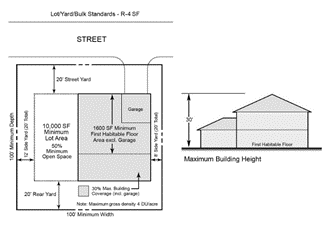
158.063 - R-4SF (Single-Family Medium-Density Residential District).
(A)
Description of District and District Policies. Established for medium-density residential development, including community residential homes with six or fewer residents plus Staff per dwelling unit, for single-family detached units only and shall be developed, redeveloped and/or maintained as stable medium-density single-family detached residential neighborhoods with a density not to exceed four dwelling units per acre. It is the intent of this district to provide sufficient acreage for medium-density residential development which will be adequately supported by existing or anticipated future public services and facilities, with the intention of preserving the stability of established residential areas. Other considerations shall include the need to preserve natural hydrologic cycles and floodplain areas to the greatest reasonable extent. In addition, Site Development Plan review of specific development proposals shall provide for smooth transitions in residential densities. Generally, medium-density areas should be located between the perimeter of low-density residential areas and areas designated for high-density residential concentrations or less restrictive nonresidential uses. Sufficient open space and landscaped screening and buffering systems shall be used to alleviate the potential adverse impacts of land use transition.
(B)
Use Regulations.
(C)
Lot, Yard, and Bulk Regulations. See table and graphic (provided for illustrative purposes) below. (Note: Also refer to Section 158.030 - Performance standards for Site Development Plans, for intensity standards, if applicable.)
a Density expressed in terms of dwelling or tourism units per acre is fractional and dependent upon lot sizes.
b In R-4SF districts all lots which existed on October 15, 1969, shall contain a minimum of 9,500 square feet of area with an average width between front and rear lines to be at least 80 feet with at least 40 feet fronting on the street.
c In the Special Canal Waterfront Yard District for all lots abutting privately owned manmade residential canals, credit shall be given for lot depth and area by measuring lot depth to the middle of the canal. Under these circumstances, the required lot depth shall be reduced to a minimum of 80 feet. For purposes of determining all other provisions of this Code, including, but not limited to, lot coverage and setbacks, the road right-of-way, mean high-water line, bulkhead and bulkhead line shall be used in accordance with this Chapter in making those determinations.
d Refer to Section 158.094(C) for waterfront yard standards.
e Minimum floor area with respect to residential, hotel, motel or other tourism uses means minimum living area of the first habitable floor, not including garage.
f Refer to Section 158.095(B)(1) for calculation of maximum building coverage for swimming pools.
g Refer to Section 158.030(E) for calculation of open space and landscaping.
(Ord. 2018-24, passed 4-1-19; Ord. 2020-14, passed 1-5-21; Ord. 2020-18, passed 1-5-21)
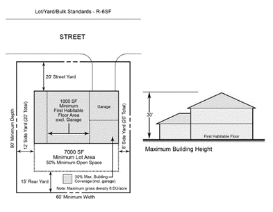
158.064 - R-6SF (Single-Family High-Density Residential District).
(A)
Description of District and District Policies. Established for high-density residential development, including community residential homes with six or fewer residents plus Staff per dwelling unit, for single-family detached dwelling units only, ranging up to a maximum of six units per acre. The high-density policy designation is intended to provide for high-density residential development which will be adequately supported by existing or anticipated public services and facilities and compatible with the surrounding area. The specific areas designated for high-density development should be developed to an intensity which is consistent with the carrying capacity of Gulf of Mexico Drive. Similarly, the site shall be provided with requisite urban services to support high density residential development. Development in the district should not be located along the narrow land corridor paralleling the dune system along the Gulf of Mexico, west of Gulf of Mexico Drive and within the highest velocity zone of hurricanes as represented in the federal flood insurance rate maps. Specific density of future development proposals within these areas shall provide for smooth transition in residential density, preserve stability of established residential areas, and shall include sufficient open space, parking and landscaping to reinforce goals and objectives for quality living areas.
(B)
Use Regulations.
(C)
Lot, Yard, and Bulk Regulations. See table and graphic (provided for illustrative purposes) below. (Note: Also refer to Section 158.102 - Performance standards for Site Development Plans, for intensity standards, if applicable.) a
a Refer to Section 158.094(A)(1) for Village study overlay standards.
b Density expressed in terms of dwelling or tourism units per acre is fractional and dependent upon lot sizes.
c Refer to Section 158.094(C) for waterfront yard standards.
d Minimum floor area with respect to residential, hotel, motel or other tourism uses means minimum living area of the first habitable floor, not including garage.
e Refer to Section 158.095(B)(1) for calculation of maximum building coverage for swimming pools.
f Refer to Section 158.030(E) for calculation of open space and landscaping.
g Charter schools are subject to administrative review, in accordance with the process set forth in F.S. § 1002.33, as may be amended.
(Ord. 2018-24, passed 4-1-19; Ord. 2020-14, passed 1-5-21; Ord. 2020-18, passed 1-5-21; Ord. 2026-01, passed 3-2-26)
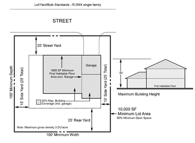
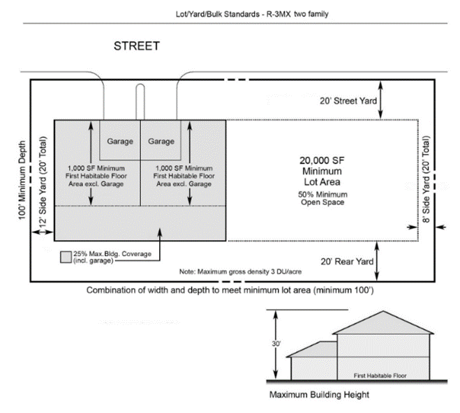
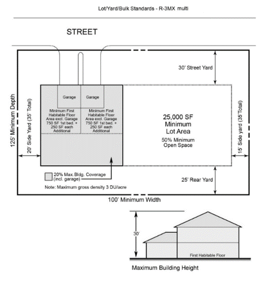
158.065 - R-3MX (Low-Medium-Density Mixed Residential District).
(A)
Description of District and District Policies. Established for low-medium-density residential development, including community residential homes, with mixed structure types and may develop with a mixture of single-family detached dwelling units as well as multiple-family dwelling units with a density not to exceed three dwelling units per acre. It is the intent of this district to provide for sufficient acreage for medium-density residential development which will be adequately supported by existing or anticipated future public services and facilities. Review of specific development densities shall be directed toward preserving stability of established residential areas. In addition, Site Development Plan review of specific development proposals shall provide for smooth transitions in residential densities. Generally, low-medium-density areas are located between the perimeter of low-density residential areas and areas designated for high-density residential concentrations or less restrictive nonresidential uses. Sufficient open space and landscaped screening and buffering systems shall be used to alleviate the potential adverse impacts of land use transition.
(B)
Use Regulations.
(C)
Lot, Yard, and Bulk Regulations. See table and graphics (provided for illustrative purposes) below. (Note: Also refer to Section 158.030 - Performance standards for Site Development Plans, for intensity standards, if applicable.) a
a Refer to Section 158.094(A)(1) for Village study overlay standards.
b Density expressed in terms of dwelling or tourism units per acre is fractional and dependent upon lot sizes.
c Refer to Section 158.094(C) for waterfront yard standards.
d Minimum floor area with respect to residential, hotel, motel or other tourism uses means minimum living area of the first habitable floor, not including garage.
e Refer to Section 158.095(B)(1) for calculation of maximum building coverage for swimming pools.
f Refer to Section 158.030(E) for calculation of open space and landscaping.
g Refer to Section 158.030(K) Supplemental controls for multifamily residential and tourism uses.
(Ord. 2018-24, passed 4-1-19; Ord. 2020-14, passed 1-5-21; Ord. 2020-18, passed 1-5-21)
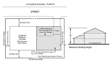
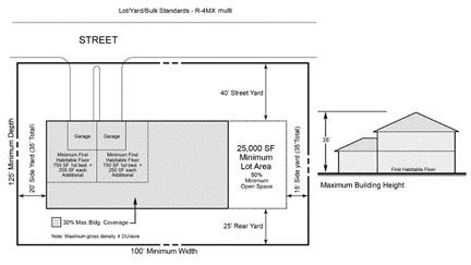
158.066 - R-4MX (Medium-Density Mixed Residential District).
(A)
Description of District and District Policies. Established for medium-density residential development, including community residential homes, with mixed structure types and may develop with detached single-family units, multiple-family units, a mixture of single-family detached dwelling units as well as multiple-family dwelling units with a density not to exceed four dwelling units per acre. It is the density residential development which will be adequately supported by existing or anticipated future public services and facilities, with the intention of preserving the stability of established residential areas. Other considerations shall include the need to [preserve natural hydrologic cycles and floodplain areas to the] greatest reasonable extent. In addition, Site Development Plan review of specific development proposals shall provide for smooth transitions in residential densities. Generally, medium-density areas should be located between the perimeter of low-density residential areas and areas designated for high-density residential concentrations or less restrictive nonresidential uses. Sufficient open space and landscaped screening and buffering systems shall be used to alleviate the potential adverse impacts of land use transition.
(B)
Use Regulations.
(C)
Lot, Yard, and Bulk Regulations. See table and graphics (provided for illustrative purposes) below. (Note: Also refer to Section 158.030 - Performance standards for Site Development Plans, for intensity standards, if applicable.)
a Density expressed in terms of dwelling or tourism units per acre is fractional and dependent upon lot sizes.
b Refer to Section 158.094(C) for waterfront yard standards.
c Minimum floor area with respect to residential, hotel, motel or other tourism uses means minimum living area of the first habitable floor, not including garage.
d Refer to Section 158.095(B)(1) for calculation of maximum building coverage for swimming pools.
e Refer to Section 158.030(E) for calculation of open space and landscaping.
f Refer to Section 158.030(K) Supplemental controls for multifamily residential and tourism uses.

(Ord. 2018-24, passed 4-1-19; Ord. 2020-14, passed 1-5-21; Ord. 2020-18, passed 1-5-21)
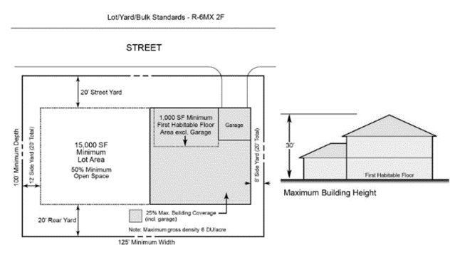
158.067 - R-6MX (High-Density Mixed Residential District).
(A)
Description of District and District Policies. Established for high-density residential development, including community residential homes, with mixed structure types and may develop with detached single-family units, multiple-family units, a mixture of single-family detached dwelling units as well as multiple-family dwelling units ranging up to a maximum of six units per acre. The high-density policy designation is intended to provide for high-density residential development which will be adequately supported by existing or anticipated public services and facilities, and compatible with the surrounding area. The specific areas designated for high-density development should be developed to an intensity which is consistent with the carrying capacity of Gulf of Mexico Drive. Similarly, the site shall be provided with requisite urban services to support high-density residential development. Development in the district shall not be located along the narrow land corridor paralleling the dune system along the Gulf of Mexico, west of Gulf of Mexico Drive and within the highest velocity zone of hurricanes as represented in the federal flood insurance rate maps, except as otherwise provided for in this Chapter. Specific density of future development proposals within these areas shall provide for smooth transition in residential density, preserve stability of established residential areas, and shall include sufficient open space, parking and landscaping to reinforce goals and objectives for quality living areas.
(B)
Use Regulations.
(C)
Lot, Yard, and Bulk Regulations. See table and graphics (provided for illustrative purposes) below. (Note: Also refer to Section 158.102 - Performance standards for Site Development Plans, for intensity standards, if applicable.)
a Density expressed in terms of dwelling or tourism units per acre is fractional and dependent upon lot sizes.
b Refer to Section 158.094(C) for waterfront yard standards.
c Minimum floor area with respect to residential, hotel, motel or other tourism uses means minimum living area of the first habitable floor, not including garage.
d Refer to Section 158.095(B)(1) for calculation of maximum building coverage for swimming pools.
e Refer to Section 158.030(F) for calculation of open space and landscaping.
f Refer to Section 158.030(L) Supplemental controls for multifamily residential and tourism uses.
g Charter schools are subject to administrative review, in accordance with the process set forth in F.S. § 1002.33, as may be amended.

(Ord. 2018-24, passed 4-1-19; Ord. 2020-14, passed 1-5-21; Ord. 2020-18, passed 1-5-21; Ord. 2026-01, passed 3-2-26)
158.068 - OI (Office-Institutional District).
(A)
Description of District and District Policies. Established for mixed land uses to accommodate development of offices, and institutional uses, including, but not limited to, banks and financial institutions. This district is intended to provide additional land development options for office and institutional land uses. Due to their generally close proximity to residential uses, these facilities shall provide a solid masonry fence and/or a berm with landscaping in order to reduce adverse impacts on adjacent residential development. The design including the material, height and screening characteristics shall satisfy sign requirements of Chapter 156 and this Zoning Code.
(B)
Use Regulations.
(C)
Lot, Yard, and Bulk Regulations. See table and graphic (provided for illustrative purposes) below. (Note: Also refer to Section 158.030 - Performance standards for Site Development Plans, for intensity standards, if applicable.) a
a Refer to Section 158.036 for Planned Unit Development (PUD) standards.
b Refer to Section 158.094(C) for waterfront yard standards.
c Refer to Section 158.095(B)(1) for calculation of maximum building coverage for swimming pools.
d Refer to Section 158.026(E) for calculation of open space and landscaping.
e Charter schools are subject to administrative review, in accordance with the process set forth in F.S. § 1002.33, as may be amended.
(Ord. 2018-24, passed 4-1-19; Ord. 2020-14, passed 1-5-21; Ord. 2020-18, passed 1-5-21; Ord. 2026-01, passed 3-2-26)
158.069 - C-1 (Limited Commercial District).
(A)
Description of District and District Policies. Established for commercial sites accessible to major thoroughfares near residential neighborhoods. Such development is intended to provide essential tourist or household services in locations highly accessible to residential areas. For instance, sites within this district are intended to accommodate neighborhood shops with limited inventory or goods as well as selected resort commercial uses. Such shops generally cater to the following markets: 1) neighborhood residential markets within the immediate vicinity as opposed to Town-wide or regional markets; 2) a specialized market with customized market demands; or 3) a tourist- or resort-oriented market in the immediate vicinity.
Areas designated for limited commercial development are not intended to accommodate large-scale retail sales, service and market. Such stores would usually differ from limited commercial shops since the former would usually require a large floor area, carry a relatively larger inventory and require a substantially greater parking area.
(B)
Use Regulations.
(C)
Lot, Yard, and Bulk Regulations. See table and graphic (provided for illustrative purposes) below. (Note: Also refer to Section 158.030 - Performance standards for Site Development Plans, for intensity standards, if applicable.) a
a Refer to Section 158.036 for Planned Unit Development (PUD) standards.
b If commercial use adjoins another commercial use or district, no side yard setback is required; however, if one is provided, it shall be 15 feet. If commercial use adjoins a residential use or district, the minimum side yard setback shall be 30 feet.
c Refer to Section 158.094(C) for waterfront yard standards.
d Refer to Section 158.095(B)(1) for calculation of maximum building coverage for swimming pools.
e Refer to Section 158.030(E) for calculation of open space and landscaping.
f Charter schools are subject to administrative review, in accordance with the process set forth in F.S. § 1002.33, as may be amended.
(Ord. 2018-24, passed 4-1-19; Ord. 2020-14, passed 1-5-21; Ord. 2020-18, passed 1-5-21; Ord. 2026-01, passed 3-2-26)
158.070 - C-2 (General Commercial District).
(A)
Description of District and District Policies. Established for purposes of accommodating general retail sales and services, including lawn and garden centers.
These areas are located in highly accessible areas adjacent to major or minor arterials which possess necessary location and market requirements. Zoning policy shall stipulate provisions for distributing various levels of shopping facilities.
The areas designated for general commercial development are specifically not adaptive to permanent residential housing, and such residential uses shall be located in other areas designated for residential development.
(B)
Use Regulations.
(C)
Lot, Yard, and Bulk Regulations. See table and graphic (provided for illustrative purposes) below. (Note: Also refer to Section 158.030 - Performance standards for Site Development Plans, for intensity standards, if applicable.) a
a Refer to Section 158.036 for Planned Unit Development (PUD) standards.
b If commercial use adjoins another commercial use or district, no side yard setback is required; however, if one is provided, it shall be 15 feet. If commercial use adjoins a residential use or district, the minimum side yard setback shall be 30 feet.
c Refer to Section 158.094(C) for waterfront yard standards.
d Refer to Section 158.095(B)(1) for calculation of maximum building coverage for swimming pools.
e Refer to Section 158.030(E) for calculation of open space and landscaping.
f Charter schools are subject to administrative review, in accordance with the process set forth in F.S. § 1002.33, as may be amended.
(Ord. 2018-24, passed 4-1-19; Ord. 2020-14, passed 1-5-21; Ord. 2020-18, passed 1-5-21; Ord. 2026-01, passed 3-2-26)
158.071 - C-3 (Highway-Oriented Commercial District).
(A)
Description of District and District Policies. Established for strategically located sites adjacent to major arterials having sufficient size, including frontage and depth, to accommodate not only the intended use but also sufficient area for implementing an efficient system of internal vehicular circulation, including consideration of space required for queuing of vehicles on-site, off-street parking and maneuvering, landscaping, screening and buffering from abutting residential development or less intensive commercial use, and efficient location and design of curb cuts.
Lands designated for highway-oriented commercial services should not be located adjacent to residential development.
(B)
Use Regulations.
(C)
Lot, Yard, and Bulk Regulations. See table and graphic (provided for illustrative purposes) below. (Note: Also refer to Section 158.030 - Performance standards for Site Development Plans, for intensity standards, if applicable.) a
a Refer to Section 158.036 for Planned Unit Development (PUD) standards.
b If commercial use adjoins another commercial use or district, no side yard setback is required; however, if one is provided, it shall be 15 feet. If commercial use adjoins a residential use or district, the minimum side yard setback shall be 30 feet.
c Refer to Section 158.094(C) for waterfront yard standards.
d Refer to Section 158.095(B)(1) for calculation of maximum building coverage for swimming pools.
e Refer to Section 158.030(E) for calculation of open space and landscaping.
f Charter schools are subject to administrative review, in accordance with the process set forth in F.S. § 1002.33, as may be amended.
(Ord. 2018-24, passed 4-1-19; Ord. 2020-14, passed 1-5-21; Ord. 2020-18, passed 1-5-21; Ord. 2026-01, passed 3-2-26)
158.072 - M-1 (Marine Commercial Services District).
(A)
Description of District and District Policies. Established for the allocation of land resources for existing and anticipated future commercial service such as marine repair and services, employee services, storage and commercial support services. Marine and commercial service areas are not adaptive to residential use.
Industry requiring a broad-based labor market, convenient access to a regional transportation system, relatively high demand for water and wastewater services, and other uniquely characteristic needs of industry, shall not be located within the barrier islands of the Town of Longboat Key. Such activities conflict with goals, objectives and policies of the Comprehensive Plan for Longboat Key and are generally inconsistent with sound planning principles and practices for managing development, redevelopment and resource conservation activities on the narrow, environmentally fragile barrier islands with substantially limited access to industrial labor, resource and product markets.
(B)
Use Regulations.
(C)
Lot, Yard, and Bulk Regulations. See table and graphic (provided for illustrative purposes) below. (Note: Also refer to Section 158.030 - Performance standards for Site Development Plans, for intensity standards, if applicable.) a
a Refer to Section 158.036 for Planned Unit Development (PUD) standards.
b If commercial use adjoins another commercial use or district, no side yard setback is required; however, if one is provided, it shall be 15 feet. If commercial use adjoins a residential use or district, the minimum side yard setback shall be 30 feet.
c Refer to Section 158.094(C) for waterfront yard standards.
d Refer to Section 158.095(B)(1) for calculation of maximum building coverage for swimming pools.
e Refer to Section 158.030(E) for calculation of open space and landscaping.
(Ord. 2018-24, passed 4-1-19; Ord. 2020-14, passed 1-5-21; Ord. 2020-18, passed 1-5-21)
158.073 - T-3 (Low-Medium-Density Tourist Resort Commercial District).
(A)
Description of District and District Policies. Established to accommodate the unique land needs for resort-oriented facilities. These facilities generally are marketed as vacation accommodations for tourists and other transients seeking an environment with a high level of amenities. The low-medium-density tourist resort commercial district is allocated to sites which shall accommodate densities not to exceed three tourist units per acre. Regulations shall be provided to minimize adverse impact on the transportation system, realizing that trip generation for transient residential facilities is generally higher than year-round accommodations. Similarly, the regulations shall provide for recreation and open space amenities on site, consistent with the purpose and intent of these districts. All commercially provided recreational activities requiring shoreline or near shore water utilization shall be concentrated at the commercial hotel facilities.
(B)
Use Regulations.
(C)
Lot, Yard, and Bulk Regulations. See table and graphics (provided for illustrative purposes) below. (Note: Also refer to Section 158.030 - Performance standards for Site Development Plans, for intensity standards, if applicable.) a
a Refer to Section 158.036 for Planned Unit Development (PUD) standards.
b Density expressed in terms of dwelling or tourism units per acre is fractional and dependent upon lot sizes.
c Refer to Section 158.094(C) for waterfront yard standards.
d Minimum floor area with respect to residential, hotel, motel or other tourism uses means minimum living area of the first habitable floor, not including garage.
e Refer to Section 158.095(B)(1) for calculation of maximum building coverage for swimming pools.
f Refer to Section 158.030(E) for calculation of open space and landscaping.
g Refer to Section 158.030(K) Supplemental controls for multifamily residential and tourism uses.
 |  |
(Ord. 2018-24, passed 4-1-19; Ord. 2020-14, passed 1-5-21; Ord. 2020-18, passed 1-5-21)
158.074 - T-6 (High-Density Tourist Resort Commercial District).
(A)
Description of District and District Policies. Established to accommodate the unique land needs for resort-oriented facilities. These facilities generally are marketed as vacation accommodations for tourists and other transients seeking an environment with a high level of amenities. The high-density tourist resort commercial district is allocated to sites which shall accommodate densities not to exceed six tourist units per acre. Regulations shall be provided to minimize adverse impact on the transportation system, realizing that trip generation for transient residential facilities is generally higher than year-round accommodations. Similarly, the regulations shall provide for recreation and open space amenities on site, consistent with the purpose and intent of these districts. All commercially provided recreational activities requiring shoreline or near shore water utilization shall be concentrated at the commercial hotel facilities.
(B)
Use Regulations.
(C)
Lot, Yard, and Bulk Regulations. See table and graphics (provided for illustrative purposes) below. (Note: Also refer to Section 158.030 - Performance standards for Site Development Plans, for intensity standards, if applicable.) a
a Refer to Section 158.036 for Planned Unit Development (PUD) standards.
b Density expressed in terms of dwelling or tourism units per acre is fractional and dependent upon lot sizes.
c Refer to Section 158.094(C) for waterfront yard standards.
d Minimum floor area with respect to residential, hotel, motel or other tourism uses means minimum living area of the first habitable floor, not including garage.
e Refer to Section 158.095(B)(1) for calculation of maximum building coverage for swimming pools.
f Refer to Section 158.030(E) for calculation of open space and landscaping.
g Refer to Section 158.030(K) Supplemental controls for multifamily residential and tourism uses.
(Ord. 2018-24, passed 4-1-19; Ord. 2020-14, passed 1-5-21; Ord. 2020-18, passed 1-5-21)
158.075 - MUC-1 (Mixed Use Community - Bay Isles District).
(A)
Description of District and District Policies. Mixed Use Community districts allow a mix of residential and nonresidential uses in planned communities developed through the Planned Unit Development procedures and standards contained in Article III, Division 7. Notwithstanding the terms of any other section of this Zoning Code related to the calculation of density for residential or tourism uses, density in each MUC district cannot exceed the overall density of tourism and dwelling units per acre established by Section 158.058 and cannot exceed any further limitations on the overall density that may be established by the Town Commission for an MUC district during the Planned Unit Development process. When computing overall density in an MUC district, all property is counted, including recreational areas, open space areas, road rights-of-way, wetland areas and other nonresidential lands. An updated land intensity schedule shall be approved with each amendment to a MUC district. Clustered development patterns are encouraged to maximize shared open spaces, thus a specific parcel or parcels within a given MUC district may be more dense than the overall density of the MUC district.
The approval of units on any parcel beyond the 892 units in MUC-2 and 1,267 units in MUC-1 authorized by resolution or ordinance prior to January 1, 2014, can be requested through the ODP/PUD process. Approval of additional units is not guaranteed, and in no case may the number of additional units cause the overall density for the entire MUC district to be exceeded.
No boundary of any existing MUC district may be expanded to include additional land.
The Town shall not use the ODP/PUD process to approve new tourism units in the MUC-2 zoning district without voter approval, unless voter approval is prohibited by applicable Florida law.
A minimum of 50 percent of the total property within each MUC district shall be maintained in open space. Acreage for recreational uses is not limited. Any changes to existing land-use patterns require approval through the ODP/PUD process and shall be in accordance with the schedule of uses in Article IV and shall meet the approval standards in Subsection 158.036(C). The general mix of uses within the boundaries of each MUC district, as calculated prior to the application of the 50 percent open space requirement, is allocated as follows:
(1)
Mixed Use Community - Bay Isles (MUC-1). This district encompasses the Bay Isles community approved by Resolution 75-27 as it has been and may be amended from time to time. Overall density within the boundaries of the MUC-1 district shall not exceed 3.26 dwelling units per acre.
(B)
Use Regulations.
(C)
Lot, Yard, and Bulk Regulations. See table and graphics (provided for illustrative purposes) below. (Note: Also refer to Section 158.030 - Performance standards for Site Development Plans, for intensity standards, if applicable.) a
a Refer to Section 158.036 for Planned Unit Development (PUD) standards.
b Density expressed in terms of dwelling or tourism units per acre is fractional and dependent upon lot sizes.
c Refer to Section 158.094(C) for waterfront yard standards.
d Minimum floor area with respect to residential, hotel, motel or other tourism uses means minimum living area of the first habitable floor, not including garage.
e Refer to Section 158.095(B)(1) for calculation of maximum building coverage for swimming pools.
f The maximum ground coverage by all buildings or structures (principal and accessory) shall be limited to 15 percent when one or more of the buildings or structures on the lot is 70 or more feet in height.
g Refer to Section 158.030(K) Supplemental controls for multifamily residential and tourism uses.

(Ord. 2018-24, passed 4-1-19; Ord. 2020-14, passed 1-5-21; Ord. 2020-18, passed 1-5-21; Ord. 2023-02, passed 3-6-23)
158.076 - MUC-2 (Mixed Used Community - Islandside District).
(A)
Description of District and District Policies. Mixed Use Community districts allow a mix of residential and nonresidential uses in planned communities developed through the Planned Unit Development procedures and standards contained in Article III, Division 7. Notwithstanding the terms of any other section of this Zoning Code related to the calculation of density for residential or tourism uses, density in each MUC district cannot exceed the overall density of tourism and dwelling units per acre established by Section 158.058 and cannot exceed any further limitations on the overall density that may be established by the Town Commission for an MUC district during the Planned Unit Development process. When computing overall density in an MUC district, all property is counted, including recreational areas, open space areas, road rights-of-way, wetland areas and other nonresidential lands. An updated land intensity schedule shall be approved with each amendment to a MUC district. Clustered development patterns are encouraged to maximize shared open spaces, thus a specific parcel or parcels within a given MUC district may be more dense than the overall density of the MUC district.
The approval of units on any parcel beyond the 892 units in MUC-2 and 1,267 units in MUC-1 authorized by resolution or ordinance prior to January 1, 2014, can be requested through the ODP/PUD process. Approval of additional units is not guaranteed, and in no case may the number of additional units cause the overall density for the entire MUC district to be exceeded.
No boundary of any existing MUC district may be expanded to include additional land.
The Town shall not use the ODP/PUD process to approve new tourism units in the MUC-2 zoning district without voter approval, unless voter approval is prohibited by applicable Florida law.
A minimum of 50 percent of the total property within each MUC district shall be maintained in open space. Acreage for recreational uses is not limited. Any changes to existing land-use patterns require approval through the ODP/PUD process and shall be in accordance with the schedule of uses in Article IV and shall meet the approval standards in Subsection 158.036(C). The general mix of uses within the boundaries of each MUC district, as calculated prior to the application of the 50 percent open space requirement, is allocated as follows:
(1)
Mixed Use Community - Islandside (MUC-2). This district encompasses the Islandside community approved by Resolution 76-7 as it has been and may be amended from time to time. Overall density within the boundaries of the MUC-2 district shall not exceed 5.05 units per acre, including tourism units.
(B)
Use Regulations.
(C)
Lot, Yard, and Bulk Regulations. See table and graphics (provided for illustrative purposes) below. (Note: Also refer to Section 158.030 - Performance standards for Site Development Plans, for intensity standards, if applicable.) a
a Refer to Section 158.036 for Planned Unit Development (PUD) standards.
b Density expressed in terms of dwelling or tourism units per acre is fractional and dependent upon lot sizes.
c Refer to Section 158.094(C) for waterfront yard standards.
d Minimum floor area with respect to residential, hotel, motel or other tourism uses means minimum living area of the first habitable floor, not including garage.
e Refer to Section 158.095(B)(1) for calculation of maximum building coverage for swimming pools.
f The maximum ground coverage by all buildings or structures (principal and accessory) shall be limited to 15 percent when one or more of the buildings or structures on the lot is 70 or more feet in height.
g Refer to Section 158.030(K) Supplemental controls for multifamily residential and tourism uses.
(Ord. 2018-24, passed 4-1-19; Ord. 2020-14, passed 1-5-21; Ord. 2020-18, passed 1-5-21)
158.077 - MUC-3 (Mixed Use Community - Promenade/Water Club District).
(A)
Description of District and District Policies. Mixed Use Community districts allow a mix of residential and nonresidential uses in planned communities developed through the Planned Unit Development procedures and standards contained in Article III, Division 7. Notwithstanding the terms of any other Section of this Zoning Code related to the calculation of density for residential or tourism uses, density in each MUC district cannot exceed the overall density of tourism and dwelling units per acre established by Section 158.058 and cannot exceed any further limitations on the overall density that may be established by the Town Commission for an MUC district during the Planned Unit Development process. When computing overall density in an MUC district, all property is counted, including recreational areas, open space areas, road rights-of-way, wetland areas and other nonresidential lands. An updated land intensity schedule shall be approved with each amendment to a MUC district. Clustered development patterns are encouraged to maximize shared open spaces, thus a specific parcel or parcels within a given MUC district may be more dense than the overall density of the MUC district.
The approval of units on any parcel beyond the 892 units in MUC-2 and 1,267 units in MUC-1 authorized by resolution or ordinance prior to January 1, 2014, can be requested through the ODP/PUD process. Approval of additional units is not guaranteed, and in no case may the number of additional units cause the overall density for the entire MUC district to be exceeded.
No boundary of any existing MUC district may be expanded to include additional land.
The Town shall not use the ODP/PUD process to approve new tourism units in the MUC-2 zoning district without voter approval, unless voter approval is prohibited by applicable Florida law.
A minimum of 50 percent of the total property within each MUC district shall be maintained in open space. Acreage for recreational uses is not limited. Any changes to existing land-use patterns require approval through the ODP/PUD process and shall be in accordance with the schedule of uses in Article IV and shall meet the approval standards in Subsection 158.036(C). The general mix of uses within the boundaries of each MUC district, as calculated prior to the application of the 50 percent open space requirement, is allocated as follows:
(1)
Mixed Use Community Promenade/Water Club (MUC-3). This district encompasses the Promenade/Water Club communities approved by Resolution 81-8, as it has been and may be amended from time to time. Overall density within the boundaries of the MUC-3 district shall not exceed 11.26 dwelling units per acre.
(B)
Use Regulations.
(C)
Lot, Yard, and Bulk Regulations. See table and graphic (provided for illustrative purposes) below. (Note: Also refer to Section 158.030 - Performance standards for Site Development Plans, for intensity standards, if applicable.) a
a Refer to Section 158.036 for Planned Unit Development (PUD) standards.
b Density expressed in terms of dwelling or tourism units per acre is fractional and dependent upon lot sizes.
c Refer to Section 158.094(C) for waterfront yard standards.
d Minimum floor area with respect to residential, hotel, motel or other tourism uses means minimum living area of the first habitable floor, not including garage.
e Refer to Section 158.095(B)(1) for calculation of maximum building coverage for swimming pools.
f The maximum ground coverage by all buildings or structures (principal and accessory) shall be limited to 15 percent when one or more of the buildings or structures on the lot is 70 or more feet in height.
g Refer to Section 158.030(K) Supplemental controls for multifamily residential and tourism uses.
(Ord. 2018-24, passed 4-1-19; Ord. 2020-14, passed 1-5-21; Ord. 2020-18, passed 1-5-21)
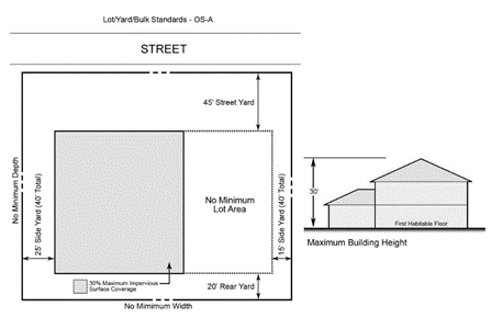
158.078 - OS-A (Open Space - Active District).
(A)
Description of District and District Policies. Open Space Active is publicly-owned or controlled open space which is designed, used or intended to be used for recreational activities by residents and visitors with on-site improvements, structures or other active, player-oriented facilities. Impervious surface coverage is limited to 30 percent of the lot or parcel.
(B)
Use Regulations.
(C)
Lot, Yard, and Bulk Regulations. See table and graphic (provided for illustrative purposes) below. (Note: Also refer to Section 158.030 - Performance standards for Site Development Plans, for intensity standards, if applicable.)
a Refer to Section 158.094(C) for waterfront yard standards.
(Ord. 2018-24, passed 4-1-19; Ord. 2020-14, passed 1-5-21; Ord. 2020-18, passed 1-5-21)
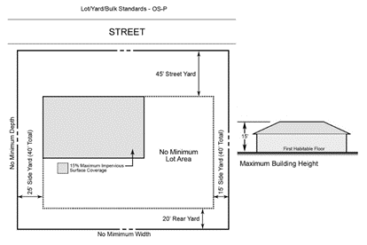
158.079 - OS-P (Open Space - Passive District).
(A)
Description of District and District Policies. Open Space - Passive is publicly-owned or controlled open space which is designed, used or intended to be used primarily for less-active leisure pursuits. Impervious surface coverage is limited to 15 percent of the lot or parcel.
(B)
Use Regulations.
(C)
Lot, Yard, and Bulk Regulations. See table and graphic (provided for illustrative purposes) below. (Note: Also refer to Section 158.030 - Performance standards for Site Development Plans, for intensity standards, if applicable.)
a Refer to Section 158.094(C) for waterfront yard standards.
(Ord. 2018-24, passed 4-1-19; Ord. 2020-14, passed 1-5-21; Ord. 2020-18, passed 1-5-21)
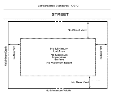
158.080 - OS-C (Open Space - Conservation District).
(A)
Description of District and District Policies. Open Space - Conservation is publicly-owned or controlled open space which is designed, used or intended to be used for the protection and management of natural areas or archaeological sites. These areas shall remain in their natural state with little or no disturbance. Structures are limited to improvements such as boardwalks, permeable pathways and signage necessary for conservation management, limited public access and resource related educational activities.
(B)
Use Regulations.
(C)
Lot, Yard, and Bulk Regulations. See table and graphic (provided for illustrative purposes) below. (Note: Also refer to Section 158.030 - Performance standards for Site Development Plans, for intensity standards, if applicable.)
a Refer to Section 158.094(C) for waterfront yard standards.
(Ord. 2018-24, passed 4-1-19; Ord. 2020-14, passed 1-5-21; Ord. 2020-18, passed 1-5-21)
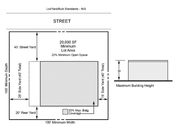
158.081 - INS (Community Facility Institutional District).
(A)
Description of District and District Policies. Established for lands accommodating public and semipublic facilities. Public facilities and utilities will be located to best maximize the efficiency of services provided, minimize costs, and minimize impacts on the natural environment.
(B)
Use Regulations.
(C)
Lot, Yard, and Bulk Regulations. See table and graphic (provided for illustrative purposes) below. (Note: Also refer to Section 158.030 - Performance standards for Site Development Plans, for intensity standards, if applicable.) a
a Refer to Section 158.036 for Planned Unit Development (PUD) standards.
b Refer to Section 158.094(C) for waterfront yard standards.
c Refer to Section 158.095(B)(1) for calculation of maximum building coverage for swimming pools.
d Refer to Section 158.030(F) for calculation of open space and landscaping.
e Charter schools are subject to administrative review, in accordance with the process set forth in F.S. § 1002.33, as may be amended.
(Ord. 2018-24, passed 4-1-19; Ord. 2020-14, passed 1-5-21; Ord. 2020-18, passed 1-5-21; Ord. 2026-01, passed 3-2-26)
158.082 - Overview of Conformance Overlay Redevelopment District (CORD).
(A)
Intent. The provisions of this zoning overlay district are intended to apply to existing residential, tourism, or mixed use projects that were legally established prior to March 12, 1984, which do not comply with the existing maximum density provisions of the Comprehensive Plan. The intent of the Conformance Overlay Redevelopment District (CORD) zoning district is to function as a zoning overlay district, which can modify or adjust underlying zone district standards to allow the redevelopment of these properties consistent with the standards of this Section. The overlay is intended to preserve the nonconforming density of these projects and enable such projects to rezone to become conforming, while providing for flexibility of design. The potential design flexibility is provided in order to achieve improved conformance with underlying zone district requirements and to encourage imaginative, functional, high-quality land planning developments compatible with adjacent and nearby lands and activities, in keeping with the low density character of the Town. Additionally, the overlay provides for flexibility to apply creative and innovative approaches and design to address challenges related to changing markets, building trends, and environmental conditions, while remaining compatible with the overall character of the island. Overall these developments should reduce or eliminate nonconformities, especially gulf and pass waterfront yard setbacks, to the greatest extent possible. Redevelopment proposed under the overlay Zoning Map Amendment process shall not be subject to any conflicting Redevelopment Standards, however, the proposed development must demonstrate that the standards proposed will enable a development that is superior to a development that could be permitted under standard zoning or that represents a significant improvement over existing nonconforming conditions. Properties approved under the Outline Development Plan process of Article III, Division 7 of this Chapter are not superseded or considered nonconforming by the provisions of this Section.
(Ord. 2018-24, passed 4-1-19)
158.083 - Uses Permitted.
The principal and accessory uses that are allowed are those that are permitted in the appropriate underlying zoning district as described in the Schedule of use regulations in Article IV.
In addition, the overlay permits the replacement of any legally established, by March 12, 1984, principal or accessory use that is not currently conforming to the applicable Future Land Use designation of the Comprehensive Plan without regard to the Redevelopment Standards of Section 158.132.
(Ord. 2018-24, passed 4-1-19)
158.084 - Procedures for Approval.
(A)
In General. The steps to request a change in zoning to the CORD will follow the requirements for a Zoning Map Amendment. A CORD Zoning Map Amendment shall be accompanied by an associated Site Development Plan that is simultaneously approved by the Town Commission. Applications for a change in zoning to CORD shall be filed and reviewed concurrently with a requested Future Land Use Map Amendment. If a referendum is required to increase density pursuant to the Town Charter, a formal application for a CORD Zoning Map Amendment and Site Development Plan may not be submitted until such referendum for the increase has been approved. Approval of a referendum for increased density is merely permission for consideration of an application and does not guarantee approval of a density increase through the CORD Zoning Map Amendment process. A CORD Zoning Map Amendment may also be allowed to include additional property(ies) that are combined with legally nonconforming density properties, when developed as a unified Site Development Plan.
(B)
Pre-Application Conference. A pre-application conference with the Planning and Zoning Official, or designee, is required, at which time the request will be reviewed for eligibility to apply for the CORD zoning designation consistent with the standards of this Section and with the provisions of the Comprehensive Plan. For the pre-application conference, Applicants must specify in writing the existing and proposed uses and the existing and proposed density and intensity of the development, as well as any other necessary information as determined by the Planning and Zoning Official to determine eligibility to apply for a change in zoning to CORD. Applications will not be processed unless they are determined by the Planning and Zoning Official, or designee, to be eligible to apply for the CORD zoning designation.
(C)
Neighborhood Information Meeting. Prior to submittal of the application by the Planning and Zoning Board, the Applicant shall hold a neighborhood information meeting with property owners and interested community members within 200 feet of the proposed development. The meeting must be held within the Town at a location and time convenient to the surrounding property owners to maximize attendance, subject to the following requirements:
(1)
Notification. Two weeks prior to the meeting date, the Applicant shall mail notices of the meeting date, time, and place to all property owners within a radius of 200 feet from the boundary of the proposed development and shall post the property. The Applicant shall inform the Planning and Zoning Official of the proposed meeting date and time prior to sending out the notices. Documentation of the mailed notice shall be provided to the Planning and Zoning Official for verification.
(2)
Applicant's Presentation. At the meeting, the Applicant shall explain the proposed use of the subject property and make a copy of the proposed concept plan available for review by attendees. The Applicant may also discuss the project's development objectives, design philosophy and proposed schedule for completion.
(3)
Question and Answer Period. Upon completion of the presentation, time shall be reserved for a question and answer period. Questions should be limited to the proposal as presented, not to the question of whether the site should be developed or redeveloped. The Applicant shall identify how potential community concerns will be mitigated. Meeting notes, prepared by the Applicant or representative, shall be taken of items covered and questions raised and responses provided at the meeting. Meeting notes will be required to be included in the formal application submittal.
(D)
Formal Application. The application for a CORD shall be filed with the Planning and Zoning Official and follow the procedures for Zoning Map Amendments. An application for Site Development Plan approval for the CORD shall be filed and reviewed concurrently with the CORD application. The application for Site Development Plan approval shall be processed in accordance with Article III, Division 5 of this Chapter. Upon receipt of the application the Planning and Zoning Official shall review the application to determine its appropriateness and completeness in respect to the requirements of this Section, and accept or reject it in writing. Upon acceptance of the application, the Town's administrative Staff shall refer the application, together with all supporting documentation and a Staff report, including findings of fact as to the consistency of the application with the Land Development Code and the Comprehensive Plan, to the Planning and Zoning Board for its review and recommendations. The Planning and Zoning Board and Town Commission shall not receive, review, make recommendations or act on applications for CORD approval except during the Town's annual Site Development Plan season. During the review process, the Town may retain consultants to assist in the review. The cost of retaining the consultants shall be borne by the Applicant. For purposes of this Chapter, the annual Site Development Plan cycle shall be September through June of the following year. For purposes of calculating the required processing times set forth in this Section for the Planning and Zoning Board and the Town Commission, the period of time from July 1 through August 31 shall not be counted in said computation.
(E)
Planning and Zoning Board Public Hearing. Upon receipt of the application from the Planning and Zoning Official, the Planning and Zoning Board shall, in a quasi-judicial proceeding, review the CORD application and make recommendations to the Town Commission that are based on competent, substantial evidence of record. The Planning and Zoning Board may also formulate findings of fact as to the consistency of the application with the Land Development Code and with the Comprehensive Plan. The Planning and Zoning Board shall recommend approval of the application as submitted, approval of the application with changes or special conditions, or denial of the application. The determination and recommendations of the Planning and Zoning Board shall be advisory only and shall not be binding upon the Town Commission. For purposes of this Section, the Planning and Zoning Board shall receive the application from the Planning and Zoning Official at the board's next regular meeting where a quorum is present following the Planning and Zoning Official's submittal of the application to the board. The Planning and Zoning Board is specifically authorized to continue its deliberations, reasonably request additional relevant materials, and elicit expert testimony to aid in its deliberations.
(F)
Town Commission Public Hearing. A public hearing on the CORD application, conducted as a quasi-judicial proceeding, shall be held by the Town Commission upon the Commission's receipt of the application from the Planning and Zoning Board. Public notice of such hearing shall be given in accordance with the provisions of applicable Florida Statutes, the Town Charter and this Chapter. For purposes of this Section, the Town Commission shall receive an application from the Planning and Zoning Board at the Commission's next regular meeting where a quorum is present, following the submittal of the Planning and Zoning Board's action on the application to the Town Commission. A transcript of the hearing may be caused to be made by the Town Commission at the cost of the Applicant, copies of which shall be made available at cost to any party to the proceedings; and all exhibits accepted in evidence shall be identified and duly preserved, or, if not accepted in evidence, shall be properly identified and the reason for the exclusion clearly noted in the record. The Town Commission is specifically authorized to continue its deliberations, request additional materials, and elicit expert testimony to aid in its deliberations, and may, at its sole discretion, remand the application to the Planning and Zoning Board for additional hearing and consideration. If changes are made to the application, accompanying plans or conditions of approval after review by the Planning and Zoning Board, the Town Commission may, at its sole discretion, remand the application back to the Planning and Zoning Board, but is not required to do so.
(G)
Town Commission Decision Procedures. At the conclusion of the public hearing, the Town Commission shall review the CORD application and either approve it as submitted, approve it with changes or special conditions, or deny it. The Applicant may request that the application be withdrawn or that the hearing be continued if the Applicant does not accept the changes or special conditions recommended by the Town Commission. The action taken by the Town Commission shall be by ordinance. The Town Commission may unilaterally extend the time for final action where the Town Commission determines additional time is necessary to properly and completely review the CORD overlay application.
(1)
In the event approval is granted, the Town Commission shall, as part of its ordinance, specify the drawings, plan sheets, renderings, specifications, and form of performance and maintenance bonds that shall be considered part of the final approval.
(2)
In the event a CORD is granted approval, the Town Commission shall set forth in the ordinance the time within which an application for Final Site Development Plan approval, or applications in the case of a phased development, shall be filed. However, if a Final Site Development Plan for the entire CORD overlay was approved concurrently with the CORD overlay, the ordinance does not need to specify a time period.
(H)
Filing with the Town Clerk. Within seven days after the adoption of the ordinance provided for in Subsection (G) above, it shall be certified by the Town Clerk, and shall be filed in the Clerk's office, and a certified copy shall be mailed to the Applicant. A CORD overlay upon approval and acceptance, as provided herein, shall be depicted on the Town Official Zoning Map and is defined as running with the land; however, an Applicant may apply for a revision to the Site Development Plan in accordance with the Site Development Plan procedures. Any changes or amendments to an approved Site Development Plan, not determined to be minor development proposals, shall require a resubmission in accordance with the provisions of this Section. Immediately following expiration of the 30-day appeal period and upon successful resolution of any appeals, if applicable, the Town Clerk shall file with the Clerk of the Circuit Court the concept plan to record it in the official records of the county in which the property is located at the cost of the Applicant.
(Ord. 2018-24, passed 4-1-19)
158.085 - CORD Zoning Development Standards.
(A)
A CORD shall be permitted only upon an order of the Town Commission approving the CORD, with a Site Development Plan, and any site specific development standards, as may be modified or adjusted by the Town Commission due to an Applicant's demonstration of applicable site constraints or economic or market related demands below, in conformance with this Section. However, prior existing nonconformities shall be eliminated to the greatest extent possible. In considering such a request, the Town Commission shall also consider the nature and character of development in the surrounding area, and the impact thereon, in determining whether, or the extent to which, these development standards may be modified.
No CORD shall be approved unless it complies with the following standards listed below in order of importance, highest to lowest, such that the control with the highest importance is the control with the greatest need for reduction or elimination of any nonconformities (and least likely of relaxation or modification) and the control with lower importance has a lesser need for reduction or elimination (and more likely of relaxation or modification):
(1)
Building Setbacks. The proposed minimum side, rear, and waterfront building setbacks, as measured from the boundaries of the CORD request, shall to the greatest extent possible conform with the setbacks allowed by the underlying zone district from the existing non-conforming development condition. For any buildings that would exceed the underlying zone district height, each building must have a minimum street setback of at least 2.5 times the overall height of the building, with a vegetative street buffer with sufficient density and height to minimize the visibility of the buildings from the right-of-way. Waivers to this required street setback may be granted if the Town Commission determines that the Waiver is necessary to meet the intent of the Comprehensive Plan and this Chapter to enable redevelopment of properties that are nonconforming to density and is in the public interest.
(2)
Open space. The open space of the property proposed for Zoning Map Amendment shall conform to the greatest extent possible to the open space permitted in the underlying zoning district from the existing nonconforming development condition. However, open space shall not be less than 20 percent of the lot area.
(3)
Lot Coverage. The lot coverage of the property proposed for Zoning Map Amendment shall conform to the greatest extent possible to the lot coverage permitted in the underlying zoning district from the existing nonconforming development condition.
(4)
Building Height. The height of structure(s) on property proposed for Zoning Map Amendment to the CORD shall conform to the greatest extent possible to the height of the underlying zone district, in which the property is located, subject to the following:
(a)
For properties with existing structures that are at or below the allowable height of the underlying zone district, the maximum height shall be the height allowed by the underlying zone district.
(b)
For properties with existing structure(s) that exceed the allowable height of the underlying zone district, the Town Commission may approve Waivers allowing for height(s) above the maximum height of the underlying zone district, provided that proposed height(s) represent a decrease in nonconforming height. The Applicant shall demonstrate how reduction(s) in height on the property, to the greatest extent possible, will be more in conformity with the zone district standards than the prior nonconforming height(s).
(5)
Maximum building length, distance between buildings, and distance between buildings and driveways. These development criteria may be modified to allow redevelopment of existing nonconforming structures, but shall not be reduced in a manner that jeopardizes public safety.
(6)
Off-Street Parking. Off-street parking shall meet the standards and requirements of the parking Section of the Land Development Code. The Town Commission may reduce the number of required parking spaces upon submittal by the Applicant of a parking study demonstrating a reduction in parking need. The parking study shall be based on competent, substantial evidence which may include, but is not limited to, utilization of professional standards, formulas or studies from sources such as the Urban Land Institute (ULI), the Institute of Transportation Engineers (ITE), or similar organizations.
(7)
Beach and Bay Access. For all proposed CORD overlays the number of existing beach and/or bay access points shall not be decreased below the number existing at the time of the CORD overlay application. All public beach and/or bay access points shall be recorded as easements in the public record and copies provided to the Town Clerk.
(8)
Natural Shoreline. For proposed CORD overlays located west of Gulf of Mexico Drive, the same percentage of natural shoreline area as a percentage of the total shoreline as it exists at the time of CORD application shall be preserved or provided.
(9)
Development of Amenities and Tourism Units. Amenities such as parks, open space, playgrounds, pools, marinas, docks, beach and Bay accesses, and tennis/pickle-ball courts must be completed prior to issuance of Building Permits of more than 40 percent of the total number of authorized residential or tourism units. For mixed-use developments, all proposed tourism units must be completed prior to the issuance of any certificates of occupancy for any residential unit.
(10)
Cubic Content. Redevelopment utilizing the CORD does not restrict the cubic content of structures to the prior extent of previously existing structures.
(11)
Density. The proposed density shall not exceed the total density allowed by the underlying zoning district of the property proposed for Zoning Map Amendment to CORD, or the density of the existing nonconforming development that is proposed for redevelopment. Owners may elect to reduce the number of nonconforming units in order to achieve compliance with the CORD development standards. If a referendum is required to increase density pursuant to the Town Charter, a formal application for a CORD Zoning Map Amendment and Site Development Plan may not be submitted until such referendum for the increase has been approved. Approval of a referendum for increased density is merely permission for consideration of an application and does not guarantee approval of a density increase through the CORD Zoning Map Amendment process.
(Ord. 2018-24, passed 4-1-19)
158.086 - Application Contents and Submittal Requirements.
An application for CORD shall be accompanied by a Site Development Plan as required in Article III, Division 5.
(Ord. 2018-24, passed 4-1-19)
158.087 - Review Criteria.
(A)
Review Criteria. The Planning and Zoning Board in its recommendation, and the Town Commission in its decision shall base its decision on each CORD application on competent, substantial evidence of record and shall include conclusions but may also include written findings of fact related to the specific proposal and shall set forth the reasons for the grant of approval, with or without changes or special conditions, or for the denial of a CORD application. The Town Commission's approval, approval with changes or special conditions, or denial of a CORD application, shall be based on the application, evidence and testimony presented in the public hearing, and all of the following standards for review:
(1)
In what respects the CORD is or is not consistent with the intent of a CORD zoning district as provided in this Section.
(2)
Whether the proposed request decreases existing nonconforming characteristics to the greatest extent possible.
(3)
The adequacy, location and amount of open space in the plan.
(4)
Whether the proposed request is compatible with surrounding properties and is consistent with the character of the surrounding area.
(5)
Whether the proposed placement of the building allows for improved scenic views from adjacent properties and/or opens scenic view corridors from the street.
(6)
Whether the proposed request will cause an increase or decrease in shadow effects on surrounding properties, the street, and the public beach, if applicable for building heights greater than underlying zone district standards.
(7)
Whether the existing or proposed vegetative street buffer is sufficient to minimize the mass and scale of the building from the right-of-way.
(8)
The physical design of the plan and the manner in which the design makes adequate provision for public services, provides adequate control over vehicular traffic and parking, and addresses the amenities of light and air, recreation and visual enjoyment.
(9)
For phased developments, the plan must provide sufficient safeguards to protect the public interest, and the residents and owners of the CORD through the completion of the project.
(10)
Whether the proposed development is not contrary to the interests of the Town and/or does not adversely impact or affect the public interest.
(Ord. 2018-24, passed 4-1-19)
158.088 - Effect of Approval.
Effect of Approval. Approval of a CORD Zoning Map Amendment and Site Development Plan does not convey any rights for development. Development may only occur after approval of a Final Site Development Plan, subdivision, and/or other development approvals and permits, as applicable, consistent with the approved concept plan, the Land Development Code, and the Comprehensive Plan.
(A)
Notwithstanding the 24-month period specified in Subsection 158.029(E), Final Site Development Plan approval for a CORD runs with the land for a period not to exceed four calendar years from the date of the ordinance adopting the Final Site Development Plan.
(Ord. 2018-24, passed 4-1-19)