
Longmont City Zoning Code
CHAPTER 15
03. - ZONING DISTRICTS
Sec. 15.03.010. - Districts established.
Zoning districts are established as shown in Table 15.03.010.
A.
Official zoning map. The official zoning map shall be designated and maintained pursuant to section 15.01.060.
B.
Organization of the zoning districts in this chapter.
1.
Base zoning districts.
a.
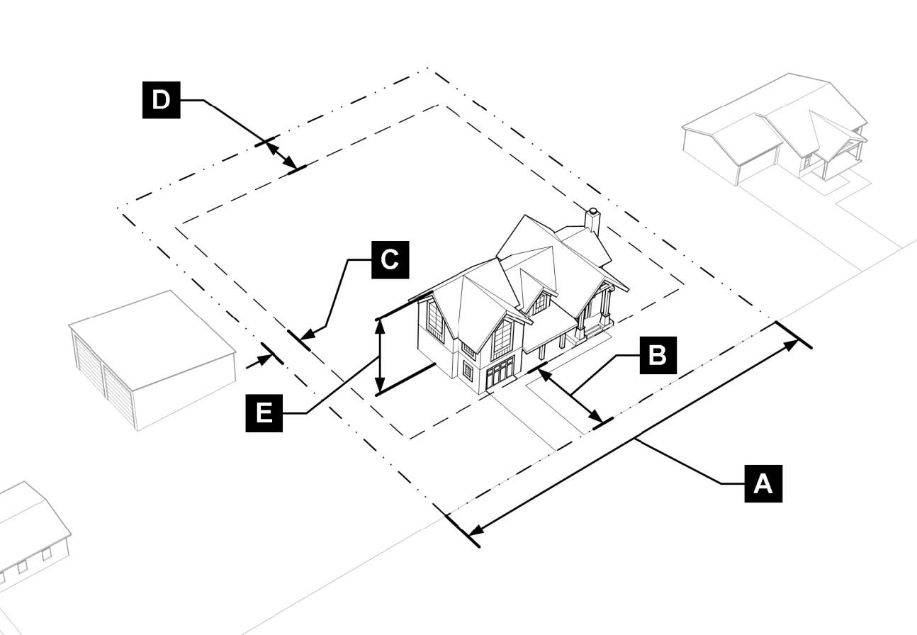
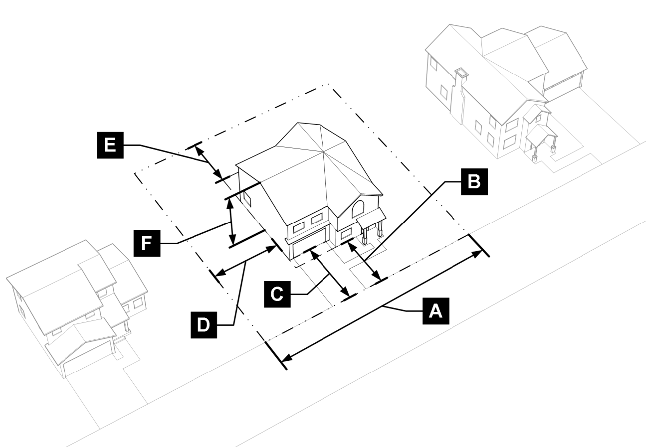
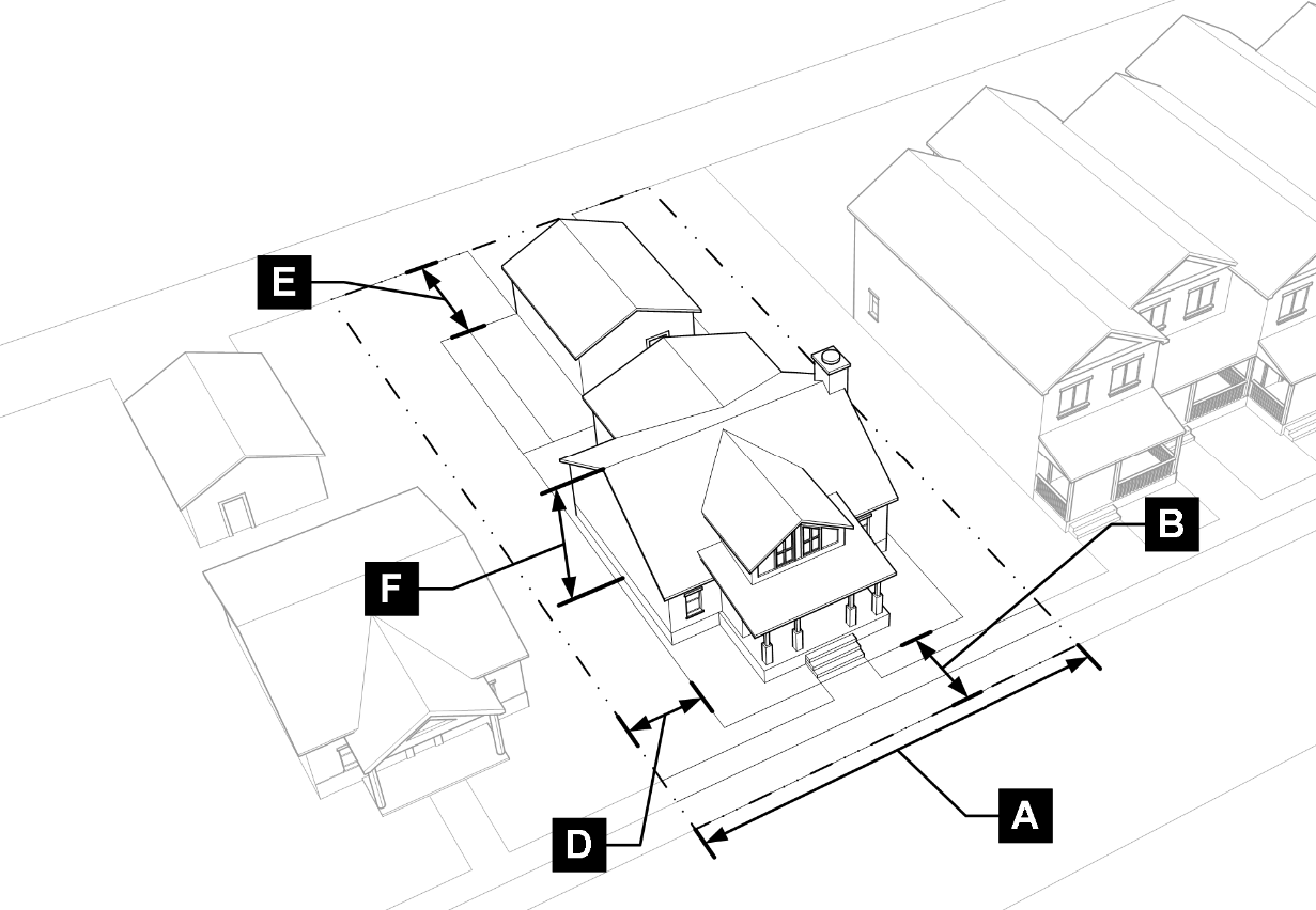
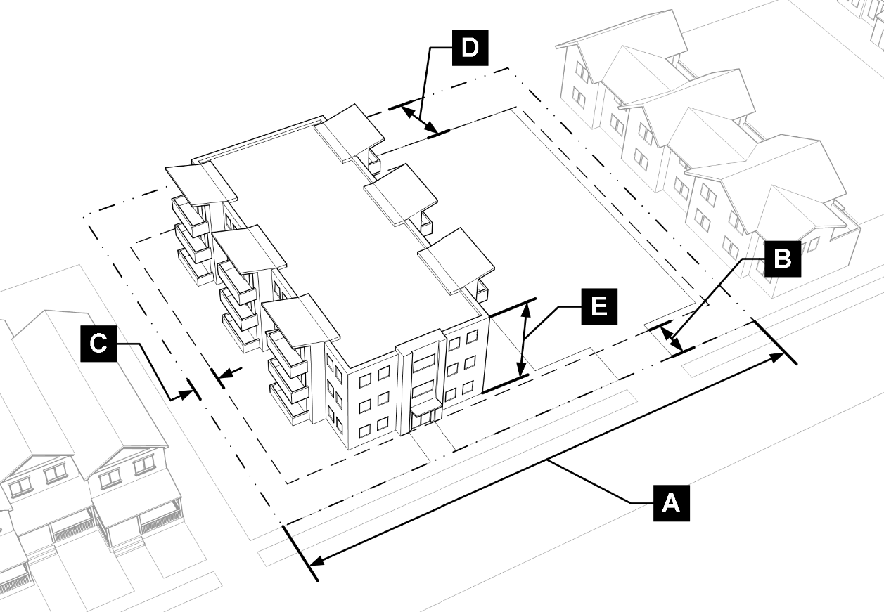
Sections 15.03.020 through 15.03.040 follow a common structure for describing the purpose and intent for each base zoning district, the respective dimensional standards, and any district-specific standards.
b.
Each base zoning district includes an illustration demonstrating the applicable dimensional standards for that district.
c.
Each base zoning district includes a summary table of dimensional standards. The labels in the table correspond to the applicable illustration. The tables may not identify all standards that may apply to a development. Where two standards are listed for a particular dimension, both shall apply.
2.
Overlay districts.
a.
An overlay district is superimposed over one or more underlying base or planned unit development zoning districts.
b.
Section 15.03.050 identifies the overlay districts and sets forth each district's purpose and the standards that modify the underlying districts.
c.
Overlay districts are established initially by the city's adoption of the official zoning map and subsequently by the approval of a rezoning pursuant to section 15.02.060.F.
3.
Planned unit developments. The planned unit development district in section 15.03.060 describes the applicable standards for that district. Evaluation of planned unit developments shall be pursuant to section 15.02.060.G.
(Code 2009, § 15.03.010)
Sec. 15.03.020. - Residential districts.
A.
General purpose of residential districts. Residential zoning districts are established, designed, and intended to provide a comfortable, healthy, safe and pleasant environment in which to live and to:
1.
Ensure adequate light, air, privacy, and open space for residents;
2.
Provide for a variety of neighborhoods with a range of housing types to accommodate varying character areas;
3.
Protect neighborhoods from the harmful effects of excessive noise, traffic congestion, and other potential adverse impacts;
4.
Provide amenities while protecting residents from incompatible uses and activities;
5.
Provide reasonable flexibility and a variety of uses compatible with the general character of each zoning district; and
6.
Allow and encourage the development of affordable housing.
B.
Residential rural (R-RU).
1.
Purpose. The purpose of the R-RU district is to establish and preserve residential districts where larger lots are desirable near agricultural and open space preservation areas or other environmentally sensitive areas. The district is primarily comprised of single-family detached dwellings on large lots and is generally concentrated in areas farther from primary employment or activity centers or located near the edge of the community providing opportunities for ex-urban or rural lifestyles.
2.
R-RU district dimensional standards.
C.
Residential single-family (R-SF).
1.
Purpose. The purpose of the R-SF district is to establish and preserve residential neighborhoods with primarily single-family detached dwellings on medium to larger lots. The district is intended to be located in proximity to activity centers and other public amenities or complementary uses and activities such as schools, parks, and open space.
2.
R-SF district dimensional standards.
D.
Residential mixed neighborhood (R-MN).
1.
Purpose. The purpose of the R-MN district is to establish and preserve mixed-density residential neighborhoods to accommodate a variety of housing types, including detached and smaller scale attached dwellings. This district may also include limited nonresidential uses that support the neighborhood pursuant to table 15.04.020. This district is intended to be conveniently located near collector and arterial streets, and in close proximity to activity centers and other public amenities and/or complementary uses and activities such as schools, parks, open space, and public transit. The R-MN district can also serve as a transition from single-family neighborhoods to multifamily residential, mixed-use, and nonresidential areas.
2.
R-MN district dimensional standards.
E.
Residential multifamily (R-MF).
1.
Purpose. The purpose of the R-MF district is to establish and preserve residential districts that are appropriate for multifamily housing and group living facilities. The R-MF district is intended to be conveniently located near collector and arterial streets, with easy access to major employment and activity centers, and public amenities or complementary uses and activities such as schools, parks, open space, and public transit. The R-MF district is primarily intended for residential uses but may also include limited nonresidential uses that support the surrounding area pursuant to table 15.04.020.
2.
R-MF district dimensional standards.
F.
Residential mobile home (R-MH).
1.
Purpose. The purpose of the R-MH district is to establish and preserve areas for mobile homes and to encourage other affordable housing options in the city. The R-MH district is intended to be conveniently located near collector and arterial streets, with easy access to major employment and activity centers, and public amenities or complementary uses and activities such as schools, parks, open space, and public transit.
2.
R-MH district dimensional standards.
(Code 2009, § 15.03.020; Ord. No. O-2025-83, § 3, 12-16-2025)
Sec. 15.03.030. - Mixed-use districts.
A.
General purpose of mixed-use districts. Mixed-use zoning districts are established, designed, and intended to provide a wide range of services and goods to meet household and business needs and also to accommodate and encourage a mix of residential and nonresidential uses to offer greater opportunities to live, work, and play within close proximity. More specifically, the mixed-use districts are intended to:
1.
Provide areas for a full range of office, retail, and service uses;
2.
Strengthen the city's economic base and expand employment opportunities;
3.
Minimize the impacts of nonresidential uses on adjacent or nearby residential districts and uses;
4.
Ensure that commercial and mixed-use development is consistent with the character areas throughout the city; and
5.
Allow and encourage the development of affordable housing.
B.
Mixed-use neighborhood (MU-N).
1.
Purpose. The purpose of the MU-N district is to provide a pedestrian-friendly mix of attached residential and smaller moderate-scale nonresidential uses and activities to serve the residents of surrounding neighborhoods with minimal impact to those neighborhoods. The MU-N district is intended to provide easy access to public amenities or complementary uses and activities such as schools, parks, open space, and public transit and may serve as a transition between established single-family neighborhoods and more intensive corridors, activity centers, or employment areas.
2.
MU-N district dimensional standards.
C.
Mixed-use corridor (MU-C).
1.
Purpose. The purpose of the MU-C district is to establish and preserve areas for a wide range of uses including attached residential, professional office, and general commercial goods and services that serve city residents and businesses, as well as complementary uses to support travelers. The MU-C district is intended to be conveniently located along primary corridors in the city with easy access to public transit and other amenities, with a focus on vertical integration of residential and nonresidential uses. The MU-C district supports a variety of residential and nonresidential uses subject to compatibility with surrounding neighborhoods in terms of scale and bulk, and appropriate mitigation of other potential adverse impacts on adjacent residential uses.
2.
MU-C District dimensional standards.
D.
Mixed-use downtown (MU-D).
1.
Purpose. The purpose of the MU-D district is to establish and preserve downtown Longmont as the city's center, accommodating a unique mix of office, service, retail, entertainment, and cultural facilities, with supportive government, civic, and residential uses and amenities. The MU-D district is intended to encourage protection of the historic character of the downtown through preservation, rehabilitation, and adaptive reuse of historic structures. The MU-D district is well-served by transit and is intended to encourage pedestrian-friendly development and redevelopment with easy access to public amenities and in a manner compatible with the existing and historic built environment and with nearby residential areas.
2.
MU-D district dimensional standards.
E.
Mixed-use employment (MU-E).
1.
Purpose. The purpose of the MU-E district is to provide areas appropriate for diverse employment by encouraging a greater variety of employment spaces in close proximity to attached residential and supporting services. The MU-E district offers flexibility in terms of the types of uses and the adaptive reuse of existing buildings to promote employment and live-work opportunities, as well as multifamily residential uses. The MU-E district is intended to accommodate a wide range of business opportunities in a pedestrian-friendly environment with easy access to public amenities, including parks, open space, and public transit.
2.
MU-E district dimensional standards.
F.
Mixed-use regional center (MU-R).
1.
Purpose. The purpose of the MU-R district is to establish and preserve distinct areas for large-scale mixed-use development and redevelopment with an emphasis on serving the commercial and retail needs of the city and the region. The MU-R district allows for pedestrian-friendly regional-scale employment, commercial activities, and multifamily residential uses with easy access to public amenities, including public transit.
2.
MU-R district dimensional standards.
(Code 2009, § 15.03.030)
Sec. 15.03.040. - Nonresidential districts.
A.
Primary employment (N-PE).
1.
Purpose. The purpose of the N-PE district is to establish areas for a wide range of employment uses, including manufacturing, industrial processing, research and development, warehousing and wholesaling, office-flex, and large employment facilities such as those in a planned office campus or headquarters development. The N-PE zoning district also accommodates limited supporting commercial uses as a means to support daily needs of employees within the district.
2.
N-PE district dimensional standards.
B.
Agricultural (N-AG).
1.
Purpose. The purpose of the N-AG district is to establish and preserve areas in the city for agricultural lands, rural residential, open space, and other related uses. The N-AG district is characterized by open areas of land, large planted areas, and detached residential uses surrounding more densely populated rural and urbanized areas of the community.
2.
N-AG district dimensional standards.
C.
Public facilities (N-PF).
1.
Purpose. The purpose of the N-PF district is to establish and preserve areas in the city for public, quasi-public, and limited private facilities and uses. The N-PF district can be used to protect the scenic and environmental quality of sensitive natural areas and also essential services or activities for the city such as active and passive recreational uses, with flexibility to accommodate unique operational and site characteristics.
2.
N-PF district dimensional standards.
(Code 2009, § 15.03.040)
Sec. 15.03.050. - Overlay zoning districts.
A.
Airport influence overlay (AI-O).
1.
Purpose. The purpose of the AI-O district is to:
a.
Allow the airport to serve the city's air transportation needs and protect the public investment in the airport;
b.
Minimize risks to public safety and hazards to airport users;
c.
Protect property values and restrict incompatible land use; and
d.
Promote appropriate land use planning and zoning in proximity to the airport.
2.
Applicability. The AI-O district is intended to regulate the following:
a.
The construction or establishment of any new building or use;
b.
The addition or expansion to an existing structure, when such addition is greater than 1,000 square feet or ten percent of the structure area or massing;
c.
The moving or relocation of any building or structure to a new site or new location; and
d.
The change from one use to another of any building, structure or land.
3.
Conflicting provisions. If the regulations stated in this section conflict with any other chapter or section of this development code, or with any other applicable land development regulation, the regulations in this section shall apply.
4.
Site plan or development plan review required. A site plan is required for all applicable development to ensure compliance with this section's regulations. See section 15.02.070.C for applicable site plan review procedures.
5.
District standards. The following standards shall apply to all property within the AI overlay district:
a.
Use restrictions. No use shall create any electrical interference with navigational signals for communications between the airport and the aircraft, make it difficult for pilots to distinguish airport lights from others, result in glare for pilots using the airport, impair visibility in the vicinity of the airport or otherwise in any way create a hazard or endanger the landing, take-off, or maneuvering of aircraft using the airport.
b.
Height limitations. No structure or object of natural growth shall be erected, altered, allowed to grow, or be maintained at a height that intrudes into the 14 CFR part 77 surfaces for the Vance Brand Airport.
c.
Nonconforming uses; hazard marking and lighting. The owner of any existing nonconforming structure or object of natural growth shall permit the installation, operation, and maintenance of markers and/or lights as shall be deemed necessary by the airport manager, to identify the presence of airport hazards.
d.
Other uses; hazard marking and lighting. Any building permit or development application approval granted may include conditions that require the owner to install, operate, and maintain markers and lights on structures or objects of natural growth as may be necessary to identify the presence of airport hazards.
e.
No permits if hazard will be created or intensified. No permit shall be granted that would allow an existing use to become a hazard or a greater hazard to air navigation.
f.
Procedure when nonconforming uses are abandoned or destroyed. Whenever the director determines that a nonconforming structure has been abandoned for a period of 180 consecutive days or has physically deteriorated, as defined in the adopted building code, no permit shall be granted that would allow such structure to deviate from the regulations of this section, except that the city may grant a permit for demolition and removal of the nonconforming structure.
B.
Conservation overlay (C-O).
1.
Purpose. To conserve residential neighborhoods and areas in the city that retain the character of periods of development, to stabilize and improve property values in such areas, and to promote new construction that is compatible with the character of such areas. These requirements will overlay or supplement the applicable standards found in the underlying zoning districts, while not affecting permitted uses.
2.
Minimum criteria for designation of a C-O District. The following shall be the minimum standards and requirements for zoning an area as a C-O district:
a.
At least 75 percent of the land area within the proposed district, not including streets and other rights-of-way, is developed.
b.
Prior to an application submittal to rezone an area to a C-O district, the applicant shall submit one of the following:
i.
A letter from a registered neighborhood group requesting the C-O district zoning for all properties within the proposed district; or
ii.
For areas without a registered neighborhood group, written evidence that more than 50 percent of the owners of properties within the proposed district agree to the C-O district zoning.
3.
Findings required. In addition to compliance with the review criteria for rezonings stated in section 15.02.050.H, the city council may zone an area as a C-O district only if the area meets the minimum criteria stated in subsection B.2 of this section and the city council finds that:
a.
The district retains the general character and appearance of its original period of development;
b.
The district evidences on-going maintenance of existing buildings or there is potential for rehabilitation of existing buildings in the district;
c.
There is potential or existing pressures for redevelopment and new infill development in the district; and
d.
The district exhibits a significant degree of continuity in terms of the built environment.
4.
Allowed uses. Principal permitted, conditional, secondary, and accessory uses allowed in the underlying zoning district are allowed in the C-O district.
5.
Special development standards. All development in a C-O district shall comply with the following development standards. In the case of conflict between these C-O district development standards and any other provision of this development code, these C-O district development standards shall govern and apply.
a.
Average front setbacks.
i.
When more than 50 percent of the existing front setbacks on the same and facing block faces (both sides of the street) are less than the minimum required by the underlying zoning, applicants shall use an average front setback rather than the minimum front setback for the underlying zoning district stated in chapter 15.03.
ii.
The average front setback is the average of the existing front setbacks of buildings located on the same and facing block faces as the proposed development.
iii.
For purposes of subsections B.5.a.i and B.5.a.ii of this section, only lots with similar uses to the use proposed for development are included in the calculations.
iv.
If lots on the same or facing block face are vacant, the setback on such vacant lots is the minimum front setback required by the underlying zoning.
b.
Contextual building heights. Notwithstanding the maximum building height limit in chapter 15.03 for the underlying zoning district, a contextual height standard shall be used in the C-O district.
i.
The contextual building height may fall at any point between the maximum building height limit and the height of existing buildings on any lot adjacent to the subject lot.
ii.
The building height on adjacent vacant lots shall be considered to be the height of the nearest existing building on the same block face as the vacant lot.
c.
Residential lot coverage limits. The lot coverage of a proposed dwelling shall be at least 50 percent and no more than 125 percent, of the average lot coverage of other dwellings located on the same or facing block face (both sides of the street).
d.
Architectural design. Development in a C-O district shall be designed and constructed to be generally compatible with the design and appearance of other existing buildings on the block. At least three of the following features shall be substantially similar to other buildings on the same or facing block face (both sides of the street):
i.
Roof slope and overhang;
ii.
Exterior building materials;
iii.
Window and door opening shape, size, and alignment; or
iv.
Front porches or porticos.
e.
Site development. Site development shall address the following the maximum extent practicable:
i.
Preserve desirable trees and other vegetation pursuant to section 15.05.040;
ii.
Locate off-street parking to mitigate impacts on adjacent properties;
iii.
Accommodate solar access of adjacent properties; and
iv.
Provide fencing that is compatible with materials, height, and design of fencing on adjacent properties.
f.
Preservation of special district features. Historic, culturally significant, and unique buildings, structures, and features in the district shall be preserved to the maximum extent feasible.
g.
Specific neighborhood design standards. An applicant, subject to the requirements of subsection B.2.b of this section, may propose neighborhood design standards specific to a proposed or existing C-O district pursuant to the following:
i.
Design standards for a proposed C-O district shall be reviewed and approved in conjunction with the rezoning request for the C-O district.
ii.
Design standards for an existing C-O district shall be reviewed and approved according to the procedures for a concept plan amendment under section 15.02.060.F.2.
iii.
All construction and development in the C-O district shall comply with the design standards. In the case of conflict between such adopted neighborhood design standards and any other provision of this development code, the specific neighborhood design standards shall apply.
6.
Application fee eligibility. The city council may, by resolution, in its sole discretion, waive the application fee for registered neighborhood groups seeking a conservation-overlay zoning for their respective neighborhood. In evaluating whether to waive the application fee, the council shall consider the following factors:
a.
Whether the census-tract median income is less than 120 percent AMI;
b.
Whether the registered neighborhood group has shown substantial community interest by presenting evidence that at least 50 percent of the residents in the neighborhood support be subject to conservation-overlay zoning; and
c.
Whether there are development pressures that are changing the character of the neighborhood.
C.
Terry Lake Overlay (TL-O).
1.
Purpose. To implement the Highway 66 mixed-use corridor framework master plan and design guidelines (the guidelines), as amended. The intent of the guidelines is to facilitate the development of a unique area with a balanced mix of uses (entertainment, retail, residential, employment, civic, recreation), pedestrian orientation with outdoor gathering spaces, well-planned access, parking, and landscaped areas, and quality architectural design.
2.
Application.
a.
This section shall apply to property within the Terry Lake Mixed-Use Area land use designation on the comprehensive plan land use map.
b.
The guidelines shall be used for any development plan within the TL-O district. Where the guidelines are less restrictive than the requirements of the development code, the guidelines shall be considered in review of any modifications, variances, or exceptions from the development code requirements. Where the guidelines are more restrictive than the development code, the guidelines shall be followed.
c.
The guidelines are available at the planning and development services department during normal business hours. The guidelines are also available on the city website.
(Code 2009, § 15.03.050; Ord. No. O-2025-79, § 1, 11-18-2025)
Sec. 15.03.060. - Planned unit development.
A.
Purpose. Planned unit developments (PUDs) are intended to encourage innovative site design and land use planning to provide a more creative design than would otherwise be achieved through strict application of a base zoning district. PUDs may allow greater freedom in mixes of uses within a development, and greater development densities when justified by exceptional design. In exchange for greater flexibility, PUDs are expected to include exceptional design to preserve critical environmental resources; provide above-average common areas and recreational amenities; incorporate creative design in the layout of buildings, common areas, and circulation; ensure compatibility with surrounding land uses and neighborhood character; and provide greater efficiency in the layout and provision of roads, utilities, and other infrastructure.
B.
Applicability.
1.
Establishing a PUD district. A PUD district shall be established pursuant to the PUD overall development plan procedures in section 15.02.060.G.
2.
Applicability of development standards.
a.
Unless specifically approved as part of the PUD plan during the overall development plan (ODP) procedure, the PUD shall comply with all standards in this development code.
b.
Where the approved PUD standards conflict with the standards in this development code, the regulations of the approved PUD plan shall control.
c.
Allowed uses shall be consistent with the comprehensive plan land use designations, unless specifically approved as part of the PUD plan.
d.
Mining activity shall only be an interim use as set forth in a PUD plan that includes future reclamation.
(Code 2009, § 15.03.060)
Sec. 15.03.070. - Summary tables of dimensional standards.
In case of a discrepancy with the summary tables for any specific zoning district in this chapter, the master tables in this section govern.
A.
Residential districts.
B.
Mixed-use districts.
C.
Nonresidential districts.
(Code 2009, § 15.03.070; Ord. No. O-2025-83, § 4, 12-16-2025)
Sec. 15.03.080. - Measurements and exceptions.
A.
Purpose. The purpose of this section is to provide standardized requirements for measuring density and dimensional standards and to list any exceptions to those standards.
B.
Lot and site requirements and residential density.
1.
Lot area.
a.
Lot area is measured as the total area within the property lines of a lot or parcel, excluding adjacent right-of-way.
b.
Minimum lot area in the R-SF, R-MN and R-MF zoning districts shall be reduced by 20 percent for projects including at least 12 percent affordable rental housing or affordable owner housing.
2.
Lot width.
a.
Lot width is measured as the distance parallel to the front lot line measured between side lot lines at a depth equal to the front building setback.
b.
Minimum lot width in the R-SF, R-MN and R-MF zoning districts shall be reduced by 20 percent for projects including at least 12 percent affordable rental housing or affordable owner housing.
3.
Residential density.
a.
Density ranges and minimum density. Residential density within the residential and mixed-use zoning districts shall comply with the minimum and maximum density ranges of the comprehensive plan for the corresponding land use category if applicable, and as follows:
i.
R-RU zoning district: up to one dwelling unit per acre.
ii.
R-SF zoning district: between one and eight dwelling units per acre.
iii.
R-MN and R-MH zoning districts: between six and 18 dwelling units per acre.
iv.
R-MF zoning district: between 18 and 35 dwelling units per acre.
v.
MU-N, MU-C, MU-D, MU-E, and MU-R zoning districts: shall comply with the minimum density of the R-MF zoning district—at least 18 dwelling units per acre, except where single-family detached dwellings are allowed in the MU-D zoning district.
vi.
N-AG zoning district: up to one dwelling unit per five acres.
b.
The director may approve an administrative modification under section 15.02.080.B for developments that do not meet the minimum density of the density ranges specified above based on the development location, scope, design or context.
c.
Measurement. For platted lots, density is calculated based on the area of the lot. For parcels that have not been platted, density is based on the total area of the parcel, including areas to be dedicated for streets, common areas, etc.
d.
Affordable housing meeting the requirements of section 15.04.030.A.2 are eligible for a density bonus up to 25 percent above the maximum density allowed in each residential zoning district.
e.
Accessory dwelling units meeting the requirements of section 15.02.080.E are not subject to the upper density range limits specified in subsection B.3.a of this section or included in the calculation of density on a lot or parcel.
C.
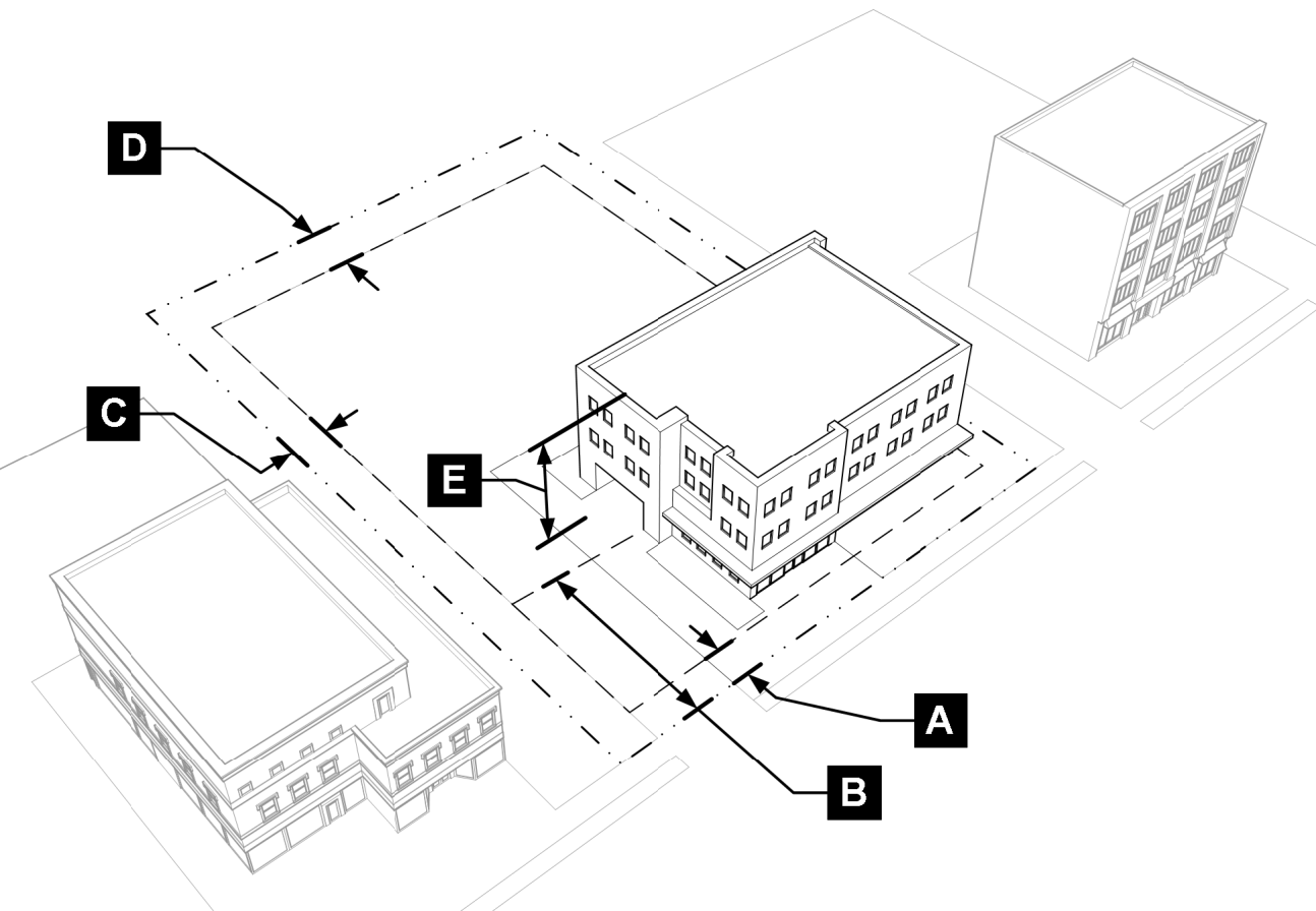
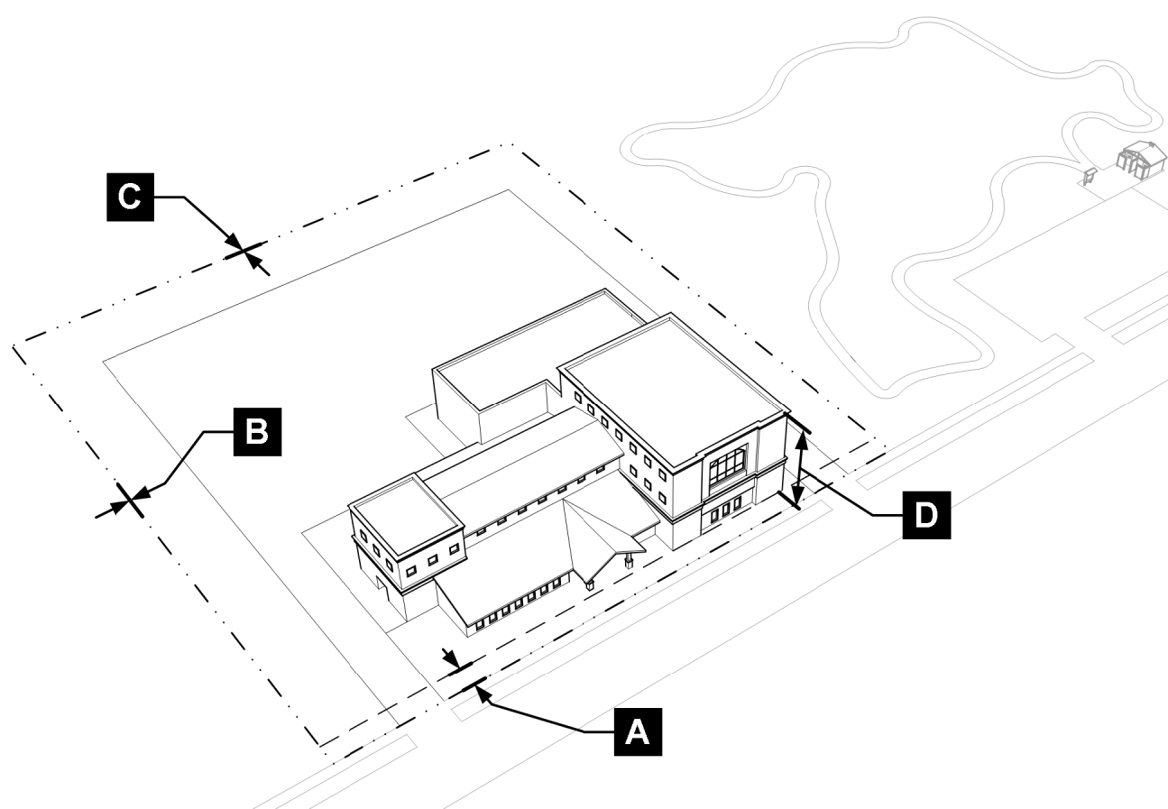
Setbacks.
1.
Measurement.
a.
Except for rear setbacks from non-dedicated alleys, setbacks are the distance between the nearest property line and the closest projection of a building or structure along a line at right angles to the property line.
b.
For non-dedicated alleys, the rear setback shall be measured from the fence line, if applicable, or from the closest edge of the travel lane.
c.
Unless exempted in table 15.03.080(1), setbacks shall be unobstructed from the ground to the sky.
2.
Attached dwellings. For attached dwellings sharing a common wall, interior side setbacks may be permitted at zero feet.
3.
Setbacks from natural areas. Setbacks from natural areas and features, including wetlands, stream/river corridors, riparian areas, and wildlife habitat, shall be measured as the horizontal distance (plan view) between the delineated edge of the natural area and the closest projection of a building or structure. Except as expressly allowed in this chapter, setbacks from natural areas shall be unobstructed from the ground to the sky.
4.
Contextual setbacks.
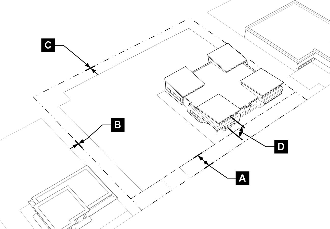
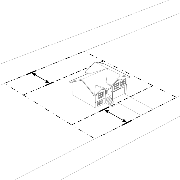
a.
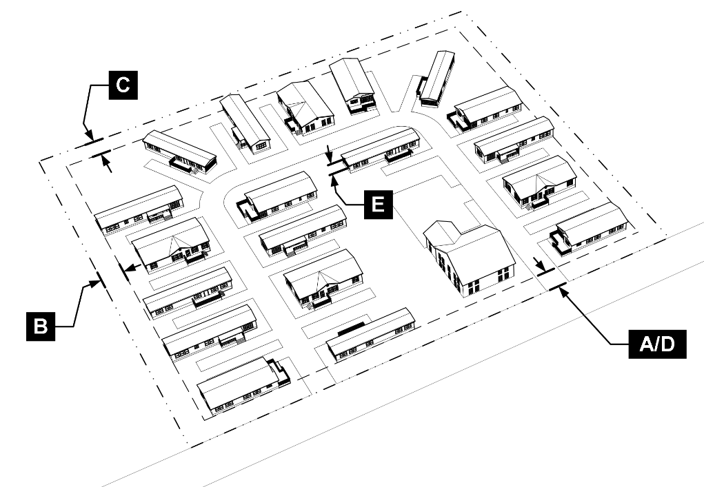
In residential districts. In residential zoning districts, the applicant has the option to use the mean average of existing front setbacks of buildings located on the same and facing block as a proposed development pursuant to figure 3.2 and the following:
i.
Contextual setbacks can only be applied where more than 50 percent of the lots on the same block face, on the same side of the street, are developed with dwellings.
ii.
Lots with similar uses as the use proposed shall be the only lots included in the average setback calculation.
iii.
Vacant lots shall be considered as having the minimum front setback as required by the zoning district for purposes of calculating the mean average.
Figure 3.2: Contextual Setbacks
b.
In all other districts. In all other zoning districts, the applicant has the option to use the mean average of existing front, side, and rear setbacks, respectively, of buildings located on the same and facing block as a proposed development if the setbacks comply with other code requirements including landscape buffers.
5.
Nonresidential and mixed-use abutting residential. The minimum side and rear setbacks for any nonresidential use or building abutting a less intensive residential use and/or building shall be determined pursuant to the landscape buffer requirements in section 15.05.040.F.
6.
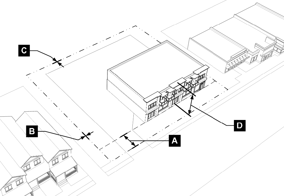
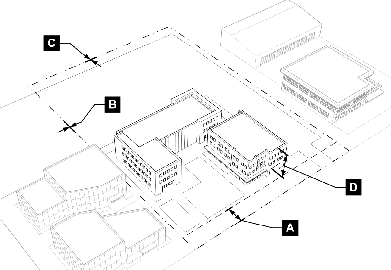
Multiple-frontage lots. For multiple-frontage lots, including corner lots, all sides of the lot with street frontage shall comply with applicable front setback requirements (figure 3.3).
Figure 3.3: Multiple Frontage Lots
7.
Cluster lots. See section 15.07.040 for reductions in setbacks and other lot dimensions for cluster lot subdivisions in the R-RU and N-AG zoning districts.
8.
Compliance with other regulations.
a.
All buildings, structures, and uses shall comply with setback regulations for oil and gas facilities in section 15.05.090.
b.
All building and structures shall comply with all other adopted city codes.
9.
Easements. No portion of any building or structure shall encroach into or over an easement.
10.
Exceptions to setbacks. The features listed in table 15.03.080(1) may be allowed to project into the required setbacks of the applicable zoning district, subject to compliance with other applicable code requirements, where they do not extend into or over an easement. These exceptions apply to all zoning districts unless otherwise stated.
D.
Building height.
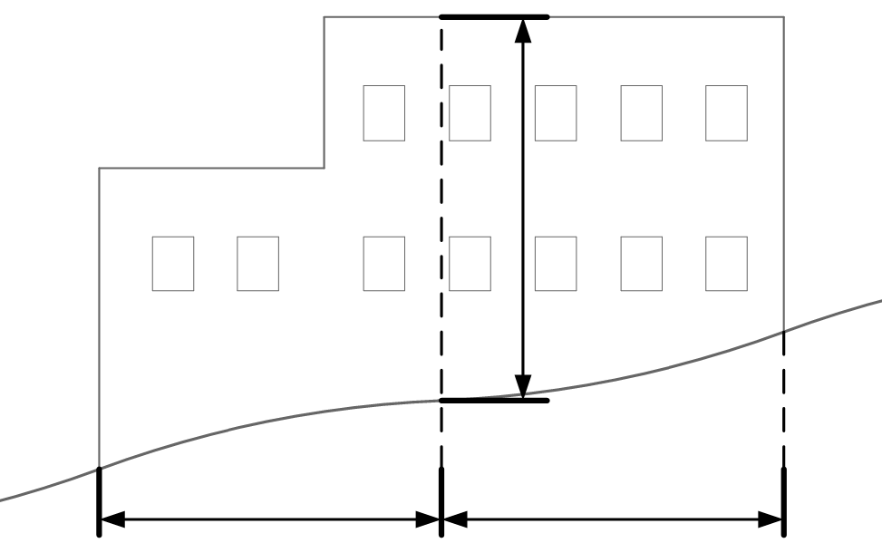
1.
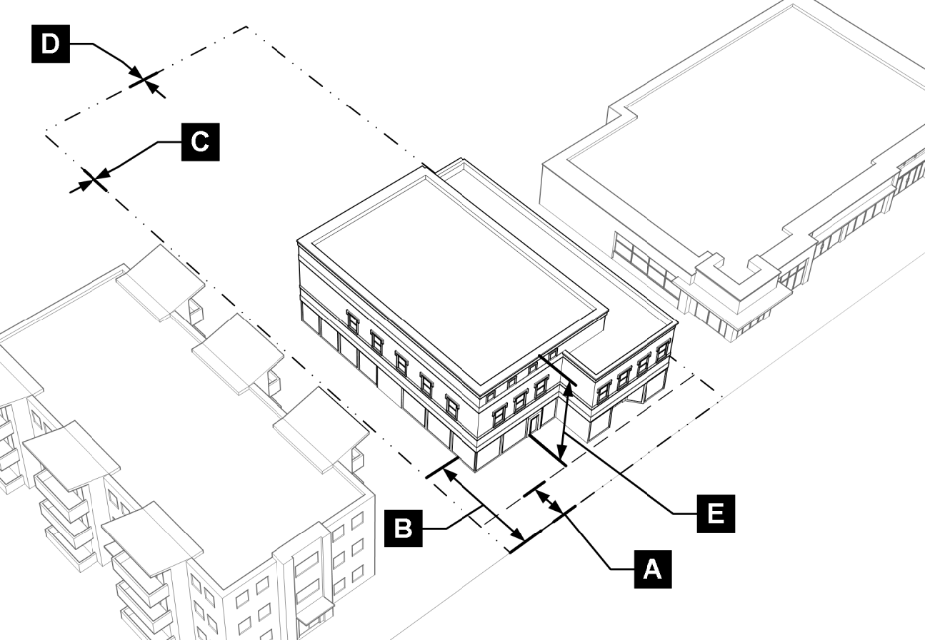
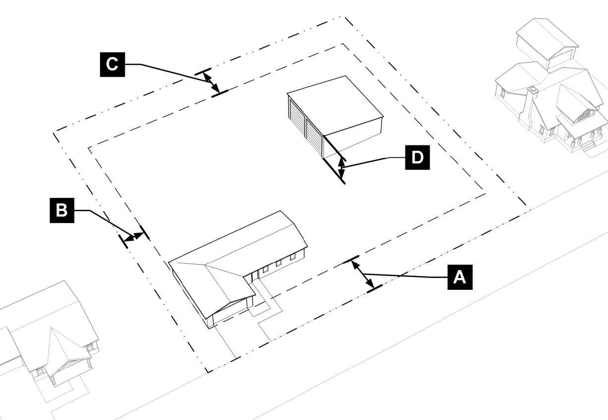
Measurement. Building height is measured from the average finished grade at the center of all walls of the building to the top of the highest part of the building (figure 3.4).
Figure 3.4: Building Height Measurement
2.
Exceptions to maximum height requirements. The features listed in table 15.03.080(2) shall be allowed to extend beyond the height limitations of the applicable zoning district. These exceptions apply to all zoning districts unless otherwise stated. Exceptions included in table 15.03.080(2) shall be designed to be consistent with surrounding height, scale, and context to the maximum extent practicable.
3.
Exceptions to minimum height requirements. Where a minimum height requirement is stated as two stories or higher, a one-story building may be allowed by the director based on location, scope, design, and context of the proposed project consistent with the administrative modification procedure and criteria in section 15.02.080.B.
(Code 2009, § 15.03.080; Ord. No. O-2020-48, § 2, 10-27-2020; Ord. No. O-2024-60, § 2, 9-24-2024; Ord. No. O-2025-35, § 2, 6-3-2025)