
Longmont City Zoning Code
CHAPTER 15
05. - DEVELOPMENT STANDARDS
Sec. 15.05.010. - Purpose.
The purpose of this chapter is to provide standards regarding environmental protection, landscaping, multi-modal access and connectivity, parking, oil and gas extraction, fences, residential, mixed-use and nonresidential design, storage and screening, outdoor lighting, adequate public facilities, wireless telecommunications, mobile homes, and residential compatibility that apply to applications reviewed under this development code.
(Code 2009, § 15.05.010)
Sec. 15.05.020. - Protection of streams and creeks/wetlands/riparian areas.
A.
Purpose. This section is intended to promote, preserve, and enhance the hydrologic, hydraulic, geomorphic, biological, ecological, aesthetic, recreational, water quality, economic, and educational functions that stream and creek corridors, wetlands, and associated riparian areas provide in the city. Appropriate strategies for the protection of streams, creeks, wetlands and riparian areas should be identified as early in the development process as possible.
B.
Applicability. This section applies to development applications for site plans, site plan waivers, subdivision plats, PUD developments, conditional uses, limited uses, secondary uses, rezonings, concept plan amendments and annexations. This section does not apply to existing residential household living uses or developments and other administrative permits and applications.
C.
Boundaries.
1.
Wetland boundaries. All wetland boundary delineations are subject to city approval. Wetlands located in and or along the banks of irrigation ditches shall not be subject to the wetland setbacks if the Army Corps of Engineers determines that the wetlands are not jurisdictional waters. All other non-jurisdictional wetlands are still subject to this Code.
a.
Mapped wetlands. Approximate wetlands boundaries, identified by reference in the Colorado Natural Heritage Program's (CNHP) Colorado Wetland Inventory (latest version) shall be field verified by a qualified professional for a jurisdictional delineation as outlined in section 15.05.020.C.1.c.
b.
Unmapped/disputed wetlands. If a wetland has not been mapped, or its boundaries not clearly established, or if either the city or applicant dispute the existing boundaries, the applicant shall retain a qualified professional with demonstrated expertise in the field to delineate the boundaries of the wetland according to professional standards approved by the city. The applicant shall use the latest version of the Regional Supplement of the Army Corps of Engineers Wetlands Delineation Manual: Arid West Region and the associated data form.
2.
Stream and creek corridor boundaries. The applicant shall use the latest version of the Regional Supplement of the Army Corps of Engineers Wetlands Delineation Manual: Arid West Region and the associated data form.
3.
Riparian area boundaries. All riparian area boundaries, identified by reference to CNHP's Colorado Wetland Inventory, shall be field verified by a qualified professional and are subject to city approval. Riparian areas shall not include ditches that are commonly known to be irrigation ditches. See chapter 15.10 for the definition of the term "riparian area" subject to protection under this section.
4.
Ordinary high-water mark. All ordinary high-water mark delineations are subject to city approval. See chapter 15.10 for the definition of the term "ordinary high-water mark."
D.
Compliance with applicable federal wetlands laws or regulations.
1.
No person shall engage in any activity that shall disturb, remove, fill, drain, dredge, clear, destroy, or alter any area, including vegetation, within a city-recognized and -approved wetland.
2.
Notwithstanding any contrary federal law or regulations, draining any wetland that falls in the jurisdiction of the federal government and its agencies is prohibited.
3.
The city shall not grant final approval to any development or activity, including subdivisions, in a wetland that falls within the federal government's jurisdiction until the applicant shows that all necessary federal approvals and permits have been obtained.
4.
The city shall not prohibit execution of a permitted mitigation plan or maintenance of those projects, nor shall it take responsibility for the mitigation project, even within areas to be accepted by the city upon final acceptance of all improvements. A letter from the Army Corps of Engineers, accepting the mitigation, is required to release the development from further obligations.
E.
Compliance with floodplain regulations. Construction or activity in a floodplain or flood hazard area must conform to this chapter and title 20 regarding floodplain development permit requirements. In the case of conflicting regulations found in this chapter and title 20, the more restrictive shall apply.
F.
Setbacks. The following setbacks are considered minimum distances:
1.
Stream and creek corridors and riparian areas. All features included in subsection F.3 of this section shall be set back at least 150 feet from the below-listed stream and creek corridors and riparian areas. The setback shall be measured from the outer edge of the riparian vegetation, including the outer edge of the canopy edge of riparian trees and shrubs, or from the ordinary high-water mark when riparian vegetation is not present. For all other stream and creek corridors and riparian areas, as defined in chapter 15.10, not listed below, the setback shall be 100 feet from the outer edge of riparian vegetation, including the outer edge of the canopy of riparian trees and shrubs, or the ordinary high-water mark when riparian vegetation is not present.
a.
Boulder Creek;
b.
Dry Creek #1, from Grandview Meadows Drive west to Mountain Drive;
c.
Dry Creek #2;
d.
Left Hand Creek;
e.
Lykins Gulch, from the confluence of the St. Vrain Creek west to the west property line of the Vance Brand Airport;
f.
Spring Gulch #1 (also known as "the slough"), from the confluence of St. Vrain Creek north to Boston Avenue;
g.
Spring Gulch #2, from the confluence of the S. Vrain Creek north to Stephen Day Park;
h.
St. Vrain Creek; and
i.
Union Reservoir.
2.
Wetlands. All features included in subsection F.3 of this section shall be set back at least 100 feet from the delineated edge of wetlands.
3.
Features subject to setbacks. Buildings and structures, including accessory buildings and structures, fences and walls, streets, access drives, parking areas, and outdoor sales, display, storage and activity areas are subject to the setbacks included in subsections F.1 and F.2 of this section, unless otherwise exempted in subsection B of this section, or prohibited or allowed in subsections G, H, I and J of this section.
4.
Vegetation preservation and enhancement within setback. Existing desirable and significant trees and other native vegetation shall be preserved within the setback. Recommendations for additional plantings to enhance wildlife and plant habitat within the setback shall be included in the species and habitat conservation plan under section 15.05.030.H.
5.
Modifications of the setback standards. The setback standards stated in subsections F.1 and F.2 of this section may be modified under the following standards and procedures, taking into consideration the findings of a detailed species and habitat conservation plan under section 15.05.030.H.
a.
Reduced setbacks. The purpose and intent of this section is to allow for preservation and enhancement of stream and creek corridors, wetlands, and other riparian areas. The city council, with a recommendation from the planning and zoning commission and the natural resources division under section 15.02.060.I.3, may reduce the setbacks if it determines that the setbacks are greater than necessary to protect stream and creek corridors, riparian areas, and wetlands. The following criteria shall be used to identify circumstances where riparian setback reductions may be considered:
i.
The development has satisfactorily completed a sustainability evaluation system assessment;
ii.
The project is designed to preserve or enhance the ecological character or function and wildlife use of the natural habitat or feature and to minimize or adequately mitigate the impacts of development;
iii.
The project is designed to preserve or enhance the existence of wildlife movement corridors between natural habitats and features;
iv.
The project is designed to preserve desirable and significant trees and other native vegetation on the site. If existing landscaping is determined to be incompatible with the intent of this section, the applicant shall mitigate such conditions through appropriate means including regrading or the replanting of native vegetation;
v.
The project is designed to mitigate adverse impacts by protecting species habitat features such as, but not limited to, raptor nest sites, night roosts, and key feeding areas; wintering areas and migratory feeding areas for waterfowl; heron rookeries; key use areas for wading and shorebirds; deer concentration areas; concentration of rare native fish; key use areas for migrant songbirds and key nesting areas for grassland birds; and other features as identified in the species and habitat conservation plan as defined in section 15.05.030.H;
vi.
The project is designed to integrate with and otherwise preserve existing site topography, such as steepness of slopes, drainage features, rock outcroppings, stream and creek terraces, oxbows or meanders in the adjacent waterway that would create aquatic habitat, and scenic topographic features; and
vii.
The development mitigates a modified setback standard by providing a higher quality, more desirable wildlife habitat enhancements along the corridor, or alternatively, in another location, as approved by the city council.
b.
Increased setbacks. The planning and development services director, in consultation with the public works and natural resources department, may increase the setbacks to protect stream and creek corridors, riparian areas, or wetlands, based on site specific conditions if any of the following conditions are present on a site:
i.
An established tiered vegetative system with native ground cover, shrub areas or mature canopy trees creating a diverse habitat;
ii.
Adjacency or proximity to like areas or other associated habitat or other wildlife resources;
iii.
Oxbows or meanders in the adjacent waterway that would create diverse aquatic habitat; or
iv.
Presence of a known state or city species of special concern, including, but not limited to, threatened and endangered species and species that increase the city's biodiversity that would enhance the wildlife values of the city.
G.
Prohibited activities. No person shall engage in any activity that shall disturb, remove, fill, drain, dredge, clear, destroy, or alter any area, including vegetation and wildlife habitat, within stream and creek corridors, riparian areas, wetlands, and their setbacks, except as may be expressly allowed in this development code, or by federal or state laws or regulations, or by other applicable city laws or regulations.
H.
Bridges. The construction of bridges according to city standards is permitted, provided such bridges are planned and constructed so as to minimize impacts on the stream and creek corridor. Bridges are not subject to stream and creek corridor or riparian area restrictions or setbacks. The construction of bridges within a jurisdictional wetland shall be prohibited unless appropriate federal permits are granted but shall not be subject to wetland setbacks.
I.
Utilities. Utilities may be allowed in a stream and creek corridor, riparian area, or wetlands setback area subject to city approval. The applicant shall reclaim any disturbance of the setback area by re-grading and re-vegetation. Provisions for reclamation of the disturbed area shall be included in any development plans, such as public improvement plans and landscaping plans for the project, with adequate security to guarantee the reclamation shall be completed. Utilities constructed in setback areas shall be located at the outside edge of the area and access roads for maintenance of utilities shall be located outside the setback area to the maximum extent practicable. Access for maintenance of utilities in setback areas shall be at specific points rather than parallel to the utility corridor.
J.
Recreation, education or scientific activities. Structures and improvements for recreational, educational, or scientific activities such as trails, fishing access, and wildlife management and viewing may be permitted in a stream and creek corridor, riparian area, or wetlands setback area provided a management plan that establishes long-term protection of the setback area is submitted prior to development and approved by the city. The project shall be designed to provide appropriate human access to natural habitats and features in order to serve recreational purposes, provided that such access is compatible with the ecological character or wildlife use of the natural habitat or feature to the maximum extent practicable.
K.
Design and aesthetics. Projects adjacent to natural areas, including, but not limited to, the waterbodies listed in section 15.05.020.F.1, shall be designed to complement the visual context of the natural area. Techniques such as architectural design, site design, the use of native landscaping, and choice of colors and building materials shall be used in such manner that scenic views across or through the site are protected, and manmade facilities are screened from off-site observers and blend with the natural visual character of the area.
(Code 2009, § 15.05.020; Ord. No. O-2019-62, § 3, 10-22-2019; Ord. No. O-2020-37, § 1, 10-13-2020; Ord. No. O-2021-16, § 7, 3-30-2021)
Sec. 15.05.030. - Habitat and species protection.
A.
Purpose. This section is intended to promote, protect, preserve, and enhance the diversity of riparian areas, wildlife and plant habitat and species in the Longmont area through appropriate and compatible land use planning and design consistent with the biological, ecological, aesthetic, recreational, economic, and educational functions that habitat and species provide.
B.
Applicability. This section applies to development applications for site plans, site plan waivers, subdivision plats, PUD developments, conditional uses, limited uses, secondary uses, rezonings, concept plan amendments and annexations. This section does not apply to existing residential household living uses or developments and other administrative permits and applications.
C.
Exemptions. The procedures and regulations contained in this section shall not apply to:
1.
Agricultural activities such as soil preparation, irrigation (including maintenance of irrigation ditches), planting, harvesting, grazing, and farm ponds where such activities have historically occurred. Expansion of such activities into existing important/critical habitat are subject to review under this section;
2.
Maintenance and repair of existing public roads, utilities, and other public facilities within an existing right-of-way or easement;
3.
Maintenance and repair of flood control structures and activities in response to a flood emergency;
4.
Maintenance and repair of existing residential or nonresidential structures; or
5.
Habitat enhancement and restoration activities undertaken pursuant to a wildlife conservation plan approved under this section.
D.
Other regulations. This section of the development code does not repeal or supersede any existing federal, state, or local laws, easements, covenants, deed restrictions or habitat conservation plans pertaining to wildlife or plant species or habitat. When this section imposes a higher or more restrictive standard, this section shall apply.
E.
Habitat and species database. The following sources shall be used to identify important plant or wildlife species or important habitat areas, including federally identified endangered or threatened plant or wildlife species, for purposes of review under this section. Any site-specific studies undertaken by the applicant and accepted by the city shall be used in place of any of the cited maps or data:
1.
Colorado Parks and Wildlife (CPW) habitat maps for Boulder and Weld Counties, as amended from time to time.
2.
Other maps or surveys completed by Boulder or Weld Counties, such as the "map of wildlife and plant habitats, natural landmarks and natural areas" included in Boulder County's comprehensive plan, as amended from time to time.
3.
Other information and maps as the city may from time to time identify in cooperation with the CPW, the U.S. Fish and Wildlife Service, or any other county, state, or federal agency, including, but not limited to, the following:
a.
State wildlife action plan (SWAP) from CPW (most current version);
b.
CPW species activity mapping (SAM) database (most current version);
c.
Information for planning and consultation (IPac) tool (U.S. Fish and Wildlife Service) (most current version);
d.
City raptor nest inventory maps (most current version); and
e.
Other approved data bases or inventories, as approved by the city.
4.
Any habitat conservation plans adopted by the city, including the wildlife management plan, as amended from time to time.
5.
Habitat and species information referenced by this section is typically intended for general planning purposes only. Errors or omissions may be corrected by the city after consultation with the CPW or other appropriate county, state, or federal agency.
F.
Review procedures. The following procedures shall apply to all applications for development that contain identified important plant or wildlife species, riparian areas or important habitat, including, but not limited to, federally or state identified endangered or threatened plant or wildlife species or those areas identified in section 15.05.020.F.1 and 2:
1.
Application. PDS may require a species and habitat conservation plan at any time prior to final approval. The applicant shall submit a plan, as applicable, depicting the general location of the property, location of structures on the site, prominent natural areas such as streams and wetlands, and other features that the planning director may require for review pursuant to this section.
2.
Preliminary review/referral. The planning director shall refer the submitted plan or plat to the CPW, U.S. Fish and Wildlife Agency, or other appropriate county, state, or federal agency for review. Applicants are also advised to meet with CPW, and other agencies as determined appropriate by the planning director to ensure compliance with the requirements of this section.
3.
Agency review. For applications referred to it, the CPW, U.S. Fish and Wildlife Service, Public Works and Natural Resources, or other appropriate agency shall determine whether the proposal will result in significant adverse impact on important plant or wildlife species or important habitat or on an endangered or threatened species, and make specific recommendations as to appropriate mitigation, if any.
4.
Review determination. Based on recommendations from the agency review indicated in subsection F.3 of this section, the planning director shall determine whether the applicant must submit a species and habitat conservation plan prior to approval of any development application. The planning director may submit a conservation plan to the appropriate agencies for review and recommendation as to whether the plan adequately addresses the adverse impacts identified in subsection F.3 of this section. (See section 15.05.030.H.)
5.
Waivers/modifications of standards. The planning director may waive or approve minor modifications of any development standard or review criteria contained in this section if the planning director finds that:
a.
The waiver or modification is consistent with the stated purposes of this section;
b.
The waiver or modification shall have no significant adverse impacts on wildlife species; habitat; or on native plant species, associations, or communities;
c.
The waiver or modification does not violate or circumvent any applicable state or federal regulation;
d.
Any potential adverse impacts shall be mitigated or offset to the maximum extent practicable; and
e.
Application of the standard or criteria is not warranted based on the location of the development, the absence of a particular species on the site, or other relevant factors.
6.
Retention of experts. The planning director may retain a qualified wildlife/plant expert, at the applicant's expense, to aid in the city's administration of this section, including, but not limited to, determinations to require a conservation plan or to waive or modify applicable standards.
G.
Habitat species protection standards. The following standards shall apply to all development applications subject to review under this section, unless the planning director determines that a specific standard may be waived or modified under subsection F.5 of this section. These standards are to be applied to protect wildlife habitat and wildlife and plant species in the most responsible and feasible manner.
1.
Setbacks. All development shall provide a development setback from any important habitat area, riparian area, or plant species area, identified according to this chapter, and as recommended and required by Colorado Parks and Wildlife, US Fish and Wildlife Service, or other appropriate county, state or federal agency. See section 15.05.020.F.
2.
Connections.
a.
If the development site contains existing habitat or natural areas that connect to other off-site natural areas or habitat, the development plan shall preserve such natural area connections to the maximum extent feasible.
b.
If natural areas are adjacent to the development site on more than one side of the site, but such natural areas are not presently connected across the development site, then the development shall, to the maximum extent practicable, provide such connection.
c.
Such connections shall be designed and constructed to allow for the continuance of existing wildlife movement between natural areas and to enhance the opportunity for the establishment of new connections between natural areas for the movement of wildlife.
3.
Non-native vegetation. On any site containing important habitat, the applicant shall retain a qualified professional to recommend native and adapted plant species that may be introduced or used for restoration of the property. All recommended plant species shall be approved by the city. In no instance shall trees prohibited in the city, as specified in the city standards, be introduced on the site. To the maximum extent feasible, except to adjust grades as necessary, existing, non-noxious and not prohibited herbaceous and woody cover on the site shall be maintained and removal of native vegetation shall be minimized. Any state listed noxious weeds shall be identified and controlled in accordance with federal, state, county, and local laws and regulations.
4.
Fencing/walls. The type of fencing/walls (materials, opacity, and the like), the location, and fence/wall height shall be determined by the decision-making body as appropriate for the wildlife species on the site based on advice from the state parks and wildlife or other appropriate agency.
5.
Exterior lighting. Use of exterior lighting shall be minimized in areas of important habitat, and lighting shall be designed so that it does not spill over or onto such habitat. See also section 15.05.140.
6.
Refuse disposal. Developments on sites containing important habitat must use approved animal-proof refuse disposal containers or other city-approved containers that shall not adversely affect important habitat or wildlife species and threatened or endangered plant species.
7.
Domestic animals. Development applications for property that includes important habitat must include a plan with specified enforcement measures for the control of domestic animals and household pets. The plan must include provisions to prevent the harassment, disturbance, and killing of wildlife and to prevent the destruction of important habitat.
8.
Wildlife conflicts. If wildlife that may create conflicts for the future occupants of the development are known to exist in areas adjacent to or on the development site, then the development must, to the maximum extent practicable, include provisions such as barriers and protection mechanisms for landscaping and other site features to minimize conflicts that might exist between the wildlife and the developed portion of the site.
9.
Prairie dog removal. Before the approval of any development application that would authorize construction, grading, or paving on any land carrying any prairie dogs, as defined in chapter 7.06, the applicant must also secure a prairie dog management permit under that chapter. No person shall undertake any construction, grading, or paving on any land which, at such time, carries any prairie dogs. In addition to being a violation of that chapter, any violation of this section shall be a violation of this development code.
10.
Construction timing.
a.
Construction shall be organized and timed to minimize disturbance of important wildlife species occupying or using on-site and adjacent natural areas, especially during nesting or denning times. If construction will occur during the nesting season, pre-construction surveys shall be completed as determined by the city. Construction may be delayed if mitigation is not possible to prevent harm to the wildlife species.
b.
Standards for protection during construction.
i.
Any limits on disturbance and setback areas approved by the city shall be shown on the public improvement plans, final plat, site plan or landscape plan for development. Such areas shall be designated in the field prior to commencement of excavation, grading, or construction with fencing or other methods approved by the planning director.
ii.
Storage of construction materials, including fill or topsoil, within habitat areas or setback areas is prohibited.
11.
Design and aesthetics. Projects adjacent to natural areas, including, but not limited to, those stream and creek corridors and riparian areas listed in section 15.05.020.F.1, shall be designed to complement the visual context of the natural area. Techniques such as architectural design, site design, the use of native landscaping, and choice of colors and building materials shall be utilized in such manner that scenic views across or through the site are protected, and manmade facilities are screened from off-site observers and blend with the natural visual character of the area.
12.
Significant trees and native vegetation. The project shall be designed to preserve significant existing trees and existing native vegetation on the site.
13.
Special habitat features. The project shall be designed to protect from adverse impacts species utilizing species habitat features such as raptor nest sites, night roosts, and key feeding areas; wintering areas and migratory feeding areas for waterfowl; heron rookeries; key use areas for wading birds and shore birds; deer concentration areas; and any other feature identified in the species or habitat conservation plan, as defined in subsection H of this section.
14.
Utilities. All utilities shall be sited underground to the maximum extent practicable. Above-ground utilities should incorporate all current and appropriate wildlife protections methods.
H.
Species and habitat conservation plans.
1.
Plan preparation. The applicant shall retain a qualified person with demonstrated expertise in the field and who is acceptable to the planning director to prepare a species or habitat conservation plan required by this section.
2.
Plan content. A species and habitat conservation plan shall include the following information, at a minimum, and as applicable. The planning director may modify or waive specific requirements due to the development's location, previous use of the site, the size and potential impact of the development, the absence of particular species on a site, the prohibition of a reasonable use of the site, and other relevant factors:
a.
A description of the ownership, location, and verification of property ownership.
b.
A description of the type and extent of any special features (including movement corridors) of the wildlife habitat on the proposed development site or as otherwise defined by the director.
c.
The location and species of any significant native trees and other native vegetation.
d.
The location and species of any state-listed noxious weeds and nonnative trees, including a description of whether the nonnative species are serving an ecological function (i.e., shading, wildlife forage, bank stabilization).
e.
The boundary of any wetlands on the site as well as the shoreline or ordinary high-water mark of any stream or body of water. For setback variance applications subject to section 15.05.020.F.5, the director may require delineation upstream and downstream of the subject property.
f.
A description of the populations of wildlife and plant species that are known to have the potential to inhabit or use the site, including a qualitative description of their spatial and temporal distribution and abundance. Include all federally or state-listed threatened or endangered species, and state species of special concern.
g.
An analysis of the potential adverse impacts of the proposed development on wildlife and plant species and habitat, or on important plant species, on- or off-site including any issues related to the timing of the proposed activities. Raptor nests locations and recommendations to protect the species should be identified in the plan if they are found within one-half mile of the project site.
h.
A description of the ecological functions provided by the site and its features.
i.
A list of proposed avoidance and mitigation measures and an analysis of the probability of success of such measures.
j.
A plan for implementation, maintenance, and monitoring of mitigation measures.
k.
Recommendations for enhancement and restoration measures, including preservation and enhancement of desirable vegetation within creek/stream, wetland and riparian setbacks. Recommendations for enhancement and restoration measures along greenways shall also take into consideration greenway planting and irrigation standards.
l.
A demonstration of fiscal, administrative, and technical competence of the applicant or other relevant entity to successfully execute the plan.
m.
Maps of the site, the proposed action, and proposed mitigation components.
n.
Relevant photographs of site features.
(Code 2009, § 15.05.030; Ord. No. O-2019-01, § 4, 1-8-2019; Ord. No. O-2020-37, § 2, 10-13-2020)
Sec. 15.05.040. - Landscape and common area standards.
A.
Purpose. These regulations are intended to achieve the following purposes:
1.
Further the goals, policies, and strategies stated in the comprehensive plan;
2.
Preserve open areas, wildlife habitat, water quality, and sensitive natural lands or features;
3.
Enhance the visual quality of the city;
4.
Promote safe and compatible design;
5.
Provide passive and active recreation opportunities and amenities;
6.
Provide off-street multi-modal transportation routes;
7.
Provide for stormwater systems, including low-impact development (LID);
8.
Screen or separate incompatible uses;
9.
Conserve energy and other limited resources; and
10.
Promote water conservation, environmental sustainability, and aesthetic quality in landscaping practices.
B.
Applicability.
1.
New development or redevelopment. Unless otherwise exempted in this development code, the standards in this section shall apply to all development.
2.
Nonconforming landscaping. Nonconforming landscaping shall be subject to section 15.08.100.
C.
Landscaping requirements.
1.
Landscape areas.
a.
The following areas are required to be landscaped according to the standards in this section:
i.
Landscape buffers;
ii.
Pocket parks, plazas and courtyards;
iii.
Parking areas (islands/medians/perimeters);
iv.
Greenways;
v.
Streetscape;
vi.
Stormwater areas; and
vii.
Residential, mixed-use and nonresidential lots not covered by structures, parking areas, drives and other hardscape areas.
b.
The following existing natural areas shall be preserved, reserved, or dedicated to the maximum extent practicable:
i.
Floodplains;
ii.
Lakes, rivers, stream corridors, wetlands, and riparian areas, including setbacks from river/stream corridors, riparian areas, and wetlands required under section 15.05.020.F;
iii.
Important wildlife habitat and migration corridors as identified in a species or habitat conservation plan submitted as part of an approved application;
iv.
Steep slope areas or geologic hazard areas such as expansive soils, rockfalls, faulting;
v.
Significant stands of mature desirable trees and existing vegetation; and
vi.
Significant cultural and historical resources as identified in a cultural resource survey completed by a qualified individual consistent with state cultural resource survey standards, and submitted as part of an approved application.
2.
Landscaping standards.
a.
Landscaping types and specifications.
i.
All landscaping materials shall be compatible with local climate and the intended purpose.
ii.
Trees and other plants listed in the approved materials list are addressed in the city standards.
iii.
In landscape buffers, pocket parks, arterial rights-of-way, greenways, parking area perimeters, and stormwater areas, a minimum of 50 percent of the required trees shall be deciduous canopy species, and a minimum of 25 percent of the required trees shall be coniferous. Conifers shall not be planted where they shade public street and sidewalk intersections during the winter months.
iv.
Grades in landscape areas shall not exceed slopes greater than 6:1 in pocket parks and 4:1 for all other areas, except that grades in shrub beds and native grass areas that will not be mowed shall not exceed 3:1 slope.
v.
Landscaped areas shall be covered with at least 75 percent of the areas with drought-tolerant vegetation or native ground cover, except for areas where additional hardscape is allowed or as allowed for an alternative landscape plan. Nonfunctional turf is prohibited. Functional turf may be used only in areas designated for civic, community, or recreational use.
vi.
No large mulch or bare soil areas are allowed. Turf shall not be used in narrow or ornamental areas such as medians, streetscapes, parking lot islands, or parkways unless it qualifies as functional turf.
b.
Plant selection and diversity.
i.
All plant materials diversity requirements are addressed in section 600 of the city standards.
ii.
All tree species prohibited within the city shall be removed by the applicant from their site unless the city forester determines that the trees will not create an adverse impact to the development or surrounding properties.
c.
Plant sizes.
i.
All required plant sizes are addressed in section 600 of the city standards.
ii.
Plants exceeding required quantities are not subject to size requirements.
d.
Restricted planting areas. Landscaping or plant materials shall not:
i.
Obstruct the operation and maintenance of public utilities.
ii.
Interfere with the function, safety, or access to any public easement or right-of-way, or the flow of stormwater runoff. Specified sight distance triangle at street and driveway intersections are addressed in section 200 of the city standards.
e.
Ground covers.
i.
Drought-tolerant vegetation or native ground cover shall be the primary ground cover in landscaped areas. The use of nonfunctional turf is prohibited. Functional turf may only be installed in areas that serve civic, recreational, or community use functions.
ii.
Mulches and other inorganic ground cover shall be installed in shrub/planting beds to reduce water evaporation.
iii.
Soil amendments at a ratio of three cubic yards of organic matter or compost per 1,000 square feet of soil shall be applied and tilled to a depth of at least six inches on all landscape areas not covered by approved impervious surfaces and permeable paving.
f.
Alternative requirements for hardscape features.
i.
In residential zoning districts, pedestrian walks and other hardscape landscape features and amenities, such as outdoor seating areas and recreation courts, may comprise up to 25 percent of the landscaped area.
ii.
In mixed-use and nonresidential districts, pedestrian walks and other hardscape landscape features and amenities, such as outdoor seating areas, and plazas with recreation and entertainment areas, water features, and public art, and approved permeable pavement may comprise up to 50 percent of the landscaped area.
iii.
The director may approve an administrative modification under section 15.02.080.B for greater percentages of hardscape features based on the consideration of the scope and scale of the proposed development and mix of uses, the proposed building placement and design, and the quality of the proposed landscape design.
3.
Installation and maintenance.
a.
Design and installation.
i.
Landscape improvements design, construction, and installation are addressed in the city standards.
ii.
Concrete path design is addressed in the city standards.
iii.
Xeriscape practice shall be applied in all areas (e.g., ground cover and plants selection, irrigation design based on water needs) unless the director determines that application is not appropriate given the proposed use of the area.
b.
Irrigation systems.
i.
The applicant shall be responsible for all costs associated with the installation of the irrigation system, including applicable tap fees.
ii.
A separate irrigation tap and system shall be provided for each legal lot, outlot, or parcel.
iii.
Irrigation of xeriscape areas shall comply with the following standards:
(A)
The plant material will be maintained in a healthy condition without regular irrigation after the plant establishment period.
(B)
Underground irrigation shall provide reliable automated irrigation for all plants during the establishment period and as otherwise needed to maintain plants in healthy condition.
(C)
The applicant has demonstrated the ability to provide ongoing maintenance of xeriscape areas necessary to keep plant material healthy with no or reduced irrigation.
4.
Water wise landscaping.
a.
Beginning January 1, 2026, all landscape plans for new development and redevelopment shall comply with Colorado Senate Bill 24-005 and Colorado House Bill 25-1113. Compliance includes the following:
i.
The installation of nonfunctional turf, nonfunctional artificial turf, and invasive plant species on multifamily residential, commercial, industrial, institutional, and common-interest community properties, as well as within public rights-of-way, medians, and transportation corridors, is prohibited.
D.
Tree preservation.
1.
All trees within areas proposed to be disturbed by development on- and off-site and in the adjacent right-of-way shall be surveyed and have location, species, size, and condition or health noted in a tree preservation plan.
2.
Existing desirable trees shall be preserved and protected from damage during site development.
3.
Existing desirable trees shall be incorporated into the design in their existing location whenever possible.
4.
Existing desirable trees may be used to satisfy the quantity (number or caliper) requirements of landscape standards.
5.
If feasible, a tree that cannot remain in its existing location shall be spaded and relocated by a professional tree spade company. All measures shall be taken to ensure the survival and health of the tree. The city forester shall be consulted for tree relocations.
6.
All existing desirable trees that are incorporated into the design shall be adequately protected in the tree protection zone from damage during construction.
7.
If the site design precludes incorporation of some or all desirable trees then replacement shall be made as follows:
a.
For any desirable trees that cannot be incorporated or are lost due to or prior to construction, the applicant shall provide the corresponding caliper lost on-site and in the right-of-way adjacent to the property, in addition to meeting or exceeding the minimum tree planting requirements.
b.
If the city forester determines that on-site or right-of-way replacement is not possible, the required replacement shall be provided on an adjacent site or the nearest public land if feasible as determined by the city forester; otherwise the dollar value of the trees (including the estimated cost of installation) shall be deposited into the city's tree planting fund.
8.
See chapter 13.24 regarding tree preservation on city property.
E.
Developments adjacent to public lands. Developments adjacent to public parks, greenways, natural areas, and other public open space shall meet the following criteria:
1.
Private lots shall not be immediately adjacent to public lands, as defined in chapter 13.20, and shall be separated by public streets or required buffers. However, development applications providing at least 12 percent of the total units in the application as affordable housing shall be exempt from this requirement.
2.
Pedestrian access to public lands is required and shall include an eight-foot-wide concrete path.
F.
Landscape buffers.
1.
General buffer standards.
a.
Buffers may be interrupted for necessary pedestrian and vehicle access.
b.
Buffers may contain a combination of landscaping, berms, walls and fences.
c.
Landscaping provided in buffer areas shall be located on the outside of walls or fences to maximize the intent of the screening and buffering.
d.
Buffers in mixed-use districts may include hardscape as part of buffer design.
e.
For multifamily, mixed-use, and nonresidential uses, and parking areas requiring buffers from other uses in a mixed-use or nonresidential zoning district, the minimum buffer width requirement, excluding buffer Type A, shall be one-half the width specified in tables 5.1 and 5.2.
f.
Gateway buffers are required on lots fronting the following community gateway areas and may comprise no more than 50 percent stormwater areas:
i.
Highway 287 between the northern city limits and Highway 66;
ii.
Highway 287 between the southern city limits and Pike Road;
iii.
Highway 119 between the western city limits and Hover Street;
iv.
Highway 119 between the eastern city limits and Highway 287;
v.
Highway 66 within the city limits;
vi.
3rd Avenue between Highway 119 and Lashley Street.
2.
Buffer types and where required. The types of buffers listed in table 15.05.040(1) below shall be provided according to the locations specified in table 15.05.040(2). Uses in the far-left column of table 15.05.040(2) shall provide landscape buffers on the property where the use is located. The landscape buffer shall be located adjacent to the frontages and uses that are to be buffered.
3.
Alternative buffer requirements. The director may approve an administrative modification under section 15.02.080.B for alternative buffer requirements based on the consideration of the scope and scale of the proposed development and mix of uses, the proposed building placement and design, the quality of the proposed landscape design and decorative screen wall as applicable, the width of the buffer, and site perimeter conditions.
G.
Residential standards. The following standards shall apply to all residential development unless specifically exempted in this section 15.05.040:
1.
Pocket parks.
a.
Applicability. Pocket parks are required for:
i.
Single-family detached and attached residential developments with 50 or more dwelling units; and
ii.
Multifamily residential developments with 50 or more dwelling units.
b.
Exception near a public neighborhood park. Pocket parks are not required when at least 50 percent of the dwelling units in a proposed development are within one-quarter mile (1,320 feet) walking distance of an existing public neighborhood park or a planned and fully funded in the approved city capital improvement program public neighborhood park.
c.
Size.
i.
Pocket park shall be provided at a ratio of one acre for every 100 single-family detached and attached dwelling units.
ii.
Pocket park shall be provided at a ratio of one acre for every 200 multifamily dwelling units.
iii.
Pocket parks shall be a minimum of one-half acre in size for developments of 100 or more single-family detached and attached dwelling units.
iv.
Pocket parks shall be a minimum of one-half acre in size for developments of 200 or more multifamily dwelling units.
v.
For developments with fewer than 100 single-family detached and attached dwelling units or 200 multifamily dwelling units, the size of the pocket park may be reduced proportionally (minimum one-quarter acre size for developments of 100 multifamily dwelling units).
d.
Location.
i.
Shall be centrally located within the development with pedestrian access to the lots and dwellings they are intended to serve.
ii.
Shall have frontage on at least one local or collector street.
e.
Design standards.
i.
Access corridors to and through pocket parks shall be a minimum of 20 feet wide with a minimum five-foot-wide concrete path.
ii.
Pocket parks shall contain amenities such as playgrounds, community gardens, tot lots, picnic areas, game courts, playing fields, plazas and courtyards, swimming pools, clubhouses, rooftop common areas, or other approved common area buildings or similar facilities based on the size of the park and the number of residents it is intended to serve.
iii.
Areas used as dog parks shall not count toward the required pocket park area.
iv.
Rear and side yard fences on lots abutting pocket parks shall not exceed five feet in height.
v.
Pocket parks shall not include:
(A)
Primary or secondary greenways; or
(B)
Right-of-way landscaped areas.
f.
Landscaping standards.
i.
Pocket parks shall contain irrigated, lower water-consuming plant materials over at least 75 percent of the landscaped area, excluding approved structures, non-landscaping amenities, and hardscape areas. Nonfunctional turf is prohibited.
ii.
Landscaping shall be provided for pocket parks at a rate of one tree and five shrubs per 2,000 square feet of landscaped area. Non-landscaping amenities, such as swimming pools, recreation courts, and common area structures, shall not be counted as landscaped area in this calculation.
g.
Stormwater areas. Stormwater areas meeting the following standards may comprise up to 50 percent of a pocket park area:
i.
Slopes shall not exceed 6:1.
ii.
A minimum of 90 percent of the stormwater area shall be used for passive and active recreation.
iii.
Stormwater areas shall comply with the standards in section 15.05.040.L.2.
iv.
Drainage structures and water quality features shall be designed and located to facilitate the maximum area for recreational use and to provide a safe environment for users.
2.
Minimum landscaping required.
a.
Any residential development subject to the standards of this section shall provide landscaping as indicated in table 15.05.040(3).
b.
Parking shall not be permitted in landscaped areas.
c.
Trees in the local and collector right-of-way shall be installed by the applicant or builder prior to certificate of occupancy. If it is not practical to install the landscaping prior to occupancy because of weather or other necessary delay, the applicant or builder shall issue a coupon or voucher to the homebuyer for the required landscaping, including delivery and installation, at the closing. A copy of the certificate shall be provided to the city prior to the issuance of a certificate of occupancy.
d.
Tree lawns, where applicable, shall be landscaped with irrigated, low water consuming plant materials such as drought-tolerant vegetation or native ground cover. Nonfunctional turf is prohibited.
H.
Mixed-use and nonresidential standards.
1.
Plazas/courtyards.
a.
Required. Plazas/courtyards are required for:
i.
Vertical mixed-use developments with 50 or more multifamily dwelling units; and
ii.
Other mixed-use or nonresidential developments as appropriate as determined by the decision-making body, based on consideration of the scope and scale of the proposed development and mix of uses, the proposed building placement and design, and the quality of the proposed landscape and screening design.
b.
Size.
i.
One-eighth acre of plaza/courtyard shall be provided for every 50 dwelling units and fraction thereof;
ii.
For other mixed-use or nonresidential developments, the decision-making body shall determine the appropriate size of the plaza or courtyard, if applicable.
c.
Location. Plazas and courtyards shall be centrally located within the development and accessible to the residents, customers, and guests they are intended to serve.
d.
Design standards. Plazas/courtyards shall include at least three of the following amenity elements:
i.
Seating at one space for every 250 square feet of plaza/courtyard area. Seating may be provided with chairs and tables, benches, or seating walls;
ii.
Trees appropriate for the space planted at one tree per 750 square feet of plaza/courtyard area;
iii.
Art or water features;
iv.
Areas and facilities for recreation, entertainment, or educational activities, or outdoor retail or food vendors;
v.
Other amenities or design elements deemed appropriate for the space by the director.
2.
Streetscape standards. Streetscapes in the public right-of-way shall be designed according to the following standards:
a.
Pedestrian sidewalks, and other paths shall be designed to provide adequate space for pedestrians, street furniture, outdoor seating areas, landscaping, and other amenities to enhance the pedestrian experience, with a minimum five-foot-wide path clear of obstructions for pedestrian access.
b.
Attached sidewalks shall be a minimum of ten feet wide. Detached sidewalks shall be a minimum of eight feet wide in all areas, except that a detached sidewalk adjacent to exclusively residential at-grade uses along local or collector streets shall be a minimum of five feet wide.
c.
Landscaping in the right-of-way shall be provided according to the following requirements:
i.
Trees in the right-of-way shall be spaced every 40 feet and, depending on the street type and adjacent uses, shall be planted in approved tree grates or in a tree lawn area.
ii.
Tree lawns, where applicable, shall be landscaped with irrigated lower water-consuming plant materials such as drought-tolerant vegetation or native ground cover. Nonfunctional turf is prohibited.
iii.
No trees are required in the intersection obstruction-free area.
I.
Greenways.
1.
Integration with open space. Greenways that are a part of a development shall be connected with common areas within the development through pedestrian connections consistent with this development code.
2.
Design of greenways. The applicant is responsible for landscaping and designing the primary greenways within or adjacent to the applicant's property.
a.
Primary greenways. Primary greenways shall meet the following standards:
i.
Primary greenways shall be at least 50 feet wide on each side of the centerline of an irrigation ditch or waterway;
ii.
Primary greenways shall be at least 50 feet wide where no irrigation ditch or waterway is present;
iii.
Primary greenways shall be at least 100 feet wide on each side of the St. Vrain Creek as measured from the ordinary high-water mark;
iv.
Primary greenways shall include a concrete path along the length of the primary greenway and to other areas required for any utility needs;
v.
Primary greenways shall include connection from the adjacent development to the primary greenway concrete paths, which may include a ten-foot-wide (inside clearance) bridge, or at arterial street crossings, a box culvert of sufficient width and height to accommodate the concrete path;
vi.
All concrete path construction shall comply with section 15.05.030;
vii.
Fences or walls adjacent to a greenway shall not exceed 48 inches in height;
viii.
Primary greenways shall include required signage, trash receptacles, floodgates, and other requirements; and
ix.
Primary greenways shall be landscaped at a ratio of at least one tree and five shrubs for every 1,500 square feet of landscaped area (excluding the ditch or river channel and concrete paths), with at least one tree and five shrubs for every 50 linear feet of greenway. The following standards shall apply to the landscaped area:
(A)
75 percent of the trees shall be deciduous canopy and 25 percent of the trees shall be conifers.
(B)
Tree placement shall be sensitive to the greenway design, existing vegetation and wildlife habitat, and shall provide screening and materials beneficial to wildlife where appropriate.
(C)
Existing desirable vegetation may be credited toward the landscaping requirements.
x.
Irrigated lower water-consuming plant materials shall be the primary ground cover except for shrub bed areas. Nonfunctional turf is prohibited. Functional turf may be used where it supports active or passive recreation;
xi.
A greenway irrigation system shall be provided separate from the irrigation system on adjacent private or common property and rights-of-way; and
xii.
Greenways shall comply with any applicable wetlands and stream/river corridor and riparian area protection standards (see section 15.05.020).
b.
Boundaries between common or private open areas. Private or common property adjacent to a primary greenway, public park, nature area or open space shall use landscaping and fencing to:
i.
Define the right-of-way and maintenance boundaries between public and private open space;
ii.
Reduce the potential for trespassing by defining where private property begins; and
iii.
Control domestic animals from entering the public land areas without the owner.
3.
Secondary greenways. Secondary greenways shall be designed and installed by the applicant and meet the following standards:
a.
Secondary greenways shall include connections between residential neighborhoods, parks, nature areas, open space, shopping and activity centers, employment centers, and primary greenways.
b.
Secondary greenways shall be at least 20 feet wide, with a minimum eight-foot-wide concrete path.
c.
Fences and walls adjacent to the greenway shall not exceed five feet in height.
d.
Secondary greenways shall be landscaped with at least one tree and five shrubs for every 50 linear feet of greenway.
e.
The primary ground cover shall include irrigated, lower-water plant materials such as drought-tolerant vegetation or native ground cover.
4.
Dedication of greenways. Under section 13.36.050, rights-of-way or easements for certain roadways, greenways, and access and transportation corridors, the city requires an applicant to dedicate adequate lands or easements or outlots for the development of primary or secondary greenways. This shall include additional primary greenway area required to satisfy the river/stream/riparian area setback requirements outlined in section 15.05.020.F.1.
5.
Roadway intersections.
a.
The applicant shall construct or financially participate in the construction of grade-separated under/overpasses where primary greenways intersect at arterial streets, unless the general manager determines that such grade-separated facilities are not feasible or needed.
b.
The applicant shall construct or financially participate in the construction of grade-separated under/overpasses along primary greenways at non-arterial street, railroad, and other intersections when the general manager determines a grade-separated crossing is necessary for public safety.
c.
In addition to grade-separated under/overpasses, as applicable, the applicant shall connect greenway concrete paths to existing and planned concrete paths, and to sidewalks and bike lanes along public streets.
d.
The applicant shall install appropriate warning signs or barricades where a primary greenway intersects a public street at grade.
6.
Modifications to greenway width standards. Greenway widths may be increased or decreased based on specific site conditions to ensure adequate wildlife habitat and movement corridors are preserved. See section 15.05.020.F.3, for guidance on when modifications to greenway standards may be appropriate.
J.
Parking area landscaping. All uncovered and non-structured parking areas except for those for detached dwelling units shall meet the following regulations:
1.
Perimeter landscaping requirements.
a.
The perimeter of a parking area shall be landscaped with at least one tree and five shrubs per 30 linear feet along a street or primary greenway right-of-way or abutting another property.
b.
Perimeter parking landscaping may be included with other buffer requirements, as required by subsection E of this section.
c.
Parking areas shall include a landscape buffer at least ten feet wide between parking lots on abutting properties, or for a parking area abutting another property or a shared driveway, unless a wider landscape buffer is required between different types of uses or different zoning districts according to subsection E of this section.
2.
Landscape islands. Landscape islands shall be provided within parking areas and shall:
a.
Be located within and at the end of each parking row so that there are no more than ten consecutive parking spaces without a landscape island separating them;
b.
Be a minimum of nine feet wide, measured from face of curb, by the depth of the adjacent parking space;
c.
Contain mulch with at least six shrubs per single parking row or 12 shrubs per double parking row; and
d.
Contain at least one tree per single parking row and two trees per double parking row. All trees shall be deciduous canopy trees.
3.
Landscape medians. Landscape medians with and without walkways shall be provided as follows:
a.
Generally. Rows of parking spaces shall be divided by landscape medians parallel to the parking rows so that there are no more than three drive aisles between landscape medians and a required parking lot buffer or landscape median.
b.
Medians with walkway. The first required landscape median shall contain a walkway and shall be designed as follows unless the parking lot contains fewer than 100 parking spaces:
i.
The landscape median with a walkway shall be located in front of an entrance into the building unless an alternate location meeting the intent of this section is approved by the director;
ii.
The walk shall connect to the perimeter pedestrian walks and include raised or striped crosswalks at all drive aisle crossings. See section 15.05.060;
iii.
The median shall be a minimum of 23 feet wide;
iv.
The pedestrian walkway shall be a minimum of seven feet wide;
v.
The landscaped area shall be a minimum of eight feet wide;
vi.
The landscape median shall be designed according to the illustration above unless an alternate design meeting the purpose of this section is approved by the director;
vii.
Landscape medians shall have at least one deciduous canopy tree and five shrubs for every 30 linear feet along the length of the median;
viii.
Landscape medians shall contain mulch or irrigated lower water consuming grass or other material suitable for the area; and
ix.
Plantings with a mature height of six inches or more shall not be planted in the vehicle overhang area under section 15.05.080.H.8.
c.
Medians without walkway. Landscape medians without a pedestrian walkway shall be ten feet wide and have at least one deciduous canopy tree and five shrubs for every 30 linear feet along the length of the median. Landscape medians shall contain mulch or irrigated grass and plantings with a mature height of six inches or more shall not be planted in the vehicle overhang area.
d.
Additional medians with walkway. Additional landscape medians with a pedestrian walkway shall be provided in a parking area at a rate of one with a walkway for every two medians without a walkway.
K.
Right-of-way landscaping.
1.
Local and collector streets. Local and collector street rights-of-way shall be landscaped as follows:
a.
Detached sidewalks, as addressed in the city standards, shall be installed to allow for a landscaped eight-foot planting strip (tree lawn) between the back of curb and the edge of sidewalk, except where attached walks are required or allowed.
b.
Deciduous canopy trees shall be planted in the tree lawn, or in a tree grate as addressed in the city standards in attached walks, at a rate of one tree for every 40 linear feet of right-of-way.
c.
Live irrigated lower water-consuming plant materials shall be the primary ground cover in tree lawns. Nonfunctional turf is prohibited.
2.
Arterial streets. Arterial right-of-way landscaping shall comply with the following:
a.
Arterial street rights-of-way design is addressed in section 600 of the city standards. The right-of-way shall be landscaped at a ratio of at least one tree and five shrubs for every 1,000 square feet of landscaped area (excluding concrete paths) with at least one tree for every 40 linear feet of right-of-way. Seventy-five percent of the trees shall be deciduous canopy species and 25 percent of the trees shall be coniferous species.
b.
For arterial streets that are state or federal highways, the following apply:
i.
If curb and gutter is to be installed within the right-of-way with the development, the arterial street right-of-way landscaping standards above shall apply.
ii.
If curb and gutter is to be installed in the future per CDOT plans, the applicant shall provide a final landscape plan that identifies the clear zones as defined and regulated by CDOT. The plan shall identify areas that will comply with city arterial standards at the time of the development and areas where arterial landscaping will be installed in the future. The final design shall accommodate the future construction with minimal impact to the initial landscaping.
iii.
If curb and gutter will not be installed in the future per CDOT plans, the final landscape plan shall identify the clear zones. The applicant shall landscape the areas outside the clear zones according to the arterial landscaping standards. The applicant shall also seed the right-of-way clear zone, using a suitable grass seed mixture and irrigation until final acceptance by the city.
iv.
If full arterial landscaping is not to be installed in conjunction with the development, it shall be completed by the city at a later time using cash-in-lieu funds from the developer. In that event, the applicant shall seed the right-of-way to establish a viable grass stand using a suitable grass seed mixture from the approved materials list and irrigation and shall maintain all such areas until final acceptance by the city. The applicant shall provide the city a cash-in-lieu payment for the required landscaping and other public improvements for future construction.
v.
Developments adjacent to State Highway 119 east of Main Street shall comply with the Ken Pratt Boulevard landscape guidelines.
3.
In the Longmont Downtown Development Authority (LDDA) boundary. Streets, streetscape, and alleys located in the city downtown development authority boundaries shall be constructed consistent with the downtown master plan for development and existing streetscape designs within the LDDA boundaries.
L.
Stormwater facilities.
1.
Low-impact development. The city encourages the use of low impact development (LID) applications in developments. Benefits include reduced public infrastructure costs, increased developable land, improved water quality and reduced development costs.
2.
Drainage detention/water quality areas. A drainage detention/water quality area shall comply with the following standards:
a.
The perimeter shall be landscaped with at least one tree and five shrubs for every 50 linear feet of perimeter. At least 50 percent of the trees shall be deciduous canopy species and 25 percent shall be coniferous species;
b.
Low water-consuming plant materials, including drought-tolerant vegetation or native grasses, shall be the primary ground cover. Nonfunctional turf is prohibited. All detention/water quality areas within the five-year floodplain shall be covered with sod or other approved vegetation. Native grass may be used if it is maintained free of weeds and irrigated until the grass is fully established. Live plant material other than grass may be planted if it is suitable to the area and is maintained free of weeds and irrigated until fully established;
c.
Provide adequate access compliant with all state and federal laws for pedestrians and maintenance equipment; and
d.
Be designed and located to provide maximum recreational use of the detention/water quality area.
M.
Modifications and exceptions. Where the scope and scale of the project or other conditions reasonably preclude strict compliance with numerical or nonnumeric landscaping standards, landscape requirements for private or common areas may be modified by the director through an administrative modification under section 15.02.080.B, and by the general manager for rights-of-way or other public areas through an exception to city standards under section 15.02.080.A. Such modifications and exceptions are subject to the following additional standards:
1.
The landscaping shall be proportionate to the scope of the project, depending on the types of uses and improvements proposed, or the scope of the development is so limited that it would be impractical or unreasonable to meet the landscaping standards;
2.
Developments shall provide increased quantities, sizes or types of landscaping or amenities to offset any reduced landscaped area to the maximum extent practicable;
3.
If required right-of-way or other public area landscaping is not possible, the dollar value of the required landscaping, including the estimated cost of installation, shall be deposited into the city's tree planting fund.
N.
Landscape plans. All landscape and irrigation plan submittal requirements are addressed in the administrative manual and section 600 of the city standards.
O.
Landscape installation and maintenance.
1.
Property owner maintenance.
a.
The property owner, such as a property owners' association, shall maintain all on-site and common area landscaping and all landscaping on adjacent rights-of-way.
b.
Such maintenance shall include all reasonable and regular:
i.
Irrigation;
ii.
Weed control;
iii.
Fertilizing;
iv.
Pruning;
v.
Waste removal;
vi.
Concrete path snow and ice removal; and
vii.
Treatment or replacement of plant materials that show signs of insect pests, diseases, or damage.
c.
The property owner shall maintain landscaping according to any landscaping plan approved by the city.
d.
The city, at its discretion and the city's expense, may agree to add, remove, replace, or maintain trees and other landscaping within the right-of-way.
2.
City maintenance.
a.
Types of landscaping. The city shall maintain primary greenways constructed according to the approved plans. The city will also maintain the following types of landscaping when it meets the criteria in subsection 2b of this section:
i.
Arterial right-of-way landscaping abutting the rear yards of single-family detached and attached dwellings where there is no property owners' association in the development or subdivision.
ii.
Secondary greenway or other facilities dedicated to the public.
b.
City maintenance criteria.
i.
The general manager shall make a determination whether the public interest is served by city maintenance based on:
(A)
Ease of maintenance and potential use of the area for open space or recreation uses by the public that offset the city cost by providing a desirable amenity to the residents of the city;
(B)
Whether the area would complement the city's park or greenway system;
(C)
Whether the applicant provides cash escrow for ongoing maintenance of the facility;
(D)
Whether installation of all landscaping and improvements is part of the public improvements addressed in the city standards;
(E)
Whether landscaping and facility design is compatible with a complimentary city facility and its use and surrounding uses.
P.
Crime prevention through environmental design (CPTED). Rights-of-way and adjacent developments and redevelopments shall incorporate the following CPTED strategies:
1.
Natural surveillance. Design public environments to maximize visibility of people and spaces to discourage criminal behavior.
a.
Orient buildings so that entries, windows, balconies, and common areas provide direct visibility to streets, walkways, and public gathering areas.
b.
Avoid blind spots and hidden areas in walkways, entries, and around dumpsters or utility areas.
c.
Ensure visibility into and out of pedestrian spaces by designing perimeter walls, hedges, and other obstructions to maintain clear sightlines between three feet and seven feet above grade.
2.
Territorial reinforcement. Establish a sense of ownership and stewardship through site and landscape design.
a.
Define boundaries between public, semi-public, and private areas using landscaping, signage, fences, pavement transitions, and similar techniques.
b.
Provide seating, gathering spaces, or other amenities that encourage legitimate use of outdoor areas.
c.
Locate open spaces centrally within developments to maximize accessibility and visibility from surrounding residences. Avoid placing parks or community spaces on the periphery where natural surveillance is limited. Children's play areas should be located centrally, visible from residential units, and away from streets, driveways, or other hazardous areas.
d.
Promote activity support by co-locating complementary uses.
3.
Maintenance and management. Support CPTED goals through routine upkeep and visible management.
a.
Ensure site design allows for easy maintenance and inspection of landscaped and built elements.
b.
Select durable, vandal-resistant materials for site furnishings, walls, and lighting.
c.
Treat concrete walls and solid surfaces with anti-graffiti coatings or finishes to deter vandalism and support ease of maintenance.
d.
Maintain landscaping, lighting, and built features to uphold CPTED principles.
4.
Site plan documentation requirements. Site plan applications for projects subject to this section shall include:
a.
A narrative describing how CPTED principles have been incorporated into the site and landscape design;
b.
A lighting plan showing adequate illumination levels and coverage for pedestrian and vehicular areas;
c.
Landscape and fence plans that demonstrate clear sightlines, defined zones of access, and appropriate materials;
d.
Written justification for any requested waivers or deviations, subject to approval by the planning director.
(Code 2009, § 15.05.040; Ord. No. O-2024-60, § 4, 9-24-2024; Ord. No. O-2025-78, § 1, 11-18-2025)
Sec. 15.05.050. - Streets and vehicle access and circulation.
A.
Purpose. Within each development, the vehicle access and circulation system shall accommodate the safe, efficient, and convenient movement of vehicles, bicycles, pedestrians, and transit through the development and to and from adjacent properties and land uses.
B.
Applicability. This section shall apply to new development and redevelopment.
C.
Consistency required. The layout of streets and highways shall conform to the street classification and configuration designated in the comprehensive plan, with all adopted street transportation, and multi-use corridor plans, as addressed in the city standards, and with the provisions of this development code.
D.
Streets.
1.
General design standards.
a.
General. The design of public streets shall reflect the nature and function of the street in relation to proposed and existing surrounding land uses.
b.
City standards. Design and construction of all public streets, including alleys, are addressed in the city standards.
2.
Connectivity.
a.
For purposes of this section, the term "local street system" means the interconnected system of collector and local streets providing access to development from an arterial street.
b.
The local street system for a proposed development shall be designed to be safe, efficient, convenient, and attractive for multi-modal use, including, without limitation, cars, trucks, buses, bicycles, pedestrians and emergency vehicles.
c.
The local street system shall provide multiple direct connections to and between local destinations such as parks, schools, and shopping. Local streets shall provide for both intra- and inter-neighborhood connections to connect separate developments together, rather than forming barriers between them. The street configuration within each individual development shall contribute to the street system of the neighborhood.
d.
Where rights-of-way for arterial, collector, or local streets exist or are designated on property adjacent to a proposed development, and those rights-of-way extend to the property or boundary line of the proposed development, the proposed development shall dedicate rights-of-way to connect those adjacent rights-of-way into or through the land contained in the proposed development.
e.
New subdivisions shall be designed in a transportation grid layout to the maximum extent practicable.
f.
Gated developments are prohibited where access to a public street would be restricted.
3.
Consideration of existing topography. Streets shall be designed to avoid steep grades and deep cuts given the existing topography.
4.
New intersections and curb cuts.
a.
Intersections and curb cuts shall be designed to provide the greatest safety for both pedestrians and motorists. In addition, curb cuts for access to off-street parking areas shall comply with table 15.05.050.
b.
For lots with 100 feet or less of street frontage, no more than one curb cut per lot is allowed. A maximum of one curb cut for every 100 feet of local street frontage or portion thereof may be allowed for lots with frontage in excess of 100 feet.
c.
New curb cuts for direct access from lots onto regional and principal arterial streets are prohibited.
5.
Private streets prohibited. Streets held in private ownership yet used as a public way for provision of public access and services, are prohibited. Private drives that provide access across a lot are allowed, provided that maintenance responsibilities are specified on a plat or plan.
6.
Cul-de-sacs. Cul-de-sacs shall comply with the following standards:
a.
Length. The maximum length of a cul-de-sac shall be 250 feet, measured from the center of the intersection to the center of the turnaround.
b.
Pedestrian and bicycle connections. Cul-de-sacs shall be designed to provide pedestrian ways and bicycle access routes at the bulb-end of the cul-de-sac to connect the cul-de-sac to an appropriate street to provide pedestrian/bicyclist circulation and access unless the decision-making body approves an alternative pedestrian access plan with the subdivision that provides adequate access.
7.
No-outlet (dead-end) streets. Except for cul-de-sacs, as provided in this section, no-outlet streets are prohibited except in cases where such streets are designed to connect with future streets on adjacent land with a temporary turnaround easement at the end of the street as addressed in the city standards.
8.
Alleys. Alleys shall be used to the maximum extent practicable for residential or mixed-use development subject to the following standards:
a.
Alleys shall connect through the block to a publicly dedicated street on each end; and
b.
Developments providing alleys may reduce lot area and width and front setback requirements of the applicable residential zoning district as noted in chapter 15.03, provided that all other standards of this development code are met.
9.
Utilities. All plans for street and alley development shall contain all utility access, easement, service, and utility cabinet locations. Utility service cabinets should be located in the least visible and least intrusive locations possible.
E.
Block length.
1.
Blocks shall not exceed 1,320 feet (one-quarter mile) in length between intersections, except where topography or other constraints or requirements dictate longer blocks.
2.
Blocks in mixed-use zoning districts shall not exceed 660 feet (one-eighth mile) in length between intersections, except where topography or other constraints or requirements dictate longer blocks.
3.
Blocks that exceed 660 feet in length shall provide a pedestrian and bicyclist access route through the center of the block. All such access routes shall meet the requirements stated in subsection G of this section.
F.
Traffic calming. Local and collector streets in residential and mixed-use districts shall be designed with traffic calming improvements, such as medians, pedestrian crossings, curb extensions, and other traffic calming techniques to reduce vehicle speeds and provide safe use of streets for all modes of transportation. Additional standards are addressed in the city standards section 200.
G.
Vehicle access and circulation.
1.
Access design; general. Vehicle access to any property shall be controlled to protect the traffic-carrying capacity of the abutting street. Vehicle access shall generally be directed to lower volume streets first, and then to higher volume streets.
2.
Access to public streets; general.
a.
Required. All new lots shall have access to a public street conforming to the standards stated in this section. In addition to direct access to a public street, access may be provided through techniques described in subsection G.6 of this section.
b.
Limits on access to streets.
i.
New direct access from a lot to an arterial street is prohibited.
ii.
New direct driveway access from a residential lot to a collector street is prohibited.
iii.
The city standards address additional access restrictions and requirements.
c.
Fire and emergency access. All development shall provide fire and emergency vehicle access according to applicable requirements stated in the fire code as adopted by the city.
d.
Location of access to public streets.
i.
In new multifamily and nonresidential developments, vehicular access shall be spaced at least 50 feet from the nearest right-of-way line of any intersecting street and no closer than 25 feet to any adjacent property line. However, either or both of these setback requirements may be reduced or enlarged to permit a single vehicular access point that can serve two adjacent properties or where compliance with these requirements would deny vehicular access to a property.
ii.
In addition, where it is not practical to meet these requirements, the director and general manager may approve a modification based on submittal of an acceptable alternative circulation plan, giving consideration to overall traffic movement and volume. In no case, however, shall the city deny access to a public right-of-way, unless the proposed access shall create an undue hazard to the public or unless other access alternatives exist.
3.
Two means of access required.
a.
General rule. To ensure public safety and to provide an efficient transportation system, each new development or subdivision shall provide a minimum of two principal means of access to the development or subdivision from public streets. The two means of access shall separately connect to the public street system.
b.
Exceptions.
i.
This requirement may be waived by the general manager if the acreage or the number of lots is so limited, or if the configuration of the proposed development or subdivision is of such unusual shape that the proposed project cannot reasonably be served by more than a single street, and that single street shall meet the public safety and transportation needs of the subdivision.
ii.
Where the general manager finds that it is impractical to make a second principal street connection or that a second principal street connection is not necessary, a secondary emergency access connection shall be required when the number of units and the nature of the development dictate the emergency access. The general manager shall determine the size and construction of the emergency access connection based on the need to accommodate required emergency vehicles as determined by the fire marshal.
c.
Timing of required access provision.
i.
Where the development is to be constructed in phases, the phasing shall be established so that two principal means of access are constructed in conjunction with the initial phase of the development. Where the acreage or the number of lots in the initial phase of the development is so limited as to not create a major safety or transportation concern to the city, and when approved by the general manager and the fire marshal, the second principal means of access may be deferred until a subsequent phase.
ii.
When this is permitted, the city may require the applicant to post financial security up to 150 percent of the cost of construction of the second principal access according to the requirements of section 15.02.110 may limit the number of building permits issued to guarantee construction of the second principal access when it is needed, and may require the dedication of any right-of-way required to construct the second principal access. The general manager shall determine what method shall be required depending on the specific and unique circumstances of the development.
4.
Reserve strips. Reserve strips controlling access to streets or for other purposes are prohibited unless such reserve strip is required and controlled by the city.
5.
Access roads. The general manager may require access roads where a development or subdivision adjoins or contains an existing or proposed arterial street on which traffic volumes and vehicular speeds warrant special safety considerations.
6.
Auto courts. Auto courts will be considered on a case-by-case basis as an alternative subdivision design under the standards described below. Auto courts should be limited to areas where parcel configurations may not allow for adequate street frontage. The use of auto courts should also be limited to minimize the impact on city services and utilities and on maintenance responsibilities of homeowners' and property owners' associations. Up to four one-family dwelling units may share a single driveway access to a public street through the use of an auto court layout approved through the preliminary subdivision plat review process described in section 15.02.060.E, provided that the auto court complies with the following standards:
a.
The surface of the shared driveway in the auto court shall be at least 20 feet wide and shall be surfaced with concrete or other permeable paving approved by the decision-making body (figure 5.1).
b.
Individual driveways leading from the shared driveway to each dwelling unit shall be at least 20 feet long, as measured from the front of the garage or carport to the closest edge of the shared driveway (figure 5.1).
c.
No portion of the shared driveway shall extend more than 150 feet from the closest edge of the adjacent public street to which the shared driveway gives access (figure 5.1).
d.
The design of the auto court shall permit a passenger vehicle to back out of an individual driveway and turn 90 degrees in either direction using only the individual driveway (but not individual driveways of any other residence), the shared driveway, or the adjacent public street. The American Association of State Highway and Transportation Officials (AASHTO) turning template for a "P" (passenger) design vehicle shall be used to confirm that these standards are met.
e.
The auto court design shall comply with all off-street parking requirements applicable to one-family dwellings. In addition, each auto court design shall provide one-half additional off-street parking space per dwelling unit, in a location other than a private driveway or on the shared driveway.
f.
Maintenance and repair of auto courts shall be the responsibility of a property owners' association or adjacent property owners. The city shall approve provisions for maintenance and repair during the subdivision review process.
g.
No parking shall be allowed on the shared driveway.
h.
The auto court shall not take access on a cul-de-sac bulb.
i.
The auto court access shall be from a standard-width street and the applicant shall demonstrate that there is adequate guest parking available on the street.
j.
Each dwelling on an auto court shall have at a minimum a two-car garage.
k.
The auto court shall comply with all other standards including fire and emergency access, and utility provision.
Figure 5.1: Auto Courts
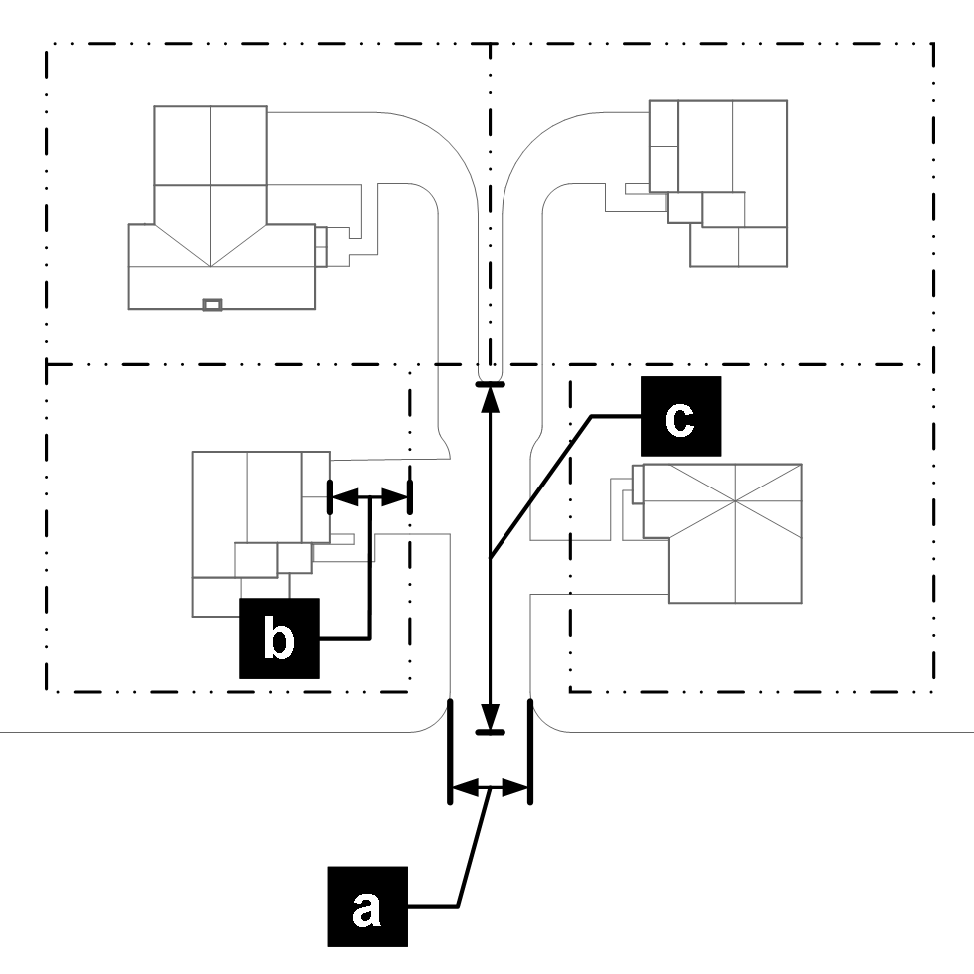
(Code 2009, § 15.05.050)
Sec. 15.05.060. - Pedestrian and bicycle access and connectivity.
A.
Purpose. These standards are intended to implement the comprehensive plan and to provide for a safe and convenient system of well-connected pedestrian ways and bikeways and multi-use corridors that link developments with shopping, employment centers, recreational facilities, open space, parks, transit stops, and schools. Within individual developments, these standards require safe and convenient pedestrian and bikeway systems that directly link buildings, parking areas, open space, transit stops, services, and other areas of interest. In addition, these standards encourage convenient access to transit services, including linking transit access to on-site pedestrian and bicycle systems.
B.
Applicability. This section applies to new development and redevelopment.
C.
Detached sidewalks required.
1.
Detached sidewalk design is addressed in the city standards. Detached sidewalks shall be installed along all streets, except where attached walks are explicitly allowed or required.
2.
Sidewalks shall be detached from the curb at least eight feet to allow for a landscaped planting strip between the edge of the right-of-way and sidewalk, except for transitioning at street intersections where sidewalks shall be attached.
D.
On-site pedestrian and bicycle access.
1.
General standards. All new development shall provide on-site pedestrian and bicycle facilities that comply with the following standards:
a.
On-site bicycle and pedestrian facilities shall connect to the city's existing and planned bike and pedestrian network, including adjacent greenway paths. Safe and convenient bicycle and pedestrian access from the site shall comply with the Americans with Disabilities Act and shall be provided to the public bike and pedestrian system located adjacent to the development.
b.
On-site connections shall be made to provide direct pedestrian and bicycle travel from the development to major pedestrian destinations located within the development and adjacent developments. In order to provide direct pedestrian connections to these adjacent destinations, the city may require additional on-site and off-site bike and pedestrian facilities not associated with a street.
c.
The development shall provide, when necessary to ensure public safety, construction of or contribution to pedestrian and bicycle facilities (for example, overpasses, underpasses, or traffic signalization) in the vicinity of parks, shopping areas, or other uses that may generate considerable pedestrian and bicycle traffic.
2.
Pedestrian connections. All primary entrances of principal structures containing mixed-use and nonresidential uses, and each entryway serving dwelling units in a single-family attached and multifamily structure, shall have direct access (without having to cross a street) to a sidewalk, pedestrian walkway, or trail that leads to a sidewalk adjacent to a public street. Each such sidewalk, pedestrian walkway, or trail shall be a minimum of five feet wide, or a minimum of seven feet wide where it is adjacent to areas where parked cars may overhang the walk or trail. See also section 15.05.120 for additional pedestrian connection requirements.
3.
Bicycle connections. In developments containing nonresidential uses or multifamily uses, bicycle access routes shall be provided between public bikeways and on-site bicycle parking areas. Sites should be designed to avoid or minimize all conflicting bicycle/motor vehicle and bicycle/pedestrian movements. All bicycle access routes connecting to the city park, open space, and greenway system shall be constructed of concrete at least eight feet wide. Bicycle access routes are also addressed in the city standards.
4.
Concrete paths. Concrete paths in public areas, including arterial right-of-way primary greenways, and parks, are addressed in city standards section 601.
5.
Transit access circulation. Nonresidential and multifamily residential developments shall incorporate bus stop locations within their site plan if requested by the regional transit district (RTD) or other transit provider. Bus stop locations shall accommodate a bus shelter and passenger-loading apron complying with RTD (or other transit provider) design criteria. All existing and proposed bus stops and park-n-ride facilities shall be linked by paved walkways to at least one sidewalk and to at least one internal walkway within each adjacent nonresidential and multifamily development that contains more than one building. Applicants are responsible for contacting and coordinating with RTD or any other transit provider to ensure compliance with this provision.
6.
Pedestrian street crossings. Pedestrian access and safety shall be emphasized when a pedestrian walkway crosses drive aisles or internal roadways. The pedestrian crossings shall be well-marked using pavement treatments, signs, striping, signals, lighting, traffic calming techniques, median refuge areas, and/or landscaping.
7.
Security, lighting and visibility. On-site pedestrian walkways, bicycle routes, and transit stops shall be illuminated to ensure personal safety. Lighting fixtures shall be compatible with the architectural character of the principal structures. Clear and direct lines of sight shall be provided in pedestrian settings to increase visibility and security to the maximum extent practicable. Any service areas (loading docks or storage areas) adjacent to pedestrian walkways or bicycle routes shall be fully screened from view. (See section 15.05.140 for additional standards.)
(Code 2009, § 15.05.060)
Sec. 15.05.070. - Underdrains.
A.
Purpose. This section provides requirements for underdrain systems which are installed to provide a safe method for conveying groundwater from around building foundations to a point of discharge.
B.
Building perimeter underdrains.
1.
When required. A building perimeter underdrain shall be provided around all foundations that retain earth and enclose habitable spaces located below grade.
2.
Design and plan approval.
a.
The building perimeter underdrain must comply with all applicable city, state, and federal regulations in place at the time of construction and shall be designed by a state-registered professional engineer.
b.
Plans for the building perimeter underdrain shall be reviewed and approved by the chief building official. Approval of the plans by the city does not relieve the professional engineer, applicant, or owner from the responsibility to construct and maintain a workable system.
3.
Compliance and inspection.
a.
The professional engineer shall inspect and certify, in writing, to the chief building official that the building perimeter underdrain was built according to the city-approved building perimeter underdrain plan.
b.
The professional engineer shall certify that the building perimeter underdrain is properly connected to the area underdrain or underdrain collection system.
c.
The city shall not issue the certificate of occupancy until receipt of the professional engineer's certification and the building perimeter underdrain connection has been completed, inspected and approved by a public works and natural resources engineer or inspector.
d.
The city may issue a stop-work order to the builder if connection of the building perimeter underdrain to the area underdrain or underdrain collection system is not completed, or if a sump pump is installed without prior written approval from the city.
e.
All building perimeter underdrains shall have a positive gravity outlet piped to an approved underdrain collection system, to a storm sewer, or to a drainage channel. The use of any conveyance system other than a gravity building perimeter underdrain system, including, but not limited to, sump pumps, must be approved in writing prior to installation by the general manager.
f.
Sump pits and pumps may be installed as a backup in addition to the gravity connection and must be approved in writing prior to installation by the general manager.
g.
No person shall make connections of sources of surface runoff to a building perimeter underdrain which in turn is connected directly or indirectly to an area underdrain and underdrain collection system. No person shall contribute or cause to be contributed, directly or indirectly, any pollutant or wastewater to the building perimeter underdrain.
4.
Ownership and maintenance. The owner of the building, dwelling, or structure shall own and maintain its building perimeter underdrain and all other portions of the underdrain that are not a part of the area underdrain and underdrain collection system.
C.
Area underdrains and underdrain collection systems.
1.
Design and plan approval.
a.
The area underdrain or underdrain collection system must comply with all applicable city, state and federal regulations in place at the time of construction.
b.
A professional engineer registered in the state must design, and stamp the area underdrain plans, underdrain collection system plans, and underdrain report. The system shall be designed in consideration of seasonal high groundwater levels anticipated at the project site.
c.
All area underdrains and underdrain collection systems shall have a positive gravity outlet piped to an approved underdrain collection system, to a storm sewer, or to a drainage channel. The use of any conveyance system other than a gravity system, such as a lift station, must be approved in writing prior to installation by the general manager.
d.
Area underdrains and underdrain collection systems, six inches in diameter or smaller, placed adjacent to and in the same trench as sanitary sewer mains shall be rigid walled nonperforated pipe and shall have a minimum clearance of one foot from the side of the underdrain pipe to the side of the sanitary sewer main pipe. Access points on underdrain systems are not allowed to connect to or surface into sanitary sewer manholes.
e.
Area underdrains and underdrain collection systems, six inches in diameter or larger must be placed in a separate trench from all other underground utilities. Area underdrains and underdrain collection system placed in the right-of-way shall be rigid walled nonperforated pipe.
f.
An underdrain report must be submitted with the plans, and shall, at a minimum, include the sizing criteria for the area underdrain and underdrain collection system and maintenance requirements.
g.
The city development review committee shall review the stamped plans and underdrain report. Approval of the plans and underdrain report by the city does not relieve the professional engineer, applicant, or owner from the responsibility to construct and maintain a workable system.
2.
Compliance and inspection.
a.
The professional engineer shall perform regular inspections of the construction of the area underdrain and underdrain collection system to ensure that the system is built in accordance with the approved plans.
b.
As-built plans must conform to the city standards. Inspection of the area underdrain and underdrain collection system will also be performed by the public works and natural resources engineer or inspector.
c.
The city shall not issue any building permits for the premises served by the area underdrain or underdrain collection system until receipt of the professional engineer's inspection reports, dye testing and/or video inspection, and as-built plans.
d.
Access points shall be installed on area underdrains and underdrain collection systems.
e.
Copies of inspection reports will be provided to the city. Dye testing and video inspection of the area underdrain and underdrain collection system to ensure operability will be submitted with the inspection reports.
f.
No person shall make connections of sources of surface runoff to an area underdrain or underdrain collection system. No person shall contribute or cause to be contributed, directly or indirectly, any pollutant or wastewater to the area underdrain or underdrain collection system.
g.
No connection of one area underdrain and underdrain collection system to another will be allowed without the express written approval of the owner.
3.
Ownership and maintenance.
a.
The property owners' association shall own and maintain any area underdrain or underdrain collection system if the system serves more than one property. Covenants, approved by the city, must specify ownership and ensure adequate maintenance by a property owners' association.
b.
Copies of the underdrain report, the professional engineer's inspection reports, the video inspection, and as-built plans will be provided to the property owners' association by the developer.
c.
Where practicable, installation of the area underdrain and underdrain collection system shall be on private property with the approval of the property owner. The city may allow installation of the area underdrain and underdrain collection system within common areas or on-site pedestrian trail systems.
4.
Use of right-of-way. The city may approve installation of the area underdrain and underdrain collection system in public rights-of-way, public open space or public pedestrian trail systems, subject to the following:
a.
The applicant obtains an infrastructure permit and maintains infrastructure according to city standards and regulations; and
b.
The applicant indemnifies the city for all costs of repair (including repair of public areas, streets, landscaping, and utilities) and liability for failure of the system, as approved by the city attorney and the risk manager.
D.
Exceptions.
1.
Submittal of exception request. Requests for exceptions to this section shall be submitted in writing to the general manager. The request shall state the exception requested, the justification and supporting data for the exception. The city may require that exceptions be signed by a professional engineer registered to do work in the state and bear their seal.
2.
Criteria.
a.
Special circumstances or conditions exist which limit the ability of the design to meet the requirements outlined in this development code. Financial difficulties, loss of prospective profits and previously approved exceptions in other developments shall not be considered as special circumstances; or
b.
The exception represents an alternative design that will meet the intent of the requirements set forth in the code;
c.
In either case, if granted, the exception will not be detrimental to the public interest or other property and will not endanger the public safety, health or welfare.
3.
Timing. All exceptions must be reviewed and acted on prior to construction. The city shall respond promptly in writing to such requests, but reserves a minimum of five working days for review and response. When additional time is required, the city shall notify the submitter of the need for additional time within two working days of the submittal.
4.
Exception does not apply to other standards beyond the request. Approval of plans by the city, which contain design elements not in compliance with this development code, and for which an exception request has not been specifically requested and approved, does not imply approval of an exception from these requirements.
(Code 2009, § 15.05.070)
Sec. 15.05.080. - Off-street parking, stacking, and loading.
A.
Purpose. This section is intended to provide off-street parking and loading facilities in proportion to the parking, loading, and transportation demands of different land uses throughout the city. This section is also intended to help protect the public health, safety, and general welfare by:
1.
Mitigating single occupancy motor vehicle travel, encouraging active forms of transportation and less polluting forms of transportation;
2.
Providing safe and convenient interaction between vehicles and pedestrians;
3.
Providing necessary access for service and emergency vehicles;
4.
Providing methods to help reduce stormwater runoff and the heat island effect of large paved parking areas; and
5.
Providing flexible methods of responding to the transportation, access, and parking demands of various land uses in different areas of the city through changes in markets, technology, and demographics.
B.
Applicability.
1.
New development and redevelopment. Unless otherwise exempted in this development code, this section shall apply to all development.
2.
Nonconforming parking and loading. Nonconforming off-street parking and loading requirements shall be subject to section 15.08.100.
3.
Exemption. Properties located within the General Improvement District ("GID") are exempt from maximum parking requirements.
C.
Reserved.
D.
Calculation of parking and loading requirements.
1.
Area measurements. All square-footage based parking and loading requirements shall be calculated on the basis of gross floor area of the subject use. Structured parking within a building shall not be counted in such calculation.
2.
Fractions. When a calculation of a parking allowance results in a fractional number, a fraction of 0.5 and higher shall be rounded up to the next highest whole number and a fraction less than 0.5 shall be rounded down to the next lowest whole number.
3.
Parking and loading for unlisted uses. For uses that are not specifically listed in table 15.05.080(1), the number of parking spaces permitted shall be the number permitted for the most similar use listed or as approved in an alternative parking plan described below.
4.
Shared parking. Shared parking shall be provided to the extent practicable, to use parking areas efficiently while allowing flexibility for additional development.
5.
Reserved.
6.
Reserved.
7.
Alternative parking plans.
a.
Scope. An alternative parking plan may be approved to satisfy vehicle parking needs by means other than providing parking according to the ratios established in table 15.05.080(1), or by providing an alternative to this section's off-street parking area design standards. Alternative parking plans may not be used to reduce required setbacks, landscaping, or screening of off-street parking areas.
b.
Applicability. Applicants who wish to: (1) provide additional parking beyond the allowed parking maximums of this section; (2) provide parking off-site; or (3) deviate from this section's off-street parking design standards, shall secure approval of an alternative parking plan according to the standards of this subsection.
c.
Contents. Alternative parking plans shall be submitted in a form established by the director. At a minimum, such plans shall detail the type of alternative proposed and the rationale behind the proposal.
d.
Review procedure and additional criteria. The alternative parking plan shall be reviewed according to the administrative modification procedure in section 15.02.080.B, and shall also demonstrate:
i.
The plan will minimize or mitigate adverse impacts to surrounding neighborhoods to the maximum extent practicable;
ii.
The plan maintains or improves traffic circulation patterns; and
iii.
The plan promotes quality urban design as well as or better than a plan that strictly complies with the off-street parking standards.
E.
Off-Street Parking Spaces. Off-street parking allowances for all projects, not in the GID zoning district, are identified in Table 15.05.080(1) below.
1.
Number of Parking Spaces Required—By Land Use.
2.
Reserved.
3.
Reserved.
4.
Accessible Parking.
a.
The location of accessible parking spaces shall be pursuant to the adopted building code and the Americans with Disabilities Act (ADA), as amended. The number of required accessible spaces shall be provided in accordance with US Department of Justice ADA Standards for Accessible Design, as amended. Accessible spaces are counted towards any parking allowance or restriction.
b.
The US Department of Justice ADA Standards for Accessible Design is on file in the office of the Director and Planning and Development Services and may be inspected by an interested person between 8:00 a.m. and 5:00 p.m., Monday through Friday, holidays excepted.
5.
For any required off-street parking minimums, a parking space that is served by an EV charging station (EVSE) counts as one standard automobile parking space and any van-accessible parking space that is wheelchair accessible and served by an EV charging station counts as two standard automobile parking spaces.
F.
Location of off-street parking spaces.
1.
Residential zoning districts.
a.
Reserved.
b.
Off-street parking for single-family detached and single-family attached dwellings may be located within the front yard setback area on a hard-surfaced driveway approved by the city, but shall not be located in any landscape area.
c.
Off-street parking for multifamily dwellings shall be located behind buildings or no closer to the street than buildings to the maximum extent practicable.
2.
Mixed-use and nonresidential zoning districts.
a.
Provided off-street parking spaces in the mixed-use and nonresidential zoning districts shall be located on the same lot as the building or use for which they are required unless parking spaces are provided, through a shared parking agreement, on lots within one-quarter mile (1,320 feet) from the proposed building or use.
b.
Off-street parking in the mixed-use and nonresidential zoning districts shall not be located within a required buffer or landscape area or in the right-of-way between the curb and the property line.
c.
Off-street parking and loading areas shall be located behind buildings or no closer to the street than buildings to the maximum extent practicable. See sections 15.05.120 and 15.05.200 for additional site layout requirements.
d.
In the MU-D and MU-C zoning districts, no parking lots shall front Main Street for new developments.
3.
Protection of rivers, streams, riparian areas and wetlands. See section 15.05.020 for required parking area setbacks from delineated river/stream corridors, riparian areas, and wetlands.
G.
Use of parking spaces.
1.
Off-street parking spaces may be used only for parking licensed, operable, motor vehicles, or as allowed under title 11.
2.
Off-street parking spaces shall not be used for the display of goods for sale or lease, for motor vehicle repair or service work (except for personal and not commercial vehicle repair or service), or for long-term storage of recreational vehicles, boats, motor homes, campers, mobile homes, or building materials.
H.
Parking lot layout and design.
1.
Vehicular access and circulation.
a.
Unobstructed vehicular access to and from a public street shall be provided in a safe manner for all off-street parking spaces.
b.
Parking lots shall provide well-defined circulation routes for vehicles, bicycles, and pedestrians. Parking lots of over 100 spaces and parking lots with spaces located more than 250 feet from the associated principal use shall include walkways to maximize connectivity.
c.
Curb definitions shall be maintained, prohibiting continuous vehicular access to parking areas along the street frontage of the site.
d.
All off-street parking and loading areas in mixed-use and nonresidential zoning districts shall meet the following design standards:
i.
Driveways shall be placed such that loading and unloading activities shall not hinder vehicular ingress or egress.
ii.
Off-street parking and loading areas shall be treated to minimize the visual impact of parked cars and trucks as viewed from the public right-of-way and adjacent properties through the use of plantings, earth berms, or screen walls. See section 15.05.040.J for off-street parking and loading area landscaping and section 15.05.130.A for additional loading area screening requirements.
iii.
Truck access and circulation routes shall be designed to minimize potential traffic and noise conflicts with adjacent sites, walkways between sidewalks and principal building entrances, and internal circulation routes.
2.
Points of conflict. The lot layout shall provide continuous, direct pedestrian access with minimum driveway and drive aisle crossings. Treatments such as raised pedestrian crossings, special paving, signs, lights and bollards shall be provided at intersections to reduce traffic conflict. Parking stalls located along primary drive lanes shall be allowed only where backing vehicles will not create circulation or safety impacts.
3.
Orientation of parking spaces. Parking stalls in lots over 100 spaces shall use 90-degree parking to provide safer and efficient parking lot layout.
4.
Addressing mobility needs. Layout and design shall accommodate user needs and provide continuity between vehicular circulation, parking needs, pedestrian, and bicycle circulation. Pedestrian drop-off areas shall be provided to the extent practicable.
5.
Surfacing Materials. All parking and driveway areas, primary access to parking facilities, and other vehicular use areas shall be surfaced with concrete, asphalt, or approved permeable paving in conformance with city standards, except those driveways with primary access to residential uses shall be surfaced with concrete. The director may allow an administrative modification under subsection 15.02.080.B for gravel, recycled asphalt or similar acceptable surface materials to be used for long-term or overnight-only vehicle storage areas.
6.
Parking area landscaping. Parking areas shall be landscaped pursuant to section 15.05.040.J.
7.
Off-street loading design standards.
a.
Each off-street loading space shall be a minimum of 500 square feet, exclusive of any area used for maneuvering or off-street parking spaces and shall be a minimum of 12 feet wide.
b.
Maneuvering or staging areas shall be large enough for the longest legal truck to serve the use and must be contained entirely on the lot served. Design of the off-street loading areas and spaces shall allow trucks to maneuver out of the areas and spaces without backing onto a public street.
c.
All off-street loading spaces shall be provided behind the front setback line. Loading areas shall be located behind or on the non-street side of the buildings to the maximum extent practicable.
8.
Design of off-street parking spaces.
a.
Minimum dimensional requirements.
i.
Off-street parking spaces shall comply with the minimum dimensional standards stated in table 15.05.080(3) as follows:
ii.
Valet parking spaces are exempt from the minimum space dimensional standards in this table.
iii.
Vehicles may overhang as noted in table 15.05.080(3) only where a landscape island, median or buffer meets current standards, or a sidewalk is at least seven feet wide.
I.
Vehicle stacking and drive-through standards. The development and design standards of this subsection shall apply to all drive-through facilities and other auto oriented uses:
1.
Drive-through aisles. The minimum standards for drive-through aisles are as follows:
a.
Drive-through aisles shall have a minimum ten-foot interior radius at curves and a minimum ten-foot width.
b.
Drive-up windows for food and beverage service shall provide at least 180 feet (approximately nine vehicles) of stacking space for each facility, as measured from the service window to the entry point into the drive-through lane. Non-food/beverage businesses may reduce the stacking space to a minimum of 60 feet (approximately three vehicles) as measured from the service window or unit to the entry point into the drive-through aisle.
c.
Each entrance to a drive-through aisle and the direction of traffic flow shall be clearly designated by signs and pavement markings.
d.
Each drive-through aisle shall be separated from the circulation routes necessary for ingress or egress from the property, or access to a parking space.
2.
Pedestrian access and crossings. Pedestrian walkways should be constructed to avoid the drive-through aisles, but where they must intersect the walkways shall have clear visibility and shall be delineated from the drive-through aisle per section 15.05.060.D.6.
3.
Design and layout.
a.
Drive-through aisles shall be separated from other internal driveways.
b.
Drive-through aisles (order stations, pick-up windows, bank teller windows, money machines, etc.) shall be located on the side or rear of principal structures to minimize their visibility from public streets.
c.
Drive-through aisles shall be separated from adjacent properties and frontages, and landscaped pursuant to the buffer requirements in section 15.05.040.F.
d.
In addition to any buffering required by section 15.05.040, drive-through aisles adjacent to residential uses in a residential district shall be separated from such uses by an opaque wall at least six feet in height and consistent with the materials and color of the principal building materials, located so that required buffer landscaping is between the wall and the adjacent residential use.
4.
Car wash facilities and auto service bays.
a.
Car wash facilities and auto service bays shall be located on the side or rear of principal structures and shall face away from public streets.
b.
In addition to any buffering required by section 15.05.040, car wash facilities and auto service bays adjacent to residential uses in a residential district shall be separated from such uses by an opaque wall at least six feet in height and consistent with the materials and color of the principal building materials, located so that required buffer landscaping is between the wall and the adjacent residential use.
J.
Bicycle parking.
1.
Required amount of bicycle parking. Mixed-use, nonresidential, and multifamily residential uses shall provide bicycle parking spaces equal to a minimum of five percent of the total number of vehicle parking spaces provided by the development, but not less than one bicycle rack.
2.
Bicycle parking location. For convenience and security, bicycle parking facilities shall be located near building entrances (and no further than 100 feet away from such entrance), shall be visible from the land uses they serve, and shall not be located in remote areas. The director may allow an administrative modification under section 15.02.080.B for office facilities or those land uses with less need for publicly available bicycle racks, to substitute indoor bike parking facilities to meet bike parking requirements. For multifamily developments, at least one bicycle rack shall be located at each building with eight or more dwelling units, as applicable. Such facilities shall not, however, be located in places that impede pedestrian or automobile traffic flow or that would cause damage to plant material.
3.
Design. Spaces for short-term bicycle parking shall provide a means for the bicycle frame and one wheel to be attached to a permanent fixture (designed for securing bicycles) by means of a lock. The required design is the "inverted U" rack. The director may allow an administrative modification under section 15.02.080.B for alternative bike parking rack design. The inverted U rack is equivalent to two bicycle spaces.
K.
Maintenance of parking, loading and stacking areas. The property owner shall be responsible for maintaining any vehicular use area in good condition and free of refuse and debris. Landscaping shall conform to section 15.05.040.
L.
Electric Vehicle Ready Requirements.
1.
On or after March 1, 2024, all new buildings and all buildings undergoing major renovations and additions must comply with the Electric Vehicle Ready requirements in the Colorado Model Electric Ready and Solar Ready Code. Specifically, residential use buildings, including one- and two-dwelling and townhome buildings, buildings meeting the definition of multifamily (defined as R-2 in the International Building Code), and commercial use buildings, that provide off-street parking spaces, must provide the minimum number of electric vehicle spaces stated in table 15.05.080(5) as follows:
2.
For purposes of the foregoing off-street electric vehicle minimum parking spaces requirements, the following applies:
a.
The requirements apply to all new buildings that have not applied for an electrical permit or have an approved site development plan as of March 1, 2024. If a developer applies for an electrical permit or has a site development plan approved before March 1, 2024, the foregoing electric vehicle minimum parking spaces requirements do not apply.
b.
"Major renovations or additions" means changes or additions to a parking area that change 50 percent or more of the parking spaces.
c.
The total number of electric vehicle spaces required shall be rounded up to the nearest whole number.
d.
For multifamily residential uses, the total number of parking spaces for the entire development shall be used to determine the number of electric vehicle parking spaces required. For all other buildings, where parking spaces are spread out over multiple lots, the electric vehicle parking spaces required will be calculated by each lot.
3.
For commercial buildings that install a DCFC EVSE, each DCFC EVSE installed shall be permitted to be substituted for other electric vehicle space types as follows:
a.
Commercial buildings, other than multifamily, shall be permitted to substitute up to ten spaces when the building provides a minimum of 20 percent of parking spaces as a combination of EV Capable, EV Ready, or EVSE Installed spaces.
b.
Multifamily development shall be permitted to substitute up to five spaces when the development provides a minimum of 60 percent of parking spaces as a combination of EV Capable Light, EV Capable, EV Ready, or EVSE Installed spaces.
4.
The following substitutions may occur when determining the number of each type of electric vehicle spaces:
a.
EVSE Installed Spaces that exceed the minimum requirements of this section are permitted to be used to meet minimum requirements for EV Ready Spaces, EV Capable Spaces, and EV Capable Light Spaces.
b.
EV Ready Spaces that exceed the minimum requirements of this section are permitted to be used to meet minimum requirements for EV Capable Spaces and EV Capable Light Spaces.
c.
EV Capable Spaces that exceed the minimum requirements of this section are permitted to be used to meet the minimum requirements for EV Capable Light Spaces.
d.
However, all attached garages with direct connection to a dwelling unit will be required to have one EV Ready Space.
5.
Waivers and Variances.
a.
Any building impacted by a declared natural disaster that destroyed buildings or resulted in other exceptional and extraordinary circumstances as determined by the Director of Planning and Development Services or designee may seek a waiver or variance from the foregoing off-street electric vehicle minimum parking spaces requirements if enforcement of these requirements will result in unnecessary hardship.
b.
Commercial, including multifamily, developments with a gross floor area greater than 10,000 square feet that assert that compliance with the foregoing off-street electric vehicle minimum parking spaces requirements will result in a substantial cost differential may seek to waive certain requirements only until the cost differential for compliance with the remaining requirements reaches one percent or less.
i.
"Substantial cost differential" means costs incurred as a result of compliance with the off-street electric vehicle minimum parking spaces requirements that would exceed one percent of total mechanical, electrical, and plumbing costs, inclusive of materials and labor, for the building.
ii.
The burden of proof is upon the applicant to provide substantiation of a cost differential, such as quotes or other licensed design professional analyses as approved by the Director of Planning and Development Services or designee.
c.
Waivers and variances sought under this chapter will be determined under the procedure provided for reviewing alternative parking plans under Section 15.05.080.D.7.
(Code 2009, § 15.05.080; Ord. No. O-2022-44, § 2, 11-15-2022; Ord. No. O-2024-17, § 1, 2-27-2024; Ord. No. O-2024-39, §§ 1, 2, 5-28-2024)
Sec. 15.05.090. - Oil and gas regulations.
A.
Purpose statement.
1.
Protect and enhance the character and quality of the city's neighborhoods;
2.
Provide visual interest and variety;
3.
Enhance the pedestrian scale of development and the streetscape;
4.
Mitigate negative visual impacts from the scale, bulk, and mass of large buildings;
5.
Balance the community's economic and aesthetic goals; and
6.
Encourage building and site design that fosters community sustainability goals, including adaptive reuse.
B.
Authority. This section is adopted pursuant to C.R.S. § 31-15-401, state constitution article XX, § 6 and C.R.S. §§ 29-20-11 et seq., 34-60-101 et seq., and 30-28-101 et seq. These standards are not intended to supersede state or federal laws, regulations, or rules pertaining to oil and gas development, but rather are meant to supplement those requirements where appropriate and to address areas of regulation where none has been heretofore established by the state or federal governments.
C.
Applicability.
1.
All oil and gas well operations and facilities within the city are subject to the requirements of this section. In the event that the provisions of this section conflict with any other provisions of this Code, this section shall supersede as it applies to oil and gas well operations and facilities.
2.
City oil and gas well permits issued pursuant to this section shall encompass within its authorization the right of the operator, its agents, employees, subcontractors, independent contractors, or any other person to perform that work reasonably necessary to conduct the activities authorized by the permit, subject to all other applicable city regulations and requirements.
3.
City oil and gas well permits may be issued for sites within the city excluding oil and gas well surface operations and facilities in residential zoning districts. For purposes of this section, residential zoning shall include residential and mixed-use planned unit development (PUD) districts and mixed-use (MU) zoning districts that include existing or planned residential uses. Any proposed oil and gas well location not complying with the requirements of this subsection, may apply for an operational conflict special exception according to the procedures in this section. Oil and gas waste disposal facilities, including injection wells for disposal of oil and gas exploration and production wastes, commercial disposal facilities, centralized E&P waste management facilities, and subsurface disposal facilities are classified as heavy industrial uses and are limited to applicable industrial zoning districts.
D.
Exceptions.
1.
Oil and gas well facilities that are in existence on the effective date of the ordinance from which this subsection is derived or that are located within territory which thereafter is annexed to the city may continue operating without the issuance of a city oil and gas well permit. A city oil and gas well permit is required for any such grandfathered well prior to any of the following: oil and gas well location expansion, new wells on the well site, and operations including completing, recompleting, hydraulic fracturing, sidetracking, or twinning of a well. Existing oil and gas well and production facilities shall not be considered nonconforming in terms of setback requirements where development has encroached within the required setbacks. The right to operate oil and gas well facilities terminates if the use thereof is discontinued for six months or more, other than by temporary abandonment or shut-in which is in conformance with COGCC rules.
2.
Accessory equipment and pumping systems that are in existence on the effective date of the ordinance from which this subsection is derived or are located within territory which thereafter is annexed to the city may continue operating without the issuance of a city oil and gas well permit. Any renovation or repair of nonconforming accessory equipment or pumping systems shall be permitted without a city oil and gas well permit, provided the work does not increase the degree of nonconformity. Any replacement of existing accessory equipment or any addition of accessory equipment shall conform to this section subject to the applicable review process in this section. The replacement or addition of individual tanks, treaters, or separators shall not require the remaining accessory equipment in an oil and gas well location to conform to the development standards in this section.
E.
Prohibitions. The following oil and gas facilities are prohibited within the city: Temporary housing at an oil and gas well location, including trailers, recreational vehicles, and similar temporary structures.
F.
Definitions. For the purposes of these oil and gas well regulations only, term definitions are included at the end of this section.
G.
General provisions.
1.
Application process:
a.
Applications subject to administrative review. The following are subject to administrative review:
i.
Oil and gas well operations and facilities that comply with all minimum and recommended standards in this section are subject to limited use site plan review.
ii.
Seismic survey operations are subject to administrative review, except that seismic survey operations on city owned property may be subject to city council approval.
iii.
Pipelines that cross public property are subject to a work in right-of-way permit review.
b.
Applications subject to public hearing review. The following are subject to public hearing review:
i.
Oil and gas well operations and facilities that meet minimum standard requirements and some or none of the recommended standards listed in this section are subject to conditional use site plan review.
ii.
The following oil and gas facilities are subject to conditional use site plan review:
(a)
Injection wells for disposal of oil and gas exploration and production wastes;
(b)
Commercial disposal facilities;
(c)
Centralized E&P waste management facilities;
(d)
Subsurface disposal facilities;
(e)
Other oil and gas facilities permitted by COGCC and not described above.
c.
Variances and operational conflicts special exceptions.
H.
Submittal requirements. Applications for a limited use or conditional use site plan for oil and gas well operations and facilities under this subsection shall contain all relevant information required for limited use and conditional use site plan applications and the specific information for oil and gas well operations and facilities contained in the administrative manual.
I.
Issuance of oil and gas well permit for unsubdivided property. A city oil and gas well permit may be granted on unsubdivided property without requiring the property to be subdivided.
J.
Notice and procedures.
1.
Limited use review. Applications for limited use review of oil and gas well operations and facilities are subject to the notice requirements of section 15.02.040.J and the review procedure for minor development applications of section 15.02.050.C.
2.
Conditional use review. Applications for conditional use review of oil and gas well operations and facilities are subject to the notice requirements of section 15.02.040.J, and the review procedure for major development applications of section 15.02.050.B.
K.
Review criteria.
1.
Limited use review. Applications for limited use review are subject to site plan and limited use review in section 15.02.070.C and D respectively, in addition to the development standard compliance criteria listed below.
2.
Conditional use review. Applications for conditional use review are subject to conditional use and site plan review in sections 15.02.060.C and 15.02.070.C respectively, in addition to the development standard compliance criteria listed below.
L.
Compliance with development standards.
1.
Applications for limited use review shall comply with all standards, including recommended standards in this section.
2.
Applications for conditional use review shall comply with the minimum standards in this section, unless a variance or special exception is granted by the decision-making body, as well as conditions of approval specified in the conditional use agreement.
M.
Variances and operational conflicts special exceptions.
1.
Variance requests.
a.
Variance requests to the standards of this section may be requested by the applicant. All applications where a variance is requested shall be processed in accordance with the standards and procedures outlined in section 15.02.060.I for variances.
b.
Requests for variances may include, but are not be limited to, one or more of the following factors:
i.
Topographic characteristics of the site;
ii.
Duration of use of the facility;
iii.
Proximity of occupied structures to the facility;
iv.
Ownership status of adjacent and/or affected land;
v.
Construction of adequate infrastructure to serve the project; and
vi.
Planned replacement and/or upgrading of facility equipment.
c.
If the decision-making body finds, based upon competent evidence in the record, that compliance with the regulations of this division is impractical, a variance may be granted by the decision-making body permanently or for a period of defined duration.
2.
Operational conflicts special exception.
a.
Special exceptions to the standards of this section may be granted where the actual application of requirements of this section conflicts in operation with the requirements of the Oil and Gas Conservation Act or implementing regulations.
b.
All applications where a special exception due to operational conflicts is requested shall be processed as a public hearing and reviewed in a noticed public hearing by the decision-making body acting in a quasi-judicial capacity.
c.
The applicant shall have the burden of pleading and proving an actual, material, irreconcilable operational conflict between the requirements of this section and the state's interest in oil and gas development in the context of a specific application.
d.
For purposes of this section, an operational conflict exists where actual application of a city condition of approval or regulation conflicts in operation with the state statutory or regulatory scheme, and such conflict would materially impede or destroy the state's interest in fostering the responsible, balanced development and production and utilization of the natural resources of oil and gas in the state in a manner consistent with protection of public health, safety and welfare, including protection of the environment and wildlife resources, and no possible construction of the regulation in question could be found that would harmonize it with the state regulatory scheme.
e.
Additional city requirements in areas regulated by the COGCC, which fall within city land use and police powers and which are necessary to protect the public health, safety and welfare under the facts of the specific application presented, and which do not impose unreasonable burdens on the applicant and which do not materially impede the state's goals, shall be presumed not to present an operational conflict.
f.
If the decision-making body finds, based upon competent evidence in the record, that compliance with the requirements of this section shall result in an operational conflict with the state statutory and regulatory scheme, a special exception to this section may be granted, in whole or in part, but only to the extent necessary to remedy the operational conflict.
g.
The decision-making body may condition the approval of a special exception as necessary to protect the public health, safety and welfare by mitigating any adverse impacts arising from the grant of approval. Any such condition shall be designed and enforced so that the condition itself does not conflict with the requirements of the COGCC.
h.
A final decision by the city on the exception request is subject to judicial review pursuant to Rule 106(a)4 of the Colorado Rules of Civil Procedure.
N.
Third party technical review.
1.
Upon determination that the application is complete, the city may require that the application materials, including requests for minor modifications, variances, and operational conflicts special exceptions, be submitted to a technical consultant deemed by the city to be appropriate and necessary to complete the review.
2.
Reasonable costs associated with such review shall be paid by the applicant.
O.
Sales and use tax license requirement.
1.
Operators shall obtain and maintain a city sales and use tax license prior to commencing operations.
2.
Operators must conform to applicable provisions of chapter 6.04 related to licensing.
P.
Building permit requirement. The operator shall obtain building permits prior to the construction of any above ground structures to the extent required by the city building and fire codes then in effect.
Q.
Approval period. Approval of limited use or conditional use applications for oil and gas well operations and facilities are valid for two years from the date of approval until the start of the operation, unless the decision-making body grants a longer approval period.
R.
Extensions. Requests for extensions to the approval period for oil and gas well operations and facilities shall be reviewed according to the procedures outlined in section 15.02.040.I.
S.
Issuance of oil and gas well permit. The following items are required by the city prior to issuance of a city oil and gas well permit:
1.
Approval of a limited use site plan or conditional use site plan, as applicable.
2.
Satisfaction of any conditions of approval of the above applications prior to commencement of operations.
3.
Copies of:
a.
Applicable executed agreements;
b.
Applicable transportation related permits;
c.
A city sales and use tax license;
d.
Required liability insurance; and
e.
All necessary state or federal permits issued for the oil and gas well operation and facilities.
4.
Financial securities, or payment of fees, as applicable.
T.
Right to enter/inspections.
1.
Right to enter. For the purpose of implementing and enforcing this section, duly authorized city personnel or contractors may enter onto subject property upon notification of the permitee, lessee or other party holding a legal interest in the property. If entry is denied, the city shall have the authority to discontinue application processing, revoke city-approved permits and applications, or to obtain an order from a court of competent jurisdiction to obtain entry.
2.
Operator contact. The applicant shall provide the telephone number of a contact person who may be reached 24 hours a day for purposes of being notified of any proposed city inspection under this section or in case of emergency. Any permitted oil and gas operations and facilities may be inspected by the city at any time, to ensure compliance with the requirements of the city-approved permit, provided that at least one hour's prior notice is given to the contact person at the telephone number supplied by the applicant. Calling the number (or leaving a message on an available answering machine or voice mail service at the number) at least one hour in advance of the proposed inspection shall constitute sufficient prior notice if the contact person does not answer. By accepting an approved city oil and gas well permit, the applicant grants consent to such inspections. The cost of any city inspection deemed reasonable and necessary to implement or enforce the regulations for the applicant shall be borne by the applicant, provided such inspections and fees are not in conflict with COGCC inspections and rules.
U.
Enforcement and penalties.
1.
Oil and gas operators working without or not in compliance with a city oil and gas well permit. Any operator engaging in oil and gas well operations who does not obtain a city oil and gas well permit pursuant to these regulations, who does not comply with city oil and gas well permit requirements, or who acts outside the jurisdiction of the city oil and gas well permit may be enjoined by the city from engaging in such oil and gas well operations and may be subject to such other penalties or civil liability as may be prescribed by law. If the city prevails in whole or part in any action, the operator shall pay all reasonable attorney fees and expert costs incurred by the city.
2.
Suspension of city oil and gas well permit. If the city determines at any time that there is a violation of the conditions of the city oil and gas well permit or that there are material changes in an oil and gas operation or facility as approved by the permit, the development services manager or designee may, for good cause, temporarily suspend the city oil and gas well permit. In such case, upon oral or written notification by the development services manager or designee, the operator shall cease operations immediately. The development services manager or designee shall forthwith provide the operator with written notice of the violation or identification of the changed condition. The operator shall have a maximum of 15 days to correct the violation. If the violation is not timely corrected, the permit may be further suspended pending a revocation hearing. The operator may request an immediate hearing before the planning and zoning commission regarding the suspension. The planning and zoning commission shall hold the hearing within ten days of the operator's written request.
3.
Revocation of city oil and gas well permit. The planning and zoning commission may, following notice and hearing, revoke a city oil and gas well permit granted pursuant to these regulations if any of the activities conducted by the operator violate the conditions of the city oil and gas well permit or these regulations, or constitute material changes in the oil and gas operation approved by the city. No less than 14 days prior to the revocation hearing, the city shall provide written notice to the permit holder setting forth the violation or the material changes and the time and date for the revocation hearing. Notice of the revocation hearing shall be published in a newspaper of general circulation not less than five days prior to the hearing. Following the hearing, the city may revoke the oil and gas permit or may specify a time by which action shall be taken to correct any violations of the oil and gas permit to avoid revocation.
4.
Transfer of permits. A city oil and gas well permit may be transferred only with the written consent of the city. The city shall not unreasonably withhold its consent, but shall ensure, in approving any transfer, that the proposed transferee can and will comply with all the requirements, terms, and conditions contained in the city oil and gas well permit and these regulations, that such requirements, terms, and conditions remain sufficient to protect the health, welfare and safety of the public, and the environment; and that an adequate guaranty of financial security related to the city-approved permit can be timely made.
5.
Judicial review. A final decision by the city on a city oil and gas well permit is subject to judicial review pursuant to rule 106(a)(4) of the Colorado Rules of Civil Procedure.
V.
General development standards. The following subsections provide minimum and/or recommended standards that will apply to any oil and gas well operations and production facilities and shall be in addition to any applicable state and federal standards. Use of consolidated well pads and directional and horizontal drilling when and where appropriate, closed loop (pitless) systems, appropriate water quality monitoring systems, and other techniques, including current and available best management practices, are intended to protect the integrity of the surface estate and subsurface resources and ensure the health, safety and general welfare of the present and future residents of the city and surrounding areas and the preservation and protection of wildlife and the environment.
1.
Compliance with state and federal regulations, rules, orders and conditions. In addition to the provisions contained in these regulations, oil and gas operations and facilities within the city shall comply with all applicable state and federal regulations, rules, orders and conditions.
2.
Multi-well sites and directional/horizontal drilling. Oil and gas well operations and facilities will be consolidated on multi-well sites and directional and horizontal drilling techniques will be used whenever possible and appropriate. In determining appropriateness, the benefits of consolidation and the use of directional and horizontal drilling, such as drilling from outside of a prohibited zoning district, minimizing surface disturbance and traffic impacts and increasing setbacks, will be weighed against the potential impacts of consolidated drilling and production activities on surrounding properties, wildlife and the environment.
3.
Well facilities siting. Oil and gas well facilities and operations shall be located and designed to minimize impacts on surrounding uses, including residential areas, schools, medical facilities, churches, day care and retirement centers, and other places of public assembly, and natural features such as distinctive land forms, vegetation, river or stream crossings, ridgelines and vistas, city-owned and city-designated open space areas, and other designated landmarks to the maximum extent practical. Efforts shall be made to avoid adversely impacting the well spacing requirements of the COGCC or the ability of the oil and gas well operator to develop the resource. Facilities should be located at the base of slopes where possible and access roads should be aligned to follow existing grades and minimize cuts and fills.
4.
Cultural resources. Applications for all oil and gas well facilities and operations may require a cultural resources report, as determined by the city. The report, if required, will be prepared by a qualified professional, and meet state requirements, including a complete written description and identification of the cultural resources on the site and within the surrounding area of the proposed oil and gas well facility and will include mitigation measures, if necessary, to ensure that appropriate actions are taken to avoid or minimize negative impacts to the maximum extent practical.
5.
Drainage. Oil and gas well operations and facilities shall comply with applicable city drainage requirements and standards.
6.
Hazard areas. Oil and gas well operations and facilities in hazard areas, including floodplains and manmade (e.g., airport) conditions, and in other areas where such operations would constitute a hazard to public health and safety or to property should be avoided. Land should not be developed for oil and gas well facilities and operations until hazards have been identified and avoided, removed, or until the applicant can show that the impact of the hazard can be mitigated to the maximum extent practical. All well facilities and operations conducted within a floodplain shall comply with title 20 pertaining to floodplain regulations.
7.
Emergency preparedness. Oil and gas well operations and facilities shall provide the city with an acceptable written emergency response plan for the potential emergencies that may be associated with the operation of the facilities. This shall include, but not be limited to, any or all of the following:
a.
Explosions, fires, gas or water pipeline leaks or ruptures, hydrogen sulfide or other toxic gas emissions, and hazardous material vehicle accidents or spills.
b.
Operation-specific emergency preparedness plans are required for any oil and gas operation that involves drilling or penetrating through known zones of hydrogen sulfide gas.
c.
The plan shall include a provision for the operator to reimburse the appropriate emergency response service provider for costs incurred in connection with the emergency.
8.
Hazardous materials. Full disclosure, consistent with COGCC requirements, including material safety data sheets of all hazardous materials that will be transported on any public or private roadway within the city for the oil and gas operation, shall be provided to the city hazards prevention office. This information will be treated as confidential and will be shared with other emergency response personnel only on an as-needed basis.
9.
Safety/security. The operator of oil and gas facilities shall comply with COGCC requirements for initial and ongoing site security and safety measures. Such requirements shall adequately address security fencing, the control of fire hazards, equipment specifications, structural stabilization and anchoring, and other relevant safety precautions.
10.
Maintenance and general operation.
a.
The operator shall at all times keep the well sites, roads, rights-of-way, facility locations, and other oil and gas operations areas safe and in good order, free of noxious weeds, litter and debris.
b.
The operator shall dispose of all water, unused equipment, litter, sewage, waste, chemicals and debris off of the site at an approved disposal site.
c.
The operator shall promptly reclaim and reseed all disturbed sites in conformance with COGCC rules.
11.
Indemnification. Each city oil and gas well permit issued by the city shall include the following language: "Operator does hereby expressly release and discharge all claims, demands, actions, judgments, and executions which it ever had, or now has or may have, or its successors or assigns may have, or claim to have, against the city and/or its departments, its agents, officers, servants, successors, assigns, sponsors, volunteers, or employees, created by, or arising out of personal injuries, known or unknown, and injuries to property, real or personal, or in any way incidental to or in connection with the actions or inactions of the operator or its agents, or caused by or arising out of, that sequence of events which occur from the operator's or its agents actions or inactions. The operator shall fully defend, protect, indemnify, and hold harmless the city and/or its departments, agents, officers, servants, successors, assigns, sponsors, or volunteers, or employees from and against each and every claim, demand, or cause of action and any and all liability, damages, obligations, judgments, losses, fines, penalties, costs, fees, and expenses incurred in defense of the city and/or its departments, its agents, officers, servants, successors, assigns, sponsors, volunteers, or employees, including, without limitation, personal injuries and death in connection therewith which may be made or asserted by operator, its agents, assigns, or any third parties on account of, arising out of, or in any way incidental to or in connection with the performance of the work performed by the operator under any permit, and the operator agrees to indemnify and hold harmless the city and/or its departments, its agents, officers, servants, successors, assigns, sponsors, volunteers, or employees from any liabilities or damages suffered as a result of claims, demands, costs, or judgments against the city and/or, its departments, its agents, officers, servants, successors, assigns, sponsors, volunteers, or employees, created by, or arising out of their acts or omissions occurring on the drill site or operation site or in the course and scope of inspecting, permitting or monitoring the oil/gas wells. Liability for any action or inaction of the city is limited to the maximum amount of recovery under the Colorado Governmental Immunity Act."
12.
Financial securities/liability insurance.
a.
Minimum standard.
i.
Performance security. The applicant may be required to provide reasonable performance security to the city through a security agreement in an amount to be determined by the city and in a form acceptable to the city as outlined in section 15.02.110.D to ensure compliance with the city oil and gas well permit and with the requirements set forth in this section. Conditions of approval covered by this performance security shall consist of measures addressing specific impacts affecting the general public and any damage to public infrastructure. Reclamation and other activities which fall under COGCC jurisdiction are exempted from this performance guarantee coverage.
ii.
Liability insurance. For any oil or gas well facility permitted under this section, the applicant shall submit a certificate of insurance to the economic development department, showing that a policy of comprehensive general liability insurance or a self-insurance program approved by the state insurance commission, in the amount of no less than $1,000,000.00 per occurrence, insuring the applicant against all claims or causes of action made against the applicant for damages arising out of the oil or gas well operations. The policy shall be written by a company authorized to do business in the state, unless the applicant provides evidence to the city that the applicant is adequately self-insured. The certificate shall require at least 30 days' notice to the city prior to termination of coverages for any reason.
b.
Recommended standard.
i.
Performance security. The applicant may be required to provide reasonable performance security to the city through a security agreement in an amount to be determined by the city and in a form acceptable to the city as outlined in section 15.02.110.D to ensure compliance with requirements set forth in this section and specific conditions in the city oil and gas permit. Conditions of approval covered by this performance security shall consist of measures addressing specific impacts that may affect the general public and any damage to public infrastructure.
13.
Impact fees. Every permit issued by the city under this section shall require the applicant or operator to pay a fee that is sufficient to pay for all impacts which the proposed operation will cause to facilities owned or operated by the city or used by the general public, including, but not limited to, repair and maintenance of roads, bridges and other transportation infrastructure; improvements made or to be made by the city to accommodate the operations and to protect public health, safety and welfare; costs incurred to process and analyze the application, including the reasonable expenses paid to independent experts or consultants; and impact fees comparable to those charged to other businesses or industries who operate within the city which are not specifically mentioned herein, and other impacts. The city shall establish a mechanism to assess and obtain payment of such fees, subject to the right of the city to request additional funds if the fees prove to be insufficient, or to refund surplus funds to the operator if the fees paid exceed the true cost of the impacts.
14.
Operation plan. Applications for all oil and gas well facilities and operations will include an operation plan, which should, at a minimum, include the operator's method and schedule for drilling, well completion, transportation, resource production, and post-operation activities.
W.
Specific development standards.
1.
Setbacks/location of wells and production facilities from buildings, platted residential lots, parks, sports fields and playgrounds, and designated outside activity areas.
a.
Recommended standard.
i.
Wells and production facilities shall be 750 feet or more from occupied buildings or occupied buildings permitted for construction.
ii.
Wells and production facilities shall be 750 feet or more, or the maximum distance practicable as determined by the city, from platted residential lots, or parks, sports fields, playgrounds or designated outside activity areas.
2.
Setbacks/location of proposed buildings, platted residential lots, parks, sports fields and playgrounds public roads, and major above ground utility lines from existing wells and production facilities.
a.
Proposed occupied buildings shall be 750 feet or more from existing oil and gas wells and production facilities.
b.
Platted residential lots, sports fields and playgrounds shall be 750 feet or more, or the maximum distance practicable, as determined by the city, from existing oil and gas wells and production facilities.
c.
Proposed unoccupied buildings and other structures shall comply with local fire code requirements.
d.
Proposed public roads and major above ground utility lines shall be located 150 feet or more from existing oil and gas wells and production facilities.
3.
Setbacks/location of proposed buildings, platted residential lots, sports fields and playgrounds from plugged and abandoned or dry and abandoned wells.
a.
Proposed occupied buildings or additions, sports fields or playgrounds shall be located 150 feet or more, or the maximum distance practicable as determined by the city, from existing plugged and abandoned or dry and abandoned oil and gas wells.
b.
Proposed unoccupied buildings shall be located 50 feet or more, or the maximum distance practicable as determined by the city, from existing plugged and abandoned or dry and abandoned wells.
c.
No proposed residential lots shall include any portion of plugged and abandoned or dry and abandoned oil and gas wells.
4.
Visual mitigation.
a.
Analysis. Applications for all oil and gas facilities may be required to include a visual impact analysis. The analysis, if required, shall include photographic simulations of the site from nearby public rights-of-way and locations as determined by the development services manager or designee and proposed impact mitigation measures as indicated below. The development services manager or designee will determine the appropriate land use from which a photographic simulation of the site shall be provided based upon topography, existing vegetative and/or structural screening, and the linear distance from the proposed oil and gas facility to the respective land use.
b.
Mitigation.
i.
Methods for appropriate visual impact mitigation include, but are not limited to, use of low profile tanks, facility painting, vegetative or structural screening, berming, or minor relocation of the facility to a less visible location on the respective site.
ii.
On-site relocation may be necessary where the proposed facility would cause visual impacts to natural ridgelines, rock outcroppings, or other distinct geologic formations, provided relocation does not adversely impact the well spacing requirements of the COGCC or the ability of the oil and gas well operator to develop the resource.
iii.
Where the painting of a facility or any structural screening (i.e., fence or wall) is required as a method of impact mitigation, such facility and screening shall be painted a uniform, noncontrasting, nonreflective color tone. The facility or structural screening paint color shall be matched to the land, not the sky, and shall be slightly darker than the adjacent landscape.
5.
Noise.
a.
Minimum standard. Sound emission levels and mitigation, at a minimum shall be in accordance with the standards as adopted and amended by COGCC.
b.
Recommended standard.
i.
Sound emission levels shall be in accordance with the standards as adopted and amended by COGCC.
ii.
The operator shall provide additional noise mitigation that may be required by the city. In determining such additional noise mitigation, specific site characteristics shall be considered, including, but not limited to, the following:
(A)
Nature and proximity of adjacent development (design, location, type);
(B)
Prevailing weather patterns, including wind directions;
(C)
Vegetative cover on or adjacent to the site or topography.
iii.
Further, based upon the specific site characteristics, the nature of the proposed activity, and its proximity to surrounding development, and type and intensity of the noise emitted, additional noise abatement measures above and beyond those required by the COGCC may be required by the city. The level of required mitigation may increase with the proximity of the facility to existing residences and platted subdivision lots and/or the level of noise emitted by the facility. One or more of the following additional noise abatement measures shall be provided by the operator if requested by the city:
(A)
Acoustically insulated housing or covers enclosing any motor or engine;
(B)
Screening of the site or noise-emitting equipment by a wall or landscaping;
(C)
Solid wall of acoustically insulating material surrounding all or part of the facility;
(D)
A noise management plan specifying the hours of maximum noise and the type frequency, and level of noise emitted;
(E)
Use of electric-power engines and motors, and pumping systems; and/or
(F)
Construction of buildings or other enclosures may be required where facilities create noise and visual impacts that cannot otherwise be mitigated because of proximity, density, and/or intensity of adjacent land use.
6.
Vibration. All mechanized equipment associated with oil and gas wells and production facilities shall be anchored so as to minimize transmission of vibration through the ground according to COGCC rules.
7.
Lighting. All on-site lighting used in the construction of the well and its appurtenances shall comply with the COGCC Rule 803. All permanent lighting fixtures installed on the site shall comply with the city lighting standards found in section 15.05.140.
8.
Water protection. Rivers, streams, reservoirs, irrigation ditches, groundwater, wetlands and other waterbodies are considered important water systems for the city. The value of both surface and groundwater are significant, and the city finds that protection of water resources is of primary importance and must be adequately addressed by any applicant for an oil and gas facility permit.
a.
Oil and gas well operations shall not adversely affect the quality or quantity of surface or subsurface waters. If the COGCC designates a waterbody as part of a public water system, oil and gas well operations shall be consistent with COGCC rule 317.B.
b.
Oil and gas well operations shall not adversely affect the water quality, quantity or water pressure of any public or private water wells.
9.
Setbacks to waterbodies.
a.
Minimum standard. Oil and gas well operations and facilities and operations shall comply with setback requirements for river/stream corridors and riparian areas, and wetlands under section 15.05.020.F. If the waterbody is associated with a designated outside activity area, the setback from the waterbody shall be consistent with the setback for the outside activity area. If the waterbody is classified as part of a public water system, oil and gas well operations shall be consistent with COGCC rule 317.B.
b.
Recommended standard. Oil and gas well operations and facilities shall be located 300 feet or more, or the maximum distance practicable as determined by the city, from the normal high-water mark of any waterbody. If the waterbody is associated with a designated outside activity area, the setback from the waterbody shall be consistent with the setback for the outside activity area. If the COGCC designates the waterbody as part of a public water system, oil and gas well operations shall be consistent with COGCC rule 317.B.
10.
Water quality testing and monitoring.
a.
The applicant shall comply with COGCC water well testing and water-bearing formation protection procedures and requirements.
b.
If the city determines that additional water quality testing or monitoring is required, the applicant shall submit a water quality monitoring plan to the city for review and approval.
c.
The plan will outline a monitoring program to establish a baseline for and monitor water quality conditions and pollutants in surface or groundwater that could be impacted by production of oil or natural gas from any well in an adjacent single or consolidated well site. The plan, at a minimum, will include the following:
i.
The type and number of wells needed to establish baseline groundwater quality upgradient and downgradient of the proposed oil and gas operations, including depth, materials of construction and location of wells on and around the site;
ii.
The constituents to be sampled for, taking into account state groundwater standards and any materials used in the oil and gas operations that could affect groundwater;
iii.
The type and frequency of samples to be collected and analyzed before operations start, during operations and after operations have been completed;
iv.
The analytical methods and reporting levels to be used;
v.
The proposed frequency of reporting results to the city and COGCC.
d.
The plan shall be based on hydrologic studies or equivalent information showing the subsurface conditions and mobility of the groundwater aquifer that will be affected by the oil and gas operations. The plan shall be prepared by an engineer registered in the state with experience in groundwater monitoring and subsurface condition investigations.
e.
The procedures and provisions in the approved plan shall be implemented by the oil and gas well operators prior to any construction or operations on the site. Oil and gas well operators shall fund the development and implementation of the water quality monitoring plan and program for the duration of operations on the site and for a minimum of five years following completion of operations and abandonment of the well. All monitoring records related to the program shall be provided to the city as soon as they are available to the operator.
11.
Waste and wastewater disposal and closed loop/pitless system.
a.
Minimum standard. All water, waste, chemicals, fluids, solutions or other solid materials or liquid substances produced or discharged by the operation of the oil and gas well's facilities shall be treated and disposed of in accordance with all applicable rules and regulations of the governmental authorities having jurisdiction over such matters.
b.
Recommended standard.
i.
No pits, production, reserve, waste, or otherwise, shall be constructed or maintained on the site and any produced water or waste and chemicals, fluids, hydrocarbons, fracturing solutions or other solid materials or liquid substances of any kind shall not be discharged on the site and shall be discharged and held only in a closed loop system comprised of sealed storage tanks, commonly used for such purposes in the industry, which contents shall be promptly removed from the site and disposed of off of the site at a licensed disposal site, in accordance with COGCC or other applicable rules and regulations.
ii.
Drilling or operation of any wastewater or other injection or disposal wells is prohibited. Except to the extent that materials are injected into a well as part of normal and ordinary drilling, completion and production operations, an operator shall not inject or re-inject any fluid, water, waste, fracking material, chemical or toxic product into any well.
12.
Production site containment. Berms or other containment devices shall be constructed around crude oil condensate or produced water and waste storage tanks and shall enclose an area sufficient to contain and provide secondary containment for 150 percent of the largest single tank. Berms or other secondary containment devices shall be sufficiently impervious to contain all spilled or released material. No more than two storage tanks shall be located within a single berm in high density areas. All berms and containment devices shall be maintained in good condition. No potential ignition sources shall be allowed inside the secondary containment area.
13.
Spill, release, discharge. The operator shall implement best management practices in compliance with applicable state and federal laws to avoid and minimize the spill, release or discharge of any pollutants, contaminants, chemicals, solid wastes, or industrial, toxic or hazardous substances or wastes at, on, in, under, or near the site. Any such spill, release or discharge, including without limitation, of oil, gas, grease, solvents, or hydrocarbons that occurs at, on, in, under, or near the site shall be remediated by the operator and notice provided by the operator in compliance with applicable state and federal laws, rules and policies.
14.
Stormwater management. The construction and operation of oil and gas wells and production equipment, including access roads and storage areas for equipment and materials, shall meet all stormwater management and pollution prevention requirements of the state department of public health and environment and any applicable requirements of chapter 14.26.
15.
Pipeline and gathering systems. The design, construction, cover, and reclamation of all pipelines and gathering lines for oil and gas operations shall be subject to the COGCC rules. The alignment location of any approved pipeline or gathering system shall be recorded against the respective property in the records of the county clerk and recorder. The location of any pipelines and gathering lines which are proposed for abandonment shall also be recorded against the respective property in the records of the county clerk and recorder upon abandonment.
16.
Air quality.
a.
Air emissions from oil and gas well facilities and operations shall be, at a minimum, in compliance with the permit and control provisions of the Colorado Air Quality Control Program, C.R.S. title 25, § 7.
b.
The operator shall make reasonable efforts to minimize methane emissions by using all feasible green completion techniques, pursuant to COGCC Rules Section 805(3), and the installation of low bleed pneumatic instrumentation and closed-loop systems.
c.
To the maximum extent practicable, all fossil fuel powered engines used on site shall employ the latest emission-reduction technologies.
d.
The use of electric-power engines and motors, and pumping systems are recommended to reduce airborne emissions wherever practical given an oil and gas well facility's proximity to available electric transmission lines.
17.
Odor/dust containment. Oil and gas facilities and equipment shall be operated in such a manner that odors and dust do not constitute a nuisance or hazard to public health, safety, welfare, and the environment, including compliance with COGCC rules section 805.b.(1), and section 15.05.160.D regarding use of best available technologies to control odor.
18.
Wildlife and habitat. Oil and gas facilities shall comply with federal and state requirements regarding the protection of wildlife and habitat, including the COGCC wildlife resource protection rules, and the provisions of section 15.05.030. The applicant shall implement such procedures as recommended by the state division of wildlife after consultation with the city natural resources staff.
19.
Reclamation, re-vegetation and well abandonment.
a.
Site vegetation analysis. Applications for oil and gas well facilities shall include an analysis of the existing vegetation on the site to establish a baseline for re-vegetation upon abandonment of the facility or upon final reclamation of the site. The analysis shall include a written description of the species, character, and density of existing vegetation on the site and a summary of the potential impacts to vegetation as a result of the proposed operation.
b.
Re-vegetation. Applications for oil and gas facilities shall include any COGCC accepted interim and final reclamation procedures and consultation with city natural resources staff regarding site specific re-vegetation plan recommendations.
c.
Well abandonment. Operators shall comply with COGCC rules regarding well abandonment. Upon the plugging and abandonment of a well, the operator shall provide surveyed coordinates of the abandoned well and a physical marker of the well location.
20.
Transportation impacts, road and access.
a.
Transportation impact study.
i.
Applications for oil and gas well facilities and operations may be required, as determined by the city, to include a transportation impact study, which shall clearly identify and distinguish the impacts to city roads and bridges related to facility construction, operations, and ongoing new traffic generation from other impacts. Transportation impact studies shall be prepared in accordance with the city standards requirements or other guidelines as provided by the city engineer. The process for mitigation of transportation impacts typically will include a plan for traffic control, evidence of the receipt of all necessary permits, ongoing roadway maintenance, and improving or reconstructing city roads as necessary, including providing financial assurance.
ii.
A traffic control plan shall be prepared for each phase of operations where city roads will be utilized for transportation of materials in support of site construction and/or operations.
iii.
In the event that public road improvements are required to accommodate an oil and gas well facility, engineered drawings prepared by a state-licensed civil engineer shall be approved prior to permitting work in the right-of-way. Such drawings shall conform to city standards. Financial assurance shall be required for the construction or reconstruction of all public roads.
b.
Maintenance. In the event that the activities of an operator cause any city roadway to become substandard, the city may require the operator to provide ongoing maintenance of the applicable substandard city roadway. Such maintenance may include dust control measures and roadway improvements such as graveling, shouldering, and/or paving as determined in the transportation impact study.
c.
Site access. Any access to a property from a city street requires a city-issued access permit. Permits are revocable upon issuance of a stop-work order or if other permit violations occur. The permitting and construction of site accesses shall comply with the city design standards.
d.
Private access roads. For private access roads connecting oil and gas well facilities with a public street or state highway, the applicant shall provide written documentation as part of the application demonstrating that it has the legal right to use such road for the purpose of accessing the facilities. All private roads used to access oil and gas well facilities shall be graded for appropriate drainage and surfaced and maintained to provide adequate access for oil and gas operation vehicles and emergency vehicles. The operator shall comply with city standards regarding vehicle tracking and dust mitigation. The operator shall also enter into an agreement with the private road owner regarding maintenance and reimbursement for damages.
e.
State highway access. If access is directly to a state highway, the applicant must have an approved state highway access permit for the proposed facility.
21.
Signs. Oil and gas well facilities shall have signage consistent with the COGCC rules. In addition, each well site and production site shall have posted in a conspicuous place a legible sign of not less than three square feet and not more than six square feet bearing the current name of the operator, a current phone number including area code, where the operator may be reached at all times, and the name or number of the lease and the number of the well printed thereon. The sign shall warn of safety hazards to the public and shall be maintained on the premises from the time materials are delivered for drilling purposes until the well site and production site is abandoned.
X.
Definitions.
(1)
For purposes of these oil and gas well regulations only, the following words shall have the following definitions. The following words, terms and phrases, when used in this section, shall have the meanings ascribed to them in this subsection, except where the context clearly indicates a different meaning:
Accessory facilities means all of the equipment, buildings, structures, and improvements associated with or required for the operation of a well site, pipeline, or compressor facility. Ancillary facilities include, but are not limited to, roads, well pads, tank batteries, combustion equipment and exclude gathering lines.
Act means the Oil and Gas Conservation Act of the State of Colorado.
Best management practices (BMPs) means practices that are designed to prevent or reduce impacts caused by oil and gas operations to air, water, soil, or biological resources, and to minimize adverse impacts to public health, safety and welfare, including the environment and wildlife resources.
Centralized exploration and production (E&P) waste management facility means a facility, other than a commercial disposal facility regulated by the state department of public health and environment, that: (1) is either used exclusively by one owner or operator or used by more than one operator under an operating agreement; and (2) is operated for a period greater than three years; and (3) receives for collection, treatment, temporary storage, and/or disposal produced water, drilling fluids, completion fluids, and any other exempt E&P wastes as defined by the COGCC rules that are generated from two or more production units or areas or from a set of commonly owned or operated leases. The term "centralized exploration and production (E&P) waste management facility" includes oil-field naturally occurring radioactive materials (NORM) related storage, decontamination, treatment, or disposal. The term "centralized exploration and production (E&P)" excludes a facility that is permitted in accordance with COGCC rule 903, pursuant to COGCC rule 902.e.
COGCC means the Colorado Oil and Gas Conservation Commission.
Commercial disposal well facility means a facility whose primary objective is disposal of Class II waste from a third party for financial profit.
Completion means an oil well shall be considered completed when the first new oil is produced through well head equipment into lease tanks from the ultimate producing interval after the production string has been run. A gas well shall be considered completed when the well is capable of producing gas through wellhead equipment from the ultimate producing zone after the production string has been run. A dry hole shall be considered completed when all provisions of plugging are complied with as set out in these rules. Any well not previously defined as an oil or gas well, shall be considered completed 90 days after reaching total depth. If approved by the COGCC, a well that requires extensive testing shall be considered completed when the drilling rig is released or six months after reaching total depth, whichever is later.
Dedicated injection well means any well as defined under 40 CFR § 144.5B, 1992 edition, (adopted by the U.S. Environmental Protection Agency) used for the exclusive purpose of injecting fluids or gas from the surface. The term "dedicated injection well" does not include gas storage wells.
Designated agent means the designated representative of any oil and gas well operator.
Designated outside activity areas means the same as that term is defined in COGCC rules.
Exploration and production waste (E&P waste) means those wastes associated with operations to locate or remove oil or gas from the ground or to remove impurities from such substances and which are uniquely associated with and intrinsic to oil and gas exploration, development, or production operations that are exempt from regulation under subtitle C of the Resource Conservation and Recovery Act (RCRA), 42 USC § 6921 et seq. For natural gas, primary field operations include those production-related activities at or near the well head and at the gas plant (regardless of whether or not the gas plant is at or near the wellhead) but prior to transport of the natural gas from the gas plant to market. In addition, uniquely associated wastes derived from the production stream along the gas plant feeder pipelines are considered E&P wastes, even if a change of custody in the natural gas has occurred between the wellhead and the gas plant. In addition, wastes uniquely associated with the operations to recover natural gas from underground storage fields are considered to be E&P wastes.
Flowlines means those segments of pipe from the wellhead downstream through the production facilities ending at: in the case of gas lines, the gas metering equipment; or in the case of oil lines the oil loading point or lease automatic custody transfer (LACT) unit; or in the case of water lines, the water loading point, the point of discharge to a pit, the injection wellhead, or the permitted surface water discharge point.
Gathering line means a pipeline and equipment described below that transports gas from a production facility (ordinarily commencing downstream of the final production separator at the inlet flange of the custody transfer meter) to a natural gas processing plant or transmission line or main. The term "gathering line" includes valves, metering equipment, communication equipment cathodic protection facilities, and pig launchers and receivers, but does not include dehydrators, treaters, tanks separators, or compressors located downstream of the final production facilities and upstream of the natural gas processing plants, transmission lines, or main lines.
Green completion practices mean those practices intended to reduce emissions of salable gas and condensate vapors during cleanout and flowback operations prior to the well being placed on production and thereafter as applicable.
Groundwater means subsurface waters in a zone of saturation.
Inactive well means any shut-in well from which no production has been sold for a period of 12 consecutive months; any well which has been temporarily abandoned for a period of six consecutive months, or any injection well which has not been utilized for a period of 12 consecutive months.
Local government designee (LGD) means the office designated to receive, on behalf of the local government, copies of all documents required to be filed with the local government designee pursuant to these rules.
Mineral estate owner means the owner or lessee of minerals located under a surface estate that are subject to an application for development.
Multi-well site means a common well pad from which multiple wells may be drilled to various bottom hole locations.
Oil means crude petroleum oil and any other hydrocarbons, regardless of gravities, which are produced at the well in liquid form by ordinary production methods, and which are not the result of condensation of gas before or after it leaves the reservoir.
Oil and gas means oil or gas or both oil and gas.
Oil and gas well means a hole drilled into the earth for the purpose of exploring for or extracting oil, gas, or other hydrocarbon substances.
Oil and gas well facility means equipment or improvements used or installed at an oil and gas well location for the exploration, production, withdrawal, gathering, treatment, or processing of oil or natural gas.
Oil and gas well location means a definable area where an operator has disturbed or intends to disturb the land surface in order to locate an oil and gas well facility.
Oil and gas well operations means exploration for oil and gas, including the conduct of seismic operations and the drilling of test bores; the siting; drilling; deepening, recompletion, reworking, or abandonment of an oil and gas well, or gas storage well; production operations related to any such well including the installation of flowlines and gathering systems; the generation, transportation, storage, treatment; and any construction, site preparation, or reclamation activities associated with such operations.
Operating plan means a general description of a facility identifying purpose, use, typical staffing pattern, equipment description and location, access routes, seasonal or periodic considerations, routine hours of operating, source of services and infrastructure, and any other information related to regular functioning of that facility.
Operator means any person who exercises the right to control the conduct of oil and gas operations.
Owner means any person with a working interest ownership in the oil and gas or leasehold interest therein.
Pit means a subsurface earthen excavation (lined or unlined), or open top tank, used for oil or gas exploration or production purposes for retaining or storing substances associated with the drilling or operation of oil and gas wells. The term "pit" may include drilling pits, production pits, reserve pits and special purpose pits as defined in COGCC Rules.
Plugging and abandonment means the cementing of a well, the removal of its associated production facilities, the removal or abandonment in-place of its flowline, and the remediation and reclamation of the well site.
Pollution means manmade or man-induced contamination or other degradation of the physical, chemical, biological, or radiological integrity of air, water, soil, or biological resource.
Production facilities mean all storage, separation, treating, dehydration, artificial lift, power supply, compression, pumping, metering, monitoring, flowline, and other equipment directly associated with oil or gas wells.
Production site means that surface area immediately surrounding proposed or existing production equipment, or other accessory equipment necessary for oil and gas production activities, exclusive of transmission and gathering pipelines.
Public water system means those systems designated by the COGCC. These systems provide to the public water for human consumption through pipes or other constructed conveyances, if such systems have at least 15 service connections or regularly serve an average of at least 25 individuals daily at least 60 days out of the year. The term "public water system" includes:
1.
Any collection, treatment, storage, and distribution facilities under control of the operator of such system and used primarily in connection with such system.
2.
Any collection or pretreatment storage facilities not under such control, which are used primarily in connection with such system.
The term "public water system," for purposes of rule 317B, does not include any special irrigation district, as defined in Colorado Primary Drinking Water Regulations (5 C.C.R. 1003.1).
Reclamation means the process of returning or restoring the surface of disturbed land as nearly as practicable to its condition prior to the commencement of oil and gas operations or to landowner specifications with an approved variance under COGCC, rule 502.b.
Remediation means the process of reducing the concentration of a contaminant or contaminants in water or soil to the extent necessary to ensure compliance with the concentration levels in COGCC rules and other applicable groundwater standards and classifications.
Seismic operations means all activities associated with acquisition of seismic data, including, but not limited to, surveying, shothole drilling, recording, shothole plugging and reclamation.
Sensitive area means an area vulnerable to potential significant adverse groundwater impacts, due to factors such as the presence of shallow groundwater or pathways for communication with deeper groundwater; proximity to surface water, including lakes, rivers, perennial or intermittent streams, creeks, irrigation canals, and wetlands. Additionally, areas classified for domestic use by the water quality control commission, local (water supply) wellhead protection areas, areas within one-eighth mile of a domestic water well, areas within one-fourth mile of a public water well, groundwater basins designated by the state groundwater commission, and surface water supply areas are sensitive areas.
Sidetracking means entering the same well head from the surface, but not necessarily following the same well bore, throughout its subsurface extent when deviation from such well bore is necessary to reach the objective depth because of an engineering problem.
Spill means any unauthorized sudden discharge of E&P waste to the environment.
Subsurface disposal facility means a facility or system for disposing of water or other oil field wastes into a subsurface reservoir.
Surface water supply area means the classified water supply segments within five stream miles upstream of a surface water intake on a classified water supply segment. Surface water supply areas shall be identified on the public water supply area map or through use of the public water system surface water supply area applicability determination tool described in COGCC rule 317B.b.
Tank shall mean a stationary vessel that is used to contain fluids, constructed of non-earthen materials (e.g., concrete, steel, plastic) that provide structural support.
Treatment facilities means any plant, equipment or other works used for the purposes of treating, separating or stabilizing any substance produced from a well.
Twinning means the drilling of a well within a radius of 50 feet from an existing well bore when the well cannot be drilled to the objective depth or produced because of an engineering problem, such as a collapsed casing or formation damage.
Waterbodies mean reservoirs, lakes, perennial or seasonally flowing rivers, streams, creeks, springs, irrigation ditches, aquifers, and wetlands.
Waters of the state means any and all surface and subsurface waters which are contained in or flow in or through this state, but does not include waters in sewage systems, waters in treatment works of disposal systems, water in potable water distribution systems, and all water withdrawn for use until use and treatment have been completed. The term "waters of the state" include, but are not limited to, all streams, lakes, ponds, impounding reservoirs, wetlands, watercourses, waterways, wells, springs, irrigation ditches or canals, drainage systems, and all other bodies or accumulations of water, surface and underground, natural or artificial, public or private, situated wholly or partly within or bordering upon the state.
Well means an oil or gas well for purposes of exploration and production.
Well site means the areas that are directly disturbed during the drilling and subsequent operation of, or affected by production facilities directly associated with, any oil or gas well or injection well and its associated well pad.
(2)
All terms used in this section that are defined in the Act or in COGCC rules and are not otherwise defined in chapter 15.10, shall be defined as provided in the Act.
(3)
All other words used in this section shall be given their usual customary and accepted meaning, and all words of a technical nature, or peculiar to the oil and gas industry, shall be given that meaning which is generally accepted in the oil and gas industry.
(Code 2009, § 15.05.090)
Sec. 15.05.100. - Fences and walls.
A.
Purpose. The regulations in this section are intended to meet the purpose and intent of this development code to provide quality design regarding fences and walls in the city without limiting the intended function of fences and walls.
B.
Fences or walls, generally.
1.
Fences and walls materials and color. Fences or walls shall be constructed of materials customarily commercially sold for fencing and walls including decorative masonry (excluding smooth face masonry), stone, brick, iron, steel, vinyl, wood, wood composite, or other comparable materials that meet the purpose of these fence and wall standards. Specific standards on chain-link or woven-wire fences are in subsection E.2 of this section. Fences and walls shall be limited to white, green, brown and gray earth-tone color palettes. Other materials and colors are prohibited unless specifically allowed in this development code or the director approves an administrative modification under section 15.02.080.B for an alternate design that meets the purposes of these fence and wall standards.
2.
Barbed wire and metal fences. Fences constructed of barbed wire, tin or sheet metal, or partly of any of those materials, are prohibited, except that in industrial districts, barbed wire shall be allowed as a topping for woven-wire industrial-type fences only if the director determines that extraordinary and unusual circumstances exist that require such a fence to meet reasonable requirements for public safety. When allowed, barbed wire shall be no closer than six feet from ground level and the barbed wire portion of the fence cannot be tilted outward from the primary plane of the woven wire fence.
3.
Electric fences. Except for low-voltage, commercially available "invisible fences" used to contain domestic pets, it is a violation of this development code to construct or maintain any fence capable of being charged with electricity.
C.
Building permit required. No fence or wall shall be constructed until a plan has been presented and a permit has been issued in the manner provided for the issuance of building permits. See section 15.02.120 for review and administrative procedures for building and construction permits.
D.
Perimeter fences and walls.
1.
Perimeter fence and wall design.
a.
Where perimeter wood privacy fences are installed, such fences shall be painted in neutral colors compatible with the neighborhood design. The finished side of the fence shall face all public rights-of-way, common areas, and other public areas, as applicable.
b.
Perimeter fence or wall designs shall be approved with all subdivision plats or site plans.
2.
Ownership and maintenance. Except where a perimeter fence or wall is provided by the city or other governmental entity, the ownership and maintenance of such fences and walls shall be the responsibility of a property owners' association or adjacent property owner. Such ownership and maintenance shall also extend to the landscaped setback area between the sidewalk and fence or wall, as described and required by this section or code.
3.
Perimeter fences and walls located adjacent to arterial and collector streets. For perimeter fences and walls located in new residential developments with frontage on an arterial or collector street, fences and walls shall include an adequate number of openings for pedestrian access, landscaping, parks and open space. Perimeter fences between pocket parks and common areas and adjacent arterial or collector street shall not exceed 48 inches in height, unless the decision-making body determines that the taller fence is needed for safety or to provide adequate buffering.
4.
Replacement perimeter fences. Perimeter fences replaced on individual lots where the subdivision, development plan or site plan does not include fence restrictions or design standards, shall comply with other applicable provisions of this section.
5.
Perimeter or individual lot or parcel fences or walls adjacent to open space areas. Fences or walls constructed adjacent to common areas, pocket parks and public parks and open space shall be consistent with the design standards specified in section 15.05.040.
E.
Front yard fences on individual lots or parcels.
1.
General requirements. Fences, barriers, walls, or other obstructions shall not be placed or constructed in the front yard of a lot between the front lot line and any portion of the front facade of the building unless they comply with the following criteria:
a.
The fence or wall is at least 50 percent transparent (not opaque) and does not exceed 42 inches in height; and
b.
All fences shall have the finished (smooth) side facing the public right-of-way, common areas, or other public areas, as applicable.
2.
Chain-link or woven-wire fences.
a.
Chain-link or other woven-wire fences are prohibited in the front yard of a lot or parcel located in a residential zoning district, except for temporary chain-link/woven-wire fences used during construction.
b.
In an industrial zoning district, chain-link or other woven-wire fences not exceeding eight feet in height may be permitted in the front yard of a lot or parcel only upon demonstration by the applicant and determination by the director, that extraordinary and unusual circumstances exist that require such a fence to meet reasonable requirements for public safety.
F.
Corner and reverse corner lots; streetline fences. On any corner lot or reverse corner lot in any residential zone, a privacy fence may be constructed along the street side portion of the side yard and rear yard, subject to the following safety considerations:
1.
The fence or wall shall be located outside of the right-of-way and set back a minimum of one foot from any sidewalk along the street.
2.
Gates in the fence shall open toward the yard rather than the sidewalk.
3.
The fence or wall shall comply with city sight distance requirements.
4.
In order to preserve sight distance, an unobstructed view shall be maintained. Sight distance requirements are addressed in the city standards. The city may require greater distances in certain high-volume or high-speed traffic intersections.
G.
Height limits. Except as otherwise stated or limited in this section or chapter, the maximum height for fences and walls shall be six feet for fences/walls located on residential property and eight feet for mixed-use and nonresidential properties and residential properties with side and rear yards abutting arterial streets, unless the director determines that a higher fence or wall is necessary on a mixed-use or nonresidential property to provide adequate screening or buffering. The height of a fence or wall is measured as the vertical distance between finished grade on the highest side of the fence to the top of the fence or wall.
H.
Fence and wall locations relative to landscape buffers. Where landscape buffers are required adjacent to streets, parks and open space areas, between land uses, or in other areas, and fences or walls are proposed in conjunction with the landscape buffers, the landscaping shall be located on the outside of the fence or wall to maximize the intent of the screening and buffering.
I.
Fence and wall clearance from fire hydrants and other utilities.
1.
Clearance from fire hydrants. No fence or wall shall be constructed that hinders or obstructs access to any fire hydrant or that encroaches within a radius of three feet from any fire hydrant. The director may require a gate or gates to be placed in any fence for the purpose of providing access for fire protection, for meter reading, or for the use and maintenance of any existing easement. The applicant should reference any applicable city rules and regulations addressing the location of any such gates.
2.
Clearance from other utilities. No fence or wall shall be constructed that hinders or obstructs access to any utilities. The applicant should contact any utility with existing facilities located where the fence is planned to determine appropriate clearances.
(Code 2009, § 15.05.100)
Sec. 15.05.110. - Residential design standards.
A.
Purpose. The residential design standards are intended to implement comprehensive plan strategies for residential development and to promote high-quality design of an urban environment. The standards are further intended to:
1.
Protect and enhance the character and quality of the city's neighborhoods;
2.
Avoid monotonous development and streetscapes;
3.
Enhance the pedestrian scale of development;
4.
Mitigate negative visual impacts from the scale, bulk, and mass of large buildings;
5.
Balance the community's economic and aesthetic goals; and
6.
Encourage building and site design that fosters community sustainability goals.
B.
Applicability.
1.
Except as expressly exempted by this development code, this section shall apply to residential development.
2.
Modifications or additions, but only to the portion of the development being modified.
3.
In addition to the design standards in this section, residential development as part of a mixed-use development shall comply with the design standards in section 15.05.120.
C.
Garages. To prevent residential streetscapes from being dominated by protruding garages, the following standards shall apply:
1.
Garages shall be:
a.
Recessed or flush with the street-facing facade of a first story room at least 12 feet wide;
b.
Recessed or flush with the street-facing facade of an unenclosed, covered porch at least 80 square feet and at least ten feet wide and six feet deep;
c.
Side-loaded (garage doors are perpendicular to the front lot line); or
d.
Protruding no more than six feet from a first story unenclosed porch measuring at least 80 square feet and at least ten feet wide and six feet deep.
2.
When garage doors are other than street-facing (for example, the doors face a side or rear lot line), the side of the garage facing the street shall include windows or other architectural details that mimic the features of the living area portion of the dwelling.
3.
Street facing garage doors shall not comprise more than 50 percent of the street-facing linear building frontage, except that garage doors located on the side of a dwelling facing a side yard street, or on lots 40 feet or less in width, may comprise up to 60 percent of the street-facing linear building frontage. For purposes of this provision, the width of the garage door shall be measured as the linear distance between the outer edges of the door, including any wall area separating two or more garage doors that is less than two feet wide (figure 5.2). Garages facing an alley or common drive are not subject to these garage door percent limitations.
Figure 5.2: Garage Design
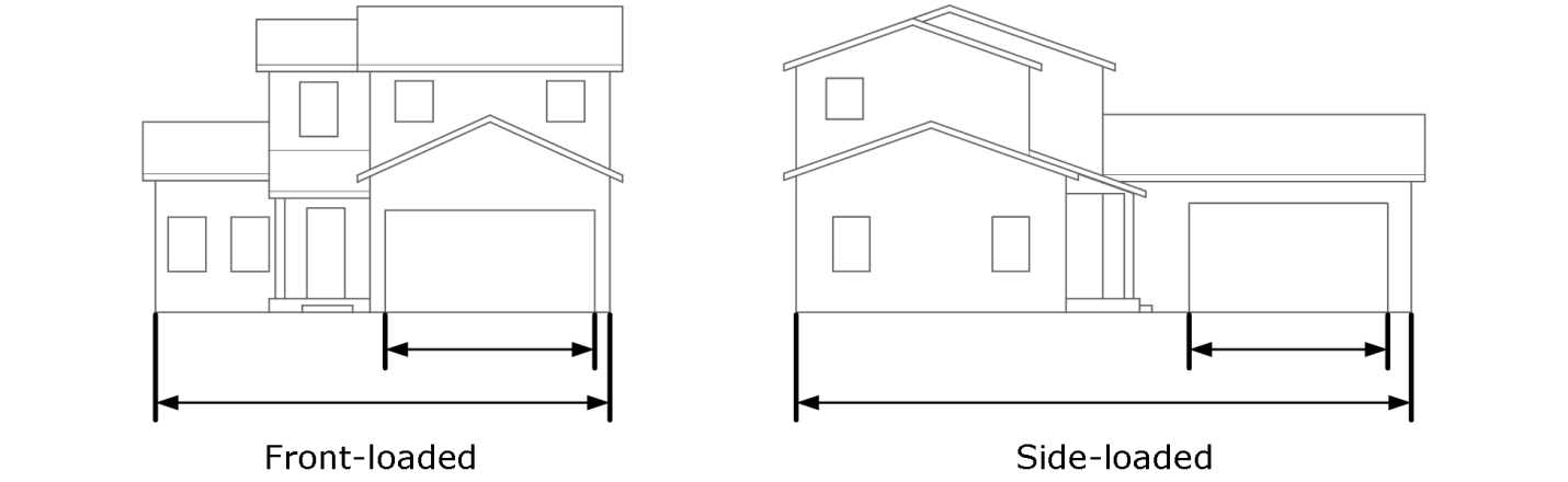
4.
The director may approve alternative garage orientation or design, through review of an administrative modification under section 15.02.080.B if:
a.
The configuration of the lot or other existing physical condition of the lot makes the application of these standards impractical; and
b.
The proposed design alternative substantially meets the intent of this section to line streets with active living spaces, create pedestrian-oriented streetscapes, and provide variety and visual interest in the exterior design of residential buildings.
D.
Architectural design of dwellings. All dwellings and accessory structures, except ADUs (see section J below) shall provide quality architectural design that takes into consideration building massing and style, roof lines, window and door placement, exterior materials and colors, and other architectural features.
1.
Dwellings on corner, end, or double frontage lots shall include architectural features, such as windows and doors, porches and entry features, building materials, and other features that match the front of the dwelling, along the sides or back of dwellings that face streets, drives, or open space areas.
2.
New or replacement dwellings, dwelling additions, and accessory structures shall be designed to be architecturally compatible with the surrounding neighborhood, as applicable, in terms of building materials and colors, roof forms, building massing and style, and other architectural features.
3.
Eaves on pitched roofs shall have a minimum width of one foot.
E.
Building materials. Building materials for residential uses shall comply with section 15.05.120.C.7, except that fiber cement board shall be a primary material and clear glass shall be a secondary material for residential buildings.
F.
Exterior colors of dwellings. Residential developments shall include a variety of exterior color palettes to provide diversity within the development. Color palettes shall be compatible with surrounding residential dwelling colors to the maximum extent practicable. Fluorescent colors and glossy finishes shall not be used on any exterior wall or roof of any dwelling or accessory structure.
G.
Transparency standards (windows, doors and openings).
1.
The ground floor of each facade facing a public street or other public area shall contain a minimum of 20 percent windows or doorways.
2.
Upper floors of each facade facing a public street or other public area shall contain a minimum of ten percent windows.
3.
Alternative transparency requirements may be approved by the director as an administrative modification under section 15.02.080.B consistent with the building design and use, orientation, placement and location context.
H.
Design variety for single-family dwellings.
1.
Residential subdivisions of ten or more lots containing single-family detached and attached dwellings shall be designed to provide variety in housing models as follows:
a.
20 lots or fewer: at least two models;
b.
21—30 lots: at least three models;
c.
31—40 lots: at least four models;
d.
More than 40 lots: at least five models.
2.
Single-family detached and attached dwellings on adjacent lots (including abutting lots, or those lots separated by a street, alley, auto court, or other common private drive fronting on the same street) shall contain different architectural elevations differentiated by at least three of the following standards (see figure 5.3):
a.
Varied architectural style such as, but not limited to, American Craftsman, Bungalow, Dutch Colonial, English Tudor, and Mid-Century Modern;
b.
Varied roof lines and facade planes;
c.
Varied architectural features such as dormers, and front porches or other prominent entrance features;
d.
Varied primary exterior building materials;
e.
Varied primary exterior color; or
f.
Other design elements that add visual interest as determined by the director.
Figure 5.3: Design Variety
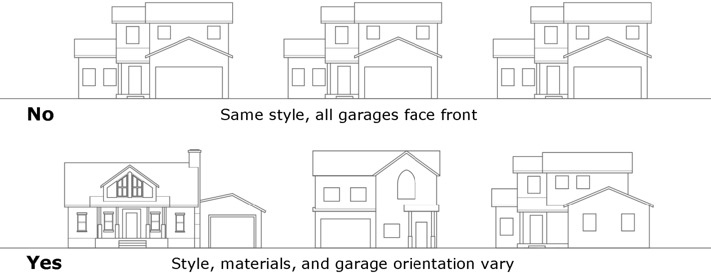
I.
Multifamily residential design standards. In addition to complying with the other applicable standards in this section, multifamily dwellings shall comply with the following standards:
1.
Building entrances—Primary.
a.
At least one main entry shall face an adjacent street, or a plaza, courtyard, or common area that has a direct and visible connection to an adjacent street.
b.
Building entries shall be connected to a public sidewalk that is not routed through a parking lot.
c.
The primary entrance shall include at least three of the following:
i.
A porch or landing;
ii.
Double doors;
iii.
A roofed structure such as a portico, awning, canopy, or marquee;
iv.
Enhanced landscaping; or
v.
Other design element giving prominence to an entry as determined by the director.
2.
Building entrances—Ground-floor units.
a.
Entrances to ground-floor units shall comply with applicable building code accessibility requirements.
b.
All residential at-grade units shall be set back at least six feet from the back of the sidewalk to allow for stairs, stoops, elevated patios and landscaping.
c.
Porches or stoops shall be at least 36 square feet in area with minimum dimensions of six feet deep and six feet wide, and shall be either recessed or covered with an architectural feature such as a canopy.
3.
Building mass and articulation.
a.
Each building facade greater than 50 feet in length shall incorporate: (i) wall plane projections; or (ii) recesses that are compatible with the proposed building architecture (figure 5.4).
Figure 5.4: Building Articulation
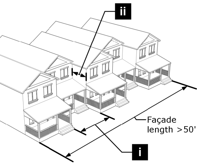
b.
Buildings shall be articulated by incorporating at least three of the following:
i.
Balconies;
ii.
Porches;
iii.
Dormers;
iv.
Variation in materials and colors;
v.
Variation in window sizes and shapes;
vi.
Vertical elements that demarcate building modules; or
vii.
Other design elements that add visual interest as determined by the director.
4.
Roof design.
a.
No continuous roofline shall exceed a length of 50 feet without a change in vertical elevation of at least two feet for a minimum length of 20 feet.
b.
Eaves on pitched roofs shall have a minimum width of one foot.
c.
Roofs shall be designed to accommodate solar energy systems to the maximum extent practicable.
5.
Transparency (windows, doors and openings).
a.
The ground floor of each facade facing a public street or other public area shall contain a minimum of 25 percent windows or doorways.
b.
Upper floors of each facade facing a public street or other public area shall contain a minimum of 15 percent windows.
c.
Alternative transparency requirements may be approved by the director as an administrative modification under section 15.02.080.B consistent with the building design and use, orientation, placement and location context.
6.
Design for security.
a.
Shared mailboxes shall be located in high-visibility and well-lit areas.
b.
Shared community buildings and rooms, such as game rooms and laundry rooms shall be visible from common, walking, and driving areas. All shared community rooms shall have transparent panels to view into the room before entering.
J.
Accessory dwelling units.
1.
For accessory dwelling unit design standards refer to section 15.02.080.E.3.e.
(Code 2009, § 15.05.110; Ord. No. O-2025-35, § 4, 6-3-2025)
Sec. 15.05.120. - Mixed-use and nonresidential design standard.
A.
Purpose. The mixed-use and nonresidential design standards are intended to implement comprehensive plan strategies and to promote high-quality design of an urban environment. The standards are further intended to:
1.
Protect and enhance the character and quality of the city's neighborhoods;
2.
Provide visual interest and variety;
3.
Enhance the pedestrian scale of development and the streetscape;
4.
Mitigate negative visual impacts from the scale, bulk, and mass of large buildings;
5.
Balance the community's economic and aesthetic goals; and
6.
Encourage building and site design that fosters community sustainability goals, including adaptive reuse, energy efficient design, and incorporating alternative energy systems.
B.
Applicability. This section shall apply to:
1.
Mixed-use and nonresidential development.
2.
Modifications or additions to existing mixed-use or nonresidential development, but only to the portion of the development being modified.
C.
General design standards.
1.
Site layout.
a.
Compatibility with natural site conditions.
i.
Development shall be avoided on sites with steep slopes and other sensitive environmental and natural areas and habitat to the maximum extent practicable.
ii.
Building envelopes and areas of site disturbance shall be selected based on the location of natural landforms, native vegetation, mature trees, underlying geology, mapped hazard areas, and setbacks required pursuant to this development code.
b.
Compatibility and coordination with adjacent development. Development shall respect local development patterns and site features to the maximum extent practicable. Elements that shall be coordinated between adjacent sites include:
i.
Shared driveways for access;
ii.
Linkages of internal vehicular and pedestrian circulation systems;
iii.
Linkages of open space systems;
iv.
Areas and access for refuse and recycling collection, loading and storage;
v.
Drainage and detention facilities; and
vi.
Other improvements where a coordinated approach benefits the larger area.
c.
Pedestrian gathering spaces. Outdoor spaces for pedestrians, such as plazas, courtyards, outdoor seating areas, and other amenities with connecting pedestrian paths shall be included with mixed-use and nonresidential developments to the maximum extent practicable, pursuant to section 15.05.040.H.1.
d.
Developments with multiple buildings. Buildings shall be arranged on the site so that their orientation frames, encloses, or otherwise gives prominence to a pedestrian corridor, an outdoor gathering space, a main street pedestrian or vehicle access corridor within the site, or the corners of street intersections or entry points into the development.
e.
Design for security. Sites shall be designed to avoid the creation of areas that are shielded on multiple sides by barriers such as screen walls or landscaping that have low visibility. Such areas shall be avoided in site design to the maximum extent practicable or shall otherwise be well-lit and have some form of surveillance.
2.
Building design. Mixed-use and nonresidential buildings shall comply with subsection 15.05.120.C.3 through C.10, except as otherwise stated in subsection C.11 below.
3.
Building entrances.
a.
Primary building entrances shall be oriented toward streets, pedestrian walkways and plazas, with direct, continuous connections to the street without requiring pedestrians to walk through parking areas.
b.
Entrances for buildings on a corner shall be chamfered at a 45-degree angle at least ten feet from the building corner to face the intersection of such corner to the maximum extent practicable.
c.
Buildings that front on the St. Vrain Creek, parks, plazas, common areas and public open spaces shall have a primary building facade with a customer entrance that faces the common or public area.
d.
All customer or resident/visitor entrances shall create architectural interest and variation from other portions of the building by incorporating at least three of the following:
i.
Changes in building plane through recesses and/or projections;
ii.
Canopies, awnings, arcades, galleries, or other overhangs;
iii.
Tower elements;
iv.
Architectural embellishments;
v.
Changes in building material, color, and/or texture; or
vi.
Other design elements that add visual interest as determined by the director.
4.
Building articulation.
a.
Horizontal articulation.
i.
Each building façade greater than 50 feet in length shall incorporate wall plane projections or recesses that are compatible with the proposed building use and architecture. Wall plane projections and recesses may also include distinctive architectural character features, such as recessed windows, columns or an equivalent element, or other features that vary a wall plane, as determined by the director.
ii.
Additionally, each building façade shall incorporate a change of materials (A) and at least two of the following elements (B through E) (see Figure 5.5):
(A)
Change in building materials—at least three materials for a façade facing a street or other public area, or facing a residential or mixed use zoning district, and at least two materials for other facades;
(B)
Change in building colors;
(C)
Change in textures or patterns;
(D)
Variation in window design; or
(E)
Other design elements that add visual interest as determined by the director.
Figure 5.5: Horizontal Articulation
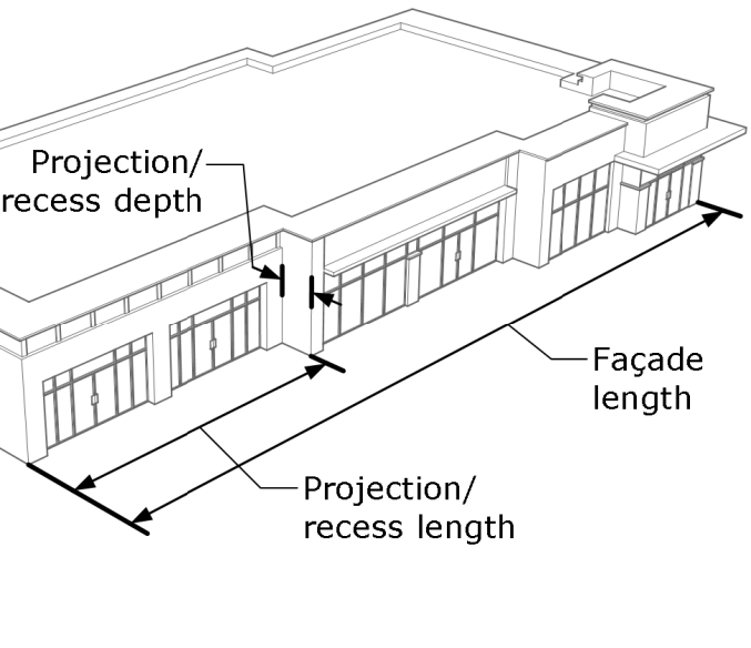
b.
Vertical articulation. Principal mixed-use and nonresidential multistory buildings, and one story buildings taller than 20 feet, shall be designed so that the massing or facade articulation of the building presents a clear base, middle, and top. First floors in mixed-use districts shall be designed with adequate floor to ceiling height to accommodate storefronts to the maximum extent practicable. Lower levels can be differentiated from upper stories by incorporation of elements including, but not limited to, the following (See Figure 5.6):
i.
Low planters and walls;
ii.
Use of veneer banding or wainscot, change in materials, and change in textures;
iii.
Heavier materials and darker colors on lower levels;
iv.
Integrated covered walkways, trellises, or architectural awnings; or
v.
Other design elements that distinguish lower levels as determined by the director.
Figure 5.6: Vertical Articulation for Multiple Story Buildings
![]()
c.
Corner building articulation. Buildings located at the intersection of two streets or on axis with a terminating street or plaza shall be designed to incorporate prominent architectural elements to the maximum extent practicable, such as increased building height or massing with a tower element with a pitched roof or extended canopy.
d.
Upper story floor area standard. The upper-most story of all buildings greater than two stories shall have a reduced floor area of at least ten percent of the ground floor (figure 5.7).
Figure 5.7: Upper Story Floor Area Standard
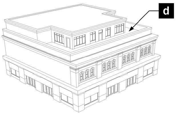
e.
Comprehensive design.
i.
Building façades facing a street or other public area, or facing or within a residential or mixed-use zoning district or development shall be designed with a similar level of detail, patterning, and finish through the use of similar architectural features, building materials, and design of landscaping features. Blank walls void of architectural detailing shall be prohibited unless the director determines that the façade is not visible from adjacent development or public rights-of-way.
ii.
Accessory building facades shall be designed and finished to complement primary buildings through the use of similar colors, materials, and architectural style.
5.
Roof and parapet design.
a.
No roofline or parapet along any building elevation shall be continuous without variation that incorporates any of the following:
i.
Projections or recesses;
ii.
Dormers;
iii.
Changes in roof or parapet height
iv.
Distinctive detailed cornices; or
v.
Other distinct architectural features as determined by the director.
b.
Roofs of buildings shall have parapets or enclosures concealing flat roofs and roof-top equipment from public view, and such parapets and enclosures shall be constructed of materials that match the building in quality and detail. Each such parapet or enclosure shall have an average height of no more than 15 percent of the height of the supporting wall, a maximum height at any point equal to 33 percent of the height of the supporting wall, and three-dimensional cornice treatments.
c.
Roofs shall be designed to accommodate solar energy systems to the maximum extent practicable.
6.
Ground-floor design.
a.
Ground-floor facades facing a street or other public area shall have arcades, display windows, entry areas, awnings, or other such features along at least 60 percent of the horizontal length.
b.
Ground-floor residential units with direct access to a public sidewalk or other public right-of-way shall comply with the design standards for multifamily dwellings in section 15.05.110.I.2.
7.
Transparency (windows, doors and openings).
a.
Ground floor façades facing a street or other public area shall contain a minimum of 50 percent windows or doorways (Figure 5.8).
b.
Upper floor facades facing public street or other public area shall contain a minimum of 15 percent windows (figure 5.8).
c.
Clear glass shall be used for storefront display windows and doors.
d.
Windows shall be accented and defined with detail elements, such as frames, sills, and lintels, and shall be located to visually establish and define the street or pedestrian ways facing portions of a building and to establish human scale and proportion.
Figure 5.8: Building Transparency
![]()
8.
Building materials.
a.
Generally. Building materials shall either be similar to the materials already being used in the existing neighborhood or, if dissimilar materials are being proposed, other characteristics such as scale and proportions, form, architectural detailing, color, and texture shall be used to ensure compatibility despite the differences in materials.
b.
Allowable building materials. Allowable materials include:
i.
Primary materials. The following primary materials may comprise more than 50 percent of any building facade:
(A)
Fire clay brick;
(B)
Natural stone;
(C)
Clear glass;
(D)
Cementitious stucco;
(E)
Other quality materials, such as repurposed materials, as determined by the director under subsection C.12 below.
ii.
Secondary materials. The following secondary materials shall not comprise more than 50 percent of any building facade:
(A)
Architectural tiles;
(B)
Quality architectural metal panels;
(C)
Fiber cement board;
(D)
Quality wood or composite siding or panels;
(E)
Split face and ground face masonry block;
(F)
Other quality materials as determined by the director under subsection C.12 below.
c.
Metal panels and roofs.
i.
Quality architectural metal panels may be used as architectural and accent features, but shall not be the primary exterior material on any building façade, except that in the MU-E, N-PE, N-PF and N-AG zoning districts building facades not facing a street or other public area, or a residential or mixed-use district or development, may have quality architectural metal panels as the primary exterior material.
ii.
Quality metal roof designs that include eaves and overhangs for visual interest are allowed and shall not count toward any limit on metal used on a building exterior.
9.
Exterior color. Mixed-use and nonresidential developments shall include a variety of exterior color palettes to provide diversity within the development. Color palettes shall be compatible with surrounding development to the maximum extent practicable. Fluorescent colors and glossy finishes shall not be used on any exterior wall or roof of any structure.
10.
Parking structure design. Parking structures shall be designed as follows to the maximum extent practicable:
a.
Facades facing a street or other public area, residential or mixed-use district shall comply with the building materials requirements of subsection C.7 of this section;
b.
The first story shall include storefronts along the street facing facade except for necessary street access to the parking structure;
c.
Upper floor parking decks shall be designed to screen vehicles; and
d.
The top parking deck shall be designed to accommodate shade structures and solar energy systems.
11.
Industrial building design.
a.
Applicability. Unless exempted herein, this section shall apply to the following industrial buildings located within the MU-E, N-PE, or N-PF zoning districts and not adjacent to a residential zoning district or an existing or planned residential or mixed-use development in a mixed-use district other than MU-E:
i.
Light and medium industrial buildings; and
ii.
Warehouse or storage facility buildings; and
iii.
Transportation depot, trucking terminal or distribution center buildings; and
iv.
Other similar buildings designed for industrial uses or public services with the majority of the building area used for manufacturing and processing, warehousing, storage, maintenance, distribution or truck loading uses.
b.
Site layout. Site design shall comply with subsection C.1, except that pedestrian gathering spaces under subsection C.1.c are encouraged where appropriate considering the site design.
c.
Building entrances. Building entrances shall comply with subsections C.3.a, C.3.c, and C.3.d above.
d.
Horizontal articulation. Building facades shall comply with subsection C.4.a above, except that for subsection C.4.a.i, wall plane projections are required only along building facades facing a street or other public area, or portions of other facades where customer entrances and offices are located.
e.
Vertical articulation. Building facades facing a street or other public area, or portions of other facades where customer entrances and offices are located are subject to subsection C.4.b. above.
f.
Corner building articulation, upper story floor area and comprehensive design. Building designs shall comply with subsections C.4.c and C.4.e above.
g.
Roof and parapet design. Building roofs and parapets shall comply with subsection C.5 above, except that for subsection C.5.a, roofline and parapet variations are required only along the building facades facing a street or other public area, or portions of other facades where customer entrances and offices are located.
h.
Transparency. Building facades facing a street or other public area shall include windows and doors on at least 25 percent of the horizontal length of the façade, or the portion of the building facade that includes customer entrances and offices, whichever is greater. The size and location of the windows shall be compatible and proportional to the building design. Windows may be clear or tinted/spandrel glass. Building facades shall include clear windows and doors on the portion of the façade that includes customer entrances and offices.
i.
Building materials. Exterior building materials shall comply with subsection C.8 above, except that the following exterior materials are also allowed as primary materials:
i.
Architectural precast or site cast tilt up concrete with quality compatible finishes and colors;
ii.
Quality aluminum composite material metal panels, such as Alucabond or Reynobond;
iii.
Quality insulated metal panels with textured finishes;
iv.
Other materials that add visual interest as determined by the director.
j.
Exterior color. Exterior colors shall comply with subsection C.9 above.
12.
Alternative design compliance. Alternative building designs, including but not limited to site layout, building entrances, horizontal, vertical and corner building articulation, upper story floor area, comprehensive design, roof and parapet design, transparency, building materials, exterior colors, and parking structure design may be allowed if the director, through an administrative modification under subsection 15.02.080.B, determines that the design creates a quality or unique building design that meets the purpose and intent of the standards in this section consistent with the building design and use, orientation, placement and location context.
(Code 2009, § 15.05.120; Ord. No. O-2023-11, § 2, 3-21-2023)
Sec. 15.05.130. - Outdoor service, storage, equipment, loading and display.
A.
Outdoor service, storage and loading areas.
1.
General design standards.
a.
In all developments loading docks, truck parking, outdoor storage, utility meters, HVAC and other mechanical equipment, trash collection, recycling collection, trash compaction, and other service functions shall be incorporated into the overall design theme of the building and the landscape so that the architectural design is continuous and uninterrupted by ladders, towers, fences, and equipment.
b.
These areas shall be located and screened so that the visual and acoustic impacts of these functions are fully contained and out of view from adjacent properties and public rights-of-way. Screening materials shall be similar to and of the same quality as the principal materials of the primary buildings and landscape.
c.
Screening, which may include walls, fencing, berming and landscaping, shall be an adequate height as demonstrated visually by the applicant. When plants are used for screening, as appropriate, they shall be planted and maintained to provide a solid screen within two years from the time of planting.
2.
Trash/recycling/compost collection areas. The following regulations shall apply to all development except for one-family and two-family dwellings:
a.
Each lot or tract containing a principal structure shall provide a designated area with equal space for the placement of trash, recycling, and compost collection containers that shall be located and designed to ensure adequate space on-site for the maneuvering of collection vehicles. Each such area shall be incorporated into the overall design of the principal structure on the site, and shall be located in the rear or side of the lot to screen the storage area and separate it from residential uses to the maximum extent practicable.
b.
Trash, recycling, and compost collection areas shall not be located within any required buffer, between a principal building and any street (excluding alleys), or adjacent to a public pedestrian path, unless the decision-making body determines that the proposed location is appropriate and will not create an adverse impact on surrounding properties or neighborhoods.
c.
Trash, recycling, and compost collection areas that are visible to surrounding uses, properties, or rights-of-way shall include enclosures and gates of sufficient height to provide adequate screening. The enclosure shall be constructed of the same materials as used in the principal structure and the gate shall be constructed of a durable and quality metal and painted a compatible color. The enclosure gate shall remain closed except when being accessed.
3.
Outdoor storage areas.
a.
Outdoor storage areas shall be incorporated into the overall design of the principal structure or the site and shall be screened from view from all property lines by an opaque fence or wall of sufficient height to provide adequate screening. The fence or wall shall incorporate at least one of the predominant materials and one of the predominant colors used in the principal structure.
b.
If an outdoor storage area shall be covered, then the covering shall include at least one of the predominant exposed roofing colors on the principal structure.
c.
Stored items shall not project above the fence or wall used to screen such materials.
d.
No flammable or explosive liquids, solids, or gases shall be stored in bulk above ground if they exceed the currently adopted fire code requirements. Flammable liquids or gases in excess of 1,000 gallons shall be stored underground. High pressure gases or liquids whether flammable or inflammable shall be stored above ground and shall meet all applicable laws and regulations.
4.
Utility/mechanical equipment. Mechanical or utility equipment shall be sited away from residential uses and shall be screened by a wall, fence, or landscaping that is adequate in height as demonstrated visually by the applicant. Fences and walls shall be of similar quality materials and color as the principal structure. Plant materials used for screening shall be planted and maintained to provide a solid screen within two years of installation.
B.
Roof-top utility/mechanical equipment. Mechanical or utility equipment on the roof of a building shall be screened from public view to the maximum extent practicable by locating equipment in the center of the roof or providing screening materials around the mechanical equipment. All screening materials shall be compatible with the principal structure in terms of design, materials and color.
C.
Outdoor retail display areas. Unless explicitly stated otherwise in an approved plan or temporary use permit, no outdoor retail display area shall be located in a required off-street parking area or landscape or buffer yard area.
(Code 2009, § 15.05.130)
Sec. 15.05.140. - Outdoor lighting.
A.
Purpose. These outdoor lighting regulations are intended to achieve the following purposes:
1.
Further the goals, policies, and strategies stated in the comprehensive plan;
2.
Ensure that the functional and security needs of the community are met in ways that do not adversely affect adjacent properties or neighborhoods;
3.
Promote safe and compatible design, curtail light pollution, reduce sky glow and improve the nighttime environment for stargazing;
4.
Minimize adverse off-site impacts of lighting such as light trespass and obtrusive light;
5.
Help protect the natural environment from the adverse effects of night lighting from gas or electric sources; and
6.
Conserve energy and resources to the greatest extent possible.
B.
Applicability.
1.
This section shall apply to new development and redevelopment, except that existing developments shall be subject to the standards of subsections F and G of this section.
2.
Nonconforming outdoor lighting shall comply with section 15.08.100.
C.
Design requirements. Developments and redevelopments shall submit a photometric site plan (lighting plan) designed by a licensed professional engineer or architect consistent with the submittal requirements in the administrative manual.
D.
Exemptions. The following are exempt from the regulations in this section unless noted otherwise:
1.
Single-family detached developments are exempt from the lighting plan requirement, but when lighting is provided it is subject to the standards of subsections F and G of this section.
2.
Public street lighting.
3.
Temporary holiday displays.
4.
Emergency/warning lights.
5.
City-owned outdoor recreational uses (ball fields, play fields, tennis courts, and other similar uses), provided these uses meet the following standards:
a.
Limits on luminaire angle. The luminaire angle from a lighting source that illuminates an outdoor recreational use may exceed an angle of zero degrees only to the extent necessary for lighting the use, and provided that the luminaire is shielded to minimize spillover to surrounding properties;
b.
Maximum permitted illumination at the property line of the recreational use shall be two footcandles;
c.
Exterior lighting for an outdoor recreational use shall be extinguished as soon as possible after the event.
6.
The director of planning and development services, or designee, may exempt lighting, including displays, from any or all provisions of chapter 15.05.140, provided the lighting serves a governmental (federal, state, county, city, transportation district or school district) purpose, is located on property owned or controlled by a governmental entity, and is designed such that they minimize impact to surrounding businesses and residents to the maximum extent possible. Such lighting includes, but is not limited to, traffic control devices, public information displays, and exterior building lighting. This exemption will be documented in a form acceptable to the director of planning and development services.
E.
Modifications. The director may waive or modify a requirement in this section upon making one of the following findings:
1.
The request complies with the standards for an administrative modification under section 15.02.080.B; or
2.
The lighting standard is impractical or unreasonable based on the nature of the development proposal and the waiver represents the least possible deviation that can afford relief from the standard being modified or waived.
F.
General regulations.
1.
The direct or reflected light from any light fixture shall not create a traffic hazard to operators of motor vehicles on public streets or to operators of aircraft, and no colored lights may be used in such a way as to be confused or construed as street-traffic or air-traffic control devices.
2.
No blinking, flashing or fluttering lights, or other illuminated device that has a changing light intensity, brightness or color, is permitted in any zoning district.
3.
The director shall approve the use of exposed neon or light emitting diode (LED) upon finding that the applicant has demonstrated such lighting is appropriate and necessary for the design of the building, will not adversely affect surrounding properties and is consistent with the purpose of the lighting standards.
4.
The director may require modifications to outdoor lighting after installation upon finding that the lighting, as installed, does not comply with these standards.
G.
General design standards. Lighting shall meet the following design standards:
1.
All outdoor lighting shall meet the functional security needs of the proposed land use without adversely affecting surrounding properties, neighborhoods, the community, or the natural environment.
2.
All new and replacement light fixtures shall be full cutoff, except that light sources not exceeding 500 lumens for individual light fixtures, 150 lumens for individual lights in a light string (e.g., patio lights), and 3000 Kelvin in color temperature are not required to be full cutoff.
3.
Light sources shall be concealed or shielded to minimize the potential for glare and light pollution.
4.
Light fixtures shall be installed so that the luminaire angle is zero degrees (vertical to the ground).
5.
No light sources shall be directed toward property boundaries or adjacent rights-of-way.
6.
Lights, such as wallpacks, that shine outward and create direct glare are prohibited.
7.
The amount of nuisance glare (light trespass) projected onto a residential use, greenway or natural area from another property shall not exceed 0.1 footcandles at the property line.
8.
Lighting shall be distributed evenly to minimize extremes in luminance levels.
9.
Light fixtures not necessary for security purposes shall be reduced, activated by motion sensor devices, or turned off during hours when the business or use is not open.
10.
Light types of limited spectral emission, such as low-pressure sodium or mercury vapor lights, are prohibited in all areas.
11.
Energy efficient lighting shall be used to the maximum extent practicable.
12.
Light sources in residential zoning districts shall not exceed 3000 Kelvin in color temperature and other areas shall not exceed 4000 Kelvin in color temperature.
13.
Light sources in the interior of buildings shall minimize glare when viewed from the exterior of the building.
14.
Light fixtures used to illuminate flags, statues, or any other objects shall minimize glare beyond the illuminated object.
15.
Light produced from architectural, landscape, and decorative uplighting shall minimize glare and shall not be visible above the building roof line.
H.
Lighting levels.
1.
Table 15.05.140 provides the maximum illuminance of various activity areas. The table is based on IESNA recommendations as published in the current Lighting Handbook, using a visual age of 25—65, a lighting zone of LZ3, and an activity area of high for nonresidential zoning districts and medium for residential zoning districts.
I.
Height standards for lighting.
1.
Light fixtures mounted to a building or structure shall not exceed the height of the building or structure.
2.
Freestanding light fixtures located in residential zoning districts shall be mounted no higher than 15 feet from the ground.
3.
Freestanding light fixtures located in mixed-use and nonresidential zoning districts shall be mounted no higher than 25 feet from the ground.
4.
Light fixtures higher than the maximum heights specified in this subsection, but not exceeding the maximum structure height in the applicable zoning district, are prohibited unless the director finds that such lighting is appropriate and necessary for the development, shall not adversely affect surrounding properties and is consistent with the purpose of the lighting standards.
5.
Lighting fixture heights greater than the maximum zoning district height may be approved only through an administrative modification or variance.
(Code 2009, § 15.05.140; Ord. No. O-2025-10, § 2, 1-28-2025)
Sec. 15.05.150. - Quality of life benchmarks/adequate public facilities standards.
A.
Purpose. The purpose of these quality of life benchmark and adequate public facilities regulations is to ensure that all utilities and other facilities and services needed to support development are available concurrently with the impacts of such development.
B.
Applicability. Adequate public facilities requirements apply to all development and subdivisions subject to this development code, unless otherwise exempt by this subsection.
C.
General requirements.
1.
Approval conditioned upon adequate public facilities. The approval of all subdivisions and developments shall be conditioned upon the provision of adequate public facilities and services, including utilities, necessary to serve the new development. No building permit shall be issued unless such public facilities and services are in place or the commitments described in this section have been made.
2.
Level of service standards.
a.
This section establishes level of service standards for the following public facilities: fire protection and emergency medical services, drainage, transportation, utilities, and schools.
b.
No subdivision, development plan, site plan, or building permit shall be approved or issued in a manner that shall result in a reduction in the levels of service below the adopted level of service standard for the affected facility or service.
D.
Drainage/water quality management.
1.
Level of service.
a.
All development shall provide adequate surface, sub-surface, and road storm drainage facilities and appurtenances as required by all current and applicable city storm drainage master plans, as addressed by city standards, as amended, and as required by city-approved drainage studies.
b.
All development shall comply with applicable state and federal stormwater regulations designed to reduce the potential adverse impact of stormwater discharges on water quality.
2.
Minimum approval requirements. Adequate stormwater drainage facilities and services to support the proposed development shall be available concurrently with the impacts of such development. Except as stated below, at the time of building permit issuance, the decision-making body shall require that all necessary drainage facilities and services are in place and available to serve the new development according to the approved drainage and erosion control report and plan for the development.
E.
Fire and emergency medical response.
1.
Fire response level of service. For fire response services, each building lot within a subdivision plat or development shall be within five minutes and 59 seconds response time of a city fire station. The fire chief may waive this requirement if the fire chief finds that:
a.
Each building on the building lot shall have an automatic fire extinguishing system meeting all applicable code requirements; or
b.
The fire chief approves an equivalent means to ensure adequate fire response.
2.
Emergency medical response level of service. For emergency medical response services, each building lot within a preliminary or final plat shall be within five minutes and 59 seconds response time of a city fire station. The fire chief may waive this requirement if the fire chief finds:
a.
A Boulder or Weld County licensed ambulance service, staffed full time, can provide emergency medical services 90 percent of the time to each building lot within five minutes and 59 seconds;
b.
Each building lot owner shall provide full-time emergency medical response services on site equivalent to the fire department's emergency medical response services; or
c.
The fire chief approves an equivalent means to ensure adequate emergency medical response.
3.
Determination of compliance with minimum standards. The fire chief shall determine whether each building lot within a preliminary or final subdivision plat or plan shall be within the required minimum five minutes and 59 seconds response time of a city fire station by:
a.
Using the Rand Corporation formula D = (T - 0.65)/1.7, where "D" equals travel distance from the nearest city fire station, and "T" equals 4.98 minutes (fire pumper truck emergency travel time without an additional one minute for firefighter response readiness); and
b.
At least annually, comparing the Rand Corporation formula output to actual city fire department response times, and adjusting the formula output to reflect actual response times from city fire stations.
4.
Minimum approval requirements. Adequate fire protection and emergency response services to support the proposed development shall be available concurrently with the impacts of such development. In this regard, the decision-making body shall require that, at the time of final plat approval or at issuance of any building permit, whichever occurs first, all such services, as described in subsections E.1 and E.2 of this section, are in place and available to serve the new development.
F.
Transportation.
1.
Levels of service.
a.
General standard. For all subdivisions and developments, the applicant shall demonstrate that, with the planned development, the transportation level of service for any signalized intersection located within one-half mile of the development site or directly impacted by the development shall not fall below level of service "D." Any of the directional traffic movements, comprising five percent or more of the total entering volume of a signalized intersection during any hour of traffic, shall not fall below level of service "D" and shall not exceed a volume to capacity (v/c) ratio of 1.0.
b.
Standard modification or waiver.
i.
The decision-making body may modify these requirements if the applicant demonstrates that adverse impacts on the level of service have been mitigated to the maximum extent feasible as determined by the decision-making body. Mitigation may include on-site or off-site street or traffic signal improvements, implementation of a transportation demand management program, reducing the intensity of the development, or other mitigation techniques.
ii.
The decision-making body may waive these requirements if it determines that the direct and cumulative impacts of the proposed development on adjacent roads and intersections will be minimal and insignificant.
2.
Threshold for transportation impact study. Unless waived by the city, a transportation impact study (TIS) shall be submitted with any application for subdivision or development that exceeds 50 peak hour trips or 500 average daily traffic (ADT), based on traffic generation estimates of the latest edition of the Institute of Transportation Engineers' Trip Generation Manual, or when specified in the criteria for a TIS (see Appendix A of city standards).
3.
Transportation impact study contents. The TIS shall be prepared according to city standards. At a minimum, the study shall contain the following information:
a.
Traffic impact area. Identification of the boundaries of the traffic impact area, which the traffic engineer shall approve in advance;
b.
Current LOS. The current projected average daily traffic volumes (level of service) on the segments and intersections of the road system in the traffic impact area based on existing conditions and factoring in approved developments. For purposes of these transportation facility standards, the term "approved development" means developments that have received preliminary or final approvals from the city and that have not been completed;
c.
LOS including the proposed development. The projected average daily traffic volumes (level of service) of the segments and intersections on the road system in the traffic impact area based upon existing conditions, the demands from approved development, and the proposed development;
d.
Study findings. A summary outlining the study findings on the traffic impacts of the proposed development, including a detailed description of proposed improvements and mitigation measures necessary to maintain the adopted level of service standard;
e.
Other information. Other information addressed in the city standards, or as may reasonably be required by the decision-making body or staff to determine compliance with the applicable level of service standards.
4.
Minimum approval requirements. At a minimum, the decision-making body shall require that, at the time of any final plat or development approval, all necessary transportation facilities and services to meet the applicable level of service standard are:
a.
Currently in place and available to serve the development; or
b.
Guaranteed by an enforceable development or public improvement agreement that ensures that the public facilities will be in place at the time that the impacts of the proposed development will occur.
5.
Council approval required without mitigation. City council approval is required for any subdivision or development not able to meet or mitigate the level of service standard specified in subsection F.1. of this section. Council may approve a subdivision or development not able to meet or mitigate the level of service standard based on a finding that the proposed subdivision or development provides the city with a unique opportunity or an appropriate site, at an appropriate location, for the particular type of land use or development proposed that will help the city achieve a balance of land use, tax base, or housing types consistent with the city's overall planning and economic development goals.
G.
Utilities.
1.
Level of service. All development shall provide adequate utilities and appurtenances, as required by any current and applicable utility master plans, as addressed in the city standards and this development code, and as required by titles 13 and 14.
2.
Minimum approval requirements. Adequate utility facilities and services to support the proposed development, as described in subsection G.1 of this section, shall be available concurrently with the impacts of such development. At the time of building permit issuance, the decision-making body shall require that all necessary utility facilities and services are in place and available to serve the new development.
H.
School capacity. The provisions of the intergovernmental agreement between the city and the St. Vrain Valley School District RE-1J, which is included as Appendix B to this development code, states the level of service and minimum approval requirements for school capacity.
(Code 2009, § 15.05.150)
Sec. 15.05.160. - Operational and performance standards.
A.
Air quality standards.
1.
Intent. Because air quality is a contributing factor to the economic vitality and quality of life of the community, the quality of the air in and surrounding the city shall be preserved at the highest possible level. Solid fuel-fired heating devices, although aesthetically pleasing, contribute a significant portion to the degradation of air quality. Therefore, this section limits the use of solid fuel-fired heating devices.
2.
Installation of solid fuel-fired heating devices; limited.
a.
No dwelling unit shall contain more than one solid fuel-fired heating device.
b.
In no event shall any dwelling unit within a development that exceeds six units per acre in density contain a solid fuel-fired heating device.
c.
No building permit shall be issued for any solid fuel-fired heating device that would exceed the limitations imposed in this subsection.
d.
Nothing in this subsection shall prevent the use of gas-fired fireplaces or gas fireplace logs in any dwelling unit.
e.
For the purpose of administering this limitation, a development shall be defined as a subdivision plat, site plan, or final development plan. In the absence of these documents, a development shall be defined as a legally established lot or parcel.
3.
Other air quality/emissions standards.
a.
To minimize off-site fugitive emissions, trucks carrying dry bulk materials are to be fully enclosed, or the cargo is to be enclosed within canvases, tarpaulins, or other method of confinement that fully covers the payload area of the truck. Alternatively, a crusting agent may be used to cover the cargo.
b.
No materials or wastes shall be deposited upon a lot in such form or manner that they may be transferred or transported off the lot by natural causes or forces.
c.
Fugitive dust from construction activity shall be controlled consistent with best management practices and state regulations.
B.
Noise.
1.
Applicability. The following noise standards are in addition to, and shall supplement, the nighttime noise standards found at sections 10.20.090 and 10.20.100. These standards are applicable to all new development and existing development in the city.
2.
General daytime noise standard.
a.
No activity or operation within the city shall exceed the maximum permitted sound levels dB(A) stated in table 10.20.110.B at the property line of the receiving premises, during the daytime (between 7:00 a.m. and 10:00 p.m.), except as provided in this section. The terms "residential," "commercial," and industrial" in table 10.20.110.B shall be defined as stated in section 10.20.110.
b.
When a development produces or is affected by noise that exceeds the standards stated in table 10.20.110.B, the applicant or owner shall provide noise attenuation techniques based on an analysis conducted by a qualified acoustical engineer. The analysis shall include a description of the noise environment and the construction or other methods necessary to attenuate the noise to permitted levels. When so required, the noise analysis and mitigation plan shall be submitted with a development application.
c.
New construction or additions. All new construction or additions that are planned to house any stationary machinery, device, or equipment that shall create noise that exceeds 60 dB(A) shall be reviewed to ensure that noise mitigation measures such as building noise attenuation and insulation, siting modifications, berms, barriers, and other measures are utilized to effect noise level reductions either up to 15 dB(A) below normal construction volumes or to 55 dB(A) at the property line abutting any residential development.
C.
Vibrations. No activity or operation shall cause or create earth-borne vibrations in excess of the displacement values stated in table 15.05.160 on or beyond any abutting parcel or shall cause any inherent or recurring generated vibration perceptible without instruments at any point along the property line on which the vibration source is located. The applicant, property owner or tenant shall be responsible for demonstrating compliance with these standards.
D.
Odors. No person or business, including the applicant, property owner or tenant, shall cause or allow the emission of odorous air contaminants from any source that results in detectable odors that are measured in excess of the following limits:
1.
It is a violation if odors are detected on properties used for residential purposes after the odorous air has been diluted with seven or more volumes of odor-free air.
2.
No violation shall occur if the city finds that the person or business causing or allowing the emission of odorous air contaminants is in compliance with all other applicable standards in this development code and is employing the best available treatment, maintenance, and control technologies currently available to maintain the lowest possible emission of odorous gases.
E.
Hazardous waste/materials.
1.
All hazardous materials or wastes shall be stored and deposited in compliance with the city's adopted fire code.
2.
If a facility, building, or project is known to use or store hazardous materials or wastes on site in excess of the amounts set forth in the adopted fire code, the applicant, property owner or tenant shall prepare, at the direction of the city fire chief, a hazardous materials impact analysis that:
a.
Assesses potential off-site impacts and appropriate mitigation procedures and precautions; and
b.
Examines methods to reduce the use and storage of hazardous materials and the production of hazardous wastes at the site.
F.
Glare or heat. If an activity or operation produces intense glare or heat, whether direct or reflected, that is perceptible from any point along the development's property lines, the operation shall be conducted within an enclosed building or with other effective screening sufficient to make such glare or heat imperceptible at the property line.
G.
Operational/physical compatibility. The following conditions may be imposed upon the approval of any development to ensure that it is compatible with surrounding properties, including, but not limited to, restrictions on:
1.
Hours of operation and deliveries;
2.
Location on a site of activities that generate potential adverse impacts on adjacent uses such as noise, odor and glare;
3.
Placement of waste receptacles;
4.
Location of loading and delivery areas;
5.
Light intensity and hours of illumination; and
6.
Placement and illumination of outdoor activity areas and equipment.
(Code 2009, § 15.05.160)
Sec. 15.05.170. - Wireless telecommunications facilities.
A.
General standards.
1.
The standards in this section apply to all applications for a permitted, limited, or conditional use wireless telecommunication facility. The applicant shall demonstrate to the city, in writing, that it meets all applicable standards and provisions of this section and this Code.
2.
Building/structure-mounted wireless telecommunication facilities are preferred over new freestanding facilities. The applicant shall explore all potential options for locating a facility on an existing building or structure prior to submitting an application for a freestanding facility and shall submit in writing efforts taken to locate a facility on an existing building or structure.
3.
When possible, wireless telecommunication facilities shall be collocated to minimize the number of telecommunication sites.
a.
No wireless telecommunication facility owner or operator shall exclude a telecommunication competitor from using the same facility or location. Upon request by the city, the owner or operator shall provide evidence why collocation is not possible.
b.
Applications for new wireless telecommunication facilities shall provide evidence that the facility can accommodate collocation of additional carriers.
c.
If a telecommunication competitor attempts to collocate a facility on an existing or approved wireless telecommunication facility or location, and the parties cannot reach agreement, the city may require a third party technical study at the expense of either or both parties to determine the feasibility of collocation.
d.
Operators using Unlicensed National Information Infrastructure (UNII) Radio Band as their primary service frequencies shall be exempt from the collocation requirements in this section.
4.
The applicant shall design all wireless telecommunication facilities to mitigate or camouflage visual impacts. The design, materials, color and screening of the wireless telecommunication facilities shall take into consideration the design, materials and colors of surrounding buildings and structures and surrounding natural landforms and vegetation.
5.
Wireless telecommunication facilities shall not reduce parking and landscaping to less than any minimum requirement for other uses on the parcel.
6.
In addition to the standards in this section and chapter 13.04, as applicable, the following standards shall apply to wireless telecommunication facilities in the public right-of-way:
a.
They are exempt from setback requirements.
b.
If proposed to be placed on the border of multiple zoning districts, the more restrictive use regulations and standards apply.
c.
They shall be located on existing utility or street lighting poles or emergency communication facilities unless the applicant demonstrates in writing that this collocation is not possible. Wireless telecommunication facilities proposed to be placed on replacement or new utility or street lighting poles, or emergency communications facilities shall be consistent in height with the facility standards specified in the city standards, city power and communications street lighting design guidelines under section 13.18.010, and the maximum building height of the applicable zoning district (50 feet for mixed-use and nonresidential zoning districts) if no facility standard exists.
d.
They shall not conflict with existing or planned utilities or facilities in the right-of-way and shall conform to sight distance requirements.
7.
Wireless telecommunication facility owners or operators shall verify that:
a.
The wireless telecommunication facility complies at all times with the current Federal Communications Commission standards for cumulative field measurements of radio frequency power densities and electromagnetic fields; and
b.
The wireless telecommunication facility complies at all times with the current Federal Communication Commission regulations prohibiting localized interference with reception of television and radio broadcasts.
8.
If the wireless telecommunication facility ceases operating for six consecutive months:
a.
The facility owner or operator shall remove it within 90 days; and
b.
Any site or development plan approving the wireless telecommunication facility, including site plans for conditional or limited uses, shall expire.
9.
The replacement or upgrade of antennas, support structures and accessory equipment that does not increase the overall height, mass, width, or amount of equipment of an existing wireless telecommunication facility is exempt from land use review under this development code and subject only to the issuance of other permits as may be required. Colors of replacement and upgrade equipment shall be consistent with the building or facility on which they are mounted.
B.
Standards for freestanding wireless telecommunication facilities (alternative tower structures, monopoles and lattice towers).
1.
Setbacks. A freestanding wireless telecommunication facility shall meet the greater of the following minimum setbacks from all property lines. Setbacks shall be measured from the nearest property line to the nearest outside edge of the freestanding wireless telecommunication facility.
a.
The setback requirements for a principal building within the applicable zoning district as specified in chapter 15.03; or
b.
The height of the freestanding wireless telecommunication facility, including antennas.
2.
Height. A freestanding wireless telecommunication facility shall not exceed 50 feet.
3.
Number. Only one freestanding wireless telecommunication facility shall be allowed on a legal parcel.
4.
Collocation. The design of new freestanding wireless telecommunication facilities shall be such that they can accommodate collocation of additional providers.
5.
Antenna shall be mounted flush to the support structure unless the applicant demonstrates this is technically infeasible.
6.
Freestanding wireless telecommunications facilities and antennas shall not be artificially lighted, unless required by federal law or regulation.
7.
The visual impacts of a tower base and ancillary structures shall be mitigated through landscaping or other screening methods.
8.
Mechanical equipment shelters shall be designed and constructed to look like a building, facility or structure typically found in the area.
C.
Standards for building- or structure-mounted wireless telecommunication facilities.
1.
A building- or structure-mounted wireless telecommunication facility is permissible only on nonresidential or multifamily buildings constructed under chapter 16.04.
2.
Antennas may encroach into a setback a maximum of two feet but shall not extend over a property line.
3.
Antennas mounted on a building wall or side of a structure shall comply with the following standards:
a.
Antennas shall be mounted flush to the building wall or side of a structure unless technical reasons dictate another type of installation and shall not extend above the roofline or parapet of the building or top of the structure; and
b.
Support structures, accessory equipment including equipment cabinets, and all other appurtenances shall be fully screened from view and not visible from the ground.
c.
Antennas shall be painted a color to match the building or structure to which they are mounted.
4.
New building- or structure-mounted installations (including those within structures) are not permitted inside of a historic district or within 250 feet of the boundary of a historic district; nor shall new installations be located on or within a structure that is designated as a National Historic Landmark or listed or eligible for listing in the National Register.
D.
Standards for rooftop-mounted wireless telecommunication facilities.
1.
A rooftop-mounted wireless telecommunications facility shall be approved only if the applicant demonstrates that a building- or structure-mounted (wall-mounted) facility is inadequate to provide service or is technically not feasible, or that the visual and aesthetic impact of the rooftop-mounted wireless telecommunication facility would be less than that of a building- or structure-mounted facility.
2.
Rooftop-mounted wireless telecommunication facilities are not permitted on buildings with pitched roofs unless the facilities are fully screened with architecturally compatible features such as cupolas, bell towers, chimneys, or similar features.
3.
A wireless telecommunication facility located on a building roof or top of structure shall comply with the following standards:
a.
Antennas, support structures, accessory equipment, and all other appurtenances shall be fully screened from view through the use of architecturally compatible features, screening materials and colors that match the building or structure to which the facility is mounted;
b.
Whip antennas shall extend no more than 12 feet above the parapet of the roof or the structure to which they are mounted regardless of the height limitations of the underlying zoning district;
c.
Panel and microwave antennas shall extend no more than ten feet above the parapet of the roof or the structure to which they are mounted regardless of the height limitations of the underlying zoning district;
d.
Accessory equipment structures shall extend no more than five feet above any parapet of the roof or the structure to which they are mounted and must be fully screened from view; and
e.
In addition to these height requirements, these facilities shall not exceed any height limit for the applicable zoning district.
4.
New rooftop-mounted installations are not permitted inside of a historic district listed on the National Register or within 250 feet of the boundary of a historic district listed on the National Register; nor shall new rooftop installations be located on or within a structure that is designated as a National Historic Landmark or listed or eligible for listing in the National Register.
E.
Standards for small cell and wireless mesh networking facilities.
1.
Small cell and wireless mesh networking facilities may be located in any zone district and in public rights-of-way attached to existing structures in the right-of-way.
2.
The small cell or wireless mesh networking facility must comply with applicable Federal Communication Commission regulations regarding radiated power.
3.
The antenna or power-radiating components of a small cell or wireless mesh network facility must be mounted a minimum of 12 feet above ground.
4.
Small cell or wireless mesh networking facilities may not extend more than 36 inches above the facility or structure on which they are mounted.
5.
For small cell networks involving multiple individual small cell facilities, the applicant may file a consolidated application for a single permit approving the small cell network instead of filing separate applications for each individual small cell facility.
6.
Small cell or wireless mesh networking facilities may be attached to any existing residential building or structure with nonconforming setbacks only if the structure conforms to chapter 16.04 and the nonconformity would not increase.
F.
Standards for amateur radio towers and amateur radio operations.
1.
Amateur radio towers are subject to restrictions in chapter 9.36.
2.
Side yard setbacks for amateur radio towers shall be 25 percent of the tower height.
3.
Rear yard setbacks for amateur radio towers shall be as described for buildings in chapter 15.03.
4.
No portion of a tower shall extend over a property line.
5.
Amateur radio towers are not permitted between the front of the principal structure and the front yard property line.
6.
Amateur radio operations shall not interfere with reception of television and radio broadcasts.
G.
Exception for insubstantial modifications. Notwithstanding any other provisions of this development code, the director shall ministerially approve any "eligible facilities request for a modification of an existing wireless tower or base station that does not substantially change the physical dimensions of such tower or base station," as that phrase is defined in United States Code and rules and regulations of the Federal Communications Commission, including report and order FCC 14-153. Where these regulations limit submission requirements, the submission requirements in this development code shall be construed to conform to those limitations.
H.
Timing for application review for wireless telecommunication facilities. The director may expedite review of an administrative or minor application for a wireless telecommunication facility in any manner necessary to comply with federal limitations on the amount of time the city may take to review these applications.
I.
Application denial. A final decision by the city to deny an application under this section shall be in writing and supported by substantial evidence in a written record.
(Code 2009, § 15.05.170)
Sec. 15.05.180. - Mobile homes.
A.
Purpose. The purpose of this section is to:
1.
Make provision for an alternate choice in housing;
2.
Encourage efficient and functional use of land for mobile homes;
3.
Minimize potential impacts on surrounding land uses.
B.
Qualifying manufactured housing exemption. Manufactured housing, as defined by C.R.S. § 31-23-301(5)(a) and excluded from the definition of the term "mobile homes," stated in chapter 15.10, shall be subject to all the zoning and development standards otherwise applicable to one-family dwellings, unless such application is inconsistent with the specifications stated in state law.
C.
Location in approved mobile home developments. Mobile homes shall be located only in mobile home developments or parks approved by the city. The location of mobile home developments and parks shall be subject to all applicable provisions of chapters 15.03 and 15.04.
D.
Existing uses as dwellings on private lots. Any existing individual mobile home parked on a private lot and occupied as a dwelling and having the prior status of a legal nonconforming use, may continue to be occupied provided that applicable health and safety regulations are complied with. Such use shall be subject to the nonconforming provisions contained in chapter 15.08.
E.
General regulations for mobile homes.
1.
Parking on rights-of-way. No mobile home shall be parked or permitted to stand upon any public street, alley or other such right-of-way for more than an eight-hour period. If so parked for less than an eight-hour period, the mobile home shall be parallel to the edge of the right-of-way, out of the flow of moving traffic, and shall not be occupied.
2.
Mobile homes in parks; location on designated spaces required. No mobile home shall be occupied in a mobile home park or development unless the mobile home is situated on a designated mobile home site or lot.
3.
Occupied recreational vehicles or sales lots prohibited. Occupied recreational vehicles and mobile home sales lots shall not be permitted in mobile home parks or developments.
4.
Compliance with state statutes. All existing and proposed mobile home developments shall comply with all applicable state statutes regarding mobile homes, including, but not limited to, the Colorado Housing Act of 1970 (C.R.S. § 24.32-700 et seq.) and the Mobile Home Park Act (C.R.S. § 28-12-200.1 et seq.).
5.
Compliance with floodplain regulations. Existing and proposed mobile home developments shall comply with applicable floodplain regulations under title 20.
F.
Procedure for new mobile home development.
1.
Site plan—Requirements generally. Before any permits can be issued for construction of mobile home developments, a site plan must be submitted, reviewed, and approved per the development procedures stated in section 15.02.070.C.
2.
Site plan—Existing mobile home parks. Nonconforming mobile home parks shall be subject to the site plan requirement of subsection F.1 of this section, only if the following are proposed:
a.
An expansion of the park; or
b.
An increase in the number of mobile home spaces over that approved on the mobile home park permit.
G.
Development and design standards for mobile home subdivisions. Unless otherwise addressed in the following provisions, mobile home developments shall comply with all applicable development and design standards in this development code and all other applicable standards and regulations stated in this Code, and specifically including applicable building codes in title 16 and the International Property Management Code in chapter 16.20.
1.
Number per lot. Only one residential mobile home dwelling unit is allowed on each lot.
2.
Street design standards. All streets in a mobile home subdivision shall be dedicated to the public. Street design and construction are addressed in the city standards.
3.
Utility design requirements. All public utilities shall be installed underground according to the adopted plumbing code, the adopted electrical code, and city standards for one-family residential service.
4.
Building code requirements. All mobile homes in mobile home subdivisions shall be certified as meeting the mobile home construction and safety standards of the Federal Department of Housing and Urban Development. A building permit is required for initial on-site preparation for the mobile home. Permits shall be required for additions, fences, and accessory structures, and these shall conform to this development code and the adopted building code.
H.
Development and design standards for mobile home parks. Unless otherwise addressed in the following provisions, mobile home parks shall comply with all applicable development and design standards in this development code and all other applicable standards and regulations stated in this Code, and specifically including applicable building codes in title 16 and the International Property Management Code in chapter 16.20.
1.
Number of units per site. Only one residential mobile home dwelling unit is allowed on each individual mobile home site.
2.
Street and drive design standards.
a.
All interior drives in mobile home parks shall be privately owned and maintained by the property owners.
b.
Required city streets on the perimeter of the development shall be dedicated to the public. Street design and construction are addressed in the city standards.
3.
Utility design requirements.
a.
All public utilities shall be installed underground according to the adopted plumbing code and electrical code, and as addressed in the city standards. Mobile home parks shall have one master meter for water service and individual meters for electric service.
b.
Adequate provision shall be made for outdoor watering at each mobile home site.
c.
No mobile home shall be occupied until it is connected to public utilities, such connections to be inspected by the city.
d.
Utilities should be installed so that utility connections can be closed when not linked to a mobile home and shall be trapped so as to prevent any escape of odor or gas. All water connections should have a frost-free shutoff.
(Code 2009, § 15.05.180)
Sec. 15.05.190. - Use of public rights-of-way.
Public rights-of-way shall be used for public purposes, including, but not limited to, utilities, streets and alleys, pedestrian walkways and bicycle paths, landscaping, and public signs (speed limit, street name signs, etc.). Private use of the public right-of-way, where allowed, is subject to chapters 13.04 and 13.37 as well as section 15.05.040.
(Code 2009, § 15.05.190)
Sec. 15.05.200. - Residential compatibility.
A.
Purpose. The purpose of this section is to promote compatible transitions between land use areas of differing intensities and to reduce potential negative impacts that may occur when nonresidential and mixed-use districts abut lower-intensity residential districts.
B.
Applicability.
1.
These standards apply to the following:
a.
Development adjacent to lots zoned R-RU, R-SF, and R-MN.
b.
Specific uses as identified in section 15.04.030 as having to comply with this section.
2.
When the provisions of this section conflict with other sections of this development code, the more restrictive provision shall apply.
C.
Building organization and design.
1.
Building and site design shall comply with residential design standards in section 15.05.110 and nonresidential and mixed-use design standards in section 15.05.120, as applicable.
2.
Multi-building developments shall be configured to locate the tallest and largest structures the furthest distance from residential zoning districts and provide a gradual decrease in building height and mass towards adjacent less intensive residential uses, so that new structures have a comparable scale as adjacent residential structures along the shared lot line or street frontage.
3.
Horizontally integrated mixed-use developments shall locate nonresidential uses away from adjacent lots zoned for residential land uses, where feasible.
4.
Multi-story structures with balconies, patios, or other public gathering spaces more than two stories above grade shall orient these features to avoid direct views into lots in lower intensity residential districts.
5.
Buildings shall be designed to be compatible with adjacent residential uses.
D.
Building height and setback in the MU-D zoning district.
1.
Any building within the MU-D district on following lots shall not exceed 35 feet in height:
a.
Lots east of Kimbark Street adjacent to R-SF zoning district;
b.
Lots west of Terry Street adjacent to R-SF and R-MN zoning districts;
c.
Lots between Emery Street and the alley between Emery and Kimbark Streets north of 4th Avenue;
d.
Lots between Emery Street and Martin Street adjacent to the R-SF zoning district;
e.
Lots between 8th Avenue and 9th Avenue adjacent to the R-MN zoning district.
2.
Buildings on lots listed in subsection D.1 of this section shall not be eligible for additional building height for affordable housing, vertical mixed-use or developments near transit centers under table 15.03.080(2).
3.
Building features referenced as exceptions to maximum height requirements in table 15.03.080(2) in section 15.03.080 shall be designed to minimize visibility from adjacent residential districts and fit within the allowed building height of the zoning district where the building is located to the maximum extent practicable.
4.
Buildings abutting an R-SF or R-MN zoning district shall comply with the minimum building setback of the adjacent residential zoning district along the common property line.
E.
Building height and setback in other areas.
1.
Any portion of a building within 75 feet of a property zoned R-RU, R-SF, or R-MN shall not exceed 35 feet in height (figure 5.9). Portions of buildings within 75 feet are not eligible for additional building height for affordable housing, vertical mixed-use or developments near transit centers under table 15.03.080(2).
2.
Any portion of a building between 75 feet and 150 feet of a property zoned R-RU, R-SF, or R-MN shall not exceed 45 feet in height (figure 5.9). Portions of buildings between 75 feet and 150 feet are not eligible for additional building height for affordable housing, vertical mixed-use or developments near transit centers under table 15.03.080(2).
3.
Any portion of a building beyond 150 feet from any property zoned R-RU, R-SF, or R-MN shall not exceed the allowed building height of the zoning district where the building is located. Portions of buildings beyond 150 feet are eligible for additional building height for affordable housing, vertical mixed-use or developments near transit centers under table 15.03.080(2).
4.
Building features referenced as exceptions to maximum height requirements in table 15.03.080(2) in section 15.03.080 shall be designed to minimize visibility from adjacent residential districts and fit within the allowed building height of the zoning district where the building is located to the maximum extent practicable.
5.
Buildings abutting an R-RU, R-SF, or R-MN zoning district shall comply with the minimum building setback of the adjacent residential zoning district along the common property line.
Figure 5.9: Building Height and Setbacks in Transition Areas
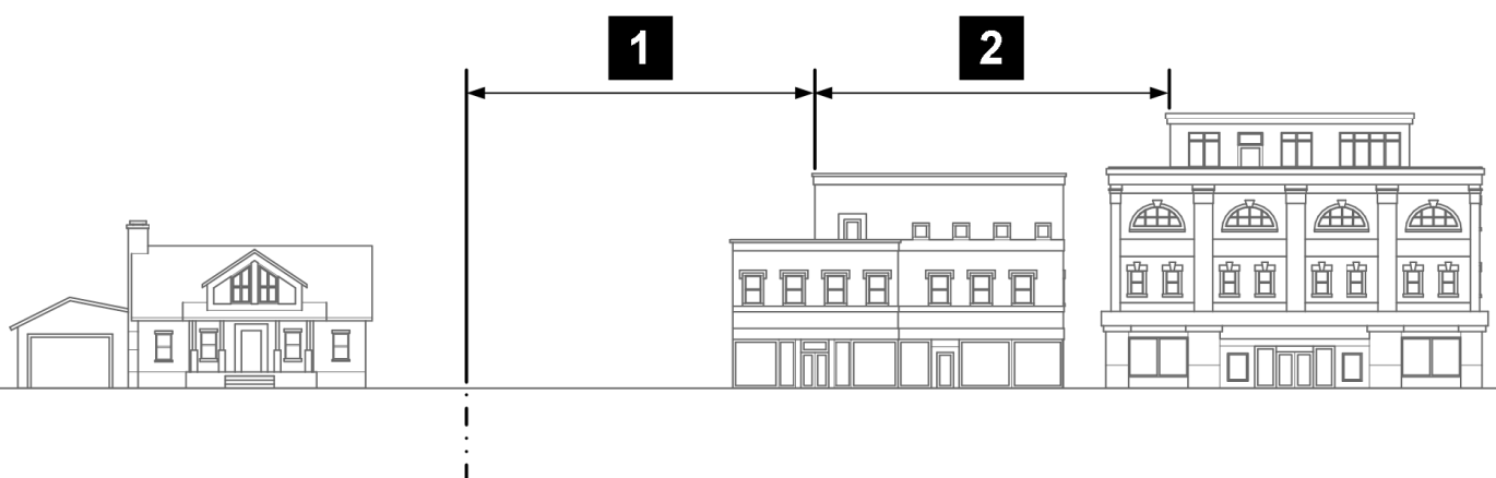
F.
Location of off-street parking areas. Off-street parking meeting the parking needs of the proposed use shall be located in one or more of the areas listed below. The areas are listed in priority order from highest to lowest; the applicant shall select the highest feasible area from this list, and shall demonstrate why that area was selected over alternative areas.
1.
Available off-street public parking areas or structures;
2.
Available off-street private shared parking areas or structures;
3.
In front of the building using allowed on-street parking;
4.
On the same lot as the use, adjacent to off-street parking areas serving nonresidential or mixed-uses;
5.
On the same lot as the use, located behind the building in a parking structure, covered parking or open parking;
6.
In front of the building on the lot; or
7.
Adjacent to lot lines abutting residential uses only if consistent with landscape buffer standards in section 15.05.040.F.
G.
Buffering and screening.
1.
Mixed-use or nonresidential service areas containing outdoor trash, recycling, or compost containers or off-street loading areas shall not be located within ten feet of a lot occupied by or zoned for residential use and shall be consistent with outdoor screening in section 15.05.130.
2.
Landscaped buffers shall be provided pursuant to section 15.05.040.F.
H.
Outdoor lighting. Outdoor lighting shall meet all standards in section 15.05.140 and shall:
1.
Have a maximum height of 15 feet within 50 feet of any residential zoning district, 25 feet in height for locations between 51 and 150 feet from any residential zoning district, and 30 feet in height for all other locations;
2.
Be fully-shielded and configured so that the source of illumination is not visible;
3.
Be directed away from adjacent lots in residential districts; and
4.
Reduce lighting levels to only accessory security lighting during non-business hours.
I.
Use and operation.
1.
The following uses or features shall be prohibited as principal or accessory uses:
a.
Public address systems and outdoor speakers;
b.
Outdoor storage; and
c.
Any use subject to a distance separation standard under section 15.04.030.
2.
Nonresidential uses with outdoor activities located adjacent to lots in a residential district shall cease operation of such outdoor activities by 10:00 p.m.
3.
Loading or unloading activities shall take place only between the hours of 7:00 a.m. and 10:00 p.m., except that loading and unloading shall not occur between 7:00 p.m. and 7:00 a.m. if located in the back of the property or from an adjacent alley.
4.
Alternate hours of outdoor activities may be approved by the director if the applicant demonstrates that the activity is compatible with the surrounding properties and neighborhood.
5.
Uses shall comply with applicable use specific standards under section 15.04.030.
6.
Uses shall comply with the operational and performance standards of section 15.05.160.
J.
Residential development adjacent to nonresidential or mixed-use development. When residential development is proposed adjacent to an existing nonresidential or mixed-use development, the decision-making body may impose residential compatibility standards on the proposed residential development including the configuration of the building and dwelling units to minimize potential conflicts with adjacent development. Any required mitigation shall be installed and maintained by the residential development, not the existing commercial or industrial use.
(Code 2009, § 15.05.210)
Sec. 15.05.220. - Inclusionary housing.
A.
Findings.
1.
The regional trend toward increasing housing prices will, without intervention, result in inadequate supplies of affordable housing in the city for low, moderate, and middle income households. This trend has a negative effect on the ability of local employers to maintain an adequate workforce, adversely impacting the economy of the city.
2.
Because land appropriate for residential development within the city is limited, it is essential that a reasonable proportion of such land be developed into housing units that are affordable to low- and moderate-income residents and working people. All development of market-rate housing should therefore include affordable housing, and the council finds that 12 percent is the reasonable proportion at this time, given economic indicators and community need.
3.
Less expensive market-rate housing (middle-tier housing) generally has less of an impact than larger market-rate housing, provides housing for an additional segment of the population that is critical to the city's workforce and economy, and would be less likely to be developed were it to be required to include an affordable housing component. The requirements of this section should therefore apply to market-rate housing in a graduated manner.
4.
The development of accessory dwelling units, the conversion of residential buildings to add a single additional housing unit, and planning approval of developments that do not create a condition for further development each have only a de minimis impact on land supply and the overall social, economic, and environmental health of the city, and need not be included within the requirements of this section.
5.
The market for rental housing is distinct from the market for for-sale housing and attracts different consumers. The construction of higher-density rental units will increase the overall quantity of rental units across all price ranges. The construction of a greater number of rental units across all price ranges will alleviate existing demand pressures, not apparent in the for-sale market, forcing some individuals to rent in price ranges below what their incomes will allow. In turn, higher-density rental developments will improve the availability of affordable rental housing. City housing data suggests that rental densities exceeding 20 units per acre are not likely to be developed absent a significant incentive. Accordingly, marginal units in a rental development that exceed a density threshold of 20 units per acre should not be subject to the requirements of this section.
B.
Applicability. This section applies to any development receiving approval of a final plat, site plan, PUD plan, overall development plan, or other similar planning approval.
1.
The following exceptions shall apply to the applicability of this section 15.05.220:
a.
The development of accessory dwelling units.
b.
Adding a single additional housing unit to any residential building.
c.
A development receiving planning approval that would not create a condition for further development as further clarified in the rules under subsection O of this section.
d.
When a development that has received final approval of a final plat, site plan, PUD plan, overall development plan, or other similar planning approval prior to December 11, 2018, requests an amendment to such final approval, this section 15.05.220 shall apply only to any additional units or square footage proposed in the requested amendment.
e.
When a development seeks planning approval to convert a residential building to a group care home, this section 15.05.220 shall apply to any additional bedroom spaces.
C.
Transitional provision, applicability by date. This section shall apply only to any development receiving approval of a final plat, site plan, PUD plan, overall development plan, or other similar planning approval after December 11, 2018. For development of one single-family detached dwelling unit on a single lot platted prior to December 11, 2018, this development code does not require a subdivision plat, because no subdivision will occur, nor a site plan. See section 15.02.070.C.2.
D.
Requirements by unit type.
1.
For sale. Developments of units for sale may satisfy the requirements of this section using any of the options listed in subsection E of this section.
2.
For rent. Developments of units for rental may satisfy the requirements of this section using any of the options listed in subsection E of this section.
3.
Live/work. Live/work units shall be considered residential development for the purposes of this section. However, for market-rate live/work units, only 80 percent of the unit shall be considered market-rate housing.
E.
Options to satisfy requirements.
1.
On-site location. The developer or builder may satisfy its obligations under this section by providing affordable housing at the same location as market-rate units.
a.
Quantity and design. At least 12 percent of the dwelling units in the development shall be affordable.
b.
Phasing. Phasing of construction of affordable units and securities for each phase shall be detailed in an affordable housing agreement approved by the city manager or designee under the same standards and procedures as a public improvement agreement.
c.
Amenities. Affordable units shall have equal access as market-rate units to all amenities within the development, including, but not limited to, common areas, indoor and outdoor facilities for convenience or recreation, and parking facilities.
d.
Homeowner associations. Affordable units must be placed on a fair and equal footing as market-rate units within the governing documents of any homeowner association or similar entity.
2.
Fee in lieu. A developer may pay a fee in lieu of providing affordable units.
a.
Amount. The council finds that inclusionary housing fee in lieu methodology for the City of Longmont reasonably calculates the impact to the city, including the city's finances and the welfare of the city's residents, of market-rate dwelling units being developed in the city. Accordingly, the fee in lieu is set initially at $7.90 per square foot of finished for-sale housing, and $1.90 per square foot of finished rental housing. The fee in lieu of providing any required fraction of a unit shall be based on its proportional share (fractional quantity divided by total number of units required) of the amount of fee in lieu that would be required for the whole development. The city manager or designee shall recalculate the fee in lieu every three years and present the recalculation to the council by July 31 of every third year commencing 2026. Thereafter the recalculated fee in lieu will become effective on January 2 of the next year.
i.
Effective December 11, 2023, the fee in lieu will be recalculated to $13.50 per square foot of finished for-sale housing, and $5.93 per square foot of finished rental housing. Notwithstanding the foregoing, an applicant that has submitted an application for a final plat, site plan, PUD plan, overall development plan, or other similar planning approval that has been accepted as complete as set forth in subsection 15.02.040.B before December 11, 2023, but has not received final approval shall pay the fee in lieu initially set in subsection 15.05.220.E.2.a, if such application receives final approval no later than December 31, 2024. Subsequent applications submitted by such applicants shall pay the fee in lieu as provided in subsection 15.05.220.E.2.b
b.
Timing of payment. A developer or builder shall pay the fee in lieu for each unit as a prerequisite for receiving the certificate of occupancy for that unit. The fee paid shall be the fee in effect at the time of the final plat or site plan for the development, whichever is later.
c.
Calculation with density cap. Rental units excluded from the requirements of this section due to the density cap in subsection Q of this section shall be excluded from the calculation of the fee in lieu in the following manner: the square footage of the development for the purposes of the fee in lieu shall be calculated as the average actual square footage of the units in the development multiplied by the number of units not excluded.
d.
Conversion of rental developments to ownership dwelling units. A rental development may be converted to a for sale development from time to time. If the inclusionary housing requirement for a rental development was satisfied with a fee in lieu contribution and the rental development is converted to a for-sale development within five years of the issuance of a final certificate of occupancy, the property owner shall pay the city the difference between the fee in lieu amount paid and the amount that would have been due at the time of the final plat or site plan for a for-sale development. An owner of a rental development shall enter into an agreement with the city, acting by and through its city manager or designee, where the form of such agreement is approved by the city manager or designee, agreeing to pay the difference between the rental fee in lieu and the for-sale fee in lieu if the rental development, or any unit therein, is converted to for-sale in the five-year period. The agreement shall indicate the difference between the fee in lieu amount owed upon conversion to a for-sale unit during the five-year term. No additional fee in lieu shall be required if such conversion occurs after the expiration of the five-year term.
3.
Off-site location. A developer or builder may seek to provide affordable units within the city in a different location than the development of the market-rate units.
a.
Quantity required. The developer or builder shall provide no less quantity of affordable housing than would have been required on-site.
b.
Location restrictions. The affordable units may not be located in a low to moderate income area as designated by the U.S. Department of Housing and Urban Development, unless an exception is granted under subsection K.3 of this section.
c.
New or existing housing. Existing homes may be acquired and deed restricted as affordable if they are in good repair in the determination of the city manager or designee based on an inspection paid for by the developer but commissioned by the city, carry a warranty of sufficient scope and duration to protect the resident from significant preexisting deficiencies, and are not already burdened by restrictions requiring them to be kept affordable or restrictions similar in effect.
d.
Timing of off-site construction. No final plat or site plan shall be executed for the location of the market-rate units until a final plat sufficient to facilitate the development of the affordable units, and site plan if necessary, have been recorded. Phasing and security shall be governed in the same manner as on-site locations as described in subsection E.1.b of this section. The affordable housing agreement shall run with the land and shall be recorded against the off-site location.
e.
Approval. Approval of the use of this option does not guarantee approval of any land use application or building permit for the off-site location. The developer risks forfeiture of security if unable to build the off-site units as proposed.
4.
Land dedication. A developer may seek to provide land to the city in lieu of the development of affordable units. Dedicated land must meet the following standards:
a.
All off-site infrastructure necessary or proper for the development of the land as affordable housing either: (i) must already be in place, and any outstanding obligations paid to neighboring landowners for public infrastructure they installed; (ii) the developer must agree to build the infrastructure within a timeframe that will not delay the development of the affordable housing and the developer may be required to post securities for the infrastructure via a public improvement agreement; or (iii) the land donation must be accompanied with additional compensation to the city sufficient to construct such infrastructure.
b.
The land must be able to support at least the quantity of affordable housing as would be required on-site, without the need for a variance, modification, rezoning, or reliance on any incentive for affordable housing found in this development code, such as a density or height bonus. The developer shall submit a concept plan illustrating how it complies.
c.
The land must not be encumbered in any manner, including, but not limited to, any lien, outstanding tax or fee accrued, or floodplain, which in any way jeopardizes the city's ability to develop that quantity of housing.
d.
The land may not be located in a low to moderate income area as designated by the U.S. Department of Housing and Urban Development, unless an exception is granted under subsection K.3 of this section.
e.
The land must be dedicated to the city at the time of execution of the plat or plan allowing the development of the market-rate units.
f.
The developer and the owner of the land shall comply with all environmental site assessment provisions of section 15.02.140 applicable to dedications via plats or site plans, and associated development.
g.
The land dedication must be in fee simple and by general warranty deed.
5.
Redemption of credits. A developer may acquire, and redeem with the city, credits generated as described in subsection L of this section, from the prior development of affordable housing, to offset an equivalent quantity of required affordable housing.
6.
Voluntary alternative agreement. A developer may propose an alternative manner in which the development will satisfy its obligations under this section. Such an agreement need not meet the otherwise applicable substantive requirements of this section, but must be approved by the city council under the provisions of subsection K.2 of this section. The agreement may facilitate the construction of lower-priced affordable homes as follows:
a.
The agreement may provide that the home price of a for-sale unit would be affordable at or below 60 percent of the area median income.
b.
For rental housing, the agreement may provide that the monthly rental price would be affordable at or below 40 percent of the area median income.
c.
Under subsections E.6.a and b of this section, the obligations otherwise applicable under this section may be reduced up to 25 percent.
d.
Subsections E.6.a through c of this section may apply to on-site and off-site affordable housing as well as land donations.
7.
Combination. A developer or builder may pursue any combination of the allowable options in this subsection.
F.
Middle-tier housing. Prior to issuance of building permits, a developer or builder may enter an agreement with the city, acting by and through the city manager or designee, where the form of such agreement is approved by the city manager or designee, providing that the development may include less affordable housing than this section would otherwise require, due to the developer's commitment to provide middle-tier housing. The agreement shall provide as follows:
1.
The requirements for any units sold for occupancy at a price affordable between 80.1 percent and 100 percent of the area median income shall be reduced to 55 percent of the otherwise applicable requirement.
2.
The requirements for any units sold for occupancy at a price affordable between 100.1 percent and 110 percent of the area median income shall be reduced to 70 percent of the otherwise applicable requirement.
3.
The requirements for any units sold for occupancy at a price affordable between 110.1 percent and 120 percent of the area median income shall be reduced to 90 percent of the otherwise applicable requirement.
4.
For-sale units sold for occupancy at a price that exceeds the median sales price in the City of Longmont for a given unit type, as published by the City of Longmont, shall be precluded from the otherwise applicable reductions in subsections F.1 through F.3.
5.
The developer or builder shall state the price tiers for which the homes will qualify.
6.
The developer or builder shall use best efforts to ensure that the initial owner or owners of each such individual home shall have a bona fide intent to occupy the premises, and shall provide documentation thereof.
7.
In order to receive building permits for such middle-tier homes, the developer or builder shall confirm in writing to the city manager or designee, in the form provided by the city manager or designee, that each home will sell for a price within the applicable range described in the agreement. In order to receive a certificate of occupancy for such a middle-tier home, the developer or builder shall produce proof, to the satisfaction of the city manager or designee, that the home will actually sell for a price within that applicable range. Promptly upon sale of the home, the developer or builder shall provide proof, to the satisfaction of the city manager or designee, that the home did actually sell for a price within the applicable range.
8.
Middle-tier true-up. Where a developer or builder sells some of such middle-tier homes for more than the designated tier, and the development's obligations under this section increase as a result, the developer or builder may still receive approvals for such homes, including certificates of occupancy, by paying to the city the amount of the fee in lieu for the difference.
G.
Deed restrictions. All required affordable housing shall carry deed restrictions and covenants in the form set by the city manager or designee.
1.
When required.
a.
Ownership covenant. Deed restrictions shall be required for each affordable for-sale unit at the time the unit passes to a qualifying owner.
b.
Rental covenant. Deed restrictions for affordable rental units shall be required prior to issuance of the first certificate of occupancy for any rental unit in the development.
2.
Content. The deed restrictions shall contain all terms determined by the city manager or designee to be appropriate to ensure the affordability of the unit and compliance with this section.
3.
Deed of trust. The deed restrictions shall be secured by a deed of trust on the property, which may be subrogated to other deeds of trust on the property.
4.
Term. All ownership and rental covenants shall be perpetual or virtually so; they shall require affordability of the affected unit for the greatest duration allowed by law.
5.
Sale.
a.
Ownership covenants. Ownership covenants shall allow sale to another homeowner qualifying under subsection H of this section. These covenants shall allow for appreciation of the home at a rate determined based on changes in the area median income, plus an allowance for the value of capital improvements to the home installed by the owner. The rate may be capped so as to ensure the continued affordability of a unit to a new purchaser, to ensure that unit price does not fall unreasonably below the level at which a unit would be considered affordable, and to facilitate the economically practical sale of a unit once its owner's income increases sufficiently for the owner to afford a market-rate unit. The seller of the home shall charge to the buyer no other special or unusual fees, including any finder's fee. The council may consider allowing an owner of an affordable unit to sell to a buyer who does not meet the qualifications of subsection H of this section in exceptional circumstances involving significant disruption to the local economy or individual financial hardship. In exchange, the owner would transfer equity to the city at that time. The city manager or designee may specify in the deed restriction the amount of such equity. The amount shall be revised upon each sale of the affordable unit, and shall be based on the difference between the most recent affordable sales price and the estimated market price of the unit at the time of most recent sale.
b.
Rental covenants. The city manager or designee may release and discharge a rental covenant after 30 years' duration, allowing sale or rental of the property to people who do not qualify under subsection H of this section, so long as the owner of the units seeking the removal of the deed restriction pays to the city at that time, for each deed-restricted affordable rental unit, the amount of the difference between the value of the unit with and without the deed restriction, as calculated by the city manager or designee based on reasonable market data collection or projections. If an arm's-length sale of the property accompanies the termination, the units shall be valued proportionally to the value at which the property is priced in the sale, so long as the city manager or designee determines that valuation to be a reasonable market price.
H.
Income qualification and local live/work preference. Affordable units may be sold or rented only to a person selected by the city manager or designee who meets the city's qualifications. Such qualifications shall be based on the person's income and assets and shall be intended to ensure that only those who require affordable housing shall be eligible. In selecting particular qualified applicants for particular affordable units, the city manager or designee shall consider applicants' household size compared to the size of available affordable units. If more qualified applicants of the appropriate household size request housing in an affordable unit than there are affordable units available, the city manager or designee shall give priority to applicants who prove their residency or employment within the city to the satisfaction of the city manager or designee. If applicants are equally so prioritized, the city manager or designee may select among the applicants by lottery.
I.
Restriction on rental of for-sale units. No owner of a for-sale affordable unit may fail to continuously occupy the unit as a primary residence, or lease or rent out the unit to any person. The city manager or designee may grant an exception to this restriction if the owner proves to the satisfaction of the city manager or designee that the lease or rental is directly necessitated by a bona fide hardship, the property has no outstanding down payment assistance loan from the city, and the lessee or renter will be a person approved by the city manager or designee as meeting the qualifications of a purchaser of an affordable unit under subsection H of this section. The owner must notify the city manager or designee at least 90 days prior to leasing or renting out the unit, to give the city manager or designee adequate time to consider the proposed exception.
J.
Affordable housing fund. All revenues accruing to the city under this section shall be placed in the affordable housing fund established in chapter 4.99.
K.
Approval process.
1.
Administrative approval.
a.
On-site. Developments which opt to satisfy this section by producing all required affordable for-sale units on-site under subsection E.1 of this section, may memorialize their commitments on the plat or site plan without requiring council approval.
b.
Fee in lieu. Developments which opt to satisfy this section by paying the fee in lieu, as described in subsection E.2 of this section, may do so without requiring council approval.
2.
Other options; approval by city council. Developments seeking to use other options in subsection E of this section must seek approval of their proposed use of such options from the city council. The council's decision on such proposals is discretionary and legislative. The council will consider whether the proposal will result in more affordable housing, providing more of a benefit to the city, than would the provision of the affordable units on-site under subsection E.1 of this section, whether practical difficulties prevent the inclusion of the affordable units on-site under subsection E.1 of this section, whether the proposal would better benefit the inhabitants of the city than requiring the provision of affordable housing on-site, or any other factors that may be relevant to these considerations.
3.
Exception to restrictions on placement of affordable housing in low to moderate income areas. The council may, in its discretion and as a legislative act, grant an exception to the restrictions of subsections E.3 and E.4 of this section on provision of off-site affordable housing and land dedication within low to moderate income areas. The council will generally consider whether the placement of the required affordable housing in such areas would result in clustering of low-income housing in a way that would negatively impact the inhabitants of the area, the surrounding community, or the city as a whole, and whether positive elements of redevelopment or investment in the area outweigh any potential negative impacts.
4.
The city manager or designee shall recommend approval or denial of each proposal before the council.
L.
Credits for excess affordable housing.
1.
Award of credit.
a.
By agreement. At the time of plat or site plan, a developer may enter into an agreement with the city, acting by and through the city manager or designee, and in a form acceptable to the city manager or designee, to memorialize that the developer shall develop more affordable housing than would otherwise be required under this section.
b.
Certificate of credit. Provided that such housing is actually developed, and a certificate of occupancy issued, the city shall award the developer a credit for the excess number of units provided.
c.
Exceptions. No credit shall be available for any affordable housing built on land donated or sold at a significant discount for the purpose of developing affordable housing in satisfaction of this section or any prior affordable housing requirements of the city; or for any affordable housing receiving any federal, state, or local subsidies whether financial subsidy, tax relief or other credits or incentives from the city under chapter 4.79. However, a development's use of a loan from the U.S. Department of Housing and Urban Development shall not disqualify its affordable housing from generating a credit.
d.
Applicable regardless of nonmonetary development code incentives. Affordable housing receiving land use incentives under this development code shall not thereby be rendered ineligible for a credit. As an exception to any otherwise applicable provision of this development code, such excess affordable housing shall not be excluded from such land use incentives by virtue of a developer's determination to seek a credit rather than to enter an agreement with the city for monetary incentives under chapter 4.79.
2.
Redemption of credit. The credit may be redeemed to offset an equivalent number of affordable housing units that would otherwise be required under this section. Such credit shall be freely transferable to any other developer but shall be transferred in a manner acceptable to the city manager or designee so as to ensure accurate tracking of the transfer of credits by the city. A credit shall expire five years after it is awarded unless, within that time, the city executes an agreement with the holder of the credit to apply the credit to a specified development. Before the credit expires, the city manager or designee may, upon request, in writing, and for good cause, extend the term of the credit by one additional term of two years.
M.
Marketing and sale of units. Rules and regulations under subsection O of this section may address marketing and sale of units to ensure that the community has sufficient notice of available affordable housing.
N.
Violation. It shall be unlawful and a violation of this development code for any person to violate any provision of this section, any rule or regulation adopted by the city manager or designee under this section, any agreement executed as described in this section, or any deed restriction recorded as described in this section.
O.
Rules and regulations. The city manager or designee may propose such reasonable rules and regulations as may be necessary for the purpose of administering, interpreting, or enforcing the provisions of this section. The rules and regulations shall be reviewed by the city attorney's office and then adopted by the city manager. Notice of adopted rules shall be published in a newspaper of general circulation in the city.
P.
Appeal. The general appeal provisions of section 15.02.040.K, shall not apply to this section, except as noted below, and no variances, modifications, or other deviations from the requirements of this section shall proceed under this development code. Appeals shall instead be permitted as follows:
1.
Appeal of decisions of the city manager's designee.
a.
To the city manager. A developer or builder may appeal to the city manager, under the procedures listed in chapter 2.98, any action, decision, refusal, denial, or order by the city manager's designee that finally disposes of a request or application under this section. The city manager shall reverse the decision of the city manager's designee upon finding that the decision misapplied or misinterpreted this section.
b.
To the city council. A developer or builder who receives an unfavorable written decision from the city manager on appeal may then appeal the matter to the city council by filing a notice of appeal as described in section 15.02.040.K.6 within seven days from the date of the city manager's decision. The council shall hear and decide on the appeal generally under the procedures detailed in section 15.02.040.K.10., 11.a through c, and 12. The council shall reverse the decision of the city manager upon finding that the decision misapplied or misinterpreted this section.
2.
Appeal of adoption of rules and regulations. Any rule or regulation promulgated under subsection O of this section may be appealed to the city council within 28 days of publication of adoption, by filing a notice of appeal as described in section 15.02.040.K.6. The council shall hear and decide on the appeal generally under the procedures detailed in sections 15.02.040.K.10, 11.a through c, and 12. The council shall reverse any rule or any part of any rule upon finding that the decision misapplied or misinterpreted this section, and may then remand any matters to the city staff for further rulemaking. Any rules or parts of rules not specifically reversed shall be final.
Q.
Density cap for rental units. Where a rental development exceeds a density of 20 units per acre, no obligation shall arise under this section to satisfy any affordable housing requirement for any marginal rental units provided exceeding that density.
(Code 2009, § 15.05.220; Ord. No. O-2018-51 , § 2, 12-11-2018; Ord. No. O-2019-17 , § 3, 3-19-2019; Ord. No. O-2021-18, § 2, 4-13-2021; Ord. No. O-2023-60, §§ 2—13, 11-28-2023)