Lynn Haven City Zoning Code
CHAPTER 3
ENVIRONMENTAL AND RESOURCE PROTECTION
3.01.00 - RESERVED
[1]
Editor's note—Sec. 2(Exh. B) of Ord. No. 1166, adopted August 27, 2024, repealed § 3.1.00, which pertained to flood damage prevention, and derived from Ord. No. 1075, § adopted April 23, 2019.
3.02.00 - ENVIRONMENTALLY SENSITIVE LANDS PROTECTION
[2]
State Law reference— Provisions to ensure the protection of environmentally sensitive lands designated in the comprehensive plan required, F.S. § 163.3202(2)(b).
3.00.01 - Purpose and Intent
The purpose of this chapter is to safeguard the public health, safety, and welfare by ensuring the long-term protection and preservation of environmentally sensitive natural resource systems. Application of the provisions of this chapter shall result in development that will reduce the adverse impacts on the hydrologic functions of wetlands, natural systems, habitats, water quality, shorelines, marine life, and coastal resources.
3.00.02 - Applicability
All new development and redevelopment shall be designed to ensure protection of areas designated as floodplains, environmentally sensitive lands, wetlands, or wellfields. No permit for development shall be issued by the City that is not consistent with the provisions of this chapter.
3.02.01 - Endangered or Threatened Species Habitats
A.
Purpose, intent, and applicability
1.
It is the purpose of this section to provide standards necessary to protect the habitats of species, both flora and fauna, of rare, endangered, threatened, or special concern status in the City (called "listed species").
2.
It is the intent of this section to require that an appropriate amount of land shall be set aside to protect the habitat of listed species.
3.
Areas subject to the standards of this section are identified in the Conservation Element of the Plan as habitat for listed species.
B.
Habitat management plan
1.
A habitat management plan shall be prepared as a prerequisite to the approval of any development proposed on a site containing areas subject to this section.
2.
The habitat management plan shall be prepared by an ecologist, biologist or other approved professional. The plan shall;
a.
Document the presence of listed species;
b.
Calculate the land needs of the listed species that may be met on the development site; and
c.
Recommend appropriate habitat management plans and other measures to protect the listed species.
3.
The development plan for a site subject to this section shall substantially conform to the recommendations in the habitat management plan.
4.
Where land in a proposed development is to be preserved as habitat of listed species, such land shall be adjacent to existing viable habitat, a significant wetland system, floodplain, or wildlife corridor.
5.
If such lands are not adjacent to the development site, land to be set aside shall be of such quantity and quality as to provide viable habitat, as documented in the study required in Section 3.02.01(B)(2).
3.02.02 - Wetlands and Shoreline Protection
A.
Wetlands protection zone
1.
There is hereby created a wetlands protection zone in which special restrictions on development apply.
2.
The boundaries of this zone shall be the most landward extent of the following:
a.
Areas within the dredge and fill jurisdiction of the FDEP;
b.
Areas within the jurisdiction of the USACOE; and
c.
Areas identified by the Florida Natural Areas Inventory.
B.
Shoreline protection zone
1.
There is hereby created a shoreline protection zone in which special restrictions on development apply.
2.
The shoreline protection zone boundary shall be located thirty (30) feet landward of the mean high water line.
C.
Request for determination of boundaries
1.
A developer may obtain a determination of the boundaries of a protected environmentally sensitive zone.
2.
The developer shall submit the request for determination of boundaries in writing by certified mail or hand delivery to the regulatory agencies.
3.
The request shall, at a minimum, set forth;
a.
An adequate description of the land;
b.
The nature of the developer's right to ownership or control of the land; and
c.
Other information needed to make the determination.
3.02.03 - Development Activities within Protected Zones
A.
Generally Except as expressly provided in this section, no development activity shall be undertaken in a protected environmentally sensitive zone.
B.
Certain activities are presumed to have an insignificant adverse effect on the beneficial functions of protected environmentally sensitive zones. Notwithstanding the prohibition in 3.02.03(A), these activities may be undertaken unless it is shown by competent substantial evidence that the specific activity would have a significant adverse effect on the protected environmentally sensitive area.
C.
Wetlands protection zones The following uses and activities are presumed to have an insignificant adverse effect on wetlands protection zones:
1.
Scenic, historic, wildlife, or scientific preserves;
2.
Minor maintenance or emergency repair to existing structures or improved areas;
3.
Cleared walking trails having no structural components;
4.
Timber catwalks and docks four (4) feet or less in width;
5.
Commercial or recreational fishing or hunting, and creation and maintenance of temporary blinds;
6.
Cultivating agricultural or horticultural products that occur naturally on the site;
7.
Constructing fences where no fill activity is required and where navigational access will not be impaired by construction of the fence;
8.
Developing an area that no longer functions as a wetland, except a former wetland that has been filled or altered in violation of any rule, regulation, statute, or this section.
a.
The developer shall demonstrate that the water regime has been permanently altered, either artificially or naturally, in a manner to preclude the area from maintaining surface water or hydroperiodicity necessary to sustain wetland structure and function.
b.
If the water regime of a wetland has been artificially altered but wetland species remain the dominant vegetation of the area, the City Manager shall determine the feasibility of restoring the altered hydrology.
c.
If the wetland may be restored at a cost that is reasonable in relation to benefits to be derived from the restored wetland, the developer shall, as a condition of development, restore the wetland and comply with the requirements of this section.
9.
Developing a wetlands stormwater discharge facility or treatment wetland in accordance with State permits.
D.
Shoreline protection zones The following uses and activities are presumed to have an insignificant adverse effect on shoreline protection zones:
1.
Scenic, historic, wildlife, or scientific preserves;
2.
Minor maintenance or emergency repair to existing structures or improved areas;
3.
Clearing of shoreline vegetation waterward of the water's edge, so as to provide a corridor not to exceed fifteen (15) feet in width, of sufficient length from the shore to allow access for a boat or swimmer to reach open water, and landward of the water's edge so as to provide an open area not to exceed twenty-five (25) feet in width. One (1) additional such corridor may be cleared for every full 100 feet of frontage along the water's edge above and beyond the first 100 feet;
4.
Clearing of shoreline vegetation to create walking trails having no structural components, not to exceed four (4) feet in width;
5.
Timber catwalks, docks, and trail bridges that are less than or equal to four (4) feet wide, provided that no filling, flooding, dredging, draining, ditching, tilling or excavating is done, except limited filling and excavating necessary for the installation of pilings;
6.
Commercial or recreational fishing, hunting, trapping, and creation and maintenance of temporary blinds;
7.
Constructing fences where no fill activity is required and where navigational access will not be impaired by construction of the fence; and
8.
Developing a wetlands stormwater discharge facility or treatment wetland in accordance with State permits.
E.
Water dependent activities
1.
Designated water dependent activities that are otherwise prohibited may be allowed if the developer shows:
a.
The public benefits of the activity substantially outweigh the adverse environmental effects on a wetland area; and
b.
No practicable alternative to placement in the protected environmentally sensitive zone exists.
2.
The following are permitted water dependent activities:
a.
Projects not exceeding 10,000 cubic yards of material placed in or removed from watercourses, water bodies, or wetlands;
b.
Dockage or marinas where dock length does not exceed twenty-five (25) percent of the width of the water body and containing less than one (1) slip per 100 feet of shoreline. All docks and slips shall be at least 100 feet from any federal navigation project;
c.
New riprap or similar structures, not including seawalls, bulkheads or the like, not exceeding fifty (50) feet of shoreline;
d.
Installation of buoys, aids to navigation, signs, and fences;
e.
Performance of maintenance dredging for ten (10) years from the date of the original permit. Thereafter, performance of maintenance dredging so long as less than 10,000 cubic yards of material is removed;
f.
Installation of subaqueous transmission and distribution lines for water, wastewater, electricity, communication cables, oil, or gas. Lines may be entrenched in (not exceeding 10,000 cubic yards of dredging), laid on, or embedded in bottom waters;
g.
Construction of foot bridges and vehicular bridges;
h.
Replacement or widening of bridges on pilings or trestles where the effects of pollutants discharged into open waters are minimized; and
i.
Construction of artificial reefs.
3.
The water dependent activity shall be designed, constructed, maintained and undertaken in a way that minimizes the adverse impacts on the beneficial functions of the affected environmentally sensitive zone.
F.
Design standards for special uses In addition to the standards listed in 3.02.03(C) through (E), the following standards apply to special uses allowed in the protected environmentally sensitive zones:
1.
The development of special uses allowed in a shoreline protection zone shall be designed to:
a.
Allow the movement of aquatic life requiring shallow water;
b.
Maintain existing flood channel capacity; and
c.
Ensure stable shoreline embankments.
2.
Development that encroaches on the shoreline protection zone shall not be located:
a.
On unstable shorelines where water depths are inadequate to eliminate or minimize the need for offshore or foreshore channel construction dredging, maintenance dredging, spoil disposal, filling, beach feeding, and other river, lake, and channel maintenance activities;
b.
In areas where there is inadequate water mixing and flushing; or
c.
In areas which have been identified as hazardous due to high winds or flooding.
3.
Access roads, parking lots, and similar structures shall be located on upland sites.
4.
Nondeveloped portions of the shoreline protection zone that are damaged during construction shall be restored or replaced through replanting of vegetation; restocking of fish, shellfish, and wildlife; reestablishment of drainage patterns; and the like. To the maximum extent possible, the restored areas shall match their prior ecological functioning.
G.
Mitigation
1.
Generally
a.
Compensatory mitigation, by which environmentally sensitive lands are purchased, created, enhanced, or restored to compensate for the loss of such lands, is required whenever a special use is allowed under Section 3.02.03(E).
b.
The purchased, created, enhanced, or restored environmentally sensitive land shall be of the same type as that destroyed or degraded and shall be located in the same sub-drainage basin or in the same ecosystem.
c.
Where lands are purchased or created for the purpose of mitigation, the first priority for location of these lands shall be within the City limits.
d.
Compensatory mitigation shall not be the basis for approving a project that could not otherwise be approved.
e.
A developer of a compensatory mitigation plan shall grant a conservation easement under Section 704.06, F.S., on the newly purchased, created, enhanced, or restored environmentally sensitive lands to protect them from future development.
f.
Compensatory mitigation shall be based on the Uniform Wetland Mitigation Assessment Method provided in Chapter 62-345, Florida Administrative Code.
2.
Wetlands Compensatory wetland mitigation shall require that the amount of wetlands purchased, created, enhanced, or restored is large enough to ensure that the amount of wetlands destroyed or degraded shall be completely and successfully replaced. The minimum replacement ratio for destroyed wetlands shall be two to one (2:1).
3.02.04 - Restricted Development Zone
A.
Generally There is hereby created a restricted development zone adjacent to each protected environmentally sensitive area. This zone shall encompass all land within twenty (20) feet of the boundary of the protected environmentally sensitive zone.
B.
Development activities
1.
All development in a restricted development zone shall be designed, constructed, and maintained to avoid significant adverse effects on the adjacent environmentally sensitive zone.
2.
The acreage within a protected environmentally sensitive zone may be used to determine the total allowable units or square footage of development that will be allowed on a site containing all or part of such a zone. This development potential may be transferred from the protected environmentally sensitive zone to the restricted development zone or beyond. Allowable development potential shall not, however, be transferred from without the area encompassed by the restricted development zone and protected environmentally sensitive zone to within such area.
3.
The following special design standards apply within restricted development zones adjacent to wetlands protection zones:
a.
Wherever possible, natural buffers shall be retained between all development and all protected environmentally sensitive zones. If a natural buffer does not exist, an equivalent buffer shall be created. The size of the buffer shall be a minimum of thirty (30) feet in width.
b.
The developer shall completely restore any portion of a protected environmentally sensitive zone damaged during construction. Complete restoration means that the damaged area shall, within two (2) years, be operating as effectively as the natural system did prior to being destroyed; and
c.
Other reasonable protective measures necessary to prevent significant adverse effects on a protected environmentally sensitive zone may be required. The factual basis of the decision to require the measure shall be stated as a finding in the written record. Protective measures may include, but are not limited to:
1.
Maintaining natural drainage patterns;
2.
Limiting the removal of vegetation to the minimum necessary to carry out the development activity;
3.
Expeditiously replanting denuded areas;
4.
Stabilizing banks and other unvegetated areas by siltation and erosion control measures;
5.
Minimizing the amount of fill used in the development activity;
6.
Disposing of dredged spoil at specified locations in a manner causing minimal environmental damage;
7.
Constructing channels at the minimum depth and width necessary to achieve their intended purposes, and designing them to prevent slumping and erosion and allow revegetation of banks;
8.
Dredging wetlands at times of minimum biological activity to avoid periods of fish migration and spawning, and other cycles and activities of wildlife; and
9.
Designing, locating, constructing, and maintaining all development in a manner that minimizes environmental damage.
4.
The following special design standards apply within restricted development zones adjacent to shoreline protection zones:
a.
All development shall be set back greater than or equal to the landward boundary of the shoreline protection zone;
b.
Total impervious surface including, but not limited to, buildings, houses, parking lots, garages, accessory buildings, driveways, pools, and walkways is limited to ninety (90) percent of the land area of the entire site;
c.
The development shall leave a minimum of ten (10) percent of the site as trees, shrubs, or other natural vegetation, or replace existing trees at a minimum ratio of two to one (2:1);
d.
Point source and nonpoint source discharges are prohibited, except for stormwater, which may be discharged only if it meets the following minimum standard:
1.
Stormwater discharges shall include an additional level of treatment equal to fifty (50) percent of the treatment criteria specified in the rules of the appropriate water management district, and shall provide off-line retention or off-line detention with filtration of the first one-half (½) inch of runoff of the total amount required to be treated.
2.
If the City or any State agency has a stormwater rule which is stricter than this standard, then the stricter rule or combination of rules shall apply.
e.
Siltation and erosion control measures shall be applied to stabilize banks and other unvegetated areas during and after construction. Sediment settling ponds shall be installed for stormwater runoff prior to the creation of any impervious surfaces. For lots or parcels that are cleared, silt screens shall be placed between the construction site and the water body to prevent erosion and siltation;
f.
Any channels constructed shall be of a minimum depth and width capable of achieving the intended purposes. Sides of channels shall reflect an equilibrium shape to prevent slumping and erosion and to allow revegetation;
g.
Any dredging shall be conducted at times of minimum biological activity to avoid fish migration and spawning, and other cycles and activities of wildlife;
h.
Any spoil that results from dredging shall be disposed of at upland sites and stabilized within thirty (30) days, unless the spoil is causing turbidity or other problems, in which case the developer shall stabilize the spoil immediately;
i.
If dredging changes the littoral drift processes and causes adjacent shores to erode, the developer shall periodically replenish these shores with the appropriate quantity and quality of aggregate;
j.
Septic tanks shall not be located closer than 150 feet from the boundary of the shoreline protection zone. If septic tanks are allowed, there shall be no more than two (2) septic tanks per one (1) acre of land;
k.
Where wet moorage is offered for boats which have holding facilities for sewage, or where other recreational vehicles are allowed to stay overnight, then pumpout, holding, or treatment facilities shall be provided by the developer for sewage and other wastes, including bilge, contained on vessels and vehicles. The facilities shall be conveniently available to all vessels and vehicles;
l.
If no natural vegetation exists, strips of buffer vegetation shall be planted between development activities and the shoreline protection zone. Buffers shall be composed of native plant species;
m.
Marinas and other appropriate developments shall post the following signs where they are readily visible to all users of the development:
1.
Regulations pertaining to handling and disposal of waste, sewage, or toxic materials.
2.
Regulations prohibiting the use of vessel toilets while moored unless the toilets are self-contained or have an approved treatment device.
3.
Regulations prohibiting the disposal of fish or shellfish cleaning wastes, scrap fish, viscera, or unused bait in or near the development.
4.
Appropriate messages relating to local ecological concerns, e.g., manatee protection.
n.
A marina shall include boat launch facilities unless the applicant can demonstrate that providing such facilities is not feasible or it is determined that the ramp would be excessively damaging to the aquatic environment;
o.
Marinas shall have adequate restroom facilities in compliance with local health board regulations; and
p.
Garbage receptacles shall be provided and maintained by the marina operator at several locations convenient to users.
3.02.05 - Prohibited Ongoing Activities
The following standards apply to post-development activities taking place within any restricted development zone or protected environmentally sensitive zone:
A.
Point source and non-point source discharges Absent an amendment to the development order, point source and non-point source discharges shall continue to meet the standards applicable to the original development.
B.
Clearing Absent an amendment to the development order, no person shall clear more vegetation than was permitted for the original development.
C.
Handling and storage of fuel, hazardous and toxic substances, and wastes.
1.
Developments where fuel or toxic substances will be stored, transferred, or sold shall employ the best available facilities and procedures for the prevention, containment, recovery, and mitigation of spillage of fuel and toxic substances. Facilities and procedures shall be designed to prevent substances from entering the water or soil, and employ adequate means for prompt and effective cleanup of spills that do occur.
2.
No toxic or hazardous wastes or substances shall be stored in outdoor containers.
3.
Storage or disposal of all types of wastes is prohibited on shorelines.
D.
Prohibited uses The long term storage of equipment or materials, and the disposal of wastes shall be prohibited.
E.
Fertilizers, herbicides, or pesticides
1.
Fertilizers, herbicides, or pesticides shall not be applied in a protected environmentally sensitive zone except for projects conducted under the authority of Sections 373.451 - 373.4595, F.S., and governmentally authorized mosquito control programs.
2.
Fertilizers, pesticides, and herbicides used in restricted development zones should be applied sparingly and at appropriate rates and time intervals.
F.
Spray vehicles Vehicles used for mixing or spraying chemicals are prohibited from withdrawing water directly from waters.
G.
Pumpout, holding, and treatment facilities for wastes from mobile sources.
H.
Sewage, solid waste, and petroleum waste generated by vessels or vehicles on the site shall be properly collected and disposed of.
3.02.06 - Deer Point Reservoir Protection Zone
The Deer Point Reservoir Protection Zone is established to protect the water quality of the Deer Point Reservoir. Development within this area must adhere to the following requirements.
1.
Allowable uses within the protection zone include those described for neighborhood commercial, conservation, recreation, low-density residential and public/institutional. All other uses are prohibited. Gasoline service stations, dry cleaners, auto service stations, solid waste landfills, or any other business or activity which generates hazardous uses or toxic waste are prohibited.
2.
Residential densities within the protection zone shall be no denser than 4.99 dwelling units per acre.
3.
Impervious surface shall be limited to a maximum of forty-five (45) percent of the total lot or parcel for all residential or nonresidential projects.
4.
Setback requirements herein represent a line of regulation within which the following restrictions shall apply.
a.
Developers, owners and tenants of parcels created after the effective date of this Code shall maintain a seventy-five-foot setback from Deer Point Reservoir and any tributaries thereto. For the purposes of this regulation, the term "tributary" shall mean any continuously flowing stream, creek, or branch. This term includes manmade canals but does not include ditches or stormwater control facilities. This setback shall be measured from the Department of Environmental Protection jurisdictional line.
b.
Within the setback area, all vegetation shall be preserved in a natural condition with no development of any kind except for a ten-foot wide path to the water and any associated piers or docks Established lawns in existence prior to the effective date of this Code, are exempt from this limitation.
c.
The required setback shall be shown on all final plats of all residential subdivisions and shall be described and recorded on all deeds as being a required setback.
4.
Septic tanks shall be prohibited in the protection zone.
5.
All development within the protection zone shall comply with stormwater treatment standards found in this Code.
Additionally, stormwater discharge facilities which directly discharge into Deer Point Reservoir, or any tributary thereto shall include an additional level of treatment equal to Outstanding Florida Waters standards.
6.
The requirements of this section shall not apply to the following.
a.
The construction of a single-family home on any lot or parcel of record in existence on the effective date of this Code. Parcel of record means a piece of property legally described by plat or deed and filed with the Clerk of the Circuit Court.
b.
Any pending request for a Comprehensive Plan map amendment which had been adopted by ordinance and transmitted to the state Department of Economic Opportunity prior to the effective date of this Code.
c.
The allowable uses or activities for any land use category in existence and shown on the Comprehensive Plan Future Land Use Map on the effective date of this Code.
d.
Any lawfully constructed building or structure in place on the effective date of this Code.
e.
The reconstruction of any lawfully permitted building or structure in existence on the effective date of this Code, which is damaged by fire, flood or other catastrophe.
f.
The construction, reconstruction, or expansion of any dock, pier, seawall bulkhead, or other similar structure on submerged lands.
(Ord. No. 1135, § 1, 10-11-22)
3.03.01 - Purpose and Intent
A.
The purpose of wellfield protection standards is to safeguard the health, safety, and welfare of the citizens of the City. This is accomplished through ensuring the protection of the principal source of water for domestic and industrial use. The availability of adequate and dependable supplies of good quality water is of primary importance to the future of the City. Therefore, standards are described in this section with the intent of protecting both the quantity and quality of the potable supply.
B.
It is further the intent of this section to control development in and adjacent to designated wellheads to protect water supplies from potential contamination.
3.03.02 - Applicability
The land uses listed below are prohibited within the wellhead protection area. Existing prohibited land uses within the wellhead protection area shall be considered nonconforming uses pursuant to Section 9.01.01:
A.
Landfills.
B.
Activities that require the storage, use, handling, production or transportation of restricted substances: agricultural chemicals, petroleum products, hazardous/toxic wastes, industrial chemicals, medical wastes, etc.
C.
Feedlots or other concentrated animal facilities.
D.
Wastewater treatment plants, percolation ponds, and similar facilities.
E.
Mines.
F.
Excavation of waterways or drainage facilities which intersect the water table.
G.
Drainage wells and sinkholes for stormwater disposal where recharge is into potable water aquifers.
3.03.03 - Wellfield Protection Area
A.
All new wells supplying potable water for public consumption in the City shall be required to establish a 200-foot zone of exclusion immediately surrounding the new wells.
B.
No development activities shall take place within the 200-foot zone of exclusion surrounding new wells.
3.04.01 - Standards
A.
To protect and enhance the air quality of the City, all sources of air pollution shall comply with rules set forth by the Environmental Protection Agency (Code of Federal Regulations, Title 40) and the FDEP.
B.
No person shall operate a regulated source of air pollution without a valid operation permit issued by the FDEP.
3.04.02 - Testing
Air pollution emissions shall be tested and results reported in accordance with techniques and methods adopted by the FDEP and submitted to the State. These tests shall be carried out under the supervision of the State and at the expense of the person responsible for the source of pollution.
3.05.01 - Applicability
During review of the building permit application, the City will determine whether or not the proposed development is in an area of historical or archaeological significance as listed on the state master site file and/or the City's comprehensive listing of historical and archaeological resources.
3.05.02 - Survey Requirements
A.
Should it be determined that the proposed development is located on a site of historical or archaeological significance, the developer is required to have the site surveyed by a competent authority from any of the area colleges, universities, or junior colleges (e.g., Gulf Coast Community College, University of West Florida, Florida State University, etc.).
B.
Should historical or archaeological resources be unearthed during development, construction, renovation, excavation, etc., the developer shall notify the City immediately and development shall stop for a reasonable period of time to be determined by the City so that a survey of the historical and archaeological resources can be conducted by a competent authority. The results of the survey will then be presented to the City to determine how development should proceed.
4.03.00 - STANDARDS FOR SUBDIVISION LAYOUT AND DESIGN
[1]
State Law reference— Provision to regulate the subdivision of land required, F.S. § 163.3202(2)(a).
4.00.01 - Applicability.
The purpose of this chapter is to provide design standards applicable to all development activity within the City.
A.
No building or other structure shall be constructed, installed, erected, or altered except in compliance with the site design and development standards set forth in this ULDC.
B.
Where an overlay district applies to a site, the standards for that district shall apply in addition to the standards of the underlying land use district.
C.
In addition to standards for all development within a land use district, supplemental standards for specific uses are set forth in Section 5.05.00. Such supplemental standards shall apply in addition to the standards of the land use district and overlay district, if applicable, in which the development is located.
D.
Where conflict arises between standards required in a land use district, in an overlay district, by supplemental standards, or by other legally binding document, the following rules shall be used in the application of standards:
1.
Where an unexpired City-approved site plan or unexpired City-approved development agreement issued prior to the effective date of this ULDC, court order, or other legally binding document which authorizes development applies to the site, the standards in the legally binding document shall apply.
2.
In all other situations, the stricter standard shall apply.
4.00.02 - Design Principles
Development design shall first take into account the protection of natural resources as set forth in Chapter 3. All development shall be designed to avoid unnecessary impervious surface cover; to provide adequate access to lots and sites; and to avoid adverse effects of shadow, glare, noise, odor, traffic, drainage, and utilities on surrounding properties.
4.01.01 - Density and Housing Types in Residential Districts
Residential development in the following land use districts shall comply with the standards set forth in Table 4.01.01 for maximum density and housing type. Density is total dwelling units per acre whether the units are single-family or multi-family.
Table 4.01.01 Density and Housing Types in Residential Districts.
4.01.02 - Density and Housing Types in Non-Residential Districts
4.01.03 - Appearance Standards for Single-Family Dwellings
A.
Applicability. To promote consistency within residential neighborhoods in the City, the following architectural and aesthetic standards shall apply to all single-family residences in the City within any land use district, except as follows:
1.
Mobile home parks
2.
Any other single-family residence located in a subdivision which is subject to covenants and restrictions which regulate exterior appearance and aesthetics when such covenants apply to all lots within the subdivision. Such subdivisions shall be deemed to be similar in appearance and are therefore exempt from the requirements of this section.
B.
Architectural and aesthetic standards
1.
Roof
a.
The roof shall have a minimum overhang of twelve (12) inches.
b.
The roof pitch shall be equal to or greater than the roof pitches of the majority of homes in the surrounding neighborhood, but not less than four (4) inches of rise for every twelve (12) inches of run.
c.
The roof covering shall consist of asphalt shingles, tile, slate, wood shakes, wood shingles, or any other roof covering that appears on the majority of homes in the surrounding neighborhood.
2.
The electric meter box shall be permanently affixed to the single-family residence.
3.
Exterior steps, if any, shall be permanently affixed to the foundation or a facade stem wall.
4.
Foundation
a.
Each single-family residence shall have a permanent foundation or permanent enclosure around the perimeter of any elevated home that presents a clean, uncluttered appearance. A permanent foundation may include break-away walls when required in flood areas pursuant to the provisions in Chapter 3.
b.
Any wheels, tongue, or other transportation apparatus shall be removed or enclosed.
c.
The foundation and finished architectural elevation shall be substantially similar in appearance to the foundation and finished architectural elevations of residences in the surrounding neighborhood.
5.
Each single-family residence shall have a minimum width of thirty-three (33) feet at the narrowest point, excluding any attached screened room, garages, carports, or utility areas.
6.
Siding
a.
Each single-family residence shall have siding material consisting of brick, stucco, stone, wood shingles, masonry, a vinyl covering, or any other material that appears on the majority of homes in the surrounding neighborhood.
b.
This provision does not require a residence's siding to be constructed from certain materials, only that the siding has the appearance of such material.
4.01.04 - Appearance Standards for Non-Residential Primary Structures
A.
New construction and redevelopment projects shall comply with chapter six (6) of the "Storefront Design Guidelines" adopted by the Community Redevelopment Agency.
B.
New construction and redevelopment projects located within an Industrial Park do not have to comply with this section.
(Ord. No. 1139, § 1, 10-25-22)
4.02.01 - Standards for Lot Design
A.
General Standards
1.
Except as specifically provided in this ULDC, no lot existing at the time of adoption of this ULDC shall be reduced, divided, or changed so as to produce a lot or tract of land which does not comply with the density requirement of Section 4.01.01.
2.
The impervious surface ratio is calculated by dividing the total of all impervious surfaces on the lot by the total lot area. Water bodies are impervious surfaces. The standards for impervious surfaces are set forth in Table 4.02.01(A).
Table 4.02.01(A)2. Standards for Impervious Surfaces.
3.
Where cluster development is proposed under unified development control in a PUD, the calculation of impervious surface shall apply to the entire site & shall not be applied to individual lots within the development site. Commercial and mixed use properties under the same ownership, within the FOCA, may combine multiple noncontiguous lots to calculate impervious surface ratio maximums providing that all lots have frontage along Florida Avenue.
4.
Lots in residential districts shall be designed to comply with the maximum density allowed in the Comprehensive Plan for each land use district, except that lots within the 1911 Plat shall meet the specifications as provided in Section 4.02.01.B.
5.
When calculations of residential density result in fractional units, the fractional units shall not be counted.
B.
Specific requirements for the 1911 Historic Plat Overlay District (1911 Plat). The minimum lot area for construction of a dwelling unit within the low density residential district in the 1911 Plat is 15,000 square feet. The minimum lot width for construction of a dwelling unit in the 1911 Plat is 75 feet. For parcels that have property frontage along an alley as shown by the 1911 Plan, the minimum lot area for construction of a dwelling unit shall be 13,500 square feet. A single-family dwelling may be constructed on a parcel with less than 15,000 square feet or less than 75 feet of lot width in the low density residential district within the 1911 Plat under the following conditions:
1.
Front and side setbacks for a residential unit shall be met.
2.
The parcel consists of a single lot or a combination of an odd number of multiple lots which are continuous along a single street in a single block as shown on the 1911 Plat.
3.
The combined lots were assessed in the County tax rolls as a single parcel or an odd number of continuous parcels as of January 14, 1975.
When all of these conditions apply, the number of dwelling units allowed shall be according to table 4.02.01(B)(4).
Table 4.02.01(B)(4): 1911 Historic Plat Reconfigurations
(Ord. No. 965, § 1, 12-11-12; Ord. No. 1010, § 1, 10-27-15; Ord. No. 1117, § 1, 12-1-21)
4.02.02 - Standards for Buildings and Building Placement
A.
Generally All development shall be on a recorded, platted lot that meets all standards set forth in this ULDC.
B.
Standards for setbacks
1.
The minimum yards required in this section for each and every building existing at the time of the adoption of this ULDC, or for any building hereafter erected or altered, shall not be encroached upon or reduced, except as specifically set forth in this section. Shrubbery, mailboxes, driveways, retaining walls, fences, curbs, and planted buffer strips shall not be construed to be encroachments of yards.
2.
No part of any yard created by the setback standards and required in connection with any building, structure, or use by this ULDC shall be considered to be part of a required yard for any other building, structure, or use.
3.
The clear visibility requirements set forth in Section 6.05.04 shall be maintained for all corner lots.
4.
Access across waterfront setbacks is described in Chapter 3, Section 3.02.03(D).
C.
Exceptions to the required minimum setback for existing residential infill lots
1.
Where there are existing adjacent buildings, the front yard setback shall be an average of the depth of the yards on the same block face.
2.
In no case shall the required front yard setback be greater than twenty-five (25) feet.
D.
All setbacks shall be measured at the shortest distance from the exterior building wall to the property line. Eave overhangs shall not be included as a main part of any building, provided, however, that no eave overhang shall exceed three (3) feet and shall not be less than eight (8) feet from ground level.
E.
Measurement of building height
1.
Building height shall be measured from the height of the curb, or from the mean ground level if no curb level has been established, to the top plate of the building.
2.
Calculation of maximum height shall not include appurtenances or attachments such as chimneys, elevator shafts, antennas, decorative architectural features, steeples, air conditioning equipment enclosures, cupolas, weather vanes, and other similar minor building features. All appurtenances or attachments which are exempt for purposes of calculating the maximum height shall not be habitable.
3.
The following structures shall not be subject to height limits: telecommunications towers, flagpoles, radio towers, and City-owned water towers.
Table 4.02.02. Standards for Building Heights and Setbacks.
1 ;sz=8q; Heights above fifty (50) feet to a maximum of one hundred (100) feet are permissible, provided that a proposal for increased heights above fifty (50) feet include increased setbacks of at least one (1) additional foot for each additional foot in height, and shall protect water views when applicable. In addition, there shall be a demonstrated public benefit, such as common open space, scenic views, plazas, or courtyards.
2 The rear yard setback shall be increased by five (5) feet for every ten (10) feet in height above twenty (20) feet.
3 When adjacent to residential land uses per the FLUM, the side yard setback shall be ten (10) feet.
NB: The Florida Avenue Corridor Overlay allows for zero (0) feet front, side, and rear property setbacks. The rear setback shall be twenty (20) feet for C and MU properties when adjacent neighboring properties have a residential land use.
(Ord. No. 1010, § 1, 10-27-15)
4.02.03 - Design Requirements for Development within the CRA Overlay District
A.
New construction and redevelopment projects within the CRA Overlay District shall comply with the "Storefront Design Guidelines" adopted by the Community Redevelopment Agency.
B.
The following commercial uses are allowed only with the approval of the Community Redevelopment Agency within the CRA Overlay District:
1.
Auto repair;
2.
Auto washing;
3.
Drive-through facilities; and
4.
Trade service establishments.
C.
The minimum off-street parking requirement for a restaurant without a drive-through in the CRA overlay district is 1 space per 300 square feet of gross floor area.
4.02.04 - Specific Standards for Single-Family Attached Development
Single-family attached development shall comply with the standards and criteria of the land use district in which it is proposed. The additional standards set forth in this section shall apply to all single-family attached development.
A.
A single-family attached dwelling unit is contiguous to adjacent units by a common wall. A zero (0) setback standard shall apply to the property line where the common wall is located.
B.
There shall be at least two (2) but not more than six (6) units in one (1) building.
C.
Each single-family attached dwelling unit shall have a direct entrance to the outside, and shall not open to a common lobby, hallway, foyer, or other similar space.
D.
Where all lots, parcels, and dwelling units are under common ownership, there shall be a management plan to demonstrate unified control and management of common areas and facilities.
E.
Where single-family attached dwelling units are to be located on individually owned lots, the site shall be platted according to the subdivision regulations set forth in Section 4.03.00, except that:
1.
Street widths shall be the same as provided for TND street widths in Section 4.05.07(C); and
2.
Only one (1) connection to an abutting street or streets shall be required for subdivisions of fifty (50) or fewer single-family attached units..
F.
There shall be provisions for a management plan for any common areas and facilities.
G.
Sidewalks or pedestrian paths shall be provided to connect buildings, parking lots, open space, and common areas.
4.02.05 - Design Standards for All Commercial Development
The design standards set forth below apply to all commercial development.
A.
Mechanical equipment, electrical meter & service components, & similar utility devices, whether ground level, wall mounted, or roof mounted, shall be screened from view from public rights-of-way thru one (1) of the following methods:
1.
Where equipment is at ground level, screening may be provided thru landscaping sufficient to block the view from public rights-of-way.
2.
Where brick, wood, or masonry materials are used to screen the equipment or devices, the materials shall be the same as the predominant exterior building materials for the principal building on the site.
B.
Street level retail uses with sidewalk frontage shall provide an entrance to the building from the sidewalk, in addition to any other access that may be provided to the building.
C.
Accessory uses and structures shall be integrated into the overall design of the site to ensure that visual and other impacts of these uses are fully contained or enclosed and out of view from adjacent properties and public streets. These uses & structures shall be designed to blend with the principal building thru the use of color, building materials, and architectural features, to ensure that no attention is attracted to the functions by the use of screening materials that are different from, or inferior to, the principal material of the building and landscape. The following are examples of accessory structures:
1.
Loading docks;
2.
Truck parking;
3.
Outdoor storage;
4.
Utility meters;
5.
HVAC equipment;
6.
Dumpsters (See Section 5.01.05); and
7.
Other similar service functions.
D.
[Reseved.]
E.
Exterior Lighting Standards.
1.
All exterior lighting shall be shielded & directed such that there is no direct illumination of adjacent residential properties.
2.
Exterior lighting shall comply with at least one of the following:
a.
Lighting fixtures shall be full cut-off fixtures which directs light & blocks upward illumination;
b.
Lighting fixtures & poles shall not exceed 22 feet or the height of the highest roofline of the building(s) within the site, whichever is greater.
F.
Commercial subdivisions shall be exempt from the requirements provided in Section 4.03.03(A)(3), 4.03.03(B)(4), and 4.03.04(B)(11).
(Ord. No. 882, § 1, 8-14-07; Ord. No. 1139, § 1, 10-25-22)
4.02.06 - Specific Standards for Neighborhood Commercial (C-1) District
A.
Retail centers shall be less than 30,000 square feet in building area.
B.
Each structure shall have siding material consisting of brick, stucco, stone, wood shingles, masonry, a vinyl covering, or any other material that appears on the majority of structures in the surrounding neighborhood.
4.02.07 - Guidelines for Compatibility Review
A.
Any proposed development shall be reviewed for compliance with the compatibility standards set forth in this section, except for the following:
1.
Any single-family detached residence;
2.
Minor subdivisions; and
3.
Non-residential buildings with a gross floor area of 5,000 square feet or less.
B.
Building dimensions, including both height and footprint;
C.
Building location and orientation compared to the typical development pattern in the neighborhood;
D.
Extent and location of parking, whether surface or structured parking;
E.
Intensity of proposed development as compared with the intensity of surrounding development;
F.
Density of proposed development as compared with the density of surrounding development;
G.
Potential impacts from outdoor activities and gathering places, such as noise or lights; and
H.
Location of site features that may have a negative impact on the surrounding area, such as dumpsters, security lights, or recreation facilities.
4.03.01 - Purpose
The purpose of these subdivision regulations is to:
A.
Provide for the orderly, economic, and safe development of land and urban services and facilities;
B.
Promote the public health, safety, morals, and general welfare of residents of the City;
C.
Ensure equitable handling of all subdivision plats by providing uniform procedures; and
D.
Place the cost of improvements against those benefiting from their construction.
4.03.02 - General Standards
A.
All subdivisions of land into three (3) or more parcels within the corporate limits of the City of Lynn Haven shall be subject to the design requirements of the land use district in which the subdivision is proposed and the design requirements specifically for subdivision layout set forth in Section 4.03.00. Procedures for preliminary plats and final plats are set forth in Chapter 10.
B.
Land subject to flooding shall be limited to approved uses and improvements in accordance with the provisions of Chapter 3.
C.
Subdivision of land into two (2) parcels, platting of a previously unrecorded lot, or adjustments of lot lines are subject to the provisions set forth in Section 4.03.05.
4.03.03 - Subdivision Lot and Block Design
A.
Blocks
1.
The lengths, widths, and shapes of blocks shall be determined with due regard to:
a.
Provision of adequate building sites suitable to the special needs of the type of use contemplated.
b.
Need for convenient access, circulation, control, and safety of street traffic.
c.
Limitations and opportunities of topography.
2.
Block lengths shall not exceed 1,320 feet and shall not be less than 400 feet.
3.
Pedestrian mid-block crossings, not less than ten (10) feet wide, shall be required in all blocks exceeding 600 feet in length and where the block is adjacent to, or across from, a school, playground, shopping, transportation, or other community facilities.
B.
Lots
1.
Every lot shall have a minimum of twenty (20) feet in width, measured at the road frontage.
2.
Lot areas and setbacks shall conform to the requirements of the land use district.
3.
Planned unit developments and traditional neighborhood developments shall not be required to meet the provisions of this section (See Sections 4.04.00 and 4.05.00).
4.
Where double frontage or reverse frontage lots are created, the access to such lots shall be from the street with the lower functional designation.
5.
Side lot lines shall be approximately at right angles to the right-of-way line of the street on which the lot fronts.
4.03.04 - Requirements for Infrastructure
A.
Generally
1.
Every subdivision developer shall be required to install improvements in accordance with specifications set forth in Chapter 6, and as may be supplemented by standards and specifications established by the City Commission.
2.
All utilities, including water, sewer, reuse, electrical, gas, telephone, cable, etc., shall be routed underground or provided by wireless means. No above-grade utility routings are allowed.
B.
Improvements. The following basic utilities shall be provided to each lot within a subdivision as provided in Chapter 6:
1.
A source of electric power.
2.
A telephone service cable.
3.
Central potable water. Each lot shall have and maintain central water service meeting City standards and provided at the developer's or property owner's expense.
4.
Central sanitary sewer. Each lot shall have and maintain central sanitary sewer service meeting City standards and provided at the developer's or property owner's expense.
5.
Lines for delivery of reclaimed water to each lot, in compliance with Technical Standards Manual. Fire hydrants or fire protection shall be provided as required by the National Fire Prevention Code. Fire hydrant systems shall be installed and made usable prior to any combustibles being brought onto the construction site.
6.
Streets and sidewalks designed and constructed for public use according to the standards and requirements of Chapter 6.
7.
Street signs, markers, and traffic signs and signals to control and circulate traffic within the street pattern shall comply with the Florida Uniform Manual of Traffic Control Devices, published by the FDOT.
8.
Street and common area lighting meeting City standards and provided at the developer's or property owner's expense. Decorative lighting is preferred. Lighting required for safety shall be located to avoid obstruction between the light fixtures and the area to be illuminated.
9.
Drainage and stormwater management facilities designed and constructed according to the standards and requirements of Chapter 6.
10.
Utility apparatus, such as pumps, valve boxes, switching boxes, and back-flow devices, placed above ground shall be screened according to the standards set forth in Section 4.06.00.
11.
Parks and recreation dedication, consistent with the adopted level of service standard.
12.
Bicycle and pedestrian ways.
4.03.05 - Requirements for Minor Subdivisions
A.
Minor subdivisions shall include splitting land into two (2) parcels, platting a previously unrecorded lot, or adjustments made to existing lot lines.
B.
Such minor subdivisions are exempt from the requirement to submit a preliminary plat and improvement plans. Applications for minor subdivisions shall only require a final plat for the purpose of recording the lot or lots as configured.
C.
A minor subdivision shall result in a lot or lots that comply with the density, dimension, and other design requirements of this ULDC.
D.
Where a lot line adjustment occurs, it shall not create a nonconforming situation with regard to a lot or any structures located on a lot.
(Ord. No. 882, § 1, 8-14-07; Ord. No. 1023, § 1, 9-12-16)
4.04.01 - Generally
A.
Purpose It is the purpose of the planned unit development overlay (PUD) to provide flexible land use and design regulations and to permit planned diversification and integration of uses and structures. The PUD is designed to:
1.
Promote more efficient and economic uses of land;
2.
Lower development and building costs by permitting smaller networks of utilities and streets and the use of more economical building types and shared facilities;
3.
Provide for open spaces and common areas and provide usable and suitably located recreation facilities within the development;
4.
Allow the controlled development of land uses most suitable to the proposed site and surrounding neighborhoods; and,
5.
Allow clustering or other innovative designs to protect sensitive environmental areas within the proposed site.
B.
Applicability
1.
A proposal for a PUD overlay district shall be an entirely voluntary procedure.
2.
The minimum area of a PUD overlay district shall be two (2) acres.
3.
The PUD overlay district shall be permissible within the following land use districts except the 1911 Plat overlay district.
a.
Low density residential
b.
Medium density residential
c.
High density residential
d.
Commercial
e.
Mixed Use
f.
Industrial
4.
Each PUD shall comply with the uses that are permitted within the underlying land use district as identified in Chapter 2, Table 2.03.02.
C.
Ownership
1.
An application shall be filed by the owner or by the authorized agent of all property included in a PUD project.
2.
In the case of multiple owners, the approved final development plan shall be binding on all owners.
3.
Common property in a PUD is a parcel or parcels of land, together with the improvements thereon, for the shared use and enjoyment of the owners and occupants and the general public.
a.
When common property exists, the ownership of such common property may be either private or public, and satisfactory arrangements shall be made for the improvement, operation, and maintenance of such common property and facilities, including private streets, drives, service and parking areas, and recreational and open space areas.
b.
A statement of the legal instruments that will be created to provide for the management of such common properties and facilities shall be included in the approved final development plan.
4.04.02 - Design Standards
A.
Density and intensity standards
Table 4.04.02(A) PUD Density and Intensity Standards
B.
Open space and recreation Usable open spaces, plazas, and recreation areas provided within a PUD shall be evaluated based on the sufficiency of such areas to:
1.
Provide appropriate recreational opportunities;
2.
Protect sensitive environmental areas;
3.
Conserve areas of unique beauty or historical significance;
4.
Provide structure to neighborhood design; and
5.
Provide compatible and cooperative relationships between adjoining land uses.
C.
Access Every dwelling unit or other use permitted in a PUD should have access to a public street, either directly or by way of a private road built to City standards, pedestrian way, court or other area which is either dedicated to public use or is a common area guaranteeing access. Permitted uses are not required to front on a dedicated public street.
D.
Infrastructure
1.
Off-street parking, for bicycles and other vehicles as well as cars, shall be provided as required by Section 6.05.00.
2.
The minimum construction requirements for streets or roads, sidewalks, water and sewer facilities, other utilities, reuse water systems, and stormwater drainage shall be in compliance with the subdivision requirements in the Technical Standards Manual.
3.
The PUD development plan shall include adequate public facilities to serve the proposed project, either on-site or off-site.
4.05.01 - Purpose and Intent
A.
It is the intent of the City to provide opportunities for property owners and developers to achieve creative and innovative site design. The traditional neighborhood development standards are intended to be consistent with concepts of new urbanism or transect zoning. These concepts allow the development of land uses including residential, professional office, retail, recreation, open space, and civic uses within close proximity to one another with a natural flow from one area to another.
B.
The purpose of TND standards is to develop neighborhoods with the following characteristics:
1.
Each designated neighborhood shall have identifiable centers and edges;
2.
Mix of uses, including residential, commercial, civic, and open space in close proximity to one another within the neighborhood;
3.
Mix of housing styles, types, and sizes, from apartments over storefronts to single-family homes with yards, to accommodate households of all ages, sizes, and incomes;
4.
Integration of parks and public spaces into each neighborhood;
5.
Building appearance that reflects typical architectural design of Northern Florida and that enhances the visual character of the neighborhood;
6.
Prominence for civic buildings;
7.
Interconnection of street networks, sidewalks, and bikeways;
8.
Small lots; and
9.
Accessibility of lots to retail and recreation by non-motorized means.
(Ord. No. 980, § 1, 3-11-14)
4.05.02 - Generally
A.
Consistency with the Comprehensive Plan
1.
A TND shall be located within the TND land use category on the FLUM.
2.
The uses within the TND shall be proposed by the applicant and shall be consistent with the TND land use category in the Comprehensive Plan.
3.
The level of service standards for transportation, water, sewer, stormwater management, and parks and recreation shall be met by the TND as a whole.
B.
Relationship to the ULDC
1.
A TND shall be processed in the same manner as a PUD.
2.
Where there are conflicts between the requirements of this section with other sections of the ULDC, the TND requirements shall apply.
C.
Size
1.
The minimum acreage for a TND is forty (40) acres.
2.
The maximum acreage for a TND is 320 acres.
3.
Tracts of land larger than 320 acres may be proposed for TND projects. Each 320 acre portion of the tract shall be designed as a complete TND.
D.
A TND may be located adjacent to a major arterial, but shall not be bisected by a major arterial.
4.05.03 - Land Use Categories and Site Design Standards
A.
Land use categories
Table 4.05.03(A) Land Use Categories for TND.
B.
Use categories and site design standards The uses within the TND shall be proposed by the applicant, consistent with the allowable uses described within this section. The required uses and design standards for each use are shown in the following table:
Table 4.05.03(B). Required Land Uses and Site Design Standards for TND.
1 See Section 4.05.05.
2 Types of public open space may include green space, parks, playgrounds, plazas, or squares.
3 Heights up to 150 feet may be permissible. A proposal for increased height above 100 ft. shall include increased setbacks, provision and protection of water views, and a demonstration of a specific public benefit in exchange for the additional height. Increased setbacks shall be at least one (1) additional foot for each foot in height above 100 feet. View protection shall include maintaining water views at the terminus of streets that end at the water as well as maintaining water views from common areas within the development. Water views are considered available when at least fifty (50) percent of the view area is clear of obstruction. Public benefits may include common open space on the waterfront, public access to the water, and scenic views.
4 The setback may be reduced to 5′ only if site-specific building plans are provided that address adequate off-street parking and not 3rd party utility conflicts with City Utilities.
5 An applicant with residential uses over ground floor commercial uses may be allowed less than the minimum land allocation if at least twenty (20) percent of the dwelling units are multi-family.
(Ord. No. 872, § 1, 3-27-07; Ord. No. 905, § 1(Exh. A), 6-24-08)
4.05.04 - Accessory Structures
A.
Generally
1.
Accessory structures and accessory dwelling units shall not exceed forty (40) percent of the total square feet of the principal structure.
2.
Customary and usual accessory structures may include: garages, pavilions, arbors, workshops, studios, or storage buildings and accessory dwelling units, either singly or in combination. Accessory structures, including pools, shall be limited to rear yards, provided that such structures are five (5) feet or more from the rear or side property line.
3.
Accessory structures shall be included in the impervious surface calculations for the lot.
B.
Nonresidential
1.
The following nonresidential accessory structures are permissible. Such structures shall be placed within a side or rear yard. Access to these accessory structures shall be from an alley. In no event shall these uses be visible from the public right-of-way, other than an alley:
a.
HVAC equipment;
b.
Loading docks;
c.
Outdoor storage;
d.
Trash containers;
e.
Truck parking; and
f.
Utility meters and other similar service functions.
2.
Drive-through service windows and stacking lanes are prohibited between the principal building and the public street.
C.
Accessory dwelling units shall meet the following design standards:
1.
No more than one (1) accessory dwelling shall be permitted on a single residential lot.
2.
An accessory dwelling unit shall not be constructed prior to the construction of the principal dwelling unit.
3.
The accessory dwelling shall be under the same ownership as the principal dwelling.
4.
Exterior construction materials will be the same as, or substantially similar to, those used on the principal dwelling.
5.
An accessory dwelling unit shall be permissible within the principal dwelling unit as provided in Section 5.01.04 (A).
(Ord. No. 999, § 1, 5-12-15)
4.05.05 - Specific Site Design Standards
A.
Block design
1.
Blocks in a TND shall meet the following standards:
Table 4.05.05(A). TND Block Width and Length Standards.
2.
Pedestrian easements
a.
For blocks over 500 feet in length, one (1) public crosswalk or pedestrian access easement, not less than ten (10) feet wide shall be provided. The crosswalk or pedestrian easement shall be located near the center and entirely across the full width of the block. The purpose of this crosswalk or pedestrian easement is to provide access to schools, playgrounds, shopping centers, transportation, and other community facilities, as shown in Figure 4.1.
b.
Blocks with more than three (3) attached structures shall have a shared pedestrian access easement to the rear yards.
c.
Where single-family residential structures are attached, there shall be no more than six (6) attached units on a single block face.
B.
Lot design
1.
There is no minimum lot area or lot width required for lots in a TND.
2.
The design of a TND shall include a variety of lot sizes, considering lot area, lot width, and lot depth. (See Figure 4.2 for an example of lot arrangements.)
3.
All lots shall have frontage on a street, public square, or other public open space.
4.
Any lots fronting a public square or public open space shall have access to an alley at the rear of the lot.
5.
Lot widths should create a relatively symmetrical street cross section that reinforces the public space of the street as a simple, unified public space.
C.
Build-to Zone (BTZ)
1.
The purpose of a build-to zone is to locate the building facade close the street or sidewalk.
2.
Building facades along a block face should be aligned to form a street edge that defines a comfortable public space with sufficient width for people to walk, to provide a formal landscape using street trees and furnishings, and to allow for the construction of canopies, roofs, or balconies that create shade and shield pedestrians from rain.
3.
A BTZ shall be established on the development plan or plat. Once established and approved, all development shall comply with the BTL location.
a.
The BTZ shall be a minimum of zero (0) feet and a maximum of twenty (20) feet from the property line. A minimum of seventy-five (75) percent of the primary building facade shall be located at the BTZ.
b.
A BTZ may be established more than twenty (20) feet from the property line, only when site constraints such as existing trees or significant geologic features require it. Where the BTZ is greater than twenty (20) feet, the front yard area shall be landscaped to provide shade for pedestrians and to establish the street edge.
4.
Open porches or outdoor cafes may extend beyond the BTZ and up to the right-of-way line.
5.
Arcades, awnings, balconies, galleries, and projecting signs may extend beyond the BTZ, and into the right-of-way, provided that the following design standards are met:
a.
The minimum height above the right-of-way shall be ten (10) feet from the bottom edge of the structure to the paved surface or the sidewalk.
b.
There shall be six (6) feet of unobstructed sidewalk width and land area for any required landscaping.
c.
There shall be no overhang beyond the outer edge of the sidewalk or street curb.
6.
Where residential units are constructed to the minimum of the build-to zone, the level of the first floor shall be raised above the level of the street to provide privacy and visual separation.
(Ord. No. 905, § 1(Exh. A), 6-24-08; Ord. No. 1016, § 1, 4-26-16)
4.05.06 - Appearance Standards for Buildings
A.
The architectural features, materials, and articulation of the facade of a building shall be continued on all sides visible from a public street. The decorative facing shall consist of brick, masonry, stone, or wood.
B.
The front facade of the principal building of any lot in a TND shall face onto a public street, public square, or other public open space.
C.
Each principal building on a site shall have clearly defined, highly visible entrances featuring at least one (1) of the following:
1.
Arcades;
2.
Arches;
3.
Awnings;
4.
Porticos;
5.
Cupolas;
6.
Galleries;
7.
Overhangs;
8.
Porches;
9.
Colonnades[;]
10.
Recesses or projections (See Figure 4.3.);
11.
Raised corniced parapets over the door;
12.
Architectural details such as tile work and molding which is integrated into the building structure and design; or
13.
Integral planters or wing walls that incorporate landscaped areas or places for sitting.
D.
Corner buildings shall have corner entrances whenever possible.
E.
The ground floor of all buildings shall be designed to encourage and complement pedestrian activity by the use of windows and doors arranged as follows:
1.
Not less than sixty (60) percent of the total surface area of the front facade shall be public entrances and windows, including retail display windows, for non-residential uses.
2.
Windows shall be transparent, not mirrored or tinted dark.
3.
Solid walls shall not exceed twenty (20) feet in length.
4.
Street level retail uses with sidewalk frontage shall provide an entrance to the building from the sidewalk in addition to any other access that may be provided to the building.
F.
Buildings shall be compatible, based on similarities in height, density, dimensions, and orientation.
4.05.07 - Streets and Alleys
A.
A circulation system shall be designed for each neighborhood development and shall include streets, sidewalks, pedestrian easements, and pedestrian and bicycle trails. This circulation system will be based, to the extent possible, on a grid type network connecting all uses and areas. Cul de sacs are allowed.
B.
Layout
1.
The circulation system shall be designed to:
a.
Secure the view of prominent natural vistas or a created vista as a termination point or gateway to another area;
b.
Provide a complete range of streets and roads, sidewalks, motorized and non-motorized trails and alleys that allow users to select various routes;
c.
Provide an alternative to trips by motorized vehicle only;
d.
Include traffic roundabouts, squares, or plazas within the system.
2.
The circulation system will provide the following interconnections:
a.
Among uses within a neighborhood;
b.
Between multiple TNDs; and
c.
With the external transportation network.
3.
Arterial roadways may be located adjacent to a TND, but shall not bisect the TND.
C.
Design guidelines
The following design standards are provided to guide the establishment of street types, pavement widths, sidewalks, and rights-of-way. Minor deviations from this table may be allowed as long as they are consistent with generally accepted TND guidelines.
(Ord. No. 1016, § 1, 4-26-16)
Table 4.05.07(C). TND Street Design Standards.
(Ord. No. 905, § 1(Exh. A), 6-24-08; Ord. No. 1016 § 1, 4-16-16)
4.05.08 - Streetscape Requirements
The following elements shall be provided along all streets (see Figure 4.4 for example):
A.
Street trees
1.
Trees shall be planted at average intervals thirty-five (35) feet on center, using existing trees where possible.
2.
Trees shall be selected using Table 4.06.05 of the ULDC.
3.
Where rights-of-way are provided on both sides of the street, the trees shall be provided on both sides. Trees may be staggered on alternate street-sides.
4.
Street medians shall be landscaped with understory trees, shrubs, and plants; landscaped areas may include public art or architectural features.
B.
Sidewalks
1.
The sidewalk shall conform to the standards shown in Table 4.05.07(C).
2.
Sidewalks shall be constructed within the right-of-way.
3.
Sidewalks may meander where required to save existing natural features or vegetation.
4.
All sidewalks shall be paved.
C.
Planting strip
1.
Planting strips shall be provided as shown in Table 4.05.07(C).
2.
A planting strip (easement or right-of-way) shall be provided for streetlights, street trees, and street furnishings adjacent to the sidewalk.
3.
The planting strip may also contain the following:
a.
Outdoor seating;
b.
Bicycle parking;
c.
Trash cans;
d.
Newspaper vending machines or newsstands;
e.
Water fountains;
f.
Public art; or
g.
Kiosks.
4.
Street furniture within the utility strip shall be designed to complement the predominant architectural style of principal buildings, based on materials, color, architectural period, and architectural design features.
D.
Parking strip
1.
Each street may have a parking strip as shown in Table 4.05.07(C).
2.
The parking strip shall be provided adjacent to the driving lanes. Parking may be either parallel or diagonal.
E.
Lighting
1.
The maximum height of decorative lighting shall be twenty-two (22) feet.
2.
The maximum spacing for street lights shall be four hundred (400) feet and at all intersections regardless of distance.
3.
Exterior lighting for parking areas and building security shall be shielded and directed to avoid direct illumination of adjacent properties.
(Ord. No. 1016, § 1, 4-26-16)
4.05.09 - Landscaping and Tree Protection
A.
Tree protection
1.
Tree protection standards set forth in Section 4.06.05 of the ULDC are applicable to a TND development.
2.
Within a TND, required open space and required streetscape shall be counted toward meeting the minimum requirements for landscaping and buffering.
B.
Buffers
1.
Buffers shall be used on the perimeter of the TND along roadways according to the standards established in Section 4.06.00.
2.
Buildings shall be setback a minimum of thirty (30) feet from any lands designated as Conservation on the Future Land Use Map, in order to provide a protective buffer adjacent to environmentally sensitive lands.
3.
Existing vegetation, other than prohibited plants, shall be retained in any required buffer area.
4.05.10 - Signage
A.
Signs shall meet the design standards set forth in this section in addition to the sign standards in the ULDC.
B.
Signs shall be consistent with the style, color, material, and finish of the principal buildings on the site.
C.
Signs shall include the predominant color of the building, with no more than three (3) different colors allowed on the sign face.
D.
Any freestanding or ground-mounted sign shall be located perpendicular to the street.
E.
Multiple tenant buildings or shopping centers shall have a unified sign design (see Figure 4.5).
F.
Lighting for signs shall be shielded to avoid lighting which is directed toward motorists or which directly illuminates adjacent properties.
G.
The maximum height of freestanding or ground-mounted signs is twelve (12) feet.
State Law reference— Provisions to regulate signage required, F.S. § 163.3202(2)(f).
4.05.11 - Public Open Space
A.
Public open spaces shall be those areas that can be used for play, recreation, social, or cultural activities. These uses shall include both active and passive recreation sites. Retail recreation shall not be counted toward the public open space requirement.
B.
Public open space within the TND shall be an integral part of the neighborhood rather than an isolated element.
1.
Open space, public parks, and civic uses shall be connected to each other and to residential areas through the use of sidewalks, pedestrian easements, or trails.
2.
A public park, playground, plaza, or square shall be located within one-fourth (¼) mile of ninety (90) percent of the residential properties.
3.
Parks, plazas, squares, and pedestrian easements shall be located to provide transitions between dissimilar uses.
C.
Permitted uses of public open space include the following:
1.
Conservation of natural, archaeological, or historical resources;
a.
Existing healthy, native forests, provided that the area is a minimum of one (1) contiguous acre;
b.
Scenic vistas such as shorelines, bodies of water, or other features, particularly those that can be seen from public roads;
c.
Prime agricultural lands of at least five (5) acres contiguous area; or
d.
Open fields and meadows, wetlands, or wildlife corridors.
2.
Walking or bicycle trails that connect the open space to residential areas and other public spaces;
3.
Parks, playgrounds, plazas, or squares;
4.
Active recreation uses are permissible, provided such uses meet the following standards:
a.
The recreation area may contain play fields, restrooms, concession stands, or bleachers, but shall not exceed seventy (70) percent of the total open space;
b.
The recreation uses shall be located outside any designated conservation areas;
c.
Impervious surfaces within the recreation area shall not exceed five (5) percent of the designated recreation area;
d.
Lighting shall be shielded and directed to avoid illumination of adjacent properties;
e.
Parking areas may include up to fifty (50) percent grass or other stabilized, dust free, unpaved surfaces, provided that all driveways and aisles shall be paved; and
f.
Paved parking areas shall be designed with pervious pavement, turf block, or other similar materials.
D.
A golf course shall not be included within calculations of required public open space. A golf course is permissible, provided that it is located at the perimeter of the TND.
E.
Landscaped medians, private yards, planting strips, and stormwater facilities shall not be included within calculations of required public open space.
4.05.12 - Parking Standards
A.
Vehicle parking
1.
Parking areas may be located on the street and in side and rear yards. Parking lots shall not abut street intersections, public squares, parks, or occupy lots which terminate a street vista.
2.
Handicapped parking shall be allowed between the front facade and the abutting street.
3.
The minimum number of parking spaces shall be determined through a parking study, prepared pursuant to the requirements of Section 6.05.13 of the ULDC. The parking study shall document the parking needs of buildings and uses to be served by the parking lot, including documentation of pedestrian access.
4.
The number of parking spaces shall not exceed the parking standard set forth in Section 6.05.06 of the ULDC.
5.
Parking and loading areas shall comply with the design guidelines set forth in Section 6.05.00 of the ULDC.
6.
Parking lots shall be landscaping as provided in Section 4.06.04 of the ULDC.
7.
Parking garages may be constructed, provided that the structure complies with the building appearance standards set forth in Section 4.05.06.
8.
Shared parking areas shall comply with the requirements of Section 6.05.13(C).
B.
Bicycle parking
1.
Bicycle parking facilities shall be provided for all public, civic, commercial, office, other nonresidential, and mixed use buildings at one (1) space per 10,000 square feet of building area.
2.
Facilities shall be designed to allow each bicycle to be secured against theft.
3.
Facilities shall be designed and installed to resist removal.
4.
Facilities shall be designed installed to resist damage by rust, corrosion, or vandalism.
5.
Facilities shall accommodate a range of bicycle shapes and sizes and allow easy locking without interfering with adjacent bicycles.
6.
Facilities shall be located so as not to interfere with pedestrian or vehicular movement.
7.
Bicycle parking may be shared by tenants occupying one (1) building.
State Law reference— Provisions to ensure safe and convenient onsite traffic flow, considering needed vehicle parking required, F.S. § 163.3202(2)(f).
(Ord. No. 1016, § 1, 4-26-16)
4.05.13 - Public Utilities
A.
Central water and central sewer are required for a TND.
B.
Cable, electric, and telephone lines shall be installed underground or located within alleys.
4.05.14 - Development Plan Requirements
A.
Unified control .....A TND requires unified control of the development site.
1.
All land included in the TND shall be under single ownership, or if under multiple ownership, a joint application for site plan and land use amendment shall be submitted.
2.
The master development plan, once approved by the City, shall be binding on all current and future owners.
3.
Responsibility for unified control may be assigned to an individual or an entity such as a homeowners' association, provided that proposed homeowners' association documents are submitted demonstrating that appropriate controls are in place following transfer of management responsibility.
4.
Common property in a TND includes a parcel or parcels of land, together with the improvements thereon, for the shared use and enjoyment of the owners and occupants and/or the general public. When common property exists, the ownership of such common property may be either private or public, and satisfactory arrangements shall be made for the improvement, operation, and maintenance of such common property and facilities, including private streets, drives, service and parking areas, and recreational and open space areas. Proposed legal instruments that will provide for the management of such common properties and facilities shall be submitted with the application for a land use amendment and site plan approval. Approval of the site plan shall include the condition that such documents are properly recorded.
B.
Master development plan requirements
1.
A master development plan shall accompany the application for a land use amendment to TND. The master development plan shall comply with the requirements set forth in Chapter 10 of the ULDC.
2.
The master development plan shall demonstrate compliance with the standards and criteria set forth for TNDs. Minor deviations from the standards set forth in this section are permissible only where necessary to address physical conditions of the site.
3.
Upon approval to TND, the site design and development standards of the master development plan control all future development and use within the TND.
4.
Building permits and public improvements shall not be authorized or installed for any TND until final approval has been granted for the land use change, including approval of the master development plan.
5.
Amendments. Procedures for modifications to an approved TND are set forth in Section 10.06.00 of the ULDC.
4.05.15 - Administrative Exception Overlay Districts
A.
In addition to any other remedy, an Applicant may seek a minor. technical deviation from a requirement of this Section 4.05 for a TND development through the creation of an Administrative Exception Overlay District.
B.
An Administrative Exception Overlay District is a defined area of land with a permitted minor, technical deviation from the standards in this Section 4.05.
C.
The City Commission may create an Administrative Exception Overlay District only upon application from an owner and upon making the following findings:
1.
The application is for a defined area of land within a TND;
2.
The application clearly sets forth the deviation from TND standards that it seeks relief from and any alternative proposal;
3.
The deviation or alternative is both minor and technical in nature;
4.
The deviation will further the purposes of the TND and the ULDC.
D.
The City Commission shall have the authority to approve or disapprove a request for an Administrative Exception Overlay District following the same notice and review process as a ULDC amendment under Section 10.02.01(B).
E.
The City Planner shall maintain the records of all approved Administrative Exception Overlay Districts and a record of such administrative exception shall be included on the plat of the area.
F.
The City Commission may establish, by resolution, an application fee for an Administrative Exception Overlay District, which shall be published in Appendix A of the Code.
(Ord. No. 980, § 1, 3-11-14; Ord. No. 1016, § 1, 4-26-16)
4.06.01 - Generally
A.
Applicability
1.
Any residential development for which a development order must be granted shall meet the requirements of this section.
2.
All non-residential developments shall comply with the requirements of this section for landscaping, buffers, and tree protection.
B.
Exemptions All lots or parcels of land used for a single-family residence shall be exempt from all provisions of the regulations in Section 4.06.00.
4.06.02 - Specifications for Landscaping and Vegetation
A.
Generally. All landscaped areas required by this section shall consider the following general elements:
1.
Integrate the proposed development into existing site features thru consideration of existing topography, hydrology, soils, and vegetation.
2.
Integrate the functional elements of the development plan, particularly the drainage systems and internal circulation systems for vehicles and pedestrians, into the landscaping plan.
3.
Minimize potential erosion thru the use of ground covers or any other type of landscape material that aids in soil stabilization.
4.
Preserve and use existing native vegetation to meet landscaping requirements.
5.
Enhance the visual environment thru the use of materials that achieve variety with respect to seasonal changes, species of living material selected, textures, colors and size at maturity.
6.
Consider the aesthetic and functional aspects of vegetation, both when initially installed and when the vegetation has reached maturity.
7.
Newly installed plants shall be placed at intervals appropriate to the size of the plant at maturity, and the design shall use short-term and long-term elements to satisfy the general design principles of this section over time.
8.
Enhance public safety and minimize potential negative impacts.
9.
Provide windbreaks, channel wind, and increase ventilation within the site.
10.
Maximize the shading of streets and vehicle use areas.
11.
Automatic irrigation systems shall be installed prior to the installation of plants.
B.
Landscape plants and vegetation A combination of trees, shrubs, and groundcover materials will be selected from the list in Table 4.06.05 to satisfy the landscape buffer and vehicular use landscaping requirements of this section.
1.
Preservation of native vegetation
a.
The native shrubs and ground cover occurring on the site may be used to satisfy the landscape buffer and vehicular use landscaping requirements of this section provided that the desired screening effect is maintained according to the landscape illustrations in Figures 4.6 through 4.9.
b.
Existing trees, other than prohibited species, which are four (4) inches DBH or larger, may be counted toward meeting the requirements for trees to satisfy the requirements of this section.
2.
Forty (40) percent of the total number of new individual plants used to satisfy the requirements of Section 4.06.02 shall be selected from the recommended native species in Table 4.06.05.
3.
The remaining sixty (60) percent of the landscape material shall be composed of native or other species, except those species listed as "Prohibited plants" in Section 4.06.02(B)(4).
4.
Prohibited plants. The following plants shall not be installed as landscape material:
a.
Chinaberry
b.
Kudzu
c.
Mimosa
d.
Popcorn tree (Tallow Tree)
5.
If the landscape designer or developer requests plant material that is not listed in Table 4.06.05, it shall be the designer's responsibility to demonstrate that the requested material meets the specifications required within Section 4.06.02 and is suitable for the climate and location.
C.
Installation of plants
1.
All plants shall be healthy and free of diseases and pests, and shall be selected from the list of approved species in Table 4.06.05.
2.
Plants shall be installed during the period of the year most appropriate for planting the particular species. If compliance with this principle requires that some or all of the landscaping be planted at a time after the issuance of a certificate of occupancy, the developer shall post a performance bond sufficient to pay the costs of the required, but not yet installed, landscaping before the certificate shall be issued.
3.
Landscaping shall be protected from vehicular and pedestrian encroachment by means of raised planting surfaces, depressed walks, curbs, edges, or wheel stops.
4.
Landscaping shall not interfere, at or before maturity, with power, cable television, or telephone lines, sewer or water pipes, or any other existing or proposed overhead or underground utility service.
5.
Mulches shall be a minimum depth of two (2) inches; plastic surface covers shall not be used.
6.
All plants shall be Florida No. 1 or better as identified in Grades and Standards for Nursery Plants, Florida Department of Agriculture.
a.
Canopy trees shall be a minimum of four (4) inches DBH and six (6) feet in height. A minimum planting area of 400 square feet shall be provided for each canopy tree. No planting strip shall be less than ten (10) feet in width.
b.
At the time of installation, understory trees shall be at least four (4) inches DBH in size and six (6) feet in height. Understory trees shall be planted with a minimum planting area of 200 square feet The minimum planting width within a planting strip shall be six (6) feet. Multi-stem trees shall be at least six (6) feet in height, but shall not be required to meet the minimum DBH requirement.
c.
Shrubs shall be planted at intervals of no less than three (3) feet measured on center nor greater than five (5) feet measured on center. Installed height of shrubs shall be at least eighteen (18) inches. If a continuous hedge is required, the shrubs shall be installed in a double-staggered row.
d.
All plants shall be installed according to industry-accepted horticultural standards.
D.
Maintenance of landscape materials
1.
All required plants shall be maintained in a healthy, pest-free condition. Maintenance shall include, but not be limited to, watering, tilling, fertilizing and spraying, mowing, weeding, removal of litter and dead plant material, and necessary pruning and trimming.
2.
All landscaped areas shall be provided with an appropriate irrigation system that conforms to the Technical Standards Manual.
3.
Required landscape materials that become diseased or die shall be replaced not later than three (3) months following the loss of the plant.
(Ord. No. 1139, § 1, 10-25-22)
4.06.03 - Buffer Requirements
A.
Purpose A buffer zone is a landscaped strip along parcel boundaries that serves as a buffer between incompatible uses, between land use districts, as an attractive boundary of the parcel or use, and as a buffer between structures and the waterfront or shoreline of waters of the state.
B.
Applicability Parcels within a PUD or a TND shall meet the requirements as specified in Section 4.04.00 and Section 4.05.00.
C.
Generally
1.
The width and degree of vegetation required depends on the nature of the adjoining streets and uses. These buffer standards are set forth in Table 4.06.03(D) and 4.06.03(E).
2.
The planting requirements for buffer zones are set out in Figures 4.6 through 4.9 and illustrate the number of plants required per 100 linear feet.
3.
To determine the number of plants for each 100 linear feet or portion thereof, divide the length of each side of the property requiring a buffer by 100 and multiply by the number of plants shown in the illustration.
4.
Buffering for mixed use developments shall be based on the more intense use in the building or cluster of buildings. For example, where a commercial use and residential use are combined either in a building or a cluster of buildings, the buffer shall be selected based on the proposed commercial use. The buffer requirements shall be applied to the perimeter of the site; these requirements do not apply between buildings or uses on the same site.
5.
No accessory structures, garbage, or trash collection points or receptacles, or parking shall be permitted in any required landscape area. This does not prohibit a combination of compatible functions such as passive recreation, landscaping, and drainage facilities, provided the visual screening effect is maintained.
D.
Standards for abutting streets
1.
The standards in Section 4.06.02 shall be applied along abutting streets as shown in Table 4.06.03(D).
Table 4.06.03(D) Buffers Along Streets.
N = No buffer required
2.
Arterial and collector streets are shown in the Transportation Element of the Comprehensive Plan. They include the following:
a.
Arterials include: SR 77; CR 389 (portion); SR 390 (portion) and Transmitter Rd.
b.
Collectors include: CR 390 (portion); CR 389 (portion); Jenks Avenue; and Baldwin Rd.
E.
Standards for abutting parcels
1.
The standards of this section shall be applied between abutting parcels as shown in Table 4.06.03(E).
Table 4.06.03(E) Buffer Standards for Abutting Parcels.
N = No buffer required
Buffers A - D are shown in Figures 4.6 through 4.9.
2.
Buffers between adjacent nonresidential uses may be averaged. The calculation of an average buffer shall be based on the width of the buffer at each end and at two (2) points that are one-third (1/3) of the distance from the end point of the line. In no case shall a buffer be less than five (5) feet in width.
(Ord. No. 1010, § 1, 10-27-15)
4.06.04 - Landscaping Requirements for Vehicle Use Areas
A.
All vehicles use areas containing more than 1,000 square feet shall be landscaped in accordance with Figures 4.10 and 4.11. Figure 4.10 identifies the areas of landscaping that may be counted toward fulfilling the vehicle use area landscaping requirement.
B.
Proportional amounts of landscaping shall be provided for fractional areas.
C.
Landscaping shall constitute twenty percent (20%) of vehicle use areas. Landscaping as shown in Figure 4.11 shall be provided for every 4,800 square feet of paved parking and access area.
D.
Wherever the principal structure on a site abuts a vehicle use area on the same site, a buffer zone between the vehicle use area and the principal structure shall be provided. The required plant materials per 100 linear feet of building shall be one (1) understory or small street tree and five (5) shrubs. The plant material may be ground planted or placed in planter boxes or large planters. If ground planted, the buffer zone will count towards the twenty percent (20%) vehicle use area requirement.
(Ord. No. 914, § 1, 1-13-09)
4.06.05 - Requirements for Trees and Tree Protection
A.
Conditions for tree removal
1.
It is the intent of this section to minimize the removal of protected trees.
a.
The developer shall take reasonable measures to design and locate the proposed improvements so that the number of protected trees to be removed is minimized.
b.
No historic, specimen, champion, or heritage tree shall be removed from a site except as expressly granted in Table 4.06.05(D).
2.
One (1) or more of the following conditions shall be demonstrated by the developer prior to issuance of a tree removal permit.
a.
A permissible use of the site cannot reasonably be undertaken unless specific trees are removed or relocated.
b.
The tree is located in such proximity to an existing or proposed structure that the safety, utility, or structural integrity of the structure is materially impaired.
c.
The tree materially interferes with the location, servicing, or functioning of existing utility lines or services.
d.
The tree creates a substantial hazard to motor, bicycle or pedestrian traffic by virtue of physical proximity to traffic or impairment of vision.
e.
The tree is diseased, insect ridden, or weakened by age, abuse, storm or fire and is likely to cause injury or damage to people, buildings, or other improvements.
f.
Any law or regulation requiring the removal.
B.
Exempt activities The following uses and activities shall be exempt from the tree protection requirements provided in Section 4.06.05.
1.
Tree removal by authorized communication, water, sewer, electrical, or other utility companies; or, federal, State, County or City agencies; or, engineers or surveyors working under a contract with such utility companies or agencies, provided that the removal is limited to those areas necessary for:
a.
maintenance of existing lines or facilities;
b.
construction of new lines or facilities in furtherance of providing utility service to its customers; and,
c.
the activity is conducted so as to avoid any unnecessary removal; and
d.
in the case of aerial electrical utility lines, the area is necessary to achieve safe electrical clearance as specified by the National Electrical Safety Codes.
2.
All pruning and trimming shall be done in accordance with National Arborist Association Standards.
3.
Written notice of the tree removal shall be provided to the City five (5) days prior to the removal, except that when the removal is needed to restore interrupted service under declared emergency conditions, no prior notice is required.
4.
Clearing of rights-of-way for existing or new roadway rights-of-way, provided that the rights-of-way are:
a.
for existing roadways that are built in conformance with City standards; or
b.
for new roadways that will be built in conformance with City standards.
i.
To qualify for the exemption for new roadways, the developer shall post a bond, letter of credit, cash, or other security guaranteeing the repair or replacement of the roadways in accordance with Section 10.05.00.
ii.
The width of the path shall not exceed the right-of-way width standards for each type of roadway established by the City.
5.
All commercial nurseries, botanical gardens, tree farms and grove operations for those trees and sites which were planted or managed for silvicultural or agricultural purposes, or for the sale or intended sale in the ordinary course of business.
6.
During emergencies caused by hurricanes or other natural disasters, the City Manager may suspend these tree protection regulations.
C.
Protected trees Protected trees shall include all trees listed in Table 4.06.05 that are a minimum of eight (8) inches DBH.
D.
Historic, specimen, champion, and heritage trees
Table 4.06.05(D). Officially Designated Trees.
1 The City Commission shall hold a public hearing, with due notice given to the owner of the tree, prior to the official designation.
E.
Replacement trees
1.
Trees removed pursuant to Section 4.06.05(A) shall be replaced at the expense of the developer.
2.
Each removed tree shall be replaced with new trees having a total DBH equivalent to that of the removed tree.
3.
Single-trunk replacement trees shall be a minimum of two (2) inches DBH and a minimum of six (6) feet overall height.
4.
A replacement tree may be a tree moved from one (1) location to another on the site.
5.
If the applicant demonstrates to the satisfaction of the City Manager that the site cannot accommodate the total number of required replacement trees as a result of insufficient planting area, the applicant shall provide either a monetary contribution to the tree protection and related expenses trust fund or plant the excess trees at a City-approved location within the City limits. If the monetary contribution is the selected option, the amount of such contribution shall be determined as follows:
a.
For every two (2) inches DBH, or fraction thereof, of required replacement trees, the contribution shall be equal to the retail value of a planted two (2) inch DBH nursery grown laurel oak tree.
b.
The retail value shall be calculated by taking the average of the median current wholesale price, published by North Florida nurseries, for a container grown, and a balled and burlapped two (2) inch DBH laurel oak tree, multiplied by two (2).
c.
The retail value shall be recalculated and adjusted annually on October 1.
6.
Any replacement tree, planted for credit, which dies within one (1) year of planting, shall be replaced by a tree with a minimum of four (4) inches DBH at the time of planting.
7.
Removed protected trees shall be replaced using a tree listed in Table 4.06.05.
F.
Street trees
1.
The developer shall plant, within five (5) feet of the property line within a residential development, one (1) shade tree for every fifty (50) linear feet of right-of-way.
2.
Except where property on one (1) side of the right-of-way is not owned by the developer, the trees shall be planted alternately on either side of the street.
3.
Trees planted within a space of fifteen (15) feet of either side of overhead or underground utilities shall be selected from the approved small tree list in Table 4.06.05.
4.
The trees shall be a minimum overall height of six (6) feet to eight (8) feet at the time of planting.
5.
Trees which can be planted in areas fifteen (15) feet or more from either side of overhead or underground utilities, or on the opposite side of the street from the overhead or underground utilities, shall be selected from the approved list of canopy trees in Table 4.06.05 and shall be at least eight (8) feet in height at the time of planting.
6.
Trees shall be installed according to industry accepted horticultural standards.
7.
Existing trees and native tree species that need less water and maintenance are preferred.
8.
Street Trees shall be selected from the list of Small Trees in Table 4.06.05.
G.
Tree protection zone
1.
To ensure the health and survival of protected trees that are not to be removed, the developer shall avoid the following kinds of tree injuries during all development activity:
a.
Mechanical injuries to roots, trunk, and branches;
b.
Injuries by chemical poisoning;
c.
Injuries by grade changes;
d.
Injuries by excavations; and
e.
Injuries by paving.
2.
A circular tree protection zone shall be established around each protected tree as follows:
a.
If the drip line (see Figure 4.12) is less than six (6) feet from the trunk of the tree, the zone shall be that area within a radius of six (6) feet from the trunk of the tree.
b.
If the drip line is more than six (6) feet from the trunk of the tree, but less than twenty (20) feet, the zone shall be that area within a radius of the full drip line around the tree.
c.
If the drip line is twenty (20) feet or more from the trunk of the tree, the zone shall be that area within a radius of twenty (20) feet around the tree.
3.
Barricade for tree protection zone
a.
Prior to the commencement of construction, the developer shall enclose the entire tree protection zone with a fence or similar barrier.
b.
Posts shall be wooden, or similar material, measuring one and one-half (1 ½) inches by three and one-half (3 ½) inches.
c.
Posts shall be implanted in the ground deep enough to be stable and with at least three (3) feet visible above ground.
d.
The protective posts shall be placed not more than six (6) feet apart and shall be linked together by a rope or chain.
4.
Permitted activities within the tree protection zone
a.
Tunneled utility lines may be placed beneath tree roots in order to protect feeder roots, rather than trenched.
b.
Trenching by authorized utilities shall be allowed except where the trees are historic, specimen, champion or heritage trees, which will be tunneled.
c.
Placement of sod or other ground covers, and the preparation of the ground surface for such covers, will be permitted.
5.
Prohibited activities within the tree protection zone:
a.
All development activities except those specifically permitted by the City shall be prohibited within the tree protection zone provided for any protected trees, including any construction of buildings, structures, paving surfaces, and stormwater retention or detention ponds.
b.
All temporary construction activities shall also be prohibited within tree protection areas, including all digging, storage of construction materials, and parking of construction vehicles.
Table 4.06.05. Landscape Trees and Plants.
1 Shade tree
4.07.01 - Corridor Overlay (GO) Design Standards
A.
Seasonal sales shall not occupy any required parking spaces, parking lot aisles, or required landscaping buffers or areas.
B.
Access Management.
1.
New curb cuts shall be minimized. New developments shall provide vehicular access to adjacent vacant parcels, and if possible, to developed parcels, by means of connected parking lots, shared driveways, cross-access easements, or other inter-parcel connections.
2.
Stub-outs and other design features shall be provided that make it visually obvious that the abutting properties will be tied in to provide cross-access.
3.
Siting of buildings shall take into consideration the relationship of the site to adjacent buildings and internal street systems and driving aisles to promote interconnectivity between adjacent land uses. Separation of buildings by intern.al streets or driving aisles may be required to promote connectivity and promote pedestrian orientation.
C.
Prohibited Uses.
1.
The following uses are prohibited in the CO district:
a.
Outdoor sale of motorized vehicles
b.
Sale of mobile/manufactured homes
D.
Transit Facilities.
1.
Developments greater than one hundred thousand (100,000) square feet shall designate a minimum one hundred (100) square foot area on the site plan as a transit stop, if requested by the Bay Town Trolley.
(Ord. No. 881, § 1, 1-24-07; Ord. No. 1139, § 1, 10-25-22)
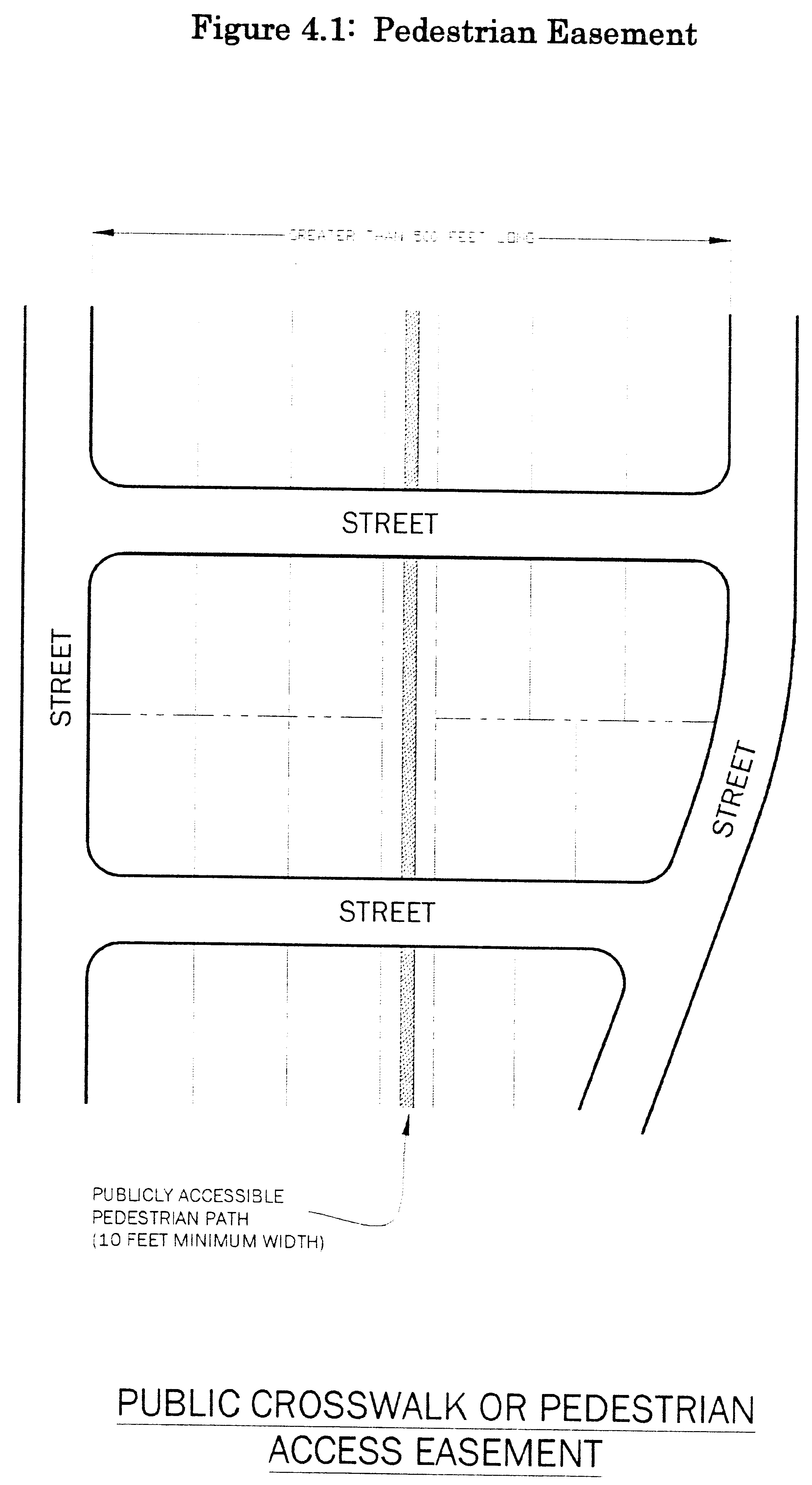
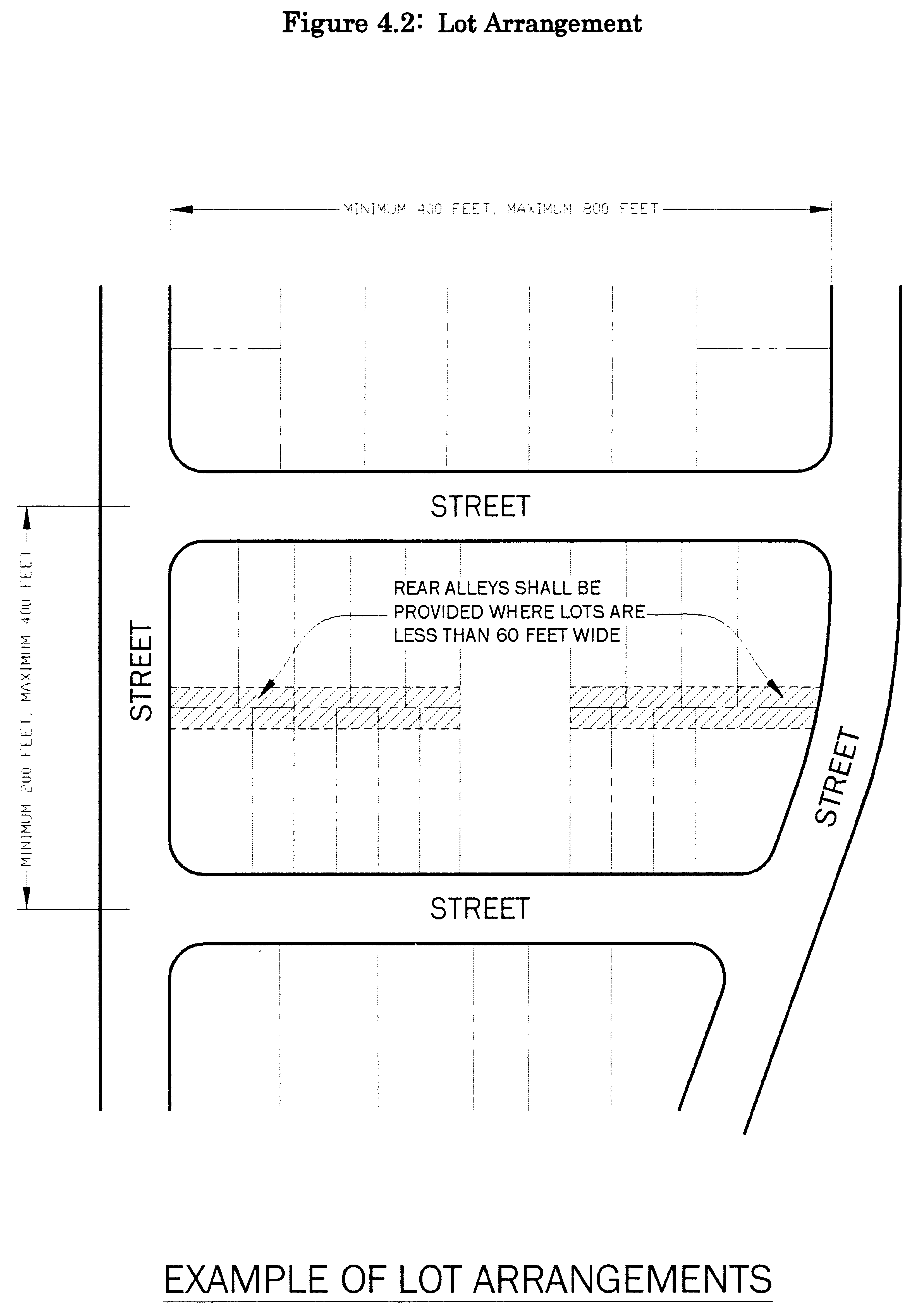
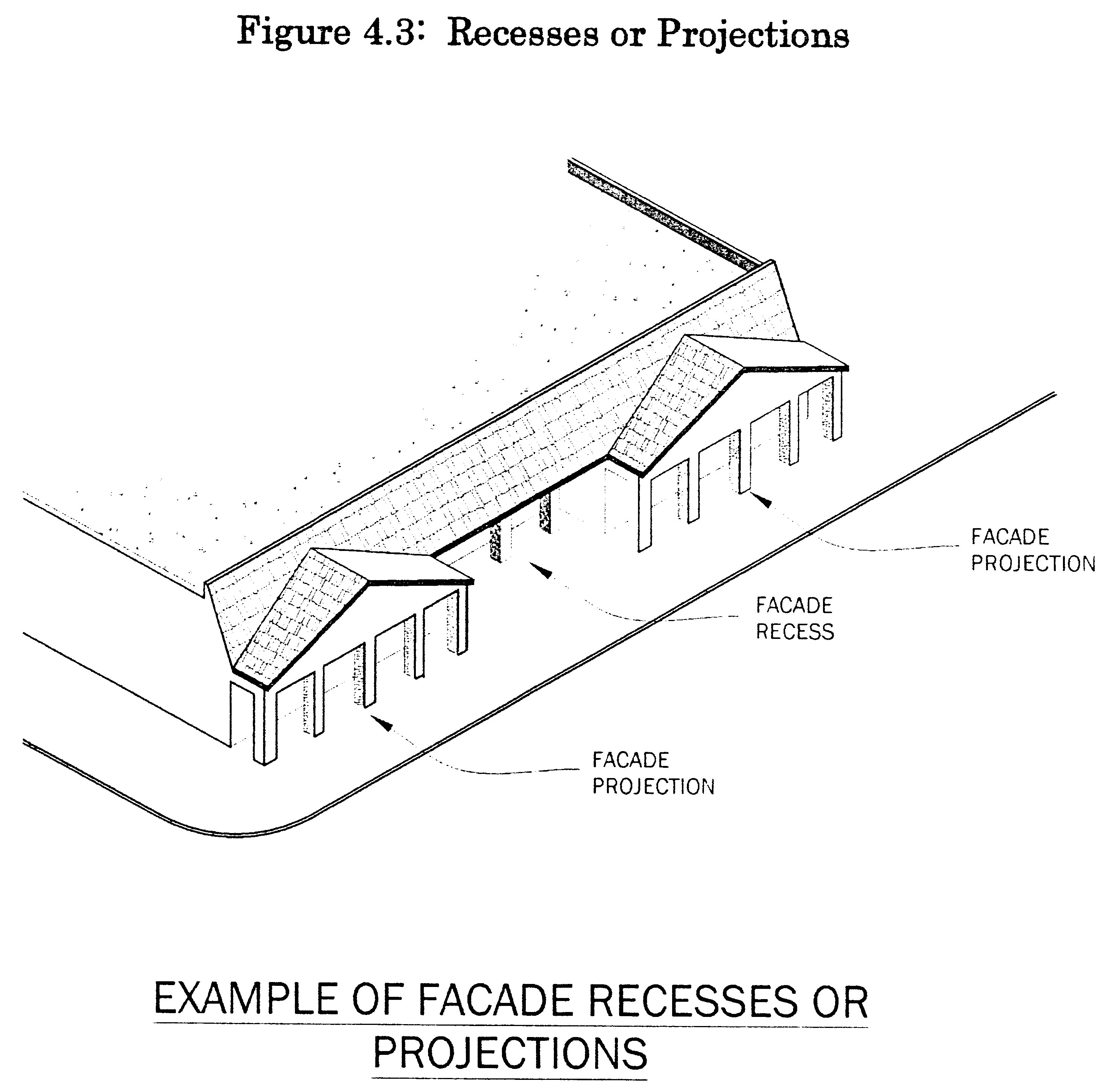
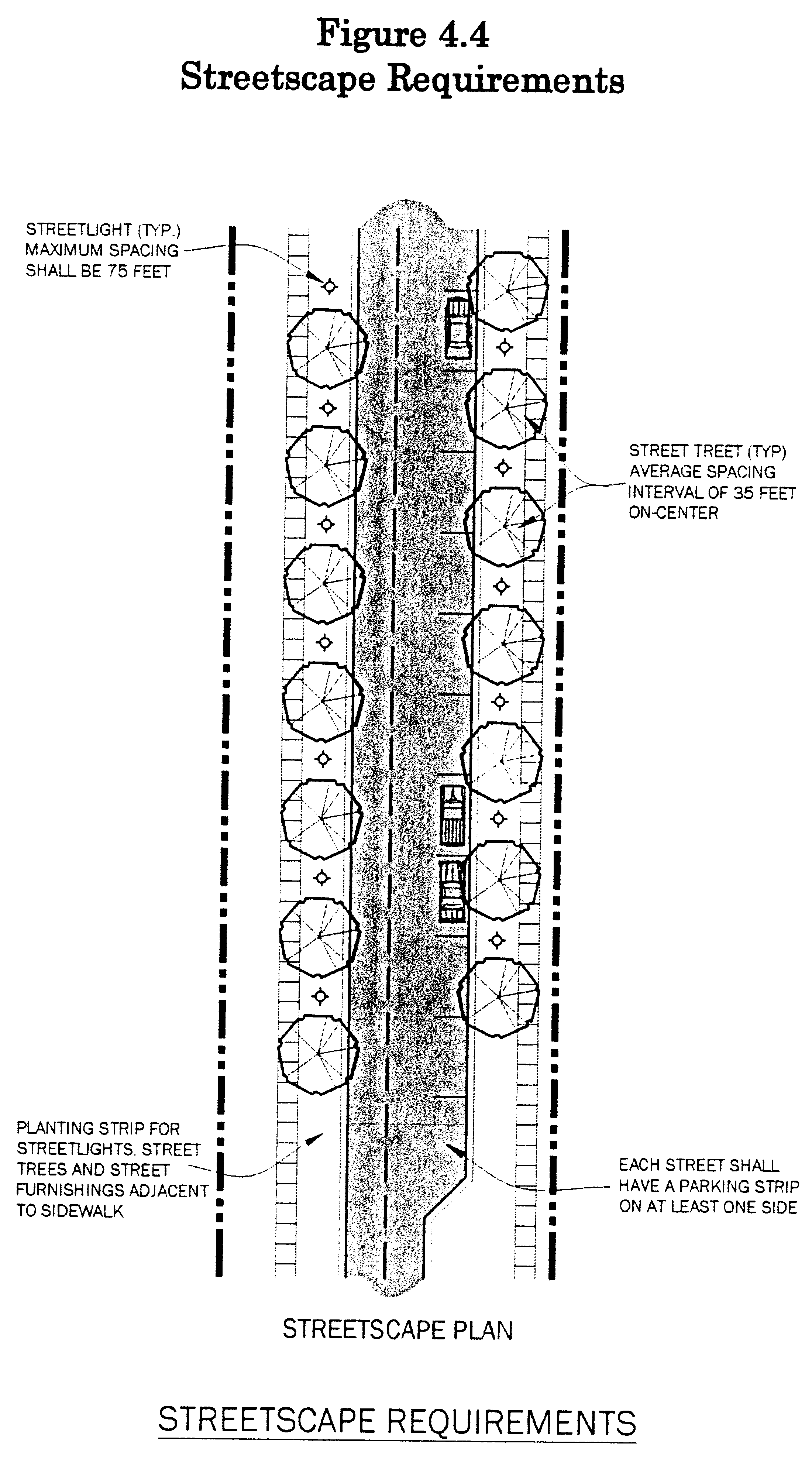
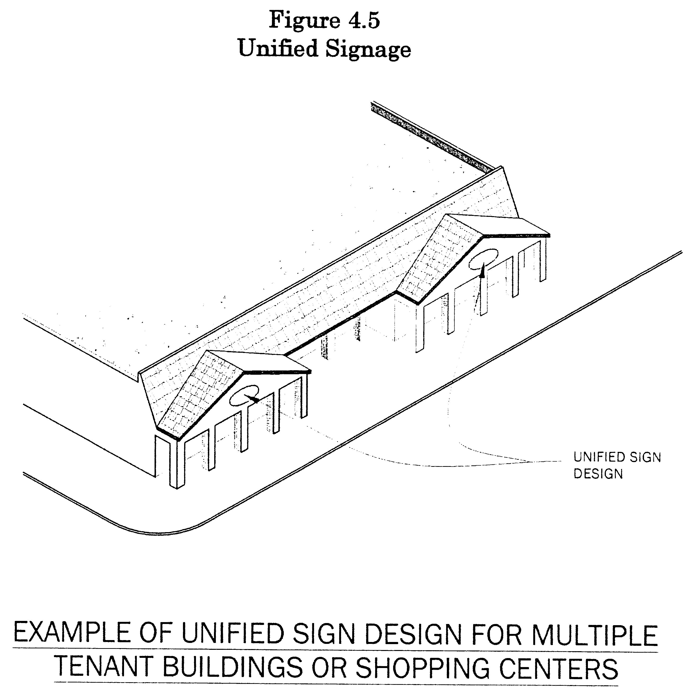
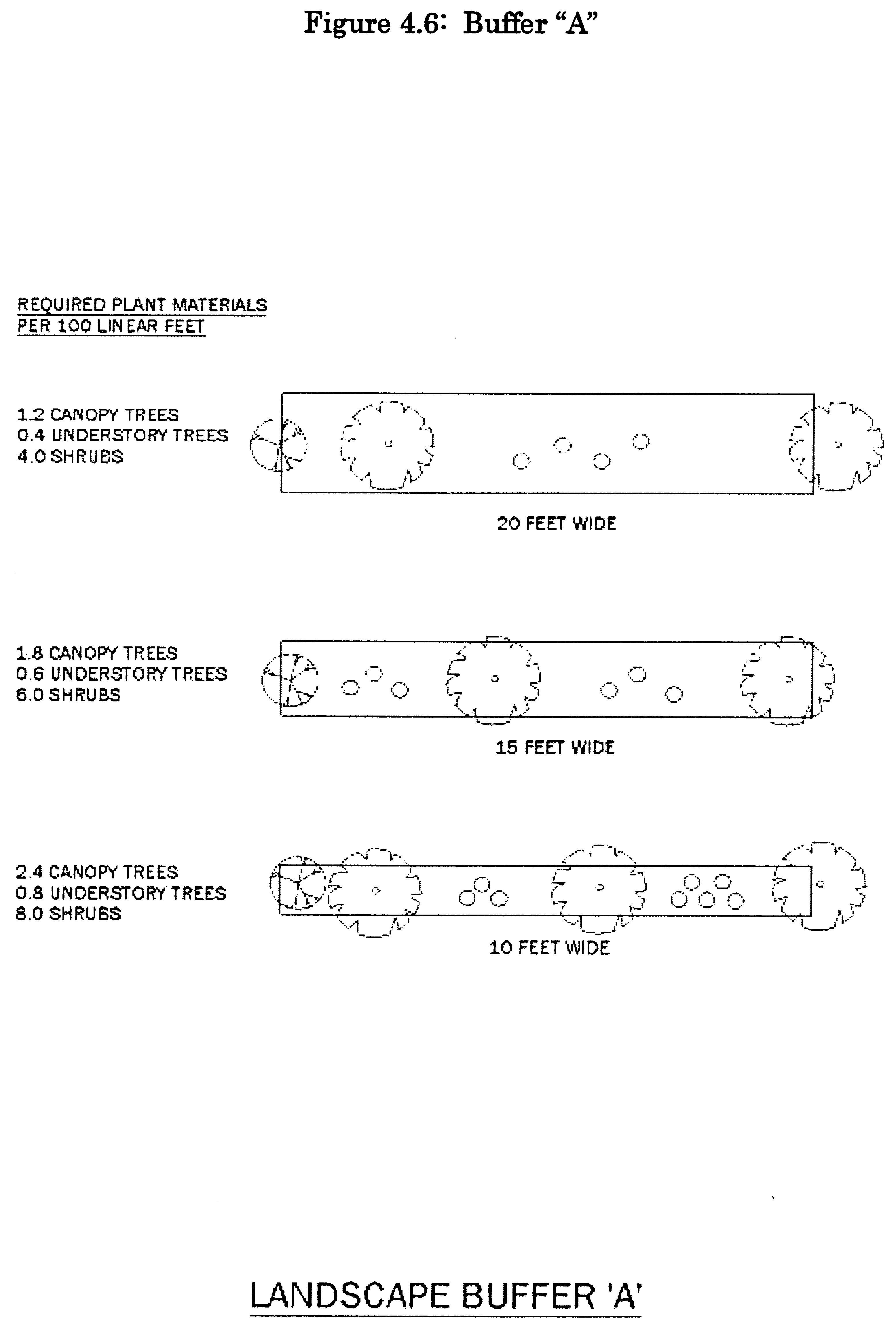
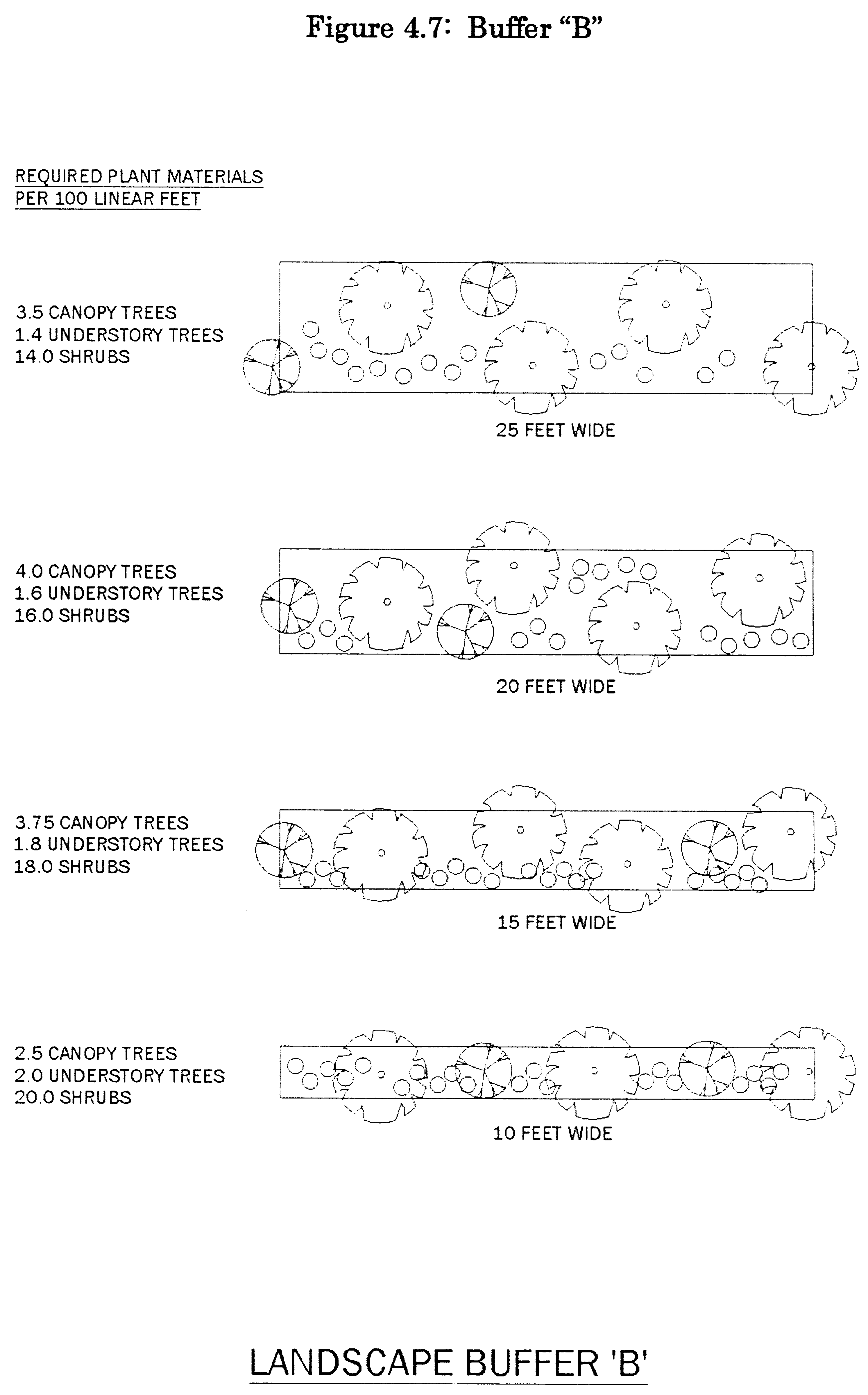
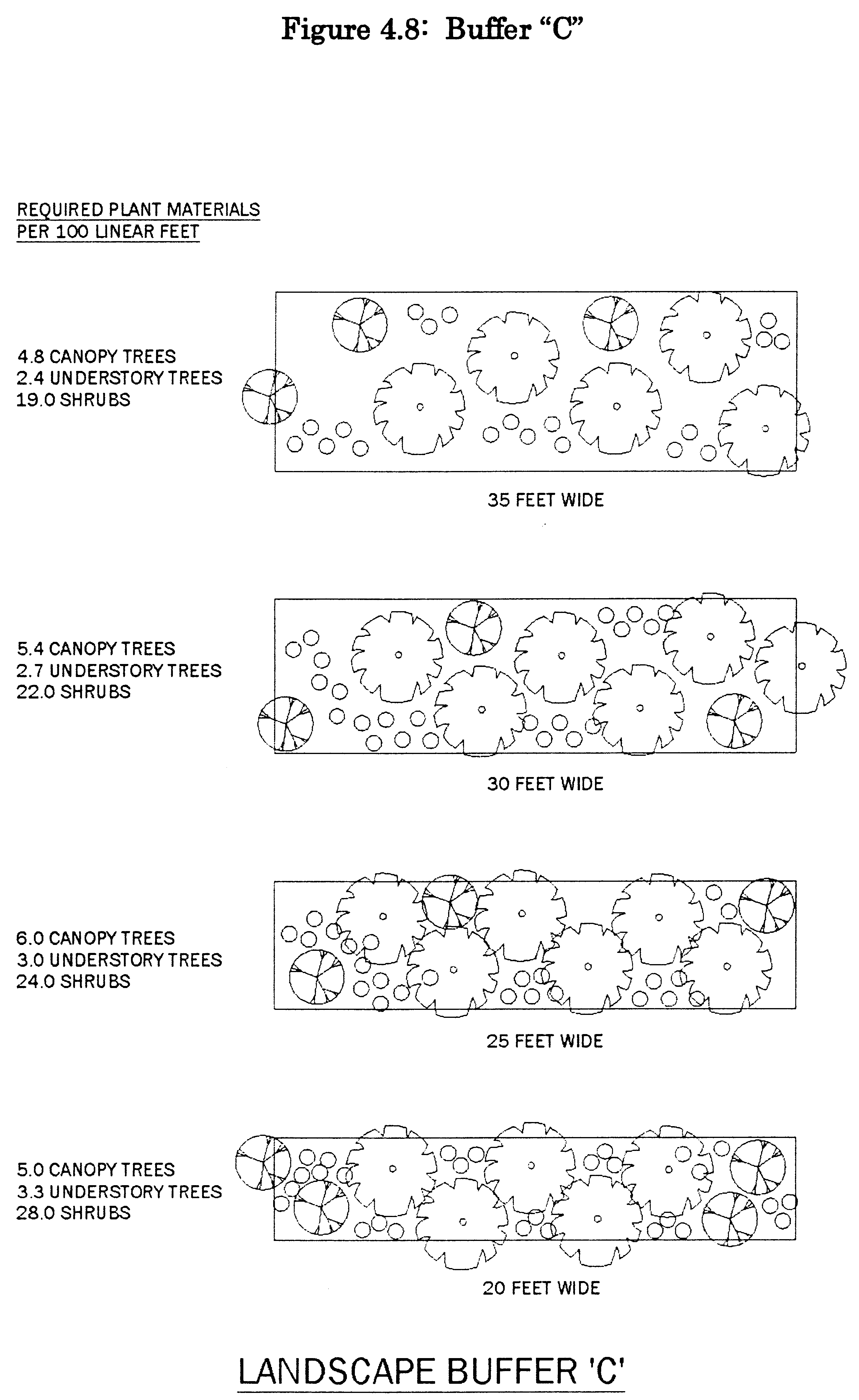
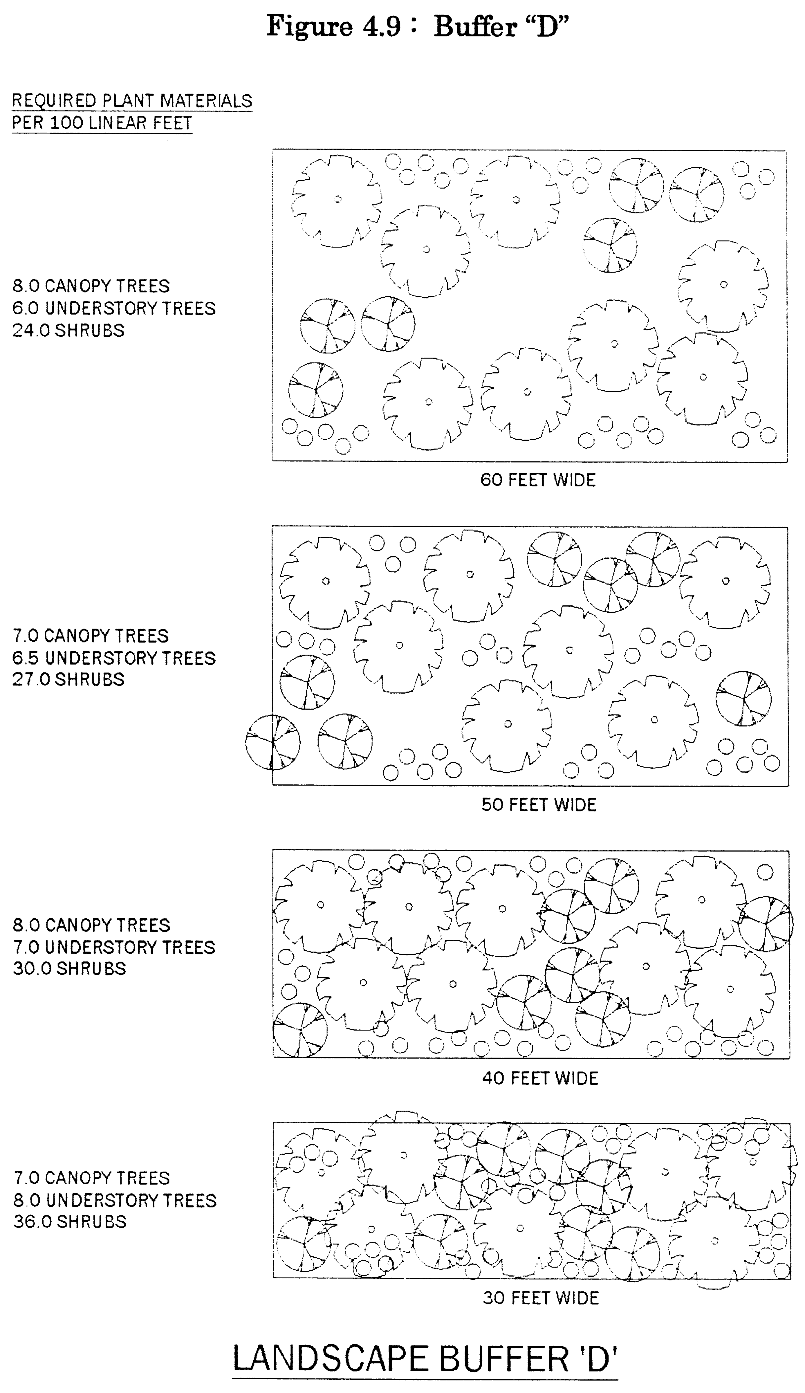
Figure 4.10: Vehicle Use Landscape Area
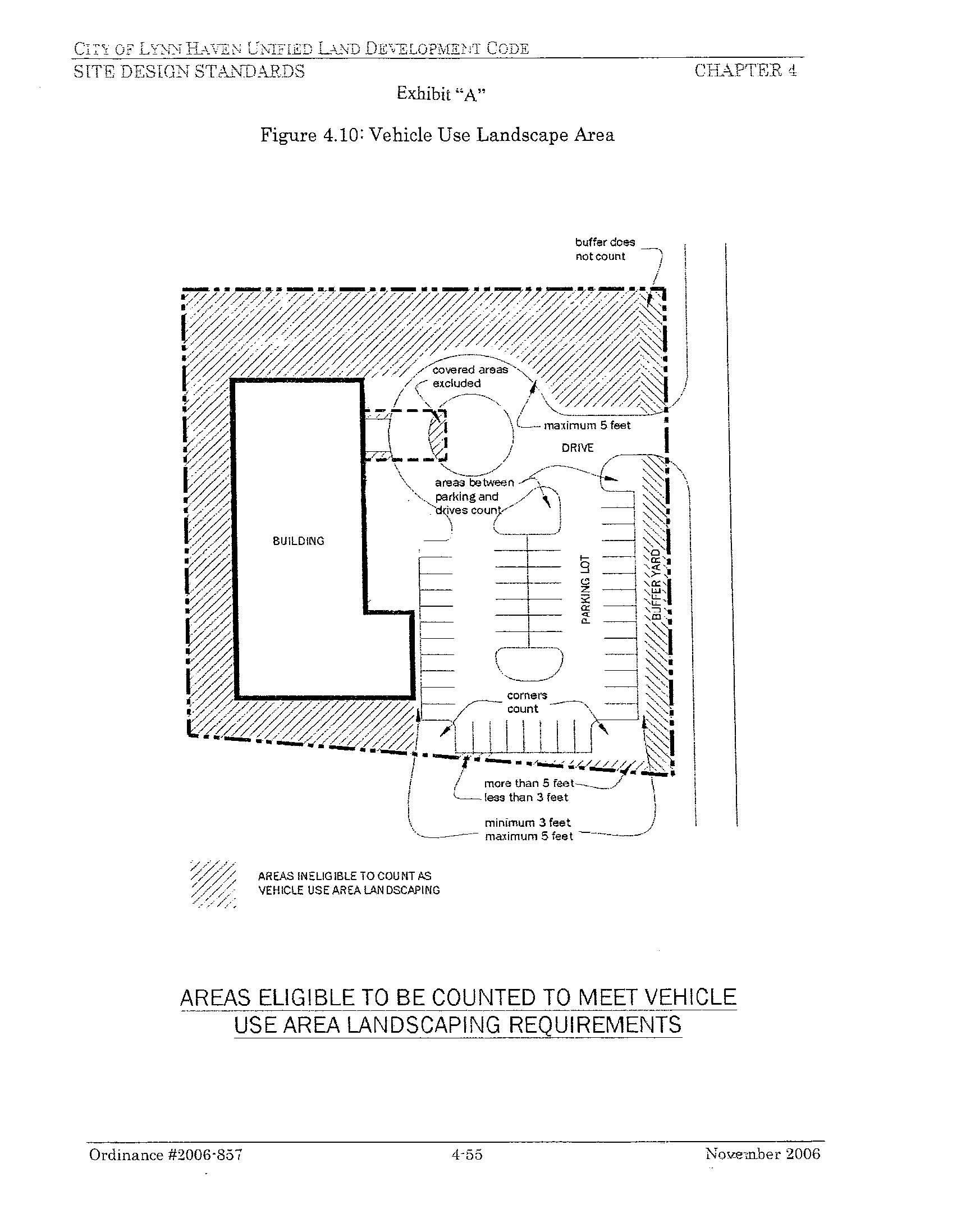
(Ord. No. 914, § 1, 1-13-09)