
Lyon Charter Township
City Zoning Code
City Zoning Code
ARTICLE 5
00 - SITE PLAN REVIEW
Section 5.01.- Intent.
The site plan review requirements in this article are intended to provide a consistent and uniform method of review of proposed development plans, to ensure full compliance with the regulations in this Ordinance and other applicable ordinances and state and federal laws, to achieve efficient use of the land, to protect natural resources, and to prevent adverse impact on adjoining or nearby properties. It is the intent of these provisions to encourage cooperation and consultation between the township and the applicant to facilitate development in accordance with the township's land use objectives.
Section 5.02. - Site plan approval.
A.
Planning commission approval required. Planning commission approval of a site plan is required prior to establishment, construction, expansion or alteration of any structure or use, as follows:
1.
Special uses and conditional rezoning proposals, subject to the provisions of this Ordinance.
2.
Multiple-family developments.
3.
Office, commercial and industrial developments.
4.
Construction, expansion or alteration of a manufactured housing park, as defined in section 3.02 (Definitions), shall be subject to preliminary plan approval in accordance with the procedures and standards of article 28.00 (Mobile Home Parks) and subsection 19.03.C (Mobile Home Park Requirements).
5.
Condominium site plans, but not including the condominium master deed, bylaws and Exhibit B, which are subject to administrative approval.
6.
Construction, expansion or alteration of a planned development, subject to the procedures and standards in article 7.00.
7.
Change of use or user involving an office, commercial or industrial land use. An example of a "change of use or user" in a commercial district would be, for example, a change from a restaurant to a brewery. Replacement of one restaurant with a similar new one would be considered a "re-occupancy," which would be subject to administrative approval.
8.
Parking lot construction involving the addition of 25 or more spaces.
9.
Essential services and public utilities and facilities, excluding lines and poles in rights-of-way and utility easements.
10.
Development of a non-single-family residential use in a single-family residential district.
11.
Any excavation, filling, soil removal, mining, landfill, or creation of a pond, except as specified in subsection B, following.
12.
Any development that proposes a new means of ingress or egress onto a public or private road, excluding driveways servicing single-family and two-family dwelling units.
13.
Uses not specifically listed in subsection B below.
B.
Administrative site plan review. Projects or uses eligible for administrative site plan review by the township's administrative team are listed in this subsection. The administrative team shall have the option to require planning commission review of a project otherwise listed in this subsection. To be eligible for administrative site plan review, the existing site improvements must be legally existing and in conformance with ordinance requirements.
At the discretion of the township, a sketch plan, rather than a complete site plan package, may be allowed for projects eligible for administrative approval involving a legally existing and conforming use and building, where all of the following conditions are met: 1) the proposed improvements will not result in expansion or substantially affect the character or intensity of the use; 2) the proposed improvements will not affect vehicular or pedestrian circulation; 3) the proposed improvements will not affect the demands on the public infrastructure or the demand for public services; and 4) the proposed improvements will not affect drainage pattern or cause environmental impacts.
1.
Minor changes during construction due to unanticipated site constraints or requirements by an outside review authority.
2.
Minor landscaping changes or species substitutions, which shall be subject to township planner approval.
3.
Minor building modifications that do not alter the facade of a multiple-family or nonresidential building beyond normal repairs.
4.
For a multiple-family or nonresidential use, construction of an accessory structure under 1,000 square feet in area, construction of an enclosure around a waste receptacle, or installation of a fence around a mechanical unit.
5.
Vacation of a road easement (final approval by the township board is required).
6.
Changes to a site required by the building official to comply with the building code.
7.
Sidewalk or bike path construction or relocation, or barrier-free access improvements.
8.
Parking lot construction involving the addition of less than 25 spaces.
9.
Construction of an addition to an existing building or expansion of an existing, conforming use, subject to the following conditions. Planning commission review shall be required if the development does not comply with any of the conditions:
a.
No variances are required.
b.
No change of use is proposed.
c.
The proposed addition or expansion shall not increase the total area occupied by the use by more than 25 percent up to a maximum of 1,000 square feet, provided that no other expansion has occurred within the past three years.
10.
Re-occupancy of, or change of user in, an existing building, subject to the following conditions. Planning commission review shall be required if the development does not comply with any of the conditions:
a.
No variances are required.
b.
The proposed use shall be conducted within a completely enclosed building.
c.
The proposed use shall not require additional parking demands, access changes, or other substantial modifications or improvements to the site or building.
d.
No change of use is proposed.
11.
Excavation, filling, soil removal, mining, or creation of ponds up to 2,500 square feet in area. Excavation, filling, and soil removal related to a residential, office, commercial or industrial development shall not require administrative review.
12.
Temporary construction buildings.
13.
Co-location on an existing wireless communication tower shall be subject to township planner approval.
14.
Development of a principal permitted agricultural use, or the construction, moving, relocation or structural alteration of permitted agricultural structures, including any customarily incidental accessory structures.
15.
Review and approval of condominium documents, including the master deed, bylaws, and condominium subdivision plan (Exhibit B), whether new or revised.
16.
Applications for special events, as defined in article 3.00. Special events shall be subject to the following conditions, at a minimum:
a.
Adequate off-street parking shall be provided.
b.
The exact duration of the special event must be specified, including set-up and take-down. Special events may not exceed two weeks in duration.
c.
Electrical and utility connections shall be subject to building official approval.
d.
Tents and other facilities shall be subject to fire marshal approval.
e.
Tents and structures shall comply with the setback requirements for principal structures for the district in which the use is located.
f.
Adequate lighting shall be provided to assure the safety of pedestrians and drivers in accordance with section 12.11.
g.
The size and number of signs shall be subject to administrative review.
h.
A performance bond may be required to assure proper clean up.
17.
Temporary uses of land or structures, as defined in article 3.00. Temporary uses of land or structures shall be subject to the following conditions, at a minimum:
a.
Adequate off-street parking shall be provided.
b.
The exact duration of the temporary use must be specified, including set-up and takedown. Temporary uses and structures may not exceed six months in duration.
c.
Electrical and utility connections shall be subject to building official approval.
d.
Tents and other facilities shall be subject to fire marshal approval.
e.
Tents and structures shall comply with the setback requirements for principal structures for the district in which the use is located.
f.
Adequate lighting shall be provided to assure the safety of pedestrians and drivers in accordance with section 12.11.
g.
The temporary use shall comply with the sign requirements for the district in which it is located.
h.
A performance bond may be required to assure proper clean up.
i.
The following requirements shall apply to specific temporary uses:
(1)
Sidewalk displays are permitted in commercial districts for a maximum of 60 days. The displays shall cover no more than 25 percent of the width of the sidewalk, provided that barrier-free access is maintained.
(2)
Sale of bedding plants is permitted in commercial districts for a maximum of 90 days.
(3)
Christmas tree sales are permitted in residential or commercial districts for a maximum of 45 days. Stumps, branches, leftover trees, and other debris shall be removed from the site within one week after Christmas.
(4)
Pumpkin sales are permitted in residential or commercial districts for a maximum of 45 days. Leftover pumpkins and other debris shall be removed from the site within one week after Halloween.
(5)
Roadside stands and farm markets shall comply with the requirements in subsection 19.02.BB.
(Ord. No. 14-14, pts. 2—4, 10-6-2014; Ord. No. 16-15, pt. 2, 10-5-2015; Ord. No. 06-24, § 1, 11-6-2024)
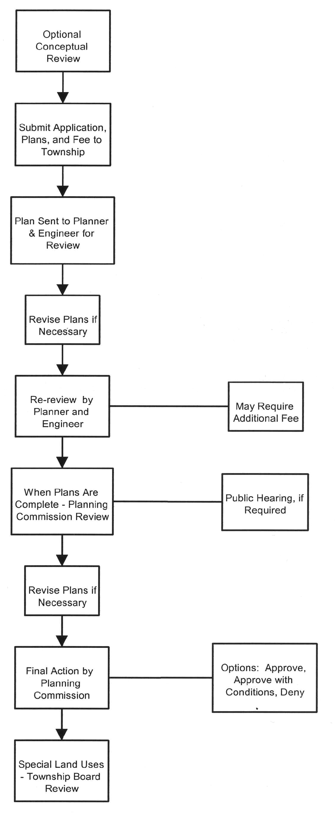
Section 5.03. - Site plan review applications and procedures.
A.
Optional pre-application conference. In order to facilitate processing of a site plan in a timely manner, the applicant may request a pre-application site plan conference with the township planner. The purpose of such a conference is to provide information and guidance to the applicant that will assist in preparation of the site plan. The applicant need not present drawings or site plans at a pre-application conference, but even if drawings or site plans are presented, no formal action shall be taken on a site plan at a pre-application conference. The township planner's fee for any such pre-application conference shall be paid by the applicant if such charges are not covered by the township's monthly retainer.
B.
Reserved.
C.
Submission of site plan for final review. In order to initiate formal review by the planning commission, the applicant is required to submit the following materials to the Lyon Township Hall:
1.
One complete and signed copy of the application for site plan review;
2.
The number of copies shall be determined by the planning department. Sheet size shall be at 24 inches by 36 inches;
3.
Proof that the plan has been submitted for review to governmental agencies that have jurisdiction over any aspect of the project, including but not limited to, the county road commission, county drain commission, county health division, Michigan Department of Transportation, Michigan Department of Environmental Quality, and other agencies deemed appropriate by the planning commission or township board;
4.
The required review fee.
Site plan materials must be submitted in complete form to the township at least 28 days prior to the planning commission or township board meeting at which the review is requested.
D.
Distribution of plans. The site plans and application shall be distributed, as necessary, to the township planner, township engineer, township attorney and other township consultants and staff for review.
E.
Determination of compliance. The township consultants and staff shall review the plans to determine compliance with township ordinances and regulations. The applicant may be required to complete revisions and submit the plans for further review prior to review of the plans by the planning commission or township board. All required revisions must be completed or the site plan may not be placed on the planning commission or township board agenda for review.
(Ord. No. 196-18, § 2, 7-2-2018; Ord. No. 08-22, § 2, 9-6-2022)
Section 5.04. - Review and action.
A.
Public hearing. Site plans involving uses that are subject to special land use approval require a public hearing. After payment of appropriate fees, the planning commission shall set the date of the public hearing, subject to the requirements in section 4.05.
B.
Planning commission final action and recommendation.
The planning commission shall review the site plan proposal together with any public hearing findings and any requested reports and recommendations from the building official and other reviewing agencies.
The planning commission is authorized to take the following action on the plan, subject to guidelines in the Zoning Ordinance: approval, approval with conditions, denial, or table the site plan, as follows:
1.
Approval. Upon determination that a site plan is in compliance with the standards and requirements of this Ordinance and other applicable ordinances and laws, approval shall be granted.
2.
Approval subject to conditions.
a.
Upon determination that a site plan is in compliance except for minor modifications, the conditions for approval shall be identified and the applicant shall be given the opportunity to correct the site plan. The conditions may include the need to obtain variances or obtain approvals from other agencies. If a plan is approved subject to conditions, the applicant shall submit a revised plan with a revision date, indicating compliance with the conditions.
b.
The applicant may re-submit the site plan to the planning commission for final approval after conditions have been met. The planning commission may waive its right to review the revised plan, and instead authorize the township planner or building official to review and approve the site plan after all required conditions have been addressed.
3.
Denial. Upon determination that a site plan does not comply with the standards and regulations set forth in this article or elsewhere in this Ordinance, or requires extensive revision in order to comply with said standards and regulations, site plan approval shall be denied.
4.
Tabling. Upon determination that a site plan is not ready for approval or rejection, or upon a request by the applicant, the planning commission may table consideration of a site plan until a future meeting.
C.
Review of condominiums. Condominiums shall require planning commission and township board review and approval. The planning commission's action shall be considered a recommendation and the decision of the township board shall become final. Condominium master deeds, bylaws, and condominium subdivision plans (Exhibit B), whether new or revised, shall require administrative site plan review and approval. Condominiums shall be subject to applicable requirements in this Zoning Ordinance, as well as the design standards in division 4 of the subdivision ordinance. All roads in a site condominium shall be dedicated to the public, and no private roads shall be permitted, except in the following circumstances:
1.
To allow continuation of existing private roads within a planned development or site condominium, except where connection to a public road is feasible; or
2.
To allow extension of an existing private road where the private road is the only means of access to a parcel.
D.
Recording of site plan review action.
1.
Each action taken with reference to a site plan review shall be duly recorded in the minutes of the planning commission as appropriate. The grounds for action taken upon each site plan shall also be recorded in the minutes.
2.
After the planning commission has taken final action on a site plan and all steps have been completed, three copies of the application and approved plans shall be stamped APPROVED and signed by the township planner. One marked copy will be returned to the applicant and the other two copies will be kept on file in the Township Hall.
SITE PLAN REVIEW
E.
Procedure after site plan approval.
1.
Application for building permit.
a.
Following final approval of the site plan and the engineering plans, and upon submittal of required performance guarantees, the applicant may apply for a building permit. It shall be the responsibility of the applicant to obtain all other applicable township, county, or state permits prior to issuance of a building permit.
b.
A building permit for a structure in a proposed condominium project shall not be issued until evidence of a recorded master deed has been provided to the township. However, the building official may issue permits for site grading, erosion control, installation of public water and sewage facilities, and construction of roads, prior to recording the master deed. No permit issued or work undertaken prior to recording of the master deed pursuant to this section shall grant any rights or any expectancy interest in the approval of the master deed.
2.
Expiration of site plan approval. If construction has not commenced within 24 months of the date of the planning commission's approval the site plan approval becomes null and void and a new application for site plan review shall be required. The planning commission may grant an extension of up to 12 months, upon written request from the applicant, if it finds that the approved site plan adequately represents current conditions on and surrounding the site and provided that the site plan conforms to the current zoning ordinance standards.
3.
Application for certificate of occupancy. Following completion of site work and building construction, the applicant may apply for a certificate of occupancy or a temporary certificate of occupancy from the building official in accordance with the procedures set forth in article 10.00. It shall be the applicant's responsibility to obtain these required certificates prior to any occupancy of the property.
4.
Property maintenance after approval.
a.
It shall be the responsibility of the owner of a property for which site plan approval has been granted to maintain the property in accordance with the approved site design on a continuing basis until the property is razed, or until new zoning regulations supersede the regulations upon which site plan approval was based, or until a new site design is approved. Any property owner who fails to so maintain an approved site design shall be deemed in violation of the use provisions of this Ordinance and shall be subject to the same penalties appropriate for a use violation.
b.
With respect to condominium projects, the master deed shall contain provisions describing the responsibilities of the condominium association, condominium owners, and public entities, with regard to maintenance of the property in accordance with the approved site plan on a continuing basis. The master deed shall further establish the means of permanent financing for required maintenance and improvement activities which are the responsibility of the condominium association. Failure to maintain an approved site plan shall be deemed in violation of the use provisions of this Ordinance and shall be subject to the same penalties appropriate for a use violation.
5.
Recorded condominium documents. Upon approval of a new or amended condominium, the developer shall supply the township with four copies of the recorded master deed, bylaws, and condominium subdivision plan (Exhibit B).
F.
Revocation. Approval of a site plan may be revoked by the planning commission if construction is not in conformance with the approved plans. In such case, the site plan shall be placed on the agenda of the planning commission for consideration and written notice shall be sent to the applicant at least ten days prior to the meeting. The building official, applicant, and any other interested persons shall be given the opportunity to present information to the planning commission and answer questions. If the planning commission finds that a violation exists and has not been remedied prior to the hearing, then it shall revoke the approval of the site plan.
G.
Modification to approved plan. A site plan approved in accordance with the provisions in this section may be subsequently modified, subject to the following requirements:
1.
Review of minor modifications. Minor modifications to an approved site plan may be reviewed by the administrative committee.
a.
Minor modification defined. Minor modifications are changes that do not substantially affect the character or intensity of the use, vehicular or pedestrian circulation, drainage patterns, the demand for public services, or the vulnerability to hazards. Examples of minor modifications include:
•
An addition to an existing commercial or industrial building that does not increase or decrease the floor space by more than 25 percent or 3,000 square feet, whichever is less.
•
Re-occupancy of a vacant building that has been unoccupied for less than 12 months.
•
Changes to building height that do not add an additional floor.
•
Additions or alterations to the landscape plan or landscape materials.
•
Relocation or screening of the trash receptacle.
•
Alterations to the internal parking layout of an off-street lot.
The construction of a new building or structure, adding or deleting parking or the addition of curb cuts onto a public road are examples of modifications which are not considered minor.
b.
Determination of minor modification. The administrative committee shall determine if the proposed modifications are minor in accordance with the guidelines in this section. In order to make the determination, the administrative committee shall solicit comments and recommendations from the planner, engineer, and public safety officials, as deemed necessary.
2.
Modifications not deemed "minor." If the modifications are not deemed minor by the administrative committee, then full review and approval by the planning commission shall be required. Planning commission review shall be required for all site plans that involve a request for a variance, a special land use, a proposal that involves a discretionary decision, or a proposal that involves a nonconforming use or structure. Township board review and approval shall be required for all modified site plans which originally required township board approval.
3.
Recording of action. Each action related to modification of a site plan shall be duly recorded in writing on a copy of the approved plan and shall be kept on file in the planning department. The planning commission shall be advised of all minor site plan modifications approved by the administrative committee and such modifications shall be noted on the site plan and in the minutes of the planning commission.
(Ord. No. 14-14, pts. 5, 6, 10-6-2014; Ord. No. 08-22, § 3, 9-6-2022; Ord. No. 07-23, § 1, 11-6-2023; Ord. No. 02-24, § 1, 2-5-2024)
Section 5.05. - Required information on all site plans.
The following information shall be included on all site plans, where applicable:
A.
Application form. The application form shall contain the following information:
1.
Applicant's name and address.
2.
Name and address of property owner, if different from applicant.
3.
Common description of property and complete legal description including the tax identification number.
4.
Dimensions of land and total acreage.
5.
Existing zoning.
6.
Proposed use of land and name of proposed development, if applicable.
7.
Proposed buildings to be constructed, including square feet of gross floor area.
8.
Proof of property ownership.
9.
Employment opportunities created, if applicable.
10.
Names, addresses, and telephone numbers of engineers, attorneys, architects, and other professionals associated with the project.
B.
Descriptive and identification data. Site plans shall consist of an overall plan for the entire development, drawn to a scale of not less than one inch = 20 feet for property less than one acre; one inch = 30 feet for property larger than one acre but less than three acres; and one inch = 50 feet for property larger than three acres. Sheet size shall be at 24 inches by 36 inches. The following descriptive and identification information shall be included on all site plans:
1.
Applicant's name and address and telephone number.
2.
Title block indicating the name of the development.
3.
Scale.
4.
Northpoint.
5.
Dates of submission and revisions (month, day, year).
6.
Location map drawn to scale with northpoint.
7.
Legal and common description of property.
8.
The dimensions of all lots and property lines, showing the relationship of the site to abutting properties. If the site is a part of a larger parcel, the plan should indicate the boundaries of total land holding.
9.
A schedule for completing the project, including the phasing or timing of all proposed developments.
10.
Identification and seal of architect, engineer, land surveyor, or landscape architect who prepared plan.
11.
Written description of proposed land use.
12.
Zoning classification of applicant's parcel and all abutting parcels.
13.
Proximity to driveways serving adjacent parcels.
14.
Proximity to section corner and major thoroughfares.
15.
Notation of any variances which have or must be secured.
16.
Net acreage (minus rights-of-way) and total acreage, to the nearest one-tenth acre.
C.
Site data.
1.
Existing lot lines, building lines, structures, parking areas, and other improvements on the site and within 100 feet of the site.
2.
Front, side, and rear setback dimensions.
3.
Topography on the site and within 100 feet of the site at two-foot contour intervals, referenced to a U.S.G.S. benchmark.
4.
Proposed site plan features, including buildings, roadway widths and names, and parking areas.
5.
Dimensions and centerlines of existing and proposed roads and road rights-of-way.
6.
Acceleration, deceleration, and passing lanes, where required.
7.
Proposed location of driveway entrances and on-site driveways.
8.
Typical cross-section of proposed roads and driveways.
9.
Location of existing drainage courses, floodplains, lakes and streams, with elevations.
10.
Location and dimensions of wetland areas. If deemed necessary because of site or soil conditions or because of the scope of the project, a detailed hydrology study may be required.
11.
Location of sidewalks within the site and within the right-of-way.
12.
Exterior lighting locations and method of shielding lights from shining off the site.
13.
Trash receptacle locations and method of screening, if applicable.
14.
Transformer pad location and method of screening, if applicable.
15.
Parking spaces, typical dimensions of spaces, indication of total number of spaces, drives, and method of surfacing.
16.
Information needed to calculate required parking in accordance with Zoning Ordinance standards.
17.
The location of lawns and landscaped areas, including required landscaped greenbelts.
18.
Landscape plan, including location, size, type and quantity of proposed shrubs, trees and other live plant material. In addition to the plant schedule on the landscape plan, a digital, editable spreadsheet of the plant schedule shall also be provided.
19.
Location, sizes, and types of existing trees five inches or greater in diameter, measured at one foot off the ground, before and after proposed development.
20.
Cross-section of proposed berms.
21.
Location and description of all easements for public right-of-way, utilities, access, shared access and drainage.
22.
Designation of fire lanes.
23.
Loading/unloading area.
24.
The location of any outdoor storage of materials and the manner by which it will be screened.
D.
Building and structure details.
1.
Location, height, and outside dimensions of all proposed buildings or structures.
2.
Indication of the number of stores and number of commercial or office units contained in the building.
3.
Building floor plans.
4.
Total floor area.
5.
Location, size, height, and lighting of all proposed signs.
6.
Proposed fences and walls, including typical cross-section and height above the ground on both sides.
7.
Building facade elevations, drawn to a scale of one inch equals four feet, or another scale approved by the building official and adequate to determine compliance with the requirements of this Ordinance. Elevations of proposed buildings shall indicate type of building materials, roof design, projections, canopies, awnings and overhangs, screen walls and accessory building, and any outdoor or roof-located mechanical equipment, such as air conditioning units, heating units, and transformers, including the method of screening such equipment. Such equipment shall be screened from view of adjacent properties and public rights-of-way. Such screening shall be designed to be perceived as an integral part of the building design.
E.
Information concerning utilities, drainage, and related issues.
1.
Schematic layout of existing and proposed sanitary sewers and septic systems; water mains, well sites, and water service leads; hydrants that would be used by public safety personnel to service the site; and, the location of gas, electric and telephone lines.
2.
Location of exterior drains, dry wells, catch basins, retention/detention areas, sumps and other facilities designed to collect, store, or transport stormwater or wastewater. The point of discharge for all drains and pipes should be specified on the site plan.
3.
Indication of site grading and drainage patterns.
4.
Types of soils and location of floodplains and wetlands, if applicable.
5.
Soil erosion and sedimentation control measures.
6.
Proposed finish grades on the site, including the finish grades of all buildings, driveways, walkways and parking lots.
7.
Listing of types and quantities of hazardous substances and polluting materials which will be used or stored on-site at the facility in quantities greater than 25 gallons per month.
8.
Areas to be used for the storage, use, loading/unloading, recycling, or disposal of hazardous substances and polluting materials, including interior and exterior areas.
9.
Underground storage tanks locations.
10.
Delineation of areas on the site which are known or suspected to be contaminated, together with a report on the status of site cleanup.
F.
Information concerning residential development.
1.
The number, type and location of each type of residential unit (one bedroom units, two bedroom units, etc.).
2.
Density calculations by type of residential unit (dwelling units per acre).
3.
Lot coverage calculations.
4.
Floor plans of typical buildings with square feet of floor area.
5.
Garage and carport locations and details, if proposed.
6.
Pedestrian circulation system.
7.
Location and names of roads and internal drives with an indication of how the proposed circulation system will connect with the existing adjacent roads. The plan should indicate whether proposed roads are intended to be private or dedicated to the public.
8.
Community building location, dimensions, floor plans, and facade elevations, if applicable.
9.
Swimming pool fencing detail, including height and type of fence, if applicable.
10.
Location and size of recreation open areas.
11.
Indication of type of recreation facilities proposed for recreation area.
12.
At least two conceptual plans shall be prepared for planning commission review for proposed residential developments that are 20 acres or larger in size. One of the conceptual plans shall be prepared following the guidelines for rural open space zoning (see section 19.03, subsection F). The planning commission shall have the authority to select the conceptual plan that best meets the intent and requirements of this Ordinance and the township master plan.
G.
Information applicable to mobile home parks.
1.
Location and number of pads for mobile homes.
2.
Distance between mobile homes.
3.
Proposed placement of mobile home on each lot.
4.
Average and range of size of mobile home lots.
5.
Density calculations (dwelling units per acre).
6.
Lot coverage calculations.
7.
Garage and carport locations and details, if proposed.
8.
Pedestrian circulation system.
9.
Location and names of roads and internal drives.
10.
Community building location, dimensions, floor plans, and facade elevations, if applicable.
11.
Swimming pool fencing detail, including height and type of fence, if applicable.
12.
Location and size of recreation open areas.
13.
Indication of type of recreation facilities proposed for recreation area.
H.
Additional information.
1.
Information related to condominium development. The following information shall be provided with all site plans including condominium development:
a.
Condominium documents, including the proposed master deed, restrictive covenants, and condominium bylaws.
b.
Condominium subdivision plan requirements, as specified in Section 66 of Public Act 59 of 1978, as amended, and Rule 401 of the Condominium Rules promulgated by the Michigan Department of Commerce, Corporation and Securities Bureau.
2.
Items not applicable. If any of the items listed are not applicable to a particular site, the following information should be provided on the site plan:
a.
A list of each item considered not applicable.
b.
The reason(s) why each listed item is not considered applicable.
3.
Other data which may be required. Other data may be required if deemed necessary by the township administrative officials, planning commission, or township board to determine compliance with the provisions in this Ordinance. Such information may include traffic studies, market analysis, environmental assessment and evaluation of the demand on public facilities and services.
4.
Industrial site plan requirements. Site plan proposals for new or expanded industrial development shall comply with the site plan requirements in section 33.03, including the requirements in subsection K regarding an industrial activity statement.
I.
Transportation impact studies.
1.
Developments requiring a transportation impact study (TIS). A TIS shall be required prior to approval of any of the following types of projects:
a.
Fast-food restaurants, convenience and party stores, and businesses that have drive-up or drive-through service.
b.
Residential projects containing 100 or more dwelling units in the total project.
c.
Commercial, office, industrial, warehouse, institutional, entertainment, and mixed use development proposals involving 100,000 square feet or more in gross floor area.
On multi-phase projects, a TIS shall be required if the entire project exceeds the threshold levels cited above, even if one or more phases of the project do not meet the threshold levels.
The planning commission may require a TIS for a proposed development even though it does not meet the criteria listed above where there is evidence that the traffic that would be generated by the development would cause or aggravate unsafe traffic conditions. In making this determination, the planning commission may consider the design of proposed roads, driveways, and parking lots as well as conditions that exist on or around the site that may contribute to traffic safety concerns.
2.
Qualifications of person preparing the TIS.
a.
The TIS shall be prepared by a traffic or transportation engineer or community planner selected by the township and who has a minimum of three years of experience preparing traffic impact studies. The resume and qualifications of the person who prepared the TIS shall be included in the study.
b.
The full cost of the TIS shall be paid for by the applicant. The township may require funds to be placed in escrow to cover such costs prior to initiation of the TIS.
3.
Contents of the TIS. The TIS shall contain the following elements, at minimum:
a.
Description of project. A description of the project and site plan shall be provided, showing the location of buildings, driveways, parking, adjoining roads, nearby intersections, and driveways on adjacent parcels. The project description should identify the proposed use, the gross and net square footage, and the number of parking spaces proposed.
b.
Existing conditions.
(1)
Maps and narrative shall be used to identify all roads within the impact area of the project, the number of lanes and right-of-way of each road, the most recent a.m. and p.m. peak hour traffic counts, and average daily traffic (ADT) counts on each road as are available from the Road Commission for Oakland County.
(2)
The historical growth rate of traffic on adjacent roads shall be determined by examining traffic counts over the past three to five years. The growth rate shall be used to project background growth for the next five years of for the number of years to complete the proposed project, whichever is longer. Where information is available from the township planner, trips from proposed projects in the impact area shall be included in the background growth projections.
(3)
Where existing traffic counts are more than three years old, new counts shall be taken. Traffic counts shall be taken during average or higher than average volume conditions, generally on a Tuesday, Wednesday or Thursday of a non-holiday week. For commercial development, additional Saturday counts shall also be taken.
(4)
The description of existing conditions shall also include accident history within 500 feet of the site and for any intersection that is expected to experience a traffic volume increase of at least five percent per 24-hour period or during peak hour due to the proposed project.
c.
Projections.
(1)
Maps and narrative shall be used to estimate the impact of the proposed project on traffic. Morning and evening peak hour and average daily traffic shall be forecast for the proposed development, based on the data and procedures outlined in the most recent edition of the Institute of Traffic Engineers Trip Generation Manual. The preparer may use other commonly-accepted sources of data or supplement the ITE data with empirical data from similar projects in Michigan.
(2)
The directional distribution of the projected traffic shall be distributed onto the existing road network (inbound v. outbound, left turn v. right turn) to project turning movements at major site access points, intersections, and interchange ramps. The rationale for the directional distribution shall be provided.
4.
Analysis of Data. The TIS shall contain the following analysis, at minimum:
a.
Capacity analysis. The impact of the projected traffic on the capacity of roads serving the proposed development shall be analyzed, using procedures outlined in the most recent edition of the Highway Capacity Manual, published by the Transportation Research Board. Pre- and post-construction capacity analysis shall also be performed at all street intersections and expressway ramps where the expected traffic will comprise five percent or more of the existing intersection capacity.
b.
Gap analysis. A "gap study" shall be completed to analyze the frequency and duration of gaps in the flow of through traffic.
c.
Access analysis. Maps and narrative shall be used to:
(1)
Identify the location and design of proposed access driveways and new road intersections;
(2)
Identify sight distance limitations;
(3)
Determine the distance to adjacent driveways and intersections; and
(4)
Provide sufficient evidence that the design and number of driveways proposed is the fewest necessary, that the driveways will provide safe and efficient movement of traffic, and that all driveways comply with the sight distance requirements of the Road Commission for Oakland County.
5.
Mitigation measures. The TIS shall identify realistic public and private mitigation measures needed to accommodate the projected traffic including the following, at minimum:
a.
The TIS shall identify improvements to intersections and roads to accommodate future volumes and provided adequate capacity.
b.
Using Road Commission for Oakland County standards, the TIS shall identify taper lanes, turn lanes, and passing lanes necessary to provide safe and adequate ingress and egress to the site.
c.
The TIS shall identify opportunities to accommodate bicyclists and pedestrians.
d.
The TIS shall identify opportunities to coordinate development and access with adjoining sites so as to alleviate the impact of increased traffic on public roads.
J.
Sketch plan requirements for administrative approval. The sketch plan for administrative approval shall contain the following information:
1.
Name, address, telephone and fax numbers of the applicant (and property owner, if different from applicant) and firm or individual preparing the plan.
2.
The property location (address, lot number, tax identification number).
3.
Site plan shall be drawn to an engineer's scale.
4.
Size and dimensions of proposed structures, including gross and usable floor areas, number of stories, and overall height.
5.
Dimensions of all property lines, showing the relationship of the site to abutting properties. If the site is part of a larger parcel, the plan should indicate the boundaries of total land holding.
6.
Existing site features, including natural and historical features, structures, driveways, fences, walls, signs, and other improvements.
7.
Location, dimensions, setback distances, and use(s) of all proposed improvements.
8.
Location and description of all existing and proposed easements and rights-of-way for utilities, access and drainage.
9.
Other information as requested by the reviewer to verify that the site and use are in accordance with the purpose and intent of this Ordinance and the township's master plan.
(Ord. No. 14-14, pt. 7, 10-6-2014; Ord. No. 08-24, § 1, 11-6-2024)
Section 5.06. - Standards for site plan approval.
The following criteria shall be used as a basis upon which site plans will be reviewed and approved:
A.
Adequacy of information. The site plan shall include all required information in sufficiently complete and understandable form to provide an accurate description of the proposed uses and structures.
B.
Site design characteristics. All elements of the site design shall be harmoniously and efficiently organized in relation to topography, the size and type of parcel, the character of adjoining property, and the type and size of buildings. The site shall be developed so as not to impede the normal and orderly development or improvement of surrounding property for uses permitted by this Ordinance.
C.
Appearance. Landscaping, earth berms, fencing, signs, walls, and other site features shall be designed and located on the site so that the proposed development is aesthetically pleasing and harmonious with nearby existing or future developments.
D.
Compliance with district requirements. The site plan shall comply with the district requirements for minimum floor space, height of building, lot size, open space, density and all other requirements set forth in the Schedule of Regulations (article 36.00), unless otherwise provided in this Ordinance.
1.
Site condominiums.
a.
In the case of site condominiums, these regulations shall be applied by requiring the site condominium unit and a surrounding limited common element to be equal in size to the minimum lot size and lot width requirements for the district in which the project is located. The site condominium unit shall be equivalent to the area of the lot where a principal building can be constructed and there shall be a limited common element associated with each site condominium unit which shall be at lease equivalent to the minimum yard area requirements.
b.
In addition, site condominium projects shall comply with the applicable design standards which have been developed for similar types of development in the township, as described in article IV of the Charter Township of Lyon Subdivision Ordinance, the Township Engineering Design Specifications, the Private Road Ordinance, and other applicable ordinances and regulations, including requirements for streets, blocks, lots, utilities, and storm drainage. These requirements and specifications are hereby incorporated and are made a part of this Ordinance by reference.
2.
Detached condominiums.
a.
In the case of detached condominiums, these regulations shall be applied by requiring that the detached condominium units comply with the requirements governing minimum distance between buildings, attachment of buildings, and other applicable requirements for the district in which the project is located. Furthermore, proposed detached condominium projects shall not exceed the maximum permitted density for the district in which the project is located, as determined on the basis of minimum lot size standards in article 17.00.
b.
In addition, site condominium projects shall comply with the applicable design standards which have been developed for similar types of development in the township, as described in article IV of the Charter Township of Lyon Subdivision Ordinance, the Township Engineering Design Specifications, the Private Road Ordinance, and other applicable ordinances and regulations, including requirements for streets, blocks, lots, utilities, and storm drainage. These requirements and specifications are hereby incorporated and are made a part of this Ordinance by reference.
E.
Preservation of natural areas. The landscape shall be preserved in its natural state as much as possible, by minimizing tree and soil removal, alteration to the natural drainage course and the amount of cutting, filling, and grading.
F.
Privacy. The site design shall provide reasonable visual and sound privacy. Fences, walls, barriers, and landscaping shall be used, as appropriate, for the protection and enhancement of property and the safety and privacy of occupants and uses.
G.
Emergency vehicle access. All buildings or groups of buildings shall be so arranged as to permit convenient and direct emergency vehicle access.
H.
Ingress and egress. Every structure or dwelling unit shall be provided with adequate means of ingress and egress via public streets and walkways.
I.
Pedestrian circulation. The site plan shall provide a pedestrian circulations system which is insulated as completely as is reasonably possible from the vehicular circulation system.
J.
Vehicular and pedestrian circulation layout. The arrangement of public and common ways for vehicular and pedestrian circulation shall respect the pattern of existing or planned streets or pedestrian or bicycle pathways in the vicinity of the site. The width of streets and drives shall be appropriate for the volume of traffic they will carry. In order to insure public safety and promote efficient traffic flow and turning movements, the applicant may be required to limit street access points or construct a secondary access road.
K.
Drainage. Appropriate measures shall be taken to insure that the removal or drainage of surface waters will not adversely affect adjoining properties or the capacity of the public or natural storm drainage system. Provisions shall be made for a feasible storm drainage system, the construction of stormwater facilities, and the prevention of erosion. Surface water on all paved areas shall be collected at intervals so that it will not obstruct vehicular or pedestrian traffic and will not create nuisance ponding in paved areas. Final grades may be required to conform to existing and future grades of adjacent properties. Grading and drainage plans shall be subject to review by the township engineer.
L.
Soil erosion and sedimentation. The proposed development shall include measures to prevent soil erosion and sedimentation during and upon completion of construction, in accordance with current county and township standards.
M.
Exterior lighting. Exterior lighting shall be designed so that it is deflected away from adjoining properties and so that it does not impede vision of drivers along adjacent streets.
N.
Public services. Adequate services and utilities, including water, sewage disposal, sanitary sewer, and stormwater control services, shall be available or provided, and shall be designed with sufficient capacity and durability to properly serve the development.
O.
Screening. Off-street parking, loading and unloading areas, outside refuse storage areas, and other storage areas that are visible from adjacent homes or from public roads, shall be screened by walls or landscaping of adequate height.
P.
Danger from hazards.
1.
The level of vulnerability to injury or loss from incidents involving hazardous materials or processes shall not exceed the capability of the township to respond to such hazardous incidents so as to prevent injury and loss of life and property. In making such an evaluation, the township shall consider the location, type, characteristics, quantities, and use of hazardous materials or processes in relation to the personnel, training, equipment and materials, and emergency response plans and capabilities of the township.
2.
Sites which include storage of hazardous materials or waste, fuels, salt, or chemicals shall be designed to prevent spills and discharges of polluting materials to the surface of the ground, groundwater, or nearby waterbodies.
Q.
Health and safety concerns. Any use in any zoning district shall comply with applicable federal, state, county, and local health and pollution laws and regulations with respect to noise; dust, smoke and other air pollutants; vibration; glare and heat; fire and explosive hazards; gases; electromagnetic radiation; radioactive materials; and, toxic and hazardous materials.
R.
Sequence of development. All development phases shall be designed in logical sequence to insure that each phase will independently function in a safe, convenient and efficient manner without being dependent upon subsequent improvements in a later phase or on other sites.
S.
Coordination with adjacent sites. All site features; including circulation, parking, building orientation, landscaping, lighting, utilities, common facilities, and open space shall be coordinated with adjacent properties.
(Ord. No. 12-20, § 2, 1-4-2021)