
Mancos City Zoning Code
ARTICLE 3
Zone Districts
Sec. 16-3-1.- Districts established.
To implement the comprehensive plan and the purposes and provisions of this land use code, the Town has established ten zoning districts as indicated in Table 16-3.1, Table of Zone Districts:
(Ord. No. 751, § 1, 11-13-2019)
Sec. 16-3-2. - Official Zoning Map.
(a)
Adoption.
(1)
Zoning map.
a.
The boundaries of the zone districts are delineated on the official zoning map, as amended.
b.
The official zoning map is available on the Town of Mancos website and is maintained by the office of the Town Clerk.
c.
From time to time, or if the official zoning map becomes damaged, destroyed, lost, or difficult to interpret, the board of trustees may adopt a new official zoning map to supersede the prior map.
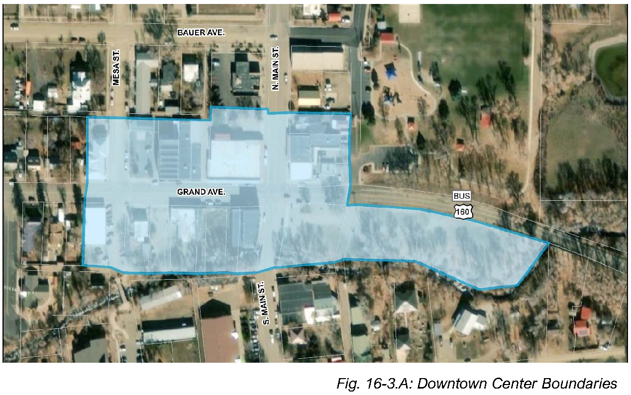
(2)
Downtown Center Map. Where reference is made to the Downtown Center in this Code it shall mean the area within the boundaries identified in Figure 16-3.A, Downtown Center Boundaries.
(b)
Amendment.
(1)
Changes or amendments to a district shown on the zoning map must be made in compliance and conformity with procedures set forth in Section 16-19-12, Rezoning (Zoning Map Amendment).
(2)
The Zoning Administrator is responsible for updating the official zoning map. Changes or amendments to the map shall be made promptly after approval by the Board of Trustees.
(Ord. No. 751, § 1, 11-13-2019; Ord. No. 761, § 1, 10-28-2020)
Sec. 16-3-3. - Interpretation of district boundaries.
The district boundary lines shown on the official zoning map are usually along streets, alleys, property lines, or extensions of those features. Where uncertainty exists as to the boundaries of districts as shown on the official zoning maps, the following rules shall apply:
(1)
Boundaries following lines.
a.
Boundaries indicated as approximately following streets, highways, or alleys shall be construed to follow the centerline of such street, highway, or alley.
b.
Boundaries indicated as approximately following platted lot lines shall be construed as following such lines.
c.
Boundaries indicated as approximately following Town limits shall be construed as following Town limits.
d.
Boundaries indicated as approximately following the centerline of irrigation ditches or drainageways shall be construed to follow such centerline.
e.
Boundaries indicated as parallel to or extensions of features indicated in this Section shall be so construed.
(2)
Boundaries determined by other methods.
a.
Distances not specifically indicated on the official zoning map shall be determined from the graphic scale on the map.
b.
Whenever any street, alley, or other public way is vacated by official action of the board of trustees, the zoning district line adjoining each side of such street, alley, or other public way shall be automatically extended to the centerline of such vacated street, alley, or way, and all area so involved shall then and henceforth be subject to all regulations of the extended districts.
c.
Where physical features of the ground are at variance with information shown on the official zoning map, or when there arises a question as to how or whether a parcel of property is zoned and such question cannot be resolved by the application of any methods provided herein, the property shall be considered as classified AR, Agriculture Residential.
(Ord. No. 751, § 1, 11-13-2019; Ord. No. 761, § 1, 10-28-2020)
Sec. 16-3-4. - District purposes.
(a)
AR: Agriculture Residential. The Agriculture Residential District is designed primarily to accommodate agricultural uses and single-family development on lots of five (5) acres. It is intended for application as temporary zoning following annexation but prior to final subdivision approval, as defined in Article 19.
(b)
AR-C: Agriculture Residential Cluster. The Agriculture Residential Cluster District is designed to accommodate clustered residential uses in areas that are shared with active agricultural uses, important natural areas, environmentally sensitive areas, and areas where clustered development would be beneficial to preserve the existing rural character.
(c)
SFR-1: Single-Family Residential Low Density. The Single-Family Residential District is designed primarily to accommodate single-family uses. It is intended for application in areas already developed with similarly-sized lots and density and areas designated single-family on the future development plan map in the comprehensive plan.
(d)
SFR-2: Single-Family Residential Medium Density. The Single-Family Residential Medium Density District is designed to accommodate single-family structures on small lots to support a compact, walkable development pattern. It is intended for use adjacent to downtown Mancos and can also be used as a transition from multifamily development to larger lot single-family residential development.
(e)
MR-1: Multifamily Residential Low Density. The Multifamily Residential Low Density District is designed primarily to accommodate multifamily uses. It is intended for application to areas already developed with multifamily structures at a similar density and areas designated multifamily or mixed residential on the future development plan map in the comprehensive plan.
(f)
MR-2: Multifamily Residential Medium Density. The Multifamily Residential Medium Density District is designed primarily to accommodate multifamily uses on smaller lots in more compact and walkable settings. It is intended for application to areas already developed with multifamily structures at a similar density and areas designated multifamily on the future development plan map in the comprehensive plan.
(g)
DMU: Downtown Mixed-Use. The Downtown Mixed-Use District is designed for application to Downtown Mancos to allow a vibrant mix of commercial, retail, office, light industrial, and residential uses that allow residents and visitors to enjoy the hub of the community.
(h)
CMU: Corridor Mixed-Use. The Corridor Mixed-Use District is intended for application to commercial corridors outside of downtown Mancos where mixed-use development exists or is indicated on the future development plan map. Commercial mixed-use development should include a combination of commercial and residential uses that are mutually supportive and that provide goods and services to surrounding residential uses.
(i)
C: Commercial. The Commercial District is designed to accommodate a wide variety of commercial activities with a compatible mix of uses to make the Town a more attractive and energetic place to live, work, and shop, and to enhance the economic development of the Town.
(j)
LI: Light Industrial. The Light Industrial District is designed to accommodate a wide variety of industrial and manufacturing activities and to enhance the economic development of the Town. It is intended for application in areas already developed with light industrial structures and areas designated light industrial on the future development plan map in the comprehensive plan.
(k)
P1: Public Parks and Open Space. The Public 1 District is designed primarily to identify and preserve public parks and open spaces, including trails, recreational areas and facilities, and passive open space.
(l)
P2: Public Government and Institution. The Public 2 District is designed primarily to accommodate the development of governmental and quasi-governmental facilities for cultural, educational, civic, recreational, and other governmental purposes.
(m)
PUD: Planned Unit Development. The Planned Unit Development District is designed to provide flexibility in the siting of structures to avoid or mitigate any hazardous areas, historic and prehistoric sites; to take advantage of the site's unique, natural resource or scenic features; and to preserve open spaces. It is intended for application in residential districts.
(Ord. No. 751, § 1, 11-13-2019)
Sec. 16-3-5. - Dimensional standards.
(a)
Dimensional standards—Residential districts.
(1)
Table 16-3.2 identifies the required dimensional standards for lots and structures in each of the residential zone districts.
a.
Additional requirements, such as riparian buffers, flood hazard requirements, or landscape buffers may impact actual setback distances.
b.
Supplemental dimensional standards for height, setback, and yard encroachments are located in Section 16-3-9.
(2)
See Section 16-3-8 for Agriculture Residential Cluster (AR-C) dimensional standards.
Notes:
[1] Attached units: Measured at end units, not between individually attached units.
[2] Unless the requirements of Section 16-6-4, Riparian Buffer, apply to require a larger setback.
(Ord. No. 751, § 1, 11-13-2019; Ord. No. 761, § 1, 10-28-2020)
Sec. 16-3-6. - Dimensional standards—Mixed-use, commercial, and industrial districts.
(a)
Table 16-3.3 identifies the required dimensional standards for lots and structures in each of the commercial and industrial zone districts.
(1)
Additional requirements, such as riparian buffers, flood hazard requirements, or landscape buffers may impact actual setback distances.
(2)
Supplemental dimensional standards for height, setback, and yard encroachments are located in Section 16-3-9.
(b)
P1 districts that are held in open space do not have dimensional standards. Where P1 districts are used for recreational activities that include structures and parking the P2 dimensional standards shall apply.
(Ord. No. 751, § 1, 11-13-2019; Ord. No. 761, § 1, 10-28-2020)
Sec. 16-3-7. - Planned unit development (PUD).
(a)
Intent. A planned unit development (PUD) designation may be applied to land intended for residential development purposes.
(b)
Uses. The use permissions shall be those of the underlying zone district.
(c)
Dimensional standards.
(1)
Minimum lot area: The minimum lot area for PUD districts shall be one (1) acre.
(2)
Maximum density: The maximum density shall be no greater than that permitted in the underlying zone district prior to PUD approval.
(3)
Minimum common open space: The minimum common open space shall be 30 percent of the land area in the PUD.
a.
At least one-half (½) of the required common open space shall be usable for recreational purposes.
b.
Common open space shall include, but is not limited to:
i.
Trails;
ii.
Setback adjacent to the normal river channel on Mancos River and Chicken Creek; or
iii.
Areas impacted by geologic hazards and flood hazards; and
iv.
Historic or prehistoric sites.
(d)
Procedures. Administrative procedures are located in Section 16-19-12, Rezoning.
(Ord. No. 751, § 1, 11-13-2019)
Sec. 16-3-8. - District-specific standards.
(a)
AR-C: Cluster development standards.
(1)
Purpose. The purpose of a cluster development subdivision is to allow the creative design of subdivisions as an alternative to conventional, large-lot subdivisions. The option will allow applicants to design subdivisions creatively to avoid placing residential buildings in floodplains or on ridgelines or steep slopes, conserve riparian areas and other natural resources, such as wildlife habitat, and maintain the open character and agricultural viability. The option allows residential units to be clustered on small lots while maintaining the allowable density. In turn, the option requires that a portion of the property be set aside as a "conservation area" that will have a limited range of allowed uses and activities.
(2)
Applicability. To be eligible for the cluster development subdivision option, the parcel of land shall be located within either an agricultural or a residential district.
(3)
Allowed uses. In a cluster development subdivision, the proposed uses shall be limited to residences, agriculture, and non-motorized recreational uses. Only agriculture, open space, forestry, greenhouses, and non-motorized recreational uses are allowed in the conservation area(s).
(4)
Submittal and review requirements. A cluster development subdivision shall be processed as a subdivision of land as described in Sections 16-19-11, Cluster Development Subdivision, and 16-19-10, Major Subdivision.
(5)
Standards Applicable to Cluster Development Subdivisions. In addition to the general subdivision design standards, the following standards shall apply to cluster development subdivisions.
a.
Components of a Cluster Development Subdivision. A cluster development subdivision is comprised of two (2) components: (A) the conservation area(s), and (B) the residential cluster. The conservation area(s) is the larger portion of the development parcel that is platted as a separate parcel and permanently conserved for passive open space, limited impact uses identified as part of the subdivision approval process, or non-motorized recreation uses. The residential cluster is the portion of the development parcel that is subdivided into parcels for residential development and accessory uses.
b.
Cluster development subdivision standards.
1.
Maximum density. The maximum number of lots is determined by dividing the total area of the tract of land by the minimum conventional lot size specified in the underlying zoning.
2.
Minimum conservation area.
i.
Conservation area(s). The minimum percentage of the cluster development subdivision parcel's gross land area that shall be set aside as conservation area(s) is fifty percent (50%). The conservation area(s) and its calculated percentage of the gross area shall be clearly delineated on the cluster development subdivision plat. The acreage, intended use, and final ownership of all conservation area tracts shall be shown on the plat.
ii.
Conservation lot(s). Up to two (2) conservation lots may be designated for a parcel, provided that the minimum fifty percent (50%) conservation area is set aside within the conservation lot(s).
3.
Location of conservation areas. The conservation areas shall be delineated to include the following features:
i.
Streams, rivers, waterbodies, wetlands, and other sensitive or unique natural features along with required setbacks as identified in this Chapter;
ii.
Floodplains and alluvial soils;
iii.
Steep slopes (thirty percent (30%) or greater);
iv.
Woodlands, natural areas, and wildlife habitats and corridors;
v.
Scenic views, especially of natural and cultural features, including views from public spaces and roads, as well as views from potential home sites; and
vi.
Identified historic and cultural features.
4.
Contiguous conservation area(s). The conservation area(s) shall be contiguous to the maximum extent feasible.
5.
Location of residential lots. The buildable residential lots and all public and private roads shall be sited to be located outside the delineated conservation areas.
(b)
MR-2: Manufactured Home Community.
(1)
Manufactured home lot.
a.
Each manufactured home site in a manufactured home community shall be clearly designated and arranged so that all manufactured homes have access to the internal driveway.
b.
There shall be a minimum of twenty (20) feet between manufactured homes.
c.
Each manufactured home shall be set in accordance with the Colorado Division of Housing Installation Guidelines in effect at the time of installation.
(2)
Manufactured home community design standards.
a.
Each manufactured home community shall have an internal driveway not less than twenty (20) feet wide, and the internal driveway shall have an all-weather, durable dust-free surface.
b.
All manufactured home communities and individual manufactured home sites shall be provided with safe, convenient, all-season pedestrian access of adequate width for the intended use.
c.
Manufactured home communities shall be properly graded and well-drained, so as to prevent the accumulation of surface water.
d.
All refuse shall be stored in rodent, dog, and bear-resistant containers, which shall be located no more than one hundred fifty (150) feet from each manufactured home site. Containers shall be provided in sufficient number and capacity to properly store all refuse generated in the manufactured home community.
e.
Exposed ground surfaces in all parts of a manufactured home community shall be protected with a vegetative growth that is capable of preventing soil erosion and of eliminating objectionable dust. The development of a community garden within the manufactured home community is a permissible accessory use.
f.
A detached, accessory storage building or buildings shall be provided within a manufactured home community, containing a minimum storage capacity of ten (10) cubic yards per manufactured home site.
g.
Exterior boundaries of manufactured home communities shall be developed with a fence, or other acceptable border, to create an attractive border. The land between the fence/border and the public street improvements shall be landscaped with street trees and other landscaping materials sufficient to reasonably screen the park from view off-site and shall be maintained by the owner of the manufactured home community or a homeowners' association.
h.
Manufactured home communities shall connect to the sanitary sewer system per the Town requirements.
i.
All utility lines, including electrical utility lines, shall be installed underground.
j.
Each manufactured home community shall include a recreational area and facilities for the use and enjoyment of the residents encompassing an area of ten percent (10%) or two (2) acres, whichever is less, of the total area of the manufactured home community. Lawns, parking, driveways, public walkways, streets, etc., shall not be considered part of the required recreational area and facilities.
(Ord. No. 751, § 1, 11-13-2019)
Sec. 16-3-9. - Supplemental dimensional standards.
No lot or yard shall be established in any district that does not meet the minimum requirements of that district along with any applicable regulations in this Section.
(1)
Maximum height.
a.
Height encroachments are permitted as identified in Table 16-3.4.
b.
Each height encroachment shall be measured from the maximum building height.
c.
Building height encroachments are not cumulative in that they are always measured from the same point.
(2)
Yard encroachments.
a.
Yard encroachments are building and site elements that project into or are located in a required yard or on the "non-buildable" side of a setback line.
b.
Measurement.
a.
Each yard encroachment shall be measured from the minimum required setback line towards the lot line; yard encroachments are always measured from the same point and are not cumulative.
2.
No permitted yard encroachment shall be closer than two feet to any lot line with the exception of fences and walls and gardens and landscaping.
(c)
The following encroachments are permitted:
(3)
Accessory buildings and structures.
a.
No accessory building shall be erected in any required front or side yard, and no detached accessory building shall be erected closer than five (5) feet to any other building.
b.
Accessory buildings may be located in the rear yard but shall not be closer than five (5) feet to the rear lot line and shall not be closer to the side lot line than the required side yard setback.
c.
No accessory building shall cover more than thirty percent (30%) of the required rear yard.
(Ord. No. 751, § 1, 11-13-2019)