
Nags Head City Zoning Code
ARTICLE 10
- PERFORMANCE STANDARDS
Section 10.1 - Application of Provisions.
Buffering, vegetation preservation, and planting requirements generally apply to all uses other than single-family and two-family uses, with the exception of large residential dwellings, which also must comply with vegetation preservation requirements. Other sections of this UDO contain the majority of buffering and vegetation preservation requirements. Article 10, Part VI, Commercial Design Standards, contains specific standards for buffering and vegetation preservation for all non-residential projects that require site plan review. Additionally, Article 7 of this UDO, Supplemental Regulations, contains buffering requirements for specific uses which may differ or be in addition to the requirements of the Commercial Design Standards. To understand specific buffering requirements, it is necessary to determine if there are any buffering related supplemental standards for the land use in question. For uses which require site plan review, the Commercial Design Standards shall be reviewed to determine all other buffering and planting requirements. Buffering requirements will differ depending on the location of the project, the land use, the adjacent land uses, and the siting of buildings, parking areas, and other improvements.
Included below are general requirements for the preparation and submission of landscape and buffer plans, the procedures for deferring vegetation installation due to seasonal planting limitations, the procedures to follow during the vegetation installation and inspection process, and the requirements for maintenance and replacement of required buffering and landscaping.
(Ord. No. 21-06-012, Art. III, Pt. XI(Att. K), 6-2-2021)
Section 10.2 - Landscape and Buffer Plan Requirements.
10.2.1. When site plan approval is required, the site plan shall contain, in addition to the information required in Article 4, Development Review Process, the information listed in subsections 10.2.1.1 to 10.2.1.5 of this section.
10.2.1.1. The existing and proposed plant material which will be used for buffering and vegetation preservation as required by this UDO; the location, species, spacing, number and height of new trees, shrubs, and other plant material that will be used to comply with this article; the location and dimensions of buffer yards; the size of earth berms; provisions for watering, soil stabilization, plant protection and maintenance access.
10.2.1.2. The number, location, species, height and size in circumference, one-half foot above existing grade of existing live trees and shrubs that will be used to meet the buffering and vegetation preservation requirements.
10.2.1.3. Areas designated for the preservation of existing vegetation.
10.2.1.4. The location and description of any barriers to be erected to protect any vegetation from damage both during and after construction.
10.2.1.5 Installation specifications and a maintenance plan to address long-term viability of proposed landscaping.
10.2.2. Required species of plant material and appropriate planting zones are defined by the Town of Nags Head Vegetative Planting Guidelines, which can be obtained from the Town of Nags Head Planning and Development Department.
10.2.3. Landscaping plans are encouraged to include a variety of species to promote overall diversity of plant material within the Town. Applicants may propose other non-invasive plant material not included in the Town of Nags Head Vegetative Planting Guidelines if it can be demonstrated that it is equal to or exceeds the quality of the plant material in the guidelines in terms of size, hardiness and overall quality.
10.2.4. Areas designated for the preservation of existing vegetation shall be marked on the site and inspected by the UDO Administrator prior to Planning Board review to ensure that the provisions of this subsection can be met.
Section 10.3 - Deferring Installation Due to Seasonal Planting Limitations.
If the required buffering is not in place at the time of a request for a certificate of compliance and it can be determined by the UDO Administrator that, due to the unavailability of plant material or that by requiring the completion of the buffering at the time of such request, it would jeopardize the health of plant materials, or weather conditions prohibit the completion of the planting, the developer/owner shall give a cashier's check to the Town in an amount equal to the total cost of the buffering improvements plus twenty (20) percent of that amount. The amount of the cashier's check shall be determined by the Town, based on a written contract from a landscape architect or firm, conditioned to hold the Town harmless to the amount of the actual cost of the proposed buffering improvements up to the full amount of the cashier's check. If the developer/owner shall fail to complete installation of the buffering improvements in accordance with this section, the Town, by an action of the Board of Commissioners may, in its sole discretion, complete such improvements utilizing the proceeds of the cashier's check.
Section 10.4 - During Construction.
10.4.1. All vegetation preservation areas shall be adequately protected during construction to prevent damage to plant material and root systems.
10.4.2. If at any time the developer/owner desires to make a change in the percentage of site area designated for the preservation of existing vegetation, the developer/owner shall submit a proposal to the UDO Administrator outlining what is proposed and how it differs from the approved plan. Once approval has been given by UDO Administrator, the site plan for the development shall be amended, and approved, to reflect the percentage of land diverted to the preservation of existing vegetation and the amount of required new buffering.
10.4.3. All buffer planting areas shall be stabilized immediately upon planting and shall be maintained as provided in Section 10.5, Maintenance and Replacement.
Section 10.5 - Maintenance and Replacement.
10.5.1. Maintenance.
10.5.1.1. The owner shall be responsible for the maintenance of all buffering. All required landscaping and preserved areas shall be maintained in good condition so as to present a healthy and orderly appearance and shall be kept free from refuse and debris. This includes, but is not limited to, the replacement of plants damaged by insects, disease, vehicular traffic and vandalism. Once the required vegetation, excluding live oaks, reaches the specified height, routine maintenance may include the periodic removal of excess vegetation along the sides and top of the buffer using accepted horticultural practices. In no instances shall the required buffer be reduced in height below the specified height described in this UDO. The practice of "limbing up" shall be prohibited except to remove dead plant material and then only with specific authorization from the UDO Administrator.
10.5.1.2. The owner shall be notified in writing by the UDO Administrator of the Town of any required buffer not being maintained. Upon notification by the Town for failure to maintain the buffering in a neat and orderly condition, the owner shall correct any defects in maintenance within ten days of notification by the Town. Failure to maintain the buffering in a neat and orderly appearance, free of refuse and debris as described above within the allotted time period shall be grounds to subject the owner to a civil penalty or penalties in accordance with Section 1.10, Violation of UDO Regulations.
10.5.2. Replacement of Vegetation.
10.5.2.1. The owner shall be notified in writing by the UDO Administrator of any vegetation which is damaged and needs to be replaced. All dead plants must be replaced as expeditiously as possible, but in no case longer than one (1) year or the next planting season, whichever occurs first, as determined by the UDO Administrator. A property owner may also be allowed to voluntarily replace an existing buffer that is located adjacent to a public right-of-way with new plantings upon approval of a replanting plan by the UDO Administrator. No more than twenty-five (25) percent of existing site buffering shall be allowed to be removed and replaced within any 12-month period. Failure to replace dead or damaged vegetation as described above within the allotted time period shall be grounds to subject the owner to a civil penalty or penalties in accordance with Section 1.10, Violation of UDO Regulations.
10.5.2.2. Any dead, unhealthy, or missing plants must be replaced with vegetation which conforms with the initial planting standards of this UDO. The minimum height of plants used in the voluntary replanting of existing buffers must conform to the expected achieved plant height standards of this UDO.
10.5.2.3. If a plant is severely damaged due to either an unusual climatic weather occurrence as documented by the local agriculture extension agent or water-related emergency declared by the Board of Commissioners, the owner shall have two (2) years from the event to replant.
Section 10.11 - Purpose and Intent.
The purpose of this section is to proactively protect, maintain and enhance the public health, safety, environment, and general welfare by establishing requirements to provide the appropriate amount and location of off-street parking and off-street loading which will:
10.11.1. Maintain and increase the level of service of the Town's streets and ability of the Town's street system to safely move traffic;
10.11.2. Facilitate safe access to and from streets;
10.11.3. Avoid conflicts between motorized and non-motorized vehicles and pedestrians;
10.11.4. Maintain and protect the visual attractiveness and community character of the Town;
10.11.5. Promote low-impact development which emphasizes stormwater management, the use of vegetative buffering and landscapes, and the preservation of open space;
10.11.6. Maximize the re-use of existing parking areas; and
10.11.7. Promote re-use of existing commercial sites by allowing for redevelopment to use existing parking configurations in appropriate circumstances.
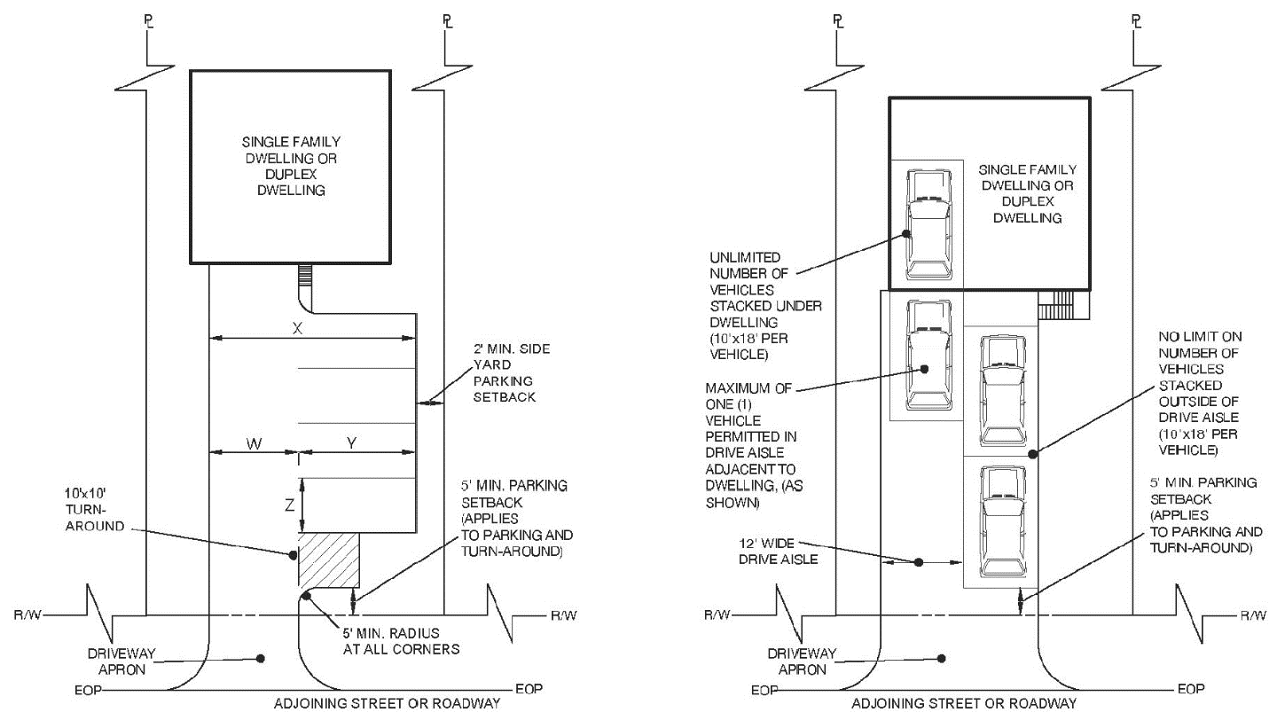
Section 10.12 - Parking Lot Requirements for Single-Family and Two-Family Dwelling Units.
Permanent off-street parking spaces shall be provided in accordance with the following requirements prior to the completion of construction of any building or structure, or at the time any principal building or structure is enlarged or increased in capacity by adding dwelling units or before conversion from one zoning use or occupancy to another:
10.12.1. Reserved for the Use Intended.
Required off-street parking spaces and loading spaces are permanent areas and shall
not be used for any other above ground purpose.
10.12.2. Safety on Busy Streets.
A turnaround area having sufficient maneuvering space, not less than ten (10) feet
× ten (10) feet, shall be provided between the designated parking spaces and a minimum
of five (5) feet from the right-of-way, so that no vehicle will be required to back
into the public right-of-way. Homes which do not front on NC 12, US 158, SR 1243,
and oceanfront homes that have lost access due to erosion, shall be exempt from this
requirement (see also Section 8.7, Reduction in Development Standards for Erosion Threatened Structures).
10.12.3. Surface Materials Appropriate for Use.
10.12.3.1. Required parking spaces shall be graded and paved with asphalt, concrete, gravel, or other surface material designed to support the intended vehicular loading and in accordance with manufacturer's recommended specifications or other acceptable methods for design of pavement structures. This provision shall not apply in situations where a CAMA permit cannot be obtained for these surface materials.
10.12.3.2. As an alternative to the approved parking space surfaces stated above, an applicant may improve up to twenty (20) percent of the required spaces with reinforced turf pavement. The use of reinforced turf pavements shall be designed to support the intended vehicular loading and in accordance with manufacturer's recommended specifications or other acceptable methods for design of pavement structures. Turf reinforced pavements shall be considered an innovative permeable pavement surface and may be reviewed by the Town Engineer and the fire official having jurisdiction for suitability and shall count as lot coverage in the same manner as other similar permeable pavement surfaces. Turf reinforced pavements shall be installed and maintained in accordance with manufacturers recommended specifications and NCDEQ BMP manual, latest edition. If the turf reinforced pavement is not being maintained in accordance with the provision above, the owner may be required to re-surface the parking in accordance with subsection 10.12.3.1.
10.12.4. Number of Parking Spaces Required.
Parking spaces shall be based on the following formula: N-2, with N representing the
number of bedrooms authorized by the septic improvement permit issued by the Dare
County Health Department or the appropriate permitting agency. The minimum number
of parking spaces shall be two (2).
10.12.5. Additional Bedrooms.
Prior to issuance of a certificate of completion for the construction of any additional
bedroom or bedrooms to an existing single-family or two-family dwelling, all required
parking spaces shall be installed.
10.12.6. Dimensional Requirements.
All residential parking area dimensions shall, at a minimum, conform to the dimensional
requirements shown in the table below:
 | |
| Figure A | Figure B |
10.12.7. Drive Aisle Width and Stacking Requirements.
Drive aisles shall be a minimum twelve (12) feet in width and shall be improved up
to the front plane of the dwelling. One (1) parking space may be located at the end
of the drive aisle closest to the dwelling. Other stacking of vehicles in the drive
aisle is prohibited. Stacking of vehicles under the dwelling or outside of the required
12-foot driveway is unlimited. All parking areas shall be located to allow clear use
of a designated turn-around area.
10.12.8. Setbacks for Parking and Drive Aisles.
10.12.8.1. All parking spaces, turn-around areas, and drive aisles shall be located no closer than two feet from any adjacent property line except where drive aisles and driveways are shared between adjacent properties.
10.12.8.2. Parking spaces, turn-around areas, and drive aisles shall be set back from the adjacent right-of-way a minimum of five (5) feet, not including the driveway and driveway apron which connects the parking areas and drive aisle to the roadway pavement.
10.12.9. Driving or parking on the designated septic system areas is expressly prohibited. To resolve violations of this ordinance, the property owner shall be required to install a physical barrier separating vehicular areas from septic system areas in order to limit damage to the system. Acceptable physical barriers may include fencing, posts with rope, raised landscape beds, landscape timbers or other landscaping treatments as approved by the Unified Development Ordinance (UDO) Administrator. Physical barriers must be installed with an adequate setback to prevent damage to the septic system, as determined by the UDO Administrator. This section may be enforced by any one or more remedies authorized by N.C.G.S. 160A-175.
(Ord. No. 21-06-012, Art. III, Pt. XI(Att. K), 6-2-2021; Ord. No. 24-06-013, Art. III, Pt. I, 6-5-2024; Ord. No. 25-10-002, Art. III, Pt. I, 10-1-2025)
Section 10.13 - Parking Requirements for All Uses Other Than Single-Family and Two-Family Dwelling Units.
10.13.1. Permanent off-street parking spaces shall be provided in accordance with the minimum parking requirements contained in this section prior to the completion of construction of any building or structure, or at the time any principal building or structure is enlarged or increased in capacity by adding dwelling units, hotel units, seats or gross floor area, or before conversion from one zoning use or occupancy to another.
10.13.2. Design standards for parking lots, including driveway design, access to Town and State roads, parking stall dimensions, fire lanes, and site design and parking lot orientation are included in the Commercial Design Standards section of this UDO (Article 10, Part VI).
(Ord. No. 21-06-012, Art. III, Pt. XI(Att. K), 6-2-2021)
Section 10.14 - Minimum Parking Requirements.
10.14.1. The number of off-street parking spaces required by this section shall be provided on the same lot with the principal use, except as may be permitted and approved pursuant to Section 10.15, Modified and Reduced Parking Requirements, or a variance granted by the Town. The required number of off-street parking spaces specified for each use shall be considered as the absolute minimum.
10.14.2. Accessory buildings used for customer service area associated with restaurants shall be included with principal buildings in the measurement for determining parking requirements.
10.14.3. Gross floor area shall be measured from the outside walls of all structures.
10.14.4. Where a fraction of a space is required by this section, the next whole number shall be provided.
10.14.5. All space requirements which are based in part or in whole upon employment shall be computed on the basis of the greatest number of persons that are on duty at any one period during the day or night during the peak season.
10.14.6. A developer shall evaluate his own needs to determine if they are greater than the minimum specified by this section.
10.14.7. Required off-street parking spaces and loading spaces are permanent areas and shall not be used for any other above ground purpose other than uses associated with a crowd gathering permit, disaster recovery or other permitted temporary uses.
(Ord. No. 20-01-002, Art. III, Pt. I, 1-8-2020
Section - 10.15 Modified and Reduced Parking Requirements.
10.15.1. Performance-Based Parking Reduction Methods.
The number of required parking spaces for uses other than single and two-family dwellings
may be reduced by the following methods without a special use permit. These methods
may be used jointly, but may not be used in conjunction with methods requiring a special
use permit, except for those permitted by Section 10.15.2.6.
10.15.1.1 Shared Parking Associated with a New Use or New Development on Adjacent
Property.
If proposed parking facilities intended to serve any proposed use are to abut and
be integrated with existing and conforming parking facilities serving other uses,
the parking requirement for the proposed use may be reduced in accordance with this
section, provided that:
10.15.1.1.1. Cross-easements are recorded in the Dare County Register of Deeds that allow unrestricted parking and traffic flow between the proposed and existing lots; and
10.15.1.1.2. Accumulated reduction of parking spaces does not exceed 50 percent of the number of spaces in the existing parking lot.
10.15.1.2. Reduction of Required Parking with the Use of Bicycle Racks.
The total parking requirement for a proposed non-residential use may be reduced by
up to three parking spaces at a rate of one parking space per bike rack if one or
more bicycle racks are located on the site provided that:
10.15.1.2.1. The subject property has frontage along NC12/S. Virginia Dare Trail or NC1243/S. Old Oregon Inlet Road;
10.15.1.2.2. Each bicycle rack must be highly visible and conveniently located in close proximity to the entrance of the principal structure;
10.15.1.2.3. Each bicycle rack must support at least five (5) bicycles; and
10.15.1.2.4. The parking reduction shall not exceed more than one (1) parking space per ten (10) parking spaces provided.
10.15.2. Parking Modification or Reduction Methods Requiring a Special Use Permit. Parking requirements or the number of required parking spaces for uses other than single and two-family dwellings may be modified or reduced by the following methods with a special use permit in accordance with Section 3.8, Special Use Permits. Only one of these methods may be used to reduce required parking, although other parking requirements may be modified pursuant to 10.15.2.6. in conjunction with a requested reduction. In addition to conditions that may be imposed as authorized by Section 3.8, in acting upon any special use permit sought under this Section, the Board of Commissioners may require upgrades or alterations to the existing parking area to address issues associated with stormwater management, backing into Town streets, or to facilitate inter-parcel connectivity.
10.15.2.1. Required Findings.
In addition to the requirements of Section 3.8, Special Use Permits, no special use permit may be issued for the following methods
until the applicant has clearly demonstrated that the request:
10.15.2.1.1. Will not result in increased traffic congestion or otherwise negatively impact existing traffic flow or pedestrian and vehicular safety;
10.15.2.1.2. Will not create parking impacts for adjacent properties or within Town rights-of-way;
10.15.2.1.3. Will not be contrary to the objectives specified in the Comprehensive Plan;
10.15.2.1.4. Is necessary to permit the reasonable use of the subject property; and
10.15.2.1.5. Will not adversely impact adjacent property or the surrounding area.
10.15.2.2. Shared Parking Associated with a Special Use Plan or Plan Amendment.
Proposed commercial uses in all commercial zoning districts may share a portion of
existing and conforming parking spaces with other commercial uses in commercial zoning
districts provided that the following conditions are met:
10.15.2.2.1. The uses should have staggered or different business hours and parking demands, such as an office building open between 9:00 a.m. and 5:00 p.m. and a restaurant open between 5:30 p.m. and 11:00 p.m., or a business open during the week and a church where parking demand peaks on the weekend;
10.15.2.2.2. No more than fifty (50) percent of required parking spaces for the proposed use may be shared with existing and conforming parking spaces of the other commercial use;
10.15.2.2.3. Commercial uses must be abutting and integrated with unrestricted traffic and parking flow between them or may be across a Town street or private easement or alley within the same block;
10.15.2.2.4. When shared parking is devoted to a use other than parking, or business hours of one or more of the uses change to preclude the shared use of the parking spaces, or one or more uses change, increasing the amount of parking spaces required, or other changes in use or parking configuration occur, the special use permits for both sites must be amended appropriately; and
10.15.2.2.5. For proposed commercial uses that redevelop existing commercial sites abutting the NC 12 Beach Road corridor from East Gulfstream to Eighth Street, an alternative parking plan may be proposed that provides a ten (10) percent reduction in required parking and may be approved with or without a shared parking arrangement at the discretion of the Board of Commissioners as part of a special use plan.
10.15.2.3. Shared Parking When Two or More Commercial Uses Exist on One Commercial Site or Adjoining Commercial Uses on Separate Properties within a Common Development Plan. Proposed commercial uses in commercial zoning district C-3 may share a portion of existing and conforming spaces with other commercial uses on the same or adjoining site provided that the following conditions are met:
10.15.2.3.1. No more than sixty (60) percent of the required spaces for the proposed use may be shared with existing and conforming parking spaces of the other commercial use;
10.15.2.3.2. If, in the event, the proposed use has patrons or clients that are not of legal driving age (e.g., dance class for youths that are not legal driving age) both commercial uses may be in operation at the same time as long as integrated traffic pattern is developed which allows for a safe drop-off site for patrons. Such traffic pattern must be approved by the Town Engineer; and
10.15.2.3.3. If such shared parking is devoted to a use other than parking, or one or more of the uses change, increasing the amount of parking spaces required, or other changes in use or parking configuration occur, the special use permits for both sites must be amended appropriately.
10.15.2.4. Off-Site Parking to Meet Use Requirements.
Proposed commercial uses in all commercial zoning districts may use an off-site lot
in a commercial zoning district to meet the minimum parking requirements of this section,
provided the following conditions are met:
10.15.2.4.1. The off-site lot does not have to adjoin the principal commercial use site, but shall be located no further than three hundred (300) feet from the principal use site and shall not be located on the opposite side of US 158 or US 64/264 from the principal use site. A sidewalk or multi-use path connection must exist between off-site lot and the principal use when located along US 158;
10.15.2.4.2. No more than fifty (50) percent of the required parking for the use shall be permitted off-site. All required parking shall be conforming and constructed in accordance with the minimum requirements of this UDO. Lot coverage requirements for the principal use site and the off-site lot for parking shall be calculated separately;
10.15.2.4.3. Parking shall be the only use of the off-site lot, upon which no other principal or accessory uses shall be allowed; and
10.15.2.4.4. An applicant for off-site parking must prove possession and control of the off-site parking property by the same person or entity having possession and control of the principal commercial use site. Such proof may be provided via copies of deeds or leases showing ownership and/or control of both the off-site parking property and the principal use property. The transfer of ownership or expiration of a lease agreement for either property may be grounds for revocation of the certificates of occupancy for the principal commercial site until additional sufficient off-site parking has been obtained and authorized.
10.15.2.5. Reduction of Required Parking for Commercial Uses with the Use of Bicycle
Racks by Special Use Permit.
By special use permit, total parking requirement for a proposed non-residential use
may be reduced by up to three parking spaces at a rate of one parking space per bike
rack if one or more bicycle racks are located on the site provided that:
10.15.2.5.1. The subject property has frontage along a two-lane roadway, or a sidewalk or similar path crosses the property or is located along the frontage of the property;
10.15.2.5.2. Each bicycle rack must be highly visible and conveniently located in close proximity to the entrance of the principal structure.
10.15.2.5.3. Each bicycle rack must support at least five (5) bicycles.
10.15.2.5.4. Parking reduction shall not exceed more than one (1) parking space per ten (10) parking spaces provided.
10.15.2.6. Modification of Parking Requirements or General Reduction of Required Parking.
A special use permit may be sought to modify any requirements pertaining to parking
as contained in Article 10, Part II., Off-Street Parking and Loading Requirements, or Sections 10.91 or 10.92, Street Access, Parking Lot Design, and Pavement Standards, of Article 10, Part VI., Commercial Design Standards, or to reduce the amount of required parking.
(Ord. No. 20-01-002, Art. III, Pt. II, 1-8-2020; Ord. No. 21-06-012, Art. III, Pt. XI(Att. K), 6-2-2021)
Section 10.16 - Required Parking by Use.
Minimum required parking by use shall be as follows. For sites with multiple principal uses, the parking requirements for each use must be met on-site or through shared parking in accordance with Section 10.15, Alternative and Reduced Commercial Parking Requirements. Also see Section 10.17, Off-Street Loading.
(Ord. No. 20-06-006, Art. III, Pt. II, 6-3-2020; Ord. No. 21-05-009, Art. III, Pt. V, 5-5-2021; Ord. No. 21-06-012, Art. III, Pt. XI(Att. K), 6-2-2021; Ord. No. 23-05-015, Art. III, Pt. II, 5-3-2023; Ord. No. 24-03-004, Art. III, Pt. VII, 3-6-2024; Ord. No. 24-04-009, Art. III, Pt. IV, 4-3-2024; Ord. No. 24-11-029, Art. III, Pt. III, 11-6-2024; Ord. No. 24-12-033, Art. III, Pt. I, 12-4-2024)
Section 10.17 - Off-Street Loading.
10.17.1. One or more loading spaces shall be provided for standing, loading and unloading operations either inside or outside a building and on the same premises with every building or structure erected after the enactment of this UDO and shall be in accordance with the requirements of the following table. A loading berth shall have minimum plan dimensions of twelve (12) feet by sixty (60) feet and a 14-foot overhead clearance. A loading space need not be necessarily a full berth but shall be sufficient to allow normal loading and unloading operations of a kind and magnitude appropriate to the use. The Town Engineer shall determine the sufficiency of loading space but in no case shall the use of such space hinder the free movement of vehicles and pedestrians over a street, sidewalk, parking lot or alley.
10.17.2. Loading spaces shall be located at least fifty (50) feet from any street right-of-way and shall be paved with asphalt, concrete, porous paving as approved by the Town Engineer or an open-face paving block over sand and filter-cloth base, provided that the open-face paving block is equivalent to Turfstone™ with regards to compressive strength, density, absorption and durability.
Section 10.21 - Purpose and Intent.
10.21.1. It is the intent of this section to balance the need to protect the public safety and welfare; the need for a well-maintained and attractive community; and the need for adequate identification, communication and advertising. The regulations for signs have the following specific objectives:
10.21.1.1. To ensure that signs are designed, constructed, installed and maintained according to minimum standards to safeguard life, health, property, and public welfare;
10.21.1.2. To allow and promote positive conditions for sign communication while at the same time avoiding nuisances to nearby properties;
10.21.1.3. To reflect and support the desired character and development patterns of the various zones, overlay zones, and promote an attractive environment;
10.21.1.4. To allow for adequate and effective signs in zoning districts of the Town while preventing signs from dominating the appearance of the area;
10.21.1.5. To ensure that the constitutionally guaranteed right of free speech is protected;
10.21.1.6. To avoid the visual clutter that is potentially harmful to traffic and pedestrian safety, property values, business opportunities, and the community's appearance; and
10.21.1.7. To provide opportunities for adequate property identification which will enhance emergency response times and improve overall public safety.
10.21.2. The regulations allow for a variety of sign types and sizes for a site. The provisions do not ensure or provide for every property or business owner's desired level of visibility for the signs. The sign standards are intended to allow signs to have adequate visibility from streets and rights-of-way that abut a site, but not necessarily to streets and rights-of-way farther away.
Section 10.22 - General Regulations.
All signs shall be erected, altered, and maintained in accordance with the following provisions:
10.22.1. Permit Required.
No sign shall hereafter be erected or attached to, suspended from or supported on
a building or structure, nor shall any existing sign be structurally altered, remodeled
or relocated until a building permit for same has been issued by the UDO Administrator.
A permit is not required for the following signs:
10.22.1.1. Signs not exceeding three (3) square feet in area.
10.22.1.2. Temporary signs, except as required for signs listed in subsection 10.23.1.4.
10.22.1.3. Noncommercial signs.
10.22.1.4. Directional signs.
10.22.1.5. An existing sign in which only the message is changed and involves no structural modification to the structure.
10.22.1.6. Permanent signs listed in subsection 10.23.2 which are six (6) square feet or less in area.
10.22.2. Material and Design.
All signs shall be constructed and designed according to generally accepted engineering
practices to withstand wind pressures and load distribution as specified in Section
1205 of the state building code, as amended.
10.22.3. Inspection.
10.22.3.1. Each sign subject to the regulations of subsection 10.22.1 of this section may be subject to an annual inspection by the Building Inspector for the purpose of ensuring that the sign is maintained in a safe condition. Any fee for the annual inspection shall be in accordance with a regularly adopted fee schedule of the Town.
10.22.3.2. When a sign or a structure supporting a sign becomes structurally unsafe, the Building Inspector shall give written notice to the owner of the premises on which the sign is located that the sign shall be made safe or removed within ten (10) days of receipt of such notice.
10.22.4. Continuing Violations.
After a notice of violation, warning citation or civil citation has been issued, any
re-erection or display, within a 12-month period, of the same sign or the erection
or display of a substantially similar sign which is in violation of this UDO on the
same premises shall be considered a continuance of the original violation.
10.22.5. Illuminated Signs.
All signs in which electrical wiring and connections are to be used shall require
a permit and shall comply with the electrical code adopted by the Town and be inspected
and approved by the Building Inspector. All illuminated signs shall comply with the
provisions of Article 10, Part IV, Outdoor Lighting.
10.22.6. Prohibited Signs.
10.22.6.1. It shall be unlawful for any person, except a public officer or employee in the performance of his public duty, to affix, post, paint, nail, fasten, place, or locate any sign, card, banner, handbill, poster, or advertising or notice of any kind, or cause the same to be done, upon public streets, highways, public right-of-way or any publicly owned or maintained property within the Town of Nags Head, or upon any curbstone, traffic control device, street sign, hydrant, fence, guardrail, or any other structure situated within any such areas or to affix the same to a wire or appurtenance thereof, except as may be authorized by the ordinances, laws, or regulations of the Town of Nags Head, the State of North Carolina or the United States.
10.22.6.2. No sign shall be erected or maintained which is a copy or imitation of an official highway sign and carrying the words "STOP" or "DANGER."
10.22.6.3. No sign or commercial sign shall be erected which contains, employs or utilizes lights or lighting which rotates, flashes, moves or alternates; except that time and temperature displays, as defined, are permitted but must be included in computing allowable signage. Continuous printout, running or ticker-tape type message panels or signs are prohibited.
10.22.6.4. No sign shall be erected which contains rotating sign panels.
10.22.6.5. No sign shall obstruct visibility at an intersection or driveway as regulated in Section 10.92.2.2.8, Vision Clearance (C).
10.22.6.6. No sign shall be posted on any telegraph, telephone, or electrical light pole or on any tree along any street.
10.22.6.7. No sign shall be permitted that obstructs ingress and egress to any window, door, fire escape, stairway, ladder or opening intended to provide light, air, ingress or egress for any room or building. Signs shall not be placed in a manner that obstructs architectural building features such as dormers, cupolas, windows, rooflines or other building elements.
10.22.6.8. No sign shall be permitted that violates any provision of any law of the state relative to outdoor advertising.
10.22.6.9 All outdoor advertising signs or structures are prohibited.
10.22.6.10. Signs supported in whole or in part by water, air or gas are prohibited.
10.22.6.11. No sign on property abutting a public trust area shall be directed toward any public trust area as defined by CAMA.
10.22.6.12. All pennants are prohibited.
10.22.6.13. Use of exposed neon, argon, krypton, or similar gas tube lighting shall be prohibited in all manners except as provided in subsection 10.24.2.5.
10.22.6.14. Tourist-oriented directional sign (TODS).
10.22.6.15. Three-dimensional sculptured objects and pictorial devices attached to and extending more than twelve (12) inches beyond any wall or roof of a building in business use are prohibited. Attached sculptured objects and pictorial devices extending twelve (12) inches or less from a building wall or building roof shall be classified as a business wall sign or roof sign and shall be subject to all regulatory requirements of this UDO pertaining to such signs.
10.22.6.16. Roof signs within the SPD-C, Village at Nags Head C-1, C-2, hotel and institutional districts are prohibited.
10.22.6.17. LED and digital signs are prohibited, except for those specified in Section 7.20, Fueling Stations.
10.22.6.18. Signs mounted or attached to nonmotorized and/or motorized vehicles, watercraft, or trailers are prohibited.
10.22.6.19. No signs shall be mounted to merchandise for sale, or typical of merchandise sold, and/or such merchandise shall be prohibited from being attached to signs or their structural components.
10.22.6.20. Placement of new signs not expressly allowed by this Part are prohibited.
(Ord. No. 24-06-014, Art. III, Pt. II, 6-5-2024)
Section 10.23 - Signs Permitted in Residential Districts.
Signs permitted in R-1, R-2, R-3, SPD-20, SED-80, and SPD-C districts are as follows:
10.23.1. Temporary Signs.
Temporary signs, provided that they are reasonably maintained, and provided that they
shall be removed when the activity or event associated with the property has ceased
according to the criteria listed below. These signs shall not be illuminated.
10.23.1.1. Temporary, nonilluminated signs not to exceed six square feet in area and not greater than thirty-six (36) inches in height may be installed on lots where an active, unexpired building permit has been issued by the Town of Nags Head, limited to one such sign per permit; such signs shall be removed within 30 days after the issuance of the certificate of compliance. Alternatively, instead of installing one sign per permit, the property owner may elect to install one non-illuminated sign not exceeding thirty-two (32) square-feet in area and thirty-six (36) inches in height, which shall be removed within 30 days after the issuance of the certificate of compliance.
10.23.1.2. One (1) freestanding, non-illuminated temporary sign shall be allowed up to six (6) square feet in area and thirty-six (36) inches in height measured from the ground to the top of the sign on a site or property that is actively listed for sale. Where more than one dwelling unit exists on a site or property that is actively listed for sale or for lease, the following signs may be erected:
10.23.1.2.1. One (1) freestanding sign shall be permitted in accordance with the provisions of subsection 10.23.1.1 of this section; or
10.23.1.2.2. One (1) freestanding sign equal to 1.25 square foot of sign area per unit, which shall include the street address of the property. However, in no case shall the sign exceed thirty-six (36) square feet; or
10.23.1.2.3. One (1) sign not exceeding ten (10) inches by ten (10) inches each shall be permitted to be affixed to the exterior of each detached dwelling unit, individual townhouse unit or individual two-family unit.
10.23.1.3. At any time when a real estate agent is present on a property that is actively listed for sale, the following additional signs may be allowed:
10.23.1.3.1. One (1) additional freestanding sign up to six (6) square feet in area and thirty-six (36) inches in height measured from the ground to the top of the sign;
10.23.1.3.2. A single banner placed on the building (excluding the roof) not exceeding thirty-six (36) square feet in area; or
10.23.1.3.3. A flag sign not exceeding twenty-four (24) square feet in area.
10.23.1.4. Signs and banners associated with a special events permit or other use on a designated public events site, are permitted within the designated event site but must be directed internally to the event and not toward the exterior of property or along the beach, sound or roadway. Such signs shall not be located adjacent to the US 158 right-of-way or abutting property lines.
10.23.2. Permanent Signs.
10.23.2.1. All properties shall be permitted to contain one (1) sign not to exceed six (6) square feet in area to be placed on the wall of the principal structure. Where the principal structure is greater than one hundred (100) feet from the public right-of-way fronting the site, an additional sign may be placed in the front yard, meeting the following criteria:
10.23.2.1.1. The sign shall not exceed three (3) square feet in area. The frame surrounding the sign face shall not be included as part of the sign area provided that the framing materials are no greater than four-inch by four-inch in thickness.
10.23.2.1.2. The sign shall not exceed thirty-six (36) inches in height measured from the ground to the top of the sign.
10.23.2.1.3. The sign shall not create an obstruction to visibility for vehicles entering and exiting driveways.
10.23.2.1.4. Amortization: Front yard signs made nonconforming by this subsection shall comply with these regulations by January 1, 2019.
10.23.2.2. One (1) bulletin board not to exceed sixteen (16) square feet shall be permitted for any church, school or other noncommercial institution, which sign or board may be indirectly lighted and shall be set back at least fifteen (15) feet from the front property line.
10.23.2.3. One (1) non-illuminated sign not over one (1) square foot in area and attached flat against the building shall be allowed at a residential property with an approved home occupation.
10.23.2.4. Noncommercial Identification Signs. The following signs are permitted, provided that such sign is located on the site it identifies and is reasonably maintained:
10.23.2.4.1. One (1) wall-mounted noncommercial identification sign per unit not to exceed six (6) square feet in sign area shall be permitted for single-family and two-family sites.
10.23.2.4.2. One (1) freestanding noncommercial identification sign per unit not to exceed three (3) square feet in sign area shall be permitted for single-family and two-family sites.
10.23.2.4.3. Two signs, which may be illuminated, may be placed at the primary entrance to a subdivision not to exceed thirty-two (32) square feet each in sign area.
10.23.2.4.4. One sign, which may be illuminated, may be permitted at the site of a multi-family residential property not to exceed thirty-two (32) square feet in sign area.
10.23.2.4.5. Two signs, which may be illuminated, may be permitted at the major entrance to a public park not to exceed forty-eight (48) square feet each in sign area.
10.23.2.4.6. One (1) freestanding sign, which may be illuminated, shall be permitted at the major entrance to a governmental or publicly owned site or designated public events site not to exceed sixty-four (64) square feet in sign area. Such sign shall not exceed ten (10) feet in height. Where the property has frontage on both US 158 and NC 12 public rights-of-way, one (1) freestanding sign not exceeding sixty-four (64) square feet in area shall be permitted to be located adjacent to each public right-of-way. Where the property is on a corner lot with frontage on more than one public right-of-way, a maximum of two (2) freestanding signs shall be permitted. One (1) freestanding sign not exceeding sixty-four (64) square feet in area shall be permitted adjacent to the public right-of-way boundary of the designated front yard of the property. One (1) freestanding sign not exceeding twenty-four (24) square feet shall be permitted adjacent to a public right-of-way boundary of a designated side yard of the property. The freestanding sign permitted in the side yard shall be located no closer than seventy (70) feet to the designated front yard public right-of-way boundary and installed so that the sign face is perpendicular to the side yard public right-of-way boundary.
10.23.2.4.7. One sign, which may be illuminated, may be placed against the wall of a governmental building (local, state or federal) not to exceed twelve (12) square feet in sign area.
10.23.2.5. One (1) freestanding sign, which may be illuminated, may be placed on the site of a medical office building not to exceed twenty-four (24) square feet in sign area and ten (10) feet in total height.
10.23.2.6. Hospitals may have two (2) square feet of sign area for each lineal foot of building frontage on US 158 which may be used as wall signs, signs adjacent to internal drive aisle not exceed twenty (20) inches in height, window signs, and one (1) freestanding sign, provided that the freestanding sign shall not exceed sixty-four (64) square feet in area nor more than twenty (20) feet in height above street grade, and may be illuminated.
(Ord. No. 21-06-012, Art. III, Pt. XI(Att. K), 6-2-2021)
Section 10.24 - Signs Permitted in Commercial Districts and the Commercial/ Residential District.
Signs permitted in the C-1, C-2, C-3, C-4, C-5, and CR districts are as follows:
10.24.1. All signs permitted in Section 10.23, Signs Permitted in Residential Districts.
10.24.2. For each premises in business use, or for each commercial site for which the Town has approved a site plan and has issued a building permit, three (3) square feet of business sign area for each lineal foot of frontage on a public right-of-way shall be permitted not to exceed a total of six hundred (600) square feet. Such sign area may be in a single sign or in a combination of signs subject to the following limitations:
10.24.2.1. Wall Signs.
10.24.2.1.1. Wall signs placed against the exterior front and side walls of a building shall be permitted, provided that they shall not extend more than twelve (12) inches beyond the building wall surface and shall not exceed twenty (20) percent of the exposed finished wall surface area including openings on the wall where it is placed.
10.24.2.1.2. Wall signs shall not be permitted on the rear wall of a building except for: (1) buildings located on property with frontage on both US 158 and either NC 12 or Wrightsville Avenue; and (2) for buildings containing multiple business uses where public entry to an individual business is limited solely to the rear of the building; (3) rear wall signs not visible from the street right-of-way and adjoining properties; and (4) rear wall signs, upon structures located adjacent to US 158, where not visible from any residential use or residentially zoned property.
10.24.2.1.3. Individual wall signs with an area of fifty (50) square feet or greater shall not be internally illuminated; such signs may be externally illuminated or reverse lit. Additionally, in the case of multiple wall signs associated with any singular business/tenant, no combined sign area fifty (50) square feet or greater shall be internally illuminated; such sign area may be externally illuminated or reverse lit.
10.24.2.2. One (1) banner not to exceed thirty-six (36) square feet in sign area shall be permitted to be placed on the principal building (exclusive of the roof and rear wall) in business use. When a banner is used in combination with wall signs, the total banner and wall signage shall not exceed twenty (20) percent of the exposed finished wall surface area including openings.
10.24.2.3. For lots along five-lane roadway corridors, only one (1) freestanding sign shall be permitted to be located permanently on the property and shall not exceed sixty-four (64) square feet in area and shall not exceed twenty (20) feet in height above street grade.
For lots along two-lane roadway corridors, only one (1) freestanding sign shall be permitted to be located permanently on the property and shall not exceed thirty-two (32) square feet in area and shall not exceed twelve (12) feet in height above street grade.
Where the property has frontage on both US 158 and NC 12 public rights-of-way, one (1) freestanding sign shall be allowed to be located adjacent to each public right-of-way, in accordance with the standards listed above.
Where the property is a corner lot with frontage on more than one public right-of-way, a maximum of two (2) freestanding signs shall be permitted in accordance with the standards listed above. The freestanding sign permitted in the side yard shall be located no closer than seventy (70) feet to the designated front yard public right-of-way boundary and installed so that the sign face is perpendicular to the side yard public right-of-way boundary.
10.24.2.4. Roof Signs.
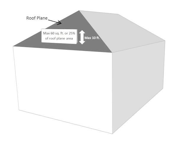
10.24.2.4.1. Roof signs shall not exceed twenty-five (25) percent of the individual roof plane area to which they are attached. In no instance shall an individual roof sign exceed sixty (60) square feet in area. There shall be no more than two (2) roof signs per building.
10.24.2.4.2. Roof signs shall not be taller than ten (10) feet from the lowest point of attachment to the roof. In no instance shall roof signs exceed the maximum height limit for the zoning district in which the sign is permitted.
10.24.2.4.3. Individual roof signs with an area of fifty (50) square feet or greater shall not be internally illuminated; such signs may be externally illuminated or reverse lit. Additionally, in the case of multiple roof signs associated with any singular business/tenant, no combined sign area fifty (50) square feet or greater shall be internally illuminated; such sign area may be externally illuminated or reverse lit.
10.24.2.5. Window signs shall be permitted to be placed only inside a commercial building and shall not exceed twenty-five (25) percent of the glass area of the pane upon which the sign is displayed. Window signs of exposed neon, argon, krypton or similar gas tube lighting shall be permittable, provided that such signs shall not exceed twenty-five (25) percent of glass pane area, and shall not exceed singly, or in combination 0.15-square-foot per lineal foot of store frontage, not to exceed twenty (20) square feet of sign area for any one store.
10.24.2.6. One (1) temporary sandwich sign shall be permitted to be located on the ground but shall not exceed ten (10) square feet in area on each side and shall not exceed four (4) feet in height.
10.24.2.7. One (1) flag sign shall be permitted in accordance with the specifications listed in the definition for flag sign as described in Appendix A Definitions.
10.24.2.8. Flag signs (non-advertising, non-informational), as defined, shall be permitted, with no more than one flag for every 20 linear feet of street frontage.
10.24.2.9. Each outdoor stand shall be allowed one (1) temporary sign attached to the stand. The total combined square foot area of all such signs shall not exceed fifteen (15) square feet in area and such signs shall not extend above the roof of the stand. This sign area shall be exempt from the calculation of total commercial site sign area limitations imposed by this subsection.
10.24.3. In any vacant site in a commercial district, the following is allowed without a permit. One (1) temporary sign, not exceeding six (6) square feet in area, shall be permitted; provided that such sign shall not be less than fifteen (15) feet from any street right-of-way or lot line, shall not be illuminated and shall be reasonably maintained. For lots which exceed one hundred (100) feet in frontage, one (1) additional square foot of sign area shall be allowed for every ten (10) feet of frontage above one hundred (100) feet. No sign shall exceed thirty-two (32) square feet in area or fifteen (15) feet in height.
(Ord. No. 20-05-005, Art. III, Pt. XXI, 5-6-2020; Ord. No. 20-07-010, Art. III, Pt. III, 7-1-2020; Ord. No. 20-09-014, Art. III, Pt. VII, 9-2-2020; Ord. No. 21-05-010, Art. III, Pts. I, II, 5-5-2021; Ord. No. 21-06-012, Art. III, Pt. XI(Att. K), 6-2-2021; Ord. No. 23-03-009, Art. III, Pt. XII, 3-15-2023)
Section 10.25 - Noncommercial Signs.
Noncommercial signs are permitted anywhere that advertising or commercial signs are permitted, subject to the same regulations applicable to such signs.
Section 10.26 - Exemptions.
10.26.1. Municipal portable message signs used for the display of public safety information and government regulatory information, and directional signage to public recreational destinations shall be exempt from the requirements of this section.
10.26.2. Municipal public art located with the public right-of-way shall be exempt from the requirements of this section.
10.26.3. The Town Manager shall review and approve all messages and all directional signage exempted by this section.
Section 10.31 - Purpose and Intent.
10.31.1. Outdoor lighting standards are hereby established to provide safe lighting levels at proper intensities so as to adequately serve their intended uses and not unreasonably interfere with the use and enjoyment of neighboring properties. These standards are not intended to regulate single-family and two-family security lighting, provided that such lighting does not create a nuisance to neighboring properties. Regulations are intended to preserve the visual integrity of the nighttime environment by reducing glare, discouraging unnecessary illumination, and prohibiting the use of structure highlighting without decreasing safety, utility, and security. To satisfy this intent, and for the purposes of this section, interior lighting shall be subject to the regulations of this section, provided that interior lighting contributes to the excessive illumination of an outdoor area, or is a source of glare that is visible from the property line or any off-site location. All outdoor lighting shall be erected, altered and maintained in accordance with the provisions of this section. Streetlights erected in accordance with Section 10.71, Street Lighting are exempt from this section.
10.31.2. The purpose of this section is to regulate artificial illuminating devices utilized for general illumination or advertisement. The regulations of this section are designed to provide a uniform distribution of light that minimizes light trespass and controls glare on and off the property. The following general and specific standards encourage lighting that favorably contributes to visual performance, safety, and aesthetics from properly shielded light sources for the following lighting applications: security, parking lots, recreational facilities, buildings and structures, landscaping, open canopies, and signs.
(Ord. No. 21-06-012, Art. III, Pt. XI(Att. K), 6-2-2021)
Section 10.32 - Inspections.
All outdoor light fixtures are subject to inspection at any time by the UDO Administrator to ensure that the light fixtures are in compliance with this section. When a light fixture fails to comply, the UDO Administrator shall give written notice to the owner and tenant of the site on which the light fixtures are located stating that the light fixtures shall be brought into compliance or removed at the owner's expense. The remedies set out in Section 1.10, Violation of UDO Regulations of this UDO shall also apply to this section.
Section 10.33 - Prohibited Lighting.
Prohibited lighting shall be as follows:
10.33.1. Light fixtures that imitate an official highway or traffic control light or sign.
10.33.2. Light fixtures in the direct line of vision with any traffic control light or sign.
10.33.3. Light fixtures that have a flashing or intermittent pattern of illumination, except as provided elsewhere in this UDO.
10.33.4. Privately-owned light fixtures located in the public right-of-way.
10.33.5. Light fixtures that are a source of glare by their design, orientation or intensity.
10.33.6. Searchlights except when used by federal, state, or local authority.
10.33.7. Light fixtures that violate any law of the state relative to outdoor lighting.
10.33.8. General purpose area and sports floodlights except to illuminate building facades and outdoor recreational uses as provided in subsections 10.37.4.2 and 10.37.5.1.
10.33.9. Illumination of the public beach and estuarine waters from uses that are not water dependent.
10.33.10. Uplighting of windsocks, fountains or flags, except for the United States flag, state flag, official flag of the Town or permitted flag sign.
10.33.11. Structure highlighting.
10.33.12. Unshielded open vertical light fixtures.
10.33.13. Outdoor miniature lights on strings except from mid-November until mid-January, provided that such lighting does not create glare or is a nuisance to adjacent properties.
Section 10.34 - General Provisions.
10.34.1. Light fixtures shall be located on the site and designed, shielded, or oriented in such a manner as to minimize light spill across property lines and prevent glare at any location on or off the property.
10.34.2. Except for fixtures which are permitted by this Article to be used for vertical illumination or for multi-purpose recreation fields, all light fixtures shall be cut-off fixtures as defined in Appendix A - Definitions.
10.34.3. All wiring to light fixtures not located on a building shall be placed underground.
10.34.4. Principal buildings shall provide security lighting.
10.34.5. Light fixtures and supporting structures shall be designed and constructed to comply with state building code requirements.
10.34.6. No light fixture, including signs, shall exceed thirty-five (35) feet in height, except as specified in subsections 10.34.7 or 10.37.5.6. Where existing nonconforming light fixtures exist, including signs, such light fixtures and sign may be replaced provided there is no increase in the degree of nonconformity.
10.34.7. All permitted structures that exceed one hundred (150) feet in height shall be lit in compliance with the FAA regulations as identified in FAA Obstruction Marking and Lighting Advisory Circular AC 70/7460-1K as amended August 8, 2000, or the most recent FAA Advisory Circular on Obstruction Marking and Lighting, and approved by the Board of Commissioners.
10.34.8. LED lamps and/or light fixtures used in installations subject to the requirements of this section shall not have a correlated color temperature in excess of 3,000K.
(Ord. No. 21-05-010, Art. III, Pt. III, 5-5-2021; Ord. No. 21-06-012, Art. III, Pt. XI(Att. K), 6-2-2021
Section 10.35 - Lighting Plan Required.
10.35.1. All proposed development for which site plan approval is required by the Board of Commissioners, shall require a lighting plan produced by the lighting manufacturer, registered architect, or engineer and shall be submitted as part of the site plan review process. To enable the Town to determine that applicable provisions of this section will be satisfied, the lighting plan shall include the following:
10.35.1.1. A site plan, drawn to a scale of one (1) inch equaling no more than twenty (20) feet, showing proposed features to be illuminated including, but not limited to: building, landscaping, signs, parking and loading areas, and location of all proposed exterior light fixtures;
10.35.1.2. Specifications and descriptions for all proposed light fixtures including photometric data;
10.35.1.3. Proposed mounting height of all exterior light fixtures;
10.35.1.4. Analyses and illuminance level plans in the form of an ISO footcandle or point-by-point grid diagram drawn to a scale referenced above. The submitted grid plan shall plot lighting levels at ten-foot intervals or less. The ISO footcandle diagram shall plot footcandles in increments of one-half footcandle or less. Either plan shall clearly account for lighting levels produced by all exterior light sources. The outdoor lighting plan shall account for cumulative lighting levels of combined indoor and outdoor light sources if any wall of the proposed building meets either subsection 10.35.1.6.1 or 10.35.1.6.2.
10.35.1.5. Drawings of all proposed building elevations showing the location and type of light fixtures, the portions of the walls to be illuminated, the illuminance levels at the wall surface, and the aiming points for any floodlight fixture.
10.35.1.6. In addition to the above provisions of this Subsection 10.35.1, an indoor lighting plan that details the location, specifications, and descriptions of proposed interior light fixtures and proposed average footcandles of interior customer areas shall be required for approval when submitted building elevations demonstrate:
10.35.1.6.1. An interior, heated wall surface area is comprised of fifty (50) percent glass or greater; or
10.35.1.6.2. The location of any glass area or architectural feature creates a potential for off-site glare.
10.35.2. Any proposed modification or alteration to a previously approved building elevation, site plan, or lighting plan may be approved administratively by the UDO Administrator, provided that the proposed change is considered minor.
Section 10.36 - General Performance Standards.
All site lighting shall utilize full cutoff fixtures unless specifically excluded by other sections of this ordinance.
10.36.1. For sites with cutoff fixtures, the maximum maintained horizontal footcandle level at any point on a common property line of improved residential property shall not exceed 1.5 footcandles.
10.36.2. For existing sites with noncutoff fixtures, the maximum maintained footcandle level at any point on a common property line of improved residential property shall not exceed 0.4 footcandle.
Section 10.37 - Specific Lighting Application Standards.
10.37.1. Parking Lots.
Illumination standards for parking lots are based on anticipated vehicular and pedestrian
activity. The standards are designed to provide the minimum lighting necessary to
ensure adequate vision and safety in parking areas while at the same time minimizing
glare. In no case shall the maximum initial lumens generated by any individual light
fixture exceed 9500 initial lamp lumens.
10.37.1.1. High levels of activity include, but are not limited to, the following uses: fueling station, convenience store, outdoor recreational uses, attended car wash, financial institution, grocery store, theater, drive-in restaurant, drive-through restaurant.
10.37.1.2. Medium levels of activity include, but are not limited to, the following uses: retail, indoor recreational use, retail shopping center, hotel, medical offices, pharmacy, child day care center, government administrative office, indoor assembly, hospital, and restaurant.
10.37.1.3. Low levels of activity include, but are not limited to, the following uses: professional office, religious complex, townhouse and multifamily dwellings, school, wholesale, warehouse, mini-storage (self-storage) complex, furniture store, private club.
10.37.1.4. Parking lot lighting shall meet one of the following standards:
10.37.1.4.1. For cutoff fixtures, the following standards shall apply:
10.37.1.4.2. For existing sites with noncutoff fixtures, the following standards shall apply:
10.37.1.4.3. Other uses.
10.37.2. Canopy Lighting.
Open canopies located over fueling station gas pumps, drive-through banking facilities,
and drive-in restaurants shall comply with the following standards:
10.37.2.1. Only the area directly below canopies may be illuminated such that illumination levels shall not exceed fifteen (15) maximum maintained footcandles and shall not be less than two (2) minimum maintained footcandles.
10.37.2.2. Light fixtures shall be mounted only under the canopy and shall be either recessed, or cutoff fixtures.
10.37.2.3. Light fixtures shall not be located elsewhere on the canopy and the sides of the canopy shall not be internally or externally illuminated.
10.37.2.4. Parking spaces not located directly beneath the canopy shall be illuminated in accordance with the requirements for parking areas.
10.37.3. Security Lighting.
Security lighting may be utilized for the protection of people and property by illuminating
areas of building ingress, walkways, and open storage areas. Security lighting may
include vertical illumination, provided that illumination above the doorway, entry
or window elevation is minimal. Security lighting shall not exceed one (1) average
maintained footcandle.
10.37.4. Architectural and Interior Lighting.
10.37.4.1. Light fixtures mounted on the walls and soffits shall be recessed, fully shielded or directed to the wall surface.
10.37.4.2. Floodlights may be utilized to up-light opaque wall surfaces from the ground, provided that the light fixture is located a horizontal distance no greater than fifteen (15) feet from the wall, shall not be mounted greater than thirty (30) inches in height, and illumination levels measured at the vertical plane shall not be exceeded.
10.37.4.3. Floodlights located on a canopy roof surface may be utilized to uplight attached, opaque parapet wall surface and canopy roof lying between the light and the parapet wall surface, provided the roof mounted floodlights are located a horizontal distance no greater than fifteen (15) feet from the parapet wall, shall not be greater than fifteen (15) inches above the canopy roof surface, and illumination levels at the vertical plane shall not be exceeded.
10.37.4.4. The maximum vertical illumination level of an entrance facade or parapet wall shall not exceed five (5) average maintained footcandles. The maximum illumination level shall not exceed one (1) average maintained footcandle for other wall surfaces.
10.37.4.5. Supported, roofed walkways and porches may be illuminated up to twelve (12) average maintained footcandles.
10.37.4.6. When a single interior, heated wall surface area of a building is fifty (50) percent glass or greater, or interior light fixtures are visible from the property line or off-site location, the following requirements shall apply:
10.37.4.6.1. Interior light fixtures shall be fully shielded or shielded to any cutoff angle required to prevent line of sight contact with the light source, lens or opening.
10.37.4.6.2. Average interior illumination level shall be the minimum average IESNA recommended level of illumination for that particular use.
10.37.5. Lighting of Outdoor Recreational Facilities.
10.37.5.1. General purpose area and sports lighting floodlight fixtures may be utilized, provided that all such light fixtures shall be directed or shielded such that the light measured at the property line does not exceed the following:
10.37.5.1.1. Horizontal illumination shall not exceed 0.1 initial footcandles for residential properties.
10.37.5.1.2. Vertical illumination shall not exceed 0.6 initial footcandles for residential properties.
10.37.5.1.3. Candela value shall not exceed 9,000 at between 82 degrees and 86 degrees above nadir.
10.37.5.2. Areas intended solely for pedestrian circulation, such as walkways connecting accessory buildings and viewing stands, shall be provided with security level illumination.
10.37.5.3. Light fixtures for the recreational use shall be turned off no later than 11:30 p.m. at private facilities unless otherwise specified. Light fixtures for multipurpose recreation fields shall be turned off no later than 9:00 p.m. at municipally owned recreation facilities. Only security level lighting shall be utilized to facilitate cleanup and nighttime maintenance.
10.37.5.4. A single flashing navigational light may be used in conjunction with an approved boat rental establishment subject to the following provisions:
10.37.5.4.1. The boat rental establishment shall provide documentation to the UDO Administrator that the light fixture and its location have been approved by the Commander, Fifth Coast Guard District, Portsmouth, Virginia.
10.37.5.4.2. The light shall be used only when the business is open and between the hours of sunrise to one-half hour after sunset.
10.37.5.4.3. The light source shall not be visible from adjacent properties and rights-of-way.
10.37.5.4.4. Navigational lights shall not be used in conjunction with any permitted sign.
10.37.5.5. The following illumination levels shall not be exceeded:
10.37.5.6. Light fixtures for illumination of the recreational use at municipally owned recreation facilities shall not exceed seventy (70) feet in height.
10.37.5.7. Outdoor amusement rides below thirty-five (35) feet in height shall be exempt from the lighting ordinance. These exemptions shall apply between the hours of 9:00 a.m. and 11:30 p.m. and between the dates of May 15 and September 15.
10.37.5.8. Three (3) rides over 35' in height per site shall be exempt from the lighting ordinance. The exemptions of paragraphs 10.37.5.7 and 10.37.5.8 shall apply between the hours of 9:00 am and 11:30 pm and between the dates of May 15 and September 15.
10.37.6. Illuminated Signs.
10.37.6.1. Internally illuminated wall or freestanding signs that utilize fluorescent tubes as a light source shall be designed and constructed such that tubes are spaced at least twelve (12) inches on center, and mounted at least 3.5 inches from the translucent sign surface.
10.37.6.2. Lights may be utilized to externally illuminate wall and freestanding signs, provided that the light fixtures are full cutoff and designed, located, aimed, and shielded so that light is directed only onto the sign area. Externally illuminated wall signs shall be downlit only, with the light fixture mounted above the sign, and not aimed toward adjacent streets, or properties. Light fixtures used to illuminate externally illuminated freestanding signs from the ground shall not be mounted at a height greater than thirty (30) inches, or located a horizontal distance from the sign greater than three-quarters the height of the sign or fifteen (15) feet, whichever is less. Light fixtures used for the external illumination of signs shall not have lamps which produce more than 75 watts and/or 1,100 lumens, and the average level of illumination shall not exceed ten (10) average maintained footcandles.
(Ord. No. 21-05-010, Art. III, Pts. IV, V, 5-5-2021; Ord. No. 21-06-012, Art. III, Pt. XI(Att. K), 6-2-2021)
Section 10.38 - Measurements.
10.38.1. Lighting levels shall be measured in footcandles with a direct-reading, portable light meter. The meter shall have a color and cosine-corrected sensor with multiple scales and shall read within an accuracy of plus or minus seven (7) percent. It shall have been tested, calibrated, and certified by an independent commercial photometric laboratory or the manufacturer within one (1) year of the date of its use.
10.38.2. Unless otherwise specified, the meter sensor shall be mounted not more than six (6) inches above ground level in a horizontal position to measure horizontal illumination. Vertical illumination shall be measured at a height of five (5) feet with the meter sensor mounted not more than six (6) inches from the wall surface and the meter sensor in the vertical position. Readings shall be taken only after the cell has been exposed long enough to provide a constant reading.
10.38.3. Measurements of newly installed high intensity discharge light fixtures shall account for the light loss factor figured into the calculation of a point-by-point printout. A light loss factor of 0.75 is normal for metal halide and 0.80 is normal for high-pressure sodium when adjusting for lamp lumen depreciation and luminaire dirt depreciation as the system ages. As an example, a calculation with a light loss factor of 0.7 would suggest a meter reading of one initial footcandle for a printout calculation of 0.7 maintained footcandles.
Division II. - Approval and Platting Requirements
The process for review and approval of subdivisions regulated by this Article can be found in Article 4, Development Review Process, Part IV, Subdivision Procedures.
Section 10.101 - Purpose and Intent.
The purpose of this section is to establish general guidelines for the siting of wireless telecommunications facilities. The goals of this section are to:
10.101.1. Encourage the location of wireless telecommunications facilities in non-residential/non-historical areas and minimize the total number of towers throughout the community;
10.101.2. Enhance the ability of the providers of telecommunications services to provide those services to the community quickly, effectively, and efficiently;
10.101.3. Encourage the location of telecommunications facilities and antennas, to the extent possible, in areas where the adverse impact on the community is minimal;
10.101.4. Encourage the location of telecommunications facilities and antennas in configurations that minimize the adverse visual impacts of the facilities and antennas;
10.101.5. Ensure that the placement, construction and modification of wireless communications facilities complies with all applicable state and federal laws in such a manner as not to unreasonably discriminate between providers of functionally equivalent personal wireless services or to have the effect of prohibiting personal wireless services.
Section 10.102 - Requirements for Wireless Telecommunications Sites, New Wireless Support Structures, or Substantial Modification of Wireless Support Services.
All wireless communications sites, new wireless support structures, or substantial modification of wireless support structures located within the Town must comply with the following requirements:
10.102.1. Safety Standards.
All proposed telecommunications towers, new wireless support structures or substantial
modification of wireless support structures and wireless facilities shall comply with
all applicable federal, state and local laws including specifically the following:
10.102.1.1. Federal Communications Commission standards, rules and regulations;
10.102.1.2. Federal Aviation Administration standards, rules and regulations;
10.102.1.3. NCGS 160D-930 et. seq.;
10.102.1.4. The North Carolina Building Code;
10.102.1.5. Accepted industry standards for wind loading, base stabilization and other critical engineering characteristics as defined by American National Standards Institute (ANSI), Telecommunications Industry Association (TIA) and Electronic Industry Alliance (EIA) 222-G or its successors.
10.102.2. Use Guidelines and Dimensional Requirements.
10.102.2.1. Permissible Uses. Wireless telecommunications facilities shall only be permitted as follows:
10.102.2.1.1. In accordance with Section 6.6, Table of Uses and Activities;
10.102.2.1.2. As a collocation of wireless facilities upon an existing permitted wireless telecommunications site; or
10.102.2.1.3. In accordance with the standards in this section pertaining to small wireless facilities.
10.102.2.2. Collocation.
10.102.2.2.1. Collocation of new antennas, wireless facilities and other equipment on an existing wireless support structure or structure within the applicant's search ring shall be required whenever reasonably feasible. Collocation is not reasonably feasible if an applicant can show it is technically or commercially impractical for the applicant to collocate or if the owners of all of the telecommunication towers within the applicant's search ring where collocation would be technically practical are unwilling to enter into a contract for such use at a fair market value.
10.102.2.2.2. Minor telecommunication towers including the structure and fenced compound shall be designed to accommodate the wireless facilities of at least one provider plus space for emergency communication antennas used by the Town's police and fire service provider.
10.102.2.2.3. Major telecommunication towers including the structure and fenced compound shall be designed to accommodate collocation of the wireless facilities of at least three providers plus space for emergency communication antennas used by the Town's police and fire service provider.
10.102.2.2.4. There is no requirement for small wireless facilities to collocate antennas for other wireless service providers or to provide in kind services for emergency communication antennas used by the Town's police and fire services.
(Ord. No. 21-06-012, Art. III, Pt. XI(Att. K), 6-2-2021)
Section 10.103 - Small Wireless Facilities.
10.103.1. Standards.
Small wireless facilities and utility poles installed to support small wireless facilities
shall comply with the following requirements:
10.103.1.1. Small wireless facilities shall be a permitted use in all rights-of-way and on properties containing uses other than single-family dwellings. Small wireless facilities shall be a special use on properties developed as single-family dwellings.
10.103.1.2. Height of New Small Wireless Facilities. New small wireless facilities in the ROW may not extend (i) more than ten feet (10') above an existing utility pole in place as of the effective date of this UDO; or (ii) for small wireless facilities on a new utility pole, more than ten feet (10') above the height permitted for a new utility pole under this UDO. A new small wireless facility on private property may not exceed the applicable height limit for the district in which it is located.
10.103.1.3. Height of New or Modified Utility Poles Installed to Support Small Wireless Facilities. Each new or modified utility pole installed in the ROW shall not exceed the greater of: (i) ten feet (10') above an existing utility pole; or (ii) fifty feet (50') above ground level. In the Single-Family Residential (R-1, R-2, R-3, SPD-20, SPD-C) zoning districts, where the existing utilities are installed underground, a utility pole or wireless support structure cannot exceed forty feet (40') above ground level, unless the applicant obtains a variance approving the taller utility pole or wireless support structure.
10.103.1.4. Maximum Size. Poles, utility poles, and/or ground mounted equipment supporting and/or necessary for the operation of a small wireless facility must conform to the size and height limitations for a small wireless facility, poles or utility poles as contained in this section.
10.103.1.5. Spacing and Setbacks. To minimize the adverse visual impacts associated with the proliferation of above-ground small wireless facilities, no utility pole located in the right-of-way supporting a small wireless facility shall be located within six hundred (600) feet of any other utility pole located in the right-of-way supporting a small wireless facility or utility pole supporting a small wireless facility that is NOT within a right-of-way. On private property, poles supporting small wireless facilities shall meet the applicable yard requirements for the district in which it is located.
10.103.1.6. Color. Small wireless facilities shall be the color for the antenna and related equipment that is consistent with or most blends into the wireless support structure on which they are installed, unless a different color is needed for public safety or service reliability reasons.
10.103.1.7. Grounding. The small wireless facility, including any ground-mounted equipment, shall be grounded in accordance with the requirements of the most current edition of the National Electrical Code adopted by the Town regarding grounding of wireless facilities.
10.103.1.8. Access. Wireless providers and their employees, agents, and contractors shall have the right of access to utility poles, wireless support structures and small wireless facilities in the right-of-way at all times for purposes consistent with this section.
10.103.2. Other Requirements.
10.103.2.1. Small wireless facilities shall be located such that they do not interfere with a public health or safety facility, such as, but not limited to, a fire hydrant, fire station, fire escape, water valve, underground vault, valve housing structure, or any other public health or safety facility. New utility poles and small wireless facilities shall not be installed directly over any water, sewer, or reuse main or service line or within an area that would impair the installation of planned sidewalk improvements.
10.103.2.2. Small wireless facilities and utility poles or wireless support structures on which they are collocated shall not be lighted or marked by artificial means, except when small wireless facilities are collocated on a light pole or where illumination is specifically required by the Federal Aviation Administration or other federal, state, or local regulations.
10.103.2.3. Wireless providers shall repair all damage to a Town rights-of-way directly caused by the activities of the wireless provider, while occupying, installing, repairing, or maintaining wireless facilities, wireless support structures, city utility poles, or utility poles and to return the rights-of-way to its functional equivalence before the damage. If the wireless provider fails to make the repairs required by the Town within a reasonable time after written notice, the Town may undertake those repairs and charge the applicable party the reasonable and documented cost of the repairs. The Town may maintain an action to recover the costs of the repairs.
10.103.2.4. Consent Required for Use of Private Property. No person may place, maintain, modify, operate, or replace a privately owned utility pole or wireless support structure or collocate small wireless facilities on a privately owned utility pole, a privately owned wireless support structure, or other private property without the consent of the property owner.
10.103.2.5. Approval Under this Section Relates Only to Small Wireless Facility. The approval of the installation, placement, maintenance, or operation of a small wireless facility does not authorize the provision of any communications services or the installation, placement, maintenance, or operation of any communications facility, including a wireline backhaul facility, other than a small wireless facility, in the rights-of-way.
10.103.3. Application Process for Small Wireless Facilities Located Within Public Rights-of-Way or On Properties Containing Uses Other than Single-Family Dwellings.
10.103.3.1. An applicant seeking to locate small wireless facilities at multiple locations in the Town shall be allowed, at the applicant's discretion, to file a consolidated application for no more than 25 separate facilities and receive a permit for the collocation of all the small wireless facilities meeting the requirements of this section. The Town may remove small wireless facility collocations from a consolidated application and treat separately small wireless facility collocations (i) for which incomplete information has been provided or (ii) that are denied. The Town may issue a separate permit for each collocation that is approved.
10.103.3.2. An application must include an attestation that the small wireless facilities shall be collocated on a utility pole, Town utility pole, or wireless support structure and that the small wireless facilities will be activated for use by a wireless services provider to provide service no later than one year from the permit issuance date, unless the Town and the wireless provider agree to extend this period or a delay is caused by a lack of commercial power at the site.
10.103.3.3. A permit application shall be deemed complete unless the Town provides notice otherwise in writing to the applicant within thirty (30) days of submission or within some other mutually agreed upon time frame. The notice shall identify the deficiencies in the application which, if cured, would make the application complete. The application shall be deemed complete on resubmission if the additional materials cure the deficiencies identified.
10.103.3.4. The permit application shall be processed on a nondiscriminatory basis and shall be deemed approved if the Town fails to approve or deny the application within forty-five (45) days from the time the application is deemed complete or a mutually agreed upon time frame between the Town and the applicant.
10.103.3.5. An application may only be denied on the basis that the proposed activity is inconsistent with any of the following:
10.103.3.5.1. Interferes with the safe operation of traffic control equipment;
10.103.3.5.2. Interferes with sight lines or clear zones for vehicles or pedestrians;
10.103.3.5.3. Interferes with compliance with the Americans with Disabilities Act or similar federal or state standards regarding pedestrian access or movement;
10.103.3.5.4. Fails to comply with reasonable and nondiscriminatory spacing requirements that apply to other communications service providers and electric utilities in the right-of-way and that concern the location of ground-mounted equipment and new utility poles. Such spacing requirements shall not prevent a small wireless facility from serving any location; and
10.103.3.5.5. Fails to comply with the requirements and design standards outlined in this UDO and other applicable codes, including screening of ground-mounted equipment.
10.103.3.6. If an application is denied, the Town must (i) document the basis for a denial, including the specific code provisions on which the denial was based and (ii) send the documentation to the applicant on or before the day the Town denies an application. The applicant may cure the deficiencies identified by the Town and resubmit the application within thirty (30) days of the denial without paying an additional application fee. The Town shall approve or deny the revised application within thirty (30) days of the date on which the application was resubmitted. Any subsequent review shall be limited to the deficiencies cited in the prior denial.
10.103.3.7. The permit may specify that collocation of the small wireless facility shall commence within six months of approval and shall be activated for use no later than one year from the permit issuance date, unless the Town and the wireless provider agree to extend this period or a delay is caused by a lack of commercial power at the site.
10.103.3.8. A wireless provider may apply to the Town to place, replace, or modify utility poles in public rights-of-way to support the collocation of small wireless facilities. Such application shall be accepted and processed in accordance with the provisions of subsection 10.103.3 and other local codes governing the placement of utility poles in the public rights-of-way, including provisions or regulations that concern public safety, objective design standards for decorative utility poles or Town utility poles, or reasonable and nondiscriminatory stealth and concealment requirements, including those relating to screening or landscaping, or public safety and reasonable spacing requirements. The application may be submitted in conjunction with the associated small wireless facility application.
10.103.3.9. The Town may charge an application fee that shall not exceed the lesser of (i) the actual, direct, and reasonable costs to process and review applications for collocated small wireless facilities; (ii) the amount charged by the Town for permitting of any similar activity; or (iii) $100.00 per facility for the first five small wireless facilities addressed in an application, plus $50.00 for each additional small wireless facility addressed in the application. In any dispute concerning the appropriateness of a fee, the Town has the burden of proving that the fee meets the requirements of this subsection.
10.103.4. Applications for Small Wireless Facilities Located on Property Developed with Single-Family Dwellings.
10.103.4.1. Applicants shall submit all relevant information as required in subsection 10.103.3 above.
10.103.4.2. The application shall be reviewed in accordance with the requirements for special uses as prescribed in Section 3.8, Special Use Permits of this UDO.
10.103.5. Removal, Relocation, or Modification of a Small Wireless Facility.
10.103.5.1. Notice. Within ninety (90) days following written notice from the Town, the wireless provider shall, at its own expense, protect, support, temporarily or permanently disconnect, remove, relocate, change or alter the position of any small wireless facilities or utility pole for which it has a permit hereunder whenever the Town has determined that such removal, relocation, change or alteration, is reasonably necessary for the construction, repair, maintenance, or installation of any Town improvement in or upon, or the operations of the Town in or upon, the public right-of-way.
10.103.5.2. Emergency Removal or Relocation of Facilities. The Town retains the right to cut or move any small wireless facilities or utility poles located within the public right-of-way, as the Town may determine to be necessary, appropriate or useful in response to any public health or safety emergency. If circumstances permit, the Town shall notify the wireless provider and provide it an opportunity to move its small wireless facilities or utility poles prior to cutting or removing them and shall notify the wireless provider after cutting or removing a small wireless facility or utility pole.
10.103.5.3. Removal of Abandoned Facilities. A wireless services provider shall remove an abandoned wireless facility within one hundred eighty (180) days of abandonment. Should the wireless services provider fail to timely remove the abandoned wireless facility, the Town may cause such wireless facility to be removed and may recover the actual cost of such removal, including legal fees, if any, from the wireless services provider. For the purposes of this subsection, a wireless facility shall be deemed abandoned at the earlier of the date that the wireless services provider indicates that it is abandoning such facility or the date that is one hundred eighty (180) days after the date that such wireless facility ceases to transmit a signal, unless the wireless services provider gives the Town reasonable evidence that it is diligently working to place such wireless facility back in service.
(Ord. No. 20-05-005, Art. III, Pt. XXII, 5-6-2020; Ord. No. 21-06-012, Art. III, Pt. XI(Att. K), 6-2-2021)
Section 10.41 - Jurisdiction; Policy.
10.41.1. The Town is authorized and empowered to approve plats showing lots, blocks, or sites of land, with or without streets or highways, to approve the redevelopment of certain entirely or partially undeveloped plats already filed in the office of the Dare County Register of Deeds and to approve or conditionally approve preliminary and final plats of lands within the Town and within one (1) mile in all directions of the corporate limits of the Town, which lands are not located in any other municipality, but in the event of land lying outside the Town and lying within a distance of one (1) mile of any other municipality, such jurisdiction granted by this section shall terminate at a boundary line equidistant from the corporate limits of such adjacent municipality.
10.41.2. It is declared to be the policy of the Board of Commissioners and the Planning Board of the Town to consider land subdivision plats as part of a plan for the orderly, efficient and economical development of the Town. This means, among other things, that land to be subdivided shall be of such character that it can be used safely for building purposes without danger to health, or peril from fire, flood erosion or other menace; that proper provisions shall be made for drainage, water supply, sewerage and other needed improvements; that all proposed lots shall be so laid out and of such size as to be in harmony with the development pattern of the neighboring properties; that the proposed streets shall compose a convenient system conforming to the official map, if such exists and shall be properly related to the proposals shown on the master plan, if such exists and shall be of such width, grade and location as to accommodate the prospective traffic, to facilitate fire protection and to provide access of firefighting equipment to buildings, and to conform with existing or planned streets and with other public facilities; that a dedication of streets and rights-of-way or easements for pedestrian and utility purposes shall be made; that proper provisions shall be made for the distribution of population and traffic which shall avoid congestion and overcrowding and which shall create conditions essential to public health, safety and general welfare; and that proper provisions shall be made for open spaces for parks, playgrounds and public beaches.
Section 10.42 - Conflict of this Part with the Zoning Requirements.
Where the regulations contained in this section are in conflict with the provisions of the zoning regulations contained in this UDO, the zoning regulations shall prevail.
Section 10.43 - Adoption of Appendix to this Ordinance by Planning Board.
The Planning Board may, from time to time, publish for the benefit of subdividers and the public, an appendix to the regulations established by this Part, which appendix in no way may alter, modify, change or amend the policy, standards or requirements of such regulations. The appendix authorized by this Part shall only be used to explain or amplify the provisions of such regulations, provide additional guidance, promulgate approved forms, list applicable statutes and ordinances affecting or referred to by such regulations and explain procedures required by such regulations.
Section 10.44 - Geographical Restrictions.
10.44.1. Ocean Frontage Lots.
10.44.1.1. There shall be no subdivisions of lots, parcels, or tracts of land having ocean frontage on which the barrier dunes are of insufficient height and width to prevent flooding. Conditional approval of the preliminary sketch, in the case of a minor subdivision, or the preliminary plat, in the case of a major subdivision, may be granted upon condition that the barrier dunes be constructed to comply with subsection 10.44.1.2 of this section prior to commencing the construction of any other improvements.
10.44.1.2. In order to meet the requirements of this section, the minimum elevation of the established dune line shall be eighteen (18) feet above mean low water, and the minimum width of the barrier dune at eighteen (18) feet above mean low water must be fifteen (15) feet. The minimum slope or grade of the dune at all places shall be 2½ feet horizontal to one foot of vertical rise (2.5:1).
10.44.1.3. Any new subdivision or any subdivision as a result of the combination or recombination of existing legal lots of record, lying between the Atlantic Ocean and NC 12 or between the Atlantic Ocean and SR 1243 shall employ side lot lines which extend from the right-of-way of NC 12 or between the Atlantic Ocean and SR 1243, whichever is applicable, to the mean high water mark of the Atlantic Ocean. Within any subdivision, the width of any lot at any point landward of the oceanfront building setback line shall not be less than the required lot width. Nothing in this subsection shall prohibit the combination or recombination of existing legal lots of record which do not abut both the Atlantic Ocean and NC 12 or SR 1243, provided that the resultant lot area and width are not reduced.
10.44.2. Unimproved Marshlands.
There shall be no subdivision of unimproved marshlands.
10.44.3. Improved, "Pumped Up" or Filled in Marshlands or Other Lands.
10.44.3.1. There shall be no subdivision of improved, "pumped up" or filled in marshlands or other lands until such shall have been approved in accordance with the laws and statutes of the United States and the state and until such improved, "pumped up" or filled in marshlands or other lands have been certified by a qualified engineer, registered by the state, as being capable of supporting the planned streets, utilities, improvements and structures for which the subdivision is planned and as being properly constructed and diked to prevent erosion and flooding under normal circumstances and tidal conditions.
10.44.3.2. Such certification, by a registered engineer, of the plans of the improvement as being adequate to meet the requirements of this section is sufficient for final approval or conditional approval of the preliminary sketch, in the case of a minor subdivision, or the preliminary plat, in the case of a major subdivision, by the Planning Board; however, in no circumstances may final approval of the final plat be made until such improvements are completed and certified in accordance with this section by an engineer registered by the state.
Section 10.45 - Subdivision of Land in Conjunction with Site Plan Approval for Commercial Development.
10.45.1. For any commercial development for which site plan approval is required in accordance with Article 4, Development Review Process, and as a part of the commercial development plan, any tract or parcel of land is so divided that one or more portions are designated as sites for commercial development and application is being made to the Town for site plan approval, such application shall be also processed in accordance with the terms of this section in addition to the terms of the zoning regulations with the following special provisions:
10.45.1.1. If the application for site plan approval is by the owner of the land or any person having standing to make application for site plan approval, and the commercial development being established is to be owned by the applicant, the provision of Section 10.62, Required Improvements Enumerated shall not be applicable.
10.45.1.2. The procedure for submission of site plans, site plan requirements and the procedure of approval of site plans as set in Article 4, Development Review Process shall be followed in lieu of the procedural requirements of this section.
10.45.1.3. Where zoning technical requirements for the content of site plans are inconsistent with this section, the technical requirements of the zoning ordinance shall apply in lieu of those set out in this section.
10.45.1.4. All improvements and standards for lots as set out in this section shall be applicable to such site plan and all divisions of a tract or parcel of land into sites and lots shall be shown.
10.45.2. No division of land into two or more sites or lots or the designation of a portion of a larger tract of land into a site or lot for commercial development shall be permitted if the portion of the tract or parcel remaining shall fail to meet the standards of this UDO relating to one or more lots.
Section 10.46 - Access to Public Street or Highway Required.
There shall be no subdivision of any tract of land which does not have access to a public street or highway which is improved to the standards of the Town or the NCDOT, whichever is applicable, which access is of a right-of-way width and is improved in accordance with Section 10.66, Streets.
Section 10.47 - Limiting Access to US 158, US 64/264, NC 12, and SR 1243.
Access to US 158, US 64/264, NC 12 or SR 1243 from any lot in a new residential subdivision of land or any recombination of existing residential lots is prohibited unless and except a variance or waiver is granted pursuant to this UDO. Access to any of the above major streets shall be provided by another existing, improved public street accepted for maintenance by the Town or a local access street, collector street or environmental street in the subdivision or an access easement shown on a subdivision plat approved by the Board of Commissioners; provided, however, that maintenance and replacement of accessways is approved by the Town Attorney and is in accordance with Section 10.51.4.
Section 10.51 - Requirements for and Contents of Preliminary Plat and Supporting Documents.
10.51.1. Contents of Preliminary Plat.
The preliminary plat shall be prepared in accordance with the following standards
and requirements:
10.51.1.1. A scale of not more than one hundred (100) feet to the inch, and preferably not less than fifty (50) feet to the inch.
10.51.1.2. The proposed subdivision name, name of the Town, Township, and County in which located, and the zoning district, including exact boundary lines of the district if in more than one district.
10.51.1.3. All parcels of land proposed to be dedicated to public use and the conditions of such dedication.
10.51.1.4. Topographic data in spot elevations or contour lines drawn at sufficiently close intervals to show drainage flow patterns and existing and finished elevations. Elevations of existing streets that abut the subdivision and any streets proposed as part of the subdivision shall be shown.
10.51.1.5. The location, width and names of any streets, alleys or public ways shown on the official map or the master plan, if such exist, within the area to be subdivided, and the width, location, grades and names of all streets or public ways proposed by the developer.
10.51.1.6. The storm drainage plan, if proposed by the subdivider, including the location and size of proposed lines, pipes, culverts and bridges.
10.51.1.7. The location and width of all easements of right-of-way, both existing and proposed, for pedestrians and for the construction and maintenance of cable television lines, utilities, including water lines, mains and fire hydrants, sewer lines and mains, and including all connections to existing lines, surface and subsurface electric and telephone lines and conduits and pedestrian walkways.
10.51.1.8. The minimum building setback line for every proposed lot, and also lot dimensions and lot numbering or lettering.
10.51.1.9. The location and dimensions of all proposed improvements, including those existing improvements which are to be incorporated into the subdivision.
10.51.1.10. An accurately positioned north arrow coordinated with any bearings shown on the map. Indication shall be made as to whether the north index is true, magnetic or grid.
10.51.1.11. The azimuth or courses and distances as surveyed of every line shall be shown, including offset lines where actually used in the field. Distances shall be in feet and decimals thereof; other units of measure may be placed in parentheses if desired.
10.51.1.12. All map lines shall be by horizontal (level) measurements. All information shown on the map shall be correctly plotted to the scale shown. Enlargement of portions of a map are acceptable in the interest of clarity, where shown as inserts on the same sheet.
10.51.1.13. For any curved line, the following data must be given:
10.51.1.13.1. Actual survey data from the point of curvature of the curve to the point of tangent shall be shown as standard curve data; or
10.51.1.13.2. As a traverse of chords around the curve.
10.51.1.14. All streets and lots shall be carefully plotted with dimension lines indicating widths and all other pertinent information necessary to reestablish all lines in the field.
10.51.1.15. As to control corners, the location and pertinent information required by state law shall be plotted on the map. All other corners which are marked by monument or natural object shall be so identified on all maps, and all corners of adjacent owners in the boundary lines of the subject tract which are marked by monument or natural object must be shown, with a distance from one or more of the subject tract's corners.
10.51.1.16. The names of adjacent landowners and lot, block and subdivision designations shall be shown.
10.51.1.17. All visible and apparent rights-of-way, watercourses, utilities, roadways and other such improvements shall be accurately located where crossing or forming any boundary line of the property shown, and locating, offset or traverse lines shall be plotted in broken lines with traverse lines shall be plotted in broken lines with azimuths or courses and distances shown on the map.
10.51.1.18. Where the map is the result of a survey, one or more corners shall, by a system of azimuths or courses and distances, be accurately tied to a monument of some United States or state agency survey system, such as the United States Coast and Geodetic Survey System, where such monument is within 2,000 feet of such corner. Where the North Carolina Grid System coordinates of such monument have been published by the state department of conservation and development, the coordinates of the referenced corner shall be computed and shown in X and Y ordinates on the map. Where such a monument is not available, the tie shall be made to some pertinent and permanent recognizable landmark or identifiable point.
10.51.1.19. The location of any natural or manmade features which may affect the suitability of the land for subdivisions. Such features shall include, but not be limited to, drainageways, flood hazard areas, wetlands, and drainage ditches. When applicable, the boundaries of flood hazard areas, wetlands, and other features shall be shown on the plat along with a notation indicating the date of determination and that the boundaries are subject to change.
10.51.2. Compliance with State Law.
The subdivider shall also comply with all the provisions of state law as may be amended,
including the requirement for certification by a surveyor.
10.51.2.1. Any AEC (area of environmental concern) shall be shown on the preliminary and final plat.
10.51.2.2. The following certification shall be placed on subdivision plats showing AEC's: "Some lots in this subdivision are located in areas of environmental concern at the date of approval. Individual permits may be required before any development may take place within those areas."
10.51.3. Outline Where Plat Covers Only Portion of Subdividers Tract.
If the application and preliminary plat covers only part of the subdividers entire
holding, a map of the entire tract, drawn at a scale of not less than 400 feet to
the inch, showing an outline of the platted area with its proposed streets and an
indication of the probable future street system in the remaining portion of the tract,
shall be submitted in a single copy with the preliminary plat. The preliminary plat
shall be considered in the light of the entire holdings of the subdivider.
10.51.4. Covenants and Deed Restrictions.
The subdivider shall submit with the preliminary plat a list of proposed covenants,
deed restrictions and a hold harmless agreement, in duplicate, which are intended
to cover all or part of the tract. There also shall be submitted an application in
duplicate in a format approved by the Planning Board. For any proposed subdivision
amenities including, but not limited to, tennis courts, swimming pools, streets, and
vehicular and pedestrian accessways for the benefit of the property owners, the developer
shall establish a property owners association having the responsibility and authority
for the upkeep, maintenance, repair, and reconstruction of such amenities and the
authority to assess and collect dues and fees from the property owners within the
subdivision for this purpose.
Section 10.52 - Requirements for and Contents of Final Plat and Supporting Documents.
10.52.1. The final plat shall contain all information required in Section 10.51, Requirements for and Contents of Preliminary Plats and Supporting Documents, including a certificate of final approval of the water facilities as constructed and excepting those streets and easements of right-of-way for utilities and the public which existed prior to subdividing and which are removed from the subdivision as finally constructed.
10.52.2. The subdivision plat, or engineering plat, shall show the exact location of all utilities and the boundaries of the easements of right-of-way for all utilities including, but not limited to, water lines, mains and valves, sewer lines, mains and valves, surface and subsurface electric and telephone and cable television lines and conduit, street lighting and related electric wiring and conduit, storm drains and mains, natural gas lines and fire hydrants. The exact location of these utilities may be shown at the expense of not showing other information as required on the final plat, since clarity is necessary, except that street and lot boundaries must be shown.
Section 10.53 - Final Plat Accompanying Documents.
The final plat must be accompanied by the following documents executed in duplicate:
10.53.1. A certificate of dedication of all improvements which are to be dedicated to the Town;
10.53.2. A list of all deed restrictions and covenants which are to be incorporated in the deeds of conveyance of the subdivided property;
10.53.3. An application form in such format as may be approved by the Planning Board, and which may be the same form as submitted with the preliminary plat.
Section 10.61 - General Prerequisites to Beginning Improvements; Selling Lots.
10.61.1. No improvements may be commenced, nor construction of such begun, nor construction of any buildings or structures started within a subdivision until final approval is granted by the UDO Administrator to the preliminary sketch, in the case of a minor subdivision, or to the preliminary plat, in the case of a major subdivision, except as provided in Section 4.24, Review Procedure for Major Subdivisions.
10.61.2. Final approval of the final plat may not be granted by the UDO Administrator until the subdivider complies with subsection 4.24.6.
10.61.3. No lot in a subdivision may be offered for sale or sold until final approval of the final plat is granted by the UDO Administrator, those improvements required to be dedicated to the Town have been accepted by the Board of Commissioners, the Town Clerk and UDO Administrator has certified the final approval on such plat and such plat has been filed for record in the office of the Dare County Register of Deeds, in accordance with the regulations of this article and state law.
Section 10.62 - Required Improvements Enumerated.
The following listed improvements are required to be constructed or provided by the subdivider; all other improvements are optional:
10.62.1. Street rights-of-way and paved streets;
10.62.2. Water lines, mains, fire hydrants and services;
10.62.3. Electric and telephone lines and conduit;
10.62.4. Streetlights and supports and related electric wires and conduit; provided, however, that within the SED-80 district, street lighting shall neither be required nor permitted;
10.62.5. Easements of right-of-way for utilities, where such are not within the street right-of-way;
10.62.6. Sewer lines and mains, but only after such time as the Town commences construction of a municipal sewage treatment facility or when connection to a privately-owned treatment plant is the basis for approval of the subdivision.
Section 10.63 - Dedications.
10.63.1. Required.
The following listed improvements and the respective easements of right-of-way must
be offered for dedication to the Town or its utility authorities, as appropriate:
10.63.1.1. Streets and street rights-of-way;
10.63.1.2. Water lines, mains, fire hydrants and services;
10.63.1.3. Easements of right-of-way for construction, operation and maintenance of utilities and cable television lines;
10.63.1.4. Streetlights and supports and related electric wiring and conduit;
10.63.1.5. Sewer lines and mains when construction of such is required by the regulations of this article.
10.63.2. Optional.
All other improvements which do not become the property of utility companies may be
dedicated to the Town at the option of the subdivider and pending acceptance by the
Board of Commissioners. Recreational facilities and parking lots may, at the option
of the subdivider, be reserved to the general public or to the purchasers of lots
within the subdivision.
10.63.3. Rejection and Rededication.
All improvements dedicated to the Town which are rejected by the Board of Commissioners
shall revert to the subdivider; except, that the improvements which are rejected for
failure to meet construction and design specifications or are substandard must be
reoffered for dedication when they are brought up to construction and design specifications
and approved standards of the Town. The reoffer of dedication shall be made within
six (6) months of initial rejection. Failure to reoffer for dedication, or failure
to meet construction and design specifications of Town standards at the time of reoffer
of dedication, shall result in a breach of the regulations of this article and may
result in bond forfeiture and incur all applicable penalties for the violation of
the regulations of this article.
Section 10.64 - Utility Easements.
10.64.1. Location.
All easements of right-of-way for the construction and maintenance of utilities and
cable television lines shall be located in the street rights-of-way between the paved
roadway and the street line; except, that where topography or subdivision design considerations
make such location impractical, a perpetual unobstructed easement shall be provided
with access to a street right-of-way; provided, however, that within the SED-80 district
all easements for utilities and cable television lines shall be located within street
rights-of-way.
10.64.2. Width.
All easements which are not within a street right-of-way shall have the following
widths as appropriate:
10.64.2.1. If designed to include only one utility, the width shall be not less than ten (10) feet;
10.64.2.2. If designed to include more than one utility, the width shall not be less than twenty (20) feet.
10.64.3. Continuity and Grading.
All easements shall be continuous from block to block and shall be cleared and graded;
provided, however, that in the SED-80 district easements shall only be cleared and
graded to the minimum extent necessary for the actual installation of utilities. In
addition, within the SED-80 district all utility easements to serve individual lots
and parcels shall, to the extent practicable, be located in the driveway area.
Section 10.65 - Buffer Easement/Subdivision Buffers for Certain Districts.
10.65.1 Subdivision Buffer Easement.
All subdivisions in the R-3 high density residential zoning district, containing lots
fronting on US 158 shall provide a 25-foot wide buffer yard easement to be recorded
on the plat.
10.65.1.1 The first fifteen (15) feet of lot depth adjacent to the right-of-way shall be left undisturbed and in its natural state. This subsection shall not preclude the construction of any required driveway, underground placement of utilities, nor the placement of a sign.
10.65.1.2. A vegetative buffer shall be provided immediately adjacent to the undisturbed area. The buffer shall be a minimum width of ten (10) feet with two (2) rows of planting material placed on ten (10) foot centers that are a minimum height of five (5) feet when installed that are expected to achieve a height of eight (8) feet within three (3) years. The use of sand or earth berms is encouraged, in which case the berm slope shall not exceed three to one (3:1). The minimum acceptable methods for buffering all other boundaries of the site shall include:
10.65.1.2.1. A vegetative buffer of a minimum width of ten (10) feet with two (2) rows of planting material placed on 10-foot centers that are a minimum height of five (5) feet when installed;
10.65.1.2.2. Sand or earth berms that will not exceed a slope of three to one (3:1) to a height of five (5) feet, stabilized with grasses and shrubs appropriate to the site; or
10.65.1.2.3. A combination of the above designed to be a minimum height of five (5) feet when installed. The selected materials for buffering must be approved by the UDO Administrator prior to the issuance of a building permit.
Section 10.66 - Streets.
10.66.1. Generally.
The residential street standards set forth in this division are established by the
Town. The purpose of this division is to provide additional detail for residential
streets and promulgate residential street standards which will serve the long-term
interests of the Town. All streets constructed as required for subdivisions must be
one or a combination of the following three types of streets and be constructed in
accordance with the design standards of this section.
10.66.2. Street Classifications.
10.66.2.1. Collector streets intended to provide the primary access to subdivisions and serve as the main feeder to a major street from a local street.
10.66.2.2. Local access streets are intended to provide access to abutting properties and on which through traffic is discouraged.
10.66.2.3. Environmental streets are intended to provide direct access to residentially zoned properties in environmentally sensitive areas on which through traffic is discouraged and serve no more than fifty (50) dwelling units.
10.66.3. Geometric Design Standards.
Geometric design standards for local access, collector, and environmental streets
shall conform to the criteria listed in chapter 36 of this Code; provided, however, that within the SED-80 district all streets shall
conform to the environmental street design standards. In addition, streets entering
and within the SED-80 district shall be designed and aligned, insofar as practicable,
to minimize the impacts of cuts in ridge line forests and salt mist intrusion and
to minimize cuts and fills in the dune system. Street rights-of-way within the SED-80
district shall only be cleared and graded to the minimum extent necessary for the
actual installation of required street improvements.
10.66.4. Intent.
Within the SED-80 district, it is the intent of this section that the paved section
of cul-de-sac provide a 40-foot edge of pavement radius but not be required to extend
the full width of the right-of-way. The pavement section should encompass only that
area necessary to provide for reasonable traffic circulation, as determined by the
Public Works Director.
10.66.5. Utility Locations.
Utility locations shall be in accordance with Town Code Section 36-4(b), utility locations.
10.66.6. Drainage.
Stormwater management shall be in accordance with Article 11, Part I of this UDO.
10.66.7. Erosion.
Erosion control shall be in accordance with Town Code Section 36-4 and Article 11, Environmental Regulations, Part II, Soil Erosion and Sedimentation Control.
10.66.8. Construction Standards.
All subdivision streets shall be constructed in accordance with the standards of Chapter 36 of the Town Code as the same may be amended from time to time.
10.66.9. Dead Ends.
10.66.9.1. The creation of dead end or loop residential streets is permitted; however, as a minimum requirement, any dead end street must be in conformance with the table in Town Code Section 36-4.
10.66.9.2. Dead ends shall not be used to avoid connection with an existing street or to avoid the extension of a through street. These regulations shall not be construed to permit the laying out of a street which ends in a dead end, and which is offset from any other dead end street in an adjoining subdivision by a distance of less than three hundred (300) feet, measured centerline to centerline extended.
10.66.9.3. Wherever possible, street patterns within a new subdivision shall be laid out so as to join existing streets of adjacent subdivisions which terminate in a dead end.
10.66.10. Street Names and Signs.
All streets must be named so as not to duplicate the names of any existing streets
in the Town. Such names shall be approved by the UDO Administrator and incorporated
on the preliminary and final plats. Street name signs must be erected on at least
two (2) opposite corners of each intersection in the subdivision and be of such a
type design and quality as meets the approval of the Planning Board.
10.66.11. Cutting and Patching of Town Streets.
Cutting of Town streets for the purpose of installing a telephone, cable television,
power cable or water service line is not permitted. For the purpose of installing
a water main, sewer main or drainage culvert, a Town street may be cut, provided that
the following requirements are met:
10.66.11.1. The existing asphalt must be cut in a clean, straight line with a device designed for cutting asphalt.
10.66.11.2. The new subbase material must be thoroughly compacted with a mechanical compactor and be free from concrete, rocks or other debris.
10.66.11.3. The new base must be a minimum of six inches ABC after mechanical compaction. A tack coat must be applied prior to paving.
10.66.11.4. The asphalt patch must be a minimum of two (2) inches type I-2, and tack must be applied along the edges of the old asphalt. The patch must extend a minimum of one (1) foot beyond the edge of the cut on both sides of such cut.
10.66.12. Flood Damage Prevention.
All subdivision proposals shall be consistent with the requirements of Article 11, Part III, Flood Damage Prevention.
Section 10.67 - Blocks.
10.67.1. Subdivisions within the SED-80 district shall be exempt from the requirements of this section.
10.67.2. Blocks shall not be less than five hundred (500) feet nor more than twelve hundred (1,200) feet in length and no less than two hundred fifty (250) feet nor more than twelve hundred (1,200) feet wide, as measured along the street right-of-way. In blocks exceeding eight hundred (800) feet in length, the subdivider shall provide for a pedestrian right-of-way through the approximate center of the block and across the width of the block. This right-of-way shall have a minimum width of ten (10) feet and must be cleared and graded. At the option of the subdivider, this pedestrian right-of-way may include a utility easement which meets the standards of this UDO for such utility easements. As an exception to the width requirements of this section, any block which fronts on one or more sides on a body of water may have a minimum width of one hundred twenty-five (125) feet.
Section 10.68 - Lots.
10.68.1. Frontage; Area.
All lots in a subdivision must front a street, and no lot shall be laid out which
shall have an area less than that required by Article 8, District Development Standards of this UDO.
10.68.2. Intersection of Boundaries with Street.
All lot boundaries which intersect a street right-of-way must be substantially at
right angles, within twenty (20) degrees, to straight streets, or radial, within fifteen
(15) degrees, to curved streets.
10.68.3. Minimum Amount of Frontage.
All lots shall be designed so that they shall front on a public street for a distance
of not less than fifty (50) feet which shall be measured along the right-of-way of
such street; provided, further, that in the case of lots fronting on a cul-de-sac
or street curve, the frontage may be reduced to not less than thirty (30) feet upon
approval of the Planning Board.
Section 10.69 - Water Lines and Water Mains; Fire Hydrants.
10.69.1. A subdivider shall install along the streets, easements of public right-of-way or other ways in such subdivision a water main, to be connected with the Town's nearest water main, of sufficient size so as to provide each individual lot in such subdivision with access to such main for connection therewith without crossing any other lot in such subdivision; provided, however, that where any part of the land being subdivided lies more than five hundred (500) feet from an existing fire hydrant or from where fire hydrants are to be installed in the subdivision, the water main must be at least a six-inch water main to each fire hydrant; provided, further, that if the subdivision lies between any area of land which is not served by a six-inch water line and an area served by an existing six-inch water line, the water line required in this section must be at least a six-inch water line.
10.69.2. The connection of such water mains with the water system of the Town and the installation and size thereof shall be in accordance with the Town water distribution facilities requirements and be under the supervision of and approved by the water superintendent of the Town, who must be notified and shall inspect such connection before it is covered. If the water superintendent and the Planning Board shall determine that a water line of greater diameter than eight (8) inches is necessary, the cost of the larger line over and above that of an eight-inch line shall be paid in accordance with Town Code Section 44-108.
10.69.3. Fire hydrants, of a type and specification meeting the currently adopted water line standards of the Town, must be installed, one at each street intersection and at maximum intervals of five hundred (500) feet. The installation shall be inspected and approved by the water superintendent before it is covered.
10.69.4. A minimum one-inch service including crossovers and meter boxes shall be provided by the developer to all lots in a residential subdivision. Larger services shall be required in multiple housing projects. The type and installation of all water distribution facilities shall meet the requirements of the currently adopted water line standards of the Town.
Section 10.70 - Electric, Telephone, Cable Television, and Natural Gas Lines.
10.70.1. Agreement with Company.
Electric power, telephone, cable television, and natural gas lines are to be installed
by agreement between the subdivider and the appropriate utility company, and such
installation must conform to the standards provided by the respective utility company.
The execution of such agreement by the subdivider and the utility company, even though
such lines are not physically installed at the time of submission of the final plat
for approval, may be deemed to meet the construction requirements of these regulations,
by the Planning Board, for the purpose of final approval.
10.70.2. Location of Electric, Telephone, and Television Lines.
The installation of electric power, cable television, and telephone lines shall be
beneath the surface of the ground, except that with respect to electric power lines,
such lines shall not be required to be buried if they meet all of the following criteria:
(1) the power lines existed above ground at the time of first approval of a plat or
development plan by the Town, whether or not the power lines are subsequently relocated
during construction of the subdivision or development plan, and (2) the power lines
are located outside the boundaries of the parcel of land that contains the subdivision
or the property covered by the development plan.
10.70.3. Location of Gas Lines.
The location of natural gas lines underground is mandatory if such location is provided
for in the subdivision plans.
(Ord. No. 21-06-012, Art. III, Pt. XI(Att. K), 6-2-2021)
Section 10.71 - Street Lighting.
10.71.1. Number; Locations.
The subdivider shall install street lighting having a suggested separation of three
hundred (300) feet and maximum separation of five hundred (500) feet, including at
least one light at each intersection or street bend of sixty (60) degrees or more.
Installation shall be on the street right-of-way; provided, however, that within the
SED-80 district, street lighting shall neither be required nor permitted.
10.71.2. Specifications.
Streetlights must have the following minimum specifications: 3,300-lumen mercury vapor
lights mounted on noncorrosive poles, which poles are designed to accommodate underground
wiring and of strength and corrosive resistance equivalent to pre-stressed concrete.
10.71.3. Design.
The design of the streetlight units may be selected by the subdivider with the requirement
that the design shall be standard throughout the subdivision and be of compatible
design with the street lighting of existing adjoining subdivisions, as determined
by the Planning Board.
10.71.4. Location of Power Lines.
The location of electric power lines for streetlights shall be underground. The cost
of the installation of underground wiring shall be borne by the subdivider.
Section 10.72 - Stormwater Runoff, Storm Drains, and Sewer Lines and Mains.
10.72.1. Stormwater Runoff.
Stormwater runoff from lots shall be managed in accordance with Article 11 of this UDO pertaining to Stormwater Management (Part I) and Soil Erosion and Sedimentation
Control (Part II).
10.72.2. Approval of Installation and Use.
The installation and size of storm drains, sewer lines and mains, if provided for
in the subdivision plans or if required by these regulations, shall be under the supervision
of and shall be approved by the water service supervisor and public works director
of the Town.
Section 10.81 - Intent.
The Town of Nags Head features a broad array of architectural styles, some of which are derived from traditional Nags Head cottage design. These standards are intended to build on a sense of continuity and community identity, not to dictate specific building styles. These standards are not intended to limit creativity but to serve as a useful tool for design professionals to engage in contextual, site-specific design. Acceptable building styles shall continue the Town's human-scaled environment through visually compatible architectural forms, massing, details, relationship to nearby buildings and neighborhoods, and the use of materials consistent with these standards. Site design will strive to create a sense of place while maintaining compatibility with adjacent land uses, encouraging walkability, promoting safe and efficient movement of pedestrians and vehicles, preserving and/or enhancing natural areas, and minimizing nuisances associated with noise, high levels of activity, and stormwater runoff.
Section 10.82 - Applicability.
These design standards shall apply to all building construction or remodeling projects requiring a special use permit or site plan review according to requirements found in this UDO. These standards shall not apply to the following uses:
•
Fishing piers
•
Public utility facilities
•
Single-family dwellings and Two-family dwellings
•
Projects located in the C-3, Commercial Services Zoning District.
Except for the uses listed above, all existing principal structures located in the Commercial Residential (CR) District, Neighborhood Commercial (C-1) District, General Commercial (C-2) District, Arts and Culture (C-4) District, Historic Character Commercial (C-5), and The Village at Nags Head SPD-C Commercial 1, Commercial 2, and Hotel zoning districts which do not meet the requirements of this section shall be regulated in accordance with Article 5, Nonconformities of this UDO. Where a project subject to site plan or special use review is associated with an existing building, such as an addition or partial remodeling, these design standards shall apply only to the new construction, or the part of the building being remodeled. These standards shall also apply to any accessory building greater than five hundred (500) square feet located on a site with a principal building that is regulated by this section.
(Ord. No. 21-06-012, Art. III, Pt. XI(Att. K), 6-2-2021; Ord. No. 23-03-009, Art. III, Pt. XI, 3-15-2023)
Section 10.83 - Design Standards.
All buildings and structures subject to these standards shall comply with the requirements of this Article.
The standards below shall be considered mandatory and required, as applicable, within each project. In some cases, additional guidelines are provided to clarify the intent of the standards and provide further guidance for project design and review. The guidelines should be incorporated into the design to achieve the desired intent of the standards and overall goals of the design standards.
For the building design compliance only. Projects are to be reviewed according to the building design standards outlined in Division II below.
Alternatively, projects adding a total habitable building area of ten thousand (10,000) square feet or less may elect to comply with the building design requirements by achieving 150 points based on the criteria outlined in the Town of Nags Head Residential Design Guidelines (Appendix B). Projects that elect to comply in this manner shall incorporate the following minimum standards into the design:
•
Buildings shall use a pitched roof with a pitch of four in 12 or greater. There shall be no vertical parapet walls.
•
Windows shall reflect a residential style. This typically includes the appearance of a double-hung or multi-paned window.
•
On the front and each side of the building, windows shall comprise not less than ten (10) percent and not more than forty (40) percent of each building vertical wall area.
•
Individual windows shall be no greater than thirty (30) square feet in area.
•
Buildings shall comply with the maximum building size and scale requirements outlined in Division II below.
•
A porch meeting the definition of ground floor will be awarded points as a first-floor porch.
•
In no instance shall metal siding be used.
Section 10.84 - Site Plan Submittal Requirements.
10.84.1. Sketch Plan Review.
Applicants are encouraged to schedule a sketch plan review meeting with planning and
development staff and the Planning Board prior to formal review. Sketch plan review
is mandatory for new constructions projects where total habitable building area is
five thousand (5,000) square feet or greater. This shall also apply to projects where
the addition of habitable area is five thousand (5,000) square feet or greater. The
purpose of the sketch plan is to review projects at a conceptual level for consistency
with the requirements of these commercial design standards and the UDO in general.
This review should be done at the early stages of project development in order to
allow for meaningful input and substantive changes to the design, if necessary. Documentation
is not required to be as complete as the formal review. However, it should include
rough site plan sketches with the building and parking layout, building renderings,
and a narrative describing the proposed project and how it is consistent with Town
development requirements. The site plan sketch shall depict adequate space allocations
for the requisite wastewater and stormwater improvements as well as vegetation/buffering
requirements and site access. Applicants are encouraged to provide more than one project
alternative or variations of the proposed project for review.
For formal review, the applicant shall submit the components of a complete site plan application in accordance with the provisions of Article 4, Development Review Process, including a full set of building elevations. Building elevations shall detail all exterior siding materials and architectural features. The site plan shall detail all landscape features including preserved areas, new vegetation, berms, pedestrian features, and other site amenities. The application shall also include a brief description of the elements that have been incorporated into the design to achieve the desired intent of the guidelines established herein. For projects that have undergone sketch plan review, the narrative shall describe the results of the sketch plan review process and how the design may have been modified to reflect this input. The Planning Board shall review the above described application and forward their recommendation on the same to the Board of Commissioners within forty-five (45) days of the date of application submittal.
10.84.2. Findings.
Prior to final action on a site plan or special use permit application, the Planning
Board shall consider findings of fact that address the standards in this section and
find that these standards have been met by the applicant as well as any findings of
fact required for approval of special use or vested right site plans in accordance
with Article 3, Legislative/Quasi-Judicial Procedures.
(Ord. No. 21-06-012, Art. III, Pt. XI(Att. K), 6-2-2021)
Section 10.85 - Building Scale.
10.85.1. Intent.
Buildings should strive to take on a more residential and "human" scale. "Human scale"
is the proportional relationship of buildings and spaces to people. A building is
considered to have good human scale if there is an expression of human activity or
use that indicates the building's size. The scale of a building is based on overall
size, its mass in relation to the space around it, and its entrances, windows, walls,
and roofline.
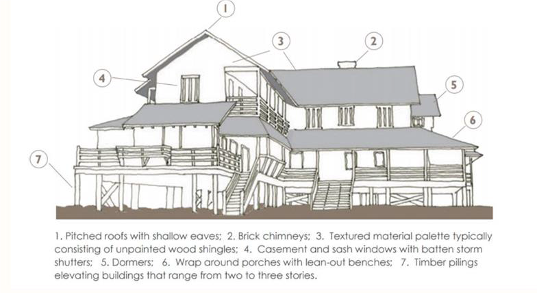
The building architecture historically intrinsic to Nags Head reflected a human scale. These buildings were simple, utilizing natural materials, wide porches and modest detailing. Interior and exterior spaces were used in equal measure and porches were the center of daily life. These early design principles set the tone for the concepts included in these design standards. The successful application of these human scale features will result in buildings and sites that relate well to the pedestrian environment, encourage community activity, and complement their surroundings.
10.85.2. Standards.
When the scale of a building is inconsistent with its site and the scale of surrounding
buildings, it shall be mitigated by design strategies that lessen its visual impact
so as to be compatible with its site and with characteristics of neighboring buildings
and sites. At a minimum, all projects shall incorporate the following design strategies:
10.85.2.1. To encourage a human scale, all buildings shall have an exterior or perimeter building sidewall that is no higher than twelve (12) feet from the floor to the top plate for each building story. Typically, buildings will not exceed three (3) stories. Exceptions include instances where the height requirements for a particular use allow the building to exceed three (3) stories or where building features are specifically exempt from the height requirements of the ordinance.
10.85.2.2. For buildings greater than one (1) story, the highest story of the building shall be incorporated into the roofline with the use of dormers or other roof articulations.
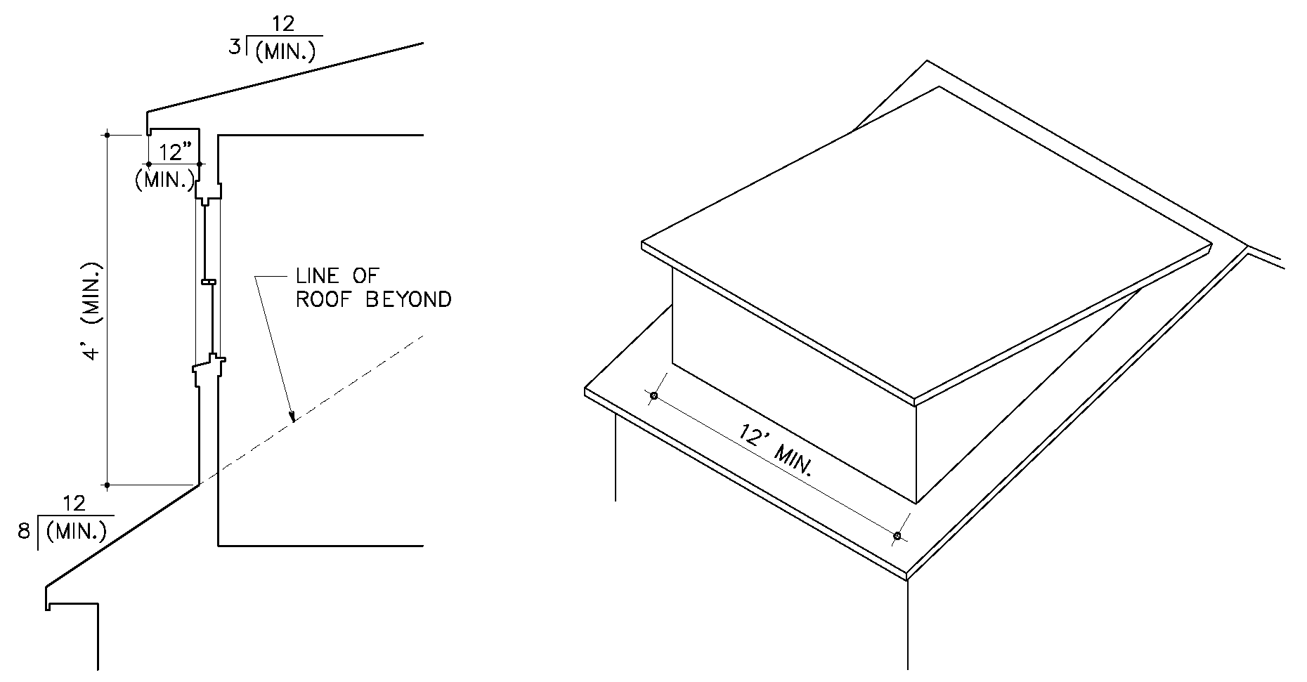 | 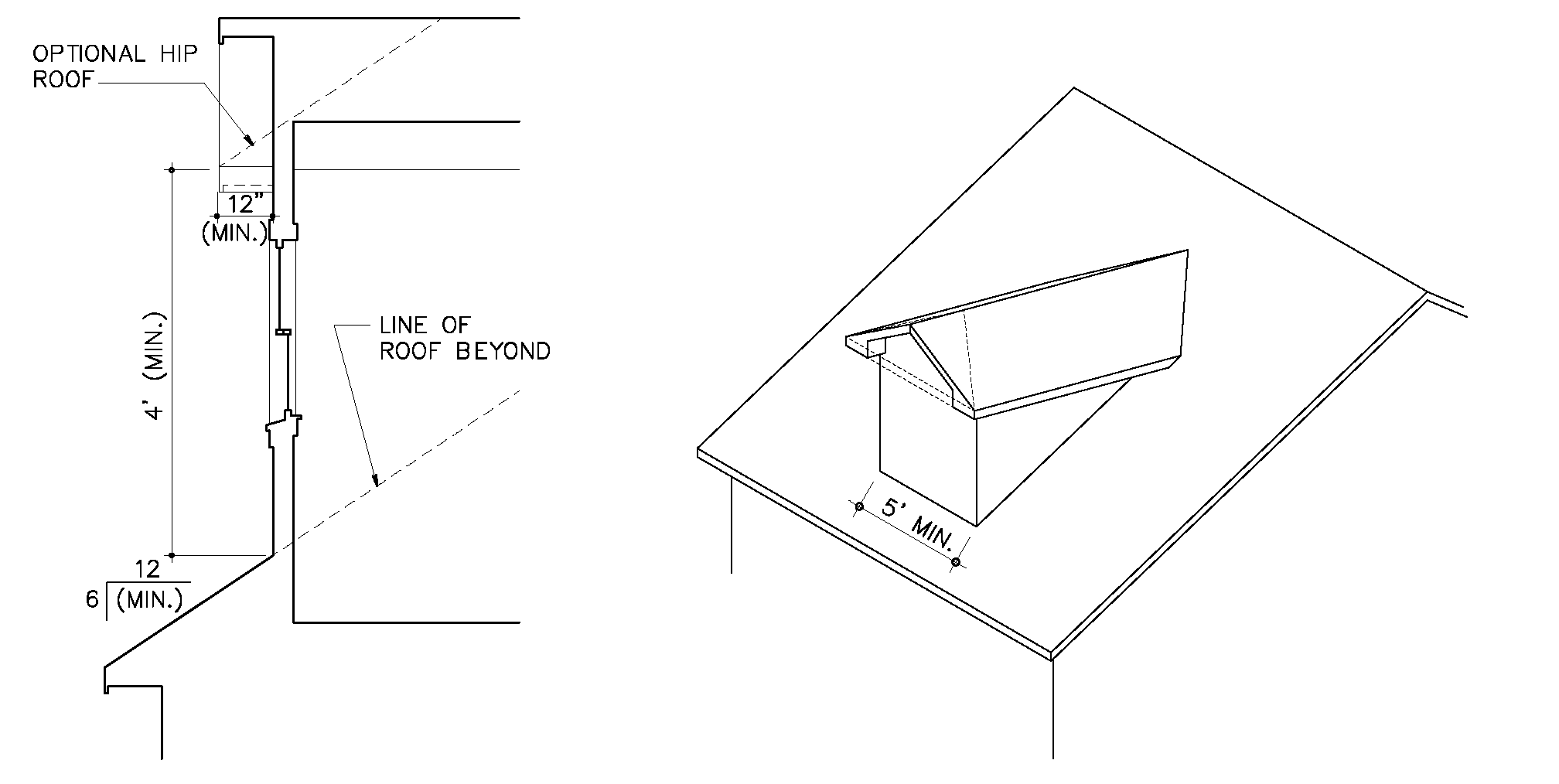 |
10.85.2.3. Larger buildings (greater than 5,000 square feet) or buildings with multiple uses and/or tenants shall be designed with a complex massing that includes rooflines with varying heights, incorporation roof variations, projections/recesses, or smaller additions to a main building.
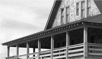
10.85.2.4. Buildings shall provide facade elements which create a comfortable zone at the first floor of the building for people. Examples include but are not limited to covered porches, arcades, siding material changes, and one- or two-story entrances with pitched roofs.
10.85.3. Guidelines.
For larger buildings or projects, designs should consider the following strategies
to break down the overall scale and mass of buildings.
10.85.3.1. Use of irregular building footprints is encouraged to 'create spaces' for human interaction, to reduce the mass of a large rectangular structure, and to cause a roof variation.
10.85.3.2. Use of multiple, smaller scale buildings which may incorporate connecting breezeways and/or walkways.
10.85.3.3. Variations in building footprint and/or form such as square, 'doughnut', 'U' or 'L' shaped buildings, bump-outs, higher floors 'stepped back', or varied rooflines.
Section 10.86 - Building Size/Dimensions.
10.86.1. Intent.
Building sizes are determined based on desired building characteristics for Character
Areas as defined by the Town of Nags Head Comprehensive Plan. These character areas
delineate appropriate building sizes and scales by roadway corridor based on existing
and historic development patterns. NC 12 and SR 1243 comprise the beach road sections
of Town which have a distinct scale and massing defined primarily by residential uses
and small-scale commercial buildings. It is the Town's intent to continue this development
pattern along the two-lane roadways within the Town. US 158/64 have traditionally
been more auto-oriented with larger-scale, local and regional services. Given the
Town's desire for buildings to maintain a residential scale, it is the Town's intent
to regulate the overall size of buildings. In both corridors, the Town encourages
walkability and a human scale appearance that relates well to pedestrians and encourages
social activity.
10.86.2. Standards.
10.86.2.1. Individual buildings along two-lane roadway sections shall not have a habitable area that exceeds five thousand (5,000) square feet, except for instances where the applicant has conducted a sketch plan review in accordance with the procedures prescribed in Article 4, Development Review Process. In these instances, the applicant shall pay particular attention to the design standards and guidelines relative to scale for larger buildings to mitigate the overall visual impact and maintain continuity with existing development. In no instance shall a building fronting a two-lane roadway section exceed ten thousand (10,000) square feet.
10.86.2.2. Individual buildings along five-lane roadway corridors shall not have a habitable area that exceeds twenty thousand (20,000) square feet, except in the case of multi-story hotel buildings within the Town's Hotel Overlay District or institutional uses including schools and hospitals.
10.86.2.3. For any buildings, regardless of the roadway type, with a habitable area of greater than five thousand (5,000) square feet, the applicant shall be required to conduct a sketch plan review of the project in accordance with the procedures prescribed in Article 4, Development Review Process of the UDO.
10.86.2.4. To prevent the appearance of large, disproportionate, and/or "strip" style buildings, the following standards shall apply:
10.86.2.4.1. The length of a principal building shall not exceed three times the width of the building. The length shall be considered the longest dimension of the structure to include porches and open decks. The width shall be considered to be the widest consistent dimension through at least forty percent (40%) of the length of the building, which may be interrupted; for example, if a building has a width of twenty-two (22) feet for 20% of its length, reduces to a width of 18' for 60% of its length, and then widens to a width of 20' for 20% of its length, the building shall be determined to have a width of 20' and shall have a length of no more than 60'.
 | Dimensions—Principal Buildings (To use Y as the width, X must extend at least 40% along the length (Z) of the building.) |
10.86.2.4.2. Properties with multiple buildings shall have each building separated by at least twenty (20) feet and shall not have the appearance of being one structure. For example, multiple buildings may appear to be one structure where there is a continuous roofline over the main structure that carries between two buildings.
10.86.2.4.3. Buildings shall be connected using exterior pedestrian walkways. Covered walkways are allowed; however, the roof covering the walkway shall be generally limited to the walkway itself.
10.86.2.4.4. The minimum width of the enclosed habitable space of a principal building shall be eighteen (18) feet measured at the first-floor level. A building shall be at least eighteen (18) feet wide along at least forty (40) percent of its length. Outside dimensions shall be used in determining length and width. This is defined as the exterior façade covering on the outside of the building (see graphic above).
10.86.2.4.5. Buildings erected in the C-3 commercial services district shall be exempt from these minimum dimensional requirements since the uses permitted in this C-3 district are recognized by the Town as being generally incompatible with residential and commercial uses. Such uses are regulated with appropriate buffering and separation requirements.
Section 10.87 - Building Height.
10.87.1. Intent.
A sudden dramatic change in building height can be incongruous with an existing streetscape.
While each zoning district maintains an overall height limit, the height of a building
shall be visually compatible with the heights of buildings on neighboring sites where
practicable and positively contribute to the overall building design.
10.87.2. Standards.
10.87.2.1. The overall height of buildings will be determined based on the dimensional requirements for each district as found in Article 8, District Development Standards or by any supplemental standards that apply to the use as found in Article 7, Supplemental Regulations.
10.87.2.2. For buildings greater than two stories, the applicant shall incorporate architectural features into the design that mitigate the visual impact of the proposed building.
10.87.2.3. Portions of hotel buildings greater than two stories shall follow the setback requirements for hotels as prescribed in the supplemental standards found in Article 7, Supplemental Regulations.
10.87.3. Guidelines.
Design strategies to mitigate the appearance of tall buildings:
10.87.3.1. Utilize a pitched roof for the upper story that incorporates habitable space with the use of dormers and other roof articulations.
10.87.3.2. Utilize a porch roof or siding material changes between the first and second story to break up the façade.
10.87.3.3. Design higher floors to be 'stepped back' or provide horizontally or vertically varied rooflines along the length of the building.
Section 10.88 - Architectural Design/Elements.
10.88.1. Intent.
It is the Town's goal to encourage design creativity that respects historic development
patterns and is characteristic of the Nags Head community. Design elements and features
that define the Nags Head cottage style architecture can be used to enhance the appearance
of structures and to promote their compatibility with the local natural and built
environment. Appendix B, the Town of Nags Head Residential Design Manual, provides
illustrative examples of Nags Head design elements. The manual also provides specifications
for Nags Head design elements which represent minimum standards that should be adhered
to when incorporating these elements into an overall design. The following design
considerations shall be applied to individual building components.
10.88.2. Roofs.
10.88.2.1. Standards.
10.88.2.1.1. For larger buildings (10,000 square feet or greater), the shape and proportion of the roof shall be articulated so as to lend visual interest and reduce the apparent size of new buildings.
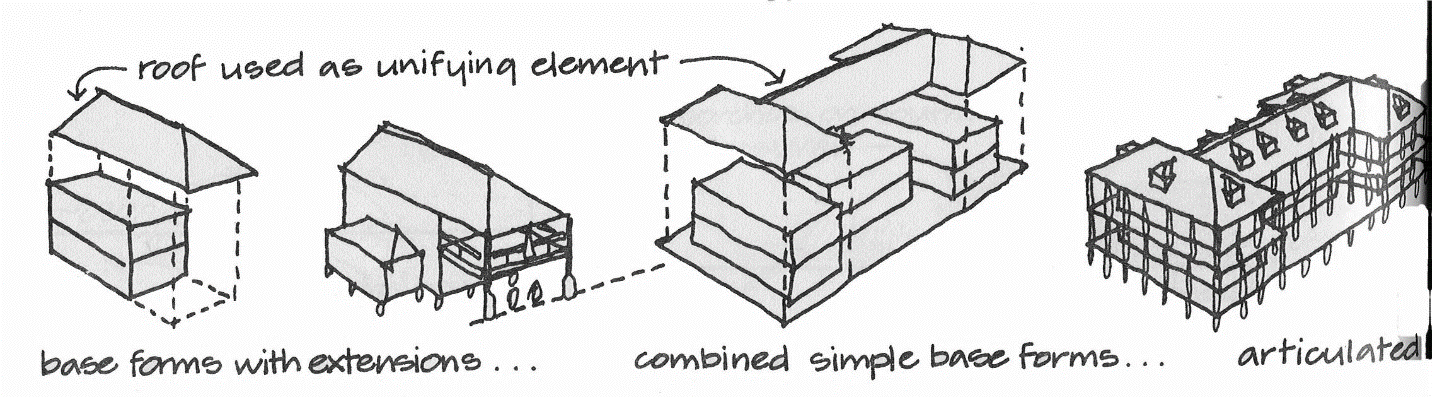
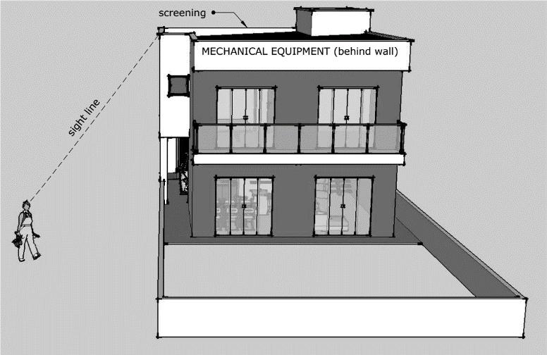
10.88.2.1.2. The roof design shall screen the visual clutter of typical rooftop installations such as any mechanical equipment, exhaust vents, transformer boxes, dish antennas, etc.
10.88.2.2. Guidelines.
10.88.2.2.1. Habitable space within the roof system with dormers to provide light and access is encouraged to reduce the apparent size of the structure.
10.88.2.2.2. Preference shall be given to roofs with a pitch of 4/12 or greater.
10.88.3. Walls.
10.88.3.1. Standards.
10.88.3.1.1. Wall elevations and roofs greater than fifty (50) horizontal feet in length shall have no more than forty (40) horizontal feet without a roof variation.
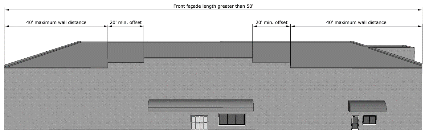
10.88.3.1.2. Walls that face a public street or that are adjacent to the wall of an existing principal building on an adjacent lot shall not be a blank wall and shall be designed with windows, doors, porches, or other building elements that provide scale and openness to the façade.
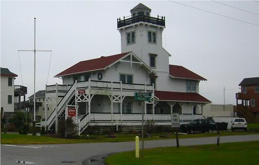
10.88.3.2. Guidelines. Roof variations may consist of dormers, coastal watch towers, bump-outs, or entrance features in the "coastal" or "Old Nags Head" style as described in the Nags Head Residential Design Guidelines (see Appendix B).
10.88.4. Windows and Doors.
10.88.4.1. Standards.
10.88.4.1.1. Windows and doors shall be visually compatible with the architectural style of the building and with local architectural styles.
10.88.4.1.2. Windows shall reflect a residential style. This typically includes the appearance of a double-hung or multi-paned window.
10.88.4.1.3. On the front and each side of the building, windows shall comprise not less than ten (10) percent and not more than forty (40) percent of each building vertical wall area.
10.88.4.1.4. Individual windows shall be no greater than thirty (30) square feet in area.
10.88.4.1.5. Doors shall be no wider than six (6) feet and not taller than eight (8) feet without having at least a 12-inch separation between windows and doors.
10.88.4.1.6. The primary entrance shall face the street or shall face the side of the building that has a pedestrian connection to the street, unless the applicant can demonstrate that the circumstances of a given application merit an alternative orientation.
10.88.4.1.7. The entrance shall be identified through the use of architectural details that may include porches or roofs for shelter, recessing, decorative lighting, trim or railings, in addition to pedestrian walkways connecting to parking areas and public sidewalks.
10.88.4.2. Guidelines.
10.88.4.2.1. Multi-paned or double hung windows are a common element of the local architecture and shall be encouraged.
10.88.4.2.2. Use of metal and glass storefront and curtain wall systems is discouraged and should be minimized.
10.88.4.2.3. Regular pattern: windows are an integral part of a building and shall be richly incorporated on front façades, and to a lesser extent, on side façades. The windows along the front façade, and to a lesser extent, on the side façade, along with the door and other decorative elements shall align horizontally and vertically in order to establish a coherent, orderly pattern and rhythm. Some departure from a perfect grid is desirable in order to create variety in rhythm.
10.88.4.2.4. Vertical form: primary windows and windowpanes shall be vertical in form, with horizontal to-vertical proportions generally measuring 3:5.
10.88.4.2.5. Window style: the primary window style shall be double hung (whether operable or not). A limited number of fixed windows (i.e., those which have one window sash/frame and do not open) may be used where deemed appropriate to the overall design.
10.88.4.2.6. Window molding: windows in wood frame buildings shall have a wide (generally four inches) molding/trim on all sides. Windows in brick buildings shall have a distinct lintel above and sill below, though treatment of the side jams is encouraged also.
10.88.4.2.7. Window to wall proportions: the proportion of window area to wall area on façades shall be carefully considered. Too little window area creates an unwelcoming presence, while the use of too much glass can be jarring in the context of traditional Nags Head style.
10.88.4.2.8. Muntins/mullions: windows (other than storefront windows and small, appropriately designed fixed windows) shall be divided into multiple panes of glass. This approach helps the window "hold" the surface of the façade, rather than appearing like a hole in the wall (the effect produced by a large single sheet of glass).
10.88.5. Building Materials.
The relationship of materials and textures of the exterior of a building shall be
compatible with that of buildings that are traditionally used in Nags Head. Examples
of exceptional design may incorporate a combination of the materials listed below
to provide overall visual interest.
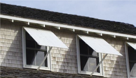
10.88.5.1. Standards.
10.88.5.1.1. For facades of buildings visible from a public way, building siding materials shall be wood or simulated shingle siding, clapboard, board and batten, or other materials commonly used in local architecture.
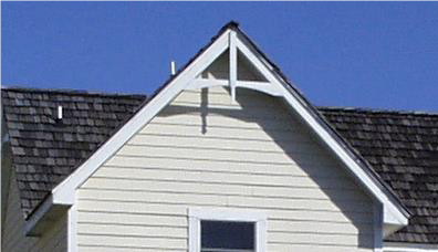
10.88.5.1.2. Use of cinder block, brick, stucco, and T-111 is acceptable for smaller buildings generally no more than one story high and not greater than 2,500 square feet. For larger buildings, these materials should be primarily considered as an accent to the overall design or in areas not visible from the public right-of-way. In no instance shall metal siding be used.
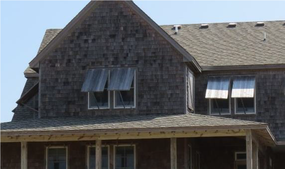
10.88.6. Building Detailing.
10.88.6.1. Standards. Traditional Nags Head buildings utilize detailing to provide visual interest and character to a design. This is achieved through the detailing elements below. Applications shall incorporate one more of the following detailing elements in the building design:
•
exposed rafters
•
gable brackets
•
workable shutters
•
column trim
10.88.6.2. Guidelines.
10.88.6.2.1. These features should be considered carefully within the context of the overall building size and design to retain a proportional scale and appearance.
10.88.6.2.2. Architectural elements and appurtenances should not appear out of character relative to the remainder of the building.
10.88.7. Gas Station and Drive-Through Canopies.
10.88.7.1. Standards. Gas Station and Drive-Through Canopies shall utilize a pitched roof with earth tone metal roofing or shingles reflecting natural materials.
10.88.8. Utilities and Mechanical Equipment.
10.88.8.1. Standards.
10.88.8.1.1. Mechanical equipment at ground level shall be placed away from public streets and buildings on adjacent sites.
10.88.8.1.2. All mechanical equipment shall be screened from public view.
10.88.8.1.3. Mechanical equipment and antennas located on rooftops shall be camouflaged as a normal architectural feature of the building, or hidden by a decorative cornice or parapet wall, as seen from the ground.
10.88.8.1.4. All utility equipment (includes meters, boxes, valves and similar equipment but does not include overhead power lines, light poles and similar equipment) shall be designed, located or screened to be as inconspicuous as possible and shall not be located on the street-side of a principal structure.
10.88.8.1.5. All utility lines serving new development and significant redevelopment shall be placed underground whenever practicable.
10.88.9. Trash and Recycling.
10.88.9.1. Standards.
10.88.9.1.1. All trash and recycling receptacles and storage areas shall be located and substantially screened from public view.
10.88.9.1.2. All non-vegetative screening used to block public view of trash and recycling receptacles and storage areas shall be made of materials compatible in color and type to the principal structure(s) on the property.
Section 10.89 - Intent.
Site designs shall consider the unique natural features of the site and complement the positive features of surrounding property. Site design will strive to create a sense of place while maintaining compatibility with adjacent land uses, encouraging walkability, fostering social interaction and community vitality, promoting safe and efficient movement of pedestrians and vehicles, preserving and/or enhancing natural areas, and minimizing nuisances associated with noise, high levels of activity, and stormwater runoff.
Section 10.90 - Building Footprint and Orientation.
10.90.1. Along the Beach Road (NC 12/SR 1243) and Other Two-Lane Roadways.
10.90.1.1. Standards.
10.90.1.1.1. Buildings shall be oriented so that the front of the building and primary entrance faces the street, except in instances where the side of the building contains the primary entrance which has a pedestrian connection to the street. Buildings shall be oriented adjacent to the front property line unless the applicant can demonstrate that the circumstances of a given application merit an alternative orientation. For corner lots, NC 12/SR 1243 shall be considered the front of the building.
10.90.1.1.2. Generally, the building shall be aligned with the front of the property (to within 5' and 15' of the front lot line) for at least thirty (30) percent of the property frontage.
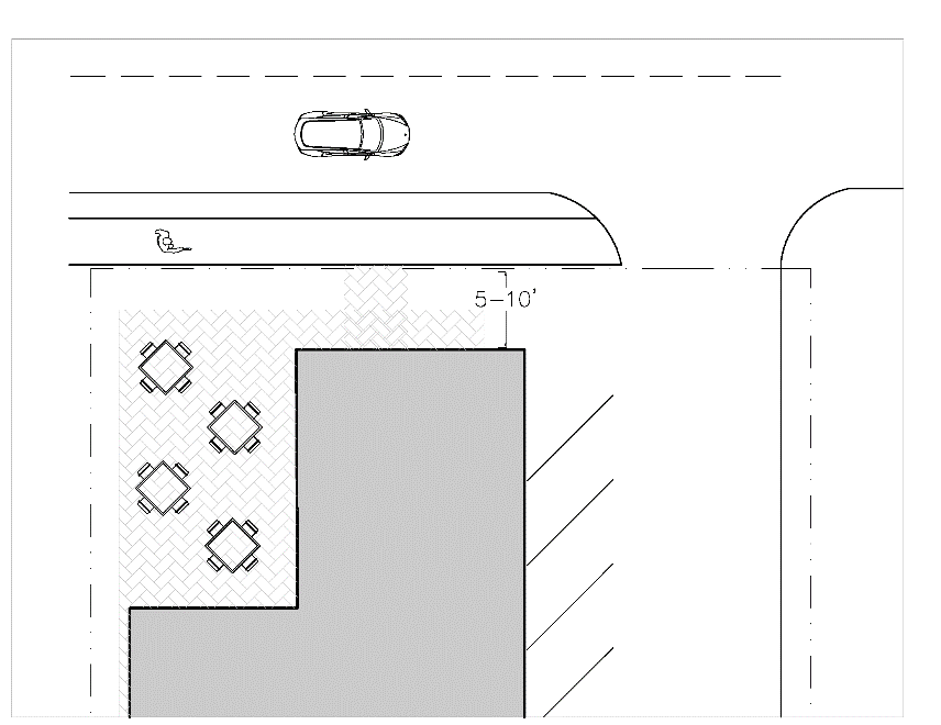
10.90.1.2. Guidelines. Desirable examples of building orientation include a human-scaled building wall located adjacent to a street frontage, and site elements such as clearly defined front entrances, landscaping, lighting, and off-street parking located to the side or rear of buildings. Compatibility shall be determined based on the pattern of buildings and spaces along the street frontage, placement of the building on the lot, and the building footprint in relation to lot size and to nearby buildings.
10.90.2. For US 158/US 64/264.
10.90.2.1. Standards.
10.90.2.1.1. Buildings shall be setback a minimum distance from the roadway.
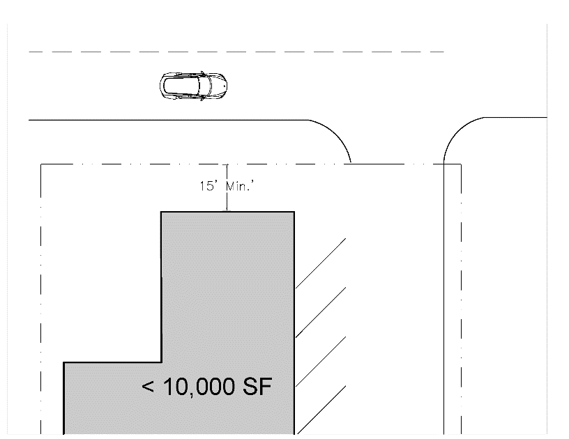
10.90.2.1.2. Buildings less than ten thousand (10,000) square feet shall be setback a minimum of 15' from the front property line.
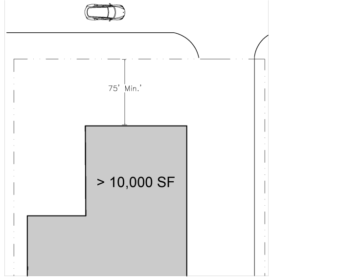
10.90.2.1.3. Buildings greater than 10,000 square feet shall be setback a minimum of 75' from the front property line.
10.90.3. Side and rear yard setbacks will be determined based on the dimensional requirements for each district as found in Article 8, District Development Standards or by any supplemental standards that apply to the use as found in Article 7, Supplemental Regulations.
10.90.4. Where these standards conflict with the supplemental standards for a specific use, the supplemental standards shall apply.
Section 10.91 - Parking Lot Orientation.
10.91.1. Along the Beach Road (NC 12/SR 1243) and Other Two-Lane Roadways.
10.91.1.1. Off-street parking must be located to the side or rear of the building. For corner lots, NC 12/SR 1243 shall be considered the front of the building.
10.91.1.2. No parking shall be located in the area between the front wall of the principal building and the front property line unless the applicant can demonstrate that the circumstances of a given application merit an alternative orientation.
10.91.1.3. No new vehicular access drives or service areas shall be located between the front property line and the front wall of the building, unless the Planning Board determines that no reasonable alternative exists for safe traffic flow into and out of the site and within the site.
10.91.1.4. The area between the front wall of a new, expanded, or reconstructed building and the front property line shall be designed and maintained as a non-vehicular area and shall be either landscaped or improved with pedestrian or customer amenities.
10.91.1.5. It is the intent of this ordinance to create a direct relationship between the habitable portion of buildings and the pedestrian environment. Buildings elevated a full story above the street will feel disconnected from the street environment. To this end, the first habitable floor of buildings directly adjacent to the street frontage shall be elevated no higher than three (3) feet above adjacent grade, or the minimum regulatory flood protection elevation, whichever is higher.
10.91.2. For US 158/US 64/264.
10.91.2.1. Sites shall be designed to screen large parking areas, either by locating parking to the rear of buildings or through the use of landscaping/buffering as required in the landscaping and buffering section of these design standards.
Section 10.92 - Street Access, Parking Lot Design, and Pavement Standards.
10.92.1. Intent.
The intent of these standards is to promote safe, convenient and sufficient access
to all properties by vehicles, pedestrians and bicyclists. The following standards
shall apply to all uses, unless otherwise noted.
10.92.2. Standards.
10.92.2.1. Street Access and Internal Circulation.
10.92.2.1.1. The street access and internal circulation plan of parking lots shall be reviewed by the Town Engineer for consistency with generally accepted engineering practices and standards.
10.92.2.1.2. Failure to comply with such standards may result in a request for site plan modifications or denial of a permitting request.
10.92.2.2. Driveway Control Dimensions.
10.92.2.2.1. Width of Driveways (W).
10.92.2.2.1.1. The width of driveways shall be measured at the property line and shall be within the specified minimum and maximum limits.
10.92.2.2.1.2. A driveway with two-way operations shall have a minimum twenty-two (22) foot and a maximum of thirty-six (36) foot width.
10.92.2.2.1.3. A driveway with one-way operation shall have a minimum twelve (12) foot and a maximum twenty-four (24) foot width.
10.92.2.2.1.4. The need for wider driveways will be considered on a case-by-case basis only after justification of actual necessity but should not exceed forty (40) feet.
10.92.2.2.2. Commercial Driveway Design. Shall consider, but not be limited to, the following:
10.92.2.2.2.1. Design vehicle type,
10.92.2.2.2.2. Approaching speed,
10.92.2.2.2.3. Driveway transition,
10.92.2.2.2.4. Channelization,
10.92.2.2.2.5. Safety,
10.92.2.2.2.6. Mobility,
10.92.2.2.2.7. Site physical features,
10.92.2.2.2.8. Intended traffic volume, and
10.92.2.2.2.9. Intensity among the many variables related to the driveway layout.
The Town Engineer shall review driveway layout and designs for consistency with generally accepted engineering practices and standards. High intensity or traffic volume generators shall require the submission of Traffic Impact Study to review the potential impacts of proposed or revised developments.
10.92.2.2.3. Driveway Angle (Y).
10.92.2.2.3.1. The recommended driveway angle, Y, for a full access driveway is 90 degrees.
10.92.2.2.3.2. The angle of the two-way operation driveway with respect to the pavement edge shall not be less than seventy-five (75) degrees or greater than ninety (90) degrees.
10.92.2.2.3.3. For one-way or right-in/right-out driveways, driveway angles between forty-five (45) and ninety (90) degrees may be allowed on a case-by-case basis.
10.92.2.2.4. Edge Clearance (E).
10.92.2.2.4.1. All portions of a commercial driveway including the returns shall be between two frontage boundary lines of the current or future right-of-way line.
10.92.2.2.5. Driveway Return (R).
10.92.2.2.5.1. The radius of the street-type driveway connection, R, shall be within a twenty (20) feet minimum and forty (40) feet maximum. However, the maximum radii dimension may be exceeded as an exception if larger radii are needed to accommodate larger vehicles expected to frequent a proposed development such as commercial service entrances.
10.92.2.2.5.2. Compound curves for driveway radii shall be prohibited.
10.92.2.2.6. Distance Between Driveways (D).
10.92.2.2.6.1. Where more than one driveway is permitted along a single property frontage, the distance, D, measured along the right-of-way line between the tangent projections of the inside edges of adjacent driveways shall be at least 100 feet.
10.92.2.2.7. Special Curb Cut Requirements.
10.92.2.2.7.1. A lot fronting US 158, NC 12/US 64/264, or SR 1243 must have six hundred (600) feet of frontage along the street before two curb cuts are allowed on the same street.
10.92.2.2.7.2. Nine hundred (900) feet of frontage is needed along either of these streets before three curb cuts are allowed on the street.
10.92.2.2.7.3. In no case shall there be more than three curb cuts on any one of the above streets.
10.92.2.2.7.4. Curb cuts in excess of one, on streets other than those mentioned above, are allowed if the Board of Commissioners determines that more than one curb cut is necessary or desirable to facilitate traffic flow.
10.92.2.2.8. Vision Clearance (C).
10.92.2.2.8.1. The minimum corner clearance, C, of the proposed driveway shall be at least fifty (50) feet from the point of tangency of the radius curvature of any intersecting streets. The recommended corner clearance distance shall be up to one hundred (100) feet in instances where the property frontage allows for this.
10.92.2.2.8.2. For full movement driveway connections at signalized intersections, the corner clearance may be required to extend beyond one hundred (100) feet when the property's road frontage allows. This is to avoid interference with the traffic signal operations and resulting traffic queues.
10.92.2.2.8.3. The radius of the driveway should not encroach on the minimum corner clearance.
10.92.2.2.8.4. No planting, structure, sign, fence, or other obstruction more than three (3) feet in height shall be placed or maintained within a ten (10) foot x 70-foot triangular area (see graphic below).
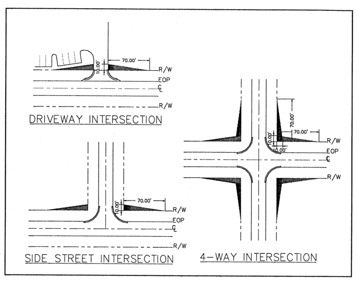
10.92.2.2.9. Driveway Profile (P).
10.92.2.2.9.1. The grade of commercial driveways within the right-of-way shall not exceed ten (10) percent.
10.92.2.2.10. Channelization.
10.92.2.2.10.1. Various types of channelization may be required to be incorporated into the driveway design.
10.92.2.2.10.2. The Town Engineer shall determine if the necessity of restrictive medians in accordance with generally accepted engineering practices and standards.
10.92.2.2.10.3. At a minimum, an above ground stop sign, and ground painted stop bar shall be placed in advance of the point of egress onto the adjoining street.
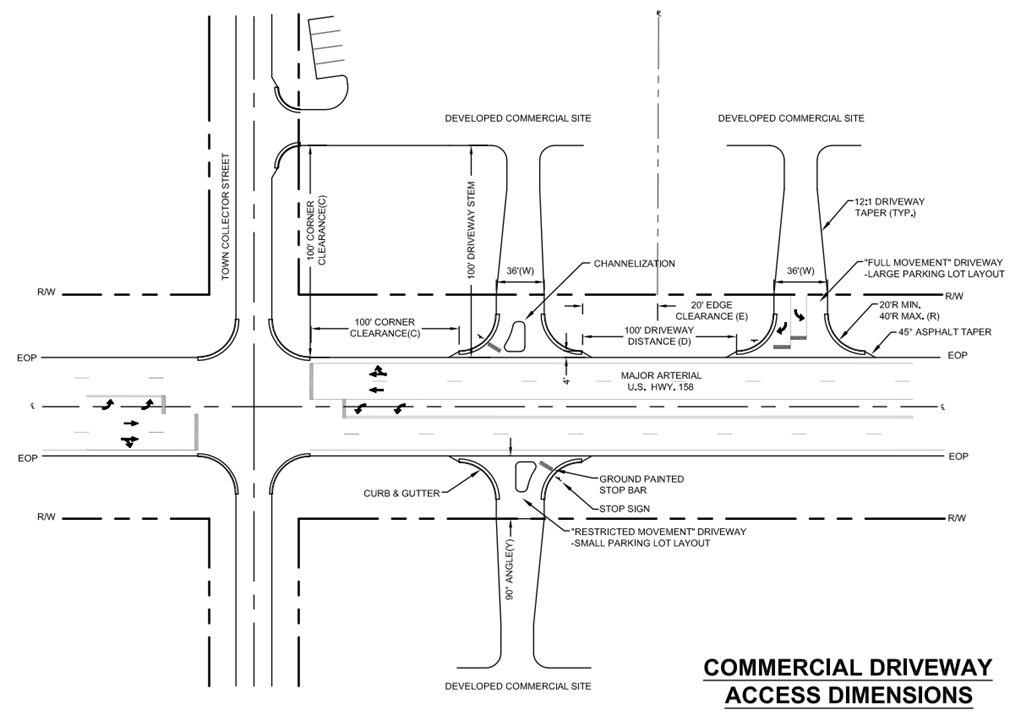
10.92.3. Corner Lots to Utilize Side Street Access.
Due to the limited amount of land available within the zoned areas of the Town for
major thoroughfare rights-of-way and the traffic hazard involved in frequent entrances
and exits from a major thoroughfare, it is the intent of this UDO to keep driveways
and street intersections along major thoroughfares US 158, NC 12, SR 1243, and US
64/264 to the minimum possible. In any district established by this UDO where a lot
abutting any of these major thoroughfares abuts any other dedicated public right-of-way,
the side street public right-of-way shall be used for access rather than direct access
from a major thoroughfare.
10.92.4. Inter-parcel Driveway Connections.
10.92.4.1. All abutting commercial parking lots are encouraged to provide inter-parcel driveway connections with adjoining commercial parcels, particularly along the US 158 frontage.
10.92.4.2. Provision of an inter-parcel connection (for connection with existing or future connections on adjoining properties) will receive a four (4) parking space reduction in required parking and a two hundred (200) square foot reduction on lot coverage.
10.92.4.3. Inter-parcel connection shall be a minimum twenty-two (22) feet in width for two-way traffic.
10.92.4.4. When inter-parcel access is provided, an inter-parcel access easement shall be recorded with the Dare County Register of Deeds.
10.92.5. Internal Drive Aisle and Parking Space Dimensional Requirements.
All commercial parking areas shall conform to the following:
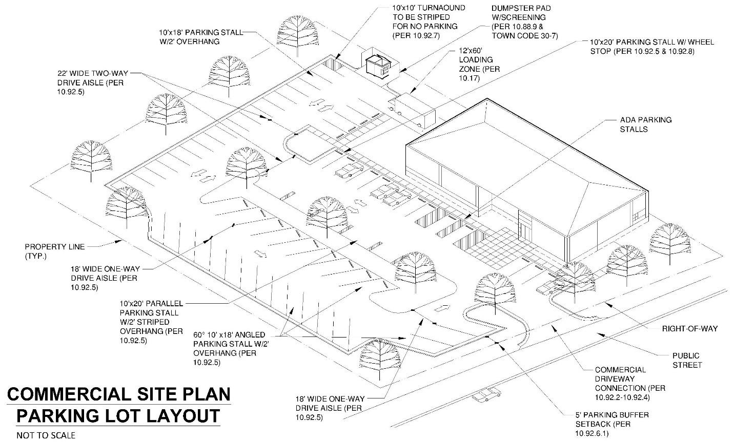
10.92.6. Parking and Drive Aisle Setbacks.
10.92.6.1. Unless otherwise specified, a required setback of not less than five (5) feet shall separate parking and loading areas from all front, side, and rear property lines.
10.92.6.2. Where off-street parking is provided between the building and the street right-of-way line, a parking lot buffer of at least ten (10) feet in width shall be provided between the parking lot and the street right-of-way line in accordance with the standards included for parking lot buffers contained Article 10, Part I, Buffering and Vegetation Preservation General Requirements.
10.92.7. Dead End Drive Aisle.
One deadend turnaround shall be provided for parking lots where dead ends exceed either
one hundred (100) feet in length or twelve (12) parking spaces in accordance with
the commercial parking lot layout diagram.
10.92.8. Wheel Stops.
10.92.8.1. All parking spaces which abut open space or buffer space shall have a fixed curb or wheel stop of six (6) inches in height.
10.92.8.2. Allowances shall be made for two (2) feet of overhang within the parking space so that no part of any car can be located within the required setback.
10.92.9. Curbs.
At drive aisle intersections with adjoining open space, curbs shall be installed along
the entire drive aisle perimeter radius (from tangent to tangent) to protect adjoining
open space from wheel travel.
10.92.10. Markings.
Each parking space shall be marked and maintained so as to be distinguishable.
10.92.11. Fire Lanes/Access Roads.
10.92.11.1. The Fire Official shall have the authority to designate fire lanes as deemed necessary for Fire Department access.
10.92.11.2. The requirements for installation of a fire lane shall be subject to the fire code.
10.92.11.3. During the site plan review process, the Fire Chief or Fire Marshal may require a drive aisle of up to twenty-six (26) feet in width in specified locations if it is determined that this is necessary to accommodate fire access roads or fire service operations.
10.92.11.4. Fire Lanes shall be marked with permanent signage stating "NO PARKING FIRE LANE"- with minimum dimensions of twelve (12) inches wide by eighteen (18) inches high with red letters on a white reflective background.
10.92.12. Safety on Busy Streets.
Sufficient maneuvering space shall be provided so that no vehicle will be required
to back into the public right-of-way of NC 12, US 158, and SR 1243.
10.92.13. Drive-Through.
10.92.13.1. Drive-throughs shall not be permitted on properties fronting two-lane roadways within the Town.
10.92.13.2. Drive-through lanes shall only be placed in areas that will not interfere with the safe movement of pedestrians and vehicles in parking and driveway areas.
10.92.13.3. Drive-throughs shall be designed with appropriate queuing lanes to prevent traffic from backing up into Town streets and thoroughfares. Drive-through queuing lanes shall be designed to hold a minimum of ten vehicles and separated from the main drive-aisle serving parking and loading areas.
10.92.13.4. Drive-through windows and queuing lanes shall be oriented away from residential uses or zoning districts.
10.92.13.5. For properties fronting both US 158 and NC 12, drive-throughs shall be oriented so that access is from US 158 or from a side street in cases where the property is a corner lot.
10.92.14. Surface Materials Appropriate for Use.
10.92.14.1. Parking lot entrances shall be graded and paved only with asphalt or concrete extending a minimum of fifty (50) feet from the right-of-way as measured along the centerline of the parking lot entrance.
10.92.14.2. Interior drive aisles established beyond the required asphalt or concrete parking lot entrance shall be graded and paved with asphalt, concrete, porous concrete, porous asphalt or concrete pavers in accordance with accepted engineering practices.
10.92.14.3. Required parking spaces shall be graded and paved with asphalt, concrete, gravel or alternative permeable pavement materials in accordance with the Town's recommended standard details manual.
10.92.14.4. The Town encourages use of pervious materials and new technologies that provide for safe and efficient driveway and parking areas and that appropriately address stormwater runoff issues. A minimum of twenty (20) percent of the surface area of the parking area and drive aisles shall be constructed using permeable surface materials, unless it can be demonstrated that a topographic or hydrologic constraint exists that would limit its use and effectiveness.
10.92.14.5. For religious complexes and public facilities which host special events, up to thirty (30) percent of the required parking area may utilize reinforced turf products. Turf parking areas may not count toward parking requirements for other commercial uses as part of a shared parking agreement. The outer perimeter of a turf parking area shall be clearly delineated by above ground markers with defined points of ingress/egress and shall not require individual parking stall wheel stops.
10.92.14.6. For all other uses, up to twenty (20) percent of the required parking area may utilize reinforced turf products and must use curb stops to clearly delineate the parking space.
10.92.14.7. For the purposes of determining lot coverage, the total square footage of permeable pavement materials, including reinforced turf products, is multiplied by 0.67.
10.92.15. Pedestrian and Bicycle Access/Facilities.
10.92.15.1. Buildings with uses requiring public access shall provide the primary pedestrian access from the street front or from a pedestrian way designed to facilitate access in shopping centers, mixed use sites, or group developments.
10.92.15.2. The approaches to loading and unloading areas in commercial districts shall be designed to minimize conflict with onsite vehicular, pedestrian and bicycle traffic and with adjacent residential uses.
10.92.15.3. A bike rack shall be provided on all properties in non-residential use with parking lots having ten (10) or more vehicle parking spaces, when such properties are located on the east side of US 158 and have frontage on a two-lane roadway; such bike racks shall support at least five (5) bicycles and be accessible to the public.
(Ord. No. 20-01-002, Art. III, Pt. III, 1-8-2020; Ord. No. 25-10-002, Art. III, Pt. II, 10-1-2025)
Section 10.93 - Landscaping, Buffering, and Vegetation Preservation.
10.93.1. Intent.
The purpose of a landscape buffer is to help provide transition between different
types of land uses, to break up or soften the appearance of paved surfaces, and to
provide the shade and greenery necessary to create a livable environment. Buffers
shall be required as prescribed in the supplemental standards for specific uses and/or
as described in the standards below.
10.93.2. General Requirements.
10.93.2.1. The table below specifies the number of plants, by type, for each required row of plants for every one hundred (100) feet of buffer yard length. For example, if the buffer yard requires two rows of plants, the numbers in the table below shall be doubled for every 100 feet of buffer yard length. Due to varying conditions in different areas of Town for wind and salt exposure, the table differentiates the required type of plant material by planting zone to improve survivability and maintenance of plant material.
10.93.2.2. Required species of plant material and appropriate planting zones are defined by the Town of Nags Head Vegetative Planting Guidelines, which can be obtained from the Town of Nags Head Planning and Development Department.
10.93.2.3. Ornamental grasses that will grow to a mature height of at least three (3) feet may be substituted for required shrubs in the beach planting zone.
10.93.2.4. Except as otherwise specified herein, at a minimum, fifty (50) percent of the number of plants shall be locally adapted, evergreen species.
10.93.2.5. Landscaping plans are encouraged to include a variety of species to promote overall diversity of plant materials within the Town. Applicants may propose other non-invasive plant material not included in the Town of Nags Head Vegetative Planting Guidelines if it can be demonstrated that it is equal to or exceeds the plant material in the guidelines in terms of size, hardiness and overall quality.
10.93.2.6. Landscaping plans must include installation specifications and a maintenance plan to address long-term viability of proposed landscaping.
10.93.2.7. Properties that provide for drip irrigation of landscape materials or a landscape plan that consists entirely of native planting materials as specified in the Town of Nags Head Vegetative Planting Guidelines may reduce the overall number of required plantings by ten (10) percent.
10.93.3. Standards.
10.93.3.1. Parking Lot Buffers.
10.93.3.1.1. For all sites where off-street parking is provided between the building and the street right-of-way line, a buffer strip of at least ten (10) feet in width shall be provided between the parking lot and the street right-of-way line.
10.93.3.1.2. The parking lot buffer shall consist of one row of plant material in accordance with the Table included in the general requirements section above.
10.93.3.1.3. Trees shall be a minimum height of five (5) feet when installed and shall maintained at the expected maturity height for each tree species.
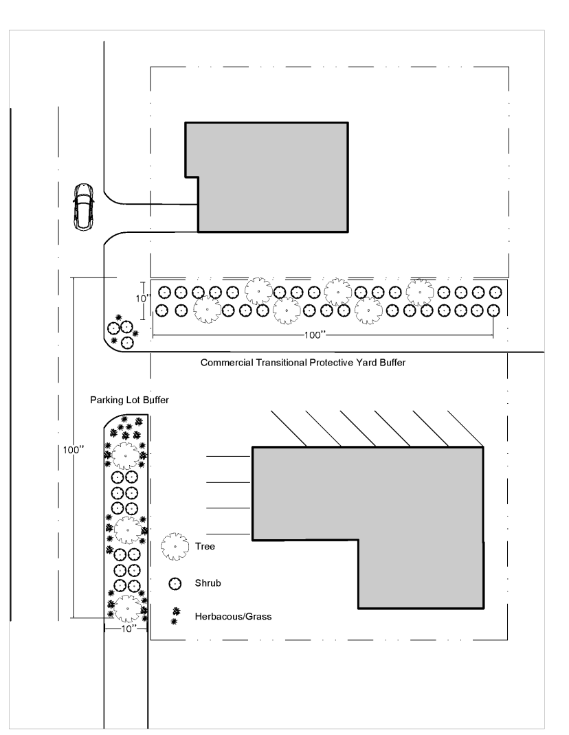
10.93.3.1.4. Shrubs shall be a minimum height of one and a half (1½) feet when installed. Fifty (50) percent of the required shrubs are expected to reach a height of five (5) feet within three (3) years. The remainder of the plant material may be low growing plants such as dwarf yaupon holly, shore juniper, indian hawthorne and false indigo, which need not exceed three feet in height at maturity.
10.93.3.1.5. Ornamental grasses that will grow to a mature height of at least three (3) feet may be substituted for required shrubs in the beach planting zone.
10.93.3.1.6. For lots adjacent to US 158 and US 64/264 with existing dune elevations or berms of more than five (5) feet in height from street grade, low growing shrubs or groundcover such as dwarf yaupon holly, shore juniper, indian hawthorne and false indigo, which need not exceed three feet in height at maturity, may be utilized to meet buffering requirements in addition to the dune or berm elevation.
10.93.3.1.7. For parking lot buffers, clustering and/or random spacing of plants and trees is encouraged to produce a natural appearance in the landscape.
10.93.3.2. Commercial Transitional Protective Yards. This section requires commercial transitional protective yards to be provided and maintained when non-residential land uses (i.e., other than single-family or two-family) are adjacent to a residential use or residential zoning district. This yard is necessary to protect residential or otherwise incompatible uses from the traffic, noise, glare, trash, activity, vibration, odor, visual disorder, and other harmful or noxious effects likely to be emitted by or associated with a more intensive use in a commercial zoning district. Commercial transitional protective yard regulations are also required to prevent adverse community appearance, to protect the character of the Town, to conserve building and land values, and to provide adequate light and air.
10.93.3.2.1. Where a use other than a single-family or two-family use abuts a residential use or residential zoning district, a buffer strip of at least 10 feet in width along the entire length of the lot shall be provided. The buffer yard shall consist of two rows of plant material in accordance with the Table included in the general requirements section above. This requirement shall also apply in the following circumstances:
10.93.3.2.1.1. When a high impact use listed below abuts a residential use which is located within a commercial zoning district.
10.93.3.2.1.2. Where a use other than a single-family or two-family use abuts a residential district along a street right-of-way line on any street other than its primary street frontage.
10.93.3.2.2. Where a high impact use listed below abuts a residential zoning district, a buffer strip of at least twenty-five (25) feet in width along the entire length of the lot shall be provided. The buffer yard shall consist of three rows of plant material in accordance with the Table included in the general requirements section above.
10.93.3.2.3. For commercial transitional protective yards, all plant material shall be a minimum height of five (5) feet when installed and shall be maintained at the expected maturity height for each plant species.
10.93.3.2.4. Ornamental grass/herbaceous plants shall not be required for commercial transitional protective yards.
10.93.3.2.5. Septic fields, either active or repair, septic tanks, and vehicular accessways and parking areas are not permitted in any required commercial transitional protective yard, and it is further provided that customary accessory buildings may be located in any rear or side yard no closer than the required buffer yard width plus five (5) feet to any property line.
10.93.3.3. High Impact Uses. High impact uses are particular uses of land, which considered as a whole because of their peculiar or operational and physical characteristics are expected to have an adverse effect on adjoining or adjacent properties. High impact uses include, but are not limited to:
10.93.3.3.1. Asphalt/concrete processing facilities.
10.93.3.3.2. Auto repair facilities.
10.93.3.3.3. Banking institutions.
10.93.3.3.4. Car washes.
10.93.3.3.5. Drive-in, take-out and drive-through restaurants.
10.93.3.3.6. Schools.
10.93.3.3.7. Fueling station.
10.93.3.3.8. Group developments.
10.93.3.3.9. Hospitals and heliports.
10.93.3.3.10. Hotels.
10.93.3.3.11. Junkyards, scrap yard, and salvage facilities.
10.93.3.3.12. Microbreweries.
10.93.3.3.13. Mini-storage facilities (self-storage).
10.93.3.3.14. Mixed-use development.
10.93.3.3.15. Public works facility.
10.93.3.3.16. Non-profit/outreach center with aquatic fitness facility.
10.93.3.3.17. Nursing homes.
10.93.3.3.18. Commercial outdoor recreation uses, including but not limited to, amusements, go-cart tracks, mini-golf courses, commercial swimming pools, tennis courts, outdoor sport climbing walls, fishing piers, and watercraft rental establishments.
10.93.3.3.19. Private clubs.
10.93.3.3.20. Real estate rental management facility.
10.93.3.3.21. Retail stores greater than 10,000 square feet gross floor area.
10.93.3.3.22. Sexually oriented businesses.
10.93.3.3.23. Shopping centers.
10.93.3.3.24. Trade centers or multi-use building.
10.93.3.3.25. Veterinary clinics with animal boarding.
10.93.3.3.26. Any accessory use serving the above, including parking; the permanent or temporary storage of vehicles associated with the use; the loading, unloading, or storage of merchandise or material; service areas or docks; or the storage or collection of refuse.
10.93.3.3.27. Large Multi-Family Dwelling Development.
10.93.3.4. Subdivision Buffers. All subdivisions in the R-3 high density residential zoning district, containing lots fronting on US 158 shall provide the following:
10.93.3.4.1. The first fifteen (15) feet of lot depth adjacent to the right-of-way shall be left undisturbed and in its natural state. This subsection shall not preclude the construction of any required driveway, underground placement of utilities, nor the placement of a sign.
10.93.3.4.2. A vegetative buffer shall be provided immediately adjacent to the undisturbed area. The buffer shall be a minimum width of ten (10) feet with two (2) rows of planting material that are a minimum height of five (5) feet when installed that are expected to achieve a height of eight (8) feet within three (3) years. The use of sand or earth berms is encouraged, in which case the berm slope shall not exceed three to one (3:1). The minimum acceptable methods for buffering all other boundaries of the site shall include:
10.93.3.4.2.1. A vegetative buffer of a minimum width of ten (10) feet with two (2) rows of planting material placed on centers that are a minimum height of five (5) feet when installed;
10.93.3.4.2.2. Sand or earth berms that will not exceed a slope of three to one (3:1) to a height of five (5) feet, stabilized with grasses and shrubs appropriate to the site; or
10.93.3.4.2.3. A combination of the above designed to be a minimum height of five (5) feet when installed. The selected materials for buffering must be approved by the UDO Administrator prior to the issuance of a building permit.
10.93.3.5. Buildings Adjacent to Street Frontage. Building walls adjacent to a street frontage shall include foundation landscaping directly adjacent to the building to screen any crawl space, stem wall, lattice work, or open parking areas.
10.93.3.6. Conflict with Other Regulations.
10.93.3.6.1. Nothing in this section shall reduce the minimum requirements of any other buffer yard requirement in this UDO.
10.93.3.6.2. Whenever two or more buffer yards are simultaneously applicable, the more stringent regulation shall control.
10.93.3.7. Interior Parking Lot Landscaping.
10.93.3.7.1. All parking lots containing ten parking spaces, or more shall provide interior parking lot landscape islands as outlined in this section.
10.93.3.7.2. Interior parking lot landscaping shall be provided at a minimum rate equal to ten percent of the total area of parking spaces. (For example, ten parking spaces at ten feet × 20 feet = 2,000 square feet will require 200 square feet of interior parking lot landscaping.)
10.93.3.7.3. To qualify as "interior" parking lot landscaping, landscape islands shall be situated either in-between parking spaces, between parking spaces and travel aisles, or between parking rows.
10.93.3.7.4. Interior parking lot landscape islands may be utilized for stormwater management with designs that direct and capture stormwater runoff from parking area surfaces.
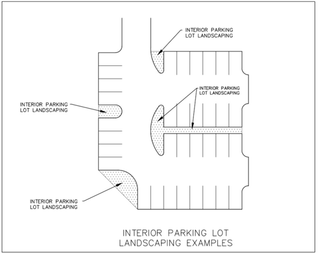
10.93.3.7.5. Proposed plantings within required interior parking lot landscape islands must comply with stormwater and vehicular overhang requirements. Planting materials must not obstruct sight distance and shall provide a permanent non-erosive vegetative groundcover.
10.93.3.7.6. Interior parking lot landscape islands shall count towards vegetation preservation and planting requirements found in this section and may also be utilized as part of required stormwater management measures.
10.93.3.8. Vegetation Preservation/Planting Requirements.
10.93.3.8.1. Intent. It is the intent of this section to require, to the extent possible, the preservation of existing vegetation during the development process. Except when necessary to provide access to a site or to ensure the safety and security of people and property, any existing healthy trees that are six inches or greater in caliper, located within a public right-of-way or undeveloped required yard shall be retained unless approved for removal during site plan review. In addition, every reasonable effort shall be made to protect and retain existing trees and shrubs not actually lying in planned roadways, drainage ways, building foundation sites and construction activity areas. This section includes minimum requirements for preservation of existing vegetation. Where this is not possible, planting of new vegetation may be utilized to meet the requirement utilizing a sliding scale.
10.93.3.8.2. Vegetation Preservation Requirement.
10.93.3.8.2.1. Projects for new development shall preserve a minimum of ten (10) percent of the lot's total area with existing natural vegetation and/or dune elevations.
10.93.3.8.2.2. Areas designated for the preservation of existing vegetation shall contain examples of significant native or locally adaptive vegetation, which may include, but shall not be limited to, combinations of trees, shrubs, forbs and grasses that are listed in the Town of Nags Head Vegetative Planting Guidelines.
10.93.3.8.2.3. Areas designated for preservation of grasses and dune plants must contain significant dune elevations.
10.93.3.8.2.4. Areas designated for the preservation of existing vegetation shall be left undisturbed and in their natural state; however, weeds, vines and similar ground vegetation may be removed, provided that no land-disturbing activity occurs and that the leaf litter, mulch, top soil and similar material are left undisturbed.
10.93.3.8.2.5. The area of existing vegetation to be preserved may be calculated using recent aerial photography and may include the canopy that is present within the property boundaries.
10.93.3.8.3. Vegetation Planting in Lieu of Preservation.
10.93.3.8.3.1. If existing vegetation cannot be preserved to meet the above requirement, new vegetation may be planted in accordance with the schedule below to meet the requirement. If no vegetation is preserved, the planting of a minimum of fifteen (15) percent of the lot's total area shall be required. At a minimum, fifty (50) percent of the required planted material shall consist of locally adapted tree species that are a minimum height of three (3) feet and one (1) inch in diameter measured at one-half foot above grade when planted. The remainder of the required plantings may be live shrubs measuring at least one and one-half feet in height when planted. A minimum of one-half of this vegetation must be located in the front or side yards of the proposed development.
10.93.3.8.3.2. When new plantings are used to meet the requirements of this section, trees shall count as one hundred (100) square feet of required planting area and shrubs shall count as fifty (50) square feet of planting area.
10.93.3.8.3.3. Preserved natural vegetation may be counted towards both buffering and vegetation preservation requirements if the vegetation is located within a required buffer yard area and also satisfies the size requirements of the buffer. New plantings used to meet a landscape buffer requirement may count for up to half of the required buffer yard area. In no case shall the required amount of buffering be reduced by more than fifty (50) percent.
10.93.3.8.3.4. The above landscaping requirements may be altered due to unique and unusual physical conditions or characteristics of the property, including the reduction of landscaping requirements for oceanfront properties and other lots containing significant vegetated dune features that will be preserved in equal proportion to what would normally be required by this section.
10.93.3.8.3.5. For purposes of administration, these landscaping requirements shall adhere to the procedures established for buffering in Article 10, Part I, Buffering and Vegetation Preservation General Requirements.
10.93.3.8.3.6. The property owner shall be responsible for maintaining the landscaped areas required by this section, including the replacement of dead and missing vegetation in accordance with section Article 10, Part I, Buffering and Vegetation Preservation General Requirements.
10.93.3.9. Vegetation within the NCDOT Right-of-Way. Prior to any removal of vegetation, with a caliper greater than four (4) inches measured at one foot above the ground, from the NCDOT right-of-way, the applicant must obtain approval from the NCDOT and the Town. Any unauthorized removal of vegetation without prior Town approval will subject the owner to civil penalties in accordance with Section 1.10, Violation of UDO Regulations.
(Ord. No. 21-06-012, Art. III, Pt. XI(Att. K), 6-2-2021; Ord. No. 24-10-026, Art. III, Pt. III, 10-2-2024)
Section 10.94 - Lighting.
In order to reduce glare, light pollution and preserve the dark night sky while providing safety and security to public spaces, the following standards shall apply:
10.94.1. Light fixtures shall be located on the site and designed, shielded, or oriented in such a manner as to minimize light spill across property lines and prevent glare at any location on or off the property.
10.94.2. All exterior lighting shall use cut-off type fixtures to minimize the component of light above horizontal (glare).
10.94.3. All lighting shall conform to the requirements of Article 10, Part IV, Outdoor Lighting.
Section 10.95 - Stormwater Management Facilities.
Projects shall incorporate stormwater control facilities to capture and retain stormwater runoff in accordance with the following criteria:
10.95.1. All runoff from the project's built-upon area must be directed into an approved stormwater management system designed to accommodate the volume of runoff generated by a 4.3-inch design storm.
10.95.2. The stormwater management system shall be designed in accordance with the standards, methodology, and procedures prescribed in Article 11, Part I, Stormwater, Fill, and Runoff Management, the Town's Stormwater Best Management Practices Manual, and the applicable requirements of the North Carolina Stormwater Best Management Practices Manual (NCDEQ BMP Manual).
10.95.3. Project designs shall utilize low-impact development principles and best management practices as the primary method for the treatment of stormwater, unless it is sufficiently demonstrated to be impractical by the applicant.
10.95.4. Stormwater plans shall be prepared by a state licensed professional engineer.
10.95.5. Prior to the issuance of a certificate of completion for the project, a state licensed professional engineer shall certify that the proposed improvements have been constructed in accordance with the project design.
10.95.6. All stormwater detention and/or retention ponds and basins shall be designed as an integral part of the development site and shall be aesthetically pleasing (for example, neatly landscaped, well-maintained, vegetated slopes, decorative fencing if fencing is used).