
Nags Head City Zoning Code
ARTICLE 8
- DISTRICT DEVELOPMENT STANDARDS
Section 8.1 - Introduction.
For each of the Town's zoning districts, the Town has established development standards including minimum lot area and width, minimum required yards (setbacks), maximum building height, and maximum lot coverage. These standards have been established to create the overall development pattern and intensity desired by the Town for certain areas consistent with the Town's goals for the built environment. Within each district, the standards for each of these items may differ depending on the type of use (i.e., commercial or residential).
The table in Section 8.2, Development Standards - Primary Zoning Districts below lists the basic development standards for each of the Town's primary zoning districts. Following the table, there are a series of footnotes which further define specific provisions within the table by directing the reader to other UDO sections. It is important to note that many uses allowed by this UDO have specific requirements that apply in addition to what is included in this table. Article 7 Supplemental Regulations identifies uses that have additional development requirements. When applying the UDO standards to a particular use, it is necessary to review the requirements of this Article as well as any requirements for the use included in Article 7. Additionally, for non-residential uses (i.e., uses other than single-family or two-family), it is also necessary to review the requirements of Article 10, Part VI, Commercial Design Standards which contains additional design considerations for the site which will affect site layout and development standards.
The Town has established several special or overlay zoning districts, as described in Article 6, Zoning Districts of this UDO, which have been created to achieve specific goals for development. These districts have been created to preserve certain environmentally sensitive or culturally unique areas of Town or to enhance the compatibility of certain uses within the Town by directing them to appropriate areas. These districts have their own development standards as well as special permitting requirements which do not apply to the Town's primary zoning districts. The special development requirements for each of these districts is included within this Article following the primary zoning districts.
The remaining portions of this Article detail the methods for calculating and applying the district development standards including any site or building features which may be wholly or partially exempted from certain requirements. Special circumstances which deviate from the general development requirements and procedures are also included.
For the development standards for the SPD-C Special Planned Development - Community District, see Article 9, SPD-C Zoning Ordinance.
(Ord. No. 21-06-012, Art. III, Pt. IX(Att. I), 6-2-2021)
Section 8.2 - Development Standards - Primary Zoning Districts.
8.2.1. Dimensional Requirements.
Footnotes:
1
Minimum Lot Area - for nonconforming lots, refer to Section 5.2, Nonconforming Lots of Record which establishes regulations under which a structure can be built on a legally nonconforming lot that does not meet the current minimum lot area or width requirements.
2
Maximum Building Height - refer also to subsection 8.6.4 Building Height.
3
Lot Coverage - refer also to subsection 8.6.6 Lot Coverage.
4
Large Residential Dwelling - refer to Section 7.4 for dimensional requirements.
5
Minimum Rear Yard Depth - for oceanfront properties, refer to subsection 8.6.3.3 Oceanfront Property.
6
Commercial - refer to Article 10, Part VI, Commercial Design Standards to determine front yard setback and building size.
7
Minimum Side Yard Depth - the total combined side yard shall be a minimum of 15 feet. In no instance shall either side yard be less than five feet.
8
C-3 Commercial Services District - refer also to Section 8.3 Special Development Standards - Primary Zoning Districts.
9
Lot Coverage, C-3 District and C-5 District - refer to subsection 8.6.6.4 Special Requirements for the C-3 District and C-5 District.
10
Building Size Limitation in CR- refer to Section 11.44.3 Coastal High Hazard Areas (Zones VE) and Properties East of NC 12 and SR 1243.
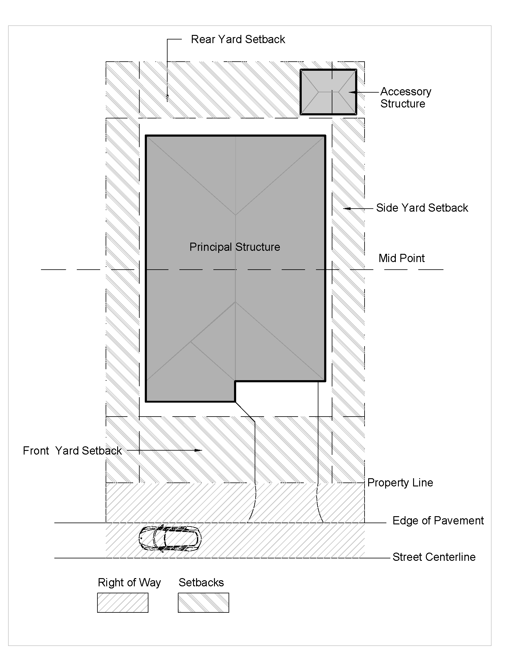
8.2.2. Graphic Illustrations - Residential Districts.
8.2.3. Graphic Illustrations - Commercial Districts.
Refer to Article 10, Part VI, Commercial Design Standards.
(Ord. No. 21-06-012, Art. III, Pt. IX(Att. I), 6-2-2021; Ord. No. 23-03-009, Art. III, Pt. V, 3-15-2023)
Section 8.3 - Special Development Standards - Primary Zoning Districts.
8.3.1. C-3 Commercial Services District.
8.3.1.1. No portion of a building, open storage, or processing area shall be closer than twenty-five (25) feet to a residential district boundary or use.
8.3.1.2. No off-street parking or loading space shall be located closer than twenty-five (25) feet to a residential boundary or use.
8.3.1.3. Surface drainage shall be directed wherever possible along natural or constructed and vegetated drainage courses or nonstructural land drainage systems so that vegetation can cleanse runoff waters.
8.3.1.4. No use shall be permitted in the C-3 zone which has noxious, harmful or deleterious effect on the environment or other development, as determined by the NC Department of Environmental Quality or the Town.
8.3.1.5. No outside storage of processed materials, which may be a possible source of pollution as determined by the NC Department of Environmental Quality, shall be allowed. Processed materials would include, but not be limited to, chemically treated lumber, or petroleum-based products which when exposed to the elements could create stormwater runoff containing pollutants. Areas devoted to the outside storage of materials shall be maintained permeable and shall be calculated as permeable lot coverage. These areas shall be clearly delineated on the site plan, and any expansion of such areas shall be considered a site modification for which approval by the Board of Commissioners is required.
8.3.1.6. No outside storage of equipment is allowed, except in designated areas which may be either gravel or paved as approved by the Town Engineer and which will count toward total lot coverage of the lot.
8.3.1.7. There shall be no fueling areas within five hundred (500) feet of the Fresh Pond.
8.3.1.8. There shall be no stormwater infiltration (other than roof runoff or incidental rainfall) areas within five hundred (500) feet of the Fresh Pond.
8.3.1.9. All stormwater retention, detention, or infiltration shall be in an area dedicated to that use, designed to minimize adverse effects on the groundwater and the Fresh Pond, and approved by the Town for location, configuration, and other considerations of the development which may adversely affect the groundwater or Fresh Pond.
8.3.1.10. No building or individual unit within a building may be used for residential purposes.
8.3.1.11. No building or individual unit shall be used for the storage of flammable or combustible liquids or materials as classified in the fire prevention code in use by the Town.
8.3.1.12. One or multiple principal and/or accessory buildings may exist on lots located within the C-3 zoning district.
8.3.1.13. One or multiple uses as found in the list of permitted uses and/or special uses within the C-3 zoning district (see Section 6.6, Table of Uses and Activities) may be allowed within buildings located in the C-3 zoning district.
8.3.2. C-5, Historic Character Commercial District.
8.3.2.1. Where the requirements listed below conflict with other requirements of the Unified Development Ordinance, this Section shall supersede.
8.3.2.1.1. Commercial structures on lots fronting NC 12 shall not exceed 4,200 square feet of habitable building area.
8.3.2.1.2. Commercial structures on lots fronting US Highway 158 shall not exceed 10,000 square feet of habitable building area.
8.3.2.1.3. Commercial structures developed on lots having frontage on both NC 12 and US Highway 158 shall not exceed 4,200 square feet of habitable building area, however, if the entirety of the structure is located 75 feet or greater from the NC 12 right-of-way, the structure size may be increased up to 10,000 square feet of habitable building area.
8.3.2.2. In addition to achieving compliance with the commercial design standards of Article 10, Part VI of the Unified Development Ordinance, when reviewing a Special Use Permit request, the Board of Commissioners must also make a finding that the proposed building design reflects the heritage of "Old Nags Head" and does not diminish the unique architectural character of the Nags Head Beach Cottage Row Historic District or the surrounding properties.
(Ord. No. 23-03-009, Art. III, Pt. IX, 3-15-2023)
Section 8.4 - Development Standards for Special Districts.
8.4.1. Dimensional Requirements.
Footnotes:
1
Minimum Lot Area - for nonconforming lots, refer to Section 5.2, Nonconforming Lots of Record.
2
Maximum Building Height - refer also to subsection 8.6.4 Building Height.
3
Lot Coverage - refer also to subsection 8.6.6 Lot Coverage.
4
Large Residential Dwelling - refer to Section 7.4 for dimensional requirements.
5
Within the SED-80 district, the required lot width shall be measured at the actual building line.
6
Within the SED-80 district, only chimneys and flagpoles are excluded from the height limitations of that district.
7
Minimum Lot Area for SPD-20 - Minimum lot sizes are only applicable to newly created lots.
8.4.2. SPD-20 Special Planned Development District.
8.4.2.1. Intent. The SPD-20 special planned development district is created to permit development that is compatible with the environmentally sensitive nature of the unique coastal landforms contained in this district. The largest portion of this district contains Jockey's Ridge State Park which has been designated by the North Carolina Coastal Resources Commission as a unique coastal geologic formation area of environmental concern (AEC) and as a National Natural Landmark by the United States Department of the Interior. Jockey's Ridge is an example of a médano or a huge hill of shifting sand that lacks vegetation. While there are several examples of this type of sand dune in the area, Jockey's Ridge is the largest and most spectacular. In addition to the dune system, the park also contains two other important ecosystems in the Town: the maritime thicket and Roanoke Sound. Additionally, the northwestern portion of the district borders on Nags Head Woods, a maritime forest. This SPD-20 district is characterized by unique topographical and vegetative features including vegetated and unvegetated dunes, migrating sand dunes, as well as a pine forest. Specifically, the intent of this section is designed to:
8.4.2.1.1. Preserve the natural features and visual attractiveness of the area. Such features include both vegetated and unvegetated dunes, and forested areas.
8.4.2.1.2. Preserve vegetation acting as soil stabilizers or which provide wind or salt mist intrusion protection value, including the dune ridge plant communities and forested areas.
8.4.2.1.3. Promote low-density residential development and residential uses in a manner that protects and preserves natural topography and vegetation.
8.4.2.1.4. Prohibit commercial and industrial uses of the land and any other use not compatible with the ecological carrying capacity of the area, and the residential and recreational uses of the area.
8.4.2.2. Site Design Standards. The following design criteria shall be satisfied in order to protect the unique natural features and vegetation in the SPD-20 district:
8.4.2.2.1. Land disturbing activity and the removal of trees greater than four (4) inches in diameter at breast height (DBH) shall be limited to the following areas:
8.4.2.2.1.1. Within the proposed building footprint, including decks and a twenty-foot perimeter around the principal building and its accessary buildings;
8.4.2.2.1.2. Within vehicular accessways;
8.4.2.2.1.3. Within the septic tank drainfield and an area around such field as determined by Dare County Health Department as to ensure proper functioning of the septic system; and
8.4.2.2.1.4. Within areas where land disturbing activities have created slopes in excess of three to one, the finished topography shall be aligned with and graded to existing neighboring dunes in such a manner as to minimize erosion.
8.4.2.2.2. The use of bulkheads shall be limited to vehicular accessways, decorative landscaping and estuarine bulkheads only.
8.4.2.2.3. A land disturbance or building permit shall be required prior to any building site preparation.
8.4.2.2.4. Prior to any tree removal or earth disturbing activity, the perimeter of all proposed structures, accessways, and drainfield areas shall be staked on the lot and inspected by the UDO Administrator.
8.4.2.2.5. The planning and development department may approve the removal of any tree which:
8.4.2.2.5.1. Is hazardous meaning likely to fall and injure persons or private property as evidenced by cracking, splitting, leaning or physical damage.
8.4.2.2.5.2. Is hazardous to public facilities or services as evidenced by cracking, splitting, leaning or physical damage.
8.4.2.2.5.3. Is diseased or dead meaning that the tree is in progressive and irreversible decline due to the presence of disease or is considered to be no longer living. The Town may require the applicant to submit a report from a certified arborist substantiating that the tree is dead or diseased to the point it is in progressive and irreversible decline.
8.4.2.2.5.4. Tree topping shall be considered tree removal.
8.4.3. SED-80 Special Environmental District.
8.4.3.1. Purpose. The Nags Head Woods is an irreplaceable maritime forest occupying the northwest corner of the Town and was the home of the first settlers. Nags Head Woods is one of a few remaining maritime forests in North Carolina and on the eastern US coast. It consists of ecologically important brackish marshlands, pine hammocks, bay forest, the ridge forest, hardwood and pine forests, interdunal ponds and dunes. Additionally, Nags Head Woods is home to more than 550 species of plants, including eight species that are considered rare in North Carolina. More than 100 species of birds, 65 species of land vertebrates, and six species of freshwater fish inhabit the various ecosystems within the ecological preserve. Each part of this natural system is important to the survival of the whole system. The least adverse environmental impacts would result from development in the bay and hardwood forests and away from the ponds and marshes. The Woods is also environmentally significant because of its natural role in the integrity of the coastal region. In 1974, Nags Head Woods was designated by the United States Congress as a National Natural Landmark.
8.4.3.2. Intent. This SED-80 district is created to permit development that is compatible with the environmentally sensitive nature of Nags Head Woods and to preserve land in a natural state where such land is considered to be a vital link in the groundwater replenishment cycle of the Outer Banks and where the destruction of natural vegetation would have a harmful effect on the stability of the soil and its resistance to erosion. More specifically, the SED-80 district is designed to:
8.4.3.2.1. Provide for the paramount public concern for these natural resources in the interest of health, safety and general welfare of the residents of and visitors to the Town.
8.4.3.2.2. Preserve the natural features and functions of the area necessary for safe and compatible development on the entire Outer Banks. Such features include, but are not limited to, the following:
8.4.3.2.2.1. The components of the groundwater storage and recharge system which are necessary for the growth and maintenance of the maritime forest vegetation. Such components include ponds, lowlands, marshes, bay forests, and wetlands.
8.4.3.2.2.2. Vegetation acting as soil stabilizers or which provide significant protection from storm or salt intrusion, including the dune ridge plant communities and scrub forest.
8.4.3.2.3. Protect the fragile ecosystems of Nags Head Woods from the effects of fire, storms, flooding and other natural and manmade disasters.
8.4.3.2.4. Prevent pollution of the estuary and the sound which might otherwise adversely affect the biological productivity of the sound.
8.4.3.2.5. Permit low-density residential development of those portions of the SED-80 district suitable for residential use and to encourage open space and limited passive recreational use of portions not suitable for residential use.
8.4.3.2.6. Prohibit commercial and industrial use of the land except as provided in this section.
8.4.3.2.7. Preserve the cultural heritage, features, and integrity of Nags Head Woods as a maritime forest.
8.4.3.3. Additional Requirements. In addition to the dimensional requirements listed in 8.4.1., within the SED-80 district, the following additional requirements shall be in effect.
8.4.3.3.1. No structure or parking lot shall be located closer than fifty (50) feet to any pond, stream, marsh, or other wetlands or wetland swales.
8.4.3.3.2. No structure or parking lot shall be located closer than one hundred thirty (130) feet of the eastern boundary of the ridge line forest, and no removal of vegetation shall be permitted within one hundred (100) feet of the eastern boundary of the ridge line forest.
8.4.3.3.3. Principal and accessory structures shall meet all requirements of subsection 8.4.3.4.2.
8.4.3.3.4. In the case of lots abutting estuarine waters (as defined by the Division of Marine Fisheries and used by CAMA), lot coverage shall be in accordance with the standards listed in subsection 8.4.1, except that in the area waterward of the US Army Corps of Engineers 404 fill line, lot coverage shall not exceed 15%. If the Corps of Engineers 404 fill line is not evident or located within the estuarine AEC, as defined by CAMA, lot coverage within the estuarine AEC shall not exceed 15%. Lot coverage allowances shall not be transferred from one portion of the lot to another. The area necessary for shared accessways in accordance with subsection 8.6.6.7.1 of this UDO shall be excluded from the total lot coverage allowance for an individual lot.
8.4.3.3.5. In those instances where a Roanoke Sound dune ridge is not evident, no principal structure may be placed closer than seventy (70) feet of the mean high-water line. In those instances where an estuarine frontal dune is not evident, no principal structure may be placed closer than fifty (50) feet of the mean high-water line.
8.4.3.3.6. The following shall apply for the following facilities so long as not adjacent to estuarine waters or located within an AEC as defined by CAMA: medical offices/nursing homes and municipally owned governmental facilities.
8.4.3.3.6.1. Dimensional requirements of subsection 8.4.1 shall apply, except that lot coverage shall not exceed twenty (20) percent of the total lot area.
8.4.3.3.6.2. In the case of lots abutting estuarine waters (as defined by the Division of Marine Fisheries and used by CAMA), or located within the estuarine AEC, as defined by CAMA, lot coverage shall not exceed fifteen (15) percent. Lot coverage allowances shall not be transferred from one portion of the lot to another.
8.4.3.3.6.3. The area necessary for shared accessways in accordance with subsection 8.6.6.7.1 of this UDO shall be excluded from the total lot coverage allowance for an individual lot.
8.4.3.4. Special Development Standards.
8.4.3.4.1. Site Plan Requirements. Development of a building site for any lawful use as authorized by this UDO shall require the submission of a site plan with proposed improvements for review and approval. This site plan shall be in addition to the requirement for a building permit.
8.4.3.4.1.1. The site plan shall be drawn to at least a one inch to 40 feet scale and include at least the following minimum requirements:
8.4.3.4.1.1.1. Existing topographical conditions of the lot showing at least two-foot contour intervals.
8.4.3.4.1.1.2. Components of the groundwater recharge system including streams, ponds, marshes, dunes and lowlands, bay forests and wetland swales.
8.4.3.4.1.1.3. Location and slope of any dunes with greater than forty (40) percent slope and height greater than eight (8) feet.
8.4.3.4.1.1.4. Direction of movement and location of any migrating dunes on or near the lot.
8.4.3.4.1.1.5. Proposed building sites.
8.4.3.4.1.1.6. All existing trees which are at least 16-inch diameter at breast height (DBH) within the proposed building site and within a 20-foot perimeter around the building site and within a five-foot perimeter around required accessways, parking areas, utility installation sites, cemeteries, hiking trails and accessory buildings.
8.4.3.4.1.1.7. Areas where trees are to be removed.
8.4.3.4.1.1.8. Specifications for the protection of existing trees during construction.
8.4.3.4.1.1.9. Grade changes or other land-disturbing activities or construction activities adjacent to trees which could adversely affect the health of the trees, with specifications on how the grade, drainage and aeration will be maintained around the trees.
8.4.3.4.1.1.10. North arrow, scale, existing rights-of-way and easements.
8.4.3.4.1.1.11. If required, an approved soil erosion and sedimentation control plan.
8.4.3.4.1.1.12. Proposed location of septic tanks and drainfields.
8.4.3.4.1.2. The proposed building site shall be staked on the lot.
8.4.3.4.1.3. All trees which are to be removed shall be clearly marked on-site with tape, paint, ribbon or other appropriate means.
8.4.3.4.2. Site Design Standards. The following design criteria shall be satisfied, except where the Board of Commissioners finds an alternative design scheme which provides equal or better performance standards regarding the intent of this UDO and to protect the natural features of the SED-80 district protected under this section:
8.4.3.4.2.1. The filling or dredging of ponds or marshes or streams or wetland swales is prohibited unless permitted by CAMA or the Corps of Engineers.
8.4.3.4.2.2. The grading or other alteration of dunes with greater than 40 percent slope and height greater than eight feet is prohibited.
8.4.3.4.2.3. The removal of any tree with a caliper sixteen (16) inches or greater is prohibited, whether or not they fall within any building site, septic area, driveway, road or utility easement, except as provided in subsection 8.4.3.4.3.1.3 of this section.
8.4.3.4.2.4. The removal of any tree with a diameter at breast height (DBH) greater than four (4) inches is prohibited except for those trees which are exempt under subsection 8.4.3.4.3.1.3 of this section, or those trees that are:
8.4.3.4.2.4.1. Within the principal building site, exclusive of decks, and within a 20-foot perimeter around the principal building.
8.4.3.4.2.4.2. Within a required accessway, parking lot, driveway, utility installation sites, cemeteries, hiking trails and accessory buildings and a five-foot perimeter around these areas.
8.4.3.4.2.4.3. Within the septic tank drainfield and an area around such field as determined by the Dare County Health Department as to ensure proper functioning of the septic system.
8.4.3.4.2.5. Trees less than four (4) inches diameter at breast height (DBH) and weeds, vines, bushes and similar ground vegetation may be removed, provided that no land disturbing activity occurs and that the leaf litter, mulch, topsoil and similar materials are left undisturbed. However, no vegetation shall be removed from the western slope of the Roanoke Sound dunes ridge or the western slope of the estuarine dune ridge.
8.4.3.4.2.6. The sewage septic tank and other utilities shall be located to the maximum extent feasible on the edges of areas that have been cleared for access and building purposes and shall satisfy the legal requirement of county, state and federal authorities.
8.4.3.4.2.7. The draw-down of groundwater, except for on-site wells designed to serve buildings on individual lots, and the alteration of natural drainage patterns are prohibited.
8.4.3.4.2.8. No building, vegetation removal or land disturbing activity shall occur on the western slope of the Roanoke Sound dune ridge. No building shall be permitted within seventy (70) feet and no vegetation shall be removed or land disturbing activity shall occur within an area fifty (50) feet easterly of the western ridge of the Roanoke Sound dune ridge. No building shall be permitted within seventy (70) feet and no vegetation shall be removed and no land-disturbing activity shall occur within fifty (50) feet westerly of the toe of the western slope of the Roanoke Sound dune ridge.
8.4.3.4.2.9. On lots which are adjacent to the Roanoke Sound and where the elevation of the estuarine frontal dunes exceeds fifteen (15) feet above mean sea level, the topography of the dune may be altered as follows:
8.4.3.4.2.9.1. The area graded shall be of minimum size necessary for the placement of a principal structure on a building site.
8.4.3.4.2.9.2. Finished graded height of the dune shall be equal to or greater than fifteen (15) feet mean sea level.
8.4.3.4.2.9.3. Vegetation may be removed from the top and eastern slope of the dune.
8.4.3.4.2.9.4. No grade alteration, land disturbing activity, or vegetation removal will be permitted on the western slope of the dune.
8.4.3.4.2.9.5. Any sand removed shall be relocated in such a manner as not to damage existing trees greater than four (4) inches in caliper.
8.4.3.4.2.9.6. The finished topography shall be aligned with and graded with existing neighboring dunes in such a manner as to minimize erosion.
8.4.3.4.2.9.7. All principal structures shall be set back fifty (50) feet from the western toe of the estuarine frontal dunes.
8.4.3.4.2.9.8. Areas where land disturbing activity has occurred shall be stabilized with appropriate erosion control measures within thirty (30) days of the beginning of land disturbing activity.
8.4.3.4.2.9.9. All pedestrian accessways from the top of the dunes to the Sound shoreline shall be raised on pilings and shall be no more than six (6) feet wide.
8.4.3.4.2.10. All structures shall be located at least one hundred thirty (130) feet westerly of the eastern boundary of the ridge line forest vegetation. The removal of any vegetation within one hundred (100) feet westerly of the ridge line forest shall be prohibited except as provided by this UDO.
8.4.3.4.2.11. The clearing of land to provide access to the building site shall be minimized; including the clearing of the forest under story. The use of shared driveways is encouraged. Driveways shall be a maximum width of twelve (12) feet which will allow for access by one vehicle, however when serving three or more residences the driveway width may be increased up to twenty (20) feet. Driveways shall follow the natural contour lines of the land insofar as possible and shall be clay, gravel, porous asphalt or like-porous surface.
8.4.3.4.2.12. Uncovered decks may extend into the 20-foot perimeter around principal structures and to any area which does not require the removal of trees greater than four (4) inches diameter breast height (DBH) and/or any areas which do not require grade changes or land disturbing activity. Decks shall not extend beyond the point of beginning of the western slope of either the Roanoke Sound dune ridges or the estuarine frontal dunes.
8.4.3.4.2.13. The Board of Commissioners may permit the removal of vegetation and may permit land disturbing activity through the Roanoke Sound dune ridge area or the ridge line forest area as regulated in this section to allow reasonable access to a principal building site[s]. In granting such access, the Board of Commissioners may require additional environmental protection measures to secure the basis and purpose and intent of this UDO.
8.4.3.4.3. Standards of Review and Approval Procedure; Intent and Purpose. When selecting the building site, the applicant shall adhere to the following standards and to the intent and purpose of this section:
8.4.3.4.3.1. Building Site Selection. The Board of Commissioners or planning and development staff, whichever the case may be as described in subsection 8.4.3.4.3.2 of this section, shall review and may approve the proposed improvements site plan indicating the proposed building sites before a building permit can be issued. The most suitable building sites are those areas that require the absolute minimum alterations of the natural vegetation, topography and groundwater systems. Evaluation of site suitability shall use the following additional criteria:
8.4.3.4.3.1.1. Existing unforested land areas shall be considered as the most suitable building sites, unless such a selection would threaten the health of the vegetation by stimulating dune migration or cause extensive salt mist intrusion into the Woods or would involve alterations or development prohibited elsewhere in this section.
8.4.3.4.3.1.2. Where vegetation must be removed for the building sites, the most suitable sites will be the sites which disturb the minimum number of healthy trees and vegetation. In approving the building sites, the board shall consider the density, height and variety of the vegetation to be removed, so as to preserve those forest stands which provide the most protection from storm and salt spray and maintain the unique natural diversity of the plant species in the Woods.
8.4.3.4.3.1.3. The planning and development department may approve the removal of any tree which:
8.4.3.4.3.1.3.1. Is likely to fall and injure persons or private property as evidenced by cracking, splitting, leaning or physical damage.
8.4.3.4.3.1.3.2. Is a threat to public facilities or services as evidenced by cracking, splitting, leaning or physical damage.
8.4.3.4.3.1.3.3. Is in progressive and irreversible decline due to the presence of disease or is considered to be no longer living. The Town may require the applicant to submit a report from a certified arborist substantiating that the tree is dead or diseased to the point it is in progressive and irreversible decline.
8.4.3.4.3.1.3.4. Tree topping shall be considered tree removal.
8.4.3.4.3.1.4. The Board of Commissioners shall review and may approve the removal of any tree greater than four (4) inches diameter at breast height (DBH) where:
8.4.3.4.3.1.4.1. The Board of Commissioners find in their opinion no reasonable alternative building site and/or supporting facilities can be located on a lot; or
8.4.3.4.3.1.4.2. The removal is necessary to construct proposed improvements as a result of: need for access around the proposed structure for construction equipment; need for access to the building site for construction equipment; essential grade changes; surface water drainage and utility installations. However, removal of trees greater than sixteen (16) inches diameter at breast height (DBH) is prohibited unless subsection 8.4.3.4.3.1.3 or subsection 8.4.3.4.3.1.4 of this section apply.
8.4.3.4.3.1.5. The topography of the site shall be evaluated for overall development suitability so that all structures shall be constructed below the canopy of existing tree cover.
8.4.3.4.3.2. Site Plan Approval Process.
8.4.3.4.3.2.1. Single-Family Residences. Site plans for single-family residences shall be reviewed by the planning and development department. The planning and development department may approve site plans when the dimensional requirements and standards of this UDO are met and when no trees sixteen (16) inches diameter at breast height (DBH) or greater are requested to be removed.
8.4.3.4.3.2.2. Other Development. The planning and development department shall review the proposed site plan and forward the site plan to the Planning Board and Board of Commissioners for review and approval. In granting approval, the Board of Commissioners shall, in addition to this article, apply Section 3.8, Special Use Permits of this UDO and all other applicable Town codes and ordinances.
8.4.3.4.3.2.3. Subdivisions. Subdivisions shall be as provided for in Article 10, Part V, Subdivision Regulations of this UDO.
8.4.3.5. Mitigation Requirements. In order to protect and reestablish natural vegetation during and after construction, the following mitigation actions are required.
8.4.3.5.1. The approved soil erosion and sedimentation control plan shall be in effect within thirty (30) days following completion of land disturbing activity and vegetation removal. Suitable native vegetative cover shall be established within the next growing season. Prior to the issuance of any required building permit, a soil erosion and sedimentation control plan shall be approved by the Town.
8.4.3.5.2. The developer or his agent of the property for which a site plan has been approved shall notify the planning and development department before any vegetation is removed. The notification shall indicate when the vegetation will be removed, and the UDO administrator Building Inspector shall conduct the necessary inspections to ensure that the vegetation removal is in accordance with the approved soil erosion and sedimentation control plan and that the approved soil erosion and sedimentation control plan is properly in effect.
8.4.3.5.3. To eliminate pest and disease damage to vegetation, any pruning or damage done to trees during construction should be properly attended to using accepted silviculture practices.
8.4.3.5.4. Any protected tree damaged during construction, or damage occurring as a result of such construction, shall be dressed and patched according to accepted arboriculture and silviculture practices. Tree damage shall be repaired prior to the issuance of a certificate of occupancy.
8.4.3.5.5. Prior to the issuance of a certificate of occupancy for the development site, UDO administrator shall inspect the site for the purpose of certifying compliance with the requirements of the site plan. Posting surety in lieu of actual compliance with an approved site plan may be permitted, provided that compliance with the approved site plan shall be obtained within one hundred eighty (180) days.
8.4.3.6. Enforcement. Enforcement in the SED-80 district shall be as follows:
8.4.3.6.1. Failure to comply with the requirements of the approved site plan shall be considered a violation and shall be subject to the immediate issuance of a stop work order by the UDO administrator and to the other procedures and remedies of this section, this article and this UDO which may apply.
8.4.3.6.2. Any unauthorized disturbance and/or removal of trees, shrubs, grass or other naturally occurring vegetation, as well as sand, soil, dirt or earth which has been removed, relocated, graded, excavated, added to, filled or disturbed in violation of this UDO or any applicable Town ordinance, and any naturally occurring trees, shrubbery, grass or other naturally occurring vegetation which has been killed, damaged, destroyed or removed in violation of this UDO shall be restored or replaced as per Table A.
8.4.3.6.3. In addition to the criminal penalties provided by this article and Section 1.10, Violation of UDO Regulations, the Town may immediately collect a $500 fine per unauthorized tree removed and/or initiate proceedings before a court of competent jurisdiction to obtain enforcement of any provision of this article by prohibitory injunction, mandamus, affirmative injunction or order of abatement, as provided by G.S. 160A-175. Enforcement may be by one, all, or a combination of such remedies.
8.4.4. SPD-C Special Planned Development - Community District.
Refer to Article 9, SPD-C Zoning Ordinance for regulations associated with the Village at Nags Head
Special Planned Development - Community District.
(Ord. No. 21-06-012, Art. III, Pt. IX(Att. I), 6-2-2021; Ord. No. 23-01-003, Art. III, Pt. II, 1-4-2023)
Section 8.5 - Development Standards for Overlay Districts.
8.5.1. O&S Ocean and Sound Waters District.
8.5.1.1. Purpose. The Ocean and Sound Waters District is established to provide for the proper use of the ocean and sound waters, including islands, that adjoin the Town to ensure the continued scenic, conservation, and recreational value that these waters provide to the Town, its residents, visitors and the surrounding area. In general, traditional recreational uses such as swimming, boating, sailing, fishing, hunting, and other active and passive noncommercial recreational activities along with commercial recreation activities (provided that the base of the activity is located in a zoning district that permits such activity or such base is located outside the zoning jurisdiction of the Town) are typically permitted uses in the district. Nothing contained within this section shall be deemed to prohibit or regulate commercial fishing and navigation.
8.5.1.2. Intent. The Ocean and Sound Waters District shall encompass and be applied to the area defined as the extraterritorial zoning area as referenced in Town Code Chapter 2, Article 1, Section 2-1. Zoning; boundary extension; establishment; application.
8.5.1.3. Dimensional Requirements. Detached single-family dwellings are permitted (not including mobile homes or floating homes), provided that such dwellings meet all the dimensional requirements of the R-1 low-density residential district.
8.5.2. CO Commercial Outdoor Recreational Uses Overlay District.
8.5.2.1. Purpose. The commercial-outdoor recreational uses overlay district is hereby established. The purpose of establishing this overlay district is to provide a set of comprehensive land use regulations for the operation of commercial-outdoor recreational uses while protecting the residentially zoned areas of the Town. All commercial-outdoor recreational uses proposed within this overlay district shall be subject to the procedures, standards, and guidelines specified in the following sections, in addition to other applicable rules, regulations, and permit requirements. In cases of conflicts with regulations in the underlying zoning district, the more restrictive requirement shall apply. Within this overlay district, all permitted and special uses in the C-2 zoning district which are on a separate lot and not in combination with any of listed commercial outdoor recreational uses shall be allowed.
8.5.2.2. Jurisdiction. The provisions of this section shall apply to all areas designated as the commercial-outdoor recreational uses overlay district and defined on the official zoning map of the Town. The provisions of this section shall also include areas within the Town's extraterritorial jurisdiction as shown on the official zoning map of the Town.
8.5.2.3. Exceptions of Applicability. All existing commercial-outdoor recreational uses which do not meet the requirements of this section shall be regulated in accordance with Article 5, Nonconformities, of this UDO.
8.5.2.4. Uses Allowed. The underlying zoning district to the Commercial-Outdoor Recreational Uses Overlay District is the C-2 General Commercial Zoning District. The outdoor recreational uses allowed in this district may be allowed as stand-alone uses or in combination with other outdoor recreational uses. Outdoor recreational uses may also be combined with certain uses allowed in the underlying C-2 zoning district. However, when any non-recreation related use is combined with a recreation use, the non-recreation use must be accessory and subordinate to an outdoor recreation use. In this instance, only the following uses shall be allowed as accessory to an outdoor recreation use and shall be contained within the principal building:
8.5.2.4.1. Concession.
8.5.2.4.2. Amusement arcade.
8.5.2.4.3. Restaurant.
8.5.2.4.4. Retail.
8.5.2.4.5. Single-family dwelling.
Lots may also be developed with any of the principal uses allowed in the C-2 zoning district. When this occurs, these lots shall not be utilized in combination with any of the recreation uses allowed within this overlay district.
8.5.2.5. General Requirements Applicable to All Commercial-Outdoor Recreational Uses. Conditional commercial-outdoor recreational uses and accessory uses are allowed provided that the following conditions are met:
8.5.2.5.1. Commercial-outdoor recreational uses shall be in accordance with applicable standards in Town Code Section 4-231, commercial-outdoor recreational uses.
8.5.2.5.2. A 12-foot wide vehicular accessway suitable for firefighting and rescue equipment as approved by the Town shall connect the commercial-outdoor recreational use to the driveway with the exception of piers and docks, unless such development is prohibited by local, state or federal regulations. Emergency accessways may also be used for the required pedestrian accessway.
8.5.2.5.3. The commercial-outdoor recreational use shall be connected to all improved facilities including restrooms and parking areas by improved walkways. Such walkways shall be at least five (5) feet wide and constructed of concrete, asphalt, wood, or other similar material and may also be used as vehicular emergency accessways if they meet the standard listed in subsection 8.5.2.5.2 above.
8.5.2.5.4. No portion of any fueling area and/or gasoline storage area shall be further than five hundred (500) feet or closer than fifty (50) feet to a fire hydrant. The location of the fire hydrant shall be approved by the Town.
8.5.2.5.5. Except for water-dependent uses, all crowd or spectator areas shall be designed and sited such that any noise, cheering, etc., resulting from the crowd or spectators is directed toward the interior of the site. Typical spectator areas would include bleachers or open picnic areas.
8.5.2.5.6. Lighting shall be in accordance with the security lighting standards in Article 10, Part IV, Outdoor Lighting of this UDO.
8.5.2.5.7. When an existing or proposed parking lot is designed and improved to allow access to adjoining properties within the commercial-outdoor recreational uses overlay zoning district, the applicant and each adjoining property owner may reduce the parking space requirement by ten (10) percent provided that cross-easements are recorded in the Dare County Register of Deeds that allow unrestricted parking and traffic flow between the proposed and existing lots. The vehicular travel area included in the cross-easement shall be excluded from lot coverage calculations, as shown in the following diagram, unless it is within the estuarine AEC.
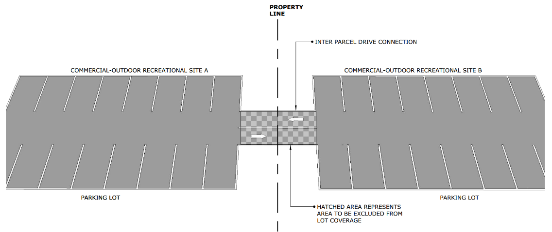
Parking Lot Access to Adjoining Properties
8.5.2.5.8. All petroleum products shall be stored in accordance with NFPA 30 and the North Carolina Fire Prevention Code standards. All petroleum products subject to the above regulations shall be stored no closer than fifty (50) feet or a distance equal to one-half the lot width whichever is less from any property line, right-of-way, drainage ditch, or estuarine waters unless the above regulations require a greater setback. All sites subject to the above regulations shall be inspected at least on an annual basis by the Town, or prior to events associated with crowd gathering permits or the designated public events site.
8.5.2.5.9. Estuarine shoreline. Commercial-outdoor recreational uses may have docks, piers, and walkways as permitted by the Town, CAMA and the corps of engineers.
8.5.2.5.10. The term "use," as referred to in this section shall mean the principal activities on the site, i.e., bumper boat pool, go-cart track, sport-climbing wall.
8.5.2.5.11. Sites which contain piers, slips, or other water dependent facilities which have been approved by the Board of Commissioners for outdoor recreational uses shall not be considered a commercial marina.
8.5.2.6. Setbacks for Commercial Outdoor Recreational Uses. Setbacks from property lines and rights-of-way for all of the commercial-outdoor recreational uses permitted in this district shall be as follows:
8.5.2.6.1. Setbacks from property line/right-of-way shall be in accordance with the following:
8.5.2.6.2. Minimum Side Yard Depth. The total combined side yard shall be a minimum of fifteen (15) feet. In no instance shall either side yard be less than five (5) feet.
8.5.2.7. Buffering Requirements.
8.5.2.7.1. Commercial-outdoor recreational uses shall provide a 10-foot wide commercial transitional protective yard adjacent to any street right-of-way.
8.5.2.7.2. Go-cart rental establishments shall provide a 25-foot wide commercial transitional protective yard adjacent to any street right-of-way and a 10-foot wide commercial transitional protective yard along any side lot line.
8.5.2.7.3. Any other outdoor-recreational use shall provide a 10-foot wide commercial transitional protective yard along a side lot line only when adjacent to a residential use.
8.5.2.7.4. For sites adjacent to estuarine waters: No buffer is required if the lot abuts estuarine waters, provided that at least fifty (50) percent of the land area within contiguous and/or adjacent 404 wetlands as defined by the US Army Corps of Engineers or fifty (50) percent of the land area waterward of the CAMA line, whichever land area is greater, is left in its natural condition. If the above conditions do not apply, or cannot be met, the rear yard buffer shall consist of a 10-foot wide commercial transitional protective yard.
8.5.2.7.5. All buffering shall be provided in accordance with the standards contained in Article 10, Part VI, Commercial Design Standards.
8.5.2.8. Combination of Commercial-Outdoor Recreational Uses. Unless held on a designated public events site as defined in Appendix A of this UDO, the combination of two or more commercial-outdoor recreational uses on any site, including accessory uses previously listed in this section, shall be permitted subject to the following additional requirements:
8.5.2.8.1. Only one principal building shall be allowed.
8.5.2.8.2. All uses, principal structures, and accessory structures within the site shall be connected by improved walkways. Such walkways shall be constructed of concrete, asphalt, wood, or other similar material and may also serve as vehicular emergency accessways described in this section.
8.5.2.8.3. There shall be only one (1) curb cut for each commercial-outdoor recreational site.
8.5.2.8.4. When not structurally connected, there shall be a separation of ten (10) feet between uses.
8.5.3. HO Hotel Overlay District.
Refer to Article 6, Zoning Districts for description of the Hotel Overlay District. Uses are permitted
in accordance with Section 6.6, Table of Uses and Activities, subject to Article 7, Supplemental Regulations and the other requirements of this UDO.
8.5.4. SRO Soundside Residential Dwelling Overlay District.
8.5.4.1. Purpose. This area was one of the earliest developed areas of the Town. Historically, it was in close proximity to the ferry landing point for many of the early visitors to Nags Head and was one of the first locations for summer houses before property owners began developing on the oceanfront. Many of the early cottages in this area were small, one to 1-1/2 story homes that resembled the cottages still present today in the Nags Head Historic Cottage Row. Although this area has experienced some redevelopment since its inception, many of the existing houses retain the character of the original development. This is reflected in the present architectural styles as well as the low-density, informal landscape which maintains the area's natural topography and vegetation. For the aforementioned reasons, the Town of Nags Head recognizes this area as one of unique significance, and consequently wishes to take measures to preserve its existing character.
8.5.4.2. Intent. The purpose of the Soundside Residential Dwelling Overlay District is to set forth regulations that will preserve the unique character and historical significance of the residential enclave located in the vicinity of the unimproved portion of Soundside Road and Chowan Avenue. Specifically, the intent of this section is to achieve the following objectives:
8.5.4.2.1. To maintain and promote residential development that patterns the architecture and building designs of the current and former cottages of this area.
8.5.4.2.2. To minimize land disturbance and preserve natural topography and vegetation.
8.5.4.2.3. To maintain a low-density character while still allowing reasonable use of property.
8.5.4.2.4. To establish minimum street and driveway standards to accommodate Town service vehicles and local traffic while reducing impervious surfaces.
8.5.4.3. Applicability. The provisions of this section shall apply to all areas designated as the Soundside Residential Dwelling Overlay District as defined on the official Zoning Map of the Town of Nags Head, North Carolina. This area generally includes parcels within the R-2 medium density residential zoning district abutting the unimproved portions of Soundside Road and Chowan Avenue. The Soundside Residential Dwelling Overlay District is bounded by the Old Nags Head Cove Subdivision to the south and east, the Southridge Subdivision and the Nags Head Hotel property lots to the north, and the Roanoke Sound to the west. Where the provisions of this section conflict with the provisions of R-2 medium density residential district, the provisions of this section shall apply.
8.5.4.4. Dimensional Requirements. In addition to the dimensional requirements set forth in subsection 8.2.1 for the R-2 medium density residential district, lot coverage for lots located in the Soundside Residential Dwelling Overlay District shall not exceed twenty-five (25) percent. Private access easements, a maximum of twenty (20) feet for two-way and fourteen (14) feet for one-way improved gravel surface area, shall be excluded from individual lot coverage calculations provided such access is not used for parking as required by Article 10, Part II, Off-Street Parking and Loading Requirements of this UDO.
8.5.4.5. Site Design Standards. The following design criteria shall be satisfied in order to protect the unique natural features and vegetation in the Soundside Residential Dwelling Overlay District:
8.5.4.5.1. Land disturbing activity and the removal of trees greater than four (4) inches in diameter measured at one foot above the ground shall be limited to the following areas:
8.5.4.5.1.1. Within the proposed building footprint, including decks and a ten-foot perimeter around the principal building and its accessory buildings;
8.5.4.5.1.2. Within vehicular accessways;
8.5.4.5.1.3. Within the septic tank drainfield and an area around such field as determined by Dare County Health Department as to ensure proper functioning of the septic system; and
8.5.4.5.1.4. Within areas where land disturbing activities have created slopes in excess of three to one, the finished topography shall be aligned with and graded to existing neighboring dunes in such a manner as to minimize erosion.
8.5.4.5.2. The use of bulkheads shall be limited to vehicular accessways, decorative landscaping and estuarine bulkheads only.
8.5.4.5.3. A land disturbance or building permit shall be required prior to any building site preparation.
8.5.4.5.4. Prior to any tree removal or earth disturbing activity, the perimeter of all proposed structures, accessways and drainfield areas shall be staked on the lot and inspected by the UDO Administrator.
8.5.4.5.5. Unimproved gravel driveways and gravel aprons shall be permitted.
8.5.4.5.6. All utilities shall be placed underground.
8.5.4.6. Building Design Standards. In addition to the applicable standards of Section 7.4 related to large residential dwellings, the following standards are encouraged for all single-family dwellings:
8.5.4.6.1. Residential structures that have a ground floor elevation that is less than four (4) feet above the required base flood elevation (BFE) should be piling supported. Ground floor enclosures of a piling supported residential structure should not exceed three hundred (300) square feet of enclosed storage.
8.5.4.6.2. Residential structures should not contain more than two habitable floors.
8.5.4.6.3. Residential structures are encouraged to achieve a minimum total of one hundred (100) points in accordance with the Nags Head Residential Design Guidelines. Fifty (50) points of the required minimum is recommended with the utilization of covered porches to achieve the desired architecture of the district.
8.5.4.6.4. Roof pitch should not exceed 12/12.
8.5.4.6.5. The following siding materials are encouraged for vertical wall siding:
8.5.4.6.5.1. Wood shingles: wood material should be red cedar, white cedar, juniper, or pressure treated pine.
8.5.4.6.5.2. Wood lap board.
8.5.4.6.5.3. Vertical board and batten siding.
8.5.4.6.5.4. T-111.
8.5.4.6.6. Height and the minimum side yard for large residential dwellings shall be regulated in accordance with Section 7.4, Dwelling, Large Residential.
8.5.4.7 Site Design Standards Alternative. Properties containing existing on-site elevation differential of ten feet or greater shall be permitted to utilize the following alternative standards:
8.5.4.7.1. Land disturbing activities may occur anywhere on the property and shall not be limited by the requirements of Section 8.5.4.5.1. Land disturbing activities shall be limited to 70% of the area of the subject property.
8.5.4.7.2. The placement of fill associated with land disturbing activities shall not create slopes that exceed 3:1 and shall be aligned with and graded to match existing neighboring elevations in such a manner as to minimize erosion. The placement of fill in association with the land disturbing activities shall be exempt from UDO Sections: 11.5.2.8; 11.5.2.9; 11.5.2.11; and 11.5.3.2.
8.5.4.7.3. The use of bulkheads and retaining walls shall not be subject to the limitations of Sections 8.5.4.5.2 or 11.5.2.10. Such bulkheads or retaining walls shall be allowed to reduce slopes resulting from land disturbing activities that exceed 3:1.
(Ord. No. 21-06-012, Art. III, Pt. IX(Att. I), 6-2-2021; Ord. No. 21-12-027, Art. III, Pt. I, 12-1-2021)
Section 8.6 - Standards/Application of Dimensional Requirements.
8.6.1. Intent—Height, Bulk, Density, Lot Coverage, Yards, and Open Space.
No building or other structure shall hereafter be erected or altered to exceed the
height or bulk requirements of this UDO; nor to accommodate a greater number of families
than allowed by this UDO; nor to occupy a greater percentage of lot area than allowed
by this UDO; nor to have narrower or smaller front yards, side yards, rear yards or
other open spaces than required by this UDO; nor shall any building, structure or
land be used in any other manner contrary to the provisions of this UDO.
8.6.2. Length and Width Requirements for Principal Buildings.
The following provision apply both to residential and commercial buildings, except
that building erected in the C-3 commercial services district shall be exempt from
these minimum dimensional requirements.
8.6.2.1. The length of a principal building shall not exceed three times the width of the building. The length shall be considered the longest dimension of the structure to include porches and open decks. The width shall be considered to be the widest consistent dimension through at least forty percent (40%) of the length of the building, which may be interrupted; for example, if a building has a width of twenty-two (22) feet for 20% of its length, reduces to a width of 18' for 60% of its length, and then widens to a width of 20' for 20% of its length, the building shall be determined to have a width of 20' and shall have a length of no more than 60'.
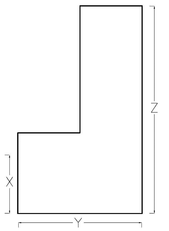 | Dimensions—Principal Buildings (To use Y as the width, X must equal at least 40 percent of the length (Z) of the building.) |
8.6.2.2. The minimum width of the enclosed habitable space of a principal building shall be eighteen (18) feet measured at the first-floor level.
8.6.2.3. A building shall be at least eighteen (18) feet wide along at least forty (40) percent of its length.
8.6.2.4. Outside dimensions shall be used in determining length and width. This is defined as the exterior façade covering on the outside of the building (see graphic above).
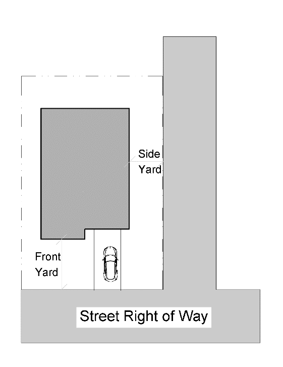
8.6.3. Yard Requirements.
8.6.3.1. Principal Structure/Use. Unless otherwise provided in this UDO, no principal structure or principal use shall be located within the front, side, or rear yards (setback areas).
8.6.3.2. Access Easements
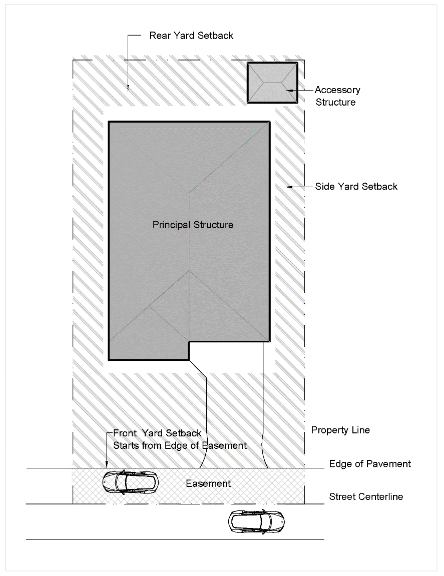
8.6.3.2. Access Easements. For lots of record which front on access easements, yard and lot depth measurements shall be made from the edge of the easement rather than from the lot line. In cases where there is no easement and the lot line is located at the centerline of the paved surface, the measurement shall be made from the edge of the street pavement.
8.6.3.3. Oceanfront Property. In the case of lots located within the Ocean Hazard AEC, the applicable rear yard setback shall be the CAMA setback measured from the static vegetation line or the first line of stable natural vegetation, whichever is furthest landward of the ocean.
8.6.3.4. Corner Lots
8.6.3.4. Corner Lots. In the case of a corner lot abutting an improved right-of-way, to ensure adequate sight clearance, the minimum width of the side yard adjacent to the right-of-way shall be no less than fifteen (15) feet, except in the case of nonconforming lots of record that are less than 10,000 square feet in lot area and sixty (60) feet or less in lot width, in which case the minimum side yard shall be twelve (12) feet. In the case of a corner lot being developed for a residential use and abutting an unimproved right-of-way, to ensure adequate sight clearance, for a distance of not less than 40 feet from the point of intersection of the intersection right-of-way, the side yard shall be no less than fifteen (15) feet. Beyond the 40-foot distance from the intersection, the minimum side yard shall be consistent with the side yard requirement for the zoning district in which the property is located.
8.6.3.5. Yard Requirements for Accessory Structures.
8.6.3.5.1. Accessory structures, including but not limited to, pools and pool surrounds, HVAC equipment/stands, and sheds, etc., may be located only in rear or side yards no closer than five (5) feet to any property line, except as provided for walls and fences in Section 7.78.

8.6.3.5.3 Midpoint
8.6.3.5.2. Fences, walls, poles, posts and other customary yard accessories, ornaments and furniture may be permitted in any yard subject to height limitations and requirements limiting obstruction of visibility or any other requirement of this UDO.
8.6.3.5.3. Accessory structures located forward of the midpoint of the principal structure shall meet the principal structure setbacks. The midpoint is defined as the halfway point of the principal structure including decks measured from front to rear on the lot.
8.6.3.5.4. Accessory structures with habitable space shall meet the setbacks of the principal structure regardless of location on the lot.
8.6.3.5.5. Municipally owned walkways, boardwalks, multi-use paths, and sidewalks are exempt from the minimum yard requirements of this UDO.
8.6.3.6. Exclusions from Yard Requirements.
8.6.3.6.1. The inner edge of the front, rear, or side yard shall be measured from the building foundation and may exclude the outermost three feet of eaves, gutters, uncovered handicapped ramps, or uncovered steps. This exclusion may also apply to cargo lifts for single-family or two-family dwellings only, and built-in railing benches constructed in accordance with Appendix B, "Town of Nags Head Residential Design Guidelines".
8.6.3.6.2. Replacement of HVAC Equipment for Single-Family Uses or Two-Family Uses (under common ownership). HVAC stands and equipment may be located within five (5) feet of a side lot line. Replacement of older systems often requires an increase in the size of the unit and/or stand which may affect the compliance with the setback requirements that apply to these structures. In cases where is it necessary to increase the size of the equipment and/or stands based on code requirements or the manufacturer's specifications, HVAC units and stands may encroach to the least extent possible beyond the required side yard setback.
8.6.3.7. Reductions in Yard Setbacks.
8.6.3.7.1. Front Yard Setback.
8.6.3.7.1.1. In any residential district where the average setback distance for existing buildings on all lots located wholly or partly within two hundred (200) feet of any lot, and within the same zoning district and fronting on the same side of the same street as such lot is less than the minimum setback required in such zoning district, the setback on such lot may be less than the required setback. However, the reduced setback shall be no less than the existing average setback distance for all lots within the two hundred (200) feet, and in no instance shall the setback be reduced to less than fifteen (15) feet.
8.6.3.7.1.2. When lots within the two hundred (200) feet are vacant, such vacant lots shall be considered as having the minimum required setback for the purpose of computing an average setback distance.
8.6.3.7.1.3. When lots within the two hundred (200) feet contain structures which have been relocated with a reduced setback in accordance with Section 8.7, the lot shall be considered as having the minimum required setback distance.
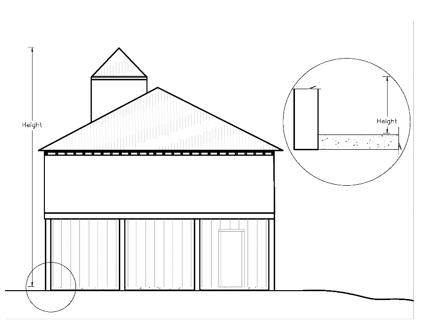
8.6.4.1. Measurement of height.
8.6.4. Building Height.
8.6.4.1. Measurement of height. Height means the vertical distance measured from the tallest part of a building to the ground at the base of the building. Typically, height is measured from the tallest portion of the roof to the top of the concrete slab. In cases where a concrete slab is not present, height is measured from the tallest part of the roof to the average finished grade using the corners at the base of the building.
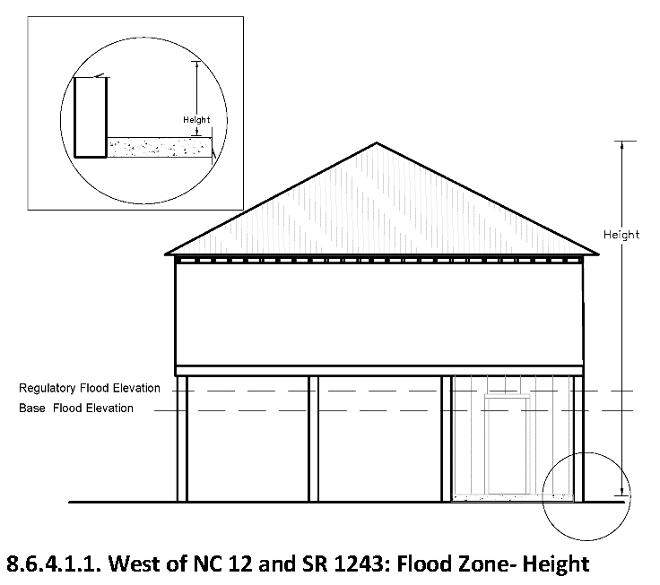
8.6.4.1.1. In Shaded X, X, or AE special flood hazard area west of NC 12 and SR 1243, as defined in 11.42.3.1.2., height will be measured from the regulatory flood protection elevation or finished grade, whichever is higher. In cases where there is a ground floor enclosure below the regulatory flood protection elevation, height shall be measured from finished grade.
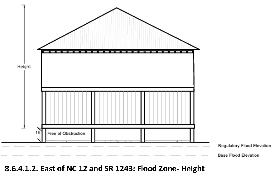
8.6.4.1.2. In coastal high hazard areas and VE zones east of NC 12 and SR 1243 in as defined in 11.42.3.1.1., height shall be measured from regulatory flood protection elevation (lowest horizontal structural member). In cases where the finished grade elevation is above the regulatory flood protection elevation, height shall be measured at approximately eighteen (18) inches above the highest, undisturbed, finished grade directly beneath the structure (free-of-obstruction).
8.6.4.2. The maximum height of a structure may be increased to forty-two (42) feet if the structure utilizes an eight-twelfths roof pitch as specified in the Town of Nags Head Residential Design Guidelines.
8.6.4.3. The maximum height for large residential dwellings shall be regulated in accordance with Section 7.4, Dwellings, Large Residential.
8.6.4.4. No portion of a structure extending above the height limitations of the district in which it is located shall be occupied or intended for human occupancy.
8.6.4.5. If the height requirement varies due to supplemental regulations in Article 7, Supplemental Regulations, then that requirement shall apply.
8.6.4.6. Exclusions from Height Limitations.
8.6.4.6.1. The height limitations imposed by the regulations of this UDO shall not apply to the following:
8.6.4.6.1.1. Chimneys.
8.6.4.6.1.2. Church spires.
8.6.4.6.1.3. Flagpoles, when associated with a residential use only.
8.6.4.6.1.4. Mechanical appurtenances.
8.6.4.6.1.5. Monuments.
8.6.4.6.1.6. Water towers.
8.6.4.6.2. The height limitations imposed by the regulations of this UDO shall not apply to the following, subject to the conditions imposed in this section:
8.6.4.6.2.1. Cupolas, provided that the height of the interior floor under the cupola shall not exceed the height limitation of the building, minus eight (8) feet.
8.6.4.6.2.2. Dish antenna, provided that the unit shall not project higher than five feet above the portion of the roof to which it is attached.
8.6.4.6.2.3. Parapet walls, not to extend more than four (4) feet above the roof line of the building.
8.6.4.6.2.4. Concealed building mounted antenna and the structural element used to conceal it shall not extend more than fifteen (15) feet above the roof line of the building or structure and be located away from the roof edge in order to be invisible from the ground.
8.6.4.6.2.5. Amusement rides, including but not limited to ferris wheels, shall not exceed sixty (60) feet in height above existing natural grade.
8.6.4.6.2.6. Structural poles associated with "Aerial Adventure Parks" shall not exceed sixty (60) feet in height above natural or original grade.
8.6.4.6.3. Within the SED-80 district, only chimneys and flagpoles are excluded from the height limitations.
8.6.5. Habitable Floors.
8.6.5.1. For the purpose of this section, area or space above the top plate of a habitable floor which is open, unrestricted, and unobstructed such as used in an a-frame, cathedral ceiling, or opposed shed roof type construction shall not be considered as a part of such habitable floor.
8.6.5.2. The enclosed area above the top plate of a structure shall not be inhabited by any person or used for any purpose other than the storage of personal effects or property.
8.6.5.3. Single-family dwellings and two-family dwellings shall not exceed three habitable floors.
8.6.5.4. Coastal watch towers meeting the criteria described in the Town of Nags Head Residential Design Guidelines, to include the maximum square floor area of 196 square feet, shall not be counted towards the maximum number of allowable habitable floors as prescribed in this section.
8.6.6. Lot Coverage.
8.6.6.1. Purpose and Intent. As defined in Appendix A of this UDO, lot coverage means that portion of the lot area, expressed as a percentage, which is covered or occupied by impervious surfaces or structures. Lot coverage is one of the primary mechanisms by which the Town regulates the development intensity of individual lots. Lot coverage limits are established for the purposes of preserving open space, limiting the amount of land disturbance necessary for development, and establishing development intensity limitations that are consistent with the Town's vision and goals for the built environment.
For the purposes of determining lot coverage, the following features shall be considered impervious - any principal or accessory use or structure located above the ground including decks, parking areas, vehicular use areas, roadways, access ways, and sidewalks or walkways that prevent the infiltration of rainwater. Lot coverage is utilized to determine zoning compliance and is distinct from the calculation of built-upon area. Built-upon area is used for the purposes of regulating stormwater management, and is described in Article 11, Part I, Buffering and Vegetation Preservation General Requirements of this UDO.
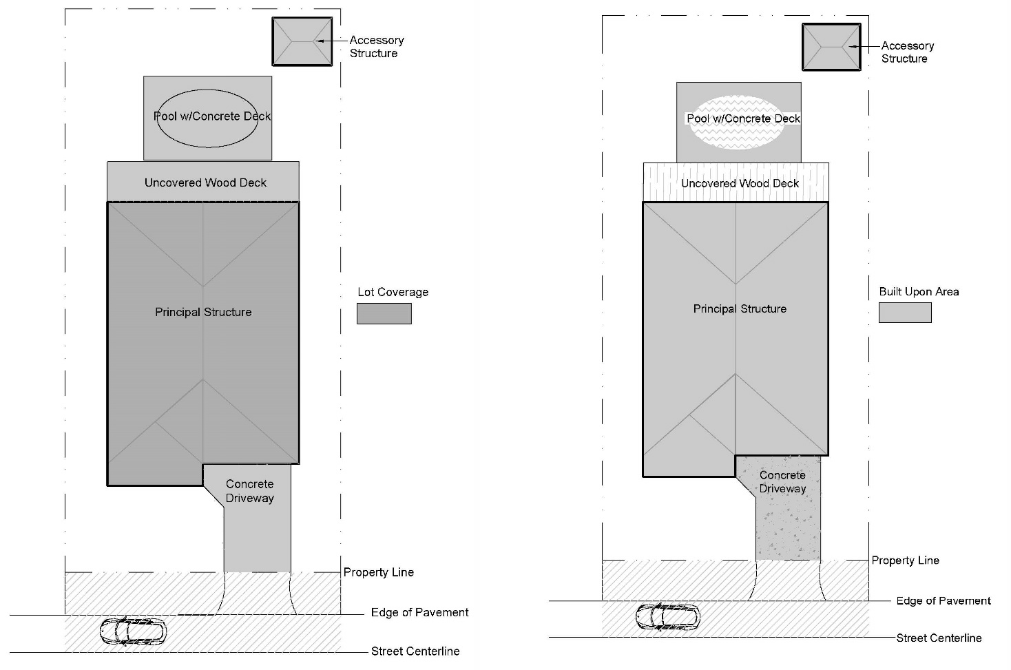
Lot Coverage Built Upon Area
Although lot coverage is calculated based on the lot area as defined in Appendix A, in some cases portions of the lot area are excluded from the calculation. For example, for an oceanfront lot, lot coverage is calculated based on the lot area west of the first line of stable natural vegetation or the static line, whichever is further landward of the ocean.
This section describes special provisions applicable to lot coverage calculations for certain uses/structures or districts. In some instances, certain building features or site elements are either excluded from the lot coverage calculation or count as a reduced percentage. Additionally, lot coverage may be increased with the application of additional stormwater management measures.
8.6.6.2. Special Requirements for Residential Uses. For residential uses in the R-1, R-2, R-3, CR, and C-2 districts, the total lot coverage may be increased by three (3) percent when all runoff from the project's built-upon area is directed into an approved stormwater management system designed to accommodate the volume of runoff generated by a 3.5-inch design storm. The approved stormwater management system shall be designed in accordance with the standards included in Article 11, Part I, Stormwater, Fill, and Runoff Management.
8.6.6.3. Special Requirements for Shared Driveways. In the R-1, R-2, R-3, CR, C-2, and SPD-20 districts, two hundred (200) square feet of lot coverage may be excluded from the lot coverage calculation for individual lots that utilize a shared driveway with an adjoining lot to provide the sole means of access to the lot. In these instances, a shared access easement must be recorded for each lot that utilizes the shared driveway.
8.6.6.4. Special Requirements for the C-3 District and C-5 District.
8.6.6.4.1. Within the C-3, Commercial Services Zoning District, lot coverage shall be in accordance with the following table:
8.6.6.4.2. Within the C-5, Historic Character Commercial Zoning District, lot coverage shall not exceed 45% of the lot area. Lot coverage may be increased to 55% of the lot area with the use of permeable paving materials.
8.6.6.5. Special Requirements for Oceanfront and Estuarine Fronting Lots.
8.6.6.5.1. In the case of an oceanfront lot, only that area landward of the first line of stable natural vegetation or the static line (if present), shall be used for calculating lot coverage. In cases where both lines are present, the calculation shall be made using the line that is furthest landward of the ocean.
8.6.6.5.2. Where an oceanfront lot has little or no stable natural vegetation, the line of such vegetation shall be a line extending between the nearest such vegetation existing north and south of the lot.
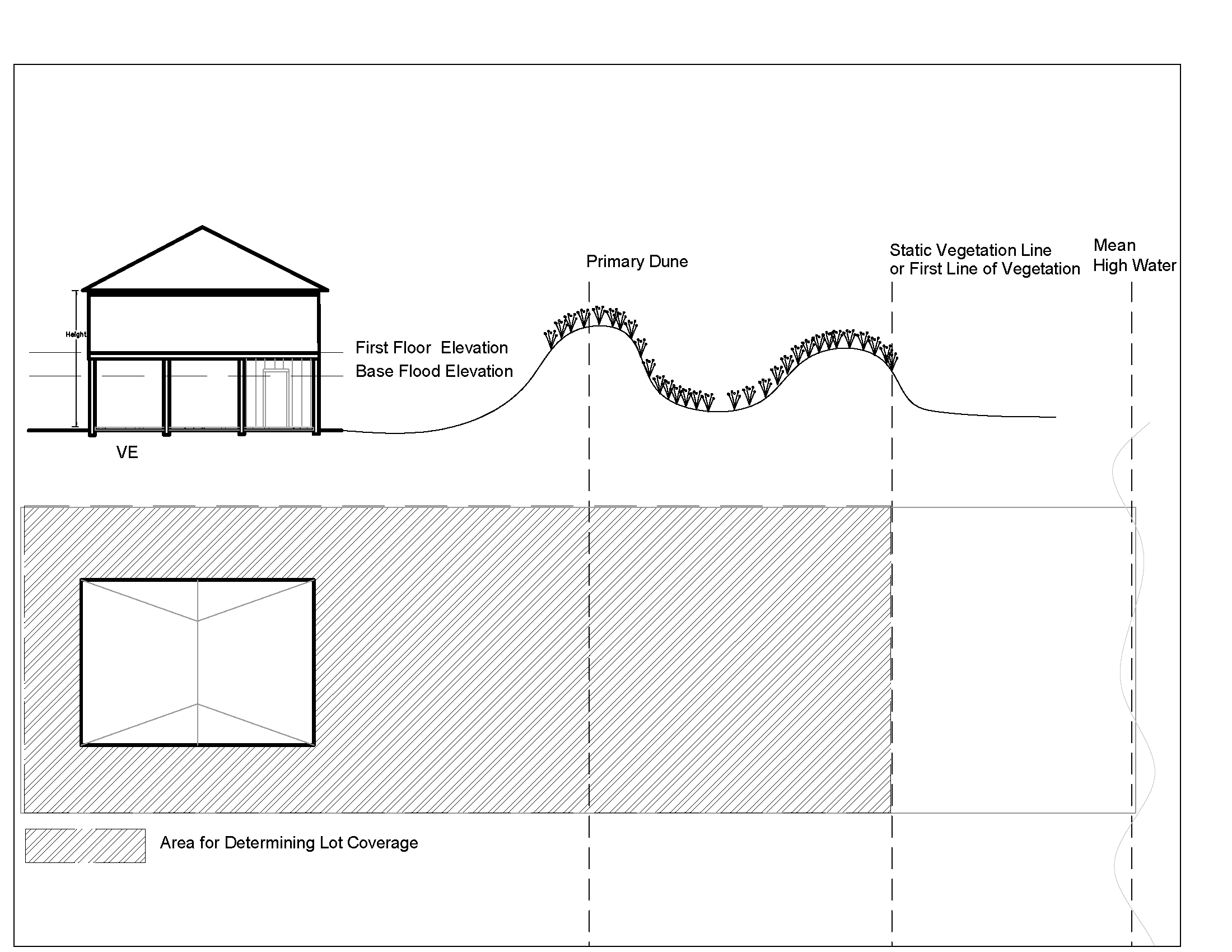
8.6.6.5.1. Lot Coverage - Oceanfront
8.6.6.5.3. In the case of lots abutting estuarine waters, lot coverage shall not exceed thirty (30) percent within the estuarine AEC as defined by CAMA or waterward of the US Army Corps of Engineers 404 fill line.
8.6.6.5.4. For both oceanfront and estuarine front lots, lot coverage allowances shall not be transferred from one portion of the lot to another.
8.6.6.6. Special Requirements for the Use of Permeable Pavement. Due to the stormwater management benefits associated with the use of permeable pavement, permeable pavement shall count at a reduced lot coverage based on the standards below.
8.6.6.6.1. Materials.
8.6.6.6.1.1. Permeable pavement materials include porous concrete, permeable interlocking concrete pavers, concrete grid pavers, Turfstone™, gravel as defined in Appendix A Definitions, reinforced turf products, and other proven technologies available as covered in the NC Best Management Practices Manual and as approved by the Town Engineer for appropriateness to the site and existing conditions. Porous concrete shall be designed and installed in accordance with ACI specifications, or equivalent standard, with hydrological, operation and maintenance considerations.
8.6.6.6.1.2. Edge restraints shall be provided on all concrete grid pavers, permeable interlocking concrete pavers, and similar type installations to confine the pavement installation. The pavement surface course structural properties shall be designed to withstand the applied vehicular loading pursuant to the specified application.
8.6.6.6.2. Location. No porous concrete shall be used east of SR 1243 or NC 12. Compacted gravel shall not be considered permeable pavement.
8.6.6.6.3. Calculation. For the purposes of determining lot coverage, the total square footage of permeable pavement materials is multiplied by 0.67.
8.6.6.7. Exclusion from Lot Coverage Calculation.
8.6.6.7.1. When access easements are provided in accordance with Section 10.47, Limiting Access to US 158, US 64/264, NC 12, and SR 1243, and Section 10.51, Requirements for and Contents of Preliminary Plat and Supporting Documents, a maximum of twenty (20) feet for two-way and fourteen (14) feet for one-way improved access surface areas shall be excluded from individual lot coverage calculations. This exemption shall also apply to existing legal lots of record meeting the lot frontage requirements of Section 10.47 and further provided that the requirements of Section 10.51 are met and where such access has been approved by the planning and development director and recorded on a subdivision plat in accordance with this UDO. This exception shall be applicable only for single-family and two-family uses for access only and shall not be used for the parking of vehicles and shall be noted in the covenants and deed restrictions required by Section 10.51.
8.6.6.7.2. Portions of built-in railing benches constructed in accordance with Appendix B, Town of Nags Head Residential Design Guidelines extending beyond the building footprint shall be excluded from individual lot coverage calculations.
8.6.6.7.3. When an existing or proposed commercial parking lot is designed and or modified to allow two-way vehicular traffic and pedestrian flow between adjoining commercial properties in commercial zoning districts the following exclusions of lot coverage shall apply provided the lot coverage exclusions of this section shall not apply to lot coverage within cross-easements located within an estuarine AEC:
8.6.6.7.3.1. Up to two hundred twenty (220) square feet of the lot coverage within the shared vehicular travel area included within a recorded cross-easement may be excluded from the lot coverage calculation of each lot for the purpose of constructing the shared vehicular travel access.
8.6.6.7.3.2. Up to seventy-five (75) square feet of lot coverage for handicap accessible, pedestrian sidewalk area within a shared cross-easement may be excluded from the lot coverage calculation of each lot for the purpose of constructing the shared pedestrian sidewalk.
8.6.6.7.4. Up to a maximum of two hundred (200) square feet of lot coverage if one or more bicycle racks are located on improved surfaces in compliance with the requirements of subsections 10.15.1.2., 10.15.2.5., and/or 10.92.15.3.
8.6.6.7.5. Municipally owned walkways, boardwalks, multi-use paths and sidewalks are exempt from the lot coverage requirements of this UDO.
8.6.6.7.6. For a preexisting use, when the service orientation of a dumpster is being converted, or when a dumpster is required to be obtained, consistent with the applicable requirements of the Town Code, any additional lot coverage in excess of the maximum allowable lot coverage and necessary to meet the Town's minimum requirements for a dumpster pad, as determined by the Public Works Director or his/her designee, shall be exempt from the lot coverage requirements of this UDO.
8.6.6.7.7. For the siting of a dumpster for the collection of recyclables, any additional lot coverage in excess of the maximum allowable lot coverage and necessary to meet the Town's minimum requirements for a dumpster pad, as determined by the Public Works Director of his/her designee, shall be exempt from the lot coverage requirements of this UDO.
(Ord. No. 20-01-002, Art. III, Pt. IV, 1-8-2020; Ord. No. 20-05-005, Art. III, Pts. XVI, XVII, 5-6-2020; Ord. No. 20-06-008, Art. II, Pt. VI, 6-3-2020; Ord. No. 21-01-001, Art. III, Pt. I, 1-6-2021; Ord. No. 21-06-012, Art. III, Pt. IX(Att. I), 6-2-2021; Ord. No. 21-06-013, Art. III, Pt. I, 6-2-2021; Ord. No. 21-09-021, Art. III, Pt. I, 9-1-2021; Ord. No. 23-03-009, Art. III, Pt. X, 3-15-2023)
Section 8.7 - Reduction in Development Standards for Erosion Threatened Structures.
8.7.1. Setback Reduction for Structures Threatened by Erosion.
8.7.1.1. Intent. The intent of this section is to facilitate the relocation on the same lot of existing single-family and two-family structures on lots abutting the Atlantic Ocean or Roanoke Sound, in cases where such structures are determined to be in imminent danger of collapse as defined by CAMA as a result of erosion by wind and water. These provisions are made available despite the fact that such relocation is a short-term solution, and the property owner is encouraged to move any endangered structure to an area that is not threatened by erosion. The provisions of this section shall not apply in the case of multiple structures located on a single site, or in cases where the footprint of the structure proposed for relocation is to be enlarged or additional living area is proposed.
8.7.1.2. Conditions for Granting Reduction. In order for a reduction in the required front yard setback for an existing residence to be granted, it must be demonstrated that:
8.7.1.2.1. The structure is in imminent danger of collapse as a result of erosion. A structure shall be considered to be in imminent danger when the top of the erosion scarp is within 20 feet of the structure.
8.7.1.2.2. The structure cannot be relocated on the same lot in a location which will meet required CAMA and zoning setbacks.
8.7.1.2.3. The structure will be relocated on the same lot such that all enclosed portions of the structure will be located more than 20 feet landward of the top of the erosion scarp.
8.7.1.2.4. The separation between any part of the structure and the front property line will be not less than 15 feet.
8.7.1.2.5. In cases where the applicant can comply with the minimum setback required by the Coastal Area Management Act for new structures, without needing the full 15 feet reduction, the Town shall grant only the minimum reduction necessary to allow compliance with the CAMA setback.
8.7.1.3. Application of This Section. The reduced setback for structures relocated in accordance with this section shall not be used in applying subsection 8.6.3.7.1 to reduce setbacks for any neighboring structure. Relocated structures shall be considered as having the minimum required setback for purposes of subsection 8.6.3.7.1.
8.7.2. Reduction of Parking and Lot Coverage Requirements for Structures Having Lost Street Access Due to Storm Damage.
8.7.2.1. Intent. The intent of this section is to facilitate the reestablishment of vehicular access and parking for single-family and two-family dwellings in cases where a Town approved street or access easement has been damaged. The provisions of this section shall establish the conditions by which a property will be eligible for permitted reductions of parking standards and/or lot coverage requirements to establish alternative access. The vehicular access provided for herein is not intended to offer or provide or accommodate a full range of municipal services.
8.7.2.2. Conditions for Granting Reduction. Compliance with all the following conditions shall be required for the granting of reductions in parking space dimensional requirements, setback requirements, and surfacing requirements as set forth in subsection 10.12.3 of this UDO, and the granting of any parking related lot coverage increases above the maximum allowed pursuant to the dimensional requirements of the zoning district in which the property is located:
8.7.2.1.1. The lot(s) in need of the reduction listed above must have frontage on the Atlantic Ocean, directly abut a lot(s) with frontage on the Atlantic Ocean, abut a previously accessible Town street adjacent to the Atlantic Ocean which has been damaged as a result of erosion, or is a lot which provides access to such lots.
8.7.2.1.2. Only lot(s) with existing single-family or two-family structures shall be eligible for the reductions listed above. These reductions are not applicable to new development on any lot.
8.7.2.1.3. Before any zoning permit can be approved, all required permits including, but not limited to CAMA and a septic improvement permit must be issued.
8.7.2.3. Standards for granting reductions. The following standards shall be applied in the consideration of reduction requests:
8.7.2.3.1. In cases where the applicant can meet part or all of the requirements of the zoning ordinance, they shall be met in terms of setbacks, lot coverage and the number and dimensions of required parking spaces. All permitted reductions as may be afforded by this section shall be the minimum deemed necessary by the zoning administrator to provide access and parking to the subject property.
8.7.2.3.2. The maximum number of parking spaces shall be the minimum number required by the zoning ordinance.
8.7.2.3.3. Any alternative access way and parking surfaces shall be approved by CAMA.
8.7.2.3.4. There shall be no expansion to the existing dwelling which would result in an increase in the number of required parking spaces or lot coverage.
8.7.2.3.5. The access way shall not exceed ten (10) feet in width.
8.7.2.3.6. For lots of record which front on Town approved access easements, yard and lot depth measurements shall be made from the lot line and not from the access easement provided for in Appendix A, Definitions, Yard.
8.7.2.4. The property owner, by acceptance of the issued zoning permit and performance of the work authorized by said permit, acknowledges and accepts that the granting of the reductions allowed by this section may result in the creation or increase of nonconformities on the property.
(Ord. No. 21-06-012, Art. III, Pt. IX(Att. I), 6-2-2021)