
New Richmond City Zoning Code
121 Art
IX Special Overlay Districts
Sec 121-59 Historic Preservation Overlay District
- Historic Preservation Commission.
DESIGNATION OF HISTORICAL STRUCTURES PROCEDURE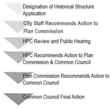
- Appointment. The Mayor shall appoint the Commissioners subject to confirmation by Common Council. The Historic Preservation Commission shall consist of 7 members. The membership shall include at least one registered architect, one historian, one licensed real estate broker, one member of the Common Council and 3 citizen members, if available in the community. Each member shall have a known interest in historic preservation. The term for each member shall be 3 years, with the exception of the Common Council, who shall have a term of one year.
- Duties. The Historic Preservation Commission shall review all requests to designate historic structures, sites and districts. They shall meet to review all requests for Certificate of Appropriateness for modifications to designated sites and structures.
- Authority. The Historic Preservation Commission shall have the power subject to this section to designate historic structures and historic sites and to recommend designation of historic districts within the City limits. Such designations shall be made based on this section Historic districts shall be approved by the Common Council. Once designated, such historic structures, sites and districts shall be subject to all the provisions of this section.
- Purpose.
- It is hereby declared a matter of public policy that the protection, enhancement, perpetuation and use of improvements or sites of special character or special architectural or historic interest or value is a public necessity and is required in the interest of the health, prosperity, safety and welfare of the people.
- The purpose of a historic district designation is allow the City to prepare a historic preservation to preserve areas of particular historic, architectural or cultural significance within the City.
- The purpose of the historic district Certificate of Appropriateness is to authorize and regulate uses which in designated historic structures or historic site to ensure that the proposed construction, reconstruction, exterior alteration or demolition conforms to the purpose and intent of this Ordinance and to the objectives and design criteria of the historic preservation plan for said district.
- Applicability.
- Refer to Historic District Overlay Map 2.
.png)
- No owner or person in charge of a historic structure, historic site or structure within a historic district shall reconstruct, alter or demolish all or any part of the exterior of such property or construct any improvement upon such designated property or properties or cause or permit any such work to be performed upon such property or demolish such property unless a Certificate of Appropriateness has been granted by the Historic Preservation Commission. Unless such certificate has been granted by the Commission, the Zoning Administrator shall not issue a permit for any such work.
- For purposes of this Ordinance, a historic structure, historic site, or historic district designation may be placed on any site, natural or improved, including any building, improvement or structure located thereon, or any area of particular historic, architectural, archaeological or cultural significance to the City such as historic structures, sites or districts which:
- Exemplify or reflect the broad cultural, political, economic or social history of the nation, State or community;
- Are identified with historic personages or with important events in National, State or Local history;
- Embody the distinguishing characteristics of an architectural type or specimen inherently valuable for a study of a period, style, method of construction, or of indigenous materials or craftsmanship;
- Are representative of the notable work of a master builder, designer or architect who influenced his/her age; or
- Have yielded, or may be likely to yield, information important to prehistory or history.
- Development and improvements within the District shall comply with the “City of New Richmond Historic Preservation Guidelines” as may be amended.
- Refer to Historic District Overlay Map 2.
- Procedure for District Designation. An application for approval shall be approved or denied pursuant to Wisconsin Statutes, Chapter 66. Additional City requirements are as follows:
- Request for approval. A request may be initiated by the City or a landowner. As provided within this Ordinance, request for approval be filed with the City Clerk on an official application form. Detailed written and graphic materials, the number and size as prescribed by the Zoning Administrator, fully explaining the proposed change, development, or use, shall also accompany such application. The request shall be considered as being officially submitted and complete when the applicant has complied with all the specified information requirements.

Recommended meeting
with Staff
Application &
Fee required - Proof of Ownership or Authorization. The applicant shall supply proof of ownership of the property for which the approval is requested or supply written authorization from the owner(s) of the property in question to proceed with the requested site plan approval.
- Procedures for Designation of historic structures, historic sites and historic districts.
- The Historic Preservation Commission may, after notice and public hearing, designate historic structures, historic sites and recommend historic districts, or rescind such designation or recommendation, after application of the criteria in NRMC 121- 59.
.png)
Public
hearing - At least 10 days prior to such hearing, the City Clerk shall set a public hearing following proper hearing notification. The City Clerk shall notify the owners of record of property within 200 feet of the boundaries of the property affected or within the boundaries of the historic district. These owners shall have the right to confer with the Historic Preservation Commission prior to final action by said Commission on the designation.
- Notice of such hearing shall also be published as Class 1 notice, under the State Statutes.
- City staff shall review the request and will provide a recommendation to the Historic Preservation Commission with its comments on the proposed designation or recession.
.png)
Recommendation
by Staff/Commission - The Plan Commission shall review the Historic District plan and make findings and fact and a recommendation to the Common Council. The Plan Commission shall make its recommendation on the Historic District plan within 30 days.
- The Common Council, upon receipt of the recommendations from the Historic Preservation Commission and Plan Commission, shall hold a public hearing, notice to be given as noted in Subsection (d),(3),(b) of this section and shall following the public hearing either designate or reject the Historic District. Designation of the Historic District shall constitute adoption of the plan in ordinance form prepared for that district and direct the implementation of said plan.
Public
hearing
- The Historic Preservation Commission may, after notice and public hearing, designate historic structures, historic sites and recommend historic districts, or rescind such designation or recommendation, after application of the criteria in NRMC 121- 59.
- Zoning of historic properties. The historic structure, historic site or historic district designation shall constitute a change in zoning for historic preservation purposes and shall be included as such on the official zoning map. The historic district zoning overlay shall be in addition to the existing underlying zoning. The map amendment shall be process according the procedures outlined in NRMC 121-29 for Ordinance amendments.
- Agencies of the City and all public utility and transportation companies, undertaking projects affecting historic structures, historic sites or historic districts, shall be required to obtain a Certificate of Appropriateness prior to initiating any changes in the character of street paving, sidewalks, utility installations, lighting, walls, fences, structures and buildings on property, easements or streets owned or franchised by the City.
- Request for approval. A request may be initiated by the City or a landowner. As provided within this Ordinance, request for approval be filed with the City Clerk on an official application form. Detailed written and graphic materials, the number and size as prescribed by the Zoning Administrator, fully explaining the proposed change, development, or use, shall also accompany such application. The request shall be considered as being officially submitted and complete when the applicant has complied with all the specified information requirements.
- Information Requirement. Unless waived by City Staff development review, every application must contain the following written and graphic materials in the number and size as required by the Zoning Administrator:
- Site Plan
- Architectural elevations or photos of all principal and accessory buildings (type, color, and materials used in all external surfaces).
- Floor Plans
- Other information as may be required by the Zoning Administrator
- Evaluation Criteria for District Designation.
- For preservation purposes, the Historic Preservation Commission shall select geographically defined areas within the City to be designated as Historic Districts and shall, with the assistance of the City planning officials prepare a historic preservation plan in ordinance form for each area. A Historic District may be designated for any geographic area of particular historic, architectural or cultural significance to the City which:
- Exemplifies or reflects the broad cultural, political, economic or social history of the nation, State or community.
- Is identified with historic personages or with important events in National, State or Local history.
- Embodies the distinguishing characteristics of architectural types or specimens inherently valuable for the study of a period or periods, styles, methods or construction, or of indigenous materials or craftsmanship.
- Is representative of the notable works of master builders, designers, or architects who influenced their age.
- Has yielded, or may be likely to yield, information important to history or prehistory. Each historic preservation plan prepared for or by the Historic Preservation Commission shall include a cultural and architectural analysis supporting the historic significance of the area, the specific guidelines for development and a statement of preservation objectives.
- For preservation purposes, the Historic Preservation Commission shall select geographically defined areas within the City to be designated as Historic Districts and shall, with the assistance of the City planning officials prepare a historic preservation plan in ordinance form for each area. A Historic District may be designated for any geographic area of particular historic, architectural or cultural significance to the City which:
- Procedure for Certificate of Appropriateness.
- A Certificate of Appropriateness is required for any change to a Historic Structure or Site. City Staff shall review for compliance and provide a report to the Historic Preservation Commission. Upon filing of any application for a Certificate of Appropriateness with the Historic Preservation Commission, the Historic Preservation Commission shall approve the application unless:
CERTIFICATE OF APPROPRIATENESS PROCEDURE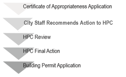
- In the case of a designated historic structure or historic site, the proposed work would detrimentally change, destroy or adversely affect any exterior architectural feature of the improvement or site upon which said work is to be done.
- In the case of the construction of a new improvement upon a historic site, or within a historic district, the exterior of such improvement would adversely affect or not harmonize with the external appearance of other neighboring improvements on such site or within the district.
- In the case of any property located in a historic district, the proposed construction, reconstruction, exterior alteration or demolition does not conform to the purpose and intent of this Ordinance and to the objectives and design criteria of the historic preservation plan for said district.
- The building or structure is of such architectural or historical significance that its demolition would be detrimental to the public interest and contrary to the general welfare of the people of the City and State.
- The building or structure is of such old and unusual or uncommon design, texture, and/or material that it could not be reproduced without great difficulty and/or expense.
- In the case of a request for a demolition permit, the denial of the permit would result in the loss of all reasonable and beneficial use of or return from the property. g. In the case of a request for the demolition of a deteriorated building or structure, any hardship or difficulty claimed by the owner is self-created or is the result of any failure to maintain the property in good repair.
- If the Historic Preservation Commission determines that the application for a Certificate of Appropriateness and the proposed changes are consistent with the character and features of the property or district, and with the above guidelines, it shall issue the Certificate of Appropriateness. Upon the issuance of such certificate, the building permit shall then be issued by the Zoning Administrator. The Commission shall make this decision within 45 days of the filing of the application.
- Agencies of the City and all public utility and transportation companies, undertaking projects affecting historic structures, historic sites or historic districts, shall be required to obtain a Certificate of Appropriateness prior to initiating any changes in the character of street paving, sidewalks, utility installations, lighting, walls, fences, structures and buildings on property, easements or streets owned or franchised by the City.
- The issuance of a Certificate of Appropriateness shall not relieve the applicant from obtaining other permits and approvals required by the City. A building permit or other municipal permit shall be invalid if it is obtained without the presentation of the Certificate of Appropriateness required for the proposed work. Insofar as they are applicable to a historic structure, historic site, or improvement in a historic district designated under this Ordinance, any provision of the plumbing code, electrical code, or building or housing code of the City shall apply, unless waived by the appropriate State or City officials. The Commission may support or propose such waivers before the appropriate State or City appeals body.
- A Certificate of Appropriateness is required for any change to a Historic Structure or Site. City Staff shall review for compliance and provide a report to the Historic Preservation Commission. Upon filing of any application for a Certificate of Appropriateness with the Historic Preservation Commission, the Historic Preservation Commission shall approve the application unless:
- Evaluation Criteria for Certificate of Appropriateness.
- In determining whether to issue a Certificate of Appropriateness, the Commission shall consider and may give decisive weight to any or all of the following standards:
- A property shall be used for its historic purpose or be placed in a new use that requires minimal change to the defining characteristics of the building and its site and environment.
- The historic character of a property shall be retained and preserved. The removal of historic materials or alteration of features and spaces that characterize a property shall be avoided.
- Each property shall be recognized as a physical record of its time, place and use. Changes that create a false sense of historical development, such as adding conjectural features or architectural elements from other buildings, shall not be undertaken.
- Most properties change over time; those changes that have acquired historic significance in their own right shall be retained and preserved.
- Distinctive features, finishes and construction techniques or examples of craftsmanship that characterize a property shall be preserved.
- Deteriorated historic features shall be repaired rather than replaced. Where the severity of deterioration requires replacement of a distinctive feature, the new feature shall match the old in design, color, texture, and other visual qualities and, where possible, materials. Replacement of missing features shall be substantiated by documentary, physical, or pictorial evidence.
- Chemical or physical treatments, such as sandblasting, that cause damage to historic materials shall not be used. The surface cleaning of structures, if appropriate, shall be undertaken using the gentlest means possible.
- Significant archaeological resources affected by a project shall be protected and preserved. If such resources must be disturbed, mitigation measures shall be undertaken.
- New additions, exterior alterations, or related new construction shall not destroy historic materials that characterize the property. The new work shall be differentiated from the old and shall be compatible with the massing, size, scale and architectural features to protect the historic integrity of the property and its environment.
- New additions and adjacent or related new construction shall be undertaken in such a manner that if removed in the future, the essential form and integrity of the historic property and its environment would be unimpaired.
- In determining whether to issue a Certificate of Appropriateness, the Commission shall consider and may give decisive weight to any or all of the following standards:
- Information Requirement. Unless waived by City Staff Development Review, every application must contain the following written and graphic materials in the number and size as required by the Zoning Administrator:
- Site Plan
- Landscape Plan
- Current survey (within one year of application date).
- Architectural elevations of all principal and accessory buildings (type, color, and materials used in all external surfaces).
- Floor Plans
- Material cut sheets
- Material samples
- Color samples
- Other information as may be required by the Zoning Administrator
- Enforcement.
- Compliance with Certificates of Appropriateness shall be started within 12 months after the issuance of the certificate, and the work shall conform to the provisions of the certificate. The City may inspect the work during and after construction in order to assure compliance. Failure to comply with a Certificate of Appropriateness or failure to obtain a Certificate of Appropriateness shall be a violation of this Ordinance. In addition to other penalties and remedies outlined in NRMC 121-13, the City shall issue a stop work order, and all work shall cease on the designated property. No additional work shall be undertaken as long as such stop work order shall continue in effect.
- Ordinary maintenance and repairs may be undertaken without a Certificate of Appropriateness, following approval by City Staff, provided that the work involves repairs to existing features of a historic structure or site, elements of a structure are replaced with pieces identical in appearance and the work does not irreversibly change the exterior appearance of the structure or site.
- Appeals.
- Should the Historic Preservation Commission fail to issue a Certificate of Appropriateness due to the failure of the proposal to conform to the guidelines, the applicant may appeal such decision to the Common Council within 30 days.
- In addition, if the Commission fails to issue a Certificate of Appropriateness, the Commission shall, with the cooperation of the applicant, work with the applicant in an attempt to obtain a Certificate of Appropriateness within the guidelines of this Ordinance.
- Interim controls.
- No building permit shall be issued by the Zoning Administrator for alteration, construction, demolition, or removal of a nominated historic structure, historic site, or any property or structure within a nominated historic district from the date of the meeting of the Historic Preservation Commission at which a nomination form is first presented until the final disposition of the nomination by the Historic Preservation Commission or the Common Council unless such alteration, removal or demolition is authorized by formal resolution of the Common Council as necessary for public health, welfare or safety. In no event shall the delay be for more than 180 days.
- Compliance.
- Every person in charge of a historic structure, historic site or improvement in a Historic District shall maintain same or cause or permit it to be maintained in a condition consistent with the provisions of this Ordinance. The Common Council may appoint the Zoning Administrator or any other individual or group of individuals to enforce this Ordinance. The duties of the Inspection Officer shall include periodic inspection at intervals provided by the Common Council of designated historic structures, historic sites and historic districts. These inspections may include physical entry upon the property and improvement, with permission of the owner, to ensure that interior alterations or maintenance will not jeopardize the exterior appearance or structural stability of the improvement. If an owner refuses permission for the enforcement officer to enter for purposes of inspection, the inspection officer may obtain a warrant of entry pursuant to Wisconsin Statutes § 66.0119 and take any other reasonable measures to further enforcement of this Ordinance.
- Maintenance. Every person in charge of an improvement on a historic site or in a Historic District shall keep in good repair all of the exterior portions of such improvement and all interior portions thereof which, if not so maintained, may cause or tend to cause the exterior portions of such improvement to fall into a state of disrepair, including but not limited to:
- The deterioration of exterior walls or other vertical supports.
- The deterioration of roofs or other horizontal members.
- The deterioration of external chimneys.
- The deterioration or crumbling of exterior plasters or mortar.
- The ineffective waterproofing of exterior walls, roofs and foundations, including broken windows or doors.
- The peeling of paint, rotting, holes and other forms of decay.
- The deterioration of surrounding environment, e.g., fences, gates, sidewalks, steps, signs, accessory structures and landscaping.
- The deterioration of any features so as to create or permit the creation of any hazardous or unsafe condition or conditions.
- All interior portions thereof which may cause the exterior to deteriorate or become damaged or otherwise to fall into a state of disrepair.
- The purpose of this subsection is to prevent the demolition of a building or structure by neglecting it and permitting damage to it by weather or vandalism.
- Insofar as they are applicable to a historic structure, historic site or improvement in a Historic District, designated under this Ordinance, any provision of the Plumbing Code, the Minimum Housing and Property Maintenance Code, Building Code, Heating, Ventilating and Air Conditioning Code, and Outdoor Signs and Outdoor Advertising Structures regulations of the General Ordinances may be varied or waived, on application, by the appropriate board having such jurisdiction over such Chapter or, in the absence of such board, by the Zoning Administrator, provided such variance or waiver does not endanger public health or safety.
- Violations. Notice of violations shall be issued by the Zoning Administrator. If the violations remain uncorrected after the time specified in the notice, the City may, at its election, impose fines and/or have the violations corrected at City expense and have a lien placed against the property equal to the cost of the repairs, plus applicable fines and administrative costs.
- Emergencies. In any case where the Zoning Administrator determines that there are emergency conditions dangerous to life, health or property affecting a historic structure, site or a property in a Historic District, the Zoning Administrator may order the remedying of these conditions without the approval of the Commission. The Zoning Administrator shall promptly notify the Commission of the action being taken. When the emergency conditions do not require demolition, the Zoning Administrator shall make every effort to carry out the intent of this Ordinance and to use the design guidelines of the Commission when remedying the emergency conditions.
HISTORY
Amended by Ord. 636 on 5/11/2026
Amended by Ord. 636 on 5/11/2026
Sec 121-60 Wellhead Protection District
- Purpose and Authority. The residents of the City depend exclusively on groundwater for a safe drinking water supply. Certain land use practices and activities can seriously threaten or degrade groundwater quality. The purpose of this section is to institute land use regulations and restrictions to protect the City municipal water supply and wells, and to promote the public health, safety and general welfare of the residents of the City. Statutory authority to enact these regulations was established by the Wisconsin Legislature in 1983, Wisconsin Act 410 (effective May 11, 1984), which specifically added groundwater protection to the statutory authorization for municipalities to protect health, safety and welfare. See Wisconsin Statutes §§ 60.61(1)(2)(g), 60.62 and 62.23(7)(c). Chapter NR 811 of the Wisconsin Administrative Code (Department of Natural Resources), Environmental Protection - Water Supply Regulations, as currently defined in the provisions of § 60.61(1)(2)(g), 60.62 and 62.23(7)(c), is adopted by reference and made a part of this section as if set forth in full. A violation of any such rules shall constitute a violation of this section, and any violation of this section shall be as provided in Subsection (d).
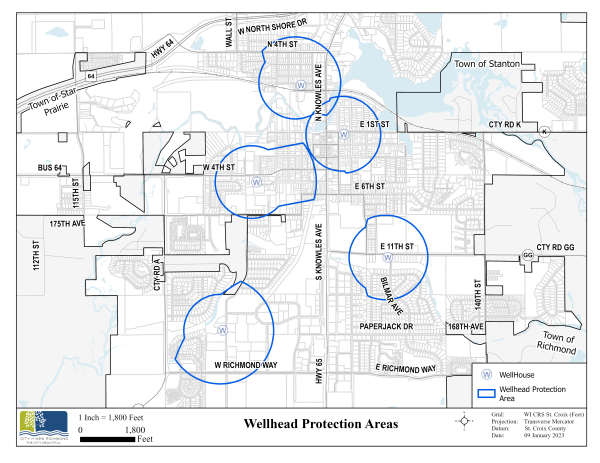
- Applicability. The regulations specified in this section shall apply to the Wellhead Protection Overlay District as identified on the “Wellhead Protection Plan” (Map 3), as may be amended.
- Wellhead Protection Overlay District.
- Intent. The areas to be protected as districts are that portion of the New Richmond well recharge areas extending to the calculated 5-year fixed radius time or travel or groundwater divide within the City boundary limits and shown as Wellhead Protection Areas on the Wellhead Protection Plan Map (Map 3). These lands are subject to land use and development restrictions because of their close proximity to the wells and the corresponding high threat of contamination.
- Permitted uses. Subject to the exemptions listed in Subsection (c),(6),b, the only permitted forms and functions within the district are listed in Table 3.
- Prohibited uses.
.png)
Prohibited
form or function- Above-ground storage tanks;
- Asbestos product sales;
- Automotive service and repair garages, body shops;
- Blue printing and photocopying services.
- Car washes.
- Equipment repair services.
- Laundromats and diaper services.
- Dry cleaning.
- Gas stations.
- Holding ponds or lagoons.
- Nurseries, lawn and garden supply stores.
- Small engine repair services.
- Underground storage tanks.
- Wells, private, production, injection or other.
- Salt storage including sand/salt combinations.
- Any other use determined by the New Richmond Zoning Administrator to be similar in nature to the above listed items.
- Separation distances. The following separation distances as specified in Chapter NR 811 of the Wisconsin Administrative Code, shall be maintained and shall not be exempted as listed in Subsection 6 herein and shown on the maps attached (LABELED WDNR SEPARATION DISTANCES):
.png)
Note limitations
in Code- Fifty feet between a well and a storm sewer main.
- Two hundred feet between a well and any sanitary sewer main, lift station or a single family residential fuel oil tank. A lesser separation distance may be allowed for sanitary sewer mains where the sanitary sewer main is constructed of water main materials and joints and pressure tested in place to meet current AWWA 600 specifications. In no case may the separation distance between a well and a sanitary sewer main be less than 50 feet.
- Four hundred feet between a well and a septic system, tank, or drain field, and receiving less than 8,000 gallons per day, a cemetery or a storm water drainage pond.
- Six hundred feet between a well and any gasoline or fuel oil storage tank installation that has received written approval from the Wisconsin Department of Commerce (hereafter commerce) or its designated agent under Chapter NR 811, Wisconsin Adm. Code.
- One thousand feet between a well and land application of municipal, commercial or industrial waste; industrial, commercial or municipal wastewater, lagoons, or storage structures; manure stacks or storage structures; and septic tanks or soil absorption units receiving 8,000 gallons per day or more.
- One thousand two hundred feet between a well and any solid waste storage, transportation, transfer, incineration, air curtain destructor, processing, one time disposal or small demolition facility; sanitary landfill; coal storage area; gasoline or fuel oil storage tanks that have not received written approval from Commerce or its designated agent under Chapter NR 811, Wisconsin Adm. Code; bulk fuel storage facilities and pesticide handling or storage facilities.
- Requirements for existing facilities.
- Existing facilities shall provide copies of all Federal, State and Local facility operation approvals or certificate and on-going environmental monitoring results to the City.
- Existing facilities shall provide additional environmental or safety structures/monitoring as deemed necessary by the City, which may include but is not limited to storm water runoff management and monitoring.
- Existing facilities shall replace equipment or expand in a manner that improves the existing environmental and safety technologies already in existence.
- Existing facilities shall have the responsibility of devising and filing with the City a contingency plan satisfactory to the City for the immediate notification of City officials in the event of an emergency.
- Exemptions and waivers.
- Individuals and/or facilities may request the City in writing, to permit additional land uses in the district.
- All requests shall be in writing, whether on or in substantial compliance with forms to be provided by the City and may require an environmental assessment report prepared by a licensed environmental engineer. Said report shall be forwarded to the City and/or designee(s) for recommendation and final decision by the Common Council.
- The individual/facility shall reimburse the City for all consultant fees associated with this review at the invoiced amount plus administrative costs.
- Any exemptions granted shall be conditional and may include required environmental and safety monitoring consistent with Local, State and Federal requirements, and/or bonds and/or securities satisfactory to the City.
- Enforcement.
- In the event that an individual and/or facility causes the release of any contaminants which endanger the district, the individual and/or facility causing said release shall immediately stop the release and clean up the release to the satisfaction of the City.
- The individual/facility shall be responsible for all costs of cleanup, including all of the following:
- City consultant fees at the invoice amount plus administrative costs for oversight, review and documentation.
- The cost of City employees’ time associated in any way with the cleanup based on the hourly rate paid to the employee multiplied by a factor determined by the City representing the City’s cost for expenses, benefits, insurance, sick leave, holidays, overtime, vacation, and similar benefits.
- The cost of City equipment employed.
- The cost of mileage reimbursed to City employees attributed to the cleanup.
- Following any such discharge the City may require additional test monitoring and/or bonds/securities.
- Enforcement shall be provided pursuant to Wisconsin Statutes § NR 140.
Map 3. WELLHEAD PROTECTION PLAN
Sec 121-61 Airport Zoning Overlay
- Purpose.
- This division is adopted pursuant to Wisconsin Statutes § 62.23(7a) and Wisconsin Statutes § 114.136. It is hereby found that an obstruction has the potential for endangering the lives and property of users of the New Richmond Regional Airport, and property or occupants of land in its vicinity; that an obstruction may affect existing and future instrument approach minimums of New Richmond Regional Airport; and that an obstruction may reduce the size of areas available for the landing, takeoff, and maneuvering of aircraft, thus tending to destroy or impair the utility of New Richmond Regional Airport and the public investment therein. Accordingly, it is declared:
- That the creation or establishment of an obstruction has the potential of being a public nuisance and may injure the region served by New Richmond Regional Airport;
- That it is necessary in the interest of the public health, public safety, and general welfare that the creation or establishment of obstructions that are a hazard to air navigation be prevented; and
- That the prevention of these obstructions should be accomplished, to the extent legally possible, by the exercise of the police power without compensation.
- It is further declared that the prevention of the creation or establishment of hazards to air navigation, the elimination, removal, alteration, or mitigation of hazards to air navigation, or marking and lighting of obstructions are public purposes for which a potential subdivision may raise and expend public funds and acquire land or interests in land.
- This division is adopted pursuant to Wisconsin Statutes § 62.23(7a) and Wisconsin Statutes § 114.136. It is hereby found that an obstruction has the potential for endangering the lives and property of users of the New Richmond Regional Airport, and property or occupants of land in its vicinity; that an obstruction may affect existing and future instrument approach minimums of New Richmond Regional Airport; and that an obstruction may reduce the size of areas available for the landing, takeoff, and maneuvering of aircraft, thus tending to destroy or impair the utility of New Richmond Regional Airport and the public investment therein. Accordingly, it is declared:
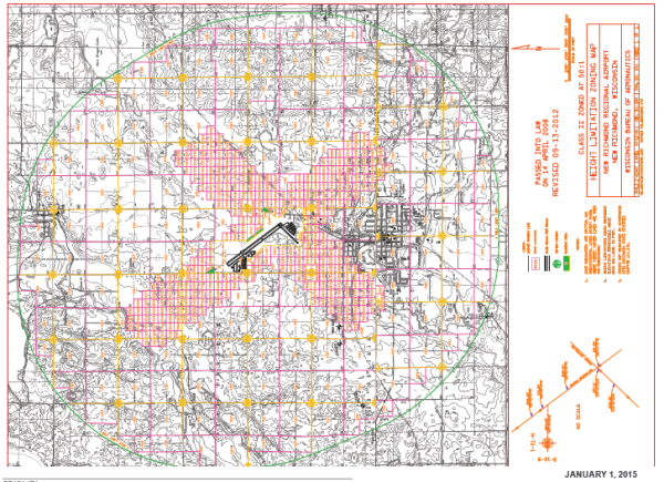
- Airport Approach Overlay District—Generally. In order to carry out the provisions of this division, there is hereby created and established an Airport Approach Overlay District, an overlay district that extends no more than three miles from the Airport boundary. These zones are designated on the “Airport Height Limitation Map,” which is made a part of this division by reference.
- Same—Height limitations. Except as otherwise provided in this division, no structure shall be erected, altered or maintained, and no tree shall be allowed to grow to a height in excess of the applicable height limit designated for that zone on the “Airport Height Limitation Map.” An area located in more than one of the zones designated on said map is considered to be only in the zone with the more restrictive height limitation. A variance from this provision may be obtained in the manner provided for conditional use permit under NRMC 121-32.
- Same—Land use.
- Scope. This section shall apply to all lands within three miles of the airport boundary as designated by the “Airport Height Limitation Map,” and shall include lands within the City and the towns of Star Prairie, Stanton, Richmond and Erin Prairie.
- Permitted uses.
- Open space.
- Agricultural use as provided in Table 3.
- Conditional uses. Any permitted use for which the affected property has been zoned by the City, town, village or County in which said property is located.
- Prohibited uses. Notwithstanding any other provisions of this division, no use may be made of land or water within any zone established by this division in such a manner as to create electrical interference with navigational signals or radio communication between the airport and aircraft, make it difficult for pilots to distinguish between airport lights and others, result in glare in the eyes of pilots using the airport, impair visibility in the vicinity of the airport, create bird strike hazards, or otherwise in any way endanger or interfere with the landing, takeoff, or maneuvering of aircraft intending to use the airport.
- Scope. This section shall apply to all lands within three miles of the airport boundary as designated by the “Airport Height Limitation Map,” and shall include lands within the City and the towns of Star Prairie, Stanton, Richmond and Erin Prairie.
- Airport Zoning District—Generally. In order to carry out the provisions of this division, there is hereby created and established an Airport Zoning District that consists of the New Richmond Regional Airport.
- Same – Land Use
- Permitted Uses – The following are permitted uses allowed within this zoning district:
- Airport terminal buildings.
- Airport hangars.
- Air cargo facilities.
- Agriculture, excluding dwellings customarily provided in conjunction with a farm use.
- Buildings and uses of public works, public services, or public utility nature.
- Commercial and industrial uses related to aviation provided compliance to NRMC 14-54 Policy and minimum standards for lessees and tenants is in compliance, specifically covering an application and granting of an authorization to operate a business at the New Richmond Regional Airport.
- Any other uses clearly similar to those listed in this section.
- Accessory Uses. The following are accessory uses allowed within this zoning district:
- Parking.
- Underground fuel tanks.
- Navigational aids and weather observation instruments.
- Storage facilities for airport purposes only.
- Any other uses clearly similar to those listed in this section.
- Conditional Uses. The following are conditional uses allowed within this zoning district:
- Outside storage.
- Fencing.
- Recreational walking trails or parks.
- Underground utility lines.
- Commercial and industrial uses not related to aviation or incidental to airport operations.
- Prohibited uses. The following are conditional uses not allowed within this zoning district:
Prohibited
form or function- Single, duplex and multifamily dwelling units.
- Planned unit development (PUD’s).
- Hospitals.
- Schools.
- Bulk flammable or bulk compressed gas storage.
- Incineration facilities.
- Uses that may attract massing birds, including landfills.
- Above grade major utility transmission lines and/or mains.
- Commercial and industrial uses not related to aviation or incidental to airport operations.
- Bulk aboveground fuel storage tanks or facilities.
- Truck terminal and freight forwarding facilities which are regularly interrelated with air shipping.
- Single, duplex and multifamily dwelling units.
- Permitted Uses – The following are permitted uses allowed within this zoning district:
- Conditional use permits. The application for a conditional use permit under this section shall be in the same manner as prescribed in NRMC 121-32.
- Site Plan Approval. The application for site plan approvals under this section shall be in the same manner as prescribed in NRMC 121-31 with the exclusion of those items previously planned by the Airport Authority and approved by the Development Review Committee as part of the sound management practices of the Airport Layout Plan, for example treatment of storm water. The remaining criteria for site plan approvals of new buildings and facilities shall focus on building construction, architectural presentation and other essential layout features such as traffic. Approval of the Airport Development Plan and Site Plans shall rest with the Development Review Committee, as composed by City Supervisors so appointed and assigned by the City Administrator. All decisions protested to be heard and decided by the Airport Commission.
Map 4. AIRPORT HEIGHT LIMITATION MAP

- Electric signs. Electric sign contractors are authorized to perform the following specific tasks:
- Install exterior electric signs, ballasts, or high voltage transformers to sockets or outline lighting tubes, and may connect said sign to a primary branch circuit, if said circuit already exists outside of the building.
- Install interior electric signs, and may connect said signs to an existing primary branch circuit.
- Maintain and replace any electric component within the sign, or its surface, or between the sign and building for exterior signs only. This Ordinance prohibits the electric sign contractors or their employees from performing work on electric signs in contradiction to the National Electrical Code or City electrical regulations.
- Install and maintain neon lighting and the required secondary wiring.
- Government buildings and structures, public, quasi-public or private recreation buildings, public parks and recreation areas, public and private educational institutions limited to accredited elementary, middle or senior high schools, and religious institutions shall be allowed the following signs:
- Sign Plan. A comprehensive sign plan shall be submitted that includes all of the following information:
- A site plan to scale showing the location of lot lines, buildings, structures, parking areas, existing and proposed signs, and any other physical features of the area included within the proposed comprehensive sign plan.
- Scale elevations of buildings showing the location of existing or proposed wall, canopy, or marquee signs.
- To scale plans for all existing and proposed signs of any type included within the comprehensive sign plan indicating area, dimensions, height, materials, colors, and any means of illumination.
- Freestanding Sign:
- One sign is allowed per lot, except that 1 additional sign shall be allowed when there is more than one principal use located on a lot.
- Sign Plan. A comprehensive sign plan shall be submitted that includes all of the following information:

