
New Richmond City Zoning Code
121 Art
VI District Standards
Sec 121-36 General District Standards
Five Levels of Review:
1 - Building Permit (BP)
2 - Administrative Permit (A)
3 - Site Plan Approval (SP)
4 - Conditional Use Permit (C)
5 - Certificate of Appropriateness (CA)
- Permit and Review Process.
- The City of New Richmond utilizes City Staff in a variety of disciplines to review applications and plans for proposed projects. City Staff Development Review shall provide initial review and feedback on all zoning applications.
- This Chapter establishes five levels of review projects. The applicant shall consult each zoning district to determine the form and function requirements as well as the Special Overlay District standards in NRMC 121 Art IX, General Standards in NRMC 121 Art VI, the Lot and Building Standards in NRMC 121 Art VIII and the Administration process in NRMC 121 Art V.
- Building Permit. Building permit subject to staff review and approval.
- Administrative Permit. Administrative permit subject to staff review and approval.
- Site Plan. Site Plan subject to Plan Commission review and approval.
- Conditional Use Permit. Conditional use permit subject to Plan Commission review and approval.
- Certificate of Appropriateness. Certificate of Appropriateness subject to Historic Preservation Commission review and approval.
- Building Permit. Building permit subject to staff review and approval.
- An owner may appeal a decision of the Zoning Administrator or City Staff to the Board of Appeals.
- Zoning Map. The locations and boundaries of the districts established by this Ordinance are hereby set forth on the Zoning Map (Map 1). The map is hereby made a part of this Ordinance and shall be known as the “City of New Richmond Zoning Map.” The map and all notations, references and data shown thereon are hereby incorporated by reference into this Ordinance and shall be as much a part of it as if all were fully described herein. It shall be the responsibility of the Zoning Administrator to maintain the map and record map amendments within 30 days after official publication of amendments. The official Zoning Map shall be kept on file by the City Clerk.
- Zoning District Boundaries. The boundaries between districts are, unless otherwise indicated, either the centerline of streets, alleys or railroad rights-of-way or lot lines or section lines or such centerlines or lot lines parallel or perpendicular thereto.
- Permitted Forms and Functions.
- The forms and functions identified in Table 3 as permitted by building permit (BP) are allowed by right in the City of New Richmond. New development or redevelopment will require submittal of a building permit application as outlined in NRMC 121-30 with adequate information to show that the development standards identified in this Ordinance have been met. Permitted Forms and Functions.
- The forms and functions identified in Table 3 as permitted by administrative permit (AP) are allowed by right in the City of New Richmond. Redevelopment up to 25% of the existing building footprint or 3,000 square feet will require submittal of an administrative permit application for review as outlined in NRMC 121-34 showing that the development standards identified in this Ordinance have been met.
- The forms and functions identified in Table 3 as permitted by site plan (SP) are allowed in the City of New Richmond. New development, or redevelopment over 25% of the existing building footprint or 3,000 square feet, will require submittal of a site plan application for site plan review as outlined in NRMC 121-31 showing that the development standards identified in this Ordinance have been met. These items will be reviewed by City staff and the Plan Commission.
- Conditional Forms and Functions.
- The forms and functions identified in Table 3 as conditional (C) are allowed by conditional use permit in the City of New Richmond. New development or redevelopment will require submittal of a conditional use permit application as outlined in NRMC 121-32 showing that the development standards and conditional use permit standards identified in this Ordinance have been met. These items will be reviewed by City Staff and Plan Commission, with final approval by City Council.
- Historic Sites. Any development within the Historic Overlay District shall require approval of a Certificate of Appropriateness. These items will be reviewed by City Staff and Historic Preservation Commission.
- All parcels hereafter annexed to the City that are not shown on the Zoning Map shall automatically, upon annexation, be classified within the Z1 District and shall be subject to all regulations, notations, references and conditions as are applicable to said district until such time that a determination may be made as to the proper zoning district classification for such parcels and an amendment can be made to that effect.
Table 2. DISTRICT DESCRIPTIONS
This table provides descriptions of the character of each District.
 Z1 AGRICULTURE/PRESERVATION Z1 AGRICULTURE/PRESERVATIONThe purpose of the Z1 Agriculture/Preservation District is to provide areas for existing agricultural uses. The large minimum lot area will retain these lands in their natural state or as agricultural uses until sanitary sewer, water, streets and other public infrastructure is available and new development occurs. This will allow orderly development to occur and will prevent uncontrolled, uneconomical spread of residential development. The purpose of this district is to provide a holding zone until a landowner/developer makes application for development, at which time the City may rezone the affected property consistent with its designation in the Comprehensive Plan, provided that the development does not result in the premature extension of public utilities, facilities, and services as specified above. |
|
 Z2 SUB-URBAN Z2 SUB-URBANThe purpose of the Z2 Sub-Urban District is to provide opportunities for low density residential areas, limited neighborhood commercial uses and complementary uses. New development within this district will be allowed only when a full range of municipal services and facilities are available to serve the area. New development is intended to create low-density residential areas and to preserve and enhance transitional residential areas between lower and higher densities |
|
 Z3 MULTI-USE / CORRIDOR Z3 MULTI-USE / CORRIDORThe purpose of the Z3 Multi-Use/Corridor District is to provide a mixture of regional commercial, retail, office, lodging and residential uses in a mixture of building forms. Other complementary uses such as schools, churches and parks will be allowed. These neighborhoods will generally be located along arterial streets. Developments will include landscaped surface parking lots and interconnected sidewalks or multi-use trails. |
|
 Z4 GENERAL URBAN Z4 GENERAL URBANThe purpose of the Z4 General Urban District is to provide a mixture of uses within a primarily residential urban fabric. The district allows a full complement of residential uses and neighborhood and community or neighborhood scale commercial uses. Streets with curbs and sidewalks will define small and medium-sized blocks to allow walkable neighborhoods. |
|
 Z5 TRADITIONAL NEIGHBORHOOD Z5 TRADITIONAL NEIGHBORHOODThe purpose of the Z5 Traditional Neighborhood District is to provide a variety of uses with primarily higher residential density in a mixed use neighborhood with neighborhood, commercial and a variety of other public/semi-public uses. It has a tight network of streets, with sidewalks, steady street tree planting and shallow, front building setbacks to create a defined urban streetscape. |
|
 Z6 CENTRAL BUSINESS Z6 CENTRAL BUSINESSThe purpose of the Z6 Central Business District is to provide opportunities for multi-story, mixed and single use commercial block buildings, townhouses, multi-family residential, lodging and civic buildings; predominately attached buildings, plazas, pocket parks and an interconnected street grid with sidewalks. |
|
• Z7-A New Richmond Municipal Airport. The purpose of the Z7-A districts to provide for the existing forms and functions associated with airport. |
|
 Z7 SPECIFIC USE / INDUSTRIAL
Map 1. CITY OF NEW RICHMOND ZONING MAP: CLICK HERE
Table 3. SPECIFIC FUNCTION AND USE
| Z1 Agriculture / Preservation | Z2 Sub-Urban | Z3 Multi-Use / Corridor | Z4 General Urban | Z5 Traditional Neighborhood | Z6 Central Business | Z7-A Special Use District | Z7-I Special Use District | |
| a. AGRICULTURE | ||||||||
| Cultivation | A | A | A | |||||
| Farm / Livestock / Stable / Grain Storage | AP | |||||||
| Greenhouse/Nursery | AP | A | SP | |||||
| Kennel | C | C | ||||||
| b. AUTOMOTIVE | ||||||||
| Gas Station / Convenience Store | C | C | C | C | ||||
| Car Wash | C | C | C | C | ||||
| Vehicle Service | SP | C | SP | SP | ||||
| Vehicle Sales / Rental | SP | SP | SP | |||||
| c. CIVIC | ||||||||
| Auditorium / Theater | SP | C | ||||||
| Food Pantry | SP | C | SP | SP | ||||
| Golf Course | C | C | ||||||
| Indoor Recreation/Fitness Centers/Instructional Classes | C | C | C | C | C | |||
| Outdoor Recreation | C | C | C | C | C | C | ||
| Library | SP | SP | SP | SP | ||||
| Museum | SP | C | SP | |||||
| Place of Worship/Assembly | SP | SP | SP | SP | SP | C | ||
| Public park, City of New Richmond only | A | A | A | A | A | A | A | A |
| Public park, other than City of New Richmond | C | C | ||||||
| d CIVIL SUPPORT | ||||||||
| Crematorium Principal | C | |||||||
| Cemetery | C | C | ||||||
| Clinic | SP | SP | SP | SP | C | C | ||
| Compost Site | AP | |||||||
| Essential Services | AP | AP | AP | AP | AP | AP | AP | AP |
| Law Enforcement / Fire Station, City of New Richmond Only | A | A | A | A | A | A | A | A |
| Funeral Home | SP | C | SP | |||||
| Hospital | C | C | C | |||||
| Public Works Garage, City of New Richmond Only | SP | SP | SP | SP | SP | SP | SP | SP |
| Veterinary Clinic | C | C | C | C | ||||
| e. COMMERCIAL / RETAIL / SERVICE | ||||||||
| Adult Oriented Establishments | C | |||||||
| Beer Garden | C | C | C | C | C | |||
| Box, Large | SP | SP | SP | |||||
| Box, Medium | SP | C | SP | SP | ||||
| Box, Small | SP | SP | SP | SP | SP | |||
| Event Center | SP | C | ||||||
| Meat Market | SP | SP | ||||||
| Mixed Use Block Building | SP | SP | C | SP | ||||
| Personal Services | AP | AP | AP | |||||
| Restaurants, including liquor and accessory outdoor seating | SP | SP | SP | SP | ||||
| Roadside Stand | A | |||||||
| f. EDUCATION | ||||||||
| Accredited Agricultural Education Facility | C | C | ||||||
| College | C | C | C | C | C | C | ||
| High School | C | C | C | |||||
| Trade School | C | C | C | C | C | C | ||
| Elementary School | C | C | C | C | ||||
| Childcare Center / Daycare facility | A | C | SP | C | C | SP | SP | |
| g. INDUSTRIAL | ||||||||
| Airport and Airport Operations | AP | |||||||
| Breweries/Distilleries; including tap room/ tasting room with kitchen facilities not including grease cooking or handling equipment having a moderate or lesser restaurant license as issued by St. Croix County or services of a licensed caterer | SP | SP | SP | SP | ||||
| Breweries/Distilleries; including an event center and/or full restaurant license as issued by St. Croix County | SP | SP | C | C | ||||
| Bulk Storage Tanks and Facilities | C | C | C | |||||
| Contractor Operations | SP | SP | ||||||
| Data Center | SP | SP | ||||||
| General Warehousing and Truck Terminal | SP | SP | ||||||
| Manufacturing, Assembly, and Machining | C | SP | SP | |||||
| Processing, not including animal processing | C | C | ||||||
| Processing, animal | ||||||||
| Craftsman / Repair Shop | SP | SP | SP | |||||
| Mini Storage | SP | SP | ||||||
| Wholesale Sales | SP | SP | ||||||
| h. LODGING | ||||||||
| Hotel, Motel, and Inn | SP | C | ||||||
| Bed & Breakfast | C | C | C | C | C | C | ||
| Short Term Rental Dwellings | A | A | A | A | A | A | ||
| i. OFFICE | ||||||||
| Laboratory Facility | SP | SP | SP | SP | ||||
| Office Building | SP | SP | SP | C | SP | |||
| j. RESIDENTIAL | ||||||||
| Townhome | BP | BP | BP | BP | BP | |||
| Two Family Dwelling | BP | BP | BP | BP | ||||
| Live/Work Unit | BP | BP | ||||||
| Licensed Community Living (9-15 residents) | C | C | C | C | C | C | ||
| Licensed Community Living (8 or less residents) | BP | BP | BP | BP | BP | BP | ||
| Major Home Occupation | HOP | HOP | HOP | HOP | HOP | HOP | ||
| Minor Home Occupation | A | A | A | A | A | A | ||
| Multiple Family Dwelling | SP | SP | SP | SP | ||||
| Nursing Home | C | C | C | C | C | |||
| One Family Dwelling | BP | BP | BP | BP | BP | BP | ||
| k. MISCELLANEOUS | ||||||||
| Accessory Structures / Uses / Residential | BP | BP | BP | BP | BP | BP | BP | BP |
| Accessory Structures / Uses / Commercial | AP | AP | AP | AP | AP | AP | AP | AP |
| Accessory Solar Photovoltaic System, Free-Standing | C | C | C | C | C | C | C | C |
| Accessory Solar Photovoltaic System, Affixed to Principal or Accessory Building | BP | BP | BP | BP | BP | BP | BP | BP |
| Drive-Through Facility | SP | SP | ||||||
| Electric Vehicle Supply Equipment (EVSE) | BP | BP | BP | BP | BP | BP | BP | BP |
| Fences | BP | BP | BP | BP | BP | BP | BP | BP |
| Historic District Building or Site | A | A | A | A | A | A | A | A |
| Large Wind Energy System, Accessory | C | C | ||||||
| Outdoor Storage, Accessory | AP | AP | AP | C | AP | |||
| Outdoor Seasonal Sales / Display Accessory | AP | AP | AP | AP | ||||
| Parking and Loading, Accessory | AP | AP | AP | AP | AP | AP | AP | AP |
| Parking, Surface, Principal Use | C | C | C | C | ||||
| Signs | BP | BP | BP | BP | BP | BP | BP | BP |
| Small Wind Energy System, Accessory | C | C | C | C | C | C | C | |
| Solar Farm | C | C | ||||||
| Swimming Pool, Accessory | BP | BP | BP | BP | BP | |||
| Telecommunications-Collocation | AP | AP | AP | AP | AP | AP | AP | AP |
| Telecommunications-New Tower | C | C | C | C | C | C | C | C |
Key
A = Allowed; in some instances a separate application may be needed. Check with City staff.
BP = Permitted with a building permit
AP = Permitted administratively subject to administrative permit approval and possible building permit.
SP = Permitted subject to submittal of a Site Plan Application as described in NRMC 121-31.
HOP = Home Occupation Permit as described in MRMC 121-57.
C = Conditional subject to submittal of Conditional Use Permit Application as described in NRMC 121-32.
CA = Certificate of Appropriateness for any Historic Site as described in NRMC 121-59.
If section is blank – the use is not allowed in that zoning district.
**Properties may be subject to special requirements for overlay districts as noted in NRMC 121 Art IX (Special Overlay Districts) or PUDs as described in NRMC 121-9.
Table 3 Updated, Ord #566, Ord #568, Ord #596, Ord #615, Ord #638
Amended by Ord. 508 on 2/22/2018
Amended by Ord. 624 on 5/12/2025
Amended by Ord. 638 on 6/8/2026
Sec 121-37 Z1 Agriculture/Preservation District
- Purpose. The purpose of the Z1 Agriculture/Preservation District is to provide areas for existing agricultural uses. The large minimum lot area will retain these lands in their natural state or as agricultural uses until sanitary sewer, water, streets and other public infrastructure is available and new development occurs. This will allow orderly development to occur and will prevent uncontrolled, uneconomical spread of residential development. The purpose of this district is to provide a holding zone until a landowner/developer makes application for development, at which time the City may rezone the affected property consistent with its designation in the Comprehensive Plan, provided that the development does not result in the premature extension of public utilities, facilities, and services as specified above.
| Table 4. Z1 AGRICULTURE / PRESERVATION DISTRICT |  |
a. LOT OCCUPATION a.1 Lot Size - 5 acre min. | |
b. BUILDING CONFIGURATION | 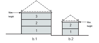 |
c. SETBACKS PRINCIPAL BUILDING
Principal buildings shall be distanced from the lot lines as shaded.
| 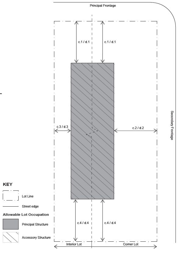 |
d. SETBACKS ACCESSORY STRUCTURE**
Accessory buildings, off-street parking & trash/refuse containers shall be distanced from the lot lines as shaded.
d.1 Front Setback, 50 ft. min.
|
Sec 121-38 Z2 Sub-Urban District
- Purpose. The purpose of the Z2 Sub-Urban District is to provide opportunities for low density residential areas, limited neighborhood commercial uses and complementary uses. New development within this district will be allowed only when a full range of municipal services and facilities are available to serve the area. New development is intended to create low-density residential areas and to preserve and enhance transitional residential areas between lower and higher densities.
| Table 5. Z2 - SUB-URBAN DISTRICT |  |
| a. LOT OCCUPATION a.1 Lot Width - twin homes - 40 ft. min / all other uses - 80 ft. min. a.2 Lot Coverage - 40% max. | |
| b. BUILDING CONFIGURATION Stories may not exceed 14 feet in height from finished floor to finished ceiling, excluding vaulted spaces, except for a first floor commercial function which must be a minimum of 11 ft with a maximum of 25 feet. b.1 Principal Building - 3 stories max. b.2 Accessory Building - 2 stories max. | 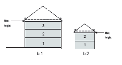 |
| c. SETBACKS PRINCIPAL BLDG Principal buildings shall be distanced from the lot lines as shaded.* All attached front porches, uncovered steps or stoops shall be allowed to encroach 10 feet maximum within front yard setback. Overhangs may encroach 2 feet within front yard setbacks. Encroachment into the sideyard setback shall require a variance. c.1 Principal Front Setback, 25 ft. min. c.2 Secondary Front Setback, 20 ft. min. c.3 Side Setback, 5 ft. min. c.4 Rear Setback, 20 ft. min. | 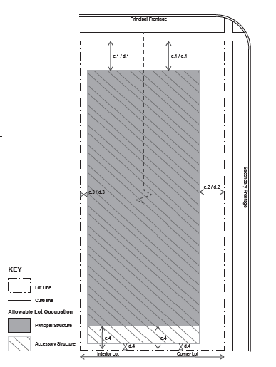 |
| d. SETBACKS ACCESSORY STRUCTURE Accessory buildings, off-street parking & trash/refuse containers shall be distanced from the lot lines as shaded. d.1 Front Setback, 25 ft. c.2 Secondary Front Setback, 20 ft. min. d.3 Side Setback, 5 ft. min. d.4 Rear Setback, 5 ft. min. |
Sec 121-39 Z3 Multi-Use/Corridor District
- Purpose. The purpose of the Z3 Multi-Use/Corridor District is to provide a mixture of regional commercial, retail, office, lodging and residential uses in a mixture of building forms. Other complementary uses such as schools, churches and parks will be allowed. These neighborhoods will generally be located along arterial streets. Developments will include landscaped surface parking lots and interconnected sidewalks or multi-use trails.
Table 6. Z3 - MULTI-USE / CORRIDOR DISTRICT |  |
a. LOT OCCUPATION • Single Family and Twin Home Uses: 30% | |
| b. BUILDING CONFIGURATION. Stories may not exceed 14 feet in height from finished floor to finished ceiling, excluding vaulted spaces, except for a first floor commercial function which must be a minimum of 11 ft with a maximum of 25 ft b.1 Principal Building - 4 stories max. b.2 Accessory Building - 2 stories max. | 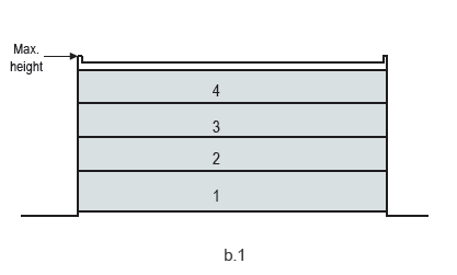 |
| c. SETBACKS PRINCIPAL BLDG. Principal buildings shall be distanced from the lot lines as shaded. All attached front porches, uncovered steps or stoops shall be allowed to encroach 10 feet maximum within front yard setback. Overhangs may encroach 2 feet within front yard setbacks. c.1 Principal Front Setback, 25 ft. min. c.2 Secondary Front Setback, 20 ft. min. c.3 Side Setback, 10 ft. min. c.4 Rear Setback, 35 ft. min. | 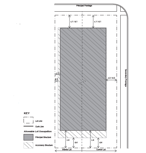 |
d. SETBACKS ACCESSORY STRUCTURE | |
| e. Off-Street Parking Setbacks: Off-street parking areas for uses other than single family, two family or townhouse dwellings shall be distanced from the lot lines as follows: e.1 Principal Front Setback, 15 ft. min. e.2 Secondary Front Setback, 10 ft. min. e.3 Side Setback, 5 ft. min. e.4 Rear Setback, 5 ft. min. e.5 Abutting residential use, 10 ft. min. |
Sec 121-40 Z4 General Urban District
- Purpose. The purpose of the Z4 General Urban District is to provide a mixture of uses within a primarily residential urban fabric. The district allows a full complement of residential uses and neighborhood and community or neighborhood scale commercial uses. Streets with curbs and sidewalks will define small and medium sized blocks to allow walkable neighborhoods.
| Table 7. Z4 - GENERAL URBAN DISTRICT |  |
| a. LOT OCCUPATION a.1 Lot Width - twin homes - 40 ft. min / all other uses - 80 ft. min. a.2 Lot Coverage - 40% max. | |
| b. BUILDING CONFIGURATION Stories may not exceed 14 feet in height from finished floor to finished ceiling, excluding vaulted spaces, except for a first floor commercial function which must be a minimum of 11 ft with a maximum of 25 ft. b.1 Principal Building - 3 stories max. b.2 Accessory Building - 2 stories max. | 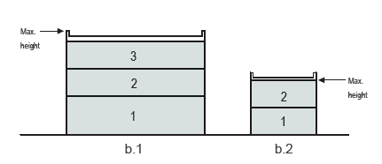 |
c. SETBACKS PRINCIPAL BLDG* | 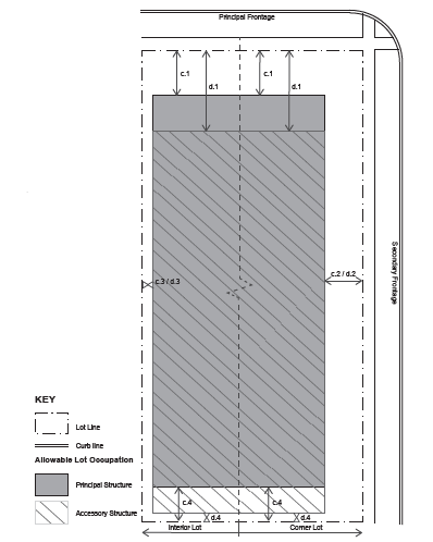 |
| d. SETBACKS ACCESSORY STRUCTURE Accessory buildings, off-street parking & trash/refuse containers shall be distanced from the lot lines as shaded. d.1 Principal Front Setback, 45 ft. min. d.2 Secondary Front Setback, 20 ft. min. d.3 Side Setback, 5 ft. min d.3 Rear Setback, 5 ft. min. |
Sec 121-41 Z5 Traditional Neighborhood District
- Purpose. The purpose of the Z5 Traditional Neighborhood District is to provide a variety of uses with primarily higher residential density in a mixed use neighborhood with neighborhood, commercial and a variety of other public/semi-public uses. It has a tight network of streets, with sidewalks, steady street tree planting and shallow, front building setbacks to create a defined urban streetscape.
| Table 8. Z5 - TRADITIONAL NEIGHBORHOOD DISTRICT |  |
| a. LOT OCCUPATION a.1 Lot Width - twin homes - 40 ft. min. / residential – 50 ft. min. / all other uses - 80 ft. min. a.2 Lot Coverage - 40% max. | |
| b. BUILDING CONFIGURATION Stories may not exceed 14 feet in height from finished floor to finished ceiling, excluding vaulted spaces, except for a first floor commercial function which must be a minimum of 11 ft with a maximum of 25 ft. b.1 Principal Building - 3 stories max. b.2 Accessory Building - 2 stories max. | 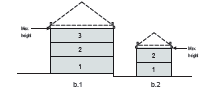 |
| c. SETBACKS PRINCIPAL BLDG* Principal buildings shall be distanced from the lot lines as shaded. All attached front porches, uncovered steps or stoops shall be allowed to encroach 10 feet maximum within front yard setback. Overhangs may encroach 2 feet within front yard setbacks.Encroachment into the sideyard setback shall require a variance. c.1 Principal Front Setback, 25 ft. min. c.2 Secondary Front Setback, 20 ft. min. c.3 Side Setback, 5 ft. min. c.4 Rear Setback, 20 ft. min. | 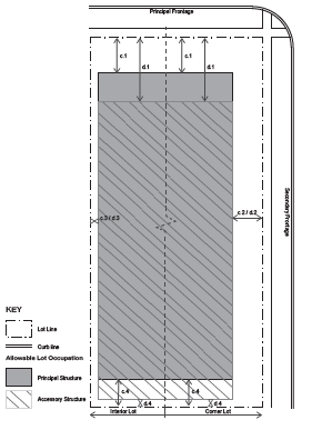 |
| d. SETBACKS - ACCESSORY STRUCTURE Accessory buildings, off-street parking & trash/refuse containers shall be distanced from the lot lines as shaded. d.1 Principal Front Setback, 45 ft. min. d.2 Secondary Front Setback, 20 ft. min. d.3 Side Setback, 5 ft. min. d.4 Rear Setback, 5 ft. min. |
Adopted by Ord. 533 on 9/16/2019
Sec 121-42 Z6 Central Business District
- Purpose. The purpose of the Z6 Central Business District is to provide opportunities for multi-story, mixed and single use commercial block buildings, townhouses, multifamily residential, lodging and civic buildings; predominately attached buildings, plazas, pocket parks and an interconnected street grid with sidewalks.
| Table 9. Z6 - CENTRAL BUSINESS DISTRICT |  |
a. LOT OCCUPATION a.1 Lot Coverage - 100% max. | |
| b. BUILDING CONFIGURATION Stories may not exceed 14 feet in height from finished floor to finished ceiling, excluding vaulted spaces, except for a first floor commercial function which must be a minimum of 11 ft with a maximum of 25 ft. b.1 Principal Building - 4 stories max. b.1 Accessory Building - 3 stories max. | 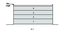 |
c. SETBACKS PRINCIPAL & ACCESSORY BUILDING Principal and accessory buildings shall be distanced from the lot lines as shown. c.1 Principal Front Setback, 0 ft. min, 5 ft. max. c.2 Secondary Front Setback, 0 ft. min, 5 ft. max. c.3 Side Setback, 0 ft. min. c.4 Rear Setback, 0 ft. min. | 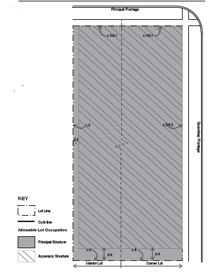 |
d. SETBACKS ACCESSORY STRUCTURE (NOT BUILDINGS) |
Sec 121-43 Z7 Special Use District
- Purpose. The purpose of the Z7 Special Use District is to create districts to support the ongoing use and expansion of airport and industrial uses. Any future expansion of these uses shall require site plan approval and compliance with this Ordinance.
- Z7-A New Richmond Municipal Airport. The purpose of the Z7-A districts to provide for the existing forms and functions associated with airport.
- Z7-I Industrial Parks. The purpose of the Z7-I district is to allow for continuation and expansion of industrial uses in specific areas of the City where they will have less conflict with other functions.
Table 10. Z7 - SPECIAL USE DISTRICT |  |
| |
| b. BUILDING CONFIGURATION b.1 Principal Building - 4 stories max. b.2 Accessory Building - 4 stories max. | 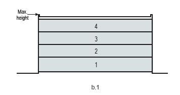 |
| c. SETBACKS PRINCIPAL BUILDING* Principal buildings shall be distanced from the lot lines as shaded. c.1 Principal Front Setback, 30 ft. min. c.2 Secondary Front Setback, 25 ft. min. c.3 Side Setback, 10 ft. min. c.4 Rear Setback, 20 ft. min. | 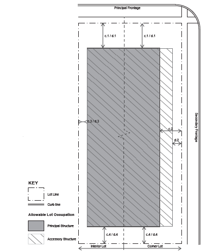 |
| d. SETBACKS ACCESSORY STRUCTURE* Accessory buildings, and trash/refuse containers shall be distanced from the lot lines as shaded. d.1 Principal Front Setback, 25 ft. min. d.2 Secondary Front Setback, 20 ft. min. d.3 Side Setback, 5 ft. min. d.4 Rear Setback, 20 ft. min. * 50 ft. abutting any non-industrial district. | |
| e. OFF-STREET PARKING SETBACKS Off-street parking areas shall be distanced from the lot lines as follows: e.1 Principal Front Setback, 15 ft. min. e.2 Secondary Front Setback, 10 ft. min. e.3 Side Setback, 5 ft. min. e.4 Rear Setback, 5 ft. min. e.5 Abutting residential use, 20 ft. min. |

