
Norcross City Zoning Code
ARTICLE I
- ZONING DISTRICTS AND USE PROVISIONS
Sec. 201-1. - General applicability.
It is the intent of this article to:
(1)
Regulate the location and use of buildings and land for residential, commercial and service, industrial and manufacturing, transportation, communications, utilities and other purposes to promote the health, safety and general welfare.
(2)
To regulate the height and size of buildings and structures hereafter erected, enlarged, structurally altered or demolished, the size of yards and open space, setbacks and the density of population.
(3)
To establish reasonable site development and design standards, subdivision regulations and requirements for adequate public facilities and services.
(Ord. No. 08-2019, § I, 6-3-2019)
Sec. 201-2. - Establishment of zoning districts.
The following districts are hereby established in the city:
(1)
Single-family residential zoning districts.
a.
R100 single-family residence.
b.
R75 single-family residence.
c.
R60 single-family residence.
d.
RTH townhouse residence.
(2)
Multi-family residential zoning districts.
a.
RD duplex residence.
b.
PRD planned residential district.
(3)
Mixed-use and commercial zoning districts.
a.
OI office-institutional.
b.
C1 neighborhood business.
c.
C2 general business.
d.
HX historic mixed-use.
e.
NX neighborhood mixed-use.
f.
CX community mixed-use.
g.
CAR commercial auto related business.
h.
BH Buford Highway.
(4)
Industrial districts.
a.
M1 light industrial.
b.
M2 heavy industrial.
(5)
Special districts.
a.
P public.
b.
FH flood hazard.
c.
CSO conservation subdivision/open space development.
d.
H historic.
(Ord. No. 08-2019, § I, 6-3-2019)
Sec. 201-3. - Official zoning map.
(a)
Official zoning map.
(1)
The city is hereby divided into zoning districts, as shown on the official zoning map which, together with all notations, references, data and other information shown on the map, is hereby adopted by reference and declared to be a part of this zoning ordinance.
(2)
The official zoning map shall be a hard copy map (paper, mylar, vellum or other similar material) identified by a signature block that includes the signature of the Mayor, and attested by the City Clerk, over the following words: "This is to certify that this is the official zoning map referred to in the Norcross Zoning Ordinance" together with the date of its adoption.
(3)
The location and boundaries of the zoning districts established by this zoning ordinance are depicted on and maintained as part of the city's geographic information system (GIS), under the direction of the City Manager. A print out or plot of this "zoning" geographic coverage layer that includes the signature block signed by the Mayor and attested by the City Clerk constitutes the city's official zoning map.
(4)
The latest adopted version of the official zoning map shall be available for inspection in the offices of the city Community Development Department during regular business hours of the city, and a copy will be available for general public reference on the city's official website.
(b)
Maintenance and updates. The Community Development Director is responsible for directing revisions to the official zoning map to reflect its amendment as soon as possible after the effective date of zoning map amendments. No unauthorized person may alter or modify the official zoning map. The Community Development Director may authorize printed copies of the official zoning map to be produced and must maintain digital or printed copies of superseded versions of the official zoning map for historical reference.
(c)
Replacement of official zoning map. In the event that the official zoning map becomes damaged, destroyed, lost or difficult to interpret because of the nature or number of changes and additions, the Mayor and City Council may by ordinance adopt a new official zoning map which shall supersede the prior official zoning map, and shall be identified by the signature block described in subsection 201-3(a)(2).
(d)
Annexation. Any land subsequently annexed to the city shall be annexed in accordance with the procedures adopted by mayor and council that are based upon state law and are part of this Code. It shall, immediately upon annexation, be classified into a zoning category compatible with adjacent zoning and land uses, and sound planning principles in accordance with the procedure in subsection 201-3(e), interpretation of zoning district boundaries, and applicable state law.
(e)
Interpretation of zoning district boundaries. Where uncertainty exists with respect to the location of the boundaries of any zoning district in the city, the following rules shall apply:
(1)
Where a zoning district boundary line is shown as approximately following a corporate limits line, a militia district line, a land lot line, a lot line or the centerline of a street, a county road, a state highway, an interstate highway or a railroad right-of-way or such lines extended, then such lines shall be constructed to be the zoning district boundary lines.
(2)
Where a zoning district boundary line is shown as being set back from a street, a county road, a state highway, an interstate highway or a railroad right-of-way, and approximately parallel thereto, then such zoning district boundary line shall be construed as being at the scaled distance from the centerline of street, county road, state highway, interstate highway or railroad right-of-way and as being parallel thereto.
(3)
Where a zoning district boundary line divides a lot, the location of the line shall be the scaled distance from the lot lines. In this situation, the requirements of the zoning district in which the greater portion of the lot lies shall apply to the balance of the lot except that such extension shall not include any part of a lot that lies more than 50 feet beyond the zoning district boundary line.
(4)
In the case of a through lot fronting on two approximately parallel streets, that is divided by a zoning district boundary line paralleling the streets, the restrictions of the zoning district in which each frontage of the through lot lies shall apply to that portion of the through lot.
(Ord. No. 08-2019, § I, 6-3-2019)
Sec. 201-4. - Single-family residential districts, general provisions.
The intent of the single-family residential districts is to protect established residential neighborhoods with detached and attached one- family dwelling units as well as promote well designed and properly located similar future residential developments. The district provisions discourage any use that would substantially interfere with the residential nature of the districts. Compatible park, open space, utility and civic uses are permitted in these districts as identified in this article.
(Ord. No. 08-2019, § I, 6-3-2019)
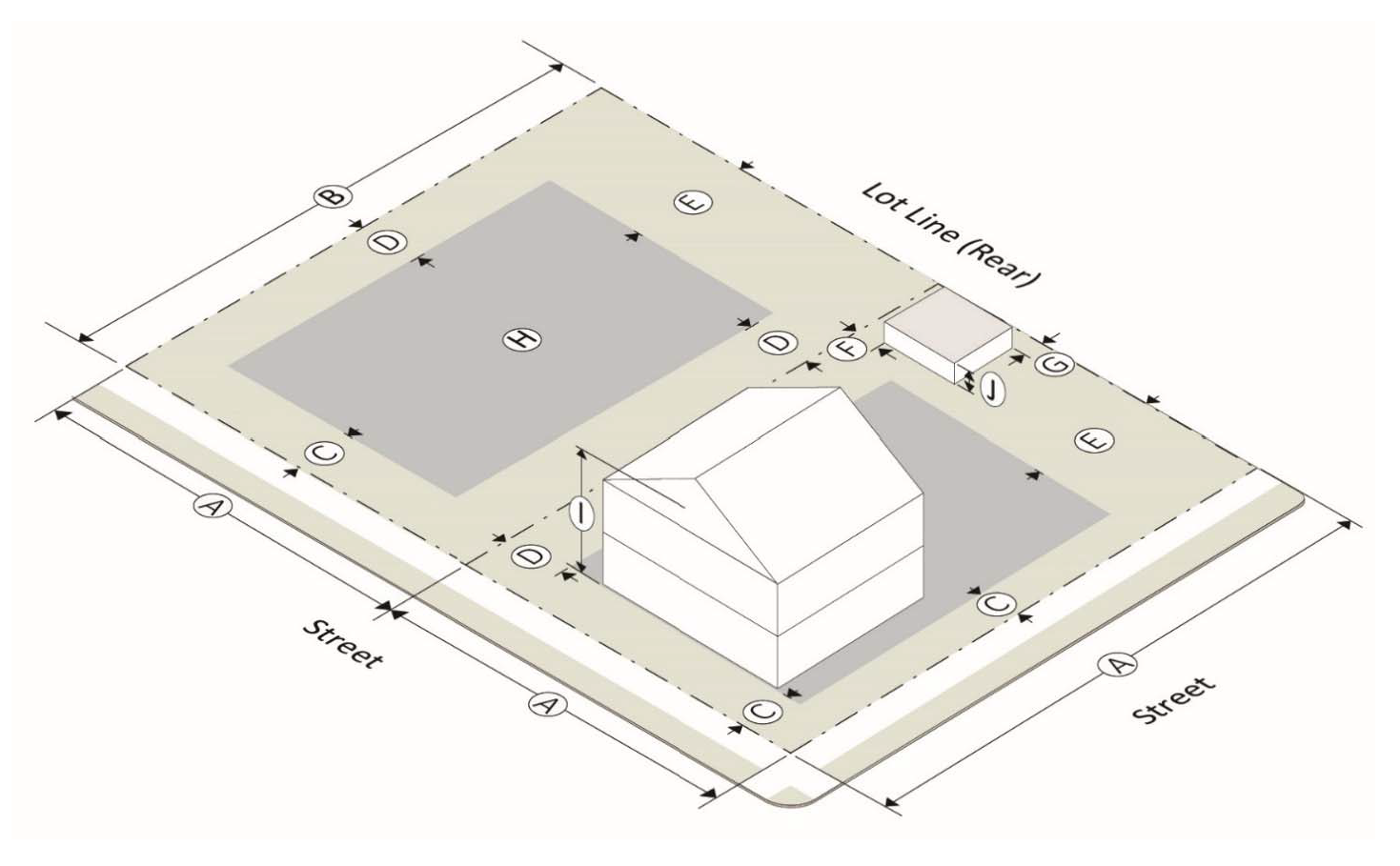
Sec. 201-5. - Interpretation of lot development standards for single-family residential districts.
The following table and graphics depict the interpretation of lot development standards for residential districts. The official definitions for these terms can be found in chapter 100, article II, definitions.
(Ord. No. 08-2019, § I, 6-3-2019)
Sec. 201-6. - R100 single-family residence.
(a)
R100 purpose. The R100 single-family residence zoning district is intended primarily for single family residences and related uses on large sized lots in the city.
(b)
R100 lot development standards.
(c)
R100 supplemental regulations.
(1)
Accessory use standards—see chapter 200, article II, supplemental and accessory use standards.
(2)
Landscape and buffering—see chapter 200, article V, tree conservation, buffers, and landscaping.
(3)
Parking and loading—see chapter 200, article III, parking and loading requirements.
(4)
Signs—see chapter 200, article IV, sign regulations.
(d)
R100 permitted uses. The following uses shall be permitted as of right in this district. Supplemental regulations for uses are in chapter 200, article II, supplemental use standards, as applicable.
(1)
Residential.
a.
Single family detached dwelling.
(2)
Services.
a.
Existing cemetery.
(3)
Educational, cultural, religious, philanthropic, social or fraternal.
a.
Places of public assembly.
(4)
Miscellaneous semi-public facilities and uses.
a.
Utility transmission and monitoring facilities.
(e)
R100 special permit uses. The following uses shall be considered special permit uses in this district. Supplemental regulations for uses are in chapter 200, article II, supplemental use standards, as applicable.
(1)
Miscellaneous lodging, rooms for rent situations.
a.
Bed and breakfast, but only when in a historic district overlay.
(2)
Educational, cultural, religious, philanthropic, social or fraternal.
a.
Elementary and secondary private education.
b.
Nursery schools and kindergartens.
(f)
R100 accessory uses. The following uses shall be considered accessory uses in this district. Supplemental regulations for uses are in article II, supplemental use standards, as applicable.
(1)
Customary residential accessory buildings.
(2)
Accessory dwelling units.
(3)
Home occupations.
(Ord. No. 08-2019, § I, 6-3-2019)
Sec. 201-7. - R75 single-family residence.
(a)
R75 purpose. The R75 single-family residence zoning district is intended primarily for single-family residences and related uses on medium sized lots in the city.
(b)
R75 lot development standards.
(c)
R75 supplemental regulations.
(1)
Accessory use standards—see chapter 200, article II, supplemental and accessory use standards.
(2)
Landscape and buffering—see chapter 200, article V, tree conservation, buffers, and landscaping.
(3)
Parking and loading—see chapter 200, article III, parking and loading requirements.
(4)
Signs—see chapter 200, article IV, sign regulations.
(d)
R75 permitted uses. The following uses shall be permitted as of right in this district. Supplemental regulations for uses are in article II, supplemental use standards, as applicable.
(1)
Residential.
a.
Single family detached dwelling.
(2)
Services.
a.
Existing cemetery.
(3)
Educational, cultural, religious, philanthropic, social or fraternal.
a.
Places of public assembly.
(4)
Miscellaneous semi-public facilities and uses.
a.
Utility transmission and monitoring facilities.
(e)
R75 special permit uses. The following uses shall be considered special permit uses in this district. Supplemental regulations for uses are in chapter 200, article II, supplemental use standards, as applicable.
(1)
Educational, cultural, religious, philanthropic, social or fraternal.
a.
Elementary and secondary private education.
(f)
R75 accessory uses. The following uses shall be considered accessory uses in this district. Supplemental regulations for uses are in chapter 200, article II, supplemental use standards, as applicable.
(1)
Customary residential accessory buildings.
(2)
Accessory dwelling units.
(3)
Home occupations.
(Ord. No. 08-2019, § I, 6-3-2019)
Sec. 201-8. - R60 single-family residence.
(a)
R60 purpose. The R60 single-family residence zoning district is intended primarily for single family residences and related uses on small sized lots in the city.
(b)
R60 lot development standards.
(c)
R60 supplemental regulations.
(1)
Accessory use standards—see chapter 200, article II, supplemental and accessory use standards.
(2)
Landscape and buffering—see chapter 200, article V, tree conservation, buffers, and landscaping.
(3)
Parking and loading—see chapter 200, article III, parking and loading requirements.
(4)
Signs—see chapter 200, article IV, sign regulations.
(d)
R60 permitted uses. The following uses shall be permitted as of right in this district. Supplemental regulations for uses are in article II, supplemental use standards, as applicable.
(1)
Residential.
a.
Single family detached dwelling.
b.
Single family detached dwelling; manufactured or modular home.
(2)
Services.
a.
Existing cemetery.
(3)
Educational, cultural, religious, philanthropic, social or fraternal.
a.
Places of public assembly.
(4)
Miscellaneous semi-public facilities and uses.
a.
Utility transmission and monitoring facilities.
(e)
R60 special permit uses. The following uses shall be considered special permit uses in this district. Supplemental regulations for uses are in article II, supplemental use standards, as applicable.
(1)
Educational, cultural, religious, philanthropic, social or fraternal.
a.
Elementary and secondary private education.
(f)
R60 accessory uses. The following uses shall be considered accessory uses in this district. Supplemental regulations for uses are in article II, supplemental use standards, as applicable.
(1)
Customary residential accessory buildings.
(2)
Accessory dwelling units.
(3)
Home occupations.
(Ord. No. 08-2019, § I, 6-3-2019)
Sec. 201-9. - RTH townhouse residence.
(a)
RTH purpose. The RTH townhouse residence zoning district is intended primarily for attached, single-family residences (townhomes) and related uses.
(b)
RTH lot development standards.
(c)
RTH supplemental regulations.
(1)
Accessory use standards—see chapter 200, article II, supplemental and accessory use standards.
(2)
Landscape and buffering—see chapter 200, article V, tree conservation, buffers, and landscaping.
(3)
Parking and loading—see chapter 200, article III, parking and loading requirements.
(4)
Signs—see chapter 200, article IV, sign regulations.
(d)
RTH permitted uses. The following uses shall be permitted as of right in this district. Supplemental regulations for uses are in chapter 200, article II, supplemental use standards, as applicable.
(1)
Residential.
a.
Single-family detached dwelling.
b.
Single-family detached dwelling; more than one housing unit per lot.
c.
Townhouse.
(2)
Services.
a.
Existing cemetery.
(3)
Educational, cultural, religious, philanthropic, social or fraternal.
a.
Places of public assembly.
(4)
Miscellaneous semi-public facilities and uses.
a.
Utility transmission and monitoring facilities.
(e)
RTH special permit uses. The following uses shall be considered special permit uses in this district. Supplemental regulations for uses are in article II, supplemental use standards, as applicable.
(1)
Educational, cultural, religious, philanthropic, social or fraternal.
a.
Elementary and secondary private education.
(f)
RTH accessory uses. The following uses shall be considered accessory uses in this district. Supplemental regulations for uses are in article II, supplemental use standards, as applicable.
(1)
Customary residential accessory buildings.
(2)
Home occupations.
(Ord. No. 08-2019, § I, 6-3-2019; Ord. No. 14-2019, 11-4-2019)
Sec. 201-10. - General provisions, multi-family residential districts.
The intent of the multi-family residential districts is to protect established multi-family residential developments as well as promote well designed and properly located similar future multi-family residential developments. The district provisions discourage any use that would substantially interfere with the residential nature of the districts. Compatible park, open space, utility and civic uses are permitted in these districts as identified in this article.
(Ord. No. 08-2019, § I, 6-3-2019)
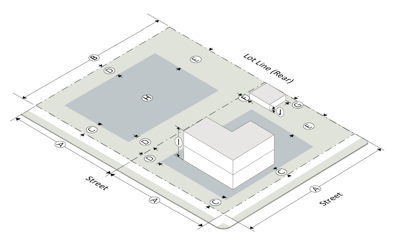
Sec. 201-11. - Interpretation of lot development standards for multi-family residential districts.
The following table and graphics depict the interpretation of lot development standards for multi-family residential districts. The official definitions for these terms can be found in the article II, definitions.
(Ord. No. 08-2019, § I, 6-3-2019)
Sec. 201-12. - RD residential duplex district.
(a)
RD purpose. The RD residential duplex zoning district is intended primarily for two-family residences and related uses.
(b)
RD lot development standards.
(c)
RD supplemental regulations.
(1)
Accessory use standards—see chapter 200, article II, supplemental and accessory use standards.
(2)
Landscape and buffering—see chapter 200, article V, tree conservation, buffers, and landscaping.
(3)
Parking and loading—see chapter 200, article III, parking and loading requirements.
(4)
Signs—see chapter 200, article IV, sign regulations.
(d)
RD permitted uses. The following uses shall be permitted as of right in this district. Supplemental regulations for uses are in chapter 200, article II, supplemental use standards, as applicable.
(1)
Residential.
a.
Single-family detached dwelling.
b.
Single-family detached dwelling; more than one housing unit per lot.
c.
Duplex.
(2)
Services.
a.
Existing cemetery.
(3)
Educational, cultural, religious, philanthropic, social or fraternal.
a.
Places of public assembly.
(4)
Miscellaneous semi-public facilities and uses.
a.
Utility transmission and monitoring facilities.
(e)
RD special permit uses. The following uses shall be considered special permit uses in this district. Supplemental regulations for uses are in article II, supplemental use standards, as applicable.
(1)
Educational, cultural, religious, philanthropic, social or fraternal.
a.
Elementary and secondary private education.
(f)
RD accessory uses. The following uses shall be considered accessory uses in this district. Supplemental regulations for uses are in chapter 200, article II, supplemental use standards, as applicable.
(1)
Customary residential accessory buildings.
(2)
Home occupations.
(Ord. No. 08-2019, § I, 6-3-2019)
Sec. 201-13. - PRD planned residence district.
(a)
PRD purpose. The PRD planned residence district is intended for higher density, multi-family residences and related uses. Approved PRDs will only contain housing types or densities allowed under the comprehensive plan's character area description.
(b)
PRD lot development standards. The PRD is a flexible district for which plans are developed and submitted for review and approval. The process for establishment, review and approval are found in chapter 100, article IV of this UDO.
(c)
PRD supplemental regulations.
(1)
Accessory use standards—see chapter 200, article II, supplemental and accessory use standards.
(2)
Landscape and buffering—see chapter 200, article V, tree conservation, buffers, and landscaping.
(3)
Parking and loading—see chapter 200, article III, parking and loading requirements.
(4)
Signs—see chapter 200, article IV, sign regulations.
(d)
PRD density. The overall density for a development in the PRD district is determined by an approved site plan for new development, or in the case of PRD development built before June 1, 2019 is determined by their approved final plats.
(e)
PRD permitted uses. The following uses shall be permitted as of right in this district. Supplemental regulations for uses are in chapter 200, article II, supplemental use standards, as applicable.
(1)
Residential.
a.
Single-family detached dwelling.
b.
Single-family detached dwelling; more than one housing unit per lot.
c.
Duplex.
d.
Townhome.
e.
Multi-family.
(2)
Group, institutional and social service living.
a.
Nursing care institutions, intermediate care institutions, handicapped or infirm institutions and child care institutions.
(3)
Services.
a.
Existing cemetery.
(4)
Educational, cultural, religious, philanthropic, social or fraternal.
a.
Places of public assembly.
(5)
Miscellaneous semi-public facilities and uses.
a.
Utility transmission and monitoring facilities.
(f)
PRD special permit uses. The following uses shall be considered special permit uses in this district. Supplemental regulations for uses are in article II, supplemental use standards, as applicable.
(1)
Educational, cultural, religious, philanthropic, social or fraternal.
a.
Elementary and secondary private education.
(g)
PRD accessory uses. The following uses shall be considered accessory uses in this district. Supplemental regulations for uses are in article II, supplemental use standards, as applicable.
(1)
Customary residential accessory buildings.
(2)
Home occupations.
(Ord. No. 08-2019, § I, 6-3-2019)
Sec. 201-14. - General provisions, mixed-use and commercial districts.
The intent of the mixed-use and commercial districts is to encourage the creation of new, and the enhancement of, existing mixed-use and commercial areas that primarily serve a variety of retail, service and office needs at a variety of intensities.
(Ord. No. 08-2019, § I, 6-3-2019)
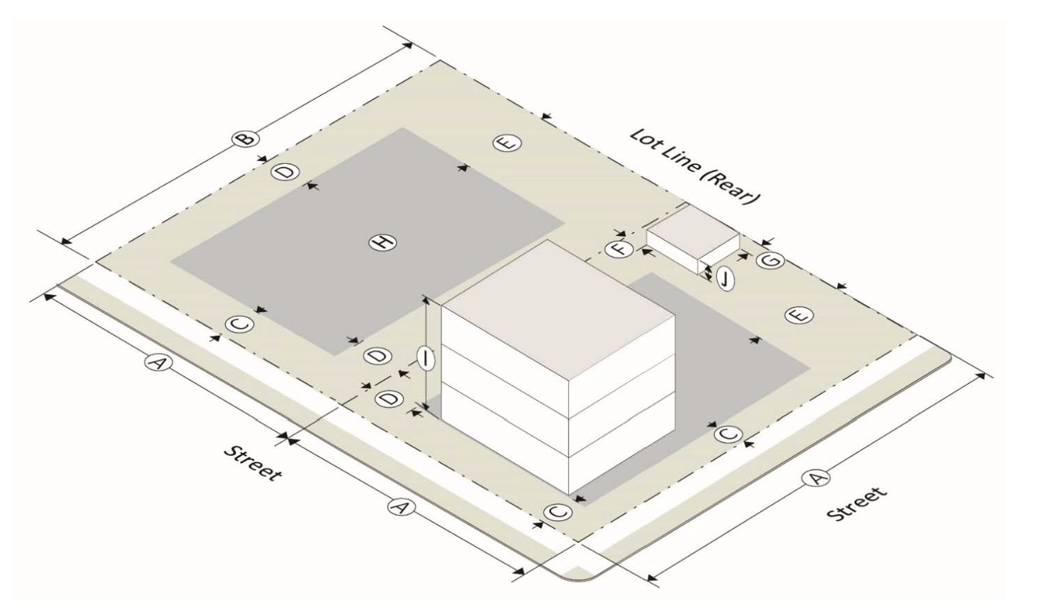
Sec. 201-15. - Interpretation of lot development standards for mixed-use and commercial districts.
The following table and graphics depict the interpretation of lot development standards for mixed-use and commercial districts. The official definitions for these terms can be found in the article II, definitions.
(Ord. No. 08-2019, § I, 6-3-2019)
Sec. 201-16. - OI office-institutional.
(a)
OI purpose. The OI office-institutional district established to provide a location for offices, institutions and limited related service activities in buildings of high character in attractive surroundings.
(b)
OI lot development standards.
(c)
OI supplemental regulations.
(1)
Accessory use standards—see chapter 200, article II, supplemental and accessory use standards.
(2)
Landscape and buffering—see chapter 200, article V, tree conservation, buffers, and landscaping.
(3)
Parking and loading—see chapter 200, article III, parking and loading requirements.
(4)
Signs—see chapter 200, article IV, sign regulations.
(d)
OI permitted uses. The following uses shall be permitted as of right in this district. Supplemental regulations for uses are in chapter 200, article II, supplemental use standards, as applicable.
(1)
Residential—group, institutional and social service living.
a.
Nursing care institutions, intermediate care institutions, handicapped or infirm institutions and child care institutions.
b.
Institutions (other than halfway houses) where mentally ill persons are confined.
(2)
Services—office, clerical, repair, research and personal not primarily related to the sale of goods or merchandise.
a.
Banks and financial institutions.
b.
Business college or business schools operated as a business enterprise.
c.
Day care center.
d.
Funeral home.
e.
Medical clinic or dental office.
f.
Personal services.
g.
Professional and business offices.
h.
Professional services.
(3)
Educational, cultural, religious, philanthropic, social or fraternal.
a.
Places of public assembly.
b.
Elementary and secondary schools.
c.
Library, museum, art gallery, art center and similar uses including associated educational and instructional activities.
(4)
Storage and parking.
a.
Automobile parking garage or parking lot not located on a lot on which there is another principal use to which the parking is related.
b.
Parking of vehicles or storage of equipment outside enclosed structures where: (i) vehicles or equipment are owned and used by the person making use of the lot, and (ii) parking or storage is more than a minor and incidental part of the overall use made of the lot.
(5)
Miscellaneous semi-public facilities and uses.
a.
Museum.
b.
Community center or recreation area.
c.
Utility transmission and monitoring facilities.
(e)
OI special permit uses. The following uses shall be considered special permit uses in this district. Supplemental regulations for uses are in article II, supplemental use standards, as applicable.
(1)
Residential—miscellaneous lodging, rooms for rent situations.
a.
Hotel.
(2)
Services—office, clerical, repair, research, and personal not primarily related to the sale of goods or merchandise.
a.
Other service establishments not listed but similar to the listed uses compatible with uses on adjoining property and meeting the intent and purpose of this district.
(3)
Educational, cultural, religious, philanthropic, social, or fraternal.
a.
Private schools, trade or vocational schools.
(4)
Food and drink.
a.
Catering or food preparation businesses.
b.
Restaurants, no drive-in or drive-thru.
(f)
OI accessory uses. Supplemental regulations for accessory uses are in chapter 200, article II, supplemental use standards, as applicable.
(Ord. No. 08-2019, § I, 6-3-2019; Ord. No. 06-2023, § I, 7-10-2023)
Sec. 201-17. - C1 neighborhood business.
(a)
C1 purpose. The C1 neighborhood business district is established to provide a location for convenience goods and services for people in nearby residential neighborhoods.
(b)
C1 lot development standards.
(c)
C1 supplemental regulations.
(1)
Accessory use standards—see chapter 200, article II, supplemental and accessory use standards.
(2)
Landscape and buffering—see chapter 200, article V, tree conservation, buffers, and landscaping.
(3)
Parking and loading—see chapter 200, article III, parking and loading requirements.
(4)
Signs—see chapter 200, article IV, sign regulations.
(d)
C1 permitted uses. The following uses shall be permitted as of right in this district. Supplemental regulations for uses are in chapter 200, article II, supplemental use standards, as applicable.
(1)
Sales and rental of goods, merchandise and equipment.
a.
Art gallery.
b.
Retail sales < 5,000 square feet.
c.
Studio or meeting facility < 5,000 square feet.
(2)
Services—office, clerical, repair, research and personal not primarily related to the sale of goods or merchandise.
a.
Banks and financial institutions.
b.
Day care center.
c.
Medical or dental office or clinic.
d.
Personal service.
e.
Professional and business office.
f.
Professional service.
(3)
Educational, cultural, religious, philanthropic, social or fraternal.
a.
Nursery school and kindergarten.
b.
Social, fraternal, clubs and lodges.
c.
Library.
d.
Museum.
(e)
C1 special permit uses. The following uses shall be considered special permit uses in this district. Supplemental regulations for uses are in article II, supplemental use standards, as applicable.
(1)
Sales and rental of goods, merchandise, and equipment.
a.
Fuel sales.
b.
Fuel sales when accessory to a permitted retail use.
c.
Studio or meeting facility 5,000—19,999 square feet.
d.
Any retail establishment not specifically permitted but which is similar to the listed uses, compatible with uses on adjoining property, and which meets the intent and purpose of the district, except that no special permit for an event hall may be given in the zoning district.
(f)
C1 accessory uses. Supplemental regulations for accessory uses are in chapter 200 article II, supplemental use standards, as applicable.
(Ord. No. 08-2019, § I, 6-3-2019; Ord. No. 06-2023, § I, 7-10-2023)
Sec. 201-18. - C2 general business.
(a)
Purpose. The C2 general business district is established to provide adequate space in appropriate locations along major streets, thoroughfares and at intersections for various types of business and service uses. These uses should include the retailing of major goods and services, general office facilities, and public functions that would serve a community area of several neighborhoods. Development of uses in the district characteristically occupies a larger area than in the C1 neighborhood business district because it is intended to serve a greater population and to offer a wider range of goods and services. Orientation and expansion of this district should occur as an increase in depth at major intersections rather than as a strip-like extension along the street or thoroughfare.
(b)
C2 Lot development standards.
(c)
C2 supplemental regulations.
(1)
Accessory use standards—see chapter 200, article II, supplemental and accessory use standards.
(2)
Landscape and buffering—see chapter 200, article V, tree conservation, buffers, and landscaping.
(3)
Parking and loading—see chapter 200, article III, parking and loading requirements.
(4)
Signs—see chapter 200, article IV, sign regulations.
(d)
C2 permitted uses. The following uses shall be permitted as of right in this district. Supplemental regulations for uses are in chapter 200, article II, supplemental use standards, as applicable.
(1)
Residential—miscellaneous, lodging, rooms for rent situations.
a.
Hotel.
(2)
Sales and rental of goods, merchandise, and equipment.
a.
Art gallery.
b.
Equipment rental—no heavy equipment or outdoor storage.
c.
Plumbing, electrical, pool, and home building supply showrooms and sales—no outdoor storage.
d.
Motorcycle sales, rental, and service.
e.
Retail sales.
f.
Studio or meeting facility.
(3)
Services—office, clerical, repair, research, and personal not primarily related to the sale of goods or merchandise.
a.
Banks and financial institutions.
b.
Building, electrical, or plumbing contractors—no outside storage.
c.
Business college or business school operated as a business enterprise.
d.
Day care center.
e.
Funeral home.
f.
Massage therapist, certified.
g.
Medical or dental office or clinic.
h.
Motorcycle service.
i.
Outdoor theater.
j.
Personal service.
k.
Professional and business office.
l.
Professional service.
m.
Taxicab or limousine service.
(4)
Manufacturing, wholesale, and warehousing.
a.
Radio, recording, or television studio and broadcast station.
(5)
Educational, cultural, religious, philanthropic, social, or fraternal.
a.
Places of public assembly.
b.
Private college, university, community college—including associated facilities such as dorms, offices, athletic fields.
c.
Libraries, museums, art galleries, art centers, and similar uses.
d.
Private schools, trade or vocational schools.
e.
Social, fraternal, clubs, and lodges.
(6)
Recreation, amusement, entertainment.
a.
Activity constructed entirely within a building or substantial structure—theater, bowling alley, skating rink, shooting range, movie theater, game room, etc.
b.
Pool hall or billiard hall—three or more tables.
(7)
Food and drink.
a.
Catering or food preparation businesses.
b.
Restaurant.
c.
Microbreweries/microdistilleries.
d.
Brew pubs.
(8)
Motor vehicle related sales and service operations.
a.
Auto parts store—no on-premise installation.
b.
Emissions inspection station.
c.
Motor vehicle service and fuel station.
(9)
Storage and parking.
a.
Automobile parking garage or parking lot not located on a lot on which there is another principal use to which the parking is related.
(10)
Services and enterprises related to animals.
a.
Veterinarian clinic—no outdoor boarding.
(11)
Miscellaneous semi-public facilities and utilities.
a.
Library.
b.
Museum.
c.
Utility transmission and monitoring facility.
(e)
C2 special permit uses. The following uses shall be considered special permit uses in this district. Supplemental regulations for uses are in article II, supplemental use standards, as applicable.
(1)
Residential—miscellaneous, lodging, rooms for rent situations.
a.
Extended stay hotel.
(2)
Sales and rental of goods, merchandise, and equipment.
a.
Building material sales.
b.
Fuel sales.
c.
Fuel sales when accessory to a permitted retail use.
d.
Garden supply center and greenhouse.
e.
Any retail establishment not specifically permitted but which is similar to the listed uses, compatible with uses on adjoining property, and which meets the intent and purpose of the district.
(3)
Services—office, clerical, repair, research, and personal—not primarily related to the sale of goods or merchandise.
a.
Hospital, clinic or other medical treatment facility greater than 10,000 square feet.
b.
Tattoo and/or body piercing establishment.
c.
Any service establishment not specifically permitted but which is similar to the listed uses, compatible with uses on adjoining property, and which meets the intent and purpose of the district.
(4)
Manufacturing, wholesale, warehousing.
a.
Wholesale warehouse—no outdoor storage.
(5)
Recreation, amusement, entertainment.
a.
Event halls.
b.
Activity conducted outside an enclosed building or substantial structure—golf driving range, etc.
(6)
Motor vehicle related sales and service operations.
a.
Automobile vehicle rental.
b.
Car wash.
c.
Motor vehicle repair and maintenance—including painting and bodywork.
d.
Motor vehicle repair and maintenance—not including substantial bodywork.
e.
Motor vehicle sales or rental—with repair and bodywork as an accessory use.
f.
Motor vehicle service and fuel station.
(7)
Miscellaneous semi-public facilities and uses.
a.
Telecommunications antenna.
b.
Telecommunications tower.
(f)
C2 accessory uses. Supplemental regulations for accessory uses are in chapter 200, article II, supplemental use standards, as applicable.
(Ord. No. 08-2019, § I, 6-3-2019; Ord. No. 05-2021, § I, 5-3-2021; Ord. No. 06-2023, § I, 7-10-2023)
Sec. 201-19. - HX historic mixed-use.
(a)
HX purpose. The HX historic mixed-use district is established to provide for a variety of retail, service, office, public and semi-public uses, with the inclusion of limited residential uses, in a pedestrian-friendly environment to promote live-work and mixed-use opportunities.
(b)
HX lot development standards.
(c)
HX supplemental regulations.
(1)
Accessory use standards—see chapter 200, article II, supplemental and accessory use standards.
(2)
Landscape and buffering—see chapter 200, article V, tree conservation, buffers, and landscaping.
(3)
Parking and loading—see chapter 200, article III, parking and loading requirements.
(4)
Signs—see chapter 200, article IV, sign regulations.
(d)
HX permitted uses. The following uses shall be permitted as of right in this district. Supplemental regulations for uses are in chapter 200, article II, supplemental use standards, as applicable.
(1)
Residential—household residence.
a.
Accessory dwelling unit.
(2)
Sales and rental of goods, merchandise, and equipment.
a.
Retail sales less than 5,000 square feet.
b.
Studio or meeting facility less than 19,999 square feet.
(3)
Services—office, clerical, repair, research, and personal not primarily related to the sale of goods or merchandise.
a.
Banks and financial institutions—no drive-in facilities.
b.
Business college or business school operated as a business enterprise.
c.
Day care center.
d.
Medical or dental office or clinic.
e.
Personal service.
f.
Professional and business office.
g.
Professional service.
(4)
Educational, cultural, religious, philanthropic, social, or fraternal.
a.
Libraries, museums, art galleries, art centers, and similar uses.
(5)
Food and drink.
a.
Restaurant—no drive-in or drive-thru.
b.
Microbreweries/microdistilleries.
c.
Brew pubs.
(6)
Mixed-use.
a.
Mixed-use as defined in chapter 100, article II.
(e)
HX special permit uses. The following uses shall be considered special permit uses in this district. Supplemental regulations for uses are in article II, Supplemental use standards, as applicable.
(1)
Residential—household residence.
a.
Townhouse.
(2)
Residential—miscellaneous, lodging, rooms for rent situations.
a.
Bed and breakfast.
b.
Hotel.
(3)
Sales and rental of goods, merchandise, and equipment.
a.
Retail sales greater than 5,000 square feet.
b.
Studio or meeting facility greater than 20,000 square feet.
c.
Any retail establishment not specifically permitted but which is similar to the listed uses, compatible with uses on adjoining property, and which meets the intent and purpose of the district.
(4)
Services—office, clerical, repair, research and personal—not primarily related to the sale of goods or merchandise.
a.
Outdoor theater.
b.
Any service establishment not specifically permitted but which is similar to the listed uses, compatible with uses on adjoining property, and which meets the intent and purpose of the district.
(5)
Educational, cultural, religious, philanthropic, social, or fraternal.
a.
Places of public assembly.
b.
Private college, university, community college—including associated facilities such as dorms, offices, athletic fields.
c.
Libraries, museums, art galleries, art centers, and similar uses.
d.
Private schools, trade or vocational schools.
e.
Social, fraternal, clubs, and lodges.
(6)
Recreation, amusement, entertainment.
a.
Activity conducted entirely within a building or substantial structure—theater, bowling alley, skating rink, movie theater, game room, etc.
b.
Event halls.
(7)
Storage and parking.
a.
Automobile parking garage or parking lot not located on a lot on which there is another principal use to which the parking is related.
(f)
HX accessory uses.
(1)
Supplemental regulations for accessory uses are in chapter 200, article II, supplemental use standards, as applicable.
(2)
Accessory dwelling unit in the HX district—may be permitted if it meets the following criteria:
a.
The principal use and secondary use shall be subject to fire separation as required by the county Fire Marshal;
b.
The dwelling unit must not occupy ground floor frontage (storefront) on South Peachtree Street or Jones Street;
c.
The dwelling unit must not displace any space that has been actively used within the preceding 12 months for retail, office, or food service, not including passive storage;
d.
The exterior appearance of any new construction will be subject to the approval of the HPC; and
e.
Only one accessory dwelling unit per lot is permitted.
(Ord. No. 08-2019, § I, 6-3-2019; Ord. No. 05-2021, § I, 5-3-2021; Ord. No. 06-2023, § I, 7-10-2023)
Sec. 201-20. - NX neighborhood mixed-use.
(a)
NX Purpose. The NX Neighborhood Mixed-Use District is established to provide suitable locations for a compatible mix of dense residential uses, convenience goods, services, office uses and dedicated open space in a compact, walkable environment. Buildings with mixed-uses are required to include a non-residential use at street level.
(b)
NX Lot Development Standards.
Note: Maximum multi-family density as allowed in the comprehensive plan character area.
(c)
NX supplemental regulations.
(1)
Accessory use standards—see chapter 200, article II, supplemental and accessory use standards.
(2)
Landscape and buffering—see chapter 200, article V, tree conservation, buffers, and landscaping.
(3)
Parking and loading—see chapter 200, article III, parking and loading requirements.
(4)
Signs—see chapter 200, article IV, sign regulations.
(d)
NX permitted uses. The following uses shall be permitted as of right in this district. Supplemental regulations for uses are in article II, supplemental use standards, as applicable.
(1)
Residential.
a.
Townhouse.
b.
Multi-family residence.
(2)
Sales and rental of goods, merchandise and equipment.
a.
Art gallery.
b.
Retail sales < 5,000 square feet.
c.
Studio or meeting facility < 5,000 square feet.
(3)
Services—office, clerical, repair, research and personal not primarily related to the sale of goods or merchandise.
a.
Banks and financial institutions.
b.
Day care center.
c.
Home occupation.
d.
Medical or dental office or clinic.
e.
Personal service.
f.
Professional and business office.
g.
Professional service.
(4)
Educational, cultural, religious, philanthropic, social or fraternal.
a.
Places of public assembly.
b.
Private college, university, community college—including associated facilities such as dorms, offices, athletic fields.
c.
Libraries, museums, art galleries, art centers and similar uses.
d.
Private schools, trade or vocational schools.
e.
Social, fraternal, clubs and lodges.
(5)
Recreation, amusement, entertainment.
a.
Activity conducted entirely within a building or substantial structure (e.g., theater).
(6)
Food and drink.
a.
Restaurant—no drive-in or drive-thru facility.
(7)
Miscellaneous semi-public facilities and utilities.
a.
Library.
b.
Museum.
c.
Utility transmission and monitoring facility.
(8)
Mixed-use.
a.
Mixed-use as defined in chapter 100, article II.
(e)
NX special permit uses. The following uses shall be considered special permit uses in this district. Supplemental regulations for uses are in chapter 200, article II, supplemental use standards, as applicable.
(1)
Sales and rental of goods, merchandise and equipment.
a.
Retail sales 5,000—24,999 square feet.
b.
Studio or meeting facility 5,000—19,999 square feet.
(f)
NX accessory uses. Supplemental regulations for accessory uses are in chapter 200, article II, supplemental use standards, as applicable.
(Ord. No. 08-2019, § I, 6-3-2019)
Sec. 201-21. - CAR commercial auto related business.
(a)
CAR purpose. The CAR auto oriented district is established to provide for a variety of retail, service, office, public and semi-public uses in an auto oriented environment including drive-in and drive through access.
(b)
CAR lot development standards.
(c)
CAR supplemental regulations.
(1)
Accessory use standards—see chapter 200, article II, supplemental and accessory use standards.
(2)
Landscape and buffering—see chapter 200, article V, tree conservation, buffers, and landscaping.
(3)
Parking and Loading—see chapter 200, article III, parking and loading requirements.
(4)
Signs—see chapter 200, article IV, sign regulations,
(d)
CAR permitted uses. The following uses shall be permitted as of right in this district. Supplemental regulations for uses are in chapter 200, article II, supplemental use standards, as applicable.
(1)
Sales and rental of goods, merchandise and equipment.
a.
Building material sales.
b.
Farm, heavy equipment, mobile home, recreational vehicle sales and service.
c.
Fuel sales.
d.
Fuel sales when accessory to a permitted retail use.
e.
Garden supply center and greenhouse.
f.
Open air market and outdoor flea market.
g.
Plumbing, electrical, pool and home building supply showrooms and sales center.
h.
Retail sales.
i.
Studio or meeting facility.
(2)
Services—office, clerical, repair, research and personal not primarily related to the sale of goods or merchandise.
a.
Banks and financial institutions.
b.
Business college or business school operated as a business enterprise.
c.
Food service/catering.
d.
Medical or dental office or clinic.
e.
Personal service.
f.
Professional and business office.
g.
Professional service.
h.
Building, electrical or plumbing contractors - No outdoor storage.
i.
Bus station or terminal, private.
j.
Taxi cab or limousine service.
(3)
Manufacturing, wholesaling, and warehousing.
a.
Truck terminal.
(4)
Food and drink.
a.
Restaurant—with or without drive-in or drive-thru facility.
(5)
Motor vehicle related sales and service operations.
a.
Automobile vehicle rental establishments.
b.
Automotive parts store.
c.
Motor vehicle service and fuel station.
d.
Car wash.
e.
Motorcycle sales, rental and service.
f.
Motor vehicle repair and maintenance - Including painting and body work.
g.
Motor vehicle repair and maintenance - Not including substantial body work.
h.
Motor vehicle sales or rental - Including repair and body work as an accessory use.
i.
Window tinting or stereo installation.
(6)
Storage and parking.
a.
Automobile parking garage or standalone parking lot.
b.
Landscaping service.
(7)
Services and enterprises related to animals.
a.
Veterinarian clinic, with or without kennel or boarding.
(8)
Educational, cultural, religious, philanthropic, social or fraternal.
a.
Places of public assembly.
b.
Private college, university, community college—including associated facilities such as dorms, offices, athletic fields.
c.
Libraries, museums, art galleries, art centers and similar uses.
d.
Private schools, trade or vocational schools.
e.
Social, fraternal, clubs and lodges.
(e)
CAR special permit uses. Any service establishment not specifically permitted, but which is similar to the listed uses, compatible with uses on adjoining property and which meets the intent and purpose of the district.
(f)
CAR accessory uses. Supplemental regulations for accessory uses are in chapter 200, article II, supplemental use standards, as applicable.
(Ord. No. 08-2019, § I, 6-3-2019)
Sec. 201-22. - CX community mixed-use.
(a)
CX purpose. The CX community mixed-use district is established to provide suitable locations for a compatible mix of residential uses, retail goods and services, office uses, and dedicated open space that serves the needs of the region.
(b)
CX lot development standards.
(c)
CX supplemental regulations.
(1)
Accessory use standards—see chapter 200, article II, supplemental and accessory use standards.
(2)
Landscape and buffering—see chapter 200, article V, tree conservation, buffers, and landscaping.
(3)
Parking and loading—see chapter 200, article III, parking and loading requirements.
(4)
Signs—see chapter 200, article IV, sign regulations.
(d)
CX permitted uses. The following uses shall be permitted as of right in this district. Supplemental regulations for uses are in chapter 200, article II, supplemental use standards, as applicable.
(1)
Residential—household residence.
a.
Multi-family residence.
b.
Townhouse.
(2)
Residential—miscellaneous, lodging, rooms for rent situations.
a.
Hotel.
(3)
Sales and rental of goods, merchandise, and equipment.
a.
Art gallery.
b.
Equipment rental—no heavy equipment or outdoor storage.
c.
Plumbing, electrical, pool, and home building supply showrooms and sales centers—no outdoor storage.
d.
Retail sales.
e.
Studio or meeting facility.
(4)
Services—office, clerical, repair, research, and personal not primarily related to the sale of goods or merchandise.
a.
Banks and financial institutions.
b.
Building, electrical or plumbing contractors—provided no equipment or materials are stored outside.
c.
Business college or business school operated as a business enterprise.
d.
Day care center.
e.
Funeral home.
f.
Medical or dental office or clinic.
g.
Outdoor theater.
h.
Personal service.
i.
Professional and business office.
j.
Professional service.
k.
Taxi cab or limousine service.
(5)
Manufacturing, wholesale, and warehousing.
a.
Radio, recording, or television studio and broadcasting station.
b.
Wholesale trade/distribution office.
c.
Logistics.
(6)
Educational, cultural, religious, philanthropic, social, or fraternal.
a.
Places of public assembly.
b.
Private college, university, community college.
c.
Library, museum, art gallery, art center, and similar uses.
d.
Private school, trade or vocational school.
e.
Social, fraternal, clubs, and lodges.
f.
Event facilities.
(7)
Recreation, amusement, entertainment.
a.
Activity conducted entirely within a building or substantial structure (e.g. theater).
b.
Pool hall or billiard hall—three or more tables.
(8)
Food and drink.
a.
Catering or food preparation businesses.
b.
Restaurant—with or without drive-in or drive-thru facility.
c.
Microbreweries/microdistilleries.
d.
Brew pubs.
(9)
Storage and parking.
a.
Automobile parking garages or parking lots not located on a lot on which there is another principal use to which the parking is related.
(10)
Services and enterprises related to animals.
a.
Veterinarian—including veterinary clinics with no outdoor kennel or boarding.
(11)
Mixed-use.
a.
Mixed-use as defined in chapter 100, article II.
(e)
CX special permit uses. The following uses shall be considered special permit uses in this district. Supplemental regulations for uses are in article II, supplemental use standards, as applicable.
(1)
Residential—miscellaneous, lodging, rooms for rent situations.
a.
Extended stay hotel.
(2)
Sales and rental of goods, merchandise, and equipment.
a.
Building material sales with outdoor storage.
b.
Fuel sales.
c.
Fuel sales when accessory to a permitted retail use.
d.
Garden supply centers and greenhouses—including outdoor storage.
e.
Similar retail establishment not listed—compatible with uses on adjoining property and which meets the intent and purpose of the district.
(3)
Services—office, clerical, repair, research, and personal not related to the sale of goods or merchandise.
a.
Hospital, clinic, or other medical treatment facility in excess of 10,000 square feet.
b.
Tattoo and/or body piercing establishment.
c.
Similar service establishment not listed—compatible with uses on adjoining property and which meets the intent and purpose of the district.
(4)
Manufacturing, wholesale, and warehousing.
a.
Wholesale warehouse—no outdoor storage.
(5)
Recreation, amusement, entertainment.
a.
Activity conducted outside enclosed building or substantial structure (e.g. driving range).
b.
Event hall.
(6)
Storage and parking.
a.
Landscaping services.
(7)
Miscellaneous public, semi-public facilities, and utilities.
a.
Telecommunication antenna.
b.
Telecommunication tower.
(f)
CX accessory uses. Supplemental regulations for accessory uses are in chapter 200, article II, supplemental use standards, as applicable.
(g)
CX residential density bonus incentive (available in the I-85 activity center character area only).
(1)
Structured parking. A density bonus of 40 percent may be applied to the overall residential component if the applicant submits a structured parking plan (garage) that is approved by the Community Development Department, plus an additional ten percent density bonus if providing electric vehicle charging stations for five percent of the parking spaces are provided, with a minimum of five charging stations.
(2)
Green building materials. A density bonus of 25 percent may be applied to the overall residential component if the applicant utilizes a minimum of three green building methods as identified by the Green Building Alliance or LEED or site components that promote energy efficiency, and which reduce surface water run-off. This would include, but not be limited to:
a.
Green roof components.
b.
Roof mounted solar panels.
c.
Cool roofing materials.
d.
Energy efficient windows.
e.
Rain gardens or bio-swales.
f.
Geothermal.
g.
Permeable pavement.
h.
Native planting.
i.
Stormwater planters.
j.
Parking lot run-off landscaping.
(3)
Calculation of density bonuses.
a.
Density bonuses are applied to the maximum residential density.
b.
A density bonus is rounded up on the half, 0.5, unit, or above.
c.
A structured parking bonus and a green building materials bonus may be combined for a maximum 75 percent increase to the maximum residential density.
(Ord. No. 08-2019, § I, 6-3-2019; Ord. No. 12-2020, § I, 12-7-2020; Ord. No. 05-2021, § I, 5-3-2021; Ord. No. 06-2023, § I, 7-10-2023)
Sec. 201-23. - BH Buford Highway.
(a)
BH purpose. The Buford Highway district is intended to encourage the redevelopment of Buford Highway in conformance with the vision for the corridor in the city's comprehensive plan and the Buford Highway Master Plan as a mixed-use and multimodal corridor. The district utilizes design standards and land use controls that will provide the necessary transition from the industrial and commercial character into the historic areas of the city, while maintaining opportunity for growth and economic vibrancy. To this end, in order to promote the vision of the city, any multifamily project within the district shall present, for administrative approval by the Mayor and Council at a regularly scheduled meeting, a plan for the mix of uses proposed for any site before moving beyond preliminary design review and approval of staff and the Architectural Review Board.
(b)
BH lot development standards.
Note: Maximum multi-family density as allowed in the comprehensive plan character area.
(c)
BH supplemental regulations.
(1)
Accessory use standards—see chapter 200, article II, supplemental and accessory use standards.
(2)
Landscape and buffering—see chapter 200, article V, tree conservation, buffers, and landscaping.
(3)
Parking and loading—see chapter 200, article III, parking and loading requirements.
(4)
Signs—see chapter 200, article IV, sign regulations.
(d)
BH permitted uses. The following uses shall be permitted as of right in this district. Supplemental regulations for uses are in chapter 200, article II, supplemental use standards, as applicable.
(1)
Residential—household residences.
a.
Townhouse.
b.
Multi-family residential—south of Buford Highway,
c.
Multi-family residential—not to exceed 350 feet north of the centerline of Buford Highway between Lively Avenue, Magnolia Street, and Holcomb Bridge Road.
d.
Where practical, any project including multi-family residential uses need to be part of an overall mixed use development within the scope of the city's mixed use definition in chapter 100, with the mix of use types approved as enumerated above in subsection (a). Amendments to previously approved mix of use types also require Mayor and Council approval.
(2)
Sales and rental of goods, merchandise and equipment.
a.
Art gallery.
b.
Retail sales, except automotive related retail sales are not allowed.
c.
Studio or meeting facility.
(3)
Services—office, clerical, repair, research and personal not primarily related to the sale of goods or merchandise.
a.
Banks and financial institutions.
b.
Business college or business school operated as a business enterprise.
c.
Day care center.
d.
Medical or dental office or clinic.
e.
Personal service.
f.
Professional service.
g.
Professional and business office.
(4)
Recreation, amusement, entertainment.
a.
Activity conducted entirely within building or substantial structure—theater, bowling alley, skating rink, shooting range, movie theatre, game room, etc.
(5)
Food and drink.
a.
Restaurant.
b.
Brew pubs.
c.
Microbreweries/microdistilleries—with or without food.
d.
Catering facilities.
(6)
Educational, cultural, religious, philanthropic, social or fraternal.
a.
Places of public assembly.
b.
Library.
c.
Museum.
d.
Art galleries, art centers and similar uses.
e.
College, university, community college—including associated facilities such as dorms, offices, athletic fields, etc.
(7)
Mixed-use.
a.
Mixed-use as defined in chapter 100, article II.
(e)
BH special permit uses. The following uses shall be considered special permit uses in this district. Supplemental regulations for uses are in article II, supplemental use standards, as applicable.
(1)
Residential—miscellaneous, lodging, rooms for rent.
a.
Hotel.
(2)
Sales and rental of goods, merchandise and equipment.
a.
Fuel sales.
b.
Any retail establishment not specifically permitted, but which is similar to the listed uses, compatible with uses on adjoining property and which meets the intent and purpose of the district.
(3)
Services—office, clerical, repair, research and personal—not primarily related to the sale of goods or merchandise.
a.
Any service establishment not specifically permitted, but which is similar to the listed uses, compatible with uses on adjoining property and which meets the intent and purpose of the district.
(4)
Storage and parking.
a.
Automobile parking garage.
b.
Standalone parking.
c.
Landscaping services.
(5)
Miscellaneous semi-public facilities and utilities.
a.
Telecommunications antenna.
b.
Telecommunications tower.
(f)
BH accessory uses. Supplemental regulations for accessory uses are in chapter 200, article II, supplemental use standards, as applicable.
(g)
BH residential density bonus incentive.
(1)
Structured parking. A density bonus of 40 percent may be applied to the overall residential component if the applicant submits a structured parking plan (garage) that is approved by the Community Development Department, plus and additional 10 percent density bonus if providing Electric Vehicle charging stations for 5% of the parking spaces are provided, with a minimum of 5 charging stations.
(2)
Green building materials. A density bonus of 25 percent may be applied to the overall residential component if the applicant utilizes a minimum of three green building methods as identified by the Green Building Alliance or LEED, or site components that promote energy efficiency, and which reduce surface water run-off. This would include, but not be limited to:
a.
Green roof components.
b.
Roof mounted solar panels.
c.
Cool roofing materials.
d.
Energy efficient windows.
e.
Rain gardens or bio-swales.
f.
Geothermal.
g.
Permeable pavement.
h.
Native planting.
i.
Stormwater planters.
j.
Parking lot run-off landscaping.
(3)
Calculation of density bonuses.
a.
Density bonuses are applied to the maximum residential density.
b.
A density bonus is rounded up on the half, 0.5, unit or above.
c.
A structured parking bonus and a green building materials bonus may be combined for a maximum 75 percent increase to the maximum residential density.
(Ord. No. 08-2019, § I, 6-3-2019; Ord. No. 05-2021, § I, 5-3-2021; Ord. No. 08-2022, § I, 8-1-2022)
Sec. 201-24. - General provisions, industrial districts.
The intent of the industrial districts is to encourage the preservation of existing and the creation of new areas that have the necessary infrastructure in place to promote manufacturing uses of varying types and intensities.
(Ord. No. 08-2019, § I, 6-3-2019)
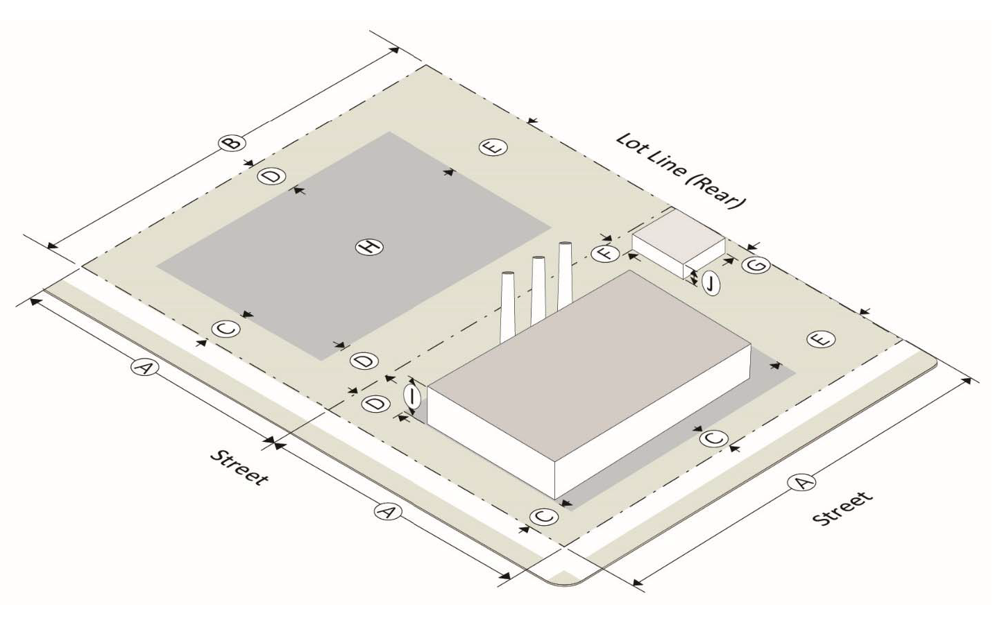
Sec. 201-25. - Interpretation of lot development standards for industrial districts.
The following table and graphics depict the interpretation of lot development standards for industrial districts. The official definitions for these terms can be found in the chapter 100, article II, definitions.
Sec. 201-26. - M1 light industry.
(a)
M1 purpose. The M1 light industry district is comprised of lands that are located on, or have ready access to, a major street or state highway and are well adapted to industrial development but whose proximity to residential or commercial districts makes it desirable to limit industrial operations and processes to those that are not objectionable by reason of the emission of noise, vibration, smoke, dust, gas, fumes, odors or radiation and that do not create fire or explosion hazards or other objectionable conditions.
(b)
M1 lot development standards.
(c)
M1 supplemental regulations.
(1)
Accessory use standards—see chapter 200, article II, supplemental and accessory use standards.
(2)
Landscape and buffering—see chapter 200, article V, tree conservation, buffers, and landscaping.
(3)
Parking and loading—see chapter 200, article III, parking and loading requirements.
(4)
Signs—see chapter 200, article IV, sign regulations.
(d)
M1 permitted uses. The following uses shall be permitted as of right in this district. Supplemental regulations for uses are in article II, supplemental use standards, as applicable.
(1)
Sales and rental of goods, merchandise and equipment.
a.
Equipment rental—including heavy equipment or outdoor storage.
b.
Farm and heavy equipment, mobile home, recreational vehicles and equipment—including sales and service.
c.
Garden supply center and greenhouse—including outdoor storage.
d.
Microbrewery/microdistillery.
e.
Open air market and outdoor flea market.
f.
Plumbing, electrical, pool and home building supply showroom and sales center.
(2)
Services—office, clerical, repair, research and personal not primarily related to the sale of goods or merchandise.
a.
Building, electrical or plumbing contractor.
b.
Business college or business school operated as a business enterprise.
c.
Machine or welding shop.
d.
Professional and business office.
e.
Professional service.
f.
Taxi cab or limousine service.
(3)
Manufacturing, wholesale, and warehousing.
a.
Building material or other outdoor storage yard—excluding junk yard.
b.
Business that services industries.
c.
Cold storage plant.
d.
Food processing.
e.
Manufacturing, artisanal.
f.
Manufacturing, light.
g.
Radio, recording or television studio and broadcasting station.
h.
Warehouse.
i.
Wholesale trade/distribution office—with showroom.
j.
Wholesale warehouse.
k.
Similar industry that meets district standards.
l.
Microbreweries.
(4)
Educational, cultural, religious, philanthropic, social or fraternal.
a.
Places of public assembly.
b.
Private school, trade or vocational.
c.
Library.
d.
Museum.
e.
Art galleries, art centers and similar uses.
f.
College, university, community college—including associated facilities such as dorms, offices, athletic fields, etc.
(5)
Recreation, amusement, entertainment.
a.
Activity conducted entirely within building or substantial structure—theater, bowling alley, skating rink, shooting range, movie theatre, game room, etc.
b.
Activity conducted outside enclosed building or substantial structure—driving range, etc.
c.
Adult entertainment.
d.
Massage therapy.
(6)
Motor vehicle related sales and service.
a.
Automobile vehicle rental.
b.
Emission inspection station.
c.
Motor vehicle repair and maintenance—including paint and body work.
d.
Motor vehicle repair and maintenance—not including substantial body work.
e.
Motor vehicle sales and rental—including repair and body work as an accessory use.
(7)
Storage and parking.
a.
Landscaping service.
b.
Mini-warehouse—no flammable or hazardous materials.
c.
Parking of fleet vehicles or storage of equipment outside enclosed structures accessory to the permitted use on site.
(8)
Services and enterprise related to animals.
a.
Animal hospital or veterinarian clinic—including outdoor kennel or boarding.
(9)
Miscellaneous semi-public facilities and utilities.
a.
Telecommunications antenna.
b.
Telecommunications tower.
(e)
M1 special permit uses. The following uses shall be considered special permit uses in this district. Supplemental regulations for uses are in article II, supplemental use standards, as applicable.
(1)
Sales and rental of goods, merchandise and equipment.
a.
Any retail establishment not specifically permitted, but which is similar to the listed uses, compatible with uses on adjoining property and which meets the intent and purpose of the district.
(2)
Services—office, clerical, repair, research and personal—not primarily related to the sale of goods or merchandise.
a.
Any service establishment not specifically permitted, but which is similar to the listed uses, compatible with uses on adjoining property and which meets the intent and purpose of the district.
(f)
M1 accessory uses. Supplemental regulations for accessory uses are in chapter 200, article II, supplemental use standards, as applicable.
(Ord. No. 08-2019, § I, 6-3-2019; Ord. No. 05-2021, § I, 5-3-2021)
Sec. 201-27. - M2 heavy industry.
(a)
M2 purpose. The M-2 heavy industry district provides a location for industrial operations and processes conducted both indoors and outdoors, and which due to their intensity of use and potential off-site impacts, should be located on or have ready access to a major thoroughfare or state highway.
(b)
M2 lot development standards.
(c)
M2 supplemental regulations.
(1)
Accessory use standards—see chapter 200, article II, supplemental and accessory use standards.
(2)
Landscape and buffering—see chapter 200, article V, tree conservation, buffers, and landscaping.
(3)
Parking and loading—see chapter 200, article III, parking and loading requirements.
(4)
Signs—see chapter 200, article IV, sign regulations.
(d)
M2 permitted uses. The following uses shall be permitted as of right in this district. Supplemental regulations for uses are in chapter 200, article II, supplemental use standards, as applicable.
(1)
Sales and rental of goods, merchandise and equipment.
a.
Farm and heavy equipment, mobile home, recreational vehicles and equipment—including sales and service.
(2)
Services—office, clerical, repair, research and personal not primarily related to the sale of goods or merchandise.
a.
Bus station or terminal—private.
b.
Machine or welding shop.
c.
Professional and business office.
(3)
Manufacturing, wholesale, and warehousing.
a.
Building material or other outdoor storage yard—excluding junk yard.
b.
Business that services industries.
c.
Cold storage plant.
d.
Manufacturing, artisanal.
e.
Manufacturing, heavy.
f.
Manufacturing, light.
g.
Truck terminal.
h.
Warehouse.
i.
Similar industry that meets district standards.
(4)
Motor vehicle related sales and service.
a.
Motor vehicle repair and maintenance—including paint and body work.
b.
Motor vehicle repair and maintenance—not including substantial body work.
(5)
Storage and parking.
a.
Landscaping service.
b.
Mini-warehouse—no flammable or hazardous materials.
c.
Parking of fleet vehicles or storage of equipment outside enclosed structures accessory to the permitted use on site.
(6)
Agriculture, silviculture, mining, quarrying operations.
a.
Yard trimming composting.
(e)
M2 special permit uses. The following uses shall be considered special permit uses in this district. Supplemental regulations for uses are in article II, supplemental use standards, as applicable.
(1)
Services—office, clerical, repair, research and personal—not primarily related to the sale of goods or merchandise.
a.
Any service establishment not specifically permitted, but which is similar to the listed uses, compatible with uses on adjoining property and which meets the intent and purpose of the district.
(f)
M2 accessory uses. Supplemental regulations for accessory uses are in chapter 200, article II, supplemental use standards, as applicable.
(Ord. No. 08-2019, § I, 6-3-2019)
Sec. 201-28. - Purpose and intent of special districts.
The intent of the special districts to provide additional standards and protections for special or unique areas in the city. These districts include public lands, public rights-of-way, and a variety of overlay districts. Overlay districts are placed over an existing base zoning district(s) and impose special provisions in addition to those in the underlying base zone. An overlay district can share common boundaries with the base zone or cut across base zone boundaries.
(Ord. No. 08-2019, § I, 6-3-2019)
Sec. 201-29. - P public.
(a)
P purpose. The P public district is established to provide a district for public uses including public facilities in road rights-of-way, government buildings, schools and publicly owned parks and recreation facilities, in accordance with the comprehensive plan for the city.
(b)
P lot development standards. The city is exempt from all lot development standards but are subject to a concept plan approval.
(c)
P supplemental regulations. Applicable supplemental use regulations shall be as established in chapter 200, article II, use regulations and restrictions.
(Ord. No. 08-2019, § I, 6-3-2019)
Sec. 201-30. - FH flood hazard overlay district.
(a)
FH purpose. The FH flood hazard district is comprised of lands that are subject to periodic flooding. The intent of the regulations within this zoning district is to limit the use of such floodplain lands to:
(1)
Prevent flood damage to persons and properties and minimize expenditures for flood relief programs, flood control projects and flood damage repair.
(2)
Preserve drainage courses that will be adequate to carry stormwater runoff from existing and future land developments.
(3)
Prohibit landfills or other obstructions to the flow of floodwaters, except those included in the permitted uses listed below.
(4)
Permit uses that are appropriate on floodplains and utilize effectively this valuable city resource.
(b)
FH uses permitted. Uses permitted within the FH flood hazard district, are subject to the provisions of chapter 400, article 4, floodplain management.
(c)
Procedure for correction of error in the FH flood hazard zoning district boundary line. If a property owner can demonstrate to the satisfaction of the Zoning Board of Appeals that an error has been made in establishing the flood hazard zoning district boundary line and that his property or a designated portion of it that now lies in the flood hazard zoning district is actually not subject to flooding, the Zoning Board of Appeals may correct the flood hazard district boundary line accordingly. The Zoning Board of Appeals and the property owner involved may seek the advice and assistance of the Soil Conservation Service of the Department of Agriculture or of the United States Army Corps of Engineers.
(Ord. No. 08-2019, § I, 6-3-2019)
Sec. 201-31. - CSO conservation subdivision overlay district.
(a)
CSO purposes. The purposes of this overlay district are as follows:
(1)
To encourage the development of residential communities, that are density neutral based upon the comprehensive plan, designed to preserve and protect environmental resources, scenic vistas, and natural and cultivated landscapes.
(2)
To enhance land, water, air and tree resources by minimizing the area of land disturbance, reducing impervious surface, optimizing stream buffers, preserving tree cover and encouraging retention and protection of conservation space.
(3)
To reduce infrastructure maintenance costs as a result of efficient community design.
(4)
To provide conservation space and pedestrian linkages and wildlife corridors among residential communities and to encourage recreation opportunities.
(5)
To preserve significant historical and archeological features.
(6)
To preserve and protect contiguous undeveloped areas within the development.
(b)
CSO applicability.
(1)
This overlay district may be overlaid only upon the R100 and R75 districts utilizing the public sanitary sewer system.
(2)
Any conditions of zoning or special use approval of the underlying district shall also be observed (exception: lot area, width or quantity).
(3)
For properties which are submitted for rezoning to R100 or R75, the applicant shall declare the intent to utilize this overlay district at the time of application and the application shall be accompanied by an existing features site analysis plan, an environmental site assessment (phase one) report, and a concept plan meeting the requirements of this subsection.
(4)
In the absence of a declaration of intent to use the overlay district with a rezoning application, the overlay district shall not be used on rezoned property for at least two years from the date of the resolution adopting a zoning change.
(c)
CSO permitted uses. Those uses permitted in the underlying district are permitted.
(d)
CSO existing features site analysis plan. At time of development, or if a zoning action is proposed, and prior to preparing the concept plan, an existing features site analysis plan, sealed by a registered engineer or landscape architect, and an environmental site assessment (phase one) report, shall be prepared and submitted by the applicant or developer.
(1)
Purpose. The purposes of the site analysis plan are to:
a.
Delineate areas that have been identified as worthy of permanent protection in conservation space because of their environmental values. This delineation shall include, but shall not be limited to, the information and steps listed in this section.
b.
Set forth the particulars of the site, including boundary, topographic data (minimum four-foot contour intervals), existing structures and utility easements.
c.
Together with the environmental site assessment (phase one) report, provide the starting point for design of the conservation subdivision with built areas being designed as separate from the areas delineated as worthy of permanent protection.
(2)
Existing features. The existing features site analysis plan shall include at least the following information:
a.
Perennial and intermittent streams, FEMA designated 100-year flood hazard zones and wetlands. The source of this information shall also be indicated.
b.
Identification of tree lines, native woodlands, open fields or meadows, peaks or rock outcroppings, and prime agricultural land.
c.
Delineation of tree resource areas by type such as hardwoods, pines or mixed; and old or new growth.
d.
Delineation of steep slope areas (15 percent or greater). The designer shall endeavor to preserve slopes greater than 40 percent.
e.
Identification of historical, archeological or other significant features identified in the environmental site assessment (phase one) report.
f.
Identification of conservation space, open space or common areas adjacent to the project.
g.
Identification of protected plant species as listed by the state department of natural resources, to be certified by a registered landscape architect, forester, arborist, biologist, botanist or horticulturist. The plan also shall include certification that timber harvesting activity has not occurred on the property in the previous 24 months prior to the approval of a rezoning application or the approval of a concept plan. At time of development, a concept plan shall be submitted by the developer for review and approval in accordance with the requirements and procedures of the development regulations. If a zoning action is proposed, the rezoning site plan shall include the following information:
1.
Delineation and specifications of conservation space including calculations and exclusions (see section 1316.5.c); and any pocket parks, neighborhood greens, play areas, or trail system to be constructed.
2.
A typical detail on the plan indicating dwelling size, lot width, building setback lines, off-street parking, street trees, sidewalks, and street pavement and right-of-way width.
3.
Lot width average, area and percent of floodplain specifications in tabular form; and density calculations (gross and net).
(3)
Density. Subdivisions in the overlay district may build to a maximum net density in excess of that normally allowed in the underlying district in exchange for the dedication of conservation space, as follows:
a.
R100—normally allows 2.9 dwelling units per acre (DUA), can build to 3.6 DUA in R100 CSO with the dedication of 40 percent conservation space;
b.
R75—normally allowed 3.6 DUA, can build to 5.8 DUA with the dedication of 40 percent conservation space.
c.
Accessory dwelling units are not counted in the density calculations.
(4)
Conservation space requirements. In order to qualify for this overlay district, conservation space shall meet the following requirements:
a.
Delineation. Priority shall be given in delineating conservation space areas as those areas of significance identified in the existing features site analysis plan, around which the built areas are designed.
b.
Undeveloped and natural. Conservation space shall remain undeveloped and natural except for the provision of non-motorized passive recreation opportunities such as running, walking, biking, and similar outdoor activities. Wetland and stream bank mitigation projects also are permitted. Primary conservation areas are required to be included in the conservation space. These areas shall be covered by a provision for permanent protection and shall include 100-year floodplains, stream buffer zones, slopes greater than 40 percent consisting of a contiguous area of at least 5,000 square feet, wetlands, endangered or threatened species or their habitat, archeological sites, cemeteries or burial grounds. Secondary conservation areas are features and areas recommended and desirable for conservation space designation and may be covered by the provisions for permanent protection. These include important historic sites, existing healthy, native forests of at least one contiguous acre, scenic view sheds, peaks and rock outcroppings, prime agriculture lands, and existing trails that connect the tract to neighboring areas. Also considered secondary conservation areas are pocket parks, neighborhood greens and stormwater management facilities and practices and may be constructed and maintained in conservation space. However, pocket parks and neighborhood greens shall not exceed ten percent of the total required conservation space.
(5)
Exclusions. Excluded from meeting the minimum amount of conservation space are the following (also see the definition of primary conservation areas):
a.
Residential yards.
b.
Recreation area improvements. Impervious surfaces in recreation areas shall not be credited.
c.
Easements. Land area within power, or gas pipeline easements, sewer line easements or pump stations shall not be credited.
d.
Other. Land area devoted to public or private streets or any land that has been, or is to be, conveyed to a public agency via a purchase agreement for such uses as parks, schools, or other public facilities shall not be credited.
(6)
Ownership. Conservation space shall be owned in fee-simple by a mandatory property owner's association; or other entity approved in advance by the Mayor and Council during their normal course of business. The developer shall record the deed to the conservation space prior to, or concurrent with, the recording of the first final subdivision plat. An access easement following the alignment of future public streets is acceptable. However, pocket parks or neighborhood greens may be deeded concurrent with the unit or phase of the final subdivision plat of which it is a part.
(7)
Property owner's association. The property owner's association bylaws or covenants, at a minimum, shall contain the following provisions:
a.
Governance of the association by the Georgia Property Owner's Association Act (O.C.G.A. § 44-3-220 et seq.) or a successor to that Act that grants lien rights to the association for maintenance expenses and tax obligations.
b.
Responsibility for the appropriate maintenance of the conservation space and should include removal of invasive or exotic plant species such as Chinese privet, kudzu and Japanese honeysuckle.
c.
Responsibility for insurance and taxes.
d.
Automatic compulsory membership of all lot purchasers and their successors; and compulsory assessments.
e.
Conditions and timing of transferring control of the association from the developer to the lot owners.
f.
Guarantee that the association will not be dissolved without the advance approval of the Mayor and Council.
(8)
Maintenance. The property owner's association, or other entity approved in advance by the Mayor and Council, shall be responsible for the continuous maintenance of buffers, conservation space and recreation areas.
(9)
Conservation surety. Conservation space delineated on the final plat and required to be in a primary conservation area shall be permanently protected by either one or both of the following options:
a.
Option 1, conveyance to the public and subdivision lot owners. A deed conveying ownership of the conservation space to the mandatory property owner's association shall be recorded and delivered prior to, or concurrent with, the approval of the final plat for the first phase of the subdivision. Both the deed and the final plat shall contain, at a minimum, the following covenant:
"The conservation space conveyed by deed and shown on the final plat shall remain permanently protected and shall not be disturbed, cleared or developed except in accordance with section 1316.6.b. of the 1985 Zoning Resolution of the City of Norcross and with O.C.G.A. § 36-22-1 et seq., having the following greenspace goals: protection of streams, floodplains and wetlands; steep slopes; woodlands, open fields and meadows; historical and archeological features; significant wildlife habitats; scenic vistas; passive recreation and connectivity with nearby open spaces. The following uses may be allowed: passive recreational amenities, such as pervious-surface paths and minimal parking spaces; picnic and restroom facilities (constructed facilities shall not exceed 15 percent of the conservation space). This covenant is intended to benefit said area to the public and the use of same to the subdivision lot owners and residents, and it shall run in perpetuity as provided by O.C.G.A. § 44-5-60(c)."
b.
Option 2, conveyance to other qualified organizations or entities. Except for pocket parks or neighborhood greens, developed recreation areas or secondary conservation areas not desired for permanent protection, conservation space shall be permanently protected by the:
1.
Recording of a covenant or conveyance of an easement which runs in perpetuity under O.C.G.A. § 44-5-60 in favor of any corporation, trust, or other organization holding land for the use of the public or certain governmental entities; or
2.
Conveyance of a conservation easement running in perpetuity to a third-party qualified organization recognized by Federal Treasury Regulation section 170A-14(c)(1). Qualified organizations recognized by this treasury regulation include, but may not be limited to, governmental entities, certain publicly supported charities, local and national land trusts, or other conservation groups that are organized or operated primarily or substantially for one of the conservation purposes specified in the Internal Revenue Code. Governmental entities that qualify to be named in covenants under O.C.G.A. § 44-5-60 or to receive conservation easements under the treasury regulation referred to in this subsection (h)(2)b for purposes of this section shall include the federal government, the state, the city, or authorities of the state or the city. If a covenant is recorded or an easement conveyed in favor of a governmental entity, formal acceptance by the governmental entity or qualified conservation organization shall be obtained prior to the recording of the covenant or conveyance of the easement. The developer shall record the necessary legal instrument to accomplish protection of the conservation space prior to, or concurrent with, the recording of the final plat. The legal instrument shall contain, at a minimum, the same language required to be placed on a deed as stated in option 1 of this section. Secondary conservation areas may also be covered by the same permanent protection options.
(10)
Development requirements. Subdivisions in this overlay district shall meet the following requirements unless a special use permit is submitted and approved by the Mayor and City Council:
a.
Minimum subdivision size: Three contiguous acres.
b.
Lot area: No minimum.
c.
Average lot width: The average width of all building lots shall be at least 60 feet.
d.
Minimum road frontage per lot: 40 feet. Exception: Road frontage may be reduced to 20 feet for lots with frontage upon cul-de-sac or "eyebrow cul-de-sac" turnarounds.
e.
Minimum yard areas (setbacks):
1.
Front: 20 feet. Exception: The front yard setback may be reduced to five feet if dwellings are constructed with side or rear entry garages. To qualify for the reduced setback on a corner lot, side entry garages must be located to the side adjacent to an abutting lot.
2.
Rear: 20 feet.
3.
Side: five feet.
f.
Maximum height: 35 feet.
g.
Garages: Dwellings shall have two-car garages.
h.
Street trees: street trees, in accordance with the requirements of chapter 200, article V, tree conservation, buffers, and landscaping, shall be provided.
i.
Underground utilities: utilities shall be located underground.
(11)
Grandfathering.
a.
Any concept plan approved prior to the adoption of this amendment shall be considered "grandfathered" and, at the developer's option, may proceed to project completion.
b.
Any concept plan submitted but not approved shall be considered "grandfathered" and, at the developer's option, may proceed to plan approval and project completion provided that the concept plan is approved within 90 calendar days of the adoption of this amendment.
(Ord. No. 08-2019, § I, 6-3-2019)
Sec. 201-32. - H historic overlay districts.
(a)
H purpose. The purpose and intent of this section to establish a uniform procedure for use in providing for the protection, enhancement, perpetuation and use of places, districts, sites, buildings, structures, objects, and landscape features having a special historical, cultural or aesthetic interest or value, in areas defined as both the local and national historic districts.
(b)
Applicability and the difference between local and national historic districts.
(1)
The city has two types of historic overlay districts, local and national.
(2)
Local and national historic districts can overlap, in which case the provisions of a local historic district take precedence over those of national historic districts.
(3)
Construction, major changes, and demolition of structures within the local historic districts are subject to HPC approval. The HPC is also responsible for issuing certificates of appropriateness within a local historic district.
(4)
Construction, major changes, and demolition of structures within national historic districts only, outside of a local historic district, are subject to ARB approval. The ARB is also responsible for issuing certificates of appropriateness within the national historic district, but outside the local historic district.
(5)
Minor structure changes within the historic districts are subject to administrative approval by the Director.
(6)
New historic districts and properties can be established by the Council based on HPC recommendations.
(7)
Properties within any historic district are subject to the city design guidelines.
(c)
Recommendation and designation of historic districts and properties.
(1)
Preliminary research by the HPC.
a.
HPC's mandate to conduct and maintain a survey of local historical resources. The HPC shall compile and collect information and conduct surveys of historic resources within the city.
b.
HPC's power to recommend districts and buildings to the City Council for designation. The HPC shall present to the City Council recommendations for historic districts and properties.
c.
HPC's documentation of proposed designation. Prior to the HPC's recommendation of a historic district or historic property to the City Council for designation, the HPC shall prepare a report for nomination consisting of:
1.
A physical description;
2.
A statement of the historical, cultural, architectural and/or aesthetic significance;
3.
A map showing district boundaries and classification {i.e. contributing, non-contributing or historic, non-historic, vacant, intrusive} of individual properties therein, or showing boundaries of individual historic properties; and
4.
Representative photographs.
(2)
Designation of a historic district.
a.
Criteria for selection of historic districts. A historic district is a geographically definable area, either contiguous or not per the recommendation of the HPC which contains buildings, structures, sites, objects, and landscape features or a combination thereof, which:
1.
Has special character or special historic/aesthetic value or interest;
2.
Represents one or more periods, styles or types of architecture typical of one or more eras in the history of the municipality, county, state or region; and
3.
Causes such area, by reason of such factors, to constitute a visibly perceptible section of the municipality or county.
b.
Boundaries of a historic district. Boundaries of a historic district shall be included in the separate ordinances designating such districts and shall be shown on the official zoning map of the city.
c.
Evaluation of properties within historic districts. Individual properties within historic districts shall be classified as:
1.
Historic (more than 50 years old);
2.
Non-historic (less than 50 years old, yet possessing architectural character);
3.
Intrusion (structure less than 50 years old which do not contribute to the character of the district);
4.
Vacant.
(3)
Designation of a historic property.
a.
Criteria for selection of historic properties. A historic property is a building, structure, site, or object; including the adjacent area necessary for the proper appreciation or use thereof, deemed worthy of preservation by reason of value to the city, the region or the state for one of the following reasons:
1.
It is an outstanding example of a structure representative of its era;
2.
It is one of the few remaining examples of a past architectural style;
3.
It is a place or structure associated with an event or persons of historic or cultural significance to the city, state, or the region; or
4.
It is the site of natural or aesthetic interest that is continuing to contribute to the cultural or historical development and heritage of the municipality, county, state or region.
(4)
Requirements for adopting an ordinance for the designation of historic districts and historic properties.
a.
Application for designation of historic districts of property. Designations may be proposed by the City Council, the HPC, or:
1.
For historic districts—a historical society, neighborhood association or group of property owners may apply to the HPC for designation;
2.
For historic properties—a historical society, neighborhood association or property owner may apply to the HPC for designation.
b.
Required components of a designation ordinance. Any ordinance designating any property or district as historic shall:
1.
List each property in a proposed historic district of describe the proposed individual historic property;
2.
Set forth the name(s) of the owner(s) of the designated property or properties;
3.
Require that a certificate of appropriateness be obtained from the HPC prior to any material change in appearance of the designated property; and
4.
Require that the property or district be shown on the official zoning map of the city and be kept as a public record to provide notice of such designation.
c.
Require public hearings. The HPC or the City Council shall hold a public hearing on any proposed ordinance for the designation of any historic district or property. Notice of the hearing shall be published in at least three consecutive issues in the principle newspaper of local circulation, and written notice of the hearing shall be mailed by the HPC to all owners and occupants of such properties. All such notices shall be published or mailed not less than ten days but not more than 20 days prior to the date set for the public hearing. A notice sent via the United States mail to the last-known owner of the property shown on the city tax digest and a notice sent via attention of the occupant shall constitute legal notification to the owner and occupant under this chapter.
d.
Notification of Historic Preservation Division. No less than 30 days prior to making a recommendation on any ordinance designating a property or district as historic, the HPC must submit the report, required in subsection 201-32.C.1.c. to the Historic Preservation Division of the Department of Natural Resources.
e.
Recommendations on proposed designations. A recommendation to affirm, modify or withdraw the proposed ordinance for designation shall be made by the HPC within 15 days following the public hearing and shall be in the form of a resolution to the City Council.
f.
The City Council actions on the HPC's recommendation. Following receipt of the HPC recommendation, the City Council may adopt the ordinance as proposed, may adopt the ordinance with any amendments they deem necessary, or reject the ordinance.
g.
Notification of adoption of ordinance for designation. Within 30 days following the adoption of the ordinance for designation by the City Council, the owners and occupants of each designated historic property, and the owners and occupants of each structure, site or work of art located within a designated historic district, shall be given written notification of such designation by the City Council, which notice shall apprise said owners and occupants of the necessity of obtaining a certificate of appropriateness prior to undertaking any material change in appearance of the historic property designated or within the historic district designated. A notice sent via the United States mail to the last-known owner of the property shown on the city tax digest and a notice sent via United States Mail shall constitute legal notification to the owner and occupant under this chapter.
h.
Notification of other agencies regarding designation. The HPC shall notify all necessary agencies within the city of the ordinance for designation.
i.
Moratorium on applications for alteration or demolition while ordinance for designation is pending. If an ordinance for designation is being considered, the HPC shall have the power to freeze the status of the involved property.
(d)
Maintenance of historic properties and building and zoning code provisions.
(1)
Ordinary maintenance or repair. Ordinary maintenance or repair of any exterior architectural or environmental feature in or on a historic property to correct deterioration, decay, or to sustain the existing form, and that does not involve a material change in design, material or outer appearance thereof, does not require a certificate of appropriateness.
(2)
Failure to provide ordinary maintenance or repair. Property owners of historic properties or properties within historic districts shall not allow their buildings to deteriorate by failing to provide ordinary maintenance or repair. The HPC shall be charged with the following responsibilities regarding deterioration by neglect.
a.
The HPC shall monitor the condition of historic properties and existing buildings in historic districts to determine if they are being allowed to deteriorate by neglect. Such conditions as broken windows, doors and exterior openings which allow the elements and vermin to enter, or the deterioration of a buildings structural system shall constitute failure to provide ordinary maintenance or repair. Refer to the existing building code for building conditions.
b.
In the event the HPC determines a failure to provide ordinary maintenance or repair, the HPC will notify the owner of the property and set forth the steps which need to be taken to remedy the situation. The owner of such property will have 30 days in which to do this.
c.
In the event that the condition is not remedied in 30 days, the owner shall be penalized as provided in chapter 100, article VI, and, at the direction of the City Council, the HPC may perform such maintenance or repair as is necessary to prevent deterioration by neglect. The owner of the property shall be liable for the cost of such maintenance and repair performed by the HPC.
d.
The city may enforce the collection of any amount due on such lien only in the following manner:
1.
The owner or parties at interest shall be allowed to satisfy the amount due on such lien by paying the city within 30 days after the perfection of such lien, a sum of money equal to 25 percent of the total amount due and by further paying to the city the remaining balance due on such lien, together with interest at the rate of seven percent per annum, in three equal annual payments, each of which shall become due and payable on the anniversary date of the initial payment made as prescribed in this subsection;
2.
Should the property upon which such lien is perfected be sold, transferred or conveyed by the owner or parties at interest at any time prior to the termination of the three-year period, then the entire balance due on such lien shall be due and payable to the city at the time of the sale, transfer or conveyance; and
3.
Should the amount of such lien or any portion thereof, be unpaid after the passage of such three-year period, or upon the occurrence of the contingency provided, the city may enforce the collection of any amount due on such lien for repair of dwellings, buildings or other structures in the same manner as provided in O.C.G.A. § 48-5-358, and other applicable state statutes. This procedure shall be subject to the right of redemption by any persons having any right, title or interest in or lien upon such property, all as provided by O.C.G.A. § 58-4-40 et seq.
(3)
Appeals of minimum maintenance and repair decisions. Any owner or other party of interest who takes exception to the city's decision relative to a recommendation of action regarding the failure to provide minimum maintenance and repair may appeal such decision to the superior court of the county in the manner provided by law for convictions of municipal ordinance violations, namely, via petition for writ of certiorari.
(4)
Affirmation of existing building and zoning codes. Nothing in this chapter shall be constructed as to exempt property owners from complying with existing city building and zoning codes, nor prevent any property owner from making any use of this property not prohibited by other statutes, ordinances or regulations.
(5)
Demolition of historic structures. See section 307-6 for procedures required for demolition of structures.
(Ord. No. 08-2019, § I, 6-3-2019)