
Normal City Zoning Code
DIVISION 15.9
PLANNED UNIT DEVELOPMENT REGULATIONS
(Entire Division 9 Amended 5/21/90)
15.9-1 INTENT
The purpose of the planned unit development regulations is to encourage and allow more creative and imaginative design for land development than is possible under the more conventional zoning regulations. The planned united development also provides for more efficient use of the land and thus may result in more economical land development. Preservation of natural site qualities, better urban amenities, more open spaces, and a higher quality project are also intended results of the planned unit development process.
The process is intended to be an alternative to the conventional subdivision of land and lot by lot development contemplated by the subdivision regulations of chapter 16 of the Municipal Code of the Town of Normal and the district regulations of this chapter. The following objectives may be attained through the use of the planned unit development process:
- A maximum choice in the types of environment available to the public by allowing a development that would not be possible under the strict application of the other sections of this and the Subdivision Code.
- Permanent preservation of common open space and recreation areas and facilities.
- A pattern of development to preserve natural vegetation, topographic and geologic features.
- The prevention and/or control of soil erosion and surface flooding.
- A creative approach to the use of land and related physical facilities that results in better development and design and the construction of aesthetic amenities.
- An efficient use of the land resulting in more economic networks of utilities, streets, schools, public grounds and buildings and other facilities.
- A land use which promotes the public health, safety, comfort, morals, and welfare.
- A combination and coordination of architectural styles, building forms, and building relationships with a possible mixing of different urban uses in an innovative overall design.
- Innovations in residential, commercial, and industrial development so that growing demands of the population may be met by greater variety in type, design and layout of buildings and by the conservation and more efficient use of open space ancillary to said buildings.
- The combination of a number of review and approval procedures into a single plan review and approval process.
- The use of public input and participation in the design and development of innovative and creative land use proposals.
The planned unit development is intended to provide for projects incorporating a single type of a variety of related uses which are planned, developed, and maintained as a unit. The planned unit development should provide amenities not otherwise required by law and often establishes facilities and open space greater than the minimum required by law. Such development may consist of conventionally subdivided lots, provided that the requirements of the Town’s subdivision ordinance are met with respect to each lot included and provided further that the platted lots are maintained in unified control, unsubdivided property maintained in separate ownership but unified control.
The planned unit development may permit the transfer of dwelling units from one portion of the tract to another and will permit the clustering of dwelling units in one or more locations upon the tract. The uses permitted within the planned unit development shall be the same as those authorized in the zoning district in which it is located unless otherwise provided by the allowable exceptions with provisions of this Code.
The unique and substantially different character of planned unit developments requires that they be processed under a special plan review procedure. Planned unit developments are of a different character than conventional subdivisions or other projects requiring site plan review, requiring the establishment herein of specific and additional procedures, standards and exceptions to govern the recommendations of the Planning Commission and the action by the Town Council.
A person, by choosing to develop property as a planned unit development, elects to submit a contemplated development proposal to a legislative and discretionary review by the Planning Commission and Town Council.
15.9-2 DESIGNATION
It is the intent of this Code that the planned unit development review procedure be conducted as a substitute for subdivision review as under Chapter 16, Subdivision Regulation of the Municipal Code of the Town of Normal, and as a substitute for administrative staff site plan review, legislative public hearing site plan review, site plan review required under the Special Use Permit procedure, or procedure for obtaining a zoning variation.
15.9-3 CONFORMANCE WITH TOWN PLANS
All planned unit developments shall be designed in such a manner as to conform to the provisions of the Town of Normal major street plans, trunk sewer extension plans, water distribution system plans, and storm drainage plans.
15.9-4 PLANNED UNIT DEVELOPMENT REVIEW PROCESS
- Procedure. Before developing a tract of land within the corporate limits of the Town as a planned unit development, the owner or developer shall comply with the following planned unit development review process consisting of the pre-application conference, the preliminary development plan, and the final development plan.
- Pre-Application Conference. Prior to the submission of a preliminary development plan, the owner or developer of a planned unit development shall request and participate in a pre-application conference with representatives of the Town Council, Planning Commission and Town staff. At or before the pre-application conference, the owner shall prepare and submit to the Town staff a sketch plan drawn to scale of the proposed planned development.
The general outline of the proposed planned unit development, as evidenced schematically by the sketch plan, is to be considered at this meeting. Thereafter, the Zoning Code Administrator shall furnish the applicant with written comments regarding the proposed development including recommendations to inform or assist the applicant prior to the preparation and submission of an application for approval of a preliminary development plan. Additional pre-application conferences may be held with the mutual consent of the applicant and the Zoning Code Administrator. It is intended that the proposal submitted will be in preliminary conceptual form and that following the anticipated review and comments, the developer will proceed with preparing detailed plans for all or a portion of the site for submission as a preliminary development plan.
There are not particular requirements for submission of materials, other than the sketch plan at a pre-application conference. However, the more information — sketch plans, site information, adjacent land uses, proposed density — the developer has, the more feedback he may get from the conference. In addition, the more formalized the nature of the information the Town staff has available to them at such a conference, the further both parties can proceed at this stage. - Preliminary Development Plan.
- Submission. The owner or developer shall submit to the Town Clerk, 2 copies of a preliminary development plan in the form and content required in sec. 15.9-9. The filing fee established in sec. 15.12-6 shall accompany the application.
- Scheduling and Notification of Public Hearing. Upon receipt of a preliminary development plan and required filing fee, the Town Clerk shall schedule and give notice of a legislative public hearing before the Planning Commission in the manner prescribed by sec. 15.12-1. The legislative public hearing shall be scheduled not later than at the first regularly scheduled Planning Commission meeting occurring more than 24 days after the filing date of the preliminary development plan.
- Distribution of Preliminary Development Plan for Review and Comment. The Town Clerk shall route one or more copies of the preliminary development plan to various Town staff members for review and comment. One copy of the plan shall be provided to each member of the Planning Commission and each member of the Town Council prior to their respective consideration and review of the plan.
- Legislative Public Hearing and Recommendation. The Planning Commission shall conduct a legislative public hearing on the preliminary development plan during which it shall determine the extent to which the plan conforms or fails to conform with the standards of this division and shall, not later than 90 days after the adjournment of the legislative public hearing, transmit its recommendation on the plan to the Town Council. The Planning Commission may recommend approval of a preliminary development plan with an approval recommendation conditioned upon the making of one or more changes in the proposal, which such changes shall be enumerated in the commission's transmittal to the Town Council or may transmit the plan to the Council without recommendation. Should the Planning Commission fail to act within 90 days from the adjournment of the public hearing or fail to adjourn the public hearing within 120 days of its commencement, the plan shall be submitted to the Council without recommendation.
- Council Approval or Rejection of a Proposed Preliminary Development Plan. Within 30 days after receipt of the Planning Commission recommendation or within 180 days from the filing date of the preliminary development plan, whichever occurs first, the Town Council shall approve or reject the proposed preliminary development plan. Failure of the Council to act within the prescribed time period shall constitute approval of the preliminary plan.
- Extension of Time Period by Mutual Consent. Time periods for review by the Planning Commission or Council may be extended by mutual consent of the owner or developer and the Planning Commission or Council. Any such extension shall stay the running of all subsequent time periods.
- Extension of Preliminary Development Plans. Approved preliminary development plans or portions thereof on which no final development plan has been submitted for review and approval shall expire and be of no force or effect 2 years after this approval, except:
- The filing of a final development plan and necessary supporting documents pursuant to sec. 15.9-11 shall extend the life of a remaining valid preliminary development plan for 1 year; or
- If the life of a preliminary development plan is extended by action of the corporate authorities.
- Utility Plat - Submission and Review Procedure. Before developing any land subject to the planned unit development regulations of this Code, an owner or developer shall comply with the following utility plat submission, review and approval procedures:
- Prerequisites. Approval and continuing validity of a preliminary development plan;
- Submission. Within 2 years from the approval of a preliminary development plan, or within 1 year after the extension of a preliminary development plan pursuant to sec. 15.9-4(C)(7)(a) or sec. 15.9-4(C)(7)(b), the owner or developer shall submit 3 sets utility plans containing engineering plans and specifications for all public improvements proposed in or necessary to serve lots and structures depicted in an approved preliminary development plan or portion thereof, which plans and specifications shall be in the form and include the content required by sec. 1.05 of A Manual Of Practice For The Design Of Public Improvements In The Town Of Normal.
- Review and Approval.
- The utility plat shall be reviewed and approved or disapproved by the Town Engineer.
- The Town Engineer may require the owner or developer to submit such additional data, plans, specifications or materials as may be necessary to completely and accurately determine the extent of compliance or non-compliance with the Town's public improvement design standards and accepted engineering practice and to demonstrate that the proposed manner of construction and installation will meet or exceed all Town public improvement construction standards.
- The utility plat shall be approved by the Town Engineer if it meets or exceeds the Town's subdivision, public improvement design standards and otherwise demonstrates good and accepted engineering design and practice.
- Approval or disapproval by the Town Engineer shall be in writing and shall make reference to the utility plat.
- Utility Installation and Inspection Procedures. The owner or developer of property desiring to install public utilities in an area depicted on a proposed or approved preliminary development plan or approved or proposed final development plan shall perform such installation in accordance with the following procedures:
- Prerequisites to Installation.
- For Installations Before Final Development Plan Approval:
- Approval and continuing validity of an approved preliminary development plan;
- Approval of a utility plan for any and all public utilities which are to be installed or the installation of which is to be commenced prior to the approval of a final development plan;
- For Installations After Final Development Plan Approval:
- Approval of a final development plan;
- Posting of a final development plan, public improvement payment, performance and workmanship bond and security therefor, in the amount and form specified in sec. 16.3-4 of the Subdivision Code for all public improvements depicted in, adjacent to or necessary to serve lots, out-lots or structures depicted in an area for which the final development plan approval has been obtained.
- For Installations Before Final Development Plan Approval:
- Inspection. During installations of utilities, either before or after final development plan approval, the owner or developer shall comply with the requirements of sec. 1.15 of A Manual Of Practice For The Design Of Public Improvements In The Town Of Normal by which the Town Engineer or his designate shall make periodic inspections. Failure to make such requests and install or maintain such installations in a manner that permits inspection shall constitute grounds for rejecting or revoking preliminary or final development plan approval, forfeiting pledged security and, in addition, shall constitute a violation of this chapter.
- Plan Review, Inspection, and Testing Fee. The cost incurred by the Town for review of utility plans and specifications as required by sec. 16.3-4.3 of the Subdivision Code and the inspection and testing of utilities as required by sec. 1.15 of A Manual Of Practice For The Design Of Public Improvements In The Town Of Normal, shall be paid by the owner or developer. Such costs shall be equal to the actual cost incurred by the Public Works Department in labor, materials, transportation and overhead for such reviews, inspection and testing as calculated by the Town Engineer. At the time such plans and specifications are filed with the Town Engineer, the owner or developer shall pay to the Town a fee of 2% of the costs as estimated by the Town Engineer of such required land improvements. Said fee shall be applied as credit against the actual costs incurred by the Public Works Department for review of such plans and the inspection and testing of such utilities. The balance of the actual costs shall be paid to the Town by the owner or developer at the time such review and inspection has been completed by the Public Works Department. All utilities to be installed under the provisions of this Code and shall be inspected by the Public Works Department during the course of construction.
- Prerequisites to Installation.
- Final Development Plan.
- Submission. Within 2 years from the approval of a preliminary development plan or 1 year from the most recent Council action extending the life of an approved preliminary development plan, the owner or developer shall submit to the Town Clerk one large format mylar, one large format paper, and 8 11x17 paper copies of a final development plan, in a form and providing all the information, data, and supporting material required by sec. 16.3-3 of the Subdivision Code and retaining the design characteristics of the approved preliminary development plan.
- Distribution of Final Development Plan for Review and Comment. The Town Clerk shall route one or more copies of the final development plan to Town staff members for review and comment. One copy of the final development plan shall be provided to each member of the Town Council prior to their consideration of the plan.
- Town Council Review, Referral and Approval or Disapproval. Within 30 days from the submission of a final development plan and supporting materials, the Town Council shall review the final development plan to determine the extent to which it conforms with the approved preliminary plan and approved public improvement plans and specifications and shall further review the supporting material to determine its conformance with the requirements of this Code. If the final development plan substantially conforms with the approved preliminary development plan and public improvement plans and specifications and if the supporting material meets all Code requirements, then the Council shall approve the final development plan by resolution within 30 days from the date of its review. If the final development plan does not in some way substantially conform with the approved preliminary development plan or if the supporting material does not conform with all Code requirements, then the Council, within 30 days from the date of its review, shall take one of the following actions:
- By resolution, approve the final development plan;
- By resolution, approve the final development plan, with conditions;
- By resolution, disapprove the final development plan;
- Refer the final development plan to the Planning Commission for legislative public hearing, at which time and place the Planning Commission shall determine the extent to which the revised final development plan conforms or fails to conform with the standards of this Code. The Planning Commission shall, not later than 90 days after the adjournment of the legislative public hearing, transmit its recommendation on the revised final development plan to the Town Council. Within 60 days from the receipt of the Planning Commission's recommendation with respect to the revised final development plan, the Town Council shall, by resolution, approve or disapprove the plan.
- Recording. Within 7 days from the date of adoption of a resolution approving the final development plan, or within 7 days from the date on which the last event referred to in this Code or characterized in the resolution as a pre-requisite to recording of the final development plan occurs, whichever is later, the Town Clerk shall record a Notice of Approval of the final plan together with the legal description of the property subject to the Final Plan in the office of the Recorder of Deeds of McLean County, Illinois. (Amended 4/15/96 by Ord. No. 4385)
- Changes in the Final Development Plan.
- Minor changes in the location, setting, height or character of the buildings and structures may be authorized by the Zoning Code Administrator, if required by engineering or other circumstances not foreseen at the time of adoption of the resolution approving the final development plan.
- No change authorized by this subsection may cause any of the following:
- A change in the use or character of the development;
- An increase in overall coverage of structures;
- An increase in the intensity of use of over 10%;
- An increase in any dimension of a building or structure by more than 5% in any direction;
- A reduction in approved open space of 5% or more;
- A reduction in off-street parking and loading space of 5% or more; or
- A reduction in required pavement widths of 5% or more.
- Non-minor Changes. Decisions concerning approval or disapproval or modifications of proposed non-minor changes in a final development plan shall be by the Town Council after the Planning Commission has conducted an additional legislative public hearing and submitted a recommendation on such proposed change. (Amended 11/20/95 by Ord. No. 4356)
- Revocation of Approved Planned Unit Development.
- The President and Board of Trustees may consider an approved final planned unit development plan subject to revocation if construction falls more than 2 years behind the schedule filed with the final development plan or if development exceeds 5 years.
- The owner of property in a planned unit development plan or the owner of any portion thereof may petition for revocation of such planned unit development plan in whole or in part.
- Upon initiation by the President and Board of Trustees or the owner of property in an approved planned unit development requesting vacation of such planned unit development in whole or in part, the Town Council shall refer such item to the Town Planning Commission for public hearing and recommendation. Notice of such hearing shall be provided by the Planning Commission in the manner set fort for legislative public hearings by the Planning Commission. Additionally, the Planning Commission shall provide personal notice to all persons having an ownership interest in such planned unit development. Such personal notice shall be provided based on ownership recorded with the Recorder of Deeds of McLean County. Personal notice shall be by regular U.S. mail or personal delivery at least 5 days prior to the public hearing on revocation.
- The Planning Commission shall conduct a legislative public hearing and make a recommendation to the Town Council regarding revocation of the planned unit development.
- Upon receipt of the Planning Commission recommendation, the Town Council shall take up and consider the petition to revoke in whole or in part the subject planned unit development. The Town Council may approve, deny, in whole or in part, revocation of the subject planned unit development. The Town Council may impose reasonable conditions on such revocation in order to advance the health, safety, and welfare of the citizens.
- In the event the Town Council revokes an approved planned unit development plan, in whole or in part, then the Town Clerk shall file a notice of such revocation with the McLean County Recorder of Deeds.
- Revocation of an approved planned unit development plan shall preclude any additional construction pursuant to such revoked plan, except construction determined necessary by the Town to wind up the development and put the same in a safe and sanitary condition. Any security posted to guarantee installation of required public improvements shall continue in effect until all approved public improvements are completed, all wind up construction is completed, and all claims against such security are resolved.
- Upon revocation of an approved planned unit development plan, the property for which such plan is revoked shall retain its zoning district classification absent such plan.
15.9-5 PAYMENT, PERFORMANCE AND WORKMANSHIP GUARANTEES
Either prior to the approval of the final development plan or prior to its recording and within the time framework, if any, specified in the resolution of approval, the owner or developer shall post, secure and file with the Town Clerk a final development plan utility improvement payment, performance and workmanship bond with appropriate evidence of security and file and establish an adjacent substandard roadway improvement guarantee and security in the manner, amount and form described respectively in sec. 16.4-6.1(B)(1) and sec. 16.4-6.1(B)(2) of the Subdivision Code. Such bond and security shall guarantee not only completion of public improvements but also common area improvements, whether public or private, including but not limited to the following: sanitary sewers, storm sewers, watermains, streets, bridges, culverts, railroad crossings, lighting, pedestrian ways, parking, drainage ways, utility poles, landscaping, and recreational facilities. (Amended 12/17/90 by Ord. 3943)
15.9-6 SUBMISSION OF RECORD DRAWINGS
After installation, and within 9 months of the Town’s acceptance for maintenance but prior to final release of the bond, the owner or developer shall submit record drawings of the public improvement plans in the form and with the content required by sec. 1.16 of A Manual Of Practice For The Design Of Public Improvements In The Town Of Normal.
15.9-7 ACCEPTANCE FOR MAINTENANCE
After the developer has complied with the requirements of sec. 1.16 and 1.17 of A Manual Of Practice For The Design Of Public Improvements In The Town Of Normal and within 30 days after the Town Engineer’s written recommendation for acceptance, the Town Council shall, by resolution, accept for maintenance all public improvements within, adjacent to or serving lots or outlots depicted on a final development plan for a planned unit development.
15.9-8 FINAL SECURITY RELEASE
- Final Development Plan Public Improvement Payment, Performance and Workmanship Bond. One year after the date on which a resolution accepting a final development plan for maintenance is adopted, unless a material or workmanship claim is submitted to the surety company or escrow agent, the security for final development plan public improvement, payment, performance and workmanship bonds shall expire and may be released upon certification of satisfactory condition by the Town Engineer.
- Adjacent Substandard Roadway Improvement Guarantees and Security. The adjacent substandard roadway improvement guarantee and security shall expire pursuant to sec. 16.4-6.2 of the Subdivision Code unless the Town Engineer has earlier certified completion of improvements to adjacent substandard roadways, and the security, plus interest at 7% per annum may be released without further action by the Town Council.
15.9-9 PRELIMINARY DEVELOPMENT PLAN AND SUPPORTING MATERIAL
- General. The owner or developer submitting a preliminary development plan shall submit all information required by this section in the form specified. Failure of an owner or developer to provide this information in the form required shall be sufficient grounds for the Town to refuse to accept the filing of a preliminary development plan or to reject the preliminary development plan at any stage in the review and approval process and, in addition, shall constitute a violation of this Code.
- Required Form and Content of a Preliminary Development Plan and Supporting Material. Plans, drawings, surveys, maps, schematics, and comparable material shall be submitted in the form as specified in sec. 1.05 of A Manual Of Practice For The Design Of Public Improvements In The Town Of Normal.
- Identification and Description.
- Name of the planned unit development, not duplicating the name of any other planned unit development or subdivision, the final plan or plat of which has been recorded in McLean County, Illinois.
- Legal description of all property included in the preliminary development plan, including a reference to the section, township and range.
- Name, address and phone number of the owner or owners of record of all property within the preliminary development plan.
- Name, address and phone number of the developer of the proposed planned unit development.
- Disclosure of the legal relationship, if any, between the owner and developer, including any of the following:
- Agent of owner;
- Purchaser under a contract for sale with owner, contingent or otherwise;
- Unrecorded owner;
- Contract purchaser.
- Name, address and phone number of the engineering firm preparing the boundary survey.
- Name, address and phone number of the Registered Professional Engineer and/or landscape architect preparing any part of the preliminary development plan or supporting material.
- Name, address and phone number of attorney(s) representing the owner(s) and/or developer(s).
- Total acreage in the preliminary development plan.
- The source of all topographical data.
- Survey Maps and Drawings Indicating Existing Conditions. A Registered Illinois Land Surveyor or Registered Professional Engineer shall prepare graphic presentations of the following:
- Boundary lines of the planned unit development with accurate distances and angles with a permissible error of closure of 1 in 5000 prepared and certified accurate by a Registered Illinois Land Surveyor.
- Topographic map depicting existing contours at vertical intervals of not more than 2 feet, with reference to U.S. Geological Survey Datum.
- Location and perimeter of any area designated as a special flood hazard area as defined in chapter 28. If the property included in the preliminary development plan is not in a special flood hazard area, the engineer shall so certify on the preliminary development plan.
- The existing zoning and zoning district lines within the area encompassed by the preliminary development plan and within 50 feet thereof.
- Specific identification, location and dimensions, if applicable, of the following located within or within 50 feet of the area included in the preliminary development plan:
- Rights-of-way;
- Lots of record;
- Street;
- Roadways;
- Drainageways (whether improved or unimproved);
- Walkways;
- Sidewalks;
- Public easements;
- Private easements;
- Railroad rights-of-way;
- Section lines;
- Corporate limit lines;
- Parks, schools and other public lands;
- Buildings and structures to remain;
- Buildings and structures to be removed.
- FEMA floodplain/floodway
- Bikeways/Constitution Trail
- Stream buffers
- Identification, location, size, gradient and invert elevation of sanitary sewers, storm sewers, drainage culverts, catch basins and sanitary and storm sewer manholes located within the area included in the preliminary development plan, the area within 100 feet of the perimeter of the area included in the preliminary development plan or located elsewhere if such constitutes the nearest existing sanitary sewer, storm sewer, drainage culvert, catch basin, sanitary sewer manhole or storm sewer manhole serving the area included in the preliminary development plan;
- Identification and location of water mains, including all valves and hydrants and any other underground utilities located within the area included in the preliminary development plan, the area within 100 feet of the perimeter of the area included in the preliminary development plan or located elsewhere if such constitutes the nearest existing water main, valve or hydrant or other underground utility serving the area included in the preliminary development plan;
- Location of or reference to location of existing monuments or survey markers used in preparation of the boundary line survey map and bench marks;
- Location map drawn to any scale showing an area bounded by the nearest major or collector street, but not less than 2 miles beyond the boundaries of the area included in the preliminary development plan.
- All other submission materials required in sec. 15.14-5. (Added 1/20/04 by Ord. No. 4926)
- Surveys, Maps, Plans and Drawings of Proposed Conditions. A Registered Land Surveyor or Registered Professional Engineer shall prepare graphic presentations of the following:
- Rights-of-way;
- Interior and exterior streets;
- Interior and exterior roadways;
- Street and roadway names;
- Alleys;
- Walkways;
- Sidewalks;
- Public easements;
- Private easements;
- Lots;
- Outlots;
- Setback lines along the perimeter of the planned unit development;
- Public Parks or areas to be designated as common recreation space;
- Other areas proposed for dedication or reservation to the public;
- Railroad crossings and rights-of-way;
- Bridges;
- Size, location, type of construction and proposed use of all proposed buildings and structures (if known);
- FEMA floodplain/floodway;
- Bikeways/Constitution Trail;
- Storm water detention areas;
- Stream buffers;
- Identification, location and size of any of the following required or proposed:
- Water mains;
- Valves;
- Hydrants;
- Street lights.
- Identification, location, size, gradient, invert elevation, and typical cross-section of any of the following required or proposed in the area included in the preliminary development plan:
- Drainage ways, improved;
- Drainage ways, unimproved;
- Flood routes.
- Identification, location, size gradient, surface elevation, and invert elevation of any of the following required or proposed in the preliminary development plan;
- Sanitary sewers;
- Storm sewers;
- Sanitary manholes;
- Storm sewer inlets and manholes;
- Sump pump drainage systems.
- Direction of storm water runoff from each lot and out-lot proposed or required in the preliminary development plan.
- Location and composition of all screening material;
- General landscaping plan;
- Parking plan and direction of traffic flow;
- Location and dimensions of curb cuts;
- Sign and lighting plan;
- Location and dimension of any other physical improvements.
- All other submission materials required in sec. 15.14-5. (Added 1/20/04 by Ord. No. 4926)
- The preliminary development plan shall contain the name and seal or seals of the professional engineer or engineers preparing all or any portion of the preliminary development plan. All waivers requested of the Town’s codes and ordinances shall be listed on the preliminary development plan. Approval of the preliminary development plan shall not constitute waiver of any applicable Town codes and ordinances unless the waiver is specifically approved by the President and Board of Trustees.
- Identification and Description.
15.9-10 PUBLIC IMPROVEMENT ENGINEERING PLANS AND SPECIFICATIONS
- General. The owner or developer submitting public improvement engineering plans and specifications shall submit all the information required by this section in the form specified. Failure of an owner or developer to provide this information in the form required shall be sufficient grounds for the Town to refuse to accept the filing of public improvement engineering plans and specifications, to reject the plans and specifications at any stage in the review and approval process, to reject a final development plan depicting lots or outlots served by such public improvements.
- Minimum Material to Be Submitted. Engineering plans and specifications shall be submitted for all public improvements proposed in or necessary to serve lots depicted in an approved preliminary development plan or portion thereof. Such materials shall include, without limitation, plans, profiles, standard details, and special details drawn in sufficient detail and supported with sufficient data to make possible a complete and accurate determination of the extent of compliance or non-compliance with the Town’s subdivision public improvement design standards and sufficient to permit construction and installation of the proposed improvements without additional or supporting engineering data.
- Required Form and Content of Public Improvement Engineering Plans and Specifications. Public improvement engineering plans, specifications, drawings, schematics and comparable material shall be submitted in the form and content as specified in sec. 1.05 of A Manual Of Practice For The Design Of Public Improvements In The Town Of Normal.
15.9-11 FINAL DEVELOPMENT PLAN AND SUPPORTING MATERIAL
- General. The owner or developer submitting a final development plan shall submit all information required by this section in the form specified. Failure of an owner or developer to provide this information in the form required shall be sufficient grounds for the Town to refuse to accept the filing of a final development plan or to reject the final development plan in any stage of the review and approval process.
- Area Included in a Final Development Plan.
- A final development plan shall not include any area not included in an approved and then valid preliminary development plan.
- A final development plan shall not depict any public or private improvements or lots served by, which are to be served by, or which under this Code require service by public or private improvements unless the utility plat for such public and private improvements has been submitted, reviewed, and approved.
- Required Form of Final Development Plans and Supporting Documents. Final development plans, certificates, and comparable material shall be submitted in the form as specified in sec. 1.05 of A Manual Of Practice For The Design Of Public Improvements In The Town Of Normal.
- Required Content of Final Development Plans.
- Identification and Description.
- The name of the planned unit development, not duplicating the name of any subdivision or planned unit development, a final plat or final development plan of which has been recorded in McLean County, Illinois.
- The legal description of all property included within the final development plan, including a reference to the section, township, range.
- Name and address of the owner or owners of record of all property within the final development plan.
- Name and address of the developer of the proposed planned unit development.
- Name and address of the Registered Land Surveyor, Registered Professional Engineer and Landscape Architect preparing the final development plan.
- Total acreage in the final development plan.
- Lots, Outlots, Public and Private Improvements. A Registered Land Surveyor, Registered Professional Engineer or Landscape Architect or contractor shall prepare graphic representations of the following:
- Rights-of-way, including the names of any streets or roadways depicted.
- Private streets, designating pavement width and street names.
- Public easements.
- Proposed lots of record consecutively numbered and keyed (on a supplemental sheet) to the lot numbering system used on the approved preliminary development plan.
- Outlots, numbered consecutively and keyed (on a supplemental sheet) to the numbering system used on the approved preliminary development plan.
- Minimum front yard setback lines and setback lines along the perimeter of the planned unit development.
- Boundaries of the planned unit development; all of which shall be drawn to meet or exceed the following standards:
- Error of closure of boundary lines survey shall not exceed 5,000 (1 foot for each 5,000 feet of perimeter survey);
- Angular error shall not exceed plus or minus 20 seconds;
- Lot line dimensions shall be shown in feet and hundredths; and
- Angles occurring in any lot line between corners shall be shown in degrees, minutes and seconds.
- Field references to:
- The nearest established street lines and official monuments which shall be accurately described in the plat by location, size and elevation;
- Township and section lines if the same are within the boundary of the final development plan or within 100 feet therefrom, referenced accurately to the lines of the subdivision by distances and angles; and
- All monuments placed at block corners, angle points and at intermediate points installed in such a manner that they may be located by a registered surveyor.
- Railroad rights-of-way.
- Public parks or areas to be designated as common recreation space and depiction of improvements to be made to the park or common recreation space.
- Railroad crossings and rights-of-way.
- Bridges.
- Other areas dedicated or reserved to the public.
- Location, width and type of surface material of all proposed sidewalks, pedestrian ways, driveways, parking areas and service areas.
- Size, location, height, number of stories and type of construction and proposed use of permanent buildings and structures.
- Size and location of proposed parking areas with arrangement of bays and aisles and with indication of the total number of spaces and direction of traffic flow.
- Location and dimensions of curb cuts.
- Detailed lighting plan with location, height and type of fixture of all street lights and parking area illumination sources.
- Detailed screening plan indicating size, location and composition of all proposed screening materials.
- Detailed landscaping plan indicating size, location and species of plant and landscaping materials.
- Detailed sign plan.
- All other submission materials required in sec. 15.14-5. (Added 1/20/04 by Ord. No. 4926)
- Private restrictions and trusteeships and their periods of existence and all specific restrictive covenants and association standards applicable to the planned unit development must be submitted with the final development plan and must be filed with the Town Clerk and Recorder of Deeds. A certified copy of any subsequent changes to the covenants or restrictions or any additional by-laws or rules promulgated must also be filed with the Town Clerk.
- Certificates. The final development plan shall be accompanied by the following certificates which can be found in the Manual of Practice duly and appropriately executed:
- Owner's, with Notary - (Exhibits A1, A2, and A3);
- Surveyor's - (Exhibit B);
- Drainage - (Exhibit C); and
- County Clerk's - (Exhibit D).
- Identification and Description.
15.9-12 PAYMENT, PERFORMANCE AND WORKMANSHIP GUARANTEES
- Final Development Plan Public Improvement Payment, Performance and Workmanship Bond.
- Nature of the Obligation. Any owner or developer of a planned unit development shall submit a final development plan public improvement payment, performance and workmanship bond obligating the signer(s) to do each of the following:
- Install all public improvements depicted on or in an approved preliminary development plan, engineering plans and specifications or final development plan in accordance with the approved utility plat.
- Pay all plan review and inspection fees.
- Prepare and submit to the Town one complete set of plans and specifications showing such required utilities as actually installed in the manner described in sec. 16.4-7.1 of the Subdivision Code.
- Penal Amount of Bond and Security.
- Penal Amount. The penal amount of the final development plan public improvement payment and performance and workmanship bond shall be the higher of the following:
- If some or all of the improvements have been installed, inspected, and approved, then 105% of the Town Engineer’s written estimate of the cost of installing all public improvements not then installed and inspected, and 5% of the Town Engineer’s estimate for all the improvements installed as a retainage until acceptance of the improvements by the Town plus 5% of the Town Engineer’s estimate for all improvements installed as a 1 year guarantee for the materials and workmanship of all improvements. Also, the developer must pay all plan review and inspection fees not paid, prepare all as-built plans and specifications not then submitted.
- If none of the improvements have been installed, then 105% of the Town Engineer’s written estimate of the cost of installing all public improvements, guaranteeing the materials and workmanship of all the improvements. Also, the developer must pay all plan review and inspection fees not paid and prepare as-built plans and specifications not then submitted.
- Security. The final development plan public improvement payment, performance and workmanship bond shall be secured in one of the following ways:
- By posting a corporate surety bond with the owner or developer as principal and an insurance company duly authorized to do business in the State of Illinois as surety in a penal amount not less than that specified in sec. 16.4-6.1(B)(1) of the Subdivision Code. The owner or developer shall keep such corporate surety bond in full force and effect until 1 year after official action by the President and Board of Trustees of the Town of Normal accepting the planned unit development for maintenance or until such later date as any written claim against the surety by the Town is finally resolved.
- By posting a cash escrow account in a local bank or savings and loan association in the amount specified in sec. 16.4-6.1(B)(1) as adjusted by any releases authorized pursuant to sec. 16.4-6.1(D) of the Subdivision Code.
- By posting an irrevocable letter of credit in the amount specified in sec. 16.4-6.1(B)(1) of the Subdivision Code from a local bank or savings and loan association naming the Town as a beneficiary thereof.
- By posting a corporate surety bond with the contractor for the owner or developer as principal and an insurance company duly authorized to do business in the State of Illinois as surety in a penal amount equal to the owner’s or developer’s obligations as specified in sec. 16.4-6.1(B)(1) of the Subdivision Code. The contractor for the owner or developer shall keep such corporate surety bond in full force and effect until 1 year after official action by the President and Board of Trustees of the Town of Normal accepting the planned unit development for maintenance or until such later date as any written claim against the surety by the Town is finally resolved.
- Penal Amount. The penal amount of the final development plan public improvement payment and performance and workmanship bond shall be the higher of the following:
- Form of Bond and Security Documents. The final development plan shall be accompanied by the following forms, which are found in the Manual of Practice, duly and appropriately executed:
- The form of the final development plan public improvement payment, performance and workmanship bond secured by corporate surety is as provided in Exhibit F or F-1.
- The form of the final development plan public improvement payment, performance and workmanship bond secured by cash escrow is provided in Exhibit G.
- The form of the final development plan public improvement payment, performance and workmanship bond secured by an irrevocable letter of credit is as provided in Exhibit H.
- Releases from Escrow Accounts Posted as Security. As installation of public improvements progresses, and is inspected and approved by the Town Engineer, releases from such escrow accounts, including interest accumulated thereon may be authorized by the Town Engineer in writing, based upon his estimate of the cost for work completed, inspected and approved, provided however, no release shall be made which would reduce the escrow account to an amount less than 10% of the Town Engineer’s original estimate of the cost of installing all public improvements, paying all plan review and inspection fees and preparing as-built plans until all public improvements in the planned unit development have been accepted for maintenance by the President and Board of Trustees of the Town, at which time the escrow account shall be released to an amount of not less than 5% of the Town Engineer’s original estimate of cost. Funds then remaining in the escrow account may be released one year after official action by the President and Board of Trustees of the Town of Normal accepted the planned unit development for maintenance or on such later date as any written claim against the escrow account by the Town is finally resolved.
- Nature of the Obligation. Any owner or developer of a planned unit development shall submit a final development plan public improvement payment, performance and workmanship bond obligating the signer(s) to do each of the following:
- Adjacent Substandard Roadway Improvement and Security.
- Nature of the Obligation. Any owner or developer developing a planned unit development bordering on one or more roadways is obligated to contribute one-half the cost of improving such roadway or roadways on all streets; the obligation shall endure for 10 years from the date of the final development plan is recorded unless:
- The developer builds the half of the street adjacent to his development, in which case the developer shall have no obligation; or
- The Town obtains the right-of-way and adjacent substandard roadway improvement guarantee and Security for the roadway opposite the development, in which case the developer’s obligation shall be limited to 5 years from the date the final plan is recorded.
- Guarantee and Security.
- Security. The adjacent substandard roadway improvement guarantee shall be secured in one of the following ways:
- By posting a corporate surety bond with the owner or developer as principal and an insurance company duly authorized to do business in the State of Illinois as surety in a penal amount not less than that determined by sec. 16.4-6.2(A) of the Subdivision Code. The owner or developer shall keep such corporate surety bond in full force and effect until one year after official action by the President and Board of Trustees of the Town of Normal accepting the street for maintenance or until such later date as any written claim against the surety by the Town is finally resolved.
- By posting a cash reserve account with the Town of Normal in the amount determined by sec. 16.4-6.2(A) as adjusted by releases authorized pursuant to sec. 16.4-6.1(D) of the Subdivision Code.
- By posting an irrevocable letter of credit in the amount determined by sec. 16.4-6.2(A) of the Subdivision Code from a local bank or savings and loan association naming the Town as beneficiary thereof.
- Form of Guarantee. The final development plan shall be accompanied by the following, which are found in The Manual of Practice, duly and appropriately executed:
- The form of the adjacent substandard roadway improvement guarantee and security secured by corporate surety is as provided in Exhibit I.
- The form of the adjacent substandard roadway improvement guarantee secured by cash escrow is as provided in Exhibit J.
- The form of the adjacent substandard roadway improvement guarantee and security secured by an irrevocable letter of credit is as provided in Exhibit K.
- Security. The adjacent substandard roadway improvement guarantee shall be secured in one of the following ways:
- Nature of the Obligation. Any owner or developer developing a planned unit development bordering on one or more roadways is obligated to contribute one-half the cost of improving such roadway or roadways on all streets; the obligation shall endure for 10 years from the date of the final development plan is recorded unless:
15.9-13 AS-BUILT PLANS
- General. After completion, inspection, and approval of all public improvements but prior to acceptance of the public improvements for maintenance, the owner or developer shall submit all information required by this section in the form specified. Failure of an owner or developer to provide this information in the form required shall be sufficient grounds for the Town to refuse to release the owner or developer from his or its final development plan public improvement payment, performance and workmanship bond; adjacent substandard roadway improvement guarantee or to release the security or reserve for such bond, bonds or guarantee, and shall constitute a violation of this Code.
- Required Form. As-built plans shall consist of photographic reproductions of abelene, tracing cloth or mylar, with a maximum size of 24 inches by 36 inches.
- Required Content. As-built plans shall provide the content required for utilities (specified in sec. 1.05 of the Manual of Practice) but shall accurately depict the plans, profiles, standard details and special details as actually installed, inspected and approved, rather than as proposed.
15.9-14 SPECIFIC REGULATIONS FOR RESIDENTIAL PLANNED UNIT DEVELOPMENTS
- Intent. It is the intent of this Section to provide specific additional regulations for planned unit developments located in residential zoning districts.
- Permitted Uses in a Residential Planned Unit Development. In addition to the lawfully authorized uses permitted in each zoning district, the following additional uses are permitted in a residential planned unit development:
- Residential Planned Unit Developments in the R-1A, R-1B, and R-2 Zoning Districts.
- Semi-detached single-family dwelling units (1 dwelling unit joined to 1 other dwelling unit by a party wall);
- Attached single-family dwelling units, townhouses and row houses in groups of no more than 5 dwelling units per building;
- Uses authorized in the underlying zoning district by special use permit or after site plan review.
- Residential Planned Unit Developments in the R-3A and R-3B Districts.
- Semi-detached single-family dwelling units (1 dwelling unit joined to 1 other dwelling unit by a party wall);
- Attached single-family dwelling units, townhouses and row houses in groups of no more than 5 dwelling units per building;
- Multi-family dwellings or apartment dwellings;
- Uses authorized in the underlying zoning district by special use permit or after site plan review.
- Residential Planned Unit Developments in the R-1A, R-1B, and R-2 Zoning Districts.
- Minimum Land Area Requirement for a Residential Planned Unit Development.
- In R-1A and R-1B planned unit developments – 5 acres.
- In R-2 planned unit developments – 5 acres.
- In R-3 planned unit developments – 1 acre.
- Minimum Dwelling Unit Requirement. No residential planned unit development shall contain less than 5 dwelling units.
- Density, Floor Area and Common Recreation Space and Requirements For Residential Planned Unit Developments Outside of the Parking Impact Zone. In accordance with the following table:
Zoning District Maximum Net Density
(Dwelling Units/Acres)Maximum Floor Area
(% of Land Area)Minimum Open Space
(% of Floor Area)Minimum Common
Recreation Space
(% of Floor Area)R-1A 4.00 20.0% 380% 18% R-1B 8.00 34.8% 210% 14% R-2 10.00 40.0% 180% 13% R-3A 23.00 52.8% 140% 12% R-3B 58.00 80.0% 85% 10% - Minimum Off-Street Parking Requirements. Two parking spaces for each dwelling unit, unless the property is in the Parking Impact Zone. Then, the provisions of the Parking Impact Zone shall apply.
- Architectural Plans. When townhouses (rowhouses) are proposed as a part of a planned unit development in the R-1A, R-1B and R-2 Districts, building elevations and architectural renderings shall be required with submission of the preliminary development plan.
- R-3A and R-3B Planned Unit Developments within the Parking Impact Zone. Within the Parking Impact Zone, R-3A and R-3B planned unit developments shall not have a maximum net density, maximum floor area, minimum open space, or minimum common recreational space. Such planned unit developments shall meet the minimum green space requirement as set forth in sec. 15.14-7(D) and minimum parking requirements and setbacks established in sec. 15.7-4.
(Entire SEC. 15.9-14 Amended 9/20/10 by Ord. No. 5349)
15.9-15 SPECIFIC REGULATIONS FOR COMMERCIAL PLANNED UNIT DEVELOPMENTS
- Intent. It is the intent of these requirements to provide additional specific regulations for planned unit developments located in commercial or business districts.
- Permitted Uses. Uses authorized in the underlying zoning district by special use permit or after site plan review.
- Minimum Land Area Requirement for a Commercial Planned Unit Development. One acre.
- Minimum Use Requirement. No commercial planned unit development shall contain less than 3 commercial uses.
- Maximum Floor Area Requirement. Thirty-one percent the gross land area in the planned unit development.
- Minimum Landscaped Open Space Requirement. Fifteen percent the gross land area in the planned unit development.
- Minimum Off-Street Parking Requirement. Four and one-half parking spaces for every 1,000 square feet of gross floor area.
15.9-16 SPECIFIC REGULATIONS FOR INDUSTRIAL PLANNED UNIT DEVELOPMENT
- Intent. It is the intent of these requirements to provide additional specific regulations for planned unit developments located in the Industrial or Manufacturing Zoning District.
- Permitted Uses. Uses authorized in the underlying zoning district by special use permit or after site plan review.
- Minimum Land Area Requirement for an Industrial Planned Unit Development. Two acres.
- Minimum Use Requirement. No industrial planned unit development shall contain less than 3 industrial uses.
- Maximum Floor Area Requirement. Fifty percent of the gross land area in the planned unit development.
- Minimum Landscaped Open Space Requirement. Ten percent the gross land area in the planned unit development.
- Minimum Off-Street Parking Requirement. One parking space for every 600 square feet of gross floor area.
15.9-17 SPECIFIC REGULATIONS FOR A C-1 MULTI-USE OFFICE PARK (One Normal Plaza PUD)
- Purpose. The purpose of the C-1, Multi-Use Office Park Planned Unit Development is to accommodate the redevelopment and encourage the re-use of an existing set of structures on a site that has been vacated by the previous tenant and/or owner. These provisions only pertain to the C-1 Multi-Use Office Park PUD approved before June 4, 2020 – the One Normal Plaza PUD.
- The multi-use office park has a controlled environment; it is not merely a free-standing office building, but a cluster of structures having characteristics of the planned unit development. In some respects, the multi-use office park may be similar to the shopping center and the industrial park, in that there are elements of shared parking, directional signage, extensive landscaped areas, and overall project coherence. Depending on its size and level of employment, the multi-use office park may include corollary uses such as a retail store, bank, restaurant, conference center and residential uses. Flexibility is a factor in multi-use office park design. The grouping and use of buildings may be designed to meet special requirements for a single tenant or to provide for multiple tenants.
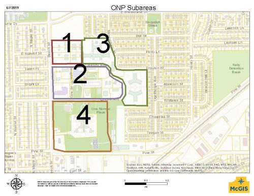
- Subareas. Because the properties and buildings in the One Normal Plaza PUD are suited to and have a history of different types of land uses, the overall PUD is divided into 4 subareas each with its own land use restrictions and design standards. The 4 subareas are shown in Figure 15.9-17(C) below.
- Subarea 1 is the area on the north side of the PUD containing the 8 historic “boys dormitories” and more recent, detached garages. This area is almost entirely residential in nature.
- Subarea 2 is the area inside the Lincoln/Oglesby loop road and contains a mixture of institutional, industrial, and residential structures. Land uses inside this area include an educational institution, a community center, a swimming facility, a software company, and residences.
- Subarea 3 is the area east and north east of Subarea 2. Land uses within this subarea include an educational institution, several nonprofits, and small personal service businesses.
- Subarea 4 is the area on the south side of Lincoln. This subarea includes a large public park space, several small-scale personal service businesses, and a small educational institution.
- Figure 15.9-17(C): Map of One Normal Plaza PUD Subareas
- Permitted and Special Uses. Land uses listed as special uses shall be processed and approved as part of an amendment to the planned unit development.
Notes: (1) Entertainment (indoor), Restaurant, Eating and Drinking Establishment uses shall not exceed 20,000 square feet in aggregate. (2) In Sub-Area 2, Arcade and Billiard uses shall not exceed 5,000 square feet each. Key: P - Permitted use without limit, PL - Permitted use limited to 5,000 square feet, S - Special useLand Use Sub-Area 1 Sub-Area 2 Sub-Area 3 Sub-Area 4 Assisted Living, Nursing Homes - P P - Auditorium - P - - Bed and Breakfast S S - - Churches and Other Places of Public Worship - P P PL Community Center - P - - Day Care Center - PL PL PL Day Care Home - P - - Dwelling, Single-Family P P - P Dwelling, Two-Family (max. of 2 unrelated individuals) P P - P Dwellings, Multifamily (max. of 2 unrelated individuals) - P - - Educational Facilities - P P PL Entertainment, Indoor - PL PL - Financial Institution (Banks, Credit Unions, Title Company) - PL PL PL Home-based businesses per the restrictions in sec. 15.4-4(C) P - - - Legislative Hall - P - - Library - P - - Medical, Offices, Laboratories, Diagnostics, Services, Rehab - P P PL Museum/Exhibition Hall - P P PL Office, Professional - P - - Park - P P P Parking Lot - P P P Personal Services Establishment, General - PL PL PL Police Station - P P - Recreational, Indoor - P PL PL Restaurant, Eating and Drinking Establishment - PL - PL Retail Goods Establishment - PL - - - Bulk Regulations.
- Subarea 1.
- Lot Size and Width: Lot sizes and widths are fixed at the current dimensions as of June 2020. Subdivision is not permitted.
- Green Space: Interior lots (Lots 103, 104, 107, and 108 – addressed as 602 604, 606 1/2 and 608 Oglesby) to maintain existing green space, which is all but the house, the 2-car garage, and the parking areas described in sec. 15.9-17(E)(1)(g). Corner lots (Lots 102, 105, 106, and 109 – addressed as 602, 604 1/2 606, and 608 1/2 Oglesby) to maintain open space remaining outside of the house and garages as permitted in sec. 15.9-17(E)(1)(g). “Green space” in Subarea 1 may include no more than 50% of nonvegetated space for things such as pools and impermeable landscape elements.
- Setbacks: To match existing.
- Building Height: Primary residential structure and detached garages to match existing.
- Building Style: Were a structure to be rebuilt, it would need to be rebuilt to exactly match the existing structures within Subarea 1.
- Fences and Walls: To match existing masonry and metal fences and walls within Subarea 1.
- Parking.
- The 4 interior lots and 2 corner lots on the south are limited to one 2-car garage and adjacent 2-car driveway and a single-car driveway or circular driveway adjacent to the house.
- The 2 corner lots on the north end are limited to two 2-car garages, adjacent 2-car driveways, and a single-car driveway adjacent to the house. Circular driveways not permitted on lots with a second detached garage.
- Subarea 2.
- Lot Size and Width: No minimums
- Green Space: 50% green space minimum (See definition of Landscape in sec. 15.3-2)
- Setbacks: Setbacks should be flexible with priority given to green space along public streets and adjacent to the public parking lot.
- Building Height: maximum of 35 feet or 2 stories, whichever is taller.
- Building Style: New construction and building additions must complement the architectural style of the existing structures within this Subarea.
- Fences and Walls: Design must complement fences and walls within Subarea 1.
- Subarea 3.
- Lot Size and Width: No minimums
- Green Space: 50% green space minimum (See definition of Landscape in sec. 15.3-2)
- Setbacks: Setbacks should be flexible with priority given to green space along public streets and adjacent to residential properties.
- Building Height: maximum of 35 feet or 2 stories, whichever is taller.
- Building Style: Building additions must complement the architectural style of the existing structures within this Subarea.
- Fences and Walls: Design must complement fences and walls within Subarea 1.
- Subarea 4.
- Lot Size and Width: No minimums
- Green Space: 60% green space minimum per lot. (See definition of Landscape in sec. 15.3-2).
- Setbacks: Setbacks should be flexible with priority given to green space along public streets and adjacent to residential properties.
- Building Height: Within Normandy Village, maximum building height must match existing cottages. Elsewhere in Subarea 4, the maximum height for residential structures is 2 stories, and the maximum height for non-residential structures is 1 story.
- Building Style: Building additions and new construction within Normandy Village must match the style and architectural details of the existing architecture. New construction elsewhere in Subarea 4 must complement the overall architectural style within One Normal Plaza.
- Fences and Walls. Fencing and/or walls are not permitted within Normandy Village unless required by the state for day care operation, in which case the fence standards from Subarea 1 apply. Fencing elsewhere in Subarea 4 is subject to the fence standards from Subarea 1.
- Subarea 1.
- Signs.
- Subarea 1. See sec. 15.4-4(C)(3) for sign provisions pertaining to signs for home occupations.
- Subarea 2.
- Monument signs are the only permitted type of freestanding sign. Monument signs are limited to 6 feet height and 75 square feet in area. Each property may have one monument sign per vehicular entrance to the site.
- Lighting of monument signs limited to downlighting or low-level landscape lighting. Lighting of wall signs limited to downlighting or backlighting.
- Wall signs limited to 1 square foot per 1 linear foot of street frontage. Wall signs limited to individual pin letters or comparable. No internally lit box signs permitted.
- Subarea 3.
- Monument signs are the only permitted type of freestanding sign. Monument signs are limited to 6 feet height and 75 square feet in area. Each property may have one monument sign per vehicular entrance to the site.
- Lighting of monument signs limited to downlighting or low-level landscape lighting. Lighting of wall signs limited to downlighting.
- Wall signs limited to 1 square foot per 1 linear foot of street frontage. Wall signs limited to individual pin letters. No internally lit box signs permitted.
- Subarea 4.
- Pole signs are prohibited.
- Low-rise signs are limited to 8 feet height and 75 square feet in area. Each property may have one monument sign per vehicular entrance to the site. Each building can have an identification sign no larger than 6 square feet in size and no more than 4 feet tall.
- Lighting of monument signs limited to downlighting or low-level landscape lighting.
- Wall signs are not permitted.
- Off-Street Parking and Loading. Parking regulations for Subarea 1 are included in sec. 15.9-17(E)(1). For Subareas 2, 3, and 4, there are no parking minimums. A multi-use office park is unique in its environment and characteristics, and it is not accurate to utilize generalized planning factors for these traffic and parking generators. All uses within multi-use office parks are traffic generators; however, they must accommodate the needs of those who use automobiles to visit them. The multi-use office park must accommodate needs of a variety of parker types; parking space needs must be considered in relation to use characteristics, building layout and site constraints. Parking demand will vary with the size of the multi-use office park and its activities. Parking facilities should be large enough to accommodate worker shift changes, if any, which is the peak time for parking. Because of differing uses located in a multi-use office park, planning ratios of total employee or gross floor area are unreliable for estimating parking needs. In order to evaluate parking space needs, number of employees and building use should be accounted for on a site-specific basis. A definitive parking space needs estimate for each use in a multi-use office park can be derived using four variables:
- Typical daily tenant-employee population;
- Typical daily tenant-caller population;
- Percent of tenant-employees being auto drivers; and
- Percent of tenant-callers being auto drivers.
- Business Operations.
- Subarea 1. Not applicable.
- Subarea 2. Business operations with a public interface limited to 10 p.m. Sunday through Thursday and 11 p.m. Friday and Saturday.
- Subarea 3. Business operations with a public interface limited to 10 p.m.
- Subarea 4. Business operations with a public interface limited to 10 p.m. Sunday through Thursday and 11 p.m. Friday and Saturday.
- Any new construction that takes place within a C-1 Multi-Use Office Park Planned Unit Development shall meet all applicable regulations and standards contained in other sections of this chapter of the Municipal Code where sec. 15.9-17 of the code is silent.
- The Town Council may waive any portion of the standards, requirements, or procedures for this section of the Code, provided that such waivers are not contrary to the spirit, purpose and intent of this Code and in accordance with all applicable federal and state laws.
(Entire SEC 15.9-17 Amended 08/16/21 by ORD. No. 5874)