
Oviedo City Zoning Code
ARTICLE XV
ENVIRONMENTAL PRESERVATION
Exhibit A—Map
Exhibit B—Natural Area Land Cover Classification
Exhibit C—Selected Native Plants Recommended for Landscaping in Central Florida
Exhibit D—Wet Detention Systems
Exhibit E—Econlockhatchee River Basin Study
Exhibit F—Econlockhatchee River Task Force Recommendations
Section 15.1.- Vegetation and Soil Protection.
(A)
Purpose and Intent The purpose of this section is to prohibit the destruction of natural vegetation and the changing of natural grades and drainage problems until a development order or development permit has been approved. Additionally, this section provides for protective measures for both vegetation and soils to be implemented prior to construction. Additional protection is provided for in other sections of this article and of this LDC, including but not limited to, Section 15.4, Section 15.5, and Section 15.8, and Section 12.3.
(B)
Required Vegetation Preservation The following preservation measures shall be implemented on all construction sites as applicable:
(1)
Clearing Procedure. The applicant shall be responsible for insuring that all possible measures are taken during the clearing process to avoid damage to trees and vegetation designated to remain after construction. This shall include use of hand labor rather than large machinery where necessary to protect trees to be preserved. All felled material shall be promptly and carefully removed from the site in order to avoid potential damage to remaining trees and vegetation and the harboring of insects, snakes, and rodents.
(2)
Protective Barricades Protective barricades shall be constructed (prior to clearing) around all trees and vegetation designated to remain. These barricades shall be located at the dripline of the trees or vegetation and shall be approximately three (3) to four (4) feet in height. Where this cannot reasonably be accomplished, the applicant will locate the barricade as close to one (1) foot away from the tree trunk for every diameter at breast height (DBH) inch as is practical or reasonable, when approved by the Land Use Administrator or City Arborist. The barricade should be rigid and sturdy enough to survive the construction period, however, any suitable new or scrap material may be used in its construction. (With approval of the Land Use Administrator or City Arborist, large wooded areas may be tagged or similarly designated instead of barricaded.)
(a)
Absolutely no fill, building materials, trash or other objects shall be placed inside these barriers. If fill is deposited adjacent to these areas, a suitable temporary or permanent retaining structure shall be constructed to prevent siltation of the barricaded area.
(b)
Barricades are to be adequately maintained and shall remain in place until their removal or modification is approved in writing. Failure of the applicant to properly locate and/or maintain the barricade may result in the issuance of a Class I or Class II Citation (depending on the magnitude of the violation). Issuance of a stop work notice ("red tag") and the requirement that the applicant provide a restoration plan to the Land Use Administrator (or some combination of these, as determined appropriate by the Land Use Administrator).
(3)
Use of Alternate Surfaces in Traffic Areas Where traffic areas are proposed at or near natural grade, alternate pervious surfaces such as "turf block" may be used in conjunction with stone or gravel. Specific details may be approved by the development order or permit issuing authority.
(4)
Excavations. Swaling and minor negative grade changes should always be designed around the dripline area as much as possible. Any exposed roots shall be trimmed. Piping should be used where deep swales or ditches would require significant grade adjacent to trees.
(5)
Trenching of any type should be avoided in the dripline area. Where underground installations are required adjacent to the trucks of specimen trees, tunneling should be used. When trenching or tunneling near trees to remain, protective measures should be taken as specified in the Tree Protection Manual for Builders and Developers.
(C)
Required Soil Conservation The following soil conservation measures shall be taken on all construction sites as required:
(1)
During Construction. The contractor shall follow standard practices or details specifically included in his environmental permit to prevent erosion and the depositing of soils off the construction site. These practices shall include the protection of bare soils from wind forces and stormwater.
(2)
After Construction. All disturbed areas shall be mulched, seeded, or sodded to restore the original vegetation as required by the permit-issuing authority, and shall be maintained as such. The removal or lack of maintenance of vegetation resulting in on-site and/or off-site erosion (sedimentation or siltation or both) or wind-blown loss of soils shall be deemed a violation of this section.
(D)
Disposal of Debris
(1)
The burying of rubbish, logs, lumber, building materials, underbrush, trash or other matter which would decompose or allow the land to thereafter settle is hereby determined to be a change or modification of the grade of land for which no permit shall be issued except upon certification to the Land Use Administrator that the same is necessary or desirable in the public interest.
(2)
Every effort shall be made by developers, builders, and contractors to minimize the amount of construction and demolition debris disposed of at the county's landfill. When properly permitted and operated, landfills specializing in construction and demolition debris should be used, as should proper burning of certain types of trash. Mulching and composting should also be utilized whenever feasible. Recycling of certain aluminum, plastic, glass and paper trash from construction activities should also be utilized when available.
(Ord. No. 1428, § 2(Exh. B), 1-22-08)
Section 15.2. - Tree Protection, Removal, and Replacement.
(A)
Purpose and Intent
(1)
Purpose. The purpose of this section is to establish protective regulations for trees within the City of Oviedo in order to maintain and protect the urban forest, control flooding problems, reduce soil erosion, and reduce air and noise pollution.
(2)
Intent. The intent of this section is to encourage the protection of the maximum number of trees within the City Of Oviedo. It is further the intent of this section to encourage the protection of trees native to Central Florida and the proper removal of exotic and invasive trees.
(B)
Tree Removal
(1)
Permit Required. No person shall engage in tree removal without first obtaining a clearing, grading, and tree removal permit. The clearing, grading and tree removal permit, when issued, shall specifically identify which trees shall be permitted to be removed. The removal permit authorizes the removal of the trees specified therein. Nothing in this section shall be construed to require the removal of such trees by the permittee.
(2)
A clearing, grading, and tree removal permit may be issued for tree removal under any of the following conditions:
(a)
Trees located on building and construction sites as shown on City approved plans, provided said trees are replaced elsewhere on the property in accordance with Subsection (E), tree replacement.
(b)
Trees located within ten (10) feet of a structure or other improvement, provided said trees are replaced elsewhere on the property in accordance with Subsection (E), tree replacement.
(c)
Trees severely diseased, severely injured or dead.
(d)
Trees that interfere with the construction or repair of public infrastructure and facilities.
(e)
Undesirable trees per Article XII Landscaping, Tree Planting, and Buffer Requirements.
(f)
Trees removed by the city or other governmental agency and which are located within a public road, drainage right-of-way, or permanent utilities and drainage easements.
(g)
Trees approved by the City Arborist provided said trees are replaced elsewhere on the property in accordance with Subsection (E), tree replacement.
(3)
When making a determination on whether a tree meets one (1) of the conditions set forth in Subsection (B), tree removal, and therefore, whether to approve or deny an application for clearing, grading, and tree removal permit under this section, the Land Use Administrator or City Arborist shall apply one (1) or more of the following standards of review as deemed relevant:
(a)
Necessity to remove trees which pose a clear and obvious safety hazard to pedestrian or vehicular traffic or threaten to cause disruption to public services or a significant obstacle to accessing and utilizing public easements and rights-of-way.
(b)
Necessity to remove trees which pose a clear and obvious safety hazard to buildings and other improvements on a lot or parcel of land. Ordinary small cracks or uplifts in pavement, sidewalks, and non-occupied structures that are typically caused by settling and small roots shall not be considered a safety hazard.
(c)
Necessity to remove diseased trees or trees weakened by age, storm, fire, or other injury or trees with severe structural defects that pose a clear and obvious safety hazard to people, buildings, or other improvements on a lot or parcel of land.
(d)
The extent to which tree removal is likely to result in damage to the property of other owners, public or private, including damage to lakes, ponds, streams, or rivers through runoff or erosion.
(e)
Any proposed landscaping including plans whereby the applicant has planted or will plant trees to replace those that are proposed to be cleared.
(f)
Topography of the land and the effect of tree removal on erosion, soil retention and the diversion or increased flow of surface water.
(g)
Good forestry practices, such as the number of healthy trees that a given parcel of land will reasonably support and the proven techniques that sustain healthy trees.
(h)
Necessity to remove trees in order to construct approved and permitted improvements to allow economic enjoyment of the property, including:
(i)
Need for access around the proposed structure for construction equipment (maximum of ten (10) feet).
(ii)
Need for access to the building site for construction equipment.
(iii)
Essential grade changes.
(iv)
Need for locating street or road rights-of-way, utilities, drainage ways, as well as the need to provide reasonable use and property access.
(i)
The extent of any damage or demonstrated hardship which would result to the Applicant from a denial of the requested permit.
(j)
The species and size of the trees proposed for removal.
(k)
The following factors shall also be considered:
(i)
Trees forming the current canopy.
(ii)
Preservation of the next generation of trees.
(4)
Contractor License Required for Contractor Obtaining Permits. Any person or entity engaged in the business of tree removal or pruning shall be licensed by the City on an annual basis. Licenses may be obtained from the City by completing an application and paying the required license fee. The license application shall contain at a minimum the name, address, and telephone number of the contractor and a copy of the contractor's occupational license and proof of liability and workers' compensation insurance. It shall be unlawful for any person or entity to engage in the business of tree removal or pruning within the City of Oviedo without a license. It shall also be unlawful for any such person or entity to fail to obtain a permit on behalf of a property owner.
(5)
Minimum Tree Requirement. The issuance of a clearing, grading, and tree removal permit does not relieve the permittee from minimum requirements of Article XII, Landscaping, Tree Planting, and Buffer Requirements, Section 12.3, Trees, Subsection (B), large trees planting/preservation, Table 12.1 Table of Planted/Preserved Large Trees.
(6)
Champion Trees. Notwithstanding any other provision of the section, champion trees shall not be removed except for extraordinary circumstances and hardships. Removal of champion trees shall require City Council approval.
(7)
Restrictions on Tree Removal after Permit Expiration. Trees not removed during the life of the permit may not be removed without the issuance of a new permit based upon a new application.
(C)
Tree Pruning Standards
(1)
Standards. Trees intended for shade purposes shall be allowed to reach mature canopy spread and shall be pruned in accordance with the ANSI A 300 Part 1 Pruning standard and ANSI Z133.1 Safety standard. Pruning should be performed with defined pruning objectives and according to a specific pruning plan to accomplish the objective including the minimum and/or maximum branch size to be removed.
(2)
Unlawful Pruning. The pruning techniques described in Subsection (F), prohibitions, shall be deemed unlawful.
(D)
Tree Designation
(1)
Certain trees, herein referred to as "heritage" or "champion" trees, are of especially great concern to the public because of ecological value, of indigenous character, size, age or historic association.
(2)
Champion Trees. Determination that a tree is a champion tree shall be made by the City Council after a recommendation of the City Tree Board. The City Arborist shall keep a permanent record of all trees so designated by the City Council. The City Council may grant tree replacement credits, upon granting a champion tree designation. Designation of a tree as a champion tree may occur in any one (1) of the following ways:
(a)
An applicant may request designation of a champion tree as part of any master plan, preliminary subdivision plat, or site plan application. To do so, the applicant shall submit an expert evaluation by a landscape architect, horticulturalist, certified arborist, or other horticultural expert as part of the application.
(b)
A property owner may request such designation at any time. To do so, the property owner shall submit an expert evaluation by a landscape architect, horticulturalist, certified arborist or other horticultural expert.
(c)
The City's Arborist may recommend such designation as part of the review of any application for development, stating in writing the reasons for such designation, or may make such designation as part of an overall tree protection planning program for the City or portion thereof.
(3)
Heritage Trees. Heritage trees are all trees (other than "undesirable trees" identified in Article XII, Landscaping, Tree Planting, and Buffer Requirements, dead trees, or diseased trees) which are have a DBH of thirty (30) or more inches.
(E)
Tree Replacement
(1)
All trees that are removed or destroyed and subject to replacement by this section shall be replaced by a species of tree listed in the latest edition of the Florida-Friendly Plant List in "Florida Yards & Neighborhoods" edited by the University of Florida, Institute of Food and Agricultural Sciences (UF/IFAS) or such other trees properly approved by the City Arborist, in accordance with the replacement tree schedule provided in Table 15.1, Tree Replacement Schedule, except that the required number of replacement trees shall not exceed two (2) times the number of large trees required in accordance with Article XII, Landscaping, Tree Planting, and Buffer Requirements, Table -12.1, Table of Planted/Preserved Large Trees. Replacement shall occur prior to the issuance of a certificate of occupancy (if approval is pending) or occur within thirty (30) days of removal or destruction, whichever date is earlier, unless a greater replacement period is provided for good cause within a clearing, grading, and tree removal permit.
TABLE 15.1: TREE REPLACEMENT SCHEDULE
(2)
Criteria for Replacement Trees.
(a)
Characteristics of Replacement Trees. The replacement tree(s) shall have at least equal shade potential, screening properties, and/or other characteristics comparable to that of the tree(s) requested to be removed.
(b)
Size of Replacement Trees. Replacement tree(s) are to be a minimum of two and one-half (2½) inches caliper. Replacement tree(s) that are a minimum of four (4) inches caliper shall be counted as two (2) replacement trees and replacement trees that are a minimum of six (6) inches caliper shall be counted as three (3) replacement trees.
(c)
Tree Species. Relocated or replacement trees shall include only species listed in the latest edition of the Florida-Friendly Plant List in "Florida Yards & Neighborhoods" edited by the University of Florida, Institute of Food and Agricultural Sciences (UF/IFAS) or as approved by the City Arborist.
(d)
Transplanting and Maintenance Requirements. All trees transplanted pursuant to this subsection shall be maintained in a healthy, living condition. Any such trees which die shall be replaced and maintained by the property owner. The City shall retain jurisdiction for one (1) year to ensure compliance with this subsection.
(3)
Tree Replacement Guidelines.
(a)
All Plant material specified shall be Florida Grades and Standard One (1) or better.
(b)
If the City Arborist determines, due to site conditions or configuration, it is impossible or impracticable for the applicant to meet the requirements for tree replacement under this subsection, the applicant may be allowed to pay fees into the City's Tree Bank per Subdivision (5), City Tree Bank.
(c)
For new development, tree replacement credit shall be allowed for the preservation of existing desirable trees on the development site, excluding wetland and other conservation areas, as follows:
TABLE 15.2: REPLACEMENT TREE CREDITS
(d)
Diversity of species shall be required for replacement trees and not more than fifty (50) percent of the replacement trees shall be of a single species.
(e)
Replacement Cost. The Applicant shall be responsible for the cost of replacing the trees removed from their property.
(4)
Elimination of Undesirable Trees and Shrubs. The natural vegetative communities existing within the City shall be protected by the control and elimination of invasive, nonnative species. To that end, the following guidelines shall apply:
(a)
Planting of Trees or any other plant species listed in Table 15.3, Prohibited Plant List below is prohibited. Plant species which are prohibited from time to time by the Florida Department of Environmental Protection (FDEP) and the Florida Department of Agriculture and Consumer Services (FDACS) are also prohibited.
(b)
Removal of Trees listed in Table, 15.3 Prohibited Plant List, from commercial, office, industrial, or multifamily sites (excluding jurisdictional wetlands) shall be completed, whenever practicable, as a requirement for approval of any development order or permit issued by the City or the issuance of a certificate of occupancy, if applicable.
(c)
Control and elimination procedures shall in no way promote the proliferation of the species through the dispersal of seed or other vegetative reproducing parts.
(d)
Control and elimination procedures shall in no way harm or cause the decline of preserved or planted trees and landscaping.
TABLE 15.3: PROHIBITED PLANT LIST
*P = Prohibited by FL Dept of Environmental Protection; N = Noxious weed listed by FL Dept of Agriculture & Consumer Services; U = Noxious weed listed by US Department of Agriculture.
(5)
City Tree Bank. A City Tree Bank is hereby established. If the City Arborist determines, due to site conditions or configuration, it is impossible or impracticable for the applicant to meet the requirements for tree replacement under this subsection, the applicant may be allowed to pay fees into the City's Tree Bank. Monies collected in the tree bank shall be used exclusively for planting of trees on public lands. The value amount to be paid into the tree bank shall be determined by the City Arborist.
(F)
Prohibitions
(1)
Placement of Materials, Machinery, or Temporary Soil Deposits. It shall be unlawful to place material, machinery, or temporary soil deposits within the tree protection zone before or during construction. Before or during construction the builder shall erect and maintain suitable protective barriers around all trees to be preserved. Upon written request, the City Arborist, on a case by case basis, may allow material or temporary soil deposits to be stored within the protective barrier if no other storage is available.
(2)
Climbing Spurs. It shall be unlawful to use climbing spurs or other similar device to aid in the climbing of a live tree, where such device causes the puncture or tears the bark of the tree.
(3)
Tree Spiking. It shall be unlawful to introduce any type of poison or reactive material to a tree for the purpose of causing it to die or become diseased.
(4)
Structure and Pavement Location. It shall be unlawful to place any structure or impervious paving within an eight-foot radius of any tree trunk or stem having a diameter of eight (8) inches or more DBH.
(5)
City Trees. It shall be unlawful to remove any tree which is within the City's rights-of-way or upon any other City property without the permission of the City evidenced by the appropriate permit.
(6)
Attachments. It shall be unlawful to attach anything to a tree or stem, including nails or spikes, other than protective wires, braces or other similar non-injurious materials.
(7)
Cut and Fill Guidelines. It shall be unlawful to remove or add any material or ground within the tree protection zone unless otherwise permitted by the City Arborist.
(8)
Encroachment of the Drip Line. During the construction stage of development, the applicant shall not cause or allow land clearing, the use of heavy equipment or material within the drip line of any tree or groups of trees to be retained. Neither shall the developer cause or allow the disposal of waste material such as paint, oil, solvents, asphalt, concrete, mortar or any other material harmful to the life of a tree within the drip line of any tree or groups of trees, or where planting beds are to be situated.
(9)
Shearing, Hat Racking, Topping or Poodle Trimming of Trees (Lollipop), Lions Tailing, Pollarding of Trees. Trees intended for shade purposes shall be allowed to reach their mature canopy spread. It shall be unlawful to engage in excessive pruning techniques on trees intended for shade purposes. Excessive shearing, pruning or shaping shall only be allowed with a permit by demonstrating necessity or without a permit in times of emergency only. The following are deemed unlawful excessive pruning techniques which are prohibited on shade trees:
(a)
Lions Talling. The improper practice of removing most secondary and tertiary branches from the interior portion of the canopy leaving most live foliage at the edge of the canopy.
(b)
Topping, hat racking, stag heading, de-horning, lopping, and rounding over: the improper practice of reducing tree size by making heading cuts through a stem more than two (2) years old; a pruning practice that destroys tree architecture and serves to initiate discoloration and decay in the cut stem.
(c)
Pollarding. The pruning technique that removes sprouts back to the same location annually or biannually maintaining a tree to a specific height.
(d)
Shearing. A pruning technique which is typically accomplished with cuts made through wood less than a year old at the sides of the canopy to create uniform dense canopies.
(e)
Poodle Trimming. Combines shearing and removing lower limbs to create tree forms that look like a "lollipop."
(10)
Construction near adjacent property, walls, structures, and pavement shall not be constructed in any way which will result in damage to roots within the tree protection zones of trees located on adjacent properties.
(G)
Tree Protection during Development and Construction
(1)
Restrictions During Construction. It shall be unlawful for any person, during the construction of any structures or other improvements, to place solvents, petroleum products, paint, masonry materials, construction machinery, or temporary soil deposits within the drip line of any tree. This provision includes soil that is placed in the drip line permanently for the purpose of a grade change, unless the grade is changed according to the guidelines described in the Florida Division of Forestry, Department of Agriculture and Consumer Services Publication, Tree Protection Manual for Buildings and Developers.
(2)
Burden of Tree Protection. It shall be the responsibility of an applicant and his/her agents to ensure the protection and survival of any retained or replacement tree shown on the tree inventory. The property owner shall guarantee survival of retained trees and replacement trees for one (1) year from completion of permitted construction, unless a greater time period is required by development agreement, order, or permit. If a retained or replacement tree dies during that time period, the property owner shall replace the tree in accordance with a remedial action approved under Subsection (J), violations and remedial actions.
(3)
Protective Barricades Required. Protective barricades shall be constructed (prior to cleaning) around all retained trees as required in Section 15.1(B)(2), Vegetation and Soil Protection, Subsection (B), required vegetation preservation.
(4)
Site Inspections. The City Arborist or designated City Inspector may conduct periodic inspections of the site. It is the responsibility of the applicant and their agents to ensure that all provisions of this section are met.
(5)
Adjacent Properties. The applicant and their agents shall ensure that the protection zones of trees located on adjacent properties are protected as required by this subsection for trees located on the site being developed.
(H)
Voluntary Tree Planting This section shall not be interpreted to restrict, regulate or limit the voluntary planting of any tree within the City. The provisions of this section govern only the planting of trees which are required to be planted or retained. Trees or plants planted in the City's rights-of-way are subject to removal or trimming by the City at any time.
(I)
Incentive Program Incentives for the purposes of protecting and preserving mature trees and planting enhanced landscaping may be approved as part of development agreement, order or permit. Such incentives shall have a public benefit and may include, but are not limited to, deviations from the minimum standards of this LDC (e.g. parking; setbacks). Any incentives granted under this subsection shall be consistent with the Comprehensive Plan.
(J)
Violations and Remedial Actions
(1)
Separate Violation. It shall be a separate violation for each tree removed and for each day a person is engaged in land clearing or grading without a permit.
(2)
Violations Require Remedial Action. Where violations have occurred, remedial action shall be taken to restore the property consistent with a restoration plan approved by the Development Review Committee. The restoration plan may require tree replacement per the replacement schedule in Table 15.4, Tree Replacement Schedule for Violations, mitigation of any other damage to the property, and payment to the City's Tree Bank, or any combination thereof.
TABLE 15.4 TREE REPLACEMENT SCHEDULE FOR VIOLATIONS
(3)
Survival of Replacement Trees. The Applicant shall guarantee the survival of replacement trees for a period of two (2) years from the date the certificate of occupancy or certificate of completion is issued, unless a greater time is required by the restoration plan. If the replacement tree dies, the tree shall be replaced in accordance with this section.
(K)
Enforcement; Penalties
(1)
Enforcement. The City may enforce the provisions of this section by any lawful means including, but not limited to, issuing a civil citation, bringing charges before the City's Code Enforcement Board, and seeking injunctive and equitable relief. For purposes of determining the penalties provided under this section, the removal or death of a tree in violation of this section shall be deemed irreparable or irreversible.
(2)
Penalties. In addition to all other remedies set forth in this section, one (1) or more of the following civil fines shall apply to violations:
(a)
Failure to Obtain a Clearing, Grading, and Tree Removal Permit. Fine of two hundred fifty dollars ($250.00) per tree or five hundred dollars ($500.00) per heritage or champion tree removed, not to exceed five thousand dollars ($5,000.00).
(b)
Removal of a Tree without a Permit. Fine of fifty dollars ($50.00) per caliper inch, not to exceed five thousand dollars ($5,000.00) per tree.
(c)
Removal of a Heritage or Champion Tree without a Permit. Fine of one hundred dollars ($100.00) per caliper inch, not to exceed five thousand ($5,000.00) per tree.
(d)
Failure to Abide by a Cease and Desist Order. Fine of two hundred fifty dollars ($250.00) per day (first offense); five hundred dollars ($500.00) (second and each subsequent offense).
(e)
Failure to Obtain a Contractor's License. Fine of two hundred fifty dollars ($250.00) (first offense); five hundred dollars ($500.00) (second and each subsequent offense).
(f)
Failure to Abide by the Requirements of Subsection (G), Tree Protection during Development and Construction. Fine of two hundred fifty dollars ($250.00) per occurrence.
(g)
Any Other Violation of Section 15.2 Tree Protection, Removal, and Replacement. Fine as provided by law and this section.
(3)
Civil Fine Determination. In determining the amount of the civil fine under Subsection (K) above, the following factors shall be considered:
(a)
The gravity of the violation.
(b)
Any actions taken by the violator to correct the violation.
(c)
Any previous violations committed by the violator.
(d)
The number and size of the trees removed, if any.
(e)
The historical significance of the any tree removed.
(f)
The remedial actions offered by the violator to restore the property.
(Ord. No. 1428, § 2(Exh. B), 1-22-08)
Section 15.3. - Species of Special Concern, Threatened or Endangered.
(A)
Purpose and Intent It is the purpose of this part to provide standards necessary to protect the habitats of species, both flora and fauna, of endangered, threatened, or special concern status. It is the intent of this part to require that an appropriate amount of land shall be set aside to protect habitat of rare, endangered, or special concern plant and animal species.
(B)
Applicability Proposals for development shall identify the presence and location of any on-site species of special concern, threatened or endangered as listed by the Florida Game and Freshwater Fish Commission, the U.S. Fish and Wildlife Service or the Florida Department of Agriculture and Consumer Services, as well as any locally designated species.
(C)
Habitat Management Plans
(1)
Developments with on-site populations of species of special concern, threatened or endangered status shall submit a habitat management plan to the Florida Game and Freshwater Fish Commission for approval. The City shall then include the plan as a condition of approval.
(2)
The habitat management plan shall be prepared by an ecologist, biologist or other related professional. The plan shall document the presence of affected species, the land needs of the species that may be met on the development site, and shall recommend appropriate habitat management plans and other measures to protect the subject population.
(3)
The habitat management plan shall be guided by the following standards:
(a)
Development shall be clustered away from the habitats of endangered and threatened wildlife and species of special concern.
(b)
To the maximum extent possible, wildlife corridors shall be maintained and the fragmentation of large ecological community associations shall be prevented.
(c)
The habitats of endangered and threatened wildlife and species of special concern shall be buffered consistent with applicable adopted requirements.
(d)
On-site plant species listed by the Florida Department of Agriculture and Consumer Services shall be preserved to the maximum extent possible.
(D)
Fee in Lieu As an alternative to preservation of land, the payment of a fee in lieu of land may be considered, whereby land which will provide a significant habitat may be purchased and preserved. This option shall be utilized in those cases where on-site preservation will provide only limited benefit as determined by the City. Such payment shall be to the City or to an agency deemed by the City to be capable of using the funds to acquire suitable properties.
Section 15.4. - Wetlands Protection.
(A)
Purpose and Intent The purpose of this section is to avoid public harm by protecting the wetland functions of water quality enhancement, water quality management, climatic stability, wildlife and human use by:
(1)
Minimizing the disruption of wetland functions by requiring a wetlands approval for development activities proposed within wetlands and their adjacent areas;
(2)
Considering the impact of development activities on wetlands functions through the City land development regulation process;
(3)
Regulating development activities according to wetland significance with the degree of protection afforded a wetland being in direct relationship to the significance of a wetland;
(4)
Using performance standards as the basis for minimizing the impact of development activities on wetland functions;
(5)
Providing for the multiple use of wetlands for compatible development activities which do not disrupt wetland functions; and
(6)
Providing for development flexibility through the availability of mitigation/compensation measures where more beneficial environmental results can be achieved.
(B)
Wetlands Approval Required It shall be unlawful for any person to undertake development within a wetland or adjacent area or to develop, change, modify or alter wetlands or adjacent areas unless activities are deemed water dependent (such as docks, piers, etc), the applicant can demonstrate economic hardship would exist if portions of the on-site wetland were not filled, or the design has exhausted all other options. Development shall be in accordance with the provisions of this section and the City's Comprehensive Plan. Prior to the commencement of any development activity, wetlands approvals shall be issued in the form of performance standards to be complied with as part of development order or development permit approval.
(C)
Application Procedures and Submittal Requirements
(1)
Wetlands Approval.
(a)
Applications for Zoning Map Amendments, PUD's and Developments of Regional Impact. Concurrent with the review of these applications, the Department shall consider the impacts of the proposed use on wetland functions, the ability of the parcel to support the proposed use without disrupting wetland functions and the ability to meet performance standards. Conceptual approval may be provided by the Department concurrent with the approval of these applications. The conceptual approval shall be binding as long as the related development order is valid and shall indicate the following:
(i)
Wetland areas to be preserved, altered, or areas to be enhanced through wetland creation;
(ii)
Development activities within wetlands and the adjacent area which are permitted subject to compliance with performance standards; and
(iii)
Conditions for the use of wetlands for surface water management and recreation.
(b)
Applications for Development Order or Permit Approval. Concurrent with the review and approval of development orders or permits, the Department shall issue a wetlands approval for development activities that are compatible or compatible subject to compliance with performance standards.
(c)
Application for Building Permits. Concurrent with the review and approval of a building permit, the Department will review the application, and based upon best available information, determine if the provisions of this section apply. A wetlands approval will be required for all building permits within a wetland or an adjacent area. Building sites located within an approved plat or site development plan for which a wetlands approval has been issued shall not require a separate wetlands approval but shall comply with the conditions set forth in the previously issued approval.
(D)
Conditions of a Wetlands Approval
(1)
Development Activity Compatibility. Prior to the issuance of a wetlands approval, the Department shall determine in accordance with the procedures currently being implemented by the SJRWMD and/or the FDEP that the proposed development activity is:
(a)
Compatible subject to compliance with the performance standards set forth in the wetlands approval; or
(b)
Incompatible, therefore a wetlands approval may not be issued by the Department.
(2)
Compliance with Performance Standards. Concurrent with the issuance of a wetlands approval the Department shall provide the applicant with a list of performance standards based on the procedures currently being implemented by the SJRWMD and/or the FDEP. For the purpose of maintaining effective performance standards, alternative and innovative techniques are encouraged if approved by the Department. Performance standards are to be monitored for effectiveness in maintaining wetland functions and periodically updated.
(3)
Mitigation/Compensation. Where site conditions preclude the use of performance standards and where opportunities exist to enhance wetland or environmental benefits, the Department may recommend mitigation/compensation on a site-specific basis. Mitigation and compensation shall equal or exceed the volume of wetland area removed from the site.
(4)
Effective Period of Approval.
(a)
The wetlands approval shall be valid as long as the related development order or permit is effective.
(b)
A wetlands approval may be reasonably extended by the City Council in order to permit the applicant to receive State agency permits related to an approved development order.
(E)
Factors to be Considered The following factors shall be considered when identifying wetland types, significance, and development activity compatibility:
(1)
Verification of Wetland Type. The applicant shall classify wetlands into one (1) or more of the following categories for the purpose of determining development activity compatibility and performance standards:
(a)
Deep marsh.
(b)
Cypress wetlands.
(c)
Hydric hammock.
(d)
Wet prairie.
(e)
Mixed hardwood swamp.
(f)
Bayhead.
(g)
Shallow marsh.
(2)
Verification of Wetland and Adjacent Area Boundaries. Verification of wetland boundaries shall be based on existing hydrology, soils, vegetative characteristics and the procedures and information as defined by the SJRWMD and/or FDEP.
(3)
Verification of Wetland Significance. For purposes of determining wetland significance, the Department shall use the following wetland significance criteria:
(a)
Size (the geographic size of the wetland).
(b)
Connection (the extent of hydrologic connection to a major wetland or aquatic system).
(c)
Landscape Diversity (the diversity of the surrounding vegetative communities).
(d)
Intactness (the degree of previous alteration of the wetland).
(e)
Uniqueness (the scarcity of a particular wetland type within the region).
(f)
Quality of the adjacent area (the degree of previous alteration of the adjacent areas).
For the purpose of determining development activity compatibility, each of the above criteria shall be evaluated and a significance score shall be made according to the procedures being implemented by the SJRWMD and/or FDEP.
(4)
Development Activity Compatibility. As wetland types vary in their ability to accept development activities without diminishing wetland functions, the compatibility of development activities is directly related to wetland types and significance. Development activity compatibility is to be based on wetland type and significance and the verification of development activity compatibility will be made by the Department according to the provisions of the SJRWMD and/or FDEP. For purposes of determining development activity compatibility and applying requisite performance standards, all development activities shall fall into one (1) of the following categories:
(a)
Compatible, therefore compliance with performance standards are encouraged; or
(b)
Compatible subject to compliance with performance standards; or
(c)
Incompatible, therefore the development activity cannot occur.
(5)
Sources of Information. For the purposes of determining wetland type, boundaries, significance, development activity compatibility and performance standards, the following sources of information shall be used:
(a)
Florida Wetlands Delineation Manual.
(b)
Any current rules and handbook guidelines of SJRWMD and FDEP.
(c)
Additional sources of information as determined by the Department.
(6)
Bonding Requirements. As a condition for granting any wetlands approval related to a development activity in a wetland or adjacent area, as defined in this section, the City Council may require the posting of a surety bond, escrow, or other means of financial guarantee that the applicant correct any deleterious effects on wetlands or adjacent areas as a result of non-compliance with the conditions of a wetlands approval. No bonding requirement shall preclude the City from pursuing another means of enforcement.
(F)
Inspections and Enforcement Development activities in wetlands or in adjacent areas shall be carried out with strict adherence to the conditions of approval in the development order and/or wetlands approval. A final inspection shall be made by the Department and a determination made as to the adequacy of the development in meeting these conditions.
(G)
Denial, Suspension, or Revocation of Approval The Department may, at its own discretion, refuse to issue or renew, suspend, or revoke any wetlands approval on the following grounds:
(1)
Material misstatement in the application for approval.
(2)
Willful disregard or violation of any of the provisions of this article.
(3)
Willful disregard or violation of any condition or conditions imposed upon any approval granted.
(4)
Negligence on the part of the applicant, his contractor or subcontractor in the performance of any development activities permitted in or adjacent to wetlands.
(5)
Any other grounds which shall, in the sound discretion of the City Council and/or Department, constitute a threat to the health, safety, and welfare of the citizens and inhabitants of the City.
If the approval is revoked, the applicant shall return any wetlands altered under the development permit or development order to its original conditions prior to such activity.
(H)
Appeals Where any person shall be aggrieved by a decision of the Department made pursuant hereto, said aggrieved person, may within fifteen (15) days from the date of the disputed decision, appeal said decision to the City Council by filing a notice of appeal with the Department. Review by the City Council shall be de novo.
(I)
Exemptions
(1)
Subdivision plats and site development plans, or phases or portions thereof, approved prior to April 20, 1992, the effective date of this section are exempted from the provisions of this section.
(2)
For the purpose of this section, approved subdivision plats are those plats that have received preliminary plat approval by the City Council.
(3)
For the purpose of this section, approved site development plans or development orders are those plans that have been authorized to proceed with development permit approvals.
Section 15.5. - Setbacks from Waterbodies.
(A)
Purpose and Intent The purposes for setbacks from waterbodies (located wholly or partially within the City) include, but are not limited to, protecting the public's interest in waterbodies, protecting private property rights and values, protecting and maintaining the chemical, physical and biological integrity of those waterbodies, and their associated wetlands, floodplains, and shoreline habitats, minimizing runoff pollution of surface waters, minimizing sedimentation and siltation, protecting aquatic (and adjacent) habitats for fish, other aquatic or amphibious life, and wildlife, preventing the spread of exotic and other invasive vegetation, and protecting aesthetic and recreational values.
(B)
Restrictions
(1)
No structures shall be constructed within fifty (50) feet from the normal high water elevation of lakes, rivers, and creeks, except for boardwalks, fishing piers, boat docks, boat houses, gazebos, boat ramps, or canoe launches that are issues applicable to site development plans and building permits. Specifically prohibited are domiciles, storage buildings, screen rooms, green houses, tents, patios, antennae, fueling facilities, satellite dishes, solar panels, and other accessory structures. Allowable structures shall be field located to minimize tree and vegetation removal and other negative environmental impacts.
(2)
No outdoor storage of vehicles, equipment, materials, debris, trash or chemicals, (except as otherwise provided in this section) shall be allowed without a special exception use order. No outdoor storage of watercraft shall be allowed within an area twenty (20) linear feet landward of the shoreline, except where such storage occurs on an approved boat dock.
(3)
Storage or use of fertilizer, pesticides, herbicides, fungicides, fuel, lubricants, or other chemicals within any waterfront buffer or setback may require a chemical management plan, if so determined by the Land Use Administrator. Review of a chemical management plan shall be subject to review by the Land Use Administrator and (if deemed necessary) by an independent consultant, selected by the City. The applicant shall reimburse the City for the consultant's review fee.
(4)
Unless otherwise specifically authorized in writing, a swale and berm system shall be utilized - properly located, installed, and maintained - to prevent lot (or other) drainage from flowing directly into the receiving waterbody or causing or significantly contributing to the sedimentation, siltation, scouring, or degradation of stormwater facilities, wetlands, water bodies, or adjacent properties.
(5)
Silt fences and other appropriate devices, as may be required or approved in writing, shall be installed and maintained as depicted in current FDEP Best Management Practices for Erosion and Sedimentation Control specifications. Any shoreline dredge and fill work, including, for example, installation of pilings, shall require adequate installation and maintenance of turbidity barriers/curtains, unless specifically exempted by the Land Use Administrator.
(6)
New waterfront development shall ensure that adequate waterfront buffers and setbacks (e.g. not less than fifty-foot building setbacks) are specified for width, composition, and maintenance/preservation and will be monitored on not less than an annual basis to ensure, at a minimum, the following buffer functions are maintained:
(a)
Aesthetic buffer features;
(b)
Erosion (sedimentation and siltation/turbidity) control;
(c)
Maintenance of water quality and quantity; and
(d)
Fish and wildlife habitats and corridors.
(7)
For lots or parcels located on a lake or river, a maximum of thirty (30) linear feet of a waterfront may be cleared for waterfront access or view without meeting the requirements of Subsection (C), permit requirements. The thirty (30) feet shall be approved through a clearing, grading, and tree removal permit. Minimal tree and vegetation removal shall occur and may need to curve between existing trees and other vegetation to minimize negative environmental impacts.
(8)
Trees that pose a clear threat to the public safety or to a structure or invasive and nuisance vegetation may be removed, subject to written approval, after a site inspection to determine the extent of the alleged threat.
(C)
Permit Requirements Applicants for all waterfront, waterfront buffer, or waterfront setback tree or vegetation removal, clearing, underbrushing, grading, filling, excavating, or other site work must obtain, at a minimum, a clearing, grading, and tree removal permit. It is the obligation of the applicant to obtain and comply with all the requirements of pertinent State and Federal permits (SJRWMD, DEP, United States Army Corps of Engineers, etc).
(1)
The application package shall include, as a minimum, a signed survey, a clear and definitive description of the type and extent of proposed activities (clearing, construction, and final proposed uses in the waterfront or setback area), methods of execution, vegetation and tree protection measures, and any other reasonable anticipated negative impacts upon listed plant and/or animal species, upon adjacent properties, or upon ambient surface water quality. This description shall include the time of year (with regard to, for example, wet or dry season, breeding season for animals, spawning season for fish - as applicable) that the clearing and construction is proposed to occur.
(2)
Trees and vegetation proposed for removal shall be clearly described in terms of species, size, location, condition, and extent of removal.
(3)
Any proposed dredge and fill activities in or adjacent to a waterfront, waterfront buffer or in any waterfront setback shall require a clearing, grading, and tree removal permit, as applicable. The application shall contain an adequately descriptive site development plan. Approval of a clearing, grading, and tree removal permit for a dredge and fill operation shall be contingent upon receiving all other applicable State and Federal permits or letters of exemption, if pertinent to the proposed operation.
(D)
Violations Violations of this section may result in issuance of a Class II Citation, issuance of a stop work notice ("red tag") or being referred to the City Council after a restoration plan has been prepared (by the applicant) to restore the site and adjacent properties and/or waterways (if pertinent) to their previous condition (or to a better condition, if required by the City Council). The Land Use Administrator shall determine which enforcement procedure or combination of procedures is applicable and whether or not a restoration plan needs to be referred to the City Council for approval.
(Ord. No. 1647 , § 9, 2-20-17)
Section 15.6. - Wellfield Protection.
(A)
Purpose and Intent The purpose of wellfield protection standards is to safeguard the health, safety, and welfare of the citizens of the City of Oviedo. This is accomplished through ensuring the protection of the principle sources of water for domestic, agricultural, and industrial use. Availability of adequate and dependable supplies of good quality water is of primary importance. Therefore, standards are described in this section with the intent of protecting both the quantity and quality of the groundwater supply. It is the intent of this section to control development in and adjacent to existing or designated wellfields to protect water supplies from potential contamination.
(B)
Development Requirements
(1)
Within the Primary Zone of Protection A Primary Zone of Protection within a Wellfield Protection Zone shall extend for a radius of seventy-five (75) feet from an existing potable well within an existing or designated wellfield. Only the following uses are allowed within the Primary Zone of Protection:
(a)
Uses associated with water supply systems.
(b)
Open space; and parks, playgrounds, playing courts, open-air shelters, and other similar recreational facilities that are not hazardous waste generators and will not be served by a septic tank.
(c)
One residential dwelling per parcel, tract, or lot that may be entirely or partially within the Primary Protection Zone, provided that the property will not contain a septic tank; and that a covenant is included within the development order or local approval affirming that the property is within the Primary Protection Zone of an existing or designated wellfield and that the property owner shall be responsible for disposal of household hazardous waste in an environmentally responsible manner using sound and generally accepted best management practices.
(d)
Accessory structures, utility lines, and roads, driveways, parking lots, piped stormwater conveyance and irrigation systems associated with a permitted use; provided, however, that all sewer pipes connecting to the municipal sewer system shall be constructed in a manner to have secondary containment as approved by the City Engineer consistent with sound and generally accepted engineering practices and principles.
(2)
Within Secondary Zone of Protection A Secondary Zone of Protection within a Wellfield Protection Zone shall extend for a radius of one hundred (100) feet from an existing potable well within an existing or designated wellfield. Sanitary hazards that pose a potentially high risk, as defined by Rule 62-555.312(3), Florida Administrative Code, are prohibited and unlawful within the Secondary Zone of Protection.
(3)
Prohibited Uses and Development Activities Within the Wellfield Protection Zone The following land uses are prohibited within Wellfield Protection Zone which shall extend for a radius of five hundred (500) feet from an existing potable well within an existing or designated wellfield:
(a)
Landfills.
(b)
Mines.
(c)
Egg production facility or commercial animal feeding operation.
(d)
Facilities for the bulk storage (including underground storage,) handling or processing of materials on the List of Highly Hazardous Chemicals, Toxics and Reactives as set forth at 29, CFR, Section 1910.119.
(e)
Motor vehicle sales and service except those classified as Conditionally Exempt Small Quantity Generator as provided in (4)(c), chemical suppliers, and industrial uses.
(4)
Special Restrictions on Development Activities and Handling of Certain Substances Within the Wellfield Protection Zone
(a)
Stormwater management practices shall not include injection wells, drainage wells or sinkholes for stormwater disposal where recharge or discharge is into potable water aquifers.
(b)
Development shall be served by City sewer utility services.
(c)
Within the one-hundred-foot to five-hundred-foot area located outside the Secondary Zone of Protection, non-residential conditionally exempt small quantity generators in accordance with the Florida Department of Environmental Protection shall be permitted. Documentation of of proper waste, storage and disposal shall be available on the premises at all times for inspection by the regulatory authority, the City and the public.
(d)
A covenant shall be included within each development order or development permit affirming that the property is within the Wellfield Protection Zone of an existing or designated wellfield and that the property owner shall be responsible for disposal of household hazardous waste in an environmentally responsible manner. The property owner shall be required to comply with requirements and prohibitions outlined within any and all local, state and federal laws, rules, codes and regulations enacted to protect groundwater resources. 1
(e)
The provisions of this section shall not be construed or interpreted to conflict with the controlling provisions of federal or state law which expressly preempt the provisions of this section; provided, however, that, in the event of non-preemption, the most stringent standard shall apply.
(Ord. No. 1595 , § 3, 1-5-15)
Section 15.7. - Econlockhatchee River Protection Overlay Standards Classification.
(A)
Preamble
(1)
The Econlockhatchee River Basin is located, in part, in the City of Oviedo, Florida and includes the Big Econlockhatchee River and its tributaries (one of which is the Little Econlockhatchee River).
(2)
The property within the City of Oviedo that is located within the Econlockhatchee River Basin involves more than five (5) percent of the total land area of the City of Oviedo.
(3)
The Econlockhatchee River Basin contains a diverse and unique ecosystem which, at the time of the enactment of this section is largely undeveloped.
(4)
Growth and development pressures that are being experienced in the Central Florida area, generally, and in the City of Oviedo, specifically, are likely to be particularly detrimental to the Econlockhatchee River Basin absent effectual regulation.
(5)
The St. Johns River Water Management District has commissioned a two-phase program to develop a Basin-Wide Natural Resources Development and Protection Plan for the Econlockhatchee River Basin.
(6)
Phase I of the Econlockhatchee River Basin Study has been completed which study is attached hereto as Exhibit "E" to this article and incorporated herein as if fully set forth herein verbatim.
(7)
The Econlockhatchee River Basin Task Force has issued final recommendations to local governments based on the results of Phase I of the Econlockhatchee River Basin Study, which recommendations are attached hereto as Exhibit "F" to this article and incorporated herein as if full set forth herein verbatim.
(8)
The City Council, (hereinafter referred to as the "Council" or "City" depending upon the context; provided, however, that when determinations are to be made by the City under the provisions of this section said determinations shall be made by the City staff delegated the particular responsibility or function) has found and determined that, for the sake of the health, safety, and welfare of the people of the City of Oviedo, special land development regulations to facilitate a balance between private property rights, development and growth and the ecological and aesthetic well-being of the Econlockhatchee River Basin need to be promulgated and enacted in order to prevent public harms that would likely result without protections afforded by such special land development regulations.
(9)
If the environmental integrity of the Econlockhatchee River Basin and the surface and groundwater resources it represents can be protected, then the capacity of the City of Oviedo as a whole to sustain and support sound economic growth is enhanced.
(10)
The Council believes that it is in the best interests of the people of Oviedo to review and consider the incorporation of appropriate recommendations of the Econlockhatchee River Basin Task Force and Study into the Comprehensive Plan and LDC after public input has been solicited and considered and all required public hearings have been held.
(11)
To implement the recommendations of the Econlockhatchee River Basin Task Force and Study, the City finds and determines that it is necessary and desirable to adopt the land development regulations as set forth herein which provide for minimal impact to private property rights while facilitating the protection of the Econlockhatchee River Basin and, further, finds and determines that such land development regulations shall be applied to all proposed development projects within the Econlockhatchee River Basin on a project by project basis as specified herein when those applications are processed through the established development review process and procedures of the City of Oviedo.
(12)
Accordingly, the Council hereby finds, determines and declares that the land development regulations set forth in this section are critically important to the successful implementation of the Econlockhatchee River Basin Study in order to prevent public harms that would otherwise occur and in order to protect and preserve the future well being of this regionally unique and environmentally sensitive area and natural resources.
(B)
Creation In addition to, and supplemental to, all Land Development Code requirements and land development regulations heretofore or hereafter established, there is hereby created an overlay zoning classification known as the "Econlockhatchee River Protection Overlay Standards Classification." Property located within the land use regulatory jurisdiction of the City and within the Econlockhatchee River Basin, as hereinafter defined, shall be subject to the provisions and requirements set forth in this section, in addition to all underlying and overlaid zoning classifications assigned to the property by the City.
(C)
Purpose and Intent
(1)
The purpose of this section is to prevent, avoid and deter public harms by protecting the public's historical interests and the future interests of the public in the important and sensitive natural resources of the Econlockhatchee River Basin ecosystem by balancing development and growth and private property rights with the public's rights and the public policy to protect environmental resources in the least intrusive manner feasible under the circumstances. The purpose of this section is also to establish general policies and guidelines for future development in the Econlockhatchee River Basin in order that the environmental integrity of the Basin will be placed in the forefront of all considerations relating to development proposed to occur in the Basin. The City hereby finds and determines that the public has a legitimate and important interest in protecting water quality and hydrology, water quantity, wildlife habitat aesthetics, open space and historical archaeological resources and desires to implement and reaffirm the provisions of Article II, Section 7 of the Constitution of the State of Florida which provides that it shall be the policy of the state to conserve and protect its natural resources and scenic beauty. Adequate provision shall be made by law for the abatement of air and water pollution and of excessive and unnecessary noise.
(2)
The City hereby finds and determines that the provisions and requirements of this section are consistent with the provisions of the State Comprehensive Plan (F.S. Ch. 187) relating to water resources, natural systems and recreational lands, property rights and land use and all other elements of the Plan. The City hereby further finds and determines that the provisions and requirements of this section are consistent with the Regional Policy Plan adopted by the East Central Florida Regional Planning Council and the Oviedo Comprehensive Plan. The City also hereby finds and determines that the provisions and requirements of this section are necessary to prevent public harms and for the protection of the public's health, safety, and welfare and, further, for the protection of this unique and important natural resource and ecosystem. All such findings and determinations are fully supported by the October, 1990 "Econlockhatchee River Basin Natural Resources Development and Protection Plan" adopted by the St. Johns River Water Management District. The Council hereby ratifies and adopts the recitals in Subsection 15.7(A) set forth prior to this subsection as an integral part of this section.
(D)
Applicability
(1)
Except as otherwise provided herein, all development within the Econlockhatchee River Basin shall comply with and shall be accomplished in accordance with the requirements of this section.
(2)
Except as otherwise provided herein, this section and the provisions of this section shall apply to all development and applications for development permits (as the term "development" is defined by F.S. § 380.04, and the term "development permit" is defined by F.S. § 163.3164(8), relating to property located within the Econlockhatchee River Basin).
(3)
The provisions of this section shall not be applicable to the following projects or properties if the below listed approval was issued prior to the effective date of this section.
(a)
Developments of regional impact that have received a final development order issued pursuant to F.S. § 380.06, which development order has not expired and is in good standing;
(b)
Platted lots resulting from approved plats lawfully recorded and approved under the provisions of the LDC of Oviedo and applicable State law; provided, however, that this exemption shall not apply to plats of lots which are five (5) acres in size or greater; and
(c)
Projects that have received an unexpired City approved development order and/or development permit on or before the effective date of this section and have lawfully commenced and are proceeding in good faith in the development approval process in accordance with the LDC.
(4)
Existing lawful uses of property, buildings and structures located outside of the Econlockhatchee River Corridor Protection Zone shall not be required to be removed or otherwise modified as a result of the standards or requirements set forth in this section. The destruction or temporary discontinuation of any such lawful uses, building or structure shall not prohibit the renewed use or reconstruction of the building or structure, but only in its pre-existing form; provided, however, that this provision shall not affect the operation of the City of Oviedo's Comprehensive Plan or of any land development regulation of the City; provided, further, however, that the provisions regarding non-conforming uses shall apply. The burden shall be on the applicant to demonstrate that existing land uses, buildings and structures qualify as pre-existing conditions.
(5)
The provisions of this section shall not operate to deny valid existing rights of property owners to continue the current lawful use of land located outside of the Econlockhatchee River Corridor Protection Zone as set forth above. If the provisions of this section are believed by a property owner to operate to restrict the valid and lawful existing rights of a property owner, such property owner may apply to the City in accordance with Subsection (G), review and appeal procedures/use by right, for an exemption from such provisions in order to preserve valid existing rights. It is not the intent of this provision to create new rights in property, but is only to consider existing rights in property which may have vested in a property owner. The fact that a parcel of property is assigned a particular zoning classification or land use designation on the effective date of this article does not vest any rights in the property owner owning said parcel of property.
(E)
Land Development Regulations Relating to the Entire Econlockhatchee River Basin
(1)
The land development regulations set forth below shall be applied to all development on a project by project basis utilizing the standards set forth for that portion of the project within the Econlockhatchee River Basin.
(2)
The following provisions shall apply to all development activities proposed within the Econlockhatchee River Basin:
(a)
Survey of Species Endangered, Threatened or of Special Concern. A survey of those species designated as an endangered species, a threatened species or a species of special concern pursuant to, Rules 68A-27.003, 68A-27.004, 68A-27.005, Florida Administrative Code, shall be required as part of all development applications where there is a reasonable expectation as determined by the City, based upon the range and habitat within the boundaries of the property sought to be developed within the Econlockhatchee River Basin. Such surveys shall utilize the most current Wildlife Methodology Guidelines published by the Florida Fish and Wildlife Conservation Commission. If any endangered species, threatened species or a species of special concern is found to exist on a project site, any proposed development within any of the habitat of the species shall be accomplished only in such a way and utilizing only such techniques which protect the values of the habitat for such species. The applicant of the proposed development site shall provide the City with a management plan for the protection of any endangered species, threatened species or a species of special concern found to exist on the property which management plan, upon approval of the plan and the proposed development by the City, shall become part of the conditions of approval for the project which conditions shall be binding upon the developer and property owner and shall run with the land pursuant to a development order, development permit or other instrument of approval issued by the City.
(b)
Use of Native Plant Species in Landscaping. Where landscaping requirements and conditions are otherwise required as part of a development approval, the development design shall include the use of native plant species and shall minimize removal of re-vegetation to the greatest extent practical as determined by the City in order to insure that wildlife habitats will be preserved and maintained and to cause landscaped areas to blend into nearby and abutting natural areas. A listing of plants recommended for use for such landscaped areas is attached hereto as Exhibit "C" and incorporated herein by this reference thereto as if fully set forth herein verbatim.
(c)
Buffering between Stormwater Management System and Conservation Areas. Sufficient separation, as determined by the City, shall be provided between stormwater management structures and conservation areas (such as, by way of example and not by way of limitation, properties assigned the Conservation land use designation pursuant to the provisions of the City Comprehensive Plan, conservation easements as defined by F.S. § 704.06, and similar properties in order to insure that no adverse impact occurs to the hydrologic regime of the conservation areas.
(d)
Drainage. Surface waters shall be managed to encourage the thriving of native vegetation where the vegetation does not impede water flow in the City's primary drainage system or otherwise cause any other adverse condition as determined by the City.
(e)
Stormwater Management Systems. Wet detention treatment systems, as defined and provided for in Chapter 40C-42, Florida Administrative Code, and The St. Johns River Water Management District's Applicant's Handbook shall be required for those areas where dry retention/detention is not possible, as determined by the City, due to limited percolation capacity. Design of wet detention treatment systems shall be consistent with the guidelines set forth in Exhibit "D" which are hereby incorporated herein by this reference thereto as if fully set forth herein verbatim. In addition to wet detention systems, the creation of forested or herbaceous wetland areas shall be encouraged and incorporated into all system design where feasible, as determined by the City, in order to further enhance stormwater treatment while also providing wildlife habitat values.
(f)
Buffers. Upland buffers from property which is designated "Environmentally Sensitive" or assigned the Conservation land use designation pursuant to the Comprehensive Plan or which has been designated a conservation area, conservation easement or similar property which averages fifty (50) feet in width with a minimum of twenty-five (25) feet in width shall be provided. Whenever determined to be feasible by the City, upland buffers shall connect with each other and with larger natural systems. Density or open space credits for upland buffers shall be encouraged and may be awarded in accordance with the terms of this section. Upland buffers shall be established pursuant to the granting of conservation easements in accordance with F.S. § 704.06, and on forms acceptance to the City.
(g)
Discharge Rates. Peak discharge rates for surface water management systems shall not exceed the pre-development peak discharge rate for the mean annual storm event (twenty-four-hour duration, two and three-tenths (2.3) year return period, four and four-tenths (4.4) inches of rainfall) and the twenty-five-year storm event (twenty-four-hour duration, eight and six-tenths (8.6) inches of rainfall).
(h)
Historical and Archaeological Requirements. All proposed development within two thousand (2,000) feet of the stream's edge of the Big Econlockhatchee River and its tributaries shall submit, as part of the development application information, a statement from the Florida Division of Historical Resources of the Florida Department of State or an archaeological consultant approved by the City describing the potential for any archaeological or historical resources to occur on the project site. If, in the opinion of the division or the City approved consultant, as the case may be, the project's location or nature is likely to contain such a resource, then a systematic and professional archeological and historical survey shall be completed by personnel approved by the City and submitted as part of the development application to the City for review and consideration as part of the material to be considered in determining whether or not to approve the development proposal. If significant archeological or historical sites are found to exist on the property, said sites shall be preserved or excavated according to current Federal and State laws and guidelines relating to such sites prior to construction on the archaeological or historical site or in any area that may reasonably be determined by the City to impact the archeological or historical site.
(i)
Rare Upland Habitats. Rare Upland Habitats shall be preserved in order to maintain the essential characteristics and viability of the rare habitats. When determined to be feasible by the City, property which contains Rare Upland Habitats shall be connected to other communities through preservation of land as mitigation for wetland impacts which are authorized by law. Preserved Rare Upland Habitats shall be eligible for the award of density credits in accordance with the terms of Subsection (H), density credits.
(F)
Econlockhatchee River Corridor Protection Zone Land Development Regulations
(1)
Purpose. This subsection identifies an area within the Econlockhatchee River Basin where more specific land development regulations shall apply. The determination of whether a project lies wholly or partly within this area shall be made in accordance with Subsection (G), review and appeal procedures/use by right.
(2)
Applicability. Any development within the Econlockhatchee River Corridor Protection Zone including, but not limited to, redevelopment and agricultural and silvicultural activities, which alters or affects wetland dependent wildlife, vegetation, water quantity, water quality or hydrology, groundwater tables, surface water levels or changes the use of property shall be subject to the provisions of this section to insure that no significant adverse effect occurs upon any of the habitats of any aquatic or wetland-dependent wildlife or any of the habitats of any species designated as an endangered species, a threatened species or a species of special concern pursuant to Rules 68A-27.003, 68A-27.004 and 68A-27.005, Florida Administrative Code; to water quality or hydrology; to water quantity; to the groundwater table; or to surface water levels. The intent of this requirement is to minimize alterations to natural hydrologic patterns and subsequent vegetation changes. The following provisions shall pertain to properties located within the Econlockhatchee River Corridor Protection Zone:
(a)
Development activities shall not be permitted within five hundred fifty (550) feet of the stream's edge of the channels of the Big Econlockhatchee River and the Little Econlockhatchee River except for the creation of wetlands and passive recreation uses, if approved by the City, when the applicant for development approval has clearly and convincingly demonstrated to the City that said activities in these areas will not adversely affect aquatic and wetland dependent wildlife; the habitat of an endangered species, a threatened species or a species of special concern; water quality or hydrology; water quantity; groundwater tables or surface water levels. As to all other property located within the Econlockhatchee River Protection Zone, residential development at the density set forth in Subsection (H), density credits, shall be permitted consistent with the provisions of this section.
(b)
Restoration of natural hydrologic regimes and preservation of upland forested areas shall be encountered through the award of open space credits or of density credits awarded in accordance with the terms of this section. The applicant may also be awarded density credits for mitigation performed or open space donated to a water management district or another governmental entity with the concurrence of the City.
(c)
Forested habitat fragmentation shall be limited. There shall be no additional crossings by road, rail, or utility corridors of the lands located in the Econlockhatchee River Corridor Protection Zone unless the following three (3) conditions are concurrently met:
(i)
There is no feasible and prudent alternative to the proposed crossing as determined by the City; and
(ii)
All possible measures to minimize harm to the resources of the Econlockhatchee River Basin will be implemented; and
(iii)
The crossing supports an activity that is clearly in the public interest as determined by the City. The use of additional crossings co-located with existing crossings shall be presumed to be the least harmful alternative. The expansion of existing crossings shall be presumed to be less harmful to natural resources than the construction of new crossings.
(d)
No encroachment (fill) shall be permitted within the one hundred (100) year floodplain (as adopted by the Federal Emergency Management Agency) of the Big Econlockhatchee River and its tributaries consistent with current City land development regulations.
(e)
The only authorized type of new stormwater treatment facilities shall be design which is acceptable to the City.
(f)
Recreation and nature trails shall not be impervious and vehicular access shall be limited to river crossings and approved access points. Wildlife underpasses which are deemed adequate to the City shall be provided at all new or expanded river crossings. As to pre-existing approved crossings relating to roads or utilities, aerial crossings of property located within the Econlockhatchee River Corridor Protection Zone shall be encouraged.
(g)
Only residential development will be permitted except as stated otherwise in this subsection.
(G)
Review and Appeal Procedures/Use by Right
(1)
The City staff shall determine the applicability of this section to property and, if an application for a development permit for a project is submitted, he or she shall determine whether the project is located to any extent within the Econlockhatchee River Basin and whether the project is located to any extent in the Econlockhatchee River Corridor Protection Zone and is, therefore, subject to the provisions of this section, and thereafter, if the proposed development is in compliance with the provisions of this section. The City staff shall expeditiously review and respond to the proposals of the applicant.
(2)
The Applicant shall submit information and documents to the City for review and consideration that must clearly and convincingly demonstrate that the proposed development or activity is exempt from or meets the intent of the provisions of this section.
(3)
The standard of review shall be whether the submitted information and documents or the proposed development clearly and convincingly demonstrate that the property is exempt from or the project complies with the provisions of this section and all applicable laws and whether significant adverse effect occurs with regard to any habitat of any aquatic or wetland-dependent wildlife or any habitat of any species designated as an endangered species, a threatened species or a species of special concern pursuant to Rules 67A-27.003, 67A-27.004, and 67A-27.005, Florida Administrative Code; with regard to water quality or hydrology; with regard to water quality; with regard to groundwater tables; or with regard to surface water levels in order to minimize alterations to and adverse effects upon natural hydrologic patterns and resulting vegetative changes.
(4)
The following documents and information, where appropriate, shall be submitted by the applicant for consideration by the City as evidence supporting the applicant's contention that the property should be deemed exempt from the provisions of this section or to overcome the presumption of significant adverse impact as to proposed projects:
(a)
The name, address and telephone number of the property owner;
(b)
The Property Appraiser's tax parcel identification number or other identification of the property involved;
(c)
The year in which the property was purchased or acquired by the current property owner;
(d)
A specific and complete description of any alleged lawful and valid existing property right involved including, at a minimum, the date when such alleged right was acquired and any action of the City alleged to have created such right;
(e)
The specific provisions of this section from which an exemption is sought and the minimum exemption necessary to preserve any vested right;
(f)
A project map utilizing the Florida Land Use, Cover and Forms Classification System;
(g)
A wildlife survey of those species designated as an endangered species, a threatened species or a species of special concern pursuant to Rules 67A-27.003, 67A-27.004, and 67A-27.005, Florida Administrative Code, utilizing the most current Wildlife Methodology Guidelines published by the Florida Game and Fresh Water Fish Commission. (This requirement may be waived by the City if determined that reliable information exists which clearly and convincingly indicates that such species are not likely to occur on the property);
(h)
A landscaping plan depicting and describing the impacts to predevelopment plant communities and the use of suggested native species;
(i)
As to projects located within two thousand (2,000) feet of the stream's edge of the Big Econlockhatchee River and its tributaries, a statement from the Florida Division of Historical Resources of the Florida Department of State, or a qualified archeological consultant approved by the City, describing the potential for any archeological or historical resources on the site proposed to be developed shall also be provided;
(j)
A scaled drawing of the property for which the application has been filed indicating the future land use designation of the property assigned by the Oviedo Comprehensive Plan;
(k)
A legal description of the property;
(l)
The current zoning classification assigned to the property;
(m)
The proposed land use designation;
(n)
The proposed zoning classification;
(o)
A conceptual plan of the proposed use contemplated by the application; and
(p)
Any additional information requested.
(5)
The Applicant may appeal in adverse determination of the staff to the City Council within fifteen (15) days of issuance of the written determination by the staff. The City Council shall promptly hold a hearing on the appeal. At least ten (10) days prior written notice of the hearing shall be provided to the applicant. The City Council shall either affirm, reverse or modify the Land Use Administrator's determination of whether the property is located in the Econlockhatchee River Basin or whether the project is located in the Econlockhatchee River Corridor Protection Zone or whether the project is in compliance with the provisions of this section or as to any other matter upon which a determination has been rendered pursuant to the terms of this section.
(6)
The procedures set forth herein are supplementary and shall not relieve a property owner or a developer of property from any other development review processes, procedures or requirements.
(7)
Any property owner owning a parcel of property which was a parcel of record within the Econlockhatchee River Corridor Protection Zone prior to the effective date of this section and who owns no property to which density credits may be transferred may, notwithstanding the provisions of this section, receive a development permit authorizing the construction of one (1) single-family detached residence, consistent with the provisions pertaining to property assigned the "A" zoning classification, except that the density shall be limited to one (1) unit upon every ten (10) acres of developable property, or portion thereof, owned by the said property owner within the said zone; subject, however, to the requirements of all laws, rules and regulations affecting said property including, but not limited to, the provisions of the Comprehensive Plan and the LDC and; provided further however, that no single-family residence may be built on any parcel of a size less than five (5) acres; provided, further, however, that if a property owner owns a parcel totaling less than five (5) developable acres in size which is located solely with the Econlockhatchee River Corridor Zone said property owner may, consistent with the provisions relating to property assigned the "Agricultural" zoning classification and subject to all laws, rules, and regulations as aforesaid construct one (1) single-family detached residence on said property, provided further, however, that these provisions shall apply only to parcels of record as of the effective date of this section.
(H)
Density Credits
(1)
In all situations where a transfer of density is authorized pursuant to the terms of this Section, the use of a planned unit development or a development agreement, consistent with F.S. § 163.3220, et seq., shall be required to implement the usage of said density credits.
(2)
In all situations where a transfer of density is authorized pursuant to the terms of this Section, the clustering of development to preserve sensitive environmental features and to further the policies and purposes expressed in this Section shall be considered and addressed in all development orders and permits pertaining to properties to which density credits were transferred.
(3)
In all situations where a transfer of density is authorized pursuant to the terms of this section, the property to which the density has been transferred, when located within the Econlockhatchee River Basin, shall be subject to the following design guidelines and criteria which shall be implemented in the planned unit development agreement or development agreement as required herein:
(a)
As to all development of properties receiving density credits pursuant to this Section, provisions and conditions shall be made a part of all development approvals which maintain the rural character of the Econlockhatchee River Basin and which maximize the compatibility of such developments with adjacent properties;
(b)
As to all properties receiving density credits pursuant to this Section as a result of property being located within the Econlockhatchee River Corridor Property Zone, only single-family detached residential uses shall be authorized with regard to the development of the portions of said properties utilizing such credits;
(c)
As to all properties receiving density credits pursuant to this Section, all development approvals relating to said properties shall maximize, to the greatest extent authorized by law, open space and habitat preservation through the clustering of land uses;
(d)
As to all properties receiving density credits pursuant to this Section, parcel configurations including, but not limited to, parcel length and depth, shall be evaluated to insure compatibility between parcels and to implement adequate buffering between parcels.
(e)
As to all properties receiving density credits pursuant to this Section, the expressed requirements, goals, policies and objectives set forth in this section shall be considered in the context of each development proposal;
(f)
When a parcel of property is located both within and without the Econlockhatchee River Basin, the most dense part of any development approved as to said property shall, to the maximum extent feasible as determined by the City, be on the portion of the property located outside of the Econlockhatchee River Basin consistent with all land development regulations applicable to said property.
(4)
In cases where density credits are authorized pursuant to the terms of this Section, density may only be transferred from property located on the same side of a water body as the property to which the density credits are to be transferred which is physically contiguous to and in common ownership with the property from which the density was transferred. Density credits may be transferred to parcels outside of the Econlockhatchee River Basin only if such property is physically contiguous to and in common ownership with the property from which the density credit arose.
(5)
The owner of property from which density is transferred pursuant to the terms of this Section shall record a deed or other appropriate instrument of conveyance in a form acceptable to the City in the chain of title relating to the parcel from which density is being transferred prior to the issuance of any development order or permit relating to the property to which density is being transferred. Said deed or instrument shall expressly restrict, by operation of the deed, the use of the property from which density is being transferred in perpetuity to non-development uses in accordance with the provisions of F.S. § 704.06, with such restrictions being expressly enforceable by the City.
(6)
Only properties that are parcels of record and in common ownership as of the effective date of this section shall be eligible to be awarded density credits.
(7)
Density credits for properties affected by the provisions of this Section shall be as follows:
(a)
Property which is located within the Econlockhatchee River Protection Zone, but is located outside the first five hundred fifty (550) feet of the said zone, property which is dedicated for preservation as an Upland Buffer or as Rare Upland Habitats and property which is donated pursuant to this article shall receive a maximum credit of one (1) dwelling unit per each unit of acres upon which a detached single-family residence could have been constructed under the terms of the LDC of Oviedo for each unit of density which is forsaken by the property owner under the terms of the zoning classification assigned to the property;
(b)
Properties otherwise located within the Econlockhatchee River Corridor Protection Zone shall receive a density credit of one (1) dwelling unit of density for every unit of density (construction of a detached single-family residence) that the owner could have utilized in accordance with the terms of Section 4.19.
(I)
Construction If there is deemed to be any conflict between the provisions of this section and the Land Development Code then the more stringent provision shall prevail and be applicable to the particular development application under review.
Section 15.8. - Conservation and Buffer Easements; Tracts and Zones.
(A)
General Areas that are determined to be environmentally sensitive open space areas at the time of final development approval shall be designated as Conservation Easements consistent with F.S. 704.06 and shall run to the benefit of the City and are enforceable by the City. Other areas, such as buffer easements, tracts, or zones (the terms easement, tract and zone may be used interchangeably in this section) shall be afforded protection by the section and elsewhere in this article.
(B)
Purpose and Intent
(1)
To establish, demarcate, maintain, and monitor conservation, easements, tracts or zones in their intended state or condition to ensure the perpetual aesthetic, biological, conservation, ecological, open space, and (in some cases) historical or recreational characteristics, so that after development of adjacent or nearby areas, these areas will continue to provide as many of their original or previous functions as can reasonably be maintained.
(2)
To establish, demarcate, maintain, and monitor buffers, set forth as easements, tracts, or zones in their intended state or condition to ensure the perpetual buffer function (e.g. separate incompatible uses, to protect environmentally sensitive areas, to preserve a scenic vista, control stormwater runoff and/or flooding, allow and maintain adequate groundwater recharge, preserve open space, and provide wildlife habitat): and
(3)
To provide information to owners, developers, adjacent property owners, and applicable management associations to help ensure compliance with this section.
(C)
Restriction
(1)
Unless specifically stated otherwise in the dedication of the conservation or natural buffer easement, tract or zone, or in any other legal document, the destruction or removal of trees, cypress "knees," shrubs, or other vegetation, any dredge and fill, dumping, grading, mowing, or other similar activities shall be prohibited, except as permitted by the Land Use Administrator. The following may be permitted:
(a)
Removal of invasive, nuisance or prohibited plant species after site inspection by the Land Use Administrator. A management plan, conservation plan or a restoration plan may be required by the Land Use Administrator before commencing such work, depending on the scope and magnitude of the proposed activity.
(b)
Clearing or tree removal, limited only to that necessary to accommodate associated construction of a boat dock or boardwalk on a waterfront lot (where these structures are specified as permissible uses), the structure not to exceed four (4) feet wide, through these conservation or natural buffer easements that extend over single-family residential platted lots that abut navigable waterway. Such clearing or tree removal shall be limited to the least necessary to provide a maximum of four (4) feet walk width. This may result in provision of a curvilinear walk or boardwalk that is located around trees and other vegetation, to minimize environmental disruption. Further, joint boardwalks along property lines will be required where practical to reduce the impact to the conservation easement, tract or area.
(c)
Trees which pose a threat to safety or a structure may be removed from a conservation or buffer easement, tract, or zone, subject to clearly demonstrating the hazard to the Land Use Administrator, receiving written permission from the property owner (if different from the applicant), and subject to receiving an arbor environmental permit for such removal. Such removal shall be the minimum necessary to eliminate or minimize the threat.
(d)
No paving or fill shall be allowed within a conservation or natural buffer easement, tract, or zone, unless specifically authorized by an approved subdivision or site development plan or specifically approved by the City Council.
(D)
Permit Requirements
(1)
Conservation Easements, Tracts, or Zones. Where a proposed activity is specifically allowed in a conservation easement, tract, or zone, the applicant for any tree or vegetation removal, clearing, under brushing, grading, filling, excavating, or other site work (in these easements, tracts, or zone) must obtain at minimum, a clearing, grading, and tree removal permit or an environmental permit, as applicable. A pre-application conference with the Land Use Administrator may be required, depending on the nature and extent of the proposed activity. It is the obligation of the applicant to obtain and comply with all the requirements of all pertinent state and federal permits as well as with all applicable City regulations.
(2)
The application package shall include, as a minimum, a signed and sealed survey, a clear and definitive description of the type and extent of the proposed activities and how the proposed activities (to the extent that they are proposed) are permissible uses within the conservation easement, methods of execution, vegetation and tree protection measures, and reasonably anticipated negative impacts upon listed plant and or animal species, upon adjacent properties, or upon ambient surface water quality (as applicable). The description shall include the time of year (with regard to, for example, wet or dry season and breeding season for pertinent fish and/or wildlife) that the clearing and construction is proposed to occur.
(3)
All clearing, tree removal, under brushing, excavation, filling, grading, construction, or other site activities in buffers shall be in compliance with approved site development or subdivision plans. This shall not apply to normal mowing and/or the normal maintenance of landscape plantings in landscaped or sodded areas of buffers.
(E)
New Development Subdivision, PUD plans, final plats, and site development plans, shall ensure adequate provisions to ensure conservation easements, tracts, and areas are specified adequately for area/size, composition, demarcation (in the field), maintenance/preservation, monitoring and enforcement. Buffers shall be adequately provided and maintained in their approved condition or state (e.g. natural or landscaped or some combination of the two (2)). Subdivision or PUD plans shall provide a minimum of ten (10) feet of conservation or upland buffer easement, tract, or zone, located landward of the normal high water elevation.
(F)
Violations and Enforcement Unauthorized tree or vegetation removal or destruction dumping, mowing, the storage, sue, dumping, or other discharge of chemical, dredging filling, grading, cultivation, or any other unauthorized activity is a violation.
(Ord. No. 1647 , § 9, 2-20-17)
Section 15.9. - Borrow Pit, Mining and Excavation.
(A)
General All borrow pits, mines and excavation within the corporate limits of the City of Oviedo shall meet the requirements set forth in Ordinance #888, the City of Oviedo Borrow Pit, Mining and Excavation Ordinance, and any and all amendments thereto.
(B)
General Requirements for Landfills All types of fills may be permitted, provided they comply with the requirements herein established. Fill shall be made to a grade (elevation) established and approved by the City Council upon the recommendation of the City Engineer. In determining grades and areas to be filled, the City Engineer shall require that said fill will not obstruct or materially interfere with natural watercourses, water management or control plans, road systems, or right-of-way of any type. All landfills shall be made in accordance with the specifications herein established. Construction permits for any building on any fill, except Type I as listed below, shall be issued only on plans drawn by a Florida registered architect or engineer.
(C)
Special Requirements for Landfills
(1)
Type I. Landfills for construction purposes shall be a properly compacted landfill or an earth material free of roots and other vegetable matter. It will be a permitted use in any district without a separate permit where a permit for construction has been issued, and shall be a permitted use by separate permit in any district where a permit for construction has not been issued.
(2)
Type II. Shall be a rubble landfill composed largely of rocks, asphalt, concrete, and other similar large type of debris. Wood material which is incidental to construction debris is not to exceed five (5) percent of the fill. Tree stumps and limbs are not permitted.
(a)
Such fills shall be a permitted use in any district when approved by the City Council.
(b)
City Council's approval shall be based upon the recommendation of the City Engineer, and shall consider proposed use of land for future development and depth of placement of such fill.
(3)
Type III. Sanitary landfill, dry refuse, shall be a type of landfill which is a layering process of covering dry refuse with equal amounts of earth according to standards established by the State of Florida Department of Health and Rehabilitative Services, and State of Florida Department of Environmental Protection.
(a)
There shall be no burning in this type of landfill.
(b)
Permitted only in agricultural and industrial districts (and not in any other district under any conditions) when approved by the city council. This landfill shall comply with all setbacks, signage, fencing and other requirements of this LDC.
(4)
Type IV. Sanitary landfill, wet refuse, said refuse shall be a type of landfill where wet refuse or garbage is disposed of in a layering process according to standards established by the State of Florida Department of Health and Rehabilitative Services and State of Florida Department of Environmental Protection.
(a)
There shall be no burning of the wet refuse in this type of landfill.
(b)
Permitted only in agricultural and industrial district (and not in any other districts under any conditions) when approved by the City Council. This landfill must comply with all setbacks, signage, fencing and other requirements of this LDC.
(5)
A permit shall be required prior to commencing any landfill operation. Permits shall be issued by the Land Use Administrator after approval by the City Council. Topographic plans showing existing grades, and the proposed finished grades shall be placed on file in the office of the Land Use Administrator with the approval of the City Council indicated thereon, and indicating the area to be filled. Said topographic plans shall be drawn by a registered engineer or surveyor.
(6)
At the time the application is filled out at the office of the Land Use Administrator, a nonrefundable deposit equal to one-half (½) the fee (not to exceed twenty-five dollars ($25.00) will be paid. Permit fees shall be twenty-five dollars ($25.00) for the first acre of land or fraction thereof to be excavated, and five dollars ($5.00) for each additional acre or fraction thereof. After approval of the application, and upon payment of the remaining portion of the fee and posting of any required bond, the permit will be issued at the office of the Land Use Administrator. Payment of fees and bonds shall be made at the office of the City Clerk. The amount of this fee may be changed by administrative procedures.
(D)
Appeals Procedure Any person adversely affected by a decision of any City official or employee in the enforcement or interpretation of this article, may appeal such decision to the City Council who, by a majority vote, may affirm, reverse, or modify the decision.
(E)
Non-Conforming Uses All pits quarries, excavations and fills lawfully in existence prior to the effective date of this LDC may continue to be operated in accordance with previous approvals, provided that all such pits, quarries, excavations and fills must be brought into full compliance with requirements of this LDC within five (5) years from the effective date of its adoption.
(F)
Liberal Construction The provisions of this LDC shall be liberally construed in order to effectively carry out the purposes of this LDC in the interest of public health, safety, and welfare of the citizens and inhabitants the City.
EXHIBIT "A"
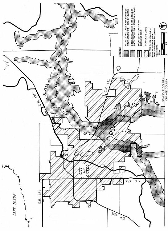
EXHIBIT "B"
NATURAL AREA LAND COVER CLASSIFICATION
EXHIBIT "C"
FLORIDA NATIVE PLANT SOCIETY
935 Orange Avenue
Winter Park, Florida 32789
SELECTED NATIVE PLANTS
RECOMMENDED FOR LANDSCAPING IN CENTRAL FLORIDA
EXHIBIT "D"
WET DETENTION SYSTEMS
Systems must be in compliance with Chapter 40C-4 F.A.C., Subsection 11.4.3(b) with the following amendments:
Within the River Corridor Protection Zone, an off-line system will be utilized.
The maximum length to width ratio for detention ponds will be 10:1 with a minimum of 3:1.
EXHIBIT "E"
ECONLOCKHATCHEE RIVER BASIN STUDY
(See Exhibit "B" of Ordinance No. 854)
EXHIBIT "F"
ECONLOCKHATCHEE RIVER TASK FORCE RECOMMENDATIONS
(See Exhibit "C" of Ordinance No. 854)