Oxford City Zoning Code
ARTICLE 10
0. - DEFINITIONS
Sec. 10.1. - Rules of construction and interpretation.
Except as specifically defined in this section or elsewhere in the code, all words and phrases used in the Land Development Code shall be interpreted to have their customary meanings as defined in a standard dictionary. To help interpret and apply this Code, the following rules shall apply:
10.1.1.
The particular controls the general.
10.1.2.
The words "shall" or "must" are always mandatory and not permissive. The words "may" and "should" are permissive not mandatory and are at the discretion of the decision-makers.
10.1.3.
Words used in the present tense include the future tense; words used in the future tense include the present tense.
10.1.4.
Words in the singular include the plural; words used in the plural include the singular.
10.1.5.
Words of one gender include the other gender, unless the context clearly indicates otherwise.
10.1.6.
Unless otherwise indicated, the term "days" means days the city is open for business.
10.1.7.
In computing any period of time prescribed or allowed by this Code, the day of the notice or final application, after which the designated period of time begins to run, is not to be included. Further, the last day is to be included unless it is not a working day, in which event the period runs until the next working day.
10.1.8
The word "structure" includes the words "building" and "accessory structure."
10.1.9.
The word "street" includes the words "road" and "highway."
10.1.10.
The word "person" includes an individual, firm, association, organization, partnership, corporation, company, trust, governmental unit, and any combination thereof.
10.1.11.
The words "Land Development Code," "Code," and "LDC" shall mean the Official Land Development Code of the City of Oxford.
10.1.12.
The words "zoning map" or "Official Zoning Map" shall mean the Official Zoning Map of the City of Oxford.
10.1.13.
Use of words like "City Council," "Planning Commission," "Director of Planning," "Administrator," and "Engineer" indicates City of Oxford officials and staff as well as their designees.
10.1.14.
The word "city" capitalized or not means the City of Oxford, MS.
10.1.15.
The words "code" or "this code" mean the Land Development Code unless otherwise specified or implied in the context of the reference.
10.1.16.
Within the LDC, sections prefaced "purpose and findings" are intended as official statements of legislative finding or purpose. These "purpose and findings" statements are legislatively adopted, together with the formal text of the LDC. They are intended as a guide to the administration and interpretation of the LDC and shall be treated in the same manner as other aspects of legislative history; however, they are not binding standards.
10.1.17.
Any term not herein defined shall be as defined elsewhere in the Municipal Code or, if not defined there, shall have their customary dictionary meaning.
(Ord. No. 2023-11A, § I, 7-5-2023)
Sec. 10.2. - Definitions.
10.2.1.
Abandoned vehicle or junked vehicle: Any vehicle which is without [a] current license tag and/or which is (a) wrecked, (b) dismantled, (c) partially dismantled, or (d) inoperative. Storage shall mean being on or occupying the premises for 30 days or more.
10.2.2.
Abandoned personal property or junk: Any scrap, waste, reclaimable material or debris, whether or not stored or used in conjunction with dismantling, processing, salvage, storage, baling, disposal or other use or disposition.
10.2.3.
Access way: An area intended to provide entrance or exit for vehicular traffic from a public or private right-of-way to an off-street parking or loading area.
10.2.4.
Accessory Amenity. A structure, desirable or useful feature or facility commonly primarily associated with the use of a building or other structure (such as a firepit or deck); or commonly associated with the entry into or at a central point in a development with no specific use (such as an unmanned "guardhouse", covered arbor, or fountain), that may or may not require a building permit for installation. (See Sec. 3.2)
10.2.5.
Accessory structure: Any structure on the same lot with and customarily incidental and secondary to (but not attached to) the main structure or use, including swimming pools (and pool houses), garden or storage sheds (over 160 square feet), and liquid petroleum gas storage tanks. (See also Structure.)
10.2.6.
Accessory use: See Section 3.11.
10.2.7.
Administrative Official: City staff charged with duties and responsibilities under the terms of this ordinance.
10.2.8.
Adult (Sexually Oriented) Uses: See Sexually oriented businesses
10.2.9.
Agriculture: See Section 3.11.
10.2.10.
Alley: See Street, Alley
10.2.11.
Alcoholic beverage: Any inebriating liquid such as beer, wine, spirits, light wine.
10.2.12.
Apartment house or multi-unit dwelling: See Dwelling, multi-family.
10.2.13.
Arborist: A professional in the practice of arboriculture, which is the cultivation, management, and study of individual trees, shrubs, vines, and other perennial woody plants. See Qualified Professional.
10.2.14.
Assisted Living Facility: See Section 3.6.
10.2.15.
Automatic Teller Machine (ATM): See Freestanding Self-Serve Structures
10.2.16.
Automobile-junk area or automobile graveyard: See Junkyard.
10.2.17.
Auto wrecking: The collecting, dismantling or wrecking of used motor vehicles, wheeled or track laying equipment, or trailers; or the storage, sale or dumping of dismantled, partially dismantled, obsolete or inoperative or wrecked motor vehicles, wheeled or track laying equipment or trailers or their parts.
10.2.18.
Bank: See Section 3.4
10.2.19.
Bar: See Tavern.
10.2.20.
Basement: A floor level below the first story of a building. (See the City of Oxford Building Code for all standards; defined as being when 50% or more of the finished square feet of a floor is less than six feet above ground level.
10.2.21.
Bed and breakfast: See Section 3.8
10.2.22.
Bedroom: A bedroom, as intended in zoning districts that limit density by bedrooms per acre, or that limit the number of bedrooms in a dwelling unit; is defined as a room that can easily be used as a sleeping room. Such a room may or may not have a closet or attached bathroom, and must meet building code requirements for light and ventilation.
10.2.23.
Berm: Mounds or walls of earth that are molded into landforms in a landscaped area. When berms are used for screening, buffering or any other purpose, the berm shall be constructed such that soil erosion is prevented and sight triangles are unobstructed. Berms shall be constructed with 4:1 or flatter slopes. The surface of the berms shall be completely covered with plant material or durable mulch so that the bare soil is not visible. Allowance for soil settlement shall be calculated at ten percent after the berms are compacted. (See also Wall, exterior)
10.2.24.
Blighted area: Blighted area shall mean an area which by reason of the presence of a substantial number of slums; deteriorated or deteriorating structures; predominance of defective or inadequate street layout; faulty lot layout in relation to size, adequacy, accessibility or usefulness, unsanitary or unsafe conditions; deterioration of site or other improvements; diversity of ownership; tax or special assessment delinquency exceeding the fair value of the land; defective or unusual conditions of title; or the existence of conditions which endanger life or property by fire or other causes, or any combination of such factors, substantially impairs or arrests the sound growth of a municipality, retards the provision of housing accommodations or constitutes an economic or social liability and is a menace to the public health, safety, morals or welfare in its present condition and use. If such blighted area consists of open land the conditions contained in the provision in subsection (d) of section 43-35-13 of the Mississippi State Code, 1972, as amended [MCA 1972, § 43-35-13(d)], shall apply. Any disaster area referred to in subsection (g) of section 43-35-13 [MCA 1972, § 43-35-13(g)] shall constitute a "blighted area." State law 43-35-3.
10.2.25.
Block: A parcel of land intended to be used for urban purposes which is entirely surrounded by public streets, highways, railroad rights-of-way, public walks, parks or green strips, rural land or drainage channels, or a combination thereof.
10.2.26.
Blue-line stream. A stream that appears as a broken or solid blue line (or a purple line) on a USGS topographic map.
10.2.27.
Board of Adjustment: The Oxford Board of Adjustment has been dissolved and its duties (variances, special exceptions, and appeals of decisions of the Director of Planning) have been transferred to the Planning Commission.
10.2.28.
Board of Aldermen: As defined in the MS Code of 1972, as amended.
10.2.29.
Breezeway: An open structure with roof but no walls, connecting an accessory structure (such as a garage or carport) to a primary structure (such as a dwelling); or connecting two primary structures to each other (such as separate buildings on a school campus).
10.2.30.
Brewery (Types) As defined by the State of Mississippi:
a.
Brewery means a person having a permit to brew beer or light wine without any production limitations but is not allowed to sell directly to consumers on site. They are allowed to provide limited amounts of beer for sampling on site between 8:00 a.m. and 10:00 p.m. as part of a structured tour of the brewery. The term does not include a brewpub, microbrewery or small craft brewery. A brewery is allowed as an Industrial Use Type under 3.10.2 Manufactured Uses.
b.
Brewpub means the premises of any location in which light wine, light spirit product or beer is manufactured or brewed, for retail sale if the total amount of light wine, light spirit product or beer produced on the premises does not exceed the production limitation imposed in Section 67-3-22, and the light wine, light spirit product or beer is produced for consumption on the premises, although without prohibition on sales for off-premises consumption. A brewpub is allowed as a Commercial Use Type under 3.8.11 Small Craft Brewery.
c.
Microbrewery means a person having a permit under this chapter to manufacture or brew light wine, light spirit product or beer in this state and who manufactures or brews not more than three thousand (3,000) barrels of light wine, light spirit product or beer at its permitted location. a microbrewery is limited to selling a maximum of 80% of their annual production on site. At least 20% of the annual productions must be distributed without any limit on the amount that can be distributed. A microbrewery is allowed as a Commercial Use Type under 3.8.11 Small Craft Brewery.
d.
Small Craft Brewery means a person having a permit under this chapter to manufacture or brew light wine, light spirit product or beer in this state and who manufactures or brews not more than sixty thousand (60,000) barrels of light wine, light spirit product or beer at all breweries that such person or its affiliates, subsidiary or parent company owns or controls or with whom such person contracts with for the manufacture of light wine, light spirit product or beer. For the purposes of this paragraph, contract-brewed beer manufactured by a person having a permit under this chapter to manufacture or brew light wine, light spirit product or beer shall be included in the sixty-thousand-barrel limitation. A small craft brewery is allowed as a Commercial Use type under 3.8.11 Small Craft Brewery.
10.2.31.
Buffer: The use of landscaping, berms, walls, fences or any combination thereof, that at least partially blocks, in a continuous manner, the view from one area to another.
10.2.32.
Buffer area/strip: An area with sufficient planting and/or structural screening which acts as a separation area between two or more incompatible uses and/or districts.
10.2.33.
Building: Any enclosed structure having a roof and intended for shelter, housing or enclosure of persons, animals or personal possessions. The main building is that building which contains the principal use of a lot.
10.2.34.
Build-to Line: See Lot Build-to line.
10.2.35.
Building area: That portion of a lot remaining after required yards have been provided.
10.2.36.
Buildable width: Width of the building site left after the required yards have been provided.
10.2.37.
Building, alteration of: Any change or rearrangement in the supporting members (such as bearing walls, beams, columns, or girders) of a building, any addition to a building or movement of a building from one location to another.
10.2.38.
Building footprint: The area of the ground floor of a building included within the surrounding exterior walls and under roof.
10.2.39.
Building code: The current building code as adopted by the Governing Authority.
10.2.40.
Building, front line of: A line intersecting the foremost portion of a building and parallel and/or concentric to the right-of-way line.
10.2.41.
Building height: The vertical distance measured from the average grade plane to the average height of the highest roof surface.
10.2.42.
Building official: The official appointed by the administration and charged with the responsibility of enforcing the city building codes and issuance of building permits.
10.2.43.
Building line, front: The building wall fronting on the street. Such building wall line shall follow and include the irregular indentations of the building. Steps and unenclosed porches shall be excluded for the purpose of this article.
10.2.44.
Building, main: A building in which is conducted the principal use of the lot on which it is situated.
10.2.45.
Building permit: A permit, which a person shall obtain from the building official granting permission to said person to construct or build any structure.
10.2.46.
Building setback line: The distance required by this Code to be maintained between a given lot line, easement or right-of-way line and any structure foundation: front, rear, or side, as specified.
10.2.47.
Building site: A single parcel of land occupied or intended to be occupied by a building or structure, and appropriate accessory building or uses.
10.2.48.
Care center, Day Care or Home Care: See Section 3.6.
10.2.49.
Care Home or Care Facility: See Group Care Home or Facility
10.2.50.
Carport: A roofed structure, fully enclosed on less than three sides, either attached to or detached from a main building, intended for the primary purpose of providing shelter for one or more motor vehicles. Items stored in a carport shall be subject to the requirements of Section 87-46 of the City of Oxford Code of Ordinances.
10.2.51.
Cementitious Stucco: Exterior coating material include traditional Portland cement and other cementitious materials, such as fly ash, ground granulated blast furnace slag (GGBS), limestone fines and silica fume.
10.2.52.
Cemetery, animal: See Section 3.6.
10.2.53.
Cemetery, human: See Section 3.6.
10.2.54.
Certificate of Appropriateness" (COA). The approval granted by a Historic Preservation Commission.
10.2.55.
Certificate of zoning compliance: A permit issued by the Director of Planning indicating that the use of the building or land in question is in conformity with this Code, is a use permitted by right or a use permitted by review, or is a legal nonconforming use, or that there has been a legal variance granted, as provided by the Code. This is a check and balance system on the zoning procedure. It means that an inspection has indicated that the use is being carried on at the time of occupancy and the condition of the structure or lot at the time of occupation meets all the requirements and legitimately can continue. No structure or lot shall be occupied until a certificate of zoning compliance has been issued when such is required in the land development code.
10.2.56.
Certified sanitary sewer: A public sewage disposal system of a type approved by the Mississippi Air and Water Pollution Control Commission, or individual sewage disposal systems of a type approved by the State.
10.2.57.
Church: See Religious Assembly.
10.2.58.
City: The City of Oxford, Mississippi.
10.2.59.
City Clerk: As defined in the Mississippi Code of 1972, as amended.
10.2.60.
City Engineer: The administrative head of the City of Oxford's engineering staff and the chief technical engineering advisor to the Mayor and Board of Aldermen and other city related officer, or the designated representative of the City Engineer.
10.2.61.
Clearing: The removal of vegetation, including tree stumps, or the material damage of landscape materials by disturbing, excavating or removing the underlying soil.
10.2.62.
Club, Recreational. See recreational club
10.2.63.
Cluster development: See Section conservation development.
10.2.64.
Columbarium: See Section 3.4.
10.2.65.
Commercial Use of Unenclosed Rooftop: See Sec. 3.11.
10.2.66.
Comprehensive plan and planning process: The officially adopted plan and comprehensive planning process that contains the elements that provide long range development policies for the City of Oxford and the area subject to urbanization in and around Oxford, Mississippi.
10.2.67.
Common Area: The areas or facilities of a subdivision, condominium development, or other form of development that is owned jointly and/or fractionally by all owners in the governing association. These may include, but are not limited to, green space, stormwater management facilities, recreational facilities, and parking areas.
10.2.68.
Common Interest Development (CID): See Residential CID (3.5.) or Nonresidential or Mixed-Use CID (3.11).
10.2.69.
Conservation development: See Section 3.5.
10.2.70.
Conforming use: Any lawful use of a building or lot, which complies, with the provisions of this Code.
10.2.71.
Convalescent, Rest, or Nursing Home: See Section 3.6.
10.2.72.
Country Club: See recreational club, See Section 3.7.
10.2.73.
Crematorium: See Section 3.10.
10.2.74.
Cul-de-sac: See Street, Cul-de-sac.
10.2.75.
Day care center: See Care Center.
10.2.76.
Deck: A roofless, floored, horizontal accessory structure that abuts a principle structure. (See the City of Oxford Building Code for all standards.)
10.2.77.
DBH (diameter breast height): The diameter of a tree as measured four and one-half feet above grade level.
10.2.78.
Deciduous: Of or referring to a plant which tends to shed its leaves each year.
10.2.79.
Demolition permit: A permit, which a person shall obtain from the Building Official granting permission to said person to demolish a building or structure.
10.2.80.
Density: The intensity of the use of land observing all yard, height and lot coverage provisions of this Code.
10.2.81.
Developer: Any person engaging in developing or improving a lot or group of lots or placing structures thereon for use or occupancy.
10.2.82.
Development: Any man-made change to improved or unimproved real estate, including but not limited to buildings or other structures, mining, dredging, filling, grading, paving, excavation or a drilling operation.
10.2.83.
Director of Planning: See Planning, Director.
10.2.84.
District: Any zoning district established by this Code.
10.2.85.
Drainage, storm: The minor (active) and major (passive) components that function to remove excess runoff produced by precipitation and convey it offsite and/or to a stormwater management facility with minimum inconvenience, life hazard, and property damage.
10.2.86.
Dripline: The periphery of the area underneath a tree, which would be encompassed by perpendicular lines, dropped from the farthest edges of the crown of the tree.
10.2.87.
Drive-in eating establishment: See Restaurant.
10.2.88.
Driveway: A type of private road for local access to one or a small group of structures, owned and maintained by an individual or group. See also Street, Private.
10.2.89.
Dumpster Enclosure: Any area used for the storage of trash or garbage. No refuse storage shall be permitted as part of the landscaped area, but refuse storage is otherwise permitted adjacent to parking areas.
10.2.90.
Dwelling: Any building, or portion thereof, which is designed or used as living quarters for human occupancy for 30 days or longer that includes facilities for cooking and a full bathroom (with toilet and bathing facilities). A dwelling may be freestanding (detached) or attached horizontally or vertically to other dwellings.
10.2.91.
Dwelling, Accessory: See Section 3.5.
10.2.92.
Dwelling, Attached: See Section 3.5.
10.2.93.
Dwelling, Detached: See Section 3.5.
10.2.94.
Dwelling, Duplex: See Dwelling, Attached.
10.2.95.
Dwelling, manufactured home: A transportable residence in one or more sections, meeting HUD standards, which is built on a permanent chassis and designed to be used with or without a permanent foundation when connected to the required utilities. (See Table of Uses Sec. 3.3)
10.2.96.
Dwelling, mobile home: A manufactured home built before 1976 that does not meet HUD Building Code standards. These structures are not allowed in Oxford, and existing such homes or structures are nonconforming uses.
10.2.97.
Dwelling, modular home: A structure built to be a residence or residences constructed and delivered to a site in two or more sections, meeting IBC Building Codes, when connected to the required utilities.
10.2.98.
Dwelling, multi-family: See Section 3.5.
10.2.99.
Dwelling, single family: See Dwelling, detached.
10.2.100.
Dwelling, townhouse: See Section 3.5.
10.2.101.
Dwelling, two-unit: See Dwelling, attached
10.2.102.
Dwelling unit: See Dwelling.
10.2.103.
Dwelling unit occupancy standard: See Chapter 87, Article IV, Section 87-61, of the City of Oxford Code of Ordinances.
10.2.104.
Dwelling, zero lot line: See Section 3.5.
10.2.105.
Easement: A grant by the property owner to the public, a corporation, or persons, of the use of a strip of land for specific purposes.
10.2.106.
Eating Establishment: See Restaurant.
10.2.107.
Electrical code: The current electric code, National Electrical Code, as adopted by the governing authority.
10.2.108.
Engineer, registered: Shall mean a professional engineer registered with the State of Mississippi.
10.2.109.
Excavate: To dig out, scoop out, hollow out, or otherwise make a hole or cavity by removing soil, sand, gravel, or other material from any property so as to change the grade of such property.
10.2.110.
Family Unit: See Chapter 87, Article IV, Section 87-61, of the City of Oxford Code of Ordinances.
10.2.111.
Farmers Market: A food market at which local farmers sell fruit and vegetables and often meat, cheese, and bakery products directly to consumers.
10.2.112.
Fence: An enclosure or barrier intended to mark a boundary, screen a view, or prevent intrusion. (See also, Wall)
10.2.113.
Fill: The placing, storing or dumping of any materials such as earth, clay, sand, concrete, rubble or non-decomposable waste of any kind upon the surface of the ground which results in increasing the natural surface elevation.
10.2.114.
Financial Institution: See Bank or Credit Union
10.2.115.
Fire code: The current standard fire prevention code, International Building Code, as adopted by the governing authorities.
10.2.116.
Firing Range: See Section 3.7.
10.2.117.
Flammable liquids: Any liquid which gives off flammable vapors, as determined by the flash point from an open cup tester as used for the testing of burning oils, at or below a temperature of 80 degrees Fahrenheit, is flammable.
10.2.118.
Flood, Level of the 100 Year: The highest level of flooding that has a one percent chance of occurring each year. Note: See current flood damage prevention code.
10.2.119.
Flood plain: The land area adjoining a river, stream, watercourse, or lake that has been or may be covered by floodwater. (This definition of flood plain may differ from that used in geologic and geomorphic writings.)
10.2.120.
Flood damage prevention code: An overall program of corrective and preventive measures for reducing flood damage, including but not limited to emergency preparedness plans, flood control works, and land use and control measures, and flood damage prevention code.
10.2.121.
Flood-proofing: Structural and/or nonstructural adjustments to a building which make it watertight below the base flood level and which enable the building to withstand the flood depths, pressures, velocities, impact and uplift forces and other factors associated with the base flood level. Said adjustments are to be certified by a registered professional engineer or architect.
10.2.122.
Floodway: The channel of a river or other water course and the adjacent land areas that must be reserved in order to discharge the base flood without cumulatively increasing the water surface elevation more than one foot. (See Flood, Level of 100 Year)
10.2.123.
Floor area: The square footage of all floor space within the outside line of walls and including the total of all space on all floors of a building.
10.2.124.
Floor area ratio (FAR): A term that expresses the relationship between the amount of usable floor area permitted in a building (or buildings) and the area of the lot on which the building stands. It is obtained by dividing the gross floor area of a building by the total area of the lot.
10.2.125.
Foot candle: A unit of illumination on a surface that is everywhere one foot from a uniform point source of light of one candle and equal to one lumen per square foot.
10.2.126.
Forestry: See Section 3.11.
10.2.127.
Franchise architecture: A building design that is trademarked, branded, or easily identified with a particular chain or corporation and is ubiquitous in nature.
10.2.128.
Fraternal Facility: A fraternity or sorority house that may or may not provide lodging and/or meals, but which does include meeting facilities.
10.2.129.
Freestanding Self-Serve Structures: See Accessory Uses or Structures.
10.2.130.
Front building line: See Building line, front.
10.2.131.
Frontage: All the property on one side of a street between two intersecting streets (crossing or terminating), measured along the line of the street. If the street is dead-ended, then all of the property abutting on one side between an intersecting street and the dead-end of the street.
10.2.132.
Funeral Homes: See Section 3.9.
10.2.133.
Future land use plan: That part of the adopted comprehensive plan that identifies the location, area and classifications of proposed land uses both inside the city and out to a designated future urban growth planning area boundary.
10.2.134.
Garage apartment: An accessory dwelling unit above a private garage. See Dwelling, Accessory.
10.2.135.
Garage, private: An accessory building or part of a main building intended primarily for storage of one or more vehicles. See also carports.
10.2.136.
Garage, public: Any building, other than a private garage, available to the public where vehicles are parked or stored for remuneration.
10.2.137.
Gas code: The current standard gas code, International Building Code, as adopted by the governing authorities.
10.2.138.
Gasoline, service or filling station: See Service Station.
10.2.139.
Gated Entries: See Section 3.11.
10.2.140.
Golf Course: A recreational facility used for the game of golf. See Open Space, Active.
10.2.141.
Governing authorities: Mayor and Board of Aldermen of the City of Oxford, Mississippi.
10.2.142.
Grade or grade level: The finished elevation of land either horizontal or sloping, after completion of site preparation for the construction of structures.
10.2.143.
Grading code: See erosion control code, Appendix D Erosion Control, located in code Chapter 98, art. IV, of this document.
10.2.144.
Grass: Low growing plants which grow in a spreading fashion to form a solid mat or lawn. Only perennial grasses (those which live for more than one growing season) shall qualify to satisfy the requirements of this Code.
10.2.145.
Green Space: An area of grass, trees, or other vegetation with no impervious surfaces, set apart for recreational or aesthetic purposes in an otherwise urban environment.
10.2.146.
Grocery Store: See Section 3.8.
10.2.147.
Gross floor area: The sum of the gross horizontal areas of the several floors of a structure, including interior balconies and means; all horizontal measurements to be made between the exterior faces or walls, including the walls of roofed porches having more than two walls.
10.2.148.
Groundcover: Low growing plants and ornamental grasses which grow in a spreading fashion to form a more or less solid mat of vegetation, and which are generally included in landscaped areas to prevent soil erosion by providing permeable cover for bare earth.
10.2.149.
Ground elevation: The height of the ground above sea level expressed in terms of mean sea level or the City of Oxford datum.
10.2.150.
Group care home or group care facility: See Section 3.6.
10.2.151.
Habitable floor: A space in the conditioned space (heated and/or cooled) of a building for living, sleeping, eating or cooking. Bathrooms, toilet compartments, closets, halls, storage or utility space, and similar areas are not considered habitable space.
10.2.152.
Hardship: An unusual situation on the part of an individual property owner that will not permit the full utilization of their property as is allowed others within the community. A hardship exists only when it is not self-created or when it is not economic in nature. In other words, a true hardship exists only when the literal interpretation of the requirements of the Code would place an individual in an unusual circumstance and would deny the right to use property for any purpose, or create an unnecessary burden, unless relief is granted.
10.2.153.
Heliports: See Section 3.11.
10.2.154.
Historic preservation code: An overall program of protection, enhancement and perpetuation of landmarks, landmark sites and historic districts which represent distinctive elements of the city's cultural, social, economic, political and architectural history; to safeguard, stabilize, promote the city's historic aesthetic and cultural heritage through the Oxford Historic Preservation Commission and the Courthouse Square Historic Preservation Commission. Standards and requirements established by the Oxford Historic Preservation Code. Note: See current Oxford Historic Preservation Code, Appendix B, of this document.
10.2.155.
Home care center: See Care center.
10.2.156.
Home occupation: See Section 3.11.
10.2.157.
Hospital: See Medical Facilities
10.2.158.
Hotel, motel, or inn: See Section 3.8.
10.2.159.
Housing code: The current standard housing code, International Building Code, as adopted by the governing authorities.
10.2.160.
Ice Dispensing Machines: See Freestanding Self-Serve Structures
10.2.161.
Irrigation: An adequate supply of water, which can be made available to landscape plant materials including, but not limited to, underground sprinkler systems or hose bibs.
10.2.162.
Junk: Abandoned personal property.
10.2.163.
Junk yard: Any area, lot, land, parcel, building or structure or part thereof used for the storage, collection, processing, purchase, sale or abandonment of wastepaper, rags, scrap metal or other scrap or discarded goods, materials, machinery or wrecked, dismantled, partially dismantled or inoperative motor vehicles or other type of junk. Also, an area of land used for the dismantling or wrecking of used automobiles or the storage, sale or dumping of dismantled, partially dismantled, inoperative, or wrecked automobiles or their parts. Junk yards are not permitted in Oxford.
10.2.164.
Kennel: An establishment in which more than three domesticated animals more than six months old are housed, groomed, bred, boarded or trained for compensation or offered for sale. (See Services Uses.)
10.2.165.
Land development code: The Code regulating zoning and land subdivision within the corporate limits of Oxford, MS. Also referred to as the Code in the text.
10.2.166.
Land development code checklist: Is a checklist of required actions which is required for all new, or renovation development or redevelopment projects of land or buildings. Note: See Historic Preservation Code.
10.2.167.
Landscape Architect: A person who is educated in the field of landscape architecture. See Qualified Professional. The practice of landscape architecture includes: site analysis, site inventory, land planning, planting design, grading, storm water management, sustainable design, construction specification, and insuring that all plans meet the current building codes and local and federal ordinances.
10.2.168.
Landscape Designer: A person educated in the profession of designing decorative and functional alteration and planting of grounds, especially at or around a building site. See Qualified Professional.
10.2.169.
Landscaped area: That area within the boundaries of a given site, which is permeable, and primarily devoted to and consists of live landscape material.
10.2.170.
Landscape material: Plant materials including, but not limited to, live trees, shrubs, ground covers, grass, flowers, and native landscape materials; also including, but not limited to, inorganic features such as planters, stone, brick, and aggregate forms, water, and other landscape elements when used to enhance live plant materials; provided, however, that the use of inorganic materials or grass in combination with inorganic materials shall not predominate over the use of live, organic plants. Artificial plants do not qualify as landscape material.
10.2.171.
Legal nonconforming use, building or yard: See Nonconforming Use, legal.
10.2.172.
Level of the 100-year flood: See Flood, Level of the 100 Year.
10.2.173.
Life Care Community: See Section 3.6.
10.2.174.
Livestock: A domestic animal normally raised on a farm such as poultry, swine, cattle, horses, sheep, goats, or similar animals, but not wildlife.
10.2.175.
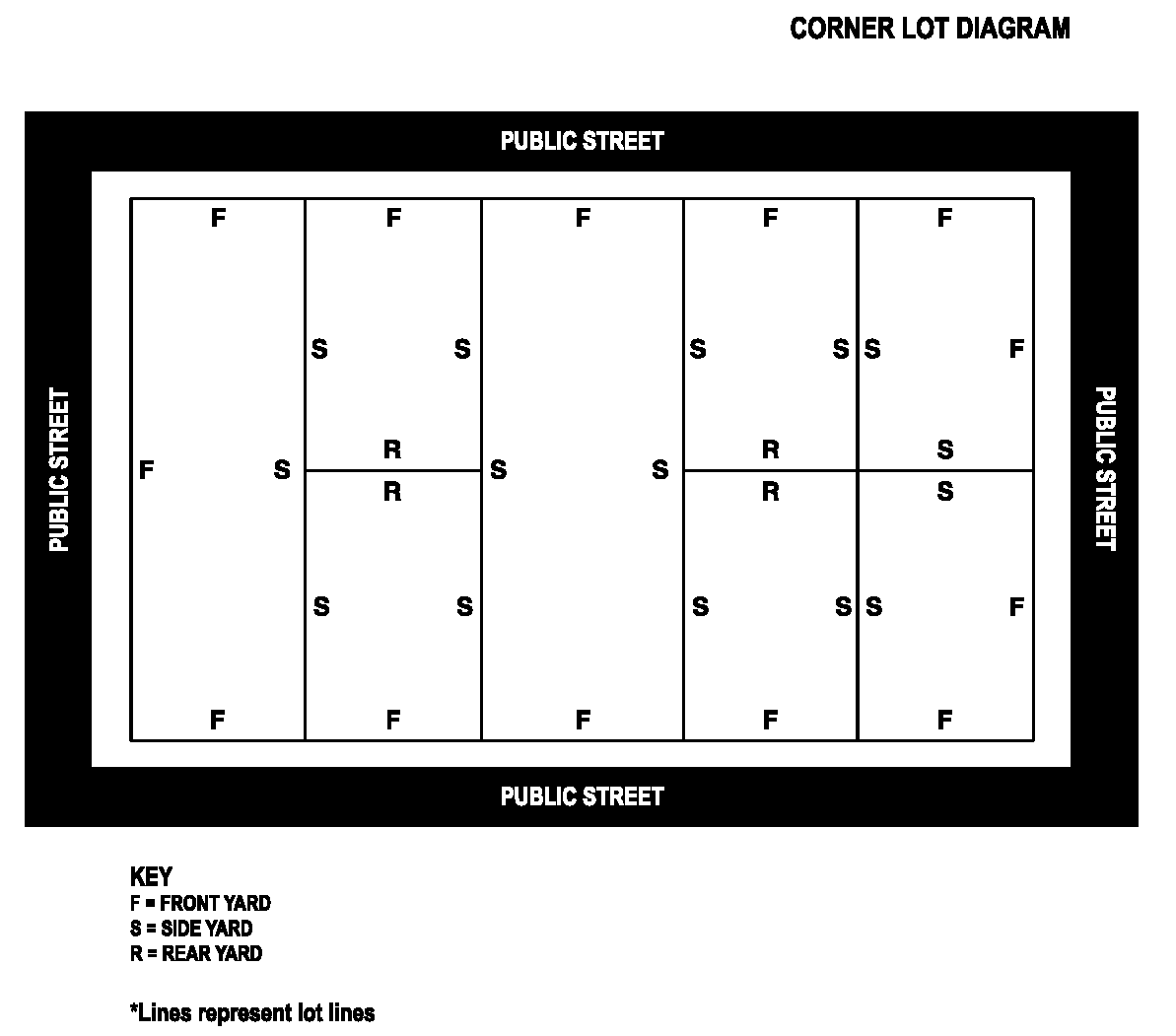
Lot: For the purpose of this Code, a lot is a buildable parcel of land of at least sufficient size to meet minimum zoning and yard requirements for uses allowed in its zoning district. Such lot shall have frontage on an improved public or private street that has been approved by the Mayor and Board of Aldermen, advised by the site plan review committee. Lots may consist of single lots of record, portions of a lot of record, a combination of complete lots of record, or a parcel of land described by metes and bounds. In the case of division or combination, however, no lot or parcel shall be created which does not meet the requirements of the land development code. (see fig. 1)
10.2.176.
Lot area: The total area included within the front, side and rear lot lines.
10.2.177.
Lot build-to line: The line at which construction of a building facade is to occur on a lot, running parallel to the front property line without setback, and thus ensuring a generally uniform (or more or less even) building facade line on the street.
10.2.178.
Lot, corner: A lot located at the intersection of and abutting on two or more streets. (see fig. 1)
10.2.179.
Lot Coverage: The area of a lot covered by impervious surfaces including the building footprint, driveways, impervious patios or terraces, parking pads, and sidewalks.
10.2.180.
Lot depth: The average horizontal distance between the front lot line and the rear lot line.
10.2.181.
Lot frontage: The front of a lot shall be construed to be the portion nearest the street right of way extending from lot line to lot line. For the purposes of determining yard requirements on corner lots, all sides of a lot adjacent to streets shall be considered frontage and yards shall be provided as indicated in this land development code.
10.2.182.
Lot, frontage, double: A lot, other than a corner lot, which has frontage on more than one street. Also referred to as a through lot. (see fig. 1)
10.2.183.
Lot, interior: A lot other than a corner lot. (see fig. 1)
10.2.184.
Lot line, front: In the case of an interior lot, the line separating said lot from the street. In the case of a corner or through lot, the line separating said lot from the street which the house will face, to be determined from the request for a building permit. Front lot line is synonymous with street right-of-way line.
10.2.185.
Lot line, side: The side lot line is the property boundary line between the front and rear lot lines.
10.2.186.
Lot, nonconforming: See Nonconforming lot.
10.2.187.
Lot lines: The lines bounding a lot as defined herein.
10.2.188.
Lot of record: A lot which is part of a subdivision recorded in the office of the county chancery clerk, or a lot or parcel of land described by metes and bounds, the description of which has been recorded in the office of the county chancery clerk and that at the time of recording was a legal, conforming use.
10.2.189.
Lot setback line: The line that is the required minimum distance from the street right-of-way line or any other lot line that establishes the area within which the principal structure must be erected or placed.
10.2.190.
Lot width: The width of a lot at the front building setback line.
10.2.191.
Lounge: See Tavern.
10.2.192.
Major thoroughfare plan: That part of the comprehensive plan now or hereafter adopted which includes the adopted major thoroughfare plan, and which sets forth identification, location, dimensions and classifications of existing and proposed public streets, major arterials, minor arterials, collectors, highways and parkways.
10.2.193.
Manufacturing: See Section 3.10.
10.2.194.
Manufactured home development: See Section 3.5.
10.2.195.
Mayor: Mayor (chief executive) of the City of Oxford.
10.2.196.
Medical facilities: Facilities that offer a range of health services (for humans or animals) to the public, including out-patient and in-patient care, and including long term medical care such as, but not limited to: nursing homes, convalescent home, rest home, medical clinic, dental clinic, public health facility, veterinary clinic or hospital. See Section 3.9.
10.2.197.
Medical Cannabis.
a.
Medical Cannabis Establishment means a cannabis cultivation facility, cannabis processing facility, cannabis testing facility, cannabis dispensary, cannabis transportation entity, cannabis disposal entity or cannabis research facility licensed and registered by the appropriate agency.
i.
Cannabis Cultivation Facility means a business entity licensed and registered by the Mississippi Department of Health that acquires, grows, cultivates and harvests medical cannabis in an indoor, enclosed, locked and secure area.
ii.
Cannabis Dispensary or "dispensary" means an entity licensed and registered with the MDOR that acquires, possesses, stores, transfers, sells, supplies or dispenses medical cannabis, equipment used for medical cannabis, or related supplies and educational materials to cardholders.
iii.
Cannabis Disposal Entity means a business licensed and registered by the Mississippi Department of Health that is involved in the commercial disposal or destruction of medical cannabis.
iv.
Cannabis Processing Facility means a business entity that is licensed and registered by the Mississippi Department of Health that: 'Acquires or intends to acquire cannabis from a cannabis cultivation facility; Possesses cannabis with the intent to manufacture a cannabis product; Manufactures or intends to manufacture a cannabis product from unprocessed cannabis or a cannabis extract';
v.
Cannabis Research Facility or "research facility" means a research facility at any university or college in this state or an independent entity licensed and registered by the Mississippi Department of Health pursuant to this chapter that acquires cannabis from cannabis cultivation facilities and cannabis processing facilities in order to research cannabis, develop best practices for specific medical conditions, develop medicines and provide commercial access for medical use.
vi.
Cannabis Testing Facility or "testing facility" means an independent entity licensed and registered by the Mississippi Department of Health that analyzes the safety and potency of cannabis.
vii.
Cannabis Transportation Entity means an independent entity licensed and registered by the Mississippi Department of Health that is involved in the commercial transportation of medical cannabis.
b.
Canopy means the total surface area within a cultivation area that is dedicated to the cultivation of flowering cannabis plants. The surface area of the plant canopy must be calculated in square feet and measured and must include all of the area within the boundaries where the cultivation of the flowering cannabis plants occurs. If the surface area of the plant canopy consists of noncontiguous area.
10.2.198.
Mobile home: Mobile homes are not allowed in Oxford. See Dwelling, manufactured home.
10.2.199.
Monastery or Convent: See Religious Assembly Uses.
10.2.200.
Mortuary and Funeral Home: See Section 3.9.
10.2.201.
Moving permit: A permit, which a person shall obtain from the building official, granting permission to that person to move or relocate a building or structure. Such permit requires a certificate of appropriateness from a Historic Preservation Commission if in a Historic District.
10.2.202.
Municipal Public Buildings and Facilities: See Section 3.6.
10.2.203.
Natural disaster: A natural occurrence such as an earthquake, flood, fire, straight line winds, hurricane, or tornado weather event which causes great damage to property.
10.2.204.
New construction: The first placement of permanent construction on a site, such as the pouring of slabs or footings, or any work beyond the stage of excavation. For a structure without a basement or poured footings, the start of construction includes the first permanent framing or assembly of the structure or any part thereof or its pilings or foundation, or the affixing of any prefabricated structure or mobile home to its permanent site. Permanent construction does not include land preparation, land clearing, grading, filling, excavation for basements, footings, piers or foundations, erection of temporary forms, installation of sewer, gas and water pipes, or electric or other service lines from the street, or existence on the property of accessory buildings such as garages or sheds, not occupied as dwelling units or not a part of the main structure
10.2.205.
Nightclub: See Restaurant.
10.2.206.
Nonconforming lot: A lot, the area, width, or other characteristic of which fails to meet requirements of the zoning district in which it is located and which was conforming ("of record") prior to enactment of the land development code.
10.2.207.
Nonconforming use: A structure and/or parcel of land lawfully occupied by an operating use that does not conform to the regulations of the district in which it is situated at the time of the passage of this Code.
10.2.208.
Nonconforming use, building or yard, Legal: An operating use, building or yard existing legally at the time of the passage of this Code which does not by reason of design, use, or dimensions conform to the regulations of the district in which it is situated. A use, building or yard established after the passage of this Code, which does not conform to regulations of the district in which it is situated, shall be considered an illegal nonconforming use. Certificate of zoning compliance required.
10.2.209.
Nursing home: See 3.6.
10.2.210.
Offices, Professional: See Section 3.8.
10.2.211.
Old Town Conservation Overlay District: Neighborhood conservation district as defined in the Land Development Code.
10.2.212.
Old Town Oxford: The boundaries of the Courthouse Square Historic Preservation District.
10.2.213.
Open space: An area of land that is undeveloped other than recreational uses (which may include some structures) and Green space (land with no impervious surfaces, that is partly or completely covered with grass, trees, shrubs, or other vegetation).
10.2.214.
Open space, active: See Section 3.7.
10.2.215.
Open space, common: A parcel or parcels of land not occupied by dwellings or other buildings, driveways, or parking areas, which is available to, accessible to, and maintained in a suitable state for the shared use and enjoyment by the owners and/or occupants of individual dwelling units within a particular development. See also, Common Area.
10.2.216.
Open space, passive: See Section 3.7.
10.2.217.
Open storage: A depository or place for storing goods related to the establishment on the same premises and not located within a building.
10.2.218.
Orphanage: See Group Care Home or Facility.
10.2.219.
Overlay district: A set of zoning requirements that is described in the Code text, is mapped, and is imposed in addition to those of the underlying district. Developments within an overlay district must conform to the requirements of both districts or the more restrictive of the two.
10.2.220.
Owner: Any person having a sufficient proprietary interest in the land sought to be developed, subdivided, or rezoned to commence and maintain proceedings to develop, subdivide, or rezone the property according to the provisions specified in this Code.
10.2.221.
Park or Playground: See Open Space, Active or Passive.
10.2.222.
Parking lot: The area and/or parking spaces required by this Code in a specific district designed and used for parking automobiles, vehicles, and loading. The parking area shall exclude fire lanes, as defined in the standard fire prevention code. A parking lot is accessory to a principle use.
10.2.223.
Parking lot encroachment barrier: Protective barriers which shall be provided, positioned, and secured to prevent any part of an automobile or other vehicle from extending into live landscaping, fences, or walls. Curbing, wheel stops, landscape timbers, railroad ties or bumper rails shall provide protection for all landscaping from vehicular encroachment.
10.2.224.
Parking space: A space located on private or public property sufficient in size to store one automobile and meeting the requirements of this Code and the disabled persons parking code. The size of parking spaces, which shall include the parking stall and circulation area, are defined in Article 6 of this Code.
10.2.225.
Parking lot perimeter landscape area: That area surrounding a parking lot which is devoted to and consists of landscape materials, fences, or other means of screening the parking lot from the view of the street.
10.2.226.
Passive Open Space: See Open Space, Passive
10.2.227.
Patio or Terrace: A roofless flat area located used for recreational purposes, that may or may not abut a principle structure, usually a dwelling. A patio or terrace with a roof is considered a porch for the purposes of this code.
10.2.228.
Permit: Written governmental permission issued by an authorized official, empowering the holder thereof to do some act not forbidden by law, but not allowed without such authorization.
10.2.229.
Permitted use: That use of a lot, which is among the uses as a matter of right under the zoning classification. See 3.3.2.
10.2.230.
Planning Commission: The Oxford Planning Commission as established and appointed by the governing authorities of the City of Oxford, MS.
10.2.231.
Planning, director of: The person designated by the mayor who is responsible for the activities and functions of the department of planning, or their designated representative. The Director is designated to administer the land development code, issues Certificates of Zoning Compliance, and to serve as the chief technical planning advisor to the Oxford Planning Commission, the Oxford Historic Preservation Commissions, and to the Mayor and Board of Aldermen.
10.2.232.
Planning department: The staff of the Oxford planning department.
10.2.233.
Planned unit development (PUD): A zoning district in which a mix of land uses may be permitted as authorized and defined in Article 2.
10.2.234.
Plat: A map, plan or layout showing land subdivision information required by the land development code for developing a subdivision or site plan.
10.2.235.
Plumbing code: The current standard plumbing code, International Council of Codes (ICC), as adopted by the governing authorities.
10.2.236.
Premises: Land together with a structure or structures occupying it.
10.2.237.
Private Club, Recreational: See recreational club.
10.2.238.
Private drive: A driveway located on a lot which serves only that lot, and which shall not be a private street. See also Driveway and Street, Private.
10.2.239.
Porch: A roofed appendage to a main building (accessible from the front, rear, or side) that may be enclosed by latticework, screening, or temporary seasonal windows. (See the City of Oxford Building Code for all standards.)
10.2.240.
Pub: See Tavern.
10.2.241.
Public building and Facilities: See Section 3.6.
10.2.242.
Public facility: See Section 3.6.
10.2.243.
Public use: A use owned and/or operated by a government authority (city, county, state, and federal) for the benefit of the general public.
10.2.244
Public works, director of: That person designated by the mayor and ratified by the mayor and Board of Aldermen who is responsible for the activities and functions of the department of public works, or their designated representative.
10.2.245.
Public or private utility: Any person, firm, corporation, municipal department or board duly authorized under State or municipal regulations to furnish such public services as electricity, gas, water, sewer, telephone, television cable, telegraph, transportation or other public services to its subscribers or customers.
10.2.246.
Qualified professional. A professional licensed and registered in the state of Mississippi performing services only in their areas of licensure, certification, or registration. This term shall include only registered arborists, land surveyors, landscape designer, registered engineers, registered architects, and registered landscape architects.
10.2.247.
Recreational Club or Facility: See Section 3.7.
10.2.248.
Recreational uses, indoor and outdoor: See Section 3.8.
10.2.249.
Recreational vehicle: A vehicular type portable structure without permanent foundation, which can be towed, hauled or driven and primarily designed as a temporary living accommodation for recreational, camping, and travel use. For the purpose of this ordinance, these include but are not limited to travel trailers pulled behind a vehicle, truck campers, camping trailers, and self-propelled motor homes.
10.2.250.
Recreational vehicle park: See Section 3.8
10.2.251.
Refuse storage: See Dumpster Enclosure.
10.2.252.
Religious assembly use: See Section 3.6.
10.2.253.
Rest Home: See Section 3.6.
10.2.254.
Restaurant: See Section 3.8.
10.2.255.
Retail Indoor Sales Business: See Section 3.8.
10.2.256.
Retail Outdoor Sales Business: See Section 3.8.
10.2.257.
Retaining Wall: See Walls, Retaining
10.2.258.
Schools: See Section 3.6.
10.2.259.
Screening: Landscaping, berms, fences, walls, or any combination thereof used to block or significantly obscure, in a continuous manner, the view from one area to another.
10.2.260.
Semi-public use: A use owned, operated and/or maintained by a private, eleemosynary institute or other group generally for the benefit of a selected public group and the community (i.e. religious group).
10.2.261.
Service Station: See Section 3.8.
10.2.262.
Service Uses, indoor: See Section 3.9.
10.2.263.
Setback line: See Lot, Setback line.
10.2.264.
Sex Entertainment Businesses. A business which provides various forms of entertainment related to sexual activities. See Appendix A-11 for specific uses and terminology. See Sex Entertainment Business Overlay District 2.6.20 for regulations.
a.
Arcade: An establishment where, for any form of consideration, one or more motion picture projectors, slide projectors, or similar machines for viewing by five or fewer persons are used to show films, motion pictures, video cassettes, slides or other photographic reproductions which are characterized by emphasis upon the depiction or description of "specified sexual activities" or "specified anatomical areas."
b.
Bookstore (Sexually oriented): An establishment which has a substantial portion of its stock-in-trade and offers for sale for any form of consideration, any one or more of the following: viii. Books, magazines, periodicals, or other printed matter or photographs, films, motion pictures, video cassettes, slides or other photographic reproductions which are characterized by emphasis upon the depiction or description of "specified sexual activities" or "specified anatomical areas."
i.
Instruments, devices, or paraphernalia which are designed for use in connection with "specified sexual activities."
c.
Cabaret (Sexually oriented): A nightclub, bar, restaurant, theater, or similar establishment which regularly features live performances which are characterized by the exposure of "specified anatomical areas" or by "specified sexual activities," or films, motion pictures, video cassettes, slides or other photographic reproductions which are characterized by an emphasis upon the depiction or description of "specified sexual activities" or "specified anatomical areas."
d.
Entertainment Establishment (Sexually oriented): An arcade, books store, cabaret, motel, motion picture theater, or similar establishment which regularly features or depicts behavior which is characterized by the exposure of "specified anatomical areas" or where any employee, operator or owner exposes his/her "specified anatomical area" for viewing by patrons
e.
Motel (Sexually oriented): A motel or similar establishment which includes the word "adult" in any name it uses or otherwise advertises the presentation of "adult" or "sexually oriented" material, offering public accommodations for any form of consideration, which provides patrons with closed circuit television transmissions, films, motion pictures, video cassettes, slides or other photographic reproductions which are characterized by an emphasis upon the depiction or description of "specified sexual activities" or "specified anatomical areas."
f.
Motion picture theater (Sexually oriented): An establishment where, for any form of consideration, films, motion pictures, video cassettes, slides or similar photographic reproductions are shown, and in which a substantial portion of the total presentation time is devoted to the showing of material which is characterized by an emphasis upon the depiction or description of "specified sexual activities or "specified anatomical areas."
10.2.265.
Shopping center: A group of retail businesses in attached or detached structures (usually one story) that may include retail stores, offices, restaurants and other businesses having a common parking area, and common ownership and/or management.
10.2.266.
Shrub: Woody or semi-woody perennial plants that are customarily included in landscape designs to provide for lower scale buffering and visual interest.
10.2.267.
Shrubber: A merchant who sells shrubs.
10.2.268.
Sidewalk: A paved, surfaced or leveled area, usually paralleling and separated from the street, used as a pedestrian walkway.
10.2.269.
Sight triangle: An area in the shape of a right triangle at the intersection of streets within which clear visibility of traffic, bicyclists, and pedestrians must be maintained.
10.2.270.
Signs: Any outdoor display, device, figure, painting, drawing, message, plaque, poster, billboard, or other display surface and its supporting structure which is designed, intended to be used to advertise or inform, any part of the advertising or information contents of which is designed to be primarily viewed from any place on the traveled way of a street or highway. These may include (but not be limited to):
a.
Awning: A building mounted sign that provides additional functionality as a shelter. Lettering or symbols can be incorporated into the drop or valance or the awning surface. Awning signs may be illuminated, but internal illumination is not permitted.
b.
Banner, commercial: Any type of cloth, fabric or other material normally displayed between poles, attached to buildings or other supports which advertises any business, product, goods or service, but not to include "public service" banners.
c.
Banner, public service: Temporary banners(s) used to promote the civic, social, educational, cultural, moral, economic or industrial welfare of the community which are of a general public interest and not for the purpose of private financial gain.
d.
Business sign: A sign, which directs the attention of the general public to a business, product, service or activity, conducted upon the premises where such sign is located. Business signs shall be classified as an accessory business use and shall be permitted in all commercial and industrial zones. Business signs shall only be allowed on the premises upon which such business is located and any other type of "off-premises" business sign, other than shopping center entrance signs and outdoor advertising signs, is prohibited.
e.
Construction Sign: The signage to be included on each site requiring a land disturbance permit. Signage shall include at a minimum "Construction Site - No Trespassing", the contractor's name, 24-hour emergency contact number for the contractor, the name of the QCP, and a 24-hour emergency contact number for the QCP. Signage shall be visible from the street, public right of way, or proposed public right of way. Signage shall not be larger than 3 square feet and shall be considered a temporary sign in accordance with the City of Oxford's Land Development Code.
f.
Digital billboard: Any billboard which electronically changes the fixed display screen composed of a series of lights, including light emitting diodes, fiber optics, or other similar technology. Digital billboards include computer programmable, microprocessor controlled electronic, or digital displays that display electronic images, graphics, or pictures, with or without textual information.
g.
Flashing sign: A sign, the illumination of which is not constant in intensity when in use, except that illuminated signs which indicate time, date, temperature or other public service information, shall not be considered to be flashing signs. This shall include traveling messages, or any other electronic or mechanical movement of the message.
h.
Foot candle: See Section 10.2.11.5.
i.
Freestanding sign: Any sign (such as a monument or post sign) mounted on a support structure and placed on or anchored in the ground and which is independent from any building or other structure.
j.
Ground sign: See monument sign.
k.
Illuminated sign: A sign in which light is incorporated.
l.
Incidental signs: Business signs customary and incidental to the business conducted on premises such as "self-service," "Master Charge," "Visa," or any other type of sign erected within any building.
m.
Marquee: A sign that is mounted to a permanent canopy. Commercial buildings in the 20th century, particularly hotels and theaters, commonly featured suspended canopies of metal, glass, and/or wood over entrances. These signs generally included lights or changeable messages.
n.
Monument sign: A freestanding sign that has a solid support structure with a base that is at least the width of the sign structure.
o.
Nonconforming sign: See section 3.1.6.
p.
Outdoor advertising sign: A sign which directs the attention of the general public to a business, product, service or activity not conducted upon the premises where such sign is located, and commonly known as "billboards."
q.
Pennant: Any type of cloth, fabric or other material normally displayed on poles, strings, wires or by other means which contains distinctive colors, patterns or shapes and contains no business name, logo or other type of commercial message.
r.
Portable signs: Any business sign or outdoor advertising sign not permanently attached to a building, post, or other type of foundation and which is capable of being moved by means of lifting or rolling on wheels with a minimum of difficulty by disconnection of wiring, bolts, or other anchors.
s.
Post Sign: A freestanding sign that is mounted on one or two support posts.
t.
Projecting sign: Any sign attached to a building, which projects outward from the building, normally at a 90-degree angle.
u.
Rope Lighting: Rope lighting, also known as fiber-optic cable lighting, is made up of tiny lights, available in either incandescent or LED bulbs, spaced about an inch apart and surrounded by clear, flexible PVC tubing but also include LED strip lighting that are protected by a waterproof coating.
v.
Sign area: The entire width within a single, continuous perimeter inclosing the outer dimensions of the actual message or copy area. It does not include decorative trim, customary extensions or embellishments nor any structural elements outside the limits of such display surface and not forming an integral part of the display. For double-face or V-type sign structures, only one display face shall be counted in computing the actual sign area.
w.
Temporary signs: Any sign not intended to be permanently located on the premises, usually noticing property for sale or rent, announcing a new business or new construction activity, or election related messages. Temporary signs are intended to be displayed for a limited time period, and they are not permanently affixed to the ground or any structure. They include, but are not limited to, signage methods such as banners or posters; and may take the form of "spike signs" that are affixed into the ground with metal spikes or stakes, or affixed to other solid objects with nails or staples or by other means. Such signs shall not be construed to be a "portable sign" as defined above.
x.
Wall Sign: Lettering, symbols, and decorative elements that are intended to draw attention to, identify or brand a business that are painted on, applied to, or attached to the wall of a building.
y.
Window Sign: Signage, including lettering, symbols, and decorative elements that are intended to draw attention to, identify, or brand a business, that are painted on, applied to (decals), or attached to the front or back of a window or on the glass portion of a door.
z.
Site plan: A plan, to scale, showing uses and structures proposed for a parcel of land as required by the land development code regulations.
10.2.271.
Site Plan review committee: As established by the land development code, its purpose shall be to utilize to the fullest extent possible its individual and collective technical expertise, to coordinate and expedite the review, processing and pre-hearing procedures as they may apply to the land development code, and all development and building codes and all applicable city codes.
10.2.272.
Slum area: Slum area shall mean an area in which there is a predominance of buildings or improvements, whether residential or nonresidential, which by reason of dilapidation, deterioration, age or obsolescence, inadequate provision for ventilation, light, air, sanitation, or open spaces, high density of population and overcrowding, or the existence of conditions which endanger life or property by fire and other causes, or any combination of such facts or conducive to ill health, transmission of disease, infant mortality, juvenile delinquency, or crime, and is detrimental to the public health, safety, morals or welfare. Mississippi State Law 43-35-3, as amended (MCA 1972, § 43-35-3)
10.2.273.
Special use: See definition in Section 3.3.
10.2.274.
Special exception use: See definition in Section 3.3.
10.2.275.
Stable or Riding Academy: See Open Space, Active - Section 3.4.
10.2.276 Story: That portion of a building, other than a basement, included between the surface of any floor and the ceiling next above it. A second story shall consist of a minimum of 51 percent of the building footprint as functional space.
10.2.277.
Street: Rights-of-way, dedicated to public use, which provide vehicular and/or pedestrian access to adjacent properties.
10.2.278.
Street, alley: A minimal street available for public use which gives a secondary means of vehicular access to the back or side of properties otherwise abutting a public street.
10.2.279.
Street, arterial: Streets, roads, or highways having the primary purpose of carrying through traffic (pedestrian, bicycle, transit, and vehicular), and the secondary purpose of providing access to abutting properties.
10.2.280.
Street, collector: Streets or roads with the dual purpose of providing access to properties and carrying local traffic (pedestrian, bicycle, transit, and vehicular) within residential, mixed-use, and commercial, and industrial areas. There may be through traffic, but the system primarily provides service access.
10.2.281.
Street, cul-de-sac, court, or dead-end street: A short street having one end open to traffic and the other permanently or temporarily terminated by a vehicular turn-around.
10.2.282.
Street, curb line radius: The radius used to join two intersecting streets or the curve of a street.
10.2.283.
Street, dedicated: A street with its right-of-way which has been given by the owner for public use and has been accepted by the City of Oxford.
10.2.284.
Street grade: The combination of slope and elevation of the street upon which a lot fronts. If there is no officially established grade, the existing grade of the street at the center of the street shall be considered the street grade.
10.2.285.
Street, half: One half of the right-of-way of a street.
10.2.286.
Street, intersection: The place where a street joins or crosses another street at an angle.
10.2.287.
Street, line: Public right-of-way line of a street.
10.2.288.
Street local: Residential or rural roads not classified in a higher system, primarily providing direct access to abutting land and to collector streets. They offer the lowest level of mobility and usually carry very little commercial truck traffic.
10.2.289.
Street, minor: See street, local.
10.2.290.
Street, private: Any private way which is platted as a principal means of access for abutting properties but which is not dedicated for public use. Maintenance shall be the responsibility of the adjoining property owners.
10.2.291.
Street, public: Any way or place, which is dedicated and accepted for public use, which provides the principal means of access for abutting properties. A public street shall be constructed to city specifications and accepted by the city prior to dedication.
10.2.292.
Street or alley, vacated: A dedicated right-of-way which has been officially closed and abandoned by Ordinance by the Governing Authority, and said right-of-way is divided equally between adjacent properties.
10.2.293.
Storage, Self- Storage Facility: See Section 3.10.
10.2.294.
Structure: Anything constructed or erected, the use of which requires a fixed location on the ground, or attached to something having a fixed location on the ground, structures include billboards, manufactured homes, walls, swimming pools, and fences, but do not include marquees, canopies, service or dispensing facilities, whether free standing or attached.
10.2.295.
Structural alterations: Any change in the roof, exterior walls or supporting members of a building.
10.2.296.
Studio, Artistic or Teaching. See Section 3.9.
10.2.297.
Sub-divider: Any person, firm, partnership, corporation or other entity acting as a unit, and subdividing or proposing to subdivide land as herein defined.
10.2.298.
Subdivision: The division of a lot, tract, or parcel of land into two or more lots, plats, sites, or other divisions of land for the purpose, whether immediate or future, of sale or building development by means of an appropriately recorded legal document. A subdivision which reduces the size of an existing lot may require approval of a new site plan for any existing development on that lot.
10.2.299.
Substantial improvement: Any repair, reconstruction or improvement of a structure, the cost of which equals or exceeds 50 percent of the actual cash value of the structure either (1) before the improvement is started, or (2) if the structure has been damaged and is being restored, before the damage occurred. Substantial improvement is started when the first alteration of any structural part of the building commences.
10.2.300.
Surveyor, registered land: Shall mean a registered land surveyor licensed in the State of Mississippi.
10.2.301.
Swimming pool code: The Standard Swimming Pool Code of the International Building Code, as adopted by the governing authorities.
10.2.302.
Tavern: See Restaurant.
10.2.303.
Temporary Use: See Section 3.11.
10.2.304.
Terrace: See Patio.
10.2.305.
Theater: See Section 3.8.
10.2.306.
Townhouse: See Dwelling, Townhouse.
10.2.307.
Travel trailer: See Recreational Vehicle
10.2.308.
Travel trailer parking area: See Recreational Vehicle Park
10.2.309.
Tree or shrub, Evergreen: A plant which tends to retain its leaves all year round.
10.2.310.
Tree, Existing: Any tree on a building site before development is proposed, indicated on an approved site plan to be retained.
10.2.311.
Tree grove: A stand of native significant and/or specimen trees with understory vegetation cover intact, drainage conditions unchanged, and general slope and grades unaltered. The extent of a grove shall extend three feet beyond the dripline of the perimeter trees in the grove.
10.2.312.
Tree, Heritage: Any tree by virtue of its species and/or size included in the heritage tree list (See Appendix) approved by the Oxford Tree Board. The listed trees are predominantly species native to Lafayette County and of size and maturity important to the health and conservation of Oxford's urban forest. In addition, any hardwood and/or evergreen tree 36 inches or greater at DBH shall be considered as a heritage tree.
10.2.313.
Tree, large: An evergreen or deciduous upright woody perennial plant having a single main stem or several main stems, which is a minimum of two-inch caliper, 12 to 14 foot with the maximum of 16 feet in height at the time of planting and which attains generally more than 30 feet in height at maturity.
10.2.314.
Tree, Native: A tree that is indigenous to the area.
10.2.315.
Tree, Protected: Any tree which meets the requirements of being classified as a "significant tree" or is declared by the developer, or required by the Oxford Planning Commission, as to be preserved and protected from clearing or infringement by development.
10.2.316.1.
Tree, Significant: Plant materials which meet the following requirements: 10.2.316.1 Healthy hardwood and evergreen trees, except pines, with a DBH of 15 inches or greater;
10.2.316.2.
Healthy pines with a DBH of 24 inches or greater measured at four and one-half feet above grade level.
10.2.317.
Tree, Small: An evergreen or deciduous upright woody perennial plant having a single main stem or several main stems, which is a minimum of six to eight feet overall height at the time of planting and which attains a minimum height of 15 feet and a maximum height of 30 feet.
10.2.318.
Tree, Specimen: Any tree identified in the Oxford Master Tree List (see Appendix A.10.1) at least four inches or more DBH that exemplifies a unique color, texture, scent, growth habit, outstanding size, or other distinguishing characteristic that makes it unique.
10.2.319.
Truck Terminal: See Section 3.10.
10.2.320.
Turf: See grass.
10.2.321.
University/college/business school: An institution at which persons are instructed in vocational, career and academic learning for preparation for employment and education after completion of high school. Example: University of Mississippi, Northwest Community College, or private business college.
10.2.322.
Variance: A modification of the literal provisions of this Code which the Planning Commission and/or the Mayor and Board of Aldermen are permitted to grant when strict enforcement of said provisions would cause undue hardship (such hardship cannot be self-created or of an economic nature) owing to circumstances unique to the individual property on which the variance is sought.
10.2.323.
Vegetation, Significant: Any large shrub meeting or exceeding eight feet in height at maturity.
10.2.324.
Vehicle Repair and Maintenance Facility: See Section 3.8.
10.2.325.
Veterinary clinic/hospital: See Medical Facilities
10.2.326.
Vicinity map: A map of the general surrounding area indicating the location of the property being subdivided.
10.2.327.
Vines: Herbaceous or semi-woody plants requiring support upon which to grow and used to provide some screening or buffering effects.
10.2.328.
Wavier: A grant of relief from the strict interpretation of a provision of this Code. See Sec. 10.2.3.10. Interpretations and Appeals.
10.2.329.
Walkway: A hard-surface, all-weather area intended for pedestrian circulation within a development. See also Sidewalk.
10.2.330.
Wall, exterior: An enclosing structure made of brick, stone, earth or other materials intended to mark a boundary, screen a view, or prevent intrusion.
10.2.331.
Wall, retaining: A structure designed to restrain soil to a slope that it would not naturally keep to (typically a steep, near-vertical or vertical slope). They are used to bound soils between two different elevations often in areas of terrain possessing substantial slopes and /or unstable soil, or in areas where the landscape needs to be shaped and engineered for specific purposes.
10.2.332.
Warehouse: See Section 3.10.
10.2.333.
Water supply system: Any system approved by the State Health Department and City of Oxford which provides a source, means or process of supplying potable water.
10.2.334.
Wholesale Use: See Section 3.10.
10.2.335.
Wireless Communication Facility—Alternative Structure: A structure that is not primarily constructed for the purpose of holding wireless communication facility antennas but on which one or more Antennas maybe mounted, including but not limited to, buildings, water tanks, pole signs, billboards, church steeples or towers, electric power transmission poles/towers, streetlights, or utility structures.
10.2.336.
Wireless Communication Facility—Antenna: Any apparatus designed for the transmitting and/or receiving "electromagnetic waves".
10.2.337.
Wireless Communication Facility—Base Station: Equipment and non-Tower supporting structure at a fixed location that enables wireless telecommunications between user equipment and a communications network. The term does not encompass a Tower or equipment associated with a Tower.
10.2.338.
Wireless Communication Facility—Co-location: The mounting or installation of Transmission Equipment of more than one wireless communications provider on an eligible support structure for the purpose of transmitting and/or receiving radio frequency signals for communications purposes.
10.2.339.
Wireless Communication Facility—Distributed Antenna System (DAS): A system consisting of (1) a number of remote communications nodes deployed through a desired coverages area, each including at least one Antenna for transmission and reception; (2) a high capacity signal transport medium (currently typically fiber optic cable) connecting each node to a central communications hub site; and (3) radio transceivers locate at the hub site (radio transceivers located at the hub site (rather than at each individual node as is use for small cells) to process or control the communications signals transmitted and received though the Antennas.
10.2.340.
Wireless Communication Facility—Provider: Any entity who owns, leases, operates, installs, purchases capacity in or maintains any telecommunications network or equipment within the City of Oxford.
10.2.341.
Wireless Communication Facility—Smart Pole: Any pole, which consists of a design pre-approved by the City of Oxford, for the purpose of also serving as a Telecommunications Facility Support Structure.
10.2.342.
Wireless Communication Facility—Small Cell Facility: A wireless service facility that meets the following qualifications or is within a stealth design that is consistent with the guidelines below: Each Antenna shall be located inside an enclosure of no more than five (5) cubic feet in volume or, for Antennas with exposed elements, the Antenna and all of its exposed elements shall fit within an enclosure of no more than five (5) cubic feet.
10.2.342.1.
Primary equipment enclosures are allowed provided that they are shrouded and concealed from view. Primary equipment enclosures larger than seventeen (17) cubic feet in volume shall be located underground. Equipment within a primary equipment enclosure may be no larger than seventeen (17) cubic feet in volume, located adjacent to an Eligible Support Structure or an Alternative Structure.
10.2.342.2.
No equipment, other than an electric meter and disconnect switch, may be installed on a pole within the first fourteen (14) feet above the ground level.
10.2.342.3.
Only the following associated equipment may be located outside of the primary equipment enclosure of any Small Cell Facility other than a Smart Pole design, and if so located, will not be included in the calculation of equipment volume: electric meter, concealment material, underground enclosures, and grounding equipment. All other equipment shall be within the volumes specified or located in an underground vault.
10.2.343.
Wireless Communication Facility: Small Cell Network: A collection of interrelated Small Cell Facilities designed to deliver wireless service.
10.2.344.
Wireless Communication Facility: Stealth Design: Any telecommunications Transmission Equipment that is integrated as an architectural feature of a Support Structure so that the purpose of the facility for providing wireless services is less readily apparent to a casual observer.
10.2.345.
Wireless Communication Facility—Support Structure: Anything constructed or erected, the use of which requires permanent location on the ground, or attachment to something having a permanent location on the ground.
10.2.346.
Wireless Communication Facility—Telecommunications Facility: One or more Antenna or utility structures housing either fiber, cable, or wire, Tower, Base Station, Mechanical and/or electronic equipment, conduit, cable, fiber, wire, and associated structures, enclosures, assemblages, devices and supporting elements that generate, transmit, or produce a signal used for communication that is proposed by a Provider, including but not limited to radio/tv/satellite and broadcast Towers, telephone service, including new microwave or cellular Towers, or small cell facilities.
10.2.347.
Wireless Communication Facility—Tower: Any Support Structure built for the primary purpose of supporting any Antennas and associated facilities for commercial, private, broadcast, microwave, public safety, licensed or unlicensed, and/or fixed or wireless services. A Tower may be concealed or non-concealed. Non-concealed Towers include: Guyed, Lattice, or Monopole.
10.2.348.
Yard: An open space at grade between a building and the adjoining lot lines. (see fig.1)
10.2.349.
Yard, front: A yard located in front of the front elevation of a building unoccupied and unobstructed by any portion of a structure from the ground upward and extended across a lot between the side lot lines and being the minimum distance between the front property line and the outside wall of the main building. (see fig. 1)
10.2.350.
Yard, rear: A yard extending across the rear of a lot measured between inner side yard lines and being the minimum distance between the rear lot line and the rear of the main building. On interior lots the rear yard shall be at the opposite end of the lot from the front yard. (see fig. 1)
10.2.351.
Yard, side: A yard between the building (from the building foundation line) and the side line of the lot and extending from the front building line to the rear building line and being the minimum distance between a side lot line and the outside wall of the side of the main buildings. On corner lots the side yard shall be at he opposite end of the lot from the front yard. (see fig. 1)
10.2.352.
Zero lot line project: See Dwelling, zero lot line.
10.2.353.
Zoning map: The official zoning map or maps which are a part of the land development code and delineate the boundaries of the zoning districts.
(Ord. No. 2018-11, 7-17-2018; Ord. No. 2021-4, § I, 5-18-2021; Ord. No. 2018-18, § IV, 9-18-2018; Ord. No. 2018-21, § VI, 10-16-2018; Ord. No. 2018-26, § I, 12-18-2018; Ord. No. 2020-11, § I, 8-18-2020; Ord. No. 2022-5, § I, 5-17-2022; Ord. No. 2022-7, § I, 6-7-2022; Ord. No. 2022-12, § I, 10-18-2022; Ord. No. 2023-11A, § I, 7-5-2023)