Pagosa Springs City Zoning Code
ARTICLE 13
- LUDC USERS MANUAL
Section 1: - Submittal Requirement Definitions
Authority - This User's Manual is adopted by the Planning Commission pursuant to the powers granted in the Town's Charter. In the case of conflict between provisions within the User's Manual and the Land Use Code, the terms of the Land Use Code shall control.
(a)
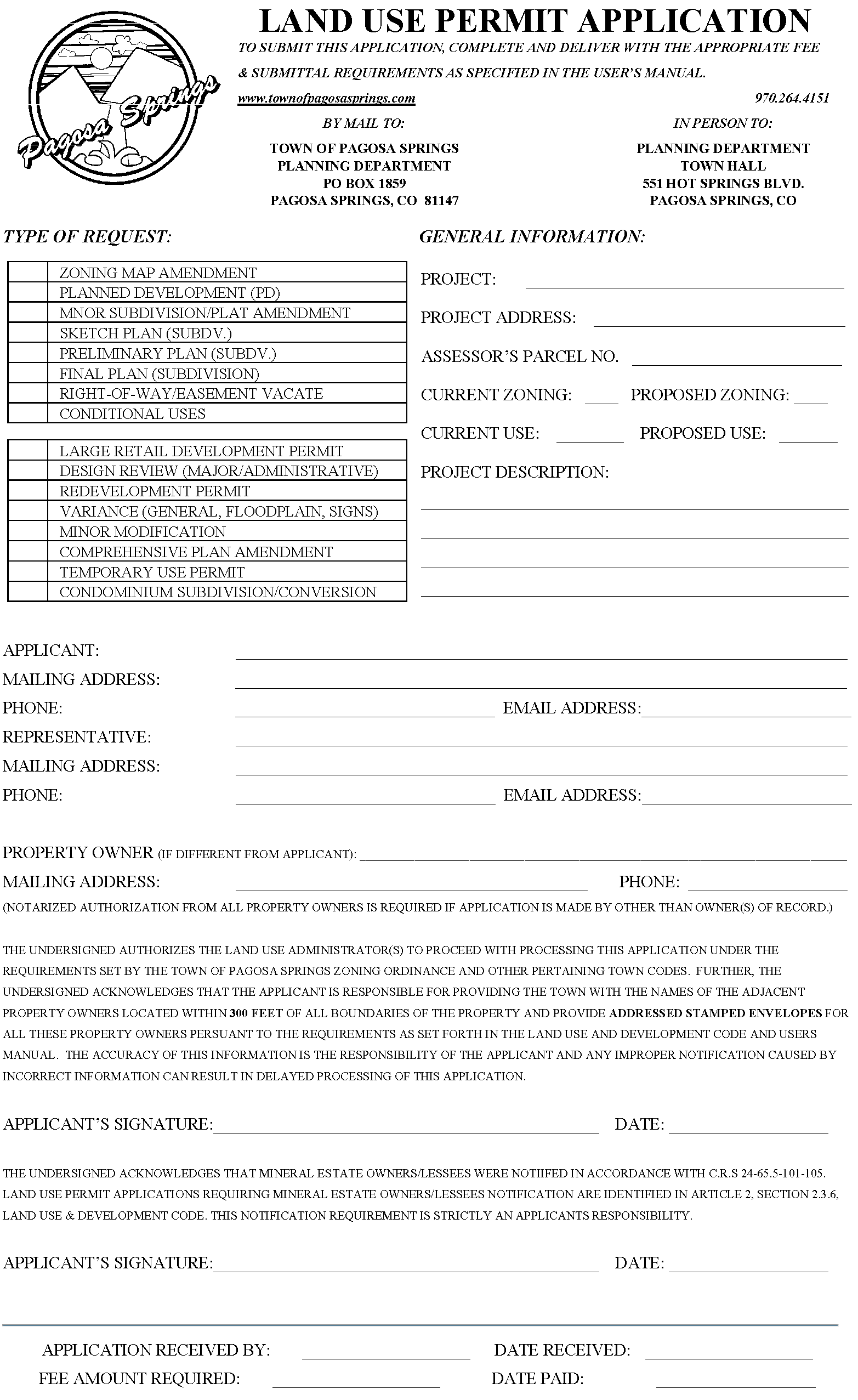
Land use application form: Forms can be downloaded from the Town's website at the following address: www.townofpagosasprings.com or a copy is available at the Planning Department office.
(b)
Development review application: Forms can be downloaded from the Town's website at the following address: www.townofpagosasprings.com or a copy is available at the Planning Department office.
Note: Project applicants or project representatives shall provide a "statement of authority" identifying all authorized individuals to act or make decisions on behalf of a land use application (a) or development review application (b). Statement of Authority letters shall be notarized.
(c)
Floodplain development permit: Forms can be downloaded from the Town's website at the following address: www.townofpagosasprings.com or a copy is available at the Planning Department office or Building Department Office.
(d)
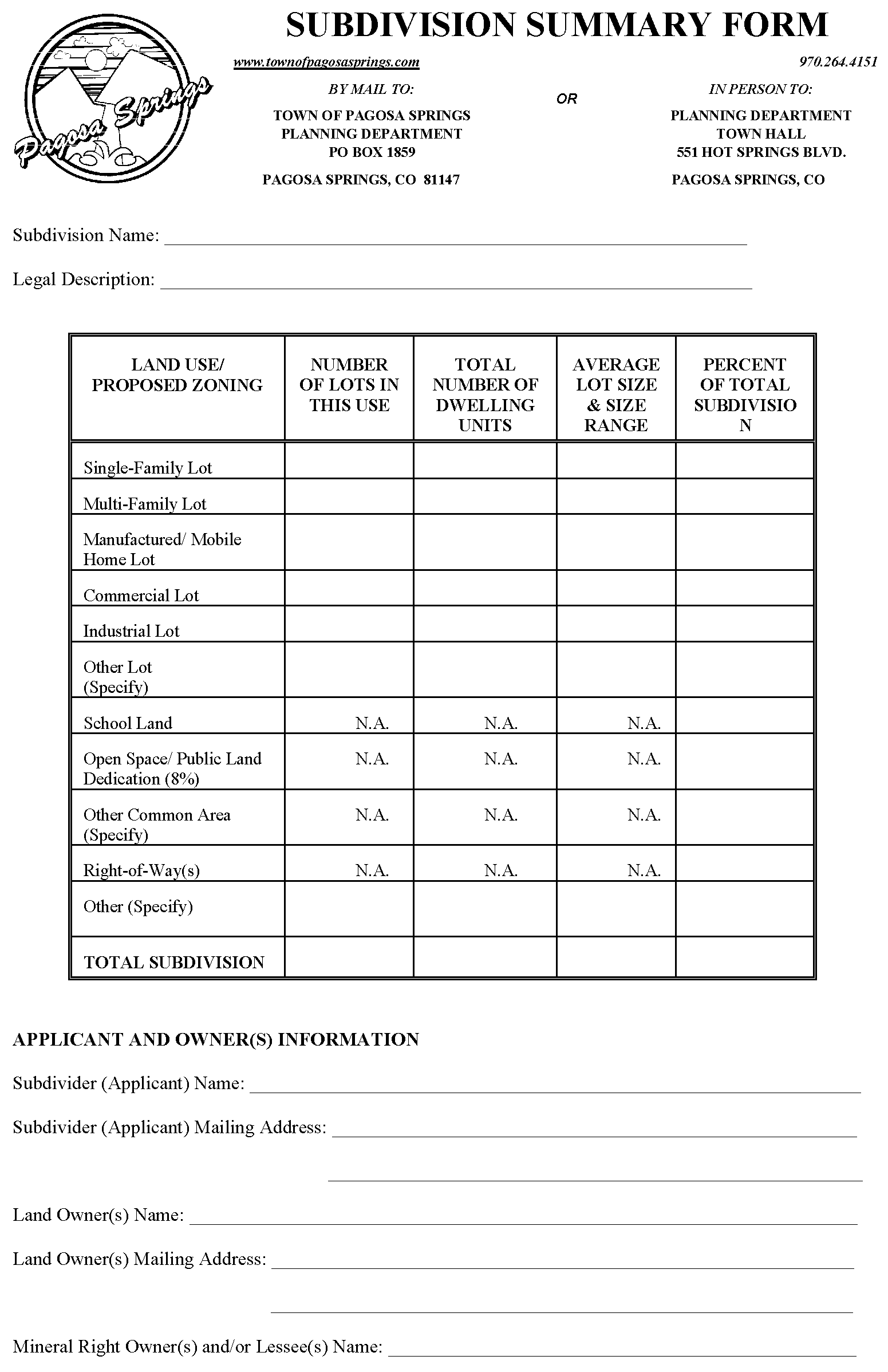
Subdivision form: This form is available upon request of the Director or within Section 7 of this User's Manual.
(e)
Land use application fees: All land use application fees are determined by Town Council. A current fee schedule is included in Section 5 of this user's manual. Fees are non-refundable and shall be cashed by the Town at the time of determination of application completeness, see LUDC, Section 2.3.4.
(f)
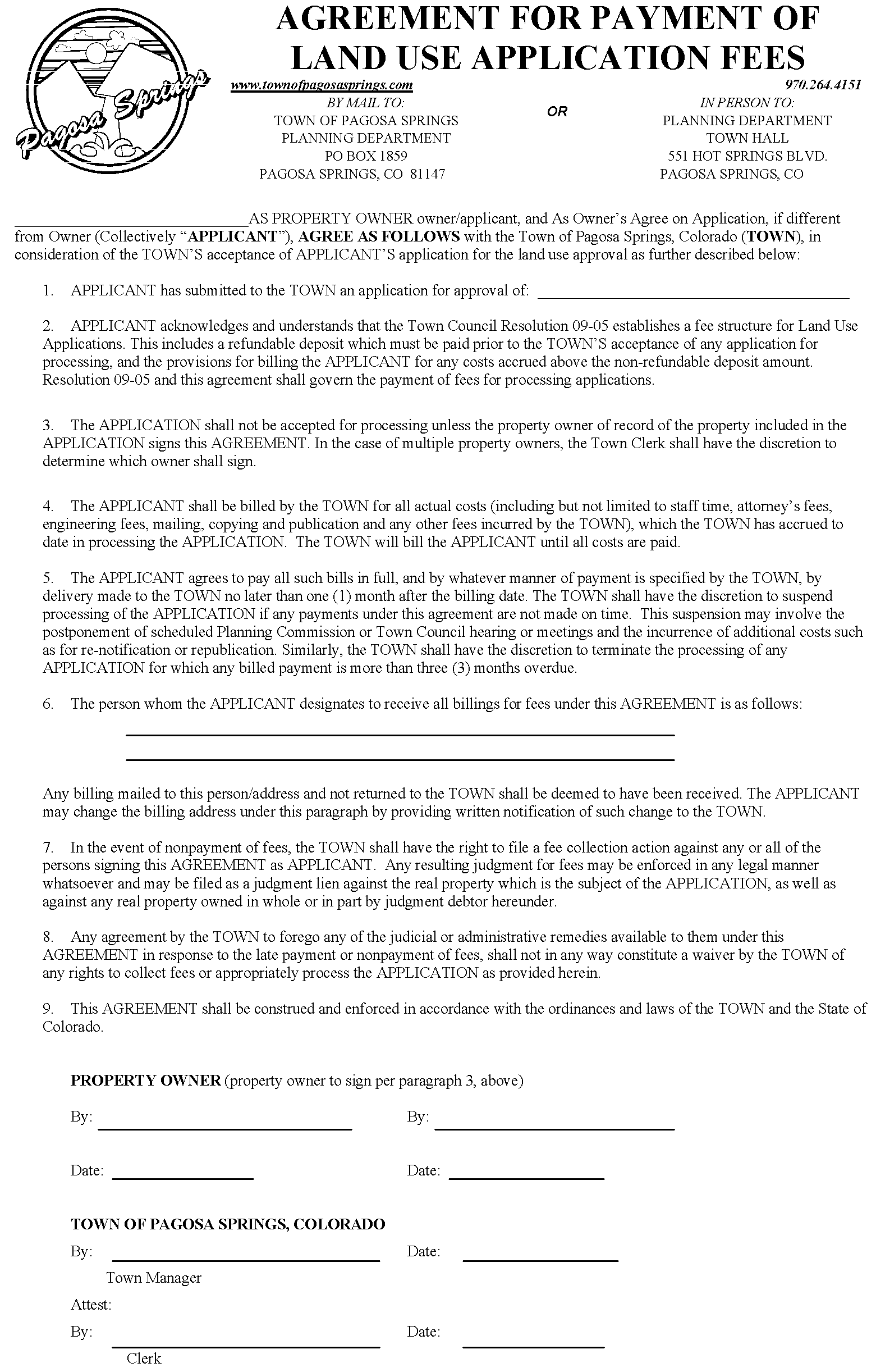
Agreement for payment of fees: This form shall be submitted and signed by the owner of record and accompany all land use application submittals. Forms are available upon request of the Director or within Section 7 of this User's Manual.
(g)
Evidence of good title: A current report providing evidence that the applicant owns the subject property, acceptable examples include: title commitment, title policy and ownership and encumbrance report. Reports shall include a legal description of the property and be dated no more than thirty (30) days from the date of application submittal.
(h)
Taxes and list of taxing entities: Certification from the Archuleta County Treasurer's Office that all ad valorem taxes and assessments due and owing have been paid. In addition, the certification shall include a list of all special districts and taxing entities serving the property. Reports shall be dated no more than thirty (30) days from the date of application submittal.
(i)
Surrounding and interested property ownership report: A current list of the names and addresses of the surrounding property owners within three hundred (300) feet of the property, mineral owners of record, mineral and oil and gas lessees for the property and appropriate ditch companies. Reports shall be dated no more than thirty (30) days from the date of application submittal. The applicant shall certify that the report is complete and accurate. Applicants should contact the Archuleta County Assessors Office to obtain current and an accurate list of ownership and the three hundred-foot radius map.
(j)
Public hearing notification envelopes: Applicants shall provide one (1) set of stamped, addressed, Number 10 self-sealing envelopes, with certificates of mailing. The envelopes shall have the Town's address as the return address and the envelopes shall be addressed to the surrounding property owners listed in the surrounding and interested property ownership report.
(k)
Mineral, oil and gas rights documentation: Evidence that the surface owner has contacted all lessees of mineral, oil and gas rights associated with the site and resolution has been reached, if applicable. The applicant shall provide the name of the current contact person, phone number and mailing address and signed documentation acknowledging compliance with C.R.S requirements. Forms can be downloaded from the Town's website at the following address: www.townofpagosasprings.com or a copy is available at the Planning Department office.
(l)
Landscape plan: Landscape plans shall conform to the specific landscaping requirements set forth in the LUDC, Section 6.10 and the requirements set forth in Section 6 of this User's Manual.
(m)
General development information: A written description based on the subdivision phase (sketch, preliminary, final or minor) or associated with any other application that identifies certain development conditions that should be discussed in detail.
(n)
Soils report and map: A report and map based on USDA Soil Conservation Service information that addresses existing conditions and any potential constraints/hazards; including groundwater issues.
(o)
Geotechnical evaluation: This report is required only for areas that have the potential for subsidence; however, this report may substitute for the soils report and map assuming all relevant information required in the soils report is provided. Geotechnical reports shall be prepared by a Colorado registered professional engineer or Colorado professional geologist with experience in mine subsidence.
(p)
Grading and drainage plan/report: All plans and information shall be certified by a Colorado registered professional engineer. Submitted plans and information shall be in conformance with the specific requirements set forth in the LUDC, Section 6.3 and the requirements set forth in Section 6 of this User's Manual. In addition, submittals shall include any required FEMA application/permit and appropriate permits as issued by the Army Corps of Engineers and State of Colorado Department of Health and Environment.
(q)
Master utility plan: Plans shall be prepared and certified by a Colorado registered professional engineer. The applicant or engineer must consult with the appropriate utility service providers regarding the design of all utilities. Submitted plans and information shall be in conformance with the specific requirements set forth in the LUDC, Section 6.3 and the requirements set forth in Section 6 of this User's Manual.
(r)
Traffic study: Studies and reports shall be prepared and certified by a professional traffic engineer.
(s)
Codes and covenants: Covenants and architectural design guidelines that accompany a development.
(t)
Context and vicinity map: Context and vicinity maps shall show the proposed development or subject property in relation to the surrounding area, a minimum of one and one-half-mile radius. Maps shall be in conformance with the specific requirements set forth in Section 6 of this User's Manual.
(u)
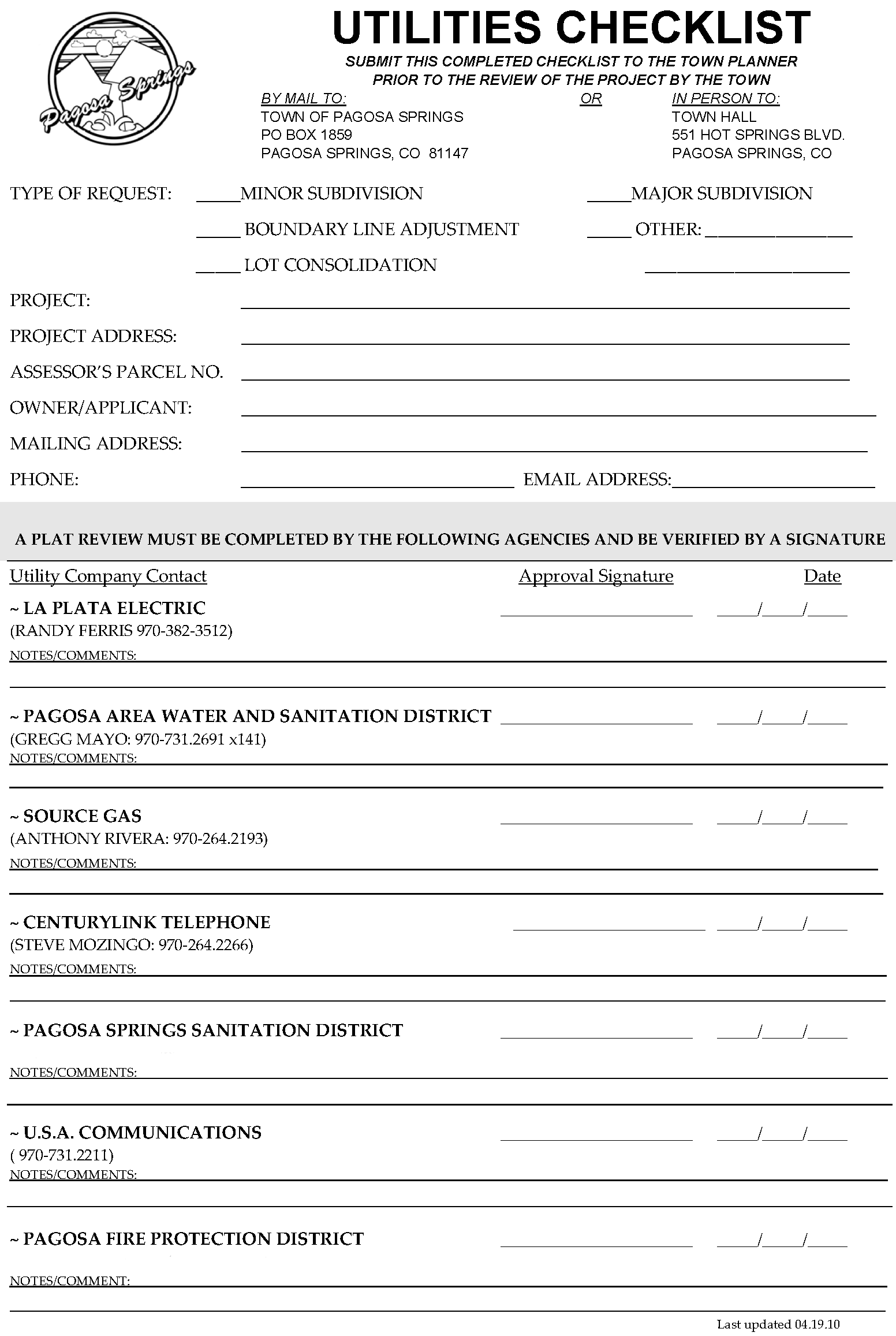
Utilities checklist: The applicant should consult and receive appropriate signatures from all required utility companies prior to submittal of the utility checklist, as applicable. This form can be downloaded from the Town's website at the following address: www.townofpagosasprings.com or a copy is available at the Planning Department office.
(v)
Engineering plans and specifications: Plans, profiles and information shall be prepared by a Colorado registered professional engineer. Submitted documentation shall be in conformance with the specific requirements set forth in the LUDC and the requirements set forth in Section 6 of this User's Manual.
(w)
Development improvement agreement (DIA): This agreement assures construction of the required public and private improvements and requires owner/developer signature prior to final plat approval. This document shall be prepared by the Town and drafted upon request by the developer.
(x)
Agency notification packets: Applicants shall provide one (1) set of 10" × 13" manila envelopes with the Town's return address and postage pre-paid. Envelopes shall include a complete set of the complete preliminary plan/plat application.
(y)
Sign permit application (new individual, existing and temporary): Forms can be downloaded from the Town's website at the following address: www.townofpagosasprings.com or a copy is available at the Planning Department office.
(z)
Plat: Preliminary Plat for town review shall comply with technical standards of section 3 of the LUDC User Manual, see attached. Applicant shall submit the following: two (2) 24" × 36" copies of the Amendment Plat, two (2) 11" × 17" copies of the Amendment Plat and one (1) electronic version (pdf) of the Amendment Plat.
Section 2: - Submittal requirements/technical standards
AMENDMENTS TO THE OFFICIAL ZONING MAP
For procedural and administrative related information see the Land Use and Development Code, Section 2.4.2, Amendments to the Official Zoning Map.
Zoning Amendments: General rezones shall meet the following submittal requirements and zoning map technical standards.
Approximate Timeline: One (1) to two (2) months.
| Submittal Requirements Checklist | ||||
| Completed land use application (a) | Surrounding and interested property ownership report (i) | |||
| Evidence of good title/legal description (g) | Public hearing notification envelopes (j) | |||
| Zoning amendment map (see technical req.) | Land use application fee [$250] (e) | |||
| General development information (m) | Agreement for payment of fees (f) | |||
| Mineral, oil and gas notice verification (k) | ||||
Application Submittal.
(a)
The applicant shall submit one (1) copy of the complete zoning map amendment package; two (2) 24" × 36" copies of the zoning amendment map/plat and one (1) 11" × 17" copy of the map/plat at least twenty (20) days prior to the scheduled Planning Commission meeting. Applications will not be placed on the Planning Commission agenda until the Director determines the application is complete, pursuant to LUDC, Section 2.3.4.
Zoning map/plat technical standards.
(a)
At minimum, maps shall include the following information:
(i)
North arrow, graphic and written scale at either (1":100' or 1":200') and date of preparation;
(ii)
The subdivision name or block, lot number of the area to be zoned (if applicable);
(iii)
Legal description of area to be zoned (entire area and individual zone districts). For unsubdivided property, district boundaries shall be determined by a metes and bounds description;
(iv)
Location and boundaries, including dimensions, of the property(s) proposed for rezoning. Note: generally, district boundaries are to be boundary lines of subdivided parcels or the center lines of physical streets, roads, highways, alleys, railroad right-of-way, channelized waterways or such lines extended along an imaginary line;
(v)
Acreage or square footage calculations of the property(s) proposed for rezoning;
(vi)
All existing land uses in the area proposed for rezoning;
(vii)
Zoning and existing land uses on all lands adjacent to the proposed rezoning;
(viii)
The location and dimensions for all existing public rights-of-way, including streets and centerlines of water-courses within and adjacent to the area proposed for rezoning;
(ix)
Names of all adjoining subdivisions with lines of abutting lots, and departing property lines of adjoining properties not subdivided;
(x)
Vicinity map per Section 6 of this User's Manual;
(xi)
Maps shall be prepared and certified by a Colorado registered professional land surveyor. In addition, the plat shall include all certificate and signature blocks as listed in Section 3, Plat Endorsements of this User's Manual; and
(xii)
Plat/Map titles shall be consistent with the requirements as set forth in Section 3, Plat Title Examples of this User's Manual.
Note: Inaccurate, incomplete or poorly drawn plats/maps shall be rejected at the Director's discretion.
General Development Information.
(a)
The applicant shall submit a written statement describing the proposal and addressing the following items:
(i)
Need for the proposed rezoning;
(ii)
Present and future impacts on the existing adjacent zone districts, uses and physical character of the surrounding area;
(iii)
Impact of the proposed change on area accesses and traffic patterns;
(iv)
Availability of utilities for any potential development;
(v)
Present and future impacts on public facilities and services, including but not limited to; fire, police, water, sanitation, roadways, parks, schools and transit;
(vi)
The relationship between the proposal and the Town Land Use Plan and/or the Comprehensive Plan; and
(vii)
Public benefits arising from the proposal.
(b)
Applicants may be requested to provide additional information, as requested by the Town and determined appropriate by the Town.
REZONINGS TO PLANNED DEVELOPMENT OVERLAY DISTRICT
For procedural and administrative related information see the Land Use and Development Code, Section 2.4.2(D), Rezoning to the Planned Development Overlay District.
Planned Development Overlay: PD's should preserve critical environmental resources, provide useable open space/recreational amenities, include exceptional design and provide greater efficiency in the layout and provision of roads, utilities and other infrastructure.
Approval of a concept plan at the time of rezoning is required prior to development in a PD overlay district. Concept plans shall meet the following submittal requirements and technical standards.
PD concept plans and all related documents will be recorded in the Office of the Archuleta County Clerk and Recorder attached to the ordinance amending the zoning map.
Approximate Timeline: One (1) to three (3) months.
| Submittal Requirements Checklist | ||||
| Completed land use application (a) | Evidence of good title/legal description (g) | |||
| Land use application fees (e) [$1000] | Surrounding and interested property ownership report (i) | |||
| Agreement for payment of fees (f) | Public hearing notification envelopes (j) | |||
| Concept plan (see technical req.) | Mineral, oil and gas notice verification (k) | |||
| General development information (m) | Context and vicinity map (t) | |||
Application Submittal.
(a)
The applicant shall submit two (2) copies of the complete PD Overlay Rezone package at least twenty (20) days prior to the scheduled Planning Commission meeting. Submittals shall include 24" × 36" complete drawing sets and one (1) 11" × 17" copy of the complete set. Applications will not be placed on the Planning Commission agenda until the Director determines the application is complete, pursuant to LUDC, Section 2.3.4.
Additional information.
(a)
Areas of land proposed for PD Overlay Zoning may be controlled by one (1) or more landowners and must be developed under unified control or a unified concept plan. However, no PD may be approved by the Town without the written consent of all landowners who own property included in the PD.
(b)
Provisions shall be made for the establishment of an organization responsible for the ownership and maintenance of such private streets and/or common open space areas unless other arrangements for ownership and maintenance thereof are provided in a manner acceptable to the Town. Note: Applicants may submit this information concurrent with preliminary subdivision applications or minor subdivision applications, as applicable.
Concept plan minimum requirements.
(a)
The initial uses permitted in the PD Overlay Zone shall be those uses permitted in the underlying standard zone district. Applicants may request the removal of those uses deemed incompatible for the PD development and the addition of uses that are deemed appropriate by the Town during the PD review process. Applicants shall submit a list of uses to be allowed in the PD by right and uses allowed only through a conditional use permit.
(b)
A statement that development on the site will meet applicable standards of the underlying zone district and this Code or a statement specifying the standards of the underlying district and this Code to which minor modifications, variances or alternative compliance are proposed and the justification for such modifications. Note: Requirements for sanitary sewer, central water, access to/or construction of utilities are not subject to minor modifications, variances or alternative compliance as defined in the LUDC.
(c)
A quantitative summary of existing conditions on the subject property to include, but not limited to the following:
(i)
Existing structures on the property;
(ii)
Existing vegetation map and initial wetland delineation; and
(iii)
Existing roadways, accesses, driveways, curb cuts, easements, pedestrian paths/trails and any other pertinent information.
(d)
A statement specifying the public benefit(s) to be contained in or associated with the proposed PD.
(e)
Provide building elevations to scale that identify massing, coloration, materials and architectural style, if applicable.
(f)
Applicants may be requested to provide additional information, as requested by the Town and determined appropriate by the Town.
(g)
At minimum, maps shall include the following information:
(i)
Legal description and/or metes and bounds description;
(ii)
Location of public and private open space, including acreage or square footage calculations;
(iii)
Proposed gross residential density or intensity of commercial uses on the property;
(iv)
Location of footprints or building envelopes for all structures, excluding single family residential units, if applicable;
(v)
Proposed road, street and pedestrian networks (as applicable to the 2003 Trails Plan and 2007 Parks, Open Space and Trails Master Plan), to include existing right-of-way adjacent to the subject project. All proposed and existing roadways/right-of-ways shall be dimensioned and labeled.
(vi)
Proposed phasing for the development;
(vii)
Standards for principal and accessory uses within each land use category including: maximum lot area, maximum lot coverage, maximum floor area, maximum building height, proposed building setbacks and parking requirements for all uses;
(viii)
Vicinity map per Section 6 of this User's Manual;
(ix)
Delineated floodplain and floodway boundaries with a note regarding source of information. If a floodplain does not exist on the property, state this on the map.
(x)
Maps shall be prepared and certified by a Colorado registered professional land surveyor; however, plats shall exclude all certificate and signature blocks as required under Section 2, Final Plan/Plat Subdivision.
Note: Inaccurate, incomplete or poorly drawn plats/maps shall be rejected at the Director's discretion.
MINOR SUBDIVISION/PLAT AMENDMENT
For procedural and administrative related information see the Land Use and Development Code, Section 2.4.3(B), Subdivision.
Minor subdivision: This procedure is permitted for a proposed division of land under certain constraints identified in Section 2.4.3(B) of the Code. Minor subdivisions shall meet the following submittal requirements and technical standards.
Plat amendment: This procedure is permitted for a proposed consolidation, un-consolidation, replat, boundary line adjustment, correction plats, changes to recorded plats or other minor amendments as identified in Section 2.4.3(B) of this Code. Plat amendments shall meet the following submittal requirements and technical standards.
Approximate timeline: Two (2) to four (4) weeks with Director review or one (1) to two (2) months depending on complexity of public improvements and/or dedications.
| Submittal Requirements Checklist | ||||
| Completed land use application (a) | Plat (see technical req.) | |||
| Evidence of good title/legal description (g) | Mineral, oil and gas notice verification (k) | |||
| Land use application fees (e) [$500] | Context and vicinity map (t) | |||
| Agreement of payment of fees (f) | Utilities checklist (u) | |||
| General development information (m) | Subdivision form (d) - major subdivision only | |||
| Taxes and list of taxing entities (h) | ||||
Application submittal.
(a)
The applicant shall submit one (1) copy of the complete minor subdivision package; two (2) 24" × 36" copies of the Subdivision or Amendment Plat and one (1) 11" × 17" copy of the Subdivision or Amendment Plat. Applications will not be reviewed and/or placed on the Planning Commission agenda until the Director determines the application is complete, pursuant to LUDC, Section 2.3.4.
General development information.
(a)
A statement addressing the proposed development and whether the project is in conformance with the Comprehensive Plan and the Land Use and Development Code.
Subdivision/amendment plat technical standards.
(a)
Minor subdivision plats and amendment plats shall comply with the standards set forth in Section 2, Final Plan/Plat Subdivision of this User's Manual.
MAJOR SUBDIVISION - SKETCH
For procedural and administrative related information see the Land Use and Development Code, Section 2.4.3, Subdivision.
Sketch plan (subdivision): Material submitted for sketch plans shall meet the following requirements and technical standards.
Approximate timeline: One (1) to three (3) months.
| Submittal Requirements Checklist | ||||
| Completed land use application (a) | Surrounding and interested property ownership report (i) | |||
| Evidence of good title/legal description (g) | Public hearing notification envelopes (j) | |||
| Land use application fees (e) [$500] | Mineral, oil and gas notice verification (k) | |||
| Agreement of payment of fees (g) | Context and vicinity map (t) | |||
| General development information (m) | Subdivision form (d) | |||
| Taxes and list of taxing entities (h) | Sketch plan (see technical req.) | |||
Application submittal.
(a)
The applicant shall submit two (2) copies of the complete sketch plan package at least twenty-six (26) days prior to the scheduled Planning Commission meeting. Submittals shall include 24" × 36" complete drawing sets and one (1) 11" × 17" copy of the complete set. Applications will not be placed on the Planning Commission agenda until the Director determines the application is complete, pursuant to LUDC, Section 2.3.4.
General development information.
(a)
The applicant shall submit a written statement describing the proposal and addressing the following items:
(i)
Discuss general design rationale and how the development is connected/integrated with surrounding land uses, how it responds to site features/constraints and whether the plan is consistent with development standards and design guidelines per Article 5, Article 6 and Article 7 of the LUDC;
(ii)
An analysis of the traffic count that may be generated by the subdivision and the proposed methods of mitigation of any impacts on the existing transportation infrastructure;
(iii)
An estimate of the impacts on services and amenities including; fire protection, recreational facilities, schools and police protection;
(iv)
Water supply information including the number of water taps and the estimated amount of water needed to serve the development;
(v)
Sewage disposal information including the type of collection system and the estimated amount of waste generated; and
(vi)
A description identifying the relationship between the proposal and the Town Land Use Plan and/or the Comprehensive Plan.
Sketch plan minimum requirements.
(a)
At minimum, maps shall include the following information:
(i)
Legal description and/or metes and bounds description;
(ii)
Project title, north arrow, graphic and written scale and date of preparation;
(iii)
Acreage or square footage calculations of the property(s);
(iv)
Lots and blocks with approximate acreage or square footage for each lot;
(v)
Topographic contours at no greater than two (2) foot intervals;
(vi)
Proposed gross residential density or intensity of commercial uses on the property;
(vii)
Location of public and private open space, including acreage or square footage calculations;
(viii)
Location of footprints or building envelopes for all structures, excluding single family residential units, if applicable;
(ix)
Proposed road, street and pedestrian networks (as applicable to the 2003 Trails Plan and 2007 Parks, Open Space and Trails Master Plan), to include existing right-of-way adjacent to the subject project. All proposed and existing roadways/right-of-ways shall be dimensioned and labeled.
(x)
Proposed phasing for the development;
(xi)
Vicinity map per Section 6 of this User's Manual;
(xii)
Existing zoning and land uses/structures on lands within, and adjacent to the proposed project;
(xiii)
The location, dimensions and names for all existing streets, alleys, easements and watercourses (with direction of flow) within and adjacent to the property;
(xiv)
Locations of existing utilities within and adjacent to the property and proposed connection points;
(xv)
Delineated floodplain and floodway boundaries with a note regarding source of information. If a floodplain does not exist on the property, state this on the map.
(xvi)
Maps shall be prepared and certified by a Colorado registered professional land surveyor, as applicable.
Note: Inaccurate, incomplete or poorly drawn plats/maps shall be rejected at the Director's discretion.
(b)
Applicants may be requested to provide additional information, as requested by the Town and determined appropriate by the Town.
(c)
Note: Applicants may request sketch and preliminary plan concurrent review, to expedite the review process. All submittal requirements shall be consistent with the requirements as listed under major subdivision, preliminary plan.
MAJOR SUBDIVISION - PRELIMINARY PLAN/PLAT
For procedural and administrative related information see the Land Use and Development Code, Section 2.4.3, Subdivision.
Preliminary plan/plat (subdivision): Material submitted for preliminary plans/plat shall meet the following requirements and technical standards.
Approximate timeline: Two (2) and four (4) months.
| Submittal Requirements Checklist | ||||
| Completed land use application (a) | Surrounding and interested property ownership report (i) | |||
| Evidence of good title/legal description (g) | Mineral, oil and gas notice verification (k) | |||
| Land use application fees (e) [$500 + $100/u] | Public hearing notification envelopes (j) | |||
| Agreement of payment of fees (f) | Traffic study (r) | |||
| Landscape plan (l) | Context and vicinity map (t) | |||
| Soils report and map (n) | Subdivision form (d) | |||
| Geotechnical evaluation (o) | Preliminary plat (see technical req.) | |||
| Grading and drainage plan/report (p) | Codes and covenants (draft, if applicable) (s) | |||
| Master utility plan (q) | Mineral, oil and gas rights documentation (k) | |||
| Engineering plans and specifications (v) | Agency notification packets (x) | |||
| General development information (m) | Preliminary plan/site design (see technical req.) | |||
| Taxes and list of taxing entities (h) | ||||
Application submittal.
(a)
The applicant shall submit fifteen (15) copies of the complete preliminary plan/plat package at least fifty (50) days prior to the scheduled Planning Commission meeting. Submittals shall include 24" × 36" complete drawing sets, a complete submittal package and one (1) 11" × 17" copy of the complete set. Applications will not be placed on the Planning Commission agenda until the Director determines the application is complete, pursuant to LUDC, Section 2.3.4.
General development information.
(a)
The applicant shall submit a written statement describing the proposal and addressing the following items:
(i)
Describe whether the preliminary plan/plat is consistent with the sketch plan, and if there are any differences provide all relevant information;
(ii)
Address items of concern expressed by the Planning Commission and Town Council, including any conditions of approval at Sketch Plan review;
(iii)
Explain how this preliminary plan/plat is consistent with the LUDC and the Comprehensive Plan;
(iv)
Submit a list of all proposed minor modifications and variances from the development standards and design guidelines as required in the LUDC; and
(v)
Explanation of any requested design requirement exceptions (alternative compliance) as defined and allowed under Section 6.1 of the LUDC.
Preliminary plan minimum requirements.
(a)
At minimum, maps should include the following information:
(i)
Legal description and/or metes and bounds description;
(ii)
Project title, north arrow, graphic and written scale and date of preparation;
(iii)
Acreage or square footage calculations of the property(s);
(iv)
Lots and blocks with consecutive numbering of all lots and blocks;
(v)
Topographic contours at no greater than two (2) foot intervals;
(vi)
Proposed gross residential density or intensity of commercial uses on the property;
(vii)
Location of public and private open space, including acreage or square footage calculations;
(viii)
Location of footprints or building envelopes for all structures, excluding single family residential units, if applicable;
(ix)
Proposed road, street and pedestrian networks (as applicable to the 2003 Trails Plan and 2007 Parks, Open Space and Trails Master Plan), to include existing right-of-way adjacent to the subject project. All proposed and existing roadways/right-of-ways shall be dimensioned and labeled.
(x)
Proposed phasing for the development;
(xi)
Vicinity map per Section 6 of this User's Manual;
(xii)
Existing zoning and land uses/structures on lands within, and adjacent to the proposed project;
(xiii)
The location, dimensions and names for all existing streets, alleys, easements and watercourses (with direction of flow) within and adjacent to the property;
(xiv)
Locations of existing utilities within and adjacent to the property and proposed connection points; maps shall also include the size of existing and proposed sewer lines, water lines, fire hydrants and street lights (applicant should consult with the appropriate utility service provider regarding the design of all utilities throughout the subdivision);
(xv)
Delineated floodplain and floodway boundaries with a note regarding source of information. If a floodplain does not exist on the property, state this on the map.
(xvi)
Maps shall be prepared and certified by a Colorado registered professional land surveyor, as applicable.
Note: Inaccurate, incomplete or poorly drawn maps shall be rejected at the Director's discretion.
(b)
Applicants may be requested to provide additional information, as requested by the Town and determined appropriate by the Town.
(c)
Note: Applicants may request sketch and preliminary plan concurrent review, to expedite the review process. All submittal requirements shall be consistent with the requirements as listed under major subdivision, preliminary plan.
Preliminary plat technical standards.
(a)
Preliminary plats shall comply with the standards set forth in Section 2, Final Plan/Plat Subdivision of this User's Manual.
Note: Engineering plans and specifications, master utility plans, landscape plans and grading and drainage plans shall be in conformance with the specific requirements set forth in the LUDC, Article 5, Article 6, Article 7 and the requirements set forth in Section 6 of this User's Manual.
SUBDIVISION - FINAL PLAN/PLAT
For procedural and administrative related information see the Land Use and Development Code, Section 2.4.3, Subdivision.
Final plan/plat (subdivision): Material submitted for final plans/plat shall meet the following requirements and technical standards.
Approximate timeline: Three (3) weeks to two (2) months, depending on consistency with preliminary plan submittal and conditions of approval.
| Submittal Requirements Checklist | ||||
| Completed land use application (a) | Engineering plans and specifications (v) | |||
| Evidence of good title/legal description (g) | General development information (m) | |||
| Land use application fees (e) [$500 + $100/u] | Context and vicinity map (t) | |||
| Agreement of payment of fees (f) | Subdivision form (d) | |||
| Landscape plan (l) | Final plat (see technical req.) | |||
| Development improvement agreement (w) | Codes and covenants (if applicable) (s) | |||
| Taxes and list of taxing entities (h) | Mineral, oil and gas rights documentation (k) | |||
| Grading and drainage plan/report (p) | Final plan/site design (see technical req.) | |||
| Master utility plan (q) | ||||
Application submittal.
(a)
The applicant shall submit one (1) copy of the complete final plan/plat package. Submittals shall include 24" × 36" complete drawing sets, a complete submittal package and one (1) 11" × 17" copy of the complete set. Applications will not be reviewed and/or placed on the Planning Commission agenda until the Director determines the application is complete, pursuant to LUDC, Section 2.3.4.
General development information.
(a)
The applicant shall submit a written statement describing the proposal and addressing the following items:
(i)
A written description confirming that the final plan/plat conforms to the preliminary plan/plat or identifying areas of non-conformity.
Final plan minimum requirements.
(a)
Final plans shall comply with the specifications identified under preliminary plan minimum requirements, including the following:
(i)
Note: Engineering plans and specifications, master utility plans, landscape plans and grading and drainage plans shall be in conformance with the specific requirements set forth in the LUDC, Article 5, Article 6, Article 7 and the requirements set forth in Section 6 of this User's Manual.
(b)
Townhome and condominium developments (multi-family) may be deemed exempt from the requirement to file or submit a final plat. However, developments that include dedications (right-of-way, access, utility easements, public land, etc.) will be required to file a final as-built plat, consistent with the technical standards listed below, for each phase of the development.
Final plat minimum requirements.
(a)
At minimum, plats shall include the following information:
(i)
Non-contiguous parcels may be included in the same subdivision and final plat approval; however, parcels that are not contiguous shall not be included on the same plat sheet. Contiguous parcels owned by different parties may be included on one (1) plat sheet, provided that all owners accept and sign the dedication, waiver and acknowledgment;
(ii)
Length measurements shall be shown to the nearest hundredth of a foot and bearings shall be shown in degrees, minutes and seconds;
(iii)
The perimeter survey description or metes and bounds description shall include at least one (1) tie to an existing section monument of record. The survey shown shall not have an error greater than one (1) part in ten thousand (10,000);
(iv)
Bearings, distances and curve data of all perimeter boundary lines shall be indicated outside the boundary line;
(v)
On curved boundaries and all curves on the plat, circular curve data shall include radius of curve, central angle, tangent, arc length, chords and notation of non-tangent curves;
(vi)
Description of all monuments, both found and set, which mark the boundaries of the property, and a description of all control monuments used in conducting the survey;
(vii)
Plats shall show any conflicting boundary evidence including: areas of conflict or overlapping deed descriptions and any difference between measured and recorded dimensions;
(viii)
Project title, north arrow, graphic and written scale and date of preparation;
(ix)
All blocks, lots and condominium units shall be consecutively numbered including square footage or acreage of each tract; including open space tracts;
(x)
Names and addresses of owners, applicant, designers, engineers and surveyors;
(xi)
Excepted parcels from inclusion noted as "outlots" or "not included in this subdivision" and the boundary completely indicated by bearings and distances;
(xii)
Existing and proposed right-of-way (including alleys) in and adjacent to the subject property (labeled and dimensioned);
(xiii)
Existing and proposed street names for all streets on and adjacent to the property;
(xiv)
Existing and proposed easements and their type in and adjacent to the subject property; including reception numbers for existing easements;
(xv)
Dedication statement(s) deeding all public land or land to be owned in common including, but not limited to, roadways, walkways, bikeways, trails and public sites (i.e. open space, parks, etc.) indicating use, ownership and maintenance of all public or private rights-of-way and land areas; and dedication of all easements;
(xvi)
Dedication language as applicable (i.e. public land, right-of-way, easements, affordable/attainable housing);
(xvii)
Location of existing structures on the property;
(xviii)
Delineated floodplain and floodway boundaries with a note regarding source of information. If a floodplain does not exist on the property, state this on the map.
(xix)
Vicinity map per Section 6 of this User's Manual;
(xx)
Maps shall be prepared and certified by a Colorado registered professional land surveyor;
(xxi)
In addition, the plat shall include all certificate and signature blocks as listed in Section 3 of this User's Manual.
(xxii)
Plat/Map titles shall be consistent with the requirements as set forth in Section 3, Plat Title Examples of this User's Manual.
Note: Inaccurate, incomplete or poorly drawn plats/maps shall be rejected at the Director's discretion.
(b)
Applicants may be requested to provide additional information, as requested by the Town and determined appropriate by the Town.
Note: Engineering plans and specifications, master utility plans, landscape plans and grading and drainage plans shall be in conformance with the specific requirements set forth in the LUDC, Article 5, Article 6, Article 7 and the requirements set forth in Section 6 of this User's Manual.
Additional documentation.
(a)
Applicants shall submit the required information, as applicable. Information may be requested by the Town or any Board with approval authority prior to final plan submittal.
(i)
Special agreements as may be required by the Town (i.e. parking agreement);
(ii)
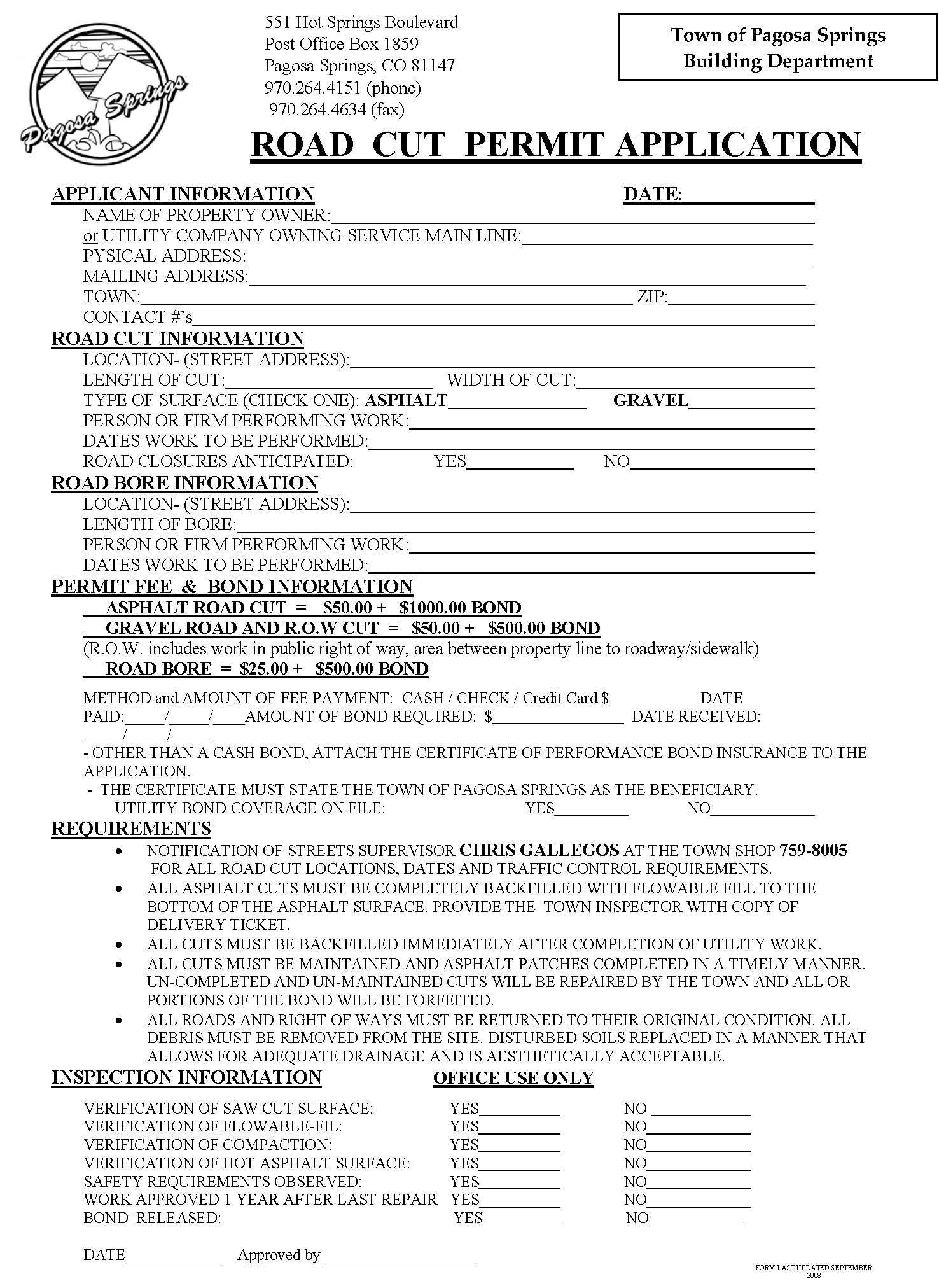
Work within right-of-way permit and maintenance bonds as required (road cuts);
(iii)
Floodplain Development Permit consistent with the requirements of Section 2 of this User's Manual;
(iv)
State highway utility permit and/or state highway access permit;
(v)
Army Corps of Engineers, 404 Permit per Clean Water Act or any other required permit(s);
(vi)
Colorado Department of Public Health and Environment, Storm Water Management Plan;
(vii)
Colorado Department of Public Health and Environment, Air Pollution Emission Notice;
(viii)
Ditch right-of-way permit (obtained from individual ditch companies), if applicable;
(ix)
U.S. Fish and Wildlife Service, Rare Species Occurrence Survey;
(x)
Warranty deeds for dedicated land, deeds shall convey to the Town all public lands as dedicated on the final plat;
(xi)
Approved adjudication of water rights and plan of augmentation (if applicable);
(xii)
FEMA approved applications including: Conditional Letter of Map Revisions (CLOMR) or Letter of Map Revisions (LOMR); and
(xiii)
Colorado Department of Public Health and Environment, Construction De-watering Permit.
(b)
Subdivision improvement agreement. The Town will require the developer to execute a development improvement agreement for public and private improvements.
SUBDIVISION - CONSERVATION
For procedural and administrative related information see the Land Use and Development Code, Section 2.4.3, Subdivision. In addition, conservation subdivision standards are further defined in Section 7.6 of the Land Use and Development Code.
Note: The conservation subdivision option is only available for developments within the Agricultural/Residential and Rural Transition districts.
SUBDIVISION - CONDOMINIUM CONVERSION
For procedural and administrative related information see the Land Use and Development Code, Section 2.4.3 (E), Condominium Subdivision Conversion.
Condominium conversion (subdivision): Commercial and residential condominium conversions shall meet the submittal requirements and technical standards as identified in Section 2 of this User's Manual, Minor Subdivisions/Plat Amendments. The Town may require condominium subdivisions to meet some or all of the final plan submittal requirements and technical standards, at the Director's discretion.
Approximate timeline: Two (2) to four (4) weeks with Director review or one (1) to two (2) months depending on complexity of public improvements and/or dedications.
Condominium plats.
(a)
In addition to the plat technical standards identified in Section 2, Final Plan/Plat Subdivision, condominium plats shall include the following information:
(i)
Zoning and existing densities on adjacent properties;
(ii)
Required parking spaces and shared trash collection areas;
(iii)
Floor plans and elevations, as required, to show separate ownership of all units, common elements and limited common elements labeled as such and numbered for ease of identification. All dimensions shall be to the nearest hundredth foot (1/100');
(iv)
Number, type and floor area of units, common elements and limited common elements; delineated in square feet and fractions thereof; proposed use for each unit, land area, percentage of open space and floor area ratio;
(v)
Statement of the total number of units shown on the proposed plat;
(vi)
Traffic study and/or mitigation plan, if required, submitted at the direction of the Director;
Condominium codes, covenants and/or declarations.
(a)
In addition to the submittal requirements, applicants shall submit one (1) copy of the codes and covenants for the proposed condominium conversion. [Codes and covenants shall be recorded by the applicant and a copy submitted to the Director for filing. The Town will not record any plat until the applicant provides verification that the codes and covenants and/or declarations have been recorded.
(b)
Applicants may be requested to provide additional information, as requested by the Town and determined appropriate by the Town.
VACATION OF RIGHT-OF-WAY AND OTHER PUBLIC EASEMENTS
For procedural and administrative related information see the Land Use and Development Code, Section 2.4.3 (D), Vacation of Right-of-Way and Other Public Easements.
Vacation of right-of-way/easements: Material submitted for right-of-way/easements vacation shall meet the following requirements and technical standards.
Approximate timeline: One (1) to two (2) months.
| Submittal Requirements Checklist | ||||
| Completed land use application (a) | Surrounding and interested property ownership report (i) | |||
| Evidence of good title/legal description (g) | Public hearing notification envelopes (j) | |||
| Land use application fees (e) [$250] | Mineral, oil and gas rights documentation (k) | |||
| Agreement of payment of fees (f) | Public hearing notification envelopes (j) | |||
| Taxes and list of taxing entities (h) | Context and vicinity map (t) | |||
| ROW/easement vacate plat (see technical req.) | Utilities checklist (u) | |||
Application Submittal.
(a)
The applicant shall submit one (1) copy of the complete application package; two (2) 24" × 36" copies of the Plat and one (1) 11" × 17" copy of the Plat at least twenty (20) days prior to the scheduled Planning Commission meeting. Applications will not be placed on the Planning Commission agenda until the Director determines the application is complete, pursuant to LUDC, Section 2.3.4.
Right-of-way/easement vacation.
(a)
In addition to the plat technical standards identified in Section 2, Final Plan/Plat Subdivision, right-of-way/easement vacates plats shall include the following information:
(i)
The location of all adjacent properties and any structures within one hundred fifty (150) feet of the boundaries of the property to be vacated;
(ii)
Existing zoning and land uses on lands within, and adjacent to the proposed project;
(iii)
Locations of existing utilities within and adjacent to the property;
(iv)
Existing public right-of-way and public access easements within one-quarter mile radius of any rights-of-way proposed for vacation;
(v)
Maps shall be prepared and certified by a Colorado registered professional land surveyor; however, plats shall exclude all certificate and signature blocks as required under Section 2, Final Plan/Plat Subdivision.
(b)
In addition to the submittal requirements listed above, applicants shall provide the following:
(i)
A written statement addressing the reasons for the vacation;
(ii)
Letters from any affected utility companies, special districts providing maintenance of infrastructure within the rights-of-way, easement beneficiaries and any landowners abutting or using an access proposed for vacation, stating the person's or entity's position on the proposed vacation; and
(iii)
Signed and notarized statements from all abutting landowners of the proposed right-of-way vacate agreeing to the proposed vacate.
(c)
Right-of-way/easement vacate plats shall be attached as an exhibit to the proposed ordinance.
(d)
Applicants may be requested to provide additional information, as requested by the Town and determined appropriate by the Town.
Vesting of title.
(a)
Vesting of title upon vacation of roadways shall be in accordance with C.R.S. § 43-2-302, as amended.
CONDITIONAL USES
For procedural and administrative related information see the Land Use and Development Code, Section 2.4.4, Conditional Use Permits.
Conditional uses: Material submitted for a conditional use permit shall meet the following requirements.
Approximate timeline: Two (2) to four (4) weeks with Director review or one (1) to two (2) months if the Director forwards the application to the Planning Commission for review.
| Submittal Requirements Checklist | ||||
| Completed land use application (a) | Mineral, oil and gas rights documentation (k) | |||
| Evidence of good title/legal description (g) | Surrounding and interested property ownership report (i) | |||
| Land use application fees (e) [$100] | Public hearing notification envelopes (j) | |||
| Taxes and list of taxing entities (h) | Context and vicinity map (t) | |||
| General development information (m) | ||||
*Note: Notice requirements per LUDC Section 2.3.6 are only required upon determination by the Director that the application will be forwarded to the Planning Commission.
Application submittal.
(a)
The applicant shall submit one (1) copy of the complete application package; and one (1) 11" × 17" copy of any maps, plats or drawings. Applications will not be reviewed and/or placed on the Planning Commission agenda until the Director determines the application is complete, pursuant to LUDC, Section 2.3.4.
General development information.
(a)
The applicant shall submit the following information, as determined to be applicable by the Director:
(i)
Written statement and any graphics necessary to describe the precise nature of the proposed use and its operating characteristics; and to illustrate how all conditional use review criteria as established in the LUDC, Section 2.4.4(C)(4);
(ii)
A map showing the proposed development of the site, including topography, building locations, parking, traffic circulation, useable open space, landscaped areas, utilities and drainage features;
(iii)
Preliminary building plans and elevations sufficient to indicate the dimensions, general appearance and scale of all buildings;
(iv)
A proposed development schedule indicating the commencement date of the project and/or construction phases in which the project may be developed, if applicable, and the completion date of the project;
(v)
Any agreements, provisions or covenants to be recorded that may govern the specific use; and
(vi)
A statement addressing any required provisions for proper ongoing maintenance and use of the site.
(b)
Applicants may be requested to provide additional information, as requested by the Town and determined appropriate by the Town.
Editor's note— Ord. No. 743 repealed the former section that pertained to large retail development permits.
DESIGN REVIEW - MAJOR AND ADMINISTRATIVE
For procedural and administrative related information see the Land Use and Development Code, Section 2.4.6, Design Review.
Design review: Material submitted for administrative design review and major design review shall meet the following requirements.
Approximate timeline: Administrative reviews two (2) to four (4) weeks, major design reviews one (1) to two (2) months.
| Submittal Requirements Checklist | ||||
| Completed development review app. (b) | Context and vicinity map (t) | |||
| Evidence of good title/legal description (g) | General development information (m) | |||
| Land use application fees (e) [$50 or $200] | Preliminary plan/site design (see technical req.) | |||
| Codes and covenants (if applicable) (s) | Grading and drainage plan/report (p) | |||
| Landscape plan (l) | Engineering plans and specifications (v) | |||
| Agreement of payment of fees (f) | Master utility plan (q) | |||
| Public hearing notification envelopes (j) | Surrounding and interested property ownership report (i) | |||
| Mineral, oil and gas rights documentation (k) | ||||
*Note: Notice requirements per LUDC Section 2.3.6 (written, posted, published) are only required for projects that fall under the major design review classification. Administrative design review projects are only required to complete the mineral, oil and gas rights documentation.
Application submittal.
(a)
Administrative design review: The applicant shall submit two (2) copies of the complete application package. Submittals shall include 24" × 36" complete drawing sets and one (1) 11" × 17" copy of the complete set. Applications may be placed on the Design Review Agenda as deemed appropriate by the Director. Applications will not be reviewed or placed on the Design Review Board agenda until the Director determines the application is complete, pursuant to LUDC, Section 2.3.4.
(b)
Major design review: The applicant shall submit two (2) copies of the complete application package at least twenty (20) days prior to the scheduled Design Review meeting. Submittals shall include 24" × 36" complete drawing sets and one (1) 11" × 17" copy of the complete set. Applications will not be placed on the Design Review Board agenda until the Director determines the application is complete, pursuant to LUDC, Section 2.3.4.
General development information.
(a)
The applicant shall submit the following information:
(i)
A written statement identifying the developer's intentions regarding future subdivision and/or sale or lease of the development, including estimated time frames, if applicable;
(ii)
An estimate of the development's need for water, sewer, fire protection and the route of utility connections; and
(ii)
For uses that require a conditional use permit, see additional submittal requirements as described in Section 2, Conditional Uses.
Design review plan minimum requirements.
(a)
Plans shall comply with the development standards and applicable requirements as set forth in the LUDC, Article 5 and Article 6.
(b)
Plans shall comply with the specifications identified under preliminary plan minimum requirements (excluding (vi)), including the following:
(i)
Note: Engineering plans and specifications, master utility plans, landscape plans and grading and drainage plans shall be in conformance with the specific requirements set forth in the LUDC, Article 5, Article 6, Article 7 and the requirements set forth in Section 6 of this User's Manual.
(c)
In addition, design review plans shall include the following information:
(i)
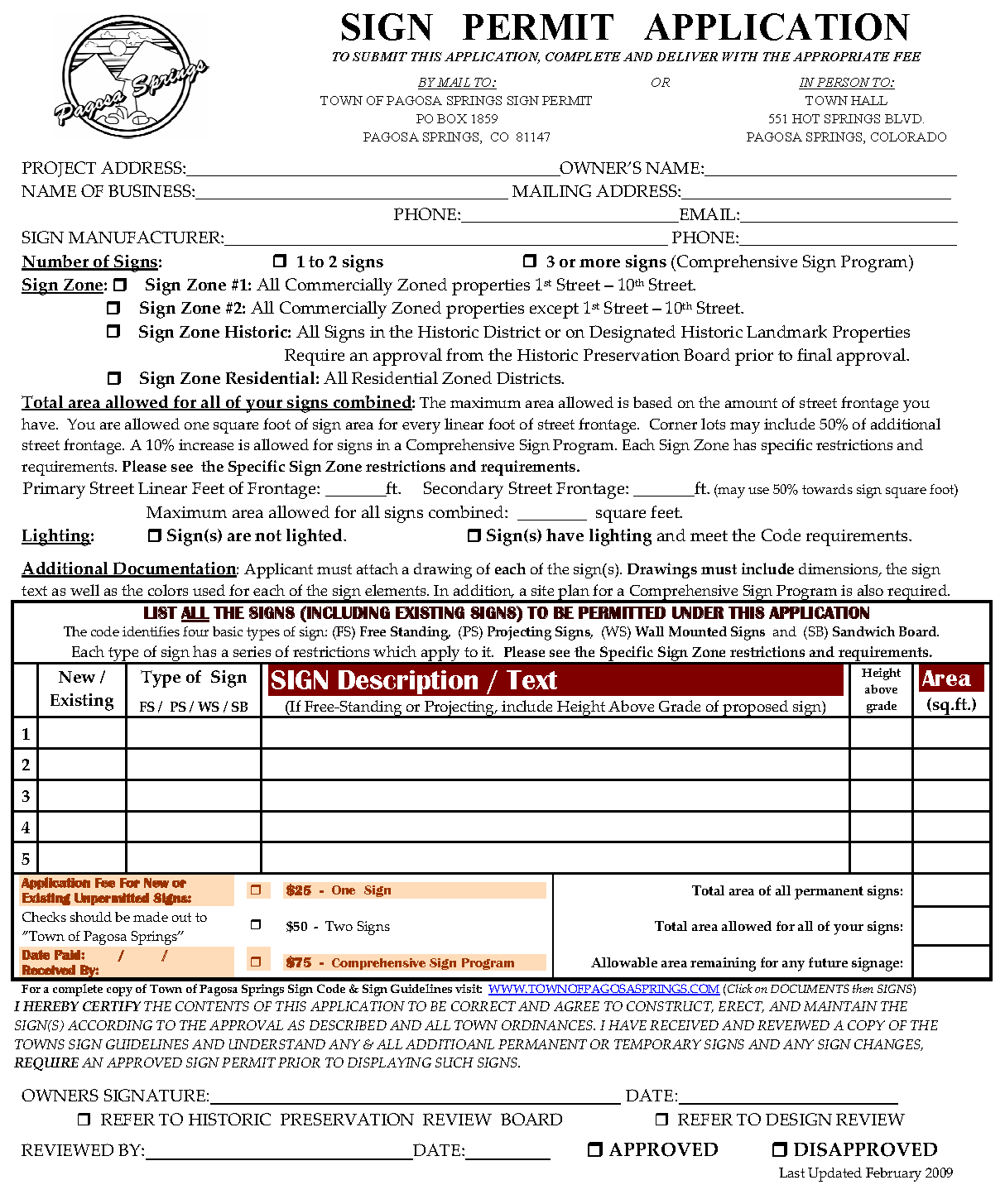
Signage plan - Signage plans shall show proposed location, size, materials, text, lighting and rendering of signs. All signage shall be in conformance with the specific requirements set forth in the LUDC, Section 6.12 (see additional information under Section 2, Sign Permits as defined in this User's Manual;
(ii)
Parking plan - The parking plan shall show the proposed location of parking spaces, driveway(s), vehicular and pedestrian circulation patterns, service access and the proposed treatment of landscaping within the parking area;
(iii)
Lighting plan - Lighting plans shall show the proposed luminaire location, type of fixtures, poles and on-site lighting. The lighting plan shall also include a spill light analysis, if applicable; and
(iv)
Building plans - Plans shall include, at minimum, elevations of the proposed building(s), proposed building use, height, materials, colors and details. Plans shall also delineate gross square footage calculations for commercial and residential units, if applicable (based on off-street parking requirements set forth in Section 6.9, LUDC).
Note: Inaccurate, incomplete or poorly drawn plats/maps shall be rejected at the Director's discretion.
(d)
Applicants may be requested to provide additional information, as requested by the Town and determined appropriate by the Town.
Additional information.
(a)
Applicants are responsible for addressing each condition of approval as determined appropriate by the Director (administrative review) or Design Review Board (major review) prior to submittal of building plans for permitting. Applicants shall submit revised documentation and/or plan sets, both 24" × 36" and 11" × 17", to the Town Planning Department to remedy conditions of approval.
Note: If conditions of approval are not adequately met prior to building plan submittal, the Director may withhold the issuance of a building permit, certificate of occupancy or temporary certificate of occupancy.
REDEVELOPMENT PERMIT
For procedural and administrative related information see the Land Use and Development Code, Section 2.4.7, Redevelopment Permit.
Redevelopment permits: Material submitted for redevelopment permits shall meet the following requirements. Redevelopment Permits are required for properties involved in relocation, demolition, or partial demolition of buildings within commercial [C, LI] or mixed-use districts [MUR, MUC, MUTC].
Approximate timeline: Administrative reviews two (2) to four (4) weeks, major design reviews one (1) to two (2) months.
| Submittal Requirements Checklist | ||||
| Completed land use application (a) | Surrounding and interested property ownership report (i) | |||
| Evidence of good title/legal description (g) | Public hearing notification envelopes (j) | |||
| Land use application fees (e) [$250] | Mineral, oil and gas rights documentation (k) | |||
| Codes and covenants (if applicable) (s) | Taxes and list of taxing entities (h) | |||
| Landscape plan (l) | Utilities checklist (u) | |||
| Agreement of payment of fees (f) | Context and vicinity map (t) | |||
| Engineering plans and specifications (v) | General development information (m) | |||
| Master utility plan (q) | Preliminary plan/site design (see technical req.) | |||
| Grading and drainage plan/report (p) | ||||
Application submittal.
(a)
The applicant shall submit two (2) copies of the complete application package at least twenty (20) days prior to the scheduled Planning Commission meeting. Submittals shall include 24" × 36" complete drawing sets and one (1) 11" × 17" copy of the complete set. Applications will not be placed on the Planning Commission agenda until the Director determines the application is complete, pursuant to LUDC, Section 2.3.4.
General development information.
(a)
The applicant shall submit the following information:
(i)
A written statement identifying the developer's intentions regarding future subdivision and/or sale or lease of the development, including estimated time frames, if applicable;
(ii)
An estimate of the development's need for water, sewer, fire protection and the route of utility connections; and
(ii)
For uses that require a conditional use permit, see additional submittal requirements as described in Section 2, Conditional Uses.
Redevelopment plan minimum requirements.
(a)
Plans shall comply with the design guidelines, development standards and applicable requirements as set forth in the LUDC, Article 5 and Article 6.
(b)
Plans shall comply with the specifications identified under preliminary plan minimum requirements (excluding (vi)), including the following:
(i)
Note: Engineering plans and specifications, master utility plans, landscape plans and grading and drainage plans shall be in conformance with the specific requirements set forth in the LUDC, Article 5, Article 6, Article 7 and the requirements set forth in Section 6 of this User's Manual.
(c)
Submitted plans shall also include the items as enumerated in Section 2, Design Review Plan Minimum Requirements, (c).
(d)
Applicants may be requested to provide additional information, as requested by the Town and determined appropriate by the Town.
Additional information.
(a)
Applicants are responsible for addressing each condition of approval as determined appropriate by the Director (Administrative Review) or Design Review Board (Major Review) prior to submittal of building plans for permitting. Applicants shall submit revised documentation and/or plan sets, both 24" × 36" and 11" × 17", to the Town Planning Department to remedy conditions of approval.
Note: If conditions of approval are not adequately met prior to building plan submittal, the Director may withhold the issuance of a building permit, certificate of occupancy or temporary certificate of occupancy.
FLOODPLAIN DEVELOPMENT PERMIT
For procedural and administrative related information see the Land Use and Development Code, Section 2.4.8, Floodplain Development Permit.
Floodplain development permit: Material submitted for floodplain development permits shall meet the following requirements. Applications may be submitted concurrently with building plans to the Town Building Department.
Approximate timeline: Based on building plan review timeframes. Contact the Town Building Department with any questions.
| Submittal Requirements Checklist | ||||
| Completed floodplain development permit (c) | Map or site plan (see technical req.) | |||
| Evidence of good title/legal description (g) | Mineral, oil and gas rights documentation (k) | |||
| Context and vicinity map (t) | ||||
Application submittal.
(a)
The applicant shall submit two (2) copies of the complete application package to the Town Building Department. Submittals shall include 24" × 36" complete drawing sets and one (1) 11" × 17" copy of the complete set. Applications will not be reviewed until the Director and/or Floodplain Administrator determines the application is complete, pursuant to LUDC, Section 2.3.4.
Projects requiring a floodplain development permit.
(a)
Projects may include, but are not limited to the following in regards to development within a special flood hazard area:
(i)
New Construction (single family, multi-family, manufactured homes and non-residential construction);
(ii)
Improvements to a structure that exceed fifty (50) percent of the assessed property value;
(iii)
Rehabilitation within the floodway/floodplain;
(iv)
Channelization;
(v)
Fill;
(vi)
Construction or modification of bridges/culverts; and
(vii)
Levee.
General provisions - Methods of reducing flood losses.
(a)
Methods proven effective in reducing flood losses include, but are not limited to:
(i)
Restricting or prohibiting uses that are dangerous to health, safety and property because they create water or erosion hazards, which lead to increases in flood heights or velocity;
(ii)
Requiring that uses vulnerable to floods, including facilities that serve such uses, be protected against flood damage at the time of initial construction;
(iii)
Controlling the alteration of natural floodplains, stream channels and natural protective barriers that accommodate or channel flood waters;
(iv)
Controlling filling, grading, dredging and other development that may increase flood hazards;
(v)
Preventing or regulating the construction of flood barriers that will unnaturally divert flood waters or that may increase flood hazards in other areas; and
(vi)
Preventing or regulating construction within areas of special flood hazard to prevent restriction of flood flows, damage to the structures and reduction in the flow capacity.
Basis for establishing areas of special flood hazard.
(a)
The Federal Insurance Administration's scientific and engineering report entitled "The Flood Insurance Study for the Town of Pagosa Springs, Colorado," dated May 2, 1991, and the "Letter of Map Revision" (LOMR), dated January, 1996, with accompanying flood insurance rate maps ("FIRM") and flood boundary floodway maps, which identifies areas of special flood hazard, is hereby adopted by reference and declared to be a part of this Article. These documents are available at Town Hall.
Map and/or site plan minimum requirements.
(a)
At minimum, maps shall include the following information:
(i)
Accurate representation of floodway and base flood elevations;
(ii)
Elevation in relation to mean sea level, of the lowest floor (including basement) of all structures;
(iii)
Elevation in relation to mean sea level, to which any structure has been flood proofed;
(iv)
Engineering calculations and data provided for map and floodway revisions;
(v)
Certification by a Colorado registered professional engineer or architect that the flood-proofing methods for any non-residential structure meet the flood-proofing criteria set forth in the General Standards below;
(vi)
Plans shall be drawn to scale and show location, dimensions, elevations and nature or the area in question;
(vii)
Plans shall show proposed structures, fill, storage of material and drainage facilities;
(viii)
Manufactured (mobile) homes are elevated and adequately anchored; and
(ix)
Maps shall be prepared and certified by a Colorado registered professional land surveyor.
(b)
In addition, the following documentation shall be submitted:
(i)
Description of the extent to which any watercourse will be altered or relocated as a result of the proposed development;
(ii)
Verification that all necessary permits from any federal, state and local government agencies from which prior approval is required.
(c)
Applicants may be requested to provide additional information, as requested by the Town and determined appropriate by the Town.
Note: Inaccurate, incomplete or poorly drawn site plans/maps shall be rejected at the Director's or Floodplain Administrator's discretion.
Alteration of watercourse.
(a)
Prior to any alteration or relocation of a watercourse, Archuleta County and the Colorado Water Conservation Board shall receive proper notice. Evidence of the notices shall be submitted to the Federal Emergency Management Agency ("FEMA").
(b)
All altered or relocated watercourses shall be maintained so that flood carrying capacity is not diminished.
General standards.
(a)
In all identified areas of special flood hazard, new construction and substantial improvements must be built consistent with the following construction standards:
(i)
Anchoring:
(1)
All structures shall be anchored to prevent flotation, collapse or lateral movement - structures shall be anchored to withstand hydrodynamic loads;
(2)
All manufactured homes shall be anchored to resist flotation, collapse or lateral movement by providing over-the-top and frame ties to ground anchors as follows:
(a)
Over-the-top ties shall be provided at each of the four corners of the manufactured home, with no additional ties per side at immediate locations, with manufactured homes less than fifty (50) feet long requiring four (4) additional ties per side;
(b)
Frame ties shall be provided at each corner of the home with five additional ties per side at immediate points, with manufactured homes less than fifty (50) feet long requiring four (4) additional ties per side;
(c)
All components of the anchoring system shall be capable of carrying a force of four thousand four hundred (4,400) pounds; and
(d)
Any structural additions to the manufactured home shall be similarly anchored.
(ii)
Construction materials and methods:
(1)
All structures shall be constructed with materials and utility equipment resistant to flood damage;
(2)
All structures shall be constructed using methods and practices that minimize flood damage;
(3)
All structures with fully enclosed areas below the lowest floor that are at or below the base flood elevation and therefore subject to flooding shall be designed to automatically equalize hydrostatic flood forces on exterior walls by allowing for the entry and exit of floodwater. Designs for meeting this requirement must either be certified by a Colorado registered professional engineer or architect and/or meet or exceed the following minimum criteria:
(a)
Minimum of two (2) openings having a total net area of not less than one (1) square inch for every square foot of enclosed area subject to flooding shall be provided;
(b)
The bottom of all openings shall be no higher than one (1) foot above grade; and
(c)
Openings may be equipped with screens, louvers or other coverings or devices provided that they permit the automatic entry and exit of floodwater.
(iii)
Utilities:
(1)
All new and replacement water supply systems shall be designed to minimize or eliminate infiltration of flood waters into the system;
(2)
New and replacement sanitary sewage systems shall be designed to minimize or eliminate infiltration of flood waters into the systems and discharge from the systems into flood waters;
(3)
On-site waste disposal systems shall be located to avoid impairment to or contamination from them during flooding; and
(4)
Electrical, heating, ventilation, plumbing and air conditioning equipment and other service facilities shall be designed and/or located to prevent water from entering or accumulating within the components during conditions of flooding.
(iv)
Subdivision:
(1)
All subdivisions shall provide base flood elevation data.
Specific standards.
(a)
In all areas of special flood hazard, improvements shall comply with the following standards:
(i)
Residential construction:
(1)
Any residential structure shall have the lowest floor, including the basement, elevated to at least one (1) foot above the base flood elevation;
(ii)
Non-residential Construction: Any non-residential structure shall either have the lowest floor, including the basement, elevated to at least one (1) foot above the base flood elevation or together with attendant utility and sanitary facilities, shall:
(1)
Flood proofed to at least one (1) foot above the base flood elevation and consistent with construction standards set forth under General Standards, (a)(ii)(3) above;
(2)
Structural components shall be capable of resisting hydrostatic and hydrodynamic loads and effects of buoyancy; and
(3)
Provide the following information where the structure is intended to be watertight below the base flood level:
(a)
A Colorado registered professional engineer or architect shall develop and/or review structural design specifications and plans for the construction, and shall certify that the design and methods of construction are in accordance with accepted standards of practice for meeting the applicable provisions of acquiring a Floodplain Development Permit; and
(b)
All certifications shall remain on file with the Director or Floodplain Administrator.
(iii)
Manufactured homes:
(1)
All new manufactured homes or those to be substantially improved shall be elevated on a permanent foundation such that the lowest floor of the manufactured home is at least one (1) foot above the base flood elevation and is securely anchored to an adequately anchored foundation system.
(iv)
Floodways:
(1)
Encroachments, fill, new construction, substantial improvements and any type of development is prohibited in the floodway unless a technical evaluation prepared by a Colorado registered professional engineer demonstrates that such encroachments or improvements will not result in any increase in flood level during the base flood discharge.
(2)
If an engineer's evaluation determines that an encroachment or improvement will not increase the flood level, such encroachments or improvements shall comply with all general and specific standards of this Section.
VARIANCE - GENERAL, FLOODPLAIN REGS., LARGE RETAIL, SIGNS
For procedural and administrative related information see the Land Use and Development Code, Section 2.4.11, Variances.
Variances: Material submitted for variances shall meet the following requirements.
Approximate timeline: One (1) and three (3) months.
| Submittal Requirements Checklist | ||||
| Completed land use application (a) | Surrounding and interested property ownership report (i) | |||
| Evidence of good title/legal description (g) | Public hearing notification envelopes (j) | |||
| Land use application fees (e) [$300] | Context and vicinity map (t) | |||
| Agreement of payment of fees (f) | Map, site plan or plat/ILC | |||
| General development information (m) | ||||
Application submittal.
(a)
The applicant shall submit one (1) copy of the complete variance package and one (1) 11" × 17" copy of the map/site plan at least twenty (20) days prior to the scheduled Board of Adjustment meeting. Applications will not be placed on the Board of Adjustment Agenda until the Director determines the application is complete, pursuant to LUDC, Section 2.3.4.
General development information.
(a)
The applicant shall submit the following information:
(i)
A letter identifying the variance being requested, a citation of the portion of the LUDC from which relief is requested, an explanation of the exceptional condition, practical difficulty or unnecessary hardship prompting the variance request;
(ii)
In addition, the letter shall address how the variance, if granted, will not:
(1)
Be detrimental to the public good;
(2)
Create a conflict with the Town Comprehensive Plan; and
(3)
Impair the intent and purpose of the Land Use and Development Code.
Maps, site plans and/or plat/improvement location certificate (ILC).
(a)
Requirements shall be dictated by the Director as deemed appropriate for the variance requested.
Note: Inaccurate, incomplete or poorly drawn plats/site plans/maps shall be rejected at the Director's discretion.
MINOR MODIFICATION/ALTERNATIVE COMPLIANCE
For procedural and administrative related information see the Land Use and Development Code, Section 2.4.12, Minor Modifications or Section 6.1, Alternative Compliance.
Minor modification/alternative compliance: Material submitted for minor modifications or alternative compliance shall meet the following requirements.
Approximate timeline: Two (2) weeks to one (1) month.
| Submittal Requirements Checklist | ||||
| Completed land use application (a) | Context and vicinity map (t) | |||
| Evidence of good title/legal description (g) | Map, site plan or plat/ILC | |||
| Land use application fees (e) [$25] | General development information (m) | |||
| Agreement of payment of fees (f) | ||||
Application submittal.
(a)
The applicant shall submit one (1) copy of the complete minor modification/alternative compliance package and one (1) 11" × 17" copy of the map/site plan. Applications will not be reviewed until the Director determines the application is complete, pursuant to LUDC, Section 2.3.4.
(b)
Minor modification applications or alternative compliance applications may accompany other land use applications or development review applications. The applicant shall submit the required documentation for the minor modification/alternative compliance concurrently with the other application consistent with the submittal timeframes as established within this User's Manual. Applications will not be reviewed or placed on the Planning Commission agenda, Design Review Board agenda or Board of Adjustment agenda until the Director determines the application is complete, pursuant to LUDC, Section 2.3.4. Note: Fees do to not apply to minor modification requests submitted concurrently with other land use application or development review applications.
General development information.
(a)
The applicant shall submit the following information:
(i)
A letter identifying the minor modification/alternative compliance being requested, a citation of the portion of the LUDC from which relief is requested, an explanation of the exceptional condition, practical difficulty or alternative/innovative design practice that achieves to the same or increased degree the objective of the existing design standard;
(ii)
In addition, the letter shall address how the variance, if granted, will not:
(1)
Be detrimental to the public good;
(2)
Create a conflict with the Town Comprehensive Plan; and
(3)
Impair the intent and purpose of the Land Use and Development Code.
Maps, site plans and/or plat/ILC.
(a)
Requirements shall be dictated by the Director as deemed appropriate for the minor modification or alternative compliance requested.
Note: Inaccurate, incomplete or poorly drawn plats/maps shall be rejected at the Director's discretion.
(b)
Applicants may be requested to provide additional information, as requested by the Town and determined appropriate by the Town.
SIGN PERMITS
For procedural and administrative related information see the Land Use and Development Code, Section 2.4.9, Sign Permits.
New individual sign permit/existing signs/temporary signs: Material submitted for sign permits shall meet the following requirements.
Approximate timeline: One (1) to three (3) weeks.
| Submittal Requirements Checklist | ||||
| Completed sign permit application (y) | Sign elevations (see technical requirements) | |||
| Land use application fees (e) [$25 per sign] | Site plan (see technical requirements) | |||
| Land use app. (temp. signs) [$10 + $50 dep.] | ||||
Application submittal.
(a)
The applicant shall submit one (1) copy of the complete sign permit package. Applications will not be reviewed until the Director determines the application is complete, pursuant to LUDC, Section 2.3.4. Applications may be placed on the Design Review Board agenda as deemed appropriate by the Director.
Sign elevation minimum requirements.
(a)
At minimum, elevations should include the following information:
(i)
Drawings, renderings or pictures indicating proposed sign height, overall dimensions, colors, materials, proposed copy, lettering detail, form and illumination specifications; and
(ii)
Outline of building elevations showing existing and proposed signs.
Site plan minimum requirements.
(a)
At minimum, site plans should include the following information:
(i)
Location and dimensions for all existing and proposed signs;
(ii)
Property boundaries and right-of-way limits as applicable to the placement of proposed signage; and
(iii)
Linear feet of street frontage.
(b)
Applicants may be requested to provide additional information, as requested by the Town and determined appropriate by the Town; and
(c)
Submittal requirements for temporary signage may be reduced or modified by the Director as deemed appropriate.
Comprehensive sign program ("CSP"): Material submitted for comprehensive sign programs shall meet the following requirements.
| Submittal Requirements Checklist | ||||
| Completed sign permit application (y) | Design plans (see technical requirements) | |||
| Land use application fees (e) [$75] | ||||
Application submittal.
(a)
The applicant shall submit one (1) copy of the complete comprehensive sign program package for all signs, including temporary signs. Applications will not be reviewed until the Director determines the application is complete, pursuant to LUDC, Section 2.3.4.
(b)
Four (4) or fewer signs shall be reviewed by the Director. Applications may be placed on the Design Review Board agenda as deemed appropriate by the Director.
(c)
Five (5) or more signs shall be reviewed by the Design Review Board.
Design plan minimum requirements.
(a)
At minimum, design plans should include the following information:
(i)
Location, size, height, area and type of illumination for all signs;
(ii)
Drawings or renderings showing a coordinated plan that incorporates uniform design elements, such as colors, shapes, lettering styles, sign materials and illustrative elements;
(iii)
Outline of building elevations showing existing and proposed signs;
(iv)
Property boundaries and right-of-way limits as applicable to the placement of proposed signage; and
(v)
Linear feet of street frontage.
(b)
Applicants may be requested to provide additional information, as requested by the Town and determined appropriate by the Town.
Note: The Design Review Board may allow a ten (10) percent increase in allowable aggregate square footage if the overall design plan complies with comprehensive sign program criteria.
TEMPORARY USE
For procedural and administrative related information see the Land Use and Development Code, Section 2.4.10, Temporary Use Permits.
Temporary uses: Material submitted for a temporary use permit shall meet the following requirements.
Approximate timeline: Three (3) weeks to two (2) months.
| Submittal Requirements Checklist | ||||
| Completed land use application (a) | Land use application fees (e) [$50 per month base fee] | |||
| Evidence of good title/legal description (g) | General development information (m) | |||
Application submittal.
(a)
The applicant shall submit one (1) copy of the complete application package; and one (1) 11" × 17" copy of any maps, plats or drawings. Applications will not be reviewed until the Director determines the application is complete, pursuant to LUDC, Section 2.3.4.
General development information.
(a)
The applicant shall submit the following information, as determined to be applicable by the Director:
(i)
Written statement and any graphics necessary to describe the precise nature of the proposed use and its operating characteristics; and to illustrate how all temporary use review criteria as established in the LUDC, Section 4.4 (C)(4)Temporary Uses/Structures;
(ii)
A map showing the proposed development of the site, including structure locations, parking, traffic circulation, useable open space, landscaped areas, utilities and drainage features, as applicable;
(iii)
Preliminary building/structure plans and elevations sufficient to indicate the dimensions, general appearance and scale of all buildings/structures;
(iv)
A proposed development schedule indicating the commencement date of the project and/or proposed duration of the permit;
(v)
A statement addressing any required provisions for proper ongoing maintenance and use of the site.
(b)
Applicants may be requested to provide additional information, as requested by the Town and determined appropriate by the Town.
COMPREHENSIVE PLAN AMENDMENTS
For procedural and administrative related information see the Land Use and Development Code, Section 2.4.15, Comprehensive Plan Amendments.
Comprehensive plan amendments: Comprehensive plan amendments shall meet the following submittal requirements.
Approximate timeline: Two (2) to three (3) months.
| Submittal Requirements Checklist | ||||
| Completed land use application (a) | Surrounding and interested property ownership report (i) | |||
| Evidence of good title/legal description (g) | Public hearing notification envelopes (j) | |||
| Amendment map (see technical req.) | Land use application fee [$100] (e) | |||
| General development information (m) | Agreement for payment of fees (f) | |||
Application Submittal.
(a)
The applicant shall submit one (1) copy of the complete comprehensive plan amendment package and one (1) 11" × 17" copy of the map at least twenty (20) days prior to the scheduled Planning Commission meeting. Applications will not be placed on the Planning Commission agenda until the Director determines the application is complete, pursuant to LUDC, Section 2.3.4.
Amendment map technical standards (if applicable).
(a)
At minimum, maps shall include the following information:
(i)
North arrow, graphic and written scale at either (1":100' or 1":200') and date of preparation;
(ii)
The subdivision name or block, lot number of the subject area (if applicable);
(iii)
Acreage or square footage calculations of the property(s) proposed for the comprehensive plan amendment;
(iv)
All existing land uses as depicted on the future land use map in the area (adjacent properties) proposed for the comprehensive plan amendment;
(v)
Clearly identify the proposed modification to the future land use plan;
(vi)
Vicinity map per Section 6 of this User's Manual.
Note: Inaccurate, incomplete or poorly drawn plats/maps shall be rejected at the Director's discretion.
General development information.
(a)
The applicant shall submit a written statement describing the proposal and addressing the following items:
(i)
Narrative addressing how the minor plan amendment meets the criteria for a Comprehensive Plan Amendment as defined in the LUDC, Section 2.4.15(C)(4);
(b)
Applicants may be requested to provide additional information, as requested by the Town and determined appropriate by the Town.
Section 3: - Plat language and technical standards.
REQUIREMENTS FOR CREATING NEW PLATS (Updated January 1, 2011)
General requirements.
(a)
Applicants submitting plats for review shall follow the technical standards as listed below:
(i)
Lot numbers followed by "X" indicate consolidated lots;
(ii)
Lot numbers followed by "A" indicate unconsolidated lots;
(iii)
Lot numbers followed by "Z" indicate lots were originally consolidated and when unconsolidated, actual boundary lines changed.
(iv)
All modifications to platted subdivisions shall be noted as amendments. This includes all land use review processes as listed within Section 2, Plat Amendments;
(v)
First lines on plats shall include the following language:
(1)
The name of the subdivision, townhome or condominium project;
(2)
If the plat is identified as a plat amendment it shall include the subdivision name, project phase, amendment and year and sequential number of amendment within calendar year;
(3)
Titles shall be centered at the top of the plat in capital bold letters (all on the same line);
(4)
The first line of the title heading on the plat shall read exactly the same as the dedication statement;
(vi)
Second lines on plats shall include the following language:
(1)
Legal description (block, lot or township, section and range), description of intent (lot consolidation, replat, lot line adjustment, etc.) and the unit(s) if applicable;
(vii)
Third lines on the plats shall include the following language:
(1)
The approving jurisdiction (Town of Pagosa Springs, Colorado) and the associated County (Archuleta County).
Easement dedication language.
(a)
Per the Archuleta County Joint Utilities Committee the following language should be utilized in establishing language for any easement dedication:
(i)
All roads and alleys are to be dedicated to the utility providers for both ingress and egress, and for the installation and maintenance of utilities;
(ii)
For all developments under the jurisdiction of the Town of Pagosa Springs, utility easements should be created on all lot lines, with the total width of each lot line easement at twenty (20) feet minimum. This twenty (20) feet can be entirely on one (1) lot, or in such cases where the lot line is common between two (2) lots, the common lot line can split the easement, with a ten-foot easement on each lot. Lot line easements can be reduced to a total width of ten (10) feet in those instances where the lot line abuts a street or alley which is effectively dedicated for the installation of utilities. Utility companies may consider fewer and smaller easements in each lot on a case-by-case basis, where building setbacks or lot size limitations restrict the amount of land available for utilities;
(iii)
All plats should contain the following language: "Property pins shall not be disturbed by the placement of utilities. In the instance where property pins are disturbed, the excavation/trenching contractor shall be responsible for their replacement."
(iv)
The _____ × _____ foot wide public utility easements as shown hereon are hereby dedicated to all public and private utility companies, as recognized by the Town of Pagosa Springs, as public utility easements, and also dedicated to the property owners within this development for the purposes of access to and connection with the public utilities. Customer owned lines shall exit the public utility easement in the shortest route possible.
(v)
All roads and alleys as shown hereon are hereby dedicated to the public forever for ingress and egress and for the use of all public and private utility companies, as recognized by the Town of Pagosa Springs, as public utility easements.
Note: Individual utility companies may require a review of each proposed project, and may have additional case specific requirements, in addition to those identified above.
PLAT TITLE EXAMPLES (Updated January 1, 2011)
Plat title examples.
(a)
Plat titles should be representative of the following examples:
* Townsite of Pagosa Springs Amendment 2005 - #1 *
A Boundary Adjustment of Block 44, Lots 6, 7, 8 and 9
Town of Pagosa Springs, Archuleta County, Colorado
Harman Park Subdivision Amendment 2006
A Consolidation of Lots H-4 thru H-7
Town of Pagosa Springs, Archuleta County, Colorado
San Juan River Villas Phase 2 *
Being an "As-Built" of Units 4—7
Town of Pagosa Springs, Archuleta County, Colorado
Townsite of Pagosa Springs Amendment 2007 -#2 *
A Unconsolidation of Block 23, Lot 26
Town of Pagosa Springs, Archuleta County, Colorado
Pradera Pointe Subdivision
Being a portion of Pagosa Development "A" and Pagosa Development "B"
Town of Pagosa Springs, Archuleta County, Colorado
* Townsite of Pagosa Springs Amendment 2007 - #3 *
A Replat of Block 50, Lots 8, 9 and 10
Town of Pagosa Springs, Archuleta County, Colorado
PLAT ENDORSEMENTS AND NOTES (Updated January 01, 2011)
All plats shall include the following endorsements containing the precise language described below.
_____
CERTIFICATE OF OWNERS
KNOW ALL MEN BY THESE PRESENTS:
That ___________ [name(s) of property owner] whose address is ___________ [address of property owners] being owner or lien holder of the following described real property, to wit: ___________ [insert legal description of the platted area and total acreage] has cause the same to be surveyed, laid out, subdivided, and designated as ___________ [subdivision name] and has caused this plat to be made and filed. In consideration of the approval of this plat, the above stated owners hereby waive any and all claims of damages against the Town of Pagosa Springs occasioned by the alteration of land surfaces to conform to this plat.
In witness thereof, this instrument is executed this _____ day of ___________ 20___.
___________ [signature of property owner(s)]
The foregoing instrument was acknowledged before me on this _____ day of ___________ 20___.
State of ___________ [State of Notary Public]
County of ___________ [County of Notary Public]
My commission expires: ___________ [Expiration date of commission]
___________ [Signature and Seal of Notary Public]
_____
CERTIFICATE OF MORTGAGEE
___________, [Name of mortgage holder] the mortgagee of the property as shown hereon, hereby consents and agrees to the subdivision of the property and the dedication of easements, as shown hereon.
___________ [Signature of mortgage holder]
The foregoing instrument was acknowledged before me on this _____ day of ___________, 20___.
State of ___________ [State of Notary Public]
County of ___________ [County of Notary Public]
My commission expires: ___________ [Expiration date of commission]
___________ [Signature and Seal of Notary Public]
_____
SURVEYOR'S CERTIFICATE
I, ___________ [Surveyor's Name], a duly registered professional land surveyor in the State of Colorado, do hereby certify that this plat of (subdivision name) Subdivision was prepared under my direction, meets the State of Colorado minimum standards for Land Survey Plats and truly and correctly represents a field survey of the same, and was monumented in accordance with sections 38-51-101, et seq., C.R.S.
___________ [Signature and Seal of Surveyor] ___________[Date]
_____
COUNTY SURVEYOR'S CERTIFICATE
I, ___________ [County Surveyor's Name], a duly registered professional land surveyor in the State of Colorado, do hereby certify that this plat of (subdivision name) meets the State of Colorado minimum standards for land survey plats.
_______[Signature and Seal of County Surveyor] _______ [Date]
_____
*PLANNING DEPARTMENT DIRECTOR APPROVAL
This plat and the statements heron are conditionally approved, pending the completion of any specified improvements, this _____ day of ___________ 20___, by the Town of Pagosa Springs, Colorado.
By Planning Department Director:___________ (Signature)
Attest by Town Clerk: ___________ ( Signature and Seal of Clerk)
_____
TOWN COUNCIL CERTIFICATE
This plat and the statements hereon are conditionally approved, pending completion of any specified improvements, this _____ day of ___________, 20___, by the Town Council of the Town of Pagosa Springs, Colorado.
By Mayor: ___________[Signature]
Attest by Town Clerk: ___________ [Signature and Seal of Clerk]
_____
APPROVAL TO RECORD CERTIFICATE
Having ascertained that the conditions of approval have been satisfactorily completed on this _____ day of ___________, 20___, the Town Council approves this plat for recording by the Archuleta County Clerk and Recorder. This approval does not extend to the design of utilities, sewage disposal, roads, or any other service facility. The Town Council's approval of this plat constitutes the acceptance, on the public's behalf, of the offer of dedications of rights-of-way, but does not constitute acceptance of roads, utilities, or services by the Town for maintenance or operation.
By Mayor: ___________[Signature]
Attest by Town Clerk: ___________[Signature and Seal of Clerk]
_____
CLERK AND RECORDER CERTIFICATE
I hereby certify that this instrument was filed in my office at _____ o'clock, this _____ day of ___________, 20___.
Reception Number: ___________
Plat File Number: ___________
By Clerk and Recorder: ___________ [Signature and Seal of Clerk]
_____
GENERAL DEDICATIONS
Any required dedications plus street and easement dedications as follows:
PUBLIC STREET DEDICATION:
(1)
The street rights-of-way shown hereon are hereby dedicated to the public for purposes of ingress and egress, and installation and maintenance of utility lines, utility facilities, drainage, and other public facilities as may be described hereon.
PRIVATE STREET DEDICATION:
(2)
The access easements shown hereon are dedicated to the owners within the development for purposes of ingress and egress, and installation and maintenance of utility lines, utility facilities, drainage, and other public facilities as may be described hereon.
UTILITY EASEMENT DEDICATION
(3)
That the utility easements shown hereon are granted to the public for the purposes of installation and maintenance of utility lines and facilities and such other purposes as may be described hereon.
OTHER DEDICATION
(4)
[Insert any other appropriate dedication statements]
PLAT NOTES
Any required dedications plus and street and easement dedications as follows:
1.
Notes should be listed in numerical order
2.
Notes should indicate on which lot site improvement(s) are located
3.
This property is hereby zoned ___________[zoning district]
PLAT RECORDING
(a)
Applicants shall follow the procedures for recording codes and covenants/declarations and plats as set forth below:
(i)
Codes and Covenants/Declarations - Codes and Covenants and/or declarations should be recorded by the applicant and a copy submitted to the Town planning department. The Town will not record any plat until the applicant provides verification that codes and covenants and/or declarations have been recorded.
(ii)
Plats - All plats shall be recorded within the thirty (30) days of Town Council approval unless otherwise stated in the applicable Section of the LUDC. Plats not recorded within the thirty (30) day period will expire.
Section 4: - Reserved.
Editor's note— Former § 4, which pertained to firms approved to complete impact assessments, was repealed by Ord. No. 743.
Section 5: - Adopted fee schedule.
FEE SCHEDULE AND IMPACT FEES
Note: Fee amounts are determined and adopted by Town Council via resolution and are subject to modification at any given time. Fee schedule is updated as of February 3, 2009.
Section 6: - Technical standards
CONTEXT AND VICINITY MAP
Context and Vicinity maps shall be required as referenced in Section 2 of this User's Manual. Maps shall show the proposed development or subject property in relation to the surrounding area, a minimum of one and one-half (1½) mile radius.
Format.
(a)
24" × 36"; with a copy at 11" × 17".
Minimum requirements.
(a)
At minimum, maps should include the following information:
(i)
Project Title, North Arrow, Scale (not greater than 1"-1000') and date of preparation;
(ii)
Boundary of proposed project including dimensions;
(iii)
Legal description and property acreage (or square footage);
(iv)
Roadways, rights-of-way and applicable easements including dimensions;
(iv)
Adjacent properties identified by subdivision name and/or property owner;
(v)
General locations of existing utilities on or adjacent to the property;
(vi)
Proposed trails, sidewalks and walkways and an indication of how the development will tie into the regional trails network, if applicable;
(vii)
Delineated floodway and floodplain boundaries with a note regarding the source of information, if applicable;
(viii)
All existing structures, streets and parking areas within five hundred (500) feet of the proposed development.
(b)
Applicants may be requested to provide additional information, as requested by the Town and determined appropriate by the Town.
SITE DRAINAGE AND SITE GRADING
Submitted plans and information shall be in conformance with the specific requirements set forth in the LUDC, Section 6.3. All plans and information shall be certified by a Colorado registered professional engineer. Applicants shall be required to submit drainage plans/reports in conjunction with the following applications: major subdivision (preliminary, final), large retail development permit, design review and redevelopment permits.
Drainage report format.
(a)
8.5" × 11".
Drainage report minimum requirements.
(a)
At minimum, the drainage report should include the following information:
(i)
Narrative describing the location and size of the development, its affect on adjacent areas, methods used in determining runoff, proposed measures to implement the design and construction of drainage facilities and design calculations;
(ii)
Calculations and nomographs used in determining storm runoffs, detention pond sizing, pipe sizing, channel design, rip-rap sizing, etc (include all pertinent graphs/tables);
(iii)
Supporting calculations for run-offs, times of concentration, flow capacity with all assumptions clearly stated; and
(iv)
Certification by a Colorado registered professional engineer.
Drainage/grading plan format.
(a)
24" × 36"; with a copy at 11" × 17". Horizontal scales shall correlate with the roadway drawing scale, if applicable.
Drainage/grading plan minimum requirements.
(a)
At minimum, the drainage and grading plans should include the following information:
(i)
Contours at two-foot intervals for up to twenty (20) percent terrain slopes and ten (10) foot intervals for terrain slopes greater than twenty (20) percent, indicating existing and developed conditions;
(ii)
Depiction of storm water flow paths;
(iii)
Identification of sub and major drainage basins and run-off control measures such as detention/retention basins; and
(iv)
Construction details, to include: erosion protection at entrances and exists of culverts, drop inlets, detention pond facilities, roadway templates showing structural data, channel cross sections and other relevant structures and improvements as determined applicable.
(b)
Applicants may be requested to provide additional information, as requested by the Town and determined appropriate by the Town.
LANDSCAPE PLAN
Submitted plans and information shall be in conformance with the specific requirements set forth in the LUDC, Section 6.11. Applicants shall be required to submit landscape plans in conjunction with the following applications: major (preliminary, final), design review and redevelopment permits.
Landscape plan format.
(a)
24" × 36"; with a copy at 11" × 17".
Landscape plan minimum requirements.
(a)
At minimum, the landscape plan should include the following information:
(i)
Square footage (or acreage) of landscaped areas including sub areas such as internal landscaped areas;
(ii)
Location, type, spacing and size of major existing plant materials, including all trees, materials that will be removed and which shall be retained or relocated;
(iii)
A legend that includes common and botanical name, size and quantity of proposed plant and other landscape materials;
(iv)
Depiction of all plant materials should represent approximate mature size of the materials; and
(v)
Amenities such as, but not limited to, fountains, benches and bike racks.
(b)
Landscaping shall be installed according to sound horticultural practices in a manner designed to encourage quick establishment and healthy growth;
(c)
All landscaping shall be installed prior to the issuance of a certificate of occupancy, unless otherwise approved by the Director.
(d)
Applicants may be requested to provide additional information, as requested by the Town and determined appropriate by the Town.
ENGINEERING PLANS AND SPECIFICATIONS (UTILITIES, ROADS, ETC.)
Plans, profiles and information shall be prepared by a Colorado registered professional engineer. Submitted documentation shall be in conformance with the specific requirements set forth in the LUDC and the requirements set forth in Section 6 of this User's Manual.
Engineering plans/specifications format.
(a)
24" × 36"; with a copy at 11" × 17".
Engineering plans/specifications minimum requirements.
(a)
At minimum, the engineering plans/specifications should include the following information, as applicable:
(i)
Roadway: Typical road geometric and structural cross-section shown on each plan sheet;
(ii)
Roadway: Right-of-way lines and widths, road names, property boundaries, tangent lengths and bearings, curve radii, delta angles, curve lengths, chord lengths and bearings, stationing at all beginning of curves and end of curves, intersections, structures, angles, curb lines, cross pans, traffic control devices (island, striping, signs, etc.), driveway cuts, curb returns and radii, and all other features to enable construction in accordance with approved standards and standard engineering practice;
(iii)
Roadway: Ground lines, grade lines of curb and gutter or centerline of street elevation at point of intersection of vertical curves, intersections and other critical points, structures, and all other features required to enable construction in accordance with approved standards;
(iv)
See LUDC, Section 6.6.3 for additional design standards and requirements related to roadways and alleys;
(v)
Structure Details: Sufficient data shall be provided regarding construction of major structures and road appurtenances such as bridges, culverts, gutters, drives, parking lots, walks, cross-pans or any other structure;
(vi)
Details shall include orientation line and grade, cross-sections, dimensions, reinforcement schedules, materials, quality, specification and any other applicable information; and
(vii)
Utilities: Sewage collection and water supply distribution plans, profiles and specifications (see requirements under master utility plan).
(b)
Applicants may be requested to provide additional information, as requested by the Town and determined appropriate by the Town.
MASTER UTILITY PLAN
Submitted plans and information shall be in conformance with the specific requirements set forth in the LUDC. Applicants shall be required to submit master utility plans in conjunction with the following applications: major (preliminary, final), large retail development permit, design review and redevelopment permits.
Master utility plan format.
(a)
24" × 36"; with a copy at 11" × 17".
Master utility plan minimum requirements.
(a)
At minimum, the master utility plan should include the following information:
(i)
Horizontal and vertical scales that best depict the aspects of the design (minimum horizontal 1"-100' and minimum vertical 1"=10');
(ii)
Locations of existing utilities on or adjacent to the property;
(iii)
Construction plans and profiles prepared by a registered Colorado professional engineer;
(iv)
Analysis of the fiscal impacts on local service and facilities may be required.
Section 7: - Application and forms.
(a)
Land use permit application, utilities checklist, subdivision form, payment of fees agreement, floodplain development permit, sign permit/temporary sign permit application and road cut permit application.