
Pagosa Springs City Zoning Code
ARTICLE 6
- DEVELOPMENT AND DESIGN STANDARDS
6.1.- GENERAL PROVISIONS
6.1.1. PURPOSE
This Section includes standards that must be followed when developing property or establishing new uses of property within the boundaries of Pagosa Springs, to ensure the protection of the health, welfare, safety, and quality of life for local citizens, visitors, and business owners. The development and design standards in this chapter shall apply to the physical layout and design of all development, unless exempted by this Land Use Code. These provisions address the physical relationship between development and adjacent properties, public streets, neighborhoods, and the natural environment, in order to implement the comprehensive plan vision for a more attractive, efficient, and livable community.
6.1.2. ALTERNATIVE EQUIVALENT COMPLIANCE
A.
Purpose and scope. To encourage creative and unique design, "alternative equivalent compliance" allows development to occur in a manner that meets the intent of this Land Use Code, yet through an alternative design that does not strictly adhere to the Code's standards. This is not a general waiver of regulations. Rather, this authorizes a site-specific plan that is equal to or better than the strict application of the standard.
B.
Applicability. The alternative equivalent compliance procedure is available only for the following sections of this Land Use Code:
1.
Section 6.3: Site Development Standards;
2.
Section 6.4: Sensitive Area Protection;
3.
Section 6.6: Access and Circulation;
4.
Section 6.7: Commercial and Mixed-Use Design Standards;
5.
Section 6.8: Multi-Family Residential Design Standards;
6.
Section 6.9: Parking and Loading;
7.
Section 6.10: Landscaping and Buffers;
8.
Section 6.11: Exterior Lighting;
9.
Section 6.12: Sign Code; and
10.
Section 7.3: Subdivision Design.
C.
Pre-application conference required. An applicant proposing alternative equivalent compliance shall request and attend a pre-application conference prior to submitting application materials for the applicable permit(s) to discuss the project, the applicable Code standards, and the proposed method of alternative compliance. The application should include sufficient explanation and justification, in both written and graphic form, for the requested alternative compliance.
D.
Decision-making responsibility. Final approval of any alternative compliance proposed under this Section shall be the responsibility of the decision-making body responsible for deciding upon the application. Administratively approved projects proposing alternative compliance shall receive written approval of the alternative compliance from the Director.
E.
Criteria. Alternative equivalent compliance may be approved if the applicant demonstrates that following criteria have been met by the proposed alternative:
1.
Achieves the intent of the subject standard to the same or better degree than the subject standard;
2.
Advances the goals and policies of the Comprehensive Plan and this Land Use Code to the same or better degree than the subject standard;
3.
Results in benefits to the community that are equivalent to or exceed benefits associated with the subject standard; and
4.
Imposes no greater impacts on adjacent properties than would occur through compliance with the specific requirements of this ordinance.
F.
Effect of approval. Alternative compliance shall apply only to the specific site for which it is requested and shall not establish a precedent for approval of other requests.
6.2. - FLOOD DAMAGE PREVENTION REGULATIONS
6.2.1. TITLE AND PURPOSE
A.
Statutory authorization. The Legislature of the State of Colorado has, in Title 29, Article 20 of the Colorado Revised Statutes, delegated the responsibility of local governmental units to adopt regulations designed to minimize flood losses. Therefore, the Town Council of the Town of Pagosa Springs, Colorado, does hereby adopt the following floodplain management regulations:
B.
Findings of fact.
1.
The flood hazard areas of the Town of Pagosa Springs are subject to periodic inundation, which may result in loss of life and property, health and safety hazards, disruption of commerce and governmental services, and extraordinary public expenditures for flood protection and relief, all of which adversely affect the health, safety and general welfare of the public.
2.
These flood losses are created by the cumulative effect of obstructions in floodplains which cause an increase in flood heights and velocities, and by the occupancy of flood hazard areas by uses vulnerable to floods and hazardous to other lands because they are inadequately elevated, floodproofed or otherwise protected from flood damage.
C.
Statement of purpose. It is the purpose of Section 6.2 to promote public health, safety and general welfare and to minimize public and private losses due to flood conditions in specific areas by provisions designed to:
1.
Protect human life and health;
2.
Minimize expenditure of public money for costly flood control projects;
3.
Minimize the need for rescue and relief efforts associated with flooding and generally undertaken at the expense of the general public;
4.
Minimize prolonged business interruptions;
5.
Minimize damage to critical facilities, infrastructure and other public facilities such as water, sewer and gas mains; electric and communications stations; and streets and bridges located in floodplains;
6.
Help maintain a stable tax base by providing for the sound use and development of flood-prone areas in such a manner as to minimize future flood blight areas; and
7.
Ensure that potential buyers are notified that property is located in a flood hazard area.
D.
Methods of reducing flood losses. In order to accomplish the purpose of Section 6.2, use of the following methods shall apply:
1.
Restrict or prohibit uses that are dangerous to health, safety or property in times of flood, or cause excessive increases in flood heights or velocities;
2.
Require that uses vulnerable to floods, including facilities which serve such uses, be protected against flood damage at the time of initial construction;
3.
Control the alteration of natural floodplains, stream channels, and natural protective barriers, which are involved in the accommodation of flood waters;
4.
Control filling, grading, dredging and other development which may increase flood damage;
5.
Prevent or regulate the construction of flood barriers which will unnaturally divert flood waters or which may increase flood hazards to other lands.
6.2.2. DEFINITIONS
Unless specifically defined below, words or phrases used in this Section 6.2 shall be interpreted to give them the meaning they have in common usage and to give Section 6.2 its most reasonable application. Definitions in Section 6.2 apply exclusively to 6.2. Shared word usage or definitions may exist in other parts of the Land Use Code and shall reference definitions in Article 8 of the Land Use Development Code.
100-Year Flood. A flood having a recurrence interval that has a one-percent chance of being equaled or exceeded during any given year (one-percent-annual-chance flood). The terms "one-hundred-year flood" and "one percent chance flood" are synonymous with the term "100-year flood." The term does not imply that the flood will necessarily happen once every one hundred (100) years.
100-Year Floodplain. The area of land susceptible to being inundated as a result of the occurrence of a one-hundred-year flood.
500-Year Flood. A flood having a recurrence interval that has a 0.2-percent chance of being equaled or exceeded during any given year (0.2-percent-chance-annual-flood). The term does not imply that the flood will necessarily happen once every five hundred (500) years.
500-Year Floodplain. The area of land susceptible to being inundated as a result of the occurrence of a five hundred-year flood.
Addition. Any activity that expands the enclosed footprint or increases the square footage of an existing structure.
Alluvial fan flooding. A fan-shaped sediment deposit formed by a stream that flows from a steep mountain valley or gorge onto a plain or the junction of a tributary stream with the main stream. Alluvial fans contain active stream channels and boulder bars, and recently abandoned channels. Alluvial fans are predominantly formed by alluvial deposits and are modified by infrequent sheet flood, channel avulsions and other stream processes.
Area of shallow flooding. A designated Zone AO or AH on a community's Flood Insurance Rate Map (FIRM) with a one (1) percent chance or greater annual chance of flooding to an average depth of one (1) to three (3) feet where a clearly defined channel does not exist, where the path of flooding is unpredictable and where velocity flow may be evident. Such flooding is characterized by ponding or sheet flow.
Base flood. The flood which has a one (1) percent chance of being equaled or exceeded in any given year (also known as a 100-year flood). This term is used in the National Flood Insurance Program (NFIP) to indicate the minimum level of flooding to be used by a community in its floodplain management regulations.
Base flood elevation (BFE). The elevation shown on a FEMA Flood Insurance Rate Map for Zones AE, AH, A1-A30, AR, AR/A, AR/AE, AR/A1-A30, AR/AH, AR/AO, V1-V30, and VE that indicates the water surface elevation resulting from a flood that has a one (1) percent chance of equaling or exceeding that level in any given year.
Basement. Any area of a building having its floor sub-grade (below ground level) on all sides.
Channel. The physical confine of stream or waterway consisting of a bed and stream banks, existing in a variety of geometries.
Channelization. The artificial creation, enlargement or realignment of a stream channel.
Code of Federal Regulations (CFR). The codification of the general and permanent Rules published in the Federal Register by the executive departments and agencies of the Federal Government. It is divided into fifty (50) titles that represent broad areas subject to Federal regulation.
Community. Any political subdivision in the state of Colorado that has authority to adopt and enforce floodplain management regulations through zoning, including, but not limited to, cities, towns, unincorporated areas in the counties, Indian tribes and drainage and flood control districts.
Conditional Letter Of Map Revision (CLOMR). FEMA's comment on a proposed project, which does not revise an effective floodplain map, that would, upon construction, affect the hydrologic or hydraulic characteristics of a flooding source and thus result in the modification of the existing regulatory floodplain.
Critical facility. A structure or related infrastructure, but not the land on which it is situated, as specified in Section 6.2.5.H, that if flooded may result in significant hazards to public health and safety or interrupt essential services and operations for the community at any time before, during and after a flood. See Section 6.2.5.H.
Development. Any man-made change in improved and unimproved real estate, including, but not limited to, buildings or other structures, mining, dredging, filling, grading, paving, excavation or drilling operations or storage of equipment or materials.
DFIRM Database. Database (usually spreadsheets containing data and analyses that accompany DFIRMs). The FEMA Mapping Specifications and Guidelines outline requirements for the development and maintenance of DFIRM databases.
Digital Flood Insurance Rate Map (DFIRM). FEMA digital floodplain map. These digital maps serve as "regulatory floodplain maps" for insurance and floodplain management purposes.
Elevated building. A non-basement building (i) built, in the case of a building in Zones A1-30, AE, A, A99, AO, AH, B, C, X, and D, to have the top of the elevated floor above the ground level by means of pilings, columns (posts and piers), or shear walls parallel to the flow of the water and (ii) adequately anchored so as not to impair the structural integrity of the building during a flood of up to the magnitude of the base flood. In the case of Zones A1-30, AE, A, A99, AO, AH, B, C, X, and D, "elevated building" also includes a building elevated by means of fill or solid foundation perimeter walls with openings sufficient to facilitate the unimpeded movement of flood waters.
Existing manufactured home park or subdivision. A manufactured home park or subdivision for which the construction of facilities for servicing the lots on which the manufactured homes are to be affixed (including, at a minimum, the installation of utilities, the construction of streets, and either final site grading or the pouring of concrete pads) is completed before the effective date of the floodplain management regulations adopted by a community.
Expansion to an existing manufactured home park or subdivision. The preparation of additional sites by the construction of facilities for servicing the lots on which the manufactured homes are to be affixed (including the installation of utilities, the construction of streets, and either final site grading or the pouring of concrete pads).
Federal register. The official daily publication for rules, proposed rules, and notices of Federal agencies and organizations, as well as executive orders and other presidential documents.
FEMA. Federal Emergency Management Agency, the agency responsible for administering the National Flood Insurance Program.
Flood or flooding. A general and temporary condition of partial or complete inundation of normally dry land areas from:
1.
The overflow of water from channels and reservoir spillways;
2.
The unusual and rapid accumulation or runoff of surface waters from any source; or
3.
Mudslides or mudflows that occur from excess surface water that is combined with mud or other debris that is sufficiently fluid so as to flow over the surface of normally dry land areas (such as earth carried by a current of water and deposited along the path of the current).
Flood Insurance Rate Map (FIRM). An official map of a community, on which the Federal Emergency Management Agency has delineated both the Special Flood Hazard Areas and the risk premium zones applicable to the community.
Flood Insurance Study (FIS). The official report provided by the Federal Emergency Management Agency. The report contains the Flood Insurance Rate Map as well as flood profiles for studied flooding sources that can be used to determine Base Flood Elevations for some areas.
Floodplain or flood-prone area. Any land area susceptible to being inundated as the result of a flood, including the area of land over which floodwater would flow from the spillway of a reservoir.
Floodplain Administrator. The community official designated by title to administer and enforce the floodplain management regulations.
Floodplain Development Permit. A permit required before construction or development begins within any Special Flood Hazard Area (SFHA). If FEMA has not defined the SFHA within a community, the community shall require permits for all proposed construction or other development in the community including the placement of manufactured homes, so that it may determine whether such construction or other development is proposed within flood-prone areas. Permits are required to ensure that proposed development projects meet the requirements of the NFIP and these floodplain management regulations.
Floodplain management. The operation of an overall program of corrective and preventive measures for reducing flood damage, including, but not limited to, emergency preparedness plans, flood control works and floodplain management regulations.
Floodplain management regulations. Zoning ordinances, subdivision regulations, building codes, health regulations, special purpose ordinances (such as a floodplain regulations, excavation and grading regulations and erosion control regulations) and other applications of police power. The term describes such state or local regulations, in any combination thereof, which provide standards for the purpose of flood damage prevention and reduction.
Flood control structure. A physical structure designed and built expressly or partially for the purpose of reducing, redirecting, or guiding flood flows along a particular waterway. These specialized flood modifying works are those constructed in conformance with sound engineering standards.
Floodproofing. Any combination of structural and/or non-structural additions, changes, or adjustments to structures which reduce or eliminate flood damage to real estate or improved real property, water and sanitary facilities, structures and their contents.
Floodway (regulatory floodway). The channel of a river or other watercourse and adjacent land areas that must be reserved in order to discharge the base flood without cumulatively increasing the water surface elevation more than a designated height. The Colorado statewide standard for the designated height to be used for all newly studied reaches shall be one-half foot (six inches). Letters of Map Revision to existing floodway delineations may continue to use the floodway criteria in place at the time of the existing floodway delineation.
Freeboard. The vertical distance in feet above a predicted water surface elevation intended to provide a margin of safety to compensate for unknown factors that could contribute to flood heights greater than the height calculated for a selected size flood such as debris blockage of bridge openings and the increased runoff due to urbanization of the watershed.
Functionally dependent use. A use which cannot perform its intended purpose unless it is located or carried out in close proximity to water. The term includes only docking facilities, port facilities that are necessary for the loading and unloading of cargo or passengers, and ship building and ship repair facilities, but does not include long-term storage or related manufacturing facilities.
Highest adjacent grade. The highest natural elevation of the ground surface prior to construction next to the proposed walls of a structure.
Historic structure. Any structure that is:
1.
Listed individually in the National Register of Historic Places (a listing maintained by the Department of Interior) or preliminarily determined by the Secretary of the Interior as meeting the requirements for individual listing on the National Register;
2.
Certified or preliminarily determined by the Secretary of the Interior as contributing to the historical significance of a registered historic district or a district preliminarily determined by the Secretary to qualify as a registered historic district;
3.
Individually listed on a state inventory of historic places in states with historic preservation programs which have been approved by the Secretary of Interior; or
4.
Individually listed on a local inventory of historic places in communities with historic preservation programs that have been certified either:
a.
By an approved state program as determined by the Secretary of the Interior or;
b.
Directly by the Secretary of the Interior in states without approved programs.
Letter of Map Revision (LOMR). FEMA's official revision of an effective Flood Insurance Rate Map (FIRM), or Flood Boundary and Floodway Map (FBFM), or both. LOMRs are generally based on the implementation of physical measures that affect the hydrologic or hydraulic characteristics of a flooding source and thus result in the modification of the existing regulatory floodway, the effective Base Flood Elevations (BFEs), or the Special Flood Hazard Area (SFHA).
Letter of Map Revision Based on Fill (LOMR-F). FEMA's modification of the Special Flood Hazard Area (SFHA) shown on the Flood Insurance Rate Map (FIRM) based on the placement of fill outside the existing regulatory floodway.
Levee. A man-made embankment, usually earthen, designed and constructed in accordance with sound engineering practices to contain, control, or divert the flow of water so as to provide protection from temporary flooding. For a levee structure to be reflected on the FEMA FIRMs as providing flood protection, the levee structure must meet the requirements set forth in 44 CFR 65.10.
Levee system. A flood protection system which consists of a levee, or levees, and associated structures, such as closure and drainage devices, which are constructed and operated in accordance with sound engineering practices.
Lowest floor. The lowest floor of the lowest enclosed area (including basement). Any floor used for living purposes which includes working, storage, sleeping, cooking and eating, or recreation or any combination thereof. This includes any floor that could be converted to such a use such as a basement or crawl space. The lowest floor is a determinate for the flood insurance premium for a building, home or business. An unfinished or flood resistant enclosure, usable solely for parking or vehicles, building access or storage in an area other than a basement area is not considered a building's lowest floor; provided that such enclosure is not built so as to render the structure in violation of the applicable non-elevation design requirement of Section 60.3 of the National Flood insurance Program regulations.
Manufactured home. A structure built in compliance with 42 USC 5401, the National Manufactured Housing Construction and Safety Standards Program (adopted on June 15, 1976), and which is transportable in one (1) or more sections and is built on a permanent chassis and designed to be used as a dwelling when connected to the required utilities, including plumbing, heating, air conditioning, and electrical systems. The term "manufactured home" does not include a "recreational vehicle" or "modular home."
Manufactured home park or subdivision. A parcel (or contiguous parcels) of land divided into two (2) or more manufactured home lots for rent or sale.
Mean sea level. For purposes of the National Flood Insurance Program, the North American Vertical Datum (NAVD) of 1988 or other datum, to which Base Flood Elevations shown on a community's Flood Insurance Rate Map are referenced.
Material safety data sheet (MSDS). A form with data regarding the properties of a particular substance. An important component of product stewardship and workplace safety, it is intended to provide workers and emergency personnel with procedures for handling or working with that substance in a safe manner, and includes information such as physical data (melting point, boiling point, flash point, etc.), toxicity, health effects, first aid, reactivity, storage, disposal, protective equipment, and spill-handling procedures.
National Flood Insurance Program (NFIP). FEMA's program of flood insurance coverage and floodplain management administered in conjunction with the Robert T. Stafford Relief and Emergency Assistance Act. The NFIP has applicable Federal regulations promulgated in Title 44 of the Code of Federal Regulations. The U.S. Congress established the NFIP in 1968 with the passage of the National Flood Insurance Act of 1968.
New construction. Structures for which the start of construction commenced on or after the effective date of a floodplain management regulation adopted by a community and includes any subsequent improvements to such structures.
New manufactured home park or subdivision. A manufactured home park or subdivision for which the construction of facilities for servicing the lots on which the manufactured homes are to be affixed (including at a minimum, the installation of utilities, the construction of streets, and either final site grading or the pouring of concrete pads) is completed on or after the effective date of floodplain management regulations adopted by a community.
No-Rise Certification. A record of the results of an engineering analysis conducted to determine whether a project will increase flood heights in a floodway. A No-Rise Certification must be supported by technical data and signed by a registered Colorado Professional Engineer. The supporting technical data should be based on the standard step-backwater computer model used to develop the 100-year floodway shown on the Flood Insurance Rate Map (FIRM) or Flood Boundary and Floodway Map (FBFM).
Physical Map Revision (PMR). FEMA's action whereby one (1) or more map panels are physically revised and republished. A PMR is used to change flood risk zones, floodplain and/or floodway delineations, flood elevations, and/or planimetric features.
Recreational vehicle. A vehicle which is:
1.
Built on a single chassis;
2.
Four hundred (400) square feet or less when measured at the largest horizontal projections;
3.
Designed to be self-propelled or permanently towable by a light duty truck; and
4.
Designed primarily not for use as a permanent dwelling but as temporary living quarters for recreational, camping, travel, or seasonal use.
Special flood hazard area. The land in the floodplain within a community subject to a one (1) percent or greater chance of flooding in any given year, i.e., the 100-year floodplain.
Start of construction. The date the building permit was issued, including substantial improvements, provided the actual start of construction, repair, reconstruction, rehabilitation, addition, placement, or other improvement was within one hundred eighty (180) days of the permit date. The actual start means either the first placement of permanent construction of a structure on a site, such as the pouring of slab or footings, the installation of piles, the construction of columns, or any work beyond the stage of excavation; or the placement of a manufactured home on a foundation. Permanent construction does not include land preparation, such as clearing, grading and filling; nor does it include the installation of streets and/or walkways; nor does it include excavation for basement, footings, piers or foundations or the erection of temporary forms; nor does it include the installation on the property of accessory buildings, such as garages or sheds not occupied as dwelling units or not part of the main structure. For a substantial improvement, the actual start of construction means the first alteration of any wall, ceiling, floor, or other structural part of a building, whether or not that alteration affects the external dimensions of the building.
Structure. A walled and roofed building, including a gas or liquid storage tank, which is principally above ground, as well as a manufactured home.
Substantial damage. Damage of any origin sustained by a structure whereby the cost of restoring the structure to its before-damaged condition would equal or exceed fifty (50) percent of the market value of the structure just prior to when the damage occurred.
Substantial improvement. Any reconstruction, rehabilitation, addition, or other improvement of a structure, the cost of which equals or exceeds fifty (50) percent of the market value of the structure before "Start of Construction" of the improvement. The value of the structure shall be determined by the local jurisdiction having land use authority in the area of interest. This includes structures which have incurred "Substantial Damage," regardless of the actual repair work performed. The term does not, however, include either:
1.
Any project for improvement of a structure to correct existing violations of state or local health, sanitary, or safety code specifications which have been identified by the local code enforcement official and which are the minimum necessary conditions or
2.
Any alteration of a "historic structure" provided that the alteration will not preclude the structure's continued designation as a "historic structure."
Threshold planning quantity (TPQ). A quantity designated for each chemical on the list of extremely hazardous substances that triggers notification by facilities to the State that such facilities are subject to emergency planning requirements.
Variance. A grant of relief to a person from the requirement of Section 6.2 when specific enforcement would result in unnecessary hardship. A variance, therefore, permits construction or development in a manner otherwise prohibited by Section 6.2. (For full requirements see Section 60.6 of the National Flood Insurance Program regulations).
Violation. The failure of a structure or other development to be fully compliant with the community's floodplain management regulations. A structure or other development without the elevation certificate, other certifications, or other evidence of compliance required in Section 60.3(b)(5), (c)(4), (c)(10), (d)(3), (e)(2), (e)(4), or (e)(5) of the National Flood Insurance Program regulations is presumed to be in violation until such time as that documentation is provided.
Water surface elevation. The height, in relation to the North American Vertical Datum (NAVD) of 1988 (or other datum, where specified), of floods of various magnitudes and frequencies in the floodplains of coastal or riverine areas.
6.2.3. GENERAL PROVISIONS
A.
Lands to which Section 6.2 applies.Section 6.2 shall apply to all Special Flood Hazard Areas and areas removed from the floodplain by the issuance of a FEMA Letter of Map Revision Based on Fill (LOMR-F) within the jurisdiction of the Town of Pagosa Springs, Colorado.
B.
Basis for establishing the Special Flood Hazard Area. The Special Flood Hazard Areas identified by the Federal Emergency Management Agency in a scientific and engineering report entitled, "The Flood Insurance Study for Archuleta County, Colorado and Incorporated Areas," dated October 5, 2023, with accompanying Flood Insurance Rate Maps dated October 5, 2023, with accompanying Flood Insurance Rate Maps (FIRM) and any revisions thereto are hereby adopted by reference and declared to be a part of Section 6.2. These Special Flood Hazard Areas identified by the FIS and attendant mapping are the minimum area of applicability of Section 6.2 and may be supplemented by studies designated and approved by the Town Council. The Floodplain Administrator shall keep a copy of the Flood Insurance Study (FIS), DFIRMs, and FIRMs on file and available for public inspection.
C.
Establishment of Floodplain Development Permit. A Floodplain Development Permit shall be required to ensure conformance with the provisions of Section 6.2.
D.
Compliance. No structure or land shall hereafter be located, altered, or have its use changed within the Special Flood Hazard Area without full compliance with the terms of Section 6.2 and other applicable regulations. Nothing herein shall prevent the Town Council from taking such lawful action as is necessary to prevent or remedy any violation. Section 6.2 meets the minimum requirements as set forth by the Colorado Water Conservation Board and the National Flood Insurance Program.
E.
Abrogation and greater restrictions.Section 6.2 are not intended to repeal, abrogate, or impair any existing easements, covenants, or deed restrictions. However, where Section 6.2 and another ordinance, regulation, easement, covenant, deed restriction conflict or overlap, whichever imposes the more stringent restrictions shall prevail.
F.
Interpretation. In the interpretation and application of Section 6.2, all provisions shall be:
1.
Considered as minimum requirements;
2.
Liberally construed in favor of the governing body; and
3.
Deemed neither to limit nor repeal any other powers granted under State statutes.
G.
Warning and disclaimer of liability. The degree of flood protection required by Section 6.2 is considered reasonable for regulatory purposes and is based on scientific and engineering considerations. On rare occasions greater floods can and will occur and flood heights may be increased by man-made or natural causes. Section 6.2 do not imply that land outside the Special Flood Hazard Area or uses permitted within such areas will be free from flooding or flood damages. Section 6.2 shall not create liability on the part of the Community or any official or employee thereof for any flood damages that result from reliance on Section 6.2 or any administrative decision lawfully made thereunder.
H.
Section 6.2 and the various parts thereof are hereby declared to be severable. Should any portion of Section 6.2 be declared by the courts to be unconstitutional or invalid, such decision shall not affect the validity of Section 6.2 as a whole, or any portion thereof other than the portion so declared to be unconstitutional or invalid.
6.2.4. ADMINISTRATION
A.
Designation of the Floodplain Administrator. The Community Development Director, or their designee, is hereby appointed as Floodplain Administrator to administer, implement and enforce the provisions of Section 6.2 and other appropriate sections of 44 CFR (National Flood Insurance Program Regulations) pertaining to floodplain management.
B.
Duties and responsibilities of the Floodplain Administrator. Duties and responsibilities of the Floodplain Administrator shall include, but not be limited to, the following:
1.
Maintain and hold open for public inspection all records pertaining to the provisions of Section 6.2, including the actual elevation (in relation to mean sea level) of the lowest floor (including basement) of all new or substantially improved structures and any floodproofing certificate required by Section 6.2.4.C.
2.
Review, approve, or deny all applications for Floodplain Development Permits required by adoption of Section 6.2.
3.
Review Floodplain Development Permit applications to determine whether a proposed building site, including the placement of manufactured homes, will be reasonably safe from flooding.
4.
Review permits for proposed development to assure that all necessary permits have been obtained from those Federal, State or local governmental agencies (including Section 404 of the Federal Water Pollution Control Act Amendments of 1972, 33 U.S.C. 1334) from which prior approval is required.
5.
Inspect all development at appropriate times during the period of construction to ensure compliance with all provisions of Section 6.2, including proper elevation of the structure.
6.
Where interpretation is needed as to the exact location of the boundaries of the Special Flood Hazard Area (for example, where there appears to be a conflict between a mapped boundary and actual field conditions) the Floodplain Administrator shall make the necessary interpretation.
7.
When Base Flood Elevation data has not been provided in accordance with Section 6.2.3.B, the Floodplain Administrator shall obtain, review and reasonably utilize any Base Flood Elevation data and floodway data available from a Federal, State, or other source, in order to administer the provisions of Section 6.2.5.
8.
For waterways with Base Flood Elevations for which a regulatory Floodway has not been designated, no new construction, substantial improvements, or other development (including fill) shall be permitted within Zones A1-30 and AE on the community's FIRM, unless it is demonstrated that the cumulative effect of the proposed development, when combined with all other existing and anticipated development, will not increase the water surface elevation of the base flood more than one-half (½) foot at any point within the community.
9.
Under the provisions of 44 CFR Chapter 1, Section 65.12, of the National Flood Insurance Program regulations, a community may approve certain development in Zones A1-30, AE, AH, on the community's FIRM which increases the water surface elevation of the base flood by more than one-half foot, provided that the community first applies for a conditional FIRM revision through FEMA (Conditional Letter of Map Revision), fulfills the requirements for such revisions as established under the provisions of Section 65.12 and receives FEMA approval.
10.
Notify, in riverine situations, Archuleta County, adjacent communities and the State Coordinating Agency, which is the Colorado Water Conservation Board, prior to any alteration or relocation of a watercourse, and submit evidence of such notification to FEMA.
11.
Ensure that the flood carrying capacity within the altered or relocated portion of any watercourse is maintained.
C.
Permit procedures. Application for a Floodplain Development Permit shall be presented to the Floodplain Administrator on forms furnished by him/her and may include, but not be limited to, plans in duplicate drawn to scale showing the location, dimensions, and elevation of proposed landscape alterations, existing and proposed structures, including the placement of manufactured homes, and the location of the foregoing in relation to Special Flood Hazard Area. Additionally, the following information is required:
1.
Elevation (in relation to mean sea level), of the lowest floor (including basement) of all new and substantially improved structures;
2.
Elevation in relation to mean sea level to which any nonresidential structure shall be floodproofed;
3.
A certificate from a registered Colorado Professional Engineer or architect that the nonresidential floodproofed structure shall meet the floodproofing criteria of Section 6.2.5.B(2);
4.
Description of the extent to which any watercourse or natural drainage will be altered or relocated as a result of proposed development;
5.
Maintain a record of all such information in accordance with Section 6.2.4.B.
D.
Approval criteria. Approval or denial of a Floodplain Development Permit by the Floodplain Administrator shall be based on all of the provisions of Section 6.2 and the following relevant factors:
1.
The danger to life and property due to flooding or erosion damage;
2.
The susceptibility of the proposed facility and its contents to flood damage and the effect of such damage on the individual owner;
3.
The danger that materials may be swept onto other lands to the injury of others;
4.
Reserved;
5.
The safety of access to the property in times of flood for ordinary and emergency vehicles;
6.
The costs of providing governmental services during and after flood conditions including maintenance and repair of streets and bridges, and public utilities and facilities such as sewer, gas, electrical and water systems;
7.
The expected heights, velocity, duration, rate of rise and sediment transport of the flood waters and the effects of wave action, if applicable, expected at the site;
8.
The necessity to the facility of a waterfront location, where applicable;
9.
The availability of alternative locations, not subject to flooding or erosion damage, for the proposed use.
E.
Variance procedures.
1.
The Board of Adjustment shall hear and render a decision, pursuant to Section 2.4.11.D of the Land Use and Development Code, on requests for variances from the requirements of Section 6.2.
2.
The Board of Adjustment shall hear and render a decision on an appeal only when it is alleged there is an error in any requirement, decision, or determination made by the Floodplain Administrator in the enforcement or administration of Section 6.2.
3.
Any person or persons aggrieved by the decision of the Board of Adjustment may appeal such decision pursuant to Section 2.4.13 of the Land Use Development Code.
4.
The Floodplain Administrator shall maintain a record of all actions involving an appeal and shall report variances to the Federal Emergency Management Agency upon request.
5.
Variances may be considered for new construction and substantial improvements to be erected on a lot of one-half (½) acre or less in size contiguous to and surrounded by lots with existing structures constructed below the base flood level, providing the relevant factors in Section 6.2.4. have been fully considered. As the lot size increases beyond the one-half (½) acre, the technical justification required for issuing the variance increases.
6.
Upon consideration of the factors noted above and the intent of Section 6.2, the Board of Adjustment may attach such conditions to the granting of variances as it deems necessary to further the purpose and objectives of Section 6.2 as stated in Section 6.2.1.C.
7.
Variances shall not be issued within any designated floodway if any increase in flood levels during the base flood discharge would result.
8.
Variances may be issued for the repair or rehabilitation of historic structures upon a determination that the proposed repair or rehabilitation will not preclude the structure's continued designation as a historic structure and the variance is the minimum necessary to preserve the historic character and design of the structure.
9.
Prerequisites for granting variances:
a.
Variances shall only be issued upon a determination that the variance is the minimum necessary, considering the flood hazard, to afford relief.
b.
Variances shall only be issued upon:
i.
Showing a good and sufficient cause;
ii.
A determination that failure to grant the variance would result in exceptional hardship to the applicant; and
iii.
A determination that the granting of a variance will not result in increased flood heights, additional threats to public safety, extraordinary public expense, create nuisances, cause fraud on or victimization of the public, or conflict with existing local laws or ordinances.
c.
Any applicant to whom a variance is granted shall be given written notice that the structure will be permitted to be built with the lowest floor elevation below the Base Flood Elevation, and that the cost of flood insurance will be commensurate with the increased risk resulting from the reduced lowest floor elevation.
10.
Variances may be issued by the Board of Adjustment for new construction and substantial improvements and for other development necessary for the conduct of a Functionally Dependent Use provided that:
a.
The criteria outlined in Section 6.2.4.D(1)—(8) are met, and
b.
The structure or other development is protected by methods that minimize flood damages during the base flood and create no additional threats to public safety.
PENALTIES FOR NONCOMPLIANCE
No structure or land shall hereafter be constructed, located, extended, converted, or altered without full compliance with the terms of Section 6.2 and other applicable regulations. Violation of the provisions of Section 6.2 by failure to comply with any of its requirements (including violations of conditions and safeguards established in connection with conditions) shall constitute a violation of the Land Use and Development Code. Any person who violates Section 6.2 or fails to comply with any of its requirements shall upon conviction thereof be fined or imprisoned as provided by the laws of the Town of Pagosa Springs. Nothing herein contained shall prevent the Town of Pagosa Springs from taking such other lawful action as is necessary to prevent or remedy any violation.
6.2.5. PROVISIONS FOR FLOOD HAZARD REDUCTION
A.
General standards. In all Special Flood Hazard Areas the following provisions are required for all new construction and substantial improvements:
1.
All new construction or substantial improvements shall be designed (or modified) and adequately anchored to prevent flotation, collapse or lateral movement of the structure resulting from hydrodynamic and hydrostatic loads, including the effects of buoyancy;
2.
All new construction or substantial improvements shall be constructed by methods and practices that minimize flood damage;
3.
All new construction or substantial improvements shall be constructed with materials resistant to flood damage;
4.
All new construction or substantial improvements shall be constructed with electrical, heating, ventilation, plumbing, and air conditioning equipment and other service facilities that are designed and/or located so as to prevent water from entering or accumulating within the components during conditions of flooding;
5.
All manufactured homes shall be installed using methods and practices which minimize flood damage. For the purposes of this requirement, manufactured homes must be elevated and anchored to resist flotation, collapse, or lateral movement. Methods of anchoring may include, but are not limited to, use of over-the-top or frame ties to ground anchors. This requirement is in addition to applicable State and local anchoring requirements for resisting wind forces;
6.
All new and replacement water supply systems shall be designed to minimize or eliminate infiltration of flood waters into the system;
7.
New and replacement sanitary sewage systems shall be designed to minimize or eliminate infiltration of flood waters into the system and discharge from the systems into flood waters; and
8.
On-site waste disposal systems shall be located to avoid impairment to them or contamination from them during flooding.
B.
Specific standards. In all Special Flood Hazard Areas where base flood elevation data has been provided as set forth in Sections 6.2.3.B, 6.2.4.B (7), or 6.2.5.G the following provisions are required:
1.
Residential construction. New construction and substantial improvement of any residential structure shall have the lowest floor (including basement), electrical, heating, ventilation, plumbing, sanitary sewer drains and air conditioning equipment and other service facilities (including ductwork), elevated to one (1) foot above the base flood elevation, and shall be certified by a registered Colorado Professional Engineer, architect, or land surveyor with the submission of a Floodplain Development Permit, pre-construction Elevation Certificate and Building Permit Construction Plans. Upon completion of the structure (post-construction), the actual elevations of the lowest floor (including basement); electrical, heating, ventilation, and plumbing equipment, sanitary sewer drains, air conditioning equipment and other service facilities (including ductwork) shall be certified by a registered Colorado Professional Engineer, architect, or land surveyor, with the submission of a post-construction Elevation Certificate. Such pre-construction and post-construction Elevation Certificates shall be submitted to the Floodplain Administrator.
2.
Nonresidential construction. With the exception of critical facilities, outlined in Section 6.2.5.H, new construction and substantial improvements of any commercial, industrial, or other nonresidential structure shall either have the lowest floor (including basement), electrical, heating, ventilation, plumbing, sanitary sewer drains, and air conditioning equipment and other service facilities (including ductwork), elevated to one (1) foot above the base flood elevation as verified in a pre-construction Elevation Certificate and Building Permit Construction Plans, or, together with attendant utility and sanitary facilities, be designed so that at one (1) foot above the base flood elevation the structure is watertight with walls substantially impermeable to the passage of water and with structural components having the capability of resisting hydrostatic and hydrodynamic loads and effects of buoyancy.
A registered Colorado Professional Engineer or architect shall develop and/or review structural design, specifications, and plans for the construction, and shall certify that the design and methods of construction are in accordance with accepted standards of practice as outlined in this subsection. Such certification shall be maintained by the Floodplain Administrator, as proposed in Section 6.2.4.C.
Upon completion of the structure (post-construction), a registered Colorado Professional Engineer, architect, or land surveyor shall verify actual elevations of the lowest floor (including basement); electrical, heating, ventilation, and plumbing equipment, sanitary sewer drains, air conditioning equipment and other service facilities (including ductwork) through the submission of a post-construction Elevation Certificate, or shall verify that up to one (1) foot above the base flood elevation the structure is watertight with walls substantially impermeable to the passage of water and with structural components having the capability of resisting hydrostatic and hydrodynamic loads and effects of buoyancy.
3.
Enclosures. New construction and substantial improvements, with fully enclosed areas below the lowest floor that are usable solely for parking of vehicles, building access, or storage in an area other than a basement and which are subject to flooding shall be designed to automatically equalize hydrostatic flood forces on exterior walls by allowing for the entry and exit of floodwaters. Designs for meeting this requirement must either be certified by a registered Colorado Professional Engineer or architect or meet or exceed the following minimum criteria:
a.
A minimum of two (2) openings having a total net area of not less than one (1) square inch for every square foot of enclosed area subject to flooding shall be provided.
b.
The bottom of all openings shall be no higher than one (1) foot above grade.
c.
Openings may be equipped with screens, louvers, valves, or other coverings or devices provided that they permit the automatic entry and exit of floodwaters.
4.
Manufactured homes. All manufactured homes that are placed or substantially improved within Zones A1-30, AH, and AE on the community's FIRM on sites (i) outside of a manufactured home park or subdivision, (ii) in a new manufactured home park or subdivision, (iii) in an expansion to an existing manufactured home park or subdivision, or (iv) in an existing manufactured home park or subdivision on which manufactured home has incurred "substantial damage" as a result of a flood, be elevated on a permanent foundation such that the lowest floor of the manufactured home, electrical, heating, ventilation, plumbing, and air conditioning equipment and other service facilities (including ductwork), are elevated to one (1) foot above the base flood elevation and be securely anchored to an adequately anchored foundation system to resist flotation, collapse, and lateral movement.
All manufactured homes placed or substantially improved on sites in an existing manufactured home park or subdivision within Zones A1-30, AH and AE on the community's FIRM that are not subject to the provisions of the above paragraph, shall be elevated so that either:
a.
The lowest floor of the manufactured home, electrical, heating, ventilation, plumbing, and air conditioning equipment and other service facilities (including ductwork), are one (1) foot above the base flood elevation, or
b.
The manufactured home chassis is supported by reinforced piers or other foundation elements of at least equivalent strength that are no less than thirty-six (36) inches in height above grade and be securely anchored to an adequately anchored foundation system to resist flotation, collapse, and lateral movement.
5.
Recreational vehicles. All recreational vehicles placed on sites within Zones A1-30, AH, and AE on the community's FIRM either:
a.
Be on the site for fewer than one hundred eighty (180) consecutive days,
b.
Be fully licensed and ready for highway use, or
c.
Meet the permit requirements of Section 6.2.4.C, and the elevation and anchoring requirements for "manufactured homes" in Section 6.2.4.C(4).
A recreational vehicle is ready for highway use if it is on its wheels or jacking system, is attached to the site only by quick disconnect type utilities and security devices, and has no permanently attached additions.
6.
Prior approved activities. Any activity for which a Floodplain Development Permit was issued by the Town of Pagosa Springs or a CLOMR was issued by FEMA prior to October 3, 2023, may be completed according to the standards in place at the time of the permit or CLOMR issuance and will not be considered in violation of Section 6.2 if it meets such standards.
C.
Standards for areas of shallow flooding (AO/AH ZONES). Located within the Special Flood Hazard Area established in Section 6.2.3.B, are areas designated as shallow flooding. These areas have special flood hazards associated with base flood depths of one (1) to three (3) feet where a clearly defined channel does not exist and where the path of flooding is unpredictable and where velocity flow may be evident. Such flooding is characterized by ponding or sheet flow; therefore, the following provisions apply:
1.
Residential construction. All new construction and substantial improvement of any residential structure shall have the lowest floor (including basement), electrical, heating, ventilation, plumbing, sanitary sewer drains and air conditioning equipment and other service facilities (including ductwork), elevated above the highest adjacent grade at least one (1) foot above the depth number specified in feet on the community's FIRM (at least three (3) feet if no depth number is specified), and shall be certified by a registered Colorado Professional Engineer, architect, or land surveyor with the submission of a Floodplain Development Permit, pre-construction Elevation Certificate and Building Permit Construction Plans. Upon completion of the structure (post-construction), the actual elevations of the lowest floor (including basement), electrical, heating, ventilation, and plumbing equipment, sanitary sewer drains, air conditioning equipment and other service facilities (including ductwork) shall be certified by a registered Colorado Professional Engineer, architect, or land surveyor, with the submission of a post-construction Elevation Certificate. Such pre-construction and post-construction Elevation Certifications shall be submitted to the Floodplain Administrator.
2.
Nonresidential construction. With the exception of critical facilities, outlined in Section 6.2.5.H, new construction and substantial improvements of any commercial, industrial, or other nonresidential structure shall either have the lowest floor (including basement), electrical, heating, ventilation, plumbing, sanitary sewer drains, and air conditioning equipment and other service facilities (including ductwork), elevated above the highest adjacent grade at least one (1) foot above the depth number specified in feet on the community's FIRM (at least three (3) feet if no depth number is specified) as verified in a pre-construction Elevation Certificate and Building Permit Construction Plans, or, together with attendant utility and sanitary facilities, be designed so that at one (1) foot above the base flood elevation the structure is watertight with walls substantially impermeable to the passage of water and with structural components having the capability of resisting hydrostatic and hydrodynamic loads and effects of buoyancy.
A registered Colorado Professional Engineer or architect shall develop and/or review structural design, specifications, and plans for the construction, and shall certify that the design and methods of construction are in accordance with accepted standards of practice as outlined in this subsection. Such certification shall be maintained by the Floodplain Administrator, as proposed in Section 6.2.4.C.
Upon completion of the structure (post-construction), a registered Colorado Professional Engineer, architect, or land surveyor shall verify actual elevations of the lowest floor (including basement); electrical, heating, ventilation, and plumbing equipment, sanitary sewer drains, air conditioning equipment and other service facilities (including ductwork) through the submission of a Post-Construction Elevation Certificate, or shall verify that up to one (1) foot above the base flood elevation the structure is watertight with walls substantially impermeable to the passage of water and with structural components having the capability of resisting hydrostatic and hydrodynamic loads and effects of buoyancy.
Within Zones AH or AO, adequate drainage paths around structures on slopes are required to guide flood waters around and away from proposed structures.
D.
Floodways. Floodways are administrative limits and tools used to regulate existing and future floodplain development. The State of Colorado has adopted floodway standards that are more stringent than the FEMA minimum standard (see definition of Floodway in Section 6.2.2). Located within Special Flood Hazard Area established in Section 6.2.3.B, are areas designated as Floodways. Since the floodway is an extremely hazardous area due to the velocity of floodwaters which carry debris, potential projectiles and erosion potential, the following provisions shall apply:
1.
Encroachments are prohibited, including fill, new construction, substantial improvements and other development within the adopted regulatory floodway unless it has been demonstrated through hydrologic and hydraulic analyses performed by a licensed Colorado Professional Engineer and in accordance with standard engineering practice that the proposed encroachment would not result in any increase (requires a No-Rise Certification) in flood levels within the community during the occurrence of the base flood discharge.
2.
If Section 6.2.5.D(1) above is satisfied, all new construction and substantial improvements shall comply with all applicable flood hazard reduction provisions of Section 6.2.5.
3.
Under the provisions of 44 CFR Chapter 1, Section 65.12, of the National Flood Insurance Regulations, a community may permit encroachments within the adopted regulatory floodway that would result in an increase in Base Flood Elevations, provided that the community first applies for a CLOMR and floodway revision through FEMA.
E.
Alteration of a watercourse. For all proposed developments that alter a watercourse within a Special Flood Hazard Area, the following standards apply:
1.
Channelization and flow diversion projects shall appropriately consider issues of sediment transport, erosion, deposition, and channel migration and properly mitigate potential problems through the project as well as upstream and downstream of any improvement activity. A detailed analysis of sediment transport and overall channel stability should be considered, when appropriate, to assist in determining the most appropriate design.
2.
Channelization and flow diversion projects shall evaluate the residual 100-year floodplain.
3.
Any channelization or other stream alteration activity proposed by a project proponent must be evaluated for its impact on the regulatory floodplain and be in compliance with all applicable Federal, State and local floodplain rules, regulations and ordinances.
4.
Any stream alteration activity shall be designed and sealed by a registered Colorado Professional Engineer or Certified Professional Hydrologist.
5.
All activities within the regulatory floodplain shall meet all applicable Federal, State and the Town of Pagosa Springs floodplain requirements and regulations.
6.
Within the regulatory floodway, stream alteration activities shall not be constructed unless the project proponent demonstrates through a floodway analysis and report, sealed by a registered Colorado Professional Engineer, that there is not more than a 0.00-foot rise in the proposed conditions compared to existing conditions floodway resulting from the project, otherwise known as a No-Rise Certification, unless the community first applies for a CLOMR and Floodway revision in accordance with Section 6.2.5.D.
7.
Maintenance shall be required for any altered or relocated portions of watercourses so that the flood-carrying capacity is not diminished.
F.
Properties removed from the floodplain by fill. A Floodplain Development Permit shall not be issued for the construction of a new structure or addition to an existing structure on a property removed from the floodplain by the issuance of a FEMA Letter of Map Revision Based on Fill (LOMR-F), unless such new structure or addition complies with the following:
1.
Residential construction. The lowest floor (including basement), electrical, heating, ventilation, plumbing, and air conditioning equipment and other service facilities (including ductwork), must be elevated to one (1) foot above the base flood elevation that existed prior to the placement of fill.
2.
Nonresidential construction. The lowest floor (including basement), electrical, heating, ventilation, plumbing, and air conditioning equipment and other service facilities (including ductwork), must be elevated to one (1) foot above the base flood elevation that existed prior to the placement of fill, or together with attendant utility and sanitary facilities be designed so that the structure or addition is watertight to at least one (1) foot above the base flood level that existed prior to the placement of fill with walls substantially impermeable to the passage of water and with structural components having the capability of resisting hydrostatic and hydrodynamic loads of effects of buoyancy.
G.
Standards for subdivision proposals.
1.
All subdivision proposals including the placement of manufactured home parks and subdivisions shall be reasonably safe from flooding. If a subdivision or other development proposal is in a flood-prone area, the proposal shall minimize flood damage.
2.
All proposals for the development of subdivisions including the placement of manufactured home parks and subdivisions shall meet Floodplain Development Permit requirements of Section 6.2.3.C. and Section 6.2.4.C and the provisions of Section 6.2.5.
3.
Base flood elevation data shall be generated for subdivision proposals and other proposed development including the placement of manufactured home parks and subdivisions which is greater than fifty (50) lots or five (5) acres, whichever is lesser, if not otherwise provided pursuant to Section 6.2.3.B or Section 6.2.4.B.
4.
All subdivision proposals including the placement of manufactured home parks and subdivisions shall have adequate drainage provided to reduce exposure to flood hazards.
5.
All subdivision proposals including the placement of manufactured home parks and subdivisions shall have public utilities and facilities such as sewer, gas, electrical and water systems located and constructed to minimize or eliminate flood damage.
H.
Standards for critical facilities. A critical facility is a structure or related infrastructure, but not the land on which it is situated, as specified in Rule 6 of the Rules and Regulations for Regulatory Floodplains in Colorado, that if flooded may result in significant hazards to public health and safety or interrupt essential services and operations for the community at any time before, during and after a flood.
1.
Classification of critical facilities. It is the responsibility of the Town Council to identify and confirm that specific structures in their community meet the following criteria:
a.
Critical facilities are classified under the following categories: (a) essential services; (b) hazardous materials; (c) at-risk populations; and (d) vital to restoring normal services. Essential services facilities include public safety, emergency response, emergency medical, designated emergency shelters, communications, public utility plant facilities, and transportation lifelines. These facilities consist of:
i.
Public safety (police stations, fire and rescue stations, emergency vehicle and equipment storage, and, emergency operation centers);
ii.
Emergency medical (hospitals, ambulance service centers, urgent care centers having emergency treatment functions, and non-ambulatory surgical structures but excluding clinics, doctors offices, and non-urgent care medical structures that do not provide these functions);
iii.
Designated emergency shelters;
iv.
Communications (main hubs for telephone, broadcasting equipment for cable systems, satellite dish systems, cellular systems, television, radio, and other emergency warning systems, but excluding towers, poles, lines, cables, and conduits);
v.
Public utility plant facilities for generation and distribution (hubs, treatment plants, substations and pumping stations for water, power and gas, but not including towers, poles, power lines, buried pipelines, transmission lines, distribution lines, and service lines); and
vi.
Air transportation lifelines (airports (municipal and larger), helicopter pads and structures serving emergency functions, and associated infrastructure (aviation control towers, air traffic control centers, and emergency equipment aircraft hangars).
b.
Specific exemptions to this category include wastewater treatment plants (WWTP), non-potable water treatment and distribution systems, and hydroelectric power generating plants and related appurtenances.
c.
Public utility plant facilities may be exempted if it can be demonstrated to the satisfaction of the Town Council that the facility is an element of a redundant system for which service will not be interrupted during a flood. At a minimum, it shall be demonstrated that redundant facilities are available (either owned by the same utility or available through an intergovernmental agreement or other contract) and connected, the alternative facilities are either located outside of the 100-year floodplain or are compliant with the provisions of this Article, and an operations plan is in effect that states how redundant systems will provide service to the affected area in the event of a flood. Evidence of ongoing redundancy shall be provided to the Town Council on an as-needed basis upon request.
d.
Hazardous materials facilities include facilities that produce or store highly volatile, flammable, explosive, toxic and/or water-reactive materials. These facilities may include:
i.
Chemical and pharmaceutical plants (chemical plant, pharmaceutical manufacturing);
ii.
Laboratories containing highly volatile, flammable, explosive, toxic and/or water-reactive materials;
iii.
Refineries;
iv.
Hazardous waste storage and disposal sites; and
v.
Above ground gasoline or propane storage or sales centers.
e.
Facilities shall be determined to be critical facilities if they produce or store materials in excess of threshold limits. If the owner of a facility is required by the Occupational Safety and Health Administration (OSHA) to keep a material safety data sheet (MSDS) on file for any chemicals stored or used in the work place, and the chemical(s) is stored in quantities equal to or greater than the Threshold Planning Quantity (TPQ) for that chemical, then that facility shall be considered to be a critical facility. The TPQ for these chemicals is: either five hundred (500) pounds or the TPQ listed (whichever is lower) for the three hundred fifty-six (356) chemicals listed under 40 C.F.R. § 302 (2010), also known as extremely hazardous substances (EHS); or ten thousand (10,000) pounds for any other chemical. This threshold is consistent with the requirements for reportable chemicals established by the Colorado Department of Health and Environment. OSHA requirements for MSDS can be found in 29 C.F.R. § 1910 (2010). The Environmental Protection Agency (EPA) regulation "Designation, Reportable Quantities, and Notification," 40 C.F.R. § 302 (2010) and OSHA regulation "Occupational Safety and Health Standards," 29 C.F.R. § 1910 (2010) are incorporated herein by reference and include the regulations in existence at the time of the promulgation of Section 6.2, but exclude later amendments to or editions of the regulations. Specific exemptions to this category include:
i.
Finished consumer products within retail centers and households containing hazardous materials intended for household use, and agricultural products intended for agricultural use.
ii.
Buildings and other structures containing hazardous materials for which it can be demonstrated to the satisfaction of the local authority having jurisdiction by hazard assessment and certification by a qualified professional (as determined by the local jurisdiction having land use authority) that a release of the subject hazardous material does not pose a major threat to the public.
iii.
Pharmaceutical sales, use, storage, and distribution centers that do not manufacture pharmaceutical products.
f.
These exemptions shall not apply to buildings or other structures that also function as critical facilities under another category outlined in this Article.
g.
At-risk population facilities include medical care, congregate care, and schools. These facilities consist of:
i.
Elder care (nursing homes);
ii.
Congregate care serving twelve (12) or more individuals (day care and assisted living);
iii.
Public and private schools (pre-schools, K-12 schools), before-school and after-school care serving twelve (12) or more children).
h.
Facilities vital to restoring normal services including government operations. These facilities consist of:
i.
Essential government operations (public records, courts, jails, building permitting and inspection services, community administration and management, maintenance and equipment centers);
ii.
Essential structures for public colleges and universities (dormitories, offices, and classrooms only).
i.
These facilities may be exempted if it is demonstrated to the Town Council that the facility is an element of a redundant system for which service will not be interrupted during a flood. At a minimum, it shall be demonstrated that redundant facilities are available (either owned by the same entity or available through an intergovernmental agreement or other contract), the alternative facilities are either located outside of the 100-year floodplain or are compliant with Section 6.2, and an operations plan is in effect that states how redundant facilities will provide service to the affected area in the event of a flood. Evidence of ongoing redundancy shall be provided to the Town Council on an as-needed basis upon request.
2.
Protection for critical facilities. All new and substantially improved critical facilities and new additions to critical facilities located within the Special Flood Hazard Area shall be regulated to a higher standard than structures not determined to be critical facilities. For the purposes of Section 6.2, protection shall include one (1) of the following:
a.
Location outside the Special Flood Hazard Area; or
b.
Elevation of the lowest floor or floodproofing of the structure, together with attendant utility and sanitary facilities, to at least two (2) feet above the base flood elevation.
3.
Ingress and egress for new critical facilities. New critical facilities shall, when practicable as determined by the Town Council, have continuous non-inundated access (ingress and egress for evacuation and emergency services) during a 100-year flood event.
(Ord. No. 1001, § I(Exh. A), 9-21-2023)
Editor's note— Ord. No. 1001, § I(Exh. A), adopted Sept. 21, 2023, repealed the former Ch. 21, § 6.2, and enacted a new Ch. 21, § 6.2 as set out herein. The former Ch. 21, § 6.2 pertained to similar subject matter and derived from Ord. No. 799, §§ I—XI, adopted Dec. 2, 2013.
6.3. - SITE DEVELOPMENT STANDARDS
6.3.1. EXCAVATION, GRADING, AND EROSION CONTROL
A.
Excavation and grading. Excavation and grading shall comply with the adopted building code.
B.
Erosion control. The prevention of soil erosion and transport of sediments during construction is of paramount importance. Therefore, the developer will be responsible for creating an erosion control plan consistent with the State of Colorado's requirements for Stormwater Management Plans (SWMP), and providing to the Director a copy of the stormwater discharge permit obtained from the State of Colorado.
6.3.2. SITE DRAINAGE
A.
General. The standards of this Section are intended to protect properties, both private and public, against flooding, erosion, sedimentation, and other encroachment due to storm waters.
1.
Peak discharge control is required when post-development runoff rates exceed historic one hundred-year base storm runoff rates due to the change in site conditions as a result of the development. Post-development peak discharge for the minor storm event shall not exceed the historic or pre-development conditions for the minor storm event.
2.
The major drainage system that conveys off-site drainage through the development and/or serves as the primary drainage channel for the development and all drainage structures therein must safely convey the base storm peak discharge and maintain them within the confines of public rights-of-way and easements. There is no requirement to provide peak discharge control for the base storm peak discharge.
3.
The minor drainage system that collects on-site drainage and conveys it through the development to primary drainage channels and consists of curb, gutter, inlets, storm drains, culverts, swells, ditches and detention facilities shall be designed to convey flows from the minor storm event and maintain their integrity if overtopped by flows from a base storm event.
4.
Determination of storm runoff shall be made by the methods defined in the following table:
5.
Waivers from peak discharge control requirements must be requested in writing and must include supporting engineering documentation. Waivers may only be granted when:
a.
Residential development is occurring that does not require new subdivision of land. Supporting engineering documentation is not required.
b.
Subdivision will result in a gross residential density of two (2) dwelling units per acre or less. Supporting engineering documentation is not required.
c.
The increase in peak discharge for the minor storm from the subdivision is less than ten (10) percent over historic levels.
d.
It has been determined and can be demonstrated that natural or manmade detention facilities exist downstream, there is adequate capacity to handle the increased peak discharge, and the subdivider has obtained legal right to utilize the required capacity of the existing facility.
e.
It has been determined that detention will cause a deleterious impact relative to base storm drainage and peak discharge.
f.
Additions to existing structures will not result in a net increase of impervious area of a basin by more than twenty-five (25) percent.
B.
Drainage study. Unless waived by the Town Engineer, the project engineer shall conduct a drainage study of the area to be developed and adjacent areas that affect the development. The subdivision of a single, previously subdivided lot into no more than two (2) new lots shall be exempt from drainage studies. The results of the study shall be presented in a drainage plan. The plan should implement the drainage design and construction in the format described below. Drainage plans/reports shall include:
1.
Off-site flows. Describe the effect of off-site flow rates on the development and how they are affected by the development. Determine the necessary control measures or the proper method of conveyance.
2.
On-site flows. Define the system that will convey the on-site flows (both historic and developed) throughout the development and describe how the flows will be dispersed off-site, based on the methodology shown in the most recent version of the Urban Storm Drainage Criteria Manual, published by the Urban Drainage and Flood Control District.
3.
On-site detention. On-site detention or retention facilities are required to store run-off that represents the difference between the one hundred-year historic run-off and developed storm runoff, and shall limit the rate of runoff from the site to the one hundred-year historic flow rate.
4.
Storm drain system. The design of the interior storm drain system shall follow the standards set forth in the most recent version of the Urban Storm Drainage Criteria Manual, published by the Urban Drainage and Flood Control District. The ten-year storm shall be the criteria for the design of all interior drain systems. The design of cross culverts and bridges of major drainage ways shall accommodate the one hundred-year storm frequency.
C.
Methodology.
1.
Rainfall and runoff analysis. The analysis of storm runoff shall be based on the rainfall data taken from the National Oceanic and Atmospheric Administration, U.S. Department of Commerce, Atlas 2, "Precipitation Frequency Atlas of the Western United States, Volume III - Colorado." The Storm Run-Off Rates Determination Method Table No. 5-8 shall be used for determining the quantity of storm runoff.
2.
Storage (detention/retention). Requisite detention facility volumes can be determined from the criteria found in the Urban Drainage and Flood Control District detention volume estimating workbook. These volumes are minimum requirements.
3.
Storage release mechanism. The release mechanisms from retention/detention ponds shall accommodate recurrence intervals of ten-year and one hundred-year storms by utilizing a structure which employs both orifice and weir flow control. Other methods of release can be specified as approved by the Town Engineer.
D.
Procedures. Developments shall be required to submit drainage design plans in conjunction with any application that requires submittal of a drainage report/plan per the User's Manual.
a.
Design review stage. Drainage design plans may be submitted at the design review stage as set forth in Section 2.4.6. Such drainage plans shall meet the requirements set forth in the user's manual.
b.
Building permit stage. Drainage design plans may be submitted at the building permit stage only when subdivision and zoning for the property have already been approved. Such drainage plans shall meet the requirements set forth in the user's manual and adopted building code.
6.3.3. SNOW STORAGE
Adequate space for snow storage shall be provided. For planning purposes, one (1) square foot of snow storage space is generally necessary for each two (2) square feet of area to be cleared. This ratio may be somewhat greater or lesser depending on individual circumstances. On-site snow storage space shall be encouraged, but removal of snow may be allowed if planning considerations so dictate.
6.3.4. SANITARY SEWER
A.
All residential, commercial, and industrial uses shall have sanitary sewer facilities designed by a registered professional engineer in accordance with the regulations and standards of the Colorado Department of Public Health and Environment and any sanitation district having jurisdiction over the property.
B.
The Town will require the sewage collection system to be conveyed to Pagosa Area Water and Sanitation District or the Pagosa Springs Sanitation General Improvement District.
C.
The sanitary sewer system shall be connected to an existing public sanitary sewer system and consist of a closed system of sanitary sewer mains and lateral branch connections to each structure or lot upon which a structure is to be built.
D.
Sanitary sewer lines are to be of sufficient size and design to collect all sewage from all proposed or portable structures within the subdivision or development.
E.
On a case-by-case basis, the Town Council may approve on-site wastewater systems that comply with the San Juan Basin Health Department standards. However, no new addition, upgrade or major repair to an individual sewage disposal system will be permitted if the property is located within four hundred (400) feet of an established municipal or sanitation district collection line, measured through existing sewer easements or utility rights-of-way, unless connection is infeasible or has been denied by the Town or a sanitation district with jurisdiction over the property.
F.
Where on-site wastewater systems are proposed for any property, the use of the system must be approved by the San Juan Basin Health Department, who shall provide a written opinion concerning the suitability of the proposed subdivision or development for individual systems, before the Town Council approves the on-site wastewater system.
6.3.5. POTABLE WATER
A.
All development shall have a potable water system provided by the Pagosa Area Water and Sanitation District or another approved water district. The design of the water system shall have been prepared by a registered professional engineer, in accordance with the regulations of the Colorado Department of Health or any water district having jurisdiction over the property. The water system shall be of sufficient size and design to supply potable water to each structure or lot in the development.
B.
Pursuant to C.R.S. 29-20-303, the Town shall not approve an application for development unless it determines in its sole discretion, after considering the application and all of the information provided, that the applicant has satisfactorily demonstrated that the proposed water supply will be adequate. For purposes of this requirement, "adequate" means a water supply that will be sufficient for build-out of the proposed development in terms of quality, quantity, dependability, and availability to provide a supply of water for the type of development proposed, and may include reasonable conservation measures and water demand management measures to account for hydrologic variability.
6.3.6. FIRE HYDRANTS
The subdivision or development shall be required to install fire hydrants at points per the requirements of any fire district having jurisdiction over the property and in compliance with the adopted fire code.
6.4. - SENSITIVE AREA PROTECTION
6.4.1. PURPOSE
The Town contains many natural amenities, including stream corridors, river corridors, natural drainages, wildlife habitat areas, waterways (lakes, rivers, and streams), wetlands, viewsheds, and hillsides, as well as significant amounts of native forest, tree cover, and open space, all of which contribute to the Town's character, quality of life, and property values. The regulations of this Section are intended to ensure that the natural character of the Town is reflected in patterns of development and redevelopment, and significant natural features are incorporated into open space areas.
6.4.2. SLOPES
Steep land (thirty (30) percent or greater slopes), unstable ground, and land subject to hazards such as landslides, rockfall, ground subsidence, wildfire, or flooding shall not be platted or developed for residential or other uses that may endanger life and limb or improvements, unless appropriate provisions, as deemed necessary by the building department, are made to eliminate or control the hazard.
6.4.3. NATURAL FEATURES
Subdivisions and any development shall make every effort to preserve existing waterways (lakes, rivers, and streams), primary vegetation (trees), rock formations, and other natural vistas.
6.4.4. AREAS OF SPECIAL FLOOD HAZARD
The Director shall keep on file and available to the public, a set of maps clearly showing all known and identified areas of special flood hazard in the Town, as such become available. The Town shall not approve any proposed subdivision or development in either an identified area of special flood hazard or in an area suspected of being in an area of special flood hazard, unless the subdivider or developer can submit adequate evidence, prepared by a registered professional engineer, that the proposed subdivision or development is not in an area of special flood hazard or meets the conditions set forth in Section 6.2.
6.4.5. GEOLOGIC HAZARD AREAS
The Town Clerk shall keep on file and available to the public, a set of maps clearly showing all known and identified geologic hazard areas in the Town, as such become available. The Town shall not approve any subdivision plan or site plan if the proposed subdivision or development is either in one (1) of these identified geologic hazard areas or is in an area suspected of being in a geologic hazard area, unless the applicant can submit adequate evidence, prepared by a registered professional geotechnical engineer, that the proposed subdivision or development meets the following conditions:
A.
Provisions have been made for the long term health, welfare, and safety of the public from geologic hazards to life, property, and improvements.
B.
The proposed development will not create an undue financial burden on the existing or future residents of the area or community as a result of damage due to geologic hazards.
C.
Structures designed for human occupancy or use shall be constructed to prevent danger to human life or property.
D.
Permitted land uses, including public facilities serving such use, shall avoid or mitigate geologic hazards at the time of initial construction.
E.
Man-made changes shall not initiate or intensify adverse natural conditions within a geologic hazard area.
6.4.6. WILDFIRE HAZARD AREAS
The Town Clerk shall keep on file and available to the public, a set of maps clearly showing all known and identified wildfire hazard areas in the Town, as such become available. The Town shall not approve any subdivision plan or site plan if the proposed subdivision or development is in an area identified as a wildfire hazard area or is in an area suspected of being in a wildfire hazard area, unless the applicant can submit adequate evidence, prepared by a qualified professional forester, that the proposed subdivision or development meets the following conditions:
A.
Any development in which residential activity is to take place shall be designed to minimize significant wildfire hazards to public health, safety, and property.
B.
Any development shall have adequate roads for emergency service by fire trucks, fire fighting personnel, and fire breaks or other means of alleviating conditions conducive to wildfire hazard.
C.
Precautions required to reduce or eliminate wildfire hazards shall be provided at the time of initial development.
D.
All subdivision and development shall adhere to the Guidelines and Criteria for Wildfire Hazard Areas published by the Colorado State Forest Service.
E.
Consideration shall be given to recommendations of the State Forest Service resulting from review of a proposed subdivision or development in a wildfire hazard area.
6.4.7. PERIMETER FENCING
If implemented, perimeter fencing shall be no higher than forty-two (42) inches, so as not to impede the movement of deer and elk. Recorded covenants or restrictions shall require individual owners to maintain said fence.
6.4.8. RIPARIAN SETBACKS
The following standards are intended to promote, preserve, and enhance the important hydrologic, biological, ecological, aesthetic, recreational, and educational functions that river and stream corridors, associated riparian areas, and wetlands provide.
6.6. - ACCESS AND CIRCULATION
6.6.1. PURPOSE
The purpose of this Section is to support the creation of a highly connected transportation system within the town in order to provide options for mobility, including vehicles, transit users, bicyclists, and pedestrians; increase effectiveness of local service delivery; promote walking and bicycling; connect neighborhoods to each other and to local destinations such as employment, schools, parks, and shopping centers; reduce vehicle miles of travel and travel times; improve air quality; reduce emergency response times; and mitigate the traffic impacts of new development.
6.6.2. CONNECTIVITY
A.
Purpose. Street and block patterns should include a clear hierarchy of well-connected streets that distribute traffic over multiple streets and avoid traffic congestion on principal routes. Within each development, the access and circulation system and a grid of street blocks should accommodate the safe, efficient, and convenient movement of vehicles, bicycles, transit users, and pedestrians through the development, and provide ample opportunities for linking adjacent neighborhoods, properties, and land uses. Local neighborhood street systems are intended to provide multiple direct connections to and between local destinations such as parks, schools, and shopping.
B.
Vehicular access to public streets. Any residential development of more than one hundred (100) units or commercial or mixed-use development with one hundred thousand (100,000) square feet or more of gross floor area, or additions to existing developments such that the total number of units or size exceeds these thresholds, shall be required to provide vehicular access to any adjacent public streets, and a minimum of two (2) street access points, unless such provision is deemed impractical by the Director due to topography, natural features, or the configuration of adjacent developments.
C.
Connections to vacant land. Where new development is adjacent to land likely to be developed or redeveloped in the future, all streets, bicycle paths, and access ways in the development's proposed street system shall continue through to the boundary lines of the area, as determined by the Director, to provide for the orderly subdivision and development of such adjacent land or the transportation and access needs of the community. In addition, all redevelopment and street improvement projects shall take advantage of opportunities for retrofitting existing streets to provide increased vehicular and pedestrian connectivity.
D.
Vehicular interconnections to similar or compatible adjacent uses. Every proposed public or private street system shall be designed to provide vehicular interconnections to all similar or compatible adjacent uses (existing and future) when such interconnections would facilitate internal and external traffic movements in the area. Such connections shall be provided during the initial phase of the project approximately every one thousand two hundred fifty (1,250) to one thousand five hundred (1,500) linear feet for each direction (north, south, east, west) in which the subject property abuts similar or compatible uses. If the common property boundary in any direction is less than one thousand two hundred fifty (1,250) linear feet, the subject property will be required to provide an interconnection if it is determined by the Director that the interconnection in that direction can best be accomplished through the subject property. When the Director deems a vehicular connection impractical, he or she can increase the length requirement and/or require pedestrian connections. The Director may delay the interconnection if such interconnection requires state approval or will result in significant hardship to the property owner.
E.
Cul-de-sacs and dead-end streets discouraged. The design of street systems shall use through-streets. Permanent cul-de-sacs and dead-end streets shall only be used when topography, the presence of natural features, and/or vehicular safety factors make a vehicular connection impractical. Where cul-de-sacs or dead-end streets are unavoidable, site and/or subdivision plans shall incorporate provisions for future vehicular connections to adjacent, undeveloped properties, and to existing adjacent development where existing connections are poor.
F.
Neighborhood protection from cut-through traffic. Street connections shall connect neighborhoods to each other and to local destinations such as schools, parks, greenbelt trail systems and shopping centers, while minimizing neighborhood cut-through vehicle traffic movements that are non-local in nature. Configuration of local and internal streets and traffic calming measures shall be used to discourage use of the local street system for cut-through collector or arterial vehicle traffic.
6.6.3. ROADWAYS
A.
Purpose. This Section sets forth criteria and standards for the design of roadways within the jurisdiction of the Town. The intent is to provide standards and guidelines that will ensure the design and construction of roadways, alleys, and associated elements that will incorporate high engineering qualities and provide the public a safe and durable roadway requiring minimal maintenance.
B.
Roadway design standards.
1.
General.
a.
All new roadways and roadway improvements shall comply with the standards in this Section. This includes graveling, paving, width of surfaced roadway, grades, shoulders, culverts, bridges, signs, etc.
b.
In determining the design of a new roadway or street improvements, the following shall be considered:
(i)
Projection of future development densities.
(ii)
Traffic volumes to be generated by developments.
(iii)
Environmental impact.
(iv)
Tie-in with existing roadways and the traffic impact created hereby.
(v)
Proper grades and sight distance.
(vi)
Selected design date from the AASHTO Green Book, which is included in the alignment section of these standards for the designer's quick reference and use. The above manual should be studied for more comprehensive coverage of roadway alignment.
2.
Roadway classifications.
a.
Major highways. Any right-of-way designated as a numbered state of federal route.
b.
Major collector street. Any right-of-way designed to carry traffic volumes greater than two thousand five hundred (2,500) vehicles per day.
c.
Minor collector street. A street designated to carry traffic volumes in the range of four hundred (400) to two thousand four hundred ninety-nine (2,499) vehicles per day.
d.
Local street, Class I, Class II and Class III. A street designated to directly serve residential areas or less concentrated activities and having traffic volumes in the range of two hundred (200) to three hundred ninety-nine (399) vehicles per day for a Class I, one hundred (100) to one hundred ninety-nine (199) vehicles per day for Class II and ninety-nine (99) or fewer vehicles per day for Class III.
e.
Alley. A way for service or access to the rear or sides of properties that also abut a street.
f.
Cul-de-sac. A dead end street terminating in a circular turn-around.
3.
Roadway basic design policies.
a.
Design period. Roadway design shall be based on the projected needs twenty (20) years after construction. Projection of development over the design period shall be based on land use regulations, existing land use, proximity to developed areas, historic growth, and other factors expected to influence development.
b.
Design controls. The general design controls cited in the most recent reversion AASHTO Green Book shall be used for the design of all roads in the Town including stopping sight distances, passing sight distances, vertical alignment, crest vertical curves, sag vertical curves, horizontal alignment, and guardrails.
c.
Roadway design. Roadways shall bear a logical relationship to the topography.
d.
Access. There shall be no less than two (2) street rights-of-way accessing any subdivision to minimize traffic congestion and/or blockage in times of emergency. Additional access points are required for larger developments pursuant to Section 6.6.2.B.
e.
Dead-end streets and cul-de-sacs.
(i)
Dead-end streets are prohibited, unless they are designed as a cul-de-sac to serve no more than twenty (20) dwelling units or designed to connect with future streets in adjacent land, in which case a temporary turnaround shall be provided.
(ii)
Cul-de-sacs should be no longer than one thousand (1,000) feet unless approved by the Town Engineer and the local fire district, and a surfaced turnaround shall be provided at the closed end with a radius of at least forty-five (45) feet to the inside edge of the improved road surface and a right-of-way radius of at least fifty (50) feet.
f.
Half streets. Half streets shall not be permitted. When a proposed half street in a subdivision adjoins another property the entire street shall be platted.
g.
Right-of-way. Acquiring right-of-way from the adjoining property owner shall be the responsibility and expense of the development.
h.
Subdivision access. Paved access to the subdivision or development from Town, County or State roads shall be provided by the subdivision or development through public streets and any additionally required permitting.
i.
Curb and gutter. All streets serving subdivisions shall have curb and gutter; however subdivisions with an average density of one (1) dwelling unit per acre or less may, at the discretion of the Planning Commission, substitute grassed swells for curb and gutter.
j.
Projected traffic volumes. Trip generation should be based on projected ADT as set forth in the most recent edition of the Trip Generation manual, published by the Institute of Traffic Engineers.
(i)
If trip generation volumes exceed one thousand (1,000) ADT for a given roadway, the developer shall provide a traffic report for the proposed roadway prepared by a registered professional engineer. The traffic report shall present trip generation calculations and level of service calculations based upon actual studies of comparative developments and uses. Traffic safety shall be addressed as well as the need for roadway improvements, such as acceleration/deceleration lanes, left turn lanes, guardrails, signs, and striping. Warrants and design criteria for acceleration/deceleration lanes shall be required, pursuant to the State Highway Access Code and the AASHTO Green Book.
(ii)
When unusual conditions exist, the Town may require a traffic study for roadways with a calculated ADT in excess of five hundred (500), at the discretion of the Director.
(iii)
Roadway geometric design should be developed using design hour volume ("DHV") when adjusted ADT exceeds one thousand (1,000). The DHV is the thirtieth highest hour volume per year and shall be calculated as ten (10) percent of adjusted ADT for roadways with ADT less than one thousand (1,000), or shall be as developed by the traffic report required above for roadways with an ADT greater than one thousand (1,000).
k.
Design speed. The following are appropriate ranges of design speeds for various conditions:
l.
Intersections.
(i)
Under normal conditions, roads should be designed so as to intersect at right angles, except where topography or other site conditions justify variations. A minimum angle of intersection of roads generally shall be no less than seventy-five (75) degrees.
(ii)
Safe sight distances at all intersections shall be required.
(iii)
Intersections, including median openings, shall be designed with adequate corner sight distance, and the area shall be kept free of obstacles.
(iv)
Corner sight distance is measured from a point on the minor road at least fifteen (15) feet from the edge of the major road pavement and measured from a height of three and three-quarters (3.75) feet on the minor road to a height of four and one-half (4.5) feet on the major road.
(v)
No fence, wall, entrance, hedge, shrub, planting, tree or other sight obstruction above two and one-half (2.5) feet above the road surface elevation shall be located within the triangular area formed by the edge of the road surface or curb lines and a line connecting them at points thirty-five (35) feet from their point of intersection.
(vi)
Roads entering a roadway from opposite sides of the road shall either be directly across from each other or offset by at least one hundred twenty-five (125) feet from centerline to centerline or sight distance requirements, whichever is greater.
(vii)
The gradient within one hundred (100) feet of an intersection should not exceed five (5) percent and shall be as flat as reasonably possible.
(viii)
Corner radii at all intersections shall be a minimum of twenty (20) feet in residential areas and forty (40) feet in industrial or commercial areas.
(ix)
Private driveways shall not exceed twelve (12) percent in grade.
m.
Public and private roadway surfacing requirements.
(i)
All new roads having a projected trip generation of two hundred (200) or greater ADT shall be paved.
(ii)
Private drives and roadways serving more than three (3) lots accessing onto a paved public road shall have paved aprons approved by the Town Engineer.
(iii)
The minimum surfacing requirement shall be eight (8) inches of Class 3 ABC material with three (3) inches of Class 6 ABC finish material, unless a geotechnical study requires greater.
4.
Roadway structure design.
a.
Soils testing and pavement design shall be accomplished by a certified testing firm under the supervision of a professional engineer.
b.
Road structure design shall be in accordance with the criteria and procedures outlined in the current CDOT Road Design Manual and its latest revision subgrade.
c.
Subgrade materials shall be tested as required by a soils engineer or certified "R" values or CBR values necessary to support selected subbase, base course, and surfacing requirements as outlined in the DOH manual or as required by the Town Engineer. "R" values or CBR values shall be determined by testing of subgrade soils or by comparable design soils conditions, as determined by the project's soil engineer.
d.
The results of the testing and the road structure design shall be submitted to the Town Engineer during the development review process.
5.
Horizontal alignment.
a.
Horizontal alignments in rural areas are usually dictated in large measure by (i) topography, and (ii) intended or existing land uses on adjacent properties. However, where possible both horizontal and vertical street alignments should relate to the natural contours of the site insofar as practical, while being consistent with safe geometric design.
b.
Collector roads shall be designed in accordance with the AASHTO Green Book.
c.
Local and stub road curves shall be designed in accordance with the AASHTO Green Book.
d.
Because of snow and ice conditions the maximum super-elevation rate shall be 0.08 ft/ft.
e.
Roadway alignment in commercial and industrial zoned areas should be commensurate with the topography but should be as direct as possible. Alignment in residential areas should fit closely with the existing topography to a reasonable extent without reducing the safety of the roadway.
f.
The alternative compliance procedure in Section 6.1.2 may be used to allow the Town Engineer to approve curve radii less than required for design speeds in special situations where smaller radii can be shown to create less environmental impact without significant reduction in safety. In no case shall any curve radius be less than fifty (50) feet.
C.
Alleys.
1.
Alleys shall be allowed in residential neighborhoods within the Town core area where practical.
2.
Alleys or other suitable means of service access shall be allowed in commercial and industrial developments.
3.
The minimum width of an alley right-of-way shall be twenty (20) feet.
D.
Roadway drainage. Adequate drainage, with no ponding areas, must be provided for all streets and alleys. Gutters, roadside ditches, culverts, and other forms of drainage channels must drain to natural drainage ways or other means of positive removal of runoff water. Minor drainage shall be designed and installed to carry the flow from a ten-year frequency storm event. Surface drainage structures, road and street configurations and site grading shall be designed and constructed to carry the flow from a base flood with no damage to the drainage system or any adjoining structures.
E.
Roadway utilities. Any utility lines to be located within a platted public right-of-way shall be installed before paving or graveling is commenced.
F.
Roadway naming guidelines. Street names shall comply with guidelines shown below and shall not duplicate any previously platted street names within the Town, unless the new street is a continuation of an existing alignment. A logical, systematic pattern of street names should be developed for each subdivision or development to assist in locating a desired street. For instance, names starting with progressive letter of the alphabet (i.e. Apple Court, Brookhill Drive, Capricho Street, etc) might be assigned to streets taking off from the principal streets running through a subdivision. Prefixes of North, South, East, and West could be helpful in many circumstances. A name assigned to a street or avenue should not be used for a court or drive. "Mall," "terrace," "lane," and other suffixes not set forth below are generally not appropriate and should not be used. The following table outlines acceptable suffixes for new roadways.
G.
Roadway signs.
1.
All signs, signing, striping, signalization, markers, delineators, signals and other traffic control devices shall conform to the requirements of the Manual on Uniform Traffic Control Devices as published by the U.S. Department of Transportation, Federal Highways Administration.
2.
In new developments, all required street name signs, speed limit signs, stop signs and other traffic control devices are to be installed to the satisfaction of the Town Engineer and paid for by the Developer. Street name signs shall be installed at all intersections in the subdivision, according to the street names approved on the Final Plat.
3.
Non-standard signs or other traffic control devices are subject to the control and approval of the Town Engineer. Requests to install non-standard signs or other devices must be submitted to the Town Engineer along with data required to support the request.
H.
Roadway snow storage and removal.
1.
All roads shall be designed and constructed so as to permit space for snow storage adjacent to the roadway.
2.
Snow shall be removed such that sight distance is not impaired.
3.
Snow shall not be cleared from private property or public sidewalks onto public rights-of-way or other private property.
I.
Procedures for roadways. All new roads created or modified as part of an application for realignment, development or subdivision shall comply with the procedures set forth in the user's manual.
J.
Roadway construction and inspection. At least seven (7) working days prior to the commencement of construction within Town rights-of-way, the developer/contractor shall: (i) notify the Town Engineer of their intent to commence construction, (ii) obtain a road construction permit, (iii) submit a proposed schedule of construction activities, and (iv) notify the Town Engineer of any changes in scheduling. Changes in design can be approved only by the Town Engineer. The Town Engineer and/or staff shall inspect the work throughout the construction period to verify that the work complies with Town's general design requirements and regulations. In cases where rights-of-way have not been publicly dedicated, the Town Engineer shall have authority pursuant to an executed development improvements agreement to ensure that construction complies with the approved subdivision or development. Upon completion of construction of a roadway, the developer shall request in writing an inspection of the completed project. Inspections of completed projects during snowy or freezing weather shall be postponed until acceptable weather conditions prevail.
K.
Roadway acceptance.
1.
Dedicated roads within the Town's jurisdiction are approved for release of security by the Town Council upon recommendation from the Administrative Officer and/or the Town Engineer when the roadways have met the following minimum requirements:
a.
Streets have been constructed according to Town regulations and standards and have been certified by the project engineer.
b.
All drainage criteria, as outlined in the Town regulations and standards, have been satisfied and have been certified by the project engineer.
c.
Adequate easements or rights-of-way for drainage requirements and pedestrian movement, both off-site and on-site, have been identified, are shown on the plans, and have been certified by a registered surveyor that all improvements are located within established rights-of-way or easements.
d.
The included roads are properly connected to the existing Town road system.
e.
All necessary road rights-of-way have been conveyed as required.
f.
All combustible or objectionable material has been cleared from the roadside, and all required signing is properly installed. All areas requiring seeding and/or foliage shall have been planted as prescribed by the plans.
2.
The Town will not completely release the performance guarantee for roads until after a three-year warranty period following the completion and inspection pursuant to the development improvement agreement.
L.
Road and alley cuts.
1.
Permit required.
a.
A permit shall be required for any curb cut or excavation or opening in or under the surface of any street, alley, sidewalk, right-of-way or other public place, or to install repair or perform miscellaneous work on any underground utility service in or under such areas, or to bore in or under such areas.
b.
All permits shall be issued in the name of the owner of the property being serviced by the utility or service in the trench for which the permit is issued, except permits for extensions of mains or service lines being installed by utility companies, which may be issued in the name of the utility company if the facility in the trench is to remain the property of the utility company.
2.
Bond required.
a.
Bonding shall be required for all work that impacts any roadway surface, curb, gutter or sidewalk, and road bores. The bonding amount shall be determined by the lineal foot, and the bond shall include provisions for up to three (3) feet in opening width. Openings larger than three (3) feet will incur additional bonding charges.
b.
The applicant for a permit shall be required to post a bond in an amount to be determined by the Town Council by resolution.
c.
Bonding can be secured with cash for escrow, check or other acceptable bonding instruments. Letters of credit are not acceptable.
d.
All bonds will be held until release is granted, upon a determination that the work has been completed in accordance with subsection 3, herein, following submission and approval of all test results, or expiration of the three-year warranty period and repair of any deficiencies noted by Town Engineer to the satisfaction of the Town.
e.
The Town may grant special bonding exceptions, so long as the exceptions assure adequate protection of the Town's property and the public safety, and compliance with standards and permit requirements. Such special exceptions may include bonding several projects at less than the total aggregate cost of the work for each project if the bonded amount is reasonably adequate relative to the number and scope of the projects permitted at one (1) time and the frequency of payment remittance under previous bonds for similar work by the applicant.
3.
Standards and requirements.
a.
General.
(i)
All work requiring a permit under this Article shall be conducted in a manner that does not unduly impede traffic, create any public hazards or damage any private property.
(ii)
All openings must be properly protected and secured from the public at all times. Openings that remain overnight must be secured with safety tape, temporary covers, barricades, warning devices and appropriate signage.
(iii)
No opening is allowed for more than three (3) days unless special exceptions or conditions exist, and are noted on the permit.
(iv)
Permittees shall notify Town staff when roads are expected to be closed or traffic affected. Permittees shall comply with Town directives on acceptable procedures for road closures, opening security, detour and signage requirements and any other necessary provisions.
(v)
All work that affects traffic circulation must incorporate traffic control in accordance with standards identified in the most recent addition of the "Manual for Uniform Traffic Control Devices."
(vi)
All permittees and their personnel or subcontractors working within the right-of-way must be properly trained and exercise all safety precautions associated with traffic control and below ground excavation.
(vii)
Appropriate shoring and other safety measures must be incorporated when conditions warrant the use of such equipment.
(viii)
Upon completion of the work, the site (including road bore access locations) must be restored to original or better condition and all excess debris removed.
(ix)
All work must be guaranteed for a one-year period and all necessary repairs as defined by the Town Engineer are the responsibility of the permit holder.
b.
Utilities.
(i)
All utility locates must be completed before road cut work commences and is the responsibility of the permittee.
(ii)
All known utility failures must be reported to the Director and repaired by the permittee in a timely manner to avoid unnecessary road subgrade and surface damage. Any resulting road damage shall be repaired at the expense of the permittee and to the satisfaction of the Town Engineer.
(iii)
Failure to correct identified deficiencies in the trenches within two (2) days of written notification from the Town shall result in forfeiture of the bond, at which time the Town is authorized to repair the trench and assess any costs in excess of the bond amount against the permittee.
c.
Asphalt roadway requirements.
(i)
Work under paved roadways must begin with saw cuts on all affected paved surfaces. Following completion of work and acceptable bedding of affected utilities, openings must be backfilled with flowable fill (flo-fill) up to the lowest level of adjoining asphalt surfaces.
(ii)
All flo-fill must be provided by a source approved by the Town.
(iii)
All edges must be coated with tack oil. The opening must be topped with hot asphalt and with the same thickness of surrounding asphalt surfaces.
(iv)
Asphalt patches may need to be installed in lifts. A cold asphalt patch must be installed to the top of the opening during winter seasons and maintained until a hot asphalt patch can be installed and completed satisfactorily. Flo-fill may be filled to the top of the opening and maintained until a hot asphalt patch can be installed; however, the Town Engineer must approve use of and completion of this temporary surface.
d.
Gravel road or alley requirements.
(i)
Following completion of work and acceptable bedding of affected utilities, openings must be backfilled with three-quarter-inch minus gravel and compacted in eight-inch lifts.
(ii)
All openings must transition evenly to adjoining surfaces.
(iii)
Compaction must meet ninety-five (95) percent of a modified proctor test for the backfill material and be verified by engineer test results.
(iv)
The permittee must repair any failures or settling in the opening before the bond is returned.
6.6.4. PRIVATE DRIVEWAYS
A.
Unless the Town has entered into an agreement with a property owner to relocate a driveway due to construction of a public road or right-of-way, the expense of the driveway culverts, surface, labor and maintenance are the complete responsibility of the property owner.
B.
All new private driveways shall not exceed a twelve (12) percent maximum sustained grade.
C.
All private driveways and driveway accesses shall meet the following minimum requirements:
1.
Twelve-foot wide traveled way.
2.
Eight-foot wide, sixty-foot long turn out areas located no further than four hundred (400) feet apart where visibility is less than four hundred (400) feet.
3.
Thirty-five-foot radius centerline curves with an appropriately widened travel way.
4.
Stabilized cut and fill slopes or no steeper than 2:1.
5.
Roadside drainage ditches.
6.
Lines and grades as approved by the Town Engineer.
7.
Minimum twenty-foot easement width or wide enough to accommodate required physical improvements, if applicable, as well as any necessary drainage easements.
8.
At any intersection of a Town road with another highway, road or street, where right-of-way has been acquired to provide clear sight distance, no driveway approach shall be permitted within the frontage thereof. At any other intersection, a driveway shall be restricted for a sufficient distance from the intersection to preserve the normal safe movement of traffic.
9.
All entrances and exits shall be located and constructed so that vehicles approaching or using them will have adequate visibility in both directions along the roadway to maneuver safely and without interfering with roadway traffic.
10.
All driveways shall be located so that the flared portion adjacent to the traveled way will not encroach upon adjoining property.
11.
No commercial driveway shall have a width greater than thirty (30) feet measured at right angles to the centerline of the driveway, except as increased by permissible radii.
12.
The axis of an approach to the highway shall be at a right angle to the centerline of the roadway and of any angle between ninety (90) degrees and sixty (60) degrees. Adjustments will be made according to the type of traffic to be served and other physical conditions.
13.
Construction of parking or servicing areas on Town right-of-way is specifically prohibited unless approved by the Town Council.
14.
All driveways and approaches shall be constructed so that they do not interfere or overload the existing drainage system adjacent to the street or roadway. Property owners must provide, at their own expense, drainage structures at entrances and exits that will become an integral part of the existing drainage system. The dimensions of all drainage structures must be approved by the Town Engineer or Streets Superintendent, prior to installation.
15.
The property owner shall assume responsibility for the removal or clearance of snow, ice or sleet upon any portion of the driveway approach, despite that the snow may have been deposited on the driveway in the course of the Town's snow removal operations.
16.
In no event shall runoff from a driveway drain onto the Town roadway.
17.
Minimum culvert size shall be twelve (12) inches.
18.
Minimum cover over culvert shall be eight (8) inches.
6.6.5. SIDEWALKS, MULTI-USE PATHWAYS, AND TRAILS
A.
Intent.
1.
The intent of the standards for sidewalks, multi-use pathways, and trails is to assure a safe, convenient, and attractive pedestrian/bicycle system that minimizes conflicts between vehicles, bicycles and pedestrians. Any person who seeks approval of a development activity generating pedestrian or bicycle traffic shall provide sufficient pedestrian traffic improvements as defined in this Land Use Code, including portions of collector or regional street improvements. The improvements shall facilitate or mitigate the pedestrian traffic generated by the development, and allow convenient pedestrian access through or across the development, and join with pedestrian ways on adjacent properties.
2.
Any development subject to trail impact fees, as provided in Article 10 of this Land Use Code, shall pay a fee as adopted by town ordinance.
B.
General provisions.
1.
Interconnected network. A sidewalk network that interconnects all dwelling units with other dwelling units, non-residential uses, and common open space shall be provided throughout each development. Sidewalks shall be separate and distinct from motor vehicle circulation to the greatest extent possible and may be required to be separated by a vegetated median and/or curb and gutter. The pedestrian circulation system shall include gathering/sitting areas and provide benches, landscaping, and other street furniture where appropriate.
2.
Sidewalks required. In all zone districts, excluding Agricultural/Residential (RA), sidewalks are required along both sides of a street unless otherwise waived through the issuance of a variance as described in Section 2.4.11 or the project meets the alternative compliance requirements as set forth in Section 6.1.2.
3.
Sidewalk width. Sidewalks shall be a minimum of five (5) feet wide along local streets; a minimum of five (5) feet wide along one (1) side and eight (8) feet wide along the other side of collector streets; and a minimum of eight (8) feet wide along both sides of arterial streets. A detached sidewalk is an acceptable sidewalk alternative if it is approved through the alternative equivalent compliance process. Sidewalks adjacent to storefronts in the downtown commercial areas shall be ten (10) to fifteen (15) feet in width, or consistent with the average sidewalk width on the block if sidewalks already exist.
4.
Sidewalk location. Sidewalks shall be located within the right-of-way unless otherwise authorized by the Town Council.
5.
Sidewalk materials. The visual and tactile properties of sidewalk paving materials shall be consistent with the proposed functions of pedestrian circulation. Sidewalks shall be constructed of concrete, brick, slate, colored/textured concrete pavers, concrete containing accents of brick, or some combination thereof that is compatible with the style, materials, colors, and details of the surrounding buildings or sidewalks. Asphalt shall not be used for sidewalks. Sidewalks must be constructed of approved materials of sufficient strength to support light maintenance vehicles.
6.
Sidewalk installation. Sidewalks and related improvements shall be installed in accordance with plans and specifications approved by the Town; and after installation or construction, they shall be subject to inspection and approval by the Town Engineer.
7.
Accessibility. Sidewalks, walkways, and multi-use trails shall be universally accessible. Refer to the Americans with Disabilities Act (ADA) requirements.
8.
Lighting. All sidewalks and other pedestrian walkways shall have lighting that complies with the standards in Section 6.11, Exterior Lighting, using poles and fixtures consistent with the overall design theme for the development.
9.
Walkways. Walkways through a subdivision block shall be not less than eight (8) feet in width, shall be within a dedicated right-of-way not less than twenty (20) feet in width, and shall be flanked with appropriate landscaping and lighting. Walkways along buildings and within parking lots shall be raised and curbed, where suitable. A direct pedestrian connection from public sidewalks to building entries, public space and parking areas shall be provided. Walkways shall be constructed of the same materials as sidewalks; except that walkways internal to asphalt surfaced parking lots may be of asphalt construction. Walkways crossing driveways in parking lots shall be clearly delineated by a change in pavement color or texture or paint striping.
10.
Multi-use trails. Multi-use trails shall be provided in the form of a pedestrian easement and construction of a trail to link internal open space areas with peripheral open space areas, and shall connect to multi-use trail routes throughout the community. The trail location, width, and materials shall be consistent with the adopted Regional Parks, Recreation, Open Space, and Trails Master Plan adopted by resolution of the Town Council, or as otherwise required or waived.
6.6.6. PARKING AND VEHICLE ACCESS
A.
Purpose. The location of parking lots and driveways should minimize the impact on aesthetics, adjacent properties, pedestrian environment and safety.
B.
Vehicle access.
1.
The number of driveways and curb cuts should be minimized and/or shared.
2.
Driveways should be accessed via alleyways, if available, and should be located so that they are less visually dominant.
6.6.7. ADDITIONAL REQUIREMENTS IN THE HOT SPRINGS BOULEVARD NEIGHBORHOOD (HSB) ZONE DISTRICT
A.
Streets in general. Street, block, and alley networks reflecting existing Town patterns shall be observed, to the extent reasonably feasible, providing opportunities for safe and efficient vehicular and/or pedestrian movement within the Hot Springs Boulevard Neighborhood, to the downtown core, and to adjacent natural features. For a network to provide a desirable pedestrian environment, it must be designed to discourage excessive speeding and cut-through traffic. Street widths and corner curb radii shall be as narrow as possible, while still providing safe access for emergency and service vehicles. Frequent, controlled intersections, raised and textured crosswalks, and various other specialized measures may be used to slow and channel traffic without restricting convenient, direct access and mobility.
B.
Streets - Dimensional standards. Hot Springs Boulevard shall consist of an eighty-foot right-of-way (R.O.W.), with one (1) twelve-foot drive lane in each direction, a center bi-directional left-turn lane fifteen (15) feet wide, and a ten-foot parallel parking lane in selected locations, used as a right-turn lane within fifty (50) feet of an intersection. The total paved width will be fifty-nine (59) feet. From the curb to the build-to line will be: a six-foot planting, lighting, and snow loading zone, an eight-foot sidewalk, and a second six and one-half-foot planting zone.
1.
Collector streets shall consist of a sixty-foot R.O.W. with two (2) drive lanes twelve (12) feet each (which includes one and one-half-foot curbs and gutters on both sides). Outside the curbline shall be a six-foot snow loading, lighting, and planting area, six-foot sidewalks, and another six-foot wide planting area.
2.
Minor and residential streets shall consist of a fifty-foot R.O.W. with two (2) drive lanes nine (9) feet each, on-street parking lane eight (8) feet on each side (including one and one-half-foot curbs and gutters on each side), a three-foot snow loading and planting area, and a five-foot sidewalk.
C.
Pedestrian network.
1.
Pedestrian use will be encouraged by the establishment of clear and direct walking routes throughout the Master Plan area and linking this area to the existing downtown core, recreational amenities, and educational facilities. A greenbelt with a walkway within the landscaped area shall be located between the commercial parking blocks and the residential area. Public sidewalks shall be constructed by the developer and shall be constructed of poured-in-place concrete, masonry paving units, or the equivalent. Sidewalks will be maintained by the property owner.
2.
Pedestrian amenities shall be located along walkways and at areas of concentrated pedestrian use, and may include benches, gazebos, bollards, kiosks, trash receptacles, path lighting, drinking fountains, public art, bicycle racks, and interpretive displays.
D.
Crossings. To ensure safety and minimize conflicts, pedestrian crossings on collector streets shall be located at traffic stop points, and/or announced by signage, landscape features, and changes in pavement type or elevation. Rolled curbs shall be constructed at all crossings.
6.7. - COMMERCIAL AND MIXED-USE DESIGN STANDARDS
6.7.1. PURPOSE
This Section is intended to promote high-quality commercial and mixed-use building design, encourage visual variety in non-residential areas of the Town, foster a more human scale and attractive street fronts, project a positive image to encourage economic development in the Town, and protect property values of both the subject property and surrounding areas. In addition, this Section intends to create a distinct image for important or highly visible areas of the Town.
6.7.2. APPLICABILITY
Development of any structure that will contain a use categorized in Table 4.1-1, Table of Allowed Uses, as a commercial use, or a mix of commercial and other uses, shall comply with the general standards of Sections 6.7.3. In addition, the following supplemental standards are applicable to properties within the listed areas or of the listed types:
A.
Properties with frontage along Highway 160 or Highway 84: Section 6.7.4.
B.
Properties within the MU-TC district (including the ODB and ODE overlay districts): Section 6.7.5.
C.
Properties within the OSHB overlay district: Section 6.7.6.
D.
Buildings of 18,000 square feet or greater: Section 6.7.7.
In case of conflict, the more restrictive standard as determined by the Director shall apply.
6.7.3. GENERAL STANDARDS
A.
Site layout.
1.
Siting. The siting of the building shall:
a.
Reflect, rather than obscure natural topography.
b.
Enable significant or important trees to be preserved.
c.
Be compatible with the original structure, when the structure is an addition to an existing structure.
2.
Building orientation. Local climatic conditions shall be considered when orienting buildings. For example, north-facing façades are especially susceptible to winter snow and ice accumulation, and entries may require special treatment. Snow shed from roofs and snowpiling zones along streets shall be considered in arranging building elements on the site. Adequate solar access shall be considered when planning outdoor spaces, with shade and relief from glare provided by landscaping and overhead structures.
3.
Development responsive to site conditions. Development shall respond to specific site conditions and opportunities such as odd-shaped lots, location on prominent intersections, unusual topography, the protection of view corridors, significant vegetation, and/or other natural features to the maximum extent feasible.
4.
Street corners. Buildings located on street corners shall recognize the importance of their location by:
a.
Concentrating tallest portions of the building at the intersection where they may "frame" the corner;
b.
Employing architectural features, such as angled façades, prominent entrances, a stepped parapet wall, or other unique building features at the corner; or
c.
Employing a similar technique as approved by the Director.
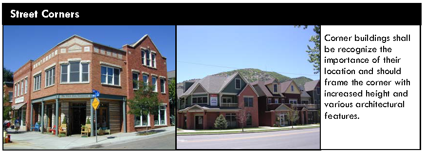
5.
Pedestrian environment.
a.
Site design shall locate pedestrian routes connecting residential, recreational, and commercial uses to minimize contact with normal vehicular traffic. This can be achieved by designing crossings at traffic stop points, and/or by announcing crossings with signage, pavement changes, and landscape features.
b.
Pedestrian use can be increased by the addition of amenities such as benches, drinking fountains, planters, trash receptacles, path lighting, and bicycle racks.
c.
When existing sidewalks, curbs, gutters, or other public improvements have deteriorated, the development shall be required to replace and/or repair the public amenities.
d.
New development required to install sidewalks may be assessed an in lieu fee for pedestrian improvements, as determined appropriate by the Director and Town Engineer, to mitigate the construction of certain pedestrian improvements.
e.
When sidewalks exist or are proposed, new development should be sited and designed to encourage human activity on the street.
f.
Construction of and/or land dedication for pedestrian improvements may be required pursuant to the subdivision/development regulations and/or development improvement agreement.
B.
Building design.
1.
Building massing and form. Unless otherwise provided in this Land Use Code, building form may vary widely, as long as certain features of building form are considered:
a.
Within the development, variability in size and shape of buildings shall occur.
b.
Incorporating human-scaled features at the ground level, referred to as "differentiation of ground level," will help to encourage pedestrian use. Examples are: articulated entries and windows, canopies, arcades, recessed entries, changes in color, material, or texture.
c.
Façade modulation shall be utilized to reduce the apparent bulk of a large building, where applicable.
d.
Large, unbroken expanses and long, continuous rooflines shall be avoided.
2.
Exterior building materials.
a.
Unless otherwise provided in this Land Use Code, a wide range of exterior building siding materials is acceptable, including, but not limited to wood, brick, stone, (metal) and stucco.
b.
Materials appearing to derive from local natural settings, such as timber and native stone, are strongly encouraged.
c.
The use of multiple exterior siding materials, siding textures and/or architectural wall features is required.
d.
Metal may be used on the exterior of buildings for architectural features. Metal may be used as an architectural feature covering no more than thirty-five (35) percent of any building façade, unless the decision-making body determines that additional metal in the design creates a high-quality or unique building design that meets the purpose and intent of the standards in this section. Metal roofs are allowed and are exempt from the limitation on percentage of metal.
e.
Wainscot treatments are encouraged and should generally be a minimum of three (3) feet in height, not to exceed four (4) feet in height.
f.
Vinyl and plastic may be considered for sign letters only.
3.
Architectural style. The architectural character of new buildings or additions shall complement the architectural character of adjacent existing buildings.
4.
Four-sided design. All building façades shall be designed with a similar level of design detail. Blank walls void of architectural detailing shall not be permitted. Exceptions may be granted for those areas of the building envelope that the applicant can demonstrate are not visible from adjacent development, public rights-of-way, trails, or the San Juan River.
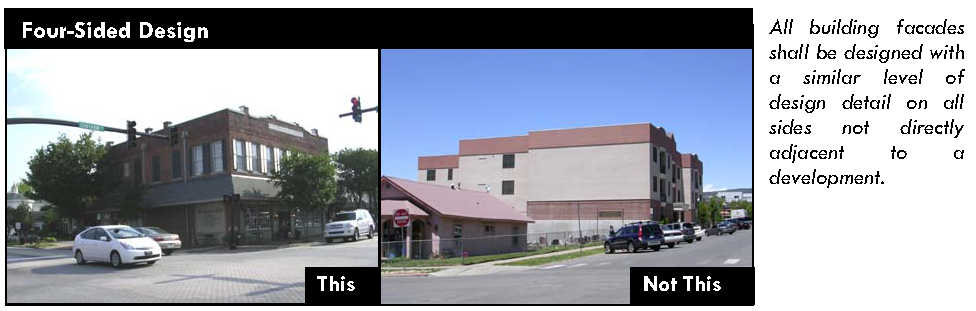
5.
Entrance visibility. Entrances shall be clearly delineated and visible from the street.
a.
Buildings should be designed with delineated and unobstructed entries accessible from adjacent streets, as opposed to entries accessible only from parking lots.
b.
When entries cannot be located adjacent to the street, delineated and unobstructed pathways using building and landscape elements should enhance building entries.
6.7.4. ADDITIONAL STANDARDS: PROPERTIES WITH HIGHWAY 160 OR HIGHWAY 84 FRONTAGE
A.
Applicability. Development of any structure that will contain a use categorized in Table 4.1-1, Table of Allowed Uses, as a commercial use, or a mix of commercial and other uses, and that has frontage along either Highway 160 or Highway 84, shall comply with the general site layout and building design standards of Sections 6.7.3. above, plus the standards of this Section.
B.
Setbacks.
1.
Highway landscape buffer. All development shall be buffered from Highway 160 or Highway 84 by a landscaped area a minimum of 40 feet deep, measured from the property line. Buildings and parking areas shall not be located in this buffer area. On sites with severe topographic constraints, this landscaped buffer may be reduced at the discretion of the Director.
C.
Building orientation.
1.
Uses with highway frontage shall have a strong internal focus, rather than a highway orientation. Entryways shall face towards the internal road system. A highway orientation will be permitted where lot depths make it difficult to achieve an internal focus.
2.
Developers shall carefully consider building orientation to achieve effective overall site planning. Although legibility of signs identifying businesses from the highway is important, buildings shall be oriented towards focal points within the development itself. These focal points may include unique natural features, a building of central importance, internal streets, or planned open space.
3.
Adjacent residential land uses shall be considered when orienting buildings on properties with highway frontage. Service and utility entrances, mechanical support facilities, and unimproved building "back sides" shall not be located within view of neighboring residences or visible from highway right-of-way. Service and utility courts or alleys may contain these necessary support functions.
D.
Access. Coordinated access points along Highway 160 and Highway 84 will be required in accordance with CDOT requirements. Location and design of these highway accesses will be based on projected traffic flows and CDOT guidelines
6.7.5. ADDITIONAL STANDARDS: MIXED-USE TOWN CENTER DISTRICT (INCLUDING ODB AND ODE OVERLAY DISTRICTS)
A.
Purpose. These standards are intended to preserve and enhance the unique character and identity of downtown Pagosa Springs and ensure that future infill and redevelopment is consistent with the Town's Downtown Master Plan. A high-quality appearance will be achieved through requirements for context-sensitive site layouts, architectural detailing, façade articulation, and other features designed to provide a more distinct character and pedestrian scale. Unique characteristics and distinctions in scale and use between the ODB and ODE overlay districts will be achieved through tailored standards as necessary. The alternative equivalent compliance process in Section 6.1.2 is available to help tailor standards for specific sites as necessary.
B.
Applicability. Development of any structure that will contain a use categorized in Table 4.1-1, Table of Allowed Uses, as a commercial use, or a mix of commercial and other uses, and that is located within the Mixed Use-Town Center district, shall comply with the general site layout and building design standards of Sections 6.7.3. above, plus the standards of this Section.
C.
Site planning.
1.
Primary entrances. Primary entrances shall be oriented towards and visible from the primary street frontage, and the San Juan River where applicable.
2.
Outdoor gathering spaces. Developments of at least twenty-five thousand (25,000) square feet in size shall incorporate outdoor gathering spaces. Outdoor gathering spaces may include, but are not limited to, plazas, mini-parks, or courtyards that are open to and accessible to the public.
a.
Minimum size. All outdoor gathering spaces shall have a minimum depth and width of twenty (20) feet and a minimum total area of one thousand (1,000) square feet.
b.
Pedestrian amenities. Outdoor gathering spaces shall include amenities that encourage pedestrian activity, such as benches, water features, drinking fountains, planters, public art, trash receptacles and bicycle racks.
3.
Parking location. Surface parking shall be located behind buildings. Surface parking will not be permitted between the building and the primary street frontage or to the side of the building where it may be viewed from the primary street frontage.
a.
Parking within the ODB and ODE Districts. Parking within the ODB and ODE districts shall be provided on-site along the alley frontage at a minimum of one (1) space per ten (10) lineal feet of alley frontage. Off-Street parking requirements contained in Table 6.9-1 shall otherwise be waived with the exception that all residential and lodging uses shall provide off-street parking as required in Section 6.9. New curb cuts accessed from Pagosa Street and San Juan Street shall be prohibited unless an alley is not available for access.
4.
Ground-floor uses. The incorporation of retail shops and/or restaurants is encouraged at the street level to promote a more active environment for pedestrians and to support office uses located within the same building (on upper floors) or nearby. Multifamily and townhome residential units shall not be permitted on the ground level along the street frontage. This configuration of uses is particularly encouraged along Pagosa Street, Lewis Street, San Juan Street, Highway 160, and other downtown street frontages, as well as adjacent to major public spaces, such as along the San Juan River, where a high level of activity and visibility is desirable. If a limited portion of a structure's ground level will be devoted to retail or restaurant space, such space should be located along those facades adjacent to or most visible from primary street frontages or major pedestrian walkways.
5.
Build-to line (ODB Overlay District). First floors of all buildings within the ODB Overlay District shall "build to" the back of the sidewalk or edge of property. Exceptions to the build-to line may be permitted if:
a.
The space set back from the build-to line is used for an outdoor gathering space, as defined in Section 6.7.5.C.2, above;
b.
The space set back from the build-to line is designed as a protected walkway for pedestrians, with the second floor placed at the build-to line; or
c.
The space set back from the build-to line is used to provide a mid-block pedestrian connection to an outdoor gathering space provided at the rear of the building, to the San Juan River, or to an adjacent trail corridor. Mid-block pedestrian connections shall be a minimum of fifteen (15) feet in width.
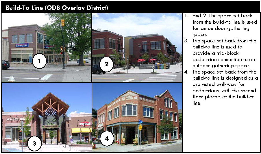
6.
Build-to zone (ODE Overlay District).
a.
A variable setback is typical of the East Village; therefore, placement of the front building façade is guided by a flexible Build-To Zone as set forth below.
(i)
First floors of all buildings within the ODE Overlay District shall build to the "build-to-zone," which shall be the area located from fifteen (15) to twenty (20) feet from the back of sidewalk or property line.
b.
The front building façade may only be located outside of the Build-To Zone to:
(i)
Reflect existing, adjacent development (in which case buildings shall be built to the average setback of the adjacent existing structures);
(ii)
Accommodate an outdoor gathering space, as defined in Section 6.9.5.C.2, above;
(iii)
Reflect the regular rhythm of residential homes interrupted by side yards traditionally found in the East Village;
(iv)
Reflect distinctions in use within the building; or
(v)
Accomplish a similar objective, as approved by the Director and/or Design Review Board.
c.
Portions of the front façade of the building built that are not located within the build-to zone shall:
(i)
Not extend further than five (5) feet from the build-to zone; and
(ii)
Be limited to twenty (20) feet in length or twenty (20) percent of the length of the front façade, whichever is less.
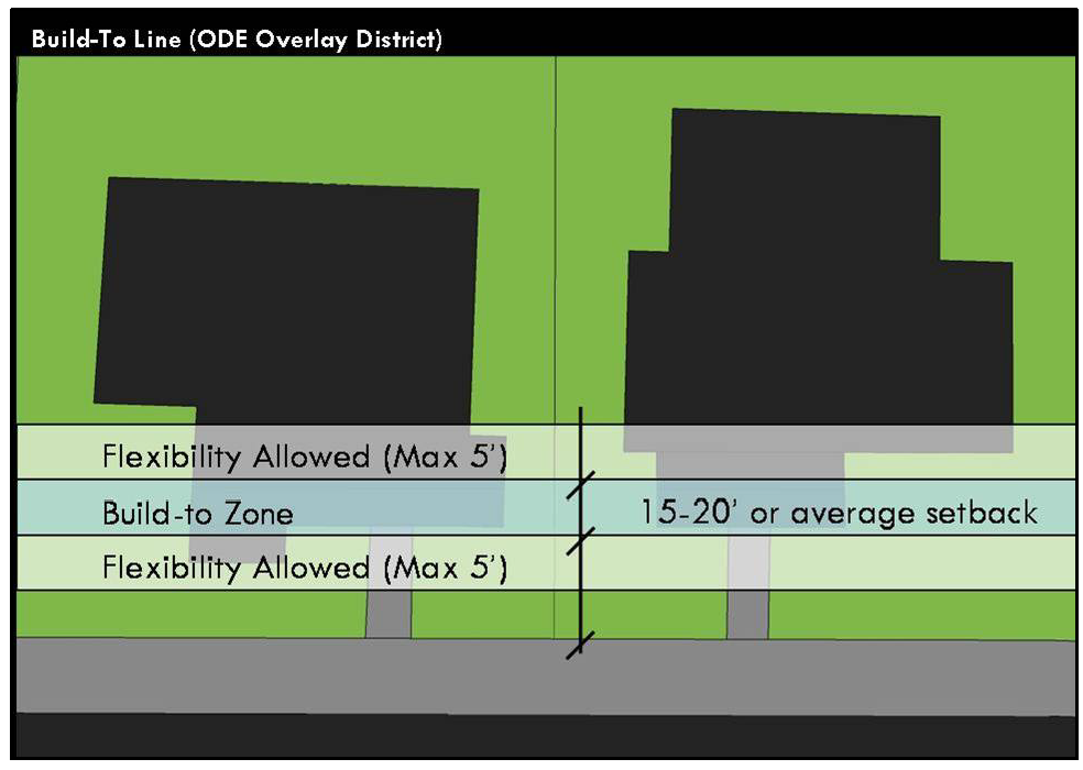
D.
Building considerations.
1.
Building articulation. The perceived mass and scale of downtown development shall be reduced to achieve a human scale. This shall be accomplished by incorporating a series of smaller design elements that are consistent with the development's architectural character. Appropriate design elements for every development shall incorporate, but are not limited to, at least four (4) of the following:
a.
Variations in roof form and parapet heights;
b.
Pronounced recesses and projections;
c.
Wall plane off-sets;
d.
Off-sets to accommodate outdoor gathering spaces;
e.
Distinct changes in texture and color of wall surfaces;
f.
Ground-level arcades and second or third-floor galleries/balconies;
g.
Protected and recessed entries; and
h.
Vertical accents or focal points.

2.
Building height/mass. A single, large, dominant building mass shall be prohibited. In addition to the requirements for building articulation, above, the following shall be required:
a.
ODB Overlay District. Building mass and height above the second floor shall be terraced back from the street, and from the San Juan River corridor where applicable.
b.
ODE Overlay District. Building mass and height above the second floor shall be terraced back from the street and/or completely contained beneath the slope of the roofline with dormers or sheds.
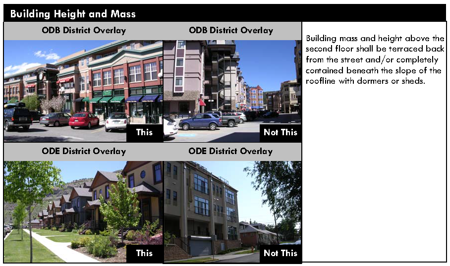
3.
Lot consolidation. The consolidation of existing lots is permitted to enhance infill and redevelopment opportunities; however, the following standards shall apply for developments occupying two (2) or more combined lots.
a.
ODB Overlay District. Façade modulation shall be provided to reflect traditional storefront widths within the downtown core, which range from twenty-five (25) to fifty (50) feet in width.
b.
ODE Overlay District. Façade modulation shall be provided to reflect the traditional residential lot widths found in the East Village, which are typically fifty (50) feet in width.
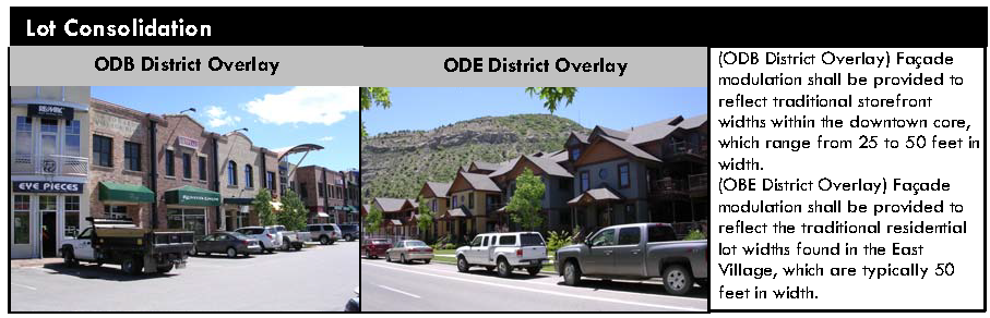
4.
San Juan River frontage. Buildings with frontage along a primary street frontage and the San Juan River shall be designed to have two (2) "front" façades in order to promote pedestrian activity in both locations.
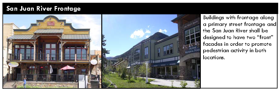
5.
Building design and character.
a.
Roof form.
(i)
ODB Overlay District. Flat roof forms with parapet walls are traditionally found in the ODB district. Due to Pagosa's varied topography, many roofs will be highly visible at a distance. Large, unbroken expanses and long, continuous rooflines shall be prohibited.
(ii)
ODE Overlay District. Box-like structures and flat roofs are incompatible with the traditionally residential character found in the East Village. The following standards shall apply:
(1)
A variety of roof forms and surfaces (pitched, shed, and dormers) shall be incorporated into structures to break up large roof planes, provide visual interest, and manage snow loads.
(2)
Flat roof sections shall be limited to a maximum of one-third (⅓) of the total roof area and shall be located where they are not visible from the primary street frontage or public right-of-way.
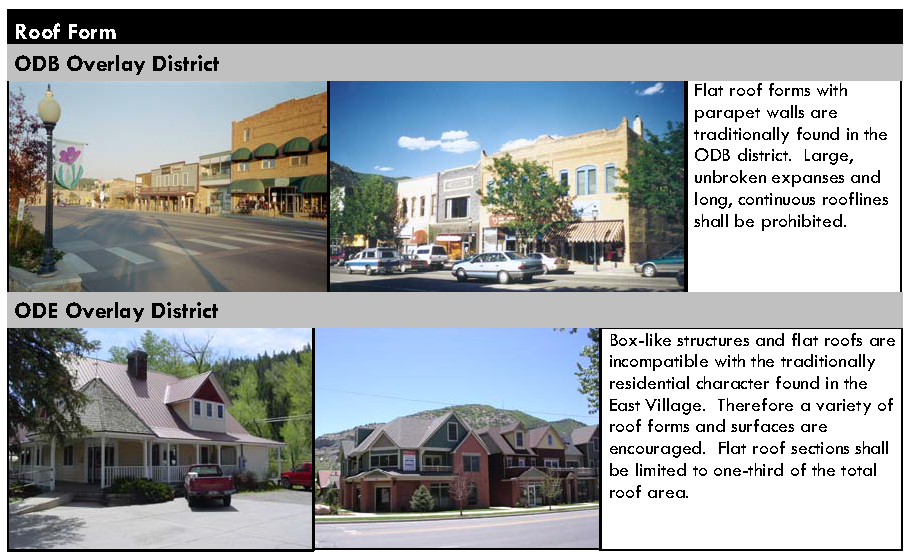
b.
Materials. Primary building materials shall be durable and project an image of permanence typical of the Downtown Core's traditional masonry storefronts and many of the East Village's historic residences. Appropriate materials include, but are not limited to:
(i)
Brick, stone, or other masonry products;
(ii)
Steel (may be used for accents only);
(iii)
Stucco;
(iv)
Cast concrete;
(v)
Split face block;
(vi)
Composite siding; or
(vii)
Comparable material approved by the Director.
c.
Color.
(i)
The use of historic color schemes in the ODB and ODE Overlay Districts is encouraged. Historic color palettes are provided in Appendix D of the Town's Design Guidelines for the Historic Business District and Local Landmarks.
(ii)
Bright colors shall be limited to use for accents and decorative details such as window details, storefronts and entrances.
d.
Awnings. Awnings shall be designed as integral elements of the building façade. Material, configuration, dimension, and location of awnings shall be appropriate for the building.
6.
Street level transparency. A minimum percentage of the total area of each ground-floor building façade that faces a street, plaza, park, or other public space, shall be comprised of transparent window openings to allow views of interior spaces and merchandise, to enhance the safety of public spaces by providing direct visibility to the street, and to create a more inviting environment for pedestrians. Such openings shall be taller than they are wide. Minimum percentages vary by location and use as follows:
a.
ODB Overlay District. Non-residential uses: Fifty (50) percent minimum.
b.
ODE Overlay District. Non-residential uses: Forty (40) percent minimum.
For the purposes of the above standard, all percentages shall be measured using elevation views of the building plan and "ground floor" shall be measured from floor plate to floor plate.
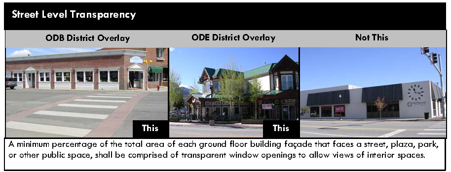
6.7.6. ADDITIONAL STANDARDS: OHSB OVERLAY DISTRICT
A.
Applicability. Development of any structure that will contain a use categorized in Table 4.1-1, Table of Allowed Uses, as a commercial use, or a mix of commercial and other uses, and that is located within the OHSB district, shall comply with the general site layout and building design standards of Sections 6.7.3. above, plus the standards of this Section.
B.
Build-to line. First floors of all commercial buildings in this overlay zone shall be placed at the build-to line established at fifty (50) feet from the R.O.W. center line along Hot Springs Boulevard, and at forty (40) feet from the center line on collector streets intersecting Hot Springs Blvd. Exceptions to the build-to line may be permitted if:
1.
The space set back from the build-to line is used for an improved public space such as a courtyard, plaza, patio, or garden between the building and the sidewalk. Such an area shall have landscaping, low walls, fencing, railings, a tree canopy, pedestrian amenities, and/or other similar site improvements designed for pedestrian interest, comfort and visual continuity.
2.
The space set back from the build-to line is designed as a protected walkway for pedestrians, with the second floor placed at the build-to line.
3.
The space set back from the build-to line is used as a recessed entry.
C.
Building height/mass. A single, large, dominant building mass is prohibited.
1.
Building mass shall be terraced back from the street on second and third stories.
2.
Variation in mass shall be related to entrances, the integral structure, and/or the organization of interior spaces and activities and not merely for cosmetic effect. False fronts or parapets create an insubstantial appearance and are prohibited.
3.
Horizontal mass shall not exceed a height to width ratio of 1:2 without substantial variation in mass that includes a change in height and a projecting or recessed element.
D.
Parking location.
1.
Parking lots on Hot Springs Boulevard. Buildings shall be sited so that parking lots are located in interior block locations with no frontage on Hot Springs Boulevard.
2.
Parking lots on collector and minor streets. Parking lots and vehicular use areas on collector and minor streets may occupy no more than fifty (50) percent of the block's street frontage and shall be screened by a landscaped area at least six (6) feet in width.
E.
View corridors. The North Range view corridor from Hot Springs Boulevard is a uniquely valuable attribute of this neighborhood, and shall be preserved to the greatest extent feasible. Views of the San Juan River and the wetlands should be preserved and visual access shall be maintained and enhanced whenever practicable.
6.7.7. ADDITIONAL STANDARDS: BUILDINGS 18,000 SQUARE FEET IN SIZE AND GREATER
A.
Applicability. Development of any building that will be eighteen thousand (18,000) square feet in size or greater shall comply with the general site layout and building design standards of Sections 6.7.3. above, plus the standards of this Section.
B.
Setbacks. The required setbacks shall comply with the setbacks in Article 5 of this Land Use Code. Reduced building setbacks may be approved by the Design Review Board if the overall design of the building reflects an "urban" style building form and site design (e.g., connected sidewalks, on-street parking, benches, display windows, awnings, etc).
C.
Building height, bulk, scale. Buildings should be visually harmonious with their surroundings, by considering the scale, proportions and character of adjacent structures and landforms. The design of a new building or addition should incorporate architectural features, elements and details to achieve human scale, if appropriate. Building elements that should be enlisted to achieve a better human scale include:
1.
Pedestrian-oriented open space, such as courtyards or other unified landscaped areas, upper story setbacks, a porch or cover entry, awnings, limited signage, and street furniture.
D.
Architectural elements, materials and color.
1.
Architectural elements.
a.
Buildings should be unique and appropriate to the community and should not be recognizable by its architecture as a standard trademark design. Generic franchise architecture shall not be acceptable.
b.
Box-like structures and flat roofs are discouraged.
c.
Roof forms will be highly visible at a distance, and projects shall avoid large, unbroken expanses and long, continuous rooflines by variation in rooflines and height. The addition of dormers, balconies, deep eaves and overhangs may create visual interest.
2.
Materials. The use of neon is prohibited for any architectural application, such as building trim. See Section 6.12 for the standards relating to the use of neon in signs.
3.
Color. Attention must be paid to the use of color on buildings as it affects the visual aesthetics of the town.
a.
Bright colors should be used minimally and may be considered only for accents and decorative details such as window details and entrances.
b.
Colors should be used to coordinate the entire building façade as a composition.
(Ord. No. 754, § 1, 5-20-2010; Ord. No. 822, § 1, 2-19-2015; Ord. No. 950, § 1, 6-1-2021; Ord. No. 957, § 1, 9-7-2021)
6.8. - MULTI-FAMILY AND TOWNHOME RESIDENTIAL DESIGN STANDARDS
6.8.1. PURPOSE
The purpose of these standards is to ensure that multi-family and townhome developments exhibit creativity and variety in design features to avoid the creation of bleak, monotonous streetscapes and neighborhoods.
6.8.2. APPLICABILITY
These standards shall be applicable to all multi-family and townhome development.
6.8.3. SITE PLANNING
A.
Building orientation. The primary entrance and façade of individual buildings within a multi-family or townhome development shall be oriented towards:
1.
Primary internal or perimeter streets, or
2.
Common open space, such as interior courtyards, parks, or on-site natural areas or features with a clearly defined and easily accessible pedestrian circulation system.
Primary entrances and façades shall not be oriented towards parking lots, garages, or carports. No primary access shall be located more than two hundred (200) feet from public right-of-way including a street or sidewalk.
B.
Pedestrian connections. An on-site system of pedestrian walkways shall be designed to provide direct access and connections to and between the following:
1.
The primary entrance or entrances to each multi-family or townhome building;
2.
To any sidewalks or walkways on adjacent properties that extend to the boundaries shared with the multi-family or townhome development;
3.
Any sidewalk system along the perimeter streets adjacent to the multi-family or townhome development;
4.
Any adjacent commercial land uses, including but not limited to retail shopping centers, office buildings, restaurants, or personal service establishments; and
5.
Any adjacent or on-site public park, trail system, open space area, greenway, or other public or civic use including but not limited to schools, places of worship, public recreational facilities, or government offices.
C.
Garage placement and design.
1.
General. The use of alley or side-loaded garages, or the use of a combination of garage orientations is encouraged where practicable.
2.
Freestanding common garages, carports, parking lots.
a.
To the maximum extent feasible, garage entries, carports, and parking lots, shall be internalized in building groupings or located away from street frontages.
b.
Parking lots and freestanding common garages and carports shall not occupy more than thirty (30) percent of each perimeter public street frontage
c.
To the maximum extent practicable, freestanding common garages and carports that are visible from perimeter public streets shall be sited perpendicular to the perimeter street in order to reduce visual impacts on the streetscape.
d.
Freestanding common garages and carports shall be limited to sixty (60) feet in length unless second-floor residential units are incorporated above them, in which case they shall be limited to eighty (80) feet in length.
e.
Detached common garages and carports shall incorporate compatible materials, scale, colors, architectural details, and roof slopes similar to those of the primary multi-family or townhome buildings.
3.
Front-loading garages.
a.
Garages that protrude towards the street in front of the primary façade of the primary structure shall not be permitted. Garage doors on all front-loading (street-oriented) garages shall be either:
(i)
Recessed a minimum of four (4) feet behind the front façade of the dwelling portion of the structure (including side-loading garages), or a front porch that is at minimum of five (5) feet wide by eight (8) feet long; or
(ii)
Recessed a minimum of two (2) feet beneath a second floor bay.
b.
A straight run of more than two (2) garage doors (street-oriented) is not permitted. Banks of more than two (2) garage doors must be interrupted by an entry to the building.
4.
Garage door color. Darker accent colors shall be utilized on garage door surfaces to minimize their visual prominence—particularly for hillside and riverfront properties. White or other highly reflective colors shall not be permitted on garage doors.
6.8.4. BUILDING DESIGN
A.
Four-sided design. All sides of a multi-family building shall display a similar level of quality and architectural detailing. The majority of a building's architectural features and treatments shall not be restricted to a single façade. Building details, including roof forms, windows, doors, trim, and siding materials, shall reflect the architectural style of the building.
B.
Façade articulation. Blocky, uniform façades are prohibited. The façades of all multi-family buildings shall be articulated through the incorporation of three (3) or more of the following:
1.
Balconies,
2.
Bay or box windows,
3.
Insets or other relief in the wall plane,
4.
Porches,
5.
Dormers,
6.
Variations in materials; or
7.
Variations in roof forms.
C.
Roof form. The incorporation of a variety of roof forms is strongly encouraged. Generally, multi-family buildings shall incorporate roof pitches of between 3:12 and 12:12; however, alternative roof forms or pitches may be allowed for small roof sections over porches, entryways, or similar features.
D.
Multi-building developments. Multi-family developments with more than three (3) buildings shall incorporate more than one (1) distinction among building designs. Distinct building designs shall be easily distinguished through a minimum of two (2) of the following:
1.
A variation in length of thirty (30) percent or more;
2.
A variation in the footprint of the building of thirty (30) percent or more;
3.
A distinct variation in color and use of materials;
4.
A variation in the type of dwelling unit contained in the building that results in a significantly different scale and mass (i.e., apartments vs. townhomes or duplexes); or
5.
A distinct variation in building height and roof form.
6.9. - PARKING AND LOADING
6.9.1. INTENT
These requirements are intended to establish orderly, safe, and efficient vehicular parking, circulation and access on adjoining thoroughfares within developments.
6.9.2. APPLICABILITY
A.
Generally.
1.
The off-street parking and loading standards of this Section shall apply to all parking lots and parking structures accessory to any building constructed and to any use established in every district.
2.
The requirements of this Section shall apply to all temporary parking lots and parking lots that are the principal use on a site.
B.
Expansions and enlargements and changes in use. The off-street parking and loading standards of this Section shall apply when an existing structure or use is expanded or enlarged, or when there is a change in use. Additional off-street parking and loading spaces shall be required to serve the enlarged or expanded area or the new use, provided that in all cases the number of off-street parking and loading spaces provided for the entire use (pre-existing plus expansion) must equal one hundred (100) percent of the minimum ratio established in this Section.
6.9.3. OFF-STREET PARKING REQUIREMENTS
A.
Schedule A. Unless otherwise expressly stated in this Land Use Code, off-street parking spaces shall be provided in accordance with Table 6.9-1, Off-Street Parking Schedule A.
B.
Schedule B. Uses subject to Off-Street Parking Schedule B, as indicated in Table 6.9-1 shall provide the minimum number of off-street parking spaces listed in Table 6.9-2 below. Unless otherwise approved, lots containing more than one (1) activity shall provide parking and loading in an amount equal to the total of the requirements for all activities.
C.
Schedule C. Uses that reference "Schedule C" in Table 6.9-1 have widely varying parking and loading demand characteristics, making it impossible to specify a single off-street parking or loading standard. Upon receiving a development application for a use subject to Schedule C standards, the Building Official and the Director shall apply the off-street parking and loading standard specified for the listed use that is deemed most similar to the proposed use or establish minimum off-street parking requirements on the basis of a parking and loading study prepared by the applicant. Such a study shall include estimates of parking demand based on recommendations of the Institute of Transportation Engineers (ITE), or other acceptable estimates as approved by the Director, and should include other reliable data collected from uses or combinations of uses that are the same as or comparable with the proposed use. Comparability will be determined by density, scale, bulk, area, type of activity, and location. The study shall document the source of data used to develop the recommendations.
D.
Maximum number of spaces permitted.
1.
General maximum requirement. For any use categorized as a "Commercial" or "Industrial" use in Table 4.1-1, Table of Allowed Uses, off-street vehicle parking spaces shall not be provided in an amount that is more than one hundred twenty-five (125) percent of the minimum requirements established in Table 6.9-1, Off-Street Parking Schedule A.
2.
Exceptions.
a.
If application of the maximum parking standard would result in less than six (6) parking spaces, the development shall be allowed six (6) parking spaces.
b.
For the purpose of calculating parking requirements, the following types of parking spaces shall not count against the maximum parking requirement, but shall count toward the minimum requirement:
(i)
Accessible parking;
(ii)
Vanpool and carpool parking;
(iii)
Structured parking, underground parking, and parking within, above, or beneath the building(s) it serves.
For the purpose of calculating parking requirements, fleet vehicle parking spaces shall not count against either the minimum or maximum requirements.
c.
Exceptions to the maximum parking requirement may be allowed in situations that meet all of the following criteria as determined by the Director:
(i)
The proposed development has unique or unusual characteristics such as high sales volume per floor area or low parking turnover, which create a parking demand that exceeds the maximum ratio and which typically does not apply to comparable uses; and
(ii)
The parking demand cannot be accommodated by on-street parking, shared parking with nearby uses, or by increasing the supply of spaces that are exempt from the maximum ratio; and
(iii)
The request is the minimum necessary variation from the standards; and
(iv)
If located in a mixed-use district, the uses in the proposed development and the site design are highly supportive of the mixed-use concept and support high levels of existing or planned transit and pedestrian activity.
E.
Computation of parking and loading requirements.
1.
Fractions. When measurements of the number of required spaces result in a fractional number, any fraction shall be rounded up to the next higher whole number.
2.
Multiple uses. Lots containing more than one (1) use shall provide parking and loading in an amount equal to the total of the requirements for all uses.
3.
Area measurements. Unless otherwise specified, all square footage-based parking and loading standards shall be computed on the basis of gross floor area of the use in question. Structured parking within a building shall not be counted in such measurement.
4.
Computation of off-street parking. Required off-street loading space shall not be included as off-street parking space in computation of required off-street parking space.
5.
Parking for unlisted uses. Parking requirements for uses not specifically listed in Table 6.9-1 shall be determined by the Director based on the requirements for the closest comparable use, as well as on the particular parking demand and trip generation characteristics of the proposed use. The Director may alternately require the submittal of a parking demand study that justifies estimates of parking demand based on the recommendations of the Institute of Transportation Engineers, and includes relevant data collected from uses or combinations of uses that are the same or comparable to the proposed use in terms of density, scale, bulk, area, type of activity, and location.
6.9.4. PARKING AREA LAYOUT AND DESIGN
A.
Stall dimensions.
1.
Parking stall and aisle dimensions shall be measured from the middle of the stall stripe of a parking stall to the middle of the adjacent stall stripe. Aisles for two-way flows shall be a minimum of twenty-four (24) feet, except when no spaces are backing onto the aisle, in which case width shall be twenty (20) feet.
2.
One (1) universally accessible, ADA-compatible, space shall be provided in each parking lot in compliance with the adopted building code, and as set forth in the following table:
3.
In parking lots of twenty (20) spaces or more, special considerations will be made for compact car spatial dimensions.
4.
The following standards may be used as guidelines for the design of indoor and outdoor parking stalls:
*—7.0' on local roads may be acceptable with approval by Town Engineer.
B.
Parking area layout.
1.
Surface. All parking and driveway areas and primary access to parking facilities shall be surfaced with asphalt, concrete or other similar materials, unless otherwise approved by the Town Engineer. Accent paving is recommended to indicate pedestrian linkages.
2.
Integrate parking lots with surroundings. Parking lots shall not dominate the frontage of pedestrian-oriented streets, interfere with designated pedestrian routes, or negatively impact surrounding neighborhoods. The pedestrian character of streets and building shall be maximized through continuity of building and landscape frontage.
3.
Design standards. All parking lot placement and design shall comply with the applicable standards in Sections 6.7, Commercial and Mixed-Use Design Standards, and 6.8, Multi-Family Residential Design Standards.
4.
Lot size. Required parking shall be broken into component parking lots, avoiding large, unrelieved expanses of paving.
C.
Landscaping. A landscaped buffer zone of five (5) to ten (10) feet may be required between the actual parking area, major arterial, or major pedestrian route. Additionally, in areas that provide parking for more than ten (10) vehicles, at least ten (10) percent of the total area of the parking lot shall be used for landscaping and/or aesthetic treatment. The following landscaping standards shall be met:
1.
A minimum of one (1) tree (generally planted in landscaped islands) for every five (5) parking spaces shall be located within the parking area/lot.
2.
Tree islands shall be installed intermittently and have a length equal to the adjacent parking stalls, contain sufficient area to protect plantings from vehicles and foot traffic and accommodate a tree root system with a clear area of earth not less than three (3) feet in width.
3.
All unimproved earth areas shall be planted, restored, or otherwise protected from erosion.
4.
Ongoing maintenance, including the replacement of dead or unhealthy plants, shall be provided by the parking area owner/leaseholder.
D.
Parking for single-family residential dwelling units. This Land Use Code requires two (2) parking spaces per single-family residential dwelling unit. The on-street parking lane at each lot's street frontage may fulfill the requirement for one (1) parking space, with driveway and garage meeting the additional requirement. Driveways and garage entrances from interior block alleys are preferred.
E.
Shared access. Wherever feasible, parking lots shall share access lanes.
F.
Circulation area design. Circulation for parking areas intended to accommodate twenty (20) vehicles or more shall be designed to facilitate the safe movement of vehicles without posing a danger to pedestrians or impeding the function of the parking area. Parking lots that accommodate twenty (20) or more vehicles must maintain continuous circulation patterns, with no dead-ends, and safe access to public streets.
G.
Lighting and maintenance. All parking area lighting shall comply with the Town's lighting requirements and provide adequate lighting for safety if night use is intended. Parking lots should provide adequate security and should limit visual clutter, parking lot signs, and equipment.
H.
Drainage. All parking areas shall have adequate drainage as determined by a drainage report.
I.
Loading/unloading areas. The Town requires all new and substantially remodeled commercial and industrial developments to provide adequate loading and unloading zones. The loading/unloading zones must be illustrated on the parking plan submitted for approval. Loading and unloading areas shall not impede major roads, highways, intersections, or other paths of travel. Also, these zones must be located away from areas where there is heavy pedestrian travel unless such areas cannot be avoided, as in the Mixed-Use Town Center District.
6.9.5. PARKING ALTERNATIVES
The Director may approve alternatives to providing the number of off-street parking spaces required by Table 6.9-1, in accordance with the following standards.
A.
Shared parking. The Director may approve shared parking facilities for developments or uses with different operating hours or different peak business periods if the shared parking complies with all of the following standards:
1.
Location. Every shared parking space shall be located no farther than six hundred (600) feet from the entrance to each building for which the shared parking is provided (measured along the shortest legal pedestrian route).
2.
Zoning classification. Shared parking areas shall be located on a site with the same or a more intensive zoning classification than required for the primary uses served.
3.
Shared parking study. Those proposing to use shared parking as a means of satisfying off-street parking requirements shall submit a shared parking analysis to the Town that clearly demonstrates the feasibility of shared parking. The study shall be provided in a form established by the Director and shall be made available to the public. It shall address, at a minimum, the size and type of the proposed development, location of required parking, the composition of tenants, the anticipated rate of parking turnover, and the anticipated peak parking and traffic loads for all uses that will be sharing off-street parking spaces. The applicant shall also demonstrate that any parking reduction requested as part of the shared parking study will not result in the spillover of parking onto other properties. The study shall utilize the Urban Land Institute shared parking methodology to calculate temporal and locational parking reductions.
4.
Agreement for shared parking. The parties involved in the joint use of off-street parking facilities shall submit a written agreement in a form to be recorded for such joint use, approved by the Director as to form and content. The agreement shall provide for the maintenance of jointly used facilities. The Director may impose such conditions of approval as may be necessary to ensure the adequacy of parking in areas affected by such an agreement. Recordation of the agreement shall take place before issuance of a building permit for any use to be served by the shared parking area. A shared parking agreement may be revoked only if all required off-street parking spaces will be provided in accordance with the requirements of this Land Use Code.
B.
Off-site parking. The Director may approve the location of required off-site parking spaces on a separate lot from the lot on which the principal use is located if the off-site parking complies with all of the following standards:
1.
Location. No off-site parking space may be located more than six hundred (600) feet from an entrance to the use being served (measured along the shortest legal pedestrian route). Off-site parking spaces shall be connected to the use by acceptable pedestrian facilities. Off-site parking spaces may not be separated from the use served by a street right-of-way with a width of more than eighty (80) feet, unless a grade-separated pedestrian walkway, a traffic signal, a shuttle bus, or other traffic control device or remote parking shuttle bus service is provided.
2.
Control of site. Required parking spaces for residential uses must be located on the site of the use or within a tract owned in common by all the owners of the properties that will use the tract.
3.
Ineligible activities. Required parking spaces for persons with disabilities may not be located off-site.
4.
Agreement for off-site parking. In the event that an off-site parking area is not under the same ownership as the principal use served, a written agreement between the record owners shall be required, approved by the Director as to form and content. The agreement shall guarantee the use of the off-site parking area for a minimum period of at least twenty (20) years. The Director may impose such conditions of approval as may be necessary to ensure the adequacy of parking in areas affected by such an agreement. An attested copy of the agreement between the owners of record shall be submitted to the town for recordation in a form acceptable by the Town Attorney. Recordation of the agreement shall take place before issuance of a building permit for any use to be served by the off-site parking area. An off-site parking agreement may be revoked only if all required off-street parking spaces will be provided in accordance with the requirements of this Land Use Code.
C.
On-street parking. On-street parking spaces in the right-of-way along the property line, between the two (2) side lot lines of the site, may be counted to satisfy the minimum off-street parking requirements, if approved by the Director.
D.
District parking. Minimum required off-street parking spaces may be waived or reduced for properties within the boundaries of a public parking or local improvement district that provides district-wide parking facilities, based on the projected parking demand to be addressed by the district-wide facility.
E.
Stacked, tandem, and valet parking. Stacked, tandem, or valet parking for nonresidential uses is allowed if an attendant is present to move vehicles. In addition, a guarantee acceptable to the town shall be filed with the town ensuring that a valet parking attendant shall always be on duty when the parking lot is in operation. For residential uses, tandem or stacked vehicle parking may be allowed.
F.
Structured parking.
1.
Maximum parking waiver. Where seventy-five (75) percent or more of the parking accessory to a use is in structured parking, there shall be no maximum cap on the number of parking spaces.
2.
Credit for nearby public structured parking. Spaces available in public parking structures located within one thousand (1,000) feet of the subject use may be counted toward the total amount of required off-street parking.
3.
Density bonus for underground parking in the commercial and mixed-use districts. A density bonus shall be granted for underground parking structures in the commercial and mixed-use districts. The bonus shall be granted at a ratio of 0.01 du/gross acre of additional bonus density for each one hundred (100) square feet of structured parking that is underground.
G.
Sites in mixed-use districts. In the mixed-use districts, the total requirement for off-street parking facilities shall be the sum of the requirements for the various uses computed separately, subject to the modifications set forth below.
1.
All uses within MU districts shall be eligible for a twenty (20) percent parking reduction to reflect the reduced automobile use associated with mixed-use developments.
2.
A ten (10) percent parking reduction for multifamily residential dwellings may be allowed if the proposed use is located within three hundred (300) feet of a transit stop with midday service headways of thirty (30) minutes or less in each direction.
3.
For non-residential uses, the minimum parking requirement may be reduced ten (10) percent if the use incorporates a transit stop that meets minimum design standards established by the Town to ensure ready access to users and is compatible with the design and materials of the non-residential use of which it is associated.
4.
A ten (10) percent parking reduction for developments that include bicycle parking at a minimum ratio of five (5) bicycle rack spaces to one (1) parking space (maximum two (2) spaces).
5.
The total number of parking spaces required of a use or uses in a MU District may be further reduced by the Director if the applicant prepares a parking evaluation that demonstrates a reduction is appropriate based on the expected parking needs of the development, availability of mass transit, and similar factors and the Town Engineer accepts such study as an accurate reflection of parking demand. The parking evaluation shall be prepared in a form and manner prescribed by the Director.
H.
Other eligible alternatives. The Director may approve any other alternative to providing off-street parking spaces on the site of the subject development if the applicant demonstrates to the satisfaction of the Director that the proposed plan will protect surrounding neighborhoods, maintain traffic circulation patterns, and promote quality urban design to at least the same extent as would strict compliance with otherwise applicable off-street parking standards.
I.
Parking in-lieu fees. Reserved.
(Ord. No. 861, § 2, 7-20-2017; Ord. No. 894, § 4, 9-20-2018)
6.10. - LANDSCAPING AND BUFFERS
6.10.1. PURPOSE
This Section is intended to ensure that new landscaping and the retention of existing vegetation is an integral part of all development and that it contributes added high quality to development, retains and increases property values, conserves water, and improves the environmental and aesthetic character of the community. It is also the intent of this Section to provide flexible requirements that encourage and allow for creativity in landscape design.
6.10.2. APPLICABILITY
All landscaping, buffering, and screening provided pursuant to this Land Use Code shall comply with the standards in this Section. A minimum landscaped area is required for development in certain zoning districts, as identified in the tables of dimensional requirements in Article 5.
6.10.3. DESIGN STANDARDS
A.
General. Developments shall incorporate a variety of landscape elements to enhance the building or site, add privacy or shade, screen obtrusive or objectionable features, and take advantage of special site conditions. Landscape elements may include, but not be limited to:
1.
Living plant material;
2.
Decorative pavement;
3.
Screening walls;
4.
Planters; or
5.
Site furniture or similar details to enhance the project.
All unimproved earth areas shall be planted, restored, or otherwise protected from erosion. No more than thirty (30) percent of any landscaping provided to meet the requirements of this Land Use Code shall consist of inorganic materials.
B.
Protection of existing vegetation. The appeal and character of the site shall be preserved and enhanced by retaining and protecting existing vegetation and trees whenever possible.
1.
Incentive. The owner shall receive credit against the percentage of landscaped area otherwise required by this Land Use Code for each healthy mature tree over two and one-half (2.5) inches diameter at breast height (DBH) preserved on the site. The credit for preserved trees is determined based on the size of the preserved tree, as shown in Table 6.10-1 below. Credit for preserved trees must not result in any reduction of trees planted in street frontage landscaping unless the preserved trees are located within twenty (20) feet of the front lot line.
2.
Designation, protection, and replacement. The owner must indicate trees intended to be preserved with a special symbol on the landscaping plan and must protect the designated trees during construction through use of a fence around the drip line. If any preserved trees for which credit has been given are lost to damage or disease within two (2) years after the credit is awarded, the owner must replace with the number of trees that would otherwise have been required if credit had not been given.
C.
Maintenance. Landscaping shall be watered and maintained by the property owner/leaseholder as necessary to preserve the intent of any approved landscape plan. Ongoing maintenance shall include the replacement of dead or unhealthy plants. Violations of this Section shall be subject to penalties pursuant to Section 1.6 of this Land Use Code.
D.
Plant materials. Plant materials shall be adaptable to local conditions. Naturalized planting schemes using native or drought-tolerant plant materials with a mountain character theme are encouraged. Lawn areas shall be kept to a minimum.
E.
Street trees. Street trees shall be organized in a formal architectural fashion to reinforce, define, and connect the spaces and corridors created by buildings and other features along a street.
1.
Location. Street trees shall be planted in the area between the curb and sidewalk or a location most appropriate for street tree planting.
2.
Spacing. Spacing of street trees shall not exceed two (2) times the tree's mature crown diameter.
3.
Type. Street trees shall consist of a mixture of canopy shade trees.
4.
Additional landscaping. Additional landscaping within the area between the curb and sidewalk may consist of shrubs, annuals, perennials, ground cover and turf, and shall be planted and maintained by the adjacent property owners at the approval of the appropriate jurisdiction.
F.
Visibility and security.
1.
Intersections shall be landscaped with plant materials of a shape and size that will not impede visibility of motorists, cyclists, or pedestrians.
2.
At no time may the security of a building, specifically the entryway and parking area, be compromised by creating visual barriers or hiding places.
G.
Landscape plan required. A landscape plan shall be submitted for developments as required in the user's manual. Plant materials shall be installed prior to issuance of a Certificate of Occupancy.
6.10.4. BUFFERING AND SCREENING
A.
Intent. To integrate adjacent land uses and provide seamless transitions from one use to another through the use of building orientation and access, landscaping, and appropriate architectural elements.
B.
General provisions.
1.
Special consideration shall be given to adjacent land uses of different intensities. It shall be the responsibility of the more intensive use to ensure that the transition from one use to another is attractive, functional, and minimizes conflicts between the current and planned uses.
2.
It is the responsibility of the higher intensity use to demonstrate that the uses will be compatible. This can be accomplished through the effective use of shared access and parking, appropriate building orientation and setbacks, landscaping, architectural treatment and limited use of fencing and screening walls. Special consideration shall be given to the impact of aesthetics, noise, lighting, and traffic.
3.
Buffering may be required between any development and adjacent natural or environmentally sensitive areas. This will be determined on a case-by-case basis.
4.
Under no circumstances shall a fence be the only screening material used as a buffer between land uses.
C.
Loading and service areas.
1.
Location. Loading docks, solid waste facilities, recycling facilities and other service and utility areas shall be placed to the rear or side of buildings in visually unobtrusive locations.
2.
Screening and landscaping. Screening and landscaping shall prevent direct views of the loading areas and their driveways from adjacent properties or from public rights-of-way. Screening and landscaping shall also prevent spill-over glare, noise, or exhaust fumes. Screening and buffering shall be achieved through walls, architectural features, and landscaping, and shall be visually impervious. Recesses in the building or depressed access ramps may be used.
D.
Mechanical equipment. Mechanical equipment antennas, rooftop appurtenances, and outdoor storage areas should be screened. Rooftop appurtenances, such as mechanical equipment and antennas shall be screened from view.
E.
Dumpsters and trash storage areas. Every development that is required to provide one (1) or more dumpsters for solid waste collection shall provide sites for such dumpsters that are:
1.
Trash storage areas shall be screened from view and secure from animals.
2.
Adjacent properties shall combine trash areas when feasible.
3.
Located to facilitate collection and minimize any negative impact on persons occupying the site, neighboring properties, or public rights-of-way; and
4.
Constructed to allow for collection without damage to the site or the collection vehicle; and
5.
Screened to prevent them from being visible to:
a.
Any dwelling unit on residential property, other than the property on which the dumpster is located;
b.
Occupants, customers, or other invitees to any building on nonresidential property, other than the property on which the dumpster is located; and
c.
Persons traveling on any public street, sidewalk, or other public way.
6.11. - EXTERIOR LIGHTING
6.11.1. PURPOSE
The general purpose of this Section is to require outdoor lighting that is adequate for safety and convenience; in scale with the activity to be illuminated and its surroundings; directed to the surface or activity to be illuminated; and designed to clearly render people and objects and contribute to a pleasant night environment.
6.11.2. APPLICABILITY
A.
General. All exterior lighting for any type of residential or nonresidential development shall comply with the standards of this Section, unless exempted in subsection D. below.
B.
Existing lighting. All lighting existing prior to the adoption of this Section shall be brought into compliance with this Section upon reconstruction or remodeling of more than a cumulative fifty (50) percent of floor area of such building or facility.
C.
Lighting plan requirement. The submission of an exterior lighting plan is required prior to the approval of any subdivision or planned unit development, or site plan, or the issuance of a building permit, to promote a standard of illumination that is unified in design, color, intensity, and fixtures. The plan shall describe such things as the light source, level of illumination, hours of illumination, the orientation, and the effects the illumination has on adjoining properties and roadways.
D.
Exempt lighting. The following types of lighting are exempt from the requirements of this Section.
1.
Soffit or wall-mounted luminaires that are permanently attached to single-family residential dwellings, not to exceed the height of the eave.
2.
Public street and right-of-way lighting.
3.
Temporary decorative seasonal lighting provided that individual lamps have a light output of two hundred (200) lumens or less.
4.
Temporary lighting for emergency or nighttime work and construction.
5.
Temporary lighting for theatrical, television, and performance areas, or for special events authorized by the Town.
6.
Lighting required and regulated by the Federal Aviation Administration.
7.
Lighting for outdoor recreational uses such as ball diamonds, playing fields, tennis courts, and similar uses, provided that such uses comply with the following standards:
a.
Maximum permitted light post height: Eighty (80) feet.
b.
Maximum permitted illumination at the property line: Two (2) footcandles.
c.
Limits on hours of illumination: Exterior lighting shall be extinguished no later than 11:00 p.m. An exception may be granted by the Town Council at their discretion.
6.11.3. GENERAL REVIEW STANDARD
If installed, all exterior lighting shall meet the functional security needs of the proposed land use without adversely affecting adjacent properties or the community. For purposes of this Section, properties that comply with the design standards of Section 6.11.4 shall be deemed to not adversely affect adjacent properties or the community.
6.11.4. DESIGN STANDARDS
Exterior lighting is not required except for purposes of public safety. However, if installed, all exterior lighting shall meet the following design standards:
A.
All light sources shall be concealed or shielded with luminaries with cut-offs with an angle not exceeding ninety (90) degrees to minimize the potential for glare and unnecessary diffusion on adjacent property. For purposes of this provision, "cutoff angle" is defined as the angle formed by a line drawn from the direction of light rays at the light source and a line perpendicular to the ground from the light source above from which no light is emitted.
B.
Parking lots and other background spaces shall be illuminated as unobtrusively as possible while meeting the functional needs of safe circulation and protection of people and property. Foreground spaces, such as building entrances and outside seating areas, shall utilize local lighting that defines the space without glare.
C.
In no case shall exterior lighting add any footcandle illumination at any point off-site.
D.
All outdoor light not necessary for security purposes shall be reduced, activated by motion sensor detectors, or turned off during non-operating hours.
E.
Light fixtures used to illuminate flags, statues, or any other objects mounted on a pole, pedestal, or platform shall use a narrow cone beam of light that will not extend beyond the illuminated object.
F.
For upward-directed architectural, landscape, and decorative lighting, direct light emissions shall not be visible above the building roof line.
G.
No flickering or flashing lights shall be permitted.
H.
Street lighting and associated underground street lighting supply circuits shall be installed. The spacing shall be determined by a lighting professional for local streets.
I.
Arterial streets and commercial areas may have a higher level of lighting if determined by the Town Council to be appropriate.
J.
Any light used for illumination of signs, parking and security area, or for any purpose other than street lighting shall be arranged to direct and confine all light beams to the subject property and away from nearby properties and the vision of passing motorists.
K.
Internally illuminated signs are discouraged.
L.
Visible light sources will be permitted with motion detecting devices so long as such lights, once activated, remain lit for no more than five (5) minutes before deactivating.
6.12. - SIGN CODE
6.12.1. PURPOSE AND OBJECTIVES
A.
General purpose. The purpose of the Pagosa Springs Sign Code is to regulate noncommercial, commercial and event signage with a comprehensive system of reasonable, effective, consistent and nondiscriminatory sign standards and requirements. The Sign Code will identify sign regulations that detail specifics for signs identifying non-commercial and commercial establishments and events, while maintaining public safety and overall community welfare.
B.
Objectives. With these purposes in mind, the Town Council hereby declares that the enactment of this comprehensive Sign Code is necessary to achieve the above stated purposes and to accomplish the following objectives:
1.
To preserve and enhance the Town as an aesthetically attractive environment that promotes residential, business and vacation activities.
2.
To preserve the historically and architecturally unique character of the Town, and maintain scenic views when possible.
3.
To encourage signage that is compatible and appropriate with surrounding buildings, landscaping and other site features.
4.
To establish signs that aid residential and business uses while not concealing or obstructing adjacent land uses or signs.
5.
To establish sign size in relation to the scale of the lot and building frontage along which the sign is to be placed.
6.
To lessen the confusion and visual clutter caused by proliferation, improper placement, illumination, animation, and excessive height and area of all signs that also compete for the attention of pedestrian and vehicular traffic.
7.
To curtail the size and number of signs to the minimum reasonably necessary to convey the desired message or identify a commercial or non-commercial establishment or event.
8.
To protect the public from the dangers of unsafe signs and require signs to be located, constructed, installed, and maintained in a safe and satisfactory manner.
6.12.2. EXEMPT SIGNS
The following signs are exempt from permit requirements, but shall otherwise be in conformance with all requirements contained in the Sign Code.
A.
Artistic murals.
B.
Construction signs not exceeding nine (9) square feet in size. Such signs shall be removed prior to the issuance of a certificate of occupancy.
C.
Flags-governmental, which are limited to no more than two (2) per parcel.
D.
Flags-nongovernmental, which are limited to no more than one (1) per parcel and shall not contain any advertising. For purposes of this provision, signs containing "open" and "welcome" are considered advertising.
E.
Holiday decorations, which may be erected for no more than forty-five (45) consecutive days per holiday.
F.
Non-profit signs.
1.
On-site signs ten (10) square feet or smaller may be displayed for up to thirty (30) days before the sponsored event, and must be removed no more than three (3) days following the event.
2.
On-site signs exceeding ten (10) square feet, and any off-site non-profit signs are not exempt from permitting requirements and must be reviewed and approved in accordance with Section 2.4.9 and comply with the remaining provisions of the Sign Code.
G.
Political signs.
1.
Signs six (6) square feet or smaller may be displayed for up to forty-five (45) days before the sponsored political event or election, and must be removed no more than three (3) days following the event or election. Only one (1) sign per candidate per lot is allowed and shall be placed on private property with permission. Signage within the right-of-way is prohibited.
2.
Signs exceeding six square (6) feet are not exempt from permitting requirements and must be reviewed and approved in accordance with Section 2.4.9 and comply with the remaining provisions of the Sign Code.
H.
Real estate signs.
1.
Residential. One (1) per street frontage, no more than nine (9) square feet, including riders.
2.
Commercial. One (1) per four hundred (400) feet of street frontage, no more than thirty-two (32) square feet in size.
3.
Temporary, off-site "Open House" signage. A sign identifying an attended open house event for property that is listed for sale or lease. A permit is required. For new construction, open house signs shall not be permitted until the Building Official has issued a certificate of occupancy.
a.
One (1) on-site "Open House" sign, non-illuminated, not exceeding six (6) square feet in area and no more than three (3) feet high measured from the top of the sign to the ground or snow level, may be permitted on the premise that is holding an "Open House."
b.
One off-site "Open House" sign, non illuminated, not exceeding six (6) square feet in area and no more than three (3) feet high measured from the top of the sign to the ground or snow level, may be permitted off-site under the provisions as established below. A maximum of two (2) additional off-site signs are permitted for each "Open House" as directional signage to the property.
(i)
Off-site signage shall be limited to one (1) sign per intersection at any given time (daily permits issued on a first come first serve basis by code administrator);
(ii)
Any permitted off-site signage shall be placed at the nearest intersection or closest proximity to the "Open House."
c.
Such signs shall be displayed only when the unit is actually open and attended by a representative, for a time period not to exceed ten (10) hours per day, and in all cases shall be removed by night. Such signs shall be limited to private property for which written permission has been obtained and to public rights-of-way that meet the following criteria:
(i)
Placement of signage within Highway 160 right-of-way, any sidewalk, street travel lane or parking lane is prohibited;
(ii)
Signage shall not be placed any closer than three (3) feet from the edge of sidewalk or seven (7) feet from the edge of asphalt, curb and gutter (note: roadways are not always situated in the center of the right-of-way and therefore seven (7) feet from edge of pavement may be private property);
d.
"Open House" signs require a permit, issued by the code administrator after an application for such sign is completed. A permit sticker will be issued and must be affixed to the "Open House" sign. Applicants are allowed a total of fourteen (14) days per application, per location.
e.
All regulations as stated above are subject to the code administrator's review and approval. Appeals to this Section are processed under Section 2.4.13.
I.
Vehicle signs, provided they are permanently attached to a vehicle and incidental to the primary use of the vehicle.
J.
Window signs occupying no more than fifty (50) percent of window area attached to the inside of the glass.
K.
Yard/garage sale signs not exceeding six (6) square feet in area and two (2) feet in overall height, which shall be removed within three (3) days of the yard/garage sale.
6.12.3. PROHIBITED SIGNS
The following signs are prohibited within the Town:
A.
Billboards.
B.
Inflatable figures, shapes or mascots used for advertising purposes, unless otherwise permitted herein.
C.
Flashing signs with lights or illumination that flash, move, rotate, scintillate, blink, flicker, vary in intensity, vary in color, or use intermittent electrical pulsations.
D.
Nongovernmental flags used for advertising purposes.
E.
Offsite signs, unless otherwise permitted under a specific provision in the Sign Code.
F.
Pennants and streamers, excluding those under the provisions of Section 6.12.4.(B)(5).
G.
Search lights or beacons.
H.
Signs in the public right-of-way, except authorized traffic control devices.
6.12.4. REGULATIONS AND STANDARDS
A.
Permanent sign standards. The following standards apply to all permanent signs unless specifically exempted in other parts of the Sign Code or by a variance granted by the Design Review Board. In many instances, the following standards are minimum requirements and the sign(s) may be subject to additional requirements elsewhere in the Sign Code.
1.
Area. The area of a sign shall be equivalent to the total exposed surface devoted to a sign message, including ornamentation, embellishment and symbols, but excluding supporting structures. Listed below are additional area definitions and specifications:
a.
Aggregate area. The following rules shall apply in determining the aggregate area of all signage on a single parcel of land:
(i)
The aggregate area shall not exceed one (1) square foot of signage per linear foot of lot frontage.
(ii)
Parcels with more than one (1) frontage may calculate maximum allowable aggregate area as the total of one (1) frontage plus fifty (50) percent of any additional frontage.
b.
Maximum area. The maximum area of any one (1) sign shall be determined by the following formulas:
(i)
Wall-mounted signs shall not exceed five (5) percent of the façade in Zone 1 or ten (10) percent of the façade in Zone 2, on which it is mounted, up to a maximum of one hundred (100) square feet, in total.
(ii)
Projecting signs shall not exceed one-half (0.5) square foot per linear foot of building frontage to a maximum of twenty-four (24) square feet.
(iii)
Freestanding (pole, monument) signs shall not exceed seventy-five (75) square feet in Zone 1, and one hundred (100) square feet in size in Zone 2, and shall not exceed one (1) freestanding sign per lot.
(iv)
Signs in a manufactured home park or on a subdivision site on which there is construction shall not exceed total area of two hundred (200) square feet.
(v)
In residential areas, no permanent sign of any type shall exceed twenty-four (24) square feet.
c.
Single-faced signs. The area of a sign with one (1) sign face shall be calculated as the total area of the face. In the case of cutout letters, displays, symbols, statuaries or logos, the area will be calculated as that area which can be enclosed within a rectangle, series of attached rectangles, or other geometric shapes.
d.
Double-faced signs. The area of a sign with two (2) sign faces shall be calculated as one (1) sign face only as long as the sign faces are identical and parallel.
e.
Angled signs. If the angle between the two (2) faces is greater than thirty (30) degrees, the sign area shall be calculated by adding the areas of the two (2) faces. If the angle is less than thirty (30) degrees, the sign area shall be calculated in the same manner as for double-faced signs. Angled signs may be used for real estate signs only.
f.
Multi-faced (three (3) or more) signs. The sign area shall be computed as the sum of the area of all sign faces.
g.
Multiple signs. Whenever more than one (1) sign is hung continuously or placed on a freestanding or projecting structure, the combination of signs shall be considered as one (1) sign for the purpose of computing sign area and determining the number of signs on a parcel.
2.
Height. The maximum height for any freestanding sign and supporting structure is not to exceed fifteen (15) feet in Zone 1 and twenty (20) feet in Zone 2. Height is measured from the average grade at the base of the sign to the top of the highest point of the sign. In no case shall any sign exceed the height of any building for which signage is provided.
a.
Freestanding signs in residential zones shall not exceed five (5) feet in height.
b.
Roof-mounted signs shall not extend beyond the roofline.
3.
Location. The following rules and standards shall apply in establishing the location of signs:
a.
No sign shall be placed so as to impede the visibility of motorists or pedestrians.
b.
Signage may be mounted on any side of a building.
c.
Except for approved sandwich board signs, no signs or sign structures shall be built or placed on the sidewalk, curb or area between sidewalk and curb, or public right-of-way except for approved sandwich board signs.
d.
Except as provided in this subsection, freestanding signs shall be installed a minimum of six (6) feet from the street right-of-way and five (5) feet from the side lot line. In the Mixed-Use Town Center District from 1 st Street to 4 th Street, freestanding signs may be installed to within one (1) foot of the sidewalk with approval by the Director. No sign may cross the plane of the property line.
4.
Illumination. The following rules and standards shall apply in establishing the type of illumination that may be used for signs:
a.
The source of a sign's illumination (bulb or direct lamp image) shall not be visible from any street, sidewalk or adjacent property. This shall not preclude the use of neon sign elements.
b.
Internally illuminated single-sided signs larger than twenty-four (24) square feet in Zone 1, and thirty-two (32) square feet in Zone 2, shall have the copy in a lighter color than the background. This includes changeable copy signs.
c.
The light from any illuminated sign shall be shaded, shielded or directed so that the light intensity or brightness will not be disruptive to residential property or create a distraction to a motorist.
d.
No sign shall have or contain blinking, flashing, fluttering or intermittent lights or other devices that create a change in color, brightness, direction or intensity of lighting.
e.
In residential districts, only indirect lighting may of the adjacent lot.
f.
On a corner lot, freestanding signs shall not be placed within a triangle formed by measuring thirty-five (35) feet along each right-of-way line and connected by a hypotenuse.
g.
Projecting signs located over sidewalks or public ways shall be placed not less than eight and one-half (8.5) feet from the travel way to the base of the sign. The projecting edge of the sign shall be at least two (2) feet back from any curb line.
h.
Neon may be used in sign text only, not as an architectural feature.
i.
Electronic message center (EMC) sign operation shall adhere to the following rules and standards:
(i)
Exterior and interior EMCs shall be allowed in sign Zone 2.
(ii)
Exterior EMCs shall be prohibited in sign Zone 1, the Historic District and on local listed historic landmark properties.
(iii)
EMCs shall be prohibited in residential districts.
(iv)
EMCs are restricted to monument and wall signs only, and shall make up no more than thirty (30) percent of such total sign area, and shall not be the predominant element of any sign.
(v)
No more than one EMC sign is allowed per property.
(vi)
Limit of no more than one message change each three minutes.
(vii)
Message transition shall occur through a minimum five-second gradual dissolve or fade-in/fadeout.
(viii)
EMC messages shall be static. Moving messages, animation and effects described in LUDC Sections 6.12.3.C and 6.12.4.A.4.d are prohibited.
(ix)
EMC light level output shall be a maximum of three-tenths (0.3) foot-candles, measured in front of the sign.
(x)
EMC signs shall be equipped with automatic dimming software or solar sensors to control brightness for nighttime viewing and variations in ambient light. Manufacturer's verification is required.
(xi)
Text shall be the lighter color and the background shall be the darker color.
(xii)
EMC sign regulations shall apply to all EMC signs located inside a building and visible from a public sidewalk or public street.
(xiii)
Temporary signage is prohibited for businesses that have an EMC sign installed.
5.
Landscaping. Freestanding signs shall be landscaped at their base extending a minimum of one (1) foot beyond the edges of the sign, in plain view. A landscape plan shall be reviewed and approved by the Administrative Officer or Design Review Board. Landscaping shall consist of shrubs, flowers, small trees or dry landscaping materials including but not limited to, decorative rock, railroad ties, bark chips and other decorative materials. The landscaping plan for permanent freestanding signs shall be approved at the time the sign application is approved.
6.
Structural and safety considerations.
a.
All exterior signs shall be designed to withstand a minimum wind load of eighty (80) miles per hour and snow load of sixty-five (65) pounds per square foot. The Building Official may require structural signs to be designed by a Colorado licensed engineer with plans complete with required information and professional stamps.
b.
All electrical service for sign lighting shall be provided with underground or hidden devices. All such devices, as well as signage using electrical devices, must comply with the State Electrical Code, and a permit must be obtained to that effect.
c.
Exposed reflective type bulbs, incandescent lamps or other illuminating devices that exceed forty (40) watts shall not be used on the exterior surface of any sign so as to expose the face of the bulb, light or lamp to any public street or adjacent property.
d.
Guy wires can only be used after special review and approval by the Design Review Board.
e.
All parts of any electric, illuminated or transparent sign shall be of metal or other materials that are not readily combustible.
f.
Freestanding signs must be anchored in concrete unless the structure is sufficiently small to allow alternative means of anchoring.
g.
Wall-mounted and projecting signs shall be directly secured by metal anchors, bolts, supports, stranded cable or braces, in such a manner as to assure that the sign remains securely attached.
h.
All structural components shall be compatible with surrounding design and architectural features.
B.
Temporary sign/banner standards.
1.
All temporary signs require sign permits and payment of a fee and a deposit, unless otherwise exempted under Section 6.12.2.
2.
Each temporary sign permit shall be valid for a maximum of two (2) consecutive weeks, unless otherwise approved in the permit. Each business or allowed use determined in the CSP shall be allowed five (5) temporary sign periods per calendar year.
3.
Unless otherwise stated herein, the area of a temporary sign shall not exceed ten (10) square feet.
4.
Signs permitted in conjunction with a conditional use permit and issued for a temporary use shall not exceed ten (10) square feet unless otherwise reviewed and approved by the Design Review Board.
5.
The following types of temporary signs are allowed pursuant to the following additional specifications:
a.
Grand opening signs. A maximum of one (1) temporary sign per street frontage indicating the grand opening of a business or industry is allowed, by permit, subject to the following requirements:
(i)
Maximum area shall not exceed sixty (60) square feet.
(ii)
Such signs shall relate to the activity being conducted on the premises where they are placed.
(iii)
Such signs shall be displayed for a maximum of four (4) weeks.
(iv)
Pennants and inflatable figures may be displayed only in conjunction with grand opening signs for a maximum of fourteen (14) days.
b.
Holiday decorations. Decorations that also include advertising shall be erected for no more than forty-five (45) days and subject to the provisions of this Section.
c.
Non-profit signs. When the dimensions exceed ten (10) square feet and/or are off-site, such signs shall require the completion of an application with a detailed plan identifying the type, number and locations of all proposed signage, for review and approval by the Administrative Officer. Signage may be erected fourteen (14) days prior to the event and removed within three (3) days following the event.
d.
Political signs. When the dimensions exceed six (6) square feet, such signs must be reviewed and approved by the Administrative Officer in accordance with all provision of the Sign Code. Signage may be erected forty-five (45) days prior to the event and removed within three (3) days following the event/election.
e.
Real estate signs. When the dimensions exceed nine (9) square feet for residential signs or thirty-two (32) square feet for commercial signs, such signs must be reviewed in accordance with all provisions of the Sign Code and approved by the Administrative Officer.
f.
Sandwich board signs. Such signs shall be removed daily, upon close of business. Such signs shall not exceed five (5) square feet of surface area per one-sided sign and ten (10) square feet of surface area as a combination of both sides of the sign. One (1) sandwich board (SB) sign is allowed per parcel. Sandwich board (SB) signs may be placed no more than three (3) feet from the primary entrance of the building, and a pedestrian way of at least forty-two (42) inches shall be maintained. In addition to the above SB regulations (Amended Per Ordinance No. 764) within the Historic District, SB signs are limited to twenty-four (24) inches in width, and shall be placed along the building wall on the sidewalk.
g.
Hot Springs Boulevard banners. The Town reserves the right to refuse to hang any banner across Hot Springs Boulevard determined to be unsafe or unsuitable.
(i)
Application, design and removal.
(1)
Application for a banner must be submitted at least two (2) weeks prior to installation.
(2)
Banners must be delivered to the Town Hall one (1) week prior to the installation date.
(3)
The banner must have the proper configuration of grommets to facilitate hanging it. One (1) grommet must be placed at each corner. Grommets must be placed along the bottom and top edges, equally spaced and not more than twenty-four (24) inches apart. Vinyl banners shall have two (2) rows of "U" shaped wind holes (6″ × 6″) cut no more than twenty-four (24) inches apart and equally spaced throughout the banner.
(4)
Banners must be picked up immediately after removal date. Unclaimed banners will be disposed of. The Town is not responsible for damage or loss.
(ii)
Qualified organization.
(1)
To qualify for a banner permit an organization or entity making application must submit evidence satisfactory to the Town indicating that such organization or entity is and has been for a period of not less than ninety (90) days preceding the date of application:
(a)
Incorporated under the laws of Colorado for purposes of social, fraternal, patriotic, or athletic-nature, and not for pecuniary gain, or
(b)
A regularly charted branch, lodge or chapter of a national nonprofit organization or society that is organized for social, fraternal, patriotic, cultural or athletic purposes.
(2)
Banners promoting events sponsored or affiliated with religious organizations may be allowed. Banners intended to promote or inhibit a specific religion shall not be allowed.
(iii)
Fees. A hanging fee will be assessed for each banner installation and the amount shall be set by Town Council resolution.
C.
Additional district-specific standards.
1.
ODE and ODB Districts. Monument signs should be used in ODE and ODB districts, instead of pole-mounted signs.
2.
Hot Springs Boulevard District. In the Hot Springs Boulevard Neighborhood, special consideration shall be given to pedestrian-oriented sign programs, clustering of signs for individual establishments, and signs containing historic appeal and/or close association with surrounding architecture. In addition to compliance with the Sign Code, Town staff will review architectural sketches of proposed signs.
3.
Historic districts. All signs in designated historic districts and with historic landmarks shall comply with the standards in Article 8, Historic Preservation, and the adopted Historic Design Guidelines, in addition to the standards of the Sign Code.
4.
Buildings eighteen thousand (18,000) square feet in size and greater.
a.
Monument signs shall be used instead of pole-mounted signs.
b.
Changeable copy signs shall be prohibited on the building and site.
c.
Directory/marquee signs should be used to reduce the number of signs used in a single location.
D.
Sign maintenance. All signs shall be properly maintained, kept in good repair and condition, and shall be constructed of safe and permanent materials. Failure to abide by this maintenance provision will constitute a violation as specified in Section 1.6.2 of this Land Use Code.
E.
Tourist Oriented Directional Signs (TODS).
l.
Tourist Oriented Directional Signs (TODS) require an annual approved town sign permit as preapproval to the Colorado Department of Transportation TODS annual application approval.
2.
Only one (l) TODS assembly of four (4) business plaques will be allowed at the following approved Highway 160 intersection locations: North Pagosa Blvd (Hwy 160 west bound only), Pinon Causeway (Hwy 160 east and west Bound) and Piedra Road (Hwy 160 west and east bound).
3.
Two (2) TODS stands of four (4) business plaques each will be allowed at the following approved Highway 84 intersection location: South approach to Highway 160.
4.
TODS locations are prohibited between 1st Street and 10th Street.
5.
Eligible tourist oriented businesses for TODS are restricted to Service Businesses (defined as: Gas, Food, Lodging and Camping), Cultural Businesses (defined as Drama, Amphitheater and Galleries), Commercial Businesses (defined as Antique Shops, Farm Markets and Gift Shops) and Recreation (defined as Natural Scenic Beauty, Outdoor Recreation, Rafting, Guest Ranch).
6.12.5. PROHIBITED, ILLEGAL, NONCONFORMING, AND UNUSED SIGNS
A.
General. In order to achieve the general purpose and objectives of the Sign Code, it is necessary to remove all signs that are illegal, nonconforming, prohibited and unused. Each such classification of signs involves a varying level of impact upon the general purpose and objectives of the Sign Code. The following subsections identify circumstances under which such classifications occur and the method of correction and/or disposition required.
B.
Removal.
1.
Determination of violation. Any sign and its supporting structure determined to be in violation of the Sign Code shall be removed within
thirty (30) days from the date of notice of violation, unless the Administrative Officer or Design Review Board has determined that such sign qualifies as a nonconforming sign. If such signs are not removed from the premises by the owner, user, or property owner following the thirty (30) days notice of violation, such signs shall be subject to removal by the Administrative Officer or his/her designee in accordance with the provisions set forth below. The existence of any prohibited or illegal sign shall also be considered a violation of the provisions of the Sign Code and shall be subject to penalties as stated in Section 1.6, Enforcement.
2.
Removal by authorities. The Administrative Officer is hereby authorized to remove any sign determined to be in violation of the Sign Code. The Administrative Officer shall mail to the sign permittee or owner by first-class, certified or registered mail a bill for the removal costs. Such costs shall be paid within thirty (30) days of receipt of the bill by the owner, agent or person having the beneficial use of the building, structure or premises upon which the sign is located. If such costs have not been remitted to the Town as directed, such unpaid charge shall constitute a lien upon the real estate. The Town Attorney is hereby authorized to file a notice of lien in the office of the County Clerk to foreclose this lien, and to sue the owner of the real estate or sign permittee, or their agents, to recover the money due, plus all its costs, together with reasonable attorney's fees to be fixed by the court. Included in the expenses recoverable by the Town shall be the costs, together with all office and legal expenses, incurred in connection with collection of the amount due hereunder. Any sign removed by the Administrative Officer, pursuant to the provisions herein contained, shall become the property of the Town and may be disposed of in any manner deemed appropriate by the Town.
C.
Nonconforming signs.
1.
In addition to the provisions in Subsection (c) below, no new permanent sign permits will be issued if nonconforming signage exists on the property.
2.
Any nonconforming sign may be brought into conformity with the Sign Code by independent action of the sign owner or user upon review and approval of an application for a sign permit by the Design Review Board or the Administrative Officer. Sign permit fees shall be waived for any nonconforming sign brought into conformity with the Sign Code.
3.
If one (1) of the following triggering events occurs and the property contains one (1) or two (2) nonconforming signs, the nonconforming signs shall be brought into conformity with the Sign Code within two (2) years of the triggering event. If the property contains three (3) or more signs, a CSP must be submitted within sixty (60) days of the triggering event and the non-conforming signs brought into conformity within two (2) years of the triggering event. Triggering events are:
(i)
A building permit is sought or required for construction valued at fifty thousand dollars ($50,000.00) or greater, according to the most recently amended International Code Council Valuation Chart, or
(ii)
A change in business use or activity, or
(iii)
A nonconforming sign is altered, repaired or relocated, which results in a decrease in the sign's nonconforming features.
4.
An area and/or height variance of up to ten (10) percent may be issued for an existing non-conforming sign. Only one (1) sign per property may be granted a variance.
D.
Unused (abandoned) signs.
1.
All unused signs that are also nonconforming with the provisions of the Sign Code shall be removed from the premises upon which it is located within thirty (30) days from the date of notice of violation.
2.
All unused signs that otherwise conform to the provisions of the Sign Code and have a valid sign permit may remain on the premise for six (6) months following the conclusion or termination of the reason for the sign. The unused sign shall have the copy, text, icon or any other message delivering features removed within thirty (30) days from the date of notice of violation.
6.12.6. FEES
The Town Council shall adopt by separate resolution fees for the following actions related to administration of the Sign Code.
A.
Sign permit application fee.
1.
Permanent sign.
2.
Temporary sign.
3.
Signs within a comprehensive sign program.
4.
Additional signage to the comprehensive sign program.
(Ord. No. 761, § 1, 5-3-2011; Ord. No. 833, § 1, 11-19-2015; Ord. No. 859, § 1, 6-8-2017)
6.13. - INTERNATIONAL BUILDING CODES[2]
6.13.1. APPLICATION
A.
General. Whenever adopted technical codes of the Town specify materials, methods of construction, or other requirements that differ from one another, the most restrictive provision shall apply. Copies of the International Commercial and Residential Codes are available for public inspection in the office of the Town of Pagosa Springs Department of Building and Fire Safety.
B.
Avigation easements within the Airport Influence Area. Where possible, approval of any permit required pursuant to the International Building Code for activities within the Archuleta County Airport Influence Area, as approved by the Board of County Commissioners and depicted on a map on file in the County Planning Office as of March 3, 1998, or as amended, shall be conditioned upon the owners of the property granting to the Town and Archuleta County an avigation easement in a form to be approved from time to time by the Town Council.
6.13.2. VIOLATIONS
No person shall erect, construct, enlarge, alter, repair, move, improve, remove, convert, demolish, equip, use, occupy or maintain any building or structure within the Town, or cause same to be done, contrary to, or in violation of any provisions of any adopted technical code.
6.13.3. INTERNATIONAL BUILDING CODE
There is hereby adopted by the Town, for the purpose of providing minimum standards to safeguard life or limb, health, property, and public welfare by regulating and controlling the design, construction, quality of materials, use and occupancy, location and maintenance of all buildings and structures within the Town, that certain code known as the International Building Code, 2015 Edition, including Appendix Chapters A, B, C, D, E, F, G, and J, published by the International Code Council. Such Code and appendices are adopted by reference thereto the same as if set forth in length in this Section with the amendments, deletions, and additions as follows:
Section 1906.1, Scope, is amended to add the following:
All residential and commercial footers, stem walls and piers must have steel reinforcement as designed by a design professional and/or approved by the Building Official.
Section 105.2 Work Exempt from permit, Exception 11 which is amended to read as follows:
11. Swings and other playground equipment.
Section 108.1 Payment of fees which is amended to read as follows:
All fees associated with plan review must be paid at the time of submission for permit. All other fees prescribed by law must be paid prior to issuance of a Certificate of Occupancy or as established in other sections of this Land Use Code.
Section 109, Fees, is Replaced as follows:
109.7 Exemption from fees.
The Town Council may, by resolution, grant an exemption of one hundred percent (100%) of the fees for units of a project meeting the definition of workforce housing or for an entire housing project if the average of the entirety of all units is at or below 100% of AMI. Developer shall request such exemption prior to filing an application for a development permit. If fee exemption is granted, the developer shall enter into a development deed restriction agreement with the Town that ensures a minimum period of time for continued affordability, with such period of time determined by Town Council based on the totality of incentives, waivers and exemptions the project will receive. The Town Council may, by resolution, impose a moratorium on the exemption from fees at any time.
Section 305.2 Day Care.
Exception: A Family Child Care Home as defined by Section 7.701.21,B. of the Code of Colorado Regulations, 12 CCR 2509-8 ("Child Care Facility Licensing Rule Manual"), and as further limited in this exception, may be located in a detached single family dwelling unit (R-3) when the head of the household obtains a license through the state of Colorado Department of Human Services prior to occupancy for such use. Use is limited to the following classifications: a family child care home, as further defined in Section 7.707.2,A., an infant/toddler home as defined in Section 7.707.2,B., and a large child care home as defined in Section 7.707.2,C., of the Child Care Facility Licensing Rule Manual. The number of children who occupy the building shall not exceed the lesser number that are allowed by the referenced sections of the Child Care Facility Licensing Rule Manual, a license issued thereunder, or 12 children. The dwelling unit must comply with all of the provisions of the International Residential Code in accordance with section 101.2 and Appendix M of the International Residential Code. Nothing in this exception is intended to eliminate the requirement that a Family Child Care Home comply with licensing regulations or conditions required under the Child Care Licensing Rule Manual or the Child Care Licensing Act, Sections 26-6-101 to 26-6-119, C.R.S.
Section 308.5.2 Child care facility.
Exceptions:
2.
A Family Child Care Home as defined by Section 7.701.21,B. of the Code of Colorado Regulations, 12 CCR 2509-8 ("Child Care Facility Licensing Rule Manual"), and as further limited in this exception, may be located in a detached single family dwelling unit (R-3) when the head of the household obtains a license through the state of Colorado Department of Human Services prior to occupancy for such use. Use is limited to the following classifications: a family child care home, as further defined in Section 7.707.2,A., an infant/toddler home as defined in Section 7.707.2,B., and a large child care home as defined in Section 7.707.2,C., of the Child Care Facility Licensing Rule Manual. The number of children who occupy the building shall not exceed the lesser number that are allowed by the referenced sections of the Child Care Facility Licensing Rule Manual, a license issued thereunder, or 12 children. The dwelling unit must comply with all the provisions of the International Residential Code in accordance with section 101.2 and Appendix M of the International Residential Code. Nothing in this exception is intended to eliminate the requirement that a Family Child Care Home comply with licensing regulations or conditions required under the Child Care Licensing Rule Manual or the Child Care licensing Act, Sections 26-6-101 to 26-6-119, C.R.S.
Section 406.1.1 Classification, is amended to read as follows:
Building or parts of buildings classified as Group U Occupancies because of the use or character of the occupancy shall not exceed 1,000 square feet in area or two (2) stories in height except as provided in Section 406.1.2. Any building or portion thereof that exceeds the limitations specified in this chapter shall be classed in the occupancy group other than Group U that it most nearly resembles.
Section 907.2.1 Group A, Exception, delete.
Section 907.2.2 Group B, Exception, delete.
Section 907.2.3 Group E, Exception 2 and 3, delete.
Section 907.2.4 Group F, Exception, delete.
Section 907.2.7 Group M, Exception, delete.
Section 907.2.8.1 Manual fire alarm system, Exception 2, delete.
Section 907.2.9 Group R-2, Exception 2, delete
Section 3202.2 Encroachments above grade and below 8 ft in height is amended to read:
Section 3202.2 Encroachments above grade. Doors and windows shall not open or project into the public right-of-way. Any other encroachments into the public way shall be reviewed for approval by the Town of Pagosa Springs Planning Commission.
Section 3202.2.1 Steps, delete.
Section 3202.2.2 Architectural features, delete.
Section 3202.2.3 Awnings, delete. Section 3202.3 Encroachments 8 feet or more above grade, delete section in its entirety.
Section 3202.4 Temporary encroachments, delete.
Chapter 36, is added to read as follows:
Chapter 36
CONSTRUCTION SITE MANAGEMENT
Section 3601 Purpose, Application and Scope. The requirements set forth in this chapter shall apply to the management and maintenance of all construction sites during construction.
Section 3602 Construction Access. Access to construction sites shall not adversely affect existing traffic patterns or access to adjacent properties. Construction access shall be limited to the approved access shown on the development permit or building permit. The construction access shall be installed in accordance with the Town of Pagosa Springs Road Standards and the requirements of the Fire Marshall. At a minimum, the access and any road where emergency access lanes must be maintained shall be built at the onset of construction.
Section 3603 Drainage. Major drainage patterns shall not be interrupted or diverted in a way that would adversely affect the site, surrounding area, or downstream properties. Any temporary diversion shall be of adequate capacity to control a 25-year storm and shall be removed upon completion of construction.
Section 3604 Grading. Massive over lot grading is discouraged. Grading shall be done in a way that minimizes erosion and disturbed areas must be re-vegetated as soon as practical within the same growing season the disturbance occurs. Major retaining walls should be completed in the first development phase to preserve the site. Should work during any development phase be discontinued for a period of ninety (90) days or longer, retaining walls and re-vegetation for the area worked shall be completed before discontinuance.
Section 3605 Storage. Fencing may be required to mitigate the visual impact of storage and construction. Fence specifications and limits shall be approved by the Planning Department and Building Department.
Section 3606 Pedestrian Protection. Protection of pedestrians during construction or demolition shall be provided as required by Section 3303.
Section 3607 Environmental Controls. At a minimum, the following environmental controls shall be provided and maintained during construction:
1.
Dust control materials shall be applied to minimize raising dust from construction operations, and provide positive means to prevent airborne dust from dispersing into the atmosphere.
2.
Areas under the contractor's control shall be free of extraneous debris. A specific program to prevent accumulation of debris at the construction site, storage and parking areas or along access roads and haul routes shall be developed. Failure to ensure the maintenance of debris may result in the issuance of a stop work order. Covered trash receptacles shall be provided on site.
3.
The contamination of soil, water or atmosphere by discharge of noxious substances from effluents, chemicals or other such substances adjacent to streams or in sanitary or storm sewers shall be prevented. Contaminated earth shall be properly disposed of offsite and replaced with suitable compacted fill and topsoil.
4.
Mud, dirt, sand, concrete, and building debris shall not be allowed to accumulate in or impact the public right-of-way during construction. Contractor shall take measures necessary to keep public rights of way in a safe and clean manner.
5.
Trees and plants shall be protected as follows:
5.1
Existing trees and plants which are designated to remain shall be protected by temporary barriers.
5.2
Root zones of trees and plants shall be protected from vehicular traffic, parking, stored materials, and dumping of refuse or chemically injurious materials or liquids.
5.3
Excavating, grading and filling and subsequent construction operations shall be supervised to prevent damage.
5.4
Trees designated to remain which are damaged or destroyed due to construction operations shall be replaced or repaired.
Section 3608 Temporary Construction Facilities. Temporary utilities required for construction shall be installed on site, out of the right-of-way and shall removed on completion of work. Materials may be new or used but must be adequate in capacity for required usage, must not create unsafe conditions and must not violate requirements of applicable codes and standards.
Adequate sanitary facilities for the convenience of all workmen shall be provided. These facilities shall be kept in a clean and sanitary condition throughout the duration of the work. The temporary facility shall be enclosed, screened and weatherproofed. If connected to a sewer, upon removal of the temporary facilities, the sewer connection shall be removed and the sewer capped. In lieu of connecting to a sewer, the temporary facility may be a portable, enclosed, chemically treated, tank-tight unit. Temporary facilities for use by workmen during building construction shall consist of at least one water closet or chemical toilet and one urinal for each thirty (30) workmen.
Temporary field offices may be new or used but must not violate the provisions of applicable codes and standards.
Section 3609 Construction Site Cleanup. Periodic cleaning shall be done to keep the site and adjacent properties free from accumulations of waste materials and windblown debris.
Upon completion of the project or any phase of a project, temporary materials, equipment, facilities and services shall be removed. This shall occur no later than ten (10) days after issuance of the Certificate of Occupancy. Damage caused by installation or use of temporary facilities shall be repaired as follows:
1.
Foundations and underground installations for construction facilities shall be removed.
2.
Areas of the site affected by temporary installations shall be filled and graded to required elevations and slopes.
Appendix Section J103.3 Grading fees, is added to read as follows:
When plans or other data are required to be submitted, a plan review fee shall be paid at the time of submitting plans and specifications for review. A grading permit fee shall be paid at permit issuance. Said plan review and grading permit fees shall be as set forth in the adopted fee schedule.
Copies of the 2006 International Building Code are available for public inspection in the office of the Town of Pagosa Springs Building Department.
6.13.4. INTERNATIONAL ENERGY CONSERVATION CODE
There is hereby adopted by the Town, for the purpose of regulating and controlling the design and construction of buildings for the effective use of energy within the Town, that certain code known as the International Energy Conservation Code, 2015 Edition, published by the International Code Council, excluding the appendices thereto. Such Code is adopted by reference thereto the same as if set forth in length in this Section, with the amendments, deletions, and additions as follows:
Section C402.1.3, Insulation component R-value-based method, is amended to add the following:
The following Table 6.13.4: Pagosa Springs Energy Prescriptive Path is added as an alternative to Table C402.1.3. Alternative paths may include energy calculations through ComCheck/ResCheck or other approved standard or compliance path. Table 6.13.4 is not all-inclusive; other paths and components not included could be taken from applicable provisions of Section 6.13 of this Article for compliance.
Table R402.1, Insulation and fenestration criteria, is amended to add the following:
The following Table 6.13.4: Pagosa Springs Energy Prescriptive Path is added as an alternative to Table R402.1. Alternative paths may include energy calculations through ComCheck/ResCheck or other approved standard or compliance path. Table 6.13.4 is not all-inclusive; other paths and components not included could be taken from applicable provisions of Section 6.13 of this Article for compliance.
Section R402.4 Air Leakage (Mandatory), also referenced as blower door test, delete.
Section R403.3.3 Duct Testing (Mandatory), delete.
Section R403.3.5 Building Cavities (Mandatory), delete.
6.13.5. INTERNATIONAL RESIDENTIAL CODE
There is hereby adopted by the Town, for the purpose of providing minimum standards to safeguard life or limb, health, property, and public welfare by regulating and controlling the design, construction, quality of materials, use and occupancy, location and maintenance of one and two-family dwellings within the Town, that certain code known as the International Residential Code, 2015 Edition, including Appendix Chapters C, E, F, J, L, M, R and S, published by the International Code Council. Such Code is adopted by reference thereto the same as if set forth in length in this Section with the amendments, deletions and additions as follows:
Section R108.1 Payment of fees, is amended to read as follows:
All fees associated with plan review must be paid at the time of submission for permit. All other fees prescribed by law must be paid prior to issuance of a Certificate of Occupancy.
Section R202 Definitions, is amended to read as follows:
TOWNHOUSE. A single-family dwelling unit constructed in a group of two or more attached units in which each unit extends from foundation to roof and with open space on at least two sides.
Table R301.2(1) Climatic and Geographic Design Criteria, is completed as follows:
• Roof Snow Load—65 psf
• Wind Speed—90 MPH
• Seismic Design Category—B
• Subject to Damage by Weathering—Severe
• Subject to Damage by Frostline Depth—42 inches
• Subject to Damage by Termite—Slight to Moderate
• Subject to Damage by Decay—Slight to Moderate
• Winter Design Temperature— -15°F (-26°C)
• Ice Shield Underlayment Required—Yes
• Flood Hazards—FIRM, Community Panel #0800190005C & LOMR to this FIRM dated January 1996
• Air Freezing Index—1634 °F
• Mean Annual Temperature—42.2 °F
Section R302.2.1 Continuity, is amended to read as follows:
The fire-resistance-rated wall or assembly separating townhouses shall be continuous from the foundation to the underside of the roof sheathing, deck or slab and the fire-resistance rating shall be for exposure from both sides of each wall. The fire-resistance rating shall extend the full length of the wall or assembly, including the wall extensions through and separating attached enclosed accessory structures. An eave of 18" max (measured from finish wall surface to finish fascia) may be constructed with the following requirements which must extend the entire length of the wall or walls: The lower roof and the upper roof shall have a minimum of Class C roof covering and roof decking or sheathing of noncombustible materials or approved fire-retardant-treated wood for a distance of 4 feet on each side of the walls or wall. The soffit and the fascia framing shall be noncombustible materials or approved fire-retardant-treated wood. The underside of the soffit framing shall be protected with 5/8" type "X" exterior gyp or noncombustible materials or approved fire-retardant treated wood. The soffit shall be without openings or penetrations.
Section R305.1 Minimum height, Exception 2, delete.
Section R314.3, Location, is amended to add a new subsection as follows:
5.
In the crawl space, if a gas appliance is installed in the crawl space.
Section R314.6, Power source, is amended to read as follows:
Smoke alarms shall receive their primary power from the building wiring and, where primary power is interrupted, shall receive power from a battery, in new construction or where alterations, repairs or additions requiring a permit occur, with exceptions approved by the Building Official. Wiring shall be permanent and without a disconnecting switch other than those required for overcurrent protection.
Section R315.3, Location, is amended to add the following:
Carbon monoxide alarms in dwelling units shall be installed in crawl spaces if a gas appliance is installed in the crawl space.
Section R315.5, Power source, is amended to read as follows:
Carbon monoxide alarms shall receive their primary power from the building wiring and, where primary power is interrupted, shall receive power from a battery, in new construction or where alterations, repairs or additions requiring a permit occur, with exceptions approved by the Building Official. Wiring shall be permanent and without a disconnecting switch other than those required for overcurrent protection.
Section R703.13 Insulated Vinyl Siding, is amended to read as follows:
Insulated vinyl siding shall be certified and labeled as conforming to the requirements of ASTM D 7793.
Section R703.14 Polypropylene Siding, is amended to read as follows:
Polypropylene siding shall be certified and labeled as conforming to the requirements of ASTM D 7254.
Section N1101.1 Scope, is amended to read as follows:
This chapter sets forth energy-efficiency related recommendations for the design and construction of buildings regulated by this code.
Section M1401.1, Installation, is amended to add the following:
Propane units are prohibited below grade or in a crawl space.
Section M1502.4.2, Duct installation, is amended to read as follows:
Exhaust ducts shall be supported at intervals not to exceed 10 feet of duct span within one foot on each side of the joint(s) and shall be secured in place. The insert end of the duct shall extend into the adjoining duct or fitting in the direction of airflow. Exhaust duct joints shall be sealed in accordance with Section M1601.4.1 and shall be mechanically fastened. Ducts shall not be joined with screws or other penetrations.
Section G2406.4 Crawl spaces, a new section is added to read as follows:
G2406.4 Crawl spaces.
Any appliance installed in a crawl space shall have a lid constructed directly over the appliance that extends a minimum of six feet (6') beyond each edge of the appliance.
Section G2445 (621) Unvented Room Heaters, is amended to read as follows:
Section G2445.1 (621.1) General. Unvented room heaters are prohibited.
Section G2445.2 through G2445.7, delete.
Section P2904.1, General, is amended to add the following:
Dwelling unit fire sprinkler systems are not required. However, if an owner or the owner's authorized agent opts to install a dwelling unit fire sprinkler system, it shall be installed in accordance with this Section.
Section P2904.4.1, Determining required flow rate for each sprinkler, is amended to add the following:
Water service pipe and the building sewer shall be separated as required by the policy adopted by the authority having jurisdiction. No exceptions will be made to this requirement.
Section AF 101.1 of Appendix F, Radon Control Methods, is amended to delete Figure AF102 (Radon Resistant Construction Details for Four Foundation Types) and to add the following:
FIGURE AF102
RADON RESISTANT CONSTRUCTION DETAILS FOR FOUR FOUNDATION TYPES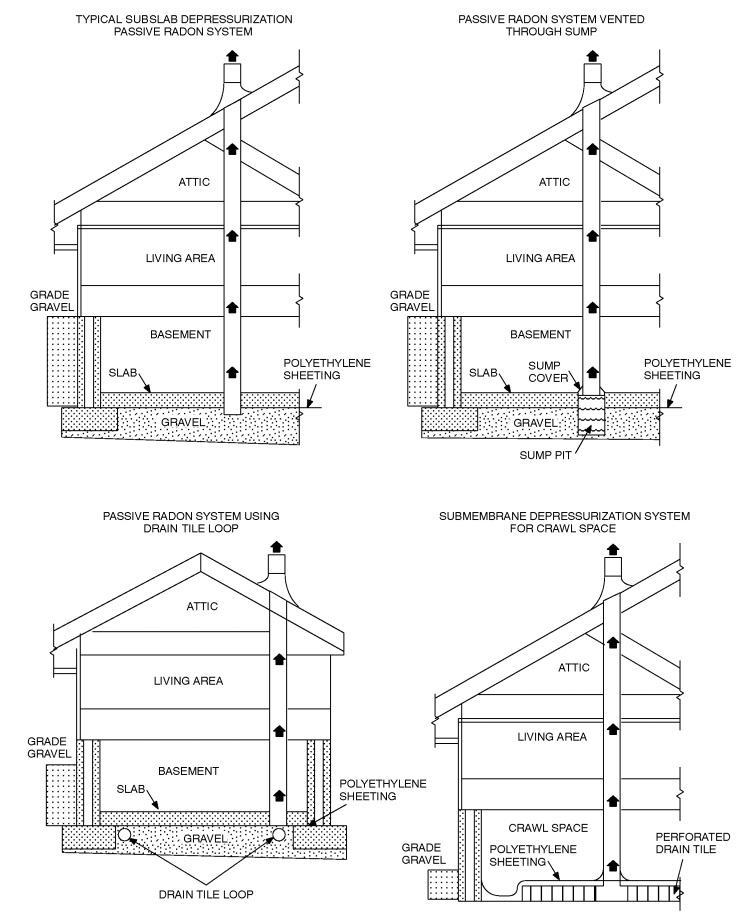
Section AF 101.1 of Appendix F, Power source, is amended to add the following:
Wiring for future pump installation shall be installed in the attic during construction.
Section AF103.3, Soil-gas-retarder, is amended to add the following:
Gravel or native soil may be used in passive and mechanical systems in basements or enclosed crawl spaces with soil floors.
Section AF103.4, Entry routes, is amended to add the following:
Gravel or native soil may be used in passive and mechanical systems in basements or enclosed crawl spaces with concrete floors or other floor systems and slab on grade dwellings.
Appendix Q of the 2018 International Residential Code, is adopted in full, to address eligible Tiny Houses built in compliance with the International Residential Code.
6.13.6. INTERNATIONAL FIRE CODE
There is hereby adopted by the Town, for the purpose of regulating and governing and safeguarding of life and property from fire and explosion hazards arising from the storage, handling and use of hazardous substances, materials and devices, and from conditions hazardous to life or property in the occupancy of buildings and premises in the Town; providing for the issuance of permits and collection of fees therefore; that certain code known as the International Fire Code, 2015 Edition, including Appendix Chapters A, B, C, D, E, F, G, H, I and J, published by the International Code Council. Such Code is adopted by reference thereto the same as if set forth in length in this Section with the amendments, deletions and additions as follows:
Section 103.1, General, is amended to read as follows:
The Town's Department of Building Safety, as defined in Section 103.1 of the International Building Code, 2015 Edition, shall serve as the Department of Fire Prevention for the implementation, administration and enforcement of the provisions of the Fire Code.
Section 104.1, General, is amended to add the following:
All final decisions shall be determined by the Fire Code Official.
Section 104.5.1 Fire restrictions.
Notwithstanding any provision of this code, in order to reduce the danger of uncontrolled fires starting or spreading within the Town, the Town Manager may, based on an evaluation of the fire danger and after consultation with the Pagosa Springs Police Chief, the Archuleta County Sheriff, and the Pagosa Fire Protection District Fire Chief, declare, amend, rescind, or reinstate fire restrictions within the Town. Fire restrictions may restrict, condition, or prohibit any activities determined to pose the risk of starting or aiding the spread of uncontrolled fire. Fire restrictions shall be imposed by an order signed by the Town Manager stating its effective date, which may be immediately upon signature, its duration, which may be until repealed, and all restricted, conditioned, or prohibited activities. The Town Manager's order shall immediately be published on the Town's website and posted at the Town Hall.
Section 202, General Definitions, Fire Code Official, is amended to read as follows:
The Town's Building Official is hereby designated as the Fire Code Official charged with the implementation, administration and enforcement of the construction and design provisions of the Fire Code.
Section 510, Emergency responder radio coverage in new buildings, delete.
Section 903.1, General, is amended to read as follows:
Automatic sprinkler systems shall comply with this section, except as set forth in Section 6.13.5. of the Municipal Code, which does not require residential fire sprinkler systems. However, if an owner or the owner's authorized agent opts to install a residential fire sprinkler system, it shall be installed in accordance with the International Fire Code, 2015 Edition, and NFPA 72, 13, 13D, 13R.
Section 903.2.7, Group M, is amended to add the following:
As applied to Existing Buildings and Change of Use Permit Applications, on a case by case basis, if the requirements of Section 903.2.7 of the Fire Code are found to be impractical, the final decision shall be determined by the Fire Code Official.
Section J.101. of Appendix J, Scope, is amended to add the following:
The requirements set forth in this Section are not required. However, if an owner or the owner's authorized agent opts to install a building information sign(s), it shall be installed in accordance with this Section.
6.13.7. INTERNATIONAL MECHANICAL CODE
There is hereby adopted by the Town, for the purpose of regulating and controlling the design, construction, installation, quality of materials, erection, installation, alteration, repair, location, relocation, replacement, addition to, use or maintenance of heating, ventilating, cooling, refrigeration systems, incinerators and other miscellaneous heat-producing appliances in the City, that certain code known as the International Mechanical Code, 2015 Edition, published by the International Code Council, excluding the appendices thereto. Such Code is adopted by reference thereto the same as if set forth in length in this Section with the amendments, deletions and additions as follows:
Section 901.3, Hazardous locations, is amended to add the following:
Propane units are prohibited below grade or in a crawl space.
6.13.8. INTERNATIONAL FUEL GAS CODE
There is hereby adopted by the Town, for the purpose of regulating and controlling the installation of fuel-gas piping systems, fuel-gas utilization equipment and related accessories within the Town, that certain code known as the International Fuel Gas Code, 2015 Edition, published by the International Code Council, excluding the appendices thereto. Such Code is adopted by reference thereto the same as if set forth in length in this Section with the amendments, deletions and additions as follows:
Section 303.3, Prohibited locations-bathroom, Exception 3, delete.
Section 303.3, Prohibited locations-bedroom, Exception 4, delete.
Section 621 Unvented Room Heaters, is amended to read as follows:
Section 621.1 General, Unvented room heaters shall be prohibited.
Section 621.2 through 621.7, delete.
6.13.9. INTERNATIONAL EXISTING BUILDING CODE
There is hereby adopted by the Town, for the purpose of the use and reuse of existing buildings, while requiring reasonable upgrades and improvements. These upgrades and improvements, where applicable, are life-safety related and include the upgrading of fire protection systems, partial or complete enclosing of vertical openings, replacement of unsafe interior finishing, providing adequate means of egress and improving accessibility and the structural system within the Town, that certain code known as the International Existing Building Code, 2015 Edition, published by the International Code Council. Such Code, and the whole thereof, is adopted by reference thereto the same as if set forth in length in this Section, including the outline of contents, index and appendices contained therein.
6.13.10. INTERNATIONAL SWIMMING POOL AND SPA CODE
There is hereby adopted by the Town, for the purpose of governing the design, construction, alteration, repair and maintenance of swimming pools, spas, hot tubs and aquatic facilities and to safeguard the public health and safety within the Town, that certain code known as the International Swimming Pool and Spa Code, 2015 Edition, published by the International Code Council. Such Code, and the whole thereof, is adopted by reference thereto the same as if set forth in length in this Section, including the outline of contents, index and appendices contained therein.
6.13.11. SNOW LOAD REQUIREMENTS
a.
The snow load requirement for manufactured structures as set forth in Table 6.13.-1: Snow Load Requirements is amended to 65 lbs.
b.
The following is deleted:
* HUD homes on temporary foundations may have roofs designed to 30 psf when pre-approved by the Building Official.
Editor's note— Ord. No. 853, adopted February 23, 2017, redesignated District R-18 as District R-22. At the direction of the city, table 6.13-1 has been updated to reflect this change.
6.13.12. FOUNDATION REQUIREMENTS
A.
All construction of commercial and residential properties shall require a foundation pursuant to standards set out in the current adopted edition of the International Building Code. In addition to conventional housing, the requirements of this Section are applicable to previously constructed houses that are moved to a different location within the Town and to remodeling projects if such remodeling project requires a new foundation.
B.
Manufactured homes in all zoning districts, with the exception of the C District if approved by the Building Official, shall have permanent foundations.
6.13.13. MANUFACTURED HOUSING REQUIREMENTS
A.
Design. Each manufactured housing units ("unit") must be designed to meet all roof load specifications as set forth in the International Building Code. Where necessary, additional structural elements may be required to meet the roof load specifications, as determined by the Town Building Official.
B.
Energy conservation. All units allowed under this Article shall comply with the current adopted edition of the International Energy Conservation Code.
C.
Securing. Temporary and permanent manufactured homes must have foundations designed and built in accordance with the manufacturer's installation instructions and State of Colorado Manufactured Home Installation Program pursuant to §§ 24-32-3301, et seq., C.R.S.
D.
Foundations. Temporary and permanent manufactured homes must have foundations designed and built in accordance with the manufacturer's installation instructions and State of Colorado Manufactured Home Installation Program pursuant to §§ 24-32-3301, et seq. C.R.S.
E.
Skirting of HUD homes.
1.
Skirting must be structurally capable of withstanding local weather conditions.
2.
Materials used may include rock, wood, block, or reinforced metal siding.
3.
Skirting must be fabricated to be rigid in form and constructed in a craftsman like manner.
4.
Skirting design and construction must be approved by the Town Building Official.
5.
Construction shall be completed within six (6) months following issuance of a required building permit. This timeframe can be extended with the permission of the Town Building Official.
A.
Prior to the issuance of a building permit for commercial or residential new construction, the owner shall submit to the Town a survey plat prepared by a licensed land surveyor that shows:
1.
The exterior boundaries of the lot marked by steel pins;
2.
The legal setbacks, front, side and rear;
3.
The location of the proposed building in relation to the boundaries and setback lines; and
4.
The flood plain and flood way boundaries as delineated on the FIRM, Community Panel #0800190005C and LOMR to this FIRM dated January 1996 or any update thereto.
B.
Prior to the issuance of a building permit for the construction of an accessory structure or additions to existing structures, the owner shall submit to the Town a plat/site plan, describing the location of the proposed building on the plat, including the setbacks. The Building Official may also require, in his or her discretion, submission of a survey plat prepared by a licensed land surveyor. Accessory structures are required to meet all other provisions as established in the Code.
6.13.14. BOARD OF APPEALS
There is hereby created a Code Board of Appeals ("Board") for the purpose of hearing and deciding appeals of orders, decisions or determinations made pursuant to this Chapter 6.13.
A.
Membership. The membership of the Board shall consist of five (5) regular members and three (3) alternate members, none of whom are employees of the Town or Fire District, and all of whom meet the qualifications established by this Section. All regular and alternate members shall be appointed jointly by the Town Council and Pagosa Fire Protection District's Board of Directors. In the event of a resignation, death or retirement of any member, or removal of a member for good cause, a replacement shall be appointed jointly by the Town Council and Pagosa Fire Protection District ("Fire District"). Members and alternate members may be removed for any or no reason by joint action of the Town Council and District Board of Directors.
B.
Member Qualifications. All alternate and regular members shall be qualified electors and residents of Archuleta County for a minimum of two (2) years prior to appointment. Members shall have experience in, and be knowledgeable about, the International Residential, Building, Fire, NFPA 72, 13, 13D and 13R Codes. All members shall hold current professional credentials, certificates and/or licenses, as well as meet the following criteria:
1.
If any such persons are available in Archuleta County, regular board members shall consist of the following individuals:
a.
Two (2) members experienced in building construction;
b.
Two (2) members who are engineer or design professionals; and
c.
One (1) fire protection professional or fire experienced contractor or engineer.
2.
If such persons are available in Archuleta County, alternate board members must meet at least one (1) of the following qualifications:
a.
Having experience in building construction;
b.
An engineer or design professional; or
c.
A fire protection professional or fire experienced contractor or engineer.
3.
If individuals with the above qualifications are not available, the Town Council and fire district may appoint individuals deemed qualified by both entities.
C.
Term of Office.
1.
Regular members. Initial appointments of regular members shall be as follows: One (1) member shall be appointed to a term of five (5) years; one (1) member shall be appointed to a term of four (4) years; one (1) member shall be appointed to a term of three (3) years; one (1) member shall be appointed to a term of two (2) years; and one (1) member shall be appointed to a term of one (1) year. Thereafter, appointments shall be for a term of five (5) years.
2.
Alternate members. Initial appointments of alternate members shall be as follows: One (1) member shall be appointed to a term of three (3) years; one (1) member shall be appointed to a term of two (2) years; one (1) member shall be appointed to a term of one (1) year. After these initial terms, each alternate member shall be appointed to a three-year term.
D.
Alternate members. In the event that any regular member of the Board is temporarily unable to act owing to absence, illness, interest in the case before the Board, or any other cause, the Chairperson of the Board shall designate an alternate member to take the place of the absent member and the alternate member shall have all the powers of a regular member while serving in the place of a regular member. The Chairperson shall make every effort to rotate the alternate member who replaces an absent regular member.
E.
Duties.
1.
The Board is authorized to establish policies and procedures necessary to carry out its duties. Copies of any policies and procedures shall be provided to the Town and the fire district.
2.
The Board shall make reasonable interpretations and may waive requirements of the Building and Fire Codes when such decisions are (i) in conformity with the intent and purpose of the applicable code; (ii) the relief does not lessen any fire-protection or health and safety requirements or any degree of structural integrity; and (iii) the material, method or work offered is, for the purpose intended, comparable to that prescribed in the applicable code in suitability, strength, effectiveness, fire resistance, durability, safety and sanitation.
3.
The Board shall review proposed changes or amendments to the codes and advise the Town Council with respect to the desirability and necessity for any such changes and may formulate suggested amendments to the codes for consideration by the Town.
F.
Appeals.
1.
Any order, decision, or determination made by the building official or fire code official may be appealed to the Board by filing a written notice of appeal with the Town Clerk no later than ten (10) calendar days from the date of the decision being appealed.
2.
A hearing shall be scheduled within thirty (30) days after receipt of a Notice of Appeal; or, if the Board has adopted a regular schedule of meetings regular meeting following receipt of the Notice. Written notice of the date, time and place of the hearing shall be mailed to the appellant, the Town and the Fire District.
3.
Three members of the Board shall constitute a quorum. In rendering any decision on an appeal, not fewer than three (3) affirmative votes shall be required.
G.
Decisions. The Board shall issue its findings and rulings thereon in writing not later than thirty (30) days after the hearing, or not later than the second regular meeting following the hearing, if the regular schedule of meetings has been adopted by the Board. Copies of the findings and rulings shall be mailed to the appellant, Town Clerk, and Fire District administrator. The decisions of the Board shall be final and there shall be no further administrative review. Decisions of the Board shall be subject to review by the Municipal Court by filing a complaint that includes the specific allegations of error no more than fourteen (14) days after the final decision by the Board. The Municipal Court's review shall be limited to a determination of whether the Board exceeded its jurisdiction or abused its discretion, based on the evidence in the record before the Board. Any appeal of the decision of the Municipal Court shall be brought in District Court as a civil matter pursuant to Rule 106 of the Colorado Rules of Civil Procedure.
(Ord. No. 759, § 1, 1-4-2011; Ord. No. 795, § I, 9-19-2013; Ord. No. 818, § 2, 1-6-2015; Ord. No. 868, §§ 1—11, 11-17-2017; Ord. No. 878, § 4, 3-22-2018; Ord. No. 886, § 3, 6-5-2018; Ord. No. 911, § 5, 6-4-2019; Ord. No. 956, § 1.B., 8-19-2021; Ord. No. 1006, § 3, 7-18-2024; Ord. No. 1015, § 2, 9-2-2025)
Editor's note— Ord. No. 868, §§ 1—11, adopted November 17, 2017, repealed § 6.13 and enacted a new § 6.13 as set out herein. Former § 6.13 pertained to similar subject matter and derived from Ord. No. 759, adopted January 4, 2011; Ord. No. 795, adopted September 19, 2013 and Ord. No. 818, adopted January 6, 2015.
6.14. - SCHOOL FEES IN LIEU OF PUBLIC LAND DEDICATION
6.14.1. RESERVED
6.14.2. USE OF FEES
A.
Section 6.14.2 is intended to provide for the administration and expenditure of all fees collected by the Town pursuant to Ordinance No. 677 (Series 2006), which was repealed by Ordinance No. 911 (Series 2019). Such fees shall be accounted for as required by law. Fees shall be deposited in an interest-bearing account which clearly identifies the lot, development activity and development approval for which the fee in lieu of public land dedication was collected and the associated category, account or fund of capital facility, by either aggregate or individual land development. Each such category, account, or fund shall be accounted for separately. Any interest or any income earned on moneys deposited in said interest-bearing account shall be credited to the account.
B.
Revenues from fees in lieu of public land dedication shall be used exclusively for capital facilities.
C.
No fees shall be used for periodic or routine maintenance, personnel costs or operational expenses.
D.
In the event that bonds or similar financing instruments are used for the advanced provision of any capital facilities for which fees in lieu of public land dedication are required, fee revenues may be used to pay debt service on such bonds or similar financing instruments.
E.
The Town may enter into an intergovernmental agreement with Archuleta School District 50 Joint Public School District ("School District") or any local government to jointly fund and provide capital facilities needed to provide public school services to the development for which the fees in lieu of public land dedication were imposed. To the extent such intergovernmental agreements utilize revenues from the fees imposed by this Article, they shall include such terms requiring compliance with this Article as deemed appropriate by the Town Council. Such intergovernmental agreements may provide that once paid to the School District, the fees in lieu of public land dedication may be used in the sole discretion of the School District so long as the other requirements of this Article are met.
F.
In the event this Ordinance is repealed or any intergovernmental agreement entered into pursuant to this Section is terminated, any fees previously paid to the School District or other local government and capital facilities purchased by the School District or other local government with such fees shall remain the property of the School District or other local government for use for the purposes contemplated by this Article.
(Ord. No. 911, §§ 6, 7, 6-4-2019)
6.15. - RESERVED
Reserved for future standards:
•
Transfer of Development Rights
•
Energy-Efficiency Standards