
Pahokee City Zoning Code
ARTICLE I
- GENERAL PROVISIONS
Sec. 14-1.- Title.
This code shall be entitled the "Land Development Code" and may be referred to herein as the "code."
Sec. 14-2. - Authority.
This land development code is enacted pursuant to the requirements and authority of F.S. § 163.3202, (the Local Government comprehensive planning and Land Development Regulation Act), the City of Pahokee Charter effective May 1,1990, and the general powers in F.S. ch. 166/125, (City of Pahokee Government).
Sec. 14-3. - Applicability.
(a)
General applicability. Except as specifically provided below, the provisions of this code shall apply to all development in the City of Pahokee, and no development shall be undertaken without prior authorization pursuant to this code.
(b)
Exceptions.
(1)
Previously issued development permits. The provisions of this code and any amendments thereto shall not affect the validity of any lawfully issued and effective development permit if:
a.
The development activity authorized by the permit has been commenced prior to the effective date of this code or any amendment thereto, or will be commenced after the effective date of this code but within six (6) months of issuance of the building permit; and
b.
The development activity continues without interruption (except because of war or natural disaster) until the development is complete. If the development permit expires, any further development on that site shall occur only in conformance with the requirements of this code or amendment thereto.
(2)
Previously approved development orders. Projects with development orders that have not expired at the time this code or an amendment thereto is adopted, and on which development activity has commenced or does commence and proceeds according to the time limits in the regulations under which the development was originally approved, must meet only the requirements of the regulations in effect when the development plan was approved. If the development plan expires or is otherwise invalidated, any further development on that site shall occur only in conformance with the requirements of this code or amendment thereto.
(3)
Consistency with plan. Nothing in this section shall be construed to authorize development that is inconsistent with the City of Pahokee comprehensive plan.
Sec. 14-4. - Guide for users.
(a)
The integration of land development regulations. This integrated land development code was enacted to replace the land development regulations that had been adopted piecemeal over the years and were thus scattered throughout the local code of ordinances. These scattered regulations lacked coordination and were difficult to find, administer and understand. The replacement of these scattered regulations with an integrated land development code should greatly enhance the efficiency, effectiveness and consistency of land development regulations by the City of Pahokee.
This being an integrated code, it should be noted that, there is article XIV of the code labeled "subdivision regulations." Thus, stormwater requirements for development, including subdivisions, are found in the article labeled "stormwater management" in general terms with reference to article XIV, "subdivision" for specific requirements of developments; tree planting requirements are found in the "landscaping" part, and so forth.
Likewise, there is article VII labeled "planned development (PD)." The distinction between P.D. developments and others is that it is to be uitilized for existing large non-conforming uses. and for the development of undeveloped lands. Thus, all commercial development, and all residential development except the building of a dwelling on a lot of record, must go through a review process.
In short, this code establishes a single set of site design criteria and development review procedures. This integration results in a different layout and an unfamiliar table of contents, but should, as familiarity with the code increases, result in a much more streamlined and effective land development regulatory system.
(b)
Checklist for preparation and review of development proposals. Every attempt has been made to make this code as easy as possible for interested citizens, developers, and local government staff to use and at the same time implement state mandates. The articles are arranged in an order that reflects the process by which a developer would start with a parcel of land and conclude with an approved development. This same ordering provides a checklist approach for interested citizens and staff who are reviewing a proposed development for compliance and consistency with code requirements. The ordering and checklist are as follows:
ARTICLE I GENERAL PROVISIONS
This article contains general provisions necessary to determine the applicability of the code, and to ensure the code's legal validity. Sec. 14-3 above, "applicability," establishes which development must comply with the requirements of this code. Certain development activities are not covered if they are authorized by previously approved development plans. Thus, an initial question is whether proposed development activity is covered by this code or by rules in effect prior to the adoption of this code.
Once a determination is made that this code applies, this user's guide should be reviewed in order to gain an understanding of how the code works. The remainder of article I need not be reviewed unless a question of intent, interpretation or validity of a regulation arises.
ARTICLE II LAND USE: TYPE, DENSITY AND INTENSITY
The first question regarding the development of any site is what use, and what density or intensity of that use, is allowed on the site. Article II provides the answer to this question. The following is a checklist of provisions that should be consulted with regard to a development proposal:
___
In what land use district is the development site located. See article IV.
___
What uses are allowed in that district. See article V.
___
If a residential development is to be proposed, what is the allowable density (dwelling units per acre). See article IV, sections 14-58 to 14-69.
___
If a neighborhood commercial development is to be proposed, what is the allowable intensity (floor area ratio) of the development. See Section 14-59.
ARTICLE XI. SUPPLEMENTAL REGULATIONS
Once the use, and its intensity and density, have been determined for a site, it must be determined whether the site is within an overlay district. For example, if the site is within a historic district, or site plan review development and review restrictions will apply. This article contains all overlay districts that might affect a site. The following is a checklist of provisions that should be consulted with regard to a development proposal:
___
Is the site a historic landmark or within a designated historic district? (To be determined at a later date)
___
Does the proposed development activity involve the construction of a house in an existing subdivision?
___
Is the site within the site plan review designated overlay zone which are those properties fronting Lake Ave, Bacom Point Road, and East Main Street.
ARTICLE III CONCURRENCY MANAGEMENT AND REVIEW
The final question to be answered with regard to whether the use, and density or intensity of that use, is appropriate for the site is whether the consistency and concurrency requirements are met. The purpose of article III is to ensure that proposed development is consistent with the local comprehensive plan.
Because the land development code is required to implement the comprehensive plan, it may be reasonable to assume that all development that conforms to all provisions of the land development code is consistent with the comprehensive plan.
No presumption may be created, however, for that form of consistency referred to as concurrency. In order for the concurrency requirement to be met, each development proposal must show that adopted levels of service for certain public facilities and services will not be degraded by the impact of the development. The following is a checklist of provisions that should be consulted with regard to a development proposal:
___
Is the development (except for concurrency) consistent with the comprehensive plan?
___
Is the general concurrency requirement met? Specifically:
___
Will the proposed development use potable water? See section 14-42(1).
___
Will the proposed development create wastewater? See section 14-42(2).
___
Will the proposed development increase traffic on surrounding streets? See section 14-42(3) and (7).
___
Will the proposed development change the amount, nature, or patterns of stormwater runoff? See section 14-42(4).
___
Will the proposed development create solid waste? See section 14-42(5).
___
Will the proposed development create a need for public recreation? See section 14-42(6).
___
Will the development have an impact on ridership of the mass transit system? See section 14-42(7).
ARTICLE XIII. RESOURCE PROTECTION STANDARDS
Once the use, and the density and intensity of that use, is determined for a site, the next question is whether any portions of the site must remain totally or partially free of development activity. Article XIII prescribes those areas and the restrictions that apply within them. The following is a checklist of provisions that should be consulted with regard to a development proposal:
___
Does the site contain protected trees, or a Canopy Road, as defined in the code? See article XIII, section 14.246.
___
Does the site contain wetlands, or other environmentally sensitive lands described in the comprehensive plan? See article XIII, division 3.
___
Is the site near a major wellhead as defined in the code? See article XIII, division 4.
___
Does the site contain habitat of threatened or endangered species? See article XIII, division 5.
___
Does the site contain land in the 100-year flood plain? See article XIII, division 6.
ARTICLE VI. DEVELOPMENT DESIGN AND IMPROVEMENT STANDARDS
Once the developable portions of the site have been determined, the next question is how the actual development will be designed and what improvements will be required. Article VI contains standards, which have been made as flexible as possible, for controlling the design of the development so that maximum public benefit is realized. The following is a checklist of provisions that should be consulted with regard to a development proposal:
___
Will the development involve the subdivision of land? See article VIII "zoning district" for minimum lot area requirements and article XIV "subdivision" for platting procedures.
___
Will the development contain buildings or other impervious surfaces? See article IV and XIV for impervious surface coverage requirements.
___
Will the development contain buildings or other structures? See article IV for building setback requirements.
___
Will the development contain streets, parking or other vehicle use areas?
___
See article VIII and XIV for street layout, design and right of way requirements.
___
See article VIII and XIV for sidewalk and bikeway requirements.
___
See article VIII for access requirements.
___
See article VIII for standards relating to drive-up facilities.
___
See article IX for off-street parking and loading requirements.
___
See article IX for landscaping requirements.
___
Will the development involve the installation of utilities? See article XIV for installation and design standards.
___
Will the development affect the quality or quantity of stormwater runoff from the site? See article XII and XIV stormwater management requirements.
___
Is the development adjacent to a street or use such that a buffer must be provided? See article IV, V and IX for buffer requirements.
___
Does the development involve a use requiring conformance with supplemental development design standards?
___
See article for supplemental standards relating uses requiring administsrative review or conditional uses.
ARTICLE V. ACCESSORY STRUCTURES AND USES
Article in conjunction with article IV and XI creates the standards for the creation, placement and construction of accessory structures or uses. The following is a checklist of provisions that should be consulted with regard to a development proposal:
___
Is a satellite dish antenna to be installed?
___
Is a storage building, utility building, or greenhouse to be installed?
___
Is a swimming pool, hot tub or similar structure to be installed?
___
Is a fence to be installed?
___
Is an accessory apartment to be created?
ARTICLE X. SIGNS
Article X provides standards and prohibitions relating to signs. The following is a checklist of provisions that should be consulted with regard to a development proposal:
___
Exempt signs are listed at article X, section 14-161.
___
Prohibited signs are listed at article X, section 14-162.
___
Regulations relating to temporary signs are at article X, section 14-163(1).
___
Regulations relating to permanent accessory signs are at article X, section 14-164.
___
Regulations relating to outdoor advertising signs are at article X, section 14-166(d)
___
The way in which measurement determinations, e.g. sign height and size, are made is covered in article X, section 14-164.
___
Regulations relating to the design, construction and location of signs are in article X, section 14-165.
ARTICLE XI. SUPPLEMENTAL OPERATIONAL PERFORMANCE STANDARDS
Article XI provides standards governing certain potentially noxious aspects of the ongoing use of development. The following is a checklist of provisions that should be consulted with regard to a development proposal:
___
Will the development create an exceptional amount of noise? See article XI section 14-201.
___
Will the development create an exceptional amount of vibration? See article XI section 14-202.
___
Will the development create air pollution? See article XI section 14-203.
___
Will the development create an exceptional amount of odor? See article XI section 14-204.
___
Will the development create a risk of fire or explosion? See article XI section 14-205.
___
Will the development create a risk of electromagnetic interference? See article XI section 14-206.
ARTICLE X. HARDSHIP RELIEF
Article X provides several avenues for seeking relief from requirements in this code that create an undue hardship. The following is a checklist of provisions that should be consulted with regard to a development proposal:
___
Is the development an existing development that does not conform to the use regulations in article II and/or the development design and improvement standards in article VI? See article VI.
___
With regard to proposed development, is relief sought from the strict application of a development design standard? See article II.
ARTICLE II. BOARDS AND AGENCIES
At this point in the code, all substantive provisions relating to the use and design of a development site have been covered. If the decision to proceed with development is made, the procedures for development review in article XII must be followed. First, however, one should become familiar with the boards and agencies involved in that review. Article XI establishes and describes the following boards and agencies:
___
Office of the director of community development. See section 14-20(d).
___
City commission. See section 14-20(a).
___
Planning board. See section 14-20(b).
___
Board of adjustment. See section 14-20(c).
___
Historic preservation. See section 14-20(d).
___
Code enforcement board. See section 1SEC.3.05.
ARTICLE II. ADMINISTRATION AND ENFORCEMENT
This article sets out the procedures for making land use decisions. Most importantly, it sets out the procedures for reviewing development plans to determine their compliance with code requirements. The following is a checklist of provisions that should be consulted with regard to a development proposal:
___
Is the proposed use "development" as defined in the code? See article I and table A.
___
If the proposed activity is development, must a development plan showing the proposed development be approved prior to the issuance of a construction permit? See section 14-20(d)(2).
___
If a development plan is not required, see section 14-20 for issuance of development permits.
___
If a development plan is required, is the proposed development a minor development or a major development. See section ? See, also, the submittal requirements at Section ?.
___
If the proposal is a minor development, follow the review procedures at articles II and XIV.
___
If the proposal is a major development, follow the review procedures at articles II, VII, and XIV.
___
If the development is to be built in phases, see article VII.
___
If the development proposal involves platting, see article XIV.
___
If a the development proposal requires an amendment to the comprehensive plan or land development code, see article II.
___
If an appeal of a decision by the department of planning and development, or by the development review board, is sought, see article II.
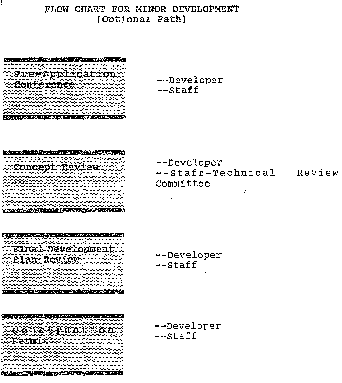
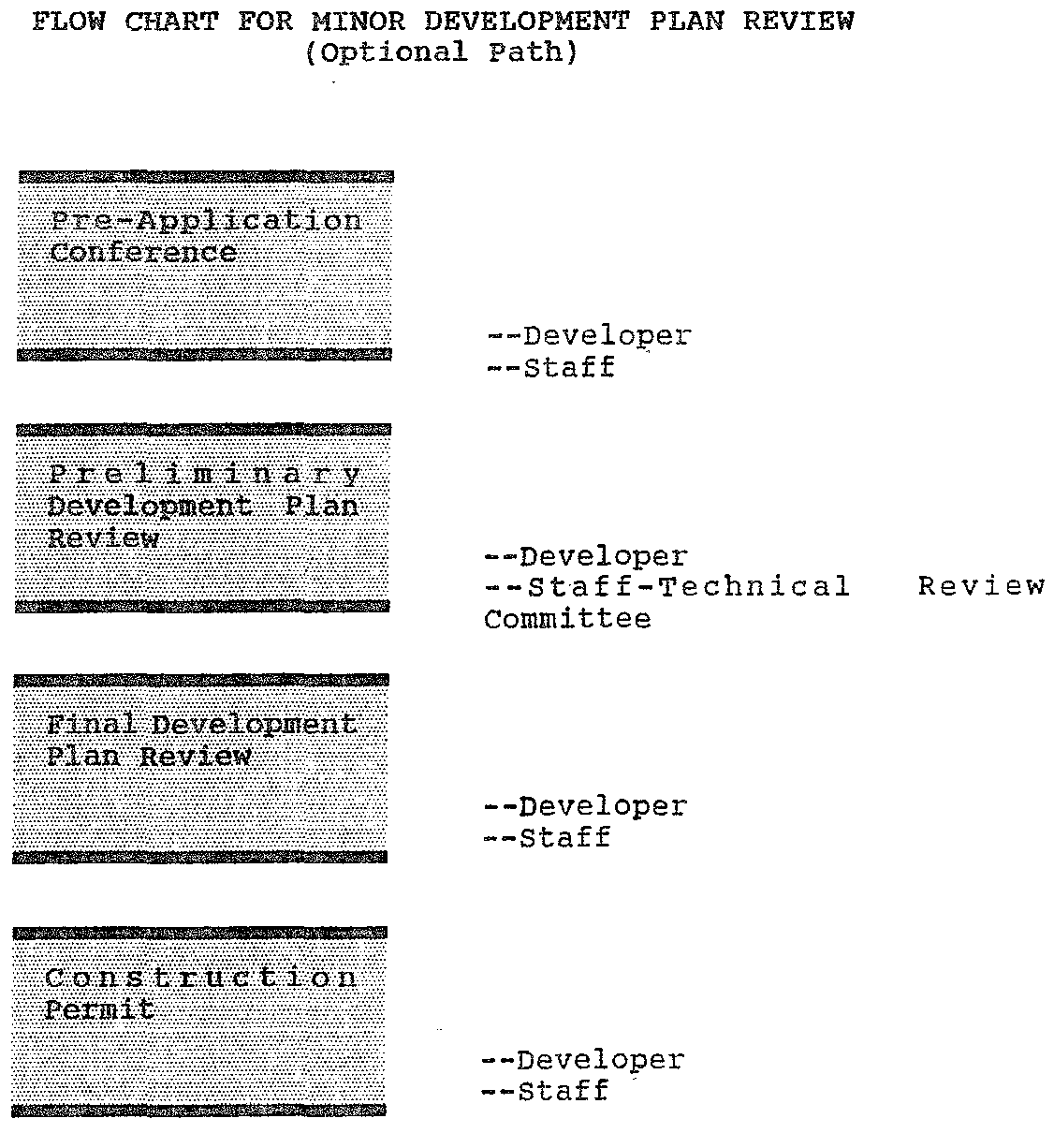
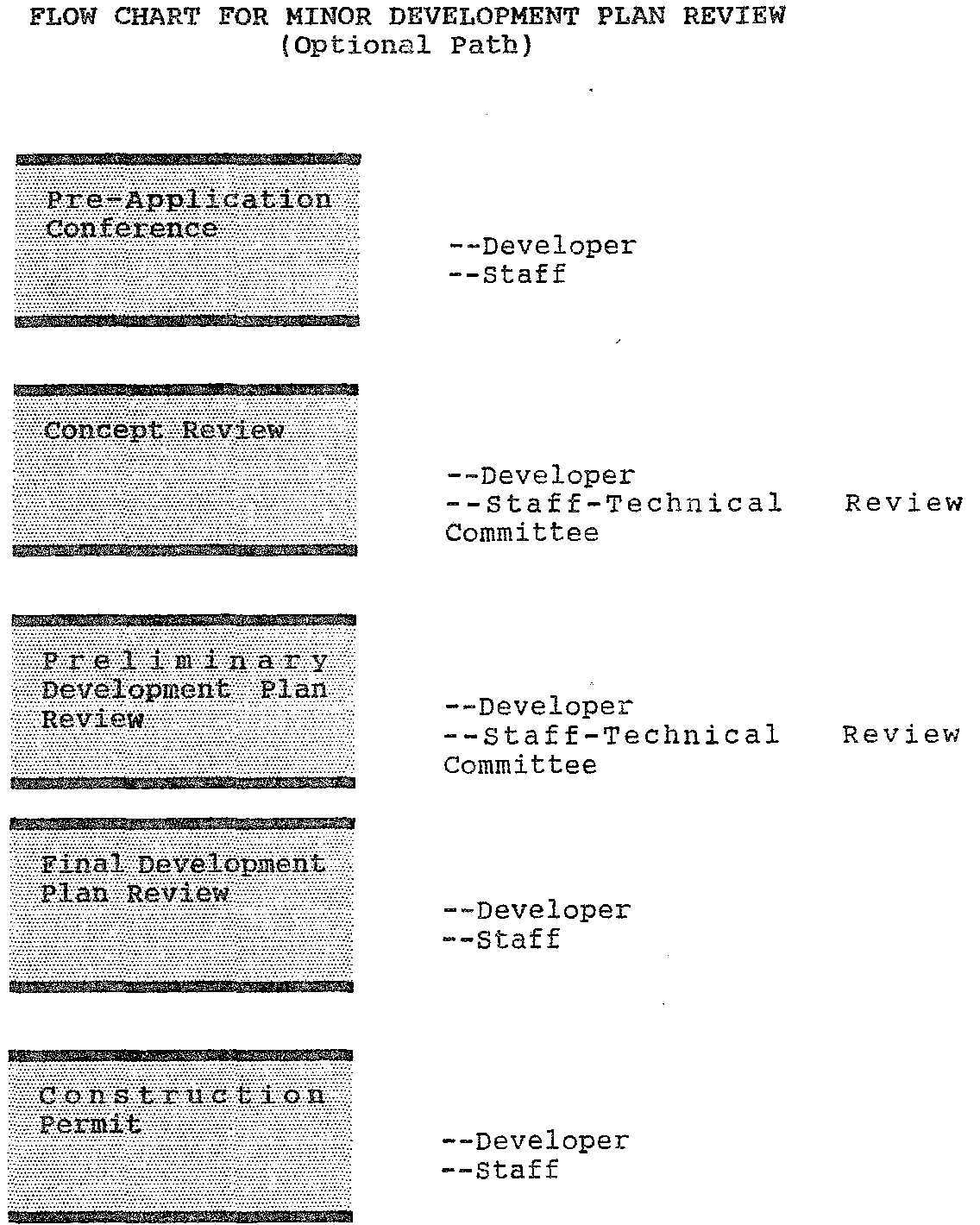
The next section contains flow charts showing the development review process for major and minor developments.
Sec. 14-5. - Description of development review procedures.
The development review process is that process by which the design of the development is reviewed to determine whether it complies with the requirements of the code. Development plan review is required for virtually all development activity, except the construction of a dwelling on a lot of record, and other very minor development activity such as the installation of a sign or the removal of a protected tree. There are five basic steps in the development plan review process: Pre-application conference, concept review, preliminary development plan review, final development plan review and issuance of construction (development) permits. As shown in the flow charts below, some of the steps are optional for minor development, but all are mandatory for major development.
Sec. 14-6. - General findings.
(a)
Statutory requirement. Chapter 163, Florida Statutes, requires each Florida local government to enact a single land development code which implements and is consistent with the local comprehensive plan, and which contains all land development regulations for the City of Pahokee.
(b)
General public need. Controlling the location, design and construction of development within the City of Pahokee is necessary to maintain and improve the quality of life in the city as more fully described below.
Sec. 14-7. - Specific findings relating to the various subject areas of this code.
With regard to the following specific subject areas of this code, the city commission finds:
(1)
Administration and enforcement.
a.
A single set of administrative procedures for making all land use decisions promotes efficiency, predictability, and citizen participation.
b.
All development proposals should undergo a development review process to assure compliance with the requirements of this code.
c.
A mandatory pre-application conference requirement enhances communication and understanding between the department and the developer thereby improving the efficiency of the development review process.
d.
Concept review allows developers to modify proposals in response to early citizen and staff comment.
e.
Developments of large potential impact on the community should go through a more rigorous review process than others.
f.
Review of planning decisions should be independent of review of land development decisions to avoid ad hoc planning on a site-by-site basis.
g.
All administrative decisions should be supported by a record with written findings to assure accountability and efficient appellate review.
h.
A quick, efficient and non-political avenue of appeal should be available for all ministerial and administrative decisions.
i.
Enforcement of development orders and the provisions of this code should be through procedures that are efficient, effective and consistent with the code enforcement procedures established by state law.
(2)
Signs.
a.
The manner of the erection, location and maintenance of signs affects the public health, safety, morals, and welfare of the people of this community.
b.
The safety of motorists, cyclists, pedestrians, other users of the public streets is affected by the number, size, location, lighting and movement of signs that divert the attention of drivers.
c.
The size and location of signs may, if uncontrolled, constitute an obstacle to effective fire-fighting techniques.
d.
The construction, erection and maintenance of large signs suspended from or placed on the tops of buildings, walls or other structures may constitute a direct danger to pedestrian and vehicular traffic below, especially during periods of strong winds.
e.
Uncontrolled and unlimited signs may degrade the aesthetic attractiveness of the natural and manmade attributes of the community and thereby undermine the economic value of tourism, visitation and permanent economic growth.
(3)
Landscaping and tree protection.
a.
Landscaping and buffering development with trees and other vegetation promotes the health, safety and welfare of the community to such an extent as to justify the imposition of landscaping and buffering requirements.
b.
Trees and landscaping benefit the community by:
1.
Absorbing carbon dioxide and returning oxygen to the atmosphere;
2.
Precipitating dust and other particulates from the air;
3.
Providing wildlife habitat, particularly for birds which in turn help control insects;
4.
Providing soil stabilization which reduces erosion and mitigates the effect of flooding;
5.
Providing shade which reduces energy consumption and glare, and making outdoor areas more comfortable during the warm months;
6.
Making the built environment more attractive by adding a variety of color, shape and pattern and thus increasing community pride and the value of property;
7.
Providing attractive buffering between incompatible land uses; and
8.
Abating noise.
c.
Because native vegetation is adapted to local diseases, pests, soil and climate, it is generally more economical and desirable than exotic species which require more pesticide, fertilizer and water.
d.
Exotic vegetation can crowd out native vegetation, use more water, and damage the environment from increased use of fertilizers and pesticides.
e.
Because some trees are more beneficial than others, the public benefits of tree protection may be obtained without preserving each and every tree.
f.
Mangrove trees are especially valuable in stabilizing, building and protecting the shoreline, providing for spawning and breeding grounds for marine organisms and other wildlife, and serving as the basis for most of the estuarine food chains, which are critical to seventy (70) to ninety (90) percent of those species considered important from a recreational and/or commercial standpoint.
(4)
Off-street parking and loading.
a.
Off-street parking and loading of vehicles promotes the public safety and welfare by reducing traffic congestion.
b.
Well-designed off-street parking and loading areas promote the safe and efficient storage, loading and circulation of vehicles.
c.
Deferring the construction of some parking areas pending determination of the actual need for parking spaces, and taking into account public demand and the size of vehicles to be parked, conserves open space and developable land, and reduces the expense and hazard of controlling stormwater runoff.
d.
Allowing the use of porous paving materials and unpaved parking areas whenever possible conserves water and energy, moderates the microclimate, and reduces the expense and hazards of controlling storm water runoff.
(5)
Stormwater management.
a.
Increased stormwater runoff may cause erosion and pollution of ground and surface water with a variety of contaminants such as heavy metals and petroleum products.
b.
Stormwater runoff often contains nutrients, such as phosphorus and nitrogen, which adversely affect flora and fauna by accelerating eutrophication of receiving waters.
c.
Erosion silts up water bodies, decreases their capacity to hold and transport water, interferes with navigation, and damages flora and fauna.
d.
Installation of impervious surfaces increases the volume and rate of stormwater runoff and decreases groundwater recharge.
e.
Improperly managed stormwater runoff increases the incidence and severity of flooding and endangers property and human life.
f.
Improperly managed stormwater runoff alters the salinity of estuarine areas and diminishes their biological productivity.
g.
Degradation of ground and surface waters imposes economic costs on the community.
h.
Eighty (80) to ninety-five (95) percent of the total annual loading of most stormwater pollutants discharged into receiving waters are concentrated in the flush created by the first one (1) inch of rainfall ("first flush"), and carried off-site in the first one-half (½) inch of runoff.
i.
Improperly managed stormwater adversely affects the drainage of off-site property.
(6)
Floodplain protection.
a.
Flooding is a natural, recurring phenomenon in the City of Pahokee.
b.
Naturally flood-prone lands serve the following important functions in the regional hydrologic cycle and ecological system:
1.
They provide natural storage and conveyance of flood waters.
2.
They facilitate groundwater recharge.
3.
They provide temporary storage of surface waters that moderates flood elevations and the timing, velocity and rate of flood discharges.
4.
They reduce erosion, and filter nutrients, sediments, and other pollutants from flood waters.
5.
They export detritus and other food sources to open water bodies and are vital habitat for fish, birds, wildlife and native plant communities.
c.
Naturally occurring flooding may provide recharge to groundwater and a basic source of flow to surface waters.
d.
The uncontrolled development of flood-prone lands substantially degrades the health, safety and welfare of the community in the following ways:
1.
The owners, residents, customers, guests, and employees occupying homes, businesses and other structures located in flood-prone areas are placed at unreasonable risk of personal injury and property damage.
2.
Expensive and dangerous search, rescue and disaster relief operations may be necessary when developed properties are flooded.
3.
Roads, public facilities, and utilities associated with development may be damaged by flooding at great expense to taxpayers and rate payers.
4.
Flooding of developed properties may lead to demands that the government construct expensive and environmentally damaging projects to control flood waters.
5.
Normally flood-free lands are placed at risk of flooding when flood waters on natural flood-prone areas are obstructed, diverted, displaced or channelized by development.
6.
Water quality is degraded, the supply of freshwater to estuaries is disrupted and habitat is lost.
7.
Property values are lowered and economic activity is disrupted by damaging floods.
(7)
Protection of environmentally sensitive lands.
a.
Protection of environmentally sensitive lands described or mapped in the conservation element of the comprehensive plan promotes the well being of the people of the City of Pahokee, it should be noted that the city does not have identified environmentally sensitive lands in its comprehensive plan, however, future annexation area could include sensitive area.
Editor's note— The environmentally sensitive lands provisions of this code assume that all environmentally sensitive lands are mapped or otherwise identified in the conservation element of the local comprehensive plan, and that the justification for a designation as environmentally sensitive is provided in terms of the beneficial functions of the environmentally sensitive areas, e.g., wildlife habitat, flood storage, aquifer recharge. If the mapping of environmentally sensitive areas appears only in the land use element (see § 163.3177(6)(d)), the language of this code should be modified accordingly.
b.
Wetlands serve the following beneficial functions:
(Note: This section reserved for potential future identified "Wetland" areas.)
1.
Wetlands provide natural storage and conveyance of flood waters, and minimize erosion and sedimentation by reducing flood flows and the velocity of flood waters.
2.
Coastal wetlands, and inland wetlands adjoining larger lakes and rivers, protect wildlife and the shoreline from destructive wave action.
3.
Wetlands filter and help decompose sediments, nutrients, and other natural and man-made pollutants that would otherwise degrade surface and ground waters.
4.
Wetlands support commercial and recreational fishing because they provide essential nutrients and hatcheries for aquatic life.
5.
Wetlands provide habitat for rare and endangered species, and provide essential breeding and protective habitats for many other birds, mammals, and reptiles.
6.
Wetlands recharge ground and surface water.
c.
Shorelines serve the following beneficial functions:
(Note: This section reserved for future shoreline sensitive areas presently, the city fronts on Lake Okeechobee. The shoreline is controlled by the U.S. Corps of Engineers. The shoreline is rip-rapped.)
1.
Land adjoining waters or wetlands, which can generally be divided into submergent, transitional, and upland vegetation zones, provides essential habitat for many plant and animal species, including species that are endangered, threatened, or of special concern.
2.
Submergent, transitional, and upland vegetation zones serve as effective buffers against noise and other human activities which may have adverse affects on aquatic and wetland dependent wildlife.
3.
Submergent, transitional, and upland vegetation zones help slow stormwater runoff flows and increase infiltration of water, nutrients, and other substances.
4.
Submergent, transitional, and upland vegetation zones reduce predation by domestic pets on wetland and wetland dependent wildlife species.
d.
"Reserved" (If other environmentally sensitive lands are to be regulated, provide justification therefor here.)
e.
During the past seventy (70) years activities the U.S. Corp of Engineers, South Florida Water District, East bay Water Management District, Urban Development activity management and agriculture have destroyed or impaired the potential beneficial functions of some environmentally sensitive lands in the City of Pahokee.
(8)
Protection of cultural resources.
a.
There are located within the city historical, architectural districts, sites, buildings, and structures, and objects that are unique and irreplaceable assets to the city which are in the process of being identified and inventoried.
b.
In recognition of these assets, the city has adopted a preservation and conservation element as part of its comprehensive plan.
c.
The preservation and conservation element of the comprehensive plan. The plan will be updated in the future to include a survey of cultural resources and adopt an official inventory of historic resources of the City of Pahokee by January 1992.
d.
The recognition, protection, enhancement and use of these resources shall be for public purposes promoting the economic, educational, cultural and general welfare of the public by increasing property values, stabilizing neighborhoods and older areas of the city, increasing economic benefits to the city and its inhabitants, enriching human life in its educational and cultural dimensions, and fostering civic pride in the beauty and noble accomplishments of the past.
e.
The city has for a number of many years exerted efforts in an attempt to encourage redevelopment and rehabilitation of the older parts of the city and continues to do so, under its community development block grant program, code enforcement and other available resources.
f.
It is the will of the Florida Legislature as expressed in F.S. ch. 267 that the state's historic sites and properties, buildings, artifacts, treasure troves, and objects of antiquity, which have scientific or historical value, or are of interest to the public, be protected and preserved.
Editor's note— These sections establish the factual basis and the public health, safety or welfare rationale for the regulations in this code. These findings of fact identify the problems that the code is intended to remedy.
Sec. 14-8. - Relationship to comprehensive plan.
(a)
Generally. The adoption of a unified land development code implements the following goals, policies and objectives of the comprehensive plan:
[List appropriate provisions of the local comprehensive plan.]
Editor's note—
Florida law (Section 163.3194(1)(b), Fla. Stat. (1985)) requires that all land development
regulations be consistent with the comprehensive plan of the enacting local government.
A land development regulation "shall be consistent with the comprehensive plan if
the land uses, densities or intensities, or other aspects of development permitted
by such order or regulation are compatible with and further the objectives, policies,
land uses, and densities or intensities in the comprehensive plan and if it meets
all other criteria enumerated by the local government." How this code meets this standard
of consistency should be explained in these sections.
Listing the goals and objectives of the plan for each subject, as suggested here,
may be impracticable. If so, more general statements of the manner in which this code
implements the comprehensive plan could be used.
For purposes of this code, the statements of consistency relating to the various
subject areas covered by the code are compiled here. If only a part of this code is
to be used, the relevant statements should be drawn from here and included with the
substantive provisions.
(b)
Specifically.
(1)
Administration and enforcement. The administration and enforcement provisions of this code implement the following goals, policies and objectives of the comprehensive plan:
[List appropriate provisions of the local comprehensive plan.]
(2)
Signs. The sign regulations in this code implement the following goals, policies and objectives of the comprehensive plan:
[List appropriate provisions of the local comprehensive plan.]
(3)
Landscaping and tree protection. The landscaping and tree protection regulations in this code implement the following goals, policies and objectives of the comprehensive plan:
[List appropriate provisions of the local comprehensive plan.]
(4)
Parking and loading. The parking and loading regulations in this code implement the following goals, policies and objectives of the comprehensive plan:
[List appropriate provisions of the local comprehensive plan.]
(5)
Stormwater management. The stormwater management regulations in this code implement the following goals, policies and objectives of the comprehensive plan:
[List appropriate provisions of the local comprehensive plan.]
(6)
Floodplain protection. The flood damage prevention provisions in this code implement the following goals, policies and objectives of the comprehensive plan:
[List appropriate provisions of the local comprehensive plan.]
(7)
Protection of environmentally sensitive lands. The protection of environmentally sensitive lands provisions in this code implement the following goals, policies and objectives of the comprehensive plan:
[List appropriate provisions of the local comprehensive plan.]
(8)
Protection of cultural resources (reserved). The protection of cultural resource provisions in this code implement the following goals, policies and objectives of the comprehensive plan:
[List appropriate provisions of the local comprehensive plan.]
Sec. 14-9. - Incorporation by reference.
(a)
Technical Construction Standards Manual.
[Engineering standards and construction design specifications should be contained in a Technical Construction Standards Manual which may here be incorporated into this code by reference.]
(b)
Maps.
[Maps showing use districts, conservation areas, overlay zones, and the like, may be here incorporated into this code by reference.]
(c)
Other materials.
[As may be needed based on the local version of this code.]
Sec. 14-10. - General intent.
With regard to this land development code in general, it's provisions shall be construed and implemented to achieve the following intentions and purposes of the city commission:
(1)
To establish the regulations, procedures and standards for review and approval of all proposed development in the city.
(2)
To foster and preserve public health, safety, comfort and welfare, and to aid in the harmonious, orderly, aesthetically pleasing and socially beneficial development of the City of Pahokee in accordance with the comprehensive plan.
(3)
To adopt a development review process that is:
a.
Efficient, in terms of time and expense;
b.
Effective, in terms of addressing the natural resource and public facility implications of proposed development; and
c.
Equitable, in terms of consistency with established regulations and procedures, respect for the rights of property owners, and consideration of the interests of the citizens of the city.
(4)
To implement the City of Pahokee comprehensive plan as required by the "Local Government comprehensive planning and Land Development Regulation Act."
(5)
To provide specific procedures to ensure that development orders and permits are conditioned on the availability of public facilities and services that meet level of service requirements (concurrency).
Sec. 14-11. - Specific intent relating to the various subject areas of this code.
Editor's note— For purposes of this code, the statements of legislative intent relating to the various subject areas covered by the code are compiled here. If only a part of this code is to be used, the relevant statements of intent should be drawn from here and included with the substantive provisions.
The provisions of this code dealing with the following specific subject areas shall be construed and implemented to achieve the following intentions and purposes of the city commission:
(1)
Administration and enforcement.
a.
To assure that all development proposals be thoroughly and efficiently reviewed for compliance with the requirements of this code, the City of Pahokee comprehensive plan, and other applicable city regulations.
b.
To promote efficiency, predictability and citizen participation.
c.
To assure compliance with approved development orders and the provisions of this code through rigorous but fair enforcement actions.
(2)
Signs.
a.
To create a comprehensive and balanced system of sign control that accommodates both the need for a well-maintained, safe and attractive community, and the need for effective business identification, advertising and communication.
b.
To permit signs that are:
1.
Compatible with their surroundings.
2.
Designed, constructed, installed and maintained in a manner which does not endanger public safety or unduly distract motorists.
3.
Appropriate to the type of activity to which they pertain.
4.
Large enough to convey sufficient information about the owner or occupants of a particular property, the products or services available on the property, or the activities conducted on the property, and small enough to satisfy the needs for regulation.
5.
Reflective of the identity and creativity of individual occupants.
c.
To promote the economic health of the community through increased tourism and property values.
(3)
Landscaping and tree protection.
a.
To enhance the attractiveness of the community.
b.
To conserve energy through the cooling and shading effects of trees.
c.
To abate nuisances such as noise, glare, heat, air pollution and stormwater runoff.
d.
To mitigate conflicts between adjoining land uses;
e.
To preserve the environmental and ecological benefits of existing native trees and vegetation.
f.
To promote safe and efficient use of off-street parking facilities and other vehicular use areas by:
1.
Clearly delineating and buffering the bounds of vehicular use areas, particularly where they abut public rights of way, so that movement, noise, and glare in one (1) area do not adversely distract activity in another area;
2.
Limiting physical site access to established points of ingress and egress; and
3.
Limiting the internal movement of vehicles and pedestrians to designated traffic configurations.
g.
To preserve the community's irreplaceable natural heritage for existing and future generations.
(4)
Parking and loading. To assure that all developments provide for adequate and safe storage and movement of vehicles in a manner consistent with community standards and good engineering and site design principles.
(5)
Stormwater management (subdivision standards).
a.
To protect and maintain the chemical, physical and biological integrity of ground and surface waters.
b.
To prevent activities which adversely affect ground and surface waters.
c.
To encourage the construction of stormwater management systems that aesthetically and functionally approximate natural systems.
d.
To protect natural drainage systems.
e.
To minimize runoff pollution of ground and surface waters.
f.
To maintain and restore groundwater levels.
g.
To protect and maintain natural salinity levels in estuarine areas.
h.
To minimize erosion and sedimentation.
i.
To prevent damage to wetlands.
j.
To protect, maintain, and restore the habitat of fish and wildlife.
(6)
Floodplain protection.
a.
To protect human life and health.
b.
To minimize expenditure of public money for costly flood control projects.
c.
To minimize the need for rescue and relief efforts associated with flooding and generally undertaken at public expense.
d.
To minimize prolonged business interruptions and damage to public facilities and utilities caused by flooding.
e.
To maintain a stable tax base by providing for the sound use and development of flood-prone areas.
f.
To insure that potential purchasers of subdivided land are notified that the property is in a flood-prone area.
g.
To assure that uses and facilities vulnerable to floods are designed and constructed to resist flood damage.
h.
To preserve natural floodplains, stream channels, and natural protective barriers to accommodate flood waters.
i.
To limit filling, grading, dredging and other development which may increase erosion, sedimentation, or flood damage.
j.
To prevent unnatural diversion of flood water to lands that are normally flood free.
k.
To maintain the normal movement of surface waters, the optimum storage capacity of watersheds, desirable groundwater levels, water quality, and the natural hydrological and ecological functions of wetlands and other flood prone lands.
l.
To avoid the need of costly and environmentally disruptive flood management structures.
m.
To encourage the use of flood-prone lands as open space.
n.
To make and maintain the City of Pahokee eligible for participation in the National Flood Insurance Program.
(7)
Protection of environmentally sensitive lands.
a.
To protect environmentally sensitive lands and their beneficial functions while also protecting the rights of property owners.
b.
To protect, maintain, and restore the chemical, physical, and biological integrity of ground and surface waters and natural habitats.
c.
To prevent activities which adversely affect ground and surface waters, natural habitats, and native flora and fauna.
d.
To maintain recharge for groundwater aquifers.
e.
To prohibit certain uses that are detrimental to environmentally sensitive areas.
f.
To protect the recreation opportunities of environmentally sensitive lands for hunting, fishing, boating, hiking, nature observation, photography, camping, and other uses.
g.
To protect the public's rights in navigable waters.
h.
To protect aesthetic and property values.
(8)
Protection of cultural resources.
a.
To identify, protect, and enhance the use of future districts, sites, buildings, and structures, and areas that are reminders of past eras, events, and persons important in local, state or national history, or which provide significant examples of architectural styles of the past, or which provide this the physical surroundings in which past generations lived.
b.
To enhance property values, stabilize older neighborhoods and the city business center, and increase the economic benefits to the city arising out of its cultural resources.
c.
To preserve and enhance the varied architectural styles that reflect the cultural, social, economic, political and architectural history of the city.
d.
To enrich human life in its educational and cultural dimensions by fostering knowledge of the community's heritage.
Cross reference— These sections explicitly establish the intent of the city commission. They should be referred to whenever interpretation or application of the code may depend on the legislative intent.
Sec. 14-12. - Rules of interpretation.
(a)
Generally. In the interpretation and application of this code all provisions shall be liberally construed in favor of the objectives and purposes of the city and deemed neither to limit nor repeal any other powers granted under state statutes.
(b)
Responsibility for interpretation. In the event that any question arises concerning the application of regulations, performance standards, definitions, development criteria, or any other provision of this code, the director shall be responsible for interpretation and shall look to the City of Pahokee comprehensive plan for guidance. Responsibility for interpretation by the director shall be limited to standards, regulations and requirements of this code, but shall not be construed to include interpretation of any technical codes adopted by reference in this code, nor be construed as overriding the responsibilities given to any commission, board or official named in other sections or articles of this code.
(c)
Computation of time. The time within which an act is to be done shall be computed by excluding the first and including the last day; if the last day is a Saturday, Sunday or legal holiday, that day shall be excluded.
(d)
Delegation of authority. Whenever a provision appears requiring the head of a department or some other city officer or employee to do some act or perform some duty, it is to be construed to authorize delegation to professional-level subordinates to perform the required act or duty unless the terms of the provision or section specify otherwise.
(e)
Gender. Words importing the masculine gender shall be construed to include the feminine and neuter.
(f)
Number. Words in the singular shall include the plural and words in the plural shall include the singular.
(g)
Shall, may. The word "shall" is mandatory; "may" is permissive.
(h)
Written or in writing The term "written" or "in writing" shall be construed to include any representation of words, letters or figures, whether by printing or otherwise.
(i)
Year. The word "year" shall mean a calendar year, unless otherwise indicated.
(j)
Day. The word "day" shall mean a working day, unless a calendar day is indicated.
(k)
Boundaries. Interpretations regarding boundaries of land use districts shall be made in accordance with the following:
(1)
Boundaries shown as following or approximately following any street shall be construed as following the centerline of the street.
(2)
Boundaries shown as following or approximately following any platted lot line or other property line shall be construed as following such line.
(3)
Boundaries shown as following or approximately following section lines, half-section lines, or quarter-section lines shall be construed as following such lines.
(4)
Boundaries shown as following or approximately following natural features shall be construed as following such features.
Sec. 14-13. - Relationship of specific to general provisions.
More specific provisions of this code shall be followed in lieu of more general provisions that may be more lenient than or in conflict with the more specific provision.
Sec. 14-14. - Abrogation.
This land development code is not intended to repeal, abrogate or interfere with any existing easements, covenants, or deed restrictions duly recorded in the public records of the city.