
Pahokee City Zoning Code
ARTICLE XIII
RESOURCE PROTECTION STANDARDS
Sec. 14-240. - Purpose.
The purpose of this article is to establish those resources or areas of a development site that must be protected from harmful affects of development. A developer should apply the provisions of this article to a proposed development site before any other development design work is done. Application of the provisions of this article will divide a proposed development site into areas that may be developed and areas that must generally be left free of development activity. The proposed development should then be designed to fit within the areas that may be developed.
Sec. 14-246. - Definitions.
Crown means the main mass of branching of a plant above the ground.
DBH means diameter at breast height. "Breast height" is defined to be fifty-four (54) inches above the surface of the ground at the base of the plant or tree. In the case of a tree with multiple main stems, the diameter shall be the sum of the diameters of the stems.
Drip line means the outermost perimeter of the crown of a plant as projected vertically to the ground. See Figure 13.01.01-A.

Figure 5.01.01-A Dripline
Mangrove means rooted trees and seedlings of the following species, but only when having a coastal or estuarine association:
Red Mangrove (Rhizophora mangle L.)
White Mangrove (Laguncularia racemosa Gaertn.)
Black Mangrove (Avicennia germinans (L) L.)
Buttonwood Mangrove (Conocarpus erecta L.).
Protected tree means any tree that as a DBH of more than eight (8) inches, and which is not otherwise exempted from this code. For the purpose of this code, all mangroves are hereby declared to be protected trees. In addition, all palms with at least four and one-half (4 ½) feet of clear trunk between the ground level and the lowest branch are declared to be protected trees.
Editor's note— The portion of this definition referring to mangrove trees should, of course, be deleted in jurisdictions where such species do not grow. The threshold DBH for protected trees will vary from jurisdiction to jurisdiction depending on local botanical conditions. The eight (8) inch DBH used here is approximately in the middle of the range of minimum diameters commonly prescribed as the standard.
Remove means to relocate, cut down, damage, poison, or in any other manner destroy or cause to be destroyed, a tree.
City staff means the staff person assigned to administer this code under the director of community development. The city staff (reviewer) shall possess a college degree in forestry or the equivalent in a related field or in experience.
Editor's note— It is not essential to the working of this code that the community have a staff forester, but it would be beneficial in establishing the best possible tree protection and landscaping program. The duties assigned to the staff forester by this code could also be performed by other competent naturalists such as a staff biologist, environmental planner or engineer, ecologist, etc. The Florida Division of Forestry has an urban forester program in many communities and may be helpful in this regard.
Tree protection zone means a circular zone around each protected tree defined as follows:
(1)
If the drip line is less than six (6) feet from the trunk of the tree, the zone shall be that area within a radius of six (6) feet around the tree.
(2)
If the drip line is more than six (6) feet from the trunk of the tree, but less than twenty (20) feet, the zone shall be that area within a radius of the full drip line around the tree.
(3)
If the drip line is twenty (20) feet or more from the trunk of the tree, the zone shall be that area within a radius of twenty (20) feet around the tree.
Editor's note— Maximum protection is afforded a tree if the protection zone is at the full drip line even if the drip line is more than twenty (20) feet from the tree. This must be weighed against the amount of land that must be set aside if large spreading trees are common in the jurisdiction. The local office of the division of forestry should be consulted for advice tailored to local conditions.
Sec. 14-247. - Exemptions.
(a)
Single-family homes. Lots or parcels of land on which a single family home is used as a residence shall be exempt from all provisions of these tree protection regulations, except that historic or specimen trees on such parcels shall be protected according to these regulations. This shall not be construed to exempt any residential developments that require the approval of a development plan by the development review board.
Editor's note— [Some jurisdictions do not exempt single family lots from tree protection requirements, e.g. Gainesville and Sarasota. Sarasota County's tree protection requirements apply to single family dwellings during construction, but once a certificate of occupancy is issued, the requirements no longer apply. Gainesville's regulations apply at all times. The need for tree protection within the jurisdiction must be weighed against the added administrative and enforcement difficulties created by not exempting single family lots. Landscaping requirements are rarely imposed on single family lots, although the energy savings that may be derived from residential landscaping would justify such imposition.]
(b)
Nuisance trees. The following types of trees shall be exempt from the tree protection requirements of this code:
Brazilian Pepper
Malaleuca
Australian Pine
Other nuisance-trees and invasive exotics that grow in the locality should be listed.
(c)
Utility operations. Tree removals by duly constituted communication, water, sewer, electrical or other utility companies or federal, state, or county agencies, or engineers or surveyors working under a contract with such utility companies or agencies shall be exempt, provided the removal is limited to those areas necessary for maintenance of existing lines or facilities or for construction of new lines or facilities in furtherance of providing utility service to its customers, and provided further that the activity is conducted so as to avoid any unnecessary removal and, in the case of aerial electrical utility lines, is not greater than that specified by the National Electrical Safety codes as necessary to achieve safe electrical clearances. Written notice of the removal shall be provided to the Department five (5) days prior to the removal, except that when the removal is needed to restore interrupted service under emergency conditions, no prior notice is required.
(d)
Surveyors. A Florida licensed land surveyor in the performance of his duties provided such alteration is limited to a swath three feet or less in width.
(e)
Commercial growers. All commercial nurseries, botanical gardens, tree farms and grove operations shall be exempt from the provisions of this part, but only as to those trees which were planted for silvicultural or agricultural purposes or for the sale or intended sale in the ordinary course of business.
(f)
Emergencies. During emergencies caused by a hurricane or other disaster, the city manager may suspend these tree protection regulations.
Sec. 14-248. - Removal of trees.
(a)
Conditions for authorization to remove protected trees.
(1)
It is the intent of this section to minimize the removal of protected trees and that no authorization shall be granted to remove a tree if the developer has failed to take reasonable measures to design and locate the proposed improvements so that the number of protected trees to be removed is minimized. In particular, the design must attempt to preserve specimen and historic trees.
(2)
No authorization for the removal of a protected tree shall be granted unless the developer demonstrates one (1) or more of the following conditions:
a.
A permissible use of the site cannot reasonably be undertaken unless specific trees are removed or relocated.
b.
The tree is located in such proximity to an existing or proposed structure that the safety, utility or structural integrity of the structure is materially impaired.
c.
The tree materially interferes with the location, servicing or functioning of existing utility lines or services.
d.
The tree creates a substantial hazard to motor, bicycle or pedestrian traffic by virtue of physical proximity to traffic or impairment of vision.
e.
The tree is diseased or weakened by age, abuse, storm or fire and is likely to cause injury or damage to people, buildings or other improvements.
f.
Any law or regulation requires the removal.
(b)
Replacement of removed trees.
(1)
Trees removed pursuant to paragraph (a) above shall be replaced at the expense of the developer.
(2)
For each inch of diameter at breast height removed, an inch of diameter at breast height shall be replaced.
(3)
A replacement tree may be a tree moved from one (1) location to another on the site, or moved off the site pursuant to paragraph (4) below. The city staff shall prescribe measures to ensure the survival of the tree.
(4)
Replacement trees shall, if practicable, be planted on the development site. If not practicable, replacement trees may be donated, or a fee in lieu may be paid, to the city for purposes of planting trees on public property. The fee in lieu shall be based on the cost of purchasing the requisite size and number of replacement trees.
(c)
Historic and specimen trees.
(1)
A historic tree is one (1) that has been designated by the city commission as one (1) of notable historical interest and value to the city because of its location or historical association with the community. A public hearing shall be held by the city commission on the designation with due notice to the owner of the tree.
(2)
A specimen tree is one (1) that has been officially designated by the city commission, upon the advice of the city staff, to be of high value because of its type, size, age, or other relevant criteria. A public hearing on the designation shall be held by the city commission with due notice to the owner of the tree.
(3)
No historic or specimen tree shall be removed without a finding by the development review board that the tree is a hazard or that it is not economically or practically feasible to develop the parcel without removing the tree. The developer shall explain in detail why the tree is a hazard or why it is not economically or practically feasible to develop the parcel without removing the historic or specimen tree. The director of community development shall make a presentation to the board on the application and make a recommendation as to whether it should be approved or denied. The decision by the board on the application shall be made within sixty (60) days of the date the application was filed.
Sec. 14-249. - Protection of trees during development activities.
(a)
Generally.
(1)
To assure the health and survival of protected trees that are not to be removed, the developer shall avoid the following kinds of tree injuries during all development activities:
a.
Mechanical injuries to roots, trunk, and branches;
b.
Injuries by chemical poisoning;
c.
Injuries by grade changes;
d.
Injuries by excavations; and
e.
Injuries by paving.
(2)
At a minimum, the protective measures described below shall be taken where appropriate to the development activity. The measures shall be planned and undertaken in consultation with the city staff and shall not be construed as limiting the authority of the development review board, upon the advice of the city staff, to impose additional reasonable requirements as may be necessary to preserve the health of protected trees in particular circumstances.
(b)
Avoiding mechanical injuries.
(1)
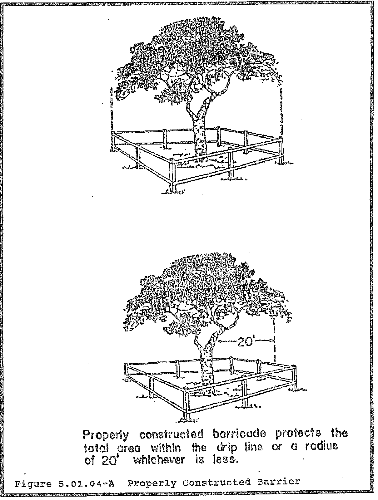
Prior to any land preparation or other development activities a protective barrier easily visible to equipment operators shall be placed around all protected trees so as to encompass the entire tree protection zone. See Figure 5.01.04-A.
(2)
No attachment, wires (other than supportive wires), signs or permits may be fastened to any protected tree.
(3)
No equipment, construction materials or debris of any kind shall be placed within the protective barrier.
(4)
Landscaping activities within the bounds of the protective barrier (before and after it is removed) shall be accomplished with light machinery or manual labor. Grubbing and similar activities are prohibited.
(5)
In lieu of constructing the barriers required above, the developer may physically designate large areas containing protected trees where no land preparation or other development activities of any kind will occur. The area shall be designated by placing stakes a maximum of twenty-five (25) feet apart and tying ribbon, plastic tape, rope, etc., from stake to stake along the outside perimeter of the area. This perimeter line shall be beyond the tree protection zone of any protected trees growing within the area.
(6)
Required protective barriers and perimeter lines shall remain in place until all construction activity, except landscaping within the protected area, is terminated.
(c)
Avoiding injuries due to chemical poisoning.
(1)
No fuel, paint, solvent, oil, thinner, asphalt, cement, grout or any other construction chemical or other material or tools of any kind shall be stored, or allowed in any manner to enter, within a required protective barrier or perimeter line.
(2)
No equipment shall be cleaned within a required protective barrier or perimeter line.
(d)
Avoiding injuries due to grade changes. Grade changes shall not be made within the tree protection zone unless the following protective measures are taken:
(1)
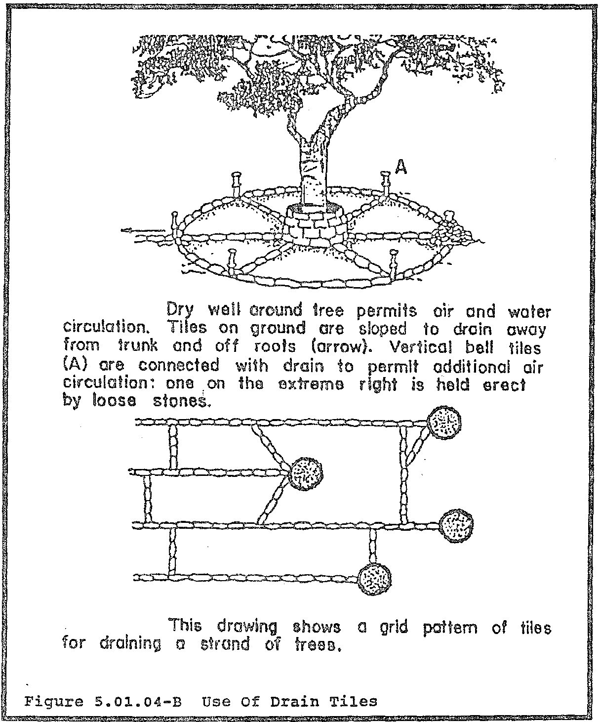
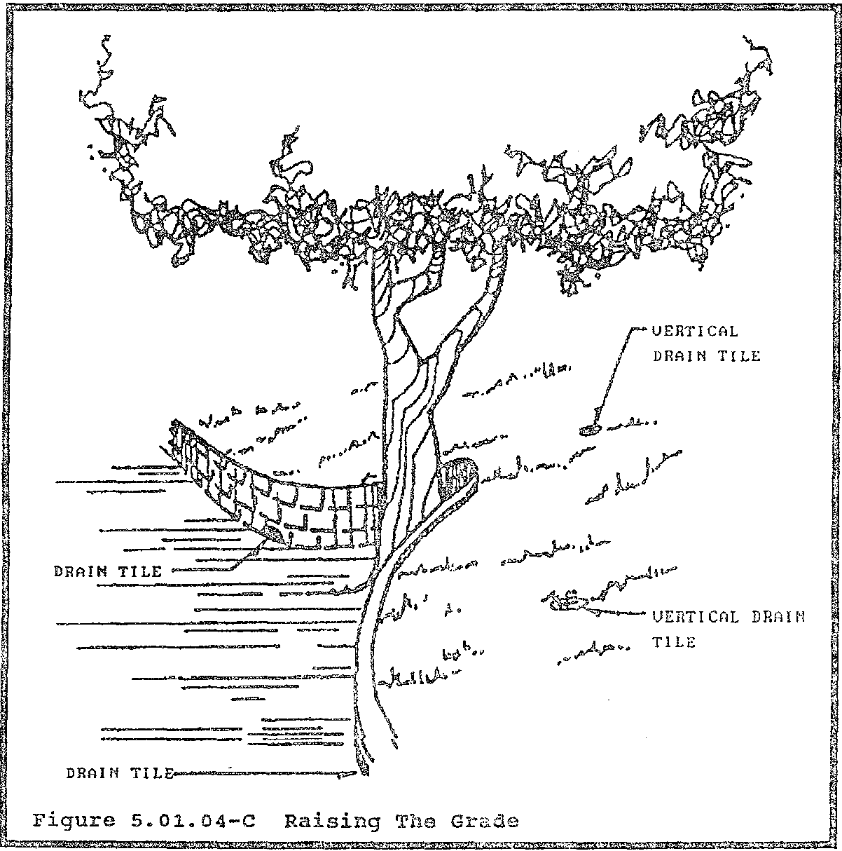
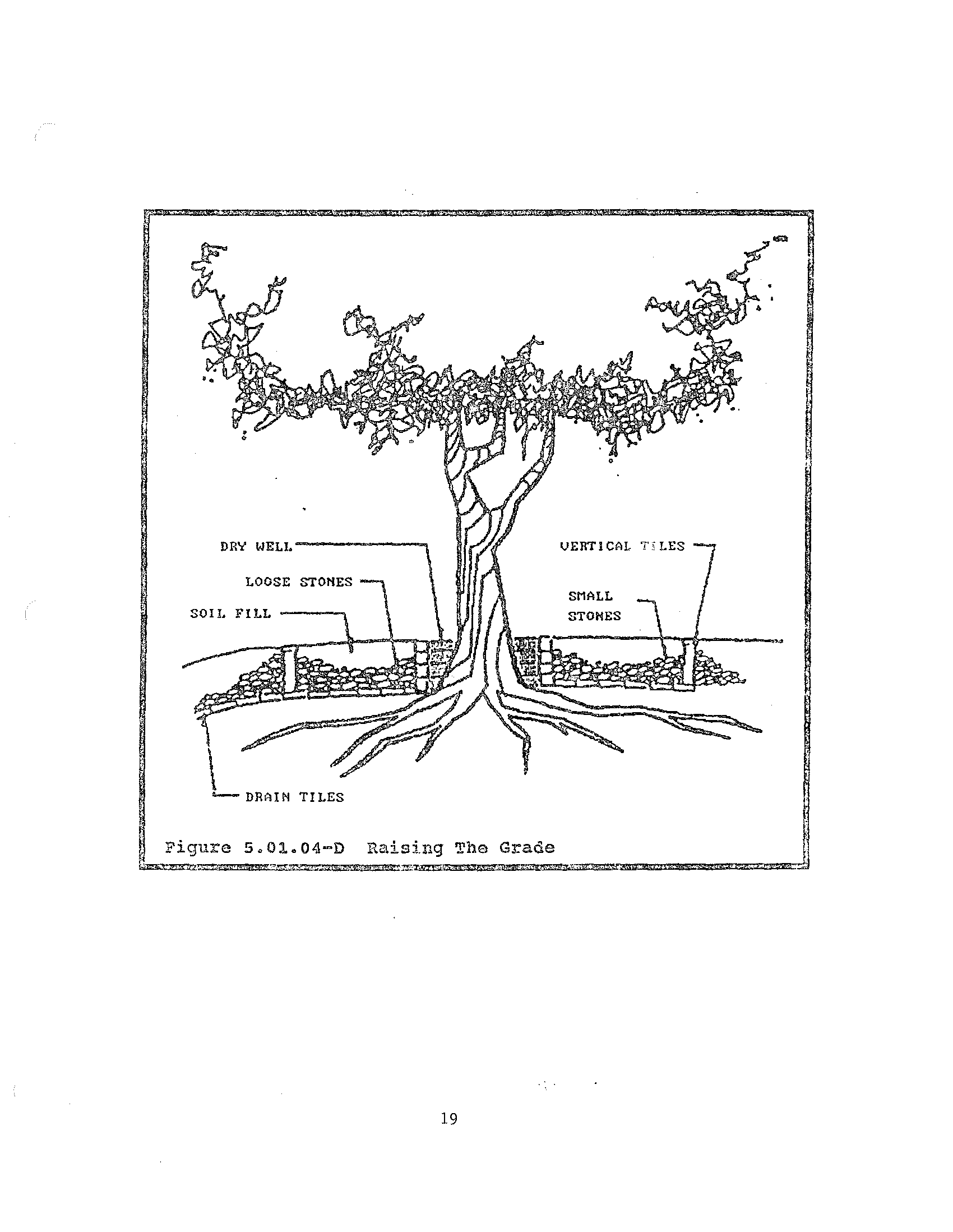
When raising the grade, the following measures shall be taken:
a.
Within the tree protection zone, existing sod, vegetation and leaf litter shall be removed and the soil loosened without injuring the roots.
b.
The area within the tree protection zone shall be properly fertilized to improve the vigor and growth of the roots.
c.
Porous, four-inch agriculture drain tiles shall be laid over the soil to drain liquids away from the trunk. A drop of at least one eighth (⅛) inch per foot shall be provided. The drain field shall be designed to provide adequate drainage of the existing configuration of the trees.
d.
The number of drains shall depend upon soil material; lighter sandy soils and porous gravelly material require fewer drains than heavy non-porous soils.
e.
Aeration shall be provided by installing vertical tiles along the system. The vertical tiles shall be filled with gravel and capped with a heavy-duty mesh to keep out trash and debris.
f.
Dry wells shall be large enough to allow for maximum growth of the tree trunk. Most large shade trees require at least a sixty (60) inch diameter well. For slow-growing mature trees, a space of twelve (12) to eighteen (18) inches shall be provided between the trunk and the side of the well at every point.
g.
To prevent washing of material into the well, the dry well casing walls shall be high enough to bring the coping just above the level of the proposed fill.
h.
Dry well walls shall be constructed of materials that permit passage of air and water. Concrete blocks backed with galvanized screening may be used for the sides of the well.
i.
Gratings or barriers shall be used around openings that are large enough to present a hazard to pedestrians.
j.
Open wells shall be cleaned regularly to remove sediment, leaves, and debris that might interfere with the free passage of air.
k.
Large stones shall be placed over the drainage tiles and a layer of smaller stones shall be placed over the remainder of the ground within the drip line.
l.
A layer of gravel shall be placed over the stones.
m.
The fill shall be completed with a layer of porous soil.
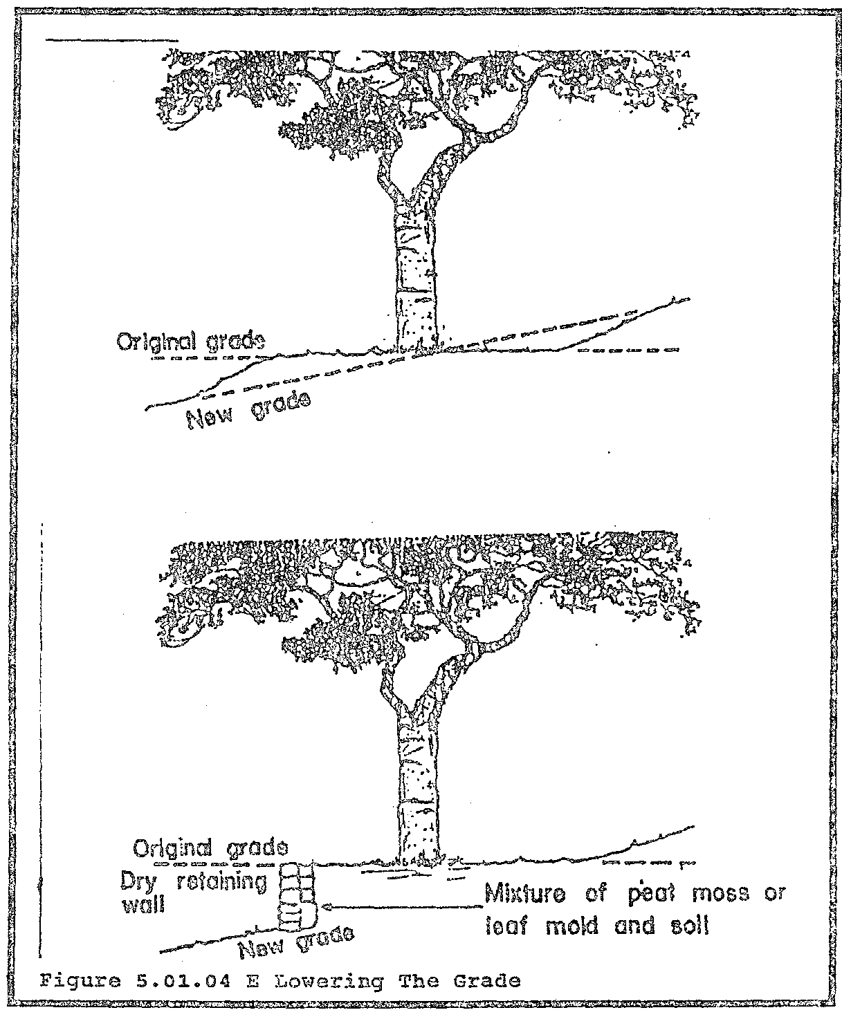
See Figures 5.01.04-B, -C, AND -D.
(2)
When lowering the grade, the following measures shall be taken:
a.
Roots shall be cut cleanly and re-trimmed after excavation.
b.
The canopy shall be pruned to aid in maintaining tree vigor.
c.
When lowering the grade of the soil surrounding a protected tree, the maximum number of tree roots within the tree protection zone shall be preserved by using any of the following methods:
1.
Terracing. The area within the tree protection zone is left at the original grade by terracing.
2.
Retaining wall. The area within the tree protection zone is left at the original grade constructing a dry retaining wall. The retaining wall shall be porous to allow for aeration.
3.
Terracing and retaining wall. The area within the tree protection zone is left at the original grade by the combined use of terracing and dry retaining wall. See Figure 5.01.04 E.
(3)
Minor changes in grade. When the change in grade is minor, as determined by the city staff, lesser protective measures than those described above may be taken. The city staff shall approve the use of these methods where their use will not endanger the health of the protected tree.
(e)
Avoiding injuries due to excavations.
(1)
Water, sewer, and other utility lines should be routed around the tree protection zones of protected trees.
(2)
If a line cannot reasonably be routed around the tree protection zone, the line shall be tunnelled beneath the area within the zone. The tunnel shall be offset to one (1) side of the trunk to prevent damage to the main tap roots.
(f)
Avoiding injury by paving within the drip line. Porous paving may be placed within the tree protection zone of a protected tree, so long as no damage is inflicted to the tree by grade change, compaction of the soil, or any other cause.
Editor's note— The foregoing protective measures and figures are adapted from "Tree Protection Manual for Builders and Developers," Florida Division of Forestry, Forest Education Bureau, Collins Building, Tallahassee, Florida 32201. Because the appropriate protective measures may change as knowledge in the area of urban forestry increases, you should contact your local forester for the latest tree protection measures.
Sec. 14-250. - Special provisions for the protection of mangroves.
(a)
Generally. In addition to the foregoing tree protection requirements, the following special provisions shall apply to the removal or alteration of mangroves (black mangrove, Avicennia germinans; white mangrove, Laguncularia racemosa; red mangrove, Rhizophora mangle).
(b)
Replacement. Mangroves may not be removed unless the developer replaces or relocates on the same development site at least an equal number of mangroves, necessary to re-vegetate a land area equal to or greater than the land area from which mangroves were removed. The developer shall provide a plan to be approved by the city staff or other appropriate professional, to assure the survival of the replaced or relocated mangroves and to stabilize the shoreline from which mangroves were removed. The approved plan is an express condition of any permit. Failure to carry out any provision of the plan shall be a violation of this code.
(c)
Other protective measures. The following protective measures apply to all mangroves.
(1)
A permit shall be obtained from DER for any alteration of mangroves in jurisdictional waters.
(2)
A permit shall be obtained from the city for any alteration of mangroves which are exempt from DER permit requirements.
(3)
Standards for alteration of mangroves shall be those contained in rule 17.27, Mangrove Protection, of the Florida Administrative Code.
Editor's note— The requirement that a DER permit be obtained should, of course, be deleted if permitting authority has been delegated to the local government pursuant to Rule 17.27.0800, F.A.C.
Sec. 14-251. - Special provisions for protection of canopy roads.
(a)
Generally. The city commission has determined that certain roadways within the city merit special protection of the trees which line and/or provide canopies over the roadway. It is the purpose of this section to describe those roadway sections and require additional protection, through control of activities that abut these roadways.
(b)
Designation of roadways. The following roads are designated as tree-lined and canopy road protection areas:
Local canopy roads should be listed.
(c)
Restrictions. All protected species within an area extending fifty (50) feet on either side of the designated roadways are protected from removal or destruction by the requirements of this section. No protected species within the area of protection shall be removed Without permit. Protected trees which are approved for removal shall be replaced with one and one-half (½) times the number [of the] trunk circumference inches as the removed tree(s).
Sec. 14-252. - Preservation of protected trees as grounds for variance from other requirements of this code.
The preservation of any protected tree may be considered as a factor in rendering a decision upon an application for a variance from the literal application of other requirements of this code. See Part 10.02.00 of this code for variance provisions.
Sec. 14-265. - General provisions.
(a)
Relationship to other requirements relating to the protection of environmentally sensitive lands. In addition to meeting the following protection of environmentally sensitive lands requirements, development plans shall comply with applicable federal, state and water management district regulations relating to environmentally sensitive lands. In all cases the strictest of the applicable standards shall apply.
(b)
Conservation element incorporated by reference. The conservation element of the city comprehensive plan as from time to time amended is hereby incorporated by reference into this code.
Editor's note— This provision is necessary only if the conservation element will be used to determine the location and/or boundaries of environmentally sensitive lands.
(c)
Compliance when subdividing land. Each lot of a proposed subdivision must include a site suitable for constructing a structure in conformity with the standards of these protection of environmentally sensitive lands regulations.
Sec. 14-266. - Definitions.
Accessory use means a use of land or structure or portion thereof customarily incidental and subordinate to the principal use of the land or structure and located on the same parcel with the principal use.
Adjacent to a protected environmentally sensitive area means any location within five hundred (500) feet of the boundary of any protected environmentally sensitive area, whether the location is on or off the development site.
Adverse effects means any modifications, alterations, or effects on waters, associated wetlands, or shorelands, including their quality, quantity, hydrology, surface area, species composition, or usefulness for human or natural uses which are or may potentially be harmful or injurious to human health, welfare, safety or property, to biological productivity, diversity, or stability or which unreasonably interfere with the reasonable use of property, including outdoor recreation. The term includes secondary and cumulative as well as direct impacts.
Associated wetland means any wetland that is adjacent or contiguous to waters, or which has a direct hydrologic connection to waters.
Beneficial functions of a protected environmentally sensitive area means those functions, described in the conservation element of the comprehensive plan, that justify designating an area as environmentally sensitive.
Clearing means the removal of trees and brush from the land, not including the ordinary mowing of grass.
Direct hydrologic connection means a surface water connection which, under normal hydrological conditions, occurs on an average of thirty (30) or more consecutive days per year. In the absence of reliable hydrologic records, a continuum of wetlands may be used to establish a direct hydrologic connection.
Pollutant means any substance, contaminant, noise, or manmade or man-induced alteration of the chemical, physical, biological, or radiological integrity of air or water in quantities or at levels which are or may be potentially harmful or injurious to human health or welfare, animal or plant life, or property, or which unreasonably interfere with the enjoyment of life or property, including outdoor recreation.
Protected environmentally sensitive area means an environmentally sensitive area designated for protection in the conservation element of the city comprehensive plan.
Significant adverse effect means any modification, alteration, or effect upon a protected environmentally sensitive area which measurably reduces the area's beneficial functions as delineated in the conservation element of the city comprehensive plan.
Water or waters includes, but is not limited to, water on or beneath the surface of the ground or in the atmosphere, including natural or artificial watercourses, streams, rivers, lakes, ponds, or diffused surface water and water percolating, standing, or flowing beneath the surface of the ground.
Water body means any natural or artificial pond, lake, reservoir, or other area with a discernible shoreline which ordinarily or intermittently contains water.
Watercourse means any natural or artificial channel, ditch, canal, stream, river, creek, waterway or wetland through which water flows in a definite direction, either continuously or intermittently, and which has a definite channel, bed, banks, or other discernible boundary. Water's edge and wetland's edge means the water's or wetland's edge shall be determined by whichever of the following indices yields the most landward extent of waters or wetlands:
(1)
The boundary established by the average annual high water mark,
(2)
The landward boundary of hydric soils, or
(3)
The landward boundary of wetland vegetation, based on the wetland vegetation index.
Sec. 14-267. - Creation of protected environmentally sensitive zones.
(a)
Wetlands protection zone.
(1)
There is hereby created a "wetlands protection zone" in which special restrictions on development apply.
(2)
The boundaries of this zone shall be the most landward extent of the following:
a.
Areas within the dredge and fill jurisdiction of the department of environmental regulation as authorized by F.S. § 403.
b.
Areas within the jurisdiction of the U.S. Army Corps of Engineers as authorized by section 404, Clean Water Act or Section 10, River and Harbor Act.
c.
Areas within the jurisdiction of the South Florida Water Management District pursuant to the Florida Administrative Code.
Editor's note— The intent of this definition is to use wetlands boundaries that will have already been determined, rather than having the local government create yet another jurisdictional line. The conservation element of the local comprehensive plan may, however, call for the delineation of boundaries that differ from those used by state and federal agencies.
(b)
Shoreline protection zone.
(1)
There is hereby created the "shoreline protection zone" in which special restrictions on development apply.
(2)
The shoreline protection zone extends from the point in waters where no emergent aquatic vegetation can grow landward to a point fifty (50) feet landward of the water's edge.
(c)
Others. Other zones should be created based on environmentally sensitive land designated in the conservation element as warranting protection.
(d)
Request for determination of boundaries. A developer may obtain a determination of the boundaries of a protected environmentally sensitive zone by submitting to the department by certified mail or hand delivery a request for determination of boundaries. The request must, as a minimum, set forth an adequate description of the land the developer wishes to develop, the nature of the developer's right to ownership or control of the land, and other information needed to make the determination. The department shall make the determination within ten (10) working days of receiving the needed information from the developer.
Sec. 14-268. - Development activities within protected environmentally sensitive zones.
(a)
Generally. Except as expressly provided herein, no development activity shall be undertaken in a protected environmentally sensitive zone.
(b)
Activities presumed to have an insignificant adverse affect on protected environmentally sensitive zones.
(1)
Certain activities are presumed to have an insignificant adverse affect on the beneficial functions of protected environmentally sensitive zones. Notwithstanding the prohibition in section 14-268(a) of this section, these activities may be undertaken unless it is shown by competent and substantial evidence that the specific activity would have a significant adverse effect on the protected environmentally sensitive area.
(2)
The following uses and activities are presumed to have an insignificant adverse effect on wetlands protection zones:
a.
Scenic, historic, wildlife, or scientific preserves.
b.
Minor maintenance or emergency repair to existing structures or improved areas.
c.
Cleared walking trails having no structural components.
d.
Timber catwalks and docks four (4) feet or less in width.
e.
Commercial or recreational fishing or hunting, and creation and maintenance of temporary blinds.
f.
Cultivating agricultural or horticultural products that occur naturally on the site.
g.
Constructing fences where no fill activity is required and where navigational access will not be impaired by construction of the fence.
h.
Developing an area that no longer functions as a wetland, except a former wetland that has been filled, or altered in violation of any rule, regulation, statute, or this code. The developer must demonstrate that the water regime has been permanently altered, either artificially or naturally, in a manner to preclude the area from maintaining surface water or hydroperiodicity necessary to sustain wetland structure and function. If the water regime of a wetland has been artificially altered, but wetland species remain the dominant vegetation of the area, the department shall determine the feasibility of restoring the altered hydrology. If the wetland may be restored at a cost that is reasonable in relation to benefits to be derived from the restored wetland, the developer shall, as a condition of development, restore the wetland and comply with the requirements of this code.
i.
Developing a "wetlands storm water discharge facility" or "treatment wetland" in accordance with state permits received under Chapters 17-25 and 17-6, Florida Administrative Code.
(3)
The following uses and activities are presumed to have an insignificant adverse effect on shoreline protection zones:
a.
Scenic, historic, wildlife, or scientific preserves.
b.
Minor maintenance or emergency repair to existing structures or improved areas.
c.
Clearing of shoreline vegetation waterward of the water's edge, so as to provide a corridor not to exceed fifteen (15) feet in width, of sufficient length from the shore to allow access for a boat or swimmer to reach open water, and landward of the water's edge so as to provide an open area not to exceed twenty-five (25) feet in width. One (1)additional such corridor may be cleared for every full one hundred (100) feet of frontage along the water's edge above and beyond the first one hundred (100) feet.
d.
Clearing of shoreline vegetation to create walking trails having no structural components, not to exceed four (4) feet in width.
e.
Timber catwalks, docks, and trail bridges that are less than or equal to four (4) feet wide, provided that no filling, flooding, dredging, draining, ditching, tiling or excavating is done, except limited filling and excavating necessary for the installation of pilings.
f.
Commercial or recreational fishing, hunting or trapping, and creation and maintenance of temporary blinds.
g.
Constructing fences where no fill activity is required and where navigational access will not be impaired by construction of the fence.
h.
Developing a "wetlands storm water discharge facility" or "treatment wetland" in accordance with state permits received under Chapters 17-25 and 17-6, Florida Administrative code.
(4)
Other protected environmentally sensitive zones.
(c)
Special uses. Certain uses that provide substantial public benefits may not be viable unless placed within a protected environmentally sensitive zone, e.g., a marina that may require the use of wetland areas for lack of suitable non-sensitive sites adjacent to a water body. A local government may decide to allow these uses in sensitive areas despite significant damage to the area. The following example creates an exception for water dependent uses, accompanied by mitigation requirements. A local government may employ other exceptions relating to local conditions.
(1)
Water dependent activities.
a.
Generally. Designated water dependent activities that are otherwise prohibited may be allowed if the developer shows:
1.
The public benefits of the activity substantially outweigh the adverse environmental effects on a wetland area; and
2.
No practicable alternative to placement in the protected environmentally sensitive zone exists.
b.
Permittable water dependent activities. The following are permittable water dependent activities:
1.
Projects not exceeding ten thousand (10,000) cubic yards of material placed in or removed from watercourses, water bodies or wetlands.
2.
Dockage or marinas where dock length does not exceed twenty-five (25) percent of the width of the water body and containing less than one (1) slip per one hundred (100) feet of shoreline. All docks and slips shall be at least one hundred (100) feet from any federal navigation project.
3.
New riprap or similar structures (not including seawalls, bulkheads or the like) not exceeding fifty (50) feet of shoreline.
4.
Installation of buoys, aids to navigation, signs, and fences.
5.
Performance of maintenance dredging for ten (10) years from the date of the original permit. Thereafter, performance of maintenance dredging so long as less than ten thousand (10,000) cubic yards of material is removed.
6.
Installation of subaqueous transmission and distribution lines for water, wastewater, electricity, communication cables, oil or gas. Lines may be entrenched in (not exceeding ten thousand (10,000) cubic yards of dredging), laid on, or embedded in bottom waters.
7.
Construction of foot bridges and vehicular bridges.
8.
Replacement or widening of bridges on pilings or trestles where the effects of pollutants discharged into open waters are minimized.
9.
Construction of artificial reefs.
Editor's note— These allowable water dependent activities are similar to those included in the rules of the Florida Department of Environmental Regulation. Fla. Admin. Code Rule 17-12.090.
c.
Minimization of impacts. The water dependent activity shall be designed, constructed, maintained and undertaken in a way that minimizes the adverse impacts on the beneficial functions of the affected environmentally sensitive zone.
(2)
Other special uses based on local conditions.
(d)
Design standards for special uses.
(1)
Generally. In addition to the standards listed in section 14-269(b) of this section, the following standards apply to special uses allowed in the protected environmentally sensitive zones.
(2)
Special uses allowed in a shoreline protection zone.
a.
The development shall be designed to:
1.
Allow the movement of aquatic life requiring shallow water;
2.
Maintain existing flood channel capacity;
3.
Assure stable shoreline embankments.
b.
Development that encroaches on the shoreline protection zone shall not be located:
1.
On unstable shorelines where water depths are inadequate to eliminate or minimize the need for offshore or foreshore channel construction dredging, maintenance dredging, spoil disposal, filling, beach feeding, and other river, lake, and channel maintenance activities;
2.
In areas where there is inadequate water mixing and flushing;
3.
In areas which have been identified as hazardous due to high winds or flooding.
c.
Access roads, parking lots, and similar structures shall be located on upland sites.
d.
Non-developed portions of the shoreline protection zone that are damaged during construction shall be restored or replaced through replanting of vegetation, restocking of fish, shellfish, and wildlife, re-establishment of drainage patterns, and the like. To the maximum extent possible, the restored areas shall match their prior ecological functioning.
e.
Accessory uses shall be limited to those which are water-dependent or necessary for operation of the development. Accessory uses will be consistent in scale and intensity with the surrounding uses. Fill shall not be placed in waters or associated wetlands to create usable land space for accessory uses.
Editor's note— The City of Pahokee should designate allowable accessory uses for different types of development.
(3)
Other design standards for other protected environmentally sensitive zones.
(e)
Mitigation.
(1)
Generally.
a.
Compensatory mitigation, by which environmentally sensitive lands are purchased, created, enhanced and/or restored to compensate for the loss of such lands, is required whenever a special use is allowed under section 14-268(c) of this section.
b.
The purchased, created, enhanced, or restored environmentally sensitive land must be of the same type as that destroyed or degraded.
c.
Compensatory mitigation shall not be the basis for approving a project that could not otherwise be approved.
d.
A development of a compensatory mitigation plan shall grant conservation easement under F.S. § 704.06, on the newly purchased, created, enhanced or restored environmentally sensitive lands to protect them from future development.
(2)
Wetlands. Compensatory wetland mitigation shall require that the amount of wetlands purchased, created, enhanced, or restored be large enough to assure that the amount of wetlands destroyed or degraded will be completely and successfully replaced. The following ratios of replacement to destroyed wetlands shall be presumed to provide reasonable assurances for type-for-type mitigation:
*If the wetland creation proposed depends extensively on natural recolonization the ratio may be 3.0:1-4.0:1.
(3)
Other special provisions relating to particular types of environmentally sensitive lands.
Sec. 14-269. - Restricted development zone.
(a)
Generally. There is hereby created a restricted development zone adjacent to each protected environmentally sensitive area. This zone shall encompass all land within five hundred (500) feet of the boundary of the protected environmentally sensitive zone.
(b)
Development activities within restricted development zone.
(1)
All development in a restricted development zone shall be designed, constructed and maintained to avoid significant adverse effects on the adjacent environmentally sensitive zone.
(2)
The acreage within a protected environmentally sensitive zone may be used to determine the total allowable units or square footage of development that will be allowed on a site containing all or part of such a zone. This development potential may be transferred from the protected environmentally sensitive zone to the restricted development zone or beyond as provided for in the clustering and transferable development rights provisions in article X. Allowable development potential may not, however, be transferred from without the area encompassed by the restricted development zone and protected environmentally sensitive zone to within such area.
(3)
The following special design standards applying within restricted development zones adjacent to wetlands protection zones:
a.
Wherever possible, natural buffers shall be retained between all development and all protected environmentally sensitive zones. If a natural buffer does not exist, an equivalent buffer shall be created. The size of the buffer shall be the minimum necessary to prevent significant adverse effects on the protected environmentally sensitive area. The factual basis of the decision as to the size of the buffer shall be stated as a finding in the written record.
b.
The developer shall completely restore any portion of a protected environmentally sensitive zone damaged during construction. Complete restoration means that the damaged area shall, within five (5) years, be operating as effectively as the natural system did prior to being destroyed.
c.
Other reasonable protective measures necessary to prevent significant adverse effects on a protected environmentally sensitive zone may be required. The factual basis of the decision to require the measure shall be stated as a finding in the written record. Protective measures may include, but are not limited to:
1.
Maintaining natural drainage patterns.
2.
Limiting the removal of vegetation to the minimum necessary to carry out the development activity.
3.
Expeditiously replanting denuded areas.
4.
Stabilizing banks and other unvegetated areas by siltation- and erosion-control measures.
5.
Minimizing the amount of fill used in the development activity.
6.
Disposing of dredged spoil at specified locations in a manner causing minimal environmental damage.
7.
Constructing channels at the minimum depth and width necessary to achieve their intended purposes, and designing them to prevent slumping and erosion and allow revegetation of banks.
8.
Dredging wetlands at times of minimum biological activity to avoid periods of fish migration and spawning, and other cycles and activities of wildlife.
9.
Designing, locating, constructing and maintaining all development in a manner that minimizes environmental damage.
10.
Prohibiting septic tanks or locating them away [from] high groundwater areas and peaty soils.
11.
Using deed restrictions and other legal mechanisms to require the developer and successors to protect the environmentally sensitive areas and maintain the development in compliance with the protective measures.
(4)
The following special design standards applying within restricted development zones adjacent to shoreline protection zones:
a.
All development shall be setback greater than or equal to fifty (50) feet from the landward boundary of the shoreline protection zone.
b.
Total impervious surface, including but not limited to buildings, houses, parking lots, garages, accessory buildings, driveways, pools, and walkways is limited to twenty-five (25) percent of the land area of the entire site.
c.
The development shall leave a minimum of fifty (50) percent of the site as trees, shrubs, or other natural vegetation, or replace existing trees at a (minimum) two-to-one (2:1) ratio.
d.
Point source and nonpoint source discharges are prohibited, except for stormwater, which may be discharged only if it meets the following minimum standard. Stormwater discharges shall include an additional level of treatment equal to fifty (50) percent of the treatment criteria specified in [the rules of the appropriate water management district], and shall provide off-line retention or off-line detention with filtration of the first one-half (½) inch of run-off of the total amount required to be treated. If the city or any state agency has a stormwater rule which is stricter than this standard, then the stricter rule or combination of rules shall apply.
Editor's note— The state imposes an additional fifty (50) percent treatment to Protect Outstanding Florida Waters, and that standard has been followed here to ensure protection of water bodies adjacent to development.
e.
Siltation and erosion control measures shall be applied to stabilize banks and other un-vegetated areas during and after construction. Sediment settling ponds shall be installed for stormwater runoff prior to the creation of any impervious surfaces. For lots or parcels that are cleared, silt screens shall be placed between the construction site and the water body to prevent erosion and siltation.
Editor's note— The city should develop erosion control guidelines and include them in this code. Erosion control measures such as the planting of natural vegetation or the use of riprap are preferred over solid structures, such as cement walls, which disrupt natural flows and processes.
f.
Any channels constructed shall be of a minimum depth and width capable of achieving the intended purposes. Sides of channels shall reflect an equilibrium shape to prevent slumping and erosion and to allow re-vegetation.
g.
Any dredging shall be conducted at times of minimum biological activity to avoid fish migration and spawning, and other cycles and activities of wildlife.
h.
Any spoil that results from dredging shall be disposed of at upland sites and stabilized within thirty (30) days, unless the spoil is causing turbidity or other problems, in which case the developer must stabilize the spoil immediately.
i.
If dredging changes the littoral drift processes and causes adjacent shores to erode, the developer shall periodically replenish these shores with the appropriate quantity and quality of aggregate.
j.
Septic tanks shall not be located closer than one hundred fifty (150) feet from the boundary of the shoreline protection zone. If septic tanks are allowed, there may be no more than two (2) septic tanks per acre of land.
k.
Where wet moorage is offered for boats which have holding facilities for sewage, or where other recreational vehicles are allowed to stay overnight, then pump-out, holding, or treatment facilities shall be provided by the developer for sewage and other wastes, including bilge, contained on vessels and vehicles. The facilities shall be conveniently available to all vessels and vehicles.
l.
If no natural vegetation exists, strips of buffer vegetation shall be planted between development activities and the shoreline protection zone. Buffers shall be a minimum of ** feet wide and shall be composed of native plant species or **.
** As per permit requirements from Department of Natural Resources (DNR) and the U.S. Army Corps of Engineers.
Editor's note— The city should develop criteria for the width and vegetative composition and density of buffers. The buffer standards provided in article VIII may be used here.
m.
Marinas and other appropriate developments shall post the following signs where they are readily visible to all users of the development:
1.
Regulations pertaining to handling and disposal of waste, sewage, or toxic materials.
2.
Regulations prohibiting the use of vessel toilets while moored unless these toilets are self-contained or have an approved treatment device.
3.
Regulations prohibiting the disposal of fish or shellfish cleaning wastes, scrap-fish, viscera, or unused bait in or near the development.
4.
Appropriate messages relating to local ecological concerns, e.g., manatee protection.
n.
A marina shall include boat launch facilities unless the applicant can demonstrate that providing such facilities is not feasible or it is determined that the ramp would be excessively damaging to the aquatic environment.
Editor's note— The idea behind this requirement is to combine destructive activities to a minimal number of sites along the shoreline. Providing a boat ramp at the already-disturbed marina site may be preferable to disturbing another site along the shoreline to provide the ramp.
o.
Marinas shall have adequate rest-room facilities in compliance with local health board regulations.
p.
Garbage receptacles shall be provided and maintained by the marina operator at several locations convenient to users.
Sec. 14-270. - Prohibited on-going activities.
The following standards apply to post-development activities taking place within any restricted development zone or protected environmentally sensitive zone.
(1)
Point source and nonpoint source discharges. Absent an amendment to the development order, point source and nonpoint source discharges shall continue to meet the standards applicable to the original development.
(2)
Clearing. Absent an amendment to the development order, no person shall clear more vegetation than was permitted for the original development.
(3)
Handling and storage of fuel, hazardous and toxic substances, and wastes.
a.
Developments where fuel or toxic substances will be stored, transferred, or sold shall employ the best available facilities and procedures for the prevention, containment, recovery, and mitigation of spillage of fuel and toxic substances. Facilities and procedures shall be designed to prevent substances from entering the water or soil, and employ adequate means for prompt and effective clean-up of spills that do occur.
b.
No toxic or hazardous wastes or substances shall be stored in outdoor containers.
c.
Storage or disposal of all types of wastes is prohibited on shorelines.
(4)
Prohibited uses. The long-term storage of equipment or materials, and the disposal of wastes shall be prohibited.
(5)
Fertilizers, herbicides, or pesticides.
a.
Fertilizers, herbicides, or pesticides shall not be applied in a protected environmentally sensitive zone except for projects conducted under the authority of F.S. § 373.451—373.4595, the Surface Water Improvement and Management Act, and governmentally authorized mosquito control programs.
b.
Fertilizers, pesticides, and herbicides used in restricted development zones shall be applied sparingly and at appropriate rates and time intervals.
(6)
Spray vehicles. Vehicles used for mixing or spraying chemicals are prohibited from withdrawing water directly from waters.
(7)
Pump-out, holding, and treatment facilities for wastes from mobile sources. Sewage, solid waste, and petroleum waste generated by vessels or vehicles on the site shall be properly collected and disposed of.
Editor's note— Enforcement of standards for post-development activities is not addressed in this Ordinance. The city should either enforce the post-development standards through an existing enforcement process or create a process to enforce post-development standards.
Sec. 14-280. - Purpose and intent.
The purpose of groundwater protection standards is to safeguard the health, safety and welfare of the citizens of the city. This is accomplished through ensuring the protection of the principle source of water for domestic, agricultural, and industrial use. The availability of adequate and dependable supplies of good quality water is of primary importance to the future of the city. Therefore, standards are described in this section with the intent of protecting both the quantity and quality of the groundwater supply. It is further the intent of this section to control development in and adjacent to designated wellheads to protect water supplies from potential contamination.
Sec. 14-281. - Definitions.
The following words, terms and phrases, when used in this chapter, shall have the meanings ascribed to them in this section, except where the context clearly indicates a different meaning:
Protected wellhead means those wellheads with a permitted capacity of one hundred thousand (100,000) GPD or more.
Wellhead protection area. Each local government must determine, based on local geologic and hydrologic conditions, the size of the area around protected wellheads in which development activities allowed but carefully regulated. The size of the area may be based on the travel time of pollutants spilled on the surface, or some other determinant.
Zone of exclusion means all land within a two hundred (200) foot radius of an existing or designated protected wellhead.
Sec. 14-282. - Restrictions on development.
(a)
Within the zone of exclusion. No development activities shall take place in the zone of exclusion.
(b)
Prohibited uses and development activities within the wellhead protection zone. The following land uses are prohibited within wellhead protection zone:
(1)
Landfills.
(2)
Facilities for the bulk storage, handling or processing of materials on the Florida Substance List (F.S. ch. 442).
(3)
Activities that require the storage, use, handling, production or transportation of restricted substances: agricultural chemicals, petroleum products, hazardous/toxic wastes, industrial chemicals, medical wastes, etc.
(4)
Feedlots or other concentrated animal facilities.
(5)
Wastewater treatment plants, percolation ponds, and similar facilities.
(6)
Mines.
(7)
Excavation of waterways or drainage facilities which intersect the water table.
(8)
Others based on local conditions.
(c)
Special restrictions on development allowed within the wellhead protection zone.
(1)
Stormwater management practices shall not include drainage wells and sinkholes for stormwater disposal where recharge is into potable water aquifers.
(2)
Where development is proposed in areas with existing wells, these wells shall be abandoned, including adequate sealing and plugging according to Chapter Rule 17.28, Florida Administrative Code.
(3)
Others based on local conditions.
Sec. 14-290. - Generally.
(a)
Purpose and intent. It is the purpose of this part to provide standards necessary to protect the habitats of species, both flora and fauna, of endangered, threatened, or special concern status in the city. It is the intent of this division to require that an appropriate amount of land shall be set aside to protect habitat of rare, endangered, or special concern plant and animal species.
(b)
Applicability. Areas subject to the standards of this article shall be those identified in the conservation element of the city comprehensive plan as habitat for rare and endangered species, threatened species, or species of special concern.
Sec. 14-291. - Habitat management plan.
(a)
When required. A habitat management plan shall be prepared as a prerequisite to the approval of any development proposed on a site containing areas subject to this division.
(b)
Contents. The habitat management plan shall be prepared by an ecologist, biologist or other related professional. The plan shall document the presence of affected species, the land needs of the species that may be met on the development site, and shall recommend appropriate habitat management plans and other measures to protect the subject wildlife.
(c)
Conformity of final development plan. The final development plan approved for a development shall substantially conform to the recommendations in the habitat management plan.
(d)
Preservation of land. Where land on a proposed development site is to be preserved as habitat of rare, endangered or special concern species, such land shall be adjacent to existing viable habitat, a significant wetland system, floodplain, or wildlife corridor. If such lands are not adjacent to the development site, land to be set aside shall be of such quantity and quality as to provide viable habitat, as documented in the study required in paragraph (b) above.
(e)
Fee in lieu. As an alternative to preservation of land, the city may establish a fee-in-lieu-of-land program, whereby the city can purchase land which will provide a significant habitat.
Editor's note— Requirements of this section should be based upon the data and analysis of the conservation element. As an alternative to a professionally-prepared study for all lands which may provide habitat for species which are rare, endangered, or of special concern, the city may establish a threshold for requiring such a study. It is important to note that the reservation of land area must recognize that the land requirements to provide habitat which satisfy the needs for food, water, and shelter for affected species may be so comprehensive or specialized that every development cannot provide a meaningful quantity or quality of land. Small, isolated areas may not function as viable habitat.
Sec. 14-300. - General provisions.
(a)
Abrogation and greater restrictions. These flood damage prevention regulations do not repeal, abrogate, or impair any existing easements, covenants, or deed restrictions.
(b)
Warning and disclaimer of liability. Although the degree of flood protection required by these flood damage prevention regulations is reasonable and appropriate for regulatory purposes, based on scientific and engineering considerations, more severe floods will occur and flood heights may be increased by man-made or natural causes. Consequently, these flood damage prevention regulations do not imply that land outside the areas of special flood hazard or uses permitted within those areas will be free from flooding or flood damages. These flood damage prevention regulations shall not create liability on the part of the city or any of its officers or employees for any flood damages that result from reliance on these flood damage prevention regulations or any administrative decision lawfully made thereunder.
(c)
Declaration of public nuisance. All development located or maintained within any area of special flood hazard after [the adoption of this chapter] in violation of these flood damage prevention regulations is hereby declared a public nuisance per se.
Sec. 14-301. - Definitions.
The following words, terms and phrases, when used in this division, shall have the meanings ascribed to them in this section, except where the context clearly indicates a different meaning:
Administrator means the federal insurance administrator.
Appurtenant structure means a structure which is on the same parcel of property as the principal structure to be insured under the federal flood insurance program and where the use is incidental to the use of the principal structure.
Area of shallow flooding means a designated AO, AH or VO zone on the flood insurance rate map, or other area designated on a map by the director of community development with base flood depths from one (1) to three (3) feet where a clearly defined channel does not exist, where the path of flooding is unpredictable, and where velocity flow may be evident.
Editor's note— The FIRM maps for some communities may not contain any AO, AH or VO zones in which case this definition and the regulations related thereto may be deleted.
Area of special flood hazard means the area of special flood hazard shall include:
(1)
All areas designated on a flood hazard boundary map as Zone A or a flood insurance rate map as Zones A, AO, AH, A1—30, AE, A99, VO, or V1-30, VE, or V. The relevant flood hazard boundary map and flood insurance rate maps, and any revisions thereto, are adopted by reference and declared to be a part of this code.
(2)
Other areas of the community designated on a map by the director of community development as having a one (1) percent or greater chance of flooding in any given year. This may include isolated topographic depressions with a history of flooding or a high potential for flooding.
Base flood means the flood having a one (1) percent chance of being equaled or exceeded in any given year.
Basement means that portion of a building having its floor below ground level on all sides.
Breakaway wall means a wall that is designed and constructed to collapse under specified lateral loading forces without causing damage to the elevated portion of the building or the supporting foundation system.
Coastal high hazard area means all areas designated on a flood insurance rate map as V1—30, VE or V.
Flood or Flooding means a temporary partial or complete inundation of normally dry land from the overflow of inland or tidal waters, or from the unusual and rapid accumulation of runoff or surface waters from any source.
Flood hazard boundary map (FHBM) means the map issued by the Federal Emergency Management Agency showing flood-prone areas. Drawn from United States Geological Survey Maps, it does not provide flood elevations and is intended to be used only until the flood insurance rate map is produced.
Flood insurance rate map (FIRM) means the official map issued by the Federal Emergency Management Agency showing both the area of special flood hazard and the risk premium zones within the city.
Floodplain means land which will be inundated by floods known to have occurred or reasonably characteristic of what can be expected to occur from the overflow of inland or tidal waters and the accumulation of runoff of surface waters from rainfall.
Flood protection elevation means the elevation of the base flood plus one (1) foot.
Floodway means the channel of a natural stream or river and portions of the floodplain adjoining the channel, which are reasonably required to carry and discharge the floodwater or flood flow of any natural stream or river.
Functionally dependent use means a use which cannot be used for its intended purpose unless it is located or carried out in close proximity to water, such as a docking, loading and unloading of cargo or passengers, ship building and ship repair, or processing seafood. The term does not include long-term storage or related manufacturing uses.
Highest adjacent grade means the highest natural elevation of the ground surface adjacent to the proposed walls of a structure.
Lowest floor means the lowest enclosed floor of a structure, including a basement, but not including the floor of an area enclosed only with insect screening or wood lattice as permitted by the flood damage prevention regulations in this code.
Mangrove stand means an assemblage of one (1) or more of the following species: black mangrove (Avicennia nitida); red mangrove (Rhizophora mangle); white mangrove (Languncularia racemosa); and buttonwood (Conocarpus erecta).
Manufactured home means a structure, transportable in one (1) or more sections, which is built on a permanent chassis, designed to be used with or without a permanent foundation, and connected to the required utilities. The term also includes park trailers, travel trailers, and similar transportable structures placed in use (other than for sale) on a site for one hundred eighty (180) consecutive days or longer.
Mean sea level means the average height of the sea for all stages of the tide. For purposes of this code the term is synonymous with National Geodetic Vertical Datum (NGVD).
New construction means structures or substantial improvements for which the "start of construction" occurred on or after the effective date of this code, and any alteration, repair, reconstruction or improvements to a structure which is in compliance with these flood damage prevention regulations.
Editor's note— "New construction" and "start of construction" are used to designate which projects must comply with the flood damage prevention provisions of this code.
Person means any individual, group of individuals, corporation, partnership, association, or any other entity, including State and local governments and agencies.
Regulatory floodway means the channel of a river or other watercourse and the adjacent land areas that must be unobstructed in order to discharge the base flood without increasing the water surface elevation of that flood more than one (1) foot at any point.
Editor's note— The "floodway" is the area that has the greatest impact on the velocity and height of flood flows. Further encroachment in the floodway zone is likely to increase the ability of the flood plain to convey water, and development in this area is susceptible to extreme flood damage. The one-foot standard is maximum allowed under federal flood insurance regulations; a larger floodway could be designated by decreasing this amount.]
Sand dunes means naturally occurring accumulations of sand in ridges or mounds landward of the beach.
Start of construction means the date the construction permit was issued, provided the "actual start of construction" was within one hundred eighty (180) days of the permit date. The "actual start of construction" means the first placement of permanent elements of a structure on a site, such as the pouring of slabs or footings, installation of piles, construction of columns, or any work beyond the stage of excavation or of the placement of a manufactured home on a foundation. Permanent construction does not include land preparation, such as clearing, grading and filling; installation of streets and/or walkways; excavation for a basement, footings, piers or foundations; erection of temporary forms; or the installation of appurtenant structures. This definition does not apply to new construction or substantial improvements under the Coastal Barrier Resources Act (P.L. 97-348).
Structure means a walled and roofed building, including a manufactured home, and a gas or liquid storage tank that is principally above ground.
Substantial improvement means any combination of repairs, reconstruction, alteration, or improvements to a structure, taking place during [the life of a structure] [a ten (10) year period], in which the cumulative cost equals or exceeds fifty (50) percent of the market value of the structure. The market value of the structure is the appraised value of the structure prior to the start of the initial repair or improvement, or, in the case of damage, the value of the structure prior to the occurrence of the damage. For the purposes of this definition, "substantial improvement" occurs when the first alteration of any wall, ceiling, floor, or other structural part of the structure commences, whether or not that alteration affects the external dimensions of the structure. The term does not, however, include any improvement of a structure to comply with existing health, sanitary, or safety codes, or any alteration of a structure listed on the National Register of Historic Places, the Local Register of Historic Places, or a State Inventory of Historic Places, unless that alteration will cause the structure to lose its historical designation.
Editor's note— This definition is used to require that improvements that equal or exceed fifty (50) percent of a structure's market value must comply with the flood damage prevention requirements in this code. This attempts to strike a balance between the competing demands for sound flood management and the need for owners to conduct routine repairs and maintenance [of] existing structures without having to comply with the code. [Floodplain] regulations are silent on the issue a period of time resulting in expenditures of over fifty (50) percent of a structure's value. A community is free, therefore, to make the code more stringent by a cumulative expenditure provision such as appears in this definition.
Sec. 14-302. - Standards for reducing flood hazards in the area of special flood hazard
(a)
Generally. The standards in this part apply to all development within the area of special flood hazard as shown on a flood hazard boundary map or a flood insurance rate map.
(b)
Anchoring. All new construction and substantial improvements of existing construction shall be anchored to prevent flotation, collapse or lateral movement of the structure during a base flood. Manufactured homes shall be anchored, tied down and blocked in accordance with the standards of Section 15C-1.10, Florida Administrative Code.
(c)
Construction materials and methods. All new construction and substantial improvements of existing construction shall be constructed with materials and utility equipment resistant to flood damage, and using methods and practices that will minimize flood damage and prevent the pollution of surface waters during a base flood.
(d)
Service facilities and utilities.
(1)
Electrical heating, ventilation, plumbing, air conditioning and other service facilities shall be designed or located to prevent water from entering or accumulating within the components during a base flood.
(2)
All new and replacement water supply and sanitary sewage systems shall be designed to minimize or eliminate both infiltration of flood waters into the systems and discharges from the systems into flood waters.
(3)
On-site sanitary sewage systems shall be located and constructed to avoid impairment to them or contamination from them during flooding, and shall not be installed wholly or partially in a regulatory floodway.
(e)
Storage of materials and equipment.
(1)
Storing or processing materials that would, in a flood, be buoyant, flammable, explosive, or potentially injurious to human, animal or plant life is prohibited.
(2)
Materials or equipment immune to substantial damage by flooding may be stored if firmly anchored to prevent flotation or if readily removable from the area upon receipt of a flood warning.
Sec. 14-303. - Additional standards for reducing flood hazards in areas for which flood insurance rate maps have been prepared.
(a)
Generally. The following standards must be complied with in all areas of special flood hazard for which a base flood elevation has been established by a flood insurance rate map or otherwise.
(b)
Residential structures.
(1)
All new construction and substantial improvements of existing construction of residential structures shall be constructed with the lowest floor elevated to or above the flood protection elevation.
(2)
For all new construction and substantial improvements of existing construction, enclosed areas below the lowest floor that are subject to flooding shall be designed to equalize hydrostatic flood forces on exterior walls by allowing for automatic entry and exit of floodwater. Designs for meeting this requirement must either be certified as meeting this requirement by a registered professional engineer or architect, or meet or exceed the following minimum standards:
a.
Provide a minimum of two (2) openings having a total net area of not less than one (1) square inch for every square foot of enclosed area subject to flooding.
b.
Place the bottom of all openings no higher than one (1) foot above grade.
c.
Equip openings with devices, such as screens, louvers, or valves that permit the automatic entry and exit of floodwater. Access to the enclosed area shall be the minimum necessary to allow for parking of vehicles (i.e. a garage door) or storing equipment used to maintain the premises (i.e. a standard exterior door), or entering the living area (i.e. a stairway or elevator). The interior of the enclosed area shall not be partitioned or finished into separate rooms.
(3)
Electrical, plumbing, and other utility connections shall not be placed below the Flood Protection Elevation.
(c)
Nonresidential structures. New construction and substantial improvements of existing construction of nonresidential structures shall either comply with section 14-302(b) of this article, or be constructed, including attendant utility and sanitary facilities, to meet the following standards:
(1)
Walls below the flood protection elevation shall be substantially impermeable to the passage of water.
(2)
Structural components shall resist hydrostatic and hydrodynamic loads and effects of buoyancy.
(3)
Be certified as meeting the standards of this section by a registered professional engineer or architect.
(d)
Subdivisions.
(1)
All preliminary subdivision proposals shall identify the area of special flood hazard and the elevation of the base flood.
(2)
All final subdivision plans shall identify the elevation of proposed structures and pads. If the site is filled above the base flood, the final pad elevation shall be certified by a registered professional engineer or surveyor.
(3)
All public utilities and facilities in subdivisions shall be located and constructed to minimize flood damage, and shall be adequately drained to reduce exposure to flood hazards.
(4)
Each lot must include a site suitable for constructing a structure in conformity with the standards of these flood damage prevention regulations.
(5)
All agreements for deed, purchase agreements, leases, or other contracts for sale or exchange of lots within an area of special flood hazard and all instruments conveying title to lots within an area of special flood hazard must prominently publish the following flood hazard warning in the document:
Flood Hazard Warning
This property may be subject to flooding. You should contact local building and zoning officials and obtain the latest information about flood elevations and restrictions before making plans for the use of this property.
Sec. 14-304. - Standards for reducing flood hazards in certain zones within the area of special flood hazard.
(a)
Regulatory floodways. The following standards apply to regulatory floodways located within the area of special flood hazard:
(1)
Encroachments, including fill, new construction, substantial improvements and other development, are prohibited unless a registered professional engineer certifies and demonstrates that the cumulative effect of the proposed development, when combined with all other existing and anticipated development, will not result in any increase in flood levels during a base flood.
(2)
All new construction and substantial improvements of existing construction shall comply with all applicable flood damage prevention provisions of sections 14-302 and 14-303 of this article.
Editor's note—
A floodway must be designated by a community if FEMA has provided the necessary data.
Regulation of the floodway is one (1) of the most important aspects of flood damage
prevention regulations. It is assumed that additional development within the floodway
would interfere with the normal movement of flood waters, and result in a significant
increase in water surface elevations. By designating a floodway zone in which development
is strictly limited, the community can be assured that a channel will be maintained
that is capable of passing floodwater associated with a base flood.
Based on these assumptions, development in the floodway is treated differently from
that in the remaining portion of the area of special flood hazard. Proposals for development
in the area of special flood hazard that are not in the floodway are reviewed only
to ensure that development is protected against the base flood and need not be reviewed
to determine their impact on flood heights because a floodway has already been designated.
Proposals for development in the regulatory floodway are first reviewed for their
cumulative impact on flood heights and are denied if flood levels would be raised.
If a technical evaluation clearly demonstrates that the cumulative impact of the proposal
will not cause an increase in flood heights, the proposal may be approved if the flood
damage prevention standards of these regulations are otherwise met.
(b)
Coastal high hazard areas. In all areas designated as coastal high hazard areas the following standards must be met:
(1)
All new construction and substantial improvements of existing construction shall be located fifty (50) feet landward of the reach of the mean high tide.
(2)
Elevation.
a.
All new construction shall be elevated so that the bottom of the lowest supporting horizontal member of the lowest floor (excluding pilings or columns) is located no lower than one (1) foot above the base flood elevation, with all construction below the lowest supporting member open so as not to impede the flow of water.
b.
No fill shall be used as structural support. Non-compacted fill may be used around the perimeter of a structure for landscaping or aesthetic purposes provided the fill will wash out from storm surge (thereby rendering the structure free of obstruction) prior to generating excessive loading forces, ramping effects, or wave deflection. The director of community development shall approve design plans for landscaping/aesthetic fill only after the applicant has provided an analysis by an engineer, architect, and/or soil scientist demonstrating that the foregoing criteria have been satisfied based upon the following considerations:
1.
The particle composition of the fill material does not have a tendency for excessive natural compaction.
2.
The volume and distribution of the fill will not cause wave deflection to adjacent properties.
3.
The slope of the fill will not cause wave run-up or ramping.
c.
The construction below the lowest floor shall be free of obstructions but may be enclosed with breakaway walls, open wood lattice or insect screening designed to collapse under wind and water loads without causing collapse, displacement, or other structural damage to the elevated portion of the structure or supporting foundation system. For the purposes of this section, a breakaway wall shall have a design safe loading resistance of not less than ten (10) and no more than twenty (20) pounds per square foot. Use of breakaway walls which exceed a design safe loading resistance of no less than ten (10) and no more than twenty (20) pounds per square foot (either by design or when so required by local or state codes) may be permitted only if a registered engineer or architect certifies that the proposed design meets the following criteria:
1.
The breakaway wall will collapse under a water load less than the load imposed by the base flood; and
2.
The elevated portion of the structure and supporting foundation system will not collapse, be displaced, or suffer structural damage from wind and water loads acting simultaneously on all building components (structural and non-structural.) Wind and water loading values to be used in this determination shall not be less than those that have a one (1) percent chance of being equalled or exceeded in any given year (one hundred (100) year mean recurrence interval.)
d.
The space below the lowest floor shall be used only for parking of vehicles, building access, or storage of equipment used to maintain the premises.
(3)
Anchoring.
a.
All structures shall be securely anchored on pilings or columns.
b.
All pilings and columns and the attached structures shall be anchored to resist flotation, collapse, and lateral movement caused by wind and water loads acting simultaneously on all components of the structure. Wind and water loading values to be used in designing the anchor and support system shall not be less than those that have a one (1) percent chance of being equalled or exceeded in any given year (one hundred (100) year mean recurrence interval.)
(4)
Site alteration. Sand dunes and mangrove stands shall not be altered in a way that increases the potential for flood damage.
(5)
Certification. A registered professional engineer or architect shall certify that the design, specifications and plans for construction comply with the requirements of this section.
(c)
Standards for areas of shallow flooding. The following standards apply to areas of shallow flooding located within the area of special flood hazard.
(1)
Residential structures. The lowest floor of all new construction of and substantial improvements to residential structures shall be elevated above the highest adjacent grade at least as high as the depth number specified in feet on the FIRM (at least two (2) feet if no depth number is specified.)
(2)
Nonresidential structures. The lowest floor of all new construction of and substantial improvements to non-residential structures shall:
a.
Be elevated as prescribed in section 14-304(c)(1) above; or
b.
Be constructed, together with attendant utility and sanitary facilities, so that any walls below the level prescribed in section 14-304(c)(1) above shall be substantially impermeable to the passage of water and any structural components below that level shall be capable of resisting hydrostatic and hydrodynamic loads and effects of buoyancy.
Editor's note— These requirements are designed to maintain the flood water storage capacity of ponding areas or to prevent damming of sheet flow flood waters.
(d)
Standards for streams without established base flood elevations and/or regulatory floodways. The following standards apply to small streams in the area of special flood hazard for which no base flood data or regulatory floodway have been provided.
(1)
Encroachments. No encroachments, including fill material or structures shall be located within a distance of the stream bank equal to two (2) times the width of the stream at the top of the bank, or fifty (50) feet from the top of each bank, whichever is greater, unless a registered professional engineer demonstrates and certifies that the encroachments would not result in any increase in flood levels in a base flood.
(2)
Elevation. New construction of or substantial improvements to structures shall be elevated or flood-proofed to minimize risks of flooding reasonably to be expected based on the best available data.
Sec. 14-305. - Administration and enforcement.
(a)
Generally. In addition to the administrative and enforcement provisions in Article XII of this code, the following provisions apply.
(b)
Designation and duties of local administrator. The director of community development of the department of planning and development shall administer and implement the provisions of these flood damage prevention regulations. In addition to duties assigned elsewhere, the director of community development shall:
(1)
Review all proposed developments to assure that the requirements of these regulations have been met.
(2)
Review all certificates submitted to satisfy the requirements of these regulations.
(3)
Notify adjacent communities, the water management district, and the state department of community affairs, prior to permitting or approving any alteration or relocation of a watercourse, and provide evidence of such notification to the Federal Emergency Management Agency.
(4)
Verify and record the actual elevation (in relation to mean sea level) of the lowest floor, or of the flood-proofing, of all new or substantially improved structures regulated by these flood damage prevention regulations.
(5)
Interpret the boundaries of the area of special flood hazard and the various zones, including the regulatory floodways and coastal high hazard areas.
(6)
Maintain all records pertaining to the implementation of these flood damage prevention regulations.
(c)
Certification of as-built elevations.
(1)
For development activity which includes structures, and in areas where base flood elevations are available, the developer shall submit to the director of community development a certification prepared by a registered land surveyor or licensed professional engineer of the as-built elevation in relation to mean sea level of the lowest floor, flood-proofed elevation, or horizontal structural members of the lowest floor, as applicable. This certification shall be provided before additional construction may occur.
(2)
The director of community development shall review submitted floor elevation survey data and inform the applicant of deficiencies within thirty (30) working days. No work shall be permitted to proceed until the deficiency is removed in the opinion of the director of community development. Failure to submit the certification or to make required corrections shall be cause to issue a stop-work order for the project.
(3)
Upon submittal of certified elevations and/or a determination by the director of community development that the development meets all of the applicable requirements of these flood damage prevention regulations, the director of community development shall issue a certificate of compliance. All work performed before the issuance of this certificate shall be at the risk of the developer.
(d)
Enforcement.
(1)
Any violation of these flood damage prevention regulations is a public nuisance and may be restrained by injunction or otherwise abated in a manner provided by law.
(2)
In addition to any remedy or penalty provided herein or by law, any person who violates the provisions of these flood damage prevention regulations shall be punished by a fine of not less than one hundred dollars ($100.00) nor more than five hundred dollars ($500.00) or by imprisonment in the county jail for a period not to exceed sixty (60) days, or by both such fine and imprisonment. Each day during which the violation occurs shall constitute a separate offense.
(3)
Any violator may be required to restore land to its undisturbed condition. In the event that restoration is not undertaken within a reasonable time after notice, the city may take necessary corrective action, the cost of which shall become a lien upon the property until paid.