
Parker City Zoning Code
CHAPTER 13
04 - Zoning Districts
13.04.010 - Zoning districts, generally.
(a)
Zoning districts established. The Town of Parker is divided into zoning districts as shown in Table 13.04.A below.
(b)
Official zoning map.
(1)
Incorporation of map.
a.
The location and boundaries of the districts established by this LDO are shown on the Official Zoning Map for the Town of Parker, Colorado.
b.
The Official Zoning Map shall be maintained by the Community Development Department and shall be made available for review and inspection.
(2)
Zoning district boundaries.
a.
Unless otherwise indicated, zoning district boundaries shall follow municipal corporation limits, section lines, lot lines, centerlines of public rights-of-way, or extensions of such lines.
b.
Ordinances amending zoning that are adopted by the Town Council shall control the boundaries and locations of the zoning districts. In the event a zoning district boundary is unclear, the official zoning district boundaries shall be determined by the Planning Director.
c.
Any appeal of a Planning Director determination shall be heard by the Town Council rather than the Planning Commission, but shall otherwise be pursuant to Section 13.03.030(i)(3), Appeals of decisions under the LDO.
(3)
Amendments to the official zoning map. Changes to the boundaries of any zoning district requires an amendment to the Official Zoning Map pursuant to Section 13.03.040(n), Rezoning.
(4)
Annexations. Town zoning shall be adopted concurrently with annexation of any territory into the Town.
(5)
Lands without zoning designation. Any property located in the Town that does not have a specified zoning designation shall be reviewed by the Planning Director for the official designation. In cases where official designation is not clear, the official zoning of such property shall be deemed to be zoned AG until such time a Rezoning is approved to a designation other than the AG district.
(c)
Organization of this chapter.
(1)
Base zoning districts.
a.
Content. Sections 13.04.020 through 13.04.190 follow a common structure and format for each base zoning district within the Town of Parker. Each district begins with a purpose statement describing the intended character of the respective district, followed by the lot and building standards that apply to development within that district such as lot parameters, setbacks, and building height. Any other commonly referenced standards that may apply to that district are noted within each base zoning district; however, such lists and references are not to be construed as an exhaustive list of the full range of requirements of this LDO that may apply to a specific project.
b.
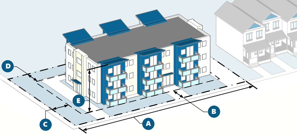
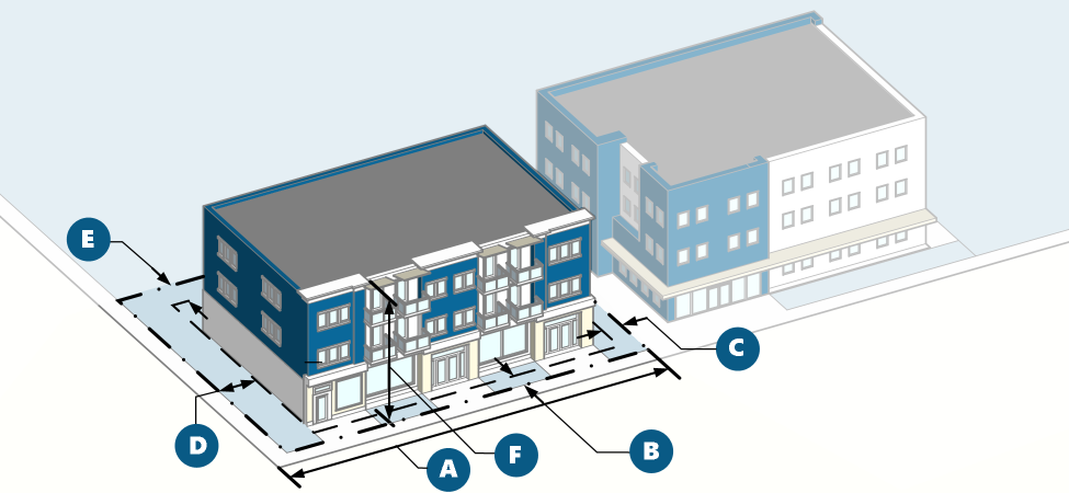
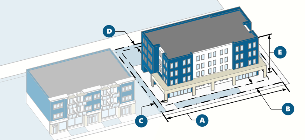
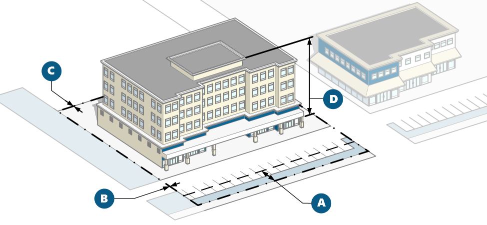
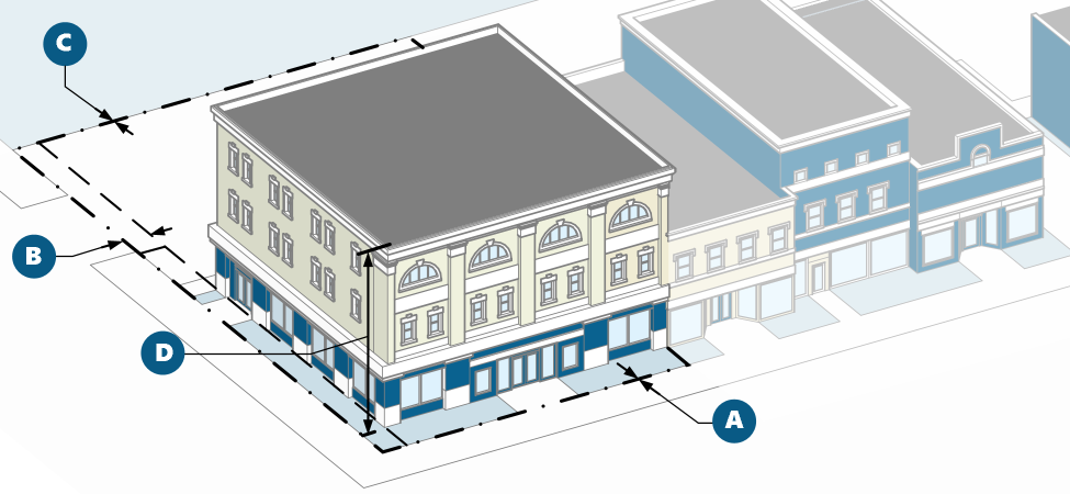
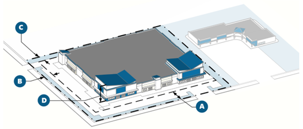
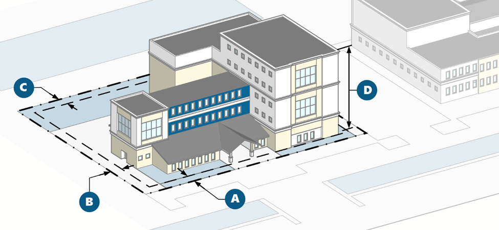
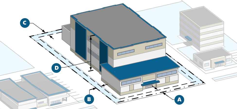
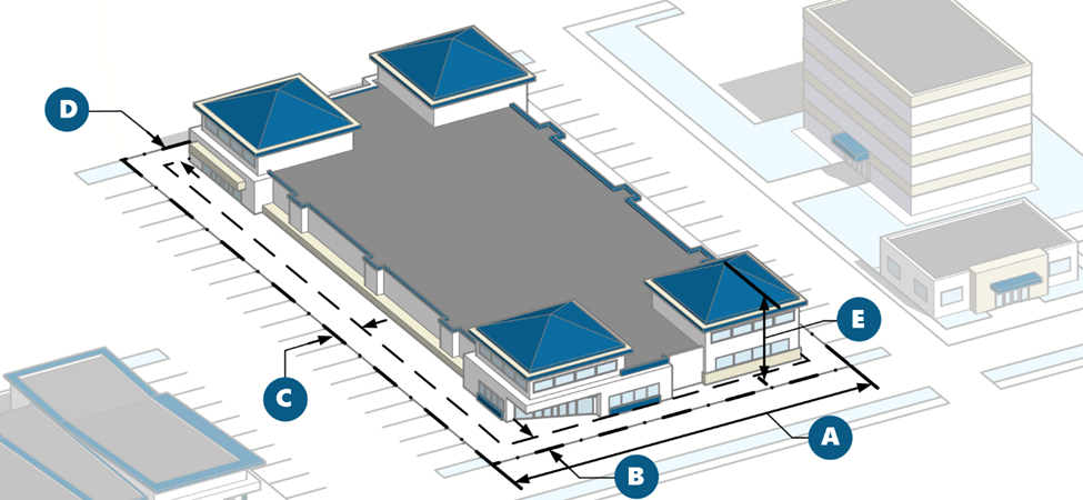
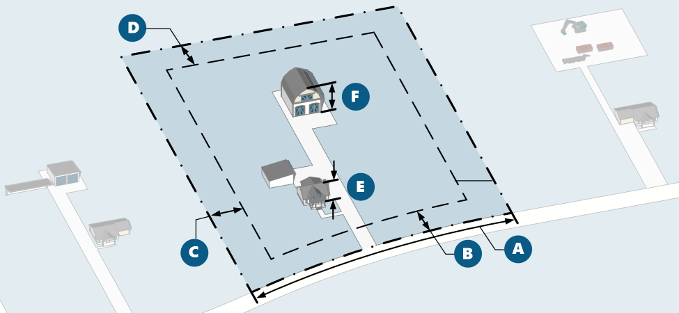
Graphics. Each base zoning district is accompanied by at least one graphic depicting how the lot and building standards apply to lots and building forms within the respective district. Such graphics and illustrations are intended to represent the general character of development within the district but are not intended to identify specific projects or locations within that district. The graphics and illustrations do not reflect all standards from the LDO that may apply to a project and are intentionally diagrammatic versus detailed. Where an illustration is inconsistent with the respective table of lot and building standards or other text within this LDO, the standards in the table and text shall govern. The master graphic showing the intent and general measurement features of the district graphics is included below:
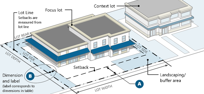
Figure 04.1 Exemplary Graphic for Zoning District Measurements
(2)
Planned developments. Planned Developments are zoning districts as described in Section 13.04.200.
(3)
Overlay districts.
a.
Overlay zoning districts are established by amending the Official Zoning Map pursuant to Section 13.03.040(n), Rezoning. An overlay district is superimposed over one or more underlying base zoning districts or a planned development district. If the standards within an overlay district expressly conflict with the standards in the underlying base zoning district, planned development district, or another applicable overlay district, the overlay standards shall apply.
b.
Section 13.04.210 identifies the overlay districts and establishes the purpose and applicable standards that modify the requirements of the underlying base zoning district or planned development district.
(4)
Summary tables of lot and building standards. Section 13.04.220 summarizes the lot and building standards from the base zoning districts for purposes of cross-comparison. Should any standard within a summary table conflict with the standards included in the respective base zoning district, the standards within the base zoning district shall govern.
(5)
Measurements methodology. Section 13.04.230 describes the methodology for measuring the various lot and building standards in this Chapter and specifies exceptions to those lot and building standards.
(Ord. 3.372.2 §1(Exh. A), 2025)
13.04.020 - Large-lot residential (SF1).
(a)
Purpose. The SF1 district is intended to accommodate large-lot suburban development of primarily single-family detached homes, with limited nonresidential supporting community and educational uses. The SF1 district is the lowest density residential district, with higher densities considered provided the impacts are comparable to other uses allowed in the district.
(b)
SF1 lot and building standards.
| Lot Standards | ||
| Lot size, minimum | 8,000 sq. ft. | |
| Lot width, minimum | 80 feet | |
| Density, minimum | None | |
| Setbacks (minimum) | ||
| Front | 25 feet | |
| Side | 10 feet [1] | |
| Side, adjacent to street | None | |
| Rear | 15 feet [1] | |
| Building separation (side and rear) | None | |
| Height (maximum) | ||
| Building height | 35 feet | |
|
Notes:
[1] On Restricted Lots, buildings 35 feet tall or less shall be set back a minimum of 25 feet from each property line with a Protected Lot; and buildings taller than 35 feet shall be set back a minimum of 40 feet from each property line with a Protected Lot. | ||
(c)
Additional standards. Additional residential design standards may apply pursuant to Section 13.08.100(c), Residential design standards.
13.04.030 - Standard-lot residential (SF2).
(a)
Purpose. The SF2 district is intended to accommodate standard suburban lots with primarily single-family detached homes, integrated parks and open space, and limited nonresidential supporting community and educational uses. The SF2 district can serve as a transitional district between low-density districts and medium- to high-density residential, mixed-use, and nonresidential districts and uses. Higher densities for housing older adults may be considered provided the impacts are comparable to other uses allowed within the district.
(b)
SF2 lot and building standards.
| Lot Standards | ||
| Lot size, minimum | 5,000 sq. ft. | |
| Lot width, minimum | 55 feet | |
| Density, minimum | None | |
| Setbacks (minimum) | ||
| Front | 20 feet | |
| Side | 5 feet [1] | |
| Side, adjacent to street | 10 feet [1] | |
| Rear | 15 feet [1] | |
| Building separation (side and rear) | None | |
| Height (maximum) | ||
| Building height | 35 feet | |
|
Notes:
[1] On Restricted Lots, buildings 35 feet tall or less shall be set back a minimum of 25 feet from each property line with a Protected Lot; and buildings taller than 35 feet shall be set back a minimum of 40 feet from each property line with a Protected Lot. | ||
(c)
Additional standards. Additional residential design standards may apply pursuant to Section 13.08.100(c), Residential design standards.
13.04.040 - Small-lot residential (SF3).
(a)
Purpose. The SF3 district is intended to allow a diverse housing stock (attached and detached) on individual lots in compact neighborhoods, or in cluster subdivision arrangements pursuant to Section 13.08.030(h), Cluster developments. This district accommodates medium- to high-density residential development, with limited nonresidential supporting community and educational uses. The SF3 district can serve as a transitional district between low- and medium-density residential and higher-density residential, mixed-use, or nonresidential districts and uses.
(b)
SF3 lot and building standards.
| Lot Standards | ||
| Lot size, minimum | 1,000 sq. ft. | |
| Lot width, minimum | 22 feet | |
| Density, minimum | None | |
| Setbacks (minimum)[1] | ||
| Front, without garage | 10 feet | |
| Front with front-facing garage | 0 feet — See DDS | |
| Side | 0 feet [2] | |
| Side, adjacent to street | 10 feet [2] | |
| Rear | 0 feet [2] | |
| Building separation (side and rear) | 10 feet | |
| Height (maximum) | ||
| Building height | 40 feet [3] | |
|
Notes:
[1] Setbacks are measured differently for single-family attached products. See measurements and exceptions in Section 13.04.220. [2] On Restricted Lots, buildings 35 feet tall or less shall be set back a minimum of 25 feet from each property line with a Protected Lot; and buildings taller than 35 feet shall be set back a minimum of 40 feet from each property line with a Protected Lot. [3] No portion of a building constructed on a Restricted Lot outside of the DE or DW zoning districts may exceed a maximum height of 35 feet within 50 feet of a Protected Lot. | ||
(c)
Additional standards.
(1)
Additional standards in the Development Design Standards may apply depending on use type.
(2)
Additional residential design standards may apply pursuant to Section 13.08.100(c), Residential design standards.
13.04.050 - Multifamily residential (MF).
(a)
Purpose. The MF district is intended to accommodate areas for high-density residential development, including a variety of housing types such as single-family attached and vertically stacked units. This district includes limited nonresidential supporting community and educational uses and can serve as a transitional district to mixed-use and nonresidential districts where appropriate.
(b)
MF lot and building standards.
| Lot Standards | ||
| Lot size, minimum | Single-family attached or duplex: 1,000 sq. ft. | |
| Other residential: 20,000 sq. ft. | ||
| Nonresidential: 10,000 sq. ft. | ||
| Lot width, minimum | Single-family attached or duplex: 22 feet | |
| Other residential: 55 feet | ||
| Nonresidential: 100 feet | ||
| Density, minimum | 10 du/ac | |
| Setbacks (minimum)[1] | ||
| Front | Single-family attached or duplex: 0 feet | |
| Other Residential: 20 feet | ||
| Nonresidential: 25 feet | ||
| Side | Single-family attached or duplex: 0 feet | |
| Other residential or nonresidential: 15 feet [2] | ||
| Side, adjacent to street | Same as front setback [2] | |
| Rear | Single-family attached or duplex: 0 feet | |
| Other Residential: 15 feet [2] | ||
| Nonresidential: 25 feet [2] | ||
| Building separation | 10 feet | |
| Height (maximum) | ||
| Building height | 45 feet; 60 feet with Use by Special Review [3] | |
|
Notes:
[1] Setbacks are measured differently for single-family attached products. See measurements and exceptions in Section 13.04.230. [2] On Restricted Lots, buildings 35 feet tall or less shall be set back a minimum of 25 feet from each property line with a Protected Lot; and buildings taller than 35 feet shall be set back a minimum of 40 feet from each property line with a Protected Lot. [3] No portion of a building constructed on a Restricted Lot outside of the DE or DW zoning districts may exceed a maximum height of 35 feet within 50 feet of a Protected Lot. | ||
(c)
Additional standards.
(1)
Additional standards in the Development Design Standards may apply depending on use type.
(2)
Additional residential design standards may apply pursuant to Section 13.08.100(c), Residential design standards.
13.04.060 - Mixed-use neighborhood (MN).
(a)
Purpose. The MN district is intended to accommodate a mix of housing types at varied densities and supporting neighborhood-centric commercial activities serving the needs of surrounding residents. The MN district is intended to include both vertical and horizontal mixed-use development and can serve as a transitional district between residential zoning districts and more intense commercial, mixed-use, and nonresidential districts and uses.
(b)
MN lot and building standards.
| Lot Standards | ||
| Lot size, minimum | Single-family attached or duplex: 1,000 sq. ft. | |
| Other residential or nonresidential: 7,000 sq. ft. | ||
| Lot width, minimum | Single-family attached or duplex: 22 feet | |
| Other residential or nonresidential: 35 feet | ||
| Density | None | |
| Setbacks | ||
| Front, minimum | Single-family attached or duplex: 0 feet | |
| Other residential: 20 feet | ||
| Nonresidential: 25 feet | ||
| Front, maximum, nonresidential | 15 feet | |
| Percentage of building front elevation required to meet maximum front setback on Mainstreet | None | |
| Side, minimum | Single-family attached: 0 feet | |
| Other residential or nonresidential: 5 feet [1] | ||
| Side, adjacent to street, minimum | 10 feet [1] | |
| Rear, with alley, minimum | None [1] | |
| Rear, without alley, minimum | Single-family attached: 0 feet | |
| Other residential or nonresidential: 8 feet [1] | ||
| Height (maximum) | ||
| Building height, maximum |
35 feet;
45 feet for vertical mixed-use building; Up to 60 feet with approval of a Use by Special Review [2] | |
| Building height, minimum | None | |
|
Notes:
[1] On Restricted Lots, buildings 35 feet tall or less shall be set back a minimum of 25 feet from each property line with a Protected Lot; and buildings taller than 35 feet shall be set back a minimum of 40 feet from each property line with a Protected Lot. [2] No portion of a building constructed on a Restricted Lot outside of the DE or DW zoning districts may exceed a maximum height of 35 feet within 50 feet of a Protected Lot. | ||
(c)
Additional standards.
(1)
Additional standards in the Development Design Standards may apply depending on use type.
(2)
Residential uses within the MN District shall require Use by Special Review approval and be consistent with the Master Plan for nonresidential development.
(3)
Additional residential design standards may apply pursuant to Section 13.08.100(c), Residential design standards.
13.04.070 - Mixed-use community (MC).
(a)
Purpose. The MC district is intended to accommodate a larger town-wide market area along central commercial character areas and community centers. The MC district includes a mix of residential and nonresidential uses at varied densities and intensities, with an emphasis on pedestrian-friendly design and active ground-floor uses, but the district may also accommodate limited auto-oriented uses. The MC district allows for both horizontal and vertical mixed-use.
(b)
MC lot and building standards.
| Lot standards | ||
| Lot size, minimum | Single-family attached or duplex: 1,000 sq. ft. | |
| Other residential or nonresidential: 7,000 sq. ft. | ||
| Lot width, minimum | Single-family attached: 22 feet | |
| Other residential or nonresidential: 35 feet | ||
| Density, minimum | None | |
| Setbacks | ||
| Front, minimum | Single-family attached or duplex: 0 feet | |
| Other residential: 20 feet | ||
| Nonresidential: 25 feet | ||
| Front, maximum | None | |
| Percentage of building front elevation required to meet maximum front setback on Mainstreet | None | |
| Side, minimum | Single-family attached: 0 feet | |
| Other residential or nonresidential: 5 feet [1] | ||
| Side, adjacent to street, minimum | 10 feet [1] | |
| Rear, with alley, minimum | 5 feet [1] | |
| Rear, without alley, minimum | Single-family attached: 0 feet | |
| Other residential or nonresidential: 8 feet [1] | ||
| Height (maximum) | ||
| Building height |
45 feet;
Up to 60 feet with approval of a Use by Special Review [2] | |
|
Notes:
[1] On Restricted Lots, buildings 35 feet tall or less shall be set back a minimum of 25 feet from each property line with a Protected Lot; and buildings taller than 35 feet shall be set back a minimum of 40 feet from each property line with a Protected Lot. [2] No portion of a building constructed on a Restricted Lot outside of the DE or DW zoning districts may exceed a maximum height of 35 feet within 50 feet of a Protected Lot. | ||
(c)
Additional standards.
(1)
Additional standards in the Development Design Standards may apply depending on use type.
(2)
Residential uses within the MC District shall require Use by Special Review approval and be consistent with the Master Plan for nonresidential development.
(3)
Additional residential design standards may apply pursuant to Section 13.08.100(c), Residential design standards.
13.04.080 - Mixed-use regional (MR).
(a)
Purpose. The MR district is intended to accommodate regional destination retail, large-scale mixed-use development, and a variety of medium-to high-density residential development along E-470 at key intersections. Although the MR district accommodates automobile-convenience, the district emphasizes pedestrian-friendly design and active ground-floor uses, with a focus on high-quality site design and clear street organization for easy access and multi-modal mobility options.
(b)
MR lot and building standards.
| Lot Standards | ||
| Lot size, minimum | Single-family attached: 1,000 square feet | |
| Other residential or nonresidential: 7,000 square feet | ||
| Lot width, minimum | Single-family attached: 22 feet | |
| Other residential or nonresidential: 35 feet | ||
| Density, minimum | 10 du/ac | |
| Setbacks | ||
| Front, minimum | Single-family attached or duplex: 0 feet | |
| Other residential: 20 feet | ||
| Nonresidential: 25 feet | ||
| From arterial roads | 20 feet | |
| Front, maximum | None | |
| Percentage of building front elevation required to meet maximum front setback on Mainstreet | None | |
| Side, minimum | None [2] | |
| Side, adjacent to street, minimum | None [2] | |
| Rear, with alley, minimum | None [2] | |
| Rear, without alley, minimum | Single-family attached: 0 feet | |
| Other residential or nonresidential: 8 feet [1] | ||
| Height | ||
| Building height, maximum | 60 feet [3] | |
| Building height, minimum | None | |
|
Notes:
[1] Unless lesser or greater setback is required pursuant to specific roads as stated in this table. Front setback shall only apply to the exterior perimeter of the larger development area, not to internal circulation streets. [2] On Restricted Lots, buildings 35 feet tall or less shall be set back a minimum of 25 feet from each property line with a Protected Lot; and buildings taller than 35 feet shall be set back a minimum of 40 feet from each property line with a Protected Lot. [3] No portion of a building constructed on a Restricted Lot outside of the DE or DW zoning districts may exceed a maximum height of 35 feet within 50 feet of a Protected Lot. | ||
(c)
Additional standards.
(1)
Additional standards in the Development Design Standards may apply depending on use type.
(2)
Additional residential design standards may apply pursuant to Section 13.08.100(c), Residential design standards.
13.04.090 - Downtown east (DE).
(a)
Purpose. The DE district is intended to maintain the walkable character of the downtown core that provides opportunities for art, entertainment, dining, business, and similar uses, as well as a variety of residential uses. The DE district creates a built environment that is in scale and character with pedestrian-oriented activities, pursuant to the Mainstreet Master Plan, and accommodates a diverse mix of development types that serve multiple mobility modes.
(b)
DE lot and building standards.
| Lot Standards | ||
| Lot size, minimum | None | |
| Lot width, minimum | None | |
| Density | To be determined during the Site Plan process. | |
| Setbacks | ||
| Front, minimum | None | |
| From Parker Road, minimum | 20 feet | |
| Front, maximum | 18 feet [1][2], except Parker Road | |
| Percentage of building front elevation required to meet maximum front setback on Mainstreet | None | |
| Side, Mainstreet, minimum | 18 feet [2] | |
| Side, other streets, minimum | 5 feet [2] | |
| Rear, with alley, minimum | None [2] | |
| Rear, without alley, minimum | None [2] | |
| Height | ||
| Building height, maximum | 60 feet | |
| Building height, Mainstreet, minimum | 2 stories | |
|
Notes:
[1] Comprised of tree lawn, pedestrian walkway, and door swing area. May be relaxed to accommodate outdoor dining, plazas, or other pedestrian activities. See Section 13.04.230(d)(1)a for how to measure setbacks in the DE and DW zoning districts. [2] On Restricted Lots, buildings 35 feet tall or less shall be set back a minimum of 25 feet from each property line with a Protected Lot and buildings taller than 35 feet shall be set back a minimum of 40 feet from each property line with a Protected Lot. | ||
(c)
Additional standards.
(1)
Mainstreet standards.
a.
All buildings adjacent to Mainstreet shall have a main entry on Mainstreet.
b.
At least 40 percent of the street frontage of each development parcel fronting on Mainstreet shall be bordered by plazas or buildings with façades located no more than 15 feet from the sidewalk.
c.
Where buildings are adjacent to a plaza with frontage on Mainstreet, they shall contain at least one of the following elements facing the plaza:
1.
Building entries or windows;
2.
Arcades;
3.
Outdoor seating areas or cafes; or
4.
Similar features that encourage pedestrian use of the plaza.
d.
No portion of a ground level frontage shall be occupied by storage, parking, or utility areas.
e.
Buildings on the southeast corner of Parker Road and Mainstreet shall be a minimum of three stories and a maximum of five stories.
(2)
General standards.
a.
All buildings adjacent to streets other than Mainstreet shall have a main entry facing the primary roadway.
b.
Additional standards in the Development Design Standards may apply depending on use type.
c.
Additional residential design standards may apply pursuant to Section 13.08.100(c), Residential design standards.
13.04.100 - Downtown west (DW).
(a)
Purpose. The DW district is intended to accommodate a mix of residential uses at varied densities supported by larger retail, office, dining, entertainment, and shopping opportunities focused on creating an active live, work, and play environment. The DW district creates a built environment that is pedestrian-oriented and accommodates a diverse mix of development types that serve multiple mobility modes.
(b)
DW lot and building standards.
| Residential Density | ||
| Lot size, minimum | None | |
| Lot width, minimum | None | |
| Density, maximum | To be determined during the Site Plan process. | |
| Setbacks | ||
| Front minimum | None | |
| From Parker Road | 20 feet | |
| Front, maximum | 18 feet [1][2], except arterials and Parker Road | |
| Percentage of building front elevation required to meet maximum front setback on Mainstreet | 50 percent | |
| Side, minimum | None [2] | |
| Side, minimum, adjacent to street | None [2] | |
| Rear, with alley, minimum | None [2] | |
| Rear, without alley, minimum | None [2] | |
| Height | ||
| Building height, maximum | 60 feet | |
| Building height, Mainstreet, minimum | 2 stories | |
|
Notes:
[1] Comprised of tree lawn, pedestrian walkway, and door swing area. May be relaxed to accommodate outdoor dining, plazas, or other pedestrian activities. See Section 13.04.230(d)(1)a for how to measure setbacks in the DE and DW zoning districts. [2] On Restricted Lots, buildings 35 feet tall or less shall be set back a minimum of 25 feet from each property line with a Protected Lot and buildings taller than 35 feet shall be set back a minimum of 40 feet from each property line with a Protected Lot. | ||
(c)
Additional standards.
(1)
Mainstreet standards.
a.
All buildings adjacent to Mainstreet shall have a main entry on Mainstreet.
b.
At least 40 percent of the street frontage of each development parcel fronting on Mainstreet shall be bordered by plazas or buildings with façades located no more than 15 feet from the sidewalk.
c.
Where buildings are adjacent to a plaza with frontage on Mainstreet, they shall contain at least one of the following elements facing the plaza:
1.
Building entries or windows;
2.
Arcades;
3.
Outdoor seating areas or cafes; or
4.
Similar features that encourage pedestrian use of the plaza.
d.
Buildings on the northwest and southwest corners of Parker Road and Mainstreet shall be a minimum of three stories and a maximum of five stories.
(2)
General Standards.
a.
All buildings adjacent to streets other than Mainstreet shall have a main entry facing the primary roadway.
b.
No portion of a ground level frontage shall be occupied by a storage or utility area.
c.
No more than 15 percent of the frontage of any site shall be occupied by off-street parking.
d.
Additional standards in the Development Design Standards may apply depending on use type.
e.
Additional residential design standards may apply pursuant to Section 13.08.100(c), Residential design standards.
13.04.110 - Neighborhood commercial (C1).
(a)
Purpose. The C1 district is intended to accommodate businesses providing neighborhood-serving convenience retail and personal service uses that are compatible with adjacent residential uses. The C1 district typically provides for small-scale, pedestrian-friendly development that generates low or moderate automobile traffic. This district can serve as a transitional district between residential zoning districts and more intense commercial, mixed-use, and nonresidential districts and uses.
(b)
C1 lot and building standards.
| Setbacks (minimum) | ||
| Front | 15 feet | |
| Side | None [1][2] | |
| Side, adjacent to street | 15 feet [1][2] | |
| Rear | 25 feet [1][2] | |
| Height (maximum) | ||
| Building height | 35 feet | |
|
Notes:
[1] On Restricted Lots, buildings 35 feet tall or less shall be set back a minimum of 25 feet from each property line with a Protected Lot; and buildings taller than 35 feet shall be set back a minimum of 40 feet from each property line with a Protected Lot. [2] Applies only to perimeter property lines; does not apply to internal site for developments with campus settings on multiple parcels. | ||
(c)
Additional standards. Additional standards in the Development Design Standards may apply depending on use type.
13.04.120 - Corridor commercial (C2).
(a)
Purpose. The C2 district is intended to accommodate a wide variety of commercial activities and for convenience to residents in Parker and surrounding market areas. The C2 district may include some wholesale and minimal assembly and manufacturing activities.
(b)
C2 lot and building standards.
| Setbacks (minimum) | ||
| Front | 10 feet | |
| Side | None [1][2] | |
| Side, adjacent to street | None | |
| Rear | 10 feet [1][2] | |
| Height (maximum) | ||
| Building height | 45 feet [3] | |
|
Notes:
[1] On Restricted Lots, buildings 35 feet tall or less shall be set back a minimum of 25 feet from each property line with a Protected Lot; and buildings taller than 35 feet shall be set back a minimum of 40 feet from each property line with a Protected Lot. [2] Applies only to perimeter property lines; does not apply to internal site for developments with campus settings on multiple parcels. [3] No portion of a building constructed on a Restricted Lot outside of the DE or DW zoning districts may exceed a maximum height of 35 feet within 50 feet of a Protected Lot. | ||
(c)
Additional standards. Additional standards in the Development Design Standards may apply depending on use type.
13.04.130 - Regional commercial (C3).
(a)
Purpose. The C3 district is intended to accommodate regional destination retail and large-scale commercial development. The district emphasizes pedestrian-friendly design and active ground-floor uses, with a focus on high-quality site design and clear street organization for easy access and multi-modal mobility options.
(b)
C3 lot and building standards.
| Setbacks (minimum) | ||
| Front | 10 feet | |
| Side | None [1] | |
| Side, adjacent to street | None [1] | |
| Rear | None [1] | |
| Height (maximum) | ||
| Building height | 60 feet [2] | |
|
Notes:
[1] On Restricted Lots, buildings 35 feet tall or less shall be set back a minimum of 25 feet from each property line with a Protected Lot; and buildings taller than 35 feet shall be set back a minimum of 40 feet from each property line with a Protected Lot. [2] No portion of a building constructed on a Restricted Lot outside of the DE or DW zoning districts may exceed a maximum height of 35 feet within 40 feet of a Protected Lot. | ||
(c)
Additional standards. Additional standards in the Development Design Standards may apply depending on use type.
(Ord. 3.372.2 §2(Exh. B), 2025)
13.04.140 - Office/employment (OE).
(a)
Purpose. The OE district is intended to accommodate employment centers with an emphasis on office and medical uses and office-supporting uses including service uses. The OE district can serve larger nonresidential areas near Highway E-470 and areas otherwise appropriate for employment designation.
(b)
OE lot and building standards.
| Setbacks (minimum) | ||
| Front | 10 feet | |
| Side | 10 feet [1][2] | |
| Side, adjacent to street | None | |
| Rear | 10 feet [1] | |
| Adjacent to E-470 | 50 feet | |
| Height (maximum) | ||
| Building height | 100 feet [3] | |
|
Notes:
[1] On Restricted Lots, buildings 35 feet tall or less shall be set back a minimum of 25 feet from each property line with a Protected Lot; and buildings taller than 35 feet shall be set back a minimum of 40 feet from each property line with a Protected Lot. [2] Applies only to perimeter property lines; does not apply to internal site for developments with campus settings on multiple parcels. [3] No portion of a building constructed on a Restricted Lot outside of the DE or DW zoning districts may exceed a maximum height of 35 feet within 50 feet of a Protected Lot. | ||
(c)
Additional standards. Additional standards in the Development Design Standards may apply depending on use type.
(Ord. 3.372.2 §2, 2025)
13.04.150 - Light industrial flex (LF).
(a)
Purpose. The LF district is intended to accommodate a mix of employment uses with an emphasis on light industrial uses and supporting office, retail, and service uses. The LF district can accommodate a variety of large-scale employment and industrial developments along the E-470 corridor, and other areas appropriate for employment. Uses within the LF district are intended to be low impact in nature and are not intended to cause fumes, odor, noise, vibration, or other nuisance or adverse impacts that are detrimental to adjacent properties or land uses.
(b)
LF lot and building standards.
| Setbacks (minimum) | ||
| Front | 10 feet | |
| Side | 10 feet [1] | |
| Side, adjacent to street | None | |
| Rear | 10 feet [1] | |
| Adjacent to E-470 | 50 feet | |
| Height (maximum) | ||
| Building height |
60 feet;
90 feet with Use by Special Review [2] | |
|
Notes:
[1] On Restricted Lots, buildings 35 feet tall or less shall be set back a minimum of 25 feet from each property line with a Protected Lot; and buildings taller than 35 feet shall be set back a minimum of 40 feet from each property line with a Protected Lot. [2] No portion of a building constructed on a Restricted Lot outside of the DE or DW zoning districts may exceed a maximum height of 35 feet within 50 feet of a Protected Lot. | ||
(c)
Additional standards. Additional standards in the Development Design Standards may apply depending on use type.
(Ord. 3.372.2 §2, 2025)
13.04.160 - Light industrial (LI).
(a)
Purpose. The LI district is intended to accommodate a variety of nonresidential uses such as manufacturing, industrial services, heavy commercial uses, and uses with a similar character that create employment and economic output within the Town that contribute to Parker's sales and property tax base. Uses within the LI district are intended to be low impact in nature and are not intended to cause fumes, odor, noise, vibration, or other nuisance or adverse impacts that are detrimental to adjacent properties or land uses. LI zoning is appropriate in the Town's Light Industrial character area.
(b)
LI lot and building standards.
| Setbacks (minimum) | ||
| Front | 10 feet | |
| Side | 10 feet [1] | |
| Side, adjacent to street | None | |
| Rear | 10 feet [1] | |
| Height (maximum) | ||
| Building height | 50 feet [2] | |
|
Notes:
[1] On Restricted Lots, buildings 35 feet tall or less shall be set back a minimum of 25 feet from each property line with a Protected Lot; and buildings taller than 35 feet shall be set back a minimum of 40 feet from each property line with a Protected Lot. [2] No portion of a building constructed on a Restricted Lot outside of the DE or DW zoning districts may exceed a maximum height of 35 feet within 50 feet of a Protected Lot. | ||
(c)
Additional standards. Additional standards in the Development Design Standards may apply depending on use type.
(Ord. 3.372.2 §2, 2025)
13.04.170 - Agricultural (AG).
(a)
Purpose. The AG district is intended to allow general farming, grazing of livestock, agriculturally related uses, restricted nonagricultural uses, and areas that economically have agricultural value and are not yet ready for urban development. This district may also be used for recently annexed properties until appropriate zoning for development is approved by Town Council.
(b)
AG lot and building standards.
| Lot Standards | ||
| Lot size, minimum | 10 acres | |
| Lot width, minimum | None | |
| Setbacks (minimum) | ||
| Front | 50 feet | |
| Side | 50 feet [1] | |
| Rear | 50 feet | |
| Height (maximum) | ||
| Building height, principal | 35 feet | |
| Building height, accessory | 70 feet [2] | |
|
Notes:
[1] On Restricted Lots, buildings 35 feet tall or less shall be set back a minimum of 25 feet from each property line with a Protected Lot; and buildings taller than 35 feet shall be set back a minimum of 40 feet from each property line with a Protected Lot. [2] No portion of a building constructed on a Restricted Lot outside of the DE or DW zoning districts may exceed a maximum height of 35 feet within 50 feet of a Protected Lot. | ||
(Ord. 3.372.2 §2, 2025)
13.04.180 - Open space (OS).
(a)
Purpose. The OS district is intended to preserve and protect Parker's natural environmental resources such as wildlife corridors and habitats; scenic viewsheds; cultural and historical areas and structures; and landmarks. The OS district also accommodates both limited active and passive outdoor recreation uses and activities. The OS district will provide buffers on zoning district boundaries adjacent to developed areas to maintain a separate identity for the Town.
(b)
OS lot and building standards.
| Lot Standards | ||
| Lot size, minimum | 1 acre | |
| Lot width, minimum | None | |
| Setbacks (minimum) | ||
| Front | 25 feet | |
| Side | 20 feet [1] | |
| Rear | 20 feet [1] | |
| Height (maximum) | ||
| Building height, principal | 25 feet | |
| Building height, accessory | Same as principal | |
|
Notes:
[1] On Restricted Lots, buildings 35 feet tall or less shall be set back a minimum of 25 feet from each property line with a Protected Lot; and buildings taller than 35 feet shall be set back a minimum of 40 feet from each property line with a Protected Lot. | ||
(Ord. 3.372.2 §2, 2025)
13.04.190 - Public facilities (PF).
(a)
Purpose. The PF district is intended to accommodate areas dedicated to, purchased, or generally acquired by a public or quasi-public entity beyond minor utilities located or operating within the jurisdiction of the Town. The PF district includes essential Town services and activities, with limited private supporting uses and activities. The PF district is intended to provide maximum flexibility for services associated with essential Town and community public services, including schools.
(b)
PF lot and building standards.
| Lot Standards | ||
| Lot size, minimum | None | |
| Lot width, minimum | None | |
| Setbacks (minimum) | ||
| Front | 10 feet | |
| Side | 10 feet [1] | |
| Rear | 10 feet [1] | |
| Height (maximum) | ||
| Building height, principal |
45 feet;
70 feet with Use by Special Review [2] | |
| Building height, accessory | Same as principal | |
|
Notes:
[1] On Restricted Lots, buildings 35 feet tall or less shall be set back a minimum of 25 feet from each property line with a Protected Lot; and buildings taller than 35 feet shall be set back a minimum of 40 feet from each property line with a Protected Lot. [2] No portion of a building constructed on a Restricted Lot outside of the DE or DW zoning districts may exceed a maximum height of 35 feet within 50 feet of a Protected Lot. | ||
(c)
Additional standards. Additional standards in the Development Design Standards may apply depending on use type.
(Ord. 3.372.2 §2, 2025)
13.04.200 - Planned development (PD).
(a)
Purpose. The PD district is intended to accommodate innovative development approaches and creative design that offers a higher level of amenities and public benefits that cannot be achieved through the strict application of the base zoning districts and standards of this LDO. PDs are intended to implement the Master Plan and may be appropriate for larger Master Planned communities. The Town Council of the Town of Parker finds that the Planned Unit Development Act of 1972 does not apply to the Town of Parker as a Colorado home rule municipality.
(b)
General standards applicable to PDs.
(1)
The minimum size requirement for establishing a new PD district shall be:
a.
Ten (10) acres; or
b.
If the Planning Director determines that the proposed development is so unique that the proposed development cannot be accommodated by an adopted zoning district.
(2)
Planned development districts are established by the Town's approval of a PD Rezoning pursuant to the procedures in Section 13.03.040(n). The PD procedure shall not be used when a Use by Special Review, Variance, Administrative Allowance, or Rezoning to a base zoning district could achieve a similar result.
(3)
For areas zoned PD - planned development, the development plans and Development Guides incorporated into the ordinance establishing the zoning are incorporated into and made a part of this LDO. Whenever such guides or plans do not address a specific topic, situation, or issue, the provisions of this LDO apply.
(4)
Any planned development shall submit a Development Guide that establishes the standards, variations, and requirements for the development that may diverge from the standards of the zoning regulations of the Town to the extent permitted by this Section 13.04.200. Those regulations established by the Development Guide and approved by the Town Council shall be recorded and used for development and review of the project.
(5)
Planned developments and Development Guides shall not contain provisions that address parking requirements, sign control, landscaping, or parks and open space requirements, except that this Subsection shall not apply to the East Main Planned Development Guide. The provisions of this LDO shall control all existing planned developments in the Town with respect to parking, sign control, landscaping, parks, and open space.
(6)
Setbacks and lot sizes required in the base zoning districts may be modified or varied through a PD. Such modifications shall be pursuant to the approved Development Guide for the proposed planned development.
(7)
No area zoned PD may include a natural medicine business.
(Ord. 3.372.2 §2, 2025)
13.04.210 - Overlay districts.
(a)
General purpose of overlay districts. Overlay districts are superimposed over portions of one or more underlying base zoning districts to supplement generally applicable regulations with additional standards that address area-specific conditions, features, or impacts. Some overlay districts may include standards that modify or supersede standards applied elsewhere in this LDO.
(b)
Light industrial conservation overlay district.
(1)
Purpose. The purpose of the Light Industrial Conservation Overlay District is to ensure that land zoned Light Industrial (LI) District near the Town's commercial core and land used for light industrial uses in adjacent land zoned "Planned Development" ("PD") are used primarily for light industrial and similar uses that are consistent with the purpose of the LI District. Because light industrial land is in short supply in the Town and is unlikely to be significantly increased in the future, the need to reserve such areas for light industrial uses is necessary to maintain the diversity of land use and economic opportunities in the Town. Certain land uses, such as uses that involve significant assemblies of the public or vulnerable populations, are generally incompatible with light industrial uses and are better suited for other locations in the Town.
(2)
Applicability. The Light Industrial Conservation Overlay District shall apply to all qualifying parcels within the overlay district boundary as shown within that district on the map attached to Ordinance No. 3.01.100 and the Official Zoning Map.
(3)
Restrictions on use. The following uses are prohibited:
a.
Religious assembly and associated schools in excess of ten thousand (10,000) square feet;
b.
Assisted/independent living facilities, continuing care facilities, or hospitals;
c.
Private indoor recreation facilities in excess of ten thousand (10,000) square feet;
d.
Adult arcade, cabaret, theater, and motion picture theater in excess of ten thousand (10,000) square feet;
e.
Public and private schools, except accredited institutions of higher education and vocational schools in excess of ten thousand (10,000) square feet; and
f.
Any use allowed in a PD that is similar to any of the above uses in terms of the size of the assembly or the vulnerability of the population to potential impacts from nearby light industrial uses, as determined by the Planning Director.
(Ord. 3.372.2 §2, 2025)
13.04.220 - Summary tables of lot and building standards.
All development and redevelopment shall comply with the standards in the tables below based on the applicable zoning district unless another provision of this LDO provides an alternative standard for a particular use, layout, or development type. Sections of this LDO that may provide alternative standards include but are not limited to Section 13.05.030, Use-specific standards.
(a)
Residential districts.
(b)
Mixed-use districts.
(c)
Commercial, employment, and industrial districts.
(d)
Other Nonresidential and Special Purpose Districts.
(Ord. 3.372.2 §§2, 3(Exh. C), 2025)
13.04.230 - Measurement methodology.
(a)
Purpose. The purpose of this Section 13.04.230 is to provide uniform requirements for measuring lot and building dimensional standards and to specify exceptions to those standards in this LDO.
(b)
Density. Density shall be calculated by the number of dwelling units per acre within a proposed development site, excluding floodplains and steep slopes that restrict the surface use of the property.
(c)
Lot standards.
(1)
Measurements.
a.
Lot area shall be calculated as the total horizontal square footage within the property lines of a lot, except for purposes of hillside development regulations where land area devoted to public or private rights-of-way (including access easements) is excluded from the total square footage.
b.
Lot coverage shall be calculated as the total square footage of those portions of a lot that are covered by principal and accessory enclosed structures, and by driveway surfaces that prevent the passage or absorption of water (including graveled driveways).
c.
Lot width shall be measured as the distance between the side lot lines at the front setback line.
(2)
Minimum lot dimensions.
a.
No part of the area or width of a lot required for the purpose of complying with the provisions of this LDO shall be included as part of the area or width required for another lot.
b.
The minimum lot area and lot width requirements in this LDO shall not apply to public utility facilities. Area and width limitations for major facilities of a public utility or for water and sewer facilities shall be addressed in the Use by Special Review procedures contained in Sections 13.03.040(t) and 13.03.040(u), respectively.
(3)
Number of buildings or uses per lot.
a.
No lot shall contain more dwellings than are permitted by the applicable zoning district and applicable annexation or Development Agreements.
b.
Multiple buildings may be permitted on a single lot if each building and associated site development complies with the lot and building standards and other development standards within this LDO.
(4)
Lot width on irregular lots. The Planning Director may establish alternative methods for measuring lot width for properties with irregularly shaped lots based on unique circumstances or lot conditions.
(d)
Setbacks.
(1)
Measurements.
a.
Front setbacks shall be measured as the distance or depth perpendicular from the front lot line to the nearest point of the structure or building, except in the DE zoning district where it shall be measured from the back of curb.
b.
Rear setbacks shall be measured as the distance or depth perpendicular from the rear lot line to the nearest point of the structure or building.
c.
Side interior setbacks shall be measured as the distance or depth perpendicular from a side lot line that is not adjacent to a street to the nearest point of the structure or building.
d.
Side street setbacks shall be measured as the distance or depth perpendicular from the side lot line that is adjacent to a street to the nearest point of the structure or building.
e.
No part of a setback area required for any building shall be included as a setback area for another building on a separate lot.
(2)
Setbacks in larger developments.
a.
Unless otherwise stated in this Section 13.04.230(d), setbacks referred to in this LDO shall be measured as stated in the definitions in Chapter 13.02, Rules of Language Construction and Definitions.
b.
No part of a setback area required for any building shall be included as a setback area for another building on a separate lot.
c.
When multiple buildings are constructed on a single lot or as part of a larger development, the setbacks shall only apply along the perimeter of the site in relation to the lot lines. Setbacks do not apply to the frontages of buildings internal to the overall development site as they relate to internal circulation, tracts, or parcels created within the overall development site.
(3)
Zero lot line configurations. Unless otherwise stated in this LDO, side-by-side configurations for single-family attached residential and for nonresidential buildings shall only be required to comply with the side setback for the applicable zoning district on the side of the residential unit or nonresidential building that does not share a common wall with an adjacent unit or building. Such configurations shall still be required to meet minimum front and rear setback requirements as applicable.
(4)
Setbacks on double frontage lots. In the case of double frontage lots, front setbacks shall be required on both frontages (see Figure 04.2).
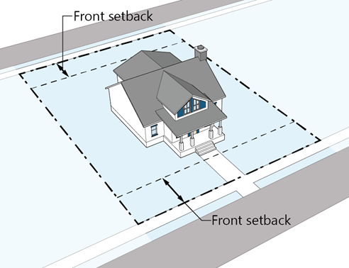
Figure 04.2 Example of a Double-Frontage Lot
(5)
Setbacks on irregular lots. Structures on irregularly shaped lots shall comply with the following:
a.
On lots with multiple street frontages, except for corner lots, the front setbacks shall apply along each lot line adjacent to a street.
b.
On lots with multiple side and/or rear lot lines not adjacent to a street or public right-of-way, the front setback shall apply to any lot line adjacent to a street, the rear setback shall apply to the lot line farthest from the front lot line, and the side setback shall apply to any other lot line.
c.
A lot bounded by only three (3) lot lines shall not have a rear lot line.
d.
The Planning Director may establish alternative setbacks for properties with irregularly shaped lots based on unique circumstances or lot conditions.
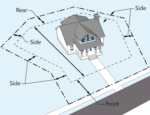
Figure 04.3 Example of Establishing Setbacks
on an Irregular Lot
(6)
Exceptions to setback standards.
a.
Setbacks do not apply to slabs, uncovered patios, walks, steps, fences, landscaping, freestanding walls. Certain features and improvements may encroach into required setbacks as specified in the table below.
b.
No exceptions shall be allowed that would result in an encroachment into a utility easement unless the Town receives written approval by utility providers.
c.
No underground construction shall be allowed to encroach within designated easements or required setbacks from adjacent property lines without prior Town approval.
(e)
Building height.
(1)
Measurement.
a.
Unless otherwise stated in this Section 13.04.230(e), building height is the vertical distance from the grade to the highest point of the roof or parapet.
b.
Measurement of building height is based on the grade, which is the level of the earth at a specific location or at ground level. When used to calculate the maximum permitted height of a building, fence, or sign, grade means the average of the finished ground level measured at the center of each walls of the building, or the finished grade at the midpoint of a fence, or the finished grade at the highest point on the perimeter of a sign or sign support structure.
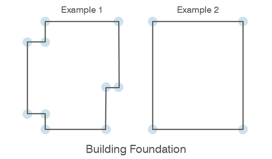
Figure 04.4 Average Elevation Taken from
Foundation Corners
c.
It shall be unlawful to construct, build, establish, or continue to maintain any building, tree, smoke stack, chimney, flag pole, wires, tower, or other structure or appurtenance that may constitute a hazard or obstruction to the safe navigation, landing, and take-off of aircraft at a publicly used airport under the regulation of the appropriate United States Civil Aeronautics Authority, in compliance with Section 13.08.070, Airport regulations.
(2)
Exceptions to height requirements.
a.
No building or part of a building shall exceed the maximum building height within any zoning district unless authorized in the table below or elsewhere in this LDO.
(Ord. 3.372.2 §2, 2025)