
Pasco County Unincorporated
City Zoning Code
City Zoning Code
CHAPTER 900
DEVELOPMENT STANDARDS
Section 901.- INFRASTRUCTURE STANDARDS[1]
Editor's note—Ord. No. 22-63, § 5(Att. A), adopted December 6, 2022, amended the title of Section 901 to read as herein set out. The former Section 901 title pertained to transportation.
901.1. - Transportation - Corridor Spacing
A.
Intent and Purpose. The intent and purpose of this section is to ensure a complete network of collectors and arterials, coordinated with land-use planning, accommodating and maintaining the integrity of the vision roads identified in the Highway Vision Plan, and promoting orderly growth to meet the needs of Pasco County.
B.
Applicability. This section shall apply to proposed development requesting:
1.
An MPUD rezoning,
2.
A preliminary site plan (PSP),
3.
A preliminary development plan (PDP) (residential or nonresidential/mixed use),
4.
A Development of Regional Impact, or
5.
A substantial modification to the above.
C.
Exemption. Complete site development applications filed before August 23, 2005, for which the application has not been denied or subsequent approval has not expired.
D.
Generally. The Highway Vision Plan shall be as adopted in the Comprehensive Plan, Transportation Element, Map 7-36.
In addition, the Board of County Commissioners may adopt in the Comprehensive Plan, special area highway vision maps for specific areas of the County. Once effective, the special area highway vision map shall supersede the Highway Vision Plan and the arterial and major collector spacing standards set forth in this section. A special area highway vision map shall not affect the subdivision collector minimum design standards, and subdivision collector roads shall not be included in the special area highway vision map(s).
E.
Spacing Requirements.
1.
Arterials. Arterials shall be spaced as depicted on the adopted Highway Vision Plan or applicable special area highway vision map.
2.
Major Collectors. Spacing shall be as follows for major collectors:
a.
As depicted on the Highway Vision Plan;
b.
As depicted on the applicable special area highway vision map; or
c.
One mile spacing for properties designated RES-3 (Residential - 3 du/ga) and higher on the Future Land Use (FLU) Map, unless an arterial already satisfies this standard.
F.
Design Requirements. Arterials and major collectors shall meet the design standards adopted by the County pursuant to Resolution No. 19-136 as amended, and depicted in the Development Review Manual. However, bicycle and pedestrian facilities shall adhere to the standards in Section 901.7.
G.
Accommodation, Continuation, Dedication, and Construction Required.
1.
Accommodation and Classification. If a proposed development contains or abuts the alignment of a major County road, then the proposed development shall accommodate the alignment, based on the ultimate classification of the roadway. The ultimate classification of the roadway shall be as determined based on the factors set forth below:
a.
The adopted Metropolitan Planning Organization Long-Range Transportation Plan;
b.
The Comprehensive Plan;
c.
The Highway Vision Plan;
d.
Applicable special area highway vision maps;
e.
County major collector and subdivision collector spacing and design standards;
f.
The street design standards of this Code;
g.
County-approved traffic studies; and
h.
Reasonably foreseeable FLUs surrounding the development containing or adjacent to the roadway subject to the design standard.
2.
Continuation. When a proposed roadway will continue an existing roadway that previously terminated outside of the proposed development or the proposed roadway will be continued beyond the proposed development at some future time, the classification of the roadway will be based on the ultimate classification of the roadway, both within and outside of the development. Any such roadways classified as subdivision collector, major collector, or arterial shall comply with the spacing and design standards of this Code.
3.
Dedication and Construction. The developer shall be required to dedicate the right-of-way for the ultimate classification of the roadway and shall be required to construct the appropriate number of lanes required for the proposed development, at a minimum of at least two lanes of the future network facility, including all drainage/retention, wetland and floodplain mitigation, shoulders, frontage roads, sidewalks, bike paths, medians, and other roadway-related improvements necessary for the ultimate classification of the roadway, unless specifically approved otherwise at the time of PDP or PSP approval.
H.
Special Design Requirements for Subdivision Collectors. For developments located in RES-3 (Residential - 3 du/ga) and higher FLU classifications, Type 1B and Type 1A roadways required by this Code shall be public roadways connected to all future arterial, major collector, and subdivision collector (Types 1B and 1A) roadways, at locations determined by the County consistent with applicable access management regulations, environmental constraints, and existing development approvals.
I.
Relief Procedures. Relief from the requirements of this section shall be as provided for in Sections 407.4, 407.5, as heard by the Planning Commission. Mobility fee credit for the requirements of this section shall be in accordance with Section 1302.2.
(Ord. No. 20-39, § 5(Att. A), 12-8-20; Ord. No. 25-55, § 4 (Att. A), 12-9-25)
901.2. - Transportation - Corridor Management
A.
Intent and Purpose.
1.
The intent of this section is to coordinate the full development of roads within transportation corridors and the planning of future transportation corridors and roads with land use planning within and adjacent to the corridors to promote orderly growth to meet adopted Level of Service (LOS) requirements and to maintain the integrity of the corridor for transportation purposes.
2.
The adoption of this section is necessary in order to preserve, protect, and provide for the dedication and/or acquisition of right-of-way and transportation corridors that are necessary to provide future transportation facilities and facility improvements to meet the needs of growth projected in the County Comprehensive Plan and to coordinate land use and transportation planning. These corridors are part of a network of transportation facilities and systems which provide mobility between and access to businesses, homes, and other land uses throughout the jurisdiction, region, and State. The Board of County Commissioners (BCC) recognizes that the provision of an adequate transportation network is an essential public service. The plan for that transportation network is described in the County Comprehensive Plan and the Transportation Corridor Preservation Map and Table, and implemented through a capital improvements program, other policies and procedures, and through regulations on land use and development as well as regulations to preserve and protect the corridors and right-of-way for the transportation network. The purpose of this section is to foster and preserve public health, safety, comfort, and welfare and to aid in the harmonious, orderly, and beneficial development of the County in accordance with the Comprehensive Plan.
3.
Ensuring that arterial, collector, and other roads and related facilities are safe and efficient, in coordination with a plan for the control of traffic, is the recognized responsibility of the County, in accordance with Sections 125.01(1)(m) and (w), Florida Statutes, and is in the best interest of the public health, safety, welfare, and convenience.
4.
Implementing methods of ensuring adequate transportation facilities to accommodate the citizenry of the County now and in the future is the responsibility of the County in order to carry out the transportation element of its Comprehensive Plan, under 163.3161, and is in the best interest of public health, safety, welfare, and convenience.
5.
This section imposes special development regulations and procedures on all land located within transportation corridors in order to ensure the availability of land within the transportation corridors to meet the transportation needs of the County as shown in the Comprehensive Plan and the Transportation Corridor Preservation Map and Table, and to promote the public health, safety, welfare, and convenience of the County and its citizens.
6.
This section is intended to protect transportation corridors from encroachment by structures or other development except under special conditions.
B.
Applicability.
1.
For purposes of jurisdictional applicability, this Section 901.2 shall apply to all development on land where any portion of the development site is within the jurisdiction of the County and shown on the County Transportation Corridor Preservation Map and Table. This section shall apply in a municipality within the County only upon the County and the municipality entering into an interlocal agreement providing for the application of this section, or portions thereof, within the municipality.
2.
For purposes of geographic applicability, if all or any portion of a proposed development site or expanded development site for which a Section 402.2, 402.3, 402.4, 403.1, 403.2, 403.3, 403.4, or 403.5 development approval or Development Permit/Order is required (which may be collectively referred to as "Section 901.2.B" development approvals or development applications) and is located within a transportation corridor, the provisions of this Section 901.2 shall apply. In addition, the County may apply Section 901.2 to other development permits/orders if all or any portion of the proposed development site or expanded development site is located within a transportation corridor.
3.
For purposes of timing applicability, Section 901.2 shall apply to Section 901.2.B development approvals, or substantial modification thereof, for which a complete application has been filed or for which a Section 901.2.B approval has expired or been denied, after the effective date of this section, unless the County and the applicant agree to an earlier application date. In addition, the County may apply Section 901.2 to other Development Permits/Orders, or substantial modification thereof, for which a complete application has been filed, or for which the Development Permit or Order has expired or been denied, after the effective date of this section, unless the County and applicant agree to an earlier application date. For section 901.2.B approvals, this section shall govern in the event of a conflict between this section and prior Development Permits/Orders.
C.
Procedures.
1.
As part of the development review process of a Section 901.2.B development application, all applications for development approvals shall show the location of any transportation corridor which is located on any portion of the development site or expanded development site or on any portion of the land which is the subject of the application. All such applications shall be reviewed by the County Administrator or designee to determine whether any portion of the proposed project is within a transportation corridor.
2.
All Section 901.2.B development approvals shall include findings or conditions addressing the consistency of the proposed project with the transportation corridor.
D.
Definitions.
1.
The words or phrases used herein shall have the meaning prescribed in the Definitions Appendix, except as otherwise specifically set forth herein.
2.
Development site shall mean the total area of the lot, tract, or parcel which is the subject of an application for a Development Permit.
3.
Expanded development site shall mean all development, parcels of land, lots, and tracts, including development, parcels of land, lots, and tracts contiguous to or nearby the development site that are (1) developed by the same or a related developer or landowner; or (2) developed as part of the same zoning plan, preliminary plan, preliminary site plan, plat, or other unified or common plan or development, as determined by the County Administrator or designee consistent with the purposes of this section. For the purposes of this definition, a related developer or landowner shall include a partnership in which any of the same persons or entities are partners, and a corporation in which any of the same persons are officers or directors.
4.
Interim use shall mean a use of the land in the transportation corridor prior to the date of conveyance of such land to the County for right-of-way, whether such conveyance is by dedication, acquisition, or other means.
E.
Density and Intensity of Development.
1.
The gross density and intensity of development of a development site and any portion of which is within a transportation corridor shall be the gross density permitted in accordance with the underlying zoning district or Comprehensive Plan Future Land Use Classification, whichever is more restrictive. However, such density and intensity may be transferred from the portion of the development site or expanded development site within a transportation corridor to portions of the development site or expanded development site that are located outside of the transportation corridor, either through clustering, density transfer, or through credit for the portion of the site in the transportation corridor in maximum permitted density or intensity calculations (collectively referred to herein as "density transfer"). Subject to limitations in the Comprehensive Plan, density transfers may result in a greater net density on the portion of the development site or expanded development site that is not located within the transportation corridor than would be permitted by the underlying zoning district, but the total gross density of the project site shall in no event exceed the density that would be allowed on the development site or expanded development site had no portion of the development site been located within a transportation corridor. This section is not intended to grant approval to the location of development in environmentally sensitive or otherwise protected lands within the development site or expanded development site. It is intended to allow the density to be used within the development site or expanded development site without additional review procedures beyond the development review that would be required for a development not located in a transportation corridor. All density transfers to an expanded development site that is not part of the Section 901.2.B Development Permit/Order under review shall be evidenced by a recorded document acceptable to the County Attorney's Office that is binding upon the transferor property and transferee property.
2.
Density transfers, unless permitted by another provision of this Code, shall be limited to the amount of density which would otherwise be permitted to be developed in the transportation corridor. In reviewing an application for development in which density transfers are shown, the Planning Commission (PC), as part of its review of the Section 901.2.B development approval, may require that the configuration of the proposed density transfer be amended if it would further the public interest, protect the environment, or provide a better design.
3.
If the density transfer would require modification of any other provision of this Land Development Code, including buffers, parking, landscaping, yards, and setbacks between buildings, then, except as set forth in Section 901.2.J., a variance from the PC shall be required in accordance with the provisions of Section 407.2, except that in the case of a variance necessitated by the requirements of Section 901.2, the conditions of Sections 407.2.D.1. a, b, and c, shall be deemed to exist.
F.
Interim Uses.
1.
The uses of land within a transportation corridor shall be only those uses listed in Section 901.2.F.2 or 901.2.F.3, below, provided that such use would be permitted on the development site by the underlying zoning district or the Comprehensive Plan, whichever is more restrictive. The purpose of this section is to allow certain uses for a limited period of time within portions of a development site that are located within a transportation corridor in order to permit the property owner to make economic use of the property until such time as the land within the transportation corridor is to be dedicated to or acquired by the County.
2.
The uses designated in this Section 901.2.F.2 may be allowed on an interim basis.
a.
Permitted interim uses.
(1)
Stormwater retention or detention facilities to serve the development.
(2)
Parking areas to serve the development that cannot be reasonably located elsewhere on the development site.
(3)
Entry features for the development, such as signage, architectural features, fountains, walls, and the like.
(4)
Temporary sales or lease offices for the development.
(5)
Landscaping, if permitted as an alternative standard, provided that a minimum of ten feet of required landscape buffers shall be located outside the transportation corridor.
(6)
Recreational facilities such as playgrounds, ball fields, outdoor courts, exercise trails, walking paths, bridal paths, and similar outdoor recreational uses, but shall not include any required parks, buffers, or other required open space.
(7)
Produce stands, produce markets, farmers' markets, and the like.
(8)
Agricultural uses, such as pasture, crop lands, tree farms, orchards, and the like, but not including stables, dairy barns, poultry houses, and the life.
(9)
Uses such as boat shows, automobile shows, recreational vehicle shows, "tent" sales, and the like.
(10)
Periodic events such as festivals, carnivals, community fairs, and the like.
(11)
Plant nurseries and landscape materials yards, excluding permanent structures.
(12)
Storage yards for equipment, machinery, and supplies for building and trade contractors, and similar outdoor storage.
(13)
Golf driving ranges.
(14)
Recreational Vehicle or boat storage yards.
b.
The following conditions shall apply to the approval of interim uses specified in Section 901.2.F.2:
(1)
The applicant agrees to discontinue and remove or relocate, at the applicant's sole expense, the interim uses no later than the beginning of the fiscal year in which monies for acquisition of right-of-way or construction within the affected transportation corridor are first programmed by either the County, in Year One of the County's Five-Year Capital Improvement Plan (CIP) or Capital Improvement Element (CIE), or the Florida Department of Transportation (FDOT) in Year One of the FDOT Five-Year Transportation Improvement Program (the termination date). This agreement shall be evidenced by an affidavit which shall state that the interim uses shall be discontinued no later than the termination date. Such affidavit shall be recorded against the development site in the public records office of the Clerk of the Circuit Court of the County, and a copy of the recorded affidavit shall be provided to the County prior to the issuance of the first Building Permit within the development site. The termination date may be extended by written correspondence from the County or FDOT, as applicable, for a time period not to exceed one year for each extension.
(2)
Areas for relocation shall be identified on the development plans submitted with the application for development approval and shall be reserved for that purpose. If the relocation would require modification of any other provision of this Land Development Code, including buffers, parking, landscaping, yards, and setbacks, then, except as set forth in Section 901.2.K.1, a variance from the PC shall be required in accordance with the provisions of Section 407.2, except that in the case of a variance necessitated by the requirements of Section 901.2, the conditions of Sections 407.2.D.1.a, b, and c, and 901.2.K.3 shall be deemed to exist.
(3)
The stormwater retention/detention facility and/or landscaping may, at the discretion of the County or FDOT, be incorporated into the design of the future transportation facility. Should this option be agreed to by the County or FDOT, the developer need not relocate the stormwater-retention/detention facility and/or landscaping, as applicable.
(4)
Buffer yards may be required in order to ensure compatibility of interim uses with other uses adjacent or nearby.
(5)
Interim uses shall meet site design requirements for setbacks for the district.
(6)
Interim uses shall comply with all other applicable provisions of this Code as may be required at the time of approval.
3.
If the termination date set forth above has already occurred at the time of the Section 901.2.B development approval or Development Permit/Order and the County or the FDOT has not extended the termination date, the property owner shall not be entitled to the interim uses set forth in this section, unless the PC, BCC, or FDOT for State roadways determine that the interim use(s) can coexist with the County's or FDOT's planned improvements in the transportation corridor. If the termination date has already occurred, and not been extended by the County or the FDOT, the provisions of Sections 901.2.E, 901.2.H, or 901.2.I shall continue to apply.
4.
Interim uses set forth in this section shall not be assessed transportation impact/mobility fees pursuant to this Code, Chapter 1300.
5.
Interim uses set forth in this section shall, where applicable, be required to obtain Right-of-Way Use Permits in accordance with Section 406.5 and enter into a license and maintenance agreement with the County for such uses.
G.
Site Design Requirements. To protect the full width of the future right-of-way, setbacks on the property which abuts or is located adjacent to a transportation corridor shall be calculated from the edge of the transportation corridor. The size of the setback shall be the setback required by the underlying zoning district.
H.
Right-of-Way Dedication.
1.
As a condition of approval of a Section 901.2.B development approval or development permit/order, in order to ensure adequate roads for the proposed development so as to meet adopted LOS requirements, and to protect the County's transportation system, all applicants for a Section 901.2.B development approval or development permit/order, where any portion of the development site or expanded development site is located within a transportation corridor, shall enter into an agreement with the County, either in the form of a development agreement or as a condition of the development approval or development permit/order, which shall provide for the dedication to the County of lands within the development site or expanded development site which are within the transportation corridor, subject to the provision of Section 901.2.I. Dedication shall be by recordation on the face of the plat, deed, grant of easement, or other method acceptable to the County. All dedications shall occur at record plat, construction plan approval where a record plat is not required, or within 90 days of the County's request, whichever occurs first. All conveyances shall be in accordance with the County Real Estate Division requirements and free and clear of all liens and encumbrances. Land to be dedicated shall be limited to the amount of land needed for the planned transportation improvements (as determined by the Metropolitan Planning Organization and Comprehensive Plan transportation element plans in effect at the time of dedication, or by the County-approved traffic study and collector/arterial spacing and design standards for the development approval or development permit/order if no such plans exist) including, where applicable, land for drainage/retention, wetland and floodplain mitigation, shoulders, frontage roads, sidewalks, bike paths, medians, and other roadway-related improvements. If the drainage, wetland, or floodplain mitigation facilities for the roadway or appurtenances will be commingled or combined with drainage, wetland, or floodplain facilities of the developer's project, the developer or another maintenance entity acceptable to the County shall be responsible for operation and maintenance of such facilities; provided, however, the developer or maintenance entity shall convey an easement giving the County and FDOT the right, but not the obligation, to enter onto the developer's property and maintain the facilities. If the drainage, wetland, or floodplain mitigation facilities for the roadway will not be commingled or combined with drainage, wetland, or floodplain facilities of the developer's project, the developer shall convey such facilities and access easements to the County or FDOT, as applicable, and the County or FDOT, as applicable, shall own operate and maintain such facilities subsequent to the expiration of any applicable maintenance guarantee period.
2.
Where development of the transportation corridor which is the subject of the development application is not shown in the County's Five-Year CIP or CIE or FDOT's Five-Year Transportation Improvement Program, and development of the road in all or any portion of such transportation corridor is not necessary to mitigate the transportation impacts of the proposed development, the property owner shall be entitled to use the portion of the development site in the transportation corridor in accordance with the provisions of Section 901.2.F.
I.
Dedication Rough Proportionality. Projects proposed adjacent to, abutting, or within a designated transportation corridor, may, as a condition of development approval, be required to dedicate and convey lands within the project site that are necessary for that transportation corridor to the County, provided that any required dedications and conveyances shall not exceed the amount of land that is roughly proportionate to the impacts of the development on the transportation network, as determined by a rough proportionality analysis performed by the County.
J.
Administrative Variances. Any property owner whose land is located within a transportation corridor may obtain a waiver of the minimum lot size buffers, yards, or setback required by the underlying zoning district, provided that such waiver does not exceed ten percent of the minimum lot size or setback requirement. Such waiver may be approved by the County Administrator or designee utilizing the administrative variance procedures set forth in this Code, Sections 407.3.
(Ord. No. 20-39, § 5(Att. A), 12-8-20; Ord. No. 24-04, § 5(Att. A), 1-9-24)
901.3. - Access Management
A.
Intent and Purpose. The intent and purpose of access management is to provide safe access to land development while preserving the flow of traffic in terms of safety, capacity, and speed by:
1.
Controlling and regulating the spacing and design of driveways, medians, and traffic signals.
2.
Limiting the number of conflict points a vehicle experiences in its travel.
3.
Separating conflict points as much as possible where they cannot be completely eliminated.
4.
Removing slower turning vehicles which require access to adjacent sites from the traffic lanes of through vehicles.
5.
Requiring cross access between development parcels.
B.
Applicability. This section shall apply to the following:
1.
Any project connecting directly or indirectly to collector, arterial, or controlled access roadways, including projects connecting to roadways on the State highway system, unless compliance with these regulations is specifically prohibited or deemed not permittable by the Florida Department of Transportation (FDOT).
2.
This section also applies to projects connecting to County-owned or maintained right-of-way within municipalities in the County. In the case of the State system or municipalities, the County Engineer shall consult with the FDOT and/or any affected municipality in the application of these regulations. In the event of a conflict between these regulations and State or municipal access-management regulations, permits, or approvals, the more restrictive regulations shall apply.
3.
Any project connecting to a local roadway, but deemed to require access-management review by the County Engineer. If access-management review is required, standards for collector roads shall apply to local roads.
4.
This section shall apply to the following applications and substantial amendments of same filed on or after November 9, 2004:
a.
Development of Regional Impact (DRI).
b.
MPUD Master Planned Unit Development zoning.
c.
Preliminary site plans.
d.
Preliminary development plans.
e.
Right-of-Way Use Permits.
In the event of any conflict between these regulations and any prior County approval(s) or permits for a project, these regulations shall govern; however, existing driveways that have been constructed as of November 9, 2004, shall be governed by this Code, Section 901.3.D.
C.
Exemptions. This section shall not apply to the following:
1.
Projects within any municipality in the County that connect only to roadways that are not owned or maintained by the County, unless such municipality enters into an Interlocal Agreement with the County providing for the application of these regulations within the municipality.
2.
Government owned or leased property that contains fire stations or other emergency response vehicles.
3.
Utility, government, or government contracted vehicles utilized to construct or maintain collector, arterial, controlled access, or local roadways.
4.
Utility, government, or government-contracted vehicles utilized for construction or maintenance on utility or government-owned or leased property adjacent to collector, arterial, controlled access, and local roadways.
D.
Nonconforming Access/Significant Change. Driveway connections constructed as of November 9, 2004, not conforming with the standards herein shall be designated as nonconforming and shall be brought into compliance when:
New or modified access connection permits are requested.
Substantial improvements are proposed to the nonconforming property that affect the existing driveway connection.
There is a change in the use of the property, including land structures or facilities that results in (a) an increase in the trip generation of the property exceeding 25 percent (either peak hour or daily), or exceeding 50 gross peak hour trips, a.m. or p.m., whichever is higher, more than the existing use; or (b) an increase in truck traffic equal to or greater than ten percent of the total gross trips generated by the site. Trip generation shall be determined in accordance with the Institute of Transportation Engineers (ITE) Trip Generation Manual (ITE Manual) trip rate, latest edition, or other trip rate as approved by the County Administrator or designee. When such additional traffic is projected, the County will review data to determine if modifications to an existing connection will be required.
If the principal activity on a property with nonconforming access features is discontinued for a consecutive period of 365 days.
When due to site specific conditions, such as limited sight distance, high-traveling speed (45 mph or greater), or the presence of ten percent or more heavy vehicles utilizing the access, a modification of access is required by the County Engineer to ensure public safety.
E.
Access Management Analysis. All projects subject to this section shall complete the Access Connection Permit Application Form 901.3.A and complete any analysis required pursuant to Form 901.3.A. However, the County Engineer may require more detailed access-management information or a more detailed access-management study where the County Engineer determines:
1.
That the information on the Access Connection Permit Application Form 901.3.A is inadequate to determine compliance with these access-management regulations.
2.
That the information or study is necessary to ensure the safety of the traveling public.
3.
In the event a study is done, the following standards shall be followed:
a.
The Level of Service standards for through movements on all Major County Road segments (facilities) shall be consistent with the standards in the County's latest adopted Comprehensive Plan.
b.
The volume/capacity (v/c) ratio of turning movements on Major County Roads cannot exceed 1.2 for Trip-Reducing Projects or exempt uses and 1.0 for other nonexempt uses with a maximum delay of 120 seconds. Delays of up to 150 seconds are acceptable for turning movements with a v/c ratio less than 0.8. However, in all cases, the turn-lane length provided should be long enough to accommodate the forecasted demand.
c.
For all access driveways and local street connections to Major County Roads, approach delays of up to 150 seconds will be acceptable.
Based on the information or study provided, the County Engineer may impose conditions on any access permit or project approval granted including, but not limited to, conditions requiring improvements, such as turn lanes.
F.
Access Order. Every owner of property which abuts a road on the County road system has a right to reasonable access to the abutting County road system if no other access is provided, but does not have the right of unregulated access to such roadways.
The order of preference for providing access to collector, arterial, and controlled access roadways for all land uses shall be as follows:
1.
Connections in accordance with corridor access-management plans where adopted and approved by the County or approved by the FDOT for roads on the State highway system.
2.
Connections to existing or extended local public streets where such access will not create an operational or safety conflict with residential uses and accesses.
3.
Access to collector roadways.
4.
Access to arterial roadways.
5.
Access to controlled-access roadways.
G.
Driveway Design Criteria. The access rights of an owner of property abutting County roads are subject to reasonable regulation to ensure the public's right and interest in a safe and efficient roadway system. For the purposes of determining whether an access is safe and efficient, Section 335.184(3)(a), Florida Statutes, and the FDOT Driveway Manual, latest edition, may be used. Property owners are encouraged to use joint access where available.
In addition, driveway design and construction shall be in substantial conformance with the standards outlined in the latest editions of the American Association of State Highway and Transportation Officials manuals, the FDOT Roadway and Traffic Design Standards Manual, and the FDOT Manual on Uniform Minimum Standards (Green Book).
H.
Number and Spacing of Driveways. Every owner of property which abuts a road on the County road system has a right to reasonable access to the abutting County roadway system, but does not have the right of unregulated access to such roadways. No building shall be erected on a lot or parcel of land subject to this Code, nor shall any Building Permit be issued unless such lot or parcel abuts or has legal access to a street dedicated to and accepted by the Board of County Commissioners, is shown on a legally recorded subdivision plat, or such lot or parcel is authorized pursuant to this Code.
One driveway shall be permitted for ingress/egress purposes to any project. For projects proposing more than one two-way driveway based upon parcel size, projected trip generation of the site, amount of roadway frontage, and other design considerations, additional drives may be permitted if approved by the County Administrator or designee.
Notwithstanding the foregoing, the County Administrator or designee may require any project which is permitted one or more driveway connections to provide cross access or a frontage/reverse-frontage road connecting such project to neighboring projects or properties in accordance with Section 901.3.M, and if such project later has reasonable access to a collector or arterial roadway through such cross access or frontage/reverse-frontage road, the County Administrator or designee may terminate the permit(s) for the original driveway(s).
The County Administrator or designee may issue one or more Temporary Access Permits for the project where the County Administrator or designee anticipates that a future access for a project will:
1.
Be safer.
2.
Create better traffic circulation.
3.
Create less traffic conflicts.
4.
Be more consistent with these access management regulations, but such future access is not feasible at the time such project is reviewed.
The issuance of any Temporary Access Permit pursuant to these regulations is not a vested right or property right and is subject to modification or termination by the County provided that each project maintains reasonable access.
All accesses shall be functional at the time of development impact. A functional access shall be defined as a constructed two-lane connection to a Type 1 street or a street functionally classified as Major County Roads. Unless otherwise approved at the time of preliminary plan approval, an emergency access is a constructed, single-lane connection to a Type 1 street or a street functionally classified as Major County Roads, which may be barricaded.
The following access requirements are established:
TABLE 901.3.A
Where no feasible alternative exists in the opinion of the County Engineer or designee, an emergency access may be provided by adding a lane to any Type 1, 2, 3, or 4 street. Additional functional accesses shall be preferred in lieu of emergency accesses.
I.
Access Control. The following general standards shall be used in evaluating proposed access connections to County and State arterials and collectors:
TABLE 901.3.B Arterial/Collector Standards
NOTE 1: Corner clearance and connection spacing are measured from the edge of the pavement on one connection to the closest edge of the pavement of the neighboring roadway or connection.
NOTE 2: Distance between median openings and signals are measured from the center of the opening or intersection to the center of the adjacent opening or intersection.
NOTE 3: If access is on an FDOT controlled roadway then FDOT standards shall apply.
J.
Isolated Corner Properties. If, due to a property's size, the County Engineer finds that corner clearance standards cannot meet Table 901.3.A, and where cross access which meets or exceeds the minimum corner clearance standards cannot be obtained with a neighboring property or is not feasible in the opinion of the County Engineer, then the following minimum corner clearance measurements can be used to permit connections:
TABLE 901.3.C
Corner Clearance for Isolated Corner Properties
NOTE 1: Corner clearance and connection spacing are measured from the edge of the pavement on one connection to the closest edge of the pavement of the neighboring roadway or connection.
K.
Throat Distances. The length of driveways or "throat length" shall be designed in accordance with the anticipated storage length for entering vehicles to prevent vehicles from backing into the flow of traffic on the public street or causing unsafe conflicts with on-site circulation.
Up to ten percent deviations from these requirements may be permitted for good cause upon approval by the County Engineer. Deviations greater than or equal to ten percent require approval in accordance with this Code, Sections 901.3.T and 407.5.
L.
Driveway Width and Radii. The following minimum standards shall be utilized for all driveways:
1.
Access width for any type of access with or without curbs shall be measured exclusive of the radii or flared sections.
2.
One-way access shall have a minimum width of 15 feet.
3.
A minimum 24 feet in width shall be used for any two-way access.
4.
The initial 50 feet of the inbound lane from a County road into the project shall be a minimum 15 feet in order to facilitate the movement of traffic off high-speed facilities with a posted speed equal to or greater than 45 miles per hour.
5.
A minimum 34 feet of width shall be used for any two-way access when one or more of the following apply to the access:
a.
Multiunit vehicles are intended to use the access; or
b.
Single unit vehicles in excess of 30 feet in length will use the access.
6.
Maximum widths shall be determined during the plan review process.
7.
No access shall have a turning radius of less than 25 feet, when a radial return is required.
8.
Radii on collector or arterial roads shall have a minimum radius of 35 feet. A 50-foot radius shall be required for an access when multiunit or single unit vehicles exceeding 30-feet in length are intended to use the access or on high-speed facilities with a posted speed equal to or greater than 45 miles per hour. Wheel-tracking diagrams shall be submitted to determine radii used to support entrance geometrics.
Up to ten percent deviations from these requirements may be permitted for good cause upon approval by the County Engineer. Deviations greater than or equal to ten percent require approval in accordance with this Code, Sections 901.3.T and 407.5.
M.
Cross Access/Frontage/Reverse-Frontage Roads.
1.
General Requirement. To further the goals of reducing conflict points and improving traffic circulation along collector and arterial roadways, each project shall be required to provide one or more minimum 24-foot wide travel lane(s) connecting the project to neighboring properties, projects, travel lanes, or roadways in a location to be determined by the County Administrator or designee during the review of the project, except in cases where all neighboring properties or projects are existing, platted, single-family residential subdivisions with no legally available roadway points of connection. Such travel lane(s) shall be free and clear of buildings, parking spaces (except as permitted by the cross-access/parking standards set forth below), landscaping, retention ponds, or any other obstruction that would prevent the free flow of traffic between the project and neighboring properties, projects, or roadways. The County Administrator or designee may determine that a travel lane or frontage/reverse-frontage road wider than 24 feet is required if warranted based on the size and trip generation of the project and adjacent projects, or if required pursuant to an adopted frontage/reverse-frontage road or access-management plan or other approved master roadway plan.
2.
Cross Access/Parking Standards.
a.
For properties with an existing developable depth less than or equal to 400 feet along arterials and collector roadways, parking spaces may connect to the 24-foot travel way, but shall not obstruct the connection point between the properties.
b.
For properties along arterial and collector roadways exceeding a developable depth of 400 feet; or for properties otherwise required to provide for a frontage/reverse-frontage road pursuant to the Comprehensive Plan, zoning amendment, DRI conditions of approval, an approved frontage/reverse-frontage roadway plan, access-management plan, or other approved master roadway plan, parking spaces shall not connect to the 24-foot travel way and shall not obstruct the connection point between properties.
c.
For infill development, parking-space connections to the 24-foot travel way shall be similar to the adjacent property(ies), but shall not obstruct the connection point between the properties.
d.
When only two adjacent developments can interconnect, parking spaces may connect to the 24-foot travel way, but shall not obstruct the connection point between the properties.
e.
If all uses along a proposed/possible interconnect are office and/or industrial, and the combined trip generation rate is less than 600 daily trips, parking spaces may connect to the 24-foot travel way, but shall not obstruct the connection point between the properties.
3.
Cross-Access/Construction Standards.
a.
If the development is located within the RES-3 (Residential - 3 du/ga) or higher Land Use Classification, the cross access shall be constructed with a minimum pavement structural number of 2.96 with a minimum two inches of asphaltic-concrete surface course.
b.
If the development is located within the RES-1 (Residential - 1 du/ga) Land Use Classification, the cross access shall be stabilized to LBR-40.
c.
If the development is located within the AG (Agricultural) and AG/R (Agricultural/Rural) Future Land Use Classifications, a cross-access easement is only required to be reserved.
N.
Median Openings. To ensure traffic safety, capacity, and control, median openings shall be spaced the maximum distance apart that will allow safe and adequate traffic circulation.
Median openings may be permitted only where the need and location is justified in the opinion of the County Engineer, taking into consideration, but not limited to, the following:
1.
Potential number of left turns into or out of the driveway.
2.
Length of frontage along the street right-of-way line of the property proposed to be developed.
3.
Distance of proposed opening from intersections or other openings.
4.
Lengths and widths of proposed storage lanes as functions of the estimated, maximum number of vehicles to be in the lane during peak hour.
5.
Safety concerns.
O.
Requirements for Turning Lanes. Turning lanes for County collector and arterial roadways shall be required in accordance with the standards outlined in Table 901.5.A. In addition, where safety concerns are present, such as limited sight distance, high traveling speed (45 mph or greater, posted or operating, whichever is higher), or the presence of ten percent or more heavy vehicles, turn lanes shall be required, as determined by the County Engineer.
At the intersection of an arterial/collector road with another arterial, collector or subdivision collector roadway, left and right turn lanes will be required.
Turn lanes shall not be provided along subdivision or local roads unless the County Engineer determines that turn lanes are warranted due to safety concerns. The exception is the intersection of a subdivision collector road with another subdivision collector/collector/arterial roadway, in which case turn lanes shall be provided if warranted based on Table 901.5.A of this Code.
Roads with a 35 mph speed or less (design or posted, whichever is higher), that are located within the compact area of a MUTRM project, or within a TND or TOD area shall not be required to provide right turn lanes, regardless of whether they are warranted. The intent is to maximize pedestrian safety.
All required turning lanes shall be designed and constructed in accordance with FDOT Indexes 301 and 526.
P.
Drainage.
1.
Each access shall be constructed in a manner that shall not cause water to enter onto the roadway and shall not interfere with the existing drainage system on the right-of-way (FDOT Index 515).
2.
The permittee shall provide, at the permittee's expense, drainage structures for the permittee's access which will become an integral part of the existing drainage system. The type, design, and condition of these structures must be in accordance with FDOT standards and meet the approval of the County.
3.
The County drainage system is designed for the protection of the County roadway system. It is not designed to serve the drainage requirements of abutting properties beyond that which has historically flowed to the County right-of-way. Drainage to the County system shall not exceed the undeveloped, historical flow.
Q.
Other Design Elements.
1.
Within the right-of-way, maximum grades shall be limited to ten percent, unless the County Engineer finds that significant physical constraints require the use of a steeper grade, the steeper grade is in conformance with FDOT Index 515, and access by the largest anticipated vehicle can be properly accommodated.
2.
The horizontal axis of an access to the roadway shall be at a right angle to the centerline of the road. An angle between 90 and 60 degrees may be approved only if the County Engineer finds that significant physical constraints require a skew angle less than 90 degrees.
3.
An access that has a gate across it shall be designed so that a minimum three-car stack distance (75 feet) is provided between the right-of-way line and the gate.
4.
The access shall be designed to facilitate the movement of vehicles off the highway to prevent the queuing of vehicles on the traveled way. An access shall not be approved for parking areas that require backing maneuvers within the County right-of-way. All off-street parking must include on-site maneuvering areas to permit vehicles to enter and exit the site in a forward gear.
R.
Maintenance. The permittee, successors-in-interest, and occupants of the property serviced by the access shall be responsible for the maintenance beyond the edge of the traveled way. The County shall maintain the culverts under the accesses which are an integral part of the drainage system in the right-of-way.
S.
Controlled Access Roadways. Notwithstanding anything in these regulations to the contrary, direct access to the following roadways shall be restricted to specific locations approved by all governmental entities with jurisdiction over such roadways:
1.
The Suncoast Parkway and the impacted portion of collector/arterial roadways forming the interchanges with the Suncoast Parkway as determined by applicable Florida Turnpike Enterprise (FTE) and FDOT regulations, where access is restricted to those locations approved by the FTE and FDOT, in consultation with the County.
2.
I-75 and the impacted portion of collector/arterial roadways forming the interchanges with I-75 as determined by applicable Federal Highway Administration (FHA) and FDOT regulations, where direct access is restricted to those locations approved by the FHA and FDOT, in consultation with the County.
T.
Alternative Standard Procedures. If an applicant wishes to deviate from the requirements of this section, an alternative standards request in accordance with Section 407.5 must be submitted and approved by the County Engineer utilizing the criteria in Section 407.5.C. Before making a determination on any alternative standard affecting the State highway system or within any municipality, the County Engineer shall consult with the FDOT and/or the affected municipality, if applicable.
U.
Access Violations.
1.
Violations: At any time under the provisions of this Code, Section 108, the County may elect to cite the owner(s) or occupant(s) of the property or project for any conditions on such property or within the right-of-way that are prohibited by these regulations or applicable permit conditions.
2.
Corrective Action: When closure or modification of an access or driveway or other corrective action is required or when the owner(s) and/or occupant(s) of the property in violation has not corrected the condition(s) in violation, the County or other authority may complete the necessary corrective action with public funds or may contract with an individual, firm, or other legal entity for such services. An invoice shall be submitted to the owner(s) for payment of the costs incurred by the County or its contractor. The owner(s) shall be required to pay all costs incurred, including any administrative costs, within 30 days of the date of the invoice. If payment is not made by the owner(s) within 30 days of the date of the invoice, the County may impose a lien upon the property for the costs of performing the corrective action, administrative costs, interest, and recording fees. The lien shall be of the same priority as liens for ad valorem taxes and, as it represents costs expended for the benefit of the property itself, the lien shall be superior to all other encumbrances, whether secured and regardless of priority. Such lien shall be duly recorded in the official records of the County and shall accrue interest at the rate of eight percent per annum from the date of recording. Upon foreclosure of the lien, the County shall be entitled to all costs and attorney's fees incurred as a result.
3.
The authority to correct dangerous conditions provided by this section does not impose any affirmative duty on the County to warn of or to correct such conditions. Making such repairs does not create a continuing obligation on the part of the County to make further repairs or to maintain the property, and does not create any liability against the local governing body for any damages to the property if such repairs were completed in good faith.
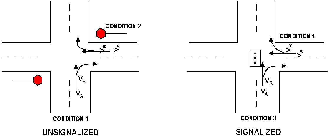
TURN-LANE WARRANTS AND DESIGN CRITERIA
DEFINITIONS OF TERMS
TABLE 1
Right-Turn Warrants
| Unsignalized | ||
| Condition 1 | On major roads without stop control (approach). | See Graph Nos. 1A and 1B |
| Condition 2 | Access roads or major through roads with stop control (approach). |
V
R
≥150
OR There are 5 or more related accidents in 1 year. |
| Signalized | ||
| Condition 3 | On major roads (approach). |
V
R
≥150
AND The total outside lane approach volume (VA) is at least 200 VPH (including right turn). OR There are 5 or more related accidents in 1 year. |
| Condition 4 | On access roads approach. |
V
R
≥150
OR There are 5 or more related accidents in 1 year. |
 | ||
NOTES:
1.
When public safety so requires due to site-specific conditions, such as limited sight distance, high-traveling speed, or the presence of a significant percentage of heavy vehicles, a turn lane may be required by the County Engineer even though the criteria in Graphs 1A and 1B are not met.
2.
The provisions of the right-turn warrants may be modified by the County Engineer if it is determined that due to site-specific constraints, the implementation will not be feasible or practical.
3.
At high speed (45 mph or greater), unsignalized/signalized intersections, a separate right turn lane may be required by the County Engineer for safe operations. A high speed shall be the greater of the posted or operating speed where an operating speed study has been conducted.
TABLE 2
Left-Turn Warrants
| Unsignalized | ||
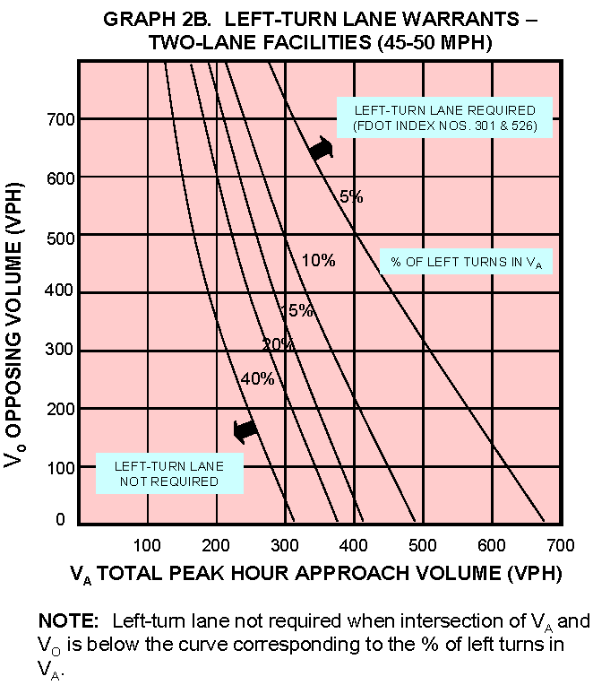
| Condition 1 | On major roads without stop control (approach). | See Graph Nos. 2A through 2D |
| Condition 2 | On access roads or through roads (approach). |
V
L
≥100
OR There are 4 or more related accidents in 1 year. |
| Signalized | ||
| Condition 3 | On major roads (approach). |
V
L
≥100
OR 20 percent or more of the total approach volume in the inside lane is left turn. OR There are 5 or more related accidents in 1 year. |
| Condition 4 | On access roads or through roads approach. |
V
L
≥100
OR There are 5 or more related accidents in 1 year. |
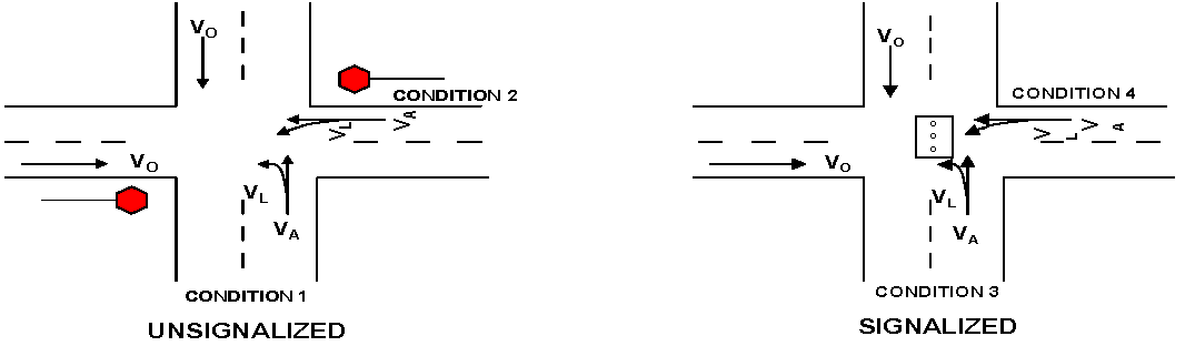 | ||
NOTES:
1.
An exclusive left-turn lane at signalized intersections or on access roads and through roads with stop control are more often needed to reduce the total delay to the approaching vehicles; therefore, use of traffic engineering software, with the approval of the County Engineer, may be used.
2.
When public safety so requires due to site-specific conditions, such as limited sight distance, high-traveling speed, or the presence of a significant percentage of heavy vehicles, a turn lane may be required by the County Engineer even though the criteria in Graphs 2A through 2D are not met.
3.
The provisions of the left-turn warrants may be modified by the County Engineer if it is determined that due to site-specific constraints, the implementation will not be feasible or practical.
4.
A dual left-turn lane may be required by the County Engineer when the left-turn volume exceeds 300 VPH.
5.
At high speed (45 mph or greater), unsignalized/signalized intersections, a separate left-turn lane may be required by the County Engineer for safe operations. A high speed shall be the greater of the posted or operating speed where an operating speed study has been conducted.
TABLE 3
Right-Turn Lane Length
(Deceleration and Storage)
NOTES:
1.
In many instances, the storage length of a right-turn lane at signalized intersections or access/major roads with stop control is dictated by the required storage length for left and/or through movements. Refer to the left-turn section for determining the storage length for a left turn.
2.
If the right-turn flow is limited due to heavy volume of conflicting movements, then the storage length shall be based on the left-turn storage length formula.
3.
The provision of storage lengths and deceleration lengths may be modified or waived by the County Engineer if it is determined that, due to site-specific constraints, the implementation will not be feasible or practical.
4.
Traffic engineering software, with the approval of the County Engineer, may be used to determine the storage length for right turns.
TABLE 4
Left-Turn Lane Lengths
(Deceleration and Storage)
NOTES:
1.
N = The number of traffic signal cycles per hour. Use 30 as a default (assumes 120-second cycle length).
2.
If the formula yields a storage length of less than 50 feet for unsignalized intersections, then a minimum storage of 50 feet shall be provided.
3.
If the formula yields a storage length of less than 100 feet for signalized intersections, then a minimum storage of 100 feet shall be provided.
4.
The provision of storage and deceleration lengths may be modified or waived by the County Engineer if it is determined that due to site-specific constraints, the implementation will not be feasible or practical.
5.
In some instances at signalized intersections or on access/major roads with stop control, the storage length of the left turn is dictated by the through or right movements. Unless otherwise approved by the County Engineer, the storage length for all movements shall be calculated and the highest length shall be used. For through-storage length, the same formula as the left turn can be used. Refer to right-turn section for determining the storage length for right turns.
6.
Traffic engineering software, with the approval of the County Engineer, may be used to determine the storage length for right turns.
Graphs 1A & 1B Source: National Cooperative Highway Research Program, Report No. 279.
Graphs 2A & 2B Source: National Cooperative Highway Research Program, Report No. 279.
Graphs 2C & 2D Source: National Cooperative Highway Research Program, Report No. 279.
SAMPLE PROBLEM NO. 1
Steps 1—6:
1.
Ninety-four-unit apartment complex. West side of Rowan Road, north of Nebraska Avenue (Main Street). Four-lane urban. Speed limit 45 mph.
2.
Existing use—vacant.
3.
Proposed use—apartments.
4.
Site plan, etc., not included in sample.
5.
Proposed access on Rowan Road, west side, at existing median opening, approximately 365 feet north of Indiana Avenue. No existing turn lane facilities north or southbound. No other access to this site is proposed.
6.
Source: ITE, 6 th Edition
ITE Code: 220
Existing Maximum Trip Generation: 0
Net Increase in Maximum Trip Generation: 698
From ITE: No. of Trips = (5.994 × 94 units) + 134.114 = 698
Total Maximum Peak Hour Trip Generation: 698
If the total maximum peak hour trip generation is greater than 50 proceed with Step 7.
Step 7:
7.
From the Pasco County Traffic Operations Division, Traffic Count File for Rowan Road (C.R. 77) (Section 820.1):
![]()
A.M. Peak Not Available
Total Daily Count: 23,624 (ADT) 10/4/01
From ITE Manual, P.M. Peak Hour Trips = (0.541 × 94 units) + 18.744 = 70 trips
A.M. Peak Hour Trips: N/A
From ITE, 67 percent (47) entering and 33 percent (23) exiting. Say 50/50 directional distribution.
Proceed to Warrants and Turn-Lane Design Criteria.
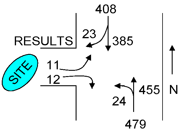
Right-Turn Warrants
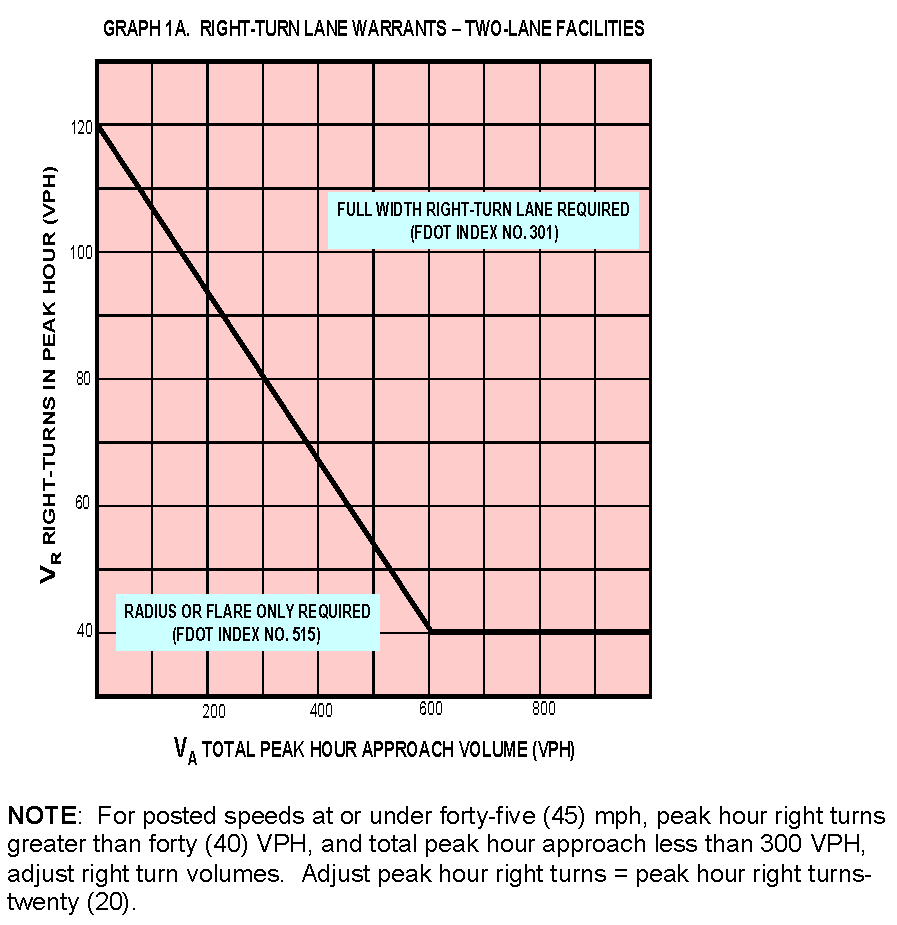
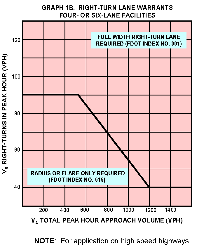
From Table 1, Condition 1, see Graph 1B to check warrants for the southbound, right-turn lane on Rowan Road.
V R = 23, V A = 385 + 23 = 408
From Graph 1B, a full width, right-turn lane is not warranted.
Left-Turn Warrants
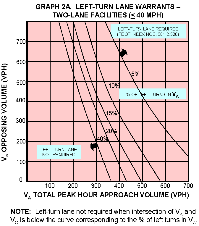
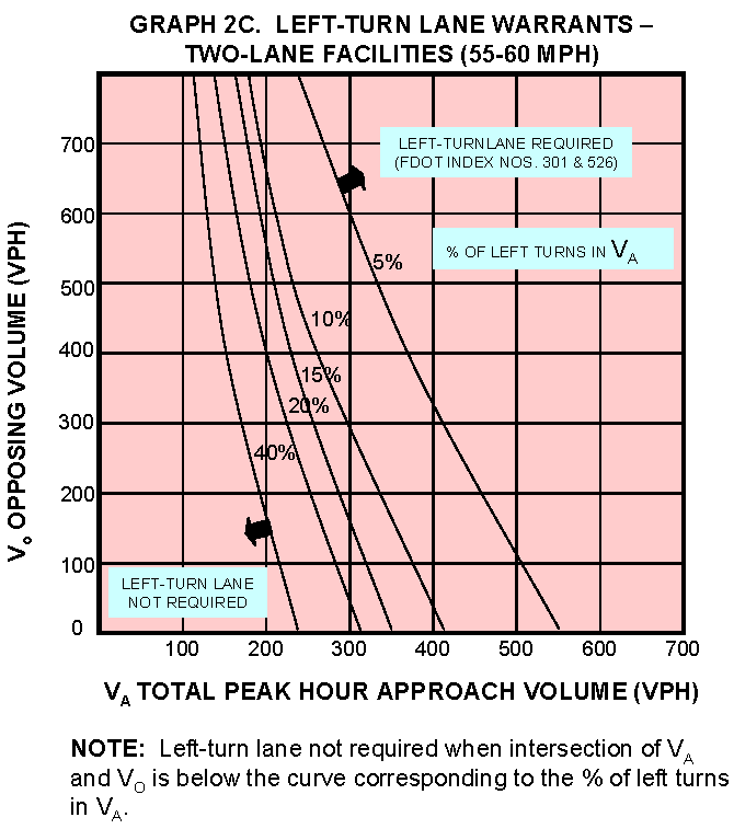
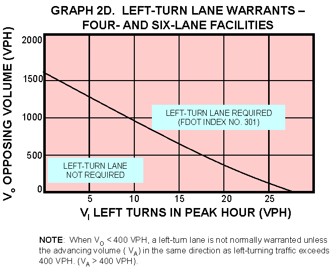
From Table 2, Condition 1, see Graph 2D to check warrants for the northbound, left-turn lane on Rowan Road.
V L = 24, V A = 455 + 24 = 479, V O = 385 + 23 = 408
From Graph 2D, the intersection of V O and V L is to the right of the curve; therefore, a left-turn lane is required.
Left-Turn Lane Lengths
From Table 4, Condition 1, the required deceleration length is determined by FDOT Index No. 301. A total deceleration distance length of 185 feet is required for the 45 mph urban condition and includes the 50-foot taper length.
The required storage length (queue) is calculated as follows:
Storage Length = 25 × V L /30 = 25 × 24/30 = 20 feet
Per Note 1, the required minimum storage length is 50 feet. This is in addition to the 185-foot deceleration, for a total deceleration and storage length of 235 feet.
(Ord. No. 24-21, § 5(Att. A), 4-23-24)
901.4. - Substandard Roadway Analysis and Mitigation
A.
Intent and Purpose. The intent and purpose of this section is to ensure that deficiencies on substandard roads impacted by new development are corrected or mitigated.
B.
Applicability. This section applies to all development where any portion of the development has connection, either directly or indirectly, to County local or collector roadways, or non-County and non-State maintained roadways on which anyone other than the owners travel.
This section shall apply to the following applications and substantial amendments of same filed on or after June 8, 2004:
1.
Development of Regional Impact.
2.
MPUD Master Planned Unit Developments, Euclidean Zonings, Conditional Uses, and Special Exceptions.
3.
Preliminary site plans.
4.
Preliminary development plans.
5.
Right-of-Way Use Permits.
C.
Exemptions.
1.
Any project having an impact of less than 500 daily trips to a Collector roadway segment on the County's Highway Vision Plan and Functional Class Map (Comprehensive Plan Map 7-36) is exempt from mitigation and analysis for that roadway segment.
2.
Any project having an impact of less than or equal to 20 daily trips to a County-maintained local or subdivision collector roadway is exempt from mitigation and analysis for that roadway segment
3.
Any project having an impact of less than or equal to 100 daily trips to a County-maintained local or subdivision collector roadway is exempt from analysis for that roadway segment.
4.
Any project having an impact of less than or equal to 100 daily trips to a non-County maintained roadway is exempt from mitigation and analysis for that roadway segment
5.
Unless specifically required by the County Administrator or designee or Board of County Commissioners, no analysis or mitigation shall be required for roadways that lie beyond the first standard collector roadway segment accessed by the project.
D.
Analysis.
1.
If applicable under Section 901.4.B and not otherwise exempt under Section 901.4.C, the following analysis requirements shall apply:
a.
When a substandard road analysis has been submitted as part of the application for an MPUD or DRI a second substandard road analysis shall not be required as part of a subsequent development application. However, should the County determine that roadway pavement conditions (to a public roadway previously identified in the initial substandard road analysis and for which no conditions of approval have been approved to bring such road to standard) have changed, it reserves the right to require an updated substandard roadway analysis.
A required Substandard Roadway Analysis may be waived by the County Administrator or Designee if:
(1)
The County agrees that all roads to be accessed, as required by this Code, meet the minimum standards of this section; or
(2)
The applicant agrees to improve the roads accessed to comply with the minimum standards of this section as determined by the County.
2.
Procedural Requirements.
a.
Methodology. Prior to undertaking a Substandard Roadway Analysis, the applicant shall prepare a written methodology statement that includes the following items and submit it for review with the appropriate review fee.
(1)
Location of development (illustrated on a map).
(2)
Proposed land uses and size.
(3)
Net external estimated daily traffic generation. If trip generation data for a specific land use is not available, then the latest version of the Institute of Traffic Engineers (ITE) Trip Generation Manual shall be used or other trip generation estimates as mutually agreed to by the applicant and the County Administrator or Designee. Trip generation estimates shall include separate estimates for interim trip generating uses.
Mining and Land Excavation, even as an interim use, is presumed to be a separate and distinct mining land use requiring separate trip generation estimates.
(4)
Internal Capture. Internal capture estimates shall be based on the ITE acceptable methodologies. In no case will an internal capture of more than 20 percent be acceptable unless the County accepts a higher internal capture percentage based on verifiable documentation; e.g., field studies of comparable sites.
(5)
Passerby Capture. If passerby data for a specific land use is not available, then the latest version of the ITE Trip Generation Manual shall be used, or other data as mutually agreed to by the applicant and the County Administrator or Designee. In no event shall the total passerby trips entering and exiting a site exceed the ten percent of the total background traffic on the adjacent roadway.
(6)
Estimated distribution and assignment of daily traffic.
(7)
Indication of proposed, potentially substandard roads to be reviewed.
The County Administrator or Designee will review and comment on the acceptability of the proposed methodology.
b.
Analysis Requirements. The substandard roadway assessment is not intended to be a topographic survey of the impacted roadways, but rather a "windshield survey," supplemented with appropriate field measurements and "ground observations" when potentially substandard conditions are observed.
E.
Submittal Information.
1.
The Substandard Roadway Analysis shall contain all the necessary data and assessment, and a list of any potential improvements and shall be signed and sealed by a Florida registered professional engineer. The data and assessment shall be sufficient for the County Administrator or Designee's review and approval of the substandard section of the study. The assessment shall include a statement as to whether the existing typical condition meets the standards; a general description of physical constraints that may prevent upgrading the substandard condition to a standard condition and a proposal of alternative standards, if necessary; and a detailed description of the proposed improvements and associated costs.
2.
Lane Width and Shoulders
a.
Data Collection: The lane and shoulder widths that represent a typical lane and shoulder width of the impacted roadways shall be field measured and reported. Extreme variations from the existing typical widths shall also be reported.
b.
Standards: The minimum lane and shoulder widths allowed are provided below. The design year and speed as stated in the below referenced tables shall mean the build-out year of the project and posted speed limit, respectively.
TABLE 901.4 A
Lane and Shoulder Widths—Rural Multilane
TABLE 901.4 B
Lane and Shoulder Widths, Two Lane Rural and Urban—Without Curb and Gutter
TABLE 901.4 C
Urban Multilane or Two Lane with Curb and Gutter
3.
Pavement Condition.
a.
Data Collection: The thickness of the surface pavement and base and the cross slopes that represent a typical surface and base thickness, and cross slopes of the impacted roadways shall be field measured and reported. The thickness of the subbase need not be field measured unless practical. If the subbase is not measured, the thickness of the subbase can be assumed standard. In addition, any quarter-panel failures and wheel-rutting shall be noted and reported. Extreme variations from the existing typical conditions shall also be reported.
b.
Standards: The minimum structural numbers for roadways are:
(1)
Local Streets in AG (Agricultural) and AG/R (Agricultural/Rural) Land Use Less Than 16 Lots and RES-1 (Residential - 1 du/ga) Land Use Less Than Ten Lots: 1.89
(2)
Local Streets: 2.19
(3)
Subdivision Collector (Type I): 3.24
(4)
Major Collector: 3.42
A minimum structural number of 4.00 is required on local and collector roadways if heavy vehicles are ten percent or more of the total daily driveway trips.
Layer coefficients are provided in Tables 901.4 D and 901.4 E below:
TABLE 901.4 D
Structural Coefficients for Different Pavement Layers
TABLE 901.4 E
Reduced Structural Coefficients Asphaltic Materials
NOTE: Reduced structural coefficients for use in the AASHTO Flexible Pavement Design Equation can be obtained from this table for all asphalt layers based on pavement condition. Pavement condition for this table should be based on the surface appearance of the asphalt pavement (cracking, patching, rutting, etc.) and may be supplemented by additional testing. Structural coefficients are not reduced for existing rock base, subbase, or subgrade.
Recommended Criteria:
Good: No cracking, minor rutting/distortion.
Fair: Crack Rating = eight or higher, minor rutting/distortion.
Poor: Crack Rating = less than eight, rutting = ⅜ inch or greater.
NOTE: Quarter-panel failures and wheel rutting are considered to be substandard conditions.
Roadway cross slopes shall conform to Table 901.4 F below:
TABLE 901.4 F
Roadway Cross Slopes
4.
Flooding
a.
Data Collection: Data collection shall include the compilation of historical flooding locations readily available from the Development Services Branch. The flooding location Geographic Information System map layer titled "Observed Flooding" shall be used to identify flooding areas.
b.
Standards: The standard is no surface ponding upon roadway.
c.
Assessment: The assessment shall include a statement as to whether impacted roadways are within the flood area, a general description of physical constraints that may prevent upgrading the substandard condition to a standard condition, and proposed alternative standards, and a detailed description of the proposed improvements and associated costs.
5.
Side Slope
a.
Data Collection: The front and back slopes that represent a typical front and back slope of the impacted roads shall be field measured and reported. Extreme variations from the existing typical conditions shall also be reported.
b.
Standards: The maximum front slope shall be one to four (1:4) within the clear zone and one to three (1:3) outside the clear zone. However, front slopes of one to three (1:3) or flatter may remain within the clear zone, but shielding may be required. Front slopes steeper than one to three (1:3) shall be shielded per FDOT Design Standards, Index 400, General Notes, as may be amended. Consideration should be given to flattening slopes of one to three (1:3) or steeper at locations where run off the road type crashes are likely to occur; e.g., on the outside of horizontal curves.
The maximum back slope shall be one to three (1:3) in the clear zone. The maximum back slope shall be one to two (1:2) outside the clear zone without shielding.
c.
Assessment: The assessment shall include a statement as to whether the existing conditions meet the standards, a general description of physical constraints that may prevent upgrading the substandard condition to standard and proposed alternative standards, and a detailed description of the proposed improvements and associated costs.
6.
Clear-Zone Widths
a.
Data Collection: The clear-zone widths that represent a typical clear-zone width of the impacted roads shall be field-measured and reported. Extreme variations from the existing typical conditions shall also be reported.
b.
Standards: Minimum clear-zone widths shall be as listed below on Table 901.4 G. The design speed shall mean the posted speed limit.
TABLE 901.4 G
Clear-Zone Width (Feet)
General Notes for Table 901.4 G
When relocation is required to meet minimum clear-zone requirements, consideration should be given to providing new construction widths.
Clear-zone widths are for side slopes one to four (1:4) and flatter. For steeper slopes, provide a clear, run-out area at the toe of the fill.
When crash history indicates the need, or where specific site investigation shows definitive crash potential, clear-zone widths shall be adjusted on the outside of horizontal curves with flush shoulders.
Clear-zone width is measured from the edge of the traveled way.
* May be reduced to < 45 mph widths if conditions more nearly approach those for low speed (40 mph or less).
TABLE 901.4 H
Horizontal Clearance for Traffic Control Signs
TABLE 901.4 I
Horizontal Clearance for Light Poles
TABLE 901.4 J
Horizontal Clearance for Utility Installations
TABLE 901.4 K
Horizontal Clearance to Signal Poles and Controller Cabinets for Signals
TABLE 901.4 L
Horizontal Clearance to Trees
TABLE 901.4 M
Horizontal Clearance to Bridge Piers and Abutments
TABLE 901.4 N
Horizontal Clearance to Railroad Grade Crossing Traffic Control Devices
TABLE 901.4 O
Horizontal Clearance to Other Roadside Obstacles
c.
Assessment: The assessment shall include a statement as to whether the existing conditions meet the standards, a general description of physical constraints that may prevent upgrading the substandard condition to standard and propose alternative standards, and a detailed description of the proposed Improvements and associated costs.
7.
Railroad Crossing Traffic Control
a.
Data Collection: Document/inventory existing control devices and other data needed to assess conditions relative to the following issues:
(1)
Traffic control (presence and advance visibility of signing and markings; need for beacons and gates);
(2)
Minimum crossing sight distance requirements;
(3)
Road surface smoothness (vertical alignment); and
(4)
Road surface width through crossing.
b.
Standards: As required by the following:
(1)
Traffic Control: Manual on Uniform Traffic Control Devices (MUTCD), Chapter 8; Federal Highway Administration (FHWA) Report FHWA-TS-86-215 or current edition; and Florida Department of Transportation (FDOT) Design Standards, Indices 17881 and 17882, as may be amended.
(2)
Sight Distance at Passive Crossing: AASHTO Green Book, Case 1, latest edition; and FDOT Manual of Uniform Minimum Standards for Design, Construction, and Maintenance for Streets and Highways, latest edition.
(3)
Road Surface Smoothness and Width Through Crossing: FDOT Plans Preparation Manual, Volume 1, Chapter 6, as amended; and FDOT Design Standards, Indices 560, 17881, and 17882, as may be amended.
c.
Assessment: Compare existing conditions with the requirements of the MUTCD and FDOT standards, and undertake analysis to determine the need for improvements. If improvements are needed, consult with the FDOT and CSX Railroad Company for agreement or disagreement and recommend appropriate improvements.
8.
Cost Estimate: The applicant shall prepare an estimate of the cost to cure the substandard conditions, and the County's Development Services Branch shall be the agency to review and accept the cost estimate. The Development Services Branch may develop and maintain average unit costs for estimating the costs of upgrading substandard roads.
F.
Mitigation. If applicable under Section 901.4.B and not otherwise exempt under Section 901.4.C, the following mitigation requirements shall apply:
1.
For Projects that have impact to collector roadways
a.
The required mitigation for substandard roads shall be the payment of the development's fair share of the cost of designing, constructing, and acquiring right-of-way for all the improvements needed to achieve the applicable minimum roadway design and maintenance standards. The fair share shall be calculated in accordance with the following equation:
Developer Share = Daily Development Trips/(Existing AADT + Daily Development Trips).
2.
For Projects that have an impact to local roadways:
a.
Developments impacting less than or equal to 100 daily trips (Substandard Road Subthreshold Developments) shall be required to pay a substandard road fair-share payment, calculated by the County, or, at the applicant's option, calculated by the applicant and approved by County. Any Substandard Road Subthreshold Development that disagrees with the cost estimate for correcting substandard conditions prepared by the County, or the calculation of the fair-share payment as determined by the County, shall have the right to prepare a cost estimate in accordance with the requirements set forth in this section, which shall be approved by the County. For the purposes of this subsection, the term "development" shall be defined as a "project" pursuant to the definition in Appendix "A".
b.
The required mitigation for substandard County-maintained roads, where the proposed development has an impact of more than 100 daily trips and exceeds the maximum entitlements of the existing zoning or land use (whichever is more restrictive), shall be the design, construction, and right-of-way donation/acquisition for all the improvements needed to achieve the applicable minimum roadway design and maintenance standards.
c.
The required mitigation for substandard County-maintained roads, where the proposed development has an impact of more than 100 daily trips and does not exceed the maximum entitlements of the existing zoning or land use (whichever is more restrictive), shall be the payment of the development's fair share of the cost of designing, constructing, and acquiring right-of-way for all the improvements needed to achieve the applicable minimum roadway design and maintenance standards. The fair share shall be calculated in accordance with the following equation:
Developer Share = Daily Development Trips/(Existing AADT + Daily Development Trips).
3.
For projects impacting more than 100 daily trips to a non-County maintained roadway segment, the mitigation shall be the design, construction, and right-of-way donation/acquisition for all the improvements needed to achieve the applicable minimum roadway design and maintenance standards.
Any substandard road fair-share payment collected by the County shall be budgeted separately and shall be utilized only to correct substandard conditions on one or more of the roads which formed the basis of the fair-share calculation or on other substandard roads which will benefit the fee payer. Such payment shall be credited against any future paving assessment that includes the project and the substandard road(s) which were the basis of the fair-share payment. If the payment has not been budgeted for one of the foregoing substandard roads within 15 years of the date the payment was made, a refund may be requested in accordance with Section 1302.1.H.
G.
Relief. The County Administrator or Designee, is authorized to grant deviations from the requirements of Section 901.4.D, 901.4.E, or 901.4.F pursuant to Section 303.6.C or 407.5, as applicable. Relief from the remaining provisions of this section may only be granted by the Board of County Commissioners in accordance with Section 407.4 or the Planning Commission in accordance with Section 407.5.
EXHIBIT 901-4
EXHIBIT A
SIZE OF DEVELOPMENT THAT GENERATES OVER 20, 100, and 500 DAILY TRIPS
NOTES: For land uses not listed herein, or land uses with higher weekend trip generation, either the ITE Trip Generation Handbook, latest edition, or other trip-generation studies as approved by the County shall be used.
To estimate total dairy driveway trips for land uses listed herein with heavy vehicles that are ten percent or more of the total daily driveway trips, the total estimated daily driveway trips for heavy vehicles shall be multiplied by 2, unless ITE heavy vehicle data or other County-approved heavy vehicle trip generation data for the land use support a different multiplier; however, In no event shall the multiplier be less than 1. The size of development thresholds listed herein may be reduced based on additional heavy vehicle trips.
Source:ITE Trip Generation Handbook, 10thEdition.
(Ord. No. 21-36, § 5(Att. A), 12-7-21)
901.5. - RESERVED
Editor's note— Ord. No. 22-63, § 5(Att. A), adopted December 6, 2022, repealed § 901.5, which pertained to Transportation Impact Study.
901.6. - Street Design and Dedication Requirements
A.
Intent and Purpose. The intent and purpose of this section is to provide for the classification and design standards of subdivision collector and local streets and for the safety of vehicular and pedestrian traffic.
B.
Applicability. This section applies to all development where a street is proposed in the unincorporated County. All development proposals containing new streets or utilizing access from existing streets shall conform to the standards and criteria contained in this section.
C.
Classification. All streets functionally classified as arterial and major collector are shown as a collector, arterial, controlled access, or freeway roadways on the Comprehensive Plan Future Traffic Circulation Map Series (presently Maps 7-22, 7-24, 7-35, and 7-36); or classified as a collector, arterial, controlled access, or freeway roadway pursuant to the functional classification or reclassification procedures and criteria established pursuant to the Comprehensive Plan (also known as Major County Roads). Streets shall be classified at the time of rezoning or preliminary plan approval if the streets have not been previously classified by the County. All other streets are classified as local streets or subdivision collector (Types 1B and 1A) in accordance with Table 901.6.A, Street Classification.
The Pasco County street classification system is established as illustrated in Table 901.6.A. The Equivalent Residential Units (ERU) Served in Table 901.6.A shall be based on the maximum number of potential lots required or allowed to access the roadway (inside or outside of the development) based on a reasonable traffic distribution using:
• The maximum density/intensity permitted by the land use classification as designated by the Comprehensive Plan and assuming compliance with Section 901.6.D.11; or
• If platted, the number of units platted.
Each single-family detached residential unit, including mobile homes on individual lots, will be considered one ERU. All other residential shall be considered three-fifths of an ERU.
D.
Design and Construction. With the exception of Minor Rural Subdivisions (MRS) and Limited Family-Lot Division (LFLD) developments, all streets and/or accessways shall be designed and constructed in accordance with the applicable portion of the following:
Florida Department of Transportation (FDOT), Manual of Uniform Minimum Standards for Design, Construction, and Maintenance for Streets and Highways, latest edition (Greenbook).
FDOT, Standard Specifications for Road and Bridge Construction, Divisions II and III, latest edition, including:
• Soil Cement as detailed in Section 270 of the FDOT, Standard Specification for Road & Bridge Construction, 1991 edition.
• Crushed concrete as detailed by the Engineering Services Department.
FDOT, Flexible Pavement Design Manual, latest edition.
However, in no instance shall the roadway standards be less than those required by this Code.
1.
Right-of-Way. The right-of-way provided for streets not functionally classified as Major County Roads shall be sufficient to:
a.
Allow development of the full cross section, including travel lanes, parking lanes, medians, and roadside clear zones.
b.
Provide for the layout of intersections and access points.
c.
Allow for sight distances in accordance with the Greenbook, latest edition, at all points, particularly on horizontal curves, at intersections, and other access points.
d.
Provide space for placement of pedestrian and bicycle facilities.
Unless otherwise approved at the time of preliminary plan approval, the minimum right-of-way required shall be as follows:
MRS accessways and LFLD accessways shall be within a 30-foot easement. All other access easements shall be a minimum of 35 feet. Lot lines may extend into the easement. The accessways are not required to be publicly dedicated.
Where a proposed development includes a previously platted or dedicated street which does not conform to the minimum right-of-way requirements or other requirements determined at the time of preliminary plan approval, additional right-of-way shall be dedicated along either one or both sides of the street so that the minimum required right-of-way can be established and improved if required.
2.
Pavement Width. The minimum pavement widths required shall be as follows:
In general, pavement widths for rural streets shall be one foot wider to allow for edge protection.
MRS accessways shall consist of a 12-foot paved cross section with 1.5 feet of stabilized shoulders. This exception only applies where interconnection is not required. LFLD accessways shall consist of 12-foot paved or unpaved stabilized sections with 1.5 feet of stabilized shoulders.
All accessways in excess of 500 feet shall provide a 10' X 38' turnout. The exact location of the turnout shall be determined by the county fire marshal or designee. Additional turnouts may be required by the county fire marshal or designee. (Figure 901.6.A: Accessway with Turnout)
Parking lanes shall be a minimum of eight feet in width on Type 1B streets and a minimum of seven feet in width on Types 2, 3, and 4 streets. On-street parking is not allowed on a Type 1A street, unless an alternative standard is approved in accordance with this Code, Section 407.5.
3.
Pavement Cross-Slope. If approved by the County Engineer, the selection of pavement cross-slope may be a compromise between meeting the drainage requirements and providing for smooth vehicle operation.
The recommended pavement cross-slope for a crowned pavement is 0.02 feet per foot. The pavement cross-slope shall not be less than 0.015 foot per foot or greater than 0.04 feet per foot. The change in cross-slope between adjacent through-travel lanes shall not exceed 0.04 feet per foot.
Inverted crown may only be used for Type 5 streets.
Where inverted crown is used, the centerline of the invert shall contain a minimum two-foot modified valley gutter.
4.
Pavement Structure and Road Design. The pavement structure required shall be based on the street classification and the number of lots proposed, cumulative with the number of lots that can reasonably be anticipated to use the street.
The pavement structure required shall be based on a structural number obtained by multiplying the structural layer coefficient by the thickness of each type of material, then adding the resultant in accordance with the FDOT, Flexible Pavement Design Manual, latest edition. Each layer shall adhere to the minimum thickness required by the FDOT.
The minimum pavement structure required for residential subdivisions (Note: This does not include Limited Family Lot Divisions) and for subdivision collectors, shall be as follows:
Where minimum structural numbers of 2.04 or 2.34 are required, the pavement structure shall contain a minimum of one and one-half-inch of Type SP asphaltic-concrete surface course.
Where a subdivision collector is required, a pavement design shall be submitted with the construction plans to determine the minimum pavement structure required. However, in no case, shall a structural number less than 3.5 with a minimum of three inches of Type SP asphaltic-concrete surface course be provided.
Construction of a subdivision collector may be completed in stages with 2¼ inches of SP 12.5 or S-I asphaltic-concrete surface course along with the required pavement markings installed at the time of the initial construction and ¾ inches of SP 9.5 or S-III asphaltic-concrete surface course installed along with any required thermoplastic stripes, prior to release of the assurance of maintenance of improvements surety.
Where a connection is made to a street functionally classified as a Major County Road, then the minimum structural number required within the right-of-way of the functionally classified street shall be based on a minimum pavement design, but in no case less than:
a.
Major Collector: 3.70 with a minimum of three inches of Type FC or Type SP asphaltic-concrete surface course.
b.
Arterial: 4.00 with a minimum of three inches of Type FC or Type SP asphaltic-concrete surface course.
A minimum structural number of 4.00 is required on local, major collector, and subdivision collector roadways if heavy vehicles are ten percent or more of the total daily driveway trips.
For commercial and industrial subdivisions, a pavement design shall be submitted with the construction plans to determine the minimum pavement structure required. However, in no case shall a structural number less than 3.5 (with a minimum of three inches of Type FC or Type SP asphaltic-concrete surface course) be allowed.
For all roads below the stabilized subgrade, a minimum of two feet of select material consisting of A-3 (SP) soil and/or A-2-4 with a maximum 15 percent passing number 200 sieve, shall be provided. The project engineer responsible for the project shall certify to the County Engineer that the select material meets these standards prior to installation of the base. Certification shall strictly comply with the subgrade certification form available in the Engineering Services Department's A Procedural Guide for the Preparation of Assurances of Completion and Maintenance.
For major collector, arterial, and subdivision collector roads, a minimum of twelve-inch stabilized subgrade (Type B) LBR 40 minimum shall be provided under all bases except for soil cement, which shall be constructed on a stable, nonyielding subgrade of LBR 20, unless otherwise approved by the County Engineer in accordance with the FDOT, Flexible Pavement Design Manual, latest edition. The layer coefficient for LBR 20 shall be 0.04 and shall be limited to a maximum depth of 12 inches.
The minimum separation between the bottom of the base to the design seasonal high water table (SHWT) shall be no less than two feet where a lime rock base is provided. Where soil cement, ABC-3 asphaltic concrete, or crushed concrete base material is used, the minimum separation between the bottom of the base to the design SHWT shall be no less than one foot.
Design SHWT is the elevation to which the ground or surface water can be expected to rise due to the worst wet season within a ten-year period. The project engineer shall make a recommendation as to the SHWT elevation based on the assessment of historical records or other available data. This recommendation shall be reviewed for approval by the County Engineer or designee.
When required, either by the geotechnical report or as determined by the County Engineer, underdrains shall consist of aggregate, pipe, and filter fabric as indicated in the FDOT Index Drawing No. 286 and as referenced in any other FDOT index drawings and standard specifications. Underdrain inverts shall be located a minimum of two feet below the bottom of the base. The engineer responsible for the project shall certify to the County Engineer that the underdrains have been properly installed prior to the installation of any asphalt. Certification shall strictly comply with the underdrain certification form available in the Engineering Services Department's A Procedural Guide for the Preparation of Assurances of Completion and Maintenance. An inspection and maintenance program shall be established by the design engineer designating an entity on the design drawings that shall be responsible for maintenance.
5.
Shoulders. The primary functions of a shoulder are to provide emergency parking for disabled vehicles and an alternate path for vehicles during avoidance or emergency maneuvers. To properly function, the shoulder shall have adequate stability and surface characteristics.
Shoulders shall be provided on all streets incorporating open drainage (rural sections) or mountable curbs. The minimum shoulder widths, measured from the edge of pavement, shall be as follows:
The shoulder serves as a continuation of the drainage system; therefore, the shoulder cross-slope shall be somewhat greater than the adjacent travel lane. The cross-slope of the shoulders shall not be steeper than .06 feet per foot.
6.
Roadside Clear Zone. The roadside clear zone is that area outside the traveled way, available for use by vehicles that have left the traveled way during avoidance maneuvers due to loss of control or due to collisions with other vehicles. The primary function of the roadside clear zone is to allow space and time for the driver of a vehicle to retain control and avoid or reduce the consequences of collision with roadside objects. This area also serves as an emergency refuge location for disabled vehicles.
The width of the roadside clear zone should be as wide as possible. The minimum widths, measured from the face of the barrier curb or edge of pavement where a barrier curb is not provided, shall be as follows:
*If private streets are allowed, then any entrance and exit gate equipment, guardhouse, or other like structure may be setback 1½ feet from the FDOT Type F and D curb.
On those roads where the minimum required clear zone is four feet, the minimum cannot be reasonably obtained, and other alternatives are impractical, the minimum may be reduced to no less than one and one-half feet pursuant to the alternative standards provisions set forth in this Code, Section 407.5. The County Engineer shall make a determination on the alternative standards application.
The slopes within the roadside clear zone shall be as flat as possible to allow for safe travel of a vehicle which has left the traveled way. The slope of the area within the roadside clear zone shall not be steeper than six feet horizontal to one foot vertical (6:1).
Outside of the roadside clear zone, where roadside swales or cuts require slopes, the slopes shall not be steeper than four feet horizontal to one foot vertical (4:1). Ditch bottoms shall be at least two feet wide and may be flat or gently rounded.
If space constraints are severe, the County Engineer may permit the use of guardrails in lieu of the requirements for width and slope of the roadside clear zone. Guardrails shall also be considered for protection of pedestrian pathways or protection of immovable roadside hazards.
Where the maximum slope or roadside clear zone requirement cannot be met, guardrails in conformance with applicable FDOT standards shall be installed.
7.
Vertical Clearance. Vertical clearance of 16.6 feet shall be provided above all streets.
8.
Medians. Median separation of opposing traffic provides a beneficial safety feature in terms of reducing headlight glare, thus improving the safety and comfort for night driving. Medians provide provisions for drainage from the street surface, provide for preservation of existing vegetation, act as a vehicle refuge area, provide a logical location for left-turn, storage lanes, and provide a means for future addition to existing traffic lanes.
Where medians are proposed or required by this Code or the County Engineer, the minimum widths shall be as follows:
a.
Type 1 and 2 Streets:
(1)
Twenty-two feet where no curb or mountable curbs are used.
(2)
15½ feet where barrier curbs are used.
b.
Types 3 and 4 Streets: The minimum median width shall be twice the roadside clear zone minimum width, plus the width of the existing or proposed obstruction. The pavement lane width around each side of the median shall be the total street width prior to encountering the median, divided by two, plus two feet of additional pavement.
c.
Type 5 Streets: Medians shall not be allowed.
Paved medians with a minimum width of 12 feet may be used for two-way turn lanes and painted medians.
The unpaved median cross-slope shall not be steeper than six feet horizontal to one foot vertical (6:1). The depth of depressed medians may be controlled by drainage requirements. Increasing the median width, rather than increasing the cross-slope, is the acceptable method for developing the required median depth.
Structures, permanent materials, or plantings within the median shall not obscure the visibility of vehicles in accordance with the clear-sight requirements of the Greenbook.
9.
Horizontal and Vertical Alignment. The following minimum and maximum posted/design speeds are established:
Horizontal and vertical alignment shall be designed in accordance with the established speeds in accordance with the applicable sections of the latest edition of the FDOT Greenbook.
10.
Cul-de-sacs. Unless otherwise approved at the time of preliminary plan approval, cul-de-sacs shall be provided on all dead-end streets, except those planned for future extension. Cul-de-sacs shall have a minimum paved radius of 50 feet and a minimum right-of-way of a 60-foot radius, unless the Fire Code requires a greater radius.
Cul-de-sacs shall not exceed 1,760 feet in length.
11.
Continuation of Existing Street Pattern and Street Access to Adjoining Property. The proposed street layout shall take into consideration the street system of the surrounding area. Streets in the proposed development shall be connected to streets and/or rights-of-way in adjacent areas to provide for proper traffic circulation unless approved otherwise at the time of preliminary plan approval, or unless all lots within a proposed MRS subdivision are five acres or greater, or unless the lots are within a proposed LFLD. Street connections and rights-of-way to adjoining areas shall be provided to give access to such areas and/or to provide for proper traffic circulation as determined necessary at the time of preliminary plan approval. Where a cul-de-sac is not provided, a temporary T-type turnaround, including barricades, shall be provided on all dead-end streets with more than two fronting lots or parcels. Subdivision collectors shall also comply with Section 901.1.H.
The developer, when required at the time of preliminary plan approval, shall extend, improve, and construct off-site streets and rights-of-way providing access to the development. The developer shall bear all costs of such extensions, improvements, and construction unless alternative relief pursuant to Section 407.4 has been granted. Mobility fee credit for off-site improvements shall be in accordance with Section 1302.2.
12.
Intersection Design and Separation. Intersections of all street types with subdivision collectors, major collectors, and arterials shall adequately provide for all turning and through-traffic movements by construction of additional lanes as determined necessary at the time of preliminary plan approval.
Right-of-way for additional turning lanes shall be provided by the developer in excess of the minimum required for the various types of streets as listed in this Code, as determined necessary at the time of preliminary plan approval. The minimum intersection spacing within the subdivision shall be 150 feet. Connections to streets functionally classified as Major County Roads shall be as specified in this Code, Section 901.3, Access Management.
Unless otherwise approved at the time of preliminary plan approval, intersections of Types 1, 2, 3, and 4 streets shall be T-type intersections.
13.
The County shall not accept or deem complete any road or street to be owned and/or maintained by the County unless the following items have been completed:
a.
All real property interests required for the street have been conveyed to the County, in a format acceptable to the County, as follows:
(1)
All right-of-way required for the street has been conveyed to the County by warranty deed or by plat dedication.
(2)
All stormwater ponds and structures that serve the street have been conveyed to the County by perpetual drainage easements. Conveyances may also be by warranty deed for stormwater ponds and structures that do not receive offsite flows. Where the drainage for the street is commingled with drainage from outside the right-of-way, or for streets within a platted subdivision, an entity other than the County shall be responsible for the operation and maintenance of the stormwater system for the street, and the County shall have the right, but not the obligation to perform maintenance of the stormwater system.
(3)
All slope easements have been conveyed to the County for all slopes (if any) required by such road or street that lie outside the right-of-way and provide lateral support for the road or street. The slope easements shall be of sufficient width to maintain the integrity of the lateral support provided by the slope area, as determined by the County-approved engineering plans. The slope easements shall be non-exclusive and shall not preclude the use of the easement area for any other use not inconsistent with its use for lateral support, such as utilities, landscaping, drainage or the construction, installation and maintenance of permanent physical improvements associated with the development of the underlying fee parcel, provided the other uses are otherwise permitted by this Code, nor shall the slope easements create a new right-of-way line from which setbacks or buffers are measured. The slope easements shall be perpetual, but shall be terminated by the County (in whole or in phases, as applicable) when the underlying fee parcel has been developed (for uses other than agriculture) so as to replace the lateral support at a grade substantially consistent with the adjacent right-of-way or with other permanent facilities capable of providing lateral support to such road or street as deemed appropriate by the County Engineer or designee.
(4)
Any other property interests required for the County to own and maintain the street, as well as all structures and features which serve or support the street have been conveyed to the County.
(5)
The required conveyances must be submitted to the Real Estate Division for review, in accordance with the Procedures for Conveying Land to Pasco County, and the Real Estate Division will submit the conveyances to the BCC for acceptance and recording. Submission to the Real Estate Division of the fully executed original conveyance documents on County-approved forms for recording shall be sufficient for satisfying conditions (1) through (4).
b.
Evidence has been provided to the County demonstrating that the SWFWMD operation and maintenance (O&M) permit has been transferred to a CDD or HOA. The O&M may be transferred to the County only for streets for which the SWFWMD Project Area consists exclusively of County-owned right-of-way and County-owned ponds that are not commingled with flows from non-County owned property.
c.
Where a developer seeks to open a street for public use, prior to submittal and completion of items (1) and (4) of this Section, the developer shall provide security adequate to assure the submittal and completion of the above-listed items, consistent with Sections 310.3—312.6 of this Code.
d.
Upon completion of the construction of the street, and satisfactory submittal of items (1) and (4) of this Section, the Developer shall provide a Defect Security (Maintenance Guarantee) to the County, and Sections 311 and 312 of this Code shall apply. The effective period for such security for non-platted streets shall be 36 months following completion.
E.
Roadside Design.
1.
Vegetation. Grass or other low growing vegetation that is easily maintained shall be used on medians and roadside clear zones. To aid in erosion control, a 16-inch strip of sod shall be placed adjacent to the street pavement/back of the curb. The placement of the sod shall not unreasonably impede drainage of the pavement.
The remainder of the roadside shall be vegetated as follows:
a.
On slopes of four feet horizontal to one foot vertical (4:1) and flatter, seed and mulch or sod may be used.
b.
On slopes steeper than four feet horizontal to one foot vertical (4:1), sod shall be used.
All vegetation shall be carefully maintained by an entity other than the County.
Landscaping in excess of the requirements of this Code may be installed within the right-of-way provided that the plantings are located outside of the roadside clear zone and do not obstruct the clear site triangle. In addition, the maintenance shall be provided by an entity other than the County and shall comply with Section 406.5 relating to Right-of-Way Use Permits and License and Maintenance Agreements.
2.
Drainage. Drainage swales shall be protected from scouring by the appropriate vegetation and, if required due to velocity of flow, erosion control measures shall be provided.
Drainage inlets shall not be placed in the travel lane of a Type 1, 2, 3, or 4 street. Drainage inlets placed within the median or roadside clear zone shall be flush with the ground surface. An area around the inlet shall be paved or concreted to improve drainage and to reduce erosion per the applicable FDOT standards.
Drainage swales perpendicular to the roadway shall not be used within the median or roadside clear zone. Drainage swales within the median or roadside clear zone shall meet the requirements for slope and changes in grade given in this Code.
3.
Culverts. Where culverts are provided, the ends of pipes shall be flush with the adjacent ground or located outside the roadside clear zone. The slope and changes in grade at the structure shall conform to the minimum requirements for roadside clear zones. Unless otherwise approved at the time of preliminary plan approval, all culverts, with the exception of those under residential driveways, shall be reinforced concrete pipe with a minimum diameter of 18 inches. Residential driveway culverts may be made of other materials acceptable to the County Engineer with a minimum diameter of 15 inches.
Headwalls and mitered end sections shall be designed and constructed in accordance with the applicable standards referenced in this Code.
4.
Curbs. Curbs may be used to provide drainage control and to improve delineation of the street pavement. The two general classes of curbs are barrier curbs and mountable curbs. Both types of curbs shall be designed with a gutter to form a combination curb and gutter section. Barrier curbs shall be relatively high and steep-faced and designed to discourage vehicles from leaving the roadway. Mountable curbs shall be low with a flat-sloping surfaced designed so that vehicles can mount them when required. Where mountable curbs are used, the width may be included in the calculation of the required shoulder width.
5.
Standards for driveways for residential construction. All new or reconstructed driveways within rights-of-way shall be designed to conform to all of the following criteria as applicable:
a.
Two-car Garages. Minimum width, 12 feet, Maximum width, 24 feet.
b.
Split Car Garages. Maximum width, 28 feet, a combined total width for multiple driveway(s) within the Right-of-Way.
c.
Townhome Garages. Minimum width, nine feet.
d.
Three-foot flared section at each end of the driveway(s).
e.
Fifteen feet minimum radii required for rural section.
f.
Florida Department of Transportation standard flares required for a road that has urban curb and gutter section. (No curbs for driveway permitted within right-of-way; wheelchair access to be provided).
g.
Unless otherwise approved by the County Administrator or Designee, driveways across roadside swales will require the placement of a drainage culvert (side drain) under the driveway in order not to impede flow in the swale resulting in an increase of backwater onto upstream property.
h.
Consistent with LDC Section 902.2.I, culverts in residential areas may be asphalt coated corrugated metal pipe (CMP) or reinforced concrete pipe (RCP) with a minimum diameter of fifteen inches. Culverts in commercial areas shall be RCP with a minimum diameter of 18 inches.
i.
Consistent with LDC Section 902.2.I, all storm sewer pipes and culverts shall have a minimum of six inches of cover from outside crown of pipe to bottom of roadway base course. The minimum cover of pipe in swale areas shall be one foot, unless otherwise approved by the County.
j.
Mitered end sections are required on all culvert installation, as per Florida Department of Transportation Standard Detail Index 273.
k.
Driveway construction from edge of pavement to the property line shall consist of one of the following:
(1)
Six inches thick, 3,000 psi reinforced concrete (existing sidewalk to be replaced where it does not meet this criteria);
(2)
Six inches lime rock with one inch asphalt;
(3)
Six inches soil cement with one inch asphalt; or
(4)
Four inches asphalt
l.
Driveway construction where mountable curb exists must tie to the back of the curb.
6.
Standards for Paver Driveways and Sidewalks. Paver driveways and sidewalks may be allowed in the right-of-way provided that concrete edge restraints or similar other protection is placed so as to protect existing pavement. Concrete paver sidewalks within the driveway limits may be installed within the County right-of-way.
a.
Paver driveways and sidewalks shall comply with Pasco County Residential Driveway Connection (Figure 901.6.E) and the following:
(1)
All pedestrian sidewalks and portion of paver driveway that are part of the pedestrian sidewalk shall meet all Americans with Disabilities Act (ADA) standards, including, but not limited to width, curb cut ramps, longitudinal slopes, cross slope and smooth surface.
(2)
Manufacturer's design specifications or Engineer design requirements for the paver driveway and sidewalk typical sections.
(3)
The owner of the property served by or upon which a paver driveway or sidewalk is or was previously installed is solely responsible for all maintenance and repair of the paver driveway or sidewalk within the County right-of-way. The County shall not be liable for the costs of any maintenance, repair, or replacement of the paver driveway and sidewalk regardless of the reason(s) requiring the maintenance or repair.
(4)
In the event any property owner fails to maintain and repair the paver materials within the County right-of-way, the County may, without prior notice to the property owner perform the necessary maintenance, repair or replace any portion of the sidewalk and/or driveway within the County right-of-way, using any materials approved by the Land Development Code or this Section. In no circumstances shall the County be obligated to replace pavers. Alternatively, if the County Engineer or designee deems appropriate, the property owner may be given notice and an opportunity to bring the driveway and/or sidewalk into compliance with the Land Development Code or this Section. The property owner is responsible for the costs of any repairs made by the County pursuant to the Land Development Code or this Section.
(5)
Maintenance. Nothing herein is intended or shall be inferred to impose any obligation on the part of the County to maintain or inspect paver driveways and sidewalks constructed in accordance with this or any other section of this Code. Property owners having pavers located within the County right-of-way shall indemnify and hold harmless the County from any claims arising from said pavers. All paver driveways and sidewalks constructed pursuant to this Code shall be maintained in perpetuity by the property owner and its successor(s) in interest unless the County expressly agrees in writing executed by both the property owner and the Chairman of the Board of County Commissioners to accept responsibility for maintenance of the paver driveway or sidewalk, or if such responsibility for maintenance of the paver driveway or sidewalk is otherwise voluntarily assumed by the County.
(6)
Right-of-Way Use Permit in accordance with Section 406.5.
(7)
License and Maintenance Agreements in an approved form may be required for installation of paver driveways and sidewalks.
F.
Pedestrian and Bicycle Facilities. Provisions for public pedestrian and bicycle traffic shall be incorporated into development layout.
1.
Bicycle and Pedestrian facilities shall be in accordance with this Code, Section 901.7.
G.
Traffic Control Devices. Traffic control devices shall be in accordance with this Code, Section 901.10.
H.
Street Names. Streets shall be named in accordance with this Code, Section 901.9, Street Naming and Addressing.
I.
Street Lighting. Street lighting shall be in accordance with this Code, Section 901.11.
FIGURE 901.6.E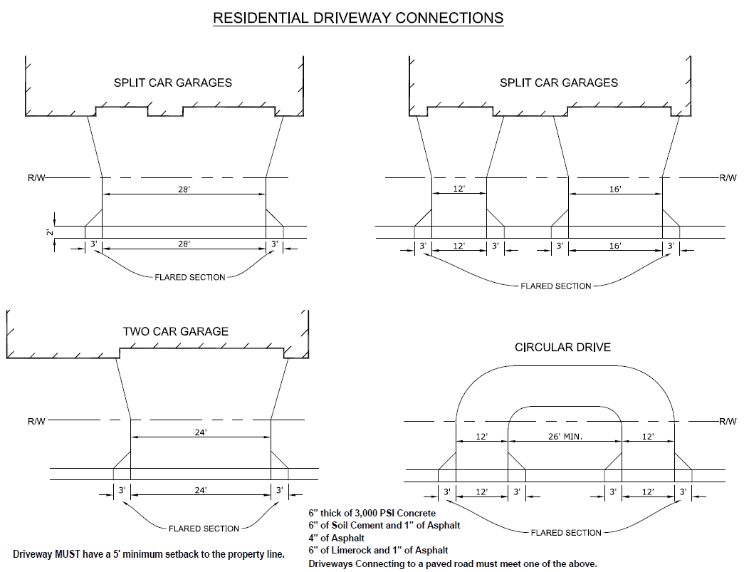
TABLE 901.6.A
Street Classification
(Ord. No. 24-04, § 5(Att. A), 1-9-24; Ord. No. 25-55, § 4 (Att. A), 12-9-25)
901.7. - Bicycle and Pedestrian Facilities
A.
Intent and Purpose. The intent of this section is to provide for the safe and efficient accommodation of bicyclists and pedestrians, promoting connected and accessible networks throughout the County.
B.
Applicability. This section shall apply to new development sites and redevelopment sites following the adoption of this section on December 9, 2025 subject to the following exemptions:
1.
Future Land Use Classifications. New development and redevelopment within AG, AG/R, and RES-1 future land use classification are exempt from the requirements of this section unless located within an MPUD zoning. In such cases, compliance with this section will be determined on a case-by-case basis.
2.
MPUD and Area Plans. Sites subject to transportation design standards of a previously adopted MPUD or area plan including but not limited to the Villages of Pasadena Hills and Connected City shall instead comply with the standards contained within their respective plans.
3.
Existing nonconformities. Existing developed sites not meeting the requirements of this section shall be brought into full compliance when the use is improved or remodeled in a value of 75 percent or more of the valuation of the existing principal structure as reflected on the Property Appraiser's current records.
C.
Locations. Bicycle and pedestrian facilities shall be installed on both sides of any street located within the development site. For those developments that abut an existing street with deficient facilities the developer is only responsible for installing improvements along the full length of the development's boundary line. All facilities shall comply with the following standards:
1.
Arterial and collector roads (Vision Roads). The following bicycle and pedestrian facilities shall be provided:
a.
Ten foot multiuse paved trails shall be provided on both sides of the roadway.
b.
Bicycle lanes shall be constructed in accordance with adopted typical sections when required as part of roadway construction. "County accepted typical sections" refers to those standards and designs accepted by Resolution No. 19-136, as amended, and depicted in the County's Development Manual.
2.
Subdivision Collector (Type 1) Streets. The following bicycle and pedestrian facilities shall be provided:
a.
Eight foot wide multiuse paved trail on one side of the street. If there is an existing or planned multiuse paved trail on one side of the street, the required trail shall be coordinated to match that alignment.
b.
Five foot sidewalk on the opposite side of the multiuse paved trail.
3.
Residential (Type 2, 3, and 4) Streets. Provide five foot sidewalks on both sides of the street. No multiuse paved trails are required.
4.
Alleys (Type 5 Streets). Bicycle and pedestrian facilities are not required.
5.
Minor Rural Subdivision Accessways. Bicycle and pedestrian facilities are not required.
6.
On-site Pedestrian Standards. All new developments and substantial redevelopments shall be designed with safe, convenient, and continuous sidewalks that link all on-site uses and connect to off-site sidewalks or multiuse paved trails. The following standards shall apply to all non-residential and multifamily projects, except as provided in subsection d of this paragraph.
a.
Connectivity to Public Sidewalks. A sidewalk, no less than five feet in width, shall be provided from the primary pedestrian entrance of all principal buildings to the off-site sidewalk or multiuse paved trail, parking areas or lots, and transit stops on the adjacent street.
b.
Internal Connections. An internal system of sidewalks shall connect all principal buildings to each other. This system shall provide sidewalks connecting all building entrances, on-site amenities, and parking areas.
c.
Parking Lot Connections. All parking lots with more than 100 or more parking spaces shall include designated sidewalks. These sidewalks shall be designed to provide a safe and direct path through parking areas to the building entrance(s), separated from vehicular travel aisles. Parking spaces shall be designed in such a manner that vehicles do not overhang sidewalks.
(1)
For parking rows perpendicular to the principal building front façade, pedestrian walkways shall be located at a minimum of one pedestrian walkway every 200 feet.
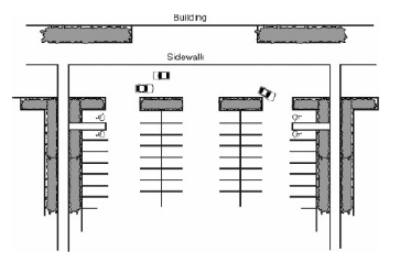
(2)
For parking rows parallel to the principal building front façade, there shall be a minimum of one walkway for every 21 parking spaces.
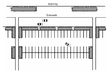
d.
Large Scale Commercial Retail Standards. A single commercial building or grouping of buildings closer than 20 feet whose total gross building area, including outdoor display and sales areas, is equal to or exceeds 25,000 square feet shall adhere to the Pedestrian Circulation standards in Section 1102.2.F.
D.
Construction. Construction of these facilities shall be completed prior to the final engineering inspection of the development site. Sidewalks along residential lots shall be constructed prior to CO.
1.
Multiuse paved trails shall:
a.
Be designed in accordance with the Florida Greenbook, Shared Use Paths.
b.
Be constructed of:
(1)
Natural or colored fiber-reinforced concrete, finished to a light broom finish, at least 3,000 psi in strength and a minimum of four inches in thickness on a compacted and non-yielding subgrade. Where multi-use path is subject to light vehicular traffic, it shall be constructed with a minimum thickness of six inches. At commercial entrances, the path shall be constructed with a minimum of eight inches thick; or
(2)
One-inch thick SP-9.5 asphaltic-concrete surface placed on a four-inch thick lime rock base over an LBR 100 compacted to a 98 percent modified proctor subgrade; or
(3)
Where environmental conditions necessitate the use of a boardwalk, that is or will be maintained by the County, the decking shall be constructed of pre-cast concrete. For boardwalks owned or maintained by others, the decking shall be constructed of either pre-cast concrete or composite material with a Dynamic Coefficient of Friction (DCOF) rating of .42 or greater.
c.
Align vertically and horizontally with abutting facilities, including any portion through a driveway.
2.
Where sidewalks are required pursuant to this section, they shall comply with the following standards:
a.
Be designed in accordance with the Florida Greenbook, Sidewalks.
b.
Be Constructed of:
(1)
Natural or colored fiber-reinforced concrete, finished to a light broom finish, at least 3,000 psi in strength and a minimum of four inches in thickness on a compacted and non-yielding subgrade. Where a sidewalk is subject to light vehicular traffic, it shall be constructed with a minimum thickness of six inches. At commercial entrances, sidewalks shall be constructed with a minimum of eight inches thick;
(2)
Pavers in accordance with Section 901.6.E.6; or
(3)
Where environmental conditions necessitate the use of a boardwalk, that is or will be maintained by the County, the decking shall be constructed of pre-cast concrete. For boardwalks owned or maintained by others, the decking shall be constructed of either pre-cast concrete or composite material with a Dynamic Coefficient of Friction (DCOF) rating of .42 or greater.
c.
Align vertically and horizontally with abutting facilities, including any portion through a driveway.
E.
Payment in Lieu of Construction. Where construction of the required multiuse paved trail and/or sidewalk is required by Section 901.7 and is not feasible or is premature, the developer shall make a payment to the County in lieu of construction. The County Engineer may deem the construction of a multiuse paved trail and/or sidewalk infeasible due to site constraints beyond the applicant's control or premature due to the corresponding sidewalk or multiuse paved trail in the Capital Improvement Program.
1.
The developer shall submit a cost estimate in an amount equal to the design and construction cost of the omitted multi-use trail and/or sidewalk to the County Engineer or designee to establish the payment amount. The final payment amount shall be determined no later than construction plan approval or issuance of the right-of-way use permit where no construction plan has been submitted. The payment shall be made no later than the final inspection of the approved construction.
2.
Any payment collected by the County shall be budgeted in a separate account and shall be utilized only to construct the sidewalk or multiuse paved trail which formed the basis of the payment or another sidewalk or multiuse paved trail that provides a direct benefit to the fee payer. If the payment has not been budgeted for the sidewalk or multiuse paved trail within 15 years of the date the payment was made, a refund may be requested in accordance with Section 1302.1.H.
F.
Maintenance. Nothing herein is intended or shall be inferred to impose any obligation on the part of the County to maintain or inspect bicycle and pedestrian facilities constructed in accordance with this or any other section of this Code. All bicycle and pedestrian facilities constructed pursuant to this Code shall be maintained in perpetuity by the developer and its successor(s) in interest unless the land on which it is built is deeded and owned in fee simple by the County, and if the County expressly agrees in writing executed by both the developer and the Chairman of the Board of County Commissioners to accept responsibility for maintenance of the bicycle and pedestrian facilities, or if such responsibility for maintenance of the bicycle or pedestrian facilities are otherwise voluntarily assumed by the County.
(Ord. No. 25-55, § 4 (Att. A), 12-9-25)
Editor's note— Ord. No. 25-55, § 4 (Att. A), adopted Dec. 9, 2025, repealed the former Section 901.7, and enacted a new Section 901.7 as set out herein. The former Section 901.7 pertained to Bicycle Facilities.
901.8. - Reserved
Editor's note— Ord. No. 25-55, § 4 (Att. A), adopted Dec. 9, 2025, repealed § 901.8, which pertained to pedestrian facilities.
901.9. - Street Naming and Addressing
A.
Intent and Purpose. The intent and purpose of this section is to provide the residents of the County with a uniform and standardized system of street naming and addressing to:
1.
Minimize future street name and addressing conflicts.
2.
Provide a database for County records and enhanced E9-1-1 services.
3.
Expedite property identification by emergency services.
4.
Comply with the addressing guidelines published by the U.S. Postal Service, Publication 28, and the National Emergency Number Association (NENA).
B.
Applicability. These regulations shall apply to the naming of all public and private streets and the addressing of all addressable structures and parcels within the incorporated and unincorporated areas of the County.
C.
Street Names.
1.
All public and private streets within the County shall receive names from the County Administrator or designee unless a street name change is requested which shall be heard by the Board of County Commissioners (BCC) at a duly noted public hearing.
2.
Street names assigned within the County shall be done in such a manner as to avoid duplication of names.
3.
Street names shall be chosen in a manner which relates to the scale and location of a project or street. In the opinion of the County Administrator or designee, street names shall be pleasant sounding, easy to read, and of a character which allows the public, and children in particular, to remember the name in an emergency situation.
4.
No duplication of street base names is permitted within the County. A street base name is that word or series of words that precede the word street, road, etc. Similar sounding names, in the opinion of the County Administrator or designee, shall be considered to be duplication, regardless of the spelling.
5.
Street names that have a secondary name, such as a vanity name or memorial name, shall not use that name for addressing purposes.
D.
Application for Street Names or Name Changes.
1.
Application for street names or street name changes may be requested by the developer or any property owner abutting the street involved. Applications shall be made to the County Administrator or designee and shall contain the proposed street name; copies of surveys showing the exact location of the street/easement; a general location map; where a street name change is requested, a petition or other demonstrative form of approval of the street name change by all other property owners on the street/easement; and, for a private street or easement, written permission from the property owner on whose property the sign is to be placed for the County to install the sign shall also be submitted and a fee established by the County Administrator or designee.
2.
Street names and street name changes shall be reviewed by the County Administrator or designee and a street name will be assigned where the base name requested complies with Section 901.9.C.
3.
A street name may be changed where any of the following conditions exist:
a.
There is an existing duplication of street base names.
b.
A street has more than one name, and a change to a single name would be in the best interest of the public safety, health, and welfare.
c.
A street has a similar sounding name in the opinion of the County Administrator or designee to another street within the County.
d.
The configuration of a street results in confusion in the numbering process.
4.
The BCC, exercising the power granted to it pursuant to Section 336.05, Florida Statutes, may determine that a condition exists for changing a street name. A street name shall be changed by resolution adopted by the BCC.
E.
Designation of Street Numbers and Changes. Street numbers for dwelling units and places of business shall be assigned at the time of Building Permit application. Where necessary in the interest of public safety, health, and welfare, street numbers may be changed by the County Administrator or designee. Numbers shall be assigned in accordance with administrative procedures adopted by the County Administrator or designee; however, such procedures shall, at a minimum, include the following:
1.
The owner, occupant, or person in charge of any house or building to which a number has been assigned shall be notified in writing of the number assigned.
2.
For new construction, two legible copies of the approved, final plats showing all lots with lot numbers and all streets with approved names or, alternatively, where no plat is involved, an approved, final site plan shall be furnished to the County Administrator or designee. Upon completion of the numbering by the County Administrator or designee, one copy of the plat or plan depicting numbers assigned shall be returned to the developer.
3.
Within 30 days after the receipt of such written notification, the owner, occupant, or person in charge of the house or building to which a number has been assigned shall affix the number in a conspicuous place over or near the principal entrance. Where the number is assigned at the time of Building Permit, the number shall be affixed prior to issuance of the Certificate of Occupancy (CO).
F.
Standards for Street Numbering. The physical numbering of buildings or houses shall conform to the following:
1.
Numbers must be easily legible from the street, with figures not less than three inches high for residences, and not less than five inches high for nonresidential development.
2.
Numbers must be in a color contrasting to the building background.
3.
Where there is a free-standing mailbox serving the building or house, easily legible numbers shall be affixed to the mailbox.
4.
Numbers shall be displayed on the front entrance of each principal building and, for a principal building which is occupied by more than one business or family dwelling unit, on each separate front entrance.
5.
Numbers which might be mistaken for or confused with the street number assigned by the County Administrator or designee shall be removed upon the display of the street number.
6.
Subaddresses shall only be numeric and shall conform to NENA Standards.
G.
Coordination with Municipalities. Within the municipalities of the County, street naming, street name changes, street numbering, and street number changes shall be finalized only after acceptance of such names or street numbers by the County Administrator or designee. The standards as set forth in this section shall apply to such names and addressing.
H.
Compliance Required.
1.
No Building Permit shall be issued for any principal building until the owner or developer has procured the official numbers for the premises, and no CO shall be issued until the said numbers are displayed in accordance with this section.
2.
Any person failing to comply with this section within 30 days after notification of a street name, street name change, street number, or street change shall be deemed to be in violation of this section.
901.10. - Traffic Control Devices
A.
Compliance with State Law. All traffic control devices, including signage and pavement markings, uniform signals, and devices installed within County rights-of-way, shall conform to the system adopted by the Florida Department of Transportation pursuant to Section 316.0745, Florida Statutes, and any other County standards.
B.
Responsible Party. Where required by a development approval, the cost of design/permitting and/or cost of construction of all required traffic control devices shall be the responsibility of the developer.
C.
Street Name Signage. The color and size of all street name signs shall be in accordance with current County standards and the Federal Manual on Uniform Traffic Control Devices, current edition, at Section 2D.43, as may be amended. On streets to be maintained by the County, all signs other than street name signs shall be date coded with a reflective label affixed to the back of the sign. It shall be punched to show month, day, and year of installation as follows:
Sample Label: Size 2" × 4"
D.
Construction Materials. All post systems, mounting brackets, and hardware shall be of a type currently in use by the County. Alternative systems shall only be used if approved by the County Administrator or designee.
All traffic control devices and materials shall be on the current Florida Department of Transportation approved products list. Proof of certification shall be required prior to installation.
E.
Maintenance. Street name signs and traffic control devices shall not be accepted by the County until the associated street has been accepted for maintenance by the County. Prior to acceptance by the County, the developer shall be responsible for all maintenance of traffic control devices and shall provide a point of contact.
901.11. - Street Lighting
A.
Applicability. Streetlights shall be provided within all subdivisions as follows:
1.
For subdivisions located within the AG (Agricultural), AG/R (Agricultural/Rural), or RES-1 (Residential - 1 du/ga) Future Land Use Classification, street lighting shall be required, as determined necessary at the time of preliminary plan approval, at all intersections which involve a Type 1 street, a Type 2 street, or a street functionally classified by the Comprehensive Plan, Future Roadway Network.
2.
For subdivisions located within the RES-3 (Residential - 3 du/ga) or higher land use classification, street lighting shall be required throughout the subdivision, except along Type 5 streets.
B.
Specifications. Street lighting shall be constructed per plans in accordance with Illuminating Engineering Society of North America Standards, utilizing Light Emitting Diode (LED) Technology. Subdivisions within an MPUD, Master Planned Unit Development District approved June 7, 2016 within a separate and distinct village or neighborhood, whose boundaries are identified by the approved construction plans for said village or neighborhood, and where construction of street lights have commenced within said village or neighborhood are exempt from the requirements to utilize this technology and may continue to match the lighting previously installed within the village or neighborhood.
C.
Street Lighting Service Area. At any time after the initial installation, the property owner(s) may petition the Board of County Commissioners (BCC) to establish a street lighting service area. Upon creation of the said area, the developer shall, at no cost to the County, transfer to the County all contracts as required by the County for the area in accordance with current BCC policy. Until such time as a street lighting service area is established, the owner/developer shall be responsible for all maintenance and the cost of operation.
901.12. - Transportation Analysis
A.
Intent and Purpose. The intent and purpose of this section is to identify potential transportation impacts of discretionary development approvals on the transportation system consistent with the mobility fee regulations, access management regulations, transportation corridor spacing requirements, and the Comprehensive Plan Transportation Level of Service (LOS) standards. The transportation analysis will be used by the County to determine whether the discretionary development approval request should be approved, denied, or conditioned, where applicable, to ensure consistency with the adopted Comprehensive Plan and this Code.
B.
Applicability. Except as exempted below, transportation analysis shall be required for all Future Land Use (FLU) Map amendments, rezonings, and amendments to Developments of Regional Impact (DRI) and MPUD Master Planned Unit Developments.
Except in the case of conflict zoning where a property has zoning which permits more trips than provided for under the FLU Map, amendments to the FLU Map shall undergo transportation needs assessment. Rezonings, amendments to DRIs and MPUDs, and FLU Map amendments associated with conflict zonings shall undergo timing and phasing analysis.
Additionally, the County may use the standards herein to evaluate other discretionary developments such as conditional uses and special exceptions for the purposes of evaluating transportation system impacts, if it exceeds the thresholds in C-1, or where the increase in gross trips is less than 50 peak hour trips.
C.
Exemptions.
1.
Applications where the increase in gross trips is less than 50 peak hour trips, a.m. or p.m., whichever is higher, provided the access is not on a roadway with a known LOS deficiency (see Table 901.12-2).
2.
FLU Map amendments to the following land use classifications:
a.
OF (Office).
b.
EC (Employment Center).
c.
IL (Industrial - Light).
d.
IH (Industrial - Heavy).
e.
PD (Planned Development): The portion of the planned development with government buildings, office, hotel, industrial, corporate business park, and/or transit-oriented development (TOD), as defined in the mobility fee definitions and regulations.
3.
Rezonings to the following zoning districts:
a.
EC-MPUD Employment Center Master Planned Unit Development.
b.
MPUD Master Planned Unit Development: The portion of the MPUD which is government buildings, office, corporate business park, hotel, industrial, and TOD.
c.
MPUDs within the following land use classifications: OF, EC, IL, and IH.
d.
PO-1 Professional Office.
e.
I-1 Light Industrial Park.
f.
I-2 General Industrial Park.
4.
Applications where the increased number of trips is from the Transfer of Development Rights (TDRs) which are purchased or received in compliance with the TDR provisions of the Comprehensive Plan and this Code.
5.
Unexpired DRIs and MPUDs which do not propose to eliminate or delay the timing of their existing road construction obligations or increase gross a.m. or p.m. peak hour trips, whichever is higher, beyond the threshold permitted by Section 901.12.C.1.
6.
Requests to eliminate or delay site-access improvements or substandard road improvements; however, such requests may be subject to additional review pursuant to Section 901.3 or 901.4.
7.
Requests to utilize statutorily-authorized extensions.
8.
Government buildings as defined in this Code, under the Mobility Fee definitions in Appendix A.
9.
Existing entitlements.
D.
Methodology Meeting. Upon submission of a Timing and Phasing Application or Comprehensive Plan Amendment Application requiring transportation analysis, staff will contact the applicant to:
1.
Determine whether the County or applicant will conduct the study.
2.
Set up a methodology meeting with the applicant or applicant's representative.
The date of the methodology meeting will be determined within one week of distribution of the application to County staff. If the County is performing the analysis, the County will prepare and submit a methodology statement for the applicant's review no later than two weeks after the methodology meeting. The purpose of the methodology statement is to establish agreed upon methodologies and assumptions prior to the start of the study and, if appropriate, to provide substantiation that the development's impacts are exempt (no net peak hour traffic impact) and further traffic study and review is not required. If the applicant chooses to perform the study, a County-approved methodology statement shall be required prior to submission of any transportation analysis. At a minimum, the following elements of the methodology, as listed below, will be specifically addressed:
3.
Exemption assertions.
4.
Collection of traffic counts.
5.
Description of land uses, site location, build-out schedule, and phasing, including any interim uses generating traffic.
6.
Study area.
7.
Access locations.
8.
Trip generation.
9.
Internal capture/passerby.
10.
Background growth procedure.
11.
Distribution and assignment.
If the County conducts the study, unless otherwise agreed to by the County, the applicant shall be required to obtain the traffic count data. If the County agrees to obtain the traffic counts, the time to complete these counts may delay the commencement of development review time frames in this Code, Table 303.1. In addition, if the County acquires the traffic counts, the applicant remains responsible for paying for the associated costs. Consistent with the standards set forth in this Code, Section 901.12.E.4, the County may use currently available counts. If new counts are needed, the County may choose to perform the counts in-house or through a third-party consultant.
To maintain the review schedule, if the County is performing the study, the applicant will be required to respond to the draft methodology statement within four business days. The applicant may request additional time for review, which will trigger an automatic extension of the review schedule. If the County is performing the study, the timeframe the County estimates to complete the analysis will be provided to the applicant in the methodology statement. Furthermore, if the applicant chooses not to have the County complete the analysis, the hearing timeframes provided in Section 303 shall be extended to permit completion of the analysis and review and comment by the County.
E.
Standards for Transportation Analysis.
1.
Trip Generation.
a.
Institute of Transportation Engineers (ITE) Trip Generation Manual (ITE Manual). The latest version of the ITE Manual will be used to estimate project traffic and exempted trips traveling to and from the site and trips associated with existing entitlements. Other rates may be used by the County or may be used if requested by the applicant and approved by the County. Unless the applicant has requested a conditioned approval identifying use density/intensity, rates associated with the highest trip generating use permitted by the existing/proposed zoning will be applied.
b.
Interim uses. Separate trip generation estimates for interim traffic-generating uses [2] shall also be considered.
c.
Reasonable yield. Unless the applicant has requested a conditioned approval identifying use density/intensity, a 25 percent reduction factor will be applied to the maximum allowable density/intensity to determine a reasonable assumption of trip yield from the site for both existing and proposed density/intensity. For example, a site with a proposed RES-6 (Residential - 6 du/ga) FLU Classification will be evaluated presuming a yield of 4.5 dwelling units per acre.
d.
Heavy vehicles. If heavy vehicles are ten percent or more of the trips generated by the proposed land use, the total estimated trips for heavy vehicles shall be multiplied by two unless ITE heavy vehicle data or other County-approved heavy vehicle trip generation data for the land use supports a different multiplier. In no event shall the multiplier be less than one. The multiplier will not be used in addition to the heavy vehicle adjustment factor used in the analysis software to determine the LOS.
2.
Internal Capture. Internal capture estimates shall be based on ITE acceptable methodologies, and where the ITE data is not applicable, professional judgment. However, in no case will an overall internal capture of more than 20 percent be used unless a higher internal capture percentage based on verifiable documentation; e.g., field studies of comparable sites, is available. Internal capture shall include the trips associated with existing entitlements. Exempted uses are allowed in calculation of internal trip capture.
3.
Passerby Capture. The total gross external trips of the project traffic may be reduced by a passerby factor to account for the project traffic that is already traveling on the adjacent roadway. Passerby capture will not exceed 20 percent of site generated traffic, unless data supporting higher rates are included in the current version of the ITE Manual reference, latest mobility fee study, or are otherwise approved by the County. In no event shall the total passerby trips entering and exiting a site exceed ten percent of the total background (existing plus future) traffic on the adjacent roadway.
In cases where median controls limit left-in/left-out access to the site, traffic on the "far side" of the road can be considered in assessing the upper limit on captured trips; however, the effects of that traffic in the associated necessary U-turns and added flow at the study area/impacted transportation system, the upstream and downstream median openings or intersections, should be identified as development traffic at those locations.
The passerby capture percentage shall be computed as the number of trips entering, plus exiting the site land uses claimed as captured, divided by the number of background trips passing by the site on Major County Roads directly abutting or passing through the site. An example of this computation is provided on Exhibit 901.12-1.
EXHIBIT 901.12-1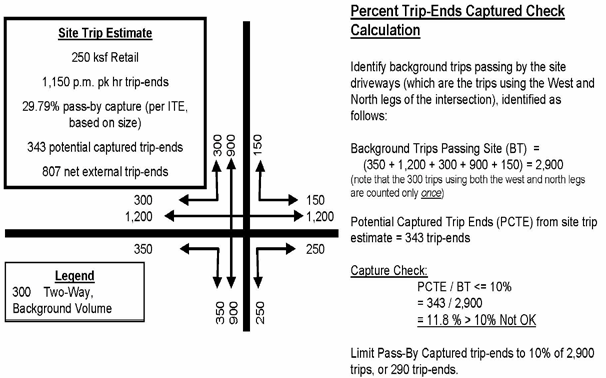
The passerby trips shall include trips associated with the existing entitlements.
4.
Trip Counts.
a.
General. All counts shall be conducted based on acceptable engineering standards. Raw turning movement counts shall be conducted during the a.m. and/or p.m. peak hours, consistent with the analysis parameters, Daily tube counts shall be conducted for a minimum of 48 hours at all intersections and road segments that are being analyzed in accordance with these provisions. The raw counts shall be converted to the 100 th highest hour of the year based on the Florida Department of Transportation's (FDOT) peak season adjustment factors and minimum K100 factors. Other peak-season adjustment factors or adjustment methodologies that may result in different peak-season adjustment factors may be used at the discretion of the County.
b.
Saturated intersections. To estimate turning movement counts for saturated intersections, the FDOT's methodology shall be followed by multiplying the average annual daily traffic tube count at appropriate locations by "the directional factor" and minimum K100 factors and by applying the percentage of turns obtained from the field-turning movement counts. The field-turning movement percentages may also be adjusted based on anticipated future development patterns in the area.
c.
Tube counts at approximate locations should be provided for segment analysis using the FDOT procedure. The segment tube counts at mid-block locations should be checked against turning movements at nearby intersections. In general, the mid-block counts and turning-movement counts should not be significantly different, unless the difference can be logically explained.
d.
Age of counts. Approved FDOT or County-maintained counts may be used if they are less than one year old. However, new counts shall be performed if there are recent improvements to the transportation system causing significant changes in traffic patterns. Counts more than one year old shall not be used unless the latest counts are representative of present conditions where little or no growth has occurred.
5.
Background Traffic Growth/Future Traffic. The existing traffic counts shall be increased by a growth factor to the project's build-out date, which shall be reasonably determined.
The growth rate shall also include all trips from exempt uses associated with the development under review. The final growth rates using the techniques in a and b below will be assumed to have contained the trips for exempt uses except for the access management portion of the analysis at the access intersections.
a.
Timing and phasing background traffic. Background traffic growth rates and background traffic volume estimates for timing and phasing shall be based on a combination of the following techniques:
(1)
Historical growth rates (minimum of the past three years) shall be used in areas where the expected growth is representative of the past growth.
(2)
Consideration of traffic from other developments shall be used in areas where the historical trend is judged by the County to be inappropriate. This may be accomplished through application of the latest adopted Tampa Bay Regional Planning Model (TBRPM), the Metropolitan Planning Organization's (MPO) Urban Area Transportation System Planning Model, or by estimating the anticipated trips using the latest edition of the ITE Manual.
(3)
The growth/future traffic on roads that do not currently exist shall be based on the TBRPM, the latest adopted model, or other acceptable planning/engineering techniques or tools.
(4)
If the TBRPM is used, the background traffic growth for existing roads shall be determined as follows:
(a)
Identify the validated year model volume and build-out year (future) model volume.
(b)
Interpolate these values to identify a model-based volume for existing conditions (year to be consistent with the date of "current" count data).
(c)
Identify the growth rate between the interpolated existing conditions model-based volume and the build-out year (future) model volume.
(d)
Apply this growth rate to the existing conditions traffic counts.
The build-out year (future) model volume is determined by applying the project's build-out year socioeconomic data to the committed and/or improved network. The build-out year socioeconomic data may be obtained by interpolating between MPO's or the County's adopted validated year and the adopted interim or future year, socioeconomic data, then adjusting to reflect the pending and approved developments.
The socioeconomic data of the model should reasonably represent, if appropriate, other developments in the vicinity of the development under review.
Minimum annual growth rates in all cases shall be two percent, unless other reasonable rates are deemed to be more appropriate by the County.
The connections of surrounding traffic analysis zones in the model shall be reviewed to reflect other approved and pending developments and to ensure appropriate network loading.
b.
Transportation Needs Assessment. The following techniques or combination thereof shall be used to estimate background traffic growth used for transportation needs assessment. The build-out of the project is assumed to match the horizon year of the Long-Range Transportation Plan (LRTP):
(1)
Historical growth rates (minimum of the past three years) shall be used in areas where the expected growth is representative of the past growth.
(2)
The volumes produced by the TBRPM as part of the latest LRTP development process documented in the LRTP Technical Appendix may be used. The traffic generated by existing entitlements is assumed to be included in the LRTP volumes.
Minimum annual growth rates in all cases should be two percent, unless other reasonable rates are deemed to be more appropriate by the County.
6.
LOS Standards. The following LOS standards shall be used:
a.
The LOS standards for through movements on all major County road segments (facilities) shall be consistent with the standards in the County's latest adopted Comprehensive Plan.
b.
The volume over capacity (v/c) ratio of turning movements on Major County Roads cannot exceed 1.2 for TRP or 1.0 for other nonexempt uses, with a maximum delay of 120 seconds. Delays of up to 150 seconds are acceptable for turning movements with a v/c ratio less than 0.8.
c.
For all access driveways and local street connections to Major County Roads approach delays of up to 150 seconds will be acceptable.
d.
For developments in urban areas with v/c ratio standards, at the intersection of a collector and an arterial roadway, the collector standard shall not exceed the v/c ratio of the arterial road standard.
e.
The LOS standard for the freeway (I-75) is only applicable to the main line.
f.
The LOS or v/c standards applicable to collector or arterial roadways are also applicable to all freeway interchanges, including the intersections of on/off ramps with Major County Roads.
g.
If a roadway forms a boundary between different area types, urban, suburban, or rural as defined in the Comprehensive Plan and mobility fee regulations, the less stringent standards will be applied. In addition, if a roadway facility under review crosses boundary lines, the less stringent standard will be applied to the first road segment/intersection.
h.
Any requirement set forth above relating to intersection LOS is only applicable to timing and phasing analysis.
7.
Study Area/Impacted Transportation System. At a minimum, the following roadway segments and intersections will be assumed to be within the study area and will be analyzed:
a.
All Major County Road segments (and associated signalized intersections including interchanges) that are directly or indirectly accessed by the proposed development.
b.
As a general rule, road segments outside of the minimum study area will not be considered impacted if the net external peak-hour project traffic (only from nonexempt uses) consumes less than or equal to five percent of the road segments' service-flow rate. The following two-way peak-hour service flow rates will be used to determine the five percent impact. The study area maybe less than the five percent impact area, based on the methodology agreed to at the methodology meeting and in the methodology statement.
TABLE 901.12-1
c.
Proximity to existing or proposed interchanges or major intersections may increase the size of the study area and impacted roads regardless of the five percent rule.
F.
General Analysis Requirements and Software. LOS analysis shall be undertaken in accordance with the procedures below:
1.
The main focus of transportation analysis is the identification of improvements to through movements. If there are any known turn-lane deficiencies at study intersections, the County may adjust the analysis parameters to account for the deficiency.
2.
Road facility limits shall be based on acceptable engineering and planning practices as set forth in the Highway Capacity Manual (HCM).
3.
All analysis shall be undertaken for conditions during the 100 th highest hour of the year. Other analysis periods, including the a.m. peak hour, may also be conducted, if appropriate.
4.
As part of the timing and phasing analysis and for uninterrupted road facilities (intersection spacing of more than two miles), the capacity of upstream and downstream intersections may be analyzed, which may restrict the amount of traffic that can be allowed on the uninterrupted portion of the facility.
5.
For purposes of analysis in ArtPlan, at major T-intersections, the dominant-turning movement will be assumed to be the through movement.
6.
For timing and phasing analysis, use of analysis software will be in accordance with the following:
a.
For unsignalized intersections, the latest version of Highway Capacity Software (HCS) is the preferred software.
b.
For signalized intersections and interrupted road segments, the latest version of ArtPlan is the preferred software, except as necessary to identify alternate solutions to through movement improvements, for which Synchro is the preferred software.
c.
For uninterrupted flow roads (those with more than two-mile signal spacing), the latest version of the FDOT's Highplan is the preferred software.
d.
Other analysis software acceptable to the County may be used to address situations not addressed by the above provisions.
e.
Existing signal timing will be obtained from the County Traffic Operations Division. The existing signal timings, including minimum and maximum settings, will be used for the initial analysis of future conditions. Timing changes outside of the existing minimum and maximum settings may be used or timing splits may be modified, but the existing cycle length will generally remain the same.
f.
Proposed or anticipated traffic signals may be considered in the future year condition, such as signals at development entrances.
g.
Other parameters that govern the roadway/intersection capacity analysis should be based on the parameters described in the latest version of the HCM.
7.
For long-term transportation assessment, the latest FDOT generalized service flow-rate tables will be used to assess the capacity of the road network.
G.
Analysis Scenarios.
1.
For timing and phasing, the following standards will be used in analysis:
a.
The analysis scenarios listed below shall be applied in the following order, as necessary:
(1)
Impact determination compares the existing and proposed net-peak-hour, external trips to determine the degree of impact to the road network. If the net-peak-hour, external trips of the existing entitlements are greater than or equal to the nonexempt net-peak-hour, external trips from proposed entitlements, no additional analysis is necessary.
(2)
If there is a net increase in peak-hour, external trips, the future scenario will be evaluated. The future scenario is defined as the analysis of existing traffic, plus reasonable background traffic and project traffic at build-out on the committed network. If no failure occurs, the analysis stops.
(3)
In circumstances where there is a failure, the future scenario will be evaluated including any improvements where construction is fully funded in the FDOT's Five-Year Transportation Improvement Plan and the County's Five-Year Capital Improvement Plan. If no failure occurs, the analysis stops.
(4)
Where there is a failure, the analysis will continue with inclusion of any cost-affordable improvements from the MPO's adopted LRTP and the Comprehensive Plan.
b.
For all locations which are estimated to fail, the analysis shall identify when each failure is expected as a fraction of development trips associated with nonexempt on-site land use quantities and the estimated year of the failure. If possible, the analysis shall identify improvements that are necessary to accommodate trips for the additional nonexempt entitlements being sought. These improvements may include new interchanges, overpasses, and/or roadways identified in the Comprehensive Plan or as required by this Code, Section 901.1.
2.
Transportation Needs Assessment. For transportation needs assessment, the analysis scenarios listed below shall be applied in the following order as necessary:
a.
Impact determination compares the existing and proposed net-peak-hour, external trips to determine the degree of impact to the road network. If the net peak hour external trips of the project traffic are less than or equal to the nonexempt net-peak-hour, external trips from existing entitlements, the analysis stops.
b.
Otherwise, the future scenario shall be analyzed with the MPO's adopted LRTP and the County's Comprehensive Plan.
c.
If failures occur, (1) appropriate improvements to accommodate future project traffic will be identified, and/or (2) appropriate reductions in proposed density/intensity increases in terms of net-peak-hour trips will be identified.
3.
Regardless of which analysis type or scenario is performed, the needed transportation corridors to satisfy this Code, Section 901.1, shall be assessed and identified.
H.
Analysis Timelines and Recommendations.
1.
Time to Complete Study. The estimated time to complete a study, including the methodology statement, is generally between one to four months, depending on the size of the project, associated complexities, and promptness in the applicant's responses to questions from the County.
If the County performs the analysis, applicants will have four business days to comment on the methodology statement and seven business days to comment on the draft analysis report. The applicant may request additional time for review which will trigger an automatic extension of the review schedule.
The County will address the applicant's comments and concerns in an efficient manner in order to complete the study within the one- to four-month period. If the applicant elects to conduct the study, the County will have 30 days from each submittal to review and respond with comments.
If there are any remaining unresolved issues with the methodology or analysis after the final study is forwarded to the applicant and the applicant chooses not to request a continuance to resolve the issues, the applicant will need to address the unresolved issues directly to the Planning Commission (PC) and/or the Board of County Commissioners (BCC) at the appropriate public hearing.
a.
MPUD/DRI/Conflict Rezoning.
(1)
If the applicant elects to conduct the analysis, the review times provided for in Section 303 shall be extended to provide time for the County to review and comment on the analysis.
(2)
When the County is conducting the analysis, the draft analysis report will be forwarded to the applicant no less than four weeks prior to the first public hearing and the final study will be forwarded to the applicant two weeks prior to the first public hearing.
(3)
The review time/analysis period of 120 days for MPUDs may be extended up to an additional 60 days for those projects that have outstanding issues as a result of the timing and phasing analysis.
b.
Euclidean Rezoning. To maintain the review times provided in Section 303, the timing and phasing analysis shall be completed prior to submitting a Euclidean rezoning application.
2.
Results and Recommendation. The results of the analysis will be used to provide a recommendation to the PC and BCC. The report presented from the analysis will identify when failures are estimated to occur and to what degree the failure is as a result of the request for increased entitlements.
In circumstances where a failure is identified, recommendations shall be presented to the PC and BCC, as appropriate. The recommendations shall be based on an evaluation of the proposed project and the total impact on the transportation network. The recommendation may be to:
a.
Approve the project.
b.
Approve the project with limitations on the phasing of the project.
c.
Approve the project subject to the timing of improvements.
d.
Approve the project subject to advance payment of mobility fees.
e.
Approve the project subject to the conversion of requested entitlements to exempt uses.
f.
Approve the project with other mitigation requirements including but not limited to transit, bicycle and pedestrian connectivity, changing the land use mix or incorporating MUTRM (MixedUse TripReduction Measures).
g.
Deny the project.
3.
Deficiencies and/or Backlogs. Mitigation assessed pursuant to this section shall not assess for the additional cost of reducing or eliminating existing deficiencies or backlogs.
I.
Waiver of the Requirements of this Section. The County Administrator or designee may waive any of the requirements of this section if it is determined that the requirement is not necessary to:
a.
Ensure consistency with the Comprehensive Plan LOS Standards.
b.
Ensure compliance with Section 901.1.
c.
Ensure the safety of the traveling public.
J.
Establishment of Uniform Approaches to Specific Segments.
1.
Common Understanding. When there is a common understanding of the capacity impacts to particular portions of the transportation system, to eliminate unnecessary time and expenditures to study the known condition, the BCC may adopt by resolution an approach to mitigation of transportation capacity issues on specific road segments.
2.
Local Planning Agency Recommendation Required. Prior to adopting such a resolution, the LPA shall review the proposal and make a recommendation to the BCC.
3.
Resolution Requirements. Such resolution shall be required to identify:
a.
The transportation capacity issues.
b.
Approved mitigation measures.
c.
Applicability of the resolution.
d.
The extent to which the resolution modifies the transportation analysis requirements for projects.
4.
Access Management. Access management analysis will continue to be required at the same stage in the review process.
TABLE 901.12-2
Transportation Analysis
50-Peak Hour Trip Threshold
Land Excavation and Mining (as defined in this Code, Sections 404.1 and 404.3) even as an interim use, is presumed to be a separate and distinct land use requiring separate trip generation estimates. Such land use is also presumed to generate more than ten percent heavy vehicles.
901.13. - Mixed-Use Trip Reduction Measures (MUTRM)
A.
Intent and Purpose. The intent of Mixed Use Trip Reduction Measures (MUTRM) is to promote a connected, mixed-use, compact development pattern that incorporates multimodal opportunities. The purpose is to reduce automobile dependency and Vehicle Miles Traveled (VMT) through this form of development. If an applicant chooses to utilize the MUTRM development option, the applicant shall either:
1.
At a minimum, meet the provisions provided in this Section and shall pay the associated fee as per the adopted fee schedule, as amended; or
2.
Obtain project approval utilizing the URBEMIS model as a trip-reducing project which estimates VMT through the consideration of: residential development density; the proposed mix of land uses; the availability of local-serving retail; transit use (which is assumed to yield no trip reduction for the purposes of this analysis in Pasco County); and the availability of bicycle/pedestrian facilities. Applicants shall pay the associated fee as per the adopted fee schedule, as amended.
B.
Principles. Through the inclusion of compact development design practices and standards, a MUTRM designated project shall qualify as a Trip Reducing Project (TRP), pursuant to Comprehensive Plan Policy TRA 2.4.1, and Section 901.12 of this Code. The TRP Level of Service Standards set forth in Policy TRA 2.4.1 shall apply for transportation analysis purposes.
Compact development practices and standards include the following design principles and techniques:
1.
The mixture and integration of residential, local-serving commercial and employment-generating land uses which contribute to increased walkability and on-site jobs to housing ratios;
2.
The inclusion of local-serving commercial uses in combination with civic and open space areas, and the incorporation of transit-friendly design features (i.e. design elements/land uses that encourage the use of public transit - shade trees, bus shelters, etc.) to support and encourage the use of transit opportunities to provide an alternative to automobile use. The incorporation of transit-friendly design features shall be provided in locations identified as part of Pasco County Metropolitan Planning Organization's Long Range Transportation Plan's (LRTP) Transit Needs Plan, and in other locations as deemed necessary through project review;
3.
The use of complete streets characterized by an interconnected street system that prioritizes pedestrian and bicycle movement through the incorporation of roadway standards for compact development as specified in Chapter 19 of the FDOT "Manual of Uniform Minimum Standards for Design, Construction, and Maintenance for Streets and Highways," and the associated cross-sections, with a revised minimum street planting width of ten feet, or eight feet with a root containment system. See Figures 901.13-1 through 901.13-7 of this Code;
4.
The ease of pedestrian walkability as determined by block sizes, and the establishment of a comprehensive pedestrian network of sidewalks, bikeways and trails throughout;
5.
Use of compact development forms including: the placement of buildings close to the street; on street parking; parking lots located to the rear of buildings; wide and shaded sidewalks and trails; and street furnishings. Minimum density (units/acre) or intensity requirements shall also be included to ensure compact development.
C.
Applicability. This section shall apply to any development project wishing to qualify as a TRP for purposes of Transportation Analysis pursuant to Comprehensive Plan Policy TRA 2.4.1 and this Code, Section 901.12, or opting to qualify for an adopted mobility fee reduction (as applied to the Compact Development Area only) even if a higher Vehicle to Capacity Ratio (a less stringent standard) is not sought. Such projects shall be designated as a MUTRM Project. All projects wishing to apply MUTRM standards must do so by submitting an MPUD (Master Planned Unit Development) rezoning request for the project.
Projects that contain approved phases prior to the project's designation as a MUTRM project shall have two options:
Option #1 - Elect to exclude those previously approved phases from designation as being a portion of the overall MUTRM Project and be exempt from the provisions of this Section; or
Option #2 - Elect to include those previously approved phases within the overall MUTRM Project and as combined meet all requirements of this Section, including the calculation of required Compact Development Area (CDA) acreage, based upon the combined project acreage.
Unless otherwise specified in Section 901.13, all MUTRM projects shall comply with the standards set forth in this Code.
D.
MUTRM Project Components. A MUTRM project shall contain at least one qualifying Compact Development Area (see Section 901.13.D.1) and may contain non-CDA area(s) (see Section 901.13.D.2). Each individual CDA shall contain at least one Neighborhood Center (see Section 901.13.D.3) located approximately one-half mile from an adjacent neighborhood center.
1.
Compact Development Area (CDA).
a.
Description. A CDA is a specifically designated area in which established development standards shall apply. These standards shall ensure the area functions as a walkable place, as determined by area, street dimensions, block sizes, and the inclusion of a comprehensive pedestrian network of sidewalks, bikeways and/or trails in accordance with this Section, and the inclusion of one or more Neighborhood Centers. Individual CDA's shall effectively be ¼-mile radius in size to promote walkability. Whereas not all site conditions promote an exact ¼-mile radius for development, it is understood that some required CDA areas might fall beyond that dimension. However, to meet the intent of walkability, this excess area shall be minimized. CDA development standards are addressed in Section 901.13.E.1.
b.
Minimum Project Area Requirements. A MUTRM project's net residential upland acres represent that portion of the project's total developable area that will be used for residential and/or nonresidential development that is not attributed to employment-generating uses in association with Section 901.13.D.1.c. The following summary outlines the associated terminology and calculations for the purposes of Section 901.13:
Total Developable Area equals:
The entire project area, minus wetlands and the associated required buffers, minus areas proposed for preservation or mitigation.
(Note: Proposed stormwater management features, such as wet or dry retention areas shall not be deducted to determine this area calculation.)
Net Residential Upland Acres equals:
The total developable area, minus if applicable, non-residential developable acreage attributed to employment-generating uses, minus a 25 percent reduction for roadway network.
In accordance with Section 901.13.E.1.a.(6), development projects shall provide a minimum of 50 percent of that project's net residential upland acres, in CDA form.
The total required CDA acreage for a MUTRM project may be located in one or more designated CDAs. However, no individual CDA may be less than ten net upland acres. If a project is less than ten net upland acres, 100 percent of the project must meet the CDA requirements.
The total required CDA acreage for a MUTRM project may be reduced through the provision of on-site employment in accordance with Section 901.13.D.1.c. However, in no case shall these reductions permit the total required CDA acreage to fall below 30 percent of the net residential upland acres.
c.
Reduction Credits for On-Site Employment. The total CDA minimum area requirements for a MUTRM project, as specified in Section 901.13.D.1.b., shall be reduced based upon the on-site inclusion of commercial, office, or industrial development proposed within the MUTRM Project. Required CDA area shall be reduced in accordance with the following schedule:
Explanation: For every one acre of office or industrial land use proposed, the project required total CDA area shall be reduced by one and one-half acre (1 acre × 150%). For every one acre of commercial land use proposed, the total project required CDA area shall be reduced by one-half acre (1 acre × 50%).
In order to qualify for CDA reduction credit, on-site employment uses shall provide vehicular, bicycle, and pedestrian connections directly to residential portions of the MUTRM project in order to minimize the need to use external roadways. To meet the intent of connectivity and receive the reduction credit, an applicant may provide bicycle and pedestrian access, and no vehicular connections to residential portions of the MUTRM project if such uses are obstructed by natural features.
2.
Non-Compact Development Area (Non-CDA). A non-CDA is that portion of a MUTRM project that is not developed as a qualifying CDA. Non-CDA development standards are addressed in Section 901.13.E.2.
3.
Neighborhood Center. A Neighborhood Center is a designated area comprising the minimum required park area as per Section 901.13.E.1.a.(3), and some combination of the following, in accordance with Section 901.13.E.1.a.(6):
• Local-serving commercial/retail uses;
• Office;
• Civic/public-serving land use (e.g., public school, library, civic or cultural assembly building, place of worship, or other similar recreational, educational, or public/semi-public use);
Transit-friendly design features (i.e. design elements/land uses that encourage the use of public transit - shade trees, bus shelters, etc.) to support and encourage the use of existing and future transit opportunities to provide an alternative to automobile use shall be used. Neighborhood Centers are addressed in Section 901.13.E.1.a.(8). The incorporation of transit-friendly design features shall be provided in locations identified as part of the LRTP's Transit Needs Plan and in other locations as deemed necessary through project review.
E.
Development Standards.
1.
Standards for Compact Development Areas. Areas proposed as CDAs shall be delineated on a MUTRM Master Plan and the associated Neighborhood Plan(s). All CDAs shall comply with the following development practices and standards.
a.
Development Pattern.
(1)
Block Structure. All CDA's shall be arranged in compact interconnected block patterns, which may be rectilinear, curvilinear, or organic in form, and shall comply with the following standards:
(a)
Blocks shall have an average perimeter not to exceed 1,320 feet, measured at the property/right-of-way line of surrounding streets, mid-block pedestrian passages [which shall be a minimum of 15 feet in width] or mews, but not including alleys, cul-de-sacs and closes, shall be included within a block for perimeter measurement purposes. However, only one mid-block pedestrian passage or one mew per block may be used for the purpose of defining block size. In no instance shall any block exceed a perimeter of 1,500 feet (except as provided in Section 901.13.E.1.a.(1)(b), below). If greater than 50 percent of the area of a block is located within the CDA, the entirety of that block shall be included in calculating the perimeter average.
(b)
Exceptions to the block perimeter requirements may be approved administratively in order to accommodate non-residential uses and natural wetland preservation areas. Lots at the edge of a neighborhood adjacent to wetlands, ponds, upland conservation areas, energy transmission corridors, are not required to be included in the block perimeter average calculation.
If proposed lots are located at the edge of an existing development with a pedestrian connection, or within proximity to a pedestrian amenity or destination, a pedestrian connection shall be provided.
If the average block perimeter requirement cannot be met for reasons other than those listed in the standards above, a five percent variation may be administratively approved by the County Administrator or designee. Exceptions to block perimeter requirements are not intended to grant relief from any other compact development design practice or standard as specified herein. Also, exceptions to block perimeter requirements are not intended to grant relief by applying to ponds, lakes, and other stormwater management features, unless that feature is located adjacent to an existing wetland system into which it directly discharges (i.e., internal ponds and lakes for the purpose of creating waterfront properties shall not be accepted as a valid reason to deviate from the required block perimeter requirements.
(c)
Block Depth. All blocks within CDA's that abut non-compact development areas shall have a minimum depth of 200 feet to provide for ease of transition between CDA and non-CDA areas.
(d)
Street Connectivity. Streets shall provide a cohesive roadway system, providing vehicular connections between all abutting neighborhoods and forming compact block sizes that encourage pedestrian activities. Gated communities are not permitted within the compact development area as they do not meet the intent of connectivity. (This does not preclude gating private parking areas, as long as the roadway network and pedestrian flow is not interrupted.)
The incorporation of methods to minimize multimodal conflict points within the roadway network shall be encouraged, (e.g., shared driveways).
(2)
Street Types. All streets, other than collectors and arterials, shall be designed as either an: "Alley", "Yield Street", "Slow Street", or "Low Street" as specified in Chapter 19 of the FDOT "Manual of Uniform Minimum Standards for Design, Construction and Maintenance for Streets and Highways", and the associated cross-sections, with a revised minimum street planting width of 10 feet, or eight feet with a root containment system. (See Figures 901.13-1 through 901.13-7 of this Code); and shall meet FDOT Complete Street policies and any standards that are established by the FDOT. Designation of street types shall be based upon their functional use as depicted on the Neighborhood Plan(s). Roadway cross sections will vary based upon the accommodation of parking on one, both or neither side(s) of the street.
Collector roadways located within a CDA shall be designed to prohibit individual residential unit driveway access, and may include on-street parking where the design speed is 35 mph or less. These collector roadways shall be designed with an urban cross-section, incorporate on-street bikeways, and be located within the minimum width cross-section deemed practical by the County.
Street designations shall be consistent with the anticipated traffic volumes, design speed and adjacent land uses associated with each street. Specifications for Collector and Arterial Roadways, Alley, Yield, Slow and Low Streets shall be designated on all master plans as applicable (MPUD, Master Roadway Plan, Neighborhood Plan, etc.).
For roads that function as county arterial roadways, the County's adopted standard roadway typical sections for arterial roadways shall apply, unless alternative standards are approved.
(3)
Pedestrian Network, Bikeways and Open Space. The pedestrian network shall be designed to result in an interconnected system linking all uses. Sidewalks and other pedestrian walkways and bikeways shall meet the following minimum standards:
(a)
Unless alternative standards are approved in conjunction with the MUTRM Master Plan and/or Master Roadway Plan approval as required, all sidewalks and bikeway lanes shall be designed in accordance with Chapter 19 of the FDOT "Manual of Uniform Minimum Standards for Design, Construction and Maintenance for Streets and Highways" and the associated cross-sections, with a revised minimum street planting width of 10 feet, or eight feet with a root containment system. See Figures 901.13-1 through 901.13-7 of this Code, for streets classified as either "alley", "yield street", "slow street" or "low street", and shall meet FDOT Complete Street policies and any standards established by FDOT. Collector and arterial roadways shall meet the requirements of this Code. Upon request by the applicant, the elimination of on-street bikeways on one or both sides of a street based upon the street's specific location and use may be deemed appropriate, where a parallel bicycle or multiuse trail exists, and it meets or exceeds the intent of the Code. Such requests shall be subject to approval by the County Administrator or designee.
(b)
Sidewalks serving single-family residential uses shall be a minimum of five feet in width.
(c)
Pedestrianways serving local-serving commercial uses shall be a minimum of 12 feet in width from face of curb to building front to accommodate sufficient space for walking and socializing, as well as the placement of street furniture, street trees, landscaping and utilities. A minimum of five feet in width of the pedestrianway shall be unobstructed in order to provide clear pedestrian movement.
(d)
For all other uses, sidewalks and pedestrianways shall be of sufficient width to accommodate anticipated pedestrian use. In no event shall the sidewalk width be less than five feet. Generally, pedestrian activity is greater where there is a higher density or intensity of uses, thereby requiring greater widths for sidewalks and pedestrianways.
(e)
Should pedestrian mid-block crossings be necessary, curb extensions or bulbouts, extending the width of any on-street parking spaces, shall be required to reduce the crossing distance for pedestrians. In conjunction with mid-block crossings intersecting with four-lane, divided or undivided roadways, pedestrian havens shall be provided.
(f)
Roadways at all pedestrian-crossings shall be marked for pedestrian safety through the use of textured pavement or other similar methods that clearly identify the pedestrian crossing area and appropriate signage in accordance with the Manual on Uniform Traffic Control Devices (MUTCD).
(g)
Where bike lanes are located adjacent to the curb the gutter width shall not be considered part of the rideable surface area. All drainage inlets, grates, and utility covers in the bicyclists' expected path shall be designed to be flush with the pavement, well-seated, and have bicycle compatible grates.
(h)
A Master Bicycle/Pedestrian Plan shall provide pedestrian connections between internal uses and interconnections to adjacent developments. MUTRM projects shall connect with a matching width into the existing or planned County trail system (as depicted on the current Greenways, Trails and Blueways Plan or other County-adopted plans depicting trail systems) where it exists or is planned adjacent to the subject project site. If a planned system does not have an approved minimum width, the on-site path shall be a minimum of ten feet wide. Site constraints may dictate the need to reduce this minimum width; however, this reduction shall be permitted through approval by the County Administrator when natural site conditions limit the width. The multiuse paths provided as part of the project shall incorporate green space, shade trees, and benches; and should integrate on-site wetlands, wet ponds, or other natural features into the multiuse path as an amenity. The multiuse paths shall be landscaped with shade trees and shrubs at an average spacing of 60 feet. Bench seating located next to a shade tree will be required every one-half mile along the multiuse path. Bicycle storage and parking shall be provided at trailheads and other locations as deemed appropriate and approved by the County.
(i)
Interconnections for pedestrian walkways shall be such that the residential/multifamily component can easily access office or commercial components by proximity of the pedestrian walkways to the buildings and encourage the use of dual entry features (access front and rear) to encourage walkability.
(j)
Unless otherwise noted in this section, each MUTRM project and the associated CDAs shall meet the requirements of the Code, Section 905.1.
In the CDAs, required neighborhood parks shall be accessible to the residents of the development by automobile, foot and bike within one-half mile distance as measured by a clear walkable route. [This requirement is not meant to require designated parking lots at every neighborhood park. Automobile access can be met through the provision of nearby parking (on- or off-street) that links pedestrian access to the park.]
In the CDAs, the required neighborhood park acreage may be composed of multiple neighborhood parks; however, each required neighborhood park shall be a minimum of ¼ acre in size. Squares, parks, or plazas can be a minimum of one-sixth acre in size and count towards the requirements for neighborhood parks, provided they contain hardscape and/or a programmatic element such as seating, sculpture, fountain, or play structure.
Dry detention areas are permitted to count towards meeting the minimum CDA park area requirement as long as useable park area that meets the minimum size requirements of this Section is provided. No more than 50 percent of a dry detention area shall count towards the associated required CDA park.
Open spaces shall be integrated in the multifamily residential areas and the non-residential areas in the form of squares, plazas and parks. Buildings shall, where practical, frame open spaces to create courtyards and squares, and create a sense of place.
(4)
Buffering. The intent and purpose of providing landscape buffering and screening is to ensure an aesthetically pleasing developed environment that provides interest to motorists and pedestrians, and to provide separation between uses and intensities where appropriate. Unless otherwise specified in this section, the requirements of this Code, Section 905.2 shall be met.
(a)
Internal Blocks. Blocks that are internal to a CDA do not have to comply with the buffer requirements per this Code, Section 905.2.D, except that the requirements associated with Sections 905.2.D.3 and 905.2.D.4 shall be met for vehicle use areas and building perimeters, respectively.
(b)
Collector Roads. An applicant will meet the requirements for buffering/screening on collector roads, either though the provision of:
(i)
A minimum of ten feet of landscaped buffering along both sides of collector roads with a Type D planting scheme; or
(ii)
A system of street trees (with spacing appropriate for the selected tree species, within a minimum ten-foot wide buffer) as approved by Planning and Development Department Staff.
This buffering/screening requirement may be administratively amended for collector roads that do not exceed a 35 mph design speed limit where on-street parking is provided. The reduction in the required buffering/screening shall be addressed at preliminary site plan review.
(c)
Incompatible Land Uses. Those uses that are deemed to be incompatible must provide a minimum width of ten feet of landscape buffering between uses with a Type B planting scheme, excluding berms. Additional buffering and screening may be required depending on the specific incompatible uses identified.
The use of a parcel of land in a manner which interrupts, conflicts, or otherwise interferes with the use of a neighboring parcel of land such that the neighboring land is impaired for its original intended use is deemed to be incompatible.
(5)
Building and Parking Standards. Shared and on-street parking is permitted and encouraged for all development in accordance with this Code, Section 601.7.E.3.b.(5).
(a)
Single-Family Detached Residential. Single-family detached residential development shall meet the requirements of this Code, Section 907 unless this Section or applicable conditions of approval delineate otherwise. At least one of the required parking spaces that may be provided on-street shall be located proximate to the dwelling unit.
(b)
All Other Development. To ensure compact forms of development for all non-single family detached residential uses the following design standards shall apply:
(i)
A building's primary orientation shall be toward the pedestrian environment, which shall connect to the street;
(ii)
Pedestrian use and access areas shall extend from the back of curb to building front, and may contain street furnishings and landscaping, as described in Section 901.13.E.1.a.(3)(c); and
(iii)
Except for on-street parking, all primary parking lots shall be located at the rear or side of principle buildings, away from the main entrances that front on pedestrian activity centers, (e.g., courtyards, sidewalks adjacent to the front entryway and the primary street network, etc.). Parking quantity shall meet the requirements of this Code, Section 907 unless this Section or applicable conditions of approval delineate otherwise.
(6)
Residential Density. The average net density of all combined CDA residential areas shall be in compliance with the minimum density requirements outlined in Table 1. Accessory dwelling units shall count towards the residential density requirement.
Table 1
MUTRM Density Requirements
*The percent of net residential upland acres built as CDA is applied to the employment-adjusted net residential upland acres and shall not be less than 30% of the total net residential upland acres.
**All MUTRM projects must meet the minimum park/open space requirements. In addition to the required park area, each CDA must provide a mix of the following use types as per Table 1: Local commercial; office; or civic/institutional. School sites may be used to meet the civic, or the commercial/office land use requirement in accordance with Section 901.13.E.1.b.(4).
(7)
Commercial and Office Standards. Local-Serving Commercial:
Commercial uses (as per Section 901.13.E.1.b.) within Neighborhood Centers shall be provided at a minimum ratio of 22 square feet of gross leasable area (GLA) per CDA residential unit, per individual CDA (i.e. 500 units @ 22 SF GLA/unit = 11,000 SF GLA), in accordance with Table 1 of this Section.
Office:
When office is provided, yet no local-serving commercial is provided, the minimum office required shall be based on a one-to-one (1:1) jobs to housing ratio for the entire project, with a minimum of 133 SF per job; (i.e. 500 units @ 1:1 jobs to housing = 500 jobs × 133 SF per job = 66,500 SF). Office uses may be located either inside or outside of the CDA to meet this requirement. A minimum of 22 square feet per CDA unit shall be located within the neighborhood center(s).
When office is provided in conjunction with local-serving commercial within each individual CDA, the office use need only meet the minimum established for local-serving commercial.
(8)
Neighborhood Center Standards. Distinguishable Neighborhood Center(s), in accordance with Section 901.13.D.3, shall be located approximately every one-half (½) mile, and shall be depicted on the MUTRM Master Plan and more completely described and detailed on the required Neighborhood Plan(s).
(a)
Composition. Each Neighborhood Center shall include the minimum required park area as per Section 901.13.E.1.a.(3) and at least two of the following uses in accordance with Table 1:
(i)
Local-serving commercial/retail;
(ii)
Office; and/or
(iii)
Civic/public-serving land use (i.e., school, library, civic or cultural assembly building, place of worship, or other similar civic, recreational, or educational use).
(b)
Commercial. Local-serving commercial uses, as per Section 901.13.E.1.b., shall be oriented toward the street and in proximity to each other in order to create an enhanced walkable pedestrian environment. A maximum building setback of 20 feet as measured to the back of curb shall be provided.
(c)
Mixed Use. A required neighborhood center may vertically incorporate residential uses with the commercial/office component.
(d)
Commercial/Office Reverter Option for Alternative Use. Any parcel or parcels located within a CDA and designated for local-serving commercial or office uses as specified in Section 901.13.E.1.a.(7) shall not be redesigned to any alternative use until such time as 75 percent of the associated required CDA residential units have been issued a certificate of occupancy (CO). After achieving 75 percent occupancy for that individual CDA, the developer or entity that controls any designated local-serving commercial or office use parcel may at their option, redesignate that parcel or parcels for other permitted uses in accordance with Section 901.13.E.1.b. Such redesignation shall not constitute a substantial amendment to the approved MUTRM plan.
Upon intent to utilize this option, an applicant shall provide official, written notification to the County of such intent to redesignate the subject parcel(s). The notification shall include the exiting land use designation, the proposed land use designation, and associated proof of 75 percent CO issuance of the required CDA residential units.
b.
Land Uses. Development land uses shall be arranged to provide the integration of residential, local-serving commercial, office, and employment-generating land uses.
(1)
Residential. All residential use types are permitted, provided the overall residential density requirements as defined in this section, are met.
(2)
Commercial. Minimum commercial requirements within a CDA shall be met by local-serving, commercial uses in accordance with Section 901.13.E.1.a.(7). As it relates to MUTRM projects, local-serving, commercial uses are those uses primarily comprised of retail and personal service businesses that directly serve the day-to-day needs of local residents. These uses include those businesses that typically serve as satellite uses located within grocery-anchored neighborhood and community-scale shopping centers. The most common of these businesses include restaurants; local food markets or groceries; ethnic food sales; liquor stores; card and gift shops; ice cream shops; dry cleaners; small fitness facilities; hair, nail, and beauty salons; pool supply sales; and other similar uses.
(3)
Office. Minimum office requirements within a CDA shall be met in accordance with Section 901.13.E.1.a.(7).
(4)
School Sites. Schools meet the civic use requirement. Due to the transportation impact mitigation associated with schools located in close proximity to residences, public schools that are required onsite as part of an MPUD approval and are located within the CDA may count toward a portion of the commercial/office land use requirement. If a school site is used to meet the commercial or office land use requirement, it would not also meet the civic use requirement of this section.
The portion of required commercial or office that a school site can replace is the average total required local-serving commercial or office per proposed number of Neighborhood Centers, as expressed below:
School Site (as replacement use) =
Total Required Local-Serving Commercial or Office
Proposed # of Neighborhood Centers
If an individual CDA is required to have less commercial or office square footage than is reduced by the provision of the school, the difference may not be reduced from the required commercial or office square footage in the other designated CDAs.
If an individual CDA is required to have more commercial or office square footage than is reduced by the provision of the school, the difference shall be provided in that same individual CDA.
(5)
Mixed-Use. A required neighborhood center may vertically incorporate residential uses with the commercial/office component.
2.
Standards for Non-Compact Development Areas. Development standards outside of a CDA shall be specified through MPUD Conditions of Approval. However, all non-CDA development shall incorporate the following development practices. Where inconsistencies result, the following shall take precedence:
a.
Street Connectivity. All streets shall, to the maximum extent feasible, provide a cohesive roadway system with the goal of providing vehicular connections between all abutting neighborhoods and forming block sizes that encourage pedestrian activities. While gated communities are permitted within the non-CDA, gated road-ways do not meet the intent or associated requirements of street connectivity. Where necessary, restricted access points leading into a gated community can be located off of a non-restricted interconnect.
b.
Open Spaces Systems. Open space systems shall be established that include preserved wetlands and uplands and their buffer edges, proposed parks, proposed lakes and other potential open space amenities. These open space systems shall provide connection to CDA-designated open spaces where possible.
c.
Pedestrian Systems. Sidewalks and multi-purpose trails shall be provided throughout the project in accordance with this Code and any additional standards as required in the MPUD conditions of approval.
d.
Integration of Mixed-Uses. The various proposed project land uses shall be integrated to promote ease of pedestrian access between uses and to assist in the reduction of automobile dependency.
e.
Employment-Generating Uses. The amount and location of employment-generating uses (office, research and development, manufacturing, assembly, etc.), shall be as depicted on the MUTRM Master Plan.
F.
Approval Process for MUTRM Projects. The approval process for MUTRM projects shall be as follows:
1.
MUTRM Master Plan. As part of an MPUD application involving a proposed MUTRM designated project, a MUTRM Master Plan shall be submitted. All plans shall be in graphic form and of sufficient scale for review (as determined by the County Administrator or designee). The plan shall graphically depict the overall MUTRM project area, including the project's Compact Development Area(s) and associated neighborhood center(s), general block configurations, location of residential and non-residential uses, residential net density, square footage and location of CDA-required uses. This Plan shall include the step-by-step calculations for the required CDA (including any employment adjustment credits), the minimum number of CDA residential units, and the minimum neighborhood serving commercial square footage. The MUTRM Master Plan shall be used by Planning and Development Department to evaluate whether the proposed MUTRM Project is consistent with this Section.
2.
Neighborhood Plan.
a.
Prior to Preliminary Development Plan/Preliminary Site Plan submittal for any development within a designated individual CDA and non-CDA areas, a Neighborhood Plan shall be submitted to the Planning and Development Department for review approval.
b.
CDA Neighborhood Plan submittals shall include the following components in graphic form and be of sufficient scale for review, as determined by the County Administrator or designee, which may be accompanied by any request(s) for consideration of alternative development standards to be applied in any CDA:
(1)
A block plan for each individual CDA demonstrating compliance with Section 901.13.E.1.a.(1), Block Structure;
(2)
The location, configuration, and designation of all CDA roadways and alleys, pursuant to Section 901.13.E.1.a.(2), Street Types;
(3)
The location and general configuration of bikeway and pedestrian systems and open space sufficient to demonstrate compliance with Section 901.13.E.1.a.(3), Pedestrian Network, Bikeways, and Open Space;
(4)
A graphic and textual description of proposed on-street and off-street parking provided, in order to demonstrate compliance with Section 901.13.E.1.a.(5), Building and Parking Standards;
(5)
A graphic and textual description of proposed buffering/screening plan to demonstrate compliance with Section 901.13.E.1.a.(4), Buffering;
(6)
The conceptual location of building types and associated unit counts and uses, as well as proposed off-street parking areas sufficient to demonstrate compliance with Section 901.13.E.1.a.(5), Building and Parking Standards;
(7)
The location and description of proposed residential product types and density calculations sufficient to demonstrate compliance with Section 901.13.E.1.a.(6), Residential Density;
(8)
Areas proposed for local-serving commercial uses, including approximate building gross leasable area, and off-street areas proposed for parking sufficient to demonstrate compliance with Sections 901.13.E.1.a.(5), (7) and (8), Building and Parking Standards, Commercial Standards, and Neighborhood Center Standards, respectively;
(9)
Areas located within CDA Neighborhood Centers and descriptive and graphic representations sufficient to demonstrate compliance with the Composition, Residential, Commercial, and Mixed Use subsections within Section 901.13.E.1.a.(8), Neighborhood Centers Standards; and
(10)
Descriptive and graphic representations sufficient to demonstrate that land uses shall be arranged to provide the integration of residential, local-serving commercial, and employment-generating land uses in compliance with Section 901.13.E.1.b., Land Uses.
c.
Non-CDA Neighborhood Plan submittals shall be reviewed in accordance with this Code, Sections 522 and 901.13.E.2, as applicable.
3.
Previously Approved MPUDs. If an applicant has a non-MUTRM MPUD approval issued prior to the effective date of Section 901.13 and opts to become a MUTRM project, the MUTRM review will be considered a nonsubstantial modification in accordance with Section 402.2.N.2. The applicant shall submit a Neighborhood Plan in accordance with Section 901.13.F.2. The County Administrator or designee may require the applicant to submit a MUTRM Master Plan concurrently, as necessary; which shall be administratively approved by the County Administrator or designee if the Master Plan meets the requirements of Section 901.13.F.1.
G.
Alternative Standards. The intent of an alternative standard is to provide design alternatives for MUTRM projects in order to provide unique housing alternatives, creative/flexible design or land use solutions for CDA neighborhood centers, or to provide relief when no feasible engineering or construction solutions can be applied to satisfy one or more MUTRM project requirements. The County Administrator or designee is authorized to approve alternative standards with or without conditions.
1.
Requests for Alternative Standards. Requests for alternative standards may be made in conjunction with the filing of a development application for a MUTRM project or with the filing of any required Neighborhood Plan. Sufficient information must be provided for the administrative official to make a determination.
2.
Criteria. The applicant shall demonstrate how all of the following criteria in either Part 1 or Part 2 have been satisfied:
Part 1:
No feasible engineering or construction solution can be applied to satisfy the requirement for which an alternative standard is being sought; or
Part 2:
a.
Connectivity of multi-use trails, bike trails, and sidewalks shall be provided throughout the entire project; and
b.
The incorporation of transit-friendly design features shall be provided in locations identified as part of the LRTP's Transit Needs Plan and in other locations as deemed necessary through project review; and
c.
In no case shall the total required CDA area be less than 30 percent of the net residential upland area; and
d.
The alternative standard is consistent with the applicable provisions of the Comprehensive Plan; and
e.
The alternative standard is not in conflict with the intent or purpose of this Section, the intent of Section 901.13.B. Principles, nor the standards for non-compact development areas outlined in Section 901.13.E.2.
3.
Denials. Any request for an alternative standard which does not meet the criteria above will be denied, and the applicant shall either:
a.
Comply with this Code, Section 901.13 (MUTRM); or
b.
Appeal the denial to the Planning Commission pursuant to this Code, Section 407.1; or
c.
Withdraw the request to be treated as a MUTRM project.
H.
Determination of Compliance with MUTRM Requirements. The following projects have been approved in compliance with the URBEMIS model as a trip-reducing project:
1.
Smith 54 MPUD. The project as approved October 23, 2012.
2.
Wiregrass MPUD. The project as approved February 25, 2014 meets MUTRM. The Compact Development Areas are the MUTRM Designated Parcels on Exhibits N and O of the Wiregrass Development Agreement recorded in Official Record Book 8858, Page 167, of the Public Records of Pasco County, Florida.
3.
Starkey Ranch MPUD. The project as approved September 11, 2012, as amended December 17, 2013, and as amended May 14, 2014 meets MUTRM. The Compact Development Areas include the Longleaf Neighborhood, the Western Neighborhood, the Central Neighborhood, and the Downtown Neighborhood.
These projects may retain the URBEMIS/MUTRM status upon amendment provided such amendment is not inconsistent with the MUTRM principles outlined in Section 901.13.B, or that the applicant otherwise demonstrates that the amendment is in compliance with Section 901.13 or URBEMIS.
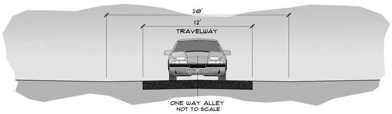
Figure 901.13-1
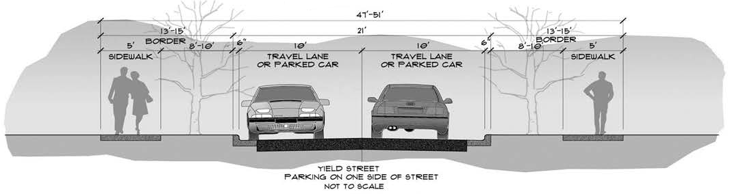
Figure 901.13-2

Figure 901.13-3
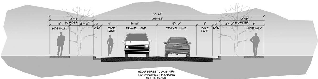
Figure 901.13-4
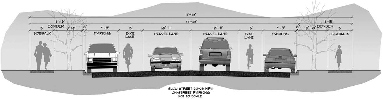
Figure 901.13-5
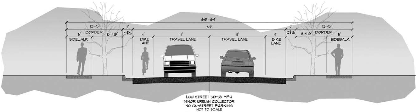
Figure 901.13-6
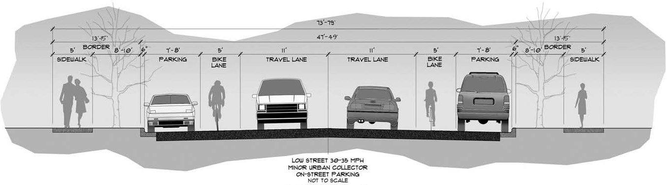
Figure 901.13-7
902.1. - Stormwater Quality
A.
Intent and Purpose. Pollutants discharged from storm sewer systems have a significant impact on receiving waters. Improperly treated discharges from industrial activities and interconnected Municipal Separate Storm Sewer Systems (MS4s) and illicit discharges or disposal of material other than stormwater to the MS4s, adversely affects the quality of waters receiving such discharges. Therefore, the Board of County Commissioners (BCC) finds it necessary for the health, safety, and general welfare of the citizens of the County and in the public's interest to protect the quality of waters receiving stormwater discharges.
B.
Applicability. This section shall apply to all parcels where any portion of the parcel is within unincorporated Pasco County or activities that result in discharges to the County's MS4s or United States waters that are within or border unincorporated Pasco County.
C.
Exemptions. The following discharges are exempt from this section:
1.
Water line flushing.
2.
Landscape irrigation.
3.
Uncontaminated groundwater infiltration (as defined at 40 CFR 35.2005[20]) to separate storm sewers.
4.
Uncontaminated pumped groundwater.
5.
Potable water.
6.
Air conditioning condensation.
7.
Irrigation water.
8.
Springs.
9.
Lawn watering.
10.
Individual residential car washing.
11.
Flows from riparian habitats and wetlands.
12.
Street wash waters.
13.
Flows from emergency fire fighting activities.
D.
Control of Stormwater Discharges.
1.
Stormwater Discharges to the MS4s and United States Waters:
a.
Stormwater discharges to the County's MS4s shall be controlled to the extent that such discharge will not impair the operation of, or contribute to, the failure of the County's MS4s.
b.
Stormwater discharges to United States waters shall be controlled to the extent that the discharge will not adversely impact the quality or beneficial uses of the receiving water or result in violation of any Federal, State, or local laws.
c.
Reporting Illegal Stormwater Discharge to the MS4s and United States Waters. Upon discovery of stormwater discharge to the County's MS4s that does or will impair the operation of or contribute to the failure of the County's MS4s or to United States waters that does or will adversely impact water quality or beneficial uses of the receiving water, or result in violation of Federal, State, or local law, the persons responsible for the discharge or the connection shall report their findings by telephone within 12 hours to the County Administrator or designee and follow within 48 hours with written notification.
d.
Control of Illegal Stormwater Discharge to the MS4s and United States Waters. Any person responsible for stormwater discharge to the County's MS4s that does or will impair the operation of or contribute to the failure of the County's MS4s or to United States waters that does or will adversely impact water quality or beneficial uses of the receiving water, or result in violation of Federal, State, or local law, shall immediately, upon notification or discovery, cease discharging or provide suitable containment facilities until corrective measures approved by the County are made, and may also be subject to fines and damages.
2.
Stormwater Discharges from Commercial Activities, Industrial Activities, and Construction Activities:
a.
Stormwater from sites where construction activities are occurring or have occurred shall be controlled in such a way as to retain pollutants, including sediment, onsite. All erosion, pollution, and sediment controls required to retain pollutants onsite shall be properly implemented, maintained, and operated to prevent pollutants from leaving the site.
b.
Stormwater from areas of commercial and industrial activity, but which are not the site of construction activities shall be treated or managed onsite using Best Management Practices (BMP), in accordance with National Pollutant Discharge Elimination System (NPDES) Permits, prior to discharging to the County's MS4s or to United States waters. Also, all stormwater discharges from the site shall be of a quality which will not adversely impact the water quality or beneficial uses, such as drinking, recreation, fishing, etc., of the receiving water.
c.
The owners or operators of commercial facilities, industrial facilities, or construction sites which intend to discharge stormwater to the County's MS4s must first receive Development Permit approval from the County.
d.
Reporting Illegal Stormwater Discharges from Construction, Commercial, and Industrial Activities. Upon discovery of a stormwater discharge contaminated with pollutants from construction activity or stormwater discharge from a commercial or industrial facility that is of a quality that does or will adversely impact the water quality or beneficial uses of the receiving water, the persons responsible for the discharge or the connection shall report their findings by telephone within 12 hours to the County Administrator or designee and follow within 48 hours with written notification.
e.
Control of Illegal Stormwater Discharges from Construction, Commercial, and Industrial Activities. Any person responsible for stormwater discharge contaminated with pollutants from construction activity, or stormwater discharge from a commercial or industrial facility that is of a quality that does or will adversely impact the water quality or beneficial uses of the receiving water, shall immediately, upon notification or discovery, cease discharging or provide suitable containment facilities until corrective measures approved by the County are made, and may also be subject to fines and damages.
3.
Control of Pollutant Contributions from Interconnected MS4s:
a.
The discharge of stormwater between interconnected State, County, or other MS4s shall not impair the quality of the discharge from the receiving MS4s.
b.
Owners of sections of an interconnected MS4 shall be responsible for the quality of discharge from their portion of the system and shall coordinate with the owners of the downstream segments prior to connections into their systems.
c.
Reporting Pollutant Contributions from Interconnected MS4s. Upon discovery of stormwater discharge between interconnected State, County, or other MS4s that does or will impair the quality of the discharge from the receiving MS4s, the persons responsible for the discharge or the impairment shall report their findings by telephone within 12 hours to the County Administrator or designee and follow within 48 hours with written notification.
d.
Control of Pollutant Contributions from Interconnected MS4s. Any person responsible for stormwater discharge between interconnected State, County, or other MS4s that does or will impair the quality of the discharge from the receiving MS4s, shall immediately, upon notification or discovery, cease discharging or provide suitable containment facilities until corrective measures approved by the receiving MS4 are made and may also be subject to fines and damages.
E.
Nonstormwater Discharges and Connections.
1.
Prohibition of Nonstormwater Discharges. Any discharge, other than stormwater, to MS4s or to United States waters which is not exempt is prohibited.
2.
Prohibition of Illicit Connections. Any point source discharge to Pasco County's MS4 or United States waters, which is not composed entirely of stormwater and is not authorized by an NPDES Permit is an illicit connection and is prohibited. Failure of a person responsible for a commercial or industrial facility or construction site to obtain Development Permit approval prior to connection to the County's MS4 is an illicit connection and is prohibited.
3.
Reporting Illicit Nonstormwater Discharges or Illicit Connections. Upon discovery of an illicit discharge or illicit connection, the persons responsible for the discharge or the connection shall report their findings by telephone within 12 hours to the County Administrator or designee and follow within 48 hours with written notification.
4.
Control of Illicit Nonstormwater Discharges or Illicit Connections. Persons responsible for illicit discharges or illicit connections shall immediately, upon notification or discovery, initiate procedures to cease discharging or provide suitable containment facilities until corrective measures approved by the County are made and may also be subject to fines and damages.
F.
Inspection and Monitoring of MS4s; Requirement for Installation and Maintenance of Structural Controls/BMPs.
1.
Inspection and Monitoring for Compliance. County personnel shall be granted access for inspection of construction sites, land, structures, mechanical systems, and facilities: (a) where structural controls/BMPs are required; or (b) which are discharging, or suspected of discharging, to the County's MS4s or United States waters. It is the purpose of the inspection to evaluate the proper installation, maintenance, and operation of required structural controls/BMPs, and to investigate the potential for release of materials other than stormwater or potential violations of any of the terms of this Code. All construction sites, structures, systems, facilities, and processes which allow or may result in discharges to the MS4s or United States waters and all records concerning them shall be made accessible to County personnel for investigation and monitoring of the existence of, or quality of, the discharges, and for proper installation, maintenance, and operation of required structural controls/BMPs.
2.
Installation, Operation, and Maintenance of Structural Controls/BMPs. Structural controls and other BMPs used to prevent nonstormwater discharges or to reduce pollutants in stormwater discharges shall be operated and maintained so as to function in accordance with the permitted design or performance criteria and to meet the standards for discharge allowed by this Code. As required by this Code, Section 902.1.D.2.a, sites where construction activities are occurring or have occurred must have structural controls/BMPs installed and maintained in a manner to retain pollutants, including sediment, on site.
G.
Enforcement, Penalties, and Proceedings.
1.
Any person who violates any subsection of this section may be prosecuted and punished as provided by this Code, Section 108. In addition to any fines which may be imposed by this section, persons responsible for a discharge which adversely impacts a receiving water shall be liable for all sampling and analytical costs incurred in monitoring the discharge, any State or Federal fines imposed as a result of the discharge, and the cost of removing or properly treating the discharge for complete restoration of the quality of all receiving waters to the extent in which they were impaired.
2.
Any fines or other funds received as a result of enforcement under this section, which are not used for specific purposes set forth in the section shall be deposited in the Stormwater Management Fund.
902.2. - Stormwater Management Requirements
A.
Intent and Purpose. It is the intent and purpose of this section to reduce existing and future flooding problems, improve surface water quality in the County, and protect the functions of natural features and surficial aquifer recharge.
B.
Applicability. This section shall apply to all development where any portion of the development is within the jurisdiction of unincorporated Pasco County.
C.
General Standards and Alternative Approaches.
1.
General Standards. The stormwater management methodologies and requirements shall be in accordance with this section.
The developer shall be responsible for obtaining any necessary permits for the stormwater management system required by local, State, or Federal agencies.
In addition to the specific standards of this section, stormwater management systems shall be designed to ensure:
a.
Site alteration shall not contribute to water becoming a health hazard or encourage the breeding of mosquitoes;
b.
The drainage area used in runoff calculation shall be the total watershed area, which may include areas beyond the site limits;
c.
Flood, safety hazards, and health hazards are reduced; and
d.
Groundwater recharge is enhanced where applicable; however, in an area designated as a groundwater recharge area, the developer shall limit runoff from the proposed site to no more than the predevelopment discharge.
2.
Alternative and Innovative Approaches. Alternative and innovative approaches to the design of water retention or detention structures and flow devices may be proposed.
If alternate and innovative stormwater management plans are proposed, it must be demonstrated to the satisfaction of the County Administrator or designee that the proposed development activity has been planned, designed, and will be constructed and maintained to meet each of the standards of this section.
D.
Performance and Design Standards. To ensure attainment of the intent and purpose of this section and to ensure that standards will be met, the design, performance, construction, and maintenance of the drainage system shall be consistent with the following:
1.
All new developments shall be required to provide a detention/retention system in order to detain/retain increased runoff caused by the development. Where public or private lakes, ponds, borrow pits, or similar type water detention/retention areas are incorporated in a comprehensive drainage plan, drainage calculations shall demonstrate that the facilities have sufficient capacity for the design storm. In the design of detention/retention facilities, the effective volume shall be based on the pond bottom or the seasonal high groundwater level, whichever is higher, as a minimum starting elevation of the stage/storage computations.
2.
The rate of stormwater discharge from new developments shall be limited to amounts which are equal to or less than the rate of discharge which existed prior to development in accordance with Chapters 40D-4 and 40D-40, Florida Administrative Code (F.A.C.), in effect on December 29, 2011; provided, however, that Drainage Basins of Special Concern shall be subject to the requirements of this Code, Section 902.2.N.
3.
The volume of stormwater discharge shall be in accordance with Chapters 40D-4 and 40D-40, F.A.C., in effect on December 29, 2011; provided, however, that Drainage Basins of Special Concern shall also be subject to the requirements of this Code, Section 902.2.N.
4.
Protect or improve the quality of ground and surface water.
5.
Maintain groundwater levels and enhance groundwater recharge where applicable.
6.
Protect the wetlands for the storage of surface waters and the biological and physical reduction and assimilation of pollutants.
7.
Prevent saltwater intrusion, where applicable, by adhering to Best Management Practices.
8.
Prevent damages due to increased flooding.
9.
Encourage the maintenance of the natural levels of salinity in estuarine areas.
10.
Minimize adverse impacts to flora, fauna, fish, and wildlife habitats.
11.
To otherwise further the objectives of this Code.
12.
Channeling runoff directly into natural water bodies shall be prohibited, unless permitted by appropriate regulatory agencies. Runoff shall be routed through swales and other systems designed to increase time of concentration, decrease velocity, increase infiltration, allow suspended solids to settle, and otherwise remove pollutants.
13.
Natural water courses shall not be dredged, cleared of vegetation, deepened, widened, straightened, stabilized, or otherwise altered without specific approval of the appropriate regulatory agencies. Water shall be retained or detained before it enters any natural water course in order to preserve the natural flow characteristics of the water course and to decrease siltation and other pollutants.
14.
The area of land disturbed by development shall be as small as practicable. Those areas which are not to be disturbed shall be protected by an adequate barrier from construction activity. Whenever possible, natural vegetation shall be retained and protected.
15.
No grading, cutting, or filling shall be commenced until erosion and sedimentation control devices have been installed between the disturbed area and water bodies, water courses, and wetlands.
16.
Land which has been cleared for development and upon which construction has not been commenced shall be protected from erosion by appropriate techniques designed to revegetate the area.
17.
The drainage system shall be designed so that sediment shall be retained on the site of the development.
18.
Wetlands and other water bodies shall not be used as sediment traps.
19.
Erosion and sedimentation facilities shall be regularly maintained to ensure proper function.
20.
Artificial water courses shall be designed, considering soil type and side bank stabilization, so that the velocity flow does not cause erosion.
21.
Vegetated buffer strips shall be provided or, where practicable, retained in their natural state along the banks of all water courses, water bodies, and/or wetlands.
22.
Intermittent water courses, such as swales, shall be vegetated, except where flows exceed five (5) feet per second (fps), then they shall be concreted or otherwise sufficiently stabilized.
23.
Although the use of wetlands for storing and purifying water is encouraged, care must be taken not to overload their capacity, thereby harming the wetlands and transitional vegetation. Wetlands should not be damaged by the construction of detention ponds.
24.
Runoff shall be retained or detained on site, in accordance with the applicable SWFWMD Rules in effect on December 29, 2011.
25.
Runoff from streets and parking lots shall be treated to reduce the quantity of oil and sediment entering receiving waters.
26.
The banks of detention and retention areas shall slope at a gentle grade into the waters in accordance with the applicable County and SWFWMD Rules as a safeguard against drowning, personal injury, or other accidents, to encourage the growth of vegetation, and to allow the alternate flooding and exposure of areas along the shore as water levels periodically rise and fall.
27.
The use of drainage detention and retention facilities and vegetated buffer zones as open space, recreation, and conservation areas shall be encouraged except where this Code is more stringent.
28.
Development, including grading, shall take place in a manner that protects the roots and stability of trees.
29.
General stormwater conveyance facilities include swales, ditches, channels, culverts, storm sewers, inlets, and weirs. The collection of stormwater runoff should be by positive gravity means without the use of siphons, pumps, or similar devices, unless specific approval is obtained.
30.
Unless otherwise approved by the County, standard details and specifications for the construction of storm drainage systems shall conform to applicable sections of the latest editions of the following:
a.
Florida Department of Transportation (FDOT), Roadway and Traffic Design Standards, latest edition.
b.
FDOT, Standard Specifications for Road and Bridge Construction, latest edition.
E.
System Designs (Frequency of Design Storms). The drainage systems shall be designed for "design storms" resulting from rainfall of the following minimum frequencies:
1.
Ten (10) Year: All storm sewers and culverts, except those crossing arterial roads. A minimum time of concentration of fifteen (15) minutes to the first inlet may be utilized in determining design flows.
2.
Twenty-Five (25) Year/Twenty-Four (24) Hour: All floodways, ditches, channels, and detention/retention areas with outfalls (open drainage basin).
3.
Fifty (50) Year: All storm sewers and culverts crossing arterial roads.
4.
100-Year/Twenty-Four (24) Hour: All retention areas without outfalls (closed drainage basin).
Rainfall intensity factors shall come from accepted meteorological and rainfall sources applicable to the County.
F.
Runoff. Runoff and routing analysis shall be based on current hydrological design procedures. Computations shall include a tabulation of inflow, discharge, storage capacity, minimum and maximum water elevations, and retention/detention time to peak.
Basic hydrological calculations shall be based on commonly accepted procedures, such as those of:
1.
Natural Resources Conservation Service
a.
A Method for Estimating Volume and Rate of Runoff in Small Watersheds, U.S. Department of Agriculture, Natural Resources Conservation Service (NRCS), Technical Paper No. 149.
b.
Urban Hydrology for Small Watersheds, USDA, NRCS Technical Release No. 55.
c.
National Engineering Handbook, Section 4, Hydrology, U.S. Department of Agriculture, NRCS, latest edition.
The NRCS, Type II, Florida Modified Rainfall Distribution, with antecedent moisture Condition II will be used. Other rainfall distributions may be utilized for design with prior approval of the County. The same shape factor shall be used for predevelopment and postdevelopment calculations unless otherwise approved by the County.
2.
Rational Method:
a.
Drainage Manual, FDOT, Volume 2A, latest edition.
b.
Standard Engineering Texts: The rational method of routing analysis may be used for systems serving projects with less than five (5) acres total contributing area.
The rational method of routing analysis may be used for systems serving projects with less than five (5) acres total contributing area.
3.
Others Alternatives as Approved by the County: Ultimate land usage shall be assumed for the selection of proper runoff coefficients or curve numbers within the basins involved. Weighted runoff coefficients or curve numbers shall be utilized where different coefficients or curve numbers exist within the areas comprising the basin.
G.
Standards for Detention/Retention, Stormwater Runoff Storage/Discharge, and Floodplain Encroachment.
1.
The detention/retention of cumulative stormwater runoff in excess of predevelopment release rates shall be provided by sufficient storage capacity constructed on the property to be developed or within approved off-site drainage areas. Detention/retention storage capacity shall be based on a twenty-five (25) year/twenty-four (24) hour design for open basins. Design high water elevations shall be established in consideration of adjacent properties and facilities such that off-site drainage impacts are minimized.
2.
The detention/retention facilities designed for the storage of stormwater to control runoff rates shall:
a.
Be designed in accordance with requirements of the SWFWMD Rules, the FDOT, or other agencies with jurisdiction.
b.
Be identified as a drainage easement on the final plat of a subdivision or duly recorded as such in other developments.
c.
Have bank slope grades not steeper than four (4) feet horizontal to one (1) foot vertical which shall be sodded to the seasonal high water elevation. Slopes steeper than 4:1 may be submitted for review and may be approved by the County. Wet ponds with slopes steeper than 4:1 may require the installation of a security fence.
d.
Include an outlet structure in detention facilities sized to release, as a maximum, the predevelopment runoff rate, and designed to provide water quality treatment of the runoff from the contributing area, in accordance with applicable standards of the respective agencies (the SWFWMD Rules, the Florida Department of Environmental Protection, and the FDOT) having jurisdiction.
e.
Be constructed to provide a minimum of six (6) inches of freeboard between the design high water elevation and the lowest berm elevation surrounding the detention/retention area.
f.
Where practicable, include in detention areas an emergency overflow spillway or other structure acceptably protected from erosion with the invert no lower than the design high water level.
g.
Have the discharge of controlling and overflow structures flow through an abutting drainage easement or public right-of-way in order to convey stormwater runoff away from the detention area.
h.
Include special engineering features, such as skimmers, designed to remove oils and other objectionable materials, in accordance with criteria established by the SWFWMD Rules.
3.
Off-site discharge is limited to amounts which will not cause adverse off-site impacts.
a.
For a project or portion of a project located within an open drainage basin, the allowable discharge shall not exceed the historic discharge, which is the peak rate at which runoff leaves a parcel of land under existing site conditions. These criteria shall not apply to projects which have been discharging stormwater runoff directly to the Gulf of Mexico.
b.
For a project or portion of a project located within a closed drainage basin, the required retention volume shall be the postdevelopment runoff volume, less the predevelopment runoff volume, computed using the SWFWMD's twenty-four (24) hour/100-year rainfall map, and the SCS, Type II, Florida modified twenty-four (24) hour rainfall distribution with an antecedent moisture Condition II. The total postdevelopment volume leaving the site shall be no more than the total predevelopment volume leaving the site for the design 100-year storm, unless otherwise approved by the County.
4.
Maintenance of predevelopment, off-site low flow may be required in hydrologically sensitive areas.
5.
Floodplain Encroachment. No net encroachment into the floodplain, up to that encompassed by the 100-year event, which will adversely affect either conveyance, storage, water quality, or adjacent lands will be allowed. Any required compensating storage shall be equivalently provided between the seasonal high water level and the 100-year flood level to allow storage function during all lesser flood events. A detailed flood study performed by a registered engineer that indicates no adverse impact to off-site flood elevations may be approved by the County to lessen or remove the flood plain compensation requirements.
6.
Off-Site Lands. Adequate provisions shall be made to allow drainage from off-site, upstream areas to downstream areas without adversely affecting the upstream or downstream areas.
7.
Exfiltration systems and percolation designed in conjunction with detention/retention systems:
a.
The detention/retention facilities must have the capacity to retain the volume required for water quality treatment without considering discharges.
b.
The seasonal high water level must be at least one (1) foot below the bottom of the exfiltration pipe.
c.
Exfiltration should not be proposed for systems to be operated and maintained by the County, unless otherwise approved by the BCC.
d.
Double ring infiltrometer tests shall be performed at each detention/retention facility. The said test shall be performed at the approximate elevation of infiltration.
e.
A safety factor of 2.0 or more shall be applied in the exfiltration design to allow for geological uncertainties by dividing the percolation rate by the safety factor.
H.
Storm Sewer Systems. The capacity of inlets, with the allowable head conditions, should equal or exceed the runoff from their individual drainage areas. The size, type, and location of storm sewer inlets, gratings, or other openings into an enclosed storm drainage system shall be in accordance with the FDOT Drainage Manual, latest edition, unless otherwise approved by the County.
1.
Drainage Structures.
a.
Roadway Inlets: Roadway inlets in curb and gutter construction shall be designed and constructed to:
(1)
Avoid abrupt changes in hydraulic slope and velocity.
(2)
Limit the quantity of stormwater flowing in a street to a depth not to exceed two (2) inches below the crown of collector streets and arterial streets, unless otherwise approved in writing by the County, but in no case shall more than one-half the width of the outside lane be flooded at design flow. Limit the quantity of stormwater flowing in local residential streets to a depth not to exceed six (6) inches deep at the inlet at the design flow.
(3)
Prevent design flows across street intersections unless concrete valley gutters are approved by the County.
(4)
Have formed inverts a minimum of six (6) inches above the flow line to properly drain inlet bottoms.
(5)
Have pipes cut flush with the inside wall.
(6)
Provide for ease of maintenance.
b.
Commercial Parking Lot Inlets: Commercial parking lot inlets shall be designed and constructed to:
(1)
Accommodate a ten (10) year/twenty-four (24) hour storm.
(2)
Have the hydraulic gradient at or below the inlet elevation.
I.
Pipe Standards.
1.
The piping and appurtenances used in the stormwater collection system shall be designed to convey the runoff of a ten (10) year storm with a minimum time of concentration of not less than fifteen (15) minutes to the first inlet.
2.
Unless otherwise approved by the County, reinforced concrete pipe (RCP) shall be used in all easements and street rights-of-way with the exception of residential driveways. All storm sewer pipes and culverts shall have a minimum of six (6) inches of cover from outside crown of pipe to bottom of roadway base course. The minimum cover of pipe in swale areas shall be one (1) foot, unless otherwise approved by the County.
3.
Minimum pipe sizes, not including driveway culverts, shall be as follows:
Application of these values to oval or elliptical pipe shall be based on equivalent round diameter.
4.
Roughness coefficients for use in Manning's Formula for storm pipe and box culverts shall be as follows:
Applications of these values to oval or elliptical pipe shall be based on equivalent round diameter.
5.
The slopes for culverts used as storm sewers shall produce a velocity within the following limits, unless otherwise approved by the County:
6.
The maximum length of pipe without an access structure shall be:
a.
18"—36" pipes: 400'
b.
42" and over, and all box culverts: 500'
7.
The minimum and maximum allowable hydraulic slopes shall be those that produce the aforementioned minimum and maximum velocities. Manholes may be used as drop structures where necessary to lessen slopes in storm sewers.
8.
Culvert capacity shall be based on sound engineering practice. Detailed analysis and design shall be based on either inlet or outlet control, whichever is applicable, using appropriate entrance loss coefficients and culvert nomographs. Backwater curve data, flood profiles, and other hydraulic information along a watershed reach shall be used to establish design water elevations and set the culvert crown elevations.
9.
When required to control high groundwater conditions, underdrains shall be designed to maintain the groundwater table elevation at least twenty-four (24) inches below the edge of the pavement.
10.
Unless otherwise approved by the County, driveways across roadside swales will require the placement of a drainage culvert (side drain) under the driveway in order not to impede flow in the swale resulting in an increase of backwater onto upstream property. Culverts in residential areas may be CMP or RCP with a minimum diameter of fifteen (15) inches. Culverts in commercial areas shall be RCP with a minimum diameter of eighteen (18) inches.
J.
Scour and Erosion. It shall be the responsibility of the developer to control soil erosion by wind or water from the date of ground breaking until such time as the responsibility is transferred to an acceptable entity in accordance with this Code.
The developer's engineer must provide for use of sediment basins, straw bale dams, velocity checks, hydroseeding applications, etc., to minimize erosion within the limits of the site being developed and prevent damage to wetland systems which are to remain in the development.
The design of canals, streams, ditches, and other waterways shall be based on current open channel design procedures using the Chezy, Talbot, and/or Manning's Formula. Design velocities without erosion protection shall not exceed the maximums for soil types as shown below. Where design levels exceed the top of banks for the required design storm; i.e., twenty-five (25) year for major waterways and berms are not provided, the extent of flooding in the flood plain shall be shown. Runoff and roughness coefficients, safe velocities, nomographs, erosion control, and practical limitations on use of design formulas shall be based on current practice in the field of hydraulics, notwithstanding any requirements of this section.
Conditions such as alignment and presence of sever irregularities in smoothness will alter the allowable velocities. Maximum flow velocities for various soil types without erosion protection are as follows:
Where erosion protection structures are constructed in floodway banks and bottoms, the design section shall be selected to provide a maximum velocity of ten (10) fps with energy dissipation structures at flow discharges to unprotected floodways. Check dams designed to control velocities in open channels shall be detailed in the plans of the proposed development to provide acceptable erosion protection.
K.
Lot Drainage.
1.
Drainage Plan. The finished grade of individual lots shall be shown on the construction plans. Generally, lots shall be graded in accordance with Types A, B, or C Typical Grading Plans as shown in Figures 902.2.A, 902.2.B, and 902.2.C. When topography or other features make such lot grading impractical, alternate standards may be presented for the County Administrator's or designee's review and approval.
The proposed minimum, finished floor elevation of all structures which may be constructed shall be included on the construction plans. As a minimum, the finished floor elevation shall be at least sixteen (16) inches above the highest crown line of the street lying between the projection of the side-building lines, unless otherwise approved by the County Administrator or designee. In no case shall finished floor elevations be specified below the 100-year flood plain as designated by the Federal Insurance Administration Flood Hazard Boundary Maps. When a detailed study from the Federal Emergency Management Agency (FEMA) has not been provided, the engineer shall submit the best available data for the 100-year base flood elevation for review and approval by the County Administrator or designee.
The Engineer of Record shall provide to Pasco County, signed and sealed design calculations for each typical lot demonstrating compliance with Pasco County's drainage criteria. The typical site-grading plan shall identify elevations, grades, ground cover, allowable tolerances, and quality-control plans addressing construction and post- construction phases.
2.
Conditions.
a.
The following conditions may be modified as approved by the County Engineer and Public Works Director or designees.
(1)
Prior to any construction on the lot, proper erosion and sedimentation controls shall be installed.
(2)
Lots that back up to drainage-retention areas and/or wetland areas designed and permitted to receive discharge shall be "Type B" or "Type C" graded. A minimum fifteen (15) foot-wide drainage and access easement shall be provided along all rear lot-lines where there is a pipe or swale. Drainage and access easements shall extend to the road right-of-way at block ends. Side-yard, cross-access easements shall be provided connecting the rear-yard easement to the front right-of-way.
(3)
Lots graded as "Type A," which back up to other lots, shall comply with Figure 902.2.A. These lots do not require a drainage easement at the rear of the lots.
(4)
Lots graded as "Type B" or "Type C," which back up to other lots or adjacent property, shall require that traffic- bearing grates be installed upon a Florida Department of Transportation (FDOT) inlet placed within each rear lot-line easement. Culverts connecting rear-yard inlets to acceptable outfalls shall be installed and shall be reinforced concrete pipe with premium sealed joints designed to sustain an H-20 loading. A minimum 7.5-foot-wide drainage and access easement shall be provided along all rear lot-lines for a total of fifteen (15) feet. Drainage and access easements shall extend to the road right-of-way at block ends. Side-yard cross- access easements shall be provided connecting the rear-yard easement to the front right-of-way.
(5)
Side-yard swales shall be sloped to create positive outfall to the front and/or rear of each lot with velocities no greater than allowable for grassed stabilization, as in the FDOT Drainage Manual.
(6)
A maintenance entity, other than and acceptable to the County, shall be designated to provide perpetual maintenance to all drainage and access easements. The approved maintenance entity shall provide annual inspections of side- and rear-yard easements and drainage facilities to verify that no modifications have been made to the grading and ground cover and to inspect any inlets and pipes to verify that no flow re- strictions exist. Any modification or flow restriction observed at any time shall be corrected. Additional inspections shall be performed if requested by an ad- joining resident or the County. The maintenance entity shall have the right to file a lien to charge property owners for corrections or modifications and collect sufficient funds to perform required maintenance.
(7)
Roof structures shall not discharge to side lot-lines.
b.
For those approvals with a side-yard setback of less than 7.5 feet, the following additional criteria shall apply:
(1)
A minimum five (5) foot wide drainage/access easement shall be provided on all side lot-lines for a minimum total of ten(10) feet.
(2)
No obstructions shall be permitted in the side-yard easements. This includes, but is not limited to, air conditioning systems, water softeners, pumps, fences, etc.
(3)
Refer to 601.6.F.1, External Compatibility Setbacks.
(4)
Height ranges are explained in Section 601.7.E.
c.
The following exceptions that do not impede drainage may be allowed in setbacks:
(1)
Within Drainage Easements:
(a)
Fences are removed and/or replaced at the owner's expense for any required maintenance within the Drainage Easement;
(b)
Fences do not impede positive drainage flow;
(c)
Fences do not impede access to drainage facility.
d.
Within Setbacks:
(1)
Fences do not impede positive drainage flows;
(2)
Fences are removed and/or replaced at the owner's expense for any required maintenance and/or regrading to provide positive drainage flow.
FIGURE 902.2.A
TYPE A TYPICAL GRADING PLAN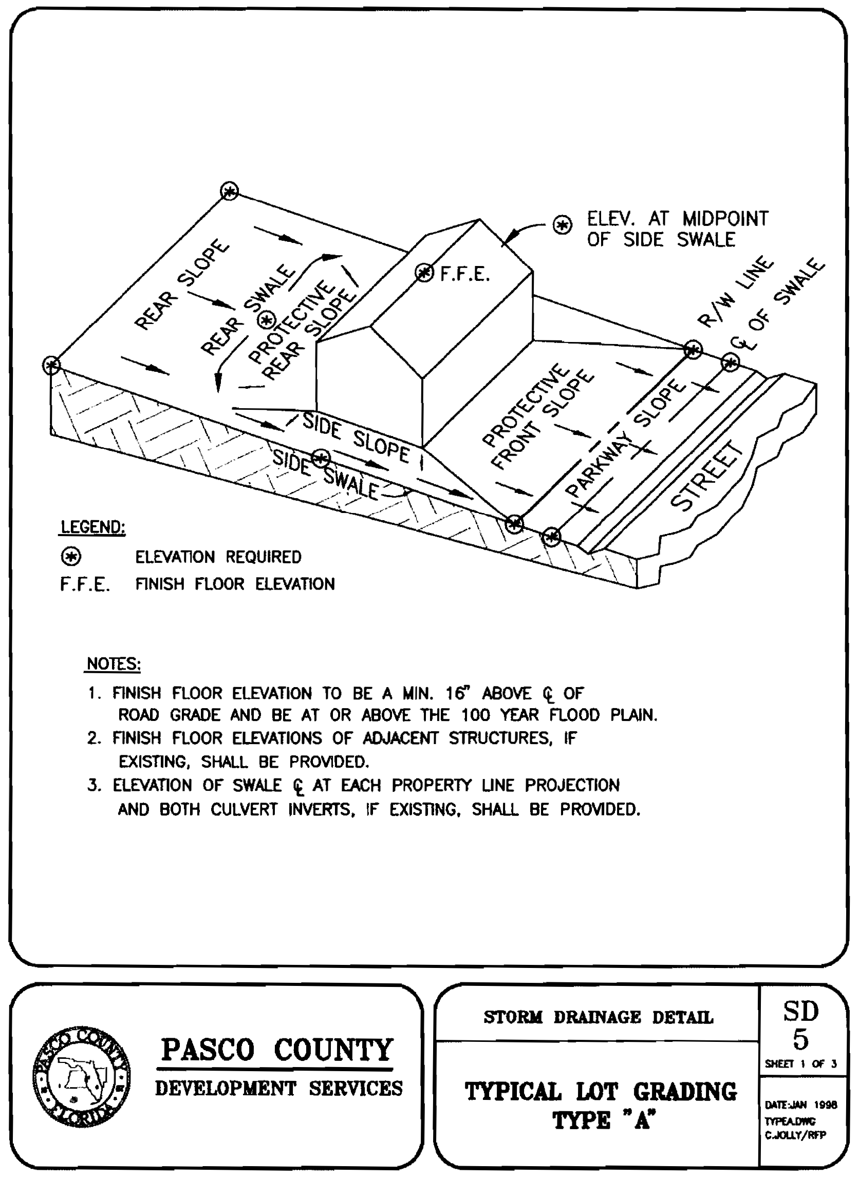
FIGURE 902.2.B
TYPE B TYPICAL GRADING PLAN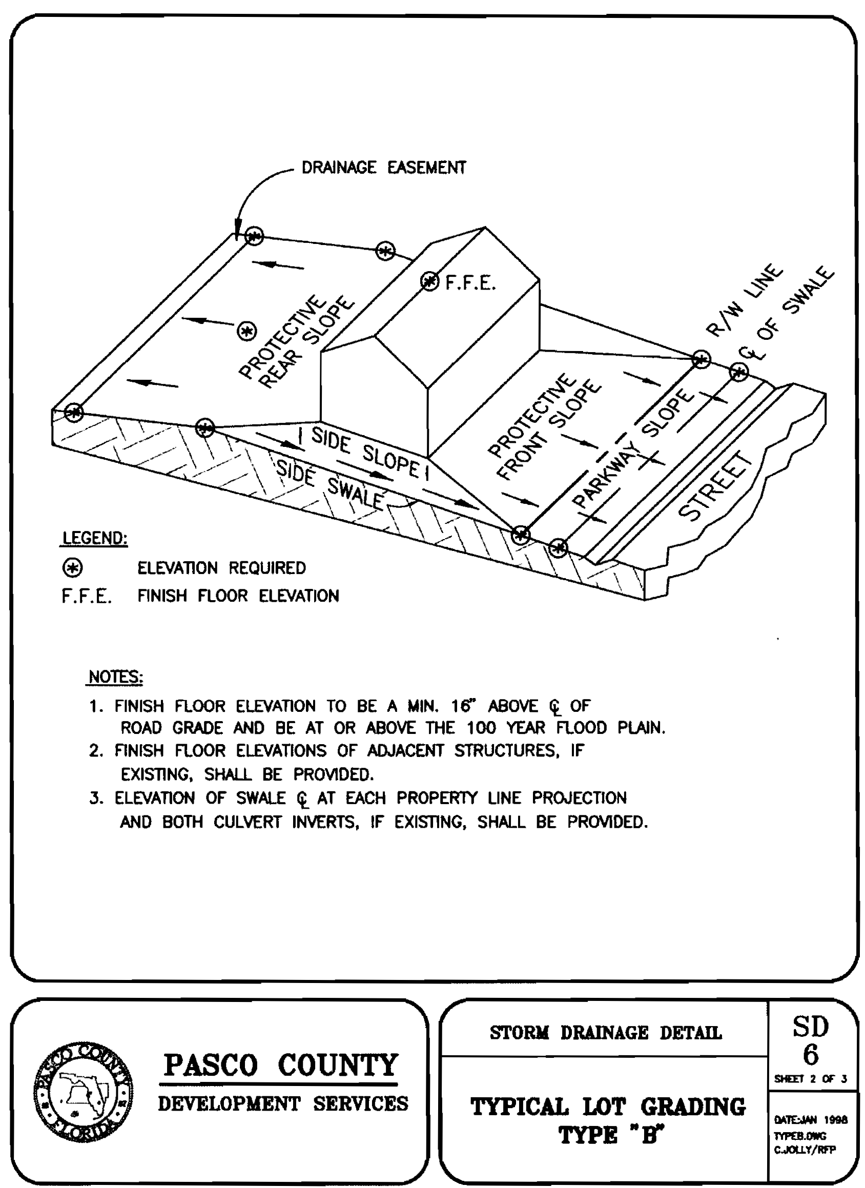
FIGURE 902.2.C
TYPE C TYPICAL GRADING PLAN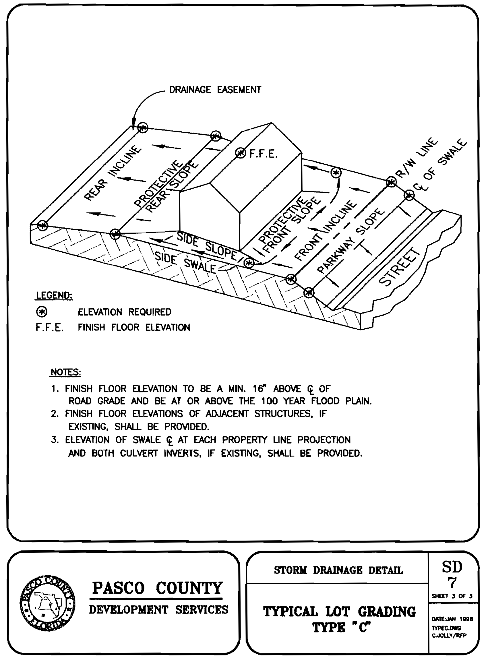
3.
Drainage Plan Requirements for Individual Lots. For lots one (1) acre or less in size, two (2) copies of a drainage plan shall be submitted with the Building Permit Application for review and approval. The following information shall be included in the plan, which shall be signed and sealed by a Florida registered Professional Engineer.
a.
The plan shall indicate the name of the development (if applicable), scale of plan, north arrow, and legend; parcel identification number or legal description sufficient to describe the size and location of the project site, including the plat book page and number, if platted; and the name, address, and telephone number of the builder, owner, and engineer/ surveyor.
b.
The plan shall show the abutting sections of any roadway(s) and the corresponding elevations along the projection of the building lines onto the centerline of the roadway(s) and the elevations on all corners of the building pad. Lot elevation at a minimum of a 100-foot grid for lots larger than one (1) acre and a fifty (50) foot grid minimum for lots one (1) acre or less. A reference elevation may be assumed.
4.
Lot Drainage Enforcement.
a.
Prior to constructing a structure on one (1) acre or less, the builder shall be required to provide an engineered lot grading plan with the Building Permit Application that does not cause an adverse impact on adjacent or off-site property.
b.
As part of the Building Permit Application for any accessory structure on one (1) acre or less where impervious area is added or where a lot's contours are proposed to be altered for an area over 500 square feet, an engineered plan addressing the lot grading shall be required. These types of permits are additions, pools, slabs, etc.
c.
Prior to the release of the CO (Certificate of Occupancy), CC (Certificate of Completion), or final inspection where no CO or CC is issued, the developer/owner/builder shall provide the Affidavit of Lot Grading and Finished Floor Elevation Compliance. For buildings and structures in Special Flood Hazard Areas, as defined by FEMA's latest update or revision, documentation of the as-built lowest floor elevation (Elevation Certificate) and an "As Built" survey demonstrating conformance to the approved Stormwater Management Plan shall be provided to the County Administrator or designee. Any deviations from the approved plan must be noted and will be reviewed for compliance with this Code.
L.
Swales, Culverts and Pipes. All swales, ditches, channels, and closed storm-drainage conduits within subdivisions shall be within an easement or dedicated right-of-way. Right-of- way or maintenance easements by instrument or plat dedication shall be provided for all facilities used to convey stormwater. The minimum width of said rights-of-way or easements shall conform to the widths shown in the following table:
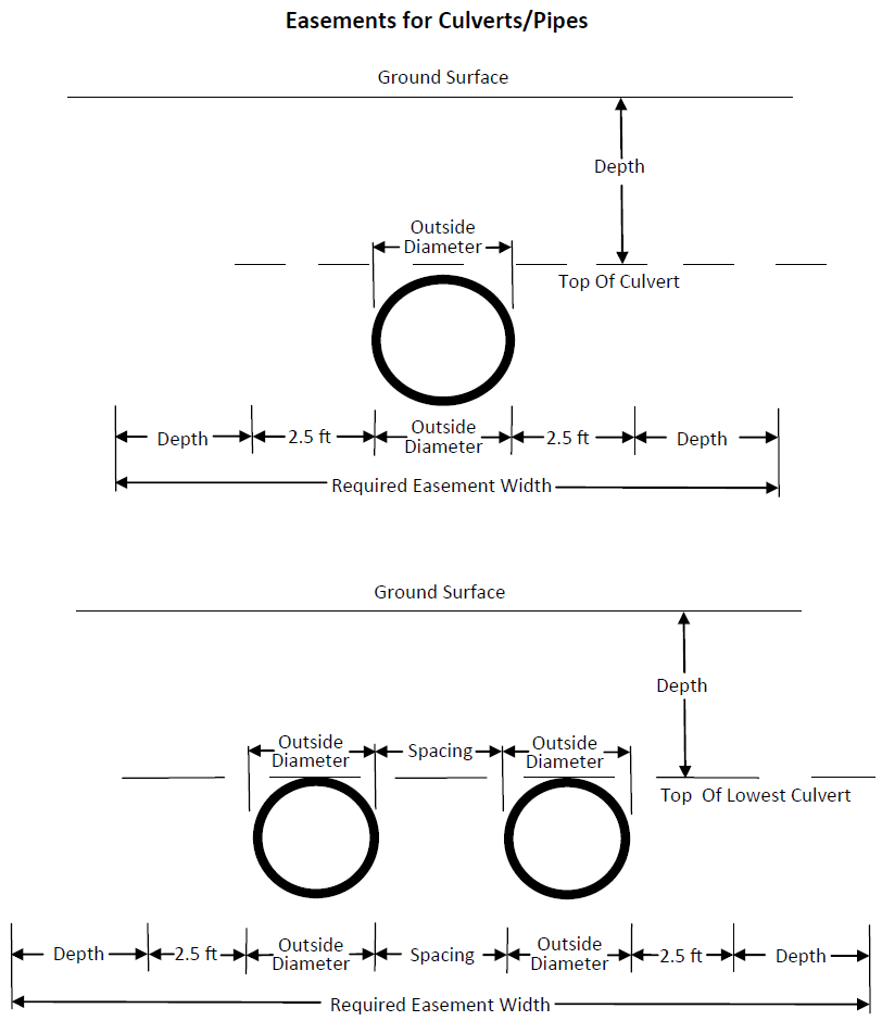
A right-of-way or easement of twenty (20) feet shall be provided for access to any stormwater detention/retention facility from a dedicated road or street. In addition, a continuous perimeter maintenance and operation easement, with a minimum width of twenty (20) feet and slopes no steeper than 4:1 (horizontal/vertical), shall be provided landward of the control elevation water line.
M.
Dedication and Maintenance.
1.
If a stormwater management system approved under this Code will function as an integral part of the County maintained regional system as determined by the County, the facilities may be required to be dedicated and formally accepted by the County.
2.
All stormwater management systems that are not dedicated to the County shall be operated and maintained by one of the following entities:
a.
A local governmental unit, municipality, a special district, or an active water control district created pursuant to Chapter 298, Florida Statutes; a drainage district created by special act; a Community Development District created pursuant to Chapter 190, Florida Statutes; or a Special Assessment District created pursuant to Chapter 170, Florida Statutes; or other governmental unit.
b.
An officially franchised, licensed, or approved communication, water, sewer, electrical, or other public utility.
c.
The property owner or developer if:
(1)
Written proof is submitted in the appropriate form, by either letter or resolution, that a governmental entity or such other acceptable entity as set forth in this Code, Section 902.2.M.2.a or 902.2.M.2.b will accept the operation and maintenance of the stormwater management and discharge facility at a time certain in the future; and
(2)
A bond or other assurance of continued financial capacity to operate and maintain the system is submitted.
d.
For profit or nonprofit corporations, including homeowners' associations, property owners' associations, condominium owners' associations, or master associations if:
(1)
The owner or developer submits documents constituting legal capacity and a binding legal obligation between the entity and the County affirmatively taking responsibility for the operation and maintenance of the stormwater management facility.
(2)
The entity has sufficient powers reflected in its organizational or operational documents to:
(a)
Operate and maintain the stormwater management system as permitted by the County;
(b)
Establish rules and regulations;
(c)
Assess members;
(d)
Contract for services; and
(e)
Exist perpetually with the articles of incorporation providing that, if the entity is dissolved, the stormwater management system will be maintained by some other acceptable entity as described above.
3.
The developer shall convey, at no cost to the County, a drainage easement within the project over all internal drainage features, and a drainage easement for an uninterrupted flow through the project of any offsite drainage sufficient to accommodate a 100-year/five-day, and 100-year/one-day, storm event within the limits of the easement without any increase in predevelopment upstream stages for the purpose of maintaining natural drainage and the free flow of stormwater and other surface waters. The drainage easements must also include a limited right of ingress and egress to perform maintenance activities related thereto for the County's agents and necessary equipment. The easement, encumbering SWFWMD jurisdictional wetlands, associated regulatory buffers, any channels, swales or ditches and access only, shall be dedicated prior to the final plat approval of any phase immediately adjacent to said easement. The easement dedication shall be substantially in the form approved by the Engineering Services Department except as may be modified as requested by the SWFWMD. It is expressly understood and agreed that the developer or its assigns will reserve onto itself rights of ownership of the easement premises not inconsistent with the easement rights granted in the easement to the County, including the grant of additional rights not in conflict with the rights granted in the easement; provided, however, that the developer or its assigns shall not conduct nor allow development on the easement premises. The County does not assume maintenance responsibility for these easements.
4.
Phased Projects.
a.
If a project is to be constructed in phases, and subsequent phases will use the same stormwater management facilities as the initial phase or phases, the operation/maintenance entity shall have the ability to accept responsibility for the operation and maintenance of the stormwater management systems of future phases of the project.
b.
In phased developments that have an integrated stormwater management system but employ independent operation/ maintenance entities for different phases, the operation/ maintenance entities, either separately or collectively, shall have the responsibility and authority to operate and maintain the stormwater management system for the entire project. That authority shall include cross easements for stormwater management and the authority and ability of each entity to enter and maintain all facilities should any entity fail to maintain a portion of the stormwater management system within the project.
5.
Applicant as Acceptable Entity: The applicant shall be an acceptable entity and shall be responsible for the operation and maintenance of the stormwater management system from the time construction begins until the stormwater management system is dedicated to and accepted by another acceptable entity.
6.
Off-Site Drainage Facilities: The County Administrator or designee may allow stormwater runoff to be discharged into drainage facilities off-site pursuant to the following:
a.
The off-site drainage facilities and channels leading to them are designed, constructed, and maintained in accordance with the requirements of this Code and the proper easement from the owner(s) of the property to be utilized is provided; and
b.
Adequate provision is made for the sharing of construction and operating costs of the facilities. The developer may be required to pay a portion of the cost of constructing the facilities as a condition to receiving approval of the drainage plans.
When drainage facilities which are not within a previously recorded drainage easement are utilized for off-site drainage, the owner/ developer shall provide a drainage easement on the approved form with a legal description and sketch (certified by a Florida Registered Land Surveyor) for each off-site drainage facility. The drainage easement shall be submitted to the County Administrator or designee prior to the construction plan approval of the individual unit or phase affected.
N.
Drainage Basins of Special Concern.
1.
Regulated Drainage Basins: The BCC may identify drainage basins or subbasins of Special Concern in order to protect the health, safety, and welfare of the public and to protect property.
Designation of Drainage Basins or subbasins of Special Concern shall include the following steps:
a.
Documentation of the fact that the basin or subbasin is prone to flooding based on records of flooding occurrence and severity. The records can include photographs and statements from the County staff or area residents.
b.
Evaluation of basin or subbasin drainage characteristics and cause of flooding based on review of relevant information, including topographic maps; drainage features and structures, such as channels and culverts; surficial soils; land use; and soil stratigraphy. If warranted, this evaluation may include modeling of stormwater runoff generation and conveyance.
c.
Determination that the flooding would be exacerbated unless the provisions of this section are put in place.
The area(s) shall be accurately depicted on maps that will be available from the County in digital and hard-copy format.
d.
Removal of the drainage Basin of Special Concern designation from any drainage Basin of Special Concern may be considered upon submittal of the following:
(1)
A scientific analysis and a proposal to remediate or otherwise improve the conditions that supported the designation.
(2)
Proposed funding for the implementation of the remediation plan.
(3)
The County Administrator or designee, in consultation with the SWFWMD, will consider whether the remediation plan presents a viable solution that is permitted and funded, and shall present same to the BCC, who shall make the final determination on the proposal.
2.
Exemptions: The Drainage Basins of Special Concern requirements shall not apply to development having:
a.
An approved master drainage plan or stormwater management plan, which has not expired prior to the date the BCC designated the area as a Drainage Basin of Special Concern. All subsequent stormwater management plans submitted in compliance with an approved, unexpired master drainage plan shall be exempt from this section.
b.
A stormwater management plan for which a complete application for a stormwater management plan or drainage plan had been submitted to the County and not withdrawn prior to the date on which the applicable drainage basin is designated as one of special concern by the BCC and that is not subsequently denied or expired. The County and the applicant may agree to an earlier application date.
c.
If required by the SWFWMD Rules, the County shall allow deviations from the Drainage Basin of Special Concern criteria to the extent necessary to prevent adverse impacts to wetlands or other surface waters when it is demonstrated that adverse impacts cannot otherwise be practicably avoided.
3.
Existing Designated Drainage Basins of Special Concern:
a.
Effective July 18, 2005, Tank Lake (west of the old railroad berm) and East Zephyrhills (excluding Lake Pasadena, but including Lake Dorothea, Lost Lake, and Silver Oaks) are designated as closed Drainage Basins of Special Concern as delineated on the maps attached as Maps 902.2.A and 902.2.B.
b.
Effective September 27, 2005, Timber Oaks is designated as a closed Drainage Basin of Special Concern as delineated on the map attached as Map 902.2.C.
4.
Basin Specific Design Standards: The BCC may establish special design standards applicable to new development activity within a specific Drainage Basin of Special Concern. Special design standards may include, but are not limited to, the following:
a.
Maximum allowable peak rate of discharge per acre.
b.
Minimum required retention volume required per acre.
5.
Standard Design Regulations for Drainage Basins of Special Concern: Unless the BCC adopts a more stringent special design standard within any Drainage Basin of Special Concern, the following standard regulations shall be applicable to Drainage Basins of Special Concern:
a.
Open Drainage Basin.
(1)
The maximum peak rate of stormwater runoff discharge from any development activity shall not exceed the prior existing maximum peak rate of stormwater runoff discharge for a two (2), ten (10), twenty-five (25), and 100-year return frequency storm event for a duration of twenty-four (24) hours.
(2)
There shall be no net loss of storage volume from the most restrictive of:
(a)
FEMA established floodplain storage volume.
(b)
Storage volume below the elevation of a recorded County observed flooding.
(c)
Calculated ponding based upon a 100-year return frequency, twenty-four (24) hour storm event.
(d)
A more critical event standard, including a 100-year return frequency, ten (10) day storm event, defined in a County or SWFWMD approved study for the applicable drainage basin.
(3)
The minimum habitable finished floor elevation shall be above the highest elevation established by the following criteria:
(a)
This Code, Section 1103, Flood Damage Prevention.
(b)
Recorded, County observed high water elevation, plus one (1) foot.
(c)
Calculated ponding elevation based upon a 100-year return frequency, twenty-four (24) hour duration storm event, plus one (1) foot.
(d)
A more critical event standard, including a 100-year return frequency, ten (10) day storm event, defined in a County- or SWFWMD-approved study for the applicable drainage basin, plus one (1) foot.
(4)
Permit applicants may present for consideration off-site mitigation plans that demonstrate that the mitigation will be viable and sustainable in perpetuity.
b.
Closed Drainage Basin
(1)
The maximum peak rate of stormwater runoff discharge from any development activity shall not exceed the prior existing, maximum, peak rate of stormwater runoff discharge for a two (2), ten (10), twenty-five (25), and 100-year return frequency storm event for a duration of twenty-four (24) hours.
(2)
Runoff volume shall be limited to predevelopment conditions such that there shall be no increase in the volume of runoff resulting from development activity for a 100-year return frequency, ten (10) day duration storm event.
(3)
There shall be no net loss of storage volume from the most restrictive of:
(a)
FEMA established floodplain storage volume.
(b)
Storage volume below the elevation of a recorded, County observed flooding.
(c)
Calculated ponding based upon a 100-year return frequency, ten (10) day storm event.
(d)
A more critical event standard, including a 100-year return frequency, ten (10) day storm event, defined in a County or SWFWMD approved study for the applicable drainage basin.
(4)
The minimum habitable finished floor elevation shall be above the highest elevation established by the following criteria:
(a)
This Code, Section 1103, Flood Damage Prevention.
(b)
Recorded, County observed flooding elevation, plus one (1) foot.
(c)
Calculated elevation based upon a 100-year return frequency, ten (10) day duration storm event, plus one (1) foot.
(d)
A more critical event standard, including a 100-year return frequency, ten (10) day storm event, defined in a County or SWFWMD approved study for the applicable drainage basin, plus one (1) foot.
(5)
Permit applicants may present for consideration, off-site mitigation plans demonstrating that the mitigation will be viable and sustainable in perpetuity.
O.
False Information. It is a violation of this Code to knowingly furnish false information or information that is not supported by scientific data to the County or any official in charge of the administration of this section on any matter relating to the administration of this section.
BASINS OF SPECIAL CONCERN
MAP 902.2-A - EAST ZEPHYRHILLS AREA BASIN STUDY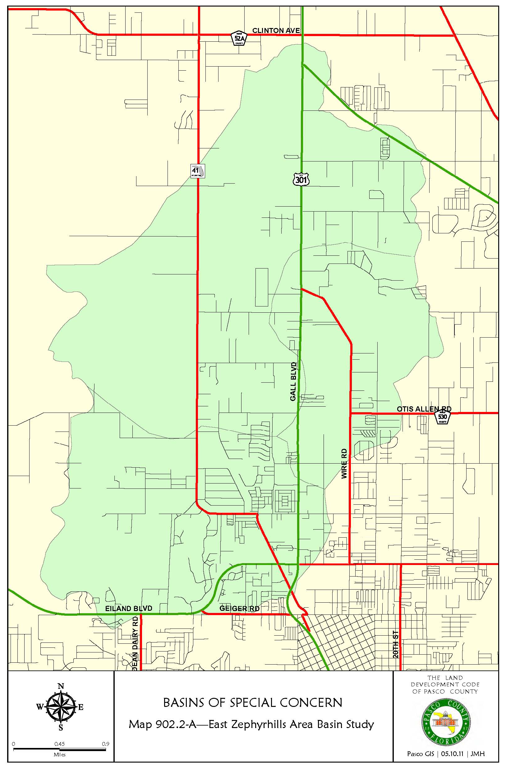
BASINS OF SPECIAL CONCERN
MAP 902.2-B - TANK LAKE AREA BASIN STUDY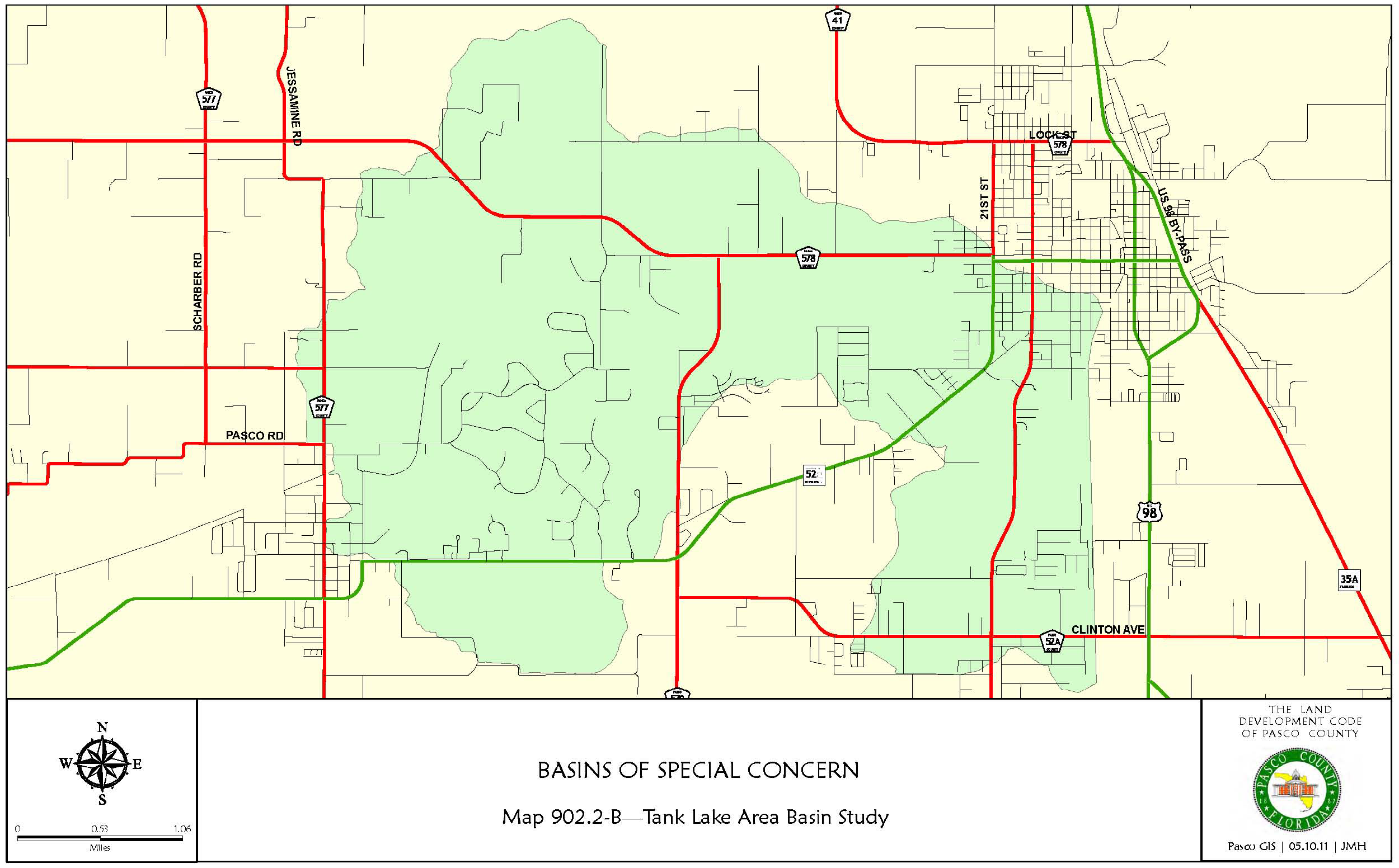
BASINS OF SPECIAL CONCERN
MAP 902.2-C - TIMBER OAKS AREA BASIN STUDY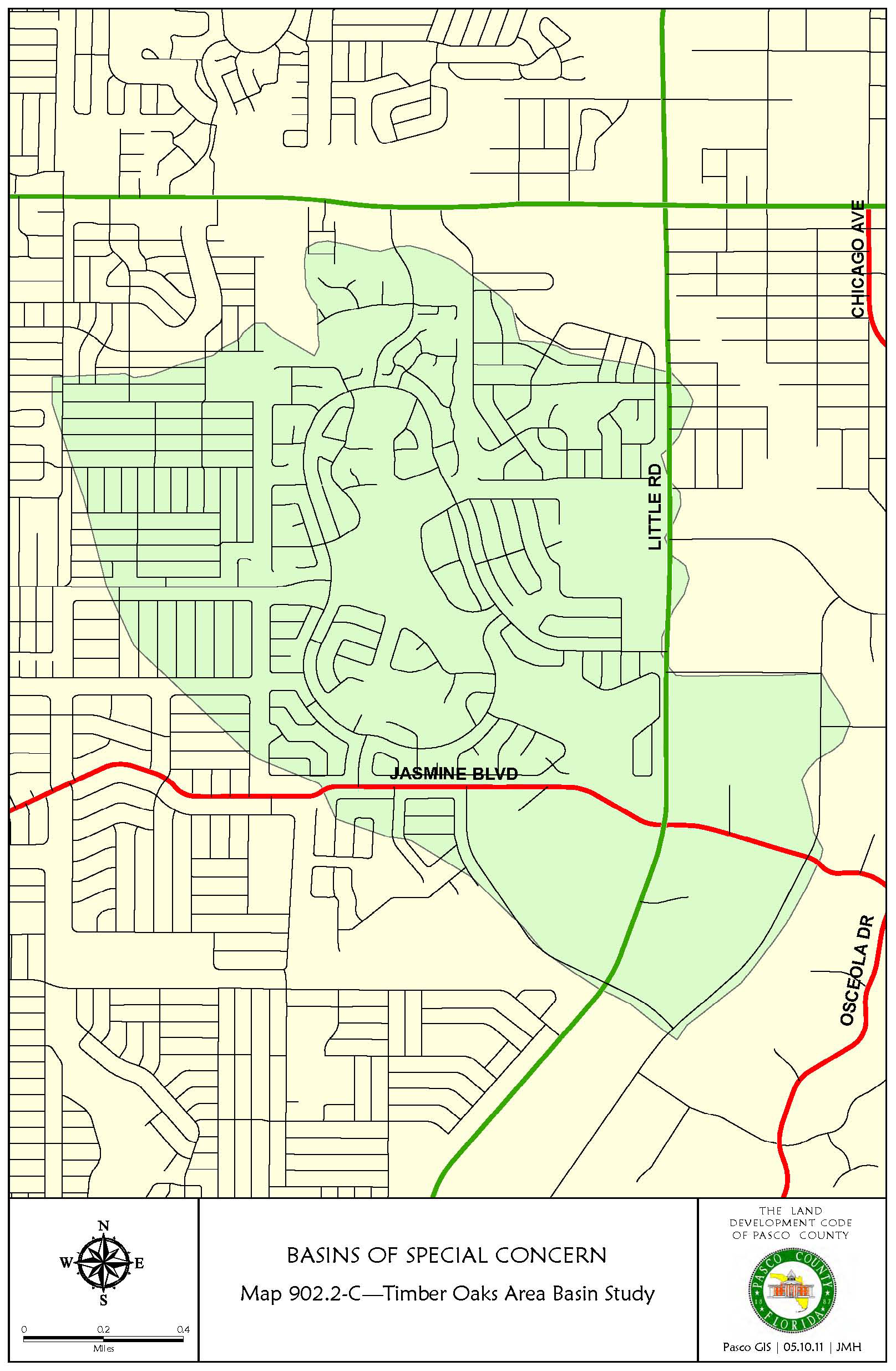
(Ord. No. 22-37, § 5(Att. A), 7-12-22)
903.1. - General
A.
Intent and Purpose. It is the intent and purpose of this section to:
1.
Protect and conserve the quality and quantity of groundwater resources;
2.
Provide an adequate, safe, efficient, economical, reliable, and environmentally sound system of potable water supply, reclaimed water supply, and sanitary sewer collection, with treatment and disposal consistent with the Pasco County Comprehensive Plan;
3.
Maximize the use of existing facilities and provide an adequate, safe, and environmentally sound system of potable water supply and reclaimed water supply; and sanitary sewer collection, treatment, and disposal; and
4.
Establish requirements for connection to potable water, reclaimed water, and sanitary sewer facilities.
B.
Applicability. This section shall apply to developments requiring preliminary development plan or preliminary site plan approval.
C.
If a development is located within the RES-3 (Residential - 3 du/ga) or higher Future Land Use Classification, utility lines of all kinds including, but not limited to, those of public or franchised utilities, electric power and light, telephone and telegraph, cable television, water, sewer, and gas, shall be constructed and installed beneath the surface of the ground within new residential subdivisions, unless it is approved otherwise at the time of preliminary development plan approval.
It shall be the developer's responsibility to make the necessary arrangements with each utility in accordance with the utility's established policies. The underground installation of incidental appurtenances such as transformer boxes, pedestal-mounted terminal boxes for electricity, or similar service hardware necessary for the provisions of utility services, shall not be required. Below ground installation shall not normally be required for commercial service connections, bulk electric power supply lines, and communication major feeder lines. Nothing in this section shall be construed to prohibit any entity furnishing utility service within the County from collecting, as a condition precedent to the installation of service facilities, any fee, prepayment, or contribution in aid of construction which may be required.
D.
Commitment to Provide Utilities. At the time of preliminary development plan or preliminary site plan submittal, a letter of intent from serving utilities shall be provide. At the time of construction plan approval, commitment letters from serving utilities shall be provided.
903.2. - Potable Water Systems
Potable water, including fire protection, shall be provided in accordance with the standards established in the Comprehensive Plan.
Where a central potable water system is provided, it shall be designed and constructed in accordance with the standards established by the serving utility. All systems shall be designed and constructed in conformance with the requirements established by the Florida Department of Environmental Protection (FDEP).
Individual potable water systems shall not be allowed unless otherwise approved at the time of preliminary plan approval. If allowed, it shall be subject to the requirements of the Pasco County Health Department.
903.3. - Reclaimed Water Systems
Where available and subject to a Utility Service Agreement between Pasco County and the developer, reclaimed water shall be provided in accordance with the standards established in the Comprehensive Plan to reduce water demand for irrigation. Where a reclaimed water system is provided, it shall be designed and constructed in accordance with the standards established by the serving utility. All systems shall be designed and constructed in conformance with the requirements established by the FDEP.
903.4. - Wastewater Systems
Wastewater disposal systems shall be provided in accordance with the Comprehensive Plan.
Where a central sanitary sewer system is provided, it shall be designed and constructed in accordance with the standards established by the serving utility. All systems shall be designed and constructed in conformance with the requirements established by the FDEP.
Individual sewage disposal systems shall not be allowed unless otherwise approved at the time of preliminary plan approval. If allowed, it shall be subject to the requirements of the Pasco County Health Department.
903.5. - Wells and/or Septic Tanks
A.
Wells. Where a potable water system is not available, the building shall be connected to a private well that is permitted by the State of Florida, Pasco County Health Department.
B.
Septic Tanks. Where a sanitary sewer system is not available, the building shall be connected to a private wastewater disposal system that is permitted by the State of Florida, Pasco County Health Department.
904.1. - Intent and Purpose
The intent and purpose of this section is to protect the public health and safety by regulating the use, condition, construction, alteration, and repair of property, structures, and occupancies in the County in order to prevent the ignition and spread of fire and risk of harm to persons or property from fire and other causes.
904.2. - Adoption of Fire Prevention Codes
Adopted for the purpose of prescribing regulations governing conditions hazardous to life and property from fire or explosion are those codes known as the Florida Fire Prevention Code, as now and subsequently amended.
If any conflict occurs between this Code and any other applicable State law or regulation, the more stringent, with regard to life safety, shall apply.
904.3. - Fire Protection Systems
A.
Purpose. The purpose of this section is to ensure a uniform system of fire protection through installations of water systems.
B.
Design; Prerequisites for Issuance of Certificate of Occupancy.
1.
Fire protection water systems shall be designed by a Florida registered professional engineer and constructed in accordance with the County, State, and Federal standards, including satisfaction of the domestic requirements established by the appropriate agencies when applicable, and the fire protection requirements established by the Florida Fire Prevention Code, as may be amended including the annex and current edition of the National Fire Protection Association (NFPA) standard 24, Installation of Private Fire Service Mains and Their Appurtenances.
2.
Water mains and fire hydrants shall be installed, tested, inspected, and fully operational before any accumulation of combustibles on a development site and issuance of a Certificate of Occupancy for any structure within a development.
C.
Developments not provided with a fire protection water system are required by the county fire marshal to have a fire protection water system designed by a Florida registered professional engineer in accordance with current edition of The National Fire Protection Association (NFPA), standard 1142, Water Supplies for Suburban and Rural Fire Fighting. Drawings of the proposed fire protection water system shall be submitted to and approved by the county Fire Rescue Department prior to the issuance of a Building Permit.
(Ord. No. 24-04, § 5(Att. A), 1-9-24)
905.1. - Neighborhood Parks
A.
Intent and Purpose. The intent and purpose of this section is to advance the health, safety, and welfare of the residents of the County by providing common areas as neighborhood parks in residential development in which to engage in recreation and play.
B.
Applicability. This section shall apply where more than 25 dwelling units are proposed. For purposes of this requirement, a development shall be aggregated with contiguous or nearby developments developed by the same or a related developer or owner that have not provided neighborhood park(s) in accordance with this section.
For the purposes of this section, a dwelling unit shall consist of single-family, multiple family, and mobile homes.
C.
Exemptions. This section shall not apply to any development which received preliminary plan approval prior to November 8, 2002, any development which submitted a complete application for preliminary plan approval prior to November 8, 2002, or any existing unexpired PUD or MPUD project that as of November 8, 2002, received preliminary plan approval for at least 80 percent of the PUD or MPUD project.
D.
Not Impact Fee Creditable. The provision of neighborhood park(s) pursuant to this section is not impact fee creditable against any portion of the fees set forth in Chapter 1200.
E.
Amount of Land Required. The amount of land required to be provided and maintained as neighborhood park(s) is as follows:
1.
One acre for 26 to 100 dwelling units;
2.
An additional 1/100 of one acre for each additional dwelling unit over 100.
F.
Neighborhood Park Standards.
1.
Type of Land. The land provided for use as neighborhood park(s) shall be developable uplands exclusive of required setbacks from wetland or environmental areas and shall not contain any restrictions or encumbrances that prevent its use as a neighborhood park.
2.
Uses Prohibited. The following uses/land area(s) shall not be included in the required neighborhood park(s) acreage:
a.
Clubhouses;
b.
Floodplain mitigation areas;
c.
Drainage/stormwater detention areas (except for drainage/stormwater detention areas used solely for required neighborhood park amenities);
d.
Parking areas (except for parking areas required to satisfy minimum parking requirements for required neighborhood park amenities);
e.
Landscape easements; and
f.
Sidewalks and bike/multimodal paths constructed to satisfy the minimum requirements of this Code.
3.
Accessibility. The land provided for each neighborhood park shall be easily accessible to the residents of the development by automobile, foot, and bicycle.
The required neighborhood park acreage shall be located no greater than one-half mile from 50 percent of the dwelling units to be served by the neighborhood park or no greater than one-quarter mile from 50 percent of the dwelling units to be served by the neighborhood park if the neighborhood park is separated from the development by a collector or arterial roadway.
4.
Uses Within Neighborhood Parks. Neighborhood parks may include, but are not limited to, sports fields, tennis courts, basketball courts, hiking and biking trails, community pools, playgrounds, and other areas where members of the development may congregate for recreational uses.
5.
Open Play Area Required. Twenty-five percent of the required neighborhood park acreage, but not less than one-half acre of each required neighborhood park, shall consist of an unpaved, open-play area without trees and structures that impair open play. The required unpaved, open-play area portion of the neighborhood park(s) must:
a.
Be set back a minimum of 50 feet from wetlands, lakes, or other water bodies or separated from all wetlands, lakes, or other water bodies by a transparent fence or landscape buffer four feet in height; and
b.
Have a minimum width of 100 feet and length of 100 feet.
6.
Minimum Size. The required neighborhood park acreage may be composed of a single or multiple neighborhood parks; however, each required neighborhood park shall be a minimum of one-half acre in size.
7.
Minimum Dimension. The required neighborhood park acreage shall have a minimum dimension of 30 feet. As noted above, the open play area shall be a minimum of 100 feet × 100 feet.
8.
Equipment. If the neighborhood park includes playground or other recreational equipment, such equipment shall comply with all applicable American Society for Testing and Materials (ASTM), Americans with Disabilities Act, and Consumer Products Safety Commission standards.
G.
Neighborhood Park Maintenance. The developer of a development that includes the neighborhood park shall be required to maintain and pay taxes on the neighborhood park(s) at no expense to the County, or convey such park(s) to a nonprofit homeowners' association; community development district; or open space trust. Neighborhood park(s) must be continuously maintained in a safe manner and consistent with safety standards established by the Consumer Product Safety Commission and ASTM. If a homeowners' association, community development district, or open space trust is formed, the developer shall provide documentation acceptable to the County demonstrating that such organization is governed according to the following:
1.
The organization is organized by the developer and operating with financial subsidization by the developer, if necessary, before the sale of any lots within the development.
2.
Membership in the organization is mandatory for all purchasers of dwelling units therein and their successors.
3.
The organization shall be responsible for maintenance of and insurance and taxes on the neighborhood park(s).
4.
The members of the organization shall share equitably the costs of maintaining and developing neighborhood park(s) in accordance with procedures established by them.
5.
The organization shall have or hire adequate staff to maintain the neighborhood park(s).
6.
In the event that the organization established to own and maintain the neighborhood park(s) or any successor organization shall at any time fail to maintain the neighborhood park(s) in reasonable order and condition, the County may serve written notice upon such organization and upon the residents and owners of the development setting forth the manner in which the organization has failed to maintain the neighborhood park(s) in reasonable condition. The said notice shall include a demand that such deficiencies of maintenance be cured within 30 days thereof. If the deficiencies set forth in the original notice shall not be cured within the said 30 days or any extension thereof, the County, in order to preserve the taxable values of the properties within the development and to prevent the neighborhood park(s) from becoming a public nuisance, may, upon approval by the Board of County Commissioners at a public hearing, enter upon the said neighborhood park(s) and maintain the same for any duration deemed appropriate by the County. The said entry and maintenance shall not vest in the public any rights to use the neighborhood park(s) and shall not cause the County to incur any liabilities or obligations related to such neighborhood park(s). The cost of such maintenance by the County, together with the cost of an insurance policy covering such maintenance (with the County as a named insured), shall be assessed ratably against the properties within the development that have a right of enjoyment of the neighborhood park(s) and shall become a tax lien on the said properties. The County, at the time of entering upon the said neighborhood park(s) for the purpose of maintenance, shall file a notice of such lien in the Office of the Clerk and Comptroller of the county upon the properties affected by such lien within the development. Notwithstanding the foregoing, the County shall be under no obligation to maintain any neighborhood park and nothing herein shall preclude the County from exercising any other available legal remedy for the failure to maintain neighborhood park(s).
H.
Alternative Standards. Alternative standards that meet or exceed the intent and purpose of this section may be approved.
905.2 - Landscaping and Buffering
A.
Intent and Purpose. It is the intent and purpose of this subsection to promote the health, safety, and general welfare of the current and future residents of the County by establishing minimum standards for the preservation, development, installation, and maintenance of native and Florida Friendly landscaping, as defined in Section 373.185, Florida Statutes.
Such landscape and buffers are intended to improve the aesthetic appearance of public, commercial, industrial, and residential areas by reducing the visual impact of large building masses; by softening the visual impact of paved surfaces and vehicular-use areas; by screening conflicting uses from one another; and otherwise helping establish a harmonious relationship between the natural and built environment.
These minimum requirements and standards recognize and address the vital contributions of landscapes and buffers to intercepting and filtering stormwater, reducing erosion, providing shade, enhancing property values, supporting wildlife, protecting natural resources, forming a "sense of place," reducing costs and impacts of storms and natural disasters, and other beneficial services.
Resources for selecting appropriate planting material, helpful guides and templates, and links to external resources mentioned in this Section can be found in the Development Manual.
B.
Applicability.
1.
This section shall be applicable to all development plans submitted on or after February 26, 2002. For development plans approved prior to February 26, 2002, and not yet subject to the Redevelopment Landscaping Section below, the applicant may elect to maintain landscaping in accordance with this Section. This option shall also be available to applicants whose development plans were approved prior to the most recent version of this Section, unless the landscape plan was specifically approved by the Planning Commission or Board of County Commissioners.
2.
Redevelopment Landscaping. Developments that existed on February 26, 2002, that do not comply with the provisions of this subsection shall be brought into compliance when significant investment is made to the current structure, as detailed in Table 905.2-A.
a.
Options for Relief. Recognizing that redevelopment and renovation presents its own special challenges, an applicant may pursue the following approaches to obtain relief from the strict application of the above standards.
(1)
The County Administrator or designee may grant relief from the strict application of the standards in Table 905.2-A without requiring an alternative standard application pursuant to Section 407.5, if the applicant is able to demonstrate with the Landscape Plan that the landscaping and buffering is the maximum possible that can be accommodated given the existing conditions on the site.
(2)
County Assistance. Developments required to be brought into compliance with this section shall be eligible to apply to the Board of County Commissioners (BCC) through the County Administrator or designee for reimbursement of the reasonable cost of drought tolerant or native trees and landscaping plants as listed by Southwest Florida Water Management District (SWFWMD) or the University of Florida Institute of Food and Agricultural Sciences (IFAS), providing such vegetation is not invasive, and approved by the County Administrator or designee in an amount not to exceed $10,000.00 from the Tree Mitigation Fund. The said reimbursement amount may be amended from time to time by resolution of the BCC.
TABLE 905.2-A
C.
General Standards.
1.
Design.
a.
Clear-Sight Triangle. Where a driveway/accessway intersects a road right-of-way or where two road rights-of-way intersect, vegetation, structures, and non-vegetative visual screens shall not be located so as to interfere with the clear- sight triangle as defined in this Code or the Florida Department of Transportation, Manual of Uniform Minimum Standards, most recent edition (Green Book), whichever is more restrictive.
b.
Sidewalks, driveways, and other impervious areas shall not be located within a required planting area except when they are constructed perpendicular to the planting area and provide direct access to a structure, parcel, or adjacent parcels.
c.
Sustainable Practices. Landscape installations shall employ environmentally sustainable principles and practices, which include Florida Friendly landscaping. A comprehensive guide to Florida Friendly landscaping principles and materials is available through the University of Florida IFAS website linked in the Development Manual. Landscaping shall be installed so that landscaping materials meet the concept of right material/right place. Installed material shall be grouped into zones according to water, soil, climate, and light requirements.
d.
Diversity.
(1)
A maximum of 50 percent of the plant materials used, other than trees, may be non-drought tolerant. The use of turfgrass varieties with excellent drought tolerance may exceed the 50 percent limitation.
(2)
A minimum of 30 percent of the plant materials, other than trees and turfgrass, shall be native Floridian species suitable for growth in the County.
(3)
Tree diversity shall be required based on the number of required trees on site (see Table 905.2-B).
TABLE 905.2-B
(4)
Where more than one species is required, even distribution shall be strived for and subject to County approval through the associated review process.
(5)
For shrubs, no one species shall constitute more than 25 percent of the total number of plantings.
(6)
Development projects one acre or less in size are exempt from the diversity requirements of Subsections 3, 4, and 5 above.
e.
Berms. Where berms are installed, drought tolerant ground cover or sod, such as Bahia, may be used to stabilize the berms. The height of the berm shall be measured and averaged at regular intervals on the exterior of the berm. The final height shall be determined by averaging the dimensions obtained. The measured interval distances shall be typically eight feet.
f.
Tree Location. Trees are required to be located on the site; however, trees may be planted within rights-of-way or on public lands pursuant to Section 905.2.D.3.
g.
Use of Existing, Noninvasive Plant Materials. Existing, noninvasive plant materials may be used to meet the buffering and landscaping requirements, provided there is no reduction in the required landscaping and the required vegetation is adequate to meet the intent of the buffer being substituted for. If existing plant materials are retained to meet the requirements, the following standards shall apply:
(1)
All new development shall retain existing, noninvasive plant materials to the maximum extent possible, unless stormwater management design, necessary grade changes, required infrastructure, or approved construction footprints necessitate their removal. Areas of retained plant materials shall be preserved in their entirety with all trees, understory, and ground cover left intact and undisturbed, provided that invasive, prohibited plant materials are removed.
(2)
Numbered photographs with site plan key, or other forms of proof and a print date showing the extent of the existing landscaping shall be provided during the review process for assessment of the existing landscaping.
(3)
The protection of existing, noninvasive plant materials shall conform to the standards listed in this Code, Section 802.
(4)
The required buffer width shall be delineated on the plans and existing vegetation within those buffers can be administratively approved to be used in whole or in part to satisfy buffer requirements. The subsequent removal of the existing vegetation shall require additional review and approval.
(5)
Trees located within environmentally sensitive lands shall not be counted or credited toward the total number of trees required.
2.
Types of Planting Materials.
a.
Shade Trees. All required shade trees shall be a selected from the Tree List in the Development Manual, unless otherwise approved by the County Administrator or Designee. All shade trees used to satisfy landscaping requirements shall at a minimum have a two-inch caliper trunk and be a minimum of six feet in height at the time of installation.
The County defines a shade tree as any tree with a height and spread over 20-feet tall at maturity, that is planted for its wider canopy, can maintain a higher bottom-branch scaffold, and provide relief from direct sunlight for at least six months of the year.
b.
Ornamental Trees. All required ornamental trees shall be selected from the Tree List in the Development Manual unless otherwise approved by the County Administrator or Designee. All ornamental trees used to satisfy landscaping requirements shall at a minimum have a two-inch caliper trunk and be a minimum of six feet in height at the time of installation.
The County defines an ornamental tree as any variety of tree which is not expected, at maturity, to reach a height of 20 or more feet which is planted for its decorative value rather than for shading purposes. Ornamental trees are usually deciduous but may include short-growing conifers or palms.
c.
Palms. Palm trees may be substituted for up to 30 percent of the required shade trees at a rate of three palm trees, grouped together, for one shade tree. Exceptions may be made for Palms classified as "Shade Palm" in the Development Manual, which may be planted individually. Palms must have a minimum of ten feet of clear trunk at the time of installation.
d.
Multiple-Trunk Trees. All proposed multiple-trunk trees shall have no less than three trunks, each trunk equal to or greater than one-inch caliper, and shall be a minimum of six feet in height at the time of installation.
e.
Shrubs.
(1)
Shrubs grown in appropriately sized containers shall have the ability to be a minimum of 24 inches in height within one year of planting (unless otherwise required) and shall maintain that height. Shrubs shall be a minimum of 18 inches in height at the time of installation. Shrubs shall be spaced a distance appropriate to the species to create a continuous appearance within one year of planting, but at no more than 36 inches on center at the time of installation.
(2)
Dwarf variety of shrubs grown in the appropriate-sized containers shall be a minimum of ten inches in height at the time of installation. Dwarf shrubs shall be spaced a distance appropriate to the species to create a continuous appearance within one year of planting, but at no more than 36 inches on center at the time of installation.
f.
Ground Cover. Ground cover plants shall be spaced so as to present a finished appearance and to obtain a reasonably complete coverage within one year after planting. Nonliving ground cover, such as mulch, gravel, rocks, etc., shall be used in conjunction with living plants so as to cover exposed soil and suppress fugitive dust.
g.
Grasses. All portions of each site, which are not devoted to buildings, sidewalks, paving, or special landscape features shall be grassed, which may include wildflower grasses.
3.
Installation of Planting Materials.
a.
Avoid Utility Conflicts. Landscape installations shall be placed to avoid conflict with the existing and/or proposed utilities, both underground and overhead. Where interference with overhead utility lines is probable, ornamental trees shall be planted with a maximum spacing of 20 feet on center. Consultation with the affected utility should occur for assistance with the selection of suitable vegetative species.
b.
Good Condition. All trees shall be planted according to the Florida Chapter, International Society of Arboriculture Standards for Planting, which is incorporated herein by reference. All trees must be maintained in good condition and planted in locations with adequate open space to allow for mature tree-canopy development.
c.
Avoid Easements. Trees shall not be planted within any easement that might interfere with the use of that easement.
d.
Nonliving Ground Cover. Nonliving ground cover such as mulch, gravel, rocks, etc. shall be used in conjunction with living plants to cover exposed soil and suppress fugitive dust. The nonliving ground covers shall be installed to a minimum depth of three inches and should not be placed directly against the plant stem or tree trunk. Nonliving ground covers shall not be required for annual beds. Stone or gravel may be used to cover a maximum of two percent of the landscaped area.
e.
Quality Practices. All landscaping shall be installed in accordance with standards and practices of the Florida Nursery, Growers, and Landscape Association and the Florida Chapter of the International Society of Arboriculture.
f.
Height. All height requirements shall be based on the finished grade of the landscaped area and measured at the main stem.
g.
Quality of Planting Areas. Equipment, construction material, and debris or fill shall not be placed in future planting areas. There shall be no cleaning of equipment or material or the storage or disposal of waste materials, such as paints, petroleum products, oils, solvents, asphalts, concrete, mortar, or any other material within these future planting areas. At the time of completion, landscape areas shall be free of compaction, foreign debris, and other components not native to the site.
h.
Interim Coverage. All portions of a lot upon which development has commenced, but not continued for a period of 30 days, shall be planted with a grass species or ground cover to prevent erosion and encourage soil stabilization. Adequate coverage, so as to suppress fugitive dust, shall be achieved within 45 days.
i.
Landscaping Adjacent to Fences and Walls. When a fence or wall is proposed along a street, roadway, or other public space (i.e., parks, pathways, plazas, etc.) landscaping as required by 905.2.D.5 shall be located between the fence or wall and the street, roadway, or public space as applicable and/or as determined by the County Administrator or designee.
D.
Specific Planting Requirements.
1.
Specific Standards for Residential Lots.
a.
Minimum shade tree planting requirement. A minimum number of shade trees shall be planted or retained on all property upon which an individual lot is located in accordance with the following table:
Table 905.2-C
b.
This requirement does not apply to lots of record existing before February 26, 2002.
c.
The minimum number of trees per lot can be counted toward minimum number of replacement inches if the landscape plans show a variety of tree species to select from to ensure diversity.
d.
All lots shall require at least one shade tree be placed in the front yard of the lot or in the right-of-way fronting the lot. For multifamily projects, 50 percent of the lots within a shared structure are required to meet this provision.
2.
On-street Parking Areas/Plantings in Rights-of-Way. Trees planted within rights-of-way shall not be counted toward lot tree minimum requirements as outlined in Table 905.2-C.
a.
Trees planted in rights-of-ways are not required to meet the diversity requirement outlined in Table 905.2-B.
b.
Tree plantings pursuant to this subsection of the Code shall require a County Right-of-Way Use Permit and a License and Maintenance Agreement if the Right-of-Way is to be dedicated to the County.
c.
To prevent obstructed views of stop signs or other safety and traffic control signs, trees shall be placed a minimum of 30' from the face of said sign.
d.
At no time, whether during installation or completion of construction, will there be imposed on the County any obligation to maintain or inspect plantings, including, but not limited to trees, shrubbery, etc., planted in the rights-of-ways pursuant to this section. Further, nothing herein is intended or shall be inferred to impose any obligation on the part of the County to maintain or inspect sidewalks constructed in accordance with any other section of this Code that are located in the same rights-of-way where said plantings are placed. All sidewalks constructed are subject to the provisions of section 901.8 of this Code and shall be inspected and maintained by the Developer and its successors and assigns, such as a CDD or HOA.
e.
Utilities/Pavement. Trees shall be installed using a tree mitigation method as shown in the Development Manual when:
(1)
The distance to any paved surface is less than the "Distance Between Paved Surface" column, shown in the Pasco County Tree list, found in the Development Manual.
(2)
The distance to any underground or ground level utilities is less than the "Ground Utility Minimum Distance from Trunk" column, shown in the Pasco County Tree list, found in the Development Manual. This provision defines utilities as pressure pipes, sanitary sewer pipes, air release valves (ARVs), underground and above ground utility boxes, manholes, water meters, backflow prevention devices, and other such structures installed for and by utility companies, not including storm water pipes and underdrains.
3.
Off Street Vehicular Use Areas. To divide and break up large expanses of paving, provide shading for paved areas, as well as creating an aesthetically pleasing environment. Applicable to all new or expanded off-street parking or other vehicular use areas.
a.
General Requirements.
(1)
A minimum of ten percent of the on-site, vehicular use area shall be devoted to interior landscape areas. For those projects that cannot meet this requirement, alternative planting solutions may be proposed and approved administratively.
(2)
A minimum of one shade tree for every 200 square feet of required interior landscaped area.
(3)
Other than trees, planting materials shall naturally grow no taller than 30 inches.
b.
Landscape Islands and Terminal Islands.
(1)
Minimum length; one foot less than the length requirements in 907.1.D.2.
(2)
Minimum width of ten feet, between back of curbs.
(3)
Maximum of ten parking spaces between islands.
(4)
All rows of parking shall be bordered by a terminal landscaped island. Where a terminal island abuts a required buffer area or where two rows of parking abut either perpendicularly or at an angle, the required plantings may be relocated elsewhere on the site upon approval of the landscape plan.
(5)
Planting Requirements Per Island:
(a)
One evergreen shade tree; shall be set back a minimum of four feet from the drive aisles.
(b)
Shrubs, dwarf shrubs, ornamental grasses, or ground cover plants shall be placed to provide a finished appearance at the time of inspection. These plantings shall be set back a minimum of one foot from curbing or pavement.
c.
Landscape Medians. Where a drive aisle is not loaded with parking spaces and another buffer is not immediately adjacent, the following planting area shall be required:
(1)
Minimum width of five feet, between back of curbs.
(2)
Planting Requirements for Medians:
(a)
One understory tree every 30 feet.
(b)
Shrubs, dwarf shrubs, ornamental grasses, or ground cover plants shall be placed to provide a finished appearance at the time of inspection. These plantings shall be set back a minimum of one foot from curbing or pavement.
(3)
No landscaping shall be placed in a manner that would impede the clear-sight triangle of internal drive aisle intersections with other drive aisles or pedestrian paths.
(4)
The County Administrator or designee may consider alternative landscape plantings and median widths as part of the review process.
d.
Additional Considerations and Standards.
(1)
Use of existing noninvasive trees is preferred in the design of the vehicle use area. Where existing trees are retained in landscape islands, the number of uninterrupted parking spaces in a row may be increased to 15.
(2)
For industrial parks or land devoted to industrial use, only the parking areas between the front of the building line and the road right-of-way or easement providing access shall comply.
(3)
For vehicle use areas serving large vehicles requiring additional maneuvering room, such as truck stops, motor freight terminals, boat and RV storage, and distribution centers, up to 50 percent of required vehicle use area landscaping may be transferred and added to the perimeter buffer or roadway buffer.
(4)
Areas that utilize grass parking shall not be subject to the provisions above so long as the vehicle use area provides for orderly circulation and parking spaces are delineated with wheel stops.
(5)
Where known or newly emerging clean energy technologies are proposed to be installed (including, but not limited to, solar carports, wind turbines, and electric vehicle charging stations), and the installation of such technologies conflict with these landscaping requirements, the County Administrator or designee may administratively approve modifications to landscaping materials or planting locations during the review process without the need for formal submission of an Alternative Standard.
4.
Building Perimeter Landscaping. The intent and purpose of building perimeter landscaping is to provide for visual interest, prevent monotony, break up wall and pavement expanses, and clearly define entryways.
a.
Building perimeter landscaping shall be placed such that a minimum of 50 percent of the building perimeter is landscaped.
b.
All shopping center, retail, office, multifamily, clubhouse, or similar uses shall provide perimeter building landscaped beds in a minimum amount equal to ten percent of the proposed building ground-level floor area.
c.
These building perimeter landscape areas shall be located adjacent to the building and shall consist of landscaped areas, raised planters, or planter boxes that are a minimum of five feet wide. These landscaped areas shall include:
(1)
Any combination of ornamental trees or group of palms, at a rate of one tree or group of palms per 50 linear feet within the required landscape area. Shade trees planted within 15 feet of the building may count towards meeting this requirement.
(2)
At a minimum, the required landscape area is to have a single row of plantings, consisting of species reaching at least 36 inches tall at maturity.
Alternative design solutions for these building perimeter landscaping requirements that meet or exceed the intent and purpose of this section may be considered through the review process.
5.
Site Perimeter Landscape Buffering and Screening. The intent and purpose of providing landscape buffering and screening is to provide for an aesthetically pleasing developed environment and separation between uses and intensities where appropriate. Perimeter landscaping is required on all sides of a lot. The required buffer type is based on the subject property's district/use and the adjacent district/use as shown in Tables 905.2-D and 905.2-E at the bottom of this section.
a.
Where the buffers are located within residential subdivisions, the buffers shall be indicated as tracts and the applicable minimum side or rear yard shall be measured from the tract line.
b.
For residential uses where the buffers are not located within a subdivision, they shall be delineated by an easement and the applicable side or rear yard shall be increased by the width of the required buffer. Additionally, where the buffer is located within an easement, the applicable side- or rear-yard setback, as required by the zoning district, shall be measured from the easement line. Further, when a buffer is located within an easement, additional conditions relating to the maintenance and disclosure of the buffer requirements to the lot owner may be imposed by the County.
TABLE 905.2-D
(1)
Single Family Districts, Multiple Family Districts, and Mobile Home Districts shall
be required to provide a Type "B" buffer between each other. Developments of the same
district shall not be required to buffer from themselves.
(2) Applies to major County roads and Type 1 subdivision collectors, except rights-of-ways
as outlined in Section 905.3, or as required by this Code. Where a local roadway exists, the required buffer shall
be determined by the adjacent district/use directly across the local roadway. # For
specific requirements for Self-Storage Facility buffering, see LDC Section 1105.
TABLE 905.2-E
Landscaping Buffer and Screening Requirements
(1)
To provide options and diversity in design, up to 30 percent of required shade trees may be substituted with ornamental trees and/or groups of palms.
(2)
If the visual screen on the adjacent development has already been approved and installed, this requirement shall be waived.
(3)
Accent Plantings may be either shrubs, dwarf shrubs, or ornamental grasses.
(4)
The minimum width will vary according to the ultimate width of abutting right-of-way and project size as follows:
Right-of-Way Width and Buffer Required:
• 0—99 Feet: 10 Feet
• 100 or More: 15 Feet
• 15 Acres or Larger Project Regardless of Right-of-Way Width: 20 Feet
(5)
When a corridor right-of-way is dedicated in accordance with this Code, the Type D and G buffer widths may be reduced to no less than ten feet as part of plan review, provided the intent and purpose of this section are met.
(6)
When the industrial uses are adjacent, such as sharing of side-yard line, the buffer is only required to extend from the front property line to that point parallel to the front building line.
(7)
Any Controlled Access Roadway also designated as a Scenic Corridor per the Pasco County Comprehensive plan shall provide a visual screen consisting of native vegetation and double rows of trees or stands of trees. The number and specific planting criteria shall meet the intent of shielding the traveling public's view of sound walls, walls, and fences, and signage while providing for views of open space and natural areas.
(8)
Where the vehicle dealership site is larger than three acres, the buffer width shall be increased to 40 feet.
c.
Joint Landscape Areas. When perimeter landscape areas are required on adjacent properties with similar densities and intensities, the County Administrator or designee may approve a Joint Landscape Area permitting installation of one such landscape area on the adjoining boundary. The Joint Landscape Area shall be a recorded, binding agreement on both property owners and their successors in interest and shall be approved by the County Administrator or designee. The agreement shall describe each property owner's initial landscape requirements and ongoing maintenance responsibilities between the two parties. The Joint Landscape Area shall meet or exceed the intent of the properties' buffer requirements including required trees and screening opacity.
d.
Drainage Easements. Where drainage easements encroach the Perimeter landscape Buffering areas, landscape shall be installed to allow positive flow of the stormwater drainage.
e.
Unless specifically stated elsewhere in this Code, landscape buffers shall follow the stricter provision between use or zoning district. Within MPUD Master Planned Unit Developments, the buffering required shall be in accordance with the use within that phase, portion, and parcel of the MPUD plan.
6.
Water Management Systems.
a.
All manmade dry and wet retention areas that are visible from the right-of-way shall be designed to appear natural by avoiding squared edges and appearing more rounded where possible. In addition, the following standards shall apply:
(1)
Trees shall be planted along the banks of the water management area at a minimum rate of one shade tree per 50 lineal foot of pond bank.
(a)
No landscape buffer shall be required between a retention/detention pond and a Type 1 subdivision road if there is an average pond width of 125 feet.
(b)
No landscape buffer shall be required between a retention/detention pond and a collector road if there is an average pond width of 175 feet.
(2)
Retention/detention ponds between an arterial road and the development, or ponds adjacent to the right-of-way that do not comply with the above requirements shall install the full buffer.
b.
Retention/detention ponds and swales not visible from the right-of-way shall be permitted within a required buffer provided they are consistent with the following criteria:
(1)
Retention/detention ponds and swales shall not exceed, at any location within the required buffer, 70 percent of the required buffer width.
(2)
A minimum five-foot wide, level planting area shall be maintained between the retention/detention pond or swale and the public right-of-way or adjacent parcel. This area shall be planted with trees and shrubs to provide a natural appearance.
c.
The banks of dry retention areas shall be sodded to the pond bottom. Wet retention areas shall be sodded to the seasonal high water line. Bahia grass may be used or planted in retention/detention areas, drainage areas, wetland setback areas and mitigation areas.
d.
Stormwater retention and detention areas that are visible from the public right-of-way or located within a required buffer and, if required to be fenced in accordance with the SWFWMD requirements, shall be enclosed with a nonopaque, six-foot decorative, metal or vinyl-coated chain-link fence. Regular chain-link fences shall not be permitted.
E.
Landscape Acceptance, Maintenance, and Prohibitions.
1.
All landscaping, including those areas as outlined in Section 905.2.D.3 as approved through the applicable development review process, shall be maintained by an entity other than the County.
2.
All required landscaping shall be maintained in a healthy condition in perpetuity in accordance with this Code.
3.
All installed landscaping shall be neat and orderly in appearance and kept free of refuse, debris, disease, pests, and weeds, and shall be fertilized and irrigated as needed to maintain plants in a healthy condition.
4.
Maintenance and pruning of required shade or ornamental trees is allowed in order to remove diseased or dead wood, remove hazardous limbs, remove or trim limbs that would obstruct vehicular movement, utility lines, or pedestrian traffic, remove double leaders or crossing limbs, or maintain or correct the size of the tree. Trimming to provide proper clearance from overhead utility lines shall be allowed; however, it shall not be allowed to significantly alter the natural form of the tree. Pruning that grossly alters the natural characteristic form of that species is not permitted, (e.g. topiary sculptures or "lollipop" shapes).
5.
Plants classified as Prohibited, Invasive (No Use), Invasive, and High Risk in the "Central" zone on the "Assessment of Non-Native Plants in Florida's Natural Areas" page of University of Florida/Institute of Food and Agricultural Sciences (UF/IFAS) shall be prohibited.
Invasive species, as identified as Category Ion the Florida Invasive Species Council (FISC) Invasive Plant Species List, adopted herein by reference, located within the area of the project proposed to be developed are required to be removed and disposed of in a manner that prevents propagation. Ongoing maintenance to prevent the establishment of prohibited, invasive species is required to be performed in perpetuity by the HOA, COD, property owner, applicable entity or assigned responsible party on those lands owned or directly controlled by the HOA, COD, property owner, applicable entity or assigned responsible party. Said ongoing maintenance responsibility shall not apply to individual single-family lots; however, HOAs may impose more restrictive invasive vegetation requirements on individual lots. Best management practices for maintenance shall be included within the Development Review Manual as the standards for implementing this section.
The Florida Department of Agriculture and Consumer Services recognizes that cogon grass is both a state and federal noxious weed and it shall be illegal in Pasco County to sell hay or sod from cogon grass-infested fields. All sod used for site development must be procured through a licensed sod farm and be certified as cogon grass free. Human movement of cogon grass in a manner inconsistent with the transport and disposal requirements of 58-57.004 F.A.C. is prohibited.
6.
Any plant materials of whatsoever type and kind required by these regulations shall be replaced within 30 days of their demise and/or removal.
7.
Paving, treating, or covering a required landscape area in any way that renders it impervious is prohibited.
8.
Parking of vehicles shall not be permitted in required landscape areas.
9.
Certification Requirements for New Development.
a.
Certification. A registered landscape architect or other person as authorized by Chapter 481, Florida Statutes, as amended or other type of professional as approved by the County Administrator or designee, shall conduct a final field inspection. A Certificate of Compliance with the requirements of this section shall be provided to the County and the property owner prior to obtaining a Certificate of Occupancy (CO). If the property owner installs the landscaping and irrigation, the owner shall act as the certifying agent.
b.
Installation Prior to CO. Prior to the issuance of any CO, or where no CO is required, prior to final inspection or the use of the lot, all required landscaping shall be installed and in place as set out in the approved landscape plans. In cases where timely installation of landscaping is not practicable due to the season or shortage, as determined by the County Administrator or designee, a bond satisfactory to the Engineering Services Department shall be posted until the planting occurs.
F.
Alternative Standards. The County Administrator or designee may approve a request for alternative standards when the intent and purpose of this section is met or exceeded by the proposed design. This is specifically designed to encourage the application of creativity in proposals for landscape solutions that comply with Section 905.2.A.
(Ord. No. 20-39, § 5(Att. A), 12-8-20; Ord. No. 21-23, § 5(Att. A), 10-12-21; Ord. No. 22-23, § 5(Att. A), 5-3-22; Ord. No. 22-63, § 5(Att. A), 12-6-22; Ord. No. 24-04, § 5(Att. A), 1-9-24; Ord. No. 24-41, Att. A, 9-3-24)
905.3. - Reserved
Editor's note— Ord. No. 22-23, § 5(Att. A), adopted May 3, 2022, repealed § 905.3, which pertained to plantings in rights-of-way of residential subdivisions—residential street trees.
905.4. - Irrigation
A.
Intent and Purpose. As landscape irrigation comprises a significant portion of water use, the intent and purpose of this section is to improve landscape irrigation water use efficiency by ensuring that landscape systems meet or exceed minimum criteria.
B.
Applicability. This section shall apply to:
1.
New development including where permanent in-ground irrigation systems are installed.
2.
Newly irrigated landscaped and turf areas for a development.
C.
Exemptions. The following are exempt from the provisions of this section:
1.
Landscaping having no supplemental irrigation through a permanent in-ground system.
2.
Bona fide agricultural land pursuant to Section 193.461, Florida Statutes.
3.
Athletic fields.
4.
Golf course play areas.
5.
Community play areas.
6.
Cemeteries.
7.
Class I and II developments where, prior to February 26, 2002, either final construction plan approval was obtained from the County or the County's written technical review comments pertaining to the construction plan were transmitted to the applicant. Class III developments where a completed application for preliminary plan approval was submitted to the County Administrator, or his designee, prior to February 26, 2002.
D.
Irrigation System Types.
1.
Conventional in-ground systems.
2.
Soil moisture sensor systems.
3.
Other types of irrigation systems meeting or exceeding the intent of this section.
E.
Irrigation System Specifications. The Florida Irrigation Society (FIS) Standards (5th Edition, December 2005, as amended), which is incorporated herein by reference, shall be used for all irrigation design and installation procedures, except where the requirements of this section supersede the FIS Standards or an alternative standard is approved.
1.
All irrigation systems installed after February 26, 2002, shall meet the following standards:
a.
Irrigation systems shall be designed to meet the needs of the plants in the landscape plan, specifically using the principle of Right Plant/Right Place.
b.
The design shall consider soil, slope, and other site characteristics in order to minimize water waste, including overspray, the watering of impervious surfaces and other non-vegetated areas, and off-site runoff.
c.
The system shall be designed to minimize free flow conditions in case of damage or other mechanical failure.
d.
The system shall be designed to use the lowest quality water feasible.
e.
Rain switches or other approved devices, such as soil moisture sensors, to prevent unnecessary irrigation, shall be incorporated.
f.
A recommended seasonal operating schedule and average precipitation rates for each irrigation zone for both establishment and maintenance conditions shall be provided.
g.
Control systems shall provide the following minimum capabilities:
(1)
Ability to be programmed in minutes, by day of week, season, and time of day;
(2)
Ability to accommodate multiple start times and programs;
(3)
Automatic shut off after adequate rainfall;
(4)
Ability to maintain time during power outages for a minimum of three days; and
(5)
Operational flexibility to meet applicable year-round water-conservation requirements and temporary water-shortage restrictions.
h.
Recommended maintenance activities and schedules shall be included.
i.
Precipitation rates for sprinklers and all other emitters in the same zone shall be matched, except that microirrigation emitters may be specified to meet the requirements of individual plants.
j.
Irrigation systems shall be designed to maximize uniformity, considering factors, such as:
(1)
Emitter types.
(2)
Head spacing.
(3)
Sprinkler pattern.
(4)
Water pressure at the emitter.
k.
Irrigation systems with main lines larger than two inches or designed to supply more than 70 gallons per minute shall incorporate a means to measure irrigation water use, at a minimum of 95 percent accuracy across the flow range.
F.
Irrigation System.
1.
Submittal Requirements: An irrigation site plan, drawn at a readable scale or accurately dimensioned, shall be submitted at the time the construction plan is submitted or building permit if site development has been completed, providing the following information:
a.
Property boundary, location of existing or proposed structures, roadways, sidewalks, other impervious features, and landscape features on site.
b.
Statement of water source for irrigation system.
c.
Design operating pressure.
d.
Delineate proposed conventional and micro irrigation zone(s), flow rate and application rate per zone.
e.
Indicate watering schedule.
f.
Materials to be used, location of pipes, controllers, valves, sprinklers, backflow prevention devices, filters, elevation, electrical supply, and pump locations.
g.
Rain switches or other approved devices.
h.
Location of mainline and lateral pipes and sizes.
i.
Location of control valves with sizes and zone numbers.
j.
Designer's name, address, and telephone number.
2.
Irrigation System Plan Standards:
a.
Where available, reclaimed wastewater shall be used for landscape irrigation.
b.
A maximum of 50 percent of the green space shall be allowed to utilize a conventional irrigation system unless a soil moisture sensor is used, in which case 65 percent may use conventional irrigation.
c.
The irrigation system shall be designed to accommodate separate landscape plant zones based on differing water requirements. Turf areas shall be on separate irrigation zones from other landscape plant zones.
d.
Sprinkler spacing shall not exceed 55 percent of the sprinklers' diameter of coverage.
e.
Sprays and rotors shall have matching application rates within each irrigation zone. Sprays and rotors shall not be combined on the same irrigation zone.
f.
All irrigation systems shall be designed to avoid overspray, runoff, or other similar conditions where water flows onto or over adjacent property, nonirrigated areas, walkways, roadways, structures, or water features. Narrow areas (four feet wide or less) shall not be irrigated unless microirrigation is utilized.
g.
Irrigation control equipment shall include an operable and functioning automatic irrigation controller having program flexibility, such as repeat cycles and multiple program capabilities. Automatic irrigation controller(s) shall have battery backup to retain the irrigation program(s). Automatic control systems shall be equipped with an operable and functioning rain-sensor device. The rain-sensor device shall be placed where it is exposed to unobstructed natural rainfall.
G.
Maintenance and Management. The irrigation system shall be maintained and managed to ensure efficient water use and to prevent wasteful practices. This includes, but is not limited to, resetting the automatic controller according to season; cleaning irrigation filters; testing the rain-sensor device; monitoring, adjusting, and repairing irrigation equipment to ensure that the efficiency of the system is maintained; replenishing mulch; utilizing turf and landscape best management practices, which include pruning plants and cutting grass around sprinkler heads.
H.
Certification.
1.
Certification to the County: A registered landscape architect, as authorized by Chapter 481, Florida Statutes, as amended; irrigation contractor; or other type of professional, as approved by the County Administrator, or designee, shall conduct a final field inspection of both the installed landscaping and irrigation system.
Prior to the issuance of the Certificate of Occupancy for all developments, including single-family or two-family residential lots, the builder of the primary structure shall provide a Certificate of Compliance that the irrigation and landscaping as installed meet the requirements of this Code.
2.
Provided to Owner: In addition, the property owner shall be provided the following:
a.
As-built drawing of the irrigation system which includes the locations and sizes of the meter, manual shutoff valve, backflow prevention device, mainline pipes and zone valves, location of the controller and sensors (rain, freeze, etc.).
b.
An irrigation valve site map detailing:
(1)
Valve locations.
(2)
Gallons per minute demands.
(3)
Precipitation rates.
(4)
Plant types within valve circuits.
(5)
Operating pressure requirements for each valve.
c.
Design-pressure criteria, including recommended system static pressure range, recommended system operating pressure range, and recommended system operating pressure.
d.
Zone-specific design criteria, including predominant plant type, soil type, slope, root zone depth, precipitation rate, recommended operating pressure range, recommended operating pressure, and wind derating criteria.
e.
Current irrigation schedule.
f.
System operation manual(s) and maintenance schedule.
g.
All required testing and inspection certificates/completed permits. If the property owner installs the irrigation system, the owner shall act as certifying agent.
906.1. - Outdoor Refuse Storage
A.
Intent and Purpose. The intent and purpose of this section is to establish regulations for areas utilized as loading areas or dock(s), outdoor refuse storage, trash collection, mechanical equipment areas, recycling, or other service functions to be screened.
B.
Applicability. This section shall apply to a new development site, a redeveloped site, or where a change in site use occurs.
C.
Exemptions. Industrial parks are exempt from this section.
D.
Existing Nonconformities. Existing sites not meeting the requirements of this section shall be brought into full compliance when one or more of the following conditions are met:
1.
An existing use is improved or remodeled in a value of 25 percent or more of the valuation of the existing principal structure as reflected on the Property Appraiser's current records.
2.
A substantial amendment is required to an existing approved site plan.
3.
A change in use generates a requirement for outdoor storage.
E.
Standards. Areas of nonresidential development that are utilized as loading areas or docks, outdoor refuse storage, trash collection, mechanical equipment, trash compaction, recycling, or other service functions shall be screened and out of view from adjacent developable properties at ground level and from rights-of-way by a masonry wall a minimum of six feet in height.
907.1. - On-Site Parking
A.
Intent and Purpose. On-site, off-street parking facilities shall be provided to lessen congestion in the streets, while ensuring safe and efficient movement of traffic, allowing flexibility in addressing vehicle parking, and ensuring that parking needs associated with new development and redevelopment are met without adversely affecting other nearby land uses, vehicle and non-vehicle movement, and surrounding neighborhoods. The purpose is to provide sufficient parking to accommodate the majority of traffic generated by the range of uses which might be located at the site over time.
B.
Applicability. This section shall apply to a new development site, a redeveloped site, or where a change in site use occurs.
C.
Existing Nonconformities. Existing developed sites not meeting the requirements of this section shall be brought into full compliance when one or more of the following conditions are met:
1.
An existing use is improved or remodeled in a value of 25 percent or more of the valuation of the existing principal structure as reflected on the Property Appraiser's current records.
2.
An amendment is required to an existing approved site plan.
3.
A change in use generates a requirement for additional parking.
D.
General Standards.
1.
On-site parking facilities required herein shall be available throughout the hours of operation of the particular business or use for which such facilities are provided. As used herein, the term "parking space" includes either covered garage space or uncovered parking lot space located off the right-of-way. Service areas such as gas-pump pads, drive-through aisles, or similar areas shall not be calculated as parking spaces. Parking lots should be located along the rear and sides of buildings, with the buildings close to the rights-of-way to promote pedestrian access, reduce visual clutter, and increase store recognition.
2.
All parking spaces shall be ample in size for the vehicles for which use is intended. The parking space area per vehicle, exclusive of any driveway or other circulation area, shall be accessible from a street, alley, or maneuvering area, and shall be not less than:
There shall be adequate provision for ingress and egress to all parking and loading spaces designed for use by employees, customers, delivery services, sales people, and/or the general public. Where a parking or loading area does not abut on a public right-of-way, private alley, or easement of access, there shall be an access drive per lane of traffic provided, and not less than 15 feet in width in all cases.
3.
The minimum parking stall length and aisle width shall be as follows:
Figure 907.1 A
Off-Street Parking Stall Dimensions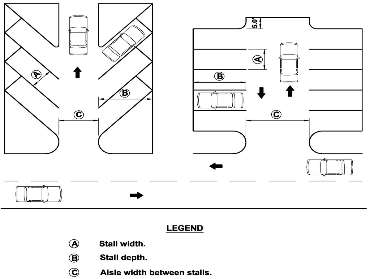
4.
For single-family attached and multiple-family units with individual garage/driveway arrangements, one vehicle may be stacked behind (parked in tandem to) each required off-street parking space and located between garage or carport and the street right-of-way line. Tandem parking must be located in a driveway or designated stabilized area. A clear-sight triangle shall be maintained. In no case shall parked vehicles placed tandem, including hitches or mechanical equipment, overhang a sidewalk. Stacked parking spaces may not be attributed to units not served directly by the driveway/garage. Tandem parking spaces shall be a minimum 40'L × 9'W of which eight feet must be stabilized, and a maximum of 42'L × 16'W, which may include the covered spaces.
5.
Commercial and industrial parking may be at a ratio of 75 percent full size to 25 percent compact parking spaces. If compact spaces are used, they should be evenly distributed throughout the site and shall be denoted by signs or pavement markings. Compact parking spaces shall not be less than 18'L × 8'W.
6.
Dead-end parking aisles greater than 150 feet in depth shall provide an emergency vehicle turnaround acceptable to the county fire marshal sufficient for a thirty-eight (38) foot long truck with a thirty-two (32) foot wheel base, or as determined by the county fire marshal.
7.
A garage or carport may be located wholly or partly inside the walls of the principal building, or attached to the outer walls. If separated from the principal building, the garage shall conform to all accessory building requirements. A freestanding parking garage on a separate parcel shall meet all principal building requirements. Additionally, the opening of the garage shall be sufficiently set back such that any queuing occurs outside of the right-of-way.
8.
Surfacing: Any off-street parking area shall be graded for proper drainage and shall be surfaced so as to provide a durable and dustless surface including, but not limited to, a gravel, concrete, bituminous concrete, or stabilized vegetation surface, and shall be so arranged as to provide for orderly, safe parking, and storage of vehicles.
9.
Vehicle wheel stops or other design features, such as curbing, shall be used so that parked vehicles do not extend more than two feet into any landscape or buffer area nor reduce an abutting sidewalk width to less than five feet.
10.
All vehicular use areas shall comply with the applicable requirements of the Americans with Disabilities Act.
11.
Parking structures can be either single-level garages with ground-level parking beneath the upper levels containing habitable floor area, or multi-level garages with ramps leading to at least one elevated parking deck.
Parking Garage Design standards. The following requirements shall apply to parking garages:
a.
Minimum setbacks: Parking garages shall comply with the minimum setbacks for principle structures in the zoning district in which they are located.
b.
Maximum height: Parking garages shall comply with the maximum height for structures in the zoning district in which they are located.
c.
Minimum parking stall dimensions: Shall comply with this section.
d.
Minimum drive aisle widths: Shall comply with this section.
e.
Floor area ratio: Parking garages shall not be counted toward the allowable floor-area ratio for a site unless specifically required by the zoning district.
f.
Vehicular accessibility: Vehicular access shall be designed in a manner that minimizes disruption to pedestrian corridors and the streetscape.
g.
Vehicular ingress and egress shall be provided from an alley or secondary street.
h.
When alley access or secondary-street access is not possible, then vehicular ingress and egress shall be permitted from the primary street.
i.
The width of a driveway intersecting a public sidewalk shall comply with Access Management Section of this Code.
j.
Minimum vehicle stacking requirements at entry points.
(1)
Free flow entries means an entry into a parking garage without controls, such as attendants or automatic ticket-dispensing controls: one vehicle space per entry lane.
(2)
Automatic ticket-dispensing entries mean an entry into a parking garage controlled by a machine dispensing tickets for garage use: two vehicle spaces per entry lane.
(3)
Manual, ticket-dispensing entries mean an entry into a parking garage controlled by a person manually dispensing tickets for garage use: four vehicle spaces per entry lane.
(4)
Manual, key-card entries mean an entry into a parking garage controlled by a key card for garage use: two vehicle spaces per entry lane.
k.
Orientation. In order to orient parking structures to the interior of development sites, parking garages shall:
(1)
Include residential dwelling units, retail storefronts or office facades along all first floor exterior walls adjacent to a street, excluding alleys, except where driveways exist; or;
(2)
Shall be screened with ornamental grillwork, artwork, or similar architectural features.
l.
Architectural design: Parking structures shall be compatible with abutting structures.
m.
Lighting: Light poles on top of parking garages shall be limited to a maximum height of 20 feet. Lighting on top of parking garages is prohibited between the hours of 11:00 p.m. and sunrise, except that lighting is allowed while the parking facility is open to the public. Security lighting is excluded from this prohibition.
E.
Parking Facilities Required. Any structure or building hereafter erected, converted, or enlarged for any of the following uses, or any open area hereafter used for commercial purposes, shall be provided with not less than the minimum spaces as set forth below, which spaces shall be readily accessible to the uses served thereby. Fractional numbers of parking spaces shall be increased to the next whole number.
Prior to permitting parking in excess of 110 percent of the required parking or ten spaces, whichever is more, consideration shall be given to shared parking pursuant to Section 907.1.G.
If parking spaces are provided in excess of ten percent of the required parking, those excess parking spaces are encouraged to be constructed with low impact materials; e.g., pervious pavers or stabilized vegetation.
Requirements for off-street parking for uses not specifically mentioned shall be the same as provided for the use most similar to the one sought as determined by the County Administrator or his designee.
In such instances, the applicant shall provide adequate information by which the proposal can be reviewed, which includes but may not necessarily be limited to the following:
1.
Types of uses;
2.
Number of employees;
3.
Building design capacity;
4.
Square feet of sales area and service area;
5.
Parking spaces proposed on site;
6.
Parking spaces provided elsewhere; and
7.
Hours of operation.
F.
Allowed Parking Facility Reductions. Where the following alternative transportation options are provided, the required parking spaces for Commercial, Office, Multiple Family, and Industrial uses may be reduced; such options shall be assessed cumulatively:
1.
Carpools, Vanpools, or Bike Sharing. Where infrastructure and support programs to facilitate shared vehicle or bicycle use, such as carpools, vanpools, car-share services, ride boards, bike-share systems, and shuttle services to mass transit are provided, the required parking spaces may be reduced by up to ten percent.
2.
Low-Emitting, Fuel Efficient, and Alternative Energy Vehicle Sharing Program. Where building occupants have access to a low-emitting, fuel efficient, or alternative energy vehicle-sharing program, the required parking spaces may be reduced by up to ten percent. The following requirements must be met:
a.
A vehicle-sharing contract must be provided that has an agreement of at least two years.
b.
The estimated number of building occupants served per vehicle must be supported by documentation.
c.
A narrative explaining the vehicle sharing program and its administration must be submitted.
d.
Parking for low-emitting and fuel efficient vehicles must be located in the nearest available spaces in the nearest available parking area. In addition to the reduced number of spaces, the spaces provided for low-emitting, fuel efficient, or alternative energy vehicles may be reduced to a minimum of 5'W × 9'L.
3.
Transit Facilities. Where the facility is located within one-quarter mile walking distance (measured from the project boundary) of one or more existing or planned stops, the required parking spaces may be reduced by up to 15 percent.
G.
Shared Parking. To reduce heat island effects and the development of unnecessary, impervious parking areas; shared parking is encouraged.
Shared parking may be allowed when land uses have different parking demand patterns and are able to use the same parking spaces/areas throughout the day. Shared parking is most effective when these land uses have significantly different peak-parking characteristics that vary by the time of day, day of the week, and/or season of the year.
1.
Calculation of Parking Spaces Required with Shared Parking. The minimum number of parking spaces for a mixed-use development or where shared-parking strategies are proposed shall be determined by a study prepared by the applicant following the procedures of the Urban Land Institute (ULI), Shared Parking Report, Institute of Transportation Engineers (ITE), Shared Parking Guidelines, or other approved procedures. A formal parking study may be waived where there is established experience with the land use mix and its impact is expected to be minimal. The actual number of parking spaces required shall be based on well recognized sources of parking data, such as the ULI or ITE reports. If standard rates are not available or limited, the applicant may collect data at similar sites to establish local parking demand rates. If the shared parking plan assumes use of an existing parking facility, then field surveys shall be conducted to determine actual parking accumulation. These surveys should consider the seasonal peak period for the combination of land uses involved. The applicant shall determine the minimum number of parking spaces required for shared-parking arrangements or mixed-use developments by the following:
a.
Determine the number of parking spaces that are required for each land use separately.
b.
Based on the hourly variation in parking demand, determine the peak-parking demand for the combined demand of all the uses in the development.
c.
Compare the calculations in Steps a and b above, and the lesser of the two peak-parking demands shall be used as the minimum number of parking spaces that needs to be provided.
2.
Distance to Parking Spaces and Pedestrian Connection Requirements. The closer shared spaces are to the land uses they serve, the more likely the arrangement will be a success. Shared spaces for residential units must be located within 300 feet of dwelling unit entrances they serve. Shared spaces at other uses must be located within 500 feet of the principal building entrances of all sharing uses. However, up to 20 percent of the spaces may be located greater than 500 feet but less than 1,000 feet from principal entrances. Clear, safe pedestrian connections must be provided. Up to 50 percent of nonresidential spaces may be provided at greater distances if a dedicated shuttle bus or van service is provided from a remote parking facility.
3.
Agreement Between Sharing Property Owners. If a privately owned parking facility is to serve two or more separate properties, a recorded legal agreement between property owners guaranteeing access to, use of, and management of designated spaces is required. The recorded, legal agreement shall be acceptable to the County Attorney's Office.
4.
Shared Parking Plan. Where shared parking is proposed, a shared parking plan shall be submitted that includes the following:
a.
A site plan of the parking spaces intended for shared parking and their proximity to land uses they will serve.
b.
A signage plan that directs drivers to the most convenient parking areas for each particular use or group of uses (if distinctions can be made).
c.
A pedestrian circulation plan that shows connections and walkways between parking areas and land uses. These paths should be as direct and short as possible.
d.
A safety and security plan that addresses lighting and maintenance of the parking area.
H.
Bicycle Parking Facilities Standards. The following customer standards shall apply for bicycle storage areas:
1.
Bicycle parking facilities shall include provisions for the secure storage and locking of bicycles in a stable position without damage to wheels, frames, or components.
2.
All designed bicycle parking facilities shall be provided with markings and symbols clearly visible to the public which indicates the location of the bicycle parking facilities.
3.
For nonresidential developments, visitor and customer bicycle parking facilities must be clearly visible from a main entry and located within 100 feet of the door, served with night lighting where required, and protected from damage from nearby vehicles. If the building has multiple main entries, bicycle parking facilities must be proportionally dispersed within 100 feet of each entry.
(Ord. No. 19-43, § 6, 12-10-19; Ord. No. 24-04, § 5(Att. A), 1-9-24)
907.2. - Loading
A.
Intent and Purpose. On site loading and unloading areas shall be provided to lessen congestion in the streets and to allow the safe loading and unloading of goods without interference to or by other on site activities.
B.
Applicability. Any site with new development, redevelopment, or change in use shall comply with this section.
C.
Exemptions. Single-family residential or multiple-family residential developments where there is not an on site office.
D.
Existing Nonconformities. Existing sites not meeting the requirements contained in this section shall be brought into full compliance under one or more of the following conditions:
1.
If an existing use is improved or remodeled in a value of 25 percent or more of the valuation of the existing principal structure as reflected on the property appraiser's current records.
2.
If an amendment, other than a minor amendment, is required to an existing approved site plan.
3.
If a change in use generates a requirement for more or larger loading spaces.
E.
Loading and Unloading Space Requirements.
1.
In addition to on site parking space(s) required, any building erected, converted, or enlarged in any district for multiple-family residential, common amenity centers, commercial, office building, manufacturing, wholesale, hospital, or similar uses, shall provide adequate on site areas for loading and unloading of vehicles. The default, minimum size loading space shall be 50'D × 12'W, with an overhead clearance of 14 feet. A standard parking space may be appropriate for uses such as offices, banks, or similar uses where the typical delivery is not by semi-tractor trailer.
2.
All nonresidential establishments shall provide loading and unloading and commercial vehicle storage space adequate for their needs.
3.
This required space will be provided in addition to established requirements for patron and employee parking.
4.
In no case where a building is erected, converted, or enlarged for commercial, manufacturing, or business purposes shall the public right-of-way be used for parking or loading and unloading of materials.
F.
Access to On Site Parking and Loading Area. Access to and from all on site parking, loading, and vehicle service areas along public rights-of-way shall consist of well-defined separate or common entrances and exits and shall comply with this Code.
907.3. - Stacking Spaces and Drive-Through Facilities
A.
Intent and Purpose. Stacking spaces (queue spaces) shall be provided to lessen congestion in the streets and to allow the safe conduct of drive-through transactions without interference by or to other on-site activities.
B.
Applicability. Any site with new development, redevelopment, or change in use that uses drive-through facilities for some or all of its transactions shall comply with this section.
C.
Exemptions. Facilities without proposed drive-throughs are exempt.
D.
Existing Nonconformities. Existing sites not meeting the requirements contained in this section shall be brought into full compliance under one or more of the following conditions:
1.
If an existing use is improved or remodeled in a value of 25 percent or more of the valuation of the existing principal structure as reflected on the Property Appraiser's current records.
2.
If an amendment, other than a minor amendment, is required to an existing approved site plan.
3.
If a change in use generates a requirement for more or larger loading spaces.
E.
Stacking Space Requirements.
1.
Stacking spaces shall be provided for any use having a drive-through facility. The following general standards shall apply to all stacking spaces and drive-through facilities:
a.
Stacking spaces and lanes for drive-through stations shall not impede on- and off-site traffic movements by blocking vehicular or pedestrian circulation. The minimum standards given herein may be adjusted upward if the project vehicle type warrants such adjustment in the review process.
b.
Drive-through lanes shall be separated from parking areas by distinctly delineating the lane through striping or other means.
c.
Queuing spaces shall not offset required number of parking spaces.
d.
Alleys or driveways in residentially zoned areas adjacent to drive-through facilities shall not be used for circulation of customer traffic.
e.
Stacking lanes for drive-through facilities shall have the following minimum widths:
(1)
One lane = 12 feet per lane.
(2)
Two or more lanes = Ten feet per lane.
f.
All drive-through facilities shall be provided with a bypass lane with a minimum width of ten feet if the bypass has no parking spaces or is not a required drive aisle for nondrive-through traffic.
g.
Each stacking space shall be a minimum of 10' × 20'.
2.
Stacking spaces shall be provided as follows:
a.
Financial institutions with drive-through windows:
(1)
Six stacking spaces for the first drive-through window and three stacking spaces for each additional window.
b.
Car wash:
(1)
Four stacking spaces per bay/stall for self-service establishments, and five stacking spaces per bay/stall for an automated establishment.
c.
Drive-in or fast-food restaurant:
(1)
Eight stacking spaces per drive-through window measured from the pickup window.
d.
All other uses:
(1)
Three stacking spaces for each window.
(Ord. No. 24-42, Exh. A, 9-17-24)
907.4. - Lighting
A.
Intent and Purpose. The intent and purpose of this section is to eliminate light trespass from buildings and sites, improve night sky access, and reduce development impact on nocturnal environments.
B.
Applicability. This section shall apply to new development and when 50 percent or more of any component; e.g., luminaries, poles, etc., of an exterior lighting system on a building or project is upgraded, changed, or replaced (not including regular maintenance), such component and the remainder of the exterior lighting shall be brought into compliance with the requirements of this Code.
C.
Standards.
1.
General: Any lighting used to illuminate any parking area shall be so arranged as to direct and/or shield light away from adjoining residential premises and right-of-way.
2.
Vehicle Dealerships: Vehicle dealerships shall comply with the lighting requirements of Section 1101.3.B.
3.
Large scale commercial projects shall comply with the lighting requirements of Section 1102.4.K.