
Pasco County Unincorporated
City Zoning Code
City Zoning Code
CHAPTER 500
ZONING STANDARDS
SECTION 501.- GENERAL
A.
Intent and purpose. The intent and purpose of zoning districts and standards are for guiding and accomplishing coordinated, adjusted, and harmonious development in accordance with existing and future needs; protecting promoting and improving public health, safety, comfort, order, appearance, convenience, morals, and general welfare through permitting, prohibiting, regulating, restricting, encouraging, and determining the uses of land, watercourses and other bodies of water, and the size, height, bulk, location, erection, construction, repair, maintenance, alteration, razing, removal and use of structures; and areas and dimensions of land and bodies of water to be occupied by uses and structures, as well as courts, yards, and other open spaces and distances to be left unoccupied by uses and structures; and the density of population and intensity of use. Zoning districts and standards and providing for administration, prevent overcrowding of land; blight; danger; congestion in travel and transportation; and loss of health, life or property from fire, flood, panic and other dangers.
Chapter 500 of this Code is made in accordance with an overall program, and with consideration of the character of the County, its various parts and the suitability of the various parts for particular uses and structures.
B.
Provisions of zoning regulations declared to be minimum or maximum requirements.
1.
In their interpretation and application, the provisions of these zoning regulations shall be held to be minimum or maximum requirements, as the case may be, adopted for the promotion of the public health, safety, morals or general welfare.
2.
Wherever the requirements of these zoning regulations are at a variance with the requirements of any governmentally adopted statute, rule, regulation, ordinance, or code, the most restrictive or that imposing the higher standards, shall govern; provided that development and other activities conducted by the County shall be exempt from the provisions of this chapter.
SECTION 530.- SUPPLEMENTAL REGULATIONS
The provisions of this chapter shall be subject to such exceptions, additions, or modifications as provided by the following supplemental regulations. The provisions of Section 530.1 shall not apply to properties located in an Urban Service Area.
(Ord. No. 21-36, § 5(Att. A), 12-7-21; Ord. No. 25-22, Attach. A, 4-9-25)
502.1.- Zoning Districts
For the purposes of this section, the County is hereby divided into zoning districts which shall be designated as follows:
502.2. - Official Zoning Map
The official boundaries of the said districts shall be shown upon the geographical information system, arc map zoning layer, to be maintained by and kept in the possession of the County Administrator or designee. The zoning layer shall constitute the County official zoning layer. All districts shall be shown on the zoning layer. The said layers and all notations, references, and other data shown thereon are hereby incorporated by reference into this section as if all were fully described herein.
502.3. - District Boundaries
Where uncertainty exists as to boundaries of any district as shown on the official zoning map, the following rules shall apply:
A.
District boundary lines are intended to follow or be parallel to the center line of streets, streams, and railroads and lot or property lines as they exist on a recorded deed or plat of record in the Office of the County Clerk and Comptroller at the time of the adoption of the this Code, unless such district boundary lines are fixed by dimensions as shown on the zoning map.
B.
Where a district boundary is not fixed by dimensions and where it approximately follows lot lines, and where it does not scale more than ten feet there from, such lot lines shall be construed to be such boundaries, unless specifically shown otherwise.
C.
Boundaries shown as following or approximately following section lines, half section lines or quarter section lines shall be construed as following such lines.
D.
In subdivided land or where a district boundary divides a lot, the location of such boundary, unless the same is indicated by dimensions, shall be determined by the use of the scale appearing on the maps.
502.4. - Interpretation of Boundaries
In the case of any uncertainty, the County Administrator or designee shall interpret the location of district boundaries based upon zoning application files, official files, and other appropriate information.
502.5. - Uncertain Classification
Whenever there is any uncertainty as to the classification of a use or the zoning district in which the use belongs, the County Administrator or designee shall determine the classification and/or zoning district within, if any, the use falls, according to its similar characteristics.
A.
If a use has characteristics similar to more than one classification, the use shall be construed as belonging to the classification providing for the more intense use of a property.
B.
If a use is specifically described in another zoning district, the use shall be construed as belonging to the zoning district in which it was more specifically identified.
C.
If a use is arguably both a permitted use and a conditional use, then the use shall be classified as a conditional use.
D.
If a use is arguably both a permitted use and a special exception use, then the use shall be classified as a special exception use.
E.
If a use is arguably both a conditional use and a special exception use, then the use shall be classified as a conditional use.
F.
In the event that a particular use is not allowed, the use is prohibited in Pasco County.
503.1.- Purpose
The purpose of the A-C Agricultural District is to preserve the rural and open character of various lands within the County. These lands are agricultural lands; sites of vital, natural water resource functions; areas with highly productive, natural plant and animal communities; and areas with valuable topographic and/or subsurface features, all of which are necessary to sustain and enhance the quality of life in the County.
Those uses will be allowed which are compatible with these overall objectives.
(Ord. No. 22-63, § 5(Att. A), 12-6-22; Ord. No. 25-22, Attach. A, 4-9-25)
503.2. - Permitted Uses
A.
Principal Uses.
1.
Agriculture, general farming, and horticulture to include animal feedlots; the commercial hatching or raising of poultry; the production of eggs; the raising of hogs; pasturage of animals, such as cattle and horses; citrus groves (as well as other fruits); forestry; plant nurseries; sheds; stables; barns; truck farms; fish hatcheries; fish pools, and other structures devoted to the on-site farm uses.
2.
Dwellings. Single-family detached dwellings on individual lots and single-family mobile homes on individual lots, where they are securely anchored as required by the County Building Code.
3.
Temporary roadside stands used on a seasonal basis for the sale of fruits, vegetables, and other agriculturally related products.
4.
Public and private parks and playgrounds.
5.
Noncommercial boat slips and piers or private docking facilities with the approval of the various State and/or Federal agencies where mandatory.
6.
Noncommercial recreation facilities including parks, playgrounds, and camps for youths and adults.
7.
Public and semipublic buildings and facilities to include the following: County, State, or Federal structures and uses; churches; civic organizations; and schools.
8.
Community Gardens, Market Gardens and Community Farms in accordance with this Code, Section 530.23.
9.
Solar Facility.
B.
Accessory Uses.
1.
Minor home occupations (unless a special exception per Section 530.21.1.D.5).
2.
Private garages and parking areas.
3.
Private swimming pools and cabanas in accordance with this Code.
4.
Signs in accordance with this Code.
5.
Accessory Dwelling Unit subject to compliance with Section 530.24.
6.
Other accessory uses customarily incidental to an allowed principal use.
(Ord. No. 22-63, § 5(Att. A), 12-6-22; Ord. No. 25-22, Attach. A, 4-9-25)
503.3. - Conditional Uses
A.
Residential Treatment and Care Facilities.
B.
Group Living Arrangement.
C.
Gun and archery range clubs and indoor or outdoor firing and archery ranges, subject to a minimum site area of ten acres.
D.
Aircraft and helicopter landing fields, subject to approval by the Federal Aviation Administration and compliance with appropriate State and local laws, provided that no aircraft landing field or helicopter pad be located closer than 1,000 feet from the closest property line of a school that provides a curriculum of elementary or secondary academic instruction, including kindergarten, elementary, middle, or high schools.
E.
Parachute drops.
F.
Amusement parks.
G.
Automobile race tracks.
H.
Medical waste disposal facilities.
I.
Auction houses.
J.
Flea markets.
K.
Drive-in theaters.
L.
Construction and demolition debris dumps, subject to all local, State, and Federal regulations.
M.
Sanitary landfills, subject to all local, State, and Federal regulations.
N.
Yard trash disposal facilities.
O.
Mining and/or reclamation including, but not limited to, mining or extraction of limestone, clay, sand, natural gas, oil, and organic soils, subject to all local, State, and Federal regulations.
P.
Sludge, septage, and other waste disposal sites.
Q.
Wastewater treatment plants, except when accessory to a development.
R.
Fertilizer manufacturing.
S.
Saw mills.
T.
The sale or consumption of alcoholic beverages in conjunction with the operation of an amusement park and as permitted under County, State, and Federal regulations provided:
1.
Unless a Specific Distance Waiver is granted by the Planning Commission in accordance with Section 402.5.D.6, No such sale or consumption of alcoholic beverages may occur or be conducted within 1,000 feet of any pre-k through 12 th grade public or private school, place of religious worship, or County park as measured from the structure used as a proprietor's place of business to the nearest property line of the pre-k through 12 th grade public or private school, place of religious worship, or County park.
2.
The sale or consumption of alcoholic beverages complies with conditional use standards set forth in this Code and has been approved by the Board of County Commissioners (BCC) in accordance with the said section.
(Ord. No. 22-63, § 5(Att. A), 12-6-22; Ord. No. 25-22, Attach. A, 4-9-25)
503.4. - Performance Standards for Conditional and Special Exception Uses
All activities shall be in conformance with standards established by the County, State, and Federal government.
(Ord. No. 22-63, § 5(Att. A), 12-6-22; Ord. No. 25-22, Attach. A, 4-9-25)
503.5. - Special Exception Uses
A.
Bed and breakfast, tourist homes.
B.
Major Home Occupations.
C.
Country clubs and golf courses.
D.
Day-care centers.
E.
Public and private utility facilities to include the following:
1.
County, State, or Federal structures and uses.
2.
Water pumping plants; transmission lines for gas, electric, and telephones or for broadcasting or communication towers and facilities.
3.
Other conforming uses which do not cause an undue nuisance or adversely affect existing structures, uses, and residents.
F.
Storage and repair facilities for essential public services.
G.
Cemeteries, mausoleums, and crematoriums.
H.
Animal hospitals or veterinarian clinics and dog kennels.
I.
Accessory uses customarily incidental to an allowed special exception use.
J.
Farm Feed and Supplies Establishments.
The following criteria and requirements shall apply to all farm feed and supplies establishments:
1.
Feed—livestock, poultry, and pets.
2.
Animal health products.
3.
Lawn and garden supplies.
4.
Fertilizer, insecticides, and pesticides.
5.
Leather goods and tack.
6.
Fence posts and supplies to be enclosed in an opaque buffer.
7.
No equipment, such as lawn mowers, tractors, and accessories, shall be stored or repaired on this site.
8.
There shall be a minimum 50-foot setback from all property lines for the building and storage areas, except as incidental to the above uses.
K.
Duplexes.
L.
Private schools.
(Ord. No. 22-63, § 5(Att. A), 12-6-22; Ord. No. 25-22, Attach. A, 4-9-25)
503.6. - Area, Density, and lot width requirements
A.
Single-Family Detached Dwellings and Mobile Homes.
1.
Minimum lot area: ten acres.
2.
Maximum possible gross density: 0.10 (nonfarm) dwelling units per acre, subject to compliance with the Comprehensive Land Use Map Classification.
3.
Minimum lot width: 250 feet.
4.
Single-family detached dwellings and mobile homes in the A-C Agricultural District are required to meet all of the standards above, except when such units are developed in a CS-MPUD Conservation Subdivision Master Planned Unit Development in accordance with this Code, the minimum lot area requirements and lot width requirements shall not apply.
B.
All Other Uses.
No minimum lot areas are required, subject to meeting minimum yard and coverage regulations.
(Ord. No. 22-63, § 5(Att. A), 12-6-22; Ord. No. 25-22, Attach. A, 4-9-25)
503.7. - Coverage Regulations
All buildings, including accessory buildings, shall not cover more than 15 percent of the total lot area.
(Ord. No. 22-63, § 5(Att. A), 12-6-22; Ord. No. 25-22, Attach. A, 4-9-25)
503.8. - Yard Regulations
The following minimum building line setbacks measured from the right-of-way or edge of ingress/egress easement (where there is no right-of-way) are required in front yard areas. All other yard areas shall be measured from the property line.
A.
Front: 50 Feet.
B.
Side: 25 Feet.
C.
Rear: 50 Feet.
D.
Single-family detached dwellings and mobile homes in the A-C Agricultural District are required to meet all of the standards above, except when such units are developed in a CS-MPUD in accordance with this Code, the minimum lot area requirements and lot width requirements shall not apply.
(Ord. No. 22-63, § 5(Att. A), 12-6-22; Ord. No. 25-22, Attach. A, 4-9-25)
503.9. - Height Regulations
Building height. Thirty-five feet maximum; however, no dwelling shall be less than ten feet in height. For exceptions, see this Code, Chapter 500, Supplemental Regulations.
(Ord. No. 22-63, § 5(Att. A), 12-6-22; Ord. No. 25-22, Attach. A, 4-9-25)
503.10. - On-Site Parking Regulations
On-site parking shall be provided in accordance with this Code.
(Ord. No. 22-63, § 5(Att. A), 12-6-22; Ord. No. 25-22, Attach. A, 4-9-25)
503.11. - Development Plan
A development plan shall be submitted in accordance with this Code.
(Ord. No. 22-63, § 5(Att. A), 12-6-22; Ord. No. 25-22, Attach. A, 4-9-25)
504.1.- Purpose
The purpose of the AC-1 Agricultural District is to preserve the rural and open character of various lands within the County and to provide for permanent, residential housing in conjunction with agricultural and open space uses. These lands are agricultural lands; sites of vital, natural water resource functions; areas with highly productive, natural plant and animal communities; and areas with valuable topographic and/or subsurface features, all of which are necessary to sustain and enhance the quality of life in the County. Those uses will be allowed which are compatible with these overall objectives.
(Ord. No. 22-63, § 5(Att. A), 12-6-22; Ord. No. 25-22, Attach. A, 4-9-25)
504.2. - Permitted Uses
A.
Principal Uses.
1.
Agriculture, general farming, and horticulture to include animal feed lots; the commercial hatching or raising of poultry; the production of eggs; the raising of hogs; pasturage of animals, such as cattle and horses; citrus groves (as well as other fruits); forestry; plant nurseries; sheds; stables; barns; truck farms; fish hatcheries; fish pools, and other structures devoted to the on-site farm uses.
2.
Dwellings: Single-family detached dwellings on individual lots.
3.
Temporary roadside stands used on a seasonal basis for the sale of fruits, vegetables, and other agriculturally related products.
4.
Public and private parks and playgrounds.
5.
Noncommercial boat slips and piers or private docking facilities with the approval of the various State and/or Federal agencies where mandatory.
6.
Noncommercial recreation facilities including parks, playgrounds, and camps for youths and adults.
7.
Public and semipublic buildings and facilities to include the following: County, State, or Federal structures and uses; churches; civic organizations; and schools.
8.
Community Gardens, Market Gardens and Community Farms in accordance with this Code, Section 530.23.
9.
Solar Facility.
B.
Accessory Uses.
1.
Minor home occupations (unless a special exception per Section 530.21.1.D.5).
2.
Private garages and parking areas.
3.
Private swimming pools and cabanas in accordance with this Code.
4.
Signs in accordance with this Code.
5.
Accessory Dwelling Unit subject to compliance with Section 530.24.
6.
Other accessory uses customarily incidental to an allowed principal use.
(Ord. No. 21-23, § 5(Att. A), 10-12-21; Ord. No. 22-63, § 5(Att. A), 12-6-22; Ord. No. 25-22, Attach. A, 4-9-25)
504.3. - Conditional Uses
A.
Residential Treatment and Care Facilities.
B.
Group Living Arrangement.
C.
Gun and archery clubs and indoor or outdoor firing and archery ranges, subject to a minimum site area of ten acres.
D.
Aircraft and helicopter landing fields, subject to approval by the Federal Aviation Administration and compliance with appropriate State and local laws, provided that no aircraft landing field or helicopter pad be located closer than 1,000 feet from the closest property line of a school that provides a curriculum of elementary or secondary academic instruction, including kindergarten, elementary, middle, or high schools.
E.
Parachute drops.
F.
Amusement parks.
G.
Automobile race tracks.
H.
Medical waste disposal facilities.
I.
Auction houses.
J.
Flea markets.
K.
Drive-in theaters.
L.
Construction and demolition debris dumps, subject to all local, State, and Federal regulations.
M.
Sanitary landfills, subject to all local, State, and Federal regulations.
N.
Yard trash disposal facilities.
O.
Mining and/or reclamation including, but not limited to, mining or extraction of limestone, clay, sand, natural gas, oil, and organic soils, subject to all local, State, and Federal regulations.
P.
Sludge, septage, and other waste disposal sites.
Q.
Wastewater treatment plants, except when accessory to a development.
R.
Fertilizer manufacturing.
S.
Saw mills.
(Ord. No. 22-63, § 5(Att. A), 12-6-22; Ord. No. 25-22, Attach. A, 4-9-25)
504.4. - Performance Standards for Conditional and Special Exception Uses
All activities shall be in conformance with standards established by the County, State, and Federal government.
(Ord. No. 22-63, § 5(Att. A), 12-6-22; Ord. No. 25-22, Attach. A, 4-9-25)
504.5. - Special Exception Uses
A.
Bed and breakfast, tourist homes.
B.
Major Home Occupations.
C.
Country clubs and golf courses.
D.
Day-care centers.
E.
Public and private utility facilities to include the following: County, State, or Federal structures and uses; water pumping plants; transmission lines for gas, electric, and telephones or for broadcasting or communication towers and facilities; and other conforming uses which do not cause an undue nuisance or adversely affect existing structures, uses, and residents.
F.
Storage and repair facilities for essential public services.
G.
Cemeteries, mausoleums, and crematoriums.
H.
Animal hospitals or veterinarian clinics and dog kennels.
I.
Accessory uses customarily incidental to an allowed special exception use.
J.
Farm Feed and Supplies Establishments.
The following criteria and requirements shall apply to all farm feed and supplies establishments:
1.
Feed—livestock, poultry, and pets.
2.
Animal health products.
3.
Lawn and garden supplies.
4.
Fertilizer, insecticides, and pesticides.
5.
Leather goods and tack.
6.
Fence posts and supplies to be enclosed in an opaque buffer.
7.
No equipment, such as lawn mowers, tractors, and accessories, shall be stored or repaired on this site.
8.
There shall be a minimum 50-foot setback from all property lines for the building and storage areas.
K.
Duplexes.
L.
Private schools.
(Ord. No. 22-63, § 5(Att. A), 12-6-22; Ord. No. 25-22, Attach. A, 4-9-25)
504.6. - Area, Density, and Lot Width Requirements
A.
Single-Family Detached Dwellings and Duplexes.
1.
Minimum lot area: ten acres.
2.
Maximum possible gross density: 0.10 (nonfarm) dwelling units per acre, subject to compliance with the Comprehensive Future Land Use Map classification.
3.
Minimum lot width: 250 feet.
4.
Single-family detached dwellings in the AC-1 Agricultural District are required to meet all of the standards above, except when such units are developed in a CS-MPUD Conservation Subdivision Master Planned Unit Development in accordance with this Code, the minimum lot area requirements and lot width requirements shall not apply.
B.
All Other Uses.
No minimum lot areas are required, subject to meeting minimum yard and coverage regulations.
(Ord. No. 22-63, § 5(Att. A), 12-6-22; Ord. No. 25-22, Attach. A, 4-9-25)
504.7. - Coverage Regulations
All buildings, including accessory buildings, shall not cover more than 15 percent of the total lot area.
(Ord. No. 22-63, § 5(Att. A), 12-6-22; Ord. No. 25-22, Attach. A, 4-9-25)
504.8. - Yard Regulations
The following minimum building line setbacks measured from the right-of-way or edge of ingress/egress easement (where there is no right-of-way) are required in front yard areas. All other yard areas shall be measured from the property line.
A.
Front: 50 feet.
B.
Side: 25 feet.
C.
Rear: 50 feet.
D.
Single-family detached dwellings in the AC-1 Agricultural District are required to meet all of the standards above, except when such units are developed in a CS-MPUD in accordance with this Code, the minimum lot area requirements and lot width requirements shall not apply.
(Ord. No. 22-63, § 5(Att. A), 12-6-22; Ord. No. 25-22, Attach. A, 4-9-25)
504.9. - Height Regulations
Building height. Thirty-five feet maximum; however, no dwelling shall be less than ten feet in height. For exceptions, see Chapter 500, Supplemental Regulations.
(Ord. No. 22-63, § 5(Att. A), 12-6-22; Ord. No. 25-22, Attach. A, 4-9-25)
504.10. - On-Site Parking Regulations
On-site parking shall be provided in accordance with this Code.
(Ord. No. 22-63, § 5(Att. A), 12-6-22; Ord. No. 25-22, Attach. A, 4-9-25)
504.11. - Development Plan
A development plan shall be submitted in accordance with this Code.
(Ord. No. 22-63, § 5(Att. A), 12-6-22; Ord. No. 25-22, Attach. A, 4-9-25)
505.1.- Purpose
The purpose of the A-R Agricultural-Residential District is to allow the development of relatively large tracts of land to accommodate those individuals who desire a rural or estate-type living environment; to curtail urban development in areas which lack facilities, until such time as those facilities are available; and to promote conservation of rural environments through limiting the intensity of development.
(Ord. No. 22-63, § 5(Att. A), 12-6-22; Ord. No. 25-22, Attach. A, 4-9-25)
505.2. - Permitted Uses
A.
Principal Uses.
1.
Commercial farming and agricultural activities, such as citrus groves (as well as other fruits); forestry; plant nurseries; truck farms; fish pools; animal feedlots; hatching and raising of poultry; production of eggs; raising of livestock (hogs, horses, cattle, sheep, etc.), shall require a minimum of five acres. Sheds, stables, barns, and other structures devoted to the on-site agricultural uses shall be required to maintain a 100-foot separation between dwellings existing on adjacent parcels of land at the time the commercial agricultural activity commenced. However, the required separation shall not be less than 50 feet from any property line.
2.
General farming pursuits of such extent as to supply the occupant's personal needs.
3.
Dwellings. Single-family detached dwellings on individual lots and single-family mobile homes on individual lots, where they are securely anchored as required by the County Building Code.
4.
Noncommercial boat slips and piers or private docking facilities with the approval of the various State and/or Federal agencies where mandatory.
5.
Maintaining livestock for the occupant's use or need only, not to exceed three grazing animals per acre minimum.
6.
Swine shall be considered, for the purpose of this section, as grazing animals. The number of swine shall not exceed one per acre, exclusive of area required for other uses.
7.
Maintaining small animals and fowl for the occupant's use or need only, not to exceed a ratio of 20 per acre.
8.
Public and semipublic buildings and facilities to include the following: County, State, or Federal structures and uses; churches; civic organizations; and schools.
9.
Temporary roadside stands used on a seasonal basis for the sale of fruits, vegetables, and other agriculturally related products shall require a minimum lot area of two acres.
10.
Community Gardens, Market Gardens and Community Farms in accordance with this Code, Section 530.23.
11.
Solar Facility.
B.
Accessory Uses.
1.
Minor home occupations (unless a special exception per Section 530.21.1.D.5).
2.
Private garages and parking areas.
3.
Private swimming pools and cabanas in accordance with this Code.
4.
Signs in accordance with this Code.
5.
Accessory Dwelling Unit subject to compliance with Section 530.24.
6.
Other accessory uses customarily incidental to an allowed principal use.
(Ord. No. 21-23, § 5(Att. A), 10-12-21; Ord. No. 22-63, § 5(Att. A), 12-6-22; Ord. No. 25-22, Attach. A, 4-9-25)
505.3. - Conditional Uses
A.
Residential Treatment and Care Facilities.
B.
Group Living Arrangement.
C.
Gun clubs and indoor or outdoor firing and archery ranges, subject to a minimum site area of ten acres.
D.
Aircraft and helicopter landing fields, subject to approval by the Federal Aviation Administration and compliance with appropriate State and local laws, provided that no aircraft landing field or helicopter pad be located closer than 1,000 feet from the closest property line of a school that provides a curriculum of elementary or secondary academic instruction, including kindergarten, elementary, middle, or high schools.
E.
Parachute drops.
F.
Amusement parks.
G.
Automobile race tracks.
H.
Medical waste disposal facilities.
I.
Construction and demolition debris dumps, subject to all local, State, and Federal regulations.
J.
Yard trash disposal facilities.
K.
Mining and/or reclamation including, but not limited to, mining or extraction of limestone, clay, sand, natural gas, oil, and organic soils, subject to all local, State, and Federal regulations.
L.
Wastewater treatment plants, except when accessory to a development.
M.
Sludge, septage, and other waste disposal sites.
(Ord. No. 22-63, § 5(Att. A), 12-6-22; Ord. No. 25-22, Attach. A, 4-9-25)
505.4. - Performance Standards for Conditional and Special Exception Uses
All activities shall be in conformance with standards established by the County, State, and Federal government.
(Ord. No. 22-63, § 5(Att. A), 12-6-22; Ord. No. 25-22, Attach. A, 4-9-25)
505.5. - Special Exception Uses
A.
Bed and breakfast, tourist homes.
B.
Duplexes.
C.
Major home occupations.
D.
Day-care centers.
E.
Public and private rights-of-way for utilities.
F.
Public and private substations for utilities.
G.
Public or private parks, playgrounds, and recreation areas.
H.
Golf courses provided the clubhouse and other structures are located over 150 feet from an abutting lot or parcel.
I.
Storage and repair facilities for essential services.
J.
Animal hospitals or veterinarian clinics and dog kennels.
K.
Travel trailer parks and travel trailer or recreational vehicle subdivisions, subject to the requirements set forth in this Code. Park model trailers located on lots within travel trailer and/or recreational vehicle subdivisions or condominiums may be utilized for permanent occupancy.
L.
Accessory uses customarily incidental to an allowed special exception use.
M.
Farm Feed and Supplies Establishments.
The following criteria and requirements shall apply to all farm feed and supplies establishments:
1.
Feed—livestock, poultry, and pets.
2.
Animal health products.
3.
Lawn and garden supplies.
4.
Fertilizer, insecticides, and pesticides.
5.
Leather goods and tack.
6.
Fence posts and supplies to be enclosed in an opaque buffer.
7.
No equipment, such as lawn mowers, tractors, and accessories, shall be stored or repaired on this site.
8.
There shall be a minimum 50-foot setback from all property lines for the building and storage areas.
N.
Private Schools.
(Ord. No. 22-63, § 5(Att. A), 12-6-22; Ord. No. 25-22, Attach. A, 4-9-25)
505.6. - Area, Density, and Lot Width Requirements
A.
Single-Family Detached Dwellings and Mobile Homes.
1.
Minimum lot area: One Acre.
2.
Maximum possible gross density: One Dwelling Unit Per Acre.
3.
Minimum lot width: 125 Feet.
4.
Single-family detached dwellings in the A-R Agricultural-Residential District are required to meet all of the standards above, except when such units are developed in a CS-MPUD Conservation Subdivision Master Planned Unit Development in accordance with this Code, Section 522.10, the minimum lot area requirements and lot width requirements shall not apply.
B.
All Other Uses.
No minimum lot areas are required, subject to meeting minimum yard and coverage regulations.
(Ord. No. 22-63, § 5(Att. A), 12-6-22; Ord. No. 25-22, Attach. A, 4-9-25)
505.7. - Coverage Regulations.
All buildings, including accessory buildings, shall not cover more than 25 percent of the total lot area.
(Ord. No. 22-63, § 5(Att. A), 12-6-22; Ord. No. 25-22, Attach. A, 4-9-25)
505.8. - Yard Regulations
The following minimum building line setbacks measured from the right-of-way or edge of ingress/egress easement (where there is no right-of-way) are required in front yard areas. All other yard areas shall be measured from the property line.
A.
Front: 50 Feet.
B.
Side: 25 Feet.
C.
Rear: 50 Feet.
D.
Single-family detached dwellings in the A-R Agricultural-Residential District are required to meet all of the standards above, except when such units are developed in a CS-MPUD in accordance with this Code, Section 522.10, the minimum lot area requirements and lot width requirements shall not apply.
(Ord. No. 22-63, § 5(Att. A), 12-6-22; Ord. No. 25-22, Attach. A, 4-9-25)
505.9. - Height Regulations
Building height. Thirty-five feet maximum; however, no dwelling shall be less than ten feet in height. For exemptions, see this Code, Chapter 500, Supplemental Regulations.
(Ord. No. 22-63, § 5(Att. A), 12-6-22; Ord. No. 25-22, Attach. A, 4-9-25)
505.10. - On-Site Parking Regulations
On-site parking shall be provided in accordance with this Code.
(Ord. No. 22-63, § 5(Att. A), 12-6-22; Ord. No. 25-22, Attach. A, 4-9-25)
505.11. - Development Plan
A development plan shall be submitted in accordance with this Code.
(Ord. No. 22-63, § 5(Att. A), 12-6-22; Ord. No. 25-22, Attach. A, 4-9-25)
506.1.- Purpose
The purpose of the AR-1 Agricultural-Residential District is to allow the development of relatively large tracts of land to accommodate those individuals who desire a rural or estate type living environment; to curtail urban development in areas which lack facilities, until such time as those facilities are available; and to promote conservation or greenbelting of rural environments through limiting the intensity and types of residential development.
(Ord. No. 22-63, § 5(Att. A), 12-6-22; Ord. No. 25-22, Attach. A, 4-9-25)
506.2. - Permitted Uses
A.
Principal Uses.
1.
Commercial farming and agricultural activities, such as citrus groves (as well as other fruits); forestry; plant nurseries; truck farms; fish pools; animal feedlots; hatching and raising of poultry; production of eggs; raising of livestock (hogs, horses, cattle, sheep, etc.), shall require a minimum of five acres. Sheds, stables, barns, and other structures devoted to the on-site agricultural uses shall be required to maintain a 100-foot separation between dwellings existing on adjacent parcels of land at the time the commercial agricultural activity commenced. However, the required separation shall not be less than 50 feet from any property line.
2.
General farming pursuits of such extent as to supply the occupant's personal needs.
3.
Dwellings: Single-family detached dwellings on individual lots.
4.
Noncommercial boat slips and piers or private docking facilities with the approval of the various State and/or Federal agencies where mandatory.
5.
Maintaining livestock for the occupant's use or need only, not to exceed three grazing animals per acre minimum.
6.
Swine shall be considered, for the purpose of this section, as grazing animals. The number of swine shall not exceed one per acre, exclusive of area required for other uses.
7.
Maintaining small animals and fowl for the occupant's use or need only, not to exceed a ratio of 20 per acre.
8.
Public and semipublic buildings and facilities to include the following: County, State, or Federal structures and uses; churches; civic organizations; and schools.
9.
Temporary roadside stands used on a seasonal basis for the sale of fruits, vegetables, and other agriculturally related products shall require a minimum lot area of two acres.
10.
Community Gardens, Market Gardens and Community Farms in accordance with this Code, Section 530.23.
11.
Solar Facility.
B.
Accessory Uses.
1.
Minor home occupations (unless a special exception per Section 530.21.1.D.5).
2.
Private garages and parking areas.
3.
Private swimming pools and cabanas in accordance with this Code.
4.
Signs in accordance with this Code.
5.
Accessory Dwelling Unit subject to compliance with Section 530.24.
6.
Other accessory uses customarily incidental to an allowed principal use.
(Ord. No. 21-23, § 5(Att. A), 10-12-21; Ord. No. 22-63, § 5(Att. A), 12-6-22; Ord. No. 25-22, Attach. A, 4-9-25)
506.3. - Conditional Uses
A.
Residential Treatment and Care Facilities.
B.
Group Living Arrangement.
C.
Gun clubs and indoor or outdoor firing and archery ranges, subject to a minimum site area of ten acres.
D.
Aircraft and helicopter landing fields, subject to approval by the Federal Aviation Administration and compliance with appropriate State and local laws, provided that no aircraft landing field or helicopter pad be located closer than 1,000 feet from the closest property line of a school that provides a curriculum of elementary or secondary academic instruction, including kindergarten, elementary, middle, or high schools.
E.
Parachute drops.
F.
Construction and demolition debris dumps, subject to all local, State, and Federal regulations.
G.
Yard trash disposal facilities.
H.
Sludge, septage, and other waste disposal sites.
I.
Wastewater treatment plants, except when accessory to a development.
J.
Mining and/or reclamation including, but not limited to, the mining or extraction of limestone, clay, sand, natural gas, oil, and organic soils, subject to all local, State, and Federal regulations.
(Ord. No. 22-63, § 5(Att. A), 12-6-22; Ord. No. 25-22, Attach. A, 4-9-25)
506.4. - Performance Standards for Conditional and Special Exception Uses
All activities shall be in conformance with standards established by the County, State, and Federal government.
(Ord. No. 22-63, § 5(Att. A), 12-6-22; Ord. No. 25-22, Attach. A, 4-9-25)
506.5. - Special Exception Uses
A.
Bed and breakfast, tourist homes.
B.
Major home occupations.
C.
Day-care centers.
D.
Public and private rights-of-way for utilities.
E.
Public and private substations for utilities.
F.
Duplexes.
G.
Public or private parks, playgrounds, and recreation areas.
H.
Golf courses provided the clubhouse and other structures are located over 150 feet from an abutting lot or parcel.
I.
Storage and repair facilities for essential services.
J.
Animal hospitals or veterinarian clinics and dog kennels.
K.
Accessory uses customarily incidental to a permitted special exception use.
L.
Farm Feed and Supplies Establishments.
The following criteria and requirements shall apply to all farm feed and supplies establishments:
1.
Feed—livestock, poultry, and pets.
2.
Animal health products.
3.
Lawn and garden supplies.
4.
Fertilizer, insecticides, and pesticides.
5.
Leather goods and tack.
6.
Fence posts and supplies to be enclosed in an opaque buffer.
7.
No equipment, such as lawn mowers, tractors, and accessories, shall be stored or repaired on this site.
8.
There shall be a minimum 50-foot setback from all property lines for the building and storage areas.
M.
Private schools.
(Ord. No. 22-63, § 5(Att. A), 12-6-22; Ord. No. 25-22, Attach. A, 4-9-25)
506.6. - Area, Density, and Lot Width Requirements
A.
Single-Family Detached Dwellings.
1.
Minimum lot area: one acre.
2.
Maximum possible gross density: one dwelling unit per acre.
3.
Minimum lot width: 125 feet.
4.
Single-family detached dwellings in the AR-1 Agricultural-Residential District are required to meet all of the standards above, except when such units are developed in a CS-MPUD Conservation Subdivision Master Planned Unit Development in accordance with this Code, the minimum lot area requirements and lot width requirements shall not apply.
B.
All Other Uses.
No minimum lot areas are required, subject to meeting minimum yard and coverage regulations.
(Ord. No. 22-63, § 5(Att. A), 12-6-22; Ord. No. 25-22, Attach. A, 4-9-25)
506.7. - Coverage Regulations
All buildings, including accessory buildings, shall not cover more than 25 percent of the total lot area.
(Ord. No. 22-63, § 5(Att. A), 12-6-22; Ord. No. 25-22, Attach. A, 4-9-25)
506.8. - Yard Regulations
The following minimum building line setbacks measured from the right-of-way or edge of ingress/egress easement (where there is no right-of-way) property lines are required in front yard areas. All other yard areas shall be measured from the property line.
A.
Front: 50 feet.
B.
Side: 25 feet.
C.
Rear: 50 feet.
D.
Single-family detached dwellings in the AR-1 Agricultural-Residential District are required to meet all of the standards above, except when such units are developed in a CS-MPUD in accordance with this Code, Section 522.10, the minimum lot area requirements and lot width requirements shall not apply.
(Ord. No. 22-63, § 5(Att. A), 12-6-22; Ord. No. 25-22, Attach. A, 4-9-25)
506.9. - Height Regulations
Building height. Thirty-five feet maximum; however, no dwelling shall be less than ten feet in height. For exemptions, see this Code, Chapter 500, Supplemental Regulations.
(Ord. No. 22-63, § 5(Att. A), 12-6-22; Ord. No. 25-22, Attach. A, 4-9-25)
506.10. - On-Site Parking Regulations
On-site parking shall be provided in accordance with this Code.
(Ord. No. 22-63, § 5(Att. A), 12-6-22; Ord. No. 25-22, Attach. A, 4-9-25)
506.11. - Development Plan
A development plan shall be submitted in accordance with this Code, Chapter 400.
(Ord. No. 22-63, § 5(Att. A), 12-6-22; Ord. No. 25-22, Attach. A, 4-9-25)
507.1.- Purpose
The purpose of the AR-5 Agricultural-Residential District is to provide a rural or farm atmosphere in which single-family home ownership may be permitted and where the growth of supplemental food supplies for families will be encouraged.
It is also intended to permit a reasonable use of the property while protecting prime agricultural or natural areas from urban encroachment and preventing rapid expansion of demands on public facilities.
(Ord. No. 22-63, § 5(Att. A), 12-6-22; Ord. No. 25-22, Attach. A, 4-9-25)
507.2. - Permitted Uses
A.
Principal Uses.
1.
Commercial farming and agricultural activities, such as citrus groves (as well as other fruits); forestry; plant nurseries; animal feedlots; hatching and raising of poultry; production of eggs; raising of livestock (horses, cattle, sheep, excluding hogs), shall be permitted and shall require a minimum of five acres. Sheds, stables, barns, and other structures devoted to the on-site agricultural uses shall not be located within 200 feet of residentially zoned property or within 50 feet from any lot line.
2.
General farming pursuits of such extent as to supply the occupant's personal needs.
3.
Dwellings: single-family detached dwellings on individual lots.
4.
Maintaining livestock for the occupant's use or need only, not to exceed three grazing animals per acre minimum.
5.
Swine shall be considered, for the purpose of this section, as grazing animals. The number of swine shall not exceed one per acre.
6.
Public schools.
7.
Temporary roadside stands used on a seasonal basis for the sale of fruits, vegetables, and other agriculturally related products.
8.
Community Gardens, Market Gardens and Community Farms in accordance with this Code, Section 530.23.
9.
Solar Facility.
B.
Accessory Uses.
1.
Minor home occupations (unless a special exception per Section 530.21.1.D.5).
2.
Private garages and parking areas.
3.
Private swimming pools and cabanas in accordance with this Code.
4.
Public and private rights-of-way for utilities.
5.
Accessory Dwelling Unit subject to compliance with Section 530.24.
6.
Other accessory uses customarily incidental to an allowed principal use.
(Ord. No. 21-23, § 5(Att. A), 10-12-21; Ord. No. 22-63, § 5(Att. A), 12-6-22; Ord. No. 25-22, Attach. A, 4-9-25)
507.3. - Conditional Uses
A.
Residential Treatment and Care Facilities.
B.
Group Living Arrangement.
C.
Gun clubs and indoor or outdoor firing and archery ranges, subject to a minimum site area of ten acres.
D.
Aircraft and helicopter landing fields, subject to approval by the Federal Aviation Administration and compliance with appropriate State and local laws, provided that no aircraft landing field or helicopter pad be located closer than 1,000 feet from the closest property line of a school that provides a curriculum of elementary or secondary academic instruction, including kindergarten, elementary, middle, or high schools.
E.
Construction and demolition debris dumps, subject to all local, State, and Federal regulations.
F.
Yard trash disposal facilities.
G.
Sludge, septage, and other waste disposal sites.
H.
Wastewater treatment plants, except when accessory to a development.
I.
Mining and/or reclamation including, but not limited to, the mining or extraction of limestone, clay, sand, natural gas, oil, and organic soils, subject to all local, State, and Federal regulations.
(Ord. No. 22-63, § 5(Att. A), 12-6-22; Ord. No. 25-22, Attach. A, 4-9-25)
507.4. - Performance Standards for Conditional and Special Exception Uses
All activities shall be in conformance with standards established by the County, State, and Federal government.
(Ord. No. 22-63, § 5(Att. A), 12-6-22; Ord. No. 25-22, Attach. A, 4-9-25)
507.5. - Special Exception Uses
A.
Bed and breakfast, tourist homes.
B.
Major home occupations.
C.
Day-care centers.
D.
Public and private rights-of-way for utilities.
E.
Public and private substations for utilities.
F.
Duplexes.
G.
Public or private parks, playgrounds, and recreation areas.
H.
Golf courses provided the clubhouse and other structures are located over 150 feet from an abutting lot or parcel.
I.
Storage and repair facilities for essential services.
J.
Public and semipublic buildings and facilities to include the following: County, State, or Federal structures and uses; churches (permanent structures only); and civic organizations.
K.
Accessory uses customarily incidental to an allowed special exception use.
L.
Farm Feed and Supplies Establishments. The following criteria and requirements shall apply to all farm feed and supplies establishments:
1.
Feed—livestock, poultry, and pets.
2.
Animal health products.
3.
Lawn and garden supplies.
4.
Fertilizer, insecticides, and pesticides.
5.
Leather goods and tack.
6.
Fence posts and supplies to be enclosed in an opaque buffer.
7.
No equipment, such as lawn mowers, tractors, and accessories, shall be stored or repaired on this site.
8.
There shall be a minimum 50-foot setback from all property lines for the building and storage areas.
M.
Private schools.
(Ord. No. 22-63, § 5(Att. A), 12-6-22; Ord. No. 25-22, Attach. A, 4-9-25)
507.6. - Area, Density, and Lot Width Requirements
Single-Family Detached Dwellings.
A.
Minimum lot area: five acres.
B.
Maximum possible gross density: one dwelling unit per five acres.
C.
Minimum lot frontage width: 200 feet.
D.
Single-family detached dwellings in the AR-5 Agricultural-Residential District are required to meet all of the standards above, except when such units are developed in a CS-MPUD Conservation Subdivision Master Planned Unit Development in accordance with this Code, the minimum lot area requirements and lot width requirements shall not apply.
(Ord. No. 22-63, § 5(Att. A), 12-6-22; Ord. No. 25-22, Attach. A, 4-9-25)
507.7. - Coverage Regulations
All buildings, including accessory buildings, shall not cover more than 30 percent of the total lot area.
(Ord. No. 22-63, § 5(Att. A), 12-6-22; Ord. No. 25-22, Attach. A, 4-9-25)
507.8. - Yard Regulations
The following minimum building line setbacks measured from the right-of-way or edge of ingress/egress easement (where there is no right-of-way) are required in front yard areas. All other yard areas shall be measured from the property line.
A.
Front: 50 feet.
B.
Side: 25 feet.
C.
Rear: 50 feet.
D.
Single-family detached dwellings in the AR-5 Agricultural-Residential District are required to meet all of the standards above, except when such units are developed in a CS-MPUD in accordance with this Code, the minimum lot area requirements and lot width requirements shall not apply.
(Ord. No. 22-63, § 5(Att. A), 12-6-22; Ord. No. 25-22, Attach. A, 4-9-25)
507.9. - Height Regulations
Building height. Thirty-five feet maximum; however, no dwelling shall be less than ten feet in height. For exemptions, see this Code, Chapter 500, Supplemental Regulations.
(Ord. No. 22-63, § 5(Att. A), 12-6-22; Ord. No. 25-22, Attach. A, 4-9-25)
507.10. - On-Site Parking Regulations
On-site parking shall be provided in accordance with this Code.
(Ord. No. 22-63, § 5(Att. A), 12-6-22; Ord. No. 25-22, Attach. A, 4-9-25)
507.11. - Development Plan
A development plan shall be submitted in accordance with this Code.
(Ord. No. 22-63, § 5(Att. A), 12-6-22; Ord. No. 25-22, Attach. A, 4-9-25)
508.1.- Purpose
The purpose of the AR-5MH Agricultural Mobile Home District is to provide a rural or farm atmosphere in which single-family mobile home ownership may be allowed on five acre parcels or larger and where the growing of supplemental food supplies for families will be encouraged. It is also intended to permit a reasonable use of the property while protecting prime agricultural or natural areas from urban encroachment and preventing rapid expansion of demands on public facilities.
(Ord. No. 22-63, § 5(Att. A), 12-6-22)
508.2. - Permitted Uses
A.
Principal Uses.
1.
Commercial farming and agricultural activities, such as citrus groves (as well as other fruits); forestry; plant nurseries; animal feed lots; hatching and raising of poultry; production of eggs; raising of livestock (horses, cattle, sheep, excluding hogs), shall be permitted and shall require a minimum of five acres. Sheds, stables, barns, and other structures devoted to the on-site agricultural uses shall not be located within 200 feet of residentially zoned property or within 50 feet from any lot line.
2.
General farming pursuits of such extent as to supply the occupant's personal needs.
3.
Dwellings: single-family mobile homes on individual lots where they are securely anchored as required by the County Building Code.
4.
Maintaining livestock for the occupant's use or need only, not to exceed three grazing animals per acre minimum.
5.
Swine shall be considered, for the purpose of this section, as grazing animals. The number of swine shall not exceed one per acre.
6.
Public schools.
7.
Temporary roadside stands used on a seasonal basis for the sale of fruits, vegetables, and other agriculturally related products.
8.
Community Gardens, Market Gardens and Community Farms in accordance with this Code, Section 530.23.
9.
Solar Facility.
B.
Accessory Uses.
1.
Minor home occupations (unless a special exception per Section 530.21.1.D.5).
2.
Private garages and parking areas.
3.
Private swimming pools and cabanas in accordance with this Code.
4.
Public and private rights-of-way for utilities.
5.
Other accessory uses customarily incidental to an allowed principal use.
(Ord. No. 21-23, § 5(Att. A), 10-12-21; Ord. No. 22-63, § 5(Att. A), 12-6-22)
508.3. - Conditional Uses
A.
Residential Treatment and Care Facilities.
B.
Group Living Arrangement.
C.
Gun clubs and indoor or outdoor firing and archery ranges, subject to a minimum site area of ten acres.
D.
Aircraft and helicopter landing fields, subject to approval by the Federal Aviation Administration and compliance with appropriate State and local laws, provided that no aircraft landing field or helicopter pad be located closer than 1,000 feet from the closest property line of a school that provides a curriculum of elementary or secondary academic instruction, including kindergarten, elementary, middle, or high schools.
E.
Construction and demolition debris disposal facilities, subject to all local, State, and Federal regulations.
F.
Yard trash disposal facilities.
G.
Sludge, septage, and other waste disposal sites.
H.
Wastewater treatment plants, except when accessory to a development.
I.
Mining and/or reclamation including, but not limited to, the mining or extraction of limestone, clay, sand, natural gas, oil, and organic soils, subject to all local, State, and Federal regulations.
(Ord. No. 22-63, § 5(Att. A), 12-6-22)
508.4. - Performance Standards for Conditional and Special Exception Uses
All activities shall be in conformance with standards established by the County, State, and Federal government.
(Ord. No. 22-63, § 5(Att. A), 12-6-22)
508.5. - Special Exception Uses
A.
Bed and breakfast, tourist homes.
B.
Major home occupations.
C.
Day-care centers.
D.
Public and private rights-of-way for utilities.
E.
Public and private substations for utilities.
F.
Duplexes.
G.
Public or private parks, playgrounds, and recreation areas.
H.
Golf courses, provided the clubhouse and other structures are located over 150 feet from an abutting lot or parcel.
I.
Storage and repair facilities for essential services.
J.
Public and semipublic buildings and facilities to include the following: County, State, or Federal structures and uses; churches (permanent structures only); and civic organizations.
K.
Accessory uses customarily incidental to a permitted special exception use.
L.
Farm Feed and Supplies Establishments. The following criteria and requirements shall apply to all farm feed and supplies establishments:
1.
Feed—livestock, poultry, and pets.
2.
Animal health products.
3.
Lawn and garden supplies.
4.
Fertilizer, insecticides, and pesticides.
5.
Leather goods and tack.
6.
Fence posts and supplies to be enclosed in an opaque buffer.
7.
No equipment, such as lawn mowers, tractors, and accessories, shall be stored or repaired on this site.
8.
There shall be a minimum 50 foot setback from all property lines for the building and storage areas.
M.
Private schools.
(Ord. No. 22-63, § 5(Att. A), 12-6-22)
508.6. - Area, Density, and Lot Width Requirements
Single-Family Mobile Homes:
A.
Minimum lot area: five acres.
B.
Maximum possible gross density: one dwelling unit per five acres, subject to compliance with the Comprehensive Plan Future Land Use Map classification.
C.
Minimum lot frontage width: 200 feet.
(Ord. No. 22-63, § 5(Att. A), 12-6-22)
508.7. - Coverage Regulations
All buildings, including accessory buildings, shall not cover more than 30 percent of the total lot area.
(Ord. No. 22-63, § 5(Att. A), 12-6-22)
508.8. - Yard Regulations
The following minimum building line setbacks measured from the property lines are required in yard areas listed below unless otherwise specified:
A.
Front: 50 feet.
B.
Side: 25 feet.
C.
Rear: 50 feet.
(Ord. No. 22-63, § 5(Att. A), 12-6-22)
508.9. - Height Regulations
Building height. Thirty-five feet maximum; however, no dwelling shall be less than ten feet in height. For exemptions, see Chapter 500, Supplemental Regulations.
(Ord. No. 22-63, § 5(Att. A), 12-6-22)
508.10. - On-Site Parking Regulations
On-site parking shall be provided in accordance with this Code.
(Ord. No. 22-63, § 5(Att. A), 12-6-22)
508.11. - Development Plan
A development plan shall be submitted in accordance with this Code.
(Ord. No. 22-63, § 5(Att. A), 12-6-22)
509.1.- Purpose
The purpose of the E-R Estate-Residential District is to serve as a transitional area between primarily agricultural areas and suburban development. Further, it is the purpose of the E-R Estate-Residential District to allow the establishment of estate-residential areas, including the raising of livestock and agriculture, on limited acreage for the primary use of the resident.
(Ord. No. 22-29, § 5(Att. A), 6-7-22; Ord. No. 22-63, § 5(Att. A), 12-6-22; Ord. No. 25-22, Attach. A, 4-9-25)
509.2. - Permitted Uses
A.
Principal Uses.
1.
Dwellings: single-family detached dwellings on individual lots.
2.
General farming pursuits of such extent as to supply the occupant's personal needs.
3.
Maintaining livestock for the occupant's use or need only, not to exceed three grazing animals per acre minimum.
4.
Swine shall be considered, for the purpose of this section, as grazing animals. The number of swine shall not exceed one per acre.
5.
Maintaining small animals, birds, and fowl for the occupant's use or need only, not to exceed a ratio of 20 per acre. No roosters shall be permitted.
6.
Noncommercial boat slips and piers or private docking facilities with the approval of the various State and/or Federal agencies where mandatory.
7.
Public schools.
8.
Community Gardens and Community Farms in accordance with this Code, Section 530.23.
B.
Accessory Uses.
1.
Minor home occupations (unless a special exception per Section 530.21.1.D.5).
2.
Private garages and parking areas.
3.
Private swimming pools and cabanas in accordance with this Code.
4.
Signs in accordance with this Code.
5.
Accessory Dwelling Unit subject to compliance with Section 530.24.
6.
Other accessory uses customarily incidental to an allowed principal use.
(Ord. No. 22-29, § 5(Att. A), 6-7-22; Ord. No. 22-63, § 5(Att. A), 12-6-22; Ord. No. 25-22, Attach. A, 4-9-25)
509.3. - Conditional Uses
A.
Residential Treatment and Care Facilities.
B.
Group Living Arrangement.
C.
Market Gardens in accordance with this Code, Section 530.23.
D.
Wastewater treatment plants, unless accessory to a development.
(Ord. No. 22-29, § 5(Att. A), 6-7-22; Ord. No. 22-63, § 5(Att. A), 12-6-22; Ord. No. 25-22, Attach. A, 4-9-25)
509.4. - Special Exception Uses
A.
Bed and breakfast, tourist homes.
B.
Duplexes.
C.
Major home occupations.
D.
Day-care centers.
E.
Public and private rights-of-way for utilities.
F.
Public and private substations for utilities.
G.
Private schools.
H.
Public or private parks, playgrounds, and recreation areas.
I.
Churches.
J.
Sports clubs or activities, such as hunting, fishing, riding, and country clubs, exclusive of outdoor firing ranges. Riding stables shall require a minimum of one acre per three grazing animals.
K.
Golf courses provided the clubhouse and other structures are located over 150 feet from an abutting lot or parcel.
L.
Professional services, such as medical, dental, legal, and engineering, excluding the storage or parking of heavy equipment.
M.
Accessory uses customarily incidental to a permitted special exception use.
(Ord. No. 22-29, § 5(Att. A), 6-7-22; Ord. No. 22-63, § 5(Att. A), 12-6-22; Ord. No. 25-22, Attach. A, 4-9-25)
509.5. - Performance Standards
All activities shall be in conformance with standards established by the County, State, and Federal government.
(Ord. No. 22-29, § 5(Att. A), 6-7-22; Ord. No. 22-63, § 5(Att. A), 12-6-22; Ord. No. 25-22, Attach. A, 4-9-25)
509.6. - Area, Density, and Lot Width Requirements
A.
Single-Family Detached Dwellings.
1.
Minimum lot area: one acre.
2.
Maximum possible gross density: one dwelling unit acre.
3.
Minimum lot width: 125 feet.
4.
Single-family detached dwellings in the E-R Estate-Residential District are required to meet all of the standards above, except when such units are developed in a CS-MPUD Conservation Subdivision Master Planned Unit Development in accordance with this Code, the minimum lot area requirements and lot width requirements shall not apply.
B.
All Other Uses.
No minimum lot areas are required, subject to meeting minimum yard and coverage regulations. Except where animals or fowl are permitted, there shall be a minimum of a 100-foot separation between dwellings on adjacent property and any stables, feed pens, fowl or bird coops, or other animal shelters. However, the required separation shall in no case be less than 50 feet from any property line.
(Ord. No. 22-29, § 5(Att. A), 6-7-22; Ord. No. 22-63, § 5(Att. A), 12-6-22; Ord. No. 25-22, Attach. A, 4-9-25)
509.7. - Coverage Regulations
All buildings, including accessory buildings, shall not cover more than 35 percent of the total lot area.
(Ord. No. 22-29, § 5(Att. A), 6-7-22; Ord. No. 22-63, § 5(Att. A), 12-6-22; Ord. No. 25-22, Attach. A, 4-9-25)
509.8. - Yard Regulations
The following minimum building-line setbacks measured from the right-of-way or edge of ingress/egress easement (where there is no right-of-way) are required in front yard areas. All other yard areas shall be measured from the property line.
A.
Front: 50 feet.
B.
Side: 25 feet.
C.
Rear: 50 feet.
D.
Single-family detached dwellings in the E-R Estate-Residential District are required to meet all of the standards above, except when such units are developed in a CS-MPUD in accordance with this Code, Section 522.10, the minimum lot area requirements and lot width requirements shall not apply.
(Ord. No. 22-29, § 5(Att. A), 6-7-22; Ord. No. 22-63, § 5(Att. A), 12-6-22; Ord. No. 25-22, Attach. A, 4-9-25)
509.9. - Height Regulations
Building height. Forty-five feet maximum; however, no dwelling shall be less than ten feet in height. For exemptions, see this Code, Chapter 500, Supplemental Regulations.
(Ord. No. 22-29, § 5(Att. A), 6-7-22; Ord. No. 22-63, § 5(Att. A), 12-6-22; Ord. No. 25-22, Attach. A, 4-9-25)
509.10. - On-Site Parking Regulations
On-site parking shall be provided in accordance with this Code.
(Ord. No. 22-29, § 5(Att. A), 6-7-22; Ord. No. 22-63, § 5(Att. A), 12-6-22; Ord. No. 25-22, Attach. A, 4-9-25)
509.11. - Development Plan
A development plan shall be submitted in accordance with this Code.
(Ord. No. 22-29, § 5(Att. A), 6-7-22; Ord. No. 22-63, § 5(Att. A), 12-6-22; Ord. No. 25-22, Attach. A, 4-9-25)
510.1.- Purpose
The purpose of the ER-2 Estate-Residential District is to encourage very low density, highly restricted, large lot, estate type developments and to serve as a transitional area between primarily agricultural areas and suburban development.
(Ord. No. 22-29, § 5(Att. A), 6-7-22; Ord. No. 22-63, § 5(Att. A), 12-6-22; Ord. No. 25-22, Attach. A, 4-9-25)
510.2. - Permitted Uses
A.
Principal Uses.
1.
Dwellings: single-family detached dwellings on individual lots.
2.
General farming and agricultural pursuits of such extent as to supply the occupant's personal needs.
3.
Maintaining livestock for the occupant's use or need only, not to exceed three grazing animals per acre minimum.
4.
Maintaining small animals and fowl for the occupant's use or need only, not to exceed a ratio of 20 per acre. No roosters shall be permitted.
5.
Noncommercial boat slips and piers or private docking facilities with the approval of the various State and/or Federal agencies where mandatory.
6.
Public schools.
7.
Community Gardens and Community Farms in accordance with this Code, Section 530.23.
B.
Accessory Uses.
1.
Minor home occupations (unless a special exception per Section 530.21.1.D.5).
2.
Private garages and parking areas.
3.
Private swimming pools and cabanas in accordance with this Code.
4.
Signs in accordance with this Code.
5.
Public and private rights-of-way for utilities.
6.
Accessory Dwelling Unit in accordance with this Code, Section 530.24.
7.
Other accessory uses customarily incidental to a permitted principal use.
(Ord. No. 22-29, § 5(Att. A), 6-7-22; Ord. No. 22-63, § 5(Att. A), 12-6-22; Ord. No. 25-22, Attach. A, 4-9-25)
510.3. - Conditional Uses
A.
Residential Treatment and Care Facilities.
B.
Group Living Arrangement.
C.
Market Gardens in accordance with this Code, Section 530.23.
D.
Wastewater treatment plants, unless accessory to a development.
(Ord. No. 22-29, § 5(Att. A), 6-7-22; Ord. No. 22-63, § 5(Att. A), 12-6-22; Ord. No. 25-22, Attach. A, 4-9-25)
510.4. - Special Exception Uses
A.
Bed and breakfast, tourist homes.
B.
Duplexes.
C.
Major home occupations.
D.
Day-care centers.
E.
Public and private substations for utilities.
F.
Public or private parks, playgrounds, and recreation areas.
G.
Accessory uses customarily incidental to an allowed special exception use.
H.
Private schools.
(Ord. No. 22-29, § 5(Att. A), 6-7-22; Ord. No. 22-63, § 5(Att. A), 12-6-22; Ord. No. 25-22, Attach. A, 4-9-25)
510.5. - Performance Standards
All activities shall be in conformance with standards established by the County, State, and Federal government.
(Ord. No. 22-29, § 5(Att. A), 6-7-22; Ord. No. 22-63, § 5(Att. A), 12-6-22; Ord. No. 25-22, Attach. A, 4-9-25)
510.6. - Area, Density, and Lot Width Requirements
Single-Family Detached Dwellings.
A.
Minimum lot area: two and a half acres.
B.
Maximum possible gross density: one dwelling unit per two and a half acres.
C.
Minimum lot frontage width: 200 feet, measured along the front property line or lines contiguous to any street, road, highway, or easement for ingress and egress, however stated.
D.
Single-family detached dwellings in the ER-2 Estate-Residential District are required to meet all of the standards above, except when such units are developed in a CS-MPUD Conservation Subdivision Master Planned Unit Development in accordance with this Code, the minimum lot area requirements and lot width requirements shall not apply.
(Ord. No. 22-29, § 5(Att. A), 6-7-22; Ord. No. 22-63, § 5(Att. A), 12-6-22; Ord. No. 25-22, Attach. A, 4-9-25)
510.7. - Coverage Regulations
All buildings, including accessory buildings, shall not cover more than 35 percent of the total lot area.
(Ord. No. 22-29, § 5(Att. A), 6-7-22; Ord. No. 22-63, § 5(Att. A), 12-6-22; Ord. No. 25-22, Attach. A, 4-9-25)
510.8. - Yard Regulations
The following minimum building line setbacks measured from the right-of-way or edge of ingress/egress easement (where there is no right-of-way) are required in front yard areas. All other yard areas shall be measured from the property line.
A.
Front: 50 feet.
B.
Side: 25 feet.
C.
Rear: 50 feet.
D.
Single-family detached dwellings in the ER-2 Estate-Residential District are required to meet all of the standards above, except when such units are developed in a CS-MPUD in accordance with this Code, the minimum lot area requirements and lot width requirements shall not apply.
(Ord. No. 22-29, § 5(Att. A), 6-7-22; Ord. No. 22-63, § 5(Att. A), 12-6-22; Ord. No. 25-22, Attach. A, 4-9-25)
510.9. - Height Regulations
Building height. Forty-five feet maximum; however, no dwelling shall be less than ten feet in height. For exemptions, see this Code, Chapter 500, Supplemental Regulations.
(Ord. No. 22-29, § 5(Att. A), 6-7-22; Ord. No. 22-63, § 5(Att. A), 12-6-22; Ord. No. 25-22, Attach. A, 4-9-25)
510.10. - On-Site Parking Regulations
On-site parking shall be provided in accordance with this Code.
(Ord. No. 22-29, § 5(Att. A), 6-7-22; Ord. No. 22-63, § 5(Att. A), 12-6-22; Ord. No. 25-22, Attach. A, 4-9-25)
510.11. - Development Plan
A development plan shall be submitted in accordance with this Code.
(Ord. No. 22-29, § 5(Att. A), 6-7-22; Ord. No. 22-63, § 5(Att. A), 12-6-22; Ord. No. 25-22, Attach. A, 4-9-25)
511.1.- Purpose
The purpose of an R-MH Mobile Home District is to provide for the development of areas with individual mobile homes within planned mobile home projects, including mobile home parks, condominiums, and subdivisions, for persons desiring the unique environments characteristic of mobile home living. It is the further purpose of this district to ensure the provision of adequate infrastructure facilities and community services necessary for such mobile home development.
(Ord. No. 21-36, § 5(Att. A), 12-7-21)
511.2. - Establishment Procedure
A.
Mobile home projects developed under single ownership or mobile home condominiums not considered to be a subdivision shall be considered mobile home parks.
B.
New or revised mobile home subdivisions or condominium projects, if appropriate, shall be required to comply with all provisions of this Code.
C.
Developers of mobile home parks shall file an application using the appropriate zoning amendment form, supplemented with a legal description of the property to be included, and a conceptual sketch plan showing the intended overall development plan.
(Ord. No. 21-36, § 5(Att. A), 12-7-21)
511.3. - Permitted Uses
A.
Principal Uses.
1.
Dwellings:
a.
Mobile homes, single-family detached modular, or factory built dwellings.
b.
Single-family detached dwellings on individual lots on parcels zoned R-MH prior to December 8, 2020.
2.
Noncommercial boat slips, piers, or private, residential docking facilities with the approval of various State and/or local agencies where appropriate.
3.
Public schools.
4.
Community Gardens and Community Farms in accordance with this Code, Section 530.23.
B.
Accessory Uses.
1.
Minor home occupations (unless a special exception per Section 530.21.1.D.5).
2.
Private garages and parking areas.
3.
Private or community swimming pools and cabanas in accordance with this Code.
4.
Signs in accordance with this Code.
5.
Management and maintenance offices and private recreational facilities including, but not limited to, golf courses and laundry facilities, provided that:
a.
Such facilities shall be restricted to the use of the occupants and guests.
b.
Such facilities shall be accessible only from a street within the development.
6.
Other accessory uses customarily incidental to an allowed principal use.
7.
Model mobile homes or mobile home sales offices within a mobile home park or condominium. However, after 90 percent occupancy of the park or condominium, model mobile homes and sales offices shall have one year to convert to residential uses unless extended by the Board of County Commissioners. Rental offices or homes sales offices shall be permitted as an accessory use within a mobile home park.
(Ord. No. 21-36, § 5(Att. A), 12-7-21)
511.4. - Special Exception Uses
All structures used for special exception uses must meet the State building construction standards set forth in Chapter 553, Florida Statutes.
A.
Public or private utilities: electrical, gas, telephone, water or sewage, and railroad rights-of-way.
B.
Private utility substations, provided there is not storage of trucks or materials on site.
C.
Private schools or day-care centers.
D.
Public or private parks, playgrounds, and recreation areas.
E.
Golf courses open to nonresidents, provided the clubhouse and other structures are located over 150 feet from an abutting lot or parcel.
F.
Governmental buildings or churches.
G.
Professional services, such as medical, dental, legal, and engineering, excluding the parking and storage of commercial vehicles or commercially related equipment.
H.
Accessory uses customarily incidental to an allowed special exception use.
(Ord. No. 21-36, § 5(Att. A), 12-7-21)
511.5. - Area and Density Requirements
Mobile homes and modular or factory built dwelling units:
A.
Minimum site area: Ten acres, inclusive of right-of-way dedication by deed, grant, or plat.
B.
Minimum lot area: 4,000 square feet.
C.
Maximum gross density: 8.8 dwelling units per acre, subject to compliance with the Comprehensive Plan Future Land Use Map classification.
(Ord. No. 21-36, § 5(Att. A), 12-7-21)
511.6. - Coverage Regulations
All buildings, including accessory buildings, shall not cover more than sixty-five (65) percent of the total lot area.
(Ord. No. 24-21, § 5(Att. A), 4-23-24)
Editor's note— Ord. No. 24-21, § 5(Att. A), adopted April 23, 2024, renumbered the former § 511.6 as § 511.7 and enacted a new § 511.6 as set out herein. The historical notation has been retained with the amended provisions for reference purposes.
511.7. - Yard Regulations
A.
The minimum building line setbacks, measured from the front, side or rear property lines, are required in yard areas listed below within a mobile home subdivision, condominium, or park, unless otherwise specified:
1.
Front (within subdivisions): twenty (20) feet from right-of-way.
2.
Front (within rental parks or condominiums): A setback of fifteen (15) feet in width from the edge of pavement of all private streets and all property lines of parcels of different uses, except for public streets, shall be provided and maintained. Such setbacks from property lines of parcels of different uses shall not be considered to be part of an abutting mobile home space nor shall the said setback be used as part of the recreation area.
3.
A side and rear setback of five (5) feet in width, measured from the property lines of individual lots, shall be provided and maintained.
B.
Development of recreational and open space areas shall be in accordance with the requirements established in this Code; however, in no case shall any part of such recreation and open space areas be less than 10,000 square feet.
(Ord. No. 21-36, § 5(Att. A), 12-7-21; Ord. No. 24-21, § 5(Att. A), 4-23-24)
Editor's note— Formerly § 511.6
511.8. - Height Regulations
Single-family detached dwellings, single-family detached modular, and factory built dwellings: forty-five (45) feet maximum; however, no dwelling shall be less than ten (10) feet in height.
Mobile and manufactured homes: fifteen (15) feet maximum.
For exceptions, see this Code, Chapter 500, Supplemental Regulations.
(Ord. No. 24-21, § 5(Att. A), 4-23-24 )
Editor's note— Ord. No. 24-21, § 5(Att. A), adopted April 23, 2024, renumbered the former § 511.8 as § 511.10 and enacted a new § 511.8 as set out herein. The historical notation has been retained with the amended provisions for reference purposes.
511.9. - Streets and Roads
Roadways or streets within a mobile home park or condominium shall be private, but the following requirements shall apply:
A.
Internal collector streets shall be 30 feet in width, with a minimum of 24 feet of paved surface.
B.
Internal local streets shall be 25 feet in width, with a minimum of 20 feet of paved surface. Roadways or streets within a mobile home park subdivision may be private, but shall comply with the requirements of this Code.
(Ord. No. 21-36, § 5(Att. A), 12-7-21; Ord. No. 24-21, § 5(Att. A), 4-23-24)
Editor's note— Formerly § 511.7.
511.10. - Existing Parks and Subdivisions
Those mobile home parks or subdivisions approved at the time of adoption of this Code shall be zoned in accordance with the above criteria as practicable as possible provided; however, that such parks or subdivisions may be completed and operated in accordance with plans for development as previously approved.
(Ord. No. 21-36, § 5(Att. A), 12-7-21; Ord. No. 24-21, § 5(Att. A), 4-23-24)
Editor's note— Formerly § 511.8.
511.11. - On-Site Parking Regulations
On-site parking shall be provided in accordance with this Code.
(Ord. No. 21-36, § 5(Att. A), 12-7-21; Ord. No. 24-21, § 5(Att. A), 4-23-24)
Editor's note— Formerly § 511.9.
511.12. - Development Plan
A development plan that substantially conforms with the conceptual sketch plan shall be submitted in accordance with this Code.
(Ord. No. 21-36, § 5(Att. A), 12-7-21; Ord. No. 24-21, § 5(Att. A), 4-23-24)
Editor's note— Formerly § 511.10.
511.13. - Neighborhood Park(s)
Neighborhood park(s) shall be provided and maintained in the same manner as a subdivision, pursuant to this Code.
(Ord. No. 21-36, § 5(Att. A), 12-7-21; Ord. No. 24-21, § 5(Att. A), 4-23-24)
Editor's note— Formerly § 511.11.
512.1.- Purpose
The purpose of the R-1MH Single-Family/Mobile Home District is to provide for the continued development of a mixed pattern of conventional residences and mobile homes, situated on individual lots, in established areas.
(Ord. No. 22-29, § 5(Att. A), 6-7-22; Ord. No. 22-63, § 5(Att. A), 12-6-22; Ord. No. 25-22, Attach. A, 4-9-25)
512.2. - Permitted Uses
A.
Principal Uses.
1.
Dwellings: single-family detached dwellings on individual lots and single-family mobile homes on individual lots where they are securely anchored as required by the County Building Code.
2.
Noncommercial boat slips and piers or private docking facilities with the approval of various State and/or Federal agencies where appropriate.
3.
Public schools.
4.
Community Gardens and Community Farms in accordance with this Code, Section 530.23.
B.
Accessory Uses.
1.
Minor home occupations (unless a special exception per Section 530.21.1.D.5).
2.
Private garages and parking areas.
3.
Private or community swimming pools and cabanas in accordance with this Code.
4.
Signs in accordance with this Code.
5.
Neighborhood Parks as required by Section 901.5 of this Code.
6.
Accessory Dwelling Unit in accordance with this Code, Section 530.24.
7.
Other accessory uses customarily incidental to an allowed principal use.
(Ord. No. 22-29, § 5(Att. A), 6-7-22; Ord. No. 22-63, § 5(Att. A), 12-6-22; Ord. No. 25-22, Attach. A, 4-9-25)
512.3. - Conditional Uses
A.
Market Gardens in accordance with this Code, Section 530.23.
B.
Residential treatment and care facilities.
C.
Group Living Arrangement.
(Ord. No. 22-29, § 5(Att. A), 6-7-22; Ord. No. 22-63, § 5(Att. A), 12-6-22; Ord. No. 25-22, Attach. A, 4-9-25)
512.4. - Special Exception Uses
All structures used for special exception uses must meet the State building construction standards set forth in Chapter 553, Florida Statutes.
A.
Duplexes.
B.
Day-care centers.
C.
Public or private rights-of-way for utilities.
D.
Public and private substations for utilities.
E.
Private schools.
F.
Public or private parks, playgrounds, and recreation areas.
G.
Churches.
H.
Golf courses provided the clubhouse and other structures are located over 150 feet from an abutting lot or parcel.
I.
Professional services, such as medical, dental, legal, and engineering, excluding the storage or parking of heavy equipment.
J.
Accessory uses customarily incidental to an allowed special exception use.
(Ord. No. 22-29, § 5(Att. A), 6-7-22; Ord. No. 22-63, § 5(Att. A), 12-6-22; Ord. No. 25-22, Attach. A, 4-9-25)
512.5. - Area, Density, and Lot Width Requirements
A.
Single-Family Detached Dwellings, Mobile Homes, and Duplexes.
1.
Minimum lot area: 20,000 square feet.
2.
Maximum possible gross density: 2.2 dwelling units per acre, except duplexes (four dwelling units per acre), subject to compliance with the Comprehensive Plan Future Land Use Map classification.
3.
Minimum lot width: 100 feet.
4.
Minimum lot depth: 150 feet.
B.
All Other Uses.
No minimum lot areas are required, subject to meeting minimum yard and coverage regulations.
(Ord. No. 22-29, § 5(Att. A), 6-7-22; Ord. No. 22-63, § 5(Att. A), 12-6-22; Ord. No. 25-22, Attach. A, 4-9-25)
512.6. - Coverage Regulations
All buildings, including accessory buildings, shall not cover more than 35 percent of the total lot area.
(Ord. No. 22-29, § 5(Att. A), 6-7-22; Ord. No. 22-63, § 5(Att. A), 12-6-22; Ord. No. 25-22, Attach. A, 4-9-25)
512.7. - Yard Regulations
The following minimum building line setbacks, measured from the property lines, are required in yard areas listed below unless otherwise specified:
A.
Front: 30 feet.
B.
Side: 15 feet.
C.
Rear: 30 feet.
(Ord. No. 22-29, § 5(Att. A), 6-7-22; Ord. No. 22-63, § 5(Att. A), 12-6-22; Ord. No. 25-22, Attach. A, 4-9-25)
512.8. - Height Regulations
Building height. Forty-five feet maximum; however, no dwelling shall be less than ten feet in height. For exceptions, see this Code, Chapter 500, Supplemental Regulations.
(Ord. No. 22-29, § 5(Att. A), 6-7-22; Ord. No. 22-63, § 5(Att. A), 12-6-22; Ord. No. 25-22, Attach. A, 4-9-25)
512.9. - On-Site Parking Regulations
On-site parking shall be provided in accordance with this Code.
(Ord. No. 22-29, § 5(Att. A), 6-7-22; Ord. No. 22-63, § 5(Att. A), 12-6-22; Ord. No. 25-22, Attach. A, 4-9-25)
512.10. - Performance Standards for Conditional Uses and Special Exceptions
All activities shall be in conformance with standards established by the County, State, and Federal government.
(Ord. No. 22-29, § 5(Att. A), 6-7-22; Ord. No. 22-63, § 5(Att. A), 12-6-22; Ord. No. 25-22, Attach. A, 4-9-25)
512.11. - Development Plan
A development plan that substantially conforms with the conceptual sketch plan shall be submitted in accordance with this Code.
(Ord. No. 22-29, § 5(Att. A), 6-7-22; Ord. No. 22-63, § 5(Att. A), 12-6-22; Ord. No. 25-22, Attach. A, 4-9-25)
512.12. - Neighborhood Park(s)
Neighborhood park(s) shall be provided and maintained in the same manner as a subdivision, pursuant to this Code.
(Ord. No. 22-29, § 5(Att. A), 6-7-22; Ord. No. 22-63, § 5(Att. A), 12-6-22; Ord. No. 25-22, Attach. A, 4-9-25)
513.1.- Purpose
The purpose of the R-2MH Rural Density Mobile Home District is to serve as a transitional area between primarily agricultural areas and suburban development. Further, it is the purpose of the R-2MH Rural Density Mobile Home District to allow for the development of low density planned unit developments of sufficient size to function as neighborhood units, with all services and facilities necessary to this development form being supplied.
513.2. - Permitted Uses
A.
Principal Uses.
1.
Dwellings: Single-family mobile homes on individual lots where they are securely anchored as required by the County Building Code.
2.
Noncommercial boat slips, piers, or private docking facilities with the approval of various State and/or Federal agencies where mandatory.
3.
Public schools.
4.
Community Gardens and Community Farms in accordance with this Code, Section 530.23.
B.
Accessory Uses.
1.
Minor home occupations (unless a special exception per Section 530.21.1.D.5).
2.
Private garages and parking areas.
3.
Private or community swimming pools and cabanas in accordance with this Code.
4.
Signs in accordance with this Code.
5.
Other accessory uses customarily incidental to a permitted principal use.
513.3. - Conditional Uses
A.
Market Gardens in accordance with this Code, Section 530.23.
B.
Residential treatment and care facilities.
513.4. - Special Exception Uses
All structures used for special exception uses must meet the State building construction standards set forth in Chapter 553, Florida Statutes.
A.
Day-care centers.
B.
Public or private rights-of-way for utilities.
C.
Public and private substations for utilities.
D.
Private schools.
E.
Public or private parks, playgrounds, and recreation areas.
F.
Churches.
G.
Golf courses, provided the clubhouse and other structures are located over 150 feet from an abutting lot or parcel.
H.
Professional services, such as medical, dental, legal, and engineering, excluding the storage or parking of heavy equipment.
I.
Accessory uses customarily incidental to an allowed special exception use.
513.5. - Area, Density, and Lot Width Requirements
A.
Mobile Homes.
1.
Minimum lot area: 20,000 square feet.
2.
Maximum possible gross density: 2.2 dwelling units per acre, subject to compliance with the Comprehensive Plan Future Land Use Map designation.
3.
Minimum lot width: 100 feet.
4.
Minimum lot depth: 150 feet.
B.
All Other Uses. No minimum lot areas are required, subject to meeting minimum yard and coverage regulations.
513.6. - Coverage Regulations
All buildings, including accessory buildings, shall not cover more than 35 percent of the total lot area.
513.7. - Yard Regulations
The following minimum building line setbacks, measured from the property lines, are required in yard areas listed below unless otherwise specified:
1.
Front: 30 feet.
2.
Side: 15 feet.
3.
Rear: 30 feet.
513.8. - Height Regulations
Building height: 16 feet maximum; however, no dwelling shall be less than ten feet in height. For exceptions, see this Code, Chapter 500, Supplemental Regulations.
513.9. - On-Site Parking Regulations
On-site parking shall be provided in accordance with this Code.
513.10. - Performance Standards for Conditional Uses and Special Exceptions
All activities shall be in conformance with standards established by the County, State, and Federal government.
513.11. - Development Plan
A development plan that substantially conforms with the conceptual sketch plan shall be submitted in accordance with this Code.
513.12. - Neighborhood Park(s)
Neighborhood park(s) shall be provided and maintained in the same manner as a subdivision, pursuant to this Code.
514.1.- Purpose
The purpose of the R-1 Rural Density Residential District is to serve as a transitional area between primarily agricultural areas and suburban development. Further, it is the purpose of the R-1 Rural Density Residential District to allow for the development of low density planned unit developments of sufficient size to function as neighborhood units, with all services and facilities necessary to this development form being supplied.
(Ord. No. 22-29, § 5(Att. A), 6-7-22; Ord. No. 22-63, § 5(Att. A), 12-6-22; Ord. No. 25-22, Attach. A, 4-9-25)
514.2. - Permitted Uses
A.
Principal Uses.
1.
Dwellings: single-family detached dwellings on individual lots.
2.
Noncommercial boat slips and piers or private docking facilities with the approval of various State and/or Federal agencies where mandatory.
3.
Public schools.
4.
Community Gardens in accordance with this Code, Section 530.23.
B.
Accessory Uses.
1.
Minor home occupations (unless a special exception per Section 530.21.1.D.5).
2.
Private garages and parking areas.
3.
Private or community swimming pools and cabanas in accordance with this Code.
4.
Signs in accordance with this Code.
5.
Neighborhood Parks as required by Section 905.1 of this Code.
6.
Accessory Dwelling Units in accordance with this Code, Section 530.24.
7.
Other accessory uses customarily incidental to an allowed principal use.
(Ord. No. 22-29, § 5(Att. A), 6-7-22; Ord. No. 22-63, § 5(Att. A), 12-6-22; Ord. No. 25-22, Attach. A, 4-9-25)
514.3. - Conditional Uses
A.
Residential treatment and care facilities.
B.
Group Living Arrangement.
C.
Wastewater treatment plants, except when accessory to a development.
D.
Market Gardens in accordance with this Code, Section 530.23.
(Ord. No. 22-29, § 5(Att. A), 6-7-22; Ord. No. 22-63, § 5(Att. A), 12-6-22; Ord. No. 25-22, Attach. A, 4-9-25)
514.4. - Special Exception Uses
A.
Duplexes.
B.
Major home occupations.
C.
Public or private rights-of-way for utilities.
D.
Public and private substations for utilities.
E.
Private schools and day-care centers.
F.
Public or private parks, playgrounds, and recreation areas.
G.
Churches.
H.
Golf courses provided the clubhouse and other structures are located over 150 feet from an abutting lot or parcel.
I.
Professional services, such as medical, dental, legal, and engineering, excluding the storage or parking of heavy equipment.
J.
Accessory uses customarily incidental to an allowed special exception use.
(Ord. No. 22-29, § 5(Att. A), 6-7-22; Ord. No. 22-63, § 5(Att. A), 12-6-22; Ord. No. 25-22, Attach. A, 4-9-25)
514.5. - Area, Density, and Lot Width Requirements
A.
Single-Family Detached Dwellings and Duplexes.
1.
Minimum lot area: 20,000 square feet.
2.
Maximum possible gross density: 2.2 dwelling units per acre, except duplexes (4.4 dwelling units per acre), subject to compliance with the Comprehensive Plan Future Land Use Map classification.
3.
Minimum lot width: 100 feet.
4.
Minimum lot depth: 150 feet.
B.
All Other Uses.
No minimum lot areas are required, subject to meeting minimum yard and coverage regulations.
(Ord. No. 22-29, § 5(Att. A), 6-7-22; Ord. No. 22-63, § 5(Att. A), 12-6-22; Ord. No. 25-22, Attach. A, 4-9-25)
514.6. - Coverage Regulations
All buildings, including accessory buildings, shall not cover more than 35 percent of the total lot area.
(Ord. No. 22-29, § 5(Att. A), 6-7-22; Ord. No. 22-63, § 5(Att. A), 12-6-22; Ord. No. 25-22, Attach. A, 4-9-25)
514.7. - Yard Regulations
The following minimum building line setbacks, measured from the property lines, are required in yard areas listed below unless otherwise specified:
A.
Front: 30 feet.
B.
Side: 15 feet.
C.
Rear: 25 feet.
(Ord. No. 22-29, § 5(Att. A), 6-7-22; Ord. No. 22-63, § 5(Att. A), 12-6-22; Ord. No. 25-22, Attach. A, 4-9-25)
514.8. - Height Regulations
Building height. Forty-five feet maximum; however, no dwelling shall be less than ten feet in height. For exceptions, see this Code, Chapter 500, Supplemental Regulations.
(Ord. No. 22-29, § 5(Att. A), 6-7-22; Ord. No. 22-63, § 5(Att. A), 12-6-22; Ord. No. 25-22, Attach. A, 4-9-25)
514.9. - On-Site Parking Regulations
On-site parking shall be provided in accordance with this Code.
(Ord. No. 22-29, § 5(Att. A), 6-7-22; Ord. No. 22-63, § 5(Att. A), 12-6-22; Ord. No. 25-22, Attach. A, 4-9-25)
514.10. - Performance Standards for Conditional Uses and Special Exceptions
All activities shall be in conformance with standards established by the County, State, and Federal government.
(Ord. No. 22-29, § 5(Att. A), 6-7-22; Ord. No. 22-63, § 5(Att. A), 12-6-22; Ord. No. 25-22, Attach. A, 4-9-25)
514.11. - Development Plan
A development plan shall be submitted in accordance with this Code.
(Ord. No. 22-29, § 5(Att. A), 6-7-22; Ord. No. 22-63, § 5(Att. A), 12-6-22; Ord. No. 25-22, Attach. A, 4-9-25)
515.1.- Purpose
The purpose of the R-2 Low Density Residential District is to provide for the orderly expansion of low-density residential development in those areas where public services are most readily available and to exclude uses not compatible with such low-density residential development.
Further, it is the purpose of the R-2 Low Density Residential District to provide areas for planned unit developments at densities and in a manner compatible with the low-density residential development.
(Ord. No. 21-36, § 5(Att. A), 12-7-21; Ord. No. 22-29, § 5(Att. A), 6-7-22; Ord. No. 22-63, § 5(Att. A), 12-6-22; Ord. No. 25-22, Attach. A, 4-9-25)
515.2. - Permitted Uses
A.
Principal Uses.
1.
Dwellings: single-family detached dwellings on individual lots.
2.
Noncommercial boat slips and piers or private docking facilities with the approval of various State and/or Federal agencies where mandatory.
3.
Public schools.
4.
Community Gardens in accordance with this Code, Section 530.23.
B.
Accessory Uses.
1.
Minor home occupations (unless a special exception per Section 530.21.1.D.5).
2.
Private garages and parking areas.
3.
Private swimming pools and cabanas in accordance with this Code.
4.
Signs in accordance with this Code.
5.
Neighborhood Parks as required by Section 905.1 of this Code.
6.
Accessory Dwelling Unit in accordance with this Code, Section 530.24.
7.
Other accessory uses customarily incidental to an allowed principal use.
(Ord. No. 21-36, § 5(Att. A), 12-7-21; Ord. No. 22-29, § 5(Att. A), 6-7-22; Ord. No. 22-63, § 5(Att. A), 12-6-22; Ord. No. 25-22, Attach. A, 4-9-25)
515.3. - Conditional Uses
A.
Residential treatment and care facilities.
B.
Group Living Arrangement.
C.
Wastewater treatment plants, except when accessory to a development.
D.
Market Gardens and Community Farms in accordance with this Code, Section 530.23.
(Ord. No. 21-36, § 5(Att. A), 12-7-21; Ord. No. 22-29, § 5(Att. A), 6-7-22; Ord. No. 22-63, § 5(Att. A), 12-6-22; Ord. No. 25-22, Attach. A, 4-9-25)
515.4. - Special Exception Uses
A.
Duplexes.
B.
Major home occupations.
C.
Public and private utilities, electrical, gas, telephone, water or sewage, and railroad rights-of-way.
D.
Public and private utility substations, provided there will be no storage of trucks or materials on the site.
E.
Private schools and day-care centers.
F.
Public or private parks, playgrounds, and recreation and recreation centers, and structures used for civic and homeowners' associations.
G.
Churches.
H.
Golf courses provided the clubhouse and other structures are located over 150 feet from an abutting lot or parcel.
I.
Professional services, such as medical, dental, legal, and engineering, excluding the storage or parking of heavy equipment.
J.
Accessory uses customarily incidental to an allowed special exception use.
(Ord. No. 21-36, § 5(Att. A), 12-7-21; Ord. No. 22-29, § 5(Att. A), 6-7-22; Ord. No. 22-63, § 5(Att. A), 12-6-22; Ord. No. 25-22, Attach. A, 4-9-25)
515.5. - Area, Density, and Lot Width Requirements
A.
Single-Family Detached Dwellings and Duplexes.
1.
Minimum lot area: 9,500 square feet.
2.
Maximum possible gross density, 4.6 dwelling units per acre, except duplexes (9.2 dwelling units per acre), subject to compliance with the Comprehensive Future Land Use Map classification.
3.
Minimum lot width: 80 feet.
4.
Minimum lot depth: 100 feet.
B.
All Other Uses.
No minimum lot areas are required, subject to meeting minimum yard and coverage regulations.
(Ord. No. 21-36, § 5(Att. A), 12-7-21; Ord. No. 22-29, § 5(Att. A), 6-7-22; Ord. No. 22-63, § 5(Att. A), 12-6-22; Ord. No. 25-22, Attach. A, 4-9-25)
515.6. - Coverage Regulations
Principal structures and accessory structures shall not cover more than 65 percent of the total lot area.
(Ord. No. 21-36, § 5(Att. A), 12-7-21; Ord. No. 22-29, § 5(Att. A), 6-7-22; Ord. No. 22-63, § 5(Att. A), 12-6-22; Ord. No. 25-22, Attach. A, 4-9-25)
515.7. - Yard Regulations
The following minimum building line setbacks, measured from the property lines, are required in yard areas listed below unless otherwise specified:
A.
Front: 25 feet.
B.
Side: ten feet.
C.
Rear: 25 feet.
(Ord. No. 21-36, § 5(Att. A), 12-7-21; Ord. No. 22-29, § 5(Att. A), 6-7-22; Ord. No. 22-63, § 5(Att. A), 12-6-22; Ord. No. 25-22, Attach. A, 4-9-25)
515.8. - Height Regulations
Building height. Forty-five feet maximum; however, no dwelling shall be less than ten feet in height. For exceptions, see this Code, Chapter 500, Supplemental Regulations.
(Ord. No. 21-36, § 5(Att. A), 12-7-21; Ord. No. 22-29, § 5(Att. A), 6-7-22; Ord. No. 22-63, § 5(Att. A), 12-6-22; Ord. No. 25-22, Attach. A, 4-9-25)
515.9. - On-Site Parking Regulations
On-site parking shall be provided in accordance with this Code.
(Ord. No. 21-36, § 5(Att. A), 12-7-21; Ord. No. 22-29, § 5(Att. A), 6-7-22; Ord. No. 22-63, § 5(Att. A), 12-6-22; Ord. No. 25-22, Attach. A, 4-9-25)
515.10. - Performance Standards for Conditional Uses and Special Exceptions
All activities shall be in conformance with standards established by the County, State, and Federal government.
(Ord. No. 21-36, § 5(Att. A), 12-7-21; Ord. No. 22-29, § 5(Att. A), 6-7-22; Ord. No. 22-63, § 5(Att. A), 12-6-22; Ord. No. 25-22, Attach. A, 4-9-25)
515.11. - Development Plan
A development plan shall be submitted in accordance with this Code.
(Ord. No. 21-36, § 5(Att. A), 12-7-21; Ord. No. 22-29, § 5(Att. A), 6-7-22; Ord. No. 22-63, § 5(Att. A), 12-6-22; Ord. No. 25-22, Attach. A, 4-9-25)
516.1.- Purpose
The purpose of the R-3 Medium Density Residential District is to provide for the orderly development of existing and proposed medium density residential areas, where adequate public service and transportation facilities are or will be available, and to exclude those uses not compatible with such development.
Further, it is the purpose of the R-3 Medium Density Residential District to provide areas for planned unit development at densities and in a manner compatible with the medium density residential development.
(Ord. No. 21-36, § 5(Att. A), 12-7-21; Ord. No. 22-29, § 5(Att. A), 6-7-22; Ord. No. 22-63, § 5(Att. A), 12-6-22; Ord. No. 25-22, Attach. A, 4-9-25)
516.2. - Permitted Uses
A.
Principal Uses.
1.
Dwellings: single-family detached dwellings on individual lots.
2.
Noncommercial boat slips and piers or private docking facilities with the approval of various State and/or Federal agencies where mandatory.
3.
Public schools.
4.
Community Gardens in accordance with this Code, Section 530.23.
B.
Accessory Uses.
1.
Minor home occupations (unless a special exception per Section 530.21.1.D.5).
2.
Private garages and parking areas.
3.
Private swimming pools and cabanas in accordance with this Code.
4.
Signs in accordance with this Code.
5.
Neighborhood Parks as required by Section 905.1 of this Code.
6.
Accessory Dwelling Unit in accordance with this Code, Section 530.24.
7.
Other accessory uses customarily incidental to an allowed principal use.
(Ord. No. 21-36, § 5(Att. A), 12-7-21; Ord. No. 22-29, § 5(Att. A), 6-7-22; Ord. No. 22-63, § 5(Att. A), 12-6-22; Ord. No. 25-22, Attach. A, 4-9-25)
516.3. - Conditional Uses
A.
Residential treatment and care facilities.
B.
Group Living Arrangement.
C.
Wastewater treatment plants, except when accessory to a development.
D.
Market Gardens and Community Farms in accordance with this Code, Section 530.23.
(Ord. No. 21-36, § 5(Att. A), 12-7-21; Ord. No. 22-29, § 5(Att. A), 6-7-22; Ord. No. 22-63, § 5(Att. A), 12-6-22; Ord. No. 25-22, Attach. A, 4-9-25)
516.4. - Special Exception Uses
A.
Duplexes.
B.
Major home occupations.
C.
Public and private utilities: electrical, gas, telephone, water or sewage, and railroad rights-of-way.
D.
Public or private substations for utilities, provided there will be no storage of trucks or materials on the site.
E.
Private schools and day-care centers.
F.
Public or private parks, playgrounds, recreation centers, and structures used for civic and homeowners' associations.
G.
Churches.
H.
Golf courses provided the clubhouse and other structures are located over 150 feet from an abutting lot or parcel.
I.
Professional services, such as medical, dental, legal, and engineering, excluding the storage or parking of heavy equipment.
J.
Accessory uses customarily incidental to an allowed special exception use.
(Ord. No. 21-36, § 5(Att. A), 12-7-21; Ord. No. 22-29, § 5(Att. A), 6-7-22; Ord. No. 22-63, § 5(Att. A), 12-6-22; Ord. No. 25-22, Attach. A, 4-9-25)
516.5. - Area, Density, and Lot Width Requirements
A.
Single-Family Detached Dwellings and Duplexes.
1.
Minimum lot area: 7,500 square feet.
2.
Maximum possible gross density, 5.8 dwelling units per acre, except duplexes (11.6 dwelling units per acre), subject to compliance with the Comprehensive Plan Future Land Use Map classification.
3.
Minimum lot width: 75 feet.
4.
Minimum lot depth: 100 feet.
B.
All Other Uses.
No minimum lot areas are required, subject to meeting minimum yard and coverage regulations.
(Ord. No. 21-36, § 5(Att. A), 12-7-21; Ord. No. 22-29, § 5(Att. A), 6-7-22; Ord. No. 22-63, § 5(Att. A), 12-6-22; Ord. No. 25-22, Attach. A, 4-9-25)
516.6. - Coverage Regulations
Principal structures and accessory structures shall not cover more than 65 percent of the total lot area.
(Ord. No. 21-36, § 5(Att. A), 12-7-21; Ord. No. 22-29, § 5(Att. A), 6-7-22; Ord. No. 22-63, § 5(Att. A), 12-6-22; Ord. No. 25-22, Attach. A, 4-9-25)
516.7. - Yard Regulations
The following minimum building line setbacks, measured from the property lines, are required in yard areas listed below unless otherwise specified:
A.
Front: 20 feet.
B.
Side: 8.5 feet, each side, for single-family.
C.
Rear: 15 feet.
(Ord. No. 21-36, § 5(Att. A), 12-7-21; Ord. No. 22-29, § 5(Att. A), 6-7-22; Ord. No. 22-63, § 5(Att. A), 12-6-22; Ord. No. 25-22, Attach. A, 4-9-25)
516.8. - Height Regulations
Building height. Forty-five feet maximum; however, no dwelling shall be less than ten feet in height. For exceptions, see this Code, Chapter 500, Supplemental Regulations.
(Ord. No. 21-36, § 5(Att. A), 12-7-21; Ord. No. 22-29, § 5(Att. A), 6-7-22; Ord. No. 22-63, § 5(Att. A), 12-6-22; Ord. No. 25-22, Attach. A, 4-9-25)
516.9. - On-Site Parking Regulations
On-site parking shall be provided in accordance with this Code.
(Ord. No. 21-36, § 5(Att. A), 12-7-21; Ord. No. 22-29, § 5(Att. A), 6-7-22; Ord. No. 22-63, § 5(Att. A), 12-6-22; Ord. No. 25-22, Attach. A, 4-9-25)
516.10. - Performance Standards for Conditional Uses and Special Exceptions
All activities shall be in conformance with standards established by the County, State, and Federal government.
(Ord. No. 21-36, § 5(Att. A), 12-7-21; Ord. No. 22-29, § 5(Att. A), 6-7-22; Ord. No. 22-63, § 5(Att. A), 12-6-22; Ord. No. 25-22, Attach. A, 4-9-25)
516.11. - Development Plan
A development plan shall be submitted in accordance with this Code.
(Ord. No. 21-36, § 5(Att. A), 12-7-21; Ord. No. 22-29, § 5(Att. A), 6-7-22; Ord. No. 22-63, § 5(Att. A), 12-6-22; Ord. No. 25-22, Attach. A, 4-9-25)
517.1.- Purpose
The purpose of the R-4 High Density Residential District is to encourage the orderly development and preservation of higher density residential environments and to provide areas in which economies of high-density residential development may be achieved without sacrificing the individualized nature of the single-family residence.
(Ord. No. 22-29, § 5(Att. A), 6-7-22; Ord. No. 22-63, § 5(Att. A), 12-6-22; Ord. No. 25-22, Attach. A, 4-9-25)
517.2. - Permitted Uses
A.
Principal Uses.
1.
Dwellings: single-family detached dwellings on individual lots.
2.
Noncommercial boat slips and piers or private docking facilities with the approval of various State and/or Federal agencies where mandatory.
3.
Public schools.
4.
Community Gardens in accordance with this Code, Section 530.23.
B.
Accessory Uses.
1.
Minor home occupations (unless a special exception per Section 530.21.1.D.5).
2.
Private garages and parking areas.
3.
Private swimming pools and cabanas in accordance with this Code.
4.
Signs in accordance with this Code.
5.
Neighborhood Parks as required by Section 905.1 of this Code.
6.
Accessory Dwelling Unit in accordance with this Code, Section 530.24.
7.
Other accessory uses customarily incidental to a permitted principal use.
(Ord. No. 22-29, § 5(Att. A), 6-7-22; Ord. No. 22-63, § 5(Att. A), 12-6-22; Ord. No. 25-22, Attach. A, 4-9-25)
517.3. - Conditional Uses
A.
Parking areas to serve the neighborhood such as, but not limited to:
1.
Additional parking for civic clubs.
2.
Parking for parks, playgrounds, and recreation areas.
B.
Residential treatment and care facilities.
C.
Group Living Arrangement.
D.
Wastewater treatment plants, except when accessory to a development.
E.
Market Gardens and Community Farms in accordance with this Code, Section 530.23.
(Ord. No. 22-29, § 5(Att. A), 6-7-22; Ord. No. 22-63, § 5(Att. A), 12-6-22; Ord. No. 25-22, Attach. A, 4-9-25)
517.4. - Special Exception Uses
A.
Duplexes.
B.
Major home occupations.
C.
Public and private utilities: electrical, gas, telephone, water or sewage, and railroad rights-of-way.
D.
Public or private utility substations, provided there will be no storage of trucks or materials on site.
E.
Private schools and day-care centers.
F.
Churches.
G.
Public or private parks, playgrounds, recreation centers, and structures used for civic and homeowners' associations.
H.
Golf courses, provided the clubhouse and other structures are located over 150 feet from an abutting lot or parcel.
I.
Cemeteries 20 acres or more in size, provided graves are over 50 feet from an abutting lot or parcel.
J.
Governmental buildings.
K.
Accessory uses customarily incidental to a permitted special exception use.
L.
Mortuaries and funeral homes, excluding crematoriums.
M.
Professional services, such as medical, dental, legal, and engineering, excluding the storage or parking of heavy equipment.
(Ord. No. 22-29, § 5(Att. A), 6-7-22; Ord. No. 22-63, § 5(Att. A), 12-6-22; Ord. No. 25-22, Attach. A, 4-9-25)
517.5. - Area, Density, and Lot Width Requirements
A.
Single-Family Detached Dwellings and Duplexes.
1.
Minimum lot area: 6,000 square feet.
2.
Maximum possible gross density, 7.3 dwelling units per acre, except duplexes (14.6 dwelling units per acre), subject to compliance with the Comprehensive Plan Future Land Use Map classification.
3.
Minimum lot width: 60 feet.
4.
Minimum lot depth: 100 feet.
B.
All Other Uses.
No minimum lot areas are required, subject to meeting minimum yard and coverage regulations.
(Ord. No. 22-29, § 5(Att. A), 6-7-22; Ord. No. 22-63, § 5(Att. A), 12-6-22; Ord. No. 25-22, Attach. A, 4-9-25)
517.6. - Coverage Regulations
Principal structures and accessory structures shall not cover more than 65 percent of the total lot area.
(Ord. No. 22-29, § 5(Att. A), 6-7-22; Ord. No. 22-63, § 5(Att. A), 12-6-22; Ord. No. 25-22, Attach. A, 4-9-25)
517.7. - Yard Regulations
A.
The following minimum building line setbacks, measured from the property lines, are required in yard areas listed below unless otherwise specified:
1.
Front: 20 feet.
2.
Side: 7.5 feet, each side.
3.
Rear: 15 feet.
B.
Front setbacks shall be subject to this Code, if applicable.
C.
For subdivisions developed after December 8, 2020, side setbacks may be reduced to no less than five feet subject to compliance with Section 902.2.K.2.b. Side entry walkways or sidewalks which project into the five-foot side setback and/or five-foot drainage easement shall be prohibited.
(Ord. No. 20-39, § 5(Att. A), 12-8-20; Ord. No. 22-29, § 5(Att. A), 6-7-22; Ord. No. 22-63, § 5(Att. A), 12-6-22; Ord. No. 25-22, Attach. A, 4-9-25)
517.8. - Height Regulations
Building height. Forty-five feet maximum; however, no dwelling shall be less than ten feet in height. For exceptions, see this Code, Chapter 500, Supplemental Regulations.
(Ord. No. 22-29, § 5(Att. A), 6-7-22; Ord. No. 22-63, § 5(Att. A), 12-6-22; Ord. No. 25-22, Attach. A, 4-9-25)
517.9. - On-Site Parking Regulations
On-site parking shall be provided in accordance with this Code.
(Ord. No. 22-29, § 5(Att. A), 6-7-22; Ord. No. 22-63, § 5(Att. A), 12-6-22; Ord. No. 25-22, Attach. A, 4-9-25)
517.10. - Performance Standards for Conditional Uses and Special Exceptions
All activities shall be in conformance with standards established by the County, State, and Federal government.
(Ord. No. 22-29, § 5(Att. A), 6-7-22; Ord. No. 22-63, § 5(Att. A), 12-6-22; Ord. No. 25-22, Attach. A, 4-9-25)
517.11. - Development Plan
A development plan shall be submitted in accordance with this Code.
(Ord. No. 22-29, § 5(Att. A), 6-7-22; Ord. No. 22-63, § 5(Att. A), 12-6-22; Ord. No. 25-22, Attach. A, 4-9-25)
518.1.- Purpose
The purpose of the MF-1 Multiple-Family Medium Density District is to provide for medium density family residential areas with adequate open areas where it is desirable to encourage such type of development.
Because of the higher than average concentrations of persons and vehicles, this district is situated where it can properly be served by public and commercial services and have convenient access to thoroughfares and collector streets. Site area requirements reflect the relative need for open space of the various types of residences based on expected density of use.
(Ord. No. 22-63, § 5(Att. A), 12-6-22)
518.2. - Permitted Uses
A.
Principal Uses.
1.
Multiple-family dwellings.
2.
Group Living Arrangements
3.
Public schools.
4.
Community Gardens in accordance with this Code, Section 530.23.
B.
Accessory Uses.
1.
Minor home occupations (unless a special exception per Section 530.21.1.D.5).
2.
Private garages and parking areas.
3.
Private swimming pools and cabanas in accordance with this Code.
4.
Signs in accordance with this Code.
5.
Neighborhood Parks as required by Section 905.1 of this Code.
6.
Other accessory uses customarily incidental to an allowed principal use.
(Ord. No. 22-63, § 5(Att. A), 12-6-22)
518.3. - Conditional Uses
A.
Residential treatment and care facilities.
B.
Helicopter landing pads, provided that no such landing pad be located closer than 1,000 feet from the closest property line of a school that provides a curriculum of elementary or secondary academic instruction, including kindergarten, elementary, middle, or high schools.
C.
Market Gardens and Community Farms in accordance with this Code, Section 530.23.
(Ord. No. 22-63, § 5(Att. A), 12-6-22)
518.4. - Special Exception Uses
A.
Public and private utility rights-of-way.
B.
Public or private utility substations.
C.
Private schools and day-care centers.
D.
Marinas, subject to siting criteria set forth in the County Comprehensive Plan.
E.
Public and private parks, playgrounds, and recreation centers.
F.
Churches.
G.
Golf courses.
H.
Cemeteries.
I.
Hospitals, clinics, governmental buildings, and private clubhouses.
J.
Professional services, such as medical, dental, legal, and engineering, excluding the storage and parking of heavy equipment.
K.
Hotels, motels, condos, bed and breakfasts, and tourist homes.
L.
Accessory uses customarily incidental to an allowed special exception use.
(Ord. No. 22-63, § 5(Att. A), 12-6-22)
518.5. - Area, Density, and Lot Width Requirements
A.
Two-Family or Duplex Dwellings.
1.
Minimum lot area: 9,000 square feet per two unit structure.
2.
Minimum lot width: 80 feet.
3.
Minimum lot depth: 100 feet.
B.
Other Multiple-Family.
1.
Minimum lot area: 15,000 square feet.
2.
Minimum lot width: 100 feet.
3.
Minimum lot depth: 100 feet.
C.
All Other Uses Including Townhouses. No minimum lot areas are required, subject to meeting minimum yard, coverage, and on-site parking regulations.
D.
Maximum Possible Gross Density. Twelve dwelling units per acre, subject to compliance with the Comprehensive Plan Future Land Use Map classification.
(Ord. No. 22-63, § 5(Att. A), 12-6-22)
518.6. - Coverage Regulations
All buildings, including accessory buildings, shall not cover more than 40 percent of the total lot area.
(Ord. No. 22-63, § 5(Att. A), 12-6-22)
518.7. - Yard Regulations
A.
Two-family, triplex, quadruplex, multiple-family, townhouses, and all nonresidential uses:
1.
The following minimum building line setbacks, measured from the property lines, are required in yard areas listed below unless otherwise specified:
a.
Front: 20 feet.
b.
Side: Ten feet.
c.
Rear: 15 feet.
B.
All structures shall be separated by not less than 15 feet.
(Ord. No. 22-63, § 5(Att. A), 12-6-22)
518.8. - Height Regulations
Building height: 45 feet maximum, except in an Urban Service Area where there is no maximum building height. For exceptions, see this Code, Chapter 500, Supplemental Regulations.
(Ord. No. 22-63, § 5(Att. A), 12-6-22)
518.9. - On-Site Parking Regulations
On-site parking shall be provided in accordance with this Code.
(Ord. No. 22-63, § 5(Att. A), 12-6-22)
518.10. - Performance Standards for Conditional Uses and Special Exceptions
All activities shall be in conformance with standards established by the County, State, and Federal government.
(Ord. No. 22-63, § 5(Att. A), 12-6-22)
518.11. - Development Plan
A development plan shall be submitted in accordance with this Code.
(Ord. No. 22-63, § 5(Att. A), 12-6-22)
518.12. - Neighborhood Park(s)
Neighborhood park(s) shall be provided and maintained in the same manner as a subdivision, pursuant to this Code.
(Ord. No. 22-63, § 5(Att. A), 12-6-22)
519.1.- Purpose
The purpose of the MF-2 Multiple-Family High Density District is to provide for high density multiple-family residential areas with adequate open areas where it is desirable to encourage such type of development.
Because of the higher than average concentrations of persons and vehicles, this district is situated where it can properly be served by public and commercial services and have convenient access to thoroughfares and collector streets. Site area requirements reflect the relative need for open space of the various types of residences based on expected density of use.
(Ord. No. 22-63, § 5(Att. A), 12-6-22)
519.2. - Permitted Uses
A.
Principal Uses.
1.
Multiple-family dwellings.
2.
Group Living Arrangement.
3.
Public schools.
4.
Community Gardens in accordance with this Code, Section 530.23.
B.
Accessory Uses.
1.
Minor home occupations (unless a special exception per Section 530.21.1.D.5).
2.
Retail and commercial services to serve primarily the needs of the occupants which are permitted uses under the C 1 Neighborhood Commercial District.
3.
Private garages and parking areas.
4.
Private swimming pools and cabanas in accordance with this Code.
5.
Signs in accordance with this Code.
6.
Neighborhood Parks as required by Section 905.1 of this Code.
7.
Other accessory uses customarily incidental to an allowed principal use.
(Ord. No. 22-63, § 5(Att. A), 12-6-22)
519.3. - Conditional Uses
A.
Residential treatment and care facilities.
B.
Helicopter landing pads, provided that no such landing pad be located closer than 1,000 feet from the closest property line of a school that provides a curriculum of elementary or secondary academic instruction, including kindergarten, elementary, middle, or high schools.
C.
Market Gardens and Community Farms in accordance with this Code, Section 530.23.
(Ord. No. 22-63, § 5(Att. A), 12-6-22)
519.4. - Special Exception Uses
A.
Public and private utility rights-of-way.
B.
Public or private utility substations.
C.
Private schools and day-care centers.
D.
Public and private parks, playgrounds, and recreation centers.
E.
Churches.
F.
Golf courses.
G.
Cemeteries.
H.
Hospitals, clinics, governmental buildings, and private clubhouses.
I.
Professional services.
J.
Accessory uses customarily incidental to an allowed special exception use.
K.
Marinas, in conjunction with multiple-family use and subject to siting criteria set forth in the Comprehensive Plan.
L.
Hotels, motels, condos, bed and breakfasts, and tourist homes.
(Ord. No. 22-63, § 5(Att. A), 12-6-22)
519.5. - Area, Density, and Lot Width Requirements
A.
Multiple-Family Structures.
1.
Minimum lot area: 20,000 square feet.
2.
Minimum lot width: 125 feet.
3.
Minimum lot depth: 125 feet.
B.
All Other Uses. No minimum lot areas are required, subject to meeting minimum yard, coverage, and on-site parking regulations.
C.
Maximum Possible Gross Density: 18 dwelling units per acre, subject to compliance with the Comprehensive Plan Future Land Use Map classification.
(Ord. No. 22-63, § 5(Att. A), 12-6-22)
519.6. - Coverage Regulations
All buildings, including accessory buildings, shall not cover more than 55 percent of the total lot area.
(Ord. No. 22-63, § 5(Att. A), 12-6-22)
519.7. - Yard Regulations
The following minimum building line setbacks, measured from the property lines, are required in yard areas listed below unless otherwise specified:
A.
Front: 20 feet.
B.
Side: 15 feet, each side, plus five feet for each additional story above three stories.
C.
Rear: 15 feet, plus five feet for each additional story above three stories.
(Ord. No. 22-63, § 5(Att. A), 12-6-22)
519.8. - Building Height Regulations
The maximum building height shall not exceed 45 feet, except where a special exception has been granted or except in an Urban Service Area where there is no maximum building height. However, in no case shall the maximum height exceed 120 feet. For exceptions, see this Code, Chapter 500, Supplemental Regulations.
(Ord. No. 22-63, § 5(Att. A), 12-6-22)
519.9. - On-Site Parking Regulations
On-site parking spaces shall be provided in accordance with this Code.
(Ord. No. 22-63, § 5(Att. A), 12-6-22)
519.10. - Performance Standards for Conditional Uses and Special Exceptions
All activities shall be in conformance with standards established by the County, State, and Federal government.
(Ord. No. 22-63, § 5(Att. A), 12-6-22)
519.11. - Development Plan
A development plan shall be submitted in accordance with this Code.
(Ord. No. 22-63, § 5(Att. A), 12-6-22)
519.12. - Neighborhood Park(s)
Neighborhood park(s) shall be provided and maintained in the same manner as a subdivision, pursuant to this Code.
(Ord. No. 22-63, § 5(Att. A), 12-6-22)
520.1.- Purpose
The purpose of the MF-3 Multiple-Family High Density District is to provide for high density multiple-family residential areas with adequate open areas where it is desirable to encourage such type of development.
Because of the higher than average concentrations of persons and vehicles, this district is situated where it can properly be served by public and commercial services and have convenient access to thoroughfares and collector streets. Site area requirements reflect the relative need for open space of the various types of residences based on expected density of use.
(Ord. No. 22-63, § 5(Att. A), 12-6-22)
520.2. - Permitted Uses
A.
Principal Uses.
1.
Multiple-family dwellings.
2.
Group Living Arrangements
3.
Public schools.
4.
Community Gardens in accordance with this Code, Section 530.23.
B.
Accessory Uses.
1.
Minor home occupations (unless a special exception per Section 530.21.1.D.5).
2.
Private garages and parking areas.
3.
Private swimming pools and cabanas in accordance with this Code.
4.
Retail and commercial services commercial to serve primarily the needs of the occupants which are permitted uses under the C-1 Neighborhood Commercial District.
5.
Signs in accordance with this Code.
6.
Neighborhood Parks as required by Section 905.1 of this Code.
7.
Other accessory uses customarily incidental to an allowed principal use.
(Ord. No. 22-63, § 5(Att. A), 12-6-22)
520.3. - Conditional Uses
A.
Residential treatment and care facilities.
B.
Helicopter landing pads, provided that no such landing pad be located closer than 1,000 feet from the closest property line of a school that provides a curriculum of elementary or secondary academic instruction, including kindergarten, elementary, middle, or high schools.
C.
Market Gardens and Community Farms in accordance with this Code, Section 530.23.
(Ord. No. 22-63, § 5(Att. A), 12-6-22)
520.4. - Special Exception Uses
A.
Public and private utility rights-of-way.
B.
Public or private utility substations.
C.
Private schools and day-care centers.
D.
Public and private parks, playgrounds, and recreation centers.
E.
Churches.
F.
Golf courses.
G.
Cemeteries.
H.
Hospitals, clinics, restoriums, governmental buildings, and private clubhouses.
I.
Professional services.
J.
Accessory uses customarily incidental to a permitted special exception use.
K.
Marinas, in conjunction with multiple-family use and subject to marina siting criteria set forth in the Comprehensive Plan.
L.
Hotels, motels, condos, bed and breakfasts, and tourist homes.
(Ord. No. 22-63, § 5(Att. A), 12-6-22)
520.5. - Area, Density, and Lot Width Requirements
A.
Multiple-Family Structures.
1.
Minimum lot area: 20,000 square feet.
2.
Minimum lot width: 125 feet.
3.
Minimum lot depth: 125 feet.
B.
All Other Uses. No minimum lot areas are required, subject to meeting minimum yard, coverage, and on-site parking regulations.
C.
Maximum Possible Gross Density. 24 dwelling units per acre, subject to compliance with the Comprehensive Plan Future Land Use Map classification.
(Ord. No. 22-63, § 5(Att. A), 12-6-22)
520.6. - Coverage Regulations
All buildings, including accessory buildings, shall not cover more than 55 percent of the total lot area.
(Ord. No. 22-63, § 5(Att. A), 12-6-22)
520.7. - Yard Regulations
The following minimum building line setbacks, measured from the property lines, are required in yard areas listed below unless otherwise specified:
A.
Front: 20 feet.
B.
Side: 15 feet, each side, plus five feet for each additional story above three stories.
C.
Rear: 15 feet, plus five feet for each additional story above three stories.
(Ord. No. 22-63, § 5(Att. A), 12-6-22)
520.8. - Building Height Regulations
The maximum building height shall not exceed 65 feet, except where a special exception has been granted or except in an Urban Service Area where there is no maximum building height. However, in no case shall the maximum height exceed 120 feet in non-Urban Service Areas. For exceptions, see this Code, Chapter 500, Supplemental Regulations.
(Ord. No. 22-63, § 5(Att. A), 12-6-22)
520.9. - On-Site Parking Regulations
On-site parking spaces shall be provided in accordance with this Code.
(Ord. No. 22-63, § 5(Att. A), 12-6-22)
520.10. - Performance Standards for Conditional Uses and Special Exceptions
All activities shall be in conformance with standards established by the County, State, and Federal government.
(Ord. No. 22-63, § 5(Att. A), 12-6-22)
520.11. - Development Plan
A development plan shall be submitted in accordance with this Code.
(Ord. No. 22-63, § 5(Att. A), 12-6-22)
520.12. - Neighborhood Park(s)
Neighborhood park(s) shall be provided and maintained in the same manner as a subdivision, pursuant to this Code.
(Ord. No. 22-63, § 5(Att. A), 12-6-22)
521.1.- [Repealed and expiration of PUD]
The PUD was repealed on August 9, 2005 (Ordinance No. 05-32). All PUDs existing as of August 9, 2005, and any amendments to those PUDs shall be governed by this Code. A PUD plan that expires shall cause the property to revert to the zoning district that existed prior to the rezoning of the PUD.
522.1.- Purpose
The purposes of the MPUD districts are:
A.
To encourage innovations in residential and nonresidential development and redevelopment so that the growing demand for housing in the County may be met by greater variety in type, design, and layout of dwellings to encourage the thoughtful consideration and inclusion of supporting nonresidential uses where appropriate, and to encourage the effective use of open space and recreational areas.
B.
To provide greater opportunities for better housing and recreation for all who are or will be residents of the County by encouraging a more efficient use of land and public services and to reflect changes in the technology of land development so that the economies so secured may inure to the benefit of those who need homes.
C.
To provide for residential cluster options and incentives that are designed to protect the rural character of the County's rural areas.
D.
To encourage more flexible land development which will respect and conserve natural resources such as streams, lakes, floodplains, groundwater, wooded areas, steeply sloped areas, and areas of unusual beauty or importance to the natural ecosystem.
E.
To encourage more efficient, flexible, and controlled employment centers, industrial, commercial, and other development under the MPUD concept.
(Ord. No. 22-63, § 5(Att. A), 12-6-22)
522.2. - General Requirements for MPUDs
A.
Calculation of Density or Intensity.
1.
The general, allowable gross density or intensity for an MPUD, a CS-MPUD Conservation Subdivision Master Planned Unit Development, an EC-MPUD Employment Center Master Planned Unit Development, or a Commercial MPUD cannot exceed that determined by the land use classification of the Pasco County Comprehensive Plan.
a.
For an MPUD or EC-MPUD, the computation of maximum gross density shall be the maximum density allowed by the land use classification applicable to the subject property, multiplied by the proposed developable residential acreage of the project, plus any density incentives as provided in the adopted Comprehensive Plan. Proposed developable residential acreage means that portion of the total site area which will be developed for residential use, inclusive of street rights-of-way, utility rights-of-way, public and private parks, community facilities, etc. Proposed developable residential acreage does not include any lands within the project which are classified as wetlands, CON (Conservation Lands), or water bodies. The computation for the CS-MPUD is addressed in Section 522.7.
b.
The computation for nonresidential projects, or portions thereof, maximum gross building square footage shall be the sum of the developable nonresidential project acreage multiplied by the maximum floor-area ratio permitted in the applicable land use classification. Proposed nonresidential acreage means the upland portion of the site exclusive of nonmitigated wetlands and natural water bodies. No nonresidential intensity may be transferred from one parcel of land to another when the parcels are physically separated from each other, except by roadways, streams, rivers, or lakes. Along coastal areas, only land above mean high tide may be used in determining acreage size.
2.
Blending of Densities.
a.
For proposals in which project boundaries encompass more than one residential land use classification (RES-1 [Residential - 1 du/ga], RES-3 [Residential - 3 du/ga], RES-6 [Residential - 6 du/ga], RES-9 [Residential - 9 du/ga], RES-12 [Residential - 12 du/ga], RES-24 [Residential - 24 du/ga]), the County shall consider the blending of densities where an applicant can demonstrate by site plan within residential land use classifications; an equivalency of development rights; improvement in the overall master plan; and consistency with the Goals, Objectives, and Policies in the Comprehensive Plan.
b.
For proposals in which project boundaries encompass more than one rural land use classification (AG [Agricultural], AG/R [Agricultural/Rural], RES-1 [Residential - 1 du/ga] for lots one acre or greater), the County may consider the blending of densities where an applicant can demonstrate by site plan; an equivalency of development rights; improvement in the overall master plan; and consistency with the Goals, Objectives, and Policies in the Comprehensive Plan. In addition, the location of residential development lots shall be arranged in a context-sensitive manner such that they preserve the integrity of the rural community by buffering, setbacks, or a combination thereof to protect and preserve the rural appearance of land when viewed from public roads and from abutting properties.
c.
Size Requirements. MPUDs that contain only residential uses must be a minimum of five acres, except where located in the coastal high hazard area where there is no minimum size.
(Ord. No. 22-63, § 5(Att. A), 12-6-22)
522.3. - Permitted Uses
When identified and approved on the master plan, the following uses shall be permitted individually or in combination in an MPUD District:
A.
All Residential Uses.
B.
Recreational Vehicles and/or Travel Trailers.
C.
Parks; playgrounds; schools; day-care centers; churches; government uses; and other, related community facilities.
D.
Professional offices, local convenience, neighborhood, community, and regional shopping facilities in planned centers that are permitted in accordance with the master plan are subject to the following standards:
1.
The area, siting, intensity, and nature of such uses shall be governed by the following criteria:
a.
The MPUD shall include at least ten acres if both residential and nonresidential uses are to be located in the MPUD.
b.
Size/Use Limitations Table:
2.
Setback, height, and buffering requirements for convenience and neighborhood commercial shall be set forth in the C-1 Neighborhood Commercial Zoning District, unless otherwise approved.
3.
Setback, height, and buffering requirements for neighborhood community and regional commercial shall be equivalent to the requirements in the C-2 General Commercial Zoning District, unless otherwise approved.
4.
Commercial Uses.
a.
Commercial uses allowed within local convenience and neighborhood centers shall be equivalent to specific C-1 Neighborhood Commercial Zoning District permitted uses, conditional uses, and special exception uses approved at the time of rezoning. Changes in local convenience and neighborhood center uses after rezoning approval shall be approved by the Board of County Commissioners (BCC) upon recommendation by the Planning Commission (PC).
b.
Commercial uses allowed in community and regional centers shall be equivalent to C-1 Neighborhood Commercial and C-2 General Commercial Zoning Districts permitted uses, conditional uses, and special exception uses approved at the time of rezoning. Changes in community and regional-center conditional or special exception uses after rezoning approval shall be approved by the BCC upon recommendation by the PC.
E.
Bed and Breakfast. A bed and breakfast that is permitted in accordance with the master plan is subject to the following standards:
1.
The building shall maintain a residential character, style, and appearance.
2.
The property shall meet the parking requirements in accordance with this Code, Section 907.1.
3.
Use of the property for a bed and breakfast shall meet all applicable building and fire codes.
F.
Recreational facilities and structures, including clubhouses, tennis courts, country clubs, pools, and similar uses, when used and designed primarily to serve the residents of the development.
G.
Golf courses, which may be calculated as open space as is hereinafter required, provided the clubhouse and other structures are located over 150 feet from any dwelling structure, and
1.
All golf courses must be managed using Pasco County's Best Management Practices for golf courses when adopted and shall provide industry-standard practices for review during the interim.
2.
A golf course is subject to the specialized location and buffer requirements of the MPUD.
H.
Marinas, subject to marina siting criteria set forth in the Pasco County Comprehensive Plan.
I.
Industrial.
J.
Colleges, Universities, and Schools
K.
Residential-Treatment and Care Facilities
L.
Hospitals, including helipads when located no closer than 1,000 feet from the closest property line of a school that provides a curriculum of elementary or secondary academic instruction, including kindergarten, elementary, middle, or high schools.
M.
Public or private utilities and utility substation, lift station, and other accessory uses, provided there is no open storage of trucks or materials on the site.
N.
Major Utilities. Major utilities that are permitted in accordance with the master plan shall be subject to the following standards:
1.
All new water or sewer plant structures shall be set back a minimum of 150 feet from any residential structure and be in compliance with State and local regulations and the Master Utility Plan. For purposes of this section, mobile and manufactured homes shall be considered residential structures.
2.
The reuse of reclaimed water and land application of effluent shall meet the requirements of the Rule 62-610, Florida Administrative Code (FAC), which in addition to other criteria, defines setback distances and minimum system-size requirements.
3.
All major utility plant sites (where the actual site is located) and polishing ponds shall be enclosed with a minimum six foot-high fence, wall, or other screening approved by the BCC.
4.
The landscaped buffer, in accordance with a minimum opacity of 0.75, shall be provided on all nonstreet property lines.
5.
Vertical storage structures are expressly prohibited within the open space, with the exception of water tanks that have a rural design in keeping with the rural character of the area and that are necessary to serve a public purpose.
O.
Aircraft landing fields and helicopter pads, subject to approval by the Federal Aviation Administration and compliance with appropriate State and local laws, provided that no aircraft landing field or helicopter pad shall be locater closer than 1,000 feet from the closest property line of a school that provides a curriculum of elementary or secondary academic instruction, including kindergarten, elementary, middle, or high schools. This use must be requested in the original approval; otherwise, a conditional use will be required.
P.
Accessory Uses.
Q.
Conditional Use. Resort condominiums may be allowed subject to the criteria and standards for review for rezoning and conditional uses in this Code, Section 402, and subject to compliance with the notification and requirements for operation criteria in the vacation rental provisions of Section 402.5.B.
R.
Community Gardens, Market Gardens and Community Farms in accordance with this Code, Section 530.23.
(Ord. No. 22-63, § 5(Att. A), 12-6-22)
522.4. - Development Standards
A.
Site Design. Design shall accomplish the following primary objectives through site design:
1.
Compatibility of Use. Land uses near the periphery of the MPUD, the EC-MPUD, or the Commercial MPUD shall be planned so as to be compatible with neighboring areas. Compatibility may be achieved through design that respects the context of the adjacent uses. Applicants must demonstrate through lot sizes, buffers between uses, or other information as identified by the County Administrator or designee, that the project, as designed, transitions appropriately to adjacent uses or effectivelyshields adjacent uses in the absence of lot/use compatibility. The County Administrator or designee reserves the right to require additional information for projects where compatibility is not clearly demonstrated.
2.
Residential Setbacks. The land use standards as enumerated in this Code, Chapter 500, shall be used as the baseline setback for each single-family detached residential housing type. Variations in setbacks from those standards enumerated in this Code, Chapter 500, may be allowed for housing types other than single-family detached where permitted on the master plan. The County may impose standards that are greater than ordinance requirements where deemed necessary to mitigate a compatibility issue. Proposed urban-design standards of Section 601, Traditional Neighborhood Design, for single-family detached uses, where allowed, shall only be permitted when the project is developed consistent with Section 601.
3.
Streets.
a.
Streets should be designed to maximize connectivity within an MPUD or EC-MPUD and surrounding areas.
b.
Roadways shall comply with the standard roadway typical sections for collectors and arterial roadway facilities as adopted by this Code, unless otherwise approved by the PC.
c.
Streets shall be designed in accordance with this Code.
4.
Parking. All parking shall be landscaped and designed in accordance with this Code.
5.
Signage. A master signage plan may be filed and approved with the master plan in accordance with this Code, Section 406.1.
6.
Utilities. Utilities shall be located underground to the maximum extent possible.
7.
Design for Refuse Disposal Stations. Refuse stations shall be designed to maximize screening and shall be located away from residential areas, including residential areas that are adjacent to the subject site. Refuse disposal stations shall not front streets within the proposed MPUD or EC-MPUD to the maximum extent possible, and in the event that it is unavoidable, must provide a shielding plan that identifies the landscape proposed or wall treatment chosen.
8.
Open Space Requirement. There shall be provisions which ensure that the open space shall continue as such and be properly maintained. The owner/developer shall indicate ownership and provide for the responsibility for maintenance of such open space land or provide for and establish one or more organizations for the ownership and maintenance of all common open space. In the case of multiple organizations for ownership and maintenance, each organization shall be a nonprofit homeowners' corporation or Community Development District formed pursuant to Chapter 190, Florida Statutes. Where practical, it shall be designed as a contiguous area easily accessible to the residents and preserving natural features.
(Ord. No. 22-63, § 5(Att. A), 12-6-22)
522.5. - EC-MPUD Standards
A.
Purpose and Intent. Within its Comprehensive Plan, Pasco County provides for a variety of mechanisms to encourage economic development, including the creation of employment-generating uses within the following Future Land Use (FLU) Classifications:
1.
EC (Employment Center)
2.
IH (Industrial - Heavy)
3.
IL (Industrial - Light)
4.
OF (Office)
5.
PD (Planned Development). The purpose of the EC-MPUD Zoning District is to implement the EC (Employment Center) Land Use Classification of the Pasco County Comprehensive Plan.
The EC (Employment Center) FLU Classification within the Pasco County Comprehensive Plan serves a special purpose within the menu of employment-generating land use classifications inasmuch as the Comprehensive Plan identifies eight distinct areas that include an EC (Employment Center) Land Use Classification. These distinct areas may include a variety of different parcels and landowners, may also include other land use classifications other than the EC (Employment Center) Land Use Classification, and are referred to hereinafter as "employment center areas" (see Exhibit 1: Employment Center Areas). These areas have been specifically identified to support and reinforce the County's growth management vision and economic development goals by focusing on development that provides an economic benefit in terms of employment opportunities and increased tax base within compact and specified employment centers. These employment centers have been designated in an effort to ensure that the lands within the County that have the greatest access to publicly funded infrastructure investments are developed consistent with the growth management vision of the County. Development within these areas is required to contain a certain percentage of one or a combination of the following preferred uses:
1.
Target Primary Business
2.
Corporate Business Park
3.
Industrial Use.
A target primary business is defined as a business that is identified by Enterprise Florida as a qualified target industry for the tax refund program or a business that is identified by the Pasco Economic Development Council (PEDC) in the economic development target industry list. A corporate business park may include target primary businesses and/or some industrial uses, but is identified as a separate preferred use in recognition of the desire for the County to permit general (nontarget) "office" uses within employment centers if they are in the form of a corporate business park.
The uses that are described and permitted within the EC-MPUD are regulated to conform to the requirements for the EC (Employment Center) FLU Classification of the Comprehensive Plan. These uses are also permitted within a variety of other zoning districts as provided in these regulations and are not strictly limited to the EC-MPUD.
B.
Mix of Uses.
1.
Mix of Use Requirement. Properties developed under the EC-MPUD that are within the EC (Employment Center) FLU Classification of the Pasco County Comprehensive Plan are required to comply with the mix of use requirements of the EC (Employment Center) FLU Classification. The method for determining the mix of use requirements/limitations for an individual application/project site provides some flexibility and is described in this Code, Section 522.5.B.2. The Comprehensive Plan requires that employment center areas shall be designed to accommodate an areawide composite land use mix as described below:
1 Support uses within an employment center are limited to only those uses that support the primary businesses and residences located within the employment center and may generally include services, such as restaurants, banks, professional services, dry cleaners, grocery stores (including neighborhood scale markets), service stations, hotels, etc. The size of the support uses are limited by the percentage mix described herein and the scope of the local neighborhood size thresholds and use as described in this Code, Chapter 500, Section 522.2.D.1, or as otherwise determined by this Code during the development review process. Commercial and/or retail uses that are designed to serve a regional purpose, such as theaters, malls, car sales, home improvement centers, and department stores are expressly prohibited within an EC-MPUD. The uses permitted within the land use mix table designation above may be developed in any sequence.
2.
De Minimis Size Parcels. For de minimis sized projects or parcels, the County Administrator or designee may allow an exemption from the mix of use requirements as follows:
a.
Any parcel of record as of January 26, 2007, with an EC (Employment Center) FLU Classification that is ten acres or less in size may be developed with any of the allowable uses in the EC-MPUD.
b.
Any parcel of record as of January 26, 2007, with an EC (Employment Center) FLU Classification that is 20 acres or less in size may be developed with up to 95 percent industrial, target industry, and/or corporate business park uses. The applicant will not be required to comply with the minimum multiple-family component in the composite mix of uses provided hereinabove.
To the extent that either de minimis option causes a deviation from the composite land use mix when the land use mix distributions are considered for the entire employment center area, then a revision within the Comprehensive Plan to the composite land use mix will be required.
3.
Determination of the Mix. If an areawide master plan has not been prepared for the employment center located at the I-75/U.S. 41 intersection, the specific method for determining the land use mix distributions shall not be implemented as a composite land use mix, but shall be implemented as a specific land use mix on a parcel-by-parcel basis using the mix standards as described hereinabove. Except for the employment center located at the I-75/U.S. 41 intersection, the Pasco County Comprehensive Plan requires an areawide composite land use mix for the EC (Employment Center) FLU Classification, which represents the range of uses that are required to be achieved within each employment center area as designated on the FLU map. An applicant within an EC-MPUD has four options to demonstrate that an individual parcel, site, or project meets the mix of use requirement and must demonstrate one of the following:
a.
That the specific parcel, site, or project provides the mix of uses, as specified in Section 522.5.B.1, based upon the uses proposed in the MPUD Master Plan.
b.
That the specific parcel, site, or project is consistent with an areawide employment center plan that has been accepted by the BCC and adopted by a special area policy into the Comprehensive Plan consistent with the mix of uses in Section 522.5.B.1.
c.
The applicant may prepare an areawide employment center plan consistent with the community planning process of Section 522.6 and the mix of uses in Section 522.5.B.1, and submit a project master plan consistent with the results of this process.
d.
The applicant may request that the mix be determined on a first-come, first-served basis by submitting a plan for a single site within a designated employment center area. The site master plan shall be mailed to all affected property owners within 45 days of the date that the rezoning application is deemed complete. If there are objections by landowners within the employment center area to the site master plan and the applicant has not resolved those objections prior to the PC hearing date, the applicant will need to pursue an alternative option as listed in this section. If there are no objections, then at the time the matter is set for public hearing, the site master plan shall be sent to all affected property owners in addition to the requirements specified in Chapter 300. If there are any objections in writing or at a public hearing that cannot be resolved by the adoption date, the applicant will be required to pursue an alternative option as outlined in Section 522.5.B.2.
4.
Mixed Use Buildings. Mixed uses and mixed use buildings are also permitted within the EC-MPUD. Where mixed use buildings are proposed, the land use mix for that land area shall be determined based upon the percentage of square footage of each use as a percentage of the total land area for that mixed use structure. The corporate business park "use" by definition is a collection of buildings that meet certain requirements as provided in Section 522.5.D.1.a. All buildings within a corporate business park as defined herein shall be recognized as a corporate business park use and shall not be separated into various uses for the purpose of this section.
C.
Compatibility. The EC-MPUD Master Plan may provide a mix of land uses as provided in Section 522.5.B.1. The specific location of different uses within the EC-MPUD District shall be established on the approved master plan.
1.
Internal Compatibility. If applicable (when not under the de minimis size exemption set forth hereinabove, in which case no range of uses is required), the master plan shall demonstrate compliance with the following characteristics:
a.
That the land uses within the master plan are arranged and designed in a complementary and compatible manner;
b.
That different uses within the proposed parcel, site, or project are effectively buffered to encourage full use and enjoyment of all property within the district;
c.
That the vehicular circulation system throughout the master plan directs traffic in an efficient and safe manner; and
d.
That the individual land use components of the master plan are interconnected by safe and convenient pedestrian linkages.
2.
External Compatibility. The master plan shall include appropriate development order conditions that accomplish "stepping down" building heights and transitioning land uses; e.g., gradual reduction of intensities and uses to minimize visual and noise impacts on either adjacent residential developments or the Northeast Pasco rural area, where applicable. Such standards that address external compatibility may include adjacent buffers and screening such that the arrangement of uses on site do not unreasonably impair the long-term use of properties adjoining the EC-MPUD District as established by the master plan. The County may require additional buffering, landscape, and screening following the evaluation of compatibility, including special standards to minimize visual and noise impacts when an EC-MPUD is adjacent to the Northeast Pasco rural area.
a.
Setback. When a nonresidential or multiple-family use is abutting any property with a residential FLU classification, there shall be an additional building setback required for that use when contiguous to the residential property as follows:
(1)
When any side of a structure equal to or less than 35 feet in height abuts the residential property, that portion of the structure(s) shall be set back a minimum of 20 feet from the property line adjacent to such residential land.
(2)
The specific minimum setbacks and other compatibility requirements for structures greater than 35 feet in height shall be determined during the rezoning process and shall become a condition of the rezoning action. At a minimum, structures that are greater than 35 feet in height shall comply with the following building height, transition zone requirements:
b.
Building Design. The side of the building that is facing or backing up to any residential development or residentially zoned property must be treated with the same architectural design standards as the front of the building. Metal buildings shall be located so that they are not visible from residential development, residentially zoned property, and collector/arterial roadways.
D.
Description of Uses.
1.
Preferred Uses. The preferred uses permitted within the EC-MPUD include any one or a combination of the following: corporate business park, industrial, or target primary business.
a.
Corporate Business Park. An office park that provides a collection of office buildings in a campus like setting that permits uses and activities conducted in an office setting generally focusing on business, government, professional, medical, or financial services, but excludes personal-services uses. To qualify as a "corporate business park" for the purposes of meeting the mix of use requirement for an employment center, the park must be consistent with the requirements of this section and consist of one of the following:
(1)
A minimum of at least three multistory office buildings, where the minimum height shall be two stories and the minimum total stories shall be nine stories;
(2)
Two or more buildings with a minimum of four floors each, excluding garage parking; or
(3)
Building(s) of such a size and character as otherwise approved by the BCC which would create a desired corporate business park setting.
A corporate business park may include target primary businesses, but is identified as a separate primary use in recognition of the desire of the County to promote general (nontarget business) "office" uses within employment centers if they are in the form of a corporate business park.
(4)
Accessory uses may occur within the multistory office building and generally have limited-external access or signs. Ancillary uses may generally be permitted as a part of a corporate business park and may count as a part of a corporate business park for the purposes of determining various economic development incentives; however, when these uses are permitted within an EC (Employment Center) FLU Classification, the land area identified for such ancillary uses shall be recognized as "support commercial/office use" for the purposes of determining the required mix of uses under the Comprehensive Plan. Principle uses: administrative and professional offices, including medical clinics, but excluding hospitals; corporate headquarters, including related supporting services and storage; sales and marketing offices; sales and service offices related to electronic equipment, computers, and similar office equipment, including repair incidental to sales and service; data and communication centers, including information processing facilities; research and development facilities, including target business medical research, testing, and pharmaceuticals; business services, such as office supplies, copy/print centers, medical supplies, pharmacies; and travel agencies.
(5)
Accessory Uses (for a Multistory Corporate Business Park): Ancillary storage; cafeteria; restaurant; bank; health facility; meeting room; off-street parking; on-site day care or facility where children are cared for while parents or guardians are occupied on the premises; other neighborhood, convenience-type amenities for the use of on-site employees; and technical library.
(6)
Ancillary Uses: college, university, vocational, trade, or business schools; transient accommodations (hotel with on-site conference and catering facilities only); and other support commercial/office uses.
(7)
Uses not Included. Building, heating, plumbing, landscaping, or electrical contractor and others who perform services off site, but store equipment and materials for perform fabrication or similar work on site; bulk mailing services; mail order house; and urgent care or emergency medical office.
b.
Industrial. In addition to the target primary businesses identified in Section 522.8.D.1.c., an EC-MPUD may also include the specific industrial uses listed below that are also permitted within the County's I-1 Light Industrial Park Zoning District:
(1)
Businesses with related offices and showroom, which manufacture, assemble, process, package, and/or distribute small unit products, such as optical devices, tool and die manufactures, electronic equipment, precision instruments, and toys.
(2)
Wholesale distribution centers, including related offices and showrooms, rail or highway freight transportation, distribution, and associated warehousing, but not to include highway freight transportation and warehousing or the retail sale of gasoline or propane.
(3)
Printing, publishing, engraving, and related reproductive process.
(4)
Ornamental iron manufacturing.
(5)
Building material manufacturing and associated storage.
(6)
Boat manufacturing.
(7)
Distribution plants, beverage bottling, and/or distribution.
(8)
Dairy products manufacturing.
(9)
Furniture, decorating materials, and upholstery manufacturing.
(10)
Garment assembly.
(11)
Laboratories devoted to research, design, experimentation, testing of products or materials, processing, and fabrication incidental thereto.
(12)
Manufacture or assembly of equipment and appliances, electronic instruments, and devices.
(13)
Manufacture of ceramic products, using only previously pulverized clay and kilns fired only by electricity or gas and the manufacturing of glass products.
(14)
Manufacture, compounding, assembling, or treatment of merchandise from the following previously prepared materials: bone, canvas, cellophane, cloth, cork, feather, felt, fiber, fur, glass, horn, leather, paper, plastics, metals, stone, shell, textiles, tobacco, wax, wood, yarn, and paints.
(15)
Manufacture, compounding, processing, packaging, treatment, and distribution of such products as bakery goods, candy, cosmetics, pharmaceuticals, toiletries, food, and kindred products.
(16)
Manufacture of musical instruments, novelties, rubberstamps or metal stamps, and other small molded rubber products.
(17)
Photographic manufacturing and processing.
(18)
Sign manufacturing, including poles.
(19)
Testing of materials and equipment.
(20)
Light Industrial Flex Space. Flex type or user space that lends itself to a variety of industrial uses as specifically set forth above, including target industries. The single-story building is designed for multiple users, divided in spaces running from front to rear. The proportion of office versus light industrial space in each user space is not determined until the user occupies the space. The space may subsequently be proportioned to accommodate the current occupant or a new occupant's changing needs, provided that an accessory use is not converted to a principle use. The space may include uses, such as manufacturing, light industrial, and scientific research functions. Accessory uses could include offices, warehousing, and wholesale stores. The square footage identified for such uses shall not be considered as "support commercial/offices use" for the purposes of determining the required mix of uses under the Comprehensive Plan.
c.
Target Primary Business. A "target primary business" is defined as a business that is identified by Enterprise Florida as a qualified target industry for the tax refund program or a business that is identified by the PEDC in their economic development target industry list, as may be amended from time-to-time. The qualified target industry list may be obtained from the PEDC. The PEDC target industry list includes, but is not limited to, the following:
(1)
Manufacturing.
(a)
Biological Products. Establishments primarily engaged in the production of bacterial and virus vaccines; toxoids; and analogous products, such as allergenic extracts, serums, plasmas, and other blood derivatives for human or veterinary use, other than in vitro and in vivo diagnostic substances.
(b)
Diagnostic Substances. Establishments primarily engaged in manufacturing in vitro and in vivo diagnostic substances, whether or not packaged for retail sale.
(c)
Electromedical Equipment. Establishments primarily engaged in manufacturing electro-medical and electrotherapeutic apparatus.
(d)
Electronic Connectors. Establishments primarily engaged in manufacturing electronic connectors.
(e)
General Industrial Machinery. Establishments primarily engaged in manufacturing machinery, equipment, and components for general industrial use, and for which no special classification is provided, may also include the manufacturing of amusement park equipment and flexible metal hose and tubing. This industry also includes establishments primarily engaged in producing or repairing machinery and equipment parts, not elsewhere classified, on a job or order basis for others.
(f)
Laboratory Analytical Instruments. Establishments primarily engaged in manufacturing laboratory instruments and instrumentation systems for chemical or physical analysis of the composition or concentration of samples of solid, fluid, gaseous, or composite material.
(g)
Laboratory Apparatus and Furniture. Establishments primarily engaged in manufacturing laboratory apparatus and furniture.
(h)
Optical Instruments and Lenses. Establishments primarily engaged in manufacturing instruments and apparatus that measure an optical property and optically project, measure, or magnify an image, such as binoculars, microscopes, prisms, and lenses.
(i)
Packaging Machinery. Establishments primarily engaged in manufacturing packaging machinery, including wrapping and bottling machinery.
(j)
Process Control devices. Establishments primarily engaged in manufacturing industrial instruments and related products for measuring, displaying (indicating and/or recording), transmitting, and controlling process variables in manufacturing, energy conversion, and public-service utilities.
(k)
Power Transmission Equipment. Establishments primarily engaged in manufacturing mechanical-power transmission equipment and parts for industrial machinery.
(l)
Publishing - Books. Establishments primarily engaged in publishing or in publishing and printing books and pamphlets. Establishments primarily engaged in printing or in printing and binding, but not publishing, books and pamphlets that are classified in Industry 2732.
(m)
Publishing - Periodicals. Establishments primarily engaged in publishing periodicals or in publishing and printing periodicals. These establishments carry on the various operations necessary for issuing periodicals, but may or may not perform their own printing.
(n)
Publishing - Miscellaneous. Establishments primarily engaged in miscellaneous publishing activities, not elsewhere classified, whether or not engaged in printing.
(o)
Pumps and Pumping Equipment. Establishments primarily engaged in manufacturing pumps and pumping equipment for general industrial, commercial, or household use, except fluid-power pumps and motors.
(p)
Semiconductors and Related Devices. Establishments primarily engaged in manufacturing semiconductors and related solid-state devices.
(q)
Speed Changers, Drives, and Gears. Establishments primarily engaged in manufacturing speed changers; industrial high-speed drives, except hydrostatic drives; and gears.
(r)
Surgical and Medical Instruments. Establishments primarily engaged in manufacturing medical, surgical, ophthalmic, and veterinary instruments and apparatus.
(s)
X-Ray Apparatus and Tubes. Establishments primarily engaged in manufacturing radiographic X-ray, fluoroscopic X-ray, and therapeutic X-ray apparatus and tubes for medical, industrial, research, and control applications or in manufacturing other irradiation equipment, including gamma and beta-ray equipment.
(2)
Medical Research, Testing, and Pharmaceuticals.
(a)
Commercial Nonphysical Research. Establishments primarily engaged in performing commercial business; marketing; opinion; and other economic, sociological, and educational research on a contract or fee basis.
(b)
Commercial Physical Research. Establishments primarily engaged in commercial physical and biological research and development on a contract or fee basis.
(c)
Medical Laboratories. Establishments primarily engaged in providing professional analytic or diagnostic services to the medical profession or to the patient on prescription of a physician.
(d)
Medicinals and Botanicals. Establishments primarily engaged in:
(i)
Manufacturing bulk organic and inorganic medicinal chemicals and their derivatives; and
(ii)
Processing (grading, grinding, and milling) bulk botanical drugs and herbs.
(e)
Pharmaceutical Preparations. Establishments primarily engaged in manufacturing, fabricating, or processing drugs in pharmaceutical preparations for human or veterinary use.
(f)
Testing Laboratories. Establishments primarily engaged in providing testing services, including facilities housing laboratory animals for clinical testing.
(3)
Office (General).
(a)
Computer Integrated Systems Design. Establishments primarily engaged in developing or modifying computer software and packaging or bundling the software with purchased computer hardware (computers and computer peripheral equipment) to create and market an integrated system for specific application.
(b)
Computer Programming Services. Establishments primarily engaged in providing computer-programming services on a contract or fee basis.
(c)
Data Processing and Preparation. Establishments primarily engaged in providing computer processing and data preparation services.
(d)
Information Retrieval Services. Establishments primarily engaged in providing on-line, information retrieval services on a contract or fee basis.
(e)
Insurance - Accident and Health Insurance (Nonretail). Establishments primarily engaged in underwriting accident and health insurance.
(f)
Insurance - Fire, Marine, and Casualty Insurance (Nonretail). Establishments primarily engaged in underwriting fire, marine, and casualty insurance.
(g)
Insurance - Hospital and Medical Service Plans (Nonretail). Establishments primarily engaged in providing hospital, medical, and other health services to subscribers or members in accordance with prearranged agreements or service plans.
(h)
Insurance - Life Insurance (Nonretail). Establishments primarily engaged in underwriting life insurance.
(i)
Pension, Health and Welfare Funds. Establishments primarily engaged in managing pension, retirement, health, and welfare funds.
(j)
Prepackaged Software. Establishments primarily engaged in the design, development, and production of prepackaged computer software. Important products of this industry include operating, utility, and applications programs.
2.
Multiple-Family Residential Uses. Multiple-family residential uses are allowed in an EC-MPUD consistent with the percentage requirements of this section. The purpose of this requirement is to allow for the creation of multiple-family residential use (excluding duplexes) consistent with this Code, Chapter 500, Section 520.
3.
Support Commercial/Office Uses. The intent of the support uses within an EC-MPUD is to provide local and neighborhood scale retail and office uses in support of the principal target industry uses and not to provide for regional scale uses, such as malls, theaters, car sales, home improvement centers, and department stores that would potentially serve an even larger area, detracting from the purpose of target industry employment. The support uses proposed as part of the EC-MPUD should be designed to support the needs of the employment generating uses and residents either living or working in the employment center. Support uses shall be permitted consistent with the provisions of this Code, Section 525, C-1 Neighborhood Commercial District. Uses proposed as support uses within an EC-MPUD that are consistent with this Code, Section 526, C-2 General Commercial District, shall be specifically listed and subject to approval by the BCC.
E.
Light Industrial Flex Space Supplemental Design Standards.
1.
Landscaping and Setback Requirements.
a.
Setbacks adjacent to interior or rear property lines shall be not less than 35 feet in depth. The first ten feet from the property lines shall be landscaped.
b.
All required setbacks shall be kept clear of loading areas for supplies, services, and buildings.
c.
Landscaping required by this subsection shall include, but not necessarily be limited to, the planting of grass, ground cover, flower beds, shrubs, hedges, or trees as provided for in this Code, Section 603. All landscaping shall be maintained in a healthy, growing condition; neat and orderly in appearance; and free of refuse and debris. All planting shall be arranged and maintained so as not to obscure the vision of traffic. Unless otherwise approved by County staff, there shall be no parking of vehicles in the landscaped area.
d.
All trucks in excess of one ton carrying capacity shall be parked in rear or side yards and screened from view from adjacent properties or any public rights-of-way. No trucks in excess of one ton carrying capacity may be parked in any street yard regardless of screening.
2.
Storage. Outside storage of any materials, supplies, or products shall not be permitted in the front of any structure and shall be properly screened to a height of at least ten feet on all sides. Outside storage shall be limited to the maximum extent possible.
3.
Loading. Loading docks, truck parking, outdoor storage, utility meters, HVAC equipment, trash dumpsters, trash compaction, and other service functions should be reasonably incorporated into the overall design of the primary building using screening walls of compatible material, style, color, texture, pattern, trim, or other details and landscaping determined acceptable to the County. The wall shall be one foot higher than the largest object being screened. An opaque gate with the same height as the wall shall be included where access is needed.
(Ord. No. 22-63, § 5(Att. A), 12-6-22; Ord. No. 24-04, § 5(Att. A), 1-9-24)
522.6. - Areawide Employment Center Planning Process
A.
Intent. The areawide employment center planning process is one method for determining the required mix for an individual application/project site as provided in Section 522.5.B.2. The intent of the areawide employment center planning process is to provide an opportunity for public participation of affected property owners, stakeholders, and adjacent property owners to plan for the mix of uses within an employment center area. The areawide employment center planning process is limited to only those areas designated in the Pasco County Comprehensive Plan as employment centers. Only landowners within the specific employment center area under consideration or the County may be an "applicant" pursuing an areawide employment center plan under this section.
B.
Applicability. The areawide employment center planning process shall serve as one option for reviewing and approving the required mix-of-uses within an EC-MPUD. The purpose of this process is to help facilitate an expedited process to create and/or amend a conceptual plan for an employment center area and to provide an opportunity for the concurrent approval of a proposed development within an EC-MPUD. The County shall process an amendment to the Comprehensive Plan during the next available plan amendment cycle to include the conceptual plan, which will guide the location and mix of uses within an employment center area.
C.
General Elements.
1.
Provide an executive summary which outlines the vision and design of the entire employment center at that location.
2.
Describe the objectives of the study.
3.
Provide a recommended land use plan, and if appropriate, any conditions for development approval, which shall be met by, or imposed upon, development within the study area.
D.
Specific Elements.
1.
The applicant shall provide a map, or series of maps, which illustrate the location of the proposed study area within the County, including political boundaries; e.g., County and municipal boundaries, current ownership patterns, parcel sizes, existing boundaries of the study area and impact area(s), and a legible, recent, full-section aerial photograph (the most recent County Property Appraiser or Planning and Growth Management Department aerial photograph or equivalent) with the boundaries of the study area marked.
2.
When a new land use plan is developed for a geographic area for which an areawide employment center plan has previously been adopted, the County shall ensure that the following requirements are met:
a.
The previously adopted plan shall be fully considered in developing the new plan;
b.
All persons involved in preparing the adopted plan will be invited to participate in the citizen participation program for preparing the new plan;
c.
Any conflicts between a proposed new plan and the previously adopted plan will be identified and fully explained during the public participation process and during deliberations of the BCC;
d.
When a new plan is adopted, the BCC shall take required actions, if any, to amend or replace the previously adopted plan; and
e.
The BCC shall hold a public hearing to take final action on the application upon review of the application and supporting documentation.
3.
An applicant shall include the following information in their submittal:
a.
Information concerning the surrounding area to demonstrate the relationship of the EC-MPUD District to adjoining, existing and planned uses. The plan must demonstrate compliance with the provisions in Section 522.5.C relating to compatibility; and
b.
Any plan which requires more than five years to complete shall include a phasing plan as a part of the submittal.
4.
Review Process. The applicant shall conduct a minimum of two neighborhood meetings to solicit comment, feedback, and input on the proposed areawide employment center plan. The applicant shall be required to notify all property owners within the employment center area under review in writing pursuant to the applicable notice provisions provided in this Code, Chapter 300, as well as place one advertisement in a newspaper with local circulation. The following is a list of items from the neighborhood workshop that must be submitted to the County prior to the PC:
a.
Identification of where and when the neighborhood workshop was held.
b.
A copy of the advertisement with the Notice of Publication.
c.
A copy of the Letter of Notification sent to affected property owners.
d.
A copy of the sign-in sheet from the neighborhood workshop.
e.
The questions or concerns asked by the audience and the applicant's response to those issues.
5.
During its review, County staff shall distribute copies of the proposal to the PC for study and comment. In considering the plan, County staff shall seek to determine that:
a.
Resulting development will be consistent with the Comprehensive Plan and zoning objectives for the area;
b.
The parcel is suitable for the proposed uses considering its size, shape, location, topography, existence of improvements, and natural features; and
c.
The proposed uses will not alter the character of the surrounding area in a manner which substantially limits, impairs, or prevents the use of surrounding properties for the permitted uses listed in the underlying district.
(Ord. No. 22-63, § 5(Att. A), 12-6-22)
522.7. - CS-MPUD Standards
The purpose of the CS-MPUD is to implement the provisions of the Pasco County Comprehensive Plan and create a method of reviewing and approving requests for density bonuses that are permitted under three FLU Classifications, including AG (Agricultural) AG/R (Agricultural/Rural), and RES-1 (Residential - 1 du/ga) for applicants who develop their rural subdivisions as a CS-MPUD.
A.
CS-MPUD Permitted Uses. The intent of the CS-MPUD is to provide an alternative residential development pattern to large, agricultural lot uses by providing landowners with density incentives in order to encourage the preservation of large amounts of open space and the clustering of residential lots. Unless otherwise approved as part of the MPUD process, permitted uses shall be consistent with those set forth in this Code, Section 505, with the exception that grazing animals shall be limited to one per acre minimum, exclusive of the area required for other uses. Transient accommodations in the form of attached housing may be considered outside of the CS-MPUD open space, provided that the size and design proposed is demonstrated to support recreational uses only and not to serve as large-scale, permanent housing.
B.
CS-MPUD Open Space Uses.
1.
Permitted Uses. Except as limited by Subsection 2 below, permitted uses within CS-MPUD open space may include, but are not limited to, the following when identified and approved on the master plan, none of which shall be considered active recreation, except as set forth in Subsection a, hereof:
a.
Active recreation areas, including neighborhood parks, which do not exceed ten percent of the required minimum CS-MPUD open space or five acres, whichever is less.
b.
Bike paths and trails.
c.
Equestrian uses and trails.
d.
Public and private natural areas and wildlife-management areas if proposed by the applicant.
e.
Restoration and maintenance activities to sustain or enhance the functions of native habitats, where applicable.
f.
Agricultural uses and accessory uses and structures, such as stables, barns, corrals, storage sheds, fences, gates, waterlines, and cattle troughs.
g.
Private hunting or fishing.
h.
Structures shall be limited in CS-MPUD open space to include only uses and structures that support the other permitted uses in the CS-MPUD open space including, but not limited to, accessory agricultural structures and uses set forth above and one caretaker dwelling unit (with permitted accessory structures) for the residence of the owner, operator, or resident caretaker of agricultural or conservation activity on agricultural open space of 40 acres or more.
i.
Minor utilities (nonregional in nature, except those facilities permitted by Subsection I.(4), below).
j.
Golf courses, provided that:
(1)
They are in compliance with the Best Management Practices for the Golf Course Maintenance Departments, published by the Florida Department of Environmental Protection; and Environmental Principles for Golf Courses in the United States, published by the Golf Course Superintendents Association of America, with respect to the golf course's design, operation, and maintenance.
(2)
Only that portion of the golf course that has pervious surfaces in a natural, vegetative state (this does not include fairways, greens, tee boxes, clubhouse, equipment shed or areas, golf-cart barns, and parking areas) may qualify as up to one-third of the CS-MPUD open space uplands required below. Any ponds, lakes, or wetlands shall be counted against the nonupland, open-space requirement below.
k.
Landscape and other buffers and setbacks (excluding any setbacks associated with residential lots) as required in this Code, Section 522.7.D.2, or otherwise required by this Code or the County as part of the approval of the CS-MPUD.
l.
A minimum of 50 percent of the total area of the CS-MPUD open space must be uplands. No more than 50 percent of the CS-MPUD open space may include the following, either singularly or in any combination:
(1)
Category I, II, or III wetlands.
(2)
Natural water bodies.
(3)
Manmade lakes that are designed to function year-round as recreational amenities for the development.
(4)
Stormwater management systems serving the CS-MPUD or designed to accommodate needs beyond those of the proposed subdivision (regional stormwater facilities) may be located within the CS-MPUD open space, provided that the stormwater systems are unfenced and are surrounded by or adjoin areas that are improved for use as a recreation area for use by the subdivision residents.
2.
Prohibited Uses. The following uses are prohibited within the CS-MPUD open space:
a.
Internal subdivision streets, except this prohibition does not limit the ability for an internal subdivision street to traverse through the CS-MPUD open space where necessary.
b.
Individual residential lots, except for caretaker residence as permitted herein.
3.
Lands Ineligible to be Counted as CS-MPUD Open Space. Lands that are encumbered by a previously approved conservation easement or any other previous development condition that preserves the site as open space in perpetuity where those encumbrances were not created through the CS-MPUD rezoning process, are not eligible to be counted as CS-MPUD open space unless the BCC, at its sole discretion, determines that the land will be provided a greater level of protection through the CS-MPUD regulations including, but not limited to, the required CS-MPUD open-space land management plan, and that such protection justifies the inclusion of some or all of the land as CS-MPUD open space.
C.
Density Incentives - CS-MPUD. The density incentives to which an applicant is entitled as a matter of right and not subject to County approval or condition for clustering as a CS-MPUD are set forth in the Future Land Use Element Appendix to the Comprehensive Plan and are as follows:
The density incentives contained herein are subject to demonstrated compliance prior to the issuance of each site plan with Section 381.0065, Florida Statutes, and Rule 64E-6.005, FAC, both as amended from time-to-time, concerning the location and design of well and septic systems as well as public water and sewerage systems, and applicable sections of this Code. Rule 64E-6.005(7), FAC, and Section 381.0065, Florida Statutes, presently permit on-site sewage treatment and disposal systems; e.g., septic tanks, where (a) a sewerage system is not available and (b) certain statutory conditions under Sections 381.0065(4)(a)-(g), Florida Statutes, are met. The minimum area of each lot under Rule 64E-6.005(7), FAC, is "at least ½ acre (21,780 square feet), exclusive of all paved areas and prepared road beds within public rights-of-way or easements and exclusive of surface water bodies." Subject to the limitations above concerning density incentive entitlements, nothing contained herein shall limit the authority of the BCC to otherwise lawfully approve, deny, or condition a CS-MPUD.
D.
CS-MPUD - Design Standards.
1.
General. The purpose of the Pasco County CS-MPUD design guidelines is to preserve the rural character and the viability of agricultural land by creating greater flexibility in the design of residential developments and to provide opportunities for the planning and design of CS-MPUDs to achieve the following objectives:
a.
Create and preserve connected and contiguous open space.
b.
Use site-specific natural features to create a viable residential development design that minimizes the disturbance to the rural landscape, preserves scenic views and existing vistas, and preserves the character of the surrounding area.
c.
Encourage the viability of agricultural land.
d.
Create a network of protected open spaces within an individual subdivision and minimize the total amount of disturbance on a site.
e.
Supplement existing off-site, protected, open space where possible to create a contiguous network of protected open space.
f.
Minimize disturbance to environmentally sensitive areas, protect biological diversity, and maintain environmental corridors.
g.
Facilitate the construction and maintenance of housing, streets, and other infrastructure in a more efficient manner.
2.
Master Plan. A master plan shall be submitted in accordance with this Code, Section 402.2. Greater flexibility and creativity in the design of residential developments to preserve on-site environmental resources and preservation areas is permitted through the conservation-subdivision development approval process and as established through the design criteria and guidelines provided herein. CS-MPUDs and the development plan for CS-MPUDs shall be organized into two components: (1) residential development and (2) CS-MPUD open space.
a.
Residential Development. The location of residential development lots shall be configured to meet the following standards in all material respects:
(1)
Residential lots shall be arranged in a contiguous pattern(s), except as necessary to incorporate roads, drainage, and retention to preserve the function, purpose, and integrity of the on-site natural resources and environmental systems to the maximum extent practicable. The purpose of this standard is to ensure that residential lots are clustered on the site consistent with the goals of creating a CS-MPUD by providing contiguous open-space areas and clustered development in a manner that is not indicative of suburban development.
(2)
Minimize disturbance to native habitats and other natural features.
(3)
Protect and preserve the rural character and appearance of land when viewed from public roads and from abutting properties.
b.
Residential Development Setback and Buffer Requirements.
(1)
The residential development shall be set back a minimum of 100 feet from all CS-MPUD property boundary lines (unless contiguous to existing and/or approved urban development) and external road rights-of-way (outside of the subject development). The BCC may approve a setback of less than 100 feet under special circumstances where the applicant demonstrates that the adjacent land-use condition of the property does not warrant that setback to protect the rural landscape.
(2)
A CS-MPUD shall ensure and/or provide a landscape buffer and/or setback buffer that is designed to protect and maintain the rural and agricultural character of the surrounding area. It is the intent of CS-MPUD design to utilize the existing landscape and vegetation to the maximum extent practical to protect the natural aesthetic and existing rural views of the area as viewed from adjacent roadways and properties. In cases where existing vegetation and landscaping do not exist or are not sufficient to protect the views of adjacent properties and roadways, staff reserves the right to require a detailed buffering plan to protect and preserve the viewshed. Such requirements are in lieu of the landscape ordinance.
c.
CS-MPUD Open Space.
(1)
Required Minimum Open Space. A minimum of 50 percent of the gross acreage of the parcel shall be designated as CS-MPUD open space, exclusive of individual lots (excluding any permitted caretaker residence).
(2)
Perpetual Easement. CS-MPUD open space shall be preserved in perpetuity through the use of an irrevocable open space or conservation easement or other mechanism that transfers all development rights to the residential development portion of the CS-MPUD and extinguishes all development rights on the CS-MPUD open space. The easement or other mechanism shall be in such form as is deemed acceptable by the County Attorney and shall be recorded at the time of platting for each phase which is subject to development, including both the residential lots and the remaining open space. Each phase shall be in compliance with density and open space provisions as provided herein. Such perpetually restricted open space may be in agricultural uses subject to the limitations within this section.
(3)
External Connectedness. Except as otherwise prioritized by Subsection (5) below and when contiguous off-site open space exists, CS-MPUD open space shall be reasonably configured to create or add to a larger, contiguous, off-site network of interconnected open space, particularly ones with existing native wildlife habitats, and opportunities that arise for providing open space that may assist in restoring native wildlife habitats. Whenever opportunities exist to create connections with existing or potential off-site open space, greenways, riverine systems, flow ways, or conservation systems on adjoining parcels, such connections shall be provided. Opportunities for connections will be determined based upon the natural features of the subject property and adjacent properties, the existence of connected natural systems, or the existence of critical linkages as defined in the Comprehensive Plan.
(4)
Internal Connectedness. CS-MPUD open space shall be configured to create connected and integrated open space within the subdivision parcel to the maximum extent practicable and shall be based upon the context-sensitive site design standards and priorities that are provided in Subsection (5) below. CS-MPUD open space shall still be considered connected if it is separated by a roadway or accessory amenity. The configuration of the CS-MPUD open space shall be determined on a case-by-case basis. Nothing herein shall be construed to require a property owner to designate more than the minimum required CS-MPUD open space/open space in the fulfillment of this provision.
(5)
Context Sensitive Site Design. Each CS-MPUD shall be designed to address the natural features of the site. In addition to the protection of natural features, each site shall be designed and shall encourage the use of CS-MPUD open space to provide:
(a)
Viewshed protection of existing and public, rural roadways.
(b)
Continuation of agriculture uses.
(c)
Recreation.
(6)
Permitted Uses. Permitted uses within the CS-MPUD open space are described in Section 522.7.B.
(7)
CS-MPUD Open Space Land Management Plan.
(8)
Unless the CS-MPUD open space is maintained as part of an existing, bona fide agricultural use, an open space land management plan for the use and maintenance of the open space shall be submitted and approved as a part of the master development plan approval process. Compliance with said plan shall become a condition of the development order for the rezoning, where applicable, a condition of the subdivision approval, and a condition of the perpetual open space or perpetual conservation easement. Any amendments to the open space land management plan must be reviewed by County staff and approved by the County biologist. When the CS-MPUD open space includes a portion of an existing, bona fide agricultural use, that portion of the CS-MPUD open space that is agricultural shall not be required to comply with the CS-MPUD open space land management plan. The open space land management plan shall address the following:
(a)
Ownership.
(b)
Baseline environmental assessment of the CS-MPUD open space as required in the CS-MPUD application requirements.
(c)
Detailed action plan addressing the following:
(i)
Compatibility with the County's study entitled Assessment of Measures to Protect Wildlife Habitat in Pasco County and the Pasco County Comprehensive Plan Conservation Element, as amended from time-to-time, provided that the study remains in effect.
(ii)
Specific responsibilities for the regular and periodic operation and maintenance of open spaces by private entities.
(iii)
If applicable, plans for restoration of native habitats.
(iv)
The necessity, purpose, and location of an on-site caretaker, if a caretaker residence is proposed as a permitted use.
(v)
Performance measures that would include conditions and methods of enforcement of obligations.
(d)
Annual monitoring report shall be submitted to the County to ensure compliance with the open space land management plan.
(e)
Such other requirements as required by the BCC at the time of approval.
d.
CS-MPUD - Street Standards.
(1)
Minimum Street Design Specifications. Street design shall support the rural character of the CS-MPUD. The number of necessary travel lanes is limited to two. All streets and multiuse trails shall be designed in accordance with the minimum design specifications for minor rural subdivisions in this Code, Section 901.6, or in accordance with the following minimum specifications, as depicted in Table 1 and Figures 1-4, unless otherwise approved by the BCC.
(2)
Additional Standards. Design and construction of the street network is limited by the following:
(a)
Only road-open drainage and multiuse trails shall be permitted within the open space.
(b)
Only lane-open drainage and multiuse trails shall be permitted within the residential development.
(3)
Regarding street design elements not specified in the CS-MPUD street standards, final street design and location for all streets shall encourage open-space conservation, pedestrian/bicycle safety, and comfort through the application of minimum standards for vehicles; e.g., roadway widths will be kept to the minimum necessary for vehicular movement in order to achieve this goal.
(4)
Continuation of Street Pattern Between Phases and Developments. The street layout of subsequent phases shall be coordinated with the street system of previous phases and developments.
(5)
Public Safety. The network shall be designed to accommodate all applicable codes pertaining to emergency response, coordinating the design with the intent to maintain the rural character.
(6)
Traffic Calming. Unless otherwise approved by the County, all streets within CS-MPUDs shall be constructed and designed to the vehicular design speed standards provided in Table 1 and shall promote the safety of pedestrians and bicyclists. Traffic calming measures, such as meandering streets, that modify vehicle speeds and support the rural character may be used to promote the pedestrian orientation within CS MPUDs and are encouraged as an alternative to traditional traffic calming methods.
(Ord. No. 22-63, § 5(Att. A), 12-6-22)
522.8. - MUTRM-MPUD
A.
Intent and Purpose. The intent of a MUTRM-MPUD, or a Mixed-Use Trip Reduction Measures MPUD, is to promote a connected, mixed-use compact development pattern that incorporates multimodal opportunities. The purpose is to reduce automobile dependency and Vehicle Miles Traveled (VMT) through this form of development.
B.
Requirements. An MUTRM-MPUD shall be reviewed in accordance with this Code, Section 901.13, Mixed-Use Trip Reduction Measures (MUTRM).
(Ord. No. 22-63, § 5(Att. A), 12-6-22)
522.9. - Connected City Master Planned Unit Development District
A.
CC-MPUD.
1.
Intent and Purpose. The purpose of the CC-MPUD Zoning District is to implement the Connected City Corridor Overlay authorized by the State's Pilot Program in Senate Bill 1216 and enabled by the Connected City Comprehensive Plan. This promotes the use of advanced technology for economic development and the improved quality of life for current and future residents, business owners, and workforce members.
The intent of this Code is to provide flexible guidance for implementing the Connected City vision, which includes:
a.
People First - CC-MPUD's must consider People First (automobiles last) in providing high levels of connectivity and also facilitating healthy choices by creating enticing streetscapes and social gathering places.
b.
Mix It Up - A mixture of land uses (horizontally or vertically) over time will be encouraged within CC-MPUD's. Shorter distances to a variety of destinations will encourage alternative modes of transportation to become the most viable preferred choice by residents.
c.
Planning for Redevelopment - CC-MPUD's must consider the future evolution of the current application into the next generation of development. The current application must reflect the measures being used to make future redevelopment more affordable.
2.
Adherence to Connected City Comprehensive Plan Policies. All CC-MPUD development applications shall be consistent with the intent and policies of the Connected City Comprehensive Plan.
3.
Adherence to Master Roadway Plan. The application must demonstrate adherence to the Master Roadway Plan, including the alignment of Primary and Intermediate Roads within and abutting the site and the use of typical sections for construction of roads, alleys and Multipurpose Trails.
4.
Adherence to the Alternative Transportation Vision Plan. The application must demonstrate consistency with the Alternative Transportation Vision Plan, as amended, and, as provided in the Connected City Financial plan, including the general location of alternative vehicle crossings and alternative routes via Multipurpose Lanes, Multipurpose Paths and Multipurpose Trails. This will provide additional connectivity through the Connected City.
5.
Adherence to the Conceptual Utility Plan. The application must demonstrate adherence to the Conceptual Utility Plan, including the location of major trunk likes.
6.
Connected City Transportation Analysis (CCTA).
a.
CC Transportation Concurrency. The roadway network adopted in the Master Roadway Plan has been analyzed based on the approved entitlements within the CC-SPA. All CC-MPUDs are therefore exempt from Transportation Concurrency through project build-out (2065) because a comprehensive Timing and Phasing Analysis was completed for the entire CC Pilot Area.
b.
CC Transportation Analysis. The CC Transportation Analysis shall be conducted in accordance with this Code, Section 522.9.H Transportation Analysis.
c.
CC Traffic Monitoring. See this Code, Sections 603.8.M.8 and 603.10 Connected City Stewardship District.
7.
Service Ready Site Acreage.
a.
The application must reflect the location and acreage of the designated Service-Ready Site Acreage, as defined in this Code, Section 522.9.I, Service Ready Site Acreage, within the project, as applicable. The applicant must also demonstrate how the acreage was derived and how the specific project percentage of the Service-Ready Site acreage within the entire CC-MPUD boundary relates to the total Service Ready Site acreage needs within the entire CC-SPA.
b.
Any parcel of record as of January 10, 2017, within the CC-SPA that is 40 acres or less in size is not required to provide Service-Ready Site Acreage. However, such parcels may elect to provide SRSA lands to become eligible for Transportation Development Fee Credits.
8.
Mix of Uses.
a.
The CC-SPA allows for all use types, although some uses are prohibited in certain SPA Zones as outlined in the CC-CPA. Each CC-SPA Zone has a specific character that describes the optimal density, intensity and predominant uses. The application must identify the Zone the project is located in, describe the proposed uses, their location within the project, the form of development, and the magnitude in which they will be developed.
b.
Mix of Use Requirement. Properties developed under the CC-MPUD that are within the CC-SPA Overlay are required to comply with the mix of use policies in the CC Comprehensive Plan. These policies encourage CC-MPUDs to provide multiple uses in close proximity that provide greater flexibility of movement from one destination to the next using multiple modes of movement (walking, biking, riding).
(1)
Mixed Used Measurement Criteria.
(a)
Demonstrate the percentage of development acreage within ¼ mile of at least three different use types; and
(b)
Demonstrate the percentage of the development acreage within ½ mile of at least four different use types; and
(c)
Demonstrate the percentage of the development acreage within one mile of at least five different use types
(d)
Different use types include but are not limited to residential, office, retail, medical, hotel, industrial, civic, institutional, social gathering places, parks and recreation.
c.
De Minimis Size Parcels. Any parcel of record as of January 10, 2017, within the CC-SPA that is 40 acres or less in size may be developed with only one use.
d.
Mixed Use Buildings. A vertical mixture of uses and home-based businesses are encouraged within the CC-SPA.
e.
Additional Incentives are available through use of MUTRM (Land Development Code Section 901.13), TND (Land Development Code Section 601) and TOD (Comprehensive Plan Objective FLU 10.2).
9.
Compatibility.
a.
The application shall provide a mix of land uses described in this Code, Section 522.9.A.8. The specific location of different uses within the CC-MPUD shall be established and clearly delineated on the Conceptual Plan.
b.
Internal Compatibility. If applicable (when not under the de minimis size exemption as described in this Code, Section 522.9.A.8.c, in which case no mix of uses is required), the master plan shall demonstrate compliance with the following characteristics:
(1)
That the land uses within the master plan are arranged and designed in a complementary and compatible manner;
(2)
That the vehicular circulation system throughout the master plan directs traffic in an efficient and safe manner; and
(3)
That the individual land use components of the master plan are interconnected by safe and convenient pedestrian and/or alternative transportation linkages.
c.
External Compatibility. The CC-MPUD shall include conditions of approval that demonstrate compatibility with adjacent properties as described in this Code, Section 522.9.Q Landscaping and Buffering.
(1)
If the adjacent property is a CC-MPUD, the applicant shall follow this Code, Section 522.9.A.9.b above.
(2)
If the adjacent property is not a CC-MPUD, the applicant is not required to provide a buffer per Table 522.9.Q-3. The applicant shall provide opportunity for future connection to adjacent properties using vehicular connectivity, pedestrian connectivity, or alternative transportation network facilities (Multipurpose Trails), if practical.
10.
Connectivity.
a.
Connectivity shall be achieved by the implementation of at least three of the following:
(1)
Vehicular Connectivity shall be provided through a cohesive roadway system, providing vehicular connections between neighborhoods and non-residential areas.
(2)
Pedestrian and Bicycle Connectivity shall be provided through a cohesive alternative transportation system of Multipurpose Lanes, Multipurpose Paths, Multipurpose Trails, sidewalks and bicycle lanes.
(3)
Neighborhood Vehicle Connectivity shall be provided through a cohesive alternative transportation system of Multipurpose Lanes, Multipurpose Paths, and Multipurpose Trails.
(4)
Gigabit speeds, or greater, using Fiber to the Premises (FTTP) and CAT 6 cable or higher within the homes and businesses.
11.
Redevelopment. The application shall delineate the portion of the proposed parcel to be planned for redevelopment in the future. The specific entitlements to be graphically allocated to the portion of the parcel planned for redevelopment must be identified by each specific use type (retail, office, multifamily, etc.).
12.
Development Fee Credits. The development fee credits within the CC-SPA are outlined in the CC-FP. The specific terms of available credits to the applicant shall be described in the CC-MPUD conditions of approval, development agreement or other development approval granted by the Board of Supervisors.
13.
Alternative Transportation.
a.
In addition to accommodating automobiles, the application must make safe accommodations for pedestrians, bicyclists, and neighborhood vehicles. Alternative transportation reduces vehicle miles traveled by automobiles while providing multiple choices for movement within the project and between uses resulting in an interconnected system linking all uses.
b.
Typical roadway sections provided in the Master Roadway Plan determined where sidewalks, bike lanes, Multipurpose Paths and Multipurpose Lanes are to be provided.
c.
Additional connections between destinations shall be provided for through the use of Multipurpose Trails. Multipurpose Trails are intended to provide increased capacity to the transportation network and may be a "short-cut" or scenic route from one destination to another.
14.
Social Gathering Spaces.
a.
The application shall generally describe the location and type of social gathering spaces that will be integrated into the design of the project. These spaces shall be:
(1)
Accessible by at least two of the following: automobile; neighborhood vehicle; bicycle; or foot
(2)
Public or private establishments, including but not limited to parks, schools, libraries, cafes, and book stores; and
(3)
Encouraged to be collocated with schools or other civic uses.
15.
Buffering.
a.
The application shall describe where landscape buffering and screening will be incorporated into the project to ensure an aesthetically pleasing development environment that provides interest to pedestrians, bicyclists, neighborhood vehicle users, and motorists to provide separation between uses and intensities where described in this Code, Section 522.9.Q Landscaping and Buffering.
16.
Building and Parking Standards.
a.
The application shall demonstrate how non-residential and multifamily development will accommodate the pedestrian and consider the alternative transportation network user as described in this Code, Section 522.9.R On-Site Parking.
b.
The application shall reflect techniques utilized to minimize the visual impact of parking for non-residential and multifamily development. The minimization of the number of parking spaces is an acceptable technique to reduce the visual impact of parking. Neighborhood vehicle parking shall be allowed as a percentage of overall parking requirements.
B.
CC-Entitled Property. The provisions of this CC-LDC apply to all land that lies within the jurisdiction of the Connected City Stewardship District (CCSD) boundary in Pasco County and which is zoned CC-MPUD or otherwise becomes a CC Entitled Property as defined in the CCSD, and addressed in this Code, Section 603 Connected City Stewardship District.
C.
General Provisions.
1.
Title. These provisions shall be entitled the Connected City Land Development Code and may be referred to herein as the CC-LDC. Whenever a reference is made to the CC-LDC or any portion thereof, the reference shall apply to all amendments, corrections, and additions, heretofore, nor or hereafter made.
2.
Authority and Purpose.
a.
Pursuant to Article VIII, Section I(f), of the Constitution of the State of Florida; the Local Government Comprehensive Plan and the Land Development Act, Chapter 163, Part II, Florida Statutes, as amended; and Chapter 125, Florida Statutes, as amended, the County is authorized and required to adopt this CC-LDC consistent with the adopted Pasco County Comprehensive Plan.
This CC-LDC consists of certain regulatory and administrative ordinances of the County, codified pursuant to the provisions of Sections 125.66, 125.67, and 125.68 Florida Statutes.
b.
The provisions of the CC-LDC shall be construed and applied to implement the post-zoning aspects of the Connected City Pilot Program, including without limitation the following matters:
(1)
To establish regulations, procedures, and standards for review and approval of all proposed development in the Connected City Stewardship District boundary for which a Connected City Master Planned Unit Development (CC-MPUD) Zoning designation has been approved, or for any other property which becomes a CC-Entitled Property as defined in the Connected City Stewardship Ordinance, Section 603 of this Code.
(2)
To foster and preserve public health, safety, and welfare and to aid in the harmonious, orderly, and progressive development of the Connected City in accordance with the adopted Comprehensive Plan and the CCSD.
(3)
To implement a development review process that is:
(a)
Efficient, in terms of time and expense;
(b)
Effective, in terms of addressing the natural resource and public facility implications of proposed development;
(c)
Equitable, in terms of consistency with regulations and procedures;
(d)
Equitable, in terms of preservation of the rights of property owners; and
(e)
Equitable, in the consideration of the interests of the citizens of Pasco County.
(4)
To implement the Comprehensive Plan provisions applicable to the Connected City, and the terms of the CCSD.
3.
Required Consistency with the Comprehensive Plan. This CC-LDC is deemed consistent with the Pasco County Comprehensive Plan, including the provisions applicable to the CSSD. Any amendments to this CC-LDC must be consistent with the Comprehensive Plan in effect at the time of any proposed amendment to this CC-LDC. An amendment to this CC-LDC is consistent with the Comprehensive Plan if it implements the Goals, Objectives, Policies, and strategies and vision statements contained in the Comprehensive Plan.
4.
Construction.
a.
Coordination with Other Regulations.
(1)
The uses, structures, and land for CC Entitled Properties within the Connected City District boundary are subject to all other applicable regulations, except for local regulations which are inconsistent with the terms of the CC-LDC or the CCSD. References to other regulations or provisions of this Code are for the convenience of the reader and are not exhaustive. The lack of a reference or a cross-reference does not exempt a use, structure, development, or land from those regulations or all other applicable provisions of this Code.
(2)
If a provision of this CC-LDC imposes different standards that those required under another local ordinance or regulation, the regulation adopted under the CC-LDC controls.
b.
Rules of Construction.
(1)
The function of the CC-LDC is to define the portions of this Code that will no longer be applicable to parcels within the CC-SPA which have elected to become a CC-Entitled Property, as defined in Sections 522.9.B and 603 of this Code and to provide replacement portions of this Code to effectively support the generalized guidance, recommendations and suggested strategies for implementation.
The portions of this Code that are intended to remain in effect for parcels of land within the CC-SPA that have elected to become a CC-Entitled Property are as follows:
301.2 - Effect of Overdue Taxes, Liens, and Fines
301.3 - Misrepresentation
303.2 - Authority to File Development Applications
303.3 - Authority to Access Property
303.6.C - Modifications to Submittal Requirements
309.2 - Inspections
310 - Performance Security
311 - Defect Security
402.3 - Conditional Uses
402.4 - Special Exceptions
402.5 - Miscellaneous Uses
403.6 - Fill
404.1 - Minor Land Excavation
404.2 - Land Excavation
404.3 - Mining
404.4 - Construction and Demolition Debris Facilities
404.5 - Land Spreading
404.6 - Yard Trash Processing
406.1 - Signs
406.2 - Billboards
406.3 - Development Agreements
406.4 - Building Permits and Certificates of Occupancy
406.6 - Model Centers
407.2 - Zoning Variances
407.3 - Administrative Variances
407.4 - Alternative Relief
407.6 - Vested Rights
Chapter 500 - Section 522 (CC-MPUD category included)
530.5 - Parking or Storage of Recreational Vehicles
530.7 - Essential Services
530.8 - Accumulation of Debris/Property Maintenance
530.9 - Temporary Uses
530.10 - Junkyards
530.11 - Travel Trailer/Recreational Vehicle Parks and Campgrounds
530.12 - Travel Trailer/RV Subdivisions
530.13 - Waterfront Property
530.14 - Applicability of this Code to the Sale of Alcoholic Beverages
530.15 - Fraternal Lodges and Social and Recreational Clubs
530.16 - Parking and Storage of Commercial Vehicles and Commercial Equipment in Certain Residential Areas Prohibited
530.17 - Reserved
530.18 - Temporary Use of Portable Storage Units
530.19 - Use of Dumpsters in Residentially Zoned Property
530.20 - Temporary/Portable Toilet Facilities
601 - Traditional Neighborhood Development
602 - Villages of Pasadena Hills Stewardship District
700.4 - Conformance with County Policy
700.6 - Consideration of Soil Conditions, Flood Hazards, and Water Resources
700.10 - Prohibitions
700.11 - Dedication
Chapter 800 - Natural and Cultural Resource Protection
901.1 - Transportation - Corridor Spacing
901.2 - Transportation Corridor Management
901.3 - Access Management
901.4 - Substandard Roadway Analysis
901.6.G - Traffic Control Devices
901.6.H - Street Names
901.6.I - Street Lighting
901.7.D - Construction
901.7.F - Maintenance
901.9 - Street Naming and Addressing
901.10 - Traffic Control Devices
901.11 - Street Lighting
901.13 - Mixed Use Trip Reduction Measures (MUTRM)
902 - Stormwater
904 - Fire Protection
905.4 - Irrigation
907.2 - Loading
907.2 - Stacking Spaces and Drive-through Facilities
907.4 - Lighting
Chapter 1000 - Miscellaneous Structure Regulations Chapter
1100 - Special Development Standards Chapter
1200 - Nonconformities
Chapter 1300 - Concurrency, Mobility and Impact Fees
The portions of this Code that no longer apply to parcels of land within the Connected City Special Planning Area that have elected to become a CC-Entitled Property are as follows:
303.1 - Development Manual (CC-LDC will serve as the Development Manual within the CC)
402.1 - Zoning Amendment Euclidean
402.2 - Zoning Amendment MPUD (CC-MPUD will be added to Pasco LDC in Chapter 522)
405 - Property Division Limited Family Lot Division
903.5 - Wells and/or septic tank (in that all parcels will be served by the PCUD)
906 - Outdoor Refuse, Loading, and Mechanical Equipment Screening (addressed in CC-LDC Landscaping & Buffering)
(2)
This CC-LDC contains numerous graphics, pictures, illustrations, and drawings in order to assist the reader in understanding and applying this CC-LDC. However, to the extent that there is any inconsistency between the text of this CC-LDC and any such graphic, picture, illustration, or drawing, the text controls unless otherwise provided in the specific section.
(3)
Title and chapter headings and section catch lines in this CC-LDC shall not be deemed to govern, limit, modify, or in any manner affect the scope, meaning, or intent of the provisions of any title, chapter, or section hereof.
(4)
Words as defined herein, whether within individual sections of this CC-LDC or as put forth in this Code, Appendix A, Definitions, are specifically incorporated herein and made a part of this CC-LDC.
(5)
All general provisions, terms, phrases, and expressions contained in this CC-LDC shall be liberally construed in order that the true intent and meaning of the CCSD may be fully carried out. Terms used in this CC-LDC, unless otherwise specifically provided, shall have the meanings prescribed by the statutes of the State for the same terms.
(6)
Where this CC-LDC incorporates by reference a provision of another statute, regulation, guideline, or rule, it shall be deemed to be the most recent applicable version.
c.
Rules of Interpretation.
(1)
Gender. Words importing the masculine gender shall be construed to include the feminine and neuter. Words importing the feminine gender shall be construed to include the masculine and neuter.
(2)
Number. A word importing the singular number only may extend and be applied to several persons and things as well as to one person and thing. The use of the plural number shall be deemed to include any single person or thing.
(3)
Shall / May. The word shall is mandatory and not discretionary; may is permissive.
(4)
Written or In Writing. The term written or in writing shall be construed to include any representation of words, letters, or figures, whether by printing or otherwise.
(5)
Computation of Time. The time within which an act is to be done shall be computed by excluding the first and including the last day. If the last day is a Saturday, Sunday, or legal holiday, that day shall be excluded.
(6)
Day. The word "day" shall mean a calendar day unless a working day is indicated.
d.
Continuation of Existing Ordinances. The sections of this CC-LDC, insofar as they are substantially the same as legislation previously adopted by the County relating to the same subject matter, shall be construed as restatements and continuations thereof and not as new enactments.
e.
Effect of Repeal or Amendment.
(1)
The repeal or amendment of an ordinance shall not revive any ordinance in force before or at the time the repealed or amended ordinance took effect.
(2)
The repeal or amendment of any ordinance shall not affect any punishment or penalty finalized before the repeal took effect, nor any suit, prosecution, or proceeding pending at the time of the repeal for an offense committed under the repealed or amended ordinance.
5.
Amendment of this CC-LDC.
a.
Purpose. The CC-LDC may be amended from time to time in accordance with the procedures and standards set forth in this section. The purpose of this section is not to relieve particular hardships and not to confer special privileges or rights on any person, but only to make adjustments to the text of the CC-LDC that are necessary in light of changed conditions or changes in public policy or that are necessary to implement the Comprehensive Plan or to advance the general welfare of the CCSD.
b.
Initiation of Amendment. An amendment to the text of the CC-LDC may be initiated by the County Staff or the Planning Commission, or such replacement, modified or substitute body, entity or person as designated by the BCC from time to time to perform such regulatory and/or advisory functions (PC), subject to approval by the BCC. County staff shall post such amendments on the County's website, and any other electronic distribution requested by the PC or BCC, but is otherwise not required to submit such amendments to any group prior to the submission to the PC.
c.
Public Hearings. Public hearings to consider and adopt amendments to the CC-LDC shall be duly noticed in accordance with the general procedures and requirements of Section 125.66, Florida Statutes, and other applicable law. Public hearings to enact emergency ordinances to amend the text of the CC-LDC need not comply with the notice requirements of Section 304, hereof, so long as they comply with the requirements of Section 125.66(3), Florida Statutes. The PC shall hold an advertised public hearing to consider a recommendation on the proposed amendment, provided additional hearings may be held at the option of the PC. The BCC shall hold an advertised public hearing to consider approval of the proposed amendment, provided additional hearings shall be held when required by applicable law.
d.
Recommendation of the PC acting as the Local Planning Agency (LPA). The PC shall consider the proposed amendment and provide a recommendation to the BCC addressing consistency with the Comprehensive Plan and the CCSD. The PC may also provide comments, including recommended changes to the proposed amendment and additional issues to be considered. The County Administrator or designee shall forward the recommendation and comments of the PC, together with any County staff recommendations, to the BCC for consideration in the public hearing or hearings in which the proposed amendment will be considered.
e.
Action by the BCC. The BCC may:
(1)
Determine that the proposed amendment is consistent with the Comprehensive Plan and the CCSD, and promotes the public health, safety and welfare and adopt the amendment as proposed, or with such modifications as are necessary ensuring consistency with the Comprehensive Plan and promoting public health, safety and welfare;
(2)
Refer the matter back to the PC for further review and recommendations; or
(3)
Determine that the proposed amendment is not consistent with the Comprehensive Plan or does not promote the public health, safety, or welfare and reject the proposed amendment.
6.
Fees. The County Administrator or his/her designee is authorized to recommend that the BCC adopt, by resolution, all necessary fees to administer, implement, and enforce the CC-LDC, including appropriate fees for procurement of consulting assistance when appropriate.
7.
Enforcement.
a.
Any person who violates any provision of the CC-LDC may be prosecuted and punished in the manner provided by law under Section 125.69, Florida Statutes; Chapter 162, Part II, Florida Statutes; Section 1 of the Pasco County Code of Ordinances; and/or as otherwise specifically provided for elsewhere in this Code.
Nothing in the CC-LDC shall be construed to prohibit the County from enforcing the CC-LDC by any means including, but not limited to, issuance of a citation without warning, a summons, an arrest, an action before an enforcement board or special master, a civil action for injunctive relief, a stop work order, demolition, or by any other matter provided for in Chapter 125, Florida Statutes, or the Pasco County Code of Ordinances. Each violation of the CC-LDC shall be a separate offense. Each day that the violation continues shall constitute a separate violation. All costs for enforcement, prosecution, and judicial review may be assessed against the violator of the provisions of the CC-LDC on finding by the court that the violations have occurred.
b.
The owner, tenant, or occupant of any land or structure or part thereof, and any architect, builder, contractor, agent, or other person who participates in, assists, directs, creates, or maintains any situation that is contrary to the requirements of the CC-LDC, or any person otherwise responsible as provided elsewhere in the CC-LDC, may be held responsible for the violation and be subject to the penalties and remedies provided for in this Code.
c.
The BCC or any aggrieved person may resort to such remedies in law and equity as may be necessary to ensure compliance with the provisions of the CC-LDC, including injunctive relief to enjoin and restrain any person violating the said provisions. The County may elect any or all of the available remedies concurrently and the pursuance of one shall not preclude the pursuance of another. The County Attorney is hereby authorized to take whatever legal action is necessary to prevent, abate, or correct violations of the CC-LDC.
d.
Any law enforcement official, County Code Enforcement Officer, and the County Administrator or designee is hereby designated as a Code Enforcement Officer authorized to issue citations for the County.
e.
County officials authorized to issue development approvals including, but not limited to, Building Permits and Certificates of Occupancy, may withhold such approvals from any person found to be in violation of the CC-LDC or in violation of any prior, unexpired, development approval issued in accordance with the provisions of the CC-LDC. Such pending development approvals and/or permits may be withheld until compliance with the CC-LDC or the development approval occurs. However, any person aggrieved by a decision to withhold a pending development approval and/or permit may appeal such decision to the PC.
f.
It shall not be a defense to or grounds for dismissal of any action for damages and civil penalties that the County has failed to exhaust its administrative remedies, has failed to serve a notice of violation, or has failed to hold an administrative hearing prior to the institution of a civil action, or that criminal proceedings or other enforcement proceedings are pending. The failure of the County to enforce any requirements of the CC-LDC shall not constitute a waiver of the County's right to enforce the CC-LDC with respect to that violation or subsequent violations of the same type or to pursue other remedies.
g.
The County's Uniform Fine Schedule, as provided for in Sections 1-11 of the Pasco County Code of Ordinances and as may be amended, is incorporated herein.
h.
In the event a violation of the CC-LDC or a permit creates an immediate health hazard or threatens immediate, serious damage to the public health or threatens or causes irreparable injury or damage to aquatic life or property, the County Administrator or designee shall have the power and authority to order immediate cessation of the activities causing such conditions. Any person receiving such an order for immediate cessation of operations shall immediately comply with the requirements thereof. It shall be unlawful for any person to fail or refuse to comply with an order for immediate cessation issued and served under the provisions of this Code. The failure of a permittee or any other appropriate party to comply with an order for immediate cessation issued under this Code or with any requirements, measures, or steps imposed upon the violator through such an order shall be unlawful and shall constitute a violation of this Code.
i.
Any person violating the provision of the CC-LDC and causing damage, destruction, or unsafe, dangerous, or unhealthful conditions shall be responsible for:
(1)
Correcting such conditions.
(2)
Repairing damage to or replacing destroyed County, public, or County maintained property.
(3)
Reimbursing the County for the cost of correcting such conditions, repairing, or replacing County or publicly owned or maintained property, where such correction, repair, or replacement by the County is required, provided that prior to undertaking repair or replacement, the County may first make:
(a)
Demand upon a person responsible for such adverse conditions, damage, or destruction to make appropriate corrections, repairs, or replacement.
(b)
If such demand is made, the responsible person shall take such action within a reasonable time as determined by the County, based upon the circumstances giving rise to the demand.
(4)
Indemnifying the County for any liability for damages caused by such violation or violations.
j.
Any person failing to implement or carry out development in accordance with the CC-LDC or other applicable regulations or approved plans, development permits, applications, conditions, or standards shall be responsible for correcting, repairing, or replacing materials, property, or conditions in order to bring the development into conformity with such regulations, the CC-LDC, plans, development permits, applications, conditions, or standards. Any such person shall be deemed in violation of the CC-LDC.
k.
Enforcement of any setback or height restrictions set forth in the CC-LDC, shall be barred if enforcement; e.g., notice of violation, citation, complaint, lawsuit, etc., of such violation has not been initiated within one year of the date the violation occurs. This exemption shall not apply to violations involving recreational vehicles, nor to buildings or structures built or placed without required building or zoning permits and/or inspections after January 1, 1995, nor to buildings or structures built or placed upon easements where structures would otherwise be prohibited.
l.
The following acts and omissions constitute a violation of the CC-LDC:
(1)
Failing to observe any requirements of the CC-LDC.
(2)
Failing to perform any act required by the CC-LDC.
(3)
Failing to perform any act required by the CC-LDC in the manner or within the time specified for performance.
(4)
Performing an act prohibited by the CC-LDC.
(5)
Failing to observe any condition of any permit or approval.
(6)
Failing to pay required fees.
D.
Greenlight Process Procedures. Applicants that have opted in to Connected City by being part of a CC-MPUD or through other approved means within this Code, may elect to use the Standard Review process, Expedited Review process, or other applicable review processes available within the Pasco County Land Development Code, Connected City Land Development Code or the Development Manual, including the Greenlight Process specified below.
1.
Intent and Purpose. The intent and purpose of this section is to provide the procedures and general standards for review of development, development activity, and other applications that are submitted to the County for review under this Code for property located within the Connected City District boundary for which a CC-MPUD zoning amendment has been approved. All applicable applications for development approval shall comply with these procedures and the applicable standards of this Connected City Land Development Code and as may be required by other Federal, State, or local regulations.
2.
Incremental Development Approvals. The commencement of specifically authorized development activities on property located within the Connected City District boundary for which a CC-MPUD zoning amendment has been approved prior to issuance of all other development approvals is anticipated and is specifically encouraged in accordance with this Connected City Land Development Code. The issuance of Incremental Development Approvals is recognized as a significant methodology to facilitate the rapid commencement of development activity fueling the economic competitiveness of the Connected City.
3.
Common Procedures.
a.
Fees. Fees shall be paid according to the fee schedule established by resolution(s) by the BCC.
b.
Preapplication Consultation.
(1)
The purpose of a preapplication consultation is to familiarize the applicant with the provisions of this Code applicable to the proposed development, and to inform the applicant about the development approval application, preparation, and submission. The owner/applicant shall request a preapplication consultation prior to submittal of a development approval application. The applicant shall provide the property identification number, physical address, and contact information, including name, telephone number, and e-mail address, if applicable, when requesting the preapplication consultation. The applicant shall provide a conceptual plan depicting the proposed development in enough detail so that staff can evaluate the proposal and provide helpful feedback to the applicant.
(2)
A preapplication consultation, with attendance by the owner/applicant, is required prior to the submission and acceptance of any development approval application for:
(a)
Preliminary Site Plans (PSPs)
(b)
Preliminary Development Plans (PDPs)
(3)
The preapplication consultation shall take place prior to the first submission in the Connected City incremental review process. In the case of a project where subdivision of land is proposed, the preapplication consultation shall take place prior to the submission of a PDP. In the case of a project where subdivision of land is not proposed, the preapplication consultation shall take place prior to the submission of a PSP. Additional consultations prior to later submissions in the incremental review process are not required but may be requested by the applicant and scheduled at the discretion of the Assistant County Administrator for Development Services or the appropriate designee.
c.
Application Submittal and Acceptance.
(1)
The owner/applicant shall submit a development approval application pursuant to applicable submittal requirements. A content-review consultation is mandatory for all development approval applications prior to acceptance.
(2)
A development approval application shall be accepted when it contains all required information and documents. Incomplete applications will not be accepted for review and shall be returned to the applicant with a list of deficiencies.
4.
Application Processing. For projects that have rezoned to CC-MPUD, a process that consists of incremental plan submissions that progress in a logical sequence and gain approval in that same sequence is available. Hereinafter, this process is referred to as the "Greenlight Process." This process shall be conducted in accordance with the procedures outlined in this Code, Subsection 522.9.D.4.b.
a.
General. At each increment of the Greenlight Process, the County Administrator or designee may issue one of the three following decisions: (A) Denial (if plans and/or proposed activity are inconsistent with the LDC); (B) Incremental Approval (if plans and proposed activity are completely acceptable and require no minor corrections or modifications); or (C) Incremental Conditional Approval (ICA) (if minor exceptions are identified by staff and the applicant desires to proceed with the next incremental review by addressing the minor exceptions with the next submission at their own risk). The ICA shall contain, in addition to standard approval conditions, Specific Conditions that identify and describe the minor exceptions that must be addressed with the next Incremental Plan submission, and which must also be addressed on a revised and resubmitted plan for the increment for which the Specific Conditions were issued. Approval, conditional or otherwise, of any increment shall not occur until all conditions for the previous increment have been satisfied.
b.
Review Increments. The Greenlight Process facilitates incremental review and conditional approval of Incremental Plans in a logical sequence that mirrors the typical construction sequence. Applicants using the Greenlight Process, which are those whose projects are located on properties with Connected City Master Planned Unit Development (CC-MPUD) zoning, shall not be permitted to submit a PDP or PSP simultaneously with construction plans. Plans and supporting documentation shall be submitted in the following incremental sequence:
(1)
Preliminary Development Plan (PDP) or Preliminary Site Plan (PSP), as applicable.
(a)
The purpose of this plan is to demonstrate project intent by addressing general conformance with this Code and applicable conditions of the CC-MPUD zoning prior to preparation of detailed incremental construction plans for an individual project.
(b)
PDP or PSP contents and submittal requirements are detailed in this Code, Section 522.9.E. Permit Types and Applications.
(2)
Mass Grading Plans.
(a)
The purpose of this plan is to allow applicants to proceed with land clearing, earth moving, and stormwater management system construction in advance of obtaining approval for other development increments that occur later in the land development process.
(b)
Depending on the size, scope, and status of a project, this increment might or might not be required. For example, small projects for which the earthwork phase of construction would be relatively short in duration would derive no benefit from pursuing mass grading as a stand-alone increment. Also, some projects might have previously obtained mass grading approval as part of a prior phase of development and would not need a stand-alone mass grading increment.
(c)
Mass Grading Construction Plan contents and submittal requirements are detailed in this Code, Section 522.9.E. Permit Types and Applications.
(3)
Utility Construction Plans.
(a)
The purpose of this plan is to allow applicants to proceed with water distribution system, wastewater collection/transmission system, and reclaimed water distribution system construction in advance of gaining approval for other development increments that occur later in the land development process.
(b)
Utility Construction Plan contents and submittal requirements are detailed in this Code, Section 522.9.E. Permit Types and Applications.
(4)
Paving, Grading, and Drainage Plans.
(a)
The purpose of this plan is to allow applicants to proceed with construction of streets, storm sewer systems, and final grading after installation of deep gravity sanitary sewer systems and before gaining final approval for all development increments.
(b)
Paving, Grading, and Drainage Plan contents and submittal requirements are detailed in this Code, Section 522.9.E. Permit Types and Applications.
(5)
Landscaping and Hardscaping Plans.
(a)
The purpose of this plan is to address tree removal and replacement, buffering, and other required landscaping, and hardscaping, including but not limited to sidewalks, plazas, courtyards, etc. Addressing these elements last mirrors the construction process and allows applicants to proceed with earlier increments of construction prior to approval of landscaping and hardscaping plans. Further, addressing these elements at the end of the development process should reduce the need for landscaping plan modifications that often occur when landscaping design is completed at the beginning of the process.
(b)
Landscaping and Hardscaping Plan contents and submittal requirements are detailed in this Code, Section 522.9.E. Permit Types and Applications.
c.
Process Detail.
(1)
Applicant shall request and attend a Preapplication Consultation for the Preliminary Development Plan (PDP) or Preliminary Site Plan (PSP), as applicable, as required by this Code, Subsection 522.9.D.3.b. Preapplication Consultation.
(2)
Applicant shall request and attend a face-to-face Content Review Consultation as required in this Code Subsection 522.9.D.3.c. Application Submittal and Acceptance.
(a)
If County staff finds at the Content Review Consultation that the application materials are incomplete, the applicant or the applicant's representative shall be provided with a list of deficiencies.
(i)
The applicant shall have up to 14 days to provide additional materials to satisfy the content deficiencies. If no additional materials are provided within 14 days and no time extension for cause is requested and granted, the application shall be deemed withdrawn and a new Content Review Consultation shall be requested at such time as the applicant is ready to submit a complete application.
(ii)
Once the applicant provides additional materials to satisfy content deficiencies, the County shall have one business day to determine if the application is complete. If staff still deems the application incomplete, the applicant or applicant's representative shall be notified by electronic mail of remaining deficiencies and shall again have 14 days to respond before the application shall be deemed withdrawn.
(b)
Once County staff finds that the application materials are complete, either at the Content Review Consultation or after the applicant has provided additional materials deemed sufficient by County staff, the County shall have one business day after receipt of the materials comprising a complete application to distribute the PDP or PSP and associated application materials to all applicable reviewing departments and/or entities.
Figure 522.9.D.-1 Greenlight Process Map Excerpt - Intake and Content Review
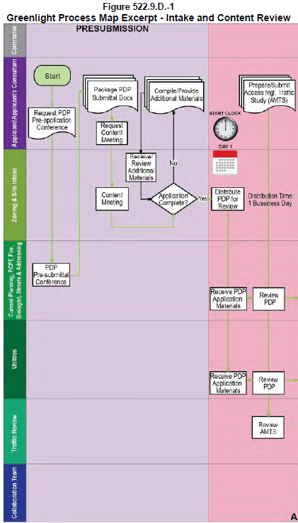
(3)
Once the PDP or PSP and accompanying application materials are distributed, Current Planning staff in the Pasco County Planning and Development Department shall have the number of days prescribed in Table 522.9.D.-1 Greenlight Process Timeframes to review the PDP or PSP and associated materials and issue an Incremental Approval, a Denial, or an ICA.
(a)
Pasco County shall approve the PDP or PSP if the County deems it consistent with the LDC. It shall be deemed consistent if all required information and documents have been prepared in accordance with professionally accepted standards, the Comprehensive Plan, Land Development Code, and all other applicable rules and regulations.
(b)
The effect of an Incremental Approval:
(i)
The applicant may rely upon the approved PDP or PSP for subsequent submittals.
(ii)
The applicant may also proceed to the next Incremental Plan in the Greenlight Process.
(iii)
The time limit on approval for a PDP or PSP shall be as indicated in this Code, Section 522.9.E. Permit Types and Applications. However, notwithstanding the approval time limit stipulated in this Code, Section 522.9.E., the applicant must submit the next Incremental Plan in the process within 180 days of approval of the PDP or PSP. If the next Incremental Plan is not submitted within 180 days, the applicant will have forfeited the ability to continue through the Greenlight Process without scheduling and attending a new preapplication consultation with Pasco County staff to update the project's status.
(c)
If the County Administrator or designee determines a PDP or PSP to be deficient, but further determines that reasonable assurance has been provided by the applicant such that it can be deemed sufficient subject to compliance with Specific Conditions of reasonable number and scope, then an ICA with Specific Conditions shall be issued. If an ICA is issued, the applicant shall address all Specific Conditions with the next Incremental Plan review.
(i)
The applicant shall make any changes to the PDP or PSP as may be required to address Specific Conditions of the ICA. In addition, any Specific Conditions of the ICA that affect the next Incremental Plan (Mass Grading or Utility Construction Plans, as applicable) shall be addressed in the next Incremental Plan.
(ii)
The applicant shall submit the revised PDP or PSP addressing the Specific Conditions of the ICA to Pasco County simultaneously with the next Incremental Plan. Pasco County shall have the number of days prescribed in Table 522.9.D.-1 Greenlight Process Timeframes to review the revised PDP or PSP and associated materials and either issue an Incremental Approval, or request additional information. The process for review and approval of a Revised Incremental Plan (a PDP, PSP, or other incremental plan described in this Code, Subsection 522.9.D.4.b. Review Increments that has been revised to address Specific Conditions of an ICA) is described in this Code, Subsection 522.9.D.4.c. Process Detail.
(iii)
When submitting the next Incremental Plan with the revised PDP or PSP, the applicant and Pasco County shall follow the same content review procedures as outlined for the PDP/PSP submission in this Code, Subsection 522.9.D.4.c. Process Detail.
(iv)
The time limit on approval of a conditionally approved PDP or PSP shall be 180 days. If the applicant does not submit a revised PDP or PSP within 180 days, the ICA will expire, except that it shall remain valid as long as the applicant has made timely submission of a revised PDP or PSP and is making timely responses to Pasco County in an effort to gain final approval of the PDP or PSP. Further, the applicant must submit the next Incremental Plan in the process within 180 days of issuance of the ICA for the PDP or PSP. If the next Incremental Plan is not submitted within 180 days, the applicant will have forfeited the ability to continue through the Greenlight Process without scheduling and attending a new preapplication consultation with Pasco County staff to recap the project's status.
(d)
If the County Administrator or designee determines a PDP or PSP to be inconsistent with the Comprehensive Plan or LDC, and determines that insufficient assurance exists such that it could be deemed consistent subject to Specific Conditions of reasonable number and scope, then the application shall be denied. The applicant shall be notified in writing with citations to the applicable regulation(s) with which the application has not sufficiently complied. If a denial is issued, the applicant may seek relief under this Code, Subsection 522.9.E.5.a. Connected City Collaboration Process.
(e)
Figure 522.9.D.-2 is an excerpt from the Connected City Greenlight Process Map depicting the PSP/PDP review process.
Figure 522.9.D.-2 Greenlight Process Map Excerpt - PDP/PSP Review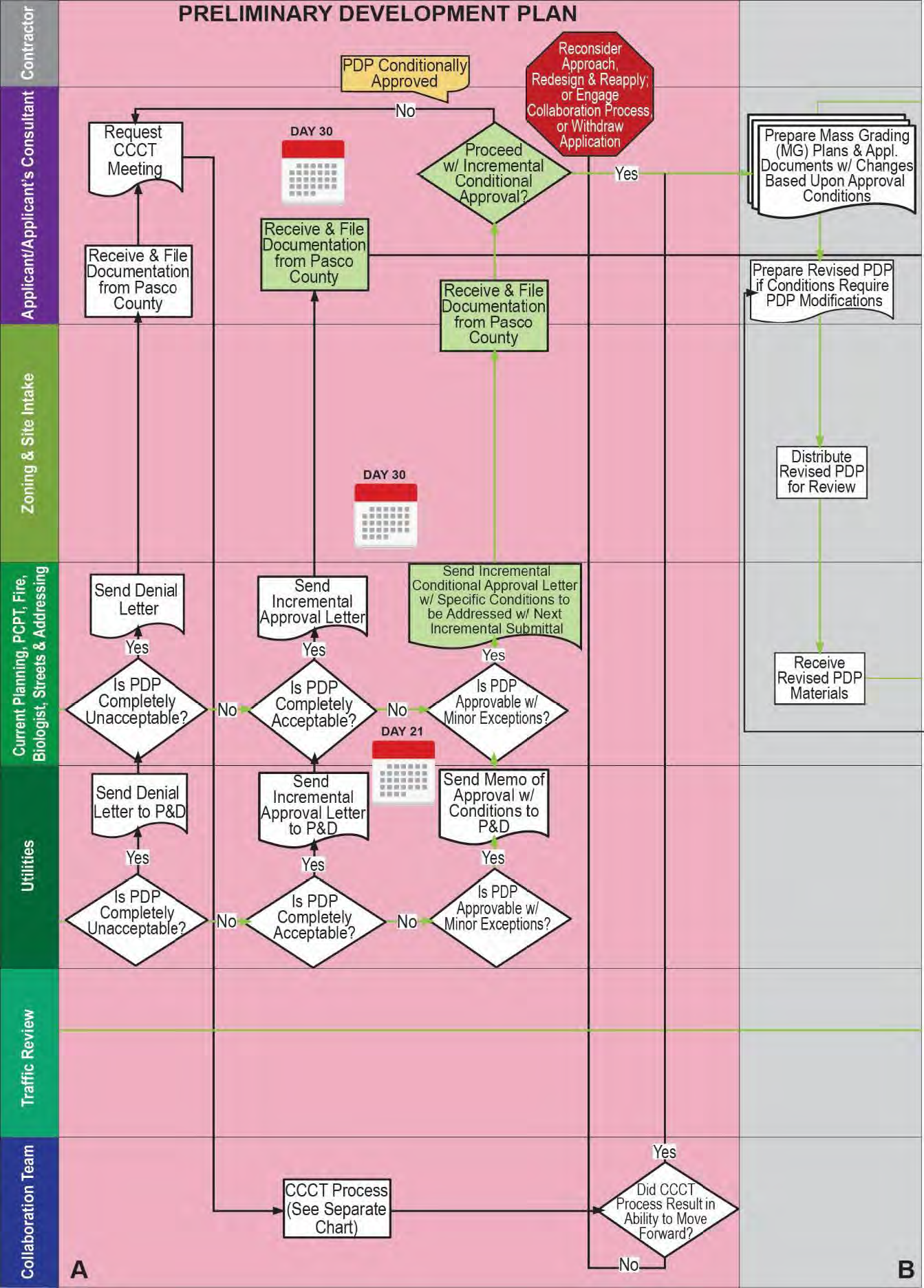
(4)
Once the next Incremental Plan in sequence (Mass Grading or Utility Construction Plan as applicable) and accompanying application materials are distributed, Current Planning staff in the Pasco County Planning and Development Department shall have the number of days prescribed in Table 522.9.D.-1 Greenlight Process Timeframes to review the incremental plan and associated materials and issue an Incremental Approval, a Denial, or an ICA.
(a)
Pasco County shall approve the Incremental Plan if the County deems it consistent with the Comprehensive Plan and LDC. It shall be deemed consistent if all required information and documents have been prepared in accordance with professionally accepted standards, the Comprehensive Plan, Connected City Land Development Code, and all other applicable rules and regulations.
(b)
The effect of an Incremental Approval:
(i)
The applicant may rely upon the approved Incremental Plan for subsequent submittals.
(ii)
The applicant may also proceed to the next Incremental Plan in the Greenlight Process.
(iii)
In addition, the applicant may proceed, at their own risk, with construction of the improvements depicted on the approved Incremental Plan.
(iv)
The approval of an Incremental Plan shall expire when its associated PDP or PSP expires. However, the expiration of the PDP or PSP notwithstanding, the applicant must submit the next Incremental Plan in the process within 180 days of approval of the current Incremental Plan. If the next Incremental Plan is not submitted within 180 days, the applicant will have forfeited the ability to continue the Greenlight Process without scheduling and attending a new preapplication consultation with Pasco County staff to update the project's status.
(c)
If the County Administrator or designee determines an Incremental Plan to be inconsistent with the Comprehensive Plan or LDC, but further determines that reasonable assurance has been provided by the applicant such that it can be deemed sufficient subject to compliance with Specific Conditions of reasonable number and scope, then an ICA with Specific Conditions shall be issued. If an ICA is issued the applicant shall address all Specific Conditions with the next Incremental Plan submittal.
(i)
The applicant shall make any changes to the current Incremental Plan as may be required to address Specific Conditions of the ICA. In addition, any Specific Conditions of the ICA that affect the next Incremental Plan (Utility Construction or Paving, Grading, and Drainage Plans, as applicable) shall be addressed in the next Incremental Plan submittal.
(ii)
The applicant shall submit the revised current Incremental Plan addressing the Specific Conditions of the ICA to Pasco County simultaneously with the next Incremental Plan. Pasco County shall have the number of days prescribed in Table 522.9.D.-1 Greenlight Process Timeframes to review the revised Incremental Plan and associated materials and either issue an Incremental Approval, or request additional information. The process for review and approval of a Revised Incremental Plan (a PDP, PSP, or other incremental plan described in Code, Subsection 522.9.D.4. Application Processing that has been revised to address Specific Conditions of an ICA) is described in this Code, Subsection 522.9.D.4.c. Process Detail.
(iii)
When submitting the next Incremental Plan with the revised current Incremental Plan, the applicant and Pasco County shall follow the same content review procedures as outlined for the PDP/PSP submission in this Code, Subsection 522.9.D.4.c. Process Detail.
(iv)
In addition, the applicant may proceed, at their own risk, with construction of the improvements depicted on the conditionally approved current Incremental Plan subject to the following:
• The applicant shall understand that proceeding with construction of the improvements depicted on the conditionally approved Incremental Plan shall be at the applicant's sole risk. If the applicant fails to satisfactorily address any of the conditions of the ICA and such failure results ultimately in the need for corrections to any constructed improvements, such corrections shall be implemented at the applicant's sole risk and expense.
• The applicant is required to execute a hold harmless affidavit in a form acceptable to the County Attorney or designee to affirm the applicant's recognition of the at-risk nature of proceeding with construction upon receipt of an ICA and to defend, indemnify and hold the County harmless for any corrections that the applicant might be required to make as a result of so proceeding; or for any damages, costs or claims arising from the decision to commence construction with the ICA.
(v)
The time limit on approval for a conditionally approved Incremental Plan shall be 180 days. If the applicant does not submit a revised Incremental Plan within 180 days, the ICA will expire, except that it shall remain valid as long as the applicant has made a timely submission of a revised Incremental Plan and is making timely responses to Pasco County in an effort to gain final approval of the Incremental Plan in question. Further, the applicant must submit the next Incremental Plan in the process within 180 days of issuance of the ICA for the current Incremental Plan. If the next Incremental Plan is not submitted within 180 days, the applicant will have forfeited the ability to continue through the Greenlight Process without scheduling and attending a new preapplication consultation with Pasco County staff to update the project's status. Once the Incremental Plan gains final approval status, it shall expire when its associated PDP or PSP expires.
(d)
If the County Administrator or designee determines an Incremental Plan to be inconsistent with the Comprehensive Plan or LDC, and determines that insufficient assurance exists such that it could be approved subject to Specific Conditions of reasonable number and scope, then the application shall be denied. The applicant shall be notified in writing with citations to the applicable regulation(s) with which the application has not sufficiently complied. If a denial is issued, the applicant may seek relief under the Collaboration Process described in this Code, Subsection 522.9.E.5.a. Connected City Collaboration Process.
(5)
Each Incremental Plan submission and review shall follow the same procedures outlined in this Code, Subsection 522.9.D.4.c. Process Detail.
(6)
After all Incremental Plans are approved, the applicant shall compile them into a single final submission that demonstrates that all conditions of each ICA have been addressed. Once the final submission is satisfactory, Pasco County shall issue a Final Approval Memorandum confirming that the project has been approved in its entirety and that all ICA Specific Conditions have been satisfactorily addressed.
(7)
Figure 522.9.D-3 is an excerpt from the Connected City Greenlight Process Map depicting the Incremental Plan review process for the Mass Grading Construction Plan increment.
Figure 522.9.D.-3 Greenlight Process Map Excerpt - Mass Grading Construction Plan
Review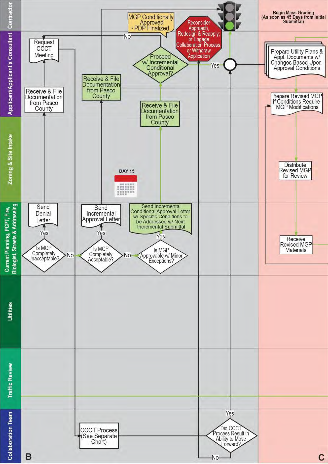
(8)
Revised Incremental Plan Processing. When any Incremental Plan described in this Code, Subsection 522.9.D.4.b. Review Increments is revised by the applicant and resubmitted to address Specific Conditions of an ICA, the following procedures shall be followed.
(a)
The applicant shall submit the Revised Incremental Plan at the same face-to-face Content Review Consultation as the next Incremental Plan in sequence.
(b)
The County shall have one business day after the Content Review Consultation to distribute the Revised Incremental Plan to applicable departments/entities as so deemed at staff's discretion.
(c)
Pasco County shall have the number of days prescribed in Table 522.9.D.-1 Greenlight Process Timeframes to review the Revised Incremental Plan and associated supporting materials and either issue an Incremental Approval, or request additional information.
(d)
The County shall approve the Revised Incremental Plan if the County deems it consistent with the Comprehensive Plan and LDC. It shall be deemed consistent if all required information and documents have been prepared in accordance with professionally accepted standards, the Comprehensive Plan, Connected City Land Development Code, and all other applicable rules and regulations. The County Administrator or designee is authorized to take into consideration and request from an applicant any other information which is reasonable and relevant to the formulation of a decision on the matter being reviewed. No Incremental Plan shall be deemed consistent until all required information relevant to that increment of development is provided.
(e)
If the County determines an Incremental Plan to be inconsistent, the applicant shall be notified in writing with citations to the applicable regulation(s) and a specific request made for additional information that is required to continue or conclude review. An applicant has the number of days prescribed in Table 522.9.D.-1 Greenlight Process Timeframes from the date of written notification of deficiency to provide all the requested information. Response by the applicant to additional rounds of comments must be made within the timeframes outlined in Table 522.9.D.-1 Greenlight Process Timeframes. The development approval application shall be deemed withdrawn unless the applicant responds, within the allotted timeframe, in one of the following ways:
(i)
The applicant provides all the information requested.
(ii)
The applicant requests in writing that the application be processed in its present form. In this case, the applicant acknowledges that the application has been determined to be inconsistent and that the final determination on the application shall be based on the information submitted, and the applicant waives the right to supplement the application with additional information. The application shall then be processed in its present form. Where an applicant has requested processing pursuant to this subsection, action shall be taken on the application within 14 days.
(iii)
The applicant requests, in writing, an extension of time to provide all the requested information. An extension of time may be granted by the County Administrator or designee. For each application, any and all extensions of time shall not exceed 180 days.
(f)
If after the third submission of a Revised Incremental Plan the County still determines an Incremental Plan to be inconsistent, the application shall be denied. The applicant shall be notified in writing with citations to the applicable regulation(s) with which the application has not sufficiently complied. The applicant may seek relief under the Collaboration Process described in this Code, Subsection 522.9.E.5.a. Connected City Collaboration Process.
(9)
Timelines for Site Plan Actions.
(a)
Refer to Table 522.9.D.-1 Greenlight Process Timeframes or timeframes for the Greenlight Process.
(b)
Note that all times are expressed in calendar days (not including holidays that occur during the work week) except intake/distribution times, which are expressed in business days in case plans are received on the day before a weekend or holiday.
(10)
Greenlight Process Map - The Greenlight Process Map in its entirety is presented as an illustrative reference on the pages that follow. It is arranged in successive 8-½-inch by 11-inch panels that are designated as A through E. These pages may be arranged together in alphabetical order for a complete picture of the Greenlight Process. In the event of any conflict between the Greenlight Process Map and Section 522.9.D Greenlight Procedures, Section 522.9.D shall govern.
TABLE 522.9.D.-1
GREENLIGHT PROCESS TIMEFRAMES
(1)
Note that all times are expressed in calendar days (not including holidays that occur during the work week) except intake/distribution times, which are expressed in business days.
(2)
Note that, for an initial PDP/PSP submission, the content feedback will occur during the face-to-face Content Review Consultation.
(3)
This refers to the review of any Incremental Plan that is submitted to address the Specific Conditions of an Incremental Conditional Approval (ICA).
(4)
No content completeness times are stated for Utility Construction Plans because the Pasco County Utilities Services Branch has no procedures for completeness review.
GREENLIGHT PROCESS PANELS A-B
GREENLIGHT PROCESS PANELS B-C
GREENLIGHT PROCESS PANELS C-D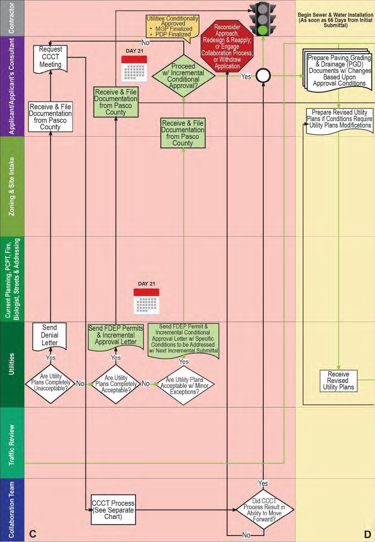
GREENLIGHT PROCESS PANELS D-E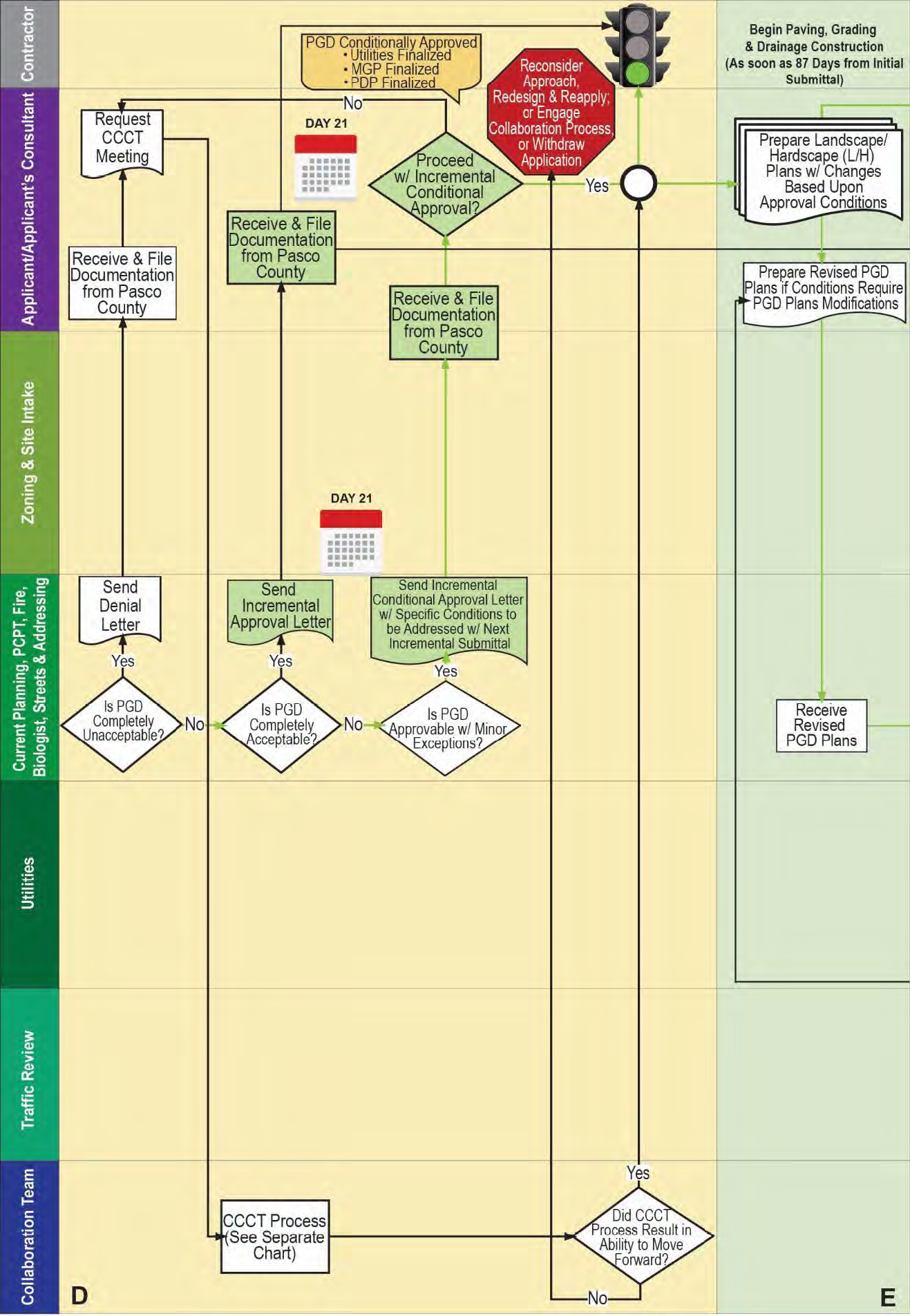
GREENLIGHT PROCESS PANEL E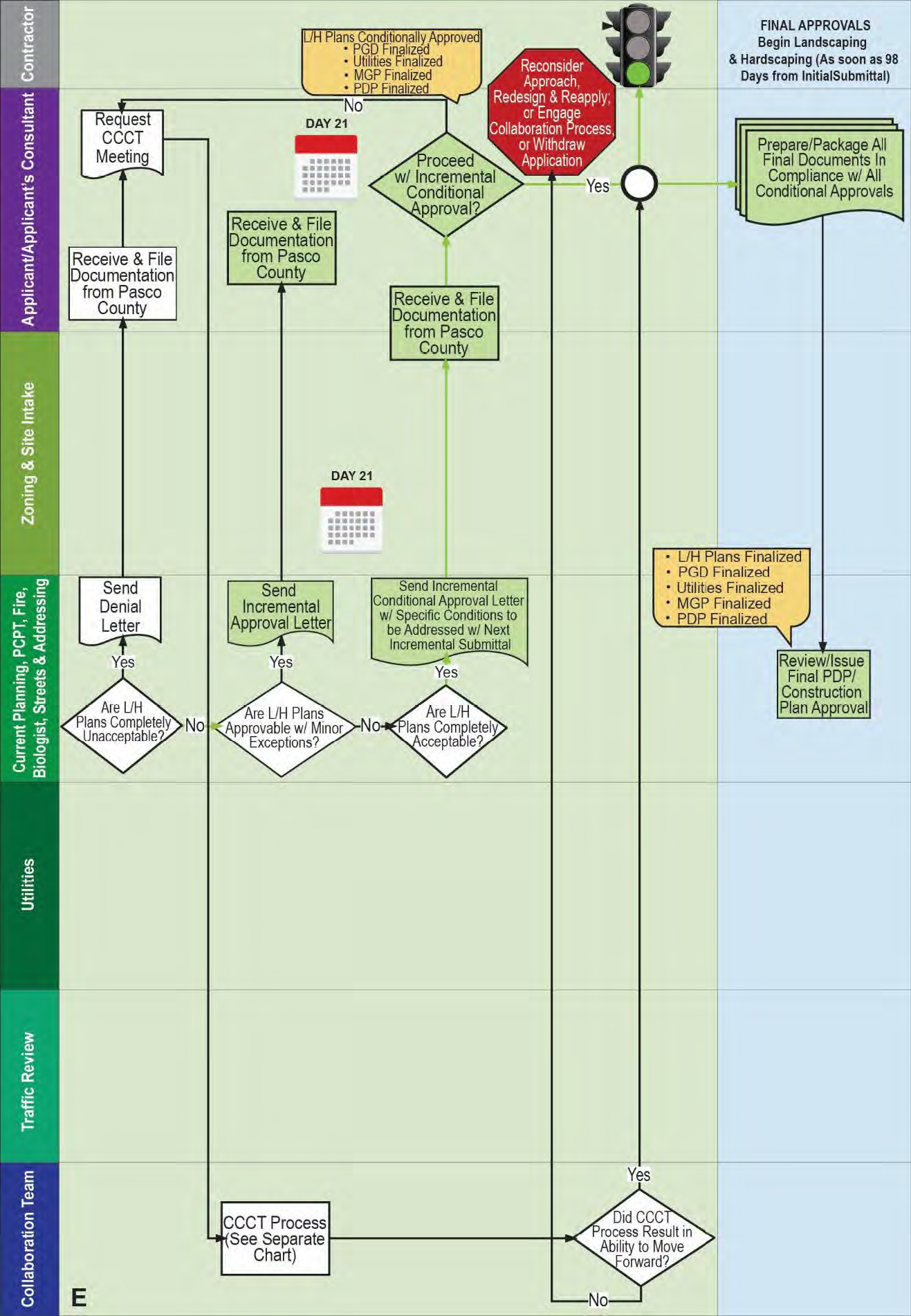
5.
Neighborhood Notice.
a.
Intent and Purpose. The intent and purpose of a neighborhood notice is to provide an opportunity for early citizen participation in conjunction with development approval applications. The neighborhood notice shall be provided at least 21 calendar days prior to the issuance of an ICA that authorizes construction (Mass Grading Plan, Utility Construction Plan, or Paving, Grading, and Drainage Plan). Neighborhood notice may be provided prior to application submittal. If an applicant fails to provide the neighborhood notice, the County shall not issue any ICA for the development that authorizes construction until the applicant provides the neighborhood notice and 21 calendar days have elapsed. A neighborhood notice is mandatory for the following development applications:
(1)
PSPs
(2)
PDPs (Residential or Nonresidential)
b.
General Requirements.
(1)
A neighborhood notice shall be provided by the applicant by mail and posting in accordance with the mailing and posting requirements below:
(a)
Timing. Neighborhood Notice is required at least 21 calendar days prior to the issuance of any ICA that authorizes construction (Mass Grading Plan, Utility Construction Plan, or Paving, Grading and Drainage Plan).
(b)
Mailed. The applicant shall provide notification by mail to those who own property, including entities such as homeowners' associations, local governments, and the District School Board of Pasco County, within 500 feet of the property lines of the land for which the final determination is sought. In addition, the notice shall also be mailed to neighborhood organizations registered with the County whose members reside within 1,000 feet of the property lines of the land for which the final determination is sought, regardless of whether such organizations own property within such distance. Names and addresses of property owners shall be deemed those appearing on the latest ad valorem tax rolls of Pasco County. For property that is a part of or adjacent to a condominium or manufactured home community, individual owners shall be noticed if located within 500 feet of the project, and for property that is a common tract, appropriate notice shall only need to be sent to the association. The County Administrator or designee may require additional notice to other property owners and neighborhood organizations based upon project design and potential impacts. Where the proposal is internal to a CC-MPUD, the public notice shall be from the boundary line of the proposed internal change, unless the applicant owns all the property to be noticed, then the public notice shall be sent to all property owners within 500 feet which might include properties internal and external to the CC-MPUD. The County Administrator or designee may require additional notice to other property owners and neighborhood organizations based upon project design and potential impacts.
(c)
Sign. A sign purchased through the County shall be erected on the property, providing notice in such a manner as to allow the public to view the same from one or more streets. In the case of landlocked property, the sign shall be erected on the nearest street right-of-way and include notation indicating the general distance and direction to the property for which the approval is sought. In all cases, the number of signs to be used shall be left to the discretion of the County Administrator or designee provided that the numbers shall be reasonably calculated to adequately inform the public of the purpose. The application shall ensure that the signs are maintained on the land until completion of the final action of the development approval application. The applicant shall ensure the removal of the signs within ten days after final action of the development approval application.
(2)
Content of the Neighborhood Notice. The neighborhood notice shall contain the following as applicable:
(a)
A general description of the project, including size and/or number of units.
(b)
Date the application was accepted for review.
(c)
Availability to view the application at the County offices where the application was filed.
(d)
Ability to provide comments directed to the County Administrator or designee.
(3)
Proof of Neighborhood Notice. The applicant shall submit a copy of the mailed neighborhood notices sent to the property owners along with the mailing list and proof of mailing to the County Administrator or designee.
E.
Permit Types and Applications.
1.
Intent and Purpose. This Code, Section 522.9.E. contains the permit types and review criteria for the development applications necessary for approval of projects within the Connected City that have undergone a rezoning amendment to Connected City Master Planned Unit Development (CC-MPUD).
2.
Section Organization. This Code, Section 522.9.E. has been organized as follows:
a.
Site Development. These are the permits necessary for land development. Permits include those which are preliminary, where the approach to meeting Pasco County development standards is outlined and the specific detailed plans authorizing construction.
b.
Miscellaneous Permits. This section contains a variety of permit types which may be required. Right-of-Way Use Permits are included in this section.
c.
Relief Applications. The final section of this chapter outlines the various methods of relief that may be available, against the strict application of this Code. These include administrative remedies as well as those requiring public hearings.
3.
Use Permits.
a.
Preliminary Development Plans (PDP-R / PDP-MU / PDP-NR)
(1)
Intent and Purpose. PDPs are used to identify applicable existing site conditions and demonstrate general conformance with the standards of this Code and applicable conditions of the CC-MPUD zoning prior to the preparation of detailed construction plans for a parcel to be subdivided for residential purposes.
While much the same information is required for a PDP-NR/MU as for Preliminary Development Plans - Residential, these projects may have individual preliminary site plans (PSPs) and construction plans prepared and approved prior to individual lot development. As such, the focus of the PDP-NR/MU is on the overall plan of development, with details of individual site development approved through PSPs. It is also recognized that there are two types of nonresidential subdivisions: common plan of development and stand-alone. As such, the required information will vary by proposed type.
(2)
Submittal Requirements. An applicant shall submit required information in the form as specified by the County Administrator or designee.
Plans shall be drawn at a readable scale, signed, and sealed by a Florida Registered Engineer. The application package shall include:
(a)
Applicant Information.
(i)
Proof of Ownership; i.e., copy of deed.
(ii)
Agent of Record Letter, if applicable.
(iii)
Application Fee.
(b)
General Information to be Shown on Plan
(i)
Pictorially show parent parcel and property division.
(ii)
A legend, title, and number of revisions; date of plan and revisions; scale of plan; north arrow; acreage in the tract being subdivided; total number of lots; and names, mailing addresses, e-mail addresses, and telephone numbers of the developer, owner, surveyor, and engineer.
(iii)
A plan, if applicable, designating each phase by number or letter and heavy line border at an appropriate scale with the size of the tract.
(c)
Map Information.
(i)
Location map showing the relationship between the areas proposed for development and surrounding developments or lots, including a current aerial photograph with the proposed development overlaid on it, which in no case shall be older than that available from the Property Appraiser's Office, with boundaries of development and roadway layout delineated. The location map shall show all Major County Roads within one mile of the proposed development.
(ii)
All existing and planned Primary and Intermediate Roadways on the Connected City Master Roadway Plan within the proposed development and within one mile of the proposed development.
(iii)
Wellhead Protection Areas and Special Protection Areas for all Community Water System supply wells within the proposed development and within 1,000 feet of the proposed development.
(d)
Existing Site Information to be Shown on Plan.
(i)
Legal description sufficient to describe the size and location of the property to be subdivided.
(ii)
Existing Streets: The name, location, right-of-way width, and pavement status; i.e., dirt, lime rock, concrete, asphalt, etc., of all existing streets, platted or recorded easements, other rights-of-way, and platted streets within 200 feet of the proposed development.
(iii)
Existing platted or recorded easements or rights-of-way for drainage, pedestrian facilities, Multipurpose Lanes, Multipurpose Paths, Multipurpose Trails, or bicycle facilities, etc., including location, width, design criteria, and purpose within 200 feet of the proposed development.
(iv)
Configuration of that portion of abutting developments within 200 feet with preliminary site plan or preliminary development plan approval, or, if platted, with Plat Book and Page number shown.
(v)
Existing storm sewers, potable water facilities, and sewerage facilities within 200 feet of the proposed development.
(vi)
Existing structures or uses on the site and a statement as to the intended future use.
(vii)
Present use of the property proposed for development.
(viii)
Future Land Use (FLU) Classification, CC-SPA Zone and zoning district of the property proposed for development and that of abutting land.
(ix)
Dates and reference numbers of most recent substantial rezonings and subsequent non-substantial rezonings, applicable special exceptions, variances, conditional uses, or vested rights that have been granted for the subject property, if applicable.
(x)
Approximate location and acreage of natural features, including lakes, marshes or swamps, watercourses, and other jurisdictional areas.
(xi)
Identify any registered cultural resources on site.
(xii)
Wetland Delineation / Identification. Provide documentation in the form of a survey, sketch, or aerial that delineates the location of the Categories I, II, or III wetland areas, as defined in the Comprehensive Plan, Conservation Element, Wetlands, Policy Nos. CON 1.3.1, CON 1.3.2, CON 1.3.3, CON 1.3.4, and CON 1.3.5, and provide the acreage for each wetland classification type.
In addition to the wetland type and acreage information, provide the following:
• Cumulative acreage total for Categories I, II, and III Wetlands.
• Acreage total for water bodies.
• Acreage total for land with FLU Classification of CON (Conservation Lands).
• Developable acreage.
(xiii)
The Base Flood Elevation, where available, and delineation of flood zone(s) shall be superimposed on the PDP in accordance with the latest Flood Insurance Rate Map published by the Federal Emergency Management Agency (FEMA) or latest study as accepted by the FEMA.
(xiv)
Density / Intensity Calculations
(e)
Proposed Development.
(i)
Identification of Subdivision Type: Each PDP-NR shall identify whether the proposed subdivision is to be a common plan of development subdivision or a stand-alone subdivision. For common plan of development subdivisions, the PDP-NR shall identify shared infrastructure and amenities, such as stormwater, parking, and landscaping.
(ii)
Proposed Circulation: The name, location, and Connected City Roadway Type and typical section for all proposed streets. Indicate if streets are proposed to be public or private. Identify nonresidential accessways where ingress/egress is proposed to be provided by easement. In common plan of development subdivisions, each individual lot is not required to have access to a street. Rather, the entire subdivision shall have access to a street, public or private. Other access may be provided internal to the subdivision through easement.
(iii)
As required by this Code, Section 903 Utilities, a statement identifying the supplier of the potable water facilities, sewerage facilities, fire service, and electric service.
(iv)
As required by this Code Section 904 Fire Protection, indicate the method of fire protection; i.e., water main size, location of hydrants, tanks, etc.
(v)
A landscape buffering plan sufficient to demonstrate the intended location, width, and type of all proposed buffers, landscaping areas, and tree replacement areas as described in this Code, Section 522.9.Q. Landscaping and Buffering.
(vi)
If residential uses are proposed, illustrate neighborhood park locations and open-space area dimensions as described in this Code, Section 522.9.P. Neighborhood Parks.
(vii)
Easements (show all existing or proposed; note if none). Proposed easements shall include required non-ingress/egress easements for double frontage lots.
(viii)
Subdivision Design:
•
Lots and Layout. Approximate lot lines, minimum lot dimensions and sizes, typical lot layout, lot numbers and design in accordance with Section 707.7, Standards.
•
Proposed model center locations.
•
Gross residential acreage densities for the entire project and net residential acreage for each phase or portion thereof. This data shall be presented in a tabular format.
(f)
Requests for variances and required fees shall be submitted with the application. As described in this Code, Subsection 522.9.E.5.d.(1) General, formal requests for alternative standards as part of the incremental approval process is not required except for alternative standards required by Subsection 522.9.E.5.d.(1).
(g)
Studies and Other Required Submittals. The following submittals may be required based on location within the County and/or development type proposed:
(i)
Listed Species Site Survey.
(ii)
Provide a narrative meeting the requirements of Section 809, Cultural Resources.
(3)
Standards of Review. The County Administrator or designee shall determine whether the application substantially meets the intended technical requirements of this Code, the CC-CPA and the CC-MPUD zoning conditions of approval sufficient for issuance of an approval or Incremental Conditional Approval. In making the determination, the County Administrator or designee shall review the PDP for the following:
(a)
Conformance with the Connected City Master Roadway Plan.
(b)
Conformance with the Connected City Conceptual Utility Plan.
(c)
Conformance with the principle of planning for redevelopment, as applicable to the site's location and configuration. At the PDP stage, this relates primarily to the proposed street configuration as it relates to the Master Roadway Plan and surrounding street network so that evolving land uses can be built around an existing grid.
(d)
Conformance of the perimeter, Primary and/or Intermediate Roadway buffering (if any) locations and widths, with the landscaping requirements of this Code, Section 522.9.Q. Landscaping and Buffering and CC-MPUD zoning, as applicable.
(e)
Conformance of the identified roadway types with those identified in the CC-MRP.
(f)
If a MUTRM project (as declared by the applicant), conformance of the street/block layout with MUTRM criteria as defined in this Code, Subsection 901.13 Mixed-Use Trip Reduction Measures.
(g)
If a TOD project (as declared by the applicant), conformance of the street/block layout and mix of uses with Comprehensive Plan Objective FLU 10.2 Transit Oriented Design.
(h)
If a TND project (as declared by the applicant), conformance of the street/block layout and development form with Land Development Code Section 601 Traditional Neighborhood Development.
(i)
Conformance of lot dimensions and setbacks with the Development Standards in the CC-MPUD zoning.
(j)
If applicable, conformance with Neighborhood Park size, location, and configuration with the standards set forth in this Code, Section 522.9.P. Neighborhood Parks or CC-MPUD zoning.
(k)
Conceptual provision for tracts, and/or easements, as appropriate, to accommodate ingress/egress, drainage, and public utilities, as applicable.
(l)
Notes indicating that future Incremental Plans will address, as a minimum, provision of utilities, fire protection, erosion and turbidity control, wetland conservation and protection, and protection of listed species in accordance with applicable rules and standards.
(4)
Form of Decision. Incremental Approval, Denial, or Incremental Conditional Approval of a PDP shall be in writing. The written approval may include conditions as necessary to ensure compliance with this Code. Refer to this Code, Section 522.9.D. Greenlight Process Procedures for an explanation of these forms of decision.
(5)
Effect of Approval. Refer to this Code, Section 522.9.D. Greenlight Process Procedures.
(6)
Time Limit of Approval. Except where project development schedules are established for Developments of Regional Impact and Florida Quality Developments, the following time limits on approvals shall apply:
(a)
Final plan approval (all Incremental Plan approvals and Final Approval) must be received for the entire PDP within six years of PDP approval.
(b)
The project must be completely platted within ten years of PDP approval.
(c)
In the event that the developer does not comply with these provisions, all plans for the uncompleted portion of the project shall be deemed void.
(d)
An applicant may request a one year extension. Such extension may be granted by the County Administrator or Designee upon showing of good cause. Within six months of expiration of the initial one year extension, the County Administrator or Designee may grant an additional one year extension, upon demonstration by the applicant that:
(i)
The proposed development remains consistent with the Comprehensive Plan;
(ii)
There has been no substantial change in the applicable Sections of this Code;
(iii)
There is a hardship; and
(iv)
The extension will not adversely impact the public health and safety.
If the applicant demonstrates compliance with the foregoing criteria, the PC may grant up to two total, two year extensions beyond the initial two one-year extensions, totaling no more than six years from the initial PDP expiration.
Any extension granted by the State of Florida shall not be required to comply with the foregoing extension criteria, but shall run concurrently with any extension granted by the County and PC.
(e)
In the event a PDP expires, all subsequent submittals shall comply with regulations in effect at the time of the said submittals.
(7)
Simultaneous Submittals. Simultaneous submittals are prohibited for those projects within the Connected City Stewardship District for which a CC-MPUD has been adopted. Refer to this Code, Section 522.9.D. Greenlight Process Procedures for a description of the incremental review and approval process.
(8)
Prohibitions.
(a)
Development of land shall not be commenced in the Connected City Stewardship District by any person, unless an Incremental Approval or Incremental Conditional Approval authorizing such development has been obtained from the County and the procedures established in this Code, Section 522.9.D. Greenlight Process Procedures have been followed by the person requesting development approval.
(b)
No person shall commence, authorize, allow, or complete any development which does not conform to or abide by the terms and conditions of an Incremental Approval or Incremental Conditional Approval and to the requirements of this Code.
(c)
It shall be unlawful for anyone who is the owner of any land or agent of the owner to transfer or convey such land by reference to, exhibition of, or other use of a site plan or a plat of a subdivision of such land, without having submitted the required site plans, plans, and plat of such subdivision and received approval in accordance with this Code, and without having recorded the approved subdivision plat, unless platting is not required.
(d)
Development approved for use at a specific density or intensity shall not be used in a manner inconsistent with that approval, without an appropriate amended Site Development Permit.
b.
Preliminary Site Plans (PSP).
(1)
Intent and Purpose. PSPs are used to identify applicable existing site conditions and demonstrate general conformance with the standards of this Code and applicable conditions of the CC-MPUD zoning prior to the preparation of detailed incremental construction plans for an individual development site.
PSPs are required for all nonresidential and multiple family developments. PSPs are also used for other development activity that is not a subdivision or development requiring an operating permit.
(2)
Submittal Requirements. An applicant shall submit required information in the form as specified by the County Administrator or designee. In circumstances where a PSP is submitted where a Preliminary Development Plan (PDP) has been approved, modifications to the submittal requirements shall be made to eliminate the need for providing duplicative information. This determination will be based on the level of detail provided with the PDP and subsequent submissions and approvals.
Plans shall be drawn at a readable scale, signed, and sealed by a Florida Registered Engineer. The application package shall include:
(a)
Application Information.
(i)
Proof of Ownership; i.e., copy of deed.
(ii)
Agent of Record Letter, if applicable.
(iii)
Application fee.
(b)
General Information to be Shown on Plan.
(i)
Pictorially show parcel.
(ii)
A legend, title, and number of revisions; date of preliminary site plan and revisions; scale of plan; north arrow; acreage in the parcel; and names, mailing addresses, e-mail addresses, and telephone numbers of the developer, owner, surveyor, and engineer.
(iii)
Phasing plan, if applicable, designating each phase by number or letter and heavy line border at an appropriate scale.
(c)
Map Information.
(i)
Location map showing the relationship between the site proposed for development and surrounding developments or lots, including a current aerial photograph with the project overlaid on it, which in no case shall be older than that available from the Property Appraiser's Office, with boundaries of development and roadway layout delineated. The location map shall show all major County Roads within one mile of the development boundary.
(ii)
All existing and planned Primary and Intermediate Roadways on the Connected City Master Roadway Plan within the proposed development and within one mile of the proposed development.
(iii)
Wellhead Protection Areas and Special Protection Areas for all Community Water System supply wells within the proposed development and within 1,000 feet of the proposed development.
(d)
Existing Site Information to be Shown on Plan.
(i)
Legal description sufficient to describe the size and location of the parcel.
(ii)
Existing Streets: The name, location, right-of-way width, and pavement status; i.e., dirt, lime rock, concrete, asphalt, etc., of all existing streets, platted or recorded easements, other rights-of-way, and platted streets within 200 feet of the proposed development.
(iii)
Existing platted or recorded easements or rights-of-way for drainage, pedestrian facilities, Multipurpose Lanes, Multipurpose Paths, Multipurpose Trails, or bicycle facilities, etc., including location, width, design criteria, and purpose within 200 feet of the proposed development.
(iv)
Configuration of that portion of abutting developments within 200 feet with PSP approval, preliminary plan or, if platted, with Plat Book and Page number shown.
(v)
Existing storm sewers, potable water facilities, and sewerage facilities on or abutting the tract within 200 feet.
(vi)
Other existing structures or uses on site and a statement as to the intended future use.
(vii)
Present use of the property proposed for development.
(viii)
Future Land Use (FLU) Classification, CC-SPA Zone and zoning district of the property proposed for development and that of abutting land.
(ix)
Dates and reference numbers of most recent substantial rezonings and subsequent nonsubstantial rezonings, applicable special exceptions, variances, conditional uses, vested rights, or PDP that have been granted for the subject property, if applicable.
(x)
Approximate location and acreage of natural features, including lakes, marshes or swamps, watercourses, and other jurisdictional areas.
(xi)
Identify registered cultural resources on site.
(xii)
Wetland Delineation / Identification Provide documentation in the form of a survey, sketch, or aerial that delineates the location of the Categories I, II, or III wetland areas, as defined in the Comprehensive Plan, Conservation Element, Wetlands, Policy Nos. CON 1.3.1, CON 1.3.2, CON 1.3.3, CON 1.3.4, and CON 1.3.5, and provide the acreage for each wetland classification type.
In addition to the wetland type and acreage information, provide the following:
• Cumulative acreage total for Categories I, II, and III wetlands.
• Acreage total for water bodies.
• Acreage total for land with FLU Classification of CON (Conservation Lands).
• Developable acreage.
• The Base Flood Elevation, where available, and delineation of flood zone(s) shall be superimposed on the PDP in accordance with the latest Flood Insurance Rate Map published by the Federal Emergency Management Agency (FEMA) or latest study as accepted by the FEMA.
(xiii)
Density / Intensity Calculations
(e)
Proposed Development.
(i)
Proposed Streets and Circulation: The name, location, and Connected City Roadway Type and typical section for all proposed streets. Indicate if streets are proposed to be public or private.
(ii)
As required by this Code, Section 903 Utilities, provide a statement identifying the supplier of the potable water facilities, sewerage facilities, fire service, and electric service.
(iii)
As required by this Code, Section 904 Fire Protection, indicate the method of fire protection; i.e., water main size, location of hydrants, tanks, etc.
(iv)
As required by this Code, Section 522.9.P. Neighborhood Parks illustrate the neighborhood park locations and open space areas.
(v)
Easements (show all existing or proposed; note if none). Proposed easements shall include required non-ingress/egress easements for double frontage lots.
(vi)
Building Information
• Proposed building layout with all setbacks to property lines and between buildings.
• Proposed building height(s), number of floors, intended uses, and finished floor elevations.
• Proposed building size(s) in square feet, which includes all floors, mezzanines, or other similar features.
(vii)
Parking Information Pursuant to this Code, Section 522.9.R. On-Site Parking:
• Calculations showing the number of parking spaces required and a statement as to the number of parking spaces (both standard and compact) to be provided.
• Indicate type of paving surface proposed for use on site.
• Americans with Disabilities Act spaces and route, including designation of accessible building entrances.
Requests for variances and required fees shall be submitted with the application. As described in this Code, Subsection 522.9.E.5.d.(1) General, formal requests for alternative standards as part of the incremental approval process is not required except for alternative standards required by Subsection 522.9.E.5.d.(1).
(f)
Studies and Other Required Submittals. The following submittals may be required based on location within the County and/or development type proposed:
(i)
Listed Species Site Survey.
(ii)
Provide a narrative meeting the requirements of Section 809, Cultural Resources.
(iii)
Connected City Transportation Analysis Application pursuant to this Code, Section 522.9.H.
(3)
Standards of Review. The County Administrator or designee shall determine whether the application substantially meets the intent of the technical requirements of the Connected City Land
Development Code (CC-LDC), the CCCPA, and the CC-MPUD zoning conditions of approval sufficient for issuance of an approval or Incremental Conditional Approval. In making the determination, the County Administrator or designee shall review the PSP for following:
(a)
Conformance with the Connected City Master Roadway Plan.
(b)
Conformance of the site access points to the access management criteria in this Code, Section 522.9.H Transportation Analysis.
(c)
Conformance with the principle of planning for redevelopment, as applicable to the site's location and configuration. At the PSP stage, this relates primarily to the proposed street configuration as it relates to the Master Roadway Plan and surrounding street network so that evolving land uses can be built around an existing grid.
(d)
Conformance of the perimeter, Primary and/or Intermediate Roadway buffering (if any) locations and widths, with the landscaping requirements of this Code, Section 522.9.Q. Landscaping and Buffering and CC-MPUD zoning, as applicable.
(e)
If applicable, conformance of the identified roadway types with those identified in the CC-MRP.
(f)
If a MUTRM project (as declared by the applicant), conformance of the street/block layout with MUTRM criteria as defined in this Code, Subsection 901.13. Mixed-Use Trip Reduction Measures.
(g)
If a TOD project (as declared by the applicant), conformance of the street/block layout and mix of uses with Comprehensive Plan Objective FLU 10.2 Transit Oriented Design.
(h)
If a TND project (as declared by the applicant), conformance of the street/block layout and development form with Land Development Code Section 601 Traditional Neighborhood Development.
(i)
Conformance of lot dimensions and setbacks with the Development Standards in the CC-MPUD zoning.
(j)
If applicable, conformance of Neighborhood Park size, location, and configuration with the standards set forth in this Code, Section 522.9.P. Neighborhood Parks or CC-MPUD zoning, as applicable.
(k)
Conceptual provision for easements, as appropriate, to accommodate ingress/egress, drainage, and public utilities, as applicable.
(l)
Notes indicating that future Incremental Plans will address, as a minimum, provision of utilities, fire protection, erosion and turbidity control, wetland conservation and protection, and protection of listed species in accordance with applicable rules and standards.
(4)
Form of Decision. Incremental Approval, Denial or Incremental Conditional Approval of a PSP shall be in writing. The written approval may include conditions as necessary to ensure compliance with this Code. Refer to LDC this Code, Section 522.9.D. Greenlight Process Procedures, for an explanation of these forms of decision.
(5)
Effect of Approval. Refer to this Code, Section 522.9.D. Greenlight Process Procedures.
(6)
Time Limit of Approval. Except where project development schedules are established for Developments of Regional Impact and Florida Quality Developments, the following time limits on approvals shall apply:
(a)
Final plan approval (all Incremental Plan approvals and Final Approval) must be received for the entire PSP within six years of PDP approval.
(b)
The project must be completely platted within ten years of PSP approval.
(c)
In the event that the developer does not comply with these provisions, all plans for the uncompleted portion of the project shall be deemed void.
(d)
An applicant may request a one year extension. Such extension may be granted by the County Administrator or Designee upon showing of good cause. Within six months of expiration of the initial one year extension, the County Administrator or Designee may grant an additional one year extension, upon demonstration by the applicant that:
(i)
The proposed development remains consistent with the Comprehensive Plan;
(ii)
There has been no substantial change in the applicable Sections of this Code;
(iii)
There is a hardship; and
(iv)
The extension will not adversely impact the public health and safety.
If the applicant demonstrates compliance with the foregoing criteria, the PC may grant up to two total, two (2) year extensions beyond the initial two one-year extensions, totaling no more than six years from the initial PSP expiration.
Any extension granted by the State of Florida shall not be required to comply with the foregoing extension criteria, but shall run concurrently with any extension granted by the County and PC.
In the event a PSP expires, all subsequent submittals shall comply with regulations in effect at the time of the said submittals.
(7)
Prohibitions.
(a)
Development of land shall not be commenced in the Connected City Stewardship District by any person, unless an Incremental Approval or Incremental Conditional Approval authorizing such development has been obtained from the County, and the procedures established in this Code, Section 522.9.D. Greenlight Process Procedures have been followed by the person requesting development approval.
(b)
No person shall commence, authorize, allow, or complete any development which does not conform to or abide by the terms and conditions of an Incremental Approval or Incremental Conditional Approval and to the requirements of this Code.
(c)
It shall be unlawful for anyone who is the owner of any land or agent of the owner, to transfer, or convey such land by reference to, exhibition of, or other use of a site plan or a plat of a subdivision of such land, without having submitted the required site plans, plans, and plat of such subdivision and received approval in accordance with this Code, and without having recorded the approved subdivision plat, unless platting is not required.
(d)
Development approved for use at a specific density or intensity shall not be used in a manner inconsistent with that approval, without an appropriate amended PSP.
c.
Stormwater Management Plan and Report.
(1)
Intent and Purpose. The Stormwater Management Plan and Report is used to ensure that the stormwater management system will be constructed in accordance with the standards of this Code, Section 902 Stormwater. It is intended that the Stormwater Management Plan and Report will accompany the Mass Grading Incremental Plan, if the Mass Grading Plan proposes wetland impacts, floodplain encroachments or alterations to pre-development drainage patterns, and the Paving, Grading, and Drainage Incremental Plan.
(2)
Submittal Requirements.
(a)
The Stormwater Management Plan and Report shall substantially conform to the preliminary plans or preliminary site plans as approved. Stormwater Management Plans and Reports may be approved only after the preliminary plans or preliminary site plans have been incrementally approved. An applicant shall submit required information in the form and within the time as specified by the County Administrator or designee.
Plans shall be drawn at a readable scale, signed, and sealed by a Florida Registered Engineer. The application package shall include sufficient information for the County Administrator or designee to evaluate the environmental characteristics of the affected area, the potential and predicted impacts of the proposed activity on area surface waters, and the effectiveness and acceptability of those measures proposed by the applicant to reduce adverse impacts.
(b)
The Stormwater Management Plan and Report shall contain, as a minimum, the following information:
(i) The names, addresses, e-mail addresses, and telephone numbers of the applicant and the engineer.
(ii) The location map.
(iii) The predevelopment, environmental, and hydrological conditions of the site, and/or receiving waters and wetlands shall be described in detail, including the following:
• The direction, peak-flow rate, and for closed basins, the volume of predevelopment stormwater runoff.
• The locations on site where predevelopment stormwater collects or percolates into the ground.
• A description of all water courses, water bodies, and wetlands on or adjacent to the site or into which stormwater from the site flows.
• Seasonal high water table elevations.
• Location of 100-year flood plain or best available information.
• Description of vegetation on and adjacent to the site.
• Topography.
• Soils.
• Location of drainage basins and subbasins.
• Rainfall data for the appropriate design storm.
• Natural Resources Conservation Service (NRCS) curve numbers.
(iv) Proposed post development conditions of the site shall be described in detail, including:
• Areas to be filled, graded, and/or excavated.
• Areas where vegetation will be cleared or otherwise removed.
• The size and location of nonresidential buildings or other structures. The typical lot layout shall be used to compute the coefficient of runoff.
• Location of drainage basins and subbasins.
• NRCS curve numbers.
• Effect of any proposed open space irrigation systems.
(v) All components of the drainage system and any measures for the detention, retention, or infiltration of water or for the protection of water quality shall be described in detail, including:
• The direction, flow rate, and for closed basins and drainage basins of special concern, the volume of stormwater that will be conveyed from the site, if any, with a comparison to the predevelopment conditions.
• Detention and retention areas, including plans for the discharge of waters.
• Areas of the, if any, site to be used or reserved for percolation.
• A plan for the control of erosion, which describes in detail the type and location of control measures.
• Any other information which the developer or the County Administrator or designee believes is necessary for an evaluation of the Stormwater Management Plan.
(3)
Standards of Review. The County Administrator or designee shall be responsible for approving or disapproving all Stormwater Management Plans and Reports. The County Administrator or designee shall not approve any Stormwater Management Plans and Reports until the said plans and reports comply with this Code and the Comprehensive Plan.
Prior to approval or disapproval, the County Administrator or designee shall determine whether the plans:
(a)
Are consistent with this Code.
(b)
Provide design features which address the protection of the public health, safety, and welfare.
(c)
Are consistent with the Goals, Objectives, and Policies set forth in the adopted Comprehensive Plan.
(d)
Provide for necessary public improvements or facilities.
(4)
Forms of Decision. As the Stormwater Management Plan and Report are a component of the Mass Grading and/or Paving, Grading, and Drainage Incremental Plans, as applicable, the decision (Approval, Incremental Conditional Approval, or Denial) shall be rendered as part of those incremental approval processes.
d.
Mass Grading Plan.
(1)
Intent and Purpose. The purpose of the Mass Grading Plan (MGP) plan is to allow applicants to proceed with land clearing, earth moving, and stormwater management system construction in advance of gaining approval for other Incremental Plans that occur later in the land development process. The intent of the MGP plan is to provide reasonable assurance to the County Administrator or designee that the stormwater management system improvements will be constructed in accordance with the standards of this Code, Section 902 Stormwater.
(2)
Submittal Requirements. An applicant shall submit required information in the form as specified by the County Administrator or designee.
Plans shall be drawn at a readable scale, signed, and sealed by a Florida Registered Engineer. The application package shall include:
(a)
Applicant Information.
(i)
Proof of Ownership; i.e., copy of deed.
(ii)
Agent of Record Letter, if applicable.
(iii)
Application fee.
(b)
General Information to be Shown on Plan.
(i)
Pictorially show parcel.
(ii)
A legend, title, and number of revision(s); date of preliminary site plan and revision(s); scale of plan; north arrow; acreage in the parcel; and names, mailing addresses, e-mail addresses, and telephone numbers of the developer, owner, surveyor, and engineer.
(iii)
Phasing plan, if applicable, designating each phase by number or letter and heavy line border at an appropriate scale. The phasing plan shall be accompanied by a narrative addressing at a minimum:
• Maximum area or the site to be exposed at any one time;
• Provisions for the preservation of natural land and water features, vegetation, drainage, and other natural features of the site;
• Provisions for actions to be taken to create or contribute to flooding, erosion, increased turbidity, siltation, or other forms of pollution in a watercourse; and
• Provisions for installation of stabilization/vegetation of the site.
(c)
Map Information.
(i)
A location map showing the relationship between the sites proposed for development and surrounding developments or lots, including a current aerial photograph, which in no case shall be older than that available from the Property Appraiser's Office, with boundaries of development and roadway layout delineated. The location map shall show all Major County Roads within one mile of the development project.
(ii)
All existing and planned Primary and Intermediate Roadways on the Connected City Master Roadway Plan within the proposed development and within one mile of the proposed development.
(iii)
Wellhead Protection Areas and Special Protection Areas for all Community Water System supply wells within the proposed development and within 1,000 feet of the proposed development.
(d)
Existing Site Information to be Shown on Plan.
(i)
A legal description sufficient to describe the size and location of the parcel.
(ii)
Existing Streets: The name, location, right-of-way width, and pavement status; i.e., dirt, lime rock, concrete, asphalt, etc., of all existing streets, platted or recorded easements, other rights-of-way, and platted streets within 200 feet of the proposed development.
(iii)
Existing platted or recorded easements or rights-of-way for drainage, pedestrian facilities, Multipurpose Lanes, Multipurpose Paths, Multipurpose Trails, or bicycle facilities, etc., including location, width, design criteria, and purpose within 200 feet of the proposed development.
(iv)
Configuration of that portion of abutting developments within 200 feet with preliminary site plan approval, preliminary plan, or if platted, with Plat Book and Page number shown.
(v)
Existing storm sewers, potable water facilities, and sewerage facilities on or abutting the tract within 200 feet.
(vi)
Other existing structures or uses on site and a statement as to the intended future use.
(vii)
Existing contours at a maximum of two foot intervals, based on the National Geodetic Vertical Datum of 1929, identifying the tract to be developed and, where practicable, extending a minimum of 100 feet beyond the tract boundary. A note stating the basis of the vertical datum shall be shown on the drawing. After October 1, 2011, the submittal shall be based on the North American Vertical Datum of 1988.
(viii)
Present use of the property proposed for development.
(ix)
Future Land Use (FLU) Classification, CC-SPA Zone and Zoning District of the Parcel Proposed for Development and that of Abutting Land
(x)
Dates and reference numbers of most recent substantial rezonings and subsequent non-substantial rezonings, applicable special exceptions, variances, conditional uses, vested rights, or preliminary plans that have been granted, if applicable.
(xi)
Location and acreage of natural features, including lakes, marshes or swamps, watercourses, and other jurisdictional areas.
(xii)
Identify any historic resources on site.
(xiii)
Wetland Delineation/Identification. Provide documentation in the form of a survey, sketch, or aerial that delineates the location of the Categories I, II, or III wetland areas, as defined in the Comprehensive Plan, Chapter 3, Conservation Element, Wetlands, Policy Nos. 1.3.1, 1.3.2, 1.3.3, 1.3.4, and 1.3.5, and provide the acreage for each wetland classification type.
(xiv)
The Base Flood Elevation, where available, and delineation of flood zone(s) shall be superimposed on the preliminary plan in accordance with the latest Flood Insurance Rate Map published by the Federal Emergency Management Agency (FEMA) or latest study as accepted by the FEMA. All development proposals greater than five acres shall include within such proposals Base Flood Elevation data.
(xv)
Tree data chart (identification by species and size) of existing and removed trees sufficient to enable evaluation of impacts.
(xvi)
The predevelopment, environmental, and hydrological conditions of the site and/or receiving waters and wetlands shall be described in detail, including the following:
• The direction; peak-flow rate; and for closed basins, the volume of predevelopment stormwater runoff.
• The location of areas on the site where predevelopment stormwater collects or percolates into the ground.
• A description of all water courses, water bodies, and wetlands on or adjacent to the site or into which stormwater flows.
• Seasonal high water table elevations.
• Location of 100-year flood plain or best available information.
• Description of vegetation.
• Topography.
• Soils.
• Location of drainage basins and subbasins.
• Rainfall data for the appropriate design storm.
• Natural Resources Conservation Service (NRCS) curve numbers.
(e)
Proposed Development.
(i)
Proposed post-development conditions of the site shall be described in detail, including:
• Areas to be filled, graded, and/or excavated.
• Areas where vegetation will be cleared or otherwise removed.
• The size and location of nonresidential buildings or other structures. The typical lot layout shall be used to compute the coefficient of runoff.
• Location of drainage basins and subbasins.
• NRCS curve numbers.
• Effect of any proposed open space irrigation systems.
(ii)
All components of the drainage system and any measures for the detention, retention, or infiltration of water or for the protection of water quality shall be described in detail in the accompanying Stormwater Management Plan and Report (refer to this Code, Subsection 522.9.E.3.c.), including:
• The direction; flow rate; and for closed basins and drainage basins of special concern, the volume of stormwater that will be conveyed from the site, if any, with a comparison to the predevelopment conditions.
• Detention and retention areas, including plans for the discharge of waters.
• Areas of the site, if any, to be used or reserved for percolation.
• A plan for the control of erosion, which describes in detail the type and location of control measures.
• Any other information which the developer or the County Administrator or designee believes is reasonably necessary for an evaluation of the stormwater management plan.
(iii)
Easements (show all existing or proposed; note if none).
Requests for variances and required fees shall be submitted with the application. As described in this Code, Subsection 522.9.E.5.d.(1) General, formal requests for alternative standards as part of the incremental approval process is not required except for alternative standards required by Subsection 522.9.E.5.d.(1).
(f)
Studies and Other Required Submittals. The following submittals may be required based on location within the County and/or development type proposed:
(i)
Listed Species Site Survey. If the site is shown on Maps 3-1 in the Comprehensive Plan, as a location for known listed species habitat.
(ii)
A narrative meeting the requirements of Section 809, Cultural Resources.
(3)
Standards for Approval. The County Administrator or designee shall not approve any mass grading plans unless the said plans and reports meet the technical requirements of this Code and are consistent with the Comprehensive Plan.
Nothing contained herein shall be construed to require Pasco County to duplicate the function of any State or Federal agency, including but not limited to the Southwest Florida Water Management District (SWFWMD) or the Army Corps of Engineers (COE).
(4)
Form of Decision. The Incremental Approval, Denial or Incremental Conditional Approval shall be made in writing. The written incremental approval may include conditions as necessary to ensure compliance with this Code. Refer to LDC this Code, Section 522.9.D. Greenlight Process Procedures, for an explanation of these forms of decision.
(5)
Effect of Approval. Refer to this Code, Section 522.9.D. Greenlight Process Procedures.
(6)
Time Limit of Approval. Except where project development schedules are established for Developments of Regional Impact and Florida Quality Developments, the following time limits on approvals shall apply:
(a)
Once a Mass Grading Incremental Plan has gained final approval status as described in this Code. Section 522.9. D. Greenlight Process Procedures, it shall expire when its associated preliminary site plan or preliminary development plan expires.
However, the expiration of the underlying PDP or PSP notwithstanding, a conditionally approved Mass Grading Plan shall expire in 180 days if the applicant has not submitted a revised Incremental Plan within that time period. If the applicant has made timely submission of a revised Incremental Plan for mass grading and is making timely responses to Pasco County in an effort to gain final approval of the Mass Grading Plan, it shall remain valid. Refer to this Code, Section 522.9.D. Greenlight Process Procedures, for a description of the process for submitting Revised Incremental Plans and gaining final approval for incremental plans.
(b)
For a Mass Grading Plan that has gained final approval, the applicant may request an extension by following the procedures for extending its underlying PDP or PSP as set forth in this Code, Subsection 522.9.E.3.a.(6) and 522.9.E.3.b.(6), respectively, Time Limit of Approval.
e.
Utility Construction Plans.
(1)
Intent and Purpose. The purpose of the Utility Construction Plan is to allow applicants to proceed with water distribution system, wastewater collection/transmission system, and reclaimed water distribution system construction (primarily gravity sanitary sewer systems) in advance of gaining approval for other development increments that occur later in the land development process. The intent of the utility plan is to provide reasonable assurance to the Assistant County Administrator for Utilities, or designee, that water distribution systems, wastewater collection/transmission systems, and reclaimed water distribution systems will be constructed in conformance with the Pasco County Standards for Design and Construction of Water, Wastewater, and Reclaimed Water Facilities Specifications, latest edition, and all applicable permitting criteria of the Florida Department of Environmental Protection (FDEP).
(2)
Submittal Requirements. Prior to installing improvements, the developer shall submit Utility Construction Plans and FDEP applications to the Pasco County Utilities Services Branch. All sheets shall be signed and sealed by a Florida registered engineer. An applicant shall submit the required information on the form as specified by the County Administrator or designee.
The Utility Construction Plans for any portion of a proposed development shall substantially conform to the preliminary development plans or preliminary site plans, as approved.
Utility Construction Plans shall, at a minimum, conform to the following requirements:
(a)
The construction plans shall be drawn to a scale of 1:50' or larger (or other scale, if approved by the Assistant County Administrator for Utilities or designee) and shall be submitted with the engineering specifications for the following improvements:
(i)
Water: Existing and proposed water supply and/or distribution system.
(ii)
Sanitary sewerage system: Horizontal and vertical alignments, shall be shown graphically, in plan and profile views, of existing and proposed sanitary sewage collection and/or treatment system.
(iii)
Reclaimed water system: Existing and proposed reclaimed water supply and/or distribution system.
(iv)
Pedestrian, bicycle, and neighborhood vehicle facilities, including Multipurpose Lanes, Multipurpose Paths and Multipurpose Trails, where applicable.
(v)
Parks, where applicable.
(vi)
Existing contours at maximum two foot intervals and proposed lot grades.
(vii)
Easements, existing and proposed.
(viii)
The plans shall certify that the utility system is in substantial conformance with Pasco County Standards for Design and Construction of Water, Wastewater, and Reclaimed Water Facilities Specifications, latest edition, and all applicable permitting criteria of the Florida Department of Environmental Protection (FDEP).
(ix)
Fire protection system.
(x)
Any other items required by the Assistant County Administrator for Utilities or designee that are necessary for review prior to a final decision of the Utility Construction Plans and FDEP Permits for the subject development.
(xi)
Geotechnical/geological engineering report meeting the requirements of this Code, Section 807 Soils and Geotechnical Hazards for manholes exceeding 12 feet in depth and all pumping station wet wells.
(xii)
Erosion and Sedimentation Control Plan.
(b)
When deemed necessary, the County Administrator or designee may require the submission of engineering calculations in support of any of the proposed construction plans and specifications submitted under this Code.
(3)
Standards of Approval. The Assistant County Administrator for Utilities or designee shall not approve any Utility Construction Plans and associated FDEP permits unless the said plans, specifications, or proposed alternative standard meets the technical requirements of this Code and FDEP rule criteria are consistent with the Comprehensive Plan and substantially conform to the preliminary development plans or preliminary site plans.
Utility Construction Plans may be approved only after the preliminary development plans or preliminary site plans have been incrementally approved.
(4)
Form of Decision. Incremental Approval, Denial or Incremental Conditional Approval of a Utility Construction Plan shall be made in writing. The written approval may include conditions as necessary to ensure compliance with this Code. Refer to LDC this Code, Section 522.9.D. Greenlight Process Procedures for an explanation of these forms of decision.
(5)
Effect of Approval. Refer to this Code, Section 522.9.D. Greenlight Process Procedures.
(6)
Consideration of Adjacent Development. Prior to construction of any development where the construction plans were designed and engineered based on the proposed construction of an abutting development, the developer shall provide one of the following to the County Administrator or designee:
(a)
A statement that the site has been reviewed and the construction plan, as approved, needs no modifications to accommodate the existing field conditions.
(b)
Revised construction plans to accommodate the existing field conditions.
(7)
Simultaneous Submissions. Simultaneous submittals are prohibited for those projects within the Connected City Stewardship District for which a CC-MPUD has been adopted. Refer to this Code, Section 522.9.D. Greenlight Process Procedures for a description of the incremental review and approval process.
(8)
Time Limit of Approval. Except where project development schedules are established for Developments of Regional Impact and Florida Quality Developments, the following time limits on approvals shall apply:
Once a Utility Construction Incremental Plan has gained final approval status as described in this Code, Section 522.9.D. Greenlight Process Procedures, it shall expire when its associated preliminary site plan or preliminary development plan expires. However, the Florida Department of Environmental Protection (FDEP) Water Distribution System and Wastewater Collection/Transmission System Permits issued by the Pasco County Utilities Services Branch shall expire one year after their issuance. These permits shall be reapplied for, inclusive of all applicable state forms and fees, if the applicant wishes to construct these systems after the original permit's expiration.
However, the expiration of the FDEP Permits and the underlying PDP or PSP notwithstanding, a conditionally approved Utility Construction Plan shall expire in 180 days if the applicant has not submitted a revised Incremental Plan within that time period. If the applicant has madetimely submission of a revised Incremental Plan for utilities and is making timely responses to Pasco County in an effort to gain final approval of the Utility Construction Plan, it shall remain valid. Refer to this Code, Section 522.9.D. Greenlight Process Procedures, for a description of the process for submitting Revised Incremental Plans and gaining final approval for incremental plans.
f.
Paving, Grading, and Drainage Plans.
(1)
Intent and Purpose. The purpose of the Paving, Grading, and Drainage Plan (PGD) is to allow applicants to proceed with construction of streets, storm sewer systems, and final grading after installation of deep gravity sanitary sewer systems and before gaining final approval for all development increments. The intent of the PGD plan is to provide reasonable assurance to the County Administrator or designee that the stormwater management system improvements will be constructed in accordance with the standards of this Code, Section 902 Stormwater and that streets will be constructed in accordance with the standards of the CC-MRP.
(2)
Submittal Requirements. Prior to installing improvements (other than those authorized under previous Incremental Plans) the developer shall submit Paving, Grading, and Drainage Plans. All sheets shall be signed and sealed by a Florida registered engineer. An applicant shall submit the required information on the form as specified by the County Administrator or designee.
The Paving, Grading and Drainage Plans for any portion of a proposed development shall substantially conform to the preliminary development plans or preliminary site plans and simultaneously submitted Stormwater Management Plan and Report.
Paving, Grading, and Drainage Plans shall, at a minimum, conform to the following requirements:
(a)
The construction plans shall be drawn to a scale of 1:50' or larger (or other scale, if approved by the County Administrator or designee) and shall be submitted with the engineering specifications for the following improvements:
(i)
Water: Existing and proposed water supply and/or distribution system so that potential conflicts between the water system and the storm sewer system can be reviewed.
(ii)
Sanitary sewerage system: Horizontal and vertical alignments, shall be shown graphically, in plan and profile view, of existing and proposed sanitary sewage collection system so that potential conflicts between the sanitary sewerage system and the storm sewer system can be reviewed.
(iii)
Reclaimed Water: Existing and proposed reclaimed water supply and/or distribution system so that potential conflicts between the reclaimed water system and the storm sewer system can be reviewed.
(iv)
Drainage facilities, showing horizontal and vertical alignments, shall be shown graphically, in the plan profile, of both natural and man-made systems; i.e., storm sewer systems and retention/detention ponds. The cover sheet of the construction plan shall provide a statement indicating whether the drainage plan provided was based on the existing field conditions of the abutting property or was based on the proposed development design of the abutting property.
(v)
Streets and Circulation: Proposed design speed, vertical and horizontal alignment, pavement cross section, structural components, design calculations, and, where applicable, proposed street names pursuant to this Code, Section 522.9.J. Street Design and Dedication Requirements. In addition, when alleys are proposed, applicant shall provide plan sheets or exhibits with vehicle/wheel tracking diagrams sufficient to demonstrate that the alleys are passable for fire trucks. Applicant shall contact the Pasco County Fire Rescue Department to confirm the appropriate vehicle specifications for the vehicle/wheel tracking diagram.
(vi)
Flood zone delineation, base flood elevation, when available, and the Federal Emergency Management Agency's current Florida Insurance Rate Map Panel Reference.
(vii)
Pedestrian, bicycle, and neighborhood vehicle facilities, including Multipurpose Lanes, Multipurpose Paths and Multipurpose Trails, where applicable.
(viii)
Parks, where applicable.
(ix)
Existing contours at maximum two foot intervals and proposed lot grades.
(x)
Easements, existing and proposed.
(xi)
Traffic control device plan showing all required signs and pavement markings and informational signs; i.e., street signs.
(xii)
The plans shall certify that the roadway system is in substantial conformance with the Manual of Uniform Minimum Standards for Design, Construction, and Maintenance of Streets and Highways, State of Florida, in effect at the time the plans are prepared.
(xiii)
Fire protection system.
(xiv)
For subdivisions, a plan showing lot lines, minimum lot sizes, lot numbers and phasing, designating each phase by number or letter with a heavy line border and a lot type typical showing minimum lot sizes, at a scale appropriate with the size of the tract.
(xv)
Any other items required by the County Administrator or designee that are necessary for review prior to a final decision of the construction plans for the subject development.
(xvi)
Geotechnical/geological engineering report meeting the requirements of this Code, Section 807 Soils and Geotechnical Hazards.
(xvii)
Erosion and Sedimentation Control Plan.
(b)
When deemed necessary, the County Administrator or designee may require the submission of engineering calculations in support of any of the proposed construction plans and specifications submitted under this Code.
(3)
Standards for Approval. The County Administrator or designee shall not approve any construction plans unless the said plans, specifications, or proposed alternative standard meets the technical requirements of this Code are consistent with the Comprehensive Plan and substantially conform to the preliminary development plans or preliminary site plans.
Construction plans may be approved only after the preliminary development plans or preliminary site plans and the Stormwater Management Plan and Report have been incrementally approved.
(4)
Form of Decision. Incremental Approval, Denial or Incremental Conditional Approval of a Paving, Grading, and Drainage Plan shall be made in writing. The written approval may include conditions as necessary to ensure compliance with this Code. Refer to this Code, Section 522.9.D. Greenlight Process Procedures for an explanation of these forms of decision.
(5)
Effect of Approval. Refer to this Code, Section 522.9.D. Greenlight Process Procedures.
(6)
Consideration of Adjacent Development. Prior to construction of any development where the construction plans were designed and engineered based on the proposed construction of an abutting development, the developer shall provide one of the following to the County Administrator or designee:
(a)
A statement that the site has been reviewed and the construction plan, as approved, needs no modifications to accommodate the existing field conditions.
(b)
Revised construction plans to accommodate the existing field conditions.
(7)
Simultaneous Submissions. Simultaneous submittals are prohibited for those projects within the Connected City Stewardship District for which a CC-MPUD has been adopted. Refer to this Code, Section 522.9.D. Greenlight Process Procedures for a description of the incremental review and approval process.
(8)
Time Limit on Approval. Except where project development schedules are established for Developments of Regional Impact and Florida Quality Developments, the following time limits on approvals shall apply:
(a)
Once a Paving, Grading, and Drainage Incremental Plan has gained final approval status as described in this Code, Section 522.9.D. Greenlight Process Procedures, it shall expire when its associated preliminary site plan or preliminary development plan expires.
However, the expiration of the underlying PDP or PSP notwithstanding, a conditionally approved Paving, Grading, and Drainage Plan shall expire in 180 days if the applicant has not submitted a revised Incremental Plan within that time period. If the applicant has made timely submission of a revised Incremental Plan for paving, grading, and drainage and is making timely responses to Pasco County in an effort to gain final approval of the Paving, Grading, and Drainage Plan, it shall remain valid. Refer to this Code, Section 522.9.D. Greenlight Process Procedures, for a description of the process for submitting Revised Incremental Plans and gaining final approval for incremental plans.
(b)
For a Paving, Grading, and Drainage Plan that has gained final approval, the applicant may request an extension by following the procedures for extending its underlying PDP or PSP as set forth in this Code, Section 522.9.E. Permit Types and Applications.
g.
Landscaping and Hardscaping Plans.
(1)
Intent and Purpose. The purpose of this plan is to address tree removal and replacement, buffering, and other required landscaping, and hardscaping, including but not limited to supplemental sidewalks, plazas, courtyards, etc., and structures such as benches, shade structures, pavilions, etc. Addressing these elements last, mirrors the construction process and allows applicants to proceed with earlier increments of construction prior to approval of landscaping and hardscaping plans. Further, addressing these elements at the end of the development process should reduce the need for landscaping plan modifications that often occur when landscaping design is completed at the beginning of the process. The intent of the plans is to provide reasonable assurance to the County Administrator or designee that the Tree Protection requirements in this Code, Section 802 Tree Preservation and Replacement and Section 522.9.Q. Landscaping and Buffering are met.
(2)
Submittal Requirements. All sheets shall be signed and sealed by a Florida registered Landscape Architect. An applicant shall submit the required information on the form as specified by the County Administrator or designee.
The Landscaping and Hardscaping Plans for any portion of a proposed development shall substantially conform to the preliminary development plans or preliminary site plans and all previously approved Incremental Plans.
Landscaping and Hardscaping Plans shall, at a minimum include the following:
(a)
The plans shall be drawn to a scale of 1:50' or larger (or other scale, if approved by the County Administrator or designee) and shall be submitted with applicable notes and specifications for the following improvements:
(i)
Trees: Existing trees to remain and trees that existed in the pre-developed condition and were removed to facilitate development shall be shown. Trees (including street trees per other provisions of the LDC) proposed as replacements for removed trees and to meet other requirements of this Code shall be shown.
(ii)
Shrubs and Ground Covers: Shrubs and ground covers proposed to meet buffering and other requirements of this Code shall be shown.
(iii)
Provide tables to list and summarize all plant materials and to provide calculations demonstrating compliance with all LDC criteria, including, but not limited to, tree replacements, lot trees, species diversity requirements, etc.
(iv)
Minimum Code-Required Landscaping and Elective Enhancements: Where the applicant proposes elective landscaping enhancements that exceed the requirements of this Code, such enhanced landscaping shall be shown and identified on the plans in a manner clearly distinguishable from landscaping intended to meet minimum Code requirements. If enhanced landscaping is not distinguished from minimum Code-required landscaping, the applicant shall be required to install all landscaping as shown on the plans, as the Pasco County Engineering Inspections Division will have no means to distinguish between required and elective landscaping.
(v)
Hardscaping Elements: Supplemental sidewalks, plazas, courtyards, etc., and structures such as benches, shade structures, pavilions, etc. shall be shown. Where structures are proposed, dimensions shall be provided to indicate their location relative to rights-of-way, easements, drainage features, and other site features deemed by the County Administrator or designee as significant and relevant to the review of the Landscaping and Hardscaping Plans.
(3)
Standards for Approval. The County Administrator or designee shall determine whether the application substantially meets the intent of the technical requirements of the Connected City Land Development Code (CC-LDC), the CC-CPA, and the CC-MPUD zoning conditions of approval sufficient for issuance of an approval or Incremental Conditional Approval. In making the determination, the County Administrator or designee shall review the Landscaping and Hardscaping Plans for the following:
(a)
Substantial conformance of site layout/configuration with the approved PDP or PSP, as appropriate, and the approved or conditionally approved PGD, as appropriate.
(b)
Substantial conformance of all buffers, tree replacement areas, vehicular use planting areas, or other required planting zones with the approved PDP or PSP. If there are substantial deviations, they shall be identified, and the narrative submitted with the Landscaping/Hardscaping Plan shall provide an explanation and justification for the deviations.
(c)
Compliance with applicable Specific Conditions, if any, of the PGD, if conditionally approved.
(d)
Depiction of the location, number, and species of all proposed planting materials.
(e)
Identification of all landscape areas by type/purpose (e.g., roadway buffer, perimeter buffer, vehicular use area landscaping, building perimeter landscaping, tree replacement area, etc.).
(f)
Provision of tables to list and summarize all plant materials and to provide calculations demonstrating compliance with all LDC criteria, including, but not limited to, tree replacements, lot trees, species diversity requirements, etc.
(g)
Provision of specifications, notes, and details for installation of plant materials, including language regarding the provision of an acceptable maintenance entity other than Pasco County.
(h)
Provision of hardscape depictions in plan view, including dimensions as necessary to determine the location of all hardscape elements relative to rights-of-way and easements.
(4)
Form of Decision. Incremental Approval, Denial or Incremental Conditional Approval of a Landscaping and Hardscaping Plan shall be made in writing. The written approval may include conditions as necessary to ensure compliance with this Code. Refer to this Code, Section 522.9.D. Greenlight Process Procedures for an explanation of these forms of decision.
(5)
Effect of Approval. Refer to this Code, Section 522.9.D. Greenlight Process Procedures.
(6)
Simultaneous Submissions. Simultaneous submittals are prohibited for those projects within the Connected City Stewardship District for which a CC-MPUD has been adopted. Refer to Section 522.9.D. Greenlight Process Procedures for a description of the incremental review and approval process.
(7)
Time Limit on Approval. Except where project development schedules are established for Developments of Regional Impact and Florida Quality Developments, the following time limits on approvals shall apply:
(a)
Once a Landscaping and Hardscaping Incremental Plan has gained final approval status as described in this Code, Section 522.9.D. Greenlight Process Procedures," it shall expire when its associated preliminary site plan or preliminary development plan expires.
(b)
However, the expiration of the underlying PDP or PSP notwithstanding, a conditionally approved Landscaping and Hardscaping Plan shall expire in 180 days if the applicant has not submitted a revised Incremental Plan within that time period. If the applicant has made timely submission of a revised Incremental Plan for landscaping and hardscaping and is making timely responses to Pasco County in an effort to gain final approval of the Landscaping and Hardscaping Plan, it shall remain valid. Refer to this Code, Section 522.9.D. Greenlight Process Procedures, for a description of the process for submitting Revised Incremental Plans and gaining final approval for incremental plans.
(c)
For a Landscaping and Hardscaping Plan that has gained final approval, the applicant may request an extension by following the procedures for extending its underlying PDP or PSP as set forth in this Code, Section 522.9.E. Permit Types and Applications.
(d)
In the event that the developer does not comply with these provisions, all plans for the project shall be deemed void.
h.
Modifications to Development Approvals.
(1)
Substantial Modifications. Unless otherwise approved by the County Administrator or designee, all substantial modification requests shall be submitted and processed as an amendment in the same manner as the original approval. A modification shall be considered substantial when:
(a)
The modification consists of a ten percent cumulative change in density or intensity (square footage).
(b)
The modification would require additional review or compliance based on other sections of this Code, the Comprehensive Plan, State or Federal law, and/or conditions that were previously imposed on the development.
(c)
The modification has the potential to be contrary to the public health or safety.
(2)
Nonsubstantial Modifications. Nonsubstantial Modifications Applications shall consist of a narrative describing the proposed changes, as well as plans depicting the proposed changes. Nonsubstantial modifications are not subject to subsequent amendments of this Code after adoption of the original approval.
(3)
Modifications Requiring a Public Hearing. The following modifications shall require a public hearing:
(a)
Modifications requiring a variance. Modifications to a condition of approval specifically imposed by the BCC or PC (where applicable).
(b)
Modifications, including alternative standards that were specifically denied by the PC. These modifications shall be approved, approved with conditions, or denied by the PC or Board of County Commissioners (BCC), as applicable, utilizing the applicable procedures and standards as set forth in this Code.
(4)
Mistake of Law. If the mistake of law by the County results in a previously approved development, or portion thereof, to not be adequately reviewed for compliance, the development shall be subject to additional review for compliance with those regulations, as amended, that were not applied due to the mistake of law.
(5)
Incremental Modifications. Modifications of any type (substantial or nonsubstantial) in the Connected City Stewardship District shall be made to all Incremental Plans affected by the modification except for the Mass Grading Plan which is superseded by the Paving, Grading, and Drainage Plans.
4.
Miscellaneous Permits.
a.
Right-of-Way Use Permit. The Right-of-Way Use Permit in the Connected City Stewardship District shall in all respects have the same characteristics (Intent and Purpose, Applicability, Exemptions, Application Requirements, Etc.) as all Rights-of-Way Use Permits in unincorporated Pasco County as addressed in this Code, Section 406.5, except that, in the Connected City Stewardship District, Right-Of-Way Use Permits for water lines, sanitary sewer lines, reclaimed water lines, landscaping and irrigation, and access management improvements including, but not limited to driveways, roadway connections including turnouts and flares, left- and right-turn lane queue storage and deceleration lanes, tapers, etc., and all other development-related features proposed in County right-of-way that are integral to any of the Incremental Plans being processed as part of the Project, shall be processed simultaneously with the Paving Grading, and Drainage Plan or Landscaping and Hardscaping Plan, as applicable. The applicant shall not be required to wait for approval of all Incremental Plans before development-related Right-of-Way Use Permits are processed. All application and other requirements for the Right-of-way Use Permit shall be as addressed in Section 406.5 of this Code.
For any improvements not directly related to the Incremental Plans for a project, such as dry/soft utility installations (electric, telephone, cable, gas, etc.) and any "after-the-fact" improvements, such as stand-alone landscaping and irrigation installed apart from an Incremental Approval process, Section 406.5 shall be followed.
5.
Relief Procedures. All projects required to use the Connected City Greenlight Process described in this Code, Section 522.9.D. Greenlight Process Procedures are eligible to seek relief through the Connected City Collaboration Process during the process of review of any Incremental Plan, including Preliminary Development Plans, Preliminary Site Plans, Mass Grading Plans, Utility Construction Plans, Paving, Grading, and Drainage Plans, and Landscaping and Hardscaping Plans. The Collaboration Process is intended to be an informal process wherein the applicant and County staff, represented by the Connected City Collaboration Team (CCCT), can collaborate to seek resolution in the case of Incremental Plan denials or disagreements over Incremental Conditional Approval Specific Conditions.
a.
Connected City Collaboration Process. The Collaboration Process is designed to be initiated by the applicant. Circumstances under which an applicant in the Greenlight Process may choose to initiate the Collaboration Process are as follows:
(1)
Circumstances Triggering Collaboration Process.
(a)
The applicant receives a denial of any of the Incremental Plans in the Greenlight Process.
(b)
The applicant receives an Incremental Conditional Approval that is subject to conditions that the applicant finds unfavorable.
(2)
Collaboration Process for Incremental Conditional Approval.
(a)
Upon receipt of an Incremental Conditional Approval (ICA) written notification, applicant shall have seven days to file a written request with the County Administrator or designee to meet with the CCCT. If the applicant fails to timely file a written request to meet with the CCCT, the applicant's opportunity to use the Collaboration Process shall be foreclosed and the standard appeal process in this Code, Subsection 522.9.E.5.b. Appeals shall become the next available opportunity to seek relief, and the applicant would be subject to the timelines prescribed therein.
(b)
The CCCT shall have ten days to hold the CCCT meeting with the applicant (or applicant's agents/consultants) to discuss the Specific Conditions that the applicant finds problematic.
(c)
During the CCCT meeting the applicant and CCCT shall discuss the facts of the project in a collaborative manner in an effort to arrive one of the following conclusions:
(i)
Applicant determines the Specific Condition(s) to be acceptable as written and agrees that the Specific Condition(s) will be properly addressed with the next Incremental Plan application and with a Revised Incremental Plan submission.
(ii)
The CCCT determines the Specific Condition(s) is able to be modified and it is revised to reflect the results of the discussion held at the CCCT meeting.
• The CCCT issues a modified ICA within three days with language adjusted as agreed at the CCCT meeting.
• Applicant accepts the revised ICA conditions and proceeds with the remainder of the Greenlight Process as outlined in this Code, Section 522.9.D. Greenlight Process Procedures.
(iii)
The CCCT determines that the Specific Condition(s) in question is appropriate and that it cannot consider deleting or revising the Specific Condition(s) and the applicant determines that it cannot resolve the Specific Condition(s) with the next Incremental Plan to be submitted. If this circumstance occurs, the applicant may:
• Withdraw the application, change the project approach, or redesign the project in whole or in part in an effort to cure the situation giving rise to the unresolvable Specific Condition(s), and submit a new application.
• File an appeal with the PC in accordance with the procedures of this Code, Subsection 522.9.E.5.b. Appeals.
(3)
Collaboration Process for Incremental Plan Denials.
(a)
Upon receipt of a denial written notification, the applicant shall have seven days to file a written request with the County Administrator or designee to meet with the CCCT. If the applicant fails to timely file a written request to meet with the CCCT, the applicant's opportunity to use the Collaboration Process shall be foreclosed and the standard appeal process in this Code, Subsection 522.9.E.5.b. Appeals shall become the next available opportunity to seek relief, and the applicant would be subject to the timelines prescribed therein.
(b)
The CCCT shall have ten days to hold the CCCT meeting with the applicant (or applicant's agents/consultants) to discuss the reasons for issuing a denial.
(c)
During the CCCT meeting the applicant and CCCT shall discuss the facts of the project in a collaborative manner in an effort to arrive one of the following conclusions:
(i)
Applicant agrees to change the project approach, or redesign the project in whole or in part to address the reasons for denial as stated in the written denial notification and file a new application.
(ii)
The CCCT determines that the reasons for denial stated in the written denial notification can be modified and transformed into Specific Conditions of approval and that the denial can be withdrawn and replaced with an ICA.
• The CCCT withdraws the denial and issues an ICA within three days with Specific Conditions agreed at the CCCT meeting.
• Applicant accepts the ICA conditions and proceeds with the remainder of the Greenlight Process as outlined in this Code, Section 522.9.D. Greenlight Process Procedures.
(iii)
Applicant does not agree to redesign the project and submit a new application, and CCCT does not agree to withdraw the denial and replace it with an ICA. If this circumstance occurs, the applicant may file an appeal with the PC in accordance with the procedures of this Code, Subsection 522.9.E.5.b. Appeals.
b.
Appeals.
(1)
General. The authority granted by this section shall be limited to final determinations made by the PC, and other administrative officials empowered to implement or interpret this Code. A determination shall not be considered final and appealable pursuant to this section unless:
(a)
A land development regulation specifically states that the determination is appealable in accordance with this section;
(b)
The determination is in writing and uses the phrase final determination or otherwise states that the determination is appealable pursuant to this section; or
(c)
The determination is a written policy or interpretation of general applicability that is considered final upon approval by the PC or upon final publication by the administrative official empowered to render such policy or interpretation.
(2)
The Appeal Provision in this section shall not apply to:
(a)
County court citations, warnings, or judgments issued pursuant to the process outlined in Section 125.69, Florida Statutes; Chapter 162, Part II, Florida Statutes; and/or Chapter 1 of the Pasco County Code of Ordinances; or
(b)
Provisions of this Code, the Code of Ordinances, or other resolutions or regulations of the Board of County Commissioners (BCC) for which different appeal procedures are provided in such provisions or by State law.
(3)
Process. Table 522.9.E.-1 provides for the appeal body and timeframe in which appeals must be filed.
TABLE 522.9.E.-1
*Applications for Appeals of PC Action have 60 days to be made complete. All other Applications for Appeals must be complete within 30 days.
Failure to submit an appeal application and fee within 30 days of the rendering of the decision to be appealed or to complete the appeal application within the required time period (30 or 60 days as applicable from the rendering of the decision to be appealed) shall foreclose the right to initiate the administrative appeal. Additionally failure to submit a completed application for appeal shall foreclose the right to initiate the administrative appeal. Each appeal application shall be accompanied by a separate application fee and treated as a separate appeal application, provided; however, the County Administrator or designee may consolidate related appeal applications for agenda, notice, and public hearing purposes.
(4)
Appeal Application. An appeal shall be initiated by the aggrieved person by filing an application and the required fee. A complete appeal application shall consist of the following:
(a)
Statement of the final determination and date of the same that is the subject of the appeal.
(b)
Copy of the final determination being appealed.
(c)
For appeals from the PC, a verbatim transcript of the meeting in which the matter being appealed was conducted. The verbatim transcript shall consist of the complete discussion of the PC meeting for the matter being appealed. The verbatim transcript produced by the Pasco County Clerk and Comptroller is acceptable.
(d)
Statement of the relief requested.
(e)
Justification for the relief requested, including citations to the specific portions of the verbatim transcript, exhibits, this Code, and/or Comprehensive Plan provisions relevant to the relief requested.
(5)
Hearing Procedures. An action on the appeal application, which may include conducting the public hearing, remand, or continuance of the matter being appealed, shall occur within 90 days of the filing of the complete appeal application, unless an appellant who is also the development approval applicant requests an extension of such time period. Public notice of the hearing shall be provided in accordance with this Code, Section 304.2 Public Notice. Sign Permit appeal hearings shall be held within the timeframe provided in this Code, Section 406.1.2. Authorization for Signs.
(6)
Standards of Review.
(a)
Appeals of Decisions of Administrative Officials. The BCC or PC, as applicable, shall conduct a de novo hearing on appeals and may adopt, modify, condition, or reverse both factual findings, legal conclusions, and conditions relating to the matter being appealed or remand the matter to the County Administrator or designee for reconsideration based on direction from the BCC or PC, as applicable. Notwithstanding the foregoing, the BCC, or PC, as applicable, may remand any appeal filed pursuant to this Section to the County Administrator or designee without conducting a public hearing.
(b)
Appeals of Final Determinations of the PC. In considering appeals of final actions of the PC, the BCC shall base its decision on facts in the record of the PC public hearing, as applicable, and shall not make new factual findings or base its decision on evidence or facts outside of the record. However, the BCC may base its decision on any applicable law and may adopt, modify, condition, or reverse the PC's legal conclusions and conditions including, but not limited to:
(i)
Conclusions and conditions relating to consistency with this Code, the Comprehensive Plan, and County approvals and development orders;
(ii)
Conclusions and conditions relating to the application of this Code, the Comprehensive Plan, and County approvals and development orders to the record evidence and facts;
(iii)
Reweighing the record evidence to evaluate consistency with this Code, the Comprehensive Plan, and County approvals and development orders; and/or
(iv)
Interpretations of this Code, the Comprehensive Plan, or County approvals and development orders.
The BCC may also remand that the matter being appealed to the PC, receive additional evidence, make additional factual findings, or reconsider the matter based on direction from the PC.
(7)
Final Determination of Appeals. The final determination pertaining to an appeal shall be rendered within 30 days of the close of the appeal hearing. Final determinations granting or remanding an appeal may be rendered in writing or by motion and may, if rendered in writing, include findings of fact, findings or conclusions of law, conditions of approval, and action taken. Final determinations denying an appeal shall be rendered in writing, including citations to any applicable ordinance, rule, statute, or other legal authority for the denial.
A final determination shall be deemed rendered after it is reduced to writing and signed by the Chairman, Vice-Chairman, or acting Chairman of the BCC or PC, as applicable, or after the adoption of a motion if no written decision is to be prepared and entered.
c.
Appeals of Final Determinations of the BCC. Any aggrieved party may appeal a final determination of the BCC to the Sixth Judicial Circuit Court of the County in accordance with the applicable Florida Rules of Procedure. An appeal shall be filed within 3 days of the decision to be appealed and shall not be a hearing de novo, but shall be limited to appellate review of the record created before the BCC in accordance with applicable law for a first tier certiorari review. For the purposes of this appeal, the record shall include:
(1)
The transcript of the BCC public hearing, along with any additional evidence accepted at the public hearing;
(2)
Where the action was an appeal, the transcript of the PC public hearing, along with any additional evidence accepted at the PC public hearing; and
(3)
Any applicable County staff reports and written orders or decisions of the PC.
(4)
Administrative Res Judicata. When a decision on an appeal application has been rendered by the BCC, no new appeal may be submitted where the new appeal requests the same relief or determination, unless the applicant can demonstrate and the County Administrator or designee determines that a material change in the circumstances or conditions has occurred which could prompt a different or contrary decision. For the purposes of this Section, facts or circumstances which were known or could have been discovered through the exercise of reasonable due diligence of the applicant or his privy prior to the initial application shall not constitute a sufficient basis for claiming a change in circumstances or conditions. This provision does not address or modify the res judicata effect of the BCC decisions in subsequent State or Federal court proceedings; such effect shall be determined in accordance with applicable law.
d.
Alternative Standards.
(1)
General. Alternative standards are only required for substantial deviations from the Connected City Conceptual Utility Plan and from the following sections of this Code:
(a)
§901.1 Transportation - Corridor Spacing (BCC approval required with recommendation from PC).
(b)
§901.2 Transportation - Corridor Management (PC approval required).
(c)
§901.3 Access Management (PC approval required).
(d)
§406.1 Signs (PC approval required).
Otherwise, design creativity is encouraged. Unique designs that meet the intent and purpose of this code may be evaluated by the County Administrator or designee as part of the incremental approval process without formal alternative standards request.
(2)
Requests. Requests for alternative standards may be made in conjunction with the filing of a development application. Alternatively, an application may be filed prior to submittal of an application. In that circumstance, sufficient information shall be submitted to permit a reasoned consideration of the request. Sufficient information must be provided for the administrative official to make a determination.
(3)
Criteria. The County Administrator or designee shall consider the following criteria when reviewing an alternative standards request to deviate from the Connected City Conceptual Utility Plan. As per below, (a), (b) or (c) shall be met, and all of (d), (e), and (f) shall be met:
(a)
The alternative standard meets or exceeds the intent and purpose of the Code requirement at issue.
(b)
The alternative standard proposes new, innovative, and/or unconventional methodologies for conforming to the guiding principles, policies, and standards of the CC-CPA.
(c)
No feasible engineering or construction solutions can be applied to satisfy the regulation.
(d)
The alternative standard does not adversely affect compliance with other Code provisions, development order(s), or permit(s).
(e)
The alternative standard is not in conflict with other mandatory substantive requirements of local, State, or Federal law.
(f)
The alternative standard is consistent with the applicable provisions of the Comprehensive Plan.
(4)
Alternative Standard to Access Management. Where an access management alternative standard is requested, or where deviations from this Code, Section 901.3 Access Management are requested, the PC shall hear the request and consider the following criteria at a public hearing duly noticed pursuant to this Code, Section 304.2 Public Notice:
(a)
No feasible engineering or construction solutions can be applied to satisfy the regulation; or
(b)
The proposed alternative standard will maintain or improve collector/arterial roadway capacity and travel times without increasing the number or severity of accidents; or
(c)
Compliance with the regulation will deny reasonable access.
(5)
Alternative Standard for Signs. For alternative standard requests regarding signs, the PC shall consider the request at a public hearing duly noticed pursuant to this Code, Section 407.5 Alternative Standards.
(a)
Purpose and Intent. The purpose of this section is to provide the circumstances where alternative standards may be approved. Granting a request shall meet or exceed the intent to:
(i)
Ensure no pole signs or other prohibited sign is erected;
(ii)
Approve signs which are compatible with other nearby signs, other elements of street and site furniture, and with adjacent structures. Compatibility shall be determined by the relationships of the elements of form, proportion, scale, color, materials, surface treatment, overall sign size, and the size and style of lettering;
(iii)
Ensure the location and placement of the sign will not endanger motorists;
(iv)
Ensure the sign will not cover or blanket any prominent view of a structure or façade of historical or architectural significance;
(v)
Ensure the sign will not obstruct views of users of adjacent buildings to side yards, front yards, or to open space;
(vi)
Ensure the sign will not negatively impact the visual quality of a public open space as a public recreation facility, square, plaza, courtyard, and the like; and
(vii)
Ensure the sign's lighting will not cause hazardous or unsafe driving conditions for motorists.
(b)
Increase in Number of Monument Signs. The intent of this subsection is to provide for allowing an increase from one to two monument signs only when there is a reduction in the overall total sign area on the site. Approval of such a request shall require the PC to affirmatively determine compliance with the following criteria:
(i)
The request is consistent with the purpose and intent of this section.
(ii)
The subject parcel shall have a total combined linear frontage between 590 and 600 linear feet of frontage.
(iii)
The combined sign structure area and copy area of both proposed monument signs shall not exceed the total sign structure area and copy area as would be allowed for one monument sign on the subject parcel;
(iv)
The total allowed sign area of all other on-site signage; e.g., wall signs, awnings, etc., shall be reduced by at least 35 percent.
(c)
Increase in Height of a Monument Sign or Size of a Wall Sign. Where an alternative standard is requested to increase the height of a monument sign, or to increase the size of a wall sign, the PC shall affirmatively determine compliance with the following criteria:
(i)
The request is consistent with the purpose and intent of this section, as stated in this Code, Subsection 407.5.D.1;
(ii)
Granting the request reduces the number of signs on the parcel and/or the number of registered billboards in the unincorporated areas of Pasco County. The request must achieve one or more of the following:
• Removal of one or more unconstructed monument signs on the parcel visible from any right-of- way which the applicant otherwise would have been permitted to erect on the parcel; or
• Removal of one or more nonconforming signs on the parcel visible from any right-of-way which the applicant otherwise would have been permitted to retain on the parcel; or
• One or more registered billboards from any parcel in unincorporated Pasco County; or
• Any combination of the above.
and
(iii)
Granting the request reduces the overall sign structure area visible on the parcel from any right-of-way. The total sign structure area which applicant otherwise would have been permitted to erect or retain on the parcel must be reduced by at least 35 percent. For the purposes of calculating the allowable sign structure area in this section, the actual size of registered billboards that are proposed to be removed will be used. All other requirements of Section 406.1 of this Code, including but not limited to, copy/sign structure ratios and required architectural features, must be observed for the proposed sign;
and
(iv)
Granting the request does not result in excessive sign heights. The maximum height for a sign erected pursuant to this alternative standard may not exceed 20 feet, or 30 feet on controlled access roadways, even where a reduction in overall numbers of signs on the property and a reduction in overall sign structure area is achieved;
and
(v)
Granting the request does not result in the erection of pole signs or any other prohibited structures identified in this Code;
and
(vi)
Granting the request meets or exceeds the stated intent and purpose of:
• Section 406.1 of this Code; and
• This subsection. The specific intent and purpose of this subsection is:
◦ To allow applicants to combine monument sign height allowances (or to combine wall sign size allowances) in exchange for reducing the overall number and size of monument signs (or wall signs) which are, or may be, erected on the property; and
◦ To provide an incentive for property owners to remove nonconforming signs and registered billboards in return for increased flexibility in the height of monument signs or increased size of wall signs; and
◦ To give flexibility in height and size to allow signs that are proportionate for the property, but not to approve signs of excessive heights or heights that will be inharmonious or incompatible with its surroundings. The sign should be compatible with building heights of the existing neighborhood and should not impose a foreign or inharmonious element to an existing skyline.
(vii)
Granting the request does not require Pasco County to compensate for any signage or registered billboards proposed to be removed. The owner(s) of any sign or registered billboard, and landowner(s) where such sign or registered billboard was erected, must provide a written acknowledgement in a form approved by the County Attorney's Office that:
• The increased height/size of signage obtained through approval of an alternative standard is just compensation, and is the sole compensation owing pursuant to Section 70.20, Florida Statutes and under any other legal theory available, for any sign and/or registered billboard removed from the property, or any sign which could have been erected but was not; and
• The sign/registered billboard owner and the landowner waive any right to additional compensation under Section 70.20, Florida Statutes, or under any other legal theory available, for any sign and/or registered billboard removed from the property, or which could have been erected but was not; and
• If the sign/registered billboard owner and landowner are not the same entity requesting approval of the alternative standard, the applicant for an alternative standard must agree to defend, indemnify, and hold the County harmless for any claim for compensation by other persons, in a form approved by the County Attorney's Office.
(6)
Denial of Alternative Standards.
(a)
Any request for an alternative standard which does not meet the criteria above will be denied, and the applicant shall either:
(i)
Comply with this Code
(ii)
Appeal the denial to the BCC in accordance with Subsection 522.9.E.5.b. Appeals.
F.
Subdivision and Platting Standards.
1.
Intent and Purpose. The intent and purpose of this Section is to set forth the standards for subdividing and platting CC-Entitled Properties. It is the intent of this Code to ensure that all future developments are served adequately and economically by the County or developed with facilities and services as are necessary for the health, safety, and welfare of the residents. Except as provided in this chapter section, platting is required when a parent parcel is divided into three or more parcels or when any lot which was platted after May 1, 1974, is divided.
2.
General. A subdivision shall not be approved unless the County finds after full consideration of all pertinent data, that the proposed subdivision conforms to all the provisions of this Code and the Comprehensive Plan. These requirements apply to the three types of subdivision plat approvals which are:
a.
Residential Subdivisions.
b.
Nonresidential and Mixed Use Subdivisions, which are those subdivisions not designed for fee-simple residential development, or which contain a mix of uses that might include a mix of fee simple and/or non-fee simple residential and non-residential uses. There are two categories of nonresidential subdivisions:
(1)
Common Plan of Development, those subdivisions where the created lots are inextricably linked through shared infrastructure such as parking, access and landscaping. The most common form of these subdivisions are shopping centers with outparcels.
(2)
Stand Alone, those subdivisions where the created lots are generally developed independently. A common form of these subdivisions are commerce parks.
3.
Exemptions. Refer to this Code, Section 700.3. Exemptions.
4.
Conformance with County Policy. The subdivision and development within any subdivision shall be consistent with the Pasco County Comprehensive Plan, all applicable provisions of this Code, and all adopted water supply, waste disposal, street lighting, and other essential utilities plans.
5.
Use of Natural Features. The arrangement of lots and blocks and the street system on CC-Entitled Properties within the Connected City should make the most advantageous use of the land form such that a compact, dense form of development is achieved where appropriate in accordance with the Connected City Land Development Code (CC-LDC).
6.
Standards. The design of subdivisions as reflected on incremental Preliminary Development Plans and subsequently submitted and incrementally approved Incremental Plans, shall be consistent with the standards adopted in the CC-MPUD zoning amendment for the subdivision.
a.
Lots and Blocks. Lots shall be consistent with the standards adopted in the approved CC-MPUD. Lots proposed for industrial or commercial purposes shall be adequate to provide off-street parking, loading, and service facilities, with recognition given to any mixed use parking reductions allowed in the CC-SPA and any cross-parking agreements with adjacent or nearby projects.
b.
Corner Lots. Corner lots shall be sized to meet setback requirements set forth in the CC-MPUD development standards.
c.
Access. The subdivision shall be so designed that remnants and landlocked areas shall not be created, which do not have access by right-of-way or easement. No lot shall be created without sufficient legal access. All subdivisions shall have access to a street, public or private, including alleys, where appropriate.
d.
Lot Lines. In subdivisions which overlap municipal, County, tax district boundaries, or other district boundaries, lot lines shall follow the boundary lines, unless specifically approved otherwise at the time of preliminary development plan approval.
e.
Double-Frontage Lots. Double frontage lots shall be approved in the CC-SPA where appropriate to facilitate a form of development that encourages fronts of buildings to face Primary, Intermediate, or Local Roads with alley access in the rear of the buildings.
f.
Block Lengths. Where practicable, the length of blocks should not exceed 1,760 feet, unless specifically approved otherwise at the time of preliminary development plan approval. Where an applicant elects to develop in accordance with MUTRM, TND, or TOD standards, the maximum block dimensions shall be dictated by those standards.
g.
Streets. All streets shall be constructed in accordance with this Code, Section 522.9.H. Street Design and Dedication Requirements.
h.
Pedestrian, Bicycle and Neighborhood Vehicle Facilities. Provisions for public pedestrian, bicycle and neighborhood vehicle traffic shall be incorporated into the subdivision design in accordance with this Code, Sections 522.9.K., Pedestrian Facilities, 522.9.I Bicycle Facilities, and 522.9.M. Neighborhood Vehicle Facilities.
i.
Street Names. Streets shall be named in accordance with this Code, Section 901.9, Street Naming and Addressing.
j.
Traffic Control Devices. Traffic control devices shall be provided, designed, and constructed in accordance with this Code, Section 901.10, Traffic Control Devices.
k.
Street Lighting. Street lighting shall be provided, designed, and constructed in accordance with this Code, Section 901.11, Street Lighting.
l.
Stormwater Management System. The Stormwater Management System shall be designed in accordance with the requirements of this Code, Section 902 Stormwater.
m.
Easements. The use of all easements shall be clearly shown on all plans. The minimum easement widths shall be as stated in this Code.
n.
Utilities. Utilities shall be in accordance with this Code, Section 522.9.O. Utilities.
o.
Fire Protection. Fire protection shall be provided in accordance with this Code, Section 904, Fire Protection.
p.
Neighborhood Parks. Neighborhood Parks shall be provided in accordance with this Code, Section 522.9.P. Neighborhood Parks for all subdivisions with a residential component.
q.
Landscaping and Buffering. Landscaping, and buffering shall be in accordance with this Code, Section 522.9.Q. Landscaping and Buffering. In addition, all double-frontage lots which abut a roadway functionally classified in the County Comprehensive Plan future roadway network shall be provided with a Type B buffer along the rear-lot lines.
7.
Prior to Platting. Prior to commencing the platting process, the following approvals are required:
a.
Incremental Conditional Approvals. The Preliminary Development Plan as required pursuant to this Code, Section 522.9.E.3.a. shall outline the intent of development for the proposed subdivision. The PDP shall identify the general configuration of lots and plans for public services as required.
After a PDP is conditionally approved, all other applicable Incremental Conditional Approvals must be issued, including the Mass Grading Plan (optional), the Utility Construction Plan, the Paving, Grading, and Drainage Plan, and the Landscaping and Irrigation Plan.
b.
Final Approval. As required by this Code, Section 522.9.D.4.c.(6) after all Incremental Plans are approved, the applicant shall submit a request for a Final Approval Memorandum. The plat shall be based upon the final plans that accompany the Final Approval Memorandum.
8.
Platting. Refer to this Code, Section 700.9 Platting.
9.
Prohibitions. Refer to this Code, Section 700.10 Prohibitions.
10.
Dedication. Refer to this Code, Section 700.11 Dedication.
G.
Natural Resources.
1.
General.
a.
Intent and Purpose. The purpose of this Code, Section 522.9.G. is to implement the CC-CPA Natural Resources and Conservation Policies, with the intent to promote development that supports the long-term sustainability of the County's natural resources.
b.
Applicability. Development of CC-Entitled Properties shall meet the requirements of this Code, Chapter 800 Natural & Cultural Resource Protection, Section 902 Stormwater, and Section 903 Utilities except as otherwise identified herein.
2.
Wetlands. Wetland protection shall be consistent with this Code, Section 805 Wetlands.
3.
Listed and Protected Species. Listed and protected shall be consistent with this Code, Section 803 Listed Species.
4.
Water.
a.
Conservation Techniques. Techniques that reduce water consumption will be encouraged in all CC-MPUD zoned development, in accordance with the following:
(1)
Waterstar.
(a)
New construction will be encouraged to incorporate a minimum of 25 percent of Waterstar or similar program standards, for such things as: water efficient appliances; plumbing fixtures; irrigation systems and landscapes; and best management practices in landscapes; or
(b)
Other techniques can be used in place of Waterstar that have a proven record of reducing water consumption, as demonstrated by the applicant. For example, new construction can utilize reclaimed water for toilets and irrigation to address water conservation; and
(c)
Construction should utilize Florida Friendly landscape design in accordance with this Code Section 522.9.Q. Landscaping and Buffering.
(2)
Developers that incorporate many new smart technologies that demonstrate water conservation may receive credit from the Smart Gigabit Community Infrastructure Development Fee, as defined in the CC-FP.
b.
Monitoring. New construction shall be built with meter requirements of Pasco County Utilities Department at time of application. The infrastructure shall contain meters and other necessary system hardware, network infrastructure, and the associated network management software.
5.
Energy.
a.
Conservations Techniques. Techniques that reduce energy consumption will be encouraged in all CC-MPUD zoned development, in accordance with the following:
(1)
Energystar.
(a)
Construction will be encouraged to incorporate a minimum of 25 percent of Energystar or similar standards, with the installation of energy efficient appliances, lighting fixtures, heating/cooling systems, tankless water heaters, higher overall insulation rating, and/or other energy efficient systems and construction techniques; or
(b)
Other techniques can be used in place of Energystar that have a proven record of reducing energy consumption, as demonstrated by the applicant.
(2)
Developers that incorporate new smart technologies that demonstrate energy conservation may receive credit from the Smart Gigabit Community Infrastructure Development Fee, as defined in the CC-FP.
b.
Renewable Energy. Developers that incorporate new smart technologies that demonstrate renewable energy receive credit from the Smart Gigabit Community Infrastructure Development Fee, as defined in the CC-FP.
6.
Recycling.
a.
All public use areas, such as parks, trailheads, libraries, schools, etc. shall provide recycling containers readily available for use by the public.
b.
Private development is encouraged to provide recycling containers in high-traffic areas.
H.
Transportation Analysis.
1.
Intent and Purpose. The intent and purpose of this section is to identify potential transportation needs and timing for those roadways shown on the CC-MRP, which serve the subject parcel, and are consistent with the Connected City Comprehensive Plan Policy TP 5.11. The CC-TA will be used to determine the necessary conditions of approval for a CC-MPUD zoning application to ensure consistency with the CC-CPA, the CC-MRP and the CC-FP.
2.
Applicability. CC-TA shall be required for all CC Entitled Properties seeking a new or amended rezoning, or CC Entitled Properties proposing to eliminate or delay the timing of their existing road construction obligations.
3.
Exemptions.
a.
Applications for amendments to CC Entitled Property zoning, where the increase in gross trips is less than 50 peak hour trips, AM or PM, whichever is higher.
b.
Government buildings as defined in this Code, under the Mobility Fee definitions in this Code, Appendix A.
4.
Methodology.
a.
Prior to conducting any study, determine whether the County or applicant will conduct the study.
b.
Set up a methodology meeting with the applicant or applicant's representative.
The date of the methodology meeting will be determined within one week of distribution of the application to County staff. If the County is performing the analysis, the County will prepare and submit a methodology statement for the applicant's review no later than two weeks after the methodology meeting. The purpose of the methodology statement is to establish agreed upon methodologies and assumptions prior to the start of the study and, if appropriate, to provide substantiation that the development's impacts are exempt (no net peak hour traffic impact) and further traffic study and review is not required. If the applicant chooses to perform the study, a County-approved methodology statement shall be required prior to submission of any transportation analysis. At a minimum, the following elements of the methodology, as listed below, will be specifically addressed:
(1)
Exemption assertions.
(2)
Collection of traffic counts.
(3)
Description of land uses, site location, build-out schedule, and phasing, including any interim uses generating traffic.
(4)
Study area.
(5)
Access locations.
(6)
Trip generation.
(7)
Internal capture/passerby.
(8)
Background growth procedure.
(9)
Distribution and assignment.
If the County conducts the study, unless otherwise agreed to by the County, the applicant shall be required to obtain the traffic count data. If the County agrees to obtain the traffic counts, the time to complete these counts may delay the commencement of development review time frames in this Code, Table 303-1 Timelines for Zoning Actions. In addition, if the County acquires the traffic counts, the applicant remains responsible for paying for the associated costs. Consistent with the standards set forth in this Code, Section 901.12.E.4 Trip Counts, the County may use currently available counts. If new counts are needed, the County may choose to perform the counts in-house or through a third-party consultant.
To maintain the review schedule, if the County is performing the study, the will be required to respond to the draft methodology statement within four business days. The applicant may request additional time for review, which will trigger an automatic extension of the review schedule. If the County is performing the study, the timeframe the County estimates to complete the analysis will be provided to the applicant in the methodology statement. Furthermore, if the applicant chooses not to have the County complete the analysis, the hearing timeframes provided in this Code, Section 303 Common Procedures shall be extended to permit completion of the analysis and review and comment by the County.
5.
Standards for Connected City Transportation Analysis.
a.
Trip Generation.
(1)
Institute of Transportation Engineers (ITE) Trip Generation Manual (ITE Manual). The latest version of the ITE Manual will be used to estimate project traffic and exempted trips traveling to and from the site and trips associated with existing entitlements. Other rates may be used by the County or may be used if requested by the applicant and approved by the County. Unless the applicant has requested a conditioned approval identifying use density/intensity, rates associated with the highest trip generating use permitted by the existing/proposed zoning will be applied.
(2)
Interim uses. Separate trip generation estimates for interim traffic-generating uses [1] shall also be considered.
(3)
Reasonable yield. Unless the applicant has requested a conditioned approval identifying use density/intensity, a 25 percent percent reduction factor will be applied to the maximum allowable density/intensity to determine a reasonable assumption of trip yield from the site for both existing and proposed density/intensity. For example, a site with a proposed RES-6 (Residential - 6 du/ga) FLU Classification will be evaluated presuming a yield of 4.5 dwelling units per acre.
b.
Internal Capture. Internal capture estimates shall be based on ITE acceptable methodologies, and where the ITE data is not applicable, professional judgment. However, in no case will an overall internal capture of more than 20 percent percent be used unless a higher internal capture percentage based on verifiable documentation; e.g., field studies of comparable sites, is available. Internal capture shall include the trips associated with existing entitlements. Exempted uses are allowed in calculation of internal trip capture.
c.
Passerby Capture. The total gross external trips of the project traffic may be reduced by a passerby factor to account for the project traffic that is already traveling on the adjacent roadway. Passerby capture will not exceed 20 percent percent of site generated traffic, unless data supporting higher rates are included in the current version of the ITE Manual reference, latest mobility fee study, or are otherwise approved by the County. In no event shall the total passerby trips entering and exiting a site exceed ten percent percent of the total background (existing plus future) traffic on the adjacent roadway.
In cases where median controls limit left-in/left-out access to the site, traffic on the far side of the road can be considered in assessing the upper limit on captured trips; however, the effects of that traffic in the associated necessary U-turns and added flow at the study area/impacted transportation system, the upstream and downstream median openings or intersections, should be identified as development traffic at those locations.
The passerby capture percentage shall be computed as the number of trips entering, plus exiting the site land uses claimed as captured, divided by the number of background trips passing by the site on Major County Roads directly abutting or passing through the site. An example of this computation is provided on Figure 522.9.H.-1.
Figure 522.9.H.-1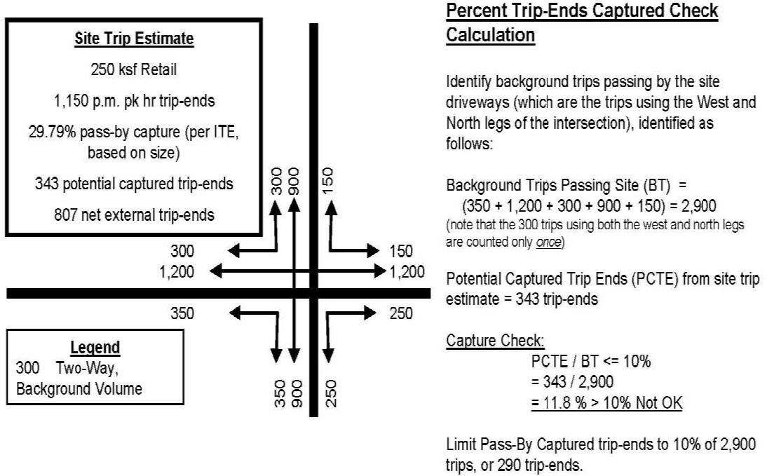
The passerby trips shall include trips associated with the existing entitlements.
d.
Trip Counts.
(1)
General. All counts shall be conducted based on acceptable engineering standards. Raw turning movement counts shall be conducted during the a.m. and/or p.m. peak hours, consistent with the analysis parameters. If daily tube counts are required, they shall be conducted for a minimum of 48 hours at all intersections and road segments that are being analyzed in accordance with these provisions, unless other monitoring measures are in place. The raw counts shall be converted to the 100th highest hour of the year based on the Florida Department of Transportation's (FDOT) peak season adjustment factors. Other peak-season adjustment factors or adjustment methodologies that may result in different peak-season adjustment factors may be used at the discretion of the County.
(2)
Saturated intersections. To estimate turning movement counts for saturated intersections, the FDOT's methodology shall be followed by multiplying the average annual daily traffic tube count at appropriate locations by the directional factor and minimum K100 factors and by applying the percentage of turns obtained from the field-turning movement counts. The field-turning movement percentages may also be adjusted based on anticipated future development patterns in the area.
(3)
Tube counts at approximate locations should be provided for segment analysis using the FDOT procedure. The segment tube counts at mid-block locations should be checked against turning movements at nearby intersections. In general, the mid-block counts and turning-movement counts should not be significantly different, unless the difference can be logically explained.
(4)
Age of counts. Approved FDOT or County-maintained counts may be used if they are less than one year old. However, new counts shall be performed if there are recent improvements to the transportation system causing significant changes in traffic patterns. Counts more than one year old shall not be used unless the latest counts are representative of present conditions where little or no growth has occurred.
e.
Background Traffic Growth / Future Traffic. The existing traffic counts shall be increased by a growth factor to the project's build-out date, which shall be reasonably determined.
Background traffic growth rates and background traffic volume estimates shall be based on a combination of the following techniques:
(1)
Historical growth rates (minimum of the past three years) shall be used in areas where the expected growth is representative of the past growth.
(2)
Consideration of traffic from other developments shall be used in areas where the historical trend is judged by the County to be inappropriate. This may be accomplished through application of the latest adopted Tampa Bay Regional Planning Model (TBRPM), the Metropolitan Planning Organization's (MPO) Urban Area Transportation System Planning Model, or by estimating the anticipated trips using the latest edition of the ITE Manual.
(3)
The growth/future traffic on roads that do not currently exist shall be based on the TBRPM, the latest adopted model, or other acceptable planning/engineering techniques or tools.
(4)
If the TBRPM is used, the background traffic growth for existing roads shall be determined as follows:
(a)
Identify the validated year model volume and build-out year (future) model volume.
(b)
Interpolate these values to identify a model-based volume for existing conditions (year to be consistent with the date of current count data).
(c)
Identify the growth rate between the interpolated existing conditions model-based volume and the build-out year (future) model volume.
(d)
Apply this growth rate to the existing conditions traffic counts.
The build-out year (future) model volume is determined by applying the project's build-out year socioeconomic data to the committed and/or improved network. The build-out year socioeconomic data may be obtained by interpolating between MPO's or the County's adopted validated year and the adopted interim or future year, socioeconomic data, then adjusting to reflect the pending and approved developments.
The socioeconomic data of the model should reasonably represent, if appropriate, other developments in the vicinity of the development under review.
Minimum annual growth rates in all cases shall be two percent, unless other reasonable rates are deemed to be more appropriate by the County.
The connections of surrounding traffic analysis zones in the model shall be reviewed to reflect other approved and pending developments and to ensure appropriate network loading.
f.
Level-of-Service (LOS) Standards. The following LOS standards shall be used:
(1)
The LOS standards for through movements on all major County road segments (facilities) shall be consistent with the standards in Policy TP 5.11 of the Connected City Comprehensive Plan.
(2)
The volume over capacity (v/c) ratio of turning movements on Major County Roads and/or Primary and Intermediate Roadways within the CC-MRP cannot exceed 1.2, with a maximum delay of 120 seconds. Delays of up to 150 seconds are acceptable for turning movements with a v/c ratio less than 0.8.
(3)
For all access driveways and local street connections to Major County Roads and/or Primary and Intermediate Roadways within the CC-MRP, approach delays of up to 150 seconds will be acceptable.
g.
Study Area / Impacted Transportation System. The following roadway segments and intersections will be assumed to be within the study area and will be analyzed.
(1)
As a general rule, the study area will consist of those portions of the Primary and Intermediate Roadways (and associated intersections) that are needed to provide access to the roadways bordering Connected City.
(2)
Roadway segments beyond those bordering Connected City boundary will not be included in the analysis.
6.
General Analysis Requirements and Software.
a.
The main focus of transportation analysis is to identify the roadways needed to serve the project, and the timing of the improvements.
b.
All analysis shall be undertaken for conditions during the 100th highest hour of the year. Other analysis periods, including the a.m. peak hour, may also be conducted, if appropriate.
c.
For uninterrupted road facilities (intersection spacing of more than two miles), the capacity of upstream and downstream intersections may be analyzed, which may restrict the amount of traffic that can be allowed on the uninterrupted portion of the facility.
d.
For purposes of analysis in ArtPlan, at major T-intersections, the dominant-turning movement will be assumed to be the through movement.
e.
Use of analysis software will be in accordance with the following:
(1)
For unsignalized intersections, the latest version of Highway Capacity Software (HCS) is the preferred software.
(2)
For signalized intersections and interrupted road segments, the latest version of ArtPlan is the preferred software, except as necessary to identify alternate solutions to through movement improvements, for which Synchro is the preferred software.
(3)
For uninterrupted flow roads (those with more than two mile signal spacing), the latest version of the FDOT's Highplan is the preferred software.
(4)
Other analysis software acceptable to the County may be used to address situations not addressed by the above provisions.
(5)
Existing signal timing will be obtained from the County Traffic Operations Division. The existing signal timings, including minimum and maximum settings, will be used for the initial analysis of future conditions. Timing changes outside of the existing minimum and maximum settings may be used or timing splits may be modified, but the existing cycle length will generally remain the same.
(6)
Proposed or anticipated traffic signals may be considered in the future year condition, such as signals at development entrances.
(7)
Other parameters that govern the roadway/intersection capacity analysis should be based on the parameters described in the latest version of the HCM.
7.
Analysis Scenarios. The following standards will be used in analysis.
a.
The analysis scenarios listed below shall be applied in the following order, as necessary:
(1)
The future scenario which includes the analysis of existing traffic, plus reasonable background traffic and project traffic at build-out on the Committed Network. If no failure occurs, the analysis stops.
(2)
In circumstances where there is a failure, the applicant will work with the County to determine the improvements required to serve the project, in accordance with the CC-MRP.
b.
For all locations which are estimated to fail, the analysis shall identify when each failure is expected as a fraction of development trips associated with on-site land use quantities and the estimated year of the failure.
8.
Analysis Timelines and Recommendations.
a.
Time to Complete Study. The estimated time to complete a study, including the methodology statement, is generally between one to four months, depending on the size of the project, associated complexities, and promptness in the applicant's responses to questions from the County.
If the County performs the analysis, applicants will have four business days to comment on the methodology statement and seven business days to comment on the draft analysis report. The applicant may request additional time for review which will trigger an automatic extension of the review schedule.
The County will address the applicant's comments and concerns in an efficient manner in order to complete the study within the one to four month period. If the applicant elects to conduct the study, the County will have 30 days from each submittal to review and respond with comments.
If there are any remaining unresolved issues with the methodology or analysis after the final study is forwarded to the applicant and the applicant chooses not to request a continuance to resolve the issues, the applicant will need to address the unresolved issues directly to the PC, and/or the Board of County Commissioners (BCC) at the appropriate public hearing.
(1)
When the County is conducting the analysis, the draft analysis report will be forwarded to the applicant no less than four weeks prior to the first public hearing and the final study will be forwarded to the applicant two weeks prior to the first public hearing, weeks prior to the first public hearing.
(2)
The review time/analysis period of 120 days for CC-Entitled Property rezonings may be extended up to an additional 60 days for those projects that have outstanding issues as a result of the timing and phasing analysis.
b.
Euclidean Rezoning. To maintain the review times provided in this Code, Section 303, the CC-TA shall be completed prior to submitting a Euclidean rezoning application.
c.
Results and Recommendation. The results of the analysis will be used to provide a recommendation to the PC, and/or BCC. The report presented from the analysis will identify when failures are estimated to occur and to what degree the failure is as a result of the request for CC-Entitled Property rezoning.
In circumstances where a failure is identified, recommendations shall be presented to the PC, and/or BCC, as appropriate. The recommendations shall be based on an evaluation of the proposed project and the total impact on the transportation network. The recommendation may be to:
(1)
Approve the project.
(2)
Approve the project with limitations on the phasing of the project.
(3)
Approve the project subject to the timing of improvements.
(4)
Approve the project subject to advance payment of Development Fees.
(5)
Approve the project with other mitigation requirements including but not limited to transit; neighborhood vehicle, bicycle and pedestrian connectivity; changing the land use mix or incorporating MUTRM (Mixed Use Trip Reduction Measures), TND or TOD.
(6)
Deny the project.
d.
Deficiencies and/or Backlogs. Mitigation assessed pursuant to this section shall not assess for the additional cost of reducing or eliminating existing deficiencies or backlogs.
9.
Waiver of the Requirements of this Section. The County Administrator or designee may waive any of the requirements of this section if it is determined that the requirement is not necessary to:
a.
Ensure consistency with the Connected City Comprehensive Plan Policy TP 5.11.
b.
Ensure compliance with CC-MRP.
c.
Ensure the safety of the traveling public.
10.
Access management analysis, in accordance with this Code, Section 901.3, is required for all sites that successfully become CC-Entitled Properties.
I.
Service-Ready Site Acreage (SRSA).
1.
Intent and Purpose. The intent and purpose of this section is to provide for the creation, development and preservation of land most positively affecting economic development.
2.
Applicability. This section shall apply to development parcels within the Connected City which have an approved CC-MPUD zoning of more than 40 acres in size.
3.
Qualification for Transportation Development Fee Credits. The provision of the Service-Ready Site Acreage (SRSA) pursuant to this section by a CC-MPUD project shall be a pre-condition to qualify such CC-MPUD for receipt of the credits against that CC-MPUD's Transportation Development Fees as defined in the Connected City Financial Plan (CC-FP) and as authorized by this Code, Section 603 Connected City Stewardship Ordinance (CC-SD).
4.
Service-Ready Site Acreage Standards.
a.
Amount of Land Required for SRSA Uses. The land quantity required to be designated to accommodate the future building square footage of SRSA entitlements identified as SRSA Uses selected by the applicant of a CC-MPUD shall be based upon a presumed, average Floor Area Ratio (FAR) of 0.61 within the designated SRSA parcel(s). The quantity of SRSA entitlements to be designated by a given CC-MPUD shall be determined when such CC-MPUD rezoning is approved, based upon the geographic location, CC-CPA planning district, pre-existing entitlements, and other goals and policies of the CC-CPA as applicable to the proposed CC-MPUD.
b.
Minimum Size. The minimum size of a SRSA parcel shall be four acres of uplands, yielding a minimum of 106,286 square feet of building area.
c.
Encouraged Uses within the Connected City SRSA. The following uses will be encouraged within the SRSA to positively affect economic development:
The below Land Use Categories are based on the Pasco County Mobility Fee Tables.
(1)
Office Uses (710, 714, 720, 750, 760).
(2)
Industrial (110, 130, 140, and Distribution Centers).
(3)
Recreation, Institutional, Office, and Retail Uses that are accessory uses within a mixed-use building (431, 437, 444, 491, 495. 520, 522, 530, 540, 550, 565, 770, 820, 814, 841, 850, 881, 912, 931, 932).
(4)
Any Primary Target Industry as defined in the Pasco County Job Creation Incentive Ordinance, as amended from time to time.
d.
Use Limitations within the Connected City SRSA. The following uses will be limited within the SRSA to preserve adequate land within the Connected City for the most desirable land uses (office, industrial and manufacturing) positively affecting economic development:
(1)
Free standing Institutional Uses (LUC 540, 550, 565, 610) shall be limited to a total of 50 acres of the potential SRSA envelope within the Connected City.
(2)
Lodging uses (LUC 310, 320, 330) shall be limited to a total of 20 acres of the potential SRSA envelope within the Connected City unless they are built in the conjunction with a corporate business park.
These use limitations may be exceeded if the acreage proposed for such limited use is in addition to the minimum SRSA requirements designated within a specific, approved CC-MPUD.
e.
Prohibited Uses within the Connected City SRSA. The following uses/land area(s) shall not be allowed within the required SRSA acreage:
The below Land Use Categories are based on the Pasco County Mobility Fee Tables.
(1)
Residential uses (LUC 210, 220, 231, 232, 240, 251, 252, 253).
(2)
Recreation Uses (412, 416, 420, 430).
(3)
Institutional Uses (566, 620).
(4)
Retail Uses (LUC 151, 816, 848, 853, 862, 890, 934, 941, 942, 944, 947, 913.P).
(5)
Industrial Uses (120, 150, 152, 160.P).
(6)
Mining.
(7)
Wetlands (Category I, II and III).
(8)
Conservation Area/ Easements.
f.
Location. SRSA parcels shall be located such that it has direct access to a constructed Primary Roadway or Intermediate Roadway shown on the Connected City Master Roadway Plan (CC-MRP). SRSA Parcels may also be located with direct access to constructed roadways on the Highway Vision Plan adopted from time to time and new constructed Major Collector Roadways or new constructed Minor Collector Roadways approved after the adoption of the CC-MRP. The foregoing roadways are collectively referred to in this section as "Adjacent Roadway(s)". The SRSA land required within a specific CC- MPUD may be positioned within the CC-MPUD boundary as desired by the applicant, provided that the locational and other criteria set forth in in this Code, Section 522.9.I., are satisfied for such SRSA land.
g.
Required SRSA Infrastructure to Establish Qualification for Transportation Development Fee Credits. The following infrastructure must be provided with connections to serve the specified SRSA parcels, as a pre-condition for such CC-MPUD to establish its eligibility for the Transportation Development Fee credits to such CC-MPUD, as defined in the CC-FP and as authorized in this Code, Section 603 Connected City Stewardship District:
(1)
Constructed Adjacent Roadways providing direct access to the SRSA parcel.
(2)
Constructed or committed to construct the portions of the Alternative Transportation improvements needed to safely provide golf cart or other personal electric vehicle interconnectivity (except across state roadways), in accordance with the requirements of Section 316.212, F.S., from all residential areas (including existing), schools, and community gathering spaces to the SRSA parcel.
(3)
Constructed Potable Water mains sized as shown on the Connected City Conceptual Utility Plan (CC-CUP) along the Adjacent Roadways providing direct access to the SRSA parcel.
(4)
Constructed Wastewater mains sized as shown on the CC-CUP along the Adjacent Roadways providing direct access to the SRSA parcel.
(5)
If Reclaimed Water mains are available within 1,500 linear feet from the proposed SRSA parcel, then constructed reclaimed water mains shall be sized and extended to the SRSA parcel as shown on the CC-CUP.
(6)
Easements granted to utility providers of Electric and Telephone for facilities and a commitment for some entity (other than Pasco County) to construct such facilities when needed by the end user of the SRSA parcels.
(7)
Constructed Fiber for Gigabit Technology along the Adjacent Roadways providing direct access to the SRSA parcels.
h.
Required SRSA Permitting to Establish Qualification for Transportation Development Fee Credits. The following development permitting must be completed by a specific CC-MPUD for the development activities within the SRSA parcels, as a pre-condition for such CC-MPUD to establish its eligibility for the Transportation Development Fee credits to such CC-MPUD, as defined in the CC-FP and as authorized in this Code, Section 603 Connected City Stewardship District:
(1)
Execution of a Utility Service Agreement with the Pasco Utilities Department.
(2)
Memorandum of Approval from the Pasco County Planning and Development Department for Mass Grading (uplands) of the SRSA parcel(s).
(3)
Environmental Resource Permit approval from the Southwest Florida Water Management District (SWFWMD) for Construction of Mass Grading (uplands) within the SRSA parcel(s).
i.
SRSA Land Pricing and Cooperation Policies. All CC-MPUD Developers shall make the SRSA land designated in each CC-MPUD available for a Primary Target Industry use which is procured by the Pasco Economic Development Council (PEDC) or the County at not greater than the following rates for the SRSA land:
(1)
If the SRSA site is permitted but not filled, the land price shall not exceed: (i) through December 31, 2018, an initial base price of $5.00 per square foot of land ("Base Price"), or (ii) for a period of five years after each SRSA site is made available by the CC-MPUD developer hereunder, the greater of the Base Price or the fair market value of the land as determined by an industry-standard MAI appraisal, taking into consideration the SRSA deed restriction on the land; and
(2)
If the SRSA site also has been filled, the land price shall not exceed the price established in (1) above, by more than 30 percent.
(3)
Any CC-MPUD developer may itself construct a SRSA-permitted use building or participate as a joint venture partner in a SRSA-permitted use project that is directly procured by such developer, by providing the SRSA land and/or participating in the SRSA site and/or building construction, on such terms as agreed with the industry joint-venture partner, in lieu of the price control mechanism for any third-party purchaser procured by PEDC or the County, as set forth in (1) or (2) above.
(4)
In the event PEDC or the County procures a Primary Target Industry prospective employer that is interested in a SRSA site in Connected City, the applicable CC-MPUD developer shall cooperate in good faith and with commercial reasonableness to assist the PEDC and/or County to secure such employment use for qualified jobs.
5.
Transportation Development Fee Credit Timing. Landowners, developers or project funding entities (CDD's) shall be eligible to establish Transportation Development Fee credits for their specific CC-MPUD in accordance with the CC-FP when all of the following SRSA criteria has been completed for such CC-MPUD:
a.
CC-MPUD approval of SRSA parcel acreage(s) and location(s);
b.
Construction of the required SRSA infrastructure as defined in this section;
c.
The applicant has provided and recorded a permanent deed restriction, in a form acceptable to the County Attorney's Office, on each SRSA site approved in the CC-MPUD, restricting the uses on each SRSA site consistent with Sections 522.9.I.4.c, 522.9.I.4.d and 522.9.I.4.e of the CC-LDC. The County shall be designated in the deed restriction as a direct, intended third-party beneficiary of such use restriction, and any modification of such deed restriction shall require a super-majority vote (e.g., 4/5 or 5/7, etc.) of the BCC at such time; and
d.
Completion of the required SRSA permitting as defined in this Section.
J.
Street Design and Dedication Requirements.
1.
Classification. Streets within the Connected City are classified based upon a logical hierarchy that begins with the major thoroughfares addressed in the CC-Master Roadway Plan (CC-MRP). Roads are classified as follows:
a.
Primary Roads. These consist of Arterial Roadways and Major Collector Roadways. These Primary Roadways shall be constructed in accordance with the typical section in the CC-MRP.
(1)
Arterial Roadways. These roadways are depicted on the CC-MRP. They provide north-south parallel travel capacity to compliment I-75 and east-west supplemental capacity at each end of the Connected City. They consist of the following:
(a)
Clinton Avenue.
(b)
Overpass Road.
(c)
Curley Road.
(d)
Boyette Road.
(2)
Major Collector Roads. The majority of these roadways are depicted on the CC-MRP. However, other Major Collector Roadways might be needed within individual projects depending on the ultimately proposed use and equivalent trip generation, as indicated in Table 522.9.J.-1. The Major Collector Roads addressed on the CC-MRP are:
(a)
Road B.
(b)
Mirada Boulevard.
(c)
Tyndall Road.
(d)
Road A.
(e)
Road C.
(f)
Kenton Road.
(g)
Road G.
(h)
Road I.
(i)
Road J.
(3)
If a project's configuration and intensity requires construction of a Major Collector Road not depicted on the CC-MRP, the applicant shall use one of the Major Collector Road Typical Sections from the CC-MRP depending upon the nature of the project and the desired aesthetic.
b.
Intermediate Roads.
(1)
These consist of certain roadways depicted on the CC-MRP and denoted also as Minor Collector Roads. However, other Intermediate/Minor Collector Roadways might be needed within individual projects depending on the ultimately proposed use and equivalent trip generation, as indicated in Table 522.9.J.-1. These Intermediate Roadways shall be constructed in accordance with the typical sections in the CC-MRP.
(2)
The Minor Collector Roads addressed on the CC-MRP are:
(a)
Road D.
(b)
Road F.
(c)
Elam Road.
(d)
Road H.
(3)
If a project's configuration and intensity requires construction of an Intermediate Road not depicted on the CC-MRP, the applicant shall use one of the Minor Collector Road Typical Sections from the CC-MRP, depending upon the nature of the project and the desired aesthetic.
c.
Local Roads.
(1)
These consist of roadways that will be proposed within individual residential, non-residential, and mixed use developments that are primarily for access to homes and businesses. They might also provide connections to Primary and Intermediate Roads.
(2)
The applicant shall use one of the approved Connected City Local Road Typical Sections, depending upon the nature of the project and the desired aesthetic.
Refer to the CC-MRP for dimensioned Typical Roadway Sections for all above-referenced classifications of streets, inclusive of all Multipurpose Lanes, Multipurpose Paths and Multipurpose Trails necessary for them to function as Complete Streets. ;eop;
TABLE 522.9.J.-1
STREET CLASSIFICATION
2.
Design and Construction. All streets and/or accessways shall be designed and constructed in accordance with the applicable portion of the following:
FDOT Design Standards, latest edition.
Florida Department of Transportation (FDOT), Manual of Uniform Minimum Standards for Design, Construction, and Maintenance for Streets and Highways, latest edition (Florida Green Book).
FDOT, Standard Specifications for Road and Bridge Construction, Divisions II and III, latest edition, including:
• Cement Treated Base as detailed in Section 270 of the FDOT, Standard Specification for Road & Bridge Construction, 2000 edition. A copy of Section 270 can be downloaded using the following website link/address: ftp://ftp.dot.state.fl.us/LTS/CO/Specifications/SpecBook/2000Book/D270.pdf
• Crushed concrete as detailed by the Pasco County Engineering Services Department.
FDOT, Flexible Pavement Design Manual, latest edition.
If Cement Treated Base is used, the following requirements apply:
• Cement Treated Base shall be plant mix. Field mix shall not be allowed.
• The design mix (300 psi) shall be prepared by an independent testing laboratory accredited by AASHTO, CMEC, or FHWA approved in the State of Florida. The design mix shall be manufactured with material that has a minimum limerock bearing ratio (LBR) of 100. The design mix submittal shall be submitted to Development Services for review.
• 180 psi, which is 60 percent of the design compressive strength of 300 psi, shall be achieved in seven days. If this criteria is not met, the material shall be removed and replaced. The compressive strength achieved in seven days shall not exceed a maximum of 120 percent of design strength.
• Cement Treated Base shall be constructed over a compacted subgrade proof rolled to achieve a density of 98 percent Modified Proctor AASHTO T-180 for a minimum depth of 12 inches. The subgrade material beneath a cement treated base shall have a minimum LBR of 40. The maximum allowable layer coefficient shall be 0.08 per inch.
However, in no instance shall the roadway standards be less than those required by this Code.
a.
Right-of-Way. The right-of-way widths to be provided for all streets within the Connected City shall be determined by street type and shall be in accordance with the typical section for that street type as detailed in the CC-MRP.
b.
Pavement Width. The pavement widths to be provided for all streets within the Connected City shall be determined by street type and shall be in accordance with the typical section for that street type as detailed in the CC-MRP.
All dead-end access ways in excess of 500 feet shall provide a 10' X 38' turnout. The exact location of the turnout shall be determined by the county fire marshal or designee. Additional turnouts may be required by the county fire marshal or designee. (Refer to Pasco County LDC Figure 901.6.A: Access way with Turnout).
On-street parking, where required, shall be 8' in width and 24' in length provided in accordance with the dimensions shown on the typical sections in the CC-MRP.
c.
Pavement Cross-Slope. If approved by the County Engineer, the selection of pavement cross-slope may be a compromise between meeting the drainage requirements and providing for smooth vehicle operation. In no case shall roadway grading cause ponding of water. Positive drainage flow shall always be maintained.
The recommended pavement cross-slope for a crowned pavement is 0.02 feet per foot. The pavement cross-slope shall not be less than 0.015 foot per foot or greater than 0.04 feet per foot. The change in cross-slope between adjacent through-travel lanes shall not exceed 0.04 feet per foot.
Inverted crown may only be used in alleys.
d.
Pavement Structure and Road Design. The pavement structure required shall be based on the street type.
The pavement structure required shall be based on a structural number obtained by multiplying the structural layer coefficient by the thickness of each type of material, then adding the resultant in accordance with the FDOT, Flexible Pavement Design Manual. Each layer shall adhere to the minimum thickness required by the FDOT.
The minimum pavement structure required for the various street types within the Connected City shall be in accordance with Table 522.9.J.-2.
TABLE 522.9.J.-2
CONNECTED CITY ROADWAY PAVEMENT DESIGN
(1)
Arterial Road design does not apply to Clinton Avenue, as its typical pavement layer specifications will be dictated by FDOT.
(2)
No Arterial Roads besides Clinton Avenue will have a design speed greater than 50 mph, so FC-5 friction course will not be used:
Where a connection is made to a Major Collector Road or Minor Collector Road, then the minimum structural number required within the right-of-way of the collector road shall be the same as that required for the collector road.
If heavy vehicles are projected to be ten percent or more of the total daily driveway trips, then the street shall be designed with pavement layer thicknesses consistent with Major Collector Roads, regardless of street type.
Roadways within commercial and industrial subdivisions, shall be designed with pavement layer thicknesses consistent with Minor Collector Roads, regardless of street type.
For all roads below the stabilized subgrade, a minimum of two feet of select material consisting of A-3 (SP) soil and/or A-2—4 with a maximum 15 percent passing number 200 sieve, shall be provided. The project engineer responsible for the project shall certify to the County Engineer that the select material meets these standards prior to installation of the base. Certification shall strictly comply with the subgrade certification form available in the Engineering Services Department's A Procedural Guide for the Preparation of Assurances of Completion and Maintenance.
For major collector, arterial, and subdivision collector roads, a minimum of 12 inch stabilized subgrade (Type B) LBR 40 minimum shall be provided under all bases except for cement treated base, which shall be constructed on a stable, nonyielding subgrade of LBR 20. The layer coefficient for LBR 20 shall be 0.04 and shall be limited to a maximum depth of 12 inches.
The minimum separation between the bottom of the base to the design seasonal high water table (SHWT) shall be no less than two feet where a limerock base is provided. Where cement treated base, ABC-3 asphaltic concrete, or crushed concrete base material is used, the minimum separation between the bottom of the base to the design SHWT shall be no less than one foot.
Design SHWT is defined as the elevation to which the ground or surface water can be expected to rise due to the worst wet season within a ten year period. The project engineer shall make a recommendation as to the SHWT elevation based on the assessment of historical records or other available data. This recommendation shall be reviewed for approval by the County Engineer or designee.
When required, either by the geotechnical report or as determined by the County Engineer, underdrains shall consist of aggregate, pipe, and filter fabric as indicated in the FDOT Index Drawing No. 286 and as referenced in any other FDOT index drawings and standard specifications. Underdrain inverts shall be located a minimum of two feet below the bottom of the base. The engineer responsible for the project shall certify to the County Engineer that the underdrains have been properly installed prior to the installation of any asphalt. Certification shall strictly comply with the underdrain certification form available in the Engineering Services Department's A Procedural Guide for the Preparation of Assurances of Completion and Maintenance. An inspection and maintenance program shall be established by the design engineer designating an entity on the design drawings that shall be responsible for maintenance.
e.
Roadside Clear Zone. The roadside clear zone is that area outside the traveled way, available for use by vehicles that have left the traveled way during avoidance maneuvers due to loss of control or due to collisions with other vehicles. The primary function of the roadside clear zone is to allow space and time for the driver of a vehicle to retain control and avoid or reduce the consequences of collision with roadside objects. This area also serves as an emergency refuge location for disabled vehicles.
The minimum widths of the roadside clear zones shall be measured from the face of the barrier curb or edge of pavement where a barrier curb is not provided, shall be as follows:
TABLE 522.9.J.-3
ROADSIDE CLEAR ZONES
* Gate equipment, guardhouses, or other like structures will be allowed within private streets adjacent to the back of curb.
On those roads where the minimum required clear zone is four feet, the minimum cannot be reasonably obtained, and other alternatives are impractical, the minimum may be reduced to no less than 1½ feet pursuant to the alternative standards provisions set forth in this Code. The County Engineer shall make a determination on the alternative standards application.
The slopes within the roadside clear zone shall be as flat as possible to allow for safe travel of a vehicle which has left the traveled way. The slope of the area within the roadside clear zone shall not be steeper than six feet horizontal to one foot vertical (6:1).
Outside of the roadside clear zone, where roadside swales or cuts require slopes, the slopes shall not be steeper than four feet horizontal to one foot vertical (4:1). Ditch bottoms shall be at least two feet wide and may be flat or gently rounded.
If space constraints are severe, the County Engineer may permit the use of guardrails in lieu of the requirements for width and slope of the roadside clear zone. Guardrails shall also be considered for protection of pedestrian pathways or protection of immovable roadside hazards.
Where the maximum slope or roadside clear zone requirement cannot be met, guardrails in conformance with applicable FDOT standards shall be installed.
f.
Vertical Clearance. Vertical clearance of 16.6 feet shall be provided above all streets.
g.
Medians. Median separation of opposing traffic provides a beneficial safety feature in terms of reducing headlight glare, thus improving the safety and comfort for night driving. Medians provide provisions for drainage from the street surface, provide for preservation of existing vegetation, act as a vehicle refuge area, provide a logical location for left-turn, storage lanes, and provide a means for future addition to existing traffic lanes.
For Primary Roads, medians shall be configured in accordance with the Typical Sections provided in the CC-MRP.
The Typical Sections in the CC-MRP notwithstanding, developers may opt to provide medians that are wider than those shown when proposing developer-constructed Major Collector Roadways. Median widths shall not be reduced from those depicted in the Typical Sections unless environmental constraints (wetland impact minimization) dictate a more compact section. In addition, developers may propose medians for aesthetic reasons on Minor Collector Roads and Local Streets, if desired.
The unpaved median cross-slope shall not be steeper than six feet horizontal to one foot vertical (6:1). The depth of depressed medians may be controlled by drainage requirements. Increasing the median width, rather than increasing the cross-slope, is the acceptable method for developing the required median depth.
Structures, permanent materials, or plantings within the median shall not obscure the visibility of vehicles in accordance with the clear-sight requirements of the Green Book.
h.
Horizontal and Vertical Alignment. The following minimum and maximum posted/design speeds are established:
TABLE 522.9.J.-4
DESIGN AND POSTED SPEED CRITERIA
* Arterial roadways, including, but not limited to Clinton Avenue, Overpass Road Curley Road, and Boyette Road are subject to the requirements of PD&E or Route Studies as applicable and are subject to change.
** Where Multipurpose Lanes are present the maximum posted speed shall be 35 mph.
Horizontal and vertical alignment shall be designed in accordance with the established speeds in accordance with the applicable sections of the latest edition of the FDOT Manual of Uniform Minimum Standards for Design, Construction, and Maintenance for Streets and Highways, latest edition (Green Book).
i.
Cul-de-sacs. Unless otherwise approved at the time of preliminary plan approval, cul-de-sacs shall be provided on all dead-end streets, except those planned for future extension. Cul-de-sacs shall have a minimum paved radius of 50 feet and a minimum right-of-way of a 60 foot radius, unless the Fire Code requires a greater radius.
Except where more stringent criteria apply, such as in MUTRM, TND, or TOD communities, cul-de-sacs shall not exceed 1,760 feet in length.
j.
Continuation of Existing Street Pattern and Street Access to Adjoining Property. The proposed street layout of the PDP shall take into consideration the street system of the surrounding area. A minimum of one major collector, minor collector, or local road in the proposed development shall be public and connected to existing or potential future major collector, minor collector, or local road and/or rights-of-way in each adjacent property (inside or outside of the development) to give access to such properties and to provide for proper traffic circulation, unless approved otherwise at the time of rezoning or preliminary plan approval pursuant to this Code, Section 522.9.D. Greenlight Process Procedures, or unless all lots within a proposed subdivision are five acres or greater. Street connections to adjacent properties shall not be required in cases where the adjacent areas are existing platted subdivisions or existing constructed development with no legally available roadway points of connection, or where the adjacent areas are completely separated from the proposed development by Category 1 wetlands, platted conservation areas, or lands with a Future Land Use designations of Conservation (CON). A temporary T-type turnaround, including barricades, shall be provided on all dead-end streets with more than two fronting lots or parcels. Major and Minor collectors shall also comply with this Code, Section 901.1.H. Special Design Requirements for Subdivision Collectors.
The conceptual location of the connection(s) required by this subsection shall be depicted as an arrow on any CC-MPUD master plan for the proposed development; however, the absence of such an arrow does not preclude the requirements of this Section.
The developer, when required at the time of rezoning or preliminary plan approval, shall extend, improve, and construct off-site streets and rights-of-way providing access to the development. The developer shall bear all costs of such extensions, improvements, and construction unless alternative relief pursuant to this Code, Section 522.9.E.5. Relief Procedures, has been granted. Transportation Development Fee credits shall be in accordance with Connected City Financial Plan.
The requirements above and the requirements in this Code, Sections 901.3.H. Number and Spacing of Driveways, and 901.3.M. Cross Access/Frontage/reverse-Frontage Roads notwithstanding, outside of the Business Core and Urban Core areas of the Connected City, it shall permissible to develop in a pattern that features enclave neighborhoods that are not interconnected to other neighborhoods with standard vehicular roadways (local streets), as long as other reasonable means of interconnected, alternative access are provided. Such other means of interconnected, alternative access include Multipurpose Lanes, Multipurpose Paths and Multipurpose Trails, which may be used in combination to achieve an equivalent degree of interconnected mobility. It shall be recognized that such alternative means of interconnection are consistent with the principal of making healthy choices easy within the Connected City.
k.
Intersection Design and Separation. Intersections of all street types with Minor Collector Roads, Major Collector Roads, and Arterial Roads shall adequately provide for all turning and through-traffic movements by construction of additional lanes as determined necessary at the time of preliminary plan approval.
Right-of-way for additional turning lanes shall be provided by the developer in excess of the minimum required for the various types of streets as listed in this Code or the CC-MRP, as determined necessary at the time of preliminary plan approval. The minimum intersection spacing within the subdivision shall be 150 feet. Connections to streets functionally classified as Major County Roads or as Arterial Roads as defined herein shall be as specified in this Code, Section 901.3, Access Management.
3.
Dedication. The County shall not accept or deem complete any road or street to be owned and/or maintained by the County unless the following items have been completed:
a.
All real property interested required for the street have been conveyed to the County, in a format acceptable to the County, as follows:
(1)
All right-of-way required for the street has been conveyed to the County by warranty deed or by plat dedication.
(2)
All stormwater ponds and structures that serve the street have been conveyed to the County by perpetual drainage easements. Conveyances may also be by warranty deed for stormwater ponds and structures that do not receive offsite flows. Where the drainage for the street is comingled with drainage from outside the right-of-way, or for streets within a platted subdivision, an entity other than the County shall be responsible for the operation and maintenance of the stormwater system.
(3)
All slope easements have been conveyed to the County for all slopes (if any) required by such road or street that lie outside the right-of-way and provide lateral support for the road or street. The slope easements shall be of sufficient width to maintain the integrity of the lateral support provided by the slope area, as determined by the County-approved engineering plans. The slope easements shall be non-exclusive and shall not preclude the use of the easement area for any other use not inconsistent with its use for lateral support, such as utilities, landscaping, drainage or the construction, installation and maintenance of permanent physical improvements associated with the development of the underlying fee parcel, provided the other uses are otherwise permitted by this Code, nor shall the slope easements create a new right-of-way lines from which setbacks or buffers are measured. The slope easements shall be perpetual, but shall be terminated by the County (in whole or in phases, as applicable) when the underlying fee parcel has been developed (for uses other than agricultural) so as to replace the lateral support at a grade substantially consistent with the adjacent right-of-way or with other permanent facilities capable of providing lateral support to such road or street as deemed appropriate by the County Engineer or designee.
(4)
Any other property interests required for the County to own and maintain the street, as well as all structures and features which serve or support the street have been conveyed to the County.
(5)
The required conveyances must be submitted to the Real Estate Division for review, in accordance with the Procedures for Conveying Land to Pasco County, and the Real Estate Division will submit the conveyances to the BCC for acceptance and recording. Submission to the Real Estate Division of the fully executed original conveyance documents on County-approved forms for recording shall be sufficient for satisfying conditions (1) through (4).
b.
Evidence has been provided to the County demonstrating that the SWFWMD operation and maintenance (O&M) permit has been transferred to a CDD or HOA. The O&M may be transferred to the County only for streets for which the SWFWMD Project Area consists exclusively of County-owned right-of-way and County-owned ponds that are not comingled with drainage flows from non-County owned property.
c.
Where a developer seeks to open a street for public use, prior to submittal and completion of items (1) and (4) of this Section, the developer shall provide security adequate to assure the submittal and completion of the above-listed items, consistent with Sections 310.3-312.6 of this Code.
d.
Upon competition of the construction of the street, and satisfactory submittal of items (1) and (4) of this Section, the Developer shall provide a Defect Security (Maintenance Guarantee) to the County, and Section 311 and 312 of this Code shall apply. The effective period for such security for non-platted streets shall be 36 months following completion.
4.
Roadside Design.
a.
Vegetation. Grass or other low growing vegetation that is easily maintained shall be used on medians and roadside clear zones. To aid in erosion control, a 16-inch strip of sod shall be placed adjacent to the street pavement/back of the curb. The placement of the sod shall not unreasonably impede drainage of the pavement.
The remainder of the roadside shall be vegetated as follows:
(1)
On slopes of four feet horizontal to one foot vertical (4:1) and flatter, seed and mulch or sod may be used.
(2)
On slopes steeper than four feet horizontal to one foot vertical (4:1), sod shall be used.
All vegetation shall be carefully maintained by an entity other than the County.
Landscaping in excess of the requirements of this Code may be installed within the right-of-way provided that the plantings are located outside of the roadside clear zone and do not obstruct the clear site triangle. In addition, the maintenance shall be provided by an entity other than the County and shall comply with this Code, Section 406.5 relating to Right-of-Way Use Permits and License and Maintenance Agreements.
b.
Drainage. Drainage swales shall be protected from scouring by the appropriate vegetation and, if required due to velocity of flow, erosion control measures shall be provided.
Drainage inlets shall not be placed in the travel lane of any street except an alley. Drainage inlets placed within the median or roadside clear zone shall be flush with the ground surface. An area around the inlet shall be paved or concreted to improve drainage and to reduce erosion per the applicable FDOT standards.
Drainage swales perpendicular to the roadway shall not be used within the median or roadside clear zone. Drainage swales within the median or roadside clear zone shall meet the requirements for slope and changes in grade given in this Code.
c.
Culverts. Where culverts are provided, the ends of pipes shall be flush with the adjacent ground or located outside the roadside clear zone. The slope and changes in grade at the structure shall conform to the minimum requirements for roadside clear zones. Unless otherwise approved at the time of preliminary plan approval, all culverts, with the exception of those under residential driveways, shall be reinforced concrete pipe with a minimum diameter of 18 inches. Residential driveway culverts may be made of other materials acceptable to the County Engineer with a minimum diameter of 15 inches.
Headwalls and mitered end sections shall be designed and constructed in accordance with the applicable standards referenced in this Code.
d.
Curbs. Curbs may be used to provide drainage control and to improve delineation of the street pavement. The two general classes of curbs are barrier curbs and mountable curbs. Both types of curbs shall be designed with a gutter to form a combination curb and gutter section. Barrier curbs shall be relatively high and steep-faced and designed to discourage vehicles from leaving the roadway. Mountable curbs shall be low with a flat-sloping surfaced designed so that vehicles can mount them when required. Where mountable curbs are used, the width may be included in the calculation of the required shoulder width.
5.
Pedestrian and Bicycle Facilities. Provisions for public pedestrian and bicycle traffic shall be incorporated into development layout.
a.
Pedestrian facilities shall be in accordance with this Code, Section 522.9.K.
b.
Bicycle facilities shall be in accordance with this Code, Section 522.9.L.
6.
Neighborhood Vehicle Facilities. Neighborhood vehicle facilities shall be provided in accordance with this Code, Section 522.9.M.
K.
Pedestrian Facilities.
1.
Intent and Purpose. The intent and purpose of this section is to provide for the safe and efficient movement and accommodation of pedestrians.
2.
Continuity. Pedestrian facilities shall align vertically and horizontally with abutting pedestrian facilities as required in Section 522.9.N, Alternative Transportation Network. Pedestrian facilities shall not be installed in such a manner that they conflict with or are obstructed by power lines, telephone poles, fire hydrants, traffic/street signs, mailboxes, trees, buildings, barriers, light poles, stormwater inlets, or any other structures.
Patio seating areas may not obstruct sidewalks used by pedestrians. A minimum of five feet of unobstructed sidewalk is required where such sidewalks pass beside or through patio seating area.
3.
Types of Pedestrian Facilities. Pedestrian facilities shall be provided in one of the following ways:
a.
Sidewalk. A continuous, minimum five foot wide sidewalk shall be provided on both sides of all streets, except for alleys; or
b.
Multipurpose Path. A continuous, minimum 12 foot wide Multipurpose Path that is located adjacent to the road within the right-of-way and/or easement; or
c.
Multipurpose Trail. A continuous, minimum 12 foot wide Multipurpose Trail located outside of the right-of-way.
Pedestrian facilities are further governed by the CC-MRP and CC-FP.
4.
Construction.
a.
Sidewalks, where required or proposed by the applicant, shall be constructed of:
(1)
Natural or colored concrete at least 3,000 psi in strength, fiber reinforced, a minimum of five feet in width along all streets, and a minimum of four inches in thickness, except at driveway approaches. Where a sidewalk is crossed by a driveway, the sidewalk shall be constructed of fiber-reinforced concrete at least 3,000 psi in strength and a minimum of six inches in thickness.
(2)
The grades of sidewalks shall be such that slopes comply with requirements of the Americans with Disabilities Act (ADA).
(3)
When there is an existing or anticipated obstruction, the sidewalk shall be installed around the object while maintaining the required sidewalk width.
b.
Multipurpose Path and Multipurpose Trail, where required or proposed by the applicant, shall be constructed of:
(1)
Natural or colored or colored fiber-reinforced concrete, finished to a light broom finish, at least 3,000 psi in strength and a minimum of four inches in thickness on a compacted and non-yielding subgrade.
(2)
Shall comply with the Americans with Disabilities Act requirements for ramps at intersections.
(3)
In certain areas, as governed by the Typical Sections provided in the CC-MRP Multipurpose Paths (See Figure 522.9.M.-1 and Figure 522.9.M.-2) and Multipurpose Trails (See Figure 522.9.M.-3) that shall be skip-striped to create two six-foot lanes for neighborhood vehicles.
Pedestrian facilities shall be constructed prior to the issuance of a Certificate of Occupancy for the abutting dwelling unit. Along non-lot areas, pedestrian facilities shall be constructed with the abutting infrastructure improvements or common areas, such as roads, utilities, drainage areas, landscape tracts, and neighborhood parks.
Pedestrian facilities shall be located as shown on the Typical Sections provided in the CC-MRP.
5.
Intersections. Best practices will be observed when designing intersections with regard to pedestrian safety incorporating concepts consistent with Vision Zero.
6.
Curb Ramps. Permanent curb ramps meeting the requirements of the Americans with Disabilities Act shall be provided at crosswalks at all intersections where pedestrian facilities are constructed.
Curb ramps shall be the width of the pedestrian facility with a 12 foot horizontal to one foot vertical (12:1) curb transition on each side when pedestrians must walk across the ramp. The ramp slope shall not exceed 12 feet horizontal to one foot vertical (12:1) and shall have a slip-resistant surface texture.
7.
Pedestrian Circulation for Non-Residential and Mixed-Use Development. Pedestrian-oriented connectivity shall connect residential and non-residential uses, shall be provided between buildings on a common parcel; between anchor buildings and uses on associated out-parcels; as well as between buildings and pedestrian facilities, bicycle facilities and transit stops on adjacent roadways. Pedestrian connectivity between building facades and parking areas, any out-parcels and their associated buildings, and transit stops shall be clearly provided and indicated through the use of landscaped areas and sidewalks.
8.
Maintenance. Nothing herein is intended or shall be inferred to impose any obligation on the part of the County to maintain or inspect sidewalks constructed in accordance with this or any other section of this Code. All sidewalks constructed pursuant to this Code shall be maintained in perpetuity by the developer and its successor(s) in interest unless the land on which it is built is deeded and owned in fee simple by the County, and if the County expressly agrees in writing executed by both the developer and the Chairman of the Board of Supervisors of the Connected City to accept responsibility for maintenance of the sidewalk, or if such responsibility for maintenance of the sidewalk is otherwise voluntarily assumed by the District.
L.
Bicycle Facilities.
1.
Intent and Purpose. The intent and purpose of this section is to provide for the safe and efficient movement and accommodation of bicyclists.
2.
Continuity. Bicycle facilities shall align with abutting bicycle facilities as required in this Code, Section 522.9.N, Alternative Transportation Network. Bicycle facilities shall not be installed in such a manner that they conflict with or are obstructed by power lines, telephone poles, fire hydrants, traffic/street signs, mailboxes, trees, buildings, barriers, light poles, stormwater inlets, or any other structures. Street conditions should be favorable for bicycling, including safe drainage grates, smooth pavements, and signals responsive to bicycles. When there is an existing or anticipated obstruction, the bicycle facilities shall be installed around the object while maintaining the required bicycle facilities clear zone width.
3.
Types of Bicycle Facilities. Bicycle facilities shall be provided in one of the following ways:
a.
Bicycle Lane. A continuous, minimum four foot, or current FDOT standards, widening of both sides of the street pavement (bicycle lanes); or
b.
Multipurpose Lane. A continuous, minimum six foot widening of both sides of the street pavement (Multipurpose Lane); or
c.
Multipurpose Path. A continuous, minimum 12-foot wide multipurpose path that is located adjacent to the road within the right-of-way and/or easement; or
d.
Multipurpose Trail. A continuous, minimum 12-foot wide multipurpose trail outside of the right-of-way.
Bicycle facilities are further governed by the Connected City Master Roadway Plan and Financial Plan.
4.
Construction.
a.
Bicycle lanes, where used in the Connected City, are not shared with neighborhood vehicles. Multipurpose Lanes where used in the Connected City are shared with neighborhood vehicles. Bicycle lanes and Multipurpose Lanes shall be constructed at the same time as the adjacent vehicular travel lane is constructed and shall meet the same design standards as the travel lane.
(1)
Bicycle lanes shall be installed in accordance with the Typical Sections provided in the CC-MRP.
(2)
Applicants shall note that, in the case of certain types of Primary Roads, Multipurpose Lanes are required in the first phase of phased lane construction and are eliminated in favor of separate Multipurpose Paths in subsequent phases. Refer to Typical Sections provided in the CC-MRP.
(3)
Bicycle lanes and Multipurpose Lanes are not required on Local Roads.
(4)
In certain areas, as governed by the Typical Sections provided in the CC-MRP portions of bicycle lanes and Multipurpose Lanes shall be painted green and set off by white striping against the vehicular travel lane and the adjacent curbing.
(a)
White striping shall be thermoplastic.
(b)
Green paint shall be a durable methyl methacrylate product meeting the specifications of Color-safe by Transpo Industries, Inc., or equivalent.
(c)
Green paint shall contain skid resistant aggregate and glass beads for retro-reflectivity. These products shall meet the specifications of and be added in the proportions recommended by the paint manufacturer.
b.
Multipurpose Path and Multipurpose Trail, where required or proposed by the applicant, shall be constructed of:
(1)
Natural or colored fiber-reinforced concrete, finished to a light broom finish, at least 3,000 psi in strength and a minimum of four inches in thickness on a compacted and non-yielding subgrade;
(2)
Shall comply with the Americans with Disabilities Act requirements for ramps at intersections;
(3)
Where a separate Multipurpose Path or Multipurpose Trail is provided, it shall be constructed prior to the issuance of a Certificate of Occupancy for the abutting dwelling unit. Along non-lot areas, Multipurpose Paths or Multipurpose Trails shall be constructed with the abutting infrastructure improvements or common areas, such as roads, utilities, drainage areas, landscape tracts, and neighborhood parks; and
(4)
Multipurpose Paths are further governed by the Typical Sections provided in the CC-MRP. Note in the typical sections that, where multipurpose paths are desired on both sides of a Major Collector Road, one will be permitted to be 12 feet in width that shall be skip-striped to create two six-foot lanes for neighborhood vehicles and the other shall be required to be 18 feet in width. The 18-foot path will consist of a 12-foot wide portion that shall be skip-striped to create two six-foot lanes for neighborhood vehicles, along with a five and one-half-foot portion for pedestrians and a six-inch wide yellow-stripe are to segregate the neighborhood vehicle travel lanes from the pedestrian lane. See Figure 522.9.M.-1 and Figure 522.9.M.-2.
(5)
Multipurpose Trails are further governed by the Typical Sections provided in the CC-MRP. Note in the typical sections that, where Multipurpose Trails are used they will be permitted to be 12 feet in width that shall be skip-striped to create two six-foot lanes for neighborhood. See Figure 522.M.-3.
5.
Intersections. Best practices will be observed when designing intersections with regard to bicycle safety incorporating concepts consistent with Vision Zero.
6.
Maintenance. Nothing herein is intended or shall be inferred to impose any obligation on the part of the County to maintain or inspect bicycle facilities constructed in accordance with this or any other section of this Code. All bicycle facilities constructed pursuant to this Code shall be maintained in perpetuity by the developer and its successor(s) in interest unless the land on which it is built is deeded and owned in fee simple by the County, and if the County expressly agrees in writing executed by both the developer and the Chairman of the Board of Supervisors of the Connected City to accept responsibility for maintenance of the bicycle facility, or if such responsibility for maintenance of the bicycle facility is otherwise voluntarily assumed by the District.
M.
Neighborhood Vehicle Facilities.
1.
Intent and Purpose. The intent and purpose of this section is allow for the augmentation and enrichment of the travel experience within the CC- SPA by providing for the safe and efficient movement and accommodation of neighborhood vehicles, in addition to the typical modes of transportation used countywide.
2.
Safety. Where Neighborhood Vehicles are permitted in the Connected City they must be consistent with the criteria in Section 316.212, F.S.
3.
Continuity. Neighborhood Vehicle facilities shall align vertically and horizontally with abutting neighborhood vehicle facilities as required in Section 522.9.N, Alternative Transportation Network. Neighborhood vehicle facilities shall not be installed in such a manner that they conflict with or are obstructed by power lines, telephone poles, fire hydrants, traffic/street signs, mailboxes, trees, buildings, barriers, light poles, stormwater inlets, or any other structures.
4.
Types of Neighborhood Vehicle Facilities. Neighborhood vehicle facilities shall be provided in one of the following ways:
a.
Multipurpose Lane. A continuous, minimum six-foot widening of both sides of the street pavement (Multipurpose Lane); or
b.
Multipurpose Path. A continuous, minimum 12-foot wide Multipurpose Path that is located adjacent to the road within the right-of-way and/or easement; or
c.
Multipurpose Trail. A continuous, minimum 12-foot wide Multipurpose Trail outside of the right-of-way; or
d.
Local Roads. Neighborhood vehicles may travel on local roads, including alleys, in the same travel lane as other vehicles such as passenger cars and trucks. In general, neighborhood vehicles may drive in the travel lanes of any roads with posted speed limits of 35 miles per hour or less if no other provisions, such as a Multipurpose Lane or Multipurpose Path, are provided within the right-of-way of that roadway.
Neighborhood Vehicle facilities are further governed by the CC-MRP and CC-FP.
5.
Construction.
a.
Multipurpose Lanes where used, shall be constructed at the same time as the adjacent vehicular travel lane is constructed and shall meet the same design standards as the travel lane.
(1)
Multipurpose Lanes shall be installed in accordance with the Typical Sections for Primary and Intermediate Roads as depicted provided in the CC-MRP.
(2)
Applicants shall note that, in the case of certain types of Primary Roads, Multipurpose Lanes are required in the first phase of phased lane construction and are eliminated in favor of separate Multipurpose Paths in subsequent phases. Refer to Typical Sections provided in the CC-MRP.
(3)
In certain areas, as governed by the Typical Sections provided in the CC-MRP, Portions of Multipurpose Lanes shall be painted green and set off by white striping against the vehicular travel lane and the adjacent curbing.
(a)
White striping shall be thermoplastic.
(b)
Green paint shall be a durable methyl methacrylate product meeting the specifications of Color-safe by Transpo Industries, Inc., or equivalent.
(c)
Green paint shall contain skid resistant aggregate and glass beads for retro-reflectivity. These products shall meet the specifications of and be added in the proportions recommended by the paint manufacturer.
b.
Multipurpose Paths where required or proposed by the applicant, shall be constructed of:
(1)
Natural or colored fiber-reinforced concrete, finished to a light broom finish, at least 3,000 psi in strength and a minimum of four inches in thickness on a compacted and non-yielding subgrade,
(2)
Shall comply with the Americans with Disabilities Act requirements for ramps at intersections.
(3)
Where a separate Multipurpose Path is provided, it shall be constructed prior to the issuance of a Certificate of Occupancy for the abutting dwelling unit. Along non-lot areas, Multipurpose Paths shall be constructed with the abutting infrastructure improvements or common areas, such as roads, utilities, drainage areas, landscape tracts, and neighborhood parks.
(4)
Multipurpose Paths are further governed by the Typical Sections provided in the CC-MRP. Note in the typical sections that, where Multipurpose Paths are desired on both sides of a Major Collector Road, one will be permitted to be 12 feet in width and the other shall be required to be 18 feet in width.
(5)
The 12-foot wide path shall be skip-striped with six-inch wide by three-foot long yellow stripes separated by a distance of nine feet. See Figure 522.9.M.-1.
Figure 522.9.M.-1 Multipurpose Path 12 Feet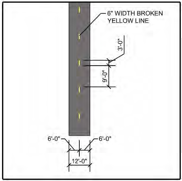
The 18-foot wide path shall consist of a 12-foot wide portion that shall be skip-striped with six-inch wide by three-foot long yellow stripes separated by a distance of nine feet to create two 6-foot lanes for neighborhood vehicles, along with a five and one-half-foot portion for pedestrians separated from the neighborhood vehicle lanes by a six-inch wide continuous yellow-stripe. See Figure 522.9.M.-2.
Figure 522.9.M.-2 Multipurpose Path 18 Feet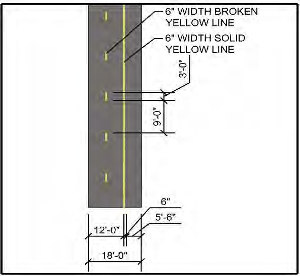
c.
Multipurpose Trails where required or proposed by the applicant, shall be constructed of:
(1)
Natural or colored fiber-reinforced concrete, finished to a light broom finish, at least 3,000 psi in strength and a minimum of four inches in thickness on a compacted and non-yielding subgrade.
(2)
Shall comply with the Americans with Disabilities Act requirements for ramps at intersections.
(3)
Multipurpose Trails shall be 12-foot wide and shall be skip-striped with six-inch wide by three-foot long yellow stripes separated by a distance of nine feet. See Figure 522.9.M.-3.
Figure 522.9.M.-3 Multipurpose Trail 12 Feet
6.
Intersections. Best practices will be observed when designing intersections with regard to neighborhood vehicle safety incorporating concepts consistent with Vision Zero.
7.
Maintenance. Nothing herein is intended or shall be inferred to impose any obligation on the part of the County to maintain or inspect neighborhood vehicle facilities constructed in accordance with this or any other section of this Code. All neighborhood vehicle facilities constructed pursuant to this Code shall be maintained in perpetuity by the developer and its successor(s) in interest unless the land on which it is built is deeded and owned in fee simple by the County, and if the County expressly agrees in writing executed by both the developer and the Chairman of the Board of Supervisors of the Connected City to accept responsibility for maintenance of the neighborhood vehicle facility, or if such responsibility for maintenance of the neighborhood vehicle facility is otherwise voluntarily assumed by the District.
N.
Active Transportation Network.
1.
Intent and Purpose. The intent and purpose of this section is to provide for a range of transportation choices for short and intermediate length trips.
2.
Master Bicycle, Pedestrian, and Neighborhood Vehicle Plan Required.
a.
All developments having a CC-MPUD zoning designation shall provide a Master Bicycle, Pedestrian, and Neighborhood Vehicle Plan to address the Alternative Transportation Network requirements set forth herein prior to the approval of the first Preliminary Development Plan (PDP).
b.
Master Bicycle, Pedestrian, and Neighborhood Vehicle Plans shall depict all existing or proposed approved Multipurpose Lanes, Multipurpose Paths, and Multipurpose Trails, if any, within 500' of the CC-MPUD boundary and shall provide for interconnection to them in accordance with the continuity requirements set forth herein.
c.
Master Bicycle, Pedestrian, and Neighborhood Vehicle Plans shall recognize that Local Roadways allow for bicycles and Neighborhood Vehicles to share the road with automobiles.
d.
Master Bicycle, Pedestrian, and Neighborhood Vehicle Plans shall address phasing of the transition of Multipurpose Lanes to Multipurpose Trails or Paths, as appropriate, for roadways that are proposed to be constructed in phases, wherein the initial phase proposes two-lane divided roadways with Multipurpose Lanes and the buildout phase proposes four-lane divided roadways with Multipurpose Paths. As a minimum, phased roadways shall be identified graphically, along with the associated Multipurpose Lanes and Paths on Master Plans. Refer to Figure 522.9.N.-1 and Figure 522.9.N.-2 below for the phasing of an example property.
Figure 522.9.N.-1 Master Bicycle, Pedestrian & Neighborhood vehicle Phase 1 Plan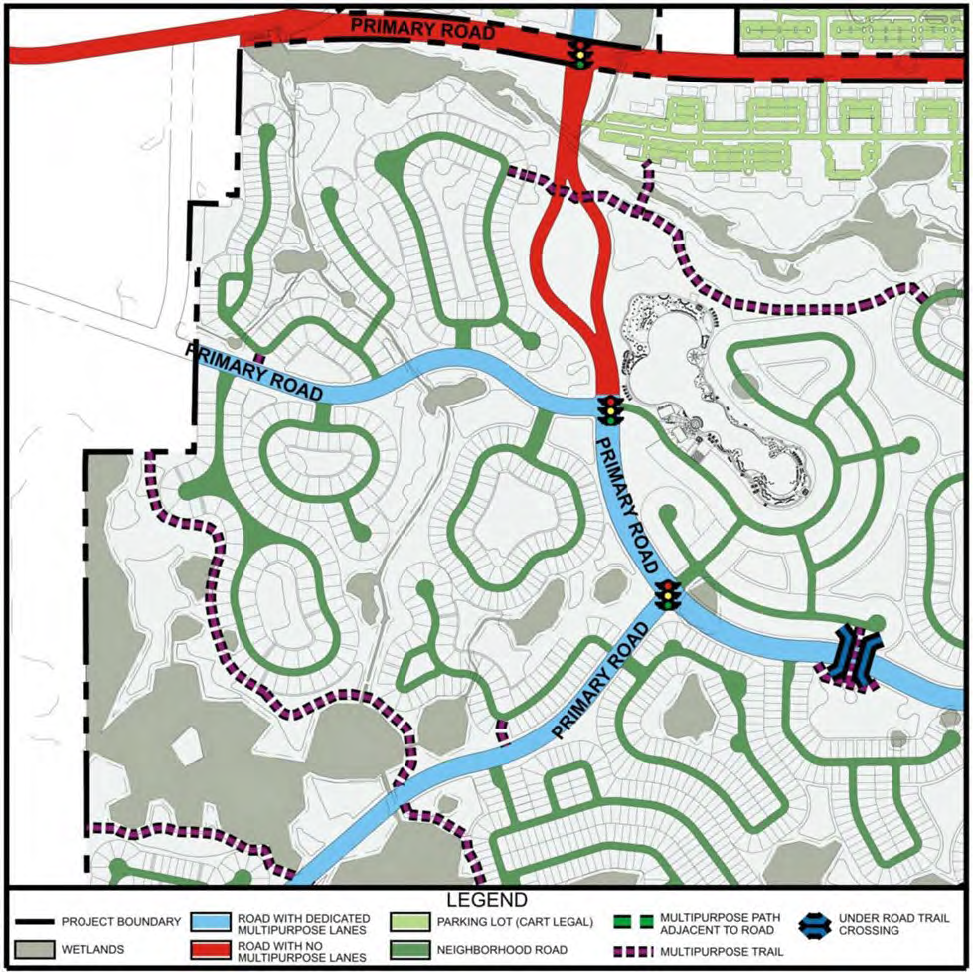
Figure 522.9.N.-2 Master Bicycle, Pedestrian & Neighborhood Vehicle Phase 2 Plan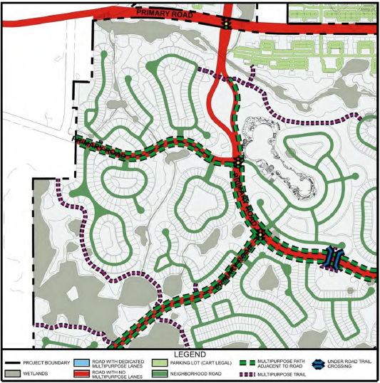
e.
If the CC-MPUD includes a mix of uses, the Master Bicycle, Pedestrian, and Neighborhood Vehicle Plan shall address how the various uses will be interconnected with Multipurpose Lanes, Multipurpose Paths, or Multipurpose Trails, as appropriate. Where adjacent non-residential parcels exist, interconnection of parking lots with Multipurpose Paths or Multipurpose Trails shall be addressed on the Master Bicycle, Pedestrian, and Neighborhood Vehicle Plan.
f.
Incremental development plans, beginning with the PDP, shall demonstrate compliance with the approved Master Bicycle, Pedestrian, and Neighborhood Vehicle Plan.
3.
Continuity.
a.
General Connectivity. Alternative Vehicle Facilities, including Multipurpose Lanes, Multipurpose Paths, and Multipurpose Trails, shall align connect with abutting Alternative Vehicle Facilities. The proposed layout of Alternative Vehicle Facilities shall consider the Alternative Transportation Network of the surrounding area. Destinations as outlined in Table 522.9.N.-1 Destinations shall be used to determine where the Alternative Vehicle Facilities in a proposed development shall be connected to Alternative Vehicle Facilities in adjacent areas to provide for proper circulation. Alternative Vehicle Facilities shall not be installed in such a manner as to conflict with or be obstructed by power lines, telephone poles, fire hydrants, traffic/street signs, mailboxes, trees, buildings, barriers, light poles, stormwater inlets, or any other structures.
TABLE 522.9.N.-1
b.
Residential Connectivity. Where practicable, Alternative Vehicle Facilities shall be considered to provide interconnection of neighborhoods where environmental or other constraints preclude roadway connectivity. Such interconnectivity shall be addressed on the Master Bicycle, Pedestrian, and Neighborhood Vehicle Plan and on subsequent Incremental Plans.
Figure 522.9.N.-3 is an example of how the Alternative Vehicle Network can shorten the travel distance for those that choose transportation modes other than the automobile. In this example, two residential lots located less than ¼-mile apart represent the origin and destination for a trip by a resident. In a car, the trip is 1.55 miles due to environmental constraints. The introduction of a Multipurpose Path provides a trip length of 0.47 miles for those that choose to walk, cycle, or use a Neighborhood Vehicle to accomplish the same trip.
Figure 522.9.N.-3. Residential Connectivity Example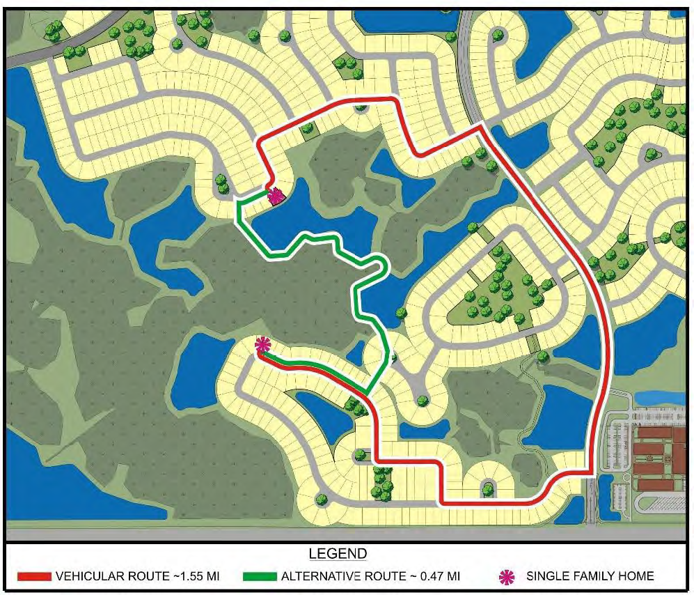
c.
School Connectivity. Where practicable and approved by the District School Board of Pasco County, schools shall be connected to the Alternative Vehicle Network and shall include accommodations for Neighborhood Vehicles. Such interconnectivity shall be addressed on the Master Bicycle, Pedestrian, and Neighborhood Vehicle Plan and on subsequent Incremental Plans.
Figure 522.9.N.-4 and Figure 522.9.N.-5 depict a collocated elementary and middle school with Multipurpose Trail connectivity and separate parking lots for Neighborhood Vehicles. Accommodation of the Alternative Vehicle Network within school sites provides a viable alternative to the automobile, and should reduce vehicular queues at pick-up and drop-off locations.
Figure 522.9.N.-4. School Connectivity Example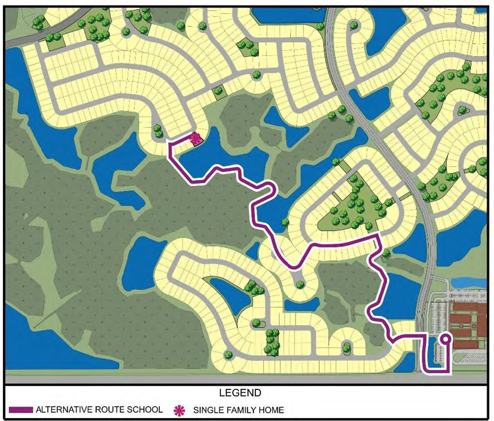
Figure 522.9.N.-5. School Connectivity Example 2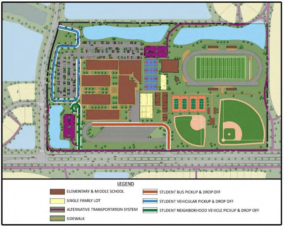
d.
Mixed-Use Connectivity. Design of office and retail uses shall demonstrate consideration of pedestrians, bicycles, and neighborhood vehicles by incorporating pedestrian connections to entry points of buildings from parking lots, as well as connections of Alternative Vehicle Facilities to Primary Roadways. Figures 522.9.N.-6 and 522.9.N.-7 demonstrate examples of these connections in an office and retail setting, respectively. Note in both figures that sidewalks are placed along primary parking lot drive aisles such that they function also as pedestrian corridors, creating a grid of pedestrian connectivity throughout the mixed-use area.
Figure 522.9.N.-6. Office Connectivity Exhibit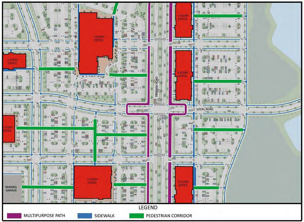
Figure 522.9.N.-7. Retail Connectivity Exhibit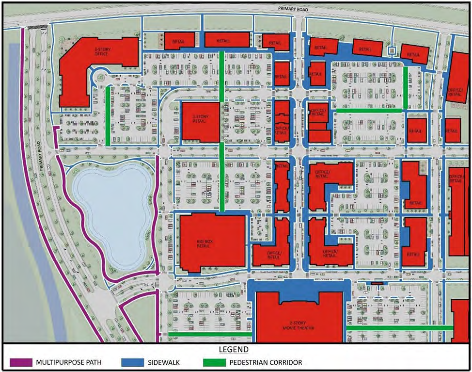
4.
Uses Permitted on Various Transportation Facilities. To encourage the use of all modes of transportation and promote user safety and comfort, Table 522.9.N.-2 establishes allowable modes of transportation for each type of facility.
Table 522.9.N.-2
Allowable Modes of Transportation by Facility Type
| MULTIPLE MODES OF TRANSPORTATION USE CHART | |||||
|---|---|---|---|---|---|
| Facility Type | MODES OF TRANSPORTATION | ||||
| Pedestrian | Bicycle |
Neighborhood
Vehicle | Automobile | Transit | |
| SIDEWALK | |||||
| BICYCLE LANE | |||||
| MULTIPURPOSE TRAIL | |||||
| MULTIPURPOSE PATH | |||||
| MULTIPURPOSE LANE | |||||
| LOCAL ROAD | |||||
| COLLECTOR ROAD | |||||
5.
Location, Coordination, and Configuration of Alternative Vehicle Facilities. For each facility type (Multipurpose Lanes, Multipurpose Paths, Multipurpose Trails, and local roads), refer to this Code, Section 522.9.M, Neighborhood Vehicle Facilities, for descriptions of these facility types and details concerning their construction (materials, installation specifications, etc.)
a.
Multipurpose Lanes.
(1)
Multipurpose Lanes shall be located within the pavement section (i.e., between the curb lines) of Primary and Intermediate Roads in their Phase 1 condition when initially phased as two-lane divided roadways. Refer to this Code, Sections 522.9.L. Bicycle Facilities and 522.9.M Neighborhood Vehicle Facilities and the Typical Sections provided in the CC-MRP.
(2)
Multipurpose Lanes shall be constructed in accordance with the criteria set forth in this Code, Sections 522.9.L Bicycle Facilities and 522.9.M. Neighborhood Vehicle Facilities.
(3)
Where Multipurpose Lanes approach intersections, striping shall be used to merge vehicles in the Multipurpose Lanes (bicycles and neighborhood vehicles) into the vehicular travel lane to avoid conflicts with turning automobiles. Transitions for these merges shall be of appropriate length based upon criteria set forth in the Florida Department of Transportation Design Standards for Construction and Maintenance Operations on the State Highway System, latest edition. Refer to this Code, Section 522.9.N.6.a, Alternative Vehicle Intersection and Crossing Scenarios for details.
b.
Multipurpose Paths.
(1)
Multipurpose Paths shall be located within rights-of-way of Primary Roads in their buildout condition. Refer to the Typical Sections provided in the CC-MRP.
(2)
Multipurpose Paths shall be constructed in accordance with the criteria set forth in this Code, Section 522.9.L. Bicycle Facilities and 522.9.M. Neighborhood Vehicle Facilities.
(3)
Where Multipurpose Paths cross Primary or Intermediate Roadways, crossings shall be located at the intersection approach, before the roadway transitions to accommodate turn-lanes, where applicable. Refer to this Code, Section 522.9.N.6.a, Intersection and Crossing Component Details.
c.
Multipurpose Trails.
(1)
Multipurpose Trails shall be located wherever linkages outside road rights-of-way are needed to provide connections between Multipurpose Lanes, Multipurpose Paths, other Multipurpose Trails, or Local Roads.
(2)
Multipurpose Trails shall be constructed in accordance with the criteria set forth in this Code, Section 522.9.L. Bicycle Facilities and 522.9.M. Neighborhood vehicle Facilities.
6.
Alternative Vehicle Intersection and Crossing Scenarios. There are numerous roadway intersection and alternative vehicle crossing scenarios that are possible within the Connected City. This section shall govern the design configuration for each anticipated scenario. If situations are encountered that do not conform to the scenarios anticipated herein, then the applicant shall propose a configuration for consideration by Pasco County as part of the incremental plan review process. Components of intersections and crossings are detailed in this Code, Section 522.9.N.6.a, Intersection and Crossing Component Details and details of the anticipated scenarios are depicted in this Code, Section 522.9.N.6.b. Intersection and Crossing Scenario Details.
a.
Intersection and Crossing Component Details. For each crossing or intersection type, there are numerous components. For example, when departing an intersection of an Intermediate Roadway or Phase 1 Primary Roadway with any other type of roadway, there will be a point where the Multipurpose Lane begins. Similarly, when a Multipurpose Path crosses a roadway, there will be a crosswalk. These are examples of components of a crossing or intersection scenario. This section provides details for each of the various components that are anticipated to be needed within the Connected City to assemble the various intersection and crossing scenarios.
(1)
Multipurpose Lane: Beginning of Lane - Refer to Detail A below for the dimensional and striping/graphical criteria for the beginning of a Multipurpose Lane.
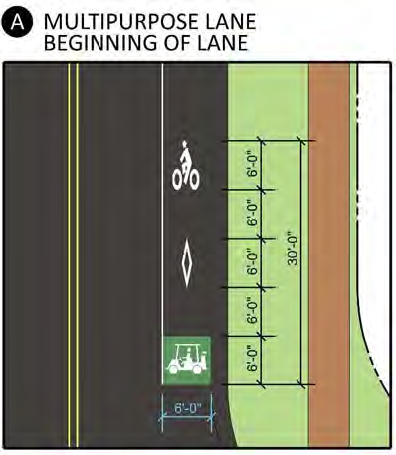
(2)
Multipurpose Lane: Merge with Vehicular Travel Lane (no turn-lanes) - Refer to Detail B below for the dimensional, striping, and signing criteria for merging neighborhood vehicles into the standard vehicular travel lane at intersection approaches.
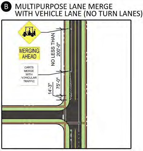
(3)
Multipurpose Lane: Merge with Vehicular Travel Lane (approaching a stop sign) - Refer to Detail C below for the dimensional, striping, and signing criteria for merging neighborhood vehicles into the standard vehicular travel lane at the approach to a stop sign.
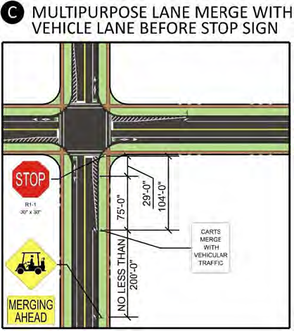
(4)
Multipurpose Lane: Merge with Vehicular Travel Lane (approaching turn-lanes) - Refer to Detail D below for the dimensional, striping, and signing criteria for merging neighborhood vehicles into the standard vehicular travel lane at the approach to turn-lanes on an Intermediate Roadway.
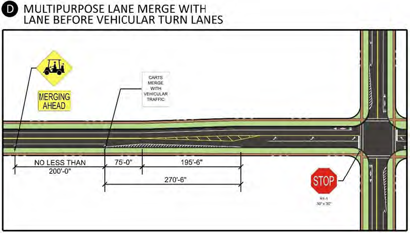
(5)
Multipurpose Lane: Merge with Vehicular Travel Lane (approaching crosswalk) - Refer to Detail E below for the dimensional, striping, and signing criteria for merging neighborhood vehicles into the standard vehicular travel lane at the approach to a crosswalk that precedes the pavement transition at a turn-lane approach.
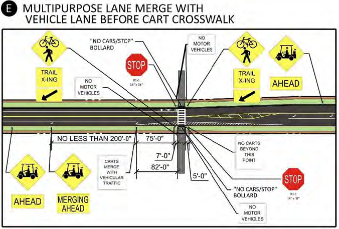
(6)
Multipurpose Lane: T-Intersection - Refer to Detail F below for the dimensional, striping, and signing criteria for Multipurpose Lanes on the through street where an intersecting street creates a T-Intersection.
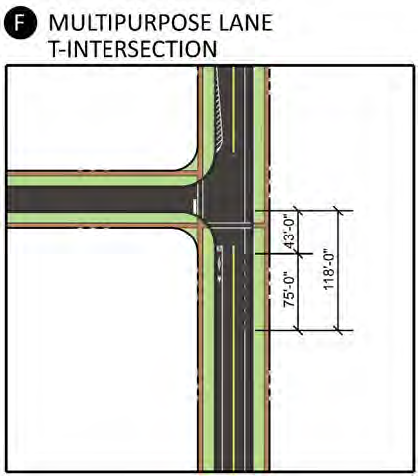
(7)
Multipurpose Path: Crosswalk Crossing Local Road at Intersection with Primary or Intermediate Road - Refer to Detail G below for the dimensional, striping, and signing criteria for crossing local streets at intersections with Primary or Intermediate Roadways.
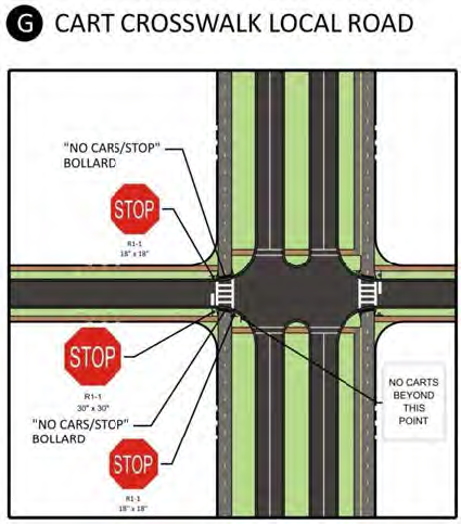
(8)
Multipurpose Path: Crosswalk Crossing Intermediate Roadway at approach to turn-lane - Refer to Detail H below for the dimensional, striping, and signing criteria for crossing Intermediate Roadways at approach to turn-lanes.
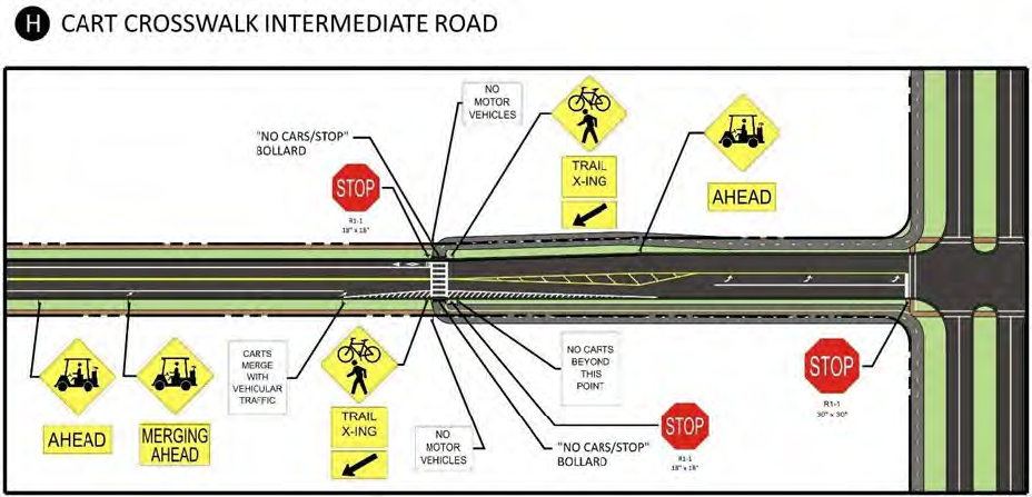
(9)
Multipurpose Path: Crosswalk Crossing Primary Roadway at approach to turn-lane - Refer to Detail N below for the dimensional, striping, and signing criteria for crossing Primary Roadways at approach to turn-lanes.
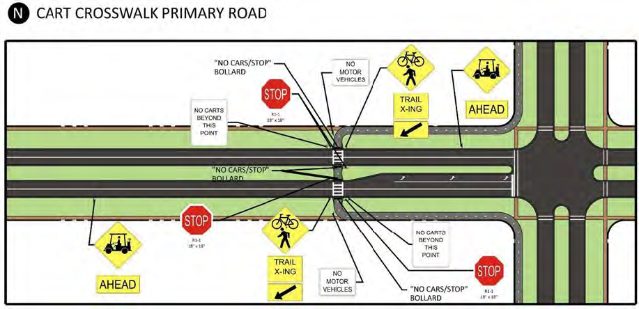
(10)
Multipurpose Trail: Connection to Local Roadway - Refer to Detail J below for the striping and signing criteria for connecting Multipurpose Trails to local roads.
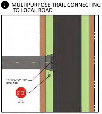
(11)
Multipurpose Trail: Temporary Dead-End - Refer to Detail K below for the signing criteria for temporary dead-ends of Multipurpose Trails to be extended in the future.
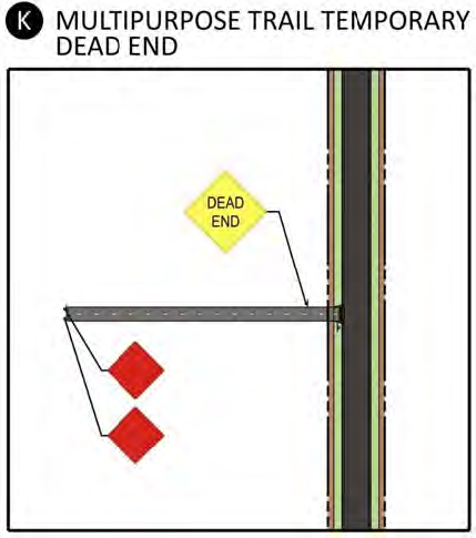
(12)
Multipurpose Trail: Underpass - Refer to Detail L below for the general clear dimensional criteria for Multipurpose Trail underpasses.
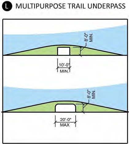
(13)
Multipurpose Trail or Path: Crosswalk - Refer to Detail M below for the dimensional and striping criteria for Multipurpose Trail or Multipurpose Path crosswalks.
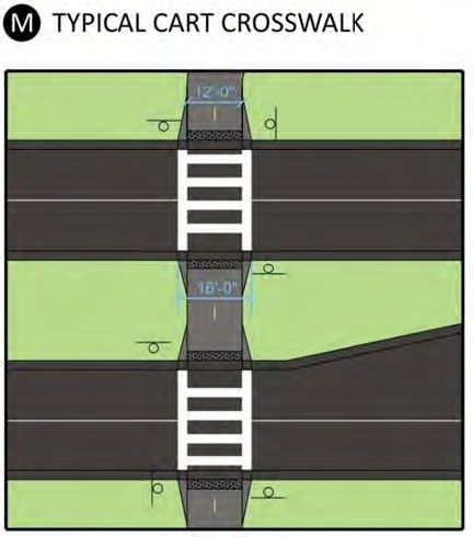
(14)
Gated Community Entrance: Detail of Multipurpose Path Crossing a Gated Entrance - Refer to Detail O below for the striping and signing criteria for the crossing of a Multipurpose Path crossing at a gated entrance.
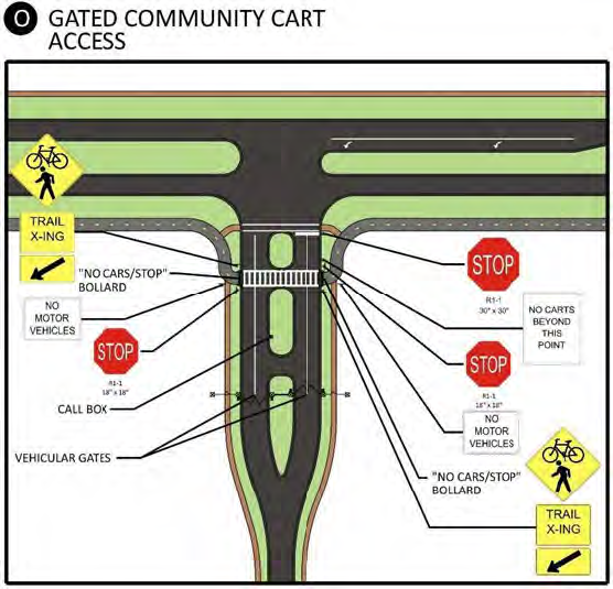
(15)
Multipurpose Trail Signs: Multipurpose Trail signs are dimensioned differently than street signs, as neighborhood vehicles tend to have a much lower profile than a car. Refer to Detail P below for a depiction of the dimensional criteria for Multipurpose Trail signs.
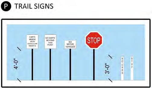
(16)
Intersection of Multipurpose Trail with Roadway: At the intersection of a Multipurpose Trail and a roadway, a bollard shall be installed to discourage automobile entry. Refer to Detail Q for signing at Multipurpose Trail and roadway intersections, and dimensional and coy details.
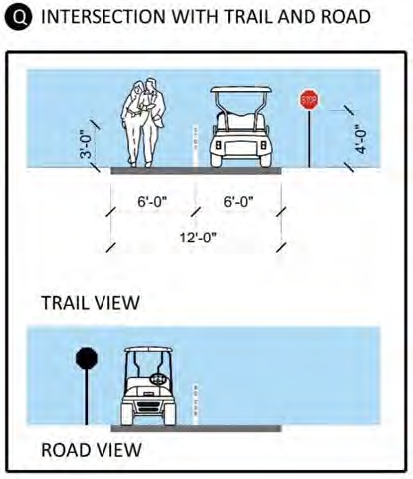
(17)
Multipurpose Lane: Merge with Vehicular Travel Lane (Primary Road approaching roundabout) - Refer to Detail R below for the dimensional, striping, and signing criteria for merging neighborhood vehicles into the standard vehicular travel lane at the approach to a roundabout.
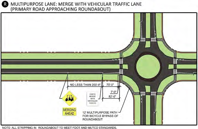
(18)
Multipurpose Path: Crosswalk Crossing Primary Road at roundabout - Refer to Detail S below for dimensional, striping, and signing criteria for multipurpose path crosswalk at roundabout.
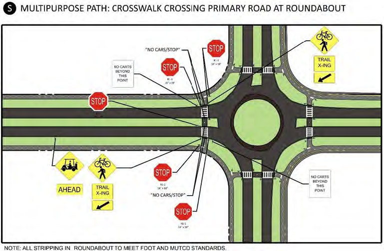
(19)
Multipurpose Lane: Merge with Vehicular Travel Lane (Intermediate Road approaching roundabout) - Refer to Detail T below for the dimensional, striping, and signing criteria for merging neighborhood vehicles into the standard vehicular travel lane at the approach to a roundabout.
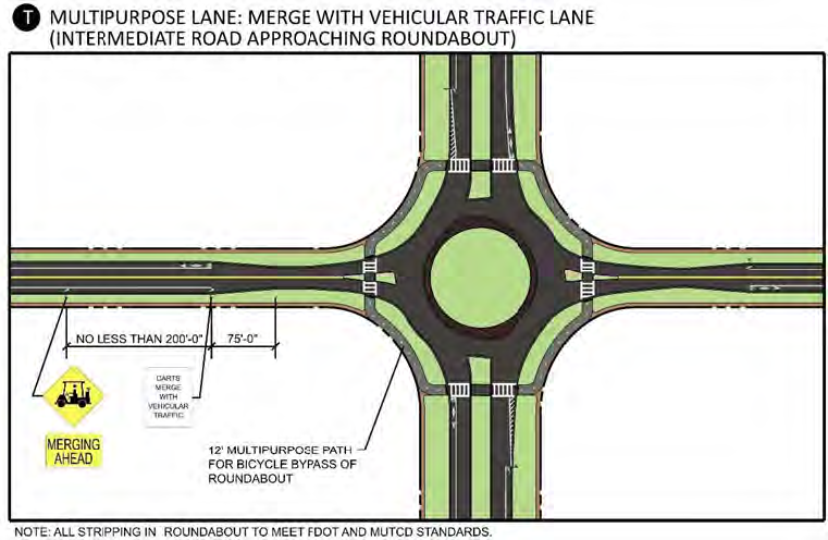
(20)
Multipurpose Lane: Merge with Vehicular Travel Lane (Intermediate Road with Crosswalk, approaching roundabout) - Refer to Detail U below for the dimensional, striping, and signing criteria for merging neighborhood vehicles into the standard vehicular travel lane and crosswalk at the approach to a roundabout.
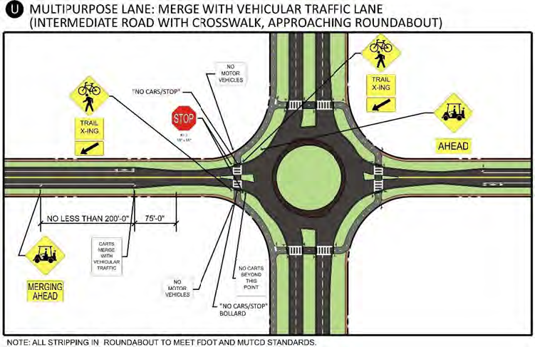
(21)
Multipurpose Path: Crosswalk Crossing Local Road at Phase 2 Primary Road (approaching roundabout) - Refer to Detail V below for dimensional, striping, and signing criteria for crosswalk at roundabout.
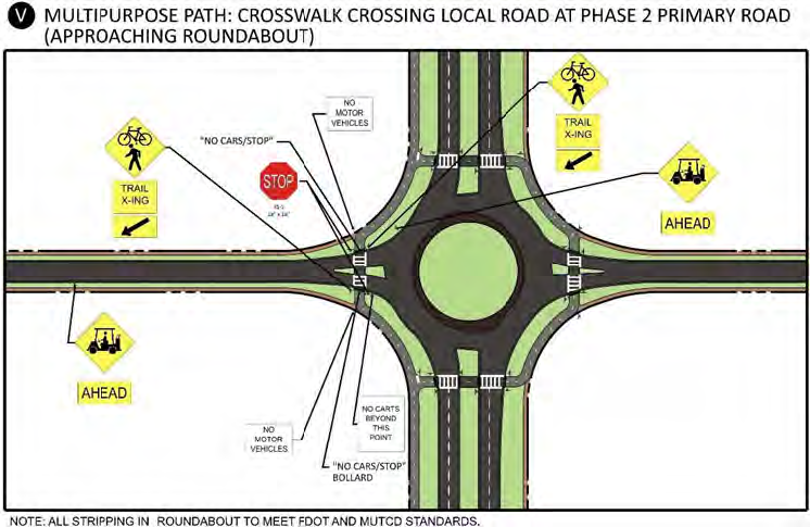
(22)
Bicycle Bypass: Bypassing via Crosswalk (Primary Road Phase 1 approaching roundabout) - Refer to Detail W below for the dimensional, striping, and signing criteria for bicycle bypass crosswalk and multipurpose path at the approach to a roundabout.
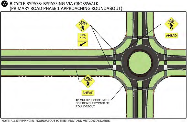
(23)
Bicycle Bypass: Bypassing via Crosswalk (Local Road approaching roundabout) - Refer to Detail X below for the dimensional, striping, and signing criteria for bicycle bypass crosswalk and multipurpose path at the approach to a roundabout.
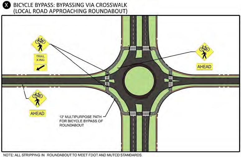
(24)
Bicycle Bypass: Bypass via Crosswalk (Intermediate Road approaching roundabout) - Refer to Detail Y below for the dimensional, striping, and signing criteria for bicycle bypass crosswalk and multipurpose path at the approach to a roundabout.
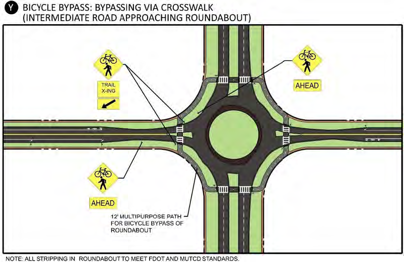
(25)
Multipurpose Trail or Path: Detail of 12-foot Multipurpose Trail or Multipurpose Path - Refer to Detail 1 below for the dimensional and striping criteria for a 12-foot Multipurpose Trail or Multipurpose Path.
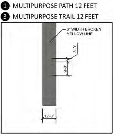
(26)
Multipurpose Path: Detail of 18-foot Multipurpose Path - Refer to Detail 2 below for the dimensional and striping criteria for an 18-foot Multipurpose Path.
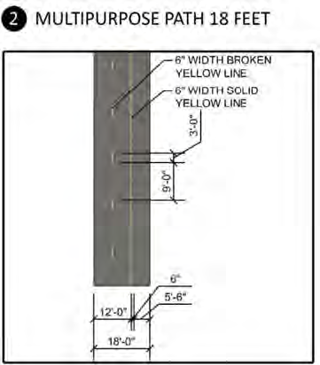
Intersection and Crossing Scenario Details. This section provides details of each of the anticipated intersection and Multipurpose Trail crossing scenarios within the Connected City. Alphabetical codes are assigned at various locations on each detail. These codes correspond to the component details provided in this Code, Section 522.9.N.6.a, above, to demonstrate how the components are assembled to address dimensions, signing, and striping for each scenario.
(1)
Scenario A: T-Intersection of Local and Intermediate Roadway - Refer to the Scenario A detail below for the configuration of a T-intersection of a Local Roadway with an Intermediate Roadway.
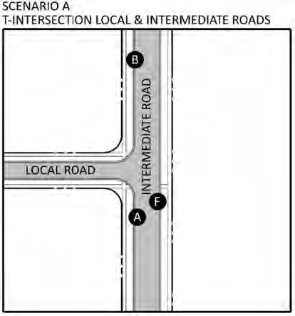
(2)
Scenario B: Four-leg Intersection of Local and Intermediate Roadway - Refer to the Scenario B detail below for the configuration of a four-leg intersection of a Local Roadway with an Intermediate Roadway.
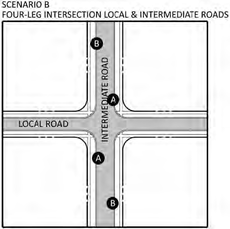
(3)
Scenario C: T-Intersection of Local and Phase 1 Primary Roadway - Refer to the Scenario C detail below for the configuration of a T-intersection of a Local Roadway with a Primary Roadway during the Primary Roadway's "Phase 1" (i.e., when it exists as a two-lane divided roadway with Multipurpose Lanes).
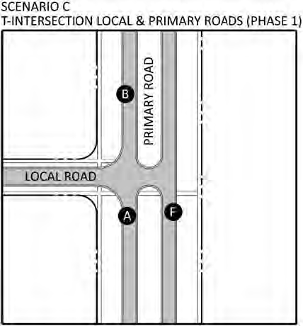
(4)
Scenario D: Four-leg Intersection of Local and Phase 1 Primary Roadway - Refer to the Scenario D detail below for the configuration of a 4-leg intersection of a Local Roadway with a Primary Roadway during the Primary Roadway's "Phase 1" (i.e., when it exists as a two-lane divided roadway with Multipurpose Lanes).
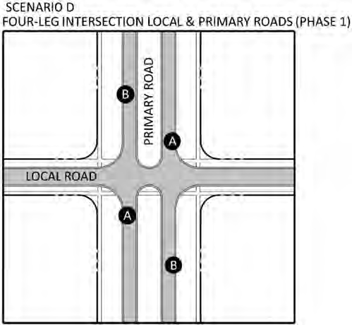
(5)
Scenario E: T-Intersection of Local and Phase 2 Primary Roadway - Refer to the Scenario E detail below for the configuration of a T-intersection of a Local Roadway with a Primary Roadway during the Primary Roadway's "Phase 2" (i.e., when it has been built-out to a four-lane divided roadway with Multipurpose Paths). Note: the depicted scenario is for Primary Roadways with a 12-foot Multipurpose Path on one side and an 18-foot Multipurpose Path on the other. For the case where a five-foot sidewalk exists on one side, a 12-foot Multipurpose Path would exist on the opposite side instead of an 18-foot Multipurpose Path.
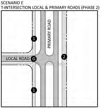
(6)
Scenario F: Four-way Intersection of Local and Phase 2 Primary Roadway - Refer to the Scenario F detail below for the configuration of a four-way intersection of a Local Roadway with a Primary Roadway during the Primary Roadway's "Phase 2" (i.e., when it has been built-out to a four-lane divided roadway with Multipurpose Paths). Note: the depicted scenario is for Primary Roadways with a 12-foot Multipurpose Path on one side and an 18-foot Multipurpose Path on the other. For the case where a five-foot sidewalk exists on one side, a 12-foot Multipurpose Path would exist on the opposite side instead of an 18-foot Multipurpose Path.
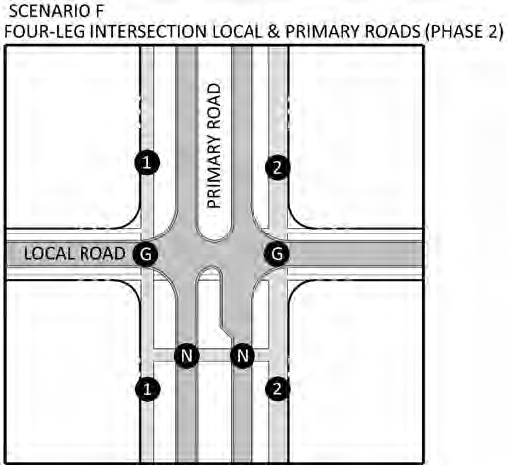
(7)
Scenario G: T-Intersection of Two Intermediate Roadways - Refer to the Scenario G detail below for the configuration of a T-intersection of two Intermediate Roadways.
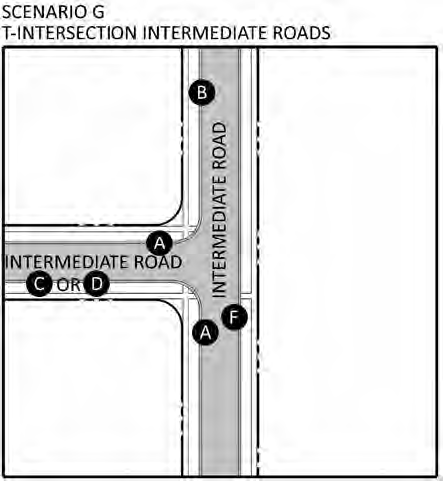
(8)
Scenario H: Four-way Intersection of Two Intermediate Roadways - Refer to the Scenario H detail below for the configuration of a four-way intersection of two Intermediate Roadways.
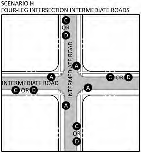
(9)
Scenario I: T-Intersection of an Intermediate Roadway with a Phase 1 Primary Roadway - Refer to the Scenario I detail below for the configuration of a T-intersection of an Intermediate Roadway with a Primary Roadway in its "Phase 1" (i.e., when it exists as a two-lane divided roadway with Multipurpose Lanes).
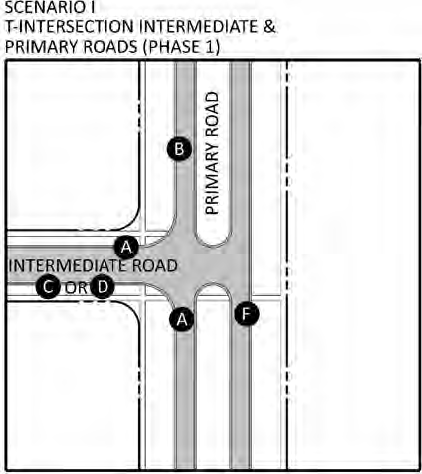
(10)
Scenario J: Four-way Intersection of an Intermediate Roadway with a Phase 1 Primary Roadway - Refer to the Scenario J detail below for the configuration of a 4-way intersection of an Intermediate Roadway with a Primary Roadway in its "Phase 1" (i.e., when it exists as a two-lane divided roadway with Multipurpose Lanes).
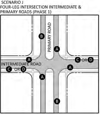
(11)
Scenario K: T-Intersection of an Intermediate Roadway with a Phase 2 Primary Roadway - Refer to the Scenario K detail below for the configuration of a T-intersection of an Intermediate Roadway with a Primary Roadway in its "Phase 2" (i.e., when it exists as a four-lane divided roadway with Multipurpose Paths).
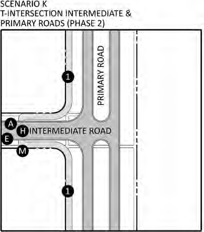
(12)
Scenario L: Four-way Intersection of an Intermediate Roadway with a Phase 2 Primary Roadway - Refer to the Scenario L detail below for the configuration of a 4-way intersection of an Intermediate Roadway with a Primary Roadway in its "Phase 2" (i.e., when it exists as a four-lane divided roadway with Multipurpose Paths).
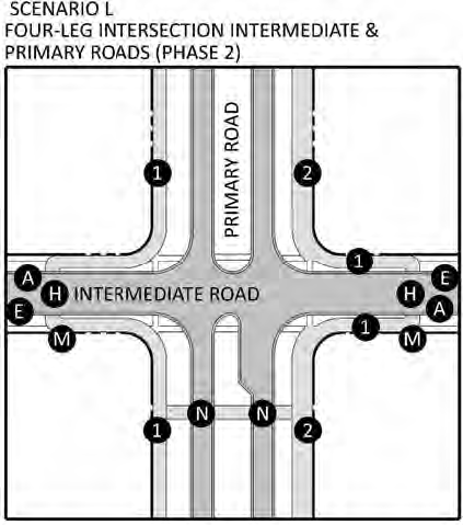
(13)
Scenario M: T-Intersection of a Primary Roadway with a Phase 1 Primary Roadway - Refer to the Scenario M detail below for the configuration of a T-intersection of a Primary Roadway with a Primary Roadway in its "Phase 1" (i.e., when it exists as a two-lane divided roadway with Multipurpose Lanes).
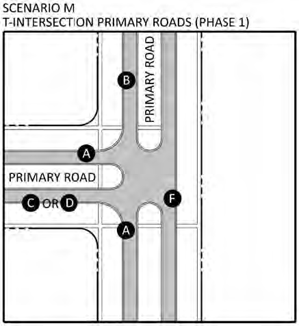
(14)
Scenario N: Four-way Intersection of a Primary Roadway with a Phase 1 Primary Roadway - Refer to the Scenario N detail below for the configuration of a four-way intersection of a Primary Roadway with a Primary Roadway in its "Phase 1" (i.e., when it exists as a two-lane divided roadway with Multipurpose Lanes).
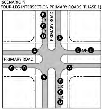
(15)
Scenario O: T-Intersection of a Primary Roadway with a Phase 2 Primary Roadway - Refer to the Scenario O detail below for the configuration of a T-intersection of a Primary Roadway with a Primary Roadway in its "Phase 2" (i.e., when it exists as a four-lane divided roadway with Multipurpose Paths). Note: the depicted scenario is for Primary Roadways with a 12-foot Multipurpose Path on one side and an 18-foot Multipurpose Path on the other. For the case where a five-foot sidewalk exists on one side, a 12-foot Multipurpose Path would exist on the opposite side instead of an 18-foot Multipurpose Path.
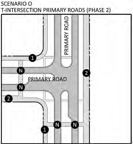
(16)
Scenario P: Four-way Intersection of a Primary Roadway with a Phase 2 Primary Roadway - Refer to the Scenario P detail below for the configuration of a four-way intersection of a Primary Roadway with a Primary Roadway in its "Phase 2" (i.e., when it exists as a four-lane divided roadway with Multipurpose Paths). Note: the depicted scenario is for Primary Roadways with a 12-foot Multipurpose Path on one side and an 18-foot Multipurpose Path on the other. For the case where a five-foot sidewalk exists on one side, a 12-foot Multipurpose Path would exist on the opposite side instead of an 18-foot Multipurpose Path.
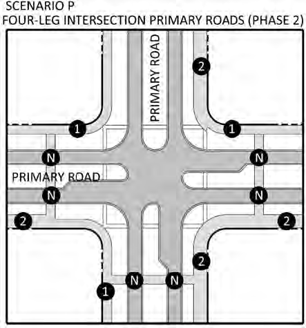
(17)
Scenario Q: Multipurpose Trail Connection to Local Roadway - Refer to the Scenario Q detail below for the configuration of a Multipurpose Trail that connects to a Local Roadway.
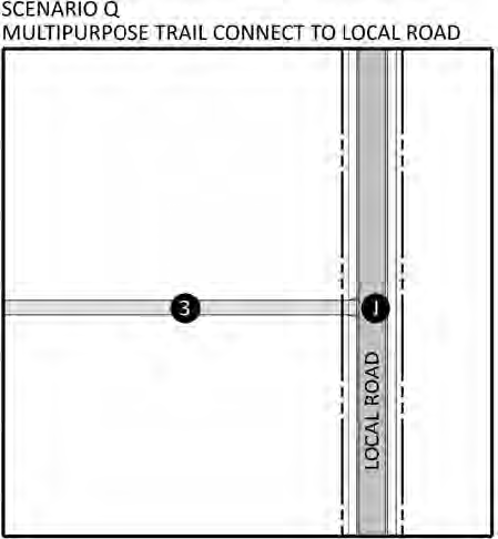
(18)
Scenario R: Multipurpose Trail Temporary Dead End - Refer to the Scenario R detail below for the configuration of a Multipurpose Trail that temporarily terminates without a connection (for example, at a phase line).
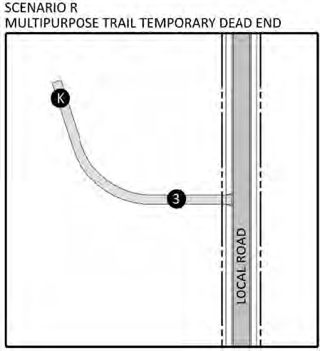
(19)
Scenario S: Gated Entry - Refer to the Scenario S detail below for the configuration of a Multipurpose Trail crossing at a gated entry off of a Primary Roadway.
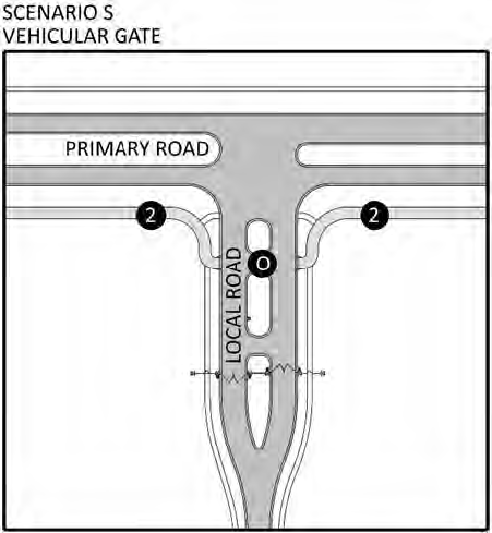
(20)
Scenario T: Roundabout intersection of a Local Road with a Local Road - Refer to the Scenario T detail below for the configuration of a roundabout at the intersection of a Local Road with a Local Road. (Multipurpose path is located around the roundabout to allow for bicycles to bypass the roundabout. Neighborhood vehicles are intended to move through the roundabout).
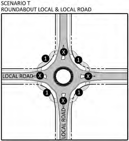
(21)
Scenario U: Roundabout intersection of a Local Road with a Phase 1 Primary Road - Refer to the Scenario U detail below for the configuration of a roundabout at the intersection of a Local Road with a Phase 1 Primary Road. (Multipurpose path is located around the roundabout to allow for bicycles to bypass the roundabout. Neighborhood vehicles are intended to move through the roundabout).
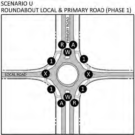
(22)
Scenario: V: Roundabout intersection of a Local Road with a Phase 2 Primary Road - Refer to the Scenario V detail below for the configuration of a roundabout at the intersection of a Local Road with a Phase 2 Primary Road. (Multipurpose path is located around the roundabout for both bicycles and neighborhood vehicles to bypass the roundabout).
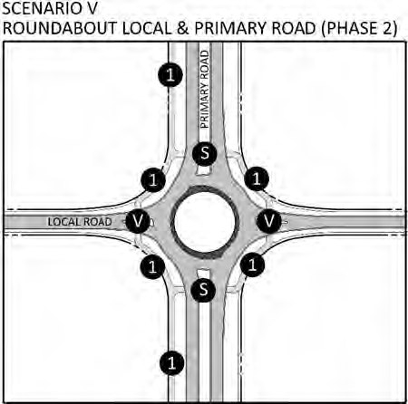
(23)
Scenario W: Roundabout intersection of an Intermediate Road with a Phase 1 Primary Road - Refer to the Scenario W detail below for the configuration of a roundabout at the intersection of an Intermediate Road with a Phase 1 Primary Road. (Multipurpose path is located around the roundabout to allow for bicycles to bypass the roundabout. Neighborhood vehicles are intended to move through the roundabout).
(24)
Scenario X: Roundabout intersection of an Intermediate Road with a Phase 2 Primary Road - Refer to the Scenario X detail below for the configuration of a roundabout at the intersection of an Intermediate Road with a Phase 2 Primary Road. (Multipurpose path is located around the roundabout for both bicycles and neighborhood vehicles to bypass the roundabout).
(25)
Scenario Y: Roundabout intersection of a Phase 1 Primary Road with a Phase 1 Primary Road - Refer to the Scenario Y detail below for the configuration of a roundabout at the intersection of a Phase 1 Primary Road with a Phase 1 Primary Road. (Multipurpose path is located around the roundabout to allow for bicycles to bypass the roundabout. Neighborhood vehicles are intended to move through the roundabout).
(26)
Scenario Z: Roundabout intersection of a Phase 2 Primary Road with a Phase 2 Primary Road - Refer to the Scenario Z detail below for the configuration of a roundabout at the intersection of a Phase 2 Primary Road with a Phase 2 Primary Road. (Multipurpose path is located around the roundabout for both bicycles and neighborhood vehicles to bypass the roundabout).
(27)
Scenario AA: Roundabout intersection of a Local Road with an Intermediate Road - Refer to the Scenario AA detail below for the configuration of a roundabout at the intersection of a Local Road with an Intermediate Road. (Multipurpose path is located around the roundabout to allow for bicycles to bypass the roundabout. Neighborhood vehicles are intended to move through the roundabout).
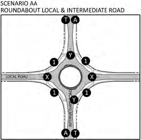
(28)
Scenario BB: Roundabout intersection of an Intermediate Road with an Intermediate Road - Refer to the Scenario BB detail below for the configuration of a roundabout at the intersection of an Intermediate Road with an Intermediate Road. (Multipurpose path is located around the roundabout to allow for bicycles to bypass the roundabout. Neighborhood vehicles are intended to move through the roundabout).
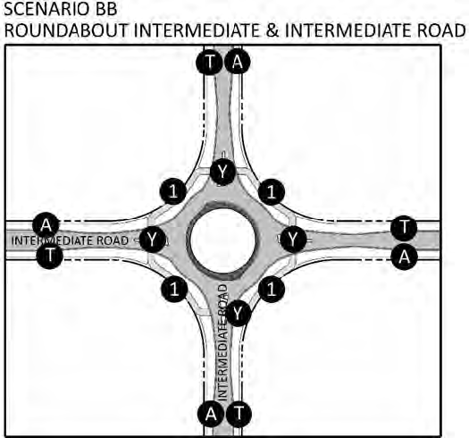
O.
Utilities.
1.
Intent and Purpose. It is the intent of this section to provide for a predictable blueprint for the incremental implementation of the extensive utility systems necessary to achieve the vision by numerous applicants during the Connected City's planning horizon. Initial applicants within the Connected City must be able to rely upon clear and consistent implementation over time by future applicants to achieve the extensive and interconnected systems.
It is the purpose of the Utilities System within the Connected City to achieve the following:
a.
Protect and conserve the quality and quantity of groundwater resources;
b.
Provide an adequate, safe, efficient, economical, reliable, and environmentally sound system of potable water supply, reclaimed water supply, and sanitary sewer collection, with treatment and disposal consistent with the CC-CPA;
c.
Maximize the use of existing facilities and provide an adequate, safe, and environmentally sound system of potable water supply and reclaimed water supply; and sanitary sewer collection, treatment, and disposal;
d.
Establish requirements for connection to potable water, reclaimed water, and sanitary sewer facilities;
e.
Provide for the extensive fiber optic network necessary to deliver Gigabit Technology to help stimulate innovation;
f.
Provide the basic utility infrastructure to create cleaner and healthier communities. The transition from the existing conditions to the proposed Connected City vision will require a far more robust potable water transmission system, wastewater collection system and reclaimed water distribution system and an equally expansive fiber distribution network. These utilities are anticipated to be all underground and located within the public rights-of-way and additional easements associated with the CC-MRP;
g.
Compliance with the Conceptual Utility Plan (CC-CUP), consisting of a Master Potable Water Plan, Master Wastewater Plan and Master Reclaimed Water Plan.; and
h.
Pasco County Utilities impact fees at the time of the specific application shall be paid with no exceptions. Additional Connected City-specific impact fees may be collected or credited in compliance with Connected City ordinances in place at the time of application.
2.
Applicability. This section shall apply to developments requiring Incremental Approval of development applications within the Connected City. These developments shall be those that have an approved CC-MPUD.
3.
Utility Lines. Utility lines of all kinds within the Connected City may include, but are not limited to, those of public or franchised utilities, electric power and light, telephone and fiber optic cable, cable television, water, sewer, and gas, shall be constructed and installed beneath the surface of the ground within new residential subdivisions, unless it is otherwise approved at the time of preliminary development plan approval.
It shall be the developer's responsibility to make the necessary arrangements with each utility in accordance with the utility's established policies. The underground installation of incidental appurtenances such as transformer boxes, pedestal-mounted terminal boxes for electricity, or similar service hardware necessary for the provisions of utility services, shall not be required. Below ground installation shall not normally be required for commercial service connections, bulk electric power supply lines, and communication major feeder lines. Nothing in this section shall be construed to prohibit any entity furnishing utility service within the County from collecting, as a condition precedent to the installation of service facilities, any fee, prepayment, or contribution in aid of construction which may be required.
4.
Commitment to Provide Utilities. At the time of preliminary development plan or preliminary site plan submittal, a letter of intent from serving utilities shall be provided. At the time of construction plan approval, commitment letters from serving utilities shall be provided.
5.
Potable Water Systems.
a.
Connected City Conceptual Plan. All applications within the Connected City shall be reviewed for general compliance with the Connected City Conceptual Water Plan depicted in the Conceptual Utility Plan.
b.
Design and Approval.
(1)
Design Standards. Potable water, including fire protection, shall be provided in accordance with the standards established in the Comprehensive Plan and the Pasco County Standards for Design and Construction of Water, Wastewater and Reclaimed Water Facilities Specs., latest edition.
All systems shall be designed and constructed in conformance with the requirements established by the Florida Department of Environmental Protection (FDEP).
(2)
Approval Process. All potable water systems shall be subject to review by the Pasco County Utilities Services Branch.
6.
Reclaimed Water Systems.
a.
Connected City Conceptual Plan. All applications within the Connected City shall be reviewed for general compliance with the Connected City Conceptual Reclaimed Water Plan depicted in the Conceptual Utility Plan.
b.
Design and Approval.
(1)
Design Standards. Subject to a Utility Service Agreement between Pasco County and the developer, reclaimed water shall be provided in accordance with the standards established in the Comprehensive Plan and the Pasco County Standards for Design and Construction of Water, Wastewater and Reclaimed Water Facilities Specs., latest edition.
All systems shall be designed and constructed in conformance with the requirements established by the Florida Department of Environmental Protection (FDEP).
(2)
Approval Process. All reclaimed water systems shall be subject to review by the Pasco County Utilities Services Branch.
7.
Wastewater Systems.
a.
Connected City Conceptual Plan. All applications within the Connected City shall be reviewed for general compliance with the Connected City Conceptual Wastewater Plan depicted in the Conceptual Utility Plan.
b.
Design and Approval.
(1)
Design Standards. Wastewater collection and transmission systems shall be provided in accordance with the standards established in the Comprehensive Plan and the Pasco County Standards for Design and Construction of Water, Wastewater and Reclaimed Water Facilities Specs., latest edition.
All systems shall be designed and constructed in conformance with the requirements established by the Florida Department of Environmental Protection (FDEP).
Individual sewage disposal systems shall not be allowed on any new projects with a CC-MPUD zoning classification.
(2)
Approval Process. All wastewater collection and transmission systems shall be subject to review by the Pasco County Utilities Services Branch.
8.
Smart Systems. Smart systems, such as smart electric meters, smart irrigation systems, and smart water meters shall be encouraged throughout the Connected City Special Planning Area.
As per this Code, Section 522.9.G. Natural Resources new construction shall be built with full-automated meter infrastructure (AMI).
P.
Neighborhood Parks.
1.
Intent and Purpose. The intent and purpose of this section is to advance the health, safety, and welfare of the residents of the Connected City Stewardship District by providing common areas as neighborhood parks in residential development in which to engage in recreation and play.
2.
Applicability. This section shall apply to all CC-Entitled Properties as defined in this Code, Section 603 Connected City Stewardship District proposing 26 or more dwelling units. For the purposes of this section, a dwelling unit shall consist of single-family (attached and detached units), and multiple family units.
For residential projects that are four or more stories, the requirements of the remainder of this section shall not apply. Instead, projects of four or more stories shall provide a usable open space of not less than five percent of the acreage of the parcel on which the building is situated. This open space shall be designed to accommodate gathering and use by provision of seating areas, outdoor dining areas, patio areas, sunbathing areas, toddler play areas, or other passive activity areas proposed by the applicant and subject to review and approval by the County Administrator or designee.
Figure 522.9.P.-1. Multistory Building Example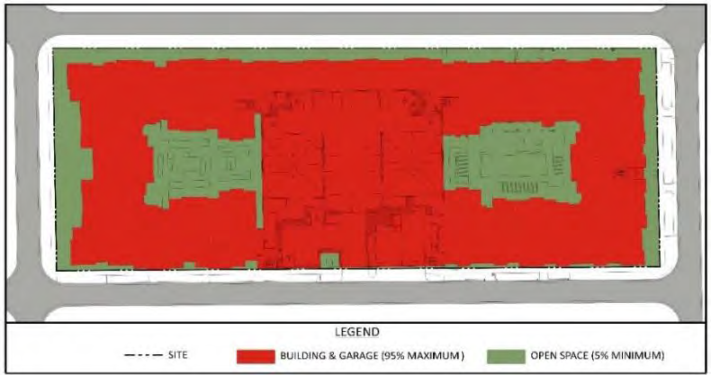
3.
No Impact Fee Creditable. The provision of neighborhood park(s) pursuant to this section is not impact fee creditable against any portion of the fees set forth in this Code, Section 1302.4 Parks and Recreation Impact Fees.
4.
Amount of Land Required. The amount of land required to be provided and maintained as neighborhood park(s) is as follows:
a.
One-half acre for 26—99 dwelling units.
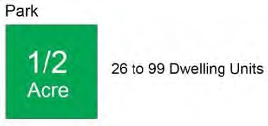
b.
An additional 1/100 of one acre for each additional dwelling unit over 99.
5.
Neighborhood Park Standards.
a.
Type of Land. The land provided for use as neighborhood park(s) shall be developable uplands exclusive of required setbacks from wetland or environmental areas and shall not contain any restrictions or encumbrances that prevent its use as a neighborhood park.
b.
Prohibited Uses. The following uses/land area(s) shall not be included in the required neighborhood park(s) acreage:
(1)
Floodplain mitigation areas;
(2)
Drainage/stormwater detention areas (except for drainage/stormwater detention areas used solely for required neighborhood park amenities);
(3)
Parking areas (except for parking areas required to satisfy minimum parking requirements for required neighborhood park amenities);
(4)
Landscape easements.
c.
Accessibility. The land provided for each neighborhood park shall be easily accessible to the residents of the development by automobile, foot, neighborhood vehicle, and bicycle.
The required neighborhood park acreage shall be located no greater than one-half mile from 50 percent of the dwelling units to be served by the neighborhood park.
d.
Minimum Size. The required neighborhood park acreage may be composed of a single or multiple neighborhood parks; however, each required neighborhood park shall be a minimum of one quarter acre in size.
e.
Elements Within Neighborhood Parks. Neighborhood parks may include, but are not limited to Table 522.9.P-1, Park Elements and other areas where members of the development may congregate for recreational uses.
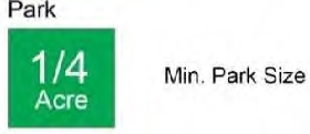
Table 522.9.P.-1
Park Elements/b>
f.
Programming / Amenities. To allow for diversity in the neighborhood park system, the Connected City Stewardship District allows park areas as small as one quarter acre to be included in the calculations for required neighborhood parks.
Linear parks that contain sidewalks, Multipurpose Trails or Multipurpose Paths may be included in the neighborhood park calculations even where certain segments of the linear park trail may be less than one quarte acre due to road crossings or other such encroachments as long as the average width of the linear park is 30 feet.
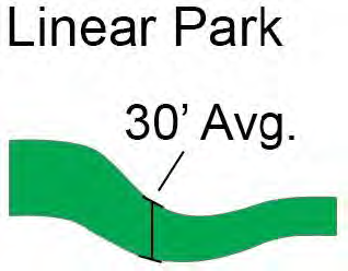
Other spaces smaller than one quarter acre may be used as green-space or contain park type elements but may not be counted toward the required total neighborhood park acreage calculation. Inclusion of non-linear park space smaller than one quarter acre for neighborhood park acreage calculations may be evaluated by the County Administrator or designee as part of the incremental approval process.
All parks shall incorporate elements such as those listed above in Table 522.9.P.-1. Park Elements.
The following is a general guideline. Applicants are encouraged to apply creativity and purpose innovative amenity packages for parks that can be evaluated by the Development Review Manager or designee as part of the incremental approval process.
(1)
All Neighborhood Parks.
(a)
Shall have a bench and a garbage/recycling receptacle as a minimum.
(b)
Shall have shade trees planted at a rate of one tree per quarter acre as a minimum.
(2)
Neighborhood Parks One-Quarter Acre to One Acre. Shall have at least two elements, which may include the elements listed in Table 522.9.P.-1 Park Elements above or other elements proposed by the applicant and evaluated by the County Administrator or designee.
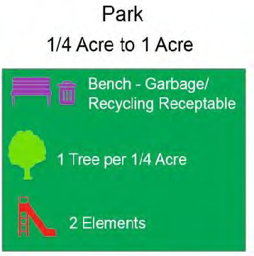
(3)
Neighborhood Parks One Acre and Greater.
(a)
Shall have an open play area.
(b)
Shall have at least one other element, which may include the elements listed in Table 522.9.P.-1 Park Elements above or other elements proposed by the applicant and evaluated by the County Administrator or designee.
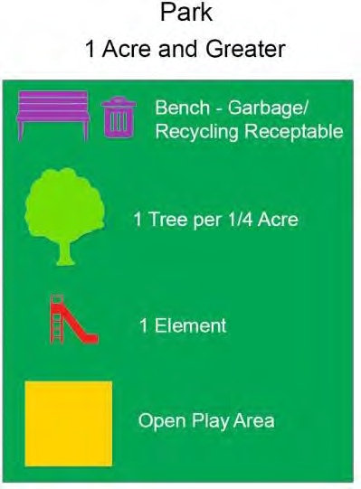
(4)
Linear Park Acreage.
(a)
Shall be measured in its totality to meet required acreage.
(b)
Shall have at least one or two elements, which may include the elements listed in Table 522.9.P.-1 Park Elements above or other elements proposed by the applicant and evaluated by the County Administrator or designee.
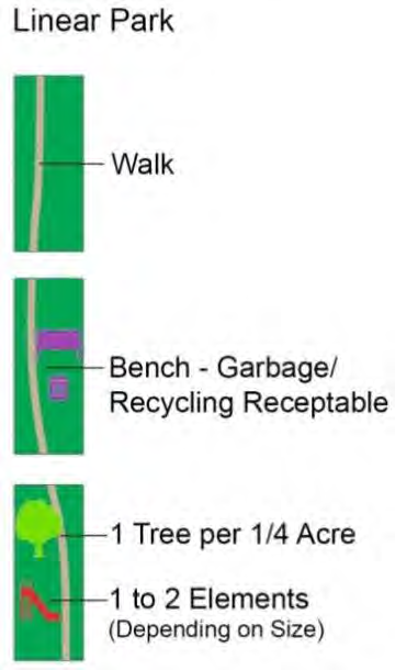
g.
Open Play Area Requirements.
(1)
Minimum setback of 25 feet from wetlands, lakes, or other water bodies; and
(2)
Minimum width of 80 feet.
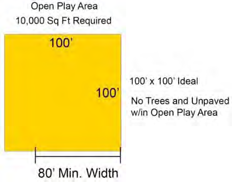
h.
Minimum Dimension. The required neighborhood park shall have a minimum dimension of 30 feet. As noted above, the open play area shall have a minimum width of 80 feet and a minimum area of 10,000 square feet.
i.
Equipment. If the neighborhood park includes playground or other recreational equipment, such equipment shall comply with all applicable American Society for Testing and Materials (ASTM), Americans with Disabilities Act, and Consumer Products Safety Commission standards.
For areas containing playground equipment for small children (often referred to as "tot lot" playgrounds), shading is to be provided by either shade trees, canopy or other method such that a minimum of one playground element and 50 percent of the seating areas are fully shaded.
j.
Internet / Intranet Connectivity. Wireless internet connectivity within neighborhood park areas is recommended, with high speed wireless connectivity preferred.
k.
Neighborhood Parks Collocated with Schools. Elements, Uses, and Dimensions for Neighborhood Parks collocated with a school will be determined by an agreement with the Pasco County School Board and shall not be subject to the standards in subsections 522.9.P.5.e, 5.f, 5.g, 5.h, and 5.i unless the School Board and Neighborhood Park Maintenance Entity agree to utilize these standards.
6.
Neighborhood Park Maintenance. The developer of a property that includes a neighborhood park shall be required to maintain and pay taxes on the neighborhood park(s) at no expense to the County, or convey such park(s) to a nonprofit homeowners' association; community development district; or open space trust. Neighborhood park(s) must be continuously maintained in a safe manner and consistent with safety standards established by the Consumer Product Safety Commission and ASTM. If a homeowners' association, community development district, or open space trust is formed, the developer shall provide documentation acceptable to the County demonstrating that such organization is governed according to the following:
a.
The organization is organized by the developer and operating with financial subsidization by the developer, if necessary, before the sale of any lots within the development.
b.
Membership in the organization is mandatory for all purchasers of dwelling units therein and their successors.
c.
The organization shall be responsible for maintenance of and insurance and taxes on the neighborhood park(s).
d.
The members of the organization shall share equitably the costs of maintaining and developing neighborhood park(s) in accordance with procedures established by them.
e.
The organization shall have or hire adequate staff to maintain the neighborhood park(s).
f.
In the event that the organization established to own and maintain the neighborhood park(s) or any successor organization shall at any time fail to maintain the neighborhood park(s) in reasonable order and condition, the County may serve written notice upon such organization and upon the residents and owners of the development setting forth the manner in which the organization has failed to maintain the neighborhood park(s) in reasonable condition. The said notice shall include a demand that such deficiencies of maintenance be cured within 30 days thereof. If the deficiencies set forth in the original notice shall not be cured within the said 30 days or any extension thereof, the County, in order to preserve the taxable values of the properties within the development and to prevent the neighborhood park(s) from becoming a public nuisance, may, upon approval by the Board of County Commissioners at a public hearing, enter upon the said neighborhood park(s) and maintain the same for any duration deemed appropriate by the County. The said entry and maintenance shall not vest in the public any rights to use the neighborhood park(s) and shall not cause the County to incur any liabilities or obligations related to such neighborhood park(s). The cost of such maintenance by the County, together with the cost of an insurance policy covering such maintenance (with the County as a named insured), shall be assessed ratably against the properties within the development that have a right of enjoyment of the neighborhood park(s) and shall become a tax lien on the said properties. The County, at the time of entering upon the said neighborhood park(s) for the purpose of maintenance, shall file a notice of such lien in the Office of the Clerk and Comptroller of the county upon the properties affected by such lien within the development. Notwithstanding the foregoing, the County shall be under no obligation to maintain any neighborhood park and nothing herein shall preclude the County from exercising any other available legal remedy for the failure to maintain neighborhood park(s).
7.
Alternative Standards. Alternative standards that meet or exceed the intent and purpose of this section may be approved.
Q.
Landscaping and Buffering.
1.
Intent and Purpose. It is the intent and purpose of this subsection to promote the health, safety, and general welfare of the current and future residents of the Connected City Special Planning Area by establishing minimum standards for the preservation, development, installation, and maintenance of a predominately native and water-efficient landscaping within the Connected City. (The types of native trees can be found at http://www.floridayards.org/fyplants/index.php.)
In addition, this section's intent is to promote and foster design creativity and flexibility in place of predictable adherence to minimum standards.
The use of plant materials improves the aesthetic appearance of public, commercial, industrial, and residential areas by reducing the visual impact of large building masses; by softening the visual impact of paved surfaces and vehicular-use areas; by screening conflicting uses from one another; and otherwise helping establish a harmonious relationship between the natural and built environment.
2.
Applicability. This section shall apply to all CC-Entitled Properties as defined in this Code, Section 603 Connected City Stewardship District.
3.
General Standards.
a.
Design.
(1)
Maintenance Responsibility. Landscaping plans must designate a person or entity, other than the County, to be responsible for maintenance of the landscaping. Landscaping within a public right-of-way shall require a County Right-of-Way Use Permit and a License and Maintenance Agreement. At the County Administrator or designee's discretion, the Right-of-Way Use Permit and License and Maintenance Agreement may be specified as a condition of approval to obtain the Hard Copy Site Development Placard (HCSDP).
(2)
Clear Sight Triangle. Except in the Urban Core, which is exempt from Clear Sight Triangle requirements, where a driveway/accessway intersects a road right-of-way or where two road rights-of-way intersect, vegetation, structures, and non-vegetative visual screens shall not be located so as to interfere with the clear-sight triangle as defined in this Code, the Florida Department of Transportation, Manual of Uniform Minimum Standards, most recent edition (Green Book), or the Florida Department of Transportation Design Standards, Index 546, most recent edition, whichever is more restrictive.
(3)
Sustainable Practices. Landscape installations shall employ environmentally sustainable principles and practices, which include Florida Friendly landscaping and utilize low-maintenance plant species. A comprehensive guide to Florida Friendly landscaping principles and materials is available at www.floridayards.org. Landscaping shall be installed so that landscaping materials meet the concept of right material/right place. Installed material shall be grouped into zones according to water, soil, climate, and light requirements. Plant groupings based on water requirements are drought tolerant, natural, and oasis.
Where shade trees are used as street trees (Table 522.9.Q.-1.), landscape buffer trees, building perimeter trees, or in other locations, the shade trees shall be planted a minimum of five feet from any sidewalk, curbing, pavement or other concrete/asphalt structure. Where this design minimum of five feet cannot be achieved, root barriers or other root control methods as specified by a Florida licensed landscape architect or engineer shall be used as depicted in Figure 522.9.Q.-1.
Figure 522.9.Q.-1 Example of Required Root Barrier Adjacent to Concrete/Asphalt Structures
for Shade and/or Street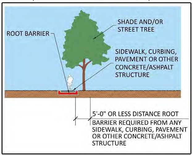
TABLE 522.9.Q.-1
(4)
Diversity.
(a)
A minimum of 50 percent of the plant materials used, other than trees, shall be drought tolerant.
(b)
A minimum of 30 percent of the plant materials, other than trees and turfgrass, shall be native Floridian species suitable for growth in the County.
(c)
Providing a diversity of tree species shall be a goal. However, the number and type of species provided on any specific development plan shall be determined by the creative intent of the applicant's Florida Licensed Landscape Architect of Record.
(d)
No one plant species of shrubs or ground cover plants or combination thereof, excluding turfgrass, shall constitute more than 33 percent coverage of the overall landscape area.
(5)
Tree Location.
(a)
Trees required for buffering shall be installed within the landscape buffer. Trees installed to replace trees that were removed must be located on the site.
(b)
Public and private road rights-of-way may contain trees and other landscaping material, provided their location does not present a traffic hazard, impede drainage, or adversely interfere with the use of the right-of-way by utilities. For shade trees planted within the public or private road rights-of-way, root barriers or other root control methods as specified by a Florida licensed landscape architect shall be used to protect sidewalks, pavement, and other such structures as well as to prevent damage to utilities.
(c)
Street Trees.
(i)
Street trees shall be required along Primary, Intermediate, and Local Roads outside of the Urban Core Zone. Where street trees are required, one tree shall be installed per 50 linear feet of roadway on both sides of the road right-of-way. Phoenix palms (other than Robellini) may be planted at a spacing of 50 linear feet. If other palms are used, they shall be installed every 25 linear feet.
(ii)
Street trees shall be shade trees unless otherwise approved by the County Administrator or designee as part of the incremental approval process. Street trees shall have a minimum height of six feet, minimum caliper of two inches, and be Florida Grade #1 or better in quality. No more than 30 percent of street trees may be palm trees. Where palms are substituted for shade trees, they shall be a single trunk species, with a minimum clear trunk of ten feet, and a minimum dbh of eight inches.
(iii)
Street trees should be centered and evenly spaced. However, reasonable flexibility in spacing, including clustering, to accommodate driveways, utilities, lighting, pedestrian and Multipurpose Path crossings, utility appurtenances, etc., may be requested by the applicant's Florida registered Landscape Architect of Record.
(iv)
Street trees may be planted between the sidewalk and the curb. Root barriers will not be required for street trees included in Table 522.9.Q.-1, in areas equal to ten feet in width or greater as depicted in Figure 522.9.Q.2. Root barriers shall be required for street trees included in Table 522.9.Q.-1, above, in areas less than ten feet in width as depicted in Figure 522.9.Q.3.
Figure 522.9.Q.-2 Example of Minimum Landscape Area for Street Tree Not Requiring
Root Barrier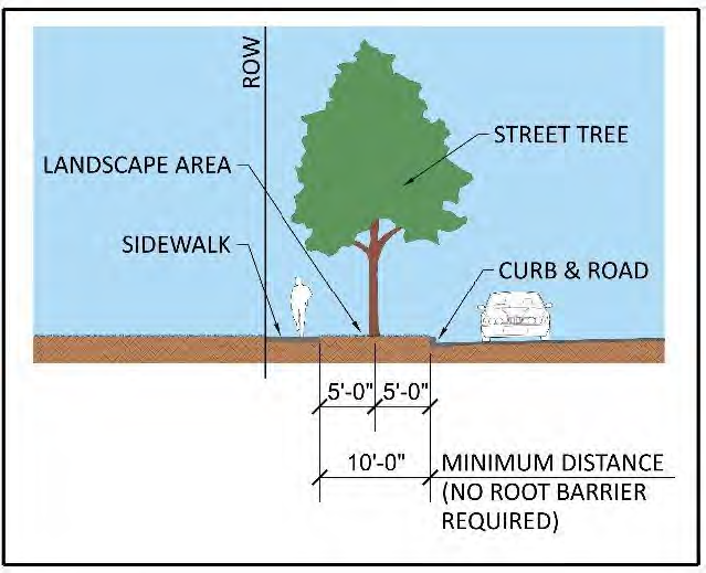
Figure 522.9.Q.-3 Example of Landscape Area for Street Tree Requiring Root Barrier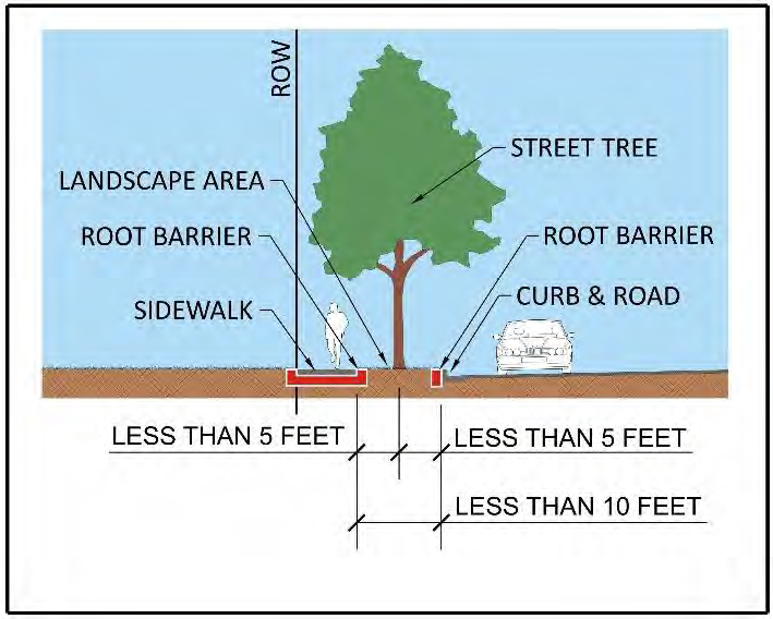
(v)
When not feasible to provide street trees inside the road right-of-way, street trees shall be planted within five feet of the right-of-way as depicted in Figure 522.9.Q.4. At the County Administrator or designee's discretion, an easement or dedicated tract may be required along with a license and maintenance agreement.
Figure 522.9.Q.-4 Example of Landscape Area for Street Tree Requiring Root Barrier
and Locating the Street Tree Outside of the Right-of-Way to Avoid Root Barrier Requirement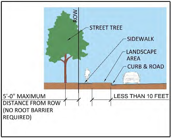
(vi)
Shade trees used as street trees shall be planted a minimum of ten feet from any above-ground utility appurtenance, such as transformer pads, meter assemblies, and fire hydrants.
(d)
Public and private road rights-of-way may contain trees and other landscaping material, provided their location does not present a traffic hazard, impede drainage, or adversely interfere with the use of the right-of-way by utilities. Landscaping within a public right-of-way that is approved through the applicable review process, where landscaping other than sod or ground cover is proposed, shall require a County Right-of-Way Use Permit and potentially a License and Maintenance Agreement.
(6)
Use of Existing, Noninvasive Plant Materials. Existing, noninvasive plant materials may be used to meet the buffering and landscaping requirements, provided there is no reduction in the required percentage of landscaped area or reduction in the number of required trees or shrubs. If existing plant materials are retained to meet the requirements, the following standards shall apply:
(a)
Areas of retained plant materials shall be preserved in their entirety with all trees, understory, and ground cover left intact and undisturbed, provided that invasive, prohibited plant materials are removed.
(b)
Numbered photographs with site plan key, showing the extent of the existing landscaping shall be provided during the review process for assessment of the existing landscaping.
(c)
The protection of existing, noninvasive plant materials shall conform to the standards listed in this Code, Section 802 Tree Preservation and Replacement.
(d)
Where existing, noninvasive vegetation meeting the intent of a landscape buffer is retained, required berms and buffering may be eliminated in whole or part through the use of an alternative standard. The subsequent removal of the existing vegetation shall void any alternative standard approved.
(e)
Trees located within environmentally sensitive lands shall not be counted or credited toward the total number of trees required.
b.
Quality of Trees.
(1)
Trees to be planted shall be Florida Grade No. 1 or better pursuant to the Florida Department of Agriculture and Consumer Services, Division of Plant Industry, Grades, and Standards for Nursery Plants, which is incorporated herein by reference.
(2)
Invasive Species.
(a)
The planting of species listed in Rule 5B 57.007, Florida Administrative Code, as amended, or classified as invasive by the Florida Exotic Pest Plant Council, is prohibited.
(b)
Invasive species located within the area of the project proposed to be developed are required to be removed.
(3)
Shade Trees. All shade trees used to satisfy landscaping requirements shall have a two-inch caliper trunk and be a minimum of six feet in height at the time of installation. All required shade trees shall be a species having an average mature spread of greater than 20 feet.
Where interference with overhead utility lines is probable, understory shade trees shall be planted. To avoid a powerline conflict, vegetation that exceeds 25 feet in height at maturity shall not be planted closer than 20 feet of the vertical plane of an existing powerline, excluding service wires. Consultation with the affected utility should occur for assistance with the selection of suitable vegetative species.
(4)
Multiple-Trunk Trees. All proposed multiple-trunk trees shall have no less than three trunks, equal to or greater than three inches caliper, and shall be a minimum of six feet in height at the time of installation.
(5)
Palms. Palm trees may be substituted for shade trees at a rate of three palm trees, grouped together, for one shade tree. Palm trees may be substituted for up to 30 percent of the required shade trees. Exceptions may be made for the Phoenix (not including Roebellini), which may be planted individually. Palms must have a minimum of ten feet of clear trunk at the time of installation.
c.
Shrubs.
(1)
Shrubs, grown in the appropriate sized containers, shall have the ability to be a minimum of 24 inches within one year of planting and shall maintain that height. Shrubs shall be a minimum of 18 inches in height at the time of installation.
(2)
Dwarf variety of shrubs, grown in the appropriate-sized containers, shall be a minimum of 14 inches in height at the time of installation.
d.
Ground Cover. Ground cover plants shall be spaced so as to present a finished appearance and to obtain a reasonably complete coverage within one year after planting. Nonliving ground cover, such as mulch, gravel, rocks, etc., shall be used in conjunction with living plants so as to cover exposed soil and suppress fugitive dust.
e.
Installation of Planting Materials.
(1)
Avoid Utility Conflicts. Landscape installations shall be placed to avoid conflict with the existing and/or proposed utilities, both underground and overhead.
(2)
Good Condition. All trees shall be planted according to the Florida Chapter, International Society of Arboriculture Standards for Planting, which is incorporated herein by reference. All trees must be maintained in good condition and planted in locations with adequate open space to allow for mature tree-canopy development.
(3)
Avoid Easements. Trees shall not be planted within any easement so as to interfere with the use of that easement, nor under any present or planned overhead utility, nor in any rights-of-way without County approval through the associated review process.
(4)
Mulch. Mulch shall be used in conjunction with living plant materials so as to cover exposed soil. Mulch shall be installed to a minimum depth of three inches. The mulch should not be placed directly against the plant stem or tree trunk. Mulch shall not be required for annual beds. Stone or gravel may be used to cover a maximum of 20 percent of the landscaped area.
(5)
Quality Practices. All landscaping shall be installed in accordance with standards and practices of the Florida Nursery, Growers, and Landscape Association and the Florida Chapter of the International Society of Arboriculture.
(6)
Height. All height requirements shall be based on the finished grade of the landscaped area and measured at the main stem.
(7)
All portions of a lot upon which development has commenced, but not continued for a period of 30 days, shall be planted with a grass species or ground cover to prevent erosion and encourage soil stabilization. Adequate coverage, so as to suppress fugitive dust, shall be achieved within 45 days.
f.
Certification Requirements for New Development.
(1)
Certification. A registered landscape architect or other person as authorized by Chapter 481, Florida Statutes, as amended, or other type of professional as approved by the County Administrator or designee, shall conduct a final field inspection. A Certificate of Compliance with the requirements of this section shall be provided to the County and the property owner prior to obtaining a Certificate of Occupancy (CO). If the property owner installs the landscaping and irrigation, the owner shall act as the certifying agent.
(2)
Installation Prior to CO. Prior to the issuance of any CO, or where no CO is required, prior to final inspection or the use of the lot, all required landscaping shall be installed and in place as set out in the approved landscape plans. In cases where timely installation of landscaping is not practical due to the season or shortage, as determined by the County Administrator or designee, a bond satisfactory to the Engineering Services Department shall be posted until the planting occurs.
4.
Specific Planting Requirements.
a.
General. The following general standards and the specific planting standards below shall apply to all sites:
(1)
All portions of each site, which are not devoted to buildings, sidewalks, paving, or special landscape features shall be grassed. However, no more than 30 percent of the required landscape area may be grassed; the balance shall be landscaped in shrubs and ground cover plants, except where turfgrass varieties with excellent drought tolerance may exceed the 30 percent limitation.
(a)
Impervious areas shall not be located within a required buffer except:
(b)
Driveways, sidewalks, Multipurpose Paths, and Multipurpose Trails are constructed perpendicular to the buffer in order to provide direct access to the parcel or adjacent parcels.
(2)
Where allowed within this Code, a meandering sidewalk, Multipurpose Paths and Multipurpose Trails may be provided within the buffer.
b.
Specific Standards for Single and Two Family Residential. A tree planting requirement. A minimum number of trees shall be planted or retained on all property upon which either a single-family dwelling, a two family dwelling, or a mobile home on an individual lot is located or to be located in accordance with Table 522.9.Q.-2 Minimum Tree Planting for Single & Two Family Dwellings.
TABLE 522.9.Q.-2
Minimum Tree Planting for Single- & Two-Family Dwellings
c.
Vehicular Use Areas. Landscaping and buffering of vehicular use areas shall be in accordance with Table 905.2.-C Vehicular Use Area Landscaping in this Code, Section 905.2. Landscaping and Buffering, which is not altered in the CC-SPA.
d.
Building Perimeter. The intent and purpose of building perimeter landscaping is to provide for visual interest, prevent monotony, break up wall and pavement expanses, and clearly define entryways. The developer shall propose building perimeter landscaping, which shall be provided in an amount and configuration determined by the creative intent of the Florida licensed Landscape Architect of Record and shall be subject to the review and approval of the County Administrator or designee.
e.
Perimeter Landscape Buffering and Screening. The intent and purpose of providing landscape buffering and screening is to promote an aesthetically pleasing developed environment that provides visual interest to pedestrians and motorists as well as separation between uses and intensities where appropriate. Buffer and screening type required is based on the subject property's use/SPA Zone and the adjacent use/SPA Zone as shown in Table 522.9.Q.-3 Landscape Buffer Type Required by Adjacent Use and Table 522.9.Q.-4 Landscaping Buffering and Screening Requirements.
TABLE 522.9.Q.-3
Landscape Buffer Type Required by Adjacent Use
*
Parking and Utility Service Areas in the Urban Core are uses requiring buffers except
as specified in Code Section 522.9.Q.4.h.
**
If a front of building adjacent to right-of-way no buffer required
Figure 522.9.Q.-5 Buffer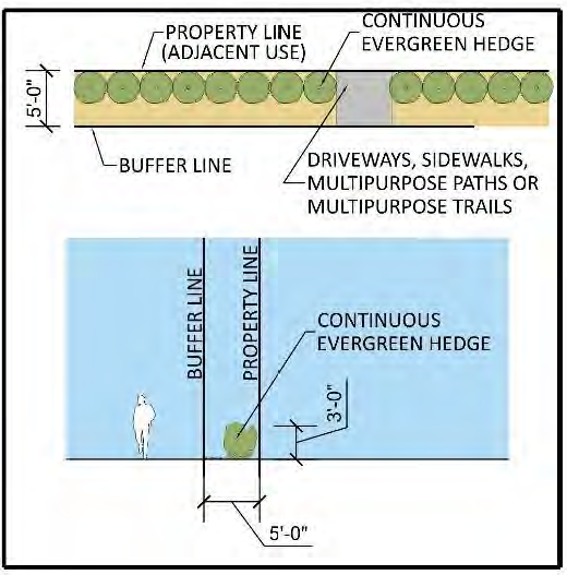
Figure 522.9.Q.-6 Buffer 2 (Evergreen Shrub Hedge)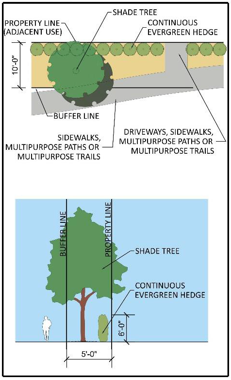
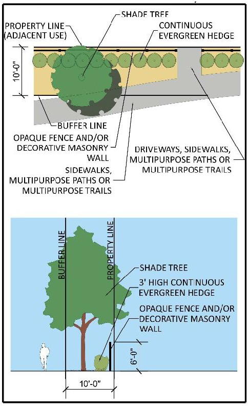
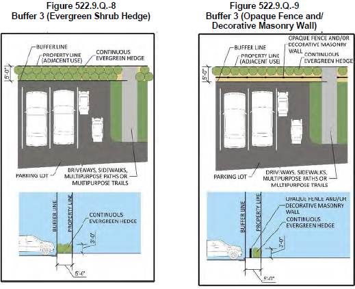
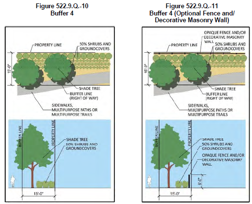
Figure 522.9.Q.-12 Buffer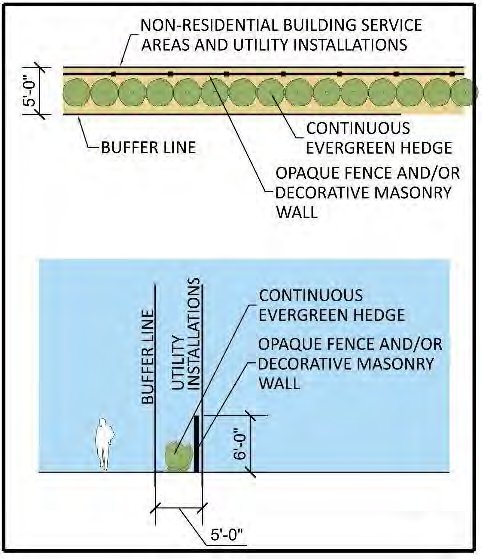
5.
Water Management Systems.
a.
Portions of all manmade dry and wet retention areas that are visible from the right-of-way or located within a required buffer shall be planted. Alternative design solutions, such as grouping of plantings, may be approved through the applicable review process as long as a minimum of one tree is provided for each 50 linear feet of retention pond bank. The said retention ponds shall be landscaped in accordance with this Code and may contain special site features, such as fountains and reflecting pools. Existing, natural vegetation may be used in lieu of new plantings.
b.
Retention/detention ponds and swales shall be permitted within a required buffer provided they are consistent with the following criteria:
(1)
Retention/detention ponds and swales shall not exceed, at any location within the required buffer, 70 percent of the required buffer width. A minimum five foot wide, level planting area shall be maintained between the retention/detention pond or swale and the public right-of-way or adjacent parcel. This area shall be planted with trees and shrubs, as determined by this Code, Section 802 Tree Preservation and Replacement.
(2)
The required vegetation shall be chosen and placed such that the functionality of the stormwater design is not impeded.
(3)
To reduce soil erosion and visually soften the edge of the water management areas, trees shall be planted along the banks of the water management area at a minimum rate of one tree per 50 linear foot of pond bank.
c.
The banks of dry retention areas shall be sodded to the pond bottom. Wet retention areas shall be sodded to the seasonal high water line. Bahia grass may be used or planted in retention/detention areas, drainage areas, wetland setback areas and mitigation areas.
d.
Stormwater retention and detention areas that are visible from the public right-of-way or located within a required buffer and, if required to be fenced in accordance with the SWFWMD requirements, shall be enclosed with a nonopaque, six foot decorative, metal or vinyl-coated chain-link fence. Regular chain-link fences shall not be permitted.
6.
Landscape Maintenance and Prohibitions.
a.
All landscaping, including those areas located in the public right-of-way as approved through the applicable development review process, shall be maintained by an entity other than the County.
b.
All required landscaping shall be maintained in a healthy condition in perpetuity in accordance.
c.
All installed landscaping shall be neat and orderly in appearance and kept free of refuse, debris, disease, pests, and weeds, and shall be fertilized and irrigated as needed to maintain plants in a healthy condition.
d.
Ongoing maintenance to prevent the establishment of prohibited, invasive species is required.
e.
Any plant materials of whatsoever type and kind required by these regulations shall be replaced within 30 days of their demise and/or removal.
f.
Paving, treating, or covering a required landscape area in any way that renders it impervious is prohibited.
g.
Parking of vehicles shall not be permitted in required landscape areas.
R.
On-Site Parking.
1.
Intent and Purpose. On-site, off-street parking facilities shall be provided to lessen congestion in the streets, while ensuring safe and efficient movement of traffic, allowing flexibility in addressing vehicle parking, and ensuring that parking needs associated with new development and redevelopment are met without adversely affecting other nearby land uses, vehicle and non-vehicle movement, and surrounding neighborhoods, The purpose is to provide sufficient parking to accommodate the majority of traffic generated by the range of uses which might be located at the site over time. In the CC-SPA, parking facilities shall be designed to put pedestrians first, accommodate neighborhood vehicles, foster pedestrian and neighborhood vehicle connectivity, and where appropriate, consider redevelopment.
2.
Applicability. This section shall apply to a new development site, a redeveloped site, or where a change in site use occurs within the Connected City for CC-Entitled Properties as defined in this Code, Section 603 Connected City Stewardship District.
3.
Existing Nonconformities. Existing developed sites not meeting the requirements of this Section shall be brought into full compliance when one or more of the following conditions are met:
a.
An existing use is improved or remodeled in a value of 25 percent or more of the valuation of the existing principal structure as reflected on the Property Appraiser's current records.
b.
An amendment is required to an existing approved site plan.
c.
A change in use generates a requirement for additional parking.
4.
General Standards.
a.
On-site parking facilities required herein shall be available throughout the hours of operation of the particular business or use for which such facilities are provided. As used herein, the term parking space includes either covered garage space or uncovered parking lot space located off the right-of-way. Service areas such as gas-pump pads, drive-through aisles, or similar areas shall not be calculated as parking spaces. Parking lots should be located along the rear and sides of buildings, with the buildings close to the rights-of-way to promote pedestrian access, reduce visual clutter, and increase store recognition. Parking lots located in the front of buildings are not prohibited. However, in all cases, specific building position and orientation, and location of parking lots relative to the building shall be reviewed on a case-by-case basis in a collaborative process between the applicant and staff to ensure that key Connected City Planning Principals, such as accommodating pedestrians and neighborhood vehicles, and designing for redevelopment, are reflected in the design.
b.
All parking spaces shall be ample in size for the vehicles for which use is intended. The parking space area per vehicle, exclusive of any driveway or other circulation area, shall be accessible from a street, alley, or maneuvering area, and shall be not less than:
TABLE 522.9.R.-1
c.
The minimum parking stall length and aisle width shall be as follows:
TABLE 522.9.R.-2
Minimum Stall Length and Aisle Width
Figure 522.9.R.-1
Off-Street Parking Stall Dimensions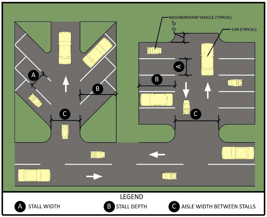
Where neighborhood vehicle parking spaces are provided along a Multipurpose Trail, the stalls shall be placed on one side of the trail only and shall be 90° spaces. The minimum Multipurpose Trail width shall be 12 feet adjacent to the parking spaces.
d.
The requirements above for neighborhood vehicle parking spaces shall apply to those developments that elect to include specific parking spaces for neighborhood vehicles. Nothing herein shall preclude neighborhood vehicles from parking in conventional parking spaces. Two neighborhood vehicles shall be permitted to park in standard vehicle 90° parking spaces in accordance with the arrangement shown in Figure 522.9.R.-2, Neighborhood Vehicle Parking - Two Cars per Space. Up to four neighborhood vehicles shall be permitted to park side-by-side at an angle of 90° to the street in standard vehicle parallel parking spaces in accordance with the arrangement shown in Figure 522.9.R.-3, Neighborhood Vehicle Parking - Four Cars per Space.
Figure 522.9.R.-2
Neighborhood Vehicle Parking in Standard 90 Degree Parking Space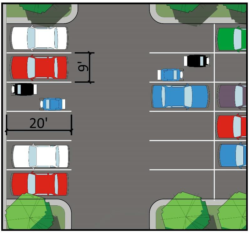
Figure 522.9.R.-3
Neighborhood Vehicle Parking in Standard Parallel Parking Space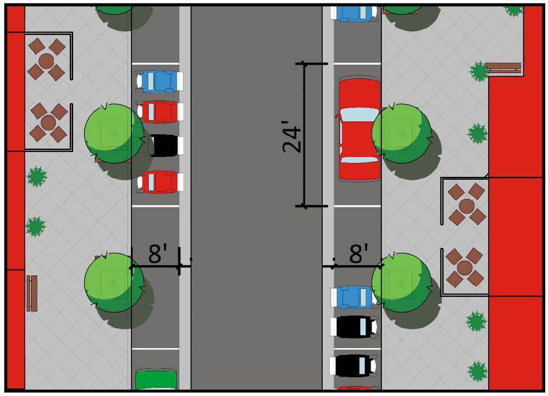
As part of putting pedestrians first, parking lots shall be connected to the sidewalk network of surrounding streets. As well, safe pedestrian circulation within the lot and connections to adjacent uses shall be prioritized over vehicle capacity.
e.
Commercial, office, multi-family, or other projects of a size that requires parking equal to or greater than 200 spaces shall be required to comply with the Complete Streets concept. Complete Streets measures that shall be employed include the following:
(1)
Placement of five foot minimum width concrete sidewalks along both sides of all drive aisles or access roads that do not have parking spaces on them. Refer to graphic examples in CC-Master Roadway Plan.
(2)
Placement of a five foot minimum width concrete sidewalk along at least one side of the drive aisle running parallel to the front of the building. Refer to graphic examples in CC-Master Roadway Plan.
(3)
Placement of crosswalks across the drive aisle running parallel to the front of the building at each building entrance to promote safe pedestrian crossing.
(4)
Parking Lot Design. The intent and purpose of this subsection is to provide parking lot design which breaks up vast expanses of pavement by creating clearly defined groupings of parking spaces while providing for vehicular needs and safe, efficient, comfortable, pedestrian flow. Vast unbroken parking lots are prohibited. Pedestrian corridors shall be used to create these separations. (See Figure 522.9R.-4 for illustrative example).
Figure 522.9.R.-4
Pedestrian Corridor Exhibit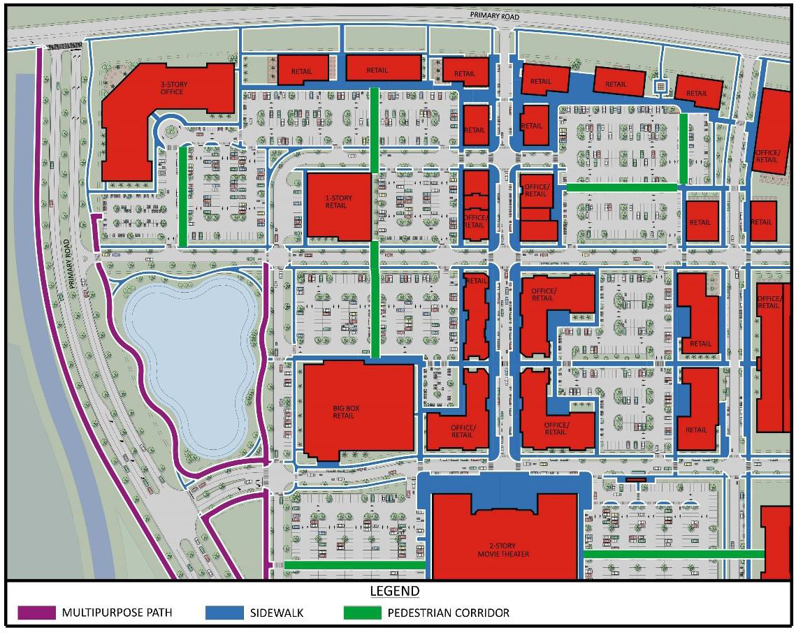
(a)
Parking areas shall be designed so that no more than 100 spaces (150 spaces for uses that require 501 or more parking spaces) of the total required spaces are part of a clearly defined grouping of spaces. Such groups shall be broken into individual areas and/or clearly separated by pedestrian corridors. The design of the pedestrian corridor shall consider pedestrian movements, conflict points with vehicles, site distance and angles, security site lighting, and safety within the parking lot area. The pedestrian corridor dimensions shall be a 12 feet minimum width and contain nine feet by six feet landscape and tree islands as shown in Figure 522.9.R.-5. There are many design options for pedestrian corridors. Refer to Figures 522.9.R.-6, 522.9.R-7, and 522.9.R.-8 for three examples of permitted design options.
Figure 522.9.R.-5
Pedestrian Corridor Plan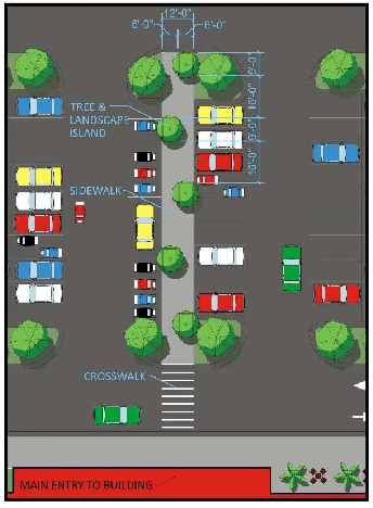
Figure 522.9.R.-6
Pedestrian Corridor
Section Option A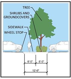
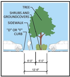
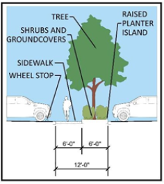
f.
Multipurpose Trails shall be connected to parking lots to allow neighborhood vehicles to access neighborhood vehicle parking spaces or conventional parking spaces, as applicable.
g.
For single-family attached and multiple-family units with individual garage/driveway arrangements, one vehicle may be stacked behind (parked in tandem to) each required off-street parking space and located between garage or carport and the street right-of-way line. Tandem parking must be located in a driveway or designated stabilized area. A clear-sight triangle shall be maintained. In no case shall parked vehicles placed tandem, including hitches or mechanical equipment, overhang a sidewalk. Stacked parking spaces may not be attributed to units not served directly by the driveway/garage. Tandem parking spaces shall be a minimum 40'L × 9'W of which eight feet must be stabilized, and a maximum of 42'L × 16'W, which may include the covered spaces.
h.
Commercial and industrial parking may be at a ratio of 75 percent full size to 25 percent compact parking spaces. If compact spaces are used, they should be evenly distributed throughout the site and shall be denoted by signs or pavement markings. Compact parking spaces shall not be less than 18'L × 8'W.
i.
Dead-end parking aisles greater than 150 feet in depth shall provide an emergency vehicle turnaround acceptable to the county fire marshal sufficient for a 38-foot long truck with a 32-foot wheel base, or as determined by the county fire marshal.
j.
A garage or carport may be located wholly or partly inside the walls of the principal building, or attached to the outer walls. If separated from the principal building, the garage shall conform to all accessory building requirements. A freestanding parking garage on a separate parcel shall meet all principal building requirements. Additionally, the opening of the garage shall be sufficiently set back such that any queuing occurs outside of the right-of-way.
k.
Surfacing: Any off-street parking area shall be graded for proper drainage and shall be surfaced so as to provide a durable and dustless surface including, but not limited to, a gravel, concrete, bituminous concrete, or stabilized vegetation surface, and shall be so arranged as to provide for orderly, safe parking, and storage of vehicles.
l.
Vehicle wheel stops or other design features, such as curbing, shall be used so that parked vehicles do not extend more than two feet into any landscape or buffer area nor reduce an abutting sidewalk width to less than five feet.
m.
All vehicular use areas shall comply with the applicable requirements of the Americans with Disabilities Act.
n.
Parking structures can be either single-level garages with ground-level parking beneath the upper levels containing habitable floor area, or multi-level garages with ramps leading to at least one elevated parking deck.
Parking Garage Design standards: The following requirements shall apply to parking garages:
(1)
Minimum setbacks: Parking garages shall comply with the minimum setbacks for principle structures in accordance with the approved CC-MPUD rezoning for the parcel on which they are situated.
(2)
Maximum height: Parking garages shall comply with the maximum height for structures in accordance with the approved CC-MPUD rezoning for the parcel on which they are situated.
(3)
Minimum parking stall dimensions: Shall comply with Table 522.9.R.-2.
(4)
Minimum drive aisle widths: Shall comply with Table 522.9.R.-2.
(5)
Floor Area Ratio: Parking garages shall not be counted toward the allowable Floor-Area Ratio for a site unless specifically required by the zoning district.
(6)
Vehicular accessibility: Vehicular access shall be designed in a manner that minimizes disruption to pedestrian corridors and the streetscape.
(7)
The width of a driveway intersecting a public sidewalk shall comply with Access Management Section of this Code.
(8)
Minimum vehicle stacking requirements at entry points.
(a)
Free flow entries means an entry into a parking garage without controls, such as attendants or automatic ticket-dispensing controls: one vehicle space per entry lane.
(b)
Automatic ticket-dispensing entries mean an entry into a parking garage controlled by a machine dispensing tickets for garage use: two vehicle spaces per entry lane.
(c)
Manual, ticket-dispensing entries mean an entry into a parking garage controlled by a person manually dispensing tickets for garage use: four vehicle spaces per entry lane.
(d)
Manual, key-card entries mean an entry into a parking garage controlled by a key card for garage use: two vehicle spaces per entry lane.
(9)
Orientation: In order to orient parking structures to the interior of development sites, parking garages shall:
(a)
Include residential dwelling units, retail storefronts or office facades along all first floor exterior walls adjacent to a street, excluding alleys, except where driveways exist; or;
(b)
Shall be screened with ornamental grillwork, artwork, or similar architectural features.
(10)
Architectural design: Parking structures shall be compatible with abutting structures.
(11)
Lighting: Light poles on top of parking garages shall be limited to a maximum height of 20 feet. Lighting on top of parking garages is prohibited between the hours of 11:00 p.m. and sunrise, except that lighting is allowed while the parking facility is open to the public. Security lighting is excluded from this prohibition.
o.
Nothing herein shall be construed to preclude the use of on-street parking on appropriate street types within the Urban Core (refer to Typical Sections in the CC-MRP. On-street parking spaces, if provided adjacent to a building or use within the Urban Core, shall off-set, one-for-one, required off-street parking spaces addressed in this Code, Subsection 522.9.R.5 Parking Facilities Required.
(1)
On-street parking shall be provided in accordance with the dimensions set forth in this Code, Table 522.9.R.-2 Minimum Stall Length and Aisle Width, above.
(2)
On-street parking shall be allowed within "Clear Sight Lines" as defined in the Florida Department of Transportation Design Standards, Index 546 and "sight triangles," as defined in Chapter 3 of the Florida Department of Transportation Manual of Uniform Minimum Standards for Design, Construction, and Maintenance for Streets and Highways.
5.
Required Parking Facilities. Any structure or building hereafter erected, converted, or enlarged for any of the following uses, or any open area hereafter used for commercial purposes, shall be provided with not less than the minimum spaces as set forth below, which spaces shall be readily accessible to the uses served thereby. Fractional numbers of parking spaces shall be increased to the next whole number.
Prior to permitting parking in excess of 110 percent of the required parking or ten spaces, whichever is more, consideration shall be given to shared parking pursuant to this Code, Subsection 522.9.R.7 Allowed Parking Facility Reductions.
If parking spaces are provided in excess of ten percent of the required parking, those excess parking spaces are encouraged to be constructed with low impact materials; e.g., pervious pavers or stabilized vegetation.
Requirements for off-street parking for uses not specifically mentioned shall be the same as provided for the use most similar to the one sought as determined by the County Administrator or designee.
In such instances, the applicant shall provide adequate information by which the proposal can be reviewed, which includes but may not necessarily be limited to the following:
a.
Types of uses;
b.
Number of employees;
c.
Building design capacity;
d.
Square feet of sales area and service area;
e.
Parking spaces proposed on site;
f.
Parking spaces provided elsewhere; and
g.
Hours of operation.
Table 522.9.R.-3
6.
Neighborhood Vehicle Parking.
a.
Allowances for neighborhood vehicles in this Code, Subsection 522.9.R.4.d notwithstanding, high schools within the Connected City shall be required to have a minimum of ten neighborhood vehicle spaces per classroom arranged in a dedicated neighborhood vehicle parking lot. Access to these neighborhood vehicle parking lots shall be from a 12-foot minimum Multipurpose Trail. The Multipurpose Trail shall not cross car or bus accesses to the high school within high school property.
Figure 522.9.R.-9
High School Exhibit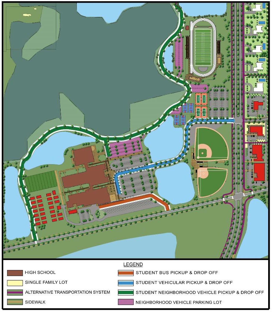
b.
When dedicated neighborhood vehicle parking spaces are provided, they shall be allowed to reduce standard vehicle parking spaces on a one-for-one basis, up to ten percent of the required number of standard vehicle parking spaces.
7.
Allowed Parking Facility Reductions. Where the following alternative transportation options are provided, the required parking spaces for Multi-family, Commercial, Office, and Industrial uses may be reduced; such options shall be assessed cumulatively:
a.
Carpools, Vanpools or Bike-Sharing. Where infrastructure and support programs to facilitate shared vehicle or bicycle use, such as carpools, vanpools, car-share services, ride boards, bike-share systems and shuttle services to mass transit are provided, the required parking spaces may be reduced by up to ten percent.
b.
Low-Emitting, Fuel Efficient, and Alternative Energy Vehicle Sharing Program. Where building occupants have access to a low-emitting, fuel efficient or alternative energy vehicle-sharing program, the required parking spaces may be reduced by up to ten percent. The following requirements must be met:
(1)
A vehicle-sharing contract must be provided that has an agreement of at least two years.
(2)
The estimated number of building occupants served per vehicle must be supported by documentation.
(3)
A narrative explaining the vehicle sharing program and its administration must be submitted.
(4)
Parking for low-emitting and fuel efficient vehicles must be located in the nearest available spaces in the nearest available parking area.
In addition to the reduced number of spaces, the spaces provided for low-emitting, fuel efficient, or alternative energy vehicles may be reduced to a minimum of 5'W × 9'L.
c.
Transit Facilities. Where the facility is located within one-quarter mile walking distance (measured from the project boundary) of one or more existing or planned stops, the required parking spaces may be reduced by up to 15 percent.
Where a reduction in the required parking is requested, the applicant shall provide an alternative standard applicable with adequate information by which the proposal can be reviewed.
d.
Shower and Locker Room Facilities for Cyclists. Developments with 100 or more employees may reduce their automobile parking requirement by ten percent when showers and locker room facilities are provided for employees that commute by bicycle.
8.
Shared Parking. To reduce heat island effects and the development of unnecessary, impervious parking areas; shared parking is encouraged.
Shared parking may be allowed when land uses have different parking demand patterns and are able to use the same parking spaces/areas throughout the day. Shared parking is most effective when these land uses have significantly different peak-parking characteristics that vary by the time of day, day of the week, and/or season of the year.
a.
Calculation of Parking Spaces Required with Shared Parking. The minimum number of parking spaces for a mixed-use development or where shared-parking strategies are proposed shall be determined by a study prepared by the applicant following the procedures of the Urban Land Institute (ULI), Shared Parking Report, Institute of Transportation Engineers (ITE), Shared Parking Guidelines, or other approved procedures. A formal parking study may be waived where there is established experience with the land use mix and its impact is expected to be minimal. The actual number of parking spaces required shall be based on well recognized sources of parking data, such as the ULI or ITE reports. If standard rates are not available or limited, the applicant may collect data at similar sites to establish local parking demand rates. If the shared parking plan assumes use of an existing parking facility, then field surveys shall be conducted to determine actual parking accumulation. These surveys should consider the seasonal peak period for the combination of land uses involved. The applicant shall determine the minimum number of parking spaces required for shared-parking arrangements or mixed-use developments by the following:
(1)
Determine the number of parking spaces that are required for each land use separately.
(2)
Based on the hourly variation in parking demand, determine the peak-parking demand for the combined demand of all the uses in the development.
(3)
Compare the calculations in Steps (1) and (2) above, and the lesser of the two peak-parking demands shall be used as the minimum number of parking spaces that needs to be provided.
b.
Distance to Parking Spaces and Pedestrian Connection Requirements. The closer shared spaces are to the land uses they serve, the more likely the arrangement will be a success. Shared spaces for residential units must be located within 300 feet of dwelling unit entrances they serve. Shared spaces at other uses must be located within 500 feet of the principal building entrances of all sharing uses. However, up to 20 percent of the spaces may be located greater than 500 feet but less than 1,000 feet from principal entrances. Clear, safe pedestrian connections must be provided. Up to 50 percent of nonresidential spaces may be provided at greater distances if a dedicated shuttle bus or van service is provided from a remote parking facility.
c.
Agreement Between Sharing Property Owners. If a privately owned parking facility is to serve two or more separate properties, a recorded legal agreement between property owners guaranteeing access to, use of, and management of designated spaces is required. The recorded, legal agreement shall be acceptable to the County Attorney's Office.
d.
Shared Parking Plan. Where shared parking is proposed, a shared parking plan shall be submitted that includes the following:
(1)
A site plan of the parking spaces intended for shared parking and their proximity to land uses they will serve.
(2)
A signage plan that directs drivers to the most convenient parking areas for each particular use or group of uses (if distinctions can be made).
(3)
A pedestrian circulation plan that shows connections and walkways between parking areas and land uses. These paths should be as direct and short as possible.
(4)
A safety and security plan that addresses lighting and maintenance of the parking area.
9.
Bicycle Parking Facilities Standards. The following customer standards shall apply for bicycle storage areas:
a.
Bicycle parking facilities shall include provisions for the secure storage and locking of bicycles in a stable position without damage to wheels, frames, or components.
b.
All designed bicycle parking facilities shall be provided with markings and symbols clearly visible to the public which indicates the location of the bicycle parking facilities.
c.
For nonresidential developments, visitor and customer bicycle - parking facilities must be clearly visible from a main entry and located within 100 feet of the door, served with night lighting where required, and protected from damage from nearby vehicles. If the building has multiple main entries, bicycle parking facilities must be proportionally dispersed within 100 feet of each entry.
S.
Home Occupations.
1.
Intent and Purpose. The intent of this section is to provide for certain types of restricted home occupations within the Connected City Entitled Properties. The purpose of this section is to establish performance standards that will provide fair and equitable administration and enforcement of this section within property which is a CC-Entitled Property as defined in this Code, Section 603 Connected City Stewardship District. Only such uses will be allowed which:
a.
Are incidental to the use of the premises as a residence;
b.
Are compatible with residential uses in the area; and
c.
Are limited in scale and intensity.
If the application of the home occupation regulations conflict with other sections of this Code, the most restrictive shall apply.
2.
Review Procedures. Unless otherwise indicated as a permitted accessory use, home occupations are reviewed pursuant to this Code, Section 402.4, as Special Exception Uses. Minor home occupations are permitted as-of-right for CC-Entitled Properties, unless they exceed specified performance standards set forth in Subsections 3.a through 3.k below.
3.
Minor Home Occupation Standards. Minor home occupations permitted as-of-right for CC-Entitled Properties and shall not exceed the following performance standards:
a.
A minor home occupation shall occupy no more than 50 percent of the total floor area of the dwelling unit and non-dwelling unit accessory building.
b.
There shall be no change in the outside appearance of the building or premises as a result of such business.
c.
No exterior signs and no signs that would be visible from the street or neighboring dwellings that are associated with the home occupation are permitted. Professional signs that are statutorily required are permitted.
d.
A home occupation shall be conducted wholly within the principal residential dwelling unit or in an accessory building on the parcel.
e.
No outside display, storage, or use of land is permitted for the home occupation.
f.
The use shall not create dangerous vapors or fumes, and no use shall be permitted where noise, light, glare, odor, dust, vibration, heat, or other nuisance extends beyond the subject dwelling unit or structure.
g.
More than one home occupation may be permitted in a single residence; however, all applicable limitations herein shall apply to the combined uses as if they were one business.
h.
In no case shall more than 28 total daily trips, including those associated with the primary residential use, be generated per dwelling unit as a result of the establishment of the home occupation(s). Neighborhood vehicles shall not count towards the maximum 28 total daily trips.
i.
All parking external to the garage shall be limited to four vehicles parked at a given time. Two neighborhood vehicles are equivalent to one standard vehicle.
j.
No truck deliveries are permitted, except for parcels delivered by public or private services that customarily make residential deliveries.
k.
Traditional home-based instruction, such as, but not limited to, tutoring and music or swimming lessons or the like, is permitted where instruction is provided by only one instructor to no more than three students per class.
4.
Major Home Occupation Standards.
a.
Major Home Occupations are defined as any home occupation that exceeds any of the Minor Home Occupation performance standards listed in Subsections 3.a through 3.k above. An applicant may seek a Special Exception from the Planning Commission (PC) for a Major Home Occupation. The PC can allow Major Home Occupations if they meet the intent and purpose of the Code, Section 522.9.S.1. The approval of the special exception shall not be transferred to another owner or lessee of the property.
T.
Gigabit to the Home/Business for CC-Entitled Properties.
1.
All roads within Connected City shall be installed with Fiber to accommodate the requirements of all residential and business structures (premises).
2.
Fiber to the premises (FTTP) shall be installed for each home and business. Such Fiber architecture must deliver and transport symmetric 1000 × 1000 Mbps (1 Gigabit per second) speeds or higher upon installation for every premises.
3.
All homes and businesses shall be installed with Cat 6 cable or higher to enable gigabit connectivity. Such cost may be creditable against the Smart Gigabit Community Infrastructure Fee as may be determined by the County Administrator or his/her designee.
(Ord. No. 20-39, § 5(Att. A), 12-8-20; Ord. No. 22-63, § 5(Att. A), 12-6-22; Ord. No. 24-04, § 5(Att. A), 1-9-24; Ord. No. 25-55, § 4 (Att. A), 12-9-25)
Land Excavation and Mining (as defined in this Code, Sections 404.2 and 404.3) even as an interim use, is presumed to be a separate and distinct land use requiring separate trip generation estimates. Such land use is also presumed to generate more than ten percent heavy vehicles.
523.1.- Purpose.
The provisions of this district are to minimize the effects generally associated with strip commercial development along roadways, reduce pedestrian and vehicular traffic, and minimize frequent ingress and egress to the highway or major road from abutting uses. The PO-1 Professional Office District is designed to be compatible with residentially developed districts and enhance land use development along the County's major highways and roads.
523.2. - Permitted Uses.
A.
Principal Uses.
1.
Professional offices or services.
2.
Business services, such as advertising agencies, travel agencies, secretarial and telephone answering services, publishing (business office only), data processing, and court reporter services.
3.
Financial services, such as insurance, accountants, economic consultants, and stock brokerage and investments firms, but excluding banks and savings and loans.
4.
Community Gardens in accordance with this Code, Section 530.23.
5.
Veterinary clinic provided that such use shall be conducted wholly within a completely enclosed building.
B.
Accessory Uses. Accessory uses and structures customarily incidental to an allowed principal use.
523.3. - Conditional Use
Market Gardens and Community Farms in accordance with this Code, Section 530.23.
523.4. - Special Exception Use
Day-care Centers.
523.5. - Areas, Density, and Lot Width Requirements
A.
Minimum Lot Area: 10,000 square feet.
B.
Minimum Lot Width: 80 feet.
523.6. - Coverage Regulations
All buildings, including accessory buildings, shall not cover more than 35 percent of the total lot area.
523.7. - Yard Regulations
The following, minimum building line setbacks measured from the property lines are required in yard areas listed below, unless otherwise specified:
A.
Front: 35 feet.
B.
Side: 7.5 feet.
C.
Rear: 15 feet.
523.8. - Height Regulations
Building height: 35-foot maximum, except in an Urban Service Area where there is no maximum building height. For exceptions, see this Code, Chapter 500, Supplemental Regulations.
523.9. - On-Site Parking
On-site parking shall be supplied in accordance with this Code, Section 907.1.
523.10. - Development Plan
Development plans shall be submitted in accordance with this Code, Chapter 400.
524.1.- Purpose
The provisions of this district are to minimize the effects generally associated with strip commercial development along roadways, reduce pedestrian and vehicular traffic, and minimize frequent ingress and egress to the highway or major road from abutting uses. The PO-2 Professional Office District is designed to be compatible with residentially developed districts and enhance land-use development along the County's major highways and roads.
524.2. - Permitted Uses
A.
Principal Uses.
1.
Professional offices or services.
2.
Business services, such as advertising agencies, travel agencies, secretarial and telephone answering services, publishing (business office only), data processing, and court reporter services.
3.
Financial services, such as insurance, accountants, economic consultants, and stock brokerage and investments firms, but excluding banks and savings and loans.
4.
Public and semipublic buildings and facilities to include the following: County, State, or Federal structures and uses; churches; civic organizations; and public schools.
5.
Post office, police and fire stations, hospitals, libraries, and museums.
6.
Personal services, such as beauty and barber shops, tailor shops, laundries, shoe repair, dry cleaners, and florists.
7.
Photographic studios.
8.
Community Gardens in accordance with this Code, Section 530.23.
9.
Veterinary clinic provided that such use shall be conducted wholly within a completely enclosed building.
B.
Accessory Uses. Accessory uses and structures customarily incidental to an allowed principal use.
524.3. - Conditional Use
Market Gardens and Community Farms in accordance with this Code, Section 530.23.
524.4. - Special Exception Use
Private Schools and Day-care Centers.
524.5. - Areas, Density, and Lot Width Requirements
A.
Minimum Lot Area: 15,000 square feet.
B.
Minimum Lot Width: 100 feet.
524.6. - Coverage Regulations
All buildings, including accessory buildings, shall not cover more than 35 percent of the total lot area.
524.7. - Yard Regulations
The following, minimum building line setbacks measured from the property lines are required in yard areas listed below, unless otherwise specified:
A.
Front: 35 feet.
B.
Side: 7.5 feet.
C.
Rear: 15 feet.
524.8. - Height Regulations
Building height: 35-foot maximum, except in an Urban Service Area where there is no maximum building height. For exceptions, see this Code, Chapter 500, Supplemental Regulations.
524.9. - On-Site Parking
On-site parking shall be in accordance with this Code, Section 907.1.
524.10. - Development Plan
Development plans shall be submitted in accordance with this Code, Chapter 400.
525.1.- Purpose
The purpose of the C-1 Neighborhood Commercial District is to provide and require a unified and organized arrangement of buildings, service, and parking areas together with adequate circulation and open space in a manner so as to provide and constitute an efficient, safe, convenient, and attractive shopping area to serve neighborhood shopping needs.
(Ord. No. 22-63, § 5(Att. A), 12-6-22)
525.2. - Permitted Uses
A.
Principal Uses.
1.
Retail sales for local or neighborhood needs, to the following limited extent, and when such business is conducted entirely within a building:
a.
The sale of baked goods and pastries, candy and confectioneries, dairy and ice cream, groceries and meats, fruit and vegetables.
b.
The sale of books, magazines, newspapers, tobacco, gifts, and stationery.
c.
Eating places, lunchrooms, restaurants, cafeterias, and places for the sale and consumption of soft drinks, juices, and ice cream, but excluding places providing dancing or entertainment.
d.
Service establishments, including barber and beauty shops, custom tailor shops, laundry agencies, self-service laundries, shoe repair, dry cleaning, pressing or tailoring shops, and florist retail outlets in which only nonexplosive and noninflammable solvents and materials are used and where no work is done on the premises for retail outlets elsewhere.
2.
Day-care centers.
3.
Financial institutions and professional offices.
4.
Fitness Centers.
5.
Public service facilities, such as police and fire stations.
6.
Essential service installations that are essential to the adequate distribution of service, provided it shall not include a business facility, repair facility, storage of materials outside a structure, storage of a vehicle, or housing or quarters for an installation or repair crew. The installation shall be subject to approval with respect to use, design, yard area, setback, and height.
7.
Parking lots and parking garages.
8.
Medical, dental, photographic, or similar laboratories and clinics or hospitals.
9.
Animal hospital or veterinary clinic provided that any such use shall be conducted wholly within a completely enclosed building, except for fenced kennel areas, and further provided that no such fenced kennel area shall be located closer than 1,500 feet to a residential district or use.
10.
Radio and television broadcasting studios.
11.
Other uses which are similar or compatible to the permitted uses.
12.
Residential treatment and care facilities.
13.
One single-family unit which is accessory to a permitted commercial use and located on the same lot.
14.
Public buildings and public utility facilities to include the following: government structures and uses, churches, civic organizations, day nurseries, and public schools. However, any public school located within 1,000 feet of a pre-existing, alcoholic beverage business establishment shall not object to the proximity of such business to the school.
15.
Community Gardens, Market Gardens and Community Farms in accordance with this Code, Section 530.23.
16.
Retail pharmacies and medical marijuana treatment center dispensing facilities. Medical marijuana treatment center dispensing facilities shall be located, at minimum, 500 feet from any existing public or private elementary school, middle school, or secondary school. Measurements shall be made from the nearest property line of the medical marijuana treatment center dispensing facility. If the medical marijuana treatment center dispensing facility is located in a multi-tenant building, the distance shall be measured from the nearest property line of the school to the nearest area of the leasehold or other space actually controlled or occupied by the medical marijuana treatment center dispensing facility.
17.
The sale or consumption of alcoholic beverages within Alcoholic Beverage Business Establishments as defined in this Code and as permitted under County, State, and Federal regulations provided:
a.
An Administrative Use Permit for the Sale of Alcoholic Beverages is issued in accordance with Section 402.5.D.
b.
Unless a Specific Distance Waiver is granted by the Planning Commission in accordance with Section 402.5.D.6, no such sale or consumption of alcoholic beverages may occur or be conducted within 1,000 feet of any pre-k through 12 th grade public or private school, place of religious worship, or County park as measured from the structure used as the proposed Alcoholic Beverage Business Establishment to the nearest property line of the pre-k through 12 th grade public or private school, place of religious worship, or County park.
c.
The premises or building in which the alcoholic beverage sales or consumption are to be conducted or occur shall not be used as an adult entertainment establishment.
d.
Bottle Clubs that hold licenses under Rule 61A-3.049 FAC or the Division of Alcoholic Beverages and Tobacco are prohibited.
B.
Accessory Uses.
1.
Accessory uses customarily incidental to an allowed principal use.
2.
Signs in accordance with this Code.
(Ord. No. 20-39, § 5(Att. A), 12-8-20; Ord. No. 22-63, § 5(Att. A), 12-6-22)
525.3. - Conditional Uses
A.
Medical waste disposal facilities subject to the following performance standards: all activities shall be in conformance with standards established by the County, State, and Federal government. Activities shall emit no obnoxious, toxic, or corrosive dust, dirt, fly ash, fumes, vapors, or gases which can cause any damage to human health, to animals or vegetation, or to other forms of property, or which can cause any soiling or staining of persons or property at any point beyond the lot line of the use creating the emission; discharge no smoke of a consistency which will restrict the passage of sunlight beyond the property line; emit any obnoxious odor perceptible beyond the lot boundaries; produce no heat or glare perceptible beyond the lot boundary; produce no electromagnetic radiation or radioactive emission injurious to human beings, animals, or vegetation (electromagnetic radiation or radioactive emissions shall not be of any intensity that interferes with the use of any other property); discharge of any untreated potentially dangerous effluent from operations into local surface or subsurface drainage courses.
B.
Helicopter landing pads, provided that no such landing pad be located closer than 1,000 feet from the closest property line of a school that provides a curriculum of elementary or secondary academic instruction, including kindergarten, elementary, middle, or high schools.
C.
Freestanding Car washes are subject to compliance with Section 1106 Car Wash Facilities Standards.
(Ord. No. 20-39, § 5(Att. A), 12-8-20; Ord. No. 22-63, § 5(Att. A), 12-6-22; Ord. No. 24-42, Exh. A, 9-17-24)
525.4. - Special Exception Uses
A.
Vehicle service station, repair garages, and washing uses provided:
1.
No principal structure or accessory structure is located closer than 30 feet to a residential district.
2.
No street entrance or exit for vehicles and no portion or equipment of such service station or other drive-in uses shall be located:
a.
Within 200 feet of a street entrance or exit of any school, park, or playground conducted for and attended by children.
b.
Within 100 feet of any hospital, church, or library.
c.
Within 75 feet of a lot in a residential district as established in this chapter.
3.
No canopy shall be closer than 15 feet of the right-of-way of any road or street subject to this Code.
4.
No pump island shall be closer than 25 feet of the right-of-way of any road or street subject to this Code.
B.
Establishments providing dancing or entertainment.
C.
Public and private utility facilities, to include the following: County, State, or Federal structures and uses; water pumping plants; transmission lines for gas, electric, and telephones, or broadcasting or communication towers and facilities; and other conforming uses which do not cause an undue nuisance or adversely affect existing structures, uses, and residents.
D.
Self-Storage Facilities and Free-Standing Recreational Vehicle/Boat Storage in compliance with Section 1105 of this Code.
E.
Private schools.
(Ord. No. 19-43, § 4, 12-10-19; Ord. No. 22-63, § 5(Att. A), 12-6-22)
525.5. - Area and Lot Width Regulations
Neighborhood commercial stores:
A.
Minimum lot area: 10,000 square feet.
B.
Minimum lot width: 80 feet.
(Ord. No. 22-63, § 5(Att. A), 12-6-22)
525.6. - Coverage Regulations
Lot Coverage: All buildings, including accessory buildings, shall not cover more than 50 percent of the lot.
(Ord. No. 22-63, § 5(Att. A), 12-6-22)
525.7. - Yard Regulations
The following minimum building line setbacks measured from the property lines are required in yard areas listed below unless otherwise specified:
A.
Front: 25 feet.
B.
Side: a side depth of 30 feet per side from residential districts; no side yard shall be required where two or more commercial districts or an industrial and commercial district adjoin side by side; however, in no case shall common walls be permitted between properties of separate ownership. In the case of such a series of adjoining structures on lots of single and separate ownership abutting and paralleling a public right-of-way, a passage of at least 20 feet in width shall be provided at grade levels at intervals not more than 400 feet apart where required for public access from adjacent residential areas or for the safety of the public.
C.
Rear: 30 feet, when adjacent to residential districts; adjacent to commercial or industrial districts, no rear yard shall be required.
(Ord. No. 22-63, § 5(Att. A), 12-6-22)
525.8. - Height Regulations
The maximum building height for commercial uses shall be 35 feet, except in an Urban Service Area where there is no maximum building height. For exceptions, see this Code, Chapter 500, Supplemental Regulations.
(Ord. No. 22-63, § 5(Att. A), 12-6-22)
525.9. - On-Site Parking
On-site parking shall be supplied in accordance with this Code, Section 907.1.
(Ord. No. 22-63, § 5(Att. A), 12-6-22)
525.10. - Performance Standards for Conditional Uses and Special Exceptions
All activities shall be in conformance with standards established by the County, State, and Federal government.
(Ord. No. 22-63, § 5(Att. A), 12-6-22)
525.11. - Development Plan
Development plans shall be submitted in accordance with this Code, Chapter 400.
(Ord. No. 22-63, § 5(Att. A), 12-6-22)
526.1.- Purpose
The purpose of the C-2 General Commercial District is to provide for the orderly development of those uses necessary to meet the community and regional needs for general goods and services, as well as those of a social, cultural, and civic nature, and to exclude uses not compatible with such activities.
526.2. - Permitted Uses
A.
Principal Uses.
1.
Unless otherwise provided in this Code, all permitted and special exception uses in the C-1 Neighborhood Commercial District.
2.
Automobile parts. New or secondhand, from enclosed buildings only, and provided there is no outside display of parts or tires.
3.
New or preowned passenger and commercial vehicle, truck, trailer, motorcycle, boat, and recreational vehicle sales and leasing, and incidental displays and/or storage and/or service departments where such service work is carried on altogether within the building, shall be Permitted Uses within the C-2 General Commercial District only if the property is designated as Commercial (COM), Mixed Use (MU) or Retail/Office/Residential (ROR), or Planned Development (PD) on the County Comprehensive Plan Future Land Use Map and the standards of this Code, Section 1101, are met.
4.
Automobile washing, body, and painting, including steam cleaning in enclosed buildings only.
5.
Bakery stores, retail only. Baking allowed on the premises.
6.
Barbecue stands and pits.
7.
Bicycle stores and repair shops. All repairs, storage, and displays shall be inside the building.
8.
Amusement facilities.
9.
Bowling alleys within a building shall not be located closer than 1,500 feet to any residential district unless such building is so constructed as to prevent the emission of odors, sounds, and/or vibrations.
10.
Cabinet and carpentry shops. All storage and work shall be inside the building.
11.
Contractor's Office and Storage. All storage shall be inside the building or in an enclosed area not visible from the right-of-way.
12.
Dancing halls or dancing academies, provided no alcoholic beverages of any type are served. Shall not be located within 500 feet of any residential district unless such building is so constructed as to prevent the emission of odors, sound, and/or vibrations.
13.
Dressed poultry and seafood stores. Retail sales shall be done inside the building.
14.
Dry cleaning.
15.
Electrical appliances and fixture stores and repair shops. All repairs, storage, and displays to be done inside the building.
16.
Exterminating products. Where the materials or ingredients are stored, mixed, or packaged, but not manufactured.
17.
Food distribution, wholesale, provided no outside storage.
18.
Garage or mechanical service. All work shall be performed inside the building.
19.
Hat cleaning and blocking.
20.
Hotels, motels, and condotels.
21.
Kennels.
22.
Laundries, hand and self-service.
23.
Lawn mowers, rental, sales, and service. All repairs, storage, and displays to be done inside the building.
24.
Lumber yards.
25.
Model home centers.
26.
Mortuaries or funeral homes, including crematoriums.
27.
Music, radio, and television stores and repair shops. All repairs, storage, and displays shall be inside the building.
28.
Nurseries, plant.
29.
Pawn shops.
30.
Pet shops.
31.
Plumber shops. Materials to be stored in properly sight-screened areas.
32.
Pottery and statues. Designed for yard ornaments, retail sales only.
33.
Propane sales. Retail only, not exceeding 20,000-gallon storage.
34.
Secondhand stores. All sales and displays shall be inside the building.
35.
Septic tank sales and installation business.
36.
Shooting and archery ranges, indoors only.
37.
Single-family unit which is accessory to a permitted commercial use and located on the same lot.
38.
Sign painting shops. All work shall be inside the building.
39.
Sod sales.
40.
Warehousing and general storage, including sales and office.
41.
Printing shops and publishing plants. Newspapers, periodicals, books, and related uses.
42.
Residential treatment and care facilities.
43.
Other uses which are similar or compatible to the principal uses.
44.
Community Gardens, Market Gardens and Community Farms in accordance with this Code, Section 530.23.
45.
The sale or consumption of alcoholic beverages within Alcoholic Beverage Business Establishments as defined in this Code and as permitted under County, State, and Federal regulations provided:
a.
An Administrative Use Permit for the Sale of Alcoholic Beverages is issued in accordance with Section 402.5.D.
b.
Unless a Specific Distance Waiver is granted by the Planning Commission in accordance with Section 402.5.D.6, no such sale or consumption of alcoholic beverages may occur or be conducted within 1,000 feet of any pre-k through 12th grade public or private school, place of religious worship, or County park as measured from the structure used as the proposed Alcoholic Beverage Business Establishment to the nearest property line of the pre-k through 12th grade public or private school, place of religious worship, or County park.
c.
The premises or building in which the alcoholic beverage sales or consumption are to be conducted or occur shall not be used as an adult entertainment establishment.
d.
Bottle Clubs that hold licenses under Rule 61A-3.049 FAC or the Division of Alcoholic Beverages and Tobacco are prohibited.
B.
Accessory Uses.
1.
Accessory uses customarily incidental to an allowed principal use.
2.
Signs in accordance with this Code.
(Ord. No. 20-39, § 5(Att. A), 12-8-20)
526.3. - Conditional Uses
A.
Automobile towing services and connected storage of vehicles. All storage shall be located to the rear of the building and must be adequately buffered or fenced from adjoining properties and the street or right-of-way, pursuant to this Code. There shall be no outside display or sale of parts or tires.
B.
Transfer stations and recycling operations as defined in this Code, Chapter 200, provided:
1.
Transfer of petroleum products or similar materials is specifically prohibited.
2.
Cardboard may be compressed, cans and glass may be crushed, and aluminum and copper may be cut. Batteries; however, shall be kept intact.
3.
All machines, except hydraulic balers, shall be enclosed within a building.
4.
All operations shall comply with requirements of this Code regarding buffering of commercial and industrial districts. Any materials stored on the property must be baled, or in a container, and shall not exceed the required buffer height.
C.
Pain management clinics as defined in Chapter 50, County Code of Ordinances, provided that:
1.
The hours of operation are limited to 8:00 a.m. to 5:00 p.m., Monday through Saturday.
2.
No pain management clinic shall be located within 1,000 feet from a day care, church, place of worship, park, university, alcohol or drug abuse treatment facility, or school. This distance requirement shall be measured from the structure where a pain management clinic would be located to the nearest property line of the uses referenced above.
3.
There shall be a one-quarter mile separation between each pain management clinic, and a pain management clinic may not be located within one-quarter mile where a conditional use for the same has been previously denied.
4.
A security plan must be submitted with the application illustrating what security devices are to be utilized, including at a minimum unobstructed windows and lighting, and information reflecting the management of patients or clients to ensure the public safety of individuals patronizing or working at any adjacent businesses or individuals residing in the area.
5.
No pain management clinic shall be located closer than 500 feet from the boundary of any residentially zoned property and in no event shall said use abut residential property or be across the street or alley from a lot which is zoned for residential use.
6.
Clinics shall provide sufficient waiting and seating areas for all patients and business invitees expected to be in the clinic at the same time. Outdoor seating, queues, or waiting areas are prohibited. The use shall be entirely within a completely enclosed building. The clinic shall post conspicuous signs that no loitering is allowed on the property.
7.
No pain management clinic shall be collocated in the same office or building with a pharmacy or be located within 500 feet of a pharmacy.
8.
Parking shall be at a ratio of one space per 300 square feet of the clinic. The County Administrator or designee may require the applicant to submit a parking analysis if the County has concerns as to safety, sufficiency, or configuration of available vehicle parking based on the unique circumstances of the site.
9.
The pain management clinic complies with Chapter 50 of the Code of Ordinances, as amended.
10.
The BCC may apply more stringent standards than those hereinabove based upon the location and unique characteristics of the subject site.
11.
A minimum distance of three miles shall be required from any off or on ramp to I-75.
D.
Amusement parks.
E.
Automobile racetracks.
F.
Medical waste disposal facilities.
G.
Auction houses.
H.
Flea markets.
I.
Drive-in theaters.
J.
Construction and demolition debris disposal facilities subject to all local, State, and Federal regulations.
K.
Yard trash disposal facilities.
L.
Wastewater treatment plants, except when accessory to a development.
M.
Helipad, provided that no such helipad is located closer than 1,000 feet from the closest property line of a school that provides a curriculum of elementary or secondary academic instruction, including kindergarten, elementary, middle, or high schools.
N.
Commercial marinas subject to the marina-siting criteria set forth in the County Comprehensive Plan.
O.
Multiple-family dwellings. Where the proposed project complies with one or more of the following:
1.
Affordable Housing as defined in Section 420.0004, Florida Statutes; or
2.
Vertically integrated mixed use (ground floor commercial, office or other non-residential use); or
3.
Located within the West Market Area as defined in the Comprehensive Plan and as depicted on Map 2-17, Market Area I West Market Area, of the Comprehensive Plan, Future Land Use Element.
P.
Mining and/or reclamation including, but not limited to, the mining or extraction of limestone, clay, sand, natural gas, oil, and organic soils subject to all local, State, and Federal regulations.
Q.
Freestanding car washes are subject to compliance with Section 1106 Car Wash Facilities Standards.
(Ord. No. 20-39, § 5(Att. A), 12-8-20; Ord. No. 21-07, § 5, 5-4-21; Ord. No. 24-42, Exh. A, 9-17-24)
526.4. - Special Exception Uses
A.
Travel-trailer parks subject to the requirements set forth in the Supplemental Regulations in this Code, Chapter 500.
B.
Public and private utility facilities to include the following: County, State, or Federal structures and uses; water pumping plants; transmission lines for gas, electric, and telephones, or broadcasting or communication towers and facilities; and other conforming uses, which do not cause an undue nuisance or adversely affect existing structures, uses, and residents.
C.
Private schools.
526.5. - Performance Standards
All activities shall be in conformance with standards established by the County, State, and Federal government.
526.6. - Area and Lot Width Regulations
General Commercial Stores.
A.
Minimum lot area: 15,000 square feet.
B.
Minimum lot width: 90 feet.
526.7. - Coverage Regulations
Lot Coverage: All buildings, including accessory buildings, shall not cover more than 50 percent of the lot.
526.8. - Yard Regulations
The following minimum building line setbacks measured from property lines are required in yard areas listed below unless otherwise specified:
A.
Front: 25 feet.
B.
Side: A side yard depth of 30 feet per side from residential districts, no side yard shall be required where two or more commercial districts or an industrial and commercial district adjoin side to side; however, in no case shall common walls be permitted between properties of separate ownership. In the case of such a series of adjoining structures on lots of single and separate ownership abutting and paralleling a public right-of-way, a passage of at least 20 feet in width shall be provided at grade level at intervals not more than 400 feet apart where required for public access from adjacent residential areas or for the safety of the public.
C.
Rear: Thirty feet, when adjacent to residential districts. Adjacent to commercial or industrial districts, no rear yard shall be required.
526.9. - Height Regulations
The maximum building height for commercial uses shall be 60 feet, except in an Urban Service Area where there is no maximum building height. For exceptions, see this Code, Chapter 500, Supplemental Regulations.
526.10. - On-site Parking Regulations
On-site parking shall be provided in accordance with this Code, Section 907.1.
526.11. - Development Plan
Development plans shall be submitted in accordance with this Code, Chapter 400.
527.1.- Purpose
The purpose of the C-3 Commercial/Light Manufacturing District is to provide for the development of business uses on suitable lands, recognize that certain commercial and manufacturing uses are compatible and can be intermingled with each other and surrounding dissimilar uses, and to provide standards and guidelines for the selection of qualified businesses. The district is primarily intended for business characterized by low land coverage, absence of objectionable external effects with adequate setbacks, attractive building design, and properly landscaped sites and parking areas.
(Ord. No. 21-36, § 5(Att. A), 12-7-21)
527.2. - Applicability
The zoning of C-3 Commercial/Light Manufacturing districts may be permitted, subject to the requirements of the Comprehensive Plan, only on land designated as IL (Industrial - Light) or IH (Industrial - Heavy) on the Comprehensive Future Land Use Plan Map, ROR (Retail/Office/Residential) where C-3 Commercial/Light Manufacturing Specific Uses only are proposed, MU (Mixed Use), or COM (Commercial), where C-3 Commercial/Light Manufacturing Specific Uses only are proposed.
(Ord. No. 21-36, § 5(Att. A), 12-7-21)
527.3. - Permitted Uses
A.
Principal Uses.
1.
Businesses with related offices and showrooms, which manufacture, assemble, process, package, store, and/or distribute small unit products, such as optical devices, tool and die manufactures, electronic equipment, precision instruments, and toys.
2.
Warehouses and wholesale distribution centers, including related offices and showrooms, but not to include highway freight transportation and warehousing and wholesale or retail of gasoline or liquefied petroleum gases (propane).
3.
Professional and administrative offices.
4.
Printing, publishing, engraving, and related reproductive processes.
5.
Cabinet and carpentry shops.
6.
Research laboratories.
7.
Schools for business or industrial training.
8.
Shooting and archery ranges, indoors only.
9.
Restaurants, except drive-in and drive-through restaurants.
10.
Radio or television station, including studios, offices, and broadcasting towers.
11.
Financial institutions, banks, etc.
12.
Public service facilities, such as police, fire stations, and post office.
13.
Garment assembly and sewing.
14.
Medical, dental, photographic, or similar laboratories, clinics or hospitals, and fitness centers.
15.
Ornamental iron manufacturing.
16.
Parking lots and parking garages.
17.
Welding shops.
18.
Machine shops.
19.
Sheet metal shops.
20.
Data processing services.
21.
Other uses which are similar or compatible to the permitted uses.
22.
Contractor's office and storage.
23.
Pest control office and storage.
24.
Residential treatment and care facilities.
25.
Hotels, motels, and condotels.
26.
Single-family unit which is accessory to a principal use and located on the same lot.
27.
Telephone exchange and transformer stations. Television facilities and operations, including studios, offices, and broadcasting towers.
28.
Community Gardens, Market Gardens and Community Farms in accordance with this Code, Section 530.23.
29.
Reserved.
30.
Automobile towing services and connected storage of vehicles. All storage shall be located to the rear of the building and must be adequately buffered or fenced from adjoining properties and the street or right-of-way, pursuant to this Code. There shall be no outside display or sale of parts or tires.
31.
The sale or consumption of alcoholic beverages within Alcoholic Beverage Business Establishments as defined in this Code and as permitted under County, State, and Federal regulations, provided:
a.
An Administrative Use Permit for the Sale of Alcoholic Beverages is issued in accordance with this Code Section 402.5.B.
b.
Unless a Specific Distance Waiver is granted by the Planning Commission in accordance with Section 402.5.B.6, no such sale or consumption of alcoholic beverages may occur or be conducted within 1,000 feet of any pre-k through 12 th grade public or private school, place of religious worship, or County park as measured from the structure used as the proposed Alcoholic Beverage Business Establishment to the nearest property line of the pre-k through 12 th grade public or private school, place of religious worship, or County park.
c.
The premises or building in which the alcoholic beverage sales or consumption are to be conducted or occur shall not be used as an adult entertainment establishment.
d.
Bottle Clubs that hold licenses under Rule 61A-3.049 FAC or the Division of Alcoholic Beverages and Tobacco are prohibited.
B.
Accessory Uses.
1.
Accessory uses customarily incidental to an allowed principal use.
2.
Signs in accordance with this Code.
(Ord. No. 20-39, § 5(Att. A), 12-8-20; Ord. No. 21-23, § 5(Att. A), 10-12-21; Ord. No. 21-36, § 5(Att. A), 12-7-21)
527.4. - Conditional Uses
A.
Public utility substations and relay facilities and other conforming uses within the confines of an enclosed building which do not cause an undue nuisance or adversely affect existing structures, uses, or residents.
B.
Aircraft landing fields and helicopter pads subject to approval by the Federal Aviation Administration and compliance with appropriate State and local laws, provided that no such aircraft landing field or helicopter pad be located closer than 1,000 feet from the closest property line of a school that provides a curriculum of elementary or secondary academic instruction, including kindergarten, elementary, middle, or high schools.
C.
Mining and/or reclamation including, but not limited to, the mining or extraction of limestone, clay, sand, natural gas, oil, and organic soils subject to all local, State, and Federal regulations.
D.
Medical waste disposal facilities.
E.
Auction houses.
F.
Construction and demolition debris disposal facilities subject to all local, State, and Federal regulations.
G.
Yard trash disposal facilities.
H.
Wastewater treatment plants, except when accessory to a development.
(Ord. No. 20-39, § 5(Att. A), 12-8-20; Ord. No. 21-36, § 5(Att. A), 12-7-21)
527.5. - Special Exceptions
A.
Solar Facility as a principal use.
B.
Free-Standing Recreational Vehicle/Boat Storage in compliance with Section 1105 of this Code.
(Ord. No. 21-23, § 5(Att. A), 10-12-21; Ord. No. 21-36, § 5(Att. A), 12-7-21)
527.6. - Area and Lot-Width Regulations
A.
Minimum Lot Size: 20,000 Square Feet.
B.
Minimum Lot Width: 100 Feet.
(Ord. No. 21-36, § 5(Att. A), 12-7-21)
527.7. - Coverage Regulations
All buildings, including accessory buildings, shall not cover more than 50 percent of the lot.
(Ord. No. 21-36, § 5(Att. A), 12-7-21)
527.8. - Yard Regulations
The following minimum building line setback shall be:
A.
Front: 20 feet.
B.
75 feet from any adjoining property not zoned commercial or industrial, side or rear.
C.
Side: Where two or more commercial and/or industrial districts adjoin side-to-side, no side setback shall be required.
D.
Rear setback requirements shall be 15 feet from the rear lot line, except as prescribed in B above.
(Ord. No. 21-36, § 5(Att. A), 12-7-21)
527.9. - Height Regulations
The maximum building height in this classification shall be 60 feet, except in an Urban Service area where there is no maximum building height. For exceptions, see this Code, Chapter 500, Supplemental Regulations.
(Ord. No. 21-36, § 5(Att. A), 12-7-21)
527.10. - Performance Standards
All activities shall be in conformance with standards established by the County, State, and Federal government. Activities shall emit no obnoxious, toxic, or corrosive dust, dirt, fly ash, fumes, vapors, or gases which can cause any damage to human health, animals, vegetation, or to other forms of property, or which can cause any soiling or staining of persons or property at any point beyond the lot line of the use creating the emission; discharge no smoke of a consistency which will restrict the passage of sun light beyond the property line; emit any obnoxious odor perceptible beyond the lot boundaries; produce no heat or glare perceptible beyond the lot boundary; produce no electromagnetic radiation or radioactive emission injuries to human beings, animals, or vegetation (electromagnetic radiation or radioactive emissions shall not be of any intensity that interferes with the use of any property); or discharge of any untreated, potentially dangerous effluent from operations and to local surface or subsurface drainage courses. Any development activities occurring adjacent to existing agricultural uses shall provide adequate buffering against discharges and emissions listed above and generated by the ongoing agricultural use.
(Ord. No. 21-36, § 5(Att. A), 12-7-21)
527.11. - On-Site Parking Regulations
On-site parking shall be provided in accordance with this Code, Section 907.1.
(Ord. No. 21-36, § 5(Att. A), 12-7-21)
527.12. - Development Plan
Development plans shall be submitted in accordance with this Code, Chapter 400.
(Ord. No. 21-36, § 5(Att. A), 12-7-21)
528.1.- Purpose
The purpose of the I-1 Light Industrial Park District is to provide areas for the establishment of uses necessary for the development of a sound and diversified economic base and to encourage the development of these uses in a manner which will be compatible with the overall area in which located while prohibiting such uses which would interfere with the development of industrial uses or which would adversely affect the surrounding area.
(Ord. No. 21-36, § 5(Att. A), 12-7-21)
528.2. - Permitted Uses
A.
Principal Uses. Only those industrial, manufacturing, compounding, processing, packaging, or treatment uses and processes from the following listing are permitted when and if they do not represent a health or safety hazard to the community through air, water, and noise pollution, including the production or emission of dust, smoke, refuse matter, toxic or noxious odors, explosives, gas and fumes, excessive noise or vibration, or similar substances and conditions based on determination by the zoning official.
1.
Unless otherwise provided in this chapter, all Permitted Uses in the C-3 Commercial/Light Manufacturing District.
2.
Building material supplies, storage, and manufacturing.
3.
Banks.
4.
Boat manufacturing.
5.
Carpenter, electrical, plumbing, welding, heating or sheet metal shop, furniture upholstering shop, laundry and clothes cleaning or dyeing establishments, printing shop, or publishing plant.
6.
Cold storage and frozen food lockers.
7.
Crematory.
8.
Dairy products manufacturing.
9.
Data processing services.
10.
Distributing plants, beverage bottling, and/or distribution.
11.
Furniture, decorating materials, and upholstery manufacturing.
12.
Rail and highway freight transportation, distribution, and warehousing.
13.
Hospitals.
14.
Animal hospital or veterinary clinic provided that any such use shall be conducted wholly within a completely enclosed building, except for fenced kennel areas, and further provided that no such fenced kennel area shall be located closer than 1,500 feet to a residential district.
15.
Laboratories devoted to research, design, experimentation, processing, and fabrication incidental thereto.
16.
Lumber yards.
17.
Machine shops.
18.
Manufacture or assembly of electrical equipment and appliances, electronic instruments, and devices.
19.
Manufacturing of ceramic products, using only previously pulverized clay and kilns fired only by electricity or gas, and the manufacturing of glass products.
20.
Manufacturing, compounding, assembling, or treatment of merchandise from the following previously prepared materials: bone, canvas, cellophane, cloth, cork, feathers, felt, fiber, fur, glass, hair, horn, leather, paper, plastics, metals, stone, shell, textiles, tobacco, wax, wood, yarn, and paints.
21.
Manufacturing, compounding, processing, packaging, treatment, and distribution of such products as bakery goods, candy, cosmetics, pharmaceuticals, toiletries, food, and kindred products. Retail sales of drugs, pharmaceuticals and medical marijuana treatment center dispensing facilities are prohibited.
22.
Manufacture of musical instruments, toys, novelties, rubber or metal stamps, and other small molded rubber products.
23.
Parking lots and parking garages.
24.
Photographic equipment and supplied manufacturing and processing.
25.
Police and fire stations, including helicopter landing facilities.
26.
Post office.
27.
Professional offices.
28.
Radio and television facilities and operations, telephone exchange and transformer stations, and broadcasting or communication towers and facilities.
29.
Recycling operations.
30.
Restaurants.
31.
Shooting ranges - indoors only.
32.
Sign manufacturing, including poles.
33.
Technical and trade schools.
34.
Testing of materials, equipment, and products.
35.
Transfer stations.
36.
Towing service and connected storage of vehicles.
37.
Public transportation terminals.
38.
Utility operations (electric and gas company operators; sewer and water authorities).
39.
Wholesale, warehousing, and storage.
40.
Other uses which are similar or compatible to the permitted uses.
41.
Hotels, motels, and condotels.
42.
The sale or consumption of alcoholic beverages within Alcoholic Beverage Business Establishments as defined in this Code and as permitted under County, State, and Federal regulations, provided:
a.
An Administrative Use Permit for the Sale of Alcoholic Beverages is issued in accordance with this Code Section 402.5.B.
b.
Unless a specific distance waiver is granted by the Planning Commission in accordance with Section 402.5.B.6, no such sale or consumption of alcoholic beverages may occur or be conducted within 1,000 feet of any pre-k through 12 th grade public or private school, place of religious worship, or County park as measured from the structure used as the proposed Alcoholic Beverage Business Establishment to the nearest property line of the pre-k through 12 th grade public or private school, place of religious worship, or County park.
c.
The premises or building in which the alcoholic beverage sales or consumption are to be conducted or occur shall not be used as an adult entertainment establishment.
d.
Bottle Clubs that hold licenses under Rule 61A-3.049 FAC or the Division of Alcoholic Beverages and Tobacco are prohibited.
B.
Accessory Uses.
1.
Accessory uses customarily incidental to an allowed principal use.
2.
Living quarters for guards, custodians, and caretakers when such facilities are accessory uses to the primary occupancy of the premises.
3.
Parking lots and parking garages.
4.
Restaurant, cafeteria, or recreational facilities for employees and other customary accessory uses for industrial uses.
5.
Signs in accordance with this Code.
(Ord. No. 20-39, § 5(Att. A), 12-8-20; Ord. No. 21-36, § 5(Att. A), 12-7-21)
528.3. - Conditional Uses
A.
Aircraft and helicopter landing fields subject to approval by the Federal Aviation Administration and compliance with appropriate State and local laws, provided that no such aircraft landing field or helicopter pad be located closer than 1,000 feet from the closest property line of a school that provides a curriculum of elementary or secondary academic instruction, including kindergarten, elementary, middle, or high schools.
B.
Automobile race tracks.
C.
Medical waste disposal facilities.
D.
Auction houses.
E.
Construction and demolition debris disposal facilities subject to all local, State, and Federal regulations.
F.
Yard trash disposal facilities.
G.
Wholesale storage of chemicals, gasoline, or liquefied petroleum gas.
H.
Wastewater treatment plants, except when accessory to a development.
I.
Mining and/or reclamation including, but not limited to, the mining or extraction of limestone; clay; sand; natural gas; oil; and organic soils to all local, State, and Federal regulations.
J.
Community Gardens, Market Gardens and Community Farms in accordance with this Code, Section 530.23.
(Ord. No. 21-36, § 5(Att. A), 12-7-21)
528.4. - Special Exceptions
A.
Solar Facility as a principal use
B.
Free-Standing Recreational Vehicle/Boat Storage in compliance with Section 1105 of this Code
(Ord. No. 21-23, § 5(Att. A), 10-12-21; Ord. No. 21-36, § 5(Att. A), 12-7-21)
528.5. - Performance Standards
Industrial activities shall be in conformance with standards established by the County. Industrial activities shall emit no obnoxious, toxic, or corrosive dust, dirt, fly ash, fumes, vapors, or gases which can cause any damage to human health, to animals or vegetation, or to other forms of property, or which can cause any soiling or staining of persons or property at any point beyond the lot line of the use creating the emission; discharge no smoke of a consistency which will restrict the passage of sunlight beyond the property line; emit any obnoxious odor perceptible beyond the lot boundaries; produce no heat or glare perceptible beyond the lot boundaries; produce no electromagnetic radiation or radioactive emission injurious to human beings, animals, or vegetation (electromagnetic radiation or radioactive emissions shall not be of an intensity that interferes with the use of any other property); discharge of any untreated potentially dangerous effluent from plant operations into local surface or subsurface drainage courses. Any development activities occurring adjacent to existing agricultural uses shall provide adequate buffering against discharges and emissions listed above, generated by the ongoing agricultural use.
(Ord. No. 21-36, § 5(Att. A), 12-7-21)
528.6. - Storage and Waste Disposal
A.
All outdoor facilities for fuel, raw materials, and products and all fuel, raw material, and products stored outdoors shall be enclosed by an approved safety fence and visual screen and shall conform to all yard and fencing requirements imposed upon the main building in this district.
B.
No materials or wastes shall be deposited upon a lot in such form or manner that they may be transferred off the lot by normal natural causes or forces, nor shall any substance which can contaminate a stream or watercourse or otherwise render such stream or watercourse undesirable as a source of water supply or recreation, or which will destroy aquatic life, be allowed to enter any stream or watercourse.
C.
All materials or wastes which might cause fumes or dust or which constitute a fire hazard or which may be edible or otherwise attractive to rodents or insects shall be stored outdoors only if enclosed in containers which are adequate to eliminate such hazards.
(Ord. No. 21-36, § 5(Att. A), 12-7-21)
528.7. - Area and Lot Width Regulations
A.
Lot Area:
1.
If within a platted industrial park: 15,000 square feet.
2.
If not within a platted industrial park: 20,000 square feet.
B.
Lot width: 100 feet.
(Ord. No. 21-36, § 5(Att. A), 12-7-21)
528.8. - Coverage Regulations
Lot coverage. All buildings, including accessory buildings, shall not cover more than 50 percent of the lot.
(Ord. No. 21-36, § 5(Att. A), 12-7-21)
528.9. - Yard Regulations
The following minimum building line setbacks measured from the property lines are required in yard areas listed below unless otherwise specified:
A.
Front: 25 feet.
B.
Side: 15 feet each side.
C.
Rear: Minimum of 25 feet in depth. Rear yards may be reduced to zero when the rear property line coincides with a railroad siding; however, no trackage shall be located nearer than 400 feet from any residential district.
D.
An open yard of not less than 150 feet in width shall be provided along each I-1 Light Industrial Park District boundary which abuts any district other than agricultural, commercial, or industrial districts. Such open yards shall be in lieu of front, side, or rear yards on that portion of lots which abut district boundaries. The 75 feet of such yard nearest the district boundary shall not be used for any processing activity, building, parking, or structure other than fences, walls, drainage facilities, or signs and shall be improved and maintained with a landscaped buffer strip in accordance with this Code. The remaining 75 feet of the said open yard shall not be used for processing activities, buildings, or structures other than off-street parking lots for passenger vehicles, fences, or walls.
E.
For internal lots within a platted industrial park:
1.
Front: 20 feet.
2.
Side: Five feet each side.
3.
Rear: Ten feet.
(Ord. No. 21-36, § 5(Att. A), 12-7-21)
528.10. - Height Regulations
The maximum building height shall be four stories or 60 feet, except in an Urban Service Area where there is no maximum building height. For exceptions, see this Code, Chapter 500, Supplemental Regulations.
(Ord. No. 21-36, § 5(Att. A), 12-7-21)
528.11. - On-Site Parking Regulations
On-site parking shall be provided in accordance with this Code, Section 907.1.
(Ord. No. 21-36, § 5(Att. A), 12-7-21)
528.12. - Development Plan
Development plans shall be submitted in accordance with this Code, Chapter 400.
(Ord. No. 21-36, § 5(Att. A), 12-7-21)
529.1.- Purpose
The purpose of the I-2 General Industrial Park District is to provide areas for the establishment of general industrial uses necessary for the development of a sound and diversified economic base and to encourage the development of these uses in a manner which will be compatible with and protect the overall area in which it is located, while prohibiting such uses which would interfere with the development of industrial uses or which would adversely affect the surrounding area.
(Ord. No. 21-36, § 5(Att. A), 12-7-21)
529.2. - Permitted Uses
Only those industrial, manufacturing, compounding, processing, packaging, or treatment uses and processes from the following listing are allowed when and only if they do not represent a health or safety hazard to the community through air, water, and noise pollution, including the production or emission of dust, smoke, refuse matter, toxic or noxious odors, explosives, gas and fumes, excessive noise or vibration, similar substances, and conditions based on the determination by the County Administrator or designee.
A.
Unless otherwise provided in this chapter, all permitted uses in the I-1 Light Industrial Park District.
B.
Automobile wrecking, junkyards, iron, or rag storage.
C.
Cement, lime, or gypsum mixing or manufacturing of plaster of Paris or other similar products.
D.
Distillation of bones.
E.
Fat rendering: soap, tallow, grease, or lard manufacturing.
F.
Garbage, offal, or dead animal reduction or dumping.
G.
Glue, size, or gelatin manufacturing.
H.
Paper or pulp manufacturing.
I.
Recycling operations.
J.
Refining or mixing of petroleum or its products, such as asphalt.
K.
Rubber or gutta-percha manufacturing or treatment.
L.
Smelting of aluminum, tin, copper, zinc, or iron ores.
M.
Stockyards or slaughter of animals.
N.
Tanning, curing, or storage of raw hides.
O.
Transfer stations.
P.
Any other use that is determined to be of the same general character as those uses allowed under permitted uses.
(Ord. No. 20-39, § 5(Att. A), 12-8-20; Ord. No. 21-36, § 5(Att. A), 12-7-21)
529.3. - Conditional Uses
A.
Aircraft landing fields and helicopter pads subject to the approval by the Federal Aviation Administration and compliance with appropriate State and local laws, provided that no such aircraft landing field or helicopter pad be located closer than 1,000 feet from the closest property line of a school that provides a curriculum of elementary or secondary academic instruction, including kindergarten, elementary, middle, or high schools.
B.
Automobile racetracks.
C.
Medical waste disposal facilities.
D.
Explosive and fireworks manufacturing or wholesale distribution and warehousing.
E.
Construction and demolition-debris dumps, subject to all local, State, and Federal regulations.
F.
Yard trash disposal facilities.
G.
Wastewater treatment plants; all districts unless accessory to a development.
H.
Hazardous waste storage and transfer sites.
I.
Gas manufacturing.
J.
Fertilizer manufacturing.
K.
Acid manufacturing.
L.
Wholesale storage of chemicals, gasoline, or liquefied petroleum gas.
M.
Chemical manufacturing plants.
N.
Mining and/or reclamation including, but not limited to, the mining or extraction of limestone, clay, sand, natural gas, oil, and organic soils subject to all local, State, and Federal regulations.
O.
Community Gardens, Market Gardens and Community Farms in accordance with this Code, Section 530.23.
(Ord. No. 21-36, § 5(Att. A), 12-7-21)
529.4. - Special Exceptions
A.
Solar Facility as a principal use
B.
Free-Standing Recreational Vehicle/Boat Storage in compliance with Section 1105 of this Code.
(Ord. No. 21-23, § 5(Att. A), 10-12-21; Ord. No. 21-36, § 5(Att. A), 12-7-21)
529.5. - Performance Standards
Industrial activities shall be in conformance with standards established by the County. Industrial activities shall emit no obnoxious, toxic, or corrosive dust, dirt, fly ash, fumes, vapors, or gases which can cause any damage to human health, animals or vegetation, or to other forms of property, or which can cause any soiling or staining of persons or property at any point beyond the lot line of the use creating the emission; discharge no smoke of a consistency which will restrict the passage of sunlight beyond the property line; emit any obnoxious odor perceptible beyond the lot boundaries; produce no heat or glare perceptible beyond the lot boundaries; produce no electromagnetic radiation or radioactive emission injurious to human beings, animals, or vegetation (electromagnetic radiation or radioactive emissions shall not be of any intensity that interferes with the use of any other property); discharge of any untreated, potentially dangerous effluent from plant operations into local surface or subsurface drainage courses. Any development activities occurring adjacent to existing agricultural uses shall provide adequate buffering against discharges and emissions listed above and generated by the ongoing agricultural use.
(Ord. No. 21-36, § 5(Att. A), 12-7-21)
529.6. - Storage and Waste Disposal
A.
All outdoor facilities for fuel, raw materials, and products; and all fuel, raw material, and products stored outdoors, shall be enclosed by an approved safety fence and visual screen and shall conform to all yard and fencing requirements imposed upon the main building in this district.
B.
No materials or wastes shall be deposited upon a lot in such form or manner that they may be transferred off the lot by normal, natural causes or forces, nor shall any substance which can contaminate a stream or watercourse or otherwise render such stream or watercourse undesirable as a source of water supply or recreation or which will destroy aquatic life, be allowed to enter any stream or watercourse.
C.
All materials or wastes which might cause fumes or dust, which constitute a fire hazard, or which may be edible or otherwise attractive to rodents or insects shall be stored outdoors only if enclosed in containers which are adequate to eliminate such hazards.
(Ord. No. 21-36, § 5(Att. A), 12-7-21)
529.7. - Area and Lot Width Regulations
A.
Minimum Lot Area: 40,000 Square Feet.
B.
Minimum Lot Width: 200 Feet.
C.
Minimum Lot Depth: 200 Feet.
(Ord. No. 21-36, § 5(Att. A), 12-7-21)
529.8. - Coverage Regulations
Lot Coverage: All buildings, including accessory buildings, shall not cover more than 50 percent of the lot.
(Ord. No. 21-36, § 5(Att. A), 12-7-21)
529.9. - Yard Regulations
The following minimum building line setbacks measured from the property lines are required in yard areas listed below, unless otherwise specified:
A.
Front: 25 feet.
B.
Side: 15 feet each side.
C.
Rear: Minimum of 25 feet in depth. Rear yards may be reduced to zero when the rear property coincides with a railroad siding; however, no trackage shall be located nearer than 400 feet from any residential district.
D.
An open yard of no less than 200 feet in width shall be provided along each I-2 General Industrial Park District boundary which abuts any district other than agricultural, commercial, or industrial.
Such open yards shall be in lieu of front, side, or rear yards on that portion of lots which abut district boundaries. The 150 feet of such yard nearest to the district boundary shall not be used for any processing activity, building, parking, or structure other than fences, walls, drainage facilities, or signs and shall be improved and maintained with a landscaped buffer strip in accordance with this Code. The remaining 50 feet of the said open yard shall not be used for processing activities, buildings, or structures other than on-site parking lots for passenger vehicles, fences, or walls.
(Ord. No. 21-36, § 5(Att. A), 12-7-21)
529.10. - Height Regulations
The maximum building height shall be four stories or 60 feet, except in an Urban Service Area where there is no maximum building height. For exceptions, see this Code, Chapter 500, Supplemental Regulations.
(Ord. No. 21-36, § 5(Att. A), 12-7-21)
529.11. - On-Site Parking Regulations.
On-site parking shall be provided in accordance with this Code, Section 907.1.
(Ord. No. 21-36, § 5(Att. A), 12-7-21)
529.12. - Development Plan
Development plans shall be submitted in accordance with this Code, Chapter 400.
(Ord. No. 21-36, § 5(Att. A), 12-7-21)
530.1.- Height Regulations Exceptions
A.
Public, semipublic, or public services buildings; hospitals; public institutions; or schools may not exceed 60 feet in height. Churches or temples may not exceed 75 feet in height, and the building shall be set back from each yard line at least one foot for each additional two feet of building height above the height limit otherwise provided in the district in which the building is located. Spires, flagpoles, chimneys, residential antennas, towers, tanks, belfries, and similar projections are exempt from the height regulations.
B.
Special industrial and commercial structures, such as cooling towers, elevator bulkheads, fire towers, tanks, water towers, and broadcasting towers which require a greater height than provided in the district in which the structure is located may be erected to a greater height than permitted provided:
1.
The structure shall not occupy more than 25 percent of the lot area; and
2.
The setbacks of the district in which the structure is erected shall be increased by one foot for each three feet of height over the maximum height permitted. However, in no case shall setbacks be less than one-third of the total height of the broadcasting tower, including antennas.
C.
If adjacent to single-family residential zoning or use (except for two or more story multifamily buildings), the setbacks of the district in which the building or structure is erected shall be increased by one foot for each three feet of height over the maximum height permitted.
(Ord. No. 21-36, § 5(Att. A), 12-7-21; Ord. No. 25-22, Attach. A, 4-9-25)
530.2. - Yard Requirements
All yards required by this Code to be provided shall be open to the sky and unobstructed by any structure, except for accessory structures and fences. Accessory structures, however, shall not be constructed within five feet of any rear or side lot line.
A.
The following may project into the required yards:
1.
Steps, porches, decks, balconies, and stoops may project to within three feet of the side or rear property line, but may not project more than four feet into the required front yard area.
2.
Open or lattice-enclosed fire escapes, fireproof outside stairways and balconies, and the ordinary projection of chimneys and flues not exceeding 3.5 feet in width and placed so as not to obstruct light or ventilation.
3.
Sills; eaves; belt courses, cornices; bay windows and ornamental features, such as wing walls; or wall-mounted air conditioning or heating units not exceeding three feet in width.
4.
Air conditioning or heating units, or similar structures mounted or constructed on a cement slab, or other permanent base not exceeding three feet in width. In order to protect suitable drainage conditions, these units or structures are not permitted within yards less than 7.5 feet in width.
B.
The yard requirements shall be adjusted in the following cases:
1.
Front Yard Adjustments.
a.
Front-Yard Adjustments for Existing Building Alignment. When appropriate, the County Administrator or designee may increase or decrease the depth of the required front yard in any district so that such front yard will approximate the average depth of the existing front yards of the existing structures on adjoining lots on each side, or if there are no such adjoining structures, shall approximate the average depth of the front yards of the nearest structures on the same side of the street within 200 feet. However, no front-yard setback shall be less than 15 feet from the property line.
b.
Front-Yard Adjustments Through Lots. In the case of through lots, front yards shall be provided on both frontages, except where one of the front yards of a through lot abuts a collector or arterial roadway, then that yard shall be a rear yard with a minimum setback of 20 feet for principal structures. Swimming pools and accessory structures may be erected to within five feet of the property line adjoining such collector or arterial roadway.
c.
Front Yard Adjustments for corner lots. In the case of corner lots with more than two frontages, at least two front yards shall each provide the full depth required in the district, and no other front yard on such lot shall have less than half of the full depth required in the district.
2.
Side and Rear Yard Adjustments.
a.
Side-yard and rear-yard width may be varied where the wall of a building is not parallel with the side or rear lot line, is broken or otherwise irregular. In such case, the average width of the yard will be no less than the generally required minimum width, provided that such yard will not be narrower at any point than one-half the normally required setback.
b.
When the side lines of a lot converge so as to form a rear lot line of less than ten feet or a point in the rear, the rear lot line is that line parallel to the front lot line and measuring ten feet in length between the two side lot lines. The depth of the rear yard is measured from such ten-foot line to the nearest part of the principal building.
c.
In the case of corner lots, there shall be two front yards and two side yards.
d.
Where an existing side, rear, or front yard setback line has been established by an existing primary building on a parcel, any additions or alterations to the primary building or other accessory uses shall be allowed to use the existing setback line, except that no new additions, alterations, or accessory buildings shall be closer to the side property line than three feet, the rear property line by five feet, and the front property line by 15 feet.
(Ord. No. 21-36, § 5(Att. A), 12-7-21; Ord. No. 25-22, Attach. A, 4-9-25)
530.3. - Construction of Accessory Buildings and Structures
No accessory building or structure, except fencing, shall be constructed upon a lot until the construction of the principal building has been actually commenced. No accessory building shall be used for residential purposes, except as provided elsewhere in this Chapter 500. Accessory buildings or structures shall not be constructed within five feet of any rear or side lot line and shall not be constructed within an easement.
The principal use shall be established prior to or concurrently with any accessory use.
(Ord. No. 21-36, § 5(Att. A), 12-7-21; Ord. No. 25-22, Attach. A, 4-9-25)
530.4. - Private Swimming Pools
Private swimming pools shall comply with the following:
A.
The pool is intended and shall be used solely for the enjoyment of the occupants of the principal use of the property on which it is located.
B.
Shall be located in the rear yard or side yard of the property, except that pools may be located in the front yard of parcels if the parcel is more than five acres in size.
C.
Shall not be located, including any walls or appurtenant accessory structures closer than five feet to any property line.
D.
The swimming pool shall be walled, fenced, or enclosed so as to prevent uncontrolled access from the street or adjacent property. The barrier shall be at least four feet in height, shall be maintained in good condition, and meet the following conditions:
1.
No openings shall be greater than four inches in width, except for necessary gates.
2.
Metal or wire, if allowed to be used as fencing material in the zoning district, shall be at least 11.5 gauge.
3.
Barbed-wire fences are permitted to serve as a barrier only in agricultural districts on properties over one acre and provided that the minimum height is four feet and that the said fence consists of a minimum of six strands separated by a minimum of eight inches.
4.
Screen mesh enclosures around swimming pools shall be set back a minimum five feet from side and rear property lines and cannot be torn or in disrepair at any location up to four feet from grade.
5.
Aboveground pools with side walls more than four feet in height need not be fenced or enclosed, provided that access to the interior of the pool is constructed or installed to prevent access to the interior of the pool by persons other than the legal occupants of the property.
6.
Split-rail or picket fences used as barriers shall be a minimum of four feet in height with a maximum spacing of four inches between rails or posts.
(Ord. No. 21-36, § 5(Att. A), 12-7-21; Ord. No. 25-22, Attach. A, 4-9-25)
530.5. - Parking or Storing of Recreational Vehicles
A.
Recreational vehicles (RVs) may be parked or stored anywhere on property zoned A-C, AC-1, A-R, AR-1, AR-5, AR-5MH, ER-2 and residentially zoned property that is one acre or more in size or those legal nonconforming lots (small lots of record) in accordance with Section 1200 Nonconformities, provided they are not parked or stored within the required zoning district's setback from the front property line, and provided they are parked or stored at least five feet from a side or rear property line. Vehicles parked in an E-R Estate-Residential Zoning District are subject to the regulations in Subsection B., below, regardless of the size of the property.
B.
On residentially zoned property less than one acre in size, or on E-R Estate- Residential zoned property of any size, RVs are subject to the following regulations:
1.
RVs may be parked or stored in the side yard or rear yard provided that:
a.
No more than one side yard on any property is used for such purpose.
b.
No part of the RV may be parked or stored in front of the principal building line of the primary residential structure or between any structure, accessory structure, or part of such structure, and the front yard. This section is intended to restrict such parking in front yards and front driveways as commonly construed.
c.
RVs may not be parked in any location less than five feet from any rear or side property line.
d.
RVs shall be screened from view from all abutting property by an opaque six-foot fence or by vegetation which is at least 75 percent opaque and at least six feet high.
e.
For double frontage or "corner" residential properties, no RVs shall be parked or stored on the side of a home bordered by a roadway.
f.
For residential properties that have a garage or carport that protrudes past the principal building line of the residence where the front door is located (an "L-shaped" or "U-shaped" structure), the "principal building line of the primary residential structure" is that building line parallel to the front door and not to the front protruding edge of the garage or carport. Under no circumstances shall RVs be parked or stored in a location where the distance from the front door to the front property line is greater than the distance from the front protruding portion of the RV to the front property line. Any person may seek a written determination from the County Administrator or designee identifying the "front door" and/or "principal building line of the primary residential structure" for residential property owned or leased by that person.
C.
The following provisions apply to all RVs parked or stored on properties zoned A-C, AC-1, A-R, AR-1, AR-5, AR-5MH, ER-2 and residentially zoned parcels:
1.
RVs may not be parked or stored on any property zoned A-C, AC-1, A-R, AR-1, AR-5, AR-5MH, ER-2 and residentially zoned property where there is no primary residential structure.
2.
RVs may be temporarily parked in the driveway on property zoned A-C, AC- 1, A-R, AR-1, AR-5, AR-5MH, ER-2, and residentially zoned lot for loading, unloading, and cleanup during the times a person is in fact physically engaged in the act of loading, unloading, or cleaning the vehicle. Campers and motor homes of all types may be temporarily parked in the driveway for trip preparation, loading, unloading, and cleanup for up to 72 hours in any seven-day period, up to four times per calendar year.
3.
RVs may not be repaired on property zoned A-C, AC-1, A-R, AR-1, AR-5, AR-5MH, ER-2, and residentially zoned property unless parked in accordance with this section and unless owned by the owner-occupant or occupant-lessee of the property. No more than one RV on the property may be in need of repair or under repair. This is intended to limit large-scale or continuous repair or restoration of RVs on property zoned A-C, AC-1, A- R, AR-1, AR-5, AR-5MH, ER-2, and residentially zoned property, whether for commercial or noncommercial purposes.
4.
RVs shall not be connected to water, sewer, or electric lines, except that properly parked or stored RVs may be connected to battery chargers. It shall be unlawful, at any time, to use RVs parked or stored on property zoned A- C, AC-1, A-R, AR-1, AR-5, AR-5MH, ER-2, and residentially zoned property for residential purposes, except that (1) park trailers may be occupied temporarily for residential purposes within properly zoned campgrounds, RV parks, and RV subdivisions; and (2) houseguests may temporarily occupy an RV in accordance with Section 530.5.C.8 below. Otherwise, the use of RVs for activities, such as sleeping, housekeeping, living quarters, bathing, dressing, watching television, working, reading, writing, working on hobbies, or other similar activities is considered use of the RV for "residential purposes," and is prohibited, even if such activities are confined to the daytime hours and the RV is not occupied overnight. Utility, water, electric, sewage, generator, or cable connections to an RV create a presumption that the RV is being used for residential purposes. This presumption may be rebutted only with clear and convincing evidence.
5.
No RV parked or stored on property zoned A-C, AC-1, A-R, AR-1, AR-5, AR- 5MH, ER-2, and residentially zoned property shall be used for commercial purposes.
6.
No RV shall be parked or stored on the right-of-way. No portion of an RV shall extend over, or interfere with, the use of any sidewalk or right-of-way intended for pedestrian or vehicular traffic.
7.
An unlimited number of RVs may be parked or stored within a completely enclosed, permanent structure on any lot zoned A-C, AC-1, A-R, AR-1, AR- 5, AR-5MH, ER-2, and in a residentially zoned district, provided the enclosed permanent structure meets all applicable construction codes and a valid Building Permit exists for the structure.
8.
Parking or storage of RVs on property zoned A-C, AC-1, A-R, AR-1, AR-5, AR-5MH, ER-2, and any residentially zoned lot shall be limited to RVs owned or leased by the occupant-owner or occupant-lessee of the lot.
a.
A vehicle owned or leased by a person who is not a resident of Pasco County and who is a houseguest of the occupant-owner or occupant- lessee of the lot may be parked or stored on the lot for a period not to exceed ten days, four times per calendar year, provided that it is parked in accordance with the other regulations in this section.
(1)
Guest RV parking shall be in accordance with all other provisions of this section, including setbacks, except that it may be temporarily used for residential purposes.
(2)
A Guest RV Parking Permit must be obtained prior to parking the vehicle on the property and must be prominently displayed.
(3)
At least 30 days must lapse before guest parking will be permitted on the same property.
b.
RVs may be parked in areas zoned for multiple-family residential use, provided that such areas are approved for such use by the owner of the property and included in the approved site plan for such property.
9.
Applicability. This section does not apply to trailers that are used or designed for commercial purposes, which bear commercial markings or advertisements, or which contain "commercial equipment" as defined by this Code. Such trailers must be parked or stored in accordance with the regulations in Section 530.16 concerning the parking or storage of commercial vehicles on residential property.
(Ord. No. 21-36, § 5(Att. A), 12-7-21; Ord. No. 25-22, Attach. A, 4-9-25)
530.6. - Clear-Sight Triangle Requirements
To prevent traffic hazards from limited visibility at a street intersection or intersection of a street and railroad crossing, no structure, building, earthen bank, or vegetation shall be allowed within the clear-sight triangle on corner lots if it exceeds 3.5 feet in height, measured from grade at the finished, paved area at the center of the roadway.
The clear-sight triangle shall be the combination of the triangle created by connecting the points 20 feet from the intersection of road right-of-way lines and the area determined using FDOT Index 546.
(Ord. No. 21-36, § 5(Att. A), 12-7-21; Ord. No. 25-22, Attach. A, 4-9-25)
530.7. - Essential Services
Essential services, as defined in this Code, shall be permitted in all districts, subject to restrictions recommended by the County Administrator or designee with respect to use, design, yard area, setback, and height.
(Ord. No. 21-36, § 5(Att. A), 12-7-21; Ord. No. 25-22, Attach. A, 4-9-25)
530.8. - Accumulation of Debris; Property Maintenance
A.
It shall be unlawful for any owner, occupant, tenant, lessee, or other person responsible for the condition of the property to permit, maintain, or cause an accumulation of debris, decaying vegetative matter, exposed salvageable material, or other manmade materials upon any lot, tract, or parcel of land where the effect of such accumulation is to cause or create:
1.
A visual nuisance or other unsightly condition visible from adjoining public or private property;
2.
An actual or potential haven or breeding place for snakes, rats, rodents, or other vermin of like or similar character;
3.
An actual or potential breeding place for mosquitoes;
4.
A fire hazard to adjacent properties; or
5.
A hazard to traffic at road intersections or rights-of-way within the County.
Debris, decaying vegetative matter, exposed salvageable material, or other manmade materials means and includes without limitation garbage; rubbish; refuse from residential, commercial, or industrial activities; animal waste; scattered recyclable material; scattered personal items, including clothing and household goods; kitchen and table food waste or other waste that is attendant with or results from the storage, preparation, cooking, or handling of food material; paper; wood scraps; yard waste; tree or landscape debris and rotting fruit; cardboard; cloth; glass; rubber; plastic; carpet; discarded vehicle tires or other vehicle or watercraft fixtures or parts; household goods and appliances; tools and equipment that are broken, derelict, or otherwise in disrepair; and similar materials. Proof of adverse effect, impact, or impairment to economic welfare shall not require expert opinion testimony or a showing of any specific decrease in property value and may be given by fact- based opinion of affected property owners, occupants, or any other person generally knowledgeable concerning property in the area.
B.
Exemptions.
This section shall not apply to generally accepted horticultural, agricultural, or environmental enhancement practices including, but not limited to, use of decaying vegetative matter for composting, mulching, or habitat creation.
(Ord. No. 21-36, § 5(Att. A), 12-7-21; Ord. No. 25-22, Attach. A, 4-9-25)
530.9. - Temporary Uses
A.
The following uses may be permitted temporarily, for a period of up to four weeks in any six-month period, after issuance of a Zoning Permit and necessary Building Permits by the County Administrator or designee:
1.
Christmas tree and tent sales.
2.
Facilities for the transshipment, processing, fabrication, or manufacture of materials for public works projects may be permitted as temporary uses during the construction periods of specific public works projects so long as such temporary uses do not cause adverse effects on adjacent lands or uses.
3.
Carnival, circus, music festivals, and street fairs.
4.
Mobile amusements, banners, and lighting equipment for promotion, advertisement, and grand openings.
5.
Tent revival meetings.
6.
Other uses that are deemed appropriate by the County Administrator or designee.
B.
Before issuing a permit, the County Administrator or designee shall determine that the site is adequate for its intended temporary use according to the following:
1.
The proposed activity is in compliance with all safety, health, and environmental standards, and is not detrimental to the surrounding area.
2.
The site is of a sufficient size to accommodate the intended temporary use.
3.
Safe and orderly flow of traffic can be ensured.
(Ord. No. 21-36, § 5(Att. A), 12-7-21; Ord. No. 25-22, Attach. A, 4-9-25)
530.10. - Junkyards
All junkyards existing at the effective date of this Code, within one year thereafter, and all new junkyards, where permitted, shall comply with the following provisions:
A.
From and after January 1, 1964, no person, firm, or corporation shall operate or maintain in the County any junkyard, motor-vehicle wrecking yard, or used-car parts business, unless and until the same shall be enclosed by a fence, the construction of which will obscure the view thereof by the passing public. The said fence shall be of a height not less than eight feet and all of the operations of such business shall be carried on and conducted within the enclosure of such fence.
B.
All junk shall be stored or arranged so as to permit access by fire-fighting equipment and to prevent the accumulation of water, and no junk pile shall reach a height of more than eight feet, unless it is 200 feet from any property line.
C.
No oil, grease, tires, gasoline, or other similar material shall be burned at any time and all other burning shall be in accordance with applicable State and local regulations.
D.
Any junkyard shall be maintained in such a manner as to cause no public or private nuisance; nor to cause any offensive or noxious sounds or odors; and not to cause the breeding or harboring of rats, flies, or other vectors.
(Ord. No. 21-36, § 5(Att. A), 12-7-21; Ord. No. 25-22, Attach. A, 4-9-25)
530.11. - Travel Trailer/Recreational Parks and Campgrounds
All commercial travel trailer parks shall be subject to the following minimum regulations:
A.
A minimum of one dump station for sewage or sanitary waste disposal for every 50 trailer pads or spaces shall be provided, except for those spaces which have approved sanitary sewer connections.
B.
Sewage or sanitary-waste facilities shall be in accordance with the requirements of County and State codes and ordinances.
C.
A buffer area of a minimum of 25 feet with appropriate screening in accordance with this Code shall be maintained around all property boundaries of travel trailer parks adjacent to residential districts. Parks adjacent to other districts and public rights-of-way shall require a minimum 15-foot buffer area and screening in accordance with this Code. Any development activities occurring adjacent to existing agricultural uses shall provide adequate buffering against discharges and emissions listed above and generated by the ongoing agricultural use.
D.
The development of recreational areas shall be in accordance with the requirements established in this Code; however, in no case shall a recreation area be less than 10,000 square feet. The said recreation area shall be in addition to the buffer area requirements of the section.
E.
A minimum space of 30 feet by 50 feet shall be provided for each travel trailer. Park trailers over 400 square feet shall have a minimum space of 40 feet by 65 feet.
F.
Setback Requirements.
1.
RV units containing 320 square feet or less shall be located a minimum of ten feet from any other RV or permanent building within or adjacent to the travel trailer park. The following accessory structures shall be located within three feet of a recreational unit (320 square feet or less) or permanent structure:
a.
Open aluminum carports.
b.
Aluminum storage sheds.
c.
Aluminum screened or glass porches.
d.
Open aluminum or metal decks or porches.
All other accessory structures shall be located a minimum of ten feet from any recreational unit (320 square feet or less) or permanent building.
2.
RV units over 320 square feet shall be located a minimum of ten feet side-to-side, eight feet end-to-side, and six feet end-to-end horizontally from any other RV. The following accessory structures may be located within three feet of an RV unit (over 320 square feet) or permanent structure:
a.
Open aluminum carports.
b.
Aluminum storage sheds.
c.
Aluminum screened or glass porches.
d.
Open aluminum or metal decks or porches.
All other accessory structures shall be located a minimum of five feet from any recreational unit (over 320 square feet) or permanent building.
3.
Front setbacks shall be subject to this Code, Chapter 600, if applicable.
G.
Provision of commercial and service facilities intended to directly serve the needs of park users are permitted, encouraged, and should be centrally located within the park.
H.
No travel-trailer park shall be divided into three parcels or more or individual lots for the purpose of sales or leasing without complying with all of the requirements of Section 530.12, Travel Trailer/RV Subdivisions.
I.
The total number of units shall be limited according to the density limitations established by the Comprehensive Plan Future Land Use (FLU) Map Classification.
J.
A development plan shall be submitted in accordance with this Code, Chapter 400.
(Ord. No. 21-36, § 5(Att. A), 12-7-21; Ord. No. 25-22, Attach. A, 4-9-25)
530.12. - Travel Trailer/RV Subdivisions
In addition to complying with the requirements of this Code, all travel trailer or RV subdivisions shall be subject to the following minimum regulations:
A.
Minimum site area: ten acres.
B.
Minimum lot area: 2,600 square feet.
C.
Minimum lot width: 40 feet.
D.
Minimum lot depth: 65 feet.
E.
Maximum possible gross density of 11.5 dwelling units per acre, subject to compliance with the density limitations established by the FLU Map Classification.
F.
Minimum front-yard setback of 20 feet.
G.
Minimum side-yard setback of 7.5 feet.
H.
Minimum rear-yard setback of ten feet.
I.
A buffer area of a minimum of 25 feet in depth and consisting of open space with appropriate screening in accordance with this Code shall be maintained around all perimeter property boundaries of travel-trailer subdivisions adjacent to residential districts. Travel-trailer or RV subdivisions adjacent to other districts shall maintain a minimum 15-foot buffer area and screening in accordance with this Code. Any development activities occurring adjacent to existing agricultural uses shall provide adequate buffering against discharges and emissions listed above and generated by the ongoing agricultural use.
J.
Recreational areas shall be provided in accordance with the requirements established in this Code; however, in no case shall any part of such recreation area be less than 10,000 square feet. The said recreation areas shall be in addition to the buffer requirements set forth in J above.
K.
Adequate central water and sewer systems shall be provided.
L.
A development plan shall be submitted in accordance with this Code, Chapter 400.
(Ord. No. 21-36, § 5(Att. A), 12-7-21; Ord. No. 25-22, Attach. A, 4-9-25)
530.13. - Waterfront Property
All waterfront property which, for the purposes of this section shall be defined as those properties which abut navigable water bodies, shall be subject to the following minimum requirements:
A.
Except as provided below and as may be permitted by Section 1001, no structure shall be located within 15 feet of the mean high-water line. This applies to dwelling structures, accessory structures, enclosed swimming pools, walls, and any other type of construction that presents a visually solid-type wall.
B.
Fences may be constructed along the rear property line or within 15 feet of the mean high-water line or alongside property lines, provided they do not exceed four feet in height and shall be constructed so as to not obstruct vision within 15 feet of the rear property line or within 15 feet of the mean high-water line. Fences in the side yard may be a maximum of six feet in height, so long as they do not extend in front of or to the rear of the dwelling structure.
(Ord. No. 21-36, § 5(Att. A), 12-7-21; Ord. No. 25-22, Attach. A, 4-9-25)
530.14. - Outdoor Lighting Illumination Limits
A.
Direct Illumination. All outdoor lighting fixtures shall have full oblique shielding (see Figure 530.14-A) so that a property's light sources do not directly illuminate another property that has an outdoor lighting protected area.
B.
Driver Vision Impairment. Lights shall not impair the vision of drivers and interfere with safe driving. A light source shall have shields to prevent it from glaring into the eyes of drivers where drivers need to see structures, signs, other vehicles, and overhead clearances to a height of 16 feet. Affected driving areas include streets, driveways, parking lots, and other vehicle use areas on-site or off-site.
C.
Measurable Spill Illumination Limits. The total illumination caused by all of a property's outdoor lighting, including light sources, diffraction, and reflections from on-site objects, shall not illuminate another property in excess of the following limits:
1.
0.2 foot-candles on property with outdoor lighting protected areas but not including the street rights-of-way.
2.
1.5 foot-candles on street rights-of-way because such limited coincidental illumination of a street will not constitute a nuisance to people using the street.
Figure 530.14-A Vertical cross section of fixture with full oblique shielding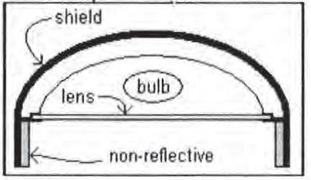
(Ord. No. 21-36, § 5(Att. A), 12-7-21; Ord. No. 25-22, Attach. A, 4-9-25)
530.15. - Fraternal Lodges and Social and Recreational Clubs
A.
Fraternal lodges and social and recreational clubs shall be conditional uses in all districts, except I-1 Light Industrial Park and I-2 General Industrial Park Districts, which must be reviewed and approved in accordance with this Code.
B.
Fraternal lodges and social and recreational clubs proposed in PO-2 Professional Office, C-1 Neighborhood Commercial, C-2 General Commercial, C-3 Commercial/Light Manufacturing Districts and areas in MPUD Master Planned Unit Development Districts designated for PO-2, C-1, C-2, or C-3 uses shall meet the minimum lot area, lot width, and yard regulations for the districts. Proposed fraternal lodges and social and recreational clubs in the PO-2 Professional Office, C-1 Neighborhood Commercial, C-2 General Commercial, C-3 Commercial/Light Manufacturing Districts and areas in MPUD Master Planned Unit Development Districts designated for PO-2, C-1, C-2, or C-3 uses shall not be required to comply with Section 530.15.C. Buffering shall be as required in this Code Section 905.2.
C.
In addition to the criteria set forth in this Code, except as noted in 530.15.B above, the following site limitations shall be observed for fraternal lodges and social and recreational clubs located in all zoning districts:
1.
Minimum lot area: 20,000 square feet.
2.
Minimum lot width: 150 feet.
3.
The height of any building constructed shall not exceed the maximum height restrictions of the applicable zoning district within which it is located.
4.
Fifty feet minimum building setback from all property lines.
5.
Landscaping and buffering shall be in accordance with this Code, Section 905.2 with the fraternal lodge and social and recreational club parcel treated as a commercial use.
D.
On site consumption of alcoholic beverages by members and guests shall be permitted in any fraternal, social, or recreational club or lodge which is approved as a conditional use, provided such use is located more than 1,000 feet from a school, church, place of worship, or public park, as measured from the structure in which alcoholic beverages are being served to the nearest property line of the school, church, place of worship, or public park.
E.
Development Plan.
A development plan shall be submitted in accordance with this Code, Chapter 400.
(Ord. No. 21-36, § 5(Att. A), 12-7-21; Ord. No. 25-22, Attach. A, 4-9-25)
530.16. - Parking and Storage of Commercial Vehicles and Commercial Equipment in Certain Residential Areas Prohibited
A.
No commercial vehicles and no commercially related equipment shall be permitted to park or be stored in any areas of the unincorporated County which are zoned R-1 Rural Density Residential, R-2 Low Density Residential, R-3 Medium Density Residential, R-4 High Density Residential, R-MH Mobile Home, R-1MH Single- Family/Mobile Home, R-2MH Rural Density Mobile Home, PUD Planned Unit Development, MF-1 Multiple Family Medium Density, MF-2 Multiple Family High Density, MF-3 Multiple Family High Density, E-R Estate-Residential, ER-2 Estate- Residential, A-R Agricultural-Residential, and AR-1 Agricultural-Residential Zoning Districts, except when such commercial vehicles and equipment are being utilized as part of a business lawfully operating in the said zoning districts. The following are specifically exempt from this section:
1.
Properties zoned A-C Agricultural and AC-1 Agricultural.
2.
Properties larger than five acres zoned A-R Agricultural-Residential and AR-1 Agricultural-Residential.
3.
Properties with a bona fide agricultural classification, as determined by the County Property Appraiser, when the vehicle or equipment are related to the agricultural use of the property.
B.
The provisions of this section shall not apply to:
1.
A commercial vehicle parked in a residential neighborhood while the operator of the said commercial vehicle is making a delivery or conducting business within the said residential area or when the commercial vehicle or equipment is parked or stored within an enclosed structure.
2.
The use of a commons area in any residentially zoned neighborhood for the parking of a commercial vehicle, provided that the commons area is actually used as a commons area, is duly recorded and platted as a commons area, and provided further that the use of the said commercial vehicle is for the benefit of the community in which it is situated or the use is for the benefit of a charitable project sponsored by the community as a whole or sponsored by any civic or charitable group within the community. For purposes of this subsection only, community is defined as the residentially zoned neighborhood which is serviced by the commons area.
C.
Any use of E-R Estate-Residential, R-1 Rural Density Residential, R-2 Low Density Residential, R-3 Medium Density Residential, R-4 High Density Residential, R-MH Mobile Home, R-1MH Single-Family/Mobile Home, R-2MH Rural Density Mobile Home, PUD Planned Unit Development, MF-1 Multiple Family Medium Density, MF-2 Multiple Family High Density, or MF-3 Multiple Family High Density zoned property for the parking or storing of commercial vehicles or equipment prior to the adoption of this section shall not be considered a nonconforming use.
D.
Nothing in this section is intended to authorize the use of residentially zoned property for commercial or industrial activities that are not permitted uses of the zoning district where the commercial vehicle or equipment is parked or stored.
(Ord. No. 21-36, § 5(Att. A), 12-7-21; Ord. No. 25-22, Attach. A, 4-9-25)
530.18. - Temporary Use of Portable Storage Units
A.
Location and Placement.
Portable storage units may be temporarily located only on certain residentially zoned and commercially zoned parcels. Units shall not obstruct vehicular or pedestrian traffic. Units shall not be placed in the right-of-way or in such a manner that a person lawfully using the sidewalk must detour into the street in order to go around the unit.
B.
Duration.
1.
A portable storage unit may be placed at a site used for residential purposes for up to 30 calendar days. One portable-storage unit may be placed on a site no more than two times per calendar year.
2.
One portable storage unit may be placed at a site zoned for commercial use and actually used for commercial purposes for up to 60 calendar days, no more than two times per calendar year, provided: (a) that the unit is not visible from surrounding parcels or from the right-of-way; the unit must be buffered by tall, opaque fencing; located behind the building; or located on a portion of a parcel with no abutting development; or (b) the location of the unit must be approved as part of a site plan.
3.
Redelivery of a portable storage unit for purposes of unloading will be allowed for a period of five days in addition to the time periods provided in this subsection.
C.
Construction.
1.
For sites where the portable storage units are being used in connection with new construction or extensive renovation or repair of property, portable storage units related to and used for the ongoing construction or storage of construction materials during such construction shall be allowed for the period of continuous construction, provided that there is an active and valid Building Permit for the property. Any portable storage unit at the site that is not specifically related to and used in connection with the construction shall be subject to the limits otherwise imposed in this section of this Code. Within five calendar days of the expiration of a Building Permit, passage of all final inspections, or the issuance of a Certificate of Occupancy (CO) (whichever is later), the portable storage units shall be removed.
2.
In the event of a fire, hurricane, or natural disaster causing substantial damage to the principal structure on the property, a portable storage unit shall be allowed on site, subject to all applicable sections of this chapter, for 60 calendar days regardless of the existence of a valid Building Permit.
D.
High Winds.
Within twelve hours after issuance of a hurricane warning including Pasco County, all portable storage units shall be removed or secured to minimize the danger of damage to persons or property from the effect of high winds on the units.
(Ord. No. 21-36, § 5(Att. A), 12-7-21; Ord. No. 25-22, Attach. A, 4-9-25)
530.19. - Use of Dumpsters in Residentially Zoned Property
Residential properties in A-R Agricultural-Residential, AR-1 Agricultural-Residential, AR-5 Agricultural-Residential, AR-5MH Agricultural Mobile Home, E-R Estate-Residential, ER-2 Estate-Residential, A-C Agricultural, and AC-1 Agricultural Zoning Districts that are more than one acre or which the Pasco County Property Appraiser has classified as a bona fide agricultural land under the Agricultural Assessment Provisions of Section 193.461, Florida Statutes, may use dumpsters of eight cubic yards or smaller on a permanent basis to store large volumes of refuse as the primary method of garbage collection and disposal for the residence, as long as the dumpster is not located on a right- of-way, and is a portable, nonabsorbent, enclosed container with a close-fitting cover or doors which is capable of being serviced by mechanical equipment. Dumpsters larger than eight cubic yards may be used only on a temporary basis and are subject to the regulations set out in subsections A-E below. Properties that are five acres or larger in A-R Agricultural-Residential and A-C Agricultural Zoning Districts are exempt from the regulations in this section.
Dumpsters are permitted on all other residentially zoned properties only on a temporary basis and are subject to the following regulations:
A.
Location and Placement.
Dumpsters may be temporarily located only on certain residentially zoned parcels. Dumpsters shall not obstruct vehicular or pedestrian traffic. Dumpsters shall not be placed on the right-of-way or in such a manner that a person lawfully using the sidewalk must detour into the street in order to go around the unit.
B.
Duration.
A dumpster may remain at a site used for residential purposes for up to 30 calendar days. One dumpster may be placed on a site no more than two times per calendar year allowed.
C.
Construction.
1.
For sites where a dumpster is being used in connection with new construction or extensive renovation or repair of property, dumpsters related to and used for the ongoing construction or demolition during such construction shall be allowed for the period of continuous construction or demolition, provided there is an active and valid Building or Demolition Permit for the property. Any dumpster at the site that is not specifically related to and used in connection with the construction or demolition shall be subject to the limits otherwise imposed in this section of this Code. Within five calendar days of the expiration of a Building Permit, passage of all final inspections, or the issuance of a CO (whichever is later), all dumpsters shall be removed.
2.
In the event of a fire, hurricane, or natural disaster causing substantial damage to the principal structure on the property, a dumpster shall be allowed on site, subject to all applicable sections of this chapter, for 60 calendar days regardless of the existence of a valid Building Permit.
D.
High Winds.
Within 12 hours after the issuance of a hurricane warning including Pasco County, all dumpsters shall be removed or secured to minimize the danger of damage to persons or property from the effect of high winds of the dumpsters.
(Ord. No. 21-36, § 5(Att. A), 12-7-21; Ord. No. 25-22, Attach. A, 4-9-25)
530.20. - Temporary/Portable Toilet Facilities
A.
Location and Placement.
Temporary toilet facilities provided in connection with construction or renovation may be temporarily located on all properties. Units shall not obstruct vehicular or pedestrian traffic. Units shall not be placed on the right-of-way or in such a manner that a person lawfully using the sidewalk must detour into the street in order to go around the unit.
B.
Removal.
Temporary toilet facilities provided in connection with construction or renovation shall be removed by the person responsible for the unit within 14 calendar days of cancellation of the rental contract for the unit or within 14 calendar days of the issuance of a CO for the structure that is under construction or renovation, whichever is sooner.
C.
Storage.
Properties upon which such units are stored when not in use shall be fenced with opaque fencing in such a manner so that the units are not visible to abutting, residentially zoned properties.
(Ord. No. 21-36, § 5(Att. A), 12-7-21; Ord. No. 25-22, Attach. A, 4-9-25)
530.21. - Home Occupations
A.
Purpose.
The intent of this section is to provide for certain types of restricted home occupations. The purpose of this section is to establish performance standards that will provide fair and equitable administration and enforcement of this section. Only such uses will be allowed which:
1.
Are incidental to the use of the premises as a residence;
2.
Are compatible with residential uses in the area;
3.
Are limited in scale and intensity; and
4.
Do not detract from the residential character of the area.
If the application of the home occupation regulations conflict with other sections of this Code, the most restrictive shall apply.
B.
Review Procedures.
Unless otherwise indicated as a permitted accessory use, home occupations are reviewed pursuant to this Code, Section 402.4, as Special Exception Uses. Minor home occupations are permitted as-of-right in designated zoning districts, unless they exceed specified thresholds.
C.
Standards for All Home Occupations.
1.
The use of the dwelling unit for the home occupation shall be clearly incidental and secondary to its use for residential purposes.
2.
There shall be no change in the outside appearance of the building or premises as a result of such business.
3.
No exterior signs and no signs that would be visible from the street or neighboring dwellings that are associated with the home occupation are permitted. Professional signs that are statutorily required are permitted.
4.
A home occupation shall be conducted wholly within the principal residential dwelling unit or in an accessory building on the parcel, except as otherwise noted herein.
5.
No outside display, storage, or use of land is permitted for the home occupation.
6.
More than one home occupation may be permitted in a single residence; however, all applicable limitations herein shall apply to the combined uses as if they were one business.
7.
No truck deliveries are permitted, except for parcels delivered by public or private services that customarily make residential deliveries.
8.
For those home occupations that require a special exception, the approval of the special exception shall not be transferred to another owner or lessee of the property.
D.
Minor Home Occupation Standards.
1.
A minor home occupation shall occupy no more than 25 percent of the total floor area of the dwelling unit and nondwelling unit accessory building.
2.
The use shall not create dangerous vapors or fumes, and no use shall be permitted where noise, light, glare, odor, dust, vibration, heat, or other nuisance extends beyond the subject dwelling unit or structure.
3.
No mechanical equipment shall be used on the premises, except those normally used for purely domestic or household purposes.
4.
New vehicle trip generation, except those as addressed in Section 530.21.D.5, shall not result from the establishment of a minor home occupation, i.e., the home occupation shall not involve appointments in the residence.
5.
An applicant may seek a Special Exception from the Planning Commission that allows trip generation as a result of the establishment of a minor home occupation, but shall meet the following conditions:
a.
In no case, shall more than 14 total daily trips, including those associated with the primary residential use, be generated per dwelling unit as a result of the establishment of the home occupation(s).
b.
All business-related visits shall be by appointment only and shall be limited to one customer at a given time. Where applicable, and where on-site parking is available, an additional person in waiting is permitted.
c.
Traditional home-based instruction, such as, but not limited to, tutoring and music or swimming lessons or the like, is permitted where instruction is provided by only one instructor to no more than three students per class.
E.
Major Home Occupation Standards.
1.
Major home occupations shall occupy no more than 30 percent of the total floor area of the dwelling unit or one accessory building on the same lot or parcel.
2.
On-site employees of the major home occupation shall be limited to residents of the property and up to two nonresident employees.
3.
External impacts, such as traffic, noise, odor, or vibrations, shall not exceed those normally associated with the principal uses permitted in the zoning district within which the property is located.
TABLE 530.21-1
Permitted Home Occupations By District.
(Ord. No. 21-36, § 5(Att. A), 12-7-21; Ord. No. 25-22, Attach. A, 4-9-25)
530.22. - Donation Bins
The requirements of this Section apply to donation bins (hereinafter referred to as "bins" or "boxes") which function as accessory uses or structures when used or designed for the purpose of collecting recyclable materials and/or re-sellable goods. This Section shall not apply to primary principal use recycling operations and donation facilities that are located within the same building, and are accessory to a primary principal use, and/or recycling operations in permanent structures. Said primary uses shall meet all applicable development standards of the district in which they are located. The requirements of this Section shall not apply to trash cans, dumpsters, and/or community recycling program containers for glass, metals, paper, cardboard, or similar curbside recyclable materials as described in Chapter 90 of the Pasco County Code of Ordinances.
Unless otherwise stated in this Code, donation bins may be permitted in accordance with this Code on commercial properties zoned C-1 Neighborhood Commercial District, C-2 General Commercial District and C-3 Commercial/Light Manufacturing District and industrial properties Zoned I-1 Light Industrial Park District and I-2 General Industrial Park District and commercial or industrial portions of MPUD Master Planned Unit Development Districts.
In addition to any applicable Zoning District and Land Development Regulations, all donation bins allowed as accessory uses or structures under this Section shall conform to the following requirements.
A.
Zoning and Permitting Requirements.
No donation bin (or box) shall be established unless and until the applicant submits the required information and obtains approval in the form of a Donation Bin Permit, subject to annual renewal, as provided in this Code.
1.
Application and Submittal Requirements. In order to obtain zoning approval for one or more donation bin(s) on a site, the applicant shall file with the Planning and Development Department, in writing, the following information:
a.
A completed Donation Bin Permit application in accordance with Section 530.22 and applicable fees; and
b.
A site plan showing the location of the proposed donation bin. The location of the donation bin shall comply with the requirements of this Section and may not be placed in a location that would interfere with any required parking spaces such that the elimination of the parking space causes the on-site business to be in violation of the minimum required parking spaces pursuant to its approved site plan and/or the Land Development Code; and
c.
Written consent of the property owner or legal designee to establish the donation bin; and
d.
Information as to the manner and schedule for which the donation bin(s) will be emptied and maintained; and
e.
Evidence that the charitable organization and professional fundraiser, if any, are registered to solicit charitable contributions in the State of Florida.
2.
Ongoing Requirements. Following the issuance of a donation bin permit, the donation bin must not be relocated elsewhere within the site unless the applicant obtains a new Donation Bin Permit. The donation bin must meet all applicable permitting requirements. Thereafter, a Donation Bin Permit renewal must be issued annually for each donation bin.
Renewal applications shall include the following:
a.
An affidavit that all information and statements in the original application continue to be true and correct.
b.
An affidavit that the subject donation bin(s) are not subject to ongoing enforcement action.
B.
Location and Site Development Requirements.
1.
Location Requirements. All donation bins must be located only upon improved, level, paved surfaces which constitute part of larger developed and occupied non-residential site in commercial, industrial zoning districts, or commercial or industrial portions of MPUD Master Planned Unit Development Districts. No donation bin shall be permitted on any site that is developed but unoccupied. Each donation bin must be located on the site in such a manner that the bin is not overturned or relocated due to a severe weather event. If not physically affixed to the paved surface, the permittee shall provide a signed indemnification form, which shall indemnify and defend the County from any and all claims and/or damages that may result from movement of the bin and/or its contents as a result of a severe weather event. Indemnification shall be provided on a form approved by the County Attorney's Office. The indemnification form may be signed by the permittee, bin operator, or bin owner. All sites shall have adequate driveway access and maneuverability to accommodate service vehicles and loading vehicles in accordance with Chapter 900 of this Code.
2.
Maximum Number. A donation bin shall be limited to one bin per parcel, except that one additional donation bin may be permitted if the parcel or lot has more than 300 feet of road frontage.
3.
Development Standards. All sites shall meet the following requirements:
a.
If more than one donation bin is located on a property, then all donation bins within the approved location must be arranged side- by-side and may not be separated by more than twelve inches.
b.
The receiving door on each donation bin must be oriented toward the interior of the site and away from the public right-of-way.
c.
Each donation bin must be enclosed by use of a receiving door or safety chute to prevent vandalism and locked so that the contents of the bin cannot be accessed by anyone other than those responsible for the retrieval of the contents.
d.
No donation bin shall exceed 25 square feet in area nor seven feet in height.
4.
Setbacks. All donation bins must conform to the following setbacks:
a.
From any residential use: 30 feet;
b.
From any residential zoning district boundary: 30 feet;
c.
From any right-of-way: five feet;
d.
From any other property line: five feet.
5.
Landscaping. No additional landscaping shall be required. However, donation bins shall not encroach on any required landscaping, and no required landscaping shall be removed to install a donation bin.
6.
Signage. Signage shall be limited to five square feet per side. Each donation bin must be clearly marked to identify the name and telephone number of its responsible operator. The permit number shall be displayed on the donation bin (box) as provided in the Donation Bin Permit. The following information shall be visible from the front of any charitable donation bin:
a.
Name, telephone number, and website of the Permittee of the charitable donation bin.
b.
Name, telephone number, and website of the benefiting nonprofit organization (if not the Permittee).
c.
Permit sticker.
The following information shall be visible from the front of any charitable donation bin that is not operated by a nonprofit organization or a professional fundraiser registered to solicit charitable contributions on behalf of a nonprofit organization in the State of Florida:
d.
"This bin is operated by a commercial company that sells the contents for profit."
This disclosure shall be printed on the depositing side of the donation bin in bold and a minimum of four-inch font size.
7.
Parking and Travel Lane Design. No donation bin shall be located so as to occupy or block access to any parking space that is needed to meet the minimum number of parking spaces required by Section 907 of this Code. For attended semi-tractor trailers or other temporary structures, a loading and unloading drive through area shall be provided with a minimum of three waiting spaces (including the car being served). One employee parking space shall be provided.
8.
Indoor Donation Bins. Notwithstanding any other requirement of this Section, donation bins may be located within a principal building or structure without further review or regulation. Donation bins also may be located within a parking garage provided that all parking and travel lane design requirements of this Section are met.
9.
Maintenance Standards. Donation bins must be regularly emptied of their contents so that materials and donations do not overflow. The appearance of donation bins shall be maintained including but not limited to, rust free, fresh paint, legible signage, and clean. The area surrounding the donation bin shall be free of any junk, garbage, trash, debris, donations, or another refuse material. All donated items must be located entirely within the donation bin.
10.
Exception for Non-Profit Organizations and Religious Institutions. Notwithstanding the zoning district requirements of this part, any non-profit organization or religious institution that engages in collection of recyclable materials as part of its organizational mission may maintain its own accessory donation bins on its own building site. All such donation bins must obtain a Donation Bin Permit.
C.
Application Completeness Review and Review Timeframes.
1.
Application; determination of completeness. Before any Donation Bin Permit is issued, a written application in the form provided by the County Administrator or designee shall be filed together with such information required in this Code Section 530.22.A. Upon submission of an application, staff shall have ten business days to determine whether the application is complete. If staff finds that the application is not complete, the applicant shall be provided, in writing, a list of deficiencies within the ten business day period. Upon resubmission of the application, staff shall have five additional business days to determine whether the applicant's revisions are sufficient to complete the application. If they are not, staff will again inform the applicant of any remaining deficiencies in writing. This process shall continue until the applicant has submitted a complete application or demands that the application be reviewed "as is."
2.
Administrative review. Administrative review of a Donation Bin Permit application shall include the review of all information submitted to determine the conformity with this Code.
3.
The County Administrator or designee shall approve or deny the Donation Bin Permit application based on whether it complies with the requirements of this Code Section 530.22 and shall approve or deny the Donation Bin Permit within 20 business days after receipt of a complete application or from the date the applicant demands that the application be reviewed "as is". The County Administrator or designee shall prepare a written notice of its decision describing the applicant's appeal rights and send the decision by certified mail, return receipt requested to the applicant pursuant to Section 407.1. The applicant may file an appeal application to the BCC within 30 calendar days after the date of receiving the appeal application. If the BCC does not grant the appeal, then the appellant may seek relief in the Circuit Court for the County, as provided by law.
D.
Nonconforming Use. Bins lawfully sited and placed on a property prior to October 25, 2016 may be considered a nonconforming use, pursuant to Chapter 1200 of this Code, and subject to the procedures and restrictions in that Chapter. A nonconforming use determination may be requested with respect to the following elements of the County's donation bin regulations.
1.
The maximum number of bins allowed on a parcel;
2.
The setback requirements for bins; and
3.
The maximum size of signage on bins. Nonconforming signage that existed prior to October 25, 2016, but is larger than allowed by this ordinance, may remain only until replaced or changed and must thereafter meet the size requirements of this ordinance.
Bins located on a property prior to October 25, 2016 will not be considered lawfully sited and/or placed and will not be considered nonconforming uses if placed on undeveloped property, located in violation of the approved site plan for the property, located without the permission of the property owner, or located or placed in violation of any other law or regulation existing at the time of placement.
E.
Violations. Violations of these provisions may be enforced as described in Chapter 100 of this Code. In addition, violations of any of these standards may result in revocation of a permit. The process for revocation is as follows:
The County Administrator or designee shall prepare a written notice of its decision to revoke the permit, describing the grounds for the decision and the affected parties' appeal rights, and send it by certified mail, return receipt requested, to the property owner, permittee, and other known parties in interest (e.g., the benefitting organization). Any owner, permittee, and/or interested party may file an application to the Board of County Commissioners (BCC) within 30 calendar days after the date of receiving the notice of revocation. If the BCC does not grant the appeal, then the appellant may seek relief in the Circuit Court for the County, as provided by law.
(Ord. No. 21-36, § 5(Att. A), 12-7-21; Ord. No. 25-22, Attach. A, 4-9-25)
530.23. - Community Gardens, Market Gardens and Community Farms
A.
Intent and Purpose.
The intent of this Section is to:
• Allow the growing of crops and ornamental flowers within Pasco County while minimizing negative impacts to adjacent properties and the community;
• Encourage locally grown produce, promote healthy and nutritional food, and fill gaps in food accessibility within the County;
• Foster community engagement by providing opportunities for recreation education/training, special events, social interaction and economic potential benefits; and
• Provide green space and enhance community character.
The purpose of this Section is to establish design, operations, and maintenance standards for Community Gardens, Market Gardens and Community Farms in Pasco County.
B.
Applicability.
1.
Community Gardens, Community Farms, and Market Gardens shall be deemed a Permitted Principal Use or Conditional Use, as per this Code Section 500, Table 530.23-1 "Table of Principal Uses and Conditional Uses by District Community Gardens, Market Gardens and Community Farms". This section shall not apply to Home Gardening as defined in this Code, Appendix A.
2.
Community Gardens, Market Gardens and Community Farms may be located on otherwise vacant properties, and shall be deemed the principal use until such time that the parcel is developed as per this Code. At that time, the subject Community Garden or Community Farm shall be deemed an accessory use.
C.
Application, Permit and Fees.
1.
A permit shall be required for a Community Garden with structures, Market Garden with or without structures, or Community Farm with structures.
2.
Application and permit fees shall apply in accordance with this Code, Section 400 Permit Types and Application, Section 406.8 Garden Plan Permits.
D.
Registration.
Community Gardens and Community Farms are required to register annually with the Food Policy Advisory Council of Pasco County.
E.
Permitted Uses.
The following uses, as detailed in Table 530.23-1 shall be located on private property, on the ground or on a portion of a building roof or other structure. These uses may be located on public property with the written approval of the County Administrator or Designee.
1.
Home Garden/Vegetable Garden.
It means a plot of ground where herbs, fruits, flowers, or vegetables are cultivated for human ingestion, in accordance with the definition in Chapter 604.71, Florida Statutes, with less than 14 vehicle trips daily, with limited heavy vehicle use.
2.
Community Garden.
A community garden is a garden used to grow and harvest food crops or ornamental plants (including flowers) with daily vehicle trips of greater than 14 vehicle trips per day and less than 100 vehicle trips per day, with limited use of heavy vehicles. Community gardens may be any size.
3.
Market Garden.
A market garden primarily sells and buys produce grown on-site or off-site including fruits, vegetables and other garden derived edibles with daily vehicle trips of more than 14 vehicle trips daily, and is less than five acres.
4.
Community Farm.
A community farm primarily grows produce, fruits, vegetables and other garden derived edibles primarily for distribution off-site with daily vehicle trips of 14 vehicle trips or more daily. Community farms may be any size.
TABLE 530.23-1
Table of Principal Uses and Conditional Uses by District Community Gardens, Market Gardens and Community Farms.
F.
Development Standards.
1.
Community Gardens, Market Gardens, and Community Farms are allowable as a Permitted Principal Use in all Agricultural zoning districts. Home gardens/vegetable gardens are allowable as a permitted principal use in all residential zoning districts.
2.
Uses allowable as Permitted Principal Uses or Conditional Uses are detailed in the Table of Permitted Principal Uses and Conditional Uses for Community Gardens, Market Gardens and Community Farms as detailed in Table 530.23-1 Table of Permitted Principal Uses and Conditional Uses by District for Community Gardens, Market Gardens and Community Farms.
All of these uses shall meet the requirements outlined in Table 530.23-2. Those uses that are permitted Conditional Uses, shall meet the additional requirements identified during the Conditional Use permit process, in accordance with Chapter 400, Permit Types and Applications, Section 402 Use Permits, 402.3 Conditional Uses.
TABLE 530.23-2
Community Gardens, Market Gardens and Community Farms Development Standards.
TABLE 530.23-3
Community Gardens, Market Gardens and Community Farms Require Site Plans
3.
Thresholds by Use Type are detailed in Table 530.23-4 for Vehicle Trips, Parking, Heavy Vehicles, Business Tax Receipts and Special Events.
TABLE 530.23-4 Thresholds by Use Type
G.
Community Gardens on Public Land.
1.
Community Gardens are allowed on public lands through the use of a Land Use Agreement for non-profit entities engaged in community development activities. Community Gardens on lands funded by impact fees shall only be allowed as an interim use.
Community Farms may be allowed through ground lease agreements with the County, for profit with payment to the County to be specifically allocated to the Food Policy Advisory Council for its stated public purpose.
2.
All public infrastructures on-site must retain or provide a direct access path, five foot in width from the closest right-of-way (ROW) and have a five-foot clear buffer around such infrastructure. A hardscape damage waiver must be filed with the Pasco County Utilities Engineering & Contracts Management Department.
3.
The applicant shall register the garden and provide the County with a completed Community Garden application, which shall include:
a.
Contact information of Garden Manager and Sponsor;
b.
A narrative stating the purpose and objective of the Community Garden;
c.
A not for profit entity must sponsor the garden and be the primary contracting entity for the Land Use Agreement and insurance;
d.
A Land Use Agreement between the applicant and the County;
e.
Approved Site Plan.
(Ord. No. 21-36, § 5(Att. A), 12-7-21; Ord. No. 25-22, Attach. A, 4-9-25)
530.24. - Accessory Dwelling Units
A.
Intent and Purpose. To allow Accessory Dwelling Units (ADUs) to be constructed in zoning districts that allow single family dwelling units and in portions of MPUDs that have single family dwellings as principal permitted uses. ADUs are intended to provide additional housing ancillary to the principal dwelling unit, to increase housing opportunities, promote mixed-income neighborhoods, encourage infill development, address the "missing middle" housing types, address affordable housing needs, and provide housing opportunities for extended families.
B.
Required Standards. The following standards are necessary to ensure the compatibility of the ADUs with the surrounding neighborhoods and to mitigate negative impacts that would be caused by increasing residential densities in such neighborhoods. ADUs may be approved on individual parcels within existing neighborhoods and subdivisions or in conjunction with new development. ADUs may not be appropriate in every situation due to existing site constraints and limitations imposed by these standards. Existing MPUDs with ADU standards are not superseded by this Code section. Additionally, individual restrictive covenants may prohibit ADUs.
1.
Dimensional Standards.
a.
Size. The minimum size of an ADU shall be subject to the Florida Building Code. ADUs shall not exceed 1,200 square feet of living space. The ADU shall be smaller than the principal unit.
b.
Setbacks. The ADU shall comply with applicable principal structure zoning setbacks.
c.
Height. It shall not exceed the height limitations of the zoning district.
d.
Lot Coverage. It shall not exceed the lot coverage of the zoning district. For MPUDs that make a distinction between the principal structure and accessory structure lot coverage, the lot coverages shall be combined.
A Special Exception in conformance with Section 402.4 of this Code may be approved for deviations from the requirements of "a" and/or "b" above.
2.
Development Standards.
a.
Florida Building Code and the applicable provisions of this Code shall apply.
b.
Where a garage is converted to an ADU, the garage door shall be removed, and the building opening closed.
c.
Parking shall be provided on site unless permanent on-street parking is permissible within the neighborhood. The number of required parking spaces shall be pursuant to Section 907.1 of this Code.
d.
The ADU may be required to connect to existing water, sewer, electric, and other existing utility connections as determined by Pasco County. Where the principal dwelling unit relies on septic and groundwater, the applicant shall obtain an approval letter from the Florida Department of Health in Pasco County.
e.
An ADU may be located within the single-family dwelling with a separate entrance or within a conforming separate accessory structure. ADUs as separate structures may be subject to separate stormwater and solid waste non-ad valorum assessments.
f.
ADUs must be built on a permanent, fixed foundation that is designed to meet the requirements of the Florida Building Code and any referenced standards.
3.
Additional Standards.
a.
Neither unit may be used as a Vacation Rental, as defined in this Code unless the process in LDC Section 402.5.B is followed.
b.
No more than one ADU may be permitted per lot.
c.
An ADU may be constructed with or after the construction of the principal dwelling unit.
d.
A lot containing an ADU shall not be subdivided to separate the ADU from the principal dwelling unit unless such division can meet all applicable standards of the zoning district, land development regulations, and the Comprehensive Plan. This includes condominium and cooperative projects. Subdividing the parcel shall cause the ADU to become a principal structure. All applicable impact and mobility fees shall be paid.
e.
ADUs are exempt from Comprehensive Plan and Zoning density calculations (including MPUDs) but shall be included in school planning calculations.
f.
Notwithstanding Sections 1302.2, 1302.4, 1302.5, 1302.6 and 1302.7 of the LDC, no impact fee (other than school) shall be assessed for an ADU that is, cumulatively with any pre-existing ADU square footage, less than 500 total square feet in size. ADUs between zero and 900 square feet shall pay the reduced multi-family rate for school impact fees. ADUs between 500 and 900 square feet shall pay the reduced ADU mobility fee rate and reduced multifamily library impact fee. ADUs in excess of the foregoing sizes shall pay the applicable single-family rate for all impact fees.
(Ord. No. 25-22, Att. A, 4-9-25)
530.25. - Backyard Chickens
Intent and Purpose. The purpose of this section is to allow the keeping of backyard chickens (exclusively hens) for the purposes of egg production within residential districts, excluding MF-1, MF-2 and MF-3. The E-R Estate-Residential District and the ER-2 Estate-Residential District are not subject to the requirements of Chapter 14 of the Code of Ordinances as the keeping of chickens is permitted by right in those Districts pursuant to Sections 509 and 510 of this Code. Where a nonconforming use for a dwelling unit on a commercially zoned parcel has been established in accordance with LDC Section 1200 Nonconformities, the parcel shall be considered a residential district for the purpose of this Section. The setbacks shall be in accordance with the required setbacks of the nearest zoning district where minimum lot area, width, depth, or setback regulations can be met. The conditions and regulations for the keeping of chickens within these zoning districts are contained within Chapter 14 of the Pasco County Code of Ordinances, incorporated herein by reference. Additionally, individual restrictive covenants may prohibit the keeping of chickens. The provisions of this Section, 530.25, do not supersede any covenant or restriction of record.
(Ord. No. 25-44, § 5(Att. A), 11-12-25)