
Pasco County Unincorporated
City Zoning Code
City Zoning Code
CHAPTER 400
PERMIT TYPES AND APPLICATIONS
SECTION 404. - OPERATING PERMITS
Generally, operating permits are required for the following uses, where an understanding of the method of operation of the proposed facility is essential to the evaluation of a conditional use application and to ensure compliance with the requirements of this Code.
401.1. - Intent and Purpose
A.
Chapter 400 contains the permit types and review criteria for the development applications necessary for approval.
B.
This chapter has been organized as follows:
1.
Use Permits. Permits in this category address what uses can be conducted on property. In some cases, such as Zoning-Euclidean, it will be a range of uses; in other circumstances, such as Conditional Use Permits, an applicant must request the ability to conduct a specific use.
2.
Site Development. These are the permits necessary for land development. Permits include those which are preliminary, where the approach to meeting Pasco County development standards is outlined and the specific detailed plans authorizing construction.
3.
Operating Permits. These are a type of permit where detailed information is required on how an operation will be conducted. Permits for the mining operations and for Construction Demolition Debris Disposal Facilities are examples of Operating Permits.
4.
Miscellaneous Permits. This section contains a variety of permit types which may be required. Signs, Billboards, Development Agreements, and Right-of-Way Use Permits are included sections.
5.
Relief Applications. The final section of this chapter outlines the various methods of relief against the strict application of this Code may be available. These include administrative remedies as well as those requiring public hearings.
402.1. - Zoning Amendments—Euclidean
A.
Initiation. Proposed Euclidean zoning amendments may be initiated by the Board of County Commissioners (BCC), by petition of owners of 75 percent or more of the area involved in the proposed change, or by the property owner. A zoning amendment may only be requested where the zoning amendment is consistent with the Future Land Use (FLU) classification of the subject property or a FLU Map amendment is simultaneously sought.
B.
Submittal Requirements. An applicant shall submit required information in the form as specified by the County Administrator or designee.
1.
Applicant Information.
a.
Proof of ownership; i.e., copy of deed.
b.
Agent of Record letter, if applicable.
c.
Application fee.
2.
The signed and sealed boundary legal descriptions and sketches.
C.
Public Hearings Required. Prior to the enactment of any change in zoning, the Planning Commission (PC) and the BCC shall each hold a separate public hearing on the proposed amendment in accordance with the timelines established in Chapter 125.022, Florida Statutes.
D.
Notice. Notice of the public hearings shall be provided in accordance with this Code and the provisions of Chapter 125.66, Florida Statutes.
E.
Review Considerations. The County Administrator or designee, PC, and BCC shall consider all of the following in reviewing a proposed zoning amendment:
1.
The existing land use pattern.
2.
Whether the approval of the request would result in the creation of an isolated district, unrelated to adjacent and nearby districts.
3.
Whether the existing district boundaries are illogically drawn in relation to existing conditions on the property proposed for the change.
4.
Whether changed or changing conditions make passage of the proposed amendment necessary.
5.
Whether the proposed change will adversely affect living conditions in the immediate and surrounding neighborhoods.
6.
Whether there is adequate access from a standard roadway to the site and whether the proposed change will create or excessively increase traffic congestion or otherwise affect traffic safety.
7.
Whether the proposed change might result in the reduction of light or air to adjacent properties or areas.
8.
Whether the proposed change might result in lower property values in adjacent areas.
9.
Whether the property, as rezoned, could be developed in a manner which would comply with other existing County and State regulations governing development.
10.
Whether the proposed change would result in, or act as a deterrent to, the improvement or development of adjacent property in accordance with the existing regulations.
11.
Whether the property which is the subject of the proposed change is a suitable site or location for the uses available under a proposed zoning district.
12.
Whether certain portions of the property are not suitable for development under the proposed zoning classification.
13.
Whether adequate public facilities are available to the site including, but not limited to, water and sewer facilities.
14.
Whether the property is developable under the proposed zoning classification without appropriate public facilities including, but not limited to, water and sewer facilities.
15.
Whether the site proposed for zoning change would be subject to flooding and the effect of such flooding on the proposed or possible improvements on the site.
16.
The physical characteristics of the site and the degree of site alteration which would be required to make the site usable for any of the range of potential uses under the proposed zoning classification.
17.
The potential need for expansion of public services and facilities to accommodate the proposed development, including the consideration of the results of the Timing and Phasing Analysis performed pursuant to Section 901.12, Transportation Analysis.
18.
Whether the proposed zoning change is consistent with the Goals, Objectives, and Policies set forth in the adopted Comprehensive Plan.
19.
Whether maintaining the existing zoning classification accomplishes a legitimate public purpose that protects the integrity of the Goals, Objectives, and Policies of the Comprehensive Plan; the public's reliance upon the existing zoning; or another legitimate public purpose as determined by applicable law.
F.
Staff and PC Recommendations
1.
Staff Review. The County Administrator or designee, after consideration of the above review considerations, shall present a recommendation to both the PC and BCC.
2.
PC Hearing and Recommendation.
a.
At the completion of the public hearing on an application for a rezoning and upon consideration of staff recommendation and the considerations in this section, the PC shall vote to recommend approval or denial of the application.
b.
The recommendation of the PC shall be submitted to the BCC in written form.
c.
The recommendation of the PC shall be advisory only and shall not be binding on the BCC.
G.
BCC Hearing.
1.
Upon receipt of the staff and PC recommendations, the BCC shall hold a separate public hearing on the proposed amendment.
2.
At the conclusion of the public hearing, the BCC may:
a.
Refer the application back to the PC for further study if additional information is necessary in order to make a decision.
b.
Deny the application.
c.
Approve the application as requested.
d.
Approve any other appropriate zoning classification of a lesser density/intensity.
3.
If the recommendation of the PC is adverse to the proposed amendment, such amendment shall not become effective except by an affirmative vote of a majority of the entire membership of the BCC.
4.
Approval shall be in the form of an ordinance or resolution approving the zoning amendment.
H.
Effect of the Final Decision.
1.
Approval. The approval of a zoning amendment shall authorize all available uses and dimensional standards, such as setbacks and coverage available in the applicable zoning district subject to further procedural requirements of this Code.
2.
Denial. Whenever the BCC has denied an application for rezoning of property, the PC shall not thereafter:
a.
Consider any further application for the same rezoning of any part or all of the same property for a period of 12 months from the date of such action.
b.
Consider an application for any other kind of rezoning on any part or all of the same property for a period of six months from the date of such action.
(Ord. No. 20-39, § 5(Att. A), 12-8-20; Ord. No. 24-21, § 5(Att. A), 4-23-24)
402.2. - Zoning Amendment—MPUD Master Planned Unit Development
A.
Initiation. An MPUD Master Planned Unit Development zoning may be initiated by the owner(s) of the subject property, the authorized agent for the owner(s), or the Board of County Commissioners (BCC).
B.
MPUD Required. An MPUD zoning shall be required in the following instances:
1.
Projects that are in the coastal high hazard area, unless otherwise determined by the County Administrator or designee.
2.
Projects greater than 20 residential units or greater than 100 acres located in the AG/R (Agricultural/Rural) Land Use Classification.
3.
Projects where the net upland acreage and proposed zoning density/intensity/lot sizes would allow the project to exceed the capacity of 1,200 daily trips as shown on Table 402.2-A. Provided; however, that projects with commercial land uses must have greater than ten net upland acres and exceed 1,200 daily trips before an MPUD is required and provided that projects that are subject to a development agreement, special exception or conditional use shall not require an MPUD. Additionally, regardless of the size or trips, office and industrial development shall not require an MPUD.
4.
Other projects as determined by the BCC or as required by the County Comprehensive Plan.
Table 402.2-A Size of Development Generating Over 1,200 Daily Trips
C.
Submittal Requirements. An applicant shall submit required information in the form as specified by the County Administrator or designee. In addition to the requirements identified for all projects in the Development Manual, applications for an MPUD zoning shall include the following information:
1.
Applicant Information.
a.
Proof of ownership; i.e., copy of deed.
b.
Agent of Record letter, if applicable.
c.
The signed and sealed boundary legal descriptions and sketches.
d.
Application fee.
2.
Project Description. A preliminary project description in sufficient detail to determine the general intent with respect to the following, if known:
a.
The general purpose and character of the proposed development.
b.
Land use by acreage, densities, and intensities.
c.
Structural concepts, including height and anticipated building type.
d.
Recreation and open space.
e.
Facilities commitments.
f.
A statement describing the intent for the management of common areas and facilities.
g.
Any requests for special approval to vary from the standards of this Code, Section 407.
3.
Map Information.
a.
A location map showing the relationship between the areas proposed for development and surrounding properties, including a current aerial photograph, which in no case shall be older than that available at the Property Appraiser's Office with boundaries of development and roadway layout delineated.
b.
All major County roads within one mile of the proposed development.
c.
Wellhead Protection Areas and Special Protection Areas for all Community Water System supply wells within the proposed development and within 1,000 feet of the proposed development.
d.
The location of all existing and proposed roadways, rights-of-way, and easements adjacent to or within the property.
4.
Physical Resources Information.
a.
Topographic information providing 100-year floodplain and wetland delineations. The most recent U.S. Geological Survey, Topographical Survey, and U.S. Geological Survey Flood Prone or Federal Emergency Management Agency mapping may be used for topography on flood-prone delineations. County wetlands maps or aerial photography interpretation may be used for wetlands delineation.
b.
A soils survey, which may be based on the most recent County soils survey, drawn to the same scale as the master plan, and clearly identifying all soil types, especially those areas which are apparently not suitable for buildings or major structures due to soil limitations.
c.
An Environmental/Wildlife Habitat Study evaluating plant and animal species listed as endangered, threatened, or species of special concern as designated by the State and Federal authorities, including the following description of the parcel: documentation of data collected and reviewed, such as the Florida Land Use and Cover Classification System, U.S. Fish and Wildlife, and Florida Fish and Wildlife Conservation Commission, and field survey map that characterizes and describes the natural resources of the site, including the location of protected species confirmed on the site and habitat suitable for listed species.
d.
A Phase I cultural resource assessment, including the following: project scope, archival research, and identification of sites adjacent to the subject property; identification of research design; and description of field methodology, field work, and analysis of the findings and conclusions. This survey shall be consistent with the current state Cultural Resource Assessment Survey (CRAS) Phase I criteria effective as of August 15, 2016, and subsequent updates. A CRAS created prior to August 15, 2016, shall be reviewed by a consultant, and recertified if it meets said standards. All recommendations made by the consultant shall be implemented by the applicant.
e.
A table showing estimated predevelopment and post development acres of wetlands by category, according to the Comprehensive Plan, and a conceptual plan for the protection and use of on-site wetlands.
5.
Master Plan.
a.
The master plan shall have the following base information:
(1)
Topography.
(2)
Floodplains and elevations.
(3)
Wetlands (Categories I, II, and III).
(4)
Critical linkages as defined in the Comprehensive Plan.
b.
The master plan shall graphically depict the proposed use of the site, including:
(1)
Proposed land uses, including the proposed number of units, lots, nonresidential square feet, density, and intensity as applicable.
(2)
A conceptual lot layout.
(3)
Open space.
(4)
Proposed preservation or conservation areas.
(5)
The proposed location of major streets and thoroughfares.
(6)
A generalized mobility plan, including bicycle, pedestrian and transit facilities.
(7)
Recreation areas for residential projects, including neighborhood parks.
(8)
Buffers and setbacks meeting the requirements of this Code and as necessary to ensure compatibility with the surrounding area.
(9)
Major facilities, including a delineation of proposed school sites and fire station sites, if necessary, for the service of the area as developed.
c.
The master plan shall identify:
(1)
The existing zoning.
(2)
The existing land use.
(3)
The Future Land Use Classification on the site and the surrounding areas within 500 feet of the site.
d.
The master plan shall include a phasing plan that describes the proposed timing for, location of, and sequence of phasing or incremental development and the proposed density for each such phase or increment of development. The applicant may provide approved Development of Regional Impact (DRI) information, which satisfies this requirement.
e.
A table showing the acreage for each category of land use, including Category I, II, and III wetlands, critical linkages, open space, and recreation.
f.
A table of proposed minimum and/or maximum gross and net residential acreages for residential land uses and proposed minimum and/or maximum floor area ratio for nonresidential land uses, as applicable.
6.
Utilities and Services Plan.
a.
Identify the location/source of sanitary sewers, potable water facilities, and the approximate location of existing facilities on the master plan, as required by this Code, Section 903.
b.
The general direction of natural surface drainage of the proposed MPUD, including a general statement regarding the disposal of stormwater drainage, including identification of whether a site falls within a basin of special concern and/or lies within the areas depicted on Maps 2-4, Flood Prone Areas, of the Comprehensive Plan.
c.
An analysis of the impact of the proposed MPUD on schools and other public facilities as provided in this Code, Section 1301.
7.
Transportation Management. A roadway plan for the MPUD shall be shown on the submitted master plan, including subdivision access locations; internal, subdivision collector roadways; and roadways required by Section 901.1, Corridor Spacing.
8.
Specific Approvals. Variations from this Code may be reviewed and approved by the BCC and PC during the public hearing held on any application for an MPUD zoning amendment. Variations shall be allowed where the BCC specifically finds, in the particular case, that the proposed variation meets or exceeds the intent of this Code. The applicant shall be required to submit sufficient information to justify such variation for staff to make a recommendation.
D.
Public Hearings Required. Prior to the enactment of any change in zoning to an MPUD, the Planning Commission (PC) and BCC shall each hold a separate public hearing on the proposed amendment.
E.
Notice. Notice of the public hearings shall be provided in accordance with Section 306 and the provisions of Chapter 125.66, Florida Statutes.
F.
Standards of Review. In addition to the review considerations listed in Section 402.1.E, the following shall be considered by the County Administrator or designee and the PC in making their recommendations on the application for an MPUD zoning:
1.
The impact of the proposed development upon public improvements, surrounding land uses in the neighborhood and subregion, and significant environmental features in the surrounding neighborhood and subregion.
2.
The adequacy of the existing public services and facilities serving the proposed development, including transportation systems, utilities, and fire and police protection.
3.
The potential need for expansion of public services and facilities to accommodate the proposed development, including the consideration of the results of the Timing and Phasing Analysis performed pursuant to Section 901.12, Transportation Analysis.
G.
Staff Review.
1.
The County Administrator or designee, after consideration of the above-referenced Standards of Review, shall present a recommendation to both the PC and the BCC.
2.
The County Administrator or designee may recommend such conditions as appropriate to ensure compliance with this Code and the Comprehensive Plan. Such conditions may relate to, but are not limited to:
a.
The establishment of limitations or ranges of densities or intensities upon the proposed MPUD or increment thereof.
b.
The establishment of timing and/or phasing conditions relating to the amount of density or intensity that may be permitted onsite in relation to availability and capacity of the transportation network.
c.
Establishment of mitigation requirements to address issues identified in the timing and phasing analysis performed pursuant to Section 901.12.
d.
Traffic patterns and road improvements serving the site, whose conditions shall attempt to alleviate direct, adverse impact on existing road systems and maximize safety.
e.
The protection of natural features, water resources, wetlands, and other ecological systems on the site, which conditions may include:
(1)
Controls on the siting and location of buildings for improvements to ensure protection of subsurface and surface water resources to ensure protection of conservation and preservation areas as designated on the plan; to ensure compatibility through the protection of natural features and existing topography; and to ensure the protection of scenic and environmentally significant natural resources, such as tree stands, rivers, streams, ponds, and lakes.
(2)
Controls which ensure the protection of natural drainage systems through limitation of disturbances of land for drainage improvements through the utilization of on-site stormwater retention and through use of innovative drainage designs or concepts.
(3)
Controls which ensure the adequacy of public services, including water and sewer service available to the site.
(4)
The minimization of potential, increased flood problems of developed areas within the site and surrounding areas.
(5)
The maintenance of major public improvements pending the development of the entire MPUD site.
(6)
The compatibility of proposed uses with established and planned uses of the surrounding neighborhood and subregion, including adequate buffering.
(7)
The internal compatibility of proposed uses whose conditions may include restrictions on location of improvements, restrictions on design, and buffering requirements.
(8)
The adequacy of useful open space to serve the proposed MPUD site and phases or increments thereof.
(9)
Controls which ensure protection of cultural resources.
(10)
The timing or sequence of phasing for purposes of ensuring the adequacy of available improvements and facilities, both public and private.
H.
PC Hearing.
1.
At the completion of the public hearing on an application for an MPUD zoning amendment, and upon consideration of the staff recommendation and the standards referenced above, the PC may:
a.
Continue the application for further consideration;
b.
Recommend approval of the application as presented;
c.
Recommend approval of the application with modifications; or
d.
Recommend denial of the application.
2.
The recommendation of the PC shall be submitted to the BCC in written form.
3.
The recommendations of the County Administrator or designee and PC are advisory only and shall not be binding on the BCC.
I.
BCC Hearing.
1.
Upon receipt of the PC recommendations, the BCC shall hold a separate public hearing on the MPUD zoning amendment.
2.
At the conclusion of the public hearing and after the consideration of the recommendation of the PC, the staff recommendation, and the standards above, the BCC may:
a.
Refer the application back to the PC for further study if further information is required in order to make a final decision;
b.
Deny the application;
c.
Approve the application as presented; or
d.
Approve the application with modified, deleted, or added conditions to ensure compliance with the Comprehensive Plan, this Code, or for the benefit of public interest.
3.
In addition to the standards of this Code, conditions imposed upon an approved MPUD plan shall constitute the standards and guidelines against the development of the MPUD site, or any increment or phase thereof, shall be reviewed. Conditions shall specify provisions, standards, conditions, or design specifications which must be met in order to ensure compliance with the standards set forth in this Code and the Comprehensive Plan.
If the recommendation of the PC is to deny the proposed MPUD zoning amendment, such amendment shall not become effective except by an affirmative vote of the majority of the entire membership of the BCC.
J.
Effect of Final Decision.
1.
If Denied. Whenever the BCC has denied an application for rezoning of the property, the PC shall not thereafter:
Consider any further application for the same rezoning of any part of the same property for a period of 12 months from the date of such action.
2.
If Approved. Written conditions of approval and a master development plan reciting all specific conditions to be imposed upon the development, in addition to the requirements of this Code, shall be issued. After the rendering of such a written approval:
a.
The zoning classification accorded to the property subject to the application shall be changed on the County zoning maps/layer to reflect an MPUD classification.
b.
Development of the MPUD site shall substantially conform to the densities or intensities, or ranges of densities or intensities, approved by the BCC for the entire site and for each phase or increment of the MPUD plan.
c.
All conditions imposed and all graphic material, excluding the yield analysis, presented depicting restrictions on development shall become part of the regulations which govern the manner in which the MPUD site may be developed and shall be binding upon the applicant or any successors in interest. Deviations from approved master plans or failure to comply with any requirement, condition, or safeguard shall constitute a violation of these zoning regulations. If there is a conflict between the conditions of approval and the master plan, the conditions of approval shall govern.
d.
The developer shall provide to the County proposals describing agreements, covenants, contracts, or deed restrictions which shall be enacted to ensure the completion of the development without any expense to the general public which was not agreed to at the time of the approval. Additionally, the said agreements, covenants, contracts, or deed restrictions shall bind all successive owners and developers of all or any portion of the MPUD project to any commitments made and any restrictions placed on the approved MPUD plan or any document, graphic, map, or other such information provided which is part of the official record.
e.
All plans or plats for development of land approved subject to a master plan shall be processed in accordance with procedures established in this Code. The site plan or plat shall be required to be submitted in substantial compliance with the approved master plan.
f.
The written approval and the conditions recited in the said approval shall constitute a development order which authorizes the activity described in Paragraph K, below.
K.
Authority Granted by Approval.
1.
The approval of an MPUD application shall authorize the applicant to proceed with the development process as prescribed in this Code.
2.
Prior to development within any phase, the applicant or his successor in interest shall present for review and approval, detailed development plans for each phase in accordance with this Code, providing that:
a.
A preliminary development plan (PDP)/residential, PDP/non-residential/mixed use, or preliminary site plan (PSP) as outlined in this Code must be approved for an entire increment (bubble) prior to any phased construction drawing approval, unless otherwise provided for in the MPUD conditions of approval.
b.
The maximum number of units and the density and intensity of each increment shall not exceed those limits of the approved MPUD plan.
L.
Requirements for Future Development.
1.
Any PSP or PDP for any phase of, increment of, or for the entire MPUD site shall be consistent with and conform to the conditions of approval set forth in the MPUD plan approval in addition to all other requirements imposed by relevant County ordinances and regulations governing the development of land and construction of buildings and structures.
2.
Each PSP or PDP submittal shall include the existing cumulative number of dwelling units and cumulative square footage of nonresidential development permitted within the MPUD.
3.
Each PSP or PDP submittal shall include an enclosed boundary survey of the total site, enclosed boundary survey of the phase to be developed within the total site, and of all lands to be held as open space or community facilities.
4.
All off-site improvements and facilities required by conditions of approval of the MPUD necessary to adequately service the development or increment thereof must be completed or will be completed in conjunction with such development.
5.
If the proposed MPUD constitutes a DRI, the MPUD shall be subject to such revisions and modifications as are necessary to address and implement recommendations of the Tampa Bay Regional Planning Council and State Land Planning Agency after appropriate review in accordance with Section 380.06, Florida Statutes.
M.
Time Limit on Approval. Except where project development schedules are established for DRIs and Florida Quality Developments, the following time limits on approvals shall apply:
1.
If the PSP and PDP for the entire MPUD are not approved within six years of the original approval or from the last substantial modification, then the conditions of approval shall expire for those portions of the MPUD that do not have (unexpired) PSP or PDP approval, unless the BCC approves a longer duration at the time of the original MPUD approval or a substantial modification thereof. Extensions authorized by the State of Florida shall not require BCC approval or a substantial modification to the MPUD.
2.
If the conditions of approval for the MPUD expire, a new rezoning for the expired portion of the MPUD shall be submitted, reviewed, and approved in accordance with the Comprehensive Plan and Code in effect at that time. No new PSP or PDP shall be submitted until the new MPUD is approved.
N.
Modifications.
1.
Substantial Modifications. A substantial modification request shall be processed as an MPUD zoning amendment in accordance with this Code, Sections 402.2.C-M. The following shall be presumed to be substantial modifications to the approved master plan:
a.
Any change in a site related condition that was imposed by the BCC at the public hearing.
b.
Any alteration of a use, material increase in density or intensity within 100 feet of the district boundary, within the project where a residence is constructed, or residential land is owned by a person other than the applicant.
c.
Any material decrease in an approved target business use, corporate business park use, or industrial use.
d.
A change from a single-family residential to a multiple family in the Central, North, and East Market Areas.
e.
A change from a residential use to a commercial use.
f.
A cumulative increase of greater than five percent in residential dwelling units if the change is greater than ten dwelling units or the size of areas proposed for nonresidential uses.
g.
An increase in structure height of ten feet or more in the East, North, or Central Market Areas or within 100 feet of an existing residential dwelling if within the South or West Market Areas.
h.
A reduction in open space or recreational areas or a change of the same within 100 feet of the boundary of the project, within the project where a residence is constructed, or residential land is owned by a person other than the applicant.
i.
Any change made following plat approval to boundaries of open space or recreational areas.
j.
Any changes of a use not previously approved.
k.
Any change that would create additional trip generation of ten percent or more.
l.
Notwithstanding a-k above, a change of any aspect, attribute, or feature of the development which might adversely impact the site or surrounding area in a manner which would be inconsistent with this Code or the Comprehensive Plan, may be considered substantial or require a hearing before the PC.
m.
In no case shall the intensity or density be increased over the maximum permitted by the adopted Comprehensive Plan.
n.
The measurement of distances shall include only abutting properties and shall not include any property across an external street.
o.
Extensions to MPUD approval other than extensions authorized by the State of Florida.
2.
Nonsubstantial Modification. The County Administrator or designee is authorized to approve administratively nonsubstantial modifications in the approved master plan, but shall not have the power to approve changes that constitute a substantial modification. If the requested revisions to the MPUD are nonsubstantial, the following information shall be provided:
a.
Applicant Statement. A statement by the applicant specifying the exact nature of the changes proposed to the master plan and/or conditions and an analysis of the applicability of the substantial modification standards.
b.
A copy of the approved master plan.
c.
A graphic or map indicating:
(1)
The boundaries of the MPUD.
(2)
Identification of the portion of the MPUD proposed for change.
(3)
Areas of the MPUD currently undeveloped.
(4)
Areas that are under separate ownership.
d.
A revised master plan showing the proposed changes.
e.
Evidence that the proposed change does not subject the MPUD to additional concurrency review pursuant to this Code, Section 1301.
3.
Review and Determination. Review procedures and timelines shall be in accordance with Chapter 125.022, Florida Statutes and as specified in the Development Manual.
Any changes on the master plan that are not included in the narrative statement required pursuant to this Code shall not be considered approved by the County.
A change of any aspect, attribute, or feature of the development that may be considered nonsubstantial which may adversely impact the site or surrounding area as determined by the County Administrator or designee, which would be inconsistent with the Goals, Objectives, and Policies of the Comprehensive Plan or general standards for development approval as set forth in this Code, may be considered substantial or require a hearing before the PC, the latter of which would require notice to the public by mail and posting in accordance with Section 306.
O.
Deviations from Approved Plans. Deviations from approved master plans or failure to comply with any requirement, conditions, or safeguard imposed by the BCC during the approval or platting procedure shall constitute a violation of this Code.
(Ord. No. 22-63, § 5(Att. A), 12-6-22; Ord. No. 24-39, § 5 (Att. A), 8-21-24)
402.3. - Conditional Uses
A.
Intent and Purpose. Conditional Uses may be compatible with the other land uses permitted in a zoning district; but, because of their unique characteristics or potential impacts on the surrounding neighborhood and/or the County as a whole, each application for a Conditional Use will require individual review of its location, design, configuration, operation, and the public need for the particular use at the particular location proposed. Each Conditional Use may require the imposition of individualized conditions to ensure that the use is appropriate at a particular location.
B.
Initiation. A Conditional Use may only be requested in zoning districts where the use is identified as a Conditional Use and is consistent with the Future Land Use classification of the subject property. A proposed Conditional Use may be initiated by the property owner or authorized agent.
C.
Submittal Requirements. An applicant shall submit required information in the form as specified by the County Administrator or designee.
1.
Applicant Information:
a.
Proof of ownership; i.e., copy of deed.
b.
Agent of Record letter, if applicable.
c.
Application fee.
2.
The signed and sealed boundary legal descriptions and sketches.
D.
Public Hearings Required. The Planning Commission (PC) and the Board of County Commissioners (BCC) shall hold separate public hearings in accordance with the timelines established in Chapter 125.022, Florida Statutes.
E.
Notice. Notice of the public hearings shall be provided in accordance with this Code and the provisions of Chapter 125.66, Florida Statutes.
F.
Required Standards. All proposed Conditional Uses shall meet all of the following standards:
1.
The proposed use shall be consistent with the Goals, Objectives, and Policies of the adopted Comprehensive Plan elements or applicable portions thereof.
2.
The proposed use will not adversely affect or contribute to the deterioration of quality of life or property values in the immediate neighborhood.
3.
The proposed use is consistent with the character of the surrounding area, including the existing land use patterns.
4.
The proposed use will not create or excessively increase traffic or parking congestion or otherwise affect public safety.
5.
The site upon which the proposed use is to be located has suitable drainage, access, ingress and egress, on-site parking, loading areas, refuse collection, and adequate utilities available to service the site.
6.
The site upon which the Conditional Use is to be located has, or will have, screening and buffering sufficient to prevent interference with the enjoyment of surrounding properties.
7.
Proposed signs and lighting will not create any adverse glare or adversely affect traffic safety, economic value, or cause other significant problems on adjoining or surrounding properties.
8.
The proposed Conditional Use will not otherwise adversely affect the health, safety, or welfare of the surrounding community or area.
9.
The proposed Conditional Use is in compliance with all specific standards established in this Code for the proposed Conditional Use.
10.
Freestanding car wash facilities shall be subject to additional review standards as follows:
a.
A demonstration by the applicant that there is a public need for a freestanding car wash at the particular location proposed.
b.
An inventory of all existing and proposed freestanding car washes located within a 1.5-mile radius of the proposed location. For purposes of this standard, the term "proposed" shall mean any freestanding car wash that has been (i) listed and approved in a MPUD, (ii) approved in a conditional use permit, and (iii) submitted or approved in a preliminary site plan (PSP).
c.
Noise limits appropriate to the surrounding land uses.
d.
A decommissioning or reuse plan should the freestanding car wash cease to be operated.
e.
Appropriate hours of operation for the proposed location.
f.
Enhanced buffering and/or setbacks, including where necessary, conditions that vacuum stations and stalls and associated air pump equipment may require additional screening from adjacent uses and/or enhanced buffering by use of enclosures to reduce blight and/or noise.
G.
Review, Recommendation, and Decision.
1.
Staff Review and Recommendation. The County Administrator or designee, after consideration of the above required standards, shall present a recommendation to both the PC and BCC. In consideration of the standards, the County Administrator or designee may recommend conditions as appropriate to ensure that the proposed Conditional Use meets the standards set forth above.
2.
PC Hearing and Recommendation.
a.
At the conclusion of the public hearing on an application for a Conditional Use and upon consideration of the competent, substantial evidence presented at the public hearing, if any; the staff recommendation; and the standards of this section, the PC shall vote to recommend approval, approval with conditions, or denial of the application.
b.
The recommendation of the PC shall be submitted to the BCC in written form.
c.
The recommendation of the PC shall be advisory only and shall not be binding on the BCC.
3.
BCC Hearing.
a.
Upon receipt of the PC recommendation, the BCC shall hold a separate public hearing on the proposed Conditional Use.
b.
At the conclusion of the public hearing, after consideration of the staff and PC recommendations, the BCC shall:
(1)
Refer the application back to the PC for further study if additional information is required in order to make a final decision;
(2)
Deny the application;
(3)
Approve the application as presented; or
(4)
Approve the application with modified, deleted, or added conditions.
c.
If the recommendation of the PC is adverse to the proposed Conditional Use, such Conditional Use shall not become effective, except by an affirmative vote of a majority of the entire membership of the BCC.
d.
Approval shall be given in the form of an ordinance or resolution approving the Conditional Use.
e.
Approval shall include such conditions as necessary to ensure compliance with the standards of review. Such conditions shall be binding on the applicant and all successors in interest to the applicant. Failure to observe conditions of approval is a violation of this Code.
H.
Effect of Final Determination.
1.
Denial. Whenever the BCC has denied an application for Conditional Use, the PC shall not thereafter:
a.
Consider any further application for the same Conditional Use of any part of the same property for a period of 12 months from the date of denial by the BCC.
b.
Consider an application for any other kind of Conditional Use of any part of the same property for a period of six months from the date of denial by the BCC.
2.
Approval.
a.
Use Authorized. The holder of a Conditional Use shall be authorized to utilize the site or location of the said use only in the manner specified in the written approval and any conditions recited therein. In addition, the Conditional Use may be subject to further procedural requirements in this Code.
b.
Any substantial expansion; alteration in the manner or method of operation of the use which results in an increase in adverse effects on surrounding properties, such as noise, traffic, odor, dust, or increase in acreage; or change in the square footage or acreage utilized for the Conditional Use shall require an amendment to the Conditional Use, which shall be processed and reviewed in the same manner as the original Conditional Use application.
An expansion, alteration, or change of a Conditional Use shall also be deemed to exist where a substantial modification of any of the standards provided for in this Code results from activity associated with the Conditional Use or where substantial change in circumstances or conditions arise including, but not limited to, a change in use from a nonprofit social operation to a commercial operation.
I.
Enforcement. Violations of conditions of approval may be addressed by any of the methods available in Section 108 or through revocation of the Conditional Use pursuant to the provisions of this Code, Section 402.4.J, or both.
(Ord. No. 20-39, § 5(Att. A), 12-8-20; Ord. No. 24-42, Exh. A, 9-17-24)
402.4. - Special Exceptions
A.
Intent and Purpose. Special Exception uses may be compatible with other land uses permitted in a zoning district; but, because of their unique characteristics or potential impacts on the surrounding neighborhood, each application for a Special Exception will require an individual review of its location, design, configuration, operation, and the public need for the particular use at the particular location proposed. Each Special Exception may require the imposition of individualized conditions to ensure that the use is appropriate at a particular location.
B.
Initiation. A Special Exception may only be requested in zoning districts where the use is identified as a Special Exception and is consistent with the Future Land Use classification of the subject property. Proposed Special Exception Uses may be initiated by the property owner or authorized agent.
C.
Submittal Requirements. An applicant shall submit required information in the form as specified by the County Administrator or designee.
1.
Applicant Information:
a.
Proof of ownership; i.e., copy of deed.
b.
Agent of Record letter, if applicable.
c.
Application fee.
2.
The signed and sealed boundary legal descriptions and sketches.
D.
Review and Decision Process.
1.
Decision Making Authority. The Planning Commission (PC) shall have the authority to hear and decide applications for Special Exceptions.
2.
Public Hearing Required. The PC shall hold a public hearing on the proposed Special Exception use in accordance with the timelines established in Chapter 125.022, Florida Statutes.
E.
Notice. Notice of the public hearing shall be provided in accordance with this Code and the provisions of Chapter 125.66, Florida Statutes.
F.
Required Standards. All proposed Special Exception uses shall meet all of the following standards:
1.
The proposed use shall be consistent with the Goals, Objectives, and Policies of the adopted Comprehensive Plan elements or applicable portions thereof.
2.
The proposed use will not create or excessively increase traffic or parking congestion or otherwise affect public safety.
3.
The site upon which the proposed use is to be located has suitable drainage, access, ingress and egress, on-site parking, loading areas, refuse collection, and adequate utilities available to service the site.
4.
The site upon which the Special Exception is to be located has, or will have, screening and buffering sufficient to prevent interference with the enjoyment of surrounding properties.
5.
Proposed signs and lighting will not create any adverse glare or adversely affect traffic safety, economic value, or cause other significant problems on adjoining or surrounding properties.
6.
There is adequate yard and open space to serve the property upon which the Special Exception use will be maintained.
G.
Staff Recommendation.
1.
The County Administrator or designee, after consideration of the above standards, shall present a recommendation to the PC.
2.
In consideration of the standards, the County Administrator or designee may recommend conditions necessary to ensure compliance with the required standards.
H.
PC Hearing.
1.
Upon receipt of staff recommendation, the PC shall hold a public hearing.
2.
At the conclusion of the public hearing, if the PC determines, after consideration of competent substantial evidence presented at the public hearing, that the above standards for approving a Special Exception have been met, the PC must grant the application for Special Exception. The PC shall:
a.
Approve the application as presented.
b.
Approve the application with modified, deleted, or added conditions as necessary to ensure compliance with review standards.
c.
Deny the request if the PC determines, after consideration of competent substantial evidence presented at the public hearing that granting the application would have an adverse effect on the health, safety, and welfare of the public based upon the standard in Section 402.4.E., the PC shall deny the application citing reasons for the same.
I.
Effect of Final Determination.
1.
Denial. Whenever the PC has denied an application for a Special Exception, the PC shall not thereafter:
a.
Consider any further application for the same Special Exception of any part of the same property for a period of 12 months from the date of denial by the PC.
b.
Consider an application for any other kind of Special Exception use of any part of the same property for a period of six months from the date of denial by the PC.
2.
Approval.
a.
Use Authorized. The holder of a Special Exception shall be authorized to utilize the site or location of the said use only in the manner specified in the written approval and any conditions recited therein shall be binding on the applicant and all successors in interest to the applicant. Failure to observe conditions of approval is a violation of this Code. Such use may be subject to further procedural requirements in this Code.
b.
Any substantial expansion; alteration in the manner or method of operation of the use which results in an increase in adverse effects on surrounding properties, such as noise, traffic, odor, dust, or increase in acreage; or change in the square footage or acreage utilized for the Special Exception shall require an amendment to the Special Exception, which shall be processed and reviewed in the same manner as the original Special Exception application.
c.
An expansion, alteration, or change of a Special Exception shall also be deemed to exist where a substantial modification of any of the standards provided for in this Code results from activity associated with the Special Exception or where substantial change in circumstances or conditions arise.
J.
Revocation of Special Exception, Conditional Use, and Administrative Use Permit for the Sale of Alcoholic Beverages Approvals.
1.
Board of County Commissioners (BCC) Jurisdiction. The BCC hereby reserves to itself the jurisdiction and authority to review and revoke Special Exception, Conditional Use, and Administrative Use Permit for the Sale of Alcoholic Beverages approvals.
2.
Initiation of Revocation Proceeding. Only the County Administrator or designee, upon a determination of probable cause, may petition the BCC for a review and/or revocation of a Conditional Use, Special Exception, or Administrative Use Permit for the Sale of Alcoholic Beverages where such use, continuation, expansion, alteration, or change of such use:
a.
Constitutes an annoyance to the community;
b.
Is injurious to the health, safety, or welfare of the community or of the public;
c.
Tends to corrupt the manners and morals of the public or of the community;
d.
Tends to attract vagrants, loiterers, or habitually intoxicated individuals;
e.
Has a history of repeated incidents of violence;
f.
Results in a substantial depreciation or lowering of property values in the community or neighborhood;
g.
Violates any of the conditions of approval;
h.
Was approved as a result of materially misleading or inaccurate information;
i.
Results in an increase in adverse effects on surrounding properties, such as noise, traffic, odor, dust, increase in acreage, or change in the square footage or acreage utilized for the Special Exception and the owner has failed to obtain an amendment; or
j.
Has resulted in repeated violations of Federal, State, or local regulations, or any one significant violation of such regulations.
3.
Staff Review. Such determination shall be rendered in writing. If the County Administrator or designee determines a hearing is warranted, a recommendation, including the basis for the recommendations, shall be made to the BCC.
4.
Public Hearing.
a.
Upon a determination by the County Administrator or designee that a revocation hearing is warranted, a public hearing shall be scheduled for the purpose of reviewing and making a final determination on the revocation of the Conditional Use, Special Exception, or Administrative Use Permit for the Sale of Alcoholic Beverages. Notice of the time and place of such hearing and of the facts and findings contained in the determination shall be given in writing to the owner of the property at least ten days prior to the scheduled hearing. All notice procedures shall be in accordance with this Code.
b.
At the public hearing, the BCC shall take testimony from County staff, property owners, and interested persons and, upon consideration of the evidence presented, determine whether to:
(1)
Revoke the Conditional Use, Special Exception, or Administrative Use Permit for the Sale of Alcoholic Beverages approval;
(2)
Approve the continuation of the Conditional Use, Special Exception, or Administrative Use Permit for the Sale of Alcoholic Beverages with additional conditions or stipulations; or
(3)
Approve the continuation of the Conditional Use, Special Exception, or Administrative Use Permit for the Sale of Alcoholic Beverages without added conditions or stipulations.
(Ord. No. 20-39, § 5(Att. A), 12-8-20)
402.5. - Miscellaneous Uses
A.
Temporary Uses.
1.
Mobile Food Operations.
a.
Intent and Purpose. It is the intent of this section to establish regulations related to the location and operation of mobile food operations on private and public property within the unincorporated County.
The purpose of this section is to promote the general health, safety, and welfare of the citizens of the County by establishing reasonable regulations and review procedures to allow for mobile food operations in a safe and sanitary manner.
It is not the intent of this section to regulate food delivery. It is not the intent of this section to regulate food preparation by individuals for private consumption, such as "tailgating" parties, where food is not offered for public consumption. Mobile non-food operations are not authorized by this section.
b.
Applicability. Owners of qualifying mobile food operations may avail themselves of the provisions of this section. Qualifying mobile food operations are those meeting all of the applicable requirements of the Florida Department of Agriculture and Consumer Services, Division of Food Safety or the Department of Business and Professional Regulation, Division of Hotels and Restaurants; and the Florida Department of Health; Florida Statutes; the Florida Administrative Code; the 2009 FDA Food Code, as may be amended from time to time; the National Fire Protection Association Codes and Standards; the Florida Building Code; the Florida Fire Prevention Code; and this LDC; and having obtained all required permits and licenses from the State of Florida and location so as to comply with the requirements of this section.
Private Property owners may avail themselves of these provisions and host qualifying mobile food operations regularly on their sites, during a permitted temporary event, or to develop non-residential property as a Food Truck Court on those properties zoned C-1, C-2, C-3, I-1, or I-2 or commercial or industrial zoned portions of an MPUD.
2.
Mobile Food Operations on Private Property.
a.
Non-Residentially Zoned. For purposes of this section, non-residentially zoned shall mean all properties zoned PO-1, PO-2, C-1, C-2, C-3, I-1, I-2, and all office, commercial, industrial, or mixed use portions of an MPUD. Private property owners/leases may allow mobile food operations on their property subject to the following:
(1)
Compliance with Section 402.5.A.1.c.(1)(a)—(e).
(2)
Compliance with all local ordinances.
(3)
General Prohibitions and Supplemental Regulations of this section shall apply.
(4)
The location of the mobile food operation may not obstruct or create unsafe ingress and/or egress.
(5)
The mobile food operation shall be set back a minimum of ten feet from all property lines.
(6)
Mobile food operators shall be required to immediately comply with any request by law enforcement and/or code enforcement officers, which may include relocation of the mobile food operation if deemed by the officer to be creating an unsafe situation.
b.
Residential Use/District/Zoning. For purposes of this section Residential District/Zoning shall mean all properties zoned A-C, AC-1, A-R, AR-1, AR-5, AR5-MH, E-R, ER-2, R-MH, R-1, R-1MH, R-2MH, R-2, R-3, R-4, MF-1, MF-2, MF-3, and residential portions of an MPUD. Community Development Districts and Property Owners' Associations shall use the same requirements and procedures listed in Section 402.5.A.2 of this Code to allow mobile food operations on their property.
c.
Property owners of existing venues that function solely for the purpose of hosting special events, such as the Pasco County Fairgrounds, are exempt from the permitting requirements of this subsection.
3.
Active Construction Sites. Mobile food operations shall vend to the personnel lawfully authorized to be on the construction site and not to the general public, an Operations shall be located in an appropriate location based on the location of the active construction, as authorized by the general contractor consistent with safe construction site management practices.
4.
Mobile Food Operations on County Property. Various County Departments, including, but not limited to, Parks, Recreation, and Natural Resources, Libraries, and Facilities, intend to identify appropriate locations on County-owned property for use by mobile food operations. Specific requirements for individual properties, including, but not limited to availability, hours of operations, frequency of use, etc., shall be established by each of the Departments, who shall have the authority to administer the mobile food operation program on their property. An indemnification agreement prepared by the County Attorney shall be signed by the owner of the mobile food operation prior to operating on County property. A reservation fee may be required.
5.
Mobile Food Operations—Food Truck Courts. Persons seeking to develop a permanent site on non-residential private property for the location of multiple mobile food operations simultaneously shall apply to construct a "Food Truck Court." Food Truck Courts shall, at a minimum, provide for restroom facilities, drinking fountains, trash and recycling receptacles, shade and seating. A Preliminary Site Plan (PSP) pursuant to LDC Section 403.3 shall be submitted to the County.
6.
General Prohibitions Applicable to all Mobile Food Operations. Mobile food operations are prohibited on public rights-of-way within the unincorporated County. Mobile food operations shall not:
a.
Be parked overnight on a site. However, semi-permanent operations such as stands, kiosks, or similar structures may remain on site provided that the duration of operation does not exceed more than 180 days per year otherwise the operation will be deemed a permanent use under this LDC and will become subject to all other applicable requirements of this LDC;
b.
Be located at one location within the County more than 104 days per year otherwise the operation will be deemed a permanent use under this LDC and will become subject to all other applicable requirements of this LDC;
c.
Be parked within terminal islands;
d.
Be parked within landscape buffers;
e.
Obstruct designated clear sight triangles;
f.
Be within ten feet of, or otherwise obstruct, a fire hydrant or fire escape;
g.
Impede safe movement of vehicles and pedestrian traffic, parking lot circulation or access to any sidewalk;
h.
Be parked within five feet of any driveway, sidewalk, utility boxes, handicap ramps, building entrances or exits, or emergency call boxes;
i.
Provide amplified music, announcements or other forms of disruptive sound;
j.
Sell or dispense food to customers in a moving vehicle or otherwise engage in drive-up sales; or
k.
Sell alcohol unless during a permitted temporary event and in accordance with all other State and local requirements.
7.
Supplemental Regulations Applicable to all Mobile Food Operations.
a.
Hours of operation:
(1)
Mobile food operations, including any setup and closing operations, shall not occur outside the hours of 6:00 a.m. to 10:00 p.m., unless:
(a)
There is an onsite business with hours of operation that extend beyond the 6:00 a.m. to 10:00 p.m. timeframe; or
(b)
The mobile food operation is associated with a permitted temporary event.
(2)
Where a site approved for mobile food operations abuts a residential use/district the mobile food operation may not begin prior to 8:00 a.m. nor extend beyond 8:00 p.m. (including any setup and closing operations) unless there is a building or other substantial sound and light barrier between the mobile food operation and the abutting residential use.
(3)
For mobile food operations operating between sunset and sunrise, all lighting must be reasonably contained on site without disruption to residential areas or traffic flow.
b.
Minimum distance between individual mobile food service operations and between mobile food service operations and any structure constructed of combustible material shall be 20 feet.
c.
Seating areas, if provided, shall be a minimum of 20 feet from the mobile food service operations and a safe distance from any customer parking and ingress/egress points.
d.
Maximum number of mobile food operations simultaneously allowed on site shall not exceed five unless associated with a permitted temporary event or a permitted Food Truck Court in accordance with Section 402.5.5.
e.
In addition to any advertising/signage adhered to the mobile food operation itself, one sandwich sign not to exceed a maximum height of three and one-half feet and a sign structure width of two feet shall be allowed within five feet of the operation. Advertising and signage adhered to the mobile food operation shall not alter the lines of the mobile food operation.
f.
Trash and recyclable receptacles shall be provided and, at a minimum, emptied daily. All trash is to be removed from the site daily. Dumpsters of existing businesses shall not be used without permission of that business(es).
8.
Revocation or Suspension of State of Florida License. If, at any time, a Mobile Food Operation's State of Florida issued license is revoked or suspended, the mobile food operation shall be prohibited from operating in Pasco County.
B.
Vacation Rentals (formerly known as Short-Term Rentals).
1.
Intent and Purpose. The intent and purpose of this section is to minimize conflicts occurring between vacation renters and permanent residents; to require explicit approval and notification for developments which intend to allow vacation rentals; and require the registration and monitoring of such units by both those that own and those that manage vacation rentals and who benefit economically therefrom and possess the authority to remedy problems that arise as a result of vacation rentals.
2.
Applicability. Nothing herein shall be construed to affect the validity or to otherwise prevent the enforcement of deed restrictions, or other similar instruments which, either explicitly or implicitly prohibit vacation rentals within a subdivision, planned unit development, condominium, or MPUD Master Planned Unit Development.
3.
Existing Nonconformities. Certain vacation rentals were eligible for nonconforming (grandfathered) status in accordance with Ordinance No. 99-21 and are on file with the County Administrator or designee.
4.
Approval Required. Except for those vacation rentals grandfathered above, pursuant to Ordinance No. 99-21, no existing or future dwelling units may be utilized for vacation rental purposes unless specifically authorized by the County through the Conditional Use process or an MPUD Zoning Amendment.
Individual dwelling units located within a platted subdivision or condominium will not be authorized as a vacation rental through the Conditional Use process or an MPUD Zoning Amendment. Rather, the Board of County Commissioners may only authorize future vacation rentals in:
a.
The entire subdivision/condominium; or
b.
A distinct section, unit, or increment of the subdivision/condominium.
5.
Application Requirements, Existing Platted Subdivision or Condominium.
a.
Applications for vacation rental approval in an existing subdivision/condominium may be submitted by any lot or unit owner.
b.
Applications must be accompanied by a petition in favor of the application signed by the owners of a minimum of 51 percent of the lots/units.
6.
Additional Notice Requirements. In addition to any other notice required by the Conditional Use process/MPUD Zoning Amendment process, written notice (Certified Mail, Return Receipt Requested) shall be mailed by the applicant at least 20 days prior to the public hearing to each lot/unit owner within the subdivision/condominium for which the application is being made and to each lot/unit owner within 250 feet of the boundary of the application. The boundary of the application shall be the entire platted subdivision/condominium even if only a distinct section, unit, or increment is proposed as the subject of the application.
The applicant shall use the latest mailing address on file with the Property Appraiser for notification. Proof of mailing shall be furnished to the County seven days prior to the public hearing.
7.
Required Standards. In determining whether or not to allow vacation rentals, the following factors shall be considered in addition to the factors required in this Code for Conditional Uses/MPUD approval:
a.
The ratio of vacation rentals to total lots within the subdivision/condominium;
b.
The setbacks between dwelling units within the subdivision/condominium; and
c.
Any other factor affecting the compatibility of vacation rentals with residential dwelling units not being utilized as vacation rentals and lots/units located within 250 feet of the boundary of the application.
8.
Post Approval Notification Requirements. Upon receiving vacation rental approval by the County, notices that vacation rentals will be allowed shall be provided as follows:
a.
Homeowners' Documents. Within ten days of approval for vacation rentals, or prior to the sale of any lots/units within the subdivision/condominium, whichever occurs first, the deed restrictions for the subdivision/condominium or instruments similar in function to deed restrictions shall indicate that vacation rentals are allowed within the subdivision/condominium and shall set forth the definition of "vacation rental" contained in this Code.
If the definition of "vacation rental" contained herein is more permissive than what is allowed in the subdivision/condominium, a more restrictive definition of "vacation rental" may be set forth. If vacation rentals are allowed in less than the entire subdivision/condominium, the deed restrictions shall identify the distinct section, unit, or increment in which vacation rentals are allowed.
b.
Recorded Notice. A document to be entitled "Notice of Vacation Rentals," which document shall boldly note that vacation rentals are allowed within the subdivision/condominium, shall be recorded by the applicant in the Public Records, separate from the deed restrictions or instruments similar in function for the subdivision/condominium. A copy of the recorded notice must be provided by the applicant to the County Administrator or designee, within ten days of approval for vacation rentals, or prior to the sale of any lots/units within the subdivision/condominium, whichever occurs first.
c.
Posted Notice. Within ten days of approval for vacation rentals, or prior to the sale of any lots/units within the subdivision/condominium, whichever occurs first, notice, including the definition of "vacation rental" must be posted in a conspicuous place in the sales office or model center, if any, for the subdivision/condominium, and shall also be included in any sales literature for the project. If the definition of "vacation rental" contained herein is more permissive than what is allowed in the project, a more restrictive definition may be included in the notice. In addition, if vacation rentals are allowed in less than the entire subdivision/condominium, the notice shall identify the distinct section, unit, or increment in which vacation rentals are allowed. The notice shall be in no less than bold, 14 point font, and shall contain substantially the following language:
NOTICE OF VACATION RENTALS
(Name of subdivision/condominium)
(Name of developer/owner)
IMPORTANT NOTICE TO PROSPECTIVE
PURCHASERS:
Vacation rentals are allowed within (name of subdivision/condominium). A vacation rental is defined by the County as a dwelling unit, which is advertised or made available more than three times per year for periods of fewer than 30 days or one calendar month at a time, whichever is less, for use, occupancy, or possession by the public. Timeshares, vacation rentals, and holiday rentals meeting this definition are examples of vacation rentals.
If you have any questions regarding vacation rentals, you may call the Pasco County Zoning and Site Development Department at (727) 847-8132.
d.
Notice to Buyer. In addition to the notice required above, prior to the execution of a contract for sale and purchase of a lot/unit within a subdivision/condominium in which vacation rentals have been authorized, the seller of such lot/unit, whether the developer or a subsequent owner, and whether the lot/unit is improved or unimproved, shall provide written notice to any prospective purchaser that vacation rentals are allowed within the subdivision/condominium. The notice shall be in substantial conformance with the Notice of Vacation Rentals set forth above and must contain a sworn statement signed and dated by the seller indicating that the seller has advised the prospective purchaser of the presence of vacation rentals in the subdivision/condominium, along with a sworn statement signed and dated by the prospective purchaser indicating that the purchaser has been advised by the seller of the presence of vacation rentals in the subdivision/condominium. Both the seller and the prospective purchaser shall be given a signed copy of the notice.
e.
Grandfathered Unit Notice Requirements. Units grandfathered pursuant to Section 402.5.B.3 shall be required to only comply with the notice requirements of Sections 402.5.B.8.b, c, and d.
9.
Registration.
a.
The property owner and management company, if applicable, shall, on or before September 30th of each year for each dwelling unit that is approved by the County as a vacation rental, register each unit with the County Administrator or designee, pay a registration fee, and obtain a business tax certificate from the Tax Collector. The application for such registration shall include: (1) the name, telephone number, e-mail address, and mailing address of the management company managing the vacation rental; (2) the name, telephone number, e-mail address, and mailing address of the owner of such unit; (3) the street address of the unit; (4) a telephone number at which a representative of the management company can be reached 24 hours per day. The number(s) submitted must be either a published local number or a toll-free number; and (5) a copy of the license required under Chapter 509, Florida Statutes. Only one business tax certificate need be obtained for each management company on an annual basis regardless of the number of properties managed under the said license. Finally, all vacation rentals, transient lodging, and bed and breakfasts on which payment is made to rent, lease, let, or use for a period of six months or less are subject to the County's Tourist Development Tax and collections, Chapter 102 of the Pasco County Code. Any dwelling unit which does not comply with these provisions shall not be utilized as a vacation rental.
b.
Within 30 days of the annual registration or due date for the tax, the unit shall not be utilized for a vacation rental. The owner of the unit and the management company for the unit shall amend or correct registration information within 15 calendar days of any change to ensure that the information on file with the County Administrator or designee is both current and accurate.
c.
Registration fees and fines collected for violation of the provisions of this ordinance shall be deposited in a separate County account to be used to provide funds for additional Code Enforcement Officers to ensure compliance with the terms of this section.
10.
Requirements for Operation. All approved vacation rentals including grandfathered units shall comply with the following requirements:
a.
Except where the requirements of this section are more stringent, vacation rentals shall comply with all requirements for public lodging establishments under Chapter 509, Florida Statutes, and any other applicable local, State, and Federal regulations.
b.
A copy of the Chapter 509, Florida Statutes, license, and the local business tax certificate for both the vacation rental and the management company for the unit shall be displayed on the back of the main entrance/exit door to the unit. The management company's telephone number shall be listed on its license.
c.
Each vacation rental must have an operable telephone with the words "In Case of Emergency Dial 911" or similar words displayed in a prominent position on or by each telephone in the unit.
d.
Each person occupying a vacation rental and each person or entity responsible for the housekeeping of the unit must be notified of all rules for trash collection. This notice must include information on the days of trash collection for the unit, the required use of trash containers, and applicable limitations on how trash may be stored until the day before collection.
e.
The maximum occupancy limits for vacation rentals shall be two persons per separate, enclosed bedroom. Persons who stay overnight in a unit shall be considered occupants of the unit irrespective of whether or not they are listed as occupants on the rental contract for the unit.
f.
A vacation rental unit shall not be made available for a period of less than six days at a time.
g.
Loading and unloading of buses shall not be allowed within the residential areas of a subdivision or condominium. For the purposes of this provision, any vehicle designed to seat more than 15 adults shall be considered a bus. School buses and public buses are exempt from the provisions of this paragraph.
h.
A written log recording the names and addresses of all persons occupying a vacation rental unit, whether or not for exchange of consideration, and the length and dates of each person's occupancy shall be kept for each rental unit and shall be provided to the County Administrator or designee at 8731 Citizens Drive, New Port Richey, Florida, for inspection within 72 hours of mailing a written request.
i.
A notice in substantial conformance with the following shall be posted on the back of the main entrance/exit door to each vacation rental in no less than a 12 point font:
NOTICE TO OCCUPANT
This unit is located within a residential community. Please be considerate of your neighbors. The following are some of the local laws and community restrictions that you should be aware of during your stay:
1. Trash: All trash must be placed in a covered, watertight, trash container. Trash may not be stored in such a manner that it may become deposited on public property or the property of another or in a manner that it otherwise becomes a nuisance. Trash must be disposed of at least twice a week. Garbage collectors will pick up your trash on (owner/management company shall verify days of collection and insert here). To ensure that your trash is picked up, please place your trash containers by the road after 5:00 p.m., the day before pickup. Trash cans must be removed from the roadside the same day trash is picked up.
2. Noise: It is unlawful in the County to create noise at such a level or for such duration that the noise unreasonably interferes with your neighbors' comfortable enjoyment of their property or disturbs the peace and tranquility of the neighborhood.
3. Animals: Dogs, cats, or other pets may not roam free outside of your unit. When outside, your dog must either be leashed or fenced and pet owners must clean up after their pet(s).
4. Clothing: With the exception of nudist and clothing-optional communities, you must wear clothes while in public or any other place where you are readily visible to the public or your neighbors. Females must wear both a top and a bottom, while males must wear a bottom. G-strings and similar articles of clothing are insufficient for this purpose.
The above notice may be modified when homeowners' association restrictions or restrictions imposed by the unit owner are more stringent than the listed regulations. In addition, restrictions may be added to the notice. Any restrictions varying from or added to the notice shall not infringe upon any civil rights guaranteed by the United States or State Constitutions.
11.
Enforcement. Violations may be addressed by any of the methods of this Code, Section 108, or revocation of approval of a Conditional Use or revocation of the registration of the vacation rental.
Both the management company and the owner of a vacation rental shall be responsible for compliance with and shall be held jointly and severally responsible for violations of this section.
12.
Tourist Tax.
a.
All vacation rentals on which payment is made to rent, lease, let, or use for a period of six months or less are subject to the County's Tourist Development Tax and collections, Chapter 102 of the Pasco County Code and Section 125.0104, Florida Statutes.
b.
Any residential dwelling unit used as a vacation rental which does not comply with this provision shall not be utilized as a vacation rental.
C.
Sexually-Oriented Businesses.
1.
Intent and Purpose. The intent and purpose of this section is to regulate the location of sexually-oriented businesses so as to prevent the adverse secondary effects on the public health, safety, and welfare, which, as the Supreme Court recognized in the case of City of Erie v. Pap's A.M., 529 U.S.C. 277 (2000), are "caused by the presence of even one such establishment." This section is designed to eliminate or lessen such adverse secondary effects by maintaining minimum distances between such sexually-oriented businesses and certain other uses and land zoned for office or residential use and allowing sexually-oriented businesses to locate in appropriate areas of the County only. This section is based upon the fundamental zoning principle that certain uses, by the very nature of the adverse secondary effects, such uses are recognized to have upon the surrounding community, must be subjected to particular restrictions so that such uses may exist without destroying the value, vitality, or existence of other lawful and reasonable uses. The sole purpose of the legislative body of the County in enacting this section is the desire to preserve and protect the quality of life, public health, safety, and general welfare of the citizens of the County and not to suppress free speech or impair the constitutional rights of any person or group of persons. Nothing herein shall be construed to authorize a commission of any obscenity offense or other criminal defense as proscribed by the laws of the State, the County, or the laws of any local government within the County.
2.
Existing Nonconformities. Subject to meeting the conditions set forth in this section, any sexually-oriented businesses eligible for nonconforming use status in accordance with Ordinance No. 03-01 may continue to operate, subject to this Code, Section 1201, as a legally nonconforming use. However, such sexually-oriented business shall not conduct different types of sexually-oriented business activities other than those being conducted on December 17, 2002, and may not expand or enlarge the area (square footage) being utilized for sexually-oriented business activities.
a.
The sexually-oriented businesses which were eligible for nonconforming status in accordance with the Pasco County Code, Ordinance No. 03-01, are on file with the County Administrator or designee.
b.
Sexually-oriented businesses granted legally nonconforming use rights under this subsection must nonetheless comply with all requirements of this Code, except Section 402.5.C.3.
3.
Locations Within Authorized Zoning District; Distance Restrictions. Sexually-oriented businesses shall be allowed only within the I-2 General Industrial Park District and then only if the following restrictions are met:
a.
No sexually-oriented business shall be located within 1,000 feet of:
(1)
Any preexisting zoning district within the County that is zoned for residential or office use including, but not limited to, residential planned unit development districts and office planned unit development districts.
(2)
Any lawfully preexisting:
(a)
Day-care facility;
(b)
Place of religious worship;
(c)
Public park; or
(d)
School.
b.
The distances provided for in this section shall be measured in a straight line, without regard to intervening structures or objects, from the nearest portion of any building in which the sexually-oriented business is operated to the nearest property line of a parcel:
(1)
Upon which, such a lawfully, preexisting day-care facility, place of religious worship, public park, or school is located; or
(2)
Within a district zoned for residential or office use.
4.
Prohibited Conduct. No sexually-oriented business shall be conducted in any manner that permits any person on any parcel of property within incorporated or unincorporated Pasco County, other than the parcel upon which the sexually-oriented business is located, to observe any live or recorded performance or any visual image tangibly fixed in any medium which performances, images, or recordings have, as their primary or dominant theme, subject matter depicting, describing, or relating to specified sexual activities, or specified anatomical areas, or which performance, recording, or visual image requires the exclusion of minors pursuant to Chapter 847, Florida Statutes, other than such observation as may occur as a result of the observer's intentional reception of such a performance, recording, or visual image within an enclosed structure on the premises of the sexually-oriented business.
5.
No Application, License, or Permit. With the express exception of business tax certificates and permits issued upon purely objective criteria applicable to all businesses within an I-2 General Industrial Park Zoning District and applications relating to such permits, no application or permit shall be required for the establishment of any sexually-oriented business.
6.
No Subjective Zoning Condition, Restriction, Safeguard, or Standard. No sexually-oriented business shall be subject to any regulation, zoning condition, restriction, safeguard, or standard that contains subjective criteria.
7.
No Variances, Waivers, or Special Exceptions. No variances, waivers, or special exceptions from the prohibitions set forth in this section shall be permitted for any reason.
D.
Administrative Use Permits for the Sale of Alcoholic Beverages.
1.
Intent and Purpose. The intent and purpose of this section is to provide uniform regulations pursuant to the authority granted by Section 562.45(2), Florida Statutes, for all Alcoholic Beverage Business Establishments in unincorporated Pasco County.
2.
Applicability. The sale of consumption of alcoholic beverages within Alcoholic Beverage Business Establishments as defined in this Code and permitted under County, State and Federal regulations.
3.
Exemptions.
a.
Off-premises sales of beer, as defined in Section 563, Florida Statutes, shall be exempt from the provisions of this Code.
b.
The sale of beer, wine, and other liquor in supermarkets for off-premises consumption shall be exempt from the provisions of this Code. For the purposes of this section, the term "supermarket" shall mean a retail store employing at the location of sale a minimum of eight full-time employees on the longest working shift and whose primary business is the retail sale of food products, apart from alcoholic beverages, where such business is located in a building, or portion thereof, of greater than 20,000 square feet in size.
c.
A prior approval issued in the form of a resolution duly adopted by the BCC, authorizing the sale of alcoholic beverages in an existing building, shall be deemed to constitute a Conditional Use which requires no further expansion in order to increase the variety of alcoholic beverages to be sold, but which may be revoked pursuant to the Section 402.4.J.
d.
State of Florida Department of Business and Professional Regulation ABT One/Two/Three Day Permit or Special Sales license for fundraisers and charity events authorized under Chapter 561.422, Florida Statutes, nonprofit civic organizations, charitable organizations, municipalities and counties; temporary events.
e.
The package sales of beer, wine, and liquor for off-premises consumption and the sale of beer, wine, and other liquor in supermarkets, shall be exempt from the 1,000-foot distance requirement from pre-k through 12th grade public or private school, place of religious worship, or County park as stated in this Code.
4.
Initiation. An Administrative Use Permit for the Sale of Alcoholic Beverages may only be requested for properties zoned C-1 Neighborhood Commercial District, C-2 General Commercial District, C-3 Commercial/Light Manufacturing District, I-1 Light Industrial Park District, and areas within MPUD designated for C-1, C-2, C-3, or I-1 uses in conjunction with an Alcoholic Beverage Business Establishment or other zoning districts or properties where the Board of County Commissioners has specifically allowed the sale of alcoholic beverages. Administrative Use Permits for the Sale of Alcoholic Beverages may be initiated by the property owner or authorized agent.
5.
Submittal Requirements. An applicant shall submit required information in the form as specified by the County Administrator or designee.
a.
Applicant Information:
(1)
Proof of ownership; i.e., copy of deed.
(2)
Agent of Record letter, if applicable.
(3)
Application fee.
b.
The signed and sealed boundary legal descriptions and sketches.
c.
Site Plan showing exact location of the Alcoholic Beverage Business Establishment within the parcel.
(1)
Identification of site as a freestanding structure or a portion of structure. If in a retail center, the site plan must show the entire center and include the address, unit dimensions, and unit numbers.
(2)
Square footage of building including outdoor patio seating areas where alcoholic beverages will be served, if applicable and/or site acreage.
d.
For Alcoholic Beverage Business Establishments proposing on-premises consumption identification of whether the site is located within 1,000 feet of a pre-k through 12th grade public or private school, place of religious worship, or County park as measured from the structure used as the proposed Alcoholic Beverage Business Establishment to the nearest property line of the pre-k through 12th grade public or private school, place of religious worship, or County park.
e.
Copy of State of Florida Department of Business Regulation, Division of Alcoholic Beverages and Tobacco, Application for Alcoholic Beverage License (DBPR ABT-6001) and License Series.
6.
Review and Decision Process.
a.
Decision Making Authority. The County Administrator or designee shall determine whether the application meets the requirements of this Code. Approval or denial of an Administrative Use Permit for the Sale of Alcoholic Beverages shall be in writing. The written approval may include conditions as necessary to ensure compliance with this Code.
Proposed on-premises consumption of alcoholic beverages in Alcoholic Beverage Business Establishments located within 1,000 feet of a pre-k through 12th grade public or private school, place of religious worship, or County park shall apply for and obtain a Waiver of Specific Distance, in accordance with Section 402.5.D.6.b, prior to issuance of an Administrative Use Permit for the Sale of Alcoholic Beverages.
b.
Public Hearings Required for Waiver of Specific Distance for proposed on-premises consumption of alcoholic beverages in Alcoholic Beverage Business Establishments located within 1,000 feet of a pre-k through 12th grade public or private school, place of religious worship, or County park.
(1)
The Planning Commission (PC) shall have the authority to hear and decide applications for Waivers of Specific Distance for proposed on-premises consumption Alcoholic Beverage Business Establishments located within 1,000 feet of a pre-k through 12th grade public or private school, place of religious worship, or County park.
(2)
Specific distance may be waived by motion of the PC upon an affirmative demonstration that due to unique physical barriers or other factors, the specific separation requirements would not be necessary in order to protect other land uses in the area.
7.
Notice. Notice for Waiver of Specific Distance shall be in accordance with Table 304-1 and Section 304.2.
Notice for Administrative Use Permit for the Sale of Alcoholic Beverages shall be conducted in accordance with Section 304.1, Table 304-1.
8.
Expansion. Prior Conditional Use Permit approvals for the on- and off-premises consumption of alcoholic beverages may be expanded to increase the variety of alcoholic beverages to be sold or to increase the square footage of the sales and/or service area, subject to an Administrative Use Permit for the Sale of Alcoholic Beverages in accordance with this Code. Requests for modifications to any other conditions of approval of a previously approved Conditional Use Permit for the on- and off-premises consumption of alcoholic beverages, including, but not limited to hours of operation, shall be processed as a modification to the Conditional Use Permit, in accordance with this Code, Section 402.3.
For the purposes of this Section, the sale of specific varieties of alcoholic beverages in an existing building, under the authority of any prior approval issued by the Clerk and Comptroller or deputy, shall be deemed to constitute a Conditional Use and/or Administrative Use Permit for the Sale of Alcoholic Beverages which may be expanded in accordance with this without regard to the proximity of the existing building to a pre-k through 12th grade public or private school, place of religious worship, or County park. Such uses may be revoked pursuant to Section 402.4.J.
9.
Prohibitions.
a.
The premises or building in which the alcoholic beverage sales or consumption are to be conducted or occur shall not be used as an adult entertainment establishment.
b.
Bottle Clubs that hold licenses under Rule 61A-3.049 FAC or the Division of Alcoholic Beverages and Tobacco are prohibited.
10.
Enforcement. Violations of conditions of approval may be addressed by any of the methods available in Section 108 or through revocation of the Administrative Use Permit for the Sale of Alcoholic Beverages pursuant to the provisions of this Code, Section 402.4.J, or both.
(Ord. No. 20-39, § 5(Att. A), 12-8-20)
403.1. - Preliminary Development Plans-Residential (PDP-R)
A.
Intent and Purpose. PDP-R are used to identify existing site conditions and demonstrate general conformance with the standards of this Code prior to the preparation of detailed construction plans for a parcel to be subdivided for residential purposes.
B.
Submittal Requirements. An applicant shall submit required information in the form as specified by the County Administrator or designee.
Plans shall be drawn at a readable scale, signed, and sealed by a Florida Registered Engineer. However, a Florida Registered Surveyor may submit the required information for a minor rural subdivision (MRS) where there are no improvements proposed or a division of land consistent with a Plat NI, in accordance with Section 700.2.D. The application package shall include:
1.
Applicant Information.
a.
Proof of Ownership; i.e., copy of deed.
b.
Agent of Record Letter, if applicable.
c.
Application fee.
2.
General Information to be Shown on Plan.
a.
Pictorially show parent parcel and property division.
b.
A legend, title, and number of revisions; date of plan and revisions; scale of plan; north arrow; acreage in the tract being subdivided; total number of lots; and names, mailing addresses, e-mail addresses, and telephone numbers of the developer, owner, surveyor, and engineer.
c.
Phasing plan, if applicable, designating each phase by number or letter and heavy line border at an appropriate scale with the size of the tract.
3.
Map Information.
a.
Location map showing the relationship between the areas proposed for development and surrounding developments or lots, including a current aerial photograph with the proposed development overlaid on it, which in no case shall be older than that available from the Property Appraiser's Office, with boundaries of development and roadway layout delineated. The location map shall show all Major County Roads within one mile of the proposed development.
b.
All existing and planned arterials and collectors (transportation corridors) within the proposed development and within one mile of the proposed development.
c.
Wellhead Protection Areas and Special Protection Areas for all Community Water System supply wells within the proposed development and within 1,000 feet of the proposed development.
4.
Existing Site Information to be Shown on Plan.
a.
Legal description sufficient to describe the size and location of the property to be subdivided.
b.
Existing Streets: The name, location, right-of-way width, and pavement status; i.e., dirt, limerock, concrete, asphalt, etc., of all existing streets, platted or recorded easements, other rights-of-way, and platted streets within 200 feet of the proposed development.
c.
Existing platted or recorded easements or rights-of-way for drainage, pedestrian ways, bridle paths, or bicycle paths, etc., including location, width, design criteria, and purpose within 200 feet of the proposed development.
d.
Configuration of that portion of abutting developments within 200 feet with preliminary site plan or preliminary development plan approval, or, if platted, with Plat Book and page number shown.
e.
Existing storm sewers, potable water facilities, and sewerage facilities within 200 feet of the proposed development.
f.
Existing structures or uses on the site and a statement as to intended future use.
g.
Existing contours at a maximum of two-foot intervals, based on the North American Vertical Datum of 1988, identifying the property to be developed and, where practicable, extending a minimum of 100 feet beyond the project boundary. A note stating the basis of the vertical datum shown on the drawing.
h.
Present use of the property proposed for development.
i.
Future Land Use (FLU) Classification and zoning district of the property proposed for development and that of abutting land.
j.
Dates and reference numbers of rezonings, special exceptions, variances, conditional uses, or vested rights that have been granted for the subject property, if applicable.
k.
Approximate location and acreage of natural features, including lakes, marshes or swamps, watercourses, and other jurisdictional areas.
l.
List any registered or recorded cultural resources on site.
m.
Wetland Delineation/Identification. Provide documentation in the form of a survey, sketch, or aerial that delineates the location of the Categories I, II, or III wetland areas, as defined in the Comprehensive Plan, Chapter 3, Conservation Element, Wetlands, Policy Nos. CON 1.3.1, CON 1.3.2, CON 1.3.3, CON 1.3.4, and CON 1.3.5, and provide the acreage for each wetland classification type.
n.
Density/Intensity Calculations. In addition to the wetland type and acreage information, provide the following:
(1)
Cumulative acreage total for Categories I, II, and III wetlands.
(2)
Acreage total for water bodies.
(3)
Acreage total for land with FLU Classification of CON (Conservation Lands).
(4)
Developable acreage.
o.
All land within the proposed development located in a transportation corridor.
p.
The Base Flood Elevation, where available, and delineation of flood zone(s) shall be superimposed on the PDP-R in accordance with the latest Flood Insurance Rate Map published by the Federal Emergency Management Agency (FEMA) or latest study as accepted by the FEMA.
q.
Hurricane evacuation zones.
5.
Proposed Development.
a.
Proposed Circulation: The name, location, width, proposed street classification and design standards, and typical design cross sections with a pavement design. Indicate if streets are proposed to be public or private.
b.
Drainage concept with direction of flow and method of disposition indicated, along with a general description of the relationship of the proposed drainage system to the natural drainage system and adjacent properties in a manner sufficient to demonstrate compliance with this Code, Section 902.
c.
As required by Section 903, a statement identifying the supplier of the potable water facilities, sewerage facilities, fire service, and electric service.
d.
If individual lot sewage disposal is proposed to be utilized, a map indicating the distribution of soil types, categorized using the Natural Resources Conservation Service classifications, and its limiting factors as it relates to the intended land use scheme.
e.
As required by Section 904, indicate the method of fire protection; i.e., water main size, location of hydrants, tanks, etc.
f.
As required by this Code, Section 905.1, illustrate the neighborhood park location and summary of uses, if applicable, along with one-quarter and one-half-mile radius distances shown. The open space area shall be dimensioned.
g.
Easements (show all existing or proposed; note if none). Proposed easements shall include required non-ingress/egress/easements for double frontage lots.
h.
Requests for alternative standards, variances, and required fees shall be submitted with the application.
i.
Subdivision Design:
(1)
Lots and Layout. Approximate lot lines, minimum lot dimensions and sizes, typical lot layout, lot numbers and design in accordance with Section 707.7, Standards.
(2)
Gross residential acreage densities for the entire project and net residential acreage for each phase or portion thereof. This data shall be presented in a tabular format.
(3)
Information as necessary to demonstrate compliance with the standards of a MRS or Limited Family-Lot Division, as applicable.
(4)
Where parking associated with model lots is proposed, a parking lot typical is required to be submitted as part of the PDP-R submittal package. Such parking areas are required to be in compliance with the master grading plan.
6.
Studies and Other Required Submittals. The following submittals may be required based on location within the County and/or development type proposed:
a.
Listed and Protected Species: All applications for Developments of Regional Impact, zoning amendments, and development approvals pursuant to Section 402.2, 403.1, 403.2, 403.3, 403.4, or 403.5 where listed or protected species are documented or have the potential to occur, a preliminary habitat assessment shall be submitted. The assessment shall, at a minimum, include: identification of on-site habitats, soils maps, survey methods and/or transects, and direct observations of any listed and protected species. Additional species specific surveys may be required. Please note that if an applicant ceases construction activity for more than 18 months, new or updated surveys shall be required, unless otherwise determined by the County Administrator or designee. If construction commences within a new breeding season for a species identified within the project area, a new breeding season survey shall be completed for review and approval.
b.
Provide a narrative meeting the requirements of Section 809, Cultural Resources.
c.
Substandard Roadway Analysis pursuant to Section 901.2.
d.
Access Management Application pursuant to Section 901.3.
7.
Resubmittal Requirements. Upon the re-submittal of response to comments, the following shall be provided:
a.
Cover-letter addressing each comment.
b.
Re-submittal application.
c.
Plan(s) revised in accordance with the review comments to the extent practicable or provide explanation as to why compliance with review comments is not appropriate.
(1)
Plans shall be bubbled or clouded showing any revisions, or a detailed description as to the location of the change, or a combination thereof.
8.
Model Lot Review.
a.
The total number of model homes shall not exceed ten percent of the total number of lots approved on the associated Preliminary Development Plan.
(1)
When multiple single-family attached product types are within a single building structure, the single building structure will be counted as one lot in regard to this ten percent standard.
b.
Roadways accessing all models are to be fully constructed and pass final inspection, including all appropriate signage as determined by the Pasco County Project Management Department (Engineering Inspections) and Pasco County Traffic Operations Department, prior to any public access to the models.
(1)
If a centralized parking area is used with visitors transported to models by shuttle/cart then only the roadways of the development accessing the parking area must meet this requirement.
c.
The parking area shall be designed in compliance with this Code and meet the technical standards of the application for development approval as detailed below:
(1)
One parking space per 2,500 square feet of model home shall be provided.
(2)
At least one parking space shall be compliant with Americans Disabilities Act (ADA) standards.
(3)
Parking areas shall be graded for proper drainage and be maintained in a dust-free condition.
(4)
Parking shall be arranged to provide for orderly and safe access.
(5)
Exiting via backing onto streets shall not be allowed.
(6)
The access driveway shall be constructed in accordance with this Code and be a minimum of 24 feet wide.
(7)
Buffers between the parking area and non-model areas shall consist of a minimum five-foot wide buffer containing four-foot high opaque hedge.
(8)
A paved, stabilized surface shall provide access to each model home prior to the issuance of a temporary Certificate of Occupancy (CO).
d.
A temporary CO is required for each model home. Final site inspection of the parking area, access drive, and buffering by the County is required prior to the issuance of a temporary CO and power release for the first model. A temporary CO must be obtained prior to use of each model thereafter. Upon the sale of an individual model, a final CO must be obtained prior to occupancy. Any modifications required for compliance with the approved Construction Plans shall be completed prior to the issuance of the final CO. Models shall not be used as a construction office, general real estate office, or a resale listing office. Model sites shall not be used for the storage of contractor's trucks, equipment, or materials. However, this provision is not construed to prohibit a subcontractor from visiting the model for the purpose of picking up plans, work orders, checks, or invoices or the like.
e.
Additional permits may be required prior to the issuance of a final CO.
C.
Standards of Review. The County Administrator or designee shall determine whether the application:
1.
Meets the technical requirements of this Code.
2.
Meets the requirements of the FLU Classification and zoning district applicable to the subject property.
3.
Meets the concurrency requirements established by this Code.
D.
Form of Decision. Approval or denial of a PDP-R shall be in writing. The written approval may include conditions as necessary to ensure compliance with this Code.
E.
Effect of Approval. Approval of a PDP-R authorizes the developer to apply for:
1.
Stormwater Management Plan and Report review.
2.
Construction plan review.
3.
Draft record plat review, when no improvements are required.
F.
Time Limit on Approval. Except where project development schedules are established for Developments of Regional Impact and Florida Quality Developments, the following time limits on approvals shall apply:
1.
Construction plan approval must be received for the entire PDP-R within six years of PDP-R approval or from the last substantial modification.
2.
The project must be completely platted within ten years of PDP-R approval or from the last substantial modification.
3.
In the event that the developer does not comply with these provisions, all plans for the uncompleted portion of the project shall be deemed void.
4.
An applicant may request a one-year extension. Such extension may be granted by the County Administrator or designee upon showing of good cause. At any time within six months prior to the expiration of the initial one-year extension, the County Administrator or designee may grant an additional one-year extension, upon demonstration by the applicant that:
a.
The proposed development remains consistent with the Comprehensive Plan;
b.
There has been no substantial change in the applicable sections of this Code;
c.
There is a hardship; and
d.
The extension will not adversely impact the public health and safety.
If the applicant demonstrates compliance with the foregoing criteria, the PC may grant up to two total, two-year extensions beyond the initial two one-year extensions, totaling no more than six years from the initial PDP expiration.
Any extension granted by the State of Florida shall not be required to comply with the foregoing extension criteria, but shall run concurrently with any extension granted by the County.
5.
In the event a PDP-R expires, all subsequent submittals shall comply with regulations in effect at the time of the said submittals.
G.
Simultaneous Submittals. Simultaneous submittals may be made in accordance with Section 403.8.
H.
Prohibitions.
1.
Development of land shall not be commenced in the unincorporated area of the County by any person, unless a Development Permit authorizing such development has been obtained from the County and the procedures established by this Code have been followed by the person requesting development approval.
2.
No person shall commence, authorize, allow, or complete any development which does not conform to or abide by the terms and conditions of an approved permit and to the requirements of this Code.
3.
It shall be unlawful for anyone who is the owner of any land or agent of the owner to transfer or convey such land by reference to, exhibition of, or other use of a site plan or a plat of a subdivision of such land, without having submitted the required site plans, plans, and plat of such subdivision and received approval in accordance with this Code, and without having recorded the approved subdivision plat, unless platting is not required.
4.
Development approved for use at a specific density or intensity shall not be used in a manner inconsistent with that approval, without an appropriate amended development approval.
(Ord. No. 24-39, § 5 (Att. A), 8-21-24)
403.2. - Preliminary Development Plans—Nonresidential/Mixed Use (PDP-NR/MU)
A.
Intent and Purpose. PDP-NR/MU are used to identify existing site conditions and demonstrate general conformance with the standards of this Code prior to the preparation of detailed construction plans for nonresidential and mixed use sites which are to be subdivided.
While much the same information is required for a PDP-NR/MU as for Preliminary Development Plans - Residential, these projects shall have individual preliminary site plans (PSPs) and construction plans prepared and approved prior to individual lot development. As such, the focus of the PDP-NR/MU is on the overall plan of development, with details of individual site development approved through PSPs. It is also recognized that there are two types of nonresidential subdivisions: "common plan of development" and "stand-alone." As such, the required information will vary by proposed type.
B.
Submittal Requirements. An applicant shall submit required information in the form as specified by the County Administrator or designee.
Plans shall be drawn at a readable scale, signed, and sealed by a Florida registered engineer. However, a Florida Registered Surveyor may submit the required information for a division of land consistent with a Plat NI, in accordance with Section 700.2.D. The application package shall include:
1.
Applicant Information.
a.
Proof of Ownership; i.e., copy of deed.
b.
Agent of Record Letter, if applicable.
c.
Application fee.
2.
General Information to be Shown on Plan.
a.
Pictorially show parent parcel and property division.
b.
A legend, title, and number of revisions; date of plan and revisions; scale of plan; north arrow; acreage in the tract being subdivided; total number of lots; and names, mailing addresses, e-mail addresses, and telephone numbers of the developer, owner, surveyor, and engineer.
c.
Phasing plan, if applicable, designating each phase by number or letter and heavy line border at an appropriate scale.
3.
Map Information.
a.
Location map showing the relationship between the areas proposed for development and surrounding developments or lots, including a current aerial photograph, with the proposed development layout overlaid on it, which in no case shall be older than that available from the Property Appraiser's Office, with boundaries of development and roadway layout delineated. The location map shall show all Major County Roads within one mile of the proposed development.
b.
All existing and planned arterial and collector roadways within the proposed development and within one mile of the proposed development.
c.
Wellhead Protection Areas and Special Protection Areas for all Community Water System supply wells within the proposed development and within 1,000 feet of the proposed development.
4.
Existing Site Information to be Shown on Plan.
a.
Legal description sufficient to describe the size and location of the property to be subdivided.
b.
Existing Streets: The name, location, right-of-way width, and pavement status; i.e., dirt, lime rock, concrete, asphalt, etc., of all existing streets, platted or recorded easements, other rights-of-way, and platted streets within 200 feet of the proposed development.
c.
Existing platted or recorded easements or rights-of-way for drainage, pedestrian ways, bridle paths, or bicycle paths, etc., including location, width, design criteria, and purpose within 200 feet of the proposed development.
d.
Configuration of that portion of abutting developments within 200 feet with PSP approval, preliminary development plan approval, or, if platted, with Plat Book and page number shown.
e.
Existing storm sewers, potable water facilities, and sewerage facilities on or within 200 feet of the proposed development.
f.
Existing structures or uses on the site with a statement as to intended future use.
g.
Existing contours at a maximum of two-foot intervals, based on the North American Vertical Datum of 1988, identifying the property to be developed and, where practicable, extending a minimum of 100 feet beyond the project boundary. A note stating the basis of the vertical datum shown on the drawing.
h.
Present use of the property proposed for development.
i.
Future Land Use (FLU) Classification and zoning district of the property proposed for development and that of abutting land.
j.
Dates and reference numbers of rezonings, special exceptions, variances, conditional uses, or vested rights that have been granted for the subject property, if applicable.
k.
Approximate location and acreage of natural features, including lakes, marshes or swamps, watercourses, and other jurisdictional areas.
l.
List any registered or recorded cultural resources on site.
m.
Wetland Delineation/Identification. Provide documentation in the form of a survey, sketch, or aerial that delineates the location of the Categories I, II, or III wetland areas, as defined in the Comprehensive Plan, Chapter 3, Conservation Element, Wetlands, Policy Nos. CON 1.3.1, CON 1.3.2, CON 1.3.3, CON 1.3.4, and CON 1.3.5, and provide the acreage for each wetland classification type.
n.
Density/Intensity Calculations. In addition to the wetland type and acreage information, provide the following:
(1)
Cumulative acreage total for Categories I, II, and III wetlands.
(2)
Acreage total for water bodies.
(3)
Acreage total for land with FLU Classification of CON (Conservation Lands).
(4)
Developable acreage.
o.
All land within the proposed development which is located in a transportation corridor.
p.
The base flood elevation, where available, and delineation of flood zone(s) shall be superimposed on the preliminary plan in accordance with the latest Flood Insurance Rate Map published by the Federal Emergency Management Agency (FEMA) or latest study as accepted by the FEMA.
q.
Hurricane Evacuation Zones if residential uses are proposed.
5.
Proposed Development.
a.
Identification of Subdivision Type: Each PDP-NR shall identify whether the proposed subdivision is to be a common plan of development subdivision or a stand-alone subdivision. For common plan of development subdivisions, the PDP-NR shall identify shared infrastructure and amenities, such as stormwater, parking, and landscaping.
b.
Proposed Circulation: The name, location, width, proposed street classification and design standards, and typical design cross sections with a pavement design. Indicate if streets are proposed to be public or private. Identify nonresidential accessways that where ingress/egress is proposed to be provided by easement. In common plan of development subdivisions, each individual lot is not required to have access to a street. Rather, the entire subdivision shall have access to a street, public or private. Other access may be provided internal to the subdivision through easement.
c.
Drainage concept with direction of flow and method of disposition indicated, along with a general description of the relationship of the proposed drainage system to the natural drainage system and adjacent properties in a manner sufficient to demonstrate compliance with this Code, Section 902.
d.
As required by this Code, Section 903, provide a statement identifying the supplier of the potable water facilities, sewerage facilities, fire service, and electric service.
e.
Pursuant to this Code, Section 904, indicate the method of fire protection; i.e., water main size, location of hydrants, tanks, etc.
f.
If individual lot sewage disposal is proposed to be utilized, a map indicating the distribution of soil types, categorized using the Natural Resources Conservation Service classifications, and its limiting factors as it relates to the intended land use scheme.
g.
If residential uses are proposed, illustrate neighborhood park location and summary of uses, if applicable, along one-quarter and one-half-mile radius distances shown, pursuant to Section 905.1. The open-space area shall be dimensioned.
h.
Easements (show all existing or proposed; note if none). Proposed easements shall include required non-ingress/egress easements for double frontage lots.
i.
Requests for alternative standards, variances, and required fees shall be submitted with the application.
j.
Subdivision Design:
(1)
Lots and Layout. Approximate lot lines, minimum lot dimensions and sizes, lot numbers, and design in conformance with Section 700.7, Standards.
(2)
Gross acreage for the entire project and net acreage for each phase or portion thereof. This data shall be presented in a tabular format.
6.
Studies and Other Required Submittals. The following submittals may be required based on location within the County and/or development type proposed:
a.
Listed and Protected Species: All applications for Developments of Regional Impact, zoning amendments, and development approvals pursuant to Section 402.2, 403.1, 403.2, 403.3, 403.4, or 403.5 where listed or protected species are documented or have the potential to occur, a preliminary habitat assessment shall be submitted. The assessment shall, at a minimum, include: identification of on-site habitats, soils maps, survey methods and/or transects, and direct observations of any listed and protected species. Additional species specific surveys may be required. Please note that if an applicant ceases construction activity for more than 18 months, new or updated surveys shall be required, unless otherwise determined by the County Administrator or designee. If construction commences within a new breeding season for a species identified within the project area, a new breeding season survey shall be completed for review and approval.
b.
Provide a narrative meeting the requirements of Section 809, Cultural Resources.
c.
Substandard Roadway Analysis pursuant to Section 901.2.
d.
Access Management Application pursuant to Section 901.3.
7.
Re-submittal Requirements. Upon the re-submittal of response to comments, the following shall be provided:
a.
Cover-letter addressing each comment.
b.
Re-submittal application.
c.
Plan(s) revised in accordance with review comments to the extent practicable or provide explanation as to why compliance with review comments is not appropriate.
(1)
Plans shall be bubbled or clouded showing any revisions, or a detailed description as to the location of the change, or a combination thereof.
C.
Standards of Review. The County Administrator or designee shall determine whether the application:
1.
Meets the technical requirements of this Code.
2.
Meets the requirements of the FLU Classification and zoning district applicable to the subject property.
3.
Meets the concurrency requirements established by this Code.
D.
Form of Decision. Approval or denial of a PDP-NR/MU shall be in writing. The written approval may include conditions as necessary to ensure compliance with this Code.
E.
Effect of Approval. Approval of a PDP-NR/MU authorizes the developer to apply for:
1.
Stormwater Management Plan and Report review.
2.
Construction plan review.
F.
Time Limit on Approval. Except where project development schedules are established for Developments of Regional Impact and Florida Quality Developments, the following time limits on approvals shall apply:
1.
Construction plan approval must be received for the entire PDP-NR/MU within six years of PDP-NR/MU approval or from the last substantial modification.
2.
The project must be platted within ten years of PDP-NR/MU approval or from the last substantial modification.
3.
In the event that the developer does not comply with these provisions, all plans for the uncompleted portion of the project shall be deemed void.
4.
An applicant may request a one-year extension. Such extension may be granted by the County Administrator or designee upon showing of good cause. At any time within six months prior to the expiration of the initial one-year extension, the County Administrator or designee may grant an additional one-year extension, upon demonstration by the applicant that:
a.
The proposed development remains consistent with the Comprehensive Plan;
b.
There has been no substantial change in the applicable Sections of this Code;
c.
There is a hardship; and
d.
The extension will not adversely impact the public health and safety.
If the applicant demonstrates compliance with the foregoing criteria, the PC may grant up to two total, two-year extensions beyond the initial two one-year extensions, totaling no more than six years from the initial PDP expiration.
Any extension granted by the State of Florida shall not be required to comply with the foregoing extension criteria, but shall run concurrently with any extension granted by the County.
5.
In the event a PDP-NR/MU expires, all subsequent submittals shall comply with regulations in effect at the time of the said submittals.
G.
Simultaneous Submissions. Simultaneous submissions may be made in accordance with Section 403.8.
H.
Prohibitions.
1.
Development of land shall not be commenced in the unincorporated area of the County by any person, unless a development approval authorizing such development has been obtained from the County, and the procedures established by this Code have been followed by the person requesting development approval.
2.
No person shall commence, authorize, allow, or complete any development which does not conform to or abide by the terms and conditions of an approved permit and to the requirements of this Code.
3.
It shall be unlawful for anyone who is the owner of any land or agent of the owner, to transfer, or convey such land by reference to, exhibition of, or other use of a site plan or a plat of a subdivision of such land, without having submitted the required site plans, plans, and plat of such subdivision and received approval in accordance with this Code, and without having recorded the approved subdivision plat, unless platting is not required.
4.
Development approved for use at a specific density or intensity shall not be used in a manner inconsistent with that approval, without an appropriate amended development approval.
(Ord. No. 24-39, § 5 (Att. A)403.4., 8-21-24)
403.3. - Preliminary Site Plans (PSP)
A.
Intent and Purpose. PSPs are used to identify existing site conditions and demonstrate general conformance with the standards of this Code prior to the preparation of detailed construction plans for an individual development site.
PSPs are required for all nonresidential and multiple family developments. PSPs are also used for other development activity that is not a subdivision or development requiring an operating permit.
B.
Submittal Requirements. An applicant shall submit required information in the form as specified by the County Administrator or designee. In circumstances where a PSP is submitted where a Preliminary Development Plan (PDP) has been approved, modifications to the submittal requirements shall be made to eliminate the need for providing duplicative information. This determination will be based on the level of detail provided with the PDP and subsequent submissions and approvals.
Plans shall be drawn at a readable scale, signed, and sealed by a Florida Registered Engineer. The application package shall include:
1.
Applicant Information.
a.
Proof of Ownership; i.e., copy of deed.
b.
Agent of Record Letter, if applicable.
c.
Application fee.
2.
General Information to be Shown on Plan.
a.
Pictorially show parcel.
b.
A legend, title, and number of revisions; date of preliminary site plan and revisions; scale of plan; north arrow; acreage in the parcel; and names, mailing addresses, e-mail addresses, and telephone numbers of the developer, owner, surveyor, and engineer.
c.
Phasing plan, if applicable, designating each phase by number or letter and heavy line border at an appropriate scale.
3.
Map Information.
a.
Location map showing the relationship between the site proposed for development and surrounding developments or lots, including a current aerial photograph with the project overlaid on it, which in no case shall be older than that available from the Property Appraiser's Office, with boundaries of development and roadway layout delineated. The location map shall show all major County Roads within one mile of the development boundary.
b.
All existing and planned arterials and collectors (transportation corridors) within the proposed development and within one mile of the proposed development.
c.
Wellhead Protection Areas and Special Protection Areas for all Community Water System supply wells within the proposed development and within 1,000 feet of the proposed development.
4.
Existing Site Information to be Shown on Plan.
a.
Legal description sufficient to describe the size and location of the parcel.
b.
Existing Streets: The name, location, right-of-way width, and pavement status; i.e., dirt, limerock, concrete, asphalt, etc., of all existing streets, platted or recorded easements, other rights-of-way, and platted streets within 200 feet of the proposed development.
c.
Existing platted or recorded easements or rights-of-way for drainage, pedestrian ways, bridle paths, or bicycle paths, etc., including location, width, design criteria, and purpose within 200 feet of the proposed development.
d.
Configuration of that portion of abutting developments within 200 feet with PSP approval, preliminary plan or, if platted, with Plat Book and page number shown.
e.
Existing storm sewers, potable water facilities, and sewerage facilities on or abutting the tract within 200 feet.
f.
Other existing structures or uses on site and a statement as to intended future use.
g.
Existing contours at a maximum of two foot intervals, based on the North American Vertical Datum of 1988, identifying the tract to be developed and, where practicable, extending a minimum of 100 feet beyond the tract boundary. A note stating the basis of the vertical datum shall be shown on the drawing.
h.
Present use of the property proposed for development.
i.
Future Land Use (FLU) Classification and zoning district of the property proposed for development and that of abutting land.
j.
Dates and reference numbers of rezonings, special exceptions, variances, conditional uses, vested rights, or PDP that have been granted for the subject property, if applicable.
k.
Approximate location and acreage of natural features, including lakes, marshes or swamps, watercourses, and other jurisdictional areas.
l.
List registered or recorded cultural resources on site.
m.
Wetland Delineation/Identification. Provide documentation in the form of a survey, sketch, or aerial that delineates the location of the Categories I, II, or III wetland areas, as defined in the Comprehensive Plan, Chapter 3, Conservation Element, Wetlands, Policy Nos. CON 1.3.1, CON 1.3.2, CON 1.3.3, CON 1.3.4, and CON 1.3.5, and provide the acreage for each wetland classification type.
n.
Density/Intensity Calculations. In addition to the wetland type and acreage information, provide the following:
(1)
Cumulative acreage total for Categories I, II, and III wetlands.
(2)
Acreage total for water bodies.
(3)
Acreage total for land with FLU Classification of CON (Conservation Lands).
(4)
Developable acreage.
o.
All land within the proposed development which is located in a transportation corridor.
p.
The base flood elevation, where available, and delineation of flood zone(s) shall be superimposed on the PSP in accordance with the latest Flood Insurance Rate Map published by the Federal Emergency Management Agency (FEMA) or latest study as accepted by the FEMA.
q.
Hurricane evacuation zones if residential uses are proposed.
r.
Tree data sufficient to enable evaluation in accordance with this Code, Section 802.
5.
Proposed Development.
a.
Proposed Streets and Circulation: The name, location, width, proposed street classification and design standards, and typical design cross sections with a pavement design as required by Section 901.6. Indicate if streets are proposed to be public or private.
b.
Drainage concept with direction of flow and method of disposition indicated, along with a general description of the relationship of the proposed drainage system to the natural drainage system and adjacent properties in a manner sufficient to demonstrate compliance with this Code, Section 902.
c.
As required by Section 903, provide a statement identifying the supplier of the potable water facilities, sewerage facilities, fire service, and electric service. The developer shall notify the appropriate electrical utility, in advance, of his intent to request service and provide confirmation to the County of service availability prior to PSP approval.
d.
As required by Section 904, indicate the method of fire protection; i.e., water main size, location of hydrants, tanks, etc.
e.
If individual lot sewage disposal is proposed to be utilized, a map indicating the distribution of soil types, categorized using the Natural Resource Conservation Service classifications, and it's limiting factors as it relates to the intended land use scheme.
f.
Landscape plan showing locations, widths, and buffer type dedicated to landscaping as required by this Code, Section 905.
g.
As required by this Code, Section 905.1, illustrate the neighborhood park location and summary of uses, if applicable, along with one-quarter and one-half-mile radius distances shown. The open space area shall be dimensioned.
h.
Easements (show all proposed; note if none). Proposed easements shall include required non-ingress/egress easements for double frontage lots.
i.
Building Information.
(1)
Proposed building layout with all setbacks to property lines and between buildings.
(2)
Proposed building height(s), number of floors, intended uses, and finished floor elevations.
(3)
Proposed building size(s) in square feet, which includes all floors, mezzanines, or other similar features.
(4)
Parking Information Pursuant to this Code, Section 907:
(a)
Calculations showing the number of parking spaces required and a statement as to the number of parking spaces (both standard and compact) to be provided.
(b)
Indicate type of paving surface proposed for use on site.
(c)
Americans with Disabilities Act spaces and route, including designation of accessible building entrances.
j.
Requests for alternative standards, variances, and required fees shall be submitted with the application.
6.
Studies and Other Required Submittals. The following submittals may be required based on location within the County and/or development type proposed:
a.
Listed and Protected Species: All applications for Developments of Regional Impact, zoning amendments, and development approvals pursuant to Section 402.2, 403.1, 403.2, 403.3, 403.4, or 403.5 where listed or protected species are documented or have the potential to occur, a preliminary habitat assessment shall be submitted. The assessment shall, at a minimum, include: identification of on-site habitats, soils maps, survey methods and/or transects, and direct observations of any listed and protected species. Additional species specific surveys may be required. Please note that if an applicant ceases construction activity for more than 18 months, new or updated surveys shall be required, unless otherwise determined by the County Administrator or designee. If construction commences within a new breeding season for a species identified within the project area, a new breeding season survey shall be completed for review and approval.
b.
Provide a narrative meeting the requirements of Section 809, Cultural Resources.
c.
Substandard Roadway Analysis pursuant to Section 901.2.
d.
Access Management Application pursuant to Section 901.3.
7.
Re-submittal Requirements. Upon the re-submittal of response to comments, the following shall be provided:
a.
Cover-letter addressing each comment.
b.
Re-submittal application.
c.
Plan(s) revised in accordance with review comments to the extent practicable or provide explanation as to why compliance with review comments is not appropriate.
(1)
Plans shall be bubbled or clouded showing any revisions, or a detailed description as to the location of the change, or a combination thereof.
C.
Standards of Review. The County Administrator or designee shall determine whether the application:
1.
Meets the technical requirements of this Code.
2.
Meets the requirements of the FLU Classification and zoning district applicable to the subject property.
3.
Meets the concurrency requirements established by this Code.
D.
Form of Decision. Approval or denial of a PSP shall be in writing. The written approval may include conditions as necessary to ensure compliance with this Code.
E.
Effect of Approval. Approval of a PSP authorizes the developer to apply for:
1.
Stormwater Management Plan and Report review.
2.
Construction plan review.
F.
Time Limit on Approval. Except where project development schedules are established for Developments of Regional Impact and Florida Quality Developments, the following time limits on approvals shall apply:
1.
The Building Permits for the entire project must be issued within six years of the PSP approval or from the last substantial modification. If the Building Permits expire after the sixth year of PSP approval, the PSP shall also expire. If no building permit is required, the site development shall be complete and pass final site inspection within six years of PSP approval or from the last substantial modification.
2.
An applicant may request a one year extension. Such extension may be granted by the County Administrator or designee upon showing of good cause. At any time within six months prior to the expiration of the initial one year extension, the County Administrator or designee may grant an additional one year extension, upon demonstration by the applicant that:
a.
The proposed development remains consistent with the Comprehensive Plan;
b.
There has been no substantial change in the applicable Sections of this Code;
c.
There is a hardship; and
d.
The extension will not adversely impact the public health and safety.
If the applicant demonstrates compliance with the foregoing criteria, the PC may grant up to two total, two year extensions beyond the initial two one-year extensions, totaling no more than six years from the initial PSP expiration.
Any extension granted by the State of Florida shall not be required to comply with the foregoing extension criteria, but shall run concurrently with any extension granted by the County.
3.
In the event a PSP expires, all subsequent submittals shall comply with the regulations in effect at the time of the said submittals.
4.
In the event that the developer does not comply with these provisions, all plans for the project shall be deemed void.
G.
Prohibitions.
1.
Development of land shall not be commenced in the unincorporated area of the County by any person, unless a Development Permit authorizing such development has been obtained from the County, and the procedures established by this Code have been followed by the person requesting development approval.
2.
No person shall commence, authorize, allow, or complete any development which does not conform to or abide by the terms and conditions of an approved permit and to the requirements of this Code.
3.
It shall be unlawful for anyone who is the owner of any land or agent of the owner, to transfer, or convey such land by reference to, exhibition of, or other use of a site plan or a plat of a subdivision of such land, without having submitted the required site plans, plans, and plat of such subdivision and received approval in accordance with this Code, and without having recorded the approved subdivision plat, unless platting is not required.
4.
Development approved for use at a specific density or intensity shall not be used in a manner inconsistent with that approval, without an appropriate amended Site Development Permit.
(Ord. No. 22-63, § 5(Att. A), 12-6-22; Ord. No. 24-39, § 5 (Att. A), 8-21-24)
403.4. - Stormwater Management Plan and Report
A.
Intent and Purpose. The Stormwater Management Plan and Report is used to ensure that the stormwater management system will be constructed in accordance with the standards of this Code, Section 902.
B.
Exemption for Limited Family-Lot Divisions. For Limited Family-Lot Divisions located outside of drainage basins of special concern or closed basins, the Stormwater Management Plan and Report requirements may be waived by the County Administrator or designee provided that adequate assurance, such as a Southwest Florida Water Management District exemption, is given, that no improvements are required and or proposed.
C.
Submittal Requirements.
1.
The Stormwater Management Plan and Report shall substantially conform to the preliminary plans or preliminary site plans as approved. Stormwater Management Plans and Reports may be approved only after the preliminary plans or preliminary site plans have been formally approved, unless it is part of a simultaneous submission pursuant to Section 403.7. An applicant shall submit required information in the form and within the time as specified by the County Administrator or designee.
Plans shall be drawn at a readable scale, signed, and sealed by a Florida Registered Engineer. The application package shall include sufficient information for the County Administrator or designee to evaluate the environmental characteristics of the affected area, the potential and predicted impacts of the proposed activity on area surface waters, and the effectiveness and acceptability of those measures proposed by the applicant to reduce adverse impacts.
2.
The Stormwater Management Plan and Report shall contain, as a minimum, the following information:
a.
The names, addresses, e-mail addresses, and telephone numbers of the applicant and the engineer.
b.
The location map.
c.
The predevelopment, environmental, and hydrological conditions of the site, and/or receiving waters and wetlands shall be described in detail, including the following:
(1)
The direction, peak-flow rate, and for closed basins, the volume of predevelopment stormwater runoff.
(2)
The locations on site where predevelopment stormwater collects or percolates into the ground.
(3)
A description of all water courses, water bodies, and wetlands on or adjacent to the site or into which stormwater from the site flows.
(4)
Seasonal high water table elevations.
(5)
Location of 100-year flood plain or best available information.
(6)
Description of vegetation on and adjacent to the site.
(7)
Topography.
(8)
Soils.
(9)
Location of drainage basins and subbasins.
(10)
Rainfall data for the appropriate design storm.
(11)
Natural Resources Conservation Service (NRCS) curve numbers.
d.
Proposed post development conditions of the site shall be described in detail, including:
(1)
Areas to be filled, graded, and/or excavated.
(2)
Areas where vegetation will be cleared or otherwise removed.
(3)
The size and location of nonresidential buildings or other structures. The typical lot layout shall be used to compute the coefficient of runoff.
(4)
Location of drainage basis and subbasins.
(5)
NRCS curve numbers.
(6)
Effect of any proposed open space irrigation systems.
e.
All components of the drainage system and any measures for the detention, retention, or infiltration of water or for the protection of water quality shall be described in detail, including:
(1)
The direction, flow rate, and for closed basins and drainage basins of special concern, the volume of stormwater that will be conveyed from the site, if any, with a comparison to the predevelopment conditions.
(2)
Detention and retention areas, including plans for the discharge of waters.
(3)
Areas of the, if any, site to be used or reserved for percolation.
(4)
A plan for the control of erosion, which describes in detail the type and location of control measures.
(5)
Any other information which the developer or the County Administrator or designee believes is necessary for an evaluation of the Stormwater Management Plan.
D.
Standards of Review. The County Administrator or designee shall be responsible for approving or disapproving all Stormwater Management Plans and Reports. The County Administrator or designee shall not approve any Stormwater Management Plans and Reports until the said plans and reports comply with this Code and the Comprehensive Plan.
Prior to approval or disapproval, the County Administrator or designee shall determine whether the plans:
1.
Are consistent with this Code.
2.
Provide design features which address the protection of the public health, safety, and welfare.
3.
Are consistent with the Goals, Objectives, and Policies set forth in the adopted Comprehensive Plan.
4.
Provide for necessary public improvements or facilities.
E.
Form of Decision. The determination shall be made in writing specifying provisions, standards, conditions, or design specifications, which must be met in order to ensure compliance with the standards set forth in this Code and the Comprehensive Plan.
In disapproving a Stormwater Management Plan and Report, the County Administrator or designee shall provide reasons for such action, making reference to specific sections of this Code.
F.
Effect of Approval.
1.
Approval of a Stormwater Management Plan and Report shall constitute authority solely for the clearing, grading, cut and fill, and the installation of stormwater pipes and retention/detention devices in accordance with the approved Stormwater management/construction plans upon the posting of the hard copy Site Development Placard on the construction site. The hard copy Site Development Placard will be issued upon satisfactorily resolving any conditions of approval. The hard copy Site Development Placard must be posted on site during construction in a location easily visible from the street. In no case may construction requiring other governmental approvals or permits commence until such approvals or permits have been obtained.
2.
In Minor Rural Subdivisions and Limited Family-Lot Divisions, improvements identified in the Stormwater Management Plan and Report may be installed without other permits; e.g., Construction Plan approval, when no other plans or improvements are required.
(Ord. No. 22-63, § 5(Att. A), 12-6-22)
403.5. - Construction Plans
A.
Intent and Purpose. Construction plans are used to ensure that all infrastructure and improvements are installed in accordance with the requirements of this Code. A construction plan shall not be required for those projects that qualify for a No-Improvement Plat (Plat-NI) in accordance with Section 700.2.D.
B.
Submittal Requirements. Prior to installing improvements, the developer shall submit construction plans. All sheets shall be signed and sealed by a Florida registered engineer. An applicant shall submit the required information on the form as specified by the County Administrator or designee.
The construction plans for any portion of a proposed development shall substantially conform to the preliminary development plans or preliminary site plans and Stormwater Management Plan and Report, as approved.
Construction plans shall, at a minimum, conform to the following requirements:
1.
The construction plans shall be drawn to a scale of 1":50' or larger (or other scale, if approved by the County Administrator or designee) and shall be submitted with the engineering specifications for the following improvements:
a.
Water: Existing and proposed water supply and/or distribution system.
b.
Sanitary sewerage system: Horizontal and vertical alignments, shall be shown graphically, in the plan profile, of existing and proposed sanitary sewage collection and/or treatment system. If septic is being proposed, the location of tank and drainfield.
c.
Drainage facilities, showing horizontal and vertical alignments, shall be shown graphically, in the plan profile, of both natural and man-made systems; i.e., storm sewer systems and retention/detention ponds. The cover sheet of the construction plan shall provide a statement indicating whether the drainage plan provided was based on the existing field conditions of the abutting property or was based on the proposed development design of the abutting property.
d.
Streets and Circulation: Proposed design speed, vertical and horizontal alignment, pavement cross section, structural components, design calculations, and, where applicable, proposed street names pursuant to Section 901.9.
e.
Flood zone delineation, base flood elevation, when available, and the Federal Emergency Management Agency's current Florida Insurance Rate Map Panel Reference.
f.
Pedestrian and bicycle facilities, where applicable.
g.
Parks, where applicable.
h.
Existing contours at maximum two (2) foot intervals and proposed lot grades.
i.
Proposed landscaping, open space and required buffers.
j.
Easements, existing and proposed.
k.
Traffic control device plan showing all required signs and pavement markings and informational signs; i.e., street signs.
l.
The plans shall certify that the roadway system is in substantial conformance with the Manual of Uniform Minimum Standards for Design, Construction, and Maintenance of Streets and Highways, State of Florida, in effect at the time the plans are prepared.
m.
Fire protection system.
n.
For subdivisions, a plan showing lot lines, minimum lot sizes, lot numbers and phasing, designating each phase by number or letter with a heavy line border and a lot type typical showing minimum lot sizes, at a scale appropriate with the size of the tract.
o.
Any other items required by the County Administrator or designee that are necessary for review prior to a final decision of the construction plans for the subject development.
p.
Geotechnical/geological engineering report meeting the requirements of this Code, Section 807.
q.
Erosion and Sedimentation Control Plan.
r.
Tree plan prepared or certified by a Registered Landscape Architect as authorized by Chapter 481, Florida Statutes, as amended, or other type of professional as approved by the County Administrator or designee, demonstrating compliance with this Code, Sections 802 and 905, and a landscape plan showing locations, widths, and buffer type dedicated to landscaping as required by this Code, Section 905. This plan shall be for perimeter landscaping and buffering. Individual site landscaping shall be reviewed with the PSP. Common plan of development subdivisions shall identify locations for internal landscaping.
2.
When deemed necessary, the County Administrator or designee may require the submission of engineering calculations in support of any of the proposed construction plans and specifications submitted under this Code.
C.
Standards for Approval. The County Administrator or designee shall not approve any construction plans unless the said plans, specifications, or proposed alternative standard meets the technical requirements of this Code are consistent with the Comprehensive Plan and substantially conform to the preliminary development plans or preliminary site plans.
Construction plans may be approved only after the preliminary development plans or preliminary site plans and the Stormwater Management Plan and Report have been formally approved.
D.
Form of Decision. The approval or denial shall be made in writing. The approval shall specify provisions, standards, conditions, or design specifications, which must be met in order to ensure compliance with the standards for approval.
In disapproving any construction plans, the County Administrator or designee shall provide reasons for such action, making reference to specific sections of this Code.
E.
Effect of Approval. The written approval authorizes:
1.
The installation of improvements in accordance with the approved construction plans upon the posting of the hard copy Site Development Placard on the construction site. The hard copy Site Development Placard will be issued upon satisfactorily resolving any conditions of approval. The hard copy Site Development Placard must be posted on-site during construction in a location easily visible from the street. In no case may construction requiring other governmental approvals or permits commence until such approvals or permit have been obtained.
2.
The issuance of Building Permits for construction of buildings or structures in the area for which preliminary site plan construction plans have been approved. No final inspection or Certificate of Occupancy (CO) shall be issued until after completion of all approved improvements and compliance with Section 309.
3.
In the case of subdivisions, no Building Permit shall be issued prior to record plat approval except:
For model homes and noncommercial clubhouse structures as specified in this Code, and community features (such as, model home office, neighborhood amenity center, clubhouse, or similar structure) and entry features (such as, decorative columns, gates, walls, fountains, gazebos, guardhouses, sign structures, etc. to be placed at the entrance of a newly approved subdivision), provided; however, the requirements of concurrency in accordance with this Code have been met. A CO for such uses may be issued provided all those approved improvements necessary to service the structures are complete, or ensured as otherwise provided in this Code.
4.
The developer to apply for final plat review.
F.
Consideration of Adjacent Development. Prior to construction of any development where the construction plans were designed and engineered based on the proposed construction of an abutting development, the developer shall provide one of the following to the County Administrator or designee:
1.
A statement that the site has been reviewed and the construction plan, as approved, needs no modifications to accommodate the existing field conditions.
2.
Revised construction plans to accommodate the existing field conditions.
G.
Waiver of Construction Plan for Limited Family-Lot Divisions (LFLD) and Minor Rural Subdivisions (MRS).
For LFLD and MRS construction plan requirements may be waived by the County Administrator or designee provided that no improvements are proposed or required.
H.
Simultaneous Submissions. Pursuant to Section 403.8, the developer may submit simultaneous submissions.
(Ord. No. 22-63, § 5(Att. A), 12-6-22)
403.6. - Fill
A.
Intent and Purpose. The intent and purpose of this section is to regulate the placement of fill, as fill activity may cause adverse impacts to watersheds, drainage patterns, native habitats, air, and water quality and may create erosion and sedimentation problems. In addition, unauthorized changes in topography, including filling of drainageways and relocating conveyances, could increase the flood potential and the impact of a destructive storm on human life, private structures, and public facilities.
B.
Applicability. This section shall apply to all fill activity within unincorporated Pasco County.
C.
Exemptions from Site Development Permit Requirements for Fill. The following activities are exempt from the permit requirements of this section, but shall nonetheless be required to meet the substantive standards of this section:
1.
Fills of less than 10,000 cubic yards on parcels that are five acres or larger. Where fills of greater than 10,000 cubic yards are proposed on parcels that are five acres or larger, a site development permit shall be required.
2.
Fills of any size within the footprint of a structure for which a Building Permit has been issued.
3.
Fills of less than five cubic yards, provided that cumulative fills do not exceed five cubic yards.
4.
Fills that have been authorized with construction plan approval.
5.
Fill incidental to agricultural operations on a parcel of land that is classified by the County Property Appraiser as bona fide agricultural land under the agricultural assessment provisions of Section 193.461, Florida Statutes. Fills that are not incidental to agricultural operations require a permit under the same conditions as any other permit, even if proposed on a parcel that is classified by the County Property Appraiser as bona fide agricultural land under the agricultural assessment provisions of Section 193.461, Florida Statutes.
D.
Prohibitions and Requirements.
1.
Fill may not be placed on any property without prior approval in the form of a Development Permit.
2.
No fill may be placed within a wetland or designated special flood hazard area identified as a velocity zone or a floodway, except as allowed in conjunction with a Building Permit for a principal structure or a preliminary site plan. If allowed, the fill shall be placed to the standards of this Code and the applicable Technical Bulletin as issued by the Federal Emergency Management Agency.
3.
Fill shall be placed in a manner so as to ensure no fugitive particulate interference with neighboring properties.
4.
Fill shall be placed so as to allow for the continued viability of protected trees on site.
E.
Generally. Prior to the issuance of such permit, a plan drawn to scale or accurately dimensioned shall be submitted for review and approval which shows the following:
1.
Legal description and boundaries of the property, or a parcel ID number, or an address.
2.
Location of all wetlands.
3.
Location of all trees of ten inches diameter at breast height or larger, within the proposed fill area.
4.
Sketch or drawing showing the location of the proposed fill and location and depth of any drainage improvements (pond, pipe, swale, etc.).
5.
Flow arrows showing the direction of the existing drainage flow.
6.
Proposed fill volume.
7.
Existing and proposed elevation of property.
F.
Specific Requirements or Standards and Approval Criteria. Prior to the issuance of any permit for a fill, the County Administrator or designee shall examine the plan and shall determine whether the proposed fill adversely affects the drainage pattern of the surrounding area, floodplain management, wetland setbacks, and ultimate County drainage plan or existing patterns. In addition to meeting the requirements for all plans as set out above, if required by the County or if a permit is sought after placement of fill for which a permit was required (known as an "after-the-fact fill permit"), the plan shall show the following:
1.
The existing and proposed grades, including the proposed fill volume;
2.
The existing and proposed drainage improvements and their depth (pond, pipe, swale, etc.);
3.
The existing and proposed topography, including surface water areas and the existing and proposed direction of the drainage flow;
4.
Contain scaled drawings; and
5.
Be signed and sealed by a Florida registered engineer and shall show a positive outfall of overflow into the County drainage system.
The plan, once approved, shall become a condition upon which the fill is permitted, and any change or addition shall constitute a violation of this section unless such change or addition is examined by the County Administrator or designee according to the same criteria required for the original issuance of the permit and is approved in writing.
403.7. - Mass Grading
A.
Intent and Purpose. The mass grading plan is used when an applicant wishes to clear land and perform grading activities on a site and when only stormwater pipes or retention/detention devices are proposed. The mass grading plan will be reviewed to ensure that the work will be constructed in accordance with the standards of this Code, Section 902.
B.
Submittal Requirements. An applicant shall submit required information in the form as specified by the County Administrator or designee.
Plans shall be drawn at a readable scale, signed, and sealed by a Florida Registered Engineer. The application package shall include:
1.
Applicant Information.
a.
Proof of Ownership; i.e., copy of deed.
b.
Agent of Record Letter, if applicable.
c.
Application fee.
2.
General Information to be Shown on Plan.
a.
Pictorially show parcel.
b.
A legend, title, and number of revision(s); date of preliminary site plan and revision(s); scale of plan; north arrow; acreage in the parcel; and names, mailing addresses, e-mail addresses, and telephone numbers of the developer, owner, surveyor, and engineer.
c.
Phasing plan, if applicable, designating each phase by number or letter and heavy line border at an appropriate scale. The phasing plan shall be accompanied by a narrative addressing at a minimum:
(1)
Maximum area or the site to be exposed at any one time;
(2)
Provisions for the preservation of natural land and water features, vegetation, drainage, and other natural features of the site;
(3)
Provisions for actions to be taken to create or contribute to flooding, erosion, increased turbidity, siltation, or other forms of pollution in a watercourse; and
(4)
Provisions for installation of stabilization/vegetation of the site.
3.
Map Information.
a.
A location map showing the relationship between the site proposed for development and surrounding developments or lots, including a current aerial photograph, which in no case shall be older than that available from the Property Appraiser's Office, with boundaries of development and roadway layout delineated. The location map shall show all Major County Roads within one mile of the development project.
b.
All existing and planned arterials and collectors (transportation corridors) within the proposed development and within one mile of the proposed development.
c.
Wellhead Protection Areas and Special Protection Areas for all Community Water System supply wells within the proposed development and within 1,000 feet of the proposed development.
4.
Existing Site Information to be Shown on Plan.
a.
A legal description sufficient to describe the size and location of the parcel.
b.
Existing Streets: The name, location, right-of-way width, and pavement status; i.e., dirt, limerock, concrete, asphalt, etc., of all existing streets, platted or recorded easements, other rights-of-way, and platted streets within 200 feet of the proposed development.
c.
Existing platted or recorded easements or rights-of-way for drainage, pedestrian ways, bridle paths, or bicycle paths, etc., including location, width, design criteria, and purpose within 200 feet of the proposed development.
d.
Configuration of that portion of abutting developments within 200 feet with preliminary site plan approval, preliminary plan, or if platted, with Plat Book and page number shown.
e.
Existing storm sewers, potable water facilities, and sewerage facilities on or abutting the tract within 200 feet.
f.
Other existing structures or uses on site and a statement as to the intended future use.
g.
Existing contours at a maximum of two foot intervals, based on the National Geodetic Vertical Datum of 1929, identifying the tract to be developed and, where practicable, extending a minimum of 100 feet beyond the tract boundary. A note stating the basis of the vertical datum shall be shown on the drawing. After October 1, 2011, the submittal shall be based on the North American Vertical Datum of 1988.
h.
Present use of the property proposed for development.
i.
Future Land Use Classification and zoning district of the parcel proposed for development and that of abutting land.
j.
Dates and reference numbers of rezonings, special exceptions, variances, conditional uses, vested rights, or preliminary plans that have been granted, if applicable.
k.
Approximate location and acreage of natural features, including lakes, marshes or swamps, watercourses, and other jurisdictional areas.
l.
List any historic or cultural resources on site.
m.
Wetland Delineation/Identification. Provide documentation in the form of a survey, sketch, or aerial that delineates the location of the Categories I, II, or III wetland areas, as defined in the Comprehensive Plan, Chapter 3, Conservation Element, Wetlands, Policy Nos. 1.3.1, 1.3.2, 1.3.3, 1.3.4, and 1.3.5, and provide the acreage for each wetland classification type.
n.
All land within the proposed development which is located in a transportation corridor.
o.
The Base Flood Elevation, where available, and delineation of flood zone(s) shall be superimposed on the preliminary plan in accordance with the latest Flood Insurance Rate Map published by the Federal Emergency Management Agency (FEMA) or latest study as accepted by the FEMA. All development proposals greater than five acres shall include within such proposals Base Flood Elevation data.
p.
Tree data sufficient to enable evaluation in accordance with this Code, Section 802.
q.
The predevelopment, environmental, and hydrological conditions of the site and/or receiving waters and wetlands shall be described in detail, including the following:
(1)
The direction; peak-flow rate; and for closed basins, the volume of predevelopment stormwater runoff.
(2)
The location of areas on the site where predevelopment stormwater collects or percolates into the ground.
(3)
A description of all water courses, water bodies, and wetlands on or adjacent to the site or into which stormwater flows.
(4)
Seasonal high water table elevations.
(5)
Location of 100-year flood plain or best available information.
(6)
Description of vegetation.
(7)
Topography.
(8)
Soils.
(9)
Location of drainage basins and subbasins.
(10)
Rainfall data for the appropriate design storm.
(11)
Natural Resources Conservation Service (NRCS) curve numbers.
5.
Proposed Development.
a.
Proposed post-development conditions of the site shall be described in detail, including:
(1)
Areas to be filled, graded, and/or excavated.
(2)
Areas where vegetation will be cleared or otherwise removed.
(3)
The size and location of nonresidential buildings or other structures. The typical lot layout shall be used to compute the coefficient of runoff.
(4)
Location of drainage basis and subbasins.
(5)
NRCS curve numbers.
(6)
Effect of any proposed open space irrigation systems.
b.
All components of the drainage system and any measures for the detention, retention, or infiltration of water or for the protection of water quality shall be described in detail, including:
(1)
The direction; flow rate; and for closed basins and drainage basins of special concern, the volume of stormwater that will be conveyed from the site, if any, with a comparison to the predevelopment conditions.
(2)
Detention and retention areas, including plans for the discharge of waters.
(3)
Areas of the site, if any, to be used or reserved for percolation.
(4)
A plan for the control of erosion, which describes in detail the type and location of control measures.
(5)
Any other information which the developer or the County Administrator or designee believes is reasonably necessary for an evaluation of the stormwater management plan.
c.
Tree plan prepared or approved by a Registered Landscape Architect as authorized by Chapter 481, Florida Statutes, as amended, or other type of professional as approved by the County Administrator or designee, demonstrating compliance with this Code, Sections 802 and 905.
d.
Easements (show all proposed; note if none).
e.
Requests for alternative standards or variances shall be filed with the application.
6.
Studies and Other Required Submittals. The following submittals may be required based on location within the County and/or development type proposed:
a.
Listed Species Site Survey. If the site is shown on Maps 3-1 in the Comprehensive Plan, as a location for known listed species habitat.
b.
A narrative meeting the requirements of Section 809, Cultural Resources.
c.
Substandard Roadway Analysis pursuant to Section 901.2.
d.
Access Management Application pursuant to Section 901.3.
7.
Re-submittal Requirements. Upon the re-submittal of response to comments, the following shall be provided:
a.
Cover-letter addressing each comment.
b.
Re-submittal application.
c.
Plan(s) revised in accordance with review comments to the extent practicable or provide explanation as to why compliance with review comments is not appropriate.
(1)
Plans shall be bubbled or clouded showing any revisions, or a detailed description as to the location of the change, or a combination thereof.
C.
Standards for Approval. The County Administrator or designee shall not approve any mass grading plans unless the said plans and reports meet the technical requirements of this Code and are consistent with the Comprehensive Plan.
D.
Form of Decision. The approval or denial shall be made in writing. The approval shall specify provisions, standards, conditions, or design specifications, which must be met in order to ensure compliance with the standards for approval.
In disapproving a mass grading plan, the County Administrator or designee shall provide reasons for such action, making reference to specific sections of this Code.
E.
Effect of Approval. Approval of a mass grading plan shall constitute authority solely for clearing, grading, cut and fill, and the installation of stormwater pipes and retention/detention devices in accordance with the approved plans upon the posting of the hard copy Site Development Placard on the construction site. The hard copy Site Development Placard will be issued upon satisfactorily resolving any conditions of approval. The hard copy Site Development Placard must be posted on site during construction in a location easily visible from the street. In no case may construction requiring other governmental approvals or permits commence until such approvals or permits have been obtained.
F.
Time Limit on Approval. Except where project development schedules are established for Developments of Regional Impact and Florida Quality Developments, the following time limits on approvals shall apply:
1.
The improvements must commence within two years of the issuance of the approval, and activity shall not lapse for a period exceeding 30 days. The improvements shall be completely installed within one year.
2.
An applicant may request a six month extension. Such extension shall be for good cause and must be submitted to the County Administrator or designee at least 60 days prior to expiration of the above time limit.
3.
In the event that the developer does not comply with these provisions, all plans for the project shall be deemed void.
(Ord. No. 22-63, § 5(Att. A), 12-6-22; Ord. No. 24-04, § 5(Att. A), 1-9-24; Ord. No. 24-39, § 5 (Att. A), 8-21-24)
403.8. - Simultaneous Submissions
A.
The applicant may simultaneously submit preliminary site plans, stormwater management and construction plans; or preliminary development plans (residential or nonresidential/mixed use), stormwater management and construction plans; or stormwater management and construction plans. All plans submitted shall be signed and sealed by a Florida registered engineer.
B.
Required Information. The applicant shall submit information required by this Code.
C.
Review Criteria. Simultaneous submissions shall be evaluated using the same process and review criteria as nonsimultaneous submissions and be subject to those provisions of Chapter 300, as applicable.
403.9. - Modifications to Development Approvals
A.
Substantial Modifications. Unless otherwise approved by the County Administrator or designee, all substantial modification requests shall be submitted and processed as an amendment in the same manner as the original approval. A modification shall be considered substantial when:
1.
The modification consists of a 25 percent cumulative increase in intensity (square footage) or a five percent cumulative increase in density if the change is greater than ten dwelling units.
2.
The modification would require additional review or compliance based on other sections of this Code, the Comprehensive Plan, State or Federal law, and/or conditions that were specifically imposed by the Planning Commission (PC) or the Board of County Commissioners (BCC) on the development.
3.
The modification has the potential to be contrary to the public health or safety.
B.
Nonsubstantial Modifications. Nonsubstantial Modifications Applications shall consist of a narrative describing the proposed changes, as well as plans depicting the proposed changes. Nonsubstantial modifications are not subject to subsequent amendments of this Code after adoption of the original approval.
Only those portions of the development that are affected by the nonsubstantial modification are subject to additional review or compliance with subsequently adopted provisions of this Code, the Comprehensive Plan, and applicable provisions of State or Federal law.
C.
Modifications Requiring a Public Hearing. The following modifications shall require a public hearing:
1.
Modifications requiring a variance.
2.
Modifications to a condition of approval specifically imposed by the Planning Commission (PC).
3.
Modifications, including alternative standards that were specifically denied by the PC. These modifications shall be approved, approved with conditions, or denied by the PC or Board of County Commissioners (BCC), as applicable, utilizing the applicable procedures and standards as set forth in this Code.
D.
Mistake of Law. If the mistake of law by the County results in a previously approved development, or portion thereof, to not be adequately reviewed for compliance, the development shall be subject to additional review for compliance with those regulations, as amended, that were not applied due to the mistake of law.
(Ord. No. 22-63, § 5(Att. A), 12-6-22)
403.10. - Landscape Plan
A.
Intent and Purpose. Landscape Plans are used to improve the aesthetic appearance of public, commercial, industrial, and residential areas by reducing the visual impact of large building masses; by softening the visual impact of paved surfaces and vehicular-use areas; by screening conflicting uses from one another; and otherwise helping establish a harmonious relationship between the natural and built environment.
B.
Applicability. This section shall be applicable to all project sites where only landscape improvements are required.
C.
Submittal Requirements. An applicant shall submit required information in the form as specified by the County Administrator or designee. A Landscaping Plan shall be prepared by a Certified Landscape Designer, Landscape Architect registered to practice in the State of Florida, or other authorized individuals as set forth in Chapter 481, Part II, Florida Statutes, as may be amended from time to time. Where landscaping improvements are proposed that may cause incidental engineering improvements requiring engineering solutions, a Florida registered engineer (P.E.) shall sign and seal all applicable sheets.
The application package shall include;
1.
Application Information
a.
Proof of Ownership; i.e., copy of the deed.
b.
Agent of Record Letter, if applicable.
c.
Application fee.
d.
Signed and sealed plans drawn at readable scale.
2.
General information to be shown on the plans.
a.
Pictorially show parcel.
b.
A legend, title, and number of revisions; date of landscape plan and revisions; scale of plan; north arrow; acreage of the parcel; and names, mailing addresses, e-mail addresses, and telephone numbers of the developer/owner and the licensed individual drawing the plans.
c.
Phasing plan, if applicable, designating each phase by number or letter and a heavy line border at an appropriate scale.
3.
Map Information.
a.
Location map.
4.
Existing information to be shown on plans.
a.
Zoning district and use of the subject property and that of adjacent land.
b.
Tree data sufficient to enable evaluation in accordance with the Code, Section 802.
c.
Existing structures or uses on the site and a statement as to their intended future use.
5.
Proposed Landscaping and Irrigation.
a.
As required per 905.2, and 905.4 of this Code.
6.
Studies and Other Required Submittals.
a.
To be determined by the County Administrator or designee at the time of review.
D.
Standards of Review. The County Administrator or designee shall not approve any landscape plans unless the said plans, specifications, or proposed alternative standard meet the technical requirements of this Code, Section 905.2.
E.
Form of Decision. Approval or denial of a landscape plan shall be in writing. The written approval may include conditions as necessary to ensure compliance with this Code.
In disapproving any landscape plans, the County Administrator or designee shall provide reasons for such action, making reference to specific sections of this Code.
F.
Effect of Approval. The written approval authorizes the installation of improvements in accordance with the approved landscape plans upon the posting of the hard copy Site Development Placard on the site. The hard copy Site Development Placard will be issued upon satisfactorily resolving any conditions of approval. In no case may improvements requiring other governmental approvals or permits commence until such approvals or permit have been obtained.
G.
Time Limit on Approval. Except where project development schedules are established for Developments of Regional Impact and Florida Quality Developments, the following time limits on approvals shall apply:
1.
The improvements must commence within two years of the issuance of the approval, and activity shall not lapse for a period exceeding 30 days. The improvements shall be completely installed within one year.
2.
An applicant may request a six month extension. Such extension shall be for good cause and must be submitted to the County Administrator or designee at least 60 days prior to expiration of the above time limit.
3.
In the event that the developer does not comply with these provisions, all plans for the project shall be deemed void.
H.
Prohibitions.
1.
Landscape installation shall not commence unless a Site Development Permit authorizing such installation has been obtained from the County, and the procedures established by this Code have been followed by the person requesting approval.
2.
No person shall commence, authorize, allow, or complete any installation which does not conform to or abide by the terms and conditions of an approval and to the requirements of this Code.
(Ord. No. 22-63, § 5(Att. A), 12-6-22; Ord. No. 24-04, § 5(Att. A), 1-9-24)
404.1. - Minor Land Excavation
A.
Intent and Purpose. The intent and purpose of this section is to protect the public health, safety, and general welfare; to ensure that land excavation is conducted in a manner compatible with the overall development of the County; and to ensure that land excavation, a temporary land use, is carried out in such a manner so as to concurrently provide for the development of the said lands for productive use.
A Minor Land Excavation Operating Permit is used to:
Evaluate in detail the proposed operating plans for a minor land excavation operation; and
Ensure that, if approved, a minor land excavation operation is conducted in a manner consistent with the requirements of this Code, the Comprehensive Plan, and in the best interest of the health, safety, and welfare of the County and its citizens.
B.
Applicability. This section shall apply to all land excavation within the unincorporated areas of the County where excavation is equal to or less than 30,000 cubic yards.
The land excavation must be operated primarily for the construction of a stormwater system, lake cleaning and/or improvement, or for bona fide agricultural purposes, including the creation of cattle, retention, or other small ponds.
Any land excavation penetrating the aquitard, regardless of amount of excavation, shall be considered mining and subject to the requirements this Code, Section 404.3.
C.
Exemption. The following activities are exempt from obtaining a Minor Land Excavation Operating Permit:
1.
Excavation which is moved from phase to phase within or between approved developments without using publicly dedicated rights-of-way, roadways, or easements. Crossing publicly dedicated rights-of-way, roadways, or easements is not considered as using same.
2.
Excavation in connection with the construction, maintenance, and repair of a public facility, public improvement, or public roadway.
D.
Application Requirements. The application for a Minor Land Excavation Operating Permit shall include plans drawn at a readable scale, signed and sealed by a Florida registered professional engineer. The application package shall include:
1.
Applicant Information.
a.
Proof of ownership; i.e., copy of deed.
b.
Agent of Record letter, if applicable.
c.
Application fee.
2.
General Information.
a.
A legend, title, and number of revision; date of plan and revision(s); scale of plan; north arrow; acreage in the project; and names, addresses, e-mail addresses, and telephone numbers of the developer, owner, surveyor, and engineer.
b.
The legal description of and the nature of the applicant's legal interest in any and all lands upon which any operations are proposed, and a metes and bounds boundary survey certified by a Land Surveyor registered in the State of Florida, of all or any part of the boundary of the applicant's property.
3.
Map Information. The location map showing the relationship between the site proposed for excavation and surrounding properties, including a current aerial photograph. The aerial shall not be older than that available at the County Property Appraiser's Office and shall have the boundaries of the site delineated. The location map shall show all major County roads within one mile of the site.
4.
Narrative. A description of overall operation including a statement of where and how the material excavated will be disposed.
5.
Site Plan.
a.
Show the property and location of the areas to be excavated, including all setbacks.
b.
A cross section of the proposed pond (hole) showing the proposed slopes, proposed depth of the excavated area, and the approximate volume to be excavated.
c.
Show the placement or disposition of excavated material.
6.
A permit or an exemption letter from the Southwest Florida Water Management District (SWFWMD) (Brooksville, telephone [800] 423-1476).
E.
Application Processing.
1.
An application for a Minor Land Excavation Operating Permit shall be reviewed by all appropriate review agencies as determined by the County Administrator or designee.
2.
The County Administrator or designee shall evaluate the request for Minor Land Excavation Operating Permit and shall:
a.
Approve the application as proposed;
b.
Approve the application with modifications; or
c.
Deny the application.
The approval of a Minor Land Excavation Operating Permit may be subject to specific conditions deemed necessary by the County Administrator or designee and appropriate for the fulfillment of the purposes of this Code. The Conditions of Approval shall be stated on the face of the Minor Land Excavation Operating Permit or may be incorporated by reference to any document which shall be attached to the permit.
F.
Terms of Permit and Effect of Approval.
1.
The effective date of any Minor Land Excavation Operating Permit shall be the date of issuance or other date specified on the face of the permit.
2.
A Minor Land Excavation Operating Permit shall be valid for 12 months.
3.
A permit shall be issued only in the name of the applicant and may be transferred only when the interests of the permittee in the lands that are the subject of the permit are to be transferred. Transfer of the permit requires notification to the County prior to the transfer. All terms and conditions of the permit shall run with the permit as well as with the land.
4.
The Scope of Operations to be permitted under any Minor Land Excavation Operating Permit shall only be as specified in the Minor Land Excavation Operating Permit (which may incorporate by reference, the whole or any part of any Plan of Operations submitted as a portion of the application for the permit) or any condition thereon imposed by any County department or public agency.
5.
The permittee shall allow designated representatives of the County Administrator or designee access to the premises of any operations conducted thereunder during the hours of operation for the purpose of monitoring compliance with the terms and conditions of the permit; this Code; and rules and regulations adopted hereunder; or any applicable Federal, State, or local regulation.
6.
The permittee(s) and the fee simple owner(s) shall be subject to absolute liability to the County to complete any reclamation of lands and to conduct the land excavation operations as required by the Minor Land Excavation Operating Permit, this Code, and any other applicable rules or regulations.
7.
All permits must be kept at the land excavation site and readily available for inspection by local enforcement personnel upon request.
G.
Prior to Excavation Activity.
1.
Prior to initiation of land excavation activities authorized by the permit, the applicant shall erect signs alerting motorists to haul traffic entering the roadway. Such signs shall be erected to County standards.
2.
The applicant shall obtain all necessary permits from the SWFWMD, the Florida Department of Environmental Protection (FDEP), and other regulatory agencies, as appropriate, prior to commencing operations under this permit. These agencies' permits shall be provided to the County. All regulations, rules, and orders of Federal, State, and local agencies are made part of the Conditions of Approval.
H.
Site Standards.
1.
Construction and Operations.
a.
The land excavation is measured from the original ground level.
b.
The land excavation must have side and back slopes constructed to a three to one (3:1) or flatter grade.
c.
Land excavation for other than construction of a stormwater management system shall not be permitted within 100 feet of the permittee's property line.
d.
Prior to excavation, the perimeter of the excavation shall be adequately staked to delineate the excavation. These stakes shall be maintained throughout the duration of excavation and reclamation. The County may require a legal description of the excavation area when necessary for determining staking and location of the excavation.
2.
Reclamation Standards. Excavated areas will be considered as reclaimed when all applicable provisions are met:
a.
The surrounding and excavated land is sufficiently level and free of holes, gullies, and washouts to permit safe operations of conventional farm and agricultural equipment, or other maintenance equipment.
b.
The surrounding and excavated land has settled and firmed to the extent that it will support conventional farm and agricultural activities or other suitable use, and that no unreasonable hazards or limitations are imposed for other ordinary uses of land.
c.
The surrounding and excavated lands are vegetated.
d.
Any permanent body of water will have a slope of one (vertical) to four (horizontal) from water's edge to the minimum depth. For the purpose of calculating the total area reclaimed, such bodies of water shall be counted as well as the land surface area.
e.
Drainage facilities are constructed in accordance with this Code.
I.
Operational Standards.
1.
The land excavation operation shall be fenced and gated or otherwise secured to prevent unauthorized or uncontrolled access.
2.
Unless otherwise allowed, the hours of operation shall be limited to daylight hours between 7:00 a.m. and 7:00 p.m. only. No excavation activities shall be conducted on Sundays and County designated holidays.
3.
The operator or an employee must be present at the site during all hours of operation.
4.
Environmental.
a.
Excavation shall not proceed to a depth that breaches an aquitard. In those geographical areas of the County where there is not an aquitard present, excavation shall not proceed to within four feet of the underlying limestone which is part of a drinking water aquifer. It shall be assumed that excavation that exceeds either of these criteria shall constitute adverse groundwater effects.
b.
Ambient and other noises resulting from the permit operations shall not result in public nuisances as measured at the permittee's property lines and shall not generate noise in excess of that allowed by any local, State, or Federal statute or code.
c.
All excavation operations shall be performed in a manner which will prevent vibrations of the soil from reaching a magnitude sufficient to cause damage of any kind to persons or property outside of permittee's exterior property lines.
d.
No blasting or other use of explosives shall be allowed.
e.
Groundwater extractions shall not exceed the available water supply as determined by the BCC or by any other applicable regulatory agency, whichever is the most restrictive.
f.
The disposal or discharge of any potentially hazardous or toxic materials into the excavated hole shall be prohibited.
g.
The applicant shall be responsible for the control of fugitive dust particulate arising from the facilities. Such control shall prevent the creation of nuisance conditions on adjoining property.
h.
No open burning shall be allowed.
i.
No water will be diverted from natural stream channels or lakes, nor shall stream channels be translocated except as provided in the approved land excavation and reclamation plan, including any approved amendment thereto.
5.
Supervision and Control of Operations.
a.
The permittee shall allow designated representatives of the County Administrator or designee access to the premises of any operations conducted thereunder during the hours of operation for the purposes of monitoring compliance with terms, conditions of the permit, and this Code.
b.
Copies of all reports or notices required of the permittee by any agency or department of the State, specifically including, but not restricted to, the FDEP and the SWFWMD, shall be provided to the County Administrator or designee within ten days of filing with the other entity.
J.
Prohibitions. No minor land excavation for which a permit is required by this section shall be conducted within the County, except within the scope of a valid Operating Permit by the County Administrator or designee.
K.
Suspension, Modification, or Revocation of Permit. Failure to comply with the County, State, or Federal statutes, rules, or regulations governing minor land excavation may constitute grounds for suspension or revocation of the Minor Land Excavation Operating Permit. Upon a determination of noncompliance, the County Administrator or designee shall notify the owner and operator/permittee of the nature of the noncompliance and may order corrective action. If the owner and operator fail to comply or take the ordered corrective action, the County Administrator or designee may notify the BCC, who may schedule a public hearing to consider suspension or revocation of the Operating Permit. After due public notice of the said hearing, the BCC shall conduct the said hearing giving all interested persons the opportunity to be heard, present testimony and evidence, and cross-examine witnesses. If, after consideration of the testimony and evidence, the BCC determines that grounds for suspension exist, the BCC may take one or a combination of the following steps:
1.
Order appropriate corrective action.
2.
Modify the existing conditions or impose additional, more stringent conditions on the permit.
3.
Suspend the permit until appropriate, corrective action is taken or additional or modified conditions are complied with. While a permit or any part of a permit is suspended, no operations authorized by the suspended portion of the Operating Permit shall be carried out. A suspension may be terminated in whole or in part upon a finding that the noncompliance has been corrected.
4.
Revoke the permit. Copies of all notices and orders sent to the permittee by the County Administrator or designee as well as reports of compliance or appeals to the BCC from the permittee shall be sent by the County Administrator or designee to any agency involved in the permit process.
L.
Enforcement Violations. In addition to suspension, modification, or revocation of the Operating Permit, violation of this section may be addressed through any of the enforcement methods in this Code, Section 108.
404.2. - Land Excavation Operating Permits
A.
Intent and Purpose. The intent and purpose of this section is to protect the public health, safety, and general welfare by ensuring that the extraction of mineral and natural resources is conducted in a manner compatible with the overall development of the County and to ensure that land excavation, a temporary land use, is carried out in such a manner as to provide for the future productive use of such sites.
A Land Excavation Operating Permit is used to:
1.
Evaluate in detail the proposed operating plans for a land excavation operation; and
2.
Ensure that, if approved, a land excavation operation is conducted in a manner consistent with the requirements of this Code; the Comprehensive Plan; and in the best interest of the health, safety, and welfare of Pasco County and its citizens.
B.
Applicability. This section shall apply to all land excavation within the unincorporated areas of Pasco County where excavation exceeds 30,000 cubic yards and does not breach the aquitard, except as provided below.
C.
Exemption. The following activities are exempt from obtaining a Land Excavation Operating Permit:
1.
Excavation which is moved from phase to phase within or between approved developments without using publicly dedicated rights-of-way, roadways, or easements. Crossing publicly dedicated rights-of-way, roadways, or easements is not considered as using same.
2.
Excavation in connection with the construction, maintenance, or repair of a public facility, public improvement, or public roadway.
D.
Application Requirements. The application for a Land Excavation Operating Permit shall be that as required for a Mining Operating Permit pursuant to Section 404.3.D.
E.
Public Hearing Required. Prior to commencing land excavation operations, a Land Excavation Operating Permit application must be reviewed and approved by the Board of County Commissioners (BCC) after a public hearing held in conjunction with a Conditional Use Permit.
F.
Notice. Notice shall be as required pursuant to Section 304.2, and the provisions of Chapter 125.66, Florida Statutes.
G.
Standards of Approval. The standards of approval shall be as those required for a Mining Operating Permit pursuant to Section 404.3.G.
H.
Operating Permit Review. The Land Excavation Operating Permit review shall be as those required for a Mining Operating Permit pursuant to Section 404.3.H.
I.
Approval Form, Permit Time Limits, and Activities Required Prior to Commencement.
1.
The BCC approval shall be in written form and shall constitute a permit for operation of a land excavation subject to the requirements of this Code and the specific requirements, limitations, conditions, and prohibitions contained in the Operating Permit.
2.
Permits for operation of a land excavation are not limited in duration and shall correspond to the permittee's approved disposal volume with an annual review for compliance.
3.
The effective date of any Land Excavation Operating Permit shall be the date of issuance by the BCC.
4.
A permit shall be valid for the volume capacity specified in the Land Excavation Operating Permit.
5.
A permit may be issued only in the name of the applicant. Transfer of the permit requires notification to the County prior to the transfer. All terms, conditions, and financial responsibilities shall run with the permit as well as with the land.
6.
The Scope of Operations to be permitted under any permit shall only be as specified in the permit (which may incorporate by reference the whole or any part of any plan of operations submitted as a portion of the application for the permit), or any recommendation thereon submitted to and accepted by the BCC by any County department, public or private agency, or individual. A copy of any incorporated recommendation or pertinent part thereof shall be attached to and considered a part thereof.
7.
A permittee may seek an amendment of any permit in order to vary or expand the scope or method of its operations at any time by filing an application that follows the procedures outlined for the original application. An amendment deemed necessary in the public interest may be proposed by any member of the BCC; Planning Commission; County Administrator or designee; or any applicable Federal, State, or local regulatory body.
8.
Prior to the issuance of a permit, the applicant shall furnish financial security as required by this section.
9.
Following approval of an application by the BCC, the County Administrator or designee shall, upon request, issue a permit to the applicant or his authorized agent, provided that of the required financial security has been submitted to the County.
10.
Prior to the initiation of storage or disposal activities authorized by the permit, the applicant shall erect signs alerting motorists to the haul traffic entering the roadway. Such signs shall be erected to County or Florida Department of Transportation standards.
11.
The applicant shall obtain all necessary permits from the Southwest Florida Water Management District (SWFWMD), the Florida Department of Environmental Protection (FDEP), and other regulatory agencies, as appropriate, prior to commencing operations. These agencies' permits shall be provided to the County. All applicable statutes, regulations, rules, and orders of Federal, State, and local agencies shall be made a part of the conditions of operations. Where an applicable statute or regulation of another agency is more stringent, that regulation shall apply.
12.
A minimum of one up-gradient and one down-gradient monitoring well shall be installed prior to commencement of operations. Installation and sampling of this well will be in accordance with Chapter 62-701, F.A.C.
13.
Background water quality for a disposal facility shall be determined by analysis, prior to any disposal of debris, of at least one sample taken from each monitoring well that was installed and each surface water location. All surface water bodies which may be affected by a contaminant release from the disposal facility shall be monitored.
14.
All laboratory analyses done in connection with the facility's Water Quality Monitoring Plan shall be conducted by laboratories holding certification from the Department of Health Environmental Laboratory Program under Chapter 64E-1, F.A.C., as referenced in Rule 62-160.300(1), F.A.C. Such certification shall be for the matrix, test method, and analyte(s) being measured to comply with this permit. The Standard Operating Procedures utilized and the laboratory's list of certified test methods and analytes must specifically address the types of sampling and analytical work that are being performed related to this facility.
J.
Terms of Permit and Effect of Approval. The terms of the Land Excavation Operating Permit and the effect of the approval of that permit shall be as that for a Mining Operating Permit pursuant to Section 404.3.J.
K.
Prior to Excavation Activity and On-Going Monitoring.
1.
Prior to the initiation of land excavation activities authorized by the Operating Permit, the applicant shall erect signs alerting motorists to the haul traffic entering the roadway. Such signs shall be erected to County standards.
2.
The applicant shall obtain all necessary permits from the SWFWMD, the FDEP, and other regulatory agencies, as appropriate, prior to commencing operations under this permit. These agencies' permits shall be provided to the County. All regulations, rules, and orders of Federal, State, and local agencies shall be made a part of these conditions of operations.
3.
All required premining monitoring shall be undertaken and copies of all reports shall be forwarded to the County Administrator or designee.
4.
The applicants shall engage, at their sole expense, the services of an independent testing lab to monitor groundwater quality on a quarterly basis.
5.
Prior to any land excavation activity, the applicants shall provide a hydrogeological report to the County prepared by a qualified professional licensed by the State of Florida. The report is to assess the potential for groundwater contamination, including the Floridan aquifer. The allowable depth of excavation will be contingent upon a finding to be determined according to the following criteria that no adverse groundwater effects will be caused by the proposed depth of excavation. Excavation shall not proceed to a depth that breaches an aquitard such that it would allow for lesser quality water to pass either way between the two systems. In those geographical areas of the County where there is not an aquitard present, excavation shall not proceed to within four feet of the underlying limestone which is part of a drinking water aquifer. It shall be assumed that excavation which exceeds either of these criteria shall constitute adverse groundwater effects.
L.
Site Standards. Site standards for a land excavation operation shall be as those for a mining operation pursuant to Section 404.3.L.
M.
Operational Standards. Operational standards for a land excavation operation shall be as those for a mining operation pursuant to Section 404.3.M.
N.
Financial Responsibility. The financial responsibility and owners'/operators' responsibilities for a land excavation operation shall be as those for a mining operation pursuant to Section 404.3.N.
O.
Prohibitions.
1.
The disposal or discharge of any material other than that approved as a part of the reclamation plan into the excavated pit is prohibited.
2.
No excavation shall be conducted within the County, except within the scope of a valid Operating Permit issued by the BCC.
P.
Suspension or Revocation of Permit. A suspension of operations for a period of two years or more by a permittee shall be cause for revocation of the permit. Any subsequent application for permission to commence excavation shall be treated as an initial application.
Failure to comply with the County, State, or Federal statutes, rules, or regulations governing land excavation may constitute grounds for suspension or revocation of the Land Excavation Operating Permit. Upon a determination of noncompliance, the County Administrator or designee shall notify the owner and operator/permittee of the nature of the noncompliance and may order corrective action. If the owner and operator fail to comply or take the ordered corrective action, the County Administrator or designee may notify the BCC, who may schedule a public hearing to consider suspension or revocation of the Operating Permit. After due public notice of the said hearing, the BCC shall conduct the said hearing giving all interested persons the opportunity to be heard, present testimony and evidence, and cross-examine witnesses. If, after consideration of the testimony and evidence, the BCC determines that grounds for suspension exist, the BCC may take one or more of the following steps:
1.
Order appropriate corrective action.
2.
Modify the existing conditions or impose additional, more stringent conditions on the permit.
3.
Suspend the permit until appropriate, corrective action is taken or additional or modified conditions are complied with. Any Land Excavation Operating Permit shall be subject to suspension or revocation in whole or in part upon a finding of noncompliance with the terms of the said permit, this Code, or applicable statutes, rules, and regulations. A suspension may be terminated in whole or in part upon a finding that the noncompliance has been corrected. While a permit or any part of a permit is suspended, no operations authorized by the suspended portion of the Operating Permit shall be carried out. A suspension may be terminated in whole or in part upon a finding that the noncompliance has been corrected.
4.
Revoke the permit. Copies of all notices and orders sent to the permittee by the County Administrator or designee as well as reports of compliance or appeals to the BCC from the permittee shall be sent by the County Administrator or designee to any agency involved in the permit process.
Q.
Failure of a permittee to have completed reclamation of any lands as required at the conclusion of any reporting year may subject the permittee(s) to a civil penalty to be paid to the County in an amount equal to the evidence of financial responsibility required to be maintained on account of the lands involved in addition to any other fines and penalties that may apply.
R.
Enforcement/Violations. In addition to suspension, modification, or revocation of the Operating Permit, violation of this section may be addressed through any of the enforcement methods in this Code, Section 108.
It shall not be a defense to or grounds for dismissal of any action for damages and civil penalties that the County has failed to exhaust its administrative remedies, has failed to serve a notice of violation, or has failed to hold an administrative hearing prior to the institution of a civil action, or that criminal proceedings or other enforcement proceedings are pending. The failure of the County to enforce any requirements of this Code shall not constitute a waiver of the County's right to enforce this Code with respect to that violation or subsequent violations of the same type or to pursue other remedies.
404.3. - Mining Operating Permits
A.
Intent and Purpose. The intent and purpose of this section is to protect the public health, safety, and general welfare by ensuring that the extraction of mineral and natural resources is conducted in a manner compatible with the overall development of the County and to ensure that mining is carried out in such a manner so as to provide for the development of the said lands for productive uses upon the conclusion of the mining activities.
A Mining Operating Permit is used to:
1.
Evaluate in detail the proposed operating plans for a mining operation; and
2.
Ensure that, if approved, a mining operation is conducted in a manner consistent with the requirements of this Code; the Comprehensive Plan; and in the best interest of the health, safety, and welfare of the County and its citizens.
B.
Applicability. This section shall apply to all mining within the unincorporated areas of the County where excavation will breach the aquitard.
C.
Related Activities. Those excavations that do not breach the aquitard:
1.
Exceeding 30,000 cubic yards require a Land Excavation Permit (see Section 404.2).
2.
Peat Mining which requires a preliminary site plan.
D.
Application Requirements. An application for a Mining Operating Permit shall include the following information and plans drawn at a readable scale, signed, and sealed by a Florida registered engineer. The application package shall include:
1.
Applicant Information.
a.
Proof of ownership. No Operating Permit shall be issued except upon the submission, review, and approval of a fully completed application submitted by the owner of the mineral rights. The application shall be signed by the fee simple owner(s) of the property subject to the application and the owner(s) of the mineral rights if different from the fee simple owner of the said property. The application shall specifically include an acknowledgement that the owner(s) of the mineral rights and the fee simple, property owner(s) are jointly and severally liable for damages resulting from failure to complete reclamation of the land.
b.
Agent of Record letter, if applicable.
c.
Application fee.
2.
General Information to be shown on site plan:
a.
A legend, title, and number of revision; date of plan and revision(s); scale of plan; north arrow; acreage in the project; and the names, mailing addresses, e-mail addresses, and telephone numbers of the operator, owner, surveyor, and engineer.
b.
Phasing plan, if applicable, designating each phase by number or letter in the order by which the phases will be mined and a heavy line border at a scale appropriate with the size of the project site.
c.
The legal description and the nature of the applicant's legal interest in any and all lands upon which any operations are proposed and a metes and bounds boundary survey, certified by a land surveyor registered in the State of Florida, of all or any part of the boundary of the applicant's property.
3.
Map information to be shown on site plan:
a.
Location map showing the relationship between the area proposed for mining and surrounding properties, including a current aerial photograph with boundaries of the site delineated. The location map shall show all major County roads within one mile of the development boundary.
b.
Show all existing and planned arterials and collectors (transportation corridor[s]) within the proposed development and within one mile of the subject property.
c.
Show all Wellhead Protection Areas and Special Protection Areas for all Community Water System supply wells within the proposed development and within 1,000 feet of the subject property.
d.
A 1:4800 scale topographic map of the mining site showing the boundaries of the site property and the surrounding adjacent lands to a distance of one mile surrounding the boundaries and outlining all areas within the site which will be involved in the mining operation.
4.
Existing Site Information:
a.
Existing Streets. The name, location, right-of-way width, and pavement status; i.e., dirt, limerock, concrete, asphalt, etc., of all existing streets, other rights-of-way, and platted streets within 100 feet of the subject property.
b.
Existing storm sewers, potable water facilities, and sewerage facilities on or abutting the tract within 100 feet.
c.
Existing platted or recorded easements or rights-of-way for drainage, pedestrian ways, bridle paths, or bicycle paths, etc., including location, width, and purpose within 100 feet of the subject property.
d.
Other existing structures or uses on the project site with a statement as to their intended use.
e.
Configuration of that portion of abutting developments within 100 feet with preliminary plan approval, or if platted, with Plat Book and page number shown.
f.
Existing contours at a maximum of two-foot intervals, based on the North American Vertical Datum of 1988, identifying the site to be developed and extending a minimum 100 feet beyond the site boundary.
g.
Present land use classification and zoning of subject property and abutting land. Plans may not be processed for review without appropriate land use classification and/or zoning.
h.
Dates and reference numbers of rezonings, special exceptions, variances, conditional uses, or vested rights that have been granted, if applicable.
i.
The approximate location and acreage of natural features, including lakes, marshes or swamps, watercourses, and other jurisdictional areas.
j.
List registered or recorded historic or cultural resources.
k.
Wetland Delineation/Identification. The applicant shall provide documentation in the form of a survey, sketch, or aerial with the application that delineates the location of the Category I, II, or III wetland areas, as defined in the Pasco County Comprehensive Plan, Chapter 3, Conservation Element, Wetlands, Policy 2.7.3, and provide the acreage for each wetland classification type.
l.
Calculations. In addition to the wetland type and acreage information, the applicant shall provide the following:
(1)
Cumulative acreage total for Category I, II, and III wetlands.
(2)
Acreage total for natural occurring lakes.
(3)
Developable acreage.
5.
Proposed Mining Operation:
a.
Proposed layout with all setbacks to property lines and between any on-site buildings.
b.
Indicate type of paving surface proposed for use on site.
c.
All land within the proposed site which is located in a transportation corridor.
d.
Tree data meeting the requirements of this Code, Section 802.3.
e.
Landscape plan in accordance with this Code, Section 905.2.
f.
Easements (show all proposed; note if none).
g.
A detailed description of the proposed haul route, including the condition relative to the pavement of all roads in the said route.
h.
The mining and reclamation plan describing the proposed mining and land reclamation operations and procedures in detail, including scaled maps, supporting documents, and calculations as follows:
(1)
The locations of the proposed units to be mined, the sequence of mining, and the estimated periods of time involved.
(2)
The locations and dimensions of proposed settling and thickening ponds, if any, together with the heights of their dams.
(3)
The location and use description of any physical plant, structure, permanent pipelines, or any other nonmovable object or device to be constructed as a part of the proposed processing operation.
i.
The drainage and flood control features to be provided during and following the conclusion of mining operations, including sufficient topographic maps to ensure adequate definition of all drainage characteristics of the applicant's lands and their effects upon neighboring lands; the design calculations; the criteria used for such design; a description of all points of discharge from the applicant's property; an estimate of the rate of such discharge during normal operations as well as annual, 25-year, and 100-year floods; and an assessment of the effect that the proposed mining and reclamation operations and drainage and flood control features will have on the natural drainage regime as it existed before the proposed operations begin.
j.
Estimates of the amount of wastes and tailings to be created, plans for their disposal, and the proposed time schedule for such disposal, together with scaled working drawings of any treatment facilities.
k.
Erosion control measures specifying the extent, density, and type of trees, grasses, or other plantings.
l.
An abstract and interpretation of the results of exploratory drilling showing the elevation of the top and base of the mineral zone, geologic nature of both underlying and overlying materials, and preoperational water levels encountered in the drill or auger holes.
m.
A detailed reclamation plan for all disturbed areas and a time schedule for reclamation that meets all applicable provisions of this Code.
6.
Other Required Submittals:
a.
Copies of a title search identifying all interested parties to both the fee simple and mineral rights of the parcel.
b.
Copies of an Ownership and Encumbrance Report prepared by a title insurance company or attorney at law.
c.
Listed Species Site Survey: If the site is shown on Map 3-1 in the Comprehensive Plan as a potential location for known listed species habitat.
d.
A narrative meeting the requirements of Section 809, Cultural Resources.
e.
Timing and Phasing Analysis pursuant to Section 901.12.
f.
Substandard Road Analysis pursuant to Section 901.4.
g.
Access Management Application pursuant to Section 901.3.
h.
A complete copy of any application to the appropriate water management authority for any use of water and/or for the construction of wells for water supply; permit issued by the said authority; data relating to the availability of the quantity required; and if not included in those documents, a statement of the specific quantities of water to be extracted and locations thereof, together with the detailed proposals of well construction, if any.
i.
Copies of all applications to and approvals from all applicable Federal, State, and local agencies.
j.
Financial security document; evidence of financial responsibility as described in this Code.
E.
Public Hearing Required. Prior to commencing operations as a mine, a Mining Operating Permit application must be reviewed and approved by the Board of County Commissioners (BCC) after a public hearing held in conjunction with a Conditional Use Permit.
F.
Notice. Notice shall be as required pursuant to this Code, Section 304.2, and the provisions of Chapter 125.66, Florida Statutes.
G.
Standards for Approval. The County Administrator or designee, the Planning Commission (PC), and the BCC shall review and consider the following criteria and standards in regard to the advisability of issuing an Operating Permit for a mine:
1.
Requirements of the land use and zoning classification applicable to the subject property.
2.
Compliance with the technical requirements of this Code.
3.
Provision of design features which assure the protection of the public health, safety, and welfare.
4.
Consistency with the Goals, Objectives, and Policies set forth in the Comprehensive Plan.
5.
Provision of necessary public improvements or facilities.
6.
Concurrency requirements established by this Code.
H.
Operating Permit Review.
1.
Staff Review. The County Administrator or designee, after consideration of the above standards, shall present a recommendation to both the PC and BCC. The said recommendation shall specify provisions, standards, conditions, or design specifications which must be met in order to ensure compliance with this Code and the Comprehensive Plan.
2.
PC Review. After receipt of the written recommendation of the County Administrator or designee, the PC shall consider the application and make a recommendation to the BCC.
3.
BCC Hearing and Action.
a.
Upon receipt of the recommendation, the BCC shall hold a separate public hearing on the proposed Mining Operating Permit.
b.
At the conclusion of the public hearing, the BCC may:
(1)
Refer the application back for further study if further information is required in order to make a final decision;
(2)
Deny the application;
(3)
Approve the permit application as presented; or
(4)
Approve the permit application with such conditions as necessary to ensure compliance with this Code; the Comprehensive Plan; and to protect the health, safety, and welfare of the citizens of Pasco County.
All or any portion of the operations for which a permit is sought may be approved subject to whatever additional conditions the BCC may deem necessary and appropriate for the fulfillment of the purposes of this Code. Such additional conditions of approval shall be stated on the face of the Operating Permit or may be incorporated therein by stated reference to any document which shall be made a part thereof.
The BCC may impose reasonable, additional conditions where necessary to protect the public health, safety, and welfare including, but not limited to, installation of stormwater management facilities; sound and/or visual buffering; hours of operation; surface water and groundwater monitoring; and that the owner or operator will take out and maintain insurance covering damage, destruction, unsafe, dangerous, or unhealthful conditions which may result from the use of the property as a mine.
I.
Approval Form, Permit Time Limits, and Activities Required Prior to Commencement.
1.
The BCC approval shall be in written form and shall constitute a permit for operation of a mine subject to the requirements of this Code and the specific requirements, limitations, conditions, and prohibitions contained in the Operating Permit.
2.
Permits for operation of a mine are not limited in duration and shall correspond to the permittee's approved disposal volume with an annual review for compliance.
3.
The effective date of any Mining Operating Permit shall be the date of issuance by the BCC.
4.
A permit shall be valid for the volume capacity specified in the Mining Operating Permit.
5.
A permit may be issued only in the name of the applicant. Transfer of the permit requires notification to the County prior to the transfer. All terms, conditions, and financial responsibilities shall run with the permit as well as with the land.
6.
The Scope of Operations to be permitted under any permit shall only be as specified in the permit (which may incorporate by reference the whole or any part of any plan of operations submitted as a portion of the application for the permit), or any recommendation thereon submitted to and accepted by the BCC by any County department, public or private agency, or individual. A copy of any incorporated recommendation or pertinent part thereof shall be attached to and considered a part thereof.
7.
A permittee may seek an amendment of any permit in order to vary or expand the scope or method of its operations at any time by filing an application that follows the procedures outlined for the original application. An amendment deemed necessary in the public interest may be proposed by any member of the BCC; PC; County Administrator or designee; or any applicable Federal, State, or local regulatory body.
8.
Prior to the issuance of a permit, the applicant shall furnish financial security as required by this section.
9.
Following approval of an application by the BCC, the County Administrator or designee shall, upon request, issue a permit to the applicant or his authorized agent, provided that of the required financial security has been submitted to the County.
10.
Prior to the initiation of storage or disposal activities authorized by the permit, the applicant shall erect signs alerting motorists to the haul traffic entering the roadway. Such signs shall be erected to County or Florida Department of Transportation standards.
11.
The applicant shall obtain all necessary permits from the Southwest Florida Water Management District (SWFWMD), the Florida Department of Environmental Protection (FDEP), and other regulatory agencies, as appropriate, prior to commencing operations. These agencies' permits shall be provided to the County. All applicable statutes, regulations, rules, and orders of Federal, State, and local agencies shall be made a part of the conditions of operations. Where an applicable statute or regulation of another agency is more stringent, that regulation shall apply.
12.
A minimum of one up-gradient and one down-gradient monitoring well shall be installed prior to commencement of operations. Installation and sampling of this well will be in accordance with Chapter 62-701, F.A.C.
13.
Background water quality for a disposal facility shall be determined by analysis, prior to any disposal of debris, of at least one sample taken from each monitoring well that was installed and each surface water location. All surface water bodies which may be affected by a contaminant release from the disposal facility shall be monitored.
14.
All laboratory analyses done in connection with the facility's Water Quality Monitoring Plan shall be conducted by laboratories holding certification from the Department of Health Environmental Laboratory Program under Chapter 64E-1, F.A.C., as referenced in Rule 62-160.300(1), F.A.C. Such certification shall be for the matrix, test method, and analyte(s) being measured to comply with this permit. The Standard Operating Procedures utilized and the laboratory's list of certified test methods and analytes must specifically address the types of sampling and analytical work that are being performed related to this facility.
J.
Terms of Permit and Effect of Approval.
1.
The effective date of any Operating Permit shall be the date of issuance or other date specified by the BCC.
2.
An Operating Permit shall be valid for the life of the mine, specifically the period specified for the completion of the mining operations, including all reclamation set out in the approved mining and reclamation plan.
3.
An Operating Permit shall be issued only in the name of the applicant. Transfer of the permit requires notification to the County prior to the transfer. All terms, conditions, and financial responsibilities shall run with the permit as well as with the land. The fee simple owner(s), if different than the owner(s) of the mineral rights, and the mortgagee, if any, shall contemporaneously receive from the permittee a copy of all documents pertaining to such requests for transfer. The prospective transferee shall also furnish with the application for transfer financial security as required by this Code. A Transfer Permit shall be issued by the County Administrator or designee upon request of the transferee or his authorized agent. Upon acceptance of the Transfer Permit, the transferee becomes the permittee under this Code and assumes the responsibility of compliance with all of the terms of this Code, applicable rules and regulations, the master mining plan submitted, and of the Operating Permit.
4.
The scope of operations to be permitted under any Operating Permit shall only be as specified in the Operating Permit approved by the BCC.
5.
A permittee may seek an amendment of any Operating Permit in order to vary or expand the scope or method of its operations at any time by filing an application that follows the procedures outlined for an original application. An amendment deemed necessary in the public interest may be proposed by the BCC or other entity as provided by regulation.
6.
All permits must be kept at the mining site and be readily available for inspection by local enforcement personnel upon request.
K.
Prior to Mining Activity.
1.
Prior to initiation of mining activities authorized by the Operating Permit, the applicant shall erect signs alerting motorists to the haul traffic entering the roadway. Such signs shall be erected to County standards.
2.
Prior to issuance of a permit, the applicant shall furnish financial security as required by this section.
3.
The applicant shall obtain all necessary permits from the SWFWMD, the FDEP, and other regulatory agencies, as appropriate, prior to commencing operations under the Operating Permit. These agencies' permits shall be provided to the County. All regulations, rules, and orders of Federal, State, and local agencies shall be made a part of the conditions of operations. Should an applicable regulation of another agency be more stringent than those herein, the more stringent shall apply.
L.
Site Standards.
1.
Construction and Operations.
a.
In order to ensure compliance with industrial-to-residential noise limits, no mine utilizing on-site crushing, excavation, or loading of rock material shall be located within 3,000 feet of developable lands zoned for residential use or residentially used property within that distance. The foregoing distance shall be measured from the portion of the mining site with active rock mining operations and shall not include any buffer or setback areas where active rock mining operations are not permitted. The foregoing distance may be reduced to 500 feet if the mining operation provides a vegetated berm that is at least five feet higher than the direct line of sight between the noise source(s) and the residential receiver(s), (see Figure 404.3A), or if the applicant demonstrates through a site-specific noise study that other noise mitigation techniques, equipment, or site conditions will ensure that the industrial-to-residential sound level limit of 66 dBA will not be exceeded. The foregoing distances shall be increased to 4,000 feet (or 1,200 feet with a berm) if the mining operation will occur during hours when the industrial-to-residential sound level limit is 55 dBA (presently 6:00 p.m. to 7:00 a.m., Monday through Saturday and all day Sunday).
FIGURE 404.3A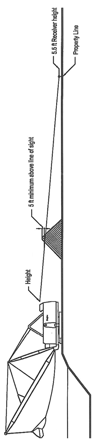
b.
Unless otherwise approved by the BCC, mining shall not be permitted within the following setback areas:
(1)
500 feet of a park, library, or school boundary.
(2)
500 feet of an adjacent residential use or developable lands zoned for residential use.
(3)
200 feet of an existing right-of-way or public or private easement for drainage, utility, or road purposes.
(4)
200 feet of permittee's property line.
c.
Prior to excavation, the perimeter of the excavation shall be adequately staked to delineate the excavation. These stakes shall be maintained throughout the duration of excavation and reclamation. The County may require a legal description of the excavation area when necessary for determining staking and location of the excavation.
d.
The mining site shall comply with the applicable landscape requirements of this Code.
e.
The construction of permanent or temporary access roads or of pipelines within the 100-year flood plain of permanent stream channels shall be subject to the advance approval of the County Administrator or designee.
2.
The disposal or discharge of any material other than that approved as a part of the reclamation plan into the excavated pit is prohibited.
M.
Operational Standards.
1.
The permittee shall allow designated representatives of the County Administrator or designee access to the premises of any operations conducted during the hours of operation for the purpose of monitoring compliance with the terms and conditions of the permit, this Code, and applicable rules and regulations.
2.
The mining operation shall be fenced and gated or otherwise secured to prevent unauthorized or uncontrolled access.
3.
Unless otherwise allowed by the BCC, the hours of operation shall be limited to daylight hours between 7:00 a.m. and 7:00 p.m., only. No mining activities shall be conducted on Sundays and County designated holidays.
4.
The operator or employee must be present at the site during all hours of operation.
5.
Environmental.
a.
The mining operations shall be in accordance with applicable FDEP and SWFWMD permits. However, upon a showing of public necessity, the BCC may establish such regulations as it deems necessary and proper pertaining to noise, dust, and other forms of pollution; source and rate of consumption of water supplies, drainage, quality, and method of discharge of waste waters not to be retained on the permittee's lands; treatment and disposal of solid wastes; methods and practices in the extraction and processing of ores, mineral, and consolidated or unconsolidated solid mineral matter; and construction and utilization of both temporary and permanent on-site and off-site transportation facilities.
b.
Ambient noises or other noises resulting from the mining operation shall not result in public nuisances as measured at the permittee's property lines and shall not generate noise in excess of that allowed by regulation of any local, State, or Federal agency.
c.
All mining operations shall be performed in a manner to minimize vibrations of the soil which would cause damage of any kind to persons or property outside of permittee's property.
d.
If authorized by the BCC, blasting or other use of explosives shall be conducted in accordance with the applicable State Fire Marshal regulations.
e.
Groundwater extractions shall be in accordance with SWFWMD rules and/or an applicable Water Use Permit.
f.
No water will be diverted from natural stream channels or lakes, nor shall stream channels be translocated, except as allowed by the applicable SWFWMD and/or FDEP permit(s). Withdrawals shall not be detrimental to downstream property owners.
g.
The applicant shall be responsible for the control of fugitive dust particulate arising from the facilities. Such control shall prevent the creation of nuisance conditions on the adjoining properties. However, if mining and/or processing activities are governed by an Air Pollution Permit issued by the FDEP, then the FDEP permit conditions and limitations shall control.
h.
No open burning is allowed without a permit.
i.
The permittee shall allow designated representatives of the County Administrator access to the premises of any operations conducted thereunder during the hours of operation for the purposes of monitoring compliance with terms, conditions of the permit, this Code, and rules and regulations adopted hereunder.
j.
The permittee shall place and maintain survey markers to identify the property covered by the permit in order to provide visual aid for inspection by the County.
k.
Copies of all reports or notices required of the permittee by any agency or Department of the State, specifically including, but not restricted to, the FDEP and SWFWMD, shall be provided to the County Administrator or designee within ten days of filing with the other entity. The fee simple owner(s), if different than the owner(s) of the mineral rights, and the mortgagee, if any, shall contemporaneously receive from the permittee a copy of all such reports or notices.
6.
The applicants shall engage, at their sole expense, the services of an independent testing lab to monitor groundwater quality on a quarterly basis, in compliance with the standards and procedures of Rules 62-520 and 62-550, F.A.C., as amended.
7.
Additional sampling at more frequent intervals, analysis for extended parameters, and additional monitoring wells may be required by the County Administrator or designee if the analysis indicates that a contaminant exceeds the regulatory limit. The sample analysis reports required by this Code shall be forwarded to the County Administrator or designee within ten days of receipt of the analysis report by the permittee.
8.
After background water quality is established, the excavation area shall be sampled every six months.
9.
Owners and Operators Responsibilities. The fee-simple owner of the land and the operator of a mine shall be responsible for compliance with these rules and all other applicable Federal, State, and local laws, rules, and regulations. Any person violating the provisions of such laws, rules, or regulations and causing damage, destruction, or unsafe, dangerous, or unhealthful conditions shall be responsible for:
a.
Correcting such conditions.
b.
In the event the owner and operator fail to correct such condition within a reasonable period of time after notice thereof, permitting the County to correct such conditions and reimbursing the County for the costs of correcting such conditions.
c.
Indemnifying the County for any liability for damages caused by such violation.
d.
The permittee and the fee-simple owner(s) shall be subject to absolute liability for failure of the permittee to complete any reclamation of lands or to conduct the operation as required by this Code; Chapter 62-701, F.A.C., as amended; and any permit issued. The liability of this section shall be in addition to those imposed as civil or criminal penalties by this Code, Section 108.
e.
The permittee(s) and the fee simple owner(s) shall be subject to absolute liability to the County to complete any reclamation of lands and to conduct the mining operations as required by the Operating Permit, this Code, and any other applicable rules or regulations. The liability of this section shall be in addition to those imposed as civil or criminal penalties by this Code, Section 108.
10.
Reclamation Standards. Reclamation shall be in accordance with the applicable SWFWMD and FDEP permits, Chapter 62, F.A.C., as applicable, and pursuant to the reclamation plan approved by the County.
11.
Annual Report.
a.
Each year, within 30 days following the anniversary date of a permit, the permittee shall provide an Annual Report of Operations to the County Administrator or designee. The annual report shall review mining operations and reclamation progress during the preceding reporting year and identify lands expected to be excavated or planned for reclamation during the current year. The report shall also contain an Annual Cost Adjustment Statement along with any required updated financial security document(s) as required by this section. The fee simple owner(s), if different than the owner(s) of the mineral rights, and the mortgagee, if any, shall contemporaneously receive from the permittee a copy of such report.
b.
The report shall be made available for public inspection.
c.
The annual report shall be reviewed and any comments or recommendations shall be presented to the BCC by the County Administrator or designee. The fee simple owner(s), if different than the owner(s) of the mineral rights, and the mortgagee, if any, shall contemporaneously receive from the permittee a copy of all such statements and documents.
d.
Failure to file the annual report in a timely manner shall be grounds for suspension of the Operating Permit. An extension of time may be granted by the BCC upon request and reasonable cause is demonstrated.
N.
Financial Responsibility.
1.
Types of Financial Security Required. Every applicant shall furnish to the BCC financial security to guarantee:
a.
Reclamation of any lands proposed for disturbance under the mining plan.
b.
Completion of any off-site performance requirements.
c.
Maintenance and/or monitoring requirements associated with the Operating Permit and/or plan.
2.
Acceptable Forms of Financial Security.
a.
Acceptable forms of this financial security shall include, but are not limited to, a Letter of Credit, Surety Bond, or Cash Bond.
b.
The financial security shall be in the name of the applicant, not the contractor, or another third party, and shall extend a minimum of one year beyond permit expiration. The applicant shall post the entire financial security prior to any activity on the land, authorized by the permit. Any bond premium shall be paid in full and shall not be revocable for nonpayment of premium.
c.
In the event a Surety Bond is furnished, the following shall apply:
(1)
The surety company shall have a currently valid Certificate of Authority, issued by the State Department of Insurance, authorizing it to write Surety Bonds in the State.
(2)
The surety company shall have a currently valid Certificate of Authority issued by the U.S. Department of Treasury under Sections 9304-9308 of Title 31, of the United States Code. The surety company shall be in full compliance with the provisions of the State Insurance Code. The surety company shall have at least twice the minimum surplus and capital required by the State Insurance Code at the time the Surety Bond is issued. If the bond amount exceeds $5,000.00, the surety company shall have at least the following rating in the latest issue of Best's Key Rating Guide:
3.
Amount of Financial Security Required.
a.
Reclamation of Disturbed Lands: Financial security shall be provided for all areas approved for disturbance in the mining plan and for those areas which have previously been disturbed and have not yet been reclaimed.
Cost itemization for reclamation shall consist of the required cost for reclamation and equipment mobilization, sod or seed, and mulch of the disturbed surface area, and surveying of the excavation area. This cost shall be multiplied by 125 percent to total the reclamation cost.
The amount shall be calculated as follows:
Proposed excavation area = __________ acres.
(1)
Slope Area:
(a)
With 4:1 side slopes:
(a) ft. (perimeter) × (b) ft. (depth) × (c) slope = (d) square feet (SF)
(a) = perimeter of excavation area(s)
(b) = depth (natural ground elevation to the bottom of the excavation)
(c) = 4 (4:1 side slope)
(d) = SF of slope surface area
(b)
With 4:1 and 2:1 combination side slopes:
(i)
(e) ft. (perimeter) × (f) ft. (depth) × (g) slope = (h) SF
(e) = perimeter of excavation area(s)
(f) = depth (natural ground elevation to a depth of six feet below normal low water level)
(g) = 4 (4:1 side slope)
(h) = SF of 4:1 slope surface area
(ii)
(i) ft. (perimeter) × (k) ft. (depth) × (m) slope = (n) SF
(j) = (e) = [(f) × 4]
(k) = total depth of the excavation less (f)
(m) = 2 (2:1 side slope)
(n) = SF of 2:1 slope surface area
(iii)
Total SF of slope surface area = (p) SF
(p) = (h) + (n)
(2)
Reclamation and Equipment Mobilization:
(a)
With 4:1 side slopes:
(d)/43,560 SF = (q) acre × $5,000.00 (cost/acre) = $ (r)
(b)
With 4:1 and 2:1 combination side slopes:
(p)/43,560 SF = (s) acre × $5,000.00 (cost/acre) = $ (t)
(c)
Seeding and mulching:
(h)/9 SF = (u) SY × $0.70 (cost/SY) = $ (v)
(3)
Surveying:
(a)
With 4:1 side slopes:
(q) acre × $1,300.00 (cost/acre) = $ (w)
(b)
With 4:1 and 2:1 combination side slopes:
(s) acre × $1,300.00 (cost/acre) = $ (y)
(4)
Total Amount of Proposed Reclamation Security:
(a)
With 4:1 side slopes:
[(r) + (v) + (w)] × 125% = $ ________
(b)
With 4:1 and 2:1 combination side slopes:
[(t) + (v) + (y)] × 125% = $ ________
The BCC reserves the right to amend and revise the cost-itemization formula from time to time as needed by adoption of a resolution. Costs given are based on the current County and/or State Department of Transportation cost estimates for the items, such as grassing, surveying, and mobilization. The said costs are a minimum of what will be accepted by the County.
b.
Completion of Off-Site Performance Requirements: The amount of the financial security shall be an amount equal to 125 percent of the estimated cost of providing and installing any off-site improvements required.
c.
Maintenance and/or Monitoring Requirements: For the purposes of determining the amount that is required for any maintenance and/or monitoring requirement, the applicant shall estimate the total cost for the period of the permit. The applicant shall submit the estimates, together with all necessary justification, to the County Administrator or designee for review and approval, accompanied by the financial security. The cost shall be estimated by a professional engineer for a third party performing the work in conformance with the guidelines approved by the County. Maintenance and/or monitoring cost shall include surface water and groundwater monitoring, collection and analysis, road maintenance, dust control, and any other costs of compliance with this Code.
d.
Annual Cost Adjustments: Each year, with the annual report, the applicant shall furnish the County with an Annual Cost Adjustment Statement along with any required updated financial security document(s).
4.
Additional Financial Security Requirements. The applicant shall acknowledge the following:
a.
That should the County collect funds under a financial security document, the applicant shall authorize the County or its designee access to the property subject to the Mining Permit to complete the required work. In the event the owner of the site is different from the applicant, then the owner of the site shall also authorize the required access.
b.
That should the County be required to institute legal proceedings in order to collect any funds under a financial security, the applicant shall be responsible for attorney's fees and court costs incurred by the County in such action if the County prevails.
c.
The fee simple owner(s), if different than the owner(s) of the mineral rights, and the mortgagee, if any, shall contemporaneously receive from the applicant a copy of all documents pertaining to financial security.
5.
Release of Financial Security. To release the financial security, the applicant shall notify the County Administrator or designee in writing to request the release of the financial security. Prior to the BCC authorizing the release, the following shall occur:
a.
The applicant shall submit a signed, sealed, and dated topographic survey with topography at one-foot intervals to indicate side slopes and total cubic yards of material excavated. In addition, a copy of this survey shall be superimposed over the approved plans to demonstrate substantial compliance with the said plans.
b.
The County Administrator or designee shall complete a final inspection, review the survey submitted, and approve reclamation of the site.
6.
Owners and Operators Responsibilities. The fee simple owner of the land and the operator of a mine shall be responsible for compliance with these rules and all other applicable Federal, State, and local laws, rules, and regulations. Any person violating the provisions of such laws, rules, or regulations and causing damage, destruction, or unsafe, dangerous, or unhealthful conditions shall be responsible for:
a.
Correcting such conditions.
b.
In the event the owner and operator fail to correct such condition within a reasonable period of time after notice thereof, permitting the County to correct such conditions and reimbursing the County for the costs of correcting such conditions.
c.
Indemnifying the County for any liability for damages caused by such violation.
d.
The permittee and the fee simple owner(s) shall be subject to absolute liability for failure of the permittee to complete any reclamation of lands or to conduct the operation as required by this Code; Chapter 62-701, F.A.C., as amended; and any permit issued. The liability of this section shall be in addition to those imposed as civil or criminal penalties by this Code, Section 108.
e.
The permittee(s) and the fee simple owner(s) shall be subject to absolute liability to the County to complete any reclamation of lands and to conduct the mining operations as required by the Operating Permit, this Code, and any other applicable rules or regulations. The liability of this section shall be in addition to those imposed as civil or criminal penalties by this Code, Section 108.
O.
Prohibitions.
1.
The disposal or discharge of any material other than that approved as a part of the reclamation plan into the excavated pit is prohibited.
2.
No mining shall be conducted within the County, except within the scope of a valid Operating Permit issued by the BCC.
P.
Suspension or Revocation of Permit. A suspension of operations for a period of two years or more by a permittee shall be cause for revocation of the permit. Any subsequent application for permission to commence excavation shall be treated as an initial application.
Failure to comply with the County, State, or Federal statutes, rules, or regulations governing mining may constitute grounds for suspension or revocation of the Mining Operating Permit. Upon a determination of noncompliance, the County Administrator or designee shall notify the owner and operator/permittee of the nature of the noncompliance and may order corrective action. If the owner and operator fail to comply or take the ordered corrective action, the County Administrator or designee may notify the BCC, who may schedule a public hearing to consider suspension or revocation of the Operating Permit. After due public notice of the said hearing, the BCC shall conduct the said hearing giving all interested persons the opportunity to be heard, present testimony and evidence, and cross-examine witnesses. If, after consideration of the testimony and evidence, the BCC determines that grounds for suspension exist, the BCC may take one or more of the following steps:
1.
Order appropriate corrective action.
2.
Modify the existing conditions or impose additional, more stringent conditions on the permit.
3.
Suspend the permit until appropriate, corrective action is taken or additional or modified conditions are complied with. Any Mining Operating Permit shall be subject to suspension or revocation in whole or in part upon a finding of noncompliance with the terms of the said permit, this Code, or applicable statutes, rules, and regulations. A suspension may be terminated in whole or in part upon a finding that the noncompliance has been corrected. While a permit or any part of a permit is suspended, no operations authorized by the suspended portion of the Operating Permit shall be carried out. A suspension may be terminated in whole or in part upon a finding that the noncompliance has been corrected.
4.
Revoke the permit. Copies of all notices and orders sent to the permittee by the County Administrator or designee as well as reports of compliance or appeals to the BCC from the permittee shall be sent by the County Administrator or designee to any agency involved in the permit process.
Q.
Failure of a permittee to have completed reclamation of any lands as required at the conclusion of any reporting year may subject the permittee(s) to a civil penalty to be paid to the County in an amount equal to the evidence of financial responsibility required to be maintained on account of the lands involved in addition to any other fines and penalties that may apply.
R.
Enforcement/Violations. In addition to suspension, modification, or revocation of the Operating Permit, violation of this section may be addressed through any of the enforcement methods in this Code, Section 108.
It shall not be a defense to or grounds for dismissal of any action for damages and civil penalties that the County has failed to exhaust its administrative remedies, has failed to serve a notice of violation, or has failed to hold an administrative hearing prior to the institution of a civil action, or that criminal proceedings or other enforcement proceedings are pending. The failure of the County to enforce any requirements of this Code shall not constitute a waiver of the County's right to enforce this Code with respect to that violation or subsequent violations of the same type or to pursue other remedies.
(Ord. No. 24-21, § 5(Att. A), 4-23-24; Ord. No. 24-39, § 5 (Att. A), 8-21-24)
404.4. - Construction and Demolition Debris Disposal Facilities (CDDDF) Operating Permit
A.
Intent and Purpose. It is the intent and purpose of this section to provide a safe, efficient, and economical method of storing and disposing of construction and demolition debris through certain operating procedures and practices.
The CDDDF Operating Permit is used to:
1.
Evaluate in detail the proposed operating plans for a CDDDF in conjunction with a conditional use application; and
2.
Ensure that, if approved, a CDDDF is operating in a manner consistent with the requirements of this Code; the Comprehensive Plan; and in the best interest of the health, safety, and welfare of Pasco County and its citizens.
B.
Applicability. This section shall apply to the unincorporated area of the County where the storage and/or disposal of construction and demolition debris is proposed.
C.
Exemption. The exemptions contained in Chapter 62-701, Florida Administrative Code (F.A.C.), as may be amended, are incorporated by reference.
D.
Application Requirements. Applications for CDDDF Operating Permits shall include plans drawn at a readable scale, signed, and sealed by a Florida registered engineer. The application package shall include:
1.
Applicant Information:
a.
Proof of ownership; i.e., copy of deed.
b.
Agent of Record letter, if applicable.
c.
Application fee.
2.
General information to be shown on the site plan:
a.
A legend, title, and number of revision; date of plan and revision(s); scale of plan; north arrow; acreage in the project; and names, mailing addresses, e-mail addresses, and telephone numbers of the operator, owner, surveyor, and engineer.
b.
A legend, title, and number of revision(s); date of preliminary plan and revision(s); scale of plan; north arrow; acreage in the tract being subdivided; total number of lots; and names, mailing addresses, e-mail addresses, and telephone numbers of the operator, owner, surveyor, and engineer.
c.
Phasing plan (if applicable) designating each phase by heavy line border at an appropriate scale.
3.
Map information to be shown on the site plan:
a.
Location map showing the relationship between the subject property and surrounding properties, including a current aerial photograph with boundaries of development and roadway layout delineated. The location map shall show all major County roads within one mile of the development boundary.
b.
Show all existing and planned arterials and collectors (transportation corridor[s]) within the subject property and within one mile of the subject property.
c.
Wellhead Protection Areas and Special Protection Areas for all Community Water System supply wells within the proposed development and within 1,000 feet of the subject property.
4.
Existing site information to be shown on the site plan:
a.
Legal description sufficient to describe the size and location of the tract.
b.
Existing Streets. The name, location, right-of-way width, and pavement status; i.e., dirt, limerock, concrete, asphalt, etc., of all existing streets, platted or recorded easements, other rights-of-way, and platted streets within 200 feet of the subject property.
c.
Existing platted or recorded easements or rights-of-way for drainage, pedestrian ways, bridle paths, or bicycle paths, etc., including location, width, design criteria, and purpose within 200 feet of the subject property.
d.
Configuration of that portion of abutting developments within 200 feet with preliminary site plan approval, or if platted, with Plat Book and page number shown.
e.
Existing storm sewers, potable water facilities, and sewerage facilities on or abutting the tract within 200 feet.
f.
Other existing structures or uses on the tract with a statement as to its intended use.
g.
Existing contours at a maximum of two-foot intervals, based on the National Geodetic Vertical Datum of 1929, identifying the tract to be developed and, where practicable, extending a minimum 100 feet beyond the tract boundary. A note stating the basis of the vertical datum shall be shown on the drawing. After October 1, 2011, the submittal shall be based on the NAVD88.
h.
Present land use of the parcel proposed for development.
i.
Future Land Use (FLU) classification and zoning district of the parcel proposed for development and abutting land.
j.
Dates and reference numbers of rezonings, special exceptions, variances, conditional uses, or vested rights that have been granted, if applicable.
k.
Approximate location and acreage of natural features, including lakes, marshes or swamps, watercourses, and other jurisdictional areas.
l.
List registered or recorded historic or cultural resources. A narrative meeting the requirements of Section 809, Cultural Resources.
m.
Wetland Delineation/Identification. Provide documentation in the form of a survey, sketch, or aerial that delineates the location of the Category I, II, or III wetland areas, as defined in the Pasco County Comprehensive Plan, Chapter 3, Conservation Element, Wetlands, Policy Nos. CON 1.3.1, CON 1.3.2, CON 1.3.3, CON 1.3.4, and CON 1.3.5 and provide the acreage for each wetland classification type.
n.
Calculations. In addition to the wetland type and acreage information, provide the following:
(1)
Cumulative acreage total for Category I, II, and III wetlands.
(2)
Acreage total for water bodies.
(3)
Acreage total for land with CON (Conservation Lands) FLU Classification.
(4)
Developable acreage.
o.
Geotechnical Site Investigation. The geotechnical site investigation shall be conducted by or under the supervision of a Florida registered engineer with experience in geotechnical engineering. The engineer shall define the engineering properties of the site that are necessary for the design, construction, and support of the CDDDF and all installations of the facility, and shall:
(1)
Identify and describe subsurface conditions, including soil stratigraphy and groundwater table conditions;
(2)
Identify and address the presence of muck, previously filled areas (if any), soft ground, lineaments, and sinkholes; and
(3)
Include estimates of the average and maximum high groundwater table across the site.
The geotechnical site investigation report shall describe the site subsurface conditions and shall include, at a minimum, the methods used in the investigation, all soil boring logs and laboratory results, analytical calculations, cross sections, interpretations, and conclusions.
(4)
The report and supporting documentation shall be signed and sealed by a Florida registered engineer.
p.
Hydrogeological Investigation and Site Report. The hydrogeological investigation and site report shall be conducted by or under the supervision of a professional geologist or professional engineer registered in the State of Florida with experience in hydrogeologic investigations, and shall:
(1)
Define the site geology and hydrology and its relationship to the local and regional hydrogeologic patterns, including:
(a)
Direction of groundwater flow, including seasonal variations;
(b)
Background quality of groundwater and surface water for the parameters listed in this section of this Code;
(c)
Any on-site hydraulic connections between aquifers;
(d)
For all confining layers, semi-confining layers, and all aquifers below the site that may be affected by the construction and demolition debris, the porosity or effective porosity, horizontal and vertical permeabilities, and the depth to and lithology of the layers and aquifers; and
(e)
Topography, soil types, and characteristics.
(2)
An inventory of all the public and private wells within a one mile radius of the proposed site. The inventory shall include, where available:
(a)
The approximate elevation of the top of the well casing and the depth of each well;
(b)
The name of the owner, the age and usage of each well, and the estimated daily pumpage; and
(c)
The stratigraphic unit screened, well construction technique, and static water levels of each well.
(3)
Identify and locate any existing, contaminated areas on the site. The site report and supporting information, including a detailed description of the methods, calculations, and interpretations used, shall be signed and sealed by the professional engineer or geologist.
q.
Stormwater Management Plan and Report prepared in accordance with this Code.
r.
A site plan, of a readable scale, which shows:
(1)
A legend indicating title and number of revisions; date of plan or revision; scale; north arrow; acreage of site; acreage of area proposed for disposal of construction and demolition debris; and names, addresses, and telephone numbers of the surveyor and/or engineer.
(2)
Location map which shows the relationship between the proposed facility, existing development, and land uses, including existing streets; utilities; rights-of-way; easements; drainage systems (natural or man-made); well fields; or water supplies, water bodies, and other natural features.
(3)
Topography of the site and 200 feet beyond the site's property line.
(4)
Proposed disposal area(s).
(5)
Total acreage of the site and proposed disposal area(s).
(6)
Setbacks of disposal area(s) from property boundaries.
(7)
Setbacks of disposal area(s) from adjoining residential areas.
(8)
Exact location of any existing or proposed structures, along with a statement of their use.
(9)
Access and traffic flow to and from the site.
(10)
Parking areas.
(11)
Existing and proposed screens, buffers, and fencing.
(12)
Conservation or preservation area (if applicable).
(13)
Storm drainage systems.
(14)
Access to utilities and points of hookup, if applicable.
(15)
Roads, utilities, and other improvements to be provided by the applicant.
(16)
Signs, if any.
(17)
Location of the entrance to disposal facility.
(18)
Location of operator and employee stations.
(19)
Location of any areas proposed for disposal of construction and demolition debris which are subject to periodic flooding.
(20)
Location of any areas proposed for disposal of construction and demolition debris which consists of a dewatered pit.
(21)
Location of any open sinkholes or areas where geologic foundation or subterranean features would not support a CDDDF.
(22)
Tabulations showing total gross acreage of the site and the percentage to be devoted to disposal of construction and demolition debris, various other uses, ground covered by structures, impervious surface coverage; and derivation of the number of off-street parking.
(23)
Tree data meeting the requirements of this Code.
(24)
Such additional data as may be required for the CDDDF.
(25)
Reclamation plan showing proposed elevations.
(26)
Existing and proposed cross sections at intervals sufficient to determine volume.
s.
Closure plans and cross section details of the final cover. The closure plan shall describe provisions for cover material for the long-term care of erosion control and general maintenance of the facility, and specify the anticipated source and amount of material necessary for proper closure of the facility.
5.
Other Required Submittals:
a.
Listed Species Site Survey: If the site is shown on Map 3-1 in the Comprehensive Plan, as a potential location for known listed species habitat.
b.
A narrative meeting the requirements of Section 809, Cultural Resources.
c.
Geotechnical/geological engineering report.
d.
Timing and Phasing Analysis pursuant to Section 901.12.
e.
Substandard Road Analysis pursuant to Section 901.4.
f.
Access Management Application pursuant to Section 901.3.
g.
Erosion and Sediment Control Plan:
(1)
Narrative.
(2)
Map/site plan.
(3)
Construction details.
(4)
Calculations.
h.
Financial security document; evidence of financial responsibilities described in this Code.
E.
Public Hearing Required. Prior to commencing operations as a CDDDF for the storing or disposing of construction and demolition debris, a CDDDF Operating Permit application must be reviewed and approved by the Board of County Commissioners (BCC) after a public hearing held in conjunction with a Conditional Use Permit.
F.
Notice. Notice shall be as required pursuant to this Code, Section 304.2, and the provisions of Chapter 125.66, Florida Statutes.
G.
Standards for Approval. The County Administrator or designee, the Planning Commission (PC), and the BCC shall review and consider the following criteria and standards in regard to the advisability of issuing an Operating Permit for a CDDDF:
1.
Requirements of the land use and zoning classification applicable to the subject property.
2.
Compliance with the technical requirements of this Code.
3.
Provision of design features which ensure the protection of the public health, safety, and welfare.
4.
Consistency with the Goals, Objectives, and Policies set forth in the Comprehensive Plan.
5.
Provision of necessary public improvements or facilities.
6.
Concurrency requirements established by this Code.
H.
Operating Permit Review.
1.
Staff Review. The County Administrator or designee, after consideration of the above standards, shall present a recommendation to both the PC and BCC. The said recommendation shall specify provisions, standards, conditions, or design specifications which must be met in order to ensure compliance with this Code and the Comprehensive Plan.
2.
PC Review. After receipt of the written recommendation of the County Administrator or designee, the PC shall consider the application and make a recommendation to the BCC.
3.
BCC Hearing and Action.
a.
Upon receipt of the recommendation, the BCC shall hold a separate public hearing on the proposed CDDDF Operating Permit.
b.
At the conclusion of the public hearing, the BCC may:
(1)
Refer the application back for further study if further information is required in order to make a final decision;
(2)
Deny the application;
(3)
Approve the permit application as presented; or
(4)
Approve the permit application with such conditions as necessary to ensure compliance with this Code; the Comprehensive Plan; and to protect the health, safety, and welfare of the citizens of Pasco County.
All or any portion of the operations for which a permit is sought may be approved subject to whatever additional conditions the BCC may deem necessary and appropriate for the fulfillment of the purposes of this Code. Such additional conditions of approval shall be stated on the face of the Operating Permit or may be incorporated therein by stated reference to any document which shall be made a part thereof.
The BCC may impose reasonable, additional conditions where necessary to protect the public health, safety, and welfare including, but not limited to, conditions requiring lining of the disposal facility pursuant to Section 403.707(9)(b), Florida Statutes, or other leach-prevention measures; installation of stormwater-management facilities; sound and/or visual buffering; hours of operation; surface water and groundwater monitoring; and that the owner or operator will take out and maintain insurance covering damage, destruction, unsafe, dangerous, or unhealthful conditions which may result from the use of the property as a CDDDF.
I.
Approval Form, Permit Time Limits, and Activities Required Prior to Commencement.
1.
The BCC approval shall be in written form and shall constitute a permit for operation of a CDDDF subject to the requirements of this Code and the specific requirements, limitations, conditions, and prohibitions contained in the Operating Permit.
2.
Permits for operation of a CDDDF are not limited in duration and shall correspond to the permittee's approved disposal volume with an annual review for compliance.
3.
The effective date of any CDDDF Operating Permit shall be the date of issuance by the BCC.
4.
A permit shall be valid for the volume capacity specified in the CDDDF Operating Permit.
5.
A permit may be issued only in the name of the applicant. Transfer of the permit requires notification to the County prior to the transfer. All terms, conditions, and financial responsibilities shall run with the permit as well as with the land.
6.
The Scope of Operations to be permitted under any permit shall only be as specified in the permit (which may incorporate by reference the whole or any part of any plan of operations submitted as a portion of the application for the permit), or any recommendation thereon submitted to and accepted by the BCC by any County department, public or private agency, or individual. A copy of any incorporated recommendation or pertinent part thereof shall be attached to and considered a part thereof.
7.
A permittee may seek an amendment of any permit in order to vary or expand the scope or method of its operations at any time by filing an application that follows the procedures outlined for the original application. An amendment deemed necessary in the public interest may be proposed by any member of the BCC; PC; County Administrator or designee; or any applicable Federal, State, or local regulatory body.
8.
Prior to the issuance of a permit, the applicant shall furnish financial security as required by this section.
9.
Following approval of an application by the BCC, the County Administrator or designee shall, upon request, issue a permit to the applicant or his authorized agent, provided that the required financial security has been submitted to the County.
10.
Prior to the initiation of storage or disposal activities authorized by the permit, the applicant shall erect signs alerting motorists to the haul traffic entering the roadway. Such signs shall be erected to County or Florida Department of Transportation standards.
11.
The applicant shall obtain all necessary permits from the Southwest Florida Water Management District, the Florida Department of Environmental Protection, and other regulatory agencies, as appropriate, prior to commencing operations. These agencies' permits shall be provided to the County. All applicable statutes, regulations, rules, and orders of Federal, State, and local agencies shall be made a part of the conditions of operations. Where an applicable statute or regulation of another agency is more stringent, that regulation shall apply.
12.
A minimum of one up-gradient and one down-gradient monitoring well shall be installed prior to commencement of operations. Installation and sampling of this well will be in accordance with Chapter 62-701, F.A.C.
13.
Background water quality for a disposal facility shall be determined by analysis, prior to any disposal of debris, of at least one sample taken from each monitoring well that was installed and each surface water location. All surface water bodies which may be affected by a contaminant release from the disposal facility shall be monitored.
14.
The applicant shall obtain all necessary permits from the Southwest Florida Water Management District, the Florida Department of Environmental Protection, and other regulatory agencies, as appropriate, prior to commencing operations. These agencies' permits shall be provided to the County. All applicable statutes, regulations, rules, and orders of Federal, State, and local agencies shall be made a part of the conditions of operations. Where an applicable statute or regulation of another agency is more stringent, that regulation shall apply.
J.
Site Standards.
1.
The proposed storage and disposal area shall not be permitted within:
a.
500 feet of a park, library, or school boundary.
b.
500 feet of a school boundary.
c.
500 feet of the property line of an adjacent residential use or lands zoned for residential use.
d.
200 feet of an existing right-of-way or public or private easement for drainage, utility, or road purposes.
e.
400 feet of permittee's property line.
2.
No construction and demolition debris shall be permitted to be disposed of above the natural grade. The natural grade shall be the grade creating a level surface when compared to the adjacent lands.
3.
No construction and demolition debris shall be permitted to be disposed of below a depth of one foot above the seasonal high water table.
4.
Debris may be stored on the property no longer than 14 days before disposal.
K.
Operational Standards.
1.
The permittee shall allow designated representatives of the County Administrator or designee access to the premises of any operations conducted thereunder during the hours of operation for the purposes of monitoring compliance with the terms, conditions of the permit, this Code, and rules and regulations adopted hereunder, or any applicable Federal, State, or local regulation.
2.
The storage and disposal areas shall be fenced and gated or otherwise secured to prevent unauthorized or uncontrolled access.
3.
Unless otherwise allowed, the hours of operation shall be limited to daylight hours between 7:00 a.m. and 7:00 p.m. only. No activities shall be conducted on Sundays and County designated holidays.
4.
The operator or an employee of the operator must be present at the site during all hours of operation.
5.
Ambient and other noises resulting from the permit operations shall not result in public nuisances as measured at the permittee's property lines and shall not generate noise in excess of that allowed by any local, State, or Federal statute or code.
6.
Water Testing.
a.
The applicant shall engage, at his sole expense, the services of an independent testing lab to monitor groundwater and surface water quality as required by Chapter 62, F.A.C. Reports filed with other state agencies shall also be filed with the County within ten days of filing with other State agencies.
b.
Additional sampling at more frequent intervals and analysis for extended parameters and additional monitoring wells may be required by the County Administrator or designee, if the analysis indicates that a contaminant exceeds the regulatory limit. The sample analysis reports shall be forwarded to the County Administrator or designee within ten days of receipt of the analysis report by the permittee.
7.
The applicant shall be responsible for the control of fugitive dust particulates arising from the site. Such control shall prevent the creation of nuisance conditions on adjoining property.
8.
No open burning is allowed at this facility.
9.
The applicant agrees to provide, at the applicant's sole expense, the services of an independent security agency or on-site caretaker (24 hours/day, seven days/week, 365 days/year) to provide periodic security inspections and surveillance of the site. The applicant shall submit a detailed report outlining the proposed scope of security services to the County Administrator or designee.
10.
Inspection, Rejection, and Disposal of Unauthorized Materials. The more stringent of these provisions or the provisions of Chapter 62-701, F.A.C., as amended, shall be complied with.
a.
The operator or designee shall be stationed during all hours of operation at the entrance to the disposal facility or on-site at the location of current disposal operations. At least one spotter shall inspect the incoming waste. Any prohibited material, including buckets or cans containing tar, paint, glue, or other liquids, shall be removed from the waste stream and placed into appropriate containers for disposal at an appropriately permitted facility.
b.
Prior to disposal of any solid waste, the operator or employee shall:
(1)
Inspect, generally, all solid waste brought to the facility for disposal.
(2)
Only allow disposal of construction and demolition debris.
(3)
Reject any other type of solid waste brought to the facility for disposal, including construction and demolition debris contaminated with such other type of solid waste.
c.
The operator or employee shall:
(1)
Inspect all disposed of materials daily.
(2)
Remove all unauthorized solid waste which may have been disposed of.
(3)
Deposit unauthorized solid waste in a watertight, nonabsorptive, specialized bulk container maintained on the dump site.
(4)
Periodically shall dispose of all unauthorized solid waste at a solid waste disposal site lawfully permitted to receive such materials. Appropriate equipment for removal of such materials shall be maintained on-site during all hours of operation.
11.
Record Keeping. The operator or his employees shall:
a.
Keep and maintain a daily log indicating the date and time of all disposals and rejections; the name and address of the disposer, including disposer whose material was rejected; and the license or vehicle identification number of the disposer's vehicle.
b.
Complete a ticket reflecting the following information:
(1)
The name of the driver and the owner of the vehicle.
(2)
The license number.
(3)
Customer number.
(4)
The estimated cubic yards of construction and demolition debris to be dumped.
(5)
Location where debris originated from.
12.
Method of Disposal. Construction and demolition debris accepted at the facility shall be crushed, compacted, and formed systematically into layers consisting of series of adjacent cells. Each cell shall be of manageable size no greater than 15 acres in size and shall be backfilled with intermediate cover, which shall be a minimum of six inches of clean fill within 30 days of forming the next adjacent cell.
13.
Owners and Operators Responsibilities. The fee simple owner of the land and the operator/permittee of a CDDDF shall be responsible for compliance with these rules and all other applicable Federal, State, and local laws, rules, and regulations. Any person violating the provisions of such laws, rules, or regulations and causing damage, destruction, or unsafe, dangerous, or unhealthful conditions shall be responsible for:
a.
Correcting such conditions.
b.
In the event the owner and operator fail to correct such condition within a reasonable period of time after notice thereof, permitting the County to correct such conditions and reimbursing the County for the costs of correcting such conditions.
c.
Indemnifying the County for any liability for damages caused by such violation.
d.
The permittee and the fee simple owner(s) shall be subject to absolute liability for failure of the permittee to complete any reclamation of lands or to conduct the operation as required by this Code; Chapter 62-701, F.A.C., as amended; and any permit issued. The liability of this section shall be in addition to those imposed as civil or criminal penalties by this Code, Section 108.
14.
Annual Reports. Each year, within 30 days following the anniversary date of the Operating Permit, the operator/permittee shall provide an annual report with the County Administrator or designee. The annual report shall contain a summary of the total quantity of solid waste disposed of and rejected by month, a copy of the log required to be maintained pursuant to this Code, and a projection of the quantity of construction and demolition debris expected to be disposed of during the next year. The report shall be made available for public inspection. The annual report shall be reviewed and any comments or recommendations shall be presented to the BCC by the County Administrator or designee in the form of an annual review of compliance, a copy of which shall be provided to the operator/permittee and the fee simple owner of the land, if different than the permittee/operator. Failure to file the annual report in a timely manner may be grounds for suspension or revocation of the permit and is a violation of this Code. An extension of time may be granted by the BCC upon request and for reasonable cause.
L.
Financial Responsibility.
1.
Closure of the Disposal Facility. Prior to operation of the CDDDF, the owner or operator shall submit to the County evidence of financial responsibility in the form of a performance assurance document sufficient to cover 115 percent of an engineer's certified cost estimate of the costs of closure of the disposal facility. This document may be for phases. The performance assurance document and the cost estimate must be reviewed by the County Attorney's Office, the County Administrator or designee, and be accepted by the BCC. The performance assurance document shall be kept in force at all times until closure of the cell(s) has been completed in conformance with the closure plan and this Code.
2.
Long-Term Maintenance.
a.
As a condition for the issuance of a permit, the applicant shall establish a self insurance fund to ensure that the CDDDF is operated in accordance with applicable County regulations and to ensure long-term maintenance of the disposal facility.
b.
The applicant shall charge a fee per cubic yard of disposal debris to fund this self insurance fund and shall report quarterly to the County on the status of the fund.
c.
The fund shall remain in effect for ten years after final closure of the site or until the County establishes and administers its own environmental fund, whichever is earlier. The County shall have the right of access to this fund to address any violations of County regulations pursuant to a written agreement with the applicant, the form of which shall be approved by the County Attorney's Office.
d.
For the purposes of determining the amount that is required for long-term maintenance, the owner or operator shall estimate the total cost for a ten-year period. The owner or operator shall submit the estimates, together with all necessary justification, to the County for review and approval accompanied by proof of financial responsibility. The costs shall be estimated by a professional engineer for a third party performing the work, on a per unit basis, in conformance with the guidelines approved by the County.
e.
Long-term maintenance costs shall include land surface care; surface water and groundwater monitoring, collection, and analysis; and any other costs of compliance with this Code.
f.
Annual Cost Adjustments.
(1)
Every owner or operator of a disposal facility shall submit to the County an annual cost adjustment statement certified by a Florida registered engineer.
(2)
The owner or operator shall revise the cost estimate for inflation and changes in the long-term maintenance plan. Such revisions shall be made annually.
M.
Closure. Final cover and seeding or planting of vegetative cover shall begin within 60 days after final receipt of construction and demolition debris in each cell and shall be completed within 180 days after final receipt of construction and demolition debris in each cell. Final cover shall consist of a 24-inch thick soil layer, the upper six inches of which shall be capable of supporting vegetation and shall be graded to eliminate ponding, promote drainage, and minimize erosion. The side slopes of all above grade disposal areas shall be no greater than three feet horizontal to one-foot vertical rise.
The owner or operator shall notify the County within 30 days after closing, covering, and seeding each cell and upon complete closure of the entire facility.
Within 45 days of completion of closure construction for the entire facility, the engineer of record shall certify to the County that the permitted closure construction is complete and that it was done in accordance with the plans submitted to the County, except where minor deviation was necessary. All deviations shall be described in detail and the reasons therefore enumerated.
N.
Prohibitions.
1.
Disposal of construction and demolition debris shall be subject to the prohibitions set forth in Rule 62-701, F.A.C., and any subsequent amendments thereto.
2.
No solid wastes other than clean fill or construction and demolition debris shall be stored or disposed of in a CDDDF.
3.
Storage and/or disposal pf construction and demolition debris is prohibited except within the scope of a valid CDDDF Operating Permit issued by the BCC.
O.
Suspension, Modification, or Revocation of Permit. Failure to comply with the County, State, or Federal statutes, rules, or regulations governing disposal of construction and demolition debris may constitute grounds for suspension or revocation of the CDDDF Operating Permit. Upon a determination of noncompliance, the County Administrator or designee shall notify the owner and operator/permittee of the nature of the noncompliance and may order corrective action. If the owner and operator fail to comply or take the ordered corrective action, the County Administrator or designee may notify the BCC, who may schedule a public hearing to consider suspension or revocation of the Operating Permit. After due public notice of the said hearing, the BCC shall conduct the said hearing giving all interested persons the opportunity to be heard, present testimony and evidence, and cross-examine witnesses. If, after consideration of the testimony and evidence, the BCC determines that grounds for suspension exist, the BCC may take one or more of the following steps:
1.
Order appropriate corrective action.
2.
Modify the existing conditions or impose additional, more stringent conditions on the permit.
3.
Suspend the permit until appropriate, corrective action is taken or additional or modified conditions are complied with. Any CDDDF Operating Permit shall be subject to suspension or revocation in whole or in part upon a finding of noncompliance with the terms of the said permit, this Code, or applicable statutes, rules, and regulations. A suspension may be terminated in whole or in part upon a finding that the noncompliance has been corrected. While a permit or any part of a permit is suspended, no operations authorized by the suspended portion of the Operating Permit shall be carried out. A suspension may be terminated in whole or in part upon a finding that the noncompliance has been corrected.
4.
Revoke the permit. Copies of all notices and orders sent to the permittee by the County Administrator or designee as well as reports of compliance or appeals to the BCC from the permittee shall be sent by the County Administrator or designee to any agency involved in the permit process.
P.
Enforcement/Violations. In addition to suspension, modification, or revocation of the Operating Permit, violation of this section may be addressed through any of the enforcement methods in this Code, Section 108.
(Ord. No. 24-21, § 5(Att. A), 4-23-24; Ord. No. 24-39, Att. A, 8-21-24)
404.5. - Land Spreading Operating Permits
A.
Intent and Purpose. It is the intent and purpose of this section to regulate and control activities which are causing or may reasonably be expected to cause pollution or contamination of water and soil and to regulate the storage, collection, transport, separation, processing, recycling, disposal, and land spreading of sludge, septage, or animal waste in the County.
A Land Spreading Operating Permit is used to:
1.
Evaluate in detail the proposed operating plans for a land spreading operation; and
2.
Ensure that, if approved, a land spreading operation is conducted in a manner consistent with the requirements of this Code; the Comprehensive Plan; and in the best interest of the health, safety, and welfare of the County and its citizens.
B.
Applicability. This section shall apply to the unincorporated area of the County.
All persons seeking to engage in the business of hauling, storing, manufacturing, installing, repairing, maintaining, disposing of, or spreading food service sludge within the County shall first obtain a valid Site Permit from either the Florida Department of Environmental Protection (FDEP) or the Pasco County Health Department, whichever is appropriate. All requirements of Rule 62-640, Florida Administrative Code (F.A.C.), which are not in conflict with this Code, are expressly incorporated into this Code.
C.
Application Requirements. An application for a Land Spreading Operating Permit shall be prepared by a Florida registered engineer. The application for a Land Spreading Operating Permit shall include plans drawn at a readable scale, signed and sealed by a Florida registered engineer. The application package shall include:
1.
Applicant Information.
a.
Proof of ownership; i.e., copy of deed.
b.
Agent of Record letter, if applicable.
c.
Application fee.
2.
General Information.
a.
A legend, title, and number of revision; date of plan and revision(s); scale of plan; north arrow; acreage in the project; and names, addresses, e-mail addresses, and telephone numbers of the developer, owner, surveyor, and engineer.
b.
The legal description of and the nature of the applicant's legal interest in any and all lands upon which any operations are proposed, and a metes and bounds boundary survey certified by a Land Surveyor registered in the State of Florida, of all or any part of the boundary of the applicant's property.
3.
Map Information. The location map showing the relationship between the site proposed for excavation and surrounding properties, including a current aerial photograph. The aerial shall not be older than that available at the County Property Appraiser's Office and shall have the boundaries of the site delineated. The location map shall show all major County roads within one mile of the site.
4.
Narrative. A description of overall operation including a statement of where and how the material excavated will be disposed.
5.
Site Plan.
a.
Show the property and location of the areas to be excavated, including all setbacks.
b.
A cross section of the proposed pond (hole) showing the proposed slopes, proposed depth of the excavated area, and the approximate volume to be excavated.
c.
Show the placement or disposition of excavated material.
D.
Application Processing.
1.
An application for a Land Spreading Operating Permit shall be reviewed by all appropriate agencies as specified in the Development Manual or determined by the County Administrator or designee.
2.
The County Administrator or designee shall prepare a recommendation to the Planning Commission (PC). The recommendation may include conditions necessary to ensure compliance with the provisions of this Code.
3.
The PC shall consider the Land Spreading Operating Permit application and staff recommendation. The PC may:
a.
Recommend approval as presented,
b.
Recommend approval with modifications,
c.
Recommend denial of the application, or
d.
Continue the matter for further deliberations.
4.
The application for a Land Spreading Operating Permit and recommendation of the PC shall be considered by the Board of County Commissioners (BCC) at the same hearing where the Land Spreading Conditional Use application is considered. The BCC may:
a.
Approve the application as recommended,
b.
Approve the application with modifications,
c.
Deny the application,
d.
Continue the hearing on the application, or
e.
Remand the application for further consideration by the PC.
E.
Terms of Permit and Effect of Approval.
1.
The effective date of any Operating Permit shall be the date of issuance or other date as specified by the BCC.
2.
The Operating Permit shall be valid for 12 months.
3.
A permit may be issued only in the name of the applicant and may be transferred only when the interests of the permittee in the lands that are the subject of the permit are to be transferred. Transfer of the permit requires notification to the County prior to the transfer. All terms and conditions of the permit shall run with the permit as well as with the land.
4.
The scope of operations to be permitted under any Land Spreading Operating Permit shall only be specified in the Land Spreading Operating Permit (which may incorporate by reference, the whole or any part of any Plan of Operations submitted as a portion of the application for the permit) or any condition thereon imposed by any County department or public agency.
5.
The permittee shall allow designated representatives of the County Administrator or designee access to the premises of any operations conducted thereunder during the hours of operation for the purpose of monitoring compliance with the terms and conditions of the permit; this Code; and rules and regulations adopted hereunder; or any applicable Federal, State, or local regulation.
6.
Representatives of the County shall have the right of entry upon 24 hours notice and at all reasonable times upon property covered by a permit for purposes of inspection. Designated representatives of the permittee, if available on the premises, shall have the right to accompany any County representative during inspection.
7.
Any permit shall be subject to suspension or termination in whole or in part at any time upon a finding by the County Administrator or designee of noncompliance with any of the terms of this Code, the permit, or with Rule 62-640, F.A.C., as amended. When a permit or any part thereof is under suspension, no operations authorized by the suspended portion shall be carried out. A suspension may be terminated in whole or in part upon a finding by the County Administrator or designee that necessary steps have been taken to correct the noncompliance.
8.
The permittee(s) and the fee simple owner(s) shall be subject to absolute liability to the County to complete any reclamation of lands and to conduct the land excavation operations as required by the Land Spreading Operating Permit, this Code, and any other applicable rules or regulations.
9.
Issuance of a permit shall entitle the applicant to begin waste disposal and/or land spreading operations in accordance with the terms of this Code and the Land Spreading Operating Permit.
10.
All permits must be kept at the disposal site and be readily available for inspection by local enforcement personnel upon request.
The following standards, together with requirements set forth in 40 CFR, § 503, and Rule 62-640 and Rule 64-E-6.010, F.A.C., as amended, shall apply to all land application areas or disposal sites governed by this section, including all sludge land application areas; and property where animal waste material is disposed of or land applied, except as specifically exempted by an interlocal agreement with a municipality located within the County for land application areas located within the geographical limits of the municipality.
F.
Site Standards.
1.
No waste material may be land applied or disposed of within 300 feet of an occupied building. For the purposes of this section, "occupied building" includes any residential, commercial, or agricultural structure inhabited or used by humans, but shall not include such structures within the property lines of a permitted land spreading site. These latter structures; however, must still comply with the setback requirements of 40 CFR, § 503, and Rule 62-640, F.A.C., as amended.
2.
On unvegetated soil, where waste material exceeds a thickness of three percent solids, the material must be tilled into the soil or must be land spread so that complete dryness occurs within 24 hours or otherwise disposed of in a manner approved by the Pasco County Health Department.
G.
Operational Standards.
1.
Reports detailing limits of actual application areas, application rates, compliance with zoning or permit conditions, and any required test or analysis reports shall be submitted annually at least 60 days prior to each anniversary of the permit approval.
2.
Permanent written records of actual application areas, application rates, and the permits must be maintained for a period of five years and must be available for inspection upon request by the County.
3.
All waste material shall be transported to the disposal site in such a manner so as to preclude leakage, spillage, or the creation of a nuisance.
4.
No land spreading disposal operations, including delivery to the site, shall be allowed except between the hours of 7:00 a.m. and 5:00 p.m., on weekdays only.
5.
Prior to land spreading in the County, the sludge shall be processed using the most stringent standards, concentrations, and requirements specified in 40 CFR, § 503, and Rule 62-640, F.A.C.
H.
General Prohibitions.
1.
No person shall cause, suffer, allow, or permit the discharge of animal waste material or sludge which causes or contributes to an objectionable odor.
2.
No person shall cause, suffer, allow, or permit the discharge of animal waste material, septage, or sludge which causes a nuisance.
3.
No person shall cause, suffer, allow, or permit the storage of stockpiling of sludge or animal waste on lands used for disposal for a period in excess of 12 hours. Stockpiling or storage of animal waste shall be prohibited.
4.
No sludge or animal waste material applied to the land in a solid or semisolid form shall be applied at a rate of thickness of greater than one inch in any given area.
5.
No industrial sludges, hazardous wastes, or untreated food-service sludges may be land spread in the County. These excluded wastes shall be handled and disposed of pursuant to appropriate FDEP rules and Federal regulations.
6.
Owners of land application areas in the County shall not allow any person, firm, or corporation to dispose of any sludge on their property unless such person, firm, or corporation has all required Federal, State, and local permits.
7.
It shall be unlawful to dispose of animal waste material, septage, or sludge in a manner prohibited by this section.
8.
Failure of any waste disposal or land spreading operation resulting in degradation of the quality of any waters outside the applicant's property may subject the applicant to a civil penalty to be paid to the County in an amount equal to the cost of restoration of water quality of the area, all costs of cleanup, administrative cost, and reasonable attorneys' fees in addition to any other fines and penalties that may apply.
9.
The County's Uniform Fine Schedule, as provided for in Section 1-11 of the Pasco County Code of Ordinances and as may be amended, is incorporated herein.
10.
The County reserves the right to require submittal of sludge analysis of sludge delivered to the County for processing. The standards, concentrations, and requirements shall be applicable upon full-scale operation of the County central sludge processing facility, or April 1, 1994, whichever occurs later.
I.
Wastewater Facility Sludge. All domestic wastewater facility sludge generated in the County shall be transported to the County central sludge processing facility, located on Hays Road, north of S.R. 52, or to another facility properly permitted by all applicable regulatory and governmental entities. The generator of the sludge, residuals, or biosolids delivered to the County facility shall pay such processing fees and charges as established from time to time by the BCC.
404.6. - Yard Trash Processing Facilities
A.
Intent and Purpose. It is the intent and purpose of this section to provide a safe, efficient, and economical method for the processing of vegetative matter resulting from landscaping, maintenance, or land clearing operations including materials such as tree and shrub trimming, grass clippings, palm fronds, trees and tree stumps, under certain operating procedures and practices.
A Yard Trash Processing Operating Permit is used to:
1.
Evaluate in detail the proposed operating plans for a yard trash processing operation, and
2.
Ensure that, if approved, a yard trash processing operation is conducted in a manner consistent with the requirements of this Code; the Comprehensive Plan; and in the best interest of the health, safety, and welfare of the County and its citizens.
B.
Applicability. This section shall apply to the unincorporated area of the County where yard trash is proposed to be stored and/or processed.
C.
Application Requirements. An application for a Yard Trash Processing Operating Permit shall be prepared by a Florida registered engineer. Applications for Yard Trash Processing Operating Permits shall include plans drawn at a readable scale, signed, and sealed by a Florida registered engineer. The application package shall include:
1.
Applicant Information:
a.
Proof of ownership; i.e., copy of deed.
b.
Agent of Record letter, if applicable.
c.
Application fee.
2.
General information to be shown on the site plan:
a.
A legend, title, and number of revision; date of plan and revision(s); scale of plan; north arrow; acreage in the project; and names, mailing addresses, e-mail addresses, and telephone numbers of the operator, owner, surveyor, and engineer.
b.
A legend, title, and number of revision(s); date of preliminary plan and revision(s); scale of plan; north arrow; acreage in the tract being subdivided; total number of lots; and names, mailing addresses, e-mail addresses, and telephone numbers of the operator, owner, surveyor, and engineer.
c.
Phasing plan (if applicable) designating each phase by heavy line border at an appropriate scale.
3.
Map information to be shown on the site plan:
a.
Location map showing the relationship between the subject property and surrounding properties, including a current aerial photograph with boundaries of development and roadway layout delineated. The location map shall show all major County roads within one mile of the development boundary.
b.
Show all existing and planned arterials and collectors (transportation corridor[s]) within the subject property and within one mile of the subject property.
c.
Wellhead Protection Areas and Special Protection Areas for all Community Water System supply wells within the proposed development and within 1,000 feet of the subject property.
4.
Existing site information to be shown on the site plan:
a.
Legal description sufficient to describe the size and location of the tract.
b.
Existing Streets. The name, location, right-of-way width, and pavement status; i.e., dirt, limerock, concrete, asphalt, etc., of all existing streets, platted or recorded easements, other rights-of-way, and platted streets within 200 feet of the subject property.
c.
Existing platted or recorded easements or rights-of-way for drainage, pedestrian ways, bridle paths, or bicycle paths, etc., including location, width, design criteria, and purpose within 200 feet of the subject property.
d.
Configuration of that portion of abutting developments within 200 feet with preliminary site plan approval, or if platted, with Plat Book and page number shown.
e.
Existing storm sewers, potable water facilities, and sewerage facilities on or abutting the tract within 200 feet.
f.
Other existing structures or uses on the tract with a statement as to its intended use.
g.
Existing contours at a maximum of two-foot intervals, based on the National Geodetic Vertical Datum of 1929, identifying the tract to be developed and, where practicable, extending a minimum 100 feet beyond the tract boundary. A note stating the basis of the vertical datum shall be shown on the drawing. After October 1, 2011, the submittal shall be based on the NAVD88.
h.
Present land use of the parcel proposed for development.
i.
Future Land Use (FLU) classification and zoning district of the parcel proposed for development and abutting land.
j.
Dates and reference numbers of rezonings, special exceptions, variances, conditional uses, or vested rights that have been granted, if applicable.
k.
Approximate location and acreage of natural features, including lakes, marshes or swamps, watercourses, and other jurisdictional areas.
l.
List registered or recorded historic or cultural resources.
m.
Wetland Delineation/Identification. Provide documentation in the form of a survey, sketch, or aerial that delineates the location of the Category I, II, or III wetland areas, as defined in the Pasco County Comprehensive Plan, Chapter 3, Conservation Element, Wetlands, Policy Nos. CON 1.3.1, CON 1.3.2, CON 1.3.3, CON 1.3.4, and CON 1.3.5; and provide the acreage for each wetland classification type.
n.
Calculations. In addition to the wetland type and acreage information, provide the following:
(1)
Cumulative acreage total for Category I, II, and III wetlands.
(2)
Acreage total for water bodies.
(3)
Acreage total for land with FLU Classification CON (Conservation Lands).
(4)
Developable acreage.
o.
Geotechnical Site Investigation. The geotechnical site investigation shall be conducted by or under the supervision of a Florida registered engineer with experience in geotechnical engineering. The engineer shall define the engineering properties of the site that are necessary for the design, construction, and support of the yard trash processing facility and all installations of the facility, and shall:
(1)
Identify and describe subsurface conditions, including soil stratigraphy and groundwater table conditions;
(2)
Identify and address the presence of muck, previously filled areas (if any), soft ground, lineaments, and sinkholes; and
(3)
Include estimates of the average and maximum high groundwater table across the site.
The geotechnical site investigation report shall describe the site subsurface conditions and shall include, at a minimum, the methods used in the investigation, all soil boring logs and laboratory results, analytical calculations, cross sections, interpretations, and conclusions.
(4)
The report and supporting documentation shall be signed and sealed by a Florida registered engineer.
p.
Hydrogeological Investigation and Site Report. The hydrogeological investigation and site report shall be conducted by or under the supervision of a professional geologist or professional engineer registered in the State of Florida with experience in hydrogeologic investigations, and shall:
(1)
Define the site geology and hydrology and its relationship to the local and regional hydrogeologic patterns, including:
(a)
Direction of groundwater flow, including seasonal variations;
(b)
Background quality of groundwater and surface water for the parameters listed in this section of this Code;
(c)
Any on-site hydraulic connections between aquifers;
(d)
For all confining layers, semi-confining layers, and all aquifers below the site that may be affected by the processing operations and yard trash, the porosity or effective porosity, horizontal and vertical permeabilities, and the depth to and lithology of the layers and aquifers; and
(e)
Topography, soil types, and characteristics.
(2)
An inventory of all the public and private wells within a one mile radius of the proposed site. The inventory shall include, where available:
(a)
The approximate elevation of the top of the well casing and the depth of each well;
(b)
The name of the owner, the age and usage of each well, and the estimated daily pumpage; and
(c)
The stratigraphic unit screened, well construction technique, and static water levels of each well.
(3)
Identify and locate any existing, contaminated areas on the site. The site report and supporting information, including a detailed description of the methods, calculations, and interpretations used, shall be signed and sealed by the professional engineer or geologist.
q.
Stormwater Management Plan and Report prepared in accordance with this Code.
r.
A site plan, of a readable scale, which shows:
(1)
A legend indicating title and number of revisions; date of plan or revision; scale; north arrow; acreage of site; acreage of area proposed for processing operations and yard trash; and names, addresses, and telephone numbers of the surveyor and/or engineer.
(2)
Location map which shows the relationship between the proposed facility, existing development, and land uses, including existing streets; utilities; rights-of-way; easements; drainage systems (natural or manmade); well fields; or water supplies, water bodies, and other natural features.
(3)
Topography of the site and 200 feet beyond the site's property line.
(4)
Proposed disposal area(s).
(5)
Total acreage of the site and proposed disposal area(s).
(6)
Setbacks of disposal area(s) from property boundaries.
(7)
Setbacks of disposal area(s) from adjoining residential areas.
(8)
Exact location of any existing or proposed structures, along with a statement of their use.
(9)
Access and traffic flow to and from the site.
(10)
Parking areas.
(11)
Existing and proposed screens, buffers, and fencing.
(12)
Conservation or preservation area (if applicable).
(13)
Storm drainage systems.
(14)
Access to utilities and points of hookup, if applicable.
(15)
Roads, utilities, and other improvements to be provided by the applicant.
(16)
Signs, if any.
(17)
Location of the entrance to disposal facility.
(18)
Location of operator and employee stations.
(19)
Location of any areas proposed for processing operations and yard trash which are subject to periodic flooding.
(20)
Location of any areas proposed for processing operations and yard trash which consists of a dewatered pit.
(21)
Location of any open sinkholes or areas where geologic foundation or subterranean features would not support a yard trash processing facility.
(22)
Tabulations showing total gross acreage of the site and the percentage to be devoted to processing operations and yard trash, various other uses, ground covered by structures, impervious surface coverage; and derivation of the number of off-street parking.
(23)
Tree data meeting the requirements of this Code.
(24)
Such additional data as may be required for the yard trash processing facility.
(25)
Reclamation plan showing proposed elevations.
(26)
Existing and proposed cross sections at intervals sufficient to determine volume.
s.
Closure plans and cross section details of the final cover. The closure plan shall describe provisions for cover material for the long-term care of erosion control and general maintenance of the facility, and specify the anticipated source and amount of material necessary for proper closure of the facility.
5.
Other Required Submittals.
a.
Listed Species Site Survey: If the site is shown on Map 3-1 in the Comprehensive Plan, as a potential location for known listed species habitat.
b.
A narrative meeting the requirements of Section 809, Historic and Cultural Resources.
c.
Geotechnical/geological engineering report.
d.
Timing and Phasing Analysis pursuant to Section 901.12.
e.
Substandard Road Analysis pursuant to Section 901.4.
f.
Access Management Application pursuant to Section 901.3.
g.
Erosion and Sediment Control Plan:
(1)
Narrative.
(2)
Map/site plan.
(3)
Construction details.
(4)
Calculations.
h.
Financial security document; evidence of financial responsibilities described in this Code.
D.
Public Hearing Required. Prior to commencing operations as a yard trash processing facility for the storing and processing of yard trash, a Yard Trash Processing Operating Permit application must be reviewed and approved by the Board of County Commissioners (BCC) after a public hearing held in conjunction with a Conditional Use Permit.
E.
Notice. Notice shall be as required pursuant to this Code, Section 304.2, and the provisions of Chapter 125.66, Florida Statutes.
F.
Standards for Approval. The County Administrator or designee, the Planning Commission (PC), and the BCC shall review and consider the following criteria and standards in regard to the advisability of issuing an Operating Permit for a yard trash processing facility:
1.
Requirements of the land use and zoning classification applicable to the subject property.
2.
Compliance with the technical requirements of this Code.
3.
Provision of design features which assure the protection of the public health, safety, and welfare.
4.
Consistency with the Goals, Objectives, and Policies set forth in the Comprehensive Plan.
5.
Provision of necessary public improvements or facilities.
6.
Concurrency requirements established by this Code.
G.
Operating Permit Review.
1.
Staff Review. The County Administrator or designee, after consideration of the above standards, shall present a recommendation to both the PC and BCC. The said recommendation shall specify provisions, standards, conditions, or design specifications which must be met in order to ensure compliance with this Code and the Comprehensive Plan.
2.
PC Review. After receipt of the written recommendation of the County Administrator or designee, the PC shall consider the application and make a recommendation to the BCC.
3.
BCC Hearing and Action.
a.
Upon receipt of the recommendation, the BCC shall hold a separate public hearing on the proposed Yard Trash Processing Operating Permit.
b.
At the conclusion of the public hearing, the BCC may:
(1)
Refer the application back for further study if further information is required in order to make a final decision;
(2)
Deny the application;
(3)
Approve the permit application as presented; or
(4)
Approve the permit application with such conditions as necessary to ensure compliance with this Code; the Comprehensive Plan; and to protect the health, safety, and welfare of the citizens of Pasco County.
All or any portion of the operations for which a permit is sought may be approved subject to whatever additional conditions the BCC may deem necessary and appropriate for the fulfillment of the purposes of this Code. Such additional conditions of approval shall be stated on the face of the Operating Permit or may be incorporated therein by stated reference to any document which shall be made a part thereof.
The BCC may impose reasonable, additional conditions where necessary to protect the public health, safety, and welfare including, but not limited to, conditions requiring lining of the disposal facility pursuant to Section 403.707(9)(b), Florida Statutes, or other leach prevention measures; installation of stormwater management facilities; sound and/or visual buffering; hours of operation; surface water and groundwater monitoring; and that the owner or operator will take out and maintain insurance covering damage, destruction, unsafe, dangerous, or unhealthful conditions which may result from the use of the property as a yard trash processing facility.
H.
Approval Form, Permit Time Limits, and Activities Required Prior to Commencement.
1.
The BCC approval shall be in written form and shall constitute a permit for operation of a yard trash processing facility subject to the requirements of this Code and the specific requirements, limitations, conditions, and prohibitions contained in the Operating Permit.
2.
Permits for operation of a yard trash processing facility are not limited in duration and shall correspond to the permittee's approved disposal volume with an annual review for compliance.
3.
The effective date of any Yard Trash Processing Operating Permit shall be the date of issuance by the BCC.
4.
A permit shall be valid for the volume capacity specified in the Yard Trash Processing Operating Permit.
5.
A permit may be issued only in the name of the applicant. Transfer of the permit requires notification to the County prior to the transfer. All terms, conditions, and financial responsibilities shall run with the permit as well as with the land.
6.
The Scope of Operations to be permitted under any permit shall only be as specified in the permit (which may incorporate by reference the whole or any part of any plan of operations submitted as a portion of the application for the permit), or any recommendation thereon submitted to and accepted by the BCC by any County department, public or private agency, or individual. A copy of any incorporated recommendation or pertinent part thereof shall be attached to and considered a part thereof.
7.
A permittee may seek an amendment of any permit in order to vary or expand the scope or method of its operations at any time by filing an application that follows the procedures outlined for the original application. An amendment deemed necessary in the public interest may be proposed by any member of the BCC; PC; County Administrator or designee; or any applicable Federal, State, or local regulatory body.
8.
Prior to the issuance of a permit, the applicant shall furnish financial security as required by this section.
9.
Following approval of an application by the BCC, the County Administrator or designee shall, upon request, issue a permit to the applicant or his authorized agent, provided that the required financial security has been submitted to the County.
10.
Prior to the initiation of storage or disposal activities authorized by the permit, the applicant shall erect signs alerting motorists to the haul traffic entering the roadway. Such signs shall be erected to County or Florida Department of Transportation standards.
11.
The applicant shall obtain all necessary permits from the Southwest Florida Water Management District (SWFWMD), the Florida Department of Environmental Protection (FDEP), and other regulatory agencies, as appropriate, prior to commencing operations. These agencies' permits shall be provided to the County. All applicable statutes, regulations, rules, and orders of Federal, State, and local agencies shall be made a part of the conditions of operations. Where an applicable statute or regulation of another agency is more stringent, that regulation shall apply.
12.
A minimum of one up-gradient and one down-gradient monitoring well shall be installed prior to commencement of operations. Installation and sampling of this well will be in accordance with Chapter 62-709, F.A.C.
13.
Background water quality for a disposal facility shall be determined by analysis, prior to any disposal of debris, of at least one sample taken from each monitoring well that was installed and each surface water location. All surface water bodies which may be affected by a contaminant release from the disposal facility shall be monitored.
I.
Prior to Processing Activity.
1.
Prior to the initiation of processing activities authorized by the Operating Permit, the applicant shall erect signs alerting motorists to haul traffic entering the roadway. Such signs shall be erected to County standards.
2.
The applicant shall obtain all necessary permits from the SWFWMD, the FDEP, and other regulatory agencies, as appropriate, prior to commencing operations under the Operating Permit. These agencies' permits shall be provided to the County. All regulations, rules, and orders of Federal, State, and local agencies are made a part of these conditions of operations. Should an applicable regulation of another agency be more stringent than the requirements herein, the more stringent shall apply.
3.
The owner or operator shall submit to the County evidence of financial responsibility in the form of a performance assurance document sufficient to cover 125 percent of an engineer's certified cost estimate of the costs of closure of the processing facility. The performance assurance document and the cost estimate must be reviewed by the County Attorney's Office, the County Administrator or designee, and accepted by the BCC. The performance assurance document shall be kept in force at all times until closure has been completed in accordance with this Code.
J.
Site Standards.
1.
The proposed storage and disposal area shall not be permitted within:
a.
500 feet of a park, library, or school boundary.
b.
500 feet of the property line of an adjacent residential use or lands zoned for residential use.
c.
200 feet of an existing right-of-way or public or private easement for drainage, utility, or road purposes.
d.
200 feet of permittee's property line.
e.
100 feet of any wetland jurisdictional line or water body, natural or manmade. This does not include ponds, ditches, or other structures that are part of a permitted stormwater management system or water bodies contained totally within facility boundaries that do not discharge from the site to surface waters.
f.
100 feet of off-site wells or 1,000 feet of a potable community supply well.
2.
There shall be an all weather access road, at least 20 feet wide, around the perimeter of the site and 15-foot wide interior access ways so that all processed or unprocessed material is within 50 feet of access by motorized firefighting equipment.
3.
Storage of processed or unprocessed material shall be stacked no higher than the buffer.
4.
Fire protection shall be provided.
K.
Operational Standards.
1.
The storage and processing areas of the facility shall be fenced and gated or otherwise secured to prevent unauthorized or uncontrolled access.
2.
Unless otherwise allowed, the hours of operation shall be limited to daylight hours between 7:00 a.m. and 7:00 p.m., only. No processing activities shall be conducted on Sundays and County designated holidays.
3.
The operator or employee must be present at the site during all hours of operation.
4.
The applicant shall be responsible for the control of fugitive dust particulate arising from the facility. Such control shall prevent the creation of nuisance conditions on adjoining property.
5.
No open burning or burying is allowed.
6.
The storage, disposal, or processing of any potentially hazardous or toxic material shall be prohibited. The storage, disposal, or processing of any material other than yard trash is prohibited.
7.
Yard trash received at the processing facility must be processed timely as follows:
a.
Any yard trash received at the facility shall be size reduced or removed within six months. To be considered processed material, it must pass a six-inch sieve. However, logs with a diameter of six inches or greater may be stored for up to 12 months before they are size-reduced or removed, provided the logs are separated and stored apart from other materials on site.
b.
Processed material shall be removed from the facility within 18 months (first in/first out) in accordance with the FDEP regulations.
c.
When operations cease, all yard trash shall be removed from the site and recycled or disposed of at a permitted facility within 18 months.
8.
Record Keeping. The operator or his employees shall:
a.
Keep and maintain a daily log indicating the date and time of all disposals and rejections; the name and address of the disposer, including disposer whose material was rejected; and the license or vehicle identification number of the disposer's vehicle.
b.
Complete a ticket reflecting the following information:
(1)
The name of the driver and the owner of the vehicle.
(2)
The license number.
(3)
Customer number.
(4)
The estimated cubic yards of yard trash accepted or rejected for disposal.
(5)
Location where yard trash originated.
9.
Owners and Operators Responsibilities. The fee simple owner of the land and the operator/permittee of a yard trash processing facility shall be responsible for compliance with these rules and all other applicable Federal, State, and local laws, rules, and regulations. Any person violating the provisions of such laws, rules, or regulations, and causing damage, destruction, or unsafe, dangerous, or unhealthful conditions shall be responsible for:
a.
Correcting such conditions.
b.
In the event the owner and operator fail to correct such condition within a reasonable period of time after notice thereof, permitting the County to correct such conditions and reimbursing the County for the costs of correcting such conditions.
c.
Indemnifying the County for any liability for damages caused by such violation.
d.
The permittee and the fee simple owner(s) shall be subject to absolute liability resulting from failure of the permittee to complete any reclamation of lands or to conduct the operation as required by this Code and any permit issued. The liability of this section shall be in addition to those imposed as civil or criminal penalties by this Code, Section 108.
10.
Annual Reports. Each year, within 30 days following the anniversary date of the Operating Permit, the operator/permittee shall provide an annual report with the County Administrator or designee. The annual report shall contain a summary of the total quantity of solid waste disposed of and rejected by month, a copy of the log required to be maintained pursuant to this Code, and a projection of the quantity of yard trash expected to be disposed of during the next year. The report shall be made available for public inspection. The annual report shall be reviewed and any comments or recommendations shall be presented to the BCC by the County Administrator or designee in the form of an annual review of compliance, a copy of which shall be provided to the operator/permittee and the fee simple owner of the land, if different than the permittee/operator. Failure to file the annual report in a timely manner may be grounds for suspension or revocation of the permit and is a violation of this Code. An extension of time may be granted by the BCC upon request and for reasonable cause.
L.
Financial Responsibility.
1.
Closure of the Yard Trash Processing Facility. Prior to operation of the yard trash processing facility, the owner or operator shall submit to the County evidence of financial responsibility in the form of a performance assurance document sufficient to cover 125 percent of an engineer's certified cost estimate of the costs of closure of the yard trash processing facility. This document may be for phases. The performance assurance document and the cost estimate must be reviewed by the County Attorney's Office, the County Administrator or designee, and be accepted by the BCC. The performance assurance document shall be kept in force at all times until closure of the cell(s) has been completed in conformance with the closure plan and this Code.
2.
Long-Term Maintenance.
a.
As a condition for the issuance of a permit, the applicant shall establish a self insurance fund to ensure that the yard trash processing facility is operated in accordance with applicable County regulations and to ensure long-term maintenance of the yard trash processing facility.
b.
The applicant shall charge a fee per cubic yard of yard trash to fund this self insurance fund and shall report quarterly to the County on the status of the fund.
c.
The fund shall remain in effect for ten years after final closure of the site or until the County establishes and administers its own environmental fund, whichever is earlier. The County shall have the right of access to this fund to address any violations of County regulations pursuant to a written agreement with the applicant, the form of which shall be approved by the County Attorney's Office.
d.
For the purposes of determining the amount that is required for long-term maintenance, the owner or operator shall estimate the total cost for a ten-year period. The owner or operator shall submit the estimates, together with all necessary justification, to the County for review and
approval accompanied by proof of financial responsibility. The costs shall be estimated by a professional engineer for a third party performing the work, on a per unit basis, in conformance with the guidelines approved by the County.
e.
Long-term maintenance costs shall include land surface care; surface water and groundwater monitoring, collection, and analysis; and any other costs of compliance with this Code.
f.
Annual Cost Adjustments
(1)
Every owner or operator of a yard trash processing facility shall submit to the County an annual cost adjustment statement certified by a Florida registered engineer.
(2)
The owner or operator shall revise the cost estimate for inflation and changes in the long-term maintenance plan. Such revisions shall be made annually.
M.
Prohibitions.
1.
Disposal of yard trash shall be subject to the prohibitions set forth in Rule 62-709, F.A.C., as may be amended.
2.
No solid wastes other than approved yard trash shall be stored at or processed in a yard trash processing facility.
3.
Except for exempt activities, storage and/or processing of yard trash is prohibited except within the scope of a valid Yard Trash Processing Operating Permit issued by the BCC.
N.
Suspension, Modification, or Revocation of Permit. Failure to comply with the County, State, or Federal statutes, rules, or regulations governing processing of yard trash may constitute grounds for suspension or revocation of the Yard Trash Processing Operating Permit. Upon a determination of noncompliance, the County Administrator or designee shall notify the owner and operator/permittee of the nature of the noncompliance and order corrective action. If the owner and operator fail to comply or take the ordered corrective action, the County Administrator or designee may notify the BCC, who may schedule a public hearing to consider suspension or revocation of the Operating Permit. After due public notice, of the said hearing, the BCC shall conduct the said hearing giving all interested persons the opportunity to be heard, present testimony and evidence, and cross-examine witnesses. If, after consideration of the testimony and evidence, the BCC determines that grounds for suspension exist, the BCC shall take one or more of the following steps:
1.
Order appropriate corrective action.
2.
Modify the existing conditions of or impose additional, more stringent conditions on the permit.
3.
Suspend the permit until appropriate, corrective action is taken, or additional or modified conditions are complied with. Any Yard Trash Processing Operating Permit shall be subject to suspension or revocation in whole or in part upon a finding of noncompliance with the terms of the said permit, this Code, or applicable status, rules, and regulations. A suspension may be terminated in whole or in part upon a finding that the noncompliance has been corrected. While a permit or any part of a permit is suspended, no operations authorized by the suspended portion of the Operating Permit shall be carried out. A suspension may be terminated in whole or in part upon a finding that the noncompliance has been corrected.
4.
Revoke the permit. Copies of all notices and orders sent to the permittee by the County Administrator or designee as well as reports of compliance or appeals to the BCC from the permittee shall be sent by the County Administrator or designee to any agency involved in the permit process.
O.
Enforcement/Violations. In addition to suspension, modification, or revocation of the Operating Permit, violation of this section may be addressed through any of the enforcement methods in this Code, Section 108.
(Ord. No. 24-21, § 5(Att. A), 4-23-24; Ord. No. 24-39, § 5 (Att. A), 8-21-24)
405.1. - Limited-Family Lot Division
A.
Applicability. A Limited-Family Lot Division (LFLD) consists of all lot divisions where a property owner desires to divide a parcel of land to convey a portion or portions of the property to a relative or relatives (as defined in Section 163.3179, Florida Statutes), so the relatives can create homesteads.
An LFLD is not a subdivision and is not required to be platted if created in conformance with this section.
B.
Requirements.
1.
The lot or lots created shall meet the minimum lot size and density standard of the zoning district in which the property is located. Wetlands and the required upland buffer may be included in the lot, provided that setbacks are measured from the upland buffer line and that no activity requiring the issuance of a Building Permit shall be allowed within five feet of the upland buffer line.
2.
A relative may only receive one lot created by an LFLD.
3.
The parcel of land to be divided shall have a Comprehensive Plan Future Land Use Classification of AG (Agricultural) or AG/R (Agricultural/Rural).
4.
The maximum number of lots created shall be five.
5.
Lots created pursuant to this exemption may not be further divided, except in accordance with this Code, Chapter 700.
6.
Building Permits for the lots created pursuant to this section may only be pulled by the relative identified in the affidavit of property-owner filed as part of the application for LFLD.
C.
Application Requirements.
1.
Graphic Requirements.
a.
Projects proposing an LFLD shall submit a complete boundary survey/graphic depiction signed and sealed by a Florida-registered surveyor, showing the following:
(1)
Boundary survey of the parcel showing boundaries of the proposed individual lots and legal descriptions of the overall parent tract and individual lots;
(2)
Existing structures and parking areas on the parcel to be divided;
(3)
Date of preparation;
(4)
Total acreage of the parcel to be divided;
(5)
Lot and block numbers, if applicable;
(6)
All easements on the property to be divided and on abutting streets;
(7)
A statement that any further division of the lot or lots shall be subject to the subdivision requirements of this Code; and
(8)
Scale of the plan, both written and graphic.
(9)
A vicinity map which depicts the location of the proposed division in relation to adjacent streets and property.
(10)
Existing and proposed contours, including directional indicators for positive drainage on a lot-by-lot basis. Lots shall be laid out to provide positive drainage away from all buildings. Individual lot drainage shall be coordinated with the general stream-drainage pattern for the area. Drainage shall be designed to avoid unnecessary concentration of storm drainage water from each lot to other lots or parcels.
2.
Narrative Requirements. The following shall be provided with the application in narrative form:
a.
An executed affidavit of property owner on a form approved by the County Attorney, wherein the property owner represents that:
(1)
The property owner has not applied for or been approved for an LFLD (formerly known as limited-family subdivision) on any other parcel in the property owner's ownership or control;
(2)
The property owner holds a fee simple title to the real property to be divided;
(3)
The grantees of each parcel or lot created are relatives in accordance with Section 163.3179, Florida Statutes; and
(4)
The name of the grantee of each lot created pursuant to the LFLD provisions of this Code.
b.
The method by which utilities, including water, sewer, and electrical shall be provided into the LFLD.
c.
Copy of the executed, binding agreement for maintenance of private accessways (ingress/egress).
406.1.1. - General
A.
Intent and Purpose.
The intent and purpose of this section is to regulate signs to promote the health, safety, and general welfare of the citizens of the County by lessening hazards to pedestrians and vehicular traffic, by preserving property values by preventing unsightly and detrimental signs that detract from the aesthetic appeal of the County and lead to economic decline and blight, by preventing signs from reaching excessive size and numbers disproportionate to the size or intensity of use of the parcel on which they are located or that they obscure one another to the detriment of the County, by ensuring good and attractive design that will strengthen the County's appearance and economic base, and by preserving the right of free speech and expression in the display of signs as required by subject matter jurisprudence.
It is not the purpose of this section to regulate or control the copy, the content, or the viewpoint of the message contained on such sign or displayed on such sign structure. Nor is it the intent of this section to afford greater protection to commercial speech than to noncommercial speech. Noncommercial signs are allowed in all districts and may be substituted for any sign expressly allowed in this section, and any sign permitted by this section may display a noncommercial message. If any or all of the other provisions of this section are held to be unconstitutional, it is the explicit intent of the Board of County Commissioners (BCC) that, at a minimum, the standards in Section 406.1.13 be considered severable and enforced as the minimum standards for signs in the County.
B.
Applicability.
All signs proposed to be located or currently existing in the unincorporated area of the County are subject to the requirements of this section. Signs proposed to be located in Special Districts governed by Chapter 600 of this Code are subject to the requirements of Section 601.10 Traditional Neighborhood Development. All persons proposing to locate a sign or in control of an existing sign or the land upon which it is located are subject to the requirements of this section. No provision of this section shall be intended to regulate the posting on private property of official signs and notices required by law, such as notices of rezonings, etc.
C.
Nonconforming Signs.
Nonconforming signs lawfully existing in the County on December 10, 2002, shall comply with this Code, Chapter 1200, Nonconformities.
D.
Exempt Signs.
The following signs are exempt from regulation under Section 406.1 of this Code, unless otherwise stated below.
1.
A sign, other than a window sign, located entirely inside the premises of a building or enclosed space not visible from exterior or adjacent property.
2.
A sign on a vehicle, other than a prohibited vehicle sign or signs.
3.
A statutory sign.
4.
A traffic control device sign.
5.
Any sign not visible from an adjacent residential use, public street, sidewalk or right-of-way or from a navigable waterway or body of water.
6.
A government sign other than those owned by Community Development Districts. A government sign shall not require a sign permit and shall be allowed in all zoning districts on public property and public rights-of-way. However, the foregoing shall have no impact on any separate requirements established by state statute for building permits, electrical permits or other statutory permits and the technical requirements of Section 406.1.8.J. of this Code.
7.
Interior signs as defined by this Code.
8.
Signs located on or within property owned or leased by Pasco County.
9.
Signs not affixed to land, a structure, a vehicle or vessel, such as those carried or held by persons.
10.
Farm Signs meeting all the criteria of Section 604.50, Florida Statutes.
(Ord. No. 22-35, § 4(Att. A), 6-21-22; Ord. No. 24-45, § 5(Att. A), 11-12-24)
406.1.2. - Authorization for Signs
A.
Applications for Sign Permits.
Applications for signs are unique in that their authorization is subject to the time, place, and manner restrictions within this Code and for the actual construction of the sign, in most circumstances, compliance with the most recent version of the Florida Building Code, as recognized by the County. The issuance of Sign Permit recognizes compliance with both this Code and the Florida Building Code. Hereinafter, these authorizations shall be referred to as Sign Permits.
1.
Sign Permits required. No person shall erect or assist in the erection, construction, alteration, and relocation of any sign for which a Sign Permit, or any other required permit, has not been obtained. "Alter" shall include, but not be limited to, the addition of sign surface area, changing a static sign face to digital display, a multiprism sign face, or any technology that automatically changes the sign face, and/or the changing or relocation of the light source. "Alter" includes any and all structural changes in the sign but shall not include the changing of copy on the face of a sign, which is designed as a changeable copy sign. Any sign erected, constructed, altered, or relocated without the required Sign Permits is illegal and a violation of this Code. The repair and maintenance of an existing sign shall not require a Sign Permit provided the work performed does not exceed that necessary to keep the sign, including the sign structure, maintained in original permitted state or to meet applicable building, electrical codes, or these regulations. If the repair and maintenance of the sign requires a Building Permit, e.g., electrical work is involved, that permit shall be obtained prior to commencement of the work.
2.
Application; determination of completeness. Before any Sign Permit is issued, a written application in the form provided by the County Administrator or designee, shall be filed, together with such drawings and specifications as may be necessary to fully advise the County of the location, construction, materials, manner of illuminating, method of securing or fastening, the number of signs applied for, the consent of the property owner, the required application fee, and proof of issuance of or application for any required development and approval for the structure. Upon the submission of an application, staff shall have ten business days to determine whether it is complete. If staff finds that the application is not complete, they shall provide the applicant with written notice of the deficiencies within the ten day period. Upon resubmission of the application, staff shall have five additional business days to determine whether the applicant's revisions are sufficient to complete the application. If they are not, staff will again inform the applicant of any remaining deficiencies in writing. This process shall continue until the applicant has submitted a complete application or demands that the application be reviewed "as is."
3.
Administrative review. Administrative review of Sign Permit applications shall include the review of all information submitted to determine conformity with this Code and an on-site inspection of the proposed sign location. Sign and landscape conflicts may be resolved by an administrative variance, see Section 407.3 Proposed structural and safety features and electrical systems shall be in accordance with the requirements of the County's adopted Construction Code. No sign shall be approved for use unless it has been inspected and found to be in compliance with all the requirements of this Code and the County's adopted Construction Code.
4.
The County Administrator or designee shall approve or deny the Sign Permit application based on whether it complies with the requirements of this Code and the County's adopted Construction Code and shall approve or deny the Sign Permit within 30 calendar days after receipt of a complete application or from the date the applicant demands that the application be reviewed "as is." The County Administrator or designee shall prepare a written notice of its decision describing the applicant's appeal rights and send it by certified mail, return receipt requested to the applicant pursuant to Section 407.1 The applicant may file an appeal application to the BCC within 30 calendar days after the date of mailing the County's written notice. The BCC shall hear and decide the appeal at the next available BCC meeting that is at least 30 calendar days after the date of receiving the appeal application. If the BCC does not grant the appeal, then the appellant may seek relief in the Circuit Court for the County, as provided by law.
B.
Extension and Expiration of Sign Applications and Sign Permits.
1.
An application for a Sign Permit for any proposed work shall be deemed to have been abandoned six months after the date of filing for the Sign Permit, unless before then a Sign Permit has been issued. One or more extensions of time for a period of not more than 90 days each may be allowed by the County Administrator or designee for the application, provided the extension is requested in writing and justifiable cause is demonstrated.
2.
Time to complete construction. Every Sign Permit issued shall become invalid unless the work authorized by such Sign Permit is commenced within six months after its issuance, or if the work authorized by such Sign Permit is suspended or abandoned for a period of six months after the time the work is commenced. If a Sign Permit is issued, the work authorized by the Sign Permit shall be commenced and at least one required inspection shall be successfully completed within six months after issuance of the Sign Permit. If the work has commenced and the Sign Permit is revoked, becomes null and void, or expires because of lack of progress or abandonment, a new Sign Permit covering the proposed work shall be obtained before proceeding with the work.
C.
Permit Revocation.
The County Administrator or designee is hereby authorized and empowered to revoke, in writing, any permit issued by the County upon failure of the holder thereof to comply with the provisions of this Code or if the permit was issued on the basis of a mistake by the County, or misstatement of facts or fraud by the applicant. The County Administrator or designee shall send the revocation by certified mail, return receipt requested to the sign owner. Any person having an interest in the sign or property may appeal the revocation by filing a written notice of appeal with the County within 15 calendar days after mailing the written notice of revocation. The BCC shall hear and decide the appeal at the next BCC meeting that is at least in 30 calendar days after the date of receiving the written notice of appeal. If the BCC does not grant the appeal, then the appellant may seek relief in the Circuit Court for the County, as provided by law.
D.
Relationship to Other Permits.
No Sign Permit for any on-site sign shall be issued by the County until a Building Permit has been issued and the construction of the principal building has actually commenced to which the Sign Permit relates.
E.
Signs on County Property.
1.
For those circumstances when the BCC is acting in its proprietary capacity, the BCC may authorize bench signs on County property in the right-of-way by written agreement or through a Board-adopted policy. All such approved signs must meet the County's advertising policy.
2.
Wayfinding Signs pursuant to the County's Wayfinding Program are government speech that may be located on County-owned property subject to the requirements of the County's Wayfinding Sign Program.
(Ord. No. 22-35, § 4(Att. A), 6-21-22; Ord. No. 24-45, § 5(Att. A), 11-12-24)
406.1.3. - Prohibited Signs and Materials
The signs and sign types listed below are prohibited and shall not be erected, operated, or placed on any property. Any lawfully existing permitted permanent sign structure or sign type that is among the prohibited signs and sign types listed below shall be deemed a nonconforming sign subject to the provisions of Section 1203.4 of this Code.
The following materials are prohibited to be used for permanent signs: non-durable materials such as paper, cardboard, fabric, vinyl, or plywood.
A variance may not be approved for a prohibited sign or material. The following types of signs are prohibited.
A.
Activated signs and devices not meeting the requirements of Section 406.1.8.J. of this Code.
B.
Revolving signs.
C.
Snipe signs. Signs having similar characteristics to snipe signs if authorized by another section of this Section 406.1 shall not be considered snipe signs and shall not be prohibited.
D.
Signs other than sandwich-style signs placed on the sidewalk or curb.
E.
Swinging signs.
F.
Vehicle signs.
G.
Signs which imitate or resemble any official traffic or government sign, signal, or device. Signs which obstruct, conceal, hide, or otherwise obscure from view any official traffic or government sign, signal, or device.
H.
Any sign which:
1.
Has unshielded, illuminated devices that produce glare or are a hazard or nuisance to motorists or occupants of adjacent properties.
2.
Due to any lighting or control mechanism, causes radio, television, or other communication interference.
3.
Is erected or maintained so as to obstruct any fire-fighting equipment, window, door, or opening used as a means of ingress or egress for fire escape purposes, including any opening required for proper light and ventilation.
4.
Does not comply with the specific standards required for that type of sign as elsewhere required in this Code.
5.
Is erected on public property or a public right-of-way, except government signs or other signs as expressly allowed in this Code (see Section 406.1.2.E.).
6.
Employs motion picture projection or has visible moving parts or gives the illusion of motion.
7.
Emits audible sound, vapor, smoke, odor particles or gaseous matter.
8.
Bears or contains statements, words or pictures which have been adjudged obscene in the community.
I.
Bench signs located on private property.
J.
Abandoned signs.
K.
Air blown devices.
L.
Inflatable signs, balloons, or devices, of all sizes and types, including but not limited to shapes of products, animals and the like.
M.
Illegal signs.
N.
Beacon lights.
O.
Roof signs located above the top line of the mansard, parapet, eaves, or similar architectural features.
P.
Window signs which, in aggregate, cover more than 25 percent of the total window surface.
Q.
Signs in or upon any river, bay, lake, or other body of water within the unincorporated limits of the County. Signs attached to or painted on piers or seawalls.
R.
Pole signs except for temporary signs.
S.
Multiprism signs.
T.
Portable signs.
U.
Pennants.
V.
Flag, sail, teardrop, feather banners and other similar freestanding banner signs where the entity has erected digital display signage on the site.
W.
Wind blown devices.
X.
Any unpermitted sign for which a Development, Building, or Sign Permit is required and the permit(s) has not been obtained.
Y.
Any sign exempt from obtaining a Sign Permit that does not comply with the applicable requirements of Section 406.1.6.
Z.
Off-site signs and messaging other than registered billboards as provided for in this Code.
AA.
Signs located on public rights-of-way without a valid Right-of-Way Use Permit and a current License and Maintenance Agreement, if required by this Code.
BB.
Graffiti.
CC.
Exterior signs or signs visible from the street or neighboring dwellings that are associated with a home occupation. Professional signs that are statutorily required are permitted.
(Ord. No. 22-35, § 4(Att. A), 6-21-22; Ord. No. 24-45, § 5(Att. A), 11-12-24)
406.1.4. - Abandoned Signs
A.
An abandoned sign is prohibited and shall be removed. An abandoned sign is any sign or sign structure which, for a period of six consecutive months, has any, all, or a combination of the following characteristics:
1.
The sign or structure does not bear copy.
2.
The sign structure is not maintained as required by this Code.
3.
The property upon which the sign or structure is located remains vacant for a period of six consecutive months or more. A property will be considered vacant when the property either no longer has a valid Certificate of Occupancy as required under Chapter 18 of the Pasco County Code of Ordinances, or when the property's actual use no longer reflects the use intended by the property's Certificate of Occupancy.
4.
The property on which the sign or structure is located remains unoccupied for a period of six consecutive months or more. A property will be considered unoccupied when it is no longer routinely habited by the presence of human beings.
B.
Signs which have any, all, or a combination of the characteristics listed above shall be covered and remain covered with an opaque covering, not bearing copy, by the property owner.
C.
Signs on parcels with active Building Permits will not be considered abandoned during the period that a permit is active provided that the internal fixtures are covered and the sign is maintained as required by this Code.
(Ord. No. 22-35, § 4(Att. A), 6-21-22; Ord. No. 24-45, § 5(Att. A), 11-12-24)
406.1.5. - Substitution Noncommercial Speech for Commercial Speech
Notwithstanding anything contained in this section to the contrary, any sign erected pursuant to the provisions of this section may, at the option of the owner, contain a noncommercial message in lieu of a commercial message and the noncommercial copy may be substituted at any time in place of the commercial copy. The noncommercial message (copy) may occupy the entire sign face or any portion thereof. The sign face may be changed from a commercial message to a noncommercial message or from one noncommercial message to another noncommercial message; provided however, that there is no change in the size, height, setback or other criteria contained in this section.
(Ord. No. 22-35, § 4(Att. A), 6-21-22; Ord. No. 24-45, § 5(Att. A), 11-12-24)
406.1.6. - Permanent Signs Exempt from Obtaining Sign Permits and Temporary Signs
A.
Permanent Signs.
The following on-site signs are not required to obtain a Sign Permit provided, however, that such signs are erected in conformance with all other requirements of this Code and provided that all required permits have been issued.
1.
In nonresidential districts a Sign Permit is not required to change or replace the copy, message, or sign face on changeable copy signs. However, the change or replacement of the copy, message, or sign face must not enlarge, increase, or decrease the sign surface area, sign structure area, nor adversely affect the original design integrity. If, in order to change or replace the copy, message, or sign face, the supporting sign structure must be unfastened, loosened, or removed, then a Sign Permit shall be required. Copy shall not be replaced such that the sign becomes an off-site sign.
2.
In residential districts, one non-illuminated wall sign not to exceed two square feet in sign surface area.
3.
In addition, all parcels may display the following without a permit(s):
a.
Flags when displayed on a pole(s) or other supporting structures and provided that the flags do not bear a commercial message.
b.
Signs or tablets not bearing a commercial message when cut into any masonry surface or when constructed of bronze or other noncombustible materials and located on a building or monument.
c.
Interior signs as defined by this Code. Such signs shall not be counted as part of the maximum sign square footage permitted on any parcel.
d.
One noncommercial sign per premises not to exceed four square feet in sign surface area and six feet in height.
B.
Temporary Signs.
Temporary Signs might be confused with snipe signs. The following regulations apply to lawful temporary signs. All allowed temporary signs shall meet the following general standards, as applicable, in addition to any applicable specific standards as provided in this Code.
1.
Time of display and Number. At all times, one temporary sign is allowed for each residential lot, nonresidential establishment having a Certificate of Occupancy (CO), or vacant lot, however, up to five temporary signs may be displayed on a residential lot, nonresidential establishment having a Certificate of Occupancy (CO), or vacant lot for a duration of 30 days immediately prior to an election. Four of said signs shall be removed within five days after the election.
2.
Location on parcel. A temporary sign shall not create a physical or visual hazard for pedestrians or motorists and shall be set back a minimum of five feet from the right-of-way line and 20 feet from the intersection of any rights-of-way. Temporary signs shall not be located within public rights-of-way or easements.
3.
Maximum sizes. All temporary signs shall not exceed four feet in width and eight feet in height. However, feather banners, as defined by this Code shall not exceed two and a half feet in width and eight feet in height.
4.
Temporary signs shall not be illuminated.
5.
Maintenance standards for temporary signs. All temporary signs and supporting structures must be made of durable materials capable of withstanding the outdoor elements for the period of time to be displayed. Signs shall not contain any tears, tattered edges, stains or other signs of wear. Any temporary sign that is broken, damaged or in poor condition must be removed within 24 hours of notice by the County. All temporary signs must be removed and safely stored indoors whenever the public is instructed by a governmental authority that weather conditions require the storage of any loose items or materials due to an impending storm or other weather system.
6.
Window signs which comprise, in aggregate, 25 percent of the total window area or less.
7.
One sandwich-style sign per business establishment having a Certificate of Occupancy, when the sign is placed on the sidewalk no further than five feet from the main entrance door of the establishment and with a maximum height of 3½ feet and maximum sign structure width of two feet. The sign shall not be placed so as to obstruct pedestrian traffic along the sidewalk.
(Ord. No. 22-35, § 4(Att. A), 6-21-22; Ord. No. 24-21, § 5(Att. A), 4-23-24; Ord. No. 24-45, § 5(Att. A), 11-12-24)
406.1.7. - Signs in Rights-of-Way
A.
Bench signs as permitted in this Code, Section 406.5, may be placed in public rights-of-way within the County.
B.
Signs for which a valid Right-of-Way Use Permit and a License and Maintenance Agreement have been obtained from the County prior to December 31, 2011, may be placed in the public right-of-way subject to the terms of the Right-of-Way Use Permit and the License and Maintenance Agreement. However, such signs are nonconforming structures pursuant to this Code, Chapter 1200.
C.
Signs permitted as interim uses, pursuant to Section 901.2 of this Code, may be located within the public right-of-way subject to the requirements for a Right-Of-Way Use Permit and a License and Maintenance Agreement.
D.
Prohibition of all other signs on rights-of-way. It shall be unlawful for any person, firm, corporation or other entity, for its own or the benefit of another, to erect, place, post, install, affix, attach, or in any other way locate or maintain a sign upon, within, or otherwise encroaching on a right-of-way or upon a structure located within such a right-of-way.
(Ord. No. 22-35, § 4(Att. A), 6-21-22; Ord. No. 24-45, § 5(Att. A), 11-12-24)
406.1.8. - General Standards
All signs for which a Sign Permit is sought or has been issued shall meet the following general standards, as applicable, in addition to any applicable specific standards as provided in this Code.
A.
For the purpose of determining the spacing requirement found in this section, distances shall be measured from the leading edge of the sign structure to the property line of the property from which the distance is being measured.
B.
Illuminated signs, including neon signs, shall not produce more than one foot-candle of illumination four feet from the sign, when measured from the base of such sign. Exposed neon tubing shall not be permitted on ground signs.
C.
Signs, including temporary signs, shall not be placed in the clear sight triangle or in the rights-of-way (unless otherwise permitted as per this Code, Section 406.1.2.E.). Signs and their supporting structures shall maintain clearance from and noninterference with all surface and underground facilities and conduits for water, sewage, electricity or communications equipment or lines. Sign placement shall not interfere with surface or underground water or with natural or artificial drainage.
D.
Maintenance of signs. All signs, including their supports, braces, guys, and anchors, shall be maintained so as to present a neat, clean appearance. Painted areas and sign surfaces shall be kept in good condition and illumination on signs designed and approved with illumination shall be maintained in safe and good working order. Illumination, if provided, shall be maintained in safe and good working order. The County may order the repair of sign(s) declared unmaintained, and with or without notice, may cause any structurally unsafe or structurally insecure sign to be immediately removed if the building official determines the sign presents an immediate threat to the public health or safety. On-site signs not currently in use, but that are not abandoned signs pursuant to Section 406.1.4, shall also be maintained in a neat and clean appearance.
E.
Height. The height of all signs shall include berms or permanent planters if the sign is located thereon and shall be measured at an elevation equal to the elevation of the closest portion of the nearest paved right-of-way to the highest point of the sign structure.
F.
Sign Shape and Area Computation. In computing sign area in square feet, standard mathematical forms for common shapes will be used. Common shapes shall include squares, rectangles, trapezoids, and triangles. The total sign area will be the area of the smallest common shape that encompasses the several components of the sign. All components of a sign shall be included as one sign. Individual components may be considered separate signs only if they are separated from other components.
G.
Ground signs shall be designed with an enclosed base. The width of such enclosed base shall be equal to at least two-thirds of the width of the sign structure measured at its widest point. The finish shall be consistent with materials used on the building that the sign serves.
H.
Number of signs. For the purpose of determining the number of signs, a sign shall be construed to be a single display surface or device containing elements organized, related, and composed to form a single unit. In cases where material is displayed in a random or unconnected manner, or where there is reasonable doubt as to the intended relationship of such components, each component or element shall be considered to be a separate sign. A projecting sign or ground sign with a sign surface on both sides of such structure shall be construed as a single sign provided that the back to back sign faces do not exceed an angle of 90 degrees and the total area of such sign shall be the area computed on a single side of the sign.
I.
Nothing contained in this section shall be construed to allow the display of signs when otherwise prohibited or restricted by private restrictions or covenants of residential or nonresidential property.
J.
Digital Signs. The intent and purpose of this section is to allow a property or business owner to consolidate advertising using a single sign instead of relying on multiple signs, banners, or flags by providing for digital display on ground signs in limited situations for nonresidential establishments which provide for multiple or successive messages on one sign face. Multiple or successive digital messaging alleviates the need for temporary messaging due to the ability to have multiple or successive messages on the same sign. Therefore, temporary signs and nonconforming signs are prohibited where a digital display is installed. Replacing temporary signage with multiple messaging on digital signs serves a public purpose by reducing visual blight, reducing sign clutter, improving traffic safety and improving the visual aesthetics of the County. Digital signs have a streamlined appearance and are progressive when compared to legally nonconforming signage on a site, such as roof signs, pole signs, and similar dated sign structures necessitating the removal of these nonconformities. Reduction in the number of lawful nonconforming signs located within the County furthers the substantial public interests in public safety and beautification of the County's roadways, is in the best interest of the County and its citizens and constitutes a public purpose.
Legally non-conforming signs with digital display are subject to the technical requirements of this section. All other digital signs are prohibited. Digital signs, as provided in subections K., L., M., and N. may be permitted subject to the following technical requirements:
1.
Digital display shall be static loop only. There shall not be any illumination that moves, appears to move, blinks, fades, rolls, shines, dissolves, flashes, scrolls, show animated movement or change in the light intensity during the static display period. Messages shall not give any appearance or optical illusion of movement or 3-D display. There shall be no special effects between messages. Noncommercial speech in lieu of any other speech may be displayed on digital display.
2.
Dwell time, defined as the interval of change between each individual message, shall be at least 15 seconds, with all illumination changing simultaneously. There shall be no special effects or other content between messages.
3.
Digital display signs shall not be interactive.
4.
Digital display shall not be configured to resemble a warning or danger signal and shall not resemble or simulate any lights or official signage used to control traffic unless at the direction of the County for a public service announcement/government declared emergency.
5.
Lighting from digital display shall not be directed skyward such that it would create any hazard for aircraft or create skyglow. Digital display shall be modulated so that, from sunset to sunrise, the brightness shall not exceed 350 Nits. Sunset and sunrise times are those times established by the Tampa Bay Area Office of the National Weather Service. At all other times, the maximum brightness level shall not exceed 1,000 Nits. The brightness of digital display shall be measured by a luminance meter. The County Administrator or designee may require in writing to the sign owner that the maximum day and/or night brightness of any digital display to be reduced provided that any such reduction in maximum allowable Nits maintains the visibility to the traveling public of the digital display during day and night time hours without any need for amendment to this section.
6.
Digital signs shall not display light that is of such an intensity or brilliance to cause glare or otherwise impair the vision of a driver. Should the County, through its County Administrator or designee, at its sole discretion, find any digital display to cause glare or to impair the vision of the driver of any motor vehicle or which otherwise interferes with the operation of a motor vehicle, upon request, the owner of the digital sign shall immediately reduce lighting intensity of the digital display to a level acceptable to the County. "Immediate" or "immediately" shall be considered by the County to mean that the owner shall promptly and diligently begin and complete modifications as soon as it is advised of the need therefore. Failure to reduce lighting intensity on request shall be a violation of this Section 406.1.
7.
Brightness and automatic dimmers. Digital display signs shall have installed and operating ambient light monitors to automatically adjust the brightness level of the digital display based upon ambient light conditions.
8.
Light trespass from digital display shall not exceed two-tenths foot-candle at the digital sign property line. The illuminance of any digital display shall not be greater than two-tenths foot-candle above ambient light levels at any given time of day or night, as measured using a foot-candle meter at a preset distance described in this section.
Foot-candle measurement shall be taken at the measurement distance determined by using the following formula:
Measurement distance (in feet)=√Square footage of the digital display face x 100.
9.
Digital display technology used shall be of the type designed to avoid hacking of the operation of the digital display.
10.
Any digital display that malfunctions, fails, or ceases to operate in its usual or normal programmed manner shall immediately revert to a black screen until it is restored to its normal operation conforming to the requirements of this section.
11.
No auditory message or mechanical sound shall be emitted from any digital sign.
12.
The owner of a digital display sign shall provide to the County an on-call contact person and phone number. The contact person must have the authority and ability to make immediate modifications to the display and lighting levels of the digital sign should the need arise.
13.
Digital signs shall comply with State and Federal technical requirements not inconsistent with this Code.
K.
Digital Signs-Regional Attractors.
1.
Intent and Purpose.
The intent and purpose of this subsection is to allow digital display on signs in limited situations for the use by regional attractors. Regional attractors are tourist destinations hosting a variety of events throughout the year that are promoted to visitors of Pasco County. Due to the large number of events and the wide variety of such events, regional attractors require the ability to convey multiple differing messages in a short amount of time to the traveling public. Therefore, it is appropriate that regional attractors may, meeting the requirements of this Code, construct signs with digital display.
2.
Regional Attractor Status.
Whether an applicant for a sign with digital display qualifies as a regional attractor meeting the intent and purpose of this Code shall be determined based upon the definition of regional attractor and the following criteria:
a.
The existing minimum acreage, under control by the entity, is at least 140 acres or the existing square footage under roof(s) is a minimum of 35,000 sq. ft.; and
b.
The existing minimum number of parking spaces, under control by the entity, is at least 450 or the existing minimum number of seats is at least 2,000; and
c.
The regional attractor hosts a minimum of 50 individual unique tourism related events as demonstrated on the regional attractor's annual events calendar.
3.
Location Requirements.
Regional attractors applying for signs with digital display shall have frontage on an arterial road, as determined by Table 7-3 Generalized Current Year Functional Classification Criteria for Reclassification of Existing Roads Functional Category of the Pasco County Comprehensive Plan or Interstate 75 and shall not be located in the Northeast Rural Area.
4.
Sign Structure Requirements.
a.
Digital display may be permitted in conjunction with a new monument sign or installed on an existing conforming monument sign. Only one sign structure containing digital display shall be permitted for each regional attractor.
b.
The sign structure shall not exceed 11 feet in height except that the sign may contain an ornamental top feature that is sculptural or artistic in nature that exceeds the 11 foot height limitation. The ornamental top feature shall not exceed 15 percent of the overall height of the sign structure. The sign structure must contain architectural features equal to at least 50 percent of the total square footage of the copy area.
c.
A digital display face is permissible on both sides of the monument sign structure provided the faces are back to back. The digital display shall be an integral component of the permanent monument sign and compatible with the design of the sign including width, depth, and color of the cabinet. The digital display area shall not exceed 50 percent of the entire sign face that it is located on.
5.
Siting Requirements.
a.
Digital associated with major attractors which abut a residential district or use shall not be erected closer than 100 feet from any property line containing the residential zoning district or use.
b.
Only one sign face shall be viewable from any one direction. Sign faces must be back to back and not in a "V" formation.
c.
Signs containing digital display must comply with all applicable requirements of Section 406.1.8, General Standards, of this Code.
L.
Digital Signs-Community Development Districts (CDD).
1.
Intent and Purpose.
The intent and purpose of this subsection is to allow non-commercial digital display on signs in limited situations for the use by governmental entities, specifically CDDs established pursuant to Chapter 190, Florida Statutes. Pursuant to Section 190.012, Florida Statutes, CDDs have special powers and obligations relating to public improvements and community facilities that require enhanced communication with District residents. Therefore, it is appropriate that CDDs may, meeting the requirements of this Code, construct signs with digital display.
2.
Qualifying CDDs.
A CDD applicant for a digital display must have a majority of the CDD board of supervisors as elected residents (electors) of the District.
3.
Location Requirements.
a.
Signs with digital display shall be located within the boundaries of a CDD may only be located within a highly visible area of the community such as amenities centers, clubhouses, etc. that frequented by residents, or high traffic area of the District and shall not be visible from an arterial road or any other location outside of the CDD boundaries.
4.
Sign Structure Requirements.
a.
Digital display may be permitted in conjunction with a new monument sign or installed on an existing conforming monument sign. Only one sign structure containing digital display shall be permitted for a CDD.
b.
A new sign structure shall not exceed five feet in height and 24 square feet of sign structure area. Where an existing monument sign is converted to contain digital display, the display shall not exceed 24 square feet.
c.
A digital display face is permissible on both sides of the monument sign structure provided the faces are back to back. The digital display shall be an integral component of the permanent monument sign and compatible with the design of the sign including width, depth, and color of the cabinet.
5.
Siting Requirements.
a.
Signs with digital display shall not be erected closer than 100 feet from any residential use.
b.
Only one sign face shall be viewable from any one direction. Sign faces must be back to back and not in a "V" formation.
c.
Signs containing digital display must comply with all applicable requirements of Section 406.1.8, General Standards, of this Code which at a minimum shall include 406.1.8.A., C., D., E., F., G. (in part), and H.
M.
Digital Signs-Homeowner Associations and Condo Associations.
1.
Intent and Purpose.
The intent and purpose of this subsection is to allow noncommercial digital display on signs in limited situations for use by Homeowner Associations, created and operating pursuant to Chapter 720, Florida Statutes, and Condominium Associations, created and operating pursuant to Chapter 718, Florida Statutes, collectively hereinafter referred to as "Associations". Associations are characterized by the existence of a board of directors charged with the governance of the Association, financially and otherwise, which may require enhanced communication with its members. Associations are also characterized by an undivided share in common elements (such as amenities centers, clubhouses, etc.) that are owned and maintained by the Association to serve Association membership that are often times the gathering place for Association members that can provide enhanced communication opportunities.
2.
Qualifying Associations.
a.
Associations not located within a CDD.
b.
Association applicants for a digital display must have a majority of its board of directors as owners of property within the Association.
3.
Location Requirements.
Signs with digital display shall be located only at amenities centers, clubhouses, etc., or high traffic area of the property serving the residents of the Association and shall not be visible from an arterial road or any other location outside of the boundaries of the Association.
4.
Additional Requirements.
The requirements of L.4. and 5. shall apply to Association digital signs.
N.
Digital Signs-Office, Commercial, and Industrial Districts and Office, Commercial or Industrial entitled portions of an MPUD.
1.
For purposes of this section, Office Districts shall mean PO-1 Professional and PO-2 Professional Office Districts, Commercial Districts shall mean C-1 Neighborhood Commercial, C-2 General Commercial and C-3 Commercial/Light Manufacturing Districts, and Industrial Districts shall mean I-1 Light Industrial Park and I-2 General Industrial Park Districts.
2.
Digital display shall be used for onsite messaging only.
3.
Sign Structure Requirements.
a.
Digital display may be installed on a new monument sign or installed on an existing conforming monument sign. It may not be installed on an existing nonconforming sign such as a pole sign but a monument sign with digital messaging may replace such signs. Digital display shall not be permitted on a monument sign that has been granted a height increase through an alternative standard.
b.
The sign structure shall not exceed 11 feet in height except that the sign may contain an ornamental top feature that is sculptural or artistic in nature that exceeds the 11 foot height limitation. The ornamental top feature shall not exceed 15 percent of the overall height of the sign structure.
c.
A digital display face is permissible on both sides of the monument sign structure provided the faces are back to back. The digital display shall be an integral component of the permanent monument sign and compatible with the design of the sign including width, depth, and color of the cabinet. The digital display area shall not exceed 50 percent of the entire sign face that it is located on.
4.
Siting Requirements.
a.
Digital which abut a residential district or use shall not be erected closer than 100 feet from any property line containing the residential zoning district or use.
b.
Signs containing digital display shall comply with all applicable requirements of this Section 406.1.8, General Standards, of this Code.
(Ord. No. 22-35, § 4(Att. A), 6-21-22; Ord. No. 24-45, § 5(Att. A), 11-12-24)
406.1.9. - Additional Standards for Permanent Signs in Residential Districts.
A.
All signs for which a Sign Permit is sought or has been issued shall meet the following general standards.
1.
Noncommercial signs are allowed in all residential districts and may be substituted for any sign expressly allowed and any such sign may display a noncommercial message. Noncommercial signs are subject to the same permit requirements, restrictions on size and type, and other conditions and specifications as to the sign for which they are being substituted.
2.
On-site signs meeting the general and specific standards of this Code, as applicable, are allowed in residential districts. Off-site signs are prohibited in residential districts.
3.
An individual firm, partnership, association, corporation, or other legal entity other than the County shall be designated as the person responsible for perpetual maintenance of the sign(s).
4.
A sign shall not create a physical or visual hazard for pedestrians or motorists entering or leaving a development and shall be set back a minimum of five feet from the right-of-way line and 20 feet from the intersection of the rights-of-way. Signs located in medians of residential development entrance streets need not comply with the setback requirements of this section.
5.
Each sign structure area shall not exceed ten feet in height and may contain an ornamental/architectural top feature that is sculptural or artistic in nature that exceeds the ten foot height limitation. The ornamental/architectural top feature shall not exceed ten percent of the overall height of the sign structure and shall be considered part of the sign structure when calculating sign height.
B.
Signs at Entrances to Residential Developments.
One double-faced ground or up to two single-faced signs may be located at each entrance to a residential development and each individual village, pod, or distinct neighborhood. One additional sign may be located at each terminus (or farthest edge) of the residential development, provided each additional sign is located at least 1,000 feet from the main development sign, up to a maximum of two additional signs. Each sign surface area shall not exceed 40 square feet.
C.
Signs Internal to a Residential Development.
1.
An unlimited number of permanent signs located on lands in common ownership shall be allowed to fulfill the functions of the residential community, not exceeding five feet in height and 24 square feet of sign structure area and meeting the right-of-way setback requirements of this section.
2.
Other permanent accessory signs, as necessary, not to exceed four square feet in sign structure area and 30 inches in height. A Sign Permit is not required unless the sign is illuminated.
D.
Nonresidential uses located within residential zoning districts shall be permitted nondigital signage that is compatible with their surroundings and site orientation, hence the allowable size and location of said signs is curtailed to the minimum necessary to protect aesthetics and community character. Parcels having nonresidential permitted uses, such as churches; special exception uses, such as day cares; and conditional uses, such as residential treatment and care facilities located in residential or agricultural districts; shall be allowed one nondigital ground sign or wall sign not exceeding eight feet in height and 80 square feet in sign structure area, including architectural features and a maximum sign copy area of 40 square feet. The sign shall not create a physical or visual hazard for pedestrians or motorists entering or leaving the property and shall be set back a minimum of five feet from the right-of-way line, 20 feet from the property line if adjacent to a residential use, and 20 feet from the intersection of any rights-of-way. Illuminated signs shall not be allowed facing residential uses unless the nonresidential use is separated from the residential use by an arterial or collector road. For nonresidential permitted uses within residential communities, one ground sign not exceeding five feet in height and 24 square feet in sign structure area is allowed. This subsection does not apply to home occupations.
(Ord. No. 22-35, § 4(Att. A), 6-21-22; Ord. No. 24-45, § 5(Att. A), 11-12-24)
406.1.10. - Additional Standards for Permanent Signs in Nonresidential Districts
A.
All signs for which a Sign Permit is sought or has been issued shall meet the following general standards:
1.
Noncommercial signs are allowed in all nonresidential districts and may be substituted for any sign expressly allowed and any such sign may display a noncommercial message. Noncommercial signs are subject to the same permit requirements, restrictions on size and type, and other conditions and specifications as to the sign for which they are being substituted.
2.
On-site signs meeting the general and specific standards of this Code, as applicable, are allowed in nonresidential districts. Off-site signs, other than registered billboards, are prohibited in nonresidential districts.
3.
Signs on properties in nonresidential districts which abut a residential district shall not be erected closer than ten feet from any residential zoning district.
4.
A sign shall not create a physical or visual hazard for pedestrians or motorists and shall be set back five feet from the right-of-way line and 20 feet from the intersection of any rights-of-way. When located on the intersection of two or more one way streets, the setback from any intersection may be reduced to 15 feet, so long as the sign does not interfere with the clear sight triangle.
5.
The finishing materials used on the sign shall be consistent with those used on the structure to which the sign relates.
6.
For public safety and to serve as visible street address for delivery of mail and official government notification, official street address numbers and/or the range of official address numbers shall be posted on the ground sign structure and shall not be considered when figuring copy area. The numbers shall be either reflective or be of a contrasting color so as to be visible both day and night from the street or be illuminated. This Section 406.1.10.A.6. shall be applied retroactively and proactively to all developed nonresidential parcels in the unincorporated Pasco County.
B.
Ground Signs.
1.
One double-faced ground or up to two single-faced signs maybe located at each entrance to a nonresidential development and each individual distinct pod. Each sign surface area shall not exceed 40 square feet.
2.
One ground sign is allowed for each parcel having frontage on a street. If a parcel has street frontage in excess of 300 feet, one additional ground sign shall be allowed for each additional 300 feet of street frontage. At least 600 feet of street frontage is needed for a second sign, and the signs shall be placed no closer than 300 feet from each other on the same parcel.
3.
Ground signs shall not exceed 11 feet in height except that a ground sign may contain an ornamental/architectural top feature that is sculptural or artistic in nature that exceeds the 11 foot height limitation. The ornamental/architectural top feature shall not exceed 15 percent of the overall height of the sign structure and shall be considered part of the sign structure when calculating sign height.
4.
Maximum sign structure area and maximum copy area.
To encourage innovative design and aesthetically pleasing ground signs in the nonresidential districts of the County, the sign structure must contain architectural features equal to at least 50 percent of the total square footage of the copy area and comply with the following standards:
a.
Single occupancy parcels. The maximum allowable copy area and total sign structure area for any single occupancy parcel shall be determined by the table below.
b.
Multioccupancy parcels. The maximum allowable copy area for any multioccupancy parcel shall be determined by the table above by aggregating the size of the buildings, proposed and existing, if the parcel has multiple buildings, and/or by calculating the copy area equal to 12 square feet for each tenant, proposed and existing, or a combination of these two approaches to achieve the higher number of square feet allowed for copy area. However, the maximum allowable copy area for a sign on a multioccupancy parcel shall not exceed 200 square feet, and the maximum sign structure area shall not exceed 400 square feet.
c.
Multioccupancy parcels with 600 feet or more of frontage. If a parcel is entitled to more than one sign under Section 406.1.10.B.2. and is a multioccupancy parcel, all allowable ground signs may be combined into a single ground sign not to exceed 400 square feet in sign structure area. Such a combined sign may not exceed 15 feet in height, except for an ornamental top feature that is sculptural or artistic in nature, that exceeds the 15 foot height limitation. However, the ornamental top feature shall not exceed 15 percent of the overall height of the structure. The combined sign may be divided into two signs, if the frontage of the parcel exceeds 1,500 feet. The total area of the combined signs shall not exceed 400 square feet in sign structure area and the height of each sign shall not exceed 15 feet.
5.
Location of multioccupancy signs. Multioccupancy signs or signs for a large scale, commercial, retail building may be located on an out-parcel if the out-parcel and the multioccupancy parcel or the large scale, commercial, retail building have shared common access. The out-parcel may also have its own sign, the size of which shall be determined by the single occupancy parcel table located in this section.
C.
Wall Signs.
Wall signs shall be allowed in nonresidential districts provided the following specific regulations are met in addition to the general regulations stated below.
1.
The maximum allowable sign structure area for wall signage shall not exceed 1½ square feet per linear foot of establishment frontage, excluding parking garages linear footage, if applicable, facing a street. Notwithstanding the foregoing, the maximum sign structure area shall not exceed 150 square feet for each frontage.
2.
Wall signs shall not project above the roof line, the top line of the mansard, parapet, eave, or other architectural features as applicable, of the establishment to which the wall sign is attached nor shall the wall sign project more than 18 inches from the wall to which it is attached.
3.
One wall sign shall be permitted for each establishment in a multioccupancy parcel. Establishments located at a corner shall be allowed one wall sign for each side of the establishment that faces a street.
D.
Projecting Signs.
Projecting signs shall be allowed in nonresidential districts, provided the following specific regulations are met, in addition to the general regulations stated below.
1.
Projecting signs may be substituted for the wall sign, provided that the sign structure area of the projecting sign is not greater than the maximum sign structure area permitted for a wall sign.
2.
Projecting signs shall not project more than four feet from the wall to which the projecting sign is attached.
3.
Projecting signs shall not be located above the roofline of the building nor more than 18 feet above the grade of the street, whichever is less.
4.
Projecting signs shall not be located closer than ten feet from an interior lot line or an adjacent establishment.
5.
Projecting signs which project over any public or private pedestrian way shall be elevated a minimum of nine feet above such pedestrian way. Projecting signs which project over any public or private street shall be elevated a minimum of 15 feet above such street.
E.
Regulations for Marquee, Canopy, and Awning Signs.
Marquee, canopy, and awning signs shall be allowed in nonresidential districts, provided the following specific regulations are met, in addition to the general regulations stated below.
1.
An awning, canopy, or marquee sign may be substituted for a wall sign.
2.
Any sign located on an awning, canopy, or marquee shall be affixed to the surface.
3.
Signs above canopies shall not be considered roof signs provided they do not project above the roofline of the building. Signs attached to entranceway canopies shall not be considered roof signs provided they do not project above the roofline of the building for which the canopy is associated with.
4.
The maximum sign structure area for awning, canopy, and marquee signs shall not exceed four square feet per linear foot of building frontage facing a street. The aggregate copy shall not exceed 25 percent of the total area of the awning, canopy, or marquee surface.
F.
Signs Internal to a Nonresidential Development.
The intent and purpose of this subsection is to allow for accessory signage internal to a nonresidential development where such signage is not readily visible from adjacent rights-of-way.
1.
An unlimited number of permanent signs may be located within a multioccupancy parcel or multiple parcels, developed under a Unified Plan of Development, not exceeding a height of five feet and 32 square feet of sign structure area, and meeting the right-of-way setback requirements of this section. The signs may be ground, wall, or projecting signs as appropriate to the site design.
2.
Unlimited permanent signs, as necessary, not to exceed four square feet in sign structure area and 30 inches in height. No Sign Permit is required unless illuminated.
3.
Colonnade signs. One colonnade sign per establishment may be suspended at least nine feet above a walkway limited to pedestrian traffic or at least 15 feet above a walkway open to vehicular traffic, not exceeding six square feet of sign structure area.
G.
Miscellaneous Nonresidential Signs.
1.
For purposes of traffic safety, in addition to the signs otherwise permitted by these sign regulations, for all permitted drive-through establishments shall be allowed two signs placed in proximity to each drive-through lane. Such sign shall be set back to the minimum building setback for the appropriate zoning district, or 40 feet, whichever is less. Sign surface area(s) may not exceed 24 square feet and the sign structure area may not exceed 11 feet in height. These signs may be internally illuminated and may emit sound only as part of a business transaction.
2.
Two signs are allowed per driveway not exceeding four square feet in sign surface area and the sign structure area may not exceed 30 inches in height. If such sign is to be illuminated, then an Electrical Permit shall be obtained. These signs may be placed with a one foot setback from the right-of-way provided that such signs meet all other applicable regulations.
(Ord. No. 22-35, § 4(Att. A), 6-21-22; Ord. No. 24-45, § 5(Att. A), 11-12-24)
406.1.11. - Unified Sign Plans for Developments
A.
Intent and Purpose.
The intent and purpose of a Unified Sign Plan (USP) is to provide applicants with an opportunity to create attractive signage having uniform or cohesive design of color, texture, materials, or architectural features which contribute to placemaking throughout the development. The establishment of an USP is voluntary and is not the intent of the County to circumvent the prohibitions of Section 553.79(22), Florida Statutes.
Further, USPs are intended to logically establish sign metrics (number, size, height, types) and/or blend sign types (residential and nonresidential) in a manner that is responsive to the specific site characteristics, function of the development, and/or the mix of uses therein.
USPs provide an opportunity for developments to incorporate signs with features which may not meet the specific provisions of the remainder of Section 406.1, but are appropriate due to the outstanding design, placemaking, theming and way-finding features of those signs.
B.
General Requirements.
1.
A USP shall be for an entire Master Planned Unit Development (MPUD) or distinct portion thereof, an entire Common Plan of Development or a distinct portion thereof. Where a portion of the MPUD or Common Plan of Development is proposed to have a USP, the area to be included within the boundaries of the USP must be contiguous and reasonably compact.
Contiguous shall mean that a substantial portion of each parcel within the USP shall be coterminous with the other parcels that the USP is composed of. The existence of a public area, wetland, right-of-way, easement, railway, water course, or other minor geographical division of a similar nature running through the USP shall not be deemed to destroy contiguity. However, nothing herein shall be construed to allow right-of-ways, easements, railways, watercourses and the like to be used to fashion or gain contiguity.
Reasonably compact shall mean the concentration of the parcels that shall be used to form the boundaries of the USP and precludes the creation of finger areas or serpentine like patterns. The existence of a minor enclave within the USP boundaries shall not destroy compactness.
2.
Standards for ground signs. Ground signs shall be designed with a height no taller than 20 feet from the ground to top of a decorative/architectural cap. The base shall be a minimum of 18 inches in height and have a width no less than one-third the width of the sign face, including any decorative/architectural features around the sign face.
C.
Submittal Requirements.
An applicant shall submit required information in the form as specified by the County Administrator or designee. The application package shall include:
1.
Applicant Information;
a.
Proof of Ownership, i.e., copy of deed;
b.
Agent of Record Letter, if applicable;
c.
Application Fee as required for a Development Agreement; and
d.
The location of the proposed USP.
2.
A narrative statement describing the proposed USP, demonstrating how the proposed USP meets or exceeds the County's intent and purpose for USPs and contributes to placemaking and way-finding for the subject project area. The narrative shall include analysis of the factors used to evaluate a USP (See Section 406.1.11.E.). This narrative shall also include analysis of the extent to which the USP is in conformance with Section 406.1 of this Code. In circumstances where the USP is not in conformance with Section 406.1, a discussion of how the proposed alternative meets or exceeds the intent of this section.
3.
A description of all allowed signage pursuant to Section 406.1 including the number of signs, the approximate location on site of each sign and the sign type, the total square footage of sign structure area, height of signs and the sign copy area for all signs allowed pursuant to this section within the subject development.
4.
A description of all signage not in compliance with Section 406.1 including the number of signs, the approximate location on site of each sign and the sign type, the total square footage of sign structure area, height of signs and the sign copy area for all signs allowed pursuant to this section within the subject development. For those signs not meeting the requirements of Section 406.1 of this Code, graphic renderings of each sign shown in context of the proposed location.
5.
As applicable, whether the USP has been approved by an architectural review board of the subject development.
D.
Prohibited Signs and Materials.
The following sign types are prohibited in a USP.
1.
Activated signs and devices not meeting the requirements of Section 406.1.8.J. of this Code;
2.
Revolving signs;
3.
Snipe signs. Signs having similar characteristics to snipe signs if authorized by another section of this Section 406.1 shall not be considered snipe signs and shall not be prohibited;
4.
Signs other than sandwich-style signs placed on the sidewalk or curb;
5.
Swinging signs;
6.
Vehicle signs;
7.
Signs which imitate or resemble any official traffic or government sign, signal or device. Signs which obstruct, conceal, hide or otherwise obscure from view any official traffic or government sign, signal or device;
8.
Any sign which:
a.
Has unshielded, illuminated devices that produce glare or are a hazard or nuisance to motorists or occupants of adjacent properties.
b.
Due to any lighting or control mechanism, causes radio, television or other communication interference.
c.
Is erected or maintained to as to obstruct any firefighting equipment, door or opening used as a means of ingress or egress for fire escape purposes, including any opening required for proper light and ventilation.
d.
Does not comply with the specific standards required for that type of sign as elsewhere required in this Code.
e.
Is erected on public property or a public right-of-way, except government signs or other signs except as expressly allowed in this Code (see Section 406.1.2.E.).
f.
Employs motion picture projection or has visible moving parts or gives the illusion of motion.
g.
Emits audible sound, vapor, smoke, odor particles or gaseous matter.
h.
Bears or contains statements, words or pictures which have been adjudicated obscene in the community.
9.
Bench signs located on private property;
10.
Abandoned signs;
11.
Inflatable signs, balloons, or devices of all sizes, including, but not limited to, activated tubes, puppets, people and the like;
12.
Illegal signs;
13.
Beacon signs;
14.
Multi-prism signs;
15.
Portable signs;
16.
Pennants;
17.
Flag, sail, teardrop, feather banners and other similar freestanding banner signs where the entity has access to digital display signage on site;
18.
New Billboards. This section shall not require the removal of lawfully existing billboards;
19.
Signs located on public rights-of-way without a valid Right-of-Way Use Permit and a current License and Maintenance Agreement if applicable;
20.
Signs advertising premises not subject to the USP; and
21.
Graffiti.
E.
Review Process.
The application for approval of a Unified Sign Plan shall be distributed to appropriate review parties as determined by the County Administrator or designee.
The County Administrator or designee shall prepare a recommendation for consideration by the Planning Commission (PC) and the Board of County Commissioners.
The following factors shall be considered in the evaluation of all requests for Unified Sign Plans.
1.
Whether the USP meets or exceeds the intent of a USP by creating a uniform or cohesive design for proposed signage based upon color, texture, materials, or architectural features.
2.
Whether the USP contributes to place making within the development.
3.
Whether the USP meets or exceeds the intent of the USP to logically use allowed signage in a manner that is responsive to the specific site characteristics, function of the development, and/or the mix of uses therein.
4.
Whether those signs included in the USP that do not meet the specific provisions of the remainder of Section 406.1 are deemed appropriate due to the outstanding design and place making features of those signs, including consideration of the elements of form, proportion, scale, color, materials, surface treatment, overall sign size and the size and style of lettering.
5.
Whether the proposed USP is consistent with the applicable Market Area Policies, Mission and Vision as enumerated in the Comprehensive Plan.
6.
Additionally, the request for a USP shall demonstrate:
a.
The location and placement of the proposed signs in the USP will not endanger motorists;
b.
Sign lighting will not cause hazardous or unsafe conditions for motorists;
c.
The proposed signs will not cover or blanket any prominent view of a structure or façade of historical or architectural significance;
d.
The proposed signs will not obstruct views of users of adjacent buildings to side yards, front yards, or to open space; and
e.
The proposed signs will not negatively impact the visual quality of a public open space such as a public recreation facility, square, plaza, courtyard; and the like.
7.
Whether the requested USP proposes signs prohibited by this section.
F.
Recommendation.
The recommendation by the County Administrator or designee may be to:
1.
Approve;
2.
Approve with modifications or conditions; or
3.
Deny.
G.
Hearings Required.
1.
The PC shall consider the request for a USP at an advertised public hearing. Notice shall be published pursuant to this Code. Additionally, there shall be notice given to adjacent property owners within 500 feet. The PC shall consider the recommendation of the County Administrator or designee, comments made at the public hearing, and the requirements of this section in preparing its recommendation for the Board of County Commissioners.
2.
The PC may recommend:
a.
Approve;
b.
Approve with modifications or conditions; or
c.
Deny.
3.
The Board of County Commissioners shall consider the request for a USP at an advertised public hearing. Notice shall be as required for the PC hearing. The Board of County Commissioners shall consider the recommendation of the County Administrator or designee, the recommendation of the PC, comments made at the public hearing, and the requirements of this section in rendering its decision. Approval or denial of a USP shall be in writing. The written approval may include conditions as necessary to ensure compliance with this Code.
H.
Effect of Approval.
1.
Approval of a USP allows for the approved signage to be used in locations anywhere within the USP without those signs being considered off-site signs.
2.
Substantial modifications to an approved USP shall be made through an amended Agreement in accordance with Section 406.3, as approved by the Board of County Commissioners after receiving a recommendation by the PC.
3.
Existing signage not incorporated into the request for approval of the USP shall be removed within the time specified in the Agreement.
4.
All signs in the area of the USP shall be in conformance with the USP. Additional Sign Permitting fees may be required to ensure compliance with the USP.
5.
For any large-scale commercial retail development proposed to be located within the USP, such development is exempt from Section 1102.4.I. of this Code.
6.
The Agreement shall be recorded in the public records of Pasco County in a manner that future purchasers will be notified of the existence of the USP.
7.
The applicant shall be responsible for notifying tenants of the requirements of the USP.
I.
Modifications to an Approved USP.
1.
Substantial Modifications.
A substantial modification request shall be processed as a USP amendment in accordance with this Code, Section 406.1.11.H.2. The following shall be presumed to be substantial modifications to the approved USP.
a.
Any change to a condition specifically imposed by the BCC at the time of the USP approval.
b.
Request for repeal of the entire USP or a portion of the USP previously approved by the BCC. Unless a new USP is applied for and approved in accordance with Section 406.1.11, the development shall comply with this Code Section 406.1.
c.
Any change to the legal description recorded in the Official Records of Pasco County as Exhibit A, Legal Description, and made part of a previously approved USP, provided that the additional property is a cohesive part of the development.
d.
Any request to extend the duration date of the USP.
e.
Request to add a sign type not previously approved in the USP, however, if using the same design standards approved in the USP, or as amended, it is a nonsubstantial modification.
f.
Any change in architectural design, theming, and color palette from what was approved in the USP. The applicant must demonstrate how the new architectural design, theming, and color palette meet the intent and purpose of a USP and how it contributes to overall placemaking and cohesive design of the previously approved USP.
g.
Notwithstanding Subsections a. through f. above, a change of any aspect, attribute, or feature of the USP which may adversely impact the site or surrounding area in a manner which would be inconsistent with this Code or the Comprehensive Plan, may be considered substantial or require a hearing before the PC.
2.
Nonsubstantial Modifications.
The County Administrator or designee is authorized to approve administratively nonsubtantial modifications to the approved USP but shall not have the power to approve changes that constitute a substantial modification. If the requested revisions to the USP are nonsubstantial, the following information shall be provided.
a.
Applicant Statement.
A statement by the applicant specifying the exact nature of the changes proposed to the USP and/or conditions and an analysis of the applicability of the substantial modification standards. The statement must include how the proposed changes meet the intent and purpose for USPs and contributes to placemaking and wayfinding for the subject project area.
b.
A copy of the approved USP, most recent version, to include any nonsubstantial modifications.
c.
A copy of the recorded Development Agreement for USP.
d.
A graphic or map indicating:
(1)
The boundaries of the USP;
(2)
Identification of the portion of the USP proposed for change; and
(3)
As applicable, whether the proposed change(s) to the USP has been approved by an architectural review board of the subject development.
3.
Review and Determination.
Upon receipt of a completed application for the nonsubstantial modification with all required documents, County staff shall have 30 days to review and request revisions.
Upon receipt of responses to comments and requested revisions from the applicant, the County Administrator or designee shall issue a nonsubstantial determination in writing within ten days along with any conditions to ensure compliance with the Comprehensive Plan and this Code. Any changes to the USP that are not included in the narrative statement required pursuant to this Code shall not be considered approved by the County.
A change in any aspect, attribute, or feature of the USP that may be considered nonsubstantial which may adversely impact the site or surrounding area as determined by the County Administrator or designee, which would be inconsistent with the Goals, Objectives, and Policies of the Comprehensive Plan or general standards for development approval as set forth in this Code, may be considered substantial or require a hearing before the PC, the latter of which would require notice to the public by mail and posting in accordance with Section 306.
J.
Deviations from Approved USP Plans.
Deviations from approved USPs or failure to comply with a requirement, condition, or safeguard imposed by the BCC during the approval procedure shall constitute a violation of this Code.
(Ord. No. 22-35, § 4(Att. A), 6-21-22; Ord. No. 24-45, § 5(Att. A), 11-12-24)
406.1.12. - Minimum Criteria for All Signs in the County
It is the intent of the BCC that, should any provision of this Section 406.1 be declared unconstitutional, the unconstitutional subsection(s) hereof is intended to be severable from the remaining provisions of Section 406.1 Should all other provisions of Section 406.1 be declared unconstitutional, notwithstanding any other provision of this Code, the following minimum criteria shall also be met by all signs erected in the County.
A.
Residential districts. No sign may be erected in a residential district that exceeds the following dimensions.
1.
Maximum sign height: Ten feet.
2.
Maximum sign structure area: 40 square feet.
B.
Nonresidential districts. No sign may be erected in a nonresidential district that exceeds the following dimensions.
1.
Maximum sign height: 15 feet.
2.
Maximum sign structure area: 400 square feet.
C.
Digital Display is prohibited, except in conformance with the requirements of Subsections 406.1.8.J., K., L., M., and N. of this Code.
(Ord. No. 22-35, § 4(Att. A), 6-21-22; Ord. No. 24-45, § 5(Att. A), 11-12-24)
406.1.13. - Enforcement
In addition to the enforcement provisions of Section 108, the County may apply any one or combination of the following remedies in the event of a violation of this section.
A.
Whenever a violation(s) of this section occurs or exists or has occurred or existed, any person, individual, entity, or otherwise, who has legal, beneficial, or equitable interest in the facility, or instrumentality causing or contributing to the violation(s), and any person, individual, entity or otherwise who has legal, beneficial, or equitable interest in the real or personal property upon which such violation(s) occurs or exists or has occurred or existed, shall be liable for such violation(s). The owner or marketer of goods, services, and/or events which are advertised on a sign, which is displayed in violation of this Code, is presumed to have a legal, beneficial, or equitable interest in the facility or instrumentations causing or contributing to the violation. Such presumption can only be rebutted by clear and convincing evidence. In addition, any person with control or responsibility over the condition or appearance of the premises where a violation exists, such as a manager, any owner or marketer of goods, services, and/or events, which are advertised on a sign which is displayed in violation of the Code, is liable for the violation. Any person who erects a sign in violation of this ordinance or any person who otherwise causes or contributes to a violation shall be liable for the violation.
B.
Information contained in any sign, including names, addresses, or telephone numbers of persons or entities benefiting from or advertising on the sign, shall be sufficient evidence of ownership or beneficial use or interest for purposes of enforcing this section. More than one person or entity may be deemed jointly and severally liable for the placement or erection of the same sign. Each unlawful sign shall be deemed a separate violation of this section.
C.
Removal of Signs on Rights-of-Way.
Any sign on a right-of-way or on public property in violation of this section shall be subject to immediate removal and impounding, without notice, by the County Administrator or designee at the joint and several expense of the owner, agent, lessee, or other person having beneficial use of the sign, the sign contractor or, if non-County right-of-way, the owner or lessee of the land upon which the sign is located.
1.
Illegal signs of negligible or no value; destruction. Any sign placed or erected in a right-of-way or on public property in violation of this section, which has negligible or no value due to its perishable or nondurable composition including, but not limited to, those made out of paper, cardboard, fabric, vinyl, plywood, poster board, or unfinished materials shall be deemed abandoned and may be destroyed by the County after removal. No notice or opportunity to reclaim such a sign shall be required of the County.
2.
Recovery of impounded signs; abandonment and destruction. Except for those signs described in subsection 1. above, any sign removed and impounded by the County shall be held in storage and the owner, if the owner's identity and whereabouts are known to the County, shall be provided with written notice via certified mail and regular mail of impoundment and 15 days from the date of notice to reclaim any such sign. Any impounded sign stored by the County may be destroyed if not reclaimed within 15 days of the written notice date or within 15 days of the date of removal if the identity and/or whereabouts of the owner are not known to the County.
D.
Removal of signs on private property for immediate peril. The County Administrator or designee may cause, without notice, the immediate removal of any sign which is an immediate peril to persons or property. The cost of removal shall be the joint and several responsibility of the owner, agent, lessee, or other person having beneficial use of the sign, the sign contractor, or the owner or lessee of the land upon which the sign is located.
(Ord. No. 22-35, § 4(Att. A), 6-21-22; Ord. No. 24-45, § 5(Att. A), 11-12-24)
406.2. - Billboards
A.
Intent and Purpose. It is the intent and purpose of this section to promote the health, safety, and welfare of persons within the County and avoid an environment that encourages visual blight by prohibiting the installation, construction, placement, or erection of new billboards, which are hereby determined to be detrimental to the aesthetic senses and public health, safety, and general welfare of the citizens of the County. It is not the intent and purpose of this section to regulate the content of speech. Noncommercial speech in lieu of any other speech may be displayed on a billboard.
B.
Applicability. Billboards that registered with the County as of September 30, 1999, are subject to the requirements and prohibitions of this section. Nonregistered billboards are unlawful and may not avail themselves of the provisions of Sections 406.2 and 406.7 of this Code.
C.
Modifications to Registered Billboards. Registered billboards may be modified in compliance with the following and only upon issuance of a Building Permit:
1.
Modifications shall not increase the area of the sign face by more than ten percent of the registered billboard.
2.
Modifications shall not increase the overall height of the billboard, including supporting structure, by more than ten percent of the registered billboard, measured from grade to the highest point of the sign face or supporting structure, whichever is higher.
3.
Conversion to digital display in strict compliance with Section 406.7 of this Code.
4.
Conversion to Tri-vison may be permitted consistent with the following standards and requirements:
a.
The conversion shall be consistent with all the requirements of Subsections 406.7.D, E, F, and H. of this Code. However, the exchange rate of existing, registered billboard face to be removed shall be three times the requested size of the tri-vision face.
b.
Each Tri-Vision face shall have no more than three rotating displays per face with only one display being viewed at a time. The dwell time for each display shall be at least 30 seconds; twirl time of each face shall be three seconds or less. All panels of the display must rotate simultaneously.
c.
Other than the rotating display panels and associated mechanical equipment to turn the panels, no other moving parts are permitted on Tri-Vision billboards.
d.
Tri-Vision billboards shall contain a default design that will freeze the face in one position if malfunction occurs.
5.
If the original registered billboard is illuminated, the power source of that illumination may be modified to incorporate an alternative power source (e.g. solar).
6.
Billboard support poles and structures must be of a neutral color (black, brown, grey or dark green). Pole wrapping is prohibited.
7.
Billboards may include one three-dimensional extension, cut-outs, or embellishment. Each is permitted to a maximum depth of five feet beyond billboard face but not into any right-of-way. They shall not extend above the billboard border and shall not exceed ten percent of the overall billboard face. Three-dimensional extensions, cut-outs, or embellishment shall comply with the requirements of the Florida Building Code and shall be required to obtain a building permit when necessary. Printed material shall not extend beyond the billboard frame.
D.
Reconstruction of Registered Billboards. Registered billboards may be reconstructed upon the original location of the registered billboard, provided that the replacement billboard complies with all restrictions pertaining to modifications of registered billboards, Section 406.2.C, and that all applicable demolition and Building Permits are obtained. Upon removal from a site for six months or longer, the registered billboard will be considered abandoned and shall not be reconstructed. This time period shall be extended when there is an active Building Permit on the property, or if an owner gives written notice to the County of the necessity for temporary removal of the billboard for a time period exceeding six months, and providing a date for replacement is within two years of removal.
E.
Relocation of Registered Billboards. Registered billboards may be relocated in compliance with the following and only upon issuance of required demolition and Building Permit(s).
1.
The relocated registered billboard shall comply with all restrictions pertaining to modifications of registered billboards, Section 406.2.C and Section 406.2.G.
2.
The new location shall not be on a different road.
3.
The new location shall be within a 1,320-foot radius from the initial location of the registered billboard proposed to be relocated.
4.
The new location shall be on a location within a parcel where such billboard would have been permissible pursuant to the County regulations in effect at the time such billboard was originally permitted and constructed.
5.
If the new location is within a detention/retention area the structure may only be located at the top of the bank of a detention/retention area, completely outside the maintenance/access area for the detention/retention area.
6.
If relocation is necessary due to governmental eminent domain action, and the criteria in E.2, E.3, E.4, or E.5 cannot be met, the County and owner may agree to an alternate new location. Size and height may be varied by agreement due to the difference in physical characteristics of the alternate new location and the original location. The County may require abandonment of other registered billboards owned by the same individual or entity if the alternate new location is more visible or heavily traveled than the original location.
F.
Nonregistered Billboards. Billboards not registered with the County as of September 30, 1999, are prohibited in the unincorporated area of the County.
G.
Landscaping and Tree Protection and Mitigation. Relocated billboards shall be landscaped where the billboard is not located on an impervious surface and where located on a developed parcel, in accordance with a County-approved landscaping plan meeting the requirements of Section 905.2 of this Code, prior to final inspection. Landscaping shall consist of five native shrubs a minimum of four feet in height, ten-gallon container at the time of planting. Billboard landscaping is in addition to any other required landscaping for the site. The billboard owner shall maintain the required landscaping in a healthy and vigorous condition, free of debris, litter and invasive species at all times.
The removal or pruning of a tree on private property by a billboard owner or its agent is subject to the provisions of this Code, Section 802 of this LDC. Damage, in any manner, to any tree located on County public lands, including right-of-way, is prohibited and subject to fines consistent with this Code Section 802.3.G.3.
H.
Enforcement. In addition to the enforcement provisions of Section 108, the County may apply any one or combination of the following remedies in the event of a violation of this section:
1.
Whenever a violation(s) of this section occurs or exists or has occurred or existed, any person, individual, entity, or otherwise, who has legal, beneficial, or equitable interest in the facility, or instrumentality causing or contributing to the violation(s), and any person, individual, entity, or otherwise who has legal, beneficial, or equitable interest in the real or personal property upon which such violation(s) occurs or exists or has occurred or existed, shall be liable for such violation(s). The owner or marketer of goods, services, and/or events which are advertised on a billboard, which is displayed in violation of this Code, is presumed to have a legal, beneficial, or equitable interest in the facility or instrumentations causing or contributing to the violation. Such presumption can only be rebutted by clear and convincing evidence. In addition, any person with control or responsibility over the condition or appearance of the premises where a violation exists, such as a manager, any owner or marketer of goods, services, and/or events, which are advertised on a billboard which is displayed in violation of the Code is liable for the violation. Any person who erects a billboard in violation of this ordinance, or any person who otherwise causes or contributes to a violation shall be liable for the violation.
2.
Information contained in any billboard, including names, addresses, or telephone numbers of persons or entities benefiting from or advertising on the billboard, shall be sufficient evidence of ownership or beneficial use or interest for purposes of enforcing this section. More than one person or entity may be deemed jointly and severally liable for the placement or erection of the same billboard. Each unlawful billboard shall be deemed a separate violation of this section.
I.
Court Declaration. Subsection 406.2.C.2 is not severable. If (a) Section 406.2.C.2 providing for the permanent removal of a minimum of three times the square footage of (2) lawfully existing registered billboard structures in exchange for the conversion of a remaining billboard face(s) to a Tri-Vision billboard, with affected billboards to be designated by agreement is declared invalid, illegal, or unenforceable by a final court order from a court of competent jurisdiction, or (b) any other portion of Subsection 406.2.C.2 is declared invalid, illegal, or unenforceable by a final order from a court of competent jurisdiction and such court order specifically requires the removal of any Tri-Vision billboard constructed in accordance with Subsection 406.2.C.2, then, upon such court order becoming final and non-appealable, (i) the authorization for any Tri-Vision billboard allowed by Subsection 406.2.C.2 and implemented through an agreement entered into pursuant to Section 406.7 of this LDC shall immediately be illegal and null and void; (ii) any Tri-Vision billboard that has been constructed pursuant to Subsection 406.2.C.2 shall become illegal and, within 30 days of the expiration of the date the order becomes final and non-appealable, must be either demolished and removed at the expense of the billboard owner or converted to a static billboard at the expense of the billboard owner; (iii) any existing registered billboard structures that were removed in order to construct a Tri-Vision billboard(s) may be rebuilt, on the same properties on which they were previously constructed, display of static message only, and to the same dimensions, subject to the receipt of required permits and compliance with the Florida Building Code, and provided that the following conditions are met: (1) if the court order described in this subsection becomes final and non-appealable within five years of the effective date of the ordinance codified in Subsection 406.2.C.2, the billboard owner shall not rebuild more than 50 percent of the registered billboard structures previously removed under Subsection 406.2.C.2 and associated agreements; (2) if the court order becomes final and appealable between five years and ten years after the effective date of the ordinance, the billboard owner shall not rebuild more than 25 percent of the registered billboard structures previously removed under Subsection 406.2.C.2 and associated agreements; (3) if the court order becomes final and appealable ten years or more after the effective date of the ordinance, the billboard owner shall not rebuild any registered billboard structures previously removed under Subsection 406.2.C.2 and associated agreements; and (4) any registered billboard structures rebuilt under this subsection shall be classified as a legally nonconforming billboard structures; and (iv) the entirety of the amendments contained within Subsection 406.2.C.2 of this LDC shall become void and repealed.
406.3. - Development Agreements
A.
Intent and Purpose. The intent and purpose of this section is to set forth the requirements necessary for the County to consider and enter into development agreements (DA). It is the further intent of the Board of County Commissioners (BCC) to encourage a strong commitment to comprehensive and capital facilities planning, to ensure the provision of adequate public facilities for development concurrent with the impacts of development, to encourage the efficient use of resources, and to reduce the economic cost of development.
B.
Applications.
1.
An application for a DA shall be submitted to the County Administrator or designee.
2.
Only a qualified applicant may file an application to enter into a DA. A qualified applicant is a person who has legal or equitable interest in the real property which is the subject of the DA. If, however, there is a question as to the sufficiency of the applicant's interest in the subject real property, County staff may rely upon an opinion from the County Attorney's Office.
C.
Requirements of a DA. A DA shall, at a minimum, conform to the standards, requirements, and procedures set forth in Chapter 163, Florida Statutes.
D.
Public Hearings. Before entering into, amending, or revoking a DA, public hearings shall be conducted in accordance with Chapter 163, Florida Statutes. The first public hearing shall be conducted by the Local Planning Agency. The day, time, and place of the second public hearing shall be announced at the first public hearing, which shall not be held the same day as the first hearing. The second public hearing shall be conducted by the BCC. At the conclusion of the second public hearing, the BCC shall approve, approve with modifications, or deny the application.
E.
Term. The duration of a DA shall not exceed such other time as provided in Chapter 163, Florida Statutes. It may be extended by mutual consent of the BCC and the developer, subject to public hearing in accordance with 406.3.D above.
F.
Cancellation. A DA may be cancelled by mutual consent of the parties to the agreement or by their successors in interest.
G.
Recordation. The DA shall be recorded in the Public Records of Pasco County within 14 days after approval by the BCC. If the DA is amended, cancelled, modified, extended, or revoked, a notice shall be given as required by law. The terms and burdens of the DA shall be binding upon and the benefits of the DA shall inure to all successors in interest to the parties to the DA.
H.
Periodic Review. The County shall review projects or land subject to a DA at least once every 12 months to determine if there has been demonstrated good faith compliance with the terms of the DA. If the County finds, on the basis of substantial, competent evidence, that there has been a failure to comply with the terms of the DA, the BCC shall set the matter for public hearing. During the public hearing, the developer may demonstrate whether or not there has been compliance with the terms of the DA. If the BCC subsequently finds, based upon substantial, competent evidence, that there has been a failure to comply with the terms of the DA, the DA may be revoked or modified by the BCC.
406.4. - Building Permits and Certificates of Completion/Occupancy
A.
Intent and Purpose. It is the intent and purpose of this section to ensure that development in Pasco County occurs in an orderly manner consistent with all provisions of this Code.
B.
Procedures. Building Permits and Certificates of Completion/Occupancy shall be processed in accordance with Chapter 18, Pasco County Code of Ordinances.
C.
Prohibitions.
1.
No building shall be erected on a lot or parcel of land subject to this Code, nor shall any Building Permit be issued therefore, unless:
a.
Such lot or parcel abuts or has legal access to a street dedicated to and accepted by the Board of County Commissioners, is shown on a legally recorded subdivision plat, or such lot or parcel is authorized pursuant to this Code.
b.
A variance from subparagraph a. has been granted pursuant to this Code.
The provisions of this Code shall not apply to the erection of agricultural buildings. Nothing in this Code shall be construed as waiving or eliminating any requirement of this Code pertaining to plan review, plan approval, or permitting prior to construction.
2.
No Building Permit shall be issued for nonmodel structures or final inspection completed for model structures within a mobile home park prior to completion of all infrastructure in accordance with this Code and the approved site plan.
406.5. - Right-of-Way Use Permit
A.
Intent and Purpose. It is the intent and purpose of this section to provide a safe, efficient, and economical method of approving of construction activity; temporary use or closure of the right-of-way; and the removal, placement, installation, or location of structures, facilities, or landscaping in or above County owned rights-of-way.
The Right-of-Way Use Permit is used to:
1.
Evaluate in detail the proposed plans for use of the right-of-way;
2.
Ensure that, if approved, use of the right-of-way is performed in a safe manner that is consistent with the requirements of this Code and the health, safety, and welfare of Pasco County and its citizens; and
3.
Ensure that the right-of-way is restored after use.
B.
Applicability. This section shall apply to all construction activity; temporary use or closure of the right-of-way, such as for a sporting event; and the removal, placement, installation, or location of structures, facilities, or landscaping in or above (overhead facilities or structures) County owned rights-of-way.
C.
Exemptions. The following activities, structures, facilities, and landscaping are exempt from the requirements of a Right-of-Way Use Permit:
1.
Mailboxes installed in accordance with United States Postal Service regulations and Florida Department of Transportation (FDOT) design standards, including those published in the "Manual on Uniform Minimum Standards for Design, Construction, and Maintenance for Streets and Highways."
2.
Landscaping installed at residential dwelling units that does or will not exceed 18 inches in height at maturity.
3.
Ground covering installed at residential dwelling units provided the covering is of permeable material. Stones, boulders, and hardscape materials are not exempt.
4.
Use of the right-of-way for moving oversize or overweight loads provided the user has obtained a permit and meets the requirements in Section 106-4 of the Pasco County Code of Ordinances.
5.
Installations or work performed by the County and installations and work performed on benches and transit shelters owned by the County.
6.
Utilities, cable, and phone lines installed in accordance with the terms of a "Blanket Permit" approved by the County Administrator or designee. The following activities, however, are not exempt, cannot be undertaken pursuant to a "Blanket Permit," and require a separate, site specific Right-of-Way Use Permit:
a.
Any and all activity in a collector or arterial roadway.
b.
Excavation, directional drill, jack and bore, or any other activity within five feet horizontal to an edge of pavement, thereunder, or within a 2:1 (H:V) control line measured from the surface at edge of pavement.
D.
Application Requirements. Applications for Rights-of-Way Use Permits shall include:
1.
Applicant Information.
a.
Name, Address, E-mail of Applicant.
b.
Engineer of Record, if any.
c.
Application Fee.
2.
General Information.
a.
Road Name.
b.
Road Location.
c.
Publicly or Privately Maintained Road.
d.
Road Type: Collector, Arterial, Residential.
3.
Narrative. A description of the overall proposed activities including the scope, the location, and the nature of the proposed work. The narrative shall include an estimated duration of any construction activity during which the right-of-way will be affected.
4.
Detailed Drawing(s). The application shall include a detailed drawing(s) showing the details and location of the proposed use, including:
a.
Location map. An aerial or survey shall be required for proposed uses involving the installation or removal of structures.
b.
Proposed work to be done in the right-of-way (to scale or accurately dimensioned).
c.
Location of any proposed open cuts shall be clearly marked on the plans.
d.
Location of any tree(s) five inches dbh that is/are proposed for removal from the right-of-way.
e.
Location requirements for bus stop benches:
(1)
The location of a proposed bench must be at an official stop approved by the County Administrator or designee for the purpose of loading and unloading passengers on an official bus route as designated by the County Administrator or designee.
(2)
Benches without advertising shall only be allowed within the right-of-way at approved bus stops without a transit shelter. Bus stops with transit shelters may have additional benches not containing advertising. The County Administrator or designee will maintain a list of approved bus stops.
(3)
Obstruction of the clear-sight triangle or recovery zone is prohibited.
(4)
FDOT requirements must be observed.
(5)
The bench with advertising shall be located as close as possible to the bus stop sign.
(6)
Benches may not be positioned more than 30 degrees off parallel to the public right-of-way.
(7)
Only one bench shall be permitted at each approved bus stop, except as provided in (2) above.
(8)
No bench shall protrude into or hang over a sidewalk.
(9)
Benches are not permitted on limited access highways.
f.
Construction and design requirements for bus stop benches:
(1)
Shall not exceed 74 inches in length, 28 inches in depth, and 44 inches in height from the ground to the top of the back panel.
(2)
Shall be constructed of sturdy materials.
(3)
Shall be placed on a concrete pad if required by the County Administrator or designee.
(4)
The sign face area on a bench shall be limited to the backboard area and copy shall not appear elsewhere on a bench.
(5)
That portion of the backboard facing the street shall display the street address of the closest parcel in clearly painted block numbers a minimum of two and three-fourth inches in height.
(6)
There shall be no display of fluorescent colors, reflective materials or paints, or any other features prohibited by this Code, Section 406.1.
g.
Traffic Signing and Marking Plans where applicable:
(1)
Signing and marking plans shall be prepared in accordance with the current versions of the Federal Manual on Uniform Traffic Control Devices and FDOT standards.
(2)
Signing and marking plans shall be provided on separate sheets of the plan set.
(3)
Signing and marking notes shall be placed on the signing and marking plan sheets. The current versions of the following notes shall be used. For County maintained roads, Pasco County standard traffic control devices notes are required. For privately maintained streets, Pasco County private street notes are required. In the streets are a combination of publicly and privately maintained, both set of notes shall be required.
(4)
Plans shall be scaled at no less than one inch to 50 feet.
(5)
Centerline curve radius data for all turns and curves shall be placed on the signing and marking plans to verify proper warning signs.
(6)
A quantity sheet or tabulation of quantities shall be included.
(7)
All signs shall be identified by the Federal Manual on Uniform Traffic Control Devices designation number; for example, a stop sign is R1-1. A graphic of the sign shall be included.
(8)
All pavement markings shall be identified by size and color.
(9)
All street names shall be shown on the plans by size and colors.
(10)
If the streets are a combination of publicly and privately maintained, each street shall be identified as publicly or privately maintained.
5.
Other Required Approvals. The following approvals also may be required to be obtained in addition to a Right-of-Way Use Permit:
a.
Uses where dewatering into the right-of-way is proposed must be accompanied by a plan to insure there is no sediment transfer and that pumped water is uncontaminated, and which is approved by the County Administrator or designee.
b.
Any proposed work requiring interruption of vehicular or pedestrian traffic shall require a maintenance of traffic plan approved by the County Administrator or designee.
c.
Proposed work requiring a road closure shall require Board of County Commissioners (BCC) approval.
d.
License and Maintenance Agreements in an approved form may be required for installation of signage, landscaping, irrigation or other facilities or structures within the right-of-way.
e.
Tree location survey and tree plan for projects larger than one single-family dwelling.
f.
Timing and Phasing Analysis and Substandard Roadway Analysis or, if completed, the applicable approval statement.
g.
Access management application or, if completed, the applicable approval statement.
h.
An indemnity agreement in an approved form may be required.
i.
An insurance policy in an approved form may be required.
j.
For each bench to be installed within the County right-of-way or on a State road in the unincorporated areas of the County, the following additional approvals are required:
(1)
Applicant/permittee must be an individual, firm, partnership, corporation, or combination thereof that has a current valid contract, in a form approved by the County Attorney, signed by the BCC, to provide benches at authorized bus stops.
(2)
Obtain from the County Administrator or designee an exclusive identification number for display on the bench. Identification numbers will not be given for benches placed prior to obtaining the required Right-of-Way Use Permit.
E.
Application Processing.
1.
An application for a Right-of-Way Use Permit shall be reviewed by all appropriate review agencies as determined by the County Administrator or designee.
2.
The County Administrator or designee shall evaluate the request for a Right-of-Way Use Permit and shall:
a.
Approve the application as proposed;
b.
Approve the application with conditions; or
c.
Deny the application.
The approval of a Right-of-Way Use Permit may be subject to specific conditions deemed necessary by the County Administrator or designee and appropriate for the fulfillment of the purposes of this Code. The Conditions of Approval shall be stated on the face of the permit or may be incorporated by reference into any document which shall be attached to the permit.
F.
Terms of Permit and Effect of Permit Approval.
1.
The permittee is liable for any damage that results from the permit holder's operations and the County shall be relieved of all responsibility from damage of any nature arising from the permit.
2.
The permit is a license for permissive use only and use of or installation of facilities in the right-of-way pursuant to the permit does not operate to create or to vest any property right in the permittee.
3.
Whenever the County decides to further utilize or perform maintenance in the right-of-way or when an approved route or bus stop is deleted by the County, any installations authorized by the permit shall be removed from the right-of-way or relocated within the right-of-way upon notice by the County Administrator or designee. Removal or relocation shall be at the expense of the holder of the permit, unless one of the specific exceptions in Section 337.403, Florida Statutes applies. Failure to timely relocate the installations will relieve the County of all liability for damage to the facilities, and/or the County may remove or relocate the installations and charge the holder of the permit for all costs incurred in removing or relocating the installations.
If maintenance of the drainage system is involved then the permit holder must relocate underground installations within 15 days of notification by the County administrator or designee.
4.
The permittee shall have up to 180 days to complete the work authorized by the permit and to complete all required restoration, unless a different time period is authorized by the County on the face of the permit or an extension has been requested for good cause shown. Upon expiration of a permit, the permit is void and further use of the right-of-way requires a new Right-of-Way Use Permit application.
5.
In the event the proposed use and the restoration of the right-of-way is not completed upon the expiration date of the permit, the County may remove or complete such work and charge the holder of the permit for all costs incurred in removing or completing the work.
6.
When an approved bus stop or route is deleted, benches shall be removed by the permittee.
G.
Prior to Construction Activity.
1.
Permittee shall notify all other utility and underground users in the area covered by the permit, so that those users may safeguard their interests.
2.
Permittee shall notify the County Administrator or designee at least 48 hours prior to the start of any construction activity.
3.
Permittees shall observe all State "One Call - Call Before You Dig" requirements.
H.
Activity Pursuant to Permit.
1.
Construction and Operations.
a.
A copy of the permit and all incorporated conditions shall be kept readily available at the site of the work at all times.
b.
All work shall be done in keeping with the standards of the County and to the satisfaction of the County Administrator or designee.
c.
Permittee shall notify the County Administrator or designee within 48 hours after concluding all activities required by or authorized by the permit.
d.
Permittee shall allow inspection of all materials and equipment by the County Administrator or designee at any time. Permittee and agents/employees, including field personnel on site, shall provide all information and identification requested by the County Administrator or designee.
e.
During construction, all safety regulations of the Florida Department of Transportation (FDOT) shall be observed. The permittee may take such safety measures, including the placing and display of caution signs, as it deems necessary to observe all required safety regulations in the conduct of activities under the permit.
f.
Permittee shall perform all testing required by County Administrator or designee. Testing shall adhere to the most current version of the Pasco County Engineering Services Department Design Standards and Pasco County Engineering Services Department Testing Specifications for the Construction of Roads, Storm Drainage, and Utilities.
g.
All underground cable or phone lines shall be installed or located at least 30 inches below grade. All lines, cable or phone lines, under the roadway shall be installed or located at least 36 inches deep, unless a different depth is approved in writing by the County Administrator or designee. Installation of cable or phone lines under the right-of-way is limited to jack and bore or directional bore; no open cuts shall be performed unless approved in writing by the County Administrator or designee.
h.
All underground utility installations other than cable or phone lines shall be installed or located at the depth specified or approved by the County Administrator or designee. Installation of utilities under the right-of-way is limited to jack and bore or directional bore; no open cuts shall be performed unless approved in writing by the County Administrator or designee.
i.
All boxes and stations must be clearly marked and located within 12 inches of the rear of the right-of-way.
j.
All other underground crossing installations not mentioned hereinabove shall be laid at such depth as may be specified by the County Administrator or designee, unless otherwise authorized. Installation of utilities under County roads shall be limited to jack and bore or directional bore.
k.
All activity performed in the County's right-of-way pursuant to a Right-of-Way Use Permit shall conform to the approved permit, the approved drawings, and the conditions, if any, of the permit. Deviations from approved drawing or other aspects of the permit or conditions that are required as a result of physical site conditions discovered after the start of the work shall be described in writing by the County within 24 hours after discovery of the condition and, to the extent possible, before further activity is performed under the permit. Upon written submission of a description of the circumstances requiring a deviation from the approved drawings/permit/conditions, the County Administrator or designee may amend the permit to authorize the deviation if the deviation otherwise meets the standards of this Code.
l.
No track type equipment will be allowed on any asphalt or concrete surface.
m.
Required erosion and sediment control devices shall be in place at all times during construction and shall be removed only after final stabilization has been established. The requirements of this Code, Section 902, shall be observed.
n.
No illicit discharge shall occur as a result of activity performed pursuant to the permit.
o.
No dewatering into a County right-of-way shall occur without prior written approval from the County Administrator or designee as a part of the approved permit. Where dewatering has been approved, no sediment transfer may occur during any dewatering into the County's right-of-way, and pumped water must be uncontaminated. No direct pumping into inlets is allowed, and there must be a visible zone of at least five feet from the dewatering discharge hose to the structure receiving the water. There shall be no dewatering into the County's right-of-way from any petroleum site, whether contaminated or not.
p.
Interruption of vehicular or pedestrian traffic or obstruction of a traffic lane shall not occur, except pursuant to the terms of an approved maintenance of traffic plan approved by the County Administrator or designee.
q.
Roads shall not be closed without prior BCC approval.
r.
Provision for safe pedestrian traffic must be maintained at all times.
s.
Open cuts shall not be performed without prior written approval from the County Administrator or designee.
t.
Work pursuant to a permit must be performed during daylight hours (sunrise to sunset), unless specifically authorized by the County Administrator or designee.
u.
Each bus bench shall display the name and business telephone number of the permittee and the identification number of the bench on the rear of the backboard.
2.
Restoration and Maintenance Standards.
a.
The County right-of-way, including sidewalks, curbs and gutters, landscaping, and any aesthetic enhancement thereto, and any adjacent private property affected during activity performed pursuant to a Right-of-Way Use Permit, or for which a Right-of-Way Use Permit was required, must be restored within 15 days of the completion of activity authorized by the permit, unless a different time period is specified in writing by the County Administrator or designee. Any sidewalks removed or damaged must be replaced within three days after the removal or damage.
b.
The County right-of-way, including sidewalks, curbs and gutters, landscaping, and any aesthetic enhancement thereto, and any adjacent private property affected during activity performed pursuant to a Right-of-Way Use Permit, or for which a Right-of-Way Use Permit was required, must be restored to their original conditions, unless a different standard for restoration is specified in writing by the County Administrator or designee.
(1)
Restorations shall adhere to the most current version of the Pasco County Engineering Services Department Design Standards and Pasco County Engineering Services Department Testing Specifications for the Construction of Roads, Storm Drainage, and Utilities.
(2)
Disturbed areas must be properly stabilized, including grading, compacting, and sodding.
(3)
Roadway connections that have been replaced must meet current Americans with Disabilities Act standards per FDOT Index 304, or most current edition.
c.
Permittee shall inform the County Administrator or designee within 48 hours after completion of required restorations.
d.
Restorations shall be maintained for one year after completion, unless a longer time period is required by this Code.
e.
The permittee shall maintain each bench in a good state of repair and appearance in perpetuity. The area surrounding each bench shall be kept free of debris, high grass, weeds, and other rubbish for a radius of seven feet from the center of the bench.
I.
Bond Requirement. The holder shall post cash, or a Surety Performance Guarantee and Maintenance Guarantee, with the County Clerk and Comptroller. The required amounts for each shall be based on cost estimates for each prepared by the permittee's engineer and approved by the County Administrator or designee. The sums approved by the County Administrator or designee shall ensure the proper and necessary restoration and maintenance of any property affected by activities under the permit to guarantee performance of the terms and conditions of the permittee's obligations, and to guarantee maintenance of property affected by activity performed under the permit for a period of 36 months following completion of the activity authorized and required by the permit. In the event a Surety Bond is posted, the said Surety Bond shall be made payable to the County and shall obligate the surety to hold the County harmless and pay the County any costs expended by the County in the event the holder of the permit should fail to meet any of its obligations. The Surety Bond shall also indemnify the County for all court costs and reasonable attorney fees in the event legal action is required to collect on the said Surety Bond. Security posted shall not be refunded, terminated, or released until the expiration of the full required maintenance period and completion of all work authorized or required by the permit.
J.
Prohibitions. Unless exempt under this section, no construction activity; temporary use, or closure of the right-of-way; or removal, placement, installation, or location of structures, facilities, or landscaping in County-owned rights-of-way shall be performed except within the scope of an approved Right-of-Way Use Permit.
K.
Suspension, Modification, or Revocation of Permit. Failure to comply with the terms and conditions of the permit, or County, State, or Federal statutes, rules, or regulations governing use of the right-of-way may constitute grounds for suspension, modification, or revocation of the Right-of-Way Use Permit. Upon a determination of noncompliance, the County Administrator or designee may take one or more of the following steps:
1.
Order appropriate corrective action.
2.
Modify the existing conditions or impose additional, more stringent conditions on the permit.
3.
Suspend the permit until appropriate, corrective action is taken or additional or modified conditions are complied with. Any Right-of-Way Use Permit shall be subject to suspension or revocation in whole or in part upon a finding of noncompliance with the terms of the said permit, this Code, or applicable statutes, rules, and regulations. While a permit or any part of a permit is suspended, no operations authorized by the suspended portion of the permit shall be carried out. A suspension may be terminated in whole or in part upon a finding that the noncompliance has been corrected.
4.
Revoke the permit.
L.
Enforcement/Violations. In addition to suspension, modification, or revocation of the Right-of-Way Use Permit, violation of this section may be addressed through any of the enforcement methods in this Code, Section 108.
(Ord. No. 20-39, § 5(Att. A), 12-8-20; Ord. No. 24-21, § 5(Att. A), 4-23-24)
406.7. - Digital Billboards
A.
Intent and Purpose. It is the intent and purpose of this section to provide for the removal of existing, registered billboard structures and the conversion of some existing, registered billboard structures to allow digital display where consistent with this Code, Section 406.7 and only when specifically approved by the Board of County Commissioners by a written agreement between the County and an owner of billboards as provided for in this Section 406.7. Billboard structures with digital display hereinafter shall be referred to as "digital billboards." No digital billboards shall be allowed in unincorporated Pasco County except as provided in this Section 406.7.
This Section 406.7 establishes regulations to minimize the secondary effects that often accompany the unregulated display of digital billboards, preserve the character and repose of adjacent areas, protect property values, and reduce traffic hazards caused by undue distractions. The County specifically finds that digital billboards authorized pursuant to the requirements of this Code, Section 406.7 and the terms and provisions contained within the written agreement between the County and an owner of billboards is the only lawful and appropriate use of digital messaging in Pasco County, unless the County determines otherwise by future amendments to this Code.
B.
Applicability. Owners of existing billboard structures meeting the requirements of Code, Section 406.2 B. of this Code may avail themselves of the provisions and requirements of this Section 406.7 by using their lawfully existing billboards and/or other lawfully existing billboard(s) within Pasco County where said other billboard(s) are obtained by an owner to meet the requirements of this Section 406.7. No variances may be granted that would alter any of the provisions of Sections 406.2 and 406.7 of this Code, unless otherwise stated in this Section 406.7.
C.
Location Requirements. Digital billboards shall be located in areas that are deemed appropriate as defined by the criteria in this Code, Section 406.7 and shall be specifically identified in the written agreement between the County and an owner of billboards. Digital billboards shall not be located in the following future land use categories, zoning districts, special districts, planning areas, and protected places, as more specifically described herein.
1.
Future Land Use Categories. Digital billboards shall not be located within the following future land use categories:
a.
Coastal (C/L), Conservation (CON),
b.
Major Recreation/Open Space (R/OS),
c.
Connerton New Town (NT),
d.
All Agricultural categories, and
e.
All Residential categories (RES-1, RES-3, RES-6, RES-9, RES-12, RES-24).
2.
Zoning Districts. Digital billboards shall not be located within the following zoning districts:
a.
All Agricultural Districts,
b.
All Residential Districts,
c.
Residential portions of MPUDs and PUDs, and
d.
Conservation Subdivision MPUDs.
3.
Special Districts. Digital billboards shall not be located within the following special districts:
a.
Traditional Neighborhood Developments,
b.
The Villages of Pasadena Hills Stewardship District, and
c.
Historic Districts.
4.
Planning Areas. Digital billboards shall not be located within the following planning areas:
a.
Northeast Rural Area,
b.
Rural Transition Area,
c.
Rural Character Area,
d.
Rural Neighborhood Protection Area,
e.
The Heart of Land O'Lakes Vision Plan,
f.
The Community Vision for the 301 Corridor,
g.
The SR 52 Corridor Dade City Entranceway,
h.
The Central, East and North Market Areas, and
i.
Within the West Market Area the Anclote West, Central, River, and Spring Districts.
The remaining West Market Area Districts may have digital billboard(s) provided the digital billboard has frontage on U.S. 19 and complies with all requirements of this Section 406.7 and said digital billboard is not located closer than 500 feet to an existing District gateway feature.
5.
Protected Places. Digital billboards shall not be located within the following protected places:
a.
Ecological Corridors;
b.
Suncoast Scenic Parkway;
c.
Parks or wetlands;
d.
Parcels acquired in fee or less than fee through the County's Environmental Lands Acquisition Program;
e.
Within a MUTRM project area;
f.
Designated scenic corridors and those identified in the future;
g.
Historic sites/cemeteries/resources regardless of registered nationally, with the State of Florida, or locally;
h.
Required open space, as defined in this Code, within an MPUD;
i.
Along local roads and all roads and road segments not already having a lawfully existing registered billboard structure on the effective date of this Code Section 406.7;
j.
Locations under review by the Florida Department of Transportation for the construction of noise abatement walls.
6.
Billboard structures proposed for digital conversion may be relocated in compliance with the following and only upon issuance of required demolition and building permit(s):
a.
The new location shall not be on a different road.
b.
The new location shall be within a 1,320-foot radius from the initial location of the registered billboard proposed to be relocated.
c.
Digital billboards shall only be located on the following Federal Aid Primary (FAP) roads and segments, subject to the maximum quantities derived from static billboard inventory on said roads on the adoption date of this ordinance:
US Highway 19 from Pasco-Pinellas County Line to Pasco-Hernando County Line (does not include Alternate US 19) maximum of 11 digital billboard faces.
State Road 54 from US Highway 19 east to the Suncoast Parkway maximum of 4 digital billboard faces.
State Road 54 from the Suncoast Parkway east to the west side of Land O'Lakes Boulevard (US 41) west maximum of 1 digital billboard face.
State Road 54 from the east side of Land O'Lakes Boulevard (US 41) east to Wesley Chapel Boulevard maximum of 1 digital billboard face.
State Road 54 from Wesley Chapel Boulevard (east of I-75) to US Highway 98 maximum of 4 digital billboard faces.
State Road 52 from US Highway 19 to Moon Lake Road maximum of 4 digital billboard faces.
Dale Mabry Highway from County Line Road to apex of Dale Mabry Highway and Land O'Lakes Boulevard (US Highway 41) maximum of 1 digital billboard face.
Land O'Lakes Boulevard (US Highway 41) from County Line Road (South) to State Road 52. Excluding those areas listed as prohibited in Section 406.7.C maximum of 7 digital billboard faces.
I-75 from the Pasco-Hillsborough County Line (south) to State Road 52 maximum of 4 digital billboard faces.
D.
Requirements for Digital Billboard Conversion.
1.
Digital billboards shall only be allowed in conjunction with an executed enforceable agreement that provides for a reduction in the number of existing, registered billboard structures in the County, as authorized pursuant to Section 70.20, Florida Statute, (2016), of the Bert J. Harris, Jr. Private Property Rights Protection Act. The County may enter into such consensual agreements with owners for the removal of lawfully existing billboard structures and the conversion of lawfully existing billboard structures to display digital messaging consistent with this Code, Section 406.7. The removal, including an agreement(s) for removal between the billboard owner and any entity, of billboard structure(s) occurring prior to the effective date of this section shall not be counted for exchange purposes under this section.
2.
For each digital billboard display face requested, static billboard face square footage shall be removed in the amount of six times the square footage of the requested digital face. Fifty percent of the static billboard face square footage to be removed shall be removed from an FAP. The remaining 50 percent shall be removed from elsewhere in the County. One hundred percent of the static billboard face to be removed for conversion on U.S. 19 shall be taken from U.S. 19. Should a billboard owner exhaust its available billboard static face inventory on an FAP road or its inventory elsewhere in the County, its percentage allocation between FAP and elsewhere in the County may be modified through an agreement pursuant to Section 70.20, Florida Statute, (2016) of the Bert J. Harris, Jr. Private Property Rights Protection Act. Square footage of static billboard faces removed may be located within the County's municipalities. The County's removal priorities of the structures may be those which are nonconforming to the location requirements of Section 406.7.C.
3.
A minimum of two lawfully existing registered Tri-Vision billboard structures having tri-vision on both faces shall be removed from Pasco County for each structure sought to be converted to display digital messaging. For a proposed removal of a combination of Tri-vision and static billboards for a conversion to digital display the specific amount of square footage to be removed shall be designated through an agreement pursuant to Section 406.7.H. and Section 70.20, Florida Statute.
4.
Billboard owners, through an agreement pursuant to Section 406.7.H. and Section 70.20, Florida Statute, may also pay, in lieu of 25 percent of the required square footage removal, or in addition to the required square footage removal, to the County monies in an amount as determined by said agreement for use in blight eradication in Pasco County.
5.
All lawfully existing billboard structures containing square footage of faces proposed for removal pursuant to the agreement required herein shall be removed completely prior to the issuance of a permit for the conversion of the first digital billboard authorized by said agreement. "Removed completely" means that the billboard structure and all debris is removed from the site.
6.
All required permits for the demolition of existing billboard structures and building permits for digital conversion shall be obtained and fees paid prior to said work. Permit fees for (i) the initial issuance of the operating permit, (ii) annual renewal of operating permit, and (iii) transfer of operating permits shall be set by resolution of the Board of County Commissioners. Annual operating permits shall expire annually on January 15 of the subject year. All annual operating fees are required to be submitted to the County's Zoning and Intake Division by no later than January 15 of that year. On or before November 1 of each year, the Division shall send to each owner a list of operating permits and a notice of fees due for all permits which were issued to them prior to September 30. The owner shall, no later than January 1 of each year, advise the Division of any errors contained in the notice. Failure to pay the required annual operating permit fees by February 15th of each year is a violation of this Code, Section 406.7. Any development order, including a building permit or billboard permit, that permits construction of a digital billboard under this section shall be deemed a development order of the type described in Section 70.20(12), Florida Statute.
E.
Digital Billboard Structure Requirements.
1.
A digital billboard may be erected as a single face, v-shape, or back-to-back type face. At the billboard owner's option, a digital billboard may be backed by a static face. Billboard faces located on the same structure shall be back-to-back or v-shape. The structure will have no more than one face on any side and shall be a monopole design. No digital billboard shall overhang road right-of-way nor be constructed on a roof or wall of any structure or building. No digital billboard regardless of size shall be mobile.
2.
Maximum height is 50 feet above the crown of the road that the billboard is intended to be viewed from or the height of the existing billboard structure to be converted, which shall be verified by the County prior to conversion of the existing billboard, whichever is less. Maximum height is measured to the highest point of the digital billboard, including any border, or the structure.
3.
Maximum digital billboard advertising face area shall be 672 square feet including any border. Such border shall be black, with no illumination and writing or symbols other than the identification (name and/or logo, and contact information) of the digital billboard owner. Faces shall be oriented away from residential areas and protected places.
4.
Pole wrapping, extensions, three-dimensional extensions, cutouts and embellishments are prohibited on digital billboard structures. Digital billboard monopoles shall be painted black, brown, grey or dark green. All visible portions of the back side of a digital billboard shall be painted monochromatic black.
F.
Siting Requirements. Digital billboards shall be sited so as to comply with State and Federal requirements not inconsistent with this Code and all of the following criteria, as applicable, which may not be varied:
1.
Separation. Digital billboards shall be a minimum of 1,000 feet away from static billboards and shall be a minimum of 1,500 feet away from digital billboards on the same side of a road as measured at the base of the structures. Further, digital billboards shall not be located near traffic control devices, driver decision and action points, or areas of limited sight distance.
2.
Setbacks for digital billboards shall be a minimum of 25 feet, as measured at the base of the structure, from the right-of-way or the future right-of-way as shown on the adopted Corridor Preservation Table, as may be amended from time to time. For roads not yet adopted into the Corridor Preservation Table, minimum setbacks shall be determined by County staff based upon the adopted Vision Map, as may be amended from time to time. Maximum set back from the right-of-way shall be 100 feet from the right-of-way of the road that the digital billboard is intended to be viewed from.
Setbacks from the future land uses, zoning districts (other than residential), special districts, planning areas, and protected places identified in Section 406.7.C. of this Code, shall be determined on a site-by-site basis taking into consideration the characteristics of the surrounding area, development and redevelopment plans if applicable, the nature of any existing or planned buffers, and any other relevant criteria, and said setbacks shall be specified in the agreement required by Section 406.7.H. of this Code. Setbacks to residential districts shall be 300 feet.
When a controlled access road, or any portion of a controlled access road, is designated as a scenic highway or scenic byway pursuant to Section 335.093, Florida Statute, permits for conversion to digital billboard(s) shall not be issued for conversion of those structure(s) visible from the portion of the road designated as a scenic highway or byway. Digital billboards proposed for a road that intersects with, crosses over or under said scenic highway or byway shall not be oriented to be viewed from said highway or byway. This shall apply to the Suncoast Scenic Parkway and all other roads so designated in the future.
3.
Only one digital billboard face shall be viewable from any one direction at an intersection. Said digital billboard shall not be located closer than 500 feet, as measured at the base of the structure, from the intersection measured at the edge of pavement of the road intersecting the road way to be served by the digital billboard. Lawfully existing registered billboard structures located closer than 500 feet to an intersection as of the effective date of this Section 406.7 may be converted to a digital billboard in conformance with the Section 406.7 and provided that the dwell time is not reduced to less than 30 seconds.
Only one digital billboard face shall be viewable from any one direction at an interchange of a controlled access highway. Digital billboards shall not be located adjacent to or within 500 feet, as measured at the base of the structure, of an interchange, safety Rest Area/Welcome Center, scale area or any other facility requiring ramps for access to or from the main traveled way. Said 500 feet is to be measured along the roadway from the beginning or ending of pavement widening at the exit from or entrance to the main traveled way. For the purpose of this subsection, all portions of an interchange between the points of pavement widening of the entrance and exit ramps of the same interchange shall be considered part of that interchange. The 500 feet shall be measured independently for each direction of travel and a digital billboard authorized for one direction shall not be placed in such a manner that it can be read from the opposing direction if within the opposing traffic control zone. Lawfully existing registered billboard structures located closer than 500 feet to an interchange as of the effective date of this Section 406.7 may be converted to a digital billboard in conformance with the Section 406.7 and provided that the dwell time is not reduced to less than 30 seconds.
4.
Digital billboard face(s) shall be oriented towards and be viewable from the roadway.
5.
Digital billboard structures if located within a detention/retention area may be located only at the top of the bank of a detention/retention area, completely outside the maintenance/access area for the detention/retention area.
6.
Relocated billboards shall be landscaped where the billboard is not located on an impervious surface and where located on a developed parcel, in accordance with a County-approved landscaping plan meeting the requirements of Section 905.2 of this Code, prior to final inspection. Landscaping shall consist of five native shrubs a minimum of four feet in height, ten-gallon container at the time of planting. Billboard landscaping is in addition to any other required landscaping for the site. The billboard owner shall maintain the required landscaping in a healthy and vigorous condition, free of debris, litter and invasive species at all times. The removal or pruning of a tree on private property by a billboard owner or its agent is subject to the provisions of this Code, Section 802 of this LDC. Damage, in any manner, to any tree located on County public lands, including right-of-way, is prohibited and subject to fines consistent with this Code Section 802.3.G.3.
G.
Technical Requirements.
1.
Digital billboards shall display static loop only. There shall not be any illumination that moves, appears to move, blinks, fades, rolls, shines, dissolves, flashes, scrolls, show animated movement or change in the light intensity during the static display period. Messages shall not give any appearance or optical illusion of movement. There shall be no special effects between messages. Noncommercial speech in lieu of any other speech may be displayed on a digital billboard.
2.
Dwell time, defined as the interval of change between each individual message, shall be at least 15 seconds. There shall be no special effects or other content between messages and all illumination shall change simultaneously.
3.
Digital billboards shall not be interactive. Display shall not be consecutive message(s) on the same digital billboard or another billboard, digital or otherwise. Message sequencing on one or more digital billboards is prohibited.
4.
Digital billboards shall not be configured to resemble a warning or danger signal and shall not resemble or simulate any lights or official signage used to control traffic unless at the direction of the County for a public service announcement/government declared emergency. Digital billboards shall display County sponsored messages at no charge on an as-needed basis as determined by the County and as specifically described in the written agreement between the County and the owner.
5.
Lighting from digital billboards shall not be directed skyward such that it would create any hazard for aircraft or create skyglow. Digital billboards shall be modulated so that, from sunset to sunrise, the brightness shall not exceed 350 Nits. Sunset and sunrise times are those times established by the Tampa Bay Area Office of the National Weather Service. At all other times, the maximum brightness level shall not exceed 5,000 Nits. The brightness of digital billboards shall be measured by a luminance meter. The County Administrator or designee may require in writing to the billboard owner that the maximum day and/or night brightness of any digital billboard to be reduced provided that any such reduction in maximum allowable Nits maintains the visibility to the traveling public of the digital billboard display during day and night time hours without any need for amendment to this section.
6.
Digital billboard(s) shall not display light that is of such an intensity or brilliance to cause glare or otherwise impair the vision of a driver. Should the County, through its County Administrator or designee, at its sole discretion, find any digital display to cause glare or to impair the vision of the driver of any motor vehicle or which otherwise interferes with the operation of a motor vehicle, upon request, the owner of the digital billboard sign shall immediately reduce lighting intensity of the digital billboard to a level acceptable to the County. "Immediate" or "immediately" shall be considered by the County to mean that the owner shall promptly and diligently begin and complete modifications as soon as it is advised of the need therefore. Failure to reduce lighting intensity on request shall be a violation of this Section 406.7.
7.
Brightness and automatic dimmers. Digital billboards shall have installed and operating ambient light monitors to automatically adjust the brightness level of the digital billboard based upon ambient light conditions.
8.
Light trespass from digital billboards shall not exceed 0.3 foot candles. The illuminance of any digital billboard display shall not be greater than 0.3 footcandles above ambient light levels at any given time of day or night, as measured using a footcandle meter at a preset distance described in this subsection. To determine compliance with the 0.3 footcandle maximum illuminance, the footcandle measurements for a display shall be taken with the sign switched off and then taken again with the sign displaying all white (maximum sign brightness), and the brightness shall be measured at the pre-set distance perpendicular from the face of a sign. For digital billboards, the pre-set distance to measure the footcandle impacts vary with the expected viewing distances will vary.
To determine compliance with the 0.3 footcandle maximum illuminance for any digital billboard which is equal to or greater than 400 square feet in area, the footcandle measurements for a display shall be taken with the sign switched off and then taken again with the sign displaying all white (maximum sign brightness), and the brightness shall be measured using a footcandle meter at the preset distance described as follows: 250 feet perpendicular from the face of a sign that is equal to or greater than 400 square feet in area.
9.
Digital billboard technology used shall be of the type designed to avoid hacking of the operation of the digital billboard.
10.
Any digital billboard that malfunctions, fails, or ceases to operate in its usual or normal programmed manner shall immediately revert to a black screen until it is restored to its normal operation conforming to the requirements of this section.
11.
No auditory message or mechanical sound shall be emitted from any digital billboard.
12.
The owner of a digital billboard shall provide to the County an on-call contact person and phone number for each authorized digital billboard. The contact person must have the authority and ability to make immediate modifications to the displays and lighting levels of the digital billboard(s) should the need arise.
13.
At the time of application for a building permit for the digital billboard, the owner shall provide written certification from the digital billboard manufacturer providing that: (i) ambient light sensors are installed; and (ii) the light intensity of the digital billboard has been preset to not exceed the brightness levels established by this Section 406.7.
14.
Digital billboard(s) shall comply with State and Federal technical requirements not inconsistent with this Code.
H.
Relocation and Reconstruction Agreement.
1.
In addition to the limitations and requirements of this Section 406.7, an executed Relocation and Reconstruction Agreement for the removal of existing registered billboard structures and the conversion of an existing registered billboard structure(s) for the purposes of digital display shall be required. Digital billboards shall only be allowed in conjunction with an approved enforceable agreement that provides for, consistent with this Section 406.7, a reduction in the number of existing registered billboard structures within Pasco County, as authorized pursuant to Section 70.20, Florida Statute (2016), of the Bert J. Harris, Jr. Private Property Rights Protection Act. The County may enter into such consensual agreements with billboard owners for the removal of existing registered billboard structures, and the conversion of an existing registered billboard(s) to a digital billboard(s). Payment into the blight eradication fund and the amount of, if applicable, shall also be addressed with said agreement. Prior to the issuance of a permit for conversion for the digital billboard, the owner of the existing registered billboard structures shall file a request for a pre-application meeting with Zoning and Intake on the required form and pay a pre-application meeting fee. Upon receipt of a complete pre-application meeting request, same shall be time and date stamped and all applications shall be processed in the order in which they are received. The pre-application meeting shall be held within 45 days of receipt of a complete pre-application meeting request. After the pre-application meeting is held, the billboard owners may move forward to negotiate an agreement in accordance with Section 70.20, Florida Statute, for those locations meeting the requirements of this Code. Billboard owners interested in entering into said agreements are required to make application to the Pasco County Attorney's Office within 45 days of the pre-application meeting for the negotiation, drafting, and presenting of a Relocation and Reconstruction Agreement to the Board of County Commissioners. Additional consulting fees shall be required in the event that a billboard owner seeks to contribute to the blight eradication fund in addition to the removal of existing registered billboard structures. Applications for a Section 70.20 agreement shall be processed and brought to the Board of County Commissioners for consideration within 180 days of acceptance by the County Attorney's Office.
2.
Content of Agreement. The agreement shall specify which existing registered billboard structures shall be permanently removed and the location(s) of the requested digital billboard conversion(s). Annexation of the parcel on which the billboard structure is located into a municipality does not equate to removal. The agreement shall require approval by the Board of County Commissioners. The agreement shall specify the time duration in which the terms of the agreement shall be complied with and an expiration date. The agreement shall include provisions granting the County use and access, without charge to the County, to digital billboard(s) for displays and messages for emergencies, other urgent displays or messages, including but not limited to Amber Alerts, Cop Killer Alerts, hurricane or other emergency warnings, and for displays and messages for County approved public benefit such as County-sponsored and co-sponsored events and attractions. The agreement shall allow for County displays and messages for an agreed number of times per year.
Upon completion of the demolition, removal, recycled or disposal of any existing registered billboard structure that is not converted into a digital billboard as authorized in an agreement with the County in accordance with Section 70.20, Florida Statute, the property upon which the existing registered billboard structure was located shall no longer include a billboard structure as a permitted structure except as otherwise expressly authorized by such agreement with the County.
Prior to the issuance of a permit for a digital billboard, the applicant shall provide a letter or other written documentation from the State of Florida stating that either the proposed billboard is not subject to State regulation, complies with applicable State regulations, or will comply as proposed with applicable State regulations.
I.
Compliance and Enforcement.
1.
No variance or alternative standard may be granted that would alter the provisions of this Section 406.7.
2.
Any violation of this Section 406.7 shall result in the County requiring the digital billboard owner to turn the billboard off until the violation is cured.
3.
At its option, the County may inspect without climbing onto the structure, any digital billboard for compliance with the standards and requirements of this Section 406.7. and the written agreement.
4.
Digital billboard owners shall annually renew each billboard's operating permit and pay the associated fees.
5.
Violations. In connection with the County's issuance of a notice of violation or other process pursuant to Section 108 of this Code, by which the County seeks to enforce the provisions of this Section 406.7 related to an alleged violation of the lighting standards, brightness standards, message sequencing, or minimum message dwell time standards established in this Section 406.7, six hours shall be deemed a reasonable time for the owner or operator to cure a first-time alleged violation. Any time period in which the digital changeable message display is turned off while the owner or operator attempts to address or cure the alleged violation shall toll the running of the six-hour period. Mechanical malfunctions that require a technician in the field to cure shall be done within 24 hours; in the interim, the screen shall remain black if the malfunction affects the digital display.
J.
Court Declaration. This Section 406.7 is not severable. If (a) Section 406.7 (providing for the permanent removal of lawfully existing registered billboard structures in exchange for the conversion of a remaining billboard structure(s) to a digital billboard, with affected billboards to be designated by agreement, and providing for public service and County-sponsored messages on the digital billboard(s)) is declared invalid, illegal, or unenforceable by a final court order from a court of competent jurisdiction, or (b) any other portion of this Section 406.7 is declared invalid, illegal, or unenforceable by a final order from a court of competent jurisdiction and such court order specifically requires the removal of any digital billboard constructed in accordance with this Section 406.7, then, upon such court order becoming final and non-appealable, (i) the authorization for any digital billboard allowed by this Section 406.7 and implemented through an agreement entered into pursuant to this Section 406.7 shall immediately be illegal and null and void; (ii) any digital billboard that has been constructed pursuant to this Section 406.7 shall become illegal and, within 30 days of the expiration of the date the order becomes final and non-appealable, must be either demolished and removed at the expense of the billboard owner or converted to a static billboard at the expense of the billboard owner; (iii) any existing registered billboard structures that were removed in order to construct a digital billboard(s) may be rebuilt, on the same properties on which they were previously constructed, display of static message only, and to the same dimensions, subject to the receipt of required permits and compliance with the Florida Building Code, and provided that the following conditions are met: (1) if the court order described in this subsection becomes final and non-appealable within five years of the effective date of the ordinance codified in this Section 406.7, the billboard owner shall not rebuild more than 50 percent of the registered billboard structures previously removed under this Section 406.7 and associated agreements; (2) if the court order becomes final and appealable between five years and ten years after the effective date of the ordinance, the billboard owner shall not rebuild more than 25 percent of the registered billboard structures previously removed under this Section 406.7 and associated agreements; (3) if the court order becomes final and appealable ten years or more after the effective date of the ordinance, the billboard owner shall not rebuild any registered billboard structures previously removed under this Section 406.7 and associated agreements; and (4) any registered billboard structures rebuilt under this subsection shall be classified as a legally nonconforming billboard structures; and (iv) this Section 406.7 of this LDC shall become void and repealed.
406.8. - Garden Plan Permits
A.
Intent and Purpose. It is the intent and purpose of this section to provide a safe, efficient and economical method of approving community garden, market garden and community farm.
The Garden Plan Permit is used to:
1.
Evaluate in detail the proposed plans for a community garden, market garden or community farm; and
2.
Ensure that, if approved, the garden or farm is developed and operated in a safe manner that is consistent with the requirements of this Code and the health, safety, and welfare of Pasco County and its citizens;
B.
Applicability. This section shall apply to all community garden, market garden and community farms.
C.
Exemptions. The following are exempt from the requirements of a Garden Plan Permit:
1.
Agricultural classified lands that are exempt under Florida Statutes, Chapter 193.461(3).
2.
Home Gardens/Vegetable Gardens on residential properties.
D.
Application Requirements.
1.
Applicant Information:
a.
Name, Address, Phone, E-Mail of Applicant.
b.
Engineer of Record, if any.
c.
Application Fee.
2.
General Information:
a.
Type of Garden:
(1)
Community Garden.
(2)
Market Garden.
(3)
Community Farm.
b.
Garden Location:
(1)
Street Address and Parcel Identification Number.
(2)
Market Area:
(a)
The Harbors:
(i)
Anclote East District.
(ii)
Anclote West District.
(iii)
Elfers District.
(iv)
Spring District.
(v)
River District.
(vi)
Central District.
(vii)
Gulfview District.
(viii)
Embassy District.
(ix)
Hudson District.
(x)
Hill District.
(xi)
Sunwest District.
(xii)
Aripeka District.
(b)
Central Market:
(i)
Midlands.
(c)
South Market Area:
(i)
Gateway Crossings.
(d)
North Market Area:
(i)
Countryside.
c.
Garden Management:
(1)
Garden Sponsor, if applicable:
(a)
Name of Garden Sponsor.
(b)
Email of Garden Sponsor.
(c)
Phone Number of Garden Sponsor.
(2)
Garden Manager:
(a)
Name of Garden Manager.
(b)
Email of Garden Manager.
(c)
Phone.
(d)
Paid or Volunteer.
(3)
Licensing of Garden Manager and/or owner. If there will be sales to the public, the garden/farm owner or manager must participate in an annual food safety program as recommended by the University of Florida's Institute of Food and Agricultural Sciences (UF/IFAS) and produce a certification of such participation to the Pasco County Food Policy Advisory Council annually.
3.
Narrative. A description of the overall proposed activities including the scope, the location and the nature of the proposed garden/farm. The narrative shall include:
a.
An estimated duration of any gardening activity;
b.
Hours of operation;
c.
If for educational or charitable use;
d.
If on-site structures, parking or irrigation are proposed;
e.
Number of projected daily vehicle trips generated by garden activities;
f.
If aquaponics and/or hydroponics operations are planned;
g.
Number of full-time and part-time employees and volunteers anticipated on a typical harvest day;
h.
If selling or bartering of raw or processed produce is planned;
i.
Garden maintenance plan, including trash and waste removal;
j.
Plans for on-site tools and equipment storage; and
k.
Lockable storage plans for fertilizers and pesticides.
4.
Garden Plan Drawing(s). The application shall include a readable, dimensioned drawing(s) showing the details and location of the proposed garden including:
a.
Location map. An aerial or survey shall be required for proposed uses involving the installation or removal of structures;
b.
Proposed work to be done in the garden area;
c.
Location of any proposed driveway cuts shall be clearly marked on the plan;
d.
Location of any tree(s) five inches dbh that is/are proposed for removal;
e.
Proposed parking area, if any;
f.
Proposed buffers, if any;
g.
Site drainage plan; and
h.
Signage, if any.
Gardens without New Structures:
a.
Show the property size with readable dimensions;
b.
Reflect existing streets (label), easements or land reservations within the site;
c.
Include proposed fencing and screening, if any;
d.
Show setbacks to all structures and from adjoining property lines;
e.
Show existing driveways and any changes proposed to said driveways;
f.
Label adjacent property owners; and
g.
Identify the source of water that will be used for irrigation purposes.
Gardens with Structures:
a.
If new structures are proposed, a Site Plan is required, consistent with this Code, Section 530.23.
b.
Show gates, fences, walls, accessory structures such as farm stands, hoop houses, green houses, storage shed, hydroponic and aquaponics systems enclosures, irrigation systems, composting bin, parking.
5.
Other Required Approvals. The following approvals may also be required in addition to a Garden Plan Permit:
a.
A right-of-way permit.
b.
Tree replacement in accordance with this Code, Section 802.
c.
Timing and Phasing Analysis and Substandard Roadway Analysis or, if completed, the applicable approval statement.
d.
Access management application or, if completed, the applicable approval statement.
E.
Application Processing.
1.
An application or a Garden Permit shall be reviewed by all appropriate review agencies as determined by the County Administrator or designee.
2.
The County Administrator or designee shall evaluate the request for Conditional Use Permit and shall:
a.
Approve the application as proposed;
b.
Approve the application with conditions; or
c.
Deny the application.
The approval of a Garden Plan Permit shall be subject to specific conditions deemed necessary by the County Administrator or designee and appropriate for the fulfillment of the purposes of this Code. The Conditions of Approval shall be stated on the face of the permit or may be incorporated by reference into any document which shall be attached to the permit.
3.
Garden Use Permits shall be evaluated with action determined pursuant to Subsection E, Application Processing, Item 2 within ten business days of application submittal for gardens without permanent structures absent extenuating circumstances.
(Ord. No. 24-21, § 5(Att. A), 4-23-24)
407.1. - Appeals
A.
General. The authority granted by this section shall be limited to final determinations made by the Planning Commission (PC) and other administrative officials empowered to implement or interpret this Code. A determination shall not be considered "final" and appealable pursuant to this section unless:
1.
A land development regulation specifically states that the determination is appealable in accordance with this section;
2.
The determination is in writing and uses the phrase "final determination" or otherwise states that the determination is appealable pursuant to this section; or
3.
The determination is a written policy or interpretation of general applicability that is considered final upon approval by the PC or upon final publication by the administrative official empowered to render such policy or interpretation.
B.
The Appeal Provisions in This Section Shall Not Apply to:
1.
County court citations, warnings, or judgments issued pursuant to the process outlined in Section 125.69, Florida Statutes; Chapter 162, Part II, Florida Statutes; and/or Chapter 1 of the Pasco County Code of Ordinances; or
2.
Provisions of this Code, the Code of Ordinances, or other resolutions or regulations of the Board of County Commissioners (BCC) for which different appeal procedures are provided in such provisions or by State law.
C.
Process. Table 407-1 provides for the appeal body and timeframe in which appeals must be filed.
TABLE 407-1
*Applications for Appeals of PC Action have 60 days to be made complete. All other Applications for Appeals must be complete within 30 days.
Failure to submit an appeal application and fee within 30 days of the rendering of the decision to be appealed or to complete the appeal application within the required time period (30 or 60 days as applicable from the rendering of the decision to be appealed) shall foreclose the right to initiate the administrative appeal. Additionally failure to submit a completed application for appeal shall foreclose the right to initiate the administrative appeal. Each appeal application shall be accompanied by a separate application fee and treated as a separate appeal application, provided; however, the County Administrator or designee may consolidate related appeal applications for agenda, notice, and public hearing purposes.
D.
Appeal Application. An appeal shall be initiated by the aggrieved person by filing an application and the required fee. A complete appeal application shall consist of the following:
1.
Statement of the final determination and date of the same that is the subject of the appeal.
2.
Copy of the final determination being appealed.
3.
For appeals from the PC, a verbatim transcript of the meeting in which the matter being appealed was conducted. The verbatim transcript shall consist of the complete discussion of the PC meeting for the matter being appealed. The verbatim transcript produced by the Pasco County Clerk and Comptroller is acceptable.
4.
Statement of the relief requested.
5.
Justification for the relief requested, including citations to the specific portions of the verbatim transcript, exhibits, this Code, and/or Comprehensive Plan provisions relevant to the relief requested.
E.
Hearing Procedures. An action on the appeal application, which may include conducting the public hearing, remand, or continuance of the matter being appealed, shall occur within 90 days of the filing of the complete appeal application, unless an appellant who is also the development approval applicant requests an extension of such time period. Public notice of the hearing shall be provided in accordance with Sections 303.7 and 304, as applicable. Sign Permit appeal hearings shall be held within the timeframe provided in Section 406.1.2.
F.
Standards of Review.
1.
Appeals of Decisions of Administrative Officials. The BCC or PC, as applicable, shall conduct a de novo hearing on appeals and may adopt, modify, condition, or reverse both factual findings, legal conclusions, and conditions relating to the matter being appealed or remand the matter to the County Administrator or designee for reconsideration based on direction from the BCC or PC, as applicable. Notwithstanding the foregoing, the BCC or PC, as applicable, may remand any appeal filed pursuant to this section to the County Administrator or designee without conducting a public hearing.
2.
Appeals of Final Determinations of the PC. In considering appeals of final actions of the PC the BCC shall base its decision on facts in the record of the PC public hearing, as applicable, and shall not make new factual findings or base its decision on evidence or facts outside of the record. However, the BCC may base its decision on any applicable law and may adopt, modify, condition, or reverse the PC's legal conclusions and conditions including, but not limited to:
a.
Conclusions and conditions relating to consistency with this Code, the Comprehensive Plan, and County approvals and development orders;
b.
Conclusions and conditions relating to the application of this Code, the Comprehensive Plan, and County approvals and development orders to the record evidence and facts;
c.
Reweighing the record evidence to evaluate consistency with this Code, the Comprehensive Plan, and County approvals and development orders; and/or
d.
Interpretations of this Code, the Comprehensive Plan, or County approvals and development orders.
The BCC may also remand that the matter being appealed to the PC receive additional evidence, make additional factual findings, or reconsider the matter based on direction from the BCC.
G.
Final Determinations on Appeals. The final determination pertaining to an appeal shall be rendered within 30 days of the close of the appeal hearing. Final determinations granting or remanding an appeal may be rendered in writing or by motion and may, if rendered in writing, include findings of fact, findings or conclusions of law, conditions of approval, and action taken. Final determinations denying an appeal shall be rendered in writing, including citations to any applicable ordinance, rule, statute, or other legal authority for the denial.
A final determination shall be deemed "rendered" after it is reduced to writing and signed by the Chairman, Vice-Chairman, or acting Chairman of the BCC or PC, as applicable, or after the adoption of a motion if no written decision is to be prepared and entered.
H.
Appeals of Final Determinations of the BCC. Any aggrieved party may appeal a final determination of the BCC to the Sixth Judicial Circuit Court of the County in accordance with the applicable Florida Rules of Procedure. An appeal shall be filed within 30 days of the decision to be appealed and shall not be a hearing de novo, but shall be limited to appellate review of the record created before the BCC in accordance with applicable law for a first tier certiorari review. For the purposes of this appeal, the "record" shall include:
1.
The transcript of the BCC public hearing, along with any additional evidence accepted at the public hearing;
2.
Where the BCC action was an appeal, the transcript of the PC public hearing, along with any additional evidence accepted at the PC public hearing; and
3.
Any applicable County staff reports and written orders or decisions of the PC.
I.
Administrative Res Judicata. When a decision on an appeal application has been rendered by the BCC, no new appeal may be submitted where the new appeal requests the same relief or determination, unless the applicant can demonstrate and the County Administrator or designee determines that a material change in the circumstances or conditions has occurred which could prompt a different or contrary decision. For the purposes of this section, facts or circumstances which were known or could have been discovered through the exercise of reasonable due diligence of the applicant or his privy prior to the initial application shall not constitute a sufficient basis for claiming a change in circumstances or conditions. This provision does not address or modify the res judicata effect of the BCC decisions in subsequent State or Federal court proceedings; such effect shall be determined in accordance with applicable law.
407.2. - Zoning Variances
A.
General.
1.
The intent and purpose of this section is to provide limited relief from the requirements of this Code in those cases where strict application of those requirements will create an unnecessary hardship, as distinguished from a mere inconvenience, where the requirements of this Code render the land difficult to use because of some rare and unique physical attribute of the property itself or some other factor unique to the property for which the variance is requested. Except where the Board of County Commissioners (BCC) has specifically delegated variance authority to some other person, body, or entity, or specifically reserved authority to it, the Planning Commission (PC) shall have the authority to hear and issue final determinations on requested variances.
2.
Variances may be granted to allow no more than a single lot, parcel, or group of adjoining lots or parcels or signs to depart from the dimensional regulations of this Code regarding the following:
a.
Required yards, buffers, or setbacks;
b.
Maximum lot coverage;
c.
Maximum heights;
d.
Errors of encroachments; and
e.
Lot size.
3.
Variances may not be granted for any other purposes. Further, variance requests shall not be granted if such variance:
a.
Allows the expansion or establishment of a use in a zone or district where such use is not permitted by this Code.
b.
Permits the establishment or expansion of an Administrative Permit without the required approval.
c.
Establishes a new nonconforming use or expands an existing nonconforming use, except pursuant to Chapter 1200.
d.
Purports to modify any definition set forth in this Code.
e.
Results in an increase in density above that permitted in the applicable zoning districts.
f.
Will be inconsistent with the Pasco County Comprehensive Plan.
g.
Results in approval of any action which would violate any floodplain management provision of this Code, the National Florida Insurance Program, and/or of the Community Rating System Program.
h.
Purports to allow action or use prohibited by this Code or the Pasco County Code of Ordinances.
B.
Application. The variance application shall include all written justification, conceptual plans, site plans, and citations to the applicable authority, and other evidence that is necessary for the PC to determine whether the variance should be granted. References to the Comprehensive Plan, this Code, or other legal authority shall include citations to the specific provision(s) or authority supporting the conclusion. Applications for a variance that affect development site conditions shall be accompanied by conceptual or site plans depicting the proposed development site with the requested variance granted and without the requested variance.
Where a variance is necessary to proceed toward preliminary site plan, preliminary development plan - residential, preliminary development plan - nonresidential, or amendment approval, the variance request must be processed prior to the preliminary site plan, preliminary development plan - residential, preliminary development plan - nonresidential, or amendment.
C.
Notice. Notice of the public hearing shall be provided in accordance with this Code, Section 306; however, a mailed notice is only required to be given to the abutting property owners.
D.
Criteria for Approval.
1.
The PC shall grant a zoning variance request when it finds, based on the application submitted and the competent substantial evidence presented at the public hearing, that the variance request complies with all of the following:
a.
The particular physical surroundings, shape, topographical condition, or other physical or environmental condition of the specific property involved would result in a particular hardship upon the owner, as distinguished from a mere inconvenience, if the strict letter of the regulations were carried out.
b.
The variance is not based on any conditions, including financial, occupational, or ability, which are personal to the applicant as applied to the property involved in the application, except that physical handicaps or disability may be considered where relevant to the request.
c.
The alleged hardship has not been created by any person presently having an interest in the property or was created as a result of a bona fide error.
d.
The granting of the variance will not be detrimental to the public welfare or injurious to other property or improvements in the vicinity.
e.
The proposed variance will not substantially increase the congestion in the public streets, or increase the danger of fire, or endanger the public safety, or substantially diminish or impair property values within the vicinity.
f.
The variance granted is the minimum variance that will make possible the reasonable use of the property.
g.
The property cannot be put to a reasonable use which complies fully with the requirements of this Code unless the variance is granted.
h.
If applicable, the requested variance satisfies the criteria established in this Code for the requested variance.
In circumstances where a variance is requested for more than one lot or parcel, each lot or parcel shall be required to demonstrate compliance with these standards.
Alternatively, a variance may be issued to correct a bona fide staff error that has been made and has led to construction that does not comply with this Code.
2.
In addition to the criteria required in Subsection D.1.a.—c. above, all of the following shall also be met for the approval of a sign variance:
a.
Signs must be compatible with other nearby signs, other elements of street and site furniture and with adjacent structures. Compatibility shall be determined by the relationships of the elements of form, proportion, scale, color, materials, surface treatment, overall sign size, and the size and style of lettering.
b.
Variance is necessary to relieve practical difficulty and unnecessary hardship, caused by unique physical or topographic circumstances or conditions of design. The particular physical surroundings, shape, topographical condition, or other physical or environmental condition of the specific property involved would result in a particular hardship upon the owner, as distinguished from a mere inconvenience, if the strict letter of the regulations were carried out.
c.
The location and placement of the sign will not endanger motorists.
d.
The sign will not cover or blanket any prominent view of a structure or façade of historical or architectural significance.
e.
The sign will not unreasonably, significantly, or materially obstruct views of users of adjacent buildings to side yards, front yards, or to open space.
f.
The sign will not negatively impact the visual quality of a public open space used as a public recreation facility, square, plaza, courtyard, or the like.
g.
The sign is compatible with building heights of the existing neighborhood and does not impose a foreign or inharmonious element to an existing skyline.
h.
The sign's lighting will not cause hazardous or unsafe driving conditions for motorists.
i.
The sign is not a prohibited sign listed in Section 406.1.3 of this Code.
j.
The sign is not a billboard or off-site sign.
3.
The PC shall disregard conclusory statements that are unsupported by justification or evidence that the requested variance complies with the above criteria, and such statements shall not be considered competent, substantial evidence to support the granting of the variance. If the PC determines that there is a lack of competent, substantial evidence demonstrating compliance with the criteria for approval, the PC shall deny the variance request.
4.
In granting any variance, the PC may prescribe appropriate conditions. Violation of such conditions shall be deemed a violation of this Code.
E.
Effect of denial. Whenever the PC has denied an application for a variance, the PC shall not thereafter:
a.
Consider any further application for the same variance of any part of the same property for a period of 12 months from the date of denial by the PC.
b.
Consider an application for any other kind of variance of any part of the same property for a period of six months from the date of denial by the PC.
F.
Appeals. Any person aggrieved by a decision of the PC may appeal to the BCC in accordance with this Code.
(Ord. No. 24-04, § 5(Att. A), 1-9-24)
407.3. - Administrative Variances
A.
The County Administrator or designee may approve, with conditions, the following eight types of administrative variances, subject to the following criteria:
1.
Errors in Yard Measurements. If an error is discovered in the location or in the previously approved, proposed location of a building or structure relative to the minimum yard requirements, the property owner may request an administrative variance provided that the variance does not exceed ten percent or 12 inches, whichever is less, from setback requirements as set forth in this Code and that the error was unintentional and unforeseen.
2.
Yard Modification. Projections into side yards may be administratively approved for up to five feet for air conditioning, heating units, pool equipment, and other similar fixtures where the side yard setback is a minimum of ten feet in width. This administrative variance may be granted for a group of similarly situated lots.
3.
Errors of encroachments of buildings or other structures into County easements or rights-of-way.
a.
If it is discovered that an error has been made in the location or in the previously approved, proposed location of a building or structure, including a swimming pool, fence, wall, or similar structure, such that the structure is partially located within a County easement or right-of-way, the property owner may apply for and receive an administrative variance seeking to allow the structure to remain within the easement or right-of-way provided that:
(1)
The administrative variance is limited to five feet or 50 percent of the width of the easement, whichever is less, unless otherwise approved by the Board of County Commissioners.
(2)
The structure does not obstruct, impede, or unreasonably interfere with the intended use of the right-of-way or easement.
(3)
The error was unintentional and unforeseen.
b.
Property owners with such errors of encroachment shall file an application, pay all required fees, and obtain a vacation of the easement or right-of-way in accordance with the standards for such applications, and also must enter into a license and maintenance agreement pursuant to Section 406.5.
4.
Minimum Lot Area. The required minimum lot area in A-C Agricultural, AC-1 Agricultural, A-R Agricultural-Residential, AR-1 Agricultural-Residential, AR-5 Agricultural-Residential, and AR-5MH Agricultural Mobile Home zoning districts may be varied up to five percent of the minimum requirement, provided that the maximum residential densities of the applicable Future Land Use Classification is complied with and the lot is not located within a platted development.
5.
Setback Modifications. An administrative variance not to exceed ten percent or 12 inches, whichever is less, from the set back requirements as set forth in this Code may be granted to allow the preservation of existing noninvasive trees.
6.
Landscaping and Sign Conflicts. An administrative variance to eliminate required trees (not to exceed two) and corresponding shrubbery to allow for a reasonably necessary line of sight to a sign may be granted.
7.
Transportation Corridor Management. Any property owner who is adversely affected by the transportation corridor requirements of Section 901.2 may obtain, to the extent the property is adversely affected, an administrative variance of the minimum lot size, buffers, yards, or setback required by the underlying zoning district, not to exceed ten percent of the minimum lot size or setback requirement.
8.
An administrative variance from the minimum 25-foot upland buffer requirement may be granted to reduce the upland buffer by up to five feet provided the wetland structure and function will be maintained. The applicant must provide information on the type of activity and associated potential for adverse site specific impacts and buffer area characteristics, such as vegetation, soils, and topography to address the following factors:
a.
Off-site or downstream impacts;
b.
Surface water or wetland type and associated hydrological requirements;
c.
Required buffer function; e.g., water quality protection, wildlife habitat requirements, and flood control;
d.
Presence or absence of listed species of plants or animals; and
e.
Natural community type and associated management requirements of the buffer.
B.
Denial of administrative variance. Any request for an administrative variance which does not meet the criteria above will be denied. If the administrative variance is denied the applicant may:
1.
Comply with the requirements;
2.
Cure the encroachments; or
3.
Request consideration of the administrative variance request at a hearing to be held by the Planning Commission (PC) in a manner consistent with requests for zoning variances as outlined in Section 407.2. The standard of review by the PC shall be the same as for the County Administrator or designee. However, if the request exceeds the quantitative threshold provided in this section, a zoning variance pursuant to Section 407.2 may be required.
C.
Effect of Approval. The granting of an administrative variance authorizes the applicant to proceed with any additional applications for development approval which the County may require for proposed development of the property or to continue the use or encroachment permitted by such administrative variance.
D.
A violation of conditions imposed upon any administrative variance is a violation of this Code.
407.4. - Alternative Relief
A.
The intent of alternative relief is to provide limited relief from the Comprehensive Plan or this Code in those cases where a strict application of these requirements will result in at least one of the following:
1.
The prohibition or prevention of compliance with State or Federal law where the Comprehensive Plan or this Code is preempted by such State or Federal law.
2.
The property owner is permanently unable to attain the reasonable, investment-backed expectation for the existing use of the real property as a whole.
3.
The property owner is permanently unable to attain a vested right to a specific use of the real property with respect to the real property as a whole.
4.
The property owner is left with existing or vested uses that are unreasonable such that the property owner permanently will bear a disproportionate share of the burden imposed for the good of the public, which in fairness should be borne by the public at large.
5.
The property owner's use of the real property is unreasonably or unfairly burdened.
6.
The proposed exaction does not bear a rational nexus to the impacts of the proposed development and/or is not roughly proportional to the impacts of the proposed development.
7.
The equal protection or substantive due process rights of a property owner will be violated.
8.
The First Amendment rights under the United States and State of Florida Constitutions of the applicant will be violated.
9.
The strict application of the Comprehensive Plan or this Code to the property owner will result in a violation of another State or Federal law not referenced above; e.g., the Telecommunications Act, RLUIPA (Religious Land Use and Institutionalized Persons Act of 2000), etc.
B.
Application. Requests for alternative relief shall relate to a development or permit application that has been submitted to the County. The application for alternative relief shall be filed with the County Attorney's Office. An application for alternative relief may not be filed after the statute of limitations has lapsed for the filing of the underlying claim in State or Federal court, and the filing of an application for alternative relief pursuant to this section will not restart the statute of limitations for any claim. An alternative relief application that is not complete may be denied for incompleteness if, upon written notice, the applicant does not provide the requested information within 30 days of the written notice. Unless otherwise approved by the County Attorney or the Planning Commission (PC), an alternative relief application shall be deemed complete when it contains all of the following information:
1.
The applicant shall identify all evidence the applicant believes will provide competent substantial evidence supporting the request and demonstrating the loss in substantial fair market value to the real property and/or specifically identify, with supporting facts and analysis, the State or Federal law that is violated by the strict application of the specific Code requirements.
2.
A legal description and sketch of the property for which the applicant is seeking alternative relief. If the property is part of a larger project, a legal description and sketch of the larger project shall also be provided.
3.
Deeds, contracts, or other documents demonstrating that the applicant is the legal or equitable owner of the property for which the applicant is seeking alternative relief.
4.
A description of the existing use of the property.
5.
Copies of all development orders, permits, and approvals that are relevant to the alternative relief application.
6.
A list of all the witnesses that will present testimony to the PC, including a short summary of the testimony that will be provided by each witness.
7.
The legal basis for the alternative relief and copies of all statutory, constitutional, and case law authority, to the extent that the applicant is relying upon such authority to support the alternative relief application.
8.
Names, addresses, telephone numbers, fax numbers, and e-mail addresses of the applicant(s) and, if applicable, the applicant's authorized agent.
9.
Upon request by the PC or the County Attorney's Office, a proposed order of the PC.
10.
Any additional information required by the alternative relief application form prepared by the County Attorney.
11.
An alternative relief application fee as set by resolution of the Board of County Commissioners (BCC).
C.
Review Process.
1.
Notice of the public hearing shall be provided in accordance with this Code, Section 306. The PC is authorized to approve, with or without conditions, the alternative relief requested.
2.
The County Attorney or designee shall make a recommendation on all alternative relief applications, which shall be based on the alternative relief application materials, other relevant facts, and applicable law. If the County Attorney's recommendation is based on facts, witnesses, or law not provided by the applicant pursuant to this section, the County Attorney's recommendation shall identify such facts, witnesses, or law. The alternative relief application and recommendation shall be considered by the PC at a de novo public hearing. The PC shall consider the evidence and testimony presented at the public hearing, and the recommendation of the County Attorney in evaluating the alternative relief application. The PC action on the alternative relief application, which may include conducting the public hearing, or continuance of the application shall occur within 90 days of the acceptance of the complete application, unless the applicant requests an extension of such time period and such request is granted by the PC.
D.
Appeals and Exhaustion of Administrative Remedies. A denial by the PC of the request for alternative relief shall be in writing and may be appealed in accordance with this Code to the BCC. The appeal shall be held at a public hearing and shall be limited to the record. The BCC's determination of the appeal shall be concluded within four months of the rendering of the PC decision. The exercise of the alternative relief and a subsequent appeal of a PC denial to the BCC as contemplated within this subsection shall be exhausted prior to the County's action being considered final for the purposes of State and Federal claims. The exercise of the alternative relief and a subsequent appeal of a PC denial to the BCC contemplated within this subsection also serves as a required nonjudicial local government administrative appeal contemplated in Section 70.51(10)(a), Florida Statutes. Further, the exhaustion of the alternative relief procedure and a subsequent appeal of the PC denial to the BCC is a lawfully available form of alternative dispute resolution pursuant to Sections 70.001(8) and (11), Florida Statutes.
407.5. - Alternative Standards
The intent of an alternative standard is to provide design alternatives that meet or exceed the technical or design requirements of this Code or provide relief when no feasible engineering or construction solutions can be applied to satisfy the regulation. The County Administrator or designee is authorized to approve alternative standards with conditions.
A.
Requests for alternative standards may be made in conjunction with the filing of a development application. Alternatively, an application may be filed prior to submittal of an application. In that circumstance, sufficient information shall be submitted to permit a reasoned consideration of the request. Prior to filing a request for alternative standards, any applicant should review Section 303.6.C, Modification to Submittal Requirements. Sufficient information must be provided for the administrative official to make a determination.
B.
The County Administrator or designee shall consider the following criteria when reviewing an alternative standards request, 1 or 2 shall be met and all of 3, 4, and 5 shall be met:
1.
The alternative standard meets or exceeds the intent and purpose of the Code requirement at issue.
2.
No feasible engineering or construction solutions can be applied to satisfy the regulation.
3.
The alternative standard does not adversely affect compliance with other Code provisions, development order(s), or permit(s).
4.
The alternative standard is not in conflict with other mandatory substantive requirements of local, State, or Federal law.
5.
The alternative standard is consistent with the applicable provisions of the Comprehensive Plan.
C.
Where deviations from Section 901.1 are requested, the Planning Commission (PC) shall hear the request and consider the following criteria at a public hearing duly noticed pursuant to this Code, Section 304:
1.
No feasible engineering or construction solutions can be applied to satisfy the regulation; or
2.
The proposed alternative standard will maintain or improve collector/arterial roadway capacity and travel times without increasing the number or severity of accidents; or
3.
Compliance with the regulation will deny reasonable access.
D.
For alternative standard requests regarding signs, the PC shall consider the request at a public hearing duly noticed pursuant to this Code, Section 304.
1.
Purpose and Intent. The purpose of this section is to provide the circumstances where alternative standards may be approved. Granting a request shall meet or exceed the intent to:
a.
Ensure no pole signs or other prohibited sign is erected;
b.
Approve signs which are compatible with other nearby signs, other elements of street and site furniture, and with adjacent structures. Compatibility shall be determined by the relationships of the elements of form, proportion, scale, color, materials, surface treatment, overall sign size, and the size and style of lettering;
c.
Ensure the location and placement of the sign will not endanger motorists;
d.
Ensure the sign will not cover or blanket any prominent view of a structure or façade of historical or architectural significance;
e.
Ensure the sign will not obstruct views of users of adjacent buildings to side yards, front yards, or to open space;
f.
Ensure the sign will not negatively impact the visual quality of a public open space as a public recreation facility, square, plaza, courtyard, and the like; and
g.
Ensure the sign's lighting will not cause hazardous or unsafe driving conditions for motorists.
2.
Increase in Number of Monument Signs. The intent of this subsection is to provide for allowing an increase from one to two monument signs only when there is a reduction in the overall total sign area on the site. Approval of such a request shall require the PC to affirmatively determine compliance with the following criteria:
a.
The request is consistent with the purpose and intent of this section, as stated in Section 407.5.D.1;
b.
The subject parcel shall have a total combined linear frontage between 590 and 600 linear feet of frontage.
The combined sign structure area and copy area of both proposed monument signs shall not exceed the total sign structure area and copy area as would be allowed for one monument sign on the subject parcel;
c.
The total allowed sign area of all other on-site signage; e.g., wall signs, awnings, etc., shall be reduced by at least 35 percent.
3.
Increase in Height of a Monument Sign or Size of a Wall Sign. Where an alternative standard is requested to increase the height of a monument sign, or to increase the size of a wall sign, the PC shall affirmatively determine compliance with the following criteria:
a.
The request is consistent with the purpose and intent of this section, as stated in Section 407.5.D.1;
b.
Granting the request reduces the number of signs on the parcel and/or the number of registered billboards in the unincorporated areas of Pasco County. The request must achieve one or more of the following:
(1)
Removal of one or more unconstructed monument signs on the parcel visible from any right-of-way which the applicant otherwise would have been permitted to erect on the parcel; or
(2)
Removal of one or more nonconforming signs on the parcel visible from any right-of-way which the applicant otherwise would have been permitted to retain on the parcel; or
(3)
One or more registered billboards from any parcel in unincorporated Pasco County; or
(4)
Any combination of the above; and
c.
Granting the request reduces the overall sign structure area visible on the parcel from any right-of-way. The total sign structure area which applicant otherwise would have been permitted to erect or retain on the parcel must be reduced by at least 35 percent. For the purposes of calculating the allowable sign structure area in this section, the actual size of registered billboards that are proposed to be removed will be used. All other requirements of Section 406.1 of this Code, including but not limited to, copy/sign structure ratios and required architectural features, must be observed for the proposed sign; and
d.
Granting the request does not result in excessive sign heights. The maximum height for a sign erected pursuant to this alternative standard may not exceed 20 feet, or 30 feet on controlled access roadways, even where a reduction in overall numbers of signs on the property and a reduction in overall sign structure area is achieved; and
e.
Granting the request does not result in the erection of pole signs or any other prohibited structures identified in this Code; and
f.
Granting the request meets or exceeds the stated intent and purpose of:
(1)
Section 406.1 of this Code; and
(2)
The specific intent and purpose of this subsection is:
(a)
To allow applicants to combine monument sign height allowances (or to combine wall sign size allowances) in exchange for reducing the overall number and size of monument signs (or wall signs) which are, or may be, erected on the property; and
(b)
To provide an incentive for property owners to remove nonconforming signs and registered billboards in return for increased flexibility in the height of monument signs or increased size of wall signs; and
(c)
To give flexibility in height and size to allow signs that are proportionate for the property, but not to approve signs of excessive heights or heights that will be inharmonious or incompatible with its surroundings. The sign should be compatible with building heights of the existing neighborhood and should not impose a foreign or inharmonious element to an existing skyline.
g.
Granting the request does not require Pasco County to compensate for any signage or registered billboards proposed to be removed. The owner(s) of any sign or registered billboard, and landowner(s) where such sign or registered billboard was erected, must provide a written acknowledgement in a form approved by the County Attorney's Office that:
(1)
The increased height/size of signage obtained through approval of an alternative standard is just compensation, and is the sole compensation owing pursuant to Section 70.20, Florida Statutes and under any other legal theory available, for any sign and/or registered billboard removed from the property, or any sign which could have been erected but was not; and
(2)
The sign/registered billboard owner and the landowner waive any right to additional compensation under Section 70.20, Florida Statutes, or under any other legal theory available, for any sign and/or registered billboard removed from the property, or which could have been erected but was not; and
(3)
If the sign/registered billboard owner and landowner are not the same entity requesting approval of the alternative standard, the applicant for an alternative standard must agree to defend, indemnify, and hold the County harmless for any claim for compensation by other persons, in a form approved by the County Attorney's Office.
E.
Denial of Alternative Standards. Any request for an alternative standard which does not meet the criteria above will be denied, and the applicant shall either:
1.
Comply with this Code.
2.
For those alternative standards heard by the PC pursuant to Section 407.5.C, a denial may be appealed to the Board of County Commissioners pursuant to this Code, Section 407.1.
F.
Effect of denial. Whenever the PC has denied a request for alternative standards, the PC shall not thereafter:
a.
Consider any further application for the same alternative standard of any part of the same property for a period of 12 months from the date of denial by the PC.
b.
Consider an application for any other kind of alternative standard of any part of the same property for a period of six months from the date of denial by the PC.
(Ord. No. 24-04, § 5(Att. A), 1-9-24)
407.6. - Vested Rights
A.
Generally. Any person that is in doubt as to whether he has established common law or statutory vesting against the Comprehensive Plan or this Code or who has had a provision of the Comprehensive Plan or this Code applied to his development and believes that such application is contrary to a common law or a statutory vested right, may seek to have the Board of County Commissioners (BCC) establish such vested rights pursuant to the criteria and procedures set forth in this section. The criteria and procedures set forth in this section are administrative remedies that shall be exhausted:
1.
Prior to filing any claim or action against the County, for damages or injunctive relief, based on common law or statutory vesting against the Comprehensive Plan or this Code.
2.
Prior to asserting any defense or counterclaim based on common law or statutory vesting against the Comprehensive Plan or this Code in any action initiated by the County or State of Florida.
The criteria and procedures set forth in this section shall not preclude the filing of other administrative remedies set forth in this Code including, but not limited to, the remedies set forth in Sections 407.1 and 407.4. However, if the application for any other administrative remedy seeks to establish or relies upon common law or statutory vested rights, the Planning Commission and/or the BCC may require the person seeking such remedy to follow the criteria and procedures in this section prior to concluding the other administrative proceeding. In such event, all applicable time periods or deadlines in the other administrative proceeding shall be tolled until the conclusion of the procedures set forth in this section.
B.
Vested Rights Classifications and Criteria. Applicants may seek to demonstrate statutory vested rights or common law vested rights in accordance with the following:
1.
Statutory vesting criteria. Any person seeking to establish statutory vested rights shall demonstrate compliance with all of the following criteria:
a.
The Comprehensive Plan, this Code, State, or Federal statutes or constitutions include a provision that vest the development against the application of one or more substantive provisions of the Comprehensive Plan or this Code (vesting provision).
b.
The development and property meet all statutory requirements of the vesting provision.
c.
The vesting provision applies to the particular Comprehensive Plan provision or this Code against which the person seeks to be statutorily vested.
d.
If the vesting provision is a State or Federal statute or constitutional provision that has not been implemented by, or incorporated into, the Comprehensive Plan or this Code, the vesting provision preempts the Comprehensive Plan provision or this Code against which the person seeks to be statutorily vested.
2.
Common Law Vesting Criteria.
a.
Any person seeking to establish common law vested rights or equitable estoppel shall demonstrate that the person has:
(1)
Relied in good faith;
(2)
Relied on some act or omission of the County; and
(3)
Made a substantial change in position or has incurred such extensive obligations and expenses that it would be highly inequitable and unjust to destroy the rights he has acquired by application of the Comprehensive Plan and/or this Code.
b.
Application of common law vesting criteria. In applying the criteria in this section for common law vesting, the BCC shall be guided by the following additional rules based on the common law:
(1)
Good faith reliance. Good faith reliance requires compliance with the law and mutual understanding of facts. Therefore, governmental action that is issued in violation of the law or that would accomplish an illegal result or governmental action based on a mutual mistake of fact may not be a basis for good faith reliance. In addition, a person may not rely in good faith on the existing Comprehensive Plan or this Code's provisions if the person has good reason to believe such provisions may change as of the date the County has accepted a development approval application. In the case of this Code, a person has good reason to believe provisions may change if an ordinance or resolution repealing or modifying such provisions has been introduced to the BCC and that the BCC has applied the "pending ordinance" doctrine to such ordinance or resolution. In the case of Comprehensive Plan provisions, a person has good reason to believe such provisions may change if an amendment to the Comprehensive Plan repealing or modifying such provisions has been heard by the Local Planning Agency.
(2)
An act or omission by the County. The governmental act forming the basis of common law vesting or equitable estoppel must be a final action or approval of a County decision-making body or administrative official with authority to take action or grant the approval as authorized by this Code. Oral statements of the County administrative officials are presumed to be nonfinal actions. The governmental act must be evidenced by a written document or approval, except in those instances where the BCC has determined an oral statement to be a final act of an administrative official with authority to act; in such cases, the act shall be evidenced by testimony from the administrative official that acted. Documentation or testimony relating to the act by the County must be clear, complete and specific, and a person may not rely on the act for purposes or property that are not clearly, completely, and specifically set forth in the act. In addition, the act upon which the person relied must be one on which the person had a right to rely. An omission, inaction, or absence of regulation by the County will only give rise to common law vesting or equitable estoppel if the County has a statutory duty to act and such omission, inaction, or absence of regulation has not been caused by the person seeking to establish common law vesting or equitable estoppel. A person may not obtain common law vesting or equitable estoppel based on the existing zoning or land use classification of property unless there is some other governmental act or omission supporting common law vesting or equitable estoppel. A governmental act by the County will only give rise to common law vesting or equitable estoppel in rare instances and under exceptional circumstances. The act must go beyond mere negligence, but it is not necessary to prove intentional deceit.
(3)
Substantial change in position or incurring extensive obligations and expenses. The substantial change in position, obligation, or expense forming the basis of common law vesting or equitable estoppel must have been induced by the act or omission by the County. Accordingly, a substantial change in position or obligation or expense occurring prior to the act or omission shall not be a basis for common law vesting or equitable estoppel. The substantial change of position, or obligation or expense forming the basis of common law vesting or equitable estoppel must have been incurred by the person seeking to establish common law vesting or equitable estoppel, and a person may not utilize substantial changes in position, obligations, or expenditures of predecessors or successors in interest. The governmental act or omission by the County must cause a serious injustice and the imposition of common law vesting or equitable estoppel must not unduly harm the public interest.
3.
Alternate Criteria or Rules for Statutory or Common Law Vesting. If the vested rights applicant believes that any of the criteria or rules set forth in this section are in conflict with a statutory provision or case law that is legally binding on the County, such person may present to the County Attorney, prior to or simultaneously with the vested rights application, a request for alternate criteria or rules based on the conflicting statutory provision or case law. If the request is granted by the County Attorney, the alternate criteria or rules accepted by the County Attorney shall govern the vested rights application in lieu of the applicable criteria or rules in this section. If the conflict between the criteria and rules in this section and the statutory provision or case law presented by the vested rights applicant cannot be reconciled without judicial action, the criteria in this section shall govern for the purposes of the vested rights application and public hearing before the BCC. However, the conflict may be addressed in any appeal of the BCC action on the vested rights application.
C.
Vested Rights Application Content Requirements. All applications to establish vested rights pursuant to this section shall be filed with the County Attorney's Office. Unless otherwise approved by the County Attorney or the BCC, a vested rights application shall be accepted when it contains all of the following information:
1.
A list of the specific Comprehensive Plan and/or Code provisions against which the applicant seeks to be vested.
2.
A legal description and sketch of the property for which the applicant is seeking vested rights. If the property is part of a larger project, a legal description and sketch of the larger project shall also be provided.
3.
Deeds, contracts, or other documents demonstrating that the applicant is the legal or equitable owner of the property for which the applicant is seeking vested rights.
4.
A description of the existing use of the property and the entitlements for which the applicant is seeking vested rights.
5.
Copies of all development orders, permits, and approvals that are relevant to the vested rights application.
6.
For statutory vesting, copies of all documentation demonstrating compliance with the criteria in Section 407.6.B. and a statement describing how the applicant complies with each of the criteria of that Section.
7.
For common law vesting or equitable estoppel, copies of all documentation demonstrating compliance with the criteria and rules in Sections 407.6.C and D. and a statement describing how the applicant complies with each of the criteria in Section 407.6.C. that is consistent with the rules in Section 407.6.D.
8.
A list of all the witnesses that will present testimony to the BCC, including a short summary of the testimony that will be provided by each witness.
9.
If not otherwise provided to comply with Section 407.6.C, Subsections 1.—8. above, copies of all statutory, constitutional, and case law authority upon which the applicant will rely to support the vested rights application.
10.
Names, addresses, telephone numbers, fax numbers, and e-mail addresses of the applicant and authorized agent for the applicant.
11.
A proposed order of the BCC establishing vested rights.
12.
Any additional information required by the vested rights application form prepared by the County Attorney.
13.
A vested rights application fee as set by resolution of the BCC.
D.
Procedural Requirements for Vested Rights Applications.
1.
The County Attorney or designee shall make a recommendation on all vested rights applications, which shall be based on the criteria and rules in this section, the vested rights application materials, other relevant facts, and applicable law. If the County Attorney's recommendation is based on facts, witnesses, or law not provided by the applicant pursuant to this section, the County Attorney's recommendation shall identify such facts, witnesses, or law. The vested rights application and recommendation shall be considered by the BCC at a de novo public hearing. The BCC shall consider the criteria and rules in this section, the evidence and testimony presented at the public hearing, and the recommendation of the County Attorney in evaluating the vested rights application. The BCC action on the vested rights application, which may include conducting the public hearing, or continuance of the application shall occur within 90 days of the acceptance of the complete application, unless the applicant requests an extension of such time period and such request is granted by the BCC. Unless otherwise approved by the BCC, the County Attorney's recommendation shall be provided to the BCC at least 28 days prior to the public hearing.
2.
Prior to the public hearing, public notice shall be provided pursuant to Section 304.2.
3.
All decisions of the BCC pertaining to the vested rights application shall be rendered by written order of the BCC within 30 days of the date of the public hearing. The BCC's order may grant vested rights with any conditions that the BCC deems necessary to ensure compliance with the criteria and rules in this section including, but not limited to, granting vested rights for a specific period of time. Decisions denying vested rights shall include citations to any applicable ordinance, rule, statute, or other legal authority for the denial. Decisions of the BCC relating to vested rights applications shall be appealable in accordance with this Code, Section 407.1.
407.7. - Unintended Consequences Relief
A.
Background. Beginning with the issuance of the Urban Land Institute Report evaluating the County's development regulations and planning framework, the County has embraced change and taken dramatic action to move forward in implementing the Report Recommendations.
1.
Pasco County adopted a restated Land Development Code with an effective date of January 1, 2012.
2.
The restated Land Development Code restructures the County's land development permitting and procedures that had been in place for more than 30 years.
3.
As recommended by the Urban Land Institute, Pasco County embraces the concept of certainty in the development review process. As such, many items that had been required to undergo public hearing reviews have been moved to administrative review.
4.
The restated Land Development Code amended the relief procedures available to development applications. Prior to the restatement of the Land Development Code, variances were used both in the traditional sense of providing relief where the strict application of the Code would create an unnecessary hardship rendering the land difficult to use because of some rare and unique physical attribute of the property itself and also as a relief valve where requirements of the Code were recognized as not working. Generally, the restated Code has placed variances in accord with standard case law on variances and categorizes them as zoning variances.
5.
Because the restated Code generally no longer provides for as liberal as a relief mechanism as the prior variance provisions, there is concern that, should the restated Code be internally inconsistent, or create an unknown or unintended consequence, an affected applicant would be without means of redress other than requesting a Code amendment.
B.
Intent and Purpose. It is the intent and purpose of this section to provide a relief mechanism for the internally inconsistent, or unknown and unintended consequences, if any, of the restated Land Development Code that is timely and efficient for affected applicants. However, this section is not intended to be used to circumvent the requirements of the Land Development Code as it existed on December 31, 2011, or achieve a result that is inconsistent with State or Federal law, should it be determined that an inconsistency, or unknown, or unintended consequence has resulted from the restated Land Development Code. It further is the intent of this section to provide a means by which the County can be made aware of and address inconsistencies and unknown or unintended consequences of the restated Land Development Code in a timely manner. This section shall remain in effect until June 30, 2014, at which time it shall automatically sunset without any further action by the Board of County Commissioners (BCC).
C.
Procedures.
1.
Application. Applications for unintended consequence relief shall be filed on forms and with the information required by the County Administrator or designee. The application shall include:
a.
A description of the problem presented by the imposition of the restated Code provision(s), including citations of the restated Code, to the development application and the relief requested.
b.
A summary of how the relief desired is necessitated by the amendment to the Land Development Code in October 2011. This can include changes to the Code which require additional action on the part of an applicant or opportunities for relief which are no longer available to the applicant.
c.
An explanation as to why no other form of relief provided by this Code is appropriate to address the inconsistency or unintended consequence or a summary of action taken by the applicant to utilize the other relief remedies provided by this Code.
2.
Review Procedures.
a.
The application shall be reviewed by the Assistant County Administrator for Development Services (ACA/DS) or designee. The ACA/DS shall:
(1)
Review the information accompanying the application.
(2)
Evaluate whether the relief requested is due to an inconsistency of or an unknown or unintended consequence of the restated Land Development Code.
(3)
Recommend approval, denial, or modification of the relief requested.
(4)
Recommend whether an amendment to this Code is necessitated by the information discovered during the review of the application.
b.
A recommendation shall be presented to the Planning Commission (PC) by the ACA/DS or designee within four weeks of the application for Unintended Consequence Relief being filed.
c.
The PC, after hearing the application, may:
(1)
Approve the request for relief;
(2)
Approve the request for relief with conditions; or
(3)
Deny the request for relief.
In no case shall the relief granted exceed that which could have been achieved prior to the restated Land Development Code to the extent that such relief is consistent with State and Federal law.
d.
The PC shall also make a recommendation to the BCC as to whether this Code needs amendment due to the issues identified in the application review. This recommendation shall be presented to the BCC at its quarterly Land Development Code update.