
Pere Marquette Charter Township
City Zoning Code
City Zoning Code
ARTICLE 19
- HIGH RISK EROSION OVERLAY ZONE
109-19.01 - PURPOSE.
The Township has determined that high risk erosion areas present unique environmental, health, safety and welfare concerns due to the potential for erosion by Lake Michigan, due to the general lack of public water and sanitary sewer service for such areas in the foreseeable future, and due to the character of existing development of lands in and near the high risk erosion areas. The purpose and intent of this section is to establish an overlay zone to regulate the uses of lands, the density of development, and the location of structures in or adjacent to the high risk erosion areas. The High Risk Erosion Overlay Zone, without limitation, is intended to:
(a)
Regulate the placement of structures and provide setback distances from the bluff line for permanent structures, which are based on studies prepared from time to time under part 323 of the Natural Resources and Environmental Protection Act (MCL 324.32301 et seq.), and which shall be consistent with part 323 and the promulgated regulations to provide protection from shoreline erosion.
(b)
Regulate the density of development of lands in the High Risk Erosion Overlay Zone to ensure the ability to move a readily moveable structure within its lot or building area, to reduce potential problems with obtaining potable well water and properly operating septic systems in light of the conditions in the area and the lack of public water and sewer service, and to be consistent with the general single-family residence character of the vicinity.
(c)
Regulate allowed uses in the High Risk Erosion Overlay Zone to be in harmony with existing single-family dwellings in the vicinity and to prohibit use which may adversely affect the high risk erosion areas and the property values of residents.
(d)
Minimize the economic hardships that residents or property owners may face in the case of unanticipated property loss due to severe erosion.
(Ord. No. 144, 8-13-2019)
109-19.02 - CONFLICTING ZONING PROVISIONS.
The High Risk Erosion Overlay Zone is an overlay zone for lands in portions of the A/R district and portions of the R-1 district of the ordinance, which lands lie in or adjacent to high risk erosion areas. Where there is any conflict between zoning provisions, the provisions of this High Risk Erosion Overlay Zone shall apply and take precedence over other provisions as to lands located, entirely or partially, in the High Risk Erosion Overlay Zone. Unless otherwise addressed in the section, zoning regulations of the underlying zoning districts shall apply to such lands.
(Ord. No. 144, 8-13-2019)
109-19.03 - LANDS INCLUDED.
(a)
The boundaries of the High Risk Erosion Overlay Zone are shown on the HREOZ map attached to this section (on file with the township), which map is incorporated by reference as part of this Ordinance.
The boundaries of the High Risk Erosion Overlay Zone have been established with consideration of studies and information concerning high risk erosion areas in the township provided by the Michigan Department of Environment, Great Lakes and Energy in a map of high risk erosion areas for Pere Marquette Township and in a listing entitled "Property Numbers in High Risk Erosion Areas in Pere Marquette Township, Mason County" bearing a date of notification of January 22, 1996, and any subsequent, updated maps and lists provided by the Michigan Department of Environment, Great Lakes and Energy. Copies of such map and list shall be filed with the township clerk and shall be available for public review.
(b)
Boundaries of high risk erosion areas. The end points of the high risk erosion areas provided below coincide with descriptions provided in the shoreland erosion studies of the Michigan Department of Environment, Great Lakes and Energy, and are as follows:
(1)
High risk erosion area A. The north end of the high risk erosion area is in Section 9, T18N, R18W and lies 990 feet due north of a line extended westerly to the shoreline from the intersection of Bryant Road and N. Lakeshore Drive. The south end of the high risk erosion area is in Section 9, T18N, R18W and lies at the line extended westerly to the shoreline from intersection of Bryant Road and N. Lakeshore Drive.
(2)
High risk erosion area B. The north end of the high risk erosion area is in Section 22, T18N, R18W and lies 1,100 feet north of the intersection line of Sections 22 and 27, T18N, R18W and the shoreline. The south end of the high risk erosion area is in Section 3, T17N, R18W and lies at a point on the shore approximately 1,500 feet north of the northern most Ludington Pumped Storage breakwater.
(Ord. No. 144, 8-13-2019; Ord. No. 145, § 1, 2-25-2020)
109-19.04 - PERMITTED USES AND STRUCTURES.
Land and buildings in this district may be used for the following uses only:
(a)
Single-family detached dwellings.
(b)
Cemeteries.
(c)
Public parks and playgrounds subject to site plan approval by the Planning Commission.
(d)
Public and private conservation area for the preservation of water, soil, open space, forest or wildlife resources.
(e)
Adult foster care family home (one to six adults).
(f)
Family child care home (one to six minor children).
(g)
Adult day care home (one to six adults).
(h)
Essential public service equipment per Section 109-3.19.
(i)
Home occupations per Section 109-3.39.
(j)
Collocated antenna, subject to the provisions of Section 109-3.29.
(k)
Structure-mounted wind energy turbines (SMWET) and small wind energy turbines (SWET) in accordance with Article 29.
(l)
Towers and antennas which do not exceed a height of 35 feet per Section 109-3.28.
(m)
Accessory uses and structures which are customarily incidental to any of the permitted principal uses and structures.
(Ord. No. 144, 8-13-2019)
109-19.05 - LOT SIZE AND SETBACK REGULATIONS.
(a)
Area A. The requirements for the R-1 Zone as contained in the Schedule of District Regulations shall apply to uses established in Area A.
(b)
Area B. The requirements for the R-1 Zone as contained in the Schedule of District Regulations shall apply to uses established in Area B.
(c)
A/R Agricultural/Residential shall be as follows:
(Ord. No. 144, 8-13-2019; Ord. No. 148, § 1, 3-9-2021)
109-19.06 - BLUFF LINE SETBACK.
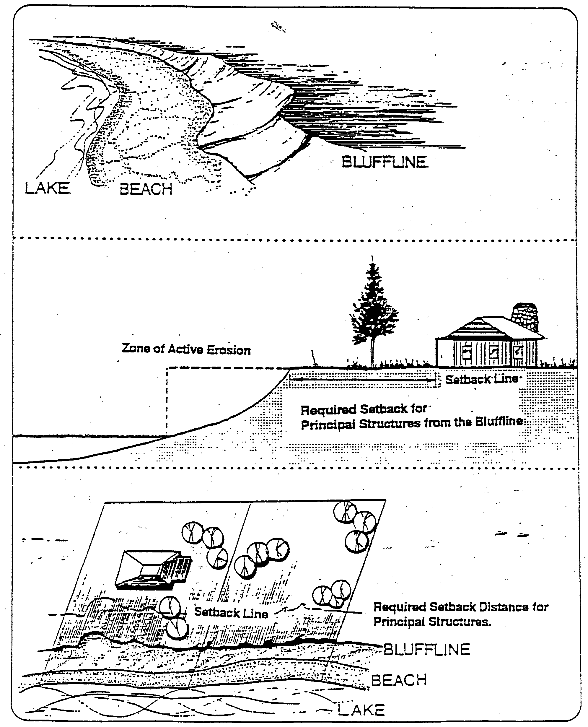
In addition to any yard setback applicable under the provisions of this Ordinance, no permanent structure or any portion of it shall be erected or located between the shoreline and the line defining the required bluff line setback distance provided the table below. Such setback line shall be construed as running parallel to the bluff line and the setback distance shall be measured in a landward direction as a distance horizontal from and perpendicular to the bluff line. If the bluff line recedes (moves landward) over time, the required minimum setback distance shall be measured from the location of the bluff line existing at the time the specific permit, variance or approval is sought.
REQUIRED SETBACK DISTANCE FROM THE BLUFF LINE
Nonpermanent structures are exempt from the setback requirements of this section. Such structures are subject to all other provisions of this zoning ordinance applicable to structures generally. To the fullest extent practical, nonpermanent structures located in high risk erosion areas shall be removed prior to loss or damage by erosion.
(Ord. No. 144, 8-13-2019)
109-19.07 - VARIANCES.
The zoning board of appeals may grant a variance from the required setback distances of this Article 19 in the following situations:
(a)
Substandard lots having the area and characteristics that would permit moving of the permanent structures. A variance from a portion of the required setback distance may be granted upon compliance with all the following conditions:
(1)
The structure to be constructed or moved on the lot shall be a readily moveable small permanent structure.
(2)
That there is access to and from the site of sufficient width and acceptable grade.
(3)
If a sanitary sewer is not used, the septic system, tile field and/or other waste handling facility shall be located landward of the principal structure.
(4)
The structure shall be located as far landward of the bluff line as possible under the requirements of this Ordinance, but in any event not less than 30 feet of the then-existing bluff line.
(5)
The readily moveable structure is not less than 30 feet landward of the bluff line and is not located on a lakeward-facing slope of 60 percent or more.
(b)
Substandard lots lacking the area and/or other characteristics that would permit moving of the permanent structures or substandard lots upon which large permanent structures are proposed. If a nonconforming parcel does not have access to and from the place where the structure is proposed to be located of sufficient width and acceptable grade to erect or move a readily moveable structure, or if the application is for a large permanent structure on a nonconforming parcel, a special exception shall be granted to utilize a shore protection structure in place of a portion of the required setback distance. A variance from a portion of the required setback distance may be granted upon compliance with all the following conditions:
(1)
If a sanitary sewer is not used, the septic system, tile field and/or other waste handling facility shall be located at least as far landward of the bluff line as the principal structure.
(2)
The permanent structure shall be located as far landward of the bluff line as possible under the requirements of this Ordinance, but in any event not less than 30 feet of the then existing bluff line.
(3)
The shore protection structure shall be designed to meet or exceed a 20-year storm event at the site for small permanent structures and a 50-year storm event at the site for large permanent structures. A professional engineer shall certify that the structure has been designed and will be constructed in accordance with these standards. If the shore protection structure is constructed in the waters of the Great Lakes or lies below the ordinary high-water mark, a permit pursuant to the provisions of part 325 of the Natural Resources and Environmental Protection Act (MCL 324.32501 et seq.) shall be obtained for the shore protection structure.
(4)
The permanent structure shall be a minimum of 30 feet from the shore protection structure. If the bluff or dune is unstable due to height, slope, wind erosion, or groundwater seepage, Pere Marquette Charter Township, with input from the Michigan Department of Environment, Great Lakes and Energy, may require a setback of more than 30 feet or an engineered bluff stabilization plan, or both. In areas of steep slopes greater than 18 percent, a greater setback may be necessary to provide access for maintenance equipment and a safe building site.
(5)
If the application is for a large permanent structure, the zoning board of appeals shall require compliance with both of the following provisions:
i.
The establishment of an escrow account to maintain the approved shore protection structure or bluff stabilization, or both. The amount required in the escrow account shall be reasonable and based on the project design.
ii.
Notice in the disclosure statement or deed that a portion of the required setback distance has been waived.
(6)
The proposed permanent structure meets the requirements of other applicable state laws, including but not limited to the provisions of part 353 of the Natural Resources and Environmental Protection Act (MCL 324.35301 et seq.).
(c)
Modification of the required setback distance. A person who can document with acceptable engineering studies an annual recession rate which differs from the Michigan Department of Environment, Great Lakes and Energy recession rate data may be granted a modification of the minimum setback requirement by the zoning board of appeals. Prior to any modification of the minimum setback requirement, the applicant's engineering studies shall be sent to the Michigan Department of Environment, Great Lakes and Energy, who shall report to the zoning board of appeals on the accuracy of the applicant's studies. The zoning board of appeals shall act only upon request for modification of the setback requirement after a determination has been made on the validity of the applicant's data and only after the zoning board of appeals has determined that such modification would not violate the spirit and intent of this Ordinance.
(Ord. No. 144, 8-13-2019)
109-19.08 - NONCONFORMING STRUCTURES.
The following regulations concerning nonconforming structures in the High Risk Erosion Overlay Zone shall be in addition to the provisions of Article 31 and shall control where inconsistent with Article 31:
(a)
Additions to nonconforming structures. The zoning board of appeals may approve an addition to a nonconforming structure if the following conditions are met:
(1)
The nonconforming structure is a small permanent structure.
(2)
The addition for which approval is sought, and all previous additions to the permanent structure, shall not add total floor space exceeding 25 percent of the foundation size of the permanent structure which size shall be the size of the foundation at the time the permanent structure first becomes nonconforming.
(3)
The addition shall not be located less than 30 feet landward of the then existing bluff line and the proposed addition does not reduce the permanent structure's distance from the bluff line.
(b)
Restoration of nonconforming structures. A nonconforming structure which has been damaged or has deteriorated may be repaired or restored to its prior condition if the cost of repair is not more than 60 percent of the structure's replacement value.
If the cost of repairing or restoring the nonconforming structure is greater than 60 percent, but less than 100 percent of its replacement cost, approval for the repairs or restoration shall require approval of the zoning board of appeals and compliance with the following conditions:
(1)
The nonconforming structure was damaged or became deteriorated by reasons other than shoreline erosion.
(2)
The nonconforming structure, if repaired or rebuilt at the existing location, would not be less than 20 feet landward from the then-existing bluff line.
(3)
The reconstructed or repaired structure shall be a readily removable structure.
If the cost of repair is more than 100 percent of the replacement cost or if the structure is declared a total loss for insurance purposes, the provisions for new permanent structures shall apply.
(Ord. No. 144, 8-13-2019)
109-19.09 - DEFINITIONS.
As used in this section, the following terms shall have the following meanings and requirements:
(a)
Accessory structure means a separate building or other structure, the use of which is incidental to that of the main building or use of the land. The structure shall not have a permanent foundation and shall be constructed to be readily moveable or removed.
(b)
Bluff line means the line which is the edge or crest of the elevated segment of the shoreline above the beach which normally has a precipitous front inclining steeply on the lakeward side. Where there is no precipitous front indicating the bluff line, the line of continuous perennial vegetation may be considered the bluff line (see graphic attached to this section).
(c)
Large permanent structure means any permanent structure other than a small permanent structure.
(d)
Nonconforming structure means a permanent structure which does not conform to the required setback distance at the time of designation or which became nonconforming due to erosion or became nonconforming due to a change in the required setback distance. Permanent structures that are constructed in violation of these rules shall not be considered to be nonconforming structures.
(e)
Nonpermanent structure means a structure which is not the principal structure on a lot, which does not have a permanent foundation, which has less than 225 square feet of enclosed space and which is not used for residential dwelling purposes. By way of example but not limitation, the term includes tents and accessory buildings for picnicking or storage. The terms also includes travel trailers and recreational vehicles parked or stored on a lot.
(f)
Permanent structure means any one of the following structures that is erected, installed, or moved on a parcel of property:
(1)
A residential building.
(2)
A commercial building.
(3)
An industrial building.
(4)
An institutional building.
(5)
A mobile home.
(6)
Accessory and related buildings.
(7)
A swimming pool or deck that has a roof or walls.
(8)
Septic systems.
(9)
Tile fields.
(10)
Other waste-handling facilities.
A permanent structure shall be considered small if it has a foundation size of 3,500 square feet or less and less than five individual living units. All other permanent structures shall be considered large. The term does not include recreation vehicles, travel trailers, swimming pools, or decks constructed on pilings if the pool or deck does not have a roof or walls. The term also does not include separate accessory structures which have less than 225 square feet, which are used for picnicking or storing of recreation or lawn equipment, and which are constructed in a manner that facilitates easy removal. The accessory structure shall not have a permanent foundation and shall not be used as a residential facility.
(g)
Readily moveable structure means a small permanent structure (with a total square footage greater than 225 square feet and with a first-floor foundation size less than 3,500 square feet) which is designed, sited and constructed to accomplish relocation at a reasonable cost relative to other structures of the same size and construction. Access to and from the site shall be of sufficient width and acceptable grade to permit the structure to be relocated.
(1)
New construction and installations shall meet the following criteria to be considered readily moveable structures:
i.
The buildings shall be on pilings, a basement or crawl space. Except as noted below, a slab-on-grade foundation does not meet this criterion.
ii.
Above-grade walls shall be either stud wall or solid log construction. Above-grade walls that are constructed of masonry, including stone walls, and concrete poured or concrete block walls do not meet this criterion.
(2)
Existing permanent structures shall be considered readily moveable structures if the cost of relocation landward of the required setback distance is not more than 25 percent of the replacement cost of the structure (including any added cost of land) or if the existing structure meets the criteria for new construction in this subsection. A one- or two-car garage which is bolted to a slab foundation, which does not have living space within the structure, and which does not have plumbing or interior walls shall be considered a readily moveable structure if it meets the remainder of the requirements specified in this subsection. Septic systems, tile fields, or other waste-handling facilities are not readily moveable structures.
(h)
Required setback distance means the least distance a permanent structure can be constructed from the bluff line without a special exception.
(i)
Setback line means the line which is the required setback distance landward of the bluff line and which is the lakeward limit for the construction of permanent structures.
(j)
Small permanent structure means a structure having a foundation of 3,500 square feet or less and less than five dwelling units.
(k)
Substandard parcel means a lot or parcel of record or a lot or parcel which is described in a land contract or deed that is executed and delivered before the designation of a high-risk erosion area and which does not have adequate depth to provide the required setback distance from the bluff line for a permanent structure.
The term also means those lots which are legally created after the designation of a high risk erosion area and which have sufficient depth to meet setback requirements for permanent structures, but which subsequently become substandard due to erosion processes or become substandard due to a change in the required setback distance.
(l)
Zoning administration. It shall be the responsibility of the zoning administrator to maintain permanent and current records of this Ordinance, including all permits applied for, issued and denied, maintain the zoning maps and property descriptions, delineate affected areas, maintain records of application for variances, appeals and decisions on these appeals by the zoning board of appeals. In the case of denying a zoning permit, the zoning administrator shall inform the property owner of the right to appeal and the conditions under which an appeal will be considered. The zoning administrator shall further inform the zoning board of appeals and the department of environmental quality at the time an appeal is filed. Written notice of an exception request from the minimum required setback distance shall be given to the department of environmental quality at least 14 days prior to the hearing before the zoning board of appeals.
(Ord. No. 144, 8-13-2019)

