
Pere Marquette Charter Township
City Zoning Code
City Zoning Code
ARTICLE 4
- ZONING DISTRICTS AND MAP
109-4.01 - ZONING DISTRICTS.
The following zoning districts are hereby established and the purpose and desired development of each district is stated along with the permitted uses in each district. In addition, certain overlay zones have been established to address specific land use concerns. The general provisions established for this Ordinance apply to all land in the Township.
•
A-1 - Agricultural District
•
A/R - Agricultural Residential District
•
R-1- Low Density Residential District
•
R-2 - Medium Density Residential District
•
Epworth Heights Resort Residential District
•
PS - Professional Services District
•
C-1- Neighborhood Commercial District
•
C-2 - Community Commercial District
•
I - General Industrial District
•
HAR - Harbor District
•
AP - Airport District
•
Pumped Storage District
•
MHP - Mobile Home Park District
•
CON - Conservation Floodplain District
•
National Scenic River Overlay District
•
High Risk Erosion Overlay District
•
Critical Dune Overlay District
•
PUD Planned Unit Development District
(Ord. No. 144, 8-13-2019)
109-4.02 - ZONING MAPS.
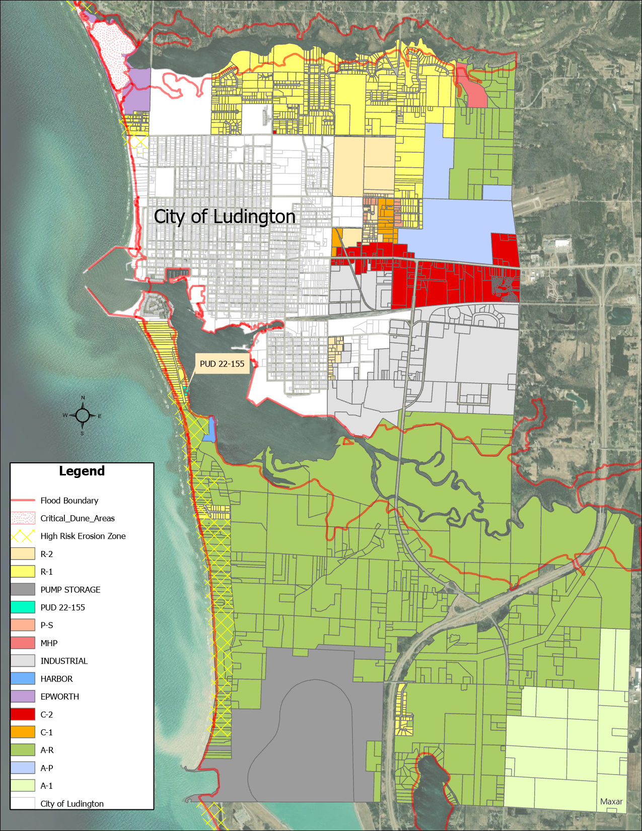
The location and boundaries of the zoning districts named and listed in Article 4 of this Ordinance are hereby established as shown on a map entitled "Zoning Map of Pere Marquette Charter Township," as amended from time to time. The map and all amendments thereto are made a part of this Ordinance.
The Pere Marquette Charter Township Board hereby amends the Pere Marquette Charter Township Zoning Ordinance and Official Zoning Map incorporated by reference therein to rezone the property located at 846 S. Lakeshore Drive; from its current classification of R-1 low-density residential zone ("R-1 Zone") to a Planned Unit Development District ("PUD"). The property is legally described as follows:
SECTION 22, T18N, R18W, STRAND SUBDIVISION LOTS 2, 3, 4 & the NORTH 95' OF LOT 5
(Ord. No. 144, 8-13-2019; Ord. No. 155, § 1, 12-13-2022)
109-4.03 - ZONING MAP INTERPRETATION.
When uncertainty exists as to the boundaries of zoning districts as shown on the zoning map the following rules of construction and interpretation shall apply:
(a)
Boundaries indicated as approximately following the centerlines of streets, highways, or alleys shall be construed to follow such centerlines.
(b)
Boundaries indicated as approximately following platted lot lines shall be construed as following such lot lines.
(c)
Boundaries indicated as approximately following township limits shall be construed as following township limits.
(d)
Boundaries indicated as following railroad lines shall be construed to be midway between the right-of-way lines.
(e)
Boundaries indicated as following shorelines shall be construed to follow such shorelines, and, in the event of change in the shoreline, shall be construed as moving with the actual shoreline; boundaries indicated as approximately following the centerline of streams, rivers, canals, lakes, or other bodies of water shall be construed to follow such centerlines.
(f)
Boundaries indicated as parallel to or extensions of features indicated in subsections (a) through (e) of this section shall be so construed. Distances not specifically indicated on the official zoning map shall be determined by the scale of the map.
(g)
Where physical or natural features existing on the ground are at variance with those shown on the official zoning maps, or in other circumstances not covered by subsections (a) through (f) of this section, the Zoning Board of Appeals shall interpret the district boundaries.
(h)
In any case where boundary lines cannot be determined by application of these rules, such boundaries shall be determined by the Zoning Board of Appeals whose decision shall be final except that such decision may be appealed to the Circuit Court.
(Ord. No. 144, 8-13-2019)
109-4.04 - LANDS NOT INCLUDED WITHIN A ZONING DISTRICT.
(a)
If, by error, omission, annexation or other reason, any land that has not been specifically included within a zoning district, such land shall be included in the R-1, Low Density Residential Zoning District.
(b)
All land, property or territory hereafter to be annexed to Pere Marquette Charter Township shall be considered to be in an R-1 district until otherwise classified.
(Ord. No. 144, 8-13-2019)

