
Petal City Zoning Code
ARTICLE XV
COMMUNITY DESIGN STANDARDS
Chapters:
15.0.
Design Standards Administration
15.1.
Access and Circulation
15.2.
Landscaping, Street Trees, Fences and Walls
15.3.
Parking and Loading
15.4.
Public Facilities
15.5.
Surface Water Management
15.6.
Other Site Design Standards
15.7.
Sensitive Lands
15.8.
Signs
Chapter 15.0 - Design Standards Administration
The following provisions describe how the community design standards (article 3) are intended to be applied, and the relationship between article 3 and the supplemental design standards for specific land uses and building types contained in article 2.
Chapter 15.7 - Sensitive Lands
[Reserved]
15.01. - Design standards; applicability.
The standards in article 3 are applied based on whether a project is classified as a major project or a minor project. In addition, each chapter of article 3 contains "applicability directions." In general, the chapters are applied as follows:
A.
Major project. Major projects, including developments that require site design review, land division approval, master planned development, and amendments to the comprehensive plan or zoning map, must conform to the applicable sections of:
•
Access and Circulation (Chapter 15.1)
•
Landscaping, Street Trees, Fences and Walls (Chapter 15.2)
•
Parking and Loading (Chapter 15.3)
•
Public Facilities (Chapter 15.4)
•
Surface Water Management (Chapter 15.5)
•
Signs (Chapter 15.8)
•
Telecommunication Facilities (Chapter 15.6)
•
Sensitive Lands (Chapter 15.7)
B.
Minor project. Minor projects are small developments and land use actions that require only land use review or conditional use approval (no site design review). The following chapters generally apply; however, individual sections will not apply to some projects.
• Access and Circulation (Chapter 15.1)
• Landscaping, Street Trees, Fences and Walls (Chapter 15.2)
• Parking and Loading (Chapter 15.3)
• Surface Water Management (Chapter 15.5)
• Signs (Chapter 15.8)
• Sensitive Lands (Chapter 15.7)
C.
Non-conforming situations. See chapter 5.3 for provisions related to non-conforming uses and developments.
15.11. - Purpose.
The purpose of this chapter is to ensure that developments provide safe and efficient access and circulation for pedestrians and vehicles. Section 15.12 provides standards for vehicular access and circulation. Section 15.13 provides standards for pedestrian access and circulation. Standards for streets and other transportation system improvements are provided in Section 15.41.
15.12. - Vehicular access and circulation.
A.
Intent and purpose. The intent of this section is to manage access to land uses and on-site circulation, and to preserve the transportation system in terms of safety, capacity, and function. This section applies to all public streets within the city, and to all properties that abut these roadways. This section implements the access management policies of the city comprehensive plan.
B.
Applicability. This chapter applies to all public streets within the city and to all properties that abut these streets. The standards apply when lots are created, consolidated, or modified through a land division, partition, lot line adjustment, lot consolidation, or street vacation; and when properties are subject to land use review or site design review.
C.
Access permit required. Access to a public street (e.g. a new curb cut or driveway approach) requires an access permit. An access permit may be in the form of a letter to the applicant, or it may be attached to a land use decision notice as a condition of approval. In either case, approval of an access permit shall follow the procedures and requirements of the applicable road authority.
D.
Traffic study requirements. The city may require a traffic study prepared by a qualified professional to determine access, circulation, and other transportation requirements.
E.
Conditions of approval. The city may require the closing or consolidation of existing curb cuts or other vehicle access points, recording of reciprocal access easements (i.e. for shared driveways), development of a frontage street, installation of traffic control devices, and/or other mitigation as a condition of granting an access permit, to ensure the safe and efficient operation of the street and highway system.
F.
Corner and intersection separation; backing onto public streets. New and modified accesses shall conform to the following standards:
1.
Except as provided under subsection 4, below, the distance from a street intersection to a driveway or other street access shall meet the minimum spacing requirements for the street's classification in the city's transportation system plan;
2.
New property access shall not be permitted within 50 feet of an intersection unless no other reasonable access to the property is available. Where no other alternatives exist, the city may allow construction of an access connection at a point less than 50 feet from an intersection, provided the access is as far away from the intersection as possible. In such cases, the city may impose turning restrictions (i.e. right in/out, right in only, or right out only);
3.
Access to and from off-street parking areas shall not permit backing onto a public street, except for single-family dwellings;
4.
The city may reduce required separation distance of access points where they prove impractical due to lot dimensions, existing development, other physical features, or conflicting code requirements, provided all of the following requirements are met:
a.
Joint-use driveways and cross-access easements are provided in accordance with subsection 15.12H;
b.
The site plan incorporates a unified access and circulation system in accordance with this section; and
c.
The property owner(s) enter in a written agreement with the city, recorded with the deed, that pre-existing connections on the site will be closed and eliminated after construction of each side of the joint-use driveway.
G.
Site circulation. New developments shall be required to provide a circulation system that accommodates expected traffic on the site. Pedestrian connections on the site, including connections through large sites, and connections between sites (as applicable) and adjacent sidewalks, must conform to the provisions in section 15.13.
H.
Joint and cross access—Requirement. The number of driveway and private street intersections with public streets should be minimized by the use of shared driveways for adjoining lots where feasible. When necessary for traffic safety and access management purposes, or to access flag lots, the city may require joint access and/or shared driveways in the following situations as follows:
1.
For shared parking areas;
2.
For adjacent developments, where access onto an arterial is limited;
3.
For multi-tenant developments, and developments on multiple lots or parcels. Such joint accesses and shared driveways shall incorporate all of the following:
a.
A continuous service drive or cross-access corridor that provides for driveway separation consistent with the applicable transportation authority's access management classification system and standards;
b.
A design speed of ten miles per hour and a maximum width of 20 feet, in addition to any parking alongside the driveway; additional driveway width or fire lanes may be approved when necessary to accommodate specific types of service vehicles, loading vehicles, or emergency service provider vehicles;
c.
Driveway stubs to property lines (for future extension) and other design features to make it easy to see that the abutting properties may be required with future development to connect to the cross-access driveway;
I.
Joint and cross access—Reduction in required parking allowed. When a shared driveway is provided or required as a condition of approval, the land uses adjacent to the shared driveway may have their minimum parking standards reduced in accordance with the shared parking provisions of section 15.33C.
J.
Joint and cross access—Easement and use and maintenance agreement. Pursuant to this section, property owners shall:
1.
Record an easement with the deed allowing cross-access to and from other properties served by the joint-use driveways and cross-access or service drive;
2.
Record an agreement with the deed that remaining access rights along the roadway for the subject property shall be dedicated to the City and pre-existing driveways will be closed and eliminated after construction of the joint-use driveway;
3.
Record a joint maintenance agreement with the deed defining maintenance responsibilities of property owners.
K.
Access connections and driveway design. All driveway connections to a public right-of-way (access) and driveways shall conform to all of the following design standards:
1.
Driveway width. Driveways shall meet the following standards:
a.
One-way driveways (one way in or out) shall have a minimum driveway width of ten feet, and a maximum width of 12 feet, and shall have appropriate signage designating the driveway as a one-way connection.
b.
For two-way access, each lane shall have a minimum width of nine feet and a maximum width of 11 feet.
2.
Driveway approaches. Driveway approaches shall be designed and located to provide exiting vehicles with an unobstructed view of other vehicles and pedestrians, and to prevent vehicles from backing into the flow of traffic on the public street or causing conflicts with on-site circulation. Construction of driveway accesses along acceleration or deceleration lanes or tapers should be avoided due to the potential for vehicular conflicts. Driveways should be located to allow for safe maneuvering in and around loading areas.
3.
Driveway construction. Driveway aprons (when required) shall be constructed of concrete and shall be installed between the street right-of-way and the private drive, as shown in Figure 15.12J. Driveway aprons shall conform to ADA requirements for sidewalks and walkways, which generally require a continuous unobstructed route of travel that is not less than three feet in width, with a cross slope not exceeding two percent, and providing for landing areas and ramps at intersections.
Figure 15.12K Examples of Acceptable Driveway Openings Next to Sidewalks/Walkways
L.
Fire access and turnarounds. When required under the Uniform Fire Code, fire access lanes with turnarounds shall be provided. Except as waived in writing by the fire marshal, a fire equipment access drive shall be provided for any portion of an exterior wall of the first story of a building that is located more than 150 feet from an existing public street or approved fire equipment access drive. The drive shall contain unobstructed adequate aisle width (14-20 feet) and turn-around area for emergency vehicles. The fire marshal may require that fire lanes be marked as "No Stopping/No Parking." For requirements related to culs-de-sac or dead-end streets, please refer to section 15.41N.
M.
Vertical clearances. Driveways, private streets, aisles, turn-around areas and ramps shall have a minimum vertical clearance of 13 feet six inches for their entire length and width.
N.
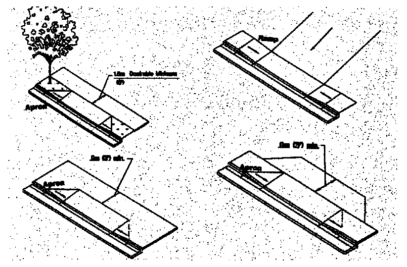
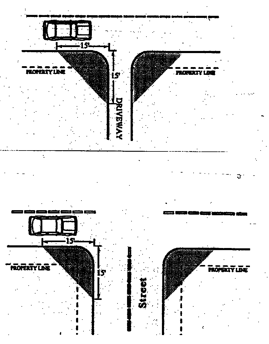
Vision clearance. No visual obstruction (e.g. sign, structure, solid fence, or shrub vegetation) between three feet and eight feet in height shall be placed in "vision clearance areas" on streets, driveways, alleys, or mid-block lanes where no traffic control stop sign or signal is provided, as shown in Figure 15.12N. The minimum vision clearance area may be modified by the city engineer upon finding that more or less sight distance is required (i.e. due to traffic speeds, roadway alignment, etc.). This standard does not apply to light standards, utility poles, trees trunks and similar objects.
Figure 15.12N Vision Clearance Areas
O.
Construction. The following development and maintenance standards shall apply to all driveways and private streets, except that the standards do not apply to driveways serving one single-family detached dwelling:
1.
Surface options. Driveways, parking areas, aisles, and turnarounds may be paved with asphalt, concrete, or comparable surfacing, or a durable non-paving or porous paving material may be used to reduce surface water runoff and protect water quality. Driveway and street materials shall be subject to review and approval by the city engineer.
2.
Surface water management. When non-porous paving is used, all driveways, parking areas, aisles, and turnarounds shall have on-site collection of surface waters to eliminate sheet flow of such waters onto public rights-of-way and abutting property. Surface water facilities shall be constructed in conformance with Chapter 15.5 and applicable engineering standards.
3.
Driveway aprons. When driveway approaches or "aprons" are required to connect driveways to the public right-of-way, they shall be paved with concrete surfacing and conform to the city's engineering design criteria and standard specifications. (See general illustrations in section 3.1.200K, above).
15.13. - Pedestrian access and circulation.
SECTION REPEALED.
15.21. - Purpose.
The purpose of chapter 15.2 is to promote community health, safety, and welfare by protecting natural vegetation and setting development standards for landscaping, street trees, fences, and walls. Together, these elements of the natural and built environment contribute to the visual quality, environmental health, and character of the community. Trees provide climate control through shading during summer months and wind screening during winter. Trees and other plants can also buffer pedestrians from traffic. Walls, fences, trees, and other landscape materials also provide vital screening and buffering between land uses. Landscaped areas help to control surface water drainage and can improve water quality, as compared to paved or built surfaces. The chapter is organized into the following sections:
15.22. - Landscape conservation.
A.
Applicability. All development sites containing significant vegetation, as defined below, shall comply with the standards of this section. The purpose of this section is to incorporate significant native vegetation into the landscapes of development and protect vegetation that is subject to requirements for sensitive lands (chapter 15.7). The use of mature, native vegetation within developments is a preferred alternative to removal of vegetation and re-planting. Mature landscaping provides summer shade and wind breaks, controls erosion, and allows for water conservation due to larger plants having established root systems.
B.
Significant vegetation. "Significant vegetation" means individual trees and shrubs within designated sensitive lands, in accordance with chapter 15.7, and trees and shrubs not within a sensitive lands area that have a caliper of six inches or larger, except that protection shall not be required for plants listed as non-native, invasive plants by the Mississippi State University Extension Service in the applicable MSU bulletins for the county, and plants listed by the city as prohibited street trees and landscape plants.
C.
Mapping and protection required. Significant vegetation shall be mapped as required by site design review, and chapter 15.7, sensitive lands. Significant trees shall be mapped individually and identified by species and diameter or caliper at four feet above grade. A "protection" area shall be defined around the edge of all branches (drip-line) of each tree. Drip lines may overlap between trees. The city also may require an inventory, survey, or assessment prepared by a qualified professional when necessary to determine construction boundaries, building setbacks, and other protection or mitigation requirements.
D.
Protection standards. Significant trees and shrubs identified as meeting the criteria in subsection B, above, shall be retained to the extent practicable to minimize the risk of erosion, landslide, and stormwater runoff. Where protection is impracticable because it would prevent reasonable development of public streets, utilities, or land uses permitted by the applicable land use district, the city may allow removal of significant vegetation from the building envelope as defined by required yard setbacks. Where other areas must be disturbed to install streets or utilities, the applicant may be required to restore such areas after construction with landscaping or other means to prevent erosion and to protect the public health, safety, and welfare. With the owner's consent, the city may accept a land dedication or become a party to a conservation easement on private property for conservation purposes.
E.
Construction. All significant vegetation on a site that is not otherwise designated and approved by the city for removal shall be protected prior to, during, and after construction in accordance with a limit-of-clearing and grading plan approved by the city. The city may limit grading activities and operation of vehicles and heavy equipment in and around significant vegetation areas to prevent erosion, pollution, or landslide hazards.
F.
Exemptions. The protection standards in "D" and "E" shall not apply to:
1.
Dead or diseased vegetation. Dead or diseased vegetation may be removed through a type I land use review.
2.
Hazardous vegetation and other emergencies. Significant vegetation may be removed without land use approval when the vegetation poses an immediate threat to life or safety, or the vegetation must be removed for other reasons of emergency (e.g. fallen over road or power line, blocked drainage way, or similar circumstance), as determined by the city or emergency service provider.
15.23. - Landscaping.
A.
Applicability. This section shall apply to all new developments requiring site design review.
B.
Landscaping plan required. A landscape plan is required.
C.
Landscape area standards. The minimum percentage of required landscaping equals:
1.
Residential and residential-commercial districts (excluding single family detached residential). Ten percent of the site.
2.
Central business district. Ten percent of the site.
3.
General commercial district. 20 percent of the site.
4.
Light industrial district. 20 percent of the site.
5.
Heavy industrial district. Ten percent of the site.
6.
Other (reserved).
D.
Landscape materials. Permitted landscape materials include trees, shrubs, ground cover plants, non-plant ground covers, and outdoor hardscape features, as described below. "Coverage" is based on the projected size of the plants at maturity, i.e. typically three or more years after planting.
1.
Existing vegetation. Existing non-invasive vegetation may be used in meeting landscape requirements. When existing mature trees are protected on the site (e.g. within or adjacent to parking areas) the decision making body may reduce the number of new trees required by a ratio of one inch caliper of new tree(s) for every one inch caliper of existing tree(s) protected.
2.
Plant selection. A combination of deciduous and evergreen trees, shrubs, and ground covers shall be used for all planted areas, the selection of which shall be based on local climate, exposure, water availability, and drainage conditions. When new vegetation is planted, soils shall be amended, as necessary, to allow for healthy plant growth.
3.
"Non-native, invasive" plants, as per section 15.22.B, shall be removed during site development and the planting of new invasive species is prohibited.
4.
Hardscape features, i.e. patios, decks, plazas, etc., may cover up to ten percent of the required landscape area; except in the central business district where hardscape features may cover up to 100 percent of the landscape area. Swimming pools, sports courts, and similar active recreation facilities may not be counted toward fulfilling the landscape requirement.
5.
Ground cover standard. All landscaped area, whether or not required, that is not planted with trees and shrubs, or covered with non-plant material (subsection 8, below), shall have ground cover plants that are sized and spaced as follows: a minimum of one plant per 12 inches on center in triangular spacing, or other planting pattern that is designed to achieve 75 percent coverage of the area not covered by shrubs and tree canopy.
6.
Tree size. Trees shall have a minimum diameter or caliper four feet above grade of two inches or greater at time of planting.
7.
Shrub size. Shrubs shall be planted from five-gallon containers or larger.
8.
Non-plant ground covers. Bark dust, chips, aggregate, or other non-plant ground covers may be used, but shall cover no more than 50 percent of the area to be landscaped and shall be confined to areas underneath plants. Non-plant ground covers cannot be a substitute for ground cover plants.
9.
Significant vegetation. Significant vegetation protected in accordance with section 15.22 may be credited toward meeting the minimum landscape area standards. Credit shall be granted on a per square foot basis. The street tree standards of section 15.24 may be waived by the city when existing trees protected within the front yard provide the same or better shading and visual quality as would otherwise be provided by street trees.
10.
Storm water facilities. Storm water treatment facilities (e.g. detention/retention ponds and swales designed for water quality treatment), when required under section 15.44, shall be landscaped with water tolerant, native plants.
E.
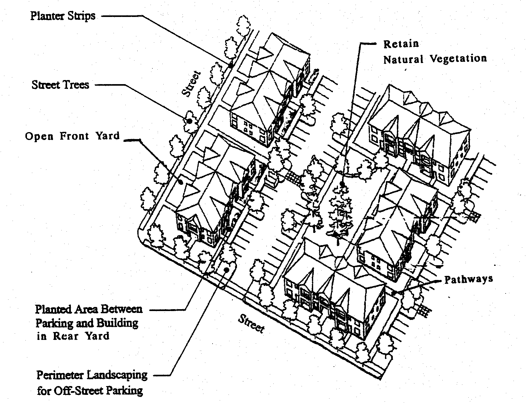
Landscape design standards. All yards, parking lots, and required street tree planter strips shall be landscaped to provide, as applicable, erosion control, visual interest, buffering, privacy, open space and pathway identification, shading, and wind buffering, based on the following criteria:
1.
Yard setback landscaping. Landscaping in yards shall:
a.
Provide visual screening and privacy within side and rear yards; while leaving front yards and building entrances mostly visible for security purposes;
b.
Use shrubs and trees as wind breaks;
c.
Retain natural vegetation;
d.
Define pedestrian pathways and open space areas with landscape materials;
e.
Provide focal points within a development, for example, by preserving large or unique trees or groves, hedges, and flowering plants;
f.
Use trees to provide summer shading within common open space areas and within front yards when street trees cannot be provided;
g.
Use a combination of plants for year-long color and interest;
h.
Use landscaping to screen outdoor storage and mechanical equipment areas, and to enhance graded areas such as berms, swales, and detention/retention ponds.
2.
Parking areas. A minimum of ten percent of the total surface area of all parking areas, as measured around the perimeter of all parking spaces and maneuvering areas, shall be landscaped. Such landscaping shall consist of "evenly distributed" shade trees with shrubs and/or ground cover plants that conform to the criteria in subsections 15.23E.1.a-h, above. "Evenly distributed" means that the trees and other plants are distributed around the parking lot perimeter and between parking bays to provide a partial canopy. At a minimum, one tree per six parking spaces on average shall be planted to create a partial tree canopy over and around the parking area. All parking areas with more than 20 spaces shall include landscape islands with trees to break up the parking area into rows of not more than 12 contiguous parking spaces. All parking area landscapes shall have dimensions of not less than 24 square feet of area, or not less than four feet in width by six feet in length, to ensure adequate soil, water, and space for healthy plant growth.
3.
Buffering and screening required. Buffering and screening are required under the following conditions:
a.
Parking/maneuvering area adjacent to streets and drives. Where a parking or maneuvering area is adjacent and parallel to a street or driveway, an evergreen hedge; decorative wall (masonry or similar quality material) with openings; arcade, trellis, or similar partially opaque structure three to four feet in height shall be established between street and driveway. The required screening shall have breaks, where necessary, to allow pedestrian access to the site. The design of the wall or screening shall also provide breaks or openings for visual surveillance of the site and security. Evergreen hedges used to comply with this standard shall be a minimum of 36 inches in height at maturity, and shall be of such species, number, and spacing to provide the required screening within one year after planting. Any areas between the wall/hedge and the street/driveway line shall be landscaped with plants or other vegetative ground cover.
b.
Parking/maneuvering area adjacent to building. Where a parking or maneuvering area, or driveway, is adjacent to a building, the area shall be separated from the building by a curb and a raised walkway, plaza, or landscaped buffer not less than five feet in width. Raised curbs, bollards, wheel stops, or other design features shall be used to protect pedestrians, landscaping, and buildings from being damaged by vehicles. Where parking areas are located adjacent to residential ground-floor living space, a four-foot wide landscape buffer with a curbed edge may fulfill this requirement.
c.
Screening of mechanical equipment, outdoor storage, service and delivery areas, and other screening when required. All mechanical equipment, outdoor storage and manufacturing, and service and delivery areas, shall be screened from view from all public streets and adjacent residential districts. When these or other areas are required to be screened, such screening shall be provided by:
1.
A decorative wall (i.e. masonry or similar quality material);
2.
Evergreen hedge;
3.
Opaque fence complying with section 3.2.500; or
4.
A similar feature that provides an opaque barrier.
Walls, fences, and hedges shall comply with the vision clearance requirements and provide for pedestrian circulation, in accordance with chapter 15.1, access and circulation. (See section 15.25 for standards specific to fences and walls).
d.
Flag lot screen. In approving a flag lot, the city may require a landscape screen and/or fence be installed along property line(s) of the flag lot, for privacy of adjoining residents. A flag lot screen shall not be required if the abutting property owner(s) indicate in writing that they do not want a screen or fence, however, the owner may install one at his or her discretion.
Figure 15.23E General Landscape Areas (Typical)
F.
Maintenance and irrigation. The use of drought-tolerant plant species is encouraged, and may be required when irrigation is not available. Irrigation shall be provided for plants that are not drought-tolerant. If the plantings fail to survive, the property owner shall replace them with an equivalent specimen (i.e. evergreen shrub replaces evergreen shrub, deciduous tree replaces deciduous tree, etc.). All man-made features required by this Code shall be maintained in good condition, or otherwise replaced by the owner.
15.24. - Street trees.
Street trees shall be planted for all developments that are subject to subdivision or site design review. Requirements for street tree planting strips are provided in section 15.41, transportation standards. Planting of street trees shall generally follow construction of curbs and sidewalks, however, the city may defer tree planting until final inspection of completed dwellings to avoid damage to trees during construction. The planting and maintenance of street trees shall conform to the following standards and guidelines and any applicable road authority requirements:
A.
Growth characteristics. Trees shall be selected based on climate zone, growth characteristics and site conditions, including available space, overhead clearance, soil conditions, exposure, and desired color and appearance. The following should guide tree selection by developers and approval by the city:
1.
Provide a broad canopy where shade is desired, except where limited by available space or except in section 4.
2.
Use low-growing trees for spaces under low utility wires.
3.
Select trees which can be "limbed-up" to comply with vision clearance requirements.
4.
Use narrow or "columnar" trees where awnings or other building features limit growth, or where greater visibility is desired between buildings and the street.
5.
Use species with similar growth characteristics on the same block for design continuity.
6.
Avoid using trees that are susceptible to insect damage and trees that produce excessive seeds or fruit.
7.
Select trees that are well-adapted to the environment, including soil, wind, sun exposure, temperature tolerance, and exhaust. Drought-resistant trees should be chosen where they suit the specific soil type.
8.
Select trees for their seasonal color if desired.
9.
Use deciduous trees for summer shade and winter sun, unless unsuited to the location due to soil, wind, sun exposure, annual precipitation, or exhaust.
10.
The diameter of the tree trunk at maturity shall not exceed the width and size of the planter strip or tree well.
B.
Caliper size. The minimum diameter or caliper size at planting, as measured four feet above grade, shall be two inches.
C.
Spacing and location. Street trees shall be planted within the street right-of-way within existing and proposed planting strips or in sidewalk tree wells on streets without planting strips, except when utility easements occupy these areas. Street tree spacing shall be based upon the type of tree(s) selected and the canopy size at maturity and, at a minimum, the planting area shall contain 16 square feet, or typically, 4 feet by 4 feet. In general, trees shall be spaced no more than 30 feet apart, except where planting a tree would conflict with existing trees, retaining walls, utilities and similar physical barriers. All street trees shall be placed outside utility easements.
D.
Soil preparation, planting and care. The developer shall be responsible for planting street trees, including soil preparation, ground cover material, staking, and temporary irrigation for two years after planting. The developer shall also be responsible for tree care (pruning, watering, fertilization, and replacement as necessary) during the first two years after planting, after which the adjacent property owners shall maintain the trees.
E.
Assurances. ALTERNATIVE 1: The developer shall pay a fee to the city, in accordance with the adopted fee schedule, for each required street tree. The fee shall cover the city's expense for the first two years of care. ALTERNATIVE 2: The city shall require the developer to provide a performance and maintenance bond in an amount determined by the city engineer, to ensure the planting of the tree(s) and care during the first two years after planting.
15.25. - Fences and walls.
Construction of fences and walls shall conform to all of the following requirements:
A.
General requirements. All fences and walls shall comply with the height limitations of the respective zoning district and the standards of this section. The city may require installation of walls and/or fences as a condition of development approval, in accordance with land division approval (e.g. flag lots), approval of a conditional use permit, or site design review approval. When required through one of these types of approvals, no further land use review is required. If not part of a prior land use approval, new fences and walls require land use review approval; if greater than six feet in height, a building permit is also required. (See also, section 15.23 for landscape screening wall requirements).
B.
Dimensions.
1.
Except as provided under subsections 2 and 3, below, the height of fences and walls within a front yard setback shall not exceed four feet as measured from the grade closest to the street right-of-way.
2.
A retaining wall exceeding four feet in height within a front yard setback, which is necessary for site grading and development, may be approved through a land division or site development review.
3.
One arbor, gate, or similar garden structures not exceeding eight feet in height and four feet in width is allowed within the front yard, provided that it is not within a clear vision triangle.
3.
Walls and fences to be built for required buffers shall comply with section 15.23.
4.
Fences and walls shall comply with the vision clearance standards of section 15.12.
C.
Maintenance. For safety and for compliance with the purpose of this chapter, walls and fences required as a condition of development approval shall be maintained in good condition, or otherwise replaced by the property owner.
D.
Materials.
1.
Permitted fence and wall materials: wood; metal; bricks, stone; stucco, or similar masonry, and non-prohibited evergreen plants.
2.
Prohibited fence and wall materials: concrete blocks; straw bales; barbed or razor wire; scrap lumber, metal, or other scrap materials; hedges higher than eight feet.
3.
Fences or walls constructed of brick or masonry exceeding four feet in height shall be subject to review and approval by the city engineer. Those that are taller than six feet also require a building permit.
15.26. - Buffer zones.
A.
General requirements. In any situation where a non-residential district abuts an area designated as rural fringe (RF), low-density residential (R-1), or medium-density residential (R-2) a buffer of not less that 15 feet shall be provided in addition to the required setbacks. The buffer zone shall be comprised of primarily vegetated or landscaped materials. In no situation shall man-made elements (i.e. parking, buildings, or hardscapes) encroach into the designated buffer area. As an exception, a privacy fence as approved in the site plan review process may be allowed providing that it meets the standards of this Code.
15.31. - Purpose.
The purpose of this chapter is to provide basic and flexible standards for development of vehicle and bicycle parking. The design of parking areas is critically important to the economic viability of some commercial areas, pedestrian and driver safety, the efficient and safe operation of adjoining streets, and community image and livability. Historically, some communities have required more parking than is necessary for some land uses, paving extensive areas of land that could be put to better use. Because vehicle parking facilities occupy large amounts of land, they must be planned and designed carefully to use the land efficiently, minimize stormwater runoff, and maintain the visual character of the community. This chapter recognizes that each development has unique parking needs and provides a flexible approach for determining parking space requirements (i.e. "minimum" and "performance-based" standards). This chapter also provides standards for bicycle parking because many people use bicycles for recreation, commuting, and general transportation. Children as well as adults need safe and adequate spaces to park their bicycles throughout the community.
15.32. - Applicability.
All developments subject to site design review, including development of parking facilities, shall comply with the provisions of this chapter.
15.33. - Automobile parking standards.
A.
Vehicle parking. Minimum standards by use. The number of required off-street vehicle parking spaces shall be determined in accordance with the standards in Table 15.33A, or alternatively, through a separate parking demand analysis prepared by the applicant and subject to a land use review. Where a use is not specifically listed in this table, parking requirements are determined by finding that a use is similar to one of those listed in terms of parking needs, or by estimating parking needs individually using the demand analysis option described above. Parking that counts toward the minimum requirement is parking in garages, carports, parking lots, bays along driveways, shared parking, and designated on-street parking. There is no minimum number of off-street parking spaces required in central business district (or in designated historic districts); however, the "maximum parking" standards of this chapter apply.
B.
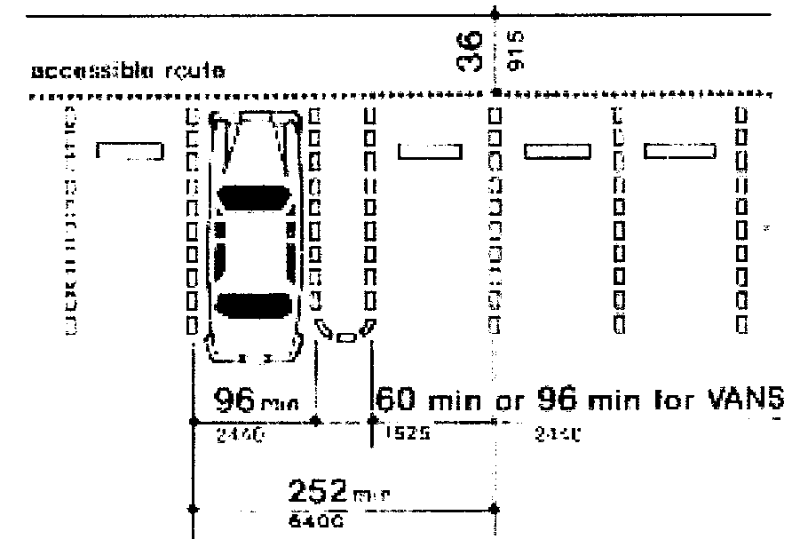
Vehicle parking. Minimum accessible parking.
1.
Accessible parking shall be provided for all uses in accordance the standards in Table 15.33B; parking spaces used to meet the standards in Table 15.33B shall be counted toward meeting off-street parking requirements in Table 15.33A;
2.
Such parking shall be located in close proximity to building entrances and shall be designed to permit occupants of vehicles to reach the entrance on an unobstructed path or walkway;
3.
Accessible spaces shall be grouped in pairs where possible;
4.
Where covered parking is provided, covered accessible spaces shall be provided in the same ratio as covered non-accessible spaces;
5.
Required accessible parking spaces shall be identified with signs and pavement markings identifying them as reserved for persons with disabilities; signs shall be posted directly in front of the parking space at a height of no less than 42 inches and no more than 72 inches above pavement level. Van spaces shall be specifically identified as such.
C.
On-street parking. On-street parking shall conform to the following standards:
1.
Dimensions. The following constitutes one on-street parking space:
a.
Parallel parking, each 22 feet of uninterrupted curb;
b.
45 or 60 degree diagonal, each with 12 feet of curb;
c.
90 degree (perpendicular) parking, each with 12 feet of curb.
d.
On street parking of commercial vehicles is prohibited.
2.
Location. Parking may be counted toward the minimum standards in Table 15.33A when it is on the block face abutting the subject land use. An on-street parking space must not obstruct a required clear vision area and its must not violate any law or street standard.
3.
Public use required for credit. On-street parking spaces counted toward meeting the parking requirements of a specific use may not be used exclusively by that use, but shall be available for general public use at all times. Signs or other actions that limit general public use of on-street spaces are prohibited.
D.
Shared parking. Required parking facilities for two or more uses, structures, or parcels of land may be satisfied by the same parking facilities used jointly, to the extent that the owners or operators show that the need for parking facilities does not materially overlap (e.g. uses primarily of a daytime versus nighttime nature; weekday uses versus weekend uses), and provided that the right of joint use is evidenced by a recorded deed, lease, contract, or similar written instrument establishing the joint use. The city may approve owner requests for shared parking through land use review.
E.
Off-site parking. Except for single-family dwellings, the vehicle parking spaces required by this chapter may be located on another parcel of land, provided the parcel is within 300 feet of the use it serves and the city has approved the off-site parking through land use review. The distance from the parking area to the use shall be measured from the nearest parking space to a building entrance, following a sidewalk or other pedestrian route. The right to use the off-site parking must be evidenced by a recorded deed, lease, easement, or similar written instrument.
F.
General parking standards.
1.
Location. Parking is allowed only on streets, within garages, carports, and other structures, or on driveways or parking lots that have been developed in conformance with this code. Chapter 15.1, access and circulation, provides design standards for driveways. Street parking spaces shall not include space in a vehicle travel lane (including emergency or fire access lanes), public right-of-way, pedestrian accessway, landscape, or other undesignated area.
2.
Mixed uses. If more than one type of land use occupies a single structure or parcel of land, the total requirements for off-street automobile parking shall be the sum of the requirements for all uses, unless it can be shown that the peak parking demands are actually less (i.e. the uses operate on different days or at different times of the day). The city may reduce the total parking required accordingly through land use review.
4.
Availability of facilities. Owners of off-street parking facilities may post a sign indicating that all parking on the site is available only for residents, customers, and/or employees. Signs shall conform to the standards of chapter 7.5.
5.
Lighting. Parking areas shall have lighting to provide at least two foot-candles of illumination over parking spaces and walkways. Light standards shall be directed downward only and shielded to prevent lighting spillover into any adjacent residential district or use.
6.
Screening of parking areas. Parking spaces shall be located or screened so that headlights do not shine onto adjacent residential uses, per section 15.23E.
G.
Parking stall design and minimum dimensions. All off-street parking spaces shall be improved to conform to city standards for surfacing, stormwater management, and striping. Standard parking spaces shall conform to the following standards and the dimensions in Figures 15.33F(1) through (3), and Table 15.33F:
1.
Motor vehicle parking spaces shall measure eight feet six inches wide by 18 feet long or by 16 feet long, with not more than a two foot overhang when allowed;
2.
All parallel motor vehicle parking spaces shall measure eight feet six inches by 22 feet;
3.
Parking area layout shall conform to the dimensions in Figure 15.33F(1) and (2), and Table 15.33F, below;
4.
Parking areas shall conform to Americans With Disabilities Act (ADA) standards for parking spaces (dimensions, van accessible parking spaces, etc.). Parking structure vertical clearance, van accessible parking spaces, should refer to federal ADA guidelines; and
5.
Bicycle parking shall be on a two feet by six feet minimum concrete pad per bike, or within a garage or patio of residential use.
Figure 15.33F(1) Parking Area Layout
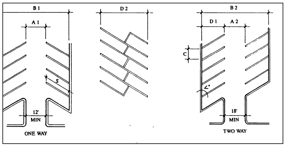
Figure 15.33F(2) Disabled Person Parking Requirements
15.34. - Loading areas.
A.
Purpose. The purpose of this section of the Code is to provide standards (1) for a minimum number of off-street loading spaces that will ensure adequate loading areas for large uses and developments; and (2) to ensure that the appearance of loading areas is consistent with that of parking areas.
B.
Applicability. Section 15.34 applies to residential projects with 50 or more dwelling units, and non-residential and mixed-use buildings with 20,000 square feet or more total floor area.
C.
Number of loading spaces.
1.
Residential buildings. Buildings where all of the floor area is in residential use shall meet the following standards:
a.
Fewer than 50 dwelling units on a site that abuts a local street: no loading spaces are required.
b.
All other buildings: One space.
2.
Non-residential and mixed-use buildings. Buildings where any floor area is in non-residential uses shall meet the following standards:
a.
Less than 20,000 square feet total floor area: no loading spaces required.
b.
20,000 to 50,000 square feet of total floor area: one loading space.
c.
More than 50,000 square feet of total floor area: two loading spaces.
D.
Size of spaces. Required loading spaces shall be at least 35 feet long and ten feet wide, and shall have a height clearance of at least 13 feet.
E.
Placement, setbacks, and landscaping. Loading areas shall conform to the setback and perimeter landscaping standards in articles 2 and 3. Where parking areas are prohibited between a building and the street, loading areas are also prohibited. The decision body may approve a loading area adjacent to or within the street right-of-way through site design review or conditional use permit review, as applicable, where it finds that loading and unloading operations are short in duration (i.e. less than one hour), not obstruct traffic during peak traffic hours, or interfere with emergency response services.
15.41. - Purpose and applicability.
A.
Purpose. The purpose of this chapter is to provide planning and design standards for public and private transportation facilities and utilities. Streets are the most common public spaces, touching virtually every parcel of land. Therefore, one of the primary purposes of this chapter is to provide standards for attractive and safe streets that can accommodate vehicle traffic from planned growth and provide a range of transportation options, including options for driving, walking, bus transit, and bicycling. This chapter is also intended to implement the city's transportation system plan.
B.
When standards apply. Unless otherwise provided, the standard specifications for construction, reconstruction, or repair of transportation facilities, utilities, and other public improvements within the city shall occur in accordance with the standards of this chapter. No development may occur unless the public facilities related to development comply with the public facility requirements established in this chapter.
C.
Engineering design criteria, standard specifications and details. The design criteria, standard construction specifications and details maintained by the city engineer, or any other road authority with jurisdiction, shall supplement the general design standards of this development code. The city's specifications, standards, and details are hereby incorporated into this code by reference.
D.
Conditions of development approval. No development may occur unless required public facilities are in place or guaranteed, in conformance with the provisions of this Code. Improvements required as a condition of development approval, when not voluntarily accepted by the applicant, shall be roughly proportional to the impact of the development on public facilities. Findings in the development approval shall indicate how the required improvements are directly related and roughly proportional to the impact.
15.42. - Transportation standards.
A.
Development standards. The following standards shall be met for all new uses and developments:
1.
All new lots created, consolidated, or modified through a land division, partition, lot line adjustment, lot consolidation, or street vacation must have frontage or approved access to a public street.
2.
Streets within or adjacent to a development shall be improved in accordance with the transportation system plan and the provisions of this chapter.
3.
Development of new streets, and additional street width or improvements planned as a portion of an existing street, shall be improved in accordance with this section, and public streets shall be dedicated to the applicable road authority;
4.
New streets and drives shall be paved.
B.
Guarantee. The city may accept a future improvement guarantee (e.g. owner agrees not to object to the formation of a local improvement district in the future) in lieu of street improvements if one or more of the following conditions exist:
1.
A partial improvement may create a potential safety hazard to motorists or pedestrians;
2.
Due to the developed condition of adjacent properties it is unlikely that street improvements would be extended in the foreseeable future and the improvement associated with the project under review does not, by itself, provide increased street safety or capacity, or improved pedestrian circulation;
3.
The improvement would be in conflict with an adopted capital improvement plan; or
4.
The improvement is associated with an approved land partition in the RL or RM district and the proposed land partition does not create any new streets.
C.
Creation of rights-of-way for streets and related purposes. Streets shall be created through the approval and recording of a final subdivision or partition plat; except the city may approve the creation of a street by acceptance of a deed, provided that the street is deemed in the public interest by the board of aldermen for the purpose of implementing the transportation system plan, and the deeded right-of-way conforms to the standards of this Code.
D.
Creation of access easements. The city may approve an access easement when the easement is necessary to provide for access and circulation in conformance with chapter 15.1, access and circulation. Access easements shall be created and maintained in accordance with the Uniform Fire Code.
E.
Street location, width, and grade. Except as noted below, the location, width and grade of all streets shall conform to the transportation system plan and an approved street plan or subdivision plat. Street location, width, and grade shall be determined in relation to existing and planned streets, topographic conditions, public convenience and safety, and in appropriate relation to the proposed use of the land to be served by such streets:
1.
Street grades shall be approved by the city engineer in accordance with the design standards in subsection N, below; and
2.
Where the location of a street is not shown in an existing street plan, the location of streets in a development shall either:
a.
Provide for the continuation and connection of existing streets in the surrounding areas, conforming to the street standards of this chapter; or
b.
Conform to a street plan adopted by the city if it is impractical to connect with existing street patterns because of particular topographical or other existing conditions of the land. Such a plan shall be based on the type of land use to be served, the volume of traffic, the capacity of adjoining streets, and the need for public convenience and safety.
F.
Minimum rights-of-way and street sections. Street rights-of-way and improvements shall be the widths in Table 15.41. A variance shall be required to vary the standards in Table 15.41. Where a range of width is indicated, the width shall be the narrower in the range unless unique and specific conditions exist as determined by the decision-making authority based upon the following factors:
1.
Street classification in the transportation system plan;
2.
Anticipated traffic generation;
3.
On-street parking needs;
4.
Sidewalk and bikeway requirements based on anticipated level of use;
5.
Requirements for placement of utilities;
6.
Street lighting;
7.
Minimize drainage, slope, and sensitive lands impacts, as identified by chapter 15.7;
8.
Street tree location, as provided for in chapter 15.2;
9.
Protection of significant vegetation, as provided for in chapter 15.2;
10.
Safety and comfort for motorists, bicyclists, and pedestrians;
11.
Street furnishings (e.g. benches, lighting, bus shelters, etc.), when provided;
12.
Access needs for emergency vehicles; and
13.
Transition between different street widths (i.e. existing streets and new streets).
Table 15.41F Street Standards from the Adopted Transportation System Plan
*Streets with parking on one side only should be avoided. When used, they must be posted NO PARKING.
Figure 15.41F(1) Three-Lane Arterial-Boulevard Street Section
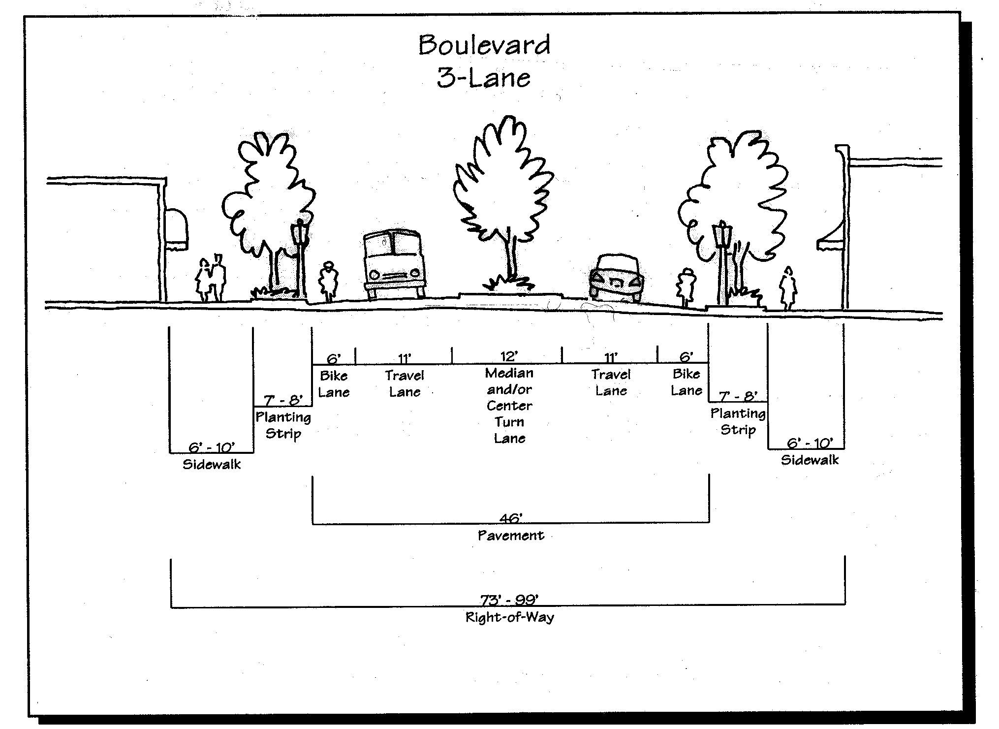
Figure 15.41F(2) Residential Collector Street Sections
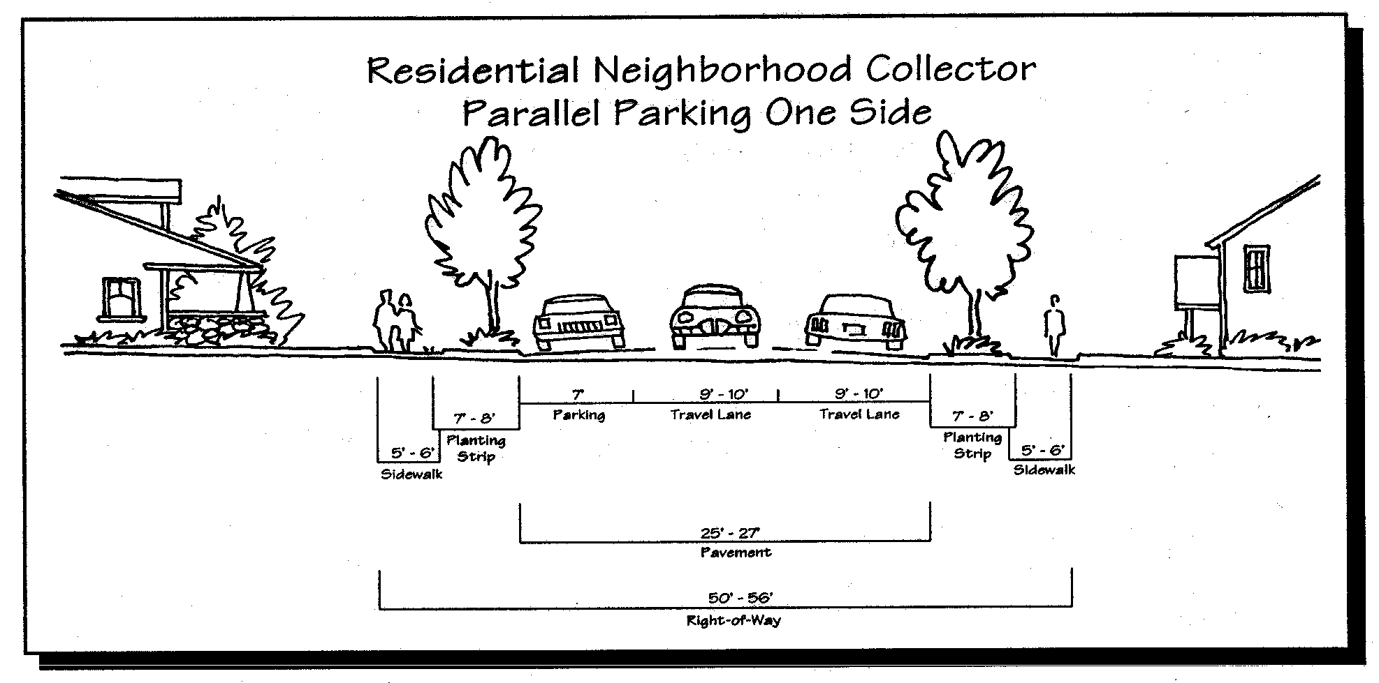
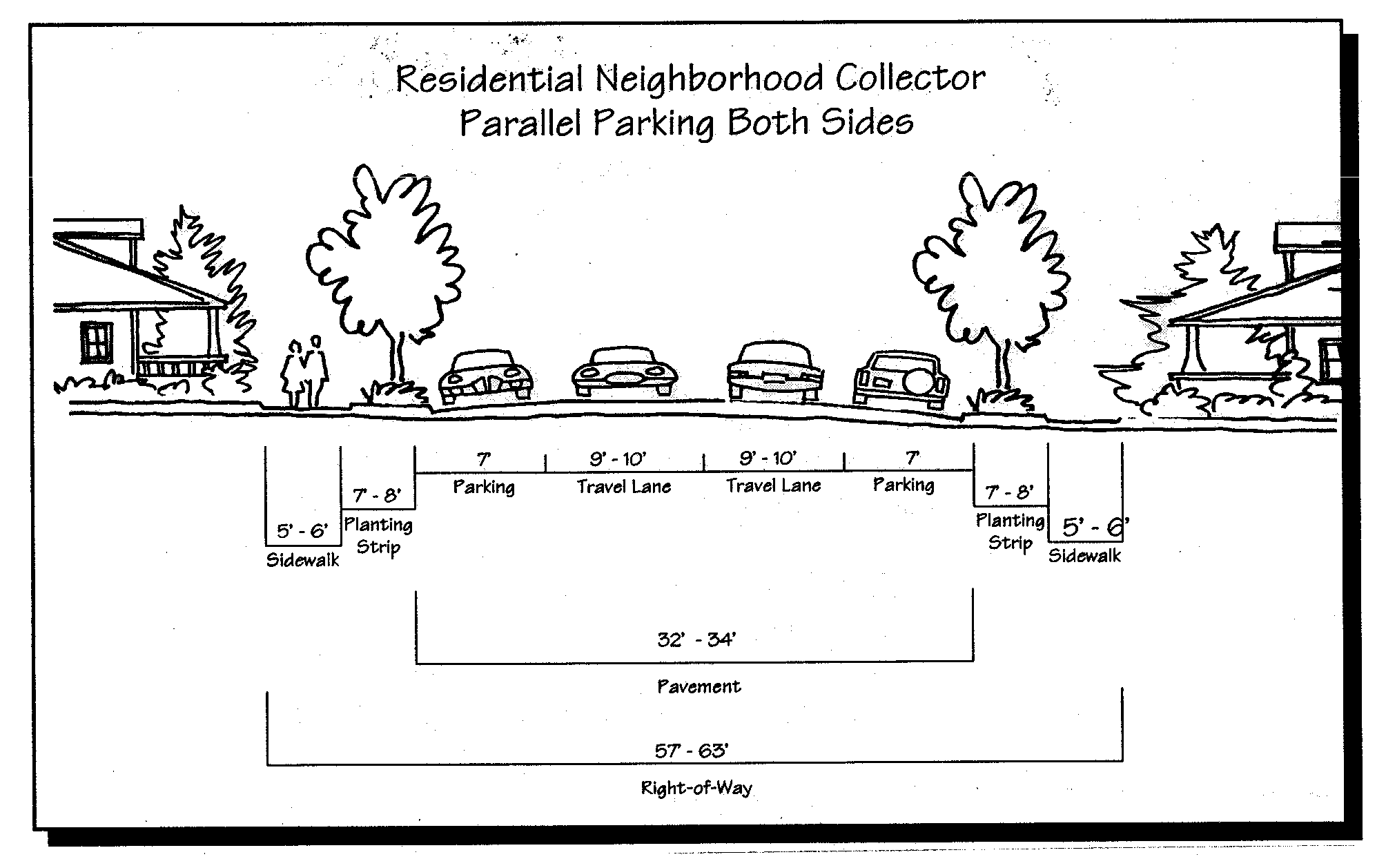
Figure 15.41F(3) Commercial/Industrial Collector Street Sections (Parking One Side)
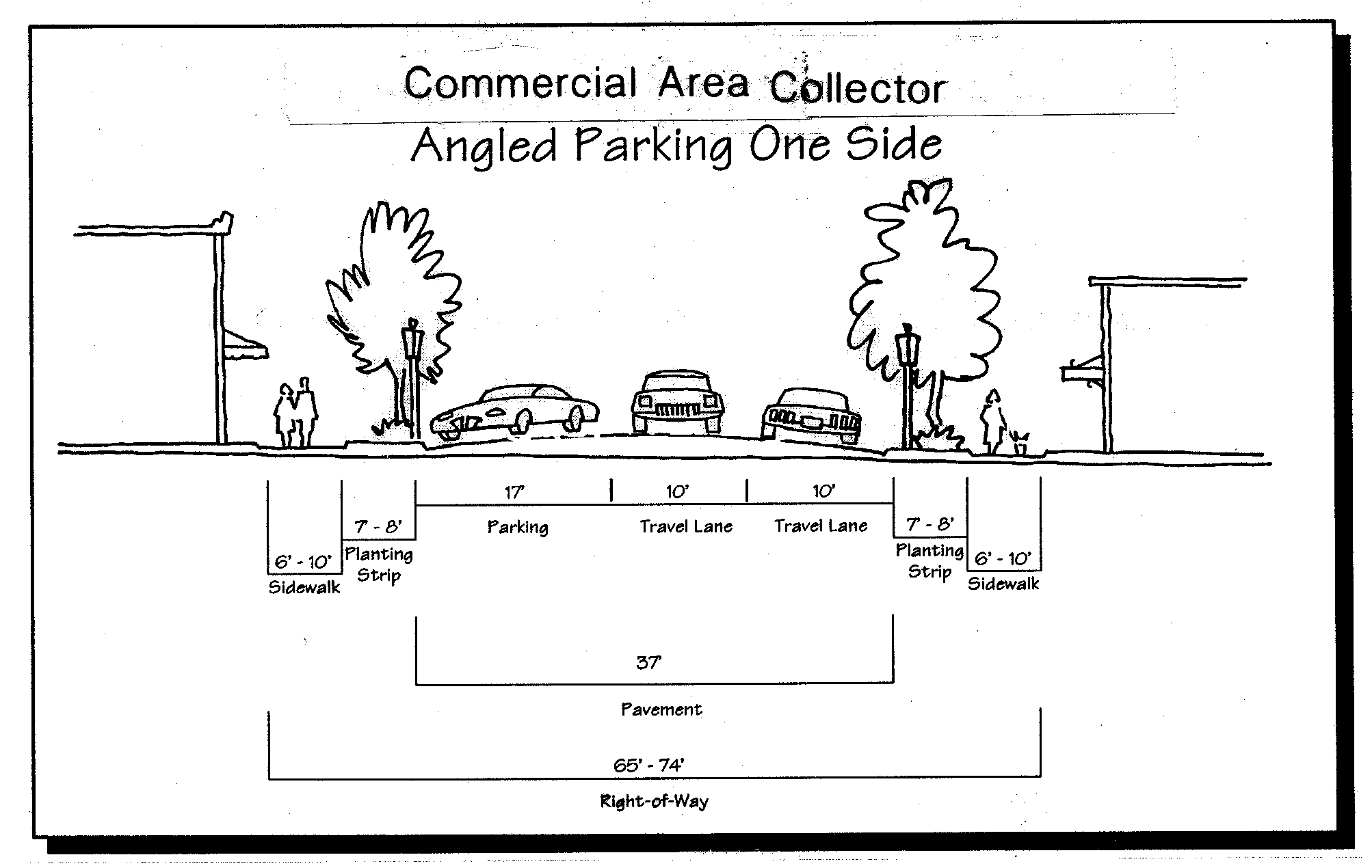
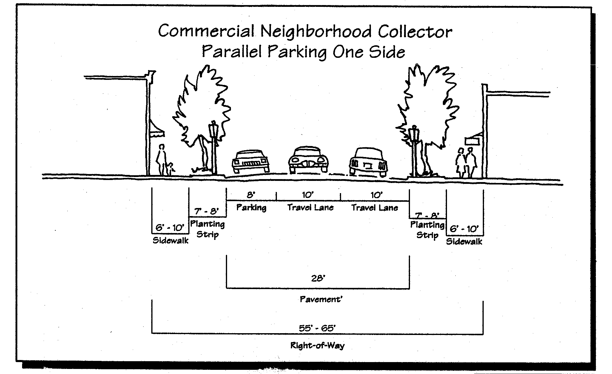
Figure 15.41F(4) Commercial/Industrial Collector Street Sections (Parking Two Sides)
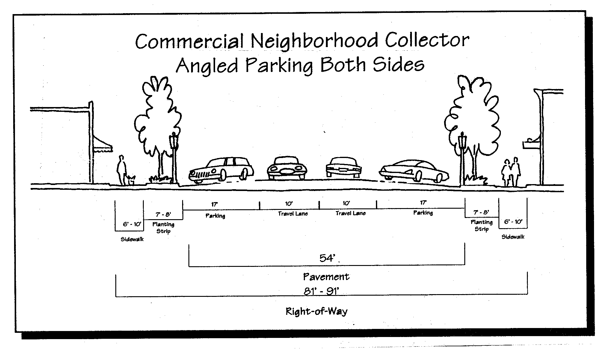
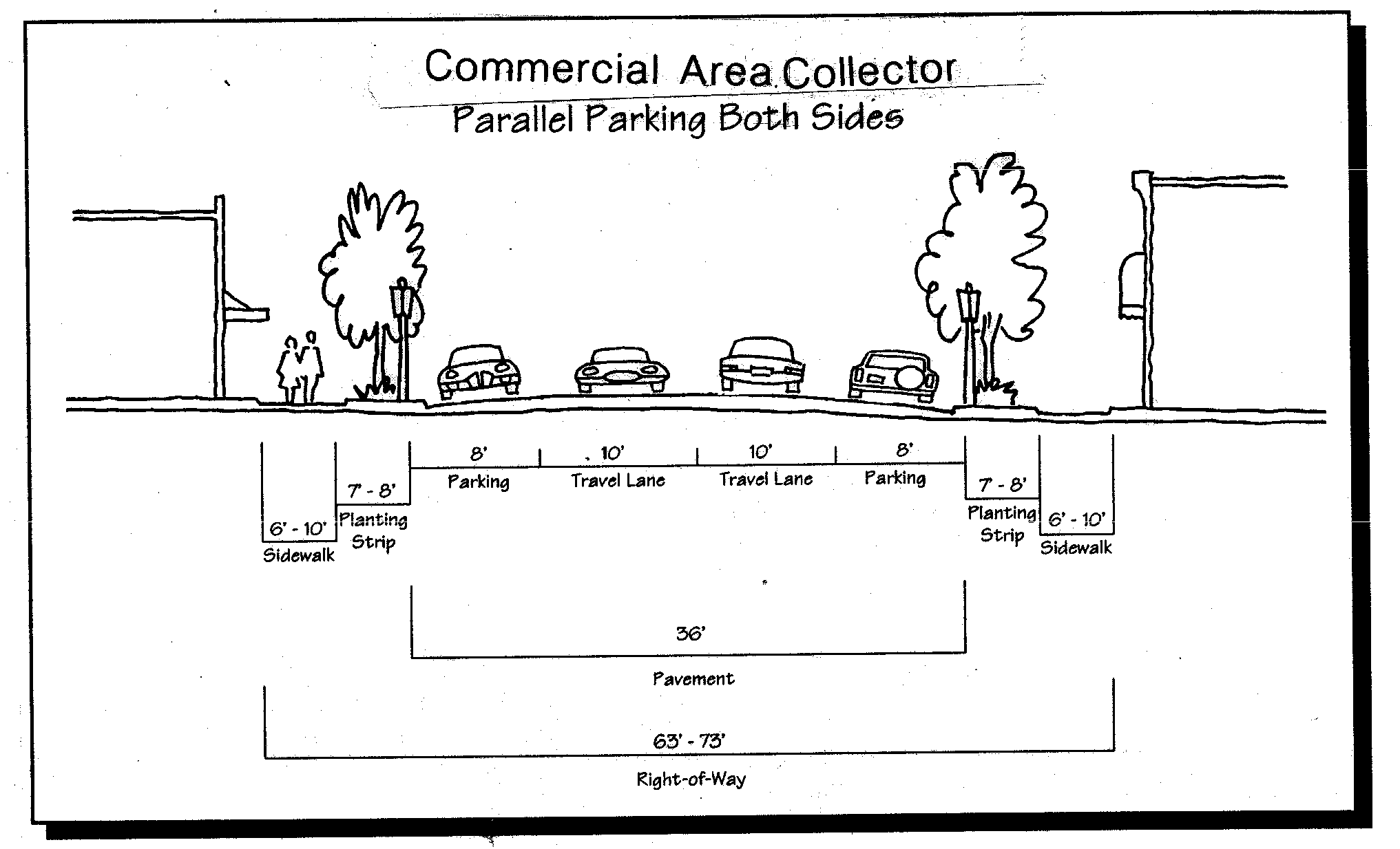
Figure 15.41F(5) Local Residential Street Sections
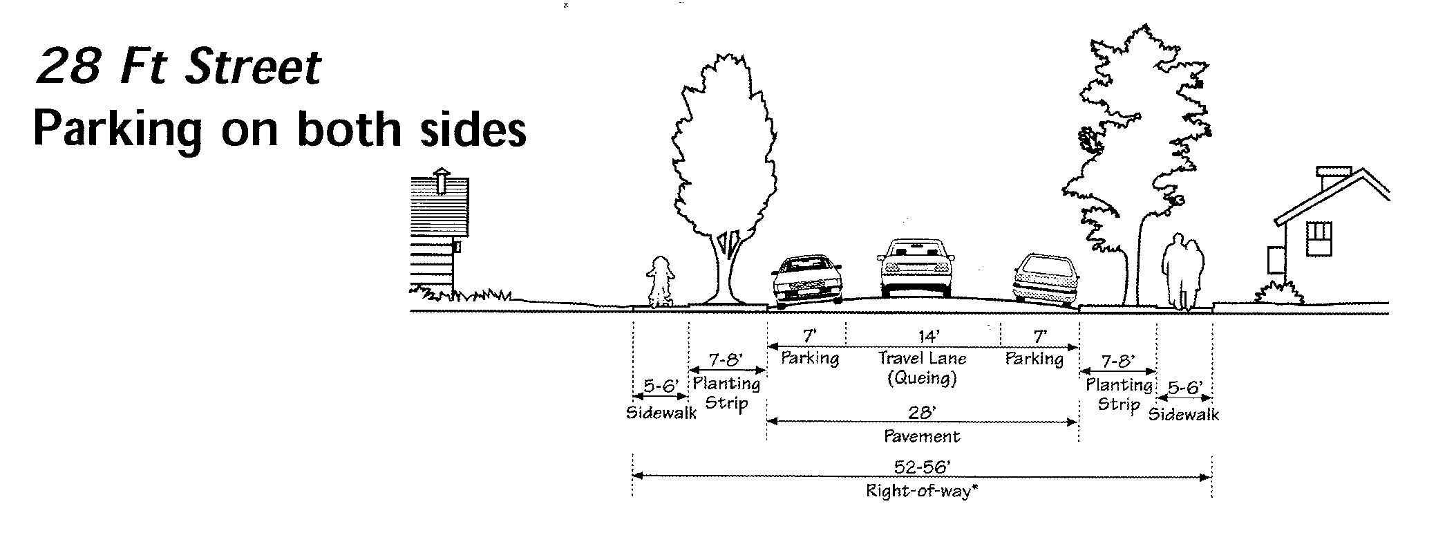
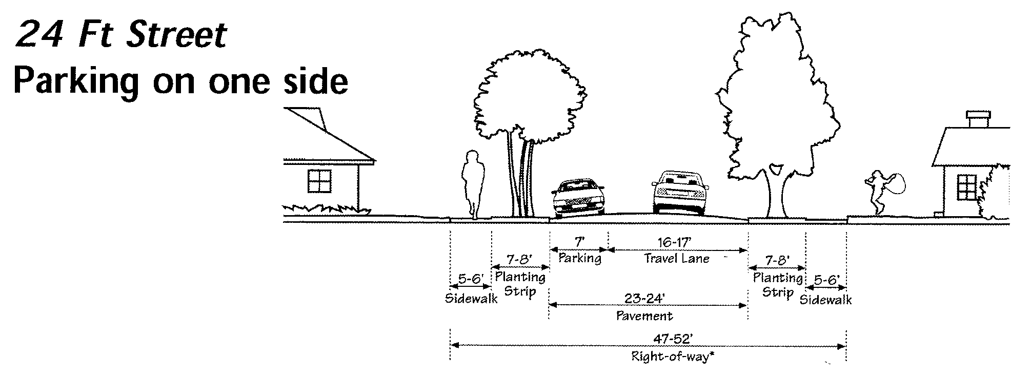
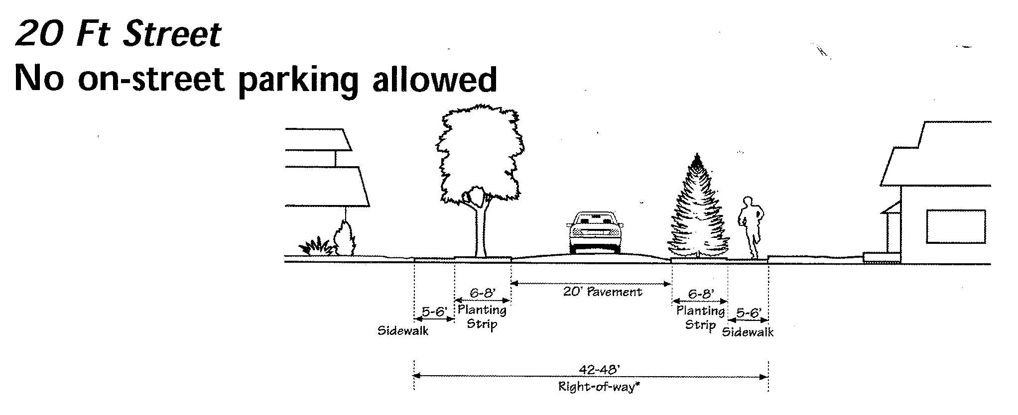
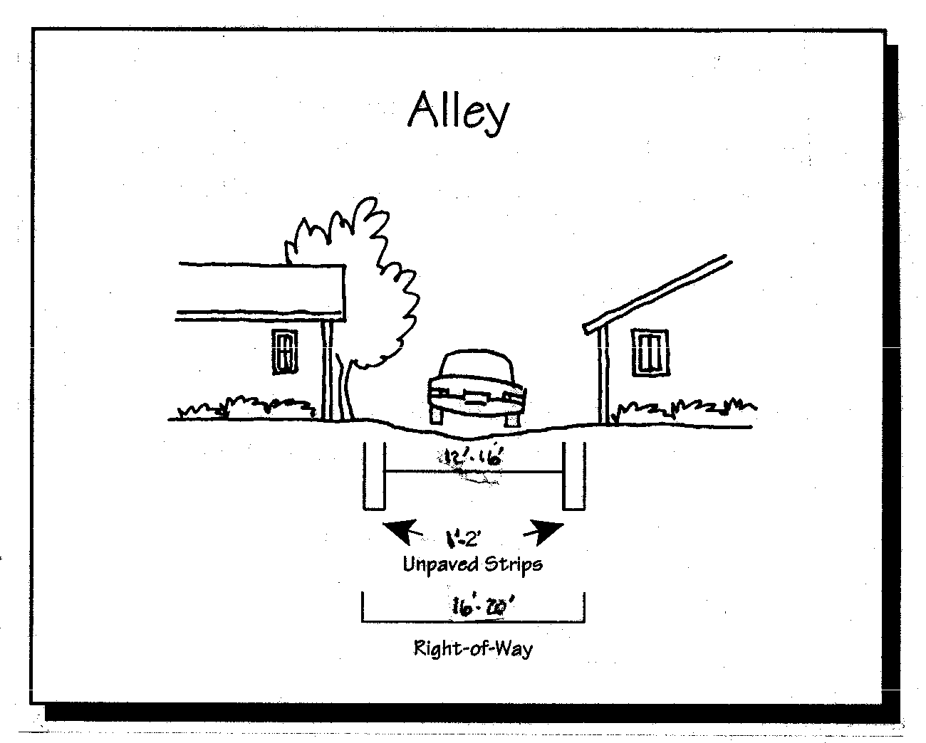
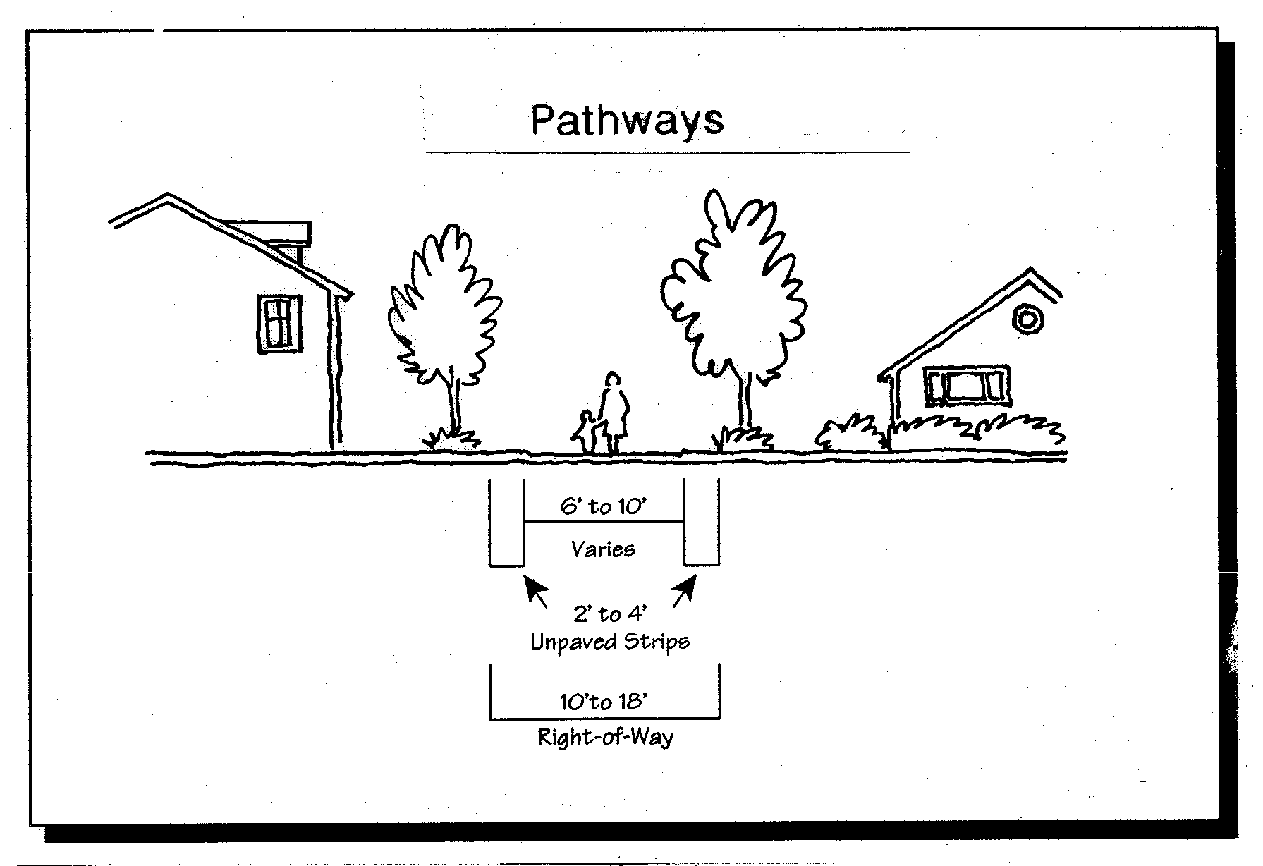
Figure 15.41F(6) Alley and Pathway Sections
[RESERVED FOR OTHER STREET SECTIONS]
G.
Subdivision street connectivity. All subdivisions shall conform to all the following access and circulation design standards, as applicable:
1.
Connectivity to abutting lands. The street system of proposed subdivisions shall be designed to connect with existing, proposed, and planned streets outside of the subdivision as provided in this section. Wherever a proposed development abuts unplatted land or a future development phase of the same development, street stubs shall be provided to allow access to future abutting subdivisions and to logically extend the street system into the surrounding area. All street stubs shall be provided with a temporary turn-around unless specifically exempted by the fire marshal, and the restoration and extension of the street shall be the responsibility of any future developer of the abutting land.
2.
When abutting an arterial street. Property access to abutting arterials shall be minimized. Where such access is necessary, shared driveways may be required in conformance with section 15.12. If vehicle access off a secondary street is possible, then the road authority may prohibit access to the arterial.
3.
Continuation of streets. Planned streets shall connect with surrounding streets to permit the convenient movement of traffic between residential neighborhoods and to facilitate emergency access and evacuation. Connections shall be designed to meet or exceed the standards in subsection 4, below, and to avoid or minimize through traffic on local streets. Appropriate design and traffic control and traffic calming measures, as provided in subsection H, below, are the preferred means of discouraging through traffic.
4.
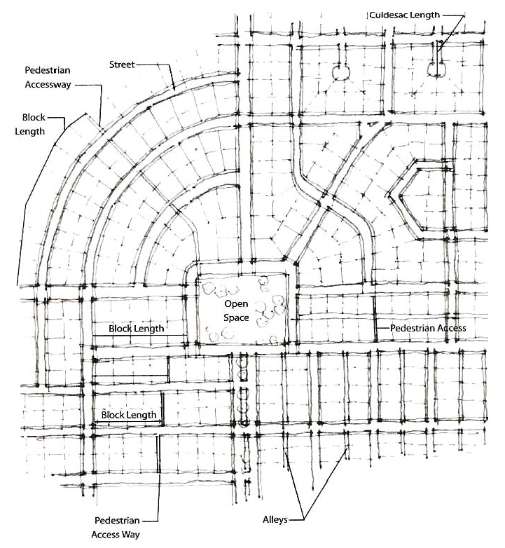
Street connectivity and formation of blocks. In order to promote efficient vehicular and pedestrian circulation throughout the city, subdivisions and site developments of more than two acres shall be served by a connecting network of public streets and/or accessways, in accordance with the following standards (minimum and maximum distances between two streets or a street and its nearest accessway):
a.
Residential districts. Minimum of 100 foot block length and maximum of 600 length; maximum 1,400 feet block perimeter;
b.
Central business district. Minimum of 100-foot length and maximum of 400-foot length; maximum 1,200-foot perimeter;
c.
General commercial districts. Minimum of 100-foot length and maximum of 600-foot length; maximum 1,400-foot perimeter;
d.
Not applicable to the industrial districts;
Figure 15.41G Street Connectivity and Formation of Blocks
5.
Accessway standards. Where a street connection in conformance with the maximum block length standards in subsection 4 is impracticable, an accessway shall be provided at or near the middle of a block in lieu of the street connection, as generally shown in Figure 15.41G. The city may also require developers to provide an accessway where a cul-de-sac or other street is planned and the accessway would connect the streets or provide a connection to other developments. Such access ways shall conform to all of the following standards:
a.
Accessways shall be no less than ten feet wide and located within a right-of-way or easement allowing public access and, as applicable, emergency vehicle access;
b.
If the streets within the subdivision or neighborhood are lighted, all accessways in the subdivision shall be lighted. Accessway illumination shall provide at least two foot-candles;
c.
A right-of-way or public access easement provided in accordance with subsection b that is less than 20 feet wide may be allowed on steep slopes where the decision body finds that stairs, ramps, or switch-back paths are required;
d.
All accessways shall conform to applicable ADA requirements;
e.
The city may require landscaping as part of the required accessway improvement to buffer pedestrians from adjacent vehicles, provided that landscaping or fencing adjacent to the accessway does not exceed four feet in height; and
f.
Which may be modified by the decision body without a variance when the modification affords greater convenience or comfort for, and does not compromise the safety of, pedestrians or bicyclists.
H.
Traffic signals and traffic calming features.
1.
Traffic signals shall be required with development when traffic signal warrants are met, in conformance with the Highway Capacity Manual and Manual of Uniform Traffic Control Devices. The location of traffic signals shall be noted on approved street plans. Where a proposed street intersection will result in an immediate need for a traffic signal, a signal meeting approved specifications shall be installed in conformance with the city engineer's requirements. The developer's cost and the timing of improvements shall be included as a condition of development approval.
2.
When an intersection meets or is projected to meet traffic signal warrants, the city may accept alternative mitigation, such as a roundabout, in lieu of a traffic signal, if approved by the city engineer.
3.
The city may require the installation of calming features such as traffic circles, curb extensions, reduced street width (parking on one side), medians with pedestrian crossing refuges, and/or special paving to slow traffic in neighborhoods or commercial areas with high pedestrian traffic.
I.
Future street plan and extension of streets.
1.
A future street plan shall be filed by the applicant in conjunction with an application for a subdivision in order to facilitate orderly development of the street system. The plan shall show the pattern of existing and proposed future streets from the boundaries of the proposed land division and shall include other divisible parcels within 600 feet surrounding and adjacent to the proposed land division. The street plan is not binding; rather it is intended to show potential future street extensions with future development.
2.
Streets shall be extended to the boundary lines of the parcel or tract to be developed when the city determines that the extension is necessary to give street access to, or permit a satisfactory future division of, adjoining land. The point where the streets temporarily end shall conform to a-c, below:
a.
These extended streets or street stubs to adjoining properties are not considered to be culs-de-sac since they are intended to continue as through streets when the adjoining property is developed.
b.
A barricade (e.g. fence, bollards, boulders or similar vehicle barrier) shall be constructed at the end of the street by the subdivider and shall not be removed until authorized by the city or other applicable agency with jurisdiction over the street. The cost of the barricade shall be included in the street construction cost.
c.
Temporary street ends shall provide turnarounds constructed to Uniform Fire Code standards for streets over 150 feet in length. See also, section 15.12.
J.
Street alignment, radii, and connections.
1.
Staggering of streets making "T" intersections at collectors and arterials shall not be designed so that offsets of less than 300 feet on such streets are created, as measured from the centerline of the street.
2.
Spacing between local street intersections shall have a minimum separation of 125 feet, except where more closely spaced intersections are designed to provide an open space, pocket park, common area, or similar neighborhood amenity. This standard applies to four-way and three-way (off-set) intersections.
3.
All local and collector streets that stub into a development site shall be extended within the site to provide through circulation unless prevented by environmental or topographical constraints, existing development patterns, or compliance with other standards in this code. This exception applies when it is not possible to redesign or reconfigure the street pattern to provide required extensions. Land is considered topographically constrained if the slope is greater than 15 percent for a distance of 250 feet or more. In the case of environmental or topographical constraints, the mere presence of a constraint is not sufficient to show that a street connection is not possible. The applicant must show why the environmental or topographic constraint precludes some reasonable street connection.
4.
Proposed streets or street extensions shall be located to allow continuity in street alignments and to facilitate future development of vacant or redevelopable lands.
5.
In order to promote efficient vehicular and pedestrian circulation throughout the city, the design of subdivisions and alignment of new streets shall conform to block length standards in section 15.12.
6.
Corner curb radii shall be at least 20 feet, except where smaller radii are approved by the city engineer.
K.
Sidewalks, planter strips, bicycle lanes. Sidewalks, planter strips, and bicycle lanes shall be installed in conformance with the standards in Table 15.41, applicable provisions of the comprehensive plan, and adopted street plans. Maintenance of sidewalks and planter strips in the right-of-way is the continuing obligation of the adjacent property owner.
L.
Intersection angles. Streets shall be laid out so as to intersect at an angle as near to a right angle as practicable, except where topography requires a lesser angle or where a reduced angle is necessary to provide an open space, pocket park, common area or similar neighborhood amenity. In addition, the following standards shall apply:
1.
Streets shall have at least 25 feet of tangent adjacent to the right-of-way intersection unless topography requires a lesser distance;
2.
Intersections which are not at right angles shall have a minimum corner radius of 20 feet along the right-of-way lines of the acute angle; and
3.
Right-of-way lines at intersection with arterial streets shall have a corner radius of not less than 20 feet.
M.
Existing rights-of-way. Whenever existing rights-of-way adjacent to a proposed development are less than standard width, additional rights-of-way shall be provided at the time of subdivision or development, subject to the provision of section 15.41.
N.
Culs-de-sac. A cul-de-sac street shall only be used when environmental or topographical constraints, existing development patterns, or compliance with other standards in this code preclude street extension and through circulation. When culs-de-sac are provided, all of the following shall be met:
1.
The cul-de-sac shall not exceed a length of 400 feet; the length of the cul-de-sac shall be measured along the centerline of the roadway from the near side of the intersecting street to the farthest point of the cul-de-sac;
2.
The cul-de-sac shall terminate with a circular or hammer-head turnaround meeting the Uniform Fire Code. Circular turnarounds shall have a radius of no less than 40 feet, and not more than a radius of 45 feet (i.e. from center to edge of pavement); except that turnarounds shall be larger when they contain a landscaped island or parking bay at their center. When an island or parking bay is provided, there shall be a fire apparatus lane of 20 feet in width; and
3.
The cul-de-sac shall provide, or not preclude the opportunity to later install, a pedestrian and bicycle accessway connection between it an adjacent streets access ways, parks, or other right-of-way. Such accessways shall conform to section 15.14.
O.
Grades and curves. Grades shall not exceed ten percent on arterials, 12 percent on collector streets, or 12 percent on any other street (except that local or residential access streets may have segments with grades up to 15 percent for distances of no greater than 250 feet), and:
1.
Centerline curve radii shall not be less than 700 feet on arterials, 500 feet on major collectors, 350 feet on minor collectors, or 100 feet on other streets; and
2.
Streets intersecting with a minor collector or greater functional classification street, or streets intended to be posted with a stop sign or signalization, shall provide a landing averaging five percent or less. Landings are that portion of the street within 20 feet of the edge of the intersecting street at full improvement.
P.
Curbs, curb cuts, ramps, and driveway approaches. Concrete curbs, curb cuts, wheelchair ramps, bicycle ramps, and driveway approaches shall be constructed in accordance with standards specified in chapter 3.1, access and circulation.
Q.
Streets adjacent to railroad right-of-way. When a transportation improvement is proposed within 300 feet of a public railroad crossing, or a modification is proposed to an existing public crossing, the state department of transportation and the rail service provider shall be notified and given an opportunity to comment. Private crossing improvements are subject to review and licensing by the rail service provider.
R.
Development adjoining arterial streets. Where a development adjoins or is crossed by an existing or proposed arterial street, the development design shall separate residential access from through traffic and minimize traffic conflicts. (See also, the access requirements under section 15.12). The development design shall include one or more of the following:
1.
A parallel access street (frontage road) along the arterial with a landscape median (raised curbs) of not less than ten feet in width separating the two streets;
2.
Deep lots (120 feet or greater) abutting the arterial or major collector to provide adequate buffering with frontage along another street;
3.
Screen planting within a non-access reservation (e.g. public easement or tract) of not less than ten feet in width at the rear or side property line along the arterial; or
4.
Other treatment approved by the city that is consistent with the purpose of this section;
S.
Alleys, public or private. Alleys shall conform to the standards in Table 15.41. Alley intersections and sharp changes in alignment shall be avoided. The corners of necessary alley intersections shall have a radius of not less than 12 feet.
T.
Private streets. Private streets shall conform to city standards of construction and shall provide sidewalks or pathways as approved by the city. Private streets shall not be used to avoid public access connectivity required by this chapter. Gated communities (i.e. where a gate limits access to a development from a public street) are prohibited.
U.
Street names. No new street name shall be used which will duplicate or be confused with the names of existing streets in the county. Street names, signs, and numbers shall conform to the established pattern in the surrounding area, except as requested by emergency service providers. All proposed new street names shall be submitted to the emergency management district, E-911 coordinator for review and approval.
V.
Survey monuments. Upon completion of a street improvement and prior to acceptance by the city, it shall be the responsibility of the developer's registered professional land surveyor to provide certification to the city that all boundary and interior monuments shall be reestablished and protected.
W.
Street signs. The city, county, or state with jurisdiction shall install all signs for traffic control and street names. The cost of signs required for new development shall be the responsibility of the developer. Street name signs shall be installed at all street intersections. Stop signs and other signs may be required.
X.
Mail boxes. Plans for mail boxes shall be approved by the United States Postal Service.
Y.
Street light standards. Street lights shall be installed in accordance with city standards.
Z.
Street cross-sections. The final lift of asphalt or concrete pavement shall be placed on all new constructed public roadways prior to final city acceptance of the roadway unless otherwise approved by the city engineer. The final lift shall also be placed no later than when 80 percent of the structures in the new development are completed or two years from the commencement of initial construction of the development, whichever is less.
15.42. - Public use areas.
A.
Dedication of public use areas.
1.
Where a proposed park, playground, or other public use shown in a plan adopted by the city is located in whole or in part in a subdivision, the city may require the dedication or reservation of this area on the final plat for the subdivision, provided that the impact of the development on the city park system is roughly proportionate to the dedication or reservation being made.
2.
The city may purchase or accept voluntary dedication or reservation of areas within the subdivision that are suitable for the development of parks and other public uses; however, the city is under no obligation to accept such areas offered for dedication or sale.
B.
System development charge credit. Dedication of land to the city for public use areas, voluntary or otherwise, shall be eligible as a credit toward any required system development charge for parks.
15.43. - Sanitary sewer and water service improvements.
A.
Sewers and water mains required. Sanitary sewers and water mains shall be installed to serve each new development and to connect developments to existing mains in accordance with the city's sanitary sewer master plan, water system master plan, and the applicable construction specifications. When streets are required to be stubbed to the edge of the subdivision, sewer and water system improvements shall also be stubbed with the streets, except as may be waived by the city engineer.
B.
Sewer and water plan approval. Development permits for sewer and water improvements shall not be issued until the city engineer has approved all sanitary sewer and water plans in conformance with city standards.
C.
Over-sizing. The city may require as a condition of development approval that sewer, water, and/or storm drainage systems serving new development be sized to accommodate future development within the area as projected by the applicable water, sewer, and/or storm drainage master plan, provided that the city may grant the developer credit toward any required system development charge for the same.
D.
Inadequate facilities. Development permits may be restricted by the city where a deficiency exists in the existing water or sewer system that cannot be rectified by the development and which if not rectified will result in a threat to public health or safety, surcharging of existing mains, or violations of state or federal standards pertaining to operation of domestic water and sewerage treatment systems.
15.44. - Storm drainage improvements.
A.
General provisions. The city shall issue a development permit only where adequate provisions for storm water and flood water runoff have been made in conformance with the city's stormwater ordinance provisions.
B.
Accommodation of upstream drainage. Culverts and other drainage facilities shall be large enough to accommodate existing and potential future runoff from the entire upstream drainage area, whether inside or outside the development. Such facilities shall be subject to review and approval by the city engineer.
C.
Effect on downstream drainage. Where it is anticipated by the city engineer that the additional runoff resulting from the development will overload an existing drainage facility, the city shall withhold approval of the development until provisions have been made for improvement of the potential condition or until provisions have been made for storage of additional runoff caused by the development in accordance with city standards.
D.
Over-sizing. The city may require as a condition of development approval that sewer, water, and/or storm drainage systems serving new development be sized to accommodate future development within the area as projected by the applicable water, sewer, and/or storm drainage master plan, provided that the city may grant the developer credit toward any required system development charge for the same.
E.
Existing watercourse. Where a proposed development is traversed by a watercourse, drainage way, channel, or stream, there shall be provided a storm water easement or drainage right-of-way conforming substantially with the lines of such watercourse and such further width as will be adequate for conveyance and maintenance to protect the public health and safety.
15.45. - Utilities.
A.
Underground utilities.
1.
Generally. All new utility lines including, but not limited to, those required for electric, communication, lighting, and cable television services and related facilities shall be placed underground, except for surface mounted transformers, surface mounted connection boxes and meter cabinets which may be placed above ground, temporary utility service facilities during construction, and high capacity electric lines operating at 50,000 volts or above.
2.
Subdivisions. The following additional standards apply to all new subdivisions, in order to facilitate underground placement of utilities:
a.
The developer shall make all necessary arrangements with the serving utility to provide the underground services. Care shall be taken to ensure that all above ground equipment does not obstruct vision clearance areas for vehicular traffic (chapter 15.1);
b.
The city reserves the right to approve the location of all surface-mounted facilities;
c.
All underground utilities, including sanitary sewers and storm drains installed in streets by the developer, shall be constructed prior to the surfacing of the streets; and
d.
Stubs for service connections shall be long enough to avoid disturbing the street improvements when service connections are made.
B.
Exception to undergrounding requirement. The standard applies only to proposed subdivisions. An exception to the undergrounding requirement may be granted due to physical constraints, such as steep topography, sensitive lands (chapter 15.7), or existing development conditions.
15.46. - Easements.
A.
Provision. The developer or applicant shall make arrangements with the city, the applicable district, and each utility franchise for the provision and dedication of utility easements necessary to provide full services to the development. The city's standard width for public main line utility easements shall be determined by the city engineer.
B.
Recordation. As determined by the city engineer, all easements for sewers, storm drainage and water quality facilities, water mains, electric lines, or other public utilities shall be recorded with the final plat.
15.47. - Construction plan approval and assurances.
A.
Plan approval and permit. No public improvements, including sanitary sewers, storm sewers, streets, sidewalks, curbs, lighting, parks, or other requirements shall be undertaken except after the plans have been approved by the city, permit fee paid, and permit issued. The permit fee is required to defray the cost and expenses incurred by the city for construction and other services in connection with the improvement. The permit fee shall be set by the board of aldermen.
A.
Performance guarantee. The city may require the developer or subdivider to provide bonding or other performance guarantees to ensure completion of required public improvements.
15.48. - Installation.
A.
Conformance required. Improvements installed by the developer either as a requirement of these regulations or at his/her own option, shall conform to the requirements of this chapter, approved construction plans, and to improvement standards and specifications adopted by the city.
B.
Adopted installation standards. The Standard Specifications for Public Works Construction, Mississippi Chapter A.P.W.A., shall be a part of the city's adopted installation standard(s); other standards may also be required upon recommendation of the city engineer.
C.
Commencement. Work shall not begin until the city has been notified in advance in writing.
D.
Resumption. If work is discontinued for more than one month, it shall not be resumed until the city is notified in writing.
E.
City inspection. Improvements shall be constructed under the inspection and to the satisfaction of the city. The city may require minor changes in typical sections and details if unusual conditions arising during construction warrant such changes in the public interest. Modifications to the approved design requested by the developer may be subject to review. Any monuments that are disturbed before all improvements are completed by the subdivider shall be replaced prior to final acceptance of the improvements.
F.
Engineer's certification and as-built plans. A registered civil engineer shall provide written certification in a form required by the city that all improvements, workmanship, and materials are in accord with current and standard engineering and construction practices, conform to approved plans and conditions of approval, and are of high grade, prior to city acceptance of the public improvements, or any portion thereof, for operation and maintenance. The developer's engineer shall also provide two set(s) of "as-built" plans, in conformance with the city engineer's specifications, for permanent filing with the city.
15.51. - Introduction.
It is the intention of the board of aldermen of the city (the board) to protect the health and safety of the citizens and visitors of the community and to prevent damage to private property and public facilities through the proper design and construction of both on-site and regional stormwater management and/or detention facilities that prevent or adequately reduce increases in peak flow rates of runoff that may otherwise increase the risk of flooding and the associated risk of public endangerment, property damage and erosion. To accomplish this goal, the board finds it is necessary to provide stormwater management practices for drainage and control of flood and surface waters within the city. This is to ensure that storm and surface waters may be properly drained and controlled, pollution may be reduced and environment enhanced, and that the health property, safety and welfare of the city and its inhabitants may be safeguarded and protected. Stormwater runoff is a major contributor to degradation and pollution of receiving waters. Discharges into a stormwater runoff system may occur because of stormwater runoff, spills, dumping, and/or improper connections to the stormwater system from developments, residential, industrial, commercial, or institutional establishments. Such discharges not only impact waterways individually, but geographically dispersed, small volume discharges can have a cumulative impact on receiving waters, which can adversely affect public health and safety, drinking water supplies, recreation, fish and other aquatic life, property values and other uses of lands and waters. The city board of aldermen endorse promulgation of this chapter to address the impacts of stormwater runoff, spills, improper dumping, and/or illegal connections to the city runoff program. This chapter applies to all lands within the corporate limits of the city.
15.52. - Purpose.
A.
The purpose of this chapter is to protect the environment, public health, safety, property and general welfare of the citizens of the city through the regulation of stormwater runoff and illicit discharges into the city storm drainage or any separate storm sewer system, to the maximum extent practicable as required by federal and state law. This ordinance establishes methods for controlling the introduction of pollutants into the city drainage system in order to comply with requirements of the National Pollutant Discharge Elimination System (NPDES) permit process.
B.
This chapter is not intended to modify or repeal any other ordinance, rule, regulation, or other provision of law. The requirements of this chapter are in addition to the requirements of any other ordinance, rule, regulation, or other provision of law, and where any provision of this chapter imposes restrictions different from those imposed by any other ordinance, rule, regulations, or other provision of law. Whichever provision is more restrictive or imposes higher protective standards for human health or the environment shall control.
15.53. - Objectives.
A.
The objectives of this chapter are:
(1)
To regulate or restrict the introduction of pollutants that may potentially enter the city drainage system;
(2)
To prohibit illegal connections and discharges to any separate storm sewer system;
(3)
To identify, define, and regulate erosion, sediment and detention controls related to stormwater runoff.
(4)
To prevent discharges that may occur as a result of spills, inappropriate dumping or disposal, and/or improper connections to the city drainage system, whether from residential, industrial, commercial or institutional establishments;
(5)
To provide the city with the authority to deal with stormwater runoff non-conformance and illicit discharges, and to establish enforcement actions for those persons or entities found to be in noncompliance or that refuse to allow access to their facilities;
(6)
To establish legal authority to carry out all inspection, surveillance, monitoring, and enforcement procedures necessary to ensure compliance with this ordinance.
15.54. - Definitions.
Accidental discharge. A discharge prohibited by this ordinance, which occurs by chance, and without planning or thought prior to occurrence.
Authorized enforcement agency. Employees or designees of the agency designated to enforce this ordinance.
Best management practices (BMPs). Schedules of activities, prohibitions of practices, general good housekeeping practices, pollution prevention and educational practices, maintenance procedures, and other management practices to prevent or reduce the discharge of pollutants directly or indirectly to stormwater, receiving waters, or stormwater conveyance systems. BMPs also include treatment practices, operating procedures, and practices to control site runoff, spillage or leaks, sludge or water disposal, or drainage from raw materials storage.
Clean Water Act. The federal Water Pollution Control Act (33 U.S.C. § 1251 et seq.), and any subsequent amendments thereto.
Construction activity. Activities subject to NPDES construction permits. These include construction projects resulting in land disturbances. Such activities include but are not limited to clearing and grubbing, grading, excavating, and demolition.
City drainage system (CDS). Any city maintained or designated roadways, ditches, culverts, channels, or conduits intended to direct water flows.
Facility. A structure, installation, or system that is designed to serve a particular purpose, service, or function.
Hazardous materials. Any material, including any substance, waste, or combination thereof, which because of its quantity, concentration, or physical, chemical, or infectious characteristics may cause, or significantly contribute to, a substantial present or potential hazard to human health, safety, property, or the environment when improperly treated, stored, transported, disposed of, or otherwise managed.
Illegal connections. An illegal connection is defined as any of the following: any pipe, open channel, drain or conveyance, whether on the surface or subsurface, which allows an illegal discharge to enter the drainage system including but not limited to any conveyances which allow any non-stormwater discharge including sewage, process wastewater, wash water, or any other such discharge, to enter the storm drain system and any connections to the storm drain system from any source, regardless of whether such pipe, open channel, drain, connection, or source had been previously allowed, permitted, or approved by an authorized enforcement agency.
Illicit discharge. Any direct or indirect discharge into a stormwater drainage system that is not composed entirely of stormwater.
Industrial activity. Activities subject to NPDES industrial permits as defined in 40 CFR, section 122.26 (b)(14).
National Pollutant Discharge Elimination System (NPDES) stormwater discharge permit. A permit issued by EPA (or by a state under authority delegated pursuant to 33 USC § 1342(b)) that authorizes the discharge of pollutants to waters of the United States, whether the permit is applicable on an individual, group, or general area-wide basis.
Non-stormwater discharge. Any discharge to the storm drain system that is not composed entirely of stormwater.
Person. Any individual, association, organization, partnership, firm, trust, estate, commission, board, public or private institution, utility, cooperative, city, county or other political subdivision of the state, any interstate body or other legal entity, joint venture, public or private corporation, or other entity recognized by law and acting as either the owner or as the owner's agent.
Pollutant. Any substance, which causes or contributes to pollution. Pollutants may include, but are not limited to paints, varnishes, solvents, petroleum hydrocarbons, automotive fluids, cooking grease, detergents (biodegradable or otherwise), degreasers, cleaning chemicals, non-hazardous liquid and solid wastes, yard wastes, refuse, rubbish, garbage, litter, discarded or abandoned objects, munitions, accumulations that may cause or contribute to pollution, any floatables, pesticides, herbicides, fertilizers, hazardous substances and wastes, sewage, fecal coliform and pathogens, dissolved and particulate metals, animal wastes, wastes and residues that result from constructing a building or structure including concrete/cement (this includes water from washing out cement trucks) and noxious or offensive matter of any kind or any other substance which has been or may be determined to be a pollutant.
Pollution. The contamination or other alteration of any water's physical, chemical or biological properties by the addition of any substance or condition including but not limited to, a change in temperature, taste, color, turbidity, or odor of such waters, or waters as will or is likely to create a nuisance or render such waters harmful, detrimental or injurious to the public health, safety, welfare, or environment, or to domestic, commercial, industrial, agricultural, recreational, or other legitimate beneficial uses, or to livestock, wild animals, birds, fish or other aquatic life.
Premises. Any parcel or portion of land whether improved or unimproved.
Separate storm sewer system. Any facility designed or used for collecting and/or conveying stormwater, including but not limited to streets or roads with drainage systems, gutters, inlets, catch basins, piped storm drains, pumping facilities, structural stormwater controls, ditches, swales, natural and man-made or altered drainage channels, reservoirs, and other drainage structures, and which are:
a)
Owned or maintained by the city.
b)
Not part of publicly owned treatment works.
State waters. Any and all rivers, streams, creeks, branches, lakes, reservoirs, ponds, drainage systems, springs, well, and other bodies of surface and subsurface water, natural or artificial, lying within or forming a part of the boundaries of the state, which are not entirely confined and retained completely upon the property of a single person.
Storm drainage system. Any one or more of various devices used in the collection, treatment or disposition of storm, flood or surface drainage waters, including but not limited to any roads with drainage systems, natural and human-made or altered drainage channels, reservoirs, manmade structures and natural watercourses and/or floodplains for the conveyance of runoff, such as detention or retention areas, berms, swales, improved gutters, pumping stations, pipes, ditches, siphons, catch basins, inlets, and other equipment and appurtenances and all extensions, improvements, remodeling, additions and alterations thereof; and any and all rights or interests in such stormwater facilities.
Stormwater/stormwater runoff. Any surface flow, runoff, and/or drainage consisting entirely of water from any form of natural precipitation, which is not absorbed, transpired, evaporated or left in surface depressions, and which then flows controlled or uncontrolled into a watercourse or body of water.
Stormwater pollution prevention plan (SWPPP). A document which describes the best management practices (BMPs) and activities to be implemented by a person or business to identify sources of pollution or contamination at a site and the actions to eliminate or reduce pollutant discharges to stormwater, stormwater conveyance systems, and/or receiving waters to the maximum extent practicable.
Structural stormwater control. A structural stormwater management facility or device that controls stormwater runoff and changes the characteristics of that runoff, including but not limited to, the quantity and quality, the period of release or the velocity of flow.
Wastewater means any water or other liquid, other than uncontaminated stormwater, discharged from a facility.
Watercourse. Any stream, river, drainage easement, that transverses property in the city.
15.55. - Applicability.
This chapter shall apply to any and all water entering a storm drainage system generated on any developed or undeveloped lands throughout all of the corporate limits of the city unless explicitly exempted by an authorized enforcement agency. The standards set forth herein and promulgated pursuant to this chapter are minimum standards; therefore this chapter does not intend nor imply that compliance by any person will ensure that there will be no contamination, pollution, or unauthorized discharge of pollutants.
15.56. - Responsibility for administration.
The board of aldermen of the city or designee shall administer, implement, and enforce the provisions of this chapter. Any powers granted or duties imposed upon the authorized enforcement agency may be delegated in writing by the director of the authorized enforcement agency to persons or entities acting in the beneficial interest of or in the employ of the agency.
15.57. - Severability.
The provisions of this chapter are hereby declared to be severable. If any provision, clause, sentence, or paragraph of this chapter or the application thereof to any person, establishment, or circumstances shall be held invalid, such invalidity shall not affect the other provisions or application of this chapter.
15.58. - Policy.
No owner of any parcel of land or property, whether with or without a structure thereupon, shall permit the erosion or escape of soil, sand, gravel, or similar material from said parcel onto any adjoining property, public street or into any drainage channel that receives rainwater runoff from said parcel in such quantities as to harm said adjoining property, public street, drainage channel, or stormwater drainage system. In the development or use of any site, the owner or their agents shall not construct or conduct any activity so as to cause the discharge of rainwater runoff in such a manner as to cause erosion or to increase blockage of such channel or storm drainage system. This includes both pre-construction and post-construction.
15.59. - Permitting.
Stormwater permits and stormwater pollution prevention plans (SWPPP) are required as follows:
•
0—.9 acre of land disturbed: no permit or SWPPP currently required.
•
1—5 acres of land disturbed: permit required from city building inspection department. A notice of intent (NOI) and SWPPP must be submitted to the planning commission.
•
Above 5 acres: Permit required from MDEQ. SWPPP must also be submitted to MDEQ.
15.59.1. - Construction and/or industrial activity.
Any person subject to an industrial or construction activity National Pollution Discharge Elimination System (NPDES) stormwater discharge permit shall comply with all provisions of such permit. Proof of compliance with said permit may be required in a form acceptable to the board prior to the allowing of discharges to the city drainage system. Dumping excess cements and washing out cement trucks are included in this article.
Section A
Standards and requirements for erosion/sediment controls.
(a)
Prior to the final approval of the plat of any subdivision, or prior to commencement of construction upon any lot or parcel of land for which a drainage report and construction plan for the installation of stormwater facilities has not been prepared and approved, the owners of the property being subdivided or upon which construction is being commenced shall, at such owner's cost, prepare a detailed drainage report and construction plans for the installation of all stormwater facilities required for such subdivision or lot, including any off-site facilities required to convey stormwater to existing drains, channels, streams, detention ponds or to other points, all in conformity with the SWPPP on file.
(b)
No final subdivision plat, subdivision construction plan, site plan or building permit shall be approved by the city unless the plans for the proposed development include temporary and permanent erosion and sedimentation control measures such that siltation of downstream drainage ways are minimized.
(c)
The above requirement shall be accomplished through a combination of the following practices:
1.
Installation of silt fences and rock or hay berms before and during construction in order to reduce on-site soil erosion and provide temporary capture of sediment.
2.
Temporary and/or permanent revegetation of bare ground in order to stabilize disturbed soil at the earliest practicable date.
3.
Construction of on-site stormwater detention facilities by the landowner or developer in a manner such that detention ponds function as temporary sedimentation basins until permanent revegetation of the subject tract is accomplished.
4.
Other measures which may be necessary to control erosion and sedimentation on a site-by-site basis.
Section B
Standards and requirements for stormwater detention.
A)
It is prohibited to place fill material or construct impervious cover or construct or place any other structure on such person's property or perform any excavation or grading in a manner, which alters the flow of surface water across said property in a manner which damages any adjacent property.
1.
No final subdivision plat, subdivision construction plan, site plan or building permit shall be approved by the city unless it can be demonstrated by the owner or developer of such property that the proposed development will not result in damage to any adjacent or downstream property. This will be certified by a professional engineer's submittal of sufficient data and calculations.
B)
The above requirement shall be accomplished through one of the following means:
1.
Design and construction of an on-site stormwater detention facility, or facilities, by the landowner or developer which limits the peak flood flows from the proposed development to the existing peak flood flows from the subject tract.
2.
Construction of, or participation in the construction of, off-site drainage improvements, such as storm inlets, storm sewers, culverts, channel modifications, land filling, and/or other drainage facilities such that the peak flood flows for fully-developed watershed conditions from the watershed area in which the proposed development is located will be sufficiently and safely passed without flooding of adjacent and downstream property and roadways.
3.
Design and construction of the development by certified engineering data and calculations utilizing limited impervious cover, infiltration of runoff from impervious cover via flow through pervious areas, and/or grass-lined swales or channels such that these measures result in a minimal increase in peak flood flows from the development.
4.
All on-site stormwater detention facilities shall be designed to adequately and safely pass all stormwater inflows, including flood flows and runoff from upstream and adjacent properties that have natural and/or existing overland flows toward and onto the subject tract. The on-site stormwater detention facilities should not impound stormwater onto or cause backwater to inundate any upstream or adjacent properties in excess of existing conditions.
Section C
Illicit discharges.
(a)
It shall be unlawful for any person to allow discharges to the city stormwater runoff system that are not composed entirely of stormwater runoff, or to contribute to increased nonpoint source pollution and degradation of receiving waters.
(b)
It shall be unlawful for any person to throw, deposit, empty, drain, discharge, or to permit to be thrown, deposited, emptied, drained or discharged into any creek, or upon its margins, slopes, banks, or stormwater drainage system within the city any garbage, rubbish, refuse, hair, ashes, cinders, fruit, vegetables, paper, rags, any animal carcass or waste, sewerage, excrement, urine, liquid, or semi-liquid waste from any industry, or any noxious substance or liquid. These non-stormwater discharges may occur due to spills, dumping and improper connections to the city separate storm system from residential, industrial, commercial or institutional establishments. Non-stormwater discharges not only impact waterways individually, but geographically dispersed, small volume non-stormwater discharges can have cumulative impacts on receiving waters. The impacts of these discharges adversely affect public health and safety, drinking water supplies, recreation, fish and other aquatic life, property values and other uses of lands and waters. These impacts can be minimized through the regulation of spills, dumping and discharges into the city separate storm sewer system. Therefore, it is determined that the regulation of spills, improper dumping and discharges to the city storm system is in the public interest and will prevent threats to public health and safety, and the environment.
(c)
No person shall, or allow others under its control, to throw, drain, or otherwise discharge or cause to be discharged into a storm drainage system or watercourses any materials, including but not limited to pollutants or waters containing any pollutants that cause or contribute to a violation of applicable water quality standards, other than stormwater. The commencement, conduct or continuance of any illegal discharge to the storm drainage system is prohibited except as follows:
1.
Discharges specified in writing by the authorized enforcement agency as being necessary to protect public health and safety.
2.
Water line flushing performed by a government agency.
3.
Landscape irrigation or lawn watering, diverted stream flows, rising ground water, ground water infiltration to storm drains, uncontaminated pumped ground water, foundation or footing drains (not including active groundwater dewatering systems), crawl space pumps, air conditioning condensation, springs, non-commercial washing of vehicles, natural riparian habitat or wet-land flows, swimming pools (if de-chlorinated—typically less than one PPM chlorine), fire fighting activities, and any other water source not containing pollutants.
4.
Dye testing is an allowable discharge, but requires a verbal notification to the authorized enforcement agency prior to the time of the test.
The prohibition shall not apply to any non-stormwater discharge permitted under an NPDES permit, waiver, or waste discharge order issued to the discharger and administered under the authority of the federal Environmental Protection Agency, provided that the discharger is in full compliance with all requirements of the permit, waiver, or order and other applicable laws and regulations, and provided that written approval has been granted for any discharge to the storm drain system.
Section D
Illegal connections.
The construction, connection, use, maintenance or continued existence of any illegal connection to the city storm drainage system is prohibited. This prohibition expressly includes, without limitation, illicit connections made in the past, regardless of whether the connection was permissible under law or practices applicable or prevailing at the time of connection. The construction, use, maintenance or continued existence of illicit connections to the storm drainage system is prohibited.
(a)
A person is considered to be in violation of this ordinance if the person connects a line conveying sewage to a storm drainage system, or allows such a connection to continue.
(b)
Improper connections in violation of this ordinance must be disconnected and redirected, if necessary, to an approved onsite wastewater management system or the sanitary sewer system upon approval of the appropriate department or agency.
(c)
Any drain or conveyance that has not been documented in plans, maps or equivalent, and which may be connected to a storm drainage system, shall be located by the owner or occupant of that property upon receipt of written notice of violation from the local enforcement authority requiring that such locating be completed. Such notice will specify a reasonable time period within which the location of the drain or conveyance is to be completed, that the drain or conveyance be identified as storm sewer, sanitary sewer or other, and that the outfall location or point of connection to the storm drainage system, sanitary sewer system or other discharge point be identified. Results of these investigations are to be documented and provided to the local enforcement authority.
15.59.2. - Monitoring of discharges/access and inspecting properties and facilities.
A.
Applicability. This section applies to all properties that create stormwater discharges associated with the use of the property.
1.
Access to properties and facilities.
(a)
The city board of aldermen or designated official shall be permitted to enter and inspect properties and facilities subject to regulation under this ordinance at reasonable times and as often as may be necessary to determine compliance with this ordinance. If a discharger has security measures in force, which require proper identification and clearance before entry into its premises, the discharger shall make the necessary arrangements to allow access to representatives of the authorized enforcement agency.
(b)
Property owners and facility operators shall allow the city board of aldermen access to all parts of the premises for the purposes of inspection, sampling, photographing, videotaping, examination and copying of records that must be kept under the conditions of an NPDES permit to discharge stormwater, and the performance of any additional duties as defined by state and federal law.
(c)
The board shall have the right to set up on any permitted property such devices as are necessary in the opinion of the authorized enforcement agency to conduct monitoring and/or sampling of the facility's stormwater discharge.
(d)
The board has the right to require a discharger to install monitoring equipment as necessary, and perform monitoring and make the monitoring data available to the board. The sampling and monitoring equipment shall be maintained at all times in a safe and proper operating condition by the discharger at its own expense. All devices used to measure stormwater flow and quality shall be calibrated to ensure their accuracy.
(e)
Any temporary or permanent obstruction that does not allow safe and easy access to the property to be inspected and/or sampled shall be promptly removed by the owner at the written or oral request of the board or authorized enforcement agency and shall not be replaced. The costs of clearing such access shall be borne by the owner.
(f)
Unreasonable delays in allowing the authorized enforcement agency access to a permitted property is a violation of a stormwater discharge permit and of this ordinance. A person who is the owner of property with a NPDES permit to discharge stormwater associated with industrial activity commits an offense if the person denies the authorized enforcement agency reasonable access to the permitted property for the purpose of conducting any activity authorized or required by this ordinance.
2.
If the board or authorized enforcement agency has been refused access to any part of the premises from which stormwater is discharged, and he/she is able to demonstrate probable cause to believe that there may be a violation of this ordinance, or that there is a need to inspect and/or sample as part of a routine inspection and sampling program designed to verify compliance with this ordinance or any order issued hereunder, or to protect the overall public health, safety, environment, and welfare of the community, then the authorized enforcement agency may seek issuance of a search warrant from any court of competent jurisdiction.
15.59.3. - Use of best management practices (BMPs).
The board or their authorized enforcement agency will adopt requirements identifying best management practices for any activity, operation, or facility which may cause or contribute to pollution or contamination of stormwater, the storm drainage system, or waters of the U.S. The owner or operator of a commercial or industrial establishment shall provide, at their own expense, reasonable protection from accidental discharge of prohibited materials or other wastes into the municipal storm drainage system or watercourses through the use of these structural and non-structural BMPs. Further, any person responsible for a property or premise, which is, or may be, the source of an illicit discharge, may be required to implement, at said person's expense, additional structural and non-structural BMP's to prevent the further discharge of pollutants to the municipal separate storm sewer system. Compliance with all terms and conditions of a valid NPDES permit authorizing the discharge of stormwater associated with industrial activity, to the extent practicable, shall be deemed compliance with the provisions of this section. These BMP's shall be part of a stormwater pollution prevention plan (SWPPP) as necessary for compliance with requirements of the NPDES permit.
15.59.4. - Watercourse or easement protection.
Every person owning property through which a watercourse passes, or such person's lessee, shall keep and maintain that part of the watercourse within the property free of trash, debris, excessive vegetation, and other obstacles that would pollute, contaminate, or significantly retard the flow of water through the watercourse. In addition, the owner or lessee shall maintain existing privately owned structures within or adjacent to a watercourse, so that such structures will not become a hazard to the use, function, or physical integrity of the watercourse.
15.59.5. - Notification of spills.
In the event of a release of hazardous materials, emergency response agencies and/or other appropriate agencies shall be immediately notified. Notwithstanding other requirements of law, as soon as any person responsible for a facility, activity, or operation, or responsible for emergency response for a facility, activity, or operation has information of any known or suspected release of pollutants or non-stormwater materials from that facility or operations which are resulting or may result in illegal discharges or pollutants discharging into stormwater, the city storm drainage system, state waters, or waters of the U.S., said person shall take all necessary steps to ensure the discovery, containment, and cleanup of such release so as to minimize the effects of a discharge. In the event of recognition of such a release of hazardous materials said person shall immediately notify the authorized enforcement or emergency response agencies of the occurrence, either in person, by phone, or facsimile no later than 24 hours, of the nature, quantity and time of the occurrence via emergency dispatch services. In the event of a release of non-hazardous materials, said person shall notify the authorized enforcement agency in person or by phone or facsimile no later than the next business day. Notifications in person or by phone shall be confirmed by written notice addressed and mailed to the city board of aldermen or authorized enforcement agency within three business days of the phone notice. If the discharge of prohibited materials emanates from a commercial or industrial establishment, the owner or operator of such establishment shall also retain an on-site written record of the discharge and the actions taken to prevent its recurrence. Such records shall be retained for at least three years. Said person shall also take immediate steps to ensure no recurrence of the discharge or spill. Failure to provide notification of a release as provided above is a violation of this ordinance.
15.59.6. - Violations.
It shall be unlawful for any person to violate any provision or fail to comply with any of the requirements of this chapter. Anyone who has violated or continues to violate the provision of this chapter, may be subject to enforcement actions outlined in this section or may be restrained by injunction or otherwise restricted in a manner provided by law. Whenever the board finds a violation of this chapter has occurred, the board may order compliance by written notice of violation.
A.
The notice shall contain:
(1)
The name and address of the alleged violator;
(2)
The address when available or a description of the building, structure or land upon which the violation is occurring, or has occurred;
(3)
A statement specifying the nature of the violation;
(4)
A description of the remedial measures necessary to restore compliance with this chapter and time schedule for the completion of such remedial action;
(5)
A statement of the penalty or penalties that shall or may be assessed against the person to whom the notice of violation is directed; and
(6)
A statement that the determination of violation may be appealed to the Board by filing a written notice of appeal within 30 days of service of notice of violation.
B.
Such notice may require:
(1)
The performance of monitoring, analyses, and reporting;
(2)
The elimination of illicit connections or discharges;
(3)
That violating discharges, practices, or operations shall cease and desist. Depending on severity of the violations, offending person(s) may be given as little as 24 hours to clean up sediments, pollutants, etc., and an additional 24 hours to put stormwater controls in place. Otherwise, a stopwork order may be issued.
(4)
The abatement or remediation of stormwater pollution or contamination hazards and the restoration of any affected property; and
(5)
Payment of a fine or costs to cover administrative, remediation, and/or abatement costs; and
(6)
The implementation of source control, pollution prevention practices, or treatment BMPs.
If abatement of a violation and/or restoration of affected property is required, the notice shall set forth a deadline within which such remediation or restoration must be completed. Said notice shall further advise that, should the violator fail to remediate or restore within the established deadline, the work will be done by a designated governmental agency or a contractor and the expense thereof shall be charged to the violator.
Section A
Violations enforcement.
In the event a violation constitutes an immediate danger to public health or public safety, the board is authorized to enter upon the subject private property, without giving prior notice, to take any and all measures necessary to abate the violation and/or restore the property. After abatement of the violation, the owner of the property will be notified of the cost of abatement, including administrative costs. The board is authorized to seek costs of the abatement as outlined in this section. The property owner may file an appeal within 30 days. If the amount due is not paid within a timely manner as determined by the decision of the appropriate authority or by the expiration of the time in which to file an appeal, the charges shall become a special assessment against the property and shall constitute a lien on the property for the amount of the assessment.
Any person violating any of the provisions of this article shall become liable to the city by reason of such violation.
15.59.7. - Penalties and prosecution.
A.
Civil. In the event the alleged violator fails to take the remedial measures set forth in the notice of violation or otherwise fails to cure the violations described therein within ten days, or such greater period as the local permitting authority shall deem appropriate, after the permitting authority has taken one or more of the actions described above, the local permitting authority may seek any legal or equitable remedy available under the law. The authorized enforcement agency may recover all attorney's fees, court costs, and other expenses associated with enforcement of this chapter, including sampling and monitoring expenses.
B.
Criminal. Violations of this chapter shall be deemed a misdemeanor. The local permitting authority may issue a citation to the alleged violator requiring such person to appear before the appropriate court to answer charges for such violation. Upon conviction, such person shall be punished by a fine not to exceed $1,000.00 or imprisonment in the county jail for 60 days, or both. Each violation and each day upon which any violation shall continue, will constitute a separate offense.
C.
Criminal prosecution. Any person that has violated or continues to violate this chapter shall be guilty of a misdemeanor and subject to criminal prosecution to the fullest extent of the law.
D.
Injunction. If a person has violated or continues to violate the provisions of this chapter, the authorized enforcement agency may petition for a preliminary or permanent injunction restraining the person from activities which would create further violations or compelling the person to perform abatement or remediation of the violation.
E.
Alternate action. In addition to any other remedy, the authorized enforcement agency may impose upon a violator alternative compensatory action; such as storm drain stenciling, attendance at compliance workshops, creek cleanup, etc.
Section A
Remedies not exclusive.
The remedies listed in this chapter are not exclusive of any other remedies available under any applicable federal, state or local law and it is within the discretion of the authorized enforcement agency to seek cumulative remedies. The local enforcement authority may recover attorney's fees, court costs, and other expenses associated with enforcement of this ordinance, including sampling and monitoring expenses.
Section B
Violations deemed a public nuisance.
In addition to the enforcement processes and penalties provided, any condition caused or permitted to exist in violation of any of the provisions of this chapter is a threat to public health, safety, and welfare, and environment, is declared and deemed a nuisance, and may be summarily abated by injunctive or other equitable relief as provided by law, or restored at the violator's expense, and/or a civil action to abate, enjoin, or otherwise compel the cessation of such nuisance may be taken.
Section C
Suspension of access to storm drainage system(s).
A.
Suspension due to illicit discharges in emergency situations. The board may, without prior notice, suspend discharge access to a person when such suspension is necessary to stop an actual or threatened discharge, which presents or may present imminent and substantial danger to the environment, or to the health or welfare of persons, or waters of the United States. If the violator fails to comply with a suspension order issued in an emergency, the authorized enforcement agency may take such steps as deemed necessary to prevent or minimize damage to the waters of the United States, or to minimize danger to persons.
B.
Suspension due to the detection of illicit discharge.
1.
Any person discharging to the city drainage system in violation of this chapter may have their access terminated if such termination would abate or reduce an illicit discharge. The authorized enforcement agency will notify a violator of the proposed termination of its city drainage system access. The violator may petition the authorized enforcement agency for a reconsideration and hearing.
2.
A person commits an offense if the person reinstates access to premises terminated pursuant to this section, without the prior approval of the authorized enforcement agency.
15.59.8. - Appeals.
Any person receiving a notice of violation may appeal the determination of the authorized enforcement agency. The notice of appeal must be filed with the board of aldermen. A hearing on the appeal before the board of aldermen shall be set by the board with at least ten days notice to the violator.
If the violation has not been corrected pursuant to the requirements set forth in the notice of violation, or, in the event of an unsuccessful appeal, then representatives of the authorized enforcement agency may enter upon the subject private property and are authorized to take any and all measures necessary to abate the violation and/or restore the property. It shall be unlawful for any owner, agent or person in possession of any premises to refuse to allow the government agency or designated contractor to enter upon the premises for the purposes set forth above.
15.61. - Telecommunication facilities.
[Reserved for standards for telecommunication facilities, as may be adopted in conformance with the Federal Telecommunication Act (1996).]