
Portage City Zoning Code
ARTICLE VI
OVERLAY ZONING DISTRICTS
Sec. 90-90.- Purpose.
The purpose of this article is to establish overlay zoning districts wherein certain additional requirements are superimposed on the underlying standard zoning districts set forth in article II of this chapter. Each overlay district is intended to address a special land use circumstance beyond those addressed by the underlying standard zoning district.
(Ord. No. 13-005, § 1, 3-28-2013)
Sec. 90-91. - How to use this article.
A given property may lie within one or more overlay zoning district based on its geographic location. The provisions of this article are intended to be consulted before issuance of any building permit, site plan approval, conditional use permit, zoning permit, zoning change, or land division to ensure the intended use meets all of the requirements of any applicable overlay district, in addition to the underlying standard zoning. For each overlay district established in this article, a definition of the resource or geographic area is provided, followed by the specific purposes of the protective regulations governing the resource or geographic location, the method of delineating the boundaries of the overlay district, and the mandatory development regulations.
(Ord. No. 13-005, § 1, 3-28-2013)
Sec. 90-92. - Overlay zoning districts.
For the purpose of this chapter, the following overlay zoning districts are hereby established.
Floodplain Zoning (see article IX)
Shoreland-Wetland Zoning (see section 90-93)
PD Planned Development Overlay District (see section 90-94)
Historic Preservation (see section 90-95)
C-1 Resource Conservation Overlay District (see section 90-96)
M-W Municipal Well Recharge Area Overlay District (see section 90-97)
S-B Sexually Oriented Business Overlay District (see Section 90-98)
(Ord. No. 13-005, § 1, 3-28-2013)
Sec. 90-93. - Shoreland wetland zoning.
(1)
Statutory authorization. This article is adopted pursuant to the authorization in Wis. Stats. §§ 62.23, 62.231, 87.30 and 144.26.
(2)
Findings of fact.
(a)
Generally. Uncontrolled use of the shoreland-wetlands and the pollution of the navigable waters of the city would adversely affect the public health, safety, convenience and general welfare and impair the tax base. The legislature of the state has delegated responsibility to all municipalities to further the maintenance of safe and healthful conditions; prevent and control water pollution; protect spawning grounds, fish and aquatic life; control building sites, placement of structures and land uses; and preserve shore cover and natural beauty.
(b)
Purpose. To promote the public health, safety, convenience and general welfare, this article has been established to:
1.
Further the maintenance of safe and healthful conditions;
2.
Prevent and control water pollution by filtering or storage of sediments, nutrients, heavy metals or organic compounds that would otherwise drain into navigable waters and to maintain stormwater and floodwater capacity;
3.
Protect fish spawning grounds, fish, aquatic life and wildlife by preserving wetlands and other fish and aquatic habitat;
4.
Prohibit certain uses detrimental to the shoreland-wetland area; and
5.
Preserve shore cover and natural beauty by restricting the removal of natural shoreland cover and controlling shoreland-wetland excavation, filling and other earth moving activities.
(3)
Title of this section. The title of this section shall be the shoreland-wetland zoning ordinance/section for the city.
(4)
Compliance. The use of wetlands and the alteration of wetlands within the shoreland area of the city shall be in full compliance with the terms of this section and other applicable local, state or federal regulations. (However, see section 90-81 for the standards applicable to nonconforming uses.) All permitted development shall require the issuance of a zoning permit unless otherwise expressly excluded by a provision of this article.
(5)
Municipalities and state agencies regulated. Unless specifically exempted by law, all cities, villages, town and counties are required to comply with this article and obtain all necessary permits. State agencies are required to comply if Wis. Stats. § 13.48(13) applies. The construction, reconstruction, maintenance and repair of state highways and bridges by the state department of transportation are exempt when Wis. Stats. § 30.12(4)(a) applies.
(6)
Abrogation and greater restrictions.
(a)
This section supersedes all the provisions of any municipal zoning ordinance enacted under Wis. Stats. §§ 62.23 or 87.30, which relate to shoreland-wetlands, except that where another municipal zoning ordinance is more restrictive than the provisions contained in this section, that ordinance shall continue in full force and effect to the extent of the greater restrictions, but not otherwise.
(b)
This section is not intended to repeal, abrogate or impair any existing deed restrictions, covenants or easements. However, where this section imposes greater restrictions, the provisions of this section shall prevail.
(7)
Interpretation. In their interpretation and application, the provisions of this section shall be held to be minimum requirements and shall be liberally construed in favor of the municipality and shall not be deemed a limitation or repeal of any other powers granted by the state statutes. Where a provision of this section is required by a standard in Wis. Admin. Code ch. NR 117, and where a section provision is unclear, the provision shall be interpreted in light of the Wis. Admin. Code ch. NR 117 standards in effect on the date of the adoption of the ordinance from which this chapter is derived or in effect on the date of the most recent text amendment to this section.
(8)
Severability. Should any portion of this section be declared invalid or unconstitutional for any reason by a court of competent jurisdiction, the remainder of this section shall not be affected.
(9)
Definitions.
(a)
For the purpose of administering and enforcing this section, the terms or words used herein shall be interpreted as follows: Words used in the present tense include the future; words in the singular number include the plural number; words in the plural number include the singular number. The word "shall" is mandatory, not permissive. All distances unless otherwise specified shall be measured horizontally.
(b)
The following words, terms and phrases, when used in this article, shall have the meanings ascribed to them in this section, except where the context clearly indicates a different meaning:
Accessory structure or use means a detached subordinate structure or a use which is clearly incidental to, and customarily found in connection with, the principal structure or use to which it is related and which is located on the same lot as that of the principal structure or use.
Boathouse shall mean, as defined in Wis. Stats. § 30.121(1), a permanent structure used for the storage of watercraft and associated materials and includes all structures which are totally enclosed, have roofs or walls or any combination of structural parts.
Department means the state department of natural resources.
Development means any manmade change to improved or unimproved real estate, including, but not limited to, the construction of buildings, structures or accessory structures; the construction of additions or substantial alterations to buildings, structures or accessory structures; the placement of buildings or structures; ditching, lagooning, dredging, filling, grading, paving, excavation or drilling operations; and the deposition or extraction of earthen materials.
Drainage system means one or more artificial ditches, tile drains or similar devices which collect surface runoff or groundwater and convey it to a point of discharge.
Environmental control facility means any facility, temporary or permanent, which is reasonably expected to abate, reduce or aid in the prevention, measurement, control or monitoring of noise, air or water pollutants, solid waste and thermal pollution, radiation or other pollutants, including facilities installed principally to supplement or to replace existing property or equipment not meeting or allegedly not meeting acceptable pollution control standards or which are to be supplemented or replaced by other pollution control facilities.
Fixed houseboat means, as defined in Wis. Stats. § 30.121(1), a structure not actually used for navigation which extends beyond the ordinary highwater mark of a navigable waterway and is retained in place either by cables to the shoreline or by anchors or spudpoles attached to the bed of the waterway.
Navigable waters means Lake Superior, Lake Michigan, all natural inland lakes within the state, and all streams, ponds, sloughs, flowages and other waters within the territorial limits of this state, including the Wisconsin portion of boundary waters, which are navigable under the laws of this state. Under Wis. Stats. §144.26(2)(d), notwithstanding any other provision of law or administrative rule promulgated thereunder, shoreland ordinances required under Wis. Stats. § 62.231 and Wis. Admin. Code ch. NR 117, do not apply to lands adjacent to farm drainage ditches if:
(1)
Such lands are not adjacent to a natural navigable stream or river;
(2)
Those parts of such drainage ditches adjacent to such lands were not navigable streams before ditching.
Ordinary high-water mark means the point on the bank or shore up to which the presence and action of surface water is so continuous so as to leave a distinctive mark such as by erosion, destruction or prevention of terrestrial vegetation, predominance of aquatic vegetation or other easily recognized characteristic.
Planning agency means the city plan commission created under Wis. Stats. § 62.23(1).
Regional flood means a flood determined to be representative or large floods known to have generally occurred in the state and which may be expected to occur or be exceeded on a particular stream because of like physical characteristics, once in every 100 years.
Shorelands means lands within the following distances from the ordinary highwater mark of navigable waters; 1,000 feet from a lake, pond or flowage; and 300 feet from a river or stream or to the landward side of the floodplain, whichever distance is greater.
Shoreland-wetland district means the zoning district, created in this article, comprised of shorelands that are designated as wetlands on the wetlands inventory maps which have been adopted and made a part of this article as described in subsection (5), above.
Special exception or conditional use means a use which is permitted by this article provided that certain conditions specified in this article are met and that a permit is granted by the board of appeals or, where appropriate, the planning agency designated by the common council.
Unnecessary hardship means the circumstance where special conditions, which were not self-created, affect a particular property and make strict conformity with the restrictions governing area, setbacks, frontage, height or density unnecessarily burdensome or unreasonable in light of the purpose of this section.
Variance means an authorization granted by the board of appeals to construct, alter or use a building or structure in a manner that deviates from the dimensional standards of this section.
Wetlands means those areas where water is at, near or above the land surface long enough to support aquatic or hydrophytic vegetation and which have soils indicative of wet conditions.
Wetland alteration means any filling, flooding, draining, dredging, ditching, tiling, excavating, temporary water level stabilization measures or dike and dam construction in a wetland area.
(10)
Enforcement and penalties. Any development, building or structure or accessory building or structure constructed, altered, added to, modified, rebuilt or replaced, or any use or accessory use established after the effective date of the ordinance from which this chapter is derived in violation of the provisions of this article, by any person, firm, association, corporation (including building contractors or their agents) shall be deemed a violation. The zoning administrator shall refer violations to the common council and the city attorney who shall prosecute such violations. Any person, firm, association or corporation who violates or refuses to comply with any of the provisions of this article shall be subject to a forfeiture as specified in chapter 1, section 1-15 in the Municipal Code of Ordinances, regarding general penalties, together with the taxable costs of such action. Each day of continued violation shall constitute a separate offense. Every violation of this section is a public nuisance and the creation thereof may be enjoined and the maintenance thereof may be abated by action at suit of the city, the state or any citizen thereof pursuant to Wis. Stats. § 87.30(2).
(11)
Zoning administrator.
(a)
The zoning administrator shall have the following duties and powers:
1.
Advise applications as to the provisions of this article and assist them in preparing permit applications and appeal forms.
2.
Issue permits and certificates of compliance and inspect properties for compliance with this section.
3.
Keep records of all permits issued, inspections made, work approved and other official actions.
4.
Have access to any structure or premises between the hours of 8:00 a.m. and 6:00 p.m. for the purpose of performing these duties.
5.
Submit copies of decisions on variances, conditional use permits, appeals for a map or text interpretation and map or text amendments within ten days after they are granted or denied to the appropriate district office of the department.
6.
Investigate and report violations of this article to the appropriate city planning agency and the district attorney, corporation counsel or city attorney.
(12)
Zoning permits.
(a)
When required. Unless another section of this article specifically exempts certain types of development from this requirement, a zoning permit shall be obtained from the zoning administrator before any new development, as defined in section 90-469, or any change in the use of an existing building or structure is initiated.
(b)
Application. An application for a permit shall be made to the zoning administrator upon forms furnished by the city and shall include, for the purpose of proper enforcement of these regulations, the following information:
1.
General information.
a.
Name, address and telephone number of applicant, property owner and contractor, where applicable.
b.
Legal description of the property and a general description of the proposed use or development.
c.
Whether or not a private water or sewage system is to be installed.
2.
Site development plan. The site development plan shall be drawn to scale and submitted as a part of the permit application form and shall contain the following information:
a.
Dimensions and area of the lot;
b.
Location of any structures with distances measured from the lot lines and centerline of all abutting streets or highways;
c.
Location of any existing or proposed on-site sewage systems or private water supply systems;
d.
Location of the ordinary high-water mark of any abutting navigable waterways;
e.
Location and landward limit of all wetlands;
f.
Existing and proposed topographic and drainage features and vegetative cover;
g.
Location of floodplain and floodway limits on the property as determined from floodplain zoning maps used to delineate floodplain areas;
h.
Location of existing or future access roads; and
i.
Specifications and dimensions for areas of proposed wetland alteration.
3.
Expiration. All permits issued under the authority of this section shall expire six months from the date of issuance.
(13)
Certificates of compliance.
(a)
Except where no zoning permit or conditional use permit is required, no land shall be occupied or used, and no building which is hereafter constructed, altered, added to, modified, rebuilt or replaced shall be occupied until a certificate of compliance is issued by the zoning administrator subject to the following provisions:
1.
The certificate of compliance shall show that the building or premises or part thereof, and the proposed use thereof, conform to the provisions of this section.
2.
Application for such certificate shall be concurrent with the application for a zoning or conditional use permit.
3.
The certificate of compliance shall be issued within ten days after the completion of the work specified in the zoning or conditional use permit, providing the building or premises or proposed use thereof conforms with all the provisions of this article.
(b)
The zoning administrator may issue a temporary certificate of compliance for a building, premises or part thereof, pursuant to rules and regulations established therefor by the common council.
(c)
Upon written request from the owner, the zoning administrator shall issue a certificate of compliance for any building or premises existing at the time of the adoption of the ordinance from which this article is derived, certifying after inspection the extent and type of use made of the building or premises and whether or not such use conforms to the provisions of this section.
(14)
Conditional use permits for wetland areas.
(a)
Application. Any use listed as a conditional use in this article shall be permitted only after an application has been submitted to the zoning administrator and a conditional use permit has been granted by the board of appeals, following the procedures insub sections 90-93(18)(c), (d), and (e) for hearing and deciding appeals.
(b)
Conditions. Upon consideration of the permit application and the standards applicable to the permitted uses in section 90-93(c), the board of appeals shall attach such conditions to a conditional use permit in addition to those required elsewhere in this article, as are necessary to further the purposes of this section as listed in subsection 90-93(2). Such conditions may include specifications for, without limitation because of specific enumeration: type of shore cover; erosion potential; increased side yard setbacks; specific sewage disposal and water supply facilities; landscaping and planting screens; period of operation; operational control; sureties; deed restrictions; location of piers, docks, parking areas and signs; and type of construction. To secure information upon which to base its determination, the board of appeals may require the applicant to furnish, in addition to the information required for a zoning permit, other pertinent information which is necessary to determine if the proposed use is consistent with the purpose of this section.
(15)
Fees.
(a)
The common council, by resolution, shall establish fees for permits and administrative procedures under this section.
(16)
Recording.
(a)
Where a zoning permit or conditional use permit is approved, an appropriate record shall be made by the zoning administrator of the land use and structures permitted.
(17)
Revocation.
(a)
Where the conditions of a zoning permit or conditional use permit are violated, the permit shall be revoked by the board of appeals.
(18)
Board of appeals.
(a)
Appointment. The mayor shall appoint a board of appeals under chapter 2, article V, division 5 of this Code and Wis. Stats. § 62.23(7)(e), consisting of five members subject to confirmation by the common council. The board of appeals shall adopt rules for the conduct of the business of the board of appeals as required by Wis. Stats. § 62.23(7)(e)3.
(b)
Powers and duties. The board of appeals shall:
1.
Hear and decide appeals where it is alleged there is error in any order, requirement, decision or determination made by an administrative official in the enforcement or administration of this article.
2.
Hear and decide applications for conditional use permits under this article.
3.
May authorize, upon appeal in specific cases, such variance from the terms of this article as shall not be contrary to the public interest, where owing to special conditions, a literal enforcement of this article will result in unnecessary hardship. In the issuance of a variance, the spirit of this article shall be observed and substantial justice done. No variance from the terms of this article shall be granted which is contrary to the public interest. A variance may be granted where, owing to special conditions, a literal enforcement of the provisions of this article would result in unnecessary hardship. The granting of a variance shall not have the effect of granting or extending any use of property which is prohibited in that zoning district by this article.
(c)
Appeals to the board of appeals. Appeals to the board of appeals may be taken by any person aggrieved or by an officer, department, board or bureau of the community affected by any order, requirement, decision or determination of the zoning administrator or other administrative official. Such appeals shall be taken within a reasonable time, as provided by the rules of the board of appeals, by filing with the official from whom the appeal is taken and with the board of appeals, a notice of appeal specifying the reasons therefor. The zoning administrator or other official from whom the appeal is taken shall transmit to the board of appeals all the papers constituting the record on which the appeal action was taken.
(d)
Public hearings.
1.
Before making a decision on an appeal, the board of appeals shall, within a reasonable period of time, hold a public hearing. The board of appeals shall give public notice of the hearing by publishing a Class 2 notice under Wis. Stats. ch. 985, specifying the date, time and place of the hearing and the matters to come before the board of appeals. At the public hearing, any party may appear in person, by agent or by attorney and present testimony.
2.
A copy of such notice shall be mailed to the parties in interest and the appropriate district office of the department at least ten days prior to all public hearings on issues involving shoreland-wetland zoning.
(e)
Decisions.
1.
The final disposition of an appeal, or application for a conditional use permit, to the board of appeals shall be in the form of a written decision, made within a reasonable time after the public hearing, signed by the board chairperson. Such decision shall state the specific facts which are the basis of the board of appeals' determination and shall either affirm, reverse or modify the order, requirement, decision or determination appealed, in whole or in part, dismiss the appeal for lack of jurisdiction or persecution, or grant the application for a conditional use.
2.
A copy of such decision shall be mailed to the parties in interest and the appropriate district office of the department within ten days after the decision is issued.
(19)
Amending shoreland-wetland zoning regulations.
(a)
The common council may, from time to time, alter, supplement or change the district boundaries and the regulations contained in this article in accordance with the requirements of Wis. Stats. § 62.23(7)(d)2, and the following:
1.
A copy of each proposed text or map amendment shall be submitted to the appropriate district office of the department within five days of the submission of the proposed amendment to the city planning agency.
2.
All proposed text and map amendments to the shoreland-wetland zoning regulations shall be referred to the city plan commission, and a public hearing shall be held as required by Wis. Stats. § 62.23(7)(d)2. The appropriate district office of the department shall be provided with written notice of the public hearing at least ten days prior to such hearing.
3.
In order to ensure that the shoreland protection objectives in Wis. Stats. § 144.26 will be accomplished by the amendment, the common council may not rezone a wetland in a shoreland-wetland zoning district, or any portion thereof, where the proposed rezoning may result in a significant adverse impact upon any of the following:
a.
Stormwater and floodwater storage capacity;
b.
Maintenance of dry season stream flow or the discharge of groundwater to a wetland, the recharge of groundwater from a wetland to another area or the flow of groundwater through a wetland;
c.
Filtering or storage of sediments, nutrients, heavy metals or organic compounds that would otherwise drain into navigable waters;
d.
Shoreline protection against soil erosion;
e.
Fish spawning, breeding, nursery or feeding grounds;
f.
Wildlife habitat; or
g.
Areas of special recreational scenic or scientific interest, including scarce wetland types and habitat of endangered species.
4.
Where the district office of the department determines that a proposed rezoning may have a significant adverse impact upon any of the criteria listed in subsection (c) of this section, the department shall so notify the city of its determination either prior to or during the public hearing held on the proposed amendment.
5.
The appropriate district office of the department shall be provided with:
a.
A copy of the recommendations and report, if any, of the city plan commission on the proposed text or map amendment within ten days after the submission of those recommendations to the common council; and
b.
Written notice of the common council's action on the proposed text or map amendment within ten days after the action is taken.
6.
If the department notifies the city plan commission in writing that a proposed amendment may have a significant adverse impact upon any of the criteria listed in subsection (c) of this section, that proposed amendment, if approved by the common council, may not become effective until more than 30 days have elapsed since written notice of the common council approval was mailed to the department, as required by subsection (e) of this section. If, within the 30-day period the department notifies the common council that the department intends to adopt a superseding shoreland-wetland zoning ordinance for the city under Wis. Stats. § 62.231(6), the proposed amendment may not become effective until the ordinance adoption procedure under Wis. Stats. § 62.231(6) is completed or otherwise terminated.
(20)
Purpose of shoreland-wetland zoning.
(a)
This section is adopted to maintain safe and healthful conditions, to prevent and control water pollution, to protect fish spawning grounds, fish and aquatic life and wildlife habitation, to preserve shore cover and natural beauty and to control building and development in wetlands whenever possible. When development is permitted in a wetland, the development should occur in a manner which minimizes adverse impacts upon the wetland.
(21)
Official shoreland-wetland zoning maps.
(a)
The following maps are hereby adopted and made a part of this article and are on file in the office of the city clerk:
1.
Wisconsin Wetland Inventory maps stamped "Final" on April 11, 1986.
2.
Floodplain zoning maps based on the Columbia County, Wisconsin and Incorporated Areas FIS Number 55021CV000A dated April 2, 2008.
3.
United States Geological Survey maps, Portage Quadrangle, dated 1984.
4.
City of Portage Official Zoning Map (current version).
(22)
District boundaries.
(a)
The shoreland-wetland zoning district includes all wetlands in the city which are five acres or more and are shown on the final wetland inventory map that has been adopted and made a part of this section in subsection 90-93(21) and which are:
1.
Within 1,000 feet of the ordinary high-water mark of navigable lakes, ponds or flowages. Lakes, ponds or flowages in the city shall be presumed to be navigable if they are listed in the department of natural resources publication "Surface Water Resources of Columbia County" or are shown on the United States Geological Survey quadrangle maps or other zoning base maps which have been incorporated by reference and made a part of this article in subsection 90-93(21).
2.
Within 300 feet of the ordinary high-water mark of navigable rivers or streams, or to the landward side of the floodplain, whichever distance is greater. Rivers and streams shall be presumed to be navigable if they are designated as either continuous or intermittent waterways on the United States Geological Survey quadrangle maps or other zoning base maps which have been incorporated by reference and made a part of this section in subsection 90-93(21). Flood hazard boundary maps, flood insurance rate maps, flood boundary-floodway maps, county soil survey maps or other existing community floodplain zoning maps used to delineate floodplain area which have been adopted by the city shall be used to determine the extent of floodplain areas in the city.
(b)
Determinations of navigability and ordinary high-water mark shall initially be made by the zoning administrator. When questions arise, the zoning administrator shall contact the appropriate district office of the department for the final determination of navigability or ordinary high-water mark.
(c)
When an apparent discrepancy exists between the shoreland-wetland district boundary shown on the official shoreland-wetland zoning maps and the actual field conditions at the time the maps were adopted, the zoning administrator shall contact the appropriate district office of the department to determine if the shoreland-wetland district boundary as mapped is in error. If the department staff concurs with the zoning administrator that a particular area was incorrectly mapped as a wetland, the zoning administrator shall have the authority to immediately grant or deny a land use or building permit in accordance with the regulations applicable to the correct zoning district. In order to correct wetland mapping errors shown on the official shoreland-wetland zoning maps, the zoning administrator shall be responsible for initiating a shoreland-wetland map amendment within a reasonable period.
(23)
Permitted uses.
(a)
The following uses are permitted subject to the provisions of Wis. Stats. chs. 30 and 31, and the provisions of other local, state and federal laws, if applicable:
1.
Activities and uses which do not require the issuance of a zoning permit, provided that no wetland alteration occurs:
a.
Hiking, fishing, trapping, hunting, swimming, snowmobiling and boating;
b.
The harvesting of wild crops, such as marsh hay, ferns, moss, wild rice, berries, tree fruits and tree seeds, in a manner that is not injurious to the natural reproduction of such crops;
c.
The practice of silviculture, including the planting, thinning and harvesting of timber;
d.
The pasturing of livestock;
e.
The cultivation of agricultural crops; and
f.
The construction and maintenance of duck blinds.
2.
Uses which do not require the issuance of a zoning permit and which may involve wetland alterations only to the extent specifically provided below:
a.
The practice of silviculture, including limited temporary water level stabilization measures which are necessary to alleviate abnormally wet or dry conditions that would have an adverse impact on the conduct of silvicultural activities if not corrected;
b.
The cultivation of cranberries, including limited wetland alterations necessary for the purpose of growing and harvesting cranberries;
c.
The maintenance and repair of existing drainage ditches, where permissible under Wis. Stats. § 30.20, or of other existing drainage systems (such as tiling) to restore preexisting levels of drainage, including the minimum amount of filling necessary to dispose of dredged spoil, provided that the filling is permissible under Wis. Stats. ch. 30, and that dredged spoil is placed on existing spoil banks where possible;
d.
The construction and maintenance of fences for the pasturing of livestock, including limited excavating and filling necessary for such construction or maintenance;
e.
The construction and maintenance of piers, docks and walkways, observation decks and trail bridges built on pilings, including limited excavating and filling necessary for such construction or maintenance;
f.
The installation and maintenance of sealed tiles for the purpose of draining lands outside the shoreland-wetland zoning district provided that such installation or maintenance is done in a manner designed to minimize the adverse impact upon the natural functions of the shoreland-wetland listed in subsection 90-93(13); and
g.
The maintenance, repair replacement and reconstruction of existing highways and bridges, including limited excavating and filling necessary for such maintenance, repair, replacement or reconstruction.
3.
Uses which are allowed upon the issuance of a conditional use permit and which may include wetland alterations only to the extent specifically provided below:
a.
The construction and maintenance of roads which are necessary for the continuity of the municipal street system, the provision of essential utility and emergency services or to provide access to uses permitted in this section, provided that:
i.
The road cannot, as a practical matter, be located outside the wetland;
ii.
The road is designed and constructed to minimize the adverse impact upon the natural functions of the wetland listed in section 90-499(3);
iii.
The road is designed and constructed with the minimum cross sectional area practical to serve the intended use;
iv.
Road construction activities are carried out in the immediate area of the roadbed only; and
v.
Any wetland alteration must be necessary for the construction or maintenance of the road.
b. The construction and maintenance of nonresidential buildings provided that:
i.
The building is used solely in conjunction with a use permitted in the shoreland-wetland district or for the raising of waterfowl, minnows or other wetland or aquatic animals;
ii.
The building cannot, as a practical matter, be located outside the wetland;
iii.
The building does not exceed 500 square feet in floor area; and
iv.
Only limited filling and excavating necessary to provide structural support for the building is allowed.
c.
The establishment and development of public and private parks and recreation areas, outdoor education areas, historic, natural and scientific areas, game refuges and closed areas, fish and wildlife habitat improvement projects, game bird and animal farms, wildlife preserves and public boat launching ramps, provided that:
i.
Any private development allowed under this subsection shall be used exclusively for the permitted purpose;
ii.
Only limited filling and excavating necessary for the development of public boat launching ramps, swimming beaches or the construction of park shelters or similar structures is allowed;
iii.
The construction and maintenance of roads necessary for the uses permitted under this subsection are allowed only where such construction and maintenance meets the criteria in subsection (3)a of this section; and
iv.
Wetland alterations in game refuges and closed areas, fish and wildlife habitat improvement projects, game bird and animal farms, wildlife preserves shall be for the purpose of improving wildlife habitat or to otherwise enhance wetland values.
d. The construction and maintenance of electric and telephone transmission lines and water, gas and sewer distribution lines, and related facilities provided that:
i.
The transmission and distribution lines and related facilities cannot, as a practical matter, be located outside the wetland;
ii.
Only limited filling or excavating necessary for such construction or maintenance is allowed; and
iii.
Such construction or maintenance is done in a manner designed to minimize the adverse impact upon the natural functions of the wetland listed in section 90-93(a)3.
e.
The construction and maintenance of railroad lines, provided that:
i.
The railroad lines cannot, as a practical matter, be located outside the wetland;
ii.
Only limited wetland alteration necessary for such construction or maintenance is allowed; and
iii.
Such construction or maintenance is done in a manner designed to minimize the adverse impact upon the natural functions of the wetland as listed in subsection 90-93(19).
(24)
Prohibited uses.
(a)
Any use not listed in subsection 90-93(23) is prohibited, unless the wetland or a portion of the wetland has been rezoned by amendment of this article in accordance with section 90-93(19).
(b)
The use of a boathouse for human habitation and the construction or placement of a boathouse or fixed houseboat below the ordinary high-water mark of any navigable waters are prohibited.
(25)
Nonconforming structures and uses.
(a)
The existing lawful use of a structure, building or property, or its accessory use, which is not in conformity with the provisions of this article may be continued subject to the following conditions.
1.
Notwithstanding Wis. Stats. § 62.23(7)(h), the repair, reconstruction, renovation, remodeling or expansion of a legal nonconforming structure in existence at the time of adoption or subsequent amendment of this article adopted under Wis. Stats. § 62.231, or of an environmental control facility in existence on May 7, 1982, related to that structure, is permitted under Wis. Stats. § 62.231(5). Wis. Stats. § 62.23(7)(h) applies to any environmental control facility that was not in existence on May 7, 1982, but was in existence on the effective date of the ordinance from which this section is derived or amendment.
2.
If a nonconforming use or the use of a nonconforming structure is discontinued for 12 consecutive months, any future use of the building, structure or property shall conform to the appropriate provisions of section.
3.
Any legal nonconforming use of property which does not involve the use of a structure and which existed at the time of the adoption of the ordinance from which this chapter is derived or subsequent amendment of this article adopted under Wis. Stats. §§ 62.231 or 61.351 may be continued although such use does not conform with the provisions of this article. However, such nonconforming use may not be extended.
4.
The maintenance and repair of nonconforming boathouses which are located below the ordinary high-water mark of any navigable waters shall comply with the requirements of Wis. Stats. § 30.121.
5.
Uses which are nuisances under common law shall not be permitted to continue as nonconforming uses.
(Ord. No. 13-005, § 1, 3-28-2013)
Sec. 90-94. - PD planned development overlay district.
This district allows variations from the typical zoning district requirements in developments that are conceived and implemented as cohesive, unified projects. This district is intended to provide more incentives for redevelopment in areas of the community which are experiencing a lack of reinvestment, or which require flexible zoning treatment because of factors which are specific to the site. This district is designed to advance both aesthetic and economic objectives of the city by controlling the site design and the land use, appearance, density, or intensity of development within the district in a manner which is consistent with sound land use, urban design, and economic revitalization principles. The application of these standards will ensure long-term progress and broad participation toward these principles. Refer to section 90-475 for the procedures applicable to proposal review in this standard zoning district. The city also intends to use the planned development overlay district to provide a mechanism for review of traditional neighborhood developments per Wis. Stats. § 66.1027.
(Ord. No. 13-005, § 1, 3-28-2013)
Sec. 90-95. - Historic preservation.
Regulations related to the preservation of historic structures are included in Chapter 34, Historic Preservation of the City of Portage Code of Ordinances and are incorporated by reference herein.
(Ord. No. 13-005, § 1, 3-28-2013)
Sec. 90-96. - C-1 resource conservation overlay district.
(1)
Description and purpose: This district is intended to preserve the natural state of scenic areas in the city. The C-1 resource conservation overlay district shall prevent uncontrolled, uneconomical spread of development, and to help discourage intensive development of marginal lands so as to prevent potential hazards to public and private property.
(2)
List of allowable land uses:
(3)
List of prohibited land uses:
(Ord. No. 13-005, § 1, 3-28-2013)
Sec. 90-97. - M-W municipal well recharge area overlay district.
(1)
Description and purpose. The residents of the city depend exclusively on groundwater for a safe drinking water supply. Certain land use practices and activities can seriously threaten or degrade groundwater quality. The purpose of this overlay district is to institute land use regulations and restrictions protecting the municipal water supply of the city and to promote the public health, safety, and general welfare of the city's residents.
(2)
Authority. Under Wis. Stats. § 62.23(7)(c), the city has the authority to enact this section, effective in the incorporated areas of the city, to encourage the protection of groundwater resources and to protect the public health, safety, and welfare of the city's residents.
(3)
Application of Regulations. The regulations specified in this section shall apply to the incorporated areas of the city that lie within the recharge areas for municipal water supply wells as defined herein and are in addition to the requirements in the underlying zoning district, if any. If there is a conflict between this section and this chapter, the more restrictive provision shall apply.
(4)
Definitions. The following words, terms, and phrases, when used in this section, shall have the meanings ascribed to them in this subsection, except where the context clearly indicates a different meaning:
(a)
Aquifer. A saturated, permeable geologic formation that contains and will yield significant quantities of water.
(b)
Conditional use. Land use or development that either by design or operation requires additional technical or regulatory review and permitting in order to exist within defined areas of a wellhead protection overlay district.
(c)
Cone of depression. The area around a well, in which the water level has been lowered at least one-tenth of a foot by pumping of the well.
(d)
Design standards. Regulations that apply to the development of structures and infrastructure within a designated wellhead protection overlay district.
(e)
Municipal water supply. The municipal water supply of the City of Portage.
(f)
Operating standards. Regulations that apply to land use activities and/or business practices within a designated wellhead protection overlay district.
(g)
Permitted use. Land use or development that by design or operation is allowed without further technical or regulatory review within defined areas of a wellhead protection overlay district.
(h)
Person. An individual, partnership, association, corporation, municipality, state agency, or other legal entity.
(i)
Recharge area. The area which encompasses all areas or features that, by surface infiltration of water that reaches the zone of saturation of an aquifer, supplies groundwater to a well.
(j)
Regulated substances. Chemicals and chemical mixtures that are health hazards. Health hazards for chemicals and chemical mixtures are typically identified on material safety data sheets (MSDS) available from the substance manufacturer or supplier. Regulated substances include:
1.
Chemicals for which there is scientific evidence that acute or chronic health effects may result from exposure including carcinogens, toxic and highly toxic agents, irritants, corrosives, sensitizers, hepatotoxins, agents that act on the hematopoietic system, reproductive toxins, and agents which damage the lungs, skin, eyes, or mucous membranes as defined in 29 CFR 1910.1200, Appendix A, "Health Hazard Definitions (Mandatory)."
2.
Mixtures of chemicals which have been tested as a whole and have been determined to be a health hazard.
3.
Mixtures of chemicals which have not been tested as a whole but which contain any chemical which has been determined to be a health hazard and comprises 1.0 percent or greater of the composition on a weight per unit weight basis.
4.
Mixtures of chemicals which include a carcinogen if the concentration of the carcinogen in the mixture is one-tenth of one (0.1) percent or greater of the composition on a weight per unit weight basis.
5.
Ingredients of mixtures prepared within the groundwater protection overlay district in cases where such ingredients are health hazards but comprise more than one-tenth of one (0.1) percent of the mixture on a weight per unit weight basis if carcinogenic, or more than one (1.0) percent of the mixture on a weight per unit weight basis if non-carcinogenic.
6.
Petroleum and nonsolid petroleum derivatives (except non-PCB dielectric fluids used in equipment or for transmission of electric power).
(k)
Well field. A piece of land used primarily for the purpose of locating wells to supply a municipal water system.
(l)
Zone of saturation. The area of unconsolidated, fractured, or porous material that is saturated with water and constitutes groundwater.
(5)
Groundwater technical review committee.
(a)
The Portage Groundwater Technical Review Committee shall consist of:
1.
The city engineer, acting as committee chair.
2.
The utility manager or utility superintendent.
3.
The mayor or city administrator.
(b)
The purpose of the groundwater technical review committee is to provide objective and scientific technical review of requests for conditional use permits and to make recommendations to the plan commission to grant or deny conditional use permits based upon the facts discovered during review, to make recommendations on any and all provisions placed on a conditional use permit, and to give advice on matters concerning groundwater.
(c)
The groundwater technical review committee may retain a consultant to assist in the review of requests for conditional use permits. Any costs incurred as part of the conditional use permit application review shall be reimbursed by the applicant.
(6)
Groundwater protection overlay district. A groundwater protection overlay district is hereby created to institute land use regulations and restrictions within the areas defined below which contributes water directly to a municipal water supply and thus promotes public health, safety, and welfare of city residents. The district is intended to protect the groundwater recharge area for the existing or future municipal water supply from contamination.
(7)
Supremacy of this district. The regulations of an overlay district will apply in addition to all other regulations which occupy the same geographic area. The provisions of any underlying zoning districts will apply to this overlay district except when provisions of the groundwater protection overlay district are more stringent.
(8)
Zones. The groundwater protection overlay district is divided into zones as follows:
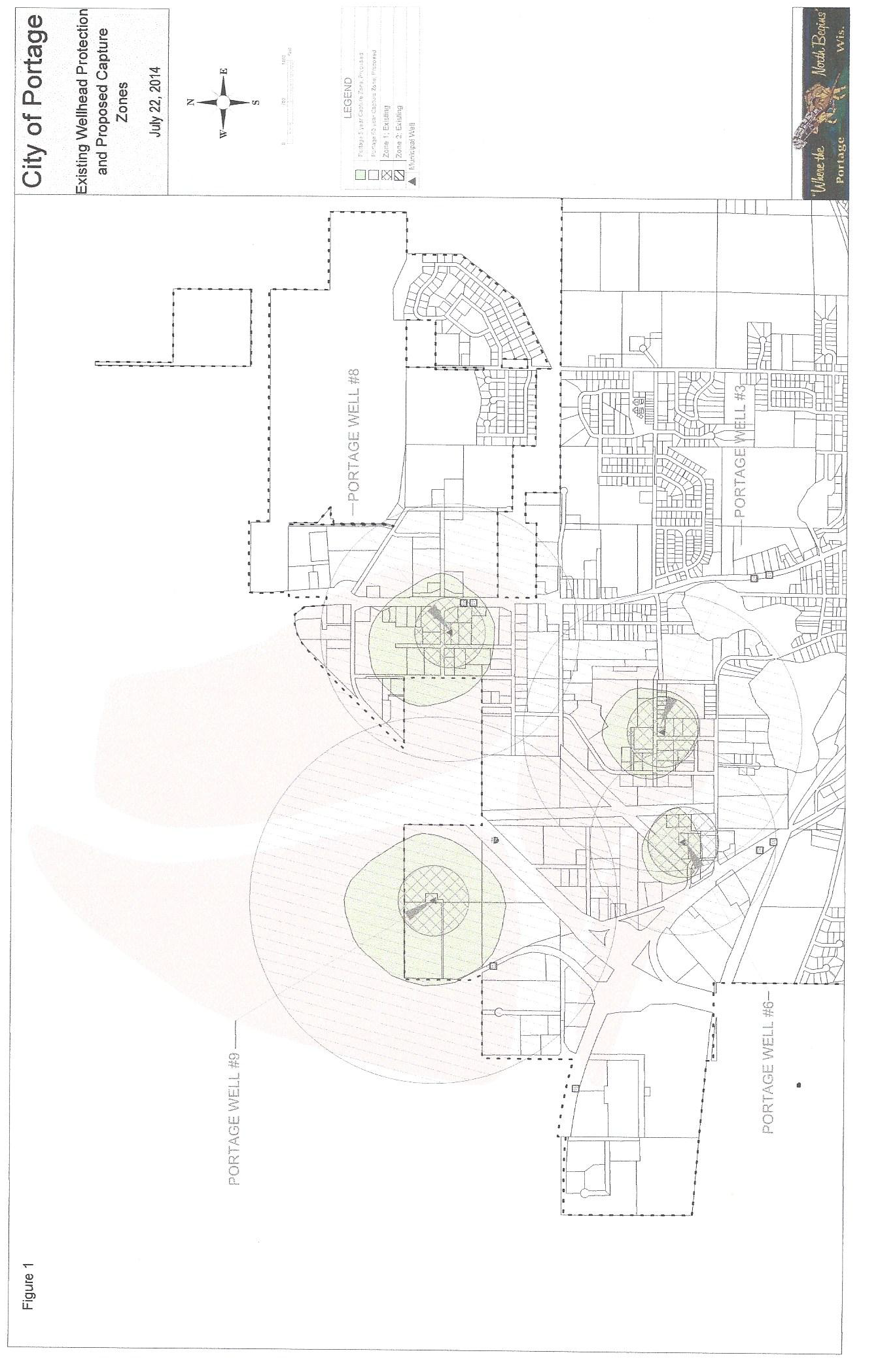
(a)
Zone 1: The area of land which lies within a 600-foot radius of each municipal well or included in the 5-year ground water capture zone, whichever is greater as identified on Figure 1. Zone boundaries are normalized to road centerlines, railways, surface water features, and include all of any tax parcel touched by the Zone 1 boundary.
(b)
Zone 2: The area of land surrounding each municipal well included in the 50-year ground water capture zone as identified on Figure 1. Zone 2 does not include the area included in the five-year ground water capture zone. Zone boundaries are normalized to road centerlines, railways, surface water features, and include all of any tax parcel touched by the Zone 2 boundary.
(9)
Groundwater protection overlay district boundaries.
(a)
The locations and boundaries of the groundwater protection overlay district established by this section are set forth schematically on Figure 1, "City of Portage—Wellhead Protection Overlay District". Said figure, together with everything shown thereon and all amendments thereto, shall be as much a part of this section as thoughtfully set forth and described herein.
(b)
The wellhead protection zones shall be located by land survey methods by the applicant to determine exact parcels affected.
(10)
Permitted uses.
(a)
The following permitted uses in Zone 1 are subject to the separation distance requirements as listed in NR 811.12(5)(d) and prohibited uses of this section in addition to applicable design and operational standards:
1.
Public and private parks, playgrounds and beaches, provided there are no on-site wastewater disposal systems or holding tanks.
2.
Wildlife and natural and woodland areas.
3.
Biking, hiking, skiing, nature, equestrian, and fitness trails.
4.
Municipally sewered residential uses whose aggregate storage and/or use of regulated substances do not exceed 20 gallons or 160 pounds at any time.
5.
Commercial, industrial, and other non-residential uses that are municipally sewered and whose aggregate use, handling, and/or storage of regulated substances do not exceed 20 gallons or 160 pounds at any time.
6.
Routine tillage, planting, and field management operations in support of agricultural crop production, where nutrients from legume, manure, and commercial sources are accounted for and credited toward crop nutrient need. The combination of all nutrient sources applied or available on individual fields may not exceed University of Wisconsin soil test recommendations for that field.
(b)
The following permitted uses in Zone 2 are subject to the separation distance requirements as listed in NR 811.12(5)(d) and prohibited uses of this section in addition to applicable design and operational standards:
1.
All of the uses permitted in Zone 1.
2.
Residential use of aboveground LP gas tanks for heating, not to exceed 1,000 gallons.
3.
Commercial, industrial, and other non-residential uses that primarily warehouse, wholesale, and/or retail various substances, which may or may not be regulated substances, but are in all cases handled as sealed containers not larger than 55 gallon drums. Handling regulated substances shall require transmitting copies of applicable permits and a current emergency contingency plan for containment annually to the city fire department.
4.
Commercial, industrial, and other non-residential uses that utilize various regulated substances where such regulated substances are used as part of a process or in some other way that is ancillary to the use. Process and use of regulated substances shall require transmitting copies of applicable permits and a current emergency contingency plan for containment annually to the city fire department and a physical containment design, sealed by a state-registered professional engineer with experience in environmental containment design, appropriate to the scope of the process and/or use of the regulated substances.
(11)
Separation distance requirements.The separation distances as specified in Wis. Admin. Code section NR 811.12(5)(d) as amended, shall be maintained unless a hydrogeologic investigation indicates lesser separation distances would provide adequate protection of a well from contamination or Department of Natural Resources approved treatment is installed to address the potential contamination concerns.
(12)
Prohibited uses. The following uses are prohibited in Zones 1 and 2:
(13)
Classification of use. Classification of a use as being permitted, prohibited, or conditional shall be determined by an application submitted to the groundwater technical review committee. The application shall be in writing and shall describe in detail the use, activities, and structures proposed along with the quantities, use of, storage, and handling of all regulated substances. A scaled site map showing all building and structure footprints, driveways, loading docks, sidewalks, parking lots, storage yards and any other information deemed necessary shall be included.
(a)
Application. The above-described application shall be submitted to the city engineer for inclusion on a meeting agenda for the groundwater technical review committee. The groundwater technical review committee may request additional information as deemed necessary to facilitate a determination.
(b)
Investigation. The groundwater technical review committee shall investigate as necessary in order to compare the nature and characteristics of the proposed use with those that are permitted, conditional, or prohibited.
(c)
Determination. The groundwater technical review committee shall determine the use as being permitted, prohibited, or conditional. The determination of the groundwater technical review committee shall be rendered in writing within 60 days from receiving all requested information and shall include findings supporting the conclusion.
(14)
Conditional use permits.
(a)
Any person may request a conditional use permit for certain uses, activities, and structures within Zone 2 of the groundwater protection overlay district not prohibited in this section pursuant to the terms set forth below and those contained in this chapter. No conditional use permit may be granted to any use, activity, or structure in Zone 1.
(b)
Use, storage handling, or production processing of regulated substances in excess of quantities outlined this section may be conditionally allowed in Zone 2 of the groundwater protection overlay district.
(c)
All properly prepared requests for a conditional use permit shall be submitted in writing to the city engineer for a review of permit application materials by the groundwater technical review committee. After review by the groundwater technical review committee, the request and recommendation of the groundwater technical review committee will then be forwarded to the city clerk, for inclusion on the agenda of the next plan commission meeting. In addition to the requirements of section 90-472, a conditional use permit application covering property within Zone 2 shall include:
1.
A site plan map set showing all proposed building and structure footprints, driveways, sidewalks, parking lots, stormwater management structures, groundwater monitoring wells, two-foot ground elevation contours and including any of the above, if existing at the time of plan submittal. The plan set should also include building plans (including floor plans of typical floors and denote all entrances, exits, loading docks, building service areas, etc.), storage areas for regulated substances, grading plans showing existing and proposed grades and contours, proposed surface water drainage patterns, catch basin and storm sewer locations, connections to existing utilities and a construction site erosion control plan. The site plan set shall be developed in accordance with the design standards as defined in this section.
2.
An operational plan and/or other documentation which describes in detail the use, activities, and structures proposed. The operational plan shall be developed in accordance with the operational standards established for the wellhead protection overlay district as defined in this section.
3.
An environmental risk assessment report prepared by a licensed environmental professional which details the risk to, and potential impact of, the proposed use, activities, and structures on groundwater quality.
4.
An operational safety plan, which details the operational procedures for material processes and containment, best management practices, stormwater runoff management, and groundwater monitoring as required.
5.
A contingency plan which addresses in detail the actions to be taken should a contamination event caused by the proposed use, activities, or structures occur.
(d)
The plan commission shall decide upon a request for a conditional use permit only after full consideration of the recommendations made by the groundwater technical review committee. Any provisions above and beyond those specified by this section that are recommended by the groundwater technical review committee may be applied to the granting of the conditional use permit by the plan commission.
(e)
All conditional use permits granted under this chapter shall be subject to provisions that will include environmental and safety monitoring determined necessary to afford adequate protection of the public water supply. These provisions shall include, but not be limited to:
1.
Provide current copies of all federal, state, and local facility operation approval or certificates and ongoing environmental monitoring results to the city.
2.
Establish environmental or safety structures/monitoring to include an operational safety plan, material processes and containment, operations monitoring, best management practices, stormwater runoff management, and groundwater monitoring.
3.
Replace equipment or expand in a manner that improves the environmental and safety technologies being utilized.
4.
Prepare, file, and maintain a current contingency plan which details the response to any emergency which occurs at the facility, including notifying municipal, county, and state officials. Provide a current copy to the city.
(f)
The person making the request shall reimburse the city for fees and expenses associated with this review at the invoiced amount, plus administrative costs.
(g)
The conditional use permit will become effective only after any costs incurred during the conditional use permit application review are satisfied by the applicant.
(h)
Conditional use permits are nontransferable. In a case of business or property transfer, the new owner is responsible for applying for a new conditional use permit.
(15)
Design and operational standards.
(a)
The following design standards apply to permitted land use activities within the Wellhead Protection Overlay District:
1.
All parking lots shall be paved with asphalt or concrete.
2.
All stormwater retention/infiltration ponds shall use a design intended to maximize natural filtration. When deemed necessary by the city engineer, the designs shall include spill containment measures, initial and secondary detainment weirs and/or outfall control valves.
(b)
The following design standards apply to conditional use activities within Zone 2 of the Wellhead Protection Overlay District:
1.
Facilities that handle regulated substances shall have a loading/unloading area designated for the handling of regulated substances. The designated loading/unloading area shall be designed with spill and/or runoff containment. Regulated substances may be loaded/unloaded only in a designated handling area.
2.
Storage areas for regulated substances shall be designed with secondary containment capable of controlling 125 percent of the maximum design capacity of the liquid and/or solid storage area.
3.
Facilities involved in the handling of regulated substances will, when required by the committee, prepare a groundwater monitoring plan.
4.
All rail spurs used to transport regulated substances shall be designed to minimize infiltration and convey runoff to a stormwater conveyance system. Rail car loading/unloading areas used to handle regulated substances shall be designed with spill and/or runoff containment.
(c)
The following operational standards apply to permitted land use activities within the wellhead protection overlay district:
1.
Regulated substances associated with paving, the pouring of concrete, or construction for which all necessary permits have been obtained may be handled in the groundwater protection overlay district, provided such regulated substances are present at the construction site for which the permits have been issued and do not pose a real and present danger of contaminating surface and/or groundwater. For the on-site storage of fuel for vehicles or other equipment, which may be associated with such construction activity, the fuel storage containers shall be secondarily contained. Regulated substances not used in the construction process and all wastes generated during construction shall be removed from the construction site not later than at the time of the completion of the construction. If construction activity has ceased for 30 days, all regulated substances shall be removed from the site until such time as the construction activity is to resume.
2.
The use of deicing salt or other chemical deicing materials shall be minimized and used only when threats to safety occur.
(d)
The following operational standards apply to conditional use activities within Zone 2 of the wellhead protection overlay district:
1.
All operational standards listed in this section.
2.
Except in the case of seasonal discontinuation of operation, the owner or operator of any non-residential property that becomes unoccupied or has discontinued operation for a period of 30 consecutive days shall remove all regulated substances from the property, except those approved to be exclusively used for heating, cooling, and providing electrical lighting for the premises, within 30 days after the date upon which the property initially became unoccupied or the operation discontinued. The owner or operator shall secure the regulated substances on the property until they have been removed. The owner or operator shall notify the city engineer in writing of the date of the cessation of operation or the property becoming unoccupied no later than the day upon which the operation actually ceases or the property becomes unoccupied, and such notification shall include the owner's name, phone number, and address and the operator's name, phone number, and forwarding address.
3.
Truck, truck trailer, rail car, or tank truck loading and unloading procedures for regulated substances shall meet the minimum requirements of the U.S. Department of Transportation and the state department of transportation.
4.
No truck, trailer, rail car, or tank truck shall be used for on-site storage of regulated substances. Regulated substances shall be transferred from the delivery vehicle to the regulated substance storage area as soon as possible and shall occur only in designated loading/unloading areas.
5.
Warning signs and chock blocks shall be provided in the loading and unloading area to prevent premature vehicular departure.
6.
No outdoor storage of product, material, or equipment other than that approved through the conditional use permitting process shall be allowed. Any designated outdoor storage area shall be an impervious surface paved with concrete or asphalt and have secondary containment.
7.
Daily visual inspections of regulated substances shall be conducted by the holder of the conditional use permit to check for container damage or leakage, stained or discolored storage surfaces in all storage areas, excessive accumulation of water in outdoor curbed areas, and to ensure that dike drain values are securely closed in outdoor curbed areas.
8.
Storage areas for regulated substances shall have access restricted to properly authorized and trained personnel.
9.
The holder of a conditional use permit shall provide adequate training to ensure that operational safety plans and contingency plans are understood by all authorized personnel.
10.
A holder of a conditional use permit using or producing regulated substances shall have an adequate quantity of spill response equipment and supplies onsite to contain and cleanup spills of regulated substances.
11.
Annual spill prevention briefings shall be provided to authorized personnel by company management to ensure adequate understanding of the operational safety and contingency plans. These briefings shall highlight any past spill events or failures and recently developed precautionary measures. Annually, records of these briefings shall be provided to the fire department.
12.
Instructions and phone numbers for reporting spills to the fire department and other local, state, and federal agencies shall be posted in all areas where regulated substances are handled.
(16)
Requirements for existing facilities. Existing facilities within the groundwater protection overlay district at the time of enactment of such district which are considered a prohibited use by this section or a conditional use, each of which are incorporated herein as if fully set forth, shall be subject to the following requirements:
(a)
Such existing facilities shall provide copies of all current, revised or new federal, state, and local operation approvals, permits or certificates; operational safety plans; and ongoing environmental monitoring results to the fire department.
(b)
Such existing facilities shall have the responsibility of devising, filing, and maintaining with the fire department, a current contingency plan, satisfactory to the city, for immediate notification of municipal, county, and state officials in the event of an emergency.
(c)
Such existing facilities will be allowed to upgrade the facilities to facilitate or enhance groundwater protection. Plans for the proposed upgrade must be approved by the plan commission and common council and appropriate permit issued by the public works department, prior to any work being initiated. Expansion of any prohibited use will not be allowed. This section does not apply to normal maintenance or minor repairs.
(17)
Changing technology.
(a)
The uses prohibited by this district are prohibited based upon the combined pollution experience of many individual uses, and the technology generally employed by a particular use considered to be of a high risk for pollution to the groundwater resource. As the technology of other uses change to low or non-risk materials or methods and after conferring with the groundwater technical review committee or other expert opinion, the city, through appropriate procedures and actions to change these provisions of this Code, may remove from the designated prohibited uses such uses as are demonstrated convincingly that they no longer pose a groundwater pollution hazard.
(b)
In dealing with uses which attempt to become permissible by continuing to utilize pollutant materials but altering their processing, storage, and handling it is not the city's intent to accept alternate or reduced hazards as the basis for making a use permissible. The city intends to continue to prohibit such uses until the technology of the use removes reliance upon the pollutant materials or processes deemed to be a groundwater hazard.
(18)
Enforcement and penalty.
(a)
Penalty. Any person who violates, neglects, or refuses to comply with any of the provisions of this section shall be subject to a penalty as provided below.
(b)
Injunction. The city may, in addition to any other remedy, seek injunction or a restraining order against the party alleged to have violated the provisions herein, the cost of which shall be charged to the defendant in such action.
(c)
Notice of violation.
1.
Any person found in violation of any provisions of this section will be served with a written notice stating the nature of the violation and providing reasonable time for compliance.
2.
The notice shall be served in the manner provided by the law for the service of civil processes. Where the address of the violator is unknown, service may be made upon the owner of the property involved at the tax-mailing address of the owner as shown on the county tax record.
(d)
Inspections. Subject to applicable provisions of law, the city building inspector, city engineer, fire inspector, or any authorized representative thereof shall be permitted to enter private property at any reasonable time, with reasonable cause or with prior notification, for such purposes as inspection, observation, measurement, sampling, and records examination pertaining to the requirements of this section to ensure that activities are in accordance with the provisions of this section. Upon request of the entity which is the subject of the inspection, and if permitted by the state public records law (Wis. Stats. §§ 19.31—19.39), information obtained as a result of the inspection shall be maintained as confidential. If the owner or tenant does not consent to the entry of the appointed individual for the above stated purposes, the city may apply to a court of competent jurisdiction for an appropriate warrant or other authority to enter said property.
(e)
Subject area. The area subject to the provisions of this section is the wellhead protection overlay district as shown on the official zoning map of the city.
(f)
Determination of applicability. It shall be the responsibility of any person owning real property and/or owning or operating a business within the wellhead protection overlay district to make a determination of the applicability as they pertain to the property and/or business, and failure to do so shall not excuse any violation of said sections.
(g)
Management.
1.
No persons shall place, deposit, or permit to be deposited, store, process, use, produce, dispose of, transport, or discharge, hereinafter referred to as "handle," any regulated substance on public or private property within the wellhead protection overlay district or in any area under the jurisdiction of said district, except as provided by law, statute, ordinance, rule, or regulation.
2.
Any violation of this section is hereby declared a nuisance.
(h)
Spills, leaks or discharges.
1.
Any person with direct knowledge of a spill, leak or discharge of a regulated substance within the wellhead protection overlay district shall, if such spill, leak, or discharge escapes containment or contacts a non-impervious ground surface and is not immediately and completely remediated, give notice to the fire department utilizing the countywide 911 service within 30 minutes. The notification shall include, at a minimum, the location of the incident, name and telephone number of the contacting party, date and time thereof, type of substances, concentration and volume, and control or corrective action taken. Such notification shall in no way alleviate other local, state, and federal reporting obligations.
2.
Any entity or person who spills, leaks or discharges said substances shall be liable for any reasonable expense, loss or damages incurred by the city in response to such an incident, in addition to the amount of any fines imposed on account thereof under state and federal law; said entity or person shall document and maintain sufficient records so as to reflect accurately the circumstances related to any such incident and develop and implement procedures to substantially eliminate the likelihood of reoccurrence of such spills, leaks or discharges as soon as practicable following the incident, but no later than 180 days after the incident.
(i)
Cleanup costs. In addition to any other action or remedy, the city may commence legal action against both the person who releases the contaminants and the owner of the facility whereupon the contaminants were released to recover the city's costs, including costs of prosecution. Any person who causes the release of any contaminants which may endanger or contaminate the municipal water supply system associated with the groundwater protection overlay district shall immediately cease such discharge and immediately initiate cleanup satisfactory to the city and any other state and/or federal regulatory agencies. The person who releases such contaminants and the person who owns the facility whereon the contaminants have been released shall be jointly and severally responsible for the cost of cleanup and other fees, including all administrative costs for oversight, review and documentation, including the city employees, equipment, and mileage.
(Ord. No. 13-005, § 1, 3-28-2013; Ord. No. 14-019, 8-28-2014)
Sec. 90-98. - S-B sexually oriented business overlay district.
(1)
Description and Purpose. The City of Portage, relying on the experience of other local governments in this state and throughout the country, finds as follows:
(a)
That sexually oriented businesses may have an adverse secondary effect on the surrounding community because the sexual nature of the business may, regardless of the intentions of the proprietors, attract persons seeking prostitution or unlawful drugs, or who are inclined to be disorderly or disruptive.
(b)
Sexually oriented businesses are typically intense commercial uses which create a large volume of foot and automobile traffic in the vicinity of the business, which may require police and other municipal services which may not be available in the townships surrounding the city.
(c)
Sexually oriented businesses have their peak activity at hours and days which are incompatible with residential and most other commercial uses.
(d)
Because of the potential for negative impacts on property values, the peace and good order of the city and the welfare of the individuals affected by sexually oriented businesses, it is necessary to minimize the secondary effects of sexually oriented businesses and assure that such establishments are not located in places which pose unacceptable conflicts with existing or planned land uses.
(e)
It is the intent of this section to protect the health, safety, and welfare of the citizens of the city and to further preserve the quality of family life and to preserve the urban and rural characteristics of its neighborhoods.
(f)
The intent of the S-B sexually oriented business overlay district is solely to regulate the location of such establishments, not the content of any presentation or materials held for sale, rent, or loan.
(g)
Nothing in this section shall be construed to permit the regulation of any activities conducted in sexually oriented businesses which are entitled to protection under the First Amendment of the United States Constitution, including:
1.
Plays, operas, musicals, or other dramatic works that are not obscene;
2.
Classes, seminars, or lectures which are held for a serious scientific or educational purpose that are not obscene.
3.
Whether or not an activity is obscene shall be judged by consideration of the following factors:
a.
Whether the average person, applying contemporary community standards, would find that the activity, taken as a whole, appeals to the prurient interest in sex;
b.
Whether the activity depicts or describes sexual conduct in a patently offensive way, as measured against community standards; and
c.
Whether the activity, taken as a whole, lacks serious literary, artistic, political, or scientific value.
(2)
Definitions.
(a)
A sexually oriented business shall be defined as any business that conducts any live performance that includes nudity and/or sexual activities or any business that devotes more than ten percent of its available floor, wall, and display space open to the public for sale, rent or loan of books, movies, novelties, or other item(s) that include any pictures, photographs, drawings, motion pictures films or similar visual representations or images of a person or portions of the human body which are distinguished or characterized by their emphasis on matters depicting, describing, or relating to sexual activities or nudity.
(b)
Nudity shall mean the showing of any human genitals, pubic area, vulva, anus, or anal cleft with less than a fully opaque covering, the showing of the female breast with less than a fully opaque covering of any part of the areola or nipple, or the showing of the covered male genitals in a discernibly turgid state.
(c)
Sexual activities shall mean the fondling of another person's genitals, pubic region, anus or female breasts; actual or implied sex acts including intercourse, oral copulation, masturbation or sodomy; or any sexual acts prohibited by Wisconsin Statutes.
(3)
Overlay District. The overlay district shall apply only to those lands in the City of Portage zoned A-I agricultural district, lying south of the Wisconsin River and/or south and east of Ontario Street.
(4)
Permitted Use. A sexually oriented business shall be a permitted use within the overlay district.
(5)
Siting Standards. Sexually oriented businesses shall meet all of the following requirements:
(a)
No sexually oriented business may be located within 1,000 feet, as measured from nearest front door to nearest front door, from any church, synagogue, temple, mosque or other place of worship, residentially zoned district, residential use regardless of zoning, school, day care center, public library, and other sexually oriented business or within 1,000 feet, as measured from the front door to the closest property boundary of a park, playground, or interstate highway.
(b)
There shall be no display windows on the premises.
(c)
The exterior building appearance and signage shall be designed to ensure that the use does not detract from the ability of businesses in the vicinity to attract customers, nor affect the marketability of properties in the vicinity for sale at their assessed values.
(d)
The business may have only one non-flashing business sign, which must be on the premises occupied by the business, may only indicate the name of the business and identify it as a sexually oriented business and shall be no larger than four feet by four feet.
(e)
A one square foot sign shall be placed on each public entrance which shall state "Admittance to adults only" and may include other pertinent business information.
(f)
The owner and operator of a sexually oriented business shall agree to comply with all federal, state, and local laws and ordinances, including those regulating obscenity and alcoholic beverages, and shall further insure that minors are not allowed on the premises;
(g)
There shall be no areas in a sexually oriented business where entertainment is provided which are not fully visible from the main area of the establishment (i.e., there shall be no areas set off by doors, curtains, screens, barriers, café, saloon doors, or other obstructions where entertainment is provided).
(h)
Minimum required parking: One space per 300 square feet of gross floor area, or one space per person at the maximum capacity of the establishment (whichever is greater).
(i)
Severability. The provisions of this section shall be severable if so determined by the Common Council.
(Ord. No. 13-005, § 1, 3-28-2013)