
Purcellville City Zoning Code
ARTICLE 4
- OVERLAY DISTRICTS
Sec. 4.1.- Intent of overlay districts.
The overlay districts in Article 4 are established to provide special regulations in designated areas of the Town of Purcellville, with the chief intent to implement the goals of the 2030 comprehensive plan for each of these districts.
(a)
Applicability. Overlay districts in Article 4 are zoning districts that overlap and overlay applicable underlying zoning districts, and also may overlap other applicable overlay districts, so that any land subject to an overlay district also is subject to the underlying zoning district, as well as any other overlay district that the land is located within. The overlay districts are organized into three general categories: Focus area districts, environmental overlay districts, and architectural review overlay districts.
(b)
Overlay district boundaries. Refer to Section 2.4 for provisions related to the interpretation of overlay district map features and overlay district boundaries and the town official zoning map.
(c)
Specific definitions. Defined terms used in an overlay district are provided in Article 11. Additional defined terms used specifically in Section 4.12, Floodplain overlay district, are provided in Section 4.12.7. Additional defined terms used specifically in Section 4.13, Architectural review overlay districts, as provided in Section 4.13.1.
(d)
Uses. Unless otherwise provided, principal and accessory uses in an overlay district are allowed only to the extent such uses are allowed by the underlying zoning district and any other applicable overlay district and are in conformance with all other applicable regulations of the zoning ordinance. Overlay districts may regulate accessory uses that do not otherwise appear in Article 3.
(e)
Additional procedures. Specific additional procedures in overlay districts, including submission requirements, are provided in Article 10, Administration and procedures.
Sec. 4.2. - List of overlay districts.
The following overlay districts are established within the Town of Purcellville:
Focus area overlay districts:
(1)
DN downtown north overlay district.
(2)
DSE downtown southeast overlay district.
(3)
DSW downtown southwest overlay district.
(4)
EM east main overlay district.
(5)
HE Hirst east overlay district.
(6)
HW Hirst west overlay district.
(7)
WE west end overlay district.
Environmental overlay districts:
(8)
FP floodplain overlay district.
Architectural review overlay districts:
(9)
ACO architectural control overlay district.
(10)
HCO historic corridor overlay district.
(11)
HPO historic properties overlay district.
Sec. 4.3. - Authority.
(1)
The authority of the Town of Purcellville to establish overlay district regulations of building placement, uses, heights, forms, and other site design elements is derived from the Code of Virginia, Title 15.2, Chapter 22.
(2)
The authority to regulate architectural features, including design, materials, and appropriateness of buildings in a manner that is consistent with the design guidelines for the Town of Purcellville as established by the board of architectural review, is derived from:
(a)
The authority granted by the Code of Virginia, § 15.2-2306; and
(b)
The Town of Purcellville Charter, Chapter 4.1.
This ordinance, by including regulations of architectural features authorized by the Charter and the Code of Ordinances, does not usurp such authority.
(3)
The authority to regulate areas within the floodplain is granted to localities by Code of Virginia, § 15.2-2280.
Sec. 4.4. - Administration of overlay districts.
(1)
All standards regulated in the subsequent sections of Article 4: Overlay districts shall be administered by the zoning administrator as granted authority by this ordinance and Code of Virginia, Title 15.2, Chapter 22.
(2)
The architectural design considerations in the subsequent sections of Article 4: Overlay districts shall be considered in the review of an application for a certificate of design approval by the board of architectural review as per the architectural control overlay district (Town of Purcellville Code of Ordinances, Chapter 54, Article II, Subdivision II), the historic corridor overlay (Code of Virginia, § 15.2-2306) and the historic properties overlay district (Code of Virginia, § 15.2-2306).
(3)
The zoning administrator or his designee is appointed to administer and implement the regulations of the floodplain overlay district and is referred to herein as the floodplain administrator, per Section 4.12.16.
Sec. 4.5. - DN downtown north overlay district.
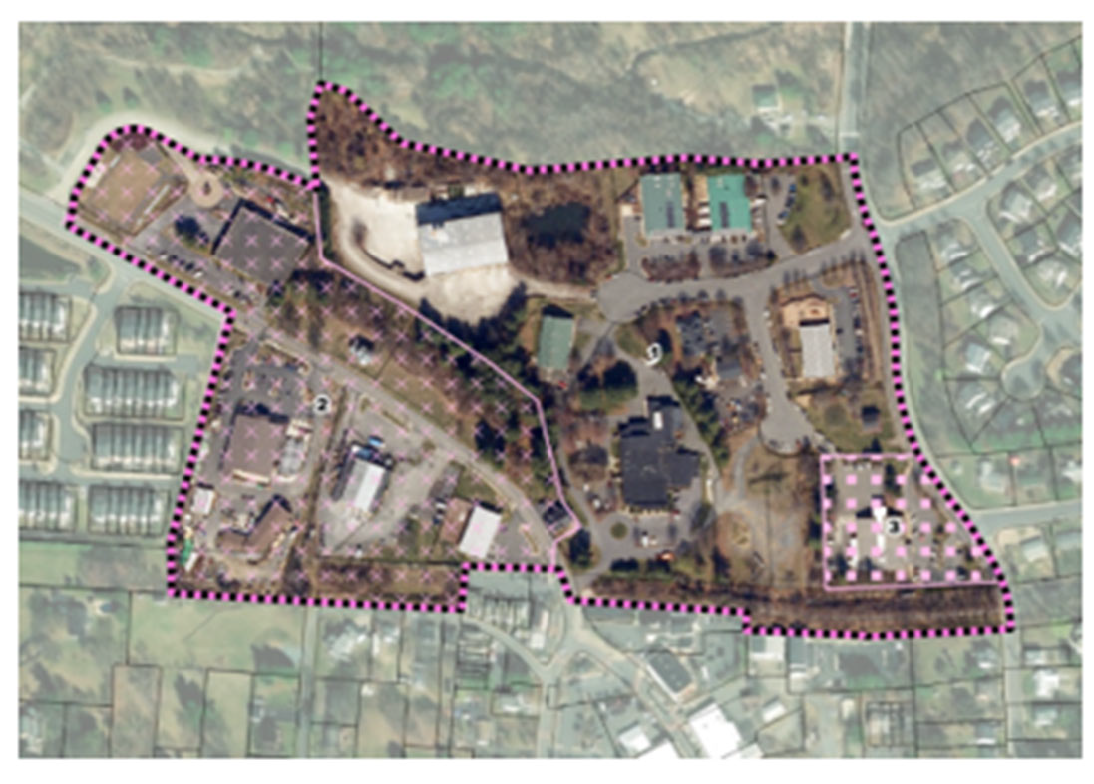
Figure 17: Map of the approximate area included in the downtown north overlay district. This map is not the official zoning map and should not be used to identify the zoning designation of individual properties.
Sec. 4.5.1. - Intent.
The downtown north overlay district shall be comprised of mixed-use neighborhood scale, commercial neighborhood scale, and institutional and government land use types as described in the 2030 comprehensive plan. The downtown north overlay district is established for the purpose of maintaining and promoting a compact walkable district, at a scale and character that is compatible with Purcellville's rural town traditions. The downtown north overlay district shall be comprised of commercial neighborhood scale in subarea 1, mixed-use neighborhood scale in subarea 2, and institutional and government land use types in subarea 3 as described in the 2030 comprehensive plan.
Sec. 4.5.2. - Applicability.
The standards of the downtown north overlay district shall be further governed through the creation of subareas.
(a)
Subarea 1 - Areas with their primary frontage along Hatcher Avenue, E. Cornwell Lane, and N. Brewster Lane.
(b)
Subarea 2 - Areas with their primary frontage along 21st Street.
(c)
Subarea 3 - Institutional and governmental uses.
Sec. 4.5.3. - Land use permitted.
No property shall be used for any purpose other than for such purpose permitted by the base district in which the property is located, except as modified by this section.
(a)
Subarea 1 - The sites may contain mixed commercial (MC) uses at the neighborhood scale consisting of a single building and use, or a group of buildings with multiple uses on single lot.
(b)
Subarea 2 - Multiple mixed uses (C4) may be permitted in a single building at the neighborhood scale, arranged both vertically and horizontally, subject to the provisions of Article 3: Uses.
(c)
Subarea 3 - Institutional and government use (post office).
Sec. 4.5.4. - Lot and bulk standards.
Sec. 4.5.5. - Site design standards.
Sec. 4.6.1. - Intent.
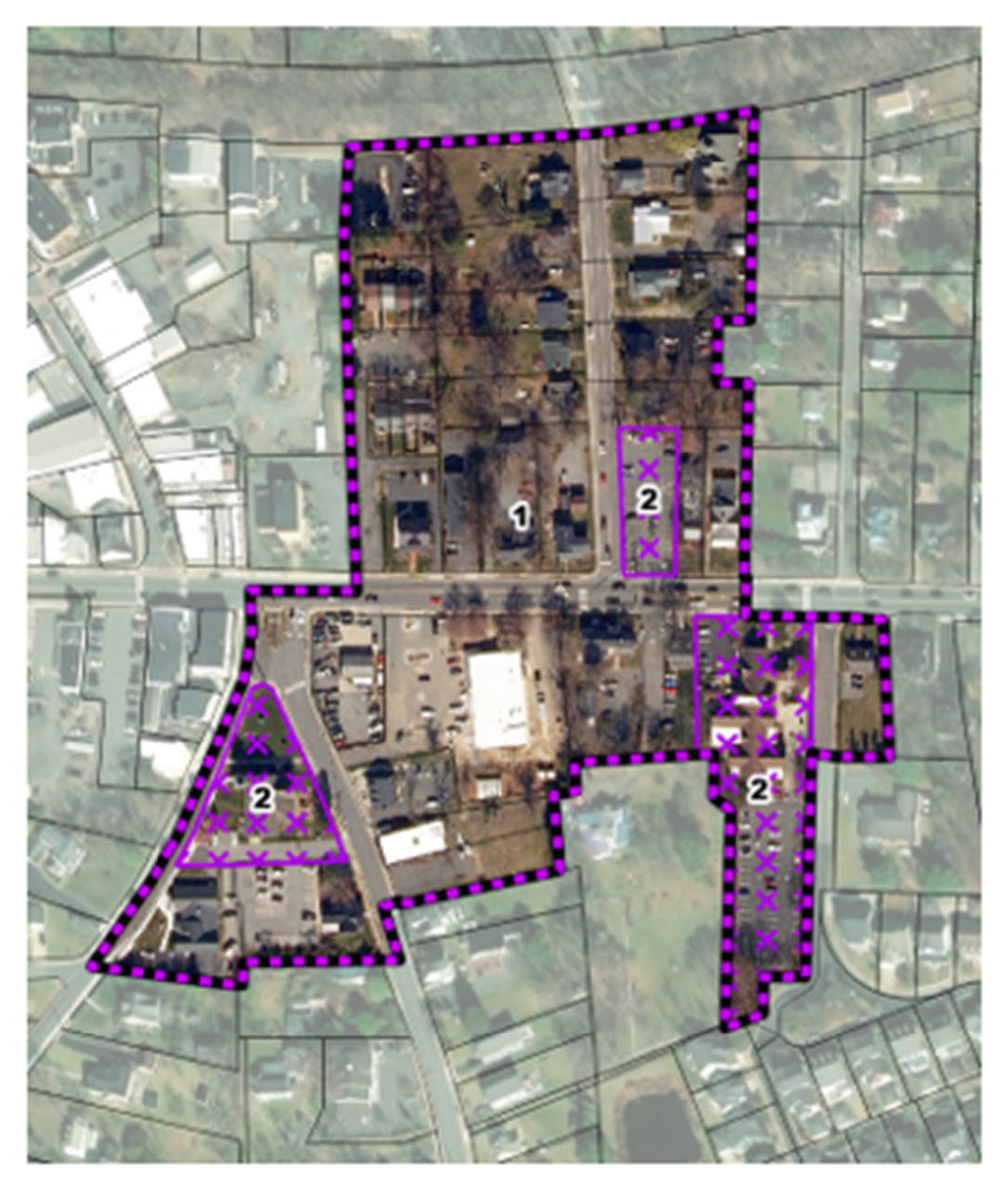
Figure 19: Map of the approximate area included in the downtown southeast overlay district. This map is not the official zoning map and should not be used to identify the zoning designation of individual properties.
The downtown southeast overlay district serves as a transition from residential areas to the east to core of downtown to the west. The downtown southeast overlay district shall be comprised of mixed-use neighborhood scale and institutional and government land use types as described in the 2030 comprehensive plan.
Sec. 4.6.2. - Applicability.
The standards of the downtown southeast overlay district shall apply to all areas mapped within the downtown southeast overlay district on the official zoning map. For any standards not specified for the downtown north overlay district, the standards of the base district shall apply.
Throughout this section, distinctions are made for buildings fronting Hatcher Street, and to the north or south of Main Street.
(a)
Subarea 1 - Mixed use neighborhood scale use.
(b)
Subarea 2 - Institutional and government use.
Sec. 4.6.3. - Land uses permitted.
No property shall be used for any purpose other than for such purpose permitted by the base district in which the property is located, except as modified by this section.
Mixed-use buildings that contain residential, office, and commercial uses, subject to the provisions of Article 3: Uses, shall be permitted.
Sec. 4.6.4. - Lot and bulk standards.
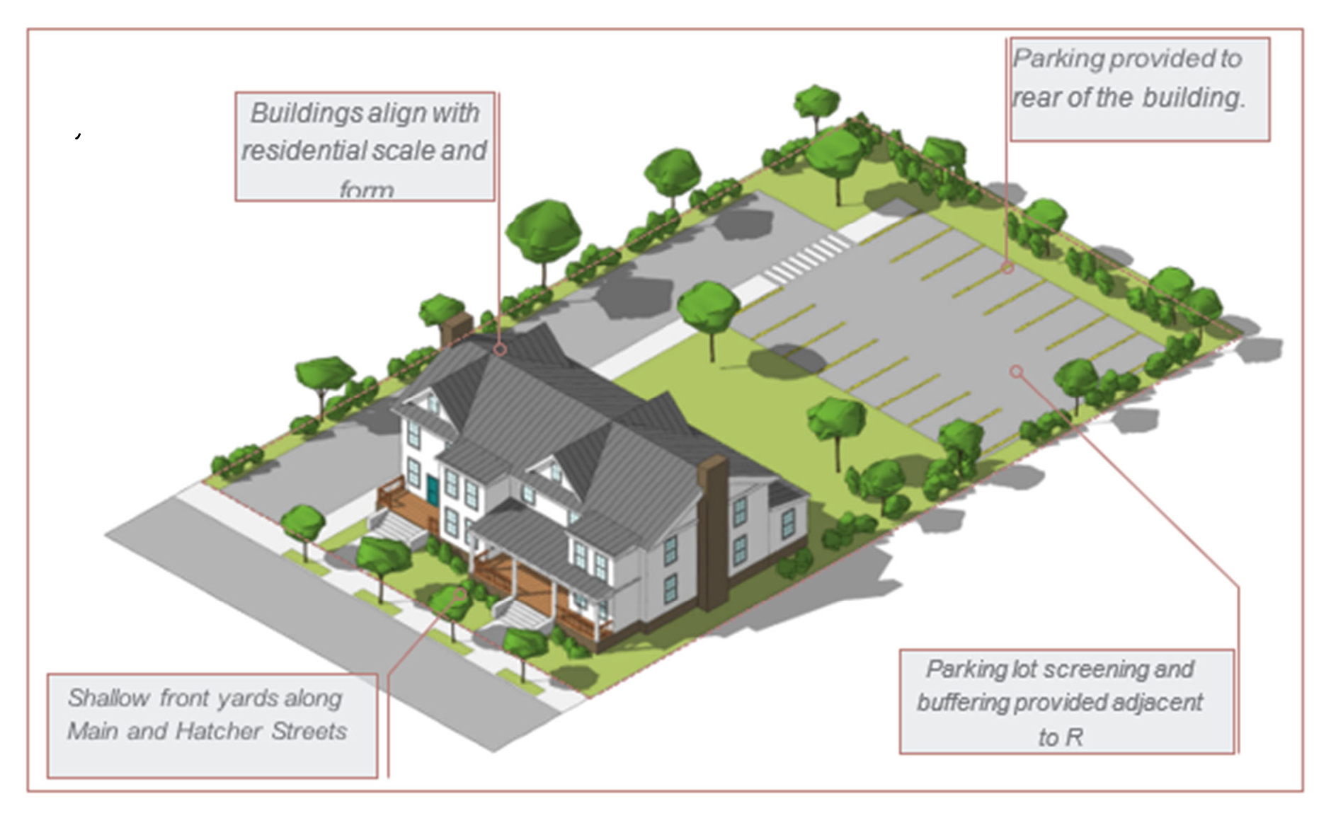
Figure 20: Diagram showing a plausible development along Main Street within the DSE overlay district.
Sec. 4.6.5. - Site design standards.
Sec. 4.7. - DSW downtown southwest overlay district.
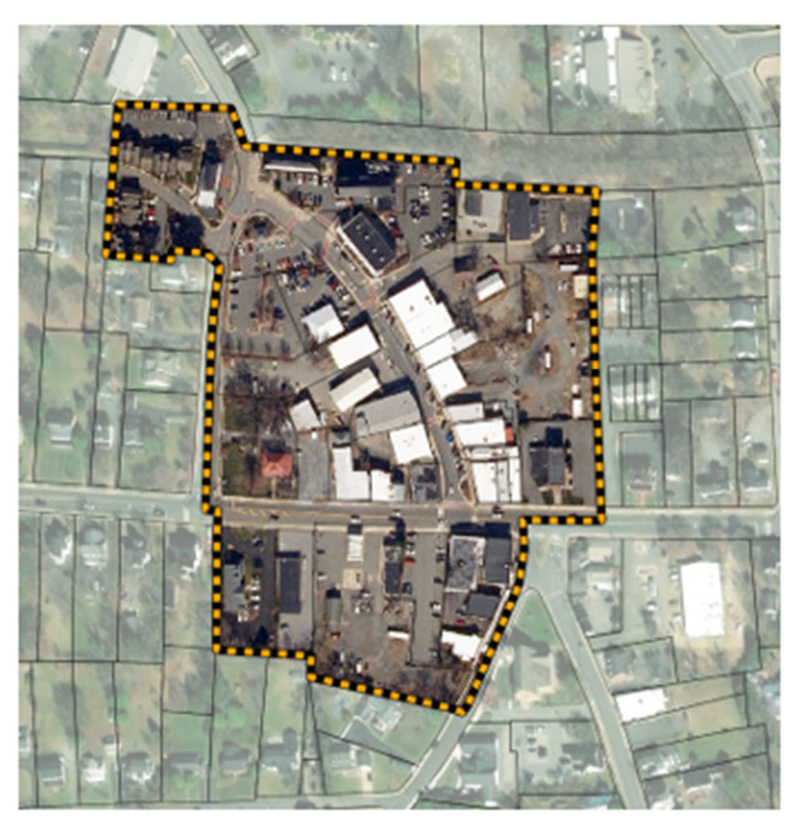
Figure 21: Map of the approximate area included in the downtown southwest overlay district. This map is not the official zoning map and should not be used to identify the zoning designation of individual properties.
Sec. 4.7.1. - Intent.
The downtown southwest overlay district serves the historic core of the town. The downtown southwest overlay district is comprised of mixed-use neighborhood scale and institutional and government land use types as described in the 2030 comprehensive plan.
Sec. 4.7.2. - Applicability.
The standards of the downtown southwest overlay district shall apply to all areas mapped within the downtown southwest overlay district on the official zoning map. For any standards not specified for the downtown southwest overlay district, the standards of the base district shall apply.
Throughout this section distinctions are made for buildings fronting 21st Street, and to the north or south of Main Street.
Sec. 4.7.3. - Land use permitted.
No property shall be used for any purpose other than for such purpose permitted by the base district in which the property is located, except as modified by this section.
Mixed-use buildings that contain residential, office, and commercial uses, subject to the provisions of Article 3: Uses, shall be permitted in a single building.
Sec. 4.7.4. - Lot and bulk standards.

Figure 22: Diagram showing a plausible infill development within the DSW overlay district.
Sec. 4.7.5. - Site design standards.
Sec. 4.8. - EM east main overlay district.
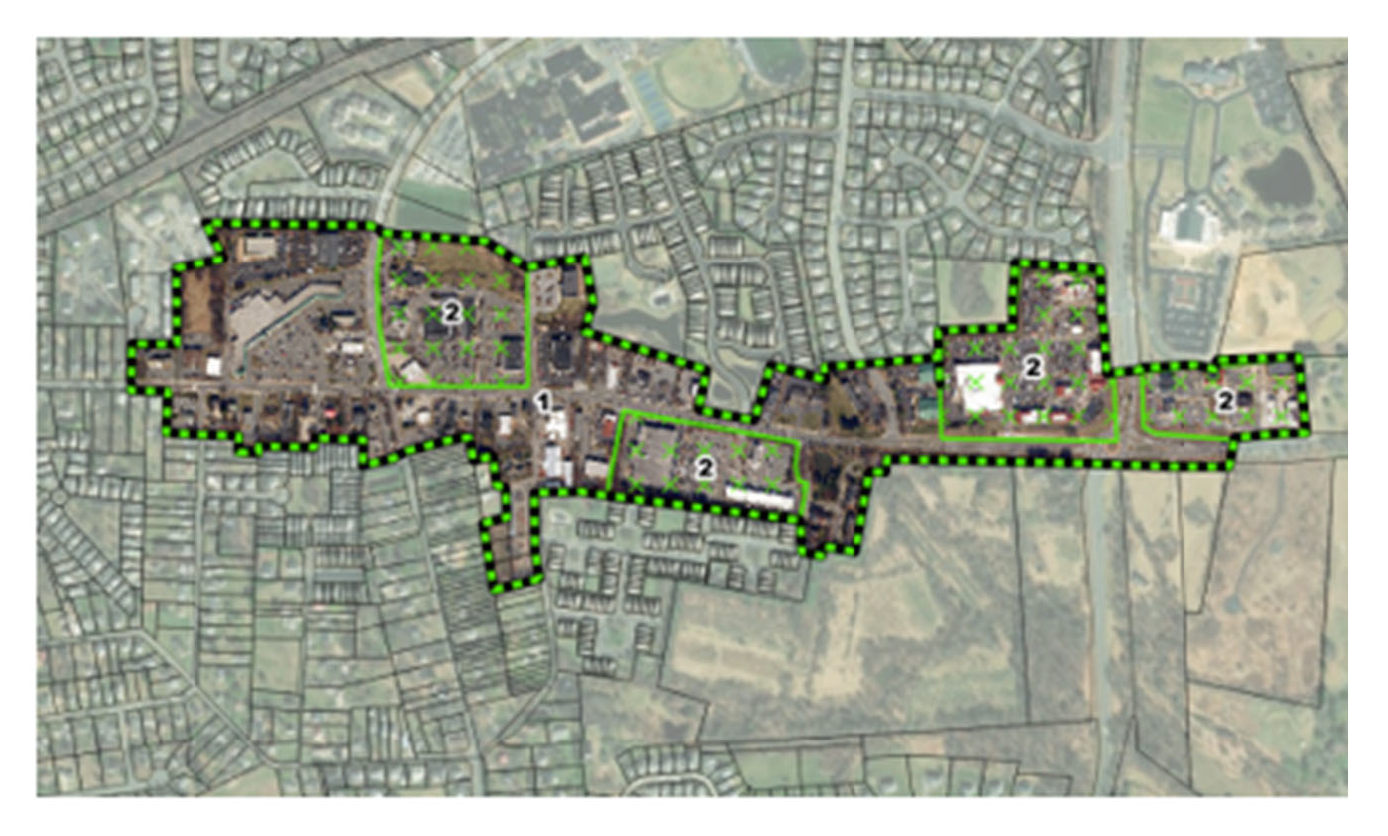
Figure 23: Map of the approximate area included in the east main overlay district. This map is not the official zoning map and should not be used to identify the zoning designation of individual properties.
Sec. 4.8.1. - Intent.
The east main overlay district is intended to promote a more pedestrian-friendly retail destination where it is easier to walk between surrounding neighborhoods and commercial uses. The scale of development should still remain compatible with the rural residential character of Purcellville. Enhancing the green space and tree canopy along Main Street and Maple Avenue, as well as providing more open spaces within the redevelopment, should be a top priority. The east main overlay district is comprised of commercial neighborhood scale and commercial medium scale land use types as described in the 2030 comprehensive plan.
Sec. 4.8.2. - Applicability.
The standards of the east main overlay district shall apply to all areas mapped within the east main overlay district on the official zoning map. For any standards not specified for the east main overlay district, the standards of the base district shall apply.
The regulations and standards of the east main overlay district shall be further governed through the creation of subareas.
(a)
Subarea 1 - Neighborhood scale commercial development.
(b)
Subarea 2 - Medium scale commercial development.
(c)
Subarea 3 - Single-family attached development.
Sec. 4.8.3. - Land uses permitted.
No property shall be used for any purpose other than for such purpose permitted by the base district in which the property is located, except as modified by this section.
(a)
Drive-through facilities.
i.
A special use permit for drive-through facilities may not be sought in subarea 1 of the east main overlay district.
ii.
Where a special permit to construct a drive-through facility in subarea 2 is sought, the drive-through shall not be located closer than 100 feet of Main Street.
Sec. 4.8.4. - Lot and bulk standards.
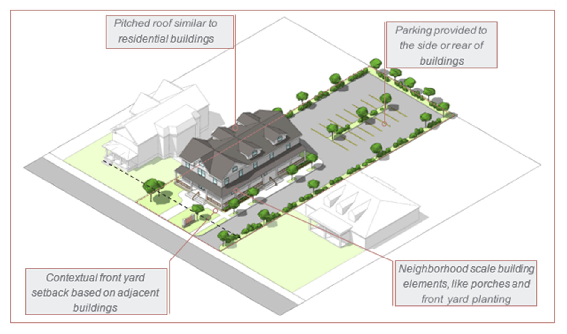
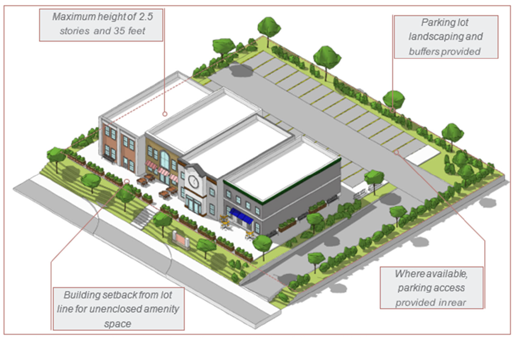
Figure 24: Diagram showing a plausible infill development within subarea 1 of the EM overlay district.
Sec. 4.8.5. - Site design standards.
Sec. 4.9. - HE Hirst east overlay district.
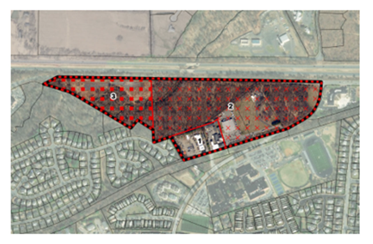
Figure 25: Map of the approximate area included in the Hirst east overlay district. This map is not the official zoning map and should not be used to identify the zoning designation of individual properties.
Sec. 4.9.1. - Intent.
The Hirst east overlay district offers significant development opportunities in Purcellville. It should be developed with green and open spaces, as well as some commercial, office, and light industrial uses that are compatible with the town's character. The overlay district is further divided into three subareas. The redevelopment in subarea 1 should be consistent with small format buildings compatible with the neighboring residential area, with sufficient surface parking and loading not adjacent to existing residential. The redevelopment in subarea 2 should be consistent with industrial or lesser intensity uses with sufficient surface parking. The development in subarea 3 should be small format professional office buildings. The Hirst east overlay district is comprised of commercial neighborhood scale, industrial business, and professional office land use types as described in the 2030 comprehensive plan.
Sec. 4.9.2. - Applicability.
The standards of the Hirst east overlay district shall apply to all areas mapped within the Hirst east overlay district on the official zoning map. For any standards not specified for the Hirst east overlay district, the standards of the base district shall apply.
The regulations and standards of the Hirst east overlay district shall be further governed through the creation of subareas.
(a)
Subarea 1 - Neighborhood scale commercial development area.
(b)
Subarea 2 - Industrial business area.
(c)
Subarea 3 - Professional office development area.
Sec. 4.9.3. - Land use permitted.
No property shall be used for any purpose other than for such purpose permitted by the base district in which the property is located.
Sec. 4.9.4. - Lot and bulk standards.
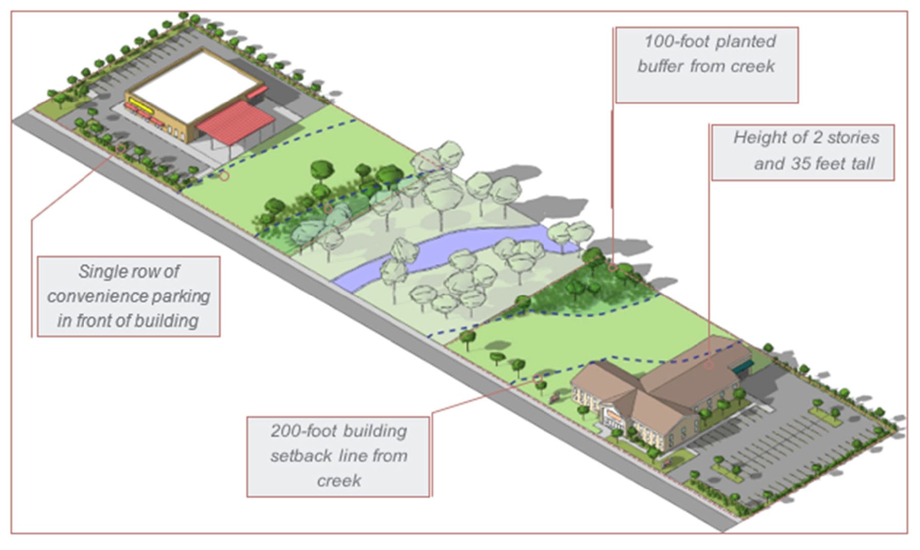
Figure 26: Diagram showing a plausible development within the HE overlay district. Notice the buffer along the creek.
Sec. 4.9.5. - Site design standards.
Sec. 4.10. - HW Hirst west overlay district.
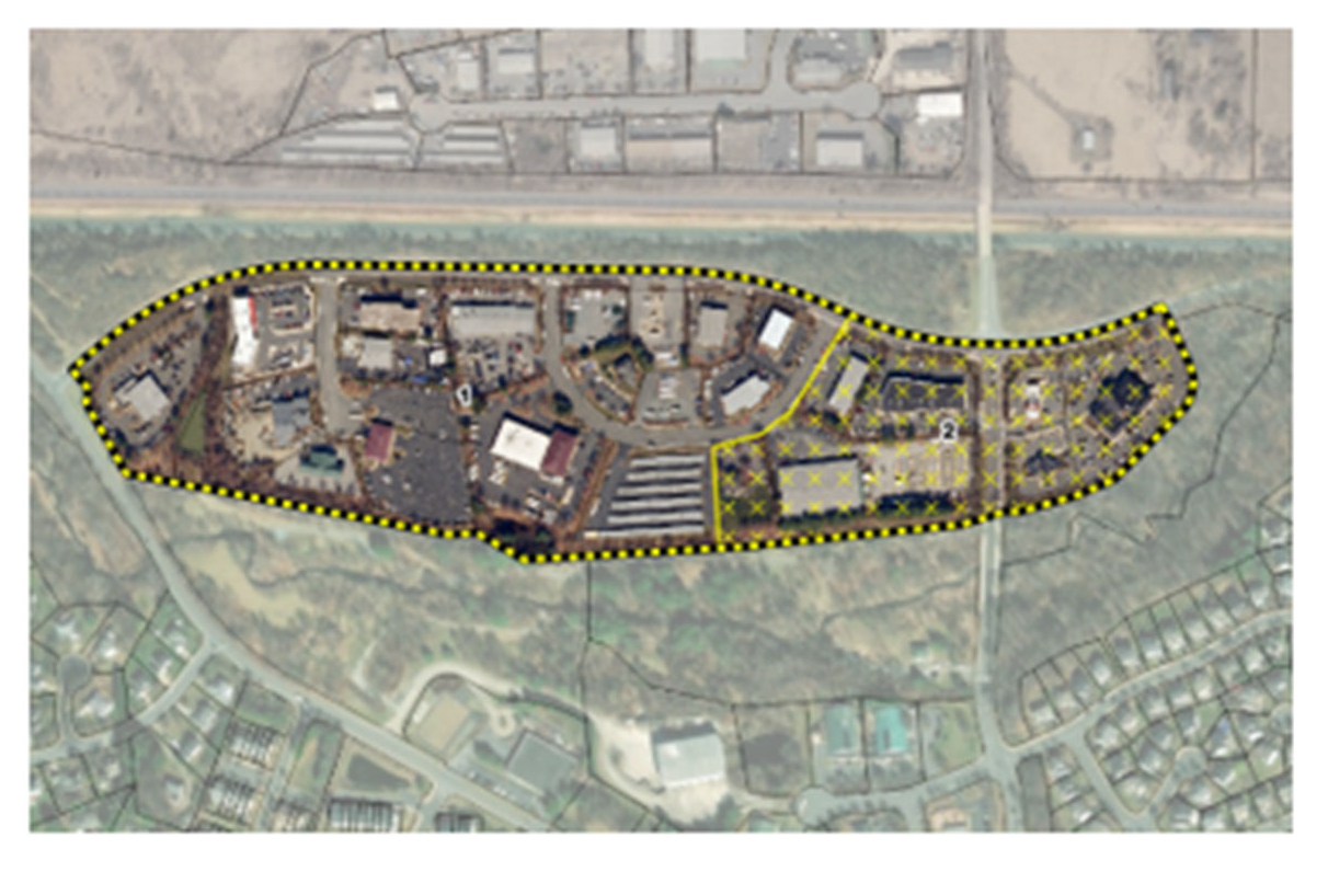
Figure 27: Map of the approximate area included in the Hirst west overlay district. This map is not the official zoning map and should not be used to identify the zoning designation of individual properties.
Sec. 4.10.1. - Intent.
The purpose of the Hirst west overlay district is to encourage opportunities for new light industrial and business infill development to complement existing light industrial and business uses in the district through enhanced building design and landscaping standards. Uses that have characteristics likely to produce serious adverse effects within or beyond the limits of the district, in accordance with the purposes and goals of the comprehensive plan, should be prohibited. Attention should be paid to preserving green space along Catoctin Creek. The Hirst west overlay district is comprised of the industrial business land use type as described in the 2030 comprehensive plan.
Sec. 4.10.2. - Applicability.
The standards of the Hirst west overlay district shall apply to all areas mapped within the Hirst west overlay district on the official zoning map. For any standards not specified for the Hirst west overlay district, the standards of the base district shall apply.
(a)
Subarea 1: Industrial business.
(b)
Subarea 2: Commercial neighborhood scale.
Sec. 4.10.3. - Land use permitted.
No property shall be used for any purpose other than for such purpose permitted by the base district in which the property is located.
Sec. 4.10.4. - Lot and bulk standards.
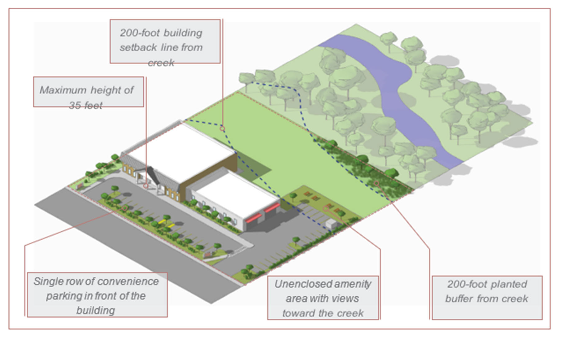
Figure 28: Diagram showing a plausible development within the HW overlay district. Notice the buffer along the creek.
Sec. 4.10.5. - Site design standards.
Sec. 4.11. - WE west end overlay district.
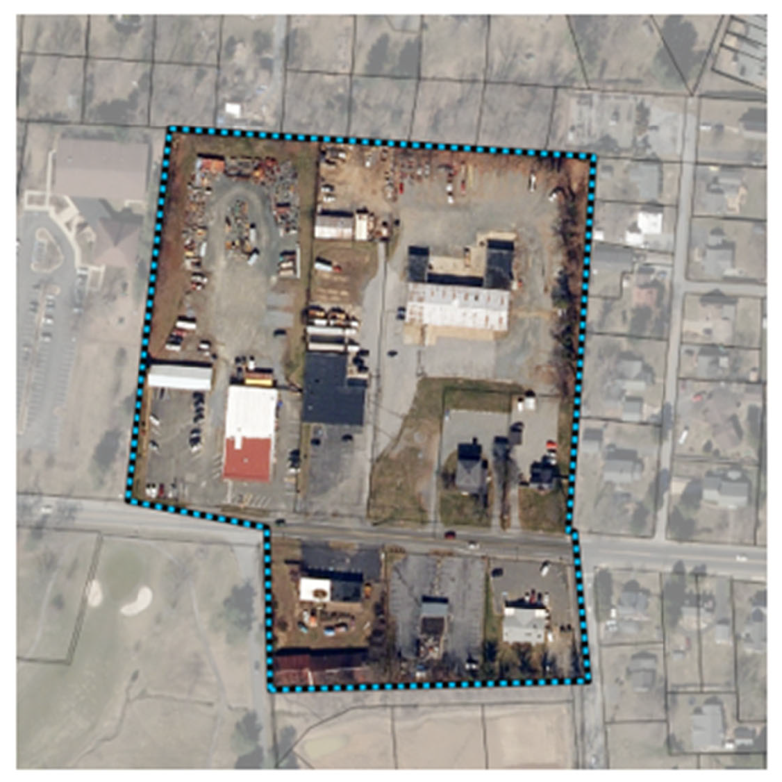
Figure 29: Map of the approximate area included in the west end overlay district. This map is not the official zoning map and should not be used to identify the zoning designation of individual properties.
Sec. 4.11.1. - Intent.
The west end overlay district regulations are intended to encourage a small-scale, diverse, walkable commercial area with limited residential uses that acts as a gateway for western Loudoun County and a transition between the rural countryside and the town environment. The west end overlay district is comprised of the mixed-use neighborhood scale land use type as described in the comprehensive plan.
Sec. 4.11.2. - Applicability.
The standards of the west end overlay district shall apply to all areas mapped within the west end overlay district on the official zoning map. For any standards not specified for the west east overlay district, the standards of the base district shall apply.
Throughout this section distinctions are made for buildings located north or south of Main Street.
Sec. 4.11.3. - Land uses permitted.
No property shall be used for any purpose other than for such purpose permitted by the base district in which the property is located.
Sec. 4.11.4. - Lot and bulk standards.
Sec. 4.11.5. - Site design standards.
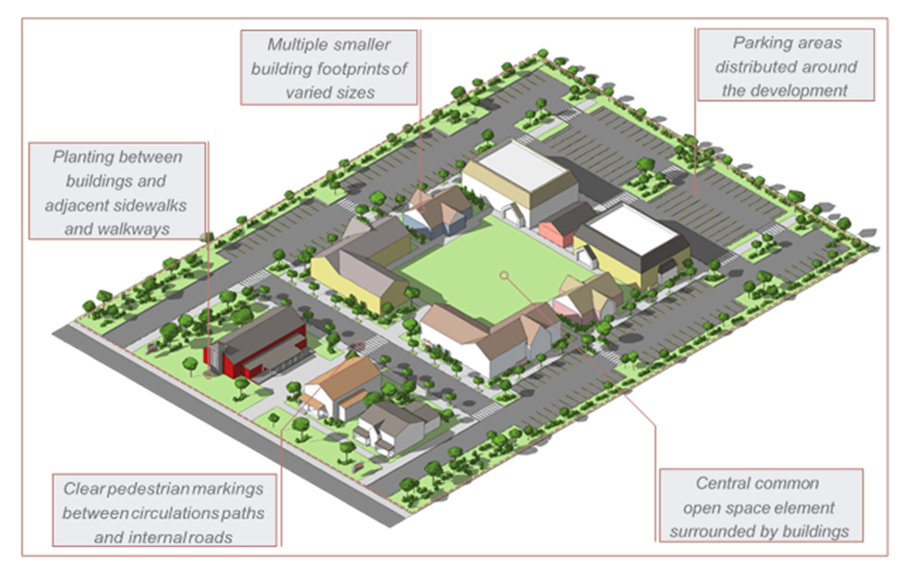
Figure 30: Diagram showing a plausible development within the WE overlay district. Notice the common open space lined by multiple buildings.
Sec. 4.12.1. - Purpose of chapter.
This district is adopted pursuant to the authority granted to localities by Code of Virginia, § 15.2-2280.
The purpose of these provisions is to prevent: the loss of life and property, the creation of health and safety hazards, the disruptions of commerce and governmental services, the extraordinary and unnecessary expenditure of public funds for flood protection and relief, and the impairment of the tax base by:
(1)
Regulating the uses, activities and development which, acting alone or in combination with other existing or future uses, activities, and development, will cause unacceptable increases in flood heights, velocities and frequencies.
(2)
Restricting or prohibiting certain uses, activities and development from locating within areas subject to flooding.
(3)
Requiring all those uses, activities and development that do occur in flood-prone areas to be protected and/or flood-proofed against flooding and flood damage.
(4)
Protecting individuals from buying land and structures which are unsuited for intended purposes because of flood hazards.
(5)
Assuring compliance with federal and state laws and regulations that address the need for floodplain management and protection.
(6)
Qualifying residents and property owners in the Town of Purcellville for the insurance and subsidies provided by the National Flood Insurance Program.
Sec. 4.12.2. - Applicability.
These provisions shall apply to all privately and publicly owned lands within the Town of Purcellville and identified as special flood hazard area (SFHA) according to the flood insurance rate map (FIRM) that is provided to Loudoun County and the Town of Purcellville by the Federal Emergency Management Agency (FEMA).
Sec. 4.12.3. - Compliance and liability.
(1)
No land shall hereafter be developed and no structure shall be located, relocated, constructed, reconstructed, enlarged, or structurally altered except in full compliance with the terms and provisions of this ordinance and any other applicable ordinances and regulations which apply to uses within the jurisdiction of this ordinance.
(2)
The degree of flood protection sought by the provisions of this ordinance is considered reasonable for regulatory purposes and is based on acceptable engineering methods of study but does not imply total flood protection. Larger floods may occur on rare occasions. Flood heights may be increased by manmade or natural causes, such as ice jams and bridge openings restricted by debris. This ordinance does not imply that areas outside the floodplain overlay district or that land uses permitted within such districts will be free from flooding or flood damage.
(3)
This ordinance shall not create liability on the part of the Town of Purcellville or any officer or employee thereof for any flood damages that result from reliance on this ordinance or any administrative decision lawfully made thereunder.
Sec. 4.12.4. - Abrogation and greater restrictions.
This ordinance supersedes any ordinance currently in effect in flood prone areas. However, any underlying ordinance shall remain in full force and effect to the extent that those provisions are more restrictive.
Sec. 4.12.5. - Severability.
If any section, subsection, paragraph, sentence, clause, or phrase of this ordinance shall be declared invalid for any reason whatever, such decision shall not affect the remaining portions of this ordinance. The remaining portions shall remain in full force and effect; and for this purpose, the provisions of this ordinance are hereby declared to be severable.
Sec. 4.12.6. - Penalties.
Any person, agency or assigned that fails to comply with any of the requirements or provisions of this article or directions of the floodplain administrator or any authorized employee of the Town of Purcellville shall be guilty of the appropriate violation and subject to the penalties therefore.
The Virginia Uniform Statewide Building Code addresses building code violations and the associated penalties in section 104 and section 115. Violations and associated penalties of the zoning ordinance of the Town of Purcellville are addressed in Article 10, Section 10.14: Enforcement and penalties.
In addition to the above penalties, all other actions are hereby reserved, including an action in equity for the proper enforcement of this article. The imposition of a fine or penalty for any violation of, or noncompliance with, this article shall not excuse the violation or noncompliance or permit it to continue; and all such persons shall be required to correct or remedy such violations within a reasonable time. Any structure constructed, reconstructed, enlarged, altered or relocated in noncompliance with this article may be declared by the Town of Purcellville to be a public nuisance and abatable as such. Flood insurance may be withheld from structures constructed in violation of this article.
Sec. 4.12.7. - Definitions.
The definitions of this section shall be used solely for the purpose of interpreting and administering the regulations of this article. Words or phrases used in this article shall be interpreted as to give them the meaning they have in common usage and to give this article its most reasonable application.
Sec. 4.12.8. - Establishment of the floodplain overlay district.
The floodplain overlay district is hereby established as an overlay district, meaning that it is a district overlaid upon other districts as shown on the official zoning map, and as such, the provisions for the floodplain overlay district shall serve as a supplement to the underlying district provisions. In the event of any conflict between the provisions or requirements of the floodplain overlay district and those of any underlying district, the more restrictive provisions shall apply.
In the event any provision concerning the floodplain overlay district is declared inapplicable as a result of any legislative or administrative actions or judicial decision, the basic underlying provisions shall remain applicable.
Basis of district: The floodplain overlay district shall include the special flood hazard areas (SFHAs). The basis for the delineation of the district shall be the flood insurance study (FIS), and the flood insurance rate map (FIRM) for Loudoun County, Virginia and Incorporated Areas, prepared by the Federal Emergency Management Agency, dated February 17, 2017, as revised or amended.
The Town of Purcellville may identify and regulate local flood hazard or ponding areas that are not delineated on the FIRM. These areas may be delineated on a "local flood hazard map" using best available topographic data and locally derived information such as flood of record, historic high-water marks or approximate study methodologies.
(1)
The approximated floodplain areas shall be the A zones on the FIRM accompanying the FIS for which no detailed flood profiles or elevations are provided, but where a one percent annual chance floodplain boundary has been approximated. For these areas, the one percent annual chance flood elevations and floodway information from federal, state, and other acceptable sources shall be used, when available.
Where the specific one percent annual chance flood elevation cannot be determined for this area using other sources of data, such as the U.S. Army Corps of Engineers Floodplain Information Reports, U.S. Geological Survey Flood Prone Quadrangles, etc., then the applicant for the proposed use, development and/or activity shall determine this elevation. For development proposed in the approximate floodplain the applicant must use technical methods that correctly reflect currently accepted practices, such as point on boundary, high water marks, or detailed methodologies hydrologic and hydraulic analyses. Studies, analyses, computations, etc., shall be submitted in sufficient detail to allow a thorough review by the floodplain administrator.
The floodplain administrator reserves the right to require a hydrologic and hydraulic analysis for any development. When such base flood elevation data is utilized, the lowest floor shall be elevated to or above the base flood level plus one foot.
During the permitting process, the floodplain administrator shall obtain:
(a)
The elevation of the lowest floor (in relation to mean sea level), including the basement, of all new and substantially improved structures; and
(b)
If the structure has been flood-proofed in accordance with the requirements of this article, the elevation (in relation to mean sea level) to which the structure has been flood-proofed.
For subdivision proposals and other proposed development proposals (including manufactured home parks and subdivisions) that exceed 50 lots or five acres, whichever is the lesser, base flood elevation data shall be obtained from other sources or developed using detailed methodologies comparable to those contained in a FIS.
(2)
The detailed floodplain areas shall be the AE or AH zones on the FIRM accompanying the FIS for which the base flood elevations have been provided and the floodway has not been delineated.
Until a regulatory floodway is designated, no new construction, substantial improvements, or other development (including fill) shall be permitted within the areas of special flood hazard, designated as zones A1-30, AE, or AH on the FIRM, unless it is demonstrated that the cumulative effect of the proposed development, when combined with all other existing and anticipated development, will not increase the water surface elevation of the base flood at any point within the Town of Purcellville.
Sec. 4.12.9. - Official zoning map.
The boundaries of the floodplain overlay district are established as shown on the flood insurance rate map which is declared to be a part of this ordinance and which shall be kept on file at the Town of Purcellville offices.
Sec. 4.12.10. - District boundary change.
The delineation of the floodplain overlay district base flood elevation (BFE) boundary within the jurisdiction of the Town of Purcellville may be revised by the town council where any natural or manmade change or changes have occurred, either within or outside the corporate boundary of the town and/or where more detailed study or combination of studies have been conducted or undertaken by the U.S. Army Corps of Engineers or other qualified agency such as Loudoun County Building and Development Department or a qualified agency contractor study document or documents indicated the need for such floodplain district boundary change. However, prior to any such district boundary change, the town council must obtain an approved letter of map revision and flood insurance rate map from the Federal Emergency Management Agency, prior to such district boundary change approval.
Sec. 4.12.11. - Interpretation of district boundaries.
Initial interpretations of the boundaries of the floodplain overlay district shall be made by the zoning administrator. Should a dispute arise concerning the boundaries of the district the applicant may appeal the decision of the administrator to the board of zoning appeals. The person questioning or contesting the location of the district boundary shall be given a reasonable opportunity to present their case to the board and to submit his own technical evidence if so desired.
Sec. 4.12.12. - General provisions.
(1)
Zoning permit required. All uses, activities and development, including placement of manufactured homes, occurring within the floodplain overlay district shall be undertaken only upon the issuance of a zoning permit. Such development shall be undertaken only in strict compliance with the provisions of this ordinance and with all other applicable codes and ordinances, such as the Virginia Uniform Statewide Building Code and the Town of Purcellville land development and subdivision control ordinance. Prior to the issuance of any such permit, the zoning administrator shall require all applications to comply with all applicable state and federal laws, and shall review all sites to assure they are reasonably safe from flooding. Under no circumstances shall any use, activity and/or development adversely affect the capacity of the channels or floodway of any watercourse, drainage ditch or any other drainage facility or system.
(2)
Effect of development on base flood elevation (BFE). No new construction or development shall be permitted within the floodplain overlay district unless it is demonstrated through hydrologic and hydraulic analysis performed in accordance with standard engineering practice that the cumulative effect of the proposed development, when combined with all other existing and anticipated development will not increase the elevation of the base flood. Within any floodway area, no new construction or development shall be permitted that would cause any increase in the base flood elevation. Hydrologic and hydraulic analyses shall be undertaken only by professional engineers or others of demonstrated qualifications, who shall certify that the technical methods used correctly reflect currently-accepted technical concepts. Studies, analyses, computations, etc., shall be submitted in sufficient detail to allow a thorough review by the floodplain administrator. Findings of this review are to be presented during a public informational meeting within 60 days to the town council and planning commission.
(3)
Alteration or relocation of waterways. Prior to any proposed alteration or relocation of any channels or of any watercourse, stream, etc., within the Town of Purcellville, a permit shall be obtained from the U.S. Corps of Engineers, the Virginia Department of Environmental Quality, and the Virginia Marine Resources Commission (a joint permit application is available from any one of these three organizations). Further notification of the proposal shall be given to all affected adjacent jurisdictions, the department of conservation and recreation (division of dam safety and floodplain management), other required agencies and the Federal Emergency Management Agency.
(4)
Information required for permits and applications. All applications for development in the floodplain overlay district and all zoning permits issued for the floodplain shall incorporate the following information:
(a)
For structures that have been elevated, the elevation of the lowest floor (including basement).
(b)
For structures that have been flood-proofed (nonresidential only), the elevation to which the structure has been flood-proofed. at known base flood elevation plus one foot (TBR) freeboard.
(c)
The elevation of the base flood.
(d)
Topographic information showing existing and proposed ground elevations, compared with most current base flood elevation data available to FEMA from the community.
(5)
General standards. The following provisions shall apply to all permits:
(a)
New construction and substantial improvements shall be according to Paragraph (6) of this article and the Virginia Uniform Statewide Building Code, and anchored to prevent floatation, collapse or lateral movement of the structure.
(b)
Manufactured homes shall be anchored to prevent floatation, collapse, or lateral movement. Methods of anchoring may include, but are not limited to, use of over-the-top or frame ties to ground anchors. This standard shall be in addition to and consistent with applicable state anchoring requirements for resisting wind forces.
(c)
New construction and substantial improvements shall be constructed with materials and utility equipment resistant to flood damage.
(d)
New construction or substantial improvements shall be constructed by methods and practices that minimize flood damage.
(e)
Electrical, heating, ventilation, plumbing, air conditioning equipment and other service facilities, including duct work, shall be designed and/or located so as to prevent water from entering or accumulating within the components during conditions of flooding.
(f)
New and replacement water supply systems shall be designed to minimize or eliminate infiltration of flood waters into the system.
(g)
New and replacement sanitary sewage systems shall be designed to minimize or eliminate infiltration of flood waters into the systems and discharges from the systems into flood waters.
(h)
On-site waste disposal systems shall be located and constructed to avoid impairment to them or contamination from them during flooding.
(i)
The flood carrying capacity within an altered or relocated portion of any watercourse shall be maintained.
(6)
Elevation and construction standards.
(a)
Residential construction. New construction or substantial improvement of any residential structure (including manufactured homes) in zones AE, AH and A with detailed base flood elevations shall have the lowest floor, including basement, elevated to or above the base flood level plus one foot. The placement of manufactured homes (mobile homes) is prohibited, except in an existing manufactured home (mobile home) park or subdivision. A replacement manufactured home may be placed on a lot in an existing manufactured home park or subdivision provided the anchoring, elevation, and encroachment standards are met.
(b)
Nonresidential construction. New construction or substantial improvement of any commercial, industrial, or nonresidential building (or manufactured home) shall have the lowest floor, including basement, elevated to or above the base flood level. Nonresidential buildings located in all AE, AH and A zones with detailed base flood elevations may be flood-proofed in lieu of being elevated provided that all areas of the building components below the elevation corresponding to the base flood elevation plus one foot are water tight with walls substantially impermeable to the passage of water, and use structural components having the capability of resisting hydrostatic and hydrodynamic loads and the effect of buoyancy. A registered professional engineer or architect shall certify that the standards of this subsection are satisfied. Such certification, including the specific elevation (in relation to mean sea level) to which such structures are flood-proofed, shall be maintained by the floodplain administrator.
(c)
Space below the lowest floor. In A, AE, and AH zones, fully enclosed areas, of new construction or substantially improved structures, which are below the regulatory flood protection elevation shall:
i.
Not be designed or used for human habitation, but shall only be used for parking of vehicles, building access, or limited storage of maintenance equipment used in connection with the premises. Access to the enclosed area shall be the minimum necessary to allow for parking of vehicles (garage door) or limited storage of maintenance equipment (standard exterior door), or entry to the living area (stairway or elevator).
ii.
Be constructed entirely of flood resistant materials below the base flood elevation.
iii.
Include measures to automatically equalize hydrostatic flood forces on walls by allowing for the entry and exit of floodwaters. To meet this requirement, the openings must either be certified by a professional engineer or architect or meet the following minimum design criteria:
a.
Provide a minimum of two openings on different sides of each enclosed area subject to flooding.
b.
The total net area of all openings must be at least one square inch for each square foot of enclosed area subject to flooding.
c.
If a building has more than one enclosed area, each area must have openings to allow floodwaters to automatically enter and exit.
d.
The bottom of all required openings shall be no higher than one foot above the adjacent grade.
e.
Openings may be equipped with screens, louvers, or other opening coverings or devices, provided they permit the automatic flow of floodwaters in both directions.
f.
Foundation enclosures made of flexible skirting are not considered enclosures for regulatory purposes, and, therefore, do not require openings. Masonry or wood underpinning, regardless of structural status, is considered an enclosure and requires openings as outlined above.
(d)
Standards for manufactured homes and recreational vehicles.
i.
All manufactured homes placed, or substantially improved, on individual lots or parcels, must meet all the requirements for new construction, including the elevation and anchoring requirements in Paragraphs (5) and (6), (1) through (3) of this section.
ii.
All recreational vehicles placed on sites must either:
a.
Be on the site for fewer than 180 consecutive days, be fully licensed and ready for highway use (a recreational vehicle is ready for highway use if it is on its wheels or jacking system, is attached to the site only by quick disconnect type utilities and security devices and has no permanently attached additions); or
b.
Meet all the requirements for manufactured homes in Paragraph (6)(d)i.
Sec. 4.12.13. - Factors to be considered when granting variances.
Variances shall be issued only upon (i) a showing of good and sufficient cause, (ii) after the board of zoning appeals has determined that failure to grant the variance would result in exceptional hardship to the applicant, and (iii) after the board of zoning appeals has determined that the granting of such variance will not result in (a) unacceptable or prohibited increases in flood heights, (b) additional threats to public safety, (c) extraordinary public expense; and will not (d) create nuisances, (e) cause fraud or victimization of the public, or (f) conflict with local laws or ordinances.
While the granting of variances generally is limited to a lot size less than one-half acre, deviations from that limitation may occur. However, as the lot size increases beyond one-half acre, the technical justification required for issuing a variance increases. Variances may be issued by the board of zoning appeals for new construction and substantial improvements to be erected on a lot of one-half acre or less in size contiguous to and surrounded by lots with existing structures constructed below the base flood level, in conformance with the provisions of this section.
In passing upon applications for variances, the board of zoning appeals shall satisfy all relevant factors and procedures specified in other sections of the zoning ordinance and consider the following additional factors:
(1)
The danger to life and property due to increased flood heights or velocities caused by encroachments. No variance shall be granted for any proposed use, development, or activity within any floodway area that will cause any increase in flood levels during the one percent annual chance flood.
(2)
The danger that materials may be swept onto other lands or downstream to the injury of others.
(3)
The proposed water supply and sanitation systems and the ability of these systems to prevent disease, contamination, and unsanitary conditions.
(4)
The susceptibility of the proposed facility and its contents to flood damage and the effect of such damage on the individual owners.
(5)
The importance of the services provided by the proposed facility to the community.
(6)
The requirements of the facility for a waterfront location.
(7)
The availability of alternative locations not subject to flooding for the proposed use.
(8)
The compatibility of the proposed use with existing development and development anticipated in the foreseeable future.
(9)
The relationship of the proposed use to the comprehensive plan and floodplain management program for the adjoining community and public areas.
(10)
The safety of access by ordinary emergency vehicles to the property in time of flood.
(11)
The expected heights, velocity, duration, rate of rise, and sediment transport of the flood waters expected at the site.
(12)
The historic nature of a structure. Variances for repair or rehabilitation of historic structures may be granted upon a determination that the proposed repair or rehabilitation will not preclude the structure's continued designation as a historic structure and the variance is the minimum necessary to preserve the historic character and design of the structure.
(13)
Such other factors which are relevant to the purposes of this ordinance.
The board of zoning appeals may refer any application and accompanying documentation pertaining to any request for a variance to any engineer or other qualified person or agency for technical assistance in evaluating the proposed project in relation to flood heights and velocities, and the adequacy of the plans for flood protection and other related matters pertaining to the hardening of utilities.
Variances shall be issued only after the board of zoning appeals has determined that the variance will be the minimum required to provide relief from any hardship to the applicant, while protecting the public.
The board of zoning appeals shall notify the applicant for a variance, in writing, that the issuance of a variance to construct a structure below the one percent annual chance flood elevation (a) increases the risks to life and property, and (b) will result in increased premium rates for flood insurance. A record shall be maintained of the above notification as well as all variance actions, including justification for the issuance of the variances. Any variances which are issued shall be noted in the annual or biennial report submitted to the Federal Emergency Management Agency.
Sec. 4.12.14. - Design criteria for utilities and facilities.
(1)
Sanitary sewer facilities. All new or replacement sanitary sewer facilities and private package sewage treatment plants (including all pumping stations and collector systems) shall be designed to minimize or eliminate infiltration of floodwaters into the systems and discharges from the systems into the floodwaters. In addition, they should be located and constructed to minimize or eliminate flood damage and impairment.
(2)
Water facilities. All new or replacement water facilities shall be designed to minimize or eliminate infiltration of floodwaters into the system and be located and constructed to minimize or eliminate flood damages.
(3)
Drainage facilities. All storm drainage facilities shall be designed to convey the flow of surface waters without damage to persons or property. The systems shall ensure drainage away from buildings and on-site waste disposal sites. The town may require a primarily underground system to accommodate frequent floods and a secondary surface system to accommodate larger, less frequent floods. Drainage plans shall be consistent with local and regional drainage plans. The facilities shall be designed to minimize (or eliminate) the discharge of excess runoff onto adjacent properties.
(4)
Utilities. All utilities, such as gas lines, electrical and telephone systems being placed in flood prone areas should be located, elevated (where possible), and constructed to minimize the change of impairment during a flooding occurrence.
(5)
Streets and sidewalks. Streets and sidewalks should be designed to minimize their potential for increasing and aggravating the levels of flood flow. Draining openings shall be required to sufficiently discharge flood flows without unduly increasing flood heights.
Sec. 4.12.15. - Existing structures in the floodplain overlay district.
(1)
Any structure or use of a structure or premises must be brought into conformity with these provisions when it is changed, repaired, or improved unless one of the following exceptions is established before the change is made:
(a)
The floodplain manager has determined that:
i.
Change is not a substantial repair or substantial improvement; and
ii.
No new square footage is being built in the floodplain that is not complaint; and
iii.
No new square footage is being built in the floodway; and
iv.
The change complies with this ordinance and the VA USBC; and
v.
The change, when added to all the changes made during a rolling five-year period does not constitute 50 percent of the structure's value.
(b)
The changes are required to comply with a citation for a health or safety violation.
(c)
The structure is a historic structure and the change required would impair the historic nature of the structure.
Sec. 4.12.16. - Administration.
(1)
Designation of the floodplain administrator. The zoning administrator is hereby appointed to administer and implement these regulations and is referred to herein as the floodplain administrator. The floodplain administrator may:
(a)
Do the work themselves. In the absence of a designated floodplain administrator, the duties are conducted by the Town of Purcellville chief executive officer.
(b)
Delegate duties and responsibilities set forth in these regulations to qualified technical personnel, plan examiners, inspectors, and other employees.
(c)
Enter into a written agreement or written contract with another community or private sector entity to administer specific provisions of these regulations. Administration of any part of these regulations by another entity shall not relieve the community of its responsibilities pursuant to the participation requirements of the National Flood Insurance Program as set forth in the Code of Federal Regulations at 44 C.F.R. Section 59.22.
(2)
Duties and responsibilities of the floodplain administrator. The duties and responsibilities of the floodplain administrator shall include, but are not limited to:
(a)
Review applications for permits to determine whether proposed activities will be located in the special flood hazard area (SFHA).
(b)
Interpret floodplain boundaries and provide available base flood elevation and flood hazard information.
(c)
Review applications to determine whether proposed activities will be reasonably safe from flooding and require new construction and substantial improvements to meet the requirements of these regulations.
(d)
Review applications to determine whether all necessary permits have been obtained from the federal, state or local agencies from which prior or concurrent approval is required; in particular, permits from state agencies for any construction, reconstruction, repair, or alteration of a dam, reservoir, or waterway obstruction (including bridges, culverts, structures), any alteration of a watercourse, or any change of the course, current, or cross section of a stream or body of water, including any change to the one percent annual chance floodplain of free-flowing non-tidal waters of the state.
(e)
Verify that applicants proposing an alteration of a watercourse have notified adjacent communities, the department of conservation and recreation (division of dam safety and floodplain management), and other appropriate agencies (VADEQ, USACE) and have submitted copies of such notifications to FEMA.
(f)
Approve applications and issue permits to develop in flood hazard areas if the provisions of these regulations have been met, or disapprove applications if the provisions of these regulations have not been met.
(g)
Inspect or cause to be inspected, buildings, structures, and other development for which permits have been issued to determine compliance with these regulations or to determine if noncompliance has occurred or violations have been committed.
(h)
Review elevation certificates and require incomplete or deficient certificates to be corrected.
(i)
Submit to FEMA, or require applicants to submit to FEMA, data and information necessary to maintain FIRMs, including hydrologic and hydraulic engineering analyses prepared by or for the Town of Purcellville, within six months after such data and information becomes available if the analyses indicate changes in base flood elevations.
(j)
Maintain and permanently keep records that are necessary for the administration of these regulations, including:
i.
Flood insurance studies, flood insurance rate maps (including historic studies and maps and current effective studies and maps) and letters of map change; and
ii.
Documentation supporting issuance and denial of permits, elevation certificates, documentation of the elevation (in relation to the datum on the FIRM) to which structures have been flood-proofed, other required design certifications, variances, and records of enforcement actions taken to correct violations of these regulations.
(k)
Enforce the provisions of these regulations, investigate violations, issue notices of violations or stop work orders, and require permit holders to take corrective action.
(l)
Advise the board of zoning appeals regarding the intent of these regulations and, for each application for a variance, prepare a staff report and recommendation.
(m)
Administer the requirements related to proposed work on existing buildings:
i.
Make determinations as to whether buildings and structures that are located in flood hazard areas and that are damaged by any cause have been substantially damaged.
ii.
Make reasonable efforts to notify owners of substantially damaged structures of the need to obtain a permit to repair, rehabilitate, or reconstruct, and prohibit the noncompliant repair of substantially damaged buildings except for temporary emergency protective measures necessary to secure a property or stabilize a building or structure to prevent additional damage.
(n)
Undertake, as determined appropriate by the floodplain administrator due to the circumstances, other actions which may include, but are not limited to: issuing press releases, public service announcements, and other public information materials related to permit requests and repair of damaged structures; coordinating with other federal, state, and local agencies to assist with substantial damage determinations; providing owners of damaged structures information related to the proper repair of damaged structures in special flood hazard areas; and assisting property owners with documentation necessary to file claims for increased cost of compliance coverage under NFIP flood insurance policies.
(o)
Notify the Federal Emergency Management Agency when the corporate boundaries of the Town of Purcellville have been modified and:
i.
Provide a map that clearly delineates the new corporate boundaries or the new area for which the authority to regulate pursuant to these regulations has either been assumed or relinquished through annexation; and
ii.
If the FIRM for any annexed area includes special flood hazard areas that have flood zones that have regulatory requirements that are not set forth in these regulations, prepare amendments to these regulations to adopt the FIRM and appropriate requirements, and submit the amendments to the governing body for adoption; such adoption shall take place at the same time as or prior to the date of annexation and a copy of the amended regulations shall be provided to department of conservation and recreation (division of dam safety and floodplain management) and FEMA.
(p)
Upon the request of FEMA, complete and submit a report concerning participation in the NFIP which may request information regarding the number of buildings in the SFHA, number of permits issued for development in the SFHA, and number of variances issued for development in the SFHA.
(q)
It is the duty of the floodplain administrator to take into account the flood, mudslide and flood-related erosion hazards, to the extent that they are known, in all official actions relating to land management and use throughout the entire jurisdictional area of the community, whether or not those hazards have been specifically delineated geographically (e.g. via mapping or surveying).
(3)
Use and interpretation of FIRMs. The floodplain administrator shall make interpretations, where needed, as to the exact location of special flood hazard areas, floodplain boundaries, and floodway boundaries. The following shall apply to the use and interpretation of FIRMs and data:
(a)
Where field surveyed topography indicates that adjacent ground elevations:
i.
Are below the base flood elevation, even in areas not delineated as a special flood hazard area on a FIRM, the area shall be considered as special flood hazard area and subject to the requirements of these regulations;
ii.
Are above the base flood elevation, the area shall be regulated as special flood hazard area unless the applicant obtains a letter of map change that removes the area from the SFHA.
(b)
In FEMA-identified special flood hazard areas where base flood elevation and floodway data have not been identified and in areas where FEMA has not identified SFHAs, any other flood hazard data available from a federal, state, or other source shall be reviewed and reasonably used.
(c)
Base flood elevations and designated floodway boundaries on FIRMs and in FISs shall take precedence over base flood elevations and floodway boundaries by any other sources if such sources show reduced floodway widths and/or lower base flood elevations.
(d)
Other sources of data shall be reasonably used if such sources show increased base flood elevations and/or larger floodway areas than are shown on FIRMs and in FISs.
(e)
If a preliminary flood insurance rate map and/or a preliminary flood insurance study has been provided by FEMA:
i.
Upon the issuance of a letter of final determination by FEMA, the preliminary flood hazard data shall be used and shall replace the flood hazard data previously provided from FEMA for the purposes of administering these regulations.
ii.
Prior to the issuance of a letter of final determination by FEMA, the use of preliminary flood hazard data shall be deemed the best available data pursuant to Subsection (8) of this article and used where no base flood elevations and/or floodway areas are provided on the effective FIRM.
iii.
Prior to issuance of a letter of final determination by FEMA, the use of preliminary flood hazard data is permitted where the preliminary base flood elevations or floodway areas exceed the base flood elevations and/or designated floodway widths in existing flood hazard data provided by FEMA. Such preliminary data may be subject to change and/or appeal to FEMA.
(4)
Jurisdictional boundary changes. The county floodplain ordinance in effect on the date of annexation shall remain in effect and shall be enforced by the town for all annexed areas until the Town adopts and enforces an ordinance which meets the requirements for participation in the National Flood Insurance Program. Municipalities with existing floodplain ordinances shall pass a resolution acknowledging and accepting responsibility for enforcing floodplain ordinance standards prior to annexation of any area containing identified flood hazards. If the FIRM for any annexed area includes special flood hazard areas that have flood zones that have regulatory requirements that are not set forth in these regulations, prepare amendments to these regulations to adopt the FIRM and appropriate requirements, and submit the amendments to the governing body for adoption; such adoption shall take place at the same time as or prior to the date of annexation and a copy of the amended regulations shall be provided to department of conservation and recreation (division of dam safety and floodplain management) and FEMA.
In accordance with the Code of Federal Regulations, Title 44 Subpart (B) Section 59.22(a)(9)(v) all NFIP participating communities must notify the Federal Emergency Management Agency and optionally the Virginia Department of Conservation and Recreation - Department of Dam Safety and Floodplain Management in writing whenever the boundaries of the community have been modified by annexation or the community has otherwise assumed or no longer has authority to adopt and enforce floodplain management regulations for a particular area.
In order that all flood insurance rate maps accurately represent the community's boundaries, a copy of a map of the community suitable for reproduction, clearly delineating the new corporate limits or new area for which the community has assumed or relinquished floodplain management regulatory authority must be included with the notification.
(5)
Letters of map revision. When development in the floodplain will cause or causes a change in the base flood elevation, the applicant, including state agencies, must notify FEMA by applying for a conditional letter of map revision and then a letter of map revision.
Example cases:
(a)
Any development that causes a rise in the base flood elevations within the floodway.
(b)
Any development occurring in zone AE without a designated floodway, which will cause a rise in the base flood elevation.
(c)
Alteration or relocation of a stream (including, but not limited to, installing culverts and bridges).
(6)
Submitting technical data. Base flood elevations may increase or decrease resulting from physical changes affecting flooding conditions. As soon as practicable, but not later than six months after the date such information becomes available, a community shall notify the Federal Emergency Management Agency of the changes by submitting technical or scientific data. The community may submit data via a LOMR. Such a submission is necessary so that upon confirmation of those physical changes affecting flooding conditions, risk premium rates and flood plain management requirements will be based upon current data.
Sec. 4.12.17. - Standards for subdivision proposals.
(1)
All subdivision proposals shall be consistent with the need to minimize flood damage;
(2)
All subdivision proposals shall have public utilities and facilities such as sewer, gas, electrical and water systems located and constructed to minimize flood damage;
(3)
All subdivision proposals shall have adequate drainage provided to reduce exposure to flood hazards; and
(4)
Base flood elevation data shall be obtained from other sources or developed using detailed methodologies, hydraulic and hydrologic analysis, comparable to those contained in a flood insurance study for subdivision proposals and other proposed development proposals (including manufactured home parks and subdivisions) that exceed 50 lots or five acres, whichever is the lesser.
Sec. 4.13.1. - Purpose and definitions.
The purpose of this article to provide for the designation of architectural review districts for: (i) all properties zoned for commercial, industrial and public building use; (ii) all properties abutting the corridors leading to the town's historic core; and (iii) those certain properties having recognized historical importance, and to set standards and procedures to be followed in maintaining these properties.
In addition to the regulations of this zoning ordinance, special review and approval by the board of architectural review (BAR) may be required as established by the Town of Purcellville Code of Ordinances.
Definitions. For the purposes of this article, the following definitions shall apply:
Sec. 4.13.2. - Architectural control overlay districts (ACOD).
(1)
Intent. The architectural control overlay district (ACOD) consists of all land areas in the town that are zoned other than residential. In addition, any lot, parcel or area of land within any area zoned for residences, which is used for other than residences, or which is the subject of an application for a special use permit, special exception or building involving any such other use, is also considered to be part of the architectural control overlay district. The intent of this district is to encourage the construction of attractive buildings, to protect and promote the general welfare and to prevent deterioration of the appearance of the town which would tend to create hazards to public health, safety and morals, and destroy opportunity for the development of business and industry.
(2)
Applicability. The architectural control overlay district (ACOD) shall apply to any building located within or partially within the town as mapped on the official zoning map of the Town of Purcellville that satisfies one or more of the following criteria:
(a)
The building lot, parcel or area of land is zoned for other than residential purposes; or
(b)
The building, lot, parcel or area of land is zoned for residence but is used for other than residential purposes; or
(c)
The building, lot, parcel or area of land is zoned for residence and is the subject of an application for a special use permit, special exception or building involving any such other use; or
(d)
The building is located on a lot that abuts the historic corridor as described in Section 4.13.3 or as mapped on the official zoning map of the Town of Purcellville.
The town council may enlarge, contract or alter the boundaries of the architectural control overlay district in such manner as it shall deem fit, or create additional architectural control districts at such time as the council deems such action to be in the public interest by promoting the general welfare of the community.
Refer to the Code of Ordinances, Chapter 54, Article II, Division 3: Architectural control overlay districts for the complete set of regulations.
Sec. 4.13.3. - Historic corridor overlay district (HCOD).[1]
(1)
Intent. The historic corridor overlay district (HCOD) implements the Purcellville comprehensive plan goals of protecting the town's unique historical and architectural character along the entrances to the Town to provide an attractive entry into the historic town core, ensuring that new development is in keeping with the small-town character of Purcellville, encouraging aesthetic treatment, and promoting tourism and visitor opportunities through historic preservation and Main Street revitalization, all of the foregoing being deemed to advance and promote the public health, safety and welfare of the citizens of Purcellville and its visitors.
(2)
Applicability. The Historic corridor overlay district (HCOD) is created to conserve elements of the town's historic character and in accordance with Code of Virginia, § 15.2-2306, as amended, to preserve and protect corridors: (i) along arterial streets or highways designated as such pursuant to Code of Virginia, Title 33.1 found by the town council to be significant routes of tourist access to the town; (ii) to historic landmarks as may be established by the Virginia Board of Historic Resources and any other buildings or structures within the town having an important historic, architectural or cultural interest and any historic areas within the town as defined by Code of Virginia, § 15.2-2201; or (iii) to designated historic landmarks, buildings, structures or districts in any contiguous locality.
An historic corridor overlay district (HCOD) may be established over any basic zoning district and/or any other overlay district, and upon the highways and their rights-of-way identified in Paragraph (2)(b) (the "HCOD streets"), regardless of whether such HCOD streets are otherwise within a zoning district.
(a)
Historic corridor overlay districts are hereby established over and upon the parcels of land contiguous to the HCOD streets in Paragraph (2)(b) from the edge of the right-of-way including the full depth of the parcel, as the parcel existed on the original adoption date of these historic corridor regulations and as shown on the Purcellville zoning map.
(b)
Subject to Paragraph (2)(a), historic corridor overlay districts are hereby established upon and along the following streets in their entirety within the corporate limits of the Town of Purcellville:
i.
Main Street (Route 7 Business).
ii.
Route 287.
iii.
Route 690 North (23rd and 21st Street).
iv.
Route 690 South (32nd Street).
v.
Route 1604 (21st Street between Main and 23rd Streets).
(c)
Unless otherwise expressly exempted, no structure or building within the historic corridor overlay district shall be erected, reconstructed, altered, restored, relocated or demolished, in whole or in part, unless and until a certificate of design approval authorizing such work shall have been approved in accordance with this article.
(d)
Exemptions. The provisions of Section 4.13.4.3 of this section notwithstanding, no certificate of design approval shall be required for the following activities:
i.
Construction or alteration of main and accessory buildings or structures in single-family detached residential use or in an agricultural and forestal district where no site plan is required for the work. Demolition of historic structures is not exempted by this section, including demolition by neglect.
ii.
Interior alterations to a building or structure having no effect on exterior appearance of the building or structure.
iii.
Construction of ramps and other modifications to serve the handicapped.
iv.
The repair and maintenance of nonconforming structures authorized pursuant to Section [4.13.4(3)] of this section.
v.
General maintenance where no change in design or material is proposed.
vi.
Additions or modifications to a building where no change in design or material is proposed as determined by the zoning administrator.
vii.
Signs, fences and light poles.
(e)
A certificate of design approval is required for the following:
i.
Except as otherwise provided in Paragraph (2)(e) of this section, no zoning permit shall be issued for any purpose, including demolition, unless and until a certificate of design approval has been issued in accord with this article for improvements subject to such zoning permit.
ii.
Except as otherwise provided in Paragraph (2)(e) of this section, for any development requiring site plan approval, no final site plan shall be approved by the town unless and until a certificate of design approval has been issued in accord with this article for all buildings and improvements shown thereon. The certificate of design approval shall be binding upon the proposed development as to conditions of issuance. The certificate shall certify that the proposed development as may be modified by the conditions of issuance is consistent with the design criteria of Section 4.13.8 of this article and any design guidelines adopted by the town council for the specific HCOD street. Signature by the zoning administrator upon the final site development plan or zoning permit, as the case may be, shall be deemed to constitute such certification.
iii.
In making such determination as to consistency with the design guidelines for the Town of Purcellville, the BAR may specify any architectural feature as to appearance, such as, but not limited to, motif and style, color, texture and materials together with configuration, orientation and other limitations as to mass, shape, height and location of buildings and structures, location and configuration of parking areas and landscaping and buffering requirements to the extent such practices are authorized under the design criteria of Section 4.13.8 of this article and any design guidelines hereafter adopted by the town council without regard to regulations of the underlying zoning district or other provisions of this ordinance.
iv.
A certificate of design approval shall be valid for a period of five years.
(f)
Demolition permit review and approval. No historic structure, as defined in this article, within any historic corridor overlay district shall be razed, demolished or moved, in whole or in part, until the razing, demolition or moving thereof is approved by the BAR, or, on appeal, by the town council after consultation with the BAR.
In addition to the right of appeal set forth herein, the owner of a historic structure, the razing or demolition of which is subject to the provisions of this section, shall, as a matter of right, be entitled to raze or demolish such landmark, building or structure provided that: (i) the owner has applied to the town council for such right, (ii) the owner has for the period of time set forth in the schedule contained in Code of Virginia, § 15.2-2306 (the "Code"), as amended, and at a price reasonably related to its fair market value, made a bona fide offer to sell the landmark, building or structure, and the land pertaining thereto, to the town or to any person, firm, corporation, government or agency thereof, or political subdivision or agency thereof, which gives reasonable assurance that it is willing to preserve and restore the landmark, building or structure and the land pertaining thereto, and (iii) no bona fide contract, binding upon all parties thereto, shall have been executed for the sale of any such landmark, building or structure, and the land pertaining thereto, prior to the expiration of the applicable time period set forth in the time schedule specified in the Code. Any appeal which may be taken to the court from the decision of the town council, whether instituted by the owner or by any other proper party, notwithstanding the provisions heretofore stated relating to a stay of the decision appealed from shall not affect the right of the owner to make the bona fide offer to sell referred to above. No offer to sell shall be made more than one year after a final decision by the town council, but thereafter the owner may renew his request to the town council to approve the razing or demolition of the historic landmark, building or structure.
(g)
Demolition by neglect.
i.
The purpose of this is to prevent the demolition by neglect through permanent damage by weather or vandalism of any historic structure, as defined in this article.
ii.
The owner of any historic structure, as defined by this article, shall maintain the building or structure in good repair; that is, structurally sound and protected against decay and deterioration in compliance with this section and the provisions of the Virginia Uniform Statewide Building Code, as adopted by the town under Chapter 14 of the town Code, to the extent that, in the opinion of the zoning administrator, such decay or deterioration may result in irreparable deterioration of any exterior architectural feature or produce a detrimental effect upon the structure or upon the character of the district, including, but not limited to:
a.
The deterioration of exterior walls or other vertical supports; or
b.
The deterioration of roofs or other horizontal members; or
c.
The deterioration of exterior chimneys; or
d.
The deterioration or crumbling of exterior stucco or mortar; or
e.
The ineffective waterproofing of exterior walls, roofs and foundations, including broken windows and doors; or
f.
The peeling of paint, rotting, holes and other forms of decay; or
g.
The lack of maintenance of surrounding structures, such as fences, walls, gates, sidewalks, steps, signs, or other accessory structures; or
h.
The deterioration of any feature so as to create or permit the creation of any hazardous condition.
iii.
The zoning administrator shall have concurrent jurisdiction with the county building official to enforce the requirements of this section.
iv.
Upon a finding by the zoning administrator that a historic structure is not in good repair and protected against decay and deterioration, the zoning administrator shall inform the owners of the property in writing, by certified mail, return receipt requested, of the specific deficiencies requiring remediation and shall order such owners to repair or secure such building or structure.
v.
If the owners or lien holder of the property cited and notified under [Paragraph] (iv) have not completed the prescribed repairs or other approved remedial measures within 90 days of the date of the notification prescribed in [Paragraph] (iv), then the zoning administrator shall notify the owners or lien holder in writing, by certified mail, return receipt requested, that they are in violation of the zoning ordinance, and enforcement shall be pursued by the zoning administrator in accordance with Article 10.
Editor's note— Formerly Article 14A. - Historic corridor overlap district—HC.
Sec. 4.13.4. - Historic properties overlay district (HPOD).
(1)
Purpose and authority. The implementation of the historic properties overlay district (HPOD) is the primary means for fulfilling the aspiration articulated in the 2030 comprehensive plan to sustain the single-family detached traditional residential land uses reflecting the character of the oldest neighborhoods in Purcellville. The HPOD follows the guidance of the 2030 comprehensive plan to amend "the Town's historic zoning overlay district to be more inclusive of all historically contributing structures even in non-contiguous areas." The Virginia Landmarks Registry listed structures in the HPO district as contributing to the "Purcellville Historic District" in December 2006, and the U.S. National Park Service listed the "Purcellville Historic District," on the National Register of Historic Places in April 2007 for its representation of "a range of architectural styles popular during the 19th and 20th centuries in rural Virginia."
Through this ordinance, which derives its authority from Code of Virginia, § 15.2-2306 (preservation of historical sites and architectural areas), the town will be able to retain and conserve the community's significant architectural and cultural heritage sites that best represent Purcellville's historical development patterns, and which helped influence and shape Purcellville's character.
(2)
Applicability. Properties comprising the HPOD include every property with the Purcellville National Register Historic District on which a known and surveyed principal building historic resource outside of the HCOD (pink in the following Figure) is located. Principal building historic resources located within the HPOD (blue in the following figure) are subject to the regulations under Section 4.13.3(f).
(3)
Demolition permit review and approval. No principal building historic resource may be demolished, as described in Article 4.13.1, or relocated unless and until a certificate of design approval authorizing such work has been approved by the BAR or, on appeal, by the town council after consultation with the BAR, in accordance with Section 4.13.3(2)(g).
Textual descriptions of these properties are in https://www.purcellvilleva.gov/DocumentCenter/View/11592/National-Register-Application-Package—-150-pp. A complete paper record, including photographs and sketches, may be viewed at the town office.
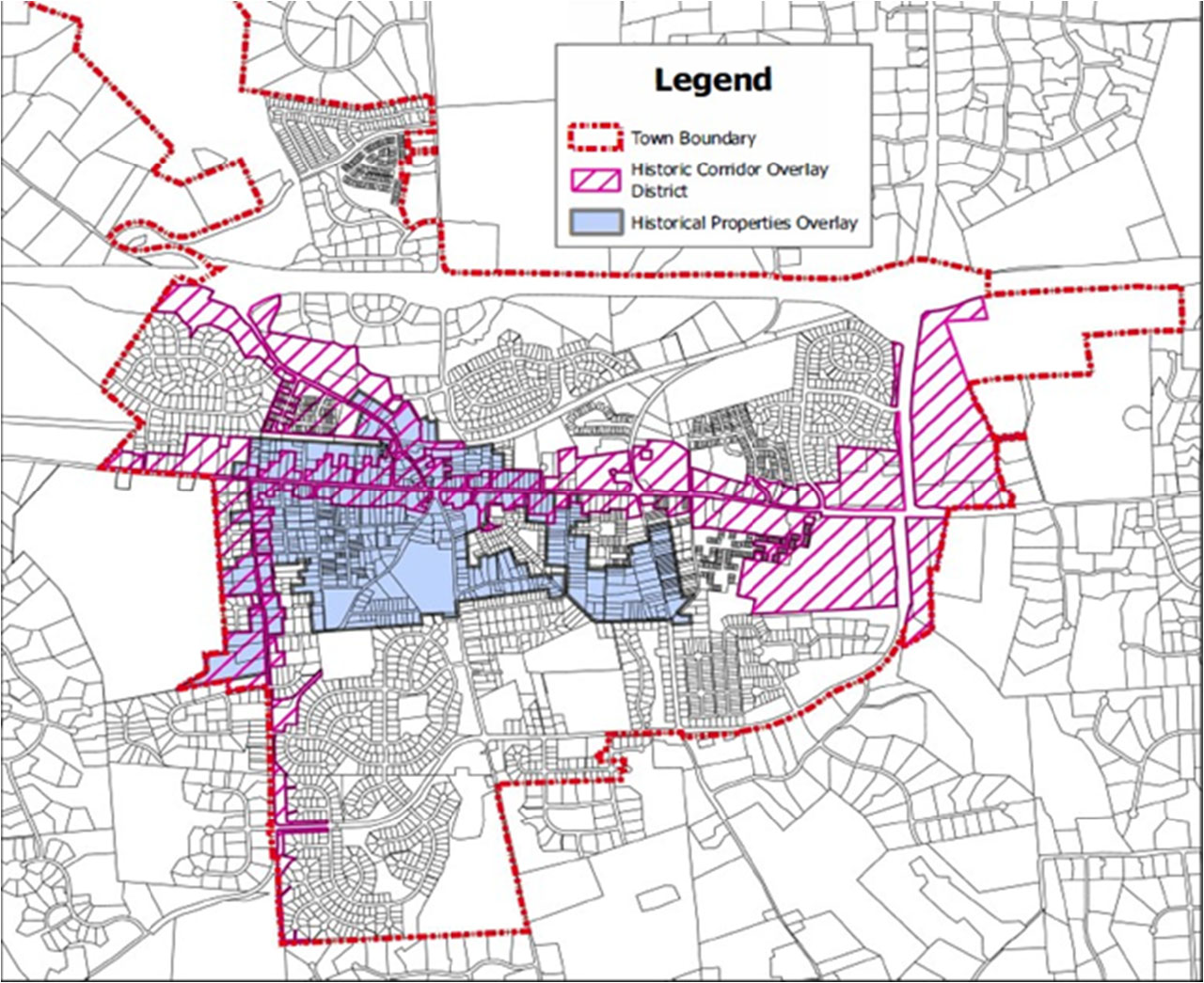
Figure 3.13.14.1: Historic corridor overlay district and historic properties overlay district
Sec. 4.13.5. - Modification of development standards in AR overlay districts.
(1)
Applicability of use regulations. All use provisions of the underlying base zoning districts shall be permitted in any AR overlay district.
(2)
Area and bulk regulations; minimum yard and setback requirements; height requirements; landscaping and screening; preservation of natural features.
(a)
Area and bulk regulations, minimum yard and setback requirements, and height regulations shall be as provided by the underlying base district, except that the following provisions and limitations shall apply to any development or portion thereof within the district which shall be visible from a designated HCOD street.
(b)
Regulations of Article 5: Landscaping, screening and open space regulations, shall apply within any HCOD district except that:
i.
In addition to the provisions of Article 5, the BAR may require specific landscaping measures in issuance of a certificate of appropriateness, as the same may be related to ensuring that the proposed development is consistent with any design guidelines adopted by the town council for the specific HCOD street. Existing landscaping, tree cover and other significant natural features shall be preserved to the greatest extent possible.
ii.
No grading or other earth disturbing activity (including trenching or tunneling), except as necessary for the construction of tree wells or tree walls, shall occur within the drip line of any trees or wooded areas nor intrude upon any other existing features designated in the certificate of design approval for preservation.
iii.
Areas designated on approved plans for preservation of existing features shall be clearly and visibly delineated on the site prior to commencement of any grading or other earth-disturbing activity (including trenching or tunneling) and no such disturbing activity or grading or movement of heavy equipment shall occur within such area. The visible delineation of all such existing features shall be maintained until the completion of development of the site. In addition, an applicant for development subject to the provisions of this article, shall sign a conservation checklist approved by the zoning administrator to further ensure that the specified existing features will be protected during development. Except as otherwise expressly approved by the agent in a particular case, such checklist shall conform to specifications contained in the Virginia Erosion and Sediment Control Handbook, pp. III-284 through III-297.
(3)
Nonconformities.
(a)
Any existing use, activity, lot or structure subject to the provisions of the HCOD, which does not conform to the provisions of the HCOD shall be subject to Article 1.18: Nonconformities, of this ordinance.
(b)
Repair and maintenance of nonconforming structures. An owner may repair and maintain a nonconforming structure or a structure occupied or used by a nonconforming use, upon determination by the zoning administrator that such repair or maintenance would not be contrary to the purpose and intent of this section.
Sec. 4.13.6. - Administration.
The AR architectural review overlay district, comprising the architectural control overlay district, the historic corridor overlay district, and the historic properties overlay district, shall be administered by the BAR pursuant to Chapter 54, Article II of the town Code. The BAR shall be responsible for issuance of certificates of design approval as required by this section.
Application for a certificate of design approval together with a fee as adopted by the town council shall be filed by the owner or contract purchaser of the subject property with the zoning administrator. Materials submitted with the application shall include all plans, maps, studies and reports, architectural drawings and renderings, manufacturer cut sheets and samples, which may be reasonably required to make the determinations called for in the particular case, with sufficient copies for necessary referrals and records. Complete applications with the required fee must be received by the zoning administrator at least 21 calendar days prior to the BAR meeting at which consideration is desired.
Upon receipt of a complete application, the zoning administrator shall schedule the same for hearing and shall cause notice of such hearing to be sent to the BAR. The BAR shall confer with the applicant at the hearing and shall approve or disapprove such application and, if approved, shall issue a certificate of design approval, with or without conditions together with such modifications as deemed necessary to ensure compliance with this article. Failure of the BAR to approve or disapprove such application within 60 days from the date of complete application shall be deemed to constitute approval of the application.
Nothing contained in this section shall be deemed to compromise, limit, or otherwise impair the planning commission in its exercise of preliminary or final site plan review as authorized in this ordinance and the Purcellville land development and subdivision control ordinance. It is the express intent of the town council that matters related to public health and safety as may be defined by the commission shall prevail over issues of aesthetics as may be defined by the BAR. Therefore, the commission in its review of any preliminary or final site plan may modify, vary or waive any requirement of the certificate of design approval related to site plan concerns, such as landscaping and setbacks, issued by the BAR upon finding that such action would better serve the public health or safety.
Sec. 4.13.7. - Appeals.
The town council reserves unto itself the right to review all decisions of the BAR made in the administration of Section 4.13 which, in its discretion, it shall deem necessary to the proper administration hereof.
Any person aggrieved by any decision of the BAR in the administration of this article may demand a review of the application by the town council. Such demand shall be made by filing a request therefore in writing with the zoning administrator with the appropriate fee within ten calendar days of the date of such decision. The town council may affirm, reverse or modify, in whole or in part, the decision of the BAR. When considering an appeal pertaining to a public safety facility, the council may issue a certificate of design approval if it finds that the facility is a public necessity. In considering an appeal, the town council shall give due consideration to provisions within the design guidelines for the Town of Purcellville, the recommendations of the BAR together with such other evidence as it deems necessary for a proper review of the application.
Any person or persons jointly or severally aggrieved by any decision of the town council may appeal such decision to the Loudoun County Circuit Court for review by filing a petition at law, setting forth the alleged illegality of the action of the town council, provided such petition is filed within 30 days after the final decision is rendered by the town council. The filing of said petition shall stay the decision of the town council pending the outcome of the appeal to the court.
For the purposes of this section, the term "person aggrieved" shall be limited to the applicant, the BAR or any member thereof, the planning commission or any member thereof, the zoning administrator, the town manager, the town council or any member thereof.
Sec. 4.13.8. - Design criteria.
(1)
The BAR and, on appeal, the town council shall use the following standards and criteria in considering applications other than demolitions filed under this article:
(a)
Proposed architectural design is suitable for Purcellville's historic small-town character in terms of external architectural features, including signs subject to public view, general design and arrangement, texture, color, line, form, scale, mass, dimension, material and lighting.
(b)
Whether or not the proposed structure, building or improvement is compatible with existing well-designed structures, acceptable to the BAR, in the vicinity and in the town as a whole.
(c)
Whether or not, and to what extent, the proposed structure, building or improvement would promote the general welfare and protect the public health, safety and morals by tending to maintain or augment the town's tax base as a whole, generating business activity, maintaining and creating employment opportunity, preserving historical sites and structures and making the town a more attractive and desirable place in which to live.
(d)
Whether or not proposed buildings use the same or architecturally harmonious materials, color, texture and treatment for all exterior walls.
(e)
Whether or not the combination of architectural elements proposed for a structure, building or improvement, in terms of design, massing, scale, proportion, dimension, color, material, texture, lighting, landscaping and roofline and height conform to accepted architectural principles for permanent buildings as contrasted with engineering standards designed to satisfy safety requirements only; and exhibit external characteristics of demonstrated architecture and aesthetic durability and quality.
(f)
Whether or not, in terms of design, material, texture, color, lighting, landscaping, dimension, line, massing, scale, proportion, roof line and height, the proposed structure, building or improvement is designed to serve primarily as an advertisement or commercial display, exhibits exterior characteristics likely to deteriorate rapidly, would be of temporary or short-term architectural or aesthetic acceptability, would be plainly offensive to human sensibilities or would otherwise constitute a reasonable foreseeable detriment to the community.
The town council at its discretion and upon recommendation of the BAR may adopt additional design guidelines for use by the BAR in the review of applications under this article. Such additional guidelines shall not be adopted unless and until the town clerk has caused notice of same to be published at least once in a newspaper of general circulation within the county, at least seven days before the council meeting at which such proposed adoption is scheduled.
(2)
No specific architectural style to be required. The BAR and the town council on appeal shall not adopt or impose any specific architectural style in the administration of this article.
(3)
Demolition permit criteria. In reviewing demolition applications, the BAR shall consider the following:
(a)
The designation of the particular structure as historic or non-historic by a qualified historic preservation professional or by a government-recognized historic survey;
(b)
The context of the structure in relation to surrounding buildings and landscape on the site; and
(c)
The appropriateness, as determined through application of applicable design criteria and guidelines, of proposed structures, which will replace the demolished structure, if any.
(d)
Deviations from approved plans. Any person who once having obtained the approval required by this article deviates substantially from the approved plan shall be subject to the violations and penalties specified in Article 10 of this ordinance.