
Riverside City Zoning Code
ARTICLE V
BASE ZONES AND RELATED USE AND DEVELOPMENT PROVISIONS
19.100.010 - Purpose.
The purpose of this chapter is to define allowable land uses and property development standards, including density of development, for all residential zones in order to produce healthy, safe, livable and attractive neighborhoods within the City of Riverside, consistent with the goals and policies of the City's General Plan. Fourteen residential zones are established to implement the residential land use designations of the General Plan. The purpose of each of the residential zones is as follows:
A.
Residential Agricultural Zone (RA-5). The Residential Agricultural Zone (RA-5) is established to provide areas where general agricultural uses can occur independently or in conjunction with a single-family residence, that preserves the agricultural character of the area.
B.
Residential Conservation Zone (RC). The Residential Conservation Zone (RC) is established consistent with General Plan objectives and voter approved initiatives (Proposition R and Measure C) to protect prominent ridges, hilltops and hillsides, slopes, arroyos, ravines and canyons, and other areas with high visibility or topographic conditions that warrant sensitive development from adverse development practices, and specifically, to achieve the following objectives:
1.
To preserve and enhance the beauty of the City's landscape;
2.
To maximize the retention of the City's natural topographic features, including, but not limited to, skyline profiles, ridgelines, ridge crests, hilltops, hillsides, slopes, arroyos, ravines, canyons, prominent trees and rock outcrops, view corridors, and scenic vistas through the careful selection and construction of building sites and building pads on said topographic features.
3.
To assure that residential use of said topographic features will relate to the surrounding topography and will not be conspicuous and obtrusive because of the design and location of said residential use;
4.
To reduce the scarring effects of excessive grading for building pads and cut and fill slopes;
5.
To prevent the construction of slopes inadequately protected from erosion, deterioration or slippage; and
6.
To conserve the City's natural topographic features.
C.
Rural Residential Zone (RR). The Rural Residential Zone (RR) is established to provide areas for single-family residences on large lots where flexible provisions apply pertaining to the keeping of farm animals such as horses, ponies, mules, cows, goats, sheep, and swine under Future Farmers of America-supervised and 4-H-supervised projects. These zones are established in those areas of the City where the keeping of such animals is already prevalent. It is also the intent of the RR Zone to provide opportunities for persons whose lifestyles include the keeping of such animals in areas where such animal-keeping activities minimize impact to other residential properties.
D.
Residential Estate Zone (RE) and R-1-½ Acre Zone. The Residential Estate Zone (RE) and R-1-½ Acre Zone are established to provide areas for large lot single-family residences where the keeping of livestock and other farm animals and agricultural uses are not permitted.
E.
Additional Single-family Residential Zones (R-1-13000, R-1-10500, R-1-8500 and R-1-7000). Additional Single-family Residential Zones (R-1-½ Acre, R-1-13000, R-1-10500, R-1-8500 and R-1-7000) are established to provide areas for single-family residences with a variety of lot sizes and housing choices.
F.
Multiple-Family Residential Zones (R-3-4000, R-3-3000, R-3-2500, R-3-2000 and R-3-1500). Medium High-Density Residential Zones (R-3-4000 and R-3-3000) and High-Density Residential Zones (R-3-2500, R-3-2000 and R-3-1500) are established to provide areas for multiple family residences, including such residential development types as apartments, town homes, condominiums, tiny homes (foundation) in tiny home communities, and single-family homes in a Small Lot Subdivision Planned Residential Development.
G.
Multiple-Family Residential Zone (R-4). The Very High-Density Residential Zone (R-4) is established to provide areas for higher density multiple family residences in areas of the City readily served by public transit and near commercial zones and other nonresidential areas that meet the everyday shopping, educational, health service and similar needs of residents.
(Ord. 7683, § 1, 2024; Ord. 7592 § 2(Exh. B), 2022; Ord. 7552 § 1, 2021; Ord. 7528 § 1(Exh. A), 2020; Ord. 7520 § 1(Exh. A), 2020; Ord. 7487 § 9, 11-5-2019; Ord. 7331 § 4, 2016; Ord. 6966 § 1, 2007)
19.100.030 - Permitted land uses.
Table 19.150.020 A (Permitted Uses Table), Table 19.150.020 B. (Incidental Use Table) and Table 19.150.020 C (Temporary Uses Table) in Chapter 19.150 (Base Zones Permitted land uses) identify permitted uses, permitted accessory uses, permitted temporary uses, and uses permitted subject to the approval of a minor conditional use permit (Chapter 19.730 - Minor Conditional Use Permit), uses requiring approval of a conditional use permit (Chapter 19.760 - Conditional Use Permit), or uses requiring some other permit. Table 19.150.020 A also identifies those uses that are specifically prohibited. Uses not listed in the Tables are prohibited unless the Community & Economic Development Director or his/her designee, pursuant to Chapter 19.060 (Interpretation of Code), determines that the use is similar to and no more detrimental than a listed permitted or conditional use. Any use which is prohibited by state and/or federal law is also strictly prohibited. Chapter 19.149 - Airport Land Use Compatibility includes Airport Land Use Compatibility Plan requirements for discretionary actions proposed on property located within an Airport Compatibility Zone.
A.
RA-5 Zone Permitted Uses. A summary of this section is contained in the Permitted Uses Table (Table 19.150.020-A), the Incidental Uses Table (Table 19.150.020 B), and the Temporary Uses Table (Table 19.150.020 C). If any conflict between this section and the Tables exists, the provisions of this section shall apply.
1.
A one-family dwelling or manufactured dwelling of a permanent character placed in a permanent location and of not less than 750 square feet ground floor area exclusive of open porches and garage;
2.
Farms or ranches for orchards, tree crops, field crops, truck gardening, berry and bush crops, flower gardening, growing of nursery plants, similar enterprises carried on in the general field of agriculture, aviaries, and raising of chinchillas, guinea pigs and parakeets;
3.
Poultry, rabbits, crowing fowl and crowing roosters.
a.
The noncommercial keeping of not more than five poultry, including crowing fowl (except crowing roosters), and 18 rabbits is permitted. Such animals shall be housed, kept or penned at least 50 feet from any residence on an adjoining lot or parcel, including the residence on the lot where the animals are kept,
b.
Where poultry and rabbits are housed, kept, or penned at least 100 feet from any residence, the noncommercial keeping of not more than 50 poultry, and 45 rabbits on any lot is permitted. The keeping of not more than seven crowing roosters are permitted on any lot, provided that such roosters are housed from sunset to sunrise in an acoustical structure so as to reduce noise emitted by such roosters and such structure is at least 100 feet from any residential structure on an adjoining lot;
4.
Pot-bellied pigs shall not be allowed in the RA-5 zone unless mandated by State law;
5.
The grazing, raising or training of equine, riding stables or academies, sheep and cattle, provided that the lot has a minimum area of one acre and animals are not housed or pastured within 100 feet of a residence provided that the property is maintained in accordance with Section 6.16.010 (Fly-Producing Conditions) of the Municipal Code, and further that:
a.
Not more than a total of two of any of the following or a total of two of any combination of horses, colts, mules, ponies, goats, sheep, cows, calves or animals of general like character shall be kept on any lot with an area of one acre and that one additional animal may be kept for each half acre over one acre in any such premises,
b.
Dairies, feeding lots and similar uses may be permitted after public hearing under a conditional use permit,
c.
Additional animals may be permitted subject to the granting of a conditional use permit in the RA-5 zone;
6.
The keeping of bees, provided that all other conditions of this Zoning Code and other City ordinances are complied with;
7.
Parks, playgrounds or community centers owned and operated by a governmental agency, subject to the granting of a conditional use permit;
8.
Golf courses, including miniature courses and driving ranges, subject to the granting of a conditional use permit;
9.
Uses customarily incidental to any of the above uses, including hobby activities of a noncommercial nature;
10.
Rented rooms in any one-family dwelling for occupancy of not more than four persons in addition to members of the family occupying such dwelling;
11.
Accessory buildings and uses, including a private garage, accessory living quarters, recreation room, private stable, barn, greenhouse, lathhouse, corral, pen, coop or other similar structure, a building or room for packing products produced or raised on the same premises, and one stand for the sale of such products;
12.
Nameplates and signs as provided in Chapter 19.620 (General Sign Provisions);
13.
The growing and wholesale disposal of earthworms in worm farms, provided that the area devoted to the cultivation of worms does not exceed 64 square feet, and further provided that:
a.
All worm farms shall be kept at least 50 feet away from all adjacent dwellings,
b.
The maximum height of any worm bed shall be two feet and all other structures shall conform to the requirements for accessory structures,
c.
Worm farms in excess of 64 square feet shall only be permitted subject to the granting of a conditional use permit;
14.
Agricultural field office as defined in Section 19.910.020 ("A" Definitions) subject to the granting of a conditional use permit in the RA-5 zone subject to the following operation and development standards:
a.
The use shall be conducted on a property zoned RA-5 having five acres or more gross area which is zoned for agricultural uses and which is predominately occupied by a commercial agricultural business,
b.
The use shall be in conjunction with any permitted agricultural use, provided that such office shall be occupied by an agricultural business, which business is either located on-site or off-site the property,
c.
The use shall be established within a stickbuilt, mobile coach or prefabricated structure, attached to or detached from any other building on the property,
d.
Adequate parking and vehicular access shall be available in accordance with Chapter 19.580 (Parking and Loading) of the Zoning Code,
e.
The building shall comply with the setback standards established for accessory structures in Chapter 19.440 (Accessory Buildings and Structures) of the Zoning Code;
15.
Agricultural caretaker living quarters as defined by Section 19.910.040 ("C" Definitions) of this title subject to the granting of a conditional use permit provided all of the following criteria apply:
a.
The use shall be conducted on a property having five acres or more gross area which is zoned residential agricultural and which is predominantly occupied by a bona fide agricultural business,
b.
The use shall be established within a stickbuilt (completely assembled on site) or prefabricated structure, attached to or detached from the primary dwelling unit on the property or within a mobile home. The square footage of the agricultural caretaker living quarters shall not exceed 50 percent of the square footage of the primary dwelling unit,
c.
Occupancy shall be limited to the agricultural caretaker and his or her family. The agricultural caretaker shall be a full-time employee of the on-site agricultural business,
d.
The primary dwelling unit on the property shall be occupied by the legal owner of the property,
e.
The agricultural caretaker living quarters shall be established in such a way as to minimize its view from adjacent streets and properties,
f.
The use shall not be conducted longer than two years except that subsequent time extensions may be granted by the City Planning Commission. Each time extension shall not exceed two years. Written notice shall be given to adjacent property owners as prescribed by Section 19.670.020 (Notice Requirements for Administrative Discretionary Permits with No Public Hearing) of this title for minor variances. The standard time extension application fee for conditional use permits shall be required,
g.
The property owners shall execute and record a covenant and agreement with the City to revert the property to single-family residential use, including the removal of the kitchen facilities of any permanent addition, and the removal of any mobile home which does not meet the requirements of the residential agricultural zone, after the expiration of the conditional use permit or the termination of the agricultural business;
16.
Home occupations and telecommuting as defined by Sections 19.910.090 ("H" Definitions) and 19.910.210 ("T" Definitions) of this Code in accordance with the provisions contained in Chapter 19.485 (Home Occupations) of this title. Such uses shall not be allowed in the RA-5 zone unless mandated by State law.
17.
Parolee/probationer home, as defined by Section 19.910.170 ("P" Definitions), transitional shelter housing, as defined by Section 19.910.210 ("T" Definitions), permanent emergency shelter, as defined by Section 19.910.060 ("E" Definitions) and drop-in center, as defined by Section 19.910.050 ("D" Definitions) of this Code, are prohibited in the RA-5 Zone.
B.
RC Zone permitted uses. A summary of this section is contained in the Permitted Uses Table (Table 19.150.020-A), the Incidental Uses Table (Table 19.150.020-B), and the Temporary Uses Table (Table 19.150.020-C). If any conflict between this section and the Tables exists, the provisions of this section shall apply.
1.
One-family dwellings of a permanent character placed in a permanent location and of not less than 750 square feet ground floor area, exclusive of open porches and garage;
2.
Planned residential developments subject to the granting of a planned residential development permit as set forth in Chapter 19.780 (Planned Residential Development Permit);
3.
Orchards, tree crops, field crops, truck gardening, berry and bush crops, flower gardening, growing of nursery plants, similar enterprises carried on in the general field of agriculture, aviaries and raising of chinchillas, guinea pigs and parakeets;
4.
Poultry, rabbits, crowing fowl and crowing roosters.
a.
The noncommercial keeping of not more than five poultry, including crowing fowl (except crowing roosters), and 18 rabbits is permitted. Such animals shall be housed, kept or penned at least 50 feet from any residence on an adjoining lot or parcel, including the residence on the lot where the animals are kept.
b.
Where poultry and rabbits are housed, kept, or penned at least 100 feet from any residence, the noncommercial keeping of not more than 50 poultry and 45 rabbits on any lot is permitted. The keeping of not more than seven crowing roosters are permitted on any lot, provided that such roosters are housed from sunset to sunrise in an acoustical structure so as to reduce noise emitted by such roosters and such structure is at least 100 feet from any residential structure on an adjoining lot.
5.
The grazing, raising or training of horses; provided, that the lot has a minimum area of one acre and animals are not housed or pastured within 100 feet of a residence; and further, that not more than a total of two horses, colts or ponies or a total of two of any combination of horses, colts or ponies shall be kept on any lot with an area of one acre and that one additional animal may be kept for each half acre over one acre in any such premises;
6.
The keeping of bees; provided, that all other conditions of this Zoning Code or other City ordinances are complied with;
7.
Parks and playgrounds of a noncommercial nature, subject to the granting of a conditional use permit;
8.
Golf courses, subject to the granting of a conditional use permit;
9.
Uses customarily incidental to any of the above uses, including hobby activities of a noncommercial nature;
10.
Rented rooms in any one-family dwelling for occupancy of not more than four persons in addition to members of the family occupying such dwelling;
11.
Accessory buildings and uses, including a private garage, accessory living quarters, recreation room, private stable, barn, greenhouse, lathhouse, corral, pen, coop or other similar structure, a building or room for packing products produced or raised on the same premises;
12.
Nameplates and signs as provided in Chapter 19.620 (General Sign Provisions);
13.
Agricultural field office as defined in Section 19.910.020 ("A" Definitions) subject to the granting of a conditional use permit.
(Ord. 7528 § 1(Exh. A), 2020; Ord. 7520 § 1(Exh. A), 2020; Ord. 7431, § 1(Exh. A), 2-20-2018; Ord. 7331 § 4, 2016; Ord. 7110 § 1, 2011; Ord. 7064 § 1, 2010; Ord. 6966 § 1, 2007)
19.100.040 - Residential development standards.
Tables 19.100.040.A (Residential Development Standards: Single-Family Residential Zones) and 19.100.040.B (Residential Development Standards: Multiple-Family Residential Zones) establish the development standards applicable to all development within the residential zones.
(Ord. 7552 §§ 2, 3, 2021; Ord. 7408 § 1, 2018; Ord. 7331 § 4, 2016; Ord. 7109 § 2, 2010; Ord. 7027 § 1, § 2, 2009; Ord. 6966 § 1, 2007)
Table 19.100.040.A
Residential Development Standards: Single-family Residential Zones
Notes:
1. See Section 19.100.060 A (Additional Density). Gross acreage means streets are included for density purposes. Notwithstanding allowable density on a gross acreage basis, individual lots must meet the minimum lot size requirements exclusive of streets, except in the RA-5 Zone as described in Note 9.
2. Lot width, depth and area; building area; and setback requirements shall be as required as set forth in the Table. However, the zoning standards and requirements of the RC and RA-5 Zones shall not apply to any buildings existing prior to or under construction on November 13, 1979, or to the restoration or rehabilitation of or to any additions to such buildings, provided that the use, restoration, rehabilitation or addition shall conform to the current standards and requirements of the zoning in existence immediately prior to November 13, 1979. Also see Section 19.100.050 A (Lot Area).
3. Where a lot is less than 65 feet in width and was of record prior to November 23, 1956, or was of record prior to the date on which such lot was annexed to the City, the required side yards adjacent to interior side lot lines shall be reduced to five feet.
4. Front setback exceptions: See Section 19.630.040 E (Permitted projections into required yards for RA-5, RE, RR, and R-1 Zones.
5. Side and rear setback exceptions: See Section 19.630.040 E (Permitted projections into required yards for RA-5, RE, RR, and R-1 Zones). The side setback can be applied to either side except that the larger setback is required when a side yard is adjacent to a street.
6. No lot that fronts onto Hawarden Drive within the Hawarden Drive Special Design Area, generally between Anna Street and the Alessandro Arroyo, shall have a front yard depth of less than 50 feet.
7. Where a lot or parcel of land at the junction of two intersecting streets in any residential zone has frontage on each street over 130 feet in length, front yards of the depth required in the appropriate zone shall be required on both frontages. Also see Chapter 19.630 (Yard Requirements and Exceptions).
8. No dwelling shall be located closer than five feet to any retaining wall exceeding two feet in height, unless such retaining wall is an integral part of an approved dwelling.
9. Lot area in the RA-5 Zone is measured to the centerline of the adjoining street or streets; provided, however, individuals may construct one single-family dwelling on a lot of less than five acres existing as of May 15, 1979 and the residence is owner occupied after construction.
10. Refer to Chapter 19.560 (Building Height Measurement) for height measurement and exceptions to height limits.
11. Project density may be greater in a Planned Residential Development (see Chapter 19.780).
12. See Section 19.100.050 (Additional Regulations for the RC Zone).
13. See Section 18.210.080 (Lots) and Article X (Definitions) for exceptions for cul-de-sac lots, knuckle lots, lots on curves and corridor lots.
14. See Section 18.210.030 N.2.a for exception to lot size on private streets if over 20,000 square feet.
15. See Chapter 19.149 - Airport Land Use Compatibility to determine if a project site is subject to Airport Land Use Compatibility Plan requirements.
16. See Chapter 18.085 (Urban Lot Splits) of the Subdivision Code and Chapter 19.443 (Two-Unit Developments) of this Title for density, lot area, lot width, lot depth, side setback and rear setback requirements for residential development pursuant to California Government Code § 65852.21 and § 66411.7.
17. See Section 19.100.065 for regulations on undersized lots.
18. See Chapter 19.780 (Planned Residential Development Permits) for setbacks in Planned Residential Developments.
Table 19.100.040 B
Residential Development Standards: Multiple-family Residential Zones
Notes:
1. Where a property abuts the RA-5, RC, RR, RE or R-1 Zone, for buildings over two stories in height, the required side and rear yards shall be increased by two and one-half feet for each story in excess of two stories, except as otherwise stated in this footnote.
2. Up to 60% of units may be located in three-story buildings with a maximum height of 40 feet.
3. Refer to Chapter 19.560 (Building Height Measurement) for height measurements and exceptions to height limits.
4. See Section 18.210.080 (Lots) and Article X (Definitions) for exemptions for cul-de-sac lots and knuckle lots.
5. See Chapter 19.149 - Airport Land Use Compatibility to determine if a project site is subject to Airport Land Use Compatibility Plan requirements.
6. See Section 19.100.075 for regulations on undersized lots.
7. See Section 19.780.060.D (Planned Residential Development Permits) for Small Lot PRD regulations.
(Ord. 7683, §§ 2(Exh. A), 3(Exh. B), 2024; Ord. 7652 § 1(Exh. A), 2023; Ord. 7592 § 2(Exh. B), 2022; Ord. 7573 § 1(Exh. A), 2021; Ord. 7552 §§ 2(Exh. A) and 3(Exh. B), 2021; Ord. 7487 § 10(Exh. B), 11-5-2019; Ord. 7413, § 1(Exh. A), 2-20-2018)
19.100.050 - Additional regulations for the RC Zone.
A.
Lot area.
1.
The lot area requirements for land Zoned RC varies based on average natural slope and the date the property was zoned RC, as set forth in this section.
2.
The lot area requirements for land Zoned RC prior to May 15, 1979, shall be as follows:
a.
Every lot shall have a minimum width at the building line of 130 feet and a minimum area of one-half acre; provided, however, that the average lot size of the lots shown on any subdivision or parcel map shall be not less than two acres.
b.
Notwithstanding the provisions of subdivision 1 of this subsection, every lot or parcel located within the Hawarden Drive Special Design Area, generally between Anna Street and Alessandro Arroyo, shall have a minimum width at the building line of 130 feet and a minimum area of two acres; provided, however, that where a lot or parcel located within said area has less width or less area than herein required and was a legally created lot of record prior to June 16, 1977, such lot may be occupied by a single-family residential use if the lot has a minimum area of one-half acre.
3.
The lot area requirements for land zoned RC on or after May 15, 1979, shall be as follows:
a.
Every lot with an average natural slope of less than 15 percent shall have a minimum width at the building line of 130 feet and a minimum area of one-half acre.
b.
Every lot with an average natural slope from 15 percent to 30 percent shall have a minimum width at the building line of 130 feet and a minimum area of two acres.
c.
Every lot with an average natural slope over 30 percent shall have a minimum width at the building line of 200 feet and a minimum area of five acres.
d.
The average lot size of the lots shown on any subdivision or parcel map shall be not less than two acres.
e.
These provisions shall not apply to lots created pursuant to California Government Code § 66411.7.
B.
Nonconforming lot size—dwelling unit permitted. Notwithstanding the provisions of subdivision 3 of subsection A above, individuals may construct one single-family dwelling on a lot existing as of May 15, 1979, of less than the minimum lot size required by Section A-3 if such individuals occupy the residence after construction.
C.
Average natural slope. For the purposes of this section, "average natural slope" shall mean the average natural inclination of the ground surface of a lot or parcel expressed as a percent and as measured by the following formula:
S = 0.002296xlxL
A
where:
S = average natural slope in percent
I = natural contour interval in feet
L = length of natural contours in feet
A = acres of property (parcel of record existing on November 13, 1979)
0.002296 = Constant that converts square feet into acres and expresses slope percent.
The average natural slope shall be computed from photogrammetric maps, grading permit plans and other data or evidence approved by the Public Works Department.
D.
Grading.
1.
No grading permit shall be issued for any grading in the RC Zone until grading plans and, if required, special drawings showing grading and topography as viewed from critical locations within the neighborhood or community, have been submitted to and approved by the designated Approving or Appeal Authority as set forth in Table 19.650.020 (Approving and Appeal Authority).
2.
The Approving and/or Appeal Authority shall consider the following items of particular concern in the review of grading proposals in the RC Zone. Conditions may be applied in the approval of grading plans so as to achieve these objectives pursuant to adopted standards included in the City's Grading Ordinance (Title 17).
a.
The maximum retention of vistas, natural plant communities and natural topographic features including ridgelines, hilltops, slopes, rock outcroppings, arroyos, ravines and canyons;
b.
The avoidance of excessive building padding or terracing and cut and fill slopes to reduce the scarring effects of grading;
c.
The encouragement of sensitive grading to ensure optimum treatment of natural hillside and arroyo features; and
d.
The encouragement of imaginative grading plans to soften the impact of grading on hillsides including rolled, sloping or split pads; rounded cut and fill slopes and post and beam construction techniques.
E.
Design review.
1.
No building permit shall be issued for any building or structure in the RC Zone until slope planting and irrigation plans and the drawings required by Chapter 19.710 (Design Review) have been submitted to and approved in accordance with the provisions of Chapter 19.710 (Design Review).
2.
In addition to the standards established in the Zoning Code and in Chapter 19.710 (Design Review), the Design Review Approving or Appeal Authority shall consider the following items of particular concern in the RC Zone and shall approve the plans and drawings if all applicable standards are met:
a.
The encouragement of unique site design to ensure optimum treatment of natural hillside and arroyo features and avoid inharmonious, incongruent, conspicuous and obtrusive development;
b.
The reduction of the scarring effects of grading and the protection of slopes subject to erosion, deterioration or slippage, and fire by the use of appropriate slope planting, irrigation and maintenance; and
c.
The encouragement of structures that will relate spatially and architecturally with the environment and complement the natural land forms.
3.
Conditions may be applied when the proposed development does not comply with applicable standards and shall be such as to bring such development into conformity or the plans and drawings may be disapproved and the Design Review Approving or Appeal Authority shall specify the standard or standards that are not met.
4.
All cut and fill slopes exceeding five feet in height shall be suitably landscaped with plant materials and adequately irrigated in accordance with approved plans and maintained on completion of the grading operations. The applicant or developer shall be responsible for the maintenance of all slope planting and irrigation systems until such time as the properties are occupied or until a homeowner's association accepts the responsibility to maintain the landscaping in common areas.
F.
Subdivisions. To assure compliance with the provisions of this chapter and the Zoning Code where a planned development permit is not required, there shall be submitted along with every tentative subdivision map and parcel map filed for approval in accordance with the provision of Title 18 (Subdivision Code) a preliminary grading plan showing at least one practical usable building site that can be developed in accordance with the provisions of this chapter for each lot or parcel.
(Ord. 7592 § 2(Exh. B), 2022; Ord. 7331 § 4, 2016; Ord. 6966 § 1, 2007)
19.100.060 - Additional regulations for the RA-5, RE, RC, RR and R-1 Zones.
A.
Additional density. In the RE, RC, RR and R-1 zones and where consistent with the applicable General Plan land use designation the typical project density may be increased according to the regulations set forth in the Planned Residential Development Permit (PRD) process (Chapter 19.780 - Planned Residential Development Permits).
B.
Conversion of existing dwelling unit to an accessory structure. In the RE, RA-5, RR and R-1 zones, one entirely new single-family dwelling may be constructed upon a lot where there already exists not more than one single-family dwelling, provided that:
1.
At the time of issuance of a building permit for the new dwelling, the property owner/applicant also obtains a building permit to make alterations to the existing dwelling as are required by the City to reduce the character of use of the existing dwelling to a lawful accessory building, or the owner/applicant obtains a building moving permit to remove the existing dwelling from the lot;
2.
The owner of the lot executes and delivers to the City a written agreement in a form approved by the City to make the required alterations or to remove the existing dwelling concurrently with or immediately after the construction and completion of the new dwelling, together with a faithful performance surety bond or other security, in the form approved by the City and in the amount of 100 percent of the amount of the cost of such alterations or removal, as estimated by the City; and
3.
The Building Official determines that the requirements of Section 19.100.040 (Residential Development Standards) and Building Code and Fire Prevention Code will be complied with.
C.
Exceptions to setback requirements.
1.
Front porches and balconies. In the R-1 Zones, front porches that are open except for an overhead covering and have no habitable space above may encroach into the front setback up to a maximum of six feet.
2.
Flexible yard setbacks.
a.
In the R-1 Zones, on local streets only, where the residential structure has the garage set back ten or more feet from the required front yard setback, the habitable portion of the residential structure may extend into the front setback up to a maximum of five feet.
b.
In conjunction with the consideration of a tentative tract or parcel map in the R-1-7000 Zone, interior side yard setbacks may be reduced to five feet provided a minimum distance of 15 feet is maintained between adjacent dwellings.
c.
In the R-1 Zones, portions of the dwelling may encroach up to ten feet into the required rear yard setback provided that the encroachment does not exceed 500 square feet in total area.
3.
Accessory structures. Refer to Chapter 19.440 (Accessory Buildings and Structures) for development standards.
4.
Stairway projections. Refer to Chapter 19.630 (Yard Requirements and Exceptions) see Section 19.630.040 (Permitted Projections into Required Yards).
5.
Fire escape projections. Refer to Chapter 19.630 (Yard Requirements and Exceptions) see Section 19.630.040 (Permitted Projections into Required Yards).
6.
Cornice, eave and sill projections. Refer to Chapter 19.630 (Yard Requirements and Exceptions) see Section 19.630.040 (Permitted Projections into Required Yards).
7.
Additions to established dwellings. For lawfully established dwellings that do not conform to the side yards required in the RC, RR, RE and R-1 Zones additions may be constructed within such required side yards if such additions are located not closer to the side lot line than the existing dwelling; provided, that in no case shall such additions be located closer than five feet to interior side lot lines or ten feet to street side lot lines.
8.
Garage in the R-1-7000 Zone. In the R-1-7000 Zone, a garage that is an integral part of the main dwelling may be located not closer than five feet to any interior side lot line.
D.
Setbacks for RR Zoned Properties less than 20,000 square feet in area. For legally created parcels within the RR Zone which are less than 20,000 square feet in area, the following setbacks shall be provided and supersede those listed in Table 19.100.040.A as follows:
1.
For lots less than 8,500 square feet in area, the R-1-7000 standards apply.
2.
For lots greater than 8,500 square feet in area, but less than 10,500 square feet in area, the R-1-8500 standards apply.
3.
For lots greater than 10,500 square feet in area, but less than 13,000 square feet in area, the R-1-10500 standards apply.
4.
For lots greater than 13,000 square feet in area, but less than 20,000 square feet in area, the R-1-13000 standards apply.
E.
Landscaping. Front and side yard setback areas adjacent to streets shall be suitably landscaped and continuously maintained as set forth in Chapter 19.570 (Water Efficient Landscaping and Irrigation). Such setbacks shall not be used for off-street parking, storage, or accessory buildings.
F.
See also Section 19.630.040 - Permitted projections into required yards for additional exceptions to the setback requirements.
(Ord. 7683, § 4, 2024; Ord. 7652 § 2, 2023; Ord. 7592 § 2(Exh. B), 2022; Ord. 7552 § 4, 2021; Ord. 7331 § 4, 2016; Ord. 6966 § 1, 2007)
19.100.065 - Regulations for infill development on undersized lots in the R-1 Zones.
A.
Setbacks for R-1-½ acre zoned properties less than 18,000 square feet in area. For legally created parcels within the R-1-½ acre Zone which are less than 18,000 square feet in area, the following setbacks shall be provided and supersede those listed in Table 19.100.040.A as follows:
1.
For lots less than 5,500 square feet in area, see section 19.100.065.E.
2.
For lots equal to or greater than 5,500 square feet in area, but less than 8,500 square feet in area, the R-1-7000 standards apply.
3.
For lots equal to or greater than 8,500 square feet in area, but less than 10,500 square feet in area, the R-1-8500 standards apply.
4.
For lots equal to or greater than 10,500 square feet in area, but less than 13,000 square feet in area, the R-1-10500 standards apply.
5.
For lots equal to or greater than 13,000 square feet in area, but less than 18,000 square feet in area, the R-1-13000 standards apply.
B.
Setbacks for R-1-13000 zoned properties less than 10,500 square feet in area. For legally created parcels within the R-1-13000 Zone which are less than 10,500 square feet in area, the following setbacks shall be provided and supersede those listed in Table 19.100.040.A as follows:
1.
For lots less than 5,500 square feet in area, see section 19.100.065.E.
2.
For lots equal to or greater than 5,500 square feet in area, but less than 7,000 square feet in area, the R-1-7000 standards apply.
3.
For lots equal to or greater than 7,000 square feet in area, but less than 8,500 square feet in area, the R-1-8500 standards apply.
4.
For lots equal to or greater than 8,500 square feet in area, but less than 10,500 square feet in area, the R-1-10500 standards apply.
C.
Setbacks for R-1-10500 zoned properties less than 8,500 square feet in area. For legally created parcels within the R-1-10500 Zone which are less than 8,500 square feet in area, the following setbacks shall be provided and supersede those listed in Table 19.100.040.A as follows:
1.
For lots less than 5,500 square feet in area, see section 19.100.065.E.
2.
For lots equal to or greater than 5,500 square feet in area, but less than 7,000 square feet in area, the R-1-7000 standards apply.
3.
For lots equal to or greater than 7,000 square feet in area, but less than 8,500 square feet in area, the R-1-8500 standards apply.
D.
Setbacks for R-1-8500 zoned properties less than 7,000 square feet in area. For legally created parcels within the R-1-8500 Zone which are less than 7,000 square feet in area, the following setbacks shall be provided and supersede those listed in Table 19.100.040.A as follows:
1.
For lots less than 5,500 square feet in area, see section 19.100.065.E.
2.
For lots equal to or greater than 5,500 square feet in area, but less than 7,000 square feet in area, the R-1-7000 standards apply.
E.
Development Standards for R-1 Zone lots less than 5,500 square feet in area. For legally created parcels within all R-1 Zones which are less than 5,500 square feet in area, the following development standards shall apply and supersede those listed in Table 19.100.040.A:
Table 19.100.065
Residential Development Standards: R-1 Zone Lots Less than 5,500 Square Feet
Notes:
1. See 19.630.040 (Permitted projections into required yards).
2. Garages and carports shall be set back 20 feet.
F.
Privacy Considerations. Residential development on R-1 Zone lots less than 5,500 square feet in area that abut the RA-5, RC, RR, RE, or R-1 Zone shall adhere to the following:
1.
Windows within 30 feet of a structure on another parcel shall not directly align with the windows of the neighboring structure.
2.
Upper story unenclosed landings, decks, and balconies that face or overlook an adjoining RA-5, RC, RR, RE, or R-1 Zoned property shall be located a minimum of 15 feet from the interior lot lines.
(Ord. 7683, § 5(Exh. C), 2024)
19.100.070 - Additional regulations for the R-3 and R-4 Zones.
A.
Usable open space.
1.
The minimum usable open space, as defined in Article X (Definitions), required for each dwelling unit shall be as set forth in Table 19.100.070 (Usable Open Space Standards: Multi-Family Residential Zones) below:
Table 19.100.070
Usable Open Space Standards: Multi-Family Residential Zones
Notes:
1. See Table 19.100.075 B for requirements for infill development on undersized lots.
2.
Development consisting of 20 units or fewer. Common open space may be divided into multiple areas; provided, however, that at least one area shall have no dimension smaller than 25 feet.
3.
Development consisting of 21 units to 75 units.
a.
Common open space may be divided into multiple areas; provided, however, that at least one area shall have no dimension smaller than 50 feet.
b.
Common open space shall include but not be limited to two of the recreational amenities listed below:
(1)
One child's outdoor play area, which shall include a range of age-appropriate equipment including those rated for use by children younger than five.
(2)
Pool and spa.
(3)
One outdoor cooking facility with sheltered dining area to accommodate seating for a minimum of twelve adults.
(4)
Court facilities (e.g., tennis, volleyball, basketball, etc.).
(5)
Exercise room.
(6)
Clubhouse with wet bar/counter facilities.
(7)
Dog park.
4.
Development consisting of 76 units or more.
a.
Common open space may be divided into multiple areas; provided, however, that at least one area shall have at least one dimension of 100 feet.
b.
Common open space shall include but not be limited to four of the following recreational amenities:
(1)
One child's outdoor play area, which shall include a range of age-appropriate equipment including those rated for use by children younger than five.
(2)
Pool and spa.
(3)
Clubhouse with a central multi-purpose room equipped with full kitchen facilities; and at least two separate and defined areas/rooms for games, exercises, recreation, entertainment, etc.
(4)
Two outdoor cooking facilities each with sheltered dining area to accommodate seating for a minimum of 12 adults.
(5)
Court facilities (e.g., tennis, volleyball, basketball, etc.).
(6)
Jogging/walking trails with exercise stations.
(7)
Community garden.
(8)
Theater.
(9)
Computer room or coworking space.
(10)
Exercise room.
(11)
Dog park.
5.
Other recreational amenities not listed above may be considered in lieu of those listed subject to Community & Economic Development Director review and approval.
6.
Recreational amenities may be grouped together and located at any one area of the common space.
7.
Recreational amenities shall be evenly dispersed throughout the site with separate recreational amenities; if not centrally located and equidistant to all residential units within the development.
8.
All recreation areas or facilities required by this section shall be maintained by private homeowners' associations, property owners, or private assessment districts subject to Community & Economic Development Director review and approval.
9.
In the R-4 Zone, the required common usable open space may be located on the roof of a garage or building, provided that minimum dimensional standards and the minimum number of amenities can be met.
10.
Onsite common useable open space reduction.
a.
Required common usable open space may be reduced by up to 20 percent for multifamily residential development located within:
(1)
One-quarter mile (1,320 feet) of a Neighborhood Park or Special Use Park; or
(2)
One-half mile (2,640 feet) of a Community Park or Regional Park.
b.
Park types shall be those defined and listed in the Comprehensive Park, Recreation & Community Services Master Plan (2020).
c.
Distances shall be measured from the outside perimeter the public park to the property line of the development site.
B.
Private usable open space. Dwelling units shall be provided with private usable open space, as defined in Article X (Definitions), accessible directly from the living area of the unit and as set forth in Table 19.100.070 (Usable Open Space Standards: Multi-Family Residential Zones) and in the following:
1.
Ground floor units. Private usable open space for ground floor units shall be in the form of a fenced yard or patio. Such private usable open space shall have no dimension of less than eight feet in R-3 zones and five feet in the R-4 Zone.
2.
Upper story units. Each dwelling unit shall have private usable open space area of at least 50 square feet. Such private usable open space shall have no dimension of less than five feet. Upper story private usable open space shall have at least one exterior side open above railing height.
3.
Each square foot of private usable open space provided beyond the minimum requirement of this section shall be considered equivalent to one and one-half square feet of the required common usable open space provided in the project; provided, however, that in no case shall private usable open space constitute more than 40 percent of the total required common usable open space for the project.
C.
Distance between buildings. The minimum distance between buildings shall be not less than 15 feet, except within a Tiny Home Community, in which case the minimum distance between buildings shall not be less than five feet.
D.
Trash collection areas. Common trash collection areas shall be provided and conform to the regulations set forth in Chapter 19.554 (Trash/Recyclable Materials Collection Area Enclosures).
E.
Keeping of animals. Domestic animals in accordance with Table 19.150.020 B (Incidental Uses Table) pursuant to Chapter 19.455 (Animal Keeping) are permitted. All other animal keeping is prohibited. No poultry, pigeons, rabbits, horses, mules, ponies, goats, swine, cows or similar animals generally considered to be non-household pets shall be kept in any R-3 or R-4 Zone.
F.
Private streets and driveways. All driveways and streets provided within any multi-family development shall be private and shall be maintained by a private homeowners' association, property owner, or private assessment district. Such private streets and driveways shall be designed, built and maintained as set forth in the permit conditions authorizing such development.
G.
Recreational vehicle parking. Recreational vehicle parking shall be in accordance with Section 19.580.070 A.4 (Recreational Vehicle Parking in Residential Zones). In addition to providing all required parking spaces, a development may provide a special parking area and spaces for recreational vehicles, provided such area and spaces are screened from view from surrounding properties by a block wall of a minimum height of eight feet, with finish surfaces matching the color and materials used on the primary buildings within the development.
H.
Landscaping. Front, side, and rear yard setback areas adjacent to streets shall be suitably landscaped and continuously maintained as set forth in Chapter 19.570 (Water Efficient Landscaping and Irrigation).
I.
Lighting.
1.
The provisions of Section 19.590.070 (Light and Glare) shall apply.
2.
The provisions of Chapter 19.556 (Lighting) shall apply.
J.
Site Planning.
1.
Primary building entrance(s) shall be oriented toward the following (listed in priority order):
a.
Public right-of-way;
b.
Primary internal streets and pedestrian walkways, not including drive aisles;
c.
Common usable open space;
d.
Secondary internal streets or drive aisles.
2.
Pedestrian walkways.
a.
Pedestrian walkways shall be included and shall be clearly demarcated from vehicular circulation areas through the use of different surfacing materials if at the same finished elevation; or shall be a raised sidewalk separated by a curb with a minimum height of six inches; and shall be ADA compliant.
b.
Pedestrian walkways shall connect building entrances with public sidewalks and on-site facilities including, but not limited to, open space, plazas, courtyards, and parking areas.
K.
Parking. In addition to the standards and requirements of Chapter 19.580 (Parking and Loading) the following standards shall apply:
1.
No parking shall be permitted between the primary building or buildings and the public right-of-way.
2.
Garages and carports visible from the public right-of-way shall match architectural style, finish materials and colors of the primary building(s).
3.
Parking garages/structures visible to the public shall match exterior building cladding materials of the primary building(s).
L.
Building appearance.
1.
A minimum of two of the following window accent features shall be used on all windows visible from the public right-of-way: sills, shutters, canopies, awnings and/or multi-paned windows.
2.
Building facades shall be designed so as to define and articulate each vertical module of residential units, using at least two of the following:
a.
Providing a variation in the wall plane (projection or recess) a minimum of two feet in depth between the modules;
b.
Varying a minimum of two of the following architectural elements between modules: window recess depth, roof shape, window shape, stoop detail, and/or railing type;
c.
Providing porches and balconies;
3.
Windows visible from the public right-of-way shall be recessed a minimum of four inches.
4.
A minimum of three exterior cladding or finish materials shall be used per building. Variation in color, texture or application method among the same material shall not be considered a different material.
M.
Fences and walls. In addition to the standards and requirements of Chapter 19.550 (Fences, Walls, and Landscape Materials) the following standards shall apply.
1.
Fences and/or walls located anywhere between the primary building(s) and the public right-of-way shall not exceed the following:
a.
Three feet in height for solid fences and walls;
b.
Four feet in height for openwork or combination solid and openwork fences and walls provided that the openwork portion of the fence or wall above a height of three feet shall be no more than one part solid to three parts open with no portion of the solid wall, excluding pilasters, extending above three feet.
c.
Fences and/or walls that enclose common usable open space amenities such as swimming pools and playgrounds, and excluding passive landscape areas, shall have a maximum height of six feet and, if solid, shall match the exterior finish material(s) and color(s) of the primary building(s).
2.
Permitted materials for fences and/or walls shall include decorative masonry split face block, brick, natural stone, precast concrete panels, stucco, wrought iron, aluminum, wood, chemically treated or naturally resistant to decay.
3.
As applicable, perimeter fencing of residential development shall be located and contain breaks to connect on-site pedestrian pathways within the development to any trails shown in the General Plan, when these residential developments are in the vicinity of planned trails outlined in the General Plan.
(Ord. 7683, §§ 6, 7(Exh. D), 2024; Ord. 7592 § 2(Exh. B), 2022; Ord. 7573 § 1(Exh. A), 2021; Ord. 7528 § 1(Exh. A), 2020; Ord. 7520 § 1(Exh. A); Ord. 7505 § 1(Exh. A), 2020; Ord. 7408 § 1, 2018; Ord. 7331 § 4, 2016; Ord. 6966 § 1, 2007)
19.100.075 - Regulations for infill development on undersized lots in the R-3 and R-4 Zones.
The following regulations shall apply to residential infill development projects in the R-3 and R-4 zones on lots less than 21,780 square feet in area:
A.
Development Standards. For legally created parcels within all R-3 and R-4 Zones which are less than 21,780 square feet in area, the following development standards shall apply and supersede those listed in Table 19.100.040.B:
Table 19.100.075 A
Residential Development Standards: R-3 and R-4 Zone Lots Less than 21,780 Square Feet
Notes:
1. Height may be increased to 45 feet if building is designed with tuck under parking. Ground floor tuck under parking shall not be considered a story.
2. Where a property abuts the RA-5, RC, RR, RE or R-1 Zone, buildings with habitable space above 20 feet in height shall increase the required side and rear yards by five feet.
B.
Privacy Considerations. Where an R-3 or R-4 zoned property less than 21,780 square feet in area abuts the RA-5, RC, RR, RE, or R-1 Zone, the development shall adhere to the following:
1.
Windows within 30 feet of a structure on another parcel shall not directly align with the windows of the neighboring structure.
2.
Upper story unenclosed landings, decks, and balconies that face or overlook an adjoining RA-5, RC, RR, RE, or R-1 zoned property shall be located a minimum of 15 feet from the interior lot lines.
C.
Usable open space. The minimum usable open space, as defined in Article X (Definitions), required for each dwelling unit on undersized lots in the R-3 and R-4 Zones shall be as set forth in Table 19.100.075 B (Usable Open Space Standards: Undersized Lots in Multi-Family Residential Zones) and shall supersede Table 19.100.070:
Table 19.100.075 B
Usable Open Space Standards: Undersized Lots in Multi-Family Residential Zones
Notes:
1. Usable open space is not required for developments with six or fewer units.
2. ;hg;Usable private open space shall have a minimum dimension of 5 feet in each
direction, with a vertical clearance of at least eight feet.
3. ;hg;Upper story private usable open space shall have at least one exterior side
open above railing height.
(Ord. 7683, § 8(Exh. E), 2024)
19.100.080 - Design review.
A.
Infill developments in the single family residential zones. A cursory review of building elevations for infill developments will take place in the plan check stage of the building permit process to insure compatibility of the new development with the existing neighborhood.
B.
Multi-family residential. In any R-3 or R-4 Zone, all new buildings, structures, or enlargements of an existing building or structure shall require design review approval pursuant to the provisions of Chapter 19.710 (Design Review).
(Ord. 7408 § 1, 2018; Ord. 7331 § 4, 2016)
19.100.090 - Other regulations applicable to all residential zones.
In addition to the requirements contained in this chapter, regulations contained in the following titles of the Riverside Municipal Code and other chapters of the Zoning Code may apply.
Title 5: Business Taxes, Licenses and Regulations
Chapter 5.49: Garage Sales
Chapter 5.75: Mobile Home Parks Rent Stabilization Procedures
Title 6: Health and Sanitation
Chapter 6.13: Exterior Structure Maintenance
Chapter 6.14: Landscape Maintenance
Chapter 6.15: Abatement of Public Nuisances
Chapter 6.16: Fly-Producing Conditions
Title 8: Animals
Chapter 8.04: Animals
Chapter 8.10: Noisy Animals
Chapter 8.19: Pot-Bellied Pigs
Chapter 8.20: Bees and Apiaries
Title 16: Buildings and Construction
Title 17: Grading
Title 18: Subdivision
Title 20: Cultural Resources
(Ord. 7331 § 4, 2016; Ord. 6966 § 1, 2007)
19.110.010 - Purpose.
Four commercial and office zones are established to implement the four commercial and office land use designations in the General Plan. The purpose of each commercial and office zone is as follows:
A.
Office Zone (O). The Office Zone (O) is intended for the location of offices for administrative, business and professional activities that involve a relatively low volume of direct customer contact. The Zone is also established to allow limited commercial uses that support the office uses and their employees.
B.
Commercial Retail Zone (CR). The Commercial Retail Zone (CR) is intended for a broad range of indoor oriented retail sales and service, and office uses as either stand-alone businesses or as part of commercial centers or office developments.
C.
Commercial General Zone (CG). The Commercial General Zone (CG) is intended to allow for more intense service commercial retail, office, and repair uses. The CG Zone allows for some outdoor retail uses.
D.
Commercial Regional Center Zone (CRC). The Commercial Regional Center Zone (CRC) is intended for intense, regional-serving commercial uses. The areas are located adjacent or in proximity to freeways and arterial roadways that accommodate regional traffic.
(Ord. 7331 §5, 2016; Ord. 6966 §1, 2007)
19.110.020 - Permitted land uses.
A.
Table 19.150.020.A (Permitted Uses Table), Table 19.150.020.B (Incidental Uses Table and Table 19.150.020.C (Temporary Uses Table) in Chapter 19.150 (Base Zones Permitted land uses) identify permitted uses, permitted accessory uses, permitted temporary uses, and uses permitted subject to the approval of a minor conditional use permit (Chapter 19.730—Minor Conditional Use Permit) or conditional use permit (Chapter 19.760—Conditional Use Permit), or uses requiring some other permit. Table 19.150.020.A also identifies those uses that are specifically prohibited. Uses not listed in the tables are prohibited unless, the Community & Economic Development Director or his/her designee, pursuant to Chapter 19.060 (Interpretation of Code), determines that the use is similar to and no more detrimental than a listed permitted or conditional use. Any use which is prohibited by state and/or federal law is also strictly prohibited.
B.
The provisions set forth in Chapter 19.215 (Neighborhood Commercial Overlay Zone—NC) may be applied to any commercial zone and may further limit the uses permitted.
C.
Chapter 19.149 - Airport Land Use Compatibility includes Airport Land Use Compatibility Plan requirements for discretionary actions proposed on property located within an Airport Compatibility Zone.
(Ord. 7487 § 19, 11-5-2019; Ord. 7413, § 1(Exh. A), 2-20-2018; Ord. 7331 §5, 2016; Ord. 7064 §2, 2010; Ord. 6966 §1, 2007)
19.110.030 - Commercial and office development standards.
Table 19.110.030 (Commercial and Office Development Standards) sets forth the minimum development standards for each of the commercial and office zones.
(Ord. 7331 §5, 2016; Ord. 7109 §3, 2010; Ord. 6966 §1, 2007)
Table 19.110.030
Commercial and Office Development Standards
Notes:
1.
The setback areas specified may be used for the following purposes:
a.
Off-street parking, loading and traffic circulation, including lights for the illumination of such areas, except where landscaped areas may be required per Chapter 19.580 (Parking and Loading) or as noted above.
b.
Signs necessary to direct and control vehicular and pedestrian traffic within the shopping center (see Chapter 19.620).
c.
The permitted signs identifying the shopping center (see Chapter 19.620).
2.
The Approving or Appeal Authority may allow a development project to exceed a maximum FAR when it can be found that such project (a) will not have a detrimental effect on infrastructure and municipal services, (b) will not adversely impact the surrounding neighborhood, and (c) will not likely set a precedent for additional development that would adversely affect infrastructure, service or surrounding land uses.
3.
Smaller minimum lot areas may be established by a master plan for the center or for the adaptive reuse or development of existing infill lots.
4.
See Chapter 19.149 - Airport Land Use Compatibility to determine if a project site is subject to Airport Land Use Compatibility Plan requirements.
(Ord. 7413, § 1(Exh. A), 2-20-2018)
19.110.040 - Additional standards, regulations and requirements for commercial and office development.
A.
Walls. Where any commercial zone adjoins any lot zoned for residential use, a minimum six-foot-high decorative masonry wall shall be erected and maintained along such property line. However, such wall shall be limited in height to three feet within the front yard setback requirement.
B.
All activities to be conducted indoors. All activities shall be conducted wholly within a building except those activities specifically permitted within Article VII.
C.
Access by easement permitted. Direct access to a public street or alley is not required for individual parcels within a commercial or office complex if permanent access to the parcel is provided by a recorded easement.
D.
Temporary sales. Temporary sales activities are permitted subject to the regulations set forth in Chapter 19.740 (Temporary Use Permit).
E.
Screening of mechanical equipment. The screening of mechanical equipment shall comply with regulations set forth in Chapter 19.555 (Outdoor Equipment Screening).
F.
Screening of trash receptacles. The screening of trash receptacles shall comply with regulations set forth in Chapter 19.554 (Trash/Recyclable Materials Collection Area Enclosures).
G.
Utilities. Utilities shall be installed and maintained as set forth in Chapter 19.555 (Outdoor Equipment Screening).
H.
Landscaping. Landscaping shall be provided and continuously maintained as set forth in Chapter 19.570 (Water Efficient Landscaping and Irrigation).
I.
Parking. Parking shall be provided as set forth in Chapter 19.580 (Parking and Loading).
J.
Lighting.
1.
All outdoor lighting associated with commercial uses adjacent to or within the immediate vicinity of residential uses shall be designated with fixtures and poles that illuminate commercial uses, while minimizing light trespass into residential areas.
2.
The candlepower of outdoor lighting shall be the minimum required for safety purposes.
3.
The provisions of Section 19.590.070 (Light and Glare) shall apply.
4.
The provisions of Chapter 19.556 (Lighting) shall apply.
(Ord. 7331 §5, 2016; Ord. 6966 §1, 2007)
19.110.050 - Design review required.
No new building, structure, outdoor dining area, sign, or exterior alteration and no enlargement of an existing building, structure, outdoor dining area or sign shall be commenced in any commercial or office zone until design review approval has been granted pursuant to Chapter 19.710 (Design Review).
(Ord. 7331 §5, 2016; Ord. 6966 §1, 2007)
19.110.060 - Other regulations applicable to all Commercial and Office Zones.
In addition to the requirements contained in this chapter, regulations contained in the following titles of the Riverside Municipal Code and other chapters of the Zoning Code may apply.
Title 5: Business Taxes, Licenses and Regulations
Chapter 5.04: Taxes, Licenses and Regulations
Chapter 5.16: Close-Out Sales
Chapter 5.24: Dance Halls and Public Dances
Chapter 5.28: Poolrooms
Chapter 5.32: Transient Occupancy Tax
Chapter 5.38: Pedestrian Food Vendors
Chapter 5.48: Swap Meet
Chapter 5.52: Massage
Chapter 5.60: Bingo
Chapter 5.64: Motor Vehicle Fuel Price Posting
Chapter 5.65: Convalescent Transport Vehicles
Chapter 5.66: Ambulances
Title 6: Health and Sanitation
Chapter 6.08: Regulation of Food Establishments and Food Facilities
Chapter 6.09: Regulation of Food Handlers
Chapter 6.13: Exterior Structure Maintenance
Chapter 6.14: Landscape Maintenance
Chapter 6.15: Abatement of Public Nuisances
Chapter 6.16: Fly-Producing Conditions
Title 7: Noise Control
Title 8: Animals
Chapter 8.18: Commercial Kennels
Title 9: Peace, Safety and Morals
Chapter 9.07: Charge for Police Response to Loud or Large Parties
Chapter 9.09: Public Pay Telephone Regulations
Chapter 9.16: Litter and Littering
Chapter 9.40: Adult-Oriented Businesses
Chapter 9.42: Fortunetelling and Occult Arts
Chapter 9.48: Disclosure of Hazardous Materials
Title 16: Building and Construction
Title 17: Grading
Title 18: Subdivision
Title 20: Cultural Resources
(Ord. 7331 §5, 2016; Ord. 6966 §1, 2007)
19.120.010 - Purpose.
A.
General. The mixed-use zones are established with the following intents and purposes:
1.
To encourage a mixture of compatible and synergistic land uses, such as residential with compatible nonresidential uses including office, retail, personal services, public spaces and other community amenities. These uses are allowed as either:
a.
Singular, stand-alone uses that contribute to a mixture of uses within the zone; or
b.
Combined uses in one project as a mixed-use development.
2.
To strengthen the interaction between residential, commercial and employment uses in order to reduce dependency on automobiles, improve air quality, decrease urban sprawl, facilitate use of transit and encourage conservation of land resources.
3.
To provide opportunities for transit-oriented development.
4.
To revitalize deteriorating commercial areas by integrating residential uses and public institutions into the commercial fabric to create an active street life and enhance the vitality of businesses.
5.
To provide alternatives to new development of small shopping centers.
6.
To foster pedestrian-oriented activity nodes by providing a mix of uses in compact, walkable areas.
7.
To increase the area available for residential development and provide alternative types of housing.
8.
To provide appropriate locations for a broad range of live/work activities to occur.
9.
To encourage medium- and high-density residential development to occur in close proximity to employment and services.
10.
To allow for a greater variety of land uses and structures, including adaptive reuse of existing structures and flexibility in site planning.
B.
Zones established. Three mixed-use zones are established to provide development opportunities for integrated, complementary residential and commercial development on the same parcel or a contiguous group of parcels. Singular, stand-alone uses are permitted when they foster an overall mixture of uses in the zone. A wide range of uses is permitted, and it is the intent of these zones to foster a mixture of product types. Development solely as commercial or residential districts is strongly discouraged. Design and development standards for all three zones are directed toward encouraging pedestrian activity and ensuring that mixed commercial and residential uses are designed to be compatible both within the development and with other surrounding areas.
1.
Mixed Use—Neighborhood (MU-N). The MU-N Zone provides opportunities for primarily neighborhood-serving commercial uses with limited, low-intensity residential uses in a mixed-use environment. It is intended to preserve the existing housing stock and residential character of neighborhoods, while allowing for development of new housing opportunities and encouraging pedestrian-oriented retail and service uses. The focus of the development and design standards is on ensuring that new and infill development are distributed and designed in a manner sensitive in scale and design to the street environment and adjacent single-family residential areas.
2.
Mixed Use—Village (MU-V). The MU-V Zone provides for medium to high-density residential development with retail, office and service uses primarily at the street level to facilitate a pedestrian environment. It is intended to encourage new housing opportunities, such as live/work units and residential over retail, that are nearby to commercial services. Plazas, courtyards, outdoor dining, transit stops and other public gathering spaces and community amenities, such as art in public spaces, are strongly encouraged. The focus of the development and design standards is on landscaping and buffering techniques to provide transitions from developed commercial areas to lower density residential neighborhoods.
3.
Mixed Use—Urban (MU-U). The MU-U Zone provides opportunities for primarily high-density residential development with commercial, office, institutional, and business uses emphasizing retail, entertainment and student-oriented activities. Such development is intended to facilitate the grouping of innovative housing options with employment uses, entertainment activities, and public gathering spaces, transit stations and other community amenities, such as art in public spaces. The focus of the development and design standards is on ensuring that large-scale mixed-use projects are functionally integrated through the relationships between location and types of uses and structures, the efficient use of land, optimal site planning and design elements.
(Ord. 7331 §6, 2016; Ord. 6966 §1, 2007)
19.120.015 - Design review required.
No new building, structure, outdoor dining area or sign exterior alteration or enlargement of an existing building, structure, outdoor dining area or sign shall be commenced in any mixed-use zone until design review approval has been granted pursuant to Chapter 19.710 (Design Review).
(Ord. 7331 §6, 2016; Ord. 6966 §1, 2007)
19.120.020 - Permitted land uses.
A.
Table 19.150.020.A (Permitted Uses Table), Table 19.150.020.B (Incidental Uses Table and Table 19.150.020.C (Temporary Uses Table) in Chapter 19.150 (Base Zones Permitted land uses) identify permitted uses, permitted accessory uses, permitted temporary uses, and uses permitted subject to the approval of a minor conditional use permit (Chapter 19.730 - Minor Conditional Use Permit), uses requiring approval of a conditional use permit (Chapter 19.760 - Conditional Use Permit), or uses requiring some other permit. Table 19.150.020.A also identifies those uses that are specifically prohibited. Uses not listed in the Tables are prohibited unless the Community & Economic Development Director or his/her designee, pursuant to Chapter 19.060 (Interpretation of Code), determines that the use is similar to and no more detrimental than a listed permitted or conditional use. Any use which is prohibited by state and/or federal law is also strictly prohibited.
B.
Chapter 19.149 - Airport Land Use Compatibility includes Airport Land Use Compatibility Plan requirements for discretionary actions proposed on property located within an Airport Compatibility Zone.
(Ord. 7413, § 1(Exh. A), 2-20-2018; Ord. 7331 § 6, 2016; Ord. 7064 § 3, 2010)
19.120.030 - Phasing.
A.
For any mixed-use development that is proposed to be constructed in phases, the applicant shall submit a development phasing plan, to be reviewed in conjunction with the site plan review permit where required, that specifies the chronology of development, including structures, public facilities and infrastructure. The project shall be phased so that supporting public facilities and infrastructure are provided concurrent with their need and are completed before the occupancy of structures. Project phasing may be reviewed independently subsequent to initial approval of the site plan review permit.
B.
If the initial phase of development does not include a mix of uses, the conditions may be applied to the development phasing plan so that a mix of component uses is provided before the completion of the project.
(Ord. No. 7701, § 4, 2025; Ord. 7573 § 1(Exh. A), 2021; Ord. 7331 § 6, 2016; Ord. 6966 § 1, 2007)
Editor's note— Ord. No. 7701, § 3, adopted February 25, 2025, repealed § 19.120.030 and renumbered §§ 19.120.040 and 19.120.050 as §§ 19.120.030 and 19.120.040. Former § 19.120.030 pertained to Site plan review permit and required findings and derived from Ord. 6966 § 1, adopted in 2007; Ord. 7331 § 6, adopted in 2016; and Ord. 7573 § 1(Exh. A), adopted in 2021
19.120.040 - Development Standards.
A.
General. Table 19.120.040 (Mixed-Use Zones Development Standards) identifies the development standards applicable to all development in the mixed-use zones. Certain development standards may be subject to special conditions. These standards are provided here or as otherwise referenced. Under Site Plan Review, when required, more restrictive development standards may be applied by the Planning Commission. Development standards established by other provisions of this Zoning Ordinance and not specifically prescribed in Table 19.120.040 shall apply.
Table 19.120.040 Mixed-Use Zones Development Standards
Notes, Exceptions and Special Provisions.
1. Standard shall apply to newly created lots or parcels only.
2. The minimum side yard setback in the MU-N Zone shall be 10 feet when adjacent to a residential zone. The minimum side yard setback in the MU-V and MU-U Zones shall be 15 feet when adjacent to a residential zone.
3. The minimum rear yard setback for any mixed-use zone shall be 25 feet when adjacent to a residential zone. Where a development abuts an alley to the rear, the rear setback shall be measured from the centerline of the alley.
4. Higher residential densities are permissible for projects in the MU-V and MU-U Zones that have the potential to serve as transit-oriented developments. Proposed projects within one-half of a mile of: (1) a transit stop along Magnolia or University Avenues or (2) any transit station may have a residential density of up to 40 dwelling units per acre in the MU-V Zone with a maximum total permissible FAR of 2.5 and up to 60 dwelling units per acre in the MU-U Zone with a maximum total permissible FAR of 4.0. This provision is permissible, not mandatory, and subject to discretion as part of the Site Plan Review process.
5. Private useable open space shall have a minimum dimension on any side of five feet. Private useable open space can also be met through equivalent design features as approved by the Planning Commission.
6. Common useable open space may be divided into more than one area; however, at least one area shall be a minimum of 625 square feet, with no dimension on any side of less than 25 feet.
7. See Chapter 19.149 - Airport Land Use Compatibility to determine if a project site is subject to Airport Land Use Compatibility Plan requirements.
8. For the purposes of this section, Mixed-Use Development shall incorporate a minimum amount of leasable retail, office or other commercial floor area as follows:
MU-N Zone 1,000 square feet or ten percent of the gross floor area of the project, whichever is greater.
MU-V Zone 40 percent of the lineal frontage of the ground floor fronting on any arterial street.
MU-U Zone 80 percent of the lineal frontage of the ground floor fronting on any arterial street.
Where a Mixed-Use Development has frontage on more than one arterial street having different classifications according to the Circulation and Community Mobility Element of the General Plan, this requirement shall apply only to the arterial street with the higher classification.
B.
Parking requirements.
1.
Parking for uses in the mixed-use zones shall be provided as required in Chapter 19.580 (Parking and Loading).
2.
Parking structures shall be architecturally integrated with the project design and their visual impact minimized through placement of buildings, use of screening materials, architectural treatment, artwork, landscaping, or other methods subject to the approval of the Approving Authority.
3.
Parking between the public right-of-way and buildings shall be prohibited.
4.
The perimeter of parking areas and driveways adjacent to streets and sidewalks shall be screened with an attractive low wall, berm, fence, landscaping, or similar methods subject to the approval of the Approving Authority.
C.
Special provisions for live/work units.
1.
Floor area requirements. The minimum floor area of a live/work unit shall be 750 square feet.
2.
Internal layout. The residential component of the live/work unit shall be internally connected to the working space.
3.
Occupancy and employees. At least one of the full-time employees of the live/work unit shall reside in the unit. The residential area shall not be rented separately from the working space. The business activity occupying the live/work unit may utilize employees in addition to residents as necessary.
4.
Retail sales. Retail space may be integrated with working space.
5.
Business Tax Certificate. A business tax certificate shall be obtained in compliance with the Municipal Code, Title 5, for business activities conducted within the live/work unit.
(Ord. No. 7701, § 5, 2025; Ord. 7592 § 3(Exh. C), 2022; Ord. 7573 § 1(Exh. A), 2021; Ord. 7487 § 11, 11-5-2019; Ord. 7413, § 1(Exh. A), 2-20-2018; Ord. 7331 § 6, 2016; Ord. 6966 § 1, 2007)
Editor's note— See editor's note, § 19.120.030.
19.120.050 - Design standards and guidelines.
The purpose of this section is to facilitate high quality development within mixed-use zones with an emphasis on innovative project design, infill development, and reuse of existing structures. These standards address site planning and building design and are in addition to the development standards in Section 19.120.060 (Development Standards) of this chapter.
A.
Setbacks.
1.
The front setback area shall include landscaping and/or a hard-surface expansion of the public sidewalk.
2.
Along street frontages in the MU-U Zone, if any portion of the building is set back 15 feet or greater at the ground level, at least one of those setback areas shall include non-residential outdoor uses consisting of plazas, patio dining, displays, public art, or entry courts.
B.
Building siting, orientation and entrances.
1.
Buildings shall be sited and oriented adjacent to the following, in order of priority:
a.
Public right-of-way;
b.
Primary internal streets and pedestrian walkways, not including drive aisles;
c.
Common usable open space;
d.
Secondary internal streets or drive aisles.
2.
Building entrances.
a.
Primary building entrance(s) and commercial storefronts shall be oriented toward the following (listed in priority order:
(1)
Public right-of-way;
(2)
Primary internal streets and pedestrian walkways, not including drive aisles;
(3)
Plazas or common usable open space;
(4)
Secondary internal streets or drive aisles.
b.
Pedestrian walkway connections to building entrances shall include special paving treatment, color or materials.
c.
At least one of the following shall be used to demarcate primary building entrances: awnings, canopies, overhangs, recesses, porticos, and/or arcades.
C.
Building step back. Buildings shall provide a transition between urban and residential areas (Figure 19.120.050 C. - Building step back). Taller elements of the building shall increasingly step back from adjacent single-family residential zones. No portion of the building, excluding parapets, shall extend above an imaginary plane drawn at the property line that is adjacent to the RA-5, RC, RR, RE, and R-1 Zones, and extended at an angle of 45 degrees toward the center of the property.
Figure 19.120.050 C. Building step back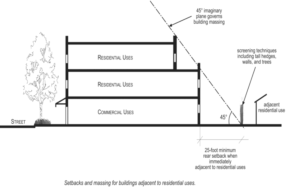
D.
Building appearance.
1.
The design of mixed-use development shall incorporate the following provisions:
a.
All building elevations visible from the public right-of-way shall be modulated at least every 50 feet by changes in building mass, facade treatment, fenestration pattern, roof form or other architectural features.
b.
Where residential and nonresidential uses are located within the same building, the nonresidential component shall be differentiated from residential component through changes in exterior finish material, floor height, glazing pattern, building wall plane, and/or horizontal projection.
c.
A minimum of three exterior cladding or finish materials shall be used per building. Variation in color, texture or application method among the same material shall not be considered a different material.
d.
Building facades shall be designed to define and articulate each vertical module of residential units, using at least two of the following:
(1)
Providing a variation in the wall plane (projection or recess) a minimum of two feet in depth between the modules;
(2)
Varying a minimum of two of the following architectural elements between modules: window recess depth, roof shape, window shape, stoop detail, and/or railing type;
(3)
Providing porches and balconies;
e.
Windows visible from the public right-of-way shall be recessed a minimum of four inches.
E.
Privacy for residential units.
1.
The windows of a residential unit shall not directly align with the windows of the unit of an adjacent building; but shall be offset by a minimum of ten feet from window edge to opposing window edge (Figure 19.120.050 E. - Privacy for Residential Unit(s).
2.
Patios, balconies or similar openings of a residential unit shall not directly align with that of the unit of an adjacent building; but shall be oriented or offset by a minimum of 15 feet from opening edge to opposing opening edge (Figure 19.120.050 E. - Privacy for Residential Units).
Figure 19.120.050 E. Privacy for Residential Units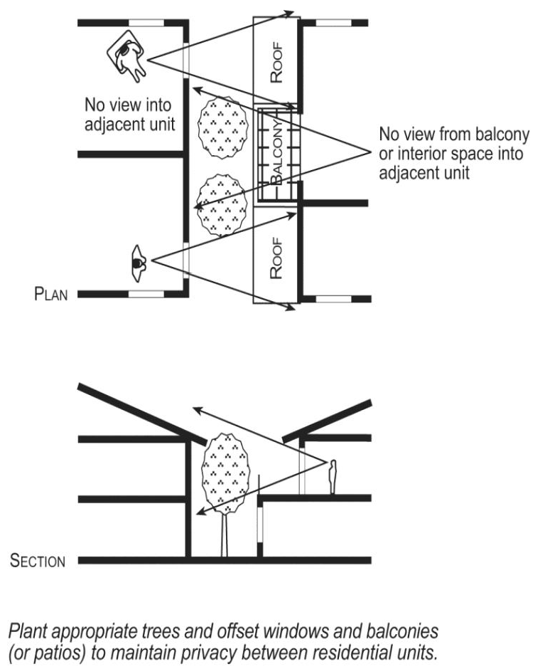
F.
Vehicle circulation and access.
1.
On-site vehicular circulation serving non-residential uses shall be open and not obstructed by the use of fences and gates. Private residential parking areas may be secured and gated.
2.
Vehicular entrances, including private garages, carports and parking structure entrances, shall be oriented toward the following (listed in priority order):
a.
Public alleys;
b.
Secondary internal streets or drive aisles;
c.
Primary internal streets;
d.
Public streets (except private garages and carports shall not take direct access from a public street).
G.
Pedestrian walkways.
1.
On-site pedestrian walkways shall be provided between adjacent uses within the project and align with walkways on neighboring properties where pedestrian connections exist.
2.
Pedestrian walkways shall connect residential and non-residential uses in the project, common open space, plazas and courtyards, parking areas and public sidewalks.
3.
Pedestrian walkways shall be clearly demarcated from vehicular circulation areas through the use of different surfacing materials if at the same finished elevation; or shall be a raised sidewalk separated by a curb with a minimum height of six inches; and shall be ADA compliant.
H.
Fences and walls. In addition to the standards and requirements of Chapter 19.550 (Fences, Walls, and Landscape Materials) the following standards shall apply:
1.
Fences and/or walls located anywhere between the primary building and the public right-of-way shall not exceed the following:
a.
Three feet in height for solid fences and walls;
b.
Four feet in height for openwork or combination solid and openwork fences and walls provided that the openwork portion of the fence or wall above a height of three feet shall be no more than one part solid to three parts open with no portion of the solid wall, excluding pilasters, extending above three feet;
c.
Fences and/or walls that enclose common usable open space amenities such as swimming pools and playgrounds, and excluding passive landscape areas, shall have a maximum height of six feet and, if solid, shall match the exterior finish material and color of the primary building(s).
I.
Permitted materials for fences and/or walls shall include decorative masonry split face block, brick, natural stone, precast concrete panels, stucco, wrought iron, aluminum, wood, chemically treated or naturally resistant to decay.
J.
Residential usable open space.
1.
Common and private usable open space shall be provided as set forth in Table 19.120.040 C.
2.
Common open space areas shall include the minimum number and type of amenities based on the project's size as set forth in 19.100.070 A. (Usable open space).
3.
Private useable open space shall be contiguous to the unit served.
4.
In the MU-V and MU-U Zones, private and common usable open space may be provided on the roofs of buildings and parking garages.
K.
Outdoor display and storage. Commercial outdoor display and storage shall not be permitted except as specified in Chapters 19.500 (Outdoor Display of Incidental Plant Materials), 19.505 (Outdoor Display and Sales) and 19.510 (Outdoor Storage).
L.
Trash receptacles and enclosures.
1.
The trash storage container areas for residential and non-residential uses shall be separate.
2.
The provisions of Chapter 19.554 (Trash/Recyclable Materials Collection Area Enclosures) regarding requirements for the screening of trash receptacles shall apply.
M.
Mechanical equipment screening. The provisions of Chapter 19.555 (Outdoor Equipment Screening) regarding required screening of mechanical equipment shall apply.
(Ord. No. 7701, §§ 6—8, 2025; Ord. 7592 § 3(Exh. C), 2022; Ord. 7573 § 1(Exh. A), 2021; Ord. 7331 § 6, 2016; Ord. 6966 § 1, 2007)
Editor's note— Ord. No. 7701, §§ 6—10, adopted in 2025, renumbered §§ 19.120.070—19.120.090 as §§ 19.120.050—19.120.070.
19.120.060 - Performance standards.
The purpose of this section is to ensure that residential uses in mixed-use zones are not adversely impacted by adjacent commercial uses, including, but not limited to, traffic, noise, light and safety impacts. In the interests of both the residents and the businesses, no site plan review permit shall be approved for a project unless the project is designed to meet the following performance standards, in addition to performance standards set forth in Chapter 19.590 (Performance Standards).
A.
Noise. Development in mixed-use zones shall comply with all requirements of Title 7 (Noise) and the California Building Standards Code.
B.
Security.
1.
The residential units shall be designed to ensure the security of residents through the provision of separate and secured entrances and exits. Where residential units are in the same structure as a commercial use, access to residential units shall be from a secured area located on the first floor at the ground level.
2.
Nonresidential and residential uses located on the same floor shall not have common entrance hallways or common balconies.
C.
Light and glare.
1.
All outdoor lighting associated with commercial uses adjacent to or within the immediate vicinity of residential uses shall be designated with fixtures and poles that illuminate commercial uses, while minimizing light trespass into residential areas.
2.
The provisions of Section 19.590.070 (Light and Glare) shall apply.
3.
The provisions of Chapter 19.556 (Lighting) shall apply.
D.
Odor.
1.
All trash storage areas for non-residential uses shall be located so as to be convenient and where associated odors and noise will not adversely impact the residential uses.
(Ord. No. 7701, § 9, 2025; Ord. 7660, § 2, 2024; Ord. 7592 § 3(Exh. C), 2022; Ord. 7573 § 1(Exh. A), 2021; Ord. 7331 § 6, 2016; Ord. 6966 § 1, 2007)
19.120.070 - Other regulations applicable to Mixed-Use Zones.
In addition to the requirements contained in this chapter, regulations contained in the following titles of the Riverside Municipal Code and other chapters of the Zoning Code may apply.
Title 5: Business Taxes, Licenses and Regulations
Chapter 5.04: Taxes, Licenses and Regulations
Chapter 5.16: Close-Out Sales
Chapter 5.24: Dance Halls and Public Dances
Chapter 5.28: Poolrooms
Chapter 5.32: Transient Occupancy Tax
Chapter 5.38: Pedestrian Food Vendors
Chapter 5.49: Garage Sales
Chapter 5.52: Massage
Chapter 5.60: Bingo
Chapter 5.64: Motor Vehicle Fuel Price Posting
Chapter 5.49: Garage Sales
Title 6: Health and Sanitation
Chapter 6.08: Regulation of Food Establishments and Food Facilities
Chapter 6.09: Regulation of Food Handlers
Chapter 6.13: Exterior Structure Maintenance
Chapter 6.14: Landscape Maintenance
Chapter 6.15: Abatement of Public Nuisances
Chapter 6.16: Fly-Producing Conditions
Title 7: Noise Control
Title 8: Animals
Chapter 8.04: Animals
Chapter 8.10: Noisy Animals
Chapter 8.18: Commercial Kennels
Chapter 8.19: Pot-Bellied Pigs
Title 9: Peace, Safety and Morals
Chapter 9.07: Charge for Police Response to Loud or Large Parties
Chapter 9.09: Public Pay Telephone Regulations
Chapter 9.16: Litter and Littering
Chapter 9.42: Fortune telling and Occult Arts
Chapter 9.48: Disclosure of Hazardous Materials
Title 16: Buildings and Construction
Title 17: Grading
Title 18: Subdivision
Title 20: Cultural Resources
(Ord. No. 7701, § 10, 2025; Ord. 7331 § 6, 2016; Ord. 6966 § 1, 2007)
19.130.010 - Purpose.
The industrial zones are established to implement the Business/Office Park and Industrial land use categories of the General Plan. The purpose of the industrial zones is to provide areas appropriate for a wide variety of industrial, manufacturing, and support uses that have the potential to provide jobs and generate tax revenue in Riverside, while protecting residential neighborhoods, schools, parks, playgrounds, day care centers, nursing homes, hospitals and other public places from nuisances or hazards associated with such activities. The industrial zones will also offer locations for new and emerging clean energy uses within the City of Riverside. Commercial uses allowed in the industrial zones are intended to serve the needs of the industrial and surrounding uses and their employees, and generally are not intended to draw customers from a larger region. The purpose of each of the industrial zones is as follows:
A.
Business and Manufacturing Park Zone (BMP). The Business and Manufacturing Park Zone (BMP) is established to provide a district for low-intensity and low-impact industrial, office, and related uses. Typical uses include research and development facilities and laboratories; uses that demonstrate clean energy practices; administrative, executive and professional offices; small-scale warehouses, light manufacturing; and support commercial.
B.
General Industrial Zone (I). The General Industrial Zone (I) is established to provide a district for general manufacturing and wholesaling, limited warehousing and distribution facilities, and support commercial. Uses that demonstrate clean energy practices are also allowed in the (I) zone.
C.
Air Industrial Zone (AI). The Air Industrial Zone (AI) is established to help protect the health, safety and general welfare of the Riverside Municipal Airport and its environs, including provisions for sensible growth and high-quality development tailored to the varied development conditions of the airport area. Uses that demonstrate compatibility with the Riverside Municipal Airport and clean energy practices are allowed in the AI Zone. The AI Zone consists of four subzones - AI-1, AI-2, AI-3, and AI-4 - with the following primary purposes:
1.
AI-1: To establish areas for businesses needing large-scale, high-visibility locations.
2.
AI-2: To establish areas for airport, industrial, office and limited commercial uses needing moderate scale sites at or adjacent to the Riverside Municipal Airport.
3.
AI-3: To establish areas for moderate-size uses with varying locations and site size needs.
4.
AI-4: To establish areas for small-size uses with limited visibility and site size needs.
D.
Airport Zone (AIR). The Airport Zone (AIR) is established in recognition of the importance of airport and aviation-related uses to the City's economy, and to allow for aviation, industrial, service and commercial uses related to or compatible with or convenient for airport operations including those that demo.
(Ord. 7587, § 1, 2022; Ord. 7541, § 1, 2020; Ord. 7331 §7, 2016; Ord. 6966 §1, 2007)
19.130.020 - Permitted land uses.
A.
Table 19.150.020.A (Permitted Uses Table), Table 19.150.020.B (Incidental Uses Table and Table 19.150.020.C (Temporary Uses Table) in Chapter 19.150 (Base Zones Permitted land uses) identify permitted uses, permitted accessory uses, permitted temporary uses, and uses permitted subject to the approval of a minor conditional use permit (Chapter 19.730 - Minor Conditional Use Permit), or conditional use permit (Chapter 19.760 - Conditional Use Permit), or uses requiring some other permit. Table 19.150.020.A also identifies those uses that are specifically prohibited. Uses not listed in the tables or in Section 19.130.025 (Uses Specifically Prohibited) are prohibited unless, the Community & Economic Development Director or his/her designee, pursuant to Chapter 19.060 (Interpretation of Code), determines that the use is similar to and no more detrimental than a listed permitted or conditional use. Any use which is prohibited by state and/or federal law is also strictly prohibited.
B.
Chapter 19.149 - Airport Land Use Compatibility includes Airport Land Use Compatibility Plan requirements for discretionary actions proposed on property located within an Airport Compatibility Zone.
(Ord. 7413, § 1(Exh. A), 2-20-2018; Ord. 7331 §7, 2016; Ord. 7064 §4, 2010; Ord. 6966 §1, 2007)
19.130.025 - Uses specifically prohibited.
A.
The following uses are specifically prohibited in any industrial zone:
1.
Any residential use other than permitted caretaker housing
2.
Ammonia, chlorine or bleaching powder manufacture
3.
Animal slaughtering
4.
Asphalt batching plant and rock, sand and gravel pit crushing and screening plant
5.
Automobile wrecking, dismantling, and salvage yards
6.
Bone, coal or wood distillation
7.
Brick, tile or clay products manufacture
8.
Cement, lime, gypsum or plaster of Paris manufacture, except that the manufacture of cement products shall be permitted
9.
Explosive manufacture or storage
10.
Fat rendering
11.
Fertilizer manufacture
12.
Foundry or smelting of ferrous metals, steel mill or boiler works
13.
Garbage, offal, dead animal or refuse incineration, reduction or dumping
14.
Glue manufacture
15.
Hydrochloric, nitric or sulfuric acid manufacture
16.
Junk, rag or scrap iron storage yards or bailing
17.
Petroleum refining or petroleum products manufacture
18.
Rock, sand or gravel excavating
19.
Rubber or gutta-percha manufacture
20.
Soap manufacture
21.
Stockyard, cattle-feeding yard or hog ranch
22.
Tallow, grease or lard manufacture or refining
23.
Tanning, curing or storing of raw hides or skins
24.
Other uses that, by written decision of the Community & Economic Development Director or his/her designee, are determined to be detrimental to the public welfare by reason of the emission of odor, dust, smoke, gas, noise, vibration or other causes.
(Ord. 7331 §7, 2016; Ord. 6966 §1, 2007)
19.130.030 - Development standards for Industrial Zones.
A.
Table 19.130.030.A (BMP, I and AIR Industrial Zones Development Standards) sets forth the minimum development standards for all development in the BMP, I, and AIR Zones.
B.
Table 19.130.030.B (AI Industrial Zones Development Standards) sets forth the minimum development standards for all development in the AI Zones.
(Ord. 7609 § 1, 2022; Ord. 7331 §7, 2016; Ord. 6966 §1, 2007)
Table 19.130.030.A
BMP, I and AIR Industrial Zones Development Standards
Notes:
1.
The Approving or Appeal Authority may allow a development project to exceed a maximum FAR when findings can be made that such project (a) will not have a detrimental effect on infrastructure and municipal services, (b) will not adversely impact the surrounding neighborhood, and (c) will not likely set a precedent for additional development that would adversely affect infrastructure, service or surrounding land uses.
2.
Smaller minimum lot areas may be established by a specific plan or master plan in the BMP Zone. A master plan must include provisions for common access, parking and maintenance. A total master plan area of five acres is required. Site plan review approval by the Community & Economic Development Director or his/her designee is required for any master plan.
3.
See Chapter 19.149 - Airport Land Use Compatibility to determine if a project site is subject to Airport Land Use Compatibility Plan requirements.
4.
In the BMP Zone, off-street parking, gate or guard houses, roofs or canopies covering unenclosed pedestrian walks and walls or fences not more than six feet in height shall be permitted in the rear 30 feet of the required 50-foot front yard setback.
5.
A minimum front yard setback of 50 feet shall be required and maintained wherever a lot or parcel in any industrial zone abuts or is adjacent to a lot or parcel in any residential zone or use.
6.
Except where the site is separated from such residential zone or use by a freeway.
7.
Measured from the residential zone or property line to the industrial building.
Table 19.130.030.B
AI Industrial Zones Development Standards
Notes:
1.
The side or rear yard setback shall be the same as the required front yard setback wherever a side or rear yard abuts any lot zoned for residential use.
2.
Smaller minimum lot areas may be established by a specific plan or airport master plan. A master plan must include provisions for common access, parking and maintenance. A total master plan area of five acres is required. Site plan approval by the Community & Economic Development Director or his/her designee is required for any master plan.
3.
See Chapter 19.149 - Airport Land Use Compatibility to determine if a project site is subject to Airport Land Use Compatibility Plan requirements.
4.
No building, structure or tree may penetrate the flight zone of an airport per the "imaginary surfaces" established by Federal Aviation Regulations FAR Part 77.25.
5.
The Approving or Appeal Authority may allow a development project to exceed a maximum FAR when findings can be made that such project (a) will not have a detrimental effect on infrastructure and municipal services, (b) will not adversely impact the surrounding neighborhood, and (c) will not likely set a precedent for additional development that would adversely affect infrastructure, service or surrounding land uses.
(Ord. No. 7701, § 11, 2025; Ord. 7609 § 2(Exh. A), 2022; Ord. 7541, §§ 2(Exh. A), 3(Exh. B), 2020; Ord. 7413, § 1(Exh. A), 2-20-2018)
19.130.040 - Additional standards, regulations and requirements for the BMP, I, AIR and AI Zones.
A.
Health Risk Assessment. A Health Risk Assessment (HRA) shall be prepared in accordance with South Coast Air Quality Management District (SCAQMD) Guideline for the new development or substantial enlargement of industrial uses within 1,000 feet of a Residential Zone or use.
B.
Walls. Wherever a lot or parcel in any industrial zone abuts a Residential Zone or use, or abuts an alley that separates the industrial zone from a Residential Zone or use, a minimum eight-foot high solid masonry wall shall be constructed along the property line or alley right-of-way line separating the industrial zone from the Residential Zone or use. Wall height shall be measured from the finished grade of the adjacent Residential Zone or use.
1.
Such wall shall be limited in height to three feet in any required front yard or street side yard setback area.
2.
Such wall shall not be required until the industrial lot or parcel is developed with a permitted use.
C.
Outdoor display and storage. Except for the outdoor storage and display of aircraft, outdoor display and storage shall not be permitted except as specified in 19.285 (Outdoor Storage Yard), 19.500 (Outdoor Display of Incidental Plant Materials), 19.505 (Outdoor Display and Sales - Incidental) and 19.510 (Outdoor Storage—Incidental).
D.
Use of interior rear and side yards for off-street parking and loading. Except for required landscape areas, required interior rear yards and side yards may be used for off-street parking, off-street loading, outdoor storage incidental to a permitted use, and any use permitted in the required front yard area; provided such loading, parking and storage areas are acoustically shielded and screened from adjacent Residential Zones or uses and the public right-of-way, to the satisfaction of the Community & Economic Development Director or his/her designee.
E.
Lighting. Lighting for signs, structures, landscaping, parking areas, loading areas and the like, shall comply with the regulations set forth in Section 19.590.070 (Light and Glare) and the provisions of Chapter 19.556 (Outdoor Lighting).
F.
Screening of mechanical equipment. All roof-supported or ground-supported mechanical equipment and utility equipment shall comply with the regulations set forth in Chapter 19.555 (Outdoor Equipment Screening).
G.
Landscaping. Front and side yard areas adjacent to streets and interior perimeter landscape planters adjacent to Residential Zones or uses shall be suitably landscaped and continuously maintained as set forth in Chapter 19.570 (Water Efficient Landscaping and Irrigation). Such setbacks shall not be used for off-street parking, loading, storage or accessory buildings.
H.
Performance standards. All uses shall comply with the performance standards set forth in Chapter 19.590 (Performance Standards) for industrial uses, except that the noise associated with aircraft operations shall be exempt from noise standards but shall comply with any applicable Federal Aviation Administration regulations regarding noise.
I.
Parking and loading requirements. Parking areas shall be provided as set forth in Chapter 19.580 (Parking and Loading).
J.
Trash receptacles and enclosures.
1.
All trash storage areas shall be located so as to be convenient to the users and where associated odors and noise will not adversely impact the users.
2.
The provisions of Chapter 19.554 (Trash/Recyclable Materials Collection Area Enclosures) regarding requirements for the screening of trash receptacles shall apply.
(Ord. 7541, § 4, 2020; Ord. 7331 §7, 2016; Ord. 6966 §1, 2007)
19.130.050 - Design review required.
No new building, structure or sign or exterior alteration or enlargement of an existing building, structure or sign shall be commenced in any industrial zone until design review approval has been granted pursuant to Chapter 19.710 (Design Review).
(Ord. 7331 §7, 2016; Ord. 6966 §1, 2007)
19.130.060 - Other regulations applicable to Industrial Zones.
In addition to the requirements contained in this chapter, regulations contained in the following titles of the Riverside Municipal Code and other chapters of the Zoning Code may apply.
Title 5: Business Taxes, Licenses and Regulations
Chapter 5.04: Taxes, Licenses and Regulations
Chapter 5.16: Close-Out Sales
Chapter 5.28: Poolrooms
Chapter 5.32: Transient Occupancy Tax
Chapter 5.38: Pedestrian Food Vendors
Chapter 5.48: Swap Meet
Chapter 5.52: Massage
Chapter 5.60: Bingo
Chapter 5.64: Motor Vehicle Fuel Price Posting
Chapter 5.66: Ambulances
Title 6: Health and Sanitation
Chapter 6.08: Regulation of Food Facilities
Chapter 6.09: Regulation of Food Handlers
Chapter 6.13: Exterior Structure Maintenance
Chapter 6.14: Landscape Maintenance
Chapter 6.15: Abatement of Public Nuisances
Title 7: Noise Control
Title 8: Animals
Chapter 8.18: Commercial Kennels
Title 9: Peace, Safety and Morals
Chapter 9.07: Social Host of Minors Accountability
Chapter 9.09: Public Pay Telephone Regulations
Chapter 9.16: Litter and Littering
Chapter 9.40: Adult-Oriented Businesses
Chapter 9.42: Fortunetelling and Occult Arts
Chapter 9.48: Unified Hazardous Materials Programs
Title 12: Airport and Aircraft
Title 16: Building and Construction
Title 17: Grading
Title 18: Subdivision
Title 20: Cultural Resources
(Ord. 7541, § 4, 2020; Ord. 7331 §7, 2016; Ord. 6966 §1, 2007)
19.140.010 - Purpose.
The Public Facilities Zone (PF) is established to create and preserve areas for official and public uses of property and related activities, including civic center, public schools, public buildings, parks and recreation facilities, waterworks and drainage facilities, and similar areas that, for the welfare of the City, should be kept clear of particular structures or improvements, and for watershed areas for conservation of flood or storm waters or for protection against flood or storm waters.
(Ord. 7331 §8, 2016; Ord. 6966 §1, 2007)
19.140.015 - Review required.
Any new building or structure or any exterior alteration or enlargement of an existing building or structure shall be subject to design review pursuant to Chapter 19.710 (Design Review). As noted in Section 19.040.110 (Public Projects) the provisions of this title do not apply to City projects.
(Ord. 7331 §8, 2016; Ord. 6966 §1, 2007)
19.140.020 - Permitted land uses.
A.
Table 19.150.020.A (Permitted Uses Table), Table 19.150.020.B (Incidental Uses Table and Table 19.150.020.C (Temporary Uses Table) in Chapter 19.150 (Base Zones Permitted land uses) identify permitted uses, permitted accessory uses, permitted temporary uses, and uses permitted subject to the approval of a minor conditional use permit (Chapter 19.730 - Minor Conditional Use Permit), uses requiring approval of a conditional use permit (Chapter 19.760 - Conditional Use Permit), or uses requiring some other permit. Table 19.150.020.A also identifies those uses that are specifically prohibited. Uses not listed in the tables are prohibited unless the Community & Economic Development Director or his/her designee, pursuant to Chapter 19.060 (Interpretation of Code), determines that the use is similar to and no more detrimental than a listed permitted or conditional use. Any use which is prohibited by state and/or federal law is also strictly prohibited.
B.
The following uses are permitted as a matter of right in the Public Facilities Zone:
1.
Drainage and flood control facilities.
2.
Any public facility use not involving a structure or building, except for public parks, or any City project or a project on City owned property, pursuant to Section 19.04.110.
C.
If not on City owned property, the following uses are permitted in the Public Facilities Zone subject to the granting of a conditional use permit pursuant to the provisions of Chapter 19.760 (Conditional Use Permit) of the Zoning Code.
1.
Public buildings and associated grounds used for governmental and related purposes and activities
2.
Public educational institutions
3.
Public parks and recreation facilities
4.
Public rifle, pistol and archery ranges
5.
Zoos, arboretums, wildlife preserves and similar uses
6.
Water and sewage treatment plants
7.
Utility substations
8.
Power generation facilities
9.
Government agency storage and maintenance yards
10.
Public parking garages
D.
Chapter 19.149 - Airport Land Use Compatibility includes Airport Land Use Compatibility Plan requirements for discretionary actions proposed on property located within an Airport Compatibility Zone.
(Ord. 7413, § 1(Exh. A), 2-20-2018; Ord. 7331 §8, 2016; Ord. 7064 §5, 2010; Ord. 6966 §1, 2007)
19.140.030 - Development standards for public facilities.
A.
Setbacks. Any building or other structure established in the Public Facilities Zone shall be set back a minimum of 20 feet from all property lines. For any building adjacent to a zone permitting residential uses, an additional setback of one foot for every two feet of building height in excess of 45 feet shall be required for any yard area abutting the zone permitting residential uses.
B.
Building height. The maximum height for any building or structure in the Public Facilities Zone shall be 60 feet or four stories, whichever is less. See Chapter 19.149 - Airport Land Use Compatibility to determine if height restrictions for airport compatibility apply.
C.
Landscaping. Landscaping shall be provided and continuously maintained as set forth in Chapter 19.570 (Water Efficient Landscaping and Irrigation). In addition, any setback abutting a public street shall be fully landscaped.
D.
Screening. Utility substations, storage and maintenance yards, and similar facilities that have an industrial character shall be screened from public view by any combination of block walls, landscaping, or durable and aesthetically acceptable fencing materials that complement the site. Such screening materials shall have a minimum height of eight feet.
E.
Trash receptacles and enclosures.
1.
All trash storage areas shall be located so as to be convenient to the users and where associated odors and noise will not adversely impact the users.
2.
The provisions of Chapter 19.554 (Trash/Recyclable Materials Collection Area Enclosures) regarding requirements for the screening of trash receptacles shall apply.
F.
Lighting. Lighting for signs, structures, landscaping, parking areas, loading areas and the like, shall comply with the regulations set forth in Section 19.590.070 (Light and Glare) and the provisions of Chapter 19.556 (Lighting).
G.
Airport land use compatibility standards.Chapter 19.149 - Airport Land Use Compatibility includes Airport Land Use Compatibility Plan requirements for discretionary actions proposed on property located within an Airport Compatibility Zone.
(Ord. 7413, § 1(Exh. A), 2-20-2018; Ord. 7331 §8, 2016; Ord. 6966 §1, 2007)
19.140.040 - Other regulations applicable to the Public Facilities Zone.
In addition to the requirements contained in this chapter, regulations contained in the following titles of the Riverside Municipal Code and other chapters of the Zoning Code may apply.
Title 5: Business Taxes, Licenses and Regulations
Chapter 5.04: Taxes, Licenses and Regulations
Chapter 5.38: Pedestrian Food Vendors
Title 6: Health and Sanitation
Chapter 6.08: Regulation of Food Establishments and Food Facilities
Chapter 6.09: Regulation of Food Handlers
Chapter 6.13: Exterior Structure Maintenance
Chapter 6.14: Landscape Maintenance
Chapter 6.15: Abatement of Public Nuisances
Title 7: Noise Control
Title 9: Peace, Safety and Morals
Chapter 9.07: Charge for Police Response to Loud or Large Parties
Chapter 9.09: Public Pay Telephone Regulations
Chapter 9.16: Litter and Littering
Chapter 9.48: Disclosure of Hazardous Materials
Title 16: Building and Construction
Title 17: Grading
Title 20: Cultural Resources
(Ord. 7331 §8, 2016; Ord. 6966 §1, 2007)
19.145.010 - Purpose.
The Railway Zone (RWY) is established to preserve and protect existing railroad rights-of-way exclusively for rail transportation and related uses. The Railway Zone is further intended to ensure that the use of railroad rights-of-way is consistent with the General Plan and compatible with adjacent uses.
(Ord. 7331 §9, 2016; Ord. 6966 §1, 2007)
19.145.020 - Permitted land uses.
A.
Table 19.150.020.A (Permitted Uses Table), Table 19.150.020.B (Incidental Uses Table and Table 19.150.020.C (Temporary Uses Table) in Chapter 19.150 (Base Zones Permitted land uses) identify permitted uses, permitted accessory uses, permitted temporary uses, and uses permitted subject to the approval of a minor conditional use permit (Chapter 19.730 - Minor Conditional Use Permit), uses requiring approval of a conditional use permit (Chapter 19.760 - Conditional Use Permit), or uses requiring some other permit. Table 19.150.020.A also identifies those uses that are specifically prohibited. Uses not listed in the Tables are prohibited unless the Community & Economic Development Director or his/her designee, pursuant to Chapter 19.060 (Interpretation of Code), determines that the use is similar to and no more detrimental than a listed permitted or conditional use. Any use which is prohibited by state and/or federal law is also strictly prohibited.
B.
The following uses shall be permitted by right in the Railway zone:
1.
Right-of-way for railroad and associated transportation of goods and persons.
2.
Uses customarily incidental to railway operations and their related transportation purposes, including railway related structures and accessory buildings used specifically for that railway or transportation business, but not including manufacturing or business purposes not directly in connection with a railway or carrier itself.
3.
Light-rail transit related facilities consisting of:
a.
Tracks
b.
Energy transmission facilities, including rights-of-way and pressure control or booster stations for gasoline, electricity, natural gas, synthetic natural gas, oil or other forms of energy sources
4.
Public streets.
5.
Any other use that the Community & Economic Development Director or his/her designee, pursuant to provisions of Chapter 19.060 (Interpretation of Code), determines that is no more detrimental than a listed permitted or conditional use.
C.
Construction caretaker temporary living quarters shall be permitted subject to approval of a minor conditional use permit pursuant to the provisions of Chapter 19.730 (Minor Conditional Use Permit).
D.
The following uses are permitted subject to the granting of a conditional use permit pursuant to the provisions of Chapter 19.760 (Conditional Use Permit):
1.
Parking lots, although no structures other than fencing are allowed.
2.
Maintenance/repair facilities
3.
Train stations
E.
Sound attenuation walls shall be permitted subject to design review pursuant to the provisions of Chapter 19.710 (Design Review).
F.
Chapter 19.149 - Airport Land Use Compatibility includes Airport Land Use Compatibility Plan requirements for discretionary actions proposed on property located within an Airport Compatibility Zone.
(Ord. 7413, § 1(Exh. A), 2-20-2018; Ord. 7331 §9, 2016; Ord. 7064 §6, 2010; Ord. 6966 §1, 2007)
19.145.030 - Development standards for the Railway Zone.
Table 19.145.030 (Railway Zone Development Standards) identifies the development standards applicable to all development within the Railway Zone.
(Ord. 7413, § 1(Exh. A), 2-20-2018; Ord. 7331 §9, 2016; Ord. 6966 §1, 2007)
19.145.040 - Other regulations applicable to the Railway Zone.
In addition to the requirements contained in this chapter, regulations contained in the following titles of the Riverside Municipal Code and other chapters of the Zoning Code may apply.
Title 5: Business Taxes, Licenses and Regulations
Chapter 5.04: Taxes, Licenses and Regulations
Title 6: Health and Sanitation
Chapter 6.08: Regulation of Food Establishments and Food Facilities
Chapter 6.09: Regulation of Food Handlers
Chapter 6.13: Exterior Structure Maintenance
Chapter 6.14: Landscape Maintenance
Chapter 6.15: Abatement of Public Nuisances
Title 7: Noise Control
Title 9: Peace, Safety and Morals
Chapter 9.16: Litter and Littering
Chapter 9.48: Disclosure of Hazardous Materials
Title 16: Building and Construction
Title 17: Grading
Title 20: Cultural Resources
(Ord. 7331 §9, 2016; Ord. 6966 §1, 2007)
19.146.010 - Purpose.
The Northside Specific Plan Zone is established to create safe, healthy and balanced community celebrating the history and culture of the greater Riverside area. The Northside Specific Plan includes a mix of diverse uses that enhance the existing character of the Northside. The Northside Specific Plan, as adopted by City Council on November 17, 2020 as may be amended from time to time, sets forth the land use regulations and development standards applicable to all properties within the Northside Specific Plan Zone. Where any conflict exists between the regulations and standards contained in the Northside Specific Plan and provisions of this Zoning Code, the more restrictive regulations or standards shall apply.
A.
As specified in the Northside Specific Plan, the Zone is divided into 12 subdistricts, each with varying uses and development standards. The subdistricts are as follows:
1.
Northside Village Center (NVC) - Serves as the key hub for the Northside neighborhood. Uses include a local-serving and community-oriented uses to serve residents.
2.
Trujillo Adobe Heritage Village (TAHV) - Provides opportunities that enhance the development of a cultural resource center celebrating the Trujillo Adobe.
3.
Open Space, Parks, and Trails (OS) - Provides for a system of parks, open space, and trails linking residential neighborhoods with new services and amenities.
4.
Freeway Mixed Use (FMU) - Allows for a mixed-use neighborhood that transitions from highway related uses closest to the freeway to residential neighborhoods on backside of West La Cadena Drive.
5.
Mixed Use Neighborhoods (MU) - Provide for a variety of office, retail and residential uses to promote mixed use developments.
6.
High Density Residential (HDR) - Allows for high density housing such as row houses, condominiums and apartments and includes both single and multi-family housing.
7.
Medium High Density Residential (MHDR) - Medium High Density Residential neighborhoods in the Northside neighborhood will be maintained in the Northside Specific Plan.
8.
Medium Density Residential (MDR) - Existing Medium Density Residential (MDR) areas in the Northside neighborhood will also be protected under the Specific Plan.
9.
Business Office Park (B/OP) - Provides for single or mixed light industrial uses that do not create nuisances due to odor, dust, noise, or heavy truck traffic.
10.
Commercial (C) - Includes existing retail areas in the Northside Specific Plan Zone.
11.
Public Facilities/Institutional (PF) - Provide space for cultural facilities and governmental activities.
12.
Transition Zone Overlay (TZO) - Allows existing land uses to transition from Business/Office Park land uses, which can continue and expand, to multi-family residential uses when the real estate market allows the properties to transition.
(Ord. 7542, § 1(Exh. A), 2020)
19.146.020 - Permitted land.
All permitted and conditionally permitted uses for each sub-district are listed in the adopted Northside Specific Plan. Any use which is prohibited by state and/or federal law is also strictly prohibited.
(Ord. 7542, § 1(Exh. A), 2020)
19.146.025 - Prohibited uses.
19.146.030 - Development standards.
Site development standards required for each sub-district are set forth in the adopted Northside Specific Plan.
19.146.040 - Interpretations.
Any standard or regulation not specifically covered by the Northside Specific Plan shall be subject to the provisions of this Zoning Code and the Riverside Municipal Code. Interpretations may be made by the Community & Economic Development Director or her/her designee or referred to the Planning Commission if not specifically covered in the City's existing regulations pursuant to the procedures set forth in Chapter 19.060 (Interpretation of Code).
(Ord. 7542, § 1(Exh. A), 2020)
19.146.050 - Design review.
Design guidelines for each sub-district and general design guidelines that apply to all sub-districts are set forth in the adopted Northside Specific Plan. Any new building, structure, sign, or exterior alteration of an existing building, structure, or sign shall require design review approval as required by the adopted Northside Specific Plan.
(Ord. 7542, § 1(Exh. A), 2020)
19.147.010 - Purpose.
A.
The Downtown Specific Plan (DSP) Zone is established to create a diverse, vibrant, 24-hour Downtown area where people can work, live, shop, receive education and enjoy recreational facilities and where arts and culture are an integral component of the urban environment.
B.
The Downtown Specific Plan Zone allows a broad range of residential, office, retail, service commercial, arts and culture, recreational, educational, institutional, and entertainment uses. The Downtown Specific Plan, as adopted by the City Council on December 10, 2002 and as may be amended from time to time, sets forth the land use regulations and development standards applicable to all properties within the Downtown Specific Plan Zone. Where any conflict exists between the regulations and standards contained in the Downtown Specific Plan and provisions of this Zoning Code, the more restrictive regulations or standards shall apply.
C.
As specified in the Downtown Specific Plan, the Zone is divided into nine subdistricts, each with varying uses and development standards. The subdistricts are as follows:
1.
Raincross District: Intended to be the hub of the Downtown area, allowing a wide variety of uses, including cultural, arts, entertainment, retail, hospitality and urban residential uses. This area provides many opportunities for growth and development, using the area's historic buildings as a point of reference for scale and design.
2.
Justice Center District: Intended to be Downtown's center for courts, governmental, and large-scale private office uses. The emphasis is on density, height, and contemporary buildings with historic references in detailing.
3.
Almond Street District: Intended to maintain the residential scale and appearance of the existing neighborhood while allowing for a mix of small-scale office uses, live/work uses, and single-family residential uses, with an emphasis on adaptive reuse of existing historic residential structures.
4.
Prospect Place Office District: Intended to provide for a variety of high-quality office uses and be a transitional area between the open space of the Riverside Community College campus and the urban intensity of the Justice Center and the Core Districts.
5.
Health Care District: Intended to encourage the expansion of the existing hospital and medical-related uses and the establishment of new medical and medical support uses, and to create an attractive entry into Downtown from the south.
6.
Market Street Gateway District: Intended to create an attractive entry into the City and the Downtown area by providing a green parkway character and high-quality development adjacent to the SR-60 freeway. This district allows office and residential uses.
7.
Residential District: Intended to maintain and protect the existing character of the single-family residential neighborhoods downtown, as well as preserve the historic housing stock. This district includes three residential areas: Heritage Square, Mile Square, and Prospect Place.
8.
Neighborhood Commercial District: Intended to provide local shopping needs for all Downtown residents. Permitted uses include grocery store, restaurants, small offices and banks, laundromat and pharmacies.
(Ord. 7552 §5, 2021; Ord. 7331 §10, 2016; Ord. 6966 §1, 2007)
19.147.020 - Permitted land uses.
All permitted and conditionally permitted uses for each subdistrict are listed in the adopted Downtown Specific Plan. Any use which is prohibited by state and/or federal law is also strictly prohibited.
(Ord. 7331 §10, 2016; Ord. 7064 §7, 2010; Ord. 6966 §1, 2007)
19.147.025 - Prohibited uses.
19.147.030 - Development standards.
Site development standards required for each subdistrict are set forth in the adopted Downtown Specific Plan.
(Ord. 7331 §10, 2016; Ord. 6966 §1, 2007)
19.147.040 - Interpretations.
Any standard or regulation not specifically covered by the Downtown Specific Plan shall be subject to the provisions of this Zoning Code and the Riverside Municipal Code. Interpretations may be made by the Community & Economic Development Director or her/her designee or referred to the Planning Commission if not specifically covered in the City's existing regulations pursuant to the procedures set forth in Chapter 19.060 (Interpretation of Code).
(Ord. 7331 §10, 2016; Ord. 6966 §1, 2007)
19.147.050 - Design Review.
Design guidelines for each subdistrict and general design guidelines that apply to all subdistricts are set forth in the adopted Downtown Specific Plan. Any new building, structure, sign, or exterior alteration of an existing building, structure, or sign shall require design review approval as required by the adopted Downtown Specific Plan.
(Ord. 7331 §10, 2016; Ord. 6966 §1, 2007)
19.148.010 - Purpose.
A.
The Orangecrest Specific Plan (OSP) Zone is established to create a diverse area where people live, shop and enjoy recreational facilities.
B.
The Orangecrest Specific Plan Zone allows a broad range of residential uses with office and retail uses spaced throughout. The Orangecrest Specific Plan, as adopted by the City Council on December 3, 1985 and as may be amended from time to time, sets forth the land use regulations and development standards applicable to all properties within the Orangecrest Specific Plan Zone. Where any conflict exists between the regulations and standards contained in the Orangecrest Specific Plan and provisions of this Zoning Code, the more restrictive regulations or standards shall apply.
C.
As specified in the Orangecrest Specific Plan, the Zone is divided into subdistricts, each with varying uses and development standards.
(Ord. 7331 §11, 2016; Ord. 6966 §1, 2007)
19.148.020 - Permitted land uses.
All permitted and conditionally permitted uses for each subdistrict are listed in the adopted Orangecrest Specific Plan. Any use which is prohibited by state and/or federal law is also strictly prohibited. See Chapter 19.149 - Airport Land Use Compatibility to determine if a project site is subject to Airport Land Use Compatibility Plan requirements.
(Ord. 7413, § 1(Exh. A), 2-20-2018; Ord. 7331 §11, 2016; Ord. 7064 §8, 2010; Ord. 6966 §1, 2007)
19.148.030 - Development standards.
Site development standards required for each subdistrict are set forth in the adopted Orangecrest Specific Plan. See Chapter 19.149 - Airport Land Use Compatibility to determine if a project site is subject to Airport Land Use Compatibility Plan requirements.
(Ord. 7413, § 1(Exh. A), 2-20-2018; Ord. 7331 §11, 2016; Ord. 6966 §1, 2007)
19.148.040 - Interpretations.
Any standard or regulation not specifically covered by the Orangecrest Specific Plan shall be subject to the provisions of this Zoning Code and the Riverside Municipal Code. Interpretations may be made by the Community & Economic Development Director or his/her designee or referred to the Planning Commission if not specifically covered in the City's existing regulations pursuant to the procedures set forth in Chapter 19.060 (Interpretation of Code).
(Ord. 7331 §11, 2016; Ord. 6966 §1, 2007)
19.148.050 - Design review.
Design guidelines for each subdistrict and general design guidelines that apply to all subdistricts are set forth in the adopted Orangrecrest Specific Plan. Any new building, structure, sign, or exterior alteration of an existing building, structure, or sign shall require design review approval as required by the adopted Orangecrest Specific Plan.
(Ord. 7331 §11, 2016; Ord. 6966 §1, 2007)
19.149.010 - Purpose.
The purpose of this chapter is to establish and implement the requirements of the Riverside County Airport Land Use Compatibility Plan (ALUCP) for airports that affect land uses within the City of Riverside. Airports that affect land uses within the City of Riverside are the Riverside Municipal Airport, Flabob Airport, and the March Air Reserve Base/Inland Port Airport.
(Ord. 7413, § 2(Exh. A), 2-20-2018)
19.149.020 - Airport Land Use Compatibility Plan (ALUCP).
The Airport Land Use Compatibility Plan (ALUCP) is a State-required, long-range master plan that reflects the anticipated growth of an airport over a 20-year time period. State law requires general and specific plans to be consistent with any ALUCP affecting the City. The requirements are established to limit noise impacts on noise-sensitive uses and to protect and preserve airports and aviation safety, as well as public safety, from aviation-related hazards.
The Riverside County Airport Land Use Compatibility Plan (RCALUCP), designates zones of airport influence areas for 13 airports in Riverside County, and provides a series of policies and compatibility criteria to ensure that both aviation uses, and surrounding areas may continue, and are compatible. In 2004, the RCALUCP established compatibility criteria, and maps for influence areas of the Riverside Municipal, Flabob Airports. In 2014, the ALUC adopted the March Air Reserve Base/Inland Port Airport Compatibility Plan which includes compatibility criteria and maps for influence areas of the March Air Reserve Base/Inland Port Airport.
The RCALUCP establishes criteria specific to each of the airport compatibility zones described in Sections 19.149.050 and 19.149.060 of this chapter. For property located within a compatibility zone and subject to airport land use compatibility plan policies and criteria, land use, density, and intensity limitations of the ALUCP may be more restrictive than what would otherwise be allowed per City zoning designation applicable to the property. In addition to complying with the Zoning requirements of this title, proposed uses and development on property within an airport compatibility zone must be determined to be consistent with, and comply with the compatibility criteria of the applicable compatibility zone and airport land use compatibility plan.
(Ord. 7413, § 2(Exh. A), 2-20-2018)
19.149.030 - Airport Land Use Commission (ALUC).
A.
The purpose of an Airport Land Use Commission (ALUC) is to conduct airport land use compatibility planning. ALUCs protect public health, safety, and welfare by ensuring the orderly expansion of airports and the adoption of land use measures that minimize the public's exposure to excessive noise and safety hazards within areas around public airports. The statutes governing ALUCs are set forth in Division 9, Part 1, Chapter 4, Article 3.5, Sections 21670—21679.5 of the California Public Utilities Code (PUC).
B.
The Riverside County Airport Land Use Commission has two principal duties, which include:
1.
Preparing and adopting the ALUCP.
2.
Reviewing plans, regulations, and other actions of local agencies, and airport operators to ensure consistency with the RCALUCP.
(Ord. 7413, § 2(Exh. A), 2-20-2018)
19.149.040 - Actions which require ALUC Review.
A.
As required by State law, the following types of actions shall be referred to the Airport Land Use Commission for determination of consistency with the applicable Airport Land Use Compatibility Plan prior to approval by the City.
1.
The adoption or approval of any amendment to a general or specific plan affecting the property within an airport influence area (Public Utilities Code Section 21676(b)).
2.
The adoption or approval of a zoning ordinance or building regulation which affects property within an airport influence area, and involves the types of airport impact concerns listed in Section 1.4 of the March ALUCP (Public Utilities Code Section 21676(b)). These are impacts related to:
a.
Exposure to aircraft noise;
b.
Land use safety with respect both to people on the ground and the occupants of aircraft;
c.
Protection of airport airspace; and
d.
General concerns related to aircraft overflights.
3.
Adoption or modification of a master plan for an existing public-use airport (Public Utilities Code Section 21676(c)).
4.
Any proposal for expansion of an existing airport or heliport if such expansion will require an amended airport permit from the State of California (Public Utilities Code Section 21664.5).
5.
Any proposal for a new airport or heliport whether for public use or private use if the facility requires a State airport permit (Public Utilities Code Section 21661.5).
B.
Other land use actions subject to ALUC Review. In addition to the above types of land use actions for which ALUC review is mandatory, other types of land use actions are subject to review under the circumstances described in Section 1.5 of Chapter 2 Countywide Policies of the Riverside County Airport Land Use Compatibility Plan.
C.
Timing of ALUC Review. Proposed projects requiring ALUC review should be submitted to ALUC as early in the process as possible so that the Commission's (or ALUC Executive Director's) review can be considered by the City before taking formal action on a project. The timing may vary depending upon the nature of the specific project. However, all projects requiring ALUC review must be submitted to ALUC for review prior to final approval by the City.
(Ord. 7413, § 2(Exh. A), 2-20-2018)
19.149.050 - Actions not subject to ALUC Review—City ALUCP Compatibility Review.
For discretionary actions on property within an airport influence area and compatibility zone, but which are not subject to ALUC review as described in Section 19.149.040 above, the City shall review such action for consistency with the applicable ALUCP, and make a finding of project consistency or inconsistency with the applicable airport compatibility plan based on the basic land use compatibility criteria described below. Where there is uncertainty with regard to compatibility of a proposed use or project with the applicable airport land use compatibility plan, the City shall consult with ALUC staff, or defer such matter to ALUC for a consistency determination.
(Ord. 7413, § 2(Exh. A), 2-20-2018)
19.149.060 - Compatibility zones and criteria for Riverside Municipal and Flabob Airports.
For uses proposed within airport influence areas of Riverside Municipal and Flabob airports, refer to the Riverside County Airport Land Use Compatibility Plan to determine whether a particular use is compatible with the applicable airport and a permissible use.
A.
Airport Compatibility Zones. The RCALUCP establishes six separate Airport Compatibility Zones for Riverside Municipal and Flabob Airports. A general description of each Compatibility Zone is provided in the following table.
Table 19.149.060 - Riverside Municipal and Flabob Airports Compatibility Zones
Compatibility Zones for the Riverside Municipal and Flabob Airports can be found in Figure PS-6A of the Public Safety Element of the City of Riverside General Plan 2025, and within Chapter 3 of the Riverside County Airport Land Use Compatibility Plan.
B.
Land use compatibility criteria. The criteria for assessing whether a project is compatible with Riverside Municipal or Flabob airports are set forth in the Basic Compatibility Criteria matrix, Table 2A in Chapter 2 - Countywide Policies of the Riverside County Airport Land Use Compatibility Plan. These criteria are to be used in conjunction with the compatibility map and policies for the applicable airport (Riverside Municipal or Flabob) within Chapter 3 of the Riverside County ALUCP, or as amended.
(Ord. 7413, § 2(Exh. A), 2-20-2018)
19.149.070 - Compatibility zones and criteria for March Air Reserve Base/Inland Port Airport.
For uses proposed within airport influence areas of the March Air Reserve Base/Inland Port Airport, refer to the March Air Reserve Base/Inland Port Airport Land Use Compatibility Plan (March ALUCP) to determine whether a particular use is compatible with the applicable airport and a permissible use.
A.
Airport Compatibility Zones. The 2014 March ALUCP establishes eight separate Compatibility Zones for March Air Reserve Base/Inland Port Airport. A general description of each compatibility zone is provided in the following table.
Table 19.149.070 - March Air Reserve Base/Inland Port Airport Compatibility Zones
The Compatibility Zones for the March Air Reserve Base/Inland Port Airport are provided in Figure PS-6B of the Public Safety Element of the City of Riverside General Plan 2025, and as established per Map MA-1 within Volume 1 of the 2014 March Air Reserve Base/Inland Port Airport Land Use Compatibility Plan.
B.
Land use compatibility criteria for March Air Reserve Base/March Inland Port Airport. The criteria for assessing whether a project is compatible with the March ARB/IPA are set forth in the Compatibility Zone Factors matrix, Table MA-1 within Volume 1 of the March ALUCP, within Chapter 3 of the Riverside County Airport Land Use Compatibility Plan, or as amended. These criteria are to be used in conjunction with the compatibility map and policies for the March ARB/IPA as presented in Chapter 3 of the Riverside County ALUCP, or as amended. The basic compatibility criteria listed in Table 2A of Chapter 2 of the Riverside County ALUCP does not apply to the environs of March ARB/IPA.
C.
Accident Potential Zones (APZ's). In addition to the compatibility zones described above, Map MA-1 within Volume 1 of the March ALUCP identifies two Accident Potential Zones (APZ's I and II) for the March Air Reserve Base/Inland Port Airport. The Department of Defense (DoD) Air Force Instruction AFI 32-7063 - December 18, 2015 describes Clear Zones, and APZ's as areas off the end of DOD runways that were developed based on past Air Force aircraft accidents and reflect land areas at greater risk of an aircraft accident. The Clear Zone and the APZs represent areas where an accident is most likely to occur, if one would occur; however, they are not predictors of accidents. More specifically, the Clear Zone, and Accident Potential Zones (APZ's) are defined as follows:
1.
The Clear Zone begins at the end of the runway and is the area of highest accident potential; it has few uses that are compatible.
2.
APZ I lies beyond the Clear Zone [and] is in area of lower but still considerable accident potential.
3.
APZ II is beyond APZ I and possesses less accident potential.
D.
Department of Defense Requirements for March Air Reserve Base/Inland Port Airport Accident Potential Zones (APZ's)
For discretionary actions proposed within March ARB/IPA Accident Potential Zones (APZ I & II) or within the Clear Zone, the proposed use and/or development shall, in addition to meeting the compatibility criteria of the March ALUCP, be consistent with current Air Force Guidance including:
1.
Department of Defense Instruction 4165.57 for Air Installations Compatible Use Zones, March 12, 2015, or as amended, and
2.
Air Force Instruction AFI 32-7063 for Air Installations Compatible Use Zones Program, December 18, 2015, or as amended. Specifically AFI 32-7063, Table A.2.1 of Attachment 2 - Land Use Compatibility Recommendations for APZS, generally identifies land uses acceptable or not acceptable within the Clear Zone, APZ I, and APZ II, and establishes maximum residential density, or nonresidential floor area ratio requirements applicable to each use and APZ.
Where a discretionary action is proposed within an APZ, or Clear Zone, the Department of the Air Force, 452d Air Mobility Wing (AFRC) March Air Reserve Base shall be consulted to determine whether the proposed discretionary action is consistent with the Air Force Guidance referenced above. Such consultation would be in addition to, and shall not be in lieu of requirements of the March ALUCP, or any review for airport land use compatibility that may be required by the Riverside County ALUC.
(Ord. 7413, § 2(Exh. A), 2-20-2018)
19.149.080 - Variance process.
Variances from development standards of the Zoning Code are subject to Chapter 19.720 Variance provisions. In addition to the variance provisions contained in Chapter 19.720, this section includes special provisions to ensure that variances do not result in a conflict with airport compatibility criteria.
A.
Any variance that involves issues of noise, safety, airspace protection, or overflight compatibility as addressed in the applicable ALUCP must be referred to ALUC for review. Specifically, at a minimum, where a variance involves a deviation from the maximum allowable lot coverage, floor area ratio, or building height, the City shall consult with ALUC staff, or defer such matter to ALUC for a consistency determination. The provisions of Chapter 19.720, including required variance findings, apply regardless of a consistency determination by ALUC.
B.
Where a variance from the Zoning Code would result in a deviation form compatibility criteria of the applicable ALUCP, such deviation shall be referred to ALUC for review. Where ALUC has determined the project and/or variance inconsistent with the applicable ALUCP, the City Council may override ALUC's determination and approve subject to making the required findings of Chapter 19.720.
(Ord. 7413, § 2(Exh. A), 2-20-2018)
19.149.090 - Overrule procedures.
When ALUC disapproves or finds an action, regulation, or permit, to be inconsistent with the ALUCP, ALUC shall notify the City within 30 days of such action pursuant to Public Utilities Code (PUC) 21675.1(d). The City Council may overrule ALUC decision, by a two-thirds vote and shall make specific findings that the proposed action, regulation, or permit is consistent with the purposes of Article 3.5, as stated in Section 21670 of the PUC.
A City Council proposed overrule of an ALUC action must provide a copy of the proposed decision and findings to both ALUC and the California Division of Aeronautics, a minimum of 45 days' prior to the decision to overrule ALUC. These agencies have 30 days in which to provide comments to City Council pursuant to PUC Sections 21676(a) and (b).
(Ord. 7413, § 2(Exh. A), 2-20-2018)
19.150.010 - Purpose.
This section establishes land use regulations for all base zones listed in this article consistent with the stated intent and purpose of each zone.
(Ord. 7573 § 1(Exh. A), 2021; Ord. 7331 §12, 2016; Ord. 6966 §1, 2007)
19.150.020 - Permitted land uses.
Table 19.150.020 A. (Permitted Uses Table), Table 19.150.020 B. (Incidental Uses Table) and Table 19.150.020 C. (Temporary Uses Table) in Chapter 19.150 (Base Zones Permitted land uses) identify permitted uses, permitted accessory uses, permitted temporary uses, and uses permitted subject to the approval of a minor conditional use permit (Chapter 19.730 - Minor Conditional Use Permit), or conditional use permit (Chapter 19.760 - Conditional Use Permit), or uses requiring some other permit. Table 19.150.020 A. also identifies those uses that are specifically prohibited. Uses not listed in tables are prohibited unless the Community & Economic Development Department Director, or his/her designee, pursuant to Chapter 19.060 (Interpretation of Code), determines that the use is similar and no more detrimental than a listed permitted or conditional use. Any use which is prohibited by state and/or federal law is also strictly prohibited.
Chapter 19.149 - Airport Land Use Compatibility includes additional Airport Land Use Compatibility Plan requirements for discretionary actions proposed on property located within an Airport Compatibility Zone. When located within an Airport Land Use Compatibility Zone, greater land use, restrictions for airport compatibility may apply per the applicable Airport Land Use Compatibility Plan.
(Ord. 7630 § 3, 2023; Ord. 7573 § 1(Exh. A), 2021; Ord. 7552 §6, 2021; Ord. 7431, § 1(Exh. A), 2-20-2018; Ord. 7331 §12, 2016; Ord. 7273 §1, 2015; Ord. 7222 § 3, 2013; Ord. 7110 §§2, 3, 4, 2011; Ord. 7109 §§4, 5, 2010; Ord. 7072 §1, 2010; Ord. 7064 §9, 2010; Ord. 6966 §1, 2007)
1
Commercial Storage Facilities are permitted in all zones with the Commercial Storage
Overlay Zone (Chapter 19.190).
2
Legal, existing duplexes built prior to the adoption of this Zoning Code are permitted
in the R-1-7000 Zone see 19.100.060 D.
3
Allowed with a Planned Residential Development (PRD) Permit, Chapter 19.780.
4
One single-family detached dwelling allowed on one legal lot 0.25 acres in size or
less in existence prior to January 1, 2018 subject to the development standards of
the R-1-7000 Zone.
5
Permitted or conditionally permitted on sites that do not include a residential use.
6
For Clean Energy Uses and associated Outdoor Storage (Chapter 19.510) and/or Indoor Vehicle Repair (Chapter 19.420), permitted with a Minor Conditional Use Permit.
7 Allowed for Two-Unit Developments pursuant to Chapter 19.443.
8 Permitted by-right if located in an industrial or commercial zone and does not contain existing residential units, or if previously developed with a vehicle fuel station.
(Ord. 7743, § 2(Exh. A), 2025; Ord. 7731, § 2(Exh. B), 2025; Ord. No. 7701, §§ 12(Exh. A), 13(Exh. A), 2025; Ord. 7683, § 9(Exh. F), 2024; Ord. 7660, § 1(Exh. A), 2024; Ord. 7652 § 3(Exh. B), 2023; Ord. 7630 § 4(Exh. A), 2023; Ord. 7592 § 4(Exh. D), 2022; Ord. 7587, § 2(Exh. A), 2022; Ord. 7573 § 1(Exh. A), 2021; Ord. 7552 §7(Exh. C), 2021; Ord. 7541, § 6(Exh. C), 2020; Ord. 7528 § 1(Exh. A), 2020; Ord. 7520 § 1(Exh. A); Ord. 7505 § 1(Exh. A), 2020; Ord. 7487 § 13(Exh. D), 11-5-2019; Ord. 7462, § 2(Exh. A), 2019; Ord. 7431 § 3(Exh. A), 2018)
1 Accessory Dwelling Units (ADU) are permitted when an existing or proposed primary single-family or multi-family residential dwelling is located on the same property, pursuant to Chapter 19.422.
2 See exemptions noted in 19.450 - Alcohol Sales
3 Outdoor Sales and Display - Incidental are permitted on an intermittent basis with a TUP. See Section 19.740
4 Where play areas are proposed in conjunction with a new drive-thru restaurant, the play area can only be considered under the same conditional use permit required for the drive-thru business.
5 Non-domestic animal keeping in the RE and R-1 zones shall only permit chicken (poultry) keeping pursuant to Chapter 19.455 Animal Keeping.
(Ord. 7743, § 3(Exh. B), 2025; Ord. No. 7701, §§ 12(Exh. A), 13(Exh. B), 2025; Ord. 7660, § 1(Exh. A), 2024; Ord. 7652 § 4(Exh. C), 2023; Ord. 7630 § 5(Exh. B), 2023; Ord. 7617 § 1(Exh. A), 2022; Ord. 7528 §1(Exh. A), 2020; Ord. 7520 §1(Exh. A); Ord. 7505 § 1(Exh. A), 2020; Ord. 7457 § 1(Exh. A), 2019; Ord. 7431 § 3(Exh. A), 2018; Ord. 7408 §1, 2018; Ord. 7331 §11, 2016; Ord. 7316 §4, 2016; Ord. 7273 §1, 2015; Ord. 7222 §3, 2013, Ord. 7110 §§2, 3, 4, 2011; 7064 §9, 2010; Ord. 6966 §1, 2007)
*=Refer to Chapter 19.149 - Airport Land Use Compatibility, and applicable Airport Land Use Compatibility Plan for airport land use compatibility zones where use may be strictly prohibited.
1 All sites having active minor conditional use permits or conditional use permits, private schools, assemblies of people, etc.
2 For Exceptions, see Chapters 19.100.030 (A) - RA-5 Permitted Uses and 19.150.020.B Incidental Uses Table
(Ord. 7743, § 4(Exh. C), 2025; Ord. 7552 §8(Exh. D), 2021; Ord. 7528 §1(Exh. A), 2020; Ord. 7520 §1(Exh. A), 2020; Ord. 7505 § 1(Exh. A), 2020; Ord. 7408 §1, 2018; Ord. 7211 §2, 2013; Ord. 7110 §§2, 3, 4, 2011; Ord. 7064 §9, 2010; Ord. 6966 §1, 2007)
19.150.030 - Special or unusual uses.
At the discretion of the Community & Economic Development Department Director, or his/her designee, a conditional use permit may be considered for a unique or unusual combination of uses or special facilities similar to and not more detrimental than other uses in a particular zone.
(Ord. 7552 §9, 2021;Ord. 7331 §12, 2016; Ord. 7235 §6, 2013; Ord. 6966 §1, 2007)