
Rosemead City Zoning Code
ARTICLE 2
- ZONING DISTRICTS, ALLOWABLE LAND USES AND ZONE-SPECIFIC STANDARDS
Chapter 17.21 - GARVEY AVENUE SPECIFIC PLAN ZONING DISTRICT[2]
Editor's note— The Garvey Avenue Specific Plan is not included herein, but is incorporated by reference and available for inspection at the City Clerk's office.
Chapter 17.29 - FIRE HAZARD SEVERITY ZONES[3]
Editor's note—Ord. No. 1029, §§ 1—3, adopted June 10, 2025, enacted provisions relating to fire hazard severity zones at the editor's discretion, these provisions have been included as Ch. 17.29, §§ 17.29.010, 17.29.020.
17.08.010 - Districts established.
Rosemead shall be divided into zoning districts that implement the General Plan. These districts shall also classify, regulate, restrict and segregate the uses of land and buildings. The Garvey Avenue Specific Plan establishes its own land use zoning districts described in Chapter 17.21 of this Title. The zoning districts described in Table 17.08.010.1 are hereby established, and shall be shown on the official Zoning Map adopted.
Table 17.08.010.1
ZONING DISTRICTS
(Ord. No. 931, § 5(Exh. A), 10-22-13; Ord. No. 978, § 5(Exh. A), 2-27-18)
17.08.020 - Official zoning map.
The official Rosemead Zoning Map has been adopted separately by the City Council and is on file in the office of the City Clerk. The Zoning Map is made a part of this Title by reference, and all notations, references and other information shown thereon shall be as much a part of this Title as if such notations, references and information were fully set forth herein. All properties included in such zoning map are classified and zoned in accordance with the zoning designation shown on the Zoning Map.
(Ord. No. 931, § 5(Exh. A), 10-22-13)
17.08.030 - Interpretation of zone boundaries.
Where uncertainty exists as to the boundaries of any zone shown on the zoning map, the following provisions shall apply:
A.
Where such boundaries are indicated as approximately following street and alley lines or lot lines, such lines shall be construed to be such boundaries.
B.
In un-subdivided property or where a zone boundary divides a lot, the location of such boundary, unless the same is indicated by dimensions, shall be determined by the use of the scale appearing on the map.
C.
Where any public street or alley, or any portion thereof, is officially vacated or abandoned, the regulations applicable to abutting property shall apply to the centerline of such vacated or abandoned street or alley.
D.
Where any private right-of-way or easement of any railroad, railway, canal, channel, transportation or public utility company, or any portion thereof, is vacated or abandoned, the regulations applicable to abutting property shall apply to such vacated or abandoned property.
E.
All property in the City not otherwise zoned, and all property hereafter annexed and not zoned upon annexation, is classified as R-1 until such time as the City Council re-classifies the property consistent with the General Plan land use designation for the property. In case any uncertainty exists, the Community Development Director shall determine the location of boundaries pursuant to Section 17.08.030.
(Ord. No. 931, § 5(Exh. A), 10-22-13)
17.08.040 - Zoning of annexed property.
A.
Petition for Pre-zoning. Upon the initiation of proceedings for the annexation of property to the City, the owner or owners may request the City to concurrently adopt the proposed zoning designation or designations for the property or properties involved in such annexation, in the event the property is annexed to the City. The City Council may also initiate proceedings for pre-zoning properties that may be annexed into the City.
B.
Pre-zoning Optional. The proceedings for establishing the zoning of property pending proceedings for annexation of such property to the City, are optional, and are not to be construed as a condition precedent to the completion of any annexation proceeding.
C.
Adoption of Zoning. Procedures for application, notice and hearings for pre-zonings shall be in accordance with Chapter 17.152, General Plan, Zoning Map and Zoning Code Amendments. The City Council shall classify property to be annexed for zoning purposes in accordance with the General Plan, and in accordance with its determination, to be effective upon the date of annexation of the property to the City.
(Ord. No. 931, § 5(Exh. A), 10-22-13)
17.08.050 - General requirements.
A.
Conflicting Regulations. Where any provision of this Title imposes more stringent requirements, regulations, restrictions or limitations than are imposed or required by the provisions of any other requirements, law or ordinance, or by private covenants, then the provisions of this Title shall control in the event of any conflict between such specific provision or regulation and a general provision. Regardless of the preceding, the Garvey Avenue Specific Plan shall take precedence over the Municipal Code when this Title conflicts with the Specific Plan.
B.
Additional Permitted Uses. Uses of land not listed as permitted in Sections 17.12.020, 17.16.020, 17.20.020, 17.24.020, and 17.28.020 shall not be permitted unless any such unlisted use is determined to be permitted by the Community Development Director in accordance with Section 17.04.040.
C.
Regulations Applicable to all Zones. The general regulations provided in this Section shall apply to all land and development subject to this Title. In the event of a conflict between these general regulations and the regulations provided with respect to a specific zone, the latter shall prevail.
1.
Uses Permitted. No building shall be erected, and no existing building shall be moved, altered, added to or enlarged, nor shall any land, building or premises be used, designed or intended to be used for any purpose or in any manner other than a use listed in this Title, or amendments thereto, as permitted in the respective zone in which such land, building or premises is located.
2.
Building Height. Where a building height is given, this shall be the maximum building height, except as specifically authorized in Article 2, Chapter 17.12 (Residential Zoning Districts), Chapter 17.16 (Commercial Zoning Districts), Chapter 17.20 (Commercial and Industrial Zoning Districts), Chapter 17.24 (Special Purpose Zoning Districts), and Chapter 17.28 (Overlay Zones). Except as hereinafter provided, no building shall be erected nor any existing building be moved, reconstructed or structurally altered to exceed in height the limit established by this Title, or amendments thereto, for the zone in which such building is located.
No penthouses or roof structures for the housing of elevators, stairways, tanks, ventilating fans or similar equipment; towers, roof signs, or other similar structures shall exceed the height limit provided in this Title, except as may otherwise be permitted. Radio and television masts, and steeples may extend not more than thirty (30) feet above the height limit provided in this Title, provided that in the opinion of the Building Official the same may be safely erected and maintained at such height in view of the surrounding conditions and circumstances. Ground-mounted flagpoles shall be allowed in residential zones to a maximum height of twenty-eight (28) feet and in nonresidential zones to a maximum height of thirty-five (35) feet.
3.
Yards. Where a yard distance is given this shall be a minimum distance, except as here after provided:
a.
No building shall be erected nor shall any existing building be removed, altered, enlarged or rebuilt, nor shall any open spaces surrounding any building be encroached upon or reduced in any manner except in conformity with the yard regulations established by this Title, or amendments thereto, for the zone in which such building is located.
b.
No yard or other open space provided about any building for the purpose of complying with the regulations of this Title or amendments thereto, shall be considered as providing a yard or open space for any other building or structure.
c.
The front yard shall be measured from the front property line except that where there is an official plan line or a future street line, the front yard shall be measured from the official plan line or future street line.
d.
All required yards shall be established by minimum building setbacks as specified in the development standards tables for each of the zone districts.
1)
Setbacks shall be the measurement between a property line or right-of-way line to the building line of any structure.
2)
The building line of a structure shall be along the foundation or columns that support the structure's outside elevation. The outside wall of a cantilevered story above the first floor shall be considered the building line for the purpose of establishing the required setback.
4.
Lot Area and Dimension Requirements.
a.
Where a minimum lot area is given this shall be the minimum lot area. However, when any lot(s) has been legally created and is subsequently zoned to a minimum parcel size larger than the existing parcel size, said lot(s) shall be found to be legally nonconforming and shall not be subject to requirements for variance to minimum lot size for the development of uses that are permitted by right.
b.
Lot Width. Where a lot width is given this shall be a minimum distance. However, when any lot(s) has been legally created and is subsequently zoned to a minimum lot width larger than the existing lot width, said lot(s) shall be found to be legally nonconforming and shall not be subject to requirements for variance to minimum lot width for the development of uses that are permitted by right.
c.
Uses that have specific lot area or dimension requirements. A nonconforming lot due to lot width or lot area may be occupied by any use permitted in the zone in which it is located except for those uses which require a width, area, or other lot dimension other than the minimum specified in the area requirements of the zone.
D.
Building Under Construction. Any building or structure for which a building permit has been issued prior to the effective date of this Title may be completed and used in accordance with the plans, specifications and permits on which the building permit was granted, as long as the construction is commenced within sixty (60) days after the issuance of the permit and diligently pursued to completion.
E.
Public Street Access for Dwellings. Unless otherwise provided for in this Title, every dwelling shall have access to a public street or other permanent means of access to a public street by way of direct lot frontage or a public or private easement or passageway other than an alley.
F.
Through Lots. On through lots, both lines separating such lot from a public street shall be designated as front lot lines.
G.
Utilities. The provisions of this Title shall have no application to utility facilities subject to the jurisdiction of and regulation by the State of California Public Utilities Commission.
H.
Street Dedication and Improvement. No building or structure shall be erected or enlarged, and no building permit shall be issued therefore, on any lot in any zone or in any planned development in any P-D zone of which lot is a part, other than R-1, R-2 or R-3 zone, if such lot abuts a Major arterial or Minor arterial, unless one-half of the street which is located on the same side of the street as such lot has been dedicated for the full width of the lot, subject to the following provisions:
1.
Major and Minor arterials to which these provisions apply are those shown on the Circulation Plan for Major Rosemead Roadways in the Circulation Element of the General Plan.
2.
The maximum area of land to be so dedicated shall be proportional to the impacts caused by the proposed development, and shall not exceed twenty-five (25) percent of any such lot.
3.
Dedication and improvements shall be for the full frontage of the lot on a Major or Minor arterial, and shall meet the standards for Major and Minor Arterial streets as approved by the City Council and on file in the office of the City Engineer.
4.
Any person required to dedicate and make improvements by the provisions of this Section shall execute and deposit with the City Manager an instrument of conveyance executed by all parties of interest as shown by a preliminary title report prepared by a title company, and in such form as approved by the City Attorney, and with respect to improvements shall either make and complete such improvements to the satisfaction of the City Engineer or file with the City Manager a bond in such amount as the City Engineer shall estimate to be necessary to complete the improvements required.
5.
Whenever any uncertainty may exist as to the application of the provisions of this Section in the matter of street alignments, area of dedication, or improvement specifications, the City Engineer shall determine their application in conformity with the adopted Circulation Plan for Major Rosemead Roadways.
6.
A property owner required to dedicate land under the provisions of this Section may appeal any such requirement to the City Council.
I.
Variable Height. In addition to the height requirements set forth in each zone, the following development standards shall apply. When the requirements of this Section conflict with sections of this Municipal Code, the most restrictive shall apply:
1.
All commercial, industrial, nonresidential planned development zones, and residential commercial mixed-use zones shall have a variable height limitation established when abutting R-1 and R-2 zones, described as follows and shown in Figure 17.08.050.1 Commercial Rear Yard Setback Adjacent to Residential Zones and Figure 17.08.050.2 Commercial Side Yard Setback Adjacent to Residential Zones:
a.
P-O, C-1, C-3, C-4, CBD, CI-MU, M-1, P-D, P, and RC-MUDO Zones Rear Yard Limitations. Establishing a height at fifteen (15) feet above the finished grade of adjacent residential property line and located twenty-five (25) feet from the rear property line, a sixty (60) degree incline plane is projected that establishes the height limitation.
b.
P-O, C-1, C-3, C-4, CBD, CI-MU, M-1, P-D, P, and RC-MUDO Zones Side Yard Limitations. Establishing a height at fifteen (15) feet above the finished grade of adjacent residential property line and located ten (10) feet from the side property line, a sixty (60) degree incline plane is projected that establishes the height limitation.
2.
When P-O, C-1, C-3, C-4, CBD, CI-MU, M-1, P-D, P, and RC-MUDO zone street frontage is opposite R-1 or R-2 zones, the inclined plane set forth in subsection (a)(1) of this section shall be used, commencing at a height of thirty-five (35) feet and located twenty (20) feet from the front property line facing the residential zone.
3.
In all zones, accessory buildings and structures, when abutting R-1 and R-2 zones shall not exceed a height of nine feet above the adjacent residential finished grade, and when abutting R-3 development, the height shall not exceed fifteen (15) feet provided a five-foot setback is maintained.
J.
Trash Enclosures. Enclosed solid waste collection areas shall be conveniently located and shall be an integral part of the architectural development of properties with three or more residential units and all properties with nonresidential development. See Article 3, Chapter 17.32 (Accessory Structures) for the development standards of trash enclosures.
K.
Security Bars. Metal security bars, gates, grilles, or wire mesh shall not be used on the exterior of any window that is visible from any street or other public space.
L.
Visible Street Address. The street address of a development shall be clearly visible from the street to which the building is addressed.
M.
Transit Measures. New multifamily developments in the R-3 zone and all commercial, industrial, mixed use and overlay zones shall incorporate both local and regional transit measures into project design that promotes the use of alternative modes of transportation and/or construct, contribute or dedicate land for the provision of on-site bicycle trails linking the facility to designated bicycle commuting routes, in accordance with the trip reduction regulations in Chapter 12.32 of the Municipal Code.
(Ord. No. 931, § 5(Exh. A), 10-22-13; Ord. No. 978, § 5(Exh. A), 2-27-18)
17.08.060 - Hierarchy of zoning district restrictiveness.
The following base zone districts are listed in the order of most restrictive permitted uses to least restrictive permitted uses:
P: Automobile Parking Zone
O-S: Open Space Zone
R-1: Single-Family Residential
R-2: Light Multiple Residential Zone
R-3: Medium Multiple Residential Zone
P-O: Professional Office Zone
C-1: Neighborhood Commercial Zone
C-4: Regional Commercial Zone
CBD: Central Business District Zone
C-3: Medium Commercial Zone
CI-MU: Commercial/Industrial Mixed-Use Zone
M-1: Light Manufacturing and Industrial Zone
P-D: Planned Development Zone
Overlay designations and the Garvey Avenue Specific Plan are not included in the order of restrictiveness.
(Ord. No. 931, § 5(Exh. A), 10-22-13; Ord. No. 978, § 5(Exh. A), 2-27-18)
17.12.010 - Purpose.
The purpose of the individual residential zoning districts and the manner in which they are applied are as follows:
A.
Single-Family Residential (R-1) District. The R-1 zoning district identifies areas characterized by single-family dwellings. The standards of the R-1 district are intended to protect the existing density and maintain the character of the City's single-family residential neighborhoods, consistent with the General Plan Low Density Residential land use designation.
B.
Light Multiple Residential (R-2) District. The R-2 zoning district identifies areas characterized by single-family dwellings and duplexes. The R-2 standards are intended to maintain the character of existing neighborhoods while allowing the opportunity for duplex and smaller lot single-family development that is consistent with the General Plan Medium Density Residential land use designation.
C.
Medium Multiple Residential (R-3) District. The R-3 zoning district identifies areas characterized by higher density attached homes, apartments, small lot subdivisions, and condominiums. The standards of the R-3 district are intended to ensure that new development is compatible with the character of existing neighborhoods while allowing for a mix of housing types, consistent with the General Plan High Density Residential land use designation.
(Ord. No. 931, § 5(Exh. A), 10-22-13; Ord. No. 998, § 3, 4-27-21)
17.12.020 - Residential district land uses and permit requirements.
Table 17.12.020.1, Uses in Residential Districts, identifies the uses of land allowed in each residential zoning district, and the land use permit required, if any, to establish each use. Where the last column in the tables (Specific Use Regulations) includes a section reference number, the regulations in the referenced section apply to the use in addition to those shown in the table.
Table 17.12.020.1: USES IN RESIDENTIAL DISTRICTS
Notes:
P Permitted Use
A Permitted Accessory Use
AUP Administrative Use Permit Required
CUP Conditional Use Permit Required
— Use Not Allowed
DR Discretionary Design
(Ord. No. 931, § 5(Exh. A), 10-22-13; Ord. No. 979, § 3(Exh. A), 6-12-18; Ord. No. 980, § 3, 7-10-18; Ord. No. 998, § 4, 4-27-21; Ord. 1005, § 5, 1-25-22)
_____
17.12.030 - Residential district development standards.
A.
General Requirements.
1.
New land uses and structures and alterations to existing land uses and structures in the R-1, R-2 and R-3 zones shall conform to the requirements in Table 17.12.030.1 (Residential District Development Standards) as well as specific district standards listed below.
Table 17.12.030.1: RESIDENTIAL DISTRICT DEVELOPMENT STANDARDS
2.
Applicability of Conventional Development Standards. All development standards applicable to the zone designation of the lot shall apply without regard to whether the proposed dwelling is conventional or manufactured housing.
B.
District Specific Requirements. In addition to the general development requirements listed in Table 17.12.030.1, Residential District Development Standards, the following development standards apply to specific residential districts as shown:
1.
R-1 and R-2 Zoning Districts.
a.
Lot Coverage and Impervious Surfaces/Landscaping. A minimum of twenty (20) percent of the entire parcel shall be fully landscaped with plant materials. Pedestrian walkways, vehicular access ways and other impervious surfaces shall not collectively occupy more than fifty (50) percent of the front and side yard areas that are visible from a public right-of-way. Addition of impervious surfaces in these areas shall require a site plan subject to approval of the Community Development Director. All other portions of these areas shall be landscaped with lawn, trees, shrubs, plants and other landscape materials in compliance with any drought tolerance requirements in effect.
b.
Floor Area Maximum and Minimum.
1)
Residential dwelling units in the R-1 zone shall have a minimum ground floor area, exclusive of open porches or garages, of one thousand (1,000) square feet and residential dwelling units in the R-2 zone shall have a minimum ground floor area, exclusive of open porches or garages, of seven hundred fifty (750) square feet.
2)
Total floor area of the second floor, including areas designated as covered or uncovered balconies, shall not exceed seventy-five (75) percent of the floor area of the first floor. For this calculation, floor area of the first floor shall only include first floor living area, and any floor area designated as garage floor area if the garage is attached.
c.
Front Driveway. Vehicle access ways (driveways) serving front facing garages shall be set back at least three feet from any side property line. The maximum width of the access way shall not exceed twenty-five (25) feet for a two-car garage or thirty-five (35) feet for a three-car garage.
d.
Walkways. Pedestrian walkways on private property shall not exceed five feet in width when located in front or side yard areas.
e.
Merged Lots. When two or more lots are merged, the allowed lot Floor Area Ratio (FAR) shall be no larger than one hundred fifty (150) percent of the FAR allowance that would occur for the largest single lot.
f.
Landscaping. Landscaped areas shall be permanently maintained in a neat and orderly manner and shall comply with the following:
1)
Landscaping shall not be permitted to limit or restrict the line of sight on any public right-of-way.
2)
A minimum of one tree shall be planted in new or remodeled residential front yards for every fifty (50) feet of street frontage.
g.
Yard Encroachments. Required yard areas shall be kept open and unobstructed, except as follows:
1)
Cornices, canopies, eaves, patios, fireplaces or other similar architectural features and exterior pad mounted heating, ventilation and air conditioning equipment may extend into required front, side or rear yards or required separations between buildings not to exceed two feet.
2)
Open, unenclosed, uncovered porches, platforms or landing places which do not extend above the level of the first floor of the building, may extend into any front, side or rear yard not more than six feet.
3)
Detached accessory buildings may occupy side and rear yards as provided in Article 3, Section 17.32.030.
4)
Detached garages, and patios may occupy not more than fifty (50) percent of a required rear yard. Swimming pools may occupy rear yards, but not required front or side yards, except that no swimming pool may be located less than five feet from a property line. Attached accessory structures, shall comply with residential front, side, and rear yard setback requirements.
5)
Storage in Yards. No portion of any side yard on the street side of a corner lot, or any portion of the rear yard on the street side of a corner lot unless it is screened with a solid block wall meeting the fence height requirements in Article 4, Chapter 17.68, or any portion of the front yard on any lot in a residential area shall be used for the permanent storage of motor vehicles, recreational, airplanes, boats, parts of any of the foregoing, rubbish, garbage, junk, tents, clotheslines, garage or trash receptacles, or building materials (except building materials used on the premises stored thereon during the time a valid permit is in effect for construction on the premises). "Permanent storage" as used in this subsection, means the presence for a period of forty-eight (48) or more consecutive hours in the front or side yard.
h.
R-1 and R-2 Development Design Standards.
1)
At least forty (40) percent of the street-facing wall of the second floor shall be set back a minimum of ten (10) feet from the street-facing wall of the first floor.
2)
Reflective building materials are prohibited.
3)
Exterior paint colors shall not exceed a light reflective value greater than forty (40) percent.
4)
Mechanical elements (roof-top and ground-level) must be screened from view.
5)
Residential front yard walls and fences may not exceed four feet in height (including fencing, hedges, or other material).
6)
Portable shade structures shall not be located in any side or front yard.
7)
All garages shall match the main house in terms of color scheme, roofing material, roof pitch, gable orientation and design.
8)
Hedges shall not encroach onto a curb or sidewalk or over a lot line.
9)
Vehicles may not be parked on any lot except in the garage, on the driveway or parking apron or other approved hardscaped surface previously approved by the Planning Division.
10)
The street address shall be clearly visible for all homes.
11)
Remodels shall utilize materials, colors, architectural style and designs that match the existing structure.
12)
Sidewall articulation shall be required on exterior walls that are not separated from an adjacent home by more than twenty-five (25) feet.
13)
Entry treatment shall not exceed a maximum total height of twelve (12) feet for single-story homes and fourteen (14) feet for two-story homes.
14)
Bay windows shall not exceed the height of one story or encroach into a required side yard.
15)
Any second floor exterior side wall that exceeds a length of twenty-four (24) feet shall require an offset of two feet for a distance of not less than eight feet.
16)
Existing residential development proposed to remain on a lot, where new residential development is proposed, shall be renovated to match or complement the new construction in colors, materials and architectural style. All onsite conditions, such as landscaping and fencing, shall also be improved.
i.
Additional Site Plan and Design Review Requirements. In addition to general city of Rosemead Planning Division review and approval requirements for residential projects, the following items are also subject to ministerial review and approval:
1)
A site plan and design review application shall be required to install hardscape directly adjacent to a new or remodeled residential driveway.
2)
A fence permit shall be required to install new fencing or replacement fencing in any residential front yard.
3)
A site plan and design review application shall be required to install a portable shade structure in the rear yard.
4)
A site plan and design review application shall be required for any accessory building greater than one hundred twenty (120) square feet in floor area, whether the total area is in one building or cumulatively in multiple buildings, including storage structures and workshops, but not including required garages.
j.
Discretionary Site Plan and Design Review. The following shall be subject to a discretionary Site Plan and Design review application, pursuant to the procedures in Chapter 17.120 (Applications and Processing) and Chapter 17.136 (Site Plan and Design Review) of this Title:
1)
Any new dwelling unit to be constructed that equals or exceeds two thousand five hundred (2,500) square feet of developed living area.
2)
Any addition to a dwelling unit in which the total floor area with the addition equals or exceeds two thousand five hundred (2,500) square feet of developed living area.
3)
Any fill that would raise the building pad or front yard elevation by more than twenty-four (24) inches above the natural grade.
k.
Residential Design Incentives. An additional five percent of bonus floor area may be obtained through the use of design incentives that are listed in Table 17.12.030.2.
Table 17.12.030.2: RESIDENTIAL BONUS FLOOR AREA DESIGN INCENTIVES
2.
R-3 Zoning District.
a.
Single-Family and Two-Family Development on R-3 Lots. If an R-3 lot is improved with two or fewer dwelling units, such residential development (excluding Small Lot Subdivision projects) shall comply with all R-2 Residential District Development Standards and R-2 District Specific Requirements outlined in Table 17.12.030.1 and Section 17.12.030.B.1., with the exception of the density requirement. One-family and two-family development on an R-3 lot shall comply with the density requirement of the R-3 zone.
b.
Maximum Heights. No building or structure shall exceed a height of thirty-five (35) feet or three stories. Building or structure height means the vertical distance from grade, as defined in this Section, to the highest point of the parapet or coping of a flat roof, or to a deck line of a mansard roof, or to the highest ridge of a pitched or hip roof. The first floor "finished floor" elevations at building entry points shall be a maximum of two feet above the finished grade adjacent to the entry point.
c.
Landscaping. All usable open space (i.e., pedestrian walkways, separations between buildings, yard areas, and common recreation areas) shall be landscaped and provided with permanent, moisture sensing devices and automatic underground irrigations systems, developed in accordance with an approved landscape plan and maintenance plan. Landscape design shall be subject to the following:
1)
A landscape and irrigation plan, prepared by a professional landscape architect, shall be submitted to the Community Development Department along with the application for a site plan and design review.
2)
Except as provided in RMC Chapter 13.08, Water Efficient Landscapes, all plants and shrubs shall be living evergreen vines, shrubs, or ground cover, mowable grass, or a combination thereof. All trees shall be living, a minimum of fifty (50) percent which shall be an evergreen type. The following minimum sizes shall apply:
• Trees, fifteen (15) gallons;
• Shrubs, five gallons; and
• Ground cover and vines from pots or rooted cuttings from flats spaced twelve (12) inches on center.
3)
All landscape designs must incorporate energy and water conservation measures.
4)
The developer and subsequent owners shall be responsible for maintaining the landscaping as shown on the approved plan. Maintenance shall include regular irrigation, weeding, fertilizing, and pruning of dead materials.
5)
Landscaping shall not be permitted to limit or restrict the line of sight on any public right-of-way.
d.
Driveway Requirements. Minimum driveway design standards shall be as follows:
1)
Two-way drives shall be twenty-six (26) feet in unobstructed width and thirteen (13) feet, six inches in unobstructed vertical clearance. The vertical clearance shall not be applicable to subterranean parking.
2)
Building projections such as balconies may project no more than three feet into the driveway width for a minimum horizontal clearance of twenty (20) feet.
3)
All driveways shall comply with County of Los Angeles Fire Department Access Standards.
4)
All points of vehicular access to public rights-of-way shall be subject to approval by the City's Public Works Department.
e.
Usable Open Space. A minimum of two hundred (200) square feet of usable open space shall be provided for each dwelling unit. "Usable open space" means space designed for outdoor living, recreation, or landscaping, and may be located on the ground, or on an unenclosed balcony, deck or porch, including patios and deck areas of swimming pools. No areas utilized for vehicular driveways, parking, covered pedestrian access between structures or dwelling units shall constitute usable open space.
f.
Floor Area Requirements. Each apartment or dwelling unit shall have a minimum floor area, excluding garages, as follows:
Table 17.12.030.3: R-3 FLOOR AREA REQUIREMENTS
1)
Storage and Utility Space. A single area having a minimum of two hundred forty (240) cubic feet of private and secure storage space shall be provided for each dwelling unit, exclusive of closets within the living space of the dwelling unit. Such storage may be located within the garage, provided it does not interfere with automobile parking.
2)
Maintenance Utility Space. Adequate storage space shall be provided in a main or accessory building for storage of maintenance equipment in projects with common recreational and landscape areas. Laundry facilities shall also be provided in a main or accessory building available and accessible to residents of all dwelling units not equipped with laundry space.
3)
Trash Collection Facilities. Adequate refuse and solid waste collection containers shall be provided and be conveniently located near the dwelling units they serve. The refuse area location(s) shall provide for large refuse collection vehicle circulation and access from a public street or alley. See Chapter 17.32 (Accessory Structures) for development standards.
4)
Building Length Limitations. The length of any building or wing of a building shall not exceed one hundred twenty (120) feet. Length means the distance between the opposing extremities of the building measured in a straight line.
5)
Distances to Swimming Pools. There shall be a minimum distance of fifteen (15) feet measured horizontally between any swimming pool and the nearest point of any balcony, porch, second story patio, sun deck, or other architectural feature of a building or structure with windows, doors, or other openings of sufficient size to permit the passage of a person.
6)
Discretionary Site Plan and Design Approval. Before issuance of a building permit for development of an apartment, small lot subdivision development, or multifamily dwelling in the R-3 zone, the developer shall submit for a site plan and design review application in conformance with Article 5, Chapter 17.120 (Applications and Processing) and Chapter 17.136 (Site Plan and Design Review).
g.
Small Lot Subdivision. The purpose of the small lot subdivision regulations is to provide supplemental development standards to allow for alternative housing typologies in small lot subdivisions within the R-3 multiple-family residential zone. A small lot subdivision shall be permitted in the R-3 zoning district pursuant to an approved tract or parcel map. A subdivision for small lots enables the construction of new small lot homes and provides a space-efficient and economical alternative to traditional single dwelling unit and multiple dwelling unit developments. The following supplemental regulations shall apply to small lot subdivisions:
1)
A Tract Map or Parcel Map, pursuant to Chapter 16 (Subdivisions) shall be required for the creation of a small lot subdivision.
2)
Access and Maintenance. An agreement for access and maintenance for all facilities used in common shall be submitted as part of the subdivision map for approval and recordation.
a)
All areas of small lot subdivision with five or more parcels subject to a reciprocal access and/or maintenance easement shall be maintained by an association that may be incorporated or unincorporated.
b)
Small lot subdivisions with four or less parcels subject to a reciprocal access and/or maintenance easement may execute a maintenance agreement in lieu of requiring an association.
c)
A maintenance agreement shall be formed, composed of and executed by all property owners, to maintain all common areas and appurtenances such as trees, landscaping, water treatment facilities, trash, parking, driveways, drive aisles, walkways, private water lines, meters, etc. Each owner and future property owners shall automatically become members of the agreement and shall be subject to a proportionate share of the maintenance and related costs. The maintenance agreement shall be recorded as a covenant and agreement to run with the land. The subdivider shall submit a copy of this agreement, once recorded, to the planning division for placement in the subdivision file.
3)
Parcels of land may be subdivided for small lot development provided that the density of the subdivision complies with the minimum lot area per dwelling unit requirement established for the underlying zoning district.
4)
Each unit in a small lot subdivision shall be constructed on an individual parcel with no common foundation, walls, or footings.
5)
No asphalt shall be permitted for paved areas. Driveways, drive aisles, and unenclosed parking areas shall consist of concrete, pavers, or other materials as deeded appropriate by the approving body.
6)
Access to a small lot within the small lot subdivision, and to its required parking spaces, shall be provided by way of a public or private street, or an access easement.
7)
For small lot subdivision projects, no demolition, grading, building permit, or certificate of occupancy shall be issued unless a site plan and design review application is approved pursuant to Section 17.136 of this Code and such said site plan and design review is filed and processed concurrently with a tract or parcel map.
8)
Trash Enclosures. All small lot subdivision developments comprised of four or more lots/units shall provide trash collection area adequately and conveniently placed throughout the development Trash collection areas shall be screened from view on three sides by a six-foot high wall. A visually opaque gate shall be provided.
9)
Roof mounted equipment is prohibited unless adequately screened from public rights-of-way and adjacent properties.
10)
The below development standards (Table 17.12.030.4) shall apply to small lot subdivision developments:
Table 17.12.030.4: SMALL LOT SUBDIVISION DEVELOPMENT STANDARDS
*Overall Development Area means the gross area within the perimeter boundaries of the development.
(Ord. No. 931, § 5(Exh. A), 10-22-13; Ord. No. 998, § 5, 4-27-21)
17.16.010 - Purpose.
The purpose of the individual commercial zoning districts and the manner in which they are applied are as follows:
A.
Professional Office (P-O) District. The P-O zoning district is intended to provide for office, professional and/or administrative service uses that are consistent with the General Plan Commercial land use designation. Limited retail and service commercial uses may be allowed when designed to meet the needs of the immediate employment population.
B.
Neighborhood Commercial (C-1) District. The C-1 zoning district is intended to provide for small-scale business activities which generally offer retailing or service-oriented uses serving the needs of nearby residents, consistent with the General Plan Commercial land use designation.
C.
Medium Commercial (C-3) District. The C-3 zoning district is intended to provide for small to medium scale commercial uses, emphasizing community serving retail, office and service uses, consistent with the General Plan Commercial land use designation.
D.
Regional Commercial (C-4) District. The C-4 zoning district is intended to provide opportunities for well-designed sub-regional commercial centers that provide goods and services in a larger retail form with ancillary smaller retail uses supporting the sub-regional commercial uses. The Regional Commercial areas will result in a higher level of site design, including architectural character and urban design, vehicular access, parking, landscaping, and pedestrian amenities, consistent with the General Plan High Intensity Commercial designation.
E.
Central Business District (CBD). The CBD zoning district is applied to the area along Valley Boulevard in the civic center area. It is intended to encourage medium scale commercial uses including retail, restaurant and cultural uses consistent with the General Plan Commercial land use designation.
(Ord. No. 931, § 5(Exh. A), 10-22-13)
17.16.020 - Commercial district land uses and permit requirements.
Table 17.16.020.1, Uses in Commercial Districts, identifies the uses of land allowed in each commercial zoning district, and the land use permit required, if any, to establish each use. Where the last column in the tables (Specific Use Regulations) includes a section reference number, the regulations in the referenced section apply to the use in addition to those shown in the table.
Table 17.16.020.1: USES IN COMMERCIAL DISTRICTS
Notes:
P Permitted Use
A Permitted Accessory Use
— Use not allowed
CUP Conditional Use Permit required
AUP Administrative Use Permit required
A.
Performance Standards. The following performance standards shall apply to all commercial uses located in the P-O, C-1, C-3, C-4, and CBD zone districts.
1.
Smoke. No use may emit from a vent, stack, chimney, or combustion process any smoke or emission, other than water vapor, that is visible to the naked eye and violates any standards established by the South Coast Air Quality Management District and the California Air Resources Board.
2.
Noise. No use may violate the City's noise standards.
3.
Vibration. No use may generate any ground-transmitted vibration that is perceptible to the human sense of touch measured at the outside boundary of the immediate space occupied by the enterprise generating the vibration if the enterprise is one of several located on a lot, or lot line if the enterprise generating the vibration is the only enterprise located on a lot.
4.
Odors. No use may generate any obnoxious or adverse odor that can be detected beyond the boundary of the lot occupied by that use.
5.
Electrical Disturbance or Interference. No use may create any electrical disturbance that adversely affects any operations, equipment, appliances, communications devices, or other electrical devices other than those of the creator of such disturbances
6.
Stormwater Runoff. The construction of any new building, and all activities conducted indoors and out of doors, shall comply with stormwater runoff regulations and National Pollution Discharge Elimination Systems (NPDES) requirements.
B.
Business License Required. A valid business license, obtained pursuant to Title 5 of the Rosemead Municipal Code, shall be required as a condition of obtaining any permit or authority to establish a use under this Zoning Code.
C.
Site Plan and Design Review Application Required.
1.
A Site Plan and Design Review application shall be submitted in accordance with the requirements of Article 5, Chapter 17.120 (Applications and Processing) and Chapter 17.136 (Site Plan and Design Review) for any new commercial development or any addition to an existing development in the P-O, C-1, C-3, CBD as follows:
a.
Any proposal to construct a new building of three thousand (3,000) gross square feet or more, or the addition of three thousand (3,000) square feet, or an addition that exceeds fifty (50) percent of the existing floor area shall require a discretionary review.
b.
Notwithstanding the provisions of Chapter 17.28 (Overlay Zones), any proposal to construct less than three thousand (3,000) square feet of new construction shall be subject to City staff-level review coordinated by the Community Development Department.
2.
See Section 17.16.030.C for development review application requirements in the C-4 zone.
(Ord. No. 931, § 5(Exh. A), 10-22-13; 957, § 3, 11-24-15)
17.16.030 - Commercial district development standards.
A.
General Requirements.
1.
Development Standards Table. New land uses and structures and alterations to existing land uses and structures in the P-O, C-1, C-3, C-4, and CBD zones shall conform to the requirements in Table 17.16.030.1, Commercial District Development Standards, as well as specific district standards listed below.
Table 17.16.030.1: COMMERCIAL DISTRICT DEVELOPMENT STANDARDS
2.
Restrictions of the Division of Space. All planned division of office, retail, or other space within a building shall be shown on building plans. No further division of space for individual lease or use purposes beyond that shown on approved plans shall be permitted without the approval of the Community Development Director. Each lease space shall contain no less than eight hundred (800) square feet of gross floor area.
3.
Exceptions to Height Limit. Through the application of a discretionary Site Plan and Design Review application in accordance with the provisions in Article 5, Chapter 17.136, the Planning Commission may allow the numerical height requirement, indicated as maximum feet in this section, to exceed the maximum by no more than five feet upon recommendation from the Community Development Director if it is determined that the additional height would provide unique architectural elements that would enhance the project overall.
4.
Encroachments.
a.
No part of the structure, permanent attachment or other similar architectural feature may extend into:
1)
Any required front, side, or rear yard or minimum distance between buildings for more than two feet.
2)
The public right-of-way without approval of an encroachment permit.
b.
Hedges or any other shrubs or landscaping shall not encroach onto a curb or sidewalk or over a lot line.
5.
Awnings.
a.
Awnings may encroach into the public right-of-way by extending over the sidewalk or parkway with review and approval from the City Engineer and Building Official.
b.
Awnings, arcades, and galleries may encroach into the sidewalk within two feet of the curb but must clear the sidewalk vertically by at least eight feet.
c.
Projections beyond the front or exterior side lot line of a corner lot shall require the review and approval of the City Engineer and the Building Official.
6.
Landscape and Irrigation Plans.
a.
Landscape and irrigation plans for any development within a commercial zone, including the type and location of plant materials to be used, shall be submitted to the Planning Division for review and approval by the Community Development Director.
b.
A total of six percent of the gross lot area shall be landscaped. The landscape plan shall be designed and installed such that much of the landscaping is visible from the public street or thoroughfare. Additional site landscaping maybe required for conditionally permitted uses or developments that require the approval of a discretionary Site Plan and Design Review application.
c.
An automatic irrigation system installed below ground except for sprinkler heads shall be permanently maintained in all landscaped areas.
d.
All landscaping shall be maintained in a neat and healthy condition.
e.
Parking lot landscaping shall include a minimum of one tree per one thousand five hundred (1,500) square feet of parking area. Trees shall be located in groupings or in regular intervals or in such a manner as to enhance the appearance of the parking lot.
f.
Landscaped areas shall comply with the city of Rosemead Water Efficient Landscape Ordinance.
7.
Fences/Walls/Landscape Screening. Each development shall be improved with fencing, walls, and landscape screening in accordance with Article 4, Chapter 17.68.
8.
Lighting. Each development shall be improved with lighting facilities in accordance with Article 4, Chapter 17.88.
9.
Mechanical Equipment, Loading Zones, and Service Area Screening.
a.
Wall-mounted equipment shall be flush with the exterior building walls and painted to match the color of the exterior of the building and screened from the view of any public right-of-way. Window-mounted air conditioners or exterior-mounted fans shall be prohibited.
b.
Ground-mounted and pad-mounted mechanical or utility equipment and other such similar equipment shall be screened from view from all public rights-of-way and adjacent properties by architectural building features, fencing or landscaping.
c.
Rooftops should be designed in a way that acknowledges their visibility from other buildings and the street. Equipment shall be screened on all four sides from both the street and neighboring buildings using parapets or similar architectural features and from the top where visible from an adjacent building of greater height.
d.
Service and loading zones where visible from public streets and views from neighboring buildings and properties shall be screened by the use of decorative walls and/or dense landscaping that will serve as both a visual and a noise barrier.
10.
Trash. Each development shall be improved with solid waste and recyclable material collection in accordance with Article 3, Chapter 17.32 (Accessory Structures).
11.
Outside Storage. The following provisions apply to uses with outside storage areas:
a.
Outside storage (not for display purposes) is permitted on the rear area of a lot or parcel of land. On corner lots or where site coverage or topography make rear yard storage impossible or impose a severe hardship upon the owner or occupant of the parcel, storage may be permitted, subject to the approval of the Community Development Director, in a side yard or open yard adjacent to a corner.
b.
Any outdoor area used for storage shall be completely enclosed by a solid masonry wall and solid gate not less than six feet in height. The Community Development Director may approve the substitution of a fence or decorative wall where such fence or wall provides adequate visual clearance, is structurally adequate, and equivalent in decorative appearance. In no event shall the height of such storage exceed the height of the wall or fence enclosing the storage area.
B.
District Specific Requirements. In addition to the general development requirements listed in Table 17.16.030.1, Commercial District Development Standards, the following development standards apply to specific commercial districts as shown:
1.
P-O Zoning District.
a.
Accessory Uses. Pharmacies, snack bars, cafeterias, copy and mail centers and other similar uses may be permitted as accessory uses where said use is less than five percent of the total net floor area of the professional office use and is established to primarily service the businesses on the same site.
b.
Signs—Content and Location. In addition to the requirements of Chapter 17.116 (Signs), signs in the P-O zone shall also be required to comply with the following:
1)
Any exterior sign displayed shall pertain only to the name and address or use conducted within the building, shall be attached flat against a wall of the building and parallel with its horizontal dimension, and shall front on the principal street, a parking area in the rear, or, in the case of a corner building, that portion of the side street within fifty (50) feet of the principal street. In no case shall a sign project above the roofline, have moving parts, flashing lights or animated lighting. The total area of such signs shall not exceed one square foot of sign area for each two linear feet of building frontage.
2)
The square footage of a sign made up of letters, words or symbols within a frame shall be determined from the outside edge of the frame itself. The square footage of a sign composed of only letters, words or symbols shall be determined from imaginary, straight lines drawn around the entire copy or grouping of such letters, words or symbols. Only those portions of the construction elements that are an integral part of the sign itself shall be considered in the allocation of square footage allowed. An obvious border designed as an integral part of the sign shall be calculated in the total square footage allowed.
2.
C-1, C-3, and CBD Zoning Districts.
a.
Manufacturing shall not be permitted in the C-3 and CBD zones, except that manufacturing as an appurtenant function of a permitted use may be permitted, provided the manufacturing operation is of a minor, accessory and limited nature and occupies not more than twenty-five (25) percent of the floor area devoted to the permitted use.
b.
Furniture Stores. Furniture stores in the C-3 and CBD zones shall be limited to new furniture, except that any used furniture taken in trade may be sold provided used furniture sales do not exceed twenty-five (25) percent of the gross floor area or twenty-five (25) of the total retail area, whichever is less.
c.
Appliance/Electronic Stores and Repairs. Appliance/Electronic stores and repairs in the C-1, C-3, and CBD zones shall be limited to new appliances and electronics, except that used appliances and electronics taken in trade may be repaired and serviced, provided such used appliance sales do not exceed twenty-five (25) percent of gross floor area or twenty-five (25) percent of total retail area, whichever is less, and shall be located to the rear of the main retail area.
3.
C-4 Zoning District. The following regulations shall apply to the C-4 Regional Commercial zone unless otherwise provided in this Title.
a.
The C-4 Regional Commercial designation consists of two project areas, "Project Area 1" and "Project Area 2," as outlined in the Land Use Element of the City's General Plan.
b.
Approval Procedure. A precise plan of design for a commercial development shall be submitted for Design Review and reviewed in accordance with the requirements of Chapter 17.28, Section 17.28.020, with the exception that the City Council shall approve or disapprove such project upon receiving a recommendation from the Planning Commission that the project satisfies the following criteria for the C-4 zone:
1)
Establish a well-balanced and carefully planned collection of signature commercial retail anchors, general retail outlets, and casual to upscale restaurants, which take advantage of the site's accessibility to major roadway corridors;
2)
Allow for the development of site in a manner which will provide a productive use of commercial opportunities;
3)
Expand commercial retail and restaurant options for local customers by providing daytime and nighttime shopping and dining opportunities in a safe and secure environment;
4)
Augment the City's economic base by providing a variety of tax generating uses;
5)
Create employment generating opportunities for the residents of Rosemead and surrounding communities;
6)
Require consistent and rational development of the site(s) in accordance with established and functional aesthetic standards; and
7)
Minimize impacts on surrounding residential neighborhoods by providing adequate mitigation measures that address project access, loading and unloading activities, parking, development scale and massing, screening, noise, lighting, and architectural design.
c.
Uses and Floor Area Requirements. The C-4 Regional Commercial zone provides opportunities for commercial retail and restaurant related uses. Although not limited to just the uses shown in the tables below, the following mix of land uses and building sizes identified in Table 17.16.030.2 and Table 17.16.030.3 following reflect the General Plan direction for the two Project Areas.
Table 17.16.030.2
LAND USE AND BUILDING FLOOR AREA REQUIREMENTS FOR PROJECT AREA 1 (as identified in the General Plan)
Table 17.16.030.3:
LAND USE AND BUILDING FLOOR AREA REQUIREMENTS FOR PROJECT AREA 2 (as identified in the General Plan)
C.
Development Standards. In addition to the Commercial District Land Uses and Permit Requirements in Section 17.16.020, Commercial District Development Standards and Special Conditions for Specific Land Uses in Section 17.16.030, the following additional standards shall also apply to development in the C-4 zone.
1.
Public Realm and Streetscape.
a.
Public Sidewalks. The following shall apply to public sidewalks:
1)
The minimum building setback shall be twelve (12) feet as measured from the curb face; and shall be in the form of both existing right-of-way and a recorded pedestrian access and utility easement;
2)
The minimum building setback area shall include a minimum seven-foot wide detached sidewalk (clear zone) and a minimum five-foot wide parkway (amenity zone) adjacent to all streets. The amenity zone shall be located between the curb face and the clear zone. The clear zone shall be located between the building and the amenity zone;
3)
The sidewalk in the clear zone shall be constructed of concrete, comply with ADA accessibility standards and be subject to the review of the City Engineer;
4)
The clear zone shall be unobstructed by any permanent or nonpermanent element for a minimum width of seven feet and a minimum height of eight feet; and
5)
The amenity zone shall include street trees, landscaping, public signs, public art, street lighting, street furniture, and other pedestrian-oriented amenities, as appropriate.
b.
Street Trees.
1)
All species of mature oak trees shall be preserved or otherwise dealt with in accordance with Article 4, Chapter 17.104.
2)
The removal of other mature trees shall be subject to the review and approval of the Urban Forester.
3)
Mature street trees that are approved for removal by the Urban Forester shall be replaced with a minimum of three new mature box trees that have at least a 24-inch box and are the same species of the replaced mature street trees or a species approved by the Urban Forester. The City reserves the right to increase the number of trees if it deems necessary in order to compensate for mature tree loss.
4)
The amenity zone shall be planted with street trees at an average spacing not greater than thirty (30) feet on center.
c.
Transit Stops.
1)
Transit stops shall be designed as integral elements of a commercial development by collocating them with pedestrian oriented amenities, such as pocket parks, courtyards, plazas, etc., whenever possible.
2)
When an existing transit stop is located on a sidewalk adjacent to the location of a development, a shelter for transit patrons shall be constructed that:
a)
Incorporates architectural features of the development and is compatible with the development; and
b)
Includes a shelter, bench and lighting.
d.
Corner Lot.
1)
On intersection corners, where both streets have four lanes:
a)
Building architecture on intersection corners, where both streets have four lanes or more, shall receive special treatment to enhance the pedestrian experience, and create visual interest and focal points at the entryways, such as, but not limited to, building cut-offs and corner entrances with additional architectural detail, decorative landscaping, hardscape, planters, canopy, overhang or other architectural covering over the building entry; and
2)
On intersection corners, regardless of the number of lanes on each street:
a)
Retail, restaurant, or overnight accommodation uses within buildings facing two or more streets shall have at least one customer entrance facing the primary street and one customer entrance facing the second street or instead of two entrances, a corner entrance; and
b)
Buildings on corner lots shall address both streets with an equal level of architectural detail.
e.
Undergrounding of Utilities.
1)
Utility lines to a development from the building to the property line, including, but not limited to, electric, communications, street lighting and cable television shall be placed underground.
2)
Utility lines within the right-of-way shall be placed underground to the maximum extent practicable. The requirements of this section may be waived by the City Council upon recommendation from the City Engineer if it is determined that topographical, soil or any other conditions make such underground installations unreasonable or impractical.
2.
Site Design and Circulation.
a.
Minimum Development Area.
1)
The minimum development area for a commercial project within Project Area 1 shall be fifteen (15) acres.
2)
The minimum development area for a commercial project within Project Area 2 shall be three acres.
3)
Lots may be subdivided within each development site area for the purpose of creating a commercial condominium or separate commercial pads in accordance with Article 3, Chapter 17.36, RMC Title 16, and the Subdivision Map Act.
b.
On-Site Tree Preservation.
1)
All species of mature oak trees shall be preserved or otherwise dealt with in accordance with Article 4, Chapter 17.104.
2)
The removal of other mature trees shall be subject to the review and approval of the City Council.
3)
Mature trees that are approved for removal by the City Council shall be replaced with new mature trees that have at least a 24-inch box and are the same species of the replaced mature trees.
c.
Bicycle Parking.
1)
Bicycle parking spaces shall be equal to three percent of required off-street parking.
2)
Bicycle parking facilities shall be:
a)
Securely anchored to the lot surface so they cannot be easily removed and shall be of sufficient strength to resist theft;
b)
Separated by a physical barrier to protect the bicycle from damage by motor vehicles if located within a vehicle parking area; and
c)
Motor vehicle entrances shall display adequate signs to indicate the availability and location of the bicycle parking facilities.
d)
Access and Location of Off-Street Parking.
3)
At-grade parking shall not be located between any building and the street frontage.
4)
Vehicular access to corner lot developments shall be from an alley or from a side street.
5)
Access to parking on interior lots shall have only one vehicular access, which shall not be from the street if the lot abuts an alley. A second vehicular access may be allowed for lots that have a street frontage of three hundred fifty (350) feet or more and do not abut an alley. Developments on those lots may have additional driveways that are not closer than three hundred (300) feet apart.
3.
Architecture.
a.
Ground Floor Facade.
1)
There shall be articulated facades at the ground floor street frontage, which may include such measures as indentation in plane, change of materials in a complimentary manner, and sensitive composition and juxtaposition of openings.
b.
Design Differentiation between Floors.
1)
The area where the first floor meets the second floor shall clearly define a change in materials, colors, and style between the first and second floors.
c.
Roofline Variation.
1)
Flat roofs are preferred and shall be screened with parapets on all sides of the building. If no rooftop equipment exists or is proposed the parapet shall be a minimum of three feet in height.
2)
Where architecturally appropriate, sloped roofs shall provide articulation and variations to divide the massiveness of the roof. Sloped roofs shall include eaves, which are a minimum of eighteen (18) inches in width. Sloped roofs shall screen mechanical equipment by providing a "roof-well", or by placing the equipment within the roof structure.
4.
Signs.
a.
A uniform sign program shall be approved by the Planning Division for each commercial development.
b.
Permitted sign types shall be limited to wall, window, awning and monument signs.
c.
Building mounted signs, including wall, window and awning, shall not exceed a cumulative total of one square foot of sign area per one lineal foot of building frontage of each business.
d.
Pole signs shall be prohibited.
e.
A monument sign shall be used only to identify multiple businesses based on the following criteria:
1)
One-third square foot of monument sign area per one lineal foot of lot frontage with a maximum of fifty (50) square feet.
2)
The entire sign structure shall be considered as sign area.
3)
The sign copy area shall not exceed sixty (60) percent of the background wall area.
4)
All monument signs shall contain only the name of the development and/or the names of the businesses.
5)
Monument signs shall not encroach into any required landscaped setback area when abutting open areas or encroach more than one-half the required landscaped setback area when located in front of a building.
6)
Sign copy shall be back-lighted or indirectly lighted.
7)
The background wall of the monument sign shall not exceed six feet in height.
8)
A maximum of two monument signs per development.
9)
The monument sign shall be set back a minimum of three feet from the property line at a location where the building is set back a minimum of ten (10) feet.
5.
Public Art Requirement. A freely accessible on-site public art work shall be integrated into each project in accordance with Article 4, Chapter 17.92.
(Ord. No. 931, § 5(Exh. A), 10-22-13)
17.20.010 - Purpose.
The purpose of the individual commercial zoning districts and the manner in which they are applied are as follows:
A.
Commercial - Industrial Mixed-Use District (CI-MU). The CI-MU zoning district is intended to provide for heavy commercial and quasi-industrial uses that are consistent with the General Plan Industrial land use designation. The purpose of the CI-MU zone is to accommodate light industry, research and development, and office uses. The emphasis is on providing career-oriented and trade jobs. Commercial uses are limited to those that support the primary industrial and office uses.
B.
Light Manufacturing and Industrial (M-1) District. The M-1 zoning district is intended to provide for manufacturing, assembly, research and development, and light industrial parks, consistent with the General Plan Industrial land use designation.
(Ord. No. 931, § 5(Exh. A), 10-22-13)
17.20.020 - Commercial and industrial land uses and permit requirements.
Table 17.20.020.1, Uses in Commercial and Industrial Districts, identifies the uses of land allowed in each such zoning district, and the land use permit required, if any, to establish each use subject to section 17.08.050. Where the last column in the tables (Specific Use Regulations) includes a section reference number, the regulations in the referenced section apply to the use in addition to those shown in the table.
Table 17.20.020.1
USES IN COMMERCIAL AND INDUSTRIAL DISTRICTS
Note:
P Permitted Use
A Permitted Accessory Use
CUP Conditional Use Permit required
AUP Administrative Use Permit required
— Use not allowed
A.
Performance Standards. The following performance standards shall apply to all uses located in CI-MU and M-1 zone districts.
1.
Smoke. No use may emit from a vent, stack, chimney, or combustion process any smoke or emission, other than water vapor, that is visible to the naked eye and violates any standards established by the South Coast Air Quality Management District and the California Air Resources Board.
2.
Noise. No use may violate the City's noise standards.
3.
Vibration. No use may generate any ground-transmitted vibration that is perceptible to the human sense of touch measured at the outside boundary of the immediate space occupied by the enterprise generating the vibration if the enterprise is onto of several located on a lot, or the lot line if the enterprise generating the vibration is the only enterprise located on a lot.
4.
Odors. No use may generate any obnoxious or adverse odor that can be detected beyond the boundary of the lot occupied by that use.
5.
Electrical Disturbance or Interference. No use may create any electrical disturbance that adversely affects any operations, equipment, appliances, communications devices, or other electrical devices other than those of the creator of such disturbances.
6.
Stormwater Runoff. The construction of any new building, and all activities conducted indoors and out of doors, shall comply with stormwater runoff regulations and National Pollution Discharge Elimination Systems (NPDES) requirements.
B.
Health Risk Assessment. The City may require a health risk assessment for any use involving hazardous materials.
C.
Business License Required. A valid business license, obtained pursuant to Title 5 of the Rosemead Municipal Code, shall be required as a condition of obtaining any permit or authority to establish a use under this Title.
D.
Site Plan and Design Review Required.
1.
A Site Plan and Design Review application shall be submitted in accordance with the requirements of Article 5, Chapter 17.120 (Applications and Processing) and Chapter 17.136 (Site Plan and Design Review) for any new development or any addition to an existing development in the CI-MU or M-1 as follows:
a.
Any proposal to construct a new building of three thousand (3,000) gross square feet or more, or the addition of three thousand (3,000) square feet, or an addition that exceeds fifty (50) percent of the existing floor area shall require a discretionary review.
b.
Notwithstanding the provisions of Chapter 17.28 (Overlay Zones), any proposal to construct less than three thousand (3,000) square feet of new construction shall be subject to City staff-level review coordinated by the Community Development Department.
(Ord. No. 931, § 5(Exh. A), 10-22-13; Ord. No. 1018, § 2, 11-14-23)
17.20.030 - Commercial and industrial district development standards.
A.
General Requirements.
1.
Development Standards Table. New land uses and structures and alterations to existing land uses and structures in the CI-MU and M-1 zones shall conform to the requirements in Table 17.20.030.1, Commercial and Industrial District Development Standards, as well as specific district standards listed below.
Table 17.20.030.1
COMMERCIAL AND INDUSTRIAL DISTRICT DEVELOPMENT STANDARDS
2.
Encroachments.
a.
No part of the structure, permanent attachment or other similar architectural feature may extend into:
1)
Any required front, side or rear yard or minimum distance between buildings for more than two feet.
2)
The public right-of-way without approval of an encroachment permit.
b.
Hedges or any other shrubs or landscaping shall not encroach onto a curb or sidewalk or over a lot line.
3.
Awnings.
a.
Awnings may encroach into the public right-of-way by extending over the sidewalk or parkway with review and approval from the City Engineer and Building Official.
b.
Awnings, arcades, and galleries may encroach into the sidewalk within two feet of the curb but must clear the sidewalk vertically by at least eight feet.
c.
Projections beyond the front or exterior side lot line of a corner lot shall require the review and approval of the City Engineer and the Building Official.
4.
Landscape and Irrigation Plans.
a.
Landscape and irrigation plans for any development within a commercial zone, including the type and location of plant materials to be used, shall be submitted to the Planning Division for review and approval by the Community Development Director or his designee.
b.
A total of three percent of the gross lot area shall be landscaped. The landscape plan shall be designed and installed such that much of the landscaping is visible from the public street or thoroughfare. Additional site landscaping maybe required for conditionally permitted uses or developments that require the approval of a Design Review or precise plan of design.
c.
An automatic irrigation system installed below ground except for sprinkler heads shall be permanently maintained in all landscaped areas.
d.
All landscaping shall be maintained in a neat and healthy condition.
e.
Landscaped areas shall comply with the city of Rosemead Water Efficient Landscape Ordinance.
5.
Fences/Walls/Landscape Screening. Each development shall be improved with fencing walls, and landscape screening in accordance with Chapter 17.68.
6.
Lighting. Each development shall be improved with lighting facilities in accordance with Chapter 17.88.
7.
Mechanical Equipment, Loading Zones, and Service Area Screening.
a.
Wall-mounted equipment shall be flush with the exterior building walls and painted to match the color of the exterior of the building and screened from the view of any public right-of-way. Window-mounted air conditioners or exterior-mounted fans shall be prohibited.
b.
Ground-mounted and pad-mounted mechanical or utility equipment and other such similar equipment shall be screened from view from all public rights-of-way and adjacent properties by architectural building features, fencing or landscaping.
c.
Rooftops should be designed in a way that acknowledges their visibility from other buildings and the street. Equipment shall be screened on all four sides from both the street and neighboring buildings using parapets or similar architectural features and from the top where visible from an adjacent building of greater height.
d.
Service and loading zones where visibility from public streets and views from neighboring buildings and properties shall be screened by the use of decorative walls and/or dense landscaping that will serve as both a visual and a noise barrier.
8.
Trash. Each development shall be improved with solid waste and recyclable material collection in accordance with Chapter 17.32 (Accessory Structures).
9.
Outside Storage. The following provisions apply to uses with outside storage areas:
a.
Outside storage (not for display purposes) of equipment or materials is permitted on the rear area of a lot or parcel of land. On corner lots or where site coverage or topography make rear yard storage impossible or impose a severe hardship upon the owner or occupant of the parcel, storage may be permitted, subject to the approval of the Community Development Director, in a side yard or open yard adjacent to a corner.
b.
Any outdoor area used for storage if visible from public right-of-way shall be completely enclosed by a solid masonry wall and solid gate not less than six feet in height. The Community Development Director may approve the substitution of a fence or decorative wall where such fence or wall provides adequate visual clearance, is structurally adequate, and equivalent in decorative appearance. In no event shall the height of such storage exceed the height of the wall or fence enclosing the storage area.
B.
District Specific Requirements. In addition to the general development requirements listed in Table 17.20.030.1, Commercial and Industrial District Development Standards, the following development standards apply to specific commercial districts as shown:
1.
CI-MU Zoning District.
a.
Merchandise. All display of merchandise for sale on the premises shall be wholly within an enclosed building, except as provided in section 17.20.030.B.1.b below.
b.
All display of merchandise for sale on the premises shall be wholly within an enclosed building except for the following:
1)
Parking Lots.
2)
Automobile Sale Areas.
3)
Service Station Fuel Dispensing Activities.
4)
Plant Nurseries.
5)
Garden and bulky hardware supplies associated with a home improvement or similar retail business, provided that all such outdoor use shall be fully screened and secured by walls or fencing materials (See Chapter 17.76 Outdoor Sales and Garage Sales).
6)
Temporary sales or special events permits with the approval of a Temporary Use Permit pursuant to Chapter 17.124 (Temporary Use Permits and Special Events).
2.
M-1 Zoning District.
a.
Retail Uses. Permitted retail sales within the M-1 Zoning District shall be subject to the following requirements:
1)
Vehicular access to the property shall be from an arterial street.
2)
All customer parking and pedestrian circulation serving the retail shall be separate from any non-retail uses on the same site.
3)
The retail use shall comply with all standards for parking, landscaping, circulation and access.
4)
No restrictions shall apply to retail sales in which the premises are "point of sale" only, with limited customer traffic and the merchandise is shipped or delivered from elsewhere.
b.
Manufacturing, assembly and heavy commercial processing uses shall be subject to the following requirements:
1)
Maintain loading and outdoor operations a minimum of fifty (50) feet from any school, park or residentially zoned property.
2)
Provide a buffer adjacent to a school, park or residential zoned property sufficient to confine light, glare, odor and noise to the property on which the industrial use is established.
3)
Uses adjacent to a school, park or residentially zoned property shall limit outdoor operations to the hours of seven a.m. to ten pm.
(Ord. No. 931, § 5(Exh. A), 10-22-13)
17.21.010 - Applicability and purpose.
The development standards and guidelines contained in this Specific Plan provide for land development and use within the Specific Plan area. The Specific Plan supersedes the otherwise applicable City of Rosemead development standards and regulations unless stated otherwise in this document. Whenever the provisions and development standards contained in this Specific Plan conflict with those contained in the City of Rosemead Municipal Code, the provisions of the Specific Plan shall take precedence. Where the Specific Plan is silent, the City of Rosemead Municipal Code shall apply.
The purpose of the Garvey Avenue Specific Plan zoning district and the manner in which it is applied are as follows:
A.
Chapter 17.21 provides the regulatory standards for development within the Garvey Avenue Specific Plan Area. The Garvey Avenue Specific Plan document must also be referenced for design guidelines applicable to the Garvey Avenue Specific Plan Area.
B.
The Garvey Avenue Specific Plan, Open Space/Parking zoning district (GSO-OS/P) allows for open space and parking development on key areas of Garvey Avenue, such as the Alhambra Wash. Continuing to allow open space, as well as parking, will help encourage the development of much-needed open space along the Wash, consistent with the Garvey Avenue Specific Plan goals.
C.
The Garvey Avenue Specific Plan, Residential/Commercial zoning district (GSP-R/C), provides transition areas between single- and multifamily residential land uses in the surrounding neighborhoods, serving as a buffer for higher land use intensity and building scale directly on Garvey Avenue. The zoning is intended to enable flexibility in development approaches while requiring high-quality design that respects and adds value to adjacent residential development.
D.
The Garvey Avenue Specific Plan (GSP) zoning district accommodates a diverse range of retail, service, and office businesses, with a focus on businesses that support the needs of the local community. The GSP zoning district also allows for flexible spaces for start-up businesses. The GSP zoning district is focused west of Del Mar Avenue, with some pockets east of Del Mar. Where guidelines and standards have not been established, the GSP zone standards largely follows C-3 Medium Commercial zoning area. However, standalone residential and mixed uses are not permitted in the GSP Zoning District.
E.
The Garvey Avenue Specific Plan, Incentivized Mixed Use zoning district (GSP-MU) allows "Horizontal" mixed-use in this district, which will enable a large development sites to be developed with buildings with only one use, provided that the overall site is developed to the mixed use standards in GSP-MU. This zone also allows for "vertical" mixed-use, where commercial uses are on the ground floor, with residential uses above. The GSP-MU zoning district is focused on the eastern half Garvey Avenue Where guidelines and standards have not been established, the GSP-MU zoning code follows the R-C MUDO Residential/Commercial Mixed-Use Development Overlay district.
(Ord. No. 978, § 5(Exh. A), 2-27-18)
17.21.020 - Garvey Avenue Specific Plan Land Uses and Permit Requirements.
Table 17.21.020.1, Uses in the Garvey Avenue Specific Plan District, identifies the uses allowed in each such zoning district, and identifies the land use permits required, if any, to establish each use subject to section 17.08.050. Where the last column in Table 17.21.020.1 (Specific Use Regulations) includes a section reference number, the regulations in the referenced section apply to the use in addition to those shown in Table 17.21.020.1.
Table 17.21.020.1
Uses in the Garvey Avenue Specific Plan District
A.
Non-Conforming Uses. To ensure that land uses are consistent with the vision presented in the Garvey Avenue Specific Plan, the conditions under which legal nonconforming uses may continue is limited. Specifically, legal nonconforming uses may remain but cannot expand, change use, rebuild, and must be continually operated.
a.
If these conditions are not met, the nonconforming use is no longer a legal nonconforming use and is subject to the City of Rosemead's Nonconforming Use Amortization Policy, RMC Section 17.72.090, with the exception of the abandonment/discontinuation clause (RMC Section 17.72.030.B).
b.
In place of the RMC Section 17.72.030.B. abandonment/discontinuation clause, a nonconforming use in the Garvey Avenue Specific Plan area that has been abandoned or has been discontinued for a period of ninety (90) days shall not be reestablished and any subsequent reuse or any new use established shall conform to the provisions of the Garvey Avenue Specific Plan.
B.
Performance Standards. Listed in other chapters of Article 2
(Ord. No. 978, § 5(Exh. A), 2-27-18)
17.21.030 - Garvey Avenue Specific Plan District Development Standards.
A.
General Requirements.
1.
Development Standards Table. All subdivisions, new land uses or structures, and substantial rehabilitation, alterations, and/or remodeling of existing land uses or structures shall be designed, constructed, and established in compliance with the requirements of Table 17.21.030.1 in addition to the applicable standards in Title 17 (Zoning) of the Rosemead Municipal Code unless explicitly defined, stated, or delineated otherwise in the Garvey Avenue Specific Plan.
Table 17.21.030.1.
GARVEY AVENUE SPECIFIC PLAN DISTRICT DEVELOPMENT STANDARDS
B.
Exceptions to Height Limit. A five-foot bonus may be granted by the Planning Commission, upon recommendation from the Community Development Director and in accordance with the requirements of Section 17.28.030(D)(13)(a)(2)(a), if it is determined that the additional height would provide unique architectural elements that would enhance the project overall.
C.
Building Placement.
1.
Buildings shall be placed on the street frontage property line or front setback line.
2.
Lots located in the GSP-R/C or GSP zones must place sixty (60) percent of the building on the property line (nonresidential) or setback (residential), illustrated in Figure 17.21-1. For the GSP-MU district, this percentage increases to seventy-five (75) percent.
3.
When the building frontage is on Garvey Avenue, a second floor's building overhang (drip line) may be considered the building frontage if the outdoor ground floor contains a restaurant dining space or pedestrian plaza. The outdoor dining space or the outdoor pedestrian plaza must be designed for such use and include both decorative hardscape and landscape.
4.
The Review Authority may grant exceptions for:
a.
A narrow lot under fifty (50) feet in which a twenty-four (24) feet driveway is necessary because no side street, alley, or easement can provide access to required parking on the rear of the lot or site;
b.
The initial phases of a multi-phased building project that will occupy the entire frontage upon completion.
D.
Building Design.
1.
Modulation. All buildings constructed in the Garvey Avenue Specific Plan area shall be designed to maximize the privacy of the adjacent homes, backyards, and residential neighborhoods. New buildings and additions to existing buildings shall incorporate at least one or more of the following types of modulation.
a.
Façade plane modulation is required. The wall plane of street-facing façades shall be modulated a minimum of eighteen (18) inches perpendicular to the plane at least once every sixty (60) feet, as measured along the property line. Façades should be modulated with elements including but not limited to vertical and horizontal breaks in the building façade plane, setbacks at upper levels, changes in material or color, use of ornament, changes in height, and incorporation of other design elements that create differentiation in the architecture to create visual and architectural interest, see Figure 3.6.
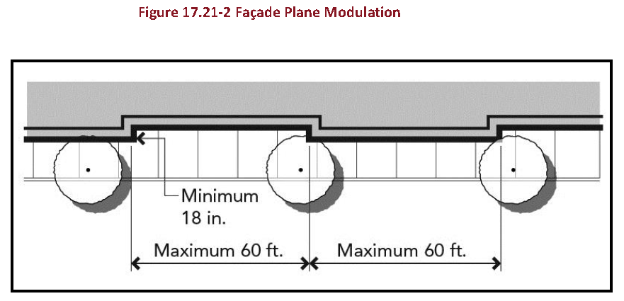
E.
Glazing and Windows. Street-facing facades of all buildings shall incorporate glazing (windows) and openings providing light to adjacent spaces, rooms, and uses, shown in Figure 17.21-3 as outlined in Table 17.21.03.1, windows and openings facing streets shall constitute a minimum of the following percentage of street-facing building faces:
1.
Fifty (50) percent of the wall for nonresidential ground floor uses;
2.
Thirty (30) percent of the wall for nonresidential upper floor uses;
3.
Forty (40) percent of the wall for residential ground floor uses; and
4.
Thirty (30) percent of the wall for residential upper floor uses.
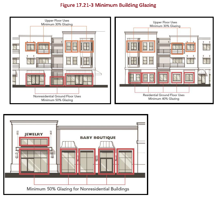
F.
Design of Roof and Skyline Forms.
1.
Penthouses, parapets, stair and elevator enclosures, and air conditioning units and mechanical equipment shall be fully integrated into the overall architectural design and expression of the building or addition through the use of equivalent materials and colors that match the overall design.
2.
All rooftop mechanical components shall be fully screened from the view of public right-of-ways or residentially zoned properties.
G.
Building Entrances. For parcels fronting Garvey Avenue, the primary entrance to a ground floor use shall face Garvey Avenue. Residential uses should have their own on-street entrance, while nonresidential uses abutting Garvey Avenue shall provide at least one street-facing, pedestrian-priority entrance that shall serve as the primary entrance to the business.
1.
Interior space shall be arranged to orient toward the Garvey Avenue entrance as the primary entrance. Signage shall be used to direct persons toward the primary entrance. Street-facing nonresidential entrances shall be unlocked and accessible to the public during business hours.
2.
Residents of a mixed use development shall have a separate and secure on-street pedestrian access to the residential units.
3.
On street frontages, ground-related entrances shall occur at least once every one hundred fifty (150) feet, as measured along the front property line. Ground-related entrances include entrances to ground- floor uses, residential units, clusters of residential units, lobbies, or private courtyards.
4.
Pedestrian walkways or sidewalks shall connect all primary building entrances to one another. Pedestrian walkways shall also connect all onsite common areas, parking areas, storage areas, public open spaces, and recreational facilities.
5.
Elevated walkways, skyways, and bridges between buildings are limited. Elevated walkways, skyways, and bridges between buildings are allowed under the following conditions:
a.
Elevated walkways, skyways, or bridges shall connect buildings located internally to a site. Elevated walkways, skyways, or bridges shall not connect buildings located on Garvey Avenue, San Gabriel Boulevard, nor be adjacent to an existing residential use.
b.
An elevated walkway, skyway, or bridge is only allowed to facilitate resident access to an adjacent buildings' recreational amenity.
c.
Each building shall be connected to no more than one other building.
d.
A maximum of one elevated walkway, skyway, or bridge is permitted per building. For example, if an elevated walkway connects two buildings on their third floors, no other elevated walkway is permitted to connect any other on any other floor.
e.
Elevated walkways, skyways, or bridges shall not cross over a street, public park, or public open space.
H.
Ground Floor Design.
1.
Ground floor design shall be high-quality, pedestrian-oriented, and sensitive to the use.
a.
Ground Floor Residential Units. In mixed use settings, ground floor residential dwelling units are allowed on any lot and on any street frontage, provided storefronts and usable commercial space are located along a minimum of fifty (50) percent of the length of the building frontage adjoining Garvey Avenue. Storefronts and usable nonresidential spaces shall comply with all standards and guidelines in Rosemead's Mixed-Use Design Guidelines.
b.
First Floor Elevation, Nonresidential Uses. The first habitable floor shall be located no more than two feet above or below the existing grade at any point along a street property line.
c.
First Floor Elevation, Residential Use. The first habitable floor of a residential-only building shall be located at least two feet above existing grade and no more than three feet along a street property line.
d.
The minimum height of nonresidential ground floor spaces shall be fourteen (14) feet. The minimum height of residential ground floor spaces shall be ten (10) feet. This height shall be measured from the floor of the first story to the floor of the second story. If there is no second story, the height shall be measured to the top of roof, see Figure 17.21-4.
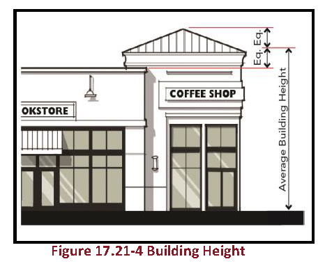
e.
Storefronts and usable nonresidential space shall be located along the required ground floor street frontages of buildings per Table 17.21.030.1 of this Chapter and have a minimum usable depth of forty (40) feet along sixty (60) percent of the length of the building frontage and in no case be less than twenty (20) feet in depth. At a corner lot where storefronts and nonresidential uses are required, storefronts and nonresidential spaces shall turn and wrap around the corner for a minimum length of twenty (20) feet, see Figure 17.21-5.
f.
Use of mirrored and reflective glazing materials and glass is prohibited. At the ground floor of buildings where the use is nonresidential, use of clear glass is required. After installation, clear glass windows at the ground floor of nonresidential uses shall not later be treated so as to become opaque or to be blocked so as to prevent visibility of the ground floor interior from the sidewalk.
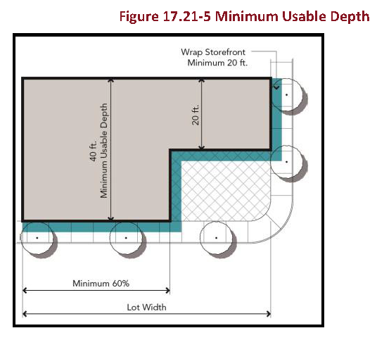
g.
Security elements and decorative grillwork at ground floors
i.
Upward rolling, side folding, or moveable security grills and elements shall not be installed on the exterior side of ground floor and street-facing storefronts, windows, openings, entries, and facades.
ii.
On the interior side of ground floor and street-facing storefronts, windows, openings, entries and facades, upward rolling, side folding, or moveable security grills and elements are allowed.
iii.
Such devices should utilize dedicated interior side pockets and ceiling cavities such that the grill and all mechanisms associated with the security element are not visible from the adjacent public right-of-way or sidewalk; regardless of installation method, such devices shall be at least eighty (80) percent open to perpendicular view.
iv.
Fixed decorative grillwork and railings are allowed at the ground floor and shall be at least eighty (80) percent open to perpendicular view.
I.
Parking Standards and Driveways. Required parking shall be determined by the standards outlined in Table 17.21.030.1 of this Chapter. Parking standards and driveways shall comply with the following requirements:
1.
Surface parking along Garvey Avenue is not allowed in the front of buildings. Surface parking in the rear of a lot shall be permitted.
2.
Notwithstanding the requirements of Table 17.21.030.1, partially subterranean and fully subterranean parking may extend to street-fronting property lines. For corner lots, surface parking lots shall be accessed from a side street or alley.
3.
Residential parking may share an entrance with nonresidential parking, but shall be separate from the nonresidential parking area, with access restrictions where necessary.
4.
For parcels of less than three hundred (300) feet in length, only one vehicular access point may be permitted. For all other lot frontages, a maximum of one vehicular access point for each three hundred (300) feet of street frontage is permitted, see Figure 17.21-6.
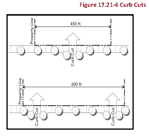
5.
Parking that is visible from streets or sidewalks or located along rear, side, or interior lot lines shall be buffered from the street, sidewalk, or lot line by a minimum five-foot in-depth landscape buffer.
6.
Openings to tuck-under parking spaces shall not be visible from the street or from an adjacent property.
7.
Tandem parking within allowed parking areas may be allowed with an AUP for multi-family projects and the residential component of mixed use projects.
J.
Loading Space. On the same premise with every building, structure, or part thereof erected or occupied for goods display, wholesale or retail, hotel, restaurant, or other similar use involving the receipt or distribution of materials or merchandise via trucks or vans, a minimum of one off-street loading space for each six thousand (6,000) square feet of building floor area dedicated to the retail, commercial, hotel, restaurant use is required for the standing, loading, and unloading services in order to avoid interference with the public use of adjacent streets or alleys. Required loading space shall not be included within the required parking space adjacent to a building or structure.
K.
Open Space and Recreation. Each type of open space has a different purpose and user; the requirements for one type of open space cannot be satisfied by another.
1.
Usable Public Open Space.
a.
All open space shall be public unless parcel location does not allow public access.
b.
High-quality porous pavers, porous concrete or other porous paving materials shall be used for all plazas and hardscape.
c.
Community benefit incentives are available for providing more open space than is required, see 17.21.040
d.
Usable public open space does not include libraries, gymnasiums, nor recreation rooms.
e.
All required usable public open space shall be developed and professionally maintained in accordance with approved landscape and irrigation.
2.
Usable Private Common Open Space.
a.
All usable common open space shall be conveniently located and readily accessible from all residential units in a residential or mixed use development.
b.
Each usable common open space shall have no side with a dimension of less than ten (10) feet and may incorporate any areas of the site except where it is within five feet of public rights-of-way, private streets or alleys, and shall not include or incorporate any driveways or parking areas, trash pickup or storage areas, or utility areas.
c.
There shall be a minimum distance of fifteen (15) feet measured horizontally between any swimming pool and the nearest point of any balcony, porch, second story patio, sun deck, or other architectural feature of a building or structure with windows, doors, or other openings of sufficient size to permit the passage of persons.
d.
Courtyards internal to a project, or enclosed on at least three sides, shall have a minimum width of forty (40) feet, and shall be landscaped with a ratio of hardscape to planting not exceeding a ratio of one square foot of landscape to one square foot of hardscape. Pools and spas shall be excluded from this ratio.
e.
All required usable common open space shall be developed and professionally maintained in accordance with approved landscape and irrigation.
3.
Usable Private Open Space.
a.
No portion of any private patio or balcony shall be used for the permanent storage of rubbish, junk, clotheslines, or garbage receptacles. "Permanent storage," as used in this subsection, means the presence for a period of forty-eight (48) or more consecutive hours on a patio or balcony.
b.
Private open space must be open air, not fully enclosed with walls. Private open space cannot be covered by a roof by more than fifty (50) percent of the area; however, balconies can have up to one hundred (100) percent ceiling coverage.
L.
Signage Standards. All signage shall comply with guidelines outlined in the Garvey Avenue Master Plan, with the exception of mixed-use projects, which shall follow the sign standards outlined in Title 17, Article 2, in Section 17.28.030. Bi-lingual signage is allowed. When storefronts use bi-lingual signage, Nonresidential signage shall identify the type of business (e.g., "restaurant," "market") in the English language and should be clearly located in the center of the storefront signage.
M.
Condominium Subdivision Standards.
1.
Nonresidential and residential condominiums are permitted in the GSP-R/C and GSP-MU zones. All condominium subdivisions within the Garvey Avenue Specific Plan area, whatever the parcel size, shall be processed and developed in accordance with the provisions of the development standards and requirements set forth in this Garvey Avenue Specific Plan. Existing provisions in Rosemead's Zoning Code relating to Procedure and Submittal Requirements (RMC Section 17.36.050), Development Standards (RMC Section 17.36.060), and Condominium Conversions (RMC Section 17.36.070) also apply as general development guidelines.
2.
All condominium applications shall include:
a.
Proposed Site Plan.
b.
Preliminary Grading Plan.
c.
Preliminary Landscaping Plan.
d.
Preliminary Lighting Plan.
e.
Preliminary Master Sign Plan.
f.
Proposed Condominium Documents.
g.
Delineation of Shared Spaces and Access.
h.
Other Information that the Community Development Director determines may be necessary to evaluate the proposed project to ensure consistency with the Garvey Avenue Specific Plan, Rosemead's General Plan, the Zoning Code, and other applicable City regulations and requirements.
Earned community benefit incentives may be applied over entire project area, even if the property is subdivided for residential condominiums or other financing purpose, with the approval of the Community Development Director.
(Ord. No. 978, § 5(Exh. A), 2-27-18)
17.21.040 - Community benefits incentives.
Community benefit incentives are provided to allow developer and property owners to increase the development potential if community benefits are identified as part of the development application, constructed as part of the project development, and operated in perpetuity. Restrictions and/or covenants are required to be recorded on the property to ensure the benefits or amenities provided to earn the Community Benefit Incentive are maintained in perpetuity. Benefits can be obtained in two ways—Affordable Housing and Senior Housing (See 3.4.3.1) or Garvey Avenue Community Benefit Program 17.21.040 (B).
A.
Density Bonus for Affordable Housing, Senior Housing
1.
A residential or mixed-use development that includes five or more dwelling units and meets one or more of the following criteria is entitled to a density bonus and one or more incentives under State Government Code Section 65915:
a.
Ten (10) percent of the total units of a housing development for lower income households, as defined in Section 50079.5 of the State Health and Safety Code.
b.
Five percent of the total units of a housing development for very low income households, as defined in Section 50105 of the State Health and Safety Code.
c.
A senior citizen housing development, as defined in Sections 51.3 and 51.12 of the State Civil Code, or Mobile Home Park that limits residency based on age requirements for housing for older persons pursuant to Section 798.76 or 799.5 of the Civil Code.
d.
Ten (10) percent of the total dwelling units in a common interest development as defined in Section 1351 of the State Civil Code for persons and families of moderate income, as defined in Section 50093 of the State Health and Safety Code, provided that all units in the development are offered to the public for purchase.
2.
Density bonuses for residential developments shall also apply for any residential or mixed use buildings in the Garvey Avenue Specific Plan area, under RMC Section 17.12.030, and as outlined in RMC Table 17.12.030.2.
3.
If a density bonus under State Bill 1818 is granted, density or intensity bonus associated with the provision of Community Benefits will not be granted.
4.
Concessions considered by the City for projects complying with SB 1818 shall not include an increase in height beyond the seventy-five-foot limitation. An increase in height above the seventy-five-foot limitation would create significant adverse impacts on the Garvey Avenue Specific Plan area.
B.
Garvey Avenue Community Benefit Program. The Garvey Avenue Community Benefit program allows for substantial redevelopment or new development projects to have an increased residential density and/or nonresidential intensity with the provision of specific community benefits. The Garvey Avenue Community Benefit Program is applicable to all parcels within the Garvey Avenue Specific Plan Corridor. However, if a density bonus is granted in accordance with Senate Bill 1818, a density or intensity bonus associated with the provision of Community Benefits will not be granted.
The Garvey Avenue Community Benefit Program is based on a point system, detailed in full in the Garvey Avenue Specific Plan. Each community benefit type is assigned a number of Community Benefit points, as described in Table 3.5. A project may earn points from a single or multiple categories, depending on the project applicant's preference. The number of Community Benefit points earned is then translated into the increased density or FAR. The increase varies by zone and land use type as shown in Table 3.6. Table 3.6 indicates the maximum density or FAR permitted. The types of community amenities or benefits eligible to receive the Community Benefit Incentive, as shown in Table 3.5, are: public open space above the required, public park, ADA park amenities, public parking above the required, lot consolidation, siting taller buildings within in the center of the proposed development, project sustainable design, project alternative energy production, "family friendly" development, and provision of an economic feasibility study for uses other than hotel and mixed use. Additional types of community benefits and associated incentives may be determined by a Rosemead City Council resolution adoption.
Table 3.5
COMMUNITY BENEFIT AMENITIES AND ASSOCIATED POINTS
Table 3.6 COMMUNITY BENEFIT INCENTIVE MAXIMUM FAR OR DENSITY
(Ord. No. 978, § 5(Exh. A), 2-27-18)
17.24.010 - Purpose.
The purpose of the individual special purpose zoning districts and the manner in which they are applied are as follows:
A.
Open Space (O-S) District. The O-S zoning district is intended to provide for urban relief, recreation and environmental preservation. This zoning district is applied to parks, streams, urban forestry areas and other similar features to enhance the quality of the environment consistent with the General Plan.
B.
Automobile Parking (P) District. The P zoning district is intended to provide for specialized facilities that serve a critical but single purpose need for automobile parking. This zone may be applied to public parking lots and structures, shared parking facilities by multiple businesses or residential projects and other similar parking needs.
C.
Planned Development (P-D) District. The P-D district is intended to provide for residential, commercial, industrial, or institutional developments that are characterized by innovative use and design concepts. This zone provides for a new development to offer amenities, quality, design excellence and other similar benefits to the community and not be inhibited by strict numerical development standards. The P-D zone may not be used to develop residential projects that exceed the density allowed under the General Plan and density bonus provided in Chapter 17.84.
(Ord. No. 931, § 5(Exh. A), 10-22-13)
17.24.020 - Special purpose district land uses and permit requirements.
Table 17.24.020.1, Uses in Special Purpose Districts, identifies the uses of land allowed in the Open Space (O-S) district and the Automobile Parking (P) zoning district, and the land use permit required, if any, to establish each use subject to Section 17.08.050. Where the last column in the tables (Specific Use Regulations) includes a section reference number, the regulations in the referenced section apply to the use in addition to those shown in the table. The Planned Development (P-D) zone district requirements are outlined in Sections 17.24.030 and 17.24.040.
Table 17.24.020.1
USES IN SPECIAL PURPOSE DISTRICTS
Note:
P Permitted Use
A Permitted Accessory Use
CUP Conditional Use Permit required
AUP Administrative Use Permit required
— Use not allowed
(Ord. No. 931, § 5(Exh. A), 10-22-13)
17.24.030 - Special purpose district development standards.
A.
Development Standards Table. New land uses and structures and alterations to existing land uses and structures in the O-S, P, and P-D zones shall conform to the requirements in Table 17.24.030.2, Special Purpose District Development Standards, as well as specific district standards listed below.
Table 17.24.030.2
SPECIAL PURPOSE DISTRICT DEVELOPMENT STANDARDS
B.
District Specific Requirements. In addition to the general development requirements listed in Table 17.24.030.2, Special Purpose District Development Standards, the following development standards apply to specific commercial districts as shown:
1.
O-S District Requirements.
a.
Development Review. Projects proposed within the Open Space (O-S) District shall be subject to applicable review procedures as set forth in Article 5 Land Use and Development Application Procedures of this Title.
b.
Supplementary District and Temporary Use Regulations. For sign, parking, fence, swimming pool, and similar regulations for the Open Space (O-S), see Article 4 Supplemental Standards of this Title.
C.
District Improvements. All such parking areas shall be improved and maintained in accordance with the provisions of Chapter 17.112 (Off-Street Parking and Loading).
D.
P-D District Requirements.
1.
This zone is designated to accommodate various types of development such as shopping centers, professional and administrative areas, multiple housing developments, single-family residential developments, commercial service centers and industrial parks and other uses or a combination of uses which can be made appropriately a part of planned development.
2.
A Planned Development zone may be established to provide diversification in the location of structures and other land uses while insuring compliance with the General Plan and compatibility with existing and future developments in surrounding areas.
3.
Development within the P-D zone shall be subject to the provisions of Section 17.24.040 of this chapter.
(Ord. No. 931, § 5(Exh. A), 10-22-13)
17.24.040 - P-D District reclassification and plan adoption.
A.
Permitted Uses. Commercial, residential, industrial, and institutional uses may be permitted in the P-D zone subject to regulations set forth in this chapter and subject to the approval of the Planning Commission and City Council.
B.
Creation of Planned Development Zone—Reclassification.
1.
Planned development zones shall be created in the same manner as property is reclassified from one zone to another as set forth in Chapter 17.152.
2.
An application for change of zone to a P-D zone shall include and be accompanied by a precise development plan, which if approved by the Planning Commission and City Council, shall become a part of the Zoning Map of the City.
3.
The Planning Commission may recommend to the City Council approval or disapproval of the P-D zone and precise development plan as submitted, or modification, alteration, adjustment, amendment or conditional approval of the development plan. The decision of the Planning Commission shall include a finding as to whether the proposed development is consistent with the General Plan.
C.
Approval of Development Plan. The Planned Development Review application shall set forth the name and address of the property owner and the description of the property. In addition, application shall be accompanied by a precise development plan which shall include the following details:
1.
Location of each existing and location and dimensions of each proposed structure in the site, the use or uses to be contained therein, the number of stories, gross building and floor area, location of entrances and loading points thereof.
2.
Location of proposed parks, playgrounds, school sites, public buildings and other such uses within the zone.
3.
All streets, points of access, curb cuts, garage door locations, driving lanes, parking areas, and in commercial developments, the ratio of off-street parking to building floor area, loading area, public transportation points, and illumination facilities for same.
4.
All pedestrian walks, malls and open areas for the use of occupants and members of the public.
5.
Location, height and material of all walls and fences. Location and height of all screen planting in front, side and rear yards.
6.
Types of surfacing, such as paving, turf or gravel, to be used at the various locations.
7.
Landscaping and tree planting plan including type and location of plant materials to be used and an irrigation plan, in accordance with the City's Water Efficient Landscape Ordinance.
8.
Plans and elevations of structures indicating architectural, building materials and construction standards.
9.
The gross land area of the site and of the footprints of the structures, and land use of the area within three hundred (300) feet of the perimeter of the site, including the location of structures and other improvements.
10.
Such other information as may be required by the Community Development Department to assist in the consideration of the development plan.
11.
A map or grading plan showing the proposed grading and topography of the site.
12.
Such application shall be processed and heard in accordance with the provisions of Article 5, Chapter 17.120 (Applications and Processing). The Planning Commission and City Council may impose reasonable conditions to the approval of the development plan.
D.
Conditions of Approval of Planned Development.
1.
An applicant may be required to dedicate land for street or other purposes authorized by law, to restrict areas for open space, for beautification or for off-street parking and to comply with such other conditions as may be imposed to achieve harmony with the General Plan and compatibility with surrounding land uses. The development as authorized shall be subject to all conditions so imposed.
2.
Such conditions may be modified where circumstances warrant after a hearing by the Planning Commission.
3.
In addition to the above requirements, all residential planned development (P-D) projects shall include in the required covenants, conditions and restrictions (CC&Rs) or other similar recorded instrument the following statement. This statement is intended to notify all prospective property owners of certain limitations on construction to residential dwellings contained in planned development projects.
a.
"All residential dwellings within this project were designed and approved under a precise plan, planned development (P-D) concept. As a result, some of the project lots and yard areas are smaller than would ordinarily be allowed under the development standards contained in the Rosemead Zoning Code."
b.
"Purchasers of project dwellings are hereby notified that they should not assume that they will be able to gain city of Rosemead approval for any further building on any smaller-than-standard lot. Applications for room additions, patio enclosures, etc., will be reviewed on a case-by-case basis. Further information is available from the city of Rosemead Planning Department during regular business hours."
E.
Modification of the Development Plan. Changes in the use shown in the Development Plan shall be considered in like manner as changes in the Zoning Map and shall be made in accordance with the procedures set forth in this Title, except such changes may be accomplished by a resolution rather than by ordinance.
F.
Area.
1.
A P-D zone shall include a parcel of land containing not less than one acre (forty-three thousand five hundred sixty (43,560) square feet). A P-D zone may be considered on a parcel of land less than one acre in area only where such property has a common boundary with property which has previously been developed under an approved plan pursuant to this chapter and the plan shall indicate that the proposed development will constitute an orderly extension in arrangement of buildings, facilities and open space throughout the combined parcels of land in addition to all other requirements for approval.
2.
The proposed density of a residential planned development shall be consistent with the land use element of the General Plan.
G.
Phasing. If development is to be accomplished in stages the development plan shall coordinate improvement of the open space, the construction of buildings, structures and improvements in such open space, and the construction of dwelling units, in order that each development stage achieves a proportionate share of the total open space environmental quality of the total planned development.
H.
Nonresidential Planned Developments. Additional conditions containing reasonable regulations regarding traffic flow, access driveways, off-street parking, signs, walls, fences, paved areas, planting areas and other open areas may be required by the Planning Commission to assure a reasonable and compatible development in harmony with, and not detrimental to, the surrounding area.
I.
Signs Permitted in the P-D Zone. Other than as specifically set forth in this section, Chapter 17.116 (Signs) shall apply to the P-D zone.
1.
Building Directory Signs. One exterior sign at each building entrance, such sign not to exceed ten (10) square feet in area, and such sign to be a limited directory type indicating only the name of the business and the use conducted by tenants.
2.
Exterior Wall Signs. Exterior wall signs may occupy not more than twenty (20) percent of any front, side or rear wall of a main building or structure, such signs to pertain only to a use conducted, service provided, goods produced or sold on the premises, or the name of the owner or tenants of the building.
3.
Freestanding Signs. One freestanding sign for each commercial business, provided that the total area of any one sign shall not exceed one hundred (100) square feet.
a.
Total height of any freestanding sign not to exceed thirty-five (35) feet.
b.
Such signs shall pertain only to a use conducted, service provided, goods produced or sold on the premises, or the name of the owner or tenants of the building.
c.
Permitted freestanding signs shall not project into any public right-of-way.
J.
Parking. Parking requirements shall be as provided in Chapter 17.112 (Off-Street Parking and Loading).
K.
Building Permits—Issuance.
1.
No building permit shall be issued until the precise development plan is approved by the Planning Commission and the City Council.
2.
Building permits shall be issued for plans substantially in accordance with the approved development plan.
L.
Development Schedule.
1.
An application for approval of a development plan in the P-D zone shall be accompanied by a development schedule indicating the approximate date on which construction of the project can be expected to begin, the anticipated rate of development and completion date.
2.
Such development schedule, if approved by the Planning Commission and City Council, shall become a part of the development plan and shall be adhered to by the owner of the site and any successor in interest.
M.
Development Plan—Expiration.
1.
Upon the abandonment of a project authorized by approval of a development plan, or upon the failure to implement the development plan within the time specified, or if no time is so specified, within one year after approval of the development plan, the development plan shall be null and void.
2.
Unless a longer period of time has otherwise been set forth in development plan conditions of approval, the plan shall not be deemed "exercised" until at least one of the following has first occurred:
a.
A grading permit has been issued and grading has been substantially completed;
b.
A building permit has been issued and construction has commenced, and the building permit remains to be valid by or through the making of satisfactory progress as determined by the Building Official;
c.
A Building Certificate of Occupancy has been issued;
d.
The use is established; or
e.
A time extension has been granted in compliance with subsection five of this section.
3.
If a project is to be developed in preapproved phases, the development plan for the property shall include conditions related to the phasing of development.
4.
If the project also involves the approval of a tentative map, the phasing shall be consistent with the tentative map and the Development Plan shall be exercised before the expiration of the tentative map, or the development plan shall expire and become void and of no further effect.
5.
Upon good cause shown by the applicant, the Planning Commission may extend the time limitation imposed by this chapter once, for a period of not to exceed one year, without a public hearing.
6.
Once a development plan has become void by failure to implement, or if no application for approval of a Development Plan has been filed within two years after classification of a property as P-D, it is the general policy of the Planning Commission to initiate amendment proceedings under this Title to rezone the project area to whatever zone it had prior to the P-D zone approval.
(Ord. No. 931, § 5(Exh. A), 10-22-13)
17.28.010 - Purpose.
The purpose of the individual overlay zones and the manner in which they are applied are as follows:
A.
Overlay Zone Districts. An overlay zone is a zoning district that applies special requirements to a portion of other zoning districts. The City of Rosemead has designated certain areas within the city to be subject to overlay zones in order to supplement the base zones in these areas with special purpose regulations. Each overlay zone specifies the uses and developments that are subject to such special requirements. Uses and developments not specified are subject only to the requirements of the base zone district.
B.
Design Overlay (D-O) Zone. The purpose of the design overlay zone is to promote orderly development so that buildings, structures, signs and landscaping will be harmonious within a specified area to prevent the development of structures or uses which are not of acceptable exterior design or appearance, are of inferior quality or likely to have a depreciating or negative effect on the local environment or surrounding area by reasons of use, design, appearance or other criteria affecting value.
C.
Residential/Commercial Mixed-Use Development Overlay (RC-MUDO) Zone. The purpose of the Residential/Commercial Mixed-Use Development Overlay Zone (RC-MUDO) is to provide opportunities for well-designed development projects that combine residential with nonresidential uses, including office, retail, business services, personal services, public spaces and uses, and other community amenities designated with the Mixed-Use land use designations in the City of Rosemead General Plan and consistent with the policy direction in the General Plan. The intent of this overlay zone is to accomplish the following objectives:
1.
Create a viable, walkable, urban environment that encourages pedestrian activity and reduces dependence on the automobile through a streetscape that is connected, attractive, safe and engaging.
2.
Provide complementary residential and commercial uses within walking distance of each other.
3.
Develop an overall urban design framework to ensure that the quality, appearance and effects of buildings, improvements and uses are compatible with the City design criteria and goals.
4.
Create quality residential/commercial Mixed-Use development that maintains value through buildings with architectural qualities that create attractive street scenes and enhance the public realm.
5.
Provide a variety of open space, including private, recreation areas and public open space and parks.
6.
Revitalize commercial corridors with residential/commercial Mixed-Use developments that attract and encourage market-driven private investment.
7.
Encourage parking solutions that are incentives for creative planning and sustainable neighborhood design.
D.
Freeway Corridor Mixed-Use (FCMU) Overlay Zone. The purpose of the Freeway Corridor Mixed-Use (FCMU) Overlay Zone is to provide new opportunities for housing, economic revitalization, and attractive placemaking at strategic locations along primary City corridors that are in general proximity to Interstate 10 Freeway. The intent of the overlay zone is to accomplish the following objectives:
1.
Provide attractive gateway developments at key locations along Interstate 10 Freeway.
2.
Create opportunities for new Mixed-Use and standalone housing types and options at varying income levels.
3.
Encourage Mixed-Use commercial and residential developments that will serve as catalysts for new economic activity with services and employment that support the local community.
4.
Establish development and design standards that contribute to community character and quality building designs.
5.
Enhance the public realm to provide an improved pedestrian environment and foster a greater sense of place.
6.
Promote reinvestment and redevelopment in the identified areas of the community.
(Ord. No. 931, § 5(Exh. A), 10-22-13; Ord. No. 1001, § 6, 9-28-21)
17.28.020 - Design overlay zone.
A.
Jurisdiction.
1.
No building permit shall be issued for any building structure or other development of property or appurtenance thereto, on any property for which a precise plan of design is required, until the precise plan of design covering the parcel or parcels to be so used shall be approved and adopted as herein provided. Design review procedures shall be followed for all improvements requiring a building permit or visible changes in form, texture, color, exterior facade or landscaping.
a.
Exceptions. The following development shall be exempt from the design overlay standards:
1)
Residential, Commercial, Industrial, and Institutional. Minor structural repairs and maintenance to existing residential, commercial, industrial, and institutional structures provided such minor maintenance and repairs meet the standards of the underlying zone. Minor repairs and maintenance to nonconforming structures shall comply with Chapter 17.72 (Nonconforming Uses, Structures, Lots, and Parking Facilities).
2)
Commercial. Additions to existing commercial structures provided such additions do not exceed fifty (50) percent of the existing floor area or two thousand (2,000) square feet, whichever is less, and do not affect the front facade of the building.
3)
Industrial. Additions to existing industrial structures provided such additions do not exceed fifty (50) percent of the existing floor area or two thousand (2,000) square feet, whichever is less, and do not affect the front facade of the building.
B.
Application filing, processing, and review.
1.
Application Filing. An application for a Design Review shall be filed and processed in compliance with Chapter 17.120 (Applications and Processing). The application shall include the information and materials specified in the handout for Design Review applications, together with the required fee, as established by City Council resolution. It is the responsibility of the applicant to provide evidence to support the findings required by Subsection "C" (Findings and Decision) below. Initial review of the application, including time requirements and requests for information, shall be provided in accordance with Section 17.120.070 (Initial Application Review and Completeness).
2.
Application Review.
a.
Each application for a Design Review shall be reviewed to ensure that the application is consistent with the purpose of this chapter; applicable development standards and regulations of this Zoning Code; and any adopted design guidelines and policies that may apply. Upon receipt of a complete application, the applicable review authority shall review the design, location, site plan configuration, and the effect of the proposed development on surrounding development by comparing the project plans to established development standards, regulations, and applicable design guidelines.
b.
If the Community Development Director determines that the plans conform to the provisions of this chapter, and the policies adopted by the City Council hereunder, the Community Development Director shall endorse his or her approval thereon in writing to the Planning Commission for them to approve, conditionally approve, or deny. When the plans for an approval do not substantially alter the appearance of the property, the only approval required shall be that of the Community Development Director. Non-substantial alterations include, but are not limited to:
1)
Façade or exterior improvements for property maintenance (inclusive of color changes that are primary building colors of existing buildings on the street);
2)
Fences and walls;
3)
Landscaping;
4)
Restriping of parking lots;
5)
Signs (excluding new pole and monument signs);
6)
Sign face changes on existing pole and monument signs;
7)
Roof pitch changes that are consistent with the existing roof shape to accommodate electrical equipment, such as air condition units; and
8)
Screening of any mechanical equipment.
c.
After the Design Review application has been deemed complete, the review authority shall either approve or deny the precise plan of design and, if approved, may impose conditions deemed reasonable and necessary to protect the public health, safety and general welfare and ensure compliance with this chapter and various regulations of the City in compliance with Subsection "C" (Findings and Decision), below.
3.
Standards of Review. When reviewing development plans that are subject to a Design Review, the following criteria, in addition to other principles of good design, shall be considered as part of the review:
a.
Compatibility. Compatibility shall be determined by use of the following criteria:
1)
The proposed development should protect the development site as well as surrounding properties from noise, odor, vibration, and other impacts that might have an adverse impact.
2)
The location and configuration of structures should minimize interference with the privacy and views of occupants of surrounding structures.
b.
Architectural Design and Detail. Architectural design and detail shall be provided in all proposed development and shall be determined by the use of the following criteria and in compliance with all other applicable provisions of this Zoning Code:
1)
New structure design is encouraged to follow a recognized and established architectural style utilizing massing, materials, details, and similar elements of that style.
2)
Long, plain, building walls should be avoided by incorporating building articulation (e.g., arcades, decks, material variation, porches, public art, roofline variation, varied setbacks, and windows) and other similar methods.
3)
Roof-mounted equipment shall be fully screened. Acceptable methods of screening may include parapet walls or some other creative feature such as an architectural solution. Individual equipment screens may only be used for structures after all other methods of screening have been explored.
4)
Rooflines on a structure should create design interest and be compatible throughout the structure and also with existing structures and surrounding development.
5)
The design of the structures, driveways, landscaping, lighting, loading facilities, parking areas, signs, solar facilities (except for solar energy systems under Chapter 15.10) and other site features should show proper consideration for the functional aspects of the site (such as, automobile, pedestrian and bicycle circulation) and the visual effect of the development on surrounding areas.
6)
Amenities (such as, arbors, architectural lighting, fountains, hardscape, public art, and trellis) and other design features should be provided on larger development projects.
7)
Green building practices should be used whenever feasible.
8)
Electrical rooms with switchgear and similar items should be located within an electrical room and integrated into the building footprint.
9)
Interior roof access shall be used.
c.
Landscape, Lighting, Parking, Signs, and Other Design Details. Landscaping, lighting, parking, signs, and other design details shall be provided in all proposed development and shall be determined by use of the following criteria:
1)
Equipment and Utilities.
a)
Utility boxes and other similar equipment should be located where they are well screened from public view.
b)
Mechanical equipment on the site shall be appropriately screened from view.
2)
Fences/Walls.
a)
Fencing, walls, solid waste enclosures, and accessory structures should be harmonious with the principal structure and other structures on the site.
3)
Landscaping. Landscaping should be designed in a way as to accent the property. Special effort should be given to colorful, creative, and varied planting designs that use native and native-compatible species that provide visual interest and water efficiency. Attention shall be given to selecting parking lot trees that provide shade. All landscaping shall conform to the provisions of Chapter 13.08 (Water Efficient Landscapes).
d.
Lighting.
1)
Lighting shall be located so as to avoid glare and to reflect the light away from adjoining property and rights-of-way while recognizing the importance of security.
2)
Wall-mounted lighting fixtures should be decorative and be compatible with the architectural style of the structure(s). Wall packs and fixtures that spread uncontrolled light shall be prohibited.
3)
Pole-mounted lighting should be of an appropriate scale to compliment the structure that it serves. Wherever possible, decorative poles and fixtures should be used.
C.
Findings and Decisions. The Planning Commission or the Community Development Director where authorized, may approve, approve with conditions, or disapprove any application based on the following criteria:
1.
The plans indicate proper consideration for the relationship between the proposed building and site developments that exist or have been approved for the general neighborhood;
2.
The plan for the proposed building and site development indicates the manner in which the proposed development and surrounding properties are protected against noise, vibrations and other factors which may have an adverse effect on the environment, and the manner of screening mechanical equipment, trash, storage and loading areas;
3.
The proposed building or site development is not, in its exterior design and appearance, so at variance with the appearance of other existing buildings or site developments in the neighborhood as to cause the nature of the local environment to materially depreciate in appearance and value;
4.
The proposed building or structure is in harmony with the proposed developments on land in the general area, especially in those instances where buildings are within or adjacent to land shown on the General Plan as being part of the Civic Center or in public or educational use, or are within or immediately adjacent to land included within any precise plan which indicates building shape, size or style;
5.
The proposed development is in conformity with the standards of this Code and other applicable ordinances in so far as the location and appearance of the buildings and structures are involved; and
6.
The site plan and the design of the buildings, parking areas, signs, landscaping, luminaires and other site features indicates that proper consideration has been given to both the functional aspects of the site development, such as automobile and pedestrian circulation, and the visual effect of the development when viewed from the public streets.
D.
Appeals. The applicant or any person aggrieved by the decision of the Planning Commission may file an appeal to the City Council on any ruling by the Planning Commission by filing a written request in compliance with appeal procedures outlined in Chapter 17.160.
E.
Issuance of Other Required Permits and Approvals.
1.
Grading shall not be commenced and no structure shall be altered, enlarged, erected, moved, or rebuilt subject to the provisions of this chapter, except in compliance with the approved development plans and the conditions imposed on the review.
2.
Expiration. Construction of improvements permitted by a Design Review approval shall be "exercised" or commenced within twelve (12) months of the actual date of approval, provided that this time limit may be increased or decreased, at the time of granting the approval, in order to allow the time limit to be concurrent with any other entitlement to construct identified in this Zoning Code.
3.
Extension. An extension of time for a Design Review maybe granted by the Planning Commission upon the written request of an interested person filed with the Community Development Department prior to the expiration of such 12-month period. Such request shall set forth the reasons, supported by factual data, why the plan has been unused, abandoned, or discontinued. No extension of time shall be granted unless the Commission finds the facts to be substantially true as set forth and to constitute justifiable cause for such extension. A fee shall be paid to the City upon the filing of each request for an extension in an amount established by the City Council from time to time by resolution, for the purpose of defraying the expenditures incidental to the proceedings set forth in this chapter.
(Ord. No. 931, § 5(Exh. A), 10-22-13; Ord. No. 954, § 3, 8-11-15)
17.28.030 - Residential/commercial mixed-use development overlay (RC-MUDO) zone.
A.
Applicability.
1.
The RC-MUDO is an overlay zone, which may be applied to existing zoning districts as designated in the General Plan.
2.
Land classified in a RC-MUDO overlay zone shall also be classified in another zone. When such a district is established, the Residential/Commercial Mixed-Use Development Overlay Zone shall be shown as an overlay to the underlying districts by the designation of RC-MUDO on the zoning map. A RC-MUDO may overlay several base districts, however, the uses permitted in each base district are limited to the boundaries of that base district, except as otherwise provided herein. The RC-MUDO Zone district shall provide the option of developing under the base zone district or developing a residential/commercial mixed-use development under the overlay zone.
3.
Residential/commercial mixed-use development shall be a development that combines and integrates residential uses with commercial, institutional, and office uses utilizing a strong pedestrian orientation. The mix of uses may be combined in a vertical residential/commercial mixed-use building or combined in separate buildings located on one property and/or under unified control. The mix of uses percentage shall be as designated in the General Plan.
B.
Approval Procedure.
1.
A precise plan of design for a residential/commercial mixed-use development shall be submitted, and approved in accordance with the requirements of Chapter 17.28, Section 17.28.020 (Design Overlay (D-O) Zone).
2.
The Site Plan and Design Review must comply with the provisions of this chapter and the Mixed-Use Design Guidelines.
3.
Only one application for a Site Plan and Design Review shall be required for a residential/commercial mixed-use development in the D Design Overlay Zone.
C.
Permitted Uses.
1.
The following uses are permitted in a residential/commercial mixed-use development: retail stores and businesses, provided there is no manufacturing, processing or treatment of products other than what is clearly incidental to the retail business conducted on the premises, and not more than twenty (20) percent of the floor area of the building shall be used in the manufacturing, processing or treatment of products, and that such operations or products are not objectionable due to noise, odor, dust smoke, vibration or other similar causes;
• Artist studios;
• ATM facilities subject to the requirements of Section 17.28.030.E.2;
• Bakery products shops;
• Banks, savings and loan associations, and financial institutions, excluding check cashing or other pay day loan services;
• Barber shops, beauty shops and manicure parlors;
• Book stores;
• Clothing and shoe stores;
• Confectionery retail shops;
• Department and variety stores;
• Drug stores and pharmacies;
• Dry cleaning stores, drop-off and pick-up only;
• Electric appliance stores and repairs;
• Employment agencies;
• Fabric and yardage stores;
• Florist shops;
• Food stores, bakery shops, delicatessens and markets;
• Furniture stores, limited to new furniture, except that used furniture taken in trade may be sold provided used furniture sales do not exceed twenty-five (25) percent of the gross floor area or twenty-five (25) percent of total retail floor area, whichever is less;
• Grocery, fruit and vegetable stores;
• Hardware stores;
• Health centers, and similar personal service establishments, with massage as an incidental use and occupying no more than twenty-five (25) percent of the floor area (Administrative Use Permit Required);
• Hobby shops;
• Interior decorating shops;
• Jewelry stores;
• Live/Work subject to the requirements of Section 17.30.210;
• Music stores;
• Paint stores;
• Pet supply stores;
• Photo-copy, printing, or office supply stores;
• Photographic studio, supply shop, or film pick-up and drop-off point;
• Radio and television stores and repair;
• Restaurants, take-out and other eating establishments;
• Retail sales of automotive parts without installation and no outside storage;
• Self-service laundries subject to the requirements of Section 17.28.030.E.5;
• Shoe stores or shoe repair shops;
• Tailor, clothing or wearing apparel shops; and
• Travel agencies.
2.
The following professional and business office uses are permitted in a residential/commercial mixed-use development:
• Accountant;
• Acupuncturist and acupressure, without massage or retail sales;
• Advertising agency;
• Architect;
• Attorney;
• Auditor;
• Bookkeeping service;
• Business consultant;
• Chiropodist;
• Chiropractor;
• Dental office;
• Engineer;
• Governmental buildings and offices;
• Insurance agency;
• Optician;
• Optometrist;
• Ophthalmologist;
• Osteopath;
• Physician;
• Psychiatrist, Psychologist, or
Counseling Services;
• Real estate broker;
• Secretarial service;
• X-ray technician.
3.
Similar professional business uses may be permitted subject to the Community Development Director making the findings set forth in Section 17.04.040.
4.
The following uses shall be the only uses for which a conditional use permit or administrative use permit may be applied for and granted in a residential/commercial mixed-use development:
a.
Conditional Use Permit.
1)
Any commercial use that operates after midnight;
2)
Any establishment having an off-sale license for alcoholic beverages;
3)
Any establishment (other than sit-down restaurants with one thousand (1,000) square feet of floor area or larger) having an on-sale license for alcoholic beverages.
4)
Commercial recreation and entertainment;
5)
Convenience markets subject to the requirements of Section 17.28.030.E.3; and
6)
Libraries and museums.
b.
Administrative Use Permit.
1)
Any outdoor dining area; and
2)
On-sale beer/wine sales for sit-down restaurants with one thousand (1,000) square feet of floor area or larger.
5.
Residential units shall be permitted in a residential/commercial mixed-use development provided that the densities shall be consistent with the General Plan.
6.
Location of Uses.
a.
Commercial uses shall be permitted on the ground floor or second floor in a residential/commercial mixed-use development.
b.
Commercial uses shall not be permitted above any professional and business office uses or residential uses.
c.
Professional and business office uses shall be permitted above the commercial component of a street frontage building, behind the commercial component on the first floor or on second floor or above with same use street frontage but below any residential uses in a residential/commercial mixed-use development.
1)
Exception. If a residential/commercial mixed-use development is located at corner that abuts a local residential street, professional office uses may be permitted on the first floor within the portion of the development that abuts the local residential street, provided that the corner tenant is reserved for a commercial retail use.
d.
Residential uses shall be located either above the commercial and/or office components of a street frontage building or located behind the commercial or office component on any floor where there is a distinct separation of uses and access, provided pedestrian connections are furnished as part of a unified development theme.
D.
Development Standards.
1.
Public Realm and Streetscape.
a.
Public Sidewalks. The following shall apply to public sidewalks:
1)
The minimum building setback shall be twelve (12) feet as measured from the curb face, and shall be in the form of both existing right-of-way and a recorded pedestrian access and utility easement;
2)
The minimum building setback area shall include a minimum seven-foot wide detached sidewalk (clear zone) and a minimum five-foot wide parkway (amenity zone) adjacent to all streets. The amenity zone shall be located between the curb face and the clear zone. The clear zone shall be located between the building and the amenity zone;
3)
The sidewalk in the clear zone shall be constructed of concrete, comply with ADA accessibility standards and be subject to the review of the City Engineer;
4)
The clear zone shall be unobstructed by any permanent or nonpermanent element for a minimum width of seven feet and a minimum height of eight feet; and
5)
The amenity zone shall include street trees, landscaping, public signs, public art, street lighting, street furniture, and other pedestrian-oriented amenities, as appropriate.
b.
Street Trees.
1)
All species of mature oak trees shall be preserved or otherwise dealt with in accordance with Article 4, Chapter 17.104.
2)
The removal of other mature trees shall be subject to the review and approval of the Urban Forester.
3)
Mature street trees that are approved for removal by the Urban Forester shall be replaced with a minimum of three new mature box trees that have at least a 24-inch box and are the same species of the replaced mature street trees or a species approved by the Urban Forester. The City reserves the right to increase the number of trees if it deems necessary in order to compensate for mature tree loss.
4)
The amenity zone shall be planted with street trees at an average spacing not greater than thirty (30) feet on center.
c.
Transit Stops.
1)
Transit stops shall be designed as integral elements of a residential/commercial mixed-use development by collocating them with pedestrian-oriented amenities, such as pocket parks, courtyards, plazas, etc., whenever possible.
2)
When an existing transit stop is located on a sidewalk adjacent to the location of a development, a shelter for transit patrons shall be constructed that:
a)
Incorporates architectural features of the development and is compatible with the development; and
b)
Includes a shelter, bench and lighting.
d.
Corner Lot.
1)
On intersection corners, where both streets have four lanes:
a)
Building architecture on intersection corners, where both streets have four lanes or more, shall receive special treatment to enhance the pedestrian experience, and create visual interest and focal points at the entryways, such as, but not limited to, building cut-offs and corner entrances with additional architectural detail, decorative landscaping, hardscape, planters, canopy, overhang or other architectural covering over the building entry; and
b)
Buildings shall have a five-foot angled corner setback measured from both intersecting property lines.
2)
On intersection corners, regardless of the number of lanes on each street:
a)
Retail and office uses within buildings facing two or more streets shall have at least one customer entrance facing the primary street and one customer entrance facing the second street or instead of two entrances, a corner entrance; and
b)
Buildings on corner lots shall address both streets with an equal level of architectural detail.
e.
Outdoor Seating.
1)
No permanent seats or structures shall be placed in the public right-of-way without the review and approval of the City Engineer.
2)
Outdoor seating furniture shall not be located within the clear zone without prior review and approval of the City Engineer.
3)
Outdoor seating furniture shall be a minimum of ten (10) feet from the nearest transit stop.
4)
Any outdoor dining area may be separated from the sidewalk only with planters, shrubs, or fencing with a maximum height of forty-two (42) inches.
f.
Undergrounding of Utilities.
1)
Utility lines to a development from the building to the property line, including, but not limited to, electric, communications, street lighting and cable television shall be placed underground.
2)
Utility lines within the right-of way shall be placed underground to the maximum extent practicable. The requirements of this section may be waived by thePlanning Commission upon recommendation from the City Engineer if it is determined that topographical, soil or any other conditions make such underground installations unreasonable or impractical.
2.
Site Design and Circulation.
a.
Lot Size. The minimum lot size for a residential/commercial mixed-use development shall be thirty thousand (30,000) square feet.
b.
On-Site Tree Preservation.
1)
All species of mature oak trees shall be preserved or otherwise dealt with in accordance with Article 4, Chapter 17.104.
2)
The removal of other mature trees shall be subject to the review and approval of the Planning Commission.
3)
Mature trees that are approved for removal by the Planning Commission shall be replaced with new mature trees that have at least a 24-inch box and are the same species of the replaced mature trees.
c.
Bicycle Parking.
1)
Bicycle parking spaces shall be equal to ten (10) percent of required off-street parking, with a minimum of eight bicycle parking spaces per residential/commercial mixed-use development. Bicycle parking facilities shall be:
a)
Securely anchored to the lot surface so they cannot be easily removed and shall be of sufficient strength to resist theft;
b)
Separated by a physical barrier to protect the bicycle from damage by motor vehicles if located within a vehicle parking area; and
c)
Motor vehicle entrances shall display adequate signs to indicate the availability and location of the bicycle parking facilities.
d.
Access and Location of Off-Street Parking.
1)
At-grade parking shall not be located between any building and the street frontage.
2)
Vehicular access to corner lot developments shall be from an alley or from a side street.
3)
Access to parking on interior lots shall have only one vehicular access, which shall not be from the street if the lot abuts an alley. A second vehicular access may be allowed for lots that have a street frontage of three hundred fifty (350) feet or more and do not abut an alley. Developments on those lots may have additional driveways that are not closer than three hundred (300) feet apart.
3.
Parking Requirements.
a.
Residential:
1)
Two parking spaces shall be provided for every dwelling unit;
2)
One guest parking space shall be provided for each two dwelling units in a multiple-family dwelling project;
3)
Residential parking shall be separate from commercial parking and accessed through a secure gated entrance; and
4)
A reduction in the number of residential parking spaces may be approved upon the determination by the Planning Commission that a parking demand analysis prepared by a competent traffic and transportation engineer demonstrates, that the required number of spaces exceeds actual expected demand.
b.
Commercial.
1)
The parking requirements shall be provided in accordance with Chapter 17.112; and commercial parking shall be separate from residential parking by a secure gated entrance to the residential areas.
4.
Separation of Access to Residential and Commercial. Access to floors with residential units shall be secure and through a locking gate or entryway.
5.
Trash and Loading Areas. Trash and refuse collection, and recycling areas shall comply with the following provisions in addition to the requirements set forth in Article 3, Chapter 17.32 (Accessory Structures).
a.
All trash enclosures shall be fully enclosed with self-closing and self-latching doors, and each enclosure shall accommodate both trash and recycling bins.
b.
Trash enclosures shall be an integral part of the building design whenever possible.
c.
Trash enclosures shall be of the same architectural style as the development.
d.
Trash chutes are encouraged. However, chute access must be screened from public view, be fully contained within a "chute closet" that is accessible by a self-latching door, and have a safety hatch that is necessary to pull in order to dispose of trash.
e.
Loading areas shall be clearly designated.
f.
Loading areas shall be screened from public view to avoid negative noise, visual, and illumination impacts on the residential portion of the development and may be accomplished by the construction of six-foot high perimeter walls that are architecturally compatible with the primary structures and on-site landscaping.
g.
All screening walls shall be landscaped using vines, hedges, or other plant material necessary to provide a minimum fifty (50) percent coverage.
h.
Trash pick up and loading activities are permitted only during the hours of seven a.m. to seven p.m.
6.
Ground Floor Access.
a.
Commercial uses that have street frontage shall be accessible to the public through the street front entrance during all hours the business is open.
b.
Residents of a development shall have a separate and secure street access to the residential units.
c.
Pedestrian walkways or sidewalks shall connect all primary building entrances to one another. Pedestrian walkways shall also connect all on-site common areas, parking areas, storage areas, open space, and recreational facilities.
7.
Open Space and Recreation.
a.
Usable Common Open Space.
1)
Each residential/commercial mixed-use development shall have at least one hundred fifty (150) square feet of usable common open space per dwelling unit.
2)
All usable common open space shall be conveniently located and readily accessible from all residential units in a residential/commercial mixed-use development.
3)
Each usable common open space shall have no side with a dimension of less than ten (10) feet and may incorporate any areas of the site except where it is within five feet of public rights-of-way, private streets and alleys, and shall not include or incorporate any driveways or parking areas, trash pickup or storage areas, utility areas, or on any rooftop where mechanical equipment is located.
4)
Forty-five (45) percent of the required usable common open space shall provide active recreation facilities such as recreational buildings, sports courts and swimming pools, children's play areas, and barbeque and picnic areas. The remainder of the required usable common open space shall be landscaped, accessible and available to all of the residents of the residential/commercial mixed-use development for outdoor activities.
5)
There shall be a minimum distance of fifteen (15) feet measured horizontally between any swimming pool and the nearest point of any balcony, porch, second story patio, sun deck, or other architectural feature of a building or structure with windows, doors, or other openings of sufficient size to permit the passage of persons.
6)
Courtyards internal to a project, or enclosed on at least three sides, shall have a minimum width of forty (40) feet, and shall be landscaped with a ratio of hardscape to planting not exceeding a ratio of one square foot of landscape to one square foot of hardscape. Pools and spas shall be excluded from this ratio.
7)
All required usable common open space shall be developed and professionally maintained in accordance with approved landscape and irrigation plans.
b.
Usable Private Open Space.
1)
Each dwelling unit shall also have a private patio or balcony for usable private open space that is not less than sixty (60) square feet in area, and shall have an average depth of not less than five feet.
2)
No portion of any private patio or balcony shall be used for the permanent storage of rubbish, junk, clotheslines, or garbage receptacles. "Permanent storage," as used in this subsection, means the presence for a period of forty-eight (48) or more consecutive hours on a patio or balcony.
8.
Landscaping.
a.
A landscape and irrigation plan shall be prepared by a professional landscape architect and shall be submitted and approved by the Planning Division along with the application for a Site Plan and Design Review.
b.
All usable open space, such as pedestrian walkways, separations between buildings, yard areas, and common recreation areas shall be landscaped and provided with permanent, moisture-sensing devices, control timer, and underground irrigation systems.
c.
Said landscaping shall be developed in accordance with the submitted and approved landscaping plan and shall include a plan for continued maintenance. The landscape plan shall satisfy the following requirements:
1)
The landscaping plan shall consist of a combination of trees, shrubs and groundcovers with careful consideration given to size at maturity.
2)
The minimum planting material size standards for identified landscaped or open areas are:
a)
Specimen size tree materials (30-inch box) shall be provided for the ultimate coverage of no less than ten (10) percent of the area to be devoted to landscaping, or ten (10) trees, whichever is greater.
b)
Tree material (15-gallon) shall be provided for the ultimate coverage of fifteen (15) percent of the area devoted to landscaping, or twenty (20) trees, whichever is greater.
c)
All shrubs shall be a minimum of five gallons in size and shall be used to enhance all entrances, walkways, building walls, and separation walls in a manner which compliments the entire project.
3)
The landscape and irrigation plan shall make use of moisture sensors and controlled timing devices in regard to landscape irrigation concept for one hundred (100) percent watering to all planted areas.
d.
Landscape design must incorporate energy and water conservation measures, and comply with RMC Chapter 13.08, Water-Efficient Landscapes, where applicable.
e.
Non-deciduous trees shall be planted in uncovered surface parking lots at a minimum of one tree per ten (10) spaces or to provide a fifty (50) percent shade canopy coverage within a minimum of ten (10) years after planting. All trees within the parking area shall be a minimum of 24-inch box size at planting. However, larger trees (e.g., 36-inch box and 48-inch box) may be required by the Planning Commission. Each tree shall have a deep root watering system and a root barrier.
f.
The developer and subsequent owners shall be responsible for maintaining the landscaping as shown on the approved plan. Maintenance shall include regular irrigation, weeding, fertilizing, and pruning and replacement of dead materials.
9.
On-Site Facilities.
a.
A laundry area shall be provided in each unit, or a common laundry area shall be provided. Such facilities shall consist of not less than one automatic washer and dryer for each five units or fraction thereof.
b.
A single area of private and secure storage space shall be provided for each dwelling unit. Such storage may be co-located with a utility closet so long as the required storage space remains clear of mechanical equipment and appurtenances, be located outside of the unit accessible from a common hallway or balcony/patio, or in the garage, provided it does not interfere with automobile parking.
10.
Lighting.
a.
A photometric survey (lighting plan) shall be approved by the Planning Commission for each mixed-use development.
c.
All residential/commercial mixed-use developments shall have exterior lighting that provides adequate visibility at entrances, public sidewalks and open areas with a safe level of illumination at night.
d.
Exterior lighting shall be of low intensity and shielded so that light will not spill out onto surrounding properties or project above the horizontal plane.
e.
Lighting shall not blink, flash, oscillate or be of unusually high intensity of brightness. Exposed neon or unshielded or uncovered lighting shall be prohibited.
f.
Lighting for commercial uses shall be appropriately shielded to not negatively impact the on-site residential units.
g.
All lighting shall be integrated with landscaping wherever possible.
11.
Walls and Fences.
a.
A six-foot high masonry wall shall be constructed along the property line of any lot where construction of any residential/commercial mixed-use development is adjacent to property zoned and or used for residential purposes. Said wall shall be limited in height to forty-two (42) inches where it abuts the required front yard setback on the adjacent property zoned or used for residential purposes.
b.
Walls shall have a decorative texture that matches the walls of the development. Vines shall be planted six feet apart along all masonry walls to soften a wall's appearance.
c.
Chain-link, wood fences, barbed wire, razor-wire, and spikes shall be prohibited.
12.
Building Form.
a.
Setbacks.
1)
Interior Lot Lines. The minimum setback area from an interior side lot line may be zero but shall be a minimum of ten (10) feet if more than zero. If the site abuts residential uses, school or park a minimum 10-foot setback is required.
2)
Side Street. No minimum setback is required except where rear of lot abuts side of residential uses, school or park, in which case a setback of twenty (20) feet shall be maintained within twenty-five (25) feet of the established common property line. This required setback area may be used to meet the landscaping requirements, or for required open space, so long as all other provisions in this Code are satisfied.
3)
Rear.
a)
If the site abuts residential uses, school or park a minimum ten-foot setback is required.
b)
If the site abuts nonresidential uses, the minimum setback from the rear lot line may be zero but shall be a minimum of ten (10) feet if more than zero.
(1)
If the site abuts an alley, the minimum setback from the property line shall be ten (10) feet, provided the setback does not contain an egress or ingress access way to or from a covered parking structure. If an egress or ingress access way is provided to or from a covered parking structure, the minimum setback from the property line shall be twenty (20) feet within the access way area.
4)
Front.
a)
The front setback on an arterial street may be zero with a maximum setback of three feet.
b)
In any case where the public sidewalk setback results in a greater setback, the sidewalk setback shall prevail.
c)
The setback area for the ground floor may be expanded beyond three feet up to an additional ten (10) feet to provide enhanced building entrances, outdoor dining areas, courtyards, pedestrian arcades, and/or landscaping, etc.
5)
Parking Lot Abutting Public Street. Any area of a surface parking lot that abuts a public street shall be set back from the sidewalk a minimum of ten (10) feet and screened by landscaping and a decorative three-foot high masonry wall. Landscaping shall include trees planted a maximum of twenty-five (25) feet on center and other plantings to achieve sixty (60) percent ground coverage within two years of planting.
b.
Variable Height Setback. All residential/commercial mixed-use developments shall have a variable height limitation when abutting R-1 and R-2 zones in accordance with Section 17.08.050.I.
c.
Encroachments.
1)
No part of the structure, permanent attachment or other similar architectural feature:
a)
May extend into a required front, side or rear yard or minimum distance between buildings for more than two feet; and
b)
May extend into the public right-of-way without approval of an encroachment permit.
2)
Hedges or any other shrubs or landscaping shall not encroach onto a curb or sidewalk or over a lot line.
d.
Building Mass.
1)
The maximum floor area ratio (FAR) and the number of dwelling units per acre for any residential/commercial mixed-use development shall be as established by the General Plan and referenced below.
2)
Mixed-Use: Residential/Commercial shall be developed with twenty-five (25) to thirty (30) dwelling units per acre and a maximum 1.6:1 FAR. The project shall consist of a 67-percent residential and 33-percent commercial land use mix. Deviations from the land use percentage mix may be approved by the Planning Commission.
3)
Mixed-Use: High Density Residential/Commercial shall be developed with forty (40) to sixty (60) dwelling units per acre and a maximum 2.0:1 FAR. The project shall consist of a 75-percent residential and 25-percent commercial land use mix. Deviations from the land use percentage mix may be approved by the Planning Commission.
13.
Height.
a.
The maximum height of a residential/commercial mixed-use development shall be consistent with the land use element of the General Plan as outlined below.
1)
Mixed-Use: Residential/Commercial (twenty-five (25) to thirty (30) du/ac; three) stories) shall have a maximum height of forty-five (45) feet.
2)
Mixed-Use: High Density Residential/Commercial (forty (40) to sixty (60) du/ac; four stories) shall have a maximum height of fifty-five (55) feet.
a)
Maximum Height Limit Exception. The Planning Commission may allow the overall height requirement, indicated as maximum feet in this section, to exceed the maximum by no more than five feet upon recommendation from the Community Development Director if it is determined that the additional height would provide unique architectural elements that would enhance the project overall.
14.
Screening.
a.
Rooftops should be designed in a way that acknowledges their visibility from other buildings and the street. Equipment shall be screened on all four sides from both the street and neighboring buildings using parapets or similar architectural features and from the top where visible from an adjacent building of greater height.
b.
Service and loading zones where visibility from public streets and views from neighboring buildings and properties shall be screened by the use of decorative walls and/or dense landscaping that will serve as both a visual and a noise barrier.
15.
Land Use.
a.
Ground Floor Uses.
1)
Notwithstanding Section 17.28.030 C.6.c.1, the ground floor uses on the street frontage shall be commercial.
2)
Outdoor seating may be allowed on private property with an administrative use permit.
3)
When alcoholic beverages are permitted in outdoor seating areas that are immediately adjacent to a public pedestrian way, the landscape separation physical design and plant material should complement the design of the building and prevent passing or carrying alcoholic beverages outside the restaurant seating area and a sign shall be posted.
b.
Vertical Compatibility of Uses.
1)
Commercial uses shall be designed and operated such that neighboring residents of residential units on the floors above are not exposed to offensive noise, especially from traffic, trash collection, routine deliveries or late night activity
2)
A conditional use permit shall be required for commercial uses that operate after midnight.
3)
No use, activity or process shall produce continual vibrations or noxious odors that are perceptible without instruments at the property lines of the site or within the interior of residential units on the site.
16.
Noise Abatement.
a.
Loudspeakers, bells, gongs, buzzers, or other noise attention or attracting devices that exceed sixty (60) decibels between the hours of seven a.m. and ten p.m. or forty-five (45) decibels between the hours of ten p.m. and seven a.m. at any one time beyond the boundaries of the property or within office or residential uses on the floors above shall not be permitted.
b.
All windows in residential units in a residential/commercial mixed-use development shall be double-paned.
c.
Mechanical equipment shall be set back a minimum of four feet from any residential property line and shall be insulated to prevent any noise disturbance.
d.
Residential portions of the project shall be designed to limit the interior noise caused by the commercial and parking elements of the development. Proper design may include, but shall not be limited to, building orientation, double or extra-strength windows, wall and ceiling insulation, and orientation and insulation of vents.
17.
Architecture.
a.
Ground Floor Facade.
1)
There shall be articulated facades at the ground floor street frontage, which may include such measures as indentation in plane, change of materials in a complimentary manner, and sensitive composition and juxtaposition of openings.
2)
A building shall have no more than twenty (20) feet of continuous linear street-level frontage that is without windows or entrances or other architectural detail.
3)
A minimum of fifty (50) percent of the ground floor facade facing any arterial street to a height of eight feet shall be visually transparent into the building or provide a minimum depth of three feet for window merchandise display. Any deviation may be reviewed and approved by the Community Development Director.
b.
Window Placement. Windows of residential units in residential/commercial mixed-use developments shall not directly face windows of other residential units within the residential/commercial mixed-use development, unless there is a distance of eighty (80) feet or more between such windows. Windows of residential/commercial mixed-use developments shall not directly face windows of residential units on lots that abut the residential/commercial mixed-use development in order to maximize privacy.
c.
Design Differentiation Between Floors. The area where the first floor meets the second floor shall clearly define a change in materials, colors, and style between the first and second floors.
18.
Signs.
a.
A uniform sign program shall be approved by the Planning Division for each residential/commercial mixed-use development.
b.
Permitted sign types shall be limited to wall, window, awning and monument signs and shall not be located above the first floor.
c.
Building-mounted signs, including wall, window and awning, shall not exceed a cumulative total of one square foot of sign area per one lineal foot of building frontage of each business.
d.
Pole signs shall be prohibited.
e.
A monument sign shall be used only to identify multiple businesses in the commercial portion of a residential/commercial mixed-use development based on the following criteria:
1)
One-third square foot of monument sign area per one lineal foot of lot frontage with a maximum of fifty (50) square feet.
2)
The entire sign structure shall be considered as sign area.
3)
The sign copy area shall not exceed sixty (60) percent of the background wall area.
4)
All monument signs shall contain only the name of the development and/or the names of the businesses.
5)
Monument signs shall not encroach into any required landscaped setback area when abutting open areas or encroach more than one-half the required landscaped setback area when located in front of a building.
6)
Sign copy shall be back-lighted or indirectly lighted.
7)
The background wall of the monument sign shall not exceed six feet in height.
8)
A maximum of one sign per development.
9)
The monument sign shall be setback a minimum of three feet from the property line at a location where the building is setback a minimum of ten (10) feet.
19.
Roofline Variation.
a.
Flat roofs are preferred and shall be screened with parapets on all sides of the building. If no rooftop equipment exists or is proposed the parapet shall be a minimum of three feet in height.
b.
Where architecturally appropriate, sloped roofs shall provide articulation and variations to divide the massiveness of the roof. Sloped roofs shall include eaves, which are a minimum of eighteen (18) inches in width. Sloped roofs shall screen mechanical equipment by providing a "roof-well", or by placing the equipment within the roof structure.
c.
All rooflines in excess of forty (40) feet wide must be broken up through the use of gables, dormers, plantons, cutouts or other appropriate means.
20.
Awnings.
a.
Awnings may encroach into the public right-of-way by extending over the sidewalk or parkway with review and approval from the City Engineer and Building Official.
b.
Awnings, arcades, and galleries may encroach into the sidewalk within two feet of the curb but must clear the sidewalk vertically by at least eight feet.
c.
Projections beyond the front or exterior side lot line of a corner lot shall require the review and approval of the City Engineer and the Building Official.
21.
Mechanical Equipment.
a.
Wall-mounted equipment shall be flush with the exterior building walls and painted to match the color of the exterior of the building and screened from the view of any public right-of-way. Window-mounted air conditioners or exterior-mounted fans shall be prohibited.
b.
Ground-mounted and pad-mounted mechanical or utility equipment and other such similar equipment shall be screened from view from all public rights-of-way and adjacent properties by architectural building features, fencing or landscaping.
E.
General requirements.
1.
Use of Green Construction Materials and Energy and Water Conservation Features. The following types of green building practices are encouraged:
a.
Developments that use materials composed of renewable, rather than nonrenewable resources (green construction materials).
b.
Developments that construct buildings that exceed minimum statewide energy construction requirements beyond Title 24 energy requirements.
c.
Developments that employ passive heating and cooling design strategies to the maximum extent feasible. Strategies to be considered include orientation; natural ventilation, including cross-ventilation in residential units, high insulation values, energy efficient windows including high performance glass, light-colored or high-albedo (reflective) roofing and exterior walls, window shading, and landscaping that provides shading during appropriate seasons.
d.
Developments that implement U.S. EPA Certified Water Sense labeled or equivalent faucets and high-efficiency toilets (HETs) in residential uses, and implement water conserving shower heads to the extent feasible.
e.
Developments that provide Energy-Star rated appliances in the residential units.
2.
Automated Teller Machines (ATMs) and Walk-Up Bank Services.
a.
ATM facilities shall be located only on the public street side of a residential/commercial mixed-use development.
b.
The ATM shall be set back three feet into an alcove adjacent to the public sidewalk to provide a privacy area.
c.
Adequate lighting for the ATM shall be provided.
d.
The ATM shall provide rear-view mirrors and cameras that can record activity and have quality color video capabilities for surveillance purposes.
e.
The ATM shall comply with ADA accessibility standards.
f.
A trash receptacle shall be immediately accessible to the ATM.
g.
ATMs and walk-up bank services are subject to the approval of the Planning Division.
h.
When the ATM is removed, the structure's facade shall have a finished appearance consistent with the existing structure, and be subject to the approval of the Planning Division.
3.
Convenience Markets.
a.
A convenience market in a residential/commercial mixed-use development shall be a market or grocery store having an enclosed gross floor area of less than three thousand (3,000) square feet and engaged primarily in the sale of a limited range of food items, a limited range of household items, magazines, off-sale alcoholic beverages and similar items but not including produce or fresh meat.
b.
Convenience markets in a residential/commercial mixed-use development shall satisfy the following criteria:
1)
A convenience market shall be permitted with a conditional use permit.
2)
No exterior vending machines shall be permitted.
3)
No video, electronic or other amusement devices or games shall be permitted on the premises.
4)
No outdoor storage or stacking of shopping carts shall be permitted.
5)
No storage, display, or sales of any merchandise, fixtures or other material shall be permitted outside the building.
4.
Household Pets. If permitted by the property owner, or specifically allowed by the right granted in the covenants, conditions and restrictions (CC&Rs) of the project, household pets subject to the requirements of Title 6 of the Rosemead Municipal Code may be allowed in the residential units of a residential/commercial mixed-use development.
5.
Self-Service Laundries.
a.
Any self-service laundry in a residential/commercial mixed-use development shall be operated with at least one attendant on-site during all hours of operation.
b.
The restroom facilities located within the self-service laundry shall remain locked at all times until access is provided to customers by means of a key provided by the self-service laundry attendant.
c.
Signs shall be posted in a conspicuous place inside the self-service laundry that notifies patrons that loitering, panhandling and/or the consumption of alcoholic beverages upon the premises is prohibited.
d.
Window signs shall not be permitted.
e.
All laundry carts shall remain inside the building.
f.
No video, electronic or other amusement devices or games shall be permitted in the self-service laundry.
g.
There shall be a maximum of three vending machines at the self-service laundry and all of the vending machines shall be located inside the building.
h.
Clear windows shall be provided at the entry and along the storefront to provide visibility into the unit.
6.
Special Activities.
a.
The sale of any goods on a sidewalk or alley adjacent to a residential/commercial mixed-use development may be permitted in compliance with Chapter 17.76 (Outdoor Sales and Garage Sales).
b.
Traditional noncommercial holiday decorations that do not contain advertising shall be permitted.
c.
The display of no more than three of any of the following flags shall be permitted at the same time at any single location on a residential/commercial mixed-use development:
1)
The flag of the United States;
2)
The flag of the state of California or its political subdivisions.
7.
Used Goods.
a.
Used goods, furniture, appliances, equipment and machinery may not be displayed or sold unless such goods have been taken in trade on new sales made at the same location.
b.
All sales of used goods, furniture, appliances, equipment and machinery shall be incidental to the permitted uses of the overlay zone and shall be a minor part of the business conducted on the premises.
(Ord. No. 931, § 5(Exh. A), 10-22-13; Ord. No. 1000, §§ 3, 5, 6, 9-28-21; Ord. 1009 , § 2, 4-12-22)
17.28.040 - Freeway Corridor Mixed-Use (FCMU) Overlay Zone.
A.
Applicability.
1.
The FCMU is an overlay zone that applies to all use and development of properties within the boundaries of the FCMU Overlay. It may be applied to existing zoning districts, as designated in the General Plan. Land classified in the FCMU Overlay shall also be classified in another zone. When such a district is established, the FCMU Overlay shall be shown as an overlay to the underlying districts by the designation of FCMU Overlay on the City zoning map.
B.
Approval Procedure and Permit Requirements.
1.
Proposed developments within the FCMU Overlay will be reviewed pursuant to established development review processes within the City's Municipal Code. In addition, proposed developments will be required to adhere the City's Municipal Code regulations and processes for other types of discretionary review such as those for variances, subdivisions, etc., as may be applicable. The following requirements outline the process for submitting an application under the FCMU Overlay.
a.
Projects shall follow the permitting requirements outlined in RMC Chapter 17.136 - Site Plan and Design Review.
b.
Unless a discretionary use is proposed as part of a project, as noted in Chapter 2, Section 4, projects shall be processed according to RMC 17.136.030.B—Administrative Staff Review.
C.
Permitted Uses.
1.
The following land uses identified in the table below apply to individual properties based on the location and application of the FCMU Overlay zones. For ease of reference, land uses are grouped based on the general use category. Property owners, developers, and applicants should refer to the Freeway Corridor Mixed-Use Overlay document to verify their property's relevant FCMU Overlay zone.
2.
The Community Development Director, or designee, may determine that a proposed use that is not specifically listed in the table below is in keeping with the vision and intent for the FCMU Overlay and therefore may be allowed if it meets all of the following criteria:
a.
The characteristics of and activities associated with the proposed use is similar to one or more of the permitted uses in the table below, and will not involve substantially greater intensity than the other uses permitted within the FCMU Overlay;
b.
The proposed use will be consistent with the purpose and intent of the FCMU Overlay;
c.
The proposed use will be compatible with the other uses listed for the FCMU Overlay.
"-" - Not Permitted
P - Permitted Use
AUP - Administrative Use Permit
CUP - Conditional Use Permit
D.
Development Standards.
1.
The following development standards identified below apply to individual properties based on the location and application of the designated FCMU Overlay zones. Property owners, developers, and applicants should refer to the Freeway Corridor Mixed-Use Overlay document to verify their property's relevant FCMU Overlay zone.
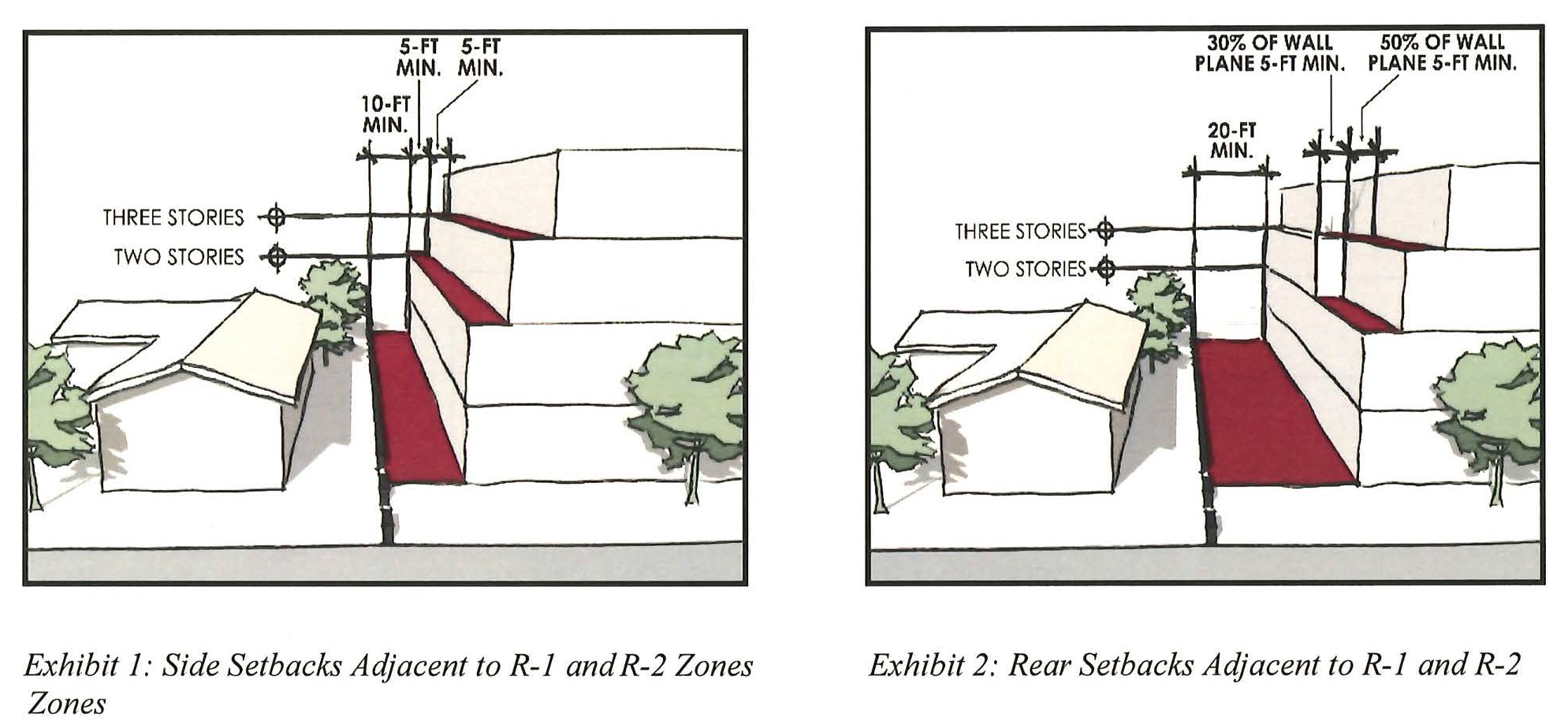
E.
Design Standards. The following site and building design standards identified below apply to all properties within the FCMU Overlay.
1.
Site Design.
a.
Access and Parking.
1)
Vehicular access for corner lots shall be from a side street or from an alley, if feasible.
2)
Access to parking on interior lots shall only have one vehicular access point unless the property has more than three hundred (300) feet or more of street frontage.
3)
Up to thirty (30) percent of required parking may be located along a public street frontage. All other required parking shall not be located between any building and public street frontage.
4)
Residential parking shall be separate from non-residential parking and accessed through a secure gated entrance. However, parking areas for required residential guest parking may be combined with required non-residential parking.
5)
On-site parking that is visible from streets and sidewalks or located along rear, side, or interior lot lines shall be buffered from the street, sidewalk, or lot line by a minimum five feet in-depth landscape buffer. Further, parking that is visible from the public right-of-way shall be buffered from the street, sidewalk or lot line by a minimum five feet in-depth landscape buffer that includes a decorative wall no higher than three feet to screen the vehicles.
6)
Tandem parking within allowed parking areas may be allowed with an AUP for Multi-Family projects and the residential component of Mixed-Use projects. Tandem parking is permitted for nonresidential uses. When a nonresidential use's tandem parking is permitted, an affidavit shall be signed for the valet parking use.
7)
On the same premises with every building, structure or part thereof erected or occupied for manufacturing, storage, warehouse, goods display, department store, wholesale or retail market, hotel, restaurant, hospital, laundry, dry cleaning plant, or other uses similarly involving the receipt or distribution of vehicles carrying materials or merchandise, there shall be provided and maintained on the lot a minimum of one off-street or off-alley loading space for each six thousand (6,000) square feet of floor area of building for standing, loading and unloading services in order to avoid undue interference with the public use of the streets or alleys. Required loading space may be included within the required parking space adjacent to a building.
8)
Parking stalls shall be striped with three inch double lines, six inches apart. The stall width shall be measured from the center point of each double striped marking.
9)
Customer parking shall be a minimum dimension of nine feet wide by eighteen (18) feet deep. Parking stalls may overhang landscape planters by two feet.
10)
Compact car parking standards. The use of compact car parking shall be allowed only for manufacturing, industrial, commercial and office uses. The number of compact car parking stalls may consist of twenty-five (25) percent of the total number of required parking stalls. Each compact car parking space shall be eight feet wide and sixteen (16) feet long. All stalls must be identified by painting "Compact" in each stall using letters no less than ten (10) inches in height. Support columns and/or lighting standards shall not intrude into the minimum dimensions. Compact car parking shall be, as much as is practical, grouped in a common location subject to the approval of the Community Development Director.
11)
Support columns and/or lighting standards shall not intrude into the minimum parking stall dimensions. Where a parking stall is located abutting a wall, column, or similar structure, the stall width shall be increased by two feet.
12)
Design standards for handicapped parking stalls shall be provided in accordance with accepted State standards and shall be considered as part of the parking space requirements for the given facility.
b.
Open Space. Each type of open space has a different purpose and user; the requirements for one type of open space cannot be satisfied by another.
1)
Public Open Space.
a)
All open space shall be public unless parcel location does not allow public access.
b)
Open space amenities for public use such as trees, seating, and recreational amenities should be provided in open space. High quality porous pavers, porous concrete or other porous paving materials shall be used for all plazas and hardscape. Shade trees should be provided in all open space. Parks and greenways should be designed with high-quality benches, lighting, paving, and landscaping.
c)
Community benefit incentives are available for providing more usable public open space than is required, see RMC Section 17.28.040.E.
d)
Usable public open space does not include libraries, gymnasiums, nor recreation rooms.
e)
All required usable public open space shall be developed and professionally maintained in accordance with approved landscape and irrigation. All landscaping should use high-quality materials.
2)
Usable Common Open Space.
a)
All usable common open space shall be conveniently located and readily accessible from all residential units in a residential or Mixed-Use development.
b)
Each usable common open space shall have no side with a dimension of less than ten (10) feet and may incorporate any areas of the site except where it is within five feet of public rights-of-way, private streets and alleys, and shall not include or incorporate any driveways or parking areas, trash pickup or storage areas, pool equipment, or utility areas.
c)
Usable common open space may be provided on a rooftop where mechanical equipment is located, if the open space is adequately mitigated for noise, odor, vibration, or other impact and is approved by the Community Development Director and Building Official.
d)
There shall be a minimum distance of fifteen (15) feet measured horizontally between any swimming pool and the nearest point of any balcony, porch, second story patio, sun deck, or other architectural feature of a building or structure with windows, doors, or other openings of sufficient size to permit the passage of persons.
e)
Courtyards internal to a project, or enclosed on at least two sides, shall have a minimum width of forty (40) feet, for lots more than sixty (60) feet in width and twenty (20) feet in width for lots less than sixty (60) feet in width and shall be landscaped with a ratio of hardscape to planting not exceeding a ratio of one square foot of landscape to one square foot of hardscape. Pools and spas shall be excluded from this ratio.
f)
All required usable common open space shall be developed and professionally maintained in accordance with approved landscape and irrigation. All landscaping should use high-quality materials.
g)
Usable common open space may include libraries, gymnasiums, or recreation rooms.
3)
Usable Private Open Space.
a)
No portion of any private patio or balcony shall be used for the permanent storage of rubbish, junk, clotheslines, or garbage receptacles. "Permanent storage," as used in this subsection, means the presence for a period of forty-eight (48) or more consecutive hours on a patio or balcony.
b)
Usable private open space must be open air, not fully enclosed with walls. Usable private open space may be enclosed with a three foot high wrought iron rail, partial wall, or other complementary material as permitted by the Community Development Director. Usable private open spaces cannot be covered by a roof by more than fifty (50) percent of the area; however, balconies can have up to one hundred (100) percent ceiling coverage.
c.
Landscaping.
1)
All landscape and irrigation plans shall comply with the requirements found in RMC Chapter 13.08 - Water Efficient Landscapes.
2)
Landscape plans shall consist of a combination of trees, shrubs, and groundcover.
a)
Tree material shall be a minimum of fifteen (15) gallons in size and comprise a minimum of fifteen (15) percent of the area devoted to landscaping.
b)
All shrubs shall be a minimum of five gallons in size.
c)
Accent plantings shall be utilized at primary site and building entries for enhanced project aesthetic.
d.
Walls and Fences.
1)
A six foot high masonry wall shall be constructed along the property line of any lot where a Mixed-Use development is adjacent to property zoned and/or used for residential purposes. Said wall shall be limited in height to forty-two (42) inches where it abuts the required front yard setback on an adjacent property zoned or used for residential purposes.
2)
All walls on a property shall complement the architectural style and design of the primary building of a development.
3)
Chain-link, wood, barbed wire, razor-wire, and spiked fence-types are prohibited.
e.
Lighting.
1)
A photometric survey (lighting plan) may be required at the discretion of the Community Development Director for new lighting proposed in a development.
2)
All developments shall have exterior lighting that provides adequate visibility at entrances, public sidewalks, open areas, and parking lots with a safe level of illumination at night.
3)
Exterior lighting shall be of low intensity and shielded so that light will not spill out onto surrounding properties or project above the horizontal plane. In residential/commercial Mixed-Use and commercial/industrial Mixed-Use development, the lighting for commercial uses shall be appropriately shielded so that it does not negatively impact the On-site residential units.
4)
Flashing, revolving, or intermittent exterior lighting visible from any property line or street shall be prohibited, except if approved in conjunction with a public art project or as an accessory feature on a temporary basis in conjunction with a special event permit.
5)
Lighting shall be integrated with landscaping wherever possible.
f.
Trash and Loading.
1)
Trash and recycling areas shall comply with the relevant provisions of RMC Section 17.32.050.
2)
Where loading areas are proposed On-site, they shall be clearly marked and identifiable.
g.
Mechanical Equipment, Loading Zones, and Service Area Screening.
1)
Wall-mounted equipment shall be flush with the exterior building walls and painted to match the color of the exterior of the building and screened from the view of any public right-of-way. Window-mounted air conditioners or exterior-mounted fans shall be prohibited.
2)
Ground-mounted and pad-mounted mechanical or utility equipment and other such similar equipment shall be screened from view from all public rights-of-way and adjacent properties by architectural building features, fencing or landscaping.
3)
Rooftops should be designed in a way that acknowledges their visibility from other buildings and the street. Equipment shall be screened on all four sides from both the street and neighboring buildings using parapets or similar architectural features and from the top where visible from an adjacent building of greater height.
4)
Service and loading zones where visible from public streets and views from neighboring buildings and properties shall be screened by the use of decorative walls and/or dense landscaping that will serve as both a visual and a noise barrier.
h.
Noise.
1)
To minimize noise disturbance, mechanical equipment shall be insulated and shall be setback a minimum of four feet from any adjacent property zoned or used for residential purposes.
2)
Residential portions of a Mixed-Use project shall be designed to limit the interior noise of the non-residential portions of the project. Design interventions to limit interior noise may include but are not limited to building orientation, double paned windows, enhanced wall and ceiling insulation, and/or orientation and insulation of vents, among others.
i.
Signs.
1)
A uniform sign program shall be approved by the Planning Division for each development.
2)
Permitted sign types shall be limited to wall, window, awning, and monument signs and shall not be located above the first floor.
3)
Building-mounted signs, including wall, window, and awning, shall not exceed a cumulative total of one square foot of area per one lineal foot of building frontage of each business.
4)
A monument sign shall be used only to identify multiple businesses in the commercial portion of a Mixed-Use development based on the following criteria:
a)
One-third square foot of monument sign area per one lineal foot of lot frontage with a maximum of fifty (50) square feet.
b)
The entire sign structure shall be considered as sign area.
c)
The sign copy area shall not exceed sixty (60) percent of the background wall area.
d)
All monument signs shall contain only the name of the development and/or the names of the businesses.
e)
Monument signs shall not encroach into any required landscaped setback area when abutting open areas or encroach more than one-half the required landscaped setback area when located in front of a building.
f)
Sign copy shall be backlighted or indirectly lighted.
g)
The background wall of the monument sign shall not exceed six feet in height.
h)
A maximum of one sign per development.
i)
The monument sign shall be setback a minimum of three feet from the property line at a location where the building is setback a minimum of ten (10) feet.
5)
For a list of prohibited sign types within the FCMU Overlay, refer to RMC 17.116.050.
2.
Building Design.
a.
Good Neighbor.
1)
Buildings shall be designed to maximize privacy of adjacent R-1 and R-2 zoned properties through appropriate placement of windows, doors, decks, roof decks, and balconies.
2)
Windows shall be located so that sight lines maximize privacy on adjacent R-1 and R-2 zoned properties. Translucent/obscured glass or windows with higher sills may be utilized to allow for interior illumination while maintaining privacy.
3)
Upper-story decks, roof decks, and balconies shall be oriented towards the street to minimize privacy concerns on R-1 and R-2 zoned properties.
4)
Tall, fast-growing, and evergreen vegetation shall be utilized along the property lines of R-1 and R-2 zones.
b.
Land Use Mix.
1)
Where a project proposes a variety of uses within a single project, non-residential uses shall be provided at ground level facing the street.
2)
Residential units in a Mixed-Use project are not permitted at ground level facing a street.
3)
Live/work uses, whether standalone or as part of a Mixed-Use project, are allowed at ground level facing the street or facing an On-site street, provided they maintain a commercial aesthetic.
c.
Massing.
1)
Variations in projecting and recessed wall and roof planes shall be provided to break up the massing of a building. Surface detailing does not substitute for adequate massing.
2)
Wall planes shall not continue for more than fifty (50) feet without a minimum offset of two feet.
3)
The mass and bulk of new buildings shall relate to and/or transition from existing buildings.
4)
Infill buildings that may be wider than existing facades shall be broken down to provide the appearance of a series of structural bays.
d.
Articulation.
1)
Building design shall incorporate three hundred sixty (360) degree architecture, which includes similar massing, roof forms, wall planes, and detailing on all building elevations.
2)
Architectural elements that add visual interest, scale, and character shall be provided. Architectural elements include but are not limited to balconies, awnings, shutters, window/door detailing, and trellises, among other potential design interventions.
3)
Use of a minimum of two high-quality materials like smooth finish stucco, brick, wood, metal, and stone are encouraged.
4)
Anti-graffiti paint or coatings shall be used on street-facing facades of primary buildings and accessory structures for the first two stories.
e.
Roofs.
1)
Buildings with flat or low-pitched roofs shall incorporate parapets or other architectural elements to break up long horizontal rooflines.
2)
Hipped or gabled roofs covering an entire building are preferred to mansard roofs and segments of pitched roofs applied at the building edge.
3)
Parapets shall be well-detailed, three-dimensional, and of substantial size to complement the building design. Parapets shall include a minimum of one of the following elements: pre-cast elements, continuous banding or projecting cornice, dentils, caps, corner details, or variety in pitch (sculpted).
4)
Penthouses, parapets, stair and elevator enclosures, and air conditioning units and other mechanical equipment shall be fully integrated into the overall architectural design of the building and/or through the use of equivalent materials and colors that match the overall design. All rooftop mechanical components shall be fully screened from the view of public rights-of-way and residentially zoned properties.
f.
Windows and Doors.
1)
Windows and doors shall be selected to complement the selected architectural style.
2)
Windows shall be articulated with accent trim, sills, shutters, and/or other elements appropriate to the architectural style of the building.
3)
Where appropriate to the architectural style, windows shall be setback into walls to create distinct patterns of shade and shadow.
4)
The street-level building frontage shall continue for no more than twenty (20) feet without windows, entrances, or other architectural detailing.
5)
A minimum of fifty (50) of the ground floor façade facing any street to a height of eight feet shall be visually transparent into the building.
6)
Anti-graffiti glass or film shall be used on street-facing windows and doors of primary buildings and accessory structures for the first two stories.
g.
Entrances.
1)
Primary entries shall be clearly identifiable through the use of enhanced design elements, which shall include a minimum of two of the following: materials/colors, window/door type, awning, and signage, among other possible design interventions.
2)
Where multiple uses are proposed within a building, separate and secure ground floor access entries shall be provided for each use, with entry design differentiated between the residential and non-residential uses.
3)
Ground floor design shall be high-quality and pedestrian-oriented. Storefront configurations and details providing a sense of human scale, variety, and interest within the overall context of buildings, bays and groupings of bays are encouraged. Details may include but are not limited to recessed entries at storefronts, recessed storefronts, display windows, projecting bays, integral awning, utilization of true dividing mullions, transoms over entries, and/or integral signs and sign boards.
4)
Storefronts and usable non-residential space shall be located along the required ground floor street frontages of buildings and shall have a minimum usable depth of forty (40) feet along sixty (60) percent of the length of the building frontage and shall in no case be less than twenty (20) feet in depth. For small lots under ten thousand (10,000) square feet, storefronts and usable non-residential space shall be located along the required ground floor street frontages of buildings and shall have a minimum usable depth of thirty (30) feet along sixty (60) percent of the length of the building frontage and shall in no case be less than fifteen (15) feet in depth. At a corner lot where storefronts and non-residential uses are proposed, storefronts and non-residential spaces shall turn and wrap around the corner for a minimum length of twenty (20) feet.
5)
Upward rolling, side folding, or moveable security grills and elements shall not be installed on the exterior side of ground floor and street-facing storefronts, windows, openings, entries, and facades. On the interior side of ground floor and street-facing storefronts, windows, openings, entries and facades, upward rolling, side folding, or moveable security grills and elements are allowed and should be designed to be integral to the architecture of the building and opening. Such devices should utilize dedicated interior side pockets and ceiling cavities such that the grill and all mechanisms associated with the security element are not visible from the adjacent public right-of-way and sidewalk; the grill work, regardless of installation method, shall be at least eighty (80) percent open to perpendicular view. Fixed decorative grillwork and railings are allowed at the ground floor and shall be at least eighty (80) percent open to perpendicular view.
h.
On-site Facilities.
1)
A private and secure storage space shall be provided for each dwelling unit within a development. Location of required storage space is preferred within the unit, however, it may be located outside of the unit. If required storage space is located outside the unit, it must be accessible from a common hallway, private balcony/patio, or in a garage. Storage shall be fully enclosed and not visible.
i.
Encroachments.
1)
No part of a structure, permanent attachment, and/or other similar architectural feature may extend into a required yard or minimum distance between buildings for more than two feet.
2)
No part of a structure, permanent attachment, and/or other similar architectural feature may extend into the public right-of-way without approval of an encroachment permit by the Public Works Department.
F.
Community Benefits Program. The FCMU Overlay provides optional opportunities for increased development intensity concurrently with the delivery of public improvements or other community benefits to satisfy the increased demand for community benefits that come with Mixed-Use developments. The FCMU Overlay Community Benefits Program is applicable to all properties within the FCMU Overlay.
Each zone in the FCMU has development standards detailing the permitted floor area ratio and dwelling units per acre allowed by right. A developer or property owner can increase the floor area ratio and dwelling units per acre allowed by right in each zone, subject to the delivery of additional amenities by the developer or property owner. However, if a density bonus is granted in accordance with Senate Bill 1818, a density or intensity bonus associated with the provision of Community Benefits will not be granted.
The FCMU Overlay Community Benefit Program is based on a point system. Each community benefit type is assigned a number of points, as described in in the table below. A project may earn points from a single, or multiple categories, depending on the applicant's preference. The number of points received is then translated into increased height, floor area ratio, and dwelling units per acre. The increases vary by zone and land use type, as shown in the table below.
City staff will be responsible for determining points awarded to an applicant when community benefits are provided and an increase in development intensity is requested. When community benefits are proposed to be included as part of a project proposal and an increase in development intensity is requested, City staff shall prepare administrative findings that validate and quantify the amount of community benefits proposed and subsequently the increase in development intensity allowed. Findings shall also address that the community benefits proposed are consistent with community goals, as envisioned in this FCMU Overlay and in the General Plan.
G.
Density Bonus. As provided by SB 1818—State Density Bonus Law and outlined locally for implementation in RMC Chapter 17.84—Density Bonus, applicants may choose to apply for a density bonus as part of a project proposal within FCMU Overlay designated zones, so long as the residential or mixed-use development includes five or more dwelling units. As noted in the RMC 17.84, projects requesting density bonuses, concessions, and/or incentives are required to be approved by the City Council and subject to the provisions of RMC Section 17.84.140 and other applicable requirements of the RMC. Applicants interested in pursuing a density bonus as part of their project should refer to the relevant requirements outlined in RMC Chapter 17.84. If a density bonus under SB 1818 is granted, a density or intensity bonus associated with the provision of community benefits will not be granted.
H.
Urban Design.
1.
Public Realm. The public realm refers to the area from the back of the curb to the face of a building. The following design standards have been provided to guide the design of the public realm in support of providing an enhanced and enjoyable public realm for residents, visitors and the community at large.
a.
Sidewalks. An interconnected sidewalk network provides safe and convenient access for use by pedestrians, while also providing opportunities for the provision of pedestrian amenities. The following sidewalk requirements are applicable to all projects within the FCMU Overlay.
1)
The building setback shall be twelve (12) feet, as measured from the curb face, and shall be in the form of both existing right-of-way and/or a recorded pedestrian access and utility easement.
2)
The building setback area shall include a minimum seven foot wide detached sidewalk (clear zone) and a minimum five foot wide parkway (amenity zone) adjacent to all public streets. The amenity zone shall be located between the curb face and the clear zone. The clear zone shall be located between the building and the amenity zone.
3)
The clear zone shall be unobstructed by any permanent element for a minimum width of seven feet and a minimum height of eight feet. However, outdoor/sidewalk dining, a nonpermanent element, may be allowed as outlined in RMC Section 17.28.040.F.4.
4)
The amenity zone may include street trees, landscaping, public signs, public art, street lighting, street furniture, and/or other pedestrian-oriented amenities.
b.
Street Trees. Street trees provide a consistent character along roadways, providing both functional and aesthetic attributes to the built environment. The following street tree requirements are applicable to all projects within the FCMU Overlay.
1)
Street trees shall be selected based upon the prevailing street trees existing along the primary public roadway adjacent to a project site. Applicant should consult the City's Urban Forester to assist in determining the most appropriate street trees for a given project location.
2)
The parkway (amenity zone) shall be planted with street trees at an average spacing not greater than thirty (30) feet on center.
3)
Where mature trees are proposed to be removed as part of a project proposal, removal shall be subject to review and approval by the City's Urban Forester. Mature trees that are approved for removal shall be replaced as part of a project with a new tree that has at least a twenty-four (24) inch box and is consistent with the species to be removed and/or as may be approved by the City's Urban Forester.
c.
Streetscape Furnishings. Streetscape furnishings enliven the public realm and facilitate the creation of a "community living room." Streetscape furnishings include but are not limited to benches, trash cans, bicycle racks, public art, planters, and tree grates, among others.
1)
All streetscape furnishings proposed shall be reviewed and approved by the Public Works Department for durability of materials and ease of maintenance.
2)
Design and selection of streetscape furnishings shall consider the safety, security, convenience, and comfort of the user.
3)
Materials and colors of streetscape furnishing shall be selected to create a consistent and coherent aesthetic. Where streetscape furnishings have been recently installed adjacent to a proposed development, said development shall match the streetscape furnishings palette for consistency.
4)
Benches and trash receptacles shall be placed at an interval of two hundred (200) feet along primary street frontages.
5)
All streetscape furnishings shall be securely anchored to the ground and a graffiti-resistant coating applied to ensure longevity of installations.
6)
Where appropriate, streetscape furnishings shall be ground together to facilitate more efficient use of parkway space.
d.
Outdoor/Sidewalk Dining. Outdoor/sidewalk dining promotes pedestrian activity and vibrancy of Mixed-Use areas and is encouraged within the FCMU Overlay area.
1)
Location.
a)
Outdoor/sidewalk dining, where permitted, may be located on the public right-of-way adjacent to the restaurant serving the outdoor/sidewalk dining. Approval for outdoor/sidewalk dining may be granted after review of the application by appropriate City departments and issuance of an encroachment permit or license agreement.
b)
All outdoor/sidewalk dining shall leave clear space for pedestrian movement between the outer edge of the dining and the curb line. Outdoor/sidewalk dining located at street intersections shall provide a fifteen (15) foot clear space radial to the corner. If pedestrian traffic is especially heavy, the Public Works Director may require additional clear space to ensure adequate room for pedestrian movements.
c)
No outdoor/sidewalk dining shall be located within fifteen (15) feet of a bus stop or bus shelter.
2)
Physical Design Requirements.
a)
All furnishings of outdoor/sidewalk dining including but not limited to tables, chairs and decorative accessories, shall be readily movable.
b)
No part of outdoor/sidewalk dining may be permanently attached to public space. The person to whom the business license for the dining is issued shall repair any damage done by the dining to public property.
c)
When an outdoor/sidewalk dining or the adjacent restaurant is occupied, no exit door shall be locked, bolted, or otherwise fastened or obstructed so that the door cannot be opened from the inside.
d)
Chairs and tables shall be arranged so as to provide for clear access to an exit. No part of an aisle shall be used in any way that will obstruct its use as an exit or that will constitute a hazardous condition.
e)
Outdoor/sidewalk dining shall not be arranged so as to restrict the use of emergency exits, fire escapes on adjacent buildings and access to fire hydrants.
f)
Freestanding or table mounted shade umbrellas shall be kept in good repair and may be used only where space permits.
g)
Freestanding heating or misting equipment may be used only where space permits.
h)
Freestanding lamps are not permitted. Flashing or moving lights are not permitted. Table candles may be used. Electric wiring shall not be placed in pedestrian areas.
i)
Awnings shall be kept in good repair.
j)
Seating and accessories and other components of the outdoor/sidewalk dining shall be maintained in a neat and safe manner.
k)
The height of a railing, fence, or planter (including plantings) used to establish boundaries of seating areas shall be at least twenty-four (24) inches in height but not higher than thirty-six (36) inches. Planters and/or plantings shall be maintained in a neat and orderly manner and shall not encroach past the approved outdoor/sidewalk dining area.
l)
Plank-style picnic tables with bench seating are not permitted.
3)
Dining Operation Requirements.
a)
Outdoor/sidewalk dining shall be operated and maintained in accordance with the applicant's building plans approved by the Community Development Director and the Public Works Director.
b)
The owner(s) shall be responsible for the removal of all wrappings, litter, and food and shall provide thorough and sanitary cleaning for outdoor/sidewalk dining area and the immediate surroundings of such area each day after the eating and drinking establishment closes.
c)
Outdoor/sidewalk dining shall not operate earlier than eight a.m. or later than twelve a.m. (midnight).
d)
If alcoholic beverages are permitted in the outdoor/sidewalk dining area by a Conditional Use Permit (CUP), a landscape separation shall be required to prevent the passing and/or carrying of alcoholic beverages out of the sidewalk area and signs noting such requirement shall be posted in conspicuous locations.
2.
Private Realm. The private realm refers to privately owned property. The following private realm design standards have been provided to guide the design of projects in furthering the character of and in support of the public realm.
a.
Corner Lot. The following applies to properties located at key intersection locations within the FCMU Overlay.
1)
Building architecture at intersection corners, where both streets have four lanes or more, shall receive special treatment to enhance the pedestrian experience and create visual interest within the built environment. Special treatments may include but are not limited to building cut-offs, corner entrances, tower elements, decorative landscaping, enhanced hardscape, and/or other design interventions.
2)
Buildings on corner lots shall address both streets with an equal level of architectural detail.
(Ord. No. 1001, § 7, 9-28-21)
17.29.010 - Fire hazard severity zone map adoption.
The City of Rosemead hereby adopts the updated Fire Hazard Severity Zone Map, as designated and recommended by the State Fire Marshall and the California Dept of Forestry and Fire Protection, identifying areas within the city limits as moderate, high, and very high fire hazard severity zones.
(Ord. No. 1029, § 1, 6-10-25)
17.29.020 - Enforcement.
The city shall enforce all applicable provisions of the California Building Standards Code, Title 24, Part 2, Chapter 7A, requiring ignition-resistant construction standards for all new construction and substantial remodels with the designated very high fire hazard severity zones.
The city shall enforce Government Code §§ 51175-51189, that ensure the Los Angeles County Fire Department is the agency responsible for enforcing defensible space regulations in designated fire hazard areas, particularly in very high fire hazard severity zones.
(Ord. No. 1029, §§ 2, 3, 6-10-25)