


Roseville City Zoning Code
CHAPTER 1012
- OVERLAY DISTRICTS
Sec. 1012.01. - Statement of purpose.
Overlay districts are designed to:
(1)
Provide specialized guidance for specific geographic areas that may have a number of underlying zoning districts.
(2)
Comply with the comprehensive plan's land use guidance.
(Ord. No. 1606, § 1012.01, 11-8-2021)
Sec. 1012.02. - Bus Rapid Transit (BRT) Overlay District.
(a)
Purpose. The Bus Rapid Transit (BRT) Overlay District is intended to:
(1)
Achieve the guidance of the comprehensive plan's future land use goals and policies.
(2)
Promote higher residential density development within the half-mile walkshed of BRT stations.
(3)
Establish standards above and beyond those existing in underlying zoning districts for those areas.
(4)
Focus on enhancing pedestrian connections as part of development.
(b)
Overlay district boundaries. This section shall apply to all lands within the jurisdiction of the city shown on the official zoning map and/or the attachments thereto as meeting both of the following:
(1)
Located within the boundaries of the Bus Rapid Transit (BRT) Overlay District; and,
(2)
Having the underlying zoning of the following base zoning districts:
a.
HDR: High Density Residential District.
b.
MU-1: Neighborhood Mixed-Use District.
c.
MU-2A and MU-2B: Community Mixed-Use Districts.
d.
MU-3: Corridor Mixed-Use District.
e.
MU-4: Core Mixed-Use District.
(c)
Density standards. Residential density shall be a minimum of 15 units per acre.
(d)
Pedestrian and bicycle facilities plan. Any expansion of existing buildings or uses, a change in use, or redevelopment of property will require submittal of a pedestrian and bicycle facilities plan prior to any city approval of proposed development. The pedestrian and bicycle facilities plan shall include the following:
(1)
Area map showing existing public and private pedestrian and bicycle facilities and destinations within a half-mile walkshed of the property.
(2)
Proposed pedestrian and bicycle facilities.
(3)
Proposed pedestrian and bicycle connections to existing or planned public sidewalks and trails, including pedestrian/bike street crossings.
(e)
Pedestrian and bicycle facilities standards.
(1)
Provision of pedestrian and bicycle connections to all existing or planned public sidewalks and trails, including pedestrian/bike street crossings, adjacent to the site.
(2)
Provision of pedestrian-oriented open space adjacent to BRT stations and major roadway intersections designed as a semi-public space, outdoor seating, or other semi-public uses.
(Ord. No. 1606, § 1012.02, 11-8-2021)
Sec. 1012.03. - Shoreland Overlay District.
(a)
Statutory authorization and policy.
(1)
Statutory authorization. The ordinance from which this section is derived is adopted pursuant to the authorization and policies contained in Minn. Stat. ch. 103F, Minn. Rules 6120.2500—6120.3900, and the planning and zoning enabling legislation in Minn. Stat. ch. 462.
(2)
Policy. The state legislature has delegated responsibility to local governments of the state to regulate the subdivision, use and development of the shorelands of public waters and thus preserve and enhance the quality of surface waters, conserve the economic and natural environmental values of shorelands, and provide for the wise use of waters and related land resources. This responsibility is hereby recognized by the city.
(3)
Purpose. The purpose of the shoreland overlay district is to recognize, preserve, protect and enhance the environmental, recreational and hydrologic resources and functions of the city's lakes by regulating the use of land adjacent to public waters. In order to promote the general health, safety and welfare, certain protected waters in the city have been given a shoreland management classification by the state department of natural resources and the city. The intent of the shoreland overlay district is to apply the regulations and standards found in this section to public waters and adjacent land as an overlay zone, further regulating the use of land as allowed by other districts of this title.
(b)
General provisions and definitions.
(1)
Jurisdiction. The provisions of this section apply to the shorelands of the public water bodies as classified in subsection (d)(1) of this section. Pursuant to Minn. Rules 6120.2500 to 6120.3900, no lake, pond, or flowage less than ten acres in size in municipalities or 25 acres in size in unincorporated areas need be regulated in a local government's shoreland regulations. A body of water created by a private user where there was no previous shoreland may, at the discretion of the city council, be exempt from this section.
(2)
Enforcement. The community development director is responsible for the administration and enforcement of this section. Any violation of the provisions of this section or failure to comply with any of its requirements, including violations of conditions and safeguards established in connection with grants of variances or conditional uses, constitutes a misdemeanor and is punishable as defined by law. Violations of this section can occur regardless of whether or not a permit is required for a regulated activity listed in subsection (c)(2) of this section.
(3)
Abrogation and greater restrictions. It is not intended by this section to repeal, abrogate, or impair any existing easements, covenants, or deed restrictions. However, where this section imposes greater restrictions, the provisions of this section shall prevail. All other ordinances inconsistent with this section are hereby repealed to the extent of the inconsistency only.
(4)
All distances, unless otherwise specified, are measured horizontally.
(5)
Definitions. The following words, terms and phrases, when used in this section, shall have the meanings ascribed to them in this subsection, except where the context clearly indicates a different meaning.
Bluff means a topographic feature such as a hill, cliff, or embankment having the following characteristics:
a.
Part or all of the feature is located in a shoreland area;
b.
The slope must drain toward the water body;
c.
The slope rises at least 25 feet above the ordinary high water level;
d.
The grade of the slope from the toe of the bluff to a point 25 feet or more above the ordinary high water level averages 30 percent or greater (see Figure 1012-1), except that an area with an average slope of less than 18 percent over a distance of at least 50 feet shall not be considered part of the bluff (see Figure 1012-2).
Figure 1012-1. Illustration of Bluff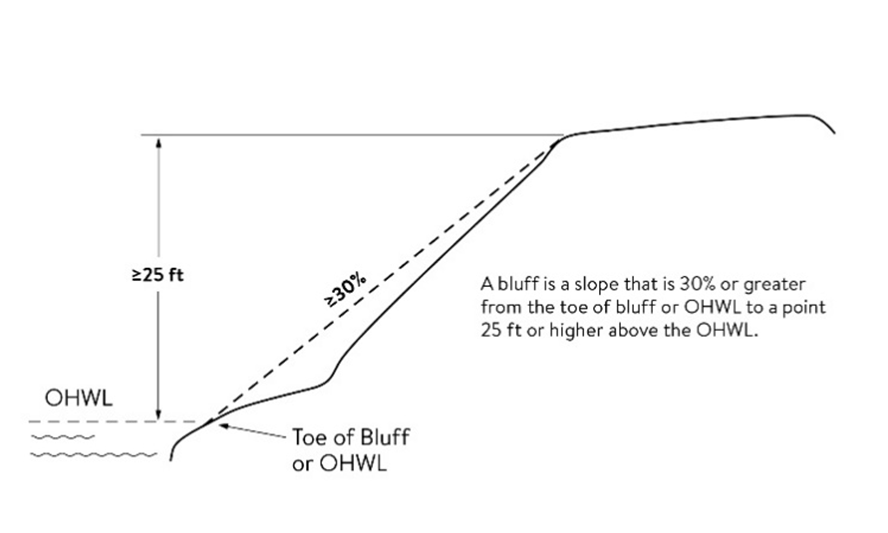
Figure 1012-2. Exception to Bluff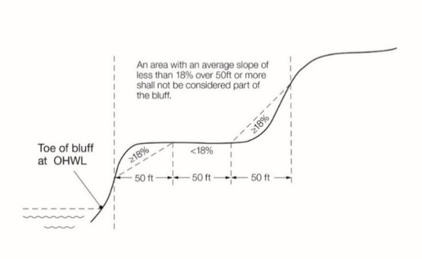
Bluff impact zone means a bluff and land located within 30 feet of the top of a bluff. See Figure 1012-3.
Figure 1012-3. Bluff Impact Zone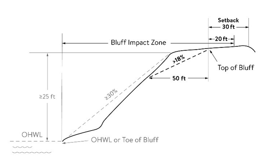
Bluff, toe of, means the lower point of a 50-foot segment with an average slope exceeding 18 percent or the ordinary high water level, whichever is higher.
Bluff, top of, means, for the purposes of measuring setbacks, bluff impact zones, and administering vegetation management standards, the higher point of a 50-foot segment with an average slope exceeding 18 percent.
Boathouse means a facility as defined by Minn. Stat. § 103G.245.
Buffer means a vegetative feature as defined by Minn. Stat. § 103F.48.
Building line means a line parallel to a lot line or the ordinary high water level at the required setback beyond which a structure may not extend.
Commercial use means the principal use of land or buildings for the sale, lease, rental, or trade of products, goods, and services.
Commissioner means the commissioner of the department of natural resources.
Conditional use means a land use or development as defined by ordinance that would not be appropriate generally but may be allowed with appropriate restrictions upon a finding that certain conditions as detailed in the zoning ordinance exist, the use or development conforms to the comprehensive land use plan of the community, and the use is compatible with the existing neighborhood.
Controlled access lot means a lot used to access public waters or as a recreation area for owners of non-riparian lots within the same subdivision containing the controlled access lot.
Dwelling site means a designated location for residential use by one or more persons using temporary or movable shelter, including camping and recreational vehicle sites.
Industrial use means the use of land or buildings for the production, manufacture, warehousing, storage, or transfer of goods, products, commodities, or other wholesale items.
Intensive vegetation clearing means the complete removal of trees or shrubs in a contiguous patch, strip, row, or block.
Nonconformity means any legal use, structure or parcel of land already in existence, recorded, or authorized before the adoption of official controls or amendments to those controls that would not have been permitted to become established under the terms of the official controls as now written.
Planned unit development means a type of development characterized by a unified site design for a number of dwelling units or dwelling sites on a parcel, whether for sale, rent, or lease, and also usually involving clustering of these units or sites to provide areas of common open space, density increases, and a mix of structure types and land uses. These developments may be organized and operated as condominiums, timeshare condominiums, cooperatives, full fee ownership, commercial enterprises, or any combination of these, or cluster subdivisions of dwelling units, residential condominiums, townhouses, apartment buildings, dwelling grounds, resorts, hotels, motels, and conversions of structures and land uses to these uses.
Public waters means any water as defined in Minn. Stat. § 103G.005, subds. 15 and 15a.
Residential planned unit development means a use where the nature of residency is nontransient and the major or primary focus of the development is not service-oriented. For example, residential apartments, manufactured home parks, timeshare condominiums, townhouses, cooperatives, and full fee ownership residences would be considered as residential planned unit developments. To qualify as a residential planned unit development, a development must contain at least five dwelling units or sites.
Semi-public use means the use of land by a private nonprofit organization to provide a public service that is ordinarily open to some persons outside the regular constituency of the organization.
Sewer system means pipelines or conduits, pumping stations, and force main, and all other construction, devices, appliances, or appurtenances used for conducting sewage or industrial waste or other wastes to a point of ultimate disposal.
Shore impact zone means land located between the ordinary high water level of a public water and a line parallel to it at a setback of 50 percent of the structure setback (see Figure 1012-4).
Figure 1012-4. Shore Impact Zone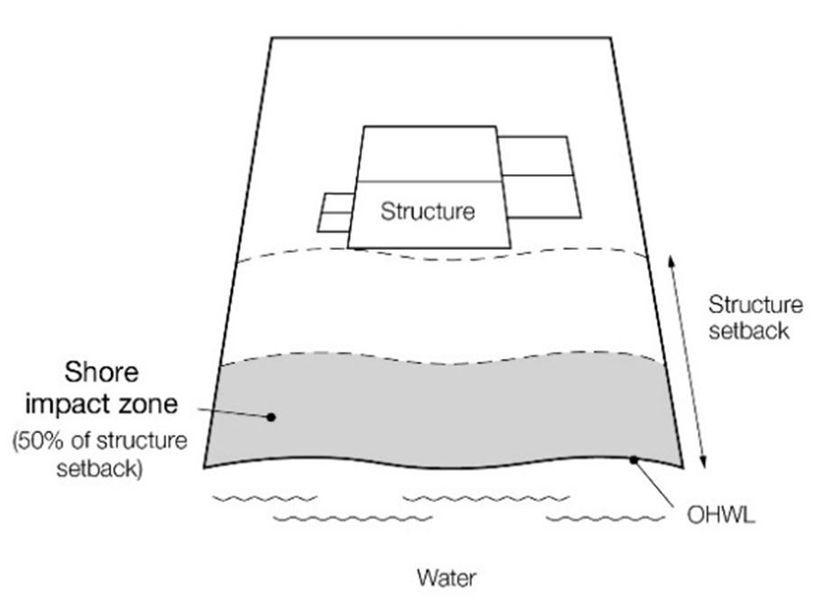
Shore recreation facilities means swimming areas, docks, watercraft mooring areas and launching ramps and other water recreation facilities.
Shoreland means land located within the following distances from public waters:
a.
1,000 feet from the ordinary high water level of a department of natural resources designated lake, pond, or flowage; and
b.
300 feet from a city-designated water body; and
c.
300 feet from a river or stream, or the landward extent of a floodplain designated by ordinance on a river or stream, whichever is greater (see Figure 1012-5).
Figure 1012-5. Definition of Shoreland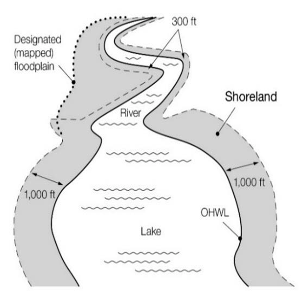
Significant historic site means any archaeological site, standing structure, or other property that meets the criteria for eligibility to the National Register of Historic Places or is listed in the state register of historic sites, or is determined to be an unplatted cemetery that falls under the provisions of Minn. Stat. § 307.08 . A historic site meets these criteria if it is presently listed on either register or if it is determined to meet the qualifications for listing after review by the state archaeologist or the director of the state historical society. All unplatted cemeteries are automatically considered to be significant historic sites.
Steep slope means lands having average slopes over 12 percent, as measured over horizontal distances of 50 feet or more, which are not bluffs.
Subdivision means land that is divided for the purpose of sale, rent, or lease, including planned unit developments.
Suitability analysis means an evaluation of land to determine if it is appropriate for the proposed use. The analysis considers factors relevant to the proposed use and may include the following features: susceptibility to flooding; existence of wetlands; soils, erosion potential; slope steepness; water supply, sewage treatment capabilities; water depth, depth to groundwater and bedrock, vegetation, near-shore aquatic conditions unsuitable for water-based recreation; fish and wildlife habitat; presence of significant historic sites; or any other relevant feature of the natural land.
Variance means the same as that defined in Minn. Stat. § 462.357, subd. 6(2).
Water-dependent use means the use of land for commercial, industrial, public or semi-public purposes, where access to and use of a public water is an integral part of the normal conduct of operation. Marinas, resorts, and restaurants with transient docking facilities are examples of commercial uses typically found in shoreland areas.
Water-oriented accessory structure or facility means a small, above-ground building or other improvement, except stairways, fences, docks, and retaining walls, which, because of the relationship of its use to surface water, reasonably needs to be located closer to public waters than the normal structure setback. Examples of such structures and facilities include watercraft and watercraft equipment storage structures, gazebos, screen houses, fish houses, pump houses, saunas, patios, and detached decks. Boathouses and boat storage structures given the meaning under Minn. Stat. § 103G.245 are not a water-oriented accessory structures.
Wetland has the meaning given under Minn. Rules 8420.0111.
(c)
Administration.
(1)
Purpose. The purpose of this subsection (c) is to identify administrative provisions to ensure this section is administered consistent with its purpose.
(2)
Permits.
a.
A permit is required for the construction of buildings or building additions (including construction of decks and signs) and those grading and filling activities not exempted by subsection (h)(3) of this section.
b.
A certificate of compliance, consistent with Minn. Rules 7082.0700, subp. 3, is required whenever a permit or variance of any type is required for any improvement on or use of the property.
(3)
Application materials. Application for permits and other zoning applications such as variances shall be made to the community development department on the forms provided. The application shall include the necessary information so that the community development director can evaluate how the application complies with the provisions of this section.
(4)
Variances. Variances may only be granted in accordance with Minn. Stat. § 462.357 and are subject to the following:
a.
Variances may not circumvent the general purposes and intent of this section; and
b.
Variances on riparian lots that allow a structure to be located within the ordinary high water level setback or that allow more impervious surface coverage than the standard shall include the following minimum conditions:
1.
The greater of 20 feet or 20 percent of contiguous shoreline to a depth of ten feet shall be restored with trees, shrubs, and low ground covers consisting of native plants which are consistent with the natural cover of the shoreline.
2.
A planting plan which is acceptable to city staff shall be submitted that demonstrates how the restoration will occur.
3.
Either a conservation easement for the restored area shall be established and recorded, or signage following city policies shall be installed and maintained around the restoration area.
(5)
Conditional uses. All conditional uses in the shoreland area are subject to a thorough evaluation of the water body and the topographic, vegetation, and soil conditions to ensure:
a.
The prevention of soil erosion or other possible pollution of public waters, both during and after construction;
b.
The visibility of structures and other facilities as viewed from public waters is limited;
c.
There is adequate water supply and on-site sewage treatment; and
d.
The types, uses, and numbers of watercraft that the project will generate are compatible in relation to the suitability of public waters to safely accommodate these watercrafts.
(6)
Mitigation.
a.
In evaluating all variances, conditional uses, and zoning and building permit applications, the zoning authority shall require the property owner to address the following conditions, when related to and proportional to the impact, to meet the purpose of this section, and to protect adjacent properties and the public interest:
1.
Advanced stormwater runoff management treatment;
2.
Reducing impervious surfaces;
3.
Increasing setbacks from the ordinary high water level;
4.
Restoration of wetlands;
5.
Limiting vegetation removal and/or riparian vegetation restoration;
6.
Provisions for the location, design, and use of structures, sewage treatment systems, water supply systems, watercraft launching and docking areas, and parking areas; and
7.
Other conditions the zoning authority deems necessary.
b.
In evaluating plans to construct sewage treatment systems, roads, driveways, structures, or other improvements on steep slopes, conditions to prevent erosion and to preserve existing vegetation screening of structures, vehicles, and other facilities as viewed from the surface of public waters assuming summer leaf-on vegetation shall be attached to permits.
(7)
Nonconformities.
a.
All legally established nonconformities as of the date of the ordinance from which this section is derived may continue, but will be managed according to Minn. Stat. § 462.357, subd. 1e and other regulations of this community for alterations and additions; repair after damage; discontinuance of use; and intensification of use.
b.
All additions or expansions to the outside dimensions of an existing nonconforming structure must meet the setback, height, and other requirements of subsections (e) through (h) of this section. Any deviation from these requirements must be authorized by a variance.
(8)
Notifications to the department of natural resources.
a.
All amendments to the ordinance from which this section is derived must be submitted to the department of natural resources for review and approval for compliance with the statewide shoreland management rules. The city will submit the proposed ordinance amendments to the commissioner at least 30 days before any scheduled public hearings.
b.
All notices of public hearings to consider variances, ordinance amendments, or conditional uses under shoreland management controls must be sent to the commissioner at least ten days before the hearings. Notices of hearings to consider proposed subdivisions/plats must include copies of the subdivision/plat.
c.
All approved ordinance amendments and subdivisions/plats, and final decisions approving variances or conditional uses under local shoreland management controls must be sent to the commissioner and postmarked within ten days of final action. When a variance is approved after the department of natural resources has formally recommended denial in the hearing record, the notification of the approved variance shall also include the summary of the public record/testimony and the findings of facts and conclusions which supported the issuance of the variance.
d.
Any request to change the shoreland management classification of public waters within the city must be sent to the commissioner for approval, and must include a resolution and supporting data as required by Minn. Rules 6120.3000, subp. 4.
e.
Any request to reduce the boundaries of shorelands of public waters within the city must be sent to the commissioner for approval and must include a resolution and supporting data. The boundaries of shorelands may be reduced when the shoreland of water bodies with different classifications overlap. In these cases, the topographic divide between the water bodies shall be used for adjusting the boundaries.
(9)
Mandatory EAW. An environmental assessment worksheet consistent with Minn. Rules ch. 4410 must be prepared for projects meeting the thresholds of Minn. Rules 4410.4300, subpts. 19a, 20a, 25, 27, 28, 29, and 36a.
(10)
Planned unit development. A planned unit development (PUD) may be permitted within the shoreland overlay district as long as it follows the requirements of chapter 1016 and subsection (j) of this section.
(d)
Shoreland classification system and land uses.
(1)
Shoreland classification system.
a.
Purpose. The purpose of the system is to ensure that shoreland development on the public waters of the city is regulated consistent with the classifications assigned by the commissioner under Minn. Rules 6120.3300.
b.
Lakes are classified as follows:
1.
State designated general development (GD) lakes:
2.
State designated natural environment (NE) lakes:
3.
City designated general development (GD) lakes:
(2)
Land uses. The land uses allowable for the shoreland overlay district shall follow the permitted and conditional use designations as defined and outlined in the underlying zoning district.
(e)
Special land use provisions; commercial, industrial, public, and semi-public use standards.
(1)
Water-dependent uses may be located on parcels or lots with frontage on public waters, provided that:
a.
The use complies with provisions of subsection (g) of this section;
b.
The use is designed to incorporate topographic and vegetative screening of parking areas and structures;
c.
Uses that require short-term watercraft mooring for patrons must centralize these facilities and design them to avoid obstructions of navigation and to be the minimum size necessary to meet the need; and
d.
Uses that depend on patrons arriving by watercraft may use signs and lighting, provided that:
1.
Signs placed in or on public waters must only convey directional information or safety messages and may only be placed by a public authority or under a permit issued by the county sheriff; and
2.
Signs placed within the shore impact zone are:
(i)
No higher than ten feet above the ground, and no greater than 32 square feet in size; and
(ii)
If illuminated by artificial lights, the lights must be shielded or directed to prevent illumination across public waters; and
3.
Other lighting may be located within the shore impact zone or over public waters if it is used to illuminate potential safety hazards and is shielded or otherwise directed to prevent direct illumination across public waters. This does not preclude use of navigational lights.
(2)
Commercial, industrial, public, and semi-public uses that are not water-dependent must be located on lots or parcels without public waters frontage, or, if located on lots or parcels with public waters frontage, must either be set back double the ordinary high water level setback or be substantially screened from view from the water by vegetation or topography, assuming summer leaf-on conditions.
(f)
Dimensional and general performance standards.
(1)
Purpose. The purpose of this subsection (f) is to establish dimensional and performance standards that protect shoreland resources from impacts of development.
(2)
Lot area and width standards. After the effective date of the ordinance from which this section is derived, all new lots must meet the minimum lot area and lot width requirements in subsection (f)(2)d of this section, subject to the following standards:
a.
Only lands above the ordinary high water level can be used to meet lot area and width standards;
b.
Lot width standards must be met at both the ordinary high water level and at the building line;
c.
Residential subdivisions of one-family housing (lot) types that have dwelling unit densities exceeding those in subsection (f)(2)d of this section are allowed only if designed and approved as residential PUDs under subsection (j) of this section; and
d.
Minimum lot area and width standards for one-family to four-family housing (lot type).
1.
Riparian lot.
2.
Non-riparian lot. The lot area and lot width shall meet the standards set forth in the underlying zoning district.
(3)
Impervious surface coverage. Lot development shall meet the impervious surface requirements of the underlying zoning district and stormwater management requirements of title 8.
(4)
Special residential lot provisions.
a.
Development of attached, courtyard cottage, and multifamily housing shall meet the following standards:
1.
The lot area and lot width shall meet the standards of the underlying zoning district.
2.
Seventy percent of the shore impact zone must be permanently protected. If that zone does not meet a riparian buffer standards, then restoration is required.
3.
Shore recreation facilities.
(i)
Shore recreation facilities must be centralized and located in areas suitable for them based on a suitability analysis.
(ii)
Docking, mooring, or over-water storage of more than six watercraft on the centralized facility for the development will only be allowed if the width of the development is greater than the minimum lot width for a riparian single-family residential lot on the respective lake type. For each watercraft greater than six, the width of the development must be increased consistent with the following table:
(iii)
Launching ramp facilities, including a small dock for loading and unloading equipment, may be provided for use by occupants of dwelling units.
(iv)
A legal instrument must be developed that:
A.
Specifies which tenants and/or lot owners have authority to use the facilities;
B.
Identifies what activities are allowed. The activities may include watercraft launching, loading, storage, beaching, mooring, docking, swimming, sunbathing, or picnicking;
C.
Limits the total number of vehicles allowed to be parked in any parking area specifically dedicated to the centralized facilities and the total number of watercraft allowed to be continuously moored, docked, or stored over water;
D.
Requires centralization of all common facilities and activities in the most suitable locations on the lot to minimize topographic and vegetation alterations; and
E.
Requires all parking areas, storage buildings, and other facilities to be screened by vegetation or topography as much as practical from view from the public water, assuming summer leaf-on conditions.
(v)
Accessory structures and facilities, except water-oriented accessory structures, must meet the required structure setback and must be centralized.
(vi)
Water-oriented accessory structures and facilities may be allowed if they meet or exceed design standards contained in subsection (g)(3) of this section and are centralized.
b.
Subdivisions of two-family (duplexes), three-family (triplexes), and four-family (quads) dwellings are conditional uses on natural environment lakes and must also meet the following standards:
1.
Each building must be set back at least 200 feet from the ordinary high water level;
2.
Watercraft docking facilities for each lot must be centralized in one location and serve all dwelling units in the building; and
3.
No more than 25 percent of a lake's shoreline can be in duplex, triplex, or quad developments.
c.
An accessory dwelling unit may be allowed as long as the standards of section 1011.12(b)(1) and subsections (f)(4)c.1 and 2 of this section are met:
1.
The minimum lot size for a detached ADU must meet the two-family (duplex) standard for the lake type.
2.
A detached ADU must be located or designed to reduce its visibility as viewed from public waters and adjacent shorelands by vegetation, topography, increased setbacks or color, assuming summer leaf-on conditions.
d.
Controlled access lots are permissible if created as part of a subdivision and in compliance with the following standards:
1.
The lot must meet the area and width requirements for residential lots, and be suitable for the intended uses of controlled access lots as provided in subsection (f)(4)d.4 of this section;
2.
If docking, mooring, or over-water storage of more than six watercraft is to be allowed at a controlled access lot, then the width of the lot (keeping the same lot depth) must be increased by a percentage of the requirements for riparian residential lots for each watercraft beyond six, consistent with the following table:
3.
The lot must be jointly owned by all purchasers of lots in the subdivision or by all purchasers of non-riparian lots in the subdivision who are provided riparian access rights on the access lot; and
4.
Covenants or other equally effective legal instruments must be developed that:
(i)
Specify which lot owners have authority to use the access lot;
(ii)
Identify what activities are allowed. The activities may include watercraft launching, loading, storage, beaching, mooring, docking, swimming, sunbathing, or picnicking;
(iii)
Limit the total number of vehicles allowed to be parked and the total number of watercraft allowed to be continuously moored, docked, or stored over water;
(iv)
Require centralization of all common facilities and activities in the most suitable locations on the lot to minimize topographic and vegetation alterations; and
(v)
Require all parking areas, storage buildings, and other facilities to be screened by vegetation or topography as much as practical from view from the public water, assuming summer leaf-on conditions.
(5)
Placement, height, and design of structures.
a.
OHWL setback for structures. When more than one setback applies to a site, structures and facilities must be located to meet all setbacks and comply with the following OHWL setback provisions:
1.
General development lake. For a general development lake, the setback shall be 50 feet.
2.
Natural environment lake. For a natural environment lake, the setback shall be 150 feet.
3.
OHWL setbacks. Structures and impervious surfaces must meet setbacks from the ordinary high water level (OHWL), except that one water-oriented accessory structure or facility, designed in accordance with subsection (g)(3) of this section, may be set back a minimum distance of ten feet from the OHWL.
4.
Setback averaging. Where structures exist on the adjoining lots on both sides of a proposed building site, structure setbacks may be altered without a variance to conform to the adjoining setbacks from the OHWL, provided the proposed structure is not located in a shore impact zone or in a bluff impact zone (see Figure 1012-6);
Figure 1012-6. Structure Setback Averaging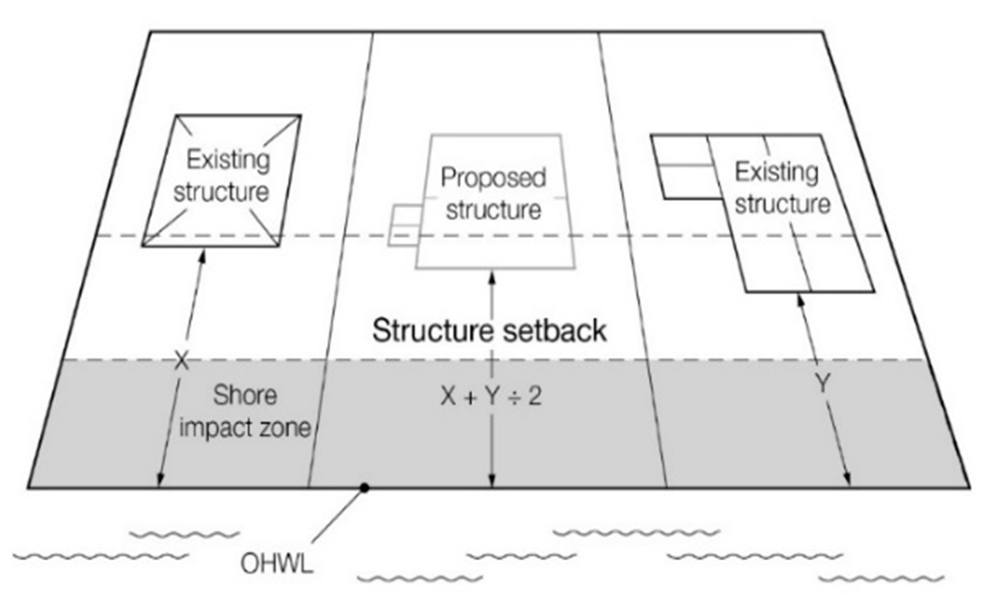
5.
Setbacks of decks. Deck additions may be allowed without a variance to a structure not meeting the required setback from the ordinary high water level if all of the following criteria are met:
(i)
The structure existed on the date the structure setbacks were established;
(ii)
A thorough evaluation of the property and structure reveals no reasonable location for a deck meeting or exceeding the existing ordinary high water level setback of the structure;
(iii)
The deck encroachment toward the ordinary high water level does not exceed 15 percent of the existing setback of the structure from the ordinary high water level or is no closer than 30 feet from the OHWL, whichever is more restrictive; and
(iv)
The deck is constructed primarily of wood or composite materials having the appearance of wood, and is not roofed or screened (see Figure 1012-7).
Figure 1012-7. Deck Encroachment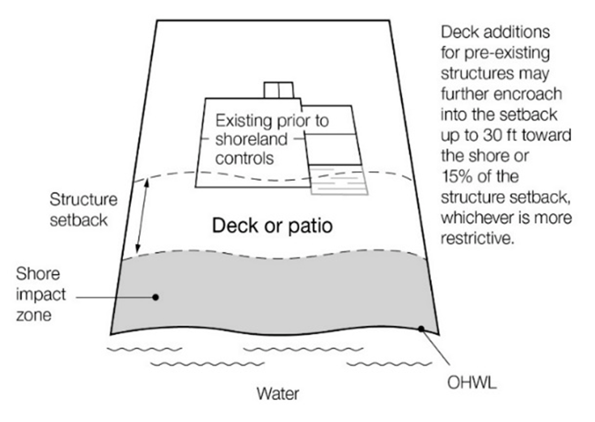
6.
Additional structure setbacks. Structures must also meet the following setbacks, regardless of the water body classification:
(i)
30 feet from the top of the bluff.
(ii)
50 feet from an unplatted cemetery.
7.
Bluff impact zones. Structures, impervious surfaces, and accessory facilities, except stairways and landings, must not be placed within bluff impact zones.
b.
Height of structures. All structures must meet the height limitations of the underlying zoning district.
c.
Lowest floor elevation.
1.
Determining elevations. Structures must be placed at an elevation consistent with the applicable floodplain regulatory elevations. Where these controls do not exist, the elevation to which the lowest floor, including basement, is placed or floodproofed must be determined for lakes by placing the lowest floor at a level at least three feet above the highest known water level, or three feet above the ordinary high water level, whichever is higher (see Figure 1012-8).
Figure 1012.8. Lowest Floor Elevation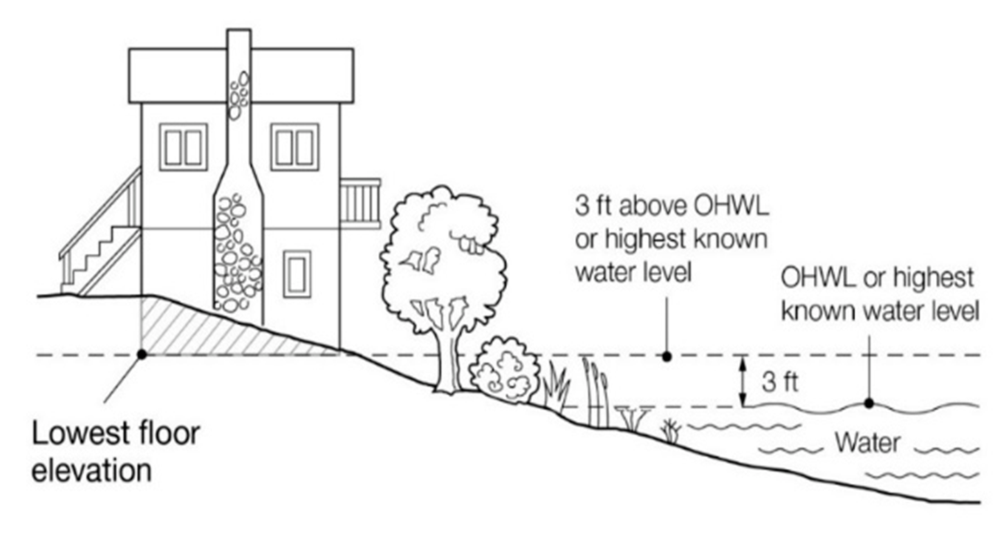
2.
Methods for placement.
(i)
In addition to the lowest floor, all service utilities must be elevated or watertight to the elevation determined in subsection (f)(5)c.1 of this section.
(ii)
If elevation methods involving fill would result in filling in the shore impact zone, then structures must instead be elevated through floodproofing methods in accordance with subsection (f)(5)c.2(iii) of this section;
(iii)
If the structure is floodproofed, then it must be built to resist hydrostatic pressure through elevation methods such as blocks, pilings, filled stem walls, elevated concrete pads, internally flooded enclosed areas, or through other accepted engineering practices consistent with FEMA Technical Bulletins 1, 2 and 3.
d.
Significant historic sites. No structure may be placed on a significant historic site in a manner that affects the values of the site unless adequate information about the site has been removed and documented in a public repository.
(6)
Water supply and sewage treatment.
a.
Water supply. Any public or private supply of water for domestic purposes must meet or exceed standards for water quality of the state department of health and the state pollution control agency.
b.
Sewage treatment. Any premises used for human occupancy must be connected to a publicly owned sewer system, where available, or comply with Minn. Rules chs. 7080 to 7081.
(g)
Performance standards for public and private facilities.
(1)
Placement and design of roads, driveways, and parking areas. Public and private roads and parking areas must be designed to take advantage of natural vegetation and topography to achieve maximum screening as viewed from public waters and comply with the following standards:
a.
Roads, driveways, and parking areas must meet structure setbacks and must not be placed within bluff and shore impact zones, when other reasonable and feasible placement alternatives exist. If the city engineer determines that no alternatives exist, they may be placed within these areas, and must be designed to minimize adverse impacts;
b.
Watercraft access ramps, approach roads, and access-related parking areas may be placed within shore impact zones, provided the vegetative screening and erosion control conditions of this subsection (g)(1) are met;
c.
Private facilities must comply with the grading and filling provisions of subsection (h)(3) of this section; and
d.
For public roads, driveways and parking areas, documentation must be provided by a qualified individual that they are designed and constructed to minimize and control erosion to public waters consistent with the field office technical guides of the local soil and water conservation district, or other applicable technical materials.
(2)
Stairways, lifts, and landings. Stairways and lifts are the preferred alternative to major topographic alterations for achieving access up and down bluffs and steep slopes to shore areas. Stairways, lifts, and landings must meet the following design requirements:
a.
Stairways and lifts must not exceed four feet in width on residential lots. Wider stairways may be used for commercial properties, public recreational uses, and planned unit developments;
b.
Landings for stairways and lifts on residential lots must not exceed 32 square feet in area. Landings larger than 32 square feet may be used for commercial properties, public space recreational uses, and planned unit developments;
c.
Canopies or roofs are not allowed on stairways, lifts, or landings;
d.
Stairways, lifts, and landings may be either constructed above the ground on posts or pilings, or placed into the ground, provided they are designed and built in a manner that ensures control of soil erosion;
e.
Stairways, lifts, and landings must be located in the most visually inconspicuous portions of lots, as viewed from the surface of the public water assuming summer leaf-on conditions, whenever practical; and
f.
Facilities such as ramps, lifts, or mobility paths for physically disabled persons are also allowed for achieving access to shore areas, if they are consistent with the dimensional and performance standards of subsections (g)(2)a through e of this section and the requirements of Minn. Rules ch. 1341.
(3)
Water-oriented accessory structures or facilities. Each residential lot may have one water-oriented accessory structure or facility if it complies with the following provisions:
a.
The structure or facility must not exceed ten feet in height, exclusive of safety rails, and cannot occupy an area greater than 250 square feet. The structure or facility may include detached decks not exceeding eight feet above grade at any point or at-grade patios;
b.
The structure or facility is not in the bluff impact zone;
c.
The setback of the structure or facility from the ordinary high water level must be at least ten feet;
d.
The structure is not a boathouse or boat storage structure as defined under Minn. Stat. § 103G.245;
e.
The structure or facility must be treated to reduce visibility as viewed from public waters and adjacent shorelands by vegetation, topography, increased setbacks or color, assuming summer leaf-on conditions;
f.
The roof may be used as an open-air deck with safety rails, but must not be enclosed with a roof or sidewalls or used as a storage area;
g.
The structure or facility must not be designed or used for human habitation and must not contain water supply or sewage treatment facilities;
h.
As an alternative for general development and recreational development water bodies, water-oriented accessory structures used solely for storage of watercraft and boating-related equipment may occupy an area up to 400 square feet, provided the maximum width of the structure is 20 feet as measured parallel to the shoreline; and
i.
Water-oriented accessory structures may have the lowest floor placed lower than the elevation specified in subsection (f)(5)c.1 of this section if the structure is designed to accommodate internal flooding, constructed of flood-resistant materials to the elevation, electrical and mechanical equipment is placed above the elevation and, if long duration flooding is anticipated, the structure is built to withstand ice action and wind-driven waves and debris.
(h)
Vegetation and land alterations.
(1)
Purpose. Alterations of vegetation and topography are regulated to prevent erosion into public waters, fix nutrients, preserve shoreland aesthetics, preserve historic values, prevent bank slumping, sustain water quality, and protect fish and wildlife habitat.
(2)
Vegetation management.
a.
Removal or alteration of vegetation must comply with the provisions of this subsection (h) except for:
1.
Vegetation alteration necessary for the construction of structures and sewage treatment systems under validly issued permits for these facilities; and
2.
The construction of public roads and parking areas if consistent with subsection (g)(1) of this section.
b.
Intensive vegetation clearing in the shore and bluff impact zones and on steep slopes is prohibited.
c.
Limited clearing and trimming of trees and shrubs in the shore and bluff impact zones and on steep slopes is allowed to provide a view to the water from the principal dwelling and to accommodate the placement of stairways and landings, picnic areas, access paths, beach and watercraft access areas, and permitted water-oriented accessory structures or facilities, provided that:
1.
The screening of structures, vehicles, or other facilities as viewed from the water, assuming summer leaf-on conditions, is not substantially reduced;
2.
Existing shading of water surfaces along rivers is preserved;
3.
Cutting debris or slash shall be scattered and not mounded on the ground; and
4.
Perennial ground cover is retained;
5.
Picnic areas, access paths, livestock watering areas, beaches and watercraft access areas are prohibited in bluff impact zones.
d.
Removal of trees, limbs, or branches that are dead, diseased, dying, or pose safety hazards is allowed without a permit.
e.
Fertilizer and pesticide runoff into surface waters must be minimized through use of vegetation, topography or both.
(3)
Grading and filling.
a.
Grading and filling activities must comply with the provisions of this subsection (h) except for the construction of public roads and parking areas if consistent with subsection (g)(1) of this section.
b.
Permit requirements.
1.
Grading, filling and excavations necessary for the construction of structures, and driveways, if part of an approved permit, do not require a separate grading and filling permit.
2.
For all other work, including driveways not part of another permit, a grading and filling permit is required for:
(i)
The movement of more than ten cubic yards of material on steep slopes or within shore or bluff impact zones; and
(ii)
The movement of more than 50 cubic yards of material outside of steep slopes and shore and bluff impact zones.
c.
Grading, filling and excavation activities must meet the following standards:
1.
Grading or filling of any wetland must meet or exceed the wetland protection standards under Minn. Rules ch. 8420 and any other permits, reviews, or approvals by other local, state or federal agencies such as watershed districts, the DNR or the United States Army Corps of Engineers;
2.
Land alterations must be designed and implemented to minimize the amount of erosion and sediment from entering surface waters during and after construction consistently by:
(i)
Limiting the amount and time of bare ground exposure;
(ii)
Using temporary ground covers such as mulches or similar materials;
(iii)
Establishing permanent, deep-rooted and dense vegetation cover as soon as possible;
(iv)
Using sediment traps, vegetated buffer strips or other appropriate techniques;
(v)
Stabilizing altered areas to acceptable erosion control standards consistent with the field office technical guides of the soil and water conservation district;
(vi)
Not placing fill or excavated material in a manner that creates unstable slopes. Plans to place fill or excavated material on steep slopes must be reviewed by qualified professionals for continued slope stability and must not create finished slopes of 30 percent or greater;
(vii)
Fill or excavated material must not be placed in bluff impact zones;
(viii)
Any alterations below the ordinary high water level of public waters must first be authorized by the commissioner under Minn. Stat. ch. 103G;
(ix)
Alterations of topography are only allowed if they are accessory to permitted or conditional uses and do not adversely affect adjacent or nearby properties; and
(x)
Placement of natural rock riprap, including associated grading of the shoreline and placement of a filter blanket, is permitted if:
A.
The finished slope does not exceed three feet horizontal to one foot vertical;
B.
The landward extent of the riprap is within ten feet of the ordinary high water level; and
C.
The height of the riprap above the ordinary high water level does not exceed three feet (see Figure 1012-9).
Figure 1012-9. Riprap Guidelines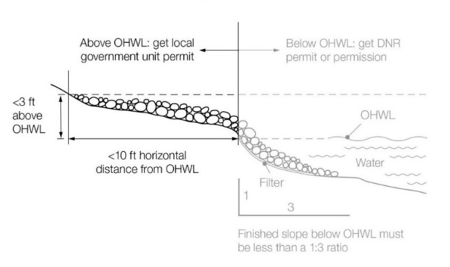
d.
Connections to public waters. Excavations to connect boat slips, canals, lagoons, and harbors to public waters require a public waters permit and must comply with Minn. Rules ch. 6115.
(i)
Subdivision/platting provisions.
(1)
Purpose. The purpose of this subsection (i) is to ensure that new development minimizes impacts to shoreland resources and is safe and functional.
(2)
Land suitability. Each lot created through subdivision, including planned unit developments authorized under subsection (j) of this section, must be suitable in its natural state for the proposed use with minimal alteration. A suitability analysis must be conducted for each proposed subdivision, including planned unit developments, to determine if the subdivision is suitable in its natural state for the proposed use with minimal alteration and whether any feature of the land is likely to be harmful to the health, safety, or welfare of future residents of the proposed subdivision or of the community.
(3)
Consistency with other controls. Subdivisions and each lot in a subdivision shall meet all official controls so that a variance is not needed later to use the lots for their intended purpose.
(4)
Dedications. When a land or easement dedication is a condition of subdivision approval, the approval must provide easements over natural drainage or ponding areas for management of stormwater and significant wetlands.
(5)
Platting. All subdivisions that cumulatively create five or more lots or parcels that are 2½ acres or less in size shall be processed as a plat in accordance with Minn. Stat. § 462.358, subd. 3a (cities), and Minn. Stat. ch. 505 . No permit for construction of buildings or sewage treatment systems shall be issued for lots created after the adoption of the ordinance from which this section is derived unless the lot was previously approved as part of a formal subdivision.
(6)
Controlled access lots. Controlled access lots within a subdivision must meet or exceed the lot size criteria in subsection (f)(2)d of this section.
(j)
Planned unit developments (PUDs).
(1)
Purpose. The purpose of this subsection (j) is to protect and enhance the natural and scenic qualities of shoreland areas during and after development and redevelopment of high-density residential and commercial uses.
(2)
Types of PUDs permissible. Planned unit developments (PUDs) are allowed for new projects on undeveloped land, redevelopment of previously built sites, or conversions of existing buildings and land. Deviation from the minimum lot size standards of subsection (f)(2)d of this section is allowed if the standards in this section are met.
(3)
Processing of PUDs. Planned unit developments must be created through rezoning to an overlay district. The planned unit development shall comply with the provisions of this section in addition to the standards set forth in chapter 1016.
(4)
Application for a PUD. In addition to the application materials required by chapter 1016, the applicant for a PUD must submit the following documents prior to final action on the application request:
a.
A property owner's association agreement (for residential PUDs) which includes mandatory membership, and which is consistent with subsection (j)(6) of this section.
b.
Deed restrictions, covenants, permanent easements or other instruments that ensure the long-term preservation and maintenance of open space in accordance with the criteria and analysis specified in subsection (j)(6) of this section.
(5)
Density determination. Proposed new or expansions to existing planned unit developments must be evaluated using the following procedures:
a.
Step 1: Identify density analysis tiers. Divide the project parcel into tiers by drawing one or more lines parallel to the ordinary high water level at the following intervals, proceeding landward:
b.
Step 2: Calculate suitable area for development. Calculate the suitable area within each tier by excluding all wetlands, bluffs, or land below the ordinary high water level of public waters.
c.
Step 3: Determine base density. For residential PUDs, divide the suitable area within each tier by the minimum single residential lot area for lakes to determine the allowable number of dwelling units, or base density, for each tier.
d.
Step 4: Determine if the site can accommodate increased density.
1.
The following increases to the dwelling unit or dwelling site base densities determined in subsection (j)(5)c of this section are allowed if the design criteria in subsection (j)(6) of this section are satisfied as well as the standards in subsection (j)(5)d.2 of this section:
2.
Structure setbacks.
(i)
Structure setbacks from the ordinary high water level are increased to at least 50 percent greater than the minimum setback; or
(ii)
The impact on the water body is reduced an equivalent amount through vegetative management, topography, or additional acceptable means and the setback is at least 25 percent greater than the minimum setback.
(6)
Design criteria. All PUDs must meet the following design criteria:
a.
General design standards.
1.
All residential planned unit developments must contain at least five dwelling units or sites.
2.
Dwelling units or dwelling sites must be clustered into one or more groups and located on suitable areas of the development.
3.
Dwelling units or dwelling sites must be designed and located to meet the dimensional standards in subsection (f) of this section.
4.
Shore recreation facilities.
(i)
Shore recreation facilities must be centralized and located in areas suitable for them based on a suitability analysis.
(ii)
The number of spaces provided for continuous beaching, mooring, or docking of watercraft must not exceed one for each allowable dwelling unit or site in the first tier.
(iii)
Launching ramp facilities, including a small dock for loading and unloading equipment, may be provided for use by occupants of dwelling units or sites located in other tiers.
5.
Structures, parking areas, and other facilities must be treated to reduce visibility as viewed from public waters and adjacent shorelands by vegetation, topography, increased setbacks, color, or other means acceptable to the local unit of government, assuming summer leaf-on conditions. Vegetative and topographic screening must be preserved, if existing, or may be required to be provided.
6.
Accessory structures and facilities, except water-oriented accessory structures, must meet the required structure setback and must be centralized.
7.
Water-oriented accessory structures and facilities may be allowed if they meet or exceed design standards contained in subsection (g)(3) of this section and are centralized.
b.
Open space requirements.
1.
Open space must constitute at least 50 percent of the total project area and must include:
(i)
Areas with physical characteristics unsuitable for development in their natural state;
(ii)
Areas containing significant historic sites or unplatted cemeteries;
(iii)
Portions of the shore impact zone preserved in its natural or existing state as follows:
A.
For existing residential PUDs, at least 50 percent of the shore impact zone.
B.
For new residential PUDs, at least 70 percent of the shore impact zone.
2.
Open space may include:
(i)
Outdoor recreational facilities for use by owners of dwelling units or sites, by guests staying in commercial dwelling units or sites, and by the general public;
(ii)
Non-public water wetlands.
3.
Open space shall not include:
(i)
Dwelling sites;
(ii)
Dwelling units or structures, except water-oriented accessory structures or facilities;
(iii)
Road rights-of-way or land covered by road surfaces and parking areas;
(iv)
Land below the OHWL of public waters; and
(v)
Commercial facilities or uses.
c.
Open space maintenance and administration requirements.
1.
Open space preservation. The appearance of open space areas, including topography, vegetation, and allowable uses, must be preserved and maintained by use of deed restrictions, covenants, permanent easements, public dedication, or other equally effective and permanent means. The instruments must prohibit:
(i)
Commercial uses (for residential PUDs);
(ii)
Vegetation and topographic alterations other than routine maintenance;
(iii)
Construction of additional buildings or storage of vehicles and other materials; and
(iv)
Uncontrolled beaching of watercraft.
2.
Development organization and functioning. Unless an equally effective alternative community framework is established, all residential planned unit developments must use an owner's association with the following features:
(i)
Membership must be mandatory for each dwelling unit or dwelling site owner and any successive owner;
(ii)
Each member must pay a pro rata share of the association's expenses, and unpaid assessments can become liens on units or dwelling sites;
(iii)
Assessments must be adjustable to accommodate changing conditions; and
(iv)
The association must be responsible for insurance, taxes, and maintenance of all commonly owned property and facilities.
d.
Erosion control and stormwater management.
1.
Erosion control plans must be developed and must be consistent with the provisions of subsection (h)(3) of this section. Erosion control plans approved by a soil and water conservation district may be required if project size and site physical characteristics warrant.
2.
Stormwater management facilities must be designed and constructed to manage expected quantities and qualities of stormwater runoff.
(Ord. No. 1606, § 1012.03, 11-8-2021; Ord. No. 1629, § 2(1012.03), 3-20-2023)