
Saint Clair Shores City Zoning Code
ARTICLE XVIII
SCHEDULE OF REGULATIONS
Sec. 48-513.- Schedule limiting height, bulk, density and area by zoning districts.
NOTES TO SCHEDULE:
(a)
The side yard abutting upon a street shall not be less than ten feet regardless of whether the main structure has an attached garage; provided, however, that on a lot which has an existing main structure located closer than ten feet from the said side lot line, accessory buildings may be located closer than ten feet but not closer to the said lot line than the main building. The maximum overhang of the roof beyond the side wall or other structural members shall be over 18 inches, and in the event the overhang exceeds 18 inches then the side wall or other structural members shall be set back from the lot line the distance of four feet plus the distance which the roof projects beyond the permitted 18 inches. When a residential structure with an attached garage is to be constructed on a lot not having a side yard abutting upon a street the minimum width of each side yard shall not be less than four feet, provided the foregoing provisions for maximum roof overhang shall apply to said minimum side yard. Any single-family dwelling unit which has an attached garage located at the front or side of the main building may encroach into the required 35-foot rear yard by an area not to exceed 600 square feet, provided that no portion of any main building permitted under this provision shall be located closer than 25 feet from the rear lot line.
(b)
In an RM-1 Multiple-Family District the total number of rooms of 80 square feet or more (not including kitchen, dining, and sanitary facilities) shall not be more than the area of the parcel in square feet, divided by 1,200. All units shall have at least one living room and one bedroom except that not more than ten percent of the units may be of an efficiency apartment type.
In an RM-2 Multiple-Family District (High Rise) the total number of rooms of 80 square feet or more (not including kitchen, dining and sanitary facilities) shall not be more than the area of the parcel in square feet, divided by 750 for three through five story buildings and 450 for any building six stories or over. All units shall have at least one living room and one bedroom, except that not more than ten percent of the units may be of an efficiency apartment type nor more than 50 percent of a one bedroom or one bedroom and efficiency type.
In both the RM-1 and RM-2 Districts, for the purpose of computing the permitted number of dwelling units per acre the following room assignments shall control:
Efficiency = two rooms.
One bedroom = two rooms.
Two bedroom = three rooms (See note below).
Three bedroom = four rooms.
Four bedroom = five rooms.
Note: Plans presented showing one-, two-, and three-bedroom units and including a den, library, or other extra room shall count such extra room as a bedroom for the purpose of computing density.
In an RM-2 Multiple-Family District (High Rise), multiple-family residential buildings two stories or less in height (low-rise) shall conform to the requirements of the RM-1 District as set forth in the Schedule of Regulations.
(c)
In all multiple-family districts (RM-1 and RM-2) the minimum distance between any two buildings shall be regulated according to the length and height of such buildings. In no instance shall the distance between two buildings or between a building and an exterior property line be less than 30 feet in an RM-1 District. In any RM-2 District the 30-foot minimum yard requirement shall be increased one foot for each one foot any building exceeds 30 feet; except that where a lot line abuts a street, one half the width of the right-of-way of said street may be considered as yard setback, however, in no instance shall the distance between the building and any such lot line be less than 50 feet. In no instance shall more than 30 percent of any required yard distance between buildings be occupied by parking areas, maneuvering lanes and driveways.
In an RM-1 or RM-2 District, the formula for regulating the required minimum distance between buildings is as follows:
S = LA + LB + 2 (HA + HB), where
S = Required minimum horizontal distance between any wall of building A and any wall of building B.
LA = Total length of building A.
The total length of building A is the length of that portion or portions of a wall or walls of building A from which, when viewed directly from above, lines drawn perpendicular to building A will intersect any wall of building B.
LB = Total length of building B.
The total length of building B is the length of that portion of portions of a wall or walls of building B from which, when viewed directly from above, the lines drawn perpendicular to building B will intersect any wall of building A.
HA = Height of building A.
The height of building A at any given level is the height above natural grade level of any portion or portions of a wall or walls along the length of building A. Natural grade level shall be the mean level of the ground immediately adjoining the portion or portions of the wall or walls along the total length of the building.
HB = Height of building B.
The height of building B at any given level is the height above natural grade level of any portion or portions of a wall or walls along the length of building B. Natural grade level shall be the mean level of the ground immediately adjoining the portion or portions of the wall or walls along the total length of the building.
(d)
Developments involving acreage under one ownership shall be subject to the approval of the Planning Commission, after public hearing, regarding modifications with respect to height regulations; subject further to the review by the Planning Commission and approval thereof. In approving an increase in structure height, the Planning Commission shall require that all yards shall at least be equal in their depth to the height of the structure.
(e)
No side yards are required along the interior side lot lines of the district, except as otherwise specified in the Building Code, provided that if walls of structures facing such interior side lot lines contain windows, or other openings, side yards of not less than ten feet shall be provided.
(f)
In the event property abuts a dedicated alley, one-half the width of said alley shall be considered in computing the rear yard requirements. Automobile service stations, as defined, shall be exempt from rear yard provisions when located on properties which abut a dedicated alley; provided, however, that in the event there is no dedicated alley a ten-foot rear yard shall be required.
(g)
Off-street loading space shall be provided in the rear yard in the ratio of at least one space per each establishment and shall be provided in addition to any required off-street parking area. Off-street loading space shall further meet the requirements of article XIX, General Provisions.
(h)
Off-street parking shall be permitted to occupy a portion of the required front yard after approval of the parking plan layout and points of ingress and egress by the Planning Commission and Council, provided that there shall be maintained a minimum unobstructed landscaped setback of ten feet between the nearest point of the off-street parking area exclusive of access driveways, and the nearest right-of-way line as indicated on the Major Thoroughfare Plan.
(i)
Side yards abutting upon a street and across from other B-2, B-3, or O-1 Districts shall be provided with a setback of at least 20 feet.
(j)
No building shall be placed closer than 50 feet to the outer perimeter (property line) of each district when said property line is adjacent to an R (Residential) District.
(k)
Yards abutting R, B, and O-1 Districts shall at least equal the requirements of the adjacent district. A 20-foot greenbelt shall be provided when said district abuts an R (Residential) District. All site plans shall be reviewed and approved by the Commission with respect to area and bulk, off-street parking, and ingress and egress.
(l)
No building shall be located closer than 20 feet to the outer perimeter (property line) of such district when said property line abuts any residential district.
Required side or rear yards may be used for off-street parking or loading and unloading provided that in such instances the Planning Commission and Council shall review and approve the proposed parking and site plan to determine that sufficient access to the rear of the building is provided for firefighting or other emergency type equipment. An obscuring wall or fence shall be provided on those sides of the property used for parking or service drives, loading, unloading, or servicing and abutting land zoned for residential use.
The extent of such wall may be determined by the Planning Commission and City Council on the basis of usage. Such wall shall be subject further to the requirements of article XIX, General Provisions.
Open storage facilities for materials or equipment used in the manufacturing, compounding, or processing shall be permitted to the rear of the building provided that any such storage area shall be obscured from adjacent properties by an obscuring wall or fence. The extent of such wall or fence may be determined by the Planning Commission and Council on the basis of usage. Such wall shall not be less than six feet in height and may depend upon usage, be required to be eight feet in height, and shall be subject further to the requirements of article XIX, General Provisions.
(m)
The minimum required floor area shall be 1,064 square feet in dwellings with basements and 1,120 square feet for those dwellings without basements. The requirements for dwellings with basements may be reduced, however, if the following conditions are met:
(i)
Existing single-family dwellings occupy 51 percent, or more of the frontage in the same block and fronting on the same street as the proposed dwelling.
(ii)
The average size of the homes within the above area is less than the minimum house size required, in which case this average size dwelling shall be the determining factor; provided, however, that in no instance shall the minimum size dwelling with a basement, be less than 925 square feet.
(n)
Developments involving two or more adjacent lots shall, however, stagger building setbacks and facades in accordance with plans and elevations approved by Council.
(o)
Building lines, distance, streets, schedule. No building or any part thereof shall be erected on any of the following streets nearer to the center of the road than herein specified:
(a)
On Jefferson Avenue nearer than 60 feet from the center of the present highway;
(b)
On Greater Mack Avenue nearer than 60 feet from the center of the present highway;
(c)
On Harper Avenue nearer than 60 feet from the center of the present highway;
(d)
On Little Mack from the intersection of Harper Avenue to 12 Mile Road nearer than 60 feet from the center of the present highway;
(e)
On Beaconsfield Avenue nearer than 60 feet from the center of the present highway;
(f)
On Nine Mile Road nearer than 60 feet from the center of the present highway;
(g)
On Stephens Avenue between Harper and the west city limits nearer than 43 feet from the center of the present highway;
(h)
On Ten Mile Road nearer than 60 feet from the center of the present highway, east of Jefferson nearer than 33 feet;
(i)
On Frazho Road nearer than 43 feet from the center of the present highway;
(j)
On Eleven Mile Road between Expressway and Little Mack nearer than 60 feet from the center of the present highway; On Eleven Mile Road between Little Mack and Jefferson Avenue nearer than 102 feet from the center of the present highway; On Eleven Mile Road between Jefferson and Lake St. Clair nearer than 60 feet from the center of the present highway;
(k)
On Martin Road nearer than 43 feet from the center of the present highway;
(l)
On Thirteen Mile Road nearer than 60 feet from the center of the present highway;
(m)
On Masonic Boulevard nearer than 43 feet from the center of the present highway;
(n)
On Eight Mile Road nearer than 60 feet from the center of the present highway;
(o)
On Twelve Mile Road nearer than 60 feet from the centerline of the present highway.
The foregoing provisions shall apply only to property zoned other than residential. On property zoned residential, the setback requirements provided in the schedule of regulations shall be measured from the building lines as established above.
Upon all other streets the building line established in the subdivision restrictions shall be followed, provided that no building shall be constructed nearer than the setback requirements provided in the schedule of regulations.
(p)
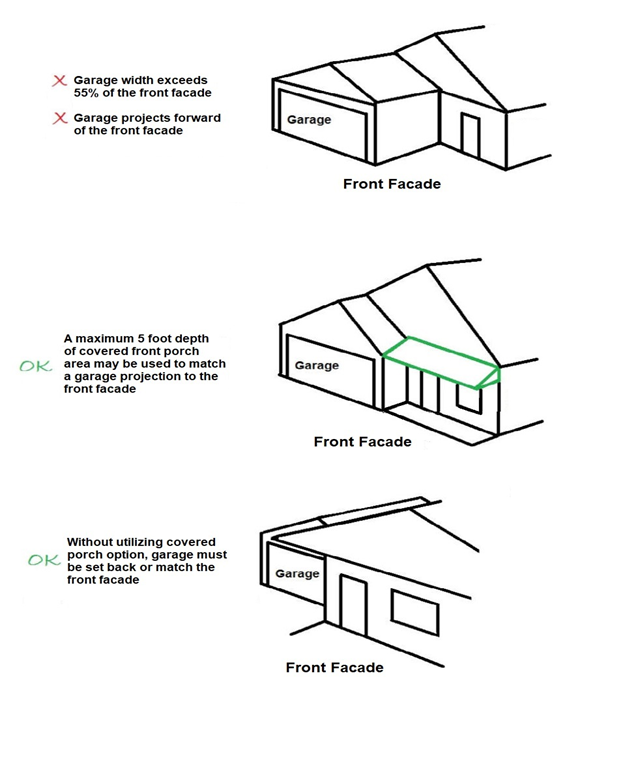
Attached garages. Attached garages shall not occupy more than 55 percent of the linear building width of the front facade of a principal residential structure. The attached garage shall not extend beyond the remainder of the facade unless; in plan/overhead view, it matches the roofline of a covered porch with a depth of five feet or less.
(Comp. Ords. 1988, § 15.481(35.66); chap. 35 eff. March 7, 1986; amended by ord. eff. Aug. 20, 1996; amended by: ord. eff. Nov. 4, 1996; amend. eff. Oct. 3, 2000; ord. eff. Dec. 29, 2010; Ord. of 8-17-2020(1), amend. eff. 9-16-2020; Ord. No. O-2025-003, 2-18-2025)
Sec. 48-514. - One-family cluster option.
(Comp. Ords. 1988, § 15.482(35.67))
Sec. 48-515. - Intent.
1.
The intent of the one-family cluster option is to allow single-family dwellings to be developed with varied yard setback requirements and design innovations, so as to either:
(a)
Provide a suitable physical transition between one-family detached housing and adjacent thoroughfares or nonresidential uses.
(b)
Permit development of parcels of land that have characteristics which would make development difficult to accomplish under the usual standards for development set forth herein for the district in which said parcels are located. The cluster option is further intended to provide flexibility in the regulation of land development; encourage innovation in land use and variety in design, layout and type of structures constructed; achieve economy and efficiency in the use of land, natural resources, energy and the provision of public services and utilities; encourage useful open space; and provide quality housing.
2.
Eligibility criteria. To be eligible for consideration under the One-Family Cluster Option, a parcel of land must conform to the following criteria:
(a)
The parcel of land must be at least 12,000 square feet in area, and must be located in the RA One-Family District.
(b)
The parcel of land must abut a collector road, major thoroughfare, or freeway.
3.
Procedures. An application for One-Family Cluster Option shall follow the procedure and requirements for a special land use, including public hearing requirements, as set forth in section 48-561, herein. In addition, the following requirements must be complied with:
(a)
Completion of site design. The applicant shall propose a date for commencement of construction and a date for completion. This time schedule shall be reviewed by the Planning Commission and approved by the City Council. If construction has not commenced within one year of approval, the one-family cluster Option approval becomes null and void and a new application for review shall be required.
(b)
Phased development. Application may be made for an entire project or for separate phases of an overall cluster housing project. Each phase of a phased project shall conform to a time schedule as approved by the Planning Commission.
(c)
Extension of approval. The applicant may apply to the City Council for a one-year extension of One-Family Cluster Option approval, provided that said application for extension is submitted prior to expiration of the previous approval. If construction commencement for completion dates as proposed by the developer and the City Council are not met, a new application for one-family cluster housing review must be submitted and approved before continuing with the project.
(d)
Change in site plan. Any proposed change in the site plan, building plans, or any option of the One-Family Cluster Option application shall be reviewed by the Planning Commission and approved by the City Council prior to effectuating said change.
4.
Application data requirements. The application and data requirements for the One-Family Cluster Housing Option shall be the same as set forth in section 48-560 for site plan review, plus such other data as may be required by the Planning Commission, City Planner, or City Council to make the determine required herein.
5.
Standards for granting approval. The Planning Commission shall recommend and the City Council shall approve a One-Family Cluster Housing Option application upon determination that the proposed use will comply with all applicable requirements of this ordinance, including site plan review regulations in section 48-560, and the following standards:
(a)
The proposed cluster housing development shall comply with applicable standards for approval of special land uses, as set forth in section 48-561.
(b)
The proposed cluster housing development shall comply with the following building and development features:
(i)
Dwelling units. One-family dwelling units permitted within the One-Family Cluster Housing Option may be attached and/or detached, or any combination thereof within the limitations of the requirements set forth herein. No more than four attached single-family units may be contained within one structure.
(ii)
Attached dwelling unit design. So as to prevent the development of attached cluster housing units that are not compatible in terms of general character or layout with surrounding development, the following guidelines shall be complied with:
-
In the case of attached cluster units that are generally rectangular in shape, the common walls of adjoining dwelling units shall not overlap by more than 50 percent.
-
In the case of attached cluster units that are not developed in a row, the dwelling units shall be attached so as to give a general appearance of a large single-family structure.
(iii)
Minimum lot area. A minimum of 4,000 square feet of land area shall be provided per dwelling unit, exclusive of public rights-of-way, in any one-family cluster development.
(iv)
Lot width. Sites proposed for cluster development shall have at least 100 feet of frontage along a collector road or major thoroughfare.
(v)
Setback standards. Front and rear yard setbacks shall be in conformance with the provisions set forth for the RA One-Family Residential District (see article XVIII — Schedule of Regulations). Side yard setbacks shall be a minimum of 12 feet, unless the side of the building facing the side lot line provides a main entrance to a dwelling unit or a private patio area, in which case the minimum side yard setback shall be increased to 25 feet. Also, where the side of the building facing the side lot line exceeds 35 feet in length, the building shall be set back an additional one foot for each four feet of building length beyond 35 feet.
(vi)
Layout of buildings. The spacing and orientation of buildings on the site shall be reviewed to ensure compatibility with uses on adjacent properties, adequate landscaping and open space. In no case shall the minimum distance between structures be less than 16 feet.
(c)
Minimum floor area. The minimum floor area required for each dwelling unit shall be the same as the minimum floor area requirements in the RB Two-Family Residential District.
(d)
Parking. A minimum of two off-street parking spaces shall be provided for each unit. Attached garages shall be required for at least one-half of the required off-street parking spaces. All parking shall be located where it will not interfere with or obstruct ingress and egress. Parking areas shall be screened from abutting single-family development. Required parking should be located near or adjacent to the dwelling units, rather than being concentrated in large lots.
(e)
Ingress and egress. One-family cluster housing developments shall not be located where the primary means of access is likely to have an adverse impact on an adjacent single-family detached residential neighborhood. Street and driveway access to abutting thoroughfares shall be kept to a minimum. Where a private drive serves more than one structure on a cluster housing site, the drive shall be at least 22 feet in width and no closer than eight feet to any exterior property line. Dwellings shall be set back at least 15 feet from any such common drive. The eight-foot setback may be waived if joint use of a common drive is proposed between adjacent projects and permanent cross easements are provided, or where the existing or proposed development on adjacent property would not be adversely affected.
(Comp. Ords. 1988, § 15.482(35.67A); chap. 35 eff. March 7, 1986; amended by ord. eff. Aug. 20, 1996)
Sec. 48-516. - Site condominium regulations.
(Comp. Ords. 1988, § 15.483(35.68))
Sec. 48-517. - Intent.
The intent of these site condominium regulations is to specify yard standards and procedures kindred to those specified by Ordinance No. 521 [chapter 38] in regulating subdivisions platted under provisions of Public Act No. 288 of 1967 (MCL 560.101 et seq.), as amended. These regulations are also intended to remove uncertainty regarding the application of zoning provisions to site condominium developments within the City by clearly establishing standards and procedures which regulate site condominium development in the City of St. Clair Shores.
(Comp. Ords. 1988, § 15.483A(35.68A); chap. 35 eff. March 7, 1986; amended by ord. eff. Aug. 20, 1996)
Sec. 48-518. - Definitions.
For the purpose of these regulations, certain terms, words and phrases shall, wherever used in these regulations, have the meaning herewith defined as follows:
1.
Governing Body. The St. Clair Shores City Council.
2.
Planning Commission. The City of St. Clair Shores Planning Commission.
3.
Condominium. Common ownership by two or more persons holding undivided fractional shares in the same property; individual ownership of a unit in a multi-unit structure; joint dominion or sovereignty.
4.
Condominium documents. Includes a master deed, to be or recorded pursuant to Public Act No. 59 of 1978, as amended (MCL 559.101 et seq.), and any other instrument referred to in the master deed or bylaws which affects the rights and obligations of a co-owner in a condominium.
5.
Condominium unit. That portion of a condominium project designed and intended for separate ownership and use as described in the master deed, regardless of whether it is intended for residential, office, industrial, business, or recreational use as a time-share unit or any other type of use, and subject to all of the height, bulk density and area regulations of section 48-513 (See lot).
6.
Site condominium subdivision. A method of subdivision where land ownership of sites is regulated by the Condominium Act (Public Act No. 59 of 1978, as amended (MCL 559.101 et seq.)) as opposed to the Subdivision Control Act (Public Act No. 288 of 1967 (MCL 560.101 et seq.)), as amended. Site condominium subdivision shall be equivalent to the term "subdivision" as used in this Zoning Ordinance and the City Subdivision Regulations Ordinance.
7.
Common elements. Portions of a condominium project other than the condominium units.
8.
General common elements. A portion of condominium common elements intended for use of all condominium unit owners.
9.
Limited common elements. A portion of condominium common elements reserved in the master deed for the exclusive use of less than all of the co-owners.
10.
Lot. A portion of a site condominium subdivision or other parcel of land intended for separate ownership and use. (See Condominium Unit).
11.
Master plan. The comprehensive plan including graphic and written proposals indicating the general locations recommended for the streets, parks, schools, public buildings, zoning districts, and all physical developments of the City of St. Clair Shores and includes any unit or part of such plan separately adopted, and any amendments to such plan or parts thereof duly adopted by the Planning Commission and the Governing Body.
12.
Preliminary site condominium plan. A map indicating the proposed layout of the site condominium subdivision in sufficient detail to provide adequate basis for review and to meet the requirements and procedures set forth hereinafter.
13.
Final site condominium plan. A map of all or part of a site condominium subdivision prepared and certified as to its accuracy by a registered engineer or land surveyor. Such maps must meet the requirements of the Act 59 of the Public Acts, as amended, and be suitable for recording by the Macomb County Register of Deeds.
14.
Improvements. Street pavements, curbs, gutters, sidewalks, crosswalks, water mains, sanitary and storm sewers, street trees, and other appropriate items.
15.
Public utility. A firm, corporation, or municipal authority providing gas, electricity, telephone, sewer, water or other services of a similar nature.
16.
Easement. A quantity of land set aside or over which a liberty, privilege or advantage is granted by the owner to the public, a corporation, or some particular person or part of the public for specific uses and purposes, and shall be designated "public" or "private" easement depending on the nature of the user.
17.
Alley. A minor vehicular and utility way used primarily to serve as an access way to the back or side of properties otherwise abutting on a street or for location of utilities and refuse service.
18.
Public walkway. A right-of-way dedicated for the purpose of a pedestrian access through residential areas, and located so as to connect to two or more streets, or a street and a public land parcel.
19.
Street. A right-of-way dedicated to public use, which provides vehicular and pedestrian access to adjacent properties whether designated as a street, highway, thoroughfare, parkway, road, avenue, lane, or however otherwise designated, and includes the land between right-of-way lines whether improved or unimproved, and may comprise pavement, curbs and gutters, shoulders, sidewalks, parking areas, lawn areas and other areas within the right-of-way lines.
20.
Major thoroughfare. An arterial street of great continuity which is intended to serve as a large volume traffic-way for both the immediate City area and region beyond, and may be designated in the City's Major Thoroughfare Plan as a major thoroughfare, parkway, expressway or equivalent term to identify those streets comprising the basic structure of the street plan.
21.
Secondary thoroughfare. A street intended to serve as a major means of access from minor streets to major thoroughfares and has considerable continuity within the framework of the City's Major Thoroughfare Plan.
22.
Marginal access street. A minor street parallel and adjacent to a major thoroughfare; and which provides access to abutting properties, separation from through traffic and having a limited number of access points to a major thoroughfare.
23.
Cul-de-sac (court). A minor street of short length, having one end open to traffic and being permanently terminated by a vehicular turn-around.
24.
Turn-around (place). A minor street of short length with two openings to traffic, beginning from the same street, and projecting parallel to each other and connecting at their termination by a loop.
(Comp. Ords. 1988, § 15.483B(35.68B); chap. 35 eff. March 7, 1986; amended by ord. eff. Aug. 20, 1996)
Sec. 48-519. - Site condominium subdivision review procedure.
The preparation and approval of a site condominium subdivision shall be carried out through three stages, including preliminary investigation, preliminary plat and final plat and in accordance with the procedure as follows:
1.
Preliminary investigation. Prior to the preparation of a preliminary site condominium subdivision plan, the proprietor shall investigate the procedures and standards of the City of St. Clair Shores and shall further investigate the existing and proposed requirements with regard to the following elements of the Master Plan.
a.
The area for the proposed subdivision shall be properly zoned for the intended use.
b.
An investigation of adequacy of existing schools and the adequacy of public open spaces including parks and playgrounds to service the proposed subdivision shall be made by the proprietor.
c.
The relationship of the proposed subdivision with respect to major thoroughfares and plans for widening thoroughfares shall be investigated by the proprietor.
d.
Standards for sewage disposal, water supply and drainage of the City of St. Clair Shores and health standards of Macomb County and the State of Michigan shall be investigated by the proprietor.
2.
Filing.
a.
Seven copies of the preliminary site condominium subdivision plan, together with written application, shall be submitted to the Secretary of the Planning Commission.
b.
Filing with the Planning Commission shall be at least 20 days prior to the regular Planning Commission meeting at which applicant will be scheduled to appear. The Planning Commission will act on the subdivision plan within 30 days after date of filing.
c.
One copy of the preliminary site condominium subdivision plan where the proposed subdivision is adjacent to or containing a county highway, shall be submitted to the Macomb County Road Commission, for approval.
3.
Identification and description. The preliminary plat shall include:
a.
Proposed name of site condominium subdivision.
b.
Location by section, town and range, or by other legal description.
c.
Names and addresses of proprietor and architect, engineer or surveyor who designed the layout. The proprietor shall also indicate his interest in the land as to whether it is a land contract interest, or if he owns the property in fee.
d.
Scale of plan, one inch equals 100 feet or less is acceptable scale.
e.
Date.
f.
Northpoint.
4.
Existing conditions. The preliminary site condominium subdivision plan shall include:
a.
Location of proposed subdivision in relation to schools, shopping, parks, and other community facilities.
b.
An overall area map showing the relationship of the subdivision to its surroundings shall be provided.
c.
Boundary line of proposed subdivision, and section or corporation lines within or adjacent to the tract.
d.
Adjacent tracts of subdivided and unsubdivided land shown in relation to the tract being proposed for subdivision.
e.
Location, widths and names of existing or prior platted streets and private streets, and public easements within or adjacent to the tract being proposed for the subdivision.
f.
Location of existing sewers, water mains, storm drains and other underground facilities within or adjacent to the tract being proposed for subdivision.
g.
If the topography is such that special grading or drainage may be necessary, existing grade at each corner of the lot shall be shown.
h.
Floodplain, regulated wetland, high risk erosion zones, structures and places listed on state or Federal Register of Historic Buildings and places, and any other existing condition on the site having bearing on layout and design.
5.
Proposed condition. The preliminary site condominium subdivision plan shall include:
a.
Layout of streets indicating rights-of-way widths and connections with adjoining platted streets and also the width and locations of alleys, easements and public walkways.
b.
Layout, numbers and dimensions of lots, including building setback lines showing dimensions.
c.
Indication of parcels of land intended to be dedicated or set aside for public use or for the use of property owners in the subdivision or lands set aside for future street connections to adjacent tracts.
d.
The proprietor shall indicate to the City Engineer the intended systems for public sanitary sewage disposal, public water supply and storm drainage by submitting a copy of the plat showing the proposed installation without capacities and other engineering features.
6.
Preliminary site condominium subdivision plan review by Planning Commission.
a.
The Secretary of the Planning Commission shall receive and check for completeness, the preliminary site condominium subdivision plan, and if complete, place the proposal on the agenda of the next Planning Commission meeting. Should any important data be omitted, the Secretary shall notify the subdivider of the additional data required and delay further Planning Commission action until the required data is received. The time limits imposed on the Planning Commission for review shall not run until receipt of all required information.
b.
The Planning Commission shall review all details of the site condominium subdivision within the framework of the various elements of the Master Plan and in accordance with design standards of these regulations.
c.
Land requirements for public uses with the framework of the Master Plan, shall be considered in the review of each preliminary site condominium subdivision plan submitted.
d.
Should the Planning Commission reject the plan, it shall record the reasons in the minutes of the meeting. A copy of the minutes shall be sent to the proprietor.
e.
Should the approval be a conditional approval and therefore tentative, the subdivision layout shall not be forwarded to the Governing Body until said conditions have been satisfied by the proprietor. The revised layout shall follow the submittal procedure indicated under 5.a above.
f.
Should the Planning Commission find that all conditions have been met, it shall give preliminary approval to the proprietor; the Chairman shall make a notation to that effect on each copy of the preliminary site condominium subdivision plan, returning one copy to the proprietor, forwarding two copies to the Governing Body with recommendations for preliminary approval, one copy to the City Engineer, one copy to the City Assessor, and retaining two copies of for the Planning Commission files.
g.
It shall be the duty of the Planning Commission to send prior notice to the owners of land immediately adjoining the property to be subdivided as a site condominium giving the time and place of said meeting of the Planning Commission, not less than five days before the date fixed therefor.
7.
Preliminary site condominium subdivision plan review by Governing Body.
a.
The Governing Body will not review a preliminary site condominium subdivision plan until it has received the review recommendation of the Planning Commission. Following the receipt of such recommendations, the Governing Body shall consider the subdivision at such meeting that the matter is placed on the regularly scheduled agenda.
b.
Should the Governing Body approve the preliminary subdivision plan, it shall be deemed to confer upon the proprietor the right to proceed with the preparation of a final plan and condominium documents.
c.
Preliminary plan approval shall not constitute approval of the final plan. It shall be deemed as approval of the layout submitted on the preliminary plan as a guide to the preparation of a final plan.
d.
The approval of the Governing Body of the preliminary site condominium subdivision plan shall be effective for a period of 12 months. Should the final plan in whole or in part not be recorded within this time limit, the preliminary plan must again be submitted to the Planning Commission for approval.
8.
Final plan preparation.
a.
The final site condominium subdivision plan shall comply with the provision of Public Act No. 59 of 1978 (MCL 559.101 et seq.), as amended (the Condominium Act).
b.
The final plan shall conform substantially to the preliminary plan as approved and it may constitute only that portion of the approved preliminary plan which the proprietor proposes to record and redevelop at the time; provided, however, that such portion conforms to these site condominium subdivision regulations.
c.
The proprietor shall submit such evidence of title, either the title opinion from an attorney as to title showing any interests of record, or an abstract of title certified to date, or a policy of title insurance of examination in order to ascertain as to whether or not the proper parties have signed the condominium documents.
9.
Final site condominium subdivision review.
a.
Five copies of the final subdivision plan and condominium documents shall be filed by the proprietor with the City Clerk; deposit with the Clerk such sum of money as the Governing Body may require to provide for its expenses and for fees required by resolution of the Governing Body.
b.
The proposed final condominium documents shall be transmitted to the Secretary of the Planning Commission for review as to compliance with the approved preliminary plan.
c.
Should the Planning Commission find that the final plan is in agreement with the preliminary plan, it shall approve same and notify the Governing Body of this action in its official minutes.
d.
Should the Planning Commission find that the final plan does not conform substantially to the previously approved preliminary plan, and that it is not acceptable, they shall record the reason in their official minutes, forward same to the Governing Body and recommend that the Governing Body disapprove the final plan until the objections causing disapproval have been changed to meet with the approval of the Planning Commission.
e.
The Governing Body shall review all recommendations of the Planning Commission and take action to approve or disapprove the final plan and condominium documents within 30 days of its filing with the City Clerk.
f.
Upon approval of the final plan and condominium documents by the Governing Body, recording may proceed as required by the Condominium Act.
10.
Design standards. The site condominium subdivision design standards set forth under this section are for the assistance of the developer. All final construction documents, grading and utility plans must be reviewed and meet with the approval of the City Manager, City Engineer, and City Assessor.
a.
Streets. Streets shall be publicly dedicated and shall conform to at least all minimum requirements established by the City. General specification, typical cross sections and other conditions set forth in the improvement section of this regulation and by the City Engineer.
b.
The street layout shall provide for continuation of secondary thoroughfares in the adjoining subdivisions or of the proper connection (present or future) with streets when adjoining property is not subdivided (generally not more than 1,300 feet apart); or conform to a plan for a neighborhood unit drawn up and adopted by the Planning Commission.
c.
The street layout shall include minor streets so laid out that their use by through traffic shall be discouraged.
d.
Should a proposed subdivision border on or contain an existing or proposed major thoroughfare, the Planning Commission may require marginal access streets, reverse frontage with an approved screen planting contained in a nonaccess reservation along the rear property line having a minimum of 15 feet, or such other treatment as may be necessary for adequate protection of residential properties and to afford separation and reduction of traffic hazards.
e.
Should a proposed site condominium subdivision border on or contain an expressway, or other limited access highway right-of-way, the Planning Commission may require the location of a street approximately parallel to and on each side of such right-of-way at a distance suitable for the development of an appropriate use of the intervening land as for parks in residential districts or for commercial or industrial purposes in appropriate districts. Such distances shall be determined with due consideration of the minimum distance required for approach grades to future grade separation.
11.
Thoroughfare design standards.
a.
Major thoroughfare width shall conform to the major thoroughfare plan of the Master Plan of the City of St. Clair Shores.
b.
Secondary thoroughfares shall have a minimum right-of-way width of 86 feet.
c.
Minor streets shall have a minimum right-of-way width of 50 feet.
d.
Marginal access streets parallel to a thoroughfare shall have a right-of-way width of not less than 34 feet, unless approved by the City Engineer.
e.
Residential cul-de-sac streets shall conform to minor street standards and shall terminate in a vehicular turnaround with a pavement diameter of at least 60 feet and minimum right-of-way of 120 feet. Cul-de-sac streets in site condominium subdivisions serving predominantly commercial or industrial land uses shall conform to secondary thoroughfare standards and shall terminate in a vehicular turnaround with a pavement diameter of 100 feet and 150 feet right-of-way diameter.
f.
Half streets and turnaround streets shall be prohibited.
g.
Alleys, where permitted, shall have a width of not less than 20 feet.
12.
Grade standards. Street grades of not less than 0.4 percent shall be acceptable. The Planning Commission may approve any change or variance to this standard, after review by the City Engineer.
13.
Horizontal alignment.
a.
Major thoroughfares shall have radii of centerline curvature of not less than 450 feet, unless approved by the City Engineer.
b.
Secondary thoroughfares shall have radii of curvature of not less than 300 feet, unless approved by the City Engineer.
c.
Between reverse curves on major thoroughfares an on secondary thoroughfares, there shall be a minimum tangent distance of 100 feet, unless approved by the City Engineer.
d.
Streets shall be laid out so as to intersect as nearly as possible to 90 degrees.
e.
Curved streets intersecting with major thoroughfares and secondary thoroughfares shall do so with a tangent section of centerline 50 feet in length measured from the right-of-way line of the major thoroughfare or secondary thoroughfare.
14.
Blocks. Blocks within subdivisions shall conform to the following standards:
Sizes:
a.
Maximum length for blocks shall be 1,300 feet in length, except where in the opinion of the Planning Commission, conditions may justify a greater length.
b.
Widths of blocks shall be determined by the condition of the layout and shall be suited to the intended layout.
15.
Public walkways.
a.
Location of public walkways or crosswalks may be required by the Planning Commission to obtain satisfactory pedestrian circulation within the subdivision where blocks exceed 1,100 feet in length.
b.
Widths of the public walkways shall be at least ten feet and shall be in the nature of an easement for this purpose.
16.
Easements.
a.
Location of utility line easements shall be provided along the rear or side lot lines as necessary for utility lines. Easements shall give access to every lot, park or public grounds. Such easements shall be a total of not less than 12 feet wide, six feet from each parcel. Alternative, an alley may be used for this purpose.
b.
Recommendations on the proposed layout of telephone and electric company easements shall be sought from all the utility companies serving the area.
17.
Site condominium units (lots). All units within site condominium subdivision shall conform to the following standards:
Sizes and shapes:
a.
The unit size, width, depth and shape in any subdivision plan for residential uses shall be appropriate for the neighborhood in which it is located.
b.
Unit areas shall conform to at least the minimum floor area requirements of the Zoning Ordinance for the district in which the project is located.
c.
Lot widths shall in no case be less than that required by the Zoning Ordinance for the district in which the project is proposed.
d.
Building setback lines shall conform to at least the minimum requirements of the Zoning Ordinance for the district in which the project is located.
e.
Excessive depth in relation to width shall be avoided. A depth-to-width ratio of three to one shall normally be considered a maximum.
f.
Corner units shall be a minimum of ten feet wider than interior units in order to permit conformance setback lines on both street frontages and create useful rear yard area.
18.
Arrangement.
a.
Every unit shall front on, abut and touch a public street.
b.
Side unit lines shall be at right angles or radical to the street lines, or as nearly as possible thereto.
c.
Residential units abutting major thoroughfare or secondary thoroughfares, where marginal access streets are not desirable or possible to attain, shall be designed with reverse frontage units with an approved screen planting contained in a nonaccess reservation along the rear property line having a minimum width of 15 feet or such other treatment as may be adequate for protection of residential properties, or width side unit lines parallel to the major traffic streets or shall be platted with extra depth to permit generous distances between building and such trafficway.
d.
Units shall have a front-to-front relationship across all streets. Any deviation shall require the review and approval of the Planning Commission.
19.
Natural features. The natural character of lands must be preserved wherever possible.
a.
Natural features. Due regard must be shown for all natural features such as large trees, natural groves, watercourses and similar community assets that will add attractiveness and value to the property, if preserved.
b.
Suitability of lands. Lands which are held to be unsuitable for residential use by reason of flooding, inadequate drainage, adverse rock or topographic conditions or any other feature likely to be harmful to health, safety or welfare of future residents will not be subdivided for residential use.
20.
Street and utility improvements. The improvements set forth under this section are to be considered as the minimum acceptable standard. All improvements and construction documents must receive approval of the City Engineer. All internal streets in a site condominium subdivision shall be public streets, dedicated to and accepted by the City. Street and utility improvements shall be provided in accordance with the standards and requirements described as follows:
a.
Major thoroughfares. Cross sections in accordance with the master plan of major thoroughfares and as determined by the City Engineer and the Planning Commission.
b.
Secondary thoroughfares. 86-foot right-of-way, 41-foot concrete pavement outside of curb to outside of curb, curb and gutter each side of pavement, 16½-foot separation strip and five-foot concrete sidewalk on each side of roadway and one foot of space between sidewalk and right-of-way line on each side.
c.
Minor streets. A minimum 50-foot right-of-way with 27 feet of concrete pavement outside of curb to outside of curb and curb gutter each side of pavement with 5½-foot separation strip and five-foot concrete sidewalk on each side of roadway and one foot of space between sidewalk and right-of-way line on each side.
d.
Marginal access streets. 34-foot right-of-way, 20-foot pavement outside of curb to outside of curb, concrete curb and gutter each side of pavement, four-foot separation strip measured from right-of-way line of the adjacent street to the marginal access street pavement, four-foot separation strip and five-foot sidewalk on one side with one foot of space between sidewalk and right-of-way line.
e.
Grading and centerline gradients. Per plans and profiles approved by the City Engineer.
f.
Curbs and gutters. In accordance with details and specifications prescribed by the City Engineer.
g.
Roadway pavements. In accordance with details and specifications prescribed by the City Engineer.
h.
Sidewalks. In accordance with details and specifications prescribed by the City Engineer.
i.
Storm drainage system and other drainage improvements. Per plans approved by the City Engineer. Where county drains are involved, a letter or document of approval from the County Drain Commission must be submitted by the proprietor.
j.
Sewage disposal. Sewer system sanitary sewers are required per plans approved by the City Engineer.
k.
Water supply. Water distribution system per plans approved by the City Engineer and in conformance with the regulations of the Michigan Department of Health relating to municipal water supplies.
l.
Trees. Existing trees near street rights-of-way shall be preserved by the proprietor. Street trees shall be provided at least one per lot.
m.
Street signs. Street name signs will be provided at intersections of all streets by the City.
21.
Fees, and charges. Engineering fees, inspection fees, water and sewer connection charges and other applicable development charges may be provided for by resolution.
(Comp. Ords. 1988, § 15.483C(35.68C); chap. 35 eff. March 7, 1986; amended by ord. eff. Aug. 20, 1996)