
Saint Cloud City Zoning Code
CHAPTER 4
SITE DESIGN AND DEVELOPMENT STANDARDS
4.1.1. - Purpose and intent.
The regulations established in this chapter are intended to provide for the harmonious development of the city and to implement St. Cloud's Comprehensive Plan. It is the intent of the City to promote the health, safety, and welfare of existing and future residents, property owners and visitors to the City by establishing minimum standards for site Design and Development and the continued maintenance of development consistent with this Code. The design and development standards contained within this chapter are intended to complement the performance and siting standards contained in chapter 3 herein.
4.1.2. - Applicability.
This chapter applies to all properties within the City of St. Cloud. Nothing in this chapter shall be construed to release any property in the city from complying with all applicable regulations of any state or federal regulation. No certificates of occupancy shall be issued unless the site meets the requirements herein provided.
4.1.3. - Erection of building adjacent to unapproved streets.
No building shall be erected on a lot or parcel of land, nor shall any use or building permit be issued therefore, unless:
A.
The street giving access to the lot or parcel on which such building is proposed to be placed has been accepted and opened as a public/private street or has otherwise received the legal status of a public street, or such street is shown on a subdivision plat prepared and recorded as provided herein.
B.
The street has been improved to an extent which, in the opinion of the city manager, meets the minimum standards for roadways as outlined herein, is adequate in the circumstances of the particular situation to serve the needs of such building and protects the public health, safety, economy, convenience and general welfare; provided that, if so authorized by regulations herein, a building permit may be issued for construction of a building concurrently with the installation of required street improvements, but no such permit shall express or imply any right of occupancy and use of such building. No such building shall be occupied or used until the installation of such street improvements has been satisfactorily completed.
4.2.1. - Minimum off-street parking requirement.
At the time of the erection of any main building or structure, or any main building is enlarged or increased in capacity, or when a structure undergoes a change in use, or that dwelling units, guestrooms or floor areas are added (see section 4.2.3.B.2 for residential requirements), minimum off-street parking spaces and bicycle parking with adequate provisions for ingress and egress shall be provided in accordance with the requirements listed in Table 4.2.1.
It is the intent of this section to encourage design features which reduce the overall trip requirements entering and leaving a site. Such design features may include but are not limited to cross access for pedestrian bikeway circulation as part of an overall system, design of facilities to integrate adjoining uses, participation by the site or businesses on the site in shuttle bus service systems or similar circulation systems not relying on the use of automobiles.
* Because religious observances often occur at times when other land uses are not in operation, it is acceptable to reduce, up to 50 percent of the required amount of parking, provided the place of worship is located within 500 feet of any public parking lot or any commercial parking lot where sufficient spaces are available by permission of the owner(s) during the time of services to make up the additional spaces required.
** Means the sale of trucks, boats, farm machinery, construction equipment, and related items.
*** Outdoor dining area square footage or seating shall be used in addition to restaurant floor area to calculate parking space requirements.
**** No on-street parking except in designated parking areas.
***** See section 4.2.6 for reduced parking requirements for Live Local Act Projects.
****** Live Local Act Projects shall follow parking requirements for "multi-family".
(Ord. No. 2024-22, § III, 4-25-2024)
4.2.2. - Off-street parking special restrictions.
The following are the special restrictions for off-street parking requirements in all zoning districts:
A.
Recreational vehicle storage in multifamily development is prohibited unless designated areas for recreational vehicles are provided. Such designated parking areas must be in excess of the required parking for the residential units.
B.
Parking spaces for all uses shall be located on the same lot with the main building to be served except when the parking can meet the following requirements:
1.
The city council may allow the establishment of off-street parking facilities within 300 feet of the premises they are intended to serve when:
a.
Practical difficulties prevent the placing of the facilities on the same lot as the premises they are designed to serve;
b.
The owner of the said parking area shall enter into a written agreement with the city, in a form acceptable to the city, with enforcement running to the city providing that the land comprising the parking area shall never be disposed of except in conjunction with the sale of the building which the parking area serves so long as the facilities are required; and
c.
The owner agrees to bear the expenses of recording the agreement and agrees that the agreement shall bind his heirs, successors, and assigns. The written agreement may be voided by the city if other off-street facilities are provided in accord with these zoning regulations.
C.
Parking requirements for two or more uses which do not conflict due to the nature and time of usage may be satisfied by the allocation of a required number of spaces may be shared in a common parking facility that has less total parking spaces then that required if the sum of the number of parking spaces for each use were calculated individually. Such allocation must be supported by evidence of expected parking patterns, must fully meet expected parking demand for all common users and must receive the approval of plans by the city council. Any change in uses which share a common parking facility will require a re-evaluation of the approval by the city council and must be incorporated into a permanent mutually binding contractual use agreement approved by the city attorney.
4.2.3. - Parking stall calculations, design, and permanent reservation requirements.
A.
Design standards and dimension requirements.
1.
A table of design standards and dimension requirements for parking spaces are provided in article chapter 6, design standards.
2.
Minimum required parking stall depths may be reduced by up to two feet provided the reduced amount is added to adjacent required landscaping, required open space or pedestrian travel ways as approved by the city manager or his designee.
3.
Parking areas shall have a minimum seven feet setback from all property lines, measured to the edge of pavement or back of parking area curb. In areas where a landscape buffer is required pursuant to section 4.8.4, no parking shall be permitted within said area and shall be setback a distance equal to the width of required landscape buffer.
4.
The design and layout of parking areas shall be incumbent upon meeting the landscape requirements of section 4.8.6.
B.
Calculation of the required off-street parking and loading and unloading spaces.
1.
Fractions of a space up to and including one-half shall be disregarded when determining the minimum requirements of this section. Any fraction of a space over one-half shall require a space. Parking shall be provided as required herein, however, a minimum of one space shall be required for the first space regardless of fractions.
2.
Single-family, duplex, mobile home or manufactured home use only: Paved driveway, paved area beneath a carport, and area within a garage shall be used to satisfy the minimum requirements for parking.
3.
Parking areas, loading and unloading areas and travel ways shall not be physically altered or used for any other use than their intended use unless approved as part of a revised site plan and/or building permit as provided for in these regulations.
4.
The city manager or his designee may grant up to a 20 percent reduction of the off-street parking requirements as identified in Table 4.2.1. The request shall be supported by a parking study completed by a traffic engineer.
C.
Determination of use. If a use is not compatible with a use listed in Table 4.2.1 or if the parking demand of a listed use is subject to conditions and situations which would warrant a parking requirement other than those listed in Table 4.2.1, an applicant may apply to the city council for a determination of parking. Prior to the review and approval by the city council, the planning commission shall review the application and provide a recommendation to the city council. Said determination by the city council shall be made following public hearing after due written notice to the adjacent property owners by certified mail and notice posted on the affected property.
4.2.4. - Bicycle parking requirements.
A.
All bicycle parking area locations are subject to the approval of the city manager or his designee, or the development review committee when stipulated by the city manager or his designee. In addition, each bicycle parking area shall meet the following requirements:
1.
Contain a bicycle parking rack and shall be identified by signage which is subject to the approval of the city manager or his designee.
2.
Minimum width shall be two feet and minimum length shall be six feet.
B.
Bicycle parking shall be calculated by determining a percentage of the requirements for vehicles. (See Table 4.2.1.)
4.2.5. - Off-street loading and unloading area requirement.
On the same premises with every building, structure or part thereof, erected and occupied, and any use which requires deliveries and is involved in the receipt or distribution by vehicles of materials or merchandise, shall provide and maintain on the lot adequate space for the maneuvering, standing, loading, and unloading services in order to avoid undue interference with public use of the streets or alleys. Such locations are subject to review and approval by the city manager or his designee.
A.
Off-street loading and unloading space defined. An open, hard-surfaced area, other than a street or public way, the principal use of which is for standing, loading and unloading of motor trucks tractors and trailers. Such space shall not be less than 12 feet in width, 45 feet in length and 14 feet in height, exclusive of access aisles and maneuvering space.
B.
Criteria specified. For every building or structure or part thereof having an area 4,000 square feet or less of building floor area and used for the purposes mentioned above, loading and unloading required spaces shall be determined by the city manager or their designee. For every building or structure or part thereof having an area 4,000 square feet or more of building floor area when used for the purposes mentioned above, off-street loading and unloading spaces shall be provided in accordance with Table 4.2.5. with at least one space being provided regardless of the size of the building.
4.2.6. - Reduced parking requirements for Live Local Act Projects.
A.
Reduced parking requirements may be considered for Live Local Act Projects as part of the site development plan review process set forth in section 4.2.9. The eligible project must be located within one-half mile of a major transit stop, as defined by this Land Development Code, with the major transit stop accessible from the development by existing or proposed sidewalks, and where the proposed parking spaces are supported by a parking demand study. The parking demand study must include data obtained from at a minimum of three similar local multi-family developments in accordance with the guidelines set forth by the Institute of Transportation Engineers report, Parking Generation. A methodology meeting with staff to discuss the parameters of the parking demand study is required as part of the live local project's mandatory pre-application meeting.
OR
B.
Multi-family components of Live Local Act Projects as defined in article II may provide 1.5 parking spaces per unit plus one additional space per ten units for guest parking, if the project is located within one-half mile of a major transit stop, as defined in article II. The major transit stop must be accessible from the development by existing or proposed sidewalks.
(Ord. No. 2024-22, § III, 4-25-2024)
4.3.1. - Administration.
A.
Title. These regulations shall be known as the Flood Damage Prevention Ordinance of the City of St. Cloud.
B.
Scope. The provisions of this section shall apply to all development that is wholly within or partially within any flood hazard area, including but not limited to the subdivision of land; filling, grading, and other site improvements and utility installations; construction, alteration, remodeling, enlargement, improvement, replacement, repair, relocation or demolition of buildings, structures, and facilities that are exempt from the Florida Building Code; placement, installation, or replacement of manufactured homes and manufactured buildings; installation or replacement of tanks; placement of recreational vehicles; installation of swimming pools; and any other development.
C.
Intent. The purposes of this section and the flood load and flood resistant construction requirements of the Florida Building Code are to establish minimum requirements to safeguard the public health, safety, and general welfare and to minimize public and private losses due to flooding through regulation of development in flood hazard areas to:
1.
Minimize unnecessary disruption of commerce, access and public service during times of flooding;
2.
Require the use of appropriate construction practices in order to prevent or minimize future flood damage;
3.
Manage filling, grading, dredging, mining, paving, excavation, drilling operations, storage of equipment or materials, and other development which may increase flood damage or erosion potential;
4.
Manage the alteration of flood hazard areas, watercourses, and shorelines to minimize the impact of development on the natural and beneficial functions of the floodplain;
5.
Minimize damage to public and private facilities and utilities;
6.
Help maintain a stable tax base by providing for the sound use and development of flood hazard areas;
7.
Minimize the need for future expenditure of public funds for flood control projects and response to and recovery from flood events; and
8.
Meet the requirements of the National Flood Insurance Program for community participation as set forth in the Title 44 Code of Federal Regulations, Section 59.22.
D.
Coordination with the Florida Building Code. This section is intended to be administered and enforced in conjunction with the Florida Building Code. Where cited, ASCE 24 refers to the edition of the standard that is referenced by the Florida Building Code.
E.
Warning. The degree of flood protection required by this section and the Florida Building Code, as amended by this community, is considered the minimum reasonable for regulatory purposes and is based on scientific and engineering considerations. Larger floods can and will occur. Flood heights may be increased by man-made or natural causes. This section does not imply that land outside of mapped special flood hazard areas, or that uses permitted within such flood hazard areas, will be free from flooding or flood damage. The flood hazard areas and base flood elevations contained in the flood insurance study and shown on flood insurance rate maps and the requirements of Title 44 Code of Federal Regulations, Sections 59 and 60 may be revised by the Federal Emergency Management Agency, requiring this community to revise these regulations to remain eligible for participation in the National Flood Insurance Program. No guaranty of vested use, existing use, or future use is implied or expressed by compliance with this section.
F.
Disclaimer of liability. This section shall not create liability on the part of the City Council of the City of St. Cloud or by any officer or employee thereof for any flood damage that results from reliance on this section or any administrative decision lawfully made thereunder.
4.3.2. - Applicability.
A.
General. Where there is a conflict between a general requirement and a specific requirement, the specific requirement shall be applicable.
B.
Areas to which this section applies. This section shall apply to all flood hazard areas within the City of St. Cloud as established in this section.
C.
Basis for establishing flood hazard areas. The flood insurance study for Osceola County, Florida, and incorporated areas dated June 18, 2013, and all subsequent amendments and revisions, and the accompanying flood insurance rate maps (FIRM), and all subsequent amendments and revisions to such maps, are adopted by reference as a part of this section and shall serve as the minimum basis for establishing flood hazard areas. Studies and maps that establish flood hazard areas are on file in the public services offices.
D.
Submission of additional data to establish flood hazard areas. To establish flood hazard areas and base flood elevations, the floodplain administrator may require submission of additional data. Where field surveyed topography prepared by a Florida licensed professional surveyor or digital topography accepted by the community indicates that ground elevations:
1.
Are below the closest applicable base flood elevation, even in areas not delineated as a special flood hazard area on a FIRM, the area shall be considered as flood hazard area and subject to the requirements of this section and, as applicable, the requirements of the Florida Building Code.
2.
Are above the closest applicable base flood elevation, the area shall be regulated as special flood hazard area unless the applicant obtains a letter of map change that removes the area from the special flood hazard area.
E.
Minimum elevation. The lowest floor elevation for all new or substantial improved buildings or structures in the special flood hazard areas shall be a minimum of two feet (24 inches) above the base flood elevation. Utility equipment that serves new or substantial improved buildings or structures in special flood hazard areas, including electric, heating, ventilation, plumbing, and air conditioning equipment and other service facilities, shall be not less than two feet (24 inches) above the base flood elevation, and shall comply with the requirements of the Florida Building Code.
F.
Other laws. The provisions of this section shall not be deemed to nullify any provisions of local, state or federal law.
G.
Abrogation and greater restrictions. This section supersedes any section in effect for management of development in flood hazard areas. However, it is not intended to repeal or abrogate any existing sections, including, but not limited to, land development regulations, zoning ordinances, stormwater management regulations, or the Florida Building Code. In the event of a conflict between this section and any other section, the more restrictive shall govern. This section shall not impair any deed restriction, covenant or easement, but any land that is subject to such interests shall also be governed by this section.
H.
Interpretation. In the interpretation and application of this section, all provisions shall be:
1.
Considered as minimum requirements;
2.
Liberally construed in favor of the governing body; and
3.
Deemed neither to limit nor repeal any other powers granted under state statutes.
4.3.3. - Duties and powers of the floodplain administrator.
A.
Designation. The building official is designated as the floodplain administrator. The floodplain administrator may delegate performance of certain duties to other employees.
B.
General. The floodplain administrator is authorized and directed to administer and enforce the provisions of this section. The floodplain administrator shall have the authority to render interpretations of this section consistent with the intent and purpose of this section and may establish policies and procedures in order to clarify the application of its provisions. Such interpretations, policies, and procedures shall not have the effect of waiving requirements specifically provided in this section without the granting of a variance pursuant to this section.
C.
Applications and permits. The floodplain administrator, in coordination with other pertinent offices of the community, shall:
1.
Review applications and plans to determine whether proposed new development will be located in flood hazard areas;
2.
Review applications for modification of any existing development in flood hazard areas for compliance with the requirements of this section;
3.
Interpret flood hazard area boundaries where such interpretation is necessary to determine the exact location of boundaries; a person contesting the determination shall have the opportunity to appeal the interpretation;
4.
Provide available flood elevation and flood hazard information;
5.
Determine whether additional flood hazard data shall be obtained from other sources or shall be developed by an applicant;
6.
Review applications to determine whether proposed development will be reasonably safe from flooding;
7.
Issue floodplain development permits or approvals for development other than buildings and structures that are subject to the Florida Building Code, including buildings, structures and facilities exempt from the Florida Building Code, when compliance with this section is demonstrated, or disapprove the same in the event of noncompliance; and
8.
Coordinate with and provide comments to the building official to assure that applications, plan reviews, and inspections for buildings and structures in flood hazard areas comply with the applicable provisions of this section.
D.
Substantial improvement and substantial determinations. For applications for building permits to improve buildings and structures, including alterations, movement, enlargement, replacement, repair, change of occupancy, additions, rehabilitations, renovations, substantial improvements, repairs of substantial damage, and any other improvement of or work on such buildings and structures, the floodplain administrator, in coordination with the building official, shall:
1.
Estimate the market value, or require the applicant to obtain an appraisal of the market value prepared by a qualified independent appraiser, of the building or structure before the start of construction of the proposed work; in the case of repair, the market value of the building or structure shall be the market value before the damage occurred and before any repairs are made;
2.
Compare the cost to perform the improvement, the cost to repair a damaged building to its pre-damaged condition, or the combined costs of improvements and repairs, if applicable, to the market value of the building or structure;
3.
Determine and document whether the proposed work constitutes substantial improvement or repair of substantial damage; and
4.
Notify the applicant if it is determined that the work constitutes substantial improvement or repair of substantial damage and that compliance with the flood resistant construction requirements of the Florida Building Code and this section is required.
E.
Modifications of the strict application of the requirements of the Florida Building Code. The floodplain administrator shall review requests submitted to the building official that seek approval to modify the strict application of the flood load and flood-resistant construction requirements of the Florida Building Code to determine whether such requests require the granting of a variance pursuant to this section.
F.
Notices and orders. The floodplain administrator shall coordinate with appropriate local agencies for the issuance of all necessary notices or orders to ensure compliance with this section.
G.
Inspections. The floodplain administrator shall make the required inspections as specified in this article for development that is not subject to the Florida Building Code, including buildings, structures and facilities exempt from the Florida Building Code. The floodplain administrator shall inspect flood hazard areas to determine if development is undertaken without issuance of a permit.
H.
Other duties of the floodplain administrator. The floodplain administrator shall have other duties, including, but not limited to:
1.
Establish, in coordination with the building official, procedures for administering and documenting determinations of substantial improvement and substantial damage made pursuant to this section;
2.
Require that applicants proposing alteration of a watercourse notify adjacent communities and the Florida Division of Emergency Management, State Floodplain Management Office, and submit copies of such notifications to the Federal Emergency Management Agency (FEMA);
3.
Require applicants who submit hydrologic and hydraulic engineering analyses to support permit applications to submit to FEMA the data and information necessary to maintain the flood insurance rate maps if the analyses propose to change base flood elevations, flood hazard area boundaries, or floodway designations; such submissions shall be made within six months of such data becoming available;
4.
Review required design certifications and documentation of elevations specified by this section and the Florida Building Code and this section to determine that such certifications and documentations are complete; and
5.
Notify the Federal Emergency Management Agency when the corporate boundaries of the City of St. Cloud are modified.
I.
Floodplain management records. Regardless of any limitation on the period required for retention of public records, the floodplain administrator shall maintain and permanently keep and make available for public inspection all records that are necessary for the administration of this section and the flood-resistant construction requirements of the Florida Building Code, including flood insurance rate maps; letters of change; records of issuance of permits and denial of permits; determinations of whether proposed work constitutes substantial improvement or repair of substantial damage; required design certifications and documentation of elevations specified by the Florida Building Code and this section; notifications to adjacent communities, FEMA, and the state related to alterations of watercourses; assurances that the flood-carrying capacity of altered watercourses will be maintained; documentation related to appeals and variances, including justification for issuance or denial; and records of enforcement actions taken pursuant to this section and the flood-resistant construction requirements of the Florida Building Code. These records shall be available for public inspection at City of St. Cloud Public Services.
4.3.4. - Permits.
A.
Permits required. Any owner or owner's authorized agent (hereinafter "applicant") who intends to undertake any development activity within the scope of this section, including buildings, structures and facilities exempt from the Florida Building Code, which is wholly within or partially within any flood hazard area shall first make application to the floodplain administrator, and the building official, and shall obtain the required permit(s) and approval(s). No such permit or approval shall be issued until compliance with the requirements of this section and all other applicable codes and regulations has been satisfied.
B.
Floodplain development permits or approvals. Floodplain development permits or approvals shall be issued pursuant to this section for any development activities not subject to the requirements of the Florida Building Code, including buildings, structures and facilities exempt from the Florida Building Code. Depending on the nature and extent of proposed development that includes a building or structure, the floodplain administrator may determine that a floodplain development permit or approval is required in addition to a building permit.
C.
Buildings, structures and facilities exempt from the Florida Building Code. Pursuant to the requirements of federal regulation for participation in the National Flood Insurance Program (44 C.F.R. Sections 59 and 60), floodplain development permits or approvals shall be required for the following buildings, structures and facilities that are exempt from the Florida Building Code and any further exemptions provided by law, which are subject to the requirements of this section:
1.
Railroads and ancillary facilities associated with the railroad.
2.
Non-residential farm buildings on farms, as provided in section 604.50, F.S.
3.
Temporary buildings or sheds used exclusively for construction purposes.
4.
Mobile or modular structures used as temporary offices.
5.
Those structures or facilities of electric utilities, as defined in section 366.02, F.S., which are directly involved in the generation, transmission, or distribution of electricity.
6.
Chickees constructed by the Miccosukee Tribe of Indians of Florida or the Seminole Tribe of Florida. As used in this paragraph, the term "chickee" means an open-sided wooden hut that has a thatched roof of palm or palmetto or other traditional materials and that does not incorporate any electrical, plumbing, or other non-wood features.
7.
Family mausoleums not exceeding 250 square feet in area which are prefabricated and assembled on site or preassembled and delivered on site and have walls, roofs, and a floor constructed of granite, marble, or reinforced concrete.
8.
Temporary housing provided by the department of corrections to any prisoner in the state correctional system.
9.
Structures identified in section 553.73(10)(k), F.S., are not exempt from the Florida Building Code if such structures are located in flood hazard areas established on flood insurance rate maps.
D.
Application for a permit or approval. To obtain a floodplain development permit or approval the applicant shall first file an application in writing on a form furnished by the community. The information provided shall:
1.
Identify and describe the development to be covered by the permit or approval.
2.
Describe the land on which the proposed development is to be conducted by legal description, street address or similar description that will readily identify and definitively locate the site.
3.
Indicate the use and occupancy for which the proposed development is intended.
4.
Be accompanied by a site plan or construction documents as specified in this section.
5.
State the valuation of the proposed work.
6.
Be signed by the applicant or the applicant's authorized agent.
7.
Give such other data and information as required by the floodplain administrator.
E.
Validity of permit or approval. The issuance of a floodplain development permit or approval pursuant to this section shall not be construed to be a permit for, or approval of, any violation of this section, the Florida Building Codes, or any other ordinance of this community. The issuance of permits based on submitted applications, construction documents, and information shall not prevent the floodplain administrator from requiring the correction of errors and omissions.
F.
Expiration. A floodplain development permit or approval shall become invalid unless the work authorized by such permit is commenced within 180 days after its issuance, or if the work authorized is suspended or abandoned for a period of 180 days after the work commences. Extensions for periods of not more than 180 days each shall be requested in writing and justifiable cause shall be demonstrated.
G.
Suspension or revocation. The floodplain administrator is authorized to suspend or revoke a floodplain development permit or approval if the permit was issued in error, on the basis of incorrect, inaccurate or incomplete information, or in violation of this section or any other ordinance, regulation or requirement of this community.
H.
Other permits required. Floodplain development permits and building permits shall include a condition that all other applicable state or federal permits be obtained before commencement of the permitted development, including, but not limited to, the following:
1.
The South Florida Water Management District; section 373.036, F.S.
2.
Florida Department of Health for onsite sewage treatment and disposal systems; section 381.0065, F.S. and Chapter 64E-6, F.A.C.
3.
Florida Department of Environmental Protection for activities subject to the joint coastal permit; section 161.055, F.S.
4.
Florida Department of Environmental Protection for activities that affect wetlands and alter surface water flows, in conjunction with the U.S. Army Corps of Engineers; Section 404 of the Clean Water Act.
5.
Federal permits and approvals.
4.3.5. - Site plan and construction documents.
A.
Information for development in flood hazard areas. The site plan or construction documents for any development subject to the requirements of this section shall be drawn to scale and shall include, as applicable to the proposed development:
1.
Delineation of flood hazard areas, floodway boundaries and flood zone(s), base flood elevation(s), and ground elevations if necessary for review of the proposed development.
2.
Where base flood elevations, or floodway data are not included on the FIRM or in the flood insurance study, they shall be established in accordance with sections 4.3.5.B.1 and 4.3.5.B.2.
3.
Where the parcel on which the proposed development will take place will have more than 50 lots or is larger than five acres and the base flood elevations are not included on the FIRM or in the flood insurance study, such elevations shall be established in accordance with section 4.3.5.B.1 below.
4.
Location of the proposed activity and proposed structures, and locations of existing buildings and structures.
5.
Location, extent, amount, and proposed final grades of any filling, grading, or excavation.
6.
Where the placement of fill is proposed, the amount, type, and source of fill material; compaction specifications; a description of the intended purpose of the fill areas; and evidence that the proposed fill areas are the minimum necessary to achieve the intended purpose.
7.
Existing and proposed alignment of any proposed alteration of a watercourse.
8.
The floodplain administrator is authorized to waive the submission of site plans, construction documents, and other data that are required by this section but that are not required to be prepared by a registered design professional if it is found that the nature of the proposed development is such that the review of such submissions is not necessary to ascertain compliance with this section.
B.
Information in flood hazard areas without base flood elevations (approximate zone A). Where flood hazard areas are delineated on the FIRM and base flood elevation data have not been provided, the floodplain administrator shall:
1.
Require the applicant to include base flood elevation data prepared in accordance with currently accepted engineering practices.
2.
Obtain, review, and provide to applicant's base flood elevation and floodway data available from a federal or state agency or other source or require the applicant to obtain and use base flood elevation and floodway data available from a federal or state agency or other source.
3.
Where base flood elevation and floodway data are not available from another source, where the available data are deemed by the floodplain administrator to not reasonably reflect flooding conditions, or where the available data are known to be scientifically or technically incorrect or otherwise inadequate:
a.
Require the applicant to include base flood elevation data prepared in accordance with currently accepted engineering practices; or
b.
Specify that the base flood elevation is two feet above the highest adjacent grade at the location of the development, provided there is no evidence indicating flood depths have been or may be greater than two feet.
4.
Where the base flood elevation data are to be used to support a letter of map change from FEMA, advise the applicant that the analyses shall be prepared by a Florida licensed engineer in a format required by FEMA, and that it shall be the responsibility of the applicant to satisfy the submittal requirements and pay the processing fees.
C.
Additional analyses and certifications. As applicable to the location and nature of the proposed development activity, and in addition to the requirements of this section, the applicant shall have the following analyses signed and sealed by a Florida licensed engineer for submission with the site plan and construction documents:
1.
For development activities proposed to be located in a regulatory floodway, a floodway encroachment analysis that demonstrates that the encroachment of the proposed development will not cause any increase in base flood elevations; where the applicant proposes to undertake development activities that do increase base flood elevations, the applicant shall submit such additional data and analysis to FEMA and shall submit the conditional letter of map revision, if issued by FEMA, with the site plan and construction documents.
2.
For development activities proposed to be located in a riverine flood hazard area for which base flood elevations are included in the flood insurance study or on the FIRM and floodways have not been designated, hydrologic and hydraulic analyses that demonstrates that the cumulative effect of the proposed development, when combined with all other existing and anticipated flood hazard area encroachments, will not increase the base flood elevation more than one foot at any point within the community. This requirement does not apply in isolated flood hazard areas not connected to a riverine flood hazard area or in flood hazard areas identified as zone AO or zone AH.
3.
For alteration of a watercourse, an engineering analysis prepared in accordance with standard engineering practices which demonstrates that the flood-carrying capacity of the altered or relocated portion of the watercourse will not be decreased, and certification that the altered watercourse shall be maintained in a manner which preserves the channel's flood-carrying capacity; the applicant shall submit the additional data analysis to FEMA.
D.
Submission of additional data and analyses. When additional hydrologic, hydraulic or other engineering data, studies, and additional analyses are submitted to support an application, the applicant has the right to seek a letter of map change from FEMA to change the base flood elevations, change floodway boundaries, or change boundaries of flood hazard areas shown on FIRMs, and to submit such data to FEMA for such purposes. The analyses shall be prepared by a Florida licensed engineer in a format required by FEMA. Submittal requirements and processing fees shall be the responsibility of the applicant.
4.3.6. - Inspections.
A.
General. Development for which a floodplain development permit or approval is required shall be subject to inspection.
B.
Development other than buildings and structures. The floodplain administrator shall inspect all development to determine compliance with the requirements of this section and the conditions of issued floodplain development permits or approvals.
C.
Buildings, structures and facilities exempt from the Florida Building Code. The floodplain administrator shall inspect buildings, structures and facilities exempt from the Florida Building Code to determine compliance with the requirements of this section and the conditions of issued floodplain development permits or approvals.
1.
Upon placement of the lowest floor, including basement, and prior to further vertical construction, the owner of a building, structure or facility exempt from the Florida Building Code, or the owner's authorized agent, shall submit to the floodplain administrator:
a.
If a design flood elevation was used to determine the required elevation of the lowest floor, the certification of elevation of the lowest floor prepared and sealed by a Florida licensed professional surveyor; or
b.
If the elevation used to determine the required elevation of the lowest floor was determined in accordance with the requirements for information in flood hazard areas without base flood elevations (approximate zone A) of this section, the documentation of height of the lowest floor above highest adjacent grade, prepared by the owner or the owner's authorized agent.
2.
As part of the final inspection, the owner or owner's authorized agent shall submit to the floodplain administrator a final certification of elevation of the lowest floor or final documentation of the height of the lowest floor above the highest adjacent grade; such certifications and documentations shall be prepared by a professional surveyor.
D.
Manufactured homes. The floodplain administrator shall inspect manufactured homes that are installed or replaced in flood hazard areas to determine compliance with the requirements of this section and the conditions of the issued permit. Upon placement of a manufactured home, certification of the elevation of the lowest floor shall be submitted to the floodplain administrator.
4.3.7. - Variances and appeals.
A.
General. The board of adjustment shall hear and decide on requests for appeals and requests for variances from the strict application of this section. The board of adjustment shall hear and decide on requests for appeals and requests for variances from the strict application of the flood-resistant construction requirements of the Florida Building Code.
B.
Appeals. The board of adjustment shall hear and decide appeals when it is alleged there is an error in any requirement, decision, or determination made by the floodplain administrator in the administration and enforcement of this section. Appeals from decisions of the board of adjustment shall be made per the process specified for the board of adjustment in the Land Development Code.
C.
Limitations on authority to grant variances. The board of adjustment shall base its decisions on variances on technical justifications submitted by applicants, the considerations for issuance in this section, the conditions of issuance set forth in this section, and the comments and recommendations of the floodplain administrator and the building official. The board of adjustment has the right to attach such conditions as it deems necessary to further the purposes and objectives of this section.
1.
Restrictions in floodways. A variance shall not be issued for any proposed development in a floodway if any increase in base flood elevations would result, as evidenced by the applicable analyses and certifications.
D.
Historic buildings. A variance is authorized to be issued for the repair, improvement, or rehabilitation of a historic building that is determined eligible for the exception to the flood-resistant construction requirements of the Florida Building Code, Existing Building, Chapter 11 Historic Buildings, upon a determination that the proposed repair, improvement, or rehabilitation will not preclude the building's continued designation as a historic building and the variance is the minimum necessary to preserve the historic character and design of the building. If the proposed work precludes the building's continued designation as a historic building, a variance shall not be granted and the building and any repair, improvement, and rehabilitation shall be subject to the requirements of the Florida Building Code.
E.
Functionally dependent uses. A variance is authorized to be issued for the construction or substantial improvement necessary for the conduct of a functionally dependent use, as defined in this section, is the minimum necessary considering the flood hazard, and all due consideration has been given to use of methods and materials that minimize flood damage during occurrence of the base flood.
F.
Considerations for issuance of variances. In reviewing requests for variances, the board of adjustment shall consider all technical evaluations, all relevant factors, all other applicable provisions of the Florida Building Code, this section, and the following:
1.
The danger that materials and debris may be swept onto other lands resulting in further injury or damage;
2.
The danger to life and property due to flooding or erosion damage;
3.
The susceptibility of the proposed development, including contents, to flood damage and the effect of such damage on current and future owners;
4.
The importance of the services provided by the proposed development to the community;
5.
The availability of alternate locations for the proposed development that are subject to lower risk of flooding or erosion;
6.
The compatibility of the proposed development with existing and anticipated development;
7.
The relationship of the proposed development to the comprehensive plan and floodplain management program for the area;
8.
The safety of access to the property in times of flooding for ordinary and emergency vehicles;
9.
The expected heights, velocity, duration, rate of rise and debris and sediment transport of the floodwaters and the effects of wave action, if applicable, expected at the site; and
10.
The costs of providing governmental services during and after flood conditions including maintenance and repair of public utilities and facilities such as sewer, gas, electrical and water systems, streets and bridges.
G.
Conditions for issuance of variances. Variances shall be issued only upon:
1.
Submission by the applicant, of a showing of good and sufficient cause that the unique characteristics of the size, configuration, or topography of the site limit compliance with any provision of this section or the required elevation standards;
2.
Determination by the board of adjustment that:
a.
Failure to grant the variance would result in exceptional hardship due to the physical characteristics of the land that render the lot undevelopable; increased costs to satisfy the requirements or inconvenience do not constitute hardship;
b.
The granting of a variance will not result in increased flood heights, additional threats to public safety, extraordinary public expense, nor create nuisances, cause fraud on or victimization of the public or conflict with existing local laws and ordinances; and
c.
The variance is the minimum necessary, considering the flood hazard, to afford relief.
3.
Receipt of a signed statement by the applicant that the variance, if granted, shall be recorded in the office of the clerk of the court in such a manner that it appears in the chain of title of the affected parcel of land; and
4.
If the request is for a variance to allow construction of the lowest floor of a new building, or substantial improvement of a building, below the required elevation, a copy in the record of a written notice from the floodplain administrator to the applicant for the variance, specifying the difference between the base flood elevation and the proposed elevation of the lowest floor, stating that the cost of federal flood insurance will be commensurate with the increased risk resulting from the reduced floor elevation (up to amounts as high as $25.00 for $100.00 of insurance coverage), and stating that construction below the base flood elevation increases risks to life and property.
4.3.8. - Violations.
A.
Violations. Any development that is not within the scope of the Florida Building Code but that is regulated by this section that is performed without an issued permit, that is in conflict with an issued permit, or that does not fully comply with this section, shall be deemed a violation of this section. A building or structure without the documentation of elevation of the lowest floor, other required design certifications, or other evidence of compliance required by this section or the Florida Building Code is presumed to be a violation until such time as that documentation is provided.
B.
Authority. For development that is not within the scope of the Florida Building Code but that is regulated by this section and that is determined to be a violation, the floodplain administrator is authorized to serve notices of violation or stop work orders to owners of the property involved, to the owner's agent, or to the person or persons performing the work.
C.
Unlawful continuance. Any person who shall continue any work after having been served with a notice of violation or a stop work order, except such work as that person is directed to perform to remove or remedy a violation or unsafe condition, shall be subject to penalties as prescribed by law.
4.3.9. - Building and structures.
A. Design and construction of buildings, structures and facilities exempt from the Florida Building Code. Buildings, structures, and facilities that are exempt from the Florida Building Code, including substantial improvement or repair of substantial damage of such buildings, structures and facilities, shall be designed and constructed in accordance with the flood load and flood resistant construction requirements of ASCE 24. Structures exempt from the Florida Building Code that are not walled and roofed buildings shall comply with the requirements for other development in this section.
4.3.10. - Subdivisions and site improvements.
A.
Minimum requirements. Subdivision proposals and site improvements for proposed other new development, including proposals for manufactured home parks and subdivisions, shall be reviewed to determine that:
1.
Such proposals are consistent with the need to minimize flood damage and will be reasonably safe from flooding;
2.
All public utilities and facilities such as sewer, gas, electric, communications, and water systems are located and constructed to minimize or eliminate flood damage;
3.
Adequate drainage is provided to reduce exposure to flood hazards; in zones AH and AO, adequate drainage paths shall be provided to guide floodwaters around and away from proposed structures;
4.
Delineation of flood hazard areas, floodway boundaries and flood zones, and design flood elevations, as appropriate, shall be shown on preliminary plats;
5.
Where the subdivision has more than 50 lots or is larger than five acres and base flood elevations are not included on the FIRM, the base flood elevations shall be determined in accordance with accepted engineering practices.
B.
Sanitary sewage facilities. All new and replacement sanitary sewage facilities, private sewage treatment plants (including all pumping stations and collector systems), and on-site waste disposal systems shall be designed in accordance with the standards for onsite sewage treatment and disposal systems in Chapter 64E-6, F.A.C. and ASCE 24 Chapter 7 to minimize or eliminate infiltration of floodwaters into the facilities and discharge from the facilities into floodwaters, and impairment of the facilities and systems.
C.
Water supply facilities. All new and replacement water supply facilities shall be designed in accordance with the water well construction standards in Chapter 62-532.500, F.A.C. and ASCE 24 Chapter 7 to minimize or eliminate infiltration of floodwaters into the systems.
D.
Limitations on sites in regulatory floodways. No development, including, but not limited to, site improvements, and land disturbing activity involving fill or regrading, shall be authorized in the regulatory floodway unless the floodway encroachment analysis required in section 4.3.5.C.1 of this section demonstrates that the proposed development or land disturbing activity will not result in any increase in the base flood elevation.
E.
Limitations on placement of fill. Subject to the limitations of this section, fill shall be designed to be stable under conditions of flooding including rapid rise and rapid drawdown of floodwaters, prolonged inundation, and protection against flood-related erosion and scour. In addition to these requirements, if intended to support buildings and structures (zone A only), fill shall comply with the requirements of the Florida Building Code.
4.3.11. - Manufactured homes.
A.
General. All manufactured homes installed in flood hazard areas shall be installed by an installer that is licensed pursuant to section 320.8249, F.S., and shall comply with the requirements of Chapter 15C-1, F.A.C. and the requirements of this section.
B.
Foundations. All new manufactured homes and replacement manufactured homes installed in flood hazard areas shall be installed on permanent, reinforced foundations that are designed in accordance with the foundation requirements of the Florida Building Code Residential Section R322.2 and this section.
C.
Anchoring. All new manufactured homes and replacement manufactured homes shall be installed using methods and practices which minimize flood damage and shall be securely anchored to an adequately anchored foundation system to resist flotation, collapse or lateral movement. Methods of anchoring include, but are not limited to, use of over-the-top or frame ties to ground anchors. This anchoring requirement is in addition to applicable state and local anchoring requirements for wind resistance.
D.
Elevation. All manufactured homes that are placed, replaced, or substantially improved in flood hazard areas shall be elevated such that the bottom of the frame is at or above the elevation required, as applicable to the flood hazard area, in the Florida Building Code, Residential Section R322.2 (Zone A).
E.
Enclosures. Enclosed areas below elevated manufactured homes shall comply with the requirements of the Florida Building Code, Residential Section R322 for such enclosed areas.
F.
Utility equipment. Utility equipment that serves manufactured homes, including electric, heating, ventilation, plumbing, and air conditioning equipment and other service facilities, shall be not less than two feet (24 inches) above the base flood elevation, and shall comply with the requirements of the Florida Building Code, Residential Section R322.
4.3.12. - Recreation vehicles and park trailers.
A.
Temporary placement. Recreational vehicles and park trailers placed temporarily in flood hazard areas shall:
1.
Be on the site for fewer than 180 consecutive days; or
2.
Be fully licensed and ready for highway use, which means the recreational vehicle or park model is on wheels or jacking system, is attached to the site only by quick-disconnect type utilities and security devices, and has no permanent attachments such as additions, rooms, stairs, decks and porches.
B.
Permanent placement. Recreational vehicles and park trailers that do not meet the limitations in section 4.3.12.A of this section for temporary placement shall meet the requirements for manufactured homes.
4.3.13. - Tanks.
A.
Underground tanks. Underground tanks in flood hazard areas shall be anchored to prevent flotation, collapse or lateral movement resulting from hydrodynamic and hydrostatic loads during conditions of the design flood, including the effects of buoyancy assuming the tank is empty.
B.
Above-ground tanks, not elevated. Above-ground tanks that do not meet the elevation requirements of section 4.13.13.C of this section shall be permitted in flood hazard areas provided the tanks are anchored or otherwise designed and constructed to prevent flotation, collapse or lateral movement resulting from hydrodynamic and hydrostatic loads during conditions of the design flood, including the effects of buoyancy assuming the tank is empty and the effects of flood-borne debris.
C.
Above-ground tanks, elevated. Above-ground tanks in flood hazard areas shall be attached to and elevated to or above the design flood elevation on a supporting structure that is designed to prevent flotation, collapse or lateral movement during conditions of the design flood. Tank-supporting structures shall meet the foundation requirements of the applicable flood hazard area.
D.
Tank inlets and vents. Tank inlets, fill openings, outlets and vents shall be:
1.
At or above the design flood elevation or fitted with covers designed to prevent the inflow of floodwater or outflow of the contents of the tanks during conditions of the design flood; and
2.
Anchored to prevent lateral movement resulting from hydrodynamic and hydrostatic loads, including the effects of buoyancy, during conditions of the design flood.
4.3.14. - Other development.
A.
General requirements for other development. All development, including man-made changes to improved or unimproved real estate for which specific provisions are not specified in this section or the Florida Building Code, shall:
1.
Be located and constructed to minimize flood damage;
2.
Meet the limitations of section 4.3.10.D of this article if located in a regulated floodway;
3.
Be anchored to prevent flotation, collapse or lateral movement resulting from hydrostatic loads, including the effects of buoyancy, during conditions of the design flood;
4.
Be constructed of flood damage-resistant materials; and
5.
Have mechanical, plumbing, and electrical systems above the design flood elevation, except that minimum electric service required to address life safety and electric code requirements is permitted below the design flood elevation provided it conforms to the provisions of the electrical part of building code for wet locations.
B.
Fences in regulated floodways. Fences in regulated floodways that have the potential to block the passage of floodwaters, such as stockade fences and wire mesh fences, shall meet the limitations of section 4.3.10.D of this article.
C.
Retaining walls, sidewalks and driveways in regulated floodways. Retaining walls and sidewalks and driveways that involve the placement of fill in regulated floodways shall meet the limitations of section 4.3.10.D of this article.
D.
Roads and watercourse crossings in regulated floodways. Roads and watercourse crossings, including roads, bridges, culverts, low-water crossings and similar means for vehicles or pedestrians to travel from one side of a watercourse to the other side, that encroach into regulated floodways shall meet the limitations of section 4.3.10.D of this article. Alteration of a watercourse that is part of a road or watercourse crossing shall meet the requirements this section.
4.3.15. - Use of terms specific to flood damage prevention.
A.
Interpretation of terms. Where terms are not defined in this article or Chapter 8 but are defined in the Florida Building Code, such terms shall have the meaning ascribed to them in the Florida Building Code. Where terms are not defined in this article, Chapter 8, or the Florida Building Code, such terms shall have ordinarily accepted meanings as the context implies.
B.
Determination of "existing" or "new " developments. When referring to a building, structure, or manufactured home park or subdivision as "existing" or "new" the following shall apply:
1.
Existing building. Any buildings for which the "start of construction" commenced before September 17, 1980 shall be considered existing.
2.
Existing manufactured home park or subdivision. A manufactured home park or subdivision for which the construction of facilities for servicing the lots on which the manufactured homes are to be affixed (including, at a minimum, the installation of utilities, the construction of streets, and either final site grading or the pouring of concrete pads) is completed before September 17, 1980 shall be considered existing.
3.
Existing structure. Any structures for which the "start of construction" commenced before September 17, 1980 shall be considered existing.
4.
New construction. For the purposes of administration of this section and the flood-resistant construction requirements of the Florida Building Code, structures for which the "start of construction" commenced on or after September 17, 1980, and includes any subsequent improvements to such structures shall be considered new.
5.
New manufactured home park or subdivision. A manufactured home park or subdivision for which the construction of facilities for servicing the lots on which the manufactured homes are to be affixed (including, at a minimum, the installation of utilities, the construction of streets, and either final site grading or the pouring of concrete pads) is completed on or after September 17, 1980 shall be considered new.
6.
Start of construction. In determining if construction or development is "new" or "existing" for the purposes of this article, the start of construction means the date of issuance for new construction and substantial improvements to existing structures, provided the actual start of construction, repair, reconstruction, rehabilitation, addition, placement, or other improvement is within 180 days of the date of the issuance. The actual start of construction means either the first placement of permanent construction of a building (including a manufactured home) on a site, such as the pouring of slab or footings, the installation of piles, the construction of columns.
Permanent construction does not include land preparation (such as clearing, grading, or filling), the installation of streets or walkways, excavation for a basement, footings, piers, or foundations, the erection of temporary forms or the installation of accessory buildings such as garages or sheds not occupied as dwelling units or not part of the main buildings.
For a substantial improvement, the actual "start of construction" means the first alteration of any wall, ceiling, floor or other structural part of a building, whether or not that alteration affects the external dimensions of the building.
4.4.1. - Purpose and intent.
The purpose and intent of this article is to ensure that exterior (outdoor) lighting positively enhances the visual impact of a building or project on surrounding properties and uses. Therefore, exterior lighting of a building or project shall be designed and installed in a consistent and coordinated fashion to provide safe, convenient and efficient lighting for customers, pedestrians and vehicles, and to avoid the creation of hot spots, glare, obtrusive light, light pollution, light trespass, and visual nuisance. Also, exterior lighting should accentuate key architectural elements of the building or project, and highlight or otherwise emphasize landscape features. The provisions of this article shall be administered by the Community Development Department.
4.4.2. - Applicability.
This article shall apply to all buildings and projects that incorporate exterior lighting, except agricultural, single family residential, duplexes, triplexes, quadruplexes, and any institution exempt from local ordinances by Florida Statute. For religious institutions and multi-family residential, this article shall apply only to paved parking areas; IESNA standards shall apply to non-paved parking areas.
4.4.3. - Exterior lighting.
A.
General standards.
1.
Exterior lighting plan. An exterior lighting plan, including a photometric plan (which covers the parcel which is the site of the building or project in question), appropriate pole, fixture, and lamp technical specifications, descriptions of lenses and optical systems and appropriate data tables shall be submitted for review at the site development and/or preliminary subdivision plan stage. The exterior lighting plan shall be prepared by a professional engineer, landscape architect or professional architect registered in Florida who shall certify on the photometric plan that the exterior lighting plan complies with this article. The photometric plan shall be prepared in a scale that is easily legible.
2.
Lighting intensities. Lighting intensities for buildings, projects, or other uses not specifically regulated by this article (for example, athletic fields, courts, and swimming pools) shall be designed as recommended by the Illuminating Engineering Society of North America (IESNA). However, all such uses shall comply with these regulations for control of glare and light level at the property line, by using hoods, visors or similar shielding devices.
3.
Footcandle intensities. Footcandle intensities specified in this article shall be maintained values calculated using a maintenance factor ("m.f.") not lower than .72.
4.
All LED lighting shall meet the backlight, uplight, and glare B-U-G ratings noted in the applicable subsections and comply with all other applicable requirements, and shall also meet the following standards:
a.
The LED correlated color temperature (CCT) shall not be higher than 4,300 K (Kelvin degrees).
b.
The maximum number of fixture lumens shall not exceed 6,500 in residential districts and no more than 20,000 lumens in non-residential districts or for legal non-residential uses in residential districts, unless otherwise allowed or exempted. Buffering will be required for levels over 10,000 lumens, when adjacent to residential, to prevent light trespass to adjoining residential properties.
5.
Light fixtures; types. All light fixtures, including security lighting, shall be cutoff fixtures, and shall be incorporated as an integral design element that complements the design of the building or project through style, material or color. Luminaires shall not be tilted. Lighting of or on buildings shall be limited to wall washer type fixtures or up-lights, which do not produce spill light or glare. A cutoff fixture shall not have more than one percent of lamp lumens above horizontal. Sag lenses, convex lenses, and drop lenses shall be prohibited. Lighting at a building or project shall not be comprised in whole or part of any floodlights, except floodlights may be permitted with a noncommercial industrial use, provided the floodlights are shielded to meet cut-off standards and light levels at the property line.
6.
Illumination levels. Illumination levels at the interior (side or rear) property line of the building or project shall not be more than 0.5 f.c. at any point when the building or project is located next to any residential use, and shall not be more than 1.0 f.c. when located next to any other use. To avoid glare or spill light from encroaching onto adjacent properties, illumination shall be installed with house side shields and reflectors, and shall be maintained in such a manner as to confine light rays to the premises of the building or project.
7.
Time controls. Non-residential lighting shall be installed with time controls so that light levels are reduced not later than one hour after the close of operations to the minimum levels needed under the IESNA to ensure safety and security (approximately a 50 percent reduction).
8.
Upgrade or replacement. When 50 percent or more of any component (e.g., luminaires, poles) of a non-conforming exterior lighting system for a building or project is upgraded, changed, or replaced (not including regular maintenance), such component for the remainder of the exterior lighting shall be brought into compliance with the requirements of this article.
B.
Specific standards.
1.
Height. Except as otherwise required under this article, the height of outdoor lighting fixtures should be reasonably consistent to supply the location with adequate lighting and to conform to the provisions of this ordinance to prevent light spilling to adjacent properties and hot spots.
2.
Parking areas. To avoid conflict in layout, parking area lighting shall be coordinated with the required parking area landscape plans. In a parking area, the following lighting requirements shall apply:
a.
All parking lot lighting shall use full cutoff fixtures.
b.
The lamp source shall be a light source that produces a color rendering index (CRI) of 65 or higher, including but not limited to LED lighting.
c.
Illumination levels outside the radius of any light pole shall range between a minimum of 0.5 f.c. and a maximum of 3.6 f.c.
3.
Pedestrian walkways and bikeways. In pedestrian walkways or bikeways, the following lighting requirements shall apply:
a.
All exterior lights shall be designed, located, installed and directed in such a manner as to prevent objectionable light trespass and glare across the property lines and/or disability glare at any location on or off the property.
b.
The light fixture/luminaire shall be decorative in appearance, style and finish.
c.
The lamp source shall be a light source that produces a CRI of 65 or higher, including but not limited to LED lighting.
d.
Illumination levels shall range between a minimum of 0.2 f.c. and a maximum of 2.5 f.c.
4.
Canopied areas. At a canopied area, such as that found at drive-through facilities at banks, service stations, convenience centers, and car-washes, lighting under the canopy, awning, porte-cochere, etcetera, shall be either recessed or cut-off fixtures. Additionally, the following lighting requirements shall apply:
a.
Luminaires must be recessed or cutoff fixtures and may not rely on surrounding structures, including canopy edge, for required shielding.
b.
The lamp source shall be a light source that produces a CRI of 65 or higher, including but not limited to LED lighting;
c.
The maximum footcandle level shall be twenty (20) f.c.
5.
Dealerships.
a.
Display areas at dealerships for new and used products, including automobiles, trucks, recreational vehicles, motorcycles, and boats, shall have a maximum footcandle level of 24 f.c. for any row or tier of display that is adjacent to an external road or street (public or private), and a maximum level often f.c. for all other rows or tiers of display. However, overflow lighting in a transition zone around a row or tier of display that is adjacent to an external road or street shall be permissible between such row or tier and the adjoining row or tier.
b.
Entrances and exits to and from the dealership shall not exceed ten (10) f.c.
c.
All other areas (parking and storage) shall comply with the applicable requirements of this article.
d.
Lighting shall be installed with time controls so that light levels are reduced not later than one hour after the close of operations to the minimum levels needed under the IESNA to ensure safety and security (approximately a 50 percent reduction).
6.
Fire lanes and driveways. Lighting at fire lanes or driveways at building entrances may exceed allowable standards of intensity for safety purposes upon demonstration that compliance with these lighting criteria would otherwise create a safety hazard. However, light levels shall not exceed five f.c. at any point.
7.
Automatic teller machines (ATMs). Lighting intensities at ATM machines shall be governed by applicable Florida Statutes. However, free standing ATMs shall not exceed 20 f.c. within a five-foot radius from the ATM or five f.c. within a thirty-foot radius.
8.
Parking garages. Interior fixtures must be shielded to prevent light spilling from the garage. Light fixtures on the top deck of a parking must be shielded to prevent light spilling from the boundary of the garage deck.
4.4.4. - Technical deviations.
A.
Any proposal which includes technical deviations from these lighting standards shall demonstrate the unique aesthetic and/or engineering design that meets or is within the spirit of these regulations. Such presentation shall include appropriate calculations and drawings or illustrations as necessary to explain the request or as may be required by the city.
B.
The city manager or his or her designee shall make a determination whether to accept such proposed technical deviation after consulting with a mutually acceptable licensed professional engineer. The cost of making such determination shall be borne by the party requesting the technical deviation.
4.4.5. - Certificate of compliance required.
A hold shall be placed and a certificate of occupancy shall not be issued until a licensed professional engineer delivers a certificate of compliance stating that the exterior lighting at the building and site complies with this article. However, where a project is of such a small scale that the lighting layout is considered an incidental engineering service, a certificate of compliance may be rendered by the licensed professional rendering the incidental service. (See F.S. pt. I, ch. 481, specifically § 481.229(4).)
4.4.6. - Appeals.
Any decision by the city manager or his or her designee with regard to this article may be appealed to the city council.
4.5.1. - General.
This article is enacted pursuant to law for the purpose of controlling the location and use of pits, quarries, excavations and fills in the interest of the public health, safety and welfare of the citizens and inhabitants of the city. It is the intent of this article to permit pits, quarries, excavations, and fills as an intermediate use and/or an alteration toward the maximum utilization of the lands within the city.
4.5.2. - Applicability to pits, quarries, excavations, and fills.
All pits, quarries, excavation and fills within the city are within the purview of this article, regardless of size, and must comply with the provisions thereof, with the exception of the following:
A.
Installation of utilities, if a valid utility use permit has been issued by the city public works department.
B.
Foundations of any building or structure, providing excavation or fill will be confined to the immediate area of the structure, if a valid building permit has been issued by the city manager or his designee.
C.
Retention reservoir, detention reservoir and other similar hydraulic modification which is a part of a site plan submitted and reviewed as a requirement for the issuance of a building permit to comply with these regulations.
D.
Excavations relating to the accessory use of land and designed to be filled upon completion (i.e., graves, septic tanks, etc.).
E.
Swimming pools in connection with residences when a permit has been issued for construction of the pool.
F.
Excavating, grading, filling and moving of earth in conjunction with the platting of a subdivision when excavated materials are not removed from the boundaries of the subdivision.
G.
Minor residential or commercial landscaping projects, not altering the designed or natural drainage pattern of the ground surface, nor designed to drain water into abutting property, nor to restrict the flow of water naturally draining from abutting properties.
4.5.3. - Permit and specifications.
The form and content of the permit application for excavations, fills, and quarries, and the specifications for pits, quarries, excavations and fills, as prepared by the city manager or his designee, shall be adopted by the city council following a recommendation by the city manager or his designee.
4.5.4. - General Requirements for pits, quarries, excavations, and fills.
A.
All sides of excavated areas shall be no greater than one-foot vertical drop for each four feet of horizontal distance measured from the setback lines into the excavated area to the water table or bottom of the excavation. Below water table the grade shall not be greater than 2½ feet horizontal to one foot vertical for the depth of no less than 25 feet, measured horizontally. Below 25 feet the grade may be one foot horizontal to one foot vertical.
B.
Where the excavation or fill is used in connection with and as a part of the city drainage system, the city public works department shall determine the depth and volume of the excavation or fill to fit the drainage system flow and storage.
C.
Before any work has commenced on any excavation, appropriate fencing and required signs as hereinafter described must be installed and posted.
D.
Before work has ceased on an excavation, the bottom of the excavation shall be graded to allow all water to drain to a sump area not less than 15 feet square, and the bottom of the excavation shall be graded in a fashion which will not cause water to accumulate in stagnant pools. Upon completion of an excavation or fill, the city council will approve the same, upon the certification of the city manager or his designee, that inspection of the site reveals that all requirements, as specified in the approved permit, have been met. Future maintenance of the permitted area will be the sole responsibility of the owner of record.
E.
All excavations shall be closed permanently with a security fence at least five feet high (not barbed wire) and warning signs of at least six square feet shall be posted permanently on each side of the excavation ten feet inside the excavation fence lines. These shall be placed at each corner, and not more than 500 feet apart, upon which signs there shall appear prominently, in letters of not less than two inches in height, the words "No Trespassing," or other appropriate warning, and in addition thereto the name of the owner, lessee, or occupant of said land. Said signs shall be placed in a manner and in such position as to be clearly noticeable from outside of the boundary line.
F.
The applicant shall post an acceptable performance bond or escrow deposit made payable to the city in the amount as currently established or as hereafter adopted by resolution of the city council from time to time, guaranteeing that excavation will be made in accordance with all requirements herein. The bond is to remain in effect until the excavation is completed in accordance with this article.
4.5.5. - Special requirements for pits, quarries, and excavations.
A.
Pits, quarries, excavations and similar uses of land where earth or mineral deposits are removed from the site shall have a permit as described in this article prior to any excavation being made.
B.
Permits may be approved by the city council if the following requirements are met:
1.
The city council determines that the proposed excavation would not conflict with any sanitary, storm or drain system, or natural flowage way, either public or private, or with any other regulations.
2.
Pits, quarries, artificial lakes, or other uses of land excavated and designed to be left open upon completion, shall be excavated within setback lines conforming to any state department of transportation requirements, but not less than the following:
a.
250 feet from centerline of any federal or state numbered highway;
b.
200 feet from the centerline of other public street, road or highway;
c.
50 feet from side, rear, or abutting property lines; and
d.
In agricultural or industrial zoned districts, 100 feet from the property line.
3.
The applicant shall submit four copies of:
a.
A topographical and boundary survey certified by a registered surveyor;
b.
An engineering site plan, certified by a state registered engineer, showing existing grades and proposed grades that will exist after excavation has been completed;
c.
Location of water table and soil types;
d.
Location of all public and private utilities on site; and
e.
Any other information deemed necessary for an adequate review by the city manager or his designee pursuant to adopted specifications.
4.
The applicant shall submit a notarized written confirmation by the owner of record of the property involved stating an approval and understanding of the intended use and stipulations in accordance with this article. If any other restrictive covenants or statements of use in addition to those in this article are in existence, they shall also be submitted.
C.
Permits shall be applied for at the office of the city manager or his designee, who is responsible for securing all relative information as required by this article. The permit, after approval of the city council, will be picked up at the city manager's or his designee's office within 90 days or the permit is void.
D.
At the time the application is filled out at the office of the city manager or his designee, a nonrefundable deposit as currently established or as hereafter adopted by resolution of the city council from time to time will be paid. Permit fees shall be as currently established or as hereafter adopted by resolution of the city council from time to time. After approval of the application, and upon payment of the remaining portion of the fee and posting of any required bond, the permit will be issued at the office of the city manager or his designee. Payment of fees and bonds shall be made at the office of the city manager or his designee. The amount of this fee may be changed by administrative procedures.
4.5.6. - General requirements for landfills.
A.
All types of fills may be permitted, provided they comply with the requirements herein established. Fill shall be made to a grade (elevation) established and approved by the city council upon the recommendation of the city manager or his designee. In determining grades and areas to be filled, the city manager or his designee shall require that said fill will not obstruct or materially interfere with natural watercourses, water management or control plans, road systems, or rights-of-way of any type. All landfills shall be made in accordance with the specifications herein established. Construction permits for any building on any fill, except Type I as listed below, shall be issued only on plans drawn by a state registered architect or engineer.
B.
Except for Type I, as listed below, a performance bond shall be given to the city council, of such type and amount as they may approve, guaranteeing the city that the fill of the tract of land involved will be completed according to the approved plan, and within the time period specified by the city council. The amount of bond shall be, as a minimum, that determined in accordance with section 4.5.2.F of this article.
4.5.7. - Special requirements for landfills.
A.
Type I. Landfills for construction purposes shall be a properly compacted landfill or an earth material free of roots and other vegetable matter. It will be a permitted use in any district without a separate permit where a permit for construction has been issued, and shall be a permitted use by separate permit in any district where a permit for construction has not been issued.
B.
Type II. Type II shall be rubble landfill composed largely of rocks, asphalt, concrete, and other similar large-type debris. Wood material which is incidental to construction debris is not to exceed five percent of the fill. Tree stumps and limbs are not permitted.
1.
Such fills shall be a permitted use in any district when approved by the city council.
2.
The city council's approval shall be based upon the recommendation of the city public works department, and shall consider proposed use of land for future development and depth of placement of such fill.
C.
Type III. Sanitary landfill, dry refuse, shall be a type of landfill which is a layering process of covering dry refuse with equal amounts of earth according to standards established by the state department of health, and state department of environmental protection.
1.
There shall be no burning in this type landfill.
2.
Permitted only in agricultural and industrial districts (and not in any other district under any conditions) when approved by the city council, this landfill shall comply with all setbacks, signage, fencing and other requirements of sections 4.5.4 and 4.5.5 of this article.
D.
Type IV. Sanitary landfill, wet refuse, shall be a type of landfill where wet refuse or garbage is disposed of in a layering process according to standards established by the state department of health and state department of environmental protection.
1.
There shall be no burning of the wet refuse in this type of landfill.
2.
Permitted only in agricultural and industrial districts (and not in any other districts under any conditions) when approved by the city council, this landfill must comply with all setbacks, signage, fencing and other requirements of sections 4.5.4 and 4.5.5 of this article.
E.
Permit required; topographic plans. A permit shall be required prior to commencing any landfill operation. Permits shall be issued by the city manager or his designee after approval by the city council. Topographic plans showing existing grades, and the proposed finished grades shall be placed on file in the office of the city clerk or his designee with the approval of the city council indicated thereon, and indicating the area to be filled. Said topographic plans shall be drawn by a state-registered engineer or surveyor.
F.
Application; permit fee and bond. At the time the application is filled out at the office of the city manager or his designee, a nonrefundable deposit as currently established or as hereafter adopted by resolution of the city council from time to time will be paid. Permit fees shall be as currently established or as hereafter adopted by resolution of the city council from time to time. After approval of the application, and upon payment of the remaining portion of the fee and posting of any required bond, the permit will be issued at the office of the city manager or his designee. Payment of fees and bonds shall be made at the office of the city manager or his designee. The amount of this fee may be changed by administrative procedures.
4.5.8. - Variances.
The city council, upon the recommendation and advice of the city manager or his designee, may grant variances from the provisions of this article which will not be contrary to the public interest where, owing to special conditions, it finds a literal enforcement of such provisions would result in unnecessary hardship.
4.5.9. - Appeals procedures.
Appeal of staff decision. Any person aggrieved by the decision of any city official in the enforcement or interpretation of this article may appeal such decision to the city council within 30 days from said decision. The city council, by majority vote, may affirm, reverse, or modify the decision of the city official.
4.5.10. - Nonconforming uses.
All pits, quarries, excavations and fills lawfully in existence prior to the effective date of the ordinance from which this article is derived may continue to be operated in accordance with previous approvals, provided that all such pits, quarries, excavations and fills must be brought into full compliance with requirements of this article within five years from the effective date of its adoption.
4.5.11. - Liberal construction.
The provisions of this article shall be liberally construed in order to effectively carry out the purposes of this article in the interest of public health, safety, and welfare of the citizens and inhabitants of the city.
4.5.12. - Penalties for violations.
Any person, whether as owner, lessee, principal, agent, employee or otherwise, who violates any of the provisions of this article, or permits any such violation to continue, or otherwise fails to comply with the requirements of this article or of any plan or statement submitted and approved under the provisions of this article, shall be guilty of an ordinance violation and subject to prosecution.
4.6.1. - Blocks.
The length, widths, and shapes of blocks shall be determined with due regard to:
A.
provision of adequate building sites suitable to the special needs of the type of use contemplated; and,
B.
zoning requirements as to lot sizes and dimensions; and,
C.
need for convenient access, circulation, control and safety of street and pedestrian traffic, and fire protection; and,
D.
limitations and opportunities of topography, with special emphasis on drainage of the proposed subdivision and the possible adverse effects of that drainage on properties surrounding the subdivisions.
4.6.2. - Block length.
Block length shall not exceed 1,400 feet nor be less than 300 feet between intersecting streets, except that the council may, where special conditions exist, approve blocks of greater length.
4.6.3. - Lots—General.
The lot size, width, depth, shape, orientation and the minimum building setback lines shall be appropriate for the location and the type of development, zoning, and the use contemplated. Lot arrangement and design shall be such that all lots shall provide satisfactory and desirable building sites.
4.6.4. - Lot dimensions.
Lot dimensions shall be determined by the particular land use and building size proposed, and the following:
A.
Corner residential lots. Corner lots for residential use shall have a minimum 15 percent greater width area than a corresponding minimum interior lot requirement to accommodate setbacks from both streets.
B.
Commercial, industrial off-street parking. Depth and width of properties reserved or laid out for commercial and industrial purposes shall be adequate to provide for the off-street service and parking facilities required by the type of use and development contemplated. Due to high lot coverage of building, parking, and roads, lot size should include suitably sized and located areas to accommodate on-site stormwater retention and, where possible, percolation.
C.
Street access. The development of the land shall be such as to provide each lot, by means of a street or access way, with satisfactory and permanent access to an existing public street. Where automobiles backing onto adjacent roadways from driveways are anticipated to present a potential traffic flow or safety problem, the city may require provisions such as turnaround areas or horseshoe driveways, or other access-control measures as deemed necessary. Lots not having full frontage on a street shall have an access way of at least a thirty-five-foot width at the street right-of-way line and suitable for access by emergency vehicles.
4.6.5. - Double-frontage lots.
Double-frontage lots shall be permitted only where necessary to separate a development from adjacent collector and arterial roadways, to overcome disadvantage of topography and orientation, or to limit individual driveway access where necessary to preserve the carrying capacity of roadways. Where double-frontage lots are created, they shall all front in the same direction. The rear of the lots shall be screened from the abutting roadway by a wall of brick or masonry construction six feet in height, and not nearer than one foot to the right-of-way line. Access rights along the rear of such lots shall be prohibited.
4.6.6. - Flag lots.
Flag lots are prohibited. All lots created from hereon in shall meet the minimum lot width requirements pursuant to the lot's respective zoning district and in no instance shall said lot width be less than 35 feet in width at the street right-of-way line.
4.7.1. - General.
All roads (public and private), driveways, sidewalks, and other transportation-related facilities shall be located, designed, and constructed in accordance with Chapter 6, Construction and Design Standards for Pavement and Drainage Systems.
4.8.1. - General provisions.
A.
Purpose. The City of St. Cloud is proud to be a Tree City USA community and as such the city council finds it is in the best public interest and welfare to support the preservation and expansion of quality trees and landscape within the city wherever possible and in a manner consistent with the economic enjoyment of private property. The intent of this article is to provide for the minimum landscaping standards in order to protect and preserve the appearance, character, and value of the surrounding neighborhoods and thereby promote the public health, safety and general welfare of the citizens of the city.
1.
Trees play a pronounced and important part in communitywide air quality, wildlife habitat, soil conservation, erosion control and flood control; and
2.
Trees are an invaluable psychological counterpoint to the manmade urban and suburban setting, camouflaging harsh scenery and unsightly city-scape and softening the outline of masonry, metal and glass; and
3.
Trees increase the value of property and are valuable property that can affect an area economically, beautifying the land and breaking the monotony of endless sidewalks and miles of highways and streets.
4.
Landscape planting and irrigation plans shall be designed utilizing Florida Friendly Landscaping™ principles to achieve the following objectives:
5.
Conserve supplemental water use through Florida Friendly Landscaping™ principles and the water authority's criteria for water efficiency.
6.
Preserve significant natural systems and promote the continuity of open space and greenway systems (e.g. wildlife corridors or wetland systems).
7.
Reduce stormwater pollution through the reduction of impervious surfaces and rate of flow from landscaped developed areas
8.
Reduce presence of invasive and exotic plant material.
9.
Minimize the negative impacts of utility service/tree conflicts.
10.
Reduce negative impacts of noise, heat, glare, water runoff and other conditions associated with the construction of expanses of building or pavement within the city.
11.
Address visual privacy and the maintenance of important viewsheds relative to adjacent developed properties.
12.
Utilize qualified professionals with knowledge of the natural systems of the region such as a landscape architect or horticulturalist in the preparation of landscape and irrigation plans.
B.
Applicability. The terms and provisions of this article shall apply to all real property, public and private, without exception, lying within the municipal boundaries of the city.
1.
The standards established in this article are to be considered the minimum requirements for the design, plant selection, installation and maintenance of landscape elements and shall apply to all new development, within the municipal boundaries of the city.
2.
Application for any permit under the LDC for construction or remodeling of an individual single family detached home is exempt from the requirements of sections 4.8.4 through 4.8.12 of this article and article 9.
3.
Bona-fide agricultural uses are exempt from the requirements of this article.
4.
Prior to the installation of any landscaping within public rights-of-way, if not part of a previously approved SDP, a right-of-way utilization permit shall be obtained in accordance with the guidelines herein.
5.
In the event that a principal use and some or all of the parking area (required or otherwise) serving the principal use are located on separate parcels, as permitted by this LDC, the open space and landscape required by this article and article 9 may be apportioned among all parcels in a cohesive fashion as approved on the SDP.
4.8.2. - Permit and submittal requirements.
A.
A development permit, land clearing authorization or tree removal permit is required prior to any activity on the site, including utility work on an unimproved tract, unless any of the following exemptions apply:
1.
The removal of naturally fallen vegetation.
2.
The limited removal of vegetation necessary to obtain clear visibility between two points for the purpose of performing field survey work.
3.
The removal of trees and/or vegetation that, in the opinion of the city manager or his or her designee is endangering public health, safety or welfare or the removal of trees and/or vegetation that, in the opinion of the city manager or his/her designee, is dying, dead or otherwise in poor health, such that its restoration to sound condition is not practical, or there is the presence of a disease which can be transmitted to other trees and/or vegetation. This exemption only applies in those instances where notice has been provided by the city manager or his or her designee as set forth herein.
4.
The removal of species listed by the Florida Exotic Pest Plant Council (FLEPPC) as category I invasive species for Central Florida.
5.
The removal of vegetation planted on the premises of a plant nursery or tree farm and grown for the purpose of selling to the general public in the ordinary course of business.
6.
The transplanting of understory vegetation including any tree with a D.B.H. of less than four inches, for use as landscaping material within the site or off the site (D.B.H. = Diameter at Breast Height which is 54 inches above existing grade. If there are multiple trunks then the largest trunk shall be used for this measurement). The SDP landscape plan shall indicate the relocation of any plant material.
7.
The removal of a living tree having a D.B.H. of less than four inches.
8.
Whenever a city department wishes to remove, alter or replace a tree, no permit shall be required to do so.
B.
Unless otherwise exempted above, the required permits or authorizations shall be obtained from the city pursuant to sections 2.8.1 and 2.8.2 of this LDC.
4.8.3. - Tree protection and preservation.
A.
New development.
1.
For new development, at a minimum, 60 inches D.B.H. (cumulatively per acre) of existing upland tree canopy shall be preserved on the development site. For a tree to qualify as an existing upland tree it must be a minimum of four inches D.B.H. A tree survey (or inventory) and preservation/mitigation plan shall be submitted for approval with any required site development plan. As an alternative to a tree survey or inventory, the developer may assume the maximum existing tree mitigation requirement. Plans shall promote the health and viability of the trees, with an emphasis on preserving larger tree canopy as well as community aesthetics.
2.
Should any of the required preservation trees be approved for removal, resulting in an existing preserved upland tree canopy of less than the required 60 inches D.B.H., a replacement tree shall be installed with a mitigation factor of one tree for every three inches D.B.H. removed up to the minimum mitigation requirement stated above.
B.
Barriers required. During the development of property, any person owning a legal interest in the real property under construction, the contractor who has been issued tree removal permit and the contractor who has been issued a building permit shall be equally responsible for the erection of any and all protective barriers, to protect any existing or installed trees from damage during construction in accordance with the tree protective barrier requirements and specifications detailed in the illustration and text labeled "Tree Protection Barrier." The property owners and contractors described above shall be subject to a $250.00 initial penalty and $100.00 daily penalty if the tree protection barriers are not in place around all protected trees prior to and during any land clearing activity, demolition activity, construction staging activity, or construction activity. Additionally, the work may be stopped by the building official, city arborist, city engineer or their designee until appropriate tree protection barriers [are] in place. Trees destroyed or receiving major damage must be replaced before occupancy or use unless approval for their removal has been granted under permit.
C.
Barrier zones. All trees and vegetation not designated for removal may be required by the terms of the permit to be protected by barrier zones erected prior to construction of any structures, roads, utility service or other improvements, and may be required, by the terms of the permit, to comply with the following if determined to be necessary by the city manager or his/her designee:
1.
Tree and vegetation protection, in compliance with the city approved protection barrier detail (Figure 4.8.3.), shall be installed and remain in place and intact until such time as landscape operations begin or construction is complete, whichever occurs first.
2.
Storage or placement of soil deposits, debris, solvents, construction material, machinery or other equipment of any kind shall be prohibited within the drip-line of a protected tree.
3.
In no case shall heavy equipment be permitted access within the protected zone.
4.
No grade changes shall be made within the protective barrier zones, without prior approval of the city manager or his/her designee.
5.
Any required removal of vegetation surrounding the tree shall be done using hand tools.
6.
Where roots greater than one inch diameter are exposed, they shall be cut cleanly and protected from drying out prior to soil backfill.
7.
Where it is not practical for underground utility lines to be routed around the tree dripline, boring/tunneling shall be employed to route the lines though the area to prevent significant root damage to protected tree.
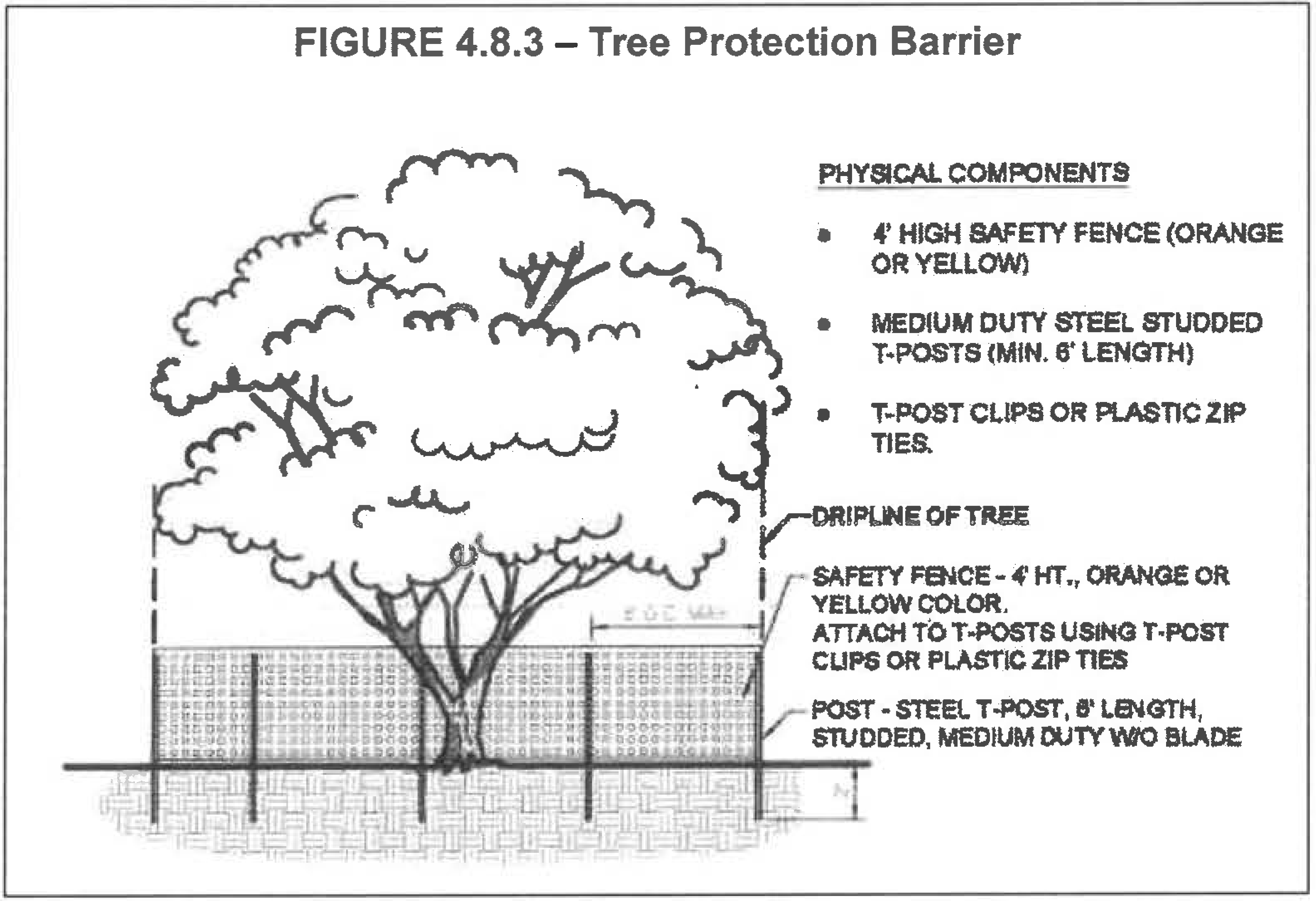
D.
Attachments prohibited. No attachments and wires other than those of a protective and non-damaging nature shall be attached to any tree.
E.
Periodic inspection. The city manager or his or her designee may conduct periodic inspections of the site before work begins and during cleaning, construction and post-construction phases of development in order to ensure compliance with these regulations and the intent of this article.
F.
Penalties for violations. Should any tree be removed without a permit, or severely pruned such as to no longer provide a natural tree form the following shall apply:
1.
No building permits shall be issued on lands where violations of this article are determined to exist, until such time as appropriate remedial action is agreed to by the city and completed by the owner of the land.
2.
No certificate of occupancy shall not be issued for any construction until all applicable remedies have been accomplished. Failure to obtain a permit prior to commencement of work shall result in the doubling of the fee.
3.
Appropriate remedial action shall include, but is not limited to, the doubling of the landscaping tree requirement, the replacement of tree(s) with similar physical size and/or replacement at an inch for inch (D.B.H.) ratio.
4.8.4. - Landscape buffers.
A.
Mixed use district. Within a mixed use district, landscape buffers shall not be allowed between place types, between adjacent neighborhoods or between buildings and roadways. Landscape buffers may be provided along the boundary line of a mixed use district to mitigate any potential conflicts with adjacent development.
B.
Landscape buffers within the city. Landscaped buffers within the city shall be developed between differing land uses based on the following. These requirements shall be deemed the minimum necessary to achieve compatibility between land uses. Buffer yards shall be developed by the more intense use based on existing adjacent contiguous uses, zoning or the site development plan whichever is most intense. In addition to the buffer criteria outlined herein, new development shall also adhere to other landscape requirements within the LDC. The buffer yard criteria described herein does not alleviate any other buffer requirement due to state mandate. Project buffers shall be generally located along the outer perimeter of the parcel to be developed extending inward from the parcel boundaries. Proposed uses are listed in the order of intensity.
1.
No structures are permitted in buffers except bus shelters, decorative hardscape features or decorative walls/fences. Parking is also prohibited within a buffer area.
2.
Buffer yard requirements: Minimum buffer types required on property boundaries between differing uses shall be as shown in Tables 4.8.4a and 4.8.4b below.
3.
Existing non-invasive vegetation may be used to fulfill buffering and screening requirements outlined herein, where such existing natural vegetation is of sufficient height and density or can be augmented to reach the requirements for height and opacity.
4.
Where two differing land uses are located opposite each other across a right-of-way, the buffer yard design type shall be further reduced to one full degree below the required standard.
5.
Buffer areas on residential developments shall be designated as common areas and shall not be included within lots. Buffers on non-residential sites may be included within lots and counted toward setback and open space requirements. The city manager or his or her designee may reduce or eliminate the required buffer where it can be shown by the applicant that the reduction is warranted by unique site features or characteristics or by the addition of structural elements (e.g. masonry walls). Conservation areas, water bodies and open spaces are exempt from this requirement. If a permanent buffer exists on the adjacent property which meets the requirements herein, no additional buffer will be required.
C.
Subdivision buffering on a multimodal corridor, avenue or boulevard [collector/arterial road]. To adequately protect abutting residential properties, double-frontage lots in the city shall be required to have landscape screening buffers, or other treatment as outlined herein unless the adjacent roadway is a section that already includes a screening buffer. Such landscape screens or other buffer treatments shall be located in separate tracts and access rights, for these tracts, shall be dedicated to the city. These double-frontage lots shall not have vehicular access onto external roadways. Lots that have rear vehicular access and corner lots are not considered double frontage lots with respect to this paragraph.
Screening buffers shall provide, at minimum, the planting equivalent of a medium buffer type and be no less than ten feet in depth along the ROW. Opaque screening to a height of six feet may consist of either finished block, brick, PVC, or a berm, including landscaping and may all be used interchangeably. Finished block shall consist of a stucco finish, a stone or brick veneer, or stained split face block. Walls shall be consistent with the style, texture and sizes of other walls on abutting and nearby properties. Painted block shall not be considered finished.
Notes: 1 ;hg;For mixed use properties the category for the proposed use shall be based on the proposed use within the development located along the periphery of lot.
2 ;hg;The city manager or his or her designee may allow alternative buffer designs. Consideration will be given to preserved natural vegetation, existing buffers on any contiguous development and enhanced landscape.
Notes: 1 ;hg;Plant material per 100 linear feet or fraction thereof.
2 ;hg;Where screening is required it shall consist of: a six-foot-tall opaque fence/wall, such as vinyl, masonry or wood (no chain link); or existing dense vegetation; or a berm a minimum of three feet in height located entirely within the buffer and planted with materials that at maturity shall reach the combined height of six feet. The location and accessibility of the wall, fence or berm shall be subject to the determination of the city manager or his/her designee.
3 ;hg;Width may include vehicle overhang resulting from wheel stop or back of curb but not vehicle parking. The buffer depth may vary along property lines as long as the total square footage of the selected buffer yard meets or exceeds the required yard area required for the total site and depth is not reduced below the minimum of the next lower category where impacts are deemed to require a visual screen.
4 ;hg;A six-foot masonry wall or other similar decorative durable wall may be utilized in conjunction with a "Low" buffer to meet the requirement for a "Medium" buffer.
5 ;hg;A six-foot masonry wall or other similar decorative durable wall may be utilized in conjunction with a "Medium" buffer to meet the requirement for a "High" buffer.
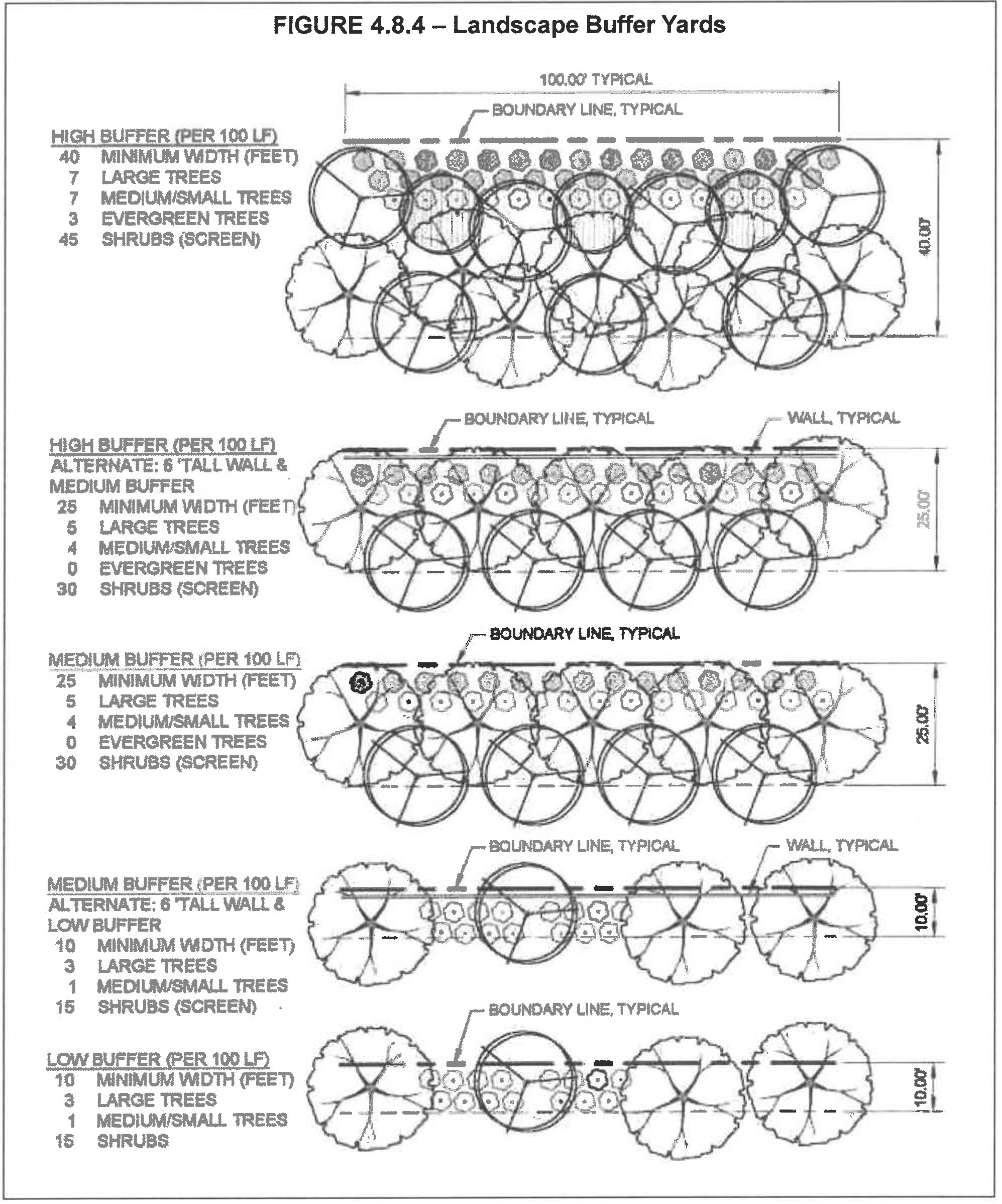
(Ord. No. 2024-22, § III, 4-25-2024)
4.8.5. - Street tree and plantings within the right-of-way.
A.
All roadways except for expressways within the city shall be lined with street trees. "Street trees", for the purpose of this subsection, shall be large trees (unless otherwise specified) and shall be provided along both sides of streets and roads or in medians, consistent with the cross sections within chapter 6 and shall be spaced no more than an average of 40 feet on center.
B.
Trees shall be planted along an alignment line—generally three to three and one-half feet from the back of the curb. Where necessary, spacing allowances may be made to accommodate curb cuts, fire hydrants and other infrastructure elements. This allowance for spacing may not exceed 55 feet on center except where necessary for transit stops or stations.
C.
At planting, trees shall be at grade or not greater than six inches in height above the finished grade. Any unpaved ground area shall be landscaped in compliance with applicable sight clearance requirements.
D.
Any vegetation planted within ten feet of a driveway and/or road intersection, shall be selected to provide for a clear sight lines as defined by FDOT Index 546.
E.
For local streets, where overhead utilities exist and would be in conflict with required plantings, small trees may be planted in lieu of large trees at a 2:1 ratio.
F.
Boulevards or avenue street planting. All developments located along either a boulevard or avenue (collector & arterial) shall be required to provide one of the following along the entire street frontage.
1.
Three large trees and groundcover per 100 linear feet of property frontage; or
2.
Two large trees and two medium/small trees and groundcover per 100 linear feet of property frontage; or
3.
Under utility lines only, four small trees and groundcover per 100 linear feet of property frontage.
G.
Street trees planted in commercial or mixed use districts may be planted in tree wells or sidewalk cutouts. Each tree must be provided with a minimum planting area as required herein.
H.
Street trees may be planted in islands or bulb-outs where on-street parking and mid-block pedestrian crossings are present, maintaining the site triangle. Planting islands or bulb-outs shall provide adequate root planting area of suitable soil conditions.
I.
Planting strips, medians, roundabouts, islands, bulb-outs, or other planting areas that may accommodate low impact development stormwater techniques may be depressed to accommodate stormwater runoff. Where curb is required, curb cuts may be used to permit the flow of water into the depressed planting area, stormwater overflow must be accommodated.
J.
Street trees shall be planted consistent with the cross sections as presented herein and no further than 14 feet from the back of curb unless it is required to be planted further from the back of curb to meet the clear zone requirement.
K.
Trees planted in the parkway, as indicated in the cross sections herein serve to protect pedestrians and calm traffic. Adequate root planting area of suitable soil conditions must be provided, including the appropriate pH scales for the plants being selected. Alternative planting systems include, but are not limited to, engineered soils, tree grates, and root barriers and may be used to enhance growing conditions and maximize growth potential given site constraints.
L.
Publicly accessible multi-use trails, bike paths and/or sidewalks may be provided within a roadway ROW provided the character and intent of the streetscape is not diminished.
M.
Where landscaping areas adjoin or extend into rights-of-way, such areas shall be considered part of the landscaped area for purposes of maintenance. As of completion of site improvements, the property owner shall have an implied easement on rights-of-way extending from the site to the road pavement in order to complete the required maintenance.
N.
All street trees must be maintained by the homeowner's association.
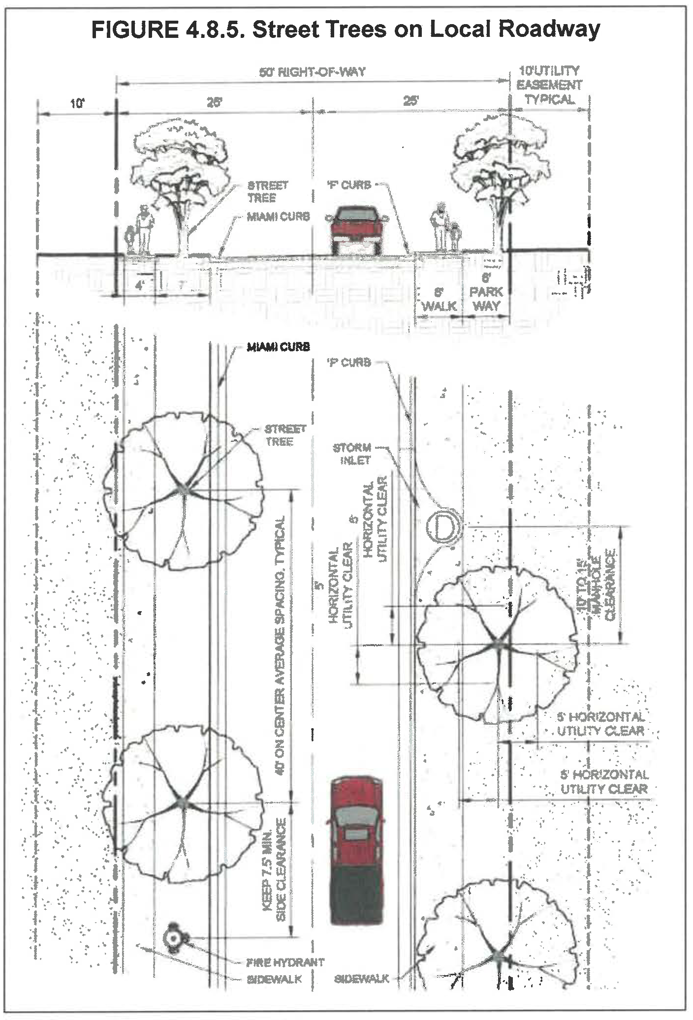
4.8.6. - Landscaping internal areas—Parking lots/foundation plantings.
A.
In an effort to conserve existing and desirable vegetation and create significant landscape areas, surface parking areas shall provide a minimum of 12.5 percent landscape area that includes one tree for every 170 square feet (sf) of landscape area and no greater than 20 percent of the area may be planted with turf grass.
B.
Except as provided herein, parking areas shall be setback from property lines pursuant to section 4.2.3.A.3. The unpaved areas shall be landscaped in accordance with the Code.
C.
Screening of vehicular areas. Whenever a surface parking area, drive aisle, paved display area or paved storage area lies within 50 feet of, and is visible from any right-of-way, the vehicular area shall require landscape buffering to include hardscape, trees, shrubs and groundcover arranged to provide a visual screen transition between the parking area and the street. Planting areas shall be provided in a strip no less than five feet in width. Hardscape elements could be a decorative metal fencing, decorative masonry knee wall (no taller than 30 inches above grade) topped with decorative metal fencing, artistic sculpture, urban seating/furniture or a combination of these elements.
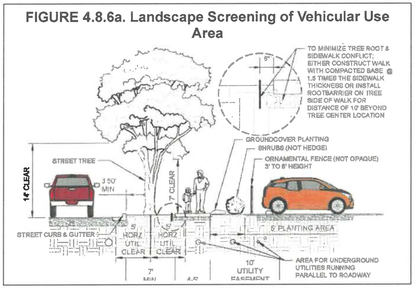
D.
With the exception of properties in the CBD and MXD zoning districts, there shall be shrubs and groundcover included in landscape areas adjacent to building walls visible to public streets. They shall provide a minimum planting area equal to 60 percent of the total length of each visible wall times eight feet. In the CBD and MXD zoning districts, there shall be shrubs & groundcover included in landscape areas provided in the public realm area in front of building walls visible to public streets. They shall provide a minimum planting area equal to 60 percent of the total length of each visible wall times five feet. These planting areas may be traditional foundation planting areas, raised planters, hanging baskets, trellised vines, freestanding decorative pots/urns, window boxes, green walls, rain gardens or a combination thereof.
E.
Plants shall be planted no closer than 30 inches from face of the building foundation to center of plant.
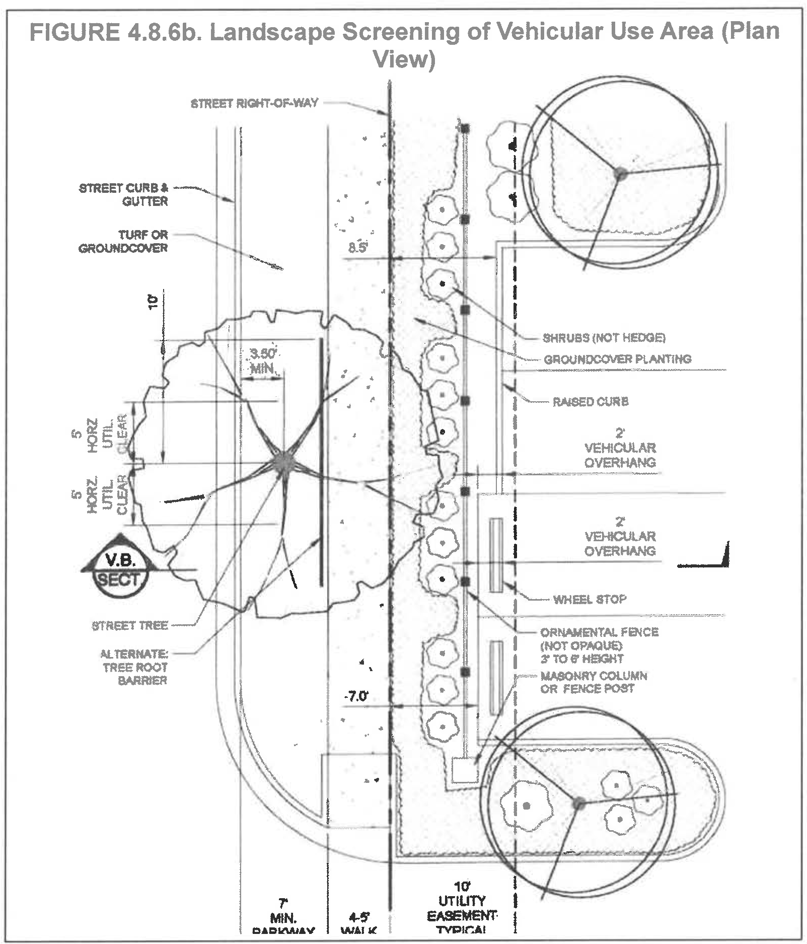
F.
Landscape islands where provided to meet the minimum requirements, shall contain landscaping materials only and shall not contain utilities or other infrastructure equipment such as fire hydrants, parking lot lights, transformers, air conditioning units or water meters.
G.
The landscaping adjacent to the parking areas shall be protected from vehicular encroachment by the use of curbing or wheel stops.
4.8.7. - Landscaping in utility service area.
A.
Proposed overhead or underground utility service facilities shall be designed to provide clearance from the mature height of trees and landscaping proposed on the landscape plan.
B.
Existing overhead or underground utility service facilities shall be considered in the design of the landscaping to provide clearance from the mature height of trees and landscaping.
C.
Trees, at time of installation, shall maintain a minimum five feet horizontal separation between the center of the tree and the city's underground utilities (water, reclaimed water and sewer).
D.
Any vegetation within a public utility easement shall conform to accepted vegetation management standards (i.e. OUC for power, water authority for water, sewer, and reclaimed water, and NFPA for fire). In all cases the minimum requirements of this article shall be met.
4.8.8. - Florida Friendly Landscaping ™ requirement.
All landscape design shall incorporate the principles of Florida Friendly Landscaping ™ for code-required landscaping.
4.8.9. - Crime Prevention Through Environmental Design (CPTED) standards.
Physical design of all landscaped areas shall include the concept of Crime Prevention Through Environmental Design (CPTED) by utilizing landscape planting, pavement designs and gateway and entrance treatments to achieve the following:
1.
Natural surveillance, through the placement of physical features and lighting of public spaces and walkways at night, in such a way as to maximize visibility, while maintaining or minimizing impacts to surrounding areas.
2.
Natural access control, through the physical guidance of people coming and going from a space by the placement of fencing, landscaping and lighting.
3.
Territoriality, through the use of physical attributes that express ownership, such as fences, pavement treatments, art, signage and landscaping.
4.8.10. - Minimum tree canopy requirements.
The existing tree canopy shall be preserved, enhanced, or created on a development parcel for all "New Development" as defined herein, in addition to any landscaping in the public realm (such as street trees), as follows:
A.
Multi-family, commercial, institutional, and industrial properties within the city, shall contain a minimum of 60 inches per acre of trees (measured in D.B.H. for preserved trees and in caliper for replacement trees).
B.
Single-family, duplex and townhouse developments within the city shall contain a minimum of 60 inches per acre of trees (measured in D.B.H. for preserved trees and in caliper for replacement trees) on common tracts and/or required open space pursuant to article 9 of this chapter. In developments where individual dwellings reside on their own fee-simple lots, a minimum of two trees shall be required per lot.
4.8.11. - General planting requirements.
Landscaping shall be provided on the development parcel for all "New Development" as defined herein, in addition to any landscaping in the public realm, as follows:
A.
Plant quality. Plant materials shall meet the following minimum standards:
1.
All nursery plants, including trees, shrubs and groundcovers shall conform to standards for Florida Grade #1 or better according to the current, edition of "Grades and Standards for Nursery Plants".
2.
All sod shall be certified apparently free of noxious and invasive exotics.
B.
Plant sizes and species.
1.
All plant material shall be selected from "The Florida Friendly Landscaping Guide to Plant Selection & Landscape Design" or other regionally appropriate plant material guide upon approval by the city manager or his/her designee.
2.
The use of native species is encouraged. On sites up to ½ acre in size, minimum one native shrub species and one native tree species shall be planted. Sites greater than ½ acre and up to one acre shall include at least three native species, each, and sites greater than one acre shall include minimum four native species each in the planting specifications.
3.
Species listed by the Florida Exotic Pest Plant Council (FLEPPC) as Category I invasive species for Central Florida shall be prohibited.
C.
Trees.
1.
All trees shall be installed as follows:
a.
a minimum of three-inch caliper for large trees;
b.
a minimum of two and one-half-inch caliper for medium trees; and
c.
a minimum of two-inch caliper for small trees.
d.
A minimum of 70 percent of the required trees shall be large/medium trees. Palm trees may be planted as part of the landscape plan (three palm trees equal one large/medium tree) but shall not be credited against the minimum canopy requirement (D.B.H. per acre) herein.
2.
Landscape plans and installation shall incorporate the following minimum diversity standards:
a.
Two genera for up to ten (including ten) required trees.
b.
Three genera for between 11 and 20 (inclusive) required trees.
c.
Four genera for greater than 20 required trees.
d.
No more than 50 percent of the required trees shall be of any one genera.
D.
Shrubs.
1.
Shrubs intended for required buffer plantings shall consist of woody plants meeting the minimum height required for a three-gallon container. Where intent is to screen the shrubs shall be planted at an appropriate size and on center spacing to attain 90 percent opacity within two years.
2.
Landscape plans and installation shall incorporate the following minimum diversity standards:
a.
One genera for up to and including 20 required shrubs.
b.
Two genera for 21—100 required shrubs.
c.
Three genera for 101—250 required shrubs.
d.
Four genera for 251+ required shrubs.
e.
No more than 50 percent of the required shrubs should be of any one genera.
E.
Turf grass. Turf grass shall be planted with species normally grown as permanent lawns. Grass areas may be sodded, plugged, sprigged or seeded except that solid sod shall be used in swales or other areas outlined herein. Turf grass in all public rights-of-way and stormwater management ponds shall be sodded as required herein.
F.
Ground covers. Ground covers other than turf grass shall be planted in such a manner as to present a finished appearance and reasonably complete coverage within one year after planting.
G.
Synthetic plants. Synthetic or artificial turf, trees, shrubs, ground covers or vines shall not be used in lieu of the plant requirements in this article unless otherwise permitted by the city manager or his or her designee due to practical consideration of site conditions.
H.
Credit for existing plants.
1.
Credit is permitted for existing plant material provided such material meets the minimum standards of this article.
2.
Credit shall be allocated on a one-for-one basis for shrubs and inch for inches, DBH, preserved for trees where such material meets or exceeds the minimum standards of this article.
I.
Mulch.
1.
Mulch is any material applied to the soil surface to protect or improve the area covered. Mulches are frequently applied around plants to modify the soil environment and enhance plant growth. They may consist of organic material such as bark, wood chips, leaves, pine needles, or grass clippings; or they can be inorganic material such as gravel, pebbles, polyethylene film, or woven ground cloth. Mulch can be applied to the soil surface but should not rest against the stems of landscape plants.
2.
Mulch type should match design needs for the area of use, be installed per green industry best management practices and utilize Florida Friendly Landscaping principles.
3.
The use of large expanses of mulched areas in lieu of planted areas is not acceptable. The use of unplanted mulch areas is acceptable where design can justify use and meet Florida Friendly Landscaping principles.
4.8.12. - Installation.
Landscape areas for installed trees shall conform to Table 4.8.11 and shall generally use as a guide the University of Florida Publication ENH 1056, "Design Solutions for a More Wind-Resistant Urban Forest"
A.
Prior to land development activity, the applicant shall be required to erect a suitable protective barrier for all protected vegetation (at a minimum, to cover the dripline of the protected trees). The protective barrier shall remain erected until such time as it is authorized to be removed by the city or upon completion of final lot grading and placement of final ground cover. During construction, no attachments or wires shall be attached to any protected vegetation. Wood, metal or other substantial material shall be utilized in the construction of barriers. No equipment or materials shall be placed within the protected areas.
B.
All landscaping and transplanting of landscape materials shall be installed according to sound horticultural principles. All installations shall be performed specific to type, species, soils, environmental conditions and include establishment through water and maintenance to ensure maximum survivability.
1.
The required planting area/rooting volume shall be free from compacted material to a minimum depth of 18 inches.
2.
The planting hole for trees shall be a minimum of three times the size of the width of the rootball, and sloped outward to encourage new root growth.
3.
Planting soil shall be native soil, where possible, and shall be protected to a depth of 18 inches from contamination from construction materials and debris, incompatible biological waste materials (e.g. too much dog urine can have a negative affect), biologically incompatible products or waste, soil compression, etc. Where potential planting soils that are within active construction areas cannot be protected from adverse factors, they should be stockpiled and protected until a time when the installation of a healthy landscape is possible. Where existing site soils are contaminated, local soils or soil mixes appropriate for the plant selection shall be imported into the site.
4.
Soil tests executed by a certified laboratory are required to certify that plant species and soils are compatible.
4.8.13. - Irrigation.
The intent of this section is to provide for the supplemental water needs of the landscape plantings while promoting water conservation principles noted by Florida Friendly Landscaping ™ and the water authority's criteria for water efficiency. Nothing within this article shall require the installation of a permanent automatic irrigation system.
A.
Irrigation systems.
1.
All required landscaping shall be provided, at minimum, with provisions for a temporary irrigation system sufficient for the establishment and ongoing health of all required landscaping plant material.
2.
The water source for any irrigation system shall be as follows:
a.
Where available, reclaimed water, harvested rainwater, stormwater or other alternative water supplies as required by the water authority shall be used for landscape irrigation, and design and installation shall be consistent with applicable regulations.
b.
Irrigation wells within the city shall only be permitted if approved through the Water Management District or FDEP through rule or CUP (Consumptive Use Permit).
c.
Where no other lesser quality water source options are available, potable water source may be used.
3.
A scaled irrigation plan shall be provided to illustrate compliance with applicable regulations, showing existing features to remain, with proposed site improvements and landscape plantings. Irrigation plans shall indicate at a minimum:
a.
Irrigation water supply size, flow rate, static or operating pressure and location.
b.
Irrigation mainline route and size.
c.
Irrigation controller type, size and location.
d.
Irrigation control valve sizes and locations.
e.
Irrigation heads and nozzles, type, arc, radius and location.
f.
A legend with graphic symbols and descriptions of each piece of irrigation equipment.
4.
Irrigation shall promote water conservation by such methods as micro-irrigation or efficient sprinkler zoning. The irrigation system shall be designed and located to minimize the watering of impervious surfaces. Trees shall have individual low flow or micro-irrigation supplies.
5.
In addition to the required automatic rainfall shutoff device, moisture sensors, weather stations, or evapotranspiration (ET) sensors is strongly encouraged on automatic irrigation systems, and shall be maintained for proper function.
B.
Irrigation design/installation. The water authority's water conservation principles, criteria for water efficiency, and standards shall apply to all irrigation design and installation.
4.8.14. - Maintenance and enforcement.
A.
Site improvements. All required site improvements shall be maintained by the property owner consistent with approved plans and requirements of this Code.
B.
Landscape/irrigation improvements.
1.
All required landscaping, whether preserved or newly planted, must demonstrate health and viability, and any required irrigation shall be installed to ensure the health and viability of the landscaping, consistent with approved plans, upon issuance of the certificate of occupancy/completion. Thereafter, all required landscaping and irrigation shall be maintained consistent with approved plans and requirements of this Code. The city may perform inspections of the landscaping and irrigation after issuance of the certificate of occupancy/completion for compliance. If the landscaping and/or irrigation is not in compliance, notice shall be given to the property owner, and the property owner shall be responsible for restoring the landscaping and/or irrigation within a time period acceptable to the city.
2.
The property owner, association or other entity acceptable to city shall be responsible for the maintenance of all landscape areas in accordance with the approved landscape or planting plans.
C.
Pruning.
1.
All pruning shall be done following the American National Standard for Tree Care Operations "Tree, Shrub and Other Woody Plant Maintenance-Standard Practices." Trees severely damaged by storms or other causes, or certain trees under utility wires or other obstructions where other pruning practices are impractical, may be exempted from this section at the determination of the city manager or his/her designee.
2.
All trees, especially the Crape Myrtle trees, shall be maintained as a natural tree form to promote their shade-giving qualities and no pruning other than for structural defect or to remove diseased or dying portions in areas where falling limbs could be a hazard to people or property, shall be expected.
3.
Trees must be pruned as they gain appropriate maturity so as not to interfere with pedestrian or truck travel and to maintain visibility. Limbs must be a minimum seven feet clear over the sidewalk and 14 feet clear over the travel lane.
4.
The cultural practices of severe pruning and removal of branches each winter shall be prohibited. Excessive pruning of trees into round balls or crown or branches, which results in an unnecessary reduction of shade, shall be prohibited.
4.8.15. - Waiver.
Upon application to the city with an explanation of justification, the city council or its designated representative may grant a waiver from the provisions of this section when such waiver would not be contrary to the public interest. Such waiver may also be granted where it furthers the intent and purposes of this article.
4.8.16. - Creation of tree bank fund.
A.
Purpose. There is hereby created the City of St. Cloud Tree Bank Fund for the purpose listed below:
1.
Acquiring, protecting, and maintaining native vegetative communities in the City of St. Cloud.
2.
Acquiring, protecting and maintaining land for the placement of trees acquired pursuant to this article.
3.
Purchasing vegetation for placement on public properties in the City of St. Cloud.
4.
Mitigating the impact of any damage from violations of this article.
B.
Maintenance of the tree bank fund. Funds may be used as a matching fund contribution toward the acquisition of native vegetative communities in the Joint Planning Agreement Area, in association with other public land acquisition programs. The tree bank fund shall be kept, maintained and identified by the city solely for the purposes set forth in this article.
C.
Source of funds for the tree bank fund. The City of St. Cloud Tree Bank Fund shall consist of funds listed below:
1.
All monies collected by the city pursuant to the provisions of this article which are obtained through civil action and consent agreements.
2.
All monies offered to and accepted by the city for the tree bank fund in the form of federal, state, or other governmental grants, allocations or appropriations, as well as foundation or private grants and donations.
3.
Contributions in lieu of, or in conjunction with, the replacement planting requirements herein, shall be determined by the city manager, or his or her designee, and will be based on the value of the plantings not being replaced. Value shall be based upon cost estimates provided by a landscape architect or other expert retained by the city.
D.
Interest. Unless otherwise restricted by the terms and conditions of a particular grant, gift, appropriation or allocation, all interest earned by the investment of all monies in the tree bank fund shall accrue to the fund and shall be disbursed for any project authorized consistent with this article. Tree bank funds shall be invested only in accordance with the laws pertaining to the investment of city funds.
E.
Effect on permitting. Decisions to grant or deny permits provided for by this article shall be made without consideration of the existence of this fund or offers of donations of monies thereto.
4.9.1. - General provisions for open space.
A.
Open space shall be properly designed and located and shall function as an amenity to the residents and users of the development.
B.
Open space shall be provided according to the criteria listed in this article as defined below.
4.9.2. - Quantity of open space.
The amount of open space to be provided within a development as follows:
A.
Non-residential developments. A minimum of 15 percent of the developable area for a non-residential development, including the non-residential portion of a multiple-use planned development, shall be designated and function as open space.
B.
Residential developments. A minimum of 20 percent of the developable area for a residential development, including the residential portion of a multiple-use planned development, shall be designated and function as open space. Multifamily dwellings, townhouses, condominium projects, and architecturally integrated subdivisions shall provide a minimum of 25 percent of the developable area to be designed and function as open space as noted in section 3.5.3.G.
C.
Mixed use development. A minimum of 20 percent of the developable area of a mixed use development shall be designated and function as open space. Open space within the city, as described by section 3.10.2.H. open space, shall be credited towards the open space requirements for development.
D.
Wetlands. If preserved wetlands are included in the open space requirement, then the requirements shall be calculated on the gross project area.
4.9.3. - Open space availability.
Open space elements shall be available and accessible to all residents and users of the development as follows:
A.
Areas such as private lot setback yards, right-of-way, and isolated areas not available to the residents and users of the development are not considered open space to meet the requirements stated above. Only parking lots required for civic or recreational uses may be counted towards the open space requirements. General uses of acceptable open space elements to meet the requirement as defined below include preservation of environmentally sensitive areas, passive recreation and active recreation.
B.
Preserved wetlands and water management areas, if designed appropriately with pedestrian access available, may contribute to the open space acreage, but because of their limited open space value, can in no case comprise more than 50 percent of the required open space acreage.
C.
Buffers, greenways, wildlife corridors and recreation areas shall be counted towards the required open space acreage.
4.9.4. - Preservation and conservation areas.
Developments which include preservation of significant native vegetation, habitat areas for rare and endangered plant and/or animal species may reduce the open space requirement at a 1:1 ratio up to one-third of the total required open space for the development when such preservation is determined by the city to be ecologically viable.
4.10.1. - Purpose of mural art.
It is the purpose of this article to promote the general welfare of the city and enhance the quality of life for city residents, businesses, workers, and visitors by integrating art and arts space into public or semi-public spaces to thereby creating unique, innovative, and attractive spaces while providing a legacy of artworks to be enjoyed by future generations. These creations provide immersive, interactive, or thought-provoking experiences, intending to elicit emotional responses, stimulate contemplation, or offer fresh perspectives. Ultimately, this aligns with art's broader purpose: to engage and impact its audience on multiple sensory and intellectual levels.
This article will establish when such artwork is to be provided for non-residential development and the criteria for the establishment of public artwork.
(Ord. No. 2024-66, § II, 9-19-2024)
4.10.2. - Applicability of the mural art requirements.
A.
The requirements for providing murals shall apply as follows:
1.
New or existing non-residential developments located in CBD-1, CBD-2, community redevelopment agency (CRA) area, or along any arterial roadways are permitted to install mural art.
a.
All murals which are located wholly or partly out-of-doors and which are not intended to meet the definition of a sign must be approved by the city manager or their designee. No such items shall be approved by the city manager or their designee unless determined that the item:
(1)
Is a true work of art and not a sign as defined within this LDC.
(2)
Is compatible with the character of the surrounding area in terms of its size, style, colors, materials, general appearance, and location.
b.
Murals must be installed in a public place, which means any exterior area on public or private property that is easily accessible to the general public or clearly visible to the general public from adjacent public property, such as a street or other public thoroughfare or sidewalk.
2.
The property owner or their agent must obtain a permit prior to the installation of the mural art.
(Ord. No. 2024-66, § II, 9-19-2024)
4.10.3. - Mural art design standards.
A.
Murals, for the purpose of this article, are defined as paintings, images, graphics, mosaics, frescos, or other artwork attached or applied directly to the exterior of an exterior wall surface that are visible to passerby and which do not direct attention to organizations, businesses, products, commodities or services, or other similar interests or activities. Murals are public art, not billboards or signs, and should not reflect public or governmental propaganda.
B.
Each mural shall be an original work of art. Copyrighted images and advertisements are prohibited.
C.
Color. A mural's color scheme shall be complementary and harmonious with the exterior colors of the building or structure, and consistent with the chosen theme.
D.
Design. The design and location of the mural shall be in keeping with the character and enhance the building on which the mural is to be located as well as the local environment.
1.
Murals shall not cover or detract from architectural features. Eaves, cornices, and other architectural features shall keep their character and remain painted to match the rest of the similar architectural features on the building.
2.
Murals shall not cover doors and windows unless permitted by city manager or their designee.
3.
A mural's overall features shall be designed to enhance the city's unique character and quality of life.
4.
A mural that has been applied to another surface to be hung on a building shall be installed in a manner that does not damage the building it is attached to.
a.
Murals hung on historic masonry shall attach via the mortar and not by drilling into the historic brick or attached by other methods which have been demonstrated not to damage the masonry.
E.
Materials. The materials used in developing a mural may consist of, but are not limited to, paint and other artistic mediums such as tile or mosaic, original digital images and low-relief sculpture.
1.
Paint utilized shall be intended for exterior use and of sufficient quality which will not corrode or compromise the integrity of the material to which it is applied.
2.
All materials used in the creation of a mural must be appropriate for outdoor locations and climate, with special considerations for longevity or quality presentation during a planned period of display.
F.
Size limits. Structures up to 24 feet (two stories) high or less may cover 100 percent of a wall with mural art. Structures greater than 24 feet (two stories) high may only cover 50 percent of a wall with mural art.
G.
Properties within the Historic Preservation Overlay or the Community Redevelopment Area (CRA) may require additional approvals through their appropriate boards.
H.
Text shall not be more than ten percent of the mural art.
(Ord. No. 2024-66, § II, 9-19-2024)
4.10.4. - Maintenance and ownership.
A.
All artwork placed on the site of a development project shall remain the property of the owner of the site and its successor and assigns; murals donated to the city and or placed on city property shall remain the property of the city. The obligation to provide all maintenance necessary to preserve and maintain the mural in good condition shall remain with the owner of that site and the owner's successors and assigns, unless agreed. Application for such request and all associated fees with processing same shall be borne by the applicant.
B.
The obligation to maintain the mural shall be enforced as follows:
1.
Maintenance of mural, as used in this article, shall include, without limitation, preserving the artwork in good condition to the satisfaction of the city, protecting the artwork against physical defacement, mutilation or alteration, and securing and maintaining insurance coverage for fire, wind, vandalism and extended liability.
2.
At any time, the city manager or their designee determines that artwork has not been maintained in substantial conformity with the manner in which it was originally approved, the code compliance division of the city, as authorized by the city manager or their designee, shall require the current property owner to either:
a.
Repair, replace or remove the artwork; or
b.
The city manager or their designee can additionally issue notice of violation for failure to maintain the artwork in accordance with the Land Development Code and/or City Code Ordinances.
C.
Stolen or removed artworks are to be replaced by the owner. Replaced pieces are to be reviewed and approved by the development review committee subject to the criteria set forth in this article.
(Ord. No. 2024-66, § II, 9-19-2024)