
Salinas City Zoning Code
ARTICLE IV
Overlay District Regulations.
Division 7. - Airport (AR) Overlay District.[1]
Editor's note— Ord. No. 2569 (NCS), § 21, adopted April 19, 2016, changed the title of Div. 7 from "Airport (AP) Overlay District" to read as herein set out.
Sec. 37-40.010. - Purpose.
The purpose of the flood (F) overlay district regulations is to:
(a)
Protect development from flood-related hazards;
(b)
Protect public health, safety, and general welfare by regulation of development within flood-prone areas;
(c)
Control the alteration of natural floodplains, stream channels, and natural protective barriers, which help accommodate or channel floodwaters;
(d)
Control filling, grading, dredging, and other development which may alter drainage patterns and/or increase flood damage;
(e)
Prevent or regulate the construction of flood barriers which will unnaturally divert floodwaters or which may increase flood hazards in other areas;
(f)
Control the cumulative effect of development in flood-prone areas that can increase flood heights and velocity, erosion, downstream impacts, and otherwise contribute to flood loss; and
(g)
Enhance water quality and groundwater recharge by identifying areas where resources can be placed for this purpose, such as floodplains or other areas, in accordance with the requirements of the latest adopted edition of the city's National Pollutant Discharge Elimination System (NPDES) permit requirements.
(Ord. No. 2463 (NCS).)
(Ord. No. 2541 (NCS), § 2, 7-23-2013)
Sec. 37-40.020. - Applicability.
(a)
The flood overlay district may be combined with any zoning district and is located within an area designated within the one-hundred-year flood boundary by the Federal Emergency Management Agency (FEMA) as shown on the Flood Insurance Rate Maps (FIRM), as amended. An area designated for the flood overlay district may be amended if map amendments are approved by FEMA, if supplemental studies show such an amendment is appropriate, and if approved by the city council. The flood overlay district shall be shown by adding "F" to the zoning designation (see Figure 37-40.10).
(b)
This division shall be used in conjunction with Ordinance 2383 (NCS) (ordinance to prevent flood damage), adopted on January 23, 2001, as amended. In case of conflict or overlap, whichever imposes the most stringent restrictions/requirements shall prevail. No structure or land shall hereafter be constructed, located, extended, converted, or altered without full compliance with this division, with Ordinance 2383 (NCS), and with all other applicable regulations.
(c)
The requirements of this division shall not apply to any project for improvement of a structure to comply with existing state or local health, sanitary, or safety code specifications that are solely necessary to assure safe living conditions.
(Ord. No. 2463 (NCS).)
Sec. 37-40.030. - Use classifications, development regulations, and design standards.
Use classifications, development regulations, and design standards shall be those of the underlying base zoning district (as identified in Article III: Base District Regulations of the Zoning Code) except as modified by the flood overlay. All new development within the flood overlay district shall comply with the requirements and development regulations of Chapter 9, Article VI: Flood Damage Prevention. New development includes, but is not limited to any man-made change to improved or unimproved real estate, including, but not limited to, buildings or other structures or modifications thereto which affect the exterior dimensions of a structure, relocation of a building or structure, mining, dredging, filling, grading, paving, excavation, or drilling operations.
(Ord. No. 2463 (NCS).)

Sec. 37-40.040. - Warning and disclaimer of liability.
This division does not imply that land outside of the flood overlay district will be free from flooding or flood damages. This division shall not create liability on the part of the city or by any officer or employee thereof for any flood damages that result from reliance on this division or any administrative decision made thereunder.
(Ord. No. 2463 (NCS).)
Sec. 37-40.050. - Conflict between regulations.
Where a conflict occurs between the flood overlay district and the base district or any other section of the Code, the flood overlay district regulations shall prevail.
(Ord. No. 2463 (NCS).)
Sec. 37-40.060. - Adoption, amendment, or repeal.
Adoption, amendment, or the repeal of the flood overlay district shall be conducted in accordance with the provisions of Article VI, Division 14: Rezones/Pre-zones/Zoning Code Amendments.
(Ord. No. 2463 (NCS).)
Sec. 37-40.070. - Purpose.
The purpose of the specific plan overlay district regulations is to:
(a)
Ensure orderly planning for the development of new growth areas and the revitalization of existing developed areas;
(b)
Avoid premature or inappropriate development that would result in incompatible uses or create public service demands exceeding the capacity of existing or planned facilities;
(c)
Allow for detailed and flexible planning of larger areas of land;
(d)
Maintain environmental equilibrium consistent with existing soil, groundwater, stormwater, vegetation and air resources; and
(e)
Ensure sensitive site planning and design.
(Ord. No. 2463 (NCS).)
Sec. 37-40.080. - Applicability.
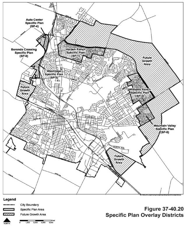
The specific plan overlay district may be combined with any zoning district located in the city. The district with which the specific plan overlay is combined shall be the base zoning district. Each specific plan overlay district shall be shown on the zoning map by adding "SP" to the zoning designation followed by consecutive numbering indicating the order of their establishment. The existing specific plan overlay areas are shown on Figure 37-40.20.
(Ord. No. 2463 (NCS).)
Sec. 37-40.090. - Use classifications, development regulations, and design standards.
Use classifications, development regulations, and design standards shall be those of the underlying base zoning district's use classifications, development regulations, and design standards (as identified in Article III: Base District Regulations of the Zoning Code) except as modified by a specific plan adopted for the site.
(Ord. No. 2463 (NCS).)
Sec. 37-40.100. - Specific plan required.
The specific plan overlay district shall be preceded by or made concurrent with the adoption of a specific plan in accordance with Article VI, Division 15: Specific Plans setting forth land use, circulation, public facilities, environmental and design standards and guidelines, and any other elements appropriate to the development or revitalization of an area, along with text and maps, all of which must be consistent with the goals and policies of the general plan.
(Ord. No. 2463 (NCS).)
Sec. 37-40.110. - Future growth area.
Approval for land use or development of a site within a future growth area, as designated in the general plan, shall be preceded by or made concurrent with the adoption of a specific plan for that site. Specific plans located in the future growth area shall also be subject to the regulations in Article III, Division 8: New Urbanism Districts.
(Ord. No. 2463 (NCS).)
Sec. 37-40.120. - Conflict between regulations.
Where a conflict occurs between the specific plan overlay district and the base district or any other section of the Code, the specific plan overlay district regulations shall prevail.
(Ord. No. 2463 (NCS).)
Sec. 37-40.130. - Adoption, amendment, or repeal.
Adoption, amendment, or the repeal of the specific plan overlay district shall be conducted in accordance with the provisions of Article VI, Division 14: Rezones/Pre-zones/Zoning Code Amendments and Article VI, Division 15: Specific Plans.
(Ord. No. 2463 (NCS).)
Sec. 37-40.140. - Purpose.
The purpose of the gateway overlay district regulations is to:
(a)
Create entrances that announce arrival and set a tone for the part of the city they introduce;
(b)
Establish attractive and inviting entrances to the city in order to form the basis for positive impressions and perceptions of the community;
(c)
Avoid inappropriate development that would result in incompatible uses or design; and
(d)
Ensure site planning and design that is sensitive to the unique gateway district.
(Ord. No. 2463 (NCS).)
Sec. 37-40.150. - Applicability.
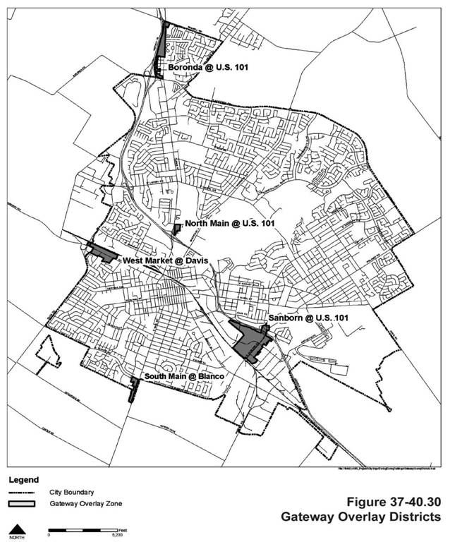
The gateway overlay district may be combined with any zoning district. The district with which the gateway overlay is combined shall be the base zoning district. The gateway overlay district shall be shown on the zoning map by adding "G" to the zoning designation. The areas designated in the general plan as gateway overlay districts are shown on Figure 37-40.30.
(Ord. No. 2463 (NCS).)
Sec. 37-40.160. - Use classifications.
The use classifications allowed the gateway overlay district shall be those use classifications allowed in the underlying base zoning district (the CR, CT, MAF, or IGC district, as applicable) except as modified in Table 37-40.10 below. See Article III: Base District Regulations for the base zoning district regulations. The footnotes listed in the applicable base district, as "Additional Use Regulations" shall apply to use classifications located in the gateway overlay district.
Notes:
NP = Not Permitted Use
CUP = Conditional Use Permit Required
SPR = Site Plan Review Required
"-" = No change to the base Zoning District Use Classification table.
** Footnotes listed in the base Zoning District Use Classification table shall apply unless modified above.
(1) See Section 37-50.270: Single room occupancy (SRO) housing.
(Ord. No. 2463 (NCS).)
Sec. 37-40.170. - Development regulations and design standards.
The development regulations and design standards shall be those of the underlying base zoning district or other applicable section, except as modified by this section, as follows:
(a)
Yards/Setbacks. A minimum fifteen-foot yard shall be provided along any property line abutting U.S. Highway 101 unless the base district requires a greater yard. Such yards shall be landscaped.
(b)
Screening/Walls and Fencing.
(1)
Any outdoor storage, loading, trash enclosures and compactors, service areas, ground-mounted mechanical area, or other conduct of business outdoors visible from public rights-of-way or U.S. Highway 101 shall be screened by a decorative masonry wall and/or a landscaped berm of a height equal to the materials to be screened as approved by the city planner in accordance with Section 37-50.090(g): Screening.
(2)
Chain link fencing with or without slats or vinyl coating shall not be used for fencing/screening purposes when visible from any public rights-of-way or U.S. Highway 101.
(3)
No barbed wire, razor, electrified fencing, or similar fencing shall be permitted.
(4)
Roll-up doors, drive-through aisles, vehicle bays, car wash entrances/exits, wash stalls, and similar features shall be screened from view of public rights-of-way and the U.S. Highway 101 by orientation of the building and/or the provision of landscaping, berms, trellises, or low walls (that are consistent with the architecture and exterior materials of the building).
(c)
Lighting.
(1)
Lighting (including the lamp, lenses, and reflectors) shall be shielded and directed away from U.S. Highway 101 and interchanges to ensure no adverse lighting impacts occur.
(2)
Lighting fixtures shall be compatible with and complementary to the architectural style of the buildings and structures on the site.
(d)
Landscaping.
(1)
A landscaping planter, a minimum of fifteen feet in depth in all commercial districts and twenty feet in depth in all industrial districts, shall be provided along the frontages of all public streets and U.S. Highway 101.
(2)
The landscaping requirements specified in Section 37-50.690(g)(7): Parking Lot Landscaping shall not be waived for properties located in an industrial district that abuts or is visible from U.S. Highway 101.
(e)
Architecture.
(1)
All building elevations shall be architecturally treated. Elevations visible from U.S. Highway 101 or public rights-of-way shall not run over thirty feet in length without being interrupted by windows or other architectural building features such as columns, awnings, etc., and shall be enhanced with the same architectural treatments as those found on the elevations containing the building's primary pedestrian entrances.
(2)
All building facades (elevations) shall have:
(A)
A recognizable base consisting of (but not limited to):
(i)
Richly textured materials (e.g., tile or masonry treatments),
(ii)
Darker colored materials, mullion, and/or panels, or
(iii)
Enhanced landscaping of mature and specimen shrubs and trees with a minimum planter depth of five feet exclusive of curbs;
(B)
A recognizable top consisting of (but not limited to):
(i)
Cornice treatments,
(ii)
Roof overhangs,
(iii)
Stepped parapets, or
(iv)
Richly textured materials (e.g., tile or masonry treatments).
(f)
Enhanced Paving. Colored, textured paving shall be provided at a minimum depth of ten feet at all primary vehicular driveway entrances (immediately behind the street right-of-way line) to the development.
(g)
Signs.
(1)
Menu-type boards shall face away from public rights-of-way and the U.S. 101 Highway.
(2)
Pole-style signs (other than highway signs) shall not be permitted.
(h)
Telecommunication Facilities. Telecommunication facilities must be stealth facilities. Also see Section 37-50.290: Telecommunication facilities.
(Ord. No. 2463 (NCS).)
Sec. 37-40.180. - Conflict between regulations.
Where a conflict occurs between the gateway overlay district and the base district or any other section of the Code, the gateway overlay district regulations shall prevail.
(Ord. No. 2463 (NCS).)
Sec. 37-40.190. - Adoption, amendment, or repeal.
Adoption, amendment, or the repeal of the gateway overlay district shall be conducted in accordance with the provisions of Article VI, Division 14: Rezones/Pre-zones/Zoning Code Amendments.
(Ord. No. 2463 (NCS).)
Sec. 37-40.200. - Purpose.
The purpose of the focused growth overlay district regulations is to focus growth at high potential, under-utilized sites ("focused growth overlay areas") within Salinas by providing standards that will enhance the city and its neighborhoods and create incentives for mixed use neighborhoods that are active, pedestrian-friendly, safe, and welcoming. In addition to this general purpose, the more specific purposes of this division are to:
(a)
Create healthy neighborhood centers where residents of all economic and cultural backgrounds can live, work, walk, shop, exercise, and spend quality time outdoors;
(b)
Increase pedestrian activity by creating neighborhood centers that are conveniently accessed by public transit;
(c)
Provide a mixture of uses to keep the neighborhoods active at all times of the day, not just morning and evening (as in the case of residential zones) or business hours (for commercial zones);
(d)
Reduce vehicle trips and traffic by encouraging a mixture of uses and activities in one location;
(e)
Encourage creative architecture and public design that communicate a neighborhood's locale, purpose, priorities, and personality to those who use the space; and
(f)
Create revitalized neighborhoods through infill development and redevelopment activities.
(Ord. No. 2463 (NCS).)
Sec. 37-40.210. - Applicability.
(a)
Focused Growth Overlay Areas. Unless administratively approved by the city planner pursuant to Section 37-40.210(b) below, development located within the following five focused growth overlay areas illustrated in Figure 37-40.40 shall adhere to the regulations of this division, and these regulations shall supersede the base district regulations:
(1)
Focused Growth Overlay Area 1: Laurel Drive at North Main Street. Focused growth area 1 is located north of downtown Salinas and adjacent to the Sherwood Park and Salinas sports complex. This highly visible and well-trafficked commercial district benefits from strong residential neighborhoods both to the east and the west.
(2)
Focused Growth Overlay Area 2: North Main Street/Soledad Street. Focused growth area 2 is centered around the intersection of North Main Street and West Rossi Streets. This area receives high traffic volume and visibility with its immediate proximity to both the US 101 Highway and the downtown core. A portion of this focused growth area is located within the central city redevelopment project area.
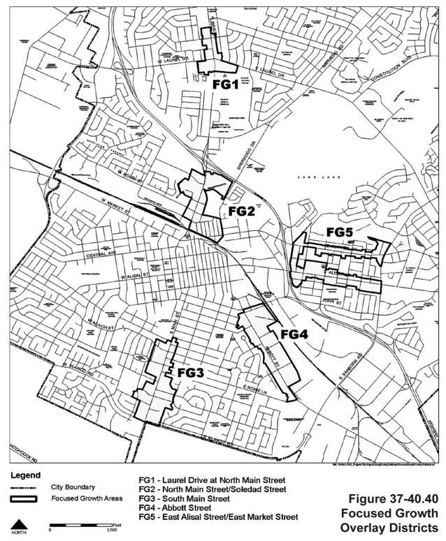
(3)
Focused Growth Overlay Area 3: South Main Street. Focused growth area 3 stretches from generally Geil Street on the north to Blanco Road on the south and contains existing commercial buildings that transition into the surrounding residential neighborhoods. Salinas high school is in close proximity to this area.
(4)
Focused Growth Overlay Area 4: Abbott Street. Focused growth area 4 stretches from John Street in the north to East Romie Lane in the south, and is in proximity to the Salinas Valley Memorial Hospital.
(5)
Focused Growth Overlay Area 5: East Alisal Street/East Market Street. Focused growth area 5 includes properties fronting Alisal and Market Streets from Sanborn Road to Kern Street. Cesar Chavez community park is located to the north of this area. This focused growth area is located within the Sunset Avenue redevelopment project area.
(b)
Exemptions from Development Regulations and Design Standards.
(1)
The city planner may administratively exempt the following projects from the development regulations and design standards of this division:
(A)
Additions expanding existing structures by less than twenty-five percent of the existing gross floor area or two thousand five hundred square feet, whichever is less;
(B)
Exterior or interior remodels involving no increase in gross floor area;
(C)
Parking lot, loading spaces, recycling and solid waste enclosures, open space, landscaping, and similar site improvements on existing developed properties; and
(D)
Additions to structures and site improvements provided to comply with the ADA/Title 24 requirements.
(2)
Exemptions for additions expanding existing structures more than twenty-five percent or two thousand five hundred square feet may be considered subject to the approval of a conditional use permit if the planning commission finds that the addition will not conflict with the purposes of this division, will enhance the existing conditions, and provide site amenities that bring the property closer to achieving consistency with the development regulations and design standards of the district.
(3)
An exemption for additions to architecturally significant historic structures (as determined by the city planner) not meeting the requirements of subsections (b)(1) or (2) above may be considered subject to the approval of a conditional use permit by the city planner. In addition to the required findings in Article VI, Division 8: Conditional Use Permits, the city planner shall also find that the addition will not damage the historic integrity, architecture, or significance of the building.
(4)
As may otherwise be provided for restoration of a damaged nonconforming structure in Section 37-50.160: Nonconforming uses and structures.
(5)
When exempted, the regulations of the underlying base zoning district shall apply.
(6)
These above-referenced exemptions shall not apply to standards or supplemental regulations applicable to all developments in the city and that are not unique to this overlay district, including, but not limited to Division 1: Flood (F) Overlay District and Division 7: Airport (AR) Overlay District regulations.
(Ord. No. 2463 (NCS).)
(Ord. No. 2507 (NCS), § 30, 5-18-2010; Ord. No. 2537 (NCS), § 2, 4-30-2013; Ord. No. 2569 (NCS), § 21, 4-19-2016)
Sec. 37-40.220. - Use classifications.
The use classifications allowed in the focused growth overlay district shall be those use classifications allowed in the underlying base zoning district (the CO, CO/R, RL 5.5, RM 3.6, RM 2.9, RH 2.1, CR, P, PS, IGC, MAF, or MX district, as applicable) except as modified in Table 37-40.20 and Sections 37-40.235 and 37.40.240 below.
(Ord. No. 2463 (NCS).)
(Ord. No. 2537 (NCS), §§ 3, 4, 4-30-2013)
Sec. 37-40.230. - Development regulations.
All development in the focused growth overlay district shall comply with the MX design standards as set forth in Section 37-30.280: Design standards and the MX development regulations as set forth in Table 37-30.120 in Section 37-30.250: Development regulations except for the following:
(a)
FAR limitations for commercial and industrial uses not contained within mixed use buildings shall be in accordance with the FAR allowed under the base district.
(b)
Residential density limitations for uses not contained within mixed use buildings shall be in accordance with the density allowed under the base district, except when the base district is MX in which case the following development regulations shall apply to every parcel of one acre or larger in size:
(1)
Minimum net density without density bonus shall be thirty dwelling units to the acre.
(2)
Maximum net density without density bonus shall not exceed forty dwelling units to the acre.
(3)
The bedrooms per dwelling unit requirement set forth in Table 37-30.80 shall not apply.
(4)
Parking requirements are reduced to one parking space per dwelling unit for studio, one-bedroom and two-bedroom dwelling units. Parking requirements for residential units containing more than two bedrooms shall be as specified for such units in the R-H-1.8 district. Required parking spaces for single-family attached dwelling units may be tandem.
(5)
Bicycle parking spaces shall be provided for multiple detached dwellings and for multifamily dwellings at a ratio of one bicycle space for every four required parking spaces, with a minimum of four spaces for each residential building.
(6)
Provided each dwelling unit containing one or more bedrooms is provided with a balcony/terrace directly accessible from the unit of at least sixty square feet in size and with no dimension less than six feet, usable open space requirements are reduced to one hundred square feet per dwelling unit for studio, one-bedroom, and two-bedroom dwelling units and to three hundred square feet per dwelling unit for dwelling units containing three or more bedrooms.
(7)
Except for yards adjacent to parcels in the residential low density (R-L) and residential medium density (R-M-3.6) districts, required minimum yards shall be reduced by five feet from the minimums set forth in Table 37-30.80, Residential High Density (R-H) Districts Development Regulations.
(8)
Maximum height shall not exceed fifty feet. Section 37-50.080: Exceptions to height limits shall apply.
(9)
When developing attached single-family dwellings, the minimum lot size may be reduced to no less than one thousand four hundred square feet.
(10)
A management plan shall be submitted for review and approval by the city planner prior to issuance of construction permits for residential structures. At a minimum, the management plan shall describe policies ensuring ongoing exterior maintenance, on-site security measures for residents and property, appropriate posting of emergency evacuation plans, and the adoption of reasonable practices governing the allocation of parking spaces and the use of common open space areas.
(11)
National Pollutant Discharge Elimination System (NPDES) permit. Permitted uses shall provide for inlet protection and trash containment and otherwise comply with applicable federal, state and local water quality regulations including storm water development standards (SWDS) and others established by the city's NPDES permit.
(c)
Development regulations for specified focused growth areas are further modified in Sections 37-40.235 and 37-40.240.
(d)
Department staff will monitor development applications to ensure that sufficient sites remain within the central city and focused growth overlay districts, or within other designated qualifying sites, to accommodate development sufficient to accommodate one hundred percent of the remaining 2007-2014 Regional Housing Needs Allocation for the city as determined by the Association of Monterey Bay Area Governments.
(Ord. No. 2463 (NCS).)
(Ord. No. 2507 (NCS), § 31, 5-18-2010; Ord. No. 2537 (NCS), § 5, 4-30-2013)
Sec. 37-40.235. - Additional use classifications and development regulations for focused growth area 2.
(a)
Residential Uses in the MX District. On parcels zoned MX that are one acre in size or larger the only non-discretionary permitted by-right uses shall be multiple detached dwellings, multifamily dwellings, and attached single-family dwellings. In each case the minimum net density shall be no less than thirty dwelling units to the acre and the maximum net density shall be no greater than forty dwelling units to the acre.
(b)
Residential and Mixed Uses in the MX District. Subject to approval of a conditional use permit, on parcels located within two thousand five hundred feet of the Intermodal Transit Center (7 Station Place) residential density may be increased to a maximum no greater than eighty units to the net acre, before density bonus, and maximum height may be increased to seventy-five feet. From time to time the city council may designate by resolution additional transit centers, which designation will allow the same level of increased density on sites located within the same distance of the subsequently designated transit centers.
(Ord. No. 2537 (NCS), § 6, 4-30-2013)
Sec. 37-40.240. - Additional use classifications and development regulations for focused growth area 4.
(a)
Industrial Projects Exempt. Regardless of size, properties with an underlying base district of industrial-general commercial (IGC) are exempt from the development and design regulations of this division, and shall be subject to the development regulations and design standards of Article III, Division 5: Industrial (I) Districts.
(b)
Residential and Mixed Uses in the CO District. Residential and mixed use residential uses shall be subject to the issuance of a conditional use permit. Single-family detached dwellings shall not be permitted. Live-work units shall be allowed in accordance with the base zoning district regulations.
(c)
Residential Uses in the MX District. On parcels zoned MX that are one acre in size or larger the only non-discretionary permitted by-right uses shall be multiple detached dwellings, multifamily dwellings, and attached single-family dwellings. In each case the minimum net density shall be no less than thirty dwelling units to the acre and the maximum net density shall be no greater than forty dwelling units to the acre.
(d)
Hotels and Motels. Hotels and motels shall be allowed in the CO district subject to the issuance of a site plan review approval and extended stay hotels and motels may be considered subject to the approval of a conditional use permit.
(e)
Outdoor Picnic Areas. An outdoor picnic area with table(s) and seats (with a minimum of eight seats required) shall be provided for commercial and mixed uses that have thirty employees or less. For commercial and mixed uses that have more than thirty employees, a minimum of sixteen seats shall be provided. Such picnic areas shall count toward the required landscaping area.
(f)
Restaurants. In the CO district, restaurant uses (without drive-through or drive-in facilities) shall be permitted subject to the issuance of a SPR.
(Ord. No. 2463 (NCS).)
(Ord. No. 2537 (NCS), § 7, 4-30-2013)
Sec. 37-40.250. - Design standards.
The mixed use (MU) design standards in Section 37-30.280: Design standards shall apply to all development in the focused growth overlay district except as otherwise permitted by this division.
(Ord. No. 2463 (NCS).)
Sec. 37-40.260. - Area design concepts.
The following area design concepts provide examples of potential development scenarios for the various focused growth areas and are intended to assist the designer in understanding the city's goals and objectives for high quality development in the focused growth overlay district. These concepts describe and illustrate the potential types of development and land uses desired for the focused growth overlay areas. These design concepts are intended to be applied in conjunction with the development regulations and design standards found in the mixed use (MU) districts to promote the development of mixed use areas that are pedestrian-oriented, compact, active, vital, and safe.
(a)
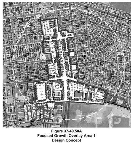
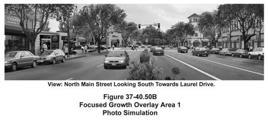
Focused Growth Overlay Area 1: Laurel Drive at North Main Street. Figures 37-40.50A and B illustrate a design concept and photo simulation for this area. With the area located at the intersection of Laurel Drive and Main Street, this area should be designed to provide a pedestrian-oriented area adjacent to a major community activity center, the Salinas sports complex. Uses within this design concept could include:
(1)
A grocery store or other large-scale retail establishment located on the southeast corner of the intersection;
(2)
Residential dwelling units located above retail along North Main Street in the form of apartments and/or live-work units;
(3)
A hotel on the southwest corner and retail on the other three corners of the main intersection of Laurel Drive and North Main Street.
(b)
Focused Growth Overlay Area 2: North Main Street/Soledad Street. Figures 37-40.60A and B illustrate a design concept and photo simulation for this area. This neighborhood's visibility, strong social services, entrance to the city's downtown, and the possibility of linking it to the rail corridor and the bus station create a clear opportunity for transit-oriented development (TOD). Revitalization of this area should include rowhouses/townhouses or other high density and mixed use buildings in proximity to the transit station. Given a portion of this area is located in the central city redevelopment project area, additional resources, programs, and incentives exist for existing and new development that are generally not available in other parts of the city, including affordable housing assistance, which can also be used to promote revitalization of the area.
(c)
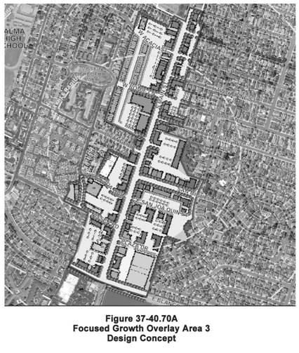
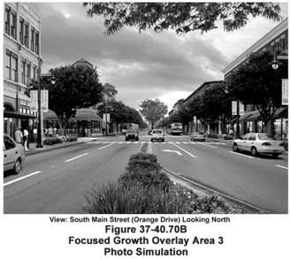
Focused Growth Overlay Area 3: South Main Street. Figures 37-40.70A and B illustrate a design concept and photo simulation for this area. This area has an abundance of existing parking and can benefit from its proximity to Salinas high school and the foot and automobile traffic that it draws. Its location on the southern entry route to downtown Salinas makes it the gateway to the city. A specialty grocery store or other large-scale retail establishment that draws pedestrians and vehicles to the site would be appropriate where Romie Lane intersects South Main Street. Offices and residences located above the retail establishments would also help focus and generate pedestrian activity in the area.
(d)
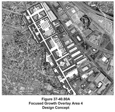
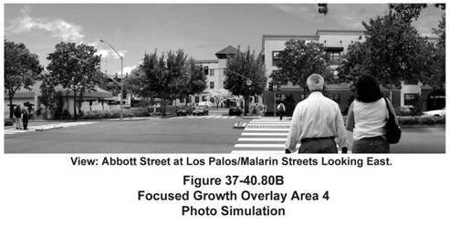
Focused Growth Overlay Area 4: Abbott Street. Figures 37-40.80A and B illustrate a design concept and photo simulation for this area. The underutilized land at the intersection of Abbott and Malarin Streets should be consolidated to create sufficient room for a potential hotel along the east side of the street. Visitors to the nearby hospital would be able to use this amenity, and the increased activity on the site would support an increased density of residential above retail/offices along the west side of Abbott Street.
(e)
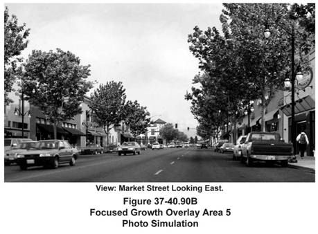
Focused Growth Overlay Area 5: East Alisal Street/East Market Street. Figures 37-40.90A and B illustrate a design concept and photo simulation for this area. The focus of this area should be on creating neighborhood main streets with a variety of shopping, eating, entertainment, and residential activities above pedestrian-oriented commercial uses. Given this focused growth area is located entirely within the sunset redevelopment project area, additional resources, programs, and incentives exist for existing and new development that are generally not available in other parts of the city, including affordable housing assistance, which can also be utilized to promote revitalization of the area.
(Ord. No. 2463 (NCS).)
Sec. 37-40.270. - Conflict between regulations.
Where a conflict occurs between the focused growth overlay district and the base district or any other section of the Code, the focused growth overlay district regulations shall prevail.
(Ord. No. 2463 (NCS).)
Sec. 37-40.280. - Adoption, amendment, or repeal.
Adoption, amendment, or the repeal of the focused growth overlay district shall be conducted in accordance with the provisions of Article VI, Division 14: Rezones/Pre-zones/Zoning Code Amendments.
(Ord. No. 2463 (NCS).)


Sec. 37-40.290. - Purpose.
The purpose of the central city overlay district regulations is to provide development regulations and design standards to:
(a)
Encourage and accommodate the increased development intensity for mixed use, commercial, retail, and office uses within the central city;
(b)
Increase opportunities for infill housing and innovative retail while transforming and aesthetically improving transportation corridors into pedestrian-oriented civic boulevards with mixed use projects;
(c)
Promote live entertainment uses in the downtown core area of the city without adversely impacting adjacent land uses; and
(d)
Encourage pedestrian-oriented neighborhoods where local residents and employees have services, shops, entertainment, jobs, and access to transit within walking distance of their homes and workplace.
(Ord. No. 2463 (NCS).)
Sec. 37-40.300. - Applicability.
(a)
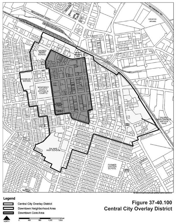
Downtown Core (DC) and Downtown Neighborhood (DN) Areas. The central city overlay district includes regulations applicable to the downtown core and downtown neighborhood areas illustrated in Figure 37-40.100. Unless an exemption is approved in accordance with Section 37-40.300(b) below, development located within the downtown core and downtown neighborhood areas shall adhere to the regulations of this division, and these regulations shall supplement the base district regulations.
(b)
Exemptions from Development Regulations and Design Standards.
(1)
The city planner may administratively exempt the following projects from the development regulations and design standards of this division:
(A)
Additions expanding existing structures by less than twenty-five percent of the existing gross floor area of the existing structure or two thousand five hundred square feet, whichever is less,
(B)
Exterior or interior remodels involving no increase in gross floor area,
(C)
Parking lot, loading spaces, recycling and solid waste enclosures, open space, landscaping, and similar site improvements on existing developed properties, and
(D)
Additions to structures and site improvements provided to comply with the ADA/Title 24 requirements;
(2)
Exemptions for additions expanding existing structures more than twenty-five percent or two thousand five hundred square feet may be considered subject to the approval of a conditional use permit if the planning commission finds that the addition will not conflict with the purposes of this division, will enhance the existing conditions, and provide site amenities that bring the property closer to achieving consistency with the development regulations and design standards of the district;
(3)
An exemption for additions to architecturally significant historic structures (as determined by the city planner) not meeting the requirements of subsection (b)(1) or (2) above may be considered subject to the approval of a conditional use permit by the city planner. In addition to the required findings in Article VI, Division 8: Conditional Use Permits, the city planner shall also find that the addition will not damage the historic integrity, architecture, or significance of the building;
(4)
As may otherwise be provided for restoration of a damaged nonconforming structure in Section 37-50.160: Nonconforming uses and structures;
(5)
When exempted, the regulations of the underlying base zoning district shall apply;
(6)
These above-referenced exemptions shall not apply to standards or supplemental regulations applicable to all developments in the city and that are not unique to this overlay district.
(Ord. No. 2463 (NCS).)
Sec. 37-40.310. - Use classifications.
(a)
Downtown Core Area. The use classifications for properties located in the downtown core (DC) area shall be those of the underlying base district (as identified in Article III: Base District Regulations of the Zoning Code), with the following exceptions:
(1)
Residential Uses. Residential uses are not permitted on the ground floor fronting Main Street regardless of the underlying base district designation.
(2)
Assembly and Similar Uses. Clubs, lodges, places of religious assembly, and similar assembly uses shall only be permitted above the ground floor of buildings facing Main Street within the downtown core area.
(3)
Live Entertainment Uses. Live entertainment uses shall be a permitted use in the downtown core area and shall not be subject to the approval of a conditional use permit for a live entertainment permit if the live entertainment use meets the following requirements:
(A)
The live entertainment use shall be limited to a musical, theatrical, dance, karaoke, cabaret, or comedy act performed by one or more persons (excludes adult entertainment);
(B)
The venue or location where the live entertainment use will be conducted or performed shall be a restaurant, art gallery, music studio, food and beverage sales establishment, or similar use which is allowed in the applicable zoning district as either a permitted use or as a use permitted subject to the issuance of a site plan review;
(C)
The live entertainment use shall be an accessory use to the principal use;
(D)
The live entertainment use shall be conducted entirely in an enclosed building;
(E)
No admission or cover change shall be charged for the live entertainment;
(F)
The hours of operation (for the live entertainment) shall be limited to Friday, Saturday, and holidays from 9:00 a.m. to 12:00 a.m. and on Sunday through Thursday from 9:00 a.m. to 10:00 p.m.;
(G)
The principal use and building complies with all applicable Fire and Building Codes, including accessibility requirements for the disabled, including the maximum occupancy established for seated patrons in the room(s) or areas where the entertainment is provided;
(H)
The maximum noise level shall not exceed a maximum of sixty-five decibels at any property line of the lot or parcel where the live entertainment use is being conducted or performed. For mixed use buildings and developments, the applicant shall demonstrate to the satisfaction of the city planner that sound attenuation measures or other buffering features have been incorporated into the building to ensure that the interior noise level (inside any residential dwelling unit) located on the subject site will not exceed a maximum of forty-five decibels;
(I)
The city planner has the authority to require and verify compliance with the requirements of this division and to bring enforcement action in accordance with Article VI, Division 18: Enforcement and Penalties in regard to any live entertainment use, which is not be operated in compliance with the requirements of this Zoning Code; and
(J)
For live entertainment uses that do not meet one or more of the above-referenced requirements, or for which the principal use is not a permitted use or use subject to a site plan review approval in the applicable zoning district, a conditional use permit for a live entertainment permit shall be required.
(b)
Downtown Neighborhood Area. The use classifications for properties located in the downtown neighborhood area shall be those of the underlying base district identified in Article III: Base District Regulations of this Zoning Code.
(Ord. No. 2463 (NCS).)
Sec. 37-40.320. - Development regulations.
(a)
General Provisions. Development located in the DC and DN areas shall be subject to the applicable development regulations identified elsewhere in this Code unless modified by this division.
(b)
Downtown Core Area. Table 37-40.30 identifies the development regulations applicable to all development in the downtown core.
(c)
Downtown Neighborhood Area. Properties in the DN area shall be subject to the development regulations of the underlying base district, except the following exceptions shall apply:
(1)
Buildings in the downtown neighborhood area shall be a maximum of fifty feet in height, except when greater height is authorized with a conditional use permit on MX properties in accordance with subparagraph (c)(3) below.
(2)
The density and FAR limitations identified in Table 37-40.30 for the DC area shall also apply to properties zoned CO, CR, PS, and MX in the DN area, unless increases are authorized on MX properties with a conditional use permit in accordance with subparagraph (c)(3) below.
(3)
Residential and mixed uses in the MX district. Subject to approval of a conditional use permit, on MX properties located within two thousand five hundred feet of the Intermodal Transit Center (7 Station Place) residential density may be increased to a maximum no greater than eighty units to the net acre, before density bonus, and maximum height may be increased to sixty feet. From time to time the city council may designate by resolution additional transit centers, which designation will allow the same level of increased density on sites located within the same distance of the subsequently designated transit centers.
(d)
Bedroom Mix Requirement Exception. Any bedroom mix requirement for three and four bedroom units required by the underlying base district shall not be required for any residential development as defined by Zoning Code Section 37-10.280 which is located within the Central City Overlay.
(e)
See Section 37-50.015 for an adaptive reuse project located within the Central City Overlay.
(Ord. No. 2463 (NCS).)
(Ord. No. 2537 (NCS), § 8, 4-30-2013; Ord. No. 2592 (NCS), § 3; Ord. No. 2605 (NCS), § 3, 7-3-2018; Ord. No. 2607 (NCS), §§ 2, 3, 9-18-2018)
Sec. 37-40.330. - Design standards for the downtown core (DC) area.
(a)
General Provisions.
(1)
The purpose of this section is to facilitate innovative project design in the downtown core (DC) area, particularly for infill development and reuse of existing structures. These standards address site planning, building design, and landscaping particularly as they enhance and promote a pedestrian-oriented district.
(2)
Development located within the downtown neighborhood area shall be subject to the design standards of the underlying base district and not the standards identified in this section.
(b)
Yards/Setbacks.
(1)
Buildings with ground floor residential uses shall have a maximum front yard and corner side yard of ten feet to accommodate stairs, landings, porches, covered architectural entry features, and similar building features. Ground floor residential uses are prohibited on properties fronting Main Street except for entry lobbies, foyers, courtyards, and similar areas that provide access to above ground floor residential dwelling units.
(2)
When provided, the front or corner side yard shall include landscaping and/or a hard-surface expansion of the sidewalk. Walkway connections to building entrances shall include special paving treatment or materials. The use of awnings, canopies, and arcades shall be provided as appropriate to provide visual interest, shade, and, to protect pedestrians from the elements.
(3)
In pedestrian areas, where there is generally no front or corner side yard for mixed use and commercial projects, a portion of the front or corner side building elevation may be set back to allow for pedestrian-oriented outdoor uses and areas only, such as outdoor patio dining areas, public art, fountains, entry forecourts, plazas and courtyards, or other amenities appropriate to an urban setback. In these cases, the city planner may allow the maximum front or corner-side yard to be extended.
(c)
Building Siting, Orientation, and Entrances.
(1)
New buildings shall be sited to avoid random and irregular building relationships, and shall be arranged to create a sense of unity and overall harmony with adjacent structures. To the maximum extent possible, new structures shall be clustered to create plazas and pedestrian malls and avoid the creation of "barrack-like" rows of structures. Where clustering is impractical, a visual link between separate structures on a site shall be established. This link can be accomplished through the use of an arcade system, trellis, or other open structure.
(2)
On parcels fronting Main Street and on parcels fronting Central Avenue and Gabilan Street, Alisal Street and San Luis Streets between Salinas and Monterey Streets, at least fifty percent of the frontage (exclusive of driveways) shall be designed to accommodate appropriate retail uses and enhance pedestrian activity along sidewalks. The ground floor story shall be at least eighteen feet in height (see Figure 37-40.130A). In no event shall blank walls or opaque doors exceed ten feet in length in frontage along the street.
(3)
The main building entrance or entrances shall be oriented to the street or major plazas or open space to maximize natural surveillance and provide "eyes on the street." The main entries to buildings shall be clearly demarcated, visible, and accessible from the street and/or pedestrian walkways. Secondary building entries may be from parking areas.
(4)
Commercial facilities in mixed use projects shall be oriented to the street, with parking located in the rear or side of buildings. The perimeter of parking lots and driveways adjacent to streets and sidewalks shall be screened with an attractive low wall, berm, or landscaping. The entrances to parking lots shall be visually minimized as much as possible from public rights-of-way.
(d)
Natural Surveillance. Whenever feasible, design and placement of buildings and other physical features are encouraged to maximize visibility and facilitate natural surveillance from public rights-of-way and other public areas. This includes building orientation, placement of windows, doors, and balconies, building and site entrances and exits, placement of parking, lighting, and refuse containers, placement and type of landscape materials, plazas, and other open space areas, location of walkways, types of walls and fences (including the use of picket, wrought-iron, and similar materials to promote visibility when appropriate), and other physical obstructions in a manner that discourages the potential for criminal activity.
(e)
Mass and Scale.
(1)
The mass and scale of a new development shall be compatible with neighboring developments and not overwhelm them with disproportionate size or a design that is out of character. Buildings shall step down to lower-profile buildings on adjacent properties.
(2)
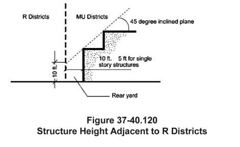
Structures shall not intercept a forty-five-degree inclined plane inward from a height of ten feet above existing grade at an R district boundary line. Single story structures and ground level parking may encroach a maximum of five feet into required side and rear yards (see Figure 37-40.120).
(3)
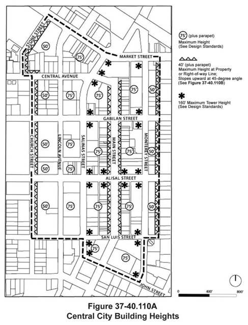
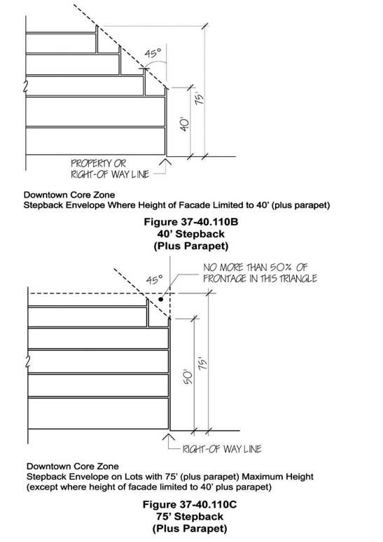
Mandatory height restrictions provide transitions between the downtown core and surrounding properties. The intent is to reduce the apparent height of the building as viewed from the street but to leave flexibility to create interlocking massing rather than "wedding-cake" stacking of progressively smaller floors (see Figures 37-40.110B and C). On lots with a maximum height of seventy-five feet, no more than fifty percent of the frontage shall rise to the maximum height; the balance of the frontage shall step back below a plane sloping forty-five degrees from the facade starting at the fifty-foot level (see Figure 37-40.110C).
(f)
Roof Treatments.
(1)
Corner Towers. Corner towers are encouraged to enhance the profile of the downtown skyline, to provide identity and orientation to the core area, and to form gateways at prominent intersections. Height and bulk shall be limited to minimize shading of sidewalks and public spaces on the opposite side of the street during the middle of the day.
(2)
Rooftop Equipment Screening. Mechanical equipment must be integrated into the overall mass of the building and screened from public view behind parapets or recessed into hips, gables, parapets, or similar features as appropriate to the architectural building design in accordance with Section 37-50.240: Screening of mechanical equipment. Plain equipment boxes are not acceptable.
(3)
Parapets. For roofs featuring a parapet wall along the building's street frontage, an additional four feet may be added to the maximum facade height to accommodate the parapet, provided that such parapet is architecturally integrated with the building. Additional parapet height along up to twenty-five percent of the building frontage may be approved for roofline articulation and for appropriate architectural enhancements.
(4)
Articulation. At a minimum, the roofline at the top of the structure shall not run in a continuous plane for more than fifty feet without offsetting or jogging the roof plane.
(5)
Roof Materials. Roof materials shall be appropriate to the style of the building, roof form, and slope. The allowable materials for roofs include tile, slate, metal, and composition shingles with an architectural grade shadow shake rather than a simple three-tab. Flat roofs shall be appropriately screened by parapets.
(g)
Facade Articulation.
(1)
Building design shall avoid large monotonous facades, long straight-line building fronts, plain box shapes, and barren exterior treatment. All building elevations visible from a public right-of-way including U.S. Highway 101 shall be highly articulated, and incorporate the chosen design theme in a consistent manner (see Figures 37-40.130A and B).
(2)
For compatibility with historic buildings on parcels fronting Main Street and on parcels fronting Central Avenue and Gabilan Street, Alisal and San Luis Streets between Salinas and Monterey Streets, building design shall use massive walls with "punctured openings" and the ground floor shall be clad and/or accented with traditional quality materials such as stone, molded plaster, hand-troweled mortar, iron, brick, terra cotta, ceramic tile, brass, or bronze.
(3)
Building facades shall generally be articulated at least every fifty feet by changes in building mass or facade treatment, such as projected entrance windows, roof form, or other architectural features or ornamentation. Use of mirrored glass and dark tinting for windows in ground floor facades facing a public right-of-way is prohibited.
(4)
For residential dwelling units, the facades of the buildings shall be designed so as to give individual identity to each grouping of dwelling units using techniques such as providing a deep notch between the various groupings; varying architectural elements between dwelling units (e.g., roof shape, window shape, stoop detail, or railing type); providing porches and balconies; or varying color or materials of each individual grouping within a harmonious palette of colors and materials.
(5)
Parapets and other utility-related structures exposed to adjoining properties shall be screened and architecturally integrated into the building using similar building materials, accents, and colors.
(h)
Privacy for Residential Dwelling Units.
(1)
To balance privacy, security, and pedestrian friendliness, the primary entrances of ground floor residential dwelling units shall face a public sidewalk, and the finished floor elevation shall be at least eighteen inches but no more than sixty inches above the sidewalk provided that an accessible "at grade" entrance is available.
(2)
Buildings should be oriented to promote privacy to the greatest extent feasible. In mixed use projects, residential windows should face away from loading, service, and recycling and solid waste deposal areas. To the extent residential windows face the windows of an adjacent dwelling unit, the windows shall be offset or use other features to provide privacy.

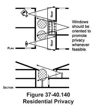
(3)
Windows, balconies, or similar openings should be oriented to minimize direct line-of-sight into adjacent dwelling units within the development (see Figure 37-40.140). In addition, dwelling units above the ground floor shall generally be designed so that they do not look directly onto private patios or backyards of the adjoining residential property or dwelling units when feasible.
(4)
Landscaping may also be used to aid in privacy screening and as a buffer from commercial development.
(i)
Special Treatment For Uses Abutting Residential Districts.
(1)
To provide privacy for adjacent residential dwelling units, the windows on the second and higher floors of buildings, which directly face residential zoning districts should be designed either as translucent, louvered, be offset from existing residential windows, or utilize another solution achieving privacy for residential dwelling units.
(2)
Development in the downtown core area shall be designed to minimize motor vehicle circulation through local single-family neighborhood streets.
(3)
Parking areas shall be located and designed to be convenient in order to minimize parking in residential neighborhoods; however pedestrian connections are encouraged.
(4)
Building facades and garages that face or abut existing dwelling units shall be designed to be compatible with the setbacks and scale of the existing development.
(j)
Colors.
(1)
Exterior building and roofing colors shall be appropriate to and enhance the architectural style and materials of the structure. Large areas of intense primary color shall generally be avoided, as subdued colors are more appropriate as the dominant overall color for a structure.
(2)
The color palette chosen for new structures shall generally be compatible with the colors of adjacent structures. An exception is when the colors of adjacent structures strongly diverge from these design standards.
(3)
Primary or bold colors may only be used to accent elements, such as door and window frames and architectural details.
(4)
Wherever possible, minimize the number of colors appearing on the structure's exterior. Small structures shall generally use no more than three colors, unless appropriate to the architectural style.
(5)
Roof flashing, rain gutters and downspouts, vents, and other roof protrusions shall be finished to complement the adjacent materials and/or colors.
(k)
Vehicle Circulation and Access.
(1)
Site access and internal circulation shall promote safety, efficiency, and convenience. Vehicular traffic shall be adequately separated from pedestrian circulation. Vehicular entrances shall be clearly identified and easily accessible to minimize pedestrian/vehicle conflict.
(2)
The number of site access points or driveway aprons shall be minimized. Driveway entrances shall be located as far as possible from street intersections and shall be coordinated with existing or planned median openings and driveways on the opposite side of the roadway. Common driveways that provide vehicular access to more than one site are encouraged.
(l)
Pedestrian Circulation.
(1)
All new uses shall be oriented and designed to enhance pedestrian movement to and between adjacent uses.
(2)
New development shall include pedestrian walkways. Pedestrian circulation shall be adequately separated from vehicular traffic. Pedestrian entrances and walkways shall be clearly identified and easily accessible to minimize pedestrian/vehicle conflict.
(3)
In mixed use projects, pedestrian walkways shall link dwelling units with the compatible commercial facilities in the project, common open space, plazas and courtyards, parking areas, and public sidewalks.
(4)
Colored, textured paving shall be used to delineate pedestrian crossings at circulation drives and parking aisles.
(m)
Plazas and Courtyards.
(1)
New nonresidential and mixed use projects on sites twenty thousand square feet or larger in size shall incorporate plazas and courtyards into the ground floor of their design. Buildings can be clustered to create usable pedestrian areas. Street furniture shall be required and other public amenities such as fountains and public art should also be provided. Where such development sites include residential development, plazas and courtyards may also be used to meet common usable open space requirements, subject to all criteria for such usable open space are met.
(2)
For such developments, the minimum requirement for plazas and courtyards shall be twenty-five square feet of plaza/courtyard space per each one thousand square feet of nonresidential gross floor area. This minimum square footage requirement shall in no instance require more than five percent of the total lot area to be devoted to plazas/courtyards.
(3)
Where ground floor building space is occupied by pedestrian-oriented retail or other pedestrian-oriented uses with entrances opening directly to the plaza/courtyard area, the city planner may allow the maximum front or corner-side yard to be extended.
(n)
Usable Open Space.
(1)
The design of the common usable open space shall complement the street pedestrian realm with plazas, pocket parks, public gathering spaces, street furniture, and landscaping.
(2)
The design shall provide visual and physical cues that demark the public open space from the private open space.
(3)
To integrate new buildings with the surrounding area, new buildings are encouraged to provide passageways through new buildings that allow for light and air to adjacent buildings.
(4)
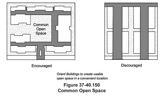
In mixed use and residential projects, common usable open space shall be provided in large, meaningful areas that are visible from the residential dwellings they serve. Common open space areas shall be convenient to the majority of dwellings and shall contain amenities appropriate to the project's size (see usable open space requirements in Table 37-40.30 and as illustrated on Figure 37-40.150).
(5)
In mixed use and residential projects, private usable open space shall be contiguous to the dwelling unit it serves and whenever possible, be screened from public view for privacy. All balconies and patios that front a public street shall be designed to screen items being stored on the balcony or patio.
(6)
Rooftop open space may be used as common usable open space or private usable open space, when directly accessible to the dwelling unit(s) it serves.
(o)
Recycling and Solid Waste Disposal.
(1)
In mixed use projects, the residential dwelling units shall have and maintain a recycling and solid waste disposal area that is separate from that used by the commercial uses whenever feasible. It shall be clearly marked for residential use only and use by commercial uses is prohibited.
(2)
All recycling and solid waste disposal areas for commercial uses shall be located so as to be convenient to the commercial users and where associated odors and noise will not adversely impact the residential uses.
(3)
Recycling and solid waste areas and receptacles shall be screened so as to not be visible from the public right-of-way and shall be in accordance with the requirements of Section 37-50.200: Recycling and solid waste disposal.
(p)
Outdoor Storage and Display. Outdoor storage and display in the central city overlay zone shall be subject to the standards and regulations specified in Section 37-50.170: Outdoor storage and display.
(q)
Parking.
(1)
Parking for uses in the downtown core area shall be provided as required in Article V, Division 2: Parking, Loading, and Outdoor Lighting. A reduction in use buildings or developments and/or stand-alone uses in the downtown core area subject to the approval of a shared parking arrangement pursuant to Section 37-30.280(q): Parking.
(2)
No parking structures are permitted on parcels fronting Main Street.
(3)
Both stand-alone structures and parking structures that are integrated with other development in the same building must include appropriate architectural detailing and provide at least fifty percent of their ground floor frontage with commercial uses. Exceptions to this fifty percent ground floor frontage requirement may be considered by the city planner subject to the approval of a conditional use permit. However, to facilitate future conversion to retail or other pedestrian-oriented uses, the sidewalk-facing ground floor of parking structures shall have a minimum fifteen-foot ground story height dimension.
(4)
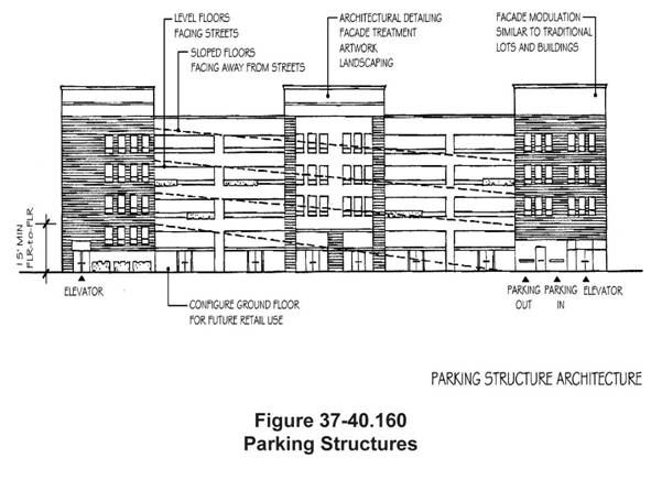
Both stand-alone structures and parking structures that are integrated with other development in the same building shall be architecturally integrated with the project design and their visual impacts minimized through proper siting and design. Parking structures shall include architectural detailing, facade treatment, artwork, landscaping, or similar features to enhance the street facade (see Figure 37-40.160).
(5)
The ground floor of all parking structures fronting a street shall be horizontal. To facilitate future conversion to retail or other pedestrian-oriented uses, the sidewalk-facing ground floor of parking structures shall have a minimum fifteen feet ground story height dimension.
(6)
To minimize curb cuts and negative impacts on pedestrians, existing alleys shall be used for ingress and egress to parking. Shared driveways and parking arrangements between commercial uses where available are strongly encouraged. On Main Street, driveways and curb cuts shall be prohibited.
(7)
Parking shall be conveniently located near nonresidential uses but visibly minimized from arterial streets and public spaces.
(8)
No existing structure shall be deemed to be nonconforming solely because of the lack of off-street parking or loading facilities required by Article V, Division 2: Parking, Loading, and Outdoor Lighting provided that the number of existing on-site parking and loading spaces as of the date of adoption of this division shall not be reduced.
(9)
Parking Lot Landscaping. Where parking lots abut streets, a minimum eight-foot-wide landscaped frontage shall be provided on the site, adjacent to the sidewalk. Landscaped frontages are not required when parking lots are sited behind buildings or plazas. A minimum number of shade trees are required, equivalent to one tree per five parking stalls. Trees in parking lots shall be spread uniformly throughout the parking area and may not be located only at the end of parking rows. Trees planted along connecting walkways and adjacent landscaped frontages may also contribute to the one-per-six requirement for parking lots. Trees in parking lots must be set into a tree well or planter having a minimum interior dimension of five feet (exclusive of curbs). Attractive bollards, raised concrete curbing, or tree guards designed to be compatible with the development shall protect trees adjacent to walkways and in plazas.
(10)
Parking Lot Location. All new construction of parking lots shall occur behind structures, to the side or within the interior of the development where it is not visible from the street.
(11)
Vehicle Maneuvering Areas. Vehicle maneuvering areas (including drive-through lanes, queuing areas, service station pump islands, and similar vehicle-related areas) shall be located within the interior of developments and be screened from view of adjacent streets. Such areas shall not be located between the street and the street facades of buildings.
(12)
Electric Vehicle Charging Areas. Whenever possible, electric vehicle charging areas shall be provided in parking areas.
(13)
Off-street parking and loading facilities need not be increased at the time of change in occupancy or use or of major or minor alteration of a structure. Except under the following conditions, no enlargement (e.g., increase in floor area that would increase the number of required parking spaces) of an existing structure nor construction of a new structure shall be permitted unless parking spaces are provided in accordance with Article V, Division 2: Parking, Loading, and Outdoor Lighting or one of the following conditions is met:
(A)
A parking waiver is granted pursuant to Section 37-50.370: Reduction of required number of parking and loading spaces.
(B)
The new replacement structure is no larger in floor area than one or more structures that occupied the same parcel on the date of adoption of this division and which will be demolished concurrently with the construction of the replacement structure.
(14)
Where required for new development, off-street loading spaces shall generally be provided adjacent to existing public alleys. The use of shared loading spaces for several properties is encouraged. The city planner may consider a waiver or modification of the loading space requirements identified in Article V, Division 2: Parking, Loading, and Outdoor Lighting where dictated by existing conditions such as parcel size and dimensions, access, and availability of off-site loading facilities.
(r)
Lighting.
(1)
Building-mounted lighting and freestanding lighting in public areas such as plazas, specifically along Main Street, shall be designed at a pedestrian scale.
(2)
Such lighting shall be architecturally integrated with the building design and shall highlight architectural details of the building.
(s)
Special Treatment for Architecturally/Historically Significant Buildings.
(1)
Architectural/historic character is a significant part of downtown Salinas's image. The character of the buildings located within downtown provides great opportunity to further define the city's image and attraction of new commercial and diverse housing opportunities.
(2)
Protect and maintain significant stylistic features. Architectural/historic features, including original materials, architectural details, and window and door openings, contribute to the character of a structure and shall be preserved when feasible. Continued maintenance is the best preservation method. Preventative measures shall not harm the architecturally/historically significant materials. Only those features that are deteriorated shall be repaired, and only those features that are beyond repair shall be replaced.
(3)
Design additions to architecturally/historically significant buildings so that the difference between the significant fabric and addition is readily apparent. Use offsets in plane (setbacks, stepbacks, or reveals), changes of fenestration, materials, and colors to differentiate old and new. As appropriate and feasible, set back added stories so that the apparent height of the original facade is unchanged.
(4)
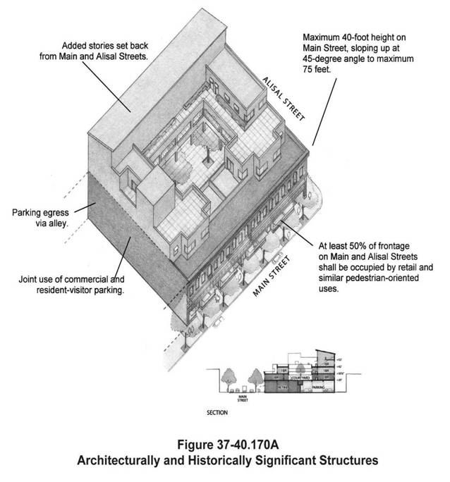
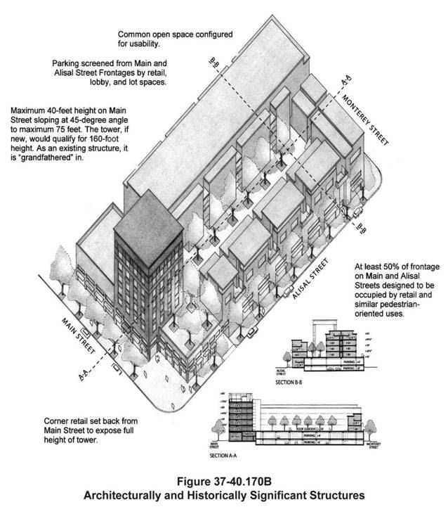
Design additions to architecturally/historically significant buildings in a manner that is consistent with the building's predominant architectural style, including the scale, form, features, and finishes. Modifications shall not obstruct significant architectural/historical features of the primary structure. Additions shall also take into consideration the architectural/historic site design and building placement of the primary structure on the lot (see Figures 37-40.170A and B).
(5)
Avoid removing or altering significant architectural features. To the extent feasible, preserve significant features in their original form and position as follows:
(A)
Preserve the size and shape, including glazing and frame shapes of windows and doors. These features have a significant effect on the building character, giving scale and visual interest to individual facades. It is most important to maintain the proportions of the original windows and doors.
(B)
Maintain a storefront and all of its character-defining features. Many of downtown's architectural/historic resources are commercial buildings with clearly defined primary entrances and large display windows. The repetition of these elements creates visual unity.
(C)
Preserve primary historic building materials whenever feasible. Do not cover or conceal the original facade materials (e.g., wood siding or painting over brick or stone).
(D)
Replace architecturally/historically significant features in-kind when restoration is not an option. If replacement is necessary, the new material shall match that being replaced in design, color, texture, and finish to convey the visual appearance of the original. When reconstruction of an element is impossible, develop a design that replicates the original or a new design that is a simplified interpretation of it.
(t)
Special Treatment for Development of Small Lots (e.g., ten thousand square feet or less).
(1)
Ground Floor Use and Design.
(A)
Although ground floor retail, restaurant, and other pedestrian-oriented neighborhood-serving uses are preferable along the pedestrian realm, residential is permitted on the ground floor with the following standards:
(i)
Residential located on the ground floor facing the pedestrian realm shall be designed with articulated facades, including features such as awnings, elevated steps and entrances, recessed windows, doors and patios, windows treated for privacy and pedestrian interest, and drought-tolerant planting.
(ii)
The more public areas of the residential dwelling units, such as lobbies, exercise rooms, living rooms, or dining areas, shall face the street while more private areas, such as bedrooms, shall be located in the rear of the building or on upper floors.
(iii)
Ground floor residential uses are prohibited on Main Street except for entry lobbies, foyers, courtyards, and similar areas, which provide access to above ground floor residential dwelling units.
(B)
New development located at signalized intersections of major streets shall be designed to accommodate pedestrian-oriented community-serving commercial uses.
(2)
Architectural Character and Massing.
(A)
The form of buildings and architectural details shall be designed to create visual interest at the street level using techniques such as staggering the frontage of the building, recessing doors and windows, providing varied display windows, providing awnings and canopies for weather protection and scale, and visually extending interior spaces outside through paving and glazing.
(B)
Building plans and facades shall vary from building to building and from project to project to create interest along the street.
(C)
Materials and colors shall be selected to unify the building appearance and fit into the pedestrian realm context by creating interest along the street and retaining the general historic theme that is established in the downtown.
(3)
Building Entries and Service Access.
(A)
To promote active, pedestrian-oriented streets, each individual tenant or business establishment and residential lobbies shall be oriented to and accessible from the major street frontage and directly from the public sidewalk.
(B)
Services area shall be located at the rear of the building unless these areas can be concealed within the interior of the building design.
(4)
Access.
(A)
To minimize the number of curb cuts thereby making the streetscape more walkable and attractive for new mixed use projects, consolidation of building sites shall be encouraged to reduce the number of access drives from the major arterials. Shared driveway access between lots is permitted to further reduce driveways cuts from the arterials.
(B)
Vehicular access shall be provided from the side streets, adjacent alleys, and parallel streets. Traffic-calming techniques should be provided to minimize intrusion of traffic into adjacent neighborhoods. Where side streets, alleys, or parallel streets are not available, driveway access shall be limited to no more than one twenty-four-foot wide driveway per two hundred feet of building frontage.
(5)
Lot Consolidations.
(A)
As many of the lots are smaller than ten thousand square feet, lot consolidation is encouraged along the corridors to leave more space along the pedestrian realm for street trees, pedestrian amenities, and on-street parking, as well as providing more efficient private development sites.
(B)
When consolidating lots, new development shall respect the existing fabric of the community by reflecting architectural/historic development patterns through the use of building indentations, breaks in buildings for open space, changes in color, or other methods.
(u)
Accessory Structures. The design of accessory structures shall be architecturally compatible with the principal structure on the site through the use of consistent architectural style, exterior building and roofing colors and materials, and landscaping.
(v)
Kiosks. Kiosk design and exterior color(s) shall be compatible with the architectural style and exterior color(s) of surrounding buildings.
(w)
Signs for the Downtown Core Area.
(1)
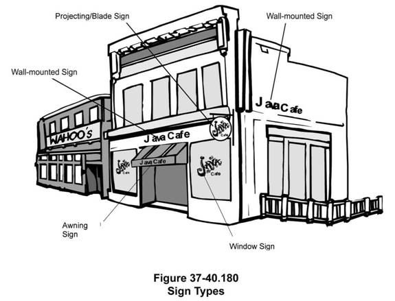
Applicability. Signs will be reviewed for their consistency with these standards and the standards provided in Article V, Division 3: Signs. These sign standards are to ensure that signs communicate their message clearly and are of high standards, visually and aesthetically. Preferred sign types are shown in Figure 37-40.180.
(2)
Design.
(A)
Signs must make a positive contribution to the general appearance of the street and the downtown core area in which they are located. High quality, imaginative, and innovative sign design is required.
(B)
The scale of signs shall be appropriate for the building on which they are placed and the area in which they are located. The size and shape of a sign shall be proportional with the scale of the structure. Small storefronts shall have smaller signs than larger storefronts.
(C)
Pedestrian-oriented signs are signs that are designed for and directed toward pedestrians so that pedestrians can easily and comfortably read the sign, as they stand adjacent to the business. Pedestrian-oriented signs are required for at least one of the permitted signs for a business.
(D)
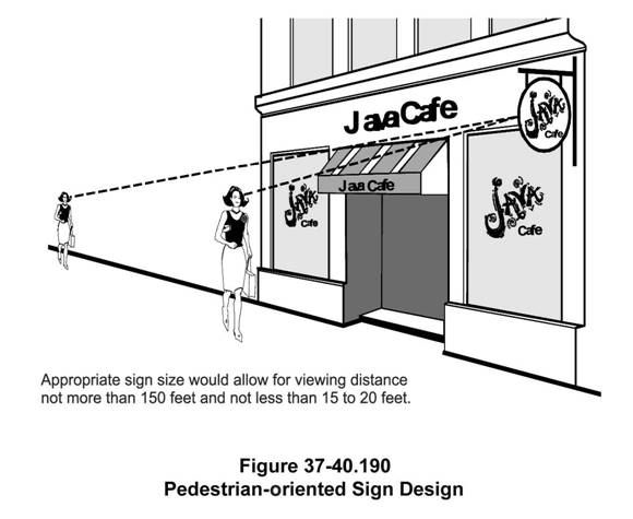
Make signs smaller if they are oriented to pedestrians. The pedestrian-oriented sign is usually read from a distance of fifteen feet to twenty feet and not more than one hundred fifty feet; the vehicle-oriented sign is viewed from a much greater distance. The closer a sign's viewing distance, the smaller that sign shall be (see Figure 37-40.190).
(E)
Signs shall be designed so that they are integrated with the design of the building. A well-designed building facade or storefront is created by the careful coordination of sign and architectural design, and a coordinated color scheme. Signs in multiple-tenant buildings shall be designed to complement or enhance the other signs in the building.
(F)
Master sign plans serve to create a coordinated project theme of uniform design elements such as color, lettering style, and placement. Master sign plans are required for new multiple-tenant buildings or integrated commercial development and encouraged for existing commercial development.
(G)
Sign materials shall be compatible with the design of the facade on which they are placed. Developers/designers shall consider the architectural design of the building's facade and select materials that complement the design. The selected materials shall also contribute to the legibility of the sign. For example, glossy finishes are often difficult to read because of glare and reflections.
(i)
Sign materials shall be extremely durable. Paper and cloth signs are not suitable for exterior use (except on awnings) because they deteriorate quickly. If wood is used, it shall be properly sealed to keep moisture from soaking into the wood and causing the sign's lettering to deteriorate.
(H)
Sign colors shall complement the colors used on the adjacent buildings and the project as a whole.
(i)
A substantial contrast shall be provided between the color and material of the background and the letters or symbols to make the sign easier to read during both day and night. Light letters on a dark background or dark letters on a light background are most legible. Light letters on a dark background work best for both day and nighttime use.
(I)
Signs must be legible.
(J)
A brief message shall be used whenever possible. The fewer the words, the more effective the sign.
(K)
Letters and words shall not be spaced too closely. Crowding of letters, words, or lines will make any sign more difficult to read. Conversely, over spacing of these elements causes the viewer to read each item individually, again obscuring the message. Letters shall not crowd the margins of the sign area.
(L)
Symbols and logos can be used in place of words whenever appropriate.
(M)
The number of lettering styles that are used on a sign shall be limited in order to increase legibility. As a general rule, limit the number of different letter types to no more than two for small signs and three for larger signs. Intricate typefaces and symbols that are difficult to read reduce the sign's ability to communicate.
(3)
Location.
(A)
The architecture of the building often identifies specific locations for signs, and these locations shall be used, except when these areas are above the main roofline.
(B)
Wall signs shall be placed to establish facade rhythm, scale, and proportion. On buildings that have a monolithic or plain facade, signs can be placed to establish or continue appropriate design rhythm, scale, and proportion.
(C)
To minimize irreversible damage to masonry, all mounting and supports shall be inserted into mortar joints and not into the face of the masonry. This technique does not damage the surface and allows for easy removal.
(D)
Signs that are replaced on stucco exteriors can result in unattractive "patched" areas. These potential maintenance problems shall be addressed during the approval process for the sign replacement.
(4)
Wall Signs. Wall signs are to be mounted flush and fixed securely to a building wall and not extending sideways beyond the building face or above the highest line of the building to which it is attached.
(A)
Wall signs shall be located on the upper portion of the storefront, within or just above the storefront opening. The length of the sign shall not exceed the width of the storefront.
(B)
Wall signs shall be placed within a clear area. These areas are defined as an architecturally continuous wall surface uninterrupted by doors, windows or architectural detail.
(C)
Wall signs shall be mounted in locations that respect the design of a building, including the arrangement of bays and openings.
(D)
Signs shall not obscure windows, grillwork, piers, pilasters, and ornamental features. Typically, wall signs shall be centered on horizontal surfaces (e.g., over a storefront opening).
(E)
Wall-mounted channel letters are encouraged.
(F)
Signs shall be designed to create a clearly defined edge, provide shadow relief, and a substantial appearance. This effect is generally difficult to achieve by painting the sign directly on the building. For this reason, painted signs are discouraged except on awnings.
(5)
Window Signs.
(A)
Window sign copy shall be applied directly to glazed area.
(B)
Window signs shall be created from high quality materials such as paint, gold leaf, or neon. Appropriate techniques for window signs include sandblasting or etched glass.
(C)
Window signs shall be applied directly to the interior face of the glazing or hung inside the window thereby concealing all mounting hardware and equipment.
(D)
Well-designed window graphics shall be used in the construction of the sign to attract attention but still allow pedestrians to view store interiors.
(6)
Can-type Signs. Can-type signs are prohibited. Any existing can-type sign where a change to sign face is proposed may only feature a colored background with lighter contrasting letters or symbols.
(7)
Awning and Canopy Signs. The use of awning and canopy signs are encouraged in the central city overlay to promote signage that is more pedestrian-scaled.
(8)
Projecting/Blade Signs.
(A)
Projecting/blade signs shall not be mounted above the second floor windowsill in multistoried buildings.
(B)
The design of the sign shall consider visually interesting elements such as square or rectangular shapes with painted or applied letters, two- or three-dimensional symbols or icons, irregular outlines, and/or internal cutouts.
(C)
Projecting/blade signs shall be small in scale.
(D)
Projecting/blade signs shall be oriented to pedestrians passing on the sidewalk in front of the buildings rather than to automobiles or pedestrians on the far side of the street.
(E)
Mounting hardware shall be an attractive and integral part of the sign design. Simple round pipe brackets with plugged ends or added decorative end elements are generally appropriate for signs. However, metal brackets of a more decorative and complex shape are encouraged where appropriate to add to the character of the building.
(9)
Hanging Signs—Where Permitted.
(A)
These signs shall be used only at ground floor locations except for upper floor businesses with covered entry porches and balconies.
(B)
These signs shall be treated similar to projecting/blade signs.
(C)
Signs shall be oriented toward the pedestrian and impart a sense of creativity in its design.
(10)
Marquee Signs.
(A)
Marquee signs are to be installed only on buildings occupied by theaters, cinemas or performing arts facilities.
(B)
The sign copy of marquee signs shall be limited to include only the facility's name and changeable copy related to current and future attractions.
(11)
Plaque Signs.
(A)
Plaque signs are to be located only on wall surfaces adjacent to tenant entries.
(B)
Signs are to include the business name and a business logo.
(C)
Plaque signs are encouraged to include unique designs or other visually stimulating decorations and may be irregular in outline shape.
(12)
Freestanding Signs.
(A)
The sign structure shall be architecturally designed and incorporate design details, materials, and colors of the associated buildings.
(B)
Pole signs are prohibited in the downtown core area.
(13)
Sign Illumination.
(A)
Sign illumination is a necessary component for effective visual communication, particularly for establishments conducting business in the after-dark hours. However, too much light can be a nuisance. Applicants shall consider if the sign needs to be lighted at all. Lighted window displays may provide sufficient illumination to identify the business. This can be particularly effective when good window displays and graphics are used.
(B)
Illumination by a projected light (e.g., spotlight) is usually the best arrangement, as signs appear to be integrated with the building's architecture. Projected lighting emphasizes the continuity of the structure's surface, and signs become an integral part of the facade, which is typically not exhibited with internal illumination. Fixtures illuminating in front of signs cast light onto the signs as well as the building's facade.
(C)
The use of small, unobtrusive fixtures for external (projection) lighting is required. Avoid the use of oversized fixtures that are out of scale with the sign and structure.
(D)
Backlighted, solid letters are encouraged. Signs consisting of opaque, individually cut letters mounted directly on a structure can often use a distinctive element of the structure's facade as a backdrop, thereby providing a better integration of the sign with the structure.
(E)
Individually illuminated letters, either internally illuminated or backlit solid letters (reverse channel), are a preferred alternative to can-type signs, which are prohibited in the downtown core area. Signs comprised of individual letters mounted directly on a structure can often use a distinctive element of the structure's facade as a backdrop, thereby providing a better integration of the sign with the structure.
(F)
Up-lighting refers to a lighting technique used particularly with monument signs where the light source is located typically in the ground, landscaping, or within a projecting wall relief, concealed from view. This technique is encouraged, especially for illuminating monument signs.
(G)
Neon signs are generally discouraged. However, neon back-lighted signs with opaque, reverse channel letters, neon back-lighted signs with dimensional plexiglas letters, and signs with illuminated open-face, channel letters are appropriate forms of illuminated signs in certain situations. Exposed neon tubing script may also be an appropriate alternative, if it fits within the context of a building design.
(H)
Whenever projection lighting is used (fluorescent or incandescent), care shall be taken to properly shield the light source to prevent glare from spilling over into adjacent areas and any public right-of-way. Signs shall be lighted only to the minimum level required for nighttime readability.
(14)
Signs for Historic and Architecturally Significant Buildings.
(A)
Many of the downtown core area's historic and architecturally significant buildings are rich with architectural design elements and details. Extreme care must be taken not to cover or interfere with design elements that contribute to the building's character.
(B)
Signs must not cover over architectural elements. As major elements of the storefront, signs must also fit into the building facade just as if they were one of the architectural elements. Within permitted parameters, use a building's or storefront's architectural elements, such as prominent entranceways, display windows, and lintel bands or friezes above transom windows or cornices, to suggest a location, size, or shape for the sign.
(C)
Signs, themselves, may also be a significant historic architectural feature of a building. The rehabilitation of these signs is strongly encouraged.
(D)
Lighting shall be in accordance with historically appropriate lighting types. This includes neon, individual incandescent bulbs, and overhead gooseneck lighting, subject to compliance with current Electrical Codes.
(E)
These sign standards are intended to allow the construction and installation of signs that are in character with the building or district on/in, which it is proposed to be located. However, the intent of these regulations is not to require all signs on a historic building to be exact replicas of the signs that would have been on the building when it was new. Rather, sign types that would have been applied to the building during its period of historic significance are encouraged. Design parameters such as size, location, font, finish, color, materials, lighting, and method of installation shall be evaluated for character and design consistency.
(Ord. No. 2463 (NCS).)
Sec. 37-40.340. - Conflict between regulations.
Where a conflict occurs between the central city overlay district and the base district or any other section of the Code, the central city overlay district regulations shall prevail.
(Ord. No. 2463 (NCS).)
Sec. 37-40.350. - Adoption, amendment, or repeal.
Adoption, amendment, or the repeal of the central city overlay district shall be conducted in accordance with the provisions of Article VI, Division 14: Rezones/Pre-zones/Zoning Code Amendments.
(Ord. No. 2463 (NCS).)
Sec. 37-40.360. - Purpose.
The purpose of the East Romie Lane Corridor (ERL) overlay district regulations is to:
(a)
Ensure that adequate and sufficient off-street parking is provided in the general vicinity of Salinas Valley memorial hospital for office uses; and
(b)
Encourage the provision and location of office and multi-family residential uses in the East Romie Lane Corridor in accordance with the general plan.
(Ord. No. 2463 (NCS).)
Sec. 37-40.370. - Applicability.
The East Romie Lane Corridor overlay district may be combined with any underlying base zoning district. The East Romie Lane Corridor overlay district shall be shown on the zoning map by adding an "ERL" to the zoning designation for properties located on Figure 37-40.200.
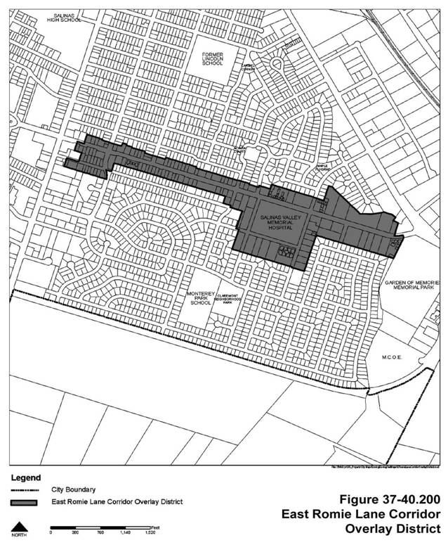
(Ord. No. 2463 (NCS).)
Sec. 37-40.380. - Use classifications, development regulations, and design standards.
The use classifications, development regulations, and design standards shall be those of the underlying base zoning district (as identified in Article III: Base District Regulations of the Zoning Code) except as follows:
(a)
Parking.
(1)
Medical and dental offices existing as of September 5, 1996 that convert to business and professional offices and return to medical or dental office uses at a later date shall provide parking at the rate of one space for every two hundred fifty square feet of medical or dental office.
(2)
Business and professional offices existing as of September 5, 1996 that convert to medical and dental offices shall provide parking at the rate of one space for every two hundred square feet of medical or dental office.
(b)
Maximum Floor Area Ratio (FAR) and Density. The maximum FAR shall be one plus ten dwelling units per acre for a mix of office and residential uses and up to a maximum of twenty dwelling units per acre for residential projects without office uses.
(Ord. No. 2463 (NCS).)
Sec. 37-40.390. - Conflict between regulations.
Where a conflict occurs between the East Romie Lane Corridor overlay district and the base district or any other section of the Code, the East Romie Lane Corridor overlay district regulations shall prevail.
(Ord. No. 2463 (NCS).)
Sec. 37-40.400. - Adoption, amendment, or repeal.
Adoption, amendment, or the repeal of the East Romie Lane Corridor overlay district shall be conducted in accordance with the provisions of Article VI, Division 14: Rezones/Pre-zones/Zoning Code Amendments.
(Ord. No. 2463 (NCS).)
Sec. 37-40.410. - Purpose.
In addition to the general purposes listed in Article I, Division 1: General Provisions, the purpose of the airport overlay district regulations is to:
(a)
Fulfill the city's obligations, in accordance with requirements of state law (Government Code Section 65302.3), to implement the airport land use compatibility policies adopted by the Monterey County airport land use commission;
(b)
Regulate land use development within the vicinity of Salinas municipal airport to protect it from potential encroachment by land uses which are incompatible with airport activities and which may impair the future development and use of the airport; and
(c)
Minimize the public's exposure to excessive noise and safety hazards that would result from incompatible land use development within areas around airport.
(Ord. No. 2463 (NCS).)
Sec. 37-40.420. - Applicability.
(a)
Development Review Applications, Structures, and Vegetation. This division shall apply to development review applications, structures, and vegetation if located on or proposed for land situated within the "area of influence" of the Salinas municipal airport as follows (see Figure 37-40.210):

(1)
General plan amendments to the Salinas general plan;
(2)
Rezoning or pre-zoning of any parcel of land;
(3)
Parcel or subdivision maps;
(4)
Sign permits or master sign plans for signs over fifty feet tall;
(5)
Large family day care home permits;
(6)
Site plan review, conditional use permits, variances, and planned unit developments for:
(A)
Any nonresidential project involving the construction of two thousand five hundred square feet or more of new floor area or an increase in the height of an existing structure; (applies to both new construction and additions), or
(B)
Any nonresidential project of any size that involves the conversion to uses that involve the assembly of persons (e.g., classrooms, churches, and gymnasiums),
(C)
Any new construction of a residential dwelling or mixed use building or development, or
(D)
Any increase in the height of an existing residential dwelling or mixed use building or development;
(7)
Building permits for any new construction of a residential dwelling;
(8)
Building permits for additions to residential dwellings involving an increase in the height of the structure, where the structure is located in the runway protection zone; or
(9)
Any structure including those in existence prior to the effective date of this division, the height of which would conflict with Salinas Municipal Code, Chapter 4: Airport, and which is determined by the deputy city manager or their designee to be hazardous to airport operations.
(b)
Tall Structures. This division also applies to any development review application for construction or alteration of a structure (including antennas, poles, or towers) higher than two hundred feet above ground level at the site, regardless of the site's location within the city of Salinas. Any such structure shall comply with the requirements of the Salinas Municipal Code, Chapter 4: Airport.
(c)
Exceptions. Except with respect to height limitation requirements on structures and trees, this division does not apply to:
(1)
Existing development (as of the effective date of this division) for which no expansion or changes of use are proposed even if the existing uses are not in conformance with the standards herein;
(2)
Use of airport property by the city of Salinas; or
(3)
Any project for improvement of a structure to comply with existing state or local health, sanitary, or safety code specifications which are solely necessary to ensure safe living conditions.
(Ord. No. 2463 (NCS).)
Sec. 37-40.430. - Review for airport compatibility.
Any development review application identified in Section 37-40.420(a) or (b) shall be reviewed by the deputy city manager, or their designee, to ensure conformance with the Salinas Municipal Code, Chapter 4: Airport, prior to approval by the applicable reviewing body.
(Ord. No. 2463 (NCS).)
Sec. 37-40.440. - Use classifications, development regulations, and design standards.
Use classifications, development regulations, and design standards shall be those of the underlying base zoning district (as identified in Article III: Base District Regulations of the Zoning Code) except as modified by the airport overlay. All development activity listed in Sections 37-40.420(a) and (b) of this division shall conform to the requirements and development regulations of Salinas Municipal Code, Chapter 4: Airport.
(Ord. No. 2463 (NCS).)
Sec. 37-40.450. - Avigation easements.
(a)
Avigation Easement Dedication. The city shall require the owner of any property located in the Salinas Municipal Airport "area of influence" to dedicate an avigation easement as a condition of approval of any development review application, or structure identified in Section 37-40.420(a) or (b). The easement is required to protect the airport airspace from objects which could constitute hazards to air navigation, and to inform future owners and prospective purchasers of the property that aircraft may fly over the location at low altitudes while approaching, departing, or maneuvering near the associated airport. Such easement shall include special provisions, for properties within the clear zone, required for the California International Airshow (see Figure 37-40.210). The easement shall be dedicated prior to the recordation of any land division or if there is no land division prior to the issuance of the first building permit for the development.
(b)
Avigation Easement Provisions. The language of the avigation easement shall be as set forth by resolution of the Salinas city council.
(c)
Recordation. The deputy city manager, or their designee, shall file the avigation easement for recordation with the Monterey County recorder's office.
(Ord. No. 2463 (NCS).)
(Ord. No. 2569 (NCS), § 6, 4-19-2016)
Sec. 37-40.460. - Conflict between regulations.
Where a conflict occurs between the airport overlay district and the base district or any other section of the Code, the airport overlay district regulations shall prevail.
(Ord. No. 2463 (NCS).)
Sec. 37-40.470. - Adoption, amendment, or repeal.
Adoption, amendment, or the repeal of the airport overlay district shall be conducted in accordance with the provisions of Article VI, Division 14: Rezones/Pre-zones/Zoning Code Amendments.
(Ord. No. 2463 (NCS).)