
Sarasota City Zoning Code
ARTICLE VII
REGULATIONS OF GENERAL APPLICABILITY
Sec. VII-101.- Purpose and intent.
The provisions of these land development regulations shall govern the type, number, size and location of all signs which may be permitted.
Increased numbers and sizes of signs, as well as certain types of lighting, may unreasonably distract the attention of motorists, obstruct the vision of motorists, pedestrians, and bicyclists, and otherwise interfere with traffic safety. Indiscriminate erection and maintenance of signs seriously detracts from the enjoyment and pleasure in the natural scenic beauty of the city and, in turn, injuriously affects the economic well-being of the citizenry. As a city whose economic well-being relies in part on tourism, it is in the best interest of the citizenry that the natural beauty of the city be preserved.
It is the intent of this division to promote the well-being of the citizenry by restricting the proliferation of signs and limiting the characteristics of signs which may be erected while at the same time protecting the free speech rights of the citizenry under the First Amendment to the Federal Constitution and article I, section 4 of the Florida Constitution. It is also the intent of this division to allow for the communication of information necessary to the conduct of commerce, government and individual expression and to further the public interest in the identification of residences and places of business and in the safe construction, installation and maintenance of signs.
(Ord. No. 02-4357, 4-29-02; Ord. No. 24-5510, § 2(Exh. A), 4-1-24)
Sec. VII-102. - Applicability and scope.
Signs shall be a permitted use in all districts, except in the MP zone district. No sign shall be located, placed, posted, erected, altered, extended, installed or continued without first obtaining a sign permit therefore in compliance with the requirements of this division. Signs must be maintained in strict conformance with city building and electrical codes and other applicable governmental regulations.
(Ord. No. 02-4357, 4-29-02)
Sec. VII-103. - General requirements.
Every sign shall be subject to the following general requirements:
(1)
All signs shall be kept in good condition, present a neat appearance and be maintained in a good state of repair.
(2)
No sign shall directly or indirectly create a traffic or fire hazard or interfere with the free and unobstructed use of streets or sidewalks.
(3)
No sign shall be erected or maintained at any location in such a manner as to obstruct free and clear vision at the intersection of any streets, drives or other public or private vehicular access ways.
(4)
No sign shall be erected or maintained at any location where, by reason of the position, illumination, shape or color it may interfere with, obstruct the view of or be confused with any authorized traffic sign, signal, or device, nor shall it make use of the words "stop," "look," "danger" or any other word, phrase, symbol or character in such a manner as to interfere with, mislead or confuse traffic.
(5)
No sign shall be attached to or placed against a building in such a manner as to prevent ingress or egress through any door or window of any building, nor shall any sign obstruct or be attached to a fire escape.
(6)
All signs may be illuminated, but all light sources shall be directed away from adjacent properties. See section VII-110 for standards applicable to particular zoning districts.
(7)
No projecting sign shall project more than four feet from the building wall.
(8)
Signs extending or hanging over any public or private sidewalk or pedestrian way shall be no less than eight feet above the surface of such sidewalk or pedestrian way. Signs extending or hanging over any public or private vehicular way shall be no less than 15 feet above the surface of such vehicular way.
(9)
All ground signs within 50 feet of any street intersection shall be placed in back of any required yard or building setback line, or the bottom of the sign shall be ten feet or higher above the crown of the road at the intersection and shall in all other respects comply with the sight triangle restrictions of section VII-1202.
(10)
Unless otherwise specified, no ground sign may be erected to a height greater than 25 feet above the level of the ground on which the sign is placed; except that, in the RSF, RMF, OPB, MCI and CN zone districts, no sign may be erected to a height greater than 20 feet above the level of the ground, and in the NT, RSM-9, OND, OCD, ORD, CND, CSD, CRD, CGD, CSC, ICD, IGD, IHD, and POS zone district, no sign may be erected to a height greater than 16 feet above the level of the ground.
(11)
Unless otherwise specified, no on-site ground sign shall be erected, constructed or maintained in a required setback; except that such on-site ground signs conforming to the following conditions, specifications and limitations may be placed in a required setback:
a.
Any such on-site ground sign shall be erected or project no closer to the front property line than one-third the depth of the required front setback.
b.
No more than one such on-site ground sign shall be erected, constructed or maintained in any such required setback area per 100 feet frontage of such setback area or per major fraction thereof; provided that, if a zoning lot in one ownership shall have less than 100 feet of setback frontage on one street, one on-site ground sign may, nevertheless, be erected in the required setback area for such zoning lot; provided, further, that in the case of corner zoning lots, this paragraph shall be construed to permit at least one on-site ground sign in the required setback area on each street frontage of a zoning lot in one ownership, where the erection, construction and maintenance of such sign shall not be in conflict with other portions of these regulations.
c.
No such on-site ground sign shall be erected, constructed or maintained in any such required setback closer than ten feet to a side property line.
d.
Where any on-site ground sign is erected, constructed or maintained closer to the property line than the building line established by law, then such sign shall be designed, constructed and maintained so as to present a minimum obstruction to horizontal vision between three feet and eight feet above ground level at the base of such sign and all words, figures, symbols and other parts of the advertising message and of any board or other background for the same shall be constructed and maintained either below the three-foot level or above the eight foot level provided nevertheless, that this provision shall not be deemed to authorize any increase in the maximum height of signs elsewhere provided in these regulations.
(12)
Unless otherwise specified, the mansard roof portion of a structure may be used for the mounting of signs, provided that such sign shall not extend above the highest point of the mansard roof line upon which the sign is mounted. A mansard roof sign is counted as one permitted wall sign.
(13)
Signs for businesses located on second floor only of a two-story building.
a.
Notwithstanding any other provisions of these regulations, a retail or service establishment located only on the second floor of a building and occupying street frontage in an office, commercial, special purpose, or production intensive commercial zoning district, other than the CT and CSD zone district, may erect one wall sign per street frontage. Such a sign shall not:
1.
Project more than 18 inches from the building wall.
2.
Exceed one square foot of area for each foot of building frontage occupied by the establishment displaying such sign or signs.
3.
Exceed a total aggregate area of 40 feet per sign.
b.
Notwithstanding any other provisions of these regulations, a retail or service establishment located only on the second floor of a building and occupying street frontage in the CSD zoning district may erect a maximum of three signs consisting of one wall sign, one canopy sign and one hanging sign, per street frontage. Such signs shall not:
1.
Project more than 18 inches from the building wall.
2.
Exceed one square foot of area for each foot of building frontage occupied by the retail or service establishment displaying such sign or signs.
3.
Exceed a maximum total aggregate area of 60 square feet.
(14)
Signs for businesses located above the first floor of a multi-story building. Notwithstanding any other provisions of these regulations, a retail or service establishment located above the second floor of a multi-story building in a office, commercial, special purpose, or production intensive commercial zoning district, other than the CT zone district, may erect directory signs as specified below:
Where a building or buildings under unified ownership or legal control contains two or more separate activities or establishments, one directory sign is permitted for each entrance to the upper level. Such sign(s) shall be located on the ground level exterior and may be either a wall sign or a ground sign. The sign may list the name of the establishment(s) and may include a location map. Each directory sign shall not exceed a total aggregate area of 16 square feet.
(15)
Marquee signs in commercial, special purpose and production intensive commercial zone districts. Notwithstanding any other provisions of these regulations, in the commercial, special purpose and production intensive commercial zone districts, signs located on marquees or canopies shall be affixed flat to the surface, shall not project more than two feet above the marquee, and shall not extend horizontally beyond the marquee or canopy. one identification sign may extend vertically below the marquee or canopy and shall not exceed one foot by six feet or the width of the marquee or canopy, whichever is less. Notwithstanding the foregoing, marquee signs are not permitted in the CT zone district.
(16)
Banners. Notwithstanding any other provisions of these regulations, in the CSC-N, CSC-C, CSC-R and CSC zone districts, and within unified developments in the DTC and DTB zone districts, banners shall be permitted subject to the following regulations:
a.
Regulations applicable to all banners:
1.
The top and bottom of all banners shall be affixed to poles designed solely for that purpose. No banners shall be affixed to other structures, vehicles, utility poles, trees, shrubs or plants.
2.
On poles up to 40 feet in height, the maximum height of banners shall be 18 feet and the minimum height of banners shall be eight feet.
3.
On poles in excess of 40 feet in height, the maximum height of banners shall be 40 feet and the minimum height of banners shall be 20 feet. Provided, however, in no event shall the height of a pole exceed 50 feet.
4.
All banners shall be constructed of fire retardant material and shall be replaced by the owner of the banner at a minimum of two times per year.
5.
All banners may contain written copy of a general non-advertising nature plus identifying logos or symbols. The term non-advertising nature shall mean the copy does not advertise specific merchandise or sale prices.
b.
Perimeter banners: The following regulations shall apply only to perimeter banners:
1.
Perimeter banners shall be of uniform dimensions throughout the zoning lot upon which they are located.
2.
The maximum size of each perimeter banner shall be 12 square feet per face.
3.
No more than two perimeter banners shall be affixed to each pole.
c.
Internal banners: The following regulations shall apply to internal banners:
1.
Internal banners shall be of uniform dimensions throughout the zoning lot upon which they are located.
2.
On poles up to 40 feet in height, the maximum size of internal banners shall be 12 square feet per face.
3.
On poles in excess of 40 feet in height, the maximum vertical dimension of internal banners shall be equal to one-fifth of the height of the pole and the maximum size of the internal banners shall be 20 square feet per face.
4.
No more than four internal banners shall be affixed to each pole.
(17)
Non-exposed neon signs shall be permitted in all zone districts in accordance with the other requirements of this division. Notwithstanding the foregoing, neon signs are not permitted in single family, multiple family and the CT zone districts.
(18)
Electronic message boards.
a.
Electronic message boards may be used in conjunction with permitted signs in any of the office, commercial and production intensive commercial zone districts. Displays on electronic message boards shall not be changed more than one time in any 24-hour period. Notwithstanding the foregoing, electronic message boards are not permitted in the CT zone district.
b.
All electronic message boards shall come equipped with functioning automatic diming technology that allows the nit level to be controlled by sensor or timer that will change the intensity automatically (nits are a unit measurement of luminance and are the standard measure of brightness for electronic signs and devices).
c.
Electronic message boards shall not exceed a maximum illumination of 5,000 nits during daylight hours and a maximum illumination of 500 nits between 15 minutes after sunset and 15 before sunrise and to account for adverse weather conditions that reduce the amount of sunlight.
d.
All electronic message boards shall be constructed and operated so that the message board defaults to a black screen when not displaying a message or when out of service.
(Ord. No. 02-4357, 4-29-02; Ord. No. 07-4720 § 2, 5-21-07; Ord. No. 07-4770, § 2, 12-17-07; Ord. No. 10-4927, § 2(att. 1), 2-22-11; Ord. No. 13-5041, § 2(att. 1), 3-4-12; Ord. No. 21-5364, § 2(Exh. A), 5-18-21)
Sec. VII-104. - Computation of sign number and area.
(a)
Number. Each single display surface or display device shall be considered one sign except as otherwise provided. In the case of double-faced signs, on-site double-faced signs with the same message on both sides or advertising the same business shall be considered as one sign.
(b)
Area. The surface area of a sign shall be the entire face of a sign, including any framing, trim or molding, but not including the supporting structure. Measurement shall be made based on the entire area within a regular geometric form including rectangles, circles, triangles and ellipses, or the cumulative combination of up to three such contiguous forms. In the case of double-faced signs, each sign face shall be included for the purpose of determining the total aggregate area of the sign.
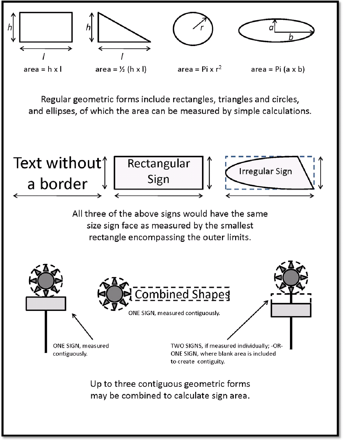
(c)
Calculation of frontage. For the purpose of computing the number and area of signs, the frontage of a zoning lot shall be established by orientation of the frontage of the buildings thereon or of the principal entrance points to the premises if building frontage does not clearly indicate zoning lot frontage. If neither of these methods are determinative, the director of neighborhood and development services shall select on the basis of traffic flow on adjacent streets, and the zoning lot shall be considered to front on the street with the greater traffic flow.
(Ord. No. 02-4357, 4-29-02; Ord. No. 09-4838, § 2(att. 1), 2-17-09; Ord. No. 10-4912, § 2(att. 1), 6-7-10)
Sec. VII-105. - Removal of signs improperly in the right-of-way.
The city manager, or his designee, is hereby authorized to remove and dispose of any sign located in the right-of-way of any public right-of-way in violation of this division.
(Ord. No. 02-4357, 4-29-02)
Sec. VII-106. - Exemptions from a permit requirement.
(a)
The following activities and signs shall not require a permit, provided that the sign complies with the limitations of this division. An otherwise exempt sign which exceeds the limitations set forth in this section shall require a permit and be governed by the applicable sections of this division.
(1)
Changing copy. Changing the advertising copy, announcement or message on a marquee, electronic message board, or changeable copy sign board. See subsections VII-110(5), VII-110(16), and VII-110(19) for additional regulations applicable to the downtown CT and CBN zone.
(2)
General maintenance. Cleaning or painting, or comparable general maintenance or repair of a sign that does not alter any regulated feature of such sign.
(3)
Integral signs. Names of buildings, dates of erection, monument citation, commemorative tablets and the like when carved into stone, concrete, or similar material or made of bronze, aluminum or other permanent type construction and made an integral part of the structure and which do not exceed four square feet in area.
(4)
Legal notices. Identification, informational or directional signs erected or required by governmental bodies.
(5)
Public signs. Signs of a non-commercial nature and in the public interest, erected by or on the order of a public officer or public agency, such as directional signs, traffic signs, regulatory signs, warning signs, hospital signs and associated signs in the SMH district, and informational signs.
(6)
Stadium signs. Non-electrical signs placed within a stadium which face inward toward the playing field.
(7)
Window signs. Window signs may be placed on any window. See subsections VII-110(5), VII-110(16), VII-110(19), VII-110(28), VI-909, and VI-910 for additional regulations applicable to the Downtown CT, CBN, Urban Mixed-Use zone districts, Housing Authority Overlay District, and the North Trail Overlay District, and require a sign permit.
(8)
Property identification signs. Signs not exceeding two square feet in area and bearing only property numbers, postbox numbers, names of occupants of premises, or other identification of premises.
(9)
Directional or warning signs. Non-advertising directional or warning signs or symbols such as "entrance," "exit," "bad dog," "caution," "slow," "no trespassing," etc., located on and pertaining to a private zoning lot, and not exceeding two square feet in area.
(10)
Temporary construction signs. One non-illuminated, temporary construction project ground sign not exceeding 32 square feet in area. Such sign may not be erected more than 60 days prior to the commencement of actual construction and must be removed within 15 days after the issuance of a certificate of occupancy. If construction is not continually and actively prosecuted to completion, such sign shall be removed within 15 days of expiration of the building permit.
(11)
Real estate signs. One non-illuminated "for sale" or "for rent" sign per zoning lot when such sign has an area per face of not more than four square feet.
(12)
Professional nameplates. Professional nameplates not exceeding two square feet in area.
(13)
Nonilluminated bulletin board or identification signs. one nonilluminated bulletin board or identification sign for each street frontage for public, charitable or eleemosynary institutions, to be located on the premises of such institutions and to be no more than 12 feet in total area. One double-faced nonilluminated bulletin board or identification sign for each street frontage for houses of worship, to be located on the premises and to be no more than 20 square feet per face or 40 square feet in total area. Illuminated bulletin boards and identification signs for these uses require a permit.
(14)
Entrance signs. Identification signs at the entrance drives of residences, estates and ranches, which do not exceed two square feet in area.
(15)
Hard hat signs. One hard hat sign at each entrance to a construction area, of no more than two square feet.
(16)
Political campaign signs. Political campaign signs announcing candidates seeking public political office and other data pertinent thereto shall be permitted up to a total area of 16 square feet for each premises in a residential zone and 32 square feet in a commercial or industrial zone. These signs shall be confined within private property. These signs may be displayed 90 days prior to and 21 days after the election for which intended. In cases where a final election follows within 75 days of a primary election, those candidates who won in the primary election may continue to display their signs during the interim period and up to 21 days after the final election.
(17)
Banners on city light poles. When authorized and installed in accordance with Ordinance No. 15-5125.
(18)
Banners fastened to fences on the campus of a public or private elementary, middle or high school.
(b)
Setback of exempt signs. The signs enumerated in subsection VII-106(a) which do not require a permit may be located in required front setbacks no closer than five feet from the property line and meet the sight triangle restrictions cited in section VII-1202 of this Code.
(c)
Impact of exempt signs on calculations under other sections of this division. The face area of exempt signs shall not be included in determining compliance with the maximum allowable sign area provisions of this division. Exempt signs are allowed in addition to signs for which permits are required.
(Ord. No. 02-4357, 4-29-02; Ord. No. 07-4720 § 2, 5-21-07; Ord. No. 10-4912, § 2(att. 1), 6-7-10; Ord. No. 15-5134, § 2, 5-18-15; Ord. No. 21-5390, § 2, 12-6-21; Ord. No. 25-5583, § 2(Exh. A), 11-17-25)
Sec. VII-107. - Permits required.
All signs require a building permit except for those listed as exempt in section VII-106.
(1)
Application requirements. An application for a sign permit shall be accompanied by the information and documentation required by the director of neighborhood and development services.
(2)
Identification tag. The director of neighborhood and development services, at the time of the issuance of the permit, shall also issue to the applicant a tag which shall have printed or impressed thereon "City of Sarasota Sign Permit," the number thereof, and the year of its issuance. No sign, unless specifically exempted, shall be erected, displayed, rebuilt, repaired, painted or otherwise maintained which does not have such a tag securely attached thereto or to its supporting structures so as to be plainly visible from the street or roadway.
(3)
Work on unpermitted signs prohibited. No person shall perform or assist in the erection, construction, maintenance, alteration, repair or painting of any sign for which a permit has not been procured.
(4)
Penalty for placement of signs prior to receiving a permit. If a sign required by these regulations to obtain a permit is erected before a permit is obtained from the director of neighborhood and development services, the permit fee for the sign shall be tripled.
(Ord. No. 02-4357, 4-29-02; Ord. No. 03-4429, § 10, 1-21-03; Ord. No. 09-4838, § 2(att. 1), 2-17-09)
Sec. VII-108. - Signs permitted in all zoning districts.
The following signs are permitted in all zoning districts except the MP and POS districts.
(1)
Exempt signs. Signs exempted from permitting requirements as enumerated in section VII-106.
(2)
Grand opening signs. One sign not to exceed 50 square feet shall be allowed in conjunction with the grand opening of a business (this includes grand openings resulting from ownership changes). Such sign may be erected for no more than two weeks. If such sign is a banner, it shall be affixed to the wall of the building.
(3)
Special event. One sign not to exceed 50 square feet shall be allowed in conjunction with a special event permitted by the city. Such sign may be erected for no more than two weeks.
(4)
Portable signs. Each business may be allowed one temporary portable A-frame sign, on private property, during the hours the business is open and provided the sign is less than four feet high and less than 18 by 24 inches per face, unless otherwise prohibited in [section] VII-110.
(Ord. No. 02-4357, 4-29-02; Ord. No. 10-4912, § 2(att. 1), 6-7-10)
Sec. VII-109. - Signs prohibited in all zoning districts.
(a)
District regulations. Signs which are not specifically permitted in a zone district or which are not otherwise specifically permitted under these land development regulations.
(b)
Obscenities. Signs which are obscene, indecent or immoral.
(c)
Signs in rights-of-way. Signs, other than those erected by a governmental agency or required to be erected by a governmental agency, erected on the right-of-way of any street, road or public way, or signs overhanging or infringing upon the right-of-way of any street, road or public right-of-way.
(d)
Signs on public property. Signs erected on public property, other than signs erected by a public authority for public purposes.
(e)
Reserved.
(f)
Revolving signs, whirling signs or animated signs.
(g)
Wind signs.
(h)
Signs on utility poles or trees, shrubs or plants.
(i)
Signs in setback areas. Except as outlined in section VII-103(11) of these regulations.
(j)
Roof signs.
(k)
Buildings which constitute signs. No building may be constructed in any zoning district which is designed to represent or to depict an article, a product or an item of food which is for sale or which is available on the premises upon which the building is located. This prohibition shall include, but shall not be limited to, depictions of animals or fowl from which the food products are derived.
(l)
Off-site signs.
For purposes of this section, the word "sign" shall mean any object, device, display, or structure, such as, but not necessarily limited to, a board, poster or placard which is used to advertise, impart information, give directions or convey a message. Notwithstanding the prohibitions contained in this article, banners on city light poles in public rights-of-way may be authorized and installed pursuant to Ordinance 15-5125. Notwithstanding the prohibition against off-site signs contained in this article, banners may be secured to fencing on a public or private elementary school, middle school, or high school campus.
(Ord. No. 02-4357, 4-29-02; Ord. No. 07-4720 § 2, 5-21-07; Ord. No. 13-5041, § 2(att. 1), 3-4-13; Ord. No. 15-5134, § 1, 5-18-15; Ord. No. 21-5390, § 1, 12-6-21)
Sec. VII-110. - Sign requirements in particular zoning districts.
Signs are permitted in the various zone districts, subject to the following restrictions:
(1)
Residential single family districts. No signs intended to be read from off the premises shall be permitted in the residential single family districts except:
a.
Subdivision development signs: Two nonilluminated subdivision ground signs, each having a total aggregate area of no more than 100 square feet, on a subdivision property while under development, to advertise the sale of zoning lots or new houses; provided that such subdivision has an area of at least four acres, and provided, further, that such signs shall be removed when 80 percent of the individual zoning lots or houses have been sold.
b.
Family day care centers: One nonilluminated identification wall sign no more than eight square feet in total aggregate area.
c.
Identification signs for entryways of subdivisions: Such signs shall contain only the name of the subdivision and shall not contain promotional or sales material; lettered portions of such signs shall not exceed 12 square feet in total aggregate area.
d.
Permitted or conditional nonresidential use, not otherwise listed: One identification wall sign not exceeding 12 square feet in area and one double-faced bulletin or ground sign not exceeding 16 square feet in area per face or 32 square feet in total aggregate area. Such signs may be illuminated.
e.
Houses of worship: Two identification wall signs not to exceed a maximum area of 32 square feet per sign and one double-faced ground sign or bulletin board for each street frontage not to exceed a maximum area of 20 square feet per face or 40 square feet of total area per sign.
f.
Cemeteries or mausoleums, private parks, playgrounds, libraries, yacht clubs, country clubs, golf courses, botanical gardens, historical monuments and museums: One identification wall sign not to exceed a maximum total aggregate area of 16 square feet.
g.
RTD-9 Nonresidential sign standards.
| a. |
Projecting sign
 or Pole/post sign;l;
| One projecting or pole/post sign, not to exceed 4 square feet in area per face, may be attached perpendicular to the facade or placed on a post in the front yard. A sign post shall not exceed 6 feet in height, excluding the decorative cap. Signage may be externally illuminated by reflection of a light source aimed at its surface. All lighting must be shielded to prevent glare or nuisance beyond the property line. | |
 |  | ||
| b. | Portable A-Frame Sign |  |
In addition to a projecting sign or pole/post sign, each business may be allowed one
(1) portable A-frame sign, on private property, during the hours the business is open
and provided the sign is less than 4 feet high and less than 18 by 24 inches per face.
|
| c. | Other signs |
Prohibited
All other signs not specifically permitted. | |
h.
Signs other than those specifically listed above are prohibited. No sign permitted above shall be erected within 20 feet of any adjacent property line. Ground signs are permitted above may be erected in required front yards, but may be no closer to the right-of-way line than one-third of the depth of the required front yard, with a maximum height of 20 feet; provided that ground signs for houses of worship may be located in front yards no closer than five feet to the right-of-way line, with a maximum height of eight feet.
(2)
Residential multiple family districts. Except in RMF-R, no signs intended to be read from off the premises shall be permitted in the residential multiple family districts except:
a.
Subdivision development signs: Two nonilluminated subdivision ground signs, each having a total aggregate area of no more than 100 square feet, on a subdivision property while under development to advertise the sale of zoning lots or new houses; provided that such subdivision has an area of at least four acres, and provided, further, that such signs shall be removed when 80 percent of the individual zoning lots or houses have been sold.
b.
Family day care centers: One nonilluminated identification wall sign no more than eight square feet in total aggregate area.
c.
Identification signs for entryways of subdivisions: Such signs shall contain only the name of the subdivision and shall not contain promotional or sales material; lettered portions of such signs shall not exceed 12 square feet in total aggregate area.
d.
Permitted or conditional nonresidential use, not otherwise listed: One identification wall sign not exceeding 12 square feet in area and one double-faced bulletin or ground sign not exceeding 16 square feet in area per face or 32 square feet in total aggregate area. Such signs may be illuminated.
e.
Houses of worship: Two identification wall signs not to exceed a maximum area of 32 square feet per sign and one double-faced ground sign or bulletin board for each street frontage not to exceed a maximum area of 20 square feet per face or 40 square feet of total area per sign.
f.
Cemeteries or mausoleums, private parks, playgrounds, libraries, botanical gardens, historical monuments and museums, radio and television stations, and model homes: One identification wall sign not to exceed a maximum total aggregate area of 16 square feet.
g.
Off-street parking lots: One identification ground sign not to exceed a maximum total aggregate area of four square feet.
h.
Multiple-family dwellings or assisted living facilities: One identification wall or ground sign which may have two faces on each streetside, with the surface area of such sign or signs not to exceed 32 square feet in total aggregate area. Such sign may be illuminated.
i.
Manufactured housing parks: One identification wall or ground sign, which may have two faces at each entrance. Such signs shall contain only the name of the park and shall not contain promotional or sales material. The surface area of such signs shall not exceed 32 feet in total aggregate area.
j.
Non-profit community theaters: One identification wall, canopy or ground sign no more than 32 feet in aggregate area or one projecting sign which shall project no more than four feet from the building wall, which may not exceed 12 square feet per face, plus one double-faced bulletin or ground sign which may not exceed 16 square feet in area per face, on each streetside.
k.
Hotels or motels:
1.
One identification ground sign and one identification wall or projecting sign which may not exceed three square feet of area for each foot of building frontage or one and one-half square feet of area for each foot of frontage property occupied by the building, whichever is greater; but not exceeding a total aggregate area of 250 square feet. Signs for each streetside are permitted when frontage occurs on arterial or collector streets.
2.
One wall or projecting identification sign for any accessory use having frontage in a hotel or motel, no more than 40 square feet in area. Hotel or motel uses located in the RMF-4, RMF-5 and RMF-6 districts may erect one on-site ground sign, as indicated above, on an arterial or collector street no closer to the front property line than 40 inches.
l.
Private clubs: One identification wall, ground or projecting sign (which shall not project more than four feet from the building wall), which may have two faces, no more than 12 square feet in total aggregate area.
m.
Fraternities or sororities: One identification wall sign no more than eight square feet in area.
n.
Colleges or universities: One identification wall or ground sign, which may have two faces, not to exceed 32 square feet in area per face, at each major entrance to such college or university.
o.
Real estate: One double-faced nonilluminated "for sale" or "for rent" sign, which may not exceed 32 square feet per face.
p.
Bed and breakfast inn or lodging house: One identification wall or ground sign no more than six square feet in area. Illumination of the sign is permitted provided that such illumination consists of only a low-intensity fluorescent or incandescent bulb. All lighting for signs shall be so designed and arranged so as to shield adjacent properties from direct glare. Neon signs, animated or moving signs are prohibited. The building and zoning administrator shall determine that the style of the sign is compatible with adjacent properties and other properties in the district.
(3)
RMF-R district. No signs intended to be read from off the premises shall be permitted in the RMF-R district except:
a.
Permitted or conditional uses: One wall sign or a ground sign which may have two faces on each streetwide to identify a development, with the surface area of such sign not to exceed 32 square feet in total aggregate area. Such signs may be illuminated. No sign permitted above shall be erected within 20 feet of any adjacent property line. Ground signs above may be erected in required front yards, but not closer than one-third the depth of the required front yard.
b.
Real estate signs: One nonilluminated "for sale" or "for rent" sign, which may not exceed 32 square feet per face, which may advertise the sale or rental of apartments or condominiums for a period of one year; provided that the structure contains 12 or more existing units.
c.
Nonresidential uses in a mixed use development: one identification wall sign per street frontage not exceeding 12 square feet in area for each nonresidential use.
(4)
WFR district. No signs intended to be read from off the premises shall be permitted in the WFR district except for:
a.
Multiple-family dwellings or interval occupancy facilities: One identification wall or ground sign, which may have two faces, with the surface area of such sign not to exceed 32 square feet in total aggregate area.
b.
Hotels and motels:
1.
One identification ground sign which must be set back at least 40 inches from the front zoning lot line.
2.
One identification wall or projecting sign which may not exceed three square feet of area for each foot of building frontage or one and one-half square feet of area for each foot of zoning lot frontage, whichever is greater.
The signs permitted by paragraphs a. and b. above shall not exceed a total aggregate area of 250 square feet.
c.
Bed and breakfast inns: One identification wall or ground sign no more than six square feet in area. Illumination of the sign is permitted provided that such illumination consists of only a low-intensity fluorescent or incandescent bulb. All lighting for signs shall be so designed and arranged so as to shield adjacent properties from direct glare. Neon, animated or moving signs are prohibited. The building and zoning administrator shall determine that the style of the sign is compatible with adjacent properties and other properties in the district.
d.
Private recreation clubs: One identification wall or ground sign no more than six square feet in area. Illumination of the sign is permitted if such illumination consists of only a low-intensity fluorescent or incandescent bulb. All lighting for signs shall be so designed and arranged to shield adjacent properties from direct glare. Neon, animated or moving signs are prohibited. The building and zoning administrator shall determine that the style of the sign is compatible with adjacent properties and other properties in the district. If approved in accordance with section VI-104(b) of this Code, as a recreational club/condominium project, the private recreation club's sign may be made a part of such condominium identification sign (see subsection VII-110(4)a. above). Such combined sign will then be considered a project identification sign. Such a project identification sign shall not exceed 38 square feet in total aggregate area.
(5)
Downtown zone districts: DTN, DTNE, DTE, DTC and DTB. All signage on a site is to be integrated into or otherwise visually related to the project's building(s) and is to be composed of materials and colors compatible with the materials of the building(s) as determined by the director of planning based on information supplied by the developer. When in conflict with any other sign standards the following standards apply.
| DTN | DTNE and DTE | DTC and DTB | |
| a. Design guidelines |
See Appendix D. Advisory Community Design Guidelines.
These nonmandatory guidelines should be consulted prior to developing signs for any project. | ||
b. Lighting
  |
Signage may be externally illuminated by reflection of a light source aimed at its
surface. All lighting must be shielded to prevent glare or nuisance beyond the property
line.
Backlighting with neon, fluorescent, or LED white light is permitted only for channel letter signs that use individually cut opaque letters (a.k.a. "halo illuminated letters"). The use of cabinet-type signs or channel letter signs with translucent backlit panels is prohibited Signage inside shopfront windows may be neon lit. Signs with flashing or intermittent lights, continuous changes of message, lights of changing degrees of intensity, and lights or lighting effects that cause glare are prohibited. |
Signage may be externally illuminated by reflection of a light source aimed at its
surface. All lighting must be shielded to prevent glare or nuisance beyond the property
line.
On primary streets (see Map VI-1001), backlighting with neon, fluorescent, or LED white light is permitted only for channel letter signs that use individually cut opaque letters (a.k.a. "halo illuminated letters"). On primary streets, no internally illuminated cabinet-type box signs are permitted. On secondary streets, backlighting with neon, fluorescent, or LED white light is permitted for channel letter signs or cabinet-type box signs with opaque panels where only the lettering appears to be lighted. Signage inside shopfront windows may be neon lit. Signs with flashing or intermittent lights, continuous changes of message, lights of changing degrees of intensity, and lights or lighting effects that cause glare are prohibited. The backlighting of awnings or canopies and messages attached thereto is prohibited. |
c. Wall sign
 |
A single external wall sign band may be applied at the top of the 1st floor facade
of each building, providing that it not exceed two feet in height by any length.
Where there is more than one sign, all signs should be complementary to each other in the following ways: 1. Type of construction materials. 2. Letter size and style of copy. 3. Method used for supporting sign. |
d. Building identification sign
 | Prohibited | Prohibited | Buildings six stories or higher may have a single building identification sign repeated on each building frontage, applied horizontally at the top of the highest floor facade, provided that it does not exceed three feet in height. Building identification signs may also be applied vertically at one corner of each building frontage, provided that the sign does not exceed three feet in width and three stories in height. Signs shall use individually cut letters or channel letters and shall be backlit, if lighted. |
e. Projecting sign
 | All approved non-residential uses may have one projecting sign permanently installed perpendicular to the facade. Such a sign shall not exceed a total of four square feet in area per face. The bottom of such signs shall be a minimum of eight feet above the walkway. | Projecting signs, not to exceed four square feet in area per face for each separate business entrance may be attached perpendicular to the facade. The bottom of such signs shall be a minimum of eight feet above the walkway. | Projecting signs, not to exceed four square feet in area per face for each separate business entrance may be attached perpendicular to the facade. The bottom of such signs shall be a minimum of eight feet above the walkway. |
f. Monument ground sign
 | Prohibited | On each secondary street frontage, one freestanding monument sign not exceeding 50 square feet in area on all faces and not exceeding ten feet in height above grade. See also FCOD VI-905. | On each secondary street frontage, one freestanding monument sign not exceeding 50 square feet in area on all faces and not exceeding ten feet in height above grade. See also FCOD VI-905. |
g. Marquee sign
 | Prohibited | Theatres may have one marquee sign for each building frontage that includes an entrance available to the general public. The marquee shall not extend beyond the top or sides of the building. | Theatres may have one marquee sign for each building frontage that includes an entrance available to the general public. The marquee shall not extend beyond the top or sides of the building. |
h. Temporary portable A-frame sign
 | Prohibited | A single temporary portable A-frame sign may be allowed for each business, on private property, provided the sign is less than four feet high and less than 18 by 24 inches per face. | A single temporary portable A-frame sign may be allowed for each business, on private property, provided the sign is less than four feet high and less than 18 by 24 inches per face. |
i. Window sign
 | Prohibited | Such signs shall cover no more than 20 percent of the area of any single pane of any window. A permanent address shall be permitted in addition to the 20 percent coverage. Window signs shall not be included in any calculation of total sign area for the building or tenant. | Such signs shall cover no more than 20 percent of the area of any single pane of any window. A permanent address shall be permitted in addition to the 20 percent coverage. Window signs shall not be included in any calculation of total sign area for the building or tenant. |
j. Awning/canopy sign
 | Prohibited |
Awnings/canopies at the first story may have signs. No such signs shall exceed 20
percent of the area of each awning/canopy (top plus all sides).
Where there is more than one sign, all signs should be complementary to each other in the following ways: 1. Type of construction materials. 2. Letter size and style of copy. 3. Method used for supporting sign. |
Awnings/canopies at the first story may have signs. No such signs shall exceed 20
percent of the area of each awning/canopy (top plus all sides).
Where there is more than one sign, all signs should be complementary to each other in the following ways: 1. Type of construction material. 2. Letter size and style of copy. 3. Method used for supporting sign. |
| k. Commercial artwork sign | Prohibited |
Commercial artwork signs shall not exceed 500 square feet.
Commercial artwork signs shall not cover windows. No more than 2.5% of the commercial artwork sign shall contain a commercial name or logo. One commercial artwork sign per zoning lot. |
Commercial artwork signs shall not exceed 500 square feet.
Commercial artwork signs shall not cover windows. No more than 2.5% of the commercial artwork sign shall contain a commercial name or logo. One commercial artwork sign per zoning lot. |
l. Real estate sign
 | One double faced nonilluminated "for sale" or "for rent" sign for each street frontage not exceeding four square feet per face and not exceeding four feet in height above grade. Upon sale or rent, the sign shall be immediately removed. | One double faced nonilluminated "for sale" or "for rent" sign for each street frontage not exceeding 16 square feet per face and not exceeding six feet in height above grade. Upon sale or rent, the sign shall be immediately removed. | One double faced nonilluminated "for sale" or "for rent" sign for each street frontage not exceeding 16 square feet per face and not exceeding six feet in height above grade. Upon sale or rent, the sign shall be immediately removed. |
| m. Other signs |
Prohibited.
All other signs not specifically permitted. |
Prohibited.
All other signs not specifically permitted. |
Prohibited.
All other signs not specifically permitted. |
| n. Other regulations | See Sections VII-101 thru VII-109. | ||
(6)
OPB and OCD district. No signs intended to be read from off the premises shall be permitted in the OPB and OCD district except:
a.
Child care and family day care centers: One nonilluminated identification wall or ground sign of no more than eight square feet in total aggregate area.
b.
Permitted or conditional nonresidential use, not otherwise listed: One identification wall sign not exceeding 12 square feet in area and one double-faced bulletin or ground sign not exceeding 16 square feet in total aggregate area.
c.
Cemeteries or mausoleums, public parks, playgrounds, libraries and model homes: One identification wall sign not to exceed a maximum total aggregate area of 16 square feet.
d.
Off-street parking lots: One identification ground sign not to exceed a maximum total aggregate area of four square feet.
e.
Multiple-family dwellings: One identification wall or ground sign, which may have two faces on each streetside, with the surface area of such sign not to exceed 32 square feet in aggregate areas. Such sign may be illuminated.
f.
Real estate signs: One double-faced nonilluminated "for sale" or "for rent" sign for each street frontage, not to exceed 16 square feet per face.
g.
Parking garages: One nonilluminated wall sign at a ratio of one square foot for each lineal foot of street frontage up to a maximum of 20 square feet.
h.
Business, professional, medical or dental offices or clinics: One wall sign for each street frontage at a ratio of one square foot for each lineal foot of street frontage up to a maximum of 40 square feet or one double-faced ground sign for each street frontage at a ratio of one square foot for each lineal foot of street frontage up to a maximum of 30 square feet per face, or 60 square feet in total aggregate area.
(7)
OPB-1 and OND district. No signs intended to be read from off the premises shall be permitted in the OPB-1 and OND district except:
a.
Business, professional, medical or dental offices or clinics: One wall sign for each street frontage at a ratio of one square foot for each lineal foot of street frontage, up to a maximum of 40 square feet, or one double-faced ground sign for each street frontage at a ratio of one square foot for each lineal foot of street frontage, up to a maximum of 30 square feet per face.
b.
Real estate signs: One nonilluminated "for sale" or "for rent" sign for each street frontage, not to exceed 16 square feet per face.
c.
Accessory uses: No signs shall be allowed except those permitted under section VII-108.
(8)
OP and ORD district. No signs intended to be read from off the premises shall be permitted in the OP and ORD district except for:
a.
Office park identification signs: One wall or double-faced ground sign for each street frontage up to a maximum of 60 square feet in total aggregate area for all signs and a maximum of 30 square feet per face for double-faced ground signs. In addition, identification wall signs are permitted for individual offices up to a maximum of four-square feet.
b.
Office park directory signs: One wall or one hanging identification sign to identify the office within the office park which shall be no greater than 40 square feet in total aggregate area or 20 square feet per face.
c.
Child care and family day care centers: One nonilluminated identification wall or ground sign of no more than eight square feet in total aggregate area.
d.
Public parks, playgrounds and recreational facilities, libraries, museums and other public recreational or cultural uses: One identification wall sign not to exceed a maximum total aggregate area of 16 square feet.
e.
Other permitted or conditional uses, except individual business or professional offices located within office parks: One wall sign for each street frontage at a ratio of one square foot for each lineal foot of street frontage up to a maximum of 32 square feet or one double-faced ground sign for each street frontage at a ratio of one square foot for each lineal foot of street frontage up to a maximum of 24 square feet per face or 48 square feet in total aggregate area.
(9)
CN and CND district. No signs intended to be read from off the premises shall be permitted in the CN and CND district except:
a.
Libraries: One identification wall sign not to exceed a maximum total aggregate of 16 square feet.
b.
Houses of worship: Signs for houses of worship shall be permitted subject to the same limitations applicable to commercial or service establishments under paragraph e. of this section.
c.
Business, professional, medical or dental offices or clinics: One wall sign for each street frontage, at a ratio of one square foot for each lineal foot of street frontage up to a maximum of 40 square feet, or one double-faced ground sign or hanging sign for each street frontage, at a ratio of one square foot for each lineal foot of street frontage up to a maximum of 30 square feet per face or 60 square feet in total aggregate area.
d.
Private clubs: One identification wall, ground or projecting sign which shall project no more than four feet from the building wall and which may have two faces, no more than 12 square feet in total aggregate area.
e.
Commercial or service establishments: Wall, ground, projecting or canopy signs to advertise services or sales of products on the premises, provided that no sign shall project more than four feet from a building wall. In addition, no ground sign shall exceed 20 feet in height above ground level in the CN district and 16 feet in height above ground level in the CND district. Signs in this subsection are subject to the following limitations:
1.
The aggregate area of all signs shall not exceed two square feet of area for each foot of building frontage occupied by the business displaying the signs or one square foot of frontage of property occupied by the building, whichever is greater; and no business shall display more than three signs, with a total aggregate area of no more than 120 square feet regardless of building or property frontage.
2.
Where a building or buildings under unified ownership or legal control contains two or more separate activities or establishments, one ground sign per street frontage is permitted. Such sign shall identify the building, complex of buildings, or businesses or services within the buildings or complex of buildings and shall contain no other sign matter. It shall not exceed two square feet of surface area for each foot of building frontage or one square foot of area of frontage of property occupied by the building, with a maximum total aggregate area of 120 square feet. The individual establishments with street frontage located in such a building or complex of buildings shall be permitted a wall, projecting or canopy sign as in this subsection e., but a ground sign is prohibited.
f.
Real estate signs: One double-faced nonilluminated "for sale" or "for rent" sign for each street frontage of no more than 16 square feet per face.
g.
Bed and breakfast inns: One identification wall or ground sign no more than six square feet in area. Illumination of the sign is permitted provided that such illumination consists of only a low-intensity fluorescent or incandescent bulb. All lighting for signs shall be so designed and arranged so as to shield adjacent properties from direct glare. Neon, animated or moving signs are prohibited. The building and zoning administrator shall determine that the style of the sign is compatible with adjacent properties and other properties in the district.
h.
Child care or family day care centers: Wall, ground, marquee or projecting signs for building identification, provided that:
The aggregate area for all signs shall not exceed three square feet of area for each foot of building frontage occupied by business or one and one-half square feet of area for each foot of frontage property occupied by building, whichever is greater, with a maximum limit of three signs with a total aggregate area not to exceed 300 square feet.
i.
Orientation. Sign display surfaces shall not be located on the rear or sides of CN or CND activities when such display would orient the sign to the residentially zoned property rather than to the CN or CND district.
(10)
CG, CRT, CGD and CRD district. No signs intended to be read from off the premises shall be permitted in the CG, CRT, CGD and CRD district except:
a.
Multiple-family dwellings: one identification wall or double-faced ground sign on each streetside, with the surface area of such sign not to exceed 32 square feet total aggregate in area. Such sign may be illuminated.
b.
Other permitted or conditional uses: Wall, ground, pylon, canopy, marquee or projecting signs to advertise services or sale of products on the premises, provided that no sign shall project more than four feet from a building wall. In addition, no ground sign shall exceed 25 feet in height above ground level in the CG and CRT districts and 16 feet in height above ground level in the CGD and CRD districts. Signs in this subsection are subject to the following limitations:
1.
The aggregate area of all signs shall not exceed three square feet of area for each foot of building frontage occupied by the business displaying the signs or one and one-half square feet of area for each foot of frontage of property occupied by the building, whichever is greater; and no business shall display more than three signs with a total aggregate area of no more than 180 square feet regardless of building or property frontage.
2.
Where a building or buildings under unified ownership or legal control contains two or more separate activities or establishments, one ground sign per street frontage is permitted. Such sign shall identify the building, complex of buildings, or businesses or services within the building or complex of buildings and shall contain no other sign matter. It shall not exceed three square feet of surface area for each foot of building frontage or one and one-half square feet of area of frontage of property occupied by the building, with a maximum total aggregate area of 180 square feet. The individual establishments with street frontage located in such a building or complex of buildings shall be permitted a wall, projecting or canopy sign as provided in this subsection b., but a ground sign is prohibited.
c.
Real estate signs: one double-faced nonilluminated "for sale" or "for rent" sign for each street frontage not exceeding 16 square feet per face.
d.
Bed and breakfast inns: one identification wall or ground sign no more than six square feet in area. Illumination of the sign is permitted provided that such illumination consists of only a low-intensity fluorescent or incandescent bulb. All lighting for signs shall be so designed and arranged so as to shield adjacent properties from direct glare. Neon, animated or moving signs are prohibited. The building and zoning administrator shall determine that the style of the sign is compatible with adjacent properties and other properties in the district.
e.
No ground sign shall be erected within 35 feet of any property zoned residential in the CG, CGD, and CRD districts. This limitation does not apply to the CRT district.
(11)
CI and ICD district. No signs intended to be read from off the premises shall be permitted in the CI and ICD district except:
a.
Permitted or conditional uses: Wall, ground, pylon, canopy, marquee or projecting signs to advertise services or sale of products on the premises, providing that no sign shall project more than four feet from a building wall. In addition, no ground sign shall exceed 25 feet in height above ground level in the CI district and 16 feet in height above ground level in the ICD district. Signs in this subsection are subject to the following limitations:
1.
The aggregate area of all signs shall not exceed three square feet of area for each foot of building frontage occupied by business or one and one-half square feet of area for each foot of frontage of property occupied by buildings, whichever is greater, with a maximum limit of three signs with a total aggregate area for all signs of 250 square feet.
2.
Where a building or buildings under unified ownership or legal control contains two or more separate activities or establishments, one ground sign per street frontage is permitted. Such sign shall identify the building, complex of buildings, or businesses or services within the building or complex of buildings and shall contain no other sign matter. It shall not exceed three square feet of surface area for each foot of building frontage or one and one-half square feet of area of frontage of property occupied by the building, with a maximum total aggregate area of 250 square feet. The individual establishments located in such a building or complex of buildings with individual street frontage shall be permitted one wall, projecting or canopy sign as in this subsection a., but ground signs are prohibited.
b.
Real estate signs: One double-faced nonilluminated "for sale" or "for rent" sign for each street frontage, which shall not exceed 32 square feet per face.
c.
Bed and breakfast inns: One identification wall or ground sign no more than six square feet in area. Illumination of the sign is permitted provided that such illumination consists of only a low-intensity fluorescent or incandescent bulb. All lighting for signs shall be so designed and arranged so as to shield adjacent properties from direct glare. Neon, animated or moving signs are prohibited. The building and zoning administrator shall determine that the style of the sign is compatible with adjacent properties and other properties in the district.
(12)
CP district. No signs intended to be read from off the premises shall be permitted in the CP district except for:
a.
Office park identification signs: one wall or double-faced ground sign for each street frontage up to a maximum of 60 square feet for an identification wall sign and a maximum of 60 square feet per sign for double-faced ground signs. Signs permitted under this paragraph shall be for the purpose of identification of an office park development located on a particular zoning lot.
b.
Office park directory signs: One wall or one hanging identification sign to identify the individual offices or business establishments within the commercial office park development, which shall be no greater than 50 square feet in total aggregate area or 25 square feet per face.
c.
Hotels and motels: One identification ground sign and one identification wall sign which together may not exceed a total aggregate area of 120 square feet for each street frontage.
d.
Child care and family day care centers: One nonilluminated identification wall or ground sign of no more than eight square feet in total aggregate area.
e.
Public parks, playgrounds and recreational facilities, libraries, museums and other public recreational or cultural uses: One identification wall sign not to exceed a maximum total aggregate area of 16 square feet.
f.
Other permitted or conditional uses including, but not limited to, banks and financial institutions, restaurants and private clubs and lodges: One wall sign for each street frontage at a ratio of one square foot for each lineal foot of street frontage up to a maximum of 40 square feet or one double-faced ground sign for each street frontage at a rate of one square foot for each lineal foot of street frontage up to a maximum of 30 square feet per face or 60 square feet in total aggregate area.
g.
Bed and breakfast inns: One identification wall or ground sign no more than six square feet in area. Illumination of the sign is permitted provided that such illumination consists of only a low-intensity fluorescent or incandescent bulb. All lighting for signs shall be so designed and arranged so as to shield adjacent properties from direct glare. Neon, animated or moving signs are prohibited. The building and zoning administrator shall determine that the style of the sign is compatible with adjacent properties and other properties in the district.
(13)
CSC, CSC-N, CSC-C, or CSC-R districts.
a.
Identification of shopping centers and shopping center establishments: One sign for the first 500 lineal feet of zoning lot frontage and one additional sign for each 500 lineal feet or major fraction thereof above 500 lineal feet of zoning lot frontage, for the purpose of general identification of the premises as "_______ shopping center"; provided that over 50 percent of the identification sign is used for the shopping center identification and the balance may be used for identification of establishments in the center by name and nature. The maximum area of each such sign shall be as follows:
1.
CSC-N: 175 square feet in total aggregate area.
2.
CSC-C: 200 square feet in total aggregate area.
3.
CSC-R: 300 square feet in total aggregate area. No ground sign shall exceed 25 feet in height.
4.
CSC: 300 square feet in total aggregate area. No ground sign shall exceed 16 feet in height.
b.
Businesses located in the shopping center:
1.
One sign which may not exceed one and one-half square feet of surface area for each one lineal foot of store frontage, plus one sign for sides of buildings, based on each complete 40 lineal feet, next to and visible from a public street, using the ratio of one and one-half square feet of surface area for each lineal foot of side, with a maximum sign area of 200 square feet; such signs shall refer only to the name and nature of the business conducted in the building and to goods and services offered; shall be mounted flat against the wall or window of the building or on canopies, marquees, or awnings; or shall project not more than four feet from the building; and one hanging-under-canopy identification sign which may not exceed the dimensions of one foot by six feet or the width of the canopy, whichever is less.
2.
In the CSC and CSC-R district: one sign per building elevation next to and visible from a public street with a maximum sign area of 350 square feet for businesses having a gross floor area of 35,000 square feet or larger in a shopping center. Each business with a gross floor area of 35,000 square feet or larger may divide the maximum of 350 square feet of one building elevation sign area between a wall sign on the building and a sign on the mall frontage of which the mall frontage sign will not exceed 50 percent of the aggregate area of 350 square feet.
c.
Real estate signs: One double-faced nonilluminated "for sale" or "for rent" sign for each street frontage, which may not exceed 32 square feet per face.
d.
Mall directory signs: One wall and one hanging marquee identification sign, to identify each entrance of a mall or the businesses within the mall, of no more than 50 square feet total aggregate area or 25 square feet per face.
e.
Ground signs for detached structures: One ground sign for each detached structure subject to the following restrictions:
1.
The total aggregate surface area of the ground sign and any street frontage sign permitted by subsection b. above shall not exceed an amount equal to one and one-half square feet for each lineal foot of building frontage of the detached structure or 200 square feet, whichever is less.
2.
The ground sign shall refer only to the name and nature of the business conducted in the detached structure.
3.
The ground sign display surface must be located in the street frontage area only and shall not be facing toward a residentially zoned district.
4.
Ground sign shall be located a minimum distance of 200 lineal feet from any shopping center identification signs permitted by subsection a. above.
f.
Entrance/site directional signs: One ground sign, not to exceed four feet in height above the level of the ground, or one ground sign, not to exceed seven feet in height above the level of the ground with a three and one-half foot open clearance between the ground and the bottom of the sign, may be located at each driveway entrance of a shopping center. The purpose of said sign shall be to identify a shopping center and the names and locations of businesses in a shopping center having gross floor areas of 35,000 square feet or larger. The ground sign shall be no more than 50 feet in total aggregate area or 25 square feet per face.
Sign display surfaces shall not be located on the rear or sides of CSC, CSC-N, CSC-C, or CSC-R activities when such display would orient the sign to the residential neighborhood rather than to the CSC, CSC-N, CSC-C, or CSC-R district.
(14)
CSD district.
a.
Business, professional, medical or dental offices or clinics: One wall sign for each street frontage, at a ratio of one square foot for each lineal foot of street frontage up to a maximum of 40 square feet, or one double-faced ground sign or hanging sign for each street frontage, at a ratio of one square foot for each lineal foot of street frontage up to a maximum of 30 square feet per face or 60 square feet in total aggregate area.
b.
Other permitted or conditional uses: Wall, ground, projecting or canopy signs to advertise services or sales of products on the premises, provided that no sign shall project more than four feet from a building wall and no ground sign shall exceed 20 feet in height above ground level. Signs in this subsection are subject to the following limitations:
1.
The aggregate area of all signs shall not exceed two square feet of area for each foot of building frontage occupied by the business displaying the signs or one square foot of area for each foot of frontage of property occupied by the building, whichever is greater; and no business shall display more than three signs with a total aggregate area of no more than 120 square feet, regardless of building or property frontage, no more than one under-canopy identification sign, which shall not exceed the dimensions of one foot by six feet or the width of the canopy, whichever is less.
2.
Where a building or buildings under unified ownership or legal control contains two or more separate activities or establishments, one ground sign per street frontage is permitted. Such signs shall identify the building, complex of buildings, or businesses or services within the building or complex of buildings and shall contain no other sign matter. It shall not exceed two square feet of surface area for each foot of building frontage or one square foot of area for each foot of frontage of property occupied by the building, with a maximum total aggregate area of 120 square feet. The individual establishments located in such a building with street frontage shall be permitted signs as in this subsection b.2. above, but a ground sign is prohibited.
c.
Real estate signs: One double-faced-nonilluminated "for sale" or "for rent" sign for each street frontage, of no more than 16 square feet per face.
d.
Bed and breakfast inns: One identification wall or ground sign no more than six square feet in area. Illumination of the sign is permitted provided that such illumination consists of only a low-intensity fluorescent or incandescent bulb. All lighting for signs shall be so designed and arranged so as to shield adjacent properties from direct glare. Neon, animated or moving signs are prohibited. The building and zoning administrator shall determine that the style of the sign is compatible with adjacent properties and other properties in the district.
e.
Orientation: Sign display surfaces shall not be located on the rear or sides of CSD district uses when such display would orient the sign face to a residential neighborhood rather than to the CSD district.
(15)
Reserved.
(16)
CT district.
| a. Design guidelines |
See appendix D advisory community design guidelines.
These nonmandatory guidelines should be consulted prior to developing signs for any project in the CT zone. |
|
b. Lighting for all signs
| Signage may be externally illuminated by reflection of a light source aimed at its surface. All lighting must be shielded to prevent glare or nuisance beyond the property line. Backlighting with neon, fluorescent, or LED white light is permitted only for signs that use individually cut opaque letters (a.k.a. "halo illuminated letters"). The use of cabinet-type box signs or channel letter signs with translucent backlit panels is prohibited. The use of neon lighting inside a storefront window or on the exterior, except for signs with individually cut letters, is prohibited. All lighting must be shielded to prevent glare or nuisance beyond the property line. The backlighting of awnings and canopies and messages attached thereto is prohibited. |
|
c. Wall sign
| Each business located on the first story may have one wall sign on each street frontage, at a ratio of two square feet for each lineal foot of street frontage up to a maximum of 40 square feet per sign. Each business located on the second story may have one wall sign on each street frontage, at a ratio of one square foot for each lineal foot of street frontage up to a maximum of 40 square feet per sign. Any such sign shall not project more than 12 inches from the building to which it is attached or project above the facade of the building or structure. |
|
d. Awning/canopy sign
| Awnings/canopies, when permitted, at the first and second story may have signs. No such signs shall exceed ten percent of the area of each awning/canopy (top plus all sides). |
|
e. Projecting sign
| Projecting signs, not to exceed four square feet in area per face may be attached perpendicular to the facade. The bottom of such signs shall be a minimum of eight feet above the walkway. For businesses located on the ground level, one projecting sign may be located at each separate business entrance. For businesses located above the ground level, one projecting sign may be located at each separate business entrance. |
f. Window sign
 | Such signs shall cover no more than 20 percent of the total window and glass portion of the door area. A permanent address shall be permitted in addition to the 20 percent coverage. Window signs shall not be included in any calculation of total sign area for the building or tenant. Handwritten signs of any type are prohibited. |
g. Directory signs
 | One wall mounted directory sign may be located at each ground level entrance for businesses located above the first story. The sign may list the name of the establishment(s) and may include a location map. Each directory sign shall not exceed a total aggregate area of 16 square feet. Any such sign shall not project more than 12 inches from the building to which it is attached. |
| AND | |
 | One directory sign at the intersection of Fillmore Drive and St. Armand's Circle is permitted in the public right-of-way upon issuance of an encroachment permit by the city manager or his designee subject to the following limitations: |
| 1. The size of the sign shall not exceed 16 square feet per side and shall be limited to 40 inches in height and 40 inches in width exclusive of posts. | |
| 2. The directory sign shall be limited in content to the identification of the tenants or occupants of the business with addresses on Fillmore Drive. There shall be no additions such as streamers, display boards, or appurtenances affixed to the directory sign. | |
| 3. The city manager or his designee shall be authorized to revoke the encroachment permit for violation of any condition of approval or if the sign is determined to be a hazard to public safety. | |
|
h. Real estate sign
| One single or double faced non-illuminated "For Sale" or "For Rent" sign for each street frontage not exceeding 16 square feet per face and not exceeding six feet in height above grade. Upon sale or rent, the sign shall be immediately removed. |
| i. Alley signage | Alleys may contain one projecting or wall sign at each customer entrance. Such signs shall not exceed four square feet in area per face. The bottom edge of such signs shall be located a minimum of eight feet above the walkway. |
|
j. Temporary portable A-frame sign
| Prohibited |
| k. [Reserved.] | |
|
l. Marquee sign
| Prohibited |
|
m. Ground sign
| Prohibited |
|
n. Building identification sign
| Prohibited |
o. Animated and electronic message board signs
 | Prohibited on the exterior of the building and inside a storefront window. |
| p. Talking signs | Prohibited on the exterior of the building. |
| q. Other signs |
Prohibited.
All other signs not specifically permitted. |
(17)
Reserved.
(18)
NT district. Only the following signs are permitted:
a.
Multiple-family dwellings, assisted living facilities, bed and breakfast inns, schools, colleges or universities:
1.
One identification wall or ground sign per street frontage, not to exceed 32 square feet in area per face.
2.
One canopy or marquee sign per building to identify individual building or facility, provided that no sign shall project more than five feet from building walls and shall not exceed 32 square feet in area.
b.
Other permitted or conditional uses:
1.
One ground sign per street frontage per zoning lot not to exceed 16 feet in height above normal ground level with a maximum total aggregate area of 120 square feet for all faces. Such signs shall identify the businesses or services, building, or complex of buildings and shall contain no other sign matter.
2.
Wall, canopy, or marquee signs provided that no sign shall project more than five feet from building walls and that the aggregate area of all these signs shall not exceed three square feet of area for each foot of the building frontage occupied by the business displaying the signs. No business shall display more than three signs with a total aggregate area of more than 100 square feet regardless of building frontage.
c.
Real estate signs: One double-faced nonilluminated "for sale" or "for rent" sign for each street frontage, not exceeding 16 square feet per face.
d.
Limitation. No ground sign shall be erected within 35 feet of any property in residential use, excluding hotels and motels.
(19)
CBN.
| a. General Standards | See VII-101 thru 109 |
| b. Design Guidelines |
See Appendix D. Advisory Community Design Guidelines.
These non-mandatory guidelines shall be consulted prior to developing signs for any project. |
|
c. Lighting
|
Signage may be externally illuminated by reflection of a light source aimed at its
surface. All lighting must be shielded to prevent glare or nuisance beyond the property
line.
The backlighting of awnings and messages attached thereto is prohibited. Backlighting with neon, fluorescent, or LED white light is permitted only for channel letter signs that use individually cut opaque letters (a.k.a. "halo illuminated letters"). The use of cabinet-type box signs or channel letter signs with translucent backlit panels is prohibited. Signage inside shopfront windows may be neon lit. Signs with flashing or intermittent lights, continuous changes of message, lights of changing degrees of intensity, and lights or lighting effects that cause glare are prohibited. |
|
d. Wall Sign
|
A single external wall sign band (with individually cut letters) may be applied at
the top of the first floor facade of each building, providing that it not exceed two
feet in height by any length.
Where there is more than one sign, all signs should be complementary to each other in the type of construction materials and letter size and style of copy. |
|
e. Projecting Sign
| Projecting signs, not to exceed four square feet in area per face for each separate business entrance, may be attached perpendicular to the facade. The bottom of such signs shall be a minimum of eight feet above the walkway. |
|
f. Awning/Canopy Sign
| Awnings and canopies at the first story may have signs. No such sign shall exceed 20 percent of the area of each awning/canopy (top plus all sides). |
|
g. Temporary Portable
A-Frame Sign | A single temporary portable A-frame sign may be allowed for each business, on private property, provided the sign is less than four feet high and less than 18 by 24 inches per face. |
|
h. Window Sign
| Such signs shall cover no more than 20 percent of the total window and glass portion of the door area. A permanent address shall be permitted in addition to the 20 percent coverage. Window signs shall not be included in any calculation of total sign area for the building or tenant. Handwritten signs of any type are prohibited. |
|
i. Marquee Sign
| Theatres may have one marquee sign for each building frontage that includes an entrance available to the general public. The marquee shall not extend beyond the top or sides of the building. |
|
j. Monument Sign
| One freestanding monument sign not exceeding 50 square feet in area on all faces and not exceeding ten feet in height above grade. |
|
k. Real Estate Sign
| One single-faced or double-faced non-illuminated "For Sale" or "For Rent" sign for each street frontage not exceeding 16 square feet per face and not exceeding six feet in height above grade. Upon sale or rent, the sign shall be immediately removed. |
| l. Other Signs | Prohibited. All other signs not specifically permitted. |
(20)
Reserved.
(21)
MCI district. No signs intended to be read from off the premises shall be permitted in the MCI district except:
a.
Houses of worship: Two identification wall signs not to exceed a maximum area of 32 square feet per sign and one double-faced ground sign or bulletin board for each street frontage not to exceed a maximum area of 20 square feet per face or 40 square feet of total area per sign.
b.
Colleges or universities: One identification ground sign, which may have two faces, not exceeding 32 square feet in area per face at each major entrance.
c.
Fraternities or sororities: One wall sign, not to exceed eight square feet in total aggregate area.
d.
Offices, medical uses or clinics, fairs and fairground activities, sports fields and arenas, vocational training for physically handicapped persons: One wall sign for each street frontage at a ratio of one square foot for each lineal foot of street frontage, up to maximum of 40 square feet, or one double-faced ground sign or hanging sign for each street frontage at a ratio of one square foot for each lineal foot of street frontage, up to a maximum of 30 square feet per face or 60 square feet in total aggregate area. Maximum height for a ground sign is 20 feet.
e.
Child care and family day care centers: One nonilluminated identification wall or ground sign not to exceed eight square feet in total aggregate area.
f.
Private clubs: One wall, ground or projecting sign which shall project no more than four feet from the building wall and which may have two faces, not to exceed 12 square feet in total aggregate area.
g.
Real estate signs: One double-faced nonilluminated "for sale" or "for rent" sign for each street frontage which may not exceed 16 square feet per face.
h.
Assisted living facilities and nursing homes: One wall or ground sign which may have two faces on each streetwide with the surface area of such sign or signs not to exceed 32 feet in total aggregate area.
i.
Bed and breakfast inn: One identification wall or ground sign no more than six square feet in area. Illumination of the sign is permitted provided that such illumination consists of only a low-intensity fluorescent or incandescent bulb. All lighting for signs shall be so designed and arranged so as to shield adjacent properties from direct glare. Neon, animated or moving signs are prohibited. The building and zoning administrator shall determine that the style of the sign is compatible with adjacent properties and other properties in the district.
(22)
I, ILW, IGD, and IHD district. No signs intended to be read from off the premises will be permitted in the I, ILW, IGD, and IHD district except:
a.
Permitted or conditional uses: Wall, ground, pylon, canopy or projecting signs to advertise services or sale of products on the premises, provided that no sign shall project more than four feet from any building wall and no ground signs shall exceed 25 feet in height above ground level. For signs in this subsection:
1.
The aggregate area of all signs shall not exceed three square feet of area for each foot of building frontage occupied by a business or one and one-half square feet of area for each foot of frontage of property occupied by the building, whichever is greater, provided that no establishment shall display more than three signs and no aggregate area of signs shall exceed a total aggregate area of 250 square feet regardless of building or property frontage.
2.
Where an industrial park or operation under unified ownership or legal control contains two or more establishments or in the case of two or more buildings under unified ownership or legal control, one ground sign per street frontage is permitted. Such sign shall identify the building or complex of buildings and shall contain no other sign matter. Area and surface calculations shall be as permitted in paragraph a. of this subsection. Individual establishments within a location covered by paragraph b. of this subsection may have one wall sign per business with the aggregate area not to exceed three square feet of sign area for each foot of store frontage. In addition, one directory ground sign to indicate activities located in the area is permitted per street frontage, with a maximum total aggregate area of 60 square feet.
b.
Real estate signs: One double-faced nonilluminated "for sale" or "for rent" sign for each street frontage, which shall not exceed 32 square feet per face.
c.
Bed and breakfast inns: One identification wall or ground sign no more than six square feet in area. Illumination of the sign is permitted provided that such illumination consists of only a low-intensity fluorescent or incandescent bulb. All lighting for signs shall be so designed and arranged so as to shield adjacent properties from direct glare. Neon, animated or moving signs are prohibited. The building and zoning administrator shall determine that the style of the sign is compatible with adjacent properties and other properties in the area.
d.
Limitation: No on-site ground sign shall be erected within 35 feet of any property zoned residential.
(23)
Reserved.
(24)
POS district. No signs intended to be read from off the premises shall be permitted in the C POS zone district except:
a.
Signs for governmental uses or purposes.
b.
Signs for all other uses as may be found to be appropriate by the planning board and the city commission.
(25)
MP district. All signs, including, but not limited to, offsite signs on any watercraft, barge, floating structure or contrivance, without regard to whether it is capable of moving under its own power or sail, except for navigation, warning, trespassing or caution signs or those required by the state to be affixed to docks, are prohibited in the MP district.
(26)
G district. No signs intended to be read from off the premises shall be permitted in the G district except:
a.
Signs for governmental uses or purposes.
b.
Signs in connection with conditional uses as may be found to be appropriate to any such special exception and expressly granted by administrative approval.
(27)
BG district. No signs intended to be read from off the premises shall be permitted in the BG district except:
a.
On an arterial or collector street frontage: Up to two monument or wall signs may be installed with the total aggregate sign area not to exceed 200 square feet. The total area of each sign shall not exceed 150 square feet. A monument sign shall not exceed seven feet in height above ground and wall sign shall not exceed 25 feet in height above ground.
b.
On a local street frontage: Up to two monument or wall signs may be installed with the total aggregate sign area not to exceed 100 square feet. The total area of each sign shall not exceed 75 square feet. A monument signs shall not exceed seven feet in height above ground and a wall sign shall not exceed 25 feet in height above ground.
c.
Parking identification sign: One parking identification sign located at a primary parking garage entrance and having a total aggregate area of ten square feet.
d.
Pole/post sign: Up to two pole/post signs, not to exceed four square feet in area per face, may be provided along each street frontage. A sign post shall not exceed six feet in height, excluding the decorative cap.
e.
Lighting: Signage may be externally illuminated by reflection of a light source aimed at its surface. All lighting must be shielded to prevent glare or nuisance beyond the property line. Backlighting with neon, fluorescent, or LED white light is permitted only for channel letter signs that use individually cut opaque letters (a.k.a. "halo illuminated letter"). The use of cabinet-type signs or channel letter signs with translucent backlit panels is prohibited.
(28)
Urban mixed-use zone districts: MU-1, MU-2, MU-3. All signage on a site is to be integrated into or otherwise visually related to the project's building(s) and is to be composed of materials and colors compatible with the materials of the building(s) as determined by the director of development services on information supplied by the developer. When in conflict with any other sign standards, the following standards apply.
| General Standards | See VII-101 thru 109 |
|---|---|
| a. Design guidelines |
See Appendix D. Advisory Community Design Guidelines.
These nonmandatory guidelines should be consulted prior to developing signs for any project. |
|
b. Lighting
|
Signage may be externally illuminated by reflection of a light source aimed at its
surface. All lighting must be shielded to prevent glare or nuisance beyond the property
line.
Backlighting with neon, fluorescent, or LED white light is permitted only for channel letter signs that use individually cut opaque letters (a.k.a. "halo illuminated letters"). The use of cabinet-type signs or channel letter signs with translucent backlit panels is prohibited. Signage inside shopfront windows may be neon lit. Signs with flashing or intermittent lights, continuous changes of message, lights of changing degrees of intensity, and lights or lighting effects that cause glare are prohibited. The backlighting of awnings or canopies and messages attached thereto is prohibited. |
|
c. Wall sign
|
A single external wall sign band (with individually cut letters) may be applied at
the top of the 1st floor facade of each building, providing that it not exceed two
feet in height by any length.
Where there is more than one sign, all signs should be complementary to each other in the following ways: 1. Type of construction materials. 2. Letter size and style of copy. 3. Method used for supporting sign. |
|
d. Projecting sign
| Projecting signs, not to exceed four square feet in area per face for each separate business entrance, may be attached perpendicular to the facade. The bottom of such signs shall be a minimum of eight feet above the walkway. |
|
e. Monument ground sign
| One freestanding monument sign not exceeding 120 square feet in area on all faces and not exceeding ten feet in height above grade. |
|
f. Marquee sign
| Theatres may have one marquee sign for each building frontage that includes an entrance available to the general public. The marquee shall not extend beyond the top or sides of the building. |
|
g. Temporary portable A-frame sign
| A single temporary portable A-frame sign may be allowed for each business, on private property, provided the sign is less than four feet high and less than 18 by 24 inches per face. |
|
h. Window sign
| Such signs shall cover no more than 20 percent of the area of any single pane of any window. A permanent address shall be permitted in addition to the 20 percent coverage. Window signs shall not be included in any calculation of total sign area for the building or tenant. |
|
i. Awning/canopy sign
|
Awnings/canopies at the first story may have signs. No such signs shall exceed 20
percent of the area of each awning/canopy (top plus all sides).
Where there is more than one sign, all signs should be complementary to each other in the following ways: 1. Type of construction materials. 2. Letter size and style of copy. 3. Method used for supporting sign. |
|
j. Real estate sign
| One double faced nonilluminated "for sale" or "for rent" sign for each street frontage not exceeding 16 square feet per face and not exceeding six feet in height above grade. Upon sale or rent, the sign shall be immediately removed. |
| k. Other signs |
Prohibited.
All other signs not specifically permitted. |
(Ord. No. 02-4357, 4-29-02; Ord. No. 03-4429, § 10, 1-21-03; Ord. No. 04-4531, § 3, 6-7-04; Ord. No. 06-4682, § 2, 7-26-06; Ord. No. 07-4720 § 2, 5-21-07; Ord. No. 07-4770, § 2, 12-17-07; Ord. No. 09-4838, § 2(att. 1), 2-17-09; Ord. No. 09-4890, § 2(att. 1), 10-19-09; Ord. No. 10-4915, § 2(att. 1), 6-7-10; Ord. No. 10-4927, § 2(att. 1), 2-22-11; Ord. No. 13-5041, § 2(att. 1), 3-4-13; Ord. No. 20-5338, § 2(Exh. A), 1-4-21; Ord. No. 24-5510, § 2(Exh. A), 4-1-24; Ord. No. 24-5540, § 2(Exh. A), 9-16-24)
Sec. VII-201.- Purpose and intent.
It is the intent and purpose of these regulations to provide accessible, attractive, secure, properly lighted, well-maintained, and screened off-street parking facilities for the citizens and the visitors of the city. These regulations are also intended to reduce traffic congestion and hazards and to assure the maneuverability of emergency vehicles by requiring the adequate, appropriately designed and well placed provision of off-street parking and loading in proportion to the needs generated by varying types of land use. The requirements for adequate, appropriately designed and well placed parking and off-street loading are intended to protect neighborhoods from the effects of vehicular noise and traffic generated by adjacent non-residential land use districts.
(Ord. No. 02-4357, 4-29-02; Ord. No. 24-5510, § 2(Exh. A), 4-1-24)
Sec. VII-202. - Applicability and scope.
(a)
Applicability. Except for one- and two-family dwellings, every use hereafter instituted, and every structure hereafter erected or enlarged, shall have permanently maintained off-street parking areas pursuant to the provisions set out in this division. Where an existing use has fewer parking spaces than the number of parking spaces that would be required by this division, and the existing use is increased in density or intensity, additional parking spaces shall only need to be provided pursuant to this division for the increased units, square footage or intensity of the use.
(b)
Compliance with regulations generally. Wherever in any zoning district, off-street facilities are provided for the parking or display of any and all types of vehicles, boats or heavy construction equipment, whether such vehicles, boats or pieces of equipment are self-propelled or not, such off-street facilities and all land upon which vehicles traverse the property as a function of the property use, including drive-in facilities, shall conform to the minimum requirements of these regulations.
(c)
Where, on January 1, 1975, a use exists whose parking, for any reason whatsoever, is less than that which was required by the zoning code in effect at the time a building permit was issued for the structure(s) thereon, such parking shall be deemed a lawfully existing characteristic of use and shall be deemed to be in conformity with these regulations and shall be allowed to continue. However, any expansion of the use shall comply with subsections (a) and (b) above.
(Ord. No. 02-4357, 4-29-02; Ord. No. 04-4573, § 11, 6-20-05; Ord. No. 06-4663, § 2, 3-20-06)
Sec. VII-203. - General parking requirements.
All required parking, except as noted below, shall be provided in accordance with the following general requirements:
(1)
No building or use shall be permitted or constructed unless off-street parking spaces are provided in accordance with the provisions of this division.
(2)
In stadiums, sports arenas, houses of worship and other places of public assembly in which occupants utilize benches, pews or similar seating arrangements, each 18 lineal inches of such seating facilities shall be counted as one seat.
(3)
Requirements for uses not listed herein shall be determined by the director of neighborhood and development services based upon the requirements for similar uses and the traffic characteristics of the use.
(4)
Required off-street parking areas shall not be used for sales, dead storage, repair, dismantling or servicing of any type or kind, nor shall areas devoted to such activities count toward meeting off-street parking requirements.
(5)
Except as provided in subsection VII-206(10) required off-street parking areas for five or more automobiles shall have individual spaces that are designed, maintained and regulated so that no parking or maneuvering incidental to parking shall be on any public street or sidewalk and so that any automobile may be parked and unparked without moving another automobile.
(6)
Except as provided in section VII-208, all off-street parking areas shall be surfaced with asphalt, bituminous or concrete material, clay brick or concrete paving units, or permeable pavement surfaces and maintained in a smooth, well-graded condition.
(7)
Lighting shall be so designed and arranged that light is directed away from any adjoining property used or zoned for residential purposes and so designed and arranged as to shield public roadways and all other adjacent properties from direct glare or hazardous interference of any kind.
(8)
Be arranged for the convenient access and safety of pedestrians and vehicles.
(9)
Be so arranged that no vehicle shall be required to back from such facilities directly onto public streets.
(10)
Have curbs, motor vehicle stops or similar devices so as to prevent vehicles from overhanging on or into public rights-of-way or adjacent property. Except, no such devices shall be required for off-street parking facilities if surfaced with grass or grass pavers.
(11)
Parking garages and structures shall be required to reduce the visual impact of vehicles located within. Screening requirements are imposed to control adverse impacts on abutting and adjacent land uses.
a.
Parking spaces contained within a parking garage or structure shall be screened from view from abutting streets by structural material of not less than 50 percent opacity. Expanses longer than 25 feet or higher than three and one-half feet shall be architecturally designed (e.g., vertical or horizontal changes in wall plane, landscaped or raised planters, decorative view ports, wrought iron grillwork or decorative masonry patterns).
b.
Parking spaces contained within a parking garage or structure shall be screened from view from adjacent residentially zoned property by structural material of not less than 75 percent opacity.
(12)
Reverse/back-in angle parking is permitted in off-street parking areas.
(Ord. No. 02-4357, 4-29-02; Ord. No. 06-4663, § 2, 3-20-06; Ord. No. 08-4799, § 2, 4-28-08; Ord. No. 08-4819, § 2(Att. 1), 7-21-08; Ord. No. 09-4838, § 2(att. 1), 2-17-09; Ord. no. 23-5474, § 2(Exh. A), 4-17-23)
Sec. VII-204. - Number of parking spaces required bicycle standards, and alternative parking ratios.
Subject to the provisions of section VII-206, the following parking requirements are established for all zone districts:
(1)
Bicycle standards. In order to enhance the multi-modal transportation opportunities, the following standards for bicycle parking shall be met:
a.
Developments within the downtown zone districts and nonresidential developments outside of the downtown zone districts having an off-street parking requirement of 20 spaces or more shall provide bicycle parking spaces equal to ten percent of the total automobile parking spaces required. Residential developments outside of the downtown zone districts having an off-street parking requirements of 20 spaces or more shall provide bicycle parking spaces equal to 20 percent of the total number of dwelling units provided.
b.
Reserved.
c.
All public parking facilities of 20 spaces or more shall provide bicycle parking spaces equal to ten percent of the total automobile parking space provided.
d.
All bicycle parking must be provided at the ground level except when designated residential parking is located above the ground level.
e.
If the bicycle parking is placed in the public right-of-way, it shall not obstruct pedestrian walkways and shall be required to obtain a right-of-way use permit, encroachment, or maintenance agreement.
f.
Bicycle racks shall be the "inverted U" type (or equivalent approved by the city engineer). Each "inverted U" type rack will count as two bicycle parking spaces. See the Engineering Design Criteria Manual, Parts 4 and 5, Street Design, Section K, Bicycle Network, for regulations as to the required bicycle racks.
g.
Half of the bicycle parking spaces shall be long-term, and half shall be short-term. Development with an off-street parking requirement of less than 50 spaces or public parking facilities containing less than 50 spaces may provide only short-term parking spaces.
1.
Short-term bicycle parking shall be bicycle racks that provide shoppers, customers, messengers and other visitors who generally park for two hours or less a convenient and readily accessible place to park bicycles. It should be located within 100 feet of the main building entrance. Where there is more than one building on a site, or where a building has more than one main entrance, the parking must be distributed to serve all buildings or main entrances.
2.
Long-term bicycle parking provides employees, students, residents, commuters and others who stay at a site for several hours (or longer) a secure place to store their bicycles. It should be located within 500 feet of the main building entrance.
The following preferred options are suitable:
Bicycle racks in a locked room or area enclosed by a fence with a locked gate.
Bicycle lockers.
Examples below are not a comprehensive list.
Alternatively, the director of development services may approve use of the following options if the applicant demonstrates the preferred options are not feasible:
A location that is visible from employee work areas.
Within view or within 100 feet of an attendant or security guard during hours of operation.
An area that is monitored by a security camera.
h.
See appendix D, Advisory Community Design Guidelines. These nonmandatory guidelines should be consulted prior to designing any bicycle parking.
(2)
Automobile standards. Parking requirements may be adjusted in accordance with section VII-211(a).
(3)
Alternative parking ratio outside of the downtown zone districts.
a.
General requirements. All alternative parking plans in subparagraph b. below are subject to the following general requirements and supersede the requirements of VII-210 (offsite parking facilities) and VII-211 (shared parking facilities).
1.
Approval.
A.
Alternative parking ratios for all site plans outside of the downtown zone districts. The director of development services, after consultation with the city engineer, shall be authorized to approve alternative plans for providing required off-street parking spaces in accordance with this section when submitted in conjunction with a site plan.
2.
An attested copy of an approved alternative parking plan must be recorded in the official records of Sarasota County on forms approved by the city attorney. An alternative parking plan may be amended by following the same procedure required for the original approval. The applicant shall provide proof of recordation prior to approval of the certificate occupancy.
3.
Violations of an approved alternative parking plan constitute a violation of these zoning regulations and will be subject to the enforcement and penalty of article VIII, enforcement proceedings and penalties.
b.
Parking ratios. Where the applicant feels the required parking ratios of this section are too high, or where the proposed use is not listed in the table, data submitted by the applicant may be used to determine the appropriate ratio for the specific proposed use. Such data may include site studies from similar uses, generally accepted engineering standards (for example, ITE parking rates), or independent engineering calculations based on the nature of the proposed use. The director of development services, in coordination with the city engineer, shall evaluate such submittals to determine an acceptable ratio for the proposed use for site plans.
(Ord. No. 02-4357, 4-29-02; Ord. No. 03-4429, § 11, 1-21-03; Ord. No. 04-4538, § 11, 6-7-04; Ord. No. 04-4547, § 10, 6-7-04; Ord. No. 07-4770, § 2, 12-17-07; Ord. No. 08-4799, § 2, 4-28-08; Ord. No. 13-5041, § 2(att. 1), 3-4-13; Ord. No. 20-5309, § 2(Exh. A), 11-2-20; Ord. No. 22-5427, § 2(Exh. A), 9-6-22; Ord. No. 23-5474, § 2(Exh. A), 4-17-23; Ord. No. 24-5523, § 2(Exh. A), 7-15-24; Ord. No. 24-5540, § 2(Exh. A), 9-16-24; Ord. No. 25-5583, § 2(Exh. A), 11-17-25)
Sec. VII-205. - Handicapped parking requirements.
Handicapped parking shall be provided consistent with the requirements of F.S. ch. 553, pt. 5, as may be amended.
(Ord. No. 02-4357, 4-29-02)
Sec. VII-206. - Off-street parking requirements in specific zone districts.
Unless otherwise reduced by other provisions in this Code, the off-street parking requirements set forth in section VII-204 may be reduced as follows in the specified zoning districts and for the following specified uses:
(1)
CP and OP districts: In the CP and OP districts, the required number of parking spaces for two or more independent uses may be reduced provided that:
a.
The required number of parking spaces for any single zoning lot may be reduced by a maximum of ten percent of the total required spaces if the zoning lot is at least two acres in size and provides only one curb cut for common direct access to an interstate connector or major arterial.
b.
The aggregate number of parking spaces required for two or more zoning lots in separate ownership may be reduced by a maximum of ten percent of the total required spaces if:
1.
The zoning lots make provision for a single curb cut for common direct access to an interstate connector or major arterial; and
2.
The combined size of the zoning lots is at least two acres.
c.
The required number of parking spaces for any single zoning lot may be reduced by a maximum of 15 percent of the total required spaces if the zoning lot is at least three acres in size and provides for only one curb cut for access to an interstate connector or major arterial.
d.
The aggregate number of spaces required for two or more zoning lots in separate ownership and development may be reduced by a maximum of 15 percent of the total required spaces, if:
1.
The combined zoning lots make provision for a single curb cut for common direct access to an interstate connector or major arterial; and
2.
The combined size of the zoning lots is at least three acres.
(2)
NT district. The required number of parking spaces for two or more independent uses may be reduced provided that:
a.
The aggregate number of parking spaces for two or more adjacent zoning lots may be reduced up to a maximum of 15 percent of the total required if:
1.
There is a separate business on each zoning lot;
2.
There is a single curb cut for access to be used by all the businesses on the adjacent zoning lots leading to a major arterial; and
3.
The owner(s) of each of the businesses enter into a written agreement as provided in section VII-210.
b.
One conveniently located six-unit bicycle rack may be substituted for no more than one parking space.
c.
In mixed use developments, the aggregate number of parking spaces may be reduced by the planning board, up to a maximum of 50 percent of the total required spaces, for residential uses, not including hotels or motels, when the time of the peak demand for the residential use does not overlap with the time of the peak demand for the nonresidential uses.
(3)
CT and CSD district. In CT and CSD zones located on St. Armand's Key, the following parking requirements shall apply.
a.
Permitted or conditional uses: one space for each 350 square feet of floor area.
b.
Residential uses: Two spaces per dwelling unit.
c.
Medical or dental offices or clinics: As prescribed by section VII-204.
d.
When any building or structure is expanded or enlarged to increase the floor area of that building or structure, off-street parking shall be provided at a ratio of one parking space for every 350 square feet of floor area contained in the expanded portion of the building or structure. No building or structure shall be expanded or enlarged where such expansion would displace any undeveloped area available or used for parking on the premises, except that such expansions or enlargements may be permitted where parking to be displaced or required parking is located off the premises.
(4)
CRT. Except for medical offices and clinics, there shall be no parking required for the first 3,000 square feet of nonresidential floor area. The requirements for any remaining nonresidential floor area shall be based on the requirements in section VII-204.
(5)
MP district. There shall be no minimum off-street parking requirements in the MP district, except when off-street parking is required by the planning board at a location appropriately zoned and reasonably convenient to the place of business, or principal mooring site in the case of a boat or vessel; then the following standards apply:
a.
In connection with commercial boating activity:
1.
Pleasure craft: One space for each slip;
2.
Commercial excursion, sight-seeing, group fishing and dinner boats: One space for each three seats;
3.
Fishing guide boats (six passengers or less): Two spaces for each slip.
b.
For other conditional uses the requirement for parking is the finding of need in the particular case.
(6)
SMH district.
a.
Off-street parking or loading areas provided for hospital buildings and associated medical office buildings lawfully constructed prior to March 20, 2000, which do not conform to the requirements of this section shall be deemed conforming and may be maintained with ordinary care.
b.
Offsite parking provisions of section VII-210 shall not apply within the SMH zone district. Required parking for uses permissible within the SMH district may be provided on a separate zoning lot within the SMH district.
(7)
OND, OCD, ORD, CND, CSD, CRD, CGD district. In the OND, OCD, ORD, CND, CSD, CRD or CGD district, the required number of parking spaces (except for CSD zones located on St. Armand's Key) may be reduced provided that:
a.
The aggregate number of parking spaces for two or more adjacent zoning lots may be reduced up to a maximum of 25 percent of the total required if:
1.
There is a separate business on each zoning lot;
2.
There is a single curb cut for access to be used by all the businesses on the adjacent zoning lots leading to arterial or higher classified street; and
3.
The owner(s) of each of the businesses enter into a parking agreement as provided in section VII-210.
b.
One conveniently located six-unit bicycle rack may be substituted for no more than one parking space.
c.
In mixed use developments, the aggregate number of parking spaces may be reduced by the planning board, up to a maximum of 50 percent of the total required spaces, for residential uses when the time of the peak demand for the residential use does not overlap with the time of the peak demand for the nonresidential uses.
d.
In CND districts located within 300 feet of Dr. Martin Luther King Jr. Way, no parking shall be required for the first 3,000 square feet of nonresidential floor area. The requirements for any remaining nonresidential floor area shall be based on the requirements in section VII-204.
(8)
Downtown zone districts: DTN, DTNE, DTE, DTC and DTB. The following standards supersede where in conflict with other parking provisions.
| DTN | DTNE and DTE | DTC and DTB | |
| a. Required parking | |||
| -Residential |
1.5 spaces for each dwelling unit
0.50 space for each dwelling unit designated as affordable to households with an income at or below 120 percent of the area median income (AMI) for a minimum of 30 years |
1.0 space for each dwelling unit
0.50 space for each dwelling unit designated as affordable to households with an income at or below 120 percent of the area median income (AMI) for a minimum of 30 years |
1.0 space for each dwelling unit
0.50 space for each dwelling unit designated as affordable to households with an income at or below 120 percent of the area median income (AMI) for a minimum of 30 years |
| -Nonresidential | 1.0 space for each 350 sq. ft. of floor area | 1.0 space for each 500 sq. ft. of floor area | 1.0 space for each 500 sq. ft. of floor area |
| -Transient lodging | 1.0 space for each guest unit | 0.5 space for each guest unit | 0.5 space for each guest unit |
| -Bicycle | See VII-204 | See VII-204 | See VII-204 |
| b. Exceptions to required parking |
Nonresidential uses of less than 1,000 sq. ft. floor area shall not be required to
provide off-street parking.
Locally designated historic buildings shall not be required to provide parking in addition to that which exists. Accessory dwelling units shall not be required to provide off-street parking. |
Liner buildings and independent buildings of less than 10,000 sq. ft. floor area shall
not be required to provide off-street parking.
On-street parking along the corresponding frontage lines shall be counted toward fulfilling the parking requirements. Locally designated historic buildings shall not be required to provide parking in addition to that which exists. |
c. 1. Location of all parking--Primary street grid (see map VI-1001)
 |
Surface parking areas shall be located in the second or third layer except that driveways,
aprons and drop-offs may be located in the first layer.
Garages shall be located in the third layer. If there is more than one frontage line, this standard applies to the frontage line that contains the main entry. In no case shall a garage be located in the first layer. Loading areas/spaces are prohibited along frontages. |
Surface parking shall be located in the second or third layer and masked by a streetwall
or liner building.
Garages shall be located in the third layer and masked by a liner building. Loading areas/spaces are prohibited along frontages. |
Surface parking shall be located in the second or third layer and masked by a streetwall
or liner building.
Garages shall be located in the third layer and masked by a liner building. Loading areas/spaces are prohibited along frontages. |
| c. 2. Location of all parking—Secondary streets | Not applicable. | All parking in DTNE must be located to the rear or side of the structure. If located at the side of the structure, the parking must be screened through the use of solid streetwalls or landscaping. Streetwalls shall not exceed four feet in height. | Not applicable. |
d. Parking access
 |
Parking shall be accessed from an alley when possible.
A garage opening which faces a primary street frontage shall not exceed two lanes in width. |
Parking shall be accessed from an alley or secondary street when possible. If parking
is accessed from a primary street there shall be only one point of access. Parking
lots and garage openings on a primary street shall not exceed two lanes in width.
Where the access crosses any pedestrian path, the intersection shall be clearly marked
and lighted for the safety of the pedestrian.
Pedestrian entrances to all parking lots and parking structures shall be directly from a frontage line. Only underground parking structures may be entered directly from a building. Vehicular entry gates at garage entries shall be positioned a minimum of 20 feet behind the front wall of the building. |
e. Tandem parking
 |
Permitted subject to the following:
Tandem spaces shall be required to meet the dimensional standards of VII-209. Such tandem parking shall not extend over the sidewalk or interfere with pedestrian or vehicular movement. Residential development may utilize tandem parking for same unit parking only. Nonresidential development may utilize tandem parking for employee parking only. |
f.
Alternative parking plans for DTNE, DTE, DTC and DTB.
1.
General requirements. All alternative parking plans in subparagraphs 2. through 7. below are subject to the following general requirements and supersede the requirements of VII-210 (offsite parking facilities) and VII-211 (shared parking facilities).
i.
The director of neighborhood and development services, after consultation with the city engineer, shall be authorized to approve alternative plans for providing required off-street parking spaces in accordance with this section.
ii.
An attested copy of an approved alternative parking plan must be recorded in the deed of records for Sarasota County on forms approved by the city attorney. An alternative parking plan may be amended by following the same procedure required for the original approval. The applicant shall provide proof of recordation prior to approval of the certificate occupancy.
iii.
Violations of an approved alternative parking plan constitute a violation of these zoning regulations and will be subject to the enforcement and penalty of article VIII, Enforcement proceedings and penalties.
2.
Parking ratios for DTNE, DTE, DTC and DTB. Where the applicant feels the required parking ratios of this section are too high, or where the proposed use is not listed in the table, data submitted by the applicant may be used to determine the appropriate ratio for the specific proposed use. Such data may include site studies from similar uses, generally accepted engineering standards (for example, ITE trip rates), or independent engineering calculations based on the nature of the proposed use. The director of neighborhood and development services, in coordination with the city engineer, shall evaluate such submittals to determine an acceptable ratio for the proposed use.
3.
Valet parking for DTNE, DTE, DTC and DTB. Valet parking may be used as a means of satisfying otherwise applicable off-street parking requirements where all of the following standards have been met.
i.
Adequate assurance of the continued operation of the valet parking is provided, such as a contractual agreement for valet services.
ii.
An equivalent number of valet spaces are available to replace the required parking spaces. Such valet spaces do not require individual striping, and may take into account the tandem or mass parking of vehicles.
iii.
All valet parking storage areas shall meet location and access requirements of this section and the parking lot landscaping requirements of section VII-304.
iv.
The valet parking spaces shall comply with EDCM drainage and construction standards.
v.
All valet parking staging areas on private property shall be designed not to cause customers who do not use the valet service to park off-premises or cause queuing in the right-of-way.
vi.
All valet parking staging areas in the right-of-way are required to obtain a valet parking permit in accord with section 33-120 of the city Code.
4.
Offsite parking for DTNE, DTE, DTC and DTB. Off-street parking spaces on a separate lot from the lot on which the principal use is located may be approved if the offsite parking complies with the all of following standards.
i.
Ineligible activities. Offsite parking may not be used to satisfy the off-street parking standards for convenience stores or other convenience-oriented uses. Required parking spaces reserved for persons with disabilities may not be located off-site.
ii.
Location. No offsite parking space may be located more than 600 feet from the primary entrance of the use served (measured along the shortest legal pedestrian route). Offsite parking spaces may not be separated from the use served by an arterial street right-of-way (as designated in the comprehensive plan), unless a grade-separated pedestrian walkway is provided, or other traffic control or remote parking shuttle bus service is provided.
iii.
Zoning classification. Offsite parking areas shall not be located in any residential district.
iv.
Agreement for offsite parking. In the event that an offsite parking area is not under the same ownership as the principal use served, a written agreement between the record owners is required. The owner of the offsite parking area shall enter into a written agreement with the city, with enforcement running to the city, providing that the land comprising the parking area shall never be disposed of except in conjunction with the sale of the building which the parking area serves so long as the facilities are required; and that the owner agrees to bear the expense of recording the agreement and such agreement shall bind his or her heirs, successors, and assigns. An attested copy of the agreement between the owners of record must be submitted to the city attorney for recordation in form established by the city attorney. Recordation of the agreement must take place prior to issuance of a building permit or certificate of occupancy for any use to be served by the offsite parking area. An offsite parking agreement may be revoked only if all required off-street parking spaces will be provided, in accordance with the off-street parking schedules in this section.
v.
Signage. All offsite parking spaces shall be clearly marked for exclusive use of the use to be served.
5.
Shared parking for DTNE, DTE, DTC and DTB. Shared parking facilities for developments or uses with different operating hours or different peak business periods may be approved if the shared parking complies with all of the following standards.
i.
Ineligible activities. Shared parking may not be used to satisfy the off-street parking standards for residential uses. Required parking spaces reserved for persons with disabilities may not be located off-site.
ii.
Location. Shared parking spaces must be located on the same or adjacent zoning lot of the primary entrance of all uses served.
iii.
Zoning classification. Shared parking areas for uses located in a nonresidential district shall not be located in any residential district.
iv.
Shared parking analysis. Those wishing to use shared parking as a means of satisfying off-street parking requirements must submit a shared parking analysis to the director of neighborhood and development services that clearly demonstrates the feasibility of shared parking. The analysis must be provided in a form acceptable to the director of neighborhood and development services. It must address, at a minimum, the size and type of the proposed development, the composition of tenants, the anticipated rate of parking turnover and the anticipated peak parking and traffic loads for all uses that will be sharing off-street parking spaces.
v.
Agreement for shared parking. A shared parking plan shall be enforced through written agreement among all owners of record. The owner of the shared parking area shall enter into a written agreement with the city with enforcement running to the city providing that the land comprising the parking area shall never be disposed of except in conjunction with the sale of the building which the parking area serves so long as the facilities are required; and that the owner agrees to bear the expense of recording the agreement and such agreement shall bind his or her heirs, successors, and assigns. An attested copy of the agreement between the owners of record shall be submitted to the city attorney for recordation in a form established by the city attorney. Recordation of the agreement must take place before issuance of a certificate of occupancy for any use to be served by the shared parking area. A shared parking agreement may be revoked only if all required off-street parking spaces will be provided on-site in accordance with the off-street parking schedules in this section. The written agreement shall be voided by the city if other off-street facilities are provided in accord with these zoning regulations.
vi.
Change in use. Where the uses subject to a shared parking agreement change, the director of planning shall have the authority to require a revised shared parking analysis and a new shared parking agreement when the revised shared parking analysis indicates additional parking is required.
6.
Mechanized parking systems for DTNE, DTE, DTC and DTB.
i.
General. Various mechanized parking systems, defined below, may be approved provided the applicant has demonstrated the viability and safety of the system. Mechanized parking systems shall not be subject to the minimum parking length and width dimensions in section VII-209 but must comply with all other provisions of article VII, division 2. All staging areas shall be designed not to cause residents or customers who do not use the parking lift to park off-premises or cause queuing in the right-of-way. Residential and nonresidential development may utilize mechanized parking for all required parking.
ii.
Parking lifts. Parking lifts may be used to stack two or three vehicles vertically in each parking space. Parking lifts must be located within a parking garage or structure.
iii.
Automated parking facility. Automated/robotic parking systems are used to mechanically park and retrieve vehicles in a multilevel parking garage. The driver of the vehicle is not permitted to enter the automated parking facility storage area.
iv.
Elevators. An "automobile elevator" constitutes a part of the automobile passageway and is used to hoist and convey the automobile to the level at which it will be parked.
7.
Payment in-lieu-of fee option in DTNE, DTE, DTC and DTB.
i.
In-lieu-of option. If there is available excess parking capacity in a public garage, as determined by the city manager, within a one-quarter mile radius of a proposed project as measured in a straight line from the boundaries of the development site, a developer may request to pay into the city in-lieu-of parking trust fund a sum of money for each nonresidential parking space required by the DTNE, DTE, DTC or DTB zone district that is not provided by the development project on-site or off-site. This in-lieu-of option does not exempt the developer or users of the subject development from paying the established rate(s) for use of any public garage.
ii.
Computation of cost to provide parking space. The initial fee shall be set by ordinance at $12,000.00 per parking space with the rate adjusted annually beginning on October 1, 2011, and every October 1 thereafter that reflects the changes in the Consumer Price Index (CPI) or any other cost changes as determined by the city commission.
iii.
Payment in-lieu-of parking funds. Payment in-lieu-of parking funds will be deposited into the City of Sarasota Payment In-Lieu-of Parking Trust Fund created pursuant to Ordinance 11-4959, as may be amended from time to time.
iv.
Time of payment. Payments made pursuant to this section shall be made prior to the issuance of a building permit for any portion or phase of a development project.
(9)
CBN. Parking areas shall not be located on street corners. Parking lots or garages shall not be located any closer to any street right-of-way than the distance by which the principal building is set back from the street right-of-way. This provision shall not be construed to preclude parking lot access driveways. No parking is required for residential uses and the first 10,000 square feet of nonresidential floor area. The requirements for any remaining nonresidential floor area shall be based on the requirements in section VII-204.
(10)
RTD-9 district.
a.
Minimum off-street parking requirements in the RTD-9 district shall be as follows:
1.
Parking is required only for the primary residential use as defined in [section] VII-204(2) above.
2.
Accessory dwelling units and accessory nonresidential uses shall not be required to provide off-street parking.
(11)
Urban mixed-use zone districts. The following standards supersede where in conflict with other parking provisions.
(Ord. No. 02-4357, 4-29-02; Ord. No. 03-4429, § 11, 1-21-03; Ord. No. 04-4531, § 3, 6-7-04; Ord. No. 04-4547, § 10, 6-7-04; Ord. No. 05-4648, § 3, 1-3-06; Ord. No. 06-4682, § 2, 7-26-06; Ord. No. 07-4770, § 2, 12-17-07; Ord. No. 08-4799, § 2, 4-28-08; Ord. No. 09-4838, § 2(att. 1), 2-17-09; Ord. No. 09-4890, § 2(att. 1), 10-19-09; Ord. No. 10-4912, § 2(att. 1), 6-7-10; Ord. No. 10-4915, § 2(att. 1), 6-7-10; Ord. No. 11-4956, § 2(att. 1) 3-21-11; Ord. No. 13-5041, § 2(att. 1), 3-4-13; Ord. No. 19-5284, § 6(Exh. D), 12-2-19; Ord. No. 20-5337, § 2(Exh. A), 8-17-21; Ord. No. 22-5404, § 2, 3-7-22; Ord. No. 22-5430, § 2(Exh. A), 12-5-22; Ord. No. 24-5510, § 2(Exh. A), 4-1-24)
Sec. VII-207. - Use of vacant zoning lots.
The director of neighborhood and development services may, where the provisions of this section have been met by the applicant, grant a permit to allow the use of a vacant zoning lot as a vehicular storage area. Such area shall comply with all landscaping provisions of division 3 of this article, except subsection VII-305(b). Such areas shall be permitted only in commercial (article VI, division 5) and industrial (article VI, division 6) zones. A vehicular storage area may be maintained and continued without dependence upon an existing use or structure, as required for off-street parking facilities.
(Ord. No. 02-4357, 4-29-02; Ord. No. 08-4799, § 2, 4-28-08; Ord. No. 09-4838, § 2(att. 1), 2-17-09)
Sec. VII-208. - Grass parking.
(a)
Grass parking is allowed in the following instances:
(1)
For any land use where excess parking is provided, that portion of parking which is in addition to required parking in any zone district.
(2)
Houses of worship, up to 50 percent of required off-street parking facilities and any parking provided in excess of required number of spaces.
(3)
Stadium parking.
(4)
Parks and recreation facilities in a G and POS zone district.
(5)
Public and private schools offering academic courses.
(6)
Child care and family day care facilities, private clubs, and assisted living facilities, up to 30 percent of their required parking facilities.
(7)
CSC, CSC-N, CSC-C and CSC-R zone district uses, up to 30 percent of their required off-street parking facilities located at the perimeters of the surfaced parking area.
(b)
Grass parking design criteria are as follows: Off-street parking facilities surfaced with turf grid systems for both required parking and excess parking shall:
(1)
Have the access aisles surfaced with asphalt, concrete material, clay brick, concrete paving units, or permeable pavement surfaces as approved by the city engineer or designee.
(2)
Be so maintained such that the grass does not constitute a nuisance by virtue of its appearance or condition and is graded in a level condition. The failure to adequately maintain a turf grid system resulting in a nuisance or unsafe condition for pedestrians or motor vehicles shall be enforceable by proceedings before the code enforcement board in accordance with section 2-310, Sarasota City Code.
(3)
Comply with the drainage requirements for stormwater runoff set forth in the engineering design criteria manual.
(4)
Comply in all other respects with the requirements of this article.
(Ord. No. 02-4357, 4-29-02; Ord. No. 24-5540, § 2(Exh. A), 9-16-24)
Sec. VII-209. - Dimensional standards.
All off-street parking shall comply with the minimum provisions noted below. However, the front of a vehicle may encroach up to two feet upon any landscaped area or walkway. Two feet of such landscaped area or walkway may be part of the required depth of each abutting parking space in such instance; however, in such instances the width of the sidewalk shall be increased to at least six feet.
Minimum Parking Dimensions
 |  |  |  | |
|---|---|---|---|---|
| Angle | Required Feet | Required Feet | Required Feet | Required Feet |
| 49° | 30' | 38' | 47' | 52' |
| 50° | 31' | 39' | 49' | 53' |
| 55° | 32' | 40' | 50' | 54' |
| 60° | 33' | 41' | 51' | 55' |
| 65° | 34' | 42' | 52' | 56' |
| 70° | 35' | 42' | 53' | 57' |
| 75° | 36' | 42' | 54' | 58' |
| 80° | 38' | 41' | 54' | 58' |
| 85° | 39' | 41' | 54' | 58' |
| 90° | 40' | 40' | 54' | 58' |
* Optional two-foot encroachment (typical)
(Ord. No. 02-4357, 4-29-02; Ord. No. 06-4663, § 2, 3-20-06; Ord. No. 08-4819, § 2(Att. 1), 7-21-08; Ord. No. 13-5049, § 2(Att. 1), 4-15-13; Ord. No. 22-5414, § 2(Exh. A), 5-16-22)
Sec. VII-210. - Off-site parking facilities.
(a)
Required off-street parking facilities shall be located on the same zoning lot as the use they are intended to serve. However, required off-street parking facilities may be on a different zoning lot as the use the parking facilities are intended to serve if approved by the planning board at a public hearing. The applicant for an offsite parking facility shall demonstrate to the satisfaction of the planning board:
(1)
Practical difficulties prevent the location of the parking facilities on the same zoning lot; and
(2)
A safe pedestrian route exists, or will be provided, for the safety of pedestrians traveling between the premises and the offsite parking facilities.
(b)
The approval by the planning board of the offsite parking facility shall be documented as an offsite parking agreement between the city and the applicant(s) in a form acceptable to the city attorney and shall provide:
(1)
The land comprising the parking facilities shall not be disposed of except in conjunction with the sale of the premises which the parking area serves, so long as the facilities are required;
(2)
The owner(s) agrees to bear the expense of recording the agreement and agrees that the agreement shall bind their heirs, successors and assigns; and the owner(s) shall agree to be responsible for the cost of any pedestrian safety devices or improvements. The written agreement shall be voided by the city if other off-street facilities are provided in accord with these regulations.
(Ord. No. 02-4357, 4-29-02)
Sec. VII-211. - Shared parking facilities.
(a)
Two or more non-residential uses located on the same or separate zoning lots may provide for shared parking facilities, upon receiving the approval of the planning board. The applicant shall demonstrate to the satisfaction of the planning board that the uses upon the zoning lot(s) are able to share the same parking spaces because their parking demands occur at different times (for example if one use operates during evenings or weekdays only). The planning board shall hold a public hearing at which the applicant shall be required to demonstrate to the satisfaction of the planning board that the type of use(s) indicates that the periods of usage will not overlap or be concurrent and that a reduction in the total number of required off-street parking spaces is justified. The applicant shall submit documentation supporting the request for shared parking spaces that shall, at a minimum, include:
(1)
The uses proposed to share parking and the number of parking spaces required for those uses by this article;
(2)
The location and number of parking spaces that are being shared including a legal description of the property upon which the uses are located and upon which the shared parking spaces are located;
(3)
An analysis showing that peak parking times of uses occur at different times and that parking area(s) will have a sufficient number of parking spaces to meet the minimum anticipated demands of all uses sharing the joint parking area(s); and
(4)
If the shared parking spaces are located off-site then the applicant shall also demonstrate that a safe pedestrian route exists, or will be provided, for the safety of pedestrians traveling between the premises and the offsite parking facilities.
(b)
The approval by the planning board of the shared parking application shall be documented as a shared parking agreement between the city and the applicant(s) in a form acceptable to the city attorney and which:
(1)
Provides access to the shared parking spaces for all uses identified;
(2)
Requires the processing of an amendment to the parking agreement for any substitution of uses not identified;
(3)
Requires the owner(s) to bear the expense of recording the parking agreement and agree that the parking agreement shall bind their heirs, successors and assigns; and
(4)
Requires the parking agreement to be recorded in the public records of the county prior to the issuance of the first building permit for the project and may be voided by the city if other off-street facilities are provided in accordance with these regulations.
(5)
Requires the termination of the parking agreement in the event of a violation of any of the following: a provision of this Code, any condition of a related development approval, or of any term or condition contained in the agreement, upon provision of reasonable notice to the property owner.
(c)
A second type of shared parking facility may be requested for two or more non-residential uses located on separate zoning lots, upon receiving the approval of the planning board. Instead of demonstrating justification for a reduction in the total number of required off-street parking spaces as required in subparagraph (a) above, the applicant shall demonstrate to the satisfaction of the planning board that the total number of such parking spaces, when combined or used together, shall not be fewer than the sum of the requirements computed separately. The planning board shall hold a public hearing in which the applicant shall submit documentation supporting the request for the shared parking spaces that shall, at a minimum, include: the data required in subsections (a)(1), (2) and (4) of this section. The approval by the planning board of the shared parking application shall be documented as a shared parking agreement between the city and the applicant(s) in a form acceptable to the city attorney and which shall address the matters enumerated in subparagraph (b) of this section.
(Ord. No. 02-4357, 4-29-02)
Sec. VII-212. - On-site location of parking.
(a)
Parking shall be permitted within the buildable area of a zoning lot and within required yards as follows:
(1)
Parking is not allowed in any required front yard setback in residential, CRT, and urban mixed-use zone districts. Parking is allowed in any required side and rear yard in residential, CRT, and urban mixed-use zone districts. When a waterfront yard is also a side, rear or special yard, all parking shall be located outside of the required waterfront setback.
(2)
In any required front, side, or rear yard in an office, commercial, production intensive commercial, governmental, and MCI zone district unless otherwise restricted or prohibited in this Code.
(3)
In any required front, side, or rear yard in the OPB and OPB-1 zone districts, provided the property is located adjacent to a major arterial street as designed by chapter 30 of the Code of the City of Sarasota. If a zoning lot in the OPB or OPB-1 zone district is not located adjacent to a major arterial street, parking is only allowed in required side and rear yards.
(4)
In the rear 20 feet of the required front yard in the WFR zone districts.
(5)
Parking is not allowed in any required waterfront setback in all zone districts.
(Ord. No. 02-4357, 4-29-02; Ord. No. 04-4515, § 10, 1-20-04; Ord. No. 06-4682, § 2, 7-26-06; Ord. No. 13-5041, § 2(att. 1), 3-4-13; Ord. No. 24-5510, § 2(Exh. A), 4-1-24; Ord. No. 25-5583, § 2(Exh. A), 11-17-25)
Sec. VII-213. - Off-street loading.
(a)
Required loading spaces.
(1)
Residential.
a.
One space: 20—99 units.
b.
Two spaces: 100 or more units.
(2)
Non-residential.
a.
One space: 10,000—50,000 sq. ft.
b.
Two spaces: 50,001—100,000 sq. ft.
c.
Three spaces: 100,001—150,000 sq. ft.
d.
Four spaces: 150,001 sq. ft. or more
(3)
Mixed use. Per requirements above.
(b)
Dimensions. The minimum dimensions of any required off-street loading space shall be a clear horizontal area of 12 feet by 30 feet, exclusive of platforms and piers, and a clear vertical space 14 feet high. For vehicle sales facilities, the loading space shall be large enough to accommodate at least one full size vehicle transport truck.
(c)
Changes in uses. When the use of a structure or land or any part thereof is changed to a use requiring off-street loading facilities, the full amount of off-street loading spaces required shall be supplied and maintained. When any structure is enlarged or any use extended so that the size of the resulting occupancy requires off-street loading space, the full amount of such space shall be supplied and maintained for the enlarged structure or extended use.
(d)
Accessibility. Each off-street loading space shall be directly accessible from a street or alley without crossing or entering any other required off-street loading space. Such loading space shall be accessible from the interior of the building it serves and shall be arranged for convenient and safe ingress and egress by motor truck or motor truck and trailer combinations, and so no truck or trailer shall be required to back from such facilities directly onto public streets.
(e)
All off-street loading areas shall be surfaced with asphalt, bituminous or concrete material, clay, brick or concrete paving units, and maintained in a smooth, well graded condition.
(f)
Required off-street loading areas shall not be used for sales, dead storage, repair, dismantling or servicing of any type or kind.
(g)
Collective, joint or combined provisions for off-street loading facilities for two or more buildings or uses may be made, upon the approval of the planning board, provided that such off-street loading facilities are sufficient in size and capacity to meet the combined requirements of the several buildings or uses and are designed, located and arranged to be usable thereby.
(Ord. No. 02-4357, 4-29-02; Ord. No. 04-4531, § 3, 6-7-04; Ord. No. 04-4573, § 27, 6-20-05)
Sec. VII-214. - Commercial vehicles and commercial trailers restricted off-street parking in residential and downtown neighborhood zone districts.
(a)
Purpose. The unregulated storage or overnight parking of commercial vehicles or commercial trailers, particularly in the front yard setback areas of single-family and multiple-family dwellings, including, but not limited to, semi-trucks, dump trucks, bucket trucks and wreckers, inclusive of unsightly equipment and visible signage, is contrary to the intent and purpose of the single-family and multiple-family and downtown neighborhood zone districts contained in this zoning code (i.e., sections VI-201, and VI-301 and VI-1001). Specifically, the intent and purpose of single-family and multiple family and downtown neighborhood zone districts include the promotion of desirable residential areas by addressing aesthetically pleasing environments and safety. The health, safety and welfare of the citizens of the city are promoted by permitting only designated types of commercial vehicles and commercial trailers, subject to regulations including visibility, location, size, number and signage to park at dwellings units in residential zone districts.
(b)
Prohibited commercial vehicles, commercial trailers and construction equipment. In any residential or downtown neighborhood zone district, at any type of residential structure, the storage or overnight parking (off-street) of any of the following commercial vehicles shall be prohibited, unless the operator thereof is performing legally licensed services:
(1)
Semi-truck and/or trailer;
(2)
Dump truck;
(3)
Any truck which is over 7,200 pounds vehicle weight;
(4)
All wreckers, including class A, B or C wreckers;
(5)
Bucket truck;
(6)
Construction equipment, including but not limited to, front end loader, bulldozer, bobcat or ditch digger, with the sole exception of construction equipment parked during the tenure of construction;
(7)
Trucks with stake beds.
(c)
Standards; permitted; visible commercial vehicles. In any residential or downtown neighborhood zone district, storage or overnight parking of one visible commercial vehicle per dwelling unit shall be permitted if each of the following requirements is met:
(1)
Maximum weight: The visible commercial vehicle is less than or equal to 7,200 pounds vehicle weight.
(2)
Maximum height: The visible commercial vehicle is not over six and one-half feet in height and may have a rack no higher than 18 inches above the vehicle height. The total height of a commercial vehicle inclusive of any rack shall be measured from the ground to the highest point of the top of any tools or ladders stored on top of the commercial vehicle.
(3)
Signage:
a.
A maximum of two signs shall be permitted on the visible commercial vehicle not to exceed a maximum area of four square feet per sign. Each single display surface shall be considered one sign. The surface area of a sign shall be the entire face of a sign, including the trim. A commercial vehicle with signage meeting the restrictions of this subparagraph shall have all such signage completely covered on the commercial vehicle with magnetic sign blanks. The color of the magnetic sign blanks shall be of a similar color as that of the commercial vehicle (e.g., close to the primary color of the vehicle); or
b.
No other temporary covering other than magnetic sign blanks as provided for in subparagraph (c)(3)a. shall be permitted.
(4)
Parking area: The visible commercial vehicle shall be parked on a paved area, shell or rock area with perimeters or borders defined by landscape features, such as bushes, railroad ties or other similar materials.
(5)
Public right-of-way: The visible commercial vehicle shall not extend over any right-of-way area, sidewalk or other public vehicular or public pedestrian passage.
(6)
Owner/operator of commercial vehicle: The visible commercial vehicle shall be owned or operated by a resident of the dwelling unit at which it is parked.
(7)
Not a prohibited vehicle: The visible commercial vehicle shall not be a "prohibited commercial vehicle" as described in section VII-214(b), above.
(d)
Standards; permitted; buffered commercial vehicles. In any residential or downtown neighborhood zone district, storage or overnight parking of a maximum of one commercial vehicle per dwelling unit satisfying the buffering requirements of this section shall be permitted in addition to one visible commercial vehicle, subject to the following requirements:
(1)
Owner/operator of buffered commercial vehicle: The buffered commercial vehicle is owned or operated by a resident of the dwelling unit at which it is parked.
(2)
Buffering requirement:
a.
The buffered commercial vehicle is parked in a side or rear yard so that the vehicle is buffered from abutting properties and the public right-of-way by a six and one-half-foot high fence or wall or eighty percent (80%) opaque six and one-half-foot high hedge;
b.
The buffered commercial vehicle is parked in a completely enclosed structure; or
c.
The buffered commercial vehicle is parked in a carport attached to the house on one side such that the house functions as one side of the carport and the carport does not extend beyond the front wall of the house.
(3)
Maximum height:
a.
The commercial vehicle buffered by a carport, fence, wall or hedge meeting the requirements of subparagraphs (d)(2)a. or (d)(2)c. above shall have a maximum height of eight feet measured from the ground to the highest point of the top of any tools or ladders stored on top of the buffered commercial vehicle.
b.
There shall be no maximum height limitation for a commercial vehicle buffered by being parked in a completely enclosed structure.
(4)
Prohibited commercial vehicles: This subsection shall not apply to or allow any prohibited commercial vehicles to be parked as a "buffered commercial vehicle."
(5)
Signage: There shall be no limitation of the size of the signage for the buffered commercial vehicle.
(6)
Maximum weight: The buffered commercial vehicle shall not exceed a maximum vehicle weight of 7,200 pounds.
(e)
Standards; permitted buffered commercial trailers. In any residential or downtown neighborhood zone district, storage or overnight parking of a maximum of one commercial trailer per dwelling unit satisfying the buffering requirements of this section shall be permitted in addition to one visible commercial vehicle, subject to the following requirements:
(1)
Enclosure requirement: The commercial trailer shall be completely enclosed if over six and one-half feet in height.
(2)
Maximum trailer length: The commercial trailer is no longer than 16 feet in total length measured from the front of the tongue to the rear of the trailer.
(3)
Maximum trailer height: The height of the commercial trailer shall not exceed eight feet measured from the ground to the highest point of the top of the commercial trailer.
(4)
Rack: The buffered commercial trailer shall have no rack attached to the top of the trailer.
(5)
Signage: There shall be no limitation of the size of the signage for the buffered commercial trailer provided such signage is not visible.
(6)
Buffering requirement:
a.
The buffered commercial trailer is parked in a completely enclosed structure; or
b.
The buffered commercial trailer is parked in a side or rear yard and buffered from abutting properties and the public right-of-way by a six and one-half-foot high fence or wall or 80 percent opaque six and one-half-foot high hedge.
c.
The parking of the commercial trailer in a carport does not constitute "buffering" and does not meet the requirements of this subsection.
(f)
Maximum number of buffered commercial vehicles and buffered commercial trailers. In no event shall the maximum number of permitted buffered commercial vehicles and buffered commercial trailers exceed a total of: one buffered commercial vehicle or one buffered commercial trailer, in addition to one visible commercial vehicle.
(g)
Exemptions and modified regulations for particular types of commercial vehicles.
(1)
Exemptions: The regulations in subsections VII-214(b), (c), (d), (e) and (f) above shall not apply to:
a.
Commercial vehicles and commercial trailers parked at dwelling units in residential or downtown neighborhood zones during performance of a service at the premises where it is parked.
b.
Commercial vehicles and commercial trailers parked in the off-street parking area of hotels or motels located in residential or downtown neighborhood zone districts, if such vehicles or trailers are owned by the hotel or motel, or are driven or owned by guests of the hotel or motel.
c.
Commercial vehicles and commercial trailers customarily owned and operated in connection with a permitted non-residential use or conditional use in residential or downtown neighborhood zone districts, when such vehicles and trailers are parked at the site of the permitted or conditional use. Examples include, but are not limited to, churches, family day care centers, child care centers, infirmaries and medical care facilities and private or public kindergartens, elementary or secondary schools.
d.
Police vehicles and fire safety vehicles.
e.
Government vehicles not exceeding the size limitations for commercial vehicles permitted by subsections VII-214(c)(1) and (2) above.
(2)
Modified regulations for particular types of commercial vehicles:
a.
Visible commercial vehicles; signage; pest control: Commercial vehicles utilized by businesses licensed by the department of agriculture and consumer services to engage in the business of pest control in accordance with F.S. ch. 482, as amended, shall be exempt from the requirement of having all visible signage completely covered with magnetic sign blanks. (See subsection VII-214(c)(2).) The basis for this exemption is the statutory requirement of visible signage for pest control vehicles as specified in F.S. § 482.051(2), and Rule 5E-14.013, Florida Administrative Code, as amended. A visible commercial vehicle utilized for pest control purposes shall be subject to a maximum limitation of two signs on the visible commercial vehicle not to exceed a maximum area of four square feet per sign. The director of neighborhood and development services may allow a larger sign of sufficient size to accommodate the licensee's name or trade name as registered with the department of agriculture and consumer services.
b.
Buffered commercial vehicles; pest control: Due to the statutory requirement of visible signage for pest control vehicles, specified in F.S. § 482.051(2), and Rule 5E-14.103, Florida Administrative Code, as amended, a commercial vehicle utilized for pest control purposes by a licensee under such regulation shall not be permitted to be buffered by being parked in a side or rear yard so that the vehicle is buffered from abutting properties and the public right-of-way by a six and one-half-foot high fence or wall or 80 percent opaque six and one-half-foot high hedge. A buffered commercial vehicle utilized by a licensee for pest control purposes in accordance with F.S. ch. 482, would only qualify as a "buffered commercial vehicle" under section VII-214(d)(2)b. or c. by having the buffered commercial vehicle parked in a completely enclosed structure or carport.
(h)
Suspension during emergency. In the event the city commission adopts an emergency ordinance pursuant to F.S. § 252.38(3)(a)5, as amended, to declare a natural emergency as defined in F.S. ch. 252, the provisions of Ordinance No. 02-4379 shall be suspended for the duration of the state of emergency so declared.
(Ord. No. 02-4379, § 3, 4-21-03; Ord. No. 05-4649, § 3, 2-21-06; Ord. No. 09-4838, § 2(att. 1), 2-17-09)
Sec. VII-215. - Advertising vehicles—Off-site parking prohibited in all zone districts.
(a)
Purpose: The unregulated off-site parking of advertising vehicles for the primary purpose of displaying visible signage has a negative effect on the aesthetic qualities of neighboring properties and the community as a whole. The potential distraction or interference with the vision of motorists by the obstruction from view of pedestrians and bicyclists caused by the size and bulk of advertising vehicles adversely affects the public health, safety and welfare.
(b)
Parking prohibited in all zone districts: The off-site parking of advertising vehicles parked for the primary purpose of displaying the message contained thereon is prohibited in all zone districts.
(c)
Exemptions: The prohibition in section VII-215(b), above, shall not apply to:
(1)
Any vehicle which displays an advertisement or business notice of its owner, so long as such vehicle is engaged in the usual business or regular work of the owner, and not used merely, mainly or primarily to display advertisements;
(2)
Buses;
(3)
For-hire vehicles;
(4)
Sightseeing vehicles.
(Ord. No. 03-4471, § 3, 6-16-03)
Sec. VII-216. - Parking in front yards prohibited; except in designated driveways.
(a)
Area of applicability. The provisions of this section VII-216 shall be applied within the boundaries of the downtown neighborhood (DTN) zone district.
(b)
Driveway to be delineated. Owners of real property containing single-family homes or duplexes who desire to provide driveways shall clearly delineate the boundaries of the driveway on the zoning lot by using pavement or shell, or by marking off and delineating the driveway area by means including, but not necessarily limited to, landscape features, fences, rocks, or railroad ties. However, no more than 50 percent of the area between the street and the front facade of the single-family residence or duplex shall be so delineated. Owners of property on which more than 50 percent of the area between the street and the front facade of the single family residence or duplex is paved or shelled upon June 7, 2010, shall not be required to remove such pavement or shell. For purposes of this section a "driveway" must have a curb cut to facilitate vehicular access from the street.
(c)
No parking outside of delineated driveway area. It shall be unlawful for the owner of a motor vehicle or trailer to park or to allow his or her motor vehicle or trailer to be parked in the area between the street and the front facade line of a single-family residence or duplex unless such vehicle is parked in a delineated driveway. On corner lots, only one of the two front yards may contain a delineated driveway area to be used for parking.
It shall be unlawful for the owner of a recreational vehicle to park or to allow his or her recreational vehicle to be parked in the area between the street and the front facade line of a single family residence or duplex unless the recreational vehicle is parked within a delineated driveway for no more than twenty-four (24) hours during loading and unloading. (See section VI-102(j)(1)Zoning Code.) On corner lots, only one of the two front yards may contain a delineated driveway area to be used for parking of recreational vehicles while loading and unloading.
Nothing herein shall be construed to allow the parking of an inoperative or unlicensed motor vehicle within a designated driveway area if the parking of such vehicle is prohibited by section 16-50 of the Code of the City of Sarasota.
(d)
Penalties for violation. Any property owner who violates section VII-216(b) shall be subject to a civil fine in the amount of $25.00 per day for each day the violation continues plus costs that may be imposed as provided by law. Any owner of a motor vehicle, recreational vehicle or trailer who violates section VII-216(c) shall be subject to a civil fine in the amount of $25.00 plus costs that may be imposed as provided by law.
(e)
Citations. A citation issued for a violation of section VII-216(c) shall contain the following:
(1)
The date and time of issuance.
(2)
The name, if available, and address of the owner of the vehicle parked in violation of section VII-216(c) and the license plate number of the vehicle. In cases where the license plate has been removed or where the officer has reason to believe that the license plate is not the plate assigned to the illegally parked vehicle, then the citation shall contain the vehicle identification number (VIN) and the identity of the owner may be obtained from the National Crime Information Center(NCIC) or from the Florida Crime Information (FCIC) by supplying the NCIC or the FCIC with the VIN.
(3)
The name and title of the law enforcement officer.
(4)
The procedure for the person to follow in order to pay the penalty or to contest the citation.
(5)
The applicable penalty if the person elects to contest the citation, including any administrative costs.
(6)
A conspicuous statement that if the person fails to pay the penalty within 20 days or fails to complete and sign a written notice of intent to contest the citation on a form provided by the city within 20 days (which will require an appearance before the special magistrate at a hearing), the person shall be deemed to have waived his or her right to contest the citation, and that, in such event, judgment shall be entered against the person in the amount of $200.00, including costs and recording fees.
(f)
Administrative waivers. The director of neighborhood and development services shall be authorized to approve an administrative waiver to allow parking of vehicles on a lot outside of a delineated driveway when one of the following conditions exist:
(1)
On street parking is not allowed on the street(s) fronting the property; or
(2)
One or more individuals permanently residing on the property are physically handicapped and special circumstances relating to the configuration of the property, the terrain, landscaping or location of a structure on the property make parking in a driveway impractical; or
(3)
On street parking is not reasonably available within 500 feet of the front property line measured along street frontages.
(4)
The director of neighborhood and development services shall grant the waiver if parking is not allowed on the street(s) fronting the property and if the vehicle displays a handicapped placard or license plate.
(5)
All other requests for an administrative waiver must be submitted in writing and must fully explain the justification for the waiver requested. If a waiver is approved, the director of neighborhood and development services shall issue a placard or sticker to be displayed on the front dashboard of the vehicle which shall contain the address of the property for which the waiver has been granted. The director of neighborhood and development services shall maintain a list of the names and addresses of all persons to whom administrative waivers have been granted and shall provide same to the chief of police. The decision of the director of neighborhood and development services to approve or to deny a request for a waiver shall be final and shall not be subject to appeal.
(g)
Authorization to enforce. The City of Sarasota Police Department shall be authorized to enforce the provisions of section VII-216(c) by leaving a citation on the windshield of a motor vehicle or recreational vehicle parked in violation of the provisions hereof, by delivering a copy of the citation to an occupant of the single family home or duplex where the vehicle is parked, or by mailing the citation to the owner. The City of Sarasota Code Compliance Division shall be authorized to enforce the provisions of section VII-216(b) by following the procedures applicable to code enforcement officers set forth in state statute and local ordinance.
(Ord. No. 10-4912, § 2(att. 1), 6-7-10)
Sec. VII-301.- Purpose.
The purpose of this division is to establish standards for landscaping and buffering. The primary intent is to promote the public health and welfare by specifying minimum standards for landscaping that will enhance the appearance of the city, help improve air and water quality, conserve soil, screen unattractive views, and muffle sound. Incompatible land uses may lead to conflicts that can be reduced or eliminated by spatial separation, vegetative buffers, physical and/or visual barriers. Abutting land uses can also be complementary or mutually supportive even though they are different. In those instances, the additional space required for buffers may be contrary to the city's objectives for mixed-use development. The requirements contained herein are intended to provide a comprehensive, consistent and flexible system to protect existing trees, to foster creative and attractive landscape design, and to require adequate buffer areas in those instances where they are needed.
(Ord. No. 02-4357, 4-29-02)
Sec. VII-302. - Applicability.
(a)
All new multi-family residences, group housing, nursing homes, dormitories, and all nonresidential development shall comply with all of the standards provided in this division.
(b)
All additions to existing buildings, except single-family and duplex dwellings, that cumulatively exceed 50 percent of the floor area of the existing building shall comply with all of the standards set forth in this division.
(c)
All new detached (not additions to existing buildings controlled by subsection (b) above) multi-family and nonresidential buildings added to existing development shall comply with all the standards provided in this division.
(d)
Changes of occupancy in existing buildings involving a change in use-type, shall comply with all the standards provided in this division.
(e)
All development in the downtown zone districts shall comply with the standards identified in section VII-308.1.
(Ord. No. 02-4357, 4-29-02; Ord. No. 04-4531, § 3, 6-7-04)
Sec. VII-303. - Buffer requirements and installation standards.
(a)
General.
(1)
Vegetated buffers shall be required to separate land uses of different intensities from each other to eliminate or minimize potential negative effects such as dirt, noise, litter, glare of lights, signs, parking areas, or to provide spacing to reduce the adverse impacts of noise, odor, or danger from fires or explosions. Buffers will also provide open space and natural barriers around the perimeter of a proposed land use in order to separate and screen the proposed use from adjacent development and vacant land.
(2)
The amount of land and the type and amount of planting specified for each buffer required by the division are designed to ameliorate nuisances between adjacent land uses. The plant units required for each of the buffers have been formulated to ensure they, in fact, function as transitional buffers.
(3)
The width, amount of vegetation, and other features of a buffer will vary depending on the nature of the abutting development and vacant land.
(4)
A buffer may be used for passive recreation, when appropriate upon approval of the approving authority. In such instances, the buffer may contain pedestrian and bicycle trails and siting areas, provided that:
a.
Minimal plant material is eliminated;
b.
The total width of the buffer is maintained; and
c.
All other regulations of this Code are met.
(5)
Minimal, generally perpendicular, utility crossings may be included in a buffer provided that:
a.
Canopy trees are neither displaced nor prevented from being planted; and
b.
Comparable performance standards are maintained.
In instances where utility easements are permitted in buffers, landscaping (buffer plantings) in those utility easements will not be allowed unless agreed to by the agency controlling the easement.
(6)
Concrete curbs or other barrier at least six inches high shall be provided between vehicular use areas and landscaped buffer areas to protect the landscaping.
(7)
Use of buffers. A buffer may be used for utility or drainage easements, provided that the requirements of such use and the buffer requirements are compatible.
(8)
Maintenance of buffer integrity. Buffers shall remain part of the zoning lot for which they are required.
(9)
No development within the required buffer. The required buffer shall not contain any development, impervious surfaces, or site features that do not function to meet the standards of this section.
a.
No grading, development, or land-disturbing activities shall occur within the buffer unless approved as part of a development plan.
1.
Stormwater detention or treatment areas and easements shall be shown on the approved landscape plan and such areas shall not occupy more than 50 percent horizontally, of the width of the buffer.
2.
Utility easements required to be located within a buffer may occupy more than 50 percent horizontally, of the width of the buffer, provided that a landscape plan agreed to by the agency controlling the easement is approved by the director of neighborhood and development services.
(10)
The arrangement of required plants and trees shall be distributed in a relatively uniform manner and as depicted on the approved landscape plan.
(11)
Existing trees and vegetation within a required buffer which meet these requirements may be counted toward the total buffer plant material requirements. If existing trees and plants do not fully meet the standards for the type of buffer required, additional vegetation shall be planted.
(b)
Location of buffers. The buffers required by these regulations shall be located along the perimeter of a zoning lot where required, except at approved entrances or exits to the property or in required sight triangles. Buffers shall extend to the zoning lot line or right-of-way line, except where easements, covenants, or natural features may require the buffer to be set back from the property line.
(c)
Determination of required buffer. The type and width of buffer required between a proposed land use and an abutting land use is based on the degree of compatibility between the uses. To determine the type of buffer required between two abutting zoning lots refer to table VII-301 below.
Table VII-301. Buffer Type Required by Impact Category and Land Use
(d)
Interpretation and exceptions.
(1)
Letters (A, B, and C) indicated in table VII-301 above refer to buffer types required.
(2)
For purposes of determining buffer requirements, if any, the director of development services is authorized to make all interpretations relating to proposed land uses and specific impact categories on the site proposed for development, and existing or future land uses on adjacent sites.
(3)
Buffers shall not be required for detached single-family dwellings, duplexes, or on zoning lots in the CT or CBN zone districts.
(4)
Buffers may be waived or reduced on zoning lots where the adjacent land use is more intensive and/or existing buffers are already in place. Such waivers shall be approved by the director of development services as part of an administrative site plan or by the planning board or city commission, as applicable, for all other site plan applications (reference zoning code section IV-501).
(5)
Buffers shall not be required for accessory uses internal to residential developments for use by its residents.
(6)
Type B buffers shall be required for accessory uses when they abut other properties in a residential zone district.
(7)
In order to screen photovoltaic panels, a solar utility shall be required to install an opaque fence not less than six feet in height at the perimeter of its zoning lot that is adjacent to an existing or future land use that is residential, office, or commercial and at the perimeter of a zoning lot that is adjacent to a street. In a situation where a tree is required to be planted in a buffer area and where it can be demonstrated that the tree will block or interfere with sunlight being captured by a photovoltaic panel used to generate electricity, the city may approve an enhanced or modified buffer.
(e)
Buffer illustrations and specifications. The buffer illustrations in exhibits 1 through 3 hereof graphically indicate the specifications of each buffer. Buffer requirements are stated in terms of the buffer width and number and type of plant units required per 100 linear feet, or fraction thereof, of buffer. The requirements of a buffer may be satisfied by any of the options illustrated within a buffer category type. The plant unit multiplier is a factor by which the basic number of plant units required for a given buffer is determined in accordance with the selected width of that buffer. To determine the total number of plant units required, the length of each side of the property requiring a given type of buffer shall be divided by 100 and multiplied by the number of plant units shown in any of the options illustrated. Any buffer area that overlaps another buffer area shall be subtracted from the total to avoid double counting. If the calculations required by this subsection yield a fractional number, that number shall be rounded up to the next highest whole number.
(1)
Each illustration (exhibits 1 through 3 hereof) depicts the total buffer required between two uses.
(2)
Whenever a wall, fence, or berm is required within a buffer, these are shown as "structure required" in the buffer illustrations, where their respective specifications are also shown. (See exhibits 4 and 5 hereof).
(3)
All buffers shall be provided with a ground cover of vegetation or other organic material. Buffers shall be maintained free from junk and debris. Dead or diseased vegetation shall be removed and replaced with healthy vegetation. The responsibility to maintain and replace plant materials shall be that of the landowner on whose property the plant material needing maintenance or replacement is located.
(4)
The density and type of buffer planting shall be arranged to achieve maximum reasonable protection to adjoining less intense uses.
(5)
Where the buffer type selected requires a berm, the berm should be graded to appear smooth, rounded and natural. Its slopes shall not exceed 3:1 grade.
(6)
Use of fences, walls, berms, and hedges when not required in a specific buffer type. Any combination of additional fences, walls, or berms may be used to supplement required trees, shrubs in required buffers. All chain-link fencing shall have all components vinyl coated (i.e., either green, black or brown vinyl). Chain link fences shall be accompanied by planting of a vine or shrub for each ten-foot section of fence so that the foliage will grow to create a fence that will be at least 60 percent opaque.
(7)
Fences and walls, location and finished side. Whenever a fence or wall is placed in a required buffer, the fence or wall shall be placed on, or near, the property line (as illustrated in the various buffer types) with the finished side of such fence or wall facing off the property on which the buffer is located.
(Ord. No. 02-4357, 4-29-02; Ord. No. 03-4472, § 9, 6-16-03; Ord. No. 04-4538, § 12, 6-7-04; Ord. No. 07-4770, § 2, 12-17-07; Ord. No. 09-4838, § 2(att. 1), 2-17-09; Ord. No. 13-5041, § 2(att. 1), 3-4-13; Ord. No. 24-5510, § 2(Exh. A), 4-1-24; Ord. No. 24-5523, § 2(Exh. A), 7-15-24)
Sec. VII-304. - Parking lot landscaping.
Landscaping of off-street parking lots shall be required to reduce the visual impact of parking areas that support multi-family residential development and nonresidential development. Regulatory standards for parking lot landscaping are imposed to control adverse impacts on abutting and adjacent land uses.
(1)
Minimum requirements. All off-street parking lots, in excess of 1,500 square feet or five spaces, whichever is less, shall comply with the following:
a.
Such parking lots shall be landscaped. For all uses, landscaping shall cover a minimum of ten percent of the total area of the parking lot. Calculations to verify these requirements shall be shown on the landscape plan. Such required parking lot landscaping as herein provided shall be in addition to any other buffers required.
b.
A five-foot minimum width, type A buffer, shall be required around the perimeter of all parking lots, in all zone districts, regardless of impact category or adjacent land use, except those parking lots abutting public alleys. Required trees may be eliminated by the director of neighborhood and development services where they would compete with existing or planned street trees within abutting public rights-of-way.
However, these requirements shall not apply to parking lots in any of the downtown zone districts if a street wall or liner building conceals the parking lot, except for access and decorative openings, from any adjoining sidewalk and abutting public street.
(2)
Design standards.
a.
All open automobile parking and maneuvering areas shall have landscaping that is evenly placed throughout the area. See exhibits 6 and 7 for examples.
b.
Concrete curbs or other approved barrier at least six inches high shall be provided between vehicular use areas and landscaped areas to protect the landscaping.
c.
Parking areas shall be graded so that landscape islands do not impound or impede the flow of stormwater runoff.
d.
Groves of trees, as well as isolated islands with single trees, are encouraged. See exhibits 6 and 7.
e.
In other vehicular use areas where the strict application of this section will seriously limit the functionality of areas such as off-street loading areas, the required landscaping may be located near the perimeter of the paved area, including such perimeters which may be adjacent to a building on the site.
f.
The front of a vehicle may encroach up to two feet upon any required landscaped area or walkway. Two feet of such landscaped area or walkway may be part of the required depth of each abutting parking space in such instance; however, in such instances the width of the sidewalk shall be increased to at least six feet.
g.
When an access way intersects a public right-of-way, all landscaping within the triangular areas described below shall provide unobstructed visibility. Such visibility shall be provided at a level between two and one-half and eight feet above finish grade. However, trees having limbs and foliage trimmed so that no limbs or foliage extend into the cross-visibility area shall be allowed. In addition, such trees shall be located so as not to create a traffic hazard. Landscaping, except required grass or ground cover, future growth lines shall not be located closer than three feet to the edge of any access way pavement. The triangular areas above referred to are:
The areas of property on both sides of an access way formed by the intersection of each side of the access way and public right-of-way lines, with two sides of each triangle being 30 feet in length from the point of intersection, and the third side being a line connecting the ends of the two other sides (i.e., such as the hypotenuse of a triangle).
h.
Good visibility in parking lots is important for both security and traffic safety reasons. Therefore, plants and trees that restrict visibility, such as tall shrubs and low branching trees shall be avoided.
i.
The landscaped areas should be evenly dispersed throughout the parking lot. This gives the maximum effect to the purposes of landscaping, while minimizing impacts on sight lines and ease of access. However, this is not meant to prohibit the provision of major plant groupings in wider islands.
j.
Existing plant material on a zoning lot that is retained and meets the planting requirements of this division relative to location, size and species may be counted toward the total planting requirement of this section.
(3)
Parking area standards.
a.
All double parking rows shall have a terminal island placed at each end with a canopy tree and shrubs as provided herein. Each such island shall be at least 288 square feet in area and at least eight feet wide, measured back of curb to back of curb. Larger islands are recommended, however, especially where canopy trees are provided.
b.
No row of parking spaces shall contain more than 15 spaces uninterrupted by a required landscape island. See exhibits 8, 9 and 10.
c.
Each double row terminal island shall include at least two canopy trees and six shrubs and either ground cover, mulch or solid sod to cover the balance of the island. All other islands shall include one canopy tree and three shrubs and either ground cover, mulch or solid sod to cover the balance of the island.
d.
Landscaping on each island shall be located so as not to cause a traffic hazard. Visibility must be maintained for all traffic movements. Shrubs shall not exceed 30 inches in height, and all trees shall be kept with at least five feet of clear trunk. See exhibit 8.
See exhibits 6 and 7 for examples of acceptable parking lot landscape areas.
(Ord. No. 02-4357, 4-29-02; Ord. No. 03-4429, § 11, 1-21-03; Ord. No. 04-4531, § 3, 6-7-04; Ord. No. 09-4838, § 2(att. 1), 2-17-09)
Sec. VII-305. - Preservation standards.
(a)
Construction barriers. During the development of the property, the owner of the property shall be responsible for the erection of any and all barriers or protective guards necessary to protect any existing or installed vegetation from damage both during construction. See exhibit 10.
(b)
Wall. Wherever a change of grade is planned, the trees to be preserved shall be protected by a wall so as to preserve the existing grade for the tree's root system. See exhibit 9.
(c)
Topsoil. Wherever a change of grade is planned, the topsoil stripped on site shall be preserved for the new landscaping to be installed.
(Ord. No. 02-4357, 4-29-02)
Sec. VII-306. - Maintenance standards.
(a)
Landscaped areas. All required landscaped areas must include an irrigation system. The plantings in any landscaped area must be properly maintained in order for the landscaped area to fulfill the purposes for which it was established. Such maintenance shall include all actions necessary to keep the landscaped area free of litter and debris and to keep plantings healthy and orderly in appearance. Where reuse water is not used to irrigate, the developer is encouraged to use drip or micro-spray irrigation systems.
(b)
Irrigation systems.
(1)
All required landscape areas must include an irrigation system. Irrigation systems appropriate to the water demand of the plant materials are encouraged. Irrigation plans must be designed to recognize differential irrigation requirements of the landscape, including high demand and low demand hydro zones under separate control.
a.
High demand hydro zones include plants that required supplement water throughout the year in addition to natural rainwater to survive or grow, and are specifically limited to a maximum of 50 percent of the total irrigated landscape vegetated area. This zone consists of turfgrass or sod, annual flowers and vegetables, and other plant species that are not Florida-friendly and have high water demand.
b.
Low demand hydro zones include planting beds and ground cover areas that require supplemental water only during seasonal dry periods, including most plants identified as Florida-friendly species.
(2)
Notwithstanding the above provision, landscape areas that include a minimum of 100 percent Florida-friendly vegetation shall be exempt from a required irrigation system, provided adequate watering is provided to establish new landscape areas and keep plantings healthy and orderly in appearance.
(3)
The use of rain barrels and similar stormwater collection for non-potable uses such as landscape watering is encouraged as a supplement to the irrigation system or where no irrigation system is required.
(c)
Buffers. The plantings, fences, walls, and berms that constitute a buffer must be properly maintained in order for the buffer to fulfill the purpose for which it is established. Such maintenance shall include all actions necessary to keep the buffer free of litter and debris, and to keep plantings, walls, fences, and berms in good repair and neat appearance. All buffer material shall be protected from damage by motor vehicles or pedestrians which could reduce the effectiveness of the buffer.
(d)
Damage. In the event that any vegetation or physical element functioning to meet the standards of this division is severely damaged, it shall be replanted or replaced within 90 days or one growing season, whichever is sooner. In the event that the damage is found to be caused by an Act of God (i.e., hurricane, winds, fire, flood, freeze) a grace period of 180 days (an additional 90 days) shall be granted for replacement.
(Ord. No. 02-4357, 4-29-02; Ord. No. 10-4927, § 2(att. 1), 2-22-11)
Sec. VII-307. - Landscaping plan requirements.
(a)
Landscaping plan.
(1)
An applicant for development approval who is required to install landscaping shall submit a landscaping plan as part of the development plan portion of an application for development approval.
(2)
The landscaping plan, which shall be drawn by a state registered landscape architect, shall include all of the following:
a.
Name of proposed development.
b.
Name, location, quantity, size, and type of existing and proposed vegetation and landscaping on the site, and its relation to all other site features such as existing and proposed buildings, utilities and easements.
c.
State registered landscape architect's license number, name, address, and telephone number, signature and seal.
d.
Elevation and section drawings of any solid screen proposed.
e.
Installation schedule.
f.
All trees four inches DBH (diameter breast height) or greater to be retained and those proposed for removal.
g.
All proposed building footprints; drives, walks, patios, parking areas, lighting and other hardscape improvements.
h.
Scale, date and north arrow; and street names.
i.
Plant list showing botanical and common name, size and quantity of all proposed plantings.
j.
Any other information that may be needed to show compliance with this division.
k.
At the time of building permit review, irrigation plans, showing hydro zones (low and high water demand areas) including a table of total square footages, head type and location, piping route and size, valves, time clocks, water source, moisture sensor and rain shut-off devices, and irrigation schedule.
(3)
Criteria for approval of landscaping plans. The following criteria shall be used to evaluate proposed landscaping plans:
a.
Landscaping materials that are native to the area and site-appropriate as determined by soil characteristics, wind and salt tolerances, drought tolerance and maintenance demands should be selected wherever feasible. For all required canopy and understory trees, a minimum of 50 percent native species shall be used. For all required vegetation, a minimum of 75 percent Florida-friendly vegetation shall be used.
b.
Landscaping should reduce the intrusion of headlights and other glare and also provide a safety barrier between pedestrians and vehicles;
c.
Landscaping shall offer a visual separation or screen between land uses that have intense activities or significantly different appearances, or that are otherwise incompatible to some degree.
d.
Landscaping shall be designed to trap noise, odor, and dust, control erosion, and allow groundwater to recharge and to provide energy conservation by providing shade.
e.
Landscaping should provide a natural habitat for birds and other animal life, and should preserve existing natural vegetation and other natural features of a site so as to enhance overall site design and protect animal populations and other ecological systems.
f.
Landscaping shall be maintained as described in section VII-307.
g.
When existing or proposed overhead power lines (except service-drops) exist, trees shall not be planted where such trees could, at mature height, conflict with those overhead utilities.
(4)
Time for installation of required landscaping. All required landscaping, including mulching and seeding, shall be completed in accordance with the landscape plan portion of the approved development plan and so certified by the designing state registered landscape architect in writing, prior to the issuance of a certificate of occupancy for the site.
(Ord. No. 02-4357, 4-29-02; Ord. No. 10-4927, § 2(att. 1), 2-22-11)
Sec. VII-308. - Plant material and installation standards.
(a)
General. Plant materials used in conformance with the provisions of this section shall be based on the plant's adaptability to the existing conditions present at the landscaped area and native plant communities, particularly considering appropriate hardiness zone, soil type and moisture conditions, light, mature plant size, desired effect, color and texture. Plant species shall be cold tolerant for the city area and shall conform at a minimum to the standards for Florida No. 1 or better, as given in "Grades and Standards for Nursery Plant," state department of agriculture and consumer services, division of plant industry, Tallahassee, as amended. For all required vegetation, a minimum of 75 percent Florida-friendly vegetation shall be used.
(b)
Prohibited plants. For purposes of determining prohibited and controlled plant species refer to the Department of Agriculture and Consumer Services rule, Chapter 5B-57, Florida Administrative Code or which are listed on the Florida Exotic Pest Plant Council Category I list of invasive plant species. Plants named in this rule may not be used except as allowed in Chapter 5B-57, Florida Administrative Code.
(c)
Ground covers. Ground covers wholly or partly in lieu of grass shall be planted in such a manner as to present a finished appearance and furnish reasonably complete coverage and shall be used with an organic mulch such as pine bark or a similar material. In no instance shall loose stone, shell or gravel be permitted or utilized.
(d)
Shrubs and hedges. Shrubs shall be a minimum of two feet in height when measured immediately after planting.
(e)
Vines. Vines shall be a minimum of 30 inches in height immediately after planting and may be used in conjunction with fences, screens or walls to meet physical barrier requirements specified.
(f)
Lawn grass. Grass areas shall be planted with grasses of species normally grown in permanent lawns in the Sarasota area and listed for the central region on the Florida-friendly plant list. Grass areas may be sodded, plugged, sprigged or seeded, except that solid sod shall be used in swales or other areas subject to erosion by wind or water. Grass areas shall be consolidated and limited to those areas on the site that receive pedestrian traffic, provide for recreation use, provide cover for required drain fields or retention areas, or provide soil erosion control such as on slopes or in swales; and where grass is used as a design unifier, or other similar practical use. Grass areas shall be identified on the landscape plan, where a plan is required.
(g)
Gardens. Edible gardens including vegetables and fruits are permitted as accessory to a primary use, provided they are maintained in orderly appearance, including use of cover crops or mulch cover outside the growing season. Garden areas shall be located outside of a required buffer area and are exempted from the Florida-friendly plant selection requirements.
(h)
Trees.
(1)
All canopy trees shall be of those species that compose the top layer of canopy of vegetation and will generally reach a mature height of 35 feet or more, a mature crown spread of 15 feet or more, and trunks which can be maintained in a clear trunk condition five feet or more above finish grade. Palm trees having an average mature spread of crown less than 15 feet may be substituted, for a maximum of 30 percent of required canopy trees, by grouping the same so as to create the equivalent of a crown spread of 15 feet.
(2)
Canopy trees shall be a minimum of 12 feet in overall height and a minimum tree caliper dimension of three inches (measured at six inches above grade) at the time of planting. All trees of species whose roots are known to cause damage to public roadways or other public works shall be planted so as to be no closer than six feet to such public works. An approved root control barrier shall be installed for those trees deemed to be a hazard to utilities, at the time of planting.
(3)
A minimum of 50 percent of the required canopy and understory trees shall be native to the state.
(4)
A recommended list of canopy trees to be used for the remaining 50 percent of required canopy trees includes, but is not limited to, those canopy trees found under recommended tree list pursuant to City Code section VII-329.
(5)
One of the following palms is equivalent to one required canopy tree when planted at the required height of 12 feet:
Phoenix canariensis (Canary Island Date Palm)
(6)
Three of the following palms are equivalent to one required canopy tree when planted at the required height of 12 feet:
(7)
Requirements for canopy trees may be substituted with understory trees when the mature height of the canopy trees will conflict with overhead powerlines (except service-drops). Appropriate setbacks of trees from such powerlines, as referenced by Florida Power and Light's "Plant the Right Tree in the Right Place" publication shall be required, a copy of which is on file at the office of the city auditor and clerk.
(8)
Accent/understory tree: A tree that, under normal forest conditions, may grow to maturity beneath canopy trees and will generally reach a mature height of at least ten feet but less than 35 feet. Such understory trees shall be a minimum of eight feet in overall height with a minimum spread of three feet and a tree caliper dimension of one inch (measured six inches above grade) at the time of planting.
(9)
A recommended list of understory trees includes, but is not limited to, those understory trees found under the recommended tree list pursuant to City Code section VII-329.
(i)
Credit for saving existing trees.
(1)
Credit is given at the ratio of one to one for existing canopy trees, in good health, meeting the tree definition. No credit shall be given to canopy trees identified by these regulations as prohibited or nuisance trees.
(2)
Credit is given at the following ratios for existing canopy trees in good health to be preserved:
a.
4"—12" caliper = 1 tree
b.
12"—18" caliper = 2 trees
c.
18"—24" caliper = 3 trees
d.
24" or greater caliper = 4 trees
(3)
Credit is given at the ratio of three palms to one tree for existing native palms.
(4)
A maximum ten percent required parking credit may be allowed for the purpose of preserving trees.
(j)
Landscaping involving tree removal and resolution of conflicts.
(1)
If a landscaping plan involves tree removal, then the provisions of division 3.1, tree protection, shall apply for the tree being removed. In the event of a conflict between division 3, transitional buffers, landscaping and vegetation, and division 3.1, tree protection, then the more restrictive provision shall apply. Any replacement tree or mitigation tree required under any provision of the tree protection division may also count towards the minimum requirements under this division.
Exhibit 1
Exhibit 2
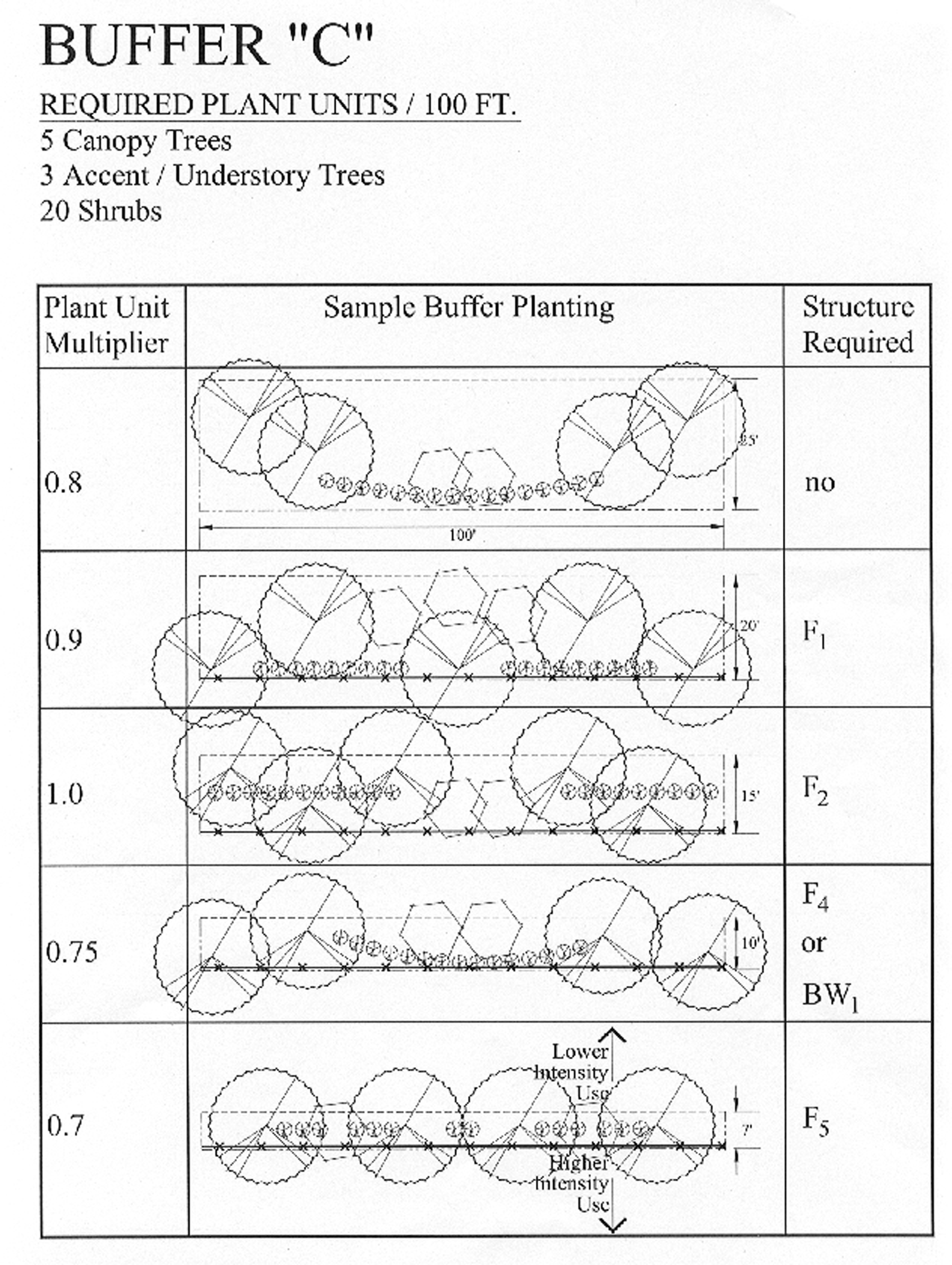
Exhibit 3
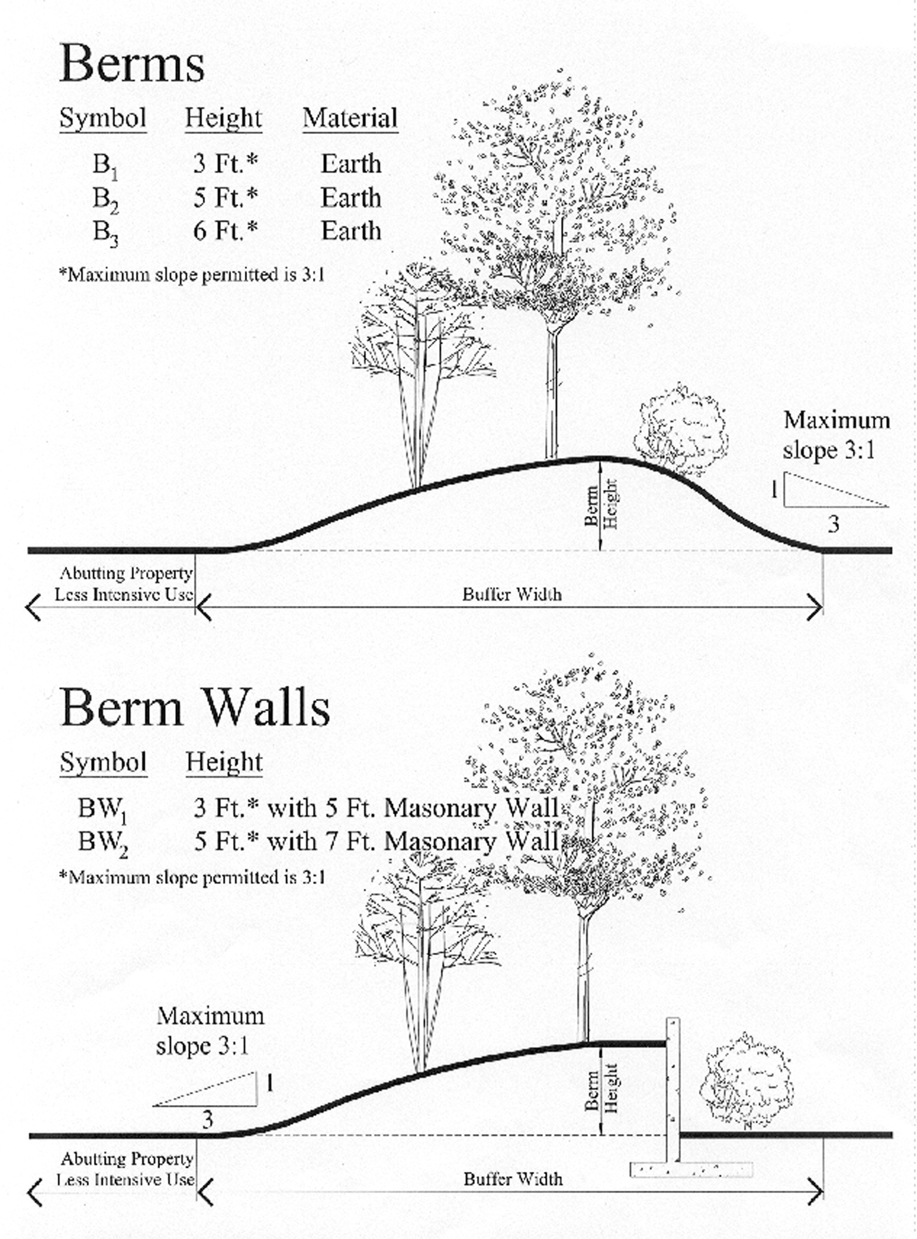
Exhibit 4
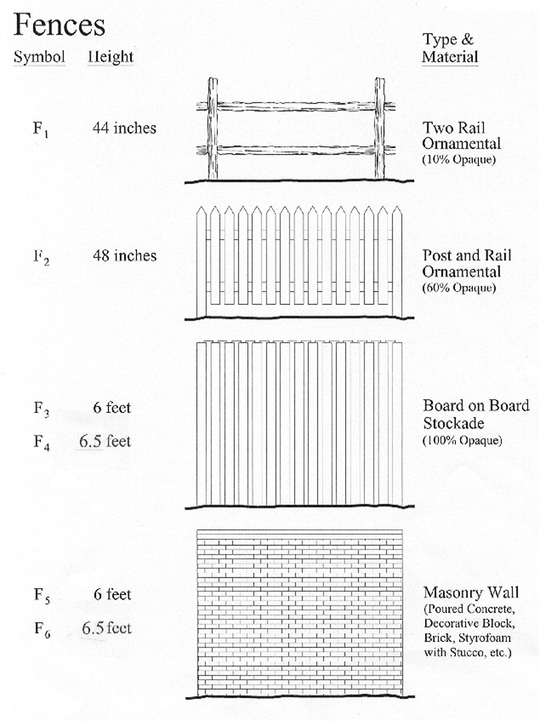
Exhibit 5
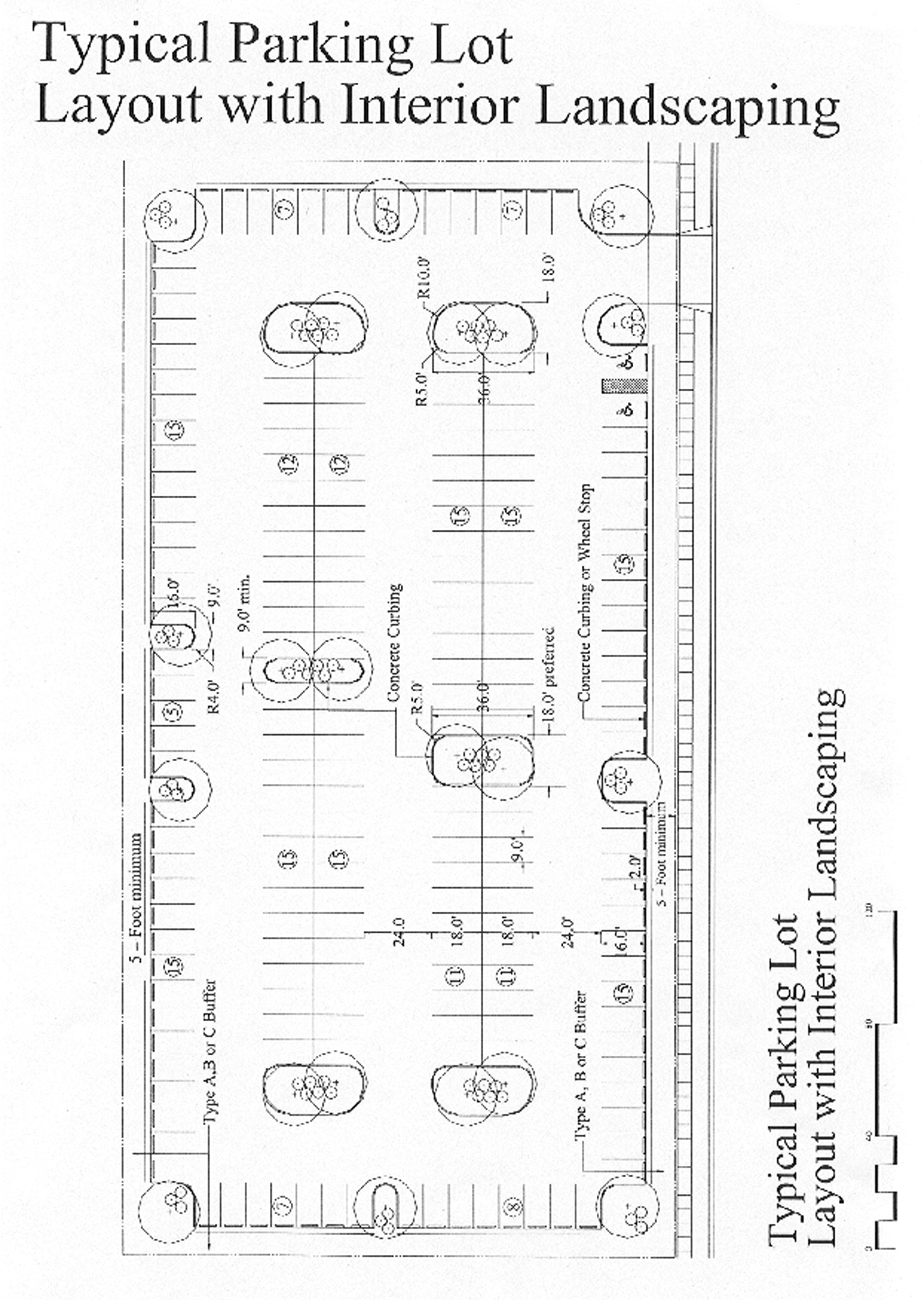
Exhibit 6
Exhibit 7
Exhibit 8
Exhibit 9
Exhibit 9
Exhibit 9
(Ord. No. 02-4357, 4-29-02; Ord. No. 10-4927, § 2(att. 1), 2-22-11; Ord. No. 16-5173, § 5(Exh. A), 7-5-16; Ord. No. 21-5369, § 2, 5-2-22; Ord. No. 25-5583, § 2(Exh. A), 11-17-25)
Sec. VII-308.1. - Landscape standards for the downtown zone districts.
When conflicts with other sections of this zoning code occur, the provisions of this section shall take precedence and shall supersede other sections of this zoning code, However, the provisions of this section shall not be construed to take precedence over the Florida Building Code or the city's Engineering Design Criteria Manual.
(Ord. No. 04-4531, § 3, 6-7-04; Ord. No. 13-5041, § 2(att. 1), 3-4-13)
Editor's note— Ord. No. 04-4531, § 3, adopted June 7, 2004, amended the Code with the addition of a new section VII-309. In order to avoid duplication of section numbers, the provisions of said ordinance have been included herein as section VII-308.1 at the discretion of the editor.
Sec. VII-309.- Administration and purpose.
(a)
The administration of article VII, division 3.1, tree protection, shall be by the director of development services.
(b)
The purpose of these regulations is to promote a healthy, diverse, and resilient tree canopy while allowing for reasonable flexibility in fulfilling the following objectives:
(1)
Encouraging the use of native and Florida-friendly trees.
(2)
Facilitating the elimination of invasive species of trees that threaten the native ecosystem.
(3)
Encouraging the use of trees suited to local growing conditions.
(4)
Facilitating the placement of the right tree in the right location through careful consideration of the appropriate tree species for the specific growing space.
(5)
Enhancing the overall appearance of the City of Sarasota.
(6)
Improving air quality through the retention and installation of trees.
(7)
Conserving water by protecting established and native landscaping.
(8)
Increasing property values through the use of trees as a capital asset.
(9)
Providing a reasonable mechanism for the removal of trees and mitigation therefor.
(10)
Encouraging the planting and protection of shade trees benefiting pedestrians and allowing for a more walkable urban environment.
(Ord. No. 02-4401, § 3, 8-4-03; Ord. No. 09-4838, § 2(att. 1), 2-17-09; Ord. No. 21-5369, § 1, 5-2-22)
Sec. VII-310. - Grand trees.
(a)
Grand tree: A tree is considered a grand tree if it is determined to have a good or moderate suitability rating by a city arborist, based on the definitions found under the suitability ratings below and is either a Live Oak (Quercus virginia) or Sand Live Oak (Quercus geminata) that has a DBH measurement of 24 inches or greater; or is a Slash Pine (Pinus elliottii), Longleaf Pine (Pinus palustris) or Southern Red Cedar (Juniperus virginiana) that has a DBH measurement of 20 inches or greater. A grand tree shall have the same meaning, and force and effect of law, as a specimen or historical tree under state law (including F.S. § 163.3209, as may be amended from time to time).
(1)
Suitability ratings.
a.
Good: Trees in this category are in good health and structural stability and have potential for longevity at the site.
b.
Moderate: Trees in this category are in fair health and/or have structural defects that may be mitigated with treatment. These trees may require more intense management and monitoring, and may have shorter life-spans than those in the "good" category.
c.
Poor: Trees in this category are in poor health or have significant defects in structure that cannot be mitigated with treatment. These trees can be expected to decline regardless of management.
(2)
The final decision as to the health of the tree is to be determined by a city arborist.
(b)
The removal of a grand tree located upon public or private property is hereby prohibited unless exempted in accordance with subparagraph (c) or (f) below.
(c)
The director of development services may exempt a grand tree from subsection (b) above upon making one or more of the following findings:
(1)
A grand tree is in an advanced state of decline, as determined by a city-approved certified arborist or state-registered landscape architect. Unless the grand tree is obviously dead or diseased, the city approved certified arborist report must include a resistograph test or similar test which is approved by the city arborist for use in determining if the grand tree is in such an advanced state of decline as to justify removal of said grand tree.
(2)
A grand tree is located where an infrastructure improvement or structure which complies with all applicable codes is to be located and the applicant has made all reasonable efforts to relocate the infrastructure improvement or structure to preserve the grand tree. Applicant shall provide alternative design plans with accompanying narrative explaining why alternate designs do not work.
(3)
In order to preserve the grand tree, it would be necessary for at least 25 percent of the parking area or buildable area to be rendered unusable or unbuildable. Applicant must show hatched diagram illustrating loss of parking area or buildable area to qualify for this exemption.
(4)
An imminent safety hazard exists which can be mitigated by removal of the grand tree.
(d)
In determining whether an applicant has made a reasonable effort to relocate the infrastructure, improvements, or structure to preserve trees, the director of development services shall consider whether an applicant has considered design alternatives or has requested a variance from the terms of the zoning code (see section IV-606(f) of this Code). In making such a determination, the director of development services may consult with an independent state-registered landscape architect in regard to the reasonableness of any effort of the applicant to preserve trees. The cost of such a consultation shall be borne by the applicant. The director of development services may require payment of an estimated fee for the consultation in advance by the applicant.
(e)
Any applicant who obtains a tree removal permit for a grand tree shall post said tree removal permit in a location visible from the right-of-way at the front of the property permitted for the tree removal no less than five working days prior to removal of the grand tree unless the director has determined that the grand tree is creating an imminent safety hazard. Additionally, said applicant shall identify the tree(s) to be removed with an orange plastic ribbon tied around the trunk of said tree commencing at least five working days prior to removal of the grand tree unless the director has determined that the grand tree is creating an imminent safety hazard to pedestrians, bicycles, vehicular traffic or public utility infrastructure. Failure to post tree removal permit and identify grand tree(s) with orange plastic ribbon shall be subject to a fine.
(f)
Notwithstanding the above, the City of Sarasota recognizes and adheres to any exception to these regulations found under state law (including, but not limited to, F.S. § 163.045, as may be amended from time to time).
(Ord. No. 02-4401, § 3, 8-4-03; Ord. No. 09-4838, § 2(att. 1), 2-17-09; Ord. No. 16-5173, § 4, 7-5-16; Ord. No. 21-5369, § 1, 5-2-22; Ord. No. 25-5583, § 2(Exh. A), 11-17-25)
Sec. VII-311. - Prohibited trees.
The following species of trees are prohibited: Melaleuca quinquenervia (Punk tree), Schinus terebinthifolius (Brazilian Pepper), Casuarina spp (Australian Pine), Cupaniopsis anacardioides (Carrotwood), Melia azedarach (Chinaberry), Sapium sebiferum (Chinese Tallow), and Ficus microcarpa (Cuban Laurel). The sale, purchase or planting of prohibited trees as defined in this Code for the purposes of planting upon private or public property shall be prohibited, unless a permit has been issued by the state department of environmental protection in accordance with F.S. § 369.251. A copy of the state permit shall be submitted to the director of neighborhood and development services prior to commencing any sale, purchase or planting of a prohibited tree. Established prohibited trees are not required to be removed by this section.
(Ord. No. 02-4401, § 3, 8-4-03; Ord. No. 21-5369, § 1, 5-2-22)
Sec. VII-312. - Protection of trees during development.
(a)
During the development of property, any person owning a legal interest in the real property under construction, the contractor who has been issued a tree removal permit and the contractor who has been issued a building permit shall be equally responsible for the erection of any and all barriers or protective guards necessary to protect any existing or installed trees from damage during construction in accordance with the tree protective barrier requirements and specifications detailed in the illustration and text labeled "tree protective barrier." (The tree protective barrier description included as exhibit 9 in section VII-308 is hereby deleted and replaced with the three (3) sketches labeled Tree Protective Barrier attached hereto and incorporated by reference herein as exhibit A.) The property owners and contractors described above shall be subject to a $250.00 initial penalty and a $100.00 daily penalty if the tree protection barriers are not in place around all protected trees and grand trees prior to and during any land clearing activity, demolition activity, construction staging activity or construction activity. Additionally, the work may be stopped by the building official, city arborist or their designees until appropriate tree protection barriers are in place.
(1)
Barricades shall be installed a minimum of ten feet from a protected tree or at the designated protected root zone as shown on the approved site plan. The city arborist may allow minor modifications to this standard based upon specific site configuration issues.
(2)
Barricades shall be installed a minimum of 20 feet from a grand tree or at the designated protected root zone as shown on the approved site plan and shall be chain link a minimum of six feet in height. The city arborist may allow minor modifications to this standard based upon specific site configuration issues.
(3)
No changes to the predevelopment conditions within the approved protected root zone are allowed during the construction process, but a barricade may be temporarily relocated to accommodate a construction issue if advance notice is provided to the city arborist.
(b)
Prior to and during land clearing, including grubbing, all trees to be removed shall be clearly marked with ribbons at 36 inches minimum above grade. All trees to be removed shall be identified by an orange plastic ribbon tied around the trunk of said tree prior to the onsite inspection of the city's arborist. The city shall provide the orange ribbon to the applicant at the time of application for the tree removal permit. If the orange ribbon is not located upon any tree at the time of inspection by the city arborist, the inspection will be rejected and a re-inspection fee shall be charged to the applicant.
(c)
Any excess soil, additional fill, vehicles, equipment, liquid waste, solvents or construction debris shall not be placed during construction within the protective barrier area surrounding a tree. The tree or its root system surrounded by a protective barrier shall not be otherwise damaged.
(d)
Any attachments or wires other than those of a protective or of a non-damaging nature shall not be attached to any trees.
(e)
Underground utility lines shall be routed around existing trees or otherwise placed by tunneling under the tree at a minimum depth of 30 inches by hand digging. Any roots affected must be cut according to guidelines set forth in this division. No roots over three inches in diameter shall be cut. Fences or walls shall not be installed where they interfere with the root system of existing trees. Footings for walls shall end at the point where large roots (over three inches in diameter) are encountered. Post holes and trenches located close to trees shall be adjusted to avoid damage to major roots.
(1)
All roots must be severed clean at the protected root zone of protected and grand trees to prevent root damage.
(2)
Root pruning must be performed with an approved cutting type of equipment, such as a chainsaw, hand saw or other cutting equipment.
(3)
Root pruning must be performed prior to any construction activities and inspected by the city arborist before requesting building permit inspections.
(4)
This section shall not apply to utility line maintenance or replacement.
(f)
Any person owning a legal interest in the real property under construction, the contractor who has been issued a tree removal permit and the contractor who has been issued a building permit shall be equally responsible for the maintenance of all trees planted or protected by this division while such property is under construction. This protection includes removal or unnecessary damage to trees or roots of trees on abutting properties. All transplanted trees on the site shall be maintained using acceptable horticultural practices. Any persons owning a legal interest in real property for which a tree removal permit has been issued shall be responsible for replacing any newly planted or transplanted trees on such property used to meet minimum requirements, as outlined in this division, which die or become so unhealthy so as to lose their aesthetic and functional requirement after the construction on such property has been completed.
(g)
All original or replanted trees required as tree mitigation shall survive for at least one year from the date of final inspection for the tree permit. Any such tree that does not survive shall be replanted at the property owner's expense. Such replanted trees shall also be required to survive for a one-year period from the date of replanting. All transplanted trees on the site shall be maintained using acceptable horticultural practices. Any person owning a legal interest in real property for which a tree removal permit has been issued shall be responsible for replacing any newly planted or transplanted trees on such property used to meet minimum requirements as outlined in this division which die or become so unhealthy so as to lose their aesthetic and functional requirement after the construction on such property has been completed.
(h)
The provisions of this section shall not apply when the director of development services has determined that the protected tree or grand tree is creating an imminent safety hazard.
(i)
Any person owning a legal interest in the real property under construction, the contractor who has been issued a tree removal permit, and the contractor who has been issued a building permit, shall all be equally responsible for compliance with each and every requirement of this section.
(Ord. No. 02-4401, § 3, 8-4-03; Ord. No. 16-5173, § 5, 7-5-16)
Sec. VII-313. - Trees abutting public property.
The owner or occupant of real property shall not permit trees located thereon to extend over any public sidewalk or other public right-of-way unless the trees or trees are kept trimmed from the sidewalk to a height of ten feet and to a height of 14½ feet over any street or public right-of-way.
(Ord. No. 02-4401, § 3, 8-4-03)
Sec. VII-314. - Trees within utility easements.
(a)
Property owner obligations: Trees planted or preserved within a utility easement by an abutting property owner shall not interfere with power lines, cable television lines, sewer pipes, water pipes or any other existing or proposed overhead or underground utility service. The location of underground utility lines shall be determined prior to planting within an easement by the property owner.
(b)
Utilities—Obligations: Utility companies, electric suppliers and governmental agencies constructing or maintaining easements for water, sewer, electricity, gas, drainage, telephone or television transmission shall be exempt from the provisions of section VII-316 requiring a tree removal permit if the applicable company, supplier or agency has executed an agreement reviewed by the planning board and approved by the city commission (hereinafter "tree protection agreement" a/k/a "TPA"). The TPA at a minimum shall contain the following provisions:
(1)
Recognizes the need to minimize the cutting or trimming of grand trees.
(2)
Establishes, to the extent feasible, design guidelines for construction and maintenance which identifies the saving of grand trees as a factor to be considered in the design process.
(3)
Provides for the protection of trees during construction or easement maintenance activity in accordance with section VII-312 of this division.
(4)
Provides for a consultation process for the director of neighborhood and development services prior to the commencement of major construction or maintenance or the removal of grand trees as detailed in the TPA, including, but not limited to, consultation with a city-approved certified arborist.
(5)
Provides that a violation of any provision or condition of the TPA constitutes a violation of this division and results in a loss of the exemption from the requirements of this division. Additionally, the applicable company, supplier or agency who has violated the TPA shall be subject to the penalties specified in section VII-325 of this division and shall be required to financially contribute to the replacement tree fund in accordance with section VII-324(b), for each tree or portion thereof removed in violation of the TPA. Violations of the TPA shall be enforceable through the code enforcement special master process as violations of the zoning code in accordance with section 2-309, Sarasota City Code.
(6)
The applicable company, supplier or agency that has executed the TPA shall indemnify and hold the city harmless from any and all claims, liabilities, losses, or damages on account of or in any way arising from the existence of the TPA.
(7)
The applicable company, supplier or agency that has executed the TPA shall be required to obtain and maintain a policy (or policies) of liability insurance for injuries to persons or damage to property caused by or resulting from the execution of the TPA and said entity's activities in the utility easement area with coverage limits acceptable to city and to name city as an additional insured in such policy or policies.
(8)
The city shall have the sole and absolute right to terminate the TPA upon reasonable advance written notice to the other contracting party as specified in the TPA.
(9)
A provision which limits the duration or term of the TPA.
(10)
In addition to the matters enumerated above, a TPA may contain such other terms and conditions as may be recommended by the director of neighborhood and development services through the city manager, by the city attorney, or by the planning board which are approved by the city commission.
(Ord. No. 02-4401, § 3, 8-4-03; Ord. No. 09-4838, § 2(att. 1), 2-17-09)
Sec. VII-315. - Suspension during emergency.
In an event the city commission adopts an emergency ordinance pursuant to F.S. § 252.38(3)(a)(5) as amended, to declare a natural emergency as defined in F.S. ch. 252, the provisions of this division shall be suspended for damaged, uprooted, or downed trees within the geographic area of the city subject to the declaration of a natural emergency for the duration of the state of emergency so declared.
(Ord. No. 02-4401, § 3, 8-4-03; Ord. No. 25-5583, § 2(Exh. A), 11-17-25)
Sec. VII-316. - Tree removal—Permit required.
Removing or causing to be removed any tree or trees protected by this division located upon private or public property is prohibited unless a tree removal permit has been obtained from the director of development services, except as provided under subsection VII-320(d). Utility companies, electric suppliers and governmental agencies constructing or maintaining easements for water, sewer, electricity, gas, drainage, telephone or television transmission shall be exempt from the provisions of this section if the applicable company, supplier or agency has executed a tree protection agreement with the city which remains in effect, in accordance with the requirements of section VII-314 of this division.
(Ord. No. 02-4401, § 3, 8-4-03; Ord. No. 09-4838, § 2(att. 1), 2-17-09; Ord. No. 21-5369, § 1, 5-2-22)
Sec. VII-317. - Local business tax receipts and insurance required.
Contractors, subcontractors, tree service contractors, their agents and employees who perform pruning, planting, trimming or removing of trees within the City of Sarasota shall be required to hold valid local business tax receipts and valid proof of worker's compensation insurance, public liability insurance and property damage insurance in accordance with any applicable requirements of Florida law.
(Ord. No. 02-4401, § 3, 8-4-03; Ord. No. 07-4720 § 2, 5-21-07)
Sec. VII-318. - Exempt trees.
This division shall not apply to:
(1)
Citrus trees.
(2)
Trees grown at commercial nurseries as part of their stock.
(3)
Trees not protected by any other ordinance, or under four and one-half inches D.B.H. with the exception of trees under four and one-half inches D.B.H. when planted to fulfill tree removal mitigation requirements or when planted to fulfill other zoning code requirements.
(4)
Trees grown in institutional botanical gardens as part of the display area. Required trees in parking areas and use and parking buffers are not exempt.
(Ord. No. 02-4401, § 3, 8-4-03; Ord. No. 21-5369, § 1, 5-2-22)
Sec. VII-319. - Permit procedure.
The director of development services may issue a tree removal permit upon application submitted in accordance with the following requirements:
(1)
Applications for a tree removal permit shall be submitted on forms prescribed by the director of development services. The applications shall include an affidavit that the applicant, if a contractor required by state law to obtain specified insurance, has obtained such insurance in the amounts required by state law and that such insurance remains in full force and effect. A permit fee shall be paid at the time the tree removal permit is issued.
(2)
A tree removal permit must be obtained prior to the removal of a prohibited tree, however, no permit fee shall be required to be paid.
(3)
The applicant shall submit a site plan containing the following information:
a.
The shape and dimensions of the lot or parcel, together with the existing and proposed locations of structures and improvements, if any.
b.
The site plan shall be drawn utilizing standard architect's or engineer's scales.
c.
The site plan shall show the physical boundaries of the real property.
d.
The site plan shall show locations of all existing trees, identified by common or botanical names and with D.B.H. annotation on each tree as to whether it is to remain, be relocated, transplanted, replaced or to be removed shall be on the plan, including all mangroves.
e.
If existing trees are to be transplanted on the property, the site plan shall include the proposed location of such trees. A statement as to how all existing trees are to be moved, maintained and protected during construction must be submitted by the landscape architect, landscape contractor or landscape nurseryman responsible for the relocation of said trees.
f.
A statement as to the grade changes proposed for the lot or parcel and how such changes will affect those trees that are to remain on the lot or parcel.
g.
If the tree is an oak tree over 24 inches D.B.H. a statement from a certified arborist or state-registered landscape architect detailing the species of the oak tree.
h.
An applicant who is re-landscaping an existing qualifying residence may submit a simplified permit application pursuant to subsection VII-320(a)(3)b.
(4)
In lieu of submitting a tree removal permit application, an applicant may submit a no tree verification statement stating that no trees protected by this division exist on site. If such statement is substantiated by an inspection of the site by the director of development services, no permit will be required.
(5)
A tree removal permit shall not be issued for the removal or alteration of any species of Mangroves, Rhizophora mangle (Red Mangrove), Laguncularia racemosa (White Mangrove), Avicennia Germinana (Black Mangrove) and Conocarpus erecta (Buttonwood Mangrove) unless a permit for the removal or alteration of mangroves has been issued by the state department of environmental protection. A copy of the state permit shall be submitted with the application for tree removal to the city.
(Ord. No. 02-4401, § 3, 8-4-03; Ord. No. 09-4838, § 2(att. 1), 2-17-09; Ord. No. 21-5369, § 2, 5-2-22)
Sec. VII-320. - Criteria for granting permits.
(a)
The director of development services shall make one or more of the following findings prior to granting a permit for removal of trees not qualifying as grand trees pursuant to this division:
(1)
Removal of trees where no mitigation is required:
a.
That the tree proposed to be removed creates a significant safety hazard to pedestrians, bicycles, vehicular traffic or public utility infrastructure.
b.
That the tree proposed to be removed prevents reasonable access to private property.
c.
That the tree proposed to be removed is a diseased tree which creates an immediate and real hazard to people, buildings or other improvements on the subject real property or to other trees or which has a 50-percent or greater crown loss.
d.
That the tree proposed to be removed is dead, and is not presently being utilized for the nesting or harborage of avian species.
e.
That the tree is weakened by age, storm, fire or other injury and is dangerous to persons or property.
f.
That the public health, safety and welfare of the citizens of the city is promoted by the removal of the tree.
g.
That the tree proposed to be removed is a prohibited tree as defined by this Code.
h.
That the tree(s) to be removed is an undesirable tree species as listed under section VII-330.
(2)
Removal of trees where mitigation is required pursuant to section VII-322(2):
a.
That the tree proposed to be removed prevents the reasonable development of a lot or parcel. It is the intent of this provision that no permit shall be granted for the removal of any tree where the applicant has failed to design and locate the proposed improvements to minimize the removal of trees. The director of development services may require an applicant for a tree permit to redesign the proposed structure or improvements or relocate the same on the site so as to maximize the preservation of existing trees and to provide space to transplant or establish replacement trees on the same parcel of land in which they are removed. The director of development services may consult with a city-approved certified arborist or state-registered landscape architect. The cost of such consultation shall be borne by the applicant. The director of development services may require payment of an estimated fee for the consultation in advance by the applicant. Any tree removed pursuant to this subsection shall be mitigated in compliance with the applicable chart set forth in section VII-322(2).
i.
In making the findings required by subparagraph (a) of this section, the director of development services shall be guided by the following:
1.
The existing or proposed locations of structures and improvements upon the lot or parcel and the impact thereon with reference to the preservation of trees.
2.
The shape and dimensions of the lot or parcel.
3.
The size, age, proximity, location, health and survivability of existing trees upon the lot or parcel.
4.
The feasibility of transplanting trees upon the lot or parcel.
5.
The feasibility of redesigning the proposed structure or improvements.
6.
A comparison shall be made between existing trees within the buildable area of a lot and existing trees within setback areas. Existing trees within setback areas shall be given preferential consideration for protection.
ii.
Removal of trees within the right-of-way located within the boundaries of the downtown edge, downtown core and downtown Bayfront zone districts. In addition to making the findings required by subparagraph (2)(a) of this section, the director of development services shall be guided by the following:
1.
The existing or proposed locations of awnings upon the building, lot or parcel and the impact thereon with reference to the preservation of healthy trees within the right-of-way.
2.
The size, age, proximity, location, health and survivability of the existing tree.
3.
The feasibility of redesigning the proposed awning.
4.
Whether the director of development services has recommended that an adjustment be pursued prior to granting a removal permit.
b.
The property owner has produced a letter from his/her insurance carrier establishing that insurance coverage will be denied unless the protected tree is removed. Any tree removed pursuant to this subsection shall be mitigated in compliance with the applicable chart set forth in section VII-322(2).
c.
The outermost bark of the main trunk of the tree proposed to be removed is within 36 inches or less from the main structure or garage on the property. Any tree removed pursuant to this subsection shall be mitigated in compliance with the applicable chart set forth in section VII-322(2).
(3)
Removal of trees where mitigation may be required contingent upon additional factors:
a.
Removal of trees on public property and city trees in rights-of-way. If a tree is shown to cause a public hazard or create an unsafe condition, it may be removed and the unsafe condition corrected. Where practical it will be replaced with a more appropriate tree that:
i.
Adheres to the "right tree, right location" site evaluation and species selection (SESS) criteria pursuant to section VII-322(2)d.
ii.
Uses planting technologies that have been shown to reduce damage to public infrastructure.
iii.
Uses best management practices for new trees planted in that particular location and situation.
iv.
A city arborist will be consulted on these determinations and that recommendation will be approved by either the director of parks and recreation or the director of public works as may be appropriate, and the director of development services prior to the tree being removed and replaced. The determination should include consideration as to whether the hazard can reasonably be mitigated or eliminated without tree removal.
b.
That the tree(s) to be removed is for the purpose of re-landscaping an existing qualifying residence and is not a grand tree. An "existing qualifying residence" shall be defined as a single-family residential structure which has been owner-occupied by the applicant for at least one year. Applicants shall be provided with a simplified permit process whereby a site plan does not have to be drawn, signed, or sealed by a professional landscape architect or engineer. The intent of this provision is to allow city residents the ability to re-landscape their residential property provided that a grand tree is not being removed and appropriate mitigation is provided. Any tree removed pursuant to this subsection shall be mitigated in compliance with the applicable chart set forth in section VII-322(2) except:
i.
Upon a finding by the city arborist that the tree removal is due to over-density of trees on the site, whereby the "right tree, right location" principles [AKA - Site Evaluation and Species Selection (SESS) criteria] are better served through tree removal, then no replacement trees or mitigation fees are required. The finding of the city arborist may be based on supplemental information provided by a licensed landscape architect or certified arborist.
ii.
If a homeowner wishes to remove no more than 25 percent of existing tree canopy in the side and back yards, then no replacement trees are required and mitigation may be fulfilled through the payment of fees into the tree mitigation fund. This exception may only be utilized once every three years. The intent of this provision is to allow city residents the flexibility to provide for open space on their canopied or re-landscaped property for sun-dependent activities such as vegetable gardens, solar panels and sun-decks.
(b)
Trees qualifying as grand trees: The applicant must meet the requirements of section VII-310 of this division.
(c)
Exempt trees: A tree qualifying as an exempt tree must meet the requirements of section VII-318 of this division.
(d)
Notwithstanding the above, the City of Sarasota recognizes and adheres to any exception to these regulations found under state law (including, but not limited to, F.S. §§ 163.045 and 163.3209, as may be amended from time to time).
Note: Removal of a healthy right-of-way tree for the purpose of improving sight view corridors or making signage more visible does not qualify as a criterion for granting a tree removal permit absent an independent public health, safety, or welfare basis for removal.
(Ord. No. 02-4401, § 3, 8-4-03; Ord. No. 06-4663, § 2, 3-20-06; Ord. No. 09-4838, § 2(att. 1), 2-17-09; Ord. No. 16-5173, § 6, 7-5-16; Ord. No. 21-5369, § 2, 5-2-22)
Sec. VII-321. - Permit denial.
If the tree removal permit is denied, the applicant shall be notified, in writing as to the reason for the denial of the permit. An applicant may appeal any decision of the director of neighborhood and development services pertaining to the denial of a tree removal permit or any other decision of the director of neighborhood and development services interpreting or applying this division to the board of adjustment. (See section IV-702(c) of this Code.)
In the event the director of neighborhood and development services determines that it is reasonable to require the redesign of the proposed structures, improvements, or their relocation on the site, so as to preserve existing trees, to accommodate the installation of replacement trees, or transplanting of existing trees, and the applicant fails to submit the design changes, relocate the building or improvements on the site or request a variance (see section IV-606(f) of this Code), the permit shall be denied.
(Ord. No. 02-4401, § 3, 8-4-03; Ord. No. 09-4838, § 2(att. 1), 2-17-09; Ord. No. 21-5369, § 2, 5-2-22)
Sec. VII-322. - Permit conditions.
All persons issued permits pursuant to this division shall:
(1)
Post a weather-proof protected copy of the tree removal permit at the site proposed for the tree removal. The permit must be displayed on the site prior to the removal of any trees, and remain on the site until the tree removal or construction work is completed.
(2)
Required replacement tree(s). When trees are removed with an approved tree removal permit pursuant to section VII-320(a)(2), or pursuant to section VII-320(a)(3) when applicable, they must be replaced as found below.
a.
If the tree is being removed from residential property 1 , it must be replaced as follows:
Table 1
b.
If a tree is being removed from any property other than residential property 1 , it must be replaced as follows:
Table 2
c.
The required replacement tree or trees shall be of like species, or an alternative species approved by the director of development services based upon consideration of the site conditions (e.g., presence of overhead power lines).
d.
The replacement tree or trees shall adhere to "right tree, right location" principles, meaning that the following site evaluation and species selection (SESS) criteria shall be considered and adhered to:
Site evaluation criteria:
Hardiness zone
Light exposure
Salt tolerance
Other trees onsite
Overhead/underground utility conflict
Building (proximity to)
Root spacing restrictions
Compacted soils, poor drainage, low oxygen
Irrigation
Soil improvements/soil Ph
Species Selection criteria:
Mature size
Form (open canopy/pyramidal/conical)
Function (shade, flower, nesting, etc.)
Fertilization
Maintenance (prune/drop fruit)
Aggressive/destructive roots
e.
The replacement canopy tree or trees canopy trees shall not be less than 12 feet in overall height, with a minimum four-foot spread. Palms shall be a minimum of 12 feet overall height. For all other protected trees which are removed, the replacement tree(s) shall not be less than eight feet in overall height.
f.
Only those tree(s) which are planted in compliance with the SESS criteria under subsection d. above, as determined by a City of Sarasota Arborist, shall be credited towards mitigation.
g.
Trees or palms shall otherwise meet or exceed the "Florida Department of Agriculture, Grades and Standards for Nursery Stock, Florida Number one Grade," as the same may be amended from time to time. Native trees are encouraged. A copy of said publication is on file at the office of the city auditor and clerk, and made part by reference.
h.
Replacement trees must be planted onsite, except where incompatible with site evaluation and species selection (SESS) criteria, whereby mitigation may be satisfied through either: paying into the tree mitigation fund; arranging to plant on private property within a neighborhood or 1,000 feet of the subject site; or on public right-of-way, public property, or public park. The receiving site must be within city limits. The owner of the receiving site must provide to the director a letter or some other written document agreeing to accept the mitigation tree(s) and to allow for said tree(s) to be watered and maintained until fully established, and give permission for the city arborist to enter the property to monitor tree health during the one-year establishment period.
i.
No mitigation shall be required if the tree removed is an undesirable tree species as listed under section VII-330.
j.
When trees are removed with an approved tree removal permit for housing sold or rented to low- and moderate-income families, permittees qualify to use eligible funds pursuant to the City of Sarasota Schedule of Fees and Charges for Tree Removal Permits and Replacement Tree Fund. For purposes of this division "housing sold or rented to low- and moderate-income families" means families having under 80 percent of the county median income. Permittees are required to replace or mitigate for tree removal in accordance with subsection (2)a. (Table 1) above, except that they will be subject to a reduced mitigation fee pursuant to the aforementioned fee schedule.
k.
In implementing the tree mitigation described in subsections (2)a. and b., above, palm trees may not be utilized as replacement mitigation trees when canopy trees have been removed. In the case of site-specific conditions such as the presence of overhead powerlines, understory trees or canopy trees that will mature to a lower height than the projected conflict structures shall be required. In the case of potential below ground utility conflicts, the director may require Silva cells or similar technology.
l.
Mitigation for trees removed from the right-of-way within the downtown zone districts. The required replacement tree or trees shall be of like species or an alternative species approved by the director of public works. The replacement tree or trees shall be equal in caliper size as the tree removed. The permittee shall plant the replacement trees or palms required prior to the issuance of any required final inspection or certificate of occupancy by the city or within 45 days of tree removal if the tree removal is not related to other permitted construction activities on site.
m.
The permittee shall plant the replacement trees or palms required prior to the issuance of any required final inspection or certificate of occupancy by the city or within 45 days of tree removal if the tree removal is not related to other permitted construction activities on site.
n.
If a replacement tree cannot be planted on the removal site or within close proximity to the removal site, as determined by the director of development services, the applicant shall be required to pay a minimum fee into the replacement tree fund as identified in section VII-324 of this division. All fees owed shall be paid prior to the issuance of any building permit for the project.
(3)
For a tree removed without proper permits the required replacement D.B.H. or fee shall be tripled and a tree of like species shall be replaced at the same location or in close proximity to the site of the tree removal, as determined by the director of development services, in addition to paying the penalties specified in section VII-325.
(4)
A tree removal permit shall be valid for a period of no more than six months from the date of issuance and may be extended in the same manner as a building permit under the Florida Building Code. If the applicant fails to obtain an extension of the tree removal permit, a new tree removal permit will be required prior to commencing construction. If trees are removed as part of a tree removal permit but replacement or mitigation trees have not been installed prior to the tree removal permit expiration, the tree replacement and mitigation obligation remains with the property and must be fulfilled prior to the issuance of any building permit unless the mitigation obligation is transferred to the new building permit.
(5)
Credit for other plantings. Trees planted in compliance with the landscaping requirements of this Code may be used in whole or in part to satisfy the replacement tree requirements of this section as determined by the director of development services.
(6)
Trees removed from the city right-of-way shall be transplanted to another city right-of-way or city property so as to maximize the preservation of existing trees if such relocation is deemed viable by a city-approved certified arborist. The cost of such relocation and shall be borne by the permittee.
(7)
After removal of trees within the city right-of-way, the permittee shall repair the sidewalk to standards specified by the EDCM within one week of tree removal or prior to the issuance of any required final inspection or certificate of occupancy by the city if other sidewalk improvements are being made related to other permitted construction activities on site. The city engineer can direct that repairs be made at an earlier time if it is felt that there is any danger to the public and can order any interim safety measures.
(Ord. No. 02-4401, § 3, 8-4-03; Ord. No. 06-4663, § 2, 3-20-06; Ord. No. 09-4838, § 2(att. 1), 2-17-09; Ord. No. 16-5173, § 7, 7-5-16; Ord. No. 17-5205, § 2, 6-19-17; Ord. No. 21-5369, § 2, 5-2-22; Ord. No. 23-5475, § 2(Exh. A), 4-17-23)
Note— 1 "Residential property" means a single-family, detached building located on a lot that is actively used for single-family residential purposes and that is either a conforming use or a legally recognized nonconforming use in accordance with the City of Sarasota's land development regulations.
Sec. VII-323. - Revocation of permits.
The director of neighborhood and development services may revoke any permit issued pursuant to the division for the failure of the permittee to adhere to any standard or requirement of this division. A permit may also be revoked by the director of neighborhood and development services upon determining the permit was granted based upon material false information, misrepresentation of material fact or mistake of fact or law. Prior to revoking a permit, the permittee shall be given written notice of the violation and the action necessary to correct the same. The notice shall be delivered by U.S. certified mail, return receipt requested, or by hand delivery. The notice shall provide that failure to correct the violation shall result in the revocation of the permit. Within five days of receipt of the aforementioned notice, the permittee may request an opportunity to appear before the director of neighborhood and development services in order to show cause why the permit should not be revoked. However, such appearance shall not be required in the event that the permittee cures the violation within the time designated. If the permittee fails to submit a timely request to appear before the director of neighborhood and development services or if such a request is submitted and the permittee fails to appear as required, the tree removal permit shall be revoked.
(Ord. No. 02-4401, § 3, 8-4-03; Ord. No. 09-4838, § 2(att. 1), 2-17-09)
Sec. VII-324. - Schedule of fees and charges.
(a)
Tree removal permit fee: The fee schedule for tree removal permits shall be adopted by resolution of the city commission and a copy of the resolution shall be maintained at the department of neighborhood and development services and in the office of the city auditor and clerk.
(b)
Replacement tree fund:
(1)
Fees collected in lieu of planting replacement trees on the removal site shall be deposited into a separate fund designated by the city as the replacement tree fund. The fee schedule for the replacement tree fund shall be adopted by resolution of the city commission and a copy of the resolution shall be maintained at the department of neighborhood and development services and in the office of the city auditor and clerk.
(2)
Fees collected for the removal of trees within the city right-of-way shall be placed into a separate fund designated by the city as the replacement tree fund as specified in subparagraph (1) of this section.
(Ord. No. 02-4401, § 3, 8-4-03; Ord. No. 06-4663, § 2, 3-20-06; Ord. No. 16-5173, § 8, 7-5-16)
Sec. VII-325. - Penalty for noncompliance.
Any person violating section VII-310 or VII-316 of this division without a proper tree removal permit shall be subject to imposition of a maximum fine of $225.00 per one inch D.B.H. of tree removed. In addition, any permit fees shall be tripled. If the illegally removed tree is a grand tree, the fine shall be $225.00 per one inch D.B.H. of tree removed and any permit fees shall be tripled. In addition, the grand tree illegally removed shall be replaced by the required replacement tree on-site at the same location or within close proximity to the removal site with a tree as close to the original size as is feasible, as determined by the director of neighborhood and development services.
In addition, any person who fails to comply with any requirements of this division or any permit conditions shall be subject to imposition of a fine of $100.00 per day until the noncompliance is corrected.
If the protected tree is completely removed from the site, the director of neighborhood and development services shall be permitted to estimate the size of the tree removed and determine the penalty.
It is the intent of this section that each tree removed or division requirement violated shall constitute a separate offense. Any person owning a legal interest in the real property upon which the removed tree is located and the contractor who was issued either the tree removal permit or building permit for construction thereon shall be individually and separately subject to the penalties as set forth herein. In addition, any person other than those enumerated above found to have illegally removed a tree in violation of this division shall be subject to the penalties as set forth herein. It shall not be a defense to this section that the person owning any legal interest in the real property upon which the tree is located or the contractor who was issued the tree removal permit or building permit for construction thereon did not have actual knowledge of the tree removal when the violation occurred.
(Ord. No. 02-4401, § 3, 8-4-03; Ord. No. 09-4838, § 2(att. 1), 2-17-09)
Sec. VII-326. - Withholding of permits and imposition of stop work orders.
Until the provisions of this division, including the conditions of any permits issued thereunder, have been fully met, the city may withhold issuance of any building permit, certificate of occupancy, or inspection required under the current city building code or issue stop work orders for any development, or construction or demolition on any lots, involving tree removal.
(Ord. No. 02-4401, § 3, 8-4-03)
Sec. VII-327. - Removal of dead or damaged trees.
Where dead, damaged or diseased trees exhibit a public health, safety or welfare concern as determined by the director of neighborhood and development services or designee, they shall be removed. Such removal shall be within a period of time as determined by the director of neighborhood and development services.
(Ord. No. 02-4401, § 3, 8-4-03; Ord. No. 09-4838, § 2(att. 1), 2-17-09)
Sec. VII-328. - Testing.
The city arborist is hereby authorized to request testing results from any applicant seeking to remove a tree. Specifically, the city arborist may request testing of any tree or the soil around the perimeter of any tree if the city arborist finds any evidence or reason to believe that the tree requested to be removed has been poisoned. The purpose of said testing is to determine if any attempt has been made to poison the tree sought to be removed. Said test shall be funded by the city's urban forestry line item. in the event the director determines that a tree has been poisoned, the procedures and penalties set forth in section VII-325 shall apply.
(Ord. No. 16-5173, § 9, 7-5-16)
Sec. VII-329. - Recommended trees.
The following are recommended trees:
(1)
Acer rubrum (Red Maple).
(2)
Bursera simaruba (Gumbo Limbo).
(3)
Chionanthus virginicus (Fringe Tree).
(4)
Clusia rosea (Clusia (Pitch Apple - tree form).
(5)
Coccoloba diversifolia (Pigeon Plum).
(6)
Coccoloba uvifera (Sea Grape - tree form).
(7)
Concarpus erectus (Buttonwood - tree form).
(8)
Cordia spp (Geiger spp).
(9)
Delonix regia (Royal Poinciana).
(10)
Eugenia foetida (Spanish Stopper — tree form).
(11)
Ilex spp (Holly spp).
(12)
Juniperus virginiana (Southern Red Cedar).
(13)
Lagerstroemia indica (Crapemyrtle - tree form).
(14)
Magnolia spp (Magnolia).
(15)
Magnolia virginiana (Sweetbay magnolia).
(16)
Myrcianthes fragrans (Simpson Stopper - tree form).
(17)
Pinus elliotti (Slash Pine).
(18)
Pinus palustris (Long Leaf Pine).
(19)
Platanus occidentalis (Sycamore).
(20)
Prunus angustifolia (Chickasaw Plum).
(21)
Prunus umbellate (Flatwoods Plum).
(22)
Quercus geminata (Sand Live Oak).
(23)
Quercus virginiana (Live Oak).
(24)
Sabal palmetto (Cabbage Palm).
(25)
Reserved.
(26)
Tabebuia aurea (Silver Trumpet tree).
(27)
Terminalia buceras CV (Black Olive or Shady Lady).
(28)
Ulmus alata (Winged Elm).
(Ord. No. 21-5369, § 1, 5-2-22; Ord. No. 25-5583, § 2(Exh. A), 11-17-25)
Sec. VII-330. - Undesirable trees.
Undesirable trees negatively impact the City of Sarasota's vision of a healthy, safe and long-term canopy. A tree's status as "undesirable" shall constitute a basis for its removal and no mitigation or fees are required for its removal. If an undesirable tree is planted, it shall not be given any credit towards required mitigation. The following trees are deemed undesirable:
(1)
Acacia auriculiformis (Earleaf Acacia).
(2)
Albizia spp (Mimosa spp).
(3)
Araucaria araucana (Monkey Puzzle).
(4)
Araucaria heterophylla (Norfolk Island Pine).
(5)
Bauhinia blakeana (Hong Kong Orchid).
(6)
Bischofia javanica (Bischofia).
(7)
Castillemon viminalis (Bottle Brush).
(8)
Chorisia speciosa (Floss Silk Tree).
(9)
Cinnamomum camphora (Camphor Tree).
(10)
Dalbergia sissoo (Indian Rosewood).
(11)
Enterolobium cyclocarpa (Ear/Elephant's Ear).
(12)
Grevillea robusta (Silk Oak).
(13)
Koelreuteria spp (Golden Rain Tree).
(14)
Schefflera actinophylla (Schefelera).
(15)
Syzgium cumini (Java Plum).
(16)
Thespesia polulnea (Mahoe).
(Ord. No. 21-5369, § 1, 5-2-22)
Sec. VII-331. - Protection of tree roots.
No tree root larger than three inches in diameter shall be severed unless a root management plan by a certified arborist and/or landscape architect has been submitted and approved by a city arborist.
(Ord. No. 21-5369, § 1, 5-2-22)
Sec. VII-332. - Canopy road designation.
Upon application by a resident or city staff, the city commission may designate a roadway as a "canopy road" and erect a sign to commemorate such designation provided that the following three conditions are met:
(a)
The canopy road shall have a minimum of approximately 50 percent upper story coverage (not counting invasive species), per section of roadway as measured by branching, drip line, shadows, and other visual cues.
(b)
The canopy road shall consist of a minimum of approximately 75 percent native and naturalized species.
(c)
The canopy road shall consist of a minimum length of approximately one-eighth mile (660 feet).
(Ord. No. 21-5369, § 1, 5-2-22)
Sec. VII-601.- Purpose.
The purpose of this division is to provide regulations governing the size, location, and operation of certain uses and development types that have the potential to adversely affect adjoining uses.
(a)
Quick vehicle servicing/motor vehicle service uses.
(b)
Motor vehicle sales agency/lots (new or used).
(c)
Accessory drive-through facilities.
(d)
Stadiums and auditoriums.
(e)
Automobile wrecking yards and recycling facilities.
(f)
Outdoor seating and other outdoor areas of establishments.
(g)
Child care and family day care facilities.
(h)
Commercial wireless telecommunication towers and antennas.
(i)
Reserved.
(j)
Outdoor commercial recreation facilities.
(k)
Reserved.
(l)
Religious institutions.
(m)
Cottage court housing development.
(n)
Motor vehicle fuel pumps.
(o)
Pharmacies. Pharmacies where permitted shall meet the following standards:
(1)
New pharmacies in the Downtown Core (DTC) zone district shall be placed at least 1,000 feet apart from existing pharmacies.
(2)
Medical marijuana dispensaries shall be located at least 500 feet from elementary, middle and secondary schools.
(p)
Motor vehicle showroom.
(q)
Motor vehicle storage lot.
(r)
Sale of alcoholic beverages.
(s)
Bed and breakfast inns.
(t)
Schools, kindergarten, elementary, secondary, vocational and trade (public or private).
(u)
Car washes, self-service and non-self-service.
(v)
Reserved.
(w)
Non-profit bingo.
(x)
Open air market/bazaar.
(y)
Attached single-family.
(z)
Alcoholism and drug receiving and treatment center.
(aa)
Group living.
(bb)
Convenience store.
(cc)
Accessory dwelling units.
(dd)
Manufactured home parks.
(ee)
Temporary uses and activities.
(ff)
Accessory home occupations.
(gg)
Flag lots.
(hh)
Short-term housing and mass shelters.
(ii)
Mobile food truck.
(jj)
Brewpub.
(kk)
Tasting room.
(ll)
Accessory nanobrewery/nanodistillery.
(mm)
Solar utility.
(Ord. No. 02-4357, 4-29-02; Ord. No. 03-4472, § 5, 6-16-03; Ord. No. 06-4682, § 2, 7-26-06; Ord. No. 10-4912, § 2(att. 1), 6-7-10; Ord. No. 18-5234, § 2(Exh. A), 2-5-18; Ord. No. 20-5309, § 2(Exh. A), 11-2-20; Ord. no. 21-5364, § 2(Exh. A), 5-18-21; Ord. No. 22-5427, § 2(Exh. A), 9-6-22; Ord. No. 23-5503, § 2(Exh. A), 2-20-24; Ord. No. 24-5523, § 2(Exh. A), 7-15-24)
Sec. VII-602. - Specific standards for certain uses.
(a)
Quick vehicle servicing/motor vehicle service uses. Motor vehicle service stations, repair shops, and their accessory uses shall comply with the following standards:
(1)
The minimum zoning lot size shall be 15,000 square feet, with a minimum street footage of 100 feet on each street.
(2)
All activities and operations shall be conducted entirely within an enclosed structure, except as follows:
a.
The dispensing of water or air; and
b.
Services incidental to accessory car washes.
(3)
No vehicle may be parked on the premises for the purpose of offering same for sale.
(4)
No principal or accessory building, no sign of any type shall be located within 25 feet of the lot line of any property that is residentially zoned.
(5)
Oil in cans may be displayed outside the station building in the standard racks provided for such display. Windshield wiper blade replacements may be displayed outside in the standard cabinets provided for such display. There shall be no outside display or stacking of tires.
(6)
In addition to the accessory drive-through facilities standards found in this division, the drive-through portions of the facility must provide sufficient stacking area before and beyond each service bay for at least two vehicles without blocking the public right-of-way.
(7)
Motor vehicle service stations where a flammable fluid is stored, housed, and sold for supply to motor vehicles, as a motor vehicle fuel station, shall additionally be required to meet the motor vehicle fuel pump standards found in this division.
(b)
Motor vehicle sales agency/lots (new or used). The purpose of this section is to ensure that motor vehicle sales agencies do not create an adverse impact on adjacent properties and surrounding neighborhoods by reason of insufficient on-site customer parking, traffic generation, obstruction of traffic, visual blight, bright lights, noise, or fumes. The following special conditions shall apply to the constructed and operation of motor vehicle sales agencies:
(1)
Applicability. All new motor vehicle sales agencies shall comply with the development standards for the district in which it is located and with this section. Existing motor vehicle sales agencies shall be subject to this section when seeking any one of the following:
a.
Cumulative expansion subsequent to the adoption of this section of at least 50 percent of the improved (building and land) square footage existing at the time of adoption of this section.
b.
Any cumulative substantial remodeling of an existing agency subsequent to the adoption of this section.
(2)
Parking and vehicle storage.
a.
Parking shall comply with article VII, division 2.
b.
No required parking areas designated for employees and customers shall be used for motor vehicle storage (long or short term), repair or finishing work or display.
(3)
Landscaping and bufferyards.
a.
All display, storage, and work areas shall be screened from adjacent uses and rights-of-way. All screening areas shall comply with the requirements of article VII, division 3, except:
1.
No street screening (bufferyard) shall be required to incorporate accent trees. However, when accent trees are not used, they shall be replaced by additional shrubs and/or hedges.
2.
Generally, the placement of accent trees (if used), shrubs and hedges in street screening (bufferyard) areas should be evenly dispersed in such street screening areas.
3.
All parking areas not used for vehicle display or storage shall comply with the requirements of article VII, division 3.
(4)
Loading and unloading of vehicles. Loading and unloading of vehicles is permitted only in accordance with this subsection. It shall be the duty of the owners and operators of the motor vehicle sales agency, and it shall also be the duty of any agents and employees present on the premises, to insure that the activities of a common carrier, operator, or other person controlling such loading or unloading activities do not violate the provisions of this subsection.
a.
Loading and unloading of vehicles is limited to the hours of 7:00 a.m. to 7:00 p.m. Monday through Saturday, excluding legal holidays.
b.
All loading and unloading shall occur on private property (on- or off-site). Shared loading and unloading areas are permitted for the purposes of meeting this requirement.
c.
Loading and unloading activities shall not block any access way.
(5)
Repair of vehicles. The repair and service facility portion of a motor vehicle sales agency shall comply with the following requirements:
a.
All repair and service activities and operations shall occur within a fully enclosed structure. Outdoor hoists are prohibited. All painting shall occur within a fully enclosed booth.
b.
The portions of the building(s) where vehicle/boat repair activities occur shall be muffled with sound absorbing materials to minimize noise impacts on adjacent zoning lots.
1.
Entrances to individual service bays shall not face adjacent residentially zoned property.
2.
No vehicles to be repaired or serviced shall be parked or stored on any street or alley.
3.
Refuse storage areas shall comply with the requirements of section VII-1401 of this Code.
4.
If body work is performed by the agency, screening approved by the appropriate city approving body for the development approval (i.e., city commission, planning board or director of building and zoning) shall be provided so that vehicles awaiting repair shall not be visible from surrounding properties and public rights-of-way.
(6)
Queuing of vehicles. An adequate on-site queuing area for service customers shall be provided. On-site driveways may be used for queuing but shall not interfere with access to required parking spaces. Required parking spaces may not double as queuing spaces.
(7)
Circulation. The location of points of ingress and egress from agencies shall be located as far away from surrounding residential zoning districts as is reasonably feasible and shall be directed to commercial streets and away from residential areas by means of signage and design. No site design or arrangement shall be permitted which requires vehicles to back into an alley or public right-of-way.
(8)
Noise control.
a.
There shall be no use of outdoor loudspeakers, bells, gongs, buzzers, or other noise attention or attracting devices used by the agency.
b.
All noise generating equipment, exposed to the exterior at any time during operation, shall be muffled with sound absorbing materials to minimize noise impacts on adjacent residential zoning lots, and shall only be operated between 8:00 a.m. and 6:00 p.m. Monday through Saturday, excluding legal holidays.
(9)
Litter. The premises shall be kept in a neat and orderly condition at all times and all improvements shall be maintained in a condition of reasonable repair and appearance.
No used or discarded motor vehicle parts or equipment or permanently disabled, junked or wrecked vehicles may be stored outside of buildings.
(10)
Hours of operation. Unless otherwise approved by the planning board as a minor conditional use, if any improved portion of the agency is within 300 feet of a residential zone district, operation of the agency shall be prohibited between the hours of 10:00 p.m. and 7:00 a.m.
(c)
Accessory drive-through facilities.
(1)
Purpose. These regulations are intended to allow for drive-through facilities by reducing the negative impacts they may create. Of special concern are noise from idling cars and voice amplification equipment, and queued traffic interfering with on-site and off-site traffic and pedestrian flow. The specific purposes of these regulations are to:
a.
Reduce noise, and visual impacts on abutting uses, particularly residential uses;
b.
Promote safer and more efficient on-site vehicular and pedestrian circulation; and
c.
Reduce conflicts between queued vehicles and traffic on adjacent streets.
(2)
When these regulations apply.
a.
Uses. The regulations apply to all uses that have drive-through facilities.
b.
Site development. These regulations apply only to the portions of the site development that comprise the drive-through facility. These regulations apply to new developments, the additions of drive-through facilities to existing developments, and the relocation of an existing drive-through facility. Drive-through facilities are not a right; the size of the site or the size and location of existing structures may make it impossible to meet these regulations.
c.
Parts of a drive-through facility. A drive-through facility is composed of two parts, the stacking lanes and the service area. The stacking lanes are the space occupied by vehicles queuing for the service to be provided. The service area is where the service occurs. In uses with service windows, the service area starts at the service window. In uses where the service occurs indoors, the service area is the area within the building where the service occurs. For other development, such as gas pumps, air compressors, vacuum cleaning stations, the service area is the area where the vehicles are parked during the service.
(3)
Vehicular access. All driveway entrances, including stacking lane entrances, must be at least 50 feet from an intersection. The distance is measured along the property line from the junction of the two street lot lines to the nearest edge of the entrance.
(4)
Setbacks. No structure, sign or outdoor speaker boxes shall be located closer than 25 feet to any residentially zoned property.
(5)
Stacking lane standards.
a.
Gasoline pumps. A minimum of 30 feet of stacking lane is required between a curb cut and the nearest gasoline pump.
b.
Other drive-through facilities.
1.
Primary facilities. A minimum of 120 feet for a single stacking lane or 60 feet per lane when there is more than one stacking lane is required for all other drive-through facilities except quick vehicle servicing. A stacking lane is measured from the curb cut to the service area. Stacking lanes do not have to be linear.
2.
Accessory facilities. A stacking lane is not required for accessory facilities where vehicles do not routinely stack up while waiting for the service. Examples are window washing, air compressor, and vacuum cleaning stations.
c.
Stacking lane design and layout. Stacking lanes must be designed so that they do not interfere with parking and vehicle circulation.
d.
Stacking lanes identified. All stacking lanes must be clearly identified, through the use of means such as striping, landscaping, and signs. Pedestrian walkways should not intersect with drive aisles if possible. If such intersections are necessary, they shall have clear visibility and be emphasized by differentiated paving or striping.
(6)
Design standards.
a.
Menu boards. Menu boards shall be a maximum of 32 square feet, with a maximum height of eight feet above ground level.
b.
Drive up windows. For drive up windows, service shall be from the left window of the motor vehicle.
(7)
Vehicle egress. A minimum of 50 feet of stacking lane is required beyond the last service area and the curb cut. Egress lanes do not have to be linear.
(d)
Stadiums and auditoriums. Stadiums and auditoriums must be constructed and operated in the following manner:
(1)
Direct vehicular access to the use shall not be provided by way of a local street, if access is available from an arterial, collector or inter-state connector.
(2)
Off-street parking areas shall be designed and screened in accordance with the provisions of article VII, division 3.
(e)
Automobile wrecking yards and recycling facilities. Automobile wrecking yards, junkyards, and recycling facilities must be constructed and operated in the following manner:
(1)
The facility is not located closer than 100 feet to any property zoned residential.
(2)
The first 25 feet of the zoning lot adjacent to a public street may be used only for the off-street parking of patrons and landscaping.
(3)
Must be completely enclosed by an eight foot high, completely opaque fence or wall constructed of wood or finished masonry.
(f)
Outdoor seating and other outdoor areas of establishments. The following standards shall apply to primary and accessory uses including, but not limited to, restaurants, bars, outdoor bars, accessory outdoor bars, nightclubs, brewpubs, microbreweries, craft distilleries, and wineries. The standards for outdoor seating and other outdoor areas, as established in these regulations, have city-wide applicability and are designed to facilitate outdoor seating and other outdoor areas of establishments, to promote and protect public health, safety, and general welfare and to provide for the creation of a more urban pedestrian environment. Outdoor seating and other outdoor areas shall provide the same amenities and facilities as interior establishments including, but not limited to, public restrooms that are accessible to customers and shade structures. Outdoor seating and other outdoor areas of establishments shall be constructed and operated in the following manner:
(1)
If the outdoor area of an establishment used for dining, drinking and circulation is on a side of the building adjacent to residentially zoned property, then the outdoor portion of the establishment, regardless of floor level, shall be separated by an intervening building or six and one-half foot high masonry wall without windows along all side(s) of the outdoor establishment that are adjacent to the residentially zoned property. No variance from this requirement may be granted. Notwithstanding the foregoing, the approving authority may allow the materials comprising the buffer wall to be other than masonry, and may approve the use of a window so long as it remains fixed or remains fully closed within the buffer wall. In such instances, the approving authority shall make a finding that such change in materials will protect the adjacent residentially zoned property(s) from potentially adverse impacts of the outdoor activity.
(2)
If the outdoor area used for dining, drinking and circulation is located on a side(s) of a building adjacent to non-residentially zoned property or a public right-of-way, it shall be separated on that side(s) of the building from the non-residentially zoned property and/or public right-of-way by either a building or a two foot high enclosure. The enclosure may consist of plants, planters, fences or walls.
(3)
The exterior of the wall(s) required in subsections (1) and (2) above shall be finished in a manner considered appropriate to the materials used.
(4)
All patrons of the establishment shall vacate the outdoor portions no later than 11:00 p.m. on Sunday through Thursday, inclusive, except the day prior to a holiday, and 11:59 p.m. on Friday, Saturday and the day prior to a holiday. Provided, however, if the outdoor portions of the establishment are located within 120 feet of residentially zoned property, as measured in a straight line from the nearest property boundary of the residentially zoned property, the patrons shall vacate the outdoor portions no later than 11:00 p.m., seven days per week. Notwithstanding the foregoing, stricter hours of operation may be established by the approving authority. In such instances, the approving authority shall make a finding that said more stringent restriction is necessary to mitigate potential impacts from the outdoor portions of the establishment to the residentially zoned property.
(5)
No amplified music or amplified entertainment shall be permitted.
(6)
Outdoor seating and other outdoor areas, on parcels with frontages on primary streets and parts of an expansion or remodeling of existing development, are exempt from table VI-1004 standards. For new development, outdoor seating and other outdoor areas can be used to satisfy the facade requirement in table VI-1004 and are exempt from other standards of table VI-1004.
(g)
Child care and family day care facilities. Child care and family day care facilities must be constructed and operated in the following manner:
(1)
Outdoor play areas shall not be located in required front setbacks.
(2)
Outdoor play areas shall be enclosed with a minimum four foot high fence.
(3)
No outdoor play activities shall be conducted before 8:00 a.m. or after 8:00 p.m.
(4)
For child care facilities, a landscape bufferyard type C, in accordance with article VII, division 3, shall be provided between the outdoor play area and side and rear property lines abutting property zoned residential, unless the abutting property is used for a child care or family day care center.
(5)
Buildings or structures shall have a minimum of 35 square feet per child of net floor space. Outdoor play areas shall provide a minimum of 100 square feet per child in any group utilizing the play area at one time. For child care centers with staggered outdoor playtimes, the minimum outdoor play area per child shall be calculated based upon one-half of the licensed capacity of the child care center.
(6)
All facilities, operation and maintenance shall meet city, county and state requirements for operation of child care centers.
(h)
Commercial wireless telecommunication towers and antennas.
(1)
Purpose. In order to accommodate the communication needs of residents and business while protecting the public health, safety, and general welfare of the community, these regulations are necessary in order to:
a.
Facilitate the provision of wireless telecommunication services to the residents and businesses of the city.
b.
Minimize adverse visual impacts and effects of towers through the utilization of careful design, landscaping, screening, innovative camouflaging techniques, and siting standards.
c.
Maximize the protection of the citizenry from the hazards of falling debris or equipment as a result of destruction by storm or wind or other natural occurrences.
d.
Avoid potential damage to adjacent properties from tower failure through structural standards and setback requirements.
e.
Protect residentially zoned areas and land uses from potential adverse impacts of wireless telecommunication towers.
f.
Minimize the visual impact of new towers and antennas by encouraging their location in currently visually impacted areas.
g.
Maximize the use of city owned property, existing and approved towers, buildings and structures, conforming and nonconforming, to accommodate new wireless telecommunications antennas in order to reduce the number of towers needed to serve the community.
h.
Maximize the opportunity for, and use of, co-location of new commercial wireless telecommunication towers.
i.
Expedite the removal of abandoned, unused, and unsafe commercial wireless telecommunication towers and antennas, and to provide a source of funds for such removal.
j.
Consider and protect the health, safety, and welfare of the citizens of the city.
k.
Protect and preserve the distinctive and unique natural features of the city which are in part the result of the city's location on the Gulf of Mexico and Sarasota Bay and having within its political boundaries several barrier islands, and
l.
Protect and preserve delicate ecosystems and habitats for native trees, plants, vegetation, wildlife, marine life and other environmentally sensitive areas from potential adverse impacts from the placement of towers and antennas.
(2)
Siting preferences.
a.
Currently, commercial wireless telecommunication towers are a prohibited use in the C and MP zone districts, a permitted use in the IGD and IHD zone districts, minor conditional uses in the Downtown zone districts and major conditional uses in all other districts within the city. All new commercial wireless telecommunications towers and antennae shall be sited consistent with such zone district regulations. If a new commercial wireless telecommunications tower or antennae is to be located within a public right-of-way, such tower and antennae must also be sited and approved in complete compliance with the city's rights-of-way use ordinance (as amended). Furthermore, all new commercial wireless telecommunication facilities shall conform to, and be reviewed in connection with, the following city siting preferences (listed in descending order of preference). Applicants shall demonstrate to the satisfaction of the approving authority that these preferences have been evaluated and adhered to in their proposed site selection.
1.
Antennas located on city owned buildings and structures. The applicant must demonstrate that there are no suitable city owned buildings or structures, within the appropriate search radius as identified in section VII-602(h)(5)a. below, which would accommodate the facility without unreasonably compromising the facility's signal reception or transmitting capability or unreasonably compromising the communication provider system's capability, as provided in section VII-602(h)(5)a. below.
2.
If a facility cannot be located on candidate sites within site preference class 1 above without unreasonably compromising the communication provider system's capability, the city will next consider sites for antennas located on non-city owned buildings and structures.
3.
If a facility cannot be located on candidate sites within site preference class 1 or 2 above without unreasonably compromising the communication provider system's capability, the city will next consider sites for towers located on city owned property.
4.
If a facility cannot be located on candidate sites within site preference class 1, 2 or 3 above without unreasonably compromising the communication provider system's capability, the city will next consider sites for towers located on industrially zoned property.
5.
If a facility cannot be located on candidate sites within site preference class 1, 2, 3, or 4 above without unreasonably compromising the communication provider system's capability, the city will next consider sites for towers located on any eligible property.
b.
The approving authority of the city may require opinions from suitable engineers or other learned professionals or experts when evaluating siting preferences.
(3)
Emplacement restriction standards. All proposed towers shall conform with the following emplacement restriction standards, in addition to the restricted areas established by section VII-602(h)(9)c. below:
a.
While commercial wireless telecommunication towers and antennas may be placed within public rights-of-way provided the relevant zone district regulations are met and provided the requirements of the city's rights-of-way use ordinance (as amended) are met, no tower shall be placed in traffic circles or on bridges;
b.
No tower shall be placed on mangrove islands;
c.
No tower shall be placed on beaches;
d.
No tower shall be placed in either a Conservation (C) overlay district or Marine Park (MP) zone district;
e.
No tower shall be placed on or adjacent to protected residential property which is otherwise eligible in accordance with section VII-602(h)(9)c. below if such eligible area is four acres or less in size; and
f.
No tower shall be placed within 1,400 linear feet from the high water mark of either Sarasota Bay or the Gulf of Mexico (i.e., the city's scenic coastal view corridor).
g.
The following towers shall be the only towers allowed in protected residential property areas:
1.
Towers supporting amateur radio antennas and conforming to all applicable provisions of this Code shall be allowed only in the buildable area of zoning lots to the side or rear of the principal structure.
2.
Towers supporting multi-channel multi-point distribution service (MMDS) antennas and direct broadcast satellite service (DBS) antennas when the antennas are no larger than one meter in diameter or diagonal measurement, and television broadcast receiving antennas. Such towers shall conform to all applicable provisions of this Code and shall be allowed only in the buildable area of zoning lots to the side or rear of the principal structure.
3.
Towers supporting commercial antennas and conforming to all applicable provisions of this Code shall be allowed only in the following locations:
(i)
City-owned zoning lots;
(ii)
Houses of worship sites, when appropriately camouflaged to blend into the facility's character (e.g., steeples, bell towers, etc.);
(iii)
Cemeteries when appropriately camouflaged to blend into the facility's character; and
(iv)
Colleges and universities when appropriately camouflaged to blend into the facility's architecture.
(4)
Additional submittal requirements. In addition to the information required elsewhere in this Code, development applications for towers shall include the following supplemental information:
a.
A report from a qualified licensed professional engineer which:
1.
Describes the tower height and design including a cross section and elevation;
2.
Documents the height above grade for all potential mounting positions for co-located antennas and the minimum separation distances between antennas;
3.
Describes the tower's capacity, including the number and types of antennas that it can accommodate;
4.
Documents what steps the applicant has taken, or will take, to avoid interference and obstruction with established or proposed public safety telecommunication facilities;
5.
Documents that the tower and/or antennas have been designed to withstand sustained wind speeds of 110 miles per hour, or the requirements of the Southern Standard Building Code as locally amended, whichever is greater;
6.
An analysis and/or other data and/or documentation that certifies that in the event of a catastrophic failure, fall, or collapse of the tower, said tower would fall or collapse within the collapse zone of the proposed tower;
7.
Includes an engineer's signature, seal and registration number; and
8.
Includes other information necessary to evaluate the request.
b.
For all commercial wireless telecommunication service towers, a letter of intent committing the tower owner and his or her successors to allow the shared use of the tower if an additional user agrees in writing to meet reasonable terms and conditions for shared use.
c.
Balloon test. As part of an application for a conditional use, the applicant shall submit documentation of having conducted a balloon test, together with a visual impact analysis of the test. The purpose of this test is to assist the approving authority in determining the aesthetic impact of a tower and its antenna(s) with respect to height and closeness of a tower in proximity to nearby residential uses and zoning.
1.
Such test shall consist of the flying of a balloon, which is the same color as the proposed tower and a minimum of four feet in diameter, anchored to the ground so the balloon flies at the same height and location as the proposed tower. The balloon shall be flown continuously each day between 8:00 a.m. and 11:00 a.m. for three consecutive days. Such test shall comply with any and all FAA and emergency medical service helicopter service rules, regulations, and notifications.
2.
Such test shall be conducted prior to either the required neighborhood workshop or the public hearing, which ever occurs earlier. Notice of such test shall be provided by both the applicant and the city as outlined in the zoning code. Each notice shall include a statement of what specific days and hours the balloon will be flown and alternative dates and hours in the event of inclement weather.
3.
The applicant shall provide documentation of the balloon test to the planning board and city commission. The documentation shall include photographic and/or video evidence depicting the balloon and its relationship and proximity to the neighboring properties, buildings and uses. The photographs/video may be accompanied by a corresponding written visual impact analysis and any other bona fide documentation or evidence the applicant feels may assist the approving authority in determining visual impact.
d.
Aesthetic effects, devices and techniques. The purpose of this subsection is to assist the planning board and city commission, as part of a conditional use request, in determining whether or not a proposed tower is camouflaged and/or concealed appropriately in a given area. The applicant shall submit the following documentation:
1.
Colorized pictorial representation, artist rendering, or similar representation drawn to scale;
2.
Design specifications of the various proposed techniques (if drawings, plans and/or other graphic representations are included, they shall be drawn to scale); and
3.
A corresponding statement explaining what the nature and character of the area is within which the tower is proposed with respect to land use, surrounding environment, building heights and design, and how the proposed camouflaging and/or concealment agent(s) will blend in and harmonize with the nature and character of the area.
(5)
Co-location requirements. All commercial wireless telecommunication towers erected, constructed, or located within the city shall comply with the following requirements:
a.
A proposed new commercial telecommunication service tower shall not be approved by the city unless the applicant demonstrates to the satisfaction of the approving authority that the telecommunications equipment planned for the proposed tower cannot be accommodated on an existing or approved tower or building within a one mile search radius for towers greater than 119 feet in height, one-half mile search radius for towers under 119 feet in height but greater than 80 feet in height, and one-quarter mile search radius for towers less than 80 feet in height, due to one or more of the following reasons:
1.
The planned equipment would exceed the structural capacity of the existing or approved tower or building, as documented by a qualified and licensed professional engineer, and the existing or approved tower cannot be reinforced, modified, or replaced to accommodate the planned or equivalent equipment at a reasonable cost.
2.
The planned equipment would cause interference or obstruction materially impacting the usability of other existing or planned equipment at the tower or building as documented by a qualified and licensed, if applicable, professional and the interference cannot be prevented at a reasonable cost.
3.
Existing or approved towers and buildings within the search radius cannot accommodate the planned equipment at a height necessary to function reasonably as documented by a qualified and licensed, if applicable, professional.
4.
Other reasons that make it unfeasible to locate the planned telecommunications equipment upon an existing or approved tower or building as documented by a qualified and licensed, if applicable, professional.
5.
Verifiable evidence from the applicant of the lack of space on existing towers, building or other structures to locate the proposed antenna within the appropriate search radius as identified in subsection (5)a. above, or the siting preferences identified in section VII-602(h)(2), shall be supplied at the time of application for a new tower.
b.
Any proposed commercial wireless telecommunication service tower shall be designed, structurally, electrically, and in all other respects, to accommodate antenna arrays as follows:
Towers must be designed to allow for future rearrangement of antennas upon the tower and to accept antennas mounted at varying heights.
c.
In order to provide the maximum opportunity for other providers to co-locate on a new tower, the applicant shall provide notice to all other potential wireless telecommunication users of the new tower, offering an opportunity for co-location. If another potential user requests co-location in writing to the city, the request shall be accommodated, unless it can be documented as outlined in section VII-602(h)(5)a. above that co-location is not possible.
d.
Co-location map. In order to encourage co-location of facilities, the city shall maintain a map of all existing towers on which an antenna has been located. To prepare and maintain such a map, at the time of its first application after the effective date of Ordinance No. 98-4030 (December 15, 1997), each applicant for a tower and or antenna shall provide the city with an inventory of all the applicant's existing towers and antennas that are located in the city and within one mile outside the city limits. The inventory shall specify the location, type and design of each tower, the ability of the tower to accommodate additional antenna, and, where applicable the height of the support structures on which the applicant's existing antennas are located. This information shall be available for public use in encouraging the co-location of antenna on existing tower facilities. By requiring and using this information, the city is in no way representing or approving such sites as available or suitable.
(6)
Additional standards and criteria for review of wireless telecommunication towers. The intent and purpose of this subsection is to address and balance the concern that wireless telecommunication towers may not be appropriate uses in and near residential areas due to aesthetic and compatibility conflicts that arise when these facilities are located in close proximity to residential uses and the recognized need of the services the wireless telecommunication towers provide to the public. These issues shall be reviewed, based on the adopted standards, on a case-by-case basis for each request. The approving authority shall consider and weigh the aesthetic impact and compatibility issues with the public benefit derived from having efficient and reliable wireless telecommunications systems when determining whether or not to approve the application.
a.
In addition to general review criteria, in order to be approved, towers and antennas shall be designed, as determined by the approving authority, to blend into the surrounding environment through the use of color, texture, and/or camouflaging architectural treatment, or by reason of existing conditions, to minimize its visual intrusiveness and negative aesthetic impact. When considering approval of an application the approving authority shall review such application with consideration of the following factors:
1.
Whether the tower will be readily visible and whether the proposed facility/tower will, as determined by the approving authority, unreasonably interfere with the view from any public park, historic building or district, or scenic coastal view corridor.
2.
Type of tower, the shape and width of the facility relative to its height, and the color, texture, and reflectivity of materials, with neutral colors and non-reflective materials being given preference, except in instances where the color is dictated by federal or state authorities such as the Federal Aviation Administration;
3.
Type of antennas proposed for the tower, with narrow profile antenna arrays being given preference, if feasible;
4.
Nature of uses on adjacent and nearby properties and the relationship of the proposed facility to the character and scale of surrounding structures and uses, with preference being given to sites adjacent to non-residential uses;
5.
Onsite and surrounding tree coverage and foliage;
6.
The effectiveness of the use of screening and concealment devices and techniques, including, but not limited to, the use of structural camouflaging, buffer walls, opaque fencing and landscaping.
(7)
Tower and antenna design and construction requirements. New or replacement towers and antennas shall meet the following design and construction requirements:
a.
As it relates to towers and facilities not located within public rights-of-way, the base of the tower, anchors, and any accessory facility or building shall be substantially screened from view from public streets. As it relates to all towers and related facilities, the base of the tower, anchors and any accessory facility or building shall be substantially screened from view from adjoining and nearby protected residential properties. Such screening shall include a combination of evergreen and deciduous trees and shrubs, with recognition of CPETD principles, except when the city commission determines a design of non-vegetated screening better reflects and complements the architectural character of the surrounding neighborhood. The use of all types of barbed wire, razor wire, and similar items is prohibited. No types of chain link fencing shall be used as buffering or screening material.
b.
All ground-mounted commercial wireless telecommunication service towers shall be of a monopole design unless the approving authority determines that an alternative design would better blend in to the particular surrounding environment.
c.
With the exception of necessary electric and telephone service and connection lines approved by the city, no part of any tower, anchoring devices, or guys, equipment or wires or braces in connection with either shall at any time project across or over any property line without the written consent of the adjoining property owner.
d.
Every tower affixed to the ground shall be designed to discourage climbing of the tower by unauthorized persons.
e.
Only one tower shall exist at any one time on any individual protected residential property as defined in this article.
f.
All ground-mounted commercial wireless telecommunication towers shall be located to create a collapse zone equal to one-fourth of the tower's height. Such collapse zone shall be free of all buildings, except for those associated with the commercial wireless telecommunication facility and those located on the zoning lot the tower is proposed to be located on.
(8)
Tower setbacks. All towers which are not located within a public right-of-way shall conform with each of the following minimum setback requirements:
a.
Towers shall meet the setbacks of the underlying zoning district with the exception of industrial zoning districts (i.e., ICD, IHD, I and ILW), where towers may encroach into the rear setback area, provided the rear property line abuts, or is adjacent to, another industrially zoned property.
b.
New towers which are not located within a public right-of-way shall be set back from the public rights-of-way of thoroughfare plan roads as shown on the most recently amended Sarasota City Plan, by a minimum distance equal to one-half of the height of the tower including all antennas and attachments.
c.
New towers shall not be located in the public rights-of-way of non-thoroughfare plan roads, unless in an industrial zone district. However, new antennas may be located on existing towers, poles and other structures in all public rights-of-way. Placement of new towers and related facilities within public rights-of-way shall only occur in strict compliance with the applicable zone district regulations and the city's right-of-way use ordinance (as amended).
d.
Towers which are not located within a public right-of-way shall not be located between a principal structure and a public street, with the following exceptions:
1.
In industrial zoning districts (ICD, IHD, I and ILW), towers may be located within a front or side yard abutting an internal industrial street.
2.
On sites with public streets on all sides, towers may be placed within a side yard that abuts a local street.
e.
A tower's set back may be reduced or its location in relation to a public street varied, at the sole discretion of the city commission, only to allow the integration of a tower onto an existing or proposed structure or building such as a church steeple, light standard, power line support device (e.g., power line tower), or similar structure.
f.
Towers erected on any protected residential property are also subject to the setback provisions of section VII-602(h)(9) below.
(9)
Tower height. All proposed towers shall conform with each of the following maximum height requirements:
a.
The height of towers shall be determined by measuring the vertical distance from the tower's lowest point of contact with the ground to the highest point of the tower, including all antennas or other attachments. When towers are mounted upon other structures, the combined height of the structure and tower must meet the height restrictions listed below.
b.
On all protected residential property the maximum height of any tower, including all antennas and other attachments, shall be 35 feet. The height limitation for any tower on protected residential property utilizing camouflaging architectural treatments and techniques in constructing the facility shall be as specified in subparagraph c. below.
c.
Except as stated in subparagraph (9)b. above, in all zoning districts, the maximum height of any tower not mounted on an existing building, including antennas and other attachments, shall not exceed one foot for each two feet the tower is setback from adjacent or the closest protected residential property. However, in no event shall any ground-mounted tower exceed the following heights:
d.
Exceptions.
1.
Towers mounted on existing buildings shall comply with the requirements of subsection (h)(15).
2.
In accordance with the Federal Communication Commission's preemptive ruling PRB1, towers erected for the sole purpose of supporting amateur radio antennas may exceed 35 feet in height provided that determination is made by the approving authority, based on evidence submitted by the applicant, that the proposed tower height is technically necessary to successfully engage in amateur radio communications.
(10)
Tower lighting. Towers shall not be illuminated by artificial means and shall not display strobe lights, except for aviation caution lights shielded from sight from the ground, unless such lighting is specifically required by the Federal Aviation Administration, local emergency medical services or other federal or state authority for a specific tower. When incorporated into the approved design of the tower, and when in accordance with all other appropriate portions of this Code, light fixtures used to illuminate ball fields, parking lots, or similar areas may be attached to the tower.
(11)
Signs and advertising. The use of any portion of a tower for signs, other than warning or equipment information signs, is prohibited.
(12)
Accessory utility buildings. All utility buildings and structures accessory to a tower shall be architecturally designed, as determined by the approving authority, to be compatible with, and blend into, the surrounding environment and shall meet the minimum building setback requirements of the underlying zoning district if said tower and accessory buildings are not located within a public right-of-way.
(13)
Annual registration and certification.
a.
The owner of a tower shall file annually with the city manager or his designee a declaration as to the continuing operation (with active antennas) of every facility installed subject to these regulations. Said declaration shall include:
1.
A listing of all tower users' names and mailing addresses; and
2.
Any additional information deemed appropriate by the city.
b.
Every three years, or within 60 days following a catastrophic act of God or other emergency that affects the structural integrity of the tower, a certification of continued structural integrity (i.e., a statement that a thorough and complete inspection of the tower was conducted and the tower and ancillary facilities are and will continue to perform as originally designed), certified by a qualified and licensed professional engineer, shall also be filed with the city manager or his designee.
c.
Failure to timely file either the annual declaration or the certification shall mean that the tower is deemed to be abandoned, unused, or unsafe, thus subject to removal.
(14)
Abandoned, unused or unsafe towers. The intent and purpose of this section is to address the compelling public interest in ensuring that towers are promptly disassembled, dismantled, and removed once they are no longer used. The city commission finds that there is substantial risk that towers may cease being used in large numbers if there is a concentration or consolidation of competitors within the industry or if even newer technologies arise, obviating the need for towers.
Towers that are abandoned or unused for a period of 12 months, or unsafe, shall be removed as follows:
a.
The manager of building, zoning and code enforcement may order that the commercial wireless telecommunication towers be demolished and removed based upon determining that the tower is abandoned or unused for a period of 12 months or unsafe in accordance with the provisions of the Standard Unsafe Building Abatement Code, 1985 Edition, and the city local amendments thereto, as revised, relating to notice and hearing.
b.
In addition to the remedies provided by chapter 7, recovery of costs or repair of demolition as set forth in The Standard Unsafe Building Abatement Code, 1985 edition and the city local amendments thereto as revised, the city may recover its costs associated with the demolition and removal of any such tower under the performance guarantee required in section VII-602(h)(17)a. below.
(15)
Antennas mounted on roofs, walls, and existing towers. The placement of commercial wireless telecommunication antennas on roofs, walls, existing towers, and other structures is encouraged. Such requests may be approved administratively by the director of neighborhood and development services, provided the antenna meets the requirements of this Code, after submittal of 1) a site plan and building plan in accordance with this Code, 2) a report prepared by a qualified and licensed professional engineer indicating the existing structure or tower's suitability to accept the antenna, and the proposed method of affixing the antenna to the structure, and 3) a copy of an affidavit of lease stating the parties to the lease, the term of the lease and the consent of the owner of the existing structure or tower to the proposed placement.
Such placements shall comply with the following requirements:
a.
No such commercial wireless telecommunication antennas shall be placed on any residential building of less than four stories.
b.
For facilities mounted on an existing building, the tower, and antenna must be of a color that is identical to, or closely compatible with, the color of the building so as to make them as visually unobtrusive as reasonably possible. In addition, supporting electrical and mechanical equipment shall be screened from view or camouflaged;
c.
No such commercial wireless telecommunication antennas shall exceed 25 feet in height from the top of the building, existing tower or other structure;
d.
For all commercial wireless telecommunication antennas mounted on an existing building, the maximum height of such antenna's support structure shall not exceed ten feet from the top of the building;
e.
The diameter of roof mounted dish antennas shall not exceed six and one-half meters (approximately 21 feet), provided that no such antenna shall be visible from front yard areas and the color, location and design shall blend into and not detract from the character and appearance of the building and surrounding properties;
f.
The diameter of a tower mounted dish antenna shall not exceed four and one-half feet.
(16)
Interference or obstruction with public safety telecommunications. New telecommunications facilities shall not interfere with existing or proposed public safety telecommunications facilities. All applications for new service shall be accompanied by a certification obtained by the applicant from the city police chief, county sheriff and county director of emergency management that the tower and ancillary facilities are not expected to interfere or obstruct. The city police chief, county sheriff and county director of emergency management shall file any objections to the application for new telecommunication facilities within 30 working days from the date of their receipt for such a request for certification. The applicant shall provide the city a copy of the request for certification with an affidavit stating the date upon which such request was submitted to the respective agency. In the event interference or obstruction does occur with public safety telecommunication facilities, it shall be the responsibility of the owner of the commercial wireless telecommunication facility creating the interference or obstruction to make all necessary repairs and/or accommodations to alleviate the problem.
(17)
Issuance of a building permit. Prior to the issuance of a building permit, a performance agreement, in a form suitable for recording in the public records of the county, supported by a form of guarantee shall be required for all new commercial wireless telecommunication towers approved under this Code.
a.
The performance agreement and guarantee shall obligate the tower owner and all subsequent tower owners to remove abandoned, unused or unsafe towers as detailed in section (h)(14) above.
1.
A cashiers check and letters of credit, in a form acceptable to the city attorney, are the only forms of guarantee acceptable to the city. The guarantee is designed to ensure the city a fund for demolition and removal of the tower and associated facilities in the event the tower owner fails to discharge his obligations to demolish and remove said tower and facilities.
2.
When the cashiers check option is utilized, the funds will be deposited in interest bearing accounts by the director of finance. In the event of default by the tower owner, interest that accrues on such funds shall be available to the city for application to the cost of demolition.
3.
Letters of credit will be accepted as guarantees, if the issuing institution meets the city's standards for providing satisfactory performance guarantees. In such instances, the performance agreement must expire a minimum of six months prior to expiration of the letter of credit. The letter of credit must be irrevocable during that time period. A minimum 90-day notification period, of the lending institution's election not to extend the validity of the letter of credit, is required and must be sent by certified mail to the director of finance. Failure to give notice as required shall automatically extend the letter of credit for successive additional six-month periods. (Such provision must be included in the letter of credit.) Should the tower owner not provide a substitute letter of credit at least 60 days prior to the expiration the funds shall be drawn immediately thereafter and a default action shall be initiated.
4.
The aggregate of all forms of guarantee posted on a project should not exceed the total of the estimated cost of demolition and removal, based on the city's cost estimate, with additional reasonable allowances for administrative costs, inflation and potential damage to existing roads and utilities.
5.
All deposits of cashier's checks and letters of credit shall comply with the requirements established by the city manager through administrative regulations.
6.
The city may choose to not require a performance agreement or guarantee for city owned towers or towers or antennas located on city owned property.
b.
Before the issuance of a building permit, the following supplemental information shall be submitted:
1.
A copy of the Federal Aviation Administration response to the submitted notice of proposed construction or alteration, or its replacement, shall be submitted to the city manager or his designee;
2.
A report from a qualified and licensed professional engineer which demonstrates the tower's compliance with the appropriate structural and electrical standards.
c.
Prior to receiving a final inspection by the city department of building, zoning and code enforcement, documented certification shall be submitted to the Federal Communication Commission, with a copy to the city department of building, zoning and code enforcement, certifying that the telecommunication facility complies with all current applicable FCC regulations, or is exempt from same, for non-ionizing electromagnetic radiation (NIER).
(18)
Technical consultants. The city shall have the right to retain independent technical consultants and experts that it deems necessary to properly evaluate applications for commercial wireless telecommunication facilities and to charge a reasonable cost under the city's billable fee system for such services to the applicant.
(19)
Right of inspection. The city or its designee shall have the right to inspect at any time the transmission tower, antenna, or related facility, together with any appurtenant facility or property of the applicant/owner's site.
(20)
Commercial wireless telecommunication towers and antennas approved prior to effective date. All commercial wireless telecommunication towers and antennas legally approved prior to the effective date of Ordinance No. 98-4030 (December 15, 1997) shall be considered permitted non-conforming uses and structures. However, to encourage the use of existing facilities, such non-conforming status shall not prevent the placement, modification or relocation of any antenna on any such tower.
(i)
Reserved.
(j)
Outdoor commercial recreational facilities. All outdoor commercial recreational facilities, or portions thereof, are subject to the following standards:
(1)
Permitted hours of operation are 9:00 a.m. to 11:00 p.m.
(2)
No outdoor amplified music or speaker systems are permitted.
(3)
No go carts, or similar vehicles, shall be allowed to operate within 500 feet of property zoned residential.
(k)
Reserved.
(l)
Religious institutions. Religious Institutions, and the addition of or expansion to facilities within the definition of houses of worship, shall meet the following standards: The minimum zoning lot size in RSF and RMF zone districts shall be two acres.
(m)
Cottage court housing development.
(1)
Purpose. The cottage court housing regulations have several potential public benefits. They:
a.
Provide flexible development options where the standard rectilinear lot pattern is not practical due to physical constraints;
b.
Promote the preservation of open and natural areas;
c.
Allow for common open areas within a development project while still achieving the density of the base zone; and
d.
Support reductions in development costs.
(2)
Description. A cottage court housing development project contains houses with some or all of the lots reduced below the minimum lot sizes, but where the overall project meets the density standard for the zone. These projects require that the planning for lots and the locations of houses on the lots be done at the same time. Because the exact location of each house is predetermined, greater flexibility in development standards can be possible while assuring that the single dwelling character of the zone is maintained.
(3)
Regulations.
a.
When these regulations apply. These regulations apply only to the RSF-3, RSF-4, RSM-9, RTD-9, all residential multiple family, G and DTN zone districts.
b.
Procedure for approval. Cottage court housing projects are subject to the subdivision review process if a street or alley is established.
c.
Density. The overall project may not exceed the density allowed by the base zone. In calculating the density, the area of the whole subdivision is included, except for public streets.
d.
Lot sizes. There is no minimum lot size (area width, or depth). Lot sizes must be adequate to meet all other required development standards.
e.
Housing types allowed. Attached single-family and detached single family are the only type of housing allowed (see II-201 residential structure types and VII-602(y) attached single-family). The proposed locations for all dwellings must be shown on the site plan. The dwelling locations must be shown in enough detail so that compliance with the required development standards is assured. Accessory dwelling units are prohibited.
f.
Development size. Cottage court housing development shall consist of no more than 12 cottage dwelling units.
g.
Cottage dwelling unit floor area. A cottage dwelling unit shall not exceed 1,500 square feet of floor area.
h.
Building setbacks. Along the perimeter of the project, all development must meet a minimum 15 feet building setback. Within the project, the distance between structures must be at least ten feet.
i.
Building coverage. The building coverage standards of the base zone do not apply to individual lots, but do apply to the overall project. Allowable areas for buildings must be shown on the site plan.
j.
Preservation of water features. Water features such as drainage ways and streams must be left in a natural state unless altered to improve the amenity of the water feature or to improve stormwater drainage. Water features must be in common ownership unless otherwise approved as part of the subdivision review.
k.
Maintenance. An enforceable maintenance agreement for any commonly owned areas must be created and recorded. The agreement must be approved by the city attorney to assure that the city's interests are protected.
l.
Open space.
i.
The common open space shall be designed as a central courtyard and comprised of green space.
ii.
A minimum of 500 square feet of common open space shall be provided for each cottage dwelling unit.
m.
Parking and access.
i.
The main entrance to each ground floor unit shall be from the courtyard or street.
ii.
Each dwelling unit abutting a public street (not including alleys) shall have a facade, entrance, porch, bay window or other architectural enhancement oriented to the public street.
iii.
Required residential parking shall be accessed from a rear lane or alley.
iv.
Garages and carports, both attached and detached, shall not be located between the common open space and the dwelling units.
n.
Front porch. The main entrance on principal buildings shall include a porch, deck or similar open-air covered main entry feature. The porch, deck or similar feature shall have a minimum depth of six feet and comprise a minimum of 30 percent of the width of the principal building's front facade or eight feet whichever is larger.
(n)
Fuel stations, automatic fueling stations, and motor vehicle fuel pumps. Fuel stations, automatic fueling stations, and motor vehicle fuel pumps where permitted shall meet the following standards:
(1)
Each fuel pump island shall be located so that there is a refueling area of at least ten feet in width on both sides of the pump island. A minimum of 20 feet is required between pump islands.
(2)
All fuel pump islands shall be located at least 15 feet from any property line, except 25 feet from an abutting residential property line.
(3)
Canopies (including their overhangs) shall be located at least five feet from any property line.
(4)
Gasoline pump islands shall be protected at each corner by a vertically imbedded metal post filled with concrete at least 30 inches in height above the ground and three inches in diameter.
(5)
Travel lanes shall be a minimum of 22 feet in width between any refueling area at the gasoline pumps and any parking spaces provided on-site.
(6)
The minimum zoning lot size for any use that includes accessory fuel pumps shall be 15,000 square feet. In addition, the zoning lot shall have a minimum of 150 feet of zoning lot frontage on at least one public street.
(7)
Drive-through portions of the facility must meet the drive-through facility standards found in this division.
(o)
Reserved.
(p)
Motor vehicle showroom. The purpose of this section is to ensure that motor vehicle showrooms do not create an adverse impact on adjacent properties and surrounding neighborhoods by reason of insufficient on-site customer parking, traffic generation, obstruction of traffic, visual blight, bright lights, noise, or fumes. The following special conditions shall apply to the constructed and operation of motor vehicle showrooms:
(1)
Applicability. All new motor vehicle showrooms shall comply with the development standards for the district in which it is located and with this section. Existing motor vehicle showrooms shall be subject to this section when seeking any one of the following:
a.
Cumulative expansion subsequent to the adoption of this section of at least 50 percent of the improved (building and land) square footage existing at the time of adoption of this section.
b.
Any cumulative substantial remodeling of an existing showroom subsequent to the adoption of this section.
(2)
Parking, vehicle display, and storage.
a.
Parking shall comply with article VII, division 2.
b.
No required parking areas designated for employees and customers shall be used for display.
c.
Only motor vehicles meant for display and sale shall be located on the site; no on-site motor vehicle storage (long or short term) shall be permitted.
d.
All vehicle display and sales shall be conducted inside a building.
(3)
Landscaping and bufferyards. All landscaping and screening shall comply with the requirements of article VII, division 3 of this Code.
(4)
Loading and unloading of vehicles. Loading and unloading of vehicles is permitted only in accordance with this subsection. It shall be the duty of the owners and operators of the motor vehicle sales agency, and it shall also be the duty of any agents and employees present on the premises, to insure that the activities of a common carrier, operator, or other person controlling such loading or unloading activities do not violate the provisions of this subsection.
a.
Loading and unloading of vehicles is limited to the hours of 7:00 a.m. to 7:00 p.m. Monday through Saturday, excluding legal holidays.
b.
All loading and unloading shall occur on-site.
c.
Loading and unloading activities shall not block any access way.
(5)
Repair of vehicles. No on-site repair or servicing of motor vehicles is permitted.
(6)
Refuse storage areas shall comply with the requirements of section VII-1401 of this Code.
(7)
Noise control. There shall be no use of outdoor loudspeakers, bells, gongs, buzzers, or other noise attention or attracting devices used by the motor vehicle showroom.
(8)
Litter. The premises shall be kept in a neat and orderly condition at all times and all improvements shall be maintained in a condition of reasonable repair and appearance. No used or discarded motor vehicle parts or equipment or permanently disabled, junked or wrecked vehicles may be stored outside of buildings.
(q)
Motor vehicle storage lot. The purpose of this section is to ensure that motor vehicle storage lots do not create an adverse impact on adjacent properties and surrounding neighborhoods by reason of insufficient on-site customer parking, traffic generation, obstruction of traffic, visual blight, bright lights, noise, or fumes. The following special conditions shall apply to the constructed and operation of motor vehicle storage lots:
(1)
Applicability. All new motor vehicle storage lots shall comply with the development standards for the district in which it is located and with this section. Existing motor vehicle storage lots shall be subject to this section when seeking any one of the following:
a.
Cumulative expansion subsequent to the adoption of this section of at least 50 percent of the improved (building and land) square footage existing at the time of adoption of this section.
b.
Any cumulative substantial remodeling of an existing storage lot subsequent to the adoption of this section.
(2)
Parking and vehicle storage. There is no off-street parking requirement associated with a motor vehicle storage lot.
(3)
Landscaping and bufferyards.
a.
All storage areas shall be screened from adjacent uses and rights-of-way. All screening areas shall comply with the requirements of article VII, division 3, except:
b.
All street screening (bufferyard) shall be a minimum of ten feet wide, which distance shall be measured from the existing right-of-way line for the street.
(4)
Loading and unloading of vehicles. Loading and unloading of vehicles is permitted only in accordance with this subsection. It shall be the duty of the owners and operators of the motor vehicle sales agency, and it shall also be the duty of any agents and employees present on the premises, to insure that the activities of a common carrier, operator, or other person controlling such loading or unloading activities do not violate the provisions of this subsection.
a.
Loading and unloading of vehicles is limited to the hours of 7:00 a.m. to 7:00 p.m. Monday through Saturday, excluding legal holidays.
b.
All loading and unloading shall occur on private property (on- or off-site). Shared loading and unloading areas are permitted for the purposes of meeting this requirement.
c.
Loading and unloading activities shall not block any access way.
(5)
Circulation. The location of points of ingress and egress from motor vehicle storage lot shall be located as far away from surrounding residential zoning districts as is reasonably feasible and shall be directed to commercial streets and away from residential areas by means of signage and design. No site design or arrangement shall be permitted which requires vehicles to back into an alley or public right-of-way.
(6)
Litter. The premises shall be kept in a neat and orderly condition at all times.
a.
No used or discarded motor vehicle parts or equipment or permanently disabled, junked or wrecked vehicles may be stored on the lot.
b.
Refuse storage areas shall comply with the requirements of section VII-1401 of this Code.
(7)
Hours of operation. The motor vehicle storage lot shall only be operated during the regular business hours of its associated motor vehicle sales agency.
(r)
Sale of alcoholic beverages.
(1)
Wherever bars, outdoor bars, accessory outdoor bars, nightclubs and alcoholic beverage stores for the sale of alcoholic beverages are allowed by conditional use under the terms of these regulations the planning board shall be authorized to consider the following criteria, where applicable, in addition to the criteria applicable to conditional uses generally:
a.
The adverse effects, if any, that the hours of operation of the proposed establishment will have upon neighboring properties, with particular attention to the effects of noise, parking and glare from exterior lighting or headlights on nearby residential properties.
b.
The amount and degree of law enforcement activities which could reasonably be anticipated to be generated by the proposed establishment, both outside and inside, with particular emphasis upon noise, vehicular use by patrons and vandalism.
c.
Whether the proposed conditional use makes adequate provision for the elimination of the potential for adverse impact upon adjacent residential areas from hazardous or illegal overflow parking.
d.
Whether the proposed conditional use makes adequate provision for the elimination of noise in the form of recorded or live music and for the elimination of common parking lot noises, which could disturb the peace and quiet of the surrounding neighborhood, by means of soundproofing, architectural design, buffers, air conditioning or any other available means.
(2)
Any conditional use for a bar, outdoor bar, accessory outdoor bar, nightclub or alcoholic beverage store shall be revoked or suspended automatically for either of the following reasons:
a.
Revocation or suspension of the state beverage license of the conditional use permittee by the division of alcoholic beverages and tobacco or the state department of business regulation.
b.
A finding by the state beverage commission that a rule or regulation of the division of alcoholic beverages and tobacco or department of business regulation has been violated by the conditional use permittee.
After an automatic revocation of a conditional use approval as provided in this paragraph, a new conditional use approval shall be required to commence operation of a bar, outdoor bar, accessory outdoor bar, nightclub or alcoholic beverage store at the same location as the previous business establishment.
(3)
No bar, outdoor bar, nightclub, or alcoholic beverage store shall be permitted at any location within 500 feet from the nearest school or church/synagogue sanctuary, a property residentially zoned, or another bar, outdoor bar, nightclub, or alcoholic beverage store. However, when a bar, outdoor bar, or nightclub (alcoholic beverage store excluded) is located above the ground floor, ten feet shall be subtracted from the 500-foot requirement for each story the facility is located above the ground floor. (For example: the separation requirement for a facility located on the third floor of a building is 480 feet.) Such minimum separation distance shall be measured in a straight line, in any direction, from the nearest point of any tenant space containing the bar, outdoor bar, nightclub, or alcoholic beverage store to the nearest property line of a zoning lot containing a school, nearest perimeter door of a church/synagogue sanctuary, or perimeter of a residentially zoned property. In the case of another bar, outdoor bar, nightclub or alcoholic beverage store, the measurement shall be taken in a straight line, in any direction, from the nearest point of any tenant space to the nearest point of the other tenant space.
a.
Whenever a license to sell alcoholic beverages has been lawfully procured from the division of alcoholic beverages and tobacco and thereafter a school, church/synagogue or residentially zoned property is established within a distance from the licensed premises which would otherwise be prohibited; the establishment of the school, church/synagogue or residentially zoned property shall not render the licensed premises in violation of the minimum separation distance standard of these regulations.
b.
Bars, outdoor bars, and nightclubs may be located on the same premises as alcoholic beverage stores. Consequently, the 500-foot separation requirement shall not apply to the proximity between an alcoholic beverage store and a bar, outdoor bar, or nightclub.
c.
As used in this section, the term school shall mean a state-accredited public or private school for children from the preschool or kindergarten level through senior high school, but shall not be deemed to include any other types of schools.
(4)
All business establishments which are in existence as of February 6, 1984 which do not meet the minimum distance requirements of this section shall nevertheless be permitted to continue in operation. Failure to meet such minimum distance requirements shall be deemed a nonconforming characteristic of use in accordance with article V.
(5)
Exemptions.
a.
The distance restrictions set forth above shall not be applicable to establishments which hold an alcoholic beverage license for the sale of alcoholic beverages in connection with a restaurant from the Florida Department of Business and Professional Regulation.
b.
The distance restrictions set forth above shall not be applicable to bars, outdoor bars, or nightclubs which are accessory to any hotel, motel, or bowling alley.
c.
Indications in the regulations pertaining to specific districts that the sale of alcoholic beverages is permitted in such zone district shall not in any way be deemed to limit, qualify or repeal any other existing city ordinance or regulation of the state relating to the licensing, dispensing or sale of such beverages or the location of alcoholic beverage establishments.
d.
The distance restrictions set forth above shall not require bars, outdoor bars, or nightclubs to be separated from one another in the area designated on Map VII-602r.1. The distance requirement set forth above shall not require alcoholic beverage stores to be separated from bars, outdoor bars, or nightclubs. However; bars, outdoor bars, nightclubs, and alcoholic beverage stores within the exemption area, are required to meet the separation requirements from schools or properties residentially zoned.
Map VII-602r.1 Exemption Area
(s)
Bed and breakfast inns. A bed and breakfast inn:
(1)
May serve meals for compensation, where food is placed upon the table in family style, without service or ordering of individual portions from a menu.
(2)
There shall be no kitchen facilities in the sleeping rooms.
(3)
The owner-manager is required to reside at the bed and breakfast inn. There may be one apartment, with kitchen facilities, for the owner-manager.
(4)
Does not provide personal services to the guests as are provided in an adult care home or assisted living facility. For purposes of this section, personal services means services in addition to housing and food services, which may be one or more of the following: Personal assistance with eating, bathing, grooming, dressing, ambulation, and housekeeping; supervision of self-administered medication; arrangement for or provision of social and leisure activities or arrangement for the provision of health care services.
(t)
Schools; kindergarten, elementary, secondary, vocational and trade (public or private).
(1)
Buildings or structures shall have a minimum of 30 square feet per student for classroom uses within the facility.
(2)
Outdoor activity areas shall have a minimum of 500 square feet per student. Vocational and trade schools are exempt.
(3)
Automobile stacking space for pickup and delivery of students shall be provided for a minimum of two automobiles.
(4)
Landscaped hedges shall be provided along side and rear property lines adjoining property zoned residential, unless adjoining property is used for educational or instructional purposes, [and] such hedge shall meet the opacity and maintenance requirements of division 3 of article VII.
(5)
Design of the educational facility shall be compatible with the scale and character of the surrounding area.
(6)
Wherever service areas are provided, they shall be screened and so located as not to interfere with the livability of adjacent residential areas.
(7)
On-site bus loading is required for new school sites. The size and design of the bus loading area is determined as part of the conditional use review.
(8)
Temporary or portable structures are treated as any other type of structure. Structures that are proposed to be placed temporarily on a site during construction are reviewed as part of the conditional use review of the proposed construction.
(u)
Car washes, self-service and non-self-service.
(1)
Site plan approval shall be obtained.
(2)
No sales, repair and outside storage of motor vehicles shall be conducted on the site.
(3)
The minimum zoning lot width shall be 200 feet.
(4)
The maximum zoning lot coverage shall be 25 percent.
(5)
The site shall have frontage on a street which has been designated as an interstate connector, major or minor arterial in accordance with the Sarasota City Plan.
(6)
Drive-through portions of the facility must meet the drive-through facility standards found in this division.
(v)
Reserved.
(w)
Non-profit bingo.
(1)
Intent and purpose. It is the intent and purpose of the city that all phases of the regulation, licensing and supervision of non-profit bingo be closely controlled and the law pertaining thereto be strictly construed and rigidly enforced, to the end that commercialization in all its forms be discouraged, participation by criminal and other undesirable elements be prevented and diversion of the proceeds of bingo games from the purposes authorized by F.S. § 849.0931 be eliminated.
(2)
Conduct of games. Each bingo game shall be conducted under the following conditions of play:
a.
No organization may conduct bingo any more than two days during any week.
b.
No lessor shall lease the lessors property for the conduct of bingo any more than four days during any week.
c.
No organization which conducts bingo on its own property may lease to another organization its property for the conduct of bingo so that between the lessor organization and lessee organization bingo is conducted on the same property more than four times per week.
d.
No person who assists in the conduct of any bingo game anywhere in the state may conduct or assist in conducting, or in anyway be associated with the conduct of any bingo game or games for more than two days during any week.
e.
Each person conducting or assisting in the conduct of a bingo game shall wear a legible tag bearing his name and the name of the organization he represents. The member or volunteer of the organization shall not conduct bingo for any other organization or lessor licensed under this article.
f.
During the course of a bingo game; the organization shall post, as directed below in a conspicuous place in letters and numbers no less than three inches high the following information:
1.
The names of all members or volunteers conducting or assisting in the conduct of the bingo game.
2.
Within 24 hours, the total gross receipts collected at each bingo game or series of bingo games.
3.
The total value of all prizes, whether in money or other takings of value, to be awarded at each bingo game or series of bingo games.
4.
The net receipts collected but not awarded as prizes.
g.
Every person directly involved in the conduct of a bingo game must be a bonafide member of the organization sponsoring the game for at least a period of one year and a resident of the county for at least six months prior to their involvement with the conduct of any bingo game. It shall be unlawful for any person or any member of any organization to falsely represent the membership status of any person involved in the conduct of a bingo game.
(3)
Use of premises. A premises may be used to conduct bingo under the following conditions:
a.
Bingo shall not be conducted between the hours of 11:00 p.m., and 11:00 a.m.
b.
Not more than one licensed organization shall lease any premises for the conduct of bingo in any twenty-four-hour period, and no other licensed organization shall conduct bingo upon the same premises in that time period. This prohibition shall not extend to or affect the leasing, rental or use of premises for any other purpose than the conduct of bingo.
c.
The rental fee for the lease and any premises on which bingo games are to be conducted shall not be calculated on a percentage basis of the seating capacity of the leased premises or the game receipts before or after payment of the actual business expenses or of the number of persons attending any occasion that includes the play of bingo games. The amount paid for such lease shall not exceed the fair market value of the leasehold interest. The director of neighborhood and development services shall be authorized to require the lessor to demonstrate the manner or method by which the fair market rent was determined. The director of neighborhood and development services shall have the right to use the services of an appraiser to ascertain whether or not the rental charge represents a fair market rent for the premises.
d.
When the actual fee for the lease of any premises on which bingo games are to be conducted includes the use of equipment, tables, chairs and other articles essential to the conduct of bingo, the provisions of subsection c. shall apply, except that the amount paid for the lease may include a separate charge which shall not be greater than the fair market rental charge for such equipment. The director of neighborhood and development services may require the lessor to demonstrate the manner and method by which the fair market rental charge for such equipment was determined.
(4)
License required.
a.
It shall be unlawful for any person or organization to conduct a bingo game or a series of bingo games without a license as required by this article.
b.
It shall be unlawful to lease any premises of any type for the conduct of bingo games as a lessor unless the lessee is the holder of a license as required by this article.
(5)
Maintenance of records. An organization shall maintain adequate records according to generally accepted accounting practices and in a form prescribed by the city which records shall show:
a.
Gross proceeds from any source related to the conduct of bingo, including a method of cash control with respect to admissions and other related activities.
b.
Receipts records.
c.
Actual expenses.
d.
Entire or net proceeds.
e.
The distribution or disposition of the entire or net proceeds.
These records shall be made available on demand for immediate inspection by the director of neighborhood and development services at reasonable times during normal business hours and whenever a bingo game is in progress, but the director of neighborhood and development services shall not interrupt an actual bingo game or interfere with the operation of the premises where bingo is played unless necessary in order to make an inspection. All records shall be retained by an organization for a minimum time of three years.
(6)
Disqualification.
a.
No license shall be issued to an organization if the representative or any of the principal officers thereof or any of the members of said organization who shall be responsible for the running of any bingo game has within five years of the date of application, been convicted of any misdemeanor involving a theft or illegal gambling or of any felony under the laws of this state, any other state, or the United States.
b.
No license shall be issued to an organization whose license under this section has previously been revoked unless the city commission has, after public hearing, specifically authorized the issuance of the license after it is satisfied that the reason or reasons for revocation have been corrected and steps taken to insure that such problem or problems will not arise in the future.
(7)
License, application, and fee.
a.
Any organization desiring to obtain a license under this article shall file with the director of neighborhood and development services a sworn application on forms supplied by the department of neighborhood and development services. The application shall be executed under oath by the chairperson of an organization. The application shall contain the following information:
1.
The applicant's name, address, phone number, and any address and phone numbers used by the applicant in the previous three years.
2.
The name, address and phone number of the chairperson designated by the applicant who will be responsible for the running of any bingo game allowed under this article.
3.
The name, address and phone number of any member of the applicant's organization who will conduct or assist in conducting bingo games allowed under this article.
4.
Whether any of the individuals listed pursuant to subparagraphs 1, 2 and 3 has, within the five-year period immediately preceding, been convicted of any misdemeanor involving a theft or illegal gambling or of any felony under the laws of the state, the United States or any other state and, if so, the particular criminal act involved and the place of conviction.
5.
Whether the applicant has had any license under this article or a similar license issued by any other jurisdiction revoked or suspended and, if so, the date of each revocation or suspension.
6.
The names of all municipalities or counties where an application has been made for a license to conduct bingo or to lease premises for the conduct of bingo.
7.
The name and address of each bank in which the net proceeds from the conduct of bingo are to be deposited.
8.
A statement that all individuals listed in subparagraphs 2 and 3 are current and active members of the applicant organization and have been for at least one year and that said individuals have been a resident of the county for at least six months.
9.
A statement that the applicant agrees to abide by all the provisions of this article and the failure to do so may result in revocation or suspension of the licensee, or the imposition of criminal penalties.
b.
Upon receipt of an application properly completed and filed and upon payment of the application fee, the director of building, zoning and code enforcement shall investigate the qualifications of the applicant to determine the applicant's eligibility for a license in accordance with the provisions of this article. The director of building, zoning and code enforcement may request the assistance of the police department or other city, county, or state agencies to investigate the applicant.
c.
In order to defray the administrative and inspection costs associated with these regulations, there shall be an initial non-refundable application fee of $150.00.
d.
A license issued under this article shall be non-transferable from one organization to another. The prohibition shall not be construed to prevent an organization from changing the name set forth in the original application; however, an amendment to the original application for the license shall be filed with the director of neighborhood and development services.
e.
All licenses issued under this article shall be renewed annually provided all the requirements of this article have been complied with by the licensed organization during the previous year. There shall be imposed a $150.00 annual license fee, separate from the application fee.
f.
Each organization licensed under this article shall display the license in a conspicuous place on the premises where bingo games are conducted, or premises leased for the conduct of bingo games, in a transparent cover or frame. The license shall be available for inspection at all times by persons using the premises when bingo games are in progress. No person shall mutilate, cover, obstruct or remove a license so displayed.
(8)
Suspension and revocation of license.
a.
The building official is authorized to suspend or revoke a license when he determines, upon sufficient cause that an organization:
1.
Permitted its name to be used in connection with a bingo game that is conducted by any person, contrary to the prohibition of this article, or acquiesced in such use.
2.
Permitted its representative to conduct a bingo game on its behalf contrary to any of the conditions of play stated in subsection 1. above, or acquiesced in such conduct.
3.
Required or permitted any person or volunteer who has not been an active member of the organization for a period of at least one year prior to this appointment or designation to act or serve as its representative or to conduct bingo.
4.
Offered, paid or gave any salary, compensation, tip or reward in any form whatsoever, directly or indirectly, to any person or volunteer conducting or assisting in the conduct of bingo.
5.
Failed or refused to maintain the records or make the reports required by this article or by the director of neighborhood and development services pursuant to this article.
6.
Its representative, or its principal officers, servants, employees, volunteers or members violated any of the requirements of this article.
b.
Before the director of neighborhood and development services suspends or revokes a license, he shall furnish the organization a written statement, by certified or registered mail or by personal service, of the cause of the suspension or revocation. Upon revocation or suspension, the organization shall immediately cease the operation of bingo games. Within 20 days of the date of revocation or suspension of a license, the organization may appeal the revocation or suspension. An appeal shall be deemed perfected when the organization has submitted, in writing, a statement that an appeal is being taken and the grounds or reasons thereof, to the city auditor and clerk. The city auditor and clerk shall schedule the appeal for consideration by the city commission. At an appeal hearing before the city commission, the organization shall be given a reasonable opportunity to be heard in order to show cause why the revocation or suspension of the license should not be allowed to stand. After hearing from the organization and such other persons or sources that the city commission shall deem appropriate, the city commission shall render its decision on the appeal. The action of the city commission shall be final.
c.
The revocation of any license issued pursuant to this article shall be for a period of one year, unless the city commission agrees to allow reinstatement upon a finding that the cause of the initial revocation has been satisfactorily eliminated by the organization. The suspension of a license may be made for up to a period of one year.
(x)
Open air market/bazaar.

(1)
Purpose. The purpose of these regulations is to allow for open-air sale of retail products in certain nonresidential zone districts, to provide for the creation of a more urban pedestrian environment, to stimulate business and to promote and protect public health, safety and general welfare.
(2)
Where these regulations apply. Permitted locations shall be limited to property zoned CN, CP, CSCN, CSCC, CSCR, CG, CI, ILW, I, CND, CSD, CRD, CGD, CSC, NT, DTE, DTC, DTB, ICD, IGD, IHD, G and CBN.
(3)
Standards. Applications for a provisional use permit shall be submitted to the director of development services and shall meet the following standards:
a.
Written approval of the owner(s) of the site shall be obtained and provided to the city. This approval shall identify the site address, owner's name, owner's mailing address, owner's telephone number, owner's acknowledgment of proposed activity and dates activity is to operate;
b.
Uses shall be limited to those permitted by the zone district (this does not include prohibited uses and uses permitted by conditional use);
c.
Hours of operation shall be limited to daylight hours only (sunup to sundown). However, the director of development services may reduce or extend the hours of operation if compatible with the surrounding properties;
d.
All vendor goods are to be removed daily from the premises after operational hours;
e.
Adequate sanitary facilities shall be provided for the intended activity. Documentation shall be provided that restrooms or other sanitary facilities are available during the duration of the activity;
f.
Temporary structures (vendor booths, administrative office space and sanitary facilities) are permitted provided they meet applicable building safety standards.
g.
Adequate and safe ingress and egress, such that the normal traffic pattern shall not be disrupted, shall be provided;
h.
One parking space for separate retail vendor shall be required either on or off-site. Stacked parking is allowed at the discretion of the director of neighborhood and development services;
i.
No sales shall be allowed within the public right-of-way.
j.
Signage shall be allowed as part of the provisional use permit as follows:
1.
One double-faced or two single-faced identification sign(s) for the market site; not exceeding 32 square feet in area per face.
2.
One single-faced sign for each retail vendor; not exceeding 16 square feet in area may be located only on the vendor's booth or one temporary portable A-frame sign (on private property during the hours of operation) may be allowed for each vendor, provided the sign is less than four feet high and less than 18 by 24 inches per face.
k.
Music may be permitted provided the volume is consistent with applicable noise limits. However, the director of development services may at any time modify the permit to prohibit music to ensure compatibility with surrounding properties;
l.
The applicant shall submit a sketch of the site identifying the location of all uses. The director of development services may require modifications at any time to ensure public safety and compatibility of surrounding uses;
m.
Commercial activities authorized in accordance with this section shall be subject to all other applicable city, county or state, taxes, permits and approvals including, but not limited to, local business tax, building permits, occupancy permits, access permits, hazardous use permits, Americans with Disability Act (ADA) standards, and similar requirements. However, signage shall be permitted in conjunction with the provisional use permit application.
(4)
Revocation of permit. The director of development services may revoke any provisional use permit issued pursuant to this section, in accordance with the provisions of article IV, section IV-1803(l) of this Code, for the failure of the permittee to adhere to any standard or requirement of this section, for the violation of any standards or requirements of the Sarasota City Code, including the zoning code and for the failure of the permittee to adhere to any written condition imposed upon the issuance of the provisional use permit.
(y)
Attached single-family. The attached single-family design provisions have been established to promote unique, interesting, human-scaled architectural designs that reinforce a neighborhood's character and enliven the streetscape, while furnishing sufficient density to provide a true urban housing type.
(1)
Each zoning lot shall include a private yard meeting the minimum district requirements for open space. A wall or solid fence, not less than five feet in height, is required on side zoning lot lines where a private yard adjoins such zoning lot lines.
(2)
Facade and roof articulation. Separations, changes in plane and height, and the inclusion of elements such as balconies, porches, arcades, dormers, and cross gables mitigate the barracks-like quality of flat walls and roofs of excessive length. Variations in wall and rooflines shall be used to add interest to, and reduce the massing of buildings. Roof features shall be in scale with the building's mass and complement the character of adjoining and/or adjacent buildings and neighborhoods.
(z)
Alcoholism and drug receiving and treatment center.
(1)
Districts permitted: Major conditional uses in the SMH district.
(2)
Parking requirements: As may be required by section VII-204 for similar principal uses.
(3)
Loading requirements: As may be required by section VII-204 for similar principal uses.
(4)
Additional provisions: Shall only be allowed in conjunction with a permitted principal hospital facility.
(aa)
Group living.
(1)
Purpose. These regulations ensure that uses in the group living category will be compatible with the character of their surrounding residential and commercial areas.
(2)
Where these regulations apply. The regulations of this section apply to all uses in the group living use category. The base zones state whether group living uses are allowed or prohibited. Group living uses that are accessory to a college or medical center, such as dormitories, fraternities and nursing homes, are exempt from these regulations.
(3)
Development standards. The development standards of the base zone and/or overlay districts apply unless superseded by the standards below.
a.
Minimum spacing.
1.
Purpose. The minimum spacing standards assure that group living uses do not unduly affect the character of residential and commercial areas.
2.
Spacing standards. Group living uses that are conditional uses must be at least 600 feet from all other zoning lots with any other group living use that is also a conditional use. Such minimum separation distance shall be measured in a straight line, in all directions from the property line of the zoning lot containing the other group living use. However, this requirement is subject to reduction or elimination in the event that the city is required to make a "reasonable accommodation" pursuant to the fair housing act.
b.
Required outdoor area. The requirement for outdoor areas applies in all residential zones. The outdoor area requirement is 48 square feet for every three residents, with a minimum dimension of six feet by six feet. Individual outdoor areas may be combined. The minimum size of a combined area is 500 square feet and the minimum dimension is 15 feet by 15 feet. Larger outdoor areas may be required as part of a site specific conditional use review.
(bb)
Convenience stores.
(1)
Purpose. The convenience store requirements provide regulations and procedures to allow convenience stores while reducing the negative impacts on nearby residents and businesses. This is achieved by requiring convenience store owners or operators to meet with interested parties both before and after the development process and by requiring the formulation of a written implementation program, referred to as a good neighbor plan. This chapter provides a consistent method of addressing issues and areas of concern to the convenience store owner/operators and nearby residents and businesses.
(2)
Where the regulations apply. All convenience stores proposing to locate in a new building or in an existing building are subject to these regulations and must obtain conditional use and site plan approval.
(3)
Additional site plan information. In addition to the site plan requirements of article IV, division 5, the site plan must contain the following information:
a.
The location of all items required in subsection (5)a.1. below; and
b.
Building elevations showing building entrances, signs, windows, height, and roof lines.
(4)
Additional conditional use information. In addition to the conditional use requirements of article IV, division 9, the conditional use application must include all of the following:
a.
Good neighbor plan. A written implementation program, referred to as a good neighbor plan, must be submitted, containing all of the items listed below.
1.
Crime prevention and awareness training.
2.
Alcohol awareness and employee training.
3.
Litter control.
4.
Loitering control.
5.
Trespass enforcement.
6.
Landscape maintenance.
7.
Neighborhood communication.
b.
Record of good faith. The conditional use application must be accompanied by written verification that the owner, operator, manager, or a representative of the parent company met with or attempted in good faith to meet with the local recognized organization(s), adjacent property owners, and the planning department. The written verification must include all of the following:
1.
A copy of the notice and the names and addresses of those notified of the applicant's desire to meet;
2.
A copy of the time, date, and location of the meeting(s), and the names, addresses, and phone numbers of those who participated in the meeting(s);
3.
A copy of the draft good neighbor plan and site plan sent to the neighborhood association and as presented at the meeting(s), if different; and
4.
Identification of those components of the good neighbor plan which were agreed upon and those which were unresolved, plus any additional items discussed during the meeting(s).
c.
Lighting certification. The applicant must document in advance that the proposed lighting meets the standards of section VII-1402.
(5)
Approval criteria. An application for conditional use approval for a convenience store may be approved if the reviewing body finds that the standards for conditional use review in IV-906 have been met and the applicant has shown that all of the following have been met:
a.
Convenience stores that abut a residential use or residential zoned land must meet the objectives stated below. The purpose of these objectives is to reduce the noise impacts on adjacent residential areas, minimize loitering, and improve safety.
1.
Parking areas, loading areas, mechanical equipment, dumpsters, and any telephones, benches, or other customer amenities should be sited or designed to reduce their impact on adjacent residential uses, where practical. Important considerations are screening to reduce noise, and the ability of store employees to monitor these areas from inside the store.
2.
Lighting must be oriented away from residential uses or residential zoned land.
b.
The good neighbor plan, site plan, the record of good faith, and the lighting report meet all of the requirements of this section and other applicable requirements of the zoning code.
(cc)
Accessory dwelling units.
(1)
Purpose. Accessory dwelling units are allowed in certain situations to:
a.
Create new housing units while respecting the look and scale of single family neighborhoods;
b.
Increase the housing stock of existing neighborhoods in a manner that is less intense than alternatives;
c.
Allow more efficient use of existing housing stock and infrastructure;
d.
Provide a mix of housing that responds to changing family needs and smaller households;
e.
Provide a means for residents, particularly seniors, single parents, and families with grown children, to remain in their homes and neighborhoods, and obtain extra income, security, companionship and services; and
f.
Provide a broader range of accessible and more affordable housing.
(2)
General provisions.
a.
Maximum of one accessory dwelling unit per zoning lot is permitted. Accessory dwelling units shall not be included in calculating the maximum density.
b.
No accessory dwelling units shall be permitted within the boundaries of the coastal islands overly district.
c.
No accessory dwelling units shall be permitted within cottage court housing development.
(2.1)
Provisions applicable in RSF-E, RSF-1, RSF-2, RSF-3, and RSF-4 zones.
a.
The applicant for a building permit for construction of a new accessory dwelling unit shall provide the city with an affidavit stating that if the accessory dwelling unit is rented, it will be rented at an affordable rate to person(s) with a household income at or below 120 percent AMI.
b.
The applicant shall provide the city with an affidavit stating the owner agrees to reside in either the principal dwelling unit or the accessory dwelling unit.
c.
Either the principal dwelling unit or the accessory dwelling unit shall be owner-occupied. Owner occupancy shall be determined by homestead status.
(3)
Design standards.
a.
Purpose. Standards for creating accessory dwelling units address the following purposes:
1.
Ensure that accessory dwelling units are compatible with the desired character and livability of the city's residential neighborhoods;
2.
Respect the general building scale and placement of structures to allow sharing of common space on the zoning lot, such as driveways and yards;
3.
Ensure that accessory dwelling units have a smaller building footprint than single family and attached dwelling units; and
4.
Provide adequate flexibility to site buildings so they fit the zoning lot.
b.
Generally. The design standards for accessory dwelling units are stated in this section. If not addressed in this section, the base zone development standards shall apply.
c.
Requirements for all accessory dwelling units. All accessory dwelling units must meet the following:
1.
Creation. An accessory dwelling unit may only be created through the following methods:
(i)
Converting existing living area, attic or garage;
(ii)
Adding floor area to the living area or garage of an existing detached or attached single family dwelling;
(iii)
Constructing a detached accessory dwelling unit on a zoning lot with an existing detached or attached single family dwelling; or
(iv)
Constructing a new detached or attached dwelling with an internal or detached accessory dwelling unit.
2.
Parking. The parking requirements balance the need to provide adequate parking, while maintaining the character of single-dwelling neighborhoods and reducing the amount of impervious surface on a site. More parking is required when a vacant lot is being developed because generally, the site can more easily be designed to accommodate the parking spaces while minimizing impervious surface. In situations where an accessory dwelling unit is being added to a zoning lot with an existing dwelling unit, it is appropriate to not require additional impervious surface if adequate on-street parking is available.
(i)
The following parking requirements apply to accessory dwelling units. All parking must also meet the requirements of article VII division 2.
(ii)
No additional parking space required. No additional parking space is required for the accessory dwelling unit if it is created on a zoning lot with an existing single family detached or attached single family dwelling and at least one abutting street allows on-street parking. Accessory dwelling units in the DTN zone shall not be required to provide off-street parking.
(iii)
One additional parking space required. one additional parking space is required for the accessory dwelling unit when either: none of the abutting streets allow on-street parking, or the accessory dwelling unit is created at the same time as the single family detached or attached single family dwelling. Accessory dwelling units in the DTN zone shall not be required to provide off-street parking.
3.
Maximum size. The size of the accessory dwelling unit may be no more than 650 square feet of floor area.
4.
Entrances, balconies, and exterior staircases. The main entrance shall not be through a garage. Second story entrances and balconies shall be oriented to the front or interior of the property. Exterior staircases shall be oriented to the interior of the property. Second story entrances, balconies and exterior staircases may be oriented to the rear of the property if accessible by an alley.
5.
Windows. Only clerestory windows are allowed above 12 feet of finished grade on any façade of an accessory dwelling unit that encroaches into the required rear or side building setback of the underlying zone district.
d.
Additional requirements for accessory dwelling units created through the addition of floor area. Accessory dwelling units created through the addition of floor area must meet the following:
1.
Exterior finish materials. The exterior finish materials must be the same or visually matched in type, size and placement with the exterior finish materials of the principal dwelling.
2.
Roof pitch. The roof pitch must be the same as the predominate roof pitch of the principal dwelling.
3.
Trim. Trim edges of elements on the addition must be the same in type size and location as the trim used on the rest of the principal dwelling.
4.
Windows. Windows must match those in the principal dwelling in proportion (relationship of width to height) and orientation (horizontal or vertical).
5.
Eaves. Eaves must project from the building walls the same distance as the eaves on the rest of the principal dwelling.
6.
[Separate entrances.] The accessory dwelling unit may not have its own separate entrance utilizing the front façade of the principal dwelling.
e.
Additional requirements for detached accessory dwelling units. Detached accessory dwelling units must meet the following:
1.
Height. The maximum height allowed for a detached accessory dwelling unit is 24 feet.
2.
Landscaping. Accessory dwelling units encroaching into the underlying zone district setback are required to provide adequate screening utilizing landscape buffer "A" or a solid wall/fence from the neighboring property.
3.
Character. The design, character, and treatment of the detached accessory dwelling unit should be as close as reasonably possible to those of the principal dwelling building.
(dd)
Manufactured home parks. Manufactured homes shall not be used for dwelling purposes, except in a manufactured home park as authorized in these regulations. Manufactured home parks are prohibited in any district other than those authorized in these regulations.
In any district where manufactured home parks are either a permitted or conditional uses, the regulations and minimum standards of this division shall apply.
(1)
Permitted uses.
a.
One manufactured home per manufactured home lot.
b.
Recreation facilities for the park, including room or center, courts for games, docks, piers, boat launching areas and similar facilities; provided that this provision shall exclude boat repair requiring the removal of the boat from the water.
c.
Park offices.
d.
Facilities for laundry, maintenance and enclosed storage for travel trailers, campers, and boats; provided that such facilities shall be designed and available only for the use of residents of the manufactured home park.
(2)
Development standards for manufactured home parks.
a.
Minimum park area: 15 acres.
b.
Minimum park width for portions used for entrance and exit: 80 feet with frontage on a public street.
c.
Minimum park width for portions used for manufactured home lots: 200 feet.
d.
Maximum density of units per gross acre: Seven.
e.
Minimum number of lots completed and ready for occupancy before first occupancy is permitted: 75 manufactured home lots.
f.
Setbacks adjacent to public streets: 50 feet.
g.
All other setbacks: 25 feet.
h.
Access: To be designed for safe and convenient movement of traffic into and out of the park, with minimization of marginal friction with free movement of traffic on adjacent streets. All traffic into or out of the park shall be through such entrances or exits.
i.
Utilities: Landscaped utilities easements may be provided along the rear of each manufactured home lot. Easements shall be no less than ten feet in width, and the area of easements shall be in addition to minimum lot size requirements. No permanent structures other than walkways, benches, recreational facilities, picnic areas and lighting systems shall be located within utility easements, and permitted structures shall be located so as not to impede the maintenance of underground facilities. All utilities, including electric power, telephone, gas and central television, shall be located within rear easements if provided, or within the 15-foot setback areas adjacent to street pavements if such rear easements are not provided; and, in both cases, such utilities shall be underground. Fuel gas, if used, and electrical power shall be serviced by an individually metered central system. Water and sewer lines shall be connected to the city system. Streetlights shall be provided on all streets and may be overhead or low level, but must reflect onto the street.
j.
Streets and drainage: Internal collector streets shall have a minimum pavement width of 26 feet back-to-back of gutter; divided roadway, 20 feet minimum pavement width for each direction of traffic, with a landscaped median no less than six feet in width; internal minor streets, minimum pavement width of 22 feet back-to-back of gutter for two-way traffic or 20 feet back-to-back of gutter for one-way traffic. Inverted-crown streets are not permitted. Open ditches and swale-type gutters are not permitted. Streets shall be constructed with a minimum four inches of limerock base or equivalent and one inch of asphalt topping, with concrete gutters. All streets in a manufactured home park shall be private and shall comply with applicable city pavement and drainage standards; an adequately engineered drainage plan is required.
k.
Recreation facilities: Six percent of gross land area shall be developed for recreational purposes, and such percentage shall not include setbacks, buffers, utilities easements or storage areas.
l.
Storage areas: While not required, storage areas may be provided for travel trailers, campers and boats; such equipment shall be permitted only in such areas, and the use of such storage areas is limited to park residents. Such storage areas shall not be visible from streets or front setbacks and shall be buffered with a six foot high, ten foot wide planted area or a six foot high structure in a five foot wide planted area.
m.
Buffers and required setbacks: All required setbacks shall be landscaped. All required setbacks of 25 feet shall have type C landscaped bufferyard.
(3)
Development standards for manufactured home lots. All home lots in manufactured home parks shall conform to the following standards:
a.
Minimum lot size. 3,500 square feet.
b.
Minimum lot width. 50 feet.
c.
Setbacks. No manufactured home, carport or other structure shall be placed or erected closer to the back of the gutter line on any internal roadway than ten feet if a utility easement is provided, or 15 feet if a utility easement is not provided. No manufactured home shall be placed or erected closer than five feet to any side or rear manufactured home lot line, provided that roof projections, overhangs, rain gutters and air conditioners may project 18 inches into any required yard areas.
d.
Concrete slab. Each lot shall have one concrete slab for carport or patio use, of no less than ten feet by 20 feet. Such slab is not required until after the manufactured home is in place.
e.
Foundation and tie-down. Each manufactured home shall be placed on a foundation to consist of a series of concrete or metal blocks or piers on concrete pads with a bearing area of at least 144 square inches or the equivalent. Bearing pads shall be spaced not more than ten feet apart along each side of the manufactured home. In addition, each manufactured home shall be firmly fastened to the ground with no less than four anchors of the screw auger, arrowhead, deadman or equivalent type, with a horizontal area of at least 28 square inches no less than 36 inches below the surface of the ground near each corner of the manufactured home. Vented skirting shall be required around each manufactured home to effectively enclose the area under the manufactured home. Foundation requirements shall not be interpreted to cause manufactured homes situated on manufactured home lots in manufactured home parks to be considered as real property.
f.
Garbage. Each manufactured home shall be provided with at least one garbage container of no less than 20-gallon capacity, with all such containers so located as to be excluded for view.
(4)
Nonconforming manufactured home parks/lots.
a.
The use of a manufactured home, mobile home or recreational vehicle located on an individual lot (or situated on a site not located in a manufactured home park) and in a district not permitting such use, shall not thereafter be allowed to resume when the use is removed from the lot or site for a period of more than six months.
b.
The following provision applies to existing nonconforming manufactured home parks that may be nonconforming because they are on land zoned other than RMF-2 and are nonconforming by reason of noncompliance with current development standards in subsections VII-602 (dd)(1), (2), and (3) above.
1.
Manufactured homes and their accessory structures in such existing, nonconforming manufactured home parks may be replaced, provided that in all cases and without any regard to time limits, replacement manufactured homes and structures shall comply with the requirements of the National Fire Protection Association (NFPA) Standard 501A, as may be amended, and shall comply (regardless of zoning district) with the following standards.
(i)
Maximum lot coverage.
(ii)
Minimum setback requirement.
(A)
Front or street: Ten feet.
(I)
On a lot in a manufactured home park that has previously had a manufactured or mobile home on it, the depth of the front or street setback shall be no smaller than the lesser of:
i.
Five feet; or
ii.
The distance from the edge of the street to the front of the home previously located on the lot.
(II)
If the home that was previously on the lot had a front setback depth of less than five feet, that home's location shall be indicated by a drawing with a surveyor's seal. This drawing shall show the distance from the edge of pavement to the front of the home previously on the lot and that distance shall be the minimum front or street setback for that lot.
(III)
In all cases, adequate access for emergency vehicles shall be maintained.
(B)
Side: Five feet. Provided that in a nonconforming park the side setback may be less than five feet if the separation requirements of the NFPA are met and the application provides written acknowledgment at the time of permit application that the lesser setback may affect placement of homes on adjacent lots and the adjacent lots must be under the control of the applicant.
(C)
Rear: Five feet. Provided that in a nonconforming park the rear setback may be less than five feet if the separation requirements of the NFPA are met and the application provides written acknowledgment at the time of permit application that the lesser setback may affect placement of homes on adjacent lots and the adjacent lots must be under the control of the applicant.
(D)
Encroachment: Roof projections, overhangs, rain gutters and air conditioners may project into any required setback areas.
(iii)
Maximum height of structures.
(A)
Recreational facilities: 35 feet.
(B)
All other structures: 25 feet.
(ee)
Temporary uses and activities.
(1)
Purpose and intent. These regulations allow short-term and minor deviations from the requirements of the zoning code for uses and activities on private property, but not for uses and activities on public parks or city-owned property (see definition of special event permit or park permit), which are truly temporary in nature, will not adversely impact the surrounding areas and land uses, and which can be terminated and removed immediately. Temporary uses and activities have no inherent rights to permanent continuance within the zone district in which they [are] located.
(2)
Description. Temporary uses and activities (temporary commercial activities) are characterized by their short term or seasonal nature and by the fact that permanent improvements are not made to the site. Temporary commercial activities include activities such as: construction trailers, leasing offices, temporary carnivals and fairs, parking lot sales, and seasonal sales such as Christmas tree, pumpkin sales and fireworks stands. There are two categories of temporary commercial activities. First, there are those which are allowed by the district in which they are located but do not meet the development standards. Examples include Christmas tree sales and a parking lot sale in a commercial zone. Second, there are temporary commercial activities which if permanent, would not be allowed by the base zone district. Examples include church carnivals and pumpkin sales in residential districts.
(3)
Temporary commercial activities. The following temporary activities, and activities of a similar nature, may be administratively approved in any zoning district by the director of neighborhood and development services through the issuance of a temporary commercial activity permit when, in his judgment, the public health, safety and welfare will not be impaired, and when the use is not so recurring in nature as to constitute a permanent use requiring an approved site plan, and when the following enumerated conditions are met:
a.
Temporary commercial activity permits. An application for a temporary commercial activity permit shall be reviewed by the director of neighborhood and development services. The director of neighborhood and development services shall grant, grant with conditions, or deny the application for a temporary commercial activity permit subject to appeal to the planning board. If an appeal by an aggrieved person of a decision by the director of neighborhood and development services relating to a temporary commercial activity permit is filed with the city auditor and clerk's office within ten days of the director's decision, the planning board shall consider the appeal at a public hearing. The planning board shall grant, grant with conditions, or deny the application. The decision of the planning board is final.
b.
Seasonal sales stands for a period not to exceed 30 days, and provided that:
1.
No structure of a permanent nature shall be constructed;
2.
Removal of all temporary structures shall be guaranteed in writing, and such structures shall be subsequently removed;
3.
Written approval of the owner of the site shall be obtained and provided to the city. This approval shall identify the site address, owner's name, owner's mailing address, owner's telephone number, owner's acknowledgment of proposed activity and dates activity is to operate. No structure shall be located in a public right-of-way;
4.
Adequate and safe ingress and egress, such that the normal traffic pattern shall not be disrupted, shall be provided;
5.
Removal of all signs, trash, or debris from the site and the immediate vicinity, upon termination of the activity shall be guaranteed in writing, and subsequently accomplished;
6.
Adequate sanitary facilities shall be provided for the intended activity and, when necessary. Documentation shall be provided that rest rooms or other sanitary facilities are available during the duration of the activity;
7.
Adequate bond, deposit in cash, cashier's check or other suitable security shall be required to insure that conditions of the permit will be met, that signs, trash, or debris will be removed from the site and from the immediate vicinity. The amount of the security shall be established by the director of neighborhood and development services upon considering the nature, size and duration of the temporary use. The form of the security shall be subject to the approval of the city attorney;
The bond, deposit in cash, cashier's check or other security, required by subsection b.7. above shall be forfeited to the city if:
(i)
The site is not adequately cleared of all trash, debris, signs and temporary structures;
(ii)
The activity remains on the site after expiration of the permit, or
(iii)
Violations of either this chapter or the conditions of the permit occur.
8.
No more than four such temporary commercial activity permits shall be issued for the same zoning lot during a calendar year; and
9.
Adequate parking for the activity intended, but no less than four parking spaces, shall be provided on-site. Parking or stopping in a public right-of-way shall be prohibited.
c.
Carnivals, circuses, craft fairs, concerts (outdoor), flea markets, car shows and sales, meetings (outdoor), revivals, business catered events (outdoor), picnics and similar activities for a period not to exceed 14 days, provided that:
1.
All the standards of subsections b.1. through 6. above shall be met:
2.
Adequate parking for the intended activity shall be provided on the site or on property adjacent to the site. Parking or stopping in the public right-of-way shall be prohibited.
3.
An adequate bond, deposit in cash, cashier's check or other suitable security shall be required to ensure that conditions of the permit will be met, and that signs, trash, or debris will be removed from the site and from the immediate vicinity. The amount of the security shall be established by the director of neighborhood and development services upon considering the nature, size and duration of the temporary use. The form of the security shall be subject to the approval of the city attorney.
The bond, deposit in cash, cashier's check or other security, required by subsection b.7. above shall be forfeited to the city if:
(i)
The site is not adequately cleared of all trash, debris, signs and temporary structures;
(ii)
The activity remains on the site after expiration of the permit, or
(iii)
Violations of either this section or the conditions of the permit occur.
(iv)
No more than two such permits shall be issued for the same zoning lot during a calendar year.
However, the Sarasota County Agricultural Fair Association, Inc. may be permitted to conduct one automobile sales event each month at the county fairgrounds in the area between Fruitville Road on the north, S. Brink Avenue on the west, Ringling Boulevard on the south and S. Pompano Avenue on the east provided all of the following conditions are met prior to the issuance of any temporary use permit for automobile sales:
a.
The total number of sale days does not exceed 28 days annually.
b.
Compliance with the following code sections:
VII-304(1)b.—Fruitville Road landscaping. The Fruitville Road frontage from Pompano Avenue to approximately 650 feet west of Brink Avenue shall be required to meet or exceed the standard of VII-304(1)b. No other landscaping shall be required.
VII-602(b)(4)—Loading and unloading of vehicles at motor vehicle sales agencies/lots.
VII-602(b)(8)—Noise control at motor vehicle sales agencies/lots.
c.
Section VII-602(ee)(3)c.4. is intended as an interim measure while the county fairgrounds is developing a unified master plan for the site. In consideration of the foregoing, this subsection shall be scheduled for repeal by adoption of an ordinance of the city commission no later than December 31, 2012.
d.
The use of mobile offices by construction firms may be authorized subject to the following standards:
1.
A final site plan or subdivision plat has been approved, and is valid, for the site on which the mobile office will be located;
2.
A building permit and/or zoning approval has been issued, and is current, for the site on which the mobile office will be located;
3.
Adequate utilities (sewer and water) shall serve the mobile office;
4.
The applicant shall submit, a sketch of the site, identifying the location of the mobile or modular office, and construction plans;
5.
No such mobile office shall be used as a sales or rental office;
6.
Such mobile office may be used as a dwelling unit for a night watchman during the period of construction; and
7.
The temporary commercial activity permit shall expire ten days after a certificate of occupancy is issued for the last building to be constructed on the site. Notwithstanding the foregoing, the maximum duration of the permit shall not exceed 365 days. The mobile office shall be removed by the person to whom the authorization was issued before expiration.
e.
Modular or mobile offices may be used during construction of a development for sales and rental activities if the following criteria are met:
1.
An approved final subdivision or site plan, which is valid, shall have been issued for the project;
2.
The applicant shall submit a sketch of the site identifying the location of the modular or mobile office, and construction plans;
3.
The modular or mobile office shall be subject to the minimum setbacks of the zoning district in which it is located;
4.
The modular office shall be located within the boundary of the project in which zoning lots or units are to be sold or rented;
5.
No sleeping accommodations shall be provided within the modular or mobile office;
6.
A minimum of six off-street parking spaces must be provided;
7.
Landscaping shall be provided and the office shall be securely attached to the ground and underpinned;
8.
The modular or mobile office shall not exceed one story in height and 750 square feet of floor area;
9.
The temporary commercial activity permit for the modular or mobile office shall expire upon the sale or rental of the last zoning lot or unit in the development. Notwithstanding the foregoing, the maximum duration of the permit shall not exceed 365 days. The office shall be removed within 30 days of the expiration date;
10.
Adequate utilities (sewer and water) shall serve the mobile office; and
11.
An adequate bond, as outlined in subsection b.7. above, shall be provided.
f.
On-premises promotional sales events may be permitted at hardware stores, home improvement centers and other similar retail stores, whether freestanding or in a shopping center, located in commercial and production intensive commercial districts, selling their own merchandise, provided that:
1.
Such events shall not exceed 14 days and each such event shall be separated by a period of not less than 21 days;
2.
The requirements of subsections b.1. through 5. above shall be met;
3.
The requirements of section VII-602(i) of this Code shall be met;
4.
No more than three such permits shall be issued during a calendar year;
5.
Adequate parking for the intended activity shall be provided on the site or on property adjacent to the site. Parking or stopping in public right-of-way shall be prohibited.
g.
Staging areas for public utility installation. Staging areas for public utility improvement projects such as the installation of sewer pipes, water pipes, and road improvements, are authorized subject to following conditions:
1.
Only projects that last one year or less are allowed as temporary commercial activities. Projects that last over one year are subject to the regulations for permanent uses.
2.
During the project, operational procedures must include steps to reduce dust and mud on the site and to reduce dust and mud on adjacent streets from vehicles entering and leaving the site. During the length of the project, the site must be enclosed or protected in a manner to prevent on-site erosion and to prevent sediment from leaving the site.
3.
At the end of the project, the site must be prepared and seeded with a mixture of appropriate grass seed to create a low maintenance vegetative ground cover. An exception to this requirement is sites that have paving prior to the start of the project. In these cases the portion of the site that has paving may remain in paving. All other portions of the site must be seeded as provided above. The ground cover or paving must be installed to the approval of the department of public works.
h.
Natural disasters and emergencies. Temporary activities and structures needed as the result of a natural disaster or other health and safety emergencies are allowed, as may be authorized by the city manager, for the duration of the emergency.
i.
Temporary signs, provided that:
1.
Must be advertising a sale or special event operated by an existing principal business.
2.
No more than one such temporary sign shall be approved for a principal business at any time.
3.
Shall be erected for no longer than 14 consecutive days.
4.
Shall not be approved more than three times in a calendar year.
5.
Shall not exceed a total sign area of 50 square feet.
6.
If the temporary sign is a banner, the banner shall be affixed to a solid surface.
j.
Temporary off-street construction site parking.
1.
Shall be required with a construction project, not involving single family and two-family dwelling units, with an approved building permit.
2.
A drawing showing the proposed location(s) of the temporary construction parking spaces and projected work force shall be submitted to the city manager, or his designee. The city manager shall consider the following criteria for approval prior to the issuance of a building permit for the project.
(i)
No such temporary parking spaces shall be located in a public right-of-way, unless in the opinion of the city manager, or his designee, there is no other area to locate the spaces.
(ii)
The number of spaces shall be sufficient, as determined by the city manager or his designee, to guarantee that no project construction workers will utilize existing public on-street parking spaces. The specific number shall be based on the projected project workforce.
k.
Noise permit in CND, CSD, CT, DTE, DTC, DTB and CBN zone districts.
1.
Shall be in conjunction with a community public event, community program, construction or demolition project.
2.
A drawing showing the proposed location of the event causing the noise shall be submitted to the city manager, or his designee, as part of the application process. In addition, a narrative stating the nature of the event, its importance to the general community; the potential benefit to the city or the general public which may result from the proposed event; the size of the event with respect to the anticipated public participation or attendance; and the availability of alternate locations where the event may reasonably be located without creating the adverse effects anticipated would result at the site for which the temporary permit is requested.
3.
The application shall also state a specific limited period of time for the request. If approved, the temporary permit may be issued for the requested period of time or any shorter period deemed appropriate by the city manager, or his designee.
4.
All standards of subsections b.2. through 6. above shall be met.
5.
Adequate parking for the intended activity, if appropriate, shall be provided on the site or on property adjacent to the site.
(4)
General standards. Temporary commercial activity permits shall be issued in accordance with the following standards:
a.
Only one temporary commercial activity permit can be active on a zoning lot at any time, unless an event or activity is sponsored, managed or operated by a nonprofit organization, and in the judgment of the director of neighborhood and development services, adequate space exists for two temporary commercial activities and the goals of sections (ee)(1) through (3) et seq. are not jeopardized. In the event the director of neighborhood and development services so finds, no more than two events or activities can be active on the same zoning lot at the same time.
b.
Each activity or event shall be separated by a period of not less than 21 consecutive days.
c.
If a non-profit organization is sponsoring the conduct of a temporary commercial activity, such nonprofit organizations shall submit a copy of their tax exempt status or other documentation, including but not limited to financial statements or sworn statements, with their temporary commercial activity permit application to demonstrate bona fide nonprofit or not-for-profit status.
For any temporary commercial activity sponsored, managed or operated by a nonprofit organization, a representative from the nonprofit organization shall be present at the activity at all times it is in operation and an affidavit shall be submitted to this effect.
d.
All temporary commercial activities and any appurtenant structures, signs, goods and other features must be set back from any public right-of-way at least 20 feet.
e.
Permanent changes to the site are prohibited.
f.
No temporary commercial activity permit shall be issued to an applicant until at least 21 days after any permit issued to that same applicant on an adjacent zoning lot has expired.
g.
The director of neighborhood and development services may deny approval of all temporary commercial activities on a site for a period of up to one year if any temporary commercial activity is commenced without, or prior to, all required approvals by the city or other agencies, or the conditions of a previously issued permit were violated.
h.
Temporary commercial activities authorized in accordance with article VII, division 6, section VII-602(ee) shall be subject to all other applicable city, county or state permits and approvals including but not limited to building permits, occupancy permits, access permits, hazardous use permits, vendor licenses, sign permits and similar requirements.
i.
Additional conditions may be required, as deemed necessary by the director of neighborhood and development services, for any temporary commercial activity.
j.
A temporary permitted use shall be valid for the period of time specified in the approval, but in no event shall such approval be valid for a period in excess of six months from the date of approval.
(ff)
Home occupations.
(1)
Purpose. The purpose of this division is to provide regulations governing the size, location, and operation of home occupations in a manner that is consistent with the residential character of the area while providing flexibility to the residents.
(2)
Standards.
a.
Permitted uses. Home occupations, except as provided below, shall be permitted accessory to single-family, duplex or multifamily uses in all zoning districts subject to the limitations of this section.
b.
General use limitations. Home occupations shall be subject to all use limitations applicable in the zone district in which they are located, the following additional limitations, and such limitations which may be imposed by the director of neighborhood and development services:
1.
The principal person or persons conducting the home occupation shall reside in the dwelling and all employees of the home occupation shall be inhabitants of the dwelling.
2.
The home occupation shall be located within the dwelling or an accessory building thereto, and does not exceed 25 percent of the total gross combined floor area of the buildings or 500 square feet, whichever is less.
3.
The home occupation shall not alter the outside appearance of the dwelling unit.
4.
There shall be no displays, or sale of merchandise on the premises.
5.
There shall be no signs other than the address and name of the resident.
6.
There shall be no use or storage of material or mechanical equipment not recognized as being part of a normal household use.
7.
Activities conducted and equipment or material used shall not change the fire safety or occupancy classifications of the premises.
8.
No traffic is generated by such home occupation in greater volume than would normally be generated by the dwelling unit without such home occupation.
9.
No traffic is generated by such home occupation so as to require any additional on-site parking spaces other than those spaces normally utilized by the dwelling unit without the home occupation.
(gg)
Flag lots.
(1)
Purpose. This division provides standards for the development of flag zoning lots from existing zoning lots that have adequate land area for two zoning lots but that either do not have adequate street frontage for more than one zoning lot or wish to have one zoning lot behind the other. The standards require access for fire protection and also require screening in the front setback to protect the privacy of the abutting residence. The intent of these regulations is to provide additional housing opportunities and to promote the efficient use of residential land. Nonresidential uses are restricted because of limited access and the greater impacts on abutting sites.
(2)
Measurements.
a.
Flag zoning lot dimensions. Residential flag zoning lot dimensions (width and depth) are measured from the midpoints between two opposite zoning lot lines of the flag portion of the zoning lot. See illustration below.
b.
Flag zoning lot area calculations. When calculating zoning lot area, both the flag portion and the pole portion are counted.
(3)
Land subdivision standards.
a.
Flag zoning lot area. The required minimum zoning lot area is the same as required in the base zone district.
b.
Flag zoning lot dimensions. The minimum zoning lot width and depth are the same as the minimum width required for the base zone district. See illustration below.
c.
Ownership. The access pole shall be part of the flag zoning lot and must be under the same ownership as the flag portion. An easement is not an allowed means of providing access to a flag zoning lot.
d.
Land subdivision review. All applicable regulations of article IV, division 10, subdivisions/plats shall be met.
(4)
Use regulations. Nonresidential development is not allowed on residential flag zoning lots.
(5)
Development standards. The following development standards shall apply to development on residential flag zoning lots:
a.
Generally. All base zone district requirements shall be met, unless otherwise stated in this section.
b.
Setbacks. All the setbacks for flag zoning lots are the same as required in the base zone district, except for the RSM-9 zone district. In the RSM-9 zone the minimum required front setback shall be 20 feet, and there shall be no maximum front setback. The zoning lot in front of a flag lot may reduce its side setbacks along the flag pole portion of the zoning lot line to three feet. All other setback requirements for the lot in front of a flag lot remain the same.
c.
Landscaped buffer area. In all base zones, a landscaped buffer area is required around the perimeter of the flag lot to buffer the flag portion from the surrounding lots. The pole and the lot line that separates the flag lot and the lot from which its was divided, are exempt from this requirement. At least a Type A buffer shall be used in accordance with article VII, division 3. All other buffers, if required, shall be in accordance with the standards of article VII, division 3, except the pole area shall be exempt from all buffer requirements. See illustration below.
d.
Access pole. The minimum width of the access pole shall be 20 feet.
Flag Lot Description and Buffer
(hh)
Short-term housing and mass shelters.
(1)
Purpose. This division provides regulations for community service uses that provide short-term housing or mass shelter. These regulations recognize that it is in the public interest to provide short-term housing and mass shelter to people who would otherwise not receive it, and to ensure that standards of public health and safety are maintained. The regulations are intended to reduce conflicts between these and other uses. These regulations recognize that short-term housing and mass shelters have differing impacts, and encourages providers to locate in existing structures and work with neighbors. These regulations also focus on the land use impacts of these uses.
(2)
Description. Short-term housing and mass shelters are defined in article II, division 2 definitions. Both are community service uses, and are managed by public or non-profit agencies. They may be in a variety of structures, from conventional houses to large institutional buildings.
(3)
Standards.
a.
Short-term housing.
1.
Existing structures and additions to existing structures. Short term housing provided in an existing structure is subject to the development standards for residential development in the base zone or overlay zone, unless superseded by standards in this subsection. Sites that do not meet the development standards at the time of application are subject to the regulations of article V, vested rights and non-conformities.
2.
New structures. Short-term housing provided in a new structure is subject to the development standards for residential development in the base zone or overlay zone, unless superseded by standards in this section.
3.
Density. The density standards for group living in section VII-602(aa)(3) must be met.
4.
Hours of operation. The facility must be open 24 hours a day.
5.
Reservations/referral. Lodging must be provided on a reservation or referral basis so clients will not be required or allowed to queue for services.
b.
Mass shelters.
1.
Maximum capacity. Mass shelters may have up to one shelter bed per 35 square feet of floor area. Adjustments to this standard are prohibited.
2.
Density. Table VII 6 GG 1 below sets out the maximum number of shelter beds allowed within a facility and within 1,300 feet of another facility. If the site has split zoning, the smaller number applies. Adjustments to this standard are prohibited.
Table VII 6 GG 1. Maximum Number of Shelter Beds For Mass Shelters
3.
Outdoor activities. All functions associated with the shelter, except for children's play areas, outdoor recreation areas and parking must take place within the building proposed to house the shelter.
4.
Hours of operation. To limit outdoor waiting, the facility must be open for at least eight hours every day between 7:00 a.m. and 7:00 p.m.
5.
Supervision. On-site supervision must be provided at all times.
6.
Development standards. The development standards for residential development in the base zone or overlay zone apply to short term housing and mass shelters, unless superseded by standards in this section.
7.
Parking. The parking space requirements shall be one space for every 500 square feet of floor area for that portion of a community service facility devoted to short-term housing and mass shelter use.
(ii)
Mobile food trucks.
(1)
Where these regulations apply. Permitted locations shall be limited to those zone districts which authorize the use in article VI.
(2)
Business tax receipt requirements. A mobile food truck shall comply with all state and local business tax regulations.
(3)
Vehicle requirements. A mobile food truck shall not be used for vending a product unless the vehicle has been designed and constructed specifically for such purpose. The mobile food truck shall be licensed in accordance with the rules and regulations of any state and federal agency having jurisdiction over the mobile food truck or products sold therein.
(4)
Insurance requirements. A mobile food truck shall obtain at a minimum, the insurance as required by any local, state or federal laws and regulations.
(5)
Standards.
a.
Sales. No person shall be allowed within the public right-of-way.
b.
Permission. Written approval of the owner(s) of the site shall be obtained and provided to the city.
c.
Hours of operation. Mobile food trucks shall be allowed to operate between 6:00 a.m. and 11:00 p.m., Sunday through Thursday, and between 6:00 a.m. and 2:00 a.m., Friday and Saturday.
d.
Solid waste collection. The operator shall provide separate refuse and recycling receptacle(s) for public use and comply with the mandatory recycling policy outlined in the city Code, chapter 16. The area shall be kept neat and orderly at all times. The refuse and recycling materials shall be separated and removed by operator prior to departure of the mobile food truck each day and property disposed. The operator shall comply with section 37-51, Sarasota City Code, as it relates to disposal of any substances (including, but not limited to, fats, oils, and grease) into the public sewer system.
e.
Restroom facility. Mobile food trucks operating at a site for duration of more than three hours shall provide documentation which confirms that employees have access to a restroom or other sanitary facility at the vending location during the hours of operation.
f.
Maximum number of mobile food trucks. No more than three mobile food trucks shall operate on any property at any one time. The number of mobile food trucks allowed on G zoned city-owned properties may be increase at the discretion of the city manager.
g.
Required parking. One parking space is required if more than two mobile food trucks are located on a single zoning lot.
h.
Overnight parking. Except for production intensive commercial zone districts, overnight parking is prohibited.
i.
Access. A mobile food truck shall not be placed in any location that impedes the ingress or egress of other businesses or building entrances or emergency exits.
j.
Noise. No outdoor amplified music and/or speaker systems from a mobile food truck are permitted.
k.
Signage. No signage other than that exhibited on or inside the mobile food truck shall be permitted.
l.
Alcohol sales. Alcohol sales from mobile food trucks are prohibited, except as allowed by special event permit and/or temporary commercial activity permit.
m.
Private event exclusion. This section excludes a contractual or other private arrangement between a mobile food truck and an individual or group that wishes to have food catered to a specific location and which is not open to the public.
(jj)
Brewpub.
(1)
Revenue from food sales shall be the primary source of the total business revenues.
(2)
Where permitted by local ordinance, state, and federal law, retail carryout sale of non-distilled fermented beverages produced on the premises shall be allowed.
(3)
Less than 50 percent of the total gross floor area of the establishment shall be used for the brewery function, including, but not limited to, the brewhouse, boiling and water treatment areas, bottling and kegging lines, malt milling and storage, fermentation tanks, conditioning tanks and serving tanks.
(4)
No outdoor storage shall be allowed.
(5)
Delivery access and functional loading bays may face a street only if located within a building having existing delivery access and/or loading bays facing a street or when located within a production intensive commercial zone district. The existing configuration of delivery access and functional loading bays facing a street may continue, but delivery access or loading bays may not be enlarged or expanded.
(kk)
Tasting room.
(1)
Floor area. The combined floor area of a tasting room, retail sales areas, and other areas intended for the general public shall not exceed 25 percent of the total floor area of the establishment.
(2)
Parking. Parking for the tasting room shall be provided at a rate of one space per 250 square feet of floor area.
(ll)
Accessory nanobrewery/nanodistillery.
(1)
A nanobrewery/nanodistillery may be permitted as an accessory use to restaurants, bars, taverns, and nightclubs.
(2)
Alcoholic beverage shall be primarily consumed on-site but may include retail carryout sale of alcoholic beverages produced on the premises where permitted by local ordinance, state and federal law.
(3)
Less than 50 percent of the total gross floor area of the establishment shall be used for the nanobrewery/nanodistillery function, including, but not limited to, the brewhouse, boiling and water treatment areas, bottling and kegging lines, malt milling and storage, fermentation tanks, conditioning tanks and serving tanks.
(4)
No outdoor storage shall be allowed.
(5)
Delivery access and functional loading bays may face a street only if located within a building having existing delivery access and/or loading bays facing a street or when located within a production intensive commercial zone district. The existing configuration of delivery access and loading bays facing a street may continue, but delivery access or functional loading bays may not be enlarged or expanded.
(mm)
Solar utility.
(1)
A solar utility is an electric production facility that converts sunlight into electricity which may be transmitted to a power grid for off-site consumption. A limited amount of electricity produced onsite may be used to power onsite facilities associated with the solar utility.
(2)
A professionally prepared glint and glare assessment shall be submitted for review in order to determine ocular impacts of sunlight reflections from photovoltaic panels that may result from the proposed solar utility.
(3)
Photovoltaic panels shall not be highly reflective and shall be oriented in a manner that does not cast sunlight reflection as glint or glare onto neighboring properties, especially windows, or create a safety concern for vehicles on a street or aircraft operations associated with the Sarasota Bradenton International Airport. In such cases, the use of screening, a non-reflective surface as an alternative finish, or other mitigation may be required.
(4)
The Sarasota Bradenton International Airport shall review a proposed solar utility that is to be located within three miles of an airport runway to determine if the proposal is consistent with Federal Aviation Administration (FAA) requirements and will not interfere with aircraft operations. The glint and glare assessment shall be provided to the airport for this review and results must show that the proposed solar array does not pose glint or glare problems for:
a.
Aircraft approaching or departing the airport; and
b.
Air Traffic Control Tower (ATCT) staff.
(5)
A solar utility shall comply with city sound regulations. Mechanical equipment, such as an inverter or a transformer, may require soundproofing or noise attenuation, being located inside a fully enclosed structure, or being located at the center of a site.
(6)
Prior to issuance of a building permit for a solar utility, the developer of a solar utility shall obtain, when applicable, solar easements from nearby property owners that protect access to sunlight on the solar utility zoning lot. Solar easements may prohibit neighboring property owners from building any structure or allowing trees to grow in a way that prevents sunlight from reaching a solar energy system.
(7)
Prior to issuance of a building permit for a solar utility, the developer shall submit a decommissioning plan to describe actions an owner must take once a solar utility stops producing electricity. The decommissioning plan shall designate responsible parties and describe when and how the parties will remove and recycle or reuse system components and restore the zoning lot to an appropriate condition for future use. The decommissioning process shall begin no later than 180 calendar days after the solar utility stops producing electricity.
(Ord. No. 02-4357, 4-29-02; Ord. No. 03-4429, § 12, 1-21-03; Ord. No. 03-4472, §§ 5, 10, 11, 6-16-03; Ord. No. 04-4514, § 7, 1-20-04; Ord. No. 04-4515, § 11, 1-20-04; Ord. No. 04-4531, § 3, 6-7-04; Ord. No. 04-4538, § 13, 6-7-04; Ord. No. 04-4573, § 12, 6-20-05; Ord. No. 05-4649, § 3, 2-21-06; Ord. No. 06-4682, § 2, 7-26-06; Ord. No. 07-4720 § 2, 5-21-07; Ord. No. 07-4770, § 2, 12-17-07; Ord. No. 08-4799, § 2, 4-28-08; Ord. No. 09-4838, § 2(att. 1), 2-17-09; Ord. No. 09-4890, § 2(att. 1), 10-19-09; Ord. No. 10-4912, § 2(att. 1), 6-7-10; Ord. No. 10-4915, § 2(att. 1), 6-7-10; Ord. No. 10-4927, § 2(att. 1), 2-22-11; Ord. No. 13-5041, § 2(att. 1), 3-4-13; Ord. No. 13-5049, § 2(Att. 1), 4-15-13; Ord. No. 20-5309, § 2(Exh. A), 11-2-20; Ord. No. 21-5346, § 3(Exh. A), 12-7-20; Ord. No. 21-5364, § 2(Exh. A), 5-18-21; Ord. No. 20-5337, § 2(Exh. A), 8-17-21; Ord. No. 22-5404, § 3(Exh. A), 3-7-22; Ord. No. 22-5414, § 2(Exh. A), 5-16-22; Ord. No. 22-5415, § 2(Exh. A), 4-16-22; Ord. No. 22-5427, § 2(Exh. A), 9-6-22; Ord. No. 23-5503, § 2(Exh. A), 2-20-24; Ord. No. 24-5523, § 2(Exh. A), 7-15-24; Ord. No. 24-5540, § 2(Exh. A), 9-16-24)
Sec. VII-701.- Public art.
(a)
Intent. It is the intent and purpose of this division to further the commitment of the city to the aesthetic enrichment of the community through the private and public acquisition of works of art so that citizens and visitors to the city will be afforded an opportunity to experience unique and engaging public art. The requirements of this division shall be construed to reflect the goals, vision, and intent of the adopted Public Art Plan and the City Commission. As used in this Article, the Public Art Plan means the Public Art Plan 2030 adopted by the City Commission on August 21, 2023, a copy of which is on file with the city auditor and clerk's office, as amended from time to time.
(b)
Public art required. Any property owner or developer who applies to the city for a building permit to construct, renovate, or make improvements of $1,000,000.00 or greater in construction value to a multi-dwelling development, mixed use development, or commercial development located within the city limits, shall be required to do one of the following:
(1)
Make a payment equal to one-half of one percent of the construction cost for the project to the city public art fund established by section VII-704 of this division. The word "project," as used herein, shall mean the improvements that are authorized by the issuance of a single building permit.
a.
Payments to the public art fund exceeding $500,000.00 may be used for public art on publicly owned land or public rights-of-way in proximity to the development project site. The developer shall enter into an agreement and make a payment into the public art fund with certain provisions as provided in the public art developer agreement. This agreement will be between the project owner and the City of Sarasota, as approved by the city manager or designee. The public art developer agreement allows the project owner to satisfy the requirements of the public art fee while subsequently contributing to the future installation of public art projects within the proximity of the project site. All artwork installed as a part of the public art developer agreement will be owned, maintained, and insured by the city public art program and such public art shall be reviewed by the public art committee. All works of art provided above shall become the sole property of the city.
(2)
Provide public art on the development site provided that:
a.
The value of such public art shall be equal to or greater than one-half of one percent of the construction costs for the project. The word "project," as used herein, shall mean the improvements that are authorized by the issuance of a single building permit.
b.
The public art is approved by the public art committee prior to the placement on the site. The public art committee shall be authorized to approve proposed public art prior to its fabrication or acquisition. Nothing herein shall be construed to require that public art be in existence and subject to examination at the time of its approval by the public art committee.
c.
All works of art located on private parcels shall be installed outside of all buildings and shall be completely visible from the adjacent public right-of-way.
d.
Maintenance and insurance agreement. All works of art provided and located on private property, while considered to be part of the city's public art collection, shall be and remain the sole property of the private landowner at the time of installation of the work of art. The private property owner shall have the sole responsibility for maintenance and insurance of such works of art in perpetuity and shall enter into a maintenance and insurance agreement with the city prior to the acceptance of the public art contribution. The work of art will be considered by the city to be a fixture of the real property upon which it is located such that title to the work of art shall run with the title to the real property upon which the work of art is located. Consequently, all subsequent owners of the real property upon which the work of art is located will be deemed by the city to be the private property owner of the work of art. The city manager is authorized to execute the agreement.
(3)
To provide public art on publicly owned land or public right-of-way provided that:
a.
The value of such public art shall be equal to or greater than one-half of one percent of the construction costs for the project. The word "project," as used herein, shall mean the improvements that are authorized by the issuance of a single building permit.
b.
If the value of the artwork exceeds $250,000.00, such public art is approved by the city commission after receiving the recommendation of the public art committee prior to the placement on the publicly owned land or right-of-way approved by the city commission. The city commission shall be authorized to approve proposed public art prior to its fabrication or acquisition. Nothing herein shall be construed to require that public art be in existence and subject to examination at the time of its approval by the public art committee.
c.
Public artwork that does not exceed the value of $250,000.00 shall be reviewed by the public art committee.
d.
All works of art provided above shall become the sole property of the city.
(c)
Exceptions and additions to public art requirements:
(1)
Affordable housing. Provided that those portions of buildings (calculated by square footage) that include dwelling units designated for households with an income at or below 120 percent of the area median income (AMI) in the North Port-Sarasota-Bradenton MSA for a period of at least 30 years shall not be required to conform to the requirements of section VII-701.
As a condition of the exemption from conformity to the requirements of section VII-701, an agreement between the developer/landowner and the City of Sarasota shall be recorded in the Official Records of Sarasota County. The agreement shall provide that a buyer or a renter of a dwelling unit designated for households with an income at or below 120 percent of the area median income (AMI) shall not have a household income greater than the income range designated for the unit that is specified in the agreement. The agreement shall further provide that a dwelling unit designated for households with an income at or below 120 percent of AMI shall have an appreciation limit applicable upon resale and that a rental unit designated for households with an income at or below 120 percent of the AMI shall be monitored for rent levels for 30 years. The agreement shall also provide for monitoring of occupant income levels for a period of 30 years.
(2)
Building permits for individual condominium units shall not be required to conform to the requirements of section VII-701.
(3)
Enhanced public art contribution. In accordance with section VI-912, developments located within the boundary of the Rosemary Residential Overlay District (RROD) shall provide enhanced funding equal to one-quarter of one percent of the construction cost in addition to the contribution required in section VII-701.
(Ord. No. 02-4357, 4-29-02; Ord. No. 04-4534, § 3, 6-7-04; Ord. No. 06-4663, § 2, 3-20-06; Ord. No. 10-4927, § 2(att. 1), 2-22-11; Ord. No. 17-5208, § 1, 8-21-17; Ord. No. 19-5290, § 1, 10-7-19; Ord. No. 25-5558, § 2(Exh. A), 3-3-25)
Sec. VII-702. - Removal, relocation, or replacement of public art.
All works of art in the city's public art collection, whether on public property, private property, or public right-of-way, shall be retained on site in its approved location and shall not be removed, relocated, or replaced without prior approval of the public art committee. However, works of art relocated less than 500 feet away from the previously approved location may be approved by the planning director or designee. All removal, relocation, and replacement proposals will be subject to review by the planning director or designee. Replacement of public art on development sites must be of reasonable equivalent value.
(Ord. No. 02-4357, 4-29-02; Ord. No. 17-5208, § 1, 8-21-17; Ord. No. 25-5558, § 2(Exh. A), 3-3-25)
Sec. VII-703. - Additional work of public art permitted.
After public art has been installed on a development site, nothing herein shall be construed to prohibit the installation and placement of additional works of art on site, provided all appliable codes and permits are met.
(Ord. No. 02-4357, 4-29-02; Ord. No. 06-4663, § 2, 3-20-06; Ord. No. 25-5558, § 2(Exh. A), 3-3-25)
Sec. VII-704. - Public art fund.
(a)
There is hereby created a public art fund which shall consist of all contributions received pursuant to section VII-701(b)(1), cash grants to the city for public art projects from governmental or private sources, and all other funds donated to the city for the provision of public art. The public art fund shall be used solely for the advancement of the public art program and all actions associated with operation and stewardship of the public art collection including public art programs, program administration, promotions, grants, and education. All expenditures from the fund shall be approved by the city commission after the recommendation of the public art committee as part of the annual budget process. Any works of art purchased with such funds shall be and remain the sole property of the city.
(b)
Disbursement of public art fund. Disbursements of the public art fund shall be at least 70 percent towards the acquisition of public art, and a combination of no more than 30 percent shall be used towards the administration of the public art program and the maintenance and upkeep of the public art collection. The public art fund shall be kept in an interest bearing account, separate from general revenues and all accrued interest shall be deposited in the public art fund. The cost of insurance for public art located on public property shall be paid from the city's general fund.
(Ord. No. 02-4357, 4-29-02; Ord. No. 17-5208, § 1, 8-21-17; Ord. No. 25-5558, § 2(Exh. A), 3-3-25)
Sec. VII-705. - Application for building permits.
(1)
If a payment to the public art fund is to be made, then, prior to the issuance of a building permit, the property owner or developer shall make the payment as outlined in section VII-701(b)(1) and (b)(1)a.
(2)
If the public art has not been created, produced, or rendered, the property owner or developer shall submit the following public art proposal items to the planning department:
a.
A description, in writing, of the process by which the artist(s) will be selected;
b.
A proposed schedule for the creation, completion, and installation of the approved public art at the development site;
c.
The location where the public art is to be installed;
d.
Written evidence of a deposit with the city finance department in the form of cash or cashier's check the amount of 115 percent of the value of the public art, as required in section VII-701(b)(2) or (3).
The application for a building permit shall certify that such public art proposal has been submitted to the planning department and the required deposit has been made.
After the issuance of the building permit, the public art committee will review the public art proposal and all documentation submitted by the property owner or developer, including photographic examples of existing work of the proposed artist and such other documentary material as may be requested by the public art committee. The public art committee shall approve, approve with conditions, or disapprove the installation of the public art according to the standards set forth in section VII-706 and shall so advise the director of development services. A contract between the artist and the developer must be submitted to the planning department prior to the release of payments.
Upon installation, the planning director or designee will certify that the artwork is properly installed according to the plans and specifications previously submitted and approved.
The director of development services will not issue a certificate of occupancy until the public art is properly installed or an extension of time up to one year for the installation has been granted by the planning director or designee or the funds deposited with the finance department have been forfeited to the city, as provided in this section.
(3)
If the public art has been created, produced, or rendered, the property owner or developer shall submit the following public art proposal items to the planning department:
a.
Graphic, photographic, or architectural renderings;
b.
A description of the proposed public art which is to be installed at the development site or other public place;
c.
The location where the public art is to be installed;
d.
An independent professional appraisal of the value of the art work to the public art committee or other evidence of value;
The application for a building permit shall certify that such public art proposal has been submitted to the planning department. The cost of the appraisal shall be the sole responsibility of the property owner or the developer.
After the issuance of the building permit, the public art committee will review the public art proposal and all documentation submitted by the property owner or developer. The public art committee shall approve, approve with conditions, or disapprove the installation of the public art according to the standards set forth in section VII-706 and shall so advise the director of development services.
Upon installation, the planning director or designee will certify that the artwork is properly installed according to the plans and specifications previously submitted and approved. The director of development services will not issue a certificate of occupancy until the public art is properly installed or an extension of time up to one year for the installation has been granted by the planning director or designee. Any such extension shall be conditioned upon the property owner or developer depositing with the city finance department, in the form of cash or cashier's check, the amount of 115 percent of the value of the public art, as required in section VII-701(b)(2) or (3).
(4)
Funds of the property owner or developer deposited with the finance department, as provided for in subsection VII-701(b)(2) or (3), shall be released when the planning director certifies to the finance director that the public art has been installed as required.
(5)
If the public art has not been installed as required herein and any extensions for such installation have elapsed, the director of development services shall petition the city commission for authorization to forfeit all monies deposited with the finance department. Such deposit shall be ordered forfeited by the city commission if it determines, after notice to the property owner or developer, that the public art was not installed as required by this section.
(6)
All decisions of the public art committee made pursuant to this section shall be appealable to the city commission within 30 days of the oral rendering of such decision.
(Ord. No. 25-5558, § 2(Exh. A), 3-3-25)
Sec. VII-706. - Standards for approval or disapproval of public art.
The public art committee shall be governed by the following mandatory and non-mandatory criteria in the exercise of its discretion to approve, approve with conditions, or disapprove the proposed installation of public art as required by this division. The public art committee must find that each element of the mandatory criteria has been satisfied. In addition, the public art committee shall determine whether or not the proposed installation of the public art, on balance, comports generally with the elements of the non-mandatory criteria.
(1)
Mandatory criteria.
a.
Whether the proposed public art conforms to the definition of public art set forth in section II-201;
b.
Whether the proposed public art meets or exceeds the value requirements of section VII-701;
c.
Whether the proposed public art is compatible with the neighborhood and not injurious to the neighborhood or otherwise detrimental to the public welfare;
d.
Whether the proposed public art presents a safety hazard to the public;
e.
Whether signs or other encroachments are or should be set back a certain distance from the proposed public art.
(2)
Non-mandatory criteria.
a.
Whether the proposed public art is of exceptional quality and enduring value;
b.
Whether the proposed public art serves to further the city's goal of promoting cultural diversity;
c.
Whether the proposed public art serves to further the city's goal of promoting a broad range of artistic styles and media from traditional to contemporary works of art in order to maintain overall balance within the city;
d.
Whether the proposed public art is supportive of the city's vision and goals;
e.
Whether the proposed public art is appropriate to the site;
f.
Whether the proposed public art should be installed at the proposed location on a site or at a different location;
g.
Whether the proposed public art requires extraordinary maintenance, such as any special servicing due to periodic adjustment, repainting, or repair or replacement of moving parts.
(Ord. No. 02-4357, 4-29-02; Ord. No. 06-4663, § 2, 3-20-06; Ord. No. 17-5208, § 1, 8-21-17)
Sec. VII-707. - Acquisition of required public art by combining private and public funds.
Any property owner or developer who exercises the option to provide required public art in accordance with section VII-701(b)(3) may request a contribution from the public art fund to be combined with the property owner or developer's private funds to provide public art, provided that:
(1)
The property owner or developer contributes the maximum amount required by section VII-701(b)(3)a., so that the private contribution is at least equal to the minimum value of public art required by this section.
(2)
The contribution from the public art fund is approved by the city commission after receiving the recommendation of the public art committee.
(3)
The public art to be provided satisfies the requirements of section VII-701(b)(3)b., and is located on either on city-owned property or on property in which the city has an easement allowing public access to the art which has been approved and accepted by the city commission.
(4)
The city commission and the developer execute a written agreement setting forth the rights and obligations of the city and the developer as to the ownership maintenance and location of the public art and the provision of insurance for the public art.
(Ord. No. 17-5208, § 1, 8-21-17; Ord. No. 25-5558, § 2(Exh. A), 3-3-25)
Sec. VII-708. - Acquisition of required public art by combining required private contributions.
Two property owners or developers who are developing two separate projects or a single property owner or developer who is developing more than one project may request to be allowed to provide a single work of public art for both projects to be displayed at one of the two project sites or at a public location, provided that:
(1)
The value of such public art shall be an amount which is at least equal to the required minimum value of the public art for the first project combined with the required minimum value of the public art for the second project.
(2)
The proposal to combine the public art requirement for the two projects is approved by the public art committee.
(3)
The public art to be provided satisfies the requirements of section VII-701(2) (b) and (g) or alternatively satisfies the requirements of section VII-701(3)(b) and (c).
(Ord. No. 17-5208, § 1, 8-21-17)
Sec. VII-901.- General requirements.
This division establishes requirements and restrictions for particular accessory uses and structures. Any accessory use or structure shall be required to obtain the same type of approval under article IV, development review procedures, of these regulations as the principal use would have to obtain, unless specified otherwise in this division. Any accessory use or structure may be approved in conjunction with the approval of the principal use. However, no construction of an accessory use or structure shall commence before the principal use is approved and construction on the principal use has commenced in accordance with these regulations. Notwithstanding the foregoing, non-opaque fencing is permitted on vacant land when there is no principal use or structure.
(Ord. No. 02-4357, 4-29-02; Ord. No. 24-5540, § 2(Exh. A), 9-16-24)
Sec. VII-902. - Residential accessory uses.
Accessory uses shall be permitted in all residential districts (i.e., RSF and RMF districts), subject to the following limitations:
(1)
Reserved.
(2)
Amateur radio antennas for private residential use shall be permitted in all residential districts as an accessory use, and shall meet the standards as set forth in section VII-602(h) of this Code.
(3)
Commercial wireless telecommunication antennas mounted on existing buildings shall be permitted in RMF-5, RMF-6, RMF-7 and RMF-R districts as an accessory use, and shall meet the standards as set forth in section VII-602(h) of this Code.
(4)
Commercial wireless telecommunication antennas mounted on existing towers and other structures shall be permitted in all residential districts as an accessory use, and shall meet the standards as set forth in section VII-602(h) of this Code.
(5)
Direct broadcast satellite service antennas (DBS) and multi-channel multi-point distribution antennas (MMDS), in accordance with the standards set forth in section VII-602(h) of this Code, shall be permitted in all residential districts as an accessory use.
(Ord. No. 02-4357, 4-29-02; Ord. No. 02-4379, § 4, 4-21-03)
Sec. VII-903. - Residential accessory buildings and structures.
Accessory buildings and structures shall be permitted in all residential districts, subject to the following limitations (See also VII-602(cc) and VII-602(ff)):
(1)
In all residential zoning districts (other than for multi-family dwelling projects), accessory buildings, antennas and their supporting structures, and in-ground swimming pools shall be subject to the following requirements:
a.
Swimming pools without cages may be located in all yards, but only in front yards if it is screened from the street by a six-foot-high finished solid wall (e.g., masonry or foam core) or solid fence. Swimming pools shall be set back a minimum of five feet from all property lines. Swimming pools are not permitted in the front yard for DTN, RSM-9, and RTD-9 zone districts.
b.
Swimming pools with cages must be located behind the front facade of the primary building in the side or rear. Swimming pools with cages shall be set back a minimum of five feet in the side or rear.
c.
Transmission towers for amateur radio antennas and their supporting structures shall be allowed in accordance with section VII-602 of this chapter.
d.
The zoning lot coverage for all accessory buildings on a zoning lot shall be included as part of the calculation of "maximum building coverage" for the particular district in which the use is located.
e.
Accessory structures in the rear and side yards, including antennas and their supporting structure and pool cages which are less than 20 feet in height, shall be set back a minimum of five feet from the rear and side property lines. Accessory structures, except as may otherwise be provided in this Code, shall not be located in any required front yard setback.
f.
Accessory structures, including freestanding antennas and their supporting structure, and pool cages more than 20 feet in height in the side and rear yard shall be subject to the yard and setback requirements of the zoning district in which they are located.
g.
Accessory buildings shall not exceed the maximum height requirement for the particular district in which it is located.
(2)
In all residential zoning districts (for multi-family dwelling projects, other than individual fee-simple townhouse projects), accessory buildings, antennas and their supporting structures, and swimming pools shall be set back at least ten feet from all property lines.
(3)
For all fee-simple townhouse projects, accessory buildings on individual fee-simple townhouse zoning lots shall be governed by the following requirements:
a.
Neither transmission towers for amateur radio antennas nor commercial wireless telecommunication antennas and towers shall be allowed.
b.
Accessory buildings shall not be allowed in front setbacks, shall not exceed ten feet in height, and shall not cover more than 50 percent of the yard in which they are located.
(4)
Accessory structures shall not be located in any required waterfront setback, except that uncaged swimming pools may be located in required waterfront setbacks provided that:
a.
The edge of the water of the swimming pool shall be set back a minimum of five feet from the mean high water mark and from adjacent zoning lot lines; and
b.
The uncaged swimming pool and any deck shall not be higher than 30 inches above average natural grade or 30 inches above the cap of the seawall, whichever is less. For purposes of this subsection, average natural grade shall be determined by averaging the grade as depicted below.
Average Natural Grade
c.
Fences, walls, poles, posts and other customary yard accessories and ornaments are not permitted in any required waterfront setbacks adjacent to the open waters of the Gulf of Mexico.
(5)
Fences and walls, except those used in connection with a government use, shall be governed by the standards found in article VII, division 11.
(6)
Accessory dwelling units shall be permitted in residential districts in accordance with section VII-602(cc).
(7)
No accessory building shall be constructed, erected, or otherwise placed on a zoning lot that is not occupied by a principal building.
(8)
Storage containers used primarily for shipping purposes, truck compartments, or trailers shall not be deemed principal or accessory structures or buildings and shall not be permitted.
(9)
Accessory buildings and structures shall not be located so as to restrict access to buildings by emergency equipment.
(10)
Private garages shall be permitted as accessory buildings in all residential districts in accordance with the standards set forth in this subsection:
a.
If attached to the principal structure, all setbacks for the principal structure shall be met.
b.
Private garages shall be used solely by the occupants of the dwellings to which they are accessory and only for noncommercial purposes.
(11)
Children's playhouses, patios, gazebos, etc. shall be permitted as accessory buildings and structures in all residential districts.
(12)
Where drainfields and septic tanks are allowed, their placement is permitted without regard to setbacks or yard restrictions, provided that all appropriate approvals shall be secured for any drainfield or septic tank.
(13)
Noncommercial greenhouses and plant nurseries, tool houses and garden sheds, garden work centers, children's play areas and equipment, private barbecue pits and similar accessory uses shall be permitted as accessory buildings and structures in all residential districts.
(14)
Seawalls, groins and other beach protective devices shall be permitted in accordance with section VII-1304 of this Code.
(15)
Private docks and community boat docks, on waterfront properties, shall be permitted in accordance with section VII-1302 of this Code.
(16)
Non-profit bingo shall be permitted as an accessory use in accordance with section VII-602(w), unless specifically prohibited.
(Ord. No. 02-4357, 4-29-02; Ord. No. 03-4429, § 13, 1-21-03; Ord. No. 04-4547, § 11, 6-7-04; Ord. No. 07-4770, § 2, 12-17-07; Ord. No. 23-5473, § 2(Exh. A), 4-17-23; Ord. No. 25-5583, § 2(Exh. A), 11-17-25)
Sec. VII-904. - Non-residential accessory uses, buildings and structures.
Accessory uses, buildings and structures shall be permitted in all office, commercial, production intensive commercial, mixed use, and open space recreation and conservation districts in accordance with the provisions of this section. Such uses and structures shall be located and designed so as to minimize any adverse impact on adjacent properties and streets and alleys.
(1)
Amateur radio antennas and their supporting structures shall be allowed only in accordance with section VII-602(h) of this Code.
(2)
Commercial wireless telecommunication antennas mounted on existing buildings shall be permitted, except the Conservation overlay district (COD) and Marine Park (MP) zone district, as an accessory use, and shall meet the standards as set forth in section VII-602(h) of this Code.
(3)
Commercial wireless telecommunication antennas mounted on existing towers shall be permitted, except the Conservation overlay district (COD) and Marine Park (MP) zone districts, as an accessory use, and shall meet the standards as set forth in section VII-602(h) of this Code.
(4)
Direct broadcast satellite service (DBS) antennas and Multi-channel multi-point distribution service (MMDS) antennas, in accordance with the standards set forth in section VII-602(h) of this Code, shall be permitted as an accessory use in all non-residential districts, except the Conservation overlay district (COD) and Marine Park (MP) zone districts.
(5)
One caretaker's accessory dwelling unit shall be permitted in accordance with the following requirements:
a.
Such accessory dwelling unit shall only be used by the person/employee affiliated with the nonresidential use(s) on the zoning lot.
(6)
Home occupations shall be permitted as an accessory use to all residential uses and shall meet the standards as set forth in article VII, division 6, section VII-602(ff) of this Code.
(7)
Fences and walls, except those used in connection with a government use, shall be governed by the standards found in article VII, division 11.
(8)
Except as may be provided in other sections of this Code, no accessory building or structure shall exceed the height of the principal building on the zoning lot.
(9)
Where zoning lots within a office, commercial, production intensive commercial, mixed use, or open space recreation and conservation district are adjacent to a residential district, accessory uses and structures located in those yards that are adjacent to the residential district(s) shall not be allowed in a required front yard, and shall be setback a minimum of five feet from such rear and side property lines.
(10)
Seawalls, groins and other beach protection devices shall be permitted in accordance with section VII-1304 of this Code.
(11)
Drive-through facilities may be allowed in all nonresidential zone districts as an accessory use in accordance with section VII-602(c), unless specifically prohibited.
(12)
Reserved.
(13)
Non-profit bingo shall be permitted as an accessory use in accordance with section VII-602(w), unless specifically prohibited.
(14)
Nutritional counseling and food distribution services shall be permitted as an accessory use to an approved community services conditional use in any office, commercial, production intensive commercial, or mixed use district.
(15)
The following accessory uses to a hotel or motel or private club may be allowed as a major conditional use, unless identified as a permitted use in a particular zone district: auditoriums, convention and meeting facilities; restaurants; service oriented uses such as beauty and barber shops, laundry and dry cleaning pick-up stations, and travel agencies; commercial uses such as book, drug store, sundry, clothing, and gift shops; recreational facilities and non-motorized equipment rentals; private and commercial docks; and other similar accessory uses. No outdoor music shall be permitted in conjunction with such uses.
a.
Accessory bars (indoor) to hotels, motels, or private clubs are permitted by-right. Accessory outdoor bars to hotels, motels, or private clubs may be allowed as a minor conditional use.
(16)
Specific accessory uses allowed in the SMH zone district. The following uses shall be allowed in the SMH zone district provided they are accessory to the permitted principal hospital facility. These uses shall primarily service the employees and patrons of the hospital facility and affiliated medical offices; however, casual or incidental use by the general public shall not be inconsistent with the intent of this requirement. In addition, a hotel/motel use may only be established by conversion of hospital patient rooms within hospital buildings existing as of March 20, 2000. Occupants of such accessory hotel/motel rooms shall be limited to families or persons attending to or visiting patients of Sarasota Memorial Hospital.
(17)
Accessory bars (indoor) to restaurants are permitted by-right. Accessory outdoor bars to an establishment may be allowed as a minor conditional use.
Notes:
(1)
The above cited accessory uses shall not have a building entrance directly to Tamiami Trail, Floyd Street, Osprey Avenue, or Hillview Street. A single wall mounted sign, not exceeding 16-square feet in area and not more than 16 feet in height, may be placed on a facade of the building fronting on a street internal to the SMH district. A sign shall not be placed on a facade facing Tamiami Trail, Floyd Street, Osprey Avenue, or Hillview Street.
(2)
The principal hospital building refers to the series of conjoined buildings located south of Waldemere Street, west of Tamiami Trail, and North of Arlington Street, including the Waldemere Garage, Waldemere Tower, East Tower and the Critical Care Tower.
(Ord. No. 02-4357, 4-29-02; Ord. No. 03-4429, § 13, 1-21-03; Ord. No. 03-4472, § 5, 6-16-03; Ord. No. 03-4473, § 2, 6-16-03; Ord. No. 04-4514, § 8, 1-20-04; Ord. No. 13-5041, § 2(att. 1), 3-4-13; Ord. No. 17-5213, § 3, 6-19-17; Ord. No. 18-5234, § 2(Exh. A), 2-5-18; Ord. No. 21-5364, § 2(Exh. A), 5-18-21; Ord. No. 23-5503, § 2(Exh. A), 2-20-24)
Sec. VII-1001.- Application of standards.
After January 10, 1974, any use established or changed to, and any building structure or tract of land developed, constructed or used for, any permitted or permissible principal or accessory use shall comply with the performance standards in this division. If any use or building or other structure existing on January 10, 1974 is extended, enlarged or reconstructed, the performance standards for the district involved shall apply with respect to such extended, enlarged or reconstructed portion or portions of such use or building or other structure.
(Ord. No. 02-4357, 4-29-02)
Sec. VII-1002. - Reserved.
Editor's note— Ord. No. 03-4422, § 1, adopted March 3, 2003, repealed section VII-1002 in its entirety. Former section VII-1002 pertained to noise and derived from Ord. No. 02-4357, adopted April 29, 2002.
Sec. VII-1003. - Vibration.
(a)
Method of measurement generally. For the purpose of measuring vibration, a three-component measuring system recognized as standard for such purpose shall be used. Location and timing of measurements shall be arranged insofar as possible to exclude vibrations emanating from off the premises involved, or a correction factor reasonable under the circumstances shall be applied to compensate for off-premises vibrations.
(b)
Method of measurement in certain districts. In all districts except "I" Industrial, measurement shall be at the zoning lot line. In "I" Industrial districts, measurement shall be at the district boundary.
(c)
Maximum permitted steady-state and impact vibration displacement in inches.
(Ord. No. 02-4357, 4-29-02)
Sec. VII-1004. - Smoke and other particulate matter.
(a)
Method of measurement of smoke. For the purpose of grading the density of emission of smoke, the Ringelmann Chart shall be employed. For the purpose of determining smoke units, the Ringelmann density reading shall be made at least once every minute during the period of observation. Each reading (Ringelmann number) shall be multiplied by the time in minutes for which it was observed and the products added together to give the total number of smoke units observed during the total period of observation, which shall be no less than one hour. The total shall then be converted into units per hour. The same method shall be used for all districts.
(b)
Maximum permitted emission of smoke. In all districts, the emission of more than ten smoke units per hour per stack and smoke with a density in excess of Ringelmann No. 2 is prohibited except as indicated below. For special operations in districts where such operations are permitted, the following limitations apply:
(c)
Maximum frequency and permitted smoke units and densities for special operations.
(1)
Maximum frequency permitted:
For rebuilding fires within 24 hour period .....Once
For banking or cleaning fires, soot blowing or process purging .....Once in six hours
(2)
Maximum smoke units permitted per hour per stack during special operations.
Ringelmann No. 1 .....20
Ringelmann No. 2 .....10
Ringelmann No. 3 .....3
(d)
Measurement of emission of particulate matter. Determination of the total net rate of emission of particulate matter within the boundaries of all zoning lots shall be made as follows:
(1)
Determine maximum emission in pounds per hour from each source of emission and divide this figure by acres of zoning lot area, obtaining the gross hourly rate of emission in pounds per acre.
(2)
For each gross hourly rate of emission, deduct the height of emission correction factor from the following table, interpolating as necessary for heights not given.
Allowance for Height of Emission
The result is the net hourly rate of emission in pounds per acre from each source of emission.
(3)
Adding together individual net rates of emission gives the total net rates of emission from all sources of emission within the boundaries of the zoning lot.
(e)
Maximum permitted emission of particulate matter. The total net rate of emission from all sources within the boundaries of any zoning lot shall not exceed 75 micrograms per cubic meter of air at the zoning lot line. From all sources within any zoning lot area, emission of particulate matter containing more than ten percent by weight of particles having a diameter of more than 44 microns is prohibited. Dust and other types of air pollution carried by wind from storage yards, piled materials, yards, roads, etc., within the zoning lot shall be included in particulate-matter measurements and limitations and shall in any case be kept to a minimum by appropriate screening, design landscaping, paving, oiling, sprinkling or other acceptable means.
(Ord. No. 02-4357, 4-29-02)
Sec. VII-1005. - Radiation hazards.
No operation involving radiation hazards shall be conducted in any zoning district which violates the regulations and standards established in title 10, chapter 1, part 20, Code of Federal Regulations, Standards for Protection Against Radiation, in its latest revised form.
(Ord. No. 02-4357, 4-29-02)
Sec. VII-1006. - Odorous matter.
In any district, no odor shall be permitted at any zoning lot line exceeding the lowest amount set forth in table III, odor thresholds, of chapter 5, physiological effects, of the Air Pollution Abatement Manual of the Manufacturing Chemists Association, according to the latest edition of such table for the compounds therein described. For compounds not described in table III, odor thresholds may be established by methods indicated in chapter 5 of such manual, and no odor exceeding the amount determined by the application of such methods shall be permitted at any zoning lot line.
(Ord. No. 02-4357, 4-29-02)
Sec. VII-1007. - Toxic or noxious matter.
(a)
Methods of measurement. For measuring density of mineral dusts the light field low-power method, described in United States Public Health Service Report 47, No. 12, pp. 660 through 672, March 18, 1932, or its equivalent, shall be used; and a standard-type impinger or its equivalent shall be employed for taking atmospheric dust samples.
(b)
Maximum allowable concentration. In any district, the concentration of toxic or noxious matter produced on any premises shall not exceed, at or beyond any zoning lot line, one-tenth of the maximum allowable concentration set forth in section 12-29 of the Industrial Code Rule No. 12, Relating to Control of Air Contaminants, adopted by the Board of Standards and Appeals of the New York State Department of Labor, June 21, 1956, or as it may thereafter be amended.
(c)
General control. In addition to the performance standards set out above, the emission of such matter shall be so controlled that no concentration at or beyond any zoning lot line surrounding the premises on which the matter is produced shall be detrimental to or endanger the public health, safety, comfort or other aspects of the general welfare or cause damage or injury to property.
(Ord. No. 02-4357, 4-29-02)
Sec. VII-1008. - Fire and explosive hazards.
All activities or operations in the city shall conform to the provisions of the city fire code.
(Ord. No. 02-4357, 4-29-02)
Sec. VII-1009. - Humidity, heat or glare.
In all districts, any activity producing humidity in the form of steam or moist air or producing heat or glare shall be carried on in such a manner that the steam, moist air, humidity, heat or glare is not physically perceptible to normal senses at any zoning lot line.
(Ord. No. 02-4357, 4-29-02)
Sec. VII-1010. - Electromagnetic interference.
In all districts, no use, activity or process shall be conducted which produces electromagnetic interference with normal radio or television reception from off the premises where the activity is conducted.
(Ord. No. 02-4357, 4-29-02)
Sec. VII-1011. - Reserved.
Editor's note— Sec. 3 of Ord. No. 21-5346, adopted December 7, 2020, deleted § VII-1011, which pertained to the protection of water and submerged land, and derived from Ord. No. 02-4357.
Sec. VII-1101.- Fences and walls and hedges.
(a)
(1)
Fences and walls up to a maximum of six and one-half feet in height are permitted in the front, rear and side setbacks in all zone districts, except as may otherwise be provided below.
(2)
Hedges up to a maximum of six and one-half feet in height are permitted in the front setback in all zone districts, except as may otherwise be provided below. Hedges in the rear and side setbacks in all zones are not limited in height, except as may otherwise be provided below.
(3)
Razor wire, barbed wire and coiled barbed wire are not permitted, except as provided in subsection (b) below.
(b)
(1)
Open mesh or open chain link fences, up to a maximum of ten feet in height, are permitted in front, rear and side setbacks in G, IGD, IHD, CI, I and ILW zone districts.
(2)
Open mesh or open chain link fences, up to a maximum of ten feet in height, are permitted in rear and side setbacks in G, ICD zone districts.
(3)
Barbed wire, razor and coiled barbed wire may be installed above the level of six feet in the G, IGD, IHD, CI, I and ILW zone districts and may extend no more than 38 inches above the ten-foot height limit.
(4)
In the DTN zone district, fences and hedges at the first layer of a lot shall not exceed four feet in height and fences shall be wrought iron, aluminum or painted/stained wood or simulated wood pickets with a minimum one and three quarter-inch spacing with pickets no more than four inches wide. Fences and walls at other layers shall not exceed six and one-half feet in height and shall be painted/stained wood or simulated wood, coated chain link, wrought iron, aluminum, or masonry (finished on both sides).
 |  |  |  |
(5)
In the RSM-9 zone district, fences, walls or hedges located between the front facade of the primary building and the front lot line shall not exceed four feet in height.
(6)
Fences and walls up to a maximum of eight feet in height are permitted in the rear and side setbacks when multifamily and/or nonresidential zone districts abut single-family zone districts. Fences and walls may be on either the multifamily, the nonresidential or the single-family zoned property.
(c)
Solid fences, walls, hedges or other type of landscaping materials that form a continuous barrier up to a maximum of 30 inches, and picket fences with a minimum one and three-quarter-inch spacing with pickets no more than four inches wide, and open mesh or chain link fences up to a maximum of 48 inches are permitted in waterfront setbacks.
(d)
Ornamental decorations and light fixtures not exceeding 18 inches in height above the maximum six and one-half feet height limit may be allowed on pillars or supports for any fence or wall.
(e)
In all zone districts, no fence or wall shall be erected or maintained which has an electric charge.
(f)
Except as listed above, nothing in these regulations shall be construed to prohibit any type of landscaping or private gardening on any zoning lot.
(g)
The height of a fence or wall shall be measured as the highest point above natural grade on either side of the fence or wall.
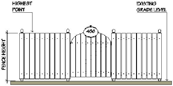
(h)
The finished side of all fences shall face the street or adjoining property.
(i)
All walls shall be finished on both sides.
(j)
Fences, walls and hedges must comply with the provisions of section VII-1203.
(k)
No fencing, wall or hedge shall be erected so as to restrict access by emergency equipment to any building.
(l)
Fire hydrants and connections to approved water supplies shall be accessible to the fire department.
Fences, walls and hedges must comply with the provisions of the Florida Fire Prevention Code as may be amended. Section 18.3.4.1 requires clearances of seven and one-half feet in front and to the sides of the fire hydrant, with a four-foot clearance to the rear of the hydrant. These dimensions may be reduced by approval of the fire official.
(m)
On properties in the Lido Shores neighborhood (see map below) having property lines that abut a thoroughfare road, as identified in the Sarasota City Plan, solid opaque fences, walls, and hedges up to a maximum of 12 feet in height are permitted along such property lines.
(1)
Said fence, wall or hedge may extend no more than 25 feet past the point where the property line no longer abuts the thoroughfare road.
(2)
Any fence or wall shall be constructed outside the public right-of-way and shall be set back a minimum of 20 feet from the edge of pavement.
(3)
The property owner shall landscape the area outside the right-of-way if either a fence or wall is erected. The landscaping plan which must be in accordance with the requirements found in section VII-303 of this article, approved by the city, shall use sufficient quantities, types, height and densities of materials to reduce the visual impact of the fence or wall. The landscaped area must include an irrigation system.
(4)
It shall be the responsibility of the property owner to maintain the landscaping in accordance with the standards found in section VII-307 of this article.
Lido Shores Neighborhood
(Ord. No. 02-4357, 4-29-02; Ord. No. 03-4429, § 14, 1-21-03; Ord. No. 03-4473, § 3, 6-16-03; Ord. No. 04-4531, § 3, 6-7-04; Ord. No. 04-4573, § 7, 6-20-05; Ord. No. 07-4720 § 2, 5-21-07; Ord. No. 07-4770, § 2, 12-17-07; Ord. No. 10-4912, § 2(att. 1), 6-7-10; Ord. No. 10-4927, § 2(att. 1), 2-22-11; Ord. No. 21-5365, § 2(Exh. A), 4-5-21)
Sec. VII-1201.- Generally.
(a)
Encroachments into required setbacks. Every part of every required setback shall be open and unobstructed from the ground to the sky except as otherwise permitted by these regulations. Except for setbacks adjacent to the Gulf of Mexico, the following encroachments are permitted in all setbacks.
(1)
Sills and belt courses may project no more than 12 inches into a required setback.
(2)
Movable awnings may project no more than three feet into a required setback, provided that, where the setback is less than five feet in width, the projection shall not exceed half the width of the setback. In nonresidential districts, with requirements for pedestrian standards, awnings, canopies, marquees and similar features may fully extend into a required front setback.
(3)
Chimneys, bay windows or pilasters may project no more than two feet into a required setback. In nonresidential districts, with requirements for pedestrian standards, bay windows, open colonnades and entry features may extend into the required front setback up to four feet.
(4)
Fire escapes and stairways which are unroofed and unenclosed may project no more than five feet into a required rear setback or no more than three feet into a required side setback of a multifamily dwelling, hotel or motel. Balconies that are unroofed and unenclosed may project no more than six feet into a required front setback, no more than five feet into a required rear setback, or no more than three feet into a required side setback of a multifamily dwelling, hotel, or motel. In nonresidential districts with requirements for pedestrian standards, uncovered stairways and wheelchair ramps that lead to the front door of a building may fully extend into the required front setback.
(5)
Hoods, canopies, roof overhangs or marquees may project no more than three feet into a required setback, but shall not come closer than one foot to the zoning lot line.
(6)
Cornices, eaves or gutters may project no more than three feet into a required setback, provided that, where the required setback is less than six feet in width, such projection shall not exceed half the width of the setback.
(7)
Window, wall-hung air-conditioning units and air-conditioning units installed at grade may project no more than three feet into any required setback in residential districts. Pool equipment and the screening wall for outdoor mechanical equipment, including, but not limited to, air-conditioning equipment and pool pumps required by subsection VI-102(u)(3) for single-family dwellings may project no more than 36 inches into any required sideyard setback. A generator at grade outside of Special Flood Hazard Areas or a generator elevated within Special Flood Hazard Areas may project no more than 36 inches into any required sideyard setback in residential districts.
(8)
Fences, walls, poles, posts and other customary yard accessories and ornaments are permitted in all yards except waterfront yards adjacent to the open waters of the Gulf of Mexico, subject to height limitations and requirements limiting the obstruction of visibility.
(9)
Structures up to 30 inches above the general ground level of the graded lot are permitted in all yards with the exception of waterfront yards adjacent to the Gulf of Mexico where no structures are permitted except as provided in section VII-1301 of the zoning code.
(10)
Pedestrian amenities located within the Bay Park as identified in section VII-1301(j) are permitted encroachments within the 30-foot waterfront setback.
(b)
Encroachments into the public right-of-way.
(1)
Encroachments prohibited: Every part of the public right-of-way in the city shall be open and unobstructed from below the ground to the sky, unless:
a.
The director of neighborhood and development services has made a determination that the intrusion into the right-of-way is an encroachment allowed by the Florida Building Code; or
b.
The intrusion into the right-of-way is a minor encroachment as defined in subsection (b)(4) hereof and an encroachment agreement between the city and the affected private property owner(s) setting out the terms and conditions upon which the particular minor encroachment will be allowed to remain in the public right-of-way has been approved by the city administration and executed by the city manager in accordance with the terms of this section.
c.
The intrusion into the right-of-way is a major encroachment as defined in subsection (b)(4) hereof; and an encroachment agreement between the city and the affected private property owner(s) setting out the terms and conditions upon which the particular major encroachment will be allowed to remain in the public right-of-way has been approved by the city commission and executed by the mayor. However, no major encroachment agreement shall be considered or approved if the purpose of such agreement is to allow the construction of an arcade (as said term is defined in this zoning code) within a public street or right-of-way. Construction of arcades shall be restricted to privately owned property.
d.
The intrusion into the right-of-way has been permitted by a duly executed easement which has been recorded in the public records of the county.
e.
The intrusion into the right-of-way is allowed by statute or by a utility franchise agreement.
f.
The intrusion into the right-of-way is a sidewalk cafe which has received a permit pursuant to subsection VII-602(v) of the zoning code.
g.
The intrusion into the right-of-way is a traffic control or directional sign.
h.
The intrusion into the right-of-way is a standard mailbox on a frangible supporting post, and the mailbox and the supporting post are free of embellishments.
i.
The intrusion into the right-of-way is public art or a public work of art and an agreement allowing the placement of same in the public right-of-way has been executed by the city manager.
(2)
Encroachment agreements; required provisions: Every encroachment agreement approved and executed in accordance with subsection VII-1201(b)(l)b. or c. above shall contain provisions to the effect that:
a.
The owner of the encroachment shall be solely responsible for the maintenance and repair of the encroachment.
b.
The owner of the encroachment shall indemnify and hold the city harmless from any and all claims, liabilities, losses or damages on account of or in any way arising from the existence of the encroachment.
c.
The ability to access public utilities, whether above or below ground, shall be ensured.
d.
The owner of the encroachment shall be required to coordinate and to pay the cost of any utility relocations made necessary by the encroachment.
(3)
Encroachment agreements; optional provisions: The following matters may, but are not required to be included in an encroachment agreement approved in accordance with subsection VII-1201(b)(l)b. and c. above.
a.
The owner of the encroachment may be required to obtain and maintain a policy (or policies) of liability insurance for injuries to persons or damage to property caused by or resulting from the presence of the encroachment with coverage limits acceptable to city and to name city as an additional insured in such policy or policies.
b.
The owner of the encroachment may be required to post a bond or obtain a letter of credit to the benefit of city as security to cover the cost of removing the encroachment from the public right-of-way.
c.
In the event that the city shall determine that the public right-of-way occupied by the encroachment is needed for any purpose whatsoever, then the city shall have the sole and absolute right to terminate the encroachment agreement upon reasonable advance written notice to the other contracting party as specified in the agreement; and if the encroachment is not removed by the owner within the notice of termination period, then the city shall have the right to remove the encroachment and to invoice the owner for the cost of same.
d.
In the event the encroachment or any portion thereof is voluntarily removed, then the encroachment may not be replaced unless a new encroachment agreement is approved and executed in accordance with this section.
e.
If applicable, in the event that the building of which the encroachment is a part is voluntarily demolished then the encroachment may not be replaced unless a new encroachment agreement is approved and executed in accordance with this section.
f.
In the event the encroachment or any portion thereof is involuntarily removed or destroyed by fire, storm or other calamity, then the encroachment may not be replaced unless a new encroachment agreement is approved and executed in accordance with this section.
g.
In the case of nonstructural supporting encroachments, a provision reserving the right to remove same in the event of an emergency without notice to the owner.
h.
A provision which limits the duration or term of the agreement other than as provided above.
In addition to the matters enumerated in subsections (2) and (3) above, an encroachment agreement may contain such other terms and conditions as may be recommended by the city engineer or director of public works through the city manager or by the city attorney and in the case of a major encroachment, which are approved by the city commission.
(4)
Major and minor encroachments:
a.
Major encroachments shall include all structures as defined in this zoning code (including portions of structures such as footers or arcades), except fences, flagpoles and signs which shall be considered minor encroachments. An encroachment agreement to allow a major encroachment shall be approved by the city commission and executed by the mayor.
b.
Minor encroachments shall include all encroachments which do not fall within the definition of major encroachments. Minor encroachments shall include, but are not necessarily limited to, all vegetation, landscaping materials, signs, flagpoles, fences, irrigation lines, private non-franchised utilities, paved areas and mailboxes which are embellished in any manner. An encroachment agreement to allow a minor encroachment shall be executed by the city manager upon the recommendation of the city engineer and the director of public works.
c.
When the term encroachment is used in this section without further modification, the term encroachment shall be construed to include both major and minor encroachments.
d.
Standard mailboxes, as described in subsection (1)h. above, shall not be considered encroachments for purposes of this section.
e.
Public art or public works of art as defined in the zoning code shall not be considered a major or minor encroachment for purposes of this section. Encroachment agreements entered into by the city manager to permit public art or public works of art in the public right-of-way are likewise not subject to the provisions of this section.
(5)
Procedures:
a.
Procedures when encroachment is proposed or discovered in connection with application for development approval:
1.
It is the responsibility of the applicant to clearly show any proposed encroachments on any development plan submitted for review. If said encroachment is a building structure support element such as footers, pilings, or pile caps less than eight feet below grade then the applicant will provide supplemental information verifying that the encroachment is either the only means to construct the project or that it is not feasible to construct the project without the encroachment. For major encroachments, other than building structure support elements the applicant needs to show a public benefit for the encroachment.
2.
The engineering division of the department of public works shall review any existing or proposed encroachments on the development plans submitted. The engineering division of the department of public works shall not accept an encroachment into the right-of-way without considering written review comments provided by the public works department in the event an encroachment which has not been identified on the plans is discovered, the engineering division of the department of public works shall provide written notice to the applicant. The notice shall advise that the application for development approval will not proceed to the next stage of review until either (a) the applicant submits revised plans which remove the encroachment; or (b) an encroachment agreement in accordance with this section is applied for and properly reflected on the development plans. Copies of such notification shall be provided to the department of neighborhood and development services, department of public works and to other affected departments.
3.
The department of building, zoning and code compliance shall review any existing or proposed encroachments which are allowed by the Florida Building Code on the development plans submitted. The department shall also identify any other existing or proposed encroachments on the plans if the plans do not require review by the department of public works. If an encroachment is discovered, the plans shall be sent to the department of public works and the department of public works shall make the final determination as to whether an encroachment exists or is reflected on the plans as drawn and if so, shall proceed as provided in subparagraph 2. above.
4.
In the event that the department of public works sends a written notice to the applicant as provided in subparagraph 2. or 3. above, then the subject application for development approval shall not be approved and no building permit shall be issued for development which includes an encroachment unless an encroachment agreement has been approved in accordance with this zoning code.
5.
In the event that the application for development approval is an application for rezoning, site plan approval, conditional use or any other request which requires approval of the city commission or the planning board; then the entire application, including the proposed encroachment agreement, shall be considered by the city commission or the planning board on the same agenda. The planning board shall make a recommendation to the city commission whether to approve or deny the proposed encroachment agreement. If the proposed encroachment agreement accompanies a site plan that only requires planning board approval, then any approval of the site plan by the planning board shall be conditioned upon approval of the proposed encroachment agreement by the city commission.
b.
Procedures when existing encroachment is discovered unrelated to application for development approval.
1.
When the possible existence of an encroachment into the public right-of-way is brought to the attention of the city by means which are unrelated to an application for development approval, the department of public works shall investigate the matter and determine whether or not an encroachment exists. If the existence of an encroachment is confirmed under these circumstances, the city engineer shall notify the owner of the encroachment in writing that same must be removed within 30 days unless an encroachment agreement is approved and executed in accordance with the zoning code.
2.
In the event the property owner desires to enter into an encroachment agreement with the city and so notifies the city engineer in writing, then the 30-day compliance period referred to in subparagraph b.1. above, shall be tolled until the agreement has been considered by the city commission or the city administration as the case may be and the department of public works shall provide the information to the city attorney's office for preparation of a proposed agreement. In the event the agreement is not approved by the city as provided herein and the owner fails to remove the encroachment as directed by the department of public works or in the alternative event that no request for an agreement is made by the property owner and the owner fails to remove the encroachment as directed, the engineering department shall refer the matter to the department of building, zoning and code enforcement to commence appropriate enforcement proceedings to require the removal of the encroachment.
(Ord. No. 02-4357, 4-29-02; Ord. No. 05-4650, § 5, 2-21-06; Ord. No. 06-4682, § 2, 7-26-06; Ord. No. 09-4838, § 2(att. 1), 2-17-09; Ord. No. 22-5410, § 2(exh. A), 4-18-22; Ord. No. 23-5476, § 2(Exh. A), 4-17-23; Ord. No. 24-5540, § 2(Exh. A), 9-16-24)
Sec. VII-1202. - Encroachments into required recess.
Every part of every required recess shall be open and unobstructed from the horizontal extension of the building where the required recess begins to the sky except as otherwise permitted by these regulations below.
(1)
Sills, belt courses and pilasters may project no more than 12 inches into a required recess.
(2)
Roof overhangs, cornices, eaves, gutters and unroofed and unenclosed balconies may project no more than there (3) feet into a required recess.
(Ord. No. 02-4357, 4-29-02)
Sec. VII-1203. - Sight triangles.
(a)
Standards outside the downtown and environs area. See Engineering Design Criteria Manual (2002 Ed.) part 4, section D.8.c., visibility at intersections.
(b)
Standards within the downtown and environs area. See Engineering Design Criteria Manual (2002 Ed.) part 5, section D.8.b., visibility at intersections.
(Ord. No. 02-4357, 4-29-02)
Sec. VII-1301.- Waterfront property.
(a)
When a waterfront yard is also a rear or side yard, the applicable minimum setback requirement for waterfront setbacks shall control over the minimum rear or side setback requirement.
(b)
Except for setbacks adjacent to the Gulf of Mexico, the depth of required waterfront setbacks shall be 30 feet. All waterfront setbacks shall be measured from the mean high-water line.
(c)
Where property is located adjacent to the Gulf of Mexico and lying between New Pass and Big Pass, the gulf-front setback shall be 150 feet from the mean high-water line; provided that setbacks for gulf-front setbacks on zoning lots with a depth less than 250 feet shall be reduced in order that the building area, including the front yard, shall be 100 feet in depth.
(d)
The height of structures in waterfront setbacks shall be limited to not more than 30 inches above average finished grade or 30 inches above the cap of the seawall, whichever is less. For purposes of this subsection, average natural grade shall be determined by averaging the grade as depicted in the following graphic.
Natural Grade Measurement
(e)
Structures up to 30 inches above natural grade or 30 inches above the cap of the seawall, whichever is less, may be allowed in the required 150-foot gulf-front setback by approval of the city commission issued at a public hearing held for such purpose. At such public hearing the property owner shall establish to the satisfaction of the city commission that the proposed structure:
(1)
Will not endanger the stability of the beach-dune system.
(2)
Will not accelerate erosion.
(3)
Will not adversely impact neighboring properties.
(4)
Will not interfere with the public's use and enjoyment of any public beaches in the vicinity.
(f)
Structures greater than 30 inches above natural grade or 30 inches above the cap of the seawall, whichever is less, are not permitted in the required 150-foot gulf-front yard. The city commission shall have the sole and exclusive authority to grant variances from the terms of this paragraph.
(g)
Should any structure permitted under subsection (f) above require approval of the state department of natural resources pursuant to the provisions of the Beach and Shore Preservation Act, nothing herein shall be construed to supersede or in any way limit the jurisdiction of the department of environmental protection to issue permits for construction within required gulf-front setbacks, if required by the Florida Statutes.
(h)
Structures designed to protect the beach and dune system or to preserve vegetation by providing a means of pedestrian access to the gulf-front beaches shall be exempt from the requirements of this section.
(i)
Except for docks, seawalls, groins and other beach or shore protection devices and as otherwise specifically provided by these regulations, no structures shall be erected that will extend beyond the building line of waterfront property.
(j)
Where located on city-owned property bounded on the west by waters of Sarasota Bay; on the east by N. Tamiami Trail, on the north by the northern boundary of Centennial Park, and on the south by the northern boundary of the Bay Park Phase 1 Site Plan (Site Plan 20-SP-04) and Boulevard of the Arts, pedestrian amenities installed within a waterfront setback may exceed 30 inches above natural grade and shall be exempt from the requirements of this section. Pedestrian amenities include, but are not limited to, ADA accommodations, railings, landscaping, land-based shade structures, refuse receptacles, drinking fountains, bicycle racks, playground equipment, signage, lighting fixtures, public art, outdoor furniture (examples such as benches, tables, swings), bollards, elevated walkways, retaining walls, and/or other park amenities and similar improvements.
(Ord. No. 02-4357, 4-29-02; Ord. No. 04-4573, § 13, 6-20-05; Ord. No. 09-4838, § 2(att. 1), 2-17-09; Ord. No. 13-5041, § 2(att. 1), 3-4-13; Ord. No. 22-5410, § 2(exh. A), 4-18-22; Ord. No. 25-5583, § 2(Exh. A), 11-17-25)
Sec. VII-1302. - Docks.
New docks may be erected subject to the following regulations:
(1)
Docks and dock expansions on the open waters of Sarasota Bay, Big Pass and New Pass shall project into said waters no less than necessary:
a.
To reach a minimum depth of minus three feet mean low water; or
b.
So as to maintain, from the lowest point of the keel or propeller, whichever is lower, of the vessel to be berthed at the dock, a minimum clearance over any submerged bottom lands of one foot as measured at mean low water.
Provided, however, except for docks which are 30 feet or less in length, a dock shall not extend farther than to a depth of minus four feet mean low water, nor shall a dock exceed an overall length of 100 feet, exclusive of tie-off pilings as measured at a right angle from the shoreline. The total area of any dock shall not exceed 500 square feet, as measured seaward from mean high water. Such docks shall not be located within 25 feet of the extended property lines of the property upon which the dock is erected or within 25 feet of the extended property lines of any adjacent property. However, if the individual zoning lot as platted, upon which the dock is to be erected, is less than 65 feet in length along the shoreline, such dock shall not be located within eight feet of the extended property line of the property upon which the dock is erected or within eight feet of the extended property lines of any adjacent property. However, no setback is required from the shared extended property line when docks or pilings are built to serve two abutting properties. In the event a new dock is being built abutting a residentially zoned parcel that has constructed a dock between April 17, 1995, and May 21, 2007, the director of neighborhood and development services is authorized to allow a lesser setback that will result in the fairest equitable distribution between the affected upland property owners giving due consideration of the lay of the upland shore line, the direction of the channel and the correlative rights of the adjoining land owners.
(2)
Docks and dock expansions on all other waterfront property and inlets or narrow waters of Sarasota Bay, shall not project into said waters so as to be located within the middle 50 percent thereof or exceed a maximum length of 30 feet, as measured from mean high water, whichever is less. The total area of any such dock shall not exceed 500 square feet, as measured seaward from mean high water. Such docks shall not be located within eight feet of the extended property lines of the property upon which the dock is erected or within eight feet of the extended property lines of any adjacent property. However, no setback is required from the shared extended property line when docks or pilings are built to serve two abutting properties. In the event a new dock is being built abutting a residentially zoned parcel that has constructed a dock between April 17, 1995, and May 12, 2007, the director of neighborhood and development services is authorized to allow a lesser setback that will result in the fairest equitable distribution between the affected upland property owners giving due consideration of the lay of the upland shore line, the direction of the channel and the correlative rights of the adjoining land owners.
(3)
No tie-off piling, vessel or boat lift shall be placed, or docked so that any portion thereof projects into the middle 50 percent of any waterway.
(4)
No terminal platform or marginal dock shall be more than 250 square feet.
(5)
No boat dock, tie-off piling, vessel, or boat lift shall obstruct navigation or the use of public waterways or impede access to existing navigable channels or waterways, whether or not such channels or waterways are marked or chartered.
(6)
No dock shall be constructed to create a vertical wall of solid earth or concrete so as to act as a bulkhead or breakwater.
(7)
The maximum decking elevation of a dock shall be plus five feet mean high water. Railings shall not exceed 42 inches in height above the decking of the dock.
(8)
A private residential dock shall be designed and constructed to permanently accommodate no more than three vessels. The access dock shall be limited to a maximum width of six feet. There shall be no more than one private residential dock per buildable waterfront zoning lot it will serve. Use of a private residential dock shall be limited to residents of the residential unit(s) served by the dock and shall not be rented.
This dock rental prohibition shall not be construed to apply to written rental contracts in existence on the date of second reading of Ordinance No. 07-4720.
(9)
Community boat docks are permitted in RSF-E, 1, 2, 3 and 4 zone districts only; subject to minor conditional use approval (article 4, division 9) and the following additional regulations:
a.
The total number of boat slips shall not exceed the total number of single-family zoning lots in the residential subdivision served by a community boat dock.
b.
Use of a community boat dock shall be limited to residents of the single-family subdivision served by the dock. A community boat dock shall not allow rentals.
c.
The access dock shall not exceed six feet in width; finger piers shall not exceed three feet in width, and 25 feet in length.
d.
The docks must be constructed adjacent to riparian property which is held in common ownership by lot owners in the subdivision as specified in this paragraph through a homeowners' association or similar entity. The adjacent riparian property must be held in common ownership by all of the lot owners in the subdivision if all private subdivision lots are riparian or if none of the subdivision's private lots are riparian. For subdivisions containing both riparian and non-riparian lots, the riparian property adjacent to the dock must be held in common ownership by all owners of the subdivision's non-riparian lots, at the least, with participation by other subdivision lots owners permissible but not required. The commonly owned riparian frontage property and the access to such frontage shall be a minimum of ten feet in width.
e.
The total aggregate area of a community boat dock shall not exceed 1,000 square feet.
(10)
Private residential multi-slip docks shall be designed and constructed to accommodate no more vessels than the total number of dwelling units within the multi-family development to which the docks are accessory. The access dock shall not exceed six feet in width, finger piers shall not exceed three feet in width, and 25 feet in length.
Use of a private residential multi-slip dock shall be limited to residents of the multi-family residential dwelling units of the development to which the docks are accessory. Private residential multi-slip docks shall not be rented to any person or entity other than a resident of one of the residential dwelling units within the development to which the docks are accessory.
This dock rental prohibition shall not be construed to apply to written rental contracts in existence on the date of second reading of Ordinance No. 07-4720.
(11)
Structures in connection with a marine fueling facility, storage and sales of marine-related products and attendant's shelter are permitted on commercial docks, provided that such structures shall not exceed an area of 50 square feet or a height of ten feet above the decking of the dock.
(12)
Docks shall not include or accommodate nonwater dependent structures and are not to be used for nonwater dependent purposes.
(13)
Boat lifts shall not exceed seven feet in height above mean high water, as measured to the top of the lifter beam. Davits shall not exceed eight feet in height above the decking of a dock. Davits shall not exceed ten feet in height above a seawall cap. No dock shall have more than one boat lift or davit for each permitted vessel.
(14)
Pilings shall not exceed ten and one-half feet in height above mean high water.
(15)
Fish cleaning tables shall not exceed 42 inches in height above the decking of a dock. No dock shall have more than one fish cleaning table.
(16)
Benches and boat lockers shall not exceed 96 inches in length, 36 inches in width or 36 inches in height above the decking of a dock. No dock shall have more than one bench and one boat locker for each permitted vessel.
(17)
Upland walkways shall be subject to the height limitation for structures in waterfront setbacks; except in the G zone district or other government-owned property, the deck of upland walkways shall be subject to a height limitation for structures in the waterfront setbacks of five feet above average natural grade, and railings shall not exceed 42 inches in height above the decking (i.e., railing shall not exceed eight and one-half feet above average natural grade).
(18)
Docks in the G zone district and the MP zone district where the MP zone district is contiguous to the G zone district or other government-owned property shall be subject to major conditional use approval, except as provided otherwise in this Code. G zone waivers to the use and development standards for docks in the MP zone district is contiguous to the G zone district or other government-owned property may be granted in accordance with article IV, division 17. However, docks in the G zone district and the MP zone district where the MP zone district is contiguous to the G zone district or other government-owned property, shall be permitted and shall not require nor be subject to major conditional use approval nor approval of any G zone waivers to the use and development standards for docks in the G zone or MP zone, if:
a.
The area of the terminal platform does not exceed 500 square feet in size;
b.
The area of the access dock does not exceed 250 square feet in size, six feet in width, and 50 feet in length as measured from the mean high-water line;
c.
The dock does not exceed 75 feet in overall length as measured from the mean high-water line;
d.
The dock does not obstruct navigation or impede access to existing navigation channels;
e.
The dock is no closer than 200 feet, as measured along the mean high-water line, to any property not zoned G or MP; and
f.
The dock is no closer than 200 feet, as measured along the mean high-water line, to another dock permitted pursuant to this sentence.
(Ord. No. 02-4357, 4-29-02; Ord. No. 04-4538, § 14, 6-7-04; Ord. No. 06-4702, § 2, 11-20-06; Ord. No. 07-4720 § 2, 5-21-07; Ord. No. 09-4838, § 2(att. 1), 2-17-09; Ord. No. 13-5041, § 2(att. 1), 3-4-13; Ord. No. 16-5168, § 2, 6-20-16; Ord. No. 21-5346, § 3(Exh. A), 12-7-20)
Sec. VII-1303. - Dredging and filling.
While dredging and filling of waterfront and submerged lands under the jurisdiction of the trustees of the internal improvement fund of the state are subject to the authority of the trustees, the city reaffirms its position that there shall be no filling of submerged and waterfront lands beyond the established mean highwater line. There shall be no dredging operations seaward beyond established mean highwater lines, except for those dredging operations necessary to maintain boat channels and basins.
(Ord. No. 02-4357, 4-29-02)
Sec. VII-1304. - Seawall, groins and beach protective devices.
(a)
All seawalls, groins, and beach protection devices must be properly designed to prevent erosion of the property on which they are erected and to not adversely affect adjacent and nearby properties. In no event shall the top of such protective devices exceed an elevation of 7.27 ft. - NAVD88. In the event the city engineer has reason to believe that the proposed elevation would create adverse impacts on adjacent or nearby properties, the city engineer shall be authorized to limit the maximum elevation of the structure to an elevation that is less than the maximum authorized by this subsection. Applicants shall be required to provide professionally certified construction plans to demonstrate that the proposed elevation of the seawall or bulkhead will not create adverse impacts on neighboring properties. If adverse impacts on adjacent and nearby properties, as determined by the city engineer, occur subsequent to approval of the structure, then it is the responsibility of the property owner who installed the structure to rectify in accordance with written notification from the city engineer. Property owners are encouraged to consider approaches and materials that enhance the biological value of traditional (flat surface) seawalls and flood barriers with the incorporation of living shoreline features, use of hybrid green-grey materials, and the use of biological forms, where practicable. Seawalls, groins, bulkheads, and beach protective devices constructed on public or private property shall be designed to conform to the standards specified in the Engineering Design Criteria Manual (EDCM).
(b)
Where properties are located on the waters of the Gulf or the waters of passes, seawalls, groins and other beach protection devices or coastal armoring shall be erected in accordance with F.S. § 161.085 and only upon approval of the city commission at a public hearing held for such purpose. At the public hearing, the applicant shall demonstrate that:
(1)
Such beach protection works are necessary to prevent such erosion;
(2)
Are properly designed to prevent erosion of the property on which they are to be erected; and
(3)
Will not adversely affect adjacent and nearby properties.
(c)
Where properties are located on any shoreline other than as described in subsection (b) above, the city engineer shall review the application for a permit and supporting materials and make a written determination as to whether the application satisfies the three criteria specified in subsection (b) above. Seawalls and bulkheads permitted in accordance with this subsection may be erected only landward of mean highwater lines.
(d)
Seawalls, groins, and beach protective devices that are seaward of the mean highwater line that existed on November 2, 2009, may be repaired or replaced to the same extent that existed on that date. Seawalls may be repaired with panels seaward of the seawall if it is determined by the director of development services that such panel is the appropriate method of repair.
(Ord. No. 02-4357, 4-29-02; Ord. No. 09-4888, § 2(att. 1), 11-2-09; Ord. No. 25-5552, § 2(Exh. A), 2-18-25)
Sec. VII-1305. - Manatee protection plan.
Construction of five or more wet or dry marine slips shall comply with the resource protection measures of the "Sarasota County Manatee Protection Plan," dated September 24, 2003, as determined through the state and federal approval process. The development location of new or expansion of existing boat facilities of five or more wet or dry marine slips shall be consistent with the boat facility siting plan component of the "Sarasota County Manatee Protection Plan," dated September 24, 2003.
(Ord. No. 06-4663, § 2, 3-20-06)
Sec. VII-1306. - Nonconforming docks.
(a)
If any existing nonconforming dock which was originally legally constructed, and which is abutting a residentially zoned parcel, is voluntarily or involuntarily destroyed or damaged (either gradually or suddenly) by less than 75 percent of the existing square footage and requires replacement of less than 75 percent of the existing pilings, it may be rebuilt to the originally existing footprint within one year of the date of discovery of the destruction or damage. It is the applicant's burden to establish the date of discovery of the gradual or sudden destruction, to provide sufficient proof of the prior existing footprint and to provide proof that the dock was originally legally constructed.
(b)
If any existing nonconforming tie-off piling which was originally legally constructed, and which is abutting a residentially zoned parcel, is voluntarily or involuntarily destroyed or damaged (either gradually or suddenly) to any extent, it may be replaced in its original existing location within one year of the date of discovery of the destruction or damage. It is the applicant's burden to establish the date of discovery of the gradual or sudden destruction, to provide sufficient proof of the prior existing footprint, and to provide sufficient proof that it was originally legally constructed.
(c)
If any existing nonconforming dock which was originally legally constructed, and which is abutting a residentially zoned parcel, is voluntarily or involuntarily destroyed or damaged by 75 percent or more of the existing square footage or requires replacement of 75 percent or more of the existing pilings, it may be rebuilt to the originally existing footprint within one year of the date of discovery of the destruction or damage if:
(1)
A notarized letter of consent is provided from any abutting property owner; or
(2)
A variance is secured pursuant to the requirements of zoning code section IV-606(c).
It is the applicant's burden to establish the date of discovery of the gradual or sudden destruction, to provide sufficient proof of the prior existing footprint, and to provide sufficient proof that the dock was originally legally constructed.
(Ord. No. 07-4720 § 2, 5-21-07)
Sec. VII-1401.- Refuse and recycling storage areas.
(a)
Applicability. Except as otherwise provided in this Code, each zoning lot containing a new multi-family or non-residential use shall provide and maintain one or more refuse containers and recycling containers on the premises. Zoning lots containing an existing multi-family or non-residential use shall be subject to this section when seeking any one of the following:
(1)
Cumulative expansion subsequent to the adoption of this section of at least 50 percent of the improved square footage existing at the time of adoption of this section.
(2)
Any cumulative substantial remodeling of the existing use subsequent to the adoption of this section.
(b)
The owner of the property shall be responsible for the collection, or contract for the collection, of the refuse and rubbish on a frequency of not less than twice weekly.
(c)
The containers shall be of sufficient number and capacity to accommodate the refuse and recyclable materials generated by the uses on the zoning lot.
(1)
The containers and their enclosures shall comply with all the requirements of the zoning district in which the use is located.
(2)
The containers shall be appropriately labeled to indicate their appropriate contents.
(3)
The containers shall be so constructed, and have secure lids, as to prevent the entrance by animals and other vermin.
(4)
The containers shall be placed in a manner so that their location and use is accessible and convenient for collecting and loading and does not restrict internal site traffic circulation.
(5)
Containers shall be located in well-lit, well-traveled areas.
(6)
Refuse container storage areas shall not be located within 50 feet of an adjacent residential zoning lot in the following situations:
a.
The storage area has containers larger than 90-gallon roll out carts; or
b.
The storage area has containers for any business providing food or beverage service, including but not limited to restaurants, delicatessens, bars, or nightclubs.
(7)
Solid waste from commercial and business establishments and from residential developments that cumulatively result in eight dwelling units or more, shall be placed on the premises or abutting alley for removal at one time. The maximum number of refuse and recycling containers placed on alleys is not regulated. Applicants may request an exception for removal of solid waste outside the premises or abutting alley due to hardships including, but not limited to, a constrained lot, shape and dimensions of real property, existing structures or infrastructure, or grand tree preservation. Applicants requesting an exception must submit their request in writing to the city manager, or designee, and explain the basis for the request.
(d)
The owner of the use shall assure appropriate hauling and refuse removal services to the site.
(e)
All outdoor storage of refuse, recyclable material, other items or material intended to be discarded or collected, and their storage containers shall be screened from public view.
(1)
Said areas shall be screened from public view on at least three sides by an opaque impact-resistance wall or fence no lower than the height of the dumpster or container within, and on the fourth side by an opaque impact-resistance gate similarly sized, or of other such material and design approved by the director of neighborhood and development services.
a.
The gate shall be maintained in working order and shall remain closed except during such times as refuse, recyclable materials and other such items are being discarded, placed for collection, or collected.
(f)
The owner of the use shall assure that any parking lot sweeping activity that occurs is limited to the hours of 7:00 a.m. to 8:00 p.m. daily.
(Ord. No. 02-4357, 4-29-02; Ord. No. 03-4429, § 15, 1-21-03; Ord. No. 4473, § 4, 6-16-03; Ord. No. 09-4838, § 2(att. 1), 2-17-09; Ord. No. 23-5477, § 2(Exh. A), 4-17-23; Ord. No. 23-5502, § 2(Exh. A), 2-20-24)
Sec. VII-1402. - Site lighting.
(a)
Purpose and intent. Nonresidential and residential buildings and projects, including their out parcels, shall be designed to provide safe, convenient, and efficient lighting for pedestrians and vehicles. Lighting shall be designed in a consistent and coordinated manner for the entire site. The lighting and lighting fixtures shall be integrated and designed so as to enhance the visual impact of the project on the community and/or should be designed to blend into the surrounding landscape. Lighting design and installation shall ensure that lighting accomplishes on-site lighting needs without intrusion on adjacent properties.
(b)
Applicability.
(1)
New development. These regulations shall apply to all new nonresidential or multiple-family development. A site lighting plan shall be required to demonstrate compliance with these regulations.
(2)
Expansion and remodeling. These regulations shall apply to any expansion or remodeling of existing non-residential or multiple family development that exceeds 50 percent of the structures' assessed valuation. A site lighting plan shall be required to demonstrate compliance with these regulations. Assessed valuation shall be determined by reference to the official property tax assessment rolls of the year the structure(s) is to be remodeled.
(3)
Repair and maintenance. These regulations shall apply to replacement of 50 percent or more of the existing lighting fixtures in any nonresidential or multiple-family development.
(4)
Turtle protection. The site lighting requirements in this section shall not supersede the requirements of article XXIII of the County Code, marine turtle protection (formerly known as Sarasota County Ordinance No. 97-082 which has been adopted by reference in City of Sarasota Resolution No. 05R-1832).
(c)
Site lighting design requirements.
(1)
Fixtures (luminaires). The light source shall be completely concealed within an opaque housing on all sides except for the bottom of the fixture where illumination exits the fixture and shall not be visible from any street right-of-way or adjacent properties. All fixtures shall be full cut-off fixtures.
Fixture Height
(2)
Fixture and pole height. Lighting fixtures and poles shall be a maximum of 30 feet in height within the parking lot and shall be a maximum of 15 feet in height within non-vehicular pedestrian areas. Lighting for recreational facilities related to schools and parks shall be exempt from this requirement unless the poles are within 100 feet of residentially zoned property. Bollard lighting shall be a maximum of 42" in height.
(3)
Light source (lamp). Only incandescent, fluorescent, metal halide, single-color light emitting diode (LED), or color-corrected high-pressure sodium may be used. The same light source type must be used for the same or similar types of lighting on any one site throughout any development.
(4)
Mounting. Fixtures shall be full cut-off type and mounted in such a manner that the cone of light is primarily directed towards the earth's surface or otherwise shielded, such that lighting is primarily contained on-site. Lighting levels at the property line shall not exceed the value in subsection (d)(2) below.
(5)
Limit lighting to periods of activity. The use of sensor technologies, timers or other means to activate lighting during times when it will be needed may be required by the director of development services to conserve energy, provide safety, and promote compatibility between different land uses.
(6)
Illumination levels.
a.
All site lighting shall be designed so that the level of illumination as measured in footcandles at any one point meets the standards in the table below or meet the NFPA 101 Life Safety Code requirements (7.8.1.3) for egress lighting of stairs and ADA ramps. Lighting levels up to 25 percent higher may be allowed by the director of development services subject to the applicant demonstrating that higher lighting levels are necessary to meet objectives for environmental programs such as Crime Prevention Through Environmental Design (CPTED) and Leadership in Energy and Environmental Design (LEED) and will not conflict with subsection (d) concerning excessive illumination below:
Exterior Lighting and Parking Lots
Nonresidential and Multi-family Residential Parking Garages
b.
Minimum and maximum levels are measured on the pavement within the lighted area.
c.
Lighting for automated teller machines (ATMs) shall be required to meet the standards of F.S. § 655.962.
(d)
Excessive illumination for nonresidential or residential lots.
(1)
Lighting within any lot that unnecessarily illuminates and substantially interferes with the use or enjoyment of any other lot, or which unnecessarily illuminates the night sky is prohibited. Lighting unnecessarily illuminates another lot if it clearly exceeds the requirements of this section. Lighting unnecessarily illuminates the night sky if it directly projects into the night sky or if it clearly exceeds average lighting levels when measured at a height above the lighting fixture or its shield.
(2)
All outdoor lighting shall be designed and located such that the maximum illumination measured in footcandles at the property line does not exceed 0.5 on adjacent residential sites, and 1.0 on adjacent commercial sites and public rights-of-way.
(3)
Lighting shall not be oriented so as to direct glare or excessive illumination onto streets in a manner that may distract or interfere with the vision of drivers on such streets.
(4)
Fixtures used to accent architectural features, landscaping or art shall be located, aimed or shielded to minimize light spill into the night sky.
(5)
Illumination using illuminated tubing or strings of lights that outline or define 50 percent or more of property lines, sales areas, roofs, doors, windows, or similar areas in a manner that is not primarily for safety purposes, as determined by the director of development services, is prohibited. However, this shall not be construed to preclude holiday/seasonal light displays.
(Ord. No. 02-4357, 4-29-02; Ord. No. 03-4473, § 5, 6-16-03; Ord. No. 06-4682, § 2, 7-26-06; Ord. No. 07-4770, § 2, 12-17-07; Ord. No. 09-4838, § 2(att. 1), 2-17-09; Ord. No. 10-4927, § 2(att. 1), 2-22-11; Ord. No. 21-5364, § 2(Exh. A), 5-18-21; Ord. No. 24-5540, § 2(Exh. A), 9-16-24)
Sec. VII-1601.- Application.
Prior to accepting a petition for annexation by the city commission, the city auditor and clerk or their designee shall render a decision as to whether the real property proposed to be annexed is within the urban service boundary. A map of the urban service boundary is adopted in the Sarasota City Plan. In the event the city auditor and clerk or their designee determines that the real property proposed to be annexed is within the urban service boundary, then the city auditor and clerk shall proceed with the processing of the petition. Provided, however, the location of real property within the urban service boundary does not ensure that the city will annex the real property. Further, the location of real property within the urban service boundary does not obviate any of the statutory requirements and procedures for annexation set forth in F.S. ch. 171, as amended, or any applicable ordinances or regulations of the city pertaining to the use or development of real property to include a favorable determination as to concurrency. Should the city auditor and clerk or their designee determine that the real property proposed to be annexed is located outside of the urban service boundary described herein, the petition for annexation shall not be accepted.
(Ord. No. 02-4357, 4-29-02; Ord. No. 03-4429, § 16, 1-21-03; Ord. No. 07-4770, § 2, 12-17-07)
Sec. VII-1602. - Annexation analysis.
The city will prepare an annexation analysis at the time an annexation is initiated within the city's urban service boundary. This analysis shall include, but not be limited to:
(1)
The suitability of the subject area for annexation,
(2)
A listing of the costs and benefits to the city and to the affected property owners,
(3)
A schedule for annexation if more than one (1) parcel is involved, and
(4)
The effect, if any, on urban sprawl.
In addition, and in order to ensure land use compatibility with planned and existing city developments within the area of the subject parcel, future land use classification(s) and future zoning district(s) which are potentially consistent with the Sarasota City Plan shall be identified for inclusion into any pre-annexation agreement that may subsequently be executed.
A recommendation as to whether or not to approve the annexation will be included within the analysis.
(Ord. No. 02-4357, 4-29-02; Ord. No. 07-4770, § 2, 12-17-07)
Sec. VII-1603. - Pre-annexation agreement.
The city and the owner of a property within the urban service boundary may enter into a pre-annexation agreement. The pre-annexation agreement shall include at a minimum the following items:
(1)
The future land use classification(s) in the Sarasota City Plan for the subject property;
(2)
The implementing zone(s) for the future land use classification(s) identified in the Sarasota City Plan applicable to the subject property;
(3)
A time frame measured from the date the pre-annexation agreement is executed within which it is contemplated that the subject property will be annexed;
(4)
A time frame measured from the date of annexation for the city to amend the future land use map(s) of the Sarasota City Plan in order to include the annexed property;
(5)
A time frame measured from the effective date of the amendment to the future land use map described in subsection (4) above for the city to rezone the annexed property to a city zone district consistent with the annexed property's future land use classification(s);
(6)
The obligation of the property owner(s) to provide all information required by the department of planning and redevelopment in order to process the amendments to the Sarasota City Plan and the official zoning district map;
(7)
The obligation of the property owners (if any) for fees associated with amending the Sarasota City Plan and the official zoning district map; and
(8)
The acknowledgement by the property owner(s) of the future land use classification(s) and zoning district(s) identified within the pre-annexation analysis and that these will govern the development of the subject property after the subject property is annexed.
(Ord. No. 02-4357, 4-29-02; Ord. No. 07-4770, § 2, 12-17-07)
Sec. VII-1604. - Zoning equivalency table.
(1)
The following zone district equivalency table shall apply to determine the new city zoning for those annexed properties which are the subject of a petition for annexation described in paragraph (3) below. Upon annexation, a property within the Sarasota County zone district shown in the left column of the table shall be assigned the corresponding city zone district shown in the right column.
(2)
If the new equivalent city zone district in accordance with the table above is RSF-E, RSF-1 or RSF-2, then the property shall be classified as "single-family (very low density)" on the city future land use map. If the new equivalent city zone district in accordance with the table above is RSF-3, then the property shall be classified as "single-family (low density)" on the city future land use map. If the new equivalent city zone district in accordance with the table above is RMF-1, RMF-2 or RMF-3, then the property shall be classified as "multiple-family (moderate density)" on the city future land use map. If the new equivalent city zone district in accordance with the table above is OND, then the property shall be classified as "neighborhood office" on the city future land use map.
(3)
The zone district equivalency table adopted by this section shall be used to determine the new city future land use classification and zoning for property upon annexation into the city, if, prior to annexation, the property was located in one of the county zone districts listed in the zone district equivalency table; and
(a)
The property was the subject of a city-initiated voluntary annexation in accordance with a municipal services and pre-annexation agreement; or
(b)
The property was the subject of a city-initiated voluntary annexation in which the property owner consented to the annexation without a municipal services and a pre-annexation agreement.
(4)
The table in subsection (1) above shall not be applied to properties annexed in accordance with:
(a)
An involuntary annexation;
(b)
Notwithstanding paragraph (3) above, a city-initiated voluntary annexation when the owner of the property to be annexed has signed a pre-annexation agreement allowing the owner to apply for a different city zone district than would result from the application of the equivalency table.
(c)
A privately initiated voluntary annexation.
(5)
An ordinance annexing property into the city shall indicate whether or not the table found in this section shall apply to determine the new city future land use classification and zone district for the annexed property. In the event the table contained in this section is applied, the future land use map shall be updated to reflect the addition of the annexed property with its city future land use classification at the first city-initiated amendment to the future land use map following the effective date of the annexation and the official zoning atlas shall be updated to reflect the city zoning of the annexed property as soon as practical following the effective date of the amendment to the future land use map.
(Ord. No. 09-4856, § 1, 12-7-09)
Sec. VII-1701.- Definitions.
The following definitions are applicable to division 17:
(a)
"Airport hazard" means an obstruction to air navigation which affects the safe and efficient use of navigable airspace or the operation of planned or existing air navigation and communication facilities.
(b)
"Airport layout plan" means a set of scaled drawings that provides a graphic representation of the existing and future development plan for the airport and demonstrates the preservation and continuity of safety, utility, and efficiency of the airport.
(c)
"Airport master plan" means a comprehensive plan of an airport which typically describes current and future plans for airport development designed to support existing and future aviation demand.
(d)
"Airport protection zoning regulations" means airport zoning regulations governing airport hazards.
(e)
"Obstruction" means any existing or proposed object, terrain, or structure construction or alteration that exceeds the federal obstruction standards contained in 14 C.F.R. part 77, subpart C. The term includes:
(1)
Any object of natural growth or terrain;
(2)
Permanent or temporary construction or alteration, including equipment or materials used and any permanent or temporary apparatus; or
(3)
Alteration of any permanent or temporary existing structure by a change in the structure's height, including appurtenances, lateral dimensions, and equipment or materials used in the structure.
(Ord. No. 18-5240, § 2(Exh. A), 5-7-18)
Sec. VII-1702. - Applicability.
In accordance with F.S. ch. 333, Airport Zoning, this division regulates airport hazards and incompatible land uses in the vicinity of the Sarasota Bradenton International Airport operated by the Sarasota Manatee Airport Authority (airport authority). Airport uses may produce noise levels that are not compatible with residential and other types of uses. An airport hazard or incompatible land use may be injurious to users of the airport and the surrounding community and should be prevented or mitigated to protect the health, safety, and general welfare of the community. Existing, planned, and proposed facilities at public-use airports contained in an airport master plan, in an airport layout plan submitted to the Federal Aviation Administration, or in comparable military documents shall be protected from airport hazards.
The airport authority is a political subdivision under F.S. ch. 333, and has adopted airport protection zoning regulations including airport airspace drawings. In event of conflict between the airport authority's protection zoning regulations and this division, the more stringent limitation or requirement shall govern and prevail.
During implementation of these airport protection zoning regulations, the city shall coordinate with the airport authority for, but not limited to, the following:
(a)
Airport zone height limitations;
(b)
Airport land use restrictions;
(c)
Non-conforming uses and structures; and
(d)
Marking and lighting.
(Ord. No. 18-5240, § 2(Exh. A), 5-7-18)
Sec. VII-1703. - Airport imaginary surface zones.
In order to carry out the provisions of these airport protection zoning regulations, there are hereby created and established certain zones which include all of the land lying beneath the approach surfaces, transitional surfaces, horizontal surfaces, and conical surfaces as they apply to the airport and are depicted on the map VII-1701, airport imaginary surface zones. An area located in more than one of the following zones shall be considered to be only in the zone with the more restrictive limitation. The various zones and height limitations are hereby established and defined as follows:
(a)
Precision instrument approach zones - Runway(s) 14 and 32: The inner edge of these approach zones coincides with the width of the primary surface and is 1,000 feet wide. Both of the approach zones expand outward uniformly to a width of 16,000 feet at a horizontal distance of 50,000 feet from the primary surface. Each zone centerline is the continuation of the centerline of the runway.
(b)
Non-precision instrument approach zone - Runway(s) 22 and 4: The inner edge of this approach zone coincides with the width of the primary surface and is 500 feet wide. The approach zone expands outward uniformly to a width of 3,500 feet at a horizontal distance of 10,000 feet from the primary surface. Its centerline is the continuation of the centerline of the runway.
(c)
Visual approach zone: The inner edge of this approach zone coincides with the width of the primary surface and is 500 feet wide. The approach zone expands outward uniformly to a width of 1,500 feet at a horizontal distance of 5,000 feet from the primary surface. Its centerline is the continuation of the centerline of the runway.
(d)
Horizontal zone: The horizontal zone is established by swinging arcs of 10,000 feet from the center of each end of the primary surface of each runway and connecting the adjacent arcs by drawing lines tangent to those arcs. The horizontal zone does not include the approach and transitional zones.
(e)
Conical zone: The conical zone is established as the area that commences at the periphery of the horizontal zone and extends outward there from a horizontal distance of 4,000 feet.
(f)
Transitional zone: The transitional zones are the areas beneath the transitional surfaces.
(g)
Runway protection zone (RPZ): A trapezoidal area at ground level that is located "off the end of a runway end that serves to enhance the protection of people and property on the ground" in the event an aircraft lands or crashes beyond the runway end.
(h)
Primary surface: A surface longitudinally centered on a runway. When a runway has a specially prepared hard surface, the primary surface extends 200 feet beyond either end of that runway. The elevation of any point on the primary surface is the same as the elevation of the nearest point on the runway centerline. Primary surface widths vary with the classification of the runway; however, the width is uniform throughout and is based on the most precise approach existing or planned for either end of that runway.
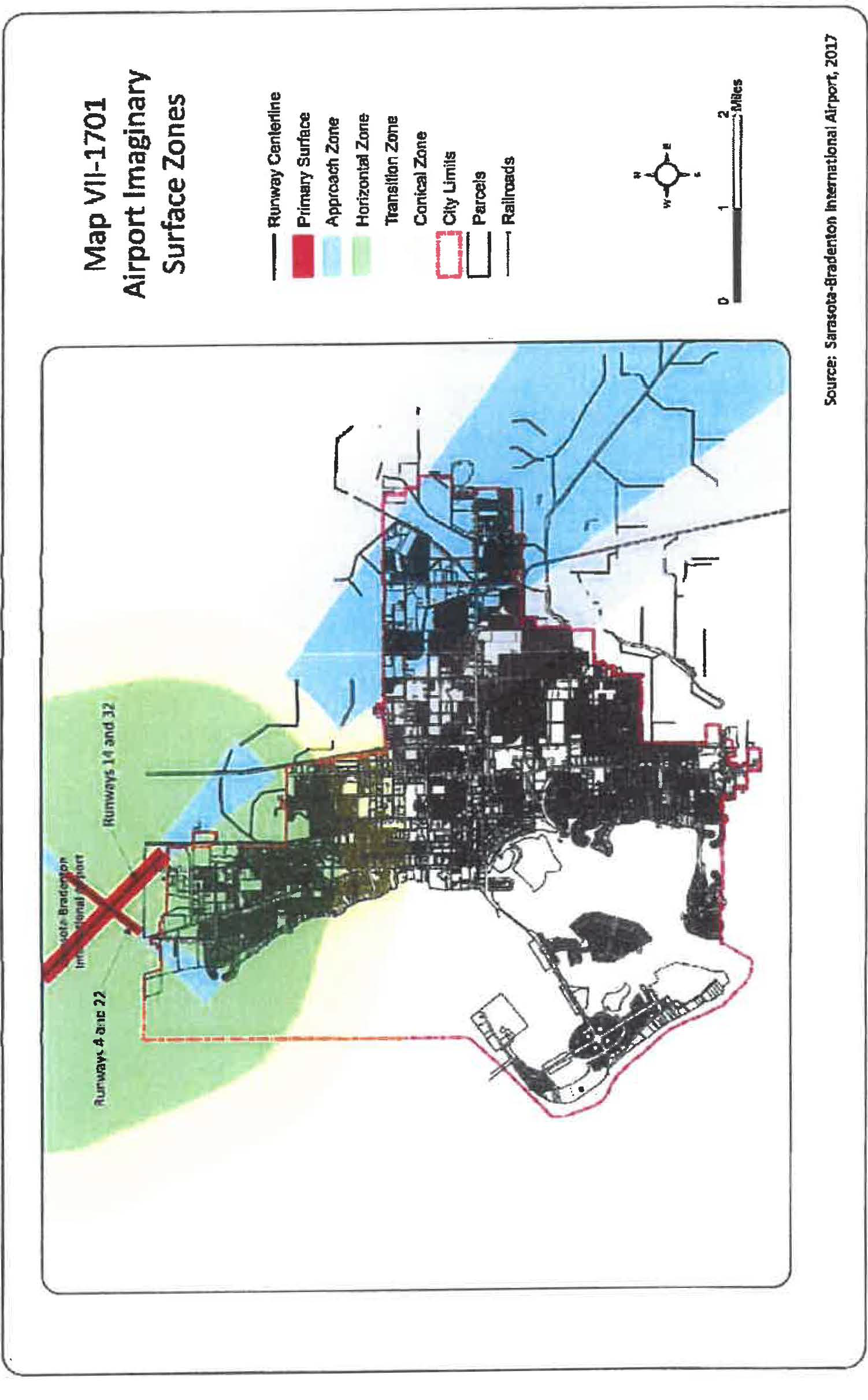
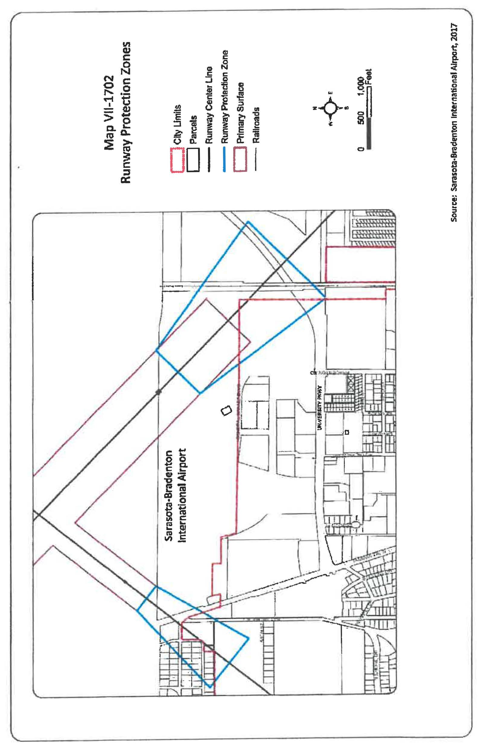
(Ord. No. 18-5240, § 2(Exh. A), 5-7-18)
Sec. VII-1704. - Airport zone height limitations.
Except as otherwise provided in this regulation, no structure shall be erected, altered, or maintained, and no tree shall be allowed to grow in any zone created by this regulation to a height in excess of the applicable height herein established for such zone as depicted on map VII-1701, airport imaginary surface zones. Such applicable height limitations are hereby established for each of the zones as follows:
(a)
Precision instrument approach zones - Runway(s) 14 and 32: Slopes 50 feet outward for each foot upward beginning at the end of and at the same elevation as the primary surface and extending to a horizontal distance of 10,000 feet along the extended runway centerline; thence slopes upward 40 feet horizontally for each foot vertically to an additional horizontal distance of 40,000 feet along the extended runway centerline.
(b)
Non-precision instrument approach zone - Runway(s) 4 and 22: Slopes 34 feet outward for each foot upward beginning at the end of and at the same elevation as the primary surface and extending to a horizontal distance of 10,000 feet along the extended runway centerline.
(c)
Horizontal zone: Established at 150 feet above the airport elevation (which is 30 feet above mean sea level) or at a height of 180 feet above mean sea level.
(d)
Conical zone: Slopes 20 feet outward for each foot upward beginning at the periphery of the horizontal zone and at 150 feet above the airport elevation (which is 30 feet above mean sea level) and extending to a height of 350 feet above the airport elevation.
(e)
Transitional zone: Slope seven feet outward for each foot upward beginning at the sides of and at the same elevation as the primary surface and the approach surface, and extending to a height of 150 feet above the airport elevation (which is 30 feet above mean sea level). In addition to the foregoing, there are established height limits sloping seven feet outward for each foot upward beginning at the sides of and the same elevation as the approach surface, and extending to where they intersect the conical surface. Where the precision instrument runway approach zone projects beyond the conical zone, there are established height limits sloping seven feet outward for each foot upward beginning at the sides of and the same elevation as the approach surface, and extending a horizontal distance of 5,000 feet measured at 90 degree angles to the extended runway centerline.
(Ord. No. 18-5240, § 2(Exh. A), 5-7-18)
Sec. VII-1705. - Airport land use restrictions.
Notwithstanding any other provisions of this regulation, no use may be made of land or water within any zone established by this regulation in such a manner as to create electrical interference with navigational signals or radio communication between the airport and aircraft, make it difficult for pilots to distinguish between airport lights and others, result in glare in the eyes of pilots using the airport, impair visibility in the vicinity of the airport, create bird strike hazards, or otherwise in any way endanger or interfere with the landing, takeoff, or maneuvering of aircraft intending to use the airport. Except as otherwise provided herein, the following land uses, structures or activities shall be prohibited:
(a)
Sanitary landfill:
(1)
Located within 10,000 feet from the nearest point of any runway used or planned to be used by turbine aircraft at the airport;
(2)
Located within 5,000 feet from the nearest point of any runway used only by nonturbine aircraft at the airport;
(3)
Located outside the perimeters defined in subparagraphs (1) and (2) above, but still within the lateral limits of the civil airport imaginary surfaces defined in 14 C.F.R. § 77.79;
(4)
The operator of any existing landfill located within the boundaries identified above shall incorporate bird management techniques or other practices to minimize bird hazards to airborne aircraft.
(b)
New incompatible uses, activities, or substantial modifications to existing incompatible uses within the airport's runway protection zones. Incompatible land uses prohibited from the runway protection zones are: residential, commercial, industrial, institutional and places of public assembly, such as churches, and other uses with similar concentrations of persons typify places of public assembly. See map VII-1702, runway protection zones.
(c)
Incompatible land uses identified in table VII-1701 that are located within the noise contours depicted on map VII-1703, noise contour zones, except where such land use is specifically contemplated therein, with appropriate mitigation or similar techniques described therein.
(d)
Residential construction and any educational facility facilities as defined in F.S. ch. 1013, within the area contiguous to the airport defined by the outer noise contour depicted on map VII-1703, noise contour zones that is considered incompatible with that type of construction listed in table VII-1701 with the exception of an aviation school facility. This restriction shall not require the removal, alteration, sound conditioning, or other change to, or interfere with the continued use or adjacent expansion of any educational facility or site in existence on July 1, 1993.
(e)
Lights and illumination used in connection with streets, parking, signs or uses of land that are arranged or operated in such manner that it is misleading to or obscures pilots' vision during critical take-off or landing stages of flight or is otherwise dangerous to aircraft operations or flight operations at the airport.
(f)
Use of high energy beam devices where the energy transmission is not fully contained in a building or some type of absorbing or masking vessel.
(g)
Activity that produces interference with navigational signals or radio communication between aircraft, the airport, or an air traffic control facility.
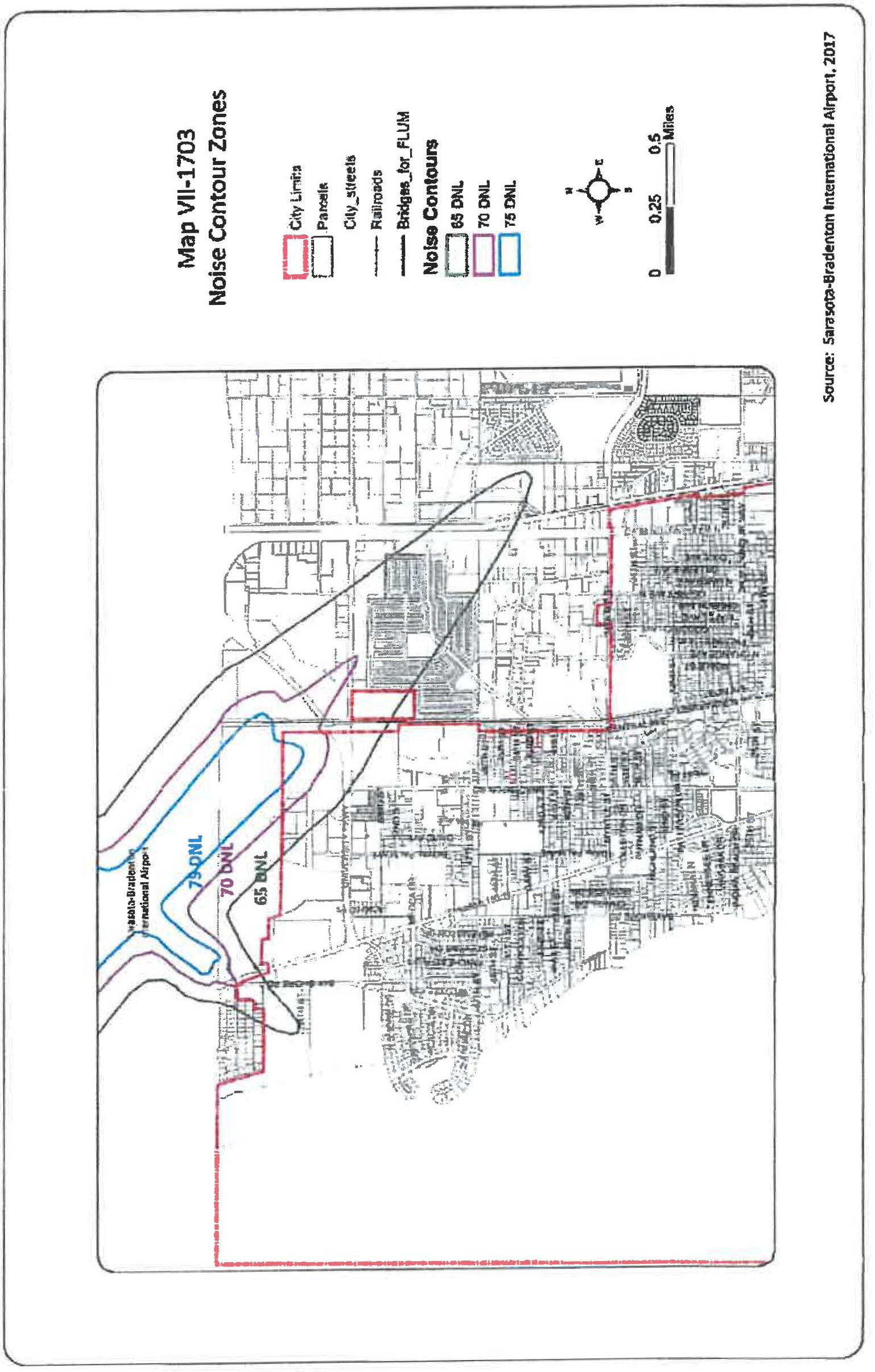
Table VII-1701. Incompatible Land Uses within Airport Noise Contours (from Title 14, Chapter I, Subchapter I, Part 150, Code of Federal Regulations)
Notes for Table VII-1701.
Y
(Yes) = Land use and related structures compatible without restrictions.
N
(No) = Land use and related structures are not compatible and are prohibited.
NLR
= Noise level reduction (outdoor to indoor) to be achieved through incorporation of noise attenuation into the design and construction of the structure.
25, 30, or 35
= Land use and related structures generally compatible; measures to achieve NLR of 25, 30, or 35 dB must be incorporated into design and construction of structure.
(1)
Where the community determines that residential or school uses must be allowed, measures to achieve outdoor to indoor noise level reduction (NLR) of at least 25 dB and 30 dB must be incorporated into the design and construction of these buildings.
(2)
Measures to achieve NLR of 25 dB must be incorporated into the design and construction of portions of these buildings where the public is received, office areas, noise sensitive areas or where the normal noise level is low.
(3)
Measures to achieve NLR of 30 dB must be incorporated into the design and construction of portions of these buildings where the public is received, office areas, noise sensitive areas or where the normal noise level is low.
(4)
Measures to achieve NLR of 35 dB must be incorporated into the design and construction of portions of these buildings where the public is received, office areas, noise sensitive areas or where the normal level is low.
(5)
Land use compatible provided special sound reinforcement systems are installed.
(6)
Residential buildings require an NLR of 25 dB.
(7)
Residential buildings require an NLR of 30 dB.
(Ord. No. 18-5240, § 2(Exh. A), 5-7-18)
Sec. VII-1706. - Marking and lighting.
The owner of any existing nonconforming structure or tree shall be required to install, operate, and maintain, or to permit the airport authority to install, operate and maintain thereon of such markers and lights as shall be deemed necessary by the airport authority to indicate to the operators of aircraft in the vicinity of the airport the presence of such airport obstructions. If installed by the airport authority, such markers and lights shall be installed, operated and maintained at the expense of the airport authority.
(Ord. No. 18-5240, § 2(Exh. A), 5-7-18)
Sec. VII-1707. - Permitting required for obstructions.
(a)
A permit may not be issued that would allow the establishment or creation of a new airport hazard or that would permit a nonconforming obstruction to become a greater hazard to air navigation than when the applicable airport protection zoning regulation was adopted.
(b)
In determining whether to issue or deny a permit, the development services department shall consider:
(1)
The safety of persons on the ground and in the air.
(2)
The safe and efficient use of navigable airspace.
(3)
The nature of the terrain and height of existing structures.
(4)
The effect of the construction or alteration of an obstruction on the state licensing standards for a public-use airport contained in F.S. ch. 330, and rules adopted thereunder.
(5)
The character of existing and planned flight operations and developments at public-use airports.
(6)
Federal airways, visual flight rules, flyways and corridors, and instrument approaches as designated by the Federal Aviation Administration.
(7)
The effect of the construction or alteration of an obstruction on the minimum descent altitude or the decision height at the affected airport.
(8)
The cumulative effects on navigable airspace of all existing obstructions and all known proposed obstructions in the area.
(c)
When issuing a permit under this section, the city shall require the owner of the obstruction to install, operate, and maintain, at the owner's expense, marking and lighting in conformance with the standards established by the Federal Aviation Administration.
(d)
The city may not approve a permit for the construction or alteration of an obstruction unless the applicant submits documentation showing both compliance with the federal requirement for notification of proposed construction or alteration and a valid aeronautical study. A permit may not be approved solely on the basis that the Federal Aviation Administration determined that the proposed construction or alteration of an obstruction was not an airport hazard.
(e)
Except as otherwise provided herein, no permit shall be issued that would be prohibited under sections VII-1704 and VII-1705. Each application for a permit shall indicate the purpose for which the permit is desired, with sufficient information in order to determine whether the resulting use, structure, or tree would conform to the regulations herein prescribed. Vertical height shall be measured from the highest point on the ground along the periphery of the structure or tree to the highest point on the structure or tree.
(f)
Within ten calendar days after receiving a permit application, the city shall provide the airport authority with written notice and an opportunity to comment on the application, when:
(1)
The application proposes vertical development in excess of 40 feet above the airport elevation (which is 30 feet above mean sea level) on a parcel that is within a horizontal distance of less than 4,200 feet from the end of an airport runway; or
(2)
The application proposes a land use or activity deemed incompatible under table VII-1701 on a parcel that is within the outer noise contour depicted on map VII-1703, noise contour zones; or
(3)
The application proposes development on a parcel that is within an airport runway protection zone as depicted on map VII-1702, runway protection zones; or
(4)
The application proposes the development of an educational facility of a public or private school, with the exception of aviation school facilities, at either end of an airport runway within the area contiguous to the airport defined by the outer noise contour depicted on map VII-1703, noise contour zones; or
(5)
The application proposes the development of a sanitary landfill located within 10,000 feet from the nearest point of any runway at the airport, or located more than 10,000 feet from the nearest point of any runway at the airport, but still within the lateral limits of the civil airport imaginary surfaces depicted on map VII-1701, airport imaginary surface zones.
Failure to provide such notice to the airport authority shall not constitute a jurisdictional or procedural defect in an approval of an application for development permit.
(g)
Within ten calendar days after receiving a permit application, the city shall provide a copy of the application to the Florida Department of Transportation's aviation office by certified mail, return receipt requested, or by a delivery service that provides a receipt evidencing delivery. To evaluate technical consistency with this section, the department shall have a 15-day review period following receipt of the application, which must run concurrently with the city's permitting process. Cranes, construction equipment, and other temporary structures in use or in place for a period not to exceed 18 consecutive months are exempt from the Florida Department of Transportation's review, unless such review is requested by the Florida Department of Transportation.
(h)
A permit shall not be granted for a nonconforming use or nonconforming obstruction that has been abandoned or that more than 80 percent of the obstruction is torn down, destroyed, deteriorated, or decayed. A permit may not be granted that would allow the obstruction to exceed the applicable height limit or otherwise deviate from these airport protection zoning regulations. Regardless of whether an application is made for a permit under this subsection the owner of the nonconforming obstruction may be required, at his or her own expense, to lower, remove, reconstruct, alter, or equip such obstruction as necessary to conform to the current airport protection zoning regulations. If the owner of the nonconforming obstruction fails or refuses to comply with such requirement within ten days after notice, the city or the airport authority may proceed to have the obstruction so lowered, removed, reconstructed, altered, or equipped and assess the cost and expense thereof upon the owner of the obstruction or the land whereon it is or was located.
(i)
A permit is not required for existing structures that received construction permits from the Federal Communications Commission for structures exceeding federal obstruction standards before May 20, 1975; a permit is not required for any necessary replacement or repairs to such existing structures if the height and location are unchanged.
(Ord. No. 18-5240, § 2(Exh. A), 5-7-18)
Sec. VII-1708. - Appeals.
Appeals of all permit decisions shall be made to the board of adjustment in accordance with article IV, division 7.
(Ord. No. 18-5240, § 2(Exh. A), 5-7-18)
Sec. VII-1709. - Nonconforming uses.
Nothing in these regulations shall require the removal, lowering, or other change or alteration of any obstruction not conforming to the regulations when adopted or amended, or otherwise interfere with the continuance of any nonconforming use, unless the nonconforming use has been abandoned or is more than 80 percent torn down, destroyed, deteriorated, or decayed, or unless, with respect to existing obstruction marking or lighting, whenever such marking or lighting requires replacement.
Nothing in these regulations shall be construed to require the removal, alteration, sound conditioning, or other change, or to interfere with the continued use or adjacent expansion of any educational structure or site in existence on July 1, 1993, or be construed to prohibit the construction of any new structure for which a site has been determined as provided in former F.S. § 235.19, as of July 1, 1993.
(Ord. No. 18-5240, § 2(Exh. A), 5-7-18)