
Schaumburg City Zoning Code
Overlay Districts
§ 154.195 - OLDE SCHAUMBURG CENTRE (OSC) OVERLAY DISTRICT.
(A)
General Purpose: The purpose of the Olde Schaumburg Centre (OSC) Overlay District is to provide a regulatory framework that will enable the unique, turn of the century character of the area at the crossroads of Schaumburg and Roselle Roads to be preserved and to encourage compatible new development. The village seeks to strengthen the aesthetics and economics of the village centre by enabling the development and/or redevelopment of quality retail, commercial, office and residential uses in a village centre setting. The centre allows for the function of contemporary land uses while emphasizing pedestrian orientation within an intimate streetscape design and deemphasizing automobile related uses. The OSC overlay district is designed to accomplish these purposes by doing the following:
(1)
Regulating building location with a zero (0) or small setback to create an intimate streetscape character and pedestrian-oriented environment;
(2)
Prohibiting parking in front yards, except in limited situations, to create a pedestrian focused rather than automobile focused environment and to create a stronger architectural statement by keeping buildings close to the roads; and
(3)
Prohibiting drive-through facilities and automobile related uses to encourage a pedestrian focused rather than automobile focused environment.
(B)
Designation of Olde Schaumburg Centre Overlay District: The Olde Schaumburg Centre Overlay District shall apply to the area of land at the crossroads of Schaumburg and Roselle Roads and shall be shown as an overlay to the underlying zoning districts on the official zoning map of the Village of Schaumburg, as amended.
(C)
Application of District: The provisions in this OSC overlay district shall serve as a supplement to the underlying zoning district regulations. Except where specifically altered in this OSC overlay district, the uses, minimum lot size, minimum lot width, yard requirements, lot coverage, floor area ratio, and maximum height shall be determined by the regulations applicable to the underlying district to which the OSC overlay district is superimposed. Where a conflict exists between the provisions of this section and those of any underlying zoning districts, the OSC overlay district provisions shall apply.
(D)
Site Plan Review: To ensure compliance with the applicable provisions of this chapter, any exterior construction, change in use, or increase in the intensity of an existing use, including variations and special uses, but excluding normal maintenance activity, in the OSC overlay district shall require site plan review by the plan commission for residential properties, zoning board for commercial properties and approval by the village board of trustees prior to the issuance of a building permit. This process shall ensure that all development proposals are in full compliance with all applicable village codes, ordinances, standards and policies. Development proposals which are located within existing buildings or result in the redevelopment of existing properties shall comply with those village requirements and policies determined appropriate by the village board.
(E)
Regulation of Construction, Rehabilitation, Exterior Appearance, Demolition, and Removal: It shall be unlawful for any person to construct, move, alter, change, make addition to, make any improvement to, add structures or buildings, demolish or remove the exterior or any aspect of the exterior of any building located within the centre unless the village has previously authorized such work. Prior approval shall not be required for ordinary repair and maintenance, in which there is no exterior change in appearance, or changes in color according to subsection (G) of this section. However, it shall be unlawful to change the color of the exterior of a building in the centre in violation of subsection (G) of this section.
(1)
Exterior alterations shall be reviewed by either the village board or the director, depending on the scope of the proposed work.
(a)
The village board shall consider exterior alterations that entail structural change, change in architectural style, building additions, new construction, and demolition. Such consideration shall not be made without a report on it from the plan commission or zoning board.
(b)
The director or designee may approve all other exterior alterations. Those shall include exterior repair and/or restoration which does not include structural change, change in architectural style, building additions, new construction, and demolition.
1.
The applicant shall submit to the community development department, hereinafter referred to as the "department", four (4) copies of plans showing existing and proposed exterior alterations.
2.
The director or designee shall render a decision in writing on the proposed plans within fourteen (14) days. If no decision is made within fourteen (14) days, the plans shall be deemed to be approved.
3.
If the plans are denied by the director, the applicant may appeal to the village board through the plan commission or zoning board. Such appeal must be made in writing to the director within ten (10) days of the denial. Such appeal shall be processed through the plan commission or zoning board in the same manner as in subsections (E)(2) and (E)(3) of this section.
(2)
In reviewing the proposed plans, the director, the plan commission or zoning board, and village board shall determine:
(a)
Whether the proposed construction or exterior alteration conforms to the objective and design criteria established for said centre as adopted by the plan commission or zoning board.
(b)
Whether the proposed work will highlight or positively enhance any exterior architectural feature of the improvement upon which said work is to be done.
(c)
Whether the new improvements will have a positive effect and harmonize with the external appearance of other neighboring improvements.
(d)
Whether the proposed improvements will have a positive effect on the general welfare of the centre.
(e)
Whether the proposed improvement will be in conformance with the historical character and appearance of the centre.
(f)
Whether the plans meet the requirements of the Olde Schaumburg Centre design manual.
(g)
Whether the plans are consistent with the preservation practices recommended in the secretary of the interior's standards for historic preservation.
(3)
If the proposed action involves the demolition, partial demolition or removal of a structure or accessory structure in the centre, a public hearing shall be held before the plan commission or zoning board.
(a)
In reviewing the plans, the plan commission or zoning board, and village board shall take into account the following information to be supplied by the applicant:
1.
A report on the state of repair and structural stability of the structure under consideration;
2.
Information and graphics on the extent and process of demolition or removal, including information on any proposed changes in landscaping; and
3.
An assessment of any alterations in the essential character of the area which would occur as a result of demolition or removal action.
(b)
Access to the interior of the structure under consideration shall be provided by the applicant to the director at least two (2) weeks prior to the scheduled hearing for the purpose of verifying the state of repair and structural stability of the structure. Additional information shall be provided to the director or designee as needed for verification of material detailed in subsection (E)(3)(a) of this section.
(c)
If it is determined that the demolition or removal would produce results contrary to the purpose of this section, the proposed demolition may be denied by the village board after a recommendation on such from the plan commission or zoning board.
(d)
In approving the issuance of the demolition permit, the village board may prescribe any conditions it deems necessary to minimize the adverse impact of the requested demolition or removal.
(e)
Notwithstanding any provisions of this section to the contrary, the applicant may submit an application to the plan commission or zoning board for finding of economic hardship within forty-five (45) days of the denial of a demolition permit by the village board, requesting such finding should the applicant perceive said denial as causing economic hardship. Upon review of the required documentation provided by the applicant, the plan commission or zoning board shall recommend approval or denial of the application. The final decision shall be made by the village board. If the village board approves the application, the applicant shall be permitted to proceed with the proposed demolition based on the demonstrated presence of financial loss. The plan commission or zoning board shall require documentation of the applicant's financial condition relating to the subject property. This documentation shall be used by the plan commission or zoning board to determine the existence and validity of economic hardship. All documents and information submitted in support of an application for finding of economic hardship, not already a matter of public record, shall remain confidential, unless the applicant provides the plan commission or zoning board with written consent for dissemination. Finding of economic hardship shall be considered by the plan commission or zoning board if an applicant, at the time of application, has produced the following information in an affidavit signed by the owner of the subject property and improvements:
1.
Estimate of the cost of the proposed construction, alteration, demolition or removal.
2.
A report from a licensed engineer or architect with experience in rehabilitation as to the structural soundness of any structures on the property and their suitability for rehabilitation.
3.
Estimated market value of the property in its current condition; after completion of the proposed construction, alteration, demolition, or removal; and after renovation of the existing property for continued use.
4.
An estimate from an architect, developer, real estate consultant, appraiser, or other real estate professional experienced in rehabilitation as to the economic feasibility of rehabilitation or reuse of the existing structure on the property.
5.
The amount paid for the property, the date of purchase and the party from whom purchased, including a description of the relationship, if any, between the owner and the person from whom the property was purchased; and any terms of financing between the seller and buyer.
6.
The assessed value of the land and improvements thereon according to the two (2) most recent assessments.
7.
Real estate taxes for the two (2) previous years.
8.
Form of ownership or operation of the property whether sole proprietorship, for profit or not for profit corporation, limited partnership, joint venture, or other.
9.
All appraisals obtained within the previous two (2) years by the owner or applicant in connection with the purchase, financing or ownership of the property.
10.
Any listing of the property for sale or rent, price asked and offers received, if any.
11.
Any consideration by the owner as to profitable adaptive uses for the property.
12.
If the property is income producing, the annual gross income from the property for the previous two (2) years, itemized operating and maintenance expenses for the previous two (2) years, and annual cash flow, if any, during the same period.
13.
Remaining balance on any mortgage or other financing secured by the property and annual debt service, if any, for the previous two (2) years.
14.
Any other information, including the income tax brackets of the owner, applicant, or principal investors in the property considered necessary by the plan commission or zoning board to make a determination as to whether the property does yield or may yield a reasonable return to the owners.
(F)
Miscellaneous:
(1)
Relation to Other Ordinances: This section supplements and is in addition to all other ordinances and codes currently in effect in the village. Whenever there is a conflict between the regulations of this section and any other section or ordinance currently in effect, the more restrictive shall apply.
(2)
Severability: The provisions of this section are severable and if any of its provisions or any sentence, clause or paragraph shall be held unconstitutional or unlawful by any court of competent jurisdiction, the decision of such court shall not affect or impair any of the remaining provisions.
(3)
Amendments to Regulations and District: The regulations imposed and the centre created under the authority of this section may be amended from time to time by ordinance after the ordinance establishing them has gone into effect, but no such amendments shall be made without a hearing before the plan commission or zoning board. Notice shall be given of the time and place of the hearing, not more than thirty (30) days, nor less than fifteen (15) days before the hearing, by publishing a notice thereof at least once in one or more newspapers published in the village, or if no newspaper is published therein, then in one or more newspapers with a general circulation within the village. In case of a written protest against any proposed amendment of the regulations or centre, signed and acknowledged by the owners of twenty percent (20%) of the frontage proposed to be altered, or by the owners of twenty percent (20%) of the frontage immediately adjoining or across the alley therefrom, or by the owners of twenty percent (20%) of the frontage directly opposite the frontage proposed to be altered, is filed with the village clerk, the amendment shall not be passed except by a favorable vote of two-thirds of all of the trustees of the village.
(G)
Color: The use of bright, brilliant, fluorescent, high gloss paint or colors within the centre or on a designated historic landmark is prohibited.
(H)
Permitted Uses: Permitted uses of structures and land as set forth herein shall be allowed in the OSC overlay district only in accordance with the conditions specified. Only those uses specifically listed hereunder shall be considered permitted uses, and no structure or land shall be devoted to any use other than a use permitted hereunder with the exception of:
Accessory uses in compliance with the provisions of sections 154.60 through 154.68 of this chapter and subsection (J) of this section;
Special uses in compliance with the provisions of subsection (I) of this section; and
Uses lawfully established prior to the effective date of the ordinance creating the OSC overlay district.
(1)
Permitted Uses in the A Agricultural District With Underlying R-6 Zoning, R-4 Large Lot Single-Family Residence District, R-6 Single-Family Residence District, and B-1 Limited Office Business District: Permitted uses prescribed by this chapter for those zoning districts delineated above shall constitute permitted uses within the OSC overlay district's respective underlying zoning districts only.
(2)
Permitted Uses in the B-2 General Business District: Permitted uses prescribed by this chapter for this zoning district shall constitute permitted uses within the OSC overlay district, except the following uses:
(a)
Service Uses:
Garages: public.
(I)
Special Uses:
(1)
Special Uses in the A Agricultural District With Underlying R-6 Zoning, R-4 Single-Family Residence District, R-6 Single-Family Residence District and B-1 Limited Office Business District: Special uses prescribed by this chapter for those zoning districts delineated above shall constitute special uses within the OSC overlay district's respective underlying zoning districts, except the following uses:
(a)
Public and Utility Uses:
Public works garages.
Public works storage yard and related facilities.
Water treatment and distribution facilities.
Water wells, reservoirs and storage facilities.
(b)
Miscellaneous:
Concrete batch plants, temporary.
(2)
Special Uses in the B-2 General Business District: Special uses prescribed by this chapter for the B-2 general business district shall constitute special uses within the OSC overlay district's underlying B-2 district, except the following uses:
(a)
Retail Uses:
Agricultural implement sales and service.
Aircraft sales and service.
Boat sales and service.
Marine craft and accessories sales and service.
Motor vehicle sales and service.
Swimming pool sales and service.
(b)
Service Uses:
Automobile body shop.
Automobile rental agencies.
Automobile repair and service.
Car wash installations.
Funeral homes.
Internet auto sales.
Tattoo establishments.
(c)
Public and Utility Uses:
Water wells, reservoirs and storage facilities.
(J)
Accessory Buildings, Structures and Uses: Accessory buildings, structures and uses shall be permitted in the OSC overlay district only in accordance with the provisions of section 154.63 of this chapter, with the exception of the following provisions which supersede provisions of section 154.63 of this chapter.
(1)
Fences:
(a)
Fences to a maximum height of five feet (5') may be permitted in a side or rear yard.
(b)
Fences which are fifty percent (50%) open and a maximum of three feet (3') in height may be permitted in a front or corner side yard. In instances where a three-foot tall fence is connected to a five-foot tall fence, a section of tapered fence shall be used to make the height transition.
(c)
Cyclone fences and other types of wire fences shall be prohibited.
(2)
Off-street Parking: Open off-street parking along Schaumburg and Roselle Roads shall be allowed up to a maximum length of fifteen percent (15%) of the linear frontage of these roads.
(K)
Site Development Requirements: Uses of structures and land in the OSC overlay district shall conform to the following site development provisions, which supersede those of the underlying zoning district(s). Unless otherwise provided below, the site development provisions of the underlying zoning district(s) shall apply.
(1)
Minimum yard requirements in the B-1 limited office business district, B-2 general business district, and all properties with direct roadway frontage on Schaumburg and/or Roselle Roads: The following yards shall be provided and maintained for properties located in the B-1 district, B-2 district, and for all properties with direct roadway frontage on Schaumburg and/or Roselle Roads:
(a)
Front and Corner Side Yards:
1.
Buildings: All buildings shall be set back from a front lot line or corner side lot line abutting either a roadway right-of-way or private street a minimum of zero feet (0') and a maximum of twenty feet (20').
2.
Parking: All off-street parking and loading areas are prohibited in front and corner side yards, except as stated in subsection (J)(2) of this section. All off-street parking and loading areas located in interior side yard shall be set back from a front lot line or corner side lot line a minimum of ten feet (10').
(b)
Interior Side Yards:
1.
Buildings: All buildings abutting a nonresidential use shall be set back a minimum of one foot (1') from the interior side lot line for fire access. However, where an interior side lot line abuts a residence zoning district, all buildings shall be set back a minimum of ten feet (10') from the abutting interior lot line.
2.
Parking: All off-street parking and loading areas abutting a nonresidential use shall be set back a minimum of five feet (5') from the interior side lot line. However, where an interior side lot line abuts a residence zoning district, all off-street parking and loading areas shall be set back a minimum of ten feet (10') from the abutting interior lot line.
(c)
Rear Yards:
1.
Buildings: All buildings shall be set back from the rear lot line a minimum of thirty feet (30').
2.
Parking: All off-street parking and loading areas shall be set back from the rear lot line a minimum of ten feet (10').
(2)
Minimum Yard Requirements for Residential Lots Fronting Lengl Drive: The following yard shall be provided and maintained for residentially zoned properties with direct roadway frontage on Lengl Drive:
(a)
Front and Corner Side Yards:
1.
Buildings: All buildings shall be set back from a front lot or corner side lot line abutting either a roadway right-of-way or private street the average distance of the established setbacks of the nearest residentially developed lots on either side of the subject lot. The maximum setback from a front lot or corner side lot line abutting either a roadway right-of-way or private street shall be fifteen feet (15').
(L)
Design Standards: All new developments and/or redevelopments shall comply with the guidelines prescribed by the Olde Schaumburg Centre Design Manual and the Secretary of the Interior's Standards for Rehabilitation.
(M)
Off-street Parking and Loading: Requirements for off-street parking and loading shall comply with the requirements prescribed by sections 154.120 through 154.127 of this chapter.
(N)
Alleys: A site plan including alleys may be allowed, subject to approval by the director of community development or his/her authorized designee, where such a layout improves on-site circulation and enhances the compatibility of the development with surrounding developments by continuing an established linear grid street pattern.
(O)
Cross Access Agreements: As deemed appropriate by the director of community development or his/her authorized designee, cross access agreements shall be incorporated, wherever possible, for all new development and/or redevelopment along Schaumburg and/or Roselle Roads to encourage internal circulation between sites rather than traffic on the districts arterial streets, as determined appropriate by the director of community development or his/her authorized designee.
(P)
Drive-Through Facilities: Drive-through facilities as principal or accessory uses shall be prohibited on all lots within the Olde Schaumburg Centre District.
(Q)
Tree Preservation, Landscaping and Screening: All uses shall conform to the applicable requirements for tree preservation, landscaping and screening as set forth in sections 154.135 and 154.136 of this chapter. Further, such tree preservation, landscaping and screening shall comply with the guidelines established by the Olde Schaumburg Centre design guidelines to the greatest extent possible.
(R)
Signs: All uses shall conform to the applicable requirements for signs as set forth in the Village of Schaumburg sign ordinance, Olde Schaumburg Centre sign regulations.
(S)
Neon Lighting: Exposed neon lighting of any kind which is visible from the exterior of the building shall not be permitted within the Olde Schaumburg Centre Overlay District.
(T)
Deliveries, Loading and Opening of Containers: No loading or unloading of any vehicles, no opening or destruction of bales, boxes, crates and containers, and no deliveries shall be permitted between the hours of 10:00 p.m. and 7:00 a.m. on Sunday evenings through Saturday morning and between the hours of 10:00 p.m. and 8:00 a.m. on Saturday evening through Sunday morning, for commercially zoned property that abuts residentially zoned property.
(Ord. 163, passed 12-5-1961; Am. Ord. 95-27, passed 3-14-1995; Am. Ord. 95-62, passed 6-13-1995; Am. Ord. 96-77, passed 9-10-1996; Am. Ord. 96-112, passed 12-17-1996; Am. Ord. 97-152, passed 12-9-1997; Am. Ord. 03-99, passed 7-22-2003; Am. Ord. 07-198, passed 12-11-2007; Am. Ord. 17-002, passed 1-10-2017; Am. Ord. 22-024, passed 3-22-2022; Am. Ord. 23-028, passed 3-28-2023)
§ 154.196 - WETLANDS, STREAMS, AND AQUATIC RESOURCES PROTECTION OVERLAY DISTRICT.
(A)
General Purpose: The purpose of this wetlands, streams, and aquatic resources protection ordinance shall be to protect persons and property within and adjacent to wetlands from potentially hazardous geological and hydrological conditions; prevent environmental degradation of the land and water, and ensure that development enhances rather than detracts from or ignores the natural topography, resources, amenities, and fragile environment of wetlands within the village.
All development proposals adjacent to or within the designated areas shall take into account and be judged by the application of current understanding of land use planning, soil mechanics, engineering geology, hydrology, civil engineering, environmental and civil design architecture and landscape architecture in wetland areas. Such current understanding is hereby found to include, but is not limited to:
(1)
Planning of development adjacent to wetlands to fit the topography, soils, geology, hydrology and other conditions existing on the proposed site.
(2)
Orienting development so that grading, excavation, landscaping and other site preparation is kept to an absolute minimum impact on the wetlands area.
(3)
Minimizing disruption of existing land and animal life.
(4)
Minimizing disruption of alteration of natural drainageways.
(5)
Timing of development activities so as to minimize impact on wetland areas.
(6)
Landscaping areas around structures to blend with natural landscapes.
(7)
Demonstrating a concern for the view of, as well as from, wetland areas.
(B)
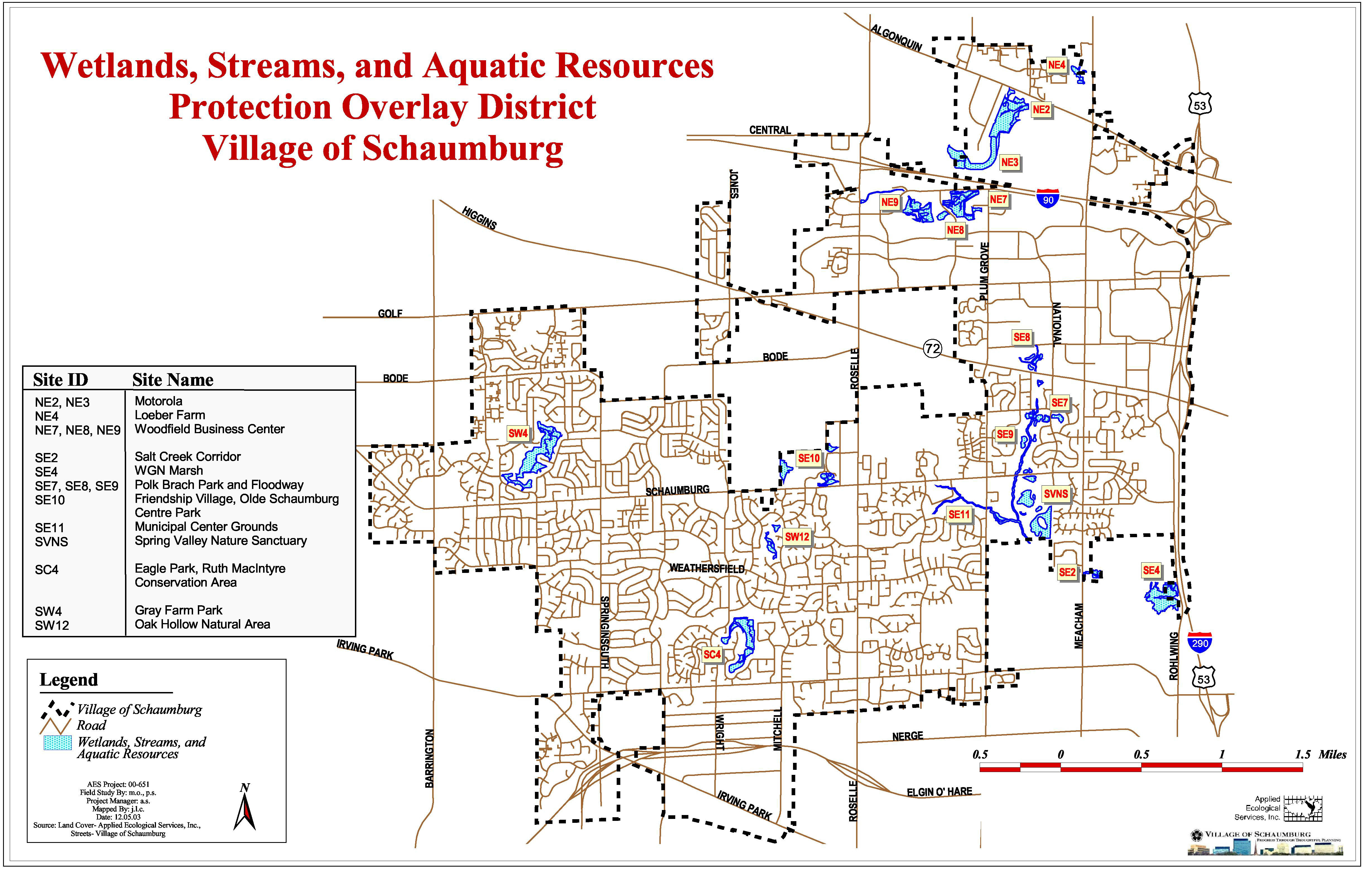
Protected Sites: The procedures, standards and requirements contained in this section shall apply to all lots immediately adjacent to and within the areas designated on a map labeled wetlands, streams, and aquatic resources protection overlay district, which is made to be part of this chapter and have the same force and effect as if all the notations, references and descriptions shown thereon were set forth or described herein. Designated areas are shown on Exhibit A below, and areas that may be approved from time to time and be made exhibits hereto.
Exhibit A
(C)
Special Use Permit for Construction: No building, wall, dam or structure intended for permanent use shall be erected, constructed, altered, enlarged or otherwise created or moved for any purpose unless a special use permit from the village board is granted. Dumping, filling, excavating or transferring of any earth material within the district is prohibited unless a special use permit is granted. However, normal gardening or farming are not subject to these requirements.
No ponds or pools shall be created, and no changes in watercourses for recreational use, conventional stormwater management practices, agricultural uses or scenic features shall be allowed unless a special use permit is granted. Exceptions to stormwater management use include practices that enhance water quality and promote infiltration of stormwater through use of best management practices as defined in this chapter. As applicable, practices shall also conform to NPDES standards.
No special use permit shall be issued unless the applicant, in support of his application, submits engineering data, surveys, site plans and other information as the village may require in order to determine the effects of such development on the affected land and water areas.
(D)
Required Plans and Development Standards: Plans and reports complying with the standards set forth herein shall be submitted to and approved by the village in the application for special use permit for construction in wetlands or within one hundred (100) linear feet of the edge of the designated wetlands, said edge to be determined as that point at which the natural edge of a wetlands area commences.
(1)
Geological and Soil Characteristics: The site proposed for development shall be investigated to determine the soil and geological characteristics. A report, prepared by a licensed professional engineer experienced in the practice of geological and soils mechanics, shall be submitted with every application for land development or special use permit within the wetlands protection district. This report shall include a description of soil type, stability of surface, and subsurface hydrological conditions. Any area which the investigation indicates as subject to geological or soil hazards or subsurface seepage shall not be developed unless the engineer can demonstrate to the Village of Schaumburg conclusively that these hazards to the wetlands can be overcome.
(2)
Site Grading and Excavation: A grading and excavation plan, prepared by a registered professional engineer, trained and experienced in civil engineering, shall be submitted with each application for a special use permit and shall include the following:
(a)
Property contours at one foot (1') intervals.
(b)
Details of the existing terrain and drainage pattern.
(c)
Dimensions, elevations and contours of proposed grading, excavation and fill.
(d)
A description of methods to be employed in disposing of soil and other materials that is removed from allowable grading and excavation sites, including location of the disposal site if on the property.
(e)
A schedule showing when each stage of the project will be completed, including the total acreage of soil surface to be disturbed during each stage and estimated starting and completion dates. The schedule shall be prepared so as to limit, to the shortest possible period, the time the soil is exposed and unprotected in order to prevent or minimize soil erosion. In no case shall the existing natural vegetation be destroyed, removed or disturbed prior to the issuance of a land development or special use permit.
(3)
Vegetation and Revegetation: A detailed description shall be submitted detailing the revegetation and stabilization methods to be employed. Additionally, a landscape plan prepared by a professional landscape architect, or a native ecological restoration plan prepared by an ecologist, shall be submitted with each application for a special use permit and contain the following:
(a)
A plan illustrating the existing vegetation within the property and showing those areas where the vegetation will be removed as part of the proposed construction.
(b)
A plan describing the proposed revegetation of disturbed areas specifying the plant materials to be used by Latin and common name.
(4)
Wetland Delineation Report: A wetland delineation report prepared per the U.S. Army Corps of Engineers 1987 Manual.
(5)
Construction Requirements: Unless otherwise noted, the following restrictions, requirements and standards shall apply to all construction within a designated wetlands area:
(a)
Every effort shall be made to develop the site in such a manner so as to minimize the alteration of the natural topography and avoid negative impacts.
(b)
With the exception of minimal grading, clearing and excavation as may be required for drainage control structures, ecological restoration, and residential yard areas, substantial site grading, filling, terracing, and excavation shall be prohibited.
(c)
No grading, filling, cleaning, clearing, terracing or excavation of any kind shall be initiated until a special use permit is granted by the village board, final engineering plans are approved, and a land development permit is issued.
(d)
The depositing of any excavation, grading or clearing material within a designated wetlands area shall be prohibited unless approved as part of a special use permit.
(6)
Stormwater Management: A stormwater management plan, prepared by a registered engineer experienced in civil engineering, shall be submitted with each application in accordance with chapters 150, "Flood Control", and 151, "Subdivision and Land Development", of this title.
Unless otherwise noted, the following restrictions, requirements and standards shall apply to all construction within an area designated on exhibit A attached to the ordinance codified herein and on file in the village clerk's office.
(a)
Natural open drainageways shall be preserved.
(b)
Except for approved drainage structures, recreation, and open space uses which do not involve the destruction of vegetative cover or alter the natural drainageways, development shall be prohibited unless approved at the village's discretion by a special use permit.
(Ord. 163, passed 12-5-1961; Am. Ord. 2055, passed 9-22-1981; Am. Ord. 95-34, passed 3-28-1995; Am. Ord. 95-62, passed 6-13-1995; Am. Ord. 97-152, passed 12-9-1997; Am. Ord. 04-54, passed 4-27-2004)
§ 154.197 - ADAPTIVE REUSE OVERLAY DISTRICT.
(A)
General Purpose: The adaptive reuse overlay district shall be considered an overlay district. School buildings and other public buildings are located within existing residential neighborhoods. As circumstances change, the buildings may no longer be required for their public use. Because the reuse of public buildings is unique and different from other special uses, the adaptive reuse overlay district provides specific regulations allowing for the reuse of public buildings intended to promote the public health, safety, comfort, morals, and convenience, by ensuring that such uses are compatible with their surroundings.
(1)
Application and Procedure: The application and procedure for the adaptive reuse overlay district shall follow the regulations set down for a special use.
(2)
Uses Allowed: Uses considered within the special use overlay district include, but not limited to the following:
Business and technical schools.
Clubs, lodges, and fraternal organizations.
Colleges and universities.
Community recreational centers.
Convalescent centers.
Cultural and entertainment centers.
Dance and music academies and conservatories.
Daycare centers.
Dormitories, housing accommodations, and associated facilities when associated with an educational institution.
Elderly housing.
Fire stations.
Government offices.
Institutional housing.
Libraries.
Municipal recreational facilities.
Museums.
Nursery schools.
Nursing homes.
Personnel training centers.
Police stations.
Preschools.
Private, kindergarten, elementary, high, and junior high schools.
Religious uses; including chapels, churches, convents, monasteries, parsonages, rectories, religious assembly halls and meeting rooms, religious reading rooms, seminaries, synagogues and temples.
Sanitariums.
Special educational institutions.
Studios for art, ceramics, and similar skills.
Studios for drama, speech, and similar skills.
Trade schools.
(3)
Limited Commercial Uses: Sites adjacent and abutting a commercial district and having frontage on a primary or secondary road may, as part of the special use, utilize the allowed uses of the B-1 district.
(4)
Submittal Requirements: The director of community development or his/her authorized designee shall maintain forms listing the items necessary for a submittal for a special use for an adaptive reuse overlay district. The submittal requirements will include:
(a)
A detailed site plan showing the intended reuse;
(b)
A detailed landscaping plan;
(c)
An explanation how the reuse of the site would comply with all codes and ordinances of the village;
(d)
The intended uses of the site and the parking calculations for these uses.
(5)
Design Criteria:
(a)
The reuse of the school site shall not negatively impact the existing character of the neighborhood in which the school is located.
(b)
The reuse of school sites shall be in full compliance with all village codes and ordinances, specifically the village building code, fire prevention code, zoning ordinance, and subdivision control ordinance. Schools which do not fully comply with all village codes and ordinances shall be upgraded to meet the minimum standards specified in these documents prior to their reuse.
(c)
In considering the reuse of a school site or public building, the adequate parking shall be provided on the premises to comply with the requirements specified in this zoning ordinance. Additional parking may be required by the village to accommodate the use of all or a portion of the surrounding open area for recreational purposes.
(d)
Both the appropriate school and park district shall be notified of all proposed reuses of school sites and their input solicited.
(Ord. 163, passed 12-5-1961; Am. Ord. 2646, passed 5-27-1986; Am. Ord. 95-62, passed 6-13-1995; Am. Ord. 07-198, passed 12-11-2007)
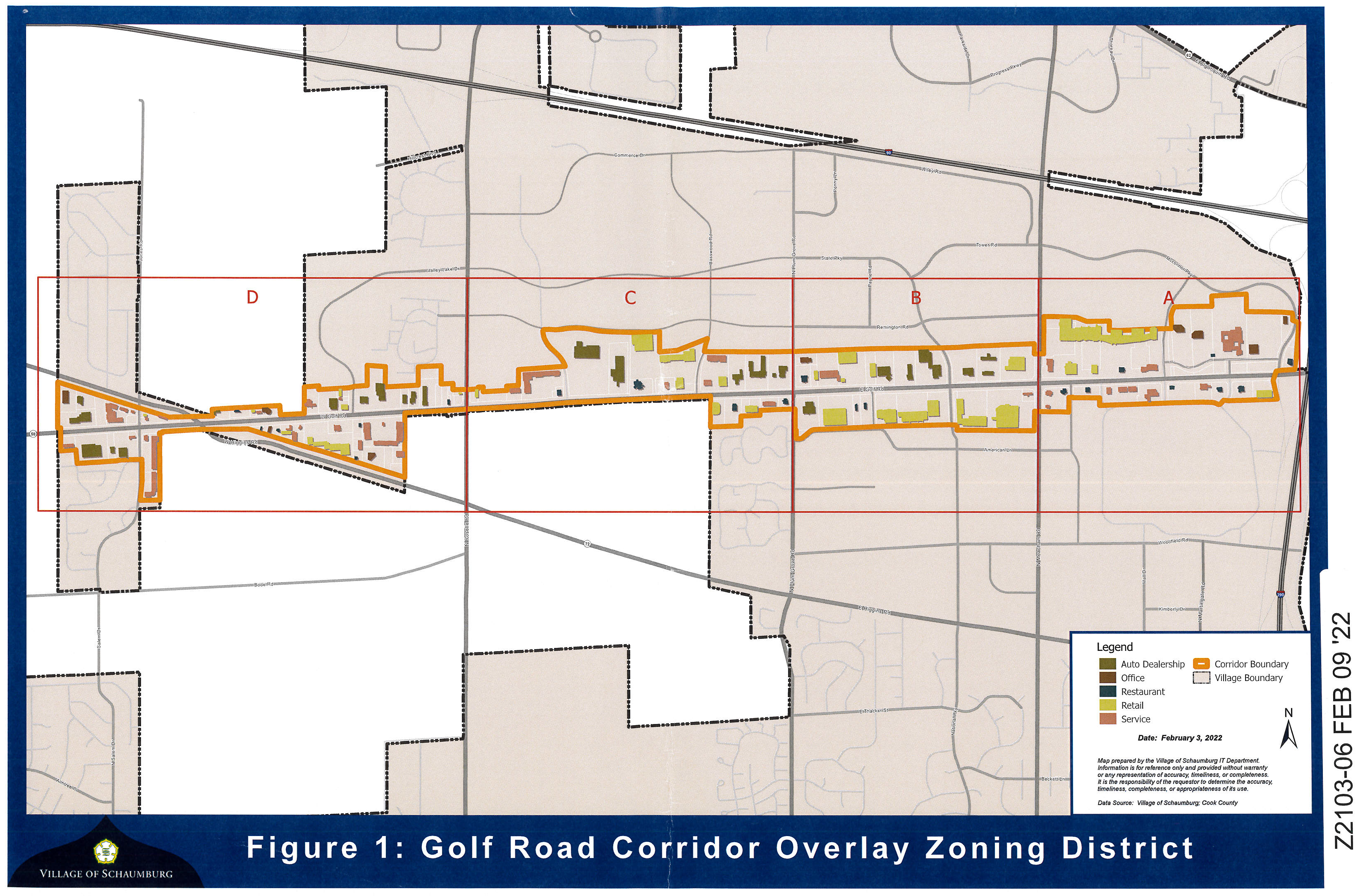
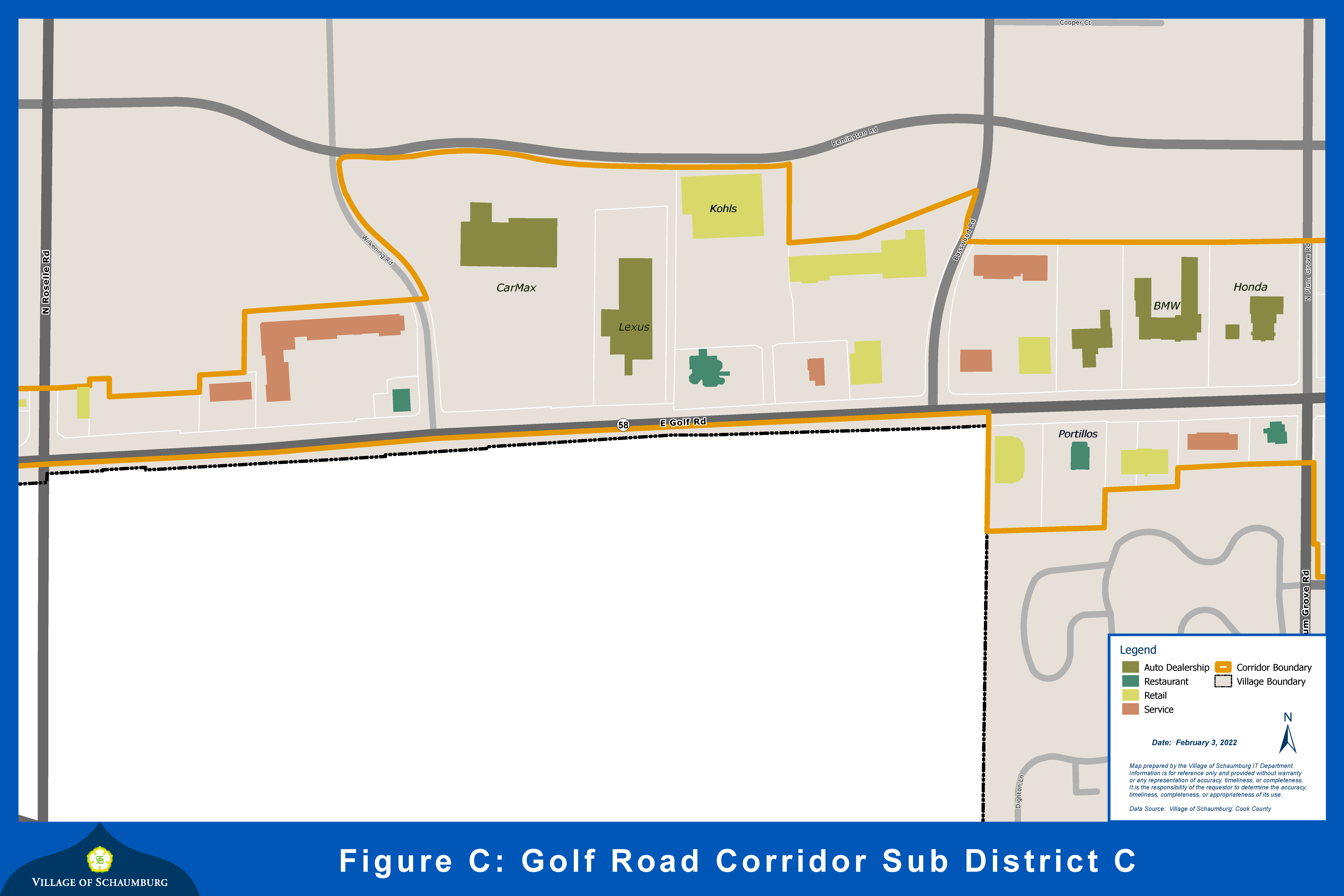
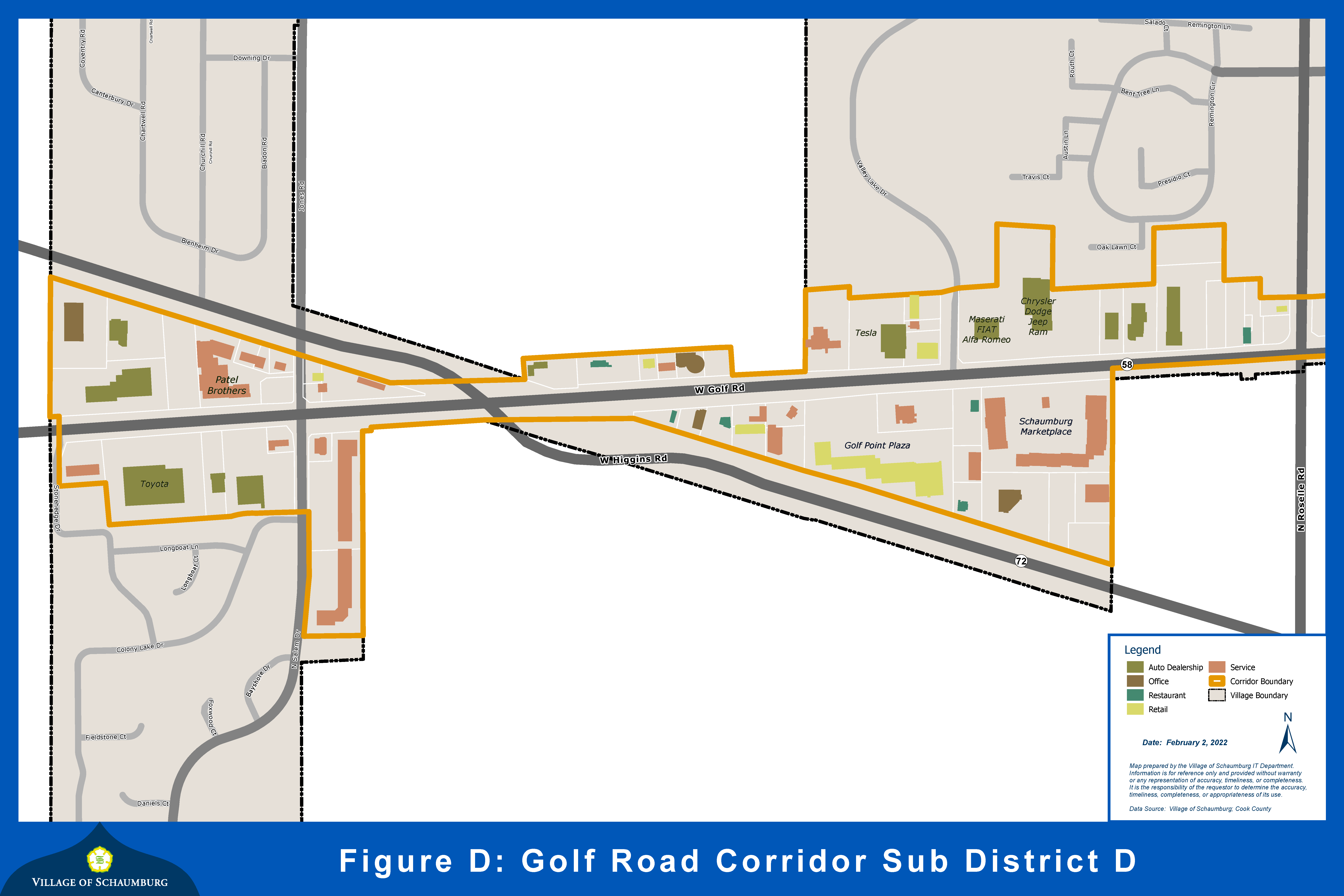
§ 154.198 - GOLF ROAD CORRIDOR OVERLAY DISTRICT.
(A)
General Purpose: The purpose of the Golf Road Corridor Overlay District is to provide guidelines and standards for development projects and land uses along Golf Road. The corridor is the village's highest traveled corridor and is a premier retail location. The eastern portion of this auto-oriented corridor serves as a regional destination, and it transitions further west to include uses that service a more localized population. The primary objective of the overlay is to maintain Golf Road as a premier commercial location by governing future land uses. It aims to promote quality commercial retail character while complementing the various car dealerships and other service uses within the corridor. The village seeks to accomplish the objectives of the Golf Road Corridor Overlay District by implementing the following:
(1)
Regulate specific land uses within the corridor by creating four (4) sub-districts.
(2)
Supplement and promote a mix of commercial, retail, and service uses to complement and enhance the "auto row" identity of the corridor.
(3)
Limit the amount of service uses to ensure that retail remains the dominant land use in the eastern portion of the corridor.
(4)
Promote retail and economically viable businesses with the highest quality building design and site character at corner/key intersections.
(B)
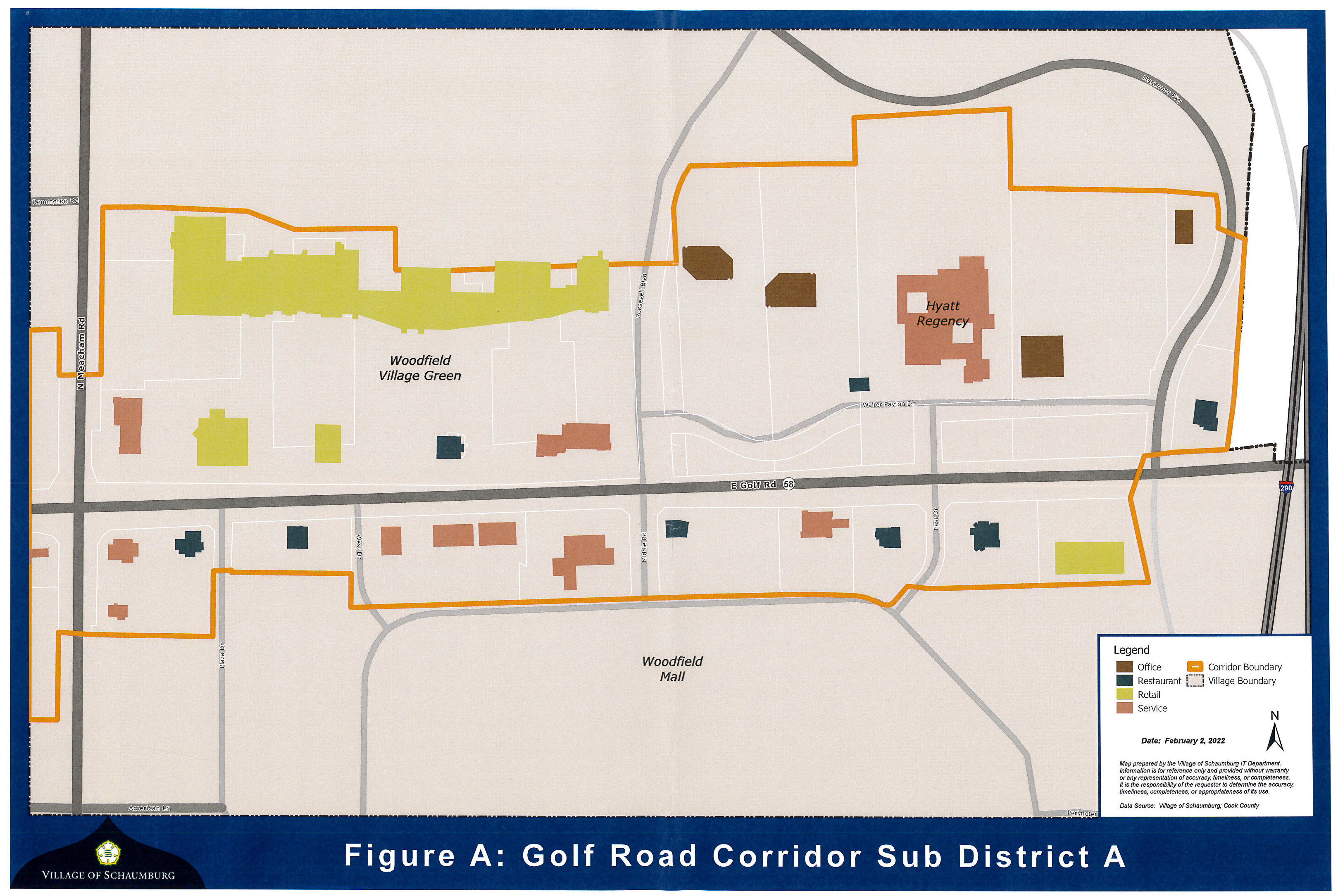
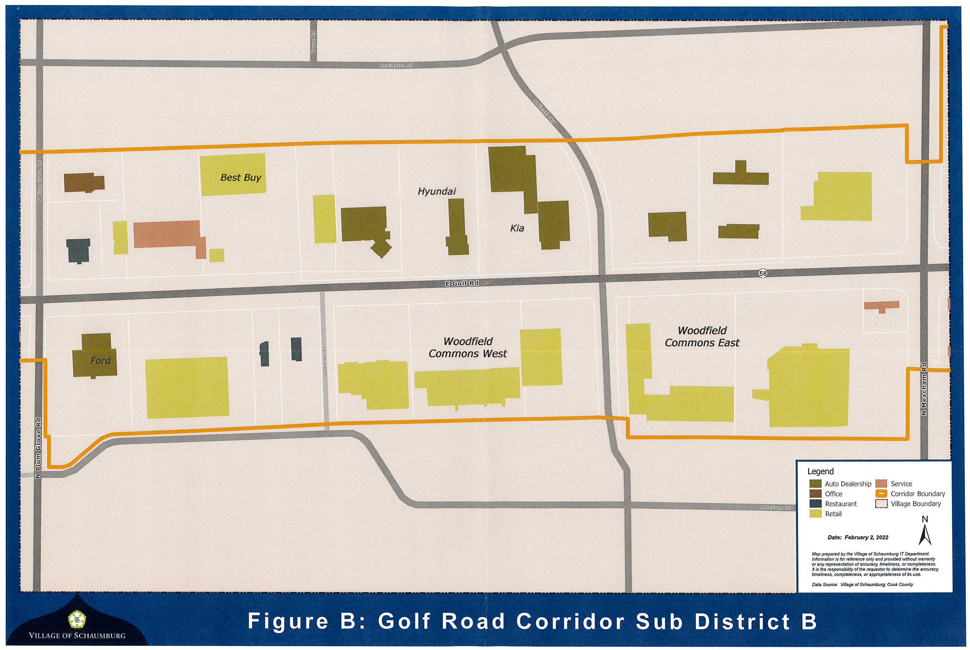
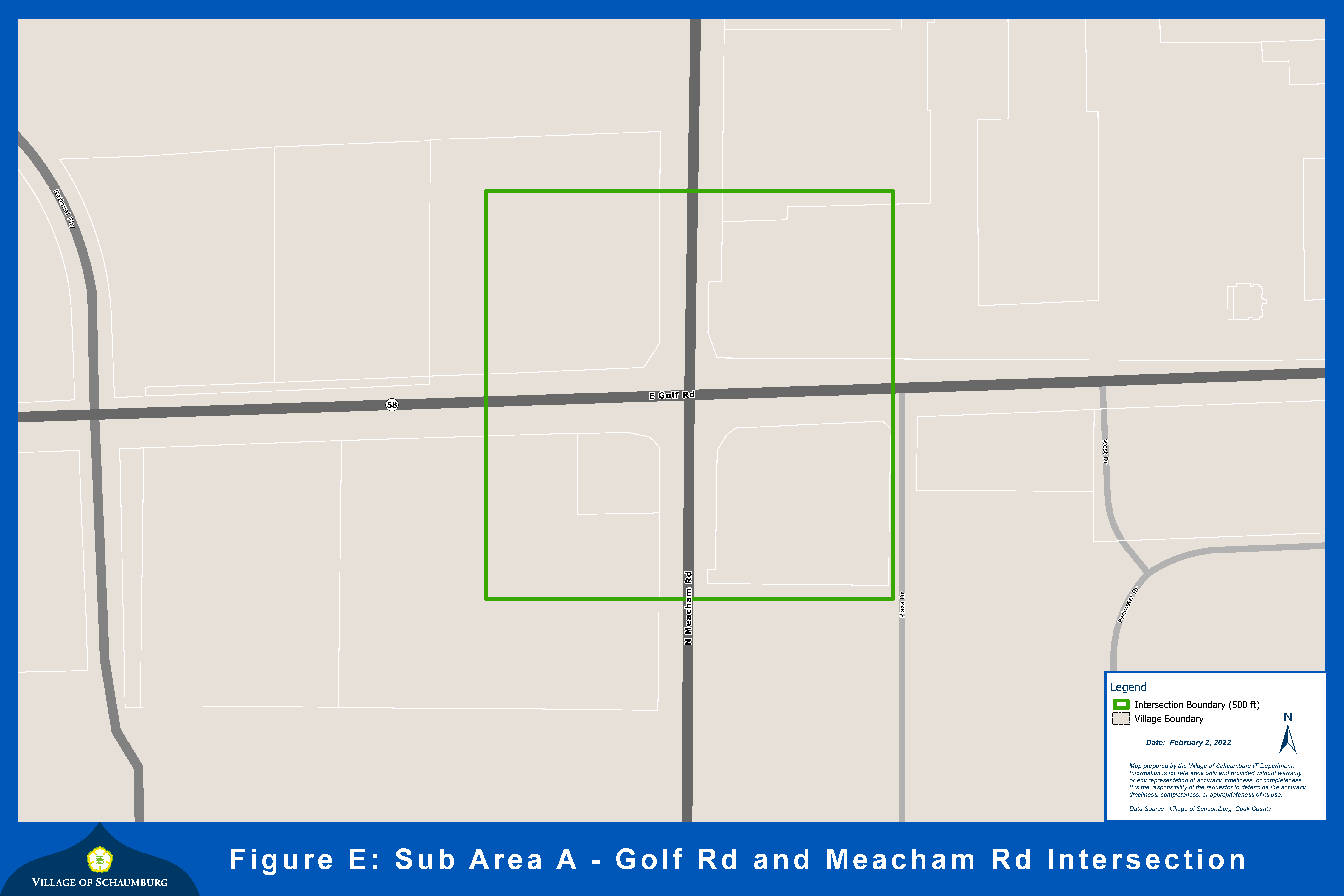
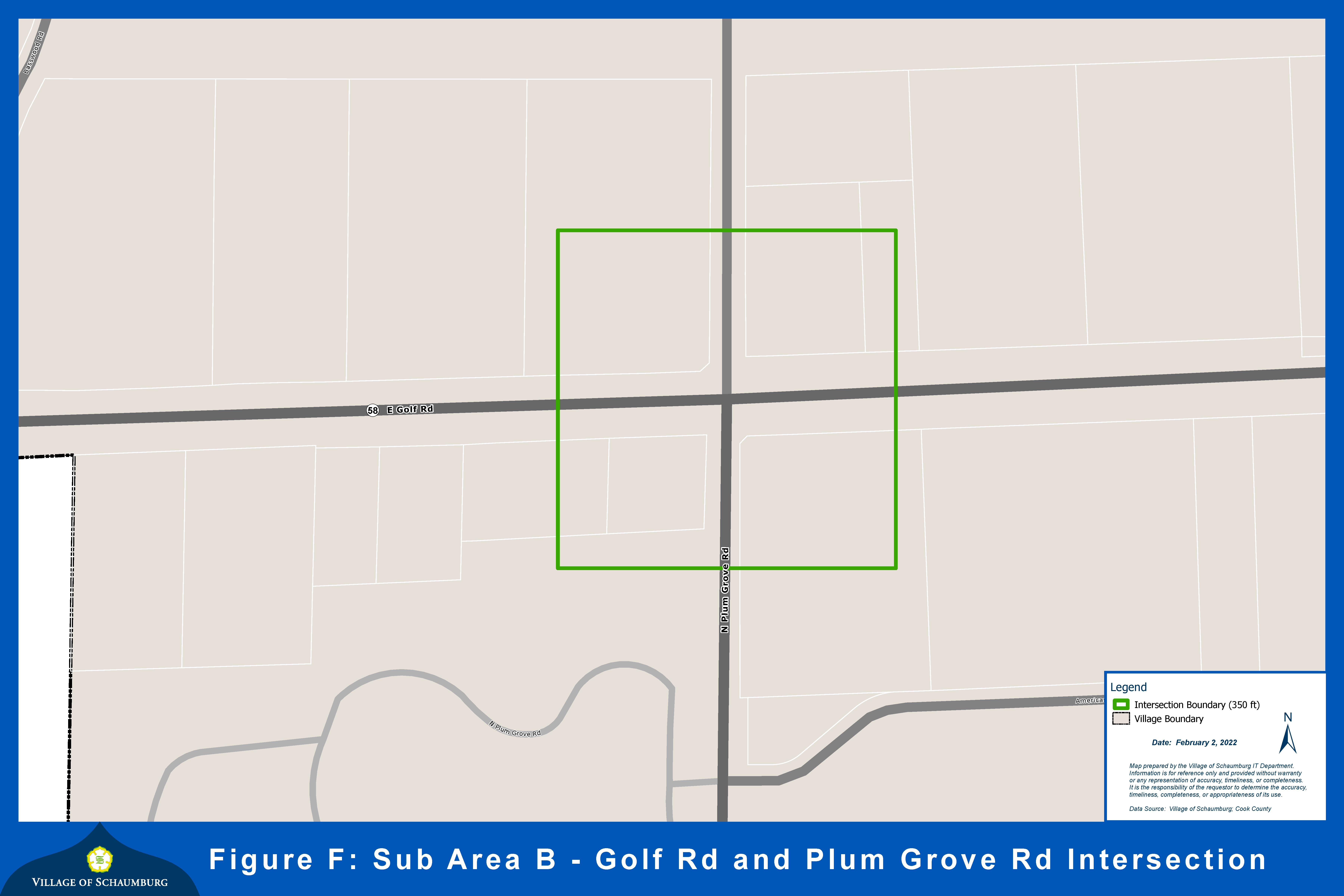
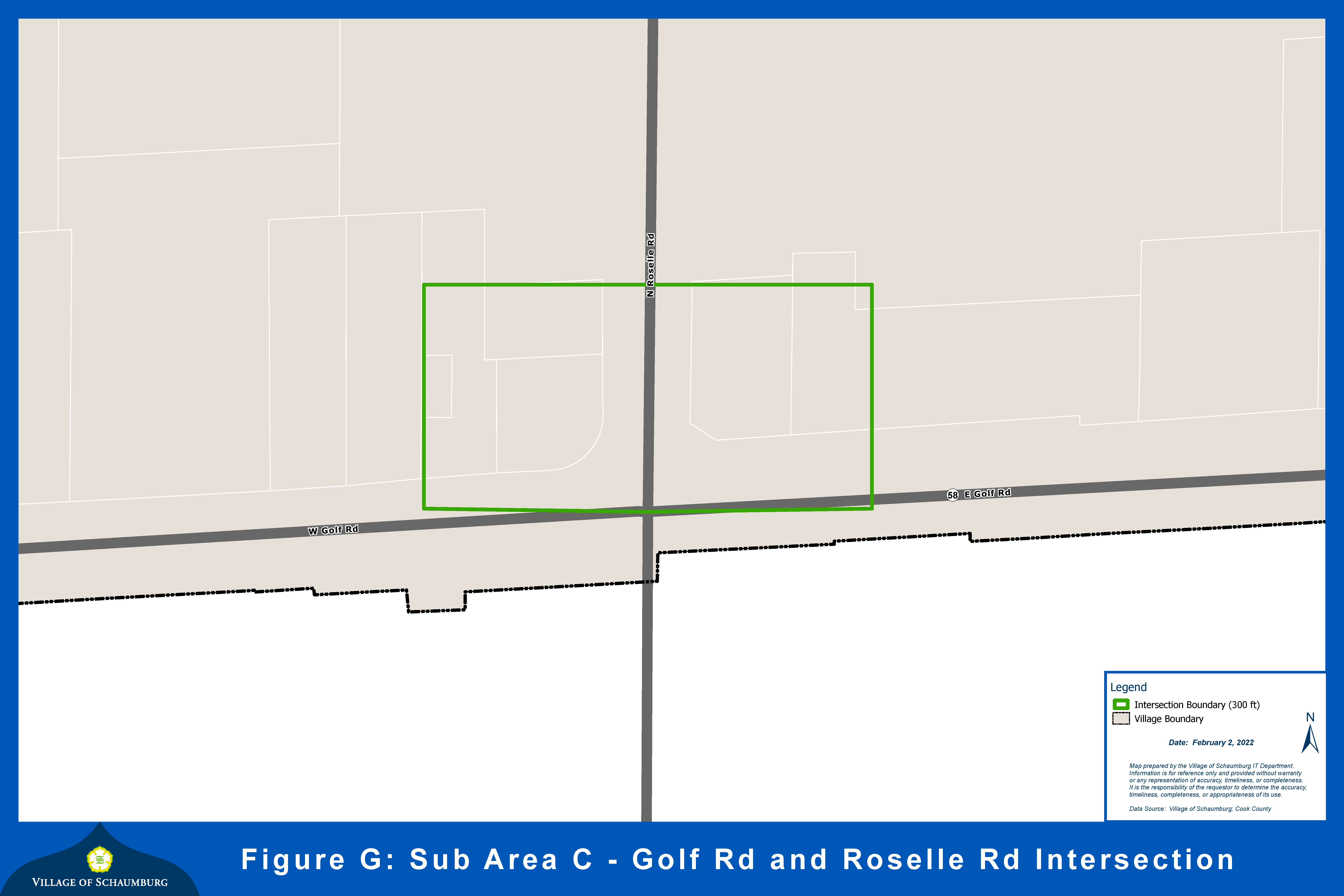
Boundaries: The Golf Road Corridor Overlay District boundaries are shown on the map in Figure 1. The geography of the corridor includes all properties located along Golf Road, east of Stonehedge Drive and west of Interstate 290/Illinois Route 53. In addition, Figures A through D represent each of the four (4) sub-districts within the corridor and Figures E through G represents each of the three (3) key corner intersections.
(C)
Application of District: The provisions in this Golf Road Corridor Overlay District shall serve as a supplement to the underlying zoning district regulations. Except where specifically altered in this Golf Road Corridor Overlay District, the uses, minimum lot size, minimum lot width, yard requirements, lot coverage, floor area ratio, and maximum height shall be determined by the regulations applicable to the underlying zoning district. Where a conflict exists between the provisions of this section and those of any underlying zoning district, the Golf Road Corridor Overlay District provisions shall apply.
(D)
Conflict with existing zoning:
(1)
Properties Zoned B-3: Properties zoned B-3, shall be subject to the land uses listed in Appendix A of the Zoning Ordinance for the land uses listed as permitted and special uses in the B-3 zoning district.
(2)
Key/Corner Intersections: Pre-existing office and service uses in existing buildings/sites identified in Figures E through G, legally established prior to the adoption of this ordinance are legal conforming, and shall be allowed to continue to operate and may be replaced with an office or service use as long as the building footprint is not enlarged. These uses shall be allowed to be replaced with a similar use with a new occupancy permit.
(3)
Status of Approved Site Plans, Approved Special Uses, Approved Variations and Approved Building Permits: Where a building or use exists or a site plan, special use, variation or building permit has been granted approval by the village board but the building has not yet been built by the effective date of the ordinance establishing the Golf Road Corridor Overlay District, such building, use, site plan, special use, variation, building permit and all buildings, structures or other improvements constructed in substantial conformance therewith, shall not be deemed to be nonconforming or illegal in any respect for noncompliance with any provision of this district, but shall, without further action of the corporate authorities, be deemed lawful, conforming and duly authorized. If requested, the village shall issue a building permit for any such building or use for which a site plan, special use or variation has been approved so long as the approval has not expired.
(4)
Status of Existing Uses: Where a use or building exists at the effective date of the ordinance establishing the Golf Road Corridor Overlay zoning district, such use or building shall not be deemed to be a nonconforming use or building, but shall, without further action, be deemed a lawful conforming and duly authorized special use or variation.
(E)
Land Use Matrix: Primary uses are allowed in the Golf Road Corridor Overlay District in accordance with the following matrix, subject to all other applicable standards of this zoning ordinance, including limits on service, office and medical uses.
Notes:
* = limited to 10% of the total square foot combined of all the buildings on sites identified in Figure E for new construction. If the use is existing, then refer to 154.197.D.b of this chapter.
⁁ = limited to 20% of the total square foot combined of all the buildings on sites identified in Figure F for new construction. If the use is existing, then refer to 154.197.D.b of this chapter.
" = limited to 50% of the total square foot combined of all the buildings on sites identified in Figure F for new construction. If the use is existing, then refer to 154.197.D.b of this chapter.
> = limited to properties that do not have direct frontage on Golf Road. Exceptions may be made for properties that are adjacent to the dealership they are affiliated with.
(F)
Size Restrictions: Variations to the maximum square foot requirement for uses referenced with (*), (⁁) and (") will be evaluated utilizing the following criteria:
(1)
Unique nature of the business model and whether the use includes any characteristics that would provide benefit to the corridor.
(2)
Quality of the building design.
(3)
Applicability to the surrounding uses.
(G)
Design Standards: The majority of the overlay district is located within the Woodfield Regional Center and, therefore, all new developments and/or redevelopments shall comply with section 154.53 pertaining to Woodfield Regional Center design review. The following additional provisions shall apply to all properties within the overlay district unless otherwise specified:
(1)
Key Corner Intersections: High quality design is especially important at key corners as they provide opportunities to showcase unique and groundbreaking design and distinctive architectural forms. Iconic buildings are strongly encouraged at the Golf and Meacham intersection.
(2)
Façade: Buildings should offer articulated facades on all sides that are visible from a public street. Façade articulation can include a variety of architectural treatments including the following:
(a)
Variations in depth, patterning, or fenestration;
(b)
Use of rhythmic bays, planar breaks, curtain walls, window systems, entry features;
(c)
Incorporation of cornices, horizontal banding, articulated columns and vertical elements, variations in wall plane and roof features, articulated entrances, awnings, and canopies;
(d)
Articulation of walls using windows, pilasters, reveals or other details.
(3)
Faux architectural elements, including faux windows, are discouraged and should be functional wherever possible. When not feasible to be functional (i.e.; back-of-house areas, security purposes, etc.), faux elements shall be used sparingly.
(4)
Rooftop parapet walls and other entry, corner, or tower features which project above the roofline should not appear flat and shall have three-dimensional returns which wrap around the edge to provide a minimum of three (3) sides to any feature.
(5)
Tree Preservation, Landscaping and Screening: All uses shall conform to the requirements for tree preservation, landscaping and screening as set forth in sections 154.135 and 154.136 of this chapter.
(6)
Lighting: Building enhancements must be accomplished with unique and appropriate illumination which exemplifies the façade during nighttime.
(H)
Site Planning and Layout: For all sites and particularly those identified on Figures E through G, any new or redevelopment of the sites should consider consolidation of adjacent parcels, when feasible. This is encouraged for safe movement both on-site and in the roadway. If unable to consolidate, other design and planning principles such as cross-access, shared drive aisles and shared parking should be considered.
(I)
Provisions for Drive-Through Establishments:
(1)
Drive-through establishments are not permitted in Subdistrict A.
(2)
Properties on the west side of the Meacham Road intersection, may have single lane drive-through facilities (including pick up only or drive-up business models) that are located at least five hundred (500) feet from the intersection when approved as a special use. Such distance is measured from the center point of the intersection of Golf and Meacham Roads.
(3)
Drive-through establishments are allowable as a special use within Subdistrict B, Subdistrict C, and Subdistrict D.
(4)
Design Criteria: In addition to the requirements of section 154.90.13, all drive-thru establishments (including pick up windows) shall comply with the following guidelines:
(a)
Vehicle Stacking Area: Vehicle stacking may be reduced for pick up operations where orders are placed in advance with sufficient evidence and data to support such reduction. Such requests shall be reviewed in conjunction with a site plan or special use request.
(b)
Visibility From Adjacent Roadways: The vehicle stacking area should, when possible, be designed to not be viewable from adjacent roadways.
(Ord. 22-013, 2-22-2022; Am. Ord. 22-038, passed 5-10-2022; Am. Ord. 23-028, passed 3-28-2023; Am. Ord. 23-035, passed 4-25-2023)
§ 154.199 - WOODFIELD HUB OVERLAY DISTRICT.
(A)
General Purpose: The purpose of the Woodfield Hub Overlay District is to provide guidelines and standards for development projects in the Woodfield Hub. The comprehensive plan recommends creating the Woodfield Hub to introduce mixed use and high-density residential to the regional center in an incremental manner. The primary objective of the overlay is to create regulations that will guide mixed use development in the district. It aims to leverage the Northwest Transportation Center to maximize its transit-oriented development potential by creating regulations for infill development.
(B)
Boundaries: The Woodfield Hub Overlay District boundaries are shown on the map in Figure 1. The geography of the district includes all properties south of Woodfield Road, east of Schaumburg Corporate Center, west of Martingale Road and north of Higgins Road.
(C)
Application of District: The provisions in this Woodfield Hub Overlay District shall serve as a supplement to the underlying zoning district regulations. Except where specifically altered in this Woodfield Hub Overlay District, the uses, minimum lot size, minimum lot width, yard requirements, lot coverage, floor area ratio, and maximum height shall be determined by the regulations applicable to the underlying zoning district. Where a conflict exists between the provisions of this section and those of any underlying zoning district, the Woodfield Hub Overlay District provisions shall apply.
(D)
Design standards: The Woodfield Hub Overlay District is located within the Woodfield Regional Center and, therefore, all new developments and/or redevelopments shall comply with section 154.53 pertaining to Woodfield Regional Center Design Review.
(1)
Building Height: Residential and mixed-use residential buildings must be at least seven (7) stories in height.
(2)
Floor Area Ratio: An increase to the floor area ratio may be allowed by the village board, acting upon the recommendation of the plan commission.
(3)
Building Materials: Buildings should incorporate high quality building materials that promote a contemporary design. The use of EIFS is prohibited residential buildings.
(4)
Building Entrances: Buildings are encouraged to showcase well-defined entrances. Entrances should be articulated as focal elements of the building mass with architectural elements that are integral to the overall design and style of the building.
(5)
Sustainability: Buildings should incorporate sustainable practices into their design. Green roofs, electric vehicle charging infrastructure, solar panels, permeable pavers and other sustainable best management practices are strongly encouraged.
(E)
Garage Design: Structured parking is encouraged. Vehicular access to garages must be provided internally from the site, no curb cuts will be permitted for garage access from a public street. Garages should offer articulated facades on all sides that are visible from a public street. Façade articulation can include a variety of elements including the following:
(1)
Wrapping garages with residential units or habitable spaces;
(2)
Variations in depth, patterning, or fenestration;
(3)
Use of rhythmic bays, planar breaks, curtain walls, window systems, entry features;
(4)
Incorporation of cornices, horizontal banding, articulated columns and vertical elements, variations in wall plane and roof features, articulated entrances, awnings, and canopies;
(5)
Articulation of walls using windows, pilasters, reveals or other details.
(F)
Connectivity: The comprehensive plan recommends breaking up the existing blocks to improve the walkable neighborhood in the district. Improving connectivity could include enhancing streetscapes, extending drive aisles to adjacent properties, or adding new streets to reduce the block lengths. All developments must evaluate connectivity to adjacent parcels. This evaluation is critical and must be provided for consideration as a part of the development review process.
(G)
Integrated Amenities and Recreation Areas: For all residential developments at least one (1) area of active and one (1) area of passive recreation shall be provided which conforms to the following:
(1)
Active recreation areas are defined as those areas where people can voluntarily undertake physical activity in their leisure time, often involving team participation, for the purpose of mental and physical satisfaction. Active recreation areas may include, but are not limited to, playgrounds, tennis courts, basketball courts, swimming pools, and walking/jogging trails. Active recreation areas can be provided on rooftops, indoors or outdoors. Activation of rooftops is encouraged.
(2)
Passive recreation areas are defined as those areas which offer constructive, restorative, and pleasurable human benefits, often fostering the appreciation and understanding of open space, for the purpose of mental satisfaction. Passive recreation areas may include, but are not limited to, benches, gazebos, pergolas, decks, patios, and fire pits.
(Ord. 22-074, passed 10-11-2022)