
Sherwood City Zoning Code
Division I
GENERAL PROVISIONS
Chapter 16.04 - ESTABLISHMENT OF ZONING DISTRICTS*
Sections:
Chapter 16.06 - PLANNING COMMISSION*
Sections:
Chapter 16.08 - HEARINGS OFFICER[1]
Editor's note— Some sections may not contain a history.
16.02.010 - Title
Title Ordinance shall be known as the City of Sherwood, Oregon Zoning and Community Development Code, Part 3 of the City Comprehensive Plan, hereinafter referred to as the "Code".
16.02.020 - Purpose
This Code is enacted to:
A.
Encourage the most appropriate use of land.
B.
Conserve and stabilize the value of property.
C.
Preserve natural resources.
D.
Facilitate fire and police protection.
E.
Provide adequate open space for light and air.
F.
Minimize congestion on streets.
G.
Promote orderly growth of the City.
H.
Prevent undue concentrations of population.
I.
Facilitate adequate provision of community facilities.
J.
Promote in other ways the public health, safety, convenience, and general welfare.
K.
Enable implementation of the Sherwood Comprehensive Plan in compliance with State Land Use Goals.
L.
Provide opportunities for a range of housing options that offer choices in home size and price.
(Ord. No. 2022-004, § 2, 6-13-2022)
16.02.030 - Conformance Required
The use of all land, as well as the construction, reconstruction, enlargement, structural alteration, movement, use, or occupation of any structure within the City shall conform to the requirements of this Code, except as allowed by Chapter 16.48. Age, gender or physical disability shall not be an adverse consideration in making a land use decision as defined in ORS 197.015 § 10.
16.02.040 - Violations
Upon failure to comply with or maintain any provision of this Code, or with any restrictions or conditions imposed hereunder, the City may withhold or withdraw any City land use approvals, permits, licenses, or utility services until the appropriate correction(s) is made. Notwithstanding any such action taken by the City, any person, firm or corporation who violates, disobeys, omits, neglects, or refuses to comply with any of the provisions of this Code, or who resists the enforcement of such provisions, shall be subject to civil penalties of no more than five-hundred dollars ($500.00) for each offense. Each day that a violation is permitted to exist shall constitute a separate offense.
16.02.050 - Interpretation
The provisions of this Code shall be interpreted as minimum requirements. When this Code imposes a greater restriction than is required by other provisions of law, or by other regulations, resolutions, easements, covenants or agreements between parties, the provisions of this Code shall control.
16.02.060 - Savings Clause
Should any section, clause or provision of this Code be declared invalid by a court of competent jurisdiction, the decision shall not affect the validity of the Code as a whole or of the remaining sections. Each section, clause, and phrase is declared severable.
16.02.070 - Conflicting Ordinances
All zoning, subdivision, and other land development ordinances previously enacted by the City are superseded and replaced by this Code.
16.02.080 - Regional, State and Federal Regulations
All development within the City shall adhere to all applicable regional, State and Federal air quality, water quality, noise, odor, building, wetlands, solid waste, natural resource, and other regulations and statutes.
16.02.090 - Community Development Plan
This Code shall be administered in conjunction with, and in a manner that is consistent with, the policies and strategies adopted in the City of Sherwood, Oregon, Community Development Plan, Part 2 of the City Comprehensive Plan. The City Zoning Map, the Transportation Plan Map, the Natural Resources and Recreation Plan Map, the Water Service Plan Map, the Storm Drainage Plan Map, and the Sanitary Sewer Service Plan Map are extracted from the Community Development Plan, and attached to this Code as appendices. References to these maps shall be deemed to include all applicable policies, standards and strategies contained in Chapters 4, 5, 6, and 7 of the Community Development Plan.
16.04.010 - Districts
For the purposes of this Code, the City is hereby divided into the following zoning districts:
16.04.020 - Official Map
Zoning district boundaries are shown on the Official Plan and Zoning Map of the City. This Map is made part of this Code by reference, and shall be kept on file in the City Recorder's office. Any future changes to the zoning of land within the City shall be appropriately depicted on the Plan and Zoning Map and certified as to the date of amendment. The Official Plan and Zoning Map shall be the first and final reference point for verifying other land use mapping and in determining actual zoning district boundaries. A dated reproduction of the Official Plan and Zoning Map is attached as Appendix A.
16.04.030 - Zoning District Boundaries
The Commission shall resolve any dispute over the exact location of a zoning district boundary. In interpreting the location of such boundaries on the Official Plan and Zoning Map, the Commission shall rely on the following guidelines:
A.
Unless otherwise indicated, zoning district boundaries are the centerlines of streets, roads, highways, alleys, or such lines extended.
B.
Where a boundary line follows or nearly coincides with a section, lot or property ownership line, the boundary shall be construed as following such line.
C.
In the event that a dedicated street, road, highway, or alley is vacated by ordinance, the zoning regulations applicable to abutting property shall apply up to the centerline of such rights-of-way.
D.
If a right-of-way is vacated in total to one (1) property, the zoning of that property shall apply to the total vacated right-of-way.
16.04.040 - Urban Growth Area
The zoning districts shown on the Official Plan and Zoning Map, for land outside of the incorporated area of the City but within the Urban Growth Boundary, shall serve as a guide to development in these areas. Actual land use regulation and development shall be controlled under the terms of the Urban Planning Area Agreement between the City and Washington County. This Agreement is made part of this Code by reference and is attached as Appendix H. An area incorporated into the City shall, upon annexation, be given an interim zoning consistent with the Official Plan and Zoning Map. The City shall provide notice of this interim zoning as per Section 16.72.020. No hearing shall be required and the interim zoning shall be considered final thirty (30) days after mailing of said notice.
16.06.010 - Appointment and Membership
A.
The City Planning Commission shall consist of seven (7) members to be appointed by the Council for terms of four (4) years. Two (2) members may be non-residents of the City, provided they reside within the Sherwood portion of the Urban Growth Boundary. Commission members shall receive no compensation for their services, but shall be reimbursed for duly authorized expenses.
B.
A Commission member may be removed by a majority vote of the Council for misconduct or non-performance of duty, as determined by the Council. Any vacancy shall be filled by the Council for the unexpired term of the predecessor in office.
C.
No more than two (2) Commission members shall be engaged principally in the buying, selling, or developing of real estate for profit as individuals, or be members of any partnership, or officers or employees of any corporation that is engaged principally in the buying, selling, or developing of real estate for profit. No more than two (2) members shall be engaged in the same kind of business, trade or profession.
16.06.020 - Officers, Minutes, and Voting
A.
The Commission shall, at its first meeting in each odd-numbered year, elect a chair and vice-chair who shall be voting members and who shall hold office at the pleasure of the Commission.
B.
Before any meeting of the Commission, public notice shall be given as required by State statute and this Code. Accurate records of all Commission proceedings shall be kept by the City, and maintained on file in the City Recorder's office.
C.
A majority of members of the Commission constitutes a quorum. A majority vote of a quorum present at an open meeting of the Commission is necessary to legally act on any matter before the Commission. The Commission may make and alter rules of procedure consistent with the laws of the State of Oregon, the City Charter, and City ordinances.
(Ord. No. 2015-003, § 2, 3-17-2015)
16.06.030 - Conflicts of Interest
A.
Commission members shall not participate in any Commission proceeding or action in which they hold a direct or substantial financial interest, or when such interest is held by a member's immediate family. Additionally, a member shall not participate when an action involves any business in which they have been employed within the previous two (2) years, or any business with which they have a prospective partnership or employment.
B.
Any actual or potential interest by a Commission member in a land use action as per Subsection A of this Section shall be disclosed by that member at the meeting of the Commission where the action is being taken. Commission members shall also disclose any pre-hearing or ex parte contacts with applicants, officers, agents, employees, or any other parties to an application before the Commission. Ex-parte contacts shall not invalidate a final decision or action of the Commission, provided that the member receiving the contact indicates the substance of the ex-parte communication and of the right of parties to rebut said content at the first hearing where action will be considered or taken.
16.06.040 - Powers and Duties
Except as otherwise provided by law, the Commission shall be vested with all powers and duties, and shall conduct all business, as set forth in the laws of the State of Oregon, the City Charter, and City ordinances.
16.08.010 - Appointment
A.
The City Council shall appoint a Hearings Officer to serve at the pleasure of the City Council. The Hearings Officer shall be selected as provided in the City's contracting rules for personal service contracts. The Hearings Officer may be terminated by a majority vote of the City Council.
B.
The City Council may appoint another Hearings Officer to serve as a backup to the Hearings Officer under § 16.08.010 A. above. The Hearings Officer appointed under § 16.08.010.A. shall notify the City when the Hearings Officer is unavailable.
C.
If the office of the Hearings Officer is vacant or a Hearings Officer is unavailable, the Planning Commission shall perform all duties of the Hearings Officer.
(Ord. No. 2010-002, § 2, 2-16-2010)
16.08.020 - Minutes
Before any meeting of the Hearings Officer, public notice shall be given as required by state statute and this Code. Accurate records of all Hearings officer proceedings shall be kept by the City and maintained on file in the City Recorder's Office.
16.08.030 - Conflicts of Interest
A.
The Hearings Officer shall not participate in any proceeding or action in which they hold a direct or substantial financial interest, or when such interest is held by a member's immediate family. Additionally, the Hearings Officer shall not participate when an action involves any business in which they have been employed within the previous two (2) years, or any business with which they have a prospective partnership or employment.
B.
Any actual or potential interest by the Hearings officer in a land use action shall be disclosed by the Hearings officer at the meeting where the action is being taken. The Hearings Officer shall also disclose any pre-hearing or ex-parte contacts with applicants, officers, agents, employees, or any other parties to an application before the Hearings Officer. Ex-parte contacts shall not invalidate a final decision or action of the Hearings Officer, provided that the Hearings Officer indicates the substance of the ex-parte communication and of the right of parties to rebut said content at the first hearing where action will be considered or taken.
16.08.040 - Powers and Duties
Except as otherwise provided by law, the Hearings Officer shall be vested with all powers and duties, and shall conduct all business, as set forth in the laws of the State of Oregon, the City Charter, this Code, and City ordinances.
16.10.010 - Generally
All words used in this Code, except where specifically defined herein, shall carry their customary meanings. Words used in the present tense include the future tense; words used in the future tense include the present tense; the plural includes the singular, and the masculine includes the feminine and neuter. The word "building" includes the word "structure"; the word "shall" is mandatory; the words "will" and "may" are permissive; the words "occupied" and "uses" shall be considered as though followed by the words "or intended, arranged, or designed to be used or occupied."
Where terms are not defined, they shall have their ordinary accepted meanings within the context with which they are used. Webster's Third New International Dictionary of the English Language, Unabridged, copyright 1986, shall be considered as providing ordinarily accepted meanings.
(Ord. No. 2018-009, § 2, 10-16-2018; Ord. No. 2016-013, § 1, 10-18-2016)
16.10.020 - Specifically
The following terms shall have specific meaning when used in this Code:
Abut: Contiguous to, in contact with, or adjoining with a common property line; two properties separated by another parcel, lot, tract or right-of-way measuring twenty (20) feet in width or less, shall be considered abutting for the purposes of interpreting the infill-related development standards. See also "adjacent."
Access: The way or means by which pedestrians and vehicles enter and leave property.
Access Way: A pathway providing a connection for pedestrians and bicyclists between two streets, between two lots, or between a development and a public right-of-way. An access way is intended to provide access between a development and adjacent residential uses, commercial uses, public use such as schools, parks, and adjacent collector and arterial streets where transit stops or bike lanes are provided or designated. An access way may be a pathway for pedestrians and bicyclists (with no vehicle access), a pathway on public or private property (i.e., with a public access easement), and/or a facility designed to accommodate emergency vehicles.
Accessory Building: A structure that is incidental and subordinate to the main use of property, is located on the same lot as the main use, and is freestanding or is joined to the primary structure solely by non-habitable space as defined by the State Building Code.
Accessory Use: A use or activity that is subordinate and incidental to the primary use of the property. A property may have more than one accessory use.
Adjacent: A relative term meaning nearby; may or may not be in actual contact with each other, but are not separated by things of the same kind. For example, a lot is adjacent to a lot across the street because the lots are separated by a street, not an intervening lot.
Alteration: An addition, removal, or reconfiguration which significantly changes the character of a historic resource, including new construction in historic districts.
Apartment: Each dwelling unit contained in a Multi-Family dwelling or a dwelling unit that is secondary to the primary use of a non-residential building.
Area of Special Flood Hazard: Is the land in the flood plain within a community subject to a 1 percent or greater chance of flooding in any given year. The area may be designated as Zone A on the FHBM. After detailed ratemaking has been completed in preparation for publication of the flood insurance rate map, Zone A usually is refined into Zones A, AO, AH, A1-30, AE, A99, AR, AR/A1-30, AR/AE, AR/AO, AR/AH, AR/A, VO, or V1-30, VE, or V. For purposes of these regulations, the term "special flood hazard area" is synonymous in meaning with the phrase "area of special flood hazard". See also, "Special flood hazard area."
Assisted Living Facilities: A program approach, within a physical structure, which provides or coordinates a range of services, available on a twenty-four-hour basis, for support of resident independence in a residential setting.
Automobile Sales Area: An open area, other than a street, used for the display, sale, or rental of new or used automobiles, and where no repair work is done, except minor incidental repair of automobiles to be displayed, sold, or rented on the premises.
Base Flood: The flood having a one percent (1%) chance of being equaled or exceeded in any given year. Also referred to as the "one hundred-year flood" or "one hundred-year flood plain."
Basement: Any area of the building having its floor subgrade (below ground level) on all sides.
Board-and-batten: Wall covering composed of solid wood wide boards, and solid wood narrow strips. Wide boards are attached vertically with small spaces remaining. Narrow strips, or batten, are attached over spaces between boards.
Boarding or Rooming House: Any building or portion thereof containing not more than five guest rooms where rent is paid in money, goods, labor or otherwise.
Building: Any structure used, intended for, supporting or sheltering any use or occupancy. Each portion of a structure separated by a division wall without any openings shall be deemed a separate building.
Building Area: That portion of a property that can be occupied by the principal use, thus excluding the front, side and rear yards.
Building, Existing: Any building erected prior to the adoption of this Code or one for which a legal building permit has been issued.
Building Height: The vertical distance above a reference datum measured to the highest point of the coping of a flat roof or to the deck line of a mansard roof or to the average height of the highest gable of a pitched or hipped roof. The height of a stepped or terraced building is the maximum height of any segment of the building. The reference datum shall be selected by the following criteria, whichever yields the greater height:
A.
The elevation of the highest adjoining sidewalk or ground surface within a five-foot horizontal distance of the exterior wall of the building, when such sidewalk or ground surface is not more than ten feet above lowest grade.
B.
An elevation ten feet higher than the lowest grade, when the sidewalk or ground surface described in this section is more than ten feet above lowest grade.
Building Official: The City employee or agent charged with the administration and enforcement of the Uniform Building Code and other applicable regulations.
Building Permit: A permit issued under the terms of the Uniform Building Code.
Buffer: A landscaped area, wall, berm or other structure or use established to separate and protect land uses.
Change in Use: A change to a parcel of land, a premise or a building which creates a change in vehicular trip generation activities, which changes the minimum parking requirements of this Code, or which changes the use classification as defined by this Code or the Uniform Building Code.
Church: Any bona-fide place of worship, including Sunday School buildings, parsonages, church halls, and other buildings customarily accessory to places of worship.
City: The City of Sherwood, Oregon and its duly authorized officials, employees, consultants and agents.
Clean Water Services: An agency of Washington County providing for sanitary sewer collection and treatment, and for storm water management.
Code: The City of Sherwood, Oregon Zoning and Community Development Code, Part 3 of the City of Sherwood Comprehensive Plan.
Co-Location: The placement of two or more antenna systems or platforms by separate FCC license holders on a structure such as a support structure, building, water tank or utility pole.
Commercial Trade School: Any private school or institution operated for profit that is not included in the definitions of an educational institution or school.
Commission: The City of Sherwood Planning Commission.
Common Courtyard: A common area for use by residents of townhomes, multi-family, and cottage cluster developments. A common courtyard may function as a community yard. Hard and soft landscape features may be included in a common courtyard, such as pedestrian paths, lawn, groundcover, trees, shrubs, patios, benches, or gazebos.
Common-Wall Dwelling: Dwelling units with shared walls such as two-family, and Multi-Family dwellings. The common wall must be shared for at least 25 percent of the length of the side of the building of the dwelling units. The common wall may be any wall of the building, including the walls of attached garages
Community Development Plan: Part 2 of the City of Sherwood Comprehensive Plan.
Compatible: Any structures or uses capable of existing together in a harmonious, orderly, efficient, and integrated manner, considering building orientation, privacy, lot size, buffering, access and circulation.
Comprehensive Plan: The City of Sherwood Comprehensive Plan.
Conditional Letter of Map Revision (CLOMR): Means a letter from FEMA commenting on whether a proposed project, if built as proposed, would meet the minimum NFIP standards or proposed hydrology changes.
Conditional Use: A use permitted subject to special conditions or requirements as defined in any given zoning district and Chapter 16.82 of the Code.
Condominium: An individually-owned dwelling unit in a multi-family housing development with common areas and facilities.
Convalescent Homes: See "Nursing Home" in this Code.
Council: The City of Sherwood City Council.
Crawlspace: An under-floor space that has its interior floor area (finished or not) no more than five feet below the top of the next-higher floor. Crawlspaces generally have solid foundation walls. See "subgrade crawlspace" also.
Critical Facility: Means a facility for which even a slight chance of flooding might be too great. Critical facilities include, but are not limited to schools, nursing homes, hospitals, police, fire and emergency response installations, installations which produce, use, or store hazardous materials or hazardous waste.
Day-Care Facility: Any facility that provides day care to six or more children, including a child day care center or group day care home, including those known under a descriptive name, such as nursery school, preschool, kindergarten, child playschool, child development center, except for those facilities excluded by law, and family day care providers as defined by this Code. This term applies to the total day care operation and it includes the physical setting, equipment, staff, provider, program, and care of children.
Deed Restriction: A covenant or contract constituting a burden on the use of private property for the benefit of property owners in the same subdivision, adjacent property owners, the public or the City of Sherwood, and designed to mitigate or protect against adverse impacts of a development or use to ensure compliance with a Comprehensive Plan.
Demolish: To raze, destroy, dismantle, deface or in any other manner cause partial or total ruin of a structure or resource.
Density: The intensity of residential land uses per acre, stated as the number of dwelling units per net buildable acre. Net buildable acre means an area measuring 43,560 square feet after excluding present and future rights-of-way and environmentally constrained areas.
Designated Landmark: A property officially recognized by the City of Sherwood as important in its history, culture, or architectural significance.
Designated Landmarks Register: The list of, and record of information about, properties officially recognized by the City of Sherwood as important in its history.
Development: Any man-made change to improved or unimproved real property or structures, including but not limited to construction, installation, or alteration of a building or other structure; change in use of a building or structure; land division; establishment or termination of rights of access; storage on the land; tree cutting; drilling; and any site alteration such as land surface mining, filling, dredging, grading, construction of earthen berms, paving, parking improvements, excavation or clearing.
Development Plan: Any plan adopted by the City for the guidance of growth and improvement in the City.
Diameter at Breast Height (DBH): Is a standard arboricultural method for measuring the diameter of a tree. For the purposes of this code, DBH shall be measured four and a half feet above ground level as defined by the International Society of Arboriculture.
Drive-In Restaurant: Any establishment dispensing food and/or drink, that caters primarily to customers who remain, or leave and return, to their automobile for consumption of the food and/or drink, including business designed for serving customers at a drive-up window or in automobiles.
Driveway Approach: The edge of a driveway where it abuts a public right-of-way.
Dwelling Types:
•
Accessory Dwelling Unit: An interior, attached, or detached dwelling unit that is used in connection with, or that is accessory to, a single dwelling on a single lot or parcel. Also known as an ADU.
•
Cottage Cluster: A grouping of no fewer than four detached dwelling units per acre, each with a footprint of less than 900 square feet, located on a single lot or parcel that includes a common courtyard. Cottage cluster may also be known as "cluster housing," "cottage housing," "bungalow court," "cottage court," or "pocket neighborhood."
•
Cottage Cluster, Community Building: A building that is part of a cottage cluster for the shared use of residents that provides space for accessory uses such as community meeting rooms, guest housing, exercise rooms, day care, community eating areas, or other similar uses.
•
Cottage Cluster Development: A development site with one or more cottage clusters.
•
Duplex: Two (2) attached dwelling units, in any configuration, located on a single lot or parcel.
•
Dwelling, Single-Family Detached: A detached structure on a lot or parcel that is comprised of a single dwelling unit.
•
Dwelling, Single-Family Attached: A single structure on two lots, containing two individual dwelling units, but with a common wall and a common property line. Otherwise identical to a two-family dwelling.
•
Dwelling, Two-Family or Duplex: A single structure on one lot containing two individual dwelling units, sharing a common wall, but with separate entrances.
•
Dwelling, Townhome or Row House: A single-family dwelling unit which is attached on one or both sides to a similar adjacent unit(s) on similar lot(s). The attachment is made along one or more common walls which are jointly owned. The units may either be on individual platted lots or may be located on a single lot as individual condominium units. The units are distinct from each other by scale, color, massing, or materials.
•
Dwelling, Multi-Family: A single structure containing five (5) or more dwelling units that share common walls or floor/ceilings with one or more units. The land underneath the structure is not divided into separate lots. Multi-dwellings include structures commonly called garden apartments, apartments and condominiums.
•
Townhome: A dwelling unit that is part of a row of two (2) or more attached dwelling units, where each unit is located on an individual lot or parcel and shares at least one common wall with an adjacent dwelling unit.
•
Townhome Block: A unit of a townhome development consisting of no less than two (2) and no more than six (6) townhomes.
•
Townhome Project: One or more townhouse structures constructed, or proposed to be constructed, together with the development site where the land has been divided, or is proposed to be divided, to reflect the townhome property lines and the any commonly owned property.
•
Triplex: Three (3) attached dwelling units, in any configuration, located on a single lot or parcel.
•
Quadplex: Four (4) attached dwelling units, in any configuration, located on a single lot or parcel.
Dwelling Unit: Any room, suite of rooms, enclosure, building or structure designed or used as a residence for one household as defined by this Code, and containing sleeping, kitchen and bathroom facilities.
Dwelling, Single-Family: A structure containing one dwelling unit.
Easement: The grant of the legal right to use of land for specified purposes.
Educational Institution: Any bona-fide place of education or instruction, including customary accessory buildings, uses, and activities, that is administered by a legally-organized school district; church or religious organization; the State of Oregon; or any agency, college, and university operated as an educational institution under charter or license from the State of Oregon. An educational institution is not a commercial trade school as defined by Section 16.10.020.
Elevated Building: Means, for insurance purposes, a nonbasement building which has its lowest elevated floor raised above ground level by foundation walls, shear walls, posts, piers, pilings, or columns.
Entrance, Main: The entrance to a dwelling or building that most pedestrians are expected to use. Typically, this is the front door of a dwelling unit. Each dwelling may have a main entrance from the outside, or multiple dwellings may share one main entrance. In multi-dwelling or multitenant buildings, main entrances open directly into the building's lobby or principal interior ground-level circulation space. When a multi-dwelling or multitenant building does not have a lobby or common interior circulation space, each dwelling unit or tenant's outside entrance is a main entrance.
Environmentally Constrained Land: Any portion of land located within the floodway, one hundred-year floodplain, wetlands and/or vegetated corridor as defined by Clean Water Services.
Environmentally Sensitive Land: Land that does not meet the definition of environmentally constrained, but which is identified on the inventory of Regionally Significant Riparian and Wildlife Habitat Map adopted as Map V-2 of the Sherwood Comprehensive Plan, Part 2.
Established Neighborhood: An existing residential area that is taken into consideration when infill development is proposed. See Chapter 16.68, Infill Development Standards, intended to promote compatibility between existing residential areas and new development through controls on the type, height, size, scale, or character of new buildings.
Expedited Land Division: A residential land division process which must be expedited within sixty-three (63) days of receiving a complete application in accordance with ORS 197.360. The decision is rendered without a public hearing and must meet applicable land use regulation requirements. All appeals of expedited land divisions must be decided by a hearings officer.
Extraordinary Historic Importance: The quality of historic significance achieved outside the usual norms of age, association, or rarity.
Evergreen: A plant which maintains year-round foliage.
Ex-parte Contact: Contact or information passed between a party with an interest in a quasi-judicial land use decision and a member of the Council or Commission, when such information is not generally available to other members of the Council or Commission, or other interested persons. The member shall disclose any pre-hearing or ex-parte contacts with applicants, officers, agents, employees, or other parties to an application before the Council or Commission. Ex-parte contacts with a member of the Commission or Council shall not invalidate a final decision or action of the Commission or Council, provided that the member receiving the contact indicates the substance of the content of the ex-parte communication and of the right of parties to rebut said content at the first hearing where action will be considered or taken.
Extra Capacity Improvements: Improvements that are defined as necessary in the interest of public health, safety and welfare by Divisions V, VI, and VIII of this Code, and the Community Development Plan, to increase the capacities of collector or arterial streets; water, sewer, storm drainage or other utility facilities; and parks and open space.
Façade, Street-Facing: The wall planes of a structure that are visible from, and at an angle of 45 degrees or less to, a front lot line or street side lot line. Angle measurements for curved front or street side lot lines shall be based on a straight line connecting the opposing lot corners of the front or street side lot line.
Family: Any number of individuals living together regardless of familial or non-familial relationship.
Family Day Care Provider: A day care provider which accommodates not more than sixteen (16) children in the provider's home.
Fence: A freestanding structure that provides a barrier between properties or different uses on the same property and is generally used to provide privacy and security. A fence may be open or solid and is usually constructed of wood, metal, wire, brick, cement block, stone, vinyl, or composite materials.
Fiber Board (also pressboard or stucco board): A building material composed of wood chips or plant fibers bonded together with or without stucco and compressed into rigid sheets.
Fiber Cement Board (i.e. HardiPlank): A fire resistant building material composed of wood fiber and cement compressed into clapboard.
Fire District: Tualatin Valley Fire and Rescue.
Flag Lot: A building lot which is provided access to a public street by means of a narrow strip of land with minimal frontage.
Flood Fringe: The area of the flood plain lying outside of the floodway.
Flood or Flooding: Means
(a)
A general and temporary condition of partial or complete inundation of normally dry land areas from:
(1)
The overflow of inland or tidal waters.
(2)
The unusual and rapid accumulation or runoff of surface waters from any source.
(3)
Mudslides (i.e. mudflows) which are proximately caused by flooding as defined in paragraph (a)(2) of this definition and are akin to a river of liquid and flowing mud on the surfaces of morally dry land areas, as when earth is carried by a current of water and deposited along the path of the current.
(b)
The collapse of subsidence or land along the shore of a lake or other body of water as a result of erosion or undermining caused by waves or currents of water exceeding anticipated cyclical levels or suddenly caused by an unusually high water level in a natural body of water, accompanied by a severe storm, or by an unanticipated force of nature, such as flash flood or an abnormal tidal surge, or by some similarly unusual and unforeseeable event, which results in flooding are defined in paragraph (a)(1) of this definition.
Flood Insurance Rate Map (FIRM): Means the official map on which the Federal Insurance Administration has delineated both the areas of special flood hazards and the risk premium zones applicable to the community. Means an official map of a community, on which the Federal Insurance Administrator has delineated both the special hazard areas and the risk premium zones applicable to the community. A FIRM that has been made available digitally is called a Digital Flood Insurance Rate Map (DFIRM).
Flood Insurance Study: Means the official report provided by the Federal Insurance Administration that includes flood profiles, the Flood-Boundary-Floodway Map, and the water surface elevation of the base flood Means an examination, evaluation and determination of flood hazards and, if appropriate, corresponding water surface elevations, or an examination, evaluation and determination of mudslide (i.e. mudflow) and/or flood-related erosion hazards.
Flood Plain: The flood-hazard area adjoining a river, stream or other water course, that is subject to inundation by a base flood. The flood plain includes the floodway and floodway fringe, and the City greenway, as defined by this Code.
Flood Plain Development: Any man-made change to improved or unimproved real estate, including but not limited to buildings or other structures, mining, dredging, filling, grading, paving, excavation or drilling operations or storage of equipment or materials.
Floodway: Means the channel of a river or other watercourse and the adjacent land areas that must be reserved in order to discharge the base flood without cumulatively increasing the water surface elevation more than a designated height.
Floor area: The total area of all floors of a building. Floor area is measured for each floor from the exterior faces of a building or structure. Floor area includes stairwells, ramps, shafts, chases, and the area devoted to garages and structured parking. Floor area does not include the following (see Figure 1):
•
Areas where the elevation of the floor is 4 feet or more below the adjacent right-of way;
•
Roof area, including roof top parking;
•
Roof top mechanical equipment; and
•
Roofed porches, exterior balconies, or other similar areas, unless they are enclosed by walls that are more than 42 inches in height for 75 percent or more of their perimeter.
Figure 1. Areas Excluded from Floor Area Calculation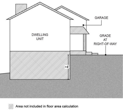
Floor area ratio (FAR): The amount of floor area of a building or structure in relation to the amount of site area, expressed in square feet. For example, a floor area ratio of 0.7 to 1 means 0.7 square feet of floor area for every one square foot of site area. FAR is calculated by dividing the total floor area of all buildings on a site by the total site area (See Figure 2).
Figure 2. Floor Area Ratio (FAR) Calculation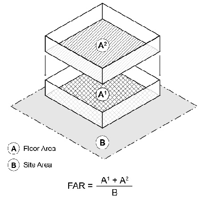
Footcandle: A unit of illumination. One footcandle is the intensity of illumination when a source of one candlepower illuminates a screen one (1) foot away.
Frontage: That side of a parcel abutting on a street or right-of-way ordinarily regarded as the front of the parcel, except that the shortest side of a corner lot facing a street, shall not be deemed the lot frontage.
Garage: A building or a portion thereof which is designed to house, store, repair or keep motor vehicles.
Government Structure: Any structure used by a federal, state, local government, or special district agency.
Ground Floor Area: The total area of a building measured by taking the largest outside dimensions of the building, exclusive of open porches, breezeways, terraces, garages, exterior stairways, and secondary stairways.
Hard Surface: Any man-made surface that prevents or retards the saturation of water into land, or that causes water to run-off in greater quantities or increased rates, than existed under natural conditions prior to development. Common hard surfaces include but are not limited to: roofs, streets, driveways, sidewalks and walkways, patios, parking and loading areas, and other graveled, oiled, macadam or concrete surfaces. Also referred to as "impermeable surface."
Hazardous Waste: Has the meaning given that term in ORS 466.005.
Hearing Authority: The City of Sherwood Planning Commission, City Council, Landmarks Advisory Board or Hearings Officer.
Hearings Officer: An individual appointed by the City Council to perform the duties as specified in this Code.
Hedges: A line of closely spaced vegetation specifically planted and trained in such a way as to form a barrier to mark the boundary of an area or visually screen an area.
Highest Adjacent Grade: Means the highest natural elevation of the finished ground surface post construction, adjacent to the proposed walls of a structure.
Historic Integrity: The quality of wholeness of historic location, design, setting, materials, workmanship, feeling, and/or association of a resource, as opposed to its physical condition.
Historic Resource: A building, structure, object, site, or district which meets the significance and integrity criteria for designation as a landmark. Resource types are further described as:
A.
Object: A construction which is primarily artistic or commemorative in nature and not normally movable or part of a building or structure, e.g., statue, fountain, milepost, monument, sign, etc.
B.
Site: The location of a significant event, use, or occupation which may include associated standing, ruined, or underground features, e.g., battlefield, shipwreck, campsite, cemetery, natural feature, garden, food-gathering area, etc.
C.
District: A geographically defined area possessing a significant concentration of buildings, structures, objects, and/or sites which are unified historically by plan or physical development, e.g., downtown, residential, neighborhood, military reservation, ranch complex, etc.
D.
Primary, Secondary, and Contributing: Historic ranking in descending order based on four scoring criteria for surveyed properties-historical, architectural, use considerations, and physical and site characteristics.
Historic Resources of Statewide Significance: Buildings, structures, objects, sites, and districts which are listed on the Federal National Register of Historic Places.
Hogged Fuel: Fuel generated from wood or other waste that has been fed through a machine that reduces it to a practically uniform size of chips, shreds, or pellets.
Home Occupation: An occupation or a profession customarily carried on in a residential dwelling unit by a member or members of a family residing in the dwelling unit and clearly incidental and secondary to the use of the dwelling unit for residential purposes.
Homeowners Association: A formally organized group of homeowners within a single housing development having shared responsibility for portions of the development such as building, landscaping, or parking maintenance, or other activities provided for by covenant or legal agreement.
Hotel: A building or buildings in which there are more than five (5) sleeping rooms occupied as temporary dwelling places, which rooms customarily do not contain full kitchen facilities, but may include kitchenettes.
Household: One person living alone or a group of people living together as a single unit, excluding occupants of a boardinghouse, fraternity, hotel, accessory dwelling unit, or similar use.
Inert Material: Solid waste material that remains materially unchanged by variations in chemical, environmental, storage, and use conditions reasonably anticipated at the facility.
Inventory of Historic Resources: The record of information about resources potentially significant in the history of the City of Sherwood as listed in the Cultural Resource Inventory (1989), and hereafter amended.
Junk: Materials stored or deposited in yards and open areas for extended periods, including inoperable or abandoned motor vehicles, inoperable or abandoned machinery, motor vehicle and machinery parts, broken or discarded furniture and household equipment, yard debris and household waste, scrap metal, used lumber, and other similar materials.
Junk-Yard: Any lot or site exceeding two hundred (200) square feet in area used for the storage, keeping, or abandonment of junk as defined by this Code.
Kennel: Any lot or premise on which four or more dogs or cats more than four months of age are kept.
Laboratory, Medical or Dental: A laboratory which provides bacteriological, biological, medical, x-ray, pathological and similar analytical or diagnostic services to doctors or dentists, and where no fabrication is conducted on the premises except the custom fabrication of dentures.
Landmarks Board: The City of Sherwood Landmarks Advisory Board.
Landscape Feature: A trellis, arbor or other decorative feature that is attached to or incorporated within the fence.
Leachate: Liquid that has come into direct contact with solid waste and contains dissolved and/or suspended contaminants as a result of such contact.
Letter of Map Change (LOMC): An official FEMA determination, by letter, to amend or revise effective Flood Insurance Rate Maps and/or Flood Insurance Studies. LOMCs are issued in the following categories:
1.
Letter of Map Amendment (LOMA): An amendment to the Flood Insurance Rate Maps based on technical data showing that an existing structure or parcel of land that has not been elevated by fill (natural grade) was inadvertently included in the special flood hazard area because of an area of naturally high ground above the base flood.
2.
Letter of Map Revision (LOMR):
a.
LOMR-F (Letter of Map Revision based on Fill) is a letter from FEMA stating that an existing structure or parcel of land that has been elevated by fill would not be inundated by the base flood.
A LOMR revises the current Flood Insurance Rate Map and/or Flood Insurance Study to show changes to the floodplains, floodways, or flood elevations. LOMRs are generally based on manmade alterations that affected the hydrologic or hydraulic characteristics of a flooding source and thus result in modification to the existing regulatory floodway, the effective Base Flood Elevation, or the Special Flood Hazard Area.
Level of Service (LOS): A measure of the overall comfort afforded to motorists as they pass through a roadway segment or intersection, based on such things as impediments caused by other vehicles, number and duration of stops, travel time, and the reserve capacity of a road or an intersection (i.e., that portion of the available time that is not used). LOS generally is referred to by the letters "A" though "F", with LOS "E" or "F" being generally unacceptable. LOS generally is calculated using the methodology in the Highway Capacity Manual, Special Report 209, by the Transportation Research Board (1985).
Limited Land Use Decision: A final decision or determination in accordance with ORS 197.195 made by a local government pertaining to a site within an urban growth boundary which concerns: 1) the approval or denial of a subdivision or partition, or 2) the approval or denial of an application based on discretionary standards designed to regulate the physical characteristics of a use permitted outright but not limited to site review and design review.
Loading or Unloading Space: An off-street space or berth for the temporary parking of vehicles while loading or unloading merchandise or materials.
Lot: A parcel of land of at least sufficient size to meet the minimum zoning requirements of this Code, and with frontage on a public street, or easement approved by the City. A lot may be:
A.
A single lot of record; or a combination of complete lots of record, or complete lots of record and portions of other lots of record.
B.
A parcel of land described by metes and bounds; provided that for a subdivision or partition, the parcel shall be approved in accordance with this Code.
Lot Area: The total horizontal area within the lot lines of a lot, exclusive of streets and access easements to other property.
Lot, Corner: A lot situated at the intersection of two or more streets, other than an alley.
Lot Coverage: The proportional amount of land on a lot covered by buildings.
Lot Depth: The average horizontal distance between the front and rear lot lines measured in the direction of the side lot lines.
Lot Frontage: The distance parallel to the front lot line, measured between side lot lines at the street line.
Lot, Interior: A lot other than a corner lot.
Lot of Record: Any unit of land created as follows:
A.
A parcel in an existing, duly recorded subdivision or partition.
B.
An existing parcel for which a survey has been duly filed which conformed to all applicable regulations at the time of filing.
C.
A parcel created by deed description or metes and bounds provided, however, contiguous parcels created by deed description or metes and bounds under the same ownership and not conforming to the minimum requirements of this Code shall be considered one lot of record.
Lot, Through: A lot having frontage on two parallel or approximately parallel streets.
Lot Lines: The property lines bounding a lot.
Lot Line, Front: The line separating a lot from any street, provided that for corner lots, there shall be as many front lines as there are street frontages.
Lot Line, Rear: A lot line which is opposite and most distant from the front lot line, provided that for irregular and triangular lots, the rear lot line shall be deemed a line ten feet in length within the lot, parallel to and at a maximum distance from the front lot line. On a corner lot, the shortest lot line abutting adjacent property that is not a street is considered a rear lot line.
Lot Line, Side: Any lot line not a front or rear lot line.
Lot Width: The horizontal distance between the side lot lines, ordinarily measured parallel to the front lot line, at the center of the lot, or, in the case of a corner lot, the horizontal distance between the front lot line and a side lot line.
Lower Explosive Limit: The minimum concentration of gas or vapor in air that will propagate a flame at twenty-five degrees (25°C) Celsius in the presence of an ignition source.
Lowest Floor: Means the lowest floor of the lowest enclosed area (including basement). An unfinished or flood resistant enclosure, usable solely for the parking of vehicles, building access or storage, in an area other than a basement area, is not considered a building's lowest floor, provided that such enclosure is not built so as to render the structure in violation of the applicable non-elevation design requirements of 16.134.090.
Major Commercial Plaza: Any lot, or combination of lots legally bound together by a deed restriction, restrictive covenant or other recorded document, having fifteen (15) or more legally permitted businesses on the site.
Manufactured Dwelling [or Manufactured Home]: Manufactured home means a structure, transportable in one or more sections, which is built on a permanent chassis and is designed for use with or without a permanent foundation when attached to the required utilities. The term "manufactured home" does not include a "recreational vehicle." All manufactured homes located in the City after the effective date of this Code shall meet or exceed the standards of the U.S. Department of Housing and Urban Development and shall have been constructed after June 15, 1976.
Manufactured Home Park: A lot, tract, or parcel with two or more spaces for rent or sale for the siting of manufactured homes.
Manufactured Home Space: A plot of land within a manufactured home park designed to accommodate one manufactured home, on a rental or lease basis.
Marijuana Processing: A building or structure used in whole or in part for processing recreational marijuana as defined in O.R.S. 475B et seq., as the processing, compounding or conversion of marijuana into cannabinoid products, concentrates or extracts, and which is licensed by the Oregon Liquor Control Commission. Processing may include packaging or labeling.
Marijuana Production: A building or structure used in whole or in part for producing recreational marijuana as defined in O.R.S. 475B et seq., as the manufacture, planting, cultivation, growing or harvesting of marijuana, and which is licensed by the Oregon Liquor Control Commission. Producing does not include cultivation and growing of an immature marijuana plant by a processor, wholesaler, or retailer if that party purchased or otherwise received the plant from a licensed producer.
Marijuana Retail Sales: A building or structure used in whole or in part for retail sales to a consumer of marijuana, cannabinoid products, and miscellaneous items, and which is licensed by the Oregon Liquor Control Commission.
Marijuana Testing Laboratories: A building or structure used in whole or in part for testing of marijuana items, and which is licensed by the Oregon Liquor Control Commission.
Marijuana Wholesale Operations: A building or structure used in whole or in part for wholesale distribution of marijuana, cannabinoid products, and miscellaneous items to a person other than a consumer, and which is licensed by the Oregon Liquor Control Commission.
Medical Marijuana Dispensary: A retail facility that is either (1) registered by the Oregon Health Authority or (2) designated as an exclusively medical license holder by the Oregon Liquor Control Commission under ORS 475.B.131, and that is allowed under state law to receive marijuana, immature marijuana plants or usable marijuana products (such as edible products, ointments, concentrates or tinctures) and to transfer that marijuana, immature plants, or usable project to a person with a valid Oregon Medical Marijuana Program card (a patient or the patient's caregiver). A medical marijuana dispensary is not a "recreational marijuana retailer" as defined in Section 3.25.010. A medical marijuana dispensary includes all premises, buildings, curtilage or other structures used to accomplish the storage, distribution and dissemination of marijuana.
Middle Housing: A term for the following residential uses: duplexes, triplexes, quadplexes, cottage clusters, and townhomes.
Mixed Solid Waste: Solid waste that contains recoverable or recyclable materials, and materials that are not capable of being recycled or recovered for future use.
Mobile Vendor: A service establishment operated from a licensed and moveable vehicle that vends or sells food and/or drink or other retail items.
Model Home: A structure constructed as and intended to be occupied as a residential dwelling unit that is temporarily used as an example of the type of residential dwelling units to be constructed in a subdivision prior to the completion of required public improvements. A model home may also include a sales office within the unit.
Motel: See "Hotel."
Municipal Solid Waste: Solid waste primarily from residential, business, and institutional uses.
Net Buildable Acre: Means an area measuring 43,560 square feet after excluding present and future rights-of-way, environmentally constrained areas, public parks and other public uses. When environmentally sensitive areas also exist on a property and said property is within the Metro urban growth boundary on or before January 1, 2002, these areas may also be removed from the net buildable area provided the sensitive areas are clearly delineated in accordance with this Code and the environmentally sensitive areas are protected via tract or restricted easement.
Net Developable Site: Remaining area of a parent parcel after excluding present and future rights-of-way, environmentally constrained areas, public parks and other public uses but not including preserved areas for tree stands which are not associated with wetlands, streams or vegetated corridors.
New Construction Within the Flood Plain Overlay: For the purposes of regulating development within the floodplain overlay, new construction means, structures for which the "start of construction" commenced on or after the effective date of this ordinance. Means structures for which the start of construction commenced on or after the effective date of a floodplain management regulation adopted by a community and includes any subsequent improvements to such structures.
Non-Attainment Area: A geographical area of the State which exceeds any state or federal primary or secondary ambient air quality standard as designated by the Oregon Environmental Quality Commission and approved by the U.S. Environmental Protection Agency.
Non-Conforming Structure or Use: A lawful structure or use, existing as of the effective date of this Code, or any applicable amendments, which does not conform to the minimum requirements of the zoning district in which it is located.
Nursing Home: An institution for the care of children or the aged or infirm, or a place of rest for those suffering bodily disorders; but not including facilities for surgical care, or institutions for the care and treatment of mental illness, alcoholism, or narcotics addiction.
Occupancy Permit: The permit provided in the Uniform Building Code which must be issued prior to occupying a building or structure or portion thereof. For the purposes of this Code, "occupancy permit" includes the final inspection approval for those buildings or structures not required to obtain an occupancy permit by the Uniform Building Code.
Occupy: To take or enter upon possession of.
Office: A room or building for the transaction of business, a profession or similar activities, including but not limited to administration, bookkeeping, record keeping, business meetings, and correspondence. Products may not be stored or manufactured in an office, except to accommodate incidental sales, display and demonstration.
Off-Street Parking: Parking spaces provided for motor vehicles on individual lots and not located on public street right-of-way.
Open Space: Open ground area which is not obstructed from the ground surface to the sky by any structure, except those associated with landscaping, or recreational facilities. Parking lots and storage areas for vehicles and materials shall not be considered open space.
Open Space, Common: Private open space provided within a development which is provided for, and which is permanently accessible to, all residents/tenants of the development.
Parks Board: The City of Sherwood Parks Advisory Board.
Partition: The dividing of an area or tract of land into two or three parcels within a calendar year when such area exists as a unit or contiguous units of land under single ownership at the beginning of each year. Partitions do not include: divisions of land resulting from lien foreclosures; divisions of land resulting from the creation of cemetery lots; divisions of land made pursuant to a court order, lot line adjustments where an additional parcel is not created and where the existing parcels are not reduced below the minimum requirements of this Code.
Partition Land: A sale or grant by a person to a public agency or public body for state highway, county road, city street or other right-of-way purposes provided that such road or right-of-way complies with the Comprehensive Plan and ORS 215.213(2)(q) to (s) and 215.283(2)(p) to (r).
Partition Plat: Partition plat includes a final map and other writing containing all the descriptions, locations, specifications, provisions and information concerning a land partition.
Pedestrian Facilities: Improvements and provisions made to accommodate or encourage walking, including but not limited to sidewalks, accessways, signalization, crosswalks, ramps, refuges, paths, and trails.
Pedestrian Way: A right-of-way for pedestrian traffic.
Person: A natural person, firm, partnership, association, social or fraternal organization, corporation, trust, estate, receiver, syndicate, branch of government, or any group or combination acting as a unit.
Plat: The final map, diagram, drawing, replat, or other writing containing all the descriptions, locations, specifications, dedications, provisions and information concerning a subdivision or partition.
Plat, Preliminary: A map and plan of a proposed subdivision, as specified by this Code.
Porch: A roofed shelter, usually open at the sides, projecting from the face of a building and used to protect the entrance to a building; a carport is not considered a porch.
Primary Use: A primary use is the activity, or combination of activities of chief importance on the site, and the main purposes for which the land or structures are intended, designed, or ordinarily used.
Principal Building/Use: The main or primary purpose for which a structure, land, or use is designed, arranged, or intended, or for which the building or use may lawfully be occupied or maintained under the terms of this Code.
Professional Engineer: A professional engineer currently licensed to practice in the State of Oregon. The type of professional engineer may be specified in the ordinance (i.e., civil, structural, acoustic, traffic, etc.).
Professions: Members of professions, such as doctors, dentists, accountants, architects, artists, attorneys, authors, engineers, and others who are generally recognized professionals by virtue of experience or education.
Psilocybin Manufacturing Facility: A building or structure used in whole or in part for the means of manufacturing, planting, cultivation, growing, harvesting, production, preparation, propagation, compounding, conversion, or processing of psilocybin or a psilocybin product, either directly or indirectly by, extraction from substances of natural origin or independently by means of chemical synthesis, or by a combination of extraction and chemical synthesis, and includes any packaging or repackaging of psilocybin or a psilocybin product or labeling or relabeling of its container.
Psilocybin Service Centers: An establishment defined under ORS 475A.220 which provides psilocybin services to clients before, during, and after the client's consumption of a psilocybin product and may include preparation administration and integration sessions.
Public Hearing: Hearings held by the Commission or the Council for which a form of prescribed public notice is given.
Public Park: A park, playground, swimming pool, reservoir, athletic field, or other recreational facility which is under the control, operation or management of the City or other government agency.
Public Place: Any premise whether, privately or publicly owned, which by physical nature, function, custom, or usage, is open to the public at times without permission being required to enter or remain.
Public Plaza: A square in a city or town; an open area usually located near urban buildings and often featuring walkways, trees and shrubs, places to sit, and sometimes shops which is under the control, operation or management of the City or other government agency.
Public Use Building: Any building or structure owned and operated by a government agency for the convenience and use of the general public.
Public Utility Facilities: Structures or uses necessary to provide the public with water, sewer, gas, telephone or other similar services.
Recreational Vehicle: A vehicle which is:
1.
Built on a single chassis;
2.
Four hundred (400) square feet or less when measured at the largest horizontal projection;
3.
Designed to be self propelled or permanently towable by another vehicle;
4.
Designed primarily not for use as a permanent dwelling but as temporary living quarters for recreational, camping, travel, or seasonal use.
(a)
Built on a single chassis;
(b)
400 square feet or less than measured at the largest horizontal projection;
(c)
Designed to be self-propelled or permanently towable by a light duty truck; and
(d)
Designed primarily not for use as a permanent dwelling but as temporary living quarters for recreational, camping, travel, or seasonal use.
Recycled Materials: Solid waste that is transformed into new products in such a manner that the original products may lose their identity.
Recycling: The use of secondary materials in the production of new items. As used here, recycling includes materials reuse.
Relocation: The removal of a resource from its historic context.
Regionally Significant Fish and Wildlife Habitat: Those areas identified on the Metro Regionally Significant Fish and Wildlife Habitat Inventory Map, adopted as Map V-2 of the Sherwood Comprehensive Plan, Part 2, as significant natural resource sites.
Residential Care Facility: A facility licensed by or under the authority of the Department of Human Resources under ORS 443.400 to 443.460 which provides residential care alone or in conjunction with treatment or training or a combination thereof for six to fifteen (15) individuals who need not be related. Staff persons required to meet Department of Human Resources licensing requirements shall not be counted in the number of facility residents, and need not be related to each other or to any resident of the residential facility.
Residential Care Home: A residence for five or fewer unrelated physically or mentally handicapped persons and for the staff persons who need not be related to each other or any other home resident.
Residential Structure: Any building or part of a building, used or constructed as a sleeping or other housekeeping accommodation, for a person or group of persons.
Restrictive Covenant: A legally binding limitation on the manner in which a tract of land or lot can be used, usually a condition placed on the deed.
Retail Trade: The sale of goods and products to the consumer generally for direct consumption and not for resale.
Retaining Wall: A solid barrier constructed of stone, concrete, steel or other material designed to retain or restrain earth, rock, or water and is used to alter the grade.
Right-of-Way: An interest in real property typically acquired by reservation, dedication, prescription, or condemnation and intended for the placement of transportation and utility facilities and infrastructure or similar public use.
Road: The portion or portions of street rights-of-way developed for vehicular traffic.
Rural Zone: A land use zone adopted by a unit of local government that applies to land outside a regional urban growth boundary.
Sanitariums: An institution for the treatment of chronic diseases or for medically supervised recuperation.
School: See "Educational Institution."
Sealed Container: A receptacle appropriate for preventing release of its contents, protecting its contents from the entry of water and vectors, and that will prevent the release of noxious odors if the contents are capable of emitting such odors.
Setback: The minimum horizontal distance between a public street right-of-way line, or side and rear property lines, to the front, side and rear lines of a building or structure located on a lot.
Shared-use path: A facility for non-motorized access conforming to City standards and separated from the roadway, either in the roadway right-of-way, independent public right-of-way, or a public access easement. It is designed and constructed to allow for safe walking, biking, and other human-powered travel modes.
Sidewalk: A pedestrian walkway with hard surfacing.
Sight Distance: The distance along which a person can see approaching objects, such as automobiles or pedestrians, from a street intersection or a driveway along a street.
Sign: An identification, description, illustration, or device which is affixed to, or represented directly or indirectly upon a building, structure, or land, which directs attention to a product, place, activity, person, institution, or business.
Significant Vegetation: A tree exceeding six inches in diameter measured four feet above grade at the base of the tree or other vegetation more than four feet above grade, but not including blackberry or other vines or weeds.
Skirting: A covering that totally obscures the undercarriage of a manufactured home, and extending from the top of the undercarriage to the ground.
Soil Amendment: A material, such as yard waste compost, added to the soil to improve soil chemistry or structure.
Solid Waste: Has the meaning given that term in ORS 159.005.
Solid Waste Facility:
A.
Conditionally Exempt Small Quantity Collection Facility: A facility that receives, sorts, temporarily stores, controls, and processes for safe transport hazardous waste from conditionally exempt generators, as that term is defined in ORS 465.003.
B.
Demolition Landfill: A land disposal site for receiving, sorting and disposing only land clearing debris, including vegetation and dirt, building construction and demolition debris and inert materials, and similar substances.
C.
Household Hazardous Waste Depot: A facility for receiving, sorting, processing and temporarily storing household hazardous waste and for preparing that waste for safe transport to facilities authorized to receive, process, or dispose of such materials pursuant to federal or state law.
D.
Limited Purpose Landfill: A land disposal site for the receiving, sorting and disposing of solid waste material, including but not limited to asbestos, treated petroleum, contaminated soil, construction, land clearing and demolition debris, wood, treated sludge from industrial processes, or other special waste material other than unseparated municipal solid waste.
E.
Resource Recovery Facility: A facility for receiving, temporarily storing and processing solid waste to obtain useful material or energy.
F.
Mixed Construction and Demolition Debris Recycling Facility: A facility that receives, temporarily stores, processes, and recovers recyclable material from mixed construction and demolition debris for reuse, sale, or further processing.
G.
Solid Waste Composting Facility: A facility that receives, temporarily stores and processes solid waste by decomposing the organic portions of the waste by biological means to produce useful products, including, but not limited to, compost, mulch and soil amendments.
H.
Monofill: A land disposal site for receiving, sorting and disposing only one type of solid waste material or class of solid waste materials for burial, such as a facility which accepts only asbestos.
I.
Municipal Solid Waste Depot: A facility where sealed containers are received, stored up to 72 hours, staged, and/or transferred from one mode of transportation to another.
J.
Small Scale Specialized Incinerator: A facility that receives, processes, temporarily stores, and burns a solid waste product as an accessory use to a permitted use, including incinerators for disposal of infectious wastes as part of a medical facility, but not including mass burn solid waste incinerators, refuse-derived fuel technologies, human or animal remains crematorium, or any energy recovery process that burns unseparated municipal solid waste.
K.
Solid Waste Facilities: Any facility or use defined in this section of this Code.
L.
Solid Waste Transfer Station: A facility that receives, processes, temporarily stores and prepares solid waste for transport to a final disposal site, with or without material recovery prior to transfer.
M.
Treatment and Storage Facility: A facility subject to regulation under the Resource Conservation and Recovery Act, 42 USC Sections 6901-6987, for receiving, sorting, treating, and/or temporarily storing hazardous waste, and for processing such waste for safe transport to facilities authorized to receive, treat, or dispose of such materials pursuant to federal or state law. Treatment and storage facilities do not include facilities for on-site disposal of hazardous waste.
N.
Wood Waste Recycling Facility: A facility that receives, temporarily stores and processes untreated wood, which does not contain pressure treated or wood preservative treated wood, in the form of scrap lumber, timbers, or natural wood debris, including logs, limbs, and tree trunks, for reuse, fuel, fuel pellets, or fireplace logs.
O.
Yard Debris Depot: A facility that receives yard debris for temporary storage, awaiting transport to a processing facility.
P.
Yard Debris Processing Facility: A facility that receives, temporarily stores and processes yard debris into a soil amendment, mulch or other useful product through grinding and/or controlled biological decomposition.
Solid Waste Processing: An activity or technology intended to change the physical form or chemical content of solid waste or recycled material including, but not limited to, sorting, baling, composting, classifying, hydropulping, incinerating or shredding.
Sound Wall: An exterior wall designed to protect sensitive land uses including parks, residential zones and institutional public zones from noise generated by roadways, railways, commercial and industrial noise sources.
Special Care Facility: A facility licensed by the State of Oregon, defined in OAR and not otherwise defined in this Code. Uses wholly contained within the facility and not independently accessible to the non-resident public which are either essential or incidental to the primary use shall be permitted. Where such facility contains uses which are otherwise listed as conditional uses in the base zone then those uses must be subjected to the conditional use process if they are independently accessible to the nonresident public from the outside of the facility building(s).
Specialized Living Facility: Identifiable services designed to meet the needs of persons in specific target groups which exist as the result of a problem, condition or dysfunction resulting from a physical disability or a behavioral disorder and require more than basic services of other established programs.
Start of Construction Within the Flood Plain Overlay: For the purposes of regulating development within the floodplain overlay, start of construction includes substantial improvement, and means the date the building permit was issued, provided the actual start of construction, repair, reconstruction, placement or other improvement was within one hundred eighty (180) days of the permit date. The actual start means either the first placement of permanent construction of a structure on a site, such as the pouring of slab or footings, the installation of piles, the construction of columns, or any work beyond the stage of excavation; or the placement of a manufactured home on a foundation. Permanent construction does not include land preparation, such as clearing, grading, and filling; nor does it include the installation of streets and/or walkways; nor does it include excavation for a basement, footings, piers, or foundations or the erection of temporary forms; nor does it include the installation on the property of accessory buildings, such as garages or sheds not occupied as dwelling units or not part of the main structure. For a substantial improvement, the actual start of construction means the first alteration of any wall, ceiling, floor, or other structural part of a building, whether or not that alteration affects the external dimensions of the building. Includes substantial improvement, and means the date the building permit was issued, provided the actual start of construction, repair, reconstruction, rehabilitation, addition placement, or other improvement was within 180 days of the permit date. The actual start means either the first placement of permanent construction of a structure on a site, such as the pouring of slab or footings, the installation of piles, the construction of columns, or any work beyond the state of excavation; or the placement of a manufactured home on a foundation. Permanent construction does not include land preparation, such as clearing, grading and filling; nor does it include the installation of streets and/or walkways; nor does it include, excavation for a basement, footings, piers, or foundations or the erection of temporary forms; not does it include the installation on the property of accessory buildings, such as garages or sheds not occupied as dwelling units nor part of the main structure. For a substantial improvement, the actual start of construction means the first alteration of any wall, ceiling, floor, or other structural part of a building, whether or not that alteration affects the external dimensions of the building.
Story: That portion of a building included between the upper surface of any floor and the upper surface of the floor next above, except that the topmost story shall be that portion of a building included between the upper surface of the topmost floor and the ceiling or roof above. If the finished floor level directly above a usable or unused under-floor space is more than six feet above grade for more than fifty percent (50%) of the total perimeter or is more than twelve (12) feet above grade at any point, such usable or unused under-floor space shall be considered as a story.
Story, First: The lowest story in a building, provided such floor level is not more than four feet below grade, for more than fifty percent (50%) of the total perimeter, or not more than eight feet below grade, at any point.
Story, Half: A story under a gable, hip, or gambrel roof, the wall plates of which, on at least two exterior walls, are not more than three feet above the floor of such story.
Street: A public or private road, easement or right-of-way that is created to provide access to one (1) or more lots, parcels, areas or tracts of land. Categories of streets include:
A.
Alley: A narrow street, typically abutting to the rear lot or property line. [See the adopted Transportation System Plan.]
B.
Arterial: Arterial streets provide connectivity at a regional level, but are not State routes. [See the adopted Transportation System Plan.]
C.
Bikeway: Any road, path or way that is in some manner specifically open to bicycle travel, regardless of whether such facilities are designated for the exclusive use of bicycles or are shared with other transportation modes. Bikeways may include:
(1)
Multi-use Path. A paved way (typically eight (8) to twelve (12) feet wide) separate from vehicular traffic; typically shared with pedestrians, skaters, and other non-motorized users.
(2)
Bike Lane. A portion of the street (typically four (4) to six (6) feet wide) that has been designated by permanent striping and pavement markings for the exclusive use of bicycles.
(3)
Shoulder Bikeway. The paved shoulder of a street that does not have curbs or sidewalks that is four feet or wider and is typically shared with pedestrians.
(4)
Shared Roadway. A travel lane that is shared by bicyclists and motor vehicles. Also called "bike route."
(5)
Multi-use Trail. An unpaved path that accommodates all-terrain bicycles; typically shared with pedestrians. [See the adopted Transportation System Plan.]
D.
Collector: Collectors are streets that provide citywide or district-wide connectivity. Collectors are primarily used or planned to move traffic between the local street system, and onto major streets, but may also accommodate through traffic. [See the adopted Transportation System Plan.]
E.
Cul-de-Sac: A short street that terminates in a vehicular turnaround. See Section 16.108.060.
F.
Half Street: A portion of the width of a street, usually along the edge of a development, where the remaining portion of the street has been or could be provided by another development.
G.
Local Street: Local streets provide the highest level of access to adjoining land uses. Local streets do not provide through connection at any significant regional, citywide or district level. [Figures 8-5a and 8-5b of the Transportation System Plan illustrate local street cross-sections.]
H.
Marginal Access Street (frontage or backage road): A minor street parallel and adjacent to a principal arterial or arterial street providing access to abutting properties, but protected from through traffic. [See the adopted Transportation System Plan.]
I.
Neighborhood Route: Neighborhood routes are streets that provide connections within or between neighborhoods, but not citywide. Neighborhood routes are primarily used or planned to move traffic between the local street system, and onto collectors and arterials. [See the adopted Transportation System Plan.]
J.
Principal Arterial: Principal arterials are streets that provide connectivity at a regional level, and are typically State routes. [See the adopted Transportation System Plan.]
Street Line: A dividing line between a lot and a street right-of-way.
Street Plug: A narrow strip of land located between a subdivision and other property that is conveyed to the City for the purpose of giving the City control over development on the adjacent property.
Structure: A structure must be more than one foot from grade to be considered a structure. Within the floodplain overlay, a structure includes, a walled and roofed building, including a gas or liquid storage tank, that is principally above ground, as well as a manufactured home. Structure means for floodplain management purposes, a walled and roofed building, including a gas or liquid storage tank, that is principally above ground as well as a manufactured home.
Structural Alterations: Any change in the supporting members of a building, such as bearing walls, columns, beams, or girders.
Stucco Board: A fiber cement board core product that mimics the appearance of stucco.
Subdivision: The division of an area or tract of land into four or more lots within a calendar year, when such area or tract of land exists as a unit or contiguous units of land under a single ownership at the beginning of such year.
Subdivision Improvements: Construction of facilities such as streets; water, sewer, gas and telephone lines; storm drainage; and landscaping.
Subgrade Crawlspace: A crawlspace foundation where the subgrade under-floor area is no more than five feet below the top of the next-higher floor and no more than two feet below the lowest adjacent grade on all sides. See "Crawlspace" also.
Substantial Damage: Within the floodplain overlay, substantial damage means a damage of any origin sustained by a structure whereby the cost of restoring the structure to its before damaged condition would equal or exceed fifty percent (50%) of the market value of the structure before damage occurred.
Substantially Improved Building: Within Chapter 16.134 Floodplain (FP) Overlay, A building that has undergone reconstruction, rehabilitation, repair, addition, or other improvement, the cost of which equals or exceeds fifty percent (50%) of the market value of the building before the "start of construction" of the improvement. This term does not include a building that has undergone reconstruction, rehabilitation, addition, or other improvement related to:
A.
Any project or improvement of a building to correct existing violations of a state or local health, sanitary, or safety code specifications that have been identified by the local code enforcement official and which are the minimum necessary to assure safe living conditions; or
B.
Any alteration of a "historic building," provided that the alteration will not preclude the structure's continued designation as a "historic building."
Substantial Improvement Within the Floodplain Overlay: means any reconstruction, rehabilitation, addition, or other improvement of a structure, the cost of which equals or exceeds 50 percent of the market value of the structure before the "start of construction" of the improvement. This term includes structures which have incurred "substantial damage", regardless of the actual repair work performed. The term does not, however, include either:
(1)
Any project for improvement of a structure to correct existing violations of state or local health, sanitary, or safety code specifications which have been identified by the local code enforcement official and which are the minimum necessary to assure safe living conditions or
(2)
Any alteration of a "historic structure," provided that the alteration will not preclude the structure's continued designation as a "historic structure."
Sufficient Infrastructure: Per OAR 660-046-020, the following level of public services to serve new Triplexes, Quadplexes, Townhomes, and Cottage Cluster developments:
•
Connection to a public sewer system capable of meeting service levels established in the City Engineering Design and Standard Details Manual.
•
Connection to a public water system capable of meeting service levels established in the City Engineering Design and Standard Details Manual.
•
Access to a city's public street system via public or private streets meeting emergency vehicle access standards established in the City Engineering Design and Standard Details Manual.
•
Storm drainage facilities capable of meeting service levels established in the City Engineering Design and Standard Details Manual for storm drainage.
Surrounding: To be encircled on all or nearly all sides; as interpreted for property lines and land uses, a use is surrounded by another use when the other use is abutting on greater than seventy-five percent (75%) of its perimeter.
Temporary Use: A use of land, buildings or structures not intended to exceed twelve (12) months, unless otherwise permitted by this Code.
Townhome: See "Dwelling Types: Townhome."
Transportation Facilities: The physical improvements used to move people and goods from one place to another; i.e., streets, sidewalks, pathways, bike lanes, airports, transit stations and bus stops, etc.
Transportation Improvements: Transportation improvements include the following:
A.
Normal operation, maintenance repair, and preservation activities of existing transportation facilities.
B.
Design and installation of culverts, pathways, multi-use paths or trails, sidewalks, bike lanes, medians, fencing, guardrails, lighting, curbs, gutters, shoulders, parking areas, and similar types of improvements within the existing right-of-way.
C.
Projects identified in the adopted Transportation System Plan not requiring future land use review and approval.
D.
Landscaping as part of a transportation facility.
E.
Emergency measures necessary for the safety and protection of property.
F.
Street or road construction as part of an approved land use application.
Unified Sewerage Agency: The former name of Clean Water Services; an agency of Washington County providing for sanitary sewer collection and treatment, and for storm water management.
Urban Growth Boundary: The Metropolitan Portland Urban Growth Boundary (UGB) as acknowledged by the State Land Conservation and Development Commission.
Urban Zone: A land use zone adopted by a unit of local government that applies to land inside a regional urban growth boundary.
Use: Any purpose for which a building or other structure or a tract of land may be designed, arranged, intended, maintained, or occupied, or any activity, occupation, business, or operation carried on, or intended to be carried on, in a building or other structure or on a tract of land.
Use by Right: A use which is a "use permitted outright" in any given zoning district established by this Code.
Variance Within the Floodplain Overlay: Means a grant of relief by a community from the terms of a floodplain management regulation.
Wall: A solid structural barrier that is not intended to alter the grade and is not considered a retaining wall or sound wall.
Warehouse: A structure or part of a structure used for storing and securing goods, wares or merchandise.
Water Dependent: Means a structure for commerce or industry which cannot exist in any other location and is dependent on the water by reason of the intrinsic nature of its operations.
Wetlands: Those land areas that are inundated or saturated by surface or ground water at a frequency and duration sufficient to support, and that under normal circumstances do support, a prevalence of vegetation typically adapted for life in saturated soil conditions. Wetlands generally include swamps, marshes, bogs and similar areas. Wetlands are generally identified in the City's 1992 Local Wetland inventory, and the Metro 2004 Natural Resources Inventory, or in the absence of such identification, are based on the Federal Manual for Identifying and Delineating Jurisdictional Wetlands (1989).
Wholesale Trade: The sale of goods and products to an intermediary generally for resale.
Window area: The aggregate area of the glass within each window, including any interior grids, mullions, or transoms.
Wireless Communication Facility: An unmanned facility for the transmission or reception of radio frequency (RF) signals usually consisting of an equipment shelter, cabinet or other enclosed structure containing electronic equipment, a support structure, antennas or other transmission and reception devices.
Yard: The existing or required space on a parcel which shall remain open, unoccupied, and unobstructed from the ground surface to the sky, except as otherwise provided by this Code. Categories of yards include:
A.
Front Yard: A yard extending across the full width of the lot between the front lot line and the nearest line or point of the building.
B.
Rear Yard: A yard, unoccupied except by a building or structure of an accessory type as provided by this Code, extending the full width of the lot between the rear lot line and the extreme rear line of a building.
C.
Side Yard: The yard along the side line of a lot and extending from the setback line to the rear yard.
Zero-Lot-Line: Attached or detached dwelling units which are constructed with only one side yard or no rear yard setbacks.
(Ord. No. 2023-002, § 2, 3-7-2023; Ord. No. 2022-002, § 2, 3-15-2022; Ord. No. 2022-004, § 2, 6-13-2022; Ord. No. 2021-010, § 2, 12-7-2021; Ord. No. 2020-011, § 1, 12-1-2020; Ord. No. 2018-009, § 2, 10-16-2018; Ord. No. 2018-008, § 2, 10-2-2018; Ord. No. 2018-007, § 2, 10-2-2018; Ord. No. 2016-013, § 1, 10-18-2016; Ord. No. 2016-008, § 2, 6-21-2016; Ord. No. 2015-005, § 2, 5-5-2015; Ord. No. 2015-003, § 2, 3-17-2015; Ord. No. 2014-012, § 3, 7-17-2014; Ord. No. 2012-003, § 2, 5-1-2012; Ord. No. 2011-009, § 2, 7-19-2011; Ord. 2006-009, §§ 1, 2)