
Sherwood City Zoning Code
Division VI
PUBLIC INFRASTRUCTURE41
Editor's note— Ord. No. 2011-011, § 1, adopted October 4, 2011, renamed Div. VI.
Chapter 16.104 - GENERAL PROVISIONS[42]
Editor's note— Ord. No. 2011-011, § 1, adopted October 4, 2011, amended the Code by, in effect, repealing Ch. 16.104, §§ 16.104.010—16.104.030, and adding a new Ch. 16.104. Former Ch. 16.104 pertained to similar subject matter, and derived from Ord. 86-851; 2005-006; and Ord. 2006-021.
Chapter 16.106 - TRANSPORTATION FACILITIES[43]
Editor's note— Ord. No. 2011-011, § 1, adopted October 4, 2011, amended the Code by repealing former Ch. 16.106, §§ 16.106.010—16.106.040, and adding a new Ch. 16.106. Former Ch. 16.106 pertained to improvement plan review, and derived from Ord. 86-851; Ord. 91-922; and Ord. No. 2010-015, adopted October 5, 2010.
Chapter 16.108 - IMPROVEMENT PLAN REVIEW[44]
Editor's note— Ord. No. 2011-011, § 1, adopted October 4, 2011, amended the Code by repealing former Ch. 16.108, §§ 16.108.010, 16.108.030—16.08.080, and adding a new Ch. 16.108. Former Ch. 16.108 pertained to streets, and derived from Ord. 86-851; Ord. 91-922; Ord. 92-947; Ord. 2000-1103; Ord. 2000-1104; Ord. 2005-006; Ord. 2005-009; Ord. 2005-017; Ord. 2006-021; Ord. No. 2010-015, adopted October 5, 2010; Ord. No. 2011-003, adopted April 5, 2011.
Chapter 16.118 - PUBLIC AND PRIVATE UTILITIES[45]
Editor's note— Some sections may not contain a history.
16.104.010 - Purpose
To ensure the health, safety, and the economic stability of the community, and to establish a quality system of public improvements, the City shall require any buildings or other development for which public facilities and public rights-of-way are not fully provided or improved to current City standards, to install said improvements. Except as otherwise provided or authorized, private improvements serving substantially the same function as equivalent public facilities shall generally be provided and improved to the standards established by this Code and other City regulations.
Green Street elements such as bioswales and porous pavement are encouraged where appropriate and feasible. Where a specific design standard supporting a green street concept is not included in the Engineering Design and Standard Details Manual (Engineering Design Manual), the design will be considered by the Engineering Department, provided additional documentation is provided to the Engineering Department that documents the design is appropriate, has a design life equal to a traditional paved street, and the maintenance costs to the City are comparable to traditional streets.
(Ord. No. 2011-011, § 1, 10-4-2011)
16.104.020 - Future Improvements
The location of future public improvements including water, sanitary sewer, storm water, streets, bicycle and pedestrian paths, and other public facilities and rights-of-way, as depicted in the Transportation System Plan (TSP) Chapters 4, 5, 6 and 7 of the Community Development Plan are intended as general locations only. The precise alignment and location of a public improvement shall be established during the land use process and shall be depicted on public improvement plans submitted and approved pursuant to § 16.108 and other applicable sections of this Code.
(Ord. No. 2011-011, § 1, 10-4-2011)
16.104.030 - Improvement Procedures
Except as otherwise provided, all public improvements shall conform to City standards and specifications found in the Engineering Design Manual and installed in accordance with Chapter 16.108. The Council may establish additional specifications to supplement the standards of this Code and other applicable ordinances. Except for public projects constructed consistent with an existing facility plan, a public improvements shall not be undertaken until land use approval has been granted, a public improvement plan review fee has been paid, all improvement plans have been approved by the City, and an improvement permit has been issued.
The City shall work with an applicant for development to determine whether Sufficient Infrastructure will be provided, or can be provided, upon submittal of a middle housing development application.
(Ord. No. 2022-004, § 2, 6-13-2022; Ord. No. 2011-011, § 1, 10-4-2011)
16.106.010 - Generally
A.
Creation
Public streets shall be created in accordance with provisions of this Chapter. Except as otherwise provided, all street improvements and rights-of-way shall conform to standards for the City's functional street classification, as shown on the Transportation System Plan (TSP) Map (Figure 17) and other applicable City standards. The following table depicts the guidelines for the street characteristics.
B.
Street Naming
1.
All streets created by subdivision or partition will be named prior to submission of the final plat.
2.
Any street created by a public dedication shall be named prior to or upon acceptance of the deed of dedication.
3.
An action to name an unnamed street in the City may be initiated by the Council or by a person filing a petition as described in this Section.
4.
All streets named shall conform to the general requirements as outlined in this Section.
5.
At the request of the owner(s), the City may approve a private street name and address. Private streets are subject to the same street name standards as are public streets. All private street signs will be provided at the owner(s) expense.
C.
Street Name Standards
1.
All streets named or renamed shall comply with the following criteria:
a.
Major streets and highways shall maintain a common name or number for the entire alignment.
b.
Whenever practicable, names as specified in this Section shall be utilized or retained.
c.
Hyphenated or exceptionally long names shall be avoided.
d.
Similar names such as Farview and Fairview or Salzman and Saltzman shall be avoided.
e.
Consideration shall be given to the continuation of the name of a street in another jurisdiction when it is extended into the City.
2.
The following classifications (suffixes) shall be utilized in the assignment of all street names:
a.
Boulevards: North/south arterials providing through traffic movement across the community.
b.
Roads: East/west arterials providing through traffic movement across the community.
c.
Avenues: Continuous, north/south collectors or extensions thereof.
d.
Streets: Continuous, east-west collectors or extensions thereof.
e.
Drives: Curvilinear collectors (less than 180 degrees) at least 1,000 feet in length or more.
f.
Lanes: Short east/west local streets under 1,000 feet in length.
g.
Terraces: short north/south local streets under 1,000 feet in length.
h.
Court: All east/west cul-de-sacs.
i.
Place: All north/south cul-de-sacs.
j.
Ways: All looped local streets (exceeding 180 degrees).
k.
Parkway: A broad landscaped collector or arterial.
3.
Except as provided for by this section, no street shall be given a name that is the same as, similar to, or pronounced the same as any other street in the City unless that street is an extension of an already-named street.
4.
All proposed street names shall be approved, prior to use, by the City.
D.
Preferred Street Names
Whenever practicable, historical names will be considered in the naming or renaming of public roads. Historical factors to be considered shall include, but not be limited to the following:
1.
Original holders of Donation Land Claims in Sherwood.
2.
Early homesteaders or settlers of Sherwood.
3.
Heirs of original settlers or long-time (50 or more years) residents of Sherwood.
4.
Explorers of or having to do with Sherwood.
5.
Indian tribes of Washington County.
6.
Early leaders and pioneers of eminence.
7.
Names related to Sherwood's flora and fauna.
8.
Names associated with the Robin Hood legend.
(Ord. No. 2018-003, § 2, 3-20-2018; Ord. No. 2014-012, § 3, 7-17-2014; Ord. No. 2011-011, § 1, 10-4-2011)
16.106.020 - Required Improvements
A.
Generally
Except as otherwise provided, all developments containing or abutting an existing or proposed street, that is either unimproved or substandard in right-of-way width or improvement, shall dedicate the necessary right-of-way prior to the issuance of building permits and/or complete acceptable improvements prior to issuance of occupancy permits. Right-of-way requirements are based on functional classification of the street network as established in the Transportation System Plan, Figure 17.
B.
Existing Streets
Except as otherwise provided, when a development abuts an existing street, the improvements requirement shall apply to that portion of the street right-of-way located between the centerline of the right-of-way and the property line of the lot proposed for development. In no event shall a required street improvement for an existing street exceed a pavement width of thirty (30) feet.
C.
Proposed Streets
1.
Except as otherwise provided, when a development includes or abuts a proposed street, in no event shall the required street improvement exceed a pavement width of forty (40) feet.
2.
Half Streets: When a half street is created, a minimum of 22 feet of driving surface shall be provided by the developer.
D.
Extent of Improvements
1.
Streets required pursuant to this Chapter shall be dedicated and improved consistent with Chapter 6 of the Community Development Plan, the TSP and applicable City specifications included in the City of Sherwood Construction Standards. Streets shall include curbs, sidewalks, catch basins, street lights, and street trees. Improvements shall also include any bikeways designated on the Transportation System Plan map. Applicant may be required to dedicate land for required public improvements only when the exaction is directly related to and roughly proportional to the impact of the development, pursuant to Section 16.106.090.
2.
If the applicant is required to provide street improvements, the City Engineer may accept a future improvements guarantee in lieu of street improvements if one or more of the following conditions exist, as determined by the City:
a.
A partial improvement is not feasible due to the inability to achieve proper design standards;
b.
A partial improvement may create a potential safety hazard to motorists or pedestrians.
c.
Due to the nature of existing development on adjacent properties it is unlikely that street improvements would be extended in the foreseeable future and the improvement associated with the project under review does not, by itself, provide a significant improvement to street safety or capacity;
d.
The improvement would be in conflict with an adopted capital improvement plan;
e.
The improvement is associated with an approved land partition on property zoned residential use and the proposed land partition does not create any new streets; or
f.
Additional planning work is required to define the appropriate design standards for the street and the application is for a project that would contribute only a minor portion of the anticipated future traffic on the street.
E.
Transportation Facilities Modifications
1.
A modification to a standard contained within this Chapter and Section 16.58.010 and the standard cross sections contained in Chapter 8 of the adopted TSP may be granted in accordance with the procedures and criteria set out in this section.
2.
A modification request concerns a deviation from the general design standards for public facilities, in this Chapter, Section 16.58.010, or Chapter 8 in the adopted Transportation System Plan. The standards that may be modified include but are not limited to:
a.
Reduced sight distances.
b.
Vertical alignment.
c.
Horizontal alignment.
d.
Geometric design (length, width, bulb radius, etc.).
e.
Design speed.
f.
Crossroads.
g.
Access policy.
h.
A proposed alternative design which provides a plan superior to these standards.
i.
Low impact development.
j.
Access Management Plans
3.
Modification Procedure
a.
A modification shall be proposed with the application for land use approval.
b.
A modification is processed as a Type II application. Modification requests shall be processed in conjunction with the underlying development proposal.
c.
When a modification is requested to provide a green street element that is not included in the Engineering Design Manual, the modification process will apply, but the modification fee will be waived.
4.
Criteria for Modification: Modifications may be granted when criterion 4a and any one of criteria 4b through 4e are met:
a.
Consideration shall be given to public safety, durability, cost of maintenance, function, appearance, and other appropriate factors to advance the goals of the adopted Sherwood Comprehensive Plan and Transportation System Plan as a whole. Any modification shall be the minimum necessary to alleviate the hardship or disproportional impact.
b.
Topography, right-of-way, existing construction or physical conditions, or other geographic conditions impose an unusual hardship on the applicant, and an equivalent alternative which can accomplish the same design purpose is available.
c.
A minor change to a specification or standard is required to address a specific design or construction problem which, if not enacted, will result in an unusual hardship. Self- imposed hardships shall not be used as a reason to grant a modification request.
d.
An alternative design is proposed which will provide a plan equal to or superior to the existing street standards.
e.
Application of the standards of this chapter to the development would be grossly disproportional to the impacts created.
(Ord. No. 2018-003, § 2, 3-20-2018; Ord. No. 2014-012, § 3, 7-17-2014; Ord. No. 2011-011, § 1, 10-4-2011)
16.106.030 - Location
A.
Generally
The location, width and grade of streets shall be considered in their relation to existing and planned streets, topographical conditions, and proposed land uses. The proposed street system shall provide adequate, convenient and safe traffic and pedestrian circulation, and intersection angles, grades, tangents, and curves shall be adequate for expected traffic volumes. Street alignments shall be consistent with solar access requirements as per Chapter 16.156, and topographical considerations.
B.
Street Connectivity and Future Street Systems
1.
Future Street Systems. The arrangement of public streets shall provide for the continuation and establishment of future street systems as shown on the Local Street Connectivity Map contained in the adopted Transportation System Plan (Figure 16).
2.
Connectivity Map Required. New residential, commercial, and mixed use development involving the construction of new streets shall be submitted with a site plan that implements, responds to and expands on the Local Street Connectivity map contained in the TSP.
a.
A project is deemed to be consistent with the Local Street Connectivity map when it provides a street connection in the general vicinity of the connection(s) shown on the map, or where such connection is not practicable due to topography or other physical constraints; it shall provide an alternate connection approved by the decision-maker.
b.
Where a developer does not control all of the land that is necessary to complete a planned street connection, the development shall provide for as much of the designated connection as practicable and not prevent the street from continuing in the future.
c.
Where a development is disproportionately impacted by a required street connection, or it provides more than its proportionate share of street improvements along property line (i.e., by building more than 3/4 width street), the developer shall be entitled to System Development charge credits, as determined by the City Engineer.
d.
Driveways that are more than 24 feet in width shall align with existing streets or planned streets as shown in the Local Street Connectivity Map in the adopted Transportation System Plan (Figure 17), except where prevented by topography, rail lines, freeways, pre-existing development, or leases, easements, or covenants.
3.
Block Length. For new streets except arterials, block length shall not exceed 530 feet. The length of blocks adjacent to arterials shall not exceed 1,800 feet.
4.
Where streets must cross water features identified in Title 3 of the Urban Growth Management Functional Plan (UGMFP), provide crossings at an average spacing of 800 to 1,200 feet, unless habitat quality or length of crossing prevents a full street connection.
5.
Where full street connections over water features identified in Title 3 of the UGMFP cannot be constructed in centers, main streets and station communities (including direct connections from adjacent neighborhoods), or spacing of full street crossings exceeds 1,200 feet, provide bicycle and pedestrian crossings at an average spacing of 530 feet, unless exceptional habitat quality or length of crossing prevents a connection.
6.
Pedestrian and Bicycle Connectivity. Paved bike and pedestrian accessways consistent with cross section standards in Figure 8-6 of the TSP shall be provided on public easements or right- of-way when full street connections are not possible, with spacing between connections of no more than 300 feet. Multi-use paths shall be built according to the Pedestrian and Bike Master Plans in the adopted TSP.
7.
Exceptions. Streets, bike, and pedestrian connections need not be constructed when any of the following conditions exists:
a.
Physical or topographic conditions make a street or accessway connection impracticable. Such conditions include but are not limited to freeways, railroads, steep slopes, wetlands or other bodies of water where a connection could not reasonably be provided.
b.
Buildings or other existing development on adjacent lands physically preclude a connection now or in the future considering the potential for redevelopment; or
c.
Where streets or accessways would violate provisions of leases, easements, covenants, restrictions or other agreements existing as of May 1, 1995, which preclude a required street or accessway connection.
C.
Underground Utilities
All public and private underground utilities, including sanitary sewers and storm water drains, shall be constructed prior to the surfacing of streets. Stubs for service connections shall be long enough to avoid disturbing the street improvements when service connections are made.
D.
Additional Setbacks
Generally additional setbacks apply when the width of a street right-of-way abutting a development is less than the standard width under the functional classifications in Section VI of the Community Development Plan. Additional setbacks are intended to provide unobstructed area for future street right-of-way dedication and improvements, in conformance with Section VI. Additional setbacks shall be measured at right angles from the centerline of the street.
(Ord. No. 2014-012, § 3, 7-17-2014; Ord. No. 2011-011, § 1, 10-4-2011)
16.106.040 - Design
Standard cross sections showing street design and pavement dimensions are located in the City of Sherwood's Engineering Design Manual.
A.
Reserve Strips
Reserve strips or street plugs controlling access or extensions to streets are not allowed unless necessary for the protection of the public welfare or of substantial property rights. All reserve strips shall be dedicated to the appropriate jurisdiction that maintains the street.
B.
Alignment
All proposed streets shall, as far as practicable, be in alignment with existing streets. In no case shall the staggering of streets create a "T" intersection or a dangerous condition. Street offsets of less than one hundred (100) feet are not allowed.
C.
Future Extension
Where necessary to access or permit future subdivision or development of adjoining land, streets must extend to the boundary of the proposed development and provide the required roadway width. Dead-end streets less than 100' in length must comply with the Engineering Design Manual.
A durable sign must be installed at the applicant's expense. The sign is required to notify the public of the intent to construct future streets. The sign must read as follows: "This road will be extended with future development. For more information contact the City of Sherwood Engineering Department."
D.
Intersection Angles
Streets shall intersect as near to ninety (90) degree angles as practical, except where topography requires a lesser angle. In all cases, the applicant shall comply with the Engineering Design Manual.
E.
Cul-de-sacs
1.
All cul-de-sacs shall be used only when exceptional topographical constraints, existing development patterns, or compliance with other standards in this code preclude a street extension and circulation. A cul-de-sac shall not be more than two hundred (200) feet in length and shall not provide access to more than 25 dwelling units.
2.
All cul-de-sacs shall terminate with a turnaround in accordance with the specifications in the Engineering Design Manual. The radius of circular turnarounds may be larger when they contain a landscaped island, parking bay in their center, Tualatin Valley Fire and Rescue submits a written request, or an industrial use requires a larger turnaround for truck access.
3.
Public easements, tracts, or right-of-way shall provide paved pedestrian and bicycle access ways at least 6 feet wide where a cul-de-sac or dead-end street is planned, to connect the ends of the streets together, connect to other streets, or connect to other existing or planned developments in accordance with the standards of this Chapter, the TSP, the Engineering Design Manual or other provisions identified in this Code for the preservation of trees.
F.
Grades and Curves
Grades shall be evaluated by the City Engineer and comply with the Engineering Design Manual.
G.
Streets Adjacent to Railroads
Streets adjacent to railroads shall run approximately parallel to the railroad and be separated by a distance suitable to allow landscaping and buffering between the street and railroad. Due consideration shall be given at cross streets for the minimum distance required for future grade separations and to provide sufficient depth to allow screening of the railroad.
H.
Buffering of Major Streets
Where a development abuts Highway 99W, or an existing or proposed principal arterial, arterial or collector street, or neighborhood route, adequate protection for residential properties must be provided, through and local traffic be separated, and traffic conflicts minimized. In addition, visual corridors pursuant to Section 16.142.040, and all applicable access provisions of Chapter 16.96, are to be met. Buffering may be achieved by: parallel access streets, lots of extra depth abutting the major street with frontage along another street, or other treatment suitable to meet the objectives of this Code.
I.
Median Islands
As illustrated in the adopted Transportation System Plan, Chapter 8, median islands may be required on arterial or collector streets for the purpose of controlling access, providing pedestrian safety or for aesthetic purposes.
J.
Transit Facilities
Development along an existing or proposed transit route, as illustrated in Figure 7-2 in the TSP, is required to provide areas and facilities for bus turnouts, shelters, and other transit-related facilities to Tri-Met specifications. Transit facilities shall also meet the following requirements:
1.
Locate buildings within 20 feet of or provide a pedestrian plaza at major transit stops.
2.
Provide reasonably direct pedestrian connections between the transit stop and building entrances on the site.
3.
Provide a transit passenger landing pad accessible to disabled persons (if not already existing to transit agency standards).
4.
Provide an easement or dedication for a passenger shelter and underground utility connection from the new development to the transit amenity if requested by the public transit provider.
5.
Provide lighting at a transit stop (if not already existing to transit agency standards).
K.
Traffic Controls
1.
Pursuant to Section 16.106.080, or as otherwise required by the City Engineer, an application must include a traffic impact analysis to determine the number and types of traffic controls necessary to accommodate anticipated traffic flow.
2.
For all other proposed developments including commercial, industrial or institutional uses with over an estimated 400 ADT, or as otherwise required by the City Engineer, the application must include a traffic impact analysis to determine the number and types of traffic controls necessary to accommodate anticipated traffic flow.
L.
Traffic Calming
1.
The following roadway design features, including internal circulation drives, may be required by the City in new construction in areas where traffic calming needs are anticipated:
a.
Curb extensions (bulb-outs).
b.
Traffic diverters/circles.
c.
Alternative paving and painting patterns.
d.
Raised crosswalks, speed humps, and pedestrian refuges.
e.
Other methods demonstrated as effective through peer reviewed Engineering studies.
2.
With approval of the City Engineer, traffic calming measures such as speed humps and additional stop signs can be applied to mitigate traffic operations and/or safety problems on existing streets. They should not be applied with new street construction unless approved by the City Engineer and Tualatin Valley Fire & Rescue.
M.
Vehicular Access Management
All developments shall have legal access to a public road. Access onto public streets shall be permitted upon demonstration of compliance with the provisions of adopted street standards in the Engineering Design Manual.
1.
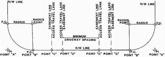
Measurement: See the following access diagram where R/W = Right-of-Way; and P.I. = Point-of-Intersection where P.I. shall be located based upon a 90 degree angle of intersection between ultimate right-of-way lines.
a.
Minimum right-of-way radius at intersections shall conform to City standards.
b.
All minimum distances stated in the following sections shall be governed by sight distance requirements according to the Engineering Design Manual.
c.
All minimum distances stated in the following sections shall be measured to the nearest easement line of the access or edge of travel lane of the access on both sides of the road.
d.
All minimum distances between accesses shall be measured from existing or approved accesses on both sides of the road.
e.
Minimum spacing between driveways shall be measured from Point "C" to Point "C" as shown below:
2.
Roadway Access
No use will be permitted to have direct access to a street or road except as specified below. Access spacing shall be measured from existing or approved accesses on either side of a street or road. The lowest functional classification street available to the legal lot, including alleys within a public easement, shall take precedence for new access points.
a.
Local Streets:
Minimum right-of-way radius is fifteen (15) feet. Access will not be permitted within ten (10) feet of Point "B," if no radius exists, access will not be permitted within twenty-five (25) feet of Point "A." Access points near an intersection with a Neighborhood Route, Collector or Arterial shall be located beyond the influence of standing queues of the intersection in accordance with AASHTO standards. This requirement may result in access spacing greater than ten (10) feet.
b.
Neighborhood Routes:
Minimum spacing between driveways (Point "C" to Point "C") shall be fifty (50) feet with the exception of single family detached dwellings and middle housing dwellings on residential lots in a recorded subdivision. Such lots shall not be subject to a minimum spacing requirement between driveways (Point "C" to Point "C"). In all instances, access points near an intersection with a Neighborhood Route, Collector or Arterial shall be located beyond the influence of standing queues of the intersection in accordance with AASHTO standards. This requirement may result in access spacing greater than fifty (50) feet.
c.
Collectors:
All commercial, industrial and institutional uses with one-hundred-fifty (150) feet or more of frontage will be permitted direct access to a Collector. Uses with less than one-hundred-fifty (150) feet of frontage shall not be permitted direct access to Collectors unless no other alternative exists.
Where joint access is available it shall be used, provided that such use is consistent with Section 16.96.040, Joint Access. No use will be permitted direct access to a Collector within one- hundred (100) feet of any present Point "A." Minimum spacing between driveways (Point "C" to Point "C") shall be one-hundred (100) feet. In all instances, access points near an intersection with a Collector or Arterial shall be located beyond the influence of standing queues of the intersection in accordance with AASHTO standards. This requirement may result in access spacing greater than one hundred (100) feet.
d.
Arterials and Highway 99W - Points of ingress or egress to and from Highway 99W and arterials designated on the Transportation Plan Map, attached as Figure 1 of the Community Development Plan, Part II, shall be limited as follows:
(1)
Single familydetached dwellings, middle housing dwellings, and manufactured homes on individual residential lots developed after the effective date of this Code shall not be granted permanent driveway ingress or egress from Highway 99W or arterials. If alternative public access is not available at the time of development, provisions shall be made for temporary access which shall be discontinued upon the availability of alternative access.
(2)
Other private ingress or egress from Highway 99W and arterial roadways shall be minimized. Where alternatives to Highway 99W or arterials exist or are proposed, any new or altered uses developed after the effective date of this Code shall be required to use the alternative ingress and egress. Alternatives include shared or crossover access agreement between properties, consolidated access points, or frontage or backage roads. When alternatives do not exist, access shall comply with the following standards:
(a)
Access to Highway 99W shall be consistent with ODOT standards and policies per OAR 734, Division 51, as follows: Direct access to an arterial or principal arterial will be permitted provided that Point 'A' of such access is more than six hundred (600) feet from any intersection Point 'A' or other access to that arterial (Point 'C').
(b)
The access to Highway 99W will be considered temporary until an alternative access to public right-of-ways is created. When the alternative access is available the temporary access to Highway 99W shall be closed.
(3)
All site plans or Residential Design Checklists for new development submitted to the City for approval after the effective date of this Code shall show ingress and egress from existing or planned local, neighborhood route or collector streets, including frontage or backage roads, consistent with the Transportation Plan Map and Chapter 6 of the Community Development Plan.
3.
Exceptions to Access Criteria for City-Owned Streets
a.
Alternate points of access may be allowed if an access management plan which maintains the classified function and integrity of the applicable facility is submitted to and approved by the City Engineer as the access management plan must be included as part of the land use submittal or an application for modification as described in § 16.106.020 E. (Transportation Facilities Modifications).
b.
Access in the Old Town (OT) Overlay Zone
Access points in the OT Overlay Zone shown in an adopted plan such as the Transportation System Plan, are not subject to the access spacing standards and do not need a variance. However, the applicant shall submit a partial access management plan for approval by the City Engineer. The approved plan shall be implemented as a condition of development approval.
N.
Private Streets
1.
The construction of a private street serving a single-family residential development is prohibited unless it provides principal access to two or fewer residential lots or parcels (i.e. flag lots).
2.
Provisions shall be made to assure private responsibility for future access and maintenance through recorded easements. Unless otherwise specifically authorized, a private street shall comply with the same standards as a public street identified in the Community Development Code and the Transportation System Plan.
3.
A private street shall be distinguished from public streets and reservations or restrictions relating to the private street shall be described in land division documents and deed records.
4.
A private street shall also be signed differently from public streets and include the words "Private Street".
(Ord. No. 2022-004, § 2, 6-13-2022; Ord. No. 2021-010, § 2, 12-7-2021; Ord. No. 2015-003, § 2, 3-17-2015; Ord. No. 2014-012, § 3, 7-17-2014; Ord. No. 2011-011, § 1, 10-4-2011)
16.106.060 - Sidewalks
A.
Required Improvements
1.
Except as otherwise provided, sidewalks shall be installed on both sides of a public street and in any special pedestrian way within new development.
2.
For Highway 99W, arterials, or in special industrial districts, the City Manager or designee may approve a development without sidewalks if alternative pedestrian routes are available.
3.
In the case of approved cul-de-sacs serving less than fifteen (15) dwelling units, sidewalks on one side only may be approved by the City Manager or designee.
B.
Design Standards
1.
Arterial and Collector Streets
Arterial and collector streets shall have minimum six (6) or eight (8) foot wide sidewalks/multi-use paths, located as required by this Code. Residential areas shall have a minimum of a six (6) foot wide sidewalk and commercial industrial areas shall have a minimum of an eight (8) foot wide sidewalk.
2.
Local Streets
Local streets shall have minimum five (5) foot wide sidewalks, located as required by this Code.
3.
Handicapped Ramps
Sidewalk handicapped ramps shall be provided at all intersections.
C.
Pedestrian and Bicycle Paths
Provide bike and pedestrian connections on public easements or right-of-way when full street connections are not possible, with spacing between connections of no more than 330 feet except where prevented by topography, barriers such as railroads or highways, or environmental constraints such as rivers and streams.
(Ord. No. 2018-007, § 2, 10-2-2018; Ord. No. 2011-011, § 1, 10-4-2011)
16.106.070 - Bike Lanes
If shown in Figure 13 of the Transportation System Plan, bicycle lanes shall be installed in public rights-of-way, in accordance with City specifications. Bike lanes shall be installed on both sides of designated roads, should be separated from the road by a twelve-inch stripe or other means approved by Engineering Staff, and should be a minimum of five (5) feet wide.
(Ord. No. 2014-012, § 3, 7-17-2014; Ord. No. 2011-011, § 1, 10-4-2011)
Editor's note— Ord. No. 2014-012, § 3, adopted July 17, 2014, amended the Code by repealing former § 16.106.070 in its entirety, and renumbering former § 16.106.080 as a new § 16.106.070. Former § 16.106.070 pertained to the Hwy. 99W Capacity Allocation Program (CAP), and derived from Ord. No. 2011-011, adopted October 4, 2011.
16.106.080 - Traffic Impact Analysis (TIA)
A.
Purpose
The purpose of this section is to implement Sections 660-012-0045(2)(b) and -0045(2)(e) of the State Transportation Planning Rule (TPR), which require the City to adopt performance standards and a process to apply conditions to land use proposals in order to minimize impacts on and protect transportation facilities. This section establishes requirements for when a traffic impact analysis (TIA) must be prepared and submitted; the analysis methods and content involved in a TIA; criteria used to review the TIA; and authority to attach conditions of approval to minimize the impacts of the proposal on transportation facilities.
This section refers to the TSP for performance standards for transportation facilities as well as for projects that may need to be constructed as mitigation measures for a proposal's projected impacts. This section also relies on the City's Engineering Design Manual to provide street design standards and construction specifications for improvements and projects that may be constructed as part of the proposal and mitigation measures approved for the proposal.
B.
Applicability
A traffic impact analysis (TIA) shall be required to be submitted to the City with a land use application at the request of the City Engineer or if the proposal is expected to involve one (1) or more of the following:
1.
An amendment to the Sherwood Comprehensive Plan or zoning map.
2.
A new direct property approach road to Highway 99W is proposed.
3.
The proposed development generates fifty (50) or more PM peak-hour trips on Highway 99W, or one hundred (100) PM peak-hour trips on the local transportation system.
4.
An increase in use of any adjacent street or direct property approach road to Highway 99W by ten (10) vehicles or more per day that exceed the twenty thousand-pound gross vehicle weight.
5.
The location of an existing or proposed access driveway does not meet minimum spacing or sight distance requirements, or is located where vehicles entering or leaving the property are restricted, or such vehicles are likely to queue or hesitate at an approach or access connection, thereby creating a safety hazard.
6.
A change in internal traffic patterns that may cause safety problems, such as back up onto the highway or traffic crashes in the approach area.
C.
Requirements
The following are typical requirements that may be modified in coordination with Engineering Staff based on the specific application.
1.
Pre-application Conference. The applicant shall meet with the City Engineer prior to submitting an application that requires a TIA. This meeting will be coordinated with Washington County and ODOT when an approach road to a County road or Highway 99W serves the property, so that the TIA will meet the requirements of all relevant agencies.
2.
Preparation. The TIA shall be prepared by an Oregon Registered Professional Engineer qualified to perform traffic Engineering analysis and will be paid for by the applicant.
3.
Typical Average Daily Trips and Peak Hour Trips. The latest edition of the Trip Generation Manual, published by the Institute of Transportation Engineers (ITE), shall be used to gauge PM peak hour vehicle trips, unless a specific trip generation study that is approved by the City Engineer indicates an alternative trip generation rate is appropriate.
4.
Intersection-level Analysis. Intersection-level analysis shall occur at every intersection where the analysis shows that fifty (50) or more peak hour vehicle trips can be expected to result from the development.
5.
Transportation Planning Rule Compliance. The requirements of OAR 660-012-0060 shall apply to those land use actions that significantly affect the transportation system, as defined by the Transportation Planning Rule.
D.
Study Area
The following facilities shall be included in the study area for all TIAs:
1.
All site-access points and intersections (signalized and unsignalized) adjacent to the proposed development site. If the site fronts an arterial or collector street, the analysis shall address all intersections and driveways along the site frontage and within the access spacing distances extending out from the boundary of the site frontage.
2.
Roads and streets through and adjacent to the site.
3.
All intersections needed for signal progression analysis.
4.
In addition to these requirements, the City Engineer may require analysis of any additional intersections or roadway links that may be adversely affected as a result of the proposed development.
E.
Analysis Periods
To adequately assess the impacts of a proposed land use action, the following study periods, or horizon years, should be addressed in the transportation impact analysis where applicable:
1.
Existing Year.
2.
Background Conditions in Project Completion Year. The conditions in the year in which the proposed land use action will be completed and occupied, but without the expected traffic from the proposed land use action. This analysis should account for all City-approved developments that are expected to be fully built out in the proposed land use action horizon year, as well as all planned transportation system improvements.
3.
Full Buildout Conditions in Project Completion Year. The background condition plus traffic from the proposed land use action assuming full build-out and occupancy.
4.
Phased Years of Completion. If the project involves construction or occupancy in phases, the applicant shall assess the expected roadway and intersection conditions resulting from major development phases. Phased years of analysis will be determined in coordination with City staff.
5.
Twenty-Year or TSP Horizon Year. For planned unit developments, comprehensive plan amendments or zoning map amendments, the applicant shall assess the expected future roadway, intersection, and land use conditions as compared to approved comprehensive planning documents.
F.
Approval Criteria
When a TIA is required, a proposal is subject to the following criteria, in addition to all criteria otherwise applicable to the underlying land use proposal:
1.
The analysis complies with the requirements of 16.106.080.C;
2.
The analysis demonstrates that adequate transportation facilities exist to serve the proposed development or identifies mitigation measures that resolve identified traffic safety problems in a manner that is satisfactory to the City Engineer and, when County or State highway facilities are affected, to Washington County and ODOT;
3.
For affected non-highway facilities, the TIA demonstrates that mobility and other applicable performance standards established in the adopted City TSP have been met; and
4.
Proposed public improvements are designed and will be constructed to the street standards specified in Section 16.106.010 and the Engineering Design Manual, and to the access standards in Section 16.106.040.
5.
Proposed public improvements and mitigation measures will provide safe connections across adjacent right-of-way (e.g., protected crossings) when pedestrian or bicycle facilities are present or planned on the far side of the right-of-way.
G.
Conditions of Approval
The City may deny, approve, or approve a development proposal with conditions needed to meet operations and safety standards and provide the necessary right-of-way and improvements to ensure consistency with the future planned transportation system. Improvements required as a condition of development approval, when not voluntarily provided by the applicant, shall be roughly proportional to the impact of the development on transportation facilities, pursuant to Section 16.106.090. Findings in the development approval shall indicate how the required improvements are directly related to and are roughly proportional to the impact of development.
(Ord. No. 2014-012, § 3, 7-17-2014)
16.106.090 - Rough Proportionality
A.
Purpose
The purpose of this section is to ensure that required transportation facility improvements are roughly proportional to the potential impacts of the proposed development. The rough proportionality requirements of this section apply to both frontage and non-frontage improvements. A proportionality analysis will be conducted by the City Engineer for any proposed development that triggers transportation facility improvements pursuant to this chapter. The City Engineer will take into consideration any benefits that are estimated to accrue to the development property as a result of any required transportation facility improvements. A proportionality determination can be appealed pursuant to Chapter 16.76. The following general provisions apply whenever a proportionality analysis is conducted.
B.
Mitigation of impacts due to increased demand for transportation facilities associated with the proposed development shall be provided in rough proportion to the transportation impacts of the proposed development. When applicable, anticipated impacts will be determined by the TIA in accordance with Section 16.106.080. When no TIA is required, anticipated impacts will be determined by the City Engineer.
C.
The following shall be considered when determining proportional improvements:
1.
Condition and capacity of existing facilities within the impact area in relation to City standards. The impact area is generally defined as the area within a one-half-mile radius of the proposed development. If a TIA is required, the impact area is the TIA study area.
2.
Existing vehicle, bicycle, pedestrian, and transit use within the impact area.
3.
The effect of increased demand on transportation facilities and other approved, but not yet constructed, development projects within the impact area that is associated with the proposed development.
4.
Applicable TSP goals, policies, and plans.
5.
Whether any route affected by increased transportation demand within the impact area is listed in any City program including school trip safety; neighborhood traffic management; capital improvement; system development improvement, or others.
6.
Accident history within the impact area.
7.
Potential increased safety risks to transportation facility users, including pedestrians and cyclists.
8.
Potential benefit the development property will receive as a result of the construction of any required transportation facility improvements.
9.
Other considerations as may be identified in the review process pursuant to Chapter 16.72.
(Ord. No. 2014-012, § 3, 7-17-2014)
16.108.010 - Preparation and Submission
An improvement plan shall be prepared and stamped by a Registered Civil Engineer certifying compliance with City specifications. Two (2) sets of the plan shall be submitted to the City for review. An improvements plan shall be accompanied by a review fee as per this Section.
A.
Review Fee
Plan review fees are calculated as a percentage of the estimated total cost of improvements and are set by the "Schedule of Development and Business Fees" adopted by Resolution of the Council. This schedule is included herein for the purposes of information, but is deemed to be separate from and independent of this Code.
B.
Engineering Agreement
A copy of an agreement or contract between the applicant and Registered Civil Engineer for:
1.
Surveying sufficient to prepare construction plans.
2.
Preparation of construction plans and specifications.
3.
Construction staking, and adequate inspection.
4.
Construction notes sufficient to develop accurate as-built plans.
5.
Drawing of accurate as-built plans and submission of reproducible mylars for finals to the City.
6.
Certificate stating that construction was completed in accordance with required plans and specifications.
(Ord. No. 2011-011, § 1, 10-4-2011)
16.108.020 - Construction Permit
A.
Approval
The City will return one (1) set of plans to the applicant marked "approved," "approved as noted" or "modify and resubmit." Plans marked for re-submittal must be corrected in accordance with notations or instructions. After correction and approval, additional plans shall be provided the City for office use, field inspection and submittal to affected agencies.
B.
Permit and Fee
Upon approval the applicant shall obtain a construction permit. The construction permit fee is set by the "Schedule of Development Fees", adopted by Resolution of the Council. This schedule is included herein for the purposes of information, but is deemed to be separate from and independent of this Code.
C.
Easement Documents
Easements shall be provided in a form acceptable to the City prior to issuance of a construction permit.
D.
Improvement Guarantees
Prior to issuance of a construction permit the applicant shall file the following documents with the City:
1.
Liability Insurance
Evidence of liability and property damage insurance adequate to protect the applicant and the City from all claims for damage or personal injury.
2.
Performance Bond
To assure full and faithful performance in the construction of required improvements in accordance with approved construction plans, the applicant shall provide security in an amount equal to one hundred twenty-five percent (125%) of the estimated cost of the improvements. In the event the applicant fails to carry out all provisions of the approved improvements plans and the City has non-reimbursed costs or expenses resulting from such failure, the City shall call on the security for reimbursement. Security may be in the form of a surety bond executed by a surety company authorized to transact business in the State of Oregon, a cash deposit, or irrevocable standby letter of credit.
(Ord. No. 2011-011, § 1, 10-4-2011)
16.108.030 - Construction
A.
Initiation of Construction
Actual construction of improvements shall not begin, or after a discontinuance, be restarted until the City is notified in writing.
B.
Inspection
All construction shall be done to the City's specifications. The City shall perform inspections to verify compliance with approved plans and shall make a final inspection of the construction at such time as the improvements are complete. The City may require changes in typical sections and details, if unusual conditions warrant the change.
C.
As-Built Plans
A complete set of reproducible plans and an electronic copy of the base files in "AutoCad" or PDF format showing the public improvements as built shall be filed with the City upon completion of the improvements.
D.
Suspension of Improvements Activity
The City may cause a suspension of construction or engineering when, in the opinion of the City, work is not being done to the City's satisfaction.
(Ord. No. 2011-011, § 1, 10-4-2011)
16.108.040 - Acceptance of Improvements
A.
Final Inspection
At such time as all public improvements, except those specifically approved for later installation, have been completed, the applicant shall notify the City of the readiness for final inspection.
B.
Notification of Acceptance
The City shall give written notice of acceptance of the improvements upon finding that the applicant has met the requirements of this Chapter and the specifications of all approved plans.
C.
Maintenance Bond
Prior to City acceptance of public improvements, the applicant shall provide the City a maintenance bond computed at ten percent (10%) of the full value of the improvements, for the purpose of correcting any defective work or maintenance that becomes apparent or arises within two (2) years after final acceptance of the public improvements.
(Ord. No. 2011-011, § 1, 10-4-2011)
16.110.010 - Required Improvements
Sanitary sewers shall be installed to serve all new developments and shall connect to existing sanitary sewer mains. Provided, however, that when impractical to immediately connect to a trunk sewer system, the use of septic tanks may be approved, if sealed sewer laterals are installed for future connection and the temporary system meets all other applicable City, Clean Water Services, Washington County and State sewage disposal standards.
(Ord. No. 2010-015, § 2, 10-5-2010; Ord. 86-851, § 3)
16.110.020 - Design Standards
A.
Capacity
Sanitary sewers shall be constructed, located, sized, and installed at standards consistent with this Code, the Sanitary Sewer Service Plan Map in the Sanitary Sewer Master Plan, and other applicable Clean Water Services and City standards, in order to adequately serve the proposed development and allow for future extensions.
B.
Over-Sizing
1.
When sewer facilities will, without further construction, directly serve property outside a proposed development, gradual reimbursement may be used to equitably distribute the cost of that over-sized system.
2.
Reimbursement shall be in an amount estimated by the City to be a proportionate share of the cost for each connection made to the sewer by property owners outside of the development, for a period of ten (10) years from the time of installation of the sewers. The boundary of the reimbursement area and the method of determining proportionate shares shall be determined by the City. Reimbursement shall only be made as additional connections are made and shall be collected as a surcharge in addition to normal connection charges.
(Ord. No. 2010-015, § 2, 10-5-2010; Ord. 91-922, § 3; Ord. 86-851)
16.110.030 - Service Availability
Approval of construction plans for new facilities pursuant to Chapter 16.106, and the issuance of building permits for new development to be served by existing sewer systems shall include certification by the City that existing or proposed sewer facilities are adequate to serve the development.
(Ord. 86-851, § 3)
16.112.010 - Required Improvements
Water lines and fire hydrants conforming to City and Fire District standards shall be installed to serve all building sites in a proposed development. All waterlines shall be connected to existing water mains or shall construct new mains appropriately sized and located in accordance with the Water System Master Plan.
(Ord. 2009-008, § 3, 7-21-2009; Ord. 86-851, § 3)
16.112.020 - Design Standards
A.
Capacity
Water lines providing potable water supply shall be sized, constructed, located and installed at standards consistent with this Code, the Water System Master Plan, the City's Design and Construction Manual, and with other applicable City standards and specifications, in order to adequately serve the proposed development and allow for future extensions.
B.
Fire Protection
All new development shall comply with the fire protection requirements of Chapter 16.116, the applicable portions of Chapter 7 of the Community Development Plan, and the Fire District.
C.
Over-Sizing
1.
When water mains will, without further construction, directly serve property outside a proposed development, gradual reimbursement may be used to equitably distribute the cost of that over-sized system.
2.
Reimbursement shall be in an amount estimated by the City to be the proportionate share of the cost of each connection made to the water mains by property owners outside the development, for a period of ten (10) years from the time of installation of the mains. The boundary of the reimbursement area and the method of determining proportionate shares shall be determined by the City. Reimbursement shall only be made as additional connections are made and shall be collected as a surcharge in addition to normal connection charges.
3.
When over-sizing is required in accordance with the Water System Master Plan, it shall be installed per the Water System Master Plan. Compensation for over-sizing may be provided through direct reimbursement, from the City, after mainlines have been accepted. Reimbursement of this nature would be utilized when the cost of over-sizing is for system wide improvements.
(Ord. No. 2010-015, § 2, 10-5-2010; Ord. No. 2009-008, § 3, 7-21-2009; Ord. 91-922, § 3; Ord. 86-851)
16.112.030 - Service Availability
Approval of construction plans for new water facilities pursuant to Chapter 16.106, and the issuance of building permits for new development to be served by existing water systems shall include certification by the City that existing or proposed water systems are adequate to serve the development.
(Ord. 86-851, § 3)
16.114.010 - Required Improvements
Storm water facilities, including appropriate source control and conveyance facilities, shall be installed in new developments and shall connect to the existing downstream drainage systems consistent with the Comprehensive Plan and the requirements of the Clean Water Services water quality regulations contained in their Design and Construction Standards R&O 04-9, or its replacement.
(Ord. 2006-021; 2000-1092 § 3; 93-972)
(Note: Section 16.114.015, Street Systems Improvement Fees (SIF) was repealed by Ordinance 91-922 § 19) to be removed from the SZCDC and permanently located in the Municipal Code).
16.114.020 - Design Standards
A.
Capacity
Storm water drainage systems shall be sized, constructed, located, and installed at standards consistent with this Code, the Storm Drainage Master Plan Map, attached as Exhibit E, Chapter 7 of the Community Development Plan, other applicable City standards, the Clean Water Services Design and Construction standards R&O 04-9 or its replacement, and hydrologic data and improvement plans submitted by the developer.
B.
On-Site Source Control
Storm water detention and groundwater recharge improvements, including but not limited to such facilities as dry wells, detention ponds, and roof top ponds shall be constructed according to Clean Water Services Design and Construction Standards.
C.
Conveyance System
The size, capacity and location of storm water sewers and other storm water conveyance improvements shall be adequate to serve the development and accommodate upstream and downstream flow. If an upstream area discharges through the property proposed for development, the drainage system shall provide capacity to the receive storm water discharge from the upstream area. If downstream drainage systems are not sufficient to receive an increase in storm water caused by new development, provisions shall be made by the developer to increase the downstream capacity or to provide detention such that the new development will not increase the storm water caused by the new development.
(Ord. No. 2010-015, § 2, 10-5-2010; Ord. 2006-021; 2000-1092 § 3; 91-922; Ord. 86-851 § 3)
16.114.030 - Service Availability
Approval of construction plans for new storm water drainage facilities pursuant to Chapter 16.106, and the issuance of building permits for new development to be served by existing storm water drainage systems shall include certification by the City that existing or proposed drainage facilities are adequate to serve the development.
(Ord. 86-851, § 3)
16.116.010 - Required Improvements
When land is developed so that any commercial or industrial structure is further than two hundred and fifty (250) feet or any residential structure is further than five hundred (500) feet from an adequate water supply for fire protection, as determined by the Fire District, the developer shall provide fire protection facilities necessary to provide adequate water supply and fire safety.
(Ord. 86-851, § 3)
16.116.020 - Standards
A.
Capacity
All fire protection facilities shall be approved by and meet the specifications of the Fire District, and shall be sized, constructed, located, and installed consistent with this Code, Chapter 7 of the Community Development Plan, and other applicable City standards, in order to adequately protect life and property in the proposed development.
B.
Fire Flow
Standards published by the Insurance Services Office, entitled "Guide for Determination of Required Fire Flows" shall determine the capacity of facilities required to furnish an adequate fire flow. Fire protection facilities shall be adequate to convey quantities of water, as determined by ISO standards, to any outlet in the system, at no less than twenty (20) pounds per square inch residual pressure. Water supply for fire protection purposes shall be restricted to that available from the City water system. The location of hydrants shall be taken into account in determining whether an adequate water supply exists.
C.
Access to Facilities
Whenever any hydrant or other appurtenance for use by the Fire District is required by this Chapter, adequate ingress and egress shall be provided. Access shall be in the form of an improved, permanently maintained roadway or open paved area, or any combination thereof, designed, constructed, and at all times maintained, to be clear and unobstructed. Widths, height clearances, ingress and egress shall be adequate for District firefighting equipment. The Fire District, may further prohibit vehicular parking along private accessways in order to keep them clear and unobstructed, and cause notice to that effect to be posted.
D.
Hydrants
Hydrants located along private, accessways shall either have curbs painted yellow or otherwise marked prohibiting parking for a distance of at least fifteen (15) feet in either direction, or where curbs do not exist, markings shall be painted on the pavement, or signs erected, or both, given notice that parking is prohibited for at least fifteen (15) feet in either direction.
(Ord. No. 2010-015, § 2, 10-5-2010; Ord. 91-922, § 3; Ord. 86-851, § 3)
16.116.030 - Miscellaneous Requirements
A.
Timing of Installation
When fire protection facilities are required, such facilities shall be installed and made serviceable prior to or at the time any combustible construction begins on the land unless, in the opinion of the Fire District, the nature or circumstances of said construction makes immediate installation impractical.
B.
Maintenance of Facilities
All on-site fire protection facilities, shall be maintained in good working order. The Fire District may conduct periodic tests and inspection of fire protection and may order the necessary repairs or changes be made within ten (10) days.
C.
Modification of Facilities
On-site fire protection facilities, may be altered or repaired with the consent of the Fire District; provided that such alteration or repairs shall be carried out in conformity with the provisions of this Chapter.
(Ord. No. 2010-015, § 2, 10-5-2010; Ord. 86-851, § 3)
16.118.010 - Purpose
Public telecommunication conduits as well as conduits for franchise utilities including, but not limited to, electric power, telephone, natural gas, lighting, and cable television shall be installed to serve all newly created lots and developments in Sherwood.
16.118.020 - Standard
A.
Installation of utilities shall be provided in public utility easements and shall be sized, constructed, located and installed consistent with this Code, and applicable utility company and City standards.
B.
Public utility easements shall be a minimum of eight (8) feet in width unless a reduced width is specifically exempted by the City Engineer. An eight-foot wide public utility easement (PUE) shall be provided on private property along all public street frontages. This standard does not apply to developments within the Old Town Overlay.
C.
Where necessary, in the judgment of the City Manager or his designee, to provide for orderly development of adjacent properties, public and franchise utilities shall be extended through the site to the edge of adjacent property(ies).
D.
Franchise utility conduits shall be installed per the utility design and specification standards of the utility agency.
E.
Public Telecommunication conduits and appurtenances shall be installed per the City of Sherwood telecommunication design standards.
F.
Exceptions: Installation shall not be required if the development does not require any other street improvements. In those instances, the developer shall pay a fee in lieu that will finance installation when street or utility improvements in that location occur.
(Ord. No. 2018-007, § 2, 10-2-2018; Ord. No. 2009-005, § 2, 6-2-2009)
16.118.030 - Underground Facilities
Except as otherwise provided, all utility facilities, including but not limited to, electric power, telephone, natural gas, lighting, cable television, and telecommunication cable, shall be placed underground, unless specifically authorized for above ground installation, because the points of connection to existing utilities make underground installation impractical, or for other reasons deemed acceptable by the City.
16.118.040 - Exceptions
Surface-mounted transformers, surface-mounted connection boxes and meter cabinets, temporary utility service facilities during construction, high capacity electric and communication feeder lines, and utility transmission lines operating at fifty thousand (50,000) volts or more may be located above ground. The City reserves the right to approve location of all surface-mounted transformers.
(Ord. 2005-17 § 5; 91-922)
16.118.050 - Private Streets
The construction of new private streets, serving single-family residential developments shall be prohibited unless it provides principal access to two or fewer residential lots or parcels i.e. flag lots. Provisions shall be made to assure private responsibility for future access and maintenance through recorded easements. Unless otherwise specifically authorized, a private street shall comply with the same standards as a public street identified in the Community Development Code and the Transportation System Plan. A private street shall be distinguished from public streets and reservations or restrictions relating to the private street shall be described in land division documents and deed records. A private street shall also be signed differently from public streets and include the words "Private Street".
(Ord. No. 2009-005, § 2, 6-2-2009; Ord. No. 2009-005, § 2, 6-2-2009; Ord. 2005-009 § 5; Ord. 86-851)