
South Miami City Zoning Code
ARTICLE XII
DOWNTOWN SoMi DISTRICT REGULATIONS
20-12.1 - Intent.
The Downtown SoMi (DS) district is intended for properties designated "Downtown SoMi" on the City's Comprehensive Plan, to provide for the establishment of place-making development that is urban in scale. This district authorizes a mixture of uses, densities, intensities, and heights that contribute to a vibrant urban experience within walking distance to rail-based rapid transit. Permitted uses and structures on both a temporary and permanent basis include retail, restaurant, residential, hotel, office, entertainment, theaters and attractions, permanent and nonpermanent kiosks, active rooftop uses and those uses reasonably accessory thereto.
Permitted heights in the DS district shall be from four (4) stories up to twelve (12) stories with bonuses available to achieve additional floors up to thirty-three (33) floors maximum pursuant to the bonus program in this Article.
The permitted Floor Area Ratio (F.A.R.) shall be up to 1.8 and shall only apply to nonresidential uses. Permitted residential density shall be up to one hundred fifty (150) dwelling units per acre. Hotel uses within this district shall be deemed part of the commercial intensity and shall not be counted for purposes of calculating residential density. For the avoidance of doubt, residential uses shall not count against F.A.R. and commercial uses (including hotel uses) shall not count towards residential density.
To promote an active, urban, and vibrant pedestrian experience, outdoor seating as a convenience for tenants and guests and as an accessory to restaurants, cafes and similar uses shall be encouraged within the DS district.
Property zoned DS may qualify for bonus height through approval of an initial Site Plan only if the project approved pursuant to such initial Site Plan (as may be modified pursuant to this Article), is a unified project for development (pursuant to a unity of title, or covenant in lieu of unity of title, or a unified plan of development pursuant to a reciprocal easement agreement) and it satisfies all of the following requirements:
(1)
The gross lot area of the property prior to dedications exceeds ten (10) acres;
(2)
The property abuts a federal highway and at least two (2) section-line roads;
(3)
A portion of the property is within one thousand five hundred (1,500) feet radius of an existing rail-based transit station; and
(4)
The property provides at least seventeen and one-half percent (17.5%) of the gross lot area as open space.
Once qualified for bonuses under an Initial Site Plan approval, each phase of the project, or additional lands added to the project subsequent to the Initial Site Plan approval, shall be eligible for bonus height as set forth in this Article.
(Ord. No. 15-19-2328, § 12, 4-23-19; Ord. No. 26-23-2477, § 2(Exh. B), 11-21-23)
20-12.2 - Reserved.
Editor's note— Ord. No. 26-23-2477, § 2(Exh. B), adopted Nov. 21, 2023, repealed § 20-12.2, which pertained to boundaries, and derived from Ord. No. 15-19-2328, § 12, adopted Apr. 23, 2019.
20-12.3 - Applicability.
The requirements of this article shall apply to all development within the DS district and in case of conflict, the provisions of this article shall control over other requirements of the Code, Ordinances, Land Development Code and all other regulations of the City of South Miami.
(Ord. No. 15-19-2328, § 12, 4-23-19)
20-12.4 - Floor Area Ratio (F.A.R.).
The permitted F.A.R. shall be up to 1.8 and shall mean a development intensity measure setting forth the maximum nonresidential gross floor area that can be developed on a property. Multiplying the F.A.R. by the gross floor area, prior to any right-of-way dedications or public easements, results in the allowable nonresidential floor area that can be developed of the property. Gross floor area shall mean the total horizontal area of the several floors of a building, measured from the exterior faces of exterior walls or from the centerline of walls separating two (2) attached buildings. In particular, gross floor area shall include all spaces designed or intended for:
(A)
Any permitted use or activity.
(B)
Interior halls, balconies or mezzanines.
(C)
Completely enclosed terraces, breezeways or porches.
(D)
Accessory buildings or structures.
(E)
Attics or basements (with headroom of seven (7) feet or more).
(F)
Permanent enclosed, air-conditioned kiosks.
However, gross floor area shall not include space used for:
(G)
Enclosed off-street parking spaces.
(H)
Accessory water tanks, chillers or cooling towers.
(I)
Uncovered steps and exterior balconies.
(J)
Open terraces, breezeways or porches.
(K)
Attics, non-habitable structures above the roof slab, and basements.
(L)
Service areas (mechanical, electrical, loading, storage, trash/refuse and communication equipment rooms or spaces).
(M)
Elevator shafts or stairwells at each floor.
(N)
Enclosed means of egress corridors.
(O)
Rooftop uses including pools, open-air restaurants, bars, cabanas, and open-air kiosks.
(P)
Outdoor seating areas and nonpermanent open-air kiosks.
(Q)
Residential uses.
(Ord. No. 15-19-2328, § 12, 4-23-19; Ord. No. 26-23-2477, § 2(Exh. B), 11-21-23)
20-12.5 - Residential density.
The permitted residential density shall be up to one hundred fifty (150) dwelling units per acre. Hotel uses shall not be counted for purposes of calculating residential density and intensity, but rather shall be included as part of commercial intensity.
(Ord. No. 15-19-2328, § 12, 4-23-19; Ord. No. 26-23-2477, § 2(Exh. B), 11-21-23)
20-12.6 - Permitted uses.
Permitted Uses are as expressly provided by these DS district regulations, including those additional uses listed in the Permitted Use Schedule in Section 20-3.3(D), and also include:
(1)
Hotels.
(2)
Outdoor dining/seating.
(3)
Rooftop uses.
(4)
Entertainment, theaters, and attractions.
(5)
Live-work units.
(6)
Assisted living facilities subject to special exception approval from the City Commission.
(7)
Research and development.
(8)
Incubator space.
(9)
Artist studios.
(10)
Child care facilities.
(11)
Schools subject to special exception approval from the City Commission.
(12)
Animal hospitals or veterinarians subject to special exception approval from the City Commission.
(13)
Automobile dealers from completely enclosed buildings.
(14)
Microbrewery/brewpubs.
(15)
Neighborhood convenience store.
(16)
Such other uses as permitted and special uses set forth in Section 20-7.17 (Hometown District).
The distance requirements between premises that sell alcoholic beverages set forth Chapter 4 (Alcoholic Beverages) shall not apply within the DS district.
(Ord. No. 15-19-2328, § 12, 4-23-19; Ord. No. 26-23-2477, § 2(Exh. B), 11-21-23)
20-12.7 - Grandfathering.
All existing legal uses and structures established prior to the enactment of these DS district regulations shall be deemed to be lawful, conforming, and permitted uses and structures. Legally nonconforming uses and structures within the DS district shall be subject to the provisions of Section 20-4.8, South Miami Land Development Code.
(Ord. No. 15-19-2328, § 12, 4-23-19)
20-12.8 - Permitted heights.
The DS district encourages a variety of heights and massing configurations based on site specific conditions, with heights adopted by ordinance.
For the property bordered by Sunset Drive on the south, 57th Avenue on the east, U.S. Highway 1 on the north, and SW 58th Avenue on the west, allowable heights are split into four (4) zones: the Sunset Zone, the Village Zone, the Central Zone, and the US-1 Gateway Zone. The dimensions of the zones and their respective maximum base and bonus heights are as follows:
Table 20-12.8
* Bonus height shall be available in Sunset Zone only if the base height within the Sunset Zone is limited to two (2) stories or less, and in such circumstance, bonus height shall be limited to the area commencing thirty (30) feet north of the project's south lot line (as of January 21, 2023) and extending north to northernmost extent of Sunset Zone (the "Secondary Sunset Zone"). Aggregate Doorplate for all portions of structures above two (2) stories in the Secondary Sunset Zone shall not exceed fifty percent (50%) of the lot area of the Secondary Sunset Zone.
Floorplates of floors above the tenth story in the Central Zone or US-1 Gateway Zone shall not exceed twenty thousand (20,000) square feet of gross floor area, except that the owner may designate one development site within such zones where the floor plates above the tenth story may be developed to twenty-five thousand (25,000) square feet of gross floor area.
The term "story" or "stories" means a habitable level within a building by which permitted heights are measured. For purposes of calculating permitted height and stories, elements and features, including, but not limited to, vertical circulation elements (such as stairs and elevators), illumination elements, chillers, mechanical space, mechanical structures, architectural features, parapets, communications equipment, and solar panels, attached to or serving structures, may exist above slab and are not to be counted toward height or constitute a story. Notwithstanding the foregoing, the height of these elements (excluding elevator overruns) and features shall not exceed twenty (20) feet in height above the roof slab above the highest habitable level. Accessory to rooftop uses, including pools, open-air restaurants, bars, cabanas, and open-air kiosks, may exist above the roof slab and are not to be counted toward height or constitute a story. Notwithstanding the foregoing, the height of these elements and features shall not exceed eighteen (18) feet in height above the roof slab above the highest otherwise habitable level.
The location and dimensions of the Sunset Zone, the Village Zone, the Central Zone and the US-1 Gateway Zone are generally illustrated in the following Diagram 1 (in the event of conflict with Table 20-12.8, Table 20-12.8 shall control):
Diagram 1
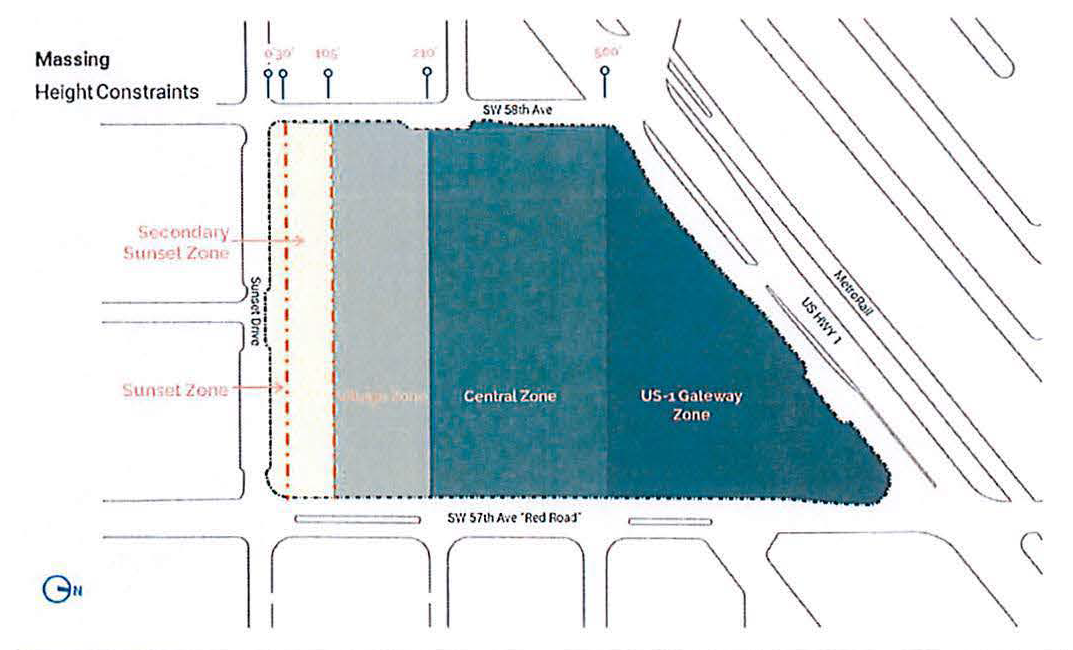
Diagram 1 set forth above does not apply to structured parking located within the DS district. Regardless of Zone, structured parking within the DS district shall be permitted to a maximum height of nine (9) stories, at the time of adoption of the DS district regulations, to the roof slab above the highest elevated parking deck. Notwithstanding the foregoing, no parking structure or part thereof shall encroach the Sunset Zone. For purposes of calculating the height of structured parking, vertical circulation elements (such as stairs and elevators), illumination elements, mechanical elements, architectural features, parapets, solar panels, and communication elements, attached to or serving structured parking, and structures accessory to rooftop uses, including pools, open-air restaurants, bars, cabanas, and open-air kiosks, may exist above the roof slab and are not to be counted toward height or constitute a story. Notwithstanding the foregoing, the height of these elements and features shall not exceed thirty-five (35) feet in height above the roof slab above the highest elevated parking deck.
Tier 1 Bonus.
For a unified development site exceeding ten (10) acres, the base height in the US-1 Gateway Zone may be increased by five (5) stories for a total height of seventeen (17) stories before application of Tier 2 Bonus Height.
Tier 2 Bonus Height.
To develop with Tier 2 bonus height, the project must obtain gross floor area in an amount equal to the total of the gross floor area of each of the proposed bonus floors irrespective of whether the use of such floors is residential or nonresidential ("bonus floor area") by providing one or more of the following:
(i)
Development of on-site qualifying enhancements on the property;
(ii)
Conversion of unused nonresidential gross floor area at a rate of 1.3 square feet of bonus floor area per one square foot of converted nonresidential gross floor area; [3]
(iii)
Conversion of unused gross floor area within the Sunset Zone at a rate of one square foot of bonus floor area per one square foot of unused gross floor area within the Sunset Zone; [4] and
(iv)
Contributing twelve dollars ($12.00) per square foot of bonus floor area. Bonus floor area will be reserved with a contribution made at Initial Site Plan Approval of ten percent (10%) of the amount due for the aggregate amount of bonus floor area required to be purchased to complete the overall project set forth in the Initial Site Plan (the "Initial Bonus Floor Area Contribution"). Thereafter, any project phase seeking administrative site plan approval shall be required to pay twenty-five percent (25%) of the required contribution for that project phase on or before administrative site plan approval, with the remaining balance due at building permit for any portion of such project phase; provided however that such project phase shall be entitled to a dollar for dollar credit for the Initial Bonus Floor Area Contribution until such Initial Bonus Floor Area Contribution is extinguished. Each portion of the contribution shall be calculated based on the rate in effect at the time of payment, with all contributions to be deposited in the City's public benefits trust fund to be established by Commission action. The contribution rate shall increase to fifteen dollars ($15.00) per square foot on January 1, 2026, and shall increase one dollar and fifty cents ($1.50) per square foot on January 1, 2027 and each year thereafter.
On-site qualifying enhancements may be applied as follows:
1.
Development of open space with publicly accessible rights-of-way or plazas—4:1 bonus. If open space, in the aggregate for the project, exceeds seventeen and one-half percent (17.5%) of the gross lot areas of the property, then each square foot of open space (in total for the project) shall qualify for four (4) square feet of bonus floor area.
A.
Such areas shall be open to the general public as set forth in an easement memorialized by Development Agreement, acceptable to the City Manager and City Attorney, from sunrise until the closure of all food and beverage uses on the property, subject to (i) reasonable rules and regulations; (ii) reasonable closure of vehicular traffic; and (iii) reasonable closure for special events that exclude the general public (not to exceed more than fifteen (15) days per year), maintenance, or emergency activities. Rights-of-way shall not be bridged over or encroached upon except where set forth in an approved Initial Site Plan. Rights-of-way may be used for outdoor seating, sidewalk sales, and similar outdoor uses provided rights-of-way maintain a clear path at least five (5) feet wide at all times.
2.
Development of affordable housing—3:1 bonus. For each square foot of affordable housing developed, the development shall qualify for three (3) square feet of bonus floor area, provided at least one hundred (100) units of affordable housing are developed in the aggregate.
a.
Affordable housing shall be limited to rents or a sales price that is affordable to qualifying households at eighty percent (80%) of Area Median Income as set forth by Miami-Dade County statistics promulgated by the U.S. Department of Housing and Urban Development. The owner shall commit by covenant prior to building permit to maintain such affordability restriction on the property for a minimum period of twenty-five (25) years. Units thus restricted shall be spread among all unit types in the building and shall be interspersed throughout the building to avoid their overconcentration in any portion of the building. The owner may forgo the covenant and instead contribute forty-five dollars ($45.00) per square foot of bonus floor area attributed to affordable housing development, with such payment to be deposited in the City's Public Benefit Trust Fund to be established to account for delaying payment from administrative site plan approval to building permit. The contribution rate shall increase to forty-eight dollars ($48.00) per square foot on January 1, 2026, and shall increase one dollar and fifty cents ($1.50) per square foot on January 1, 2027 and each year thereafter.
3.
Development of workforce housing—2:1 bonus. For each square foot of workforce housing developed, the development shall qualify for two (2) square feet of bonus floor area, provided at least one hundred (100) units of workforce housing are developed in the aggregate.
a.
Workforce housing shall be limited to rents or sales price that is affordable to qualifying households at one hundred forty percent (140%) of Area Median Income as set forth by Miami-Dade County statistics promulgated by the U.S. Department of Housing and Urban Development. The owner shall commit by covenant prior to building permit to maintain such affordability restriction on the property for a minimum period of twenty-five (25) years. Units thus restricted shall be spread among all unit types in the building and shall be interspersed throughout the building to avoid their overconcentration in any portion of the building. The owner may forgo the covenant and instead contribute forty-five dollars ($45.00) per square foot of bonus floor area attributable to workforce housing development, with such payment to be deposited in the City's public benefit trust fund to be established to account for delaying payment from administrative site plan approval to building permit. The contribution rate shall increase to forty-eight dollars ($48.00) per square foot on January 1, 2026, and shall increase one dollar and fifty cents ($1.50) per square foot on January 1, 2027 and each year thereafter.
4.
Condominium—1:5 bonus. For each five (5) square feet of residential gross floor area dedicated to condominium ownership, the development shall qualify for one square foot of bonus floor area up to a maximum bonus of one hundred thousand (100,000) square feet.
a.
Prior to issuance of a building permit, the owner shall post a bond or letter of credit for the benefit of the City in an amount equal to eighteen dollars ($18.00) per square foot of any such bonus floor. Such bond or letter of credit shall be released only if the units submitted for condominium ownership have been sold to bona fide purchasers unrelated to the developer and by arms-length transactions (with no bona fide purchaser owning more than ten (10) condominium units) and continue within the condominium form of ownership on the anniversary of five (5) years from the date of the temporary or final certificate of occupancy for the condominium, whichever is first to occur. If the units submitted for condominium ownership are not sold to bona fide purchasers unrelated to the developer and by arms-length transactions (with no bona fide purchaser owning more than ten (10) condominium units) and continue within the condominium form of ownership for at least five (5) years from the date of the temporary or final certificate of occupancy for the condominium, whichever is first to occur, the City may claim the full amount of the bond or draw the full amount of the letter of credit. No certificate of occupancy for any such condominium building shall be issued until the Condominium Declaration has been recorded, or in lieu of such recordation, the owner may forgo the condominium filing and instead contribute eighteen dollars ($18.00) per square foot of bonus floor area attributable to condominium development, with such payment to be deposited in the City's public benefit trust fund to be established. The eighteen dollar ($18.00) per square foot payment includes a fifty percent (50%) penalty over and above the regular bonus contribution rate to account for delaying payment from administrative site plan approval to certificate of occupancy. The contribution rate shall increase to twenty-one dollars ($21.00) per square foot on January 1, 2026, and shall increase one dollar and fifty cents ($1.50) per square foot on January 1, 2027 and each year thereafter.
5.
Sustainability—1:5 bonus and 1:3 bonus. Provided all buildings on the property above fifty thousand (50,000) square feet of aggregate floor area are constructed for certification to a minimum LEED Silver or equivalent certification, individual buildings developed to higher sustainability standards shall contribute bonus height as follows:
a.
LEED Gold: For each five (5) square feet of a building that achieves LEED GOLD, or equivalent certification approved by the City Manager, the overall development shall [be] qualified for one square foot of bonus floor area.
b.
LEED Platinum, PassivHaus, or Living Building Challenge certification, or equivalent certification approved by the City Manager: For each three (3) square feet of a building that achieves LEED Platinum, PassivHaus, or Living Building Challenge certification, the overall development shall [be] qualified for one square foot of bonus floor area.
c.
Prior to issuance of a building permit, the owner shall post a bond or letter of credit for the benefit of the City in an amount equal to eighteen dollars ($18.00) per square foot of bonus floor area attributable to sustainability certification, with such payment to be deposited in the City's public benefit trust fund to be established. The eighteen dollar ($18.00) per square foot payment includes a fifty percent (50%) penalty over and above the regular bonus contribution rate to account for delaying payment from administrative site plan approval to certificate of occupancy. Such bond or letter of credit shall be released only if the building obtains the intended certification within one year following temporary or final certificate of occupancy, whichever is first to occur. If the intended certification is not produced to the City Manager on or before the one-year anniversary of the temporary or final certificate of occupancy, whichever is first to occur, the City may claim the full amount of the bond or draw the full amount of the letter of credit.
Notwithstanding anything to the contrary herein, no structure shall be erected or constructed at a height of more than four (4) stories within the first one hundred (100) feet, or more than two (2) stories within the first fifty (50) feet, of a property that is adjacent to an RS-, RT-, or RM-zoned property, as measured from the abutting property. For purposes of this provision, adjacent shall include contiguous properties and those located across a street or alley.
(Ord. No. 15-19-2328, § 12, 4-23-19; Ord. No. 26-23-2477, § 2(Exh. B), 11-21-23)
For the property bordered by Sunset Drive on the south, 57th Avenue on the east, U.S. Highway 1 on the north, and SW 58th Avenue on the west, the City recognizes that prior to the adoption of the ordinance from which this section is derived, the property was permitted a floor area ratio of 3.0 (the "Previous F.A.R Threshold"). For the purposes of bonus floor area, the owner of such property may convert unused floor area up to the Previous F.A.R. Threshold of 3.0 rather than the current F.A.R. limitation of 1.8.
--- (4) ---
For the property bordered by Sunset Drive on the south, 57th Avenue on the east. U.S. Highway 1 on the north, and SW 58th Avenue on the west, the portion of the property located within the Sunset Zone is permitted a base height of four (4) stories. The owner-applicant may elect to build less floors than permitted. For floor area that the owner-applicant forgoes within the Sunset Zone between the proposed height and the four (4) stories that are permitted, such floor area may be converted to bonus floor area.
20-12.9 - Open space, building coverage and impervious coverage.
(A)
Open Space. Open space shall refer to that part of a lot that is essentially unimproved by permanent buildings. Open spaces landscaped and/or hardscaped ground level spaces, such as courts, pedestrian passages, streets, sidewalks, and yards, that are generally open and accessible to the public, subject to reasonable time, place, and manner restrictions set forth in a Development Agreement. The minimum open space shall be fifteen percent (15%) of the total lot area, in the aggregate for the project. Not more than ten percent (10%) of any required open space shall be water area.
(B)
Building Coverage. Building coverage is all horizontal area that is covered by buildings and not open to the sky directly above. Building coverage includes outdoor area covered by a structure that is open to an improved public or private street, and includes covered pedestrian passages such as breezeways or paseos. Building coverage shall exceed no more than eighty percent (80%) of the total lot area.
(C)
Impervious Coverage. The maximum amount of ground level open space which may be covered by all uses requiring impervious ground cover shall not exceed ninety percent (90%) of site open space. Impervious ground cover shall include streets, alleys, driveways, pedestrian ways, parking areas, patios, and swimming pools, except where such area is under a canopy of a shade tree planted at ground level within publicly accessible open space (including rights-of-way on the perimeter of the project) that, at time of planting, is at least twenty (20) feet in height and eight (8) inches at breast height.
(Ord. No. 15-19-2328, § 12, 4-23-19; Ord. No. 26-23-2477, § 2(Exh. B), 11-21-23)
20-12.10 - Landscaping.
Landscaping and tree protection requirements within the DS district reflect the district's urban scale and as-built condition and shall be subject to the provision of Section 20-4.5, South Miami Land Development Code, except as expressly set forth in this section.
(A)
Site Trees.
(1)
Minimum Number of Site Trees. The minimum number of Site Trees required under Section 20-4.5 for landscape plan submittals shall be eight (8) Site Trees per acre of net lot area or thirty-four (34) Site Trees per acre of required open space.
(2)
Size and Type of Site Trees. Site Trees shall be of a species typically grown in Miami-Dade County. Thirty-five percent (35%) of the required trees and/or palms shall be native species.
i.
Trees. Site Trees shall be a minimum of ten (10) feet high and have a minimum caliper of two (2) inches at time of planting except that thirty percent (30%) of the Site Tree requirement may be met by native species with a minimum height of eight (8) feet and a minimum caliper of four (4) inches at time of planting.
ii.
Palms. Palms which meet the following requirements shall count as a required Site Tree on the basis of two (2) palms per tree.
iii.
Minimum canopy of fifteen (15) feet spread at maturity.
iv.
Provided at an average maximum spacing of twenty-five (25) feet on center.
v.
Fourteen-foot minimum overall height or minimum caliper of four (4) inches at time of planting.
(3)
It is provided however that queen palms (Syagrus romanzoffiana) shall not be allowed as Site Trees.
(4)
No more than forty-five percent (45%) of the minimum Site Tree requirements may be met by palms.
(B)
Street Trees. Street Trees shall be planted along the sides of all streets within a development and on the development side of any contiguous street.
(1)
Minimum Number of Street Trees. Street Trees shall be planted for every fifty (50) feet of street frontage. The following shall be subtracted from the linear feet of street frontage for the purposes of calculating the number of required Street Trees:
(a)
Widths of driveways;
(b)
Widths of fire lanes;
(c)
Lengths of frontage containing colonnades or arcades open to the public which are located within four (4) feet of the edge of the roadway; and
(d)
Lengths of frontage with Florida Department of Transportation (FDOT) impingement up to the property line.
(2)
Spacing of Street Trees. In no case shall trees of species with spreading crowns (e.g., live oaks) be spaced closer together than twenty-five (25) feet or shall trees of any species be spaced farther apart than fifty (50) feet. Street frontage exempt from this spacing requirement includes:
(a)
Areas of frontage excluded from the calculation of the minimum number of Street Trees; and
(b)
Areas of frontage adjacent to loading zones.
(3)
Size and Type of Street Trees. Street Trees shall be of a species typically grown in Miami-Dade County. Fifty percent (50%) of the required trees and/or palms shall be native species.
(a)
Trees. Trees which meet the following requirements shall count as a required Street Tree:
i.
Normally mature to a height of at least twenty (20) feet.
ii.
At time of planting, Street Trees shall have a clear trunk of four (4) feet, an overall height of twelve (12) feet and a minimum caliper of four (4) inches at time of planting.
(b)
Palms. Palms which meet the following requirements shall count as a required street tree on the basis of two (2) palms per tree.
i.
Minimum canopy of fifteen (15) feet spread at maturity.
ii.
Provided at an average maximum spacing of twenty-five (25) feet on center.
iii.
Fourteen-foot minimum overall height or minimum caliper of four (4) inches at time of planting.
iv.
It is provided however that queen palms (Syagrus romanzoffiana) shall not be allowed as Street Trees.
v.
No more than twenty-five percent (25%) of the minimum Street Tree requirements may be met by palms.
(4)
Placement and Planting of Street Trees.
(a)
Street Trees shall be high quality shade trees or qualifying palms and shall be planted in tree lawns with a minimum width of eight (8) feet, or within tree wells with minimum four-foot by four-foot surface openings.
1.
Tree wells may be enclosed with pavers or other hardscape materials above the required rootzone volume. The landscape architect shall present a recommendation regarding the need for the installation of an aeration system necessary to conduit water and oxygen to the roots of trees within free wells.
(b)
Where possible, Street Trees shall be planted between the street and the public sidewalk. Street trees may be planted between the sidewalk and adjacent buildings only where the location of existing or proposed utility lines along the street, or the clear zone requirements of the public works department or other maintaining agency, prevent the location of trees between the street and sidewalk. Where Street Trees are approved to be planted between the sidewalk and adjacent buildings, the trees may be located as close as five (5) feet away from building face.
i.
When trees are requested by a property owner to be planted within the right-of-way, the requesting property owners shall execute a covenant provided by the City to provide for the maintenance of such trees subsequent to planting. Where the State, County, or municipality determines that the planting of trees and other landscape material is not appropriate in the public right-of-way, they may require that said trees and landscape material be placed on private property.
ii.
Street Trees may be placed within the swale area or shall be placed on private property where demonstrated to be necessary due to right-of-way obstructions and maintaining safe sight-lines as determined by the City's Public Works Department or the appropriate governmental authority. The City may require root barriers as per City rules.
iii.
Where trees are planted on private property, they shall be placed within seven (7) feet of the edge of the dedicated right-of-way or within seven (7) feet of the edge of the roadway and/or inside edge of a sidewalk on private roads and shall be maintained by the private property owner such that the trees do not interfere with the activities of the right-of-way.
(c)
On-street parking spaces may be located between Street Trees, as long as the required number of trees are planted along the street frontage, and the minimum rootzone volume is provided for each tree.
(d)
A minimum ten-foot separation shall be provided between Street Trees and street stormwater inlets, except where bioretention inlets that incorporate trees are utilized.
(e)
Where the required Street Trees would overlap with trees that are required to satisfy perimeter landscaping requirements for vehicular use areas, only the requirements for the vehicular use area must be met.
(f)
The reviewing board, or the City Manager or designee, may require the adjustment of the prescribed build-to line in order to accommodate the required Street Trees and ensure that the trees will meet separation requirements from utility lines, buildings, and paved areas.
(C)
Shrubs and Hedges.
(1)
Shrubs shall be provided at a ratio of three (3) per required Site Tree. All shrubs shall be a minimum of eighteen (18) inches in height when measured immediately after planting.
(2)
When used as a visual screen, buffer, or hedge, shrubs shall be planted, as required under Section 20-4.5(F) and Section 20-4.5(G), at a maximum spacing of thirty (30) inches on-center, or if planted at a minimum height of thirty-six (36) inches, shall have a maximum, average spacing of forty-eight (48) inches on-center and shall be maintained so as to form a continuous, unbroken, and solid visual screen within a maximum of one year after time of planting.
(3)
Shrubs and hedges shall not necessarily be of the same species.
(4)
Thirty percent (30%) of required shrubs and hedges shall be native species.
(Ord. No. 15-19-2328, § 12, 4-23-19; Ord. No. 26-23-2477, § 2(Exh. B), 11-21-23)
20-12.11 - Dimensional standards.
Dimensional standards are as expressly provided herein, including those listed in Section 20-3.5(I), Dimensional Requirements Downtown SoMi District.
(Ord. No. 15-19-2328, § 12, 4-23-19)
20-12.12 - Mobility management and parking.
This section shall be the sole and exclusive series of regulations governing parking and vehicular access management within the DS district.
(A)
Vehicular Parking Dimensional Design Standards.
(1)
Vehicular Parking Spaces: Shall conform to the minimum requirements contained in the Minimum Parking Space Dimensions table and Typical Parking Stall and Aisle Dimensions diagram below:
1 Except where existing driveway was constructed at twenty-one (21) feet, and any expansion of the parking garage directly above such existing condition.
Typical Parking Stall and Aisle Dimensions
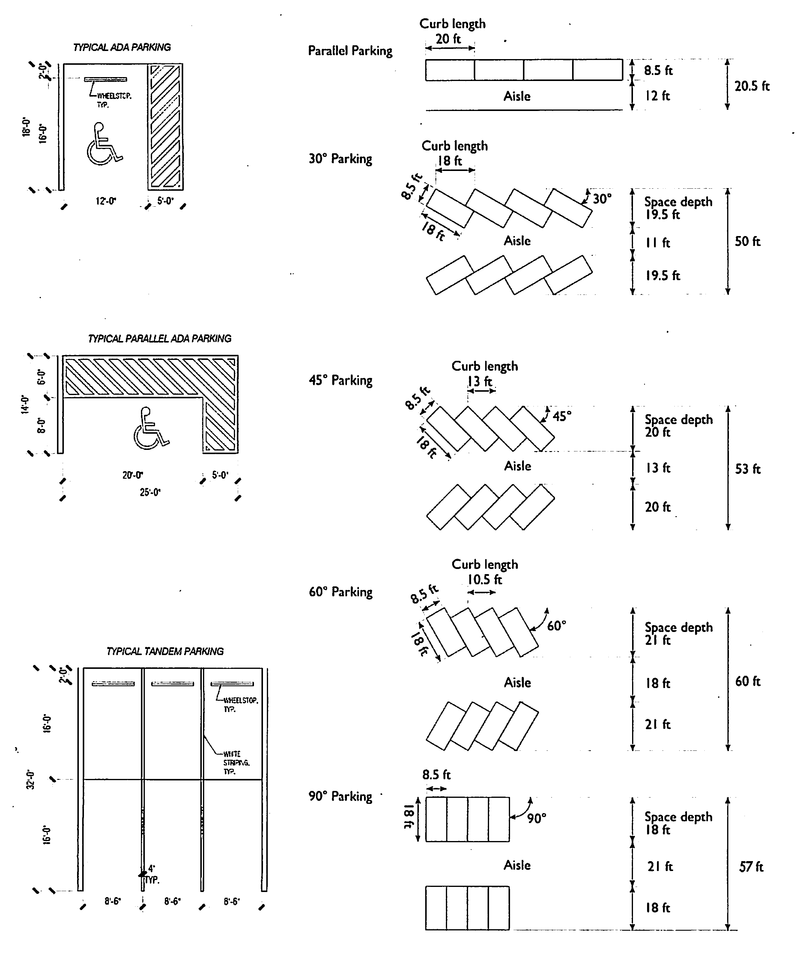
(2)
Valet/Residential Tandem Space: Shall be a minimum eight and one-half (8.5) feet in width by thirty-two (32) feet in depth.
(3)
Parking Space Lift: Shall be a minimum of eight and one-half (8.5) feet in width by eighteen (18) feet in depth with a minimum vertical clearance of ten and one-half (10.5) feet.
(4)
Handicapped Spaces: Shall be provided as required by the Florida Building Code (FBC) and in accordance with The Americans with Disabilities Act (ADA).
(B)
Vehicular Parking Space Requirements. Parking within the DS district shall reflect the district's urban scale, mixture and allocation of new and existing uses, proximity to rail-based rapid transit, pedestrian connectivity to the neighboring Hometown District, as well as the on-street and publicly accessible off-street parking resources that exist within the adjacent Hometown District.
(1)
Required Vehicular Parking Spaces. The Unadjusted Parking Requirement shall first be calculated for each use category pursuant to Section 20-12.12(C). Next, the Transit Oriented Development Reduction shall be calculated for Residential, Hotel, and Office uses as provided for in Section 20-12.12(D). Under the Standard Parking Analysis, the number of required off-street vehicular parking spaces for a development shall be equal to the sum of the Unadjusted Parking Requirement less the Transit Oriented Development Reduction.
(2)
On-Street Spaces. On-street parking spaces adjacent to a lot or parcel shall count toward the off-street parking requirements for that lot or parcel; a partial space longer than eleven (11) feet shall count as a full space.
(C)
Unadjusted Parking Requirements.
(1)
Residential Uses. The Unadjusted Parking Requirement for Residential uses within the DS district shall be as set forth below:
(a)
Dwelling, Multifamily—Efficiency/Studio or One-Bedroom: One space per unit.
(b)
Dwelling, Multi-Family—Two-Bedroom: One and one-half (1.5) spaces per unit.
(c)
Dwelling, Multi-Family—Three-Bedroom or more: Two (2) spaces per unit.
(2)
Hotel Uses. The Unadjusted Parking Requirement for Hotel uses within the DS district shall be equal to one space per four (4) hotel rooms or fraction thereof.
(3)
Theater or Cinema Uses. The Unadjusted Parking Requirement for Theater or Cinema uses within the DS district shall be one space per every six (6) theater or cinema seats.
(4)
Retail, Restaurant, and Commercial Uses. The Unadjusted Parking Requirement for Retail, Restaurant and Commercial uses within the DS district shall be equal to one space per every six hundred fifteen (615) square feet of gross floor area dedicated to Retail, Restaurant and Commercial uses.
(a)
For the calculation of parking requirements, Retail, Restaurant and Commercial uses shall be defined as all approved permitted and special uses contained in the Permitted Use Schedule in Section 20-3.3(D) under the subheadings "Public and Institutional Uses", "Business and Professional Services", "Retail and Wholesale Trade", and "Transportation, Warehousing and Communications" except for the following use types:
i.
Hotel or Motel;
ii.
Theater or Cinema; and
iii.
All use types defined as Office Uses in Section 20-12.12(C)(5)(a) below.
(5)
Office Uses. The Unadjusted Parking Requirement for Offices uses within the DS district shall be equal to one space per every five hundred (500) square feet of gross floor area dedicated to Office uses.
(a)
For the calculation of parking requirements Office uses shall be defined as the following permitted and special uses contained on the Permitted Use Schedule in Section 20-3.3(D); Accounting and Auditing Services; Acupuncturist; Advertising Agency; Architectural Services; Building Contractors Office; Chiropractic Office or Clinic; Counseling Services; Dentist Office; Employment Agency; Engineering Services; Insurance Agency; Interior Decorator, Office Only; Investigative Services: Investment and Tax Counseling; Law Office; Learning Centers or Educational Facilities; Loan or Finance Agency; Market Research Services; Massage Therapist; Medical Office; Notary Public; Office, Business, or Professional; Opticians or Optical Goods, Office only; Personal Skills Instruction Studio; Physical Therapist; Planning and Zoning Consultant; Public Relations Services; Real Estate Agency; Tutorial Services; and Travel Agency.
(D)
Transit Oriented Development Reduction. The intent and purpose of this section is to recognize the DS districts proximity to rail based rapid transit.
(1)
The Unadjusted Parking Requirement of Residential, Hotel, and Office uses, within the DS district may be reduced by twenty (20) percent for properties located within one thousand five hundred (1,500) feet of rail-based rapid transit. Distances shall be measured along the pedestrian pathway between the nearest pedestrian access point for the subject property and the transit station.
(E)
Bicycle Parking Program. The intent and purpose of this section is to encourage the use of bicycles as an alternative mode of transportation in and around the DS district. A minimum of one bicycle parking space for every ten (10) required on-site vehicular parking spaces shall be provided.
(F)
Loading and Service. Minimum loading standards shall be required as shown in Section 20-4.4(M), except as modified below.
(1)
Residential Uses. Less than five hundred (500) units, minimum loading or unloading spaces shall be provided as indicated below:
(2)
Commercial Uses. From forty thousand (40,000) square feet to seven hundred thousand (700,000) square feet of gross floor area, minimum loading or unloading spaces shall be provided as indicated below:
(3)
The off-street loading space(s) can be shared in one location with a reduction ratio of twenty (20) percent as long as a dock master is assigned to coordinate loading schedules.
(4)
In lieu of the above loading requirements, the number and size of required loading bays may be determined by an approved Shared Loading Study completed by a licensed professional engineer. The Shared Loading Study shall consider the project, its proposed mix of uses, their respective gross floor area, customary loading requirements and times for each use, shared loading facilities, enhancements to improve their accessibility and maneuvering requirements, technology to expedite loading/unloading, staging areas, dock masters, and any other factors. The Shared Loading Study shall be provided to the City as part of an Initial Site Plan application. The Shared Loading Study must be prepared using a professionally appropriate methodology, acceptable to the City Manager.
(Ord. No. 15-19-2328, § 12, 4-23-19; Ord. No. 26-23-2477, § 2(Exh. B), 11-21-23)
20-12.13 - Initial site plan review and approval process.
For purposes of this section, the term "Initial Site Plan" shall refer to the first site plan proposed for a unified property regulated by these DS district regulations. Review and approval of the Initial Site Plan shall follow the procedures and requirements identified below:
(A)
Initial Site Plan Review Procedures.
(1)
Planning and Zoning Department Review. Upon receipt of a complete initial Site Plan application, the Planning and Zoning Department shall review the application and submit its findings and recommendations to the Planning Board and City Commission together with its recommendations on the rezoning request, if any.
(2)
Planning Board. Where an Initial Site Plan is considered for lands zoned DS, the Planning Board shall review and provide comments for the City Commission's consideration regarding the relationship of the Initial Site Plan to the existing comprehensive plan and existing land development regulations.
(3)
City Commission. The City Commission shall have direct authority to review and approve the Initial Site Plan concurrently with its review and approval of a rezoning to the DS District, if applicable. The City Commission may affix conditions to the initial site plan approval. City Commission approval shall be subject to the applicant entering into a Development Agreement approved by the by the City Commission consistent with the requirements of Section 163.3227. The Development Agreement shall be executed and recorded prior to issuance of administrative site plan approvals for individual buildings of the project depicted in the Initial Site Plan, The Development Agreement shall be supported by such subsidiary covenants and agreements as the Commission deems necessary such as, without limitation, a Covenant in Lieu of Unity of Title, Easement and Operating Agreement, Maintenance Covenants. Allocation of Density and Intensity, Phasing Plan, etc.
(4)
Amendments. Amendments to the Initial Site Plan shall follow the Major Change and Minor Change processes and procedures identified in Section 20-12.14, South Miami Land Development Code.
(5)
Administrative Site Plan Approvals. Each building or phase of development shall require an administrative site plan review to ensure compliance of the building or phase with the requirements of this Land Development Code, this Article in particular, the Initial Site Plan, and the Development Agreement.
(B)
Initial Site Plan Application Requirements. The Initial Site Plan submissions shall contain, but not be limited to, the following:
(1)
Existing Site Characteristics.
(a)
Property survey by registered surveyor;
(b)
Rights-of-way and easements;
(c)
Structures and uses;
(d)
Ownership Report. A report identifying all property ownership and beneficial interest within the boundaries of the proposed project, giving evidence of unified control of the entire area. The report shall state agreement of all owners or holders of beneficial interest to proceed with the proposed development according to the terms of the proposed Site Plan; and
(e)
Utility survey.
(2)
Photographs of surrounding properties.
(3)
Zoning districts.
(4)
Existing Tree Survey.
(5)
Proposed Site Plan. It is recognized that the intent of the DS district regulations is to encourage creativity and flexibility in site design. It is further recognized that due to the scale and urban nature of development within the DS district, site planning can be a fluid exercise impacted by a host of dynamic market factors. In recognition of the foregoing, the proposed Site Plan submissions shall address the following:
(a)
Name, address and phone of owner and designer;
(b)
Property lines;
(c)
Rights-of-way and easements;
(d)
Structures and uses and locations;
(e)
Parking spaces, access-ways, driveways, sidewalks, wheel stops and curbs;
(f)
Curb cuts and median openings;
(g)
Lighting and irrigation systems;
(h)
Fences and walls;
(i)
Loading docks and service space;
(j)
Storm sewers;
(k)
Dumpster/waste disposal locations;
(l)
Radius map; and
(m)
Dimensions.
(6)
Proposed Landscape Plan. The following landscaping information shall be submitted:
(a)
Proposed trees, shrubs, grass and other vegetation including their location, height, shape, size, and type by both common and botanical classifications.
(b)
Proposed berms, water courses and topographic features, including their location, height, size and shape.
(c)
Proposed landscape maintenance plan.
(d)
Tree disposition plan.
(e)
Tree mitigation plan.
(7)
Proposed Buildings and Structures. All proposed structures, fences and walls shall be shown in elevation drawings reflecting their location, size, height and construction material and generalized floor plans.
(8)
Tabular Summary. A tabular summary/legend, providing the existing and proposed project development program, F.A.R., residential density, commercial and hotel intensity and other information as required by the Planning and Zoning Department, shall be submitted.
(9)
Conceptual Signage Palette. Prior to the first building permit, the applicant for site plan approval shall provide a Master Signage Plan in accordance with Section 20-12.15, South Miami Land Development Code.
(10)
Traffic Access and Impact Study. A study evaluating the impact of traffic from the proposed project in accordance with Section 20-4.1(D), South Miami Land Development Code.
(11)
Pedestrian and Vehicular Circulation.
(12)
Construction Phasing Plan.
(13)
Proposed Exterior Finishes and Materials.
(14)
Renderings.
(15)
Optional. Context studies.
(16)
Optional. Economic Impact Statement.
(C)
Site Plan Expiration. Final approval of an Initial Site Plan by the City Commission shall expire two (2) years after the approval is rendered if no Administrative Site Plan is approved prior to the expiration date. The expiration date shall be extended by two (2) years from the date of an approved Administrative Site Plan. An Administrative Site Plan shall expire one year after approval unless an application for a building permit or demolition permit has been filed with the City. A legal, administrative, or judicial challenge to the Site Plan shall toll all time frames until the resolution of the challenge, including appeals. Notwithstanding the foregoing, the City Manager or City Commission may extend the Initial Site Plan or any individual Administrative Site Plan approval for one additional year or for some other amount of time as appropriate under the circumstances.
(Ord. No. 15-19-2328, § 12, 4-23-19; Ord. No. 26-23-2477, § 2(Exh. B), 11-21-23)
20-12.14 - Final plans/administrative amendments.
Any project to be developed within the DS district shall be generally developed in substantial conformity with an approved Administrative Site Plan that is itself substantially in conformity with the Initial Site Plan. Amendments may be made to the Initial Site Plan through either a Major Change or a Minor Change. A Minor Change that does not (i) shift the location of a building by the lesser of ten percent (10%) (more than ten percent (10%)) or ten (10) feet in any horizontal direction; (ii) increase the height of a building in stories; (iii) reduce an approved open space feature by more than five percent (5%) of its approved area; or (iv) change the manner of operation of an approved building or feature, shall be approved by the City Manager provided the proposed modification is otherwise consistent with this article, the Land Development Code, and the Development Agreement. Any proposed amendment that does not meet the preceding criteria shall be deemed a Major Change.
(A)
Major Change.
(1)
An applicant for a Major Change shall schedule a preliminary conference with the Planning and Zoning Department. The Planning and Zoning Department shall accept the application and formulate its recommendation for consideration by the Planning Board [3] and the City Commission as applicable. The Planning and Zoning Department shall forward its recommendation to the Planning Board within sixty (60) days of its receipt of a complete application.
(2)
An application for Major Change approval shall be heard by the Planning Board at a public hearing. The Planning and Zoning Department shall post, publish, and otherwise notice the public hearing. The Planning Board shall formulate its recommendation on the Major Change to the City Commission.
(3)
An application for Major Change approval shall be heard by the City Commission at a public hearing. The Planning and Zoning Department shall post, publish, and otherwise notice the public hearing. The City Commission shall have final review and approval authority on applications for a Major Change.
(B)
Minor Change.
(1)
An applicant for a Minor Change to an approved Site Plan shall schedule a preliminary conference with the Planning and Zoning Department to explain the proposed change and to present the proposed modified Site Plan.
(2)
Upon the Planning and Zoning Department's acceptance of a complete application for a proposed Minor Change to the approved Site Plan, it shall review the proposed changes for compliance with this section. Upon confirmation of compliance, the Planning and Zoning Director (or his/her designee) shall recommend approval of the modified Site Plan to the City Manager.
(3)
Upon receipt of a recommendation of approval from the Planning and Zoning Department, the City Manager shall administratively approve the modified Site Plan. The City Manager shall then place a copy of the modified Site Plan and decision in the DS district file. Notice of the approval of the modified Site Plan by the City Manager shall be transmitted to the City Commission and posted on the City's website.
(4)
A fifteen-day waiting period shall apply for all approvals of Minor Changes.
(Ord. No. 15-19-2328, § 12, 4-23-19; Ord. No. 26-23-2477, § 2(Exh. B), 11-21-23)
20-12.15 - Master signage plan.
The intent of this section is to allow for the creation of a specialized and comprehensive signage plan for the DS district that reflects the districts unique character, size, urban scale, mixture of uses, and pedestrian connectivity. It is recognized that signs form an integral part of architectural building and site design and require equal attention in their design, placement and construction. The Master Signage Plan approved in accordance with this section shall integrate with the overall site design, contribute to the unique character of the DS district, and maintain a harmonious and aesthetically pleasing visual environment that integrates with the character of the surrounding community. This section shall be the sole and exclusive series of regulations governing signage within the DS district. The DS district is not required to meet any other provision of Section 20-4.3, Sign Regulation, or any other signage provisions contained in the South Miami Land Development Code. Once approved, the Master Signage Plan shall govern the placement and operation of signage within the DS district.
(A)
Master Signage Plan Requirements. The Master Signage Plan shall include both a graphic plan and text to describe the intended design, erection and maintenance of signs within the DS district that face the public right-of-way. In recognition of the foregoing, the Master Signage Plan submission shall provide signage guidelines that address:
(1)
Size and dimensional standards;
(2)
Number, combination, location and orientation standards;
(3)
Lighting and illumination standards;
(4)
Material quality standards;
(5)
Optional. Standards for signs within private property, including those facing internal driveways and plazas.
(B)
Permitted Signage. All signage meeting the guidelines of an approved Master Signage Plan shall be permitted within the DS district. By way of illustration, but not limitation, the following types of signage are permissible within the DS district: Wall signs (flat mounted, mounted letter, projecting blade signs, banners, flags), canopy signs (flat roof, awning), window and door signs, entryway embeds, menu boards (sidewalk signs), tenant address signs, anchor signs, monument signs, major identification signs, temporary signs, and permanent wayfinding, including retail center and parking signage.
(C)
Master Signage Plan Review Procedures.
(1)
The applicant for approval of a Master Signage Plan or amendment to an approved Master Signage Plan, shall schedule a preliminary conference with the Planning and Zoning Department to review the Master Signage Plan. The Planning and Zoning Department shall accept the Master Signage Plan and formulate its recommendation for consideration by the Planning Board and the City Commission as applicable. The Planning and Zoning Department shall forward its recommendation to the Planning Board within sixty (60) days of its receipt of a complete Master Signage Plan.
(2)
Master Signage Plan approval shall be heard by the Planning Board at a public hearing. The Planning and Zoning Department shall post, publish, and otherwise notice the public hearing. The Planning Board shall formulate its recommendation on the Master Signage Plan to the City Commission.
(3)
Master Signage Plan approval shall be heard by the City Commission at a public hearing. The Planning and Zoning Department shall post, publish, and otherwise notice the public hearing. The City Commission shall have final review and approval authority on the Master Signage Plan.
(D)
Sign Permit Application and Review Requirements.
(1)
Sign Permit Application Requirements. Permit applications for all signage fronting a public right-of-way shall contain the following:
(a)
Survey or an accurate site plan of the lot depicting the location of all public and private streets, existing signage locations, buildings, parking lots, driveways, and landscaped areas;
(b)
An accurate indication on the site plan of the proposed location of each proposed sign;
(c)
Properly dimensioned and scaled drawings and descriptions showing sign proportions, location of each sign on the building, color scheme, lettering or graphic style, material, lighting, and other information which depicts the proposed sign;
(d)
If needed, a completed building permit application and electrical permit application; and
(e)
Building permit and electrical drawings as required by the Florida Building Code.
(2)
Permit Application Review Requirements.
(a)
Conforming Signage. Signs in substantial conformance with the guidelines of a Master Signage Plan approved by the City Commission shall be administratively approved by the Planning Director within thirty (30) days following the submission of a complete sign permit application.
(b)
Non-Conforming Signage. Signs not in substantial conformance with the guidelines of a Master Signage Plan approved by the City Commission shall be reviewed and approved as follows:
i.
The applicant shall schedule a preliminary conference with the Planning and Zoning Department to review the sign permit application. The Planning and Zoning Department shall accept the sign permit application and formulate its recommendation for consideration by the Planning Board and the City Commission as applicable. The Planning and Zoning Department shall forward its recommendation to the Planning Board within thirty (30) days of its receipt of a complete sign permit application.
ii.
The sign permit application for a non-conforming sign shall be heard by the Planning Board at a public hearing. The Planning and Zoning Department shall post, publish, and otherwise notice the public hearing. The Planning Board shall formulate its recommendation on the sign permit application to the City Commission.
iii.
Approval of the non-conforming sign permit application shall be heard by the City Commission at a public hearing. The Planning and Zoning Department shall post, publish, and otherwise notice the public hearing. The City Commission shall have final review and approval authority on the sign permit application for a non-conforming sign.
(E)
Exceptions from the Sign Permit Application and Review Requirements. The following signage may be erected without a permit or review by the City but shall comply with all structural and safety requirements of the Florida Building Code; however, all electrical installations and modifications may only be initiated upon issuance of a valid electrical permit.
(1)
Signage erected on private property, including those facing internal driveways and plazas, which do not face and are not substantially viewable from a public right-of-way or publicly accessible open space (including rights-of-way and plazas); and
(2)
Signage exempt pursuant to Section 20-4.3(C), South Miami Land Development Code.
(F)
Prohibited Signs and Sign Characteristics. No sign shall be constructed, erected, used, operated or maintained which:
(1)
Blinks, flashes, or displays intermittent lights similar to or resembling flashing lights customarily associated with danger or customarily used by police, fire or other emergency vehicles.
(2)
Rotates, except for traditional rotating barber poles.
(3)
Uses the words "stop" or "danger" or implies the need or requirement for stopping; or which is a copy or imitation of an official sign. Prohibition of the words "stop" or "danger" does not apply in instances when such words are used in descriptive lines of advertising, so long as they are not used to copy or imply any official traffic warning.
(4)
Creates a blended background of colored lights with traffic signal lights which might confuse motorists when viewed from a distance of up to three hundred (300) feet.
(5)
Projects over any public street, sidewalk or alley in a single-family residential zoning district.
(6)
Is a snipe sign on either public or private property.
(7)
Is a balloon or blimp.
(8)
Is located on the roof, except for signs located on mansard or shed roofs where such signs are permitted.
(9)
Advertises products, services or establishments not available on premises.
(10)
Is located on a back lit and translucent awning.
(11)
Is a hanging sign not providing adequate clearance above public walkways as required by the Land Development Code and the Florida Building Code.
(12)
Blocks egress, ingress, light or ventilation to a site.
(13)
Conveys the impression that property or structures can be used for purposes not permitted by this Code or other regulations.
(14)
Is portable or movable, including those signs that are tied down with metal straps, chaining or otherwise temporarily anchored to an existing structure or other similar method of anchoring, excluding permitted portable outdoor dining signs.
(15)
Is a sign painted or affixed in any manner to any vehicle, trailer or truck or similar transportable device and which is used to advertise a place of business or activity as viewed from a public right-of-way, except for:
(a)
Commercial vehicle signs when such vehicles are operational and used daily for delivery or service purposes such as food service, and not used or intended for use as portable signs;
(b)
Buses, taxis or similar common carrier vehicles which are licensed or certified by Miami-Dade County or other governmental agencies; and
(c)
Vehicles converted to permanent kiosks for retail or food and/or beverage sales.
(Ord. No. 15-19-2328, § 12, 4-23-19; Ord. No. 26-23-2477, § 2(Exh. B), 11-21-23)