
Spalding County Unincorporated
City Zoning Code
City Zoning Code
ARTICLE 22D
NORTH EXPRESSWAY IMPROVEMENT DISTRICT OVERLAY NEID
Sec. 2201D.- Purpose.
The North Expressway Improvement District (NEID) is an overlay zone which governs the development of property located along the U.S. Highway 19/41 corridor from the Henry-Spalding County line to the north boundary of the city limits of the City of Griffin, Georgia. This zone applies additional development standards to the area contained within the overlay zone. The purpose of this overlay zone is to develop standards and criteria for the orderly development of property located within its boundaries in a comprehensive, planned manner creating a quality business and residential development environment, to prevent piece-meal development along the U.S. Highway 19/41 and to improve the aesthetic appeal and quality of development located therein. The NEID overlay zone is designed to create an attractive and functional entryway along U.S. Highway 19/41 through northern Spalding County to the City of Griffin.
The area within the NEID overlay zone has developed without comprehensive planning for more than fifty (50) years. Its current appearance evidences the negative impacts of piece meal, uncontrolled and unattractive development. The presence of this development has been a detriment to new, better quality of developments along U.S. Highway 19/41. The development standards required herein protect the health, safety and general welfare of the public to achieve the purposes and goals stated herein. To promote the improvement of the quality of development along the U.S. Highway 19/41 corridor, strict adherence to aesthetic development criteria including buffers, greenbelts, landscaping and signage restrictions shall be required.
It is the express legislative intent of the NEID overlay that further strip or single lot commercial development will undermine the objectives sought through the adoption and implementation of this ordinance [article]. The NEID overlay is intended to improve the quality of development along U.S. Highway 19/41 by enhancing the economic and aesthetic appeal of the U.S. Highway 19/41 corridor and promoting the orderly development of properties therein. The NEID overlay is also intended to reduce harmful effects resulting from heat, noise, traffic congestion and glare. The development requirements within the NEID overlay are intended to reduce traffic congestion and visual clutter often associated with development along a major thoroughfare, using required buffer and landscaped areas, limitations on ingress and egress to individual parcels, restrictions on lighting, outdoor storage and impervious areas.
(Res. No. 2022-012, § 1, 8-15-22)
Sec. 2202D. - Identification of property located within the NEID overlay zone.
A.
NEID shall include and apply to all real property in Spalding County located and lying within the following boundaries, as designated on the North Expressway Improvement District Overlay Map which is adopted herein and made a part hereof as if fully set forth.
B.
No tract shall be divided between NEID and another zoning district.
(Res. No. 2022-012, § 1, 8-15-22)
Sec. 2203D. - Development compliant with the Spalding County Future Land Use Map (FLUM).
Any development proposed in the NEID overlay must be compliant with the Spalding County Future Land Use Map (FLUM).
(Res. No. 2022-012, § 1, 8-15-22)
Sec. 2204D. - Definitions.
A.
Mixed-use development means a style of development that blends residential, commercial, cultural, institutional, or entertainment uses into one space, where those functions are to some degree physically and functionally integrated, and that provides pedestrian connections. Mixed-use development may be applied to a single building, a block or neighborhood. These projects may be completed by a private developer, a governmental agency, a quasi-governmental agency or a combination thereof. A mixed-use development may be new construction, reuse of an existing building or brownfield site, or a combination thereof.
B.
Planned development means a development for which a master development plan must be approved prior to the issuance of any development permit. Each development permit issued shall be conditioned upon compliance with the required master development plan. If rezoning is required for any development, whether single-family residential, condominium, commercial, or mixed use, rezoning approval shall be conditioned upon compliance with the required master development plan. The master development plan shall identify the tract of land for the proposed development, the nature of the proposed development, public streets, common areas and open space, aesthetic amenities, landscaping, public facilities and restrictive covenants relating to the development.
(Res. No. 2022-012, § 1, 8-15-22)
Sec. 2205D. - Permitted uses.
A.
The following principal uses are permitted in NEID:
1.
Planned single-family residential development meeting the criteria of this article, which development may include any and all principal uses contained in article 7 (R-1 single-family residential low-density district), section 703(A); article 7A (R-1A single-family residential district) section 703A(A); article 8 (R-2 single-family district), section 803(A) of the Zoning Ordinance of Spalding County;
2.
Planned residential development meeting the criteria of this article which development is limited to that principal use contained in article 11A (R-6 planned residential community district), section 1103A(A)(1) of the Zoning Ordinance of Spalding County.
3.
Planned commercial development meeting the criteria of this article, which development may include any and all principal uses contained in article 12 (C-1 highway commercial district), section 1203(A) and article 13 (C-1A neighborhood commercial district), section 1303(A). of the Zoning Ordinance of Spalding County.
4.
Planned mixed use development meeting the criteria of this article, which development may include any and all principal uses contained in subsections (A)(1)—(3) of this section and any and all principal uses contained in article 19 (O-I office and institutional district), section 1903(A), excluding family personal care home (section 1903(A)(6)), personal care home, commercial district (section 1903(A)(7)), group home transitional (section 1903)(A)(8)) and cemetery (section 1903(A)(17)).
B.
The following principal uses are permitted as special exceptions in NEID:
1.
For planned single-family residential developments, any principal uses permitted as a special exception in article 7 (R-1 single-family residential low-density district), section 703(B); article 7A (R-1A single-family residential district) section 703A(B); article 8 (R-2 single-family district), section 803(B); and article 11A (R-6 planned residential community district), section 1103A(B) of the Zoning Ordinance of Spalding County.
2.
For planned commercial developments, any principal use permitted as a special exception in article 12 (C-1 highway commercial), section 1203(B)(1) and (3) and Article 13 (C-1A neighborhood commercial), section 1303(B)(1), (2), (4), (5) and (6) and any other commercial use which constitutes an extraordinary use in section 2205D(D) and requires storage, continuous, unenclosed outside.
3.
For planned commercial developments, a principal use permitted in article 14 (C-1B heavy commercial), section 1403(A)(1), (2), (6), (7), (12), (13), (14) or (18) and any other commercial use which constitutes an extraordinary use in section 2205D(D) and requires storage, continuous, unenclosed outside.
4.
For planned mixed use developments, any principal use permitted as a special exception in subsections (B)(1)—(3) of this section and any and all principal uses permitted as a special exception in article 19 (O-I office and institutional district), section 1903(B), excluding golf course (section 1903(B)(4)), airport (section 1903(B)(6)).
C.
The following accessory uses are permitted in NEID:
1.
For planned single-family residential developments, any accessory use permitted in article 7 (R-1 single-family residential low-density district) section 703(C); article 7A (R-1A single-family residential district) section 703A(C); article 8 (R-2 single-family district), section 803(C); and article 11A (R-6 planned residential community district), section 1103A(C) of the Zoning Ordinance of Spalding County.
2.
For planned residential development, any accessory use permitted in article 11A (R-6 planned residential community district), section 1103A(C) of the Zoning Ordinance of Spalding County.
3.
For planned commercial developments, any accessory use permitted in article 12 (C-1 highway commercial), section 1203(C)(1), (3) and article 13 (C-1A neighborhood commercial), section 1303(C).
D.
Extraordinary development: A proposed development which does not fall within the permitted principal uses in subsection (A) or permitted special exception uses in subsection (B) may be considered for development within the NEID overlay, if it meets the following criteria:
1.
The proposed development provides unique and extraordinary benefits to Spalding County;
2.
The proposed development is consistent with the purpose of this ordinance, stated in section 2201D;
3.
The proposed development does not create an undue burden on or constitute a nuisance to the surrounding properties and area;
4.
The proposed development is consistent with the Spalding County Comprehensive Land Use Plan;
5.
Approval of any development pursuant to this subsection must comply with the procedures required in section 2206D; and
6.
Any development approved pursuant to this subsection must comply with all development requirements set forth in section 2208D.
E.
Nonconforming uses in NEID: Upon adoption of the NEID overlay, there exist lots, structures and uses which were lawful prior to adoption of the NEID overlay, but which are afterward prohibited by the requirements of the NEID overlay. Nonconforming lots, structures and uses may continue after the adoption of the NEID overlay and shall be governed by section 403.
F.
Single-family detached dwellings meeting the minimum heated floor area of the underlying zoning district on lots of record as they existed at the time of the adoption of this ordinance [article]. Nothing in this section shall prevent the expansion of existing single-family, site-built homes provided that the minimum setback, buffer and height requirements of the underlying zoning district are met.
G.
Conflict with zoning district development criteria. To the extent the provisions contained in this article may conflict with the development standards and criteria contained in any other zoning district, the most restrictive provisions shall control.
(Res. No. 2022-012, § 1, 8-15-22)
Sec. 2206D. - Rezoning procedures within NEID and the relationship between NEID and other zoning districts.
A.
Districts to which property within NEID may be rezoned. Any person desiring to develop property within the NEID overlay which requires rezoning shall file with the zoning administrator an application to rezone the subject property for a principal use or principal use special exception identified in section 2205D(A), (B). The rezoning application may only request rezoning to a district for which a principal use or principal use special exception is allowed in the NEID overlay in section 2205D. The application must state that the property lies within the NEID overlay. In the event the application requests rezoning for a use identified as a principal use special exception, as set forth in section 2205D(B), the application must note that special exception approval shall be required by the Spalding County Board of Zoning Appeals.
B.
Preapplication conference. Prior to filing an application for rezoning of property within the NEID overlay, the applicant shall confer with the zoning administrator and the planning commission chairman to review the general character of the planned development (based on a tentative land use sketch, if available) and to obtain information on development standards and ordinances affecting the proposed planned development. In the event the application requests rezoning for a use identified as a principal use special exception, as set forth in section 2205D(B), the chairmen of the board of appeals and planning commission shall also participate in the conference.
C.
Master development plan requirement. Any application for rezoning within the NEID overlay shall be accompanied with a master development plan which complies with the requirements of section 416. The master development plan shall also show compliance with the development standards contained within the applicable zoning district for which zoning is sought in the NEID overlay. In addition, thereto, the master development plan shall include:
1.
The location and use of existing and proposed public, semi-public and community facilities such as schools, parks and open areas on the site, including areas proposed to be dedicated or reserved for community or public use.
2.
Perspective drawings of representative building types, provided this is not required for single-family detached dwellings.
3.
An off-street parking and loading plan.
4.
A written plan of intent, which must include the following:
a.
A statement of present ownership of all land within the proposed development and a financial plan from the developer that indicates the ability to develop and complete the proposed development in accordance with the plan submitted.
b.
An explanation of the character of the development, including a summary of acres, number and types of dwellings, commercial or industrial units, and gross density by type of land use.
c.
A development and construction time schedule showing major activities of proposed development.
d.
If the planned development will be in phases, a general statement of the proposed development schedule by phase.
e.
Agreements, provisions and covenants which govern the use, maintenance and protection of the development and any common or open areas.
D.
Rezoning conditioned on the master development plan. All applications for rezoning within the NEID overlay shall be conditioned upon the master development plan submitted with the application. If approval of the application for rezoning requires modifications to the master development plan, the applicant must file the following with the zoning administrator:
1.
Written notice of consent to the modifications.
2.
A site plan properly revised to include the modifications.
3.
The official zoning map of Spalding County shall not be changed until such time as the provisions of this section have been fulfilled.
E.
Rezoning for principal use, special exception conditioned on site plan. All applications for rezoning within the NEID overlay for a principal use, special exception identified in section 2204D(B) shall be conditioned upon the master development plan submitted with the application. If approval of the application for rezoning to a principal use, special exception requires modifications to the master development plan, the applicant must file the following with the zoning administrator:
1.
Written notice of consent to the modifications.
2.
A new master development plan properly revised to include the modifications.
3.
The official zoning map of Spalding County shall not be changed until such time as the provisions of this section have been fulfilled.
F.
Revision of development plan after rezoning.
1.
Minor extensions, alterations or modifications of existing buildings or structures may be permitted after review and approval by the planning commission, provided that such changes must be consistent with the purposes and intent of the master development plan. For purposes of this section, a minor extension, alteration or modification of the master development plan shall be any change which does not change the uses proposed for the development, the density of the land use pattern, the location or dimension of streets, the change in shape of the size or architecture of any structure located or to be located within the development.
2.
Any major or substantial change in the approved master development plan must be reviewed and approved by the board of commissioners after receipt of recommendations from the planning commission in accordance with the procedures of section 414. A request for revision to the master development plan must be supported by a written statement indicating the nature of the revision and the reason it is considered necessary or desirable to revise the development. For purposes of this section, a major or substantial change shall be any change in the development plan which is not listed in section 2206D(F)(1).
(Res. No. 2022-012, § 1, 8-15-22)
Sec. 2207D. - Procedures for development of property within NEID when rezoning is not required.
A.
Proposed development on any property located in the NEID overlay for which rezoning is not required must comply with the following requirements:
1.
Prior to filing a permit for development, the applicant shall confer with the zoning administrator and the chairmen of the board of appeals and planning commission as required by section 2206D(B);
2.
The applicant must submit a master development plan that meets the requirements of section 2206D(C);
3.
A permit for development will be issued after the master development plan has been reviewed by the planning commission and approved by the board of commissioners in the same manner as would be required if the proposed development required rezoning; and
4.
Any permit for development will be conditioned upon the approved master development plan.
(Res. No. 2022-012, § 1, 8-15-22)
Sec. 2208D. - General development standards in NEID.
The following standards shall govern development in the NEID overlay and shall apply to any residential or commercial planned development:
A.
Intersections with U.S. Highway 19/41. It is preferable for new developments with frontage on U.S. Highway 19/41 to be accessed by means of development of new streets which intersect or otherwise connect through an existing pattern or future pattern of road development with the roads designated above.
B.
Landscaped area, U.S. Highway 19/41 frontage.
1.
Landscaped buffer to right-of-way. Any new development in the NEID overlay shall provide for a fifty (50) feet landscaped area from the boundary of the right-of-way of U.S. Highway 19/41 further defined herein as street planting;
2.
Landscaping and screening requirements. Development within the NEID overlay shall also meet the following landscaping requirements in addition to any requirements of appendix K, landscaping and tree preservation ordinance for multi-family, commercial, institutional and industrial developments:
a.
Landscape plan submission. A landscape plan shall be submitted and approved as part of the predevelopment master development plan required by section 2206D(C) or section 2207D(A) which shall show lot or parcel dimensions, building dimensions, tree/landscape preservation areas, and the location and size of all tree and plant materials.
b.
A landscape plan must be prepared and stamped by a registered landscape architect licensed to practice in the State of Georgia and should follow these general principles:
i.
Preservation of as much existing plant material and land formation as possible; clear-cutting and mass grading are not favored practices;
ii.
Emphasizing native plant species and efficient use of water;
iii.
Consideration of prevailing building and geographic context (color, material, mass, function, topography);
iv.
Role of the landscape as a tactile part of the development's character of a place;
v.
Beautification of the as built environment;
vi.
Quality of design and construction pursuant to best management practices.
c.
Street planting area:
i.
The unpaved buffer to right-of-way in section 2208D(B)(1) shall be a minimum of twenty (20) feet in depth, measured from the edge of the public right-of-way toward the center of the lot or parcel;
ii.
Along the total length of the development's street frontage exclusive of points of ingress and/or egress, a canopy tree shall be planted at intervals of forty (40) feet with at least one (1) understory planted in between;
iii.
A canopy tree shall be three (3) inches caliper and not less than twelve (12) feet in height at planting;
iv.
An understory trees shall be two (2) inches caliper and not less than six (6) feet in height at planting;
v.
The remaining area shall be landscaped with shrubs and ground cover.
vi.
A monument sign may be placed within the street planting area at least ten (10) horizontal feet from all property lines, but it must not obstruct sight distance at an intersection or along a public right-of-way.
d.
Perimeter planting area:
i.
the unpaved swath of land located between the side and/or rear property lines of a parcel or lot and designed for the preservation and placement of plant materials, a minimum of ten (10) feet in depth measured from the edge of the property line toward the center of the lot or parcel.
ii.
Within the required perimeter planting, area canopy trees shall be planted at intervals of seventy (70) feet with two (2) understory trees planted in between. A canopy trees shall be three (3) inches caliper and not less than twelve (12) feet in height at planting. An understory tree shall be two (2) inches caliper and not less than six (6) feet in height at planting. The remaining area shall be landscaped with shrubs and ground cover.
e.
Interior planting: Landscaped islands shall terminate each row of parking spaces. Terminal islands shall be at least ten (10) feet wide and eighteen (18) feet long and include one (1) canopy tree which shall be three (3) inches caliper and not less than eight (8) feet tall at planting. The remaining area of terminal islands shall be landscaped with shrubs and ground cover one (1) foot high at planting.
f.
Interior islands: Landscaped interior island shall be provided within each row of parking spaces. One (1) interior island shall be provided for every ten (10) parking spaces or fraction thereof. Each interior island shall be at least ten (10) feet wide and eighteen (18) feet long and shall include one (1) canopy tree which shall be three (3) inches caliper and not less than eight (8) feet tall at planting. The remaining area of interior islands shall be landscaped with shrubs and ground cover one (1) foot in height at planting.
g.
The perimeter of terminal and interior islands shall be surrounded with a continuous raised curb. Island width and length shall be measured from the inside edge of the curb. Trees planted in islands must be allowed to grow to maturity and full canopy and shall not be pruned beyond requirements of basic maintenance.
C.
Landscaped area buffer, rear. For planned residential, commercial and industrial developments, a twenty-five-foot landscaped buffer, in addition to any required landscape area. No buffer shall be required for planned single-family residential developments. No screening, as required in section 407 shall be required in the NEID overlay.
D.
Compliance with zoning district development standards. Any planned development must comply with the development standards of the zoning district for which a principal use, principal use special exception or accessory use is allowed in the NEID overlay. In the event a development standard of the zoning district conflicts with those required by the NEID overlay, the most restrictive requirement shall control.
E.
Compliance with the Spalding County subdivision ordinance. Any planned residential development must comply with the development standards of the Spalding County subdivision ordinance, appendix A. In the event a development standard required by appendix A conflicts with those required by the NEID overlay, the most restrictive requirement shall control.
F.
Compliance with the Spalding County commercial development standards ordinance. Any planned commercial development must comply with the development standards of the Spalding County Commercial Development Ordinance, appendix J. In the event a development standard required by appendix J conflicts with those required by the NEID overlay, the most restrictive requirement shall control.
G.
Off-premises and general advertising signage. Off-premises and general advertising signage shall be prohibited in NEID.
H.
Traffic management plan. A traffic management plan shall be submitted, in the discretion of the zoning administrator, based on the size and intensity of the development and traffic conditions. The traffic management plan must identify any traffic problem(s) that will be generated by the development and provide reasonable solutions thereto.
I.
Development of future roads. Each master development plan submitted for any planned development shall provide (where possible) for dedication (present or future) for the construction of public roads by which property located interior to the planned development may be accessed. The approval of any site plan shall be conditioned upon the agreement of a developer of any planned development to participate in the costs of construction of such proposed public road.
J.
Outdoor lighting. All outdoor lights or light arrangements used for advertising, security or night operations must be directed away from adjoining or nearby residential lot and public roadways.
K.
Decorative fences and walls.
1.
All required opaque fences or walls shall be constructed of one (1) or a combination of the following: decorative wood, stone, stucco on block, decorative block, or brick. These fences or walls shall not exceed six (6) feet in height;
2.
Decorative wrought iron fencing may be used for architectural and security purposes only;
3.
Chain link, unfinished concrete or cinder block, plastic or fiberglass, barbed or razor wire, and plywood fences, or like materials are prohibited. Paint shall not be considered a finish material.
L.
Detention facility screening.
1.
All detention facilities shall be completely screened from all adjoining lots and roadways with shrubs at three (3) feet in height, when installed, planted at intervals of four (4) feet around the perimeter of the pond.
2.
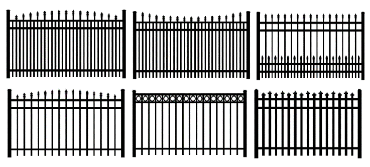
All security fencing and required detention pond fencing must be constructed of decorative metal and must be colored black or have a natural earth tone. Security fencing and required detention pond fencing in rear yards may utilize black vinyl coated chain link fencing. The following are acceptable security fence styles:
(Res. No. 2022-012, § 1, 8-15-22)
Sec. 2209D. - Planned single-family residential development standards in NEID.
The following standards shall govern single-family residential development in the NEID overlay:
A.
Minimum planned residential development size. Twenty (20) acres.
B.
Common areas. Each planned single-family residential development in NEID shall set aside and develop ten (10) percent of the total acreage of the development for recreation, common areas, and green space.
C.
Sidewalks. For planned residential developments in which the majority of lots do not exceed one (1) acre in size, sidewalks shall be required on all interior streets within the planned development.
D.
Minimum front yard depth. One hundred (100) feet.
E.
Cul-de-sac restriction. Development of planned single-family residential development on cul-de-sac streets is discouraged in NEID. Streets within a planned single-family residential development should interconnect within a modified grid system. No cul-de-sac may exceed three hundred (300) linear feet.
F.
Curb and gutter. All streets within a planned single-family residential development shall have curb and gutter.
G.
Utilities. No overhead utility lines shall be permitted, except on a temporary basis as may be required for construction. Any such temporary line must be immediately removed upon completion of construction.
H.
Topography preservation. Development shall be compatible with topography of the land and preserve any unusual topographic or natural features.
I.
Signage. Signage within a planned single-family residential development shall be limited to one (1) entry monument sign not greater than six (6) feet in height and not exceeding forty-eight (48) square feet.
J.
Driveways. No driveway for a residential dwelling shall be allowed on U.S. Highway 19/41.
K.
Development incentive standards. In the event the development incorporates and includes at least six (6) of the development incentives enumerated in Section 2210D, the following developments standards may be applied:
1.
Minimum lot area: Eleven thousand (11,000) square feet, if public water and public sewer are available.
2.
Minimum lot width: Each lot may be reduced to a minimum width of one hundred (100) feet, if public water is available; or to seventy-five (75) feet, if public water and sewer are available.
3.
Minimum frontage width: Same as minimum lot width.
4.
Minimum front yard depth: Seventy-five (75) feet, if public water is available; or fifty (50) feet if public water and sewer are available.
5.
Cul-de-sac restriction: No cul-de-sac may exceed five hundred (500) linear feet.
(Res. No. 2022-012, § 1, 8-15-22)
Sec. 2210D. - Planned residential development standards in NEID.
The following standards shall govern planned residential development in the NEID overlay:
A.
Each planned residential development must comply with the design standards for all R-6 developments in section 1105A.
B.
Each planned residential development must comply with the development standards for R-6 districts in section 1106A.
C.
Amenities, lighting and other design criteria: The development shall be constructed with the following:
1.
A clubhouse which shall include a fitness center and conference/meeting room;
2.
A pool and tennis court area, which shall be enclosed by decorative fencing;
3.
A playground area which complies with the construction and design criteria set forth in Spalding County's Design Guideline for Spalding County Parks, Chapter 3, Playground Equipment, Intermediate Play Structure;
4.
Parking garages to provide covered parking for at least one (1) vehicle per residential dwelling unit;
5.
A landscaped entry boulevard with decorative signage;
6.
Sidewalks interconnecting between residential buildings, the clubhouse and each amenity or recreational area; and
7.
Decorative exterior lighting fixtures throughout (See: Outdoor lighting. Georgiapower.com/multiDecorativeFixtures);
D.
Dwellings: Developments shall be primarily limited to one- and two-bedroom dwelling units, provided that a maximum of ten (10) percent of total number of dwelling units may be three-bedroom dwelling units;
E.
Public water and sewer required: Each development must be served by public water and sewer.
(Res. No. 2022-012, § 1, 8-15-22)
Sec. 2211D. - Planned commercial development standards in NEID.
The following standards shall govern planned commercial development in the NEID overlay:
A.
Minimum planned commercial development size. As set by the Spalding County Health Department.
B.
Ownership control. All land in a planned commercial development shall be owned by or under land lease by one (1) individual, corporation or other legal entity. Properties may be sold after a final plat has been recorded with the properties subject to private deed covenants that assure the continuance of the planned development as originally approved and developed.
C.
Topography preservation. Development shall be compatible with topography of the land and preserve any unusual topographic or natural features.
D.
Utilities and accessibility. Water, sewage, highway shall be adequate for the proposed development. No overhead utility lines shall be permitted, except on a temporary basis as may be required for construction. Any such temporary line must be immediately removed upon completion of construction.
E.
Ingress and egress. Access shall be controlled by limiting the number of curb cuts, which shall not exceed two (2) for the first one hundred fifty (150) feet of frontage, with twenty (20) feet maximum curb cut. The number and width of such cuts may be increased by one (1) and ten (10) feet, respectively, for each additional one hundred fifty (150) feet of frontage.
F.
Parking and development circulation.
1.
No automobile parking or service areas will be permitted within the required front yard setback or within thirty (30) feet of the property line of an adjoining residential zoning lot;
2.
Parking and service areas must be separated from adjoining residential lots by a suitable planting screen, fence, or wall at least six (6) feet in height above finished grade, which must provide for a reasonable visual separation between the properties;
3.
Vehicle parking shall be in paved, striped parking areas, with no vehicle parking allowed in landscaped areas, graveled areas or rights-of-way;
4.
All delivery vehicle parking (including tractor trailers) shall be parked in the rear of any building and not visible from the road;
5.
Inter-parcel connectivity is required and shall be provided in the site plan; and
6.
Acceleration and deceleration lanes shall be as required by Georgia DOT regulations.
G.
Loudspeaker systems. No outside loudspeaker systems shall be utilized.
H.
Lighting. All lights or lighting shall:
1.
Be pedestrian scale fixtures, except the primary parking lot lighting may have a maximum height of thirty-two (32) feet to provide efficient lighting design;
2.
Preapproved as part of the site plan which must include a photometric plan which demonstrates that on-site lighting does not leave the premises;
3.
Be full cut-off, downward type lighting, including fuel canopies, signage, parking lot lighting and building mounted lighting;
4.
Shall not blink, flash, oscillate or be unusually bright.
I.
Drainage, soil erosion and sedimentation. A grading plan, prepared by a professional engineer familiar with surface water management, drawn in accordance with the Spalding County soil erosion and sedimentation control ordinance shall be required before any land disturbance permit is granted for the project.
J.
Landscaping. A landscape plan is required for the site and shall be fully implemented prior to issuance of a certificate of occupancy. If not feasible to complete landscaping due to weather conditions or other extenuating circumstances, the owner shall post a performance bond or other acceptable security in an amount equal to one hundred ten (110) percent of the cost of the landscaping improvements which remain incomplete. The owner must complete the required improvements in a satisfactory manner within six (6) months.
K.
Maintenance. The owner shall provide adequate maintenance of the landscaping improvements for a minimum of two (2) years from implementation. The zoning administrator shall inspect the development at least once during this period to ensure that the approved plan has been fully implemented and maintained. If the landscaping has died within the two-year period, such landscaping shall be replaced by the owner.
L.
General deed covenants. The planned commercial development shall be included within private deed covenants running with the land to assure the continuance of the planned commercial development in accordance with approved plans and development.
M.
Exterior walls. The exterior walls of all buildings shall be constructed with materials, other than plain cement block, the exterior of which gives the appearance of masonry.
N.
Loading docks. All loading docks and parking areas for trucks must be located or screened so as to be concealed from view of neighboring street and property. No loading dock shall be located in the front of any facility or building.
O.
Outside storage. Outside storage will be permitted only for those uses identified in subsection 2205D(B)(2), (3) only at the rear and sides of the buildings and pursuant to the following additional requirements:
1.
Any continuous, unenclosed outside storage of finished products shall be located beyond a sixty (60) feet landscaped area from the boundary of the right-of-way of U.S. Highway 19/41 further defined herein as street planting required in section 2208D(B)(1).
2.
Any continuous, unenclosed outside storage of unfinished products or raw material must be screened from the view of adjacent property and roadways by masonry walls or other permanent screening, such screening shall be at least two (2) feet higher than the height of the materials being screened and no less than six (6) feet nor more than ten (10) feet tall.
P.
Service areas. All service areas, including dumpsters or other refuse disposal equipment, shall be fully screened by a masonry wall that matches the exterior finish or façade of the building and provide for an automatic closure(s) on the gate(s).
Q.
Mechanical equipment. All mechanical equipment shall be concealed by screening in a manner compatible with the architectural character of the building or incorporating it into the building(s) roof.
R.
Parking. All parking areas shall be covered with plant mix asphalt or concrete surface and all driveways shall be similarly paved.
S.
Tree removal. A minimum of twenty (20) percent of all existing trees with a diameter exceeding ten (10) inches shall be retained. This requirement is in addition to the requirements of any required landscape area required in sections 2207D(B), (C).
T.
Exterior containers. All mechanical equipment servicing buildings, aboveground tanks and other similar items, storage facilities, garbage cans, trash containers, or pelletized trash or recycling materials shall be located or screened so as to be concealed from the view of neighboring streets and property.
U.
Signage. Signage within any planned commercial development shall be limited, as follows:
1.
Individual tract or outparcel: One (1) monument sign not exceeding eight (8) feet in height or sixty-four (64) square feet.
2.
Planned centers: One (1) monument sign per road frontage not exceeding eight (8) feet in height or eighty (80) square feet.
V.
Wall signs. Individual businesses located within a planned center shall be allowed one (1) nonilluminated wall sign not exceeding four (4) feet in height or twenty (20) square feet.
W.
Architectural consistency. Development shall use consistent architectural themes throughout. An individual business that requires a specific architectural design or style may be excluded from this requirement, provided the development maintains consistency in overall project design and appearance. Exterior wall finish materials shall be predominantly composed of muted colors, with stronger colors being limited to use as an accent in order to reduce the perceived mass of the building.
X.
Roof line. The roof line and building façade shall include design elements that reduce the perceived mass of the building and add architectural interest.
Y.
Building materials/primary façade. Each building façade facing a public road or private drive shall be considered a primary façade. The primary façade shall be calculated as the entire width of the building multiplied by the entire height of the building, less the width and length of each window or door. Primary façades shall be constructed of at least seventy-five (75) percent brick, brick veneer, stone, cast stone or architecturally treated concrete masonry units. The remaining twenty-five (25) percent of the primary façade may be constructed of any material, except untreated concrete masonry units or unfinished exterior siding.
Z.
Development incentive standards. In the event the development incorporates and includes at least six (6) of the development incentives enumerated in section 2212D, the following developments standards may be applied:
1.
Maximum building height: Forty-five (45) feet.
2.
Minimum rear setback: Twenty-five (25) feet.
3.
Signage: One (1) additional wall sign per establishment.
(Res. No. 2022-012, § 1, 8-15-22)
Sec. 2212D. - Planned mixed use development standards in NEID.
The following standards shall govern planned commercial development in the NEID overlay:
A.
Minimum planned mixed use development size. Five (5) acres.
B.
Ownership control. All land in a planned mixed-use development shall be owned by or under land lease by one (1) individual, corporation or other legal entity. Properties may be sold after a final plat has been recorded with the properties subject to private deed covenants that assure the continuance of the planned development as originally approved and developed.
C.
Topography preservation. Development shall be compatible with topography of the land and preserve any unusual topographic or natural features.
D.
Utilities and accessibility. Water, sewage, highway shall be adequate for the proposed development. No overhead utility lines shall be permitted, except on a temporary basis as may be required for construction. Any such temporary line must be immediately removed upon completion of construction.
E.
Ingress and egress. Access shall be controlled by limiting the number of curb cuts, which shall not exceed two (2) for the first one hundred fifty (150) feet of frontage, with twenty (20) feet maximum curb cut. The number and width of such cuts may be increased by one (1) and ten (10) feet, respectively, for each additional one hundred fifty (150) feet of frontage.
F.
Parking and development circulation.
1.
No automobile parking or service areas will be permitted within the required front yard setback or within thirty (30) feet of the property line of an adjoining residential zoning lot;
2.
Parking and service areas must be separated from adjoining residential lots by a suitable planting screen, fence, or wall at least six (6) feet in height above finished grade, which must provide for a reasonable visual separation between the properties;
3.
Vehicle parking shall be in paved, striped parking areas, with no vehicle parking allowed in landscaped areas, graveled areas or rights-of-way;
4.
All delivery vehicle parking (including tractor trailers) shall be parked in the rear of any building and not visible from the road;
5.
Inter-parcel connectivity is required and shall be provided in the site plan; and
6.
Acceleration and deceleration lanes shall be as required by Georgia DOT regulations.
G.
Loudspeaker systems. No outside loudspeaker systems shall be utilized.
H.
Lighting. All lights or lighting shall:
1.
Be pedestrian scale fixtures, except the primary parking lot lighting may have a maximum height of thirty-two (32) feet to provide efficient lighting design;
2.
Preapproved as part of the site plan which must include a photometric plan which demonstrates that on-site lighting does not leave the premises;
3.
Be full cut-off, downward type lighting, including fuel canopies, signage, parking lot lighting and building mounted lighting;
4.
Shall not blink, flash, oscillate or be unusually bright.
I.
Drainage, soil erosion and sedimentation. A grading plan, prepared by a professional engineer familiar with surface water management, drawn in accordance with the Spalding County soil erosion and sedimentation control ordinance shall be required before any land disturbance permit is granted for the project.
J.
Landscaping. A landscape plan is required for the site and shall be fully implemented prior to issuance of a certificate of occupancy. If not feasible to complete landscaping due to weather conditions or other extenuating circumstances, the owner shall post a performance bond or other acceptable security in an amount equal to one hundred ten (110) percent of the cost of the landscaping improvements which remain incomplete. The owner must complete the required improvements in a satisfactory manner within six (6) months.
K.
Maintenance. The owner shall provide adequate maintenance of the landscaping improvements for a minimum of two (2) years from implementation. The zoning administrator shall inspect the development at least once during this period to ensure that the approved plan has been fully implemented and maintained. If the landscaping has died within the two-year period, such landscaping shall be replaced by the owner.
L.
General deed covenants. The planned commercial development shall be included within private deed covenants running with the land to assure the continuance of the planned commercial development in accordance with approved plans and development.
M.
Exterior walls. The exterior walls of all buildings shall be constructed with materials, other than plain cement block, the exterior of which gives the appearance of masonry.
N.
Loading docks. All loading docks and parking areas for trucks must be located or screened so as to be concealed from view of neighboring street and property. No loading dock shall be located in the front of any facility or building.
O.
Outside storage. Outside storage will be permitted only at the rear and sides of the buildings and then only if screened from the view of adjacent property and roadways by masonry walls or other permanent screening. Screening shall be at least two (2) feet higher than the height of the materials being screened and no less than six (6) feet nor more than ten (10) feet tall.
P.
Service areas. All service areas, including dumpsters or other refuse disposal equipment, shall be fully screened by a masonry wall that matches the exterior finish or façade of the building and provide for an automatic closure(s) on the gate(s).
Q.
Mechanical equipment. All mechanical equipment shall be concealed by screening in a manner compatible with the architectural character of the building or incorporating it into the building(s) roof.
R.
Parking. All parking areas shall be covered with plant mix asphalt or concrete surface and all driveways shall be similarly paved.
S.
Tree removal. A minimum of twenty (20) percent of all existing trees with a diameter exceeding ten (10) inches shall be retained. This requirement is in addition to the requirements of any required landscape area required in sections 2207D(B), (C).
T.
Exterior containers. All mechanical equipment servicing buildings, aboveground tanks and other similar items, storage facilities, garbage cans, trash containers, or pelletized trash or recycling materials shall be located or screened so as to be concealed from the view of neighboring streets and property.
U.
Signage. Signage within any planned commercial development shall be limited, as follows:
1.
Individual tract or outparcel: One (1) monument sign not exceeding eight (8) feet in height or sixty-four (64) square feet.
2.
Planned centers: One (1) monument sign per road frontage not exceeding eight (8) feet in height or eighty (80) square feet.
V.
Wall signs. Individual businesses located within a planned mixed-use development shall be allowed one (1) nonilluminated wall sign not exceeding four (4) feet in height or twenty (20) square feet.
W.
Architectural consistency. Development shall use consistent architectural themes throughout. An individual business that requires a specific architectural design or style may be excluded from this requirement, provided the development maintains consistency in overall project design and appearance. Exterior wall finish materials shall be predominantly composed of muted colors, with stronger colors being limited to use as an accent in order to reduce the perceived mass of the building.
X.
Roof line. The roof line and building façade shall include design elements that reduce the perceived mass of the building and add architectural interest.
Y.
Building materials/primary façade. Each building façade facing a public road or private drive shall be considered a primary façade. The primary façade shall be calculated as the entire width of the building multiplied by the entire height of the building, less the width and length of each window or door. Primary facades shall be constructed of at least seventy-five (75) percent brick, brick veneer, stone, cast stone or architecturally treated concrete masonry units. The remaining twenty-five (25) percent of the primary façade may be constructed of any material, except untreated concrete masonry units or unfinished exterior siding.
Z.
Development incentive standards. In the event the development incorporates and includes at least six (6) of the development incentives enumerated in section 2212D, the following developments standards may be applied:
1.
Maximum building height: Forty-five (45) feet.
2.
Minimum rear setback: Twenty-five (25) feet.
3.
Signage: One (1) additional wall sign per establishment.
(Res. No. 2022-012, § 1, 8-15-22)
Sec. 2213D. - Criteria for development incentives.
The following criteria may be used for planned developments within the NEID overlay for applicability of incentive development criteria:
A.
Scenic vistas. Developments which incorporate and preserve existing scenic vistas, views, natural scenic topography, existing lakes, rivers and/or streams.
B.
Development of internal roadways. Developments which include development of an internal plan of roads to discourage traffic congestion and to enhance the limitation of direct access of developments onto U.S. Highway 19/41.
C.
Reduction of impervious surfaces. Developments which reduce impervious surface coverage by fifteen (15) percent or more beyond the minimum standards allowed by this or any other application regulation or ordinance.
D.
Increased landscaped areas. Developments which increase landscaped areas, setbacks or buffers by more than fifty (50) percent, or (for developments adjoining planned residential or planned apartment developments) the provision of bike and/or pedestrian paths adjacent thereto.
E.
Reduction of building mass. Developments which reduce building mass by dividing buildings into a village style.
F.
Consolidation of small lots. Developments which consolidate small lots to create parcels of a size exceeding ten (10) acres.
G.
Pitched roof designs. Developments which incorporate and use pitched roof designs.
H.
Public facilities. Development which includes construction of and/or dedication for public facilities such as parks, roadway and right-of-way, police, fire or emergency medical services, regional drainage facilities, or other public facilities.
I.
Conservation devices. Developments which utilize energy and/or water conservation devices.
(Res. No. 2022-012, § 1, 8-15-22)
Sec. 2214D. - Hardship tracts.
For purposes of this ordinance [article], a "hardship tract" shall be any tract consisting of less than five (5) acres which is adjoined on at least two (2) sides by one (1) or more planned developments as defined in section 2204D(A), neither of which includes the hardship tract. A hardship tract shall be identified by the zoning administrator by the time of the preapplication conference for the planned development which adjoins the hardship tract on its second side.
The hardship tract shall be considered for rezoning to the same zoning classification sought for the planned development which adjoins the hardship tract on its second side, and such consideration shall proceed simultaneously with the rezoning required for such planned development. The applicant seeking rezoning for the planned development which adjoins the second side of the hardship tract shall be responsible for the payment of any and all fees required for rezoning of the hardship tract.
Any master development plan submitted by the applicant seeking rezoning for the planned development which adjoins the hardship tract on its second side must provide a point of access by which the hardship tract may obtain ingress and egress by means of a public road. The point of ingress and egress to the hardship tract must allow for its reasonable economic development.
(Res. No. 2022-012, § 1, 8-15-22)